APPENDIX C Proposed Change Areas Map and Matrix

Welcome message from author
This document is posted to help you gain knowledge. Please leave a comment to let me know what you think about it! Share it to your friends and learn new things together.
Transcript

APPENDIX C Proposed Change Areas Map
and Matrix

SOUTH LOS ANGELES

§̈¦
§̈¦
PICO BLVD
SLAUSON AVE
BROA
DWAY
GRAN
DVERNON AVE
AVAL
ON B
LVD
JEFFERSON BLVD
EXPOSITION BLVD
ARLIN
GTON
AVE
WASHINGTON BLVD
MARTIN LUTHER KING, JR BLVD
10
1103030
480
4490
1926
5
1925
546
4380
15
560
4510
1220
1740
12016
2240
1270
2850
1970
1730
2320
550
3610
280
4230
2160
1570
3920
4670
551
1710
2750
3375
1620
4080
2420
1427
2115
330
2560
1200
1692
2630
1820
3808 3809
2140
2770
2360
12501190
2250
547
4480
1910
3010
540
1300
680
1330
20
740
490
4360
1480
80
3000
970
4630
1410
4060
3883
380
3960
3140
3017
2780
1785
3350
1290
3884
2740
3190
292295
2070
1432
840
1426
1495
1640
1420
17
2050
4150
2930
3500 3645
3807
4435
2098
2760
1397
520
4270
3090
4130
230
1422
1050
3050
3850
50290
440
2540
762
1916
30
4640
1460 1490
710
3400
3210
2350
1960
2860
2025
1800
2100
2480
1428
3250
2470
114
2650
2260
4626
850
1400
1652
2002
1560
420
1872
1140
3806
1120
4180
570
2152
3535
390
1622
3035
720
2195
2004
15901688
980
85
2380
1876
2880
1500
530
1260
4320
2680
3690
300
1210
3812
13981395
730
1418
2000
960
1870
1421
1750
3860
2042
4575
1424
860
1920
18101834
3440
770 1030
2060
3900
1435
2670
1240
2390
1690
1550
3520
3780
3460
1360
890
1630
2800
3710
4625
4410
3970
1832
320
1160
1696
2048
3650
3882
4635
3691
350
4050
4530
1380
3330
1540
800
3620
3420
820
3870
130
1423
1705
2110
3940
4340
180
1670
2200
1610
43904300
1654
2190
1110
1830
3360
4570
3490
2118
3700
580
780
1680
3941
2220
220
3455
4220
34753510
4070
1370
3810
3290
660
1780
4145
3901
4160
3070
3890
1770
1455
1497
1575
3815
3456
1700
2085
4240
4841
1660
764
3772
1382
4260
1895
3990
38803910
3805
2920
3671
1950
2105
4725
3080 3110
2106
4330
2550
1725
3260
4000
2020
3698
1624
4140
2040
3585
1399
4210
3760
3570
340
3670
3790
1760
4420
4135
1310
3450
4450
852
1860
3040
3391
3852
42804200
3770
1032
3560
1450
1180
1384
310
4610
2255
1562
4580
10
4075
1565
1320
4460
2648
2102
210
722
1350
2005
4250
2148
3340
1100
4010
610
4470
270
1675
3240
2245
1440
1727
2460
3120
1580
3121
410
3150
2146
1265
3830
3457
2120
3130
545
3800
430
1650
1836
4100
4020
3355
1890
1431
4540
1840
115
1230
3270
1685
1962
282
3840
3930
4077
1825
3696
4823
2925
3980
2500
4030
2720
4202
2170
4170
1280
360
1390
1877
3265
315
3879
3382
984
4430
3430
2010
3590
1438
4617
2330
3320
650
1445
3012
1915
4595
2645
3480
3887
3817
1040
572
982
1625
3076
3935
3580
1779
2322
1912
2649
2150
3814
3477
2725
3370
1465
1914
2655
3642
4235
1155
2835
3825
1345
1561
3775
265
1305
1815
1365
1921
4615
592
1442
682
SOURCE: TAHA, 2016.
taha 2016-021 CITY OF LOS ANGELESEnvironmental Impact ReportSouth and Southeast Los Angeles Community Plans PROPOSED CHANGE AREA KEY
SOUTH LOS ANGELES CPA - NORTH
0 2,000 4,000 Feet²LEGEND:South Los Angeles CPA Change Areas
SouthLos Angeles

§̈¦
§̈¦
MANCHESTER AVE
WEST
ERN
AVE
NORM
ANDI
E AVE
HOOV
ER S
T
BROA
DWAY
SLAUSON AVE
VERM
ONT A
VE
FLORENCE AVE
120TH ST
IMPERIAL HWY
VAN
NESS
AVE
CENTURY BLVD
105
110
4490
4670
43804510
5805
5510
5855
4730
5334
4950
4890
5875
4480
5267
4630
5640
5570
4360
4660
5345
5970
5540
4230
55605440
55505650
6060
5385
5210
4800
5465
5800
4640
6012
4435
4650
4270
5900
5002
5790
5770
4370
5200
5780
5298
5010
5910
4626
5100
5870
6020
58655867
5060
5630
5878
6070
4320
5791
5340
5310
4690
5338
5600
5080 52205050
5290
5880
5520
4855
4575
5300
5301
4680
5070
5670
4822
5470
5562
4625
5810
4410
4821
5030
5565
6040
4635
4725
5890
5292
4530
5350
4935
5990
4837
5000
4340
4790
43904300
4840
4970
5351
4570
5811
5355
4842
48324805
53885332
4720
5230
5352
4220
4841
4180
5876
4820
4850
5852 5860
5270
5280
4240
5330
4260
6015
5874
5302
5303
4160
5286
5285
4330
5950
44204450
5863
4823
5357
4280
5040
4145
5370
58845861
5877
4210
4940
5930
5840
5610
4610
5690
4580
4880
4460
4941
5862
4881
4693
4250
5879
4470
4885
5638
5798
5795
4955
5342
5265
4780
5645
4540
6000
5885
4740
4200
6030
4990
4202
5287
5466
6005
5294
4430
5266
4617
5635
4595
4700
4895
4834
5495
5882
490649304920
5463
5467
4960
4770
5284
5856
5897
5637
4908
5896
4235
6035
4824
5386
4870
4910
5205
4615
5469
4835
5555
5275
SOURCE: TAHA, 2016.
taha 2016-021 CITY OF LOS ANGELESEnvironmental Impact ReportSouth and Southeast Los Angeles Community Plans
PROPOSED CHANGE AREA KEYSOUTH LOS ANGELES CPA - SOUTH
0 2,000 4,000 Feet²LEGEND:South Los Angeles CPA Change Area
SouthLos Angeles

SLA change Matrix Page 1
DU / TC / AC /
AC-2DSA_REF Existing GP LU
DesignationProposed GP
LU Designation Existing Zoning Proposed Zoning Existing FAR
Proposed FAR
Existing Height District
Proposed Height District
Existing Height
Proposed Height Location Survey Land
UseProposed Changes ZC / GPA
CPIO Subarea (Letter)
CPIO Subarea Applicable Ordinance
DU 5 Low Medium II Residential
RD2-1-O RD2-1-O-CPIO 3:1 3:1 1 1 45' 45'Block bounded by Pico Blvd., S Van Ness Ave. and Venice
Blvd.Residential
Establish Character Residential CPIO
subarea to preserve the existing scale and historic character of the neighborhood.
ZC OCharacter Residential
NO EXISTING [Q]
DU 10Public Facilities/Low Medium II
Residential
Low Medium II Residential
RD2-1-O RD2-1-O-CPIO 3:1 3:1 1 1 45' 45'Only 1 lot 1313 S. Van Ness
Ave.Apartments
Establish Character Residential CPIO
subarea to preserve the existing scale and historic character of the neighborhood.
Bring land use category into
consistency with zone and current use of
subject and adjacent parcels.
ZC/GPA OCharacter Residential
NO EXISTING [Q
DU 15 Medium Residential R3-1-O R3-1-O-CPIO 3:1 3:1 1 1 45' 45'
Block bounded by Gramercy Pl., Venice Blvd., both sides of Wilton Pl. and 2 lots away
from Pico Blvd.,
Residential
Establish Character Residential CPIO
subarea to preserve the existing scale and historic character of the neighborhood.
ZC OCharacter Residential
NO EXISTING [Q]
DU 16 Medium Residential R3-1 R3-1-CPIO 3:1 3:1 1 1 45' 45'
Block bounded by Gramercy Pl., 15th St, St. Andrews Pl. and 2 lots away from Pico
Blvd.
Residential
Establish Character Residential CPIO
subarea to preserve the existing scale and historic character of the neighborhood.
ZC OCharacter Residential
NO EXISTING [Q]
DU 17 Low Medium I Residential
R2-1 R2-1-CPIO 3:1 3:1 1 1 33' 33'Lots east of Manhattan Pl., between 15th St. and 2 lots
away from Pico Blvd.Residential
Establish Character Residential CPIO
subarea to preserve the existing scale and historic character of the neighborhood.
ZC OCharacter Residential
NO EXISTING [Q]
DU 20Low Medium II
Residential (Medium Residential)
Low Medium II Residential
RD2-1-O ([Q]R3-1-O) RD2-1-O-CPIO 3:1 3:1 1 1 45' 45'
Lots on east side of S Van Ness Ave. from just 2 lots
south of Pico Blvd. to Venice Blvd.
Multiple residential uses
Establish Character Residential CPIO
subarea to preserve the existing scale and historic character of the neighborhood.
Bring zone and land use category into consistency with
current use of subject and adjacent parcels.
ZC/GPA OCharacter Residential
[Q] limits density to 1200 SF, less than what R3 allows. Underlying zone and land use RD2-1-O, Low Medium II Residential
AC-2D 30 General CommercialNeighborhood Commercial
C2-1VL-O C2-2D-O-CPIO 1.5:1 3:1 1VL 2D3 stories or
45'4 stories
8 lots on south side of Pico Blvd. from Van Ness Ave. to
Gramercy Pl.
Primarily commercial uses
Enable specialized transit oriented development
parameters for commercial
properties in close proximity to light rail
stations and intersections of major
bus lines.
ZC/GPA E TOD Low NO EXISTING [Q]
AC-2D 50General Commercial/
Community Commercial
Neighborhood Commercial
C2-1VL/C2-1 C2-2D-CPIO 1.5:1/1.5:1
3:1 1VL/1 2D3 stories or
45'/NL4 stories
lots on south side of Pico Blvd. from Gramercy Pl. to
Western Ave.
Convalescent hospital (Sunray
Healthcare Center), Retail uses, cleaners,
liquor store, Gas station, self car
wash
Enable specialized transit oriented development
parameters for commercial
properties in close proximity to light rail
stations and intersections of major
bus lines.
ZC/GPA E TOD Low NO EXISTING [Q]

SLA change Matrix Page 2
DU / TC / AC /
AC-2DSA_REF Existing GP LU
DesignationProposed GP
LU Designation Existing Zoning Proposed Zoning Existing FAR
Proposed FAR
Existing Height District
Proposed Height District
Existing Height
Proposed Height Location Survey Land
UseProposed Changes ZC / GPA
CPIO Subarea (Letter)
CPIO Subarea Applicable Ordinance
DU 80
Community Commercial /
General Commercial / Low Medium I
Residential
Neighborhood Commercial
C2-1-HPOZ / C2-1VL-HPOZ /
[Q]R4-1-HPOZC2-1VL-HPOZ-CPIO 1.5:1/1.5:
1/3:11.5:1 1/1vl/1 1VL
NL / 3 stories or 45' / 33'
3 stories or 45'
South side of Pico Blvd. from Western Ave. to Harvard Ave. and lots fronting east side of Western Ave. from Pico Blvd. to 14th St., plus one parcel frontin Hovart Blvd and four parcels at SE corner of Pico
and Harvard. Does not include church-owned school.
1 and 2 story commercial uses,
1 and 2 story 100% residential,
parking lot
Establish Neighborhood-Serving CPIO
subarea to ensure that future projects
enhance neighborhood
character.
ZC/GPA ANeighborhood
Serving Corridor
[Q] limits expansion of church and limits density to R2-1 (REF. SA 58 OF ORD 167,121)
TC 85 Community Commercial
Medium Residential
R4-1-HPOZ R3-1-HPOZ 3:1 3:1 1 1 NL 45'Lots on the north side of 14th Street between Western Ave
and Oxford Ave
Single family and low scale residential
Bring zone and land use category into consistency with
current use of subject and adjacent parcels.
ZC/GPA x NO EXISTING [Q]
DU 114 General CommercialNeighborhood Commercial
C2-1VL-HPOZ C2-1VL-HPOZ-CPIO 1.5:1 1.5:1 1VL 1VL3 stories or
45'3 stories or
45'
Lots on south side of Pico from Ardmore Ave. to
Normandie Ave., excluding 2 lots closest to Normandie,
and lot at NW corner of Normandie Ave. and 14th St.
Primarily commercial uses (coin laundry, tire
shop, mini market, flooring,
apartments, tailor, etc.), parking lot.
Establish Neighborhood-Serving CPIO
subarea to ensure that future projects
enhance neighborhood
character.
ZC/GPA ANeighborhood
Serving CorridorNO EXISTING [Q]
DU 115 General CommercialNeighborhood Commercial
C2-1VL-HPOZ C2-1-HPOZ-CPIO 1.5:1 1.5:1 1VL 13 stories or
45'NL
2 lots fronting Pico Blvd. on south side at Pico Blvd. and
Normandie Ave.
8-story self storage (with
Byzantine Latino Quarter sign on
top), t-shrit outlet
Establish Neighborhood-Serving CPIO
subarea to ensure that future projects
enhance neighborhood
character.
ZC/GPA ANeighborhood
Serving CorridorNO EXISTING [Q]
AC 120 General Commercial/Medium Residential
Neighborhood Commercial
C2-1VL/[Q]R4-1 C2-1VL-CPIO 1.5:1/3:1 1.5:1 1VL/1 1VL
3 stories or 45' / 45'
3 stories or 45'
Block bounded by Pico Blvd., Normandie Ave., 15th St. and
Mariposa Ave.
St. Sophia Historic Monument and other church-
owned properties (some may be
residential)
Establish Neighborhood-Serving CPIO
subarea to ensure that future projects
enhance neighborhood
character.
ZC/GPA ANeighborhood
Serving Corridor
Ord. 167,121 SA 68, [Q] ON R4, LIMITS EXPANSION OF EXISTING USES AND DENSITY TO R3-1
AC-2D 130 Commercial Manufacturing
Neighborhood Commercial
[Q]C2-2 C2-2D-CPIO 6:1 3:1 2 2D NL 4 storiesSouth side of Pico Blvd.. from Mariposa Ave. to Berendo St.
Mostly 1 story commercial uses,
including liquor store, and some 2
story buildings
Enable specialized transit oriented development
parameters for commercial
properties in close proximity to light rail
stations and intersections of major
bus lines.
ZC/GPA E TOD Low 167,121 Sas 71, 73, 75, 79, 83: C2-2 TO QC2-2- [Q] prohibits R4 and R5
AC-2D 180 Commercial Manufacturing
Community Commercial
[Q]C2-2 / [Q]C2-1 C2-2D-CPIO 6:1/1.5:1 3:1 2/1 2D NL/NL 4 storiesSouth side of Pico Blvd. from Berendo St. to Menlo Ave.)
Mostly commercial and some residential
buildings, 2 story mixed use
building; Casa Shalom 4+ story
residential project, Commercial uses
Enable specialized transit oriented development
parameters for commercial
properties in close proximity to light rail
stations and intersections of major
bus lines.
ZC/GPA E TOD Low 167,121 SA 87, 91, 93 C2-2 TO QC2-2- [Q] prohibits R4 and R5
DU 210Commercial
Manufacturing/Low Medium II
Residential
Neighborhood Commercial
[Q]C2-1 C2-1VL-CPIO 1.5:1 1.5:1 1 1VL NL3 stories or
45'
2440 W. Pico Blvd.-2400 W. Pico Blvd. (south side Pico Blvd. from Menlo Ave. to
Westmoreland Ave.)
Commercial uses (car wash on SW
corner) and residential
Establish Neighborhood-Serving CPIO
subarea to ensure that future projects
enhance neighborhood
character.
ZC/GPA ANeighborhood
Serving Corridor167,121 SA 95 C2-1 TO QC2-1- [Q] prohibits R4 and R5
AC 220 Commercial Manufacturing
Neighborhood Commercial
CM-1/P-1 C2-1VL-CPIO 1.5:1/ 3:1 1.5:1 1 1VL NL / NL3 stories or
45'
2390 W Pico Blvd., 1322 S Westmoreland Ave. and 1323
S. Orchard Ave.Post office
Establish Neighborhood-Serving CPIO
subarea to ensure that future projects
enhance neighborhood
character.
ZC/GPA ANeighborhood
Serving CorridorNO EXISTING [Q]

SLA change Matrix Page 3
DU / TC / AC /
AC-2DSA_REF Existing GP LU
DesignationProposed GP
LU Designation Existing Zoning Proposed Zoning Existing FAR
Proposed FAR
Existing Height District
Proposed Height District
Existing Height
Proposed Height Location Survey Land
UseProposed Changes ZC / GPA
CPIO Subarea (Letter)
CPIO Subarea Applicable Ordinance
DU 230Commercial
Manufacturing/ Low Medium II Residential
Neighborhood Commercial
[Q]C2-1/RD1.5-1 C2-1VL-CPIO 1.5:1/ 3:1 1.5:1 1/1 1VL NL / 45'
3 stories or 45'
South side of Pico Blvd. from Orchard Ave. to Arapahoe St, and 1310 S Arapaho St at SE corner of Pico and Arapaho
Commercial (strip mall) and
residential (apt. complex),
Commercial uses, 2 story
commercial
Establish Neighborhood-Serving CPIO
subarea to ensure that future projects
enhance neighborhood
character.
ZC/GPA ANeighborhood
Serving Corridor
167,121 SAs 95, 113, 117: C2-1 TO QC2-1- [Q] prohibits R4 and R5
TC 265 Commercial Manufacturing
Low Medium II Residential
[Q]C2-1 RD1.5-1 1.5:1 3:1 1 1 NL 45'Parcel near Arapaho St. and Pico Blvd, just south of SA
260Residential
Bring zone and land use category into consistency with
current use of subject and adjacent parcels.
ZC/GPA x167,121 SA 117 C2-1 TO QC2-1- [Q] prohibits R4 and R6
DU 270 General CommercialNeighborhood Commercial
C2-1VL C2-1VL-CPIO 1.5:1 1.5:1 1VL 1VL3 stories or
45'3 stories or
45'
2218 W. Pico Blvd., 2208 W. Pico Blvd., 1303 S. Hoover
St., southwest corner of Pico Blvd. and Hoover St.
Mixed use 2 story building
Establish Neighborhood-Serving CPIO
subarea to ensure that future projects
enhance neighborhood
character.
ZC/GPA ANeighborhood
Serving Corridor
NO EXISTING [Q]
DU 280 Medium Residential [Q]R4-1 R3-1-CPIO 3:1 3:1 1 1 45' 45'
Block bounded by Venice Blvd. on south side,
Gramercy Pl. on west, 15th St. on north and St.Andrews Pl. Does not include church-
owned parcel.
Apt. complexes, 3 story buildings;
does not inlcude church at 1518 Gramercy Pl
Establish Character Residential CPIO
subarea to preserve the existing scale and historic character of the neighborhood.
ZC OCharacter Residential
[Q] limits expansion of church and limits density to R3-1 (REF. SA 190 OF ORD 167,121)
DU 282 Medium Residential [Q]R4-1 [Q]R4-1-CPIO 3:1 3:1 1 1 45' 45'Third lot sout of 15th at SE
corner of Gramercy Blvd and 15th
church property
Establish Character Residential CPIO
subarea to preserve the existing scale and historic character of the neighborhood.
ZC OCharacter Residential
[Q] limits expansion of church and limits density to R3-1 (REF. SA 190 OF ORD 167,121)
DU 290Low Medium I
Residential (Medium Residential)
Medium Residential
R2-1 ([Q]R3-1) R3-1-CPIO 3:1 3:1 1 1 33' 45'
Lots fronting east side of St. Andrews Place generally between Pico Blvd to the north and 15th St. to the
south.
Multiple residential units
Establish Character Residential CPIO
subarea to preserve the existing scale and historic character of the neighborhood.
Bring zone and land
ZC /GPA OCharacter Residential
[Q] limits density to 1200 SF, less than what R3 allows. Underlying zone and land use R2-1, Low Medium I Residential
DU 292Low Medium I
Residential (Medium Residential)
Low Medium II Residential
R2-1 ([Q]R3-1) RD2-1-CPIO 3:1 3:1 1 1 33' 45'
Lots fronting east side of St. Andrews Place between 15th
St. to the north and Venice Blvd to the south.
Multiple residential units
Establish Character Residential CPIO
subarea to preserve the existing scale and historic character of the neighborhood.
Bring zone and land use category into consistency with
current use of subject and adjacent parcels.
ZC/GPA OCharacter Residential
[Q] limits density to 1200 SF, less than what R3 allows. Underlying zone and land use R2-1, Low Medium I Residential
DU 295 Low Medium I Residential
R2-1 R2-1-CPIO 3:1 3:1 1 1 33' 33'
2 blocks generally bounded on north by 2 lots ways from Pico Blvd., south by Venice
Blvd. and east by St. Andrews Pl. West side of Manhattan
Pl. only.
Multiple residential units, single
residential homes, elder care facilities
Establish Character Residential CPIO
subarea to preserve the existing scale and historic character of the neighborhood.
ZC OCharacter Residential
NO EXISTING [Q]
AC-2D 300 Community Commercial
C2-1 C2-2D-CPIO 1.5:1 3:1 1 2D NL 4 storiesLots west side of Western Ave. 3 lots south from Pico
Blvd. to 15th St.
Auto repair establishments
Enable specialized transit oriented development
parameters for commercial
properties in close proximity to light rail
stations and intersections of major
bus lines.
ZC E TOD Low
NO EXISTING [Q]

SLA change Matrix Page 4
DU / TC / AC /
AC-2DSA_REF Existing GP LU
DesignationProposed GP
LU Designation Existing Zoning Proposed Zoning Existing FAR
Proposed FAR
Existing Height District
Proposed Height District
Existing Height
Proposed Height Location Survey Land
UseProposed Changes ZC / GPA
CPIO Subarea (Letter)
CPIO Subarea Applicable Ordinance
DU 310 Community Commercial
Neighborhood Commercial
C2-1-HPOZ C2-1VL-HPOZ-CPIO 1.5:1 1.5:1 1 1VL NL3 stories or
45'
Corner lots fronting east side of Western Ave. from 14th St.
to 15th St.
1 and 2 story commercial uses,
including auto repair and NE
corner of Western Ave. and 15th St.
Establish Neighborhood-Serving CPIO
subarea to ensure that future projects
enhance neighborhood
character.
ZC/GPA ANeighborhood
Serving Corridor
NO EXISTING [Q]
TC 315 Community Commercial
Low Medium I Residential
C2-1-HPOZ R2-1-HPOZ 1.5:1 3:1 1 1 NL 33'Internal lot at NE corner of Western Ave. and 15th St.
Courtyard apartment complex
Bring zone and land use category into consistency with
current use of subject and adjacent parcels.
ZC/GPA x
NO EXISTING [Q]
TC 320 Low Medium I Residential
[Q]R4-1-HPOZ R2-1-HPOZ 3:1 3:1 1 1 33' 33'
8 lots properties on east side of Harvard Blvd. just 2 lots
south of Pico Blvd. to 15th St. (1320 S. Harvard Blvd.-1423
S. Harvard Blvd).
Residential use single family homes (not
church/school property)
Bring zone into consistency with land
use category and current use of subject and adjacent parcels.
ZC x
[Q] limits expansion of church and limits density to R2-1 (REF. SA 58 OF ORD 167,121)
TC 330 Low Medium I Residential
[Q]R4-1-HPOZ R2-1-HPOZ 3:1 3:1 1 1 33' 33'21 lots in block bounded by 14th St., Normandie Ave., 15th St. and Ardmore Ave.
Residential multifamily
dwellings, an Byzentine Latino Quarter Lodge
Frat. Org (historic Monument n- 4 lots including parking lot)
Bring zone into consistency with land
use category and current use of subject and adjacent parcels.
ZC x
[Q] limits expansion of church and limits density to R2-1 (REF. SA 60 OF ORD 167,121)
TC 340 Low Medium I Residential
[Q]R4-1-HPOZ R2-1-HPOZ 3:1 3:1 1 1 33' 33'West side lots of Normanide Ave. from14th St. to15th St.
4 lots located along Normandie Ave. are church parking, church located on 2759
15th St, parking on Normandie
Ave./15th St.
Bring zone into consistency with land
use category and current use of subject and adjacent parcels.
ZC x
[Q] limits expansion of church and limits density to R2-1 (REF. SA 60 OF ORD 167,121)
TC 350 Low Medium II Residential
[Q]R4-1 RD1.5-1 3:1 3:1 1 1 45' 45'
East side of Berendo St., middle of block, south of Pico Blvd. see revised ZIMAS map.
Does not include church-owned parcels.
Residential properties (not
including church or school
properties)
Bring zone into consistency with land
use category and current use of subject and adjacent parcels.
ZC x
167,121 SA 86. [Q] LIMITS CHURCH EXPANSION TO 20% AND LIMITS DENSITY TO RD1.5-1
AC-2D 360 Low Medium II Residential
Community Commercial
RD1.5-1 C2-2D-CPIO 3:1 3:1 1 2D 45' 4 stories
3 lots on east side of New Hampshire Ave. just south of
Pico Blvd. with following addresses: 1320, 1322, and
1326 S. New Hampshire Ave.
Residential multi-family
development, single residence
Enable specialized transit oriented development
parameters for commercial
properties in close proximity to light rail
stations and intersections of major
bus lines.
ZC/GPA E TOD Low
NO EXISTING [Q]
AC-2D 380 Community Commercial
[Q]C2-1 C2-2D-CPIO 1.5:1 3:1 1 2D NL 4 storiesWest side of Western Ave.
from 15th St. to Venice Blvd.Commercial; Strip
mall
Enable specialized transit oriented development
parameters for commercial
properties in close proximity to light rail
stations and intersections of major
bus lines.
ZC E TOD Low
existing [[Q] IN ZIMAS. ORDINANCE173809 SUBAREA 160. PAGE MISSING FROM ordinance, intent of 160 was to required design guidelines for multi-family developments, commercial developments, Mixed use. Restricts max density at R3,
DU 390 Community Commercial
Neighborhood Commercial
[Q]C2-1-HPOZ C2-1VL-HPOZ-CPIO 1.5:1 1.5:1 1 1VL NL3 stories or
45'
Lots fronting east side of Western Ave. from 15th St. to
Cambridge St., and block bounded by Western Ave.,
Cambridge St., Venice Blvd. and Oxford Ave, excluding
residential fronting on Cambridge St.
Auto repair establishments,
Restaurant equipment store, 2
story strip mall (dentist,
acupuncture, Yoshinoya, check cashing, cigarette stand, etc), older
mixed use building with apartments
and furniture store.
Establish Neighborhood-Serving CPIO
subarea to ensure that future projects
enhance neighborhood
character.
ZC/GPA ANeighborhood
Serving Corridor
ORDINANCE 173,809 SUBAREA 160. Page missing from ordinance, intent of 160 was to required design guidelines for multi-family developments, commercial developments, Mixed use. Restricts max density at R3,
SLA change Matrix Page 5
DU / TC / AC /
AC-2DSA_REF Existing GP LU
DesignationProposed GP
LU Designation Existing Zoning Proposed Zoning Existing FAR
Proposed FAR
Existing Height District
Proposed Height District
Existing Height
Proposed Height Location Survey Land
UseProposed Changes ZC / GPA
CPIO Subarea (Letter)
CPIO Subarea Applicable Ordinance
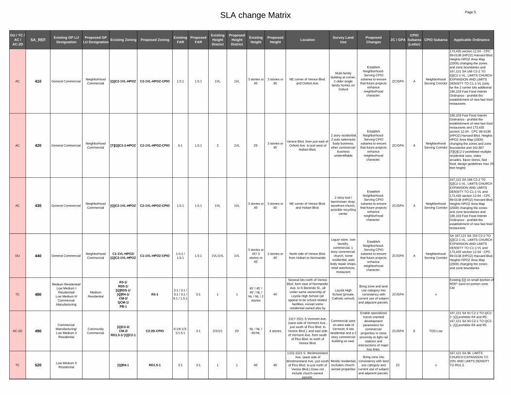
AC 410 General CommercialNeighborhood Commercial
[Q]C2-1VL-HPOZ C2-1VL-HPOZ-CPIO 1.5:1 1.5:1 1VL 1VL3 stories or
45'3 stories or
45'NE corner of Venice Blvd.
and Oxford Ave.
Multi-family building at corner,
2 older single family homes on
Oxford
Establish Neighborhood-Serving CPIO
subarea to ensure that future projects
enhance neighborhood
character.
ZC/GPA ANeighborhood
Serving Corridor
173,435 section 12.04 - CPC 99-0138 (HPOZ) Harvard Blvd. Heights HPOZ Area Map (2000) changing the zones and zone boundaries and 167,121 SA 166 C2-2 TO [Q]C2-1-VL. LIMITS CHURCH EXPANSION AND LIMITS DENSITY TO C1-1-VL (only for the 2 corner lots additional 180,103 Fast Food Interim Ordinance - prohibit the establishment of new fast food restaurants.
AC 420 General CommercialNeighborhood Commercial
[T][Q]C2-2-HPOZ C2-1VL-HPOZ-CPIO 6:1 1.5:1 2 1VL 25'3 stories or
45'
Venice Blvd. from just east of Oxford Ave. to just west of
Hobart Blvd.
2 story residential, 2 auto sales/auto body business,
other commercial business
unidentifiable
Establish Neighborhood-Serving CPIO
subarea to ensure that future projects
enhance neighborhood
character.
ZC/GPA ANeighborhood
Serving Corridor
180,103 Fast Food Interim Ordinance - prohibit the establishment of new fast food restaurants and 173,435 section 12.04 - CPC 99-0138 (HPOZ) Harvard Blvd. Heights HPOZ Area Map (2000) changing the zones and zone boundaries and 162,807 [T][Q]C2-2 prohibited multiple residential uses, video arcades, liquor stores, fast food, design guidelines max 25 feet height)
AC 430 General CommercialNeighborhood Commercial
[Q]C2-1VL-HPOZ C2-1VL-HPOZ-CPIO 1.5:1 1.5:1 1VL 1VL3 stories or
45'3 stories or
45'NE corner of Venice Blvd.
and Hobart Blvd.
2 story tool / lawnmower shop; storefront church, possible recycling
center
Establish Neighborhood-Serving CPIO
subarea to ensure that future projects
enhance neighborhood
character.
ZC/GPA ANeighborhood
Serving Corridor
167,121 SA 166 C2-2 TO [Q]C2-1-VL. LIMITS CHURCH EXPANSION AND LIMITS DENSITY TO C1-1-VL and 173,435 section 12.04 - CPC 99-0138 (HPOZ) Harvard Blvd. Heights HPOZ Area Map (2000) changing the zones and zone boundaries and 180,103 Fast Food Interim Ordinance - prohibit the establishment of new fast food restaurants
DU 440 General CommercialNeighborhood Commercial
C1-1VL-HPOZ/ [Q]C2-1VL-HPOZ C1-1VL-HPOZ-CPIO 1.5:1 /
1.5:11.5:1 1VL/1VL 1VL
3 stories or 45'/ 3
stories or 45'
3 stories or 45'
North side of Venice Blvd. from Hobart to Normandie
Liquor store, coin laundry,
commercial, 1 story commercial,
church, some residential, auto
body repair shops, retail warehouse,
restaurant
Establish Neighborhood-Serving CPIO
subarea to ensure that future projects
enhance neighborhood
character.
ZC/GPA ANeighborhood
Serving Corridor
SA 167,121 SA 154 C2-2 TO [Q]C2-1-VL. LIMITS CHURCH EXPANSION AND LIMITS DENSITY TO C1-1-VL and 173,435 section 12.04 - CPC 99-0138 (HPOZ) Harvard Blvd. Heights HPOZ Area Map (2000) changing the zones and zone boundaries
TC 480
Medium Residential/Low Medium I Residential/
Low Medium II/Commercial
Manufacturing
Medium Residential
R3-1/RD5-1/
[Q]RD5-1/[Q]R4-1/
CM-2/QCM-1/
PB-1
R3-13:1 / 3:1 / 3:1 / 3:1 / 6:1 / 1.5:1
3:1 1 1
45' / 45' / 45' / NL /
NL / NL / 2 stories
45'
Several lots north of Venice Blvd. form east of Normandie
Ave. to S Berendo St., all under same ownership of Loyola High School (all
appear to be school related facilities, except some
residential owned also by
Loyola High School (private, Catholic school)
Bring zone and land use category into consistency with
current use of subject and adjacent parcels.
ZC/GPA x
Existing [Q] on small /portion of RD5*-1and on portion zone CM
AC-2D 490Commercial
Manufacturing/Low Medium II
Residential
Community Commercial
[Q]C2-2/CM-2/
RD1.5-1/ [Q]C2-1C2-2D-CPIO 6:1/6:1/3:
1/1.5:13:1 2/2/1/1 2D
NL / NL / 45'/NL
4 stories
1317-1521 S.Vermont Ave. (west side of Vermont Ave., just south of Pico Blvd. to
Venice Blvd.), and east side of Vermont Ave. from south
of Pico Blvd. to north of Venice Blvd.
Commercial uses on west side of Vermont, 6 lots
residential and a 2 story commercial building on east.
Enable specialized transit oriented development
parameters for commercial
properties in close proximity to light rail
stations and intersections of major
bus lines.
ZC/GPA E TOD Low
167,121 SA 91 C2-2 TO QC2-2- [Q] prohibits R4 and R5; 167,121 SA 93 C2-1 TO QC2-1- [Q] prohibits R4 and R5
TC 520 Low Medium II Residential
[Q]R4-1 RD1.5-1 3:1 3:1 1 1 45' 45'
1315-1521 S. Westmoreland Ave. (west side of
Westmoreland Ave. just south of Pico Blvd. to just north of
Venice Blvd.) Does not include church-owned
parcels.
Mostly residential; excludes church-owned properties
Bring zone into consistency with land
use category and current use of subject and adjacent parcels.
ZC x
167,121 SA 96. LIMITS CHURCH EXPANSION TO 20% AND LIMITS DENSITY TO RD1.5

SLA change Matrix Page 6
DU / TC / AC /
AC-2DSA_REF Existing GP LU
DesignationProposed GP
LU Designation Existing Zoning Proposed Zoning Existing FAR
Proposed FAR
Existing Height District
Proposed Height District
Existing Height
Proposed Height Location Survey Land
UseProposed Changes ZC / GPA
CPIO Subarea (Letter)
CPIO Subarea Applicable Ordinance
DU 530
Commercial Manufacturing/
Medium Residential/Low Medium II
Residential
Hybrid IndustrialCM-1/P-1/RD1.5-1 CM-1-CPIO 1.5:1
/1.5:1/3:11.5:1 1 1
NL / NL / 45'
NL
Lots on Venice Blvd. (north and south side) generally
bounded from Arapahoe St. on west to Menlo St. on the
east
Various uses, including industrial and commercial uses, Post Office use in a privately owned lot, and
associated parking lot
Establish Hybrid industrial CPIO
subarea to addresss land use conflicts
between residential and industrial uses.
ZC/GPA J Hybrid NO EXISTING [Q]
AC 540General Commercial/
Commercial Manufacturing
Community Commercial
R4-1VL/CM-1 C2-1VL-CPIO 3:1/1.5:1 1.5:1 1VL/1 1VL
3 stories or 45' / NL
3 stories or 45'
1319 S. Hoover St.-1529 S. Hoover St. (west side of
Hoover St. from alley, south of Pico Blvd. to Venice Blvd.)
Mostly residential (including 20-50
unit Apt. Complex)
Enable specialized transit oriented development
parameters for commercial
properties in close proximity to light rail
stations and intersections of major
bus lines.
ZC/GPA C General Corridor NO EXISTING [Q]
DU 545 General CommercialNeighborhood Commercial
C2-1VL C2-1VL-CPIO 1.5:1 1.5:1 1VL 1VL3 stories or
45'3 stories or
45'
Lots on southeast corner of Arlington Ave. and Venice
Blvd.Auto Repair
Establish Neighborhood-Serving CPIO
subarea to ensure that future projects
enhance neighborhood
character.
ZC/GPA ANeighborhood
Serving CorridorNO EXISTING [Q]
DU 546 Low Medium II Residential
RD2-1 RD2-1-CPIO 3:1 3:1 1 1 45' 45'
Block bounded by Arlington Ave., Venice Blvd., Van Ness Ave., just north of Washington
Blvd. excluding the NW corner
Residential
Establish Character Residential CPIO
subarea to preserve the existing scale and historic character of the neighborhood.
ZC OCharacter Residential
NO EXISTING [Q]
DU 547 Low Medium I Residential
R2-1 R2-1-CPIO 3:1 3:1 1 1 33' 33'Blocks bounded by Van Ness Ave., Venice Blvd., Wilton Pl., just north of Washington Blvd.
Residential
Establish Character Residential CPIO
subarea to preserve the existing scale and historic character of the neighborhood.
ZC OCharacter Residential
NO EXISTING [Q]
DU 549 Low Medium II
Residential (Medium Residential)
Low Medium II Residential
RD2-1 ([Q]R3-1) RD2-1-CPIO 3.1 3.1 1 1 45' 45'
East side of Wilton Place from 18th St to Washington
Blvd, excluding two commercial parcels
Residential
Establish Character Residential CPIO
subarea to preserve the existing scale and historic character of the neighborhood.
ZC OCharacter Residential
[Q] limits density to max 12,00 sf (less than what R3 allows); underlying zone and land use RD2-1 and Low Medium II Residential.
DU 550 Low Medium II
Residential (Medium Residential)
Low Medium II Residential
RD2-1 ([Q]R3-1) RD1.5-1-CPIO 3:1 3:1 1 1 45' 45'
East side of Wilton Pl from Venice to 18th St; west side ofGramercy Pl from Venice to Washington (excluding two
commercial parcels to south); and east side of Gramercy
from Venice to 18th St.
Single family and multi-family
residential units
Establish Character Residential CPIO
subarea to preserve the existing scale and historic character of the neighborhood.
ZC OCharacter Residential
[Q] limits density to max 12,00 sf (less than what R3 allows); underlying zone and land use RD2-1 and Low Medium II Residential.
DU 551 Medium Residential R3-1 R3-1-CPIO 3:1 3:1 1 1 45' 45'
4 blocks roughly bounded by Venice Blvd., Manhattan Pl., Washington Blvd. just east of
Gramercy Pl.
Residential
Establish Character Residential CPIO
subarea to preserve the existing scale and historic character of the neighborhood.
ZC OCharacter Residential
NO EXISTING [Q]
AC-2D 560 Community Commercial
[Q]C2-1/P1-1 C2-2D-CPIO 1.5:1/ 3:1 3:1 1/1 2D NL / NL 4 stories
Whole block bounded by Western Ave., 18th St. and
Venice Blvd.
Commercial, grocery store
(Food 4 Less), CVS, drive thru
fast food restaurant
Enable specialized transit oriented development
parameters for commercial
properties in close proximity to light rail
stations and intersections of major
bus lines.
ZC E TOD Low
173,809 SA 160 C2-1 TO [Q]C2-1 [q]requires design guidelines for MF res., 2:1 for MU, limited to R3 density in c2 zone
DU 570 Community Commercial
Neighborhood Commercial
[Q]C2-1-HPOZ C2-1VL-HPOZ-CPIO 1.5:1 1.5:1 1 1VL NL3 stories or
45'SE corner of Western Ave.
and Venice Blvd.Primarily
commercial uses
Establish Neighborhood-Serving CPIO
subarea to ensure that future projects
enhance neighborhood
character.
ZC/GPA ANeighborhood
Serving Corridor
173,809 SA 160: Design Guidelines, max 2:1 FAR for MU projects, max R3 density, prev. QS

SLA change Matrix Page 7
DU / TC / AC /
AC-2DSA_REF Existing GP LU
DesignationProposed GP
LU Designation Existing Zoning Proposed Zoning Existing FAR
Proposed FAR
Existing Height District
Proposed Height District
Existing Height
Proposed Height Location Survey Land
UseProposed Changes ZC / GPA
CPIO Subarea (Letter)
CPIO Subarea Applicable Ordinance
TC 572 Community Commercial
Low Medium I Residential
[Q]C2-1-HPOZ R2-1-HPOZ 1.5:1 3:1 1 1 NL 33'Internal lots in block bounded by Venice Blvd., Oxford Ave.,
and Western Blvd.
Rear yards of residential fronting
on Oxford Ave.
Bring zone and land use category into consistency with
current use of subject and adjacent parcels.
ZC/GPA x
173,809 SA 160: Design Guidelines, max 2:1 FAR for MU projects, max R3 density, prev. QS
DU 580 General CommercialNeighborhood Commercial
C1-1VL-HPOZ C1-1VL-HPOZ-CPIO 1.5:1 1.5:1 1VL 1VL3 stories or
45'3 stories or
45'
Block on south side of Venice Blvd. from Oxford Ave. to
Harvard Blvd.
Auto service and repair
establishment, Commercial,
some residential
Establish Neighborhood-Serving CPIO
subarea to ensure that future projects
enhance neighborhood
character.
ZC/GPA ANeighborhood
Serving CorridorNO EXISTING [Q]
TC 592 General CommercialLow Medium I
ResidentialR2-1-HPOZ 3:1 3:1 1 1 33' 33'
Sliver of residential lot, 1649 S Hobart Blvd
Sliver of residential lot
Bring land use category into
consistency with zone and current use of
subject and adjacent parcel
GPA x
No Existing [Q]
DU 610 General CommercialNeighborhood Commercial
C1-1VL-HPOZ C1-1VL-HPOZ-CPIO 1.5:1 1.5:1 1VL 1VL3 stories or
45'3 stories or
45'
South side of Venice Blvd. From Harvard Blvd. to
Normandie
Commercial, some residential
Establish Neighborhood-Serving CPIO
subarea to ensure that future projects
enhance neighborhood
character.
ZC/GPA ANeighborhood
Serving Corridor
NO EXISTING [Q]
TC 650General Commercial/
Low Medium I Residential
Open SpaceC1-1VL/
R2-1 OS-1XL 1.5:1/3:1 1.5:1 1VL/1 13 stories or
45' / 33'NL
South side of Venice Blvd. from Normandie Ave. to west
of Angelus Cemetery, triangle shaped lot, could be city owned, no info on ZIMAS
Triangle shaped parcel, open
space with tree
Bring zone and land use category into consistency with
current use of subject and adjacent parcels.
ZC/GPA x
NO EXISTING [Q]
DU 660Commercial
Manufacturing/Low Medium II
Residential
Hybrid IndustrialCM-2/
RD1.5-1 CM-1-CPIO 6:1/3:1 1.5:1 2/1 1 NL / 45' NLVenice Blvd. north and south side from Catalina St. to New
Hampshire Ave.
Various uses including some light industrial,
commercial uses and some residential
(residentially zoned lots are parking lots;
residential uses are on CM-zoned
lots).
Establish Hybrid industrial CPIO
subarea to addresss land use conflicts
between residential and industrial uses.
ZC/GPA J Hybrid
NO EXISTING [Q]
AC-2D 680Low Medium II
Residential/Commercial
Manufacturing
Community Commercial
[Q]C2-2/RD1.5-1/
CM-2/[Q]C2-1/CM-1
C2-2D-CPIO6:1/3:1/6:1/1.5:1/1.
5:13:1 2/1/2/1/1 2D
NL / 45' / NL/NL / NL
4 stories
West side of Vermont Blvd. from Venice Blvd. to
Washington Blvd., south corner lots excluded, and east side of Vermont Ave.
from Venice Blvd. to 17th Pl. and corner of Menlo Ave. Also includes east side of New Hampshire Ave from 1736 New Hampshire to
Washington Ave.
Commercial, one motel, some residential
Enable specialized transit oriented development
parameters for commercial
properties in close proximity to light rail
stations and intersections of major
bus lines.
ZC/GPA E TOD Low
167,121 SA 305 and 257:Prohibits R4 and R5
TC 682 Commercial Manufacturing
Low Medium II Residential
RD1.5-1 3:1 3:1 1 1 45' 45'Internal lot at rear of 1630 S.
New Hampshire, west of Vermont Blvd.
Rear residential yard
Bring land use category into
consistency with zone and current use of
subject and adjacent parcel
GPA x NO EXISTING [Q]
AC 710
General Commercial/Commercial
Manufacturing/Low Medium II
Residential
Community Commercial
[Q]C2-1VL/CM-1/P-1/
RD1.5-1
C2-1VL-CPOI 1.5:1/1.5:1/3:1
1.5:1 1VL/1/1/1 1VL3 stories or 45' / NL / NL / 45'
3 stories or 45'
West side of Hoover St. from Venice Blvd. to 18th St. and
corner of Arapahoe St.
Primarily commercial uses
Enable specialized transit oriented development
parameters for commercial
properties in close proximity to light rail
stations and intersections of major
bus lines.
ZC/GPA C General Corridor
Existing [q] ord. 167121 SA 275 PROHIBITS R4 AND R5
DU 720 Medium ResidentialLow Medium II
Residential[Q]R4-1 RD2-1-CPIO 3:1 3:1 1 1 45' 45'
North of Washington Blvd. between Gramercy Pl. and
St. Andrews Pl. Doesn't include two church-owned parcels nearest 18th St.
Mostly residential (does not inlcude church at 1800
&1810 Gramercy Pl.)
Establish Character Residential CPIO
subarea to preserve the existing scale and historic character of the neighborhood.
ZC /GPA OCharacter Residential
167,121 SA 334. LIMITS CHURCH EXPANSION TO 20% AND LIMITS DENSITY TO RD1.5-1

SLA change Matrix Page 8
DU / TC / AC /
AC-2DSA_REF Existing GP LU
DesignationProposed GP
LU Designation Existing Zoning Proposed Zoning Existing FAR
Proposed FAR
Existing Height District
Proposed Height District
Existing Height
Proposed Height Location Survey Land
UseProposed Changes ZC / GPA
CPIO Subarea (Letter)
CPIO Subarea Applicable Ordinance
DU 722 Medium ResidentialLow Medium II
Residential[Q]R4-1 [Q]R4-1-CPIO 3:1 3:1 1 1 45' 45'
2 lots at SE corner of 18th St. and Gramercy Place
Church
Establish Character Residential CPIO
subarea to preserve the existing scale and historic character of the neighborhood.
ZC/GPA OCharacter Residential
167,121 SA 334. LIMITS CHURCH EXPANSION TO 20% AND LIMITS DENSITY TO RD1.5-1
AC-2D 730 Community Commercial
P-1 C2-2D-CPIO 3:1 3:1 1 2D NL 6 stories
Lots on east side of Manhattan Pl. from 18th St. to
2 lots north of Washington Blvd.
Primarily residential
Enable specialized transit oriented development
parameters for commercial
properties in close proximity to light rail
stations and intersections of major
bus lines.
ZC F TOD Medium
NO EXISTING [Q]
DU 740 Community Commercial
Neighborhood Commercial
[Q]C2-1-HPOZ C2-1VL-HPOZ-CPIO 1.5:1 1.5:1 1 1VL NL3 stories or
45'
Lots on east side of Western Ave. just south of Venice
Blvd. to just north of Washington Blvd.
Primarily commercial uses
Establish Neighborhood-Serving CPIO
subarea to ensure that future projects
enhance neighborhood
character.
ZC/GPA ANeighborhood
Serving Corridor
173,809 SA 160: Design Guidelines, max 2:1 FAR for MU projects, max R3 density, prev. QS
AC 762 Medium Residential [Q]R3-1 R3-1-CPIO 3:1 3:1 1 1 45' 45'
Lots on west side of Westmoreland Ave. from
17th Pl. to just north of Washington Blvd.
Multi-family residential;
contributors to Washington
Gardens Multi-Family Historic
District.
Establish Character Residential CPIO
subarea to preserve the existing scale and historic character of the neighborhood.
Bring zone into consistency with
current use of subject and adjacent parcels.
ZC OCharacter Residential
173,809 SA460: Design guidelines, Residential developments limited to max density of 1,200 sq ft per dwelling unit in R3 zone.
DU 764 Medium Residential R3-1 R3-1-CPIO 3:1 3:1 1 1 45' 45'
Block bounded by Westmoreland to the west,
17th place to the north, Orchard Ave to the east, and the alley above Washington
Blvd to the south
Multi-family residential;
contributors to Washington
Gardens Multi-Family Historic
District.
Establish Character Residential CPIO
subarea to preserve the existing scale and historic character of the neighborhood.
ZC OCharacter Residential
NO EXISTING [Q]
DU 770Commercial
Manufacturing/ Low Medium II Residential
Neighborhood Commercial
[Q]C2-1/RD2-1 C2-1VL-CPIO 1.5:1/ 3:1 1.5:1 1 1VL NL / 45'
3 stories or 45'
North side of Washington Blvd. from Arlington Ave. to
Van Ness Ave.
2 story commercial, Fire Station #26, State Historic Resource,
auto repair establishment
Establish Neighborhood-Serving CPIO
subarea to ensure that future projects
enhance neighborhood
character.
ZC/GPA ANeighborhood
Serving Corridor
167,121 SA 345 Prohibits R4 and R5
DU 780Commercial
Manufacturing/Low Medium I
Residential
Neighborhood Commercial
[Q]C2-1/R2-1/ [Q]CM-1 C2-1VL-CPIO 1.5:1/3:1/
1.5:11.5:1 1 1VL NL / 33'/ NL
3 stories or 45'
North side of Washington Blvd. from Van Ness Ave. to
Wilton Pl.
Church building and parking lot,
Wholesale electric co. other possible
light industrial? No signs
Establish Neighborhood-Serving CPIO
subarea to ensure that future projects
enhance neighborhood
character.
ZC/GPA ANeighborhood
Serving Corridor
167,121 SA 345 Q PROHIBITS R4 AND R5, 180,103 Fast Food Interim Ordinance - prohibit the establishment of new fast food restaurants and 177,323 Prohibits automobile-related uses, junk yards, open storage and recycling materials processing and sorting facilities, promoting mixed-use commercial and 173,809 SA 580 C2-1VL TO [Q]CM-1 [Q]= Max of 2:1 FAR for commercial/residential mixed use projects: Max 1.5:1 FAR for commercial uses, prohibited residential only uses, Max 2:1 FAR for industrial/residential mixed uses

SLA change Matrix Page 9
DU / TC / AC /
AC-2DSA_REF Existing GP LU
DesignationProposed GP
LU Designation Existing Zoning Proposed Zoning Existing FAR
Proposed FAR
Existing Height District
Proposed Height District
Existing Height
Proposed Height Location Survey Land
UseProposed Changes ZC / GPA
CPIO Subarea (Letter)
CPIO Subarea Applicable Ordinance
DU 800 Commercial Manufacturing
Neighborhood Commercial
[Q]CM-1 C2-1VL-CPIO 1.5:1 1.5:1 1 1VL NL3 stories or
45'
North side of Washington Blvd. from Wilton Pl. to
Gramercy Pl. and North east corner of Washington Blvd.
and Gramercy Pl.
Vacant lots surrounded by block wall with
mural (once slated for
redevelopement by CRA ?); Liquor store and parking
lot fronting Washington and
Gramercy
Establish Neighborhood-Serving CPIO
subarea to ensure that future projects
enhance neighborhood
character.
ZC/GPA ANeighborhood
Serving Corridor
173,809 SA 580,600,620 C2-1VL TO [Q]CM-1 [Q]= Maximum of 2:1 FAR for Mixed use projects: Max. 1.5:1 for commercial only. Residential is prohibited unless it is part of a Industrial/residential mixed use development, if so then max 2:1 FAR is allowed. Design Guidelines requirement.
DU 820 Commercial Manufacturing
Neighborhood Commercial
[Q]C2-1 C2-1VL-CPIO 1.5:1 1.5:1 1 1VL NL3 stories or
45'
North west corner of St. Andrews Pl. and Washington
Blvd., and North side of Washington Blvd. between St Andrews Pl. and Manhattan
Pl.
Commercial stores, party
supply, furniture, auto related
product stores, 1 and 2 story
commercial uses
Establish Neighborhood-Serving CPIO
subarea to ensure that future projects
enhance neighborhood
character.
ZC/GPA ANeighborhood
Serving Corridor
167,121 Sas 331 and 333 Prohibits R4 and R5
AC-2D 840 Community Commercial
[Q]C2-1/P-1 C2-2D-CPIO 1.5:1/3:1 3:1 1/1 2D NL / NL 6 stories
North west corner of Washington Blvd. and
Western Ave. from Manhattan Pl. to 18th St.
Commercial uses
Enable specialized transit oriented development
parameters for commercial
properties in close proximity to light rail
stations and intersections of major
bus lines.
ZC F TOD Medium
173,809 SA 160: Design Guidelines, max 2:1 FAR for MU projects, max R3 density, prev. QS
AC-2D 850 Community Commercial
[Q]C2-1-HPOZ C2-2D-HPOZ-CPIO 1.5:1 3:1 1/1 2D NL 6 storiesNorth east corner of
Washington Blvd. and Western Ave.
Primarily commercial uses
Enable specialized transit oriented development
parameters for commercial
properties in close proximity to light rail
stations and intersections of major
bus lines.
ZC F TOD Medium
173,809 SA 160: Design Guidelines, max 2:1 FAR for MU projects, max R3 density, prev. QS
DU 852Community
Commercial/Low Medium I
Residential
Neighborhood Commercial
[Q]C2-1-HPOZ/R2-1-HPOZ C2-1VL-HPOZ-CPIO 1.5:1/3:1 1.5:1 1 1VL NL / 33'
3 stories or 45'
North west corner of Washington Blvd and Oxford
Ave.
Multi-family residential
(Harvard Heights contributor), 2 two-story historic mixed
use residential/commercial contributing
buildings
Establish Neighborhood-Serving CPIO
subarea to ensure that future projects
enhance neighborhood
character.
ZC/GPA ANeighborhood
Serving Corridor
173,809 SA 160: Design Guidelines, max 2:1 FAR for MU projects, max R3 density, prev. QS
DU 860 Commercial Manufacturing
Neighborhood Commercial
[Q]C2-1-HPOZ C2-1VL-HPOZ-CPIO 1.5:1 1.5:1 1 1VL NL3 stories or
45'
North side of Washington Blvd. from Oxford Ave. to
Harvard Blvd.
Commercial building and
parking lot, Offices (Ray Charles
Studio), warehouse uses, some residential,
mortuary
Establish Neighborhood-Serving CPIO
subarea to ensure that future projects
enhance neighborhood
character.
ZC/GPA ANeighborhood
Serving Corridor
167,121 SAs 327, 325, 323: Prohibits R4 and R5
DU 890 Commercial Manufacturing
Neighborhood Commercial
[Q]C2-1-HPOZ/ R2-1-HPOZ C2-1VL-HPOZ-CPIO 1.5:1/3:1 1.5:1 1 1VL NL/33'
3 stories or 45'
North side of Washington, from Harvard Blvd. to
Normandie.
Private school, aurto repair,
Hungarian cultural center, multi-
family complex
Establish Neighborhood-Serving CPIO
subarea to ensure that future projects
enhance neighborhood
character.
ZC/GPA ANeighborhood
Serving Corridor
167,121 SA 321, 319, 317, 315: Prohibits R4 and R5
DU 930Low Medium II
Residential/Commercial
Manufacturing
Community Commercial
[Q]C2-1 C2-1-CPIO 1.5:1 1.5:1 1 1 NL NLNorth side of Washington Blvd., from Walton Ave. to
New Hampshire Ave.
Auto body, retail, residential, used
car sales, commercial,
various tenants
Establish General Corridor CPIO
subarea to ensure that future projects
enhance neighborhood
character.
ZC/GPA C General Corridor
167,121 SA 307, 313, 311: Prohibits R4 and R5 (Published in 1991). Previous ordinance 162,616 published in 1987 placed [T] , changed from C2-1, C2-2, R4-1, R4-2 to (T)(Q)CM-1, CPC No.86-454 ('89) removed (T) , General Covenant and Agreement (89-412319) There shall be no medical or dental offices permitted.

SLA change Matrix Page 10
DU / TC / AC /
AC-2DSA_REF Existing GP LU
DesignationProposed GP
LU Designation Existing Zoning Proposed Zoning Existing FAR
Proposed FAR
Existing Height District
Proposed Height District
Existing Height
Proposed Height Location Survey Land
UseProposed Changes ZC / GPA
CPIO Subarea (Letter)
CPIO Subarea Applicable Ordinance
AC-2D 960 Commercial Manufacturing
Community Commercial
[Q]CM-1 C2-2D-CPIO 1.5:1 3:1 1 2D NL 4 stories
North west corner of Washington Blvd. and
Vermont Ave, and west side of Vermont Ave. south of
Venice Blvd.
Rite Aid, Burger King drive through
Enable specialized transit oriented development
parameters for commercial
properties in close proximity to light rail
stations and intersections of major
bus lines.
ZC/GPA E TOD Low
167,121 SA 307 Prohibits R4 and R5 (Published in 1991) Previous ordinance 162,616 published in 1987 placed [T] , changed from C2-1, C2-2, R4-1, R4-2 to (T)(Q)CM-1, CPC No.86-454 ('89) removed (T) , General Covenant and Agreement (89-412319) There shall be no medical or dental offices permitted.
AC-2D 970Commercial
Manufacturing/Low Medium II
Residential
Community Commercial
[Q]C2-1/RD1.5-1 C2-2D-CPIO 1.5:1/3:1 3:1 1/1 2D NL / 45' 4 stories
East side of Vermont Ave. between 17th St. and
Washington Blvd., and South east corner of Vermont Ave.
and Washington Blvd.
Auto related
Enable specialized transit oriented development
parameters for commercial
properties in close proximity to light rail
stations and intersections of major
bus lines.
ZC/GPA E TOD Low
167,121 SA 303 Prohibits R4 and R5
DU 980Commercial
Manufacturing / Low Medium II Residential
Community Commercial
[Q]C2-1/ CM-1 / RD1.5-1 C2-1-CPIO 1.5:1 /
1.5:1 / 3:11.5:1 1/1/1 1 NL/NL/45' NL
North side of Washington Blvd. between Menlo Ave.
and Arapahoe St.
Auto related and residential, vacant
lot, liquor store, commercial
Establish General Corridor CPIO
subarea to ensure that future projects
enhance neighborhood
character.
ZC/GPA C General Corridor
167,121 SA 299, 295, 289, 287, 283: Prohibits R4 and R5
AC 982 Low Medium II Residential
Community Commercial
RD1.5-1 C2-1-CPIO 3:1 1.5:1 1 1 45' NLInternal lot on east side of Menlo Ave. just north of
Washington Blvd.Parking lot
Establish General Corridor CPIO
subarea to ensure that future projects
enhance neighborhood
character.
ZC/GPA C General Corridor NO EXISTING [Q]
AC 984 Medium ResidentialCommunity Commercial
[Q]R3-1 C2-1-CPIO 3:1 1.5:1 1 1 45' NLTwo internal lots fronting west
side of Westmoreland Ave. just north of Washington Blvd.
Parking lot
Establish General Corridor CPIO
subarea to ensure that future projects
enhance neighborhood
character.
ZC/GPA C General Corridor
Ord. 173,809 SA 460 Residential density limited to 1200 SF/DU in R3 zone, Multi-family developments must conform with Multi-family residential design guidelines.
AC 1030General Commercial/
Commercial Manufacturing
Community Commercial
P-1VL/[Q]C2-1/
C2-1C2-1VL-CPIO NL/1.5:1/1
.5:11.5:1 1VL/1/1/1 1VL
3 stories or 45' / NL /
NL
3 stories or 45'
North west corner of Washington Blvd. and Hoover St. from Arapahoe St to 18th
St. Excludes 6 publicly owned parcels along Hoover
St.
Commercial uses
Enable specialized transit oriented development
parameters for commercial
properties in close proximity to light rail
stations and intersections of major
bus lines.
ZC/GPA C General Corridor
Ord.180,103 Fast Food Interim Ordinance - prohibit the establishment of new fast food restaurants, Ord. 167,121 SA 281 change C2-1 to [Q]C2-1, residential uses at the density of the R4 and R5 zones shall be prohibited, Ord. 161,116 SA 38A Height District Changes
TC 1032 General Commercial Open Space C2-1 OS-1XL 1.5:1 1.5:1 1 1XL NL NL6 parcels on west side of
Hoover St between 18th St and Washington Blvd
private school and park (publicly
owned)
Bring zone and land use category into consistency with
current use of subject and adjacent parcels.
ZC/GPA x
NO EXISTING [Q]
AC 1040 Commercial Manufacturing
Neighborhood Commercial
[Q]CM-1-O C2-1VL-O-CPIO 1.5:1 1.5:1 1 1VL NL3 stories or
45'
South east corner of Washington Blvd. and
Arlington Ave.
Commercial uses (Bob's Tire Town)
Establish Neighborhood-Serving CPIO
subarea to ensure that future projects
enhance neighborhood
character.
ZC/GPA ANeighborhood
Serving Corridor
173,809-SA 550- INTENT: Q]= Maximum of 2:1 FAR for Mixed use projects: Max. 1.5:1 for commercial only. Residential is prohibited unless it is part of a Industrial/residential mixed use development, if so then max 2:1 FAR is allowed. Design Guidelines requirement.

SLA change Matrix Page 11
DU / TC / AC /
AC-2DSA_REF Existing GP LU
DesignationProposed GP
LU Designation Existing Zoning Proposed Zoning Existing FAR
Proposed FAR
Existing Height District
Proposed Height District
Existing Height
Proposed Height Location Survey Land
UseProposed Changes ZC / GPA
CPIO Subarea (Letter)
CPIO Subarea Applicable Ordinance
DU 1050 Commercial Manufacturing
Neighborhood Commercial
C2-1VL-O/ [Q]C2-1-O C2-1VL-O-CPIO 1.5:1/1.5:
11.5:1 1VL/1 1VL
3 stories or 45'/NL
3 stories or 45'
South side of Washington Blvd. generally between
Arlington Ave. and Western Ave.
Commercial uses (Incl. Bob's Tire
Town)
Establish Neighborhood-Serving CPIO
subarea to ensure that future projects
enhance neighborhood
character.
ZC/GPA ANeighborhood
Serving Corridor
167,121 SA 351, 359, 361: Prohibits R4 &R5
AC-2D 1100 Community Commercial
[Q]C2-1-O C2-2D-O-CPIO 1.5:1 3:1 1 2D NL 4 stories
North west corner of Western Ave. and Washington Blvd. from Washington Blvd. to
20th St.
Primarily commercial uses
Enable specialized transit oriented development
parameters for commercial
properties in close proximity to light rail
stations and intersections of major
bus lines.
ZC E TOD Low
180,103 Fast Food Interim Ordinance - prohibit the establishment of new fast food restaurants and 177,323 Prohibits automobile-related uses, junk yards, open storage and recycling materials processing and sorting facilities, promoting mixed-use commercial and173,809 SA 160 C2-1-0 TO [Q]C2-1-0, Design Guidelines, [Q]= Max of 2:1 FAR for commercial/residential mixed uses, Max of 1.5:1 for commercial uses, Residential restricted to max density R3 zone
AC-2D 1110 Community Commercial
[Q]C2-1-HPOZ C2-2D-HPOZ-CPIO 1.5:1 3:1 1 2D NL 4 storiesSouth east corner of
Washington Blvd. and Western Ave.
Primarily commercial uses
Enable specialized transit oriented development
parameters for commercial
properties in close proximity to light rail
stations and intersections of major
bus lines.
ZC E TOD Low
180,103 Fast Food Interim Ordinance - prohibit the establishment of new fast food restaurants and173,809 SA 160 C2-1-0 TO [Q]C2-1-0, Design Guidelines, [Q]= Max of 2:1 FAR for commercial/residential mixed uses, Max of 1.5:1 for commercial uses, Residential restricted to max density R3 zone and 173,435 section 12.04 - CPC 99-0138 (HPOZ) Harvard Blvd. Heights HPOZ Area Map (2000) changing the zones and zone boundaries
DU 1120 Commercial Manufacturing
Neighborhood Commercial
[Q]C2-1-HPOZ C2-1VL-HPOZ-CPIO 1.5:1 1.5:1 1 1VL NL3 stories or
45'
South side of Washington Blvd. from Oxford Ave. to
Harvard Blvd.
Retail, conv. home 4 lots, auto
related, fast food, large house
Establish Neighborhood-Serving CPIO
subarea to ensure that future projects
enhance neighborhood
character.
ZC/GPA ANeighborhood
Serving Corridor
167,121 SA 365, 367 Prohibits R4 and R5
DU 1140 Commercial Manufacturing
Neighborhood Commercial
[Q]C2-1-HPOZ C2-1VL-HPOZ-CPIO 1.5:1 1.5:1 1 1VL NL3 stories or
45'
South side of Washington, from Harvard Blvd. to
Normandie Ave.
Retail, convalescent
home, auto repair, strip mall, gas
station
Establish Neighborhood-Serving CPIO
subarea to ensure that future projects
enhance neighborhood
character.
ZC/GPA ANeighborhood
Serving Corridor
167,121 SA 369, 375 Prohibits R4 and R5
TC 1155 Low Medium I Residential
Open Space R2-1-HPOZ OS-1XL-HPOZ 3:1 1.5:1 1 1XL 33' NLNW corner of Normandie
Ave. and Cordova St.Pocket Park
Bring zone and land use category into consistency with
current use of subject and adjacent parcels.
ZC/GPA x
NO EXISTING [Q]

SLA change Matrix Page 12
DU / TC / AC /
AC-2DSA_REF Existing GP LU
DesignationProposed GP
LU Designation Existing Zoning Proposed Zoning Existing FAR
Proposed FAR
Existing Height District
Proposed Height District
Existing Height
Proposed Height Location Survey Land
UseProposed Changes ZC / GPA
CPIO Subarea (Letter)
CPIO Subarea Applicable Ordinance
DU 1160 Commercial Manufacturing
Hybrid Industrial [Q]CM-1 CM-1-CPIO 1.5:1 1.5:1 1 1 NL NLSouth side of Washington Blvd. between Normandie Ave. and Raymond Ave.
Various industrial uses, warehouse,
auto painting
Establish Hybrid industrial CPIO
subarea to addresss land use conflicts
between residential and industrial uses.
ZC/GPA J Hybrid
173,809 SA 635 The FAR shall be no more than 2:1 for commercial/residential mixed use developments and 1.5:1 for commercial developments. Commercial developments and commercial/residential mixed use developments must obtain plan approval to ensure conformity with the commercial development design guidelines. Industrial developments and industrial/residential mixed use developments must obtain plan approval to ensure conformity with the industrial development design guidelines. Residential only uses shall be prohibited in the CM zone. However, industrial/residential mixed use may be permitted. In such cases, the FAR shall be no more than 2:1.
DU 1180 Commercial Manufacturing
Hybrid Industrial [Q]CM-1/
PF-1 CM-1-CPIO 1.5:1/1.5:1
1.5:1 1 1 NL / NL NLSouthside of Washington, to
midblock east side of Raymond Ave.
Church, retail
Establish Hybrid industrial CPIO
subarea to addresss land use conflicts
between residential and industrial uses.
ZC/GPA J Hybrid
173,809 SA 635 The FAR shall be no more than 2:1 for commercial/residential mixed use developments and 1.5:1 for commercial developments. Commercial developments and commercial/residential mixed use developments must obtain plan approval to ensure conformity with the commercial development design guidelines. Industrial developments and industrial/residential mixed use developments must obtain plan approval to ensure conformity with the industrial development design guidelines. Residential only uses shall be prohibited in the CM zone. However, industrial/residential mixed use may be permitted. In such cases, the FAR shall be no more than 2:1.
TC 1190 Limited Manufacturing
Public Facilities M1-1 PF-1 1.5:1 1.5:1 1 1 NL NLSouth west corner of Budlong
Ave. and Washington Blvd.LAUSD new
school
Bring zone and land use category into consistency with
current use of subject and adjacent parcels.
ZC/GPA x
NO EXISTING [Q]
DU 1200 Limited Manufacturing
Limited Industrial M1-1 M1-1-CPIO 1.5:1 1.5:1 1 1 NL NL
South side of Washington Blvd., midblock between
Vermont Ave. and Budlong Ave., north of Cordova St.
Warehouse and other industrial
uses
Establish Compatible Industrial CPIO
subarea to improve transition between
industrial and residential uses and
improve building design.
ZC/GPA KCompatible
Industrial
NO EXISTING [Q]
AC-2D 1210 Limited Manufacturing
Community Commercial
M1-1/M1-2 C2-2D-CPIO 1.5:1/6:1 3:1 1/2 2D NL / NL 4 stories
South west corner of Washington Blvd. and
Vermont Ave.
Primarily commercial uses
Enable specialized transit oriented development
parameters for commercial
properties in close proximity to light rail
stations and intersections of major
bus lines.
ZC/GPA E TOD Low
NO EXISTING [Q]

SLA change Matrix Page 13
DU / TC / AC /
AC-2DSA_REF Existing GP LU
DesignationProposed GP
LU Designation Existing Zoning Proposed Zoning Existing FAR
Proposed FAR
Existing Height District
Proposed Height District
Existing Height
Proposed Height Location Survey Land
UseProposed Changes ZC / GPA
CPIO Subarea (Letter)
CPIO Subarea Applicable Ordinance
TC 1220
Commercial Manufacturing/
Limited Manufacturing/Low Medium II
Residential
Public Facilities
[Q]C2-1/M1-1/P-1/[Q]CM-1/RD1.5-1
PF-11.5:1/1.5:1/3:1/1.5:
1/3:11.5:1 1 1
NL / NL / NL / NL /
45'NL
South side of Washington Blvd. between Vermont Ave. and Orchard Ave. excluding
south east corner.
West Adams Prep LAUSD school
Bring zone and land use category into consistency with
current use of subject and adjacent parcels.
ZC/GPA x
167,121 SA 401 Prohibits R4 and R5 [Q] CM?
DU 1230 Commercial Manufacturing
Community Commercial
[Q]C2-1 C2-1-CPIO 1.5:1 1.5:1 1 1 NL NLSouth side of Washington
Blvd. between Orchard Ave. and New England St.
Commercial uses
Establish General Corridor CPIO
subarea to ensure that future projects
enhance neighborhood
character.
ZC/GPA C General Corridor
167,121 SA 403 Prohibits R4 and R5
AC 1240Commercial
Manufacturing/Low Medium II
Residential
Community Commercial
[Q]C2-1/RD1.5-1 C2-1-CPIO 1.5:1/3:1 1.5:1 1 1 NL / 45' NL
South side of Washington Blvd. between New England
St. and Magnolia Ave.Commercial uses
Establish General Corridor CPIO
subarea to ensure that future projects
enhance neighborhood
character.
ZC/GPA C General Corridor
167,121 SA 405 Prohibits R4 and R5
AC 1250Commercial
Manufacturing/Low Medium II
Residential
Community Commercial
CM-1/P-1/[Q]C2-1 C2-1-CPIO 1.5:1/1.5:
11.5:1 1 1
NL / NL / NL
NLSouth side of Washington
Blvd. from Magnolia Ave. to Arapahoe St.
Warehouse, Commercial,
Children Bureau of Southern
California, Office Building
Establish General Corridor CPIO
subarea to ensure that future projects
enhance neighborhood
character.
ZC/GPA C General Corridor
167,121 SA 418 Prohibits R4 and R5
AC 1260General Commercial/
Commercial Manufacturing
Community Commercial
(Q)P-1VL/R4-1VL/(Q)CM-1/
R4-1/P-1/
CM-1/C2-1VL/[Q]C2-1
C2-1VL-CPIO
NL/3:1/1.5:1/3:1/3:1/1.5:1/1.5:1/1.5:1
1.5:11VL/1VL/1/1/1/1/1VL/1
1VL
3 stories or 45' / NL / NL / NL /
NL / NL / 3 stories or 45' / NL
3 stories or 45'
West side of Hoover St. from Washington Blvd. to 10
Freeway, and parcel at sout east corner of Hoover and
20th St.
Commercial uses
Enable specialized transit oriented development
parameters for commercial
properties in close proximity to light rail
stations and intersections of major
bus lines.
ZC/GPA C General Corridor
Ord.180,103 Fast Food Interim Ordinance - prohibit the establishment of new fast food restaurants, Ord. 167,121 SA 432 and 450 change to HD 1-VL, Ord. 161,116 SA 38A Height District Changes
TC 1265 Public Facilities [Q]C2-1 PF-1 1.5:1 1.5:1 1 1 NL NLIrregular shaped lot north of the 10 Freeway, just east of
Hoover St.
Caltrans building, lot
Bring zone into consistency with land
use category and current use of subject and adjacent parcels.
ZC x
[Q] 173,809 SA 680 Multi-family residential must conform to muti family residential development design guidelines. FAR max 2:1 for commercial/res MU and 1.5:1 for commercial, both must conform with commercial design guidelines. Res uses in C2 restricted to max density allowed in R3 zone.
AC-2D 1270 Community Commercial
[Q]C2-1 C2-2D-CPIO 1.5:1 3:1 1 2D NL 6 storiesEntire block at south east
corner of Washington Blvd. and Hoover St.
Pep Boys, office building, other
commercial uses
Enable specialized transit oriented development
parameters for commercial
properties in close proximity to light rail
stations and intersections of major
bus lines.
ZC F TOD Medium
173,809 SA680: 2:1 FAR FOR COMM/RES MU PROJECTS. 1.5:1 for commercial only. Max R3 DENSITY. DESIGN GUIDELINES, [Q] 167,121 SA 436
DU 1280 Community Commercial
Neighborhood Commercial
[Q]C2-1-O C2-1VL-O-CPIO 1.5:1 1.5:1 1 1VL NL3 stories or
45'Lots at south west corner of Western Ave. and 20th St.
Primarily commercial uses
Establish Neighborhood-Serving CPIO
subarea to ensure that future projects
enhance neighborhood
character.
ZC/GPA ANeighborhood
Serving Corridor
180,103 Fast Food Interim Ordinance - prohibit the establishment of new fast food restaurants and 177,323 Prohibits automobile-related uses, junk yards, open storage and recycling materials processing and sorting facilities, promoting mixed-use commercial and173,809 SA 160 C2-1-0 TO [Q]C2-1-0, Design Guidelines, [Q]= Max of 2:1 FAR for commercial/residential mixed uses, Max of 1.5:1 for commercial uses, Residential restricted to max density R3 zone

SLA change Matrix Page 14
DU / TC / AC /
AC-2DSA_REF Existing GP LU
DesignationProposed GP
LU Designation Existing Zoning Proposed Zoning Existing FAR
Proposed FAR
Existing Height District
Proposed Height District
Existing Height
Proposed Height Location Survey Land
UseProposed Changes ZC / GPA
CPIO Subarea (Letter)
CPIO Subarea Applicable Ordinance
TC 1285 Public Facilities [Q]C2-1-O PF-1 1.5:1 1.5:1 1 1 NL NLNarrow lot on east side of
Manhattan Place, just south of 20th St.
Fire station parking lot
Bring zone into consistency with land
use category and current use of subject and adjacent parcels.
ZC x
173,809 SA 160 C2-1-0 TO [Q]C2-1-0, Design Guidelines, [Q]= Max of 2:1 FAR for commercial/residential mixed uses, Max of 1.5:1 for commercial uses, Residential restricted to max density R3 zone
TC 1290 Low Medium I Residential
[Q]R4-1-HPOZ R2-1-HPOZ 3:1 3:1 1 1 33' 33'
Lots generally bounded by Oxford Ave. and Hobart Blvd.,
south of Washington Blvd. Does not include church-
owned parcels at southern end of block.
Primarily multiple family residential . Excludes church-
owned lots.
Bring zone into consistency with land
use category and current use of subject and adjacent parcels.
ZC x
167,121 SA 364 LIMITS CHURCH EXPANSION to 20% AND LIMITS DENSITY TO R2-1 20%, corresponding zone is R2-1; and 173,435 section 12.04 - CPC 99-0138 (HPOZ) Harvard Blvd. Heights HPOZ Area Map (2000) changing the zones and zone boundaries
TC 1300 Low Medium II Residential
[Q]R4-1-HPOZ RD2-1-HPOZ 3:1 3:1 1 1 45' 45'
Block generally bounded by Hobart Blvd., 21st St. and
Harvard Blvd. excluding lots fronting Washington Blvd.
Primarily multiple fam. residential
Bring zone into consistency with land
use category and current use of subject and adjacent parcels.
ZC x
167,121 SA 366 LIMITS CHURCH EXPANSION AND LIMITS DENSITY TO RD2-1 and 173,435 section 12.04 - CPC 99-0138 (HPOZ) Harvard Blvd. Heights HPOZ Area Map (2000) changing the zones and zone boundaries
TC 1305 Low Medium II Residential
R3-1 RD2-1 3:1 3:1 1 1 45' 45'4 lots (slivers) on west side of Congress Ave. just north of
the 10 FreewayResidential yard
Bring zone into consistency with land
use category and current use of subject and adjacent parcels.
ZC x
NO EXISTING [Q]
DU 1310 Commercial Manufacturing
Hybrid Industrial CM-1 CM-1-CPIO 1.5:1 1.5:1 1 1 NL NLNorth east corner of
Normandie Ave. and Cordova St.
Apt. complex and industrial uses (light industrial
most likely)
Establish Hybrid industrial CPIO
subarea to addresss land use conflicts
between residential and industrial uses.
ZC/GPA J Hybrid
NO EXISTING [Q]
AC 1320 Commercial Manufacturing
Hybrid Industrial
[Q]CM-1/[T](Q)CM-1/
M1-1/R3-1
CM-1-CPIO 1.5:1/1.5:1/1.5:1/3:
11.5:1 1 1
NL / 2 stories or
30' per the [T](Q) / NL /
45'
NL1915-1951 Raymond Ave., 5
lots south of Washington Blvd.
Auto Body Repair
Establish Hybrid industrial CPIO
subarea to addresss land use conflicts
between residential and industrial uses.
ZC/GPA J Hybrid
173,809 SA 635 change M1-1 to [Q]CM-1 Maximum of 2:1 FAR for commercial/residential mixed use developments: Max. 1.5:1 for commercial only. Residential is prohibited unless it is part of a Industrial/residential mixed use development, if so then max 2:1 FAR is allowed. Design Guidelines requirements for commercial/residential mixed use developments, Industrial developments and industrial/residential mixed use developments. Residential only uses shall be prohibited in the CM zone. Industrial/residential mixed use may be permitted. In such cases, the FAR shall be no more than 2:1., Ord.180,103 Fast Food Interim Ordinance - prohibit the establishment of new fast food restaurants, Ord. 154 634 change R3-1 to [T](Q)CM-1 max 2 stories or 30 feet height.
AC 1330
Limited Manufacturing/
Commercial Manufacturing/
General Commercial
Hybrid IndustrialM1-1/ M1-2/
CM-2/C2-1VL
CM-1-CPIO 1.5:1/6:1/ 6:1/1.5:1
1.5:1 1/2/2/1VL 1NL/NL/NL/3
stories or 45'
NL
Top half of the block facing Cordova St. at north, Budlong Ave. to west, east of Vermont Ave., and lots on west side of Vermont Ave. from Cordova
St. to 20th St. (6 lots) lots fronting 20th St. (4 lots)
Some residential, bakery,
warehouse, private school, dance hall
Establish Hybrid industrial CPIO
subarea to addresss land use conflicts
between residential and industrial uses.
ZC/GPA J Hybrid
NO EXISTING [Q]

SLA change Matrix Page 15
DU / TC / AC /
AC-2DSA_REF Existing GP LU
DesignationProposed GP
LU Designation Existing Zoning Proposed Zoning Existing FAR
Proposed FAR
Existing Height District
Proposed Height District
Existing Height
Proposed Height Location Survey Land
UseProposed Changes ZC / GPA
CPIO Subarea (Letter)
CPIO Subarea Applicable Ordinance
TC 1345 Open SpaceLow Medium II
ResidentialR1-1-O-HPOZ RD1.5-1-O-HPOZ 3:1 3:1 1 1 33' 45'
Lot on east side of Cimarron St. just north of the 10
Freeway
Parking lot for shelter
Bring zone and land use category into consistency with
current use of subject and adjacent parcels.
ZC/GPA x
NO EXISTING [Q]
DU 1350 Community Commercial
Neighborhood Commercial
[Q]C2-1-O C2-1VL-O-CPIO 1.5:1 1.5:1 1 1VL NL3 stories or
45'Lots on west side of Western Ave. from 20th St. to 10 Fwy.
Primarily commercial uses
Establish Neighborhood-Serving CPIO
subarea to ensure that future projects
enhance neighborhood
character.
ZC/GPA ANeighborhood
Serving Corridor
180,103 Fast Food Interim Ordinance - prohibit the establishment of new fast food restaurants and 177,323 Prohibits automobile-related uses, junk yards, open storage and recycling materials processing and sorting facilities, promoting mixed-use commercial and173,809 SA 160 C2-1-0 TO [Q]C2-1-0, Design Guidelines, [Q]= Max of 2:1 FAR for commercial/residential mixed uses, Max of 1.5:1 for commercial uses, Residential restricted to max density R3 zone
DU 1360 Community Commercial
Neighborhood Commercial
[Q]C2-1-HPOZ/ R4-1 C2-1VL-HPOZ-CPIO 1.5:1/3:1 1.5:1 1/1 1VL NL / NL
3 stories or 45'
Lots on east side of Vermont Ave. just south of Washington
Blvd. to 10 Fwy.
Primarily commercial uses
Establish Neighborhood-Serving CPIO
subarea to ensure that future projects
enhance neighborhood
character.
ZC/GPA ANeighborhood
Serving Corridor
173,809 SA 160 C2-1-0 TO [Q]C2-1-0, Design Guidelines, [Q]= Max of 2:1 FAR for commercial/residential mixed uses, Max of 1.5:1 for commercial uses, Residential restricted to max density R3 zone and180,103 Fast Food Interim Ordinance - prohibit the establishment of new fast food restaurants and 177,323 Prohibits automobile-related uses, junk yards, open storage and recycling materials processing and sorting facilities, promoting mixed-use commercial and 173,435 section 12.04 - CPC 99-0138 (HPOZ) Harvard Blvd. Heights HPOZ Area Map (2000) changing the zones and zone boundaries
TC 1365 Low Medium I Residential
R2-1-HPOZ / R4-1 R2-1-HPOZ 3:1/3:1 1 1 33' / NL 33'Tiny lot south of 2069 S.
Oxford, at Oxford Ave and the 10 Fwy
Portion of residential lot
(driveway)
Bring zone into consistency with land
use category and ZC x
NO EXISTING [Q]
AC 1370General Commercial/
Commercial Manufacturing/ Low
Medium II Residential
Hybrid Industrial[Q]C2-2/C2-1VL/RD1.5-1
CM-1-CPIO 6:1/1.5:1/3:1
1.5:1 2/1VL/1 1NL /3
Stories or 45' / 45'
NLSouth west corner of 20th St.
and Vermont Ave.Office building
Establish Hybrid industrial CPIO
subarea to addresss land use conflicts
between residential and industrial uses.
ZC/GPA J Hybrid
167,121 SA 461 Prohibits R4 and R5
TC 1380 Low Medium II Residential
[Q]R4-1 RD1.5-1 3:1 3:1 1 1 45' 45'
3 blocks south of 20th St. between Menlo Ave. and Magnolia Ave. north of 10
Fwy
Residential
Bring zone into consistency with land
use category and current use of subject and adjacent parcels.
ZC x
167,121 SA 456 R4-1 TO [Q]R4-1. LIMITS CHURCH EXPANSION TO 20% AND LIMITS DENSITY TO RD1.5-1 and 161,116 SA 38A height district changes to 1
DU 1382 Low Medium II Residential
[Q]R4-1 RD1.5-1-CPIO 3:1 3:1 1 1 45' 45'
West side of Magnolia Ave. south of 20th St. and one lot
fronting 20th. Most are contributors to Magnolia
Avenue Residential Historic Distric identified by SurveyLA.
Residential
Establish Character Residential CPIO
subarea to preserve the existing scale and historic character of the neighborhood.
Bring zone into consistency with
current use of subject and adjacent parcels.
ZC OCharacter Residential
167,121 SA 456 R4-1 TO [Q]R4-1. LIMITS CHURCH EXPANSION TO 20% AND LIMITS DENSITY TO RD1.5-1

SLA change Matrix Page 16
DU / TC / AC /
AC-2DSA_REF Existing GP LU
DesignationProposed GP
LU Designation Existing Zoning Proposed Zoning Existing FAR
Proposed FAR
Existing Height District
Proposed Height District
Existing Height
Proposed Height Location Survey Land
UseProposed Changes ZC / GPA
CPIO Subarea (Letter)
CPIO Subarea Applicable Ordinance
DU 1384 Low Medium II Residential
RD1.5-1 RD1.5-1-CPIO 3:1 3:1 1 1 45' 45'
East side of Magnolia Ave. south of 20th St. and one lot fronting 20th. Contributors to Magnolia Avenue Residential Historic Distric identified by
SurveyLA.
Residential
Establish Character Residential CPIO
subarea to preserve the existing scale and historic character of the neighborhood.
ZC OCharacter Residential
NO EXISTING [Q]
TC 1390 Public Facilities C2-1 PF-1 1.5:1 1.5:1 1 1 NL NLSouth east corner of
Washington Blvd. and Union Ave.
mini storage; public facilities
Bring zone into consistency with land
use category and current use of subject and adjacent parcels.
ZC x
[Q] 167,121 SA 440 change C2-2 to HD 1
TC 1395 Public FacilitiesRD1.5-1-O/ R1-1-
O/ C2-1-O PF-1-O 3:1/ 3:1/ 1.5:1
1.5:1 1/1/1 145' / 33' /
NLNL
North and south side of 10 Frwy from Arlington Ave to
Western AveFreeway buffer
Bring zone into consistency with land
use category and current use of subject and adjacent parcels.
ZC x
NO EXISTING [Q]
TC 1397 Public Facilities R4-1/ C2-1/ R3-1 PF-1 3:1/ 1.5:1/ 3:1
1.5:1 1/1/1 1NL / NL /
45'NL
North and south side of 10 Frwy from Western Ave to
Vermont AveFreeway buffer
Bring zone into consistency with land
use category and current use of subject and adjacent parcels.
ZC x
NO EXISTING [Q]
TC 1398 Public FacilitiesC2-1/ R4-1/
FRWY/ VARIOUS PF-1 1.5:1/ 3:1 1.5:1 1/1 1NL / NL /
NL NL
North and south side of 10 Frwy from Vermont to Union
Ave.Freeway buffer
Bring zone into consistency with land
use category and current use of subject and adjacent parcels.
ZC x
NO EXISTING [Q]
TC 1399Low Medium II
Residential / Public Facilities
Public Facilities RD2-1/ C2-1/ R4-1 PF-1 3:1/1.5:1/ 3:1
1.5:1 1/1/1 1 45' / NL/NL NL
South of 10 Frwy from Hoover St to Union Ave,
Triangle parcel, SE corner at intersection of Union Ave and
20th St, Lot at north west corner of Washington Blvd. and Toberman St., along 10
Fwy.
Freeway buffer / parking, vacant
land / small portion of front yard / storage under freeway
Bring zone and land use category into consistency with
current use of subject and adjacent parcels.
ZC/GPA x
NO EXISTING [Q]
TC 1400 Low Residential Low II Residential [Q]R4-1-O-HPOZ R1-1-O-HPOZ 3:1 3:1 1 1 33' 33'Block north of 23rd St. from
Cimarron St. to Gramercy Pl., north of alley.
Residential
Bring zone and land use category into consistency with
current use of subject and adjacent parcels.
ZC/GPA x
167,121 SA 669. LIMITS CHURCH EXPANSION TO 20% AND LIMITS DENSITY TO R1-1-O
AC 1410 Community Commercial
Neighborhood Commercial
P1-1-O/C2-1-O C2-1-O-CPIO 3:1/1.5:1 1.5:1 1 1 NL / NL
3 stories or 45'
West side of Western Ave. from 10 Fwy to 24th St.
Auto related, L.A. Metropolitan
Medical Center
Establish General Corridor CPIO
subarea to ensure that future projects
enhance neighborhood
character.
ZC/GPA C General Corridor
NO EXISTING [Q]
DU 1418 Community Commercial
[T][Q]C2-2D [T][Q]C2-2D-CPIO 2:1 2:1 2D 2D 75' 75'Parcel at NE corner of Western and Adams
Golden State Mutual building /
new development
Establish Neighborhood-Serving CPIO
subarea to ensure that future projects
enhance neighborhood
character.
ZC/GPA ANeighborhood
Serving Corridor
CPC-2010-760-GPA-VZC-HD-SPR: GPA from Low Medium II Res to Community Commercial, Vesting zone change and HD change from RD1.5-1 to [T][Q]C2-2D, max height of 75'. See Letter of determination for further conditions. Conditions will remain with subarea. CC Adoption Date: 12/20/2012.
DU 1420Low Medium II
Residential/Community Commercial
Neighborhood Commercial
C2-1/RD1.5-1 C2-1-CPIO 1.5:1 / 3:1 1.5:1 1/1 1 NL / 45' NL
East side of Western Ave. from 10 Fwy to Adams Blvd, and parcel at NE corner of
Adams and Hobart.
Apartments, offices, strip mall
Establish Neighborhood-Serving CPIO
subarea to ensure that future projects
enhance neighborhood
character.
ZC/GPA ANeighborhood
Serving Corridor
NO EXISTING [Q]
DU 1421 Medium Residential R3-1 R3-1-CPIO 3:1 3:1 1 1 45' 45'
Lots north of 22nd street south of the 10 Fwy, between Western Ave and Congress
Ave. Does not include commercial lot at NE corner
of Western and 22nd.
Apartments, a couple houses,
vacant lot.
Establish Character Residential CPIO
subarea to preserve the existing scale and historic character of the neighborhood.
ZC OCharacter Residential
NO EXISTING [Q]
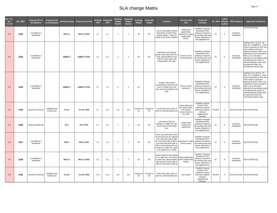
SLA change Matrix Page 17
DU / TC / AC /
AC-2DSA_REF Existing GP LU
DesignationProposed GP
LU Designation Existing Zoning Proposed Zoning Existing FAR
Proposed FAR
Existing Height District
Proposed Height District
Existing Height
Proposed Height Location Survey Land
UseProposed Changes ZC / GPA
CPIO Subarea (Letter)
CPIO Subarea Applicable Ordinance
DU 1422 Low Medium II Residential
RD1.5-1 RD1.5-1-CPIO 3:1 3:1 1 1 45' 45'
Lots on west side of Hobart Blvd south of 22nd Street towards Adams. Does not
include 3 lots north of Adams.
Multi-family apartments,
parking lot, maybe single family
homes.
Establish Character Residential CPIO
subarea to preserve the existing scale and historic character of the neighborhood.
ZC OCharacter Residential
NO EXISTING [Q]
DU 1423 Low Medium II Residential
[Q]RD2-1 [Q]RD2-1-CPIO 3:1 3:1 1 1 45' 45'
Mid-block church-owned parcels, block with 22nd St. to
north, Harvard Blvd to east, 25th St. to the south, and Hobart Blvd to the west.
Church, church-owned property
Establish Character Residential CPIO
subarea to preserve the existing scale and historic character of the neighborhood.
ZC OCharacter Residential
Ordinance No. 167121 SA 654, R4-1 to [Q]RD2-1. Limits church expansion to 20%, any more subject to plot plan approval and fees.Other uses restricted to those permitted in RD2-1 zone. No demo / alteration of any building under consideration for historic or cultural landmark status shall be approved unless the Commission deems okay.
DU 1424 Low Medium II Residential
[Q]RD2-1 [Q]RD2-1-CPIO 3:1 3:1 1 1 45'
Southern half of block surrounded by 22nd St to the
north, La Salle Ave to the east, and Harvard Blvd to the
west.
Church, church parking lot
Establish Character Residential CPIO
subarea to preserve the existing scale and historic character of the neighborhood.
ZC OCharacter Residential
Ordinance No. 167121 SA 646, R4-1 to [Q]RD2-1. Limits church expansion to 20%, any more subject to plot plan approval and fees.Other uses restricted to those permitted in RD2-1 zone. No demo / alteration of any building under consideration for historic or cultural landmark status shall be approved unless the Commission deems okay.
AC 1425 General CommercialNeighborhood Commercial
P-1VL C2-1VL-CPIO 3:1 1.5:1 1VL 1VL3 stories or
45'3 stories or
45'Lot at south west corner of
22nd St. and Normandie Ave.
Paved parking lot (for semis trucks,
too?) tied to service station to
the south
Establish General Corridor CPIO
subarea to ensure that future projects
enhance neighborhood
character.
ZC/GPA C General Corridor NO EXISTING [Q]
DU 1426 Medium Residential R3-1 R3-1-CPIO 3:1 3:1 1 1 45' 45'
Lots south of 22nd St. between La Salle Ave. and 2nd lot west of Normandie
Ave.
Single family houses and apartments
Establish Character Residential CPIO
subarea to preserve the existing scale and historic character of the neighborhood.
ZC OCharacter Residential
NO EXISTING [Q]
DU 1427 Low Medium II Residential
RD2-1 RD2-1-CPIO 3:1 3:1 1 1 45' 45'
North and south side of 23rd St east and west of Congress
Ave, and north side of 24th St., and South side of 24th st. and north and south side of
25th st. from Normandie Ave. to east of La Salle Ave. (appx.
5 lots deep from La Salle)
Apartments, single family houses
Establish Character Residential CPIO
subarea to preserve the existing scale and historic character of the neighborhood.
ZC OCharacter Residential
NO EXISTING [Q]
DU 1428 Low Medium II Residential
RD1.5-1 RD1.5-1-CPIO 3:1 3:1 1 1 45' 45'
South of 25th St. from Hobart to La Salle Ave; Lots east of
La Salle Ave. approximately 5 lots deep from south side of 25th to north side of 23rd St.
Mainly apartments, some single family
houses
Establish Character Residential CPIO
subarea to preserve the existing scale and historic character of the neighborhood.
ZC OCharacter Residential
NO EXISTING [Q]
DU 1431 General CommercialNeighborhood Commercial
C2-1VL C2-1VL-CPIO 1.5:1 1.5:1 1VL 1VL3 stories or
45'3 stories or
45'Three lots at NW corner of
23rd St. and Normandie Ave.Gas Station
Establish General Corridor CPIO
subarea to ensure that future projects
enhance neighborhood
character.
ZC/GPA C General Corridor NO EXISTING [Q]
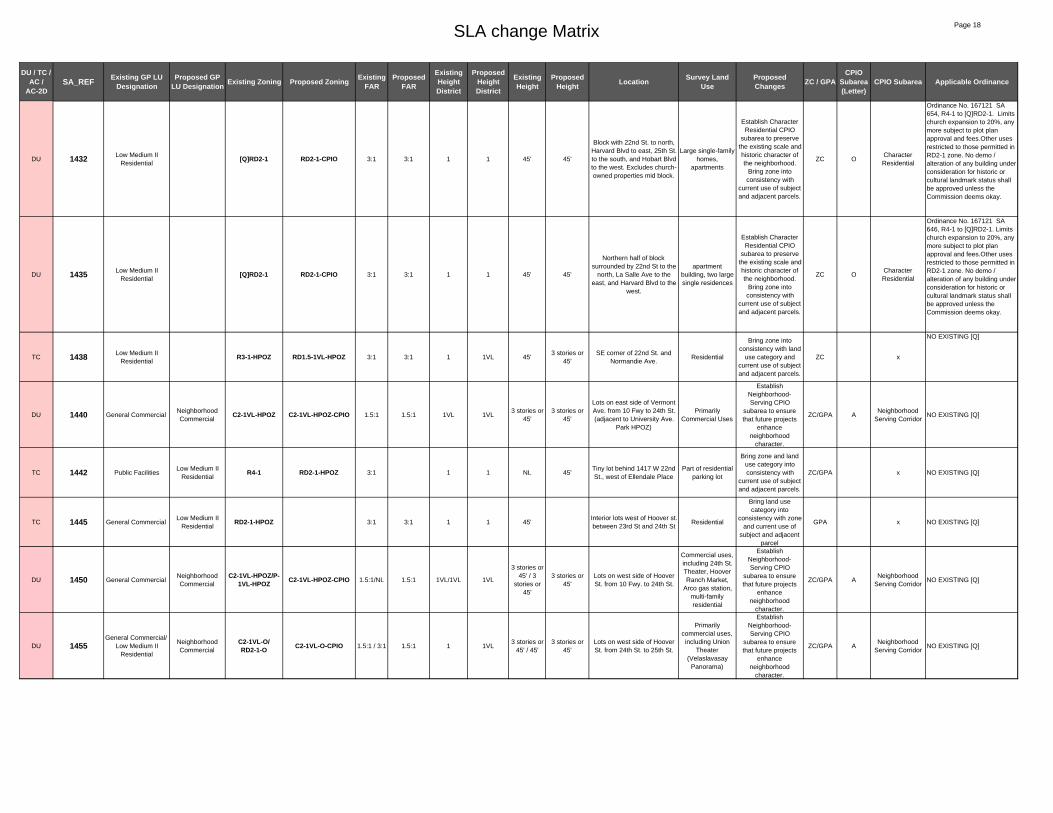
SLA change Matrix Page 18
DU / TC / AC /
AC-2DSA_REF Existing GP LU
DesignationProposed GP
LU Designation Existing Zoning Proposed Zoning Existing FAR
Proposed FAR
Existing Height District
Proposed Height District
Existing Height
Proposed Height Location Survey Land
UseProposed Changes ZC / GPA
CPIO Subarea (Letter)
CPIO Subarea Applicable Ordinance
DU 1432 Low Medium II Residential
[Q]RD2-1 RD2-1-CPIO 3:1 3:1 1 1 45' 45'
Block with 22nd St. to north, Harvard Blvd to east, 25th St. to the south, and Hobart Blvd to the west. Excludes church-owned properties mid block.
Large single-family homes,
apartments
Establish Character Residential CPIO
subarea to preserve the existing scale and historic character of the neighborhood.
Bring zone into consistency with
current use of subject and adjacent parcels.
ZC OCharacter Residential
Ordinance No. 167121 SA 654, R4-1 to [Q]RD2-1. Limits church expansion to 20%, any more subject to plot plan approval and fees.Other uses restricted to those permitted in RD2-1 zone. No demo / alteration of any building under consideration for historic or cultural landmark status shall be approved unless the Commission deems okay.
DU 1435 Low Medium II Residential
[Q]RD2-1 RD2-1-CPIO 3:1 3:1 1 1 45' 45'
Northern half of block surrounded by 22nd St to the
north, La Salle Ave to the east, and Harvard Blvd to the
west.
apartment building, two large single residences
Establish Character Residential CPIO
subarea to preserve the existing scale and historic character of the neighborhood.
Bring zone into consistency with
current use of subject and adjacent parcels.
ZC OCharacter Residential
Ordinance No. 167121 SA 646, R4-1 to [Q]RD2-1. Limits church expansion to 20%, any more subject to plot plan approval and fees.Other uses restricted to those permitted in RD2-1 zone. No demo / alteration of any building under consideration for historic or cultural landmark status shall be approved unless the Commission deems okay.
TC 1438 Low Medium II Residential
R3-1-HPOZ RD1.5-1VL-HPOZ 3:1 3:1 1 1VL 45'3 stories or
45'SE corner of 22nd St. and
Normandie Ave.Residential
Bring zone into consistency with land
use category and current use of subject and adjacent parcels.
ZC x
NO EXISTING [Q]
DU 1440 General CommercialNeighborhood Commercial
C2-1VL-HPOZ C2-1VL-HPOZ-CPIO 1.5:1 1.5:1 1VL 1VL3 stories or
45' 3 stories or
45'
Lots on east side of Vermont Ave. from 10 Fwy to 24th St. (adjacent to University Ave.
Park HPOZ)
Primarily Commercial Uses
Establish Neighborhood-Serving CPIO
subarea to ensure that future projects
enhance neighborhood
character.
ZC/GPA ANeighborhood
Serving CorridorNO EXISTING [Q]
TC 1442 Public FacilitiesLow Medium II
ResidentialR4-1 RD2-1-HPOZ 3:1 1 1 NL 45'
Tiny lot behind 1417 W 22nd St., west of Ellendale Place
Part of residential parking lot
Bring zone and land use category into consistency with
current use of subject and adjacent parcels.
ZC/GPA x NO EXISTING [Q]
TC 1445 General CommercialLow Medium II
ResidentialRD2-1-HPOZ 3:1 3:1 1 1 45'
Interior lots west of Hoover st. between 23rd St and 24th St
Residential
Bring land use category into
consistency with zone and current use of
subject and adjacent parcel
GPA x NO EXISTING [Q]
DU 1450 General CommercialNeighborhood Commercial
C2-1VL-HPOZ/P-1VL-HPOZ C2-1VL-HPOZ-CPIO 1.5:1/NL 1.5:1 1VL/1VL 1VL
3 stories or 45' / 3
stories or 45'
3 stories or 45'
Lots on west side of Hoover St. from 10 Fwy. to 24th St.
Commercial uses, including 24th St. Theater, Hoover Ranch Market,
Arco gas station, multi-family residential
Establish Neighborhood-Serving CPIO
subarea to ensure that future projects
enhance neighborhood
character.
ZC/GPA ANeighborhood
Serving CorridorNO EXISTING [Q]
DU 1455General Commercial/
Low Medium II Residential
Neighborhood Commercial
C2-1VL-O/RD2-1-O C2-1VL-O-CPIO 1.5:1 / 3:1 1.5:1 1 1VL
3 stories or 45' / 45'
3 stories or 45'
Lots on west side of Hoover St. from 24th St. to 25th St.
Primarily commercial uses, including Union
Theater (Velaslavasay
Panorama)
Establish Neighborhood-Serving CPIO
subarea to ensure that future projects
enhance neighborhood
character.
ZC/GPA ANeighborhood
Serving CorridorNO EXISTING [Q]

SLA change Matrix Page 19
DU / TC / AC /
AC-2DSA_REF Existing GP LU
DesignationProposed GP
LU Designation Existing Zoning Proposed Zoning Existing FAR
Proposed FAR
Existing Height District
Proposed Height District
Existing Height
Proposed Height Location Survey Land
UseProposed Changes ZC / GPA
CPIO Subarea (Letter)
CPIO Subarea Applicable Ordinance
AC 1460 Neighborhood Office Commercial
Neighborhood Commercial
[Q]C2-1VL-O-HPOZ/
RD2-1-O-HPOZ/ RD1.5-1-O-HPOZ/
C2-1L-O-HPOZ/C2-1-O-
HPOZ/R4-1L-O-HPOZ
C2-1VL-HPOZ-CPIO1.5:1/3:1/3:1/3:1/3:
11.5:1
1VL/1/1/1L/1/1L
1VL
3 stories or 45' / 45' /
45'/ 6 stories or
75' / NL / 6 stories or
75'
3 stories or 45'
Lots on east side of Hoover St. from 25th St. to 10 Fwy.,
including 3 blocks along Union Ave.
Commercial uses
Establish Neighborhood-Serving CPIO
subarea to ensure that future projects
enhance neighborhood
character.
ZC/GPA ANeighborhood
Serving Corridor
Ord. 173,809 SA 760, change from QCM-1 to [Q]C2-1VL, Design guidelines, max 2:1 FAR for commercial/ residential mixed-use and 1.5:1 for commercial developments. Residential uses in C2 zone max R3 density. "Q" Conditions per CPC 28302 shall be retained for existing use(s). SA 780, change from C2-1L-O to [Q]C2-1VL-O. Same conditions as above, excluding the reference to CPC 28302.
TC 1465 Neighborhood Office Commercial
Low Medium II Residential
RD1.5-1-0-HPOZ 3:1 3:1 1 1 45'Interior lot east of Union Ave on south side of 23rd St. (3rd
from corner)
single family residential
Bring land use category into
consistency with zone and current use of
subject and adjacent parcel
GPA x
NO EXISTING [Q]
AC 1480 Commercial Manufacturing
Neighborhood Commercial
[Q]C2-2-HPOZ/R3-1-HPOZ/
[Q]P-1-HPOZ/P-1-HPOZ/R4P-1/R4-1
C2-1VL-HPOZ-CPIO 6:1/3:1/3:1/3:1
1.5:1 2/1/1/1 1VLNL / 45' / NL / NL / NL / NL
3 stories or 45'
Block bounded by Washington Blvd. to north,
20th St. to south, Toberman St. to west and Oak St. to east, excluding the school.
Private school on SE corner of
Washington and Toberman St. -
HPOZ contributing feature, multi-family houses,
parking lots, food truck
parking/storage area,
commercial/office?
Establish Neighborhood-Serving CPIO
subarea to ensure that future projects
enhance neighborhood
character.
ZC/GPA ANeighborhood
Serving Corridor
[Q] 167,121 SA 547 & 551 Prohibits R4 and R5
AC 1490 Commercial Manufacturing
Neighborhood Commercial
(Q)CM-1-HPOZ/(Q)CM-2-HPOZ/
(Q)P-1-HPOZC2-1VL-HPOZ-CPIO 1.5:1/6:1/
3:11.5:1 1/2/1 1VL
NL / NL / NL / 20'
max per Q
3 stories or 45'
Midblock south side of Washington Blvd., east of Toberman St. and west of
Oak St.
Light industrial, office,? parking lot
Establish Neighborhood-Serving CPIO
subarea to ensure that future projects
enhance neighborhood
character.
ZC/GPA ANeighborhood
Serving Corridor
Ord. 152,095 change from C2-2 to (Q)CM-2, from R4P-1 to (Q)CM-1, from r4-1 to (Q) P-1, maximum 20 feet height, landscaped buffer setback of 10 feet along 20th St. except across driveway, Ord.180,218 North University Ave. Park-Exposition Park-West Adams St. Neighborhood Stabilization Overlay (NSO) District, Ord.180,103 Fast Food Interim Ordinance - prohibit the establishment of new fast food restaurants, Ord.173,160 changing zones and boundaries to (Q)CM-1-HPOZ/(Q)CM-2-HPOZ/(Q)P-1-HPOZ, Ord.171,682 and Ord. 162,128, conditional uses for alcoholic beverages.
TC 1495 Public FacilitiesFRWY/ R4-1-O/
C2-2-O PF-1-O 3:1/ 1.5:1/6:1
1.5:1 1/2 1 NL/NL/NL NLSW corner of 110 / 10
InterchangeParking, CHP
building
Bring zone into consistency with land
use category and current use of subject and adjacent parcels.
ZC x
NO EXISTING [Q]
TC 1497 Public Facilities C2-1-O PF-1-O 1.5:1 1 1 NL NLSouth side of ramp that
transitions from the 10 east to the 110 south
vacant land, parking
Bring zone into consistency with land
use category and current use of subject and adjacent parcels.
ZC x
NO EXISTING [Q]

SLA change Matrix Page 20
DU / TC / AC /
AC-2DSA_REF Existing GP LU
DesignationProposed GP
LU Designation Existing Zoning Proposed Zoning Existing FAR
Proposed FAR
Existing Height District
Proposed Height District
Existing Height
Proposed Height Location Survey Land
UseProposed Changes ZC / GPA
CPIO Subarea (Letter)
CPIO Subarea Applicable Ordinance
DU 1500General Commercial/
Commercial Manufacturing/ Low
Medium II Residential
Neighborhood Commercial
C2-1VL-O-HPOZ / [Q]C2-2-O-HPOZ/ RD1.5-1-O-HPOZ
C2-1VL-O-HPOZ-CPIO 1.5:1/ 6:1/ 3:1
1.5:1 1VL/2/1 1VL3 stories or 45'/NL / 45'
3 stories or 45'
North side of Washington Blvd., from 10 Fwy. to 110
Fwy. connection ; South side of Washington Blvd. between
Oak St. and Bonsallo Ave.
Vertigo event hall building. Some
commercial uses, vacant buildings, parking lots, US
Post Office, office building, mortuary,
SEIU office building
Establish Neighborhood-Serving CPIO
subarea to ensure that future projects
enhance neighborhood
character.
ZC/GPA ANeighborhood
Serving Corridor
[Q] 167,121 SA 525, 535 and 533 Prohibits R4 and R5
AC 1540Commercial
Manufacturing/Low Medium II
Residential
Neighborhood Commercial
[Q]C2-2-O-HPOZ/P-1-O-
HPOZ/[Q]R4-1-O-HPOZ
C2-1-O-HPOZ-CPIO 6:1/3:1/3:1/1.5:1
1.5:1 2/1/1 1 NL/45' NLSouth east corner
Washington Blvd. and Bonsallo Ave.
Vacant, church, institutional
Establish Neighborhood-Serving CPIO
subarea to ensure that future projects
enhance neighborhood
character.
ZC/GPA ANeighborhood
Serving Corridor
[Q] 167,121 SA 515 Prohibits R4 and R5[Q] 167,121 SA 516 Limits expansion of church and limits density to R1.5-1
TC 1550 Commercial Manufacturing
Public Facilities R3-1 PF-1 3:1 1.5:1 1 1 45' NLSouth east corner 17th St.
and Georgia St.LAUSD college ready academy
Bring zone and land use category into consistency with
current use of subject and adjacent parcels.
ZC/GPA x
NO EXISTING [Q]
TC 1560 Low Medium II Residential
Low II Residential [Q]R4-1-O-HPOZ R1-1-O-HPOZ 3:1 3:1 1 1 33' 33'North side of 25th St. from
Cimarron St. to Gramercy Pl. Residential
(ZIMAS)
Bring zone and land use category into consistency with
current use of subject and adjacent parcels.
ZC/GPA x
167,121 SA 698. LIMITS CHURCH EXPANSION TO 20% AND LIMITS DENSITY TO R1-1-O
TC 1561 Low Residential Open Space R1-1-O-HPOZ OS-1XL 3:1 1.5:1 1 1XL 33' NLIsland on Gramercy Park, east of Gramercy Place
Gramercy park
Bring zone and land use category into consistency with
current use of subject and adjacent parcels.
ZC/GPA x
NO EXISTING [Q]
TC 1562 Medium ResidentialHigh Medium Residential
R1-1-O-HPOZ R4-1-O-HPOZ 3:1 3:1 1 1 33' NL4 lots on west side of St
Andrews Place between 24th St. and Adams Blvd.
Multi-family residential, owner listed on ZIMAS as
LOS ANGELES LOMOD SOUTH
INC C/O C/O HOUSING
AUTHORITY L A CITY
Bring zone and land use category into consistency with
current use of subject and adjacent parcels.
ZC/GPA x
NO EXISTING [Q]
TC 1565 Medium Residential R1-1-O-HPOZ R3-1-O-HPOZ 3:1 3:1 1 1 33' 45'4 lots on east side of St
Andrews Place between 24th St. and Adams Blvd.
St. John of God Retirement and
Care Center
Bring zone into consistency with land
use category and current use of subject and adjacent parcels.
ZC x
NO EXISTING [Q]
AC 1570
High Medium Residential/
Medium Residential/Community Commercial
Neighborhood Commercial
[Q]C2-1-O-HPOZ/C2-1-O-HPOZ/
R4-1-O-HPOZ/R1-1-O-HPOZ
C2-1-O-HPOZ-CPIO 1.5:1/1.5:1/3:1/3:1
1.5:1 1 1VLNL / NL / NL / 33'
3 stories or 45'
Lots on north west corner of Western Ave. and Adams St. bounded by St. Andrews Pl.
and 25th St.
Senior residential home ,
convalescent home
Establish Neighborhood-Serving CPIO
subarea to ensure that future projects
enhance neighborhood
character.
ZC/GPA ANeighborhood
Serving Corridor
173,809 SA 690 Multi family residential developments must obtain plan approval to ensure conformity with the multi family residential development design guidelines. The FAR shall be no more than 2:1 for commercial/residential mixed use developments and 1.5:1 for commercial developments. Commercial developments and commercial/residential mixed use developments must obtain plan approval to ensure conformity with the commercial development design guidelines. Residential Uses in the C2 zone shall be restricted t a maximum density allow in the R3 zone.

SLA change Matrix Page 21
DU / TC / AC /
AC-2DSA_REF Existing GP LU
DesignationProposed GP
LU Designation Existing Zoning Proposed Zoning Existing FAR
Proposed FAR
Existing Height District
Proposed Height District
Existing Height
Proposed Height Location Survey Land
UseProposed Changes ZC / GPA
CPIO Subarea (Letter)
CPIO Subarea Applicable Ordinance
DU 1575General Commercial/
Low medium II Residential
Neighborhood Commercial
C2-1VL-HPOZ/RD2-1-HPOZ C2-1VL-HPOZ-CPIO 1.5:1/3:1 1.5:1 1VL/1 1VL
3 stories or 45' / 45'
3 stories or 45'
Lots on west side of Vermont Ave. from 10 Fwy. to Adams
St. HPOZ
Primarily commercial uses
Establish Neighborhood-Serving CPIO
subarea to ensure that future projects
enhance neighborhood
character.
ZC/GPA ANeighborhood
Serving Corridor
No existing [Q]
TC 1580 Low Medium II Residential
[Q]R4-1-HPOZ RD2-1-HPOZ 3:1 3:1 1 1 45' 45'
North side of 24th St. just east of Vermont Ave. to Ellendale Pl. excluding church-owned
parcels.
Residential, excluded church-
owned parcels
Bring zone into consistency with land
use category and current use of subject and adjacent parcels.
ZC x
[Q] limits expansion of church and limits density to RD2-1 (REF. SA 772 OF ORD 167,121)
TC 1590 Low Medium II Residential
[Q]R4-1-HPOZ RD2-1-HPOZ 3:1 3:1 1 1 45' 45'North side of 24th St.
between Ellendale Pl. and Magnolia Ave.
Residential (3,3,1,3)
Bring zone into consistency with land
use category and current use of subject and adjacent parcels.
ZC x
[Q] limits expansion of church and limits density to RD2-1 (REF. SA 776 OF ORD 167,121)
TC 1610 Public FacilitiesR4-1-O/C2-1-O PF-1 3:1 1.5:1 1 1 NL / NL NL
Long lot west of 110 Fwy. From Washington Blvd. to
21st St.Undeveloped
Bring zone into consistency with land
use category and current use of subject and adjacent parcels.
ZC x
NO EXISTING [Q]
DU 1620 Commercial Manufacturing
Hybrid Industrial CM-2-O CM-2-O-CPIO 6:1 6:1 2 2 NL NL
Block bounded by 18th St, Figueroa, Washington Blvd,
and Georgia St. Also includes NW corner of 18th
St and Figueroa.
Auto dealership, parking lot for
adjacent dealership
Establish Hybrid Industrial CPIO
subarea to addresss land use conflicts
between residential and industrial uses.
ZC/GPA I Hybrid Limited
No existing [Q]
AC 1622 Commercial Manufacturing
Hybrid Industrial [Q]R4-1/CM-1 CM-2-CPIO 3:1/5:1 6:1 1 2 45' / NL NL
Portion of block bounded by 17th St to the north, Figueroa
to the east, 18th St to the south, and Georgia St to the west. Does not include NW corner, SE corner, or chuch
property at SW corner
auto dealership, parking lot, two
multi-family residential buildings
Establish Hybrid Limited CPIO subarea to addresss land use
conflicts between residential and industrial uses.
ZC/GPA I Hybrid Limited
[Q] 167,121 SA 502. LIMITS CHURCH EXPANSION TO 20% AND LIMITS DENSITY TO RD3-1
TC 1624 Public FacilitiesM1-1-O/ M2-2-O/ R4-1-O/ C2-1-O PF-1-O
1.5:1/ 1.5:1/ 3:1/
1.5:11.5:1 1/2/1/1 1
NL / NL / NL / NL
NLFreeway buffer, SE corner of
110/10 interchangeFreeway buffer
Bring zone into consistency with land
use category and current use of subject and adjacent parcels.
ZC x
NO EXISTING [Q]
TC 1625Commercial
Manufacturing/Open Space
Hybrid IndustrialC2-1-O/ CM-1-O/
P-2-O CM-1-O 3:1/1.5:1/3:1
1.5:1 1/1/2 1NL / NL /
NLNL
Lot at south west corner of Georgia St. and 18th St.
Light manufacturing
Bring zone and land use category into consistency with
current use of subject and adjacent parcels.
ZC/GPA x NO EXISTING [Q]
TC 1630 Low Residential Low II Residential [Q]R4-1-O-HPOZ R1-1-O-HPOZ 3:1 3:1 1 1 33' 33'
Midblock south side of 25th St. from just west of Arlington Ave. to Cimarron St. (church-
owned parcels on eastern end excluded)
Mostly residential, excludes church-owned properties
Bring zone and land use category into consistency with
current use of subject and adjacent parcels.
ZC/GPA x
167,121 SA 688. LIMITS CHURCH EXPANSION TO 20% AND LIMITS DENSITY TO R1-1-O
AC 1640
Community Commercial/
General Commercial/ Low Medium II
Residential
Neighborhood Commercial
C2-1/C1-1VL / RD2-1 C2-1VL-CPIO 1.5:1/1.5:
1/ 3:11.5:1 1/1VL/1 1VL
NL / 3 stories or 45' /45'
3 stories or 45'
North side of Adams Blvd. from Hobart Blvd. to
Normandie Ave., Three lots at SW corner of Normandie
Ave. and 25th St.
Primarily commercial uses,
parking
Establish Neighborhood-Serving CPIO
subarea to ensure that future projects
enhance neighborhood
character.
ZC/GPA ANeighborhood
Serving Corridor
NO EXISTING [Q]

SLA change Matrix Page 22
DU / TC / AC /
AC-2DSA_REF Existing GP LU
DesignationProposed GP
LU Designation Existing Zoning Proposed Zoning Existing FAR
Proposed FAR
Existing Height District
Proposed Height District
Existing Height
Proposed Height Location Survey Land
UseProposed Changes ZC / GPA
CPIO Subarea (Letter)
CPIO Subarea Applicable Ordinance
AC 1650 General CommercialNeighborhood Commercial
C1-1VL-HPOZ C2-1VL-HPOZ-CPIO 1.5:1 1.5:1 1VL 1VL3 stories or
45'3 stories or
45'
North east corner of Normandie Ave. and Adams
Blvd. Smog test center
Establish Neighborhood-Serving CPIO
subarea to ensure that future projects
enhance neighborhood
character.
ZC/GPA ANeighborhood
Serving Corridor
ord. 173,809 SA 710 - [Q]R4-1-0 to [Q]C2-1VL-O, Maximum of 2:1 FAR for Mixed use projects: Max. 1.5:1 for commercial only. Residential uses restricted to max R3. Design Guidelines requirement for multi family residential developments. Ord.167,121 SA 728 ( C2-1 to [Q]R4-1-0 LIMITS CHURCH EXPANSION AND LIMITS DENSITY TO RD 1.5-1 ), 727, 736, 738,744 - Ordinance 180,218 , Ordinance 173,402, ord.171,682, Ord. 162,128
DU 1652 General CommercialNeighborhood Commercial
[Q]C2-1VL-O-HPOZ C2-1VL-O-HPOZ-CPIO 1.5:1 1.5:1 1VL 1VL
3 stories or 45'
3 stories or 45'
Northern side of Adams Blvd. from just west of Normandie
Ave. to Raymond Ave.
Primarily low scale residential, church
Establish Neighborhood-Serving CPIO
subarea to ensure that future projects
enhance neighborhood
character.
ZC/GPA ANeighborhood
Serving Corridor
Ord. 173,809 SA 710: Multi-family development must conform to Multi-Family Design Guidelines; Max 2:1 FAR for commercial-residential mixed use and 1.5:1 for commercial uses; Residential uses in C2 zone restricted to max R3 density.
AC 1654Neighborhood Office Commercial/ General
Commercial
Neighborhood Commercial
C1-1L-HPOZ/C1-1VL-HPOZ C2-1VL-HPOZ-CPIO 3:1/ 1.5:1 1.5:1 1L/1VL 1VL
6 stories or 75' / 3
stories or 45'
3 stories or 45'
Northern side of Adams Blvd. from Raymond Ave. to
Catalina St.
3 story residential multi family, low scale residential, laundromat, auto
repair
Establish Neighborhood-Serving CPIO
subarea to ensure that future projects
enhance neighborhood
character.
ZC/GPA ANeighborhood
Serving CorridorNO EXISTING [Q]
TC 1660 Low Medium I Residential
[Q]R4-1-HPOZ R2-1-HPOZ 3:1 3:1 1 1 33' 33'
South side of 25th St. between Catalina St. and just
west of Vermont Ave. Excludes church-owned
properties.
Multi-family residential,
excluding church-owned properties
Bring zone into consistency with land
use category and current use of subject and adjacent parcels.
ZC x
[Q] limits expansion of church and limits density to R2-1 (REF. SA 748 OF ORD 167,121). MW matrix notes: ref code changed from DU to AC; proposed land use updated from Medium Residential to Low Medium I.
AC-2D 1670 Neighborhood Office Commercial
Community Commercial
[Q]C2-1VL-HPOZ C2-2D-HPOZ-CPIO 1.5:1/1.5:1
3:1 1VL 2D3 stories or
45'6 stories
North west corner of Vermont Ave. and Adams Blvd. up to
25th St. and Catalina St.
Primarily commercial uses
Enable specialized transit oriented development
parameters for commercial
properties in close proximity to light rail
stations and intersections of major
bus lines.
ZC/GPA F TOD Medium
Ord.167,121, SA 610, SA 606, SA 758, SA 760 : CM-1 to C2-1-VL, SA 746 limits expansion of church, Ord.180,218 North University Ave. Park-ExpositionPark-West Adams St. Neighborhood Stabilization Overlay (NSO) District, Ord.180,103 Fast Food Interim Ordinance - prohibit the establishment of new fast food restaurants, Ordinance 173,402 change to C2-1VL-HPOZ/[Q]C2-1VL-HPOZ, Ord.171,682 and Ord. 162,128, conditional uses for alcoholic beverages.
DU 1675 General CommercialNeighborhood Commercial
C2-1VL C2-1VL-CPIO 1.5:1 1.5:1 1VL 1VL3 stories or
45' 3 stories or
45'
Lots on east side of Vermont Ave. from 24th St. to 25th St. (adjacent to University Ave.
Park HPOZ)
Primarily Commercial Uses
Establish Neighborhood-Serving CPIO
subarea to ensure that future projects
enhance neighborhood
character.
ZC/GPA ANeighborhood
Serving CorridorNO EXISTING [Q]

SLA change Matrix Page 23
DU / TC / AC /
AC-2DSA_REF Existing GP LU
DesignationProposed GP
LU Designation Existing Zoning Proposed Zoning Existing FAR
Proposed FAR
Existing Height District
Proposed Height District
Existing Height
Proposed Height Location Survey Land
UseProposed Changes ZC / GPA
CPIO Subarea (Letter)
CPIO Subarea Applicable Ordinance
DU 1680 Low Medium II Residential
[Q]R4-1 RD2-1-CPIO 3:1 3:1 1 1 45' 45'
South side of 24th St. from just east of Vermont Ave. to
Ellendale Pl. excluding church-owned parcels.
Residential (3). Includes
contributors to University Park
Extension Historic Distric, identified
by SurveyLA. (Excludes
Estonian House church properties at 1306, 1312 and 1316 W. 24th St)
Establish Character Residential CPIO
subarea to preserve the existing scale and historic character of the neighborhood.
Bring zone into consistency with
current use of subject and adjacent parcels.
ZC OCharacter Residential
[Q] limits expansion of church and limits density to RD2-1 (REF. SA 766 OF ORD 167,121)
DU 1685 Low Medium II Residential
[Q]R4-1 [Q]R4-1-CPIO 3:1 3:1 1 1 45' 45'
3 parcels near SW corner of 24th St and Ellendale Place:
1306, 1312 and 1316 W. 24th St
Estonian House church
Establish Character Residential CPIO
subarea to preserve the existing scale and historic character of the neighborhood.
ZC OCharacter Residential
[Q] limits expansion of church and limits density to RD2-1 (REF. SA 766 OF ORD 167,121)
DU 1688 Low Medium II Residential
RD2-1 RD2-1-CPIO 3:1 3:1 1 1 45' 45'South side of 24th Street between Ellendale Pl and
Magnolia Ave
Residential. Includes
contributors to University Park
Extension Historic Distric, identified
by SurveyLA.
Establish Character Residential CPIO
subarea to preserve the existing scale and historic character of the neighborhood.
ZC OCharacter Residential
NO EXISTING [Q]
AC-2D 1690Neighborhood Office
Commercial/Community Commercial
Community Commercial
[Q]C2-1VL/ C2-1 / R4-1 C2-2D-CPIO 1.5:1/1.5:
1/3:13:1 1VL/1/1 2D
3 stories or 45' / NL /
NL6 stories
North east corner of Vermont Ave. and Adams St.
Fast food restaurant and
parking lot
Enable specialized transit oriented development
parameters for commercial
properties in close proximity to light rail
stations and intersections of major
bus lines.
ZC/GPA F TOD Medium
Ord. 173,809 SA 720 change to [Q]C2-1VL, The FAR shall be no more than 2:1 for commercial/residential mixed use developments and 1.5:1 for commercial developments. Commercial developments and commercial/residential mixed use developments must obtain plan approval to ensure conformity with the commercial development design guidelines. Multi-family residential developments mustobtain plan approval to ensure conformity with the multi-family residential development design guidelines. Residential uses restricted to R3 maximum density, Ord.180,218 North University Ave. Park-Exposition Park-West Adams St. Neighborhood Stabilization Overlay (NSO) District, Ord.180,103 Fast Food Interim Ordinance - prohibit the establishment of new fast food restaurants, Ord.171,682 and Ord. 162,128, conditional uses for alcoholic beverages.
DU 1692 Low Medium II Residential
RD1.5-1 RD1.5-1-CPIO 3:1 3:1 1 1 45' 45'
North side of Adams Blvd and south side of 25th St. from
mid-block on west to Magnolia on east; north side
of 25th from Vermont to Magnolia (excluding lots
fronting Vermont).
Mostly multi-family and some single family residential;
many are contributors to University Park
Extension Historic District identified
by SurveyLA, and two church parking
lots.
Establish Character Residential CPIO
subarea to preserve the existing scale and historic character of the neighborhood.
ZC OCharacter Residential
NO EXISTING [Q]

SLA change Matrix Page 24
DU / TC / AC /
AC-2DSA_REF Existing GP LU
DesignationProposed GP
LU Designation Existing Zoning Proposed Zoning Existing FAR
Proposed FAR
Existing Height District
Proposed Height District
Existing Height
Proposed Height Location Survey Land
UseProposed Changes ZC / GPA
CPIO Subarea (Letter)
CPIO Subarea Applicable Ordinance
DU 1696 Low Medium II Residential
RD2-1-O RD2-1-O-CPIO 3:1 3:1 1 1 45' 45'NE corner of Magnolia Ave
and 24th St. (10 blocks fronting 24th)
Residential, including some contributors to University Park
Extension Historic District identified
by SurveyLA
Establish Character Residential CPIO
subarea to preserve the existing scale and historic character of the neighborhood.
ZC OCharacter Residential
NO EXISTING [Q]
DU 1698 Low Medium II Residential
[Q]R4-1-O [Q]R4-1-O-CPIO 3:1 3:1 1 1 45' 45'NE corner of Magnolia Ave. and 25th St. (3 lots fronting
25th;
Church on 3 lots; contributor to
University Park Extension Historic District identified
by SurveyLA
Establish Character Residential CPIO
subarea to preserve the existing scale and historic character of the neighborhood.
ZC OCharacter Residential
[Q] limits expansion of church and limits density to RD1.5-1-O (REF. SA 804 OF ORD 167,121)
DU 1700 Low Medium II Residential
[Q]R4-1-O RD2-1-O-CPIO 3:1 3:1 1 1 45' 45'
25th St. (north side) between Magnolia Ave. & Hoover St.
Excludes church-owned parcels.
Primarily residential,; 2 are
contributors to University Park
Extension Historic District identified
by SurveyLA. excludes religious institution located
at 1189, 1183, 1177 25th St.
Establish Character Residential CPIO
subarea to preserve the existing scale and historic character of the neighborhood.
Bring zone into consistency with
current use of subject and adjacent parcels.
ZC OCharacter Residential
[Q] limits expansion of church and limits density to R1.5-1-O (REF. SA 804 OF ORD 167,121)
DU 1705 Low Medium II Residential
RD1.5-1-O RD1.5-1-O-CPIO 3:1 3:1 1 1 45' 45'SE corner of 25th St. and
Magnolia Ave. (9 lots fronting 25th St.)
Residential; 6 are contributors to University Park
Extension Historic District identified
by SurveyLA)
Establish Character Residential CPIO
subarea to preserve the existing scale and historic character of the neighborhood.
ZC OCharacter Residential
NO EXISTING [Q]
DU 1708 General CommercialLow Medium II
Residential[Q]C2-1VL-O RD1.5-1-O-CPIO 1.5:1 3:1 1VL 1
3 stories or 45'
45' 1128 W 25th St
Residential home; contributor to
University Park Extension Historic District (identified
by SurveyLA)
Establish Character Residential CPIO
subarea to preserve the existing scale and historic character of the neighborhood.
Bring zone and land use category into consistency with
current use of subject and adjacent parcels.
ZC/GPA OCharacter Residential
Ord.167,121 SA 790 change R4-1-O to RD1.5-1-O and C2-1-O to RD1.5-1-O, SA 792 change C2-1-O to C2-1-VL-O , SA 872 change C2-1-O, C4-1-O and (Q)C1.5-1-O to HD 1-VL-O , Ordinance 180,218 , Ord.171,682, Ord. 162,128, conditional uses for alcoholic beverages
AC 1710
General Commercial/ Low Medium II
Residential/ Commercial
Manufacturing
Neighborhood Commercial
C2-1VL-O/[Q]C2-1VL-O/
(Q)C1.5-1VL-O/C4-1VL-O/
RD1.5-1-O
C2-1VL-O-CPIO1.5:1/1.5:1/1.5:1/1.
5:1/3:11.5:1
1VL/1VL/1VL/1VL/1
1VL
3 stories or 45' / 3
stories or 45' / 3
stories or 45' / 3
stories or 45' / 45'
3 stories or 45'
NW corner of Hoover St. and Adams St. Excludes
residential along 25th St.Commercial uses
Establish Neighborhood-Serving CPIO
subarea to ensure that future projects
enhance neighborhood
character.
ZC/GPA ANeighborhood
Serving Corridor
Ord.167,121 SA 790 change R4-1-O to RD1.5-1-O and C2-1-O to RD1.5-1-O, SA 792 change C2-1-O to C2-1-VL-O , SA 872 change C2-1-O, C4-1-O and (Q)C1.5-1-O to HD 1-VL-O , Ordinance 180,218 , Ord.171,682, Ord. 162,128, conditional uses for alcoholic beverages
TC 1725 Low Medium II Residential
[Q]R4-1-O-HPOZ RD1.5-1-O-HPOZ 3:1 3:1 1 1 45' 45'
parcels between Estrella Ave, 23rd St, and the 110
Freeway. Excludes many church-owned parcels.
Los Angeles Neighborhood
Land park, some residential.
Excludes church-owned parcels.
Bring zone into consistency with land
use category and current use of subject and adjacent parcels.
ZC xORD-167121-SA516 - Regulates church use, limits other uses to RD1.5-1
TC 1727 Public FacilitiesC2-1-O / R4-1-O /
M1-1-O PF-1-O 1.5:1/ 3:1/ 1.5:1
1.5:1 1/1/1 1NL / NL /
NLNL
East and west sides of 110 Frwy from Figueroa to 21st
St, east side of 110 Fwy from 21st St. to Washington Blvd
Freeway buffer
Bring zone into consistency with land
use category and current use of subject and adjacent parcels.
ZC x NO EXISTING [Q]
AC-2D 1730 Limited Manufacturing
Community Commercial
M1-1-O/M1-2-O C2-2D-CPIO 1.5:1/6:1 6:1 1/2 2D NL / NL NL
SW corner of of Washington Blvd. and Figueroa St. lots
fronting Washington Blvd. on south side from Freeway. to
Figueroa St.
Auto related establishments
Enable specialized transit oriented development
parameters for commercial
properties in close proximity to light rail
stations and intersections of major
bus lines.
ZC/GPA H TOD Regional NO EXISTING [Q]

SLA change Matrix Page 25
DU / TC / AC /
AC-2DSA_REF Existing GP LU
DesignationProposed GP
LU Designation Existing Zoning Proposed Zoning Existing FAR
Proposed FAR
Existing Height District
Proposed Height District
Existing Height
Proposed Height Location Survey Land
UseProposed Changes ZC / GPA
CPIO Subarea (Letter)
CPIO Subarea Applicable Ordinance
TC 1740 Medium Residential [Q]R4-1-O R3-1-O 3:1 3:1 1 1 45' 45'
Part of block bounded by Manhattan Pl. to Cimarron St. (East to West) Adams St. to
27th (North to South) 43 parcels excluding SE corner Adams St. & Cimarron St.
from corner east 7 parcels)
Multiple family residential
Bring zone into consistency with land
use category and current use of subject and adjacent parcels.
ZC x
167,121 SA 926 & 927. LIMITS CHURCH EXPANSION TO 20% AND LIMITS DENSITY TO R3-1-O
DU 1750Community
Commercial/High Medium Residential
Neighborhood Commercial
C2-1-O-HPOZ C2-1-O-HPOZ-CPIO 1.5:1 1.5:1 1 1 NL NLNorthwest corner of Adams
St./Western Ave. from Western Ave. to 29th St.
Strip mall, 100 + mixed use building
Establish Neighborhood-Serving CPIO
subarea to ensure that future projects
enhance neighborhood
character.
ZC/GPA ANeighborhood
Serving Corridor
NO EXISTING [Q]
AC-2D 1760Community
Commercial/General Commercial
Community Commercial
C2-1-O/C1-1VL-O C2-2D-O-CPIO 1.5:1/1.5:
13:1 1/1VL 2D
NL / 3 stories or
45'6 stories
SE corner of Adams St. and Western Ave.
5 story office, parking lot
Enable specialized transit oriented development
parameters for commercial
properties in close proximity to light rail
stations and intersections of major
bus lines.
ZC/GPA F TOD Medium
NO EXISTING [Q]
AC 1770General Commercial/
Low Medium II Residential
Neighborhood Commercial
C1-1VL-O/R3-1VL-O/ RD1.5-
1-OC2-1VL-O-CPIO 1.5:1/3:1/
3:11.5:1 1VL/1VL/1 1VL
3 stories or 45' / 45'/45'
3 stories or 45'
South side of Adams St., from Hobart Blvd. to Normandie
Ave.; Lots immediately behind boulevard-facing lots on
south side of Adams from Harvard Blvd to midblock
between La Salle and Dalton; Internal lot near SE corner of
La Salle Ave. and Adams Blvd.
Primarily commercial uses,
Greater Page Temple, parking lots, multi-family
residential building
Establish Neighborhood-Serving CPIO
subarea to ensure that future projects
enhance neighborhood
character.
ZC/GPA ANeighborhood
Serving Corridor
NO EXISTING [Q]
DU 1779 General CommercialLow Medium II
ResidentialRD1.5-1-O RD1.5-1-O-CPIO 3:1 3:1 1 1 45' 45' 2617 S. Dalton Ave. single residence
Establish Character Residential CPIO
subarea to preserve the existing scale and historic character of the neighborhood.
Bring land use category into
consistency with current use of subject and adjacent parcels.
ZC/GPA OCharacter Residential
NO EXISTING [Q]
AC 1780
General Commercial/Neighborhood Office
Commercial/Low Medium II
Residential
Neighborhood Commercial
C2-1VL-O-HPOZ/C1-1VL-O-HPOZ/C1-1L-O-HPOZ/[Q]C2-1VL-O-
HPOZ/RD1.5-1-O-HPOZ
C2-1VL-O-HPOZ-CPIO1.5:1/1.5:1/1.5:1/1.
5:1/3:11.5:1
1VL/1VL/1L/1VL/1
1VL
3 stories or 45' / 3
stories or 45' / 3
stories or 45' / 3
stories or 45' / 45'
3 stories or 45'
South side of Adams St., from Normandie Ave. to
Catalina St.
Primarily commercial uses, some residential
and church
Establish Neighborhood-Serving CPIO
subarea to ensure that future projects
enhance neighborhood
character.
ZC/GPA ANeighborhood
Serving Corridor
Ord. 167,121 SA 898, 896 - change C2-1-0 to [Q] C2-1-VL-0, LIMITS CHURCH EXPANSION AND LIMITS DENSITY TO C1-1-VL , 894, 892, 890, 900, 902 - C2-1-0 to C2-1-VL-0, Ord.180,218, Ord.180,103 Fast Food Interim Ordinance - prohibit the establishment of new fast food restaurants, Ord. 173,402, Ord.171,682, Ord. 162,128

SLA change Matrix Page 26
DU / TC / AC /
AC-2DSA_REF Existing GP LU
DesignationProposed GP
LU Designation Existing Zoning Proposed Zoning Existing FAR
Proposed FAR
Existing Height District
Proposed Height District
Existing Height
Proposed Height Location Survey Land
UseProposed Changes ZC / GPA
CPIO Subarea (Letter)
CPIO Subarea Applicable Ordinance
DU 1785 Neighborhood Office Commercial
Neighborhood Commercial
[Q]C2-1VL-O-HPOZ C2-1VL-O-HPOZ-CPIO 1.5:1 1.5:1 1VL 1VL
3 stories or 45'
3 stories or 45'
SE corner Adams Blvd. and Catalina St., Lots on SW corner of Adams St. and
Vermont Ave., including lots facing Adams St. from
Catalina St. to Vermont Ave., and lots facing Vermont Ave. from Adams St. to Dana St.
Used auto sales, two story multi
family apartment building, St. Agnus church and school
property
Establish Neighborhood-Serving CPIO
subarea to ensure that future projects
enhance neighborhood
character.
ZC/GPA ANeighborhood
Serving Corridor
Ord. 173,809 SA 720 change to [Q]C2-1VL-O, The FAR shall be no more than 2:1 for commercial/residential mixed use developments and 1.5:1 for commercial developments. Commercial developments and commercial/residential mixed use developments must obtain plan approval to ensure conformity with the commercial development design guidelines. Multi-family residential developments mustobtain plan approval to ensure conformity with the multi-family residential development design guidelines. Residential uses restricted to R3 maximum density, Ordinance 173,402 change to C2-1-0-HPOZ, Ord.180,103 Fast Food Interim Ordinance - prohibit the establishment of new fast food restaurants, Ord.171,682 and Ord. 162,128, conditional uses for alcoholic beverages.
AC-2D 1800 Neighborhood Office Commercial
Community Commercial
[Q]C2-1VL-O C2-2D-O-CPIO 1.5:1 3:1 1VL 2D3 stories or
45'6 stories
SE corner of Adams St. and Vermont Ave., lots fronting Vermont Ave. on east side
from Adams St. to mid block
Ralphs supermarket and other commercial
uses
Enable specialized transit oriented development
parameters for commercial
properties in close proximity to light rail
stations and intersections of major
bus lines.
ZC/GPA F TOD Medium
Ord. 173,809 SA 720 change to [Q]C2-1VL-O, The FAR shall be no more than 2:1 for commercial/residential mixed use developments and 1.5:1 for commercial developments. Commercial developments and commercial/residential mixed use developments must obtain plan approval to ensure conformity with the commercial development design guidelines. Multi-family residential developments mustobtain plan approval to ensure conformity with the multi-family residential development design guidelines. Residential uses restricted to R3 maximum density, Ord.180,218 North University Ave. Park-Exposition Park-West Adams St. Neighborhood Stabilization Overlay (NSO) District, Ord.180,103 Fast Food Interim Ordinance - prohibit the establishment of new fast food restaurants, Ord.171,682 and Ord. 162,128, conditional uses for alcoholic beverages.

SLA change Matrix Page 27
DU / TC / AC /
AC-2DSA_REF Existing GP LU
DesignationProposed GP
LU Designation Existing Zoning Proposed Zoning Existing FAR
Proposed FAR
Existing Height District
Proposed Height District
Existing Height
Proposed Height Location Survey Land
UseProposed Changes ZC / GPA
CPIO Subarea (Letter)
CPIO Subarea Applicable Ordinance
AC-2D 1810 Community Commercial
[T][Q]C2-1L-O/R4-1L-O/[Q]C2-1-O C2-2D-O-CPIO 1.5:1 /
3:1/ 1.5:13:1 1L/1L/1 2D
6 stories or 75' / 6
stories or 75'/NL
6 storiesSW Adams St. and Menlo
Ave.
Ralphs supermarket parking lot,
supermarket, and other commercial
uses
Enable specialized transit oriented development
parameters for commercial
properties in close proximity to light rail
stations and intersections of major
bus lines.
ZC/GPA F TOD Medium
Ord. 173,809 SA 720 change to [Q]C2-1VL-O, The FAR shall be no more than 2:1 for commercial/residential mixed use developments and 1.5:1 for commercial developments. Commercial developments and commercial/residential mixed use developments must obtain plan approval to ensure conformity with the commercial development design guidelines. Multi-family residential developments mustobtain plan approval to ensure conformity with the multi-family residential development design guidelines. Residential uses restricted to R3 maximum density, Ord. 158,193 change to R4-1-L-O, Ord. 164,849 change to (T)(Q)C2 -1L-O, Design Standards Requirements, .Ord. 158,193 change to R4-1-L-O, Ord. 164,849 change to (T)(Q)C2 -1-O, Design Standards Requirements, Ord.180,218 North University Ave. Park-Exposition Park-West Adams St. Neighborhood Stabilization Overlay (NSO) District, Ord.171,682 and Ord. 162,128, conditional uses for
TC 1815 Medium Residential R4-1L-O R3-1-O 3:1 3:1 1L 16 stories or
75 ft.45'
Sliver near SW corner of Adams Blvd and Ellendale
Place
Part of driveway for apt. building to
south
Bring zone into consistency with land
use category and current use of subject and adjacent parcels.
ZC x
NO EXISTING [Q]
TC 1820 Medium Residential [Q]R4-1-O-HPOZ R3-1-O-HPOZ 3:1 3:1 1 1 45' 45'
Part of block bounded by Manhattan Pl. to Cimarron St. (East to West) Adams St. to
27th (North to South) 43 parcels excluding SE corner Adams St. & Cimarron St.
from corner east 7 parcels)
Single family residential
Bring zone into consistency with land
use category and current use of subject and adjacent parcels.
ZC x
167,121 SA 926 & 927. LIMITS CHURCH EXPANSION TO 20% AND LIMITS DENSITY TO R3-1-O
TC 1825 Medium Residential [Q]R4-1-O-HPOZ R3-1-O-HPOZ 3:1 3:1 1 1 45' 45'
Parcel located on south side of Adams Blvd at Gramercy
Place. Does not include church-owned property.
Aids Healthcare Foundation facility
(closed?)
Bring zone into consistency with land
use category and current use of subject and adjacent parcels.
ZC x
ORD-167121-SA927 - limits expansion of church to 20%; Corresponding zone listed as R3-1-O.
AC-2D 1830 Community Commercial
Community Commercial
C2-1-O C2-2D-O-CPIO 1.5:1 3:1 1VL 2D NL 6 storiesWestern Ave., east side from
29th St. to 30th St.
Parking lot at (NW corner), 2
churches and 2 undeveloped lots
Enable specialized transit oriented development
parameters for commercial
properties in close proximity to light rail
stations and intersections of major
bus lines.
ZC/GPA F TOD Medium NO EXISTING [Q]
DU 1832 Low Medium II Residential
RD1.5-1-O RD1.5-1-O-CPIO 3:1 3:1 1 1 45' 45'
West and east sides of Hobart Blvd and Harvard
Blvd, and west side of LaSalle Ave. 27th St. to Adams Blvd. Does not inlude lots fronting Adams or two northernmost
internal lots between Harvard and LaSalle.
Mix of single family homes, apartment
buildings, and parking / vacant
lots
Establish Character Residential CPIO
subarea to preserve the existing scale and historic character of the neighborhood.
ZC OCharacter Residential
NO EXISTING [Q]
DU 1834 Low Medium II Residential
RD1.5-1-O RD1.5-1-O-CPIO 3:1 3:1 1 1 45' 45'
Blocks between La Salle Ave. and Normandie Ave, between Adams and 27th St. Does not include lots fronting Adams or
certain lots adjacent to commercial.
Apartments and some single family
homes
Establish Character Residential CPIO
subarea to preserve the existing scale and historic character of the neighborhood.
ZC OCharacter Residential
NO EXISTING [Q]

SLA change Matrix Page 28
DU / TC / AC /
AC-2DSA_REF Existing GP LU
DesignationProposed GP
LU Designation Existing Zoning Proposed Zoning Existing FAR
Proposed FAR
Existing Height District
Proposed Height District
Existing Height
Proposed Height Location Survey Land
UseProposed Changes ZC / GPA
CPIO Subarea (Letter)
CPIO Subarea Applicable Ordinance
DU 1836 General CommercialMedium
ResidentialR3-1VL-O R3-1VL-O-CPIO 3:1 3:1 1VL 1VL
3 stories or 45'
3 stories or 45'
Three lots fronting Normandie south of Adams Blvd, just
south of alleyApartments
Establish Character Residential CPIO
subarea to preserve the existing scale and historic character of the neighborhood.
Bring land use category into
consistency with current use of subject and adjacent parcels.
ZC/GPA OCharacter Residential
NO EXISTING [Q]
TC 1840 Low Medium II Residential
[Q]R4-1-O-HPOZ RD1.5-1-O-HPOZ 3:1 3:1 1 1 45' 45'2 parcels on north side of Dana St., just to east of
Catalina Street
Multi-family housing owned by LA City Housing
Authority
Bring zone into consistency with land
use category and current use of subject
ZC x
[Q] limits expansion of church and limits density to that permitted in land use designation (corresponding
DU 1860Community
Commercial/ General Commercial / Low
Residential
Neighborhood Commercial
C2-1-O-HPOZ/ C2-1VL-O-HPOZ / R2-
1-O-HPOZC2-1VL-O-HPOZ-CPIO 1.5:1/1.5:
1/ 3:11.5:1 1/1VL/1 1VL
NL/3 stories or 45' /33'
3 stories or 45'
East side of Western Ave. from 27th St. to 30th St.
Strip mall, (27th to 28th st),
residential, commercial
Establish Neighborhood-Serving CPIO
subarea to ensure that future projects
enhance neighborhood
character.
ZC/GPA ANeighborhood
Serving Corridor
NO EXISTING [Q]
DU 1870 General CommercialNeighborhood Commercial
C2-1VL-O C2-1VL-O-CPIO 1.5:1 1.5:1 1VL 1VL3 stories or
45'3 stories or
45'East side of Western Ave.,
from 27th St. to 29th St.
Church, mostly low scale residential
Establish Neighborhood-Serving CPIO
subarea to ensure that future projects
enhance neighborhood
character.
ZC/GPA ANeighborhood
Serving Corridor
NO EXISTING [Q]
DU 1872 Low Residential Low II Residential R1-1-O R1-1-O-CPIO 3:1 3:1 1 1 33' 33'
27th St. to the north, Normandie Ave. to the east, 29th St. to the south, and the alley between Western and
Hobart Blvd to the west. Does not include park.
Mainly single family houses,
some multi-family
Establish Character Residential CPIO
subarea to preserve the existing scale and historic character of the neighborhood.
ZC/GPA OCharacter Residential
NO EXISTING [Q]
DU 1876 Low Medium II Residential
RD1.5-1-O RD1.5-1-O-CPIO 3:1 3:1 1 1 45' 45'West side of Normandie Ave.
from 27th St. to 29th St.
Older homes, mostly converted into apartments
Establish Character Residential CPIO
subarea to preserve the existing scale and historic character of the neighborhood.
ZC OCharacter Residential
NO EXISTING [Q]
TC 1877 Low Medium II Residential
Open Space RD1.5-1-O-HPOZ OS-1XL-O-HPOZ 3:1 1.5:1 1 1XL 45' NLSE corner of Budlong Ave.
and 27th St.Park
Bring zone and land use category into consistency with
current use of subject and adjacent parcels.
ZC/GPA x
NO EXISTING [Q]
TC 1890 Community Commercial
Low Medium II Residential
(Q)C2-1-O RD1.5-1-O 1.5:1 3:1 1 1 NL 45'Lots fronting west side of
Menlo Ave.Multi-family residential
Bring zone and land use category into consistency with
current use of subject and adjacent parcels.
ZC/GPA x
Ord.180,218 North University Ave. Park-Exposition Park-West Adams St. Neighborhood Stabilization Overlay (NSO) District, Ord.171,682 and Ord. 162,128, conditional uses for alcoholic beverages.
TC 1895 Community Commercial
Low Medium II Residential
RD1.5-1-O 3:1 3:1 1 1 45' 45'Lots on the west side of
Menlo Ave between Adams Blvd and 29th St
Multi-family residential
Bring land use category into
consistency with zone and current use of
subject and adjacent parcel
GPA x
NO EXISTING [Q]
TC 1910Medium Residential/
Low Medium II Residential
Medium Residential
[Q]R4-1-O/ RD1.5-1-O R3-1-O 3:1 3:1 1 1 45'/ 45' 45'
Lots fronting east side of Ellendale Pl from Adams Blvd
to 29th Street
Primarily multiple family 2-3 story
housing, primarily student housing, both private and University Ave.
owned
Bring zone and land use category into consistency with
current use of subject and adjacent parcels.
ZC/GPA xORD-167121-SA6424 - Limits expansion of church to 20% and limits density to R3-1-O
TC 1912 High Medium Residential
RD1.5-1-O R4-1L-O 3:1 3:1 1 1L 45'6 stories or
75'
Interior lots near SE corner of Orchard Ave. and Adams
Blvd.
Multi-family residential
(buildings front Adams)
Bring zone into consistency with land
use category and current use of subject and adjacent parcels.
ZC x NO EXISTING [Q]

SLA change Matrix Page 29
DU / TC / AC /
AC-2DSA_REF Existing GP LU
DesignationProposed GP
LU Designation Existing Zoning Proposed Zoning Existing FAR
Proposed FAR
Existing Height District
Proposed Height District
Existing Height
Proposed Height Location Survey Land
UseProposed Changes ZC / GPA
CPIO Subarea (Letter)
CPIO Subarea Applicable Ordinance
TC 1914 Low Medium II Residential
R4-1L-O RD1.5-1-O 3:1 3:1 1L 16 stories or
75 ft.45'
1180 W Adams Blvd (South side of Adams between
Magnolia Ave. and MonmouthSingle Residence
Bring zone into consistency with land
use category and current use of subject and adjacent parcels.
ZC x NO EXISTING [Q]
TC 1915 High Medium Residential
RD1.5-1-O/ R3-1-O R4-1L-O 3:1/3:1 3:1 1/1 1L 45' / 45'
6 stories or 75'
Two interior lots south of Adams Blvd. between
Monmouth Ave and Hoover St.
Church-owned private school
Bring zone into consistency with land
use category and current use of subject and adjacent parcels.
ZC x NO EXISTING [Q]
TC 1916 Low Medium II Residential
Medium Residential
[Q]R4-1-O R3-1-O 3:1 3:1 1 1 45' 45'
Trianglular block bordered by Portland St, Hoover St, and
Adams Blvd. Excludes church-owned parcels.
Residential uses including fraternity houses, some lots
privately owned others owned by
USC, for possibly graduate student
or faculty housing.
Bring zone and land use category into consistency with
current use of subject and adjacent parcels.
ZC/GPA xORD-169193-SA1120 - Limits expansion of church to 20% and limits density to R3-1-O
TC 1918 Low Medium II Residential
Medium Residential
[Q]R4-1-O 3:1 3:1 1 1 45' 45'Southeast corner of Adams
and Hoover St.
Church-owned lots; religious,
former institutional uses
Bring land use category into
consistency with zone and current use of
subject and adjacent parcels.
GPA xORD-169193-SA1120 - Limits expansion of church to 20% and limits density to R3-1-O
TC 1920 Community Commercial
Low Medium II Residential
P-1-O-HPOZ RD1.5-1-O-HPOZ 3:1 3:1 1 1 33' 45'NE corner Adams St. & St.
James Pl.Parking lot, owned
by AAA
Bring zone and land use category into consistency with
current use of subject and adjacent parcels.
ZC/GPA x
[Q] 167,121 SA 852 Limits expansion of church and limits density to R1-1-O, r4-1-0, C2-1-0, C2-2-0
TC 1921
Community Commercial/
Low Medium II Residential/ Public
Facilities
Open Space
[Q]R4-1-O-HPOZ/RD1.5-1-O-
HPOZ/ R1-1-O-HPOZ
OS-1XL-O-HPOZ 3:1/3:1/3:1
1.5:1 1/1/1 1XL NL /45' /33' NL4 medians: two on St. James Place, two on St. James Park
Narrow medians
Bring zone and land use category into consistency with
current use of subject and adjacent parcels.
ZC/GPA xNo Q listed on ZIMAS, likely limits density to the zone corresponding to the land use.
TC 1925 High Medium Residential
[Q]R4-1-O-HPOZ R4-1-O-HPOZ 3:1 3:1 1 1 NL NLBetween 23rd and Adams St., just west of Figueroa St. east
of St. James Pl.)
Mount Saint Marys College campus
Bring zone into consistency with land
use category and current use of subject and adjacent parcels.
ZC x
Ord. 167,121 SA 852 change to [Q]R4-1-O limits expansion of churches, Ord. 162,128 and Ord. 171,682, conditional uses for alcoholic beverages, Ord.180,218 North University Ave. Park-Exposition Park-West Adams St. Neighborhood Stabilization Overlay (NSO) District, Ord.173,160 changing zones and boundaries
TC 1926 High Medium Residential
[Q]R4-1-O R4-1-O 3:1 3:1 1 1 NL NL
Between 23rd and Adams St., just west of Figueroa St., and
west side of Figueroa between 23rd and Adams
Mount Saint Marys College Campus, St Vincent Church
(Historic Monument) and parking lot, 2nd
Historic Monument and school
Bring zone into consistency with land
use category and current use of subject and adjacent parcels.
ZC x
Ord. 167,121 SA 852 change to [Q]R4-1-O limits expansion of churches, Ord.180,218 North University Ave. Park-Exposition Park-West Adams St. Neighborhood Stabilization Overlay (NSO) District, Ord. 162,128 and Ord. 171,682, conditional uses for alcoholic beverages
DU 1950 General CommercialNeighborhood Commercial
C2-1VL-O C2-1VL-O-CPIO 1.5:1 1.5:1 1VL 1VL3 stories or
45'3 stories or
45'Lots on west side of Vermont Ave. from 27th St. to 30th St.
Commercial uses
Establish Neighborhood-Serving CPIO
subarea to ensure that future projects
enhance neighborhood
character.
ZC/GPA ANeighborhood
Serving CorridorNO EXISTING [Q]
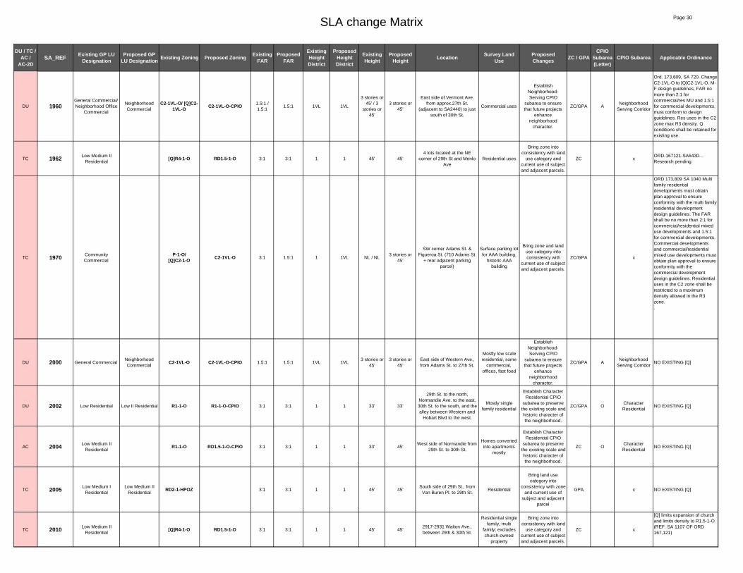
SLA change Matrix Page 30
DU / TC / AC /
AC-2DSA_REF Existing GP LU
DesignationProposed GP
LU Designation Existing Zoning Proposed Zoning Existing FAR
Proposed FAR
Existing Height District
Proposed Height District
Existing Height
Proposed Height Location Survey Land
UseProposed Changes ZC / GPA
CPIO Subarea (Letter)
CPIO Subarea Applicable Ordinance
DU 1960General Commercial/ Neighborhood Office
Commercial
Neighborhood Commercial
C2-1VL-O/ [Q]C2-1VL-O C2-1VL-O-CPIO 1.5:1 /
1.5:11.5:1 1VL 1VL
3 stories or 45' / 3
stories or 45'
3 stories or 45'
East side of Vermont Ave. from approx.27th St.
(adjacent to SA2440) to just south of 30th St.
Commercial uses
Establish Neighborhood-Serving CPIO
subarea to ensure that future projects
enhance neighborhood
character.
ZC/GPA ANeighborhood
Serving Corridor
Ord. 173,809, SA 720. Change C2-1VL-O to [Q]C2-1VL-O. M-F design guidelines, FAR no more than 2:1 for commercial/res MU and 1.5:1 for commercial developments, must conform to design guidelines. Res uses in the C2 zone max R3 density. Q conditions shall be retained for existing use.
TC 1962 Low Medium II Residential
[Q]R4-1-O RD1.5-1-O 3:1 3:1 1 1 45' 45'4 lots located at the NE
corner of 29th St and Menlo Ave
Residential uses
Bring zone into consistency with land
use category and current use of subject and adjacent parcels.
ZC xORD-167121-SA6430… Research pending
TC 1970 Community Commercial
P-1-O/ [Q]C2-1-O C2-1VL-O 3:1 1.5:1 1 1VL NL / NL
3 stories or 45'
SW corner Adams St. & Figueroa St. (710 Adams St.
+ rear adjacent parking parcel)
Surface parking lot for AAA building,
historic AAA building
Bring zone and land use category into consistency with
current use of subject and adjacent parcels.
ZC/GPA x
ORD 173,809 SA 1040 Multi family residential developments must obtain plan approval to ensure conformity with the multi family residential development design guidelines. The FAR shall be no more than 2:1 forcommercial/residential mixed use developments and 1.5:1 for commercial developments. Commercial developments and commercial/residential mixed use developments must obtain plan approval to ensure conformity with the commercial development design guidelines. Residential uses in the C2 zone shall berestricted to a maximum density allowed in the R3 zone..
DU 2000 General CommercialNeighborhood Commercial
C2-1VL-O C2-1VL-O-CPIO 1.5:1 1.5:1 1VL 1VL3 stories or
45'3 stories or
45'East side of Western Ave., from Adams St. to 27th St.
Mostly low scale residential, some
commercial, offices, fast food
Establish Neighborhood-Serving CPIO
subarea to ensure that future projects
enhance neighborhood
character.
ZC/GPA ANeighborhood
Serving CorridorNO EXISTING [Q]
DU 2002 Low Residential Low II Residential R1-1-O R1-1-O-CPIO 3:1 3:1 1 1 33' 33'
29th St. to the north, Normandie Ave. to the east, 30th St. to the south, and the alley between Western and
Hobart Blvd to the west.
Mostly single family residential
Establish Character Residential CPIO
subarea to preserve the existing scale and historic character of the neighborhood.
ZC/GPA OCharacter Residential
NO EXISTING [Q]
AC 2004 Low Medium II Residential
R1-1-O RD1.5-1-O-CPIO 3:1 3:1 1 1 33' 45'West side of Normandie from
29th St. to 30th St.
Homes converted into apartments
mostly
Establish Character Residential CPIO
subarea to preserve the existing scale and historic character of the neighborhood.
ZC OCharacter Residential
NO EXISTING [Q]
TC 2005 Low Medium I Residential
Low Medium II Residential
RD2-1-HPOZ 3:1 3:1 1 1 45' 45'South side of 29th St., from
Van Buren Pl. to 29th St.Residential
Bring land use category into
consistency with zone and current use of
subject and adjacent parcel
GPA x NO EXISTING [Q]
TC 2010 Low Medium II Residential
[Q]R4-1-O RD1.5-1-O 3:1 3:1 1 1 45' 45'2917-2931 Walton Ave., between 29th & 30th St.
Residential single family, multi
family; excludes church-owned
property
Bring zone into consistency with land
use category and current use of subject and adjacent parcels.
ZC x
[Q] limits expansion of church and limits density to R1.5-1-O (REF. SA 1107 OF ORD 167,121)

SLA change Matrix Page 31
DU / TC / AC /
AC-2DSA_REF Existing GP LU
DesignationProposed GP
LU Designation Existing Zoning Proposed Zoning Existing FAR
Proposed FAR
Existing Height District
Proposed Height District
Existing Height
Proposed Height Location Survey Land
UseProposed Changes ZC / GPA
CPIO Subarea (Letter)
CPIO Subarea Applicable Ordinance
DU 2020 General CommercialNeighborhood Commercial
C2-1VL-O C2-1VL-O-CPIO 1.5:1 1.5:1 1VL 1VL3 stories or
45'3 stories or
45'
Lots on west side of Vermont Ave. from 30th St. and 30th
Pl.Commercial uses
Establish Neighborhood-Serving CPIO
subarea to ensure that future projects
enhance neighborhood
character.
ZC/GPA ANeighborhood
Serving Corridor
NO EXISTING [Q]
TC 2025 Low Medium II Residential
[Q]R4-1-O RD2-1-O 3:1 3:1 1 1 45' 45'29th St. (north)/ Orchard
Ave.(east)/ alley (south)/ alley (west)
Residential. Excludes church at
1276 W. 29th St
Bring zone into consistency with land
use category and current use of subject and adjacent parcels.
ZC x
Ord.167,121 SA 6450 RD1.5-1-O to [Q]R4-1-0, Ordinance 180,218 , Ord.171,682, Ord. 162,128, conditional uses for alcoholic beverages
DU 2040 General CommercialNeighborhood Commercial
C2-1VL-O-HPOZ C2-1VL-O-HPOZ-CPIO 1.5:1 1.5:1 1VL 1VL3 stories or
45'3 stories or
45'West side of Western Ave.
from 30th St. 31st St.Mostly commercial
Establish Neighborhood-Serving CPIO
subarea to ensure that future projects
enhance neighborhood
character.
ZC/GPA ANeighborhood
Serving Corridor
NO EXISTING [Q]
DU 2042 Low Residential Low II Residential R1-1-O R1-1-O-CPIO 3:1 3:1 1 1 33' 33'
30th St. to the north, the alley between Western and Hobart to the west, Jefferson to the south (excludes lots fronting Jefferson though), and the
alley in between Brighton and Normandie to the east.
single family and low scale residential
Establish Character Residential CPIO
subarea to preserve the existing scale and historic character of the neighborhood.
ZC/GPA OCharacter Residential
NO EXISTING [Q]
DU 2048 Medium Residential R3-1-O R3-1-O-CPIO 3:1 3:1 1 1 45' 45'West side of Normandie Ave. from 30th St. to alley north of
Jefferson Blvd.
single family and apartments
Establish Character Residential CPIO
subarea to preserve the existing scale and historic character of the neighborhood.
ZC OCharacter Residential
NO EXISTING [Q]
AC-2D 2050 Neighborhood Office Commercial
Community Commercial
[Q]C2-1VL-O C2-2D-O-CPIO 1.5:1 3:1 1VL 2D3 stories or
45'6 stories
East side of Western Ave. from 30th Pl. to Jefferson
Blvd., and West of Jefferson Blvd. from Western Ave. to
Hobart Blvd., and SW corner of Western Ave. and
Jefferson Blvd.
Commercial uses
Enable specialized transit oriented development
parameters for commercial
properties in close proximity to light rail
stations and intersections of major
bus lines.
ZC/GPA F TOD Medium
Ord.173,809 SA 960, change C2-1-O to [Q]C2-1VL-O Maximum of 2:1 FAR for commercial/residential mixed use projects: Max. 1.5:1 for commercial only. Residential uses restricted to max R3. Design Guidelines requirement for commercial developments and commercial/residential mixed use projects, Ord.167,121 SA 1228, change C2-1-O to HD 1-VL-O, Ord.180,103 Fast Food Interim Ordinance - prohibit the establishment of new fast food restaurants, Ord.171,682 and Ord. 162,128, conditional uses for alcoholic beverages.
DU 2056General Commercial/ Neighborhood Office
Commercial
Neighborhood Commercial
C2-1VL-O/ C2-1L-O C2-1VL-O-CPIO 1.5:1 / 3:1 1.5:1 1VL/1L 1VL
3 stories or 45' / 6
stories or 75'
3 stories or 45'
North side of Jefferson from Brighton Ave on the west to
Catalina St on the east.
Oil drill site between Budlong and Van Buren;
otherwise primarily commercial uses, including strip mall
, laundromat, smog test center, doughnut shop,
storefront church, auto uses, and
some multi-family residential.
Establish General Corridor CPIO
subarea to ensure that future projects
enhance neighborhood
character.
ZC/GPA C General Corridor
NO EXISTING [Q]

SLA change Matrix Page 32
DU / TC / AC /
AC-2DSA_REF Existing GP LU
DesignationProposed GP
LU Designation Existing Zoning Proposed Zoning Existing FAR
Proposed FAR
Existing Height District
Proposed Height District
Existing Height
Proposed Height Location Survey Land
UseProposed Changes ZC / GPA
CPIO Subarea (Letter)
CPIO Subarea Applicable Ordinance
TC 2060Low Medium I Residential/
/General CommercialPublic Facilities
C2-1VL-O/R2-1-O PF-1-O 1.5:1/3:1 1.5:1 1VL/1 1
3 stories or 45' / 33'
NLBlock generally bounded by
30th Pl., Catalina St. and Jefferson Blvd.
LAUSD School
Bring zone and land use category into consistency with
current use of subject and adjacent parcels.
ZC/GPA x
NO EXISTING [Q]
AC-2D 2070
Medium Residential/General Commercial/
Low Medium I Residential / High
Medium Residential
Community Commercial
C2-1VL-O/R3-1-O/ R4-1-O C2-2D-O-CPIO 1.5:1/3:1/
3:13:1 1VL/1/1 2D
3 stories or 45' / 45'/NL
6 stories
Block generally bounded by 30th Pl., Catalina St. and Jefferson Blvd., and NE
corner of Jefferson Blvd and Vermont Ave.
Religious institution, office
building and parking, senior
housing complex
Enable specialized transit oriented development
parameters for commercial
properties in close proximity to light rail
stations and intersections of major
bus lines.
ZC/GPA F TOD Medium
NO EXISTING [Q]
TC 2085 Low Medium II Residential
[Q]R4-1-O RD1.5-1-O 3:1/3:1 3:1 1 1 45' 45'
30th (south)/ Hoover St. (east)/ alley (north). Does not
include church-owned parcels.
Residential, excludes church at 1063,1059, 1051 and 1049 W. 30th
St
Bring zone into consistency with land
use category and current use of subject and adjacent parcels.
ZC x
Ord.167,121 SA 6446 RD1.5-1-O to [Q]R4-1-0, Ordinance 180,218 , Ord.171,682, Ord. 162,128, conditional uses for alcoholic beverages, Ord.46951, Ord.158,192 establishment of the setback lines
DU 2097 General CommercialNeighborhood Commercial
C2-1VL-O C2-1VL-O-CPIO 1.5:1 1.5:1 1VL 1VL3 stories or
45'3 stories or
45'3411 S. Gramercy Place (just
south of Jefferson)single residence
Establish Neighborhood-Serving CPIO
subarea to ensure that future projects
enhance neighborhood
character.
ZC/GPA ANeighborhood
Serving CorridorNO EXISTING [Q]
DU 2098 General CommercialNeighborhood Commercial
C2-1VL-O-HPOZ C2-1VL-O-HPOZ-CPIO 1.5:1 1.5:1 1VL 1VL3 stories or
45'3 stories or
45'
North side of Jefferson from Arlington to St. Andrews
Place.
Primarily commercial,
Baptist church, fast food
restaurant, Catholic church, private school,
some residential, auto repair shop
Establish Neighborhood-Serving CPIO
subarea to ensure that future projects
enhance neighborhood
character.
ZC/GPA ANeighborhood
Serving CorridorNO EXISTING [Q]
AC-2D 2100 Neighborhood Office Commercial
Community Commercial
[Q]C2-1VL-O-HPOZ C2-2D-O-HPOZ-CPIO 1.5:1 3:1 1VL 2D
3 stories or 45'
6 stories
West side of Western Ave. from 31st St. to Jefferson
Blvd. and lots on Jefferson Blvd. from Western Ave. to
St. Andrews
Residential and commercial
Enable specialized transit oriented development
parameters for commercial
properties in close proximity to light rail
stations and intersections of major
bus lines.
ZC/GPA F TOD Medium
Ord. 173,809 SA 960 change C2-1-O to [Q] C2-1VL-O Maximum of 2:1 FAR for Mixed use projects: Max. 1.5:1 for commercial only. Residential uses restricted to max R3. Design Guidelines requirement for commercial developments, Ord.180,103 Fast Food Interim Ordinance - prohibit the establishment of new fast food restaurants, Ord.171,682, Ord. 162,128, conditional uses for alcoholic beverages
DU 2102Low Residential/ Neighborhood Commercial
Neighborhood Commercial
[Q]C2-1VL-O / R1-1-O C2-1VL-O-CPIO 1.5:1/3:1 1.5:1 1VL/1 1VL
3 stories or 45' / 33'
3 stories or 45'
North side of Jefferson Blvd from Hobart to Harvard, Sliver
parcel behind lots at NW corner of Harvard Blvd and
Jefferson Blvd
Multi-family residential, and
Side yard for multi-family residential
Establish General Corridor CPIO
subarea to ensure that future projects
enhance neighborhood
character.
ZC/GPA C General Corridor
AC 2105 Low Medium II Residential
Neighborhood Commercial
RD1.5-1-O C2-1VL-O-CPIO 3:1 1.5:1 1 1VL 45'3 stories or
45'
North side of Jefferson Blvd from Harvard Blvd to Halldale
Ave.
Apartment complex
Establish General Corridor CPIO
subarea to ensure that future projects
enhance neighborhood
character.
ZC/GPA C General Corridor NO EXISTING [Q]
DU 2106 General CommercialNeighborhood Commercial
C2-1VL-O C2-1VL-O-CPIO 1.5:1 1.5:1 1VL 1VL3 stories or
45'3 stories or
45'North side of Jefferson from Halldale Ave to Brighton Ave
Multi-family residential
Establish General Corridor CPIO
subarea to ensure that future projects
enhance neighborhood
character.
ZC/GPA C General Corridor NO EXISTING [Q]

SLA change Matrix Page 33
DU / TC / AC /
AC-2DSA_REF Existing GP LU
DesignationProposed GP
LU Designation Existing Zoning Proposed Zoning Existing FAR
Proposed FAR
Existing Height District
Proposed Height District
Existing Height
Proposed Height Location Survey Land
UseProposed Changes ZC / GPA
CPIO Subarea (Letter)
CPIO Subarea Applicable Ordinance
TC 2110 Low Medium II Residential
[Q]R4-1-O-HPOZ/[Q]R4-1-O RD2-1-O-HPOZ 3:1 3:1 1 1 45' 45'
3416-3448 Arlington Ave. east and lots at Cimarron St.
and 35th. Doesn't include land along Jefferson.
Parking lot?
Bring zone into consistency with land
use category and current use of subject and adjacent parcels.
ZC x
ORD 167,121 SA1259. Limits church expansion and limits density to corresponding zone, RD2-1-O.
AC 2115Low Medium II
Residential/ General Commercial
Neighborhood Commercial
C2-1VL-O-HPOZ/ [Q]R4-1-O-HPOZ C2-1VL-O-HPOZ-CPIO 1.5:1/3:1 1.5:1 1VL/1 1VL
3 stories or 45' / 45'
3 stories or 45'
Lots along Jefferson between Arlington and Cimarron
Commercial at corner (Jefferson
Park HPOZ contributor),
vacant lot / gravel pit, church
Establish General Corridor CPIO
subarea to ensure that future projects
enhance neighborhood
character.
ZC/GPA C General CorridorORD-167121-SA1259 - limits expansion of church and limits density to RD2-1
TC 2118 Low Medium II Residential
R2-1-O/ [Q]C2-1-O RD1.5-1-O 3:1/1.5:1 3:1 1/1 1 33' / NL 45'
Lots fronting 35th St. on north side between Cimarron St.
and Gramercy Pl.
4-unit apartment buildings
Bring zone into consistency with land
use category and current use of subject and adjacent parcels.
ZC x[Q] 173,809 SA 1110 R2-1-O TO [Q]C2-1-O
TC 2120 Low Medium I Residential
[Q]C2-1-O R2-1-O 1.5:1 3:1 1 1 NL 33'North side 35th St. between Cimarron St. & Gramercy Pl.
single family residential
Bring zone and land use category into consistency with
current use of subject and adjacent parcels.
ZC/GPA x
[Q] 173,809 SA 1110 R2-1-O TO [Q]C2-1-O
AC-2D 2140 Neighborhood Office Commercial
Community Commercial
[Q]C2-1VL/P-1 C2-2D-CPIO 1.5:1/3:1 3:1 1VL/1 2D
3 stories or 45' / NL
6 storiesSE corner of Western Ave.
and Jefferson Blvd.Single family
Enable specialized transit oriented development
parameters for commercial
properties in close proximity to light rail
stations and intersections of major
bus lines.
ZC/GPA F TOD Medium
Ord. 173,809 SA 960 change to [Q]C2-1VL-O, The FAR shall be no more than 2:1 for commercial/residential mixed use developments and 1.5:1 for commercial developments. Commercial developments and commercial/residential mixed use developments must obtain plan approval to ensure conformity with the commercial development design guidelines. Residential uses restricted to R3 maximum density, Ord.180,103 Fast Food Interim Ordinance - prohibit the establishment of new fast food restaurants, Ord.171,682 and Ord. 162,128, conditional uses for alcoholic beverages.
TC 2146 General CommercialLow Medium II
ResidentialC2-1VL-O RD1.5-1-O 1.5:1 3:1 1VL 1
3 stories or 45'
45'4 interior parcels on south
side of Jefferson Blvd, close to Normandie intersection.
Multi-family residential and
parking for residential
Bring zone and land use category into consistency with
current use of subject and adjacent parcels.
ZC/GPA x NO EXISTING [Q]
DU 2148 General CommercialNeighborhood Commercial
C2-1VL-O C2-1VL-O-CPIO 1.5:1 1.5:1 1VL 1VL3 stories or
45'3 stories or
45'
West side of Normandie Ave from Jefferson Blvd. to 35th
St.; 5 parcels.
Car wash, multi-family residential, some commercial
Establish General Corridor CPIO
subarea to ensure that future projects
enhance neighborhood
character.
ZC/GPA C General Corridor NO EXISTING [Q]

SLA change Matrix Page 34
DU / TC / AC /
AC-2DSA_REF Existing GP LU
DesignationProposed GP
LU Designation Existing Zoning Proposed Zoning Existing FAR
Proposed FAR
Existing Height District
Proposed Height District
Existing Height
Proposed Height Location Survey Land
UseProposed Changes ZC / GPA
CPIO Subarea (Letter)
CPIO Subarea Applicable Ordinance
TC 2150 Neighborhood Office Commercial
Low Medium II Residential
[Q]C2-1VL RD1.5-1 1.5:1 3:1 1VL 13 stories or
45'45'
One lot at 1724 Jefferson Blvd.
one lot used for Single Family
residence at 1724 w Jefferson Blvd.
Bring zone and land use category into consistency with
current use of subject and adjacent parcels.
ZC/GPA x
Ord. 173,809 SA 960 change to [Q]C2-1VL-O, The FAR shall be no more than 2:1 for commercial/residential mixed use developments and 1.5:1 for commercial developments. Commercial developments and commercial/residential mixed use developments must obtain plan approval to ensure conformity with the commercial development design guidelines. Residential uses restricted to R3 maximum density, Ord.180,103 Fast Food Interim Ordinance - prohibit the establishment of new fast food restaurants, Ord.171,682 and Ord. 162,128, conditional uses for alcoholic beverages.
DU 2152General Commercial/ Neighborhood Office
Commercial
Neighborhood Commercial
C2-1VL/ C2-1L C2-1VL-CPIO 1.5:1/ 3:1 1.5:1 1VL/1L 1VL
3 stories or 45' / 6
stories or 75'
3 stories or 45'
South side of Jefferson from Normandie Ave to to Walton Ave. Includes 2 parcels at
NE corner of Normandie and 35th St., and SE corner of
Walton and Jefferson
Church parking lot, primarily
commercial, store / residential, auto repair, residential, Churches, Korean
Memorial Association
Establish General Corridor CPIO
subarea to ensure that future projects
enhance neighborhood
character.
ZC/GPA C General Corridor NO EXISTING [Q]
AC-2D 2160 Medium ResidentialCommunity Commercial
R3-1 C2-2D-CPIO 3:1 3:1 1 2D 45' 6 storiesSW corner of Jefferson Blvd. and Vermont Ave. (across of
USC)Residential project
Enable specialized transit oriented development
parameters for commercial
properties in close proximity to light rail
stations and intersections of major
bus lines.
ZC/GPA F TOD Medium NO EXISTING [Q]
TC 2170 Medium Residential [Q]R4-1-O R3-1-O 3:1 3:1 1 1 45' 45'
Parcel in the middle of the block bounded by Hoover St.
(west), 32nd St. (north), University Ave. (east).
Excludes church-owned parcels.
Private school/childcare?
Bring zone into consistency with land
use category and current use of subject and adjacent parcels.
ZC x[Q] 167,121 SA 1155 Limits expansion of church and limits density to R3-1-O
TC 2190 Low Medium II Residential
Low Medium I Residential
R1-1-O/R2-1-O/
[Q]C2-1-OR2-1-O 3:1/3:1/
1.5:13:1 1 1
33' / 33' / NL
33'
Block bound by Cimarron St. (west), 35th St. (north),
Gramercy Pl. (east), 35th Pl. (south)
Residential units
Bring zone and land use category into consistency with
current use of subject and adjacent parcels.
ZC/GPA x
[Q] 173,809 SA 1110 R2-1-O TO [Q]C2-1-O
TC 2195 Low Medium I Residential
Low II Residential R1-1-O 3:1 3:1 1 1 33' 33'
Lots fronting west side of Gramercy Place from 35th St. to 35th Place and lots fronting
north side of 35th Pl from Gramercy to Cimarron St.
Primarily single family residential
homes
Bring land use category into
consistency with zone and current use of
subject and adjacent parcel
GPA x
NO EXISTING [Q]

SLA change Matrix Page 35
DU / TC / AC /
AC-2DSA_REF Existing GP LU
DesignationProposed GP
LU Designation Existing Zoning Proposed Zoning Existing FAR
Proposed FAR
Existing Height District
Proposed Height District
Existing Height
Proposed Height Location Survey Land
UseProposed Changes ZC / GPA
CPIO Subarea (Letter)
CPIO Subarea Applicable Ordinance
AC-2D 2200
Neighborhood Office Commercial /
General Commercial / Low Medium I
Residential
Community Commercial
[Q]C2-1VL-O / C2-1VL-O / R2-1-O C2-2D-O-CPIO 1.5:1 /
1.5:1 / 3:13:1 1VL/1VL/1 2D
3 stories or 45' / 3
stories or 45' / 33'
4 storiesWest side of Western Ave. from 35th St. to 37th Place
Primarily commercial uses
Enable specialized transit oriented development
parameters for commercial
properties in close proximity to light rail
stations and intersections of major
bus lines.
ZC/GPA E TOD Low
Ord. 173,809 SA 960 change to [Q]C2-1VL-O, The FAR shall be no more than 2:1 for commercial/residential mixed use developments and 1.5:1 for commercial developments. Commercial developments and commercial/residential mixed use developments must obtain plan approval to ensure conformity with the commercial development design guidelines. Residential uses restricted to R3 maximum density, Ord.180,103 Fast Food Interim Ordinance - prohibit the establishment of new fast food restaurants, Ord.171,682 and Ord. 162,128, conditional uses for alcoholic beverages.
AC-2D 2220
Neighborhood Office Commercial /
General Commercial / Low Medium I
Residential
Community Commercial
[Q]C2-1VL-O/ C2-1VL-O/
R2-1-O/ P-1VL-OC2-2D-O-CPIO 1.5:1/1.5:
1/ 3:1/ 3:13:1
1VL/1VL/11VL
2D
3 stories or 45' / 3
stories or 45' / 33' / 3 stories or
45'
6 storiesEast side of Western Ave. from 35th St. to 37th place
Primarily commercial uses
Enable specialized transit oriented development
parameters for commercial
properties in close proximity to light rail
stations and intersections of major
bus lines.
ZC/GPA F TOD Medium
Ord. 173,809 SA 960 change to [Q]C2-1VL-O, The FAR shall be no more than 2:1 for commercial/residential mixed use developments and 1.5:1 for commercial developments. Commercial developments and commercial/residential mixed use developments must obtain plan approval to ensure conformity with the commercial development design guidelines. Residential uses restricted to R3 maximum density, Ord.180,103 Fast Food Interim Ordinance - prohibit the establishment of new fast food restaurants, Ord.171,682 and Ord. 162,128, conditional uses for alcoholic beverages.
TC 2240 Low Medium II Residential
[Q]R4-1-O RD2-1-O 3:1 3:1 1 1 45' 45'East side of Denker Ave.
between 35th St. & 35th Pl.
Residential. Excludes church-owned property.
Bring zone into consistency with land
use category and current use of subject and adjacent parcels.
ZC x
[Q] 167,121 SA 1368 LIMITS CHURCH EXPANSION TO 20% AND LIMITS DENSITY TO RD2-1-O
DU 2245 General CommercialNeighborhood Commercial
C2-1VL C2-1VL-CPIO 1.5:1 1.5:1 1VL 1VL3 stories or
45'3 stories or
45'
Both sides of Normandie Ave. from 35th St. to 36th St,
excluding lots at NE corner of Normandie and 35th Pl.
Commercial, retail, churches, some
residential, parking lot
Establish General Corridor CPIO
subarea to ensure that future projects
enhance neighborhood
character.
ZC/GPA C General Corridor
NO EXISTING [Q]
TC 2250 Low Medium II Residential
[Q]R4-1 RD2-1 3:1 3:1 1 1 45' 45'
west side of Raymond Ave. between 35th St. & 35th Pl., excluding church-owned and
city-owned parcels.
Residential. Excludes
ABUNDANT LIFE CHRISTIAN
CHURCH 3500 S Normandie Ave.
Bring zone into consistency with land
use category and current use of subject and adjacent parcels.
ZC x
[Q] 167,121 SA 1361 LIMITS CHURCH EXPANSION TO 20% AND LIMITS DENSITY TO RD2-1-O
TC 2255General Commercial/
Low Medium II Residential
Public Facilities C2-1VL/ [Q]R4-1 PF-1 1.5:1/3:1 1.5:1 1 13 stories or
45' / 45'NL
NE corner of Normandie Ave. and 35th Pl.
DWP building, parking lot
Bring zone and land use category into consistency with
current use of subject and adjacent parcels.
ZC/GPA x
[Q] 167,121 SA 1361 LIMITS CHURCH EXPANSION TO 20% AND LIMITS DENSITY TO RD2-1-O
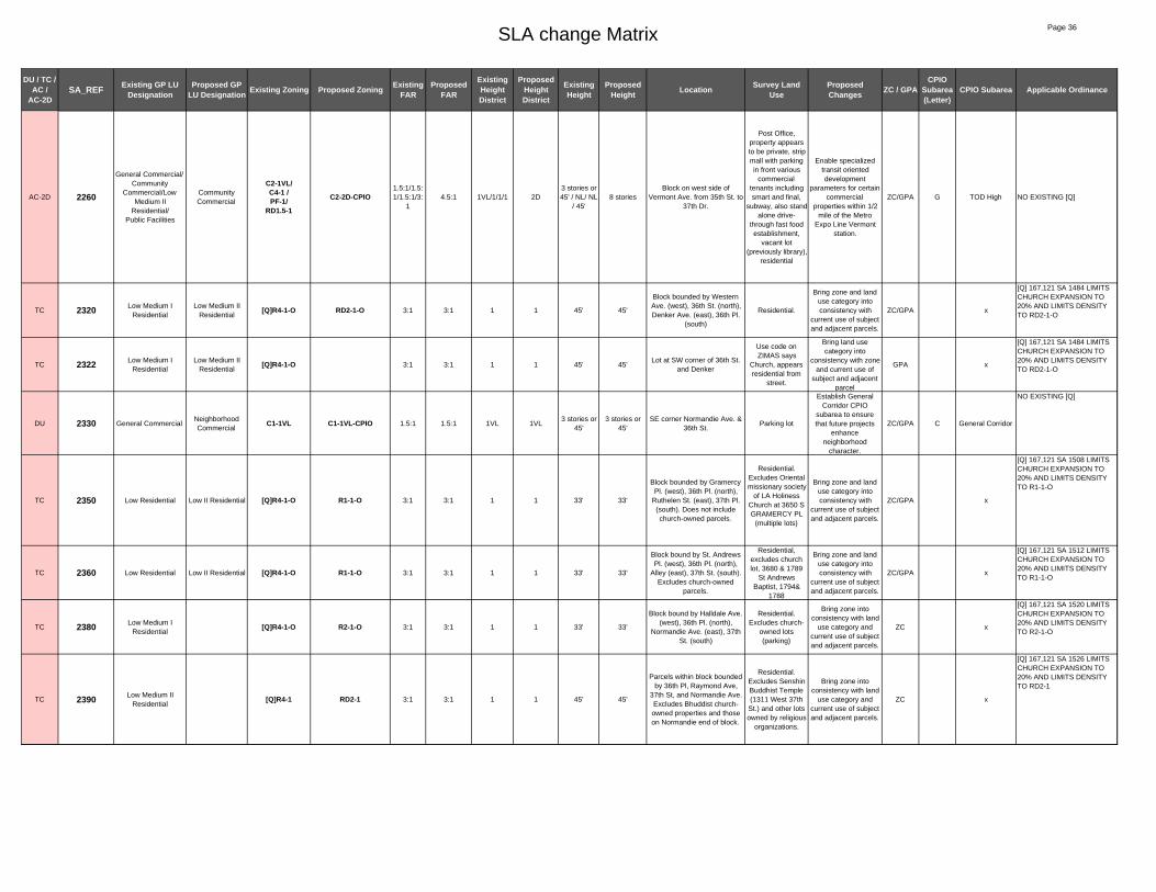
SLA change Matrix Page 36
DU / TC / AC /
AC-2DSA_REF Existing GP LU
DesignationProposed GP
LU Designation Existing Zoning Proposed Zoning Existing FAR
Proposed FAR
Existing Height District
Proposed Height District
Existing Height
Proposed Height Location Survey Land
UseProposed Changes ZC / GPA
CPIO Subarea (Letter)
CPIO Subarea Applicable Ordinance
AC-2D 2260
General Commercial/Community
Commercial/Low Medium II
Residential/Public Facilities
Community Commercial
C2-1VL/C4-1 /PF-1/
RD1.5-1
C2-2D-CPIO1.5:1/1.5:1/1.5:1/3:
14.5:1 1VL/1/1/1 2D
3 stories or 45' / NL/ NL
/ 45'8 stories
Block on west side of Vermont Ave. from 35th St. to
37th Dr.
Post Office, property appears to be private, strip mall with parking in front various
commercial tenants including smart and final,
subway, also stand alone drive-
through fast food establishment,
vacant lot (previously library),
residential
Enable specialized transit oriented development
parameters for certain commercial
properties within 1/2 mile of the Metro
Expo Line Vermont station.
ZC/GPA G TOD High NO EXISTING [Q]
TC 2320 Low Medium I Residential
Low Medium II Residential
[Q]R4-1-O RD2-1-O 3:1 3:1 1 1 45' 45'
Block bounded by Western Ave. (west), 36th St. (north), Denker Ave. (east), 36th Pl.
(south)
Residential.
Bring zone and land use category into consistency with
current use of subject and adjacent parcels.
ZC/GPA x
[Q] 167,121 SA 1484 LIMITS CHURCH EXPANSION TO 20% AND LIMITS DENSITY TO RD2-1-O
TC 2322 Low Medium I Residential
Low Medium II Residential
[Q]R4-1-O 3:1 3:1 1 1 45' 45'Lot at SW corner of 36th St.
and Denker
Use code on ZIMAS says
Church, appears residential from
street.
Bring land use category into
consistency with zone and current use of
subject and adjacent parcel
GPA x
[Q] 167,121 SA 1484 LIMITS CHURCH EXPANSION TO 20% AND LIMITS DENSITY TO RD2-1-O
DU 2330 General CommercialNeighborhood Commercial
C1-1VL C1-1VL-CPIO 1.5:1 1.5:1 1VL 1VL3 stories or
45'3 stories or
45'SE corner Normandie Ave. &
36th St.Parking lot
Establish General Corridor CPIO
subarea to ensure that future projects
enhance neighborhood
character.
ZC/GPA C General Corridor
NO EXISTING [Q]
TC 2350 Low Residential Low II Residential [Q]R4-1-O R1-1-O 3:1 3:1 1 1 33' 33'
Block bounded by Gramercy Pl. (west), 36th Pl. (north),
Ruthelen St. (east), 37th Pl. (south). Does not include church-owned parcels.
Residential. Excludes Oriental missionary society
of LA Holiness Church at 3650 S GRAMERCY PL
(multiple lots)
Bring zone and land use category into consistency with
current use of subject and adjacent parcels.
ZC/GPA x
[Q] 167,121 SA 1508 LIMITS CHURCH EXPANSION TO 20% AND LIMITS DENSITY TO R1-1-O
TC 2360 Low Residential Low II Residential [Q]R4-1-O R1-1-O 3:1 3:1 1 1 33' 33'
Block bound by St. Andrews Pl. (west), 36th Pl. (north),
Alley (east), 37th St. (south). Excludes church-owned
parcels.
Residential, excludes church lot, 3680 & 1789
St Andrews Baptist, 1794&
1788
Bring zone and land use category into consistency with
current use of subject and adjacent parcels.
ZC/GPA x
[Q] 167,121 SA 1512 LIMITS CHURCH EXPANSION TO 20% AND LIMITS DENSITY TO R1-1-O
TC 2380 Low Medium I Residential
[Q]R4-1-O R2-1-O 3:1 3:1 1 1 33' 33'
Block bound by Halldale Ave. (west), 36th Pl. (north),
Normandie Ave. (east), 37th St. (south)
Residential. Excludes church-
owned lots (parking)
Bring zone into consistency with land
use category and current use of subject and adjacent parcels.
ZC x
[Q] 167,121 SA 1520 LIMITS CHURCH EXPANSION TO 20% AND LIMITS DENSITY TO R2-1-O
TC 2390 Low Medium II Residential
[Q]R4-1 RD2-1 3:1 3:1 1 1 45' 45'
Parcels within block bounded by 36th Pl, Raymond Ave,
37th St, and Normandie Ave. Excludes Bhuddist church-owned properties and those on Normandie end of block.
Residential. Excludes Senshin Buddhist Temple (1311 West 37th St.) and other lots owned by religious
organizations.
Bring zone into consistency with land
use category and current use of subject and adjacent parcels.
ZC x
[Q] 167,121 SA 1526 LIMITS CHURCH EXPANSION TO 20% AND LIMITS DENSITY TO RD2-1

SLA change Matrix Page 37
DU / TC / AC /
AC-2DSA_REF Existing GP LU
DesignationProposed GP
LU Designation Existing Zoning Proposed Zoning Existing FAR
Proposed FAR
Existing Height District
Proposed Height District
Existing Height
Proposed Height Location Survey Land
UseProposed Changes ZC / GPA
CPIO Subarea (Letter)
CPIO Subarea Applicable Ordinance
DU 2420 Low Medium I Residential
R2-1-O R2-1-O-CPIO 3:1 3:1 1 1 33' 33'
Block bounded by Gramercy Pl. Pl., 37th Pl., Ruthelen St. and Exposition Blvd.; Block bounded by Ruthelen St. on
west 37th Pl. on north, Exposition Blvd. on south and St. Andrews Pl. on east; Lots fronting 37th Pl. on south side from St. Andrews Pl. on west to alley, just west of Western Ave.; Lots fronting 37th Dr. on north side from St. Andrews
Pl. to alley just west of Western Ave.
Primarily residential
Establish Multi-Family Design CPIO subarea
to enhance the character of the neighborhood.
ZC N Multi-Family
NO EXISTING [Q]
AC-2D 2460 General CommercialCommunity Commercial
C2-1VL-O C2-2D-O-CPIO 1.5:1 3:1 1VL 2D3 stories or
45'6 stories
Lots on west side of Western Ave. from 37th Pl. to
Exposition Blvd.
Primarily commercial uses
Enable specialized transit oriented development
parameters for commercial
properties in close proximity to light rail
stations and intersections of major
bus lines.
ZC/GPA F TOD Medium
NO EXISTING [Q]
DU 2470 Low Medium I Residential
R2-1-O R2-1-O-CPIO 3:1 3:1 1 1 33' 33'Lots on south side of 37th Dr. from St. Andrews to alley just
west of Western Ave.
Primarily residential
Establish Multi-Family Design CPIO subarea
to enhance the character of the neighborhood.
ZC N Multi-Family
NO EXISTING [Q]
AC-2D 2480 Low Medium I Residential
Community Commercial
R2-1-O C2-2D-O-CPIO 3:1 3:1 1 2D 33' 6 stories
Lots fronting Exposition Blvd. on north side from St.
Andrews Pl. to alley, located west of Western Ave.
Primarily residential
Enable specialized transit oriented development
parameters for commercial
properties in close proximity to light rail
stations and intersections of major
bus lines.
ZC/GPA F TOD Medium
NO EXISTING [Q]
AC-2D 2500 General CommercialCommunity Commercial
[Q]C2-1VL-O C2-2D-O-CPIO 1.5:1 3:1 1VL 2D3 stories or
45'6 stories
NE corner of Exposition Blvd. and Western Ave.
Primarily commercial uses
Enable specialized transit oriented development
parameters for commercial
properties in close proximity to light rail
stations and intersections of major
bus lines.
ZC/GPA F TOD Medium
Ord. 173,809 SA 1210 change RD3-1-O to [Q]C2-1VL-O, The FAR shall be no more than 2:1 for commercial/residential mixed use developments and 1.5:1 for commercial developments. Commercial developments and commercial/residential mixed use developments must obtain plan approval to ensure conformity with the commercial development design guidelines. Residential uses restricted to R3 maximum density, Ord. 167,121 SA 1616 change to RD3-1-O, Ord.180,103 Fast Food Interim Ordinance - prohibit the establishment of new fast food restaurants, Ord.171,682 and Ord. 162,128, conditional uses for alcoholic beverages.
TC 2540 Low Medium I Residential
[Q]R4-1-O R2-1-O 3:1 3:1 1 1 33' 33'
Block generally bounded by Halldale Ave. on west 37th
Dr. on north, Normandie Ave. approximately from Halldale Ave. (not including church
property on NW corner Normandie Ave. and
Exposition Blvd. or 4 lots on east side)
Residential properties.
Excludes church at 1416 W. 37th Dr.
Bring zone into consistency with land
use category and current use of subject and adjacent parcels.
ZC x
Ord. 167,121 SA 1606 change R2-1-O to [Q]R4-1-O, limits expansion of church and limits density to R2-1-O, Ord.171,682 and Ord. 162,128, conditional uses for alcoholic beverages.

SLA change Matrix Page 38
DU / TC / AC /
AC-2DSA_REF Existing GP LU
DesignationProposed GP
LU Designation Existing Zoning Proposed Zoning Existing FAR
Proposed FAR
Existing Height District
Proposed Height District
Existing Height
Proposed Height Location Survey Land
UseProposed Changes ZC / GPA
CPIO Subarea (Letter)
CPIO Subarea Applicable Ordinance
AC-2D 2550 Low Medium II Residential
Community Commercial
[Q]C2-1 C2-2D-CPIO 3:1 3:1 1 2D 25' 4 storiesNE corner of Normandie Ave.
and Exposition Blvd.Commercial Uses
Enable specialized transit oriented development
parameters for commercial
properties in close proximity to light rail
stations and intersections of major
bus lines.
ZC/GPA E TOD Low
Ord.180,103 Fast Food Interim Ordinance - prohibit the establishment of new fast food restaurants, Ord.180,218 North University Ave. Park-Exposition Park-West Adams St. Neighborhood Stabilization Overlay (NSO) District, Ord. 163,053 zone change from CM-1 and P-1 to [T][Q] C2-1, uses limited to C1 Zone, max 25 feet height, Ord.171,682, Ord. 162,128, conditional uses for alcoholic beverages
DU 2560 Low Medium II Residential
RD2-1 RD2-1-CPIO 3:1 3:1 1 1 45' 45'
Blocks bounded by 37th Pl, Raymond Ave, Catalina St., and Exposition Blvd; Lots on
37th Dr. within a block generally bounded by
Normandie Ave. on west 37th Dr. on north, Raymond Ave. on east, Exposition Blvd. on
south; and block bounded by Catalina St, 37th Dr, 37th Pl, and just west of vermont Ave.
Residential uses
Establish Multi-Family Design CPIO subarea
to enhance the character of the neighborhood.
ZC N Multi-Family
NO EXISTING [Q]
AC-2D 2630
General Commercial/Community
Commercial/Low Medium II
Residential
Community Commercial
C2-1VL/[Q]R4-1 C2-2D-CPIO 1.5:1/3:1 4.5:1 1VL/1 2D
3 stories or 45' / 45'
8 stories
Block bounded by 37th Dr. to the north, Vermont Ave. to the
east, Exposition Blvd. to the south, Catalina St. to the
west.
Religious institution and
parking, residential.
Mosque at 1025 Exposition Boulevard
Enable specialized transit oriented development
parameters for certain commercial
properties within 1/2 mile of the Metro
Expo Line Vermont station.
ZC/GPA G TOD High
EXISTING [Q] = 167,121, SA- 1580: existing churches subject to sec12.11 all other uses limited to RD2-1
TC 2642 Public Facilities PF-1/ R1-1 PF-1 1.5:1/3:1 1.5:1 1/1 1 NL / 33' NL
Center median along Exposition Blvd between
Vermont Ave. and Figueroa St.
Light rail right of way / street
Bring zone into consistency with land
use category and current use of subject and adjacent parcels.
ZC x
NO EXISTING [Q]
DU 2645 General CommericalNeighborhood Commercial
C2-1VL C2-1VL-CPIO 1.5:1 1.5:1 1VL 1VL3 stories or
45'3 stories or
45'NE corner of Arlington Ave.
and Rodeo Rd.
Retail (small market/liquor
store)
Establish General Corridor CPIO
subarea to ensure that future projects
enhance neighborhood
character.
ZC/GPA C General Corridor
NO EXISTING [Q]
DU 2648 General CommercialNeighborhood Commercial
C1-1VL C1-1VL-CPIO 1.5:1 1.5:1 1VL 1VL3 stories or
45'3 stories or
45'
lots along north side of Rodeo Rd. from Arlington Ave. to
Cimarron St. Does not include lots fronting Arlington.
Apartments, small stores
Establish General Corridor CPIO
subarea to ensure that future projects
enhance neighborhood
character.
ZC/GPA C General Corridor
NO EXISTING [Q]
TC 2649 Open Space R2-1 OS-1 3:1 1.5:1 1 1 33' NLNE corner of Cimarron St and
Rodeo Road, south of the Expo light rail ROW
Open space Government
owned, utilities (City of LA)
Bring zone into consistency with land
use category and current use of subject and adjacent parcels.
ZC x
NO EXISTING [Q]
DU 2650 Low Medium I Residential
R2-1 R2-1-CPIO 3:1 3:1 1 1 33' 33'South side of Rodeo Rd. from Van Ness Ave. to St. Andrews
Place
Primarily residential
Establish Multi-Family Design CPIO subarea
to enhance the character of the neighborhood.
ZC N Multi-Family NO EXISTING [Q]
TC 2655 Low Medium I Residential
Low II Residential R1-1 3:1 3:1 1 1 33' 3785 S. Cimarron St Residential
Bring land use category into
consistency with zone and current use of
subject and adjacent parcel
GPA x NO EXISTING [Q]

SLA change Matrix Page 39
DU / TC / AC /
AC-2DSA_REF Existing GP LU
DesignationProposed GP
LU Designation Existing Zoning Proposed Zoning Existing FAR
Proposed FAR
Existing Height District
Proposed Height District
Existing Height
Proposed Height Location Survey Land
UseProposed Changes ZC / GPA
CPIO Subarea (Letter)
CPIO Subarea Applicable Ordinance
AC-2D 2670 Low Medium I Residential
Community Commercial
R2-1 C2-2D-CPIO 3:1 3:1 1 2D 33' 4 stories
Lots on south side of Exposition Blvd. from St.
Andrews Place walking path to just west of Western Ave.
Primarily residential
Enable specialized transit oriented development
parameters for commercial
properties in close proximity to light rail
stations and intersections of major
bus lines.
ZC/GPA E TOD Low NO EXISTING [Q]
AC-2D 2680 General CommercialCommunity Commercial
C2-1VL C2-2D-CPIO 1.5:1 3:1 1VL 2D3 stories or
45'6 stories
Both sides of Westen Ave. from Exposition to 38th Place
Primarily commercial uses
Enable specialized transit oriented development
parameters for commercial
properties in close proximity to light rail
stations and intersections of major
bus lines.
ZC/GPA F TOD Medium
NO EXISTING [Q]
AC-2D 2720 General CommercialCommunity Commercial
P-1VL/C2-1VL C2-2D-CPIO 3:1/1.5:1 3:1 1VL/1VL 2D
3 stories or 45' / 3
stories or 45'
4 storiesSW and SE corners of Normandie Ave. and
Expostion Blvd.
Commercial uses; auto sales
establishment at SW corner
Enable specialized transit oriented development
parameters for commercial
properties in close proximity to light rail
stations and intersections of major
bus lines.
ZC/GPA E TOD Low NO EXISTING [Q]
TC 2725 Low Medium II Residential
[Q]R4-1 RD2-1 3:1 3:1 1 1 45' 45'Lot at SW corner of 38th St.
and Normandie Ave.
Normandie Community
Temple parking lot
Bring zone into consistency with land
use category and current use of subject and adjacent parcels.
ZC x
ORD-167121-SA1728 - limits church expansion, density limited to that permitted in RD1.5-1
DU 2740 Low Medium II Residential
RD1.5-1 RD1.5-1-CPIO 3:1 3:1 1 1 45' 45'
Lots on south side of Exposition Blvd. roughly from Normandie Ave. on west to Budlong Ave. on east; 4 lots on NE corner of Normandie
Ave and 38th St
Multiple family
Establish Multi-Family Design CPIO subarea
to enhance the character of the neighborhood.
ZC N Multi-Family NO EXISTING [Q]
AC-2D 2750 Medium ResidentialCommunity Commercial
[Q]R3-1 C2-2D-CPIO 3:1 4.5:1 1 2D 45' 8 storiesBlock bounded by Exposition,
Wisconsin St., 38th St, and Budlong Ave.
Several multiple family
developments
Enable specialized transit oriented development
parameters for certain commercial
properties within 1/2 mile of the Metro
Expo Line Vermont station.
ZC/GPA G TOD High
173,809 SA1915: change RD1.5-1 to [Q]R3-1, residential limited to max 1200 square feet/dwelling unit in R3 zone multi-family residential development design guidelines, Ord.167,121, SA 1696: R3-1 to RD1.5-1, Ord.180,218 North University Ave. Park-Exposition Park-West Adams St. Neighborhood Stabilization Overlay (NSO) District, Ord.171,682 and Ord. 162,128, conditional uses for alcoholic beverages
AC-2D 2760
Community Commercial/
Medium Residential / Low Medium II
Residential
Community Commercial
C2-1/[Q]R4-1 /(Q)C2-1 C2-2D-CPIO 1.5:1/3:1/
1.5:14.5:1 1/1/1 2D
NL / 45' / NL
8 stories
SW corner of Vermont Ave. and Exposition Blvd.; Lots on
west side of Vermont Ave. from Leighton Ave. to Expo
Gas station, some multiple family residential and
other commercial uses. Gas Station
at 3775 South Vermont Ave.
Enable specialized transit oriented development
parameters for certain commercial
properties within 1/2 mile of the Metro
Expo Line Vermont station.
ZC/GPA G TOD High
Ord.167,121, SA 1694: R3-1 to [Q]R4-1, limits extension of churches to 20% and all other uses limited to R3-1,Ord.180,218 North University Ave. Park-Exposition Park-West Adams St. Neighborhood Stabilization Overlay (NSO) District, Ord.171,682 and Ord. 162,128, conditional uses for alcoholic beverages. Need further research on (Q) temporary condition.
DU 2770 Low Medium I Residential
R2-1 R2-1-CPIO 3:1 3:1 1 1 33' 33'
Lots on north side of 38th Pl. from mid block to just west of
Western Ave., 12 lots; Lots generally bounded by 38th St.
to the north just west of Western Ave., 38th Pl. on the south and mid block on the
west
Primarily residential
Establish Multi-Family Design CPIO subarea
to enhance the character of the neighborhood.
ZC N Multi-Family
NO EXISTING [Q]

SLA change Matrix Page 40
DU / TC / AC /
AC-2DSA_REF Existing GP LU
DesignationProposed GP
LU Designation Existing Zoning Proposed Zoning Existing FAR
Proposed FAR
Existing Height District
Proposed Height District
Existing Height
Proposed Height Location Survey Land
UseProposed Changes ZC / GPA
CPIO Subarea (Letter)
CPIO Subarea Applicable Ordinance
DU 2780 Low Medium II Residential
[Q]R4-1 RD2-1-CPIO 3:1 3:1 1 1 45' 45'Lots on 38th St. roughly from Normandie Ave. on west to
Budlong Ave. on eastMultiple family
Establish Multi-Family Design CPIO subarea
to enhance the character of the neighborhood.
ZC N Multi-Family
EXISTING [Q] = 167,121, SA- 1704: R3-1 to [Q]R4-1, limits extension of churches to 20% and all other uses limited to RD2-1, Ord.180,218 North University Ave. Park-ExpositionPark-West Adams St. Neighborhood Stabilization Overlay (NSO) District, Ord.171,682 and Ord. 162,128, conditional uses for alcoholic beverages
AC-2D 2800 Medium ResidentialCommunity Commercial
[Q]R4-1 C2-2D-CPIO 3:1 4.5:1 1 2D 45' 8 storiesSW corner of Vermont Ave.
and Exposition Blvd.Multiple family
Enable specialized transit oriented development
parameters for certain commercial
properties within 1/2 mile of the Metro
Expo Line Vermont station.
ZC/GPA G TOD High
Ord.167,121, SA 1694: R3-1 to [Q]R4-1, limits extension of churches to 20% and all other uses limited to R3-1,Ord.180,218 North University Ave. Park-Exposition Park-West Adams St. Neighborhood Stabilization Overlay (NSO) District, Ord.171,682 and Ord. 162,128, conditional uses for alcoholic beverages
TC 2835 Low Medium II Residential
Open Space RD1.5-1 OS-1XL 3:1 1.5:1 1 1XL 45' NLNE corner of Rolland Curtis
Pl. and Normandie Avemini park
Bring zone and land use category into consistency with
current use of subject and adjacent parcels.
ZC/GPA x
NO EXISTING [Q]
AC 2850 Medium Residential [Q]R3-1 R3-1-CPIO 3:1 3:1 1 1 45' 45'
Block bounded by 38th St. to north, Wisconsin St. to the east, 39th St. to the south,
and Walton Ave. to the west
Multiple family
Establish Multi-Family Design CPIO subarea
to enhance the character of the neighborhood.
ZC N Multi-Family
173,809 SA1915: change RD1.5-1 to [Q]R3-1, residential limited to max 1200 square feet/dwelling unit in R3 zone multi-family residential development design guidelines, Ord.167,121, SA 1824: R3-1 to RD1.5-1,Ord.180,218 North University Ave. Park-Exposition Park-West Adams St. Neighborhood Stabilization Overlay (NSO) District, Ord.171,682 and Ord. 162,128, conditional uses for alcoholic beverages
AC-2D 2860 Low Medium II Residential
Community Commercial
RD1.5-1 C2-2D-CPIO 3:1 4.5:1 1 2D 45' 8 stories
Block generally bounded by 38th St. to the north,
Wisconsin St. on the west, 39th St. on the south, and Vermont Ave. on east (not
including lots within SA2690)
Multiple family
Enable specialized transit oriented development
parameters for certain commercial
properties within 1/2 mile of the Metro
Expo Line Vermont station.
ZC/GPA G TOD High NO EXISTING [Q]
AC-2D 2880 General CommercialCommunity Commercial
C2-1VL C2-2D-CPIO 1.5:1 3:1 1VL 2D3 stories or
45'4 stories
The east side of Western Ave. from 38th Place to 39th Street, and the west side of Western from 38th Place to
Leighton Ave.
Primarily commercial uses
Enable specialized transit oriented development
parameters for commercial
properties in close proximity to light rail
stations and intersections of major
bus lines.
ZC/GPA E TOD Low NO EXISTING [Q]
TC 2920 General CommercialNeighborhood Commercial
C1-1VL 1.5:1 1.5:1 1VL 1VL3 stories or
45'NW corner Denker Ave. &
39th St.Multiple family
residential
Bring land use category into
consistency with zone and current use of
subject and adjacent parcel
GPA x NO EXISTING [Q]
DU 2925 General CommercialNeighborhood Commercial
C2-1VL C2-1VL-CPIO 1.5:1 1.5:1 1VL 1VL3 stories or
45'3 stories or
45'Four corners of intersection at 39th St. and Normandie Ave.
Commercial, salon, auto repair,
meat market
Establish General Corridor CPIO
subarea to ensure that future projects
enhance neighborhood
character.
ZC/GPA C General Corridor NO EXISTING [Q]

SLA change Matrix Page 41
DU / TC / AC /
AC-2DSA_REF Existing GP LU
DesignationProposed GP
LU Designation Existing Zoning Proposed Zoning Existing FAR
Proposed FAR
Existing Height District
Proposed Height District
Existing Height
Proposed Height Location Survey Land
UseProposed Changes ZC / GPA
CPIO Subarea (Letter)
CPIO Subarea Applicable Ordinance
TC 2930 Low Medium II Residential
[Q]R4-1 RD1.5-1 3:1 3:1 1 1 45' 45'
block bound by (w) Budlong Ave., (n) 39th st, (e)Walton Ave., (s) 39 Pl. (Excludes
church-owned parcel)
multi-family residential (3).
Excludes church, BETHANY
CHURCH OF GOD 3916 S Budlong Ave.
Bring zone into consistency with land
use category and current use of subject and adjacent parcels.
ZC x
[Q] 167,121 SA 1864 LIMITS CHURCH EXPANSION TO 20% AND LIMITS DENSITY TO R1.5-1
TC 3000Open Space/Highway
Oriented Limited Commercial
Open SpaceOS-1XL/
R1-1 OS-1XL 1.5:1/3:1 1.5:1 1XL/1 1XL NL / 33' NLBlock bounded by 39th St., Western Ave. Leighton Ave.
and Hobart Blvd.
Recreation and parks facility
Bring zone and land use category into consistency with
current use of subject and adjacent parcels.
ZC/GPA x NO EXISTING [Q]
TC 3010 Low Medium II Residential
Low Medium I Residential
[Q]R4-1 R2-1 3:1 3:1 1 1 33' 33'
Browning Blvd. between Halldale Ave. & Brighton Ave.
excluding church-owned parcels (42 parcels north
from Browning Blvd.)
8 multi fam., 7 single fam., 4 two fam., Excludes church, TRUE FELLOWSHIP
MISSIONARY at 3959 Brighton Ave.
Bring zone and land use category into consistency with
current use of subject and adjacent parcels.
ZC/GPA x
[Q] 167,121 SA 1882 LIMITS CHURCH EXPANSION TO 20% AND LIMITS DENSITY TO R2-1
TC 3012 Low Medium II Residential
Low Medium I Residential
[Q]R4-1 3:1 3:1 1 1 33' 33'
Two church-owned parcels fronting Brighton Ave. in block
bounded by Brighton, Browning Blvd, Halldale Ave, and 39th St. (3957 and 3959
Brighton)
True Fellowship Missionary Baptist
Church.
Bring land use category into
consistency with zone and current use of
subject and adjacent parcel
GPA x
[Q] 167,121 SA 1882 LIMITS CHURCH EXPANSION TO 20% AND LIMITS DENSITY TO R2-1
TC 3017 Low Medium II Residential
R2-1 RD1.5-1 3:1 3:1 1 1 33' 45'
Lots fronting Leighton Ave. on south side, between
Normandie Ave and Budlong Ave.
Primarily multi-family residential
Bring zone into consistency with land
use category and current use of subject and adjacent parcels.
ZC x
NO EXISTING [Q]
TC 3030Open Space/ Community
Commercial / High Medium Residential
Public FacilitiesRD1.5-1/ R4-1/
C2-1L / [Q]C2-1 / OS-1XL
PF-1
3:1/ 3:1/ 3:1/
1.5:1/1.5:1
1.5:11/ 1/ 1L/ 1/
1XL1
45'/ NL/ 6 Stories or
75' / NL/ NLNL
Exposition Park (bounded by MLK to the south, Exposition to the north, Figueroa to the
east, and Vermont to the west, excluding Jesse Brewer
Jr. Park in NW corner)
Government owned: Coliseum, museums, swim
stadium, LA Memorial Sports Arena, parking
lots.
Bring zone and land use category into consistency with
current use of subject and adjacent parcels.
ZC/GPA x
Ord. 173,809 SA1920: change C2-1 to [Q]C2-1, Maximum of 2:1 FAR for Mixed use projects: Max. 1.5:1 for commercial only. Residential uses in C2 zone restricted to max R3, Ord.167,121, SA 2028, SA 2034 (C2-1 to HD 1-L), Ord.180,103 Fast Food Interim Ordinance - prohibit the establishment of new fast food restaurants, Ord.180,218 North University Ave. Park-Exposition Park-West Adams St. Neighborhood Stabilization Overlay (NSO) District, Ord.171,682 and Ord. 162,128, conditional uses for alcoholic beverages, Ord. 180768 Coliseum District Specific Plan, Sign Ordinance, Ord. 177, 840, Ord.177,558 Coliseum District Specific Plan
DU 3035 Low Medium I Residential
R2-1 R2-1-CPIO 3:1 3:1 1 1 33' 33'
Lots on either side of Browning Blvd from Van Ness
Ave to alley just west of Western Ave.
Duplex houses (part of Browning Duplex Historic
District identified by SurveyLA)
Establish Character Residential CPIO
subarea to preserve the existing scale and historic character of the neighborhood.
ZC OCharacter Residential
NO EXISTING [Q]
AC-2D 3040 Neighborhood Office Commercial
Community Commercial
[Q]C2-1VL C2-2D-CPIO 1.5:1 3:1 1VL 2D3 stories or
45'4 stories
West side of Western Ave., from Leighton Ave. to Browning Blvd. Blvd.
Primarily commercial uses
Enable specialized transit oriented development
parameters for commercial
properties in close proximity to light rail
stations and intersections of major
bus lines.
ZC/GPA E TOD Low
Ord. 173,809 SA 1900: change C2-1 to [Q]C2-1VL. Multi-family Residential development must conform to Multi-Family Residential Design Guidelines; FAR max 2:1 for commercial-residential mixed-use and 1.5:1 for commercial uses; projects must conform to commercial design guidelines; residential uses in C2 zone restricted to max R3 density.

SLA change Matrix Page 42
DU / TC / AC /
AC-2DSA_REF Existing GP LU
DesignationProposed GP
LU Designation Existing Zoning Proposed Zoning Existing FAR
Proposed FAR
Existing Height District
Proposed Height District
Existing Height
Proposed Height Location Survey Land
UseProposed Changes ZC / GPA
CPIO Subarea (Letter)
CPIO Subarea Applicable Ordinance
TC 3050 Low Medium I Residential
[Q]R4-1 R2-1 3:1 3:1 1 1 33' 33'
SW corner Leighton Ave. & Harvard Blvd. (10 southern parcels from corner) & SE
corner Leighton Ave. & Hobart Blvd. (9 southern
parcels excluding the corner)
Two fam. res., multi. fam. res., no
church
Bring zone into consistency with land
use category and current use of subject and adjacent parcels.
ZC x
[Q] 167,121 SA 1952 LIMITS CHURCH EXPANSION TO 20% AND LIMITS DENSITY TO R2-1
AC-2D 3070 Community Commercial
[Q]C2-1 C2-2D-CPIO 1.5:1 3:1 1 2D NL 6 stories
Lots on west side of Vermont Ave. from Leighton Ave. to
Browning Blvd, and lots fronting Leighbton Ave. and Browning Blvd to the west of Vermont Ave. (5 lots deep on
each street)
LA county building, residential uses, including both
multiple family and single family
Enable specialized transit oriented development
parameters for commercial
properties in close proximity to light rail
stations and intersections of major
bus lines.
ZC/GPA F TOD Medium
173,809 SA1920: change C2-1 to [Q]C2-1, Maximum of 2:1 FAR for Mixed use projects: Max. 1.5:1 for commercial only. Residential uses in C2 zone restricted to max R3, Ord.167,121, SA 1824: R3-1 to RD1.5-1,Ord.180,218 North University Ave. Park-ExpositionPark-West Adams St. Neighborhood Stabilization Overlay (NSO) District, Ord.171,682 and Ord. 162,128, conditional uses for alcoholic beverages
AC-2D 3076 Low Medium II Residential
Community Commercial
R3-1 C2-2D-CPIO 3:1 3:1 1 2D 45' 6 storiestwo lots west of Vermont,
fronting Browning Blvd and Leighton Ave.
Multiple family residential
Enable specialized transit oriented development
parameters for commercial
properties in close proximity to light rail
stations and intersections of major
bus lines.
ZC/GPA F TOD Medium NO EXISTING [Q]
TC 3080 Low Medium II Residential
[Q]R4-1 RD1.5-1 3:1 3:1 1 1 45' 45'
North side of Martin Luther King Jr. Blvd. between Wilson and Van Ness, excluding C2 and church-owned parcels.
Residential. Excludes
PLEASANT HILL BAPTIST
CHURCH INC 2009 W Martin
Luther King Jr. JR Blvd.
Bring zone into consistency with land
use category and current use of subject and adjacent parcels.
ZC x
[Q] 167,121 SA 1930 limits expansion of church and limits density to R1.5-1
AC-2D 3090Neighborhood Office
Commercial, Low Medium I Residential
Community Commercial
[Q]C2-1VL/P-1/ RD5-1 C2-2D-CPIO 1.5:1/3:1/
3:13:1 1VL/1/1 2D
3 stories or 45'/ NL/ 45
ft6 stories
NW Corner of Western Ave. and Martin Luther King Jr. Blvd.; 2 lots located on the NE corner of Western Ave. and Martin Luther King Jr. Blvd.; SW corner of Martin Luther King Jr. Blvd. and
Western Ave., lots on south side of MLK from 4 lots west
of St. Andrews Pl. and Western Ave. lots on west side of Western Ave. from Exposition Blvd. to 41st St.; SE corner of Martin Luther King Jr. Blvd. and Western
Ave. excluding church-owned parcels.
primarily commercial uses, possibly a religious
institution and/or private school,
auto sales establishment, m-f residential, drive-
thru fast food, Ralphs
supermarket, senior housing
Enable specialized transit oriented development
parameters for commercial
properties in close proximity to light rail
stations and intersections of major
bus lines.
ZC/GPA F TOD Medium
Ord. 173,809 SA 1900: change C2-1 to [Q]C2-1VL. Multi-family Residential development must conform to Multi-Family Residential Design Guidelines; FAR max 2:1 for commercial-residential mixed-use and 1.5:1 for commercial uses; projects must conform to commercial design guidelines; residential uses in C2 zone restricted to max R3 density. Portion changing from RD5-1 is already built out to R4 density (senior housing).
TC 3110 Medium ResidentialLow Medium I
ResidentialR2-1 3:1 3:1 1 1 33'
Lots located just north of Martin Luther King Jr. Blvd. (not including lots fronting
Martin Luther King Jr. Blvd.) from Hobart Blvd. to La Salle
Ave.
Two family residential
Bring land use category into
consistency with zone and current use of
subject and adjacent parcel
GPA x NO EXISTING [Q]
DU 3120General Commercial/Neighborhood Office
Commercial
Neighborhood Commercial
C2-1VL C2-1VL-CPIO 1.5:1 1.5:1 1VL 1VL3 stories or
45'3 stories or
45'
Lots on north side of Martin Luther King Jr. Blvd. generally
bounded by Hobart Blvd. to mid block just east of
Brighton Ave.
Various commercial uses,
church, and residential uses
Establish General Corridor CPIO
subarea to ensure that future projects
enhance neighborhood
character.
ZC/GPA C General Corridor NO EXISTING [Q]
DU 3121 General CommercialNeighborhood Commercial
C2-1VL C2-1VL-CPIO 1.5:1 1.5:1 1VL 1VL3 stories or
45'3 stories or
45'
Lots on north side of Martin Luther King Jr. Blvd. generally
bounded by Hobart Blvd. to Denker Ave.
Church, commercial, some
residential
Establish General Corridor CPIO
subarea to ensure that future projects
enhance neighborhood
character.
ZC/GPA C General Corridor NO EXISTING [Q]

SLA change Matrix Page 43
DU / TC / AC /
AC-2DSA_REF Existing GP LU
DesignationProposed GP
LU Designation Existing Zoning Proposed Zoning Existing FAR
Proposed FAR
Existing Height District
Proposed Height District
Existing Height
Proposed Height Location Survey Land
UseProposed Changes ZC / GPA
CPIO Subarea (Letter)
CPIO Subarea Applicable Ordinance
DU 3130 Neighborhood Office Commercial
Community Commercial
[T][Q]C2-1L [T][Q]C2-1L-CPIO 1.5:1 1.5:1 1L 1L6 stories or
75'6 stories or
75'NW corner of Martin Luther
King Jr. Blvd./Normandie Ave.Drive-through
restaurant
Establish General Corridor CPIO
subarea to ensure that future projects
enhance neighborhood
character.
ZC/GPA C General Corridor
Ord. 165,364 CPC 89-0213 establishing a building line on portions of Normandie Ave., Ord.180,103 Fast Food Interim Ordinance - prohibit the establishment of new fast food restaurants, Ord.171,682 and Ord. 162,128 conditional uses for alcoholic beverages.
DU 3140 Medium Residential R3-1 R3-1-CPIO 3:1 3:1 1 1 45' 45'
Lots on north side of Martin Luther King Jr. Blvd. from
alley (just east of Normandie Ave.) to Budlong Ave. and lots on south side of Martin Luther King Jr. Blvd. from
alley just east of Normandie Ave. and to alley just west of
Budlong Ave.
Primarily residential
Establish Multi-Family Design CPIO subarea
to enhance the character of the neighborhood.
ZC/GPA N Multi-Family
NO EXISTING [Q]
TC 3150 Medium Residential [Q]R4-1 R3-1 3:1 3:1 1 1 45' 45'NE corner MLK & Budlong
Ave.residential
Bring zone into consistency with land
use category and current use of subject and adjacent parcels.
ZC x
[Q] 167,121 SA 2090 limits expansion of church and limits density to R3-1
AC 3155 Medium ResidentialNeighborhood Commercial
[Q]R4-1 C2-1VL-CPIO 3:1 1.5:1 1 1VL 45'3 stories or
45'
Northeast corner of Martin Luther King Jr. Blvd. and
Budlong Ave.
Univerity SDA Church
Establish General Corridor CPIO
subarea to ensure that future projects
enhance neighborhood
character.
ZC C General Corridor
[Q] 167,121 SA 2090 limits expansion of church and limits density to R3-1
AC 3160 Medium ResidentialNeighborhood Commercial
R3-1 C2-1VL-CPIO 3:1 1.5:1 1 1VL 45'3 stories or
45'
Lots on north side of Martin Luther King Jr. Blvd. locating in a block generally bounded by Budlong Ave. on the west to Vermont Ave. (not part of
proposed SA 2740)
Residential, commercial uses
Establish General Corridor CPIO
subarea to ensure that future projects
enhance neighborhood
character.
ZC/GPA C General Corridor NO EXISTING [Q]
AC 3170 Community Commercial
[T][Q]C2-1 C2-1-CPIO 1.5:1 1.5:1 1 1 NL NL
Lot on north side of Martin Luther King, Jr. Blvd between Budlong Ave. and Vermont
Ave.
Commercial uses, undeveloped lot
ZC/GPA C General Corridor
Ord.180,218 North University Ave. Park-Exposition Park-West Adams St. Neighborhood Stabilization Overlay (NSO) District, Ord. 167,121 SA 2083 change (T)(Q)C2-1 to [T][Q]C2-1, CPC 83-230 ZC - minimum setback from MLK Blvd.. of 15 feet, no automotive service, sales or storage facilities shall be permitted, Ord.180,103 Fast Food Interim Ordinance - prohibit the establishment of new fast food restaurants, Ord.171,682 and Ord. 162,128 conditional uses for alcoholic beverages.

SLA change Matrix Page 44
DU / TC / AC /
AC-2DSA_REF Existing GP LU
DesignationProposed GP
LU Designation Existing Zoning Proposed Zoning Existing FAR
Proposed FAR
Existing Height District
Proposed Height District
Existing Height
Proposed Height Location Survey Land
UseProposed Changes ZC / GPA
CPIO Subarea (Letter)
CPIO Subarea Applicable Ordinance
AC 3180 Community Commercial
[Q]C2-1/ P-1 C2-1-CPIO 1.5:1/3:1 1.5:1 1/1/1 1 NL/NL NL
Lots on north side of Martin Luther King Jr. Blvd. locating in a block generally bounded by Budlong Ave. on the west to Vermont Ave. (not part of
proposed SA 2740)
Commercial uses drive through fast
food, undeveloped lot
Establish General Corridor CPIO
subarea to ensure that future projects
enhance neighborhood
character.
ZC/GPA C General Corridor
Ord. 173,809 SA 1920 change C2-1 to [Q]C2-1, Multi-family residential developments must obtain plan approval to ensure conformity with the multi-family residential development design guidelines. FAR shall be no more than 2:1 for commercial/residential mixed use developments and 1.5:1 for commercial developments. Commercial developments and commercial/residential mixed use developments must obtain plan approval to ensure conformity with the commercial development design guidelines. Residential uses restricted to R3 maximum density, The "T" and "Q" conditions as per CPC 86-603 and CPC 83-230 shall be retained for the existing use(s); Ord.180,218 North University Ave. Park-Exposition Park-West Adams St. Neighborhood Stabilization Overlay (NSO) District, Ord. 167,121 SA 2083 change (T)(Q)C2-1 to [T][Q]C2-1, CPC 83-230 ZC - minimum setback from MLK Blvd.. of 15 feet, no automotive service, sales or storage facilities shall be permitted, Ord.180,103
AC-2D 3190Community
Commercial/ Medium Residential
Community Commercial
[Q]C2-1/P-1/ [Q]R3-1 C2-2D-CPIO 1.5:1/3:1/
3:13:1 1/1/1 2D NL / NL/45' 6 stories
Lots on NW corner of Vermont Ave. and Martin
Luther King Jr. Blvd.; lots on SW corner of Martin Luther King Jr. Blvd. and Vermont Ave.; block on SE corner of Martin Luther King Jr. Blvd.
and Vermont Ave.
Strip mall, Starbucks and
other commercial uses; Gas station at SW corner of
Martin Luther King Jr. Blvd../Vermont
Ave., strip mall, multiple family residential and
auto repair; strip mall
Enable specialized transit oriented development
parameters for commercial
properties in close proximity to light rail
stations and intersections of major
bus lines.
ZC/GPA F TOD Medium
Ord. 173,809 SA1920: change C2-1 to [Q]C2-1, Maximum of 2:1 FAR for Mixed use projects: Max. 1.5:1 for commercial only. Residential uses in C2 zone restricted to max R3, Ord.180,103 Fast Food Interim Ordinance - prohibit the establishment of new fast food restaurants, Ord.180,218 North University Ave. Park-Exposition Park-West Adams St. Neighborhood Stabilization Overlay (NSO) District, Ord.171,682 and Ord. 162,128, conditional uses for alcoholic beverages
DU 3210 Low Medium I Residential
RD5-1 R2-1-CPIO 3:1 3:1 1 1 45' 33'
South side Martin Luther King Jr. Blvd. between Van Ness
Ave. & St. Andrews Pl. excluding 4 parcels on east
end
Residential
Establish Legacy Single-Family CPIO subarea to preserve
the existing scale and character of the neighborhood.
ZC MLegacy Single-
Family
NO EXISTING [Q]
DU 3240 Community Commercial
Community Commercial
C2-1 C2-1-CPIO 1.5:1 1.5:1 1 1 NL NL
Lots on south side of Martin Luther King Jr. Blvd. generally
bounded by Hobart Blvd. to La Salle Ave.
Commercial uses motel, car wash and other retail
Establish General Corridor CPIO
subarea to ensure that future projects
enhance neighborhood
character.
ZC/GPA C General Corridor
NO EXISTING [Q]
TC 3250Community
Commercial/Low Medium I
Residential
Public FacilitiesC2-1/R2-1 PF-1 1.5:1/3:1 1.5:1 1 1 NL / 33' NL
South side of Martin Luther King Jr. Blvd. from La Salle
Ave. to Denker Ave.
City owned building, police and fire building and parking lot
Bring zone and land use category into consistency with
current use of subject and adjacent parcels.
ZC/GPA x
NO EXISTING [Q]
DU 3260 General CommercialNeighborhood Commercial
C2-1VL C2-1VL-CPIO 1.5:1 1.5:1 1VL 1VL3 stories or
45'3 stories or
45'
South side of Martin Luther King Jr. Blvd. from Denker
Ave. to Brighton Ave.
Commercial uses and some multiple
family
Establish General Corridor CPIO
subarea to ensure that future projects
enhance neighborhood
character.
ZC/GPA C General Corridor
NO EXISTING [Q]

SLA change Matrix Page 45
DU / TC / AC /
AC-2DSA_REF Existing GP LU
DesignationProposed GP
LU Designation Existing Zoning Proposed Zoning Existing FAR
Proposed FAR
Existing Height District
Proposed Height District
Existing Height
Proposed Height Location Survey Land
UseProposed Changes ZC / GPA
CPIO Subarea (Letter)
CPIO Subarea Applicable Ordinance
TC 3265 Medium ResidentialLow Medium I
ResidentialR2-1 3:1 3:1 1 1 33'
Lots south of MLK fronting east side of Halldale Ave. and
both sides of Brighton Ave.
Single family residential
Bring land use category into
consistency with zone and current use of
subject and adjacent parcel
GPA x
NO EXISTING [Q]
DU 3270 Neighborhood Office Commercial
Community Commercial
C2-1L C2-1L-CPIO 3:1 3:1 1L 1L6 stories or
75'6 stories or
75'
SW, SE, and NE corner of Normandie Ave. and Martin
Luther King Jr. Blvd.
Gas station on SW corner and on
NE corner fast food drive-through restaurant on SE
corner
Establish General Corridor CPIO
subarea to ensure that future projects
enhance neighborhood
character.
ZC/GPA C General Corridor
NO EXISTING [Q]
TC 3280Low Medium II
Residential/ Neighborhood Office
Commercial
Low Medium II Residential
C2-1L RD1.5-1 1.5:1 3:1 1L 16 stories or
75'45'
4007 Normandie Ave. (west side Normandie Ave. south of
MLK Jr. Blvd.commercial
Bring zone and land use category into consistency with
current use of subject and adjacent parcels.
ZC/GPA x
NO EXISTING [Q]
DU 3290 Community Commercial
[Q]C2-1 C2-1-CPIO 1.5:1 1.5:1 1 1 NL NL
SW and SE corner of Budlong Ave. and Martin
Luther King Jr. Blvd. and lots on south side of Martin Luther King Jr. Blvd. from Budlong
Ave. to Kansas Ave.
Commercial Uses
Establish General Corridor CPIO
subarea to ensure that future projects
enhance neighborhood
character.
ZC/GPA C General Corridor
Ord. 173,809 SA 1920 change C2-1 to [Q]C2-1, Multi-family residential developments must obtain plan approval to ensure conformity with the multi-family residential development design guidelines. FAR shall be no more than 2:1 for commercial/residential mixed use developments and 1.5:1 for commercial developments. Commercial developments and commercial/residential mixed use developments must obtain plan approval to ensure conformity with the commercial development design guidelines. Residential uses restricted to R3 maximum density, The "T" and "Q" conditions as per CPC 86-603 and CPC 83-230 shall be retained for the existing use(s); Ord. 167,121 SA 2160 change C1-1 to HD 1-VL, Ord.180,103 Fast Food Interim Ordinance - prohibit the establishment of new fast food restaurants, Ord.171,682 and Ord. 162,128 conditional uses for alcoholic beverages.

SLA change Matrix Page 46
DU / TC / AC /
AC-2DSA_REF Existing GP LU
DesignationProposed GP
LU Designation Existing Zoning Proposed Zoning Existing FAR
Proposed FAR
Existing Height District
Proposed Height District
Existing Height
Proposed Height Location Survey Land
UseProposed Changes ZC / GPA
CPIO Subarea (Letter)
CPIO Subarea Applicable Ordinance
DU 3320 Community Commercial
[Q]C2-1 C2-1-CPIO 1.5:1 1.5:1 1 1 NL NLSE corner of Menlo Ave. and Martin Luther King Jr. Blvd.
Medical Clinic
Establish General Corridor CPIO
subarea to ensure that future projects
enhance neighborhood
character.
ZC/GPA C General Corridor
Ord. 173,809 SA 1920 change C2-1 to [Q]C2-1, Multi-family residential developments must obtain plan approval to ensure conformity with the multi-family residential development design guidelines. FAR shall be no more than 2:1 for commercial/residential mixed use developments and 1.5:1 for commercial developments. Commercial developments and commercial/residential mixed use developments must obtain plan approval to ensure conformity with the commercial development design guidelines. Residential uses restricted to R3 maximum density, The "T" and "Q" conditions as per CPC 86-603 and CPC 83-230 shall be retained for the existing use(s); Ord. 167,121 SA 2072 change C2-1 to HD 1-L, Ord.180,103 Fast Food Interim Ordinance - prohibit the establishment of new fast food restaurants, Ord.171,682 and Ord. 162,128 conditional uses for alcoholic beverages.
DU 3330 High Medium Residential
Medium Residential
R3-1 R3-1-CPIO 3:1 3:1 1 1 45' 45'
South side Martin Luther King Jr. Blvd. just east of Menlo
Ave. and just west of Hoover St.
Residential uses, 2 story apartment
complexes; includes many contributors to Exposition Park Square Historic District identified
by SurveyLA.
Establish Character Residential CPIO
subarea to preserve the existing scale and historic character of the neighborhood.
Bring land use category into
consistency with current use of subject and adjacent parcels.
ZC OCharacter Residential
NO EXISTING [Q]
DU 3340 Community Commercial
(T)(Q)C2-2 (T)(Q)C2-2-CPIO 6:1 6:1 2 2 NL NL
SW corner of Hoover St. and Martin Luther King Jr. Blvd. (5
parcels) and SE corner (3 parcels)
Honda of Downtown LA
(relocation)
Establish General Corridor CPIO
subarea to ensure that future projects
enhance neighborhood
character.
ZC C General Corridor
See CPC-2016-1032-GPA-ZC-HD-BL-ZAD-SPR
DU 3350 Community Commercial
R3-1/C2-1 C2-1-CPIO 3:1/1.5:1 1.5:1 1 1 45' / NL NL
Block bounded by 40th Pl. and Martin Luther King
between Hoover St. and Figueroa St., excluding 3
parcels from Hoover and lots on west side of Figueroa from
40th Place to 41st Dr.
High housing 3-5 stories,
commercial uses
Establish General Corridor CPIO
subarea to ensure that future projects
enhance neighborhood
character.
ZC C General Corridor
NO EXISTING [Q]. Zone change from Residential to Commercial is a technical correction to be consistent with commercial land use designation, so DU overall.
AC-2D 3355 Community Commercial
C2-1 C2-2D-CPIO 1.5:1 3:1 1 2D 6 storiesSW corner of Martin Luther King, Jr. Blvd. and Figueroa
St.Bank, parking lot
Enable specialized transit oriented development
parameters for commercial
properties in close proximity to light rail
stations and intersections of major
bus lines.
ZC F TOD Medium
NO EXISTING [Q]

SLA change Matrix Page 47
DU / TC / AC /
AC-2DSA_REF Existing GP LU
DesignationProposed GP
LU Designation Existing Zoning Proposed Zoning Existing FAR
Proposed FAR
Existing Height District
Proposed Height District
Existing Height
Proposed Height Location Survey Land
UseProposed Changes ZC / GPA
CPIO Subarea (Letter)
CPIO Subarea Applicable Ordinance
DU 3360Neighborhood Office Commercial/ General
Commercial
Neighborhood Commercial
[Q]C2-1VL/C2-1VL C2-1VL-CPIO 1.5:1/1.5:
11.5:1 1VL 1VL
3 stories or 45'/3
stories or 45'
3 stories or 45'
East side of Western Ave. from mid block to 41st Pl., and west side of Western
Ave. from 41st St. to 43rd St.
Motel, commercial uses
Establish General Corridor CPIO
subarea to ensure that future projects
enhance neighborhood
character.
ZC/GPA C General Corridor
Ord. 173,809 SA 1900 change C2-1 VL to [Q]C2-1VL, The FAR shall be no more than 2:1 for commercial/residential mixed use developments and 1.5:1 for commercial developments. Commercial developments and commercial/residential mixed use developments must obtain plan approval to ensure conformity with the commercial development design guidelines. Residential uses restricted to R3 maximum density, Ord. 167,121 SA 2112 change C2-1 to HD 1-VL, Ord.180,103 Fast Food Interim Ordinance - prohibit the establishment of new fast food restaurants, Ord.171,682 and Ord. 162,128, conditional uses for alcoholic beverages
DU 3370 General CommercialNeighborhood Commercial
P-1 C2-1VL-CPIO 3:1 1.5:1 1 1VL NL3 stories or
45'NE corner Vermont Ave. &
41st Dr.Three story apartments
Establish General Corridor CPIO
subarea to ensure that future projects
enhance neighborhood
character.
ZC/GPA C General Corridor
NO EXISTING [Q]
DU 3375 Medium Residential [Q]R3-1 R3-1-CPIO 3:1 3:1 1 1 45' 45'
Both sides of 40th Pl and 41st St from Hoover to Menlo, and block surrounded by Menlo to east, 41st St to south, alley to
west, and 40th Pl to north.
Primarily multi-family residential;
includes many contributors to Exposition Park Square Historic District identified
by SurveyLA.
Establish Character Residential CPIO
subarea to preserve the existing scale and historic character of the neighborhood.
Bring zone into consistency with
current use of subject and adjacent parcels.
ZC OCharacter Residential
Ord. No. 173809 SA 2170: Residential development must comply with multi-family residential design guidelines, and residential development limited to max density of 1200 SF per dwelling unit in R3 zone.
DU 3382 Low Medium II Residential
Community Commercial
RD1.5-1 C2-1-CPIO 3:1 1.5:1 1 1 45' NL
Lot fronting south side of 40th Place, near SW corner of Figueroa and 40th Pl., and
Internal lots near NW corner of Figueroa St. and 41st Dr.
Multi-family residential
development (Stovall Housing Corp) and Multi-family residential
development (Figueroa Arms
Apts)
Establish General Corridor CPIO
subarea to ensure that future projects
enhance neighborhood
character.
ZC/GPA C General Corridor NO EXISTING [Q]
AC-2D 3391Neighborhood Office
Commercial/General Commercial
Community Commercial
[Q]C2-1VL C2-2D-CPIO 1.5:1 3:1 1VL 2D3 stories or
45'6 stories
West side of Western Ave. from 43rd St. to 43rd Pl.
Primarily commercial uses
Enable specialized transit oriented development
parameters for commercial
properties in close proximity to light rail
stations and intersections of major
bus lines.
ZC/GPA F TOD Medium
Ord. 173,809 SA 1900, SA 1960 change C2-1 to [Q]C2-1VL, The FAR shall be no more than 2:1 for commercial/residential mixed use developments and 1.5:1 for commercial developments. Commercial developments and commercial/residential mixed use developments must obtain plan approval to ensure conformity with the commercial development design guidelines. Residential uses restricted to R3 maximum density, Ord.180,103 Fast Food Interim Ordinance - prohibit the establishment of new fast food restaurants, Ord.171,682 and Ord. 162,128, conditional uses for alcoholic beverages

SLA change Matrix Page 48
DU / TC / AC /
AC-2DSA_REF Existing GP LU
DesignationProposed GP
LU Designation Existing Zoning Proposed Zoning Existing FAR
Proposed FAR
Existing Height District
Proposed Height District
Existing Height
Proposed Height Location Survey Land
UseProposed Changes ZC / GPA
CPIO Subarea (Letter)
CPIO Subarea Applicable Ordinance
DU 3400 General CommercialNeighborhood Commercial
C2-1VL C2-1VL-CPIO 1.5:1 1.5:1 1VL 1VL3 stories or
45'3 stories or
45'Lots on east side of Western Ave. from 41st Pl. to 42nd Pl.
primarily commercial uses
Establish General Corridor CPIO
subarea to ensure that future projects
enhance neighborhood
character.
ZC/GPA C General Corridor NO EXISTING [Q]
TC 3420 Low Medium I Residential
[Q]R4-1 R2-1 3:1 3:1 1 1 33' 33'
NW corner 43rd St. & Kenwood Ave. extends north
along Kenwood Ave. Excludes all church-owned
parcels.
Residential. Excludes 4 parcels
south from sw corner owned by
Archdiocese.
Bring zone into consistency with land
use category and current use of subject and adjacent parcels.
ZC x
[Q] 167,121 SA 2290 LIMITS CHURCH EXPANSION TO 20% AND LIMITS DENSITY TO R2-1
TC 3430 Low Medium II Residential
Low Medium I Residential
R2-1 3:1 3:1 1 1 33' 1112 & 1118 W. 41st Pl. Residential
Bring land use category into
consistency with zone and current use of
subject and adjacent parcel
GPA x NO EXISTING [Q]
TC 3440 Low Medium II Residential
Low Medium I Residential
R2-1 3:1 3:1 1 1 33'East side Walton Ave. from
42nd St. to Vernon Ave.Multi family residential
Bring land use category into
consistency with zone and current use of
subject and adjacent parcel
GPA x NO EXISTING [Q]
DU 3450 General CommercialNeighborhood Commercial
[Q]C2-1VL C2-1VL-CPIO 1.5:1/1.5:1/3:1
1.5:1 1VL 1VL3 stories or
45'3 stories or
45'Lots on east side of Vermont Ave. from 40th Pl. to 42nd St.
Various commercial uses
Establish General Corridor CPIO
subarea to ensure that future projects
enhance neighborhood
character.
ZC/GPA C General Corridor
Ord. 173,809 SA 2160 change [Q]C2-1 to [Q]C2-1VL, FAR shall be no more than 2:1 for commercial/residential mixed use developments and 1.5:1 for commercial developments. Commercial developments and commercial/residential mixed use developments must obtain plan approval to ensure conformity with the commercial development design guidelines. Residential uses restricted to R3 maximum density, Ord. 167,121 SA 2079 change C2-1 to [Q]C2-1, Residential uses at the density of the R4 and R5 prohibited, Ord.180,103 Fast Food Interim Ordinance - prohibit the establishment of new fast food restaurants, Ord.171,682 and Ord. 162,128 conditional uses for alcoholic beverages.

SLA change Matrix Page 49
DU / TC / AC /
AC-2DSA_REF Existing GP LU
DesignationProposed GP
LU Designation Existing Zoning Proposed Zoning Existing FAR
Proposed FAR
Existing Height District
Proposed Height District
Existing Height
Proposed Height Location Survey Land
UseProposed Changes ZC / GPA
CPIO Subarea (Letter)
CPIO Subarea Applicable Ordinance
AC 3455General Commercial/Neighborhood Office
Commercial/Medium Residential
Neighborhood Commercial
[Q]C2-1VL/C2-1VL/
R3-1C2-1VL-CPIO 1.5:1/1.5:
1/3:11.5:1 1VL/1VL/1 1VL
3 stories or 45' / 3
stories or 45' / 45'
3 stories or 45'
Lots on east side of Vermont Ave. from 42nd St. to 43rd Pl.
and lots on west side from 42nd St. to 43rd St.
Primarily commercial, strip mall, motel, multi-family residential
development, liquor store, vacant
lot
Establish General Corridor CPIO
subarea to ensure that future projects
enhance neighborhood
character.
ZC/GPA C General Corridor
Ord. 173,809 SA 2160 change [Q]C2-1 to [Q]C2-1VL, FAR shall be no more than 2:1 for commercial/residential mixed use developments and 1.5:1 for commercial developments. Commercial developments and commercial/residential mixed use developments must obtain plan approval to ensure conformity with the commercial development design guidelines. Residential uses restricted to R3 maximum density, Ord. 167,121 SA 2079 change C2-1 to [Q]C2-1, Residential uses at the density of the R4 and R5 prohibited, Ord.180,103 Fast Food Interim Ordinance - prohibit the establishment of new fast food restaurants, Ord.171,682 and Ord. 162,128 conditional uses for alcoholic beverages.
DU 3456Neighborhood Office
Commercial/ Low Medium II Residential
Neighborhood Commercial
[Q]C2-1VL/ RD1.5-1 C2-1VL-CPIO 1.5:1/3:1 1.5:1 1VL/1 1VL
3 stories or 45' / 45'
3 stories or 45'
East side of Hoover from 41st Dr. to 41st Place and from 42nd Street to 42nd Place, and the west side of Hoover
from 42nd Street to 42nd Place.
Commercial and multi-family residential
Establish Neighborhood-Serving CPIO
subarea to ensure that future projects
enhance neighborhood
character.
ZC/GPA ANeighborhood
Serving Corridor
Ord. 173,809 SA 2250. FAR shall be no more than 2:1 for commercial/residential mixed use developments and 1.5:1 for commercial developments. Commercial developments and commercial/residential mixed use developments must obtain plan approval to ensure conformity with the commercial development design guidelines. Residential uses restricted to R3 maximum density, Multi-family residential must obtain plan approval to ensure conformity with the multi family residential development design guidelines.
AC 3457Neighborhood Office Commercial/ Medium
Residential
Neighborhood Commercial
[Q]C2-1VL/ R3-1 C2-1VL-CPIO 1.5:1/3:1 1.5:1 1VL/1 1VL3 stories or
45' / 45'3 stories or
45'East side of Hoover from 41st
Pl to 42nd St.
Commercial including auto
repair, and residential.
Establish Neighborhood-Serving CPIO
subarea to ensure that future projects
enhance neighborhood
character.
ZC/GPA ANeighborhood
Serving Corridor
Ord. 173,809 SA 2250. FAR shall be no more than 2:1 for commercial/residential mixed use developments and 1.5:1 for commercial developments. Commercial developments and commercial/residential mixed use developments must obtain plan approval to ensure conformity with the commercial development design guidelines. Residential uses restricted to R3 maximum density, Multi-family residential must obtain plan approval to ensure conformity with the multi family residential development design guidelines.
TC 3460 Medium Residential [Q]R4-1 R3-1 3:1 3:1 1 1 45' 45'SW corner Menlo Ave. &
42nd Pl. excluding church-owned parcels.
No notes on map: lot 7 & 8 (partial), church (zimas)/ 950 W. 42 Pl/ remaining is
residential. NEW BETHEL
PRIMITIVE BAPTIST 950
West 42nd Place
Bring zone into consistency with land
use category and current use of subject and adjacent parcels.
ZC x
[Q] 167,121 SA 2324 LIMITS CHURCH EXPANSION TO 20% AND LIMITS DENSITY TO R1.5-1
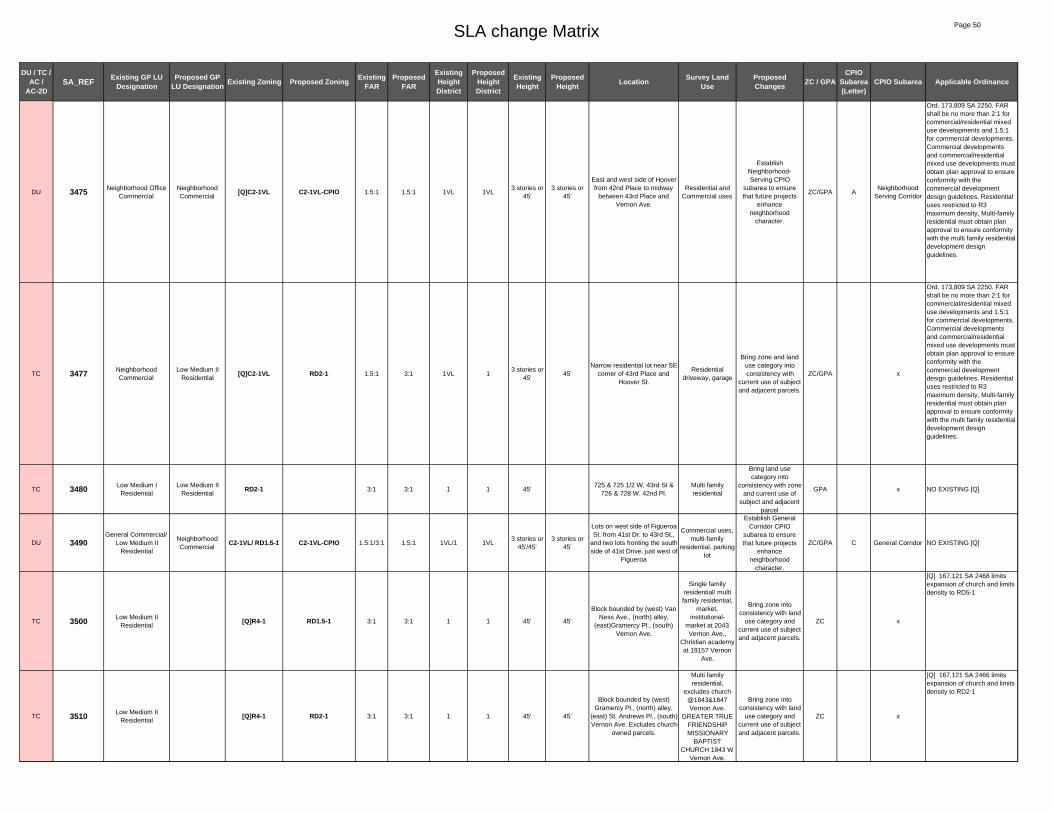
SLA change Matrix Page 50
DU / TC / AC /
AC-2DSA_REF Existing GP LU
DesignationProposed GP
LU Designation Existing Zoning Proposed Zoning Existing FAR
Proposed FAR
Existing Height District
Proposed Height District
Existing Height
Proposed Height Location Survey Land
UseProposed Changes ZC / GPA
CPIO Subarea (Letter)
CPIO Subarea Applicable Ordinance
DU 3475 Neighborhood Office Commercial
Neighborhood Commercial
[Q]C2-1VL C2-1VL-CPIO 1.5:1 1.5:1 1VL 1VL3 stories or
45'3 stories or
45'
East and west side of Hoover from 42nd Place to midway
between 43rd Place and Vernon Ave.
Residential and Commercial uses
Establish Neighborhood-Serving CPIO
subarea to ensure that future projects
enhance neighborhood
character.
ZC/GPA ANeighborhood
Serving Corridor
Ord. 173,809 SA 2250. FAR shall be no more than 2:1 for commercial/residential mixed use developments and 1.5:1 for commercial developments. Commercial developments and commercial/residential mixed use developments must obtain plan approval to ensure conformity with the commercial development design guidelines. Residential uses restricted to R3 maximum density, Multi-family residential must obtain plan approval to ensure conformity with the multi family residential development design guidelines.
TC 3477 Neighborhood Commercial
Low Medium II Residential
[Q]C2-1VL RD2-1 1.5:1 3:1 1VL 13 stories or
45'45'
Narrow residential lot near SE corner of 43rd Place and
Hoover St.
Residential driveway, garage
Bring zone and land use category into consistency with
current use of subject and adjacent parcels.
ZC/GPA x
Ord. 173,809 SA 2250. FAR shall be no more than 2:1 for commercial/residential mixed use developments and 1.5:1 for commercial developments. Commercial developments and commercial/residential mixed use developments must obtain plan approval to ensure conformity with the commercial development design guidelines. Residential uses restricted to R3 maximum density, Multi-family residential must obtain plan approval to ensure conformity with the multi family residential development design guidelines.
TC 3480 Low Medium I Residential
Low Medium II Residential
RD2-1 3:1 3:1 1 1 45'725 & 725 1/2 W. 43rd St &
726 & 728 W. 42nd Pl.Multi family residential
Bring land use category into
consistency with zone and current use of
subject and adjacent parcel
GPA x NO EXISTING [Q]
DU 3490General Commercial/
Low Medium II Residential
Neighborhood Commercial
C2-1VL/ RD1.5-1 C2-1VL-CPIO 1.5:1/3:1 1.5:1 1VL/1 1VL3 stories or
45'/45'3 stories or
45'
Lots on west side of Figueroa St. from 41st Dr. to 43rd St.,
and two lots fronting the south side of 41st Drive, just west of
Figueroa
Commercial uses, multi-family
residential, parking lot
Establish General Corridor CPIO
subarea to ensure that future projects
enhance neighborhood
character.
ZC/GPA C General Corridor NO EXISTING [Q]
TC 3500 Low Medium II Residential
[Q]R4-1 RD1.5-1 3:1 3:1 1 1 45' 45'
Block bounded by (west) Van Ness Ave., (north) alley,
(east)Gramercy Pl., (south) Vernon Ave.
Single family residential/ multi family residential,
market, institutional-
market at 2043 Vernon Ave.,
Christian academy at 1915? Vernon
Ave.
Bring zone into consistency with land
use category and current use of subject and adjacent parcels.
ZC x
[Q] 167,121 SA 2468 limits expansion of church and limits density to RD5-1
TC 3510 Low Medium II Residential
[Q]R4-1 RD2-1 3:1 3:1 1 1 45' 45'
Block bounded by (west) Gramercy Pl., (north) alley,
(east) St. Andrews Pl., (south) Vernon Ave. Excludes church-
owned parcels.
Multi family residential,
excludes church @1843&1847 Vernon Ave.
GREATER TRUE FRIENDSHIP MISSIONARY
BAPTIST CHURCH 1843 W
Vernon Ave.
Bring zone into consistency with land
use category and current use of subject and adjacent parcels.
ZC x
[Q] 167,121 SA 2466 limits expansion of church and limits density to RD2-1

SLA change Matrix Page 51
DU / TC / AC /
AC-2DSA_REF Existing GP LU
DesignationProposed GP
LU Designation Existing Zoning Proposed Zoning Existing FAR
Proposed FAR
Existing Height District
Proposed Height District
Existing Height
Proposed Height Location Survey Land
UseProposed Changes ZC / GPA
CPIO Subarea (Letter)
CPIO Subarea Applicable Ordinance
AC-2D 3520 Neighborhood Office Commercial
Community Commercial
[Q]C2-1VL C2-2D-CPIO 1.5:1 3:1 1VL 2D3 stories or
45'6 stories
Lots on north side of Vernon Ave. from St. Andrews Pl. to alley (just west of Western
Ave.); NW corner of Western Ave. and Vernon Ave.; Block on south side of Vernon Ave. from St. Andrews Pl. to alley (just west of Western Ave.)
Primarily commercial uses
some residential, 2 story commercial building with liquor
store and office/residential,
vacant lot.
Enable specialized transit oriented development
parameters for commercial
properties in close proximity to light rail
stations and intersections of major
bus lines.
ZC/GPA F TOD Medium
Ord. 173,809 SA 1960 change C2-1VL to [Q]C2-1VL, The FAR shall be no more than 2:1 for commercial/residential mixed use developments and 1.5:1 for commercial developments. Commercial developments and commercial/residential mixed use developments must obtain plan approval to ensure conformity with the commercial development design guidelines. Residential uses restricted to R3 maximum density, Ord. 167,121 SA 2464 change C2-1 to HD 1-L, Ord.180,103 Fast Food Interim Ordinance -
AC-2D 3535 Neighborhood Office Commercial
Community Commercial
[Q]C2-1VL C2-2D-CPIO 1.5:1 3:1 1VL 2D3 stories or
45'6 stories
Lots on east side of Western Ave. from 42nd Pl. to Vernon Ave.; NW corner of Western Ave. and Vernon Ave. (lots fronting Vernon Ave. from Western Ave. to Hobart
Blvd.); Lots on north side of Vernon Ave. from Hobart Blvd. to Harvard Blvd.; SE
corner of Vernon Ave./Western Ave., lots
fronting Western Ave. from Vernon Ave. to 45th St.
Primarily commercial uses,
1 and 2 story commercial and
office uses, some residential, car
wash, gas station, coin laundry
Enable specialized transit oriented development
parameters for commercial
properties in close proximity to light rail
stations and intersections of major
bus lines.
ZC/GPA F TOD Medium
Ord. 173,809 SA 1960 change C2-1VL to [Q]C2-1VL, The FAR shall be no more than 2:1 for commercial/residential mixed use developments and 1.5:1 for commercial developments. Commercial developments and commercial/residential mixed use developments must obtain plan approval to ensure conformity with the commercial development design guidelines. Residential uses restricted to R3 maximum density, Ord. 167 121 SA 2266 change C2-
AC 3560 Low Medium II Residential
Neighborhood Commercial
[Q]R4-1 C2-1VL-CPIO 3:1 1.5:1 1 1VL 45'3 stories or
45'
Block bounded by (west) Denker Ave., (north) alley, (east) Dalton Ave., (south)
Vernon Ave. Does not include church-owned lot at corner of
Denker and Vernon.
Vacant lot, post office, retail
commercial, junk yard at 1525
Vernon Ave., post office at 1519, 1517, 1509. Excludes ST MATTHEWS
BAPTIST CHURCH 1534 W
Vernon Ave.
Establish General Corridor CPIO
subarea to ensure that future projects
enhance neighborhood
character.
ZC/GPA C General Corridor
[Q] 167,121 SA 2450 limits expansion of church and limits density to RD1.5-1
TC 3570 Low Medium II Residential
[Q]R4-1 RD1.5-1 3:1 3:1 1 1 45' 45'
Block bounded by (west) Halldale Ave., (north) alley, (east) Brighton Ave., (south)
Vernon Ave. Excludes church-owned parcel at corner of
Vernon and Brighton.
Two family residential, residential.
Excludes church AGAPE
MISSIONARY BIBLE CHURCH 1431 W Vernon
Ave.
Bring zone into consistency with land
use category and current use of subject and adjacent parcels.
ZC x
[Q] 167,121 SA 2444 limits expansion of church and limits density to RD1.5-1
DU 3580 General CommercialNeighborhood Commercial
RD1.5-1 C2-1VL-CPIO 3:1 1.5:1 1 1VL 45'3 stories or
45'1413 & 1415 Vernon Ave.
Multi family residential
Establish General Corridor CPIO
subarea to ensure that future projects
enhance neighborhood
character.
ZC/GPA C General Corridor
NO EXISTING [Q]
DU 3585 General CommercialNeighborhood Commercial
C2-1VL C2-1VL-CPIO 1.5:1 1.5:1 1VL 1VL3 stories or
45'3 stories or
45'
Lots on north Vernon Ave. between Raymond Ave. and
past Van Buren Pl.
Residential; Auto Repair; Parking
Lot
Establish General Corridor CPIO
subarea to ensure that future projects
enhance neighborhood
character.
ZC/GPA C General Corridor
NO EXISTING [Q]
TC 3590General Commercial/ Neighborhood Office
Commercial
Low Medium I Residential
R2-1 3:1 3:1 1 1 33'4343 and 4345 Budlong Ave.
(north of Vernon Ave.)
Two family residential, single family residential
Bring land use category into
consistency with zone and current use of
subject and adjacent parcel
GPA x
NO EXISTING [Q]

SLA change Matrix Page 52
DU / TC / AC /
AC-2DSA_REF Existing GP LU
DesignationProposed GP
LU Designation Existing Zoning Proposed Zoning Existing FAR
Proposed FAR
Existing Height District
Proposed Height District
Existing Height
Proposed Height Location Survey Land
UseProposed Changes ZC / GPA
CPIO Subarea (Letter)
CPIO Subarea Applicable Ordinance
AC-2D 3610Medium Residential/Neighborhood Office
Commercial
Community Commercial
[Q]R3-1/[Q]C2-1VL/
R3-1/R4-1/C2-1
C2-2D-CPIO3:1/1.5:1/3:1/3:1/1.
5:13:1 1/1VL/1/1/1 2D
45' / 3 stories or 45' / 45' / NL / NL
6 storiesNW corner of Vermont Ave.
and Vernon Ave.
Number uno (shopping center) supermarket and
various other retail stores, some
residential (only 3 lots)
Enable specialized transit oriented development
parameters for commercial
properties in close proximity to light rail
stations and intersections of major
bus lines.
ZC/GPA F TOD Medium
Ord. 173,809 SA 2140 change C2-1 to [Q]C2-1VL, FAR shall be no more than 2:1 for commercial/residential mixed use developments and 1.5:1 for commercial developments. Commercial developments and commercial/residential mixed use developments must obtain plan approval to ensure conformity with the commercial development design guidelines. Residential uses restricted to R3 maximum density, Ord. 167,121 SA 2406 change R4-1 to R3-1, Ord.171,682 and Ord. 162,128 conditional uses for alcoholic beverages.
AC-2D 3620 Neighborhood Office Commercial
Community Commercial
[Q]C2-1VL C2-2D-CPIO 1.5:1 3:1 1VL 2D3 stories or
45'6 stories
West side of Vermont from Vernon to 45th St, east side of Vermont from 43d St to
45th St, north and south sides of Vernon from Vermont to
Menlo Ave.
Commercial uses retail stores, dry
cleaners, eye clinic, residential uses, one 2-story
building with commercial on the ground floor and
possibly residential or office above.
Enable specialized transit oriented development
parameters for commercial
properties in close proximity to light rail
stations and intersections of major
bus lines.
ZC/GPA F TOD Medium
Ord. 173,809 SA 2140 change C2-1 to [Q]C2-1VL, FAR shall be no more than 2:1 for commercial/residential mixed use developments and 1.5:1 for commercial developments. Commercial developments and commercial/residential mixed use developments must obtain plan approval to ensure conformity with the commercial development design guidelines. Residential uses restricted to R3 maximum density, Ord. 167,121 SA 2400 change C2-1 to C1-1-VL, Ord.180,103 Fast Food Interim Ordinance - prohibit the establishment of new fast food restaurants, Ord.171,682 and Ord. 162,128 conditional uses for alcoholic
TC 3625Low Medium I
Residential / Medium Residential
Public FacilitiesR2-1 / R3-1 /
[Q]R3-1 PF-1 3:1/ 3:1/ 1.5:1 1/1/1 1 45'/45' NLSouth of Vernon Ave. from Orchard Ave to Wesley Ave
Public elementary school
Bring zone and land use category into consistency with
current use of subject and adjacent parcels.
ZC/GPA x
Ord. 173,792 SA 2490: change RD2-1 to [Q]R3-1, Residential developments shall be limited toa maximum density of 1,200 square feet perdwelling unit in the R3 zone.2. Multi-family residential developments mustobtain plan approval to ensure conformitywith the multi-family residentialdevelopment design guidelines.
TC 3635 Public Facilities [Q]C2-1VL PF-1 1.5:1 1.5:1 1VL 13 stories or
45'NL
NE corner Hoover St. & Vernon Ave.
Fire station
Bring zone into consistency with land
use category and current use of subject and adjacent parcels.
ZC x
ORD-173809-SA2240- limits density to R3. Limits expansion of churches.. Limites FAR for commercial and Mixed used projects

SLA change Matrix Page 53
DU / TC / AC /
AC-2DSA_REF Existing GP LU
DesignationProposed GP
LU Designation Existing Zoning Proposed Zoning Existing FAR
Proposed FAR
Existing Height District
Proposed Height District
Existing Height
Proposed Height Location Survey Land
UseProposed Changes ZC / GPA
CPIO Subarea (Letter)
CPIO Subarea Applicable Ordinance
TC 3642 Neighborhood Commercial
Public Facilities [Q]C2-1VL PF-1 1.5:1 1.5:1 1VL 13 stories or
45'NL
721 W Vernon Ave (north side of Vernon, east of
Hoover)
Fire Station No. 46 parking lot
Bring zone and land use category into consistency with
current use of subject and adjacent parcels.
ZC/GPA x
Ord. 173,809 SA2240 The FAR shall be no more than 2:1 for commercial/residential mixed use developments and 1.5:1 for commercial developments. Commercial developments and commercial/residential mixed use developments must obtain plan approval to ensure conformity with the commercial development design guidelines. Residential uses restricted to R3 maximum density. The "Q" conditions as per CPC 86-447 GPC shall be retained for existing uses.
AC 3645Neighborhood Commercial /
Medium Residential
Neighborhood Commercial
[Q]C2-1VL/ R3-1 C2-1VL-CPIO 1.5:1/3:1 1.5:1 1VL/1 1VL3 stories or
45' / 45'3 stories or
45'
Lots on west and southeast corners of Vernon Ave. and
Hoover St. Lots north of Vernon Ave. roughly between
Hoover St. st and Figueroa St.
Commercial. Market and Liquor
Establish General Corridor CPIO
subarea to ensure that future projects
enhance neighborhood
character.
ZC/GPA C General Corridor
Ord. 173,809 SA2240 The FAR shall be no more than 2:1 for commercial/residential mixed use developments and 1.5:1 for commercial developments. Commercial developments and commercial/residential mixed use developments must obtain plan approval to ensure conformity with the commercial development design guidelines. Residential uses restricted to R3 maximum density. The "Q" conditions as per CPC 86-447 GPC shall be retained for existing uses.
AC-2D 3650Community
Commercial/ Medium Residential
Community Commercial
C2-1 C2-2D-CPIO 1.5:1 3:1 1 2D NL 6 storiesLots on west side of Figueroa St. from 43rd St. To 45th St.
Commercial uses, strip mall, residential
Enable specialized transit oriented development
parameters for commercial
properties in close proximity to light rail
stations and intersections of major
bus lines.
ZC/GPA F TOD Medium NO EXISTING [Q]
AC-2D 3670 Neighborhood Office Commercial
Community Commercial
[Q]C2-1VL C2-2D-CPIO 1.5:1 3:1 1VL 2D3 stories or
45'6 stories
Lots on west side Western Ave. from Vernon Ave. to
45th St.
Fast Food establishment
parking lot in front, restaurant,
appliance store, cash advance
place
Enable specialized transit oriented development
parameters for commercial
properties in close proximity to light rail
stations and intersections of major
bus lines.
ZC/GPA F TOD Medium
Ord. 173,809 SA 2260 change [Q]C2-1 to [Q]C2-1VL, Design guidelines for multi-family residential developments, the FAR shall be no more than 2:1 for commercial/residential mixed use developments and 1.5:1 for commercial developments. Commercial developments and commercial/residential mixed use developments must obtain plan approval to ensure conformity with the commercial development design guidelines. Residential uses restricted to R3 maximum density, Ord. 167,121 SA 2489 change C2-1 to HD 1-L, 167,121 SA 2641 change C2-1 to [Q]C2-1, residential uses at the density of R4 and R5 zones shall be prohibited, Ord.180,103 Fast Food Interim Ordinance - prohibit the establishment of new fast food restaurants, Ord.171,682 and Ord. 162,128, conditional uses for alcoholic beverages.

SLA change Matrix Page 54
DU / TC / AC /
AC-2DSA_REF Existing GP LU
DesignationProposed GP
LU Designation Existing Zoning Proposed Zoning Existing FAR
Proposed FAR
Existing Height District
Proposed Height District
Existing Height
Proposed Height Location Survey Land
UseProposed Changes ZC / GPA
CPIO Subarea (Letter)
CPIO Subarea Applicable Ordinance
AC 3671 Neighborhood Office Commercial
Neighborhood Commercial
[Q]C2-1VL C2-1VL-CPIO 1.5:1 1.5:1 1VL 1VL3 stories or
45'3 stories or
45'Lots on west side of Western Ave. from45th St. to 46th St.
Fast Food establishment
parking lot in front, restaurant,
appliance store, cash advance
place
Establish General Corridor CPIO
subarea to ensure that future projects
enhance neighborhood
character.
ZC/GPA C General Corridor
Ord. 173,809 SA 2260 change [Q]C2-1 to [Q]C2-1VL, Design guidelines for multi-family residential developments, the FAR shall be no more than 2:1 for commercial/residential mixed use developments and 1.5:1 for commercial developments. Commercial developments and commercial/residential mixed use developments must obtain plan approval to ensure conformity with the commercial development design guidelines. Residential uses restricted to R3 maximum density, Ord. 167,121 SA 2489 change C2-1 to HD 1-L, 167,121 SA 2641 change C2-1 to [Q]C2-1, residential uses at the density of R4 and R5 zones shall be prohibited, Ord.180,103 Fast Food Interim Ordinance - prohibit the establishment of new fast food restaurants, Ord.171,682 and Ord. 162,128, conditional uses for alcoholic beverages.
DU 3690 General CommercialNeighborhood Commercial
C2-1VL C2-1VL-CPIO 1.5:1 1.5:1 1VL 1VL3 stories or
45'3 stories or
45'
Lots on south side of Vernon Ave. from alley (just east of Western Ave.) to Harvard
Ave.
Commercial and residential uses
Establish General Corridor CPIO
subarea to ensure that future projects
enhance neighborhood
character.
ZC/GPA C General Corridor NO EXISTING [Q]
AC-2D 3691 General CommercialCommunity Commercial
C2-1VL C2-2D-CPIO 1.5:1 3:1 1VL 2D3 stories or
45'6 stories
Lots on south side of Vernon Ave. from Harvard Blvd. to
Denker Ave.
Commercial and residential uses
Enable specialized transit oriented development
parameters for commercial
properties in close proximity to light rail
stations and intersections of major
bus lines.
ZC/GPA F TOD Medium NO EXISTING [Q]
DU 3696 General CommercialNeighborhood Commercial
C2-1VL C2-1VL-CPIO 1.5:1 1.5:1 1VL 1VL3 stories or
45'3 stories or
45'
Lots on north-east and north-west corners of Vernon Ave. and Normandie Ave., lots on southwest corner to 45th St.
Apartments; Commercial
Establish General Corridor CPIO
subarea to ensure that future projects
enhance neighborhood
character.
ZC/GPA C General Corridor NO EXISTING [Q]
DU 3698 Neighborhood Office Commercial
Neighborhood Commercial
C2-1L C2-1VL-CPIO 3:1 1.5:1 1L 1VL6 stories or
75'3 stories or
45'Lots on corners of Vernon
Ave. and Budlong Ave.
Market; RV Storage/Enclosed
Parking Lot; Vermont Ave. Square United
Church and parking lot
Establish General Corridor CPIO
subarea to ensure that future projects
enhance neighborhood
character.
ZC/GPA C General Corridor NO EXISTING [Q]
AC-2D 3700 Low Medium II Residential
Community Commercial
[Q]R4-1 C2-2D-CPIO 3:1 3:1 1 2D 45' 6 storiesSW corner Vernon Ave. & Kansas Ave. (7 parcels)
Residential
Enable specialized transit oriented development
parameters for commercial
properties in close proximity to light rail
stations and intersections of major
bus lines.
ZC/GPA F TOD Medium
[Q] 167,121 SA 2508 limits expansion of church and limits density to RD2-1
AC-2D 3710 General CommercialCommunity Commercial
C2-1VL C2-2D-CPIO 1.5:1 3:1 1VL 2D3 stories or
45'6 stories
Lots on south side of Vernon Ave. from Kansas Ave. to alley (just west of Vermont
Ave.)
Mostly commercial some residential, church. St. Brigid Church at 5214 South Western
Ave.
Enable specialized transit oriented development
parameters for commercial
properties in close proximity to light rail
stations and intersections of major
bus lines.
ZC/GPA F TOD Medium NO EXISTING [Q]

SLA change Matrix Page 55
DU / TC / AC /
AC-2DSA_REF Existing GP LU
DesignationProposed GP
LU Designation Existing Zoning Proposed Zoning Existing FAR
Proposed FAR
Existing Height District
Proposed Height District
Existing Height
Proposed Height Location Survey Land
UseProposed Changes ZC / GPA
CPIO Subarea (Letter)
CPIO Subarea Applicable Ordinance
DU 3760 Neighborhood Office Commercial
Neighborhood Commercial
[Q]C2-1VL C2-1VL-CPIO 1.5:1 1.5:1 1VL 1VL3 stories or
45'3 stories or
45'Lots on east side of Western Ave. from 45th St. to 46th St.
Commercial uses
Establish General Corridor CPIO
subarea to ensure that future projects
enhance neighborhood
character.
ZC/GPA C General Corridor
Ord. 173,809 SA 2280 change [Q]C2-1 to [Q]C2-1VL, Design guidelines for multi-family residential developments, the FAR shall be no more than 2:1 for commercial/residential mixed use developments and 1.5:1 for commercial developments. Commercial developments and commercial/residential mixed use developments must obtain plan approval to ensure conformity with the commercial development design guidelines. Residential uses restricted to R3 maximum density, Ord. 167,121 SA 2635 change C2-1 to [Q]C2-1, residential uses at the density of R4 and R5 zones shall be prohibited, Ord.180,103 Fast Food Interim Ordinance - prohibit the establishment of new fast food restaurants, Ord.171,682 and Ord. 162,128, conditional uses for alcoholic beverages.
TC 3770 Low Medium II Residential
[Q]R4-1 RD1.5-1 3:1 3:1 1 1 45' 45'
Block bounded by (west) alley, (north) 45th St., (east)
Normandie Ave., (south) 46th St.
Multi family residential (2 story)-
all residential
Bring zone into consistency with land
use category and current use of subject and adjacent parcels.
ZC x
[Q] 167,121 SA 2620 limits expansion of church and limits density to RD1.5-1
DU 3772 General CommercialNeighborhood Commercial
C2-1VL C2-1VL-CPIO 1.5:1 1.5:1 1VL 1VL3 stories or
45'3 stories or
45'
Lots on the east side of Normandie Ave. from 45th St south to 3 lots south of 46th
St.
Mostly multi-family, one commercial
building, empty lot.
Establish General Corridor CPIO
subarea to ensure that future projects
enhance neighborhood
character.
ZC/GPA C General Corridor
NO EXISTING [Q]
TC 3775 Public Facilities Low II Residential R1-1 3:1 3:1 1 1 33'
Long narrow lot north residential parcels at NW
corner 46th St. & Raymond Ave.
Residential
Bring land use category into
consistency with zone and current use of
subject and adjacent parcel
GPA x
NO EXISTING [Q]
TC 3780
Low Medium I Residential/
General Commercial/Neighborhood Office
Commercial
Public Facilities[Q]R4-1/C2-1VL/
R2-1PF-1 3:1/1.5:1/
3:11.5:1 1VL/1VL/1 1
33' / 3 stories or 45' / 33'
NL
Area generally bounded by Western Ave., 46th St., St. Andrews Pl. and alley of
block bounded by 47th St., Western Ave., 48th St. and
St. Andrews Pl..
New LAUSD middle school. Barack Obama
Global Prep Academy 1700 W.
46th st.
Bring zone and land use category into consistency with
current use of subject and adjacent parcels.
ZC/GPA x
Ord. 167,121 SA 2660 change C2-1 to HD 1-VL, SA 2658 change R2-1 to [Q]R4-1, limits church expansion to 20% and limits density to R2-1, Ord.180,103 Fast Food Interim Ordinance - prohibit the establishment of new fast food restaurants, Ord.171,682 and Ord. 162,128, conditional uses for alcoholic beverages.
DU 3790General Commercial
/Highway Oriented and Limited Commercial
Neighborhood Commercial
C2-1VL C2-1VL-CPIO 1.5:1 1.5:1 1VL 1VL3 stories or
45'3 stories or
45'
Lots east side of Western Ave. from 46th St. to
midblock of (just south of 47th St.)
Commercial uses
Establish General Corridor CPIO
subarea to ensure that future projects
enhance neighborhood
character.
ZC/GPA C General Corridor NO EXISTING [Q]
TC 3800 Low Medium II Residential
[Q]R4-1 RD1.5-1 3:1 3:1 1 1 45' 45'
Block bound by (west) alley, (north) 46th St., (east)
Normandie Ave., (south) 47th St. Excludes church-owned
parcels.
2 multi family, 1 single family residential.
Excludes church (on 2 lots), PILGRIM
BONGREGATIONAL CHURCH,
UNITED CHURCH OF CHRIST 4601 S. Normandie Ave.
Bring zone into consistency with land
use category and current use of subject and adjacent parcels.
ZC x
[Q] 167,121 SA 2680 limits expansion of church and limits density to RD2-1

SLA change Matrix Page 56
DU / TC / AC /
AC-2DSA_REF Existing GP LU
DesignationProposed GP
LU Designation Existing Zoning Proposed Zoning Existing FAR
Proposed FAR
Existing Height District
Proposed Height District
Existing Height
Proposed Height Location Survey Land
UseProposed Changes ZC / GPA
CPIO Subarea (Letter)
CPIO Subarea Applicable Ordinance
DU 3805
Neighborhood Office Commercial/ General
Commercial / Highway Oriented
and Limited Commercial
Neighborhood Commercial
C2-1L/ C2-1VL C2-1VL-CPIO 3:1/1.5:1 1.5:1 1L/1VL 1VL
6 stories or 75' / 3
stories or 45'
3 stories or 45'
Lots on west side of Normandie Ave. from 47th St. to mid-block between 51st St.
and 51st Place, and on the east side of Normandie from 3 lots north of 47th St. to 3 lots south of 48th St., and
50th St. to mid-block between 51st St. and 51st Place.
Commercial, storefront
churches, multi-family, single
family residential. Includes liquor
stores, used auto sales, marijuana dispensary, auto
repair, salon, bakery, 2-story
mixed use market, 3 auto repair/smog
check
Establish General Corridor CPIO
subarea to ensure that future projects
enhance neighborhood
character.
ZC/GPA C General Corridor
NO EXISTING [Q]
DU 3806 Low Residential Low II Residential R1-1 R1-1-CPIO 3:1 3:1 1 1 33' 33'
Blocks bounded by Normandie to the west,
Vernon to the north, Budlong to the east, and 47th St. to the
south. Excludes parcels fronting Normandie and
Vernon, and LAUSD school at corner.
Single family residential, historic
neighborhood
Establish Character Residential CPIO
subarea to preserve the existing scale and historic character of the neighborhood.
ZC/GPA OCharacter Residential
NO EXISTING [Q]
DU 3807 Low Residential Low II Residential R1-1 R1-1-CPIO 3:1 3:1 1 1 33' 33'
Blocks bounded by Budlong to the west, Vernon to the north, Vermont to the east, and 47th St. to the south. Excludes parcels fronting
Vernon and Vermont.
Single family residential, historic
neighborhood
Establish Character Residential CPIO
subarea to preserve the existing scale and historic character of the neighborhood.
ZC/GPA OCharacter Residential
NO EXISTING [Q]
DU 3808 Low Residential Low II Residential R1-1 R1-1-CPIO 3:1 3:1 1 1 33' 33'
Lots bounded by 49th St to the south, the alley east of
Normandie to the west, 47th st to the north, and Budlong to the east. Excludes park.
Single family residential, historic
neighborhood
Establish Character Residential CPIO
subarea to preserve the existing scale and historic character of the neighborhood.
ZC/GPA OCharacter Residential
NO EXISTING [Q]
DU 3809 Low Residential Low II Residential R1-1 R1-1-CPIO 3:1 3:1 1 1 33' 33'
Lots bounded by 47th Street to the north, the alley west of Vermont to the east, 50th St to the south, and Budlong to
the west.
Single family residential, historic
neighborhood
Establish Character Residential CPIO
subarea to preserve the existing scale and historic character of the neighborhood.
ZC/GPA OCharacter Residential
NO EXISTING [Q]
DU 3810 General CommercialNeighborhood Commercial
C2-1VL C2-1VL-CPIO 1.5:1 1.5:1 1VL 1VL3 stories or
45'3 stories or
45'
Lots facing Vermont Ave. from just south of 45th St. on
north to 48th St. on south side. Excludes school-owned
parcels on west side of Vermont between 46th and
47th Streets.
Primarily commercial uses, does not include LAUSD school
Establish General Corridor CPIO
subarea to ensure that future projects
enhance neighborhood
character.
ZC/GPA C General Corridor NO EXISTING [Q]
TC 3812 General Commercial/ Low Residential
Public FacilitiesC2-1VL/
R1-1 PF-1 1.5:1/3:1 1.5:1 1 13 stories or
45' / 33'NL
Lots on west side of Vermont, from 46th St. to 47th St.
(LAPD school)LAUSD school
Bring zone and land use category into consistency with
current use of subject and adjacent parcels.
ZC/GPA x NO EXISTING [Q]
TC 3814 Low Medium I Residential
Open Space R2-1 OS-1XL 3:1 1.5:1 1 1XL 33' NL4600 S Orchard Ave (north of
47th St)Park
Bring zone and land use category into consistency with
current use of subject and adjacent parcels.
ZC/GPA x NO EXISTING [Q]
DU 3815Neighborhood Office
Commercial/ Low Medium II Residential
Neighborhood Commercial
C2-1L/ RD2-1 C2-1VL-CPIO 3:1/3:1 1.5:1 1L/1 1VL6 stories or
75' / 45'3 stories or
45'
East side of Hoover St from above 45th St. to below 47th
St., and SW corner of 47th St. and Hoover St.
Residential, commercial, warehouse
Establish Neighborhood-Serving CPIO
subarea to ensure that future projects
enhance neighborhood
character.
ZC/GPA ANeighborhood
Serving CorridorNO EXISTING [Q]
TC 3817 Neighborhood Office Commercial
Low Medium II Residential
C2-1L RD2-1 1.5:1 3:1 1L 16 stories or
75'45'
Interior parcels east of Hoover between 45th St. and 46th St.; Interior sliver parcel near SE corner of 46th St.
and Hoover St.
Residential
Bring zone and land use category into consistency with
current use of subject and adjacent parcels.
ZC/GPA x NO EXISTING [Q]

SLA change Matrix Page 57
DU / TC / AC /
AC-2DSA_REF Existing GP LU
DesignationProposed GP
LU Designation Existing Zoning Proposed Zoning Existing FAR
Proposed FAR
Existing Height District
Proposed Height District
Existing Height
Proposed Height Location Survey Land
UseProposed Changes ZC / GPA
CPIO Subarea (Letter)
CPIO Subarea Applicable Ordinance
TC 3825 Low Medium I Residential
C2-1L R2-1 1.5:1 3:1 1L 16 stories or
75'33'
Interior parcel near NE corner of Wilton Pl and 48th St.
Residential yard
Bring zone into consistency with land
use category and current use of subject and adjacent parcels.
ZC x NO EXISTING [Q]
DU 3830 Neighborhood Office Commercial
Neighborhood Commercial
C2-1L C2-1VL-CPIO 3:1 1.5:1 1L 1VL6 stories or
75'3 stories or
45'
2 lots located at NW corner of 48th St. and Western Ave. and 3 lots located at SW
corner of Western Ave. and 48th St.
Commercial uses
Establish Neighborhood-Serving CPIO
subarea to ensure that future projects
enhance neighborhood
character.
ZC/GPA ANeighborhood
Serving CorridorNO EXISTING [Q]
DU 3840 Neighborhood Office Commercial
Neighborhood Commercial
C2-1L C2-1VL-CPIO 3:1 3:1 1L 1L6 stories or
75'3 stories or
45'NW corner of 48th St. and
Western Ave.Commercial uses
Establish Neighborhood-Serving CPIO
subarea to ensure that future projects
enhance neighborhood
character.
ZC/GPA ANeighborhood
Serving CorridorNO EXISTING [Q]
TC 3850 Low Residential Low II Residential [Q]R4-1 R1-1 3:1 3:1 1 1 33' 33'West side of Gramercy Pl.
south of 48th St. Excludes 5 church-owned parcels.
Primarily residential.
Excludes church, BROOKINS
COMMUNITY AFRICAN
METHODIST EPISCOPAL
CHURCH, INC. 4831 S
GRAMERCY PL
Bring zone and land use category into consistency with
current use of subject and adjacent parcels.
ZC/GPA x
Ord. 167,121 SA 2836: R1-1 changed to [Q]R4-1, limits church expansion to 20% and limits density to R1-1.
TC 3852 Low Residential Low II Residential [Q]R4-1 3:1 3:1 1 1 33' 33'5 internal lots fronting Gramercy Place near Gramercy and 49th St.
church, BROOKINS
COMMUNITY AFRICAN
METHODIST EPISCOPAL
CHURCH, INC. 4831 S
GRAMERCY PL
Bring land use category into
consistency with zone and current use of
subject and adjacent parcel
GPA x
Ord. 167,121 SA 2836: R1-1 changed to [Q]R4-1, limits church expansion to 20% and limits density to R1-1.
TC 3860 Low Residential Low II Residential [Q]R4-1 R1-1 3:1 3:1 1 1 33' 33'
Block bounded by (west) St Andrews Pl., (north) alley,
(east) alley, (south) 50th St. Excludes easternmost, church-owned parcel.
Residential
Bring zone and land use category into consistency with
current use of subject and adjacent parcels.
ZC/GPA x
[Q] 167,121 SA 2930 LIMITS CHURCH EXPANSION TO 20% AND LIMITS DENSITY TO R1-1
DU 3870 General CommercialNeighborhood Commercial
C2-1VL C2-1VL-CPIO 1.5:1 1.5:1 1VL 1VL3 stories or
45'3 stories or
45'
East side of Western Ave. from mid block (just north of
49th St.) to 51st St.Commercial uses
Establish General Corridor CPIO
subarea to ensure that future projects
enhance neighborhood
character.
ZC/GPA C General Corridor NO EXISTING [Q]
TC 3879
Neighborhood Office Commercial/ Low
Medium II Residential/ Low
Residential
Low Medium II Residential
C2-1L/ RD2-1/ R1-1 RD2-1 1.5:1/ 3:1/
3:13:1 1L/1/1 1
6 stories or 75' / 45' /
33'45'
NE corner of 51st Place and Normandie Ave.
3 single-family homes
Bring zone and land use category into consistency with
current use of subject and adjacent parcels.
ZC/GPA x NO EXISTING [Q]

SLA change Matrix Page 58
DU / TC / AC /
AC-2DSA_REF Existing GP LU
DesignationProposed GP
LU Designation Existing Zoning Proposed Zoning Existing FAR
Proposed FAR
Existing Height District
Proposed Height District
Existing Height
Proposed Height Location Survey Land
UseProposed Changes ZC / GPA
CPIO Subarea (Letter)
CPIO Subarea Applicable Ordinance
AC 3880 General CommercialNeighborhood Commercial
[Q]C2-1VL C2-1VL-CPIO 1.5:1 1.5:1 1VL 1VL3 stories or
45'3 stories or
45'
Lots facing Vermont Ave. from just south of 48th St. on north to 49th St. on south side
Primarily commercial uses
Establish General Corridor CPIO
subarea to ensure that future projects
enhance neighborhood
character.
ZC/GPA C General Corridor
Ord. 173,809 SA 2380 change to [Q]C2-1VL, Multi-family residential developments must obtain plan approval to ensure conformity with the multi-family residential development design guidelines. FAR shall be no more than 2:1 for commercial/residential mixed use developments and 1.5:1 for commercial developments. Commercial developments and commercial/residential mixed use developments must obtain plan approval to ensure conformity with the commercial development design guidelines. Residential uses restricted to R3 maximum density, The "Q" conditions as per CPC 86-603 and CPC 27083 shall be retained for the existing use(s); Ord. 167,121 SA 2877 and 2879 change C2-1 to [Q]C2-1, Residential uses at the density of the R4 and R5 prohibited, Ord.180,103 Fast Food Interim Ordinance - prohibit the establishment of new fast food restaurants, Ord.171,682 and Ord. 162,128 conditional uses for alcoholic beverages.
DU 3882 Low Residential Low II Residential R1-1 R1-1-CPIO 3:1 3:1 1 1 33' 33'
Lots bounded by 49th St to the north, Budlong to the
east, 51st St to the south, and the alley east of Normandie to
the west.
Single family residential, historic
neighborhood
Establish Character Residential CPIO
subarea to preserve the existing scale and historic character of the neighborhood.
ZC/GPA OCharacter Residential
NO EXISTING [Q]
DU 3883 Low Residential Low II Residential R1-1 R1-1-CPIO 3:1 3:1 1 1 33' 33'
Lots on the south side of 51st Street from Normandie Ave to
Budlong, exlcuding commercial lots fronting
Normandie.
Single family residential, historic
neighborhood
Establish Character Residential CPIO
subarea to preserve the existing scale and historic character of the neighborhood.
ZC/GPA OCharacter Residential
NO EXISTING [Q]
DU 3884 Low Residential Low II Residential R1-1 R1-1-CPIO 3:1 3:1 1 1 33' 33'
Block bounded by 50th St to the north, Kansas Ave to the
east, 51st St to the south, and Budlong to the west, plus the
south side of 51st St. from Budlong to Vermont,
excluding commercial lots on Vermont.
Single family residential, historic
neighborhood
Establish Character Residential CPIO
subarea to preserve the existing scale and historic character of the neighborhood.
ZC/GPA OCharacter Residential
NO EXISTING [Q]
AC 3885 Low Medium II Residential
Neighborhood Commercial
RD2-1 C2-1VL-CPIO 3:1 1.5:1 1 1VL 45'3 stories or
45'945 W 49th St (north side of 49th east of Vermont Ave.)
Parking lot
Establish General Corridor CPIO
subarea to ensure that future projects
enhance neighborhood
character.
ZC/GPA C General Corridor NO EXISTING [Q]
DU 3887 Neighborhood Office Commercial
Neighborhood Commercial
C1-1L C1-1L-CPIO 3:1 1.5:1 1L 1VL6 stories or
75'3 stories or
45'NW corner of Hoover St. and
48th St.Residential, store
Establish Neighborhood-Serving CPIO
subarea to ensure that future projects
enhance neighborhood
character.
ZC/GPA ANeighborhood
Serving CorridorNO EXISTING [Q]
TC 3890 Low Medium II Residential
[Q]R4-1 RD2-1 3:1 3:1 1 1 45' 45'NW corner Hoover St. & 49th St. (8 parcels west and north)
Residences
Bring zone into consistency with land
use category and current use of subject and adjacent parcels.
ZC x
[Q] 167,121 SA 2880 limits expansion of church and limits density to RD2-1

SLA change Matrix Page 59
DU / TC / AC /
AC-2DSA_REF Existing GP LU
DesignationProposed GP
LU Designation Existing Zoning Proposed Zoning Existing FAR
Proposed FAR
Existing Height District
Proposed Height District
Existing Height
Proposed Height Location Survey Land
UseProposed Changes ZC / GPA
CPIO Subarea (Letter)
CPIO Subarea Applicable Ordinance
AC 3898 Low ResidentialNeighborhood Commercial
[Q]R4-1 C2-1VL-CPIO 3:1 1.5:1 1 1VL 33'3 stories or
45'1719 W 50th St (just west of
Western Ave)
Parking lot, GREATER NEW
JERUSALEM MISSIONARY
BAPTIST CHURCH OF L.A.
Establish General Corridor CPIO
subarea to ensure that future projects
enhance neighborhood
character.
ZC/GPA C General Corridor
[Q] 167,121 SA 2930 LIMITS CHURCH EXPANSION TO 20% AND LIMITS DENSITY TO R1-1
DU 3900General Commercial/
Low Medium I Residential
Neighborhood Commercial
C2-1VL/[Q]R4-1 C2-1VL-CPIO 1.5:1/3:1 1.5:1 1VL/1 1VL
3 stories or 45'/33'
3 stories or 45'
Western Ave. from 51st St to 53rd St.
Commercial uses, Catholic church,
parking lot. Includes Church-owned lot at 1738
W. 52nd St.
Establish General Corridor CPIO
subarea to ensure that future projects
enhance neighborhood
character.
ZC/GPA C General Corridor
[Q] 167,121 SA 3126 LIMITS CHURCH EXPANSION TO 20% AND LIMITS DENSITY TO R1-1; [Q] 167,121 SA 3126 LIMITS CHURCH EXPANSION TO 20% AND LIMITS DENSITY TO R1-1
DU 3901 General CommercialNeighborhood Commercial
C2-1VL C2-1VL-CPIO 1.5:1 1.5:1 1VL 1VL3 stories or
45'3 stories or
45'
Lots fronting Western Ave. from mid block of (block
bounded by 48th St., Western Ave., 49th St. and alley) to
just north of 51st St.
Commercial uses
Establish General Corridor CPIO
subarea to ensure that future projects
enhance neighborhood
character.
ZC/GPA C General Corridor NO EXISTING [Q]
DU 3910 General CommercialNeighborhood Commercial
C2-1VL C2-1VL-CPIO 1.5:1 1.5:1 1VL 1VL3 stories or
45'3 stories or
45'
Lots facing Vermont Ave. from just south of 49th St. on north to 50th St. on south side
Primarily commercial uses
Establish General Corridor CPIO
subarea to ensure that future projects
enhance neighborhood
character.
ZC/GPA C General Corridor NO EXISTING [Q]
TC 3920 Low Medium II Residential
[Q]R4-1 RD2-1 3:1 3:1 1 1 33' 45'
Block bounded by (west) Vermont Ave., (north) 49th
St., (east) Hoover St., (south) 50th St. (residential parcels
only, excludes church-owned parcels).
Residences. Excludes church,
ST. JOHN BAPTIST
CHURCH, INC. 936 W. 49TH ST
Bring zone into consistency with land
use category and current use of subject and adjacent parcels.
ZC x
[Q] 167,121 SA 2902 LIMITS CHURCH EXPANSION TO 20% AND LIMITS DENSITY TO R2-1
AC 3930 Low Medium II Residential
Neighborhood Commercial
C2-1 C2-1VL-CPIO 1.5:1 1.5:1 1 1VL NL3 stories or
45'NW corner Hoover St. & 50th St. (4 lots north to 49th St.)
Mixed use, retail comm., multi
family
Establish Neighborhood-Serving CPIO
subarea to ensure that future projects
enhance neighborhood
character.
ZC/GPA ANeighborhood
Serving CorridorNO EXISTING [Q]
TC 3935General Commercial/
Highway Oriented and Limited Commercial
Low Medium II Residential
C2-1VL RD2-1 1.5:1 3:1 1VL 13 stories or
45'45'
522 W. 47th Street (just west of Figueroa St.)
Residential
Bring zone and land use category into consistency with
current use of subject and adjacent parcels.
ZC/GPA x NO EXISTING [Q]
DU 3940 General CommercialNeighborhood Commercial
C2-1VL C2-1VL-CPIO 1.5:1 1.5:1 1VL 1VL3 stories or
45'3 stories or
45'Lots on west side of Figueroa St. from 45th St. to 51st St.
Commercial uses
Establish General Corridor CPIO
subarea to ensure that future projects
enhance neighborhood
character.
ZC/GPA C General Corridor NO EXISTING [Q]
DU 3941General Commercial
/Low Medium II Residential
Neighborhood Commercial
C2-1VL/RD2-1 C2-1VL-CPIO 1.5:1 1.5:1 1VL 1VL3 stories or
45' / 45'3 stories or
45'Lots on west side of Figueroa St. from 48th St. to 51st St.
Commercial uses
Establish General Corridor CPIO
subarea to ensure that future projects
enhance neighborhood
character.
ZC/GPA C General Corridor NO EXISTING [Q]
TC 3960 Low Medium I Residential
Low II Residential [Q]R4-1 R1-1 3:1 3:1 1 1 33' 33'
Block bounded by (west) Western Ave., (north) 51st
St., (east) Denker Ave., (south) 51st Pl.
Single family, (2 multi family) no
church, only residential
Bring zone into consistency with land
use category and current use of subject and adjacent parcels.
ZC x
[Q] 167,121 SA 3064 LIMITS CHURCH EXPANSION TO 20% AND LIMITS DENSITY TO R1-1

SLA change Matrix Page 60
DU / TC / AC /
AC-2DSA_REF Existing GP LU
DesignationProposed GP
LU Designation Existing Zoning Proposed Zoning Existing FAR
Proposed FAR
Existing Height District
Proposed Height District
Existing Height
Proposed Height Location Survey Land
UseProposed Changes ZC / GPA
CPIO Subarea (Letter)
CPIO Subarea Applicable Ordinance
TC 3970 Low Medium I Residential
[Q]R4-1 R2-1 3:1 3:1 1 1 33' 33'
Block bounded by (west) Denker Ave., (north) 51st Pl., (east) Halldale Ave., (south)
alley. Excludes church-owned parcels.
(1) multi family, (10) single family. Does not include
LIBERTY BAPTIST
CHURCH 1506 W 51ST PL and other
church-owned parcels.
Bring zone into consistency with land
use category and current use of subject and adjacent parcels.
ZC x
[Q] 167,121 SA 3116 LIMITS CHURCH EXPANSION TO 20% AND LIMITS DENSITY TO R2-1
TC 3980 Low Medium II Residential
[Q]R4-1 RD1.5-1 3:1 3:1 1 1 45' 45'NW corner Normandie Ave. &
52nd St., 3 parcels along Normandie.
Multi family. Does not include church (2 parcels) ROCK
OF FAITH BAPTIST
CHURCH 5151 S Normandie Ave.
Bring zone into consistency with land
use category and current use of subject and adjacent parcels.
ZC x
[Q] 167,121 SA 3110 LIMITS CHURCH EXPANSION TO 20% AND LIMITS DENSITY TO RD1.5-1
DU 3990 General CommercialNeighborhood Commercial
[T][Q]C2-2D [T][Q]C2-2D-CPIO 1.5:1/6:1 1.5:1 2D/1VL 2D
3 stories or 45'/ 3
stories or 45' per the
[T][Q]
3 stories or 45' per the
[T][Q]
Block facing Vermont Ave. on west side from 50th St. to
51st St.
Primarily commercial uses
Establish General Corridor CPIO
subarea to ensure that future projects
enhance neighborhood
character.
ZC/GPA C General Corridor
Ord. 167,121 SA 2990 change C2-1 to HD 1-VL, Ord. 168,598, change from C2-1VL to [T][Q]C2-2D, Air quality installations, lightning directed onto the site, attractively landscaping, graffiti removal and deterrence, height maximum 3 stories/45 feet, any use shall operate only between 7am-9pm, use limited to a recreational or community center including child care facilities and classrooms, Ord.180,103 Fast Food Interim Ordinance - prohibit the establishment of new fast food restaurants, Ord.171,682 and Ord. 162,128 conditional uses for alcoholic beverages. (UNDERLYING ZONE C2-1VL) PERM. Q TEMP T
DU 4000 General CommercialNeighborhood Commercial
C2-1VL C2-1VL-CPIO 1.5:1 1.5:1 1VL 1VL3 stories or
45'3 stories or
45'Lots on east side of Vermont Ave. from 50th St. to 51st Pl.
Primarily commercial uses
Establish General Corridor CPIO
subarea to ensure that future projects
enhance neighborhood
character.
ZC/GPA C General Corridor
NO EXISTING [Q]
TC 4010 Low Medium I Residential
[Q]R4-1 R2-1 3:1 3:1 1 1 33' 33'
Block bounded by (west) alley, (north) 51st St., (east)
Alley, (south) 51st Pl. (residential parcels only) Excludes church-owned
parcel.
Multi family, single family. Excludes
church, ZION TEMPLE
MISSIONARY BAPTIST
CHURCH 937 W. 51ST PL
Bring zone into consistency with land
use category and current use of subject and adjacent parcels.
ZC x
[Q] 167,121 SA 3082 limits expansion of church and limits density to R2-1
TC 4020 Low Medium II Residential
[Q]R4-1 RD2-1 3:1 3:1 1 1 45' 45'SE corner Hoover St. & 50th
St.
Multi family. Excludes church THE CARVER MISSIONARY
BAPTIST CHURCH 5050 S
Hoover St.
Bring zone into consistency with land
use category and current use of subject and adjacent parcels.
ZC x
[Q] 167,121 SA 3009 limits expansion of church and limits density to RD2-1

SLA change Matrix Page 61
DU / TC / AC /
AC-2DSA_REF Existing GP LU
DesignationProposed GP
LU Designation Existing Zoning Proposed Zoning Existing FAR
Proposed FAR
Existing Height District
Proposed Height District
Existing Height
Proposed Height Location Survey Land
UseProposed Changes ZC / GPA
CPIO Subarea (Letter)
CPIO Subarea Applicable Ordinance
DU 4030 General CommercialNeighborhood Commercial
[Q]C2-1VL C2-1VL-CPIO 1.5:1 1.5:1 1VL 1VL3 stories or
45'3 stories or
45'SW corner of 51st St. and
Figueroa St.Commercial uses
Establish General Corridor CPIO
subarea to ensure that future projects
enhance neighborhood
character.
ZC/GPA C General Corridor
Ord. 173,792 SA 2580 change to C2-1 to [Q]C2-1VL, Multi-family residential developments must obtain plan approval to ensure conformity with the multi-family residential development t design guidelines. FAR shall be no more than 2:1 for commercial/residential mixed use developments and 1.5:1 for commercial developments. Commercial developments and commercial/residential mixed use developments must obtain plan approval to ensure conformity with the commercial development design guidelines. Residential uses restricted to R3 maximum density, Ord.180,103 Fast Food Interim Ordinance - prohibit the establishment of new fast food restaurants, Ord.171,682 and Ord. 162,128 conditional uses for alcoholic beverages.
TC 4050 Low Medium I Residential
Low II Residential [Q]R4-1 R1-1 3:1 3:1 1 1 33' 33'
North side 52nd St., east from Western Ave. (10 parcels), excluding church-owned parcels on western side.
Single and multi-family residential; excludes church-
owned private catholic
elementary school-1743,1747, 1751& 1755 W 52nd St/
Bring zone into consistency with land
use category and current use of subject and adjacent parcels.
ZC x
[Q] 167,121 SA 3126 LIMITS CHURCH EXPANSION TO 20% AND LIMITS DENSITY TO R1-1
TC 4060 Low Medium I Residential
[Q]R4-1 R2-1 3:1 3:1 1 1 33' 33'
South side 52nd St. from Western Ave. to Denker Ave.
(excluding west corner parcel) include Denker Ave. facing parcels south to 53rd
St.
Single family, multi family. Excludes church-owned
residence at 1738 W 52nd St.
Bring zone into consistency with land
use category and current use of subject and adjacent parcels.
ZC x
[Q] 167,121 SA 3196 LIMITS CHURCH EXPANSION TO 20% AND LIMITS DENSITY TO R2-1
DU 4070 General CommercialNeighborhood Commercial
[Q]C2-1VL C2-1VL-CPIO 1.5:1 1.5:1 1VL 1VL 33'3 stories or
45'
Lots on west side of Vermont Ave. from 51st St. to 53rd St.
and lots on east side of Vermont Ave. from 51st Pl. to
53rd Rd.
Primarily commercial uses
Establish General Corridor CPIO
subarea to ensure that future projects
enhance neighborhood
character.
ZC/GPA C General Corridor
Ord. 173,792 SA 2440 change to [Q]C2-1 to [Q]C2-1VL, Multi-family residential developments must obtain plan approval to ensure conformity with the multi-family residential development t design guidelines. FAR shall be no more than 2:1 for commercial/residential mixed use developments and 1.5:1 for commercial developments. Commercial developments and commercial/residential mixed use developments must obtain plan approval to ensure conformity with the commercial development design guidelines. Residential uses restricted to R3 maximum density, The "Q" conditions as per CPC 86-603 and CPC shall be retained for the existing use(s); Ord. 167,121 SA 3219 change C2-1 to [Q]C2-1, Residential uses at the density of the R4 and R5 prohibited, Ord.180,103 Fast Food Interim Ordinance - prohibit the establishment of new fast food restaurants, Ord.171,682 and Ord. 162,128 conditional uses for alcoholic beverages.

SLA change Matrix Page 62
DU / TC / AC /
AC-2DSA_REF Existing GP LU
DesignationProposed GP
LU Designation Existing Zoning Proposed Zoning Existing FAR
Proposed FAR
Existing Height District
Proposed Height District
Existing Height
Proposed Height Location Survey Land
UseProposed Changes ZC / GPA
CPIO Subarea (Letter)
CPIO Subarea Applicable Ordinance
DU 4075 General CommercialNeighborhood Commercial
C2-1VL C2-1VL-CPIO 1.5:1 1.5:1 1VL 1VL3 stories or
45'3 stories or
45'
East side of Hoover St. from 51st St. to 53rd St. and SW
corner of 52nd St. and Hoover St.
Parking lot, residential, commercial
Establish Neighborhood-Serving CPIO
subarea to ensure that future projects
enhance neighborhood
character.
ZC/GPA ANeighborhood
Serving Corridor
NO EXISTING [Q]
DU 4077 General Commercial Neighborhood Commercial
[Q]C2-1VL C2-1VL-CPIO 1.5:1 1.5:1 1VL 1VL3 stories or
45'3 stories or
45'NW corner of Hoover St. and
53rd St.Residential
Establish Neighborhood-Serving CPIO
subarea to ensure that future projects
enhance neighborhood
character.
ZC/GPA ANeighborhood
Serving Corridor
[Q] 173,792 SA 2540 change RD2-1 to [Q]C2-1VL, Multi-family residential developments must obtain plan approval to ensure conformity with multi-family residential development design guidelines; FAR shall be no more that 2:1 for commercial/residential mixed use and 1.5:1 for commercial developments. Must obtain plan approval with commercial design guidelines; residential uses in C2 zone shall be restricted to a maximum density allowed in R3 zone.
TC 4080 Low Medium I Residential
[Q]R4-1 R2-1 3:1 3:1 1 1 33' 33'
Block bounded by (west) Hoover St., (north) 52nd St., (east) Figueroa St., (south) 52nd Pl. (residential parcels
only)
Multi family, single family. Excludes
ROSE OF SHARON
MISSIONARY BAPTIST
CHURCH at 728 W 52ND ST
Bring zone into consistency with land
use category and current use of subject and adjacent parcels.
ZC x
[Q] 167,121 SA 3234 LIMITS CHURCH EXPANSION TO 20% AND LIMITS DENSITY TO R2-1
DU 4100Neighborhood Office
Commercial/General Commercial
Neighborhood Commercial
C2-1VL/ C2-1L C2-1VL-CPIO 1.5:1/3:1 1.5:1 1VL/1L 1VL
3 stories or 45'/ 6
stories or 75'
3 stories or 45'
Lots on north and south side of 54th St. (just west of
Western Ave.) total of 10 lots, plus NW corner of 54th St.
and Western Ave. (4 lots) and SW corner of Western Ave.
and Manhattan Pl
Commercial uses
Establish General Corridor CPIO
subarea to ensure that future projects
enhance neighborhood
character.
ZC/GPA C General Corridor NO EXISTING [Q]
TC 4130 Low Medium I Residential
[Q]R4-1 R2-1 3:1 3:1 1 1 33' 33'SE corner Denker Ave. &
53rd St. east from 1528 W. 53rd to 1414 W. 53rd St.
Single family & multi family
Bring zone into consistency with land
use category and current use of subject and adjacent parcels.
ZC x
[Q] 167,121 SA 3290 LIMITS CHURCH EXPANSION TO 20% AND LIMITS DENSITY TO R2-1
DU 4135 Neighborhood Office Commercial
Neighborhood Commercial
C2-1L C2-1VL-CPIO 3:1 1.5:1 1L 1VL6 stories or
75'3 stories or
45'
West side of Normandie from 52nd St. to 55th St, east side
of Normandie from 51st Place to 52nd St and 53rd St
to 55th St.
Residential, some retail, restaurants, Arco gas station
Establish General Corridor CPIO
subarea to ensure that future projects
enhance neighborhood
character.
ZC/GPA C General Corridor
NO EXISTING [Q]
TC 4137 Low Medium I Residential
C2-1L R2-1 3:1 3:1 1L 16 stories or
75 ft.33'
Interior sliver at NE corner of Normandie Ave and 55th St
Residential
Bring zone into consistency with land
use category and current use of subject and adjacent parcels.
ZC x
NO EXISTING [Q}
DU 4140General Commercial/Neighborhood Office
Commercial
Community Commercial
C2-1L C2-1L-CPIO 3:1 3:1 1L 1L6 stories or
75'6 stories or
75'
Lots on east and west of Vermont Ave. from 53rd Rd. to half a block (on both sides of Vermont Ave.) just south of
54th St.
Strip malls, 2 liquor stores,
some retail, some office, vacant
building on NE corner of 53rd St. and Vermont Ave.
Establish General Corridor CPIO
subarea to ensure that future projects
enhance neighborhood
character.
ZC/GPA C General Corridor
NO EXISTING [Q]
DU 4145General Commercial/
Low Medium II Residential
Neighborhood Commercial
C2-1VL/ [Q]R4-1 C2-1VL-CPIO 1.5:1/ 3:1 1.5:1 1VL/1 1VL3 stories or
45' / 33'3 stories or
45'
East side of Hoover St. from 53rd St. to 57th St, and west
side of Hoover from alley north of 54th St. to 55th St,
and NW corner of hoover and 57th St.
Church, residential, commercial
Establish Neighborhood-Serving CPIO
subarea to ensure that future projects
enhance neighborhood
character.
ZC/GPA ANeighborhood
Serving Corridor
[Q] 167,121 SA 3366 LIMITS CHURCH EXPANSION TO 20% AND LIMITS DENSITY TO R2-1
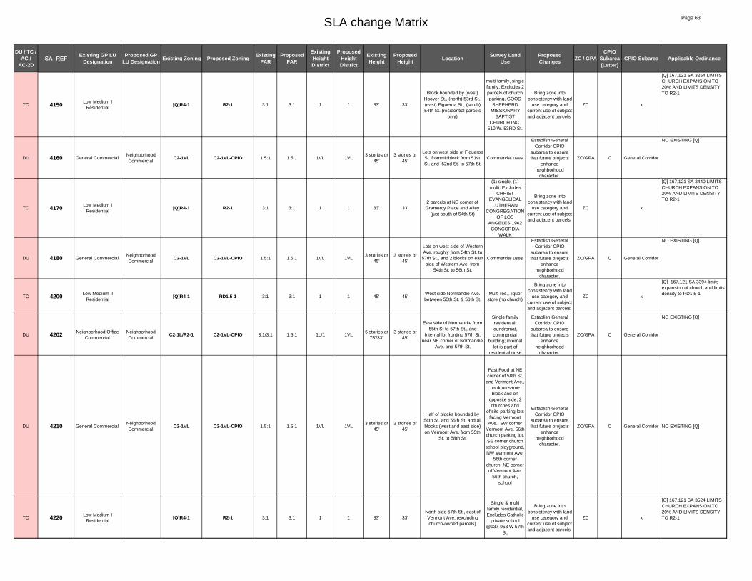
SLA change Matrix Page 63
DU / TC / AC /
AC-2DSA_REF Existing GP LU
DesignationProposed GP
LU Designation Existing Zoning Proposed Zoning Existing FAR
Proposed FAR
Existing Height District
Proposed Height District
Existing Height
Proposed Height Location Survey Land
UseProposed Changes ZC / GPA
CPIO Subarea (Letter)
CPIO Subarea Applicable Ordinance
TC 4150 Low Medium I Residential
[Q]R4-1 R2-1 3:1 3:1 1 1 33' 33'
Block bounded by (west) Hoover St., (north) 53rd St., (east) Figueroa St., (south) 54th St. (residential parcels
only)
multi family, single family. Excludes 2 parcels of church parking, GOOD
SHEPHERD MISSIONARY
BAPTIST CHURCH INC.
510 W. 53RD St.
Bring zone into consistency with land
use category and current use of subject and adjacent parcels.
ZC x
[Q] 167,121 SA 3254 LIMITS CHURCH EXPANSION TO 20% AND LIMITS DENSITY TO R2-1
DU 4160 General CommercialNeighborhood Commercial
C2-1VL C2-1VL-CPIO 1.5:1 1.5:1 1VL 1VL3 stories or
45'3 stories or
45'
Lots on west side of Figueroa St. frommidblock from 51st St. and 52nd St. to 57th St.
Commercial uses
Establish General Corridor CPIO
subarea to ensure that future projects
enhance neighborhood
character.
ZC/GPA C General Corridor
NO EXISTING [Q]
TC 4170 Low Medium I Residential
[Q]R4-1 R2-1 3:1 3:1 1 1 33' 33'2 parcels at NE corner of Gramercy Place and Alley
(just south of 54th St)
(1) single, (1) multi. Excludes
CHRIST EVANGELICAL
LUTHERAN CONGREGATION
OF LOS ANGELES 1962
CONCORDIA WALK
Bring zone into consistency with land
use category and current use of subject and adjacent parcels.
ZC x
[Q] 167,121 SA 3440 LIMITS CHURCH EXPANSION TO 20% AND LIMITS DENSITY TO R2-1
DU 4180 General CommercialNeighborhood Commercial
C2-1VL C2-1VL-CPIO 1.5:1 1.5:1 1VL 1VL3 stories or
45'3 stories or
45'
Lots on west side of Western Ave. roughly from 54th St. to 57th St., and 2 blocks on east
side of Western Ave. from 54th St. to 56th St.
Commercial uses
Establish General Corridor CPIO
subarea to ensure that future projects
enhance neighborhood
character.
ZC/GPA C General Corridor
NO EXISTING [Q]
TC 4200 Low Medium II Residential
[Q]R4-1 RD1.5-1 3:1 3:1 1 1 45' 45'West side Normandie Ave. between 55th St. & 56th St.
Multi res., liquor store (no church)
Bring zone into consistency with land
use category and current use of subject and adjacent parcels.
ZC x
[Q] 167,121 SA 3394 limits expansion of church and limits density to RD1.5-1
DU 4202 Neighborhood Office Commercial
Neighborhood Commercial
C2-1L/R2-1 C2-1VL-CPIO 3:1/3:1 1.5:1 1L/1 1VL6 stories or
75'/33'3 stories or
45'
East side of Normandie from 55th St to 57th St., and
Internal lot fronting 57th St. near NE corner of Normandie
Ave. and 57th St.
Single family residential,
laundromat, commercial
building; internal lot is part of
residential ouse
Establish General Corridor CPIO
subarea to ensure that future projects
enhance neighborhood
character.
ZC/GPA C General Corridor
NO EXISTING [Q]
DU 4210 General CommercialNeighborhood Commercial
C2-1VL C2-1VL-CPIO 1.5:1 1.5:1 1VL 1VL3 stories or
45'3 stories or
45'
Half of blocks bounded by 54th St. and 55th St. and all blocks (west and east side) on Vermont Ave. from 55th
St. to 58th St.
Fast Food at NE corner of 58th St.
and Vermont Ave., bank on same block and on
opposite side, 2 churches and
offsite parking lots facing Vermont Ave.. SW corner
Vermont Ave. 56th church parking lot, SE corner church
school playground, NW Vermont Ave.
56th corner church, NE corner of Vermont Ave.
56th church, school
Establish General Corridor CPIO
subarea to ensure that future projects
enhance neighborhood
character.
ZC/GPA C General Corridor NO EXISTING [Q]
TC 4220 Low Medium I Residential
[Q]R4-1 R2-1 3:1 3:1 1 1 33' 33'North side 57th St., east of Vermont Ave. (excluding church-owned parcels)
Single & multi family residential, Excludes Catholic
private school @937-953 W 57th
St.
Bring zone into consistency with land
use category and current use of subject and adjacent parcels.
ZC x
[Q] 167,121 SA 3524 LIMITS CHURCH EXPANSION TO 20% AND LIMITS DENSITY TO R2-1

SLA change Matrix Page 64
DU / TC / AC /
AC-2DSA_REF Existing GP LU
DesignationProposed GP
LU Designation Existing Zoning Proposed Zoning Existing FAR
Proposed FAR
Existing Height District
Proposed Height District
Existing Height
Proposed Height Location Survey Land
UseProposed Changes ZC / GPA
CPIO Subarea (Letter)
CPIO Subarea Applicable Ordinance
TC 4230 Low Medium I Residential
[Q]R4-1 R2-1 3:1 3:1 1 1 NL 33'
Block bounded by (west) Hoover St., (north) 55th St., (east) Figueroa St., (south)
56th St.
Multi & single family residential. Excludes church
parking lot for SECOND AFRICAN
METHODIST EPISCOPAL
CHURCH 5500 S. Hoover St.
Bring zone into consistency with land
use category and current use of subject and adjacent parcels.
ZC x
[Q] 167,121 SA 3366 LIMITS CHURCH EXPANSION TO 20% AND LIMITS DENSITY TO R2-1
TC 4235 General CommercialLow Medium I
ResidentialC2-1VL R2-1 1.5:1 3:1 1VL 1
3 stories or 45'
33'517 W. 56th Street (parcel behind resident facing the
street)
Rear portion of residential
property/house
Bring zone and land use category into consistency with
current use of subject and adjacent parcels.
ZC/GPA x NO EXISTING [Q]
DU 4240 Commercial Manufacturing
Neighborhood Commercial
[Q]C2-1 C2-1VL-CPIO 1.5:1 1.5:1 1 1VL NL3 stories or
45'
North side of Slauson Ave. from Van Ness Ave. to St.
Andrews Pl.
Primarily commercial uses including cleaners
adult day care Flower St. shop, vacant building, auto repair, new building possibly office, 1 window manufacturer
Establish General Corridor CPIO
subarea to ensure that future projects
enhance neighborhood
character.
ZC/GPA C General Corridor
ORD-167121, SA 3471: Restricts residential density to R3.
TC 4250 Commercial Manufacturing
Public Facilities [Q]C2-1 PF-1 1.5:1 1.5:1 1 1 NL NL
North side of Slauson Ave., 4 lots located in block bounded
by Ruthelen St. and St. Andrews Pl.
Fire Station
Bring zone and land use category into consistency with
current use of subject and adjacent parcels.
ZC/GPA x
ORD-167121-SA3479. Residential density at the R4 AND R5 zone is prohibited.Ord. 167,121 SA 3479 change C2-1 to [Q]C2-1, residential uses at the density of the R4 and R5 zones shall be prohibited. Ord.171,682 and Ord. 162,128, conditional uses for alcoholic beverages
AC-2D 4260 Commercial Manufacturing
Community Commercial
CM-1/[Q]CM-1 C2-2D-CPIO 1.5:1/1.5:
13:1 1 2D NL/NL 6 stories
Lots on facing Slauson Ave. (north side) block bounded by
St. Andrews Pl. and Manhattan Pl.
Auto related use at NW corner of
Slauson Ave.& St. Andrews, followed
by 5 lots developed with
single family and lots zoned [Q] is a
narrow surface parking lot and
Pizza Hut at NW corner of
Manhattan Place and Slauson Ave.
Enable specialized transit oriented development
parameters for commercial
properties in close proximity to light rail
stations and intersections of major
bus lines.
ZC/GPA F TOD Medium
[Q] ONLY ON 1 LOT placed by Ordinance 173792 Subarea 2735, MU max 2:1, commercial 1.5:1,design guidelines, res prohibited in cm zone except for MU res/ind proj.
AC-2D 4270 Neighborhood Office Commercial
Community Commercial
[Q]C2-1VL C2-2D-CPIO 1.5:1 3:1 1VL 2D3 stories or
45'6 stories
NW corner of Slauson Ave. and Western Ave., total of 6 lots; and 2 blocks located on east side of Western Ave.,
block 1 (6 lots on east side of Western Ave. from 57th St. to 58th St., block 2 from 58th St. to Slauson Ave. (NE corner
of Slauson Ave. and Vermont Ave., total of 3 lots)
Big lots and large parking lot, gas
station, and other commercial uses
Enable specialized transit oriented development
parameters for commercial
properties in close proximity to light rail
stations and intersections of major
bus lines.
ZC/GPA F TOD Medium
[Q} PLACED BY 173792 Subarea 2740: Design Guidelines for new project 2:1 FAR for MU max R3 density

SLA change Matrix Page 65
DU / TC / AC /
AC-2DSA_REF Existing GP LU
DesignationProposed GP
LU Designation Existing Zoning Proposed Zoning Existing FAR
Proposed FAR
Existing Height District
Proposed Height District
Existing Height
Proposed Height Location Survey Land
UseProposed Changes ZC / GPA
CPIO Subarea (Letter)
CPIO Subarea Applicable Ordinance
DU 4280 Neighborhood Office Commercial
Neighborhood Commercial
[Q]C2-1VL C2-1VL-CPIO 1.5:1 1.5:1 1VL 1VL3 stories or
45'3 stories or
45'
Lots facing Western Ave. on east side of street from 56th
St. to 57th St.Commercial uses
Establish General Corridor CPIO
subarea to ensure that future projects
enhance neighborhood
character.
ZC/GPA C General Corridor
Ordinance # 173792 subarea2740 :Multi-family residential developments must obtain plan approval to ensure conformity with the multi-family residential development design guidelines. The FAR shall be no more than 2:1 for commercial /residential mixed use developments and 1.5:1 for commercial developments. Commercial developments and commercial/residential mixed use developments must obtain~ plan approval to ensure conformity. With the commercial development design guidelines. Residential uses in the C2 zone shall be restricted to a maximum density allowed in the R3 zone.
DU 4300 Commercial Manufacturing
Hybrid Industrial CM-1 CM-1-CPIO 1.5:1 1.5:1 1 1 NL NL
Lots fronting north side of Slauson Ave. (approx. 1731-1709 W Slauson Ave. and
lots on south side of 58th St. from 1744-1710 W 58th St.
Appears to be primarily light industrial uses
Establish Hybrid industrial CPIO
subarea to addresss land use conflicts
between residential and industrial uses.
ZC/GPA J Hybrid
NO EXISTING [Q]
AC 4310 Commercial Manufacturing
Hybrid Industrial [Q]MR1-1VL CM-1-CPIO 1.5:1 1.5:1 1VL 13 stories or
45' NL
Lots on north side Slauson Ave.
Industrial use, public storage
parking lot
Establish Hybrid industrial CPIO
subarea to addresss land use conflicts
between residential and industrial uses.
ZC/GPA J Hybrid
[Q] 167,545 SA 20 landscaping, parking, sign & lighting restrictions
DU 4320 Commercial Manufacturing
Hybrid Industrial [Q]CM-1 CM-1-CPIO 1.5:1 1.5:1 1 1 NL NL
Lots on north side Slauson Ave. from approx. 1659 W.
Slauson Ave. to end of block at Denker Ave.
Self Storage Building,
residential units on 8 lots, and 1 retail?
on 1 lot, NW corner of Slauson Ave. and Denker
Establish Hybrid industrial CPIO
subarea to addresss land use conflicts
between residential and industrial uses.
ZC/GPA J Hybrid
[Q] placed on by ord. 173792 SA 2760: FAR of max 2:1 for MU projects, design guidelines of comm. And industrial, retain existing [q]
DU 4330 Commercial Manufacturing
Hybrid Industrial [Q]CM-1 CM-1-CPIO 1.5:1 1.5:1 1 1 NL NL
Lots fronting 58th St.(on south side) from Denker Ave. to Normandie Ave. includes all lots except those in SA
3415 and SA 3720 developed with light industrial uses
Residential dwelling units, single family
primarily
Establish Hybrid industrial CPIO
subarea to addresss land use conflicts
between residential and industrial uses.
ZC/GPA J Hybrid
Existing [Q] placed by ordinance 173,792 subareas 2780,3170,3190No more than 2:1 FAR for Comm. Res MU, Design Guidelines, Res prohibited, Unless in industrial/residential MU w/ max at 2:1
DU 4340 Commercial Manufacturing
Hybrid Industrial [Q]CM-1 CM-1-CPIO 1.5:1 1.5:1 1 1 NL NL
4 lots fronting 58th St. on (south side) including 1508-
1456 W, 58th St.; 3 lots fronting 58th St. on (south
side) starting at 1422 -1410 W. 58th St. and 3 lots
fronting Normandie Ave. from 5815-1503 S Normandie Ave.; Lots facing Slauson Ave. (on south side of St.)
total 2 blocks2 blocks Block 1 from Denker to Halladale
Ave. Block 2 Halldale Ave. to Normandie Ave. primarily
industrial uses
Appears light manufacturing
(printing shops), Industrial use,
welding/aluminum business? Auto service center?,
Slauson Ave. block 1 from
Denker to Halldale Ave. developed
with surface parking lot SE
corner of Denker and Slauson Ave., animal hospital,
metal processing and other
industrial, block 2 from Halldale Ave. to Normandie Ave. primarily industrial
uses
Establish Hybrid Limited CPIO subarea to addresss land use
conflicts between residential and industrial uses.
ZC/GPA I Hybrid Limited
Existing [Q] placed by ordinance 173,792 subareas 2780,3170,3190: No more than 2:1 FAR for Comm. Res MU, Design Guidelines, Res prohibited, Unless in industrial/residential MU w/ max at 2:1

SLA change Matrix Page 66
DU / TC / AC /
AC-2DSA_REF Existing GP LU
DesignationProposed GP
LU Designation Existing Zoning Proposed Zoning Existing FAR
Proposed FAR
Existing Height District
Proposed Height District
Existing Height
Proposed Height Location Survey Land
UseProposed Changes ZC / GPA
CPIO Subarea (Letter)
CPIO Subarea Applicable Ordinance
DU 4360 Commercial Manufacturing
Hybrid Industrial [Q]CM-1 CM-1-CPIO 1.5:1 1.5:1 1 1 NL NLLots fronting 58th St. from
Normandie Ave. to Budlong Ave.
Industrial uses
Establish Hybrid Limited CPIO subarea to addresss land use
conflicts between residential and industrial uses.
ZC/GPA I Hybrid Limited
Existing [Q] placed by ordinance 173,792 subareas 2800, 3210,3230. No more than 2:1 FAR for Comm. Res MU, Design Guidelines, Res prohibited, Unless in industrial/residential MU w/ max at 2:1
TC 4370 Commercial Manufacturing
Medium Residential
[Q]CM-1/P-1 R3-1 1.5:1/3:1 3:1 1 1 NL / NL 45'
Lots fronting 58th St. from Budlong to 2 lots west of
Vermont Ave.
Residential uses (single family)
Bring zone and land use category into consistency with
current use of subject and adjacent parcels.
ZC/GPA x
Existing [Q] placed by ordinance 173,792 subareas 2820. No more than 2:1 FAR for Comm. Res MU, Design Guidelines, Res prohibited, Unless in industrial/residential MU w/ max at 2:1
AC-2D 4380
Commercial Manufacturing/
General Commercial/ Community Commercial
Community Commercial
P-1/C2-1VL/ [Q]C2-
1VL/[Q]CM-1/[Q]C2-1
C2-2D-CPIO
3:1/1.5:1/ 1.5:1/ 1.5:1/ 1.5:1
3:11/1VL/1VL/
1/12D
NL / 3 stories or
45'/3 stories or 45'/NL/NL
6 stories
NW corner of Vermont Ave. and Slauson Ave. (not
including MTA ROW); NE corner of Vermont Ave. and Slauson Ave. (not including MTA ROW); SW corner of Vermont Ave. and Slauson Ave.; SE corner of Slauson
Ave. and Vermont Ave. bounded by Slauson Ave. on
north, Menlo Ave. on east, 58th Pl. on the south,
Vermont Ave. on the west
Parking lot, Drive-through fast food and undeveloped commercial and
industrial lots, existing industrial
use, Shopping center, including
supermarket, Kmart, Drive-
through Fast Food and other retail
uses
Enable specialized transit oriented development
parameters for commercial
properties in close proximity to light rail
stations and intersections of major
bus lines.
ZC/GPA F TOD Medium
Existing [Q] Ordinance 173792 SA 2850, 3250, 3300: Design Guidelines for Multiple Fam. And MU commercial uses. Max 2:1 FAR for com/res MU. Max density R3 and [Q] ORD. 173792 SA 28602:1 FAR for Icommres/ind/res uses. NO residential allowed other then MU. Design Guidelines
TC 4390Commercial
Manufacturing/Light Manufacturing
Hybrid Industrial[Q]C2-2/[Q]CM-1 CM-1 6:1/1.5:1 1.5:1 2/1 1 NL / NL NL
NW corner Slauson Ave. & Vermont Ave.
LACMTA rail line
Bring zone and land use category into consistency with
current use of subject and adjacent parcels.
ZC/GPA x
[Q] 167,121 SA 3594 Residential uses prohibited except as provided in industrial zones
DU 4410 Commercial Manufacturing
Hybrid Industrial [Q]CM-1 CM-1-CPIO 1.5:1 1.5:1 1 1 NL NLLots located in the middle of block bounded by Vermont
Ave. and Hoover St.Residential uses
Establish Hybrid industrial CPIO
subarea to addresss land use conflicts
between residential and industrial uses.
ZC/GPA J Hybrid
[Q] ORD. 173792 SA 2860: max 2:1 FAR for MU (comm./res). NO residential allowed other than MU in ind/res. Design Guidelines
AC 4420 Commercial Manufacturing
Hybrid Industrial [Q]CM-1 CM-1-CPIO 1.5:1 1.5:1 1 1 NL NL6 Lots located at the NW corner of Hoover St. and
Slauson Ave.Shelter
Establish Hybrid industrial CPIO
subarea to addresss land use conflicts
between residential and industrial uses.
ZC/GPA J Hybrid
[Q] ORD. 173792 SA 2860: max 2:1 FAR for MU (comm./res). NO residential allowed other then MU in ind/res. Design Guidelines
DU 4430 Commercial Manufacturing
Neighborhood Commercial
[Q]C2-1 C2-1VL-CPIO 1.5:1 1.5:1 1 1VL NL3 stories or
45'SE corner Hoover St. & 57th
St.
Possibly vacant commercial
building? Might be or have been
church
Establish Neighborhood-Serving CPIO
subarea to ensure that future projects
enhance neighborhood
character.
ZC/GPA ANeighborhood
Serving Corridor
[Q] 167,121 SA 3545 Prohibits R4 and R5
DU 4435 Commercial Manufacturing
Hybrid Industrial [Q]CM-1/ CM-1 CM-1-CPIO 1.5:1/1.5:1
1.5:1 1 1 NL / NL NL
Both sides of Hoover St from 57th St. to 58th St, excluding
SE corner of 57th and Hoover, and Lots fronting Slauson Ave. (north side)
from Hoover St. on west side
St. Johns Well Child and Family Center, house, office building,
warehouse, industrial uses,
residential uses.
Establish Hybrid industrial CPIO
subarea to addresss land use conflicts
between residential and industrial uses.
ZC/GPA J Hybrid
[Q] Ord. 173,792, SA 2840, 2880: Max 2:1 FAR for MU (comm./res). NO residential allowed other than MU ind/res. Commercial development design guidelines, Industrial development design guidelines.
DU 4450 General CommercialNeighborhood Commercial
C2-1VL/[Q]C2-1VL C2-1VL-CPIO 1.5:1/1.5:
11.5:1 1VL 1VL
3 stories or 45' / 3
stories or 45'
3 stories or 45'
Lots on west side of Figueroa St. from 57th St. to 58th St.
Commercial uses
Establish General Corridor CPIO
subarea to ensure that future projects
enhance neighborhood
character.
ZC/GPA C General Corridor
Ord. 167,121 SA 3542 change C2-1 to HD 1VL and 3543 change C2-1 to [Q] C2-1. Residential uses at the density of the R4 and R5 shall be prohibited, Ord.180,103 Fast Food Interim Ordinance - prohibit the establishment of new fast food restaurants, Ord.171,682 and Ord. 162,128 conditional uses for alcoholic beverages.

SLA change Matrix Page 67
DU / TC / AC /
AC-2DSA_REF Existing GP LU
DesignationProposed GP
LU Designation Existing Zoning Proposed Zoning Existing FAR
Proposed FAR
Existing Height District
Proposed Height District
Existing Height
Proposed Height Location Survey Land
UseProposed Changes ZC / GPA
CPIO Subarea (Letter)
CPIO Subarea Applicable Ordinance
DU 4460General Commercial/
Commercial Manufacturing
Community Commercial
C2-1VL/[Q]CM-1 C2-1-CPIO 1.5:1/1.5:
11.5:1 1VL/1 1
3 stories or 45' / NL
NLNW corner of Figueroa St.
and Slauson Ave. Dental office
Establish General Corridor CPIO
subarea to ensure that future projects
enhance neighborhood
character.
ZC/GPA C General Corridor
Existing [Q] existing [q] 173792, 2880 max 2:1 FAR for MU (comm/res). NO residential allowed other than MU in ind/res. Design Guidelines
DU 4470 General CommercialNeighborhood Commercial
C2-1VL C2-1VL-CPIO 1.5:1 1.5:1 1VL 1VL3 stories or
45'3 stories or
45'
lots facing Slauson Ave. (on south side from Van Ness
Ave.) to Wilton Pl.
Residential and commercial uses
including cleaners/laundry establishment, 2 story residential units, auto sales, possibly vacant
building
Establish General Corridor CPIO
subarea to ensure that future projects
enhance neighborhood
character.
ZC/GPA C General Corridor
NO EXISTING [Q]
DU 4480 Light Manufacturing Limited Industrial M2-1 M1-1-CPIO 1.5:1 1.5:1 1 1 NL NLSE corner of Slauson Ave.
and Wilton Pl.
Appears to be primarily industrial
uses
Establish Compatible Industrial CPIO
subarea to improve transition between
industrial and residential uses and
improve building design.
ZC/GPA KCompatible
Industrial
NO EXISTING [Q]
AC-2D 4490 Light ManufacturingCommunity Commercial
M2-1 C2-2D-CPIO 1.5:1 3:1 1 2D NL 6 stories
SW corner of Slauson Ave. and Vermont Ave. and 1 lot at
the SE corner of Slauson Ave. and Vermont Ave.
Commercial center, including
Home Depot, Walgreens ,
Starbucks, and a variety of other
retail stores, and a new strip mall
including several tenants
Enable specialized transit oriented development
parameters for commercial
properties in close proximity to light rail
stations and intersections of major
bus lines.
ZC/GPA F TOD Medium
NO EXISTING [Q]
DU 4510 Light Manufacturing Limited Industrial M2-1 M1-1-CPIO 1.5:1 1.5:1 1 1 NL NLSW corner of Western Ave.
and Slauson Ave. (not including SA 3640)
Appears to be primarily industrial
uses
Establish Compatible Industrial CPIO
subarea to improve transition between
industrial and residential uses and
improve building design.
ZC/GPA KCompatible
Industrial
NO EXISTING [Q]
DU 4530Commercial
Manufacturing/ General Commercial
Hybrid Industrial [Q]CM-1/C2-1VL CM-1-CPIO 1.5:1/1.5:1
1.5:1 1/1VL 1NL/3 stories
or 45'NL
Lots fronting Slauson Ave. (on south side) 1st block,
Normandie Ave. to Raymond Ave., 2nd block Raymond Ave. to Budlong Ave., and
Small interior lot on east side of Normandie between
Slauson and 58th Place.
Primarily industrial uses, unpaved
parking
Establish Hybrid Limited CPIO subarea to addresss land use
conflicts between residential and industrial uses.
ZC/GPA I Hybrid Limited
Existing [Q] placed by ordinance 173,792 subareas 2800, 3210,3230. No more than 2:1 FAR for Comm. Res MU, Design Guidelines, Res prohibited, Unless in industrial/residential MU w/ max at 2:1
DU 4540 Commercial Manufacturing
Hybrid Industrial [Q]CM-1 CM-1-CPIO 1.5:1 1.5:1 1 1 NL NLSE corner of Budlong Ave.
and Slauson Ave., a total of 5 lots fronting Slauson Ave.
5 lots developed primarily with light industrial and one lot developed with
1 story multiple family apartments
Establish Hybrid Limited CPIO subarea to addresss land use
conflicts between residential and industrial uses.
ZC/GPA I Hybrid Limited
Existing [Q] placed by ordinance 173,792 subareas 3250 . No more than 2:1 FAR for Comm. Res MU, Design Guidelines, Res prohibited, Unless in industrial/residential MU w/ max at 2:1
DU 4570 Community Commercial
C2-1 C2-1-CPIO 1.5:1 1.5:1 1 1 NL NL12 lots fronting Slauson Ave.
between Menlo Ave. and alley just west of Hoover St.
A two story commercial
building on one lot (possibly
residential on 2nd floor) subarea is primarily surface
parking lot
Establish General Corridor CPIO
subarea to ensure that future projects
enhance neighborhood
character.
ZC/GPA C General Corridor
NO EXISTING [Q]
TC 4575General Commercial/
Low Medium I Residential
Public FacilitiesR2-1/
C2-1VL PF-1 3:1/1.5:1 1.5:1 1/1VL 133' / 3
stories or 45'
NL
Area bounded by Slauson to the north, Hoover to the east, 60th to the south, and Menlo to the west; excluding parcels that front along Slauson and
those that front Hoover between Slauson and 58th Pl.
New LAUSD school.
Bring zone and land use category into consistency with
current use of subject and adjacent parcels.
ZC/GPA x
NO EXISTING [Q]

SLA change Matrix Page 68
DU / TC / AC /
AC-2DSA_REF Existing GP LU
DesignationProposed GP
LU Designation Existing Zoning Proposed Zoning Existing FAR
Proposed FAR
Existing Height District
Proposed Height District
Existing Height
Proposed Height Location Survey Land
UseProposed Changes ZC / GPA
CPIO Subarea (Letter)
CPIO Subarea Applicable Ordinance
DU 4580 General CommercialNeighborhood Commercial
C2-1VL C2-1VL-CPIO 1.5:1 1.5:1 1VL 13 stories or
45'3 stories or
45'
6 lots fronting Hoover St. from Slauson Ave. to 58th Pl., and
lots fronting Slauson (on south side) from Hoover St. to
Denker Ave.
Vacant lots, commercial uses
(some auto related, some
residential, office, one wholesale establishment)
Establish General Corridor CPIO
subarea to ensure that future projects
enhance neighborhood
character.
ZC/GPA C General Corridor
NO EXISTING [Q]
DU 4595 Low Medium I Residential
Community Commercial
R2-1 C2-1-CPIO 3:1 1.5:1 1 1 33' NLTwo lots fronting Estrella Ave. and Denver Ave, just south of
Slauson Ave.
Parking lot for commercial on
Slauson
Establish General Corridor CPIO
subarea to ensure that future projects
enhance neighborhood
character.
ZC/GPA C General Corridor
NO EXISTING [Q]
DU 4610 Commercial Manufacturing
Hybrid Industrial [Q]CM-1 CM-1-CPIO 1.5:1 1.5:1 1 1 NL NLEast side of Western Ave. from 59th St. to 60th Pl.
Church , auto repair, office
building, warehouse district
Establish Hybrid Limited CPIO subarea to addresss land use
conflicts between residential and industrial uses.
ZC/GPA I Hybrid Limited
ORD-173792-SA3020- Change zone from M to CM. Requires design guidelines. Max mar 2:1 for mixed use projects..Residential uses prohibited.
DU 4615 Low Medium I Residential
Hybrid Industrial R2-1 CM-1-CPIO 3:1 1.5:1 1 1 33' NLeastern half of the alley near
SE corner of Western and 59th St.
Back of church building
Establish Hybrid industrial CPIO
subarea to addresss land use conflicts
between residential and industrial uses.
ZC/GPA J Hybrid NO EXISTING [Q]
DU 4617 General Commercial / Low Residential
Neighborhood Commercial
C2-1VL/R1-1 C2-1VL-CPIO 1.5:1/3:1 1.5:1 1VL/1 1VL3 stories or
45'/33'3 stories or
45'
Both sides of Normandie Ave. from north of 58th Place to
59th Place, and Interior lot at NW corner of Normandie
Ave. and 59th Place
Single family residential, multi-family residential,
churches, liquor/market, laundromat,
restaurant, retail, empty lot, parking
lot
Establish General Corridor CPIO
subarea to ensure that future projects
enhance neighborhood
character.
ZC/GPA C General Corridor NO EXISTING [Q]
DU 4625 General CommercialNeighborhood Commercial
C2-1VL C2-1VL-CPIO 1.5:1 1.5:1 1VL 1VL3 stories or
45'3 stories or
45'
12 lots fronting Hoover St. from just south of Slauson
Ave. to 59th Pl.
Commercial uses, including some
auto related uses and some residential
Establish Neighborhood-Serving CPIO
subarea to ensure that future projects
enhance neighborhood
character.
ZC/GPA ANeighborhood
Serving CorridorNO EXISTING [Q]
AC 4626 General CommercialCommunity Commercial
C2-1VL C2-1-CPIO 1.5:1 1.5:1 1VL 13 stories or
45'NL
SW corner of Figueroa St. and Slauson Ave. (lots
fronting Slauson Ave. on south side bounded by
Denker Ave. to Figueroa St.) and lots fronting Figueroa St.
from just south of Slauson Ave. to 59th St.
Commercial uses strip mall, some
office, liquor store at NW corner of
59th St and Figueroa St. most lots facing Fig. Are
residential
Establish General Corridor CPIO
subarea to ensure that future projects
enhance neighborhood
character.
ZC/GPA C General Corridor NO EXISTING [Q]
AC 4630General Commercial/
Low Medium I Residential
Community Commercial
C2-1VL/R2-1 C2-1-CPIO 1.5:1/3:1 1.5:1 1VL/1 1
3 stories or 45' / 33'
NL
SE corner of Slauson Ave. and Figueroa St. and lots on
east side of Figueroa St. from Slauson Ave. to 59th Pl.
Primarily commercial
Establish General Corridor CPIO
subarea to ensure that future projects
enhance neighborhood
character.
ZC/GPA C General Corridor NO EXISTING [Q]
TC 4635 Public Facilities R3-1 PF-1 3:1 1.5:1 1 1 45' NLEast and west side of 110 Frwy from Slauson Ave to
Gage AveFreeway buffer
Bring zone into consistency with land
use category and current use of subject and adjacent parcels.
ZC x NO EXISTING [Q]
DU 4640 General CommercialNeighborhood Commercial
C2-1VL C2-1VL-CPIO 1.5:1 1.5:1 1VL 1VL3 stories or
45'3 stories or
45'
Lots on west side of Broadway from Slauson Ave
to 64th St.
Commercial and residential uses,
including fast food restaurant, liquor
store, cabinet store, and discount
store.
Establish General Corridor CPIO
subarea to ensure that future projects
enhance neighborhood
character.
ZC/GPA C General Corridor NO EXISTING [Q]

SLA change Matrix Page 69
DU / TC / AC /
AC-2DSA_REF Existing GP LU
DesignationProposed GP
LU Designation Existing Zoning Proposed Zoning Existing FAR
Proposed FAR
Existing Height District
Proposed Height District
Existing Height
Proposed Height Location Survey Land
UseProposed Changes ZC / GPA
CPIO Subarea (Letter)
CPIO Subarea Applicable Ordinance
DU 4650 Light Manufacturing Limited Industrial M1-1 M1-1-CPIO 1.5:1 1.5:1 1 1 NL NL
Block bounded by SE corner of Hyde Park & Van Ness Ave. to SW corner of Hyde
Park & Wilton Pl.
Light industrial
Establish Compatible Industrial CPIO
subarea to improve transition between
industrial and residential uses and
improve building design.
ZC/GPA KCompatible
IndustrialNO EXISTING [Q]
DU 4660 Light Manufacturing Limited Industrial M1-1 M1-1-CPIO 1.5:1 1.5:1 1 1 NL NL
North side 60th St. between Gramercy Pl. & Wilton Pl, and
west side of Gramercy between 60th and 62nd.
Light industrial
Establish Compatible Industrial CPIO
subarea to improve transition between
industrial and residential uses and
improve building design.
ZC/GPA KCompatible
IndustrialNO EXISTING [Q]
DU 4670 Light Manufacturing Light Industrial M2-1 M2-1-CPIO 1.5:1 1.5:1 1 1 NL NL
Area just south of Slauson Ave., generally bounded by
railroad right of way, Gramercy Pl., Gage Ave. and Western Ave./Manhattan Pl.
Primarily industrial
Establish Industrial Preserve CPIO
subarea to protect industrial land from non-industrial uses.
ZC/GPA LIndustrial Preserve
NO EXISTING [Q]
DU 4680 Limited Manufacturing
Limited Industrial M1-1 M1-1-CPIO 1.5:1 1.5:1 1 1 NL NLLots on west side of Western Ave. from 60th St. to Gage
Ave. St.Primarily industrial
Establish Compatible Industrial CPIO
subarea to improve transition between
industrial and residential uses and
improve building design.
ZC/GPA KCompatible
IndustrialNO EXISTING [Q]
AC 4690Commercial
Manufacturing/Open Space
Community Commercial
[Q]CM-1/OS-1XL C2-1-CPIO 1.5:1/1.5:
11.5:1 1/1XL 1 NL / NL NL
Lots on east side of Western Ave. from 60th St. to Gage
Ave.
Residential and commercial uses
Establish General Corridor CPIO
subarea to ensure that future projects
enhance neighborhood
character.
ZC/GPA C General Corridor
ORD-173792-SA3040- Change zone from M to CM. Requires design guidelines. Max mar 2:1 for mixed use projects..Residential uses prohibited. Ord. 173,792 SA 3040 change M1-1 to [Q]CM-1, FAR shall be no more than 2:1 for mixed use and 1.5:1 for commercial, commercial developments, commercial/residential, industrial, industrial/residential must obtain plan approval, residential only uses shall be prohibited in the CM zone . Ord.180,103 Fast Food Interim Ordinance - prohibit the establishment of new fast food restaurants, Ord.171,682 and Ord. 162,128, conditional uses for alcoholic beverages
DU 4693 Low Residential/ General Commercial
Neighborhood Commercial
R1-1/C2-1VL C2-1VL-CPIO 3:1/1.5:1 1.5:1 1/1VL 1VL
33'/3 stories or
45'
3 stories or 45'
Both sides of Normandie from 59th Place to Gage Ave., and
interior lot at SW corner of 60th Place and Normandie
Ave.
Commercial, residential, smog
test facility, church, banquet hall,
parking, used car sales, restaurant, markets, parking
lot
Establish General Corridor CPIO
subarea to ensure that future projects
enhance neighborhood
character.
ZC/GPA C General Corridor
NO EXISTING [Q]
TC 4700 Low Medium I Residential
Medium Residential
[Q]R3-1 R3-1 3:1 3:1 1 1 45' 45'NE corner Menlo Ave. and
61st (3 corner parcels and 1 parcel east of corner)
(3) 2 family dwellings
Bring zone and land use category into consistency with
current use of subject and adjacent parcels.
ZC/GPA x
[Q] 164,951 limits density to no more than 1 dwelling unit per 1,200 sq ft of lot area
TC 4710 Low Medium I Residential
Medium Residential
[T][Q]R3-1 3:1 3:1 1 1 30' 30'NE corner Menlo Ave. & 61st
(3rd parcel east of corner)
(1) multi unit dwelling (# of units
in ?)
Bring land use category into
consistency with zone and current use of
subject and adjacent parcel
GPA x
[Q] 164,952 limits density to no more than 4 dwelling units, additional height, parking, landscaping, air quality, and energy conservation restrictions. Max height 30'.

SLA change Matrix Page 70
DU / TC / AC /
AC-2DSA_REF Existing GP LU
DesignationProposed GP
LU Designation Existing Zoning Proposed Zoning Existing FAR
Proposed FAR
Existing Height District
Proposed Height District
Existing Height
Proposed Height Location Survey Land
UseProposed Changes ZC / GPA
CPIO Subarea (Letter)
CPIO Subarea Applicable Ordinance
TC 4720 Low Medium I Residential
Medium Residential
[Q]R3-1 R3-1 3:1 3:1 1 1 45' 45'
North side of 61st St. between Menlo Ave. and Hoover Street (9 residential parcels west of
Hoover St)
Single & multi family dwellings
Bring zone and land use category into consistency with
current use of subject and adjacent parcels.
ZC/GPA x
[Q] 164,951 limits density to no more than 1 dwelling unit per 1,200 sq ft of lot area
DU 4725General Commercial
/ Low Medium I Residential
Neighborhood Commercial
C2-1VL / [Q]R4-1 C2-1VL-CPIO 1.5:1/ 3:1 1.5:1 1VL/1 1VL3 stories or
45' / 33'3 stories or
45'
East side of Hoover St. from 59th St. to 62nd St, west side
of Hoover from 60th St. to 62nd St.
Mix of residential and commercial,
church
Establish Neighborhood-Serving CPIO
subarea to ensure that future projects
enhance neighborhood
character.
ZC/GPA ANeighborhood
Serving Corridor
[Q] 167,093 SA 4012 LIMITS CHURCH EXPANSION TO 20% AND LIMITS DENSITY TO R2-1
TC 4730 Low Medium I Residential
[Q]R4-1 R2-1 3:1 3:1 1 1 33' 33'
Block bounded by (west) Hoover St., (north) 61st St., (east) Figueroa St., (south) 62nd St. Excluding church-
owned parcel.
Mix of single, multiple
residential, institution., & mixed use--
Excludes church.
Bring zone into consistency with land
use category and current use of subject and adjacent parcels.
ZC x
[Q] 167,093 SA 4012 LIMITS CHURCH EXPANSION TO 20% AND LIMITS DENSITY TO R2-1
TC 4740 Low Medium I Residential
[Q]R4-1 R2-1 3:1 3:1 1 1 33' 33'Block bounded by (west)
Grand Ave., (north) 61st St., (east) alley, (south) alley
Single, multi residential.
Excludes church: SOUTHERN CALIFORNIA
ASSOCIATION OF SEVENTH-DAY ADVENTISTS
Bring zone into consistency with land
use category and current use of subject and adjacent parcels.
ZC x
[Q] 167,093 SA 4022 LIMITS CHURCH EXPANSION TO 20% AND LIMITS DENSITY TO R2-1
TC 4770 Low Residential Low II Residential R3-1 R1-1 3:1 3:1 1 1 45' 33' 6111 S. HaasSingle fam. Residential
Bring zone and land use category into consistency with
current use of subject and adjacent parcels.
ZC/GPA x NO EXISTING [Q]
DU 4775 Limited Manufacturing
Limited Industrial M1-1 M1-1-CPIO 1.5:1 1.5:1 1 1 NL NLNE corner at 62nd and Van
Ness Ave.
Mini market, vacant lot, empty
building
Establish Compatible Industrial CPIO
subarea to improve transition between
industrial and residential uses and
improve building design.
ZC/GPA KCompatible
IndustrialNO EXISTING [Q]
TC 4780 Limited Manufacturing
Low II Residential R1-1 3:1 3:1 1 1 33'NW corner 62nd St. & Haas
St.(1) multi res., (3)
single fam.
Bring land use category into
consistency with zone and current use of
subject and adjacent parcel
GPA x NO EXISTING [Q]
DU 4790 Light Manufacturing Limited Industrial [Q]MR1-1VL [Q]MR1-1VL-CPIO 1.5:1 1.5:1 1VL 1VL3 stories or
45' 3 stories or
45'East side of Wilton Pl. from
Gage Ave. to 62nd St.
(1) multi res., (1) institutional,
remaining light industrial
Establish Industrial Preserve CPIO
subarea to protect industrial land from non-industrial uses.
ZC/GPA LIndustrial Preserve
[Q] 167,547 SA 40 landscaping, parking, sign & lighting restrictions
DU 4800 Light Manufacturing Limited Industrial M1-1 MR1-1VL-CPIO 1.5:1 1.5:1 1 1VL NL NLWest side of Gramercy
between 62nd and Gage.Alley
Establish Industrial Preserve CPIO
subarea to protect industrial land from non-industrial uses.
ZC/GPA LIndustrial Preserve
NO EXISTING [Q]
DU 4805Low Residential/
General Commercial/ Low Medium I
Residential
Neighborhood Commercial
R1-1/C2-1VL/ R4-1VL/
R2-1C2-1VL-CPIO 3:1/1.5:1/
3:1/3:11.5:1
1/1VL/1VL/1
1VL
33' / 3 stories or
45' /3 stories or 45'/ 33'
3 stories or 45'
SW corner Gage Ave. & Normandie Ave. and NE
corner Normandie and 64th St.
Senior housing
Establish General Corridor CPIO
subarea to ensure that future projects
enhance neighborhood
character.
ZC/GPA C General Corridor NO EXISTING [Q]
TC 4818Low Medium I
Residential/ General Commercial
Public Facilities C2-1VL/ R2-1 PF-1 1.5:1/3:1 1.5:1 1VL/1 13 stories or
45' / 33/NL
Parcel in the middle of the alley west of Vermont Ave,
between 60th Place and 61st St.
Alley
Bring zone and land use category into consistency with
current use of subject and adjacent parcels.
ZC/GPA x NO EXISTING [Q]

SLA change Matrix Page 71
DU / TC / AC /
AC-2DSA_REF Existing GP LU
DesignationProposed GP
LU Designation Existing Zoning Proposed Zoning Existing FAR
Proposed FAR
Existing Height District
Proposed Height District
Existing Height
Proposed Height Location Survey Land
UseProposed Changes ZC / GPA
CPIO Subarea (Letter)
CPIO Subarea Applicable Ordinance
AC 4820 General CommercialCommunity Commercial
C2-1VL C2-1-CPIO 1.5:1/1.5:1
1.5:1 1VL/1 13 stories or
45'NL
Lots east side of Vermont Ave. from 59th Pl. to 70th St.,
and lots on west side of Vermont Ave. from 60th St. to
70th St. ( with exception of one lot at NW corner of 64th St. and Vermont Ave., zoned PF, and east side of Vermont Ave from 68th St to 69th St)
Commercial uses
Establish General Corridor CPIO
subarea to ensure that future projects
enhance neighborhood
character.
ZC/GPA C General Corridor NO EXISTING [Q]
AC 4821General Commercial/
Low Medium II Residential
Community Commercial
C2-1VL / RD2-1 C2-1-CPIO 1.5:1/ 3:1 1.5:1 1VL/1 13 stories or
45' / 45'NL
Lots east and west side of Vermont Ave. from 66th St. to
Gage Ave.Commercial uses
Establish General Corridor CPIO
subarea to ensure that future projects
enhance neighborhood
character.
ZC/GPA C General Corridor NO EXISTING [Q]
AC 4822General Commercial/
Community Commercial
Community Commercial
C2-1VL/C2-1/P-1
C2-1-CPIO 1.5:1/ 1.5:1/ 3:1
1.5:1 1VL/1/1 13 stories or 45' / NL /
NLNL
Lots east and west side of Vermont Ave. from 64th St. to
61st St. ( with exception of library lots at NW corner of 64th St. and Vermont Ave., zoned PF and park at NE
corner of Vermont and Gage)
Commercial uses
Establish General Corridor CPIO
subarea to ensure that future projects
enhance neighborhood
character.
ZC/GPA C General Corridor NO EXISTING [Q]
DU 4823 General CommercialNeighborhood Commercial
C2-1VL C2-1VL-CPIO 1.5:1 1.5:1 1VL 1VL3 stories or
45'3 stories or
45'
Lots east and west side of Vermont Ave. from 59th Pl. to
61st St.Commercial uses
Establish General Corridor CPIO
subarea to ensure that future projects
enhance neighborhood
character.
ZC/GPA C General Corridor NO EXISTING [Q]
TC 4824 General Commercial Public Facilities C2-1VL PF-1 1.5:1 1.5:1 1VL 13 stories or
45'NL
Third lot north of 64th St. fronting Vermont Ave. (west
side of Vermont). Also includes small parcel at rear.
Part of public library
Bring zone and land use category into consistency with
current use of subject and adjacent parcels.
ZC/GPA x NO EXISTING [Q]
TC 4826 Community Commercial
Open Space C2-1 OS-1XL 1.5:1 1.5:1 1 1XL NL NLPark on east side of Vermont Ave between 62nd Place and
Gage AvePark
Bring zone and land use category into consistency with
current use of subject and adjacent parcels.
ZC/GPA x NO EXISTING [Q]
AC 4832General Commercial/
Low Medium I Residential
Neighborhood Commercial
[Q]C2-1VL/ R2-1 C2-1VL-CPIO 1.5:1/ 3:1 1.5:1 1VL/1 1VL3 stories or
45' / 33'3 stories or
45'
West side of Hoover from 62nd St. to 62nd Place, and
east side of Hoover from 62nd St. to Gage Ave.
Multi-family, single family, senior
housing
Establish Neighborhood-Serving CPIO
subarea to ensure that future projects
enhance neighborhood
character.
ZC/GPA ANeighborhood
Serving Corridor
[Q] Ord. 1737,792 SA 3430 M-F residential development design guidelines, FAR max 2:1 for comm/res MU and 1.5:1 for commercial. Commercial development design guidelines. Res uses in C2 zone restricted to max density allowed in R3 zone.
TC 4834 Low Medium II Residential
Open Space RD2-1/RD1.5-1 OS-1XL 3:1/3:1 1.5:1 1/1 1XL 45'/45' NLNW corner of Hoover St. and
Gage Ave.Small park
Bring zone and land use category into consistency with
current use of subject and adjacent parcels.
ZC/GPA x NO EXISTING [Q]
DU 4835 General CommercialCommunity Commercial
R2-1 C2-1-CPIO 3:1 1.5:1 1 1 33' NLSW corner 62nd St. &
Figueroa St., 3rd parcel west of corner
Residential (Sliver Overlapped to neighboring driveway)
Establish General Corridor CPIO
subarea to ensure that future projects
enhance neighborhood
character.
ZC/GPA C General Corridor NO EXISTING [Q]
DU 4837 General CommercialNeighborhood Commercial
C2-1VL C2-1VL-CPIO 1.5:1 1.5:1 1VL 1VL3 stories or
45'3 stories or
45'East side of Hoover St. from
Gage Ave. to 66th St.Mainly residential, some commercial
Establish Neighborhood-Serving CPIO
subarea to ensure that future projects
enhance neighborhood
character.
ZC/GPA ANeighborhood
Serving CorridorNO EXISTING [Q]
DU 4840General Commercial/
Low Medium I Residential
Neighborhood Commercial
C2-1VL/[Q]R4-1 C2-1VL-CPIO 1.5:1/3:1 1.5:1 1VL/1 1VL
3 stories or 45' / 33'
3 stories or 45'
Lots fronting Figueroa St. (on west side) from 59th St. to 70th St. and (on east side)
from 59th Pl. to 71st St.
Some residential some commercial uses, Methodist
church, gas station, strip mall, auto uses, Antioch Christian Church
Establish General Corridor CPIO
subarea to ensure that future projects
enhance neighborhood
character.
ZC/GPA C General Corridor
[Q] 167,093 SA 4012 LIMITS CHURCH EXPANSION TO 20% AND LIMITS DENSITY TO R2-1 (only one lot in subarea)

SLA change Matrix Page 72
DU / TC / AC /
AC-2DSA_REF Existing GP LU
DesignationProposed GP
LU Designation Existing Zoning Proposed Zoning Existing FAR
Proposed FAR
Existing Height District
Proposed Height District
Existing Height
Proposed Height Location Survey Land
UseProposed Changes ZC / GPA
CPIO Subarea (Letter)
CPIO Subarea Applicable Ordinance
DU 4841 General CommercialNeighborhood Commercial
C2-1VL C2-1VL-CPIO 1.5:1 1.5:1 1VL 1VL3 stories or
45'3 stories or
45'
Lots fronting Figueroa St. (on west side) from 59th St. to 61st St. and (on east side) from 59th Pl. to 60th St.
Some residential some commercial uses i.e.. car wash
and church
Establish General Corridor CPIO
subarea to ensure that future projects
enhance neighborhood
character.
ZC/GPA C General Corridor NO EXISTING [Q]
DU 4842General Commercial/
Low Medium I Residential
Neighborhood Commercial
C2-1VL C2-1VL-CPIO 1.5:1 1.5:1 1VL 1VL3 stories or
45'3 stories or
45'
Lots fronting Figueroa St. (on both sides) from 65th St. to
70th St.
Primarily residential some commercial uses i.e.. car wash and
church
Establish General Corridor CPIO
subarea to ensure that future projects
enhance neighborhood
character.
ZC/GPA C General Corridor NO EXISTING [Q]
TC 4850 Low Medium I Residential
[Q]R4-1 R2-1 3:1 3:1 1 1 33' 33'
Block bounded by (west) Figueroa St., (north) Gage
Ave., (east) Flower St., (south) 64th St. excluding
church-owned parcels
Single, multi family; excludes 1
church church parking lot, church
At 6330 S. Figueroa St. St and 455 W 64th St., church lot at
lt2 east of church , adjacent to turnaround. EXCLUDES HAMILTON
METHODIST CHURCH
Bring zone into consistency with land
use category and current use of subject and adjacent parcels.
ZC x
[Q] 167,093 SA 4136 LIMITS CHURCH EXPANSION TO 20% AND LIMITS DENSITY TO R2-1
TC 4855 Public Facilities R3-1/ C2-1 PF-1 3:1/ 1.5:1 1.5:1 1/1 1 45' / NL NLEast and west sides of 110
Frwy from Gage Ave to Florence Ave
Freeway buffer
Bring zone into consistency with land
use category and current use of subject and adjacent parcels.
ZC x
NO EXISTING [Q]
TC 4870 General CommercialMedium
ResidentialR3-1 3:1 3:1 1 1 45' 45' 6618 S. Van Ness Ave. Vacant lot
Bring land use category into
consistency with zone and current use of
subject and adjacent parcel
GPA x NO EXISTING [Q]
DU 4880 General CommercialNeighborhood Commercial
C2-1VL C2-1VL-CPIO 1.5:1 1.5:1 1VL 1VL3 stories or
45'3 stories or
45'Western Ave. (east and west)
from Gage Ave. to 70th St.Primarily
commercial uses
Establish General Corridor CPIO
subarea to ensure that future projects
enhance neighborhood
character.
ZC/GPA C General Corridor NO EXISTING [Q]
DU 4881 General CommercialNeighborhood Commercial
C2-1VL C2-1VL-CPIO 1.5:1 1.5:1 1VL 1VL3 stories or
45'3 stories or
45'Western Ave. (east and west)
from 66th St. to 70th St.Primarily
commercial uses
Establish General Corridor CPIO
subarea to ensure that future projects
enhance neighborhood
character.
ZC/GPA C General Corridor NO EXISTING [Q]
DU 4885 General CommercialNeighborhood Commercial
C2-1VL C2-1VL-CPIO 1.5:1 1.5:1 1VL 1VL3 stories or
45'3 stories or
45'
Both sides of Normandie Ave. from 64th St. to south of 67th
St.
Commercial, churches, Epworth
Apts, preschool, residential, vacant
lots, auto repair
Establish General Corridor CPIO
subarea to ensure that future projects
enhance neighborhood
character.
ZC/GPA C General Corridor NO EXISTING [Q]
TC 4890 Low Residential Low II Residential [Q]R4-1 R1-1 3:1 3:1 1 1 33' 33'
Block bounded by (west) Halldale Ave., (north) 65th St,
(east) Normandie Ave., (south) 65th Pl., and Block
bounded by (west) Normandie Ave., (north) 65th
St., (east) Raymond Ave., (south) 65th Pl.
Single family multi family. Excludes
church-owned lots
Bring zone and land use category into consistency with
current use of subject and adjacent parcels.
ZC/GPA x
[Q] 167,093 SA 4311 LIMITS CHURCH EXPANSION TO 20% AND LIMITS DENSITY TO R1-1
AC 4895 Low ResidentialNeighborhood Commercial
[Q]R4-1 C2-1VL-CPIO 3:1 1.5:1 1 1VL 33'3 stories or
45'
2 internal lots at NW corner of Normandie Ave and 65th
Placechurch
Establish General Corridor CPIO
subarea to ensure that future projects
enhance neighborhood
character.
ZC/GPA C General Corridor
[Q] 167,093 SA 4311 LIMITS CHURCH EXPANSION TO 20% AND LIMITS DENSITY TO R1-1
AC 4905 Low ResidentialNeighborhood Commercial
[Q]R4-1 C2-1VL-CPIO 3:1 1.5:1 1 1VL 33'3 stories or
45'
2 Internal lots at NE corner of Normandie Ave and 65th Pl, 1349 W 65TH PL and the lot
behind it
church
Establish General Corridor CPIO
subarea to ensure that future projects
enhance neighborhood
character.
ZC/GPA C General Corridor
[Q] 167,093 SA 4307 LIMITS CHURCH EXPANSION TO 20% AND LIMITS DENSITY TO R1-1

SLA change Matrix Page 73
DU / TC / AC /
AC-2DSA_REF Existing GP LU
DesignationProposed GP
LU Designation Existing Zoning Proposed Zoning Existing FAR
Proposed FAR
Existing Height District
Proposed Height District
Existing Height
Proposed Height Location Survey Land
UseProposed Changes ZC / GPA
CPIO Subarea (Letter)
CPIO Subarea Applicable Ordinance
DU 4906 Low ResidentialNeighborhood Commercial
R1-1 C2-1VL-CPIO 3:1 1.5:1 1 1VL 33'3 stories or
45'
Interior lots to east of Normandie Ave. between 65th Place and 66th St.
parking lot, school (tied to school
fronting Normandie)
Establish General Corridor CPIO
subarea to ensure that future projects
enhance neighborhood
character.
ZC/GPA C General Corridor
NO EXISTING [Q]
AC 4908 Low ResidentialNeighborhood Commercial
R1-1 C2-1VL-CPIO 3:1 1.5:1 1 1VL 33'3 stories or
45'Interior lot at SW corner of
Normandie Ave. and 66th St.Vacant lot
Establish General Corridor CPIO
subarea to ensure that future projects
enhance neighborhood
character.
ZC/GPA C General Corridor
NO EXISTING [Q]
DU 4910 Low Medium II Residential
Community Commercial
RD2-1 C2-1-CPIO 3:1 1.5:1 1 1 45' NL
SE corner Vermont Ave. & 65th St. (2nd parcel east of corner, small portion of lot
behind residential lot)
Residential
Establish General Corridor CPIO
subarea to ensure that future projects
enhance neighborhood
character.
ZC/GPA C General Corridor NO EXISTING [Q]
AC 4920 General CommercialNeighborhood Commercial
R3-1VL C2-1VL-CPIO 3:1 1.5:1 1VL 1VL3 stories or
45' 3 stories or
45'SW & SE corner of
Normandie Ave. & 68th St.
West side of Normandie Ave. vacant lot, east side Normandie
Ave. single family, store/res combo
Establish General Corridor CPIO
subarea to ensure that future projects
enhance neighborhood
character.
ZCGPA C General Corridor NO EXISTING [Q]
TC 4930 General CommercialMedium
ResidentialR3-1VL 3:1 3:1 1VL 1VL
3 stories or 45'
West side Hoover St. & 68th St. (3rd parcel west of corner
north & south side)
(1) single dwelling, (1) multi unit
Bring land use category into
consistency with zone and current use of
subject and adjacent parcel
GPA x NO EXISTING [Q]
DU 4935 General CommercialNeighborhood Commercial
C2-1VL C2-1VL-CPIO 1.5:1 1.5:1 1VL 1VL3 stories or
45'3 stories or
45'
East side of Hoover St. from 66th St to 70th St. and west side of Hoover from 66th St.
to 69th St.
Mix of residential and commercial
Establish Neighborhood-Serving CPIO
subarea to ensure that future projects
enhance neighborhood
character.
ZC/GPA ANeighborhood
Serving CorridorNO EXISTING [Q]
DU 4940 General CommercialNeighborhood Commercial
C2-1VL C2-1VL-CPIO 1.5:1 1.5:1 1VL 1VL3 stories or
45'3 stories or
45'
Lots on west side of Broadway from 64th St. to
71st St.
Commercial uses, including auto
uses, a church, and possibly one
Single family
Establish General Corridor CPIO
subarea to ensure that future projects
enhance neighborhood
character.
ZC/GPA C General Corridor NO EXISTING [Q]
DU 4941 General CommercialNeighborhood Commercial
C2-1VL C2-1VL-CPIO 1.5:1 1.5:1 1VL 1VL3 stories or
45'3 stories or
45'
Lots on west side of Broadway from 64th St. to
68th St.
Multiple family, some commercial
uses
Establish General Corridor CPIO
subarea to ensure that future projects
enhance neighborhood
character.
ZC/GPA C General Corridor NO EXISTING [Q]
TC 4950 Low Residential Low II Residential [Q]R4-1 R1-1 3:1 3:1 1 1 33' 33'
Block bounded by (west) Cimarron St., (north) 70th St, (east) Gramercy Pl., (south)
71st St.
Single & multi family
Bring zone and land use category into consistency with
current use of subject and adjacent parcels.
ZC/GPA x
[Q] 167,093 SA 4559 LIMITS CHURCH EXPANSION TO 20% AND LIMITS DENSITY TO R1-1
TC 4955 Low Residential Low II Residential [Q]R4-1 3:1 3:1 1 1 33' 33'
4 lots at east end of block bounded by 70th st to the north, Gramercy Pl to the
east, and 71st st to the south
church @7017 &2007 W. 71st
And 2000&2008 W70thSt (zimas) GRACE TEMPLE
MISSIONARY BAPTIST
CHURCH 7017 S GRAMERCY PL
Bring land use category into
consistency with zone and current use of
subject and adjacent parcel
GPA x
[Q] 167,093 SA 4559 LIMITS CHURCH EXPANSION TO 20% AND LIMITS DENSITY TO R1-1.
TC 4960 General CommercialMedium
ResidentialR3-1VL 3:1 3:1 1VL 1VL
3 stories or 45'
SE & SW corner Normandie Ave. & 71st St.
Multi family
Bring land use category into
consistency with zone and current use of
subject and adjacent parcel
GPA x NO EXISTING [Q]
TC 4965General Commercial
/ Low Medium II Residential
Public Facilities C2-1VL / RD1.5-1 PF-1 1.5:1/ 3:1 1.5:1 1VL/1 13 stories or
45' / 45'NL
Block bounded by 68th St, Menlo Ave, 69th St, and
Vermont Ave
LAUSD School: Gerald Lawson
Academy
Bring zone and land use category into consistency with
current use of subject and adjacent parcels.
ZC/GPA x NO EXISTING [Q]

SLA change Matrix Page 74
DU / TC / AC /
AC-2DSA_REF Existing GP LU
DesignationProposed GP
LU Designation Existing Zoning Proposed Zoning Existing FAR
Proposed FAR
Existing Height District
Proposed Height District
Existing Height
Proposed Height Location Survey Land
UseProposed Changes ZC / GPA
CPIO Subarea (Letter)
CPIO Subarea Applicable Ordinance
DU 4970Low Medium II
Residential/ General Commercial
Community Commercial
RD1.5-1 C2-1-CPIO 3:1 3:1 1 1 45' NLNE corner 70th St. & Vermont Ave. (Western Ave. side of pn
6013005806)
Parking lot to at&t facility
Establish General Corridor CPIO
subarea to ensure that future projects
enhance neighborhood
character.
ZC/GPA C General Corridor NO EXISTING [Q]
TC 4990 Low Medium II Residential
[Q]R4-1 RD1.5-1 3:1 3:1 1 1 45' 45'Block bounded by 70th street, Menlo Ave, 71st Street, and alley just east of Vermont.
3 residential lots
Bring zone into consistency with land
use category and current use of subject and adjacent parcels.
ZC x
[Q] 167,093 SA 4536 LIMITS CHURCH EXPANSION TO 20% AND LIMITS DENSITY TO RD1.5-1
DU 5000Low Medium II
Residential/General Commercial
Neighborhood Commercial
[Q]R4-1/C2-1VL C2-1VL-CPIO 3:1/1.5:1 1.5:1 1/1VL 1VL
45' / 3 stories or
45'
3 stories or 45'
Eastern portion of block bounded by (west) Menlo
Ave., (north) 69th St., (east) Hoover St., (south) 70th St., (commercial parcels on east side + residential parcels with
existing parking lots)
Private school at 801 W 71st St and lot at 823 W 70th
stand 6901 Hoover St. st, remaining is
residential, (2) parking lots. Most of it is Menlo Ave.
Park
Establish Neighborhood-Serving CPIO
subarea to ensure that future projects
enhance neighborhood
character.
ZC/GPA ANeighborhood
Serving Corridor
[Q] 167,093 SA 4482 LIMITS CHURCH EXPANSION TO 20% AND LIMITS DENSITY TO RD2-1/ 167,093 SA 4484 C2-1 to C2-1VL
TC 5002Low Medium II
Residential/General Commercial
Low Medium II Residential
[Q]R4-1/C2-1VL RD2-1 3:1/1.5:1 3:1 1/1VL 1
45' / 3 stories or
45' 45'
West part of block bounded by (west) Menlo Ave., (north) 69th St., (east) Hoover St.,
(south) 70th St.
Primarily multi family and single family residential
Bring zone and land use category into consistency with
current use of subject and adjacent parcels.
ZC/GPA x
[Q] 167,093 SA 4482 LIMITS CHURCH EXPANSION TO 20% AND LIMITS DENSITY TO RD2-1/ 167,093 SA 4484 C2-1 to C2-1VL
TC 5010 Low Medium I Residential
[Q]R4-1 R2-1 3:1 3:1 1 1 33' 33'
Block generally bounded by (w) Bonsallo Ave., (n) 69th
St., (e) Estrella Ave., (s) 70th St. (not including 4 lots
located at NW corner of 70th St. and Estrella Ave.)
Single & multi family, nw corner of 70th &
Estrella Ave.
Bring zone into consistency with land
use category and current use of subject and adjacent parcels.
ZC x
[Q] 167,093 SA 4494 LIMITS CHURCH EXPANSION TO 20% AND LIMITS DENSITY TO R2-1
AC-2D 5030 Medium ResidentialCommunity Commercial
R3-1 C2-2D-CPIO 3:1 3:1 1 2D 45' 6 stories70th St. and Figueroa St. (SW
corner)
Senior housing and large surface parking lot fronting Figueroa
St., 2 residences
Enable specialized transit oriented development
parameters for commercial
properties in close proximity to light rail
stations and intersections of major
bus lines.
ZC/GPA F TOD Medium NO EXISTING [Q]
TC 5040 General Commercial Public Facilities C2-1VL PF-1 1.5:1 1.5:1 1VL 13 stories or
45'NL
West side of Figueroa St. from 70th St. to 71st St.
LA City recreational facility
Bring zone and land use category into consistency with
current use of subject and adjacent parcels.
ZC/GPA x NO EXISTING [Q]
DU 5050 General CommercialNeighborhood Commercial
C2-1VL C2-1VL-CPIO 1.5:1 1.5:1 1VL 1VL3 stories or
45'3 stories or
45'
Lots fronting Florence (north and south side) from Van
Ness Ave. to St. Andrews Pl.
Primarily commercial uses
Establish Neighborhood-Serving CPIO
subarea to ensure that future projects
enhance neighborhood
character.
ZC/GPA ANeighborhood
Serving CorridorNO EXISTING [Q]
AC-2D 5060
Neighborhood Commercial/Low Medium I Residential/
Public Facilities
Community Commercial
[Q]C2-1VL/R2-1/PF-1
C2-2D-CPIO 1.5:1 / 3:1/ 3:1
3:1 1VL/1/1 2D3 stories or 45' / 33' /
NL6 stories
Intersection of Florence Ave. and Western Ave.
Primarily commercial uses
Enable specialized transit oriented development
parameters for commercial
properties in close proximity to light rail
stations and intersections of major
bus lines.
ZC/GPA F TOD Medium
existing [Q] Ordinance 173,792 Subarea 3540 limits residential to R3 density, and requires Design Guidelines for Multiple Fam and Comm. projects: allows up to 2:1 FAR for Mixed Use Commercial/Residential Projects
AC 5070 General CommercialCommunity Commercial
C2-1VL C2-1-CPIO 1.5:1 1.5:1 1VL 13 stories or
45'NL
Florence Ave. from Harvard Blvd. to Halldale Ave.
Primarily commercial uses
Establish Commercial Only CPIO subarea to
ensure that future projects enhance
neighborhood character.
ZC/GPA DCommercial-Only
CorridorNO EXISTING [Q]
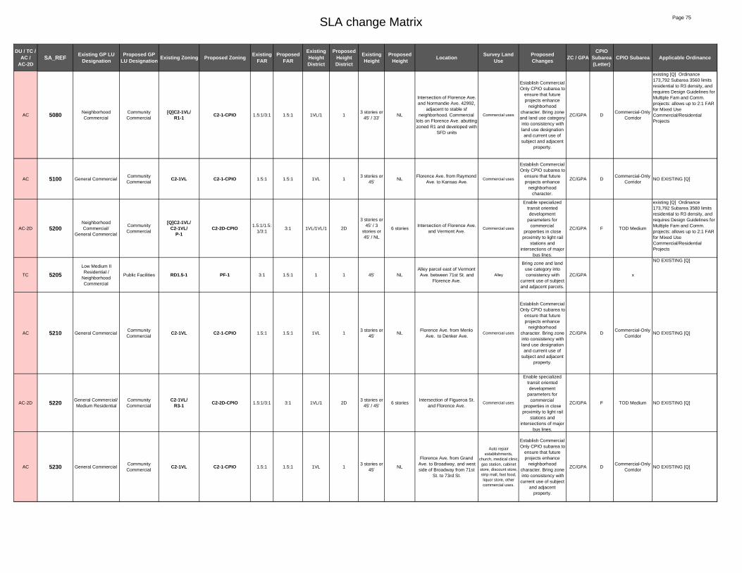
SLA change Matrix Page 75
DU / TC / AC /
AC-2DSA_REF Existing GP LU
DesignationProposed GP
LU Designation Existing Zoning Proposed Zoning Existing FAR
Proposed FAR
Existing Height District
Proposed Height District
Existing Height
Proposed Height Location Survey Land
UseProposed Changes ZC / GPA
CPIO Subarea (Letter)
CPIO Subarea Applicable Ordinance
AC 5080 Neighborhood Commercial
Community Commercial
[Q]C2-1VL/R1-1 C2-1-CPIO 1.5:1/3:1 1.5:1 1VL/1 1
3 stories or 45' / 33'
NL
Intersection of Florence Ave. and Normandie Ave. 42992,
adjacent to stable sf neighborhood. Commercial
lots on Florence Ave. abutting zoned R1 and developed with
SFD units
Commercial uses
Establish Commercial Only CPIO subarea to
ensure that future projects enhance
neighborhood character. Bring zone and land use category into consistency with land use designation and current use of
subject and adjacent property.
ZC/GPA DCommercial-Only
Corridor
existing [Q] Ordinance 173,792 Subarea 3560 limits residential to R3 density, and requires Design Guidelines for Multiple Fam and Comm. projects: allows up to 2:1 FAR for Mixed Use Commercial/Residential Projects
AC 5100 General CommercialCommunity Commercial
C2-1VL C2-1-CPIO 1.5:1 1.5:1 1VL 13 stories or
45'NL
Florence Ave. from Raymond Ave. to Kansas Ave.
Commercial uses
Establish Commercial Only CPIO subarea to
ensure that future projects enhance
neighborhood character.
ZC/GPA DCommercial-Only
CorridorNO EXISTING [Q]
AC-2D 5200Neighborhood Commercial/
General Commercial
Community Commercial
[Q]C2-1VL/C2-1VL/
P-1C2-2D-CPIO 1.5:1/1.5:
1/3:13:1 1VL/1VL/1 2D
3 stories or 45' / 3
stories or 45' / NL
6 storiesIntersection of Florence Ave.
and Vermont Ave. Commercial uses
Enable specialized transit oriented development
parameters for commercial
properties in close proximity to light rail
stations and intersections of major
bus lines.
ZC/GPA F TOD Medium
existing [Q] Ordinance 173,792 Subarea 3580 limits residential to R3 density, and requires Design Guidelines for Multiple Fam and Comm. projects: allows up to 2:1 FAR for Mixed Use Commercial/Residential Projects
TC 5205Low Medium II Residential /
Neighborhood Commercial
Public Facilities RD1.5-1 PF-1 3:1 1.5:1 1 1 45' NLAlley parcel east of Vermont Ave. between 71st St. and
Florence Ave.Alley
Bring zone and land use category into consistency with
current use of subject and adjacent parcels.
ZC/GPA x
NO EXISTING [Q]
AC 5210 General CommercialCommunity Commercial
C2-1VL C2-1-CPIO 1.5:1 1.5:1 1VL 13 stories or
45'NL
Florence Ave. from Menlo Ave. to Denker Ave.
Commercial uses
Establish Commercial Only CPIO subarea to
ensure that future projects enhance
neighborhood character. Bring zone into consistency with land use designation and current use of
subject and adjacent property.
ZC/GPA DCommercial-Only
CorridorNO EXISTING [Q]
AC-2D 5220 General Commercial/Medium Residential
Community Commercial
C2-1VL/R3-1 C2-2D-CPIO 1.5:1/3:1 3:1 1VL/1 2D
3 stories or 45' / 45'
6 storiesIntersection of Figueroa St.
and Florence Ave.Commercial uses
Enable specialized transit oriented development
parameters for commercial
properties in close proximity to light rail
stations and intersections of major
bus lines.
ZC/GPA F TOD Medium NO EXISTING [Q]
AC 5230 General CommercialCommunity Commercial
C2-1VL C2-1-CPIO 1.5:1 1.5:1 1VL 13 stories or
45'NL
Florence Ave. from Grand Ave. to Broadway, and west side of Broadway from 71st
St. to 73rd St.
Auto repair establishments,
church, medical clinic,gas station, cabinet
store, discount store, strip mall, fast food, liquor store, other commercial uses.
Establish Commercial Only CPIO subarea to
ensure that future projects enhance
neighborhood character. Bring zone into consistency with
current use of subject and adjacent
property.
ZC/GPA DCommercial-Only
CorridorNO EXISTING [Q]

SLA change Matrix Page 76
DU / TC / AC /
AC-2DSA_REF Existing GP LU
DesignationProposed GP
LU Designation Existing Zoning Proposed Zoning Existing FAR
Proposed FAR
Existing Height District
Proposed Height District
Existing Height
Proposed Height Location Survey Land
UseProposed Changes ZC / GPA
CPIO Subarea (Letter)
CPIO Subarea Applicable Ordinance
TC 5265 Medium Residential [Q]R4-1 R3-1 3:1 3:1 1 1 45' 45'West side off Normandie Ave.
from 74th St to 76th St.
Residential. Does not include churches: SAINT HILLRIE
CHURCH OF GOD 7529 S Normandie
Ave. PRESBYTERY OF THE PACIFIC 7501 S Normandie Ave. BETHLEHEM
MISSIONARY BAPTIST CHURCH 7401 SO Normandie
Ave.
Bring zone into consistency with land
use category and current use of subject and adjacent parcels.
ZC x
Ord.171,682 and Ord. 162,128, conditional uses for alcoholic beverages. Ord. 167,093 SA 4816 change R4-1 to [Q]R4-1, Churches shall be subject to regulations, prior action of Zoning Administrator shall remain in full force, Other uses of property shall be restricted to those uses permitted in the zone corresponding to the land use. Corresponding zone R3-1.
DU 5266 General CommercialNeighborhood Commercial
C2-1VL C2-1VL-CPIO 1.5:1 1.5:1 1VL 1VL3 stories or
45'3 stories or
45'NW corner of 79th St. and
Normandie Ave.Commercial
Establish General Corridor CPIO
subarea to ensure that future projects
enhance neighborhood
character.
ZC/GPA C General Corridor
NO EXISTING [Q]
TC 5267 Low ResidentialMedium
Residential[Q]R4-1 R3-1 3:1 3:1 1 1 45' 45'
East side of Normandie, north of 79th street
Multi-family residential
development
Bring zone and land use category into consistency with
current use of subject and adjacent parcels.
ZC/GPA x
Ord. 167,093 SA 4816 change R4-1 to [Q]R4-1, Churches shall be subject to regulations, prior action of Zoning Administrator shall remain in full force, Other uses of property shall be restricted to those uses permitted in the corresponding zone: RD6-1.
DU 5270 General CommercialNeighborhood Commercial
C2-1VL C2-1VL-CPIO 1.5:1 1.5:1 1VL 1VL3 stories or
45'3 stories or
45'
West side of Vermont Ave. from 73rd St. to just south of
78th St. and east side of Vermont Ave. from 74th St. to
77th St.
Primarily commercial uses
Establish General Corridor CPIO
subarea to ensure that future projects
enhance neighborhood
character.
ZC/GPA C General Corridor NO EXISTING [Q]
TC 5275 General Commercial Low II Residential [Q]R4-1 3:1 3:1 1 1 45' 45'Tiny lot on Vermont Ave,
adjacent to lot at corner of 78th St. and Vermont Ave.
Owned by Crenshaw Cristian Center
Church
Bring land use category into
consistency with zone and current use of
subject and adjacent parcel
GPA x
Ord. 167093, SA 4980 Change C2-1 and R4-1 to [Q]R4-1. Churches shall be subject to regulations, prior action of zoning administrator shall remain in full force, other uses of property shall be restricted to those uses in the corresponding zone: RD6-1.
DU 5280 Community Commercial
C2-1 C2-1-CPIO 1.5:1 1.5:1 1 1 NL NLBlock on east side of Vermont Ave. from 73rd St. to 74th St.
Primarily commercial uses
Establish General Corridor CPIO
subarea to ensure that future projects
enhance neighborhood
character.
ZC C General Corridor NO EXISTING [Q]
TC 5284 Low Medium II Residential
Open Space RD1.5-1 OS-1XL 3:1 1.5:1 1 1XL 45' NL833 W 76th St. (west of
Hoover St.)Pocket Park
Bring zone and land use category into consistency with
current use of subject and adjacent parcels.
ZC/GPA x NO EXISTING [Q]
AC 5285 Low Medium II Residential
Neighborhood Commercial
[Q]R4-1 C2-1VL-CPIO 3:1 1.5:1 1 1VL 45'3 stories or
45'West side of Hoover St. from
74th St to 78th St
Residential. TRUE GOSPEL
MISSIONARY BAPTIST CHURCH 7723 S. Hoover St.
Establish General Corridor CPIO
subarea to ensure that future projects
enhance neighborhood
character.
ZC/GPA C General Corridor
Ord.171,682 and Ord. 162,128, conditional uses for alcoholic beverages. Ord. 167,093 SA 4082 change R2-1 to [Q]R4-1, Churches shall be subject to regulations, prior action of Zoning Administrator shall remain in full force, Other uses of property shall be restricted to those uses permitted in the zone corresponding to the land use

SLA change Matrix Page 77
DU / TC / AC /
AC-2DSA_REF Existing GP LU
DesignationProposed GP
LU Designation Existing Zoning Proposed Zoning Existing FAR
Proposed FAR
Existing Height District
Proposed Height District
Existing Height
Proposed Height Location Survey Land
UseProposed Changes ZC / GPA
CPIO Subarea (Letter)
CPIO Subarea Applicable Ordinance
DU 5286 General CommercialNeighborhood Commercial
C2-1VL C2-1VL-CPIO 1.5:1 1.5:1 1VL 1VL3 stories or
45'3 stories or
45'Both sides of Hoover St. from
78th St. to 79th St.Church, residential
Establish Neighborhood-Serving CPIO
subarea to ensure that future projects
enhance neighborhood
character.
ZC/GPA ANeighborhood
Serving Corridor
NO EXISTING [Q]
DU 5287 General Commercial / Medium Residential
Neighborhood Commercial
C2-1VL/ [Q]R3-1 C2-1VL-CPIO 1.5:1/ 3:1 1.5:1 1VL/1 1VL3 stories or
45' / 45'3 stories or
45'
East side of Hoover St. from alley north of 73rd St. to 75th
St.
Churches, multi-family residential
Establish Neighborhood-Serving CPIO
subarea to ensure that future projects
enhance neighborhood
character.
ZC/GPA ANeighborhood
Serving Corridor
[Q] Ord 173,792 SA 3940 Change RD2-1 to [Q]R3-1, Residential developments limited to max density 1,200 SF per dwelling unit in the R3 zone; Multi-family residential design guidelines.
DU 5290General Commercial/
Low Medium I Residential
Neighborhood Commercial
C2-1VL C2-1VL-CPIO 1.5:1 1.5:1 1VL 1VL3 stories or
45'3 stories or
45'Lots fronting Figueroa St. from 73rd St. to 77th St.
Commercial and residential uses
Establish General Corridor CPIO
subarea to ensure that future projects
enhance neighborhood
character.
ZC/GPA C General Corridor NO EXISTING [Q]
TC 5292 General Commercial Public Facilities C2-1VL PF-1 1.5:1 1.5:1 1VL 13 stories or
45'NL
City-owned lots on east side of Figueroa St. between 75th
St. and 76th St.
City-owned building, parking
lot for parking enforcement
vehicles
Bring zone and land use category into consistency with
current use of subject and adjacent parcels.
ZC/GPA x NO EXISTING [Q]
TC 5294 General CommercialMedium
ResidentialR3-1 3:1 3:1 1 1 45' 45'
NW and SW corner of 76th St and Flower St (4 lots plus
slivers along Flower)Residential
Bring land use category into
consistency with zone and current use of
subject and adjacent parcel
GPA x NO EXISTING [Q]
TC 5298 Public Facilities C2-1/ R3-1 PF-1 1.5:1/ 3:1 1.5:1 1/1 1 NL / 45' NLEast and west sides of 110 Frwy from Florence Ave to
80th StreetFreeway buffer
Bring zone into consistency with land
use category and current use of subject and adjacent parcels.
ZC x NO EXISTING [Q]
DU 5300 General CommercialNeighborhood Commercial
C2-1VL C2-1VL-CPIO 1.5:1 1.5:1 1VL 1VL3 stories or
45'3 stories or
45'Western Ave. (east and west)
from 74th St. to 85th St.Primarily commercial
uses
Establish General Corridor CPIO
subarea to ensure that future projects
enhance neighborhood
character.
ZC/GPA C General Corridor NO EXISTING [Q]
DU 5301 General CommercialNeighborhood Commercial
C2-1VL C2-1VL-CPIO 1.5:1 1.5:1 1VL 1VL3 stories or
45'3 stories or
45'Western Ave. (east and west)
from 76th St. to 79th St.Primarily
commercial uses
Establish General Corridor CPIO
subarea to ensure that future projects
enhance neighborhood
character.
ZC/GPA C General Corridor NO EXISTING [Q]
DU 5302 General CommercialNeighborhood Commercial
C2-1VL C2-1VL-CPIO 1.5:1 1.5:1 1VL 1VL3 stories or
45'3 stories or
45'Western Ave. (east and west)
from 79th St. to 82nd St.Primarily
commercial uses
Establish General Corridor CPIO
subarea to ensure that future projects
enhance neighborhood
character.
ZC/GPA C General Corridor NO EXISTING [Q]
AC 5303 General Commercial/ Medium Residential
Neighborhood Commercial
C2-1VL/R3-1 C2-1VL-CPIO 1.5:1/3:1 1.5:1 1VL/1 1VL
3 stories or 45' 45'
3 stories or 45'
Western Ave. (east and west) from 82nd St. to 85th St.
Primarily commercial uses, some multi-family
residential
Establish General Corridor CPIO
subarea to ensure that future projects
enhance neighborhood
character.
ZC/GPA C General Corridor NO EXISTING [Q]

SLA change Matrix Page 78
DU / TC / AC /
AC-2DSA_REF Existing GP LU
DesignationProposed GP
LU Designation Existing Zoning Proposed Zoning Existing FAR
Proposed FAR
Existing Height District
Proposed Height District
Existing Height
Proposed Height Location Survey Land
UseProposed Changes ZC / GPA
CPIO Subarea (Letter)
CPIO Subarea Applicable Ordinance
AC 5310 Medium ResidentialNeighborhood Commercial
[Q]R3-1/R3-1/ [Q]R4-1 C2-1VL-CPIO 3:1/3:1/3:
11.5:1 1/1/1 1VL 45' / 45' /45'
3 stories or 45'
Lots on west side of Figueroa St. from 77th St. to 79th St.,
and Lots on East side of Figueroa St. from 77th St. to 79th St. Excludes parcel at SW corner of Figueroa and
78th St.
Residential uses, and church: WORLD WIDE CRUSADE
FOR CHRIST at 440 W 78TH ST
Establish General Corridor CPIO
subarea to ensure that future projects
enhance neighborhood
character.
ZC/GPA C General Corridor
Ord. 173,792 SA 4020 change RD1.5-1 to [Q]R3-1, Residential developments shall be limited to a maximum density of 1200 square feet per dwelling unit in the R3 zone, Multi-family residential developments must obtain plan approval. Ord. 167,093 SA 4928 change C2-1 to RD1.5-1Ord.171,682 and Ord. 162,128 conditional uses for alcoholic beverages, and [Q] ordinance: ORD-167093-SA4932 standards for church properties otherwise R3 density, corresponding zone R3-1
TC 5315 Medium Residential Public Facilities R3-1 PF-1 3:1 1.5:1 1 1 45' NL514 W 78th St (lot at SW
corner of Figueroa and 78th St)
DWP Power Distribution Station
Bring zone and land use category into consistency with
current use of subject and adjacent parcels.
ZC/GPA x
NO EXISTING [Q]
DU 5330 General CommercialNeighborhood Commercial
C2-1VL C2-1VL-CPIO 1.5:1 1.5:1 1VL 1VL3 stories or
45'3 stories or
45'
Lots on west side of Broadway from 73rd St. to
81st St.
Commercial and residential uses
Establish General Corridor CPIO
subarea to ensure that future projects
enhance neighborhood
character.
ZC/GPA C General Corridor NO EXISTING [Q]
DU 5332 General CommercialNeighborhood Commercial
C2-1VL/ RD1.5-1 C2-1VL-CPIO 1.5:1/ 3:1 1.5:1 1VL/1 1VL3 stories or
45' / 45'3 stories or
45'
Lots on west side of Broadway from 81st St. to
84th Pl.
Commercial and residential uses,
vacant lot
Establish General Corridor CPIO
subarea to ensure that future projects
enhance neighborhood
character.
ZC/GPA C General Corridor NO EXISTING [Q]
DU 5334 Low Residential Low II Residential R1-1 R1-1-CPIO 3:1 3:1 1 1 33' 33'
Blocks bounded by 79th Street to the north, New
Hampshire Ave to the east, 83rd St to the south, and
Normandie Ave to the west.
Residential; many are contributors to Vermont Knolls Historic District
identified by SurveyLA.
Establish Character Residential CPIO
subarea to preserve the existing scale and historic character of the neighborhood.
ZC/GPA OCharacter Residential
NO EXISTING [Q]
DU 5338 Medium Residential R3-1 R3-1-CPIO 3:1 3:1 1 1 45' 45'Parcels on the east side of New Hampshire Ave from 79th Street to 83rd Street.
Mainly multi-family residential; most are
contributors to Vermont Knolls Historic District
identified by SurveyLA.
Establish Character Residential CPIO
subarea to preserve the existing scale and historic character of the neighborhood.
ZC/GPA OCharacter Residential
NO EXISTING [Q]
TC 5339 General Commercial Public Facilities C2-1VL PF-1 1.5:1 1.5:1 1VL 13 stories or
45'NL
SE corner of 78th St. and Vermont Ave.
Fire Station
Bring zone and land use category into consistency with
current use of subject and adjacent parcels.
ZC/GPA x NO EXISTING [Q]
AC 5340Community
Commercial/General Commercial
Community Commercial
C2-1VL/[Q]C2-1 C2-1-CPIO 1.5:1/1.5:
11.5:1 1VL/1 1
3 stories or 45' / NL
NL
Vermont Ave. from 78th St. to 83rd St. (on east side) and
from 79th St. to 83rd (on west side); exculdes fire station
parcels at SE corner of 78th and Vermont
Primarily commercial uses
Establish General Corridor CPIO
subarea to ensure that future projects
enhance neighborhood
character.
ZC/GPA C General Corridor
Existing [Q] Placed by Ordinance 173,792 Subarea 3900: : Design Guidelines for Multiple family and Commercial and MU projects. Up to 2:1 FAR for commercial residential Mixed used projects, density limited to R3 [q] retained tpers cpc86-790-gpc?
DU 5342Medium Residential/
Community Commercial
Community Commercial
[Q]C2-1/R3-1
C2-1-CPIO 1.5:1/ 3:1 1.5:1 1/1 1 NL / 45' NLLots between 82nd St. and
83rd street, east of Vermont Ave.
Parking structure
Establish General Corridor CPIO
subarea to ensure that future projects
enhance neighborhood
character.
ZC/GPA C General Corridor
Existing [Q] Placed by Ordinance 173,792 Subarea 3900: : Design Guidelines for Multiple family and Commercial and MU projects. Up to 2:1 FAR for commercial residential Mixed used projects, density limited to R3 [q] retained tpers cpc86-790-gpc?

SLA change Matrix Page 79
DU / TC / AC /
AC-2DSA_REF Existing GP LU
DesignationProposed GP
LU Designation Existing Zoning Proposed Zoning Existing FAR
Proposed FAR
Existing Height District
Proposed Height District
Existing Height
Proposed Height Location Survey Land
UseProposed Changes ZC / GPA
CPIO Subarea (Letter)
CPIO Subarea Applicable Ordinance
TC 5345 Medium Residential [Q]R4-1 R3-1 3:1 3:1 1 1 45' 45'
Blocks generally bounded by 79th St. Hoover St. and 52nd St. excluding church-owned
parcls.
Residential. Excludes churches: THREE Oak St.S BAPTIST CHURCH 8109 S
Hoover St. AMAZING GRACE
OUTREACH MINISTRIES 731 W
80TH ST
Bring zone into consistency with land
use category and current use of subject and adjacent parcels.
ZC x
Ord.171,682 and Ord. 162,128, conditional uses for alcoholic beverages. Ord. 167,093 SA 5036 change R2-1 to [Q]R4-1, Churches shall be subject to regulations, prior action of Zoning Administrator shall remain in full force, Other uses of property shall be restricted to those uses permitted in the zone corresponding to the land use, R3-1.
DU 5350 General CommercialNeighborhood Commercial
C2-1VL C2-1VL-CPIO 1.5:1 1.5:1 1VL 1VL3 stories or
45'3 stories or
45'Lots fronting Figueroa St. from 79th St. to 81st St.
Residential, commercial, nursing
home, church.
Establish General Corridor CPIO
subarea to ensure that future projects
enhance neighborhood
character.
ZC/GPA C General Corridor
Existing [Q] conditions placed by Ordinance ORD-1ORD-173792-SA4070 placed q on R3 to limit Residential developments shall be limited to a maximum density of 1,200 square feet per dwelling unit in the R3 zone. Multi-family residential developments must obtain plan approval to ensure conformity with the multi-family residential development design guidelines.
AC 5351 General Commercial/Medium Residential
Neighborhood Commercial
C2-1VL/R3-1/
[Q]R3-1C2-1VL-CPIO 1.5:1/3:1/
3:11.5:1 1VL/1/1 1VL
3 stories or 45' / 45' /
45'
3 stories or 45'
Lots east and west side of Figueroa St. from 81st St. to
84th St.
Commercial, residential, empty
lot
Establish General Corridor CPIO
subarea to ensure that future projects
enhance neighborhood
character.
ZC/GPA C General Corridor
Ord. 167,093 SA 4980 - Limits expansion of churches to 20%; corresponding zone for other uses RD6-1.
DU 5352Community
Commercial/General Commercial
Neighborhood Commercial
C2-1VL/[Q]C2-1 C2-1VL-CPIO 1.5:1/3:1 1.5:1 1VL/1 1VL
3 stories or 45' / 45'
3 stories or 45'
Lots east and west side of Figueroa St. from 84th St. to
midblock Manchester Ave.Commercial uses
Establish General Corridor CPIO
subarea to ensure that future projects
enhance neighborhood
character.
ZC/GPA C General Corridor
Ord. 167,093 SA 5336 - Conformity with multi-family residential design guidelines. Max 2:1 FAR for commercial/ residential mixed use and 1.5:1 for commercial developments. Commercial development design guidelines. Residential uses in C2 zone restricted to max R3 density.
TC 5355 Low Residential Low II Residential [Q]R4-1 R1-1 3:1 3:1 1 1 33' 33'
South side of 83rd St. from midblock west of Gramercy to
Cimarron St. (excludes church-owned parcels)
Residential.
Bring zone and land use category into consistency with
current use of subject and adjacent parcels.
ZC/GPA x
Ord.171,682 and Ord. 162,128, conditional uses for alcoholic beverages. Ord. 167,093 SA 5223 change R1-1 to [Q]R4-1, Churches shall be subject to regulations, prior action of Zoning Administrator shall remain in full force, Other uses of property shall be restricted to those uses permitted in the R1-1 zone.
TC 5357 Low Residential Low II Residential [Q]R4-1 3:1 3:1 1 1 33' 33'SW corner of 83rd St. and Gramercy Place (5 lots)
ST. MARKS COMMUNITY METHODIST
CHURCH 2002-2022 W. 83rd St
Bring land use category into
consistency with zone and current use of
subject and adjacent parcel
GPA x
Ord.171,682 and Ord. 162,128, conditional uses for alcoholic beverages. Ord. 167,093 SA 5223 change R1-1 to [Q]R4-1, Churches shall be subject to regulations, prior action of Zoning Administrator shall remain in full force, Other uses of property shall be restricted to those uses permitted in the R1-1 zone.
AC-2D 5370 Medium ResidentialCommunity Commercial
[T][Q]R3-1 C2-2D-CPIO 3:1 1 2D 45' 6 stories
South side of 83rd St. west of Vermont, excludes lots
fronting Vermont (6 lots + vacated alley)
Vermont Knoll Retirement Community
Enable specialized transit oriented development
parameters for commercial
properties in close proximity to light rail
stations and intersections of major
bus lines.
ZC/GPA F TOD Medium
Existing [Q] Placed by Ordinance 173,792 Subarea 3770: : Design Guidelines for Multiple family projects. Residential density limited to a max density of 1,200 sq ft per dwelling unit in the R3 zone.
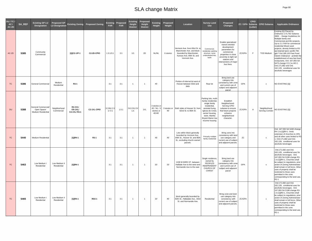
SLA change Matrix Page 80
DU / TC / AC /
AC-2DSA_REF Existing GP LU
DesignationProposed GP
LU Designation Existing Zoning Proposed Zoning Existing FAR
Proposed FAR
Existing Height District
Proposed Height District
Existing Height
Proposed Height Location Survey Land
UseProposed Changes ZC / GPA
CPIO Subarea (Letter)
CPIO Subarea Applicable Ordinance
AC-2D 5385 Community Commercial
[Q]C2-1/P-1 C2-2D-CPIO 1.5:1/3:1 3:1 1/1 2D NL/NL 6 stories
Vermont Ave. from 83rd St. to Manchester Ave. and block bounded by Manchester, Kansas Ave, 85th St, and
Vermont Ave.
Commercial, residential, parking
structure, some undeveloped lots,
bank
Enable specialized transit oriented development
parameters for commercial
properties in close proximity to light rail
stations and intersections of major
bus lines.
ZC/GPA F TOD Medium
Existing [Q] Placed by Ordinance 173,792 Subarea 3900: : Design Guidelines for Multiple family and Commercial and MU projects. Up to 2:1 FAR for commercial residential Mixed used projects, density limited to R3 [q] retained tpers cpc86-790-gpc? Ord.180,103 Fast Food Interim Ordinance - prohibit the establishment of new fast food restaurants, Ord. 167,093 SA 5473 change C2-2 to HD 2, Ord.171,682 and Ord. 162,128, conditional uses for alcoholic beverages
TC 5386 General CommercialMedium
ResidentialR3-1 3:1 3:1 1 1 45'
Portion of internal lot west of Hoover between 83rd and
84thRear lot
Bring land use category into
consistency with zone and current use of
subject and adjacent parcel
GPA x NO EXISTING [Q]
DU 5388General Commercial/
Open Space/ Medium Residential
Neighborhood Commercial
R4-1VL/OS-1XL/
C2-1VL/ R3-1C2-1VL-CPIO 3:1/NL/1.5
:1/ 3:11.5:1
1VL/1XL/1VL/1
1VL
3 stories or 45' / NL / 3 stories or
45'/45'
3 stories or 45'
Both sides of Hoover St. from 82nd St. to 85th St.
Parking lots, multi-family residential,
single family residential,
assisted living, Iglesia de Cristo, senior housing, store, Martha
Bryant Manor low income housing
Establish Neighborhood-Serving CPIO
subarea to ensure that future projects
enhance neighborhood
character.
ZC/GPA ANeighborhood
Serving CorridorNO EXISTING [Q]
TC 5440 Medium Residential [Q]R4-1 R3-1 3:1 3:1 1 1 45' 45'
Lots within block generally bounded by Vermont Ave.,
84th St., Hoover St. and 85th St., excluding church-owned
parcels.
Primarily multiple family residential
Bring zone into consistency with land
use category and current use of subject and adjacent parcels.
ZC x
Ord. 167 093 SA 5430 change R4-1 to [Q]R4-1 limits extension of churches to 20% and all other uses limited to R3-1, Ord.171,682 and Ord. 162,128, conditional uses for alcoholic beverages
TC 5463 Low Medium I Residential
Low Medium II Residential
[Q]R4-1 3:1 3:1 1 1 33' 33'1439 W 83RD ST, between Halldale Ave to the west and Normandie Ave to the east
Single residence, owned by PEOPLES
INDEPENDENT CHURCH OF
CHRIST
Bring land use category into
consistency with zone and current use of
subject and adjacent parcel
GPA x
Ord.171,682 and Ord. 162,128, conditional uses for alcoholic beverages. Ord. 167,093 SA 5198 change R3-1 to [Q]R4-1, Churches shall be subject to regulations, prior action of Zoning Administrator shall remain in full force, Other uses of property shall be restricted to those uses permitted in the zone corresponding to the land use, R2-1
TC 5465 Low Medium I Residential
Low Medium II Residential
[Q]R4-1 RD2-1 3:1 3:1 1 1 33' 45'block generally bounded by
82th St., Halladale Ave., 83rd St. and Normandie Ave.
Residential
Bring zone and land use category into consistency with
current use of subject and adjacent parcels.
ZC/GPA x
Ord.171,682 and Ord. 162,128, conditional uses for alcoholic beverages. Ord. 167,093 SA 5198 change R3-1 to [Q]R4-1, Churches shall be subject to regulations, prior action of Zoning Administrator shall remain in full force, Other uses of property shall be restricted to those uses permitted in the zone corresponding to the land use, R2-1

SLA change Matrix Page 81
DU / TC / AC /
AC-2DSA_REF Existing GP LU
DesignationProposed GP
LU Designation Existing Zoning Proposed Zoning Existing FAR
Proposed FAR
Existing Height District
Proposed Height District
Existing Height
Proposed Height Location Survey Land
UseProposed Changes ZC / GPA
CPIO Subarea (Letter)
CPIO Subarea Applicable Ordinance
DU 5466 General CommercialNeighborhood Commercial
C2-1VL/ R4-1VL C2-1VL-CPIO 1.5:1/ 3:1 1.5:1 1VL 1VL
3 stories or 45' / 3
stories or 45'
3 stories or 45'
Four corners at intersection of Normandie Ave. and 83rd St.
Commercial stores, service
store, residential
Establish General Corridor CPIO
subarea to ensure that future projects
enhance neighborhood
character.
ZC/GPA C General Corridor
NO EXISTING [Q]
TC 5467 Low Medium II Residential
[Q]R4-1 RD2-1 3:1 3:1 1 1 33' 45' 1404 and 1406 W 84TH ST Residential
Bring zone into consistency with land
use category and current use of subject and adjacent parcels.
ZC xORD-167093-5352- Limits expansion of churches, limits residential density to R2
TC 5469 General CommercialLow Medium II
ResidentialRD2-1 3:1 3:1 1 1 45'
Sliver bounded by 83rd St, Normandie Ave, and 84th St.
Residential (sliver)
Bring land use category into
consistency with zone and current use of
subject and adjacent parcel
GPA x NO EXISTING [Q]
TC 5470 Low Medium II Residential
[Q]R4-1 RD1.5-1 3:1 3:1 1 1 45' 45'South side of 85th St. from
Budlong Ave. to Kansas Ave.
Primarily multiple family residential. Excludes church.
Bring zone into consistency with land
use category and current use of subject and adjacent parcels.
ZC xORD-167093-SA5476- Limits expansion of churches, limits residential density to RD1.5
AC-2D 5495 Medium ResidentialCommunity Commercial
[Q]R4-1 C2-2D-CPIO 3:1 3:1 1 2D 45' 6 stories927 W. 85th Street (North
side of 85th St east of Vermont Ave)
Parking lot
Enable specialized transit oriented development
parameters for commercial
properties in close proximity to light rail
stations and intersections of major
bus lines.
ZC/GPA F TOD Medium
Ord. 167 093 SA 5430 change R4-1 to [Q]R4-1 limits extension of churches to 20% and all other uses limited to R3-1, Ord.171,682 and Ord. 162,128, conditional uses for alcoholic beverages
AC-2D 5510
Neighborhood Office Commercial/
Medium Residential/ General Commercial
/ Community Commercial/ Low
Residential
Community Commercial
[Q]C2-1VL/R3P-1/ P-1/
[Q]R5-1/R1P-1C2-2D-CPIO
1.5:1/3:1/3:1/3:1/
3:13:1 1VL/1/1/1/1 2D
3 stories or 45' / NL/NL/
NL6 stories
NW, NE, SW and SE corner of Western Ave. and
Manchester Ave., and 11 lots in block generally bounded by 87th St. to north Western Ave. on east, 88th St. on south and St. Andrews Pl. on west (1/2
block)
Commercial uses primarily, including
Ralphs supermarket, residential complex
Enable specialized transit oriented development
parameters for commercial
properties in close proximity to light rail
stations and intersections of major
bus lines.
ZC/GPA F TOD Medium
ORD-173792-SA4100- unclear, description of [Q] omitted. Possibly the intent was to limit density to the R3
AC-2D 5520Community
Commercial/Low Medium II
Residential
Community Commercial
[Q]C2-1/[Q]R4-1 C2-2D-CPIO 1.5:1/3:1 3:1 1 2D NL / 45' 6 stories
North side of Manchester Ave. from Budlong Ave. to
Kansas Ave., including Small lot on east side of Budlong
between 85th St. and Manchester Ave.
Commercial uses, church property
Enable specialized transit oriented development
parameters for commercial
properties in close proximity to light rail
stations and intersections of major
bus lines.
ZC/GPA F TOD Medium
Ord. 173,792 SA3900: change C2-1 to [Q]C2-1, Maximum of 2:1 FAR for Mixed use projects: Max. 1.5:1 for commercial only. Residential uses in C2 zone restricted to max R3, Ord.180,103 Fast Food Interim Ordinance - prohibit the establishment of new fast food restaurants, Ord. 167,093 SA 5473 change C2-2 to HD 2, Ord.171,682 and Ord. 162,128, conditional uses for alcoholic beverages, ORD-167093-SA5476- Limits expansion of churches, limits residential density to RD1.5

SLA change Matrix Page 82
DU / TC / AC /
AC-2DSA_REF Existing GP LU
DesignationProposed GP
LU Designation Existing Zoning Proposed Zoning Existing FAR
Proposed FAR
Existing Height District
Proposed Height District
Existing Height
Proposed Height Location Survey Land
UseProposed Changes ZC / GPA
CPIO Subarea (Letter)
CPIO Subarea Applicable Ordinance
AC-2D 5540 Community Commercial
[Q]C2-1 C2-2D-CPIO 1.5:1 3:1 1 2D NL 6 stories
Lots on north side of Manchester Ave. from just
east of Vermont Ave. to Hoover St. and Lots on south side of Manchester Ave. from Baring Cross St. to Hoover St.
Primarily commercial uses, Supermarket,
and other commercial uses, some
residential uses
Enable specialized transit oriented development
parameters for commercial
properties in close proximity to light rail
stations and intersections of major
bus lines.
ZC/GPA F TOD Medium
Ord. 173,792 SA3900: change C2-1 to [Q]C2-1, allows up to 2:1 FAR for Mixed Use Commercial/Residential Projects and 1.5:1 for commercial developments, requires Design Guidelines for commercial developments and Commercial/Residential Projects, residential uses limited to R3 zone density, Ord.180,103 Fast Food Interim Ordinance - prohibit the establishment of new fast food restaurants, Ord. 167 093 SA 5471 change C2-1 to HD2, 5472 change C2-1 to HD 1-VL, 5466 change C2-1 to HD 1-VL, Ord.171,682 and Ord. 162,128, conditional uses for alcoholic beverages
DU 5550 Community Commercial
[Q]C2-1/R3-1 C2-1-CPIO 1.5:1/ 3:1 1.5:1 1 1 NL / 45' NL
North side of Manchester Ave. from Hoover St. to
Figueroa St.
Primarily commercial uses
Establish Commercial Only CPIO subarea to
ensure that future projects enhance
neighborhood character. Bring zone into consistency with land use designation and current use of
subject and adjacent property.
ZC/GPA DCommercial-Only
Corridor
Existing [Q] Placed by Ordinance 173,792 Subarea 3900: : Design Guidelines for Multiple family and Commercial and MU projects. Up to 2:1 FAR for commercial residential Mixed used projects, density limited to R3 [q] retained tpers cpc86-790-gpc?
TC 5555 Public Facilities R3-1 PF-1 3:1 1.5:1 1 1 45' NLTiny lot behind 729 W.
ManchesterCity-owned portion of
back lot
Bring zone into consistency with land
use category and current use of subject and adjacent parcels.
ZC x
NO EXISTING [Q]
AC 5560Community
Commercial/Low Medium II
Residential
Community Commercial
[Q]C2-1/RD1.5-1 C2-1-CPIO 1.5:1/3:1 1.5:1 1/1 1 NL / 45' NL
NE corner of Figueroa St. and Manchester Ave.
Shopping centers, including auto repair
establishment
Establish Commercial Only CPIO subarea to
ensure that future projects enhance
neighborhood character. Bring zone and land use category into consistency with
current use of subject and adjacent
property.
ZC/GPA DCommercial-Only
Corridor
Ordinance 173,792 SA 3900- Multiple-family, commercial, Mixed use projects must comply with design guidelines. Residential density limited to the R3
TC 5562 Public Facilities R3-1 PF-1 3:1 1.5:1 1 1 45' NLEast and west side of 110
Frwy from 79th St to 84th StFreeway buffer
Bring zone into consistency with land
use category and current use of subject and adjacent parcels.
ZC x
NO EXISTING [Q]
TC 5565 Public FacilitiesC2-1 / C2-1VL/ RD1.5-1/ R3-1/
FRWYPF-1
1.5:1/ 1.5:1/ 3:1/
3:1/1.5:1 1/ 1VL/ 1/ 1 1
NL / 3 stories or 45' / 45' / 45' / NL
NLEast and west side of 110 Frwy from 84th Place to
Manchester AveFreeway buffer
Bring zone into consistency with land
use category and current use of subject and adjacent parcels.
ZC x
NO EXISTING [Q]
DU 5570 Community Commercial
C2-1/ [Q]C2-1 C2-1-CPIO 1.5:1/1.5:1
1.5:1 1/1 1 NL/NL NL
North side of Manchester Ave. between freeway on
ramps, and Block bounded by Olive St. on west, 84th Pl. to the north, Broadway to east and Manchester Ave. to the
south
Public parking? Park and ride faculty,
ownership is Caltrans,public storage /
warehouse establishment,
commercial uses
Establish Commercial Only CPIO subarea to
ensure that future projects enhance
neighborhood character. Bring zone into consistency with
current use of subject and adjacent
property.
ZC/GPA DCommercial-Only
Corridor
Ordinance 173,792 SA 3900- Multiple-family, commercial, Mixed use projects must comply with design guidelines. Residential density limited to the R3
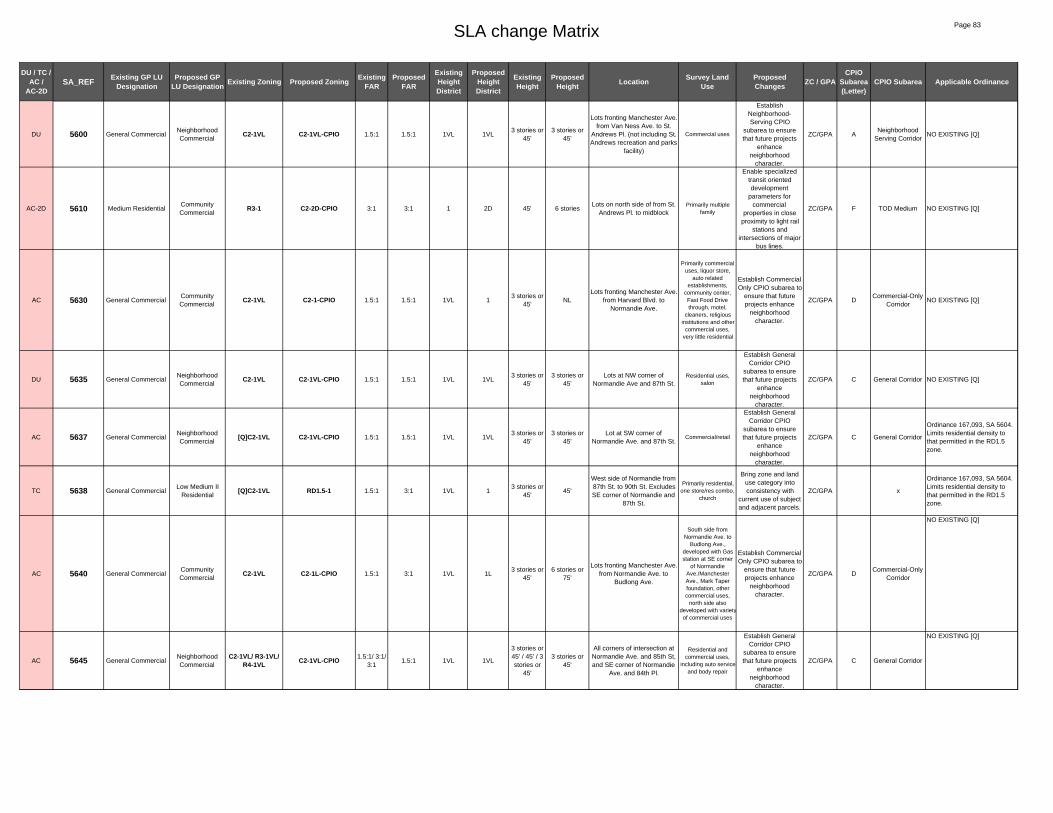
SLA change Matrix Page 83
DU / TC / AC /
AC-2DSA_REF Existing GP LU
DesignationProposed GP
LU Designation Existing Zoning Proposed Zoning Existing FAR
Proposed FAR
Existing Height District
Proposed Height District
Existing Height
Proposed Height Location Survey Land
UseProposed Changes ZC / GPA
CPIO Subarea (Letter)
CPIO Subarea Applicable Ordinance
DU 5600 General CommercialNeighborhood Commercial
C2-1VL C2-1VL-CPIO 1.5:1 1.5:1 1VL 1VL3 stories or
45'3 stories or
45'
Lots fronting Manchester Ave. from Van Ness Ave. to St.
Andrews Pl. (not including St. Andrews recreation and parks
facility)
Commercial uses
Establish Neighborhood-Serving CPIO
subarea to ensure that future projects
enhance neighborhood
character.
ZC/GPA ANeighborhood
Serving CorridorNO EXISTING [Q]
AC-2D 5610 Medium ResidentialCommunity Commercial
R3-1 C2-2D-CPIO 3:1 3:1 1 2D 45' 6 storiesLots on north side of from St.
Andrews Pl. to midblockPrimarily multiple
family
Enable specialized transit oriented development
parameters for commercial
properties in close proximity to light rail
stations and intersections of major
bus lines.
ZC/GPA F TOD Medium NO EXISTING [Q]
AC 5630 General CommercialCommunity Commercial
C2-1VL C2-1-CPIO 1.5:1 1.5:1 1VL 13 stories or
45'NL
Lots fronting Manchester Ave. from Harvard Blvd. to
Normandie Ave.
Primarily commercial uses, liquor store,
auto related establishments,
community center, Fast Food Drive through, motel,
cleaners, religious institutions and other
commercial uses, very little residential
Establish Commercial Only CPIO subarea to
ensure that future projects enhance
neighborhood character.
ZC/GPA DCommercial-Only
CorridorNO EXISTING [Q]
DU 5635 General CommercialNeighborhood Commercial
C2-1VL C2-1VL-CPIO 1.5:1 1.5:1 1VL 1VL3 stories or
45'3 stories or
45'Lots at NW corner of
Normandie Ave and 87th St.Residential uses,
salon
Establish General Corridor CPIO
subarea to ensure that future projects
enhance neighborhood
character.
ZC/GPA C General Corridor NO EXISTING [Q]
AC 5637 General CommercialNeighborhood Commercial
[Q]C2-1VL C2-1VL-CPIO 1.5:1 1.5:1 1VL 1VL3 stories or
45'3 stories or
45'Lot at SW corner of
Normandie Ave. and 87th St.Commercial/retail
Establish General Corridor CPIO
subarea to ensure that future projects
enhance neighborhood
character.
ZC/GPA C General Corridor
Ordinance 167,093, SA 5604. Limits residential density to that permitted in the RD1.5 zone.
TC 5638 General CommercialLow Medium II
Residential[Q]C2-1VL RD1.5-1 1.5:1 3:1 1VL 1
3 stories or 45'
45'
West side of Normandie from 87th St. to 90th St. Excludes SE corner of Normandie and
87th St.
Primarily residential, one store/res combo,
church
Bring zone and land use category into consistency with
current use of subject and adjacent parcels.
ZC/GPA x
Ordinance 167,093, SA 5604. Limits residential density to that permitted in the RD1.5 zone.
AC 5640 General CommercialCommunity Commercial
C2-1VL C2-1L-CPIO 1.5:1 3:1 1VL 1L3 stories or
45'6 stories or
75'
Lots fronting Manchester Ave. from Normandie Ave. to
Budlong Ave.
South side from Normandie Ave. to
Budlong Ave., developed with Gas station at SE corner
of Normandie Ave./Manchester Ave., Mark Taper foundation, other commercial uses,
north side also developed with varietyof commercial uses
Establish Commercial Only CPIO subarea to
ensure that future projects enhance
neighborhood character.
ZC/GPA DCommercial-Only
Corridor
NO EXISTING [Q]
AC 5645 General CommercialNeighborhood Commercial
C2-1VL/ R3-1VL/ R4-1VL C2-1VL-CPIO 1.5:1/ 3:1/
3:11.5:1 1VL 1VL
3 stories or 45' / 45' / 3 stories or
45'
3 stories or 45'
All corners of intersection at Normandie Ave. and 85th St, and SE corner of Normandie
Ave. and 84th Pl.
Residential and commercial uses,
including auto service and body repair
Establish General Corridor CPIO
subarea to ensure that future projects
enhance neighborhood
character.
ZC/GPA C General Corridor
NO EXISTING [Q]

SLA change Matrix Page 84
DU / TC / AC /
AC-2DSA_REF Existing GP LU
DesignationProposed GP
LU Designation Existing Zoning Proposed Zoning Existing FAR
Proposed FAR
Existing Height District
Proposed Height District
Existing Height
Proposed Height Location Survey Land
UseProposed Changes ZC / GPA
CPIO Subarea (Letter)
CPIO Subarea Applicable Ordinance
AC-2D 5650 Community Commercial
[Q]C2-1 C2-2D-CPIO 1.5:1 3:1 1 2D NL 6 stories
Manchester from Budlong to Vermont, south side, and
block bounded by Vermont, Manchester, Menlo and 88th
St.
Primarily commercial uses, church, some
residential, city-ownedparking lot
Enable specialized transit oriented development
parameters for commercial
properties in close proximity to light rail
stations and intersections of major
bus lines.
ZC F TOD Medium
Ord. 173,792 SA3900: change C2-1 to [Q]C2-1, Maximum of 2:1 FAR for Mixed use projects: Max. 1.5:1 for commercial only. Residential uses in C2 zone restricted to max R3, Ord. 167,093 SA 5566 - change C2-1 to HD2, 5564 change C2-1 to HD 1-VL, Ord. 167,093 SA 5602 change R3P-1 to C2-2, Ord.180,103 Fast Food Interim Ordinance - prohibit the establishment of new fast food restaurants, Ord.171,682 and Ord. 162,128, conditional uses for alcoholic beverages
TC 5670Community
Commercial/Low Medium II
Residential
Public Facilities[Q]C2-1/RD2-1 PF-1 1.5:1/ 3:1 1.5:1 1 1 NL / 45' NL
Lots on south side of Manchester Ave. from Menlo
Ave. to Baring Cross St.LAUSD School
Bring zone and land use category into consistency with
current use of subject and adjacent parcels.
ZC/GPA x
Ord. 167,093 SA 5600 change R4-1, R3-1 to RD2-1, SA 5572 change C2-1 to HD 2, Ord.171,682 and Ord. 162,128, conditional uses for alcoholic beverages
DU 5690Community
Commercial/ General Commercial
Community Commercial
[Q]C2-1 C2-1-CPIO 1.5:1 1.5:1 1 1 NL NL
South side of Manchester Ave. from Hoover St. to
Figueroa St. (not including school property on SE corner
of Manchester Ave. and Hoover St.)
Primarily commercial uses
Establish Commercial Only CPIO subarea to
ensure that future projects enhance
neighborhood character.
ZC/GPA DCommercial-Only
Corridor
Existing [Q] Placed by Ordinance 173,792 Subarea 3900: : Design Guidelines for Multiple family and Commercial and MU projects. Up to 2:1 FAR for commercial residential Mixed used projects, density limited to R3 [q] retained tpers cpc86-790-gpc?
AC 5770Highway Oriented
and Limited Commercial
Neighborhood Commercial
(T)(Q)C2-1 (T)(Q)C2-1-CPIO 1.5:1 1.5:1 1 1 NL NLWest side of Western Ave. from 88th St. to midblock
(88th Pl.)Supermarket
Establish Neighborhood-Serving CPIO
subarea to ensure that future projects
enhance neighborhood
character.
ZC/GPA ANeighborhood
Serving Corridor
existing T AND Q Placed by Ordinance 171523 resulted from a zone change chase; conditions include hours of operation and hours for service deliveries, trash pick-up, and parking area sweeping.
DU 5780Highway Oriented
and Limited Commercial
Neighborhood Commercial
(T)(Q)C2-1VL (T)(Q)C2-1VL-CPIO 1.5:1 1.5:1 1VL 1VL3 stories or
45' 3 stories or
45'
West side of Western Ave. from midblock (88th Pl.) to
88th St.
Parking for supermarket
Establish Neighborhood-Serving CPIO
subarea to ensure that future projects
enhance neighborhood
character.
ZC/GPA ANeighborhood
Serving Corridor
existing T AND Q Placed by Ordinance 171523 resulted from a zone change chase; conditions include hours of operation and hours for service deliveries, trash pick-up, and parking area sweeping.
DU 5790General Commercial/
Neighborhood Commercial
Neighborhood Commercial
C2-1VL/[Q]C2-1VL C2-1VL-CPIO 1.5:1/1.5:
11.5:1 1VL 1VL
3 stories or 45' / 3
stories or 45'
3 stories or 45'
West side of Western Ave. from 89th St. to 92nd St. and
east side of Western Ave. from mid block (88th St.) to
98th St.
Primarily commercial uses
Establish Neighborhood-Serving CPIO
subarea to ensure that future projects
enhance neighborhood
character.
ZC/GPA ANeighborhood
Serving Corridor
Existing [Q] ORD-173792-SA4380 Maximum R3 density, design guidelines for multiple and commercial, 2:1 FAR for commercial residential Mixed Used projects
DU 5791 General CommercialNeighborhood Commercial
C2-1VL C2-1VL-CPIO 1.5:1 1.5:1 1VL 1VL3 stories or
45'3 stories or
45'
East side of Western Ave. from 89th St. to 94th St. and west side of Western Ave.
from mid block (88th St.) to 92nd St.
Primarily commercial uses
Establish Neighborhood-Serving CPIO
subarea to ensure that future projects
enhance neighborhood
character.
ZC/GPA ANeighborhood
Serving CorridorNO EXISTING [Q]
AC 5795 General CommercialNeighborhood Commercial
[Q]C2-1VL C2-1VL-CPIO 1.5:1 1.5:1 1VL 1VL3 stories or
45'3 stories or
45'West side of Normandie Ave.
from 90th St. to 92nd St.Commercial and residential uses
Establish General Corridor CPIO
subarea to ensure that future projects
enhance neighborhood
character.
ZC/GPA C General Corridor
Ordinance 167,093, SA 5604. Limits residential density to that permitted in the RD1.5 zone.
AC 5798 General CommercialNeighborhood Commercial
[Q]C2-1VL C2-1VL-CPIO 1.5:1 1.5:1 1VL 1VL3 stories or
45'3 stories or
45'
West side of Normandie Ave. from 92nd St. to 2 lots south
of 94th Pl.
Commercial and residential uses
Establish General Corridor CPIO
subarea to ensure that future projects
enhance neighborhood
character.
ZC/GPA C General Corridor
Ordinance 167,093, SA 5604. Limits residential density to that permitted in the RD1.5 zone.

SLA change Matrix Page 85
DU / TC / AC /
AC-2DSA_REF Existing GP LU
DesignationProposed GP
LU Designation Existing Zoning Proposed Zoning Existing FAR
Proposed FAR
Existing Height District
Proposed Height District
Existing Height
Proposed Height Location Survey Land
UseProposed Changes ZC / GPA
CPIO Subarea (Letter)
CPIO Subarea Applicable Ordinance
DU 5800 General CommercialNeighborhood Commercial
C2-1VL C2-1VL-CPIO 1.5:1 1.5:1 1VL 1VL3 stories or
45'3 stories or
45'Vermont Ave.(east side only)
from 88th St. to 92nd St.Primarily commercial
uses
Establish General Corridor CPIO
subarea to ensure that future projects
enhance neighborhood
character.
ZC/GPA C General Corridor NO EXISTING [Q]

SOUTHEAST LOS ANGELES

§̈¦
MAIN
ST
CENT
RAL A
VE
GRAN
D
BROA
DWAY
SLAUSON AVE
AVAL
ON B
LVD
VERNON AVE
SAN
PEDR
O ST
FLORENCE AVE
ALAM
EDA S
T
WASHINGTON BLVD
41ST ST
COMP
TON
AVE
MARTIN LUTHER KING JR BLVD
110
140
3880
3660
160
265
3680
970
3980
4000
1780
960
130
3920
3960
5040
11760
600
95011750
37053700
1810
60
750
1800 70
1625
330
3710
1195
6040
38403860
1660
1790
1010
170
1820
3820
3940
90
2960
2820
1160010060
1470
11630
1805
1200
400
16501620
11420
1290
940 450
11710
3900
4303100 2050
4401280
2840
11620
2770
1460
405
610
1340
11730
1480
3740
910
11350
1670
510
1190
11700
520
1250
11170 2900
1160
480
1180
2590
114003720
11330
3360
1260
9020
1770
11740
1870
930
10240
1485
100
2910
200
720
1240
1220
3040
5020
380
11150
1690
1850
1230
1530
3000
11290
1600
9000
1270
880
1725
840
1610
2580
1030
9902740
2540
5060
2530
1170
11610
11690
2890
2000
11270
490
80
1490
1000
410
4040
3260
1040
10690
4080
1150
5080
2660
1255
630
20101990
1300
2520
250
1720
620
1840
3320
3380
3800
1980
11010
650
10830
640
3400
8080
10870
11410
3500
300
3120
220
890
11250
3520
3340
5000
3180
1920
2180
10490
2601930
3440
175
4020
10510
2830
3160
1210
1130
1730
3480
3200
3420
3140
1710
50
10670
2550
10530
3300
3430
10790
11310
10
10130
10170
11230
11190
10710
11210
10290
980
1081047010150
10250
11030
730
10850
240
10190
11220
10210
3280
1940
1655
10730
3080
1205
690
10270
120
1970
10550
830
30
340
3240
354010740
1890
4060
27801420
3020
360
420
2060
710
2750
230
205
1830
760
2600
10230
3220
10970
20820
11430
1715
2170
685
3902080
1140
2140
1615
9080
22902280
680
2480
210
2350
1860
2340
31452490
3250
6060
8020
SOURCE: TAHA, 2016.
taha 2016-021 CITY OF LOS ANGELESEnvironmental Impact ReportSouth and Southeast Los Angeles Community Plans PROPOSED CHANGE AREA KEY
SOUTHEAST LOS ANGELES CPA - NORTH
0 2,000 4,000 Feet²LEGEND:Southeast Los Angeles CPA Change Areas
SoutheastLos Angeles

MANCHESTER AVE
FIGUE
ROA S
T
MAIN
ST
CENT
RAL A
VE
BROA
DWAY
SLAUSON AVE
AVAL
ON B
LVD
103RD ST
SAN
PEDR
O ST
FLORENCE AVE
120TH ST
IMPERIAL HWY
COMP
TON
AVE
CENTURY BLVD
140
3660
1020
3680
970
10040
560
130
11595
10010
1380
7020
790
11760
800
950
2090
1290
37053700
1625
3710
2410
1110
1760
2620
6020
750
1960
11640
2820
2560
2630
1470
1650
1500
1620
1370
2400
1360
6000
280
2270
2120
2460
920
2100
2570
1510
9040
2020
1460
2860
1480
1400
11480
1520
11700
1410
290
350
11570
770
2125
11740
660
10240
1120
1485
2910
7080
310
460
2250
2870
11550
11660
1525
1900
1100
840
2850
8040
2360
11690
7000
10470
1490
1910
11750
11130
11670
1600
2810
11650
550
3060
590
1030
1390670
2110 1070
530
1320
2720
1880
10610
1365
3560
8080
10870
11510
3500
2880
1610
10990
1040220
2690
3540
3580
900
3520
3620
1310
3640
3600
2700
1950
260
1750
1930
3440
11590
1130
3480
11460
1710
80001060
11450
1740
1050
810
10930
2230
2940
3780
11230
580
9060
10290
11070
11090
11580
11210
10310
10410
6080
10350
10250
1440
10430
11540
10370
10330
1515
10910
10750
11470
11440
11220
10390
11520
10890
10650
11050
10950
10080
1655
10730
10590
10550
11100
10090
780
2040
1156010450
1450870
10320
10770
10270
150
2610
2670
10570
10630
11370
11530
10110
1970
1090
1080
10740
1890
27801420
24501350
2390
20702130
500
2640
10210
2920
8060
2310
10230
2030
2300
2800
11680
11490
180
2615
1330
2330 190
1140
2420
1615
2290
1700
2440
2430
8020
SOURCE: City of Los Angeles, TAHA, 2016.
taha 2016-021 CITY OF LOS ANGELESEnvironmental Impact ReportSouth and Southeast Los Angeles Community Plans PROPOSED CHANGE AREA KEY
SOUTHEAST LOS ANGELES CPA - SOUTH
0 2,000 4,000 Feet²LEGEND:Southeast Los Angeles CPA Change Areas
SoutheastLos Angeles

PROPOSED ZONING and LAND USE CHANGES – SOUTHEAST LOS ANGELES
# CPIO
District CPIO SA
Change Class Location Acres
General Plan Zoning Max. Height Max. FAR E P/a/ E P/b/ E P E P
10 TOD MED AC-2D North side of Vernon Ave. from Honduras St. and Long Beach Ave. 0.38 LMM, NC CC [Q]C2-1,C1-1VL C2-2D-CPIO no/45 ft 6 stories 1.5:1 3.5:1 20 RES LSF DU 1576 E. Martin Luther King Jr. Blvd. 0.12 OS LMR I OS-1XL R2-1-CPIO no 33 ft 1.5:1 3:1 25 X X TC 1600 E. Martin Luther King Jr. Blvd. 0.12 LMR I OS R2-1 OS-1XL 33 ft no 3:1 1.5:1 30 X X TC 41st St. and Morgan Ave. 0.24 LMR I LMR I OS-1XL R2-1 no 33 ft 1.5:1 3:1 50 X X TC 1030-1050 E. Martin Luther King Jr. Blvd. 0.4 PF LMR II PF-1 RD1.5-1 no 45 ft 1.5:1 3:1 60 X X TC South side of Martin Luther King Jr. Blvd. from San Pedro St. to Avalon
Blvd. 4.58 LMR II,
LMM, NC PF RD2-1, M1-1, [Q]C2-1VL PF-1 45 ft/no no 3:1/1.5:1 1.5:1
70 IND CI DU 1527 and 1531 E. 32nd St., 2701 Nevin St.; 2740 Compton Ave. 4.03 LMM LMI M1-1, R3-1 M1-1-CPIO no/45 ft no 1.5:1/3:1 1.5:1 80 X X TC Trinity St. and Washington Blvd. 1.38 LGM PF PF-1-O, M2-2-O PF-1-O no no 1.5:1/6:1 1.5:1 90 X X TC East side of Central Ave. from 34th and 35th Sts. 1.96 LMM, LMR I PF M1-1, R2-1 PF-1 no/33 ft no 1.5:1/3:1 1.5:1
100 X X TC Hope and 37th Sts. 1.45 PF PF R4-2 PF-1 no no 6:1 1.5:1 120 X X TC 854, 855, 858 28th Sts. and 2715-2717 Griffith St. 0.79 LMR II LMR II C2-1 RD2-1 no 45 ft 1.5:1 3:1 130 X X TC 1501 S. Compton Ave. 8.12 LMM OS MR1-1 OS-1XL no no 1.5:1 1.5:1 140 X X TC Florence and Central Aves. 75.2 LGM, HM PF M3-1, MR2-1 PF-1 no no 1.5:1 1.5:1 150 X X TC 9335 and 9405 S. Firth Blvd. 0.4 PF MR PF-1 R3-1 no 45 ft 1.5:1 3:1 160 X X TC West side of Grand Ave. from Washington to Adams Blvds. 30.77 LMM, PF PF C2-2-0, M1-2-0, R4-2-0 PF-1-O no no 6:1 1.5:1 170 TOD REG AC-2D Washington Blvd. from Trinity and Stanford Sts. 10.13 LMM, LGM CC M2-2-O, M1-2-O, [T][Q]MR1-1VL-O C2-2D-O-CPIO no/45 ft no 6:1/1.5:1 6:1 175 TOD HI AC-2D San Pedro and 20th Sts. 1.24 LMM, LMR
I, LMR II CC M1-2, CM-1, [Q]P-1, (T)(Q)M1-1,
RD1.5-1, [Q]R4-1, P1-1 C2-2D-CPIO no/45 ft 8 stories 1.5:1/3:1 4:1
180 X X TC Anzac and 102nd Sts. 0.15 LMR I PF R2-1 PF-1 33 ft no 3:1 1.5:1 190 X X TC 10728 S. Grape St. 0.12 LR OS R1-1 OS-1XL 33 ft no 3:1 1.5:1 200 X X TC 22nd and Naomi Sts. 1.45 NC OS OS-1XL OS-1XL no no 1.5:1 1.5:1 205 X X TC 1339 and 1341 E. 22nd St 0.26 NC LMR I R2-1 R2-1 33 ft 33 ft 3:1 3:1 210 X X TC APN: 5119012011 (Adams Blvd.) 0.04 LMR I LMR I [Q]C2-1 R2-1 no 33 ft 1.5:1 3:1 220 COR GC DU South side of Slauson Ave. from Brentwood St. to Inskeep Ave. 0.68 LMM CC M-1 C2-1-CPIO no no 1.5:1 1.5:1 230 COR GC AC 2817 and 2823 Central Ave. and 1049 29th St. 0.27 LMM NC [Q]C2-1 C2-1VL-CPIO no 45 ft 1.5:1 1.5:1 240 X X TC 21st St. and Compton Ave. 0.5 LMM LMR II M1-1 RD2-1 no 45 ft 1.5:1 3:1 250 X X TC 1178, 1180, 1182 E. 52nd Sts. 0.8 PF LMR II RD1.5-1 RD1.5-1 45 ft 45 ft 3:1 3:1 260 X X TC 416-436 W. 58th Sts. 0.63 LMM LMR II M1-1 RD2-1 no 45 ft 1.5:1 3:1 265 X X TC Los Angeles and 23rd Sts. 18.77 LMM PF M1-2-O PF-1-O no no 6:1 1.5:1 270 X X TC 4009 S. Adair St. 0.07 LMR II LMR II [Q]C2-1 RD2-1 45 ft 45 ft 1.5:1 3:1 280 X X TC Belhaven and 118th Sts. 3.67 PF LR II R1-1 R1-1 33 ft 33 ft 3:1 3:1 290 X X TC 116th Pl. from Stanford St and Clovis Ave. Belhaven Sts. east of Clovis Ave. 6.51 PF LR II R1-1 R1-1 33 ft 33 ft 3:1 3:1 300 X X TC Central Ave. from Walnut and 20th Sts. 0.68 NC PF C1-1VL PF-1 45 ft no 1.5:1 1.5:1 310 X X TC East side of Central Ave. from 105 Fwy and 118th St. 1.4 PF MR R3-1 R3-1 45 ft 45 ft 3:1 3:1 330 TOD REG AC-2D Washington Blvd. from Hill and Trinity Sts. 39.44 LGM, LMM CC M2-2-O, M1-2-O, [T][Q]M1-2-O,
MR1-2-O C2-2D-O-CPIO no no 6:1 6:1
340 X X TC Alameda and 15th Sts. 0.36 LGM LGI M3-1 M2-1 no no 1.5:1 1.5:1 350 TOD LOW AC-2D 440 E. 120th St. 1.7 MR, OS NC [T][Q]C2-1, OS-1XL C2-2D-CPIO no 4 stories 1.5:1 3:1 360 X X TC 27th St. at Maple Ave. 0.29 LMR II MR [Q]R3-1 [Q]R3-1 45 ft 45 ft 3:1 3:1 380 X X TC 600-646 E. 23rd St. 1.34 LMR II LMR II R4-1 RD1.5-1 no 45 ft 3:1 3:1 390 X X TC 549 E. 35th St. 0.11 CM LMR I R2-1 R2-1 33 ft 33 ft 3:1 3:1 400 TOD HI AC-2D South side of Washington Blvd. from Griffith and Central Aves. 3.48 LMM, MR CC M1-2, [Q]M1-1, [Q]P-1 C2-2D-CPIO no 8 stories 1.5:1/6:1 4:1 405 TOD HI AC-2D South side of Washington Blvd. from Stanford and Griffith Aves. 1.9 LMM CC M1-2-O C2-2D-O-CPIO no 8 stories 6:1 4:1 410 TOD MED AC-2D West side of Central Ave. from 20th and 21st Sts. 1.01 LMM CC [Q]M1-1, [Q]C2-1 C2-2D-CPIO no 6 stories 1.5:1 3.5:1 420 COR NS DU West side of Griffith Ave. from 31st and 32nd Sts. 0.57 CM NC [Q]C2-1 C2-1-CPIO no no 1.5:1 1.5:1 430 X X TC 1600 block of 32nd St and 33rd St 2.17 LMR I LMR I R3-1 R2-1 45 ft 33 ft 3:1 3:1 440 X X TC 1500 block 22nd St. 1.69 LMR I LMR I R3-1 R2-1 45 ft 33 ft 3:1 3:1 450 X X TC 1300 block 23rd St. 4.73 LMR I LMR I R3-1 R2-1 45 ft 33 ft 3:1 3:1 460 X X TC 100 block 82nd Pl. 1.4 LMR I LMR I R3-1 R2-1 45 ft 33 ft 3:1 3:1 470 TOD LOW AC-2D West side of Long Beach Ave. from 48th Pl. and 49th St. 0.52 CM CC [Q]C2-1 C2-2D-CPIO no 4 stories 1.5:1 3:1 480 X X TC 21st and Adair Sts. 2.31 LMR II MR R4-2-O R3-1-O no 45 ft 6:1 3:1 490 TOD MED AC-2D East side of Central Ave. from 22nd and 25th Sts. 2.06 LMM CC [Q]C2-1, [Q]C2-1VL C2-2D-CPIO no/45 ft 6 stories 1.5:1 3.5:1 500 TOD MED AC-2D 1901 E. Santa Ana Blvd. 0.27 PF NC C2-1 C2-2D-CPIO no 6 stories 1.5:1 3.5:1 510 TOD MED AC-2D East side of Central Ave. from 20th and 21st Sts. 1.73 LMM, LMR I CC [Q]C2-1, [Q]R4-1, R2-1 C2-2D-CPIO no/33 ft 6 stories 1.5:1/3:1 3.5:1 520 X X TC West side of wall from 37th and 38th Sts. 1.73 LMR I LMR I RD1.5-1 R2-1 45 ft 33 ft 3:1 3:1 530 X X TC West side of Avalon Blvd. from 108th and 109th Sts. 0.77 LMR II MR C2-1 R3-1 no 45 ft 1.5:1 3:1 550 X X TC 107th and 180th St, east of Central Ave. 0.96 LR PF PF-1 PF-1 no no 1.5:1 1.5:1 560 X X TC Maie Ave. and 92nd St. 7.33 LMR I LMR II M2-1 RD1.5-1 no 45 ft 1.5:1 3:1 580 X X TC 118th St and 118th Place, west of San Pedro St. 0.55 LMR I, PF PF R2-1 PF-1 33 ft no 3:1 1.5:1 590 TOD LOW AC-2D East side Figueroa St. from 118th to 119th Sts. 1.73 PF CC R1-1, R4-1 RAS3-2D-CPIO 33 ft/no 4 stories 3:1 3:1 600 X X TC 48th to 51st Sts. and Wall to San Pedro Sts. 11.25 LMM LMR II RD1.5-1 RD1.5-1 45 ft 45 ft 3:1 3:1

PROPOSED ZONING and LAND USE CHANGES – SOUTHEAST LOS ANGELES
# CPIO
District CPIO SA
Change Class Location Acres
General Plan Zoning Max. Height Max. FAR E P/a/ E P/b/ E P E P
610 IND HZ AC Trinity and 32nd Sts. 1.87 LMM HI M1-1 CM-1-CPIO no no 1.5:1 1.5:1 620 X X TC 42nd and Wadsworth Sts. 1.26 LMR I PF R2-1 PF-1 33 ft no 3:1 1.5:1 630 X X TC 752 E. Vernon Ave. and 753 E. 45th St. 0.85 PF LMR II RD2-1 RD2-1 45 ft 45 ft 3:1 3:1 640 COR NS DU East side of San Pedro Pl. from 42nd St. and 42nd Pl. 0.71 LMR I NC C2-1 C2-1VL-CPIO no 45 ft 1.5:1 1.5:1 650 X X TC Trinity and 30th Sts. 0.71 LMM PF M1-1 PF-1 no no 1.5:1 1.5:1 660 TOD LOW AC-2D East side Figueroa St. from 111th to 113th Sts. 5.4 LMR I,
LMR II CC R2-1, RD1.5-1, R3-1 RAS3-2D-CPIO 33 ft/45 ft 4 stories 3:1 3:1
670 TOD MED AC-2D Northwest corner of Figueroa St. and Imperial Hwy. 1.05 GC, LMR I, PF
CC C2-1VL, R2-1, R4-1VL C2-2D-CPIO 45/33 ft 6 stories 1.5:1/3:1 3.5:1
680 X X TC 4417 S. Mettler St. 0.07 CC LMR I R2-1 R2-1 33 ft 33 ft 3:1 3:1 685 COR GC AC 4414 S. Mettler St. 0.11 LMR I CC [Q]C2-1 C2-1-CPIO no no 1.5:1 1.5:1 690 COR GC AC East side of Avalon Blvd. from 43rd St. and 43rd Pl. 0.81 CM CC [Q]C2-1 C2-1-CPIO no no 1.5:1 1.5:1 710 COR GC AC 191, 194 and 188 W. Vernon Ave. 0.38 MR CC [Q]C2-1VL C2-1-CPIO 45 ft no 1.5:1 1.5:1 720 X X TC 52nd St. and Hooper Ave. 2.09 LMR II PF RD1.5-1 PF-1 45 ft no 3:1 1.5:1 725 X X TC 52nd St., west of Hooper Ave. 0.8 LMR II PF PF-1 PF-1 no no 1.5:1 1.5:1 730 COR PC AC Avalon Blvd. and 50th St. 0.51 MR NC C2-1VL, [Q]R4-1 C2-1VL-CPIO 45 ft 45 ft 1.5:1/3:1 1.5:1 750 X X TC Alba St. and Slauson Ave. 6.72 LGM LGI M3-2 M2-2 no no 6:1 6:1 760 X X TC Long Beach Ave. and 51st St. 0.25 CM LMR I [Q]C2-1 R2-1 no 33 ft 1.5:1 3:1 770 COR NS DU East side of Central Ave. from 94th and 98th Sts. 2.51 GC NC RD3-1 C2-1VL-CPIO 45 ft 45 ft 3:1 1.5:1 780 X X TC Main and 116th Sts. 0.44 PF NC [Q]C2-1 C2-1VL 45 ft 45 ft 1.5:1 1.5:1 790 X X TC Santa Ana and Mona Blvds. 3.84 LMM MR M1-1, [T][Q]R3-1 R3-1 no/45 ft 45 ft 1.5:1/3:1 3:1 800 COR GC DU Avalon Blvd. from 99th to 105th Sts. 10.27 NC NC [Q]C2-1VL C2-1VL-CPIO 45 ft 45 ft 1.5:1 1.5:1 810 COR GC AC Central Ave. from 85th St. and Manchester Ave. 0.56 CM, GC NC C2-1, C2-1VL C2-1-CPIO no/45 ft no 1.5:1 1.5:1 820 X X TC 700 and 704 E. Martin Luther King Jr. Blvd. 0.17 LMR II LMR II [Q]C2-1VL RD2-1 45 ft 45 ft 1.5:1 3:1 830 TOD LOW AC-2D Maple Ave. and 21st St. 0.08 LMM,
LMR II NC [Q]C2-2VL, RD2-1 C2-2D-CPIO no/45 ft 4 stories 1.5:1/3:1 3:1
840 IND CI DU North side of Florence Ave. from Stanford and McKinley Aves. 1.88 LGM, HM LGI MR2-1, M3-1 M2-1-CPIO no no 1.5:1 1.5:1 870 COR GC AC East side of Broadway from 99th St. and Century Blvd. 0.41 GC CC [Q]C2-1 C2-1-CPIO no no 1.5:1 1.5:1 880 TOD MED AC-2D Broadway from Martin Luther King Jr Blvd. and 41st St. 3.52 LGM,
LMR II CC M1-1, RD2-1 C2-2D-CPIO no/45 ft 6 stories 1.5:1/3:1 3.5:1
890 COR GC DU East side of Broadway from 47th Pl. and 48th St. 0.67 GC NC [T][Q]CM-1VL C2-1VL-CPIO 45 ft 45 ft 1.5:1 1.5:1 900 TOD LOW AC-2D 444 W. Imperial Hwy. 0.77 PF CC P-1, C2-1 C2-2D-CPIO no 4 stories 1.5:1 3:1 910 X X TC Adams Blvd. and Compton Ave. 4.89 LMR I, LMR
II, MR, LMMPF RD2-1, RD1.5-1, R3-1, M1-1,
[T][Q]MR1-1VL PF-1
45 ft/no no 3:1/1.5:1 1.5:1
920 X X TC Main St. from 88th Pl. and 90th St. 4.12 LMR II, GC PF RD2-1, R2-1, C2-1VL PF-1 45 ft/33 ft no 3:1/1.5:1 1.5:1 930 X X TC Griffith Ave. and Jefferson Blvd. 2.88 LMR II,
LMM PF RD2-1, [Q]MR1-1VL PF-1
45 ft no 3:1/1.5:1 1.5:1
940 X X TC Maple and 31st Sts. 2.44 LMR II, LMM
PF M1-1, [Q]MR1-1VL, [Q]R4-1 PF-1 no/45 ft no 1.5:1 1.5:1
950 X X TC Main and 57th Sts. 3.17 LMM PF MR1-1 PF-1 no no 1.5:1 1.5:1 960 X X TC 53rd St. from San Pedro St. and Avalon Blvd. 12.47 LMM, GC,
LMR I PF M1-1, C2-1VL, R2-1 PF-1 no/45 ft/33 ft no 1.5:1/3:1 1.5:1
970 X X TC Avalon Blvd. and 56th St. 15.69 LMM PF MR1-1 PF-1 no no 1.5:1 1.5:1 980 X X TC Long Beach Ave. and 42nd St. 1.03 LMM MR M1-1 R3-1 no 45 ft 1.5:1 3:1 990 TOD MED AC-2D 4300 hundred block Honduras St. 1.15 LMR II,
LMM CC RD1.5-1, M1-1 RAS3-2D-CPIO 45 ft/no 6 stories 3:1/1.5:1 3.5:1
1000 X X TC Compton Ave. and 32nd St. 1.35 LMM PF M1-1 PF-1 no no 1.5:1 1.5:1 1005 X X TC Northeast corner of Compton Ave. and 32nd St. 0.22 LMM MR M1-1 R3-1 no 45 ft 1.5:1 3:1 1010 IND CI DU Compton Ave. and 41st St. 4.74 LMM LMI M1-1 M1-1-CPIO no no 1.5:1 1.5:1 1020 X X TC Central Ave. and Century Blvd. 23.41 PF PF M1-1 PF-1 no no 1.5:1 1.5:1 1030 IND HZ AC-2D Fortuna and 57th Sts. 3.08 LMM HI MR1-1 CM-2D-CPIO no 4 stories 6:1 3:1 1040 IND HZ AC-2D Morgan Ave. to Long Beach Ave. and 57th St. to Slauson Ave. 3.14 LMM HI M1-1 CM-2D-CPIO no 4 stories 1.5:1 3:1 1050 X X TC West of Stanford Ave. from 118th to 120th Sts. 3.07 LMR I, LR,
LMR II PF R2-1, R1-1, RD2-1 PF-1 33 ft/45 ft no 3:1 1.5:1
1060 X X TC West of Stanford Ave. from Imperial Hwy. to 116th Pl. 2.49 LMR I PF RD2-1, R2-1 PF-1 45 ft/33 ft no 3:1 1.5:1 1070 X X TC East of Avalon Blvd. from 111th Pl. to Imperial Hwy. 2.41 LMM,
LMR I, LMR II
PF M1-1, R2-1, RD2-1 PF-1 no/45 ft/33 ft no 1.5:1/3:1 1.5:1
1080 X X TC West side of Stanford Ave. from 109th St to 111th Pl 1.78 OS, LMR I PF OS-1XL, R2-1 PF-1 no/33 ft no 1.5:1/3:1 1.5:1 1090 X X TC West side of Stanford Ave. from 105th St to 108th St 1.68 LR, LMR II PF R1-1, RD2-1, RD1.5-1 PF-1 33 ft/45 ft no 3:1 1.5:1 1100 X X TC West of Stanford Ave. from Century Blvd. to 105th St. 3.13 LR PF R1-1 PF-1 33 ft no 3:1 1.5:1 1110 X X TC 98th St. and Stanford Ave. 4.4 LMR II, LR PF RD2-1, R1-1 PF-1 45 ft/33 ft no 3:1 1.5:1 1120 X X TC South side of 98th St. from McKinley and Wadsworth Aves. 1.9 LR PF R1-1 PF-1 33 ft no 3:1 1.5:1

PROPOSED ZONING and LAND USE CHANGES – SOUTHEAST LOS ANGELES
# CPIO
District CPIO SA
Change Class Location Acres
General Plan Zoning Max. Height Max. FAR E P/a/ E P/b/ E P E P
1130 COR GC AC Main St. from 59th St. to 59th Pl. 1.25 LMM NC MR1-1 C2-1-CPIO no no 1.5:1 1.5:1 1135 X X TC 5929 S Woodlawn Ave. 0.12 LMM MR MR1-1 R3-1 no 45 ft 1.5:1 3:1 1140 COR GC DU Southeast corner of Broadway and 70th St. 0.14 PF NC PF-1 C2-1VL-CPIO no 45 ft 1.5:1 1.5:1 1150 COR PC DU East side of Avalon Blvd. from 49th and 50th Sts. 1.14 PF NC PF-1 C2-1VL-CPIO no 45 ft 1.5:1 1.5:1 1160 IND HZ AC Jefferson Blvd. from Stanford and Griffith Aves. 4.01 LMM, CM HI M1-1, [T][Q]CM-1VL CM-1-CPIO no/45 ft no 1.5:1 1.5:1 1170 IND HZ AC Jefferson Blvd. from Griffith and Wadsworth Aves. 3.81 LMM HI M1-1 CM-1-CPIO no no 1.5:1 1.5:1 1180 TOD MED AC-2D Jefferson Blvd. from Wadsworth and Central Aves. 4.19 LMM CC M1-1, [Q]C2-1VL C2-2D-CPIO no/45 ft. 6 stories 1.5:1 3.5:1 1190 X X AC 29th St. from San Pedro St. and Griffith Ave. 4.42 LMM, MR MR M1-1, MR1-1 R3-1 no 45 ft 1.5:1 3:1 1195 IND HZ AC North side of 31st St. from San Pedro St. and Griffith Ave. 5.67 LMM HI M1-1 CM-1-CPIO no no 1.5:1 1.5:1 1200 IND HLR AC San Pedro St. from 29th and 31st Sts. 7.97 LMM HI M1-1, [Q]MR-1VL, [Q]M1-1 CM-1-CPIO no no 1.5:1 1.5:1 1205 X X TC Southeast corner of 31st and Trinity Sts. 0.57 LMM LMR II M1-1 RD1.5-1 no 45 ft 1.5:1 3:1 1210 COR GC DU Northwest corner of San Pedro and 27th Sts.
South side of San Pedro St. from 28th to 29th Sts. 1.3 GC, LMR II,
CM NC CM-1, .RD1.5-1 C2-1VL-CPIO
no/45 ft 45 ft 1.5:1/3:1 1.5:1
1220 IND HZ AC-2D 41st St. from Morgan and Long Beach Aves. 3.73 LMR I, LMM HI C2-1, M1-1 CM-2D-CPIO no 4 stories 1.5:1 3:1 1230 TOD MED AC-2D West side of San Pedro St. from 21st to 22nd Sts. 1.73 LMM,
LMR II CC M1-2-O, R4-2-O C2-2D-O-CPIO no 6 stories 6:1 3.5:1
1240 TOD MED AC-2D West side of San Pedro St. from 22nd to 23rd Sts. 1.89 LMM CC M1-2-O, [Q]M1-2-O C2-2D-O-CPIO no 6 stories 6:1 3.5:1 1250 IND HLR AC-2D Maple Ave. and 22nd St. 2.28 LMR I,
LMM, OS HI [Q]CM-2-O, (Q)CM-2-O,CM-2-O,
PF-1-O, [Q]C2-2-O CM-2D-O-CPIO no 4 stories 6:1 3:1
1255 IND HLR AC-2D North side of 23rd St. from Maple Ave. and Wall St. 1.14 OS HI [Q]CM-1 CM-2D-CPIO no 4 stories 1.5:1 3:1 1260 IND CI DU South side of Washington Blvd. from Central and Naomi Aves. 2.07 LMM LMI M1-2 M1-2-CPIO no no 6:1 3:1 1270 COR GC AC San Pedro St. from 33rd St. to Jefferson Blvd.
North side of Jefferson Blvd. from San Pedro St. to Stanford Ave. 4.13 LMM,
LMR II NC M1-1, [Q]MR1-1VL, RD1.5, RD2-1 C2-1-CPIO no/45 ft no 1.5:1/3:1 1.5:1
1280 IND CI AC-2D West of Compton Ave. at 20th St. 2.76 LMM LMI [T][Q]MR-1VL, M1-1, P-1 M1-2D-CPIO 45 ft/no no 1.5:1 3:1 1290 IND CI DU 58th St. from Main St. and Avalon Blvd. 14.89 LMM LMI MR1-1 MR1-1-CPIO no no 1.5:1 1.5:1 1300 COR GC AC Central Ave. from 31st and 34th Sts. 3.79 LMM, GC NC M1-1, (T)(Q)C2-1L C2-1VL-CPIO no/75 ft 45 ft 1.5:1 1.5:1 1310 X X TC South side of 116th Pl. from Avalon Blvd. to Stanford Ave. 1.64 PF PF R2-1 PF-1 33 ft no 3:1 1.5:1 1320 X X TC South side of 116th Pl. from San Pedro St. to Towne Ave. 1.34 PF LMR I R2-1, R3-1 R2-1 33 ft/45 ft 33 ft 3:1 3:1 1330 X X TC 1814 E. 114th St. 0.2 LR NC C2-1 C2-1VL-CPIO no 45 ft 1.5:1 1.5:1 1340 TOD LOW AC-2D 20th St. from Maple Ave. and Trinity St. 2.76 LMM NC [T][Q]CR-1VL-O, [Q]C2-2-O,
[T][Q]MR1-1VL-O, [Q]M1-2-O, [T][Q]CM-1-O
C2-2D-O-CPIO no/45 ft 4 stories 1.5:1/6:1 3:1
1350 X X TC Broadway from 112th St. to Imperial Hwy 0.66 PF PF C2-1 PF-1 no no 1.5:1 1.5:1 1360 X X TC 109th St., west of Compton Ave. 3.17 OS OS R2-1 OS-1XL 33 ft no 3:1 1.5:1 1365 X X TC 110th St., west of Compton Ave. 0.94 LMR I LMR I OS-1XL R2-1 no 33 ft 1.5:1 3:1 1370 X X TC Southwest corner of Central Ave. and 108th St. 6.35 LMM PF M1-1, MR1-1, M2-1 PF-1 no no 1.5:1 1.5:1 1380 TOD MED AC-2D East side of Central Ave. at Lanzit Ave. 7.05 LMM, PF,
LMR II CC [Q]CM-1, PF-1, R2-1 C2-2D-CPIO no/33 ft 6 stories 1.5:1/3:1 3.5:1
1390 TOD MED AC-2D Central Ave. from 114th St. and Imperial Hwy 1.76 NC, NOC CC C2-1VL C2-2D-CPIO 45 ft 6 stories 1.5:1 3.5:1 1400 TOD MED AC-2D Central Ave. from 103rd and 105th Sts. 4.19 NC, GC,
LMR II CC C2-1VL, C1-1VL, [Q]R4-1, P-1VL C2-2D-CPIO 45 ft/no 6 stories 1.5:1/3:1 3.5:1
1410 TOD MED AC-2D Central Ave. from 105th and 107th Sts. 3.77 LMR II CC RD2-1 RAS3-2D-CPIO 45 ft 4 stories 3:1 3.5:1 1420 X X TC Southeast corner of Main and 64th Sts. 0.4 GC, LMR I PF [Q]C2-1, R2-1 PF-1 45 ft/33 ft no 1.5:1/3:1 1.5:1 1440 COR GC DU Central Ave. from Manchester Ave. and 87th St. 1.25 LMR II, CM NC CM-1 C2-1-CPIO no no 1.5:1 1.5:1 1450 COR GC DU West side of Central Ave. from Century Blvd. to 101st St. 0.55 GC NC [Q]C2-1 C2-1VL-CPIO 45 ft 45 ft 1.5:1 1.5:1 1460 IND CI DU South side of Slauson Ave. from Los Angeles to Mettler Sts. 10.9 LMM LMI MR1-1, [Q]MR1-1 MR1-1-CPIO no no 1.5:1 1.5:1 1470 COR CO AC Florence Ave. from Broadway to San Pedro St. 13.16 GC CC [T][Q]C2-1, C2-1VL, [Q]C2-1 C2-1-CPIO no/45 ft no 1.5:1 1.5:1 1480 COR CO AC Florence Ave. from San Pedro St. to Avalon Blvd. 4.41 GC CC C2-1VL C2-1-CPIO 45 ft no 1.5:1 1.5:1 1485 COR CO AC Southeast corner of Florence Ave. and San Pedro St. 1.95 GC CC [Q]CM-1 C2-1-CPIO no no 1.5:1 1.5:1 1490 IND HLR DU south side of Florence Ave. from Avalon Blvd. to Central Ave. 4.92 CM HI CM-1 CM-1-CPIO no no 1.5:1 1.5:1 1500 COR CO DU Manchester Ave. from Broadway to Main St. 6.55 CC CC [Q]C2-1 C2-1-CPIO no no 1.5:1 1.5:1 1510 COR CO DU Manchester Ave. from Main to San Pedro Sts. 7.72 CC CC [Q]C2-1 C2-1-CPIO no no 1.5:1 1.5:1 1515 COR GC AC Main St. and 86th Pl. 1.12 CC CC [Q]C2-1 C2-1-CPIO no no 1.5:1 1.5:1 1520 COR CO DU Manchester Ave. from Avalon Blvd. to McKinley Ave. 4.38 GC NC C2-1VL, R3-1 C2-1-CPIO 45 ft 45 ft 1.5:1/3:1 1.5:1 1525 IND HLR DU Manchester Ave. from Stanford to Central Aves. 6.62 CM HI CM-1 CM-1-CPIO no no 1.5:1 1.5:1 1530 IND HZ AC Jefferson and Avalon Blvds. 3.26 LMM,
LMR II HI M1-1, RD2-1 CM-1-CPIO no/45 ft no 1.5:1/3:1 1.5:1
1600 IND HLR AC-2D Long Beach Ave. to Duarte and 55th Sts. to Slauson Ave. 6.32 LGM HI M2-2, QCM-2 CM-2D-CPIO no 4 stories 6:1 3:1 1610 IND CI DU Duarte St. to Alba and 55th Sts. to Slauson Ave. 18.02 LGM LMI M2-2 M1-1-CPIO no no 6:1 1.5:1 1615 RES MFD AC 5904 San Pedro St. 0.13 LMM MR [Q]MR1-1 [Q]R4-1 no 45 ft 1.5:1 3:1 1620 RES MFD AC South of Slauson Ave. on Los Angeles, San Pedro, Crocker, Towne, and
Mettler Sts. 13.29 LMM MR MR1-1 R3-1-CPIO no 45 ft 1.5:1 3:1
1625 COR GC AC Wall St. to Los Angeles St., south of Slauson Ave. 9.47 LMM CC MR1-1 C2-1-CPIO no no 1.5:1 1.5:1

PROPOSED ZONING and LAND USE CHANGES – SOUTHEAST LOS ANGELES
# CPIO
District CPIO SA
Change Class Location Acres
General Plan Zoning Max. Height Max. FAR E P/a/ E P/b/ E P E P
1650 X X TC 58th Pl. from Inskeep Ave. to Main St. 5.55 LMR I, LMM PF R2-1, M1-1 PF-1 33 ft/no no 3:1/1.5:1 1.5:1 1655 X X TC Main and 59th Sts. 0.6 PF PF MR1-1 PF-1 no no 1.5:1 1.5:1 1660 TOD REG AC-2D Washington Blvd. from Figueroa and Hill Sts. 17.58 LGM, LMM RCC M2-2-O, M1-2-O C2-2D-O-CPIO no no 6:1 6:1 1670 IND CI DU East side of Main St. from 23rd to 32nd Sts. 8.42 LMM LMI M1-2, M1-1 M1-1-CPIO no no 6:1/1.5:1 1.5:1 1690 COR GC AC East side of Broadway from 41st and 43rd Pls. 6.24 CM CC M1-1, CM-1, [Q]C2-1,[T][Q] CM-1 C2-1-CPIO no no 1.5:1 1.5:1 1700 X X TC 121st St. and Avalon Blvd. 0.1 GC LR II C2-1VL R1-1 45 ft 33 ft 1.5:1 3:1 1710 COR NS DU San Pedro St. from 60th to 64th Sts. 5.6 GC NC C2-1VL C2-1VL-CPIO 45 ft 45 ft 1.5:1 1.5:1 1715 X X TC Part of 415 E. Adams Blvd. 0.19 LMR II LMR II [Q]C2-1VL RD2-1 45 ft 45 ft 1.5:1 3:1 1720 TOD MED AC-2D Maple Ave. from 25th and 27th Sts. 3.37 NC NC [Q]C2-1VL, [Q]C1.5-1VL, [Q]C1.5-1 C2-2D-CPIO 45 ft 6 stories 1.5:1 3.5:1 1725 COR NS AC Maple Ave. from 23rd and 25th Sts. 2.69 NC NC [Q]C1.5-1VL C2-1-CPIO 45 ft no 1.5:1 1.5:1 1730 COR NS DU East side of Compton Ave. from 54th to 55th Sts. 1.22 NC NC C2-1VL C2-1VL-CPIO 45 ft 45 ft 1.5:1 1.5:1 1740 TOD MED AC-2D Avalon Blvd. from 118th and 119th Sts. 5.57 NC NC [Q]C2-1VL C2-2D-CPIO 45 ft 6 stories 1.5:1 3.5:1 1750 COR NS DU Avalon Blvd. from 91st and 97th Sts. 8.51 GC NC C2-1VL C2-1VL-CPIO 45 ft 45 ft 1.5:1 1.5:1 1760 IND CI DU Manchester Ave. to 87th St. from San Pedro and Mettler Sts. 8.92 LMM, LGM LMI M2-1 M1-1-CPIO no no 1.5:1 1.5:1 1770 COR NS DU 41st St. from Hooper Ave. and Compton Ave. 3.44 GC NC C2-1VL C2-1VL-CPIO 45 ft 45 ft 1.5:1 1.5:1 1780 IND CI DU 5030 S. Long Beach Ave. 12.48 LGM,
LMR II LMI M2-2 M1-1-CPIO no no 6:1 1.5:1
1790 IND CI DU Jefferson Blvd. from Main to San Pedro Sts. 14.22 LMM LMI M1-1, M1-2, QM1-1, [T][Q]MR1-1VL M1-1-CPIO no/45 ft no 6:1/1.5:1 1.5:1 1800 IND CI DU Hooper Ave. to Compton Ave., south of 28th St. 8.55 LMM LMI MR1-1 MR1-1-CPIO no no 1.5:1 1.5:1 1805 IND CI DU 28th St. at Hooper Ave. 3.46 LMM LMI M1-1 M1-1-CPIO no no 1.5:1 1.5:1 1810 IND HZ AC 29th St., 32nd St., Naomi Ave. 11.77 LMM HI M1-1, [Q]MR1-1 CM-1-CPIO no no 1.5:1 1.5:1 1820 IND HZ AC 29th St. and 31st St. from Griffith to Central Aves. 11.08 LMM HI M1-1, (Q)M1-1, [T][Q]MR1-1VL,
[Q]P-1 CM-1-CPIO no/45 ft no 1.5:1 1.5:1
1830 X X TC 319, 323, and 327 E. 35th St. 0.34 LMM LMR I R2-1 R2-1 33 ft 33 ft 3:1 3:1 1840 IND HZ AC East side of Maple Ave. from 31st to 33rd Sts. 1.98 LMM HI M1-1 CM-1-CPIO no no 1.5:1 1.5:1 1850 X X TC West side of Maple Ave. from 36th St. to 36th Pl. 1.74 LMR II PF RD1.5-1 PF-1 45 ft no 3:1 1.5:1 1860 X X TC 115 E. 36th St. 0.05 LMM LMR II RD1.5-1 RD1.5-1 45 ft 45 ft 3:1 3:1 1870 IND CI DU East side of Main St. from 35th St. to Martin Luther King Jr. Blvd. 6.78 LMM LMI M1-2, M1-1, P-1 M1-1-CPIO no no 6:1/1.5:1 1.5:1 1880 X X TC West side of Main St. from 108th to 109th Sts. 1.65 GC, LMR I PF C2-1, R2-1 PF-1 no no 1.5:1 1.5:1 1890 IND HLR AC-2D Westside of Compton Ave. from 57th St. and Slauson Ave. 1.24 LMM HI M1-1, MR1-1 CM-2D-CPIO no 4 stories 1.5:1 3:1 1900 IND CI DU 108th St. from McKinley to Central Aves. 7.53 LMM LMI M1-1 M1-1-CPIO no no 1.5:1 1.5:1 1910 IND CI DU Avalon Blvd. and Lanzit Ave. 2.09 LMM LMI M1-1 M1-1-CPIO no no 1.5:1 1.5:1 1920 IND CI DU East side of Avalon Blvd. from 53rd and 56th Sts. 2.77 LMM, LMR I LMI M1-1 M1-1-CPIO no no 1.5:1 1.5:1 1930 IND CI DU West side of Main St. from 57th St. to Slauson Ave. 1.16 LMM LMI M1-1 M1-1-CPIO no no 1.5:1 1.5:1 1940 IND HZ AC West side of Long Beach Ave. from 27th St. to 40th Pl. 1.87 LMM, LMR I HI M1-1 CM-1-CPIO no no 1.5:1 1.5:1 1950 IND HZ AC Main St. from 91st to 102nd Sts. 15.94 CM HI CM-1, C2-1VL, [Q]R4-1, [Q]CM-1VL CM-1-CPIO no/45 ft no 1.5:1/3:1 1.5:1 1960 IND HLR AC 1700 E. 110th St. 3.97 LMM HI MR1-1 CM-1-CPIO no no 1.5:1 1.5:1 1970 X X TC East side of Figueroa St. at 58th St. 0.96 LMM,
LMR II PF [Q]C2-1, M1-1, RD2-1 PF-1
no/45 ft no 1.5:1/3:1 1.5:1
1980 COR PC DU Avalon Blvd. from 41st to 42nd Sts. 2.17 GC NC C2-1VL, [Q]CM-1VL C2-1VL-CPIO 45 ft 45 ft 1.5:1 1.5:1 1990 COR GC AC Avalon Blvd. from 40th Pl. to 41st St. 2.42 LMM NC M1-1 C2-1VL-CPIO no 45 ft 1.5:1 1.5:1 2000 IND HZ AC Main St. from Martin Luther King Jr. Blvd. to 42nd St. 5.53 CM HI CM-1, [Q]CM-1VL CM-1-CPIO no/45 ft no 1.5:1 1.5:1 2010 IND CI DU South side of Martin Luther King Jr. Blvd. from 110 Fwy and Broadway 1.79 LGM LMI [Q]CM-1, P-1, M1-1, [Q]C2-1, QM1-1 M1-1-CPIO no no 1.5:1 1.5:1 2020 X X TC South side of 91st St. from Compton to Maie Aves. 2.96 MR PF R3-1 PF-1 45 ft no 3:1 1.5:1 2030 X X TC Central Ave. and 98th St. 0.5 GC PF RD3-1 PF-1 45 ft no 3:1 1.5:1 2040 X X TC 109th St, east of Compton Ave. 0.58 LMR I, PF MR R2-1, M2-1 R3-1 33 ft/no 45 ft 3:1/1.5:1 3:1 2050 X X TC South side of 33rd St. from Hooper to Compton Aves. 2.81 PF LMR II PF-1 RD1.5-1 no 45 ft 1.5:1 3:1 2060 IND CI DU Southwest corner of Main and 28th Sts. 0.37 PF LMI PF-1 M1-1-CPIO no no 1.5:1 1.5:1 2070 TOD LOW AC-2D South side of 103rd St. from Wilmington Ave. to Hickory St. 1.85 LMR II NC RD2-1, [Q]R4-1 C2-2D-CPIO 45 ft 4 stories 3:1 3:1 2080 X X TC Trinity and Adair Sts., south of 36th St. 0.15 LMR I LMR I PF-1 R2-1 no 33 ft 1.5:1 3:1 2090 TOD MED AC-2D Imperial Hwy. from Broadway to Main St. 9.54 LMR I, LMR
II, PF CC [Q]R4-1, R2-1, RD2-1, C2-1 C2-2D-CPIO no/45 ft/
33 ft6 stories 1.5:1/3:1 3.5:1
2100 TOD LOW AC-2D Imperial Hwy from Main St. to San Pedro St 4.23 GC, LMR II CC C2-1VL, RD2, RD1.5 C2-2D-CPIO 45 ft 4 stories 1.5:1/3:1 3:1 2110 TOD MED AC-2D Main St. from 111th St. to Imperial Hwy. 7.22 GC, LMR II CC C2-1VL, [Q]R4-1, PF-1 C2-2D-CPIO 45 ft/no 6 stories 1.5:1/3:1 3.5:1 2120 TOD MED AC-2D Imperial Hwy. and Avalon Blvd. 10.32 NC, GC,
LMR, LMR II
CC [Q]C2-1VL, R2-1, [Q]R4-1 C2-2D-CPIO 45 ft/33 ft 6 stories 1.5:1/3:1 3.5:1
2125 TOD LOW AC-2D Avalon Blvd. from 115th St. to 116th Pl. 3.63 LMR I NC R2-1 RAS3-2D-CPIO 33 ft 4 stories 3:1 3:1 2130 X X TC Compton Ave., south of 103rd St. 0.36 GC, PF PF PF-1 PF-1 no no 1.5:1 1.5:1 2140 X X TC 1210 E. 43rd Pl. 0.14 LMR I LMR I R3-1 R2-1 45 ft 33 ft 3:1 3:1 2170 IND HZ AC 41st Pl., west of Main St. 0.3 CM HI RD1.5-1 CM-1-CPIO 45 ft no 3:1 1.5:1 2180 COR PC DU East side of Avalon Blvd. from 42nd St. to 42nd Pl. 0.85 GC NC CR-1VL C2-1VL-CPIO 45 ft 45 ft 1.5:1 1.5:1 2220 X X TC 111th Pl., east of San Pedro St. 0.15 PF PF R2-1 PF-1 33 ft no 3:1 1.5:1

PROPOSED ZONING and LAND USE CHANGES – SOUTHEAST LOS ANGELES
# CPIO
District CPIO SA
Change Class Location Acres
General Plan Zoning Max. Height Max. FAR E P/a/ E P/b/ E P E P
2230 X X TC 111th St., east of San Pedro St. 0.75 LMR I PF R2-1 PF-1 33 ft no 3:1 1.5:1 2240 X X TC 249 E. 104th St. 0.13 LMR I LMR I C2-1VL R2-1 45 ft 33 ft 1.5:1 3:1 2250 X X TC South side of 98th St. from Broadway to San Pedro St. 3.64 LMR I LR II R1-1 R1-1 33 ft 33 ft 3:1 3:1 2270 X X TC Wilmington Ave. from 97th St. to Century Blvd. 5.54 LR LMR I R3-1, R1-1 R2-1 45 ft/33 ft 33 ft 3:1 3:1 2280 X X TC 243 W. 58th St. 0.1 GC LMR I R2-1 R2-1 33 ft 33 ft 3:1 3:1 2290 COR GC AC 246 W. 58th St. 0.11 LMR I CC [Q]CR-1VL (R2-1) C2-1-CPIO 45 ft no 1.5:1 1.5:1 2300 COR GC AC Olive St. from 108th to 109th Sts. 0.29 NC NC R2-1, R4-1 C2-1VL-CPIO 33 ft/no 45 ft 3:1 1.5:1 2310 X X TC Olive St. from 109th St. to 111th Pl. 0.79 PF, MR LMR I R2-1 R2-1 33 ft 33 ft 3:1 3:1 2320 X X TC 108th St. and Avalon Blvd. 0.06 OS OS RD1.5-1 OS-1XL 45 ft no 3:1 1.5:1 2330 X X TC 610 and 614 E. 108th St. 0.17 OS LMR II RD1.5-1 RD1.5-1 45 ft 45 ft 3:1 3:1 2340 X X TC 252 1/2 E. 23rd St. 0.04 NC LMR II RD2-1 RD2-1 45 ft 45 ft 3:1 3:1 2350 X X TC Adams Blvd., west of Maple Ave. 0.05 LMR II LMR II [Q]C2-1VL RD1.5-1 45 ft 45 ft 1.5:1 3:1 2360 X X TC 112th St., east of Central Ave. 1.48 PF, LMR II PF PF-1, R2-1 PF-1 no/33 ft no 1.5:1/3:1 1.5:1 2390 X X TC Northwest corner of Imperial Hwy. and Croesus Ave. 0.39 LMR II LMR II R3-1 RD2-1 45 ft 45 ft 3:1 3:1 2400 X X TC South side of 119th St. from Main to San Pedro Sts. 3.21 LMR I LMR I R3-1 R2-1 45 ft 33 ft 3:1 3:1 2410 X X TC 103rd St. and 103rd Pl. from McKinley to Clovis Aves. 5.62 CC LR II R1-1 R1-1 33 ft 33 ft 3:1 3:1 2420 X X TC Southwest corner of Avalon Blvd. and 76th St. 0.14 MR PF [Q]R4-1 PF-1 45 ft no 3:1 1.5:1 2430 X X TC Southeast corner of Olive St. and 105th St. 0.07 OS LMR I R2-1 R2-1 33 ft 33 ft 3:1 3:1 2440 COR GC DU 99th St., east of Figueroa St. 0.1 LR, GC NC C2-1VL C2-1VL-CPIO 45 ft 45 ft 1.5:1 1.5:1 2450 TOD MED AC-2D 1139 E. Imperial Hwy. 0.41 LR, NC NC C2-1VL C2-2D-CPIO 45 ft 6 stories 1.5:1 3.5:1 2460 TOD LOW AC-2D Avalon Blvd. from 116th St. to 105 Fwy 2.74 MR NC R2-1 RAS3-2D-CPIO 33 ft 4 stories 3:1 3:1 2480 X X TC 48th St., west of Hooper Ave. 0.08 LMR I LMR II RD2-1 RD2-1 45 ft 45 ft 3:1 3:1 2490 X X TC 49th St., west of Hooper Ave. 0.03 LMR I LMR I RD2-1 R2-1 45 ft 33 ft 3:1 3:1 2500 X X TC Vernon and Long Beach Aves. 0.1 LMM LMI M1-1, [Q]C2-1 M1-1 no no 1.5:1 1.5:1 2510 X X TC Vernon and Long Beach Aves. 0.11 LMM PF [Q]C2-1 PF-1 no no 1.5:1 1.5:1 2520 X X TC Long Beach Ave. from Vernon Ave. to 48th Pl. 1.07 LMM PF [Q]C2-1 PF-1 no no 1.5:1 1.5:1 2530 X X TC Long Beach Ave. from Vernon Ave. to 48th Pl. 1.46 LMM LMI [Q]C2-1 M1-1 no no 1.5:1 1.5:1 2540 X X TC Long Beach Ave. from 48th Pl. and 55th St. 1.47 LMR I, LMM PF R2-1, [Q]C2-1 PF-1 33 ft/no no 3:1/1.5:1 1.5:1 2550 X X TC Long Beach Ave. from 48th Pl. and 55th St. 0.78 LMR I, LMM LMI R2-1, [Q]C2-1 M1-1 33 ft/no no 3:1/1.5:1 1.5:1 2560 X X TC Long Beach Ave. from 108th to115th Sts. 4.17 PF, OS PF M2-1, M1-1 PF-1 no no 1.5:1 1.5:1 2570 X X TC Long Beach Ave. from 108th and 115th Sts. 2.96 PF, OS LMI M2-1, M1-1 M1-1 no no 1.5:1 1.5:1 2580 IND HZ AC-2D West side of Compton Ave. from 21st St. to Adams Blvd. 7.94 LMM HI P-1, P-1VL, M1-1, MR-1, [Q]P-1,
[T][Q]MR1-1VL, (Q)M1-1 CM-2D-CPIO no/45 ft 4 stories 1.5:1 3:1
2590 X X TC 1050 E. 52nd Pl. 2.54 LMR I, CM PF R2-1, [Q]C2-1 PF-1 33 ft/no no 3:1/1.5:1 1.5:1 2600 TOD MED AC-2D South side of Vernon Ave. from Honduras St. to Long Beach Ave. 0.3 LMR II CC RD2-1 C2-2D-CPIO 45 ft 6 stories 3:1 3.5:1 2610 X X TC North side of 108th St. from Grandee to Willowbrook Aves. 0.53 PF LMI M1-1 M1-1 no no 1.5:1 1.5:1 2615 X X TC 108th St. at Willowbrook Ave. 0.22 PF PF M1-1 PF-1 no no 1.5:1 1.5:1 2620 X X TC San Pedro St. to Avalon Blvd. and 87th to 88th Pls. 13.3 LMM, LGM PF M1-1, M2-1 PF-1 no no 1.5:1 1.5:1 2630 COR GC AC East side of Broadway from 94th St. and Colden Ave. 3.5 GC NC C2-1, P-1, R3-1 C2-1-CPIO no/45 ft no 1.5:1/3:1 1.5:1 2640 TOD LOW AC-2D Southwest corner of Central Ave. and 119th St. 0.32 GC CC CR-1VL, P-1VL C2-2D-CPIO 45 ft 4 stories 1.5:1 3:1 2650 COR GC DU 76th Pl. and 77th St. west of Central Ave. 0.56 GC NC C2-1VL (R2-1VL) C2-1VL-CPIO 45 ft 45 ft 1.5:1 1.5:1 2660 COR PC DU east side of Central Ave. from 51st to 52nd Sts. 1.16 GC NC C1-1VL C2-1-CPIO 45 ft no 1.5:1 1.5:1 2670 COR GC DU East side of Figueroa St. from 91st Pl. to 92nd St. 0.53 NC NC [Q]C2-1 C2-1VL-CPIO 45 ft 45 ft 1.5:1 1.5:1 2680 COR GC AC 445 W. 87th St. 0.29 GC, PF NC C2-1VL, R4-1 C2-1VL-CPIO 45 ft 45 ft 1.5:1/3:1 1.5:1 2690 COR GC AC West side of Broadway from 101st to 102nd Sts. 0.9 GC NC [Q]R4-1 C2-1-CPIO 45 ft no 3:1 1.5:1 2700 COR GC DU West side of Broadway from 102nd to 103rd Sts. 0.87 GC NC RD2-1 C2-1VL-CPIO 45 ft 45 ft 3:1 1.5:1 2710 COR GC AC Olive St. from Century Blvd. and 102nd St. 0.62 LMR I NC R2-1 C2-1-CPIO 33 ft no 3:1 1.5:1 2720 COR CO AC Manchester Ave. from 110 Fwy. and Olive St. 0.98 GC CC C2-1VL C2-1-CPIO 45 ft no 1.5:1 1.5:1 2730 TOD MED AC-2D Flower and 43rd Sts. 0.41 GC CC R3-1VL C2-2D-CPIO 45 ft 6 stories 3:1 3.5:1 2740 TOD MED AC-2D Figueroa St. from 43rd St. to Vernon Ave. 1.52 GC CC P-1VL C2-2D-CPIO no 6 stories 1.5:1 3.5:1 2750 TOD MED AC-2D Northwest corner of Flower St. and 40th Pl. 0.36 CC CC P-1L C2-2D-CPIO no 6 stories 1.5:1 3.5:1 2760 TOD MED AC-2D Flower St. from 40th Pl. to 41st St. 0.59 CC CC R3-1L C2-2D-CPIO 45 ft 6 stories 3:1 3.5:1 2770 TOD MED AC-2D Flower St. from 38th St. and Martin Luther King Jr. Blvd. 4.22 CC CC R4-1L C2-2D-CPIO 75 ft 6 stories 3:1 3.5:1 2780 COR NS DU Southwest corner of Gage Ave. and San Pedro St. 0.42 GC NC R3-1 C2-1VL-CPIO 45 ft 45 ft 3:1 1.5:1 2790 X X TC 1803 E. Imperial Hwy. 0.12 LMR II LMR II CR-1VL RD2-1 45 ft 45 ft 1.5:1 3:1 2800 X X TC 1805 and 1813 E. Imperial Hwy. 0.25 GC LMR II CR-1VL RD2-1 45 ft 45 ft 1.5:1 3:1 2810 TOD LOW AC Imperial Hwy. at Wilmington Ave. 1.31 GC, LR CC C2-1VL, R1-1 C2-2D-CPIO 45/33 ft 4 stories 1.5:1/3:1 3:1 2820 RES MFD AC Woodlawn Ave. and Wall St., south of Slauson Ave. 3.55 LMM MR MR1-1 R3-1-CPIO no 45 ft 1.5:1 3:1 2830 COR PC DU east side of Central Ave. from 47th Pl. and 49th St. 1.44 GC NC C1-1VL C2-1-CPIO 45 ft 45 ft 1.5:1 1.5:1 2840 X X TC 55th St and 56th St. at Towne Ave. 2.69 LMR I LMR I RD2-1 R2-1 45 ft 33 ft 3:1 3:1 2850 COR GC AC West side of Broadway from 95th St. to Colden Ave. 1.56 LR, GC NC [Q]C2-1, R1-1 C2-1VL-CPIO 45/33 ft 45 ft 1.5:1/3:1 1.5:1 2860 TOD MED AC-2D Wilmington Ave. from 103rd St. to 105th St 3.24 GC NC [Q]C2-1 C2-2D-CPIO 45 ft 6 stories 1.5:1 3.5:1

PROPOSED ZONING and LAND USE CHANGES – SOUTHEAST LOS ANGELES
# CPIO
District CPIO SA
Change Class Location Acres
General Plan Zoning Max. Height Max. FAR E P/a/ E P/b/ E P E P
2870 TOD LOW AC-2D Wilmington Ave. from 105th St. to Santa Ana Blvd. 4.71 GC NC [Q]C2-1, C2-1VL, R2-1VL C2-2D-CPIO 45 ft/33 ft 4 stories 1.5:1/3:1 3.5:1 2880 TOD MED AC-2D West side of Wilmington Ave. from 110th to 112th Sts. 1.7 GC NC [Q]C2-1 C2-2D-CPIO 45 ft 6 stories 1.5:1 3.5:1 2890 TOD MED AC-2D Vernon Ave. and Main St. 3.68 CM NC [Q]C2-1, CM-1 C2-2D-CPIO no 6 stories 1.5:1 3.5:1 2895 TOD MED AC-2D Woodlawn and Vernon Aves. 1.15 NC NC R3-1VL, [Q]C2-1 C2-2D-CPIO 45 ft/no 6 stories 1.5:1/3:1 3.5:1 2900 TOD MED AC-2D Long Beach Ave. from Vernon Ave. to 46th St. 2.26 LMR II CC RD2-1 C2-2D-CPIO 45 ft 6 stories 3:1 3.5:1 2910 X X TC Inskeep Ave. from Slauson Ave. to 59th St. 1.94 LMR I LMR I [Q]R4-1 R2-1 45 ft 33 ft 3:1 3:1 2920 X X TC 9701 S. Grandee Ave. 0.29 LMR I NC C2-1, R2-1 C2-1-CPIO no/33 ft 45 ft 1.5:1/3:1 1.5:1 2940 TOD MED AC-2D 1463 E. 103rd St. 0.74 CC CC PF-1 C2-2D-CPIO no 6 stories 1.5:1 3.5:1 2960 IND IP DU 2435 S. Alameda St. 3.78 LGM LGI M3-2 M2-2-CPIO no no 6:1 6:1 3000 X X TC Main St. and Woodlawn Ave., south of Martin Luther King Jr. Blvd. 3.09 CM, NC,
LMR I PF [Q]C2-1VL, CM-1, R2-1 PF-1 45 ft/no/33 ft no 1.5:1/3:1 1.5:1
3020 COR NS DU Martin Luther King Jr Blvd. from Woodlawn Ave. to Adair St. 2.8 GC NC [Q]C2-1VL C2-1VL-CPIO 45 ft 45 ft 1.5:1 1.5:1 3040 COR NS DU San Pedro St. from Martin Luther King Jr. Blvd. to 41st Pl. 3.92 NC NC [Q]C2-1VL C2-1VL-CPIO 45 ft 45 ft 1.5:1 1.5:1 3060 COR CO AC South side of Manchester Ave. from San Pedro St. and Avalon Blvd. 3.49 LMM CC M1-1 C2-1-CPIO no no 1.5:1 1.5:1 3080 IND HZ AC-2D San Pedro and Mettler Sts. 1.13 LMM HI [Q]CM-1 CM-2D-CPIO no 4 stories 1.5:1 3:1 3100 IND HZ AC-2D Avalon Blvd. from 36th St. to Martin Luther King Jr. Blvd. 4.97 LMM HI M1-1 CM-2D-CPIO no 4 stories 1.5:1 3:1 3120 COR NS AC Compton Ave. from 45th to 48th Sts. 4.71 NC NC [Q]C2-1VL C2-1VL-CPIO 45 ft 45 ft 1.5:1 1.5:1 3140 COR NS AC Compton Ave. from 48th to 49th Sts. 2.35 NC NC [Q]C2-1VL C2-1VL-CPIO 45 ft 45 ft 1.5:1 1.5:1 3145 COR NS DU 48th Pl., east of Compton Ave. 0.04 LMR I NC R2-1 C2-1VL-CPIO 33 ft 45 ft 3:1 1.5:1 3160 COR NS DU Compton Ave. from 48th Pl. to 51st St. 3.86 NC NC RD1.5-1, [Q]C2-1 C2-1VL-CPIO 45 ft 45 ft 1.5:1/3:1 1.5:1 3180 COR NS DU West side of Compton Ave. from 51st to 55th Sts. 3.37 NC NC RD1.5-1, [Q]R4-1 C2-1VL-CPIO 45 ft 45 ft 3:1 1.5:1 3200 COR NS AC East side of Compton Ave. from 51st to 53rd Sts. 1.61 NC NC [Q]C2-1VL, C2-1 C2-1VL-CPIO 45 ft/no 45 ft 1.5:1 1.5:1 3220 COR NS DU 1515 E. 52nd St. 0.12 LMR I NC R2-1 C2-1VL-CPIO 33 ft 45 ft 3:1 1.5:1 3240 COR GC DU East side of Compton Ave. from 55th to 57th Sts. 1.19 NC, LMR I NC [Q]R4-1, [Q]C2-1VL, RD1.5-1,
[Q]C2-1, R2-1 C2-1VL-CPIO 45 ft 45 ft 1.5:1/3:1 1.5:1
3250 X X TC Part of 1474 E. 56th St. 0.02 NC LMR I [Q]C2-1 R2-1 45 ft 33 ft 1.5:1 3:1 3260 COR GC DU South side of Martin Luther King Jr. Blvd. from Avalon Blvd. to Griffith Ave. 1.29 GC, LMM NC [Q]C2-1, M1-1 C2-1VL-CPIO no 45 ft 1.5:1 1.5:1 3280 TOD MED AC-2D East side of San Pedro St. from 21st to 23rd Sts. 2.16 GC, LMR I CC [T][Q]C2-2, R2-1, [Q]C2-1VL C2-2D-CPIO no/33 ft/45 ft 6 stories 1.5:1/3:1 3.5:1 3300 TOD LOW AC-2D San Pedro St. from 23rd to 25th Sts. 2.85 GC NC [Q]C2-1, [Q]R4-1, [Q]C2-1VL,
[TQ]C2-2, C2-1VL C2-2D-CPIO 45 ft/no 4 stories 1.5:1/3:1 3:1
3320 TOD LOW AC-2D San Pedro St. from 25th to 27th Sts. 2.85 GC NC [Q]C2-1, RD1.5-1, [Q]C2-1VL, C2-1VL
C2-2D-CPIO 45 ft 4 stories 1.5:1/3:1 3:1
3340 COR GC AC San Pedro St. from 27th to 28th Sts. 1.51 GC NC [Q]C2-1, RD1.5-1 C2-1VL-CPIO 45 ft 45 ft 1.5:1/3:1 1.5:1 3360 COR GC DU Main St. from 42nd St. to 43rd Pl. 5.66 GC NC [Q]C2-1, C2-1VL C2-1VL-CPIO 45 ft 45 ft 1.5:1 1.5:1 3380 COR PC DU Main St. from 47th to 49th Sts. 3.6 GC NC [Q]C2-1 C2-1VL-CPIO 45 ft 45 ft 1.5:1 1.5:1 3400 COR PC DU Main St. from 49th to 51st Sts. 2.7 GC NC [Q]C2-1 C2-1VL-CPIO 45 ft 45 ft 1.5:1 1.5:1 3420 COR GC DU 53rd and 54th Sts., east of Main St. 0.8 GC NC P-1VL C2-1VL-CPIO no 45 ft 1.5:1 1.5:1 3430 COR GC DU West side of Main St. from 56th to 57th Sts. 0.77 GC NC CR-1VL C2-1VL-CPIO 45 ft 45 ft 1.5:1 1.5:1 3440 COR GC DU Main St. from 59th Pl. to 62nd St. 4.79 GC NC CM-1VL, [Q]C2-1 C2-1VL-CPIO 45 ft 45 ft 1.5:1 1.5:1 3480 COR GC DU Main St. from 64th to 67th Sts. 3.84 GC NC [Q]C2-1 C2-1VL-CPIO 45 ft 45 ft 1.5:1 1.5:1 3500 COR GC DU Main St. from 68th to 71st Sts. 3.6 GC NC [Q]C2-1 C2-1VL-CPIO 45 ft 45 ft 1.5:1 1.5:1 3520 COR GC DU Main St. from 73rd to 75th Sts. 2.94 GC NC [Q]C2-1 C2-1VL-CPIO 45 ft 45 ft 1.5:1 1.5:1 3540 COR PC DU Main St. from 75th to 78th Sts. 5.14 GC NC [Q]C2-1 C2-1VL-CPIO 45 ft 45 ft 1.5:1 1.5:1 3560 COR PC DU Main St. from 78th to 81st Sts. 5.13 GC NC [Q]C2-1 C2-1VL-CPIO 45 ft 45 ft 1.5:1 1.5:1 3580 COR PC DU Main St. from 81st to 84th Sts. 5.2 GC NC [Q]C2-1, [Q]C2-1VL C2-1VL-CPIO 45 ft 45 ft 1.5:1 1.5:1 3600 COR GC DU Main St. from 84th to 85th Sts. 4.56 GC NC [Q]C2-1, [Q]C2-1VL C2-1VL-CPIO 45 ft 45 ft 1.5:1 1.5:1 3620 COR GC DU Main St. from 102nd to 105th Sts. 4.64 GC NC [Q]C2-1 C2-1VL-CPIO 45 ft 45 ft 1.5:1 1.5:1 3640 COR GC DU Main St. from 105th to 107th Sts. 4.36 GC NC [Q]C2-1 C2-1VL-CPIO 45 ft 45 ft 1.5:1 1.5:1 3660 IND IP DU Avalon Blvd. to Central Ave., Slauson Ave. to 60th St. 62.89 LGM LGI M2-1 M2-1-CPIO no no 1.5:1 1.5:1 3680 IND IP DU Avalon Blvd. to Central Ave., 60th St. to Gage Ave. 67.32 LGM LGI M2-1 M2-1-CPIO no no 1.5:1 1.5:1 3700 IND IP DU East side of Avalon Blvd. from Gage to Florence Aves. 19.01 LGM LGI M2-1 M2-1-CPIO no no 1.5:1 1.5:1 3705 IND IP DU Stanford Ave. and McKinley Ave. from Gage to Florence Aves. 37.81 LGM LGI MR2-1 MR2-1-CPIO no no 1.5:1 1.5:1 3710 IND IP DU East side of McKinley Ave. from Gage and Florence Aves. 6.34 HM HVI M3-1 M3-1-CPIO no no 1.5:1 1.5:1 3720 TOD MED AC-2D Broadway from 43rd St. to Vernon Ave. 5.31 NC, LMR I CC [Q]C2-1VL, R2-1 C2-2D-CPIO 45 ft/33 ft 6 stories 1.5:1/3:1 3.5:1 3740 TOD MED AC-2D Broadway from Vernon Ave. to 46th St. 6.81 NC CC [Q]C2-1VL, R2-1, R3-1VL, P-1VL C2-2D-CPIO 45 ft/33 ft 6 stories 1.5:1/3:1 3.5:1 3780 COR NS DU Avalon Blvd. from 88th Pl. and 91st St. 3.4 GC NC RD2-1, [TQ]RD1.5-1 C2-1VL-CPIO 45 ft 45 ft 3:1 1.5:1 3800 IND IP DU 16th St. from Long Beach Ave. to Alameda St. 3.58 LGM LGI M3-2, MR2-2 MR2-2-CPIO no no 6:1 6:1 3820 IND IP DU Long Beach Ave. to Alameda St., north of Washington Blvd. 14.26 LGM LGI MR2-2 MR2-2-CPIO no no 6:1 6:1 3840 IND IP DU Long Beach Ave. to Alameda St. from Washington Blvd. to 21st St. 16.87 LGM LGI M2-2 M2-2-CPIO no no 6:1 6:1 3860 IND IP DU Long Beach Ave. to Alameda St. from 21st to 24th Sts. 12.66 LGM LGI M2-2 M2-2-CPIO no no 6:1 6:1 3880 IND IP DU Long Beach Ave. to Alameda St. from 24th St. to Martin Luther King Jr. Blvd. 38.11 HM HVI M3-2 M3-2-CPIO no no 6:1 6:1 3900 IND IP DU Long Beach Ave. to Alameda St. from Martin Luther King Jr. Blvd. to 41st St. 12 LGM LGI M2-2 M2-2-CPIO no no 6:1 6:1 3920 IND IP DU Long Beach Ave. to Alameda St. from 41st St. to 42nd St. 14.19 LGM LGI M2-2 M2-2-CPIO no no 6:1 6:1

PROPOSED ZONING and LAND USE CHANGES – SOUTHEAST LOS ANGELES
# CPIO
District CPIO SA
Change Class Location Acres
General Plan Zoning Max. Height Max. FAR E P/a/ E P/b/ E P E P
3940 IND IP DU Long Beach Ave. to Alameda St. from 42nd St. to 43rd St. 11.33 LGM LGI M2-2 M2-2-CPIO no no 6:1 6:1 3960 IND IP DU Long Beach Ave. to Alameda St. from 45th St. to 46th St. 14.64 LGM LGI M2-2 M2-2-CPIO no no 6:1 6:1 3980 IND IP DU Long Beach Ave. to Alameda St. from 46th St. to 48th Pl. 18.98 LGM LGI M2-2 M2-2-CPIO no no 6:1 6:1 4000 IND IP DU Long Beach Ave. to Alameda St. from 48th Pl to 50th St. 18.3 LGM LGI M2-2 M2-2-CPIO no no 6:1 6:1 4020 TOD MED AC-2D Central Ave. from Washington Blvd. to 20th St. 1.62 NC CC C1-1VL, C2-1VL C2-2D-CPIO 45 ft 6 stories 1.5:1 3.5:1 4040 TOD MED AC-2D Central Ave. and Adams Blvd. 8.65 NC, LMR I CC [Q]C2-1, R2-1 C2-2D-CPIO no/33 ft 6 stories 1.5:1 3.5:1 4060 COR GC AC se corner of Central Ave. and 29th St; Southwest corner of Central Ave.
and 32nd St 1 LMM NC [Q]M-1, M1-1, [Q]C2-1 C2-1VL-CPIO no 45 ft 1.5:1 1.5:1
4080 TOD MED AC-2D Central Ave. from Martin Luther King Jr. Blvd. to 41st St. 4.51 NC CC [Q]C2-1VL C2-2D-CPIO 45 ft 6 stories 1.5:1 3.5:1 5000 TOD MED AC-2D Central Ave. from 41st St. to 42nd Pl. 5.01 GC CC [Q]C2-1VL C2-2D-CPIO 45 ft 6 stories 1.5:1 3.5:1 5020 TOD MED AC-2D Central Ave. from 42nd Pl. to Vernon Ave. 6.43 CC CC [Q]C2-1 C2-2D-CPIO no 6 stories 1.5:1 3.5:1 5040 TOD MED AC-2D Vernon Ave. and Central Ave. 5.8 CC CC [Q]C2-1 C2-2D-CPIO no 6 stories 1.5:1 3.5:1 5060 TOD MED AC-2D Central Ave. from Vernon Ave. to 45th St. 4.76 CC CC [Q]C2-1 C2-2D-CPIO no 6 stories 1.5:1 3.5:1 5080 TOD MED AC-2D Central Ave. from 45th St. to 47th St. 4.07 CC CC [Q]C2-1 C2-2D-CPIO no 6 stories 1.5:1 3.5:1 6000 X X TC south side of Santa Ana Blvd. from Graham Ave. to Wilmington Ave. 2.96 PF PF (T)(Q)RZ2.5-1 PF-1 45 ft no 3:1 1.5:1 6020 IND CI DU Mettler St. to Avalon Blvd. north of 87th Pl. 4.43 LMM LMI M1-1 M1-1-CPIO no no 1.5:1 1.5:1 6040 TOD REG AC-2D Washington Blvd. to 20th St. from Maple Ave. to Trinity St 5.58 CC CC [T][[Q]C2-1-O C2-2D-O-CPIO no no 1.5:1 6:1 6060 X X TC part of 712 E 25th St. 0.01 GC LMR II [Q]C2-1VL RD2-1 45 ft 45 ft 1.5:1 3:1 6080 COR CO AC Manchester Blvd. from Figueroa St. to 110 Fwy 1.1 GC, PF CC C2-1VL C2-1-CPIO 45 ft no 1.5:1 1.5:1 7000 COR CO DU West side of Broadway from Manchester Blvd. to 87th St. 2.74 CC CC [Q]C2-1 C2-1-CPIO no no 1.5:1 1.5:1 7020 TOD MED AC-2D East side of Central Ave. from 109th St. to Lanzit Ave. 6.68 LMM CC MR1-1 C2-2D-CPIO no 6 stories 1.5:1 3.5:1 7040 TOD MED AC-2D West side of Central Ave. from 109th St. to Lanzit Ave. 0.95 LMM CC MR1-1 C2-2D-CPIO no 6 stories 1.5:1 3.5:1 7060 TOD MED AC-2D West side of Central Ave. from Lanzit Ave. to 112th St. 1.62 LMM CC MR1-1 C2-2D-CPIO no 6 stories 1.5:1 3.5:1 7080 TOD MED AC-2D Central Ave. from 112th St. to 114th St. 3.64 NC CC C2-1VL C2-2D-CPIO 45 ft 6 stories 1.5:1 3.5:1 8000 TOD MED AC-2D West side of Main St. from Imperial Hwy to 115th St. 0.79 GC CC C2-1VL C2-2D-CPIO 45 ft 6 stories 1.5:1 3.5:1 8020 X X TC Part of 111 W 73rd St. 0 GC LMR I [Q]C2-1 R2-1 no 33 ft 1.5:1 3:1 8040 TOD MED AC-2D 10341 S Graham Ave. 1.55 OS, PF, LR CC PF-1, R1-1 C2-2D-CPIO no/33 ft 6 stories 1.5:1/3:1 3.5:1 8060 X X TC 1700 E 103rd St. 0.29 OS PF PF-1 PF-1 no no 1.5:1 1.5:1 8080 COR GC AC 71st St. at San Pedro St; 71st St. at Avalon Blvd. 1.54 GC, LMR I CC [T][Q]C2-1, R2-1, C2-1VL C2-1-CPIO no/45 ft no 1.5:1 1.5:1 9000 TOD HI AC-2D North east corner of Figueroa St. and Adams Blvd. 1.91 CC CC C2-1VL-O C2-2D-O-CPIO 45 ft 8 stories 1.5:1 4.5:1 9020 TOD HI AC-2D Figueroa St. from Adams Blvd. to 28th St 3.99 CC CC C2-1L, (T)(Q)C2-2D C2-2D-O-CPIO 75 ft/no 8 stories 1.5:1/3:1 4.5:1 9040 TOD MED AC-2D Wilmington Ave. from Santa Ana Blvd. to 110th St. 6.17 GC, LMR I NC C2-1VL, R2-1 C2-2D-CPIO 45 ft/33 ft 6 stories 1.5:1/3:1 3.5:1 9060 TOD MED AC-2D East side of Wilmington Ave. from 112th St. to 114th St. 2.3 GC, LR NC C2-1VL, R1-1 C2-2D-CPIO 45 ft/33 ft 6 stories 1.5:1/3:1 3.5:1 9080 X X TC 714 E 31st St. 0.12 LMR II LMR II RD2-1, [Q]P-1 RD2-1 45 ft 45 ft 3:1 3:1
10010 TOD MED AC-2D South side of 103rd St. from Compton Ave. to Grandee Ave. 9.38 NC & MR CC CR-1VL, R3-1 C2-2D-CPIO 45 ft 6 stories 1.5:1/3:1 3.5:1 10040 TOD MED AC-2D Compton Ave. to Grandee Ave. from 103rd St. to Century Blvd. 14.17 CC CC [Q]C2-1 C2-2D-CPIO no 6 stories 1.5:1 3.5:1 10060 TOD HI AC-2D North side of Washington Blvd. from San Pedro St. to Griffith Ave. 8.16 LGM HI M2-2-O CM-2D-O-CPIO no 10 stories 6:1 4:1 10080 COR NS DU West side of San Pedro St. from 76th Pl. to 78th St. 1.51 GC NC C2-1VL C2-1VL-CPIO 45 ft 45 ft 1.5:1 1.5:1 10090 COR GC DU West side of San Pedro St. from 87th St. to 88th Pl 1.8 GC NC C2-1VL C2-1VL-CPIO 45 ft 45 ft 1.5:1 1.5:1 10110 COR NS DU San Pedro St. from 102nd St. to 104th St. 2.31 GC NC C2-1VL C2-1VL-CPIO 45 ft 45 ft 1.5:1 1.5:1 10130 COR GC DU Broadway from 46th St. to 48th St. 4.41 GC NC C2-1VL C2-1VL-CPIO 45 ft 45 ft 1.5:1 1.5:1 10150 COR GC DU Broadway from 48th St. to 51st St. 4.86 GC, LMR I NC C2-1VL, R2-1 C2-1VL-CPIO 45 ft/33 ft 45 ft 1.5:1/3:1 1.5:1 10170 COR GC DU Broadway from 51st St. to 53rd St. 4.06 GC, LMR II NC C2-1VL, RD2-1 C2-1VL-CPIO 45 ft 45 ft 1.5:1/3:1 1.5:1 10190 COR GC DU Broadway from 53rd St. to 56th St. 4.72 GC NC C2-1VL C2-1VL-CPIO 45 ft 45 ft 1.5:1 1.5:1 10210 COR GC DU Broadway from 56th St. to 57th St. 2.25 GC NC C2-1VL C2-1VL-CPIO 45 ft 45 ft 1.5:1 1.5:1 10230 COR GC AC Broadway and 58th St 1.04 NC CC [Q]C2-1 C2-1-CPIO no no 1.5:1 1.5:1 10240 COR GC AC Broadway from Slauson Ave. to 59th St 2.46 LMM, GC CC [Q]C2-1, C2-1VL C2-1-CPIO no/45 ft no 1.5:1 1.5:1 10250 COR GC DU Broadway from 59th St. to 67th St. 6.44 GC NC C2-1VL C2-1VL-CPIO 45 ft 45 ft 1.5:1 1.5:1 10270 COR GC DU Broadway from 69th St. to 71st St. 1.5 GC NC C2-1VL C2-1VL-CPIO 45 ft 45 ft 1.5:1 1.5:1 10290 COR GC DU Broadway from 73rd St. to 79th St. 5.7 GC NC C2-1VL C2-1VL-CPIO 45 ft 45 ft 1.5:1 1.5:1 10310 COR GC DU Broadway from 79th St. to 85th St. 5.89 GC NC C2-1VL C2-1VL-CPIO 45 ft 45 ft 1.5:1 1.5:1 10320 COR GC AC Broadway from 85th St. to 85th Pl. 0.68 CC CC [Q]C2-1 C2-1-CPIO no no 1.5:1 1.5:1 10330 COR GC DU Broadway from 87th Pl to 94th St. 9.92 GC, MR,
LMR II NC C2-1VL, RD2-1 C2-1VL-CPIO 45 ft 45 ft 1.5:1/3:1 1.5:1
10350 COR GC DU West side of Broadway from 94th St. to 95th St. 0.86 GC NC [Q]C2-1 C2-1VL-CPIO 45 ft 45 ft 1.5:1 1.5:1 10370 COR GC DU Broadway from Colden Ave. to 99th St. 4.44 GC NC C2-1VL C2-1VL-CPIO 45 ft 45 ft 1.5:1 1.5:1 10390 COR GC AC Broadway from 99th St. to 101st St. 2.73 GC CC C2-1VL C2-1-CPIO 45 ft no 1.5:1 1.5:1 10410 COR GC DU Broadway from 103rd St. to 105th St. 3.46 NC NC C2-1VL C2-1VL-CPIO 45 ft 45 ft 1.5:1 1.5:1 10430 COR GC DU Broadway from 107th St. to 109th St. 3.36 NC NC C2-1VL C2-1VL-CPIO 45 ft 45 ft 1.5:1 1.5:1 10450 TOD MED AC-2D Broadway and Imperial Hwy 1.03 NC CC C2-1VL C2-2D-CPIO 45 ft 6 stories 1.5:1 3.5:1 10470 RES MFD AC South side of 117th St. from Athens Way & Spring St 3.13 LMR I MR R2-1 R3-1-CPIO 33 ft 45 ft 3:1 3:1 10490 TOD MED AC-2D Central Ave. from 21st St. to 25th St. 4.19 GC CC [Q]C2-1VL,C2-1VL C2-2D-CPIO 45 ft 6 stories 1.5:1 3.5:1

PROPOSED ZONING and LAND USE CHANGES – SOUTHEAST LOS ANGELES
# CPIO
District CPIO SA
Change Class Location Acres
General Plan Zoning Max. Height Max. FAR E P/a/ E P/b/ E P E P
10510 COR GC DU Central Ave. from 27th St. to 28th St. 2.85 GC NC C2-1VL C2-1VL-CPIO 45 ft 45 ft 1.5:1 1.5:1 10530 COR PC DU Central Ave. from 47th St. to 51st St. 6.1 GC NC C2-1VL C2-1-CPIO 45 ft 45 ft 1.5:1 1.5:1 10550 COR GC DU Central Ave. from Florence Ave. to 79th St. 5.07 GC NC C2-1VL C2-1VL-CPIO 45 ft 45 ft 1.5:1 1.5:1 10570 COR GC DU Central Ave. from 79th St. to 85th St. 4.38 GC NC C2-1VL C2-1VL-CPIO 45 ft 45 ft 1.5:1 1.5:1 10590 COR GC DU Central Ave. from 87th St. to 93rd St. 9.11 GC NC C2-1VL C2-1VL-CPIO 45 ft 45 ft 1.5:1 1.5:1 10610 COR NS DU Central Ave. from Clovis Ave. to Hooper Ave. 4.29 GC NC C2-1VL C2-1VL-CPIO 45 ft 45 ft 1.5:1 1.5:1 10630 TOD MED AC-2D West side of Central Ave. from 101st St. to 103rd St. 1.32 GC NC C2-1VL C2-2D-CPIO 45 ft 6 stories 1.5:1 3.5:1 10650 TOD MED AC-2D West side of Central Ave. from 107th to 108th St.; east side of Central Ave.
from 108th St. to 109th St. 1.45 GC, NC CC [Q]C2-1VL, C2-1VL C2-2D-CPIO 45 ft 6 stories 1.5:1 3.5:1
10670 COR PC DU Avalon Blvd. from 46th St. to 49th St. 4.9 GC NC C2-1VL C2-1VL-CPIO 45 ft 45 ft 1.5:1 1.5:1 10690 COR PC DU Avalon Blvd. from 51st St. to 53rd St. 3.35 GC NC C2-1VL C2-1VL-CPIO 45 ft 45 ft 1.5:1 1.5:1 10710 COR GC DU West side of Avalon Blvd. from 55th St. to 57th St. 2.31 GC & LMM CC C2-1VL, MR1-1 C2-1VL-CPIO 45 ft/no 45 ft 1.5:1 1.5:1 10730 COR GC DU Avalon Blvd. from 73rd St. to 76th St. 4.32 GC NC C2-1VL C2-1VL-CPIO 45 ft 45 ft 1.5:1 1.5:1 10740 COR GC AC West side of Avalon Blvd. from 74th to 76th Sts. 1.08 MR NC [Q]R4-1 C2-1VL-CPIO 45 ft 45 ft 3:1 1.5:1 10750 COR NS DU Avalon Blvd. from 79th St. to 83rd St. 2.85 GC NC C2-1VL C2-1VL-CPIO 45 ft 45 ft 1.5:1 1.5:1 10770 COR GC DU East side of Avalon Blvd. from 87th St. to 87th Pl. 0.98 GC NC C2-1VL C2-1VL-CPIO 45 ft 45 ft 1.5:1 1.5:1 10790 COR GC DU Main St. from 45th St. to 47th St. 3.12 GC NC C2-1VL C2-1VL-CPIO 45 ft 45 ft 1.5:1 1.5:1 10810 COR PC DU east side of Main St. from 47th St. to 48th St. 1.73 GC NC C2-1VL C2-1VL-CPIO 45 ft 45 ft 1.5:1 1.5:1 10830 COR PC DU Main St. from 50th St. to 53rd St. 4.08 GC NC C2-1VL C2-1VL-CPIO 45 ft 45 ft 1.5:1 1.5:1 10850 COR GC DU Main St. from 53rd St. to 57th St. 5.56 GC NC C2-1VL C2-1VL-CPIO 45 ft 45 ft 1.5:1 1.5:1 10870 COR GC DU Main St. from 62nd St. to 64th St 3.47 GC, LMR I NC C2-1VL, R2-1 C2-1VL-CPIO 45/33 ft 45 ft 1.5:1/3:1 1.5:1 10890 COR GC DU Main St. from 87th St. to 88th Pl. 3.77 GC NC C2-1VL C2-1VL-CPIO 45 ft 45 ft 1.5:1 1.5:1 10910 COR GC DU Main St. from 88th Pl. to 91st St. 2.8 GC NC C2-1VL C2-1VL-CPIO 45 ft 45 ft 1.5:1 1.5:1 10930 COR GC DU Main St. from 108th St. to 111th St. 6.34 GC NC C2-1 C2-1-CPIO no no 1.5:1 1.5:1 10950 TOD LOW AC-2D Main St. from 119th St. to 120th St. 2.19 NC NC C2-1VL C2-2D-CPIO 45 ft 4 stories 1.5:1 3:1 10970 TOD MED AC-2D 21st and 22nd St. east of San Pedro St 0.85 LMR I CC R2-1 C2-2D-CPIO 33 ft 6 stories 3:1 3.5:1 10990 COR CO AC North side of Manchester Ave. from San Pedro St. to Towne St 1.49 GC NC C2-1VL C2-1-CPIO 45 ft no 1.5:1 1.5:1 11010 COR GC DU Figueroa St. from 49th St. to 51st St. 2.06 GC, LMR II NC C2-1VL, RD2-1 C2-1VL-CPIO 45 ft 45 ft 1.5:1/3:1 1.5:1 11030 COR GC DU Figueroa St. from 51st St. to 57th St. 5.74 GC NC C2-1VL C2-1VL-CPIO 45 ft 45 ft 1.5:1 1.5:1 11050 COR GC DU Figueroa St. from Manchester Blvd. to 88th Pl. 2.65 GC NC C2-1VL C2-1VL-CPIO 45 ft 45 ft 1.5:1 1.5:1 11070 COR GC DU Figueroa St. from 98th St. to 104th St. 4.49 GC NC C2-1VL, [Q]C2-1 C2-1VL-CPIO 45 ft 45 ft 1.5:1 1.5:1 11090 COR GC DU Figueroa St. from 106th St. to 109th Pl. 3.26 GC NC C2-1VL C2-1VL-CPIO 45 ft 45 ft 1.5:1 1.5:1 11100 TOD MED AC-2D Southwest corner of 103rd St. and Compton Ave. 0.7 GC, PF CC CR-1VL, PF-1 C2-2D-CPIO 45 ft/no 6 stories 1.5:1 3.5:1 11130 COR GC AC Broadway from 86th Pl. to 88th St. 2.9 CC CC [Q]C2-1 C2-1-CPIO no no 1.5:1 1.5:1 11150 COR GC AC Vernon Ave. from San Pedro St. to Mettler St. 5.19 CC CC [Q]C2-1 C2-1-CPIO no no 1.5:1 1.5:1 11170 COR GC AC Avalon Blvd. from 43rd St. to 46th St. 7.64 CC CC [Q]C2-1 C2-1-CPIO no no 1.5:1 1.5:1 11190 COR PC AC Avalon Blvd. from 42nd St. to 43rd Pl. 1.65 CC, GC NC [Q]C2-1, C2-1VL C2-1VL-CPIO 45 ft 45 ft 1.5:1 1.5:1 11210 IND HZ DU Westside of Avalon Blvd. from 59th Pl to 61st St. 2.01 CM HI CM-1, [Q]C2-1 CM-1-CPIO no no 1.5:1 1.5:1 11220 COR GC DU West side of Avalon Blvd. from 61st St. to 67th St. 3.98 CM, LMR I NC CM-1, [Q]C2-1 C2-1VL-CPIO no 45 ft 1.5:1 1.5:1 11230 IND HZ DU West side of Avalon Blvd. from 67th St. to 71st St. 3.005 CM, LMR I HI [Q]C2-1, R2-1 CM-1-CPIO no/33 ft no 1.5:1/3:1 1.5:1 11250 COR GC AC Central Ave. from 51st St. to 57th St. 8.86 CM, LMR I NC CM-1, [Q]C2-1, R2-1 C2-1-CPIO no/33 ft no 1.5:1/3:1 1.5:1 11270 TOD MED AC-2D Figueroa St. from 43rd St. to 46th St. 4.82 GC, LMR II CC C2-1VL, RD2-1 C2-2D-CPIO 45 ft 6 stories 1.5:1/3:1 3.5:1 11290 COR GC DU Figueroa St. from 41st St. to 43rd St. 3.65 GC NC C2-1VL C2-1VL-CPIO 45 ft 45 ft 1.5:1 1.5:1 11310 TOD MED AC-2D Figueroa St. from Martin Luther King Jr. Blvd. to 41st St. 2.17 CC CC C2-1L C2-2D-CPIO 75 ft 6 stories 1.5:1 3.5:1 11330 X X DU South side of Martin Luther King Jr Blvd. from Broadway Pl to Main St. 2.54 GC, LMR II NC C2-1VL,RD2-1 C2-1VL-CPIO 45 ft 45 ft 1.5:1/3:1 1.5:1 11350 TOD MED AC-2D San Pedro St. to Mettler St. from 36th St. to Martin Luther King Jr. Blvd. 7.26 CM NC C2-1, [Q]C2-1, CM-1 C2-2D-CPIO no 6 stories 1.5:1 3.5:1 11370 TOD LOW AC-2D Figueroa St. from 119th St. to 120th St. 0.64 MR, NC CC R3-1, C2-1VL C2-2D-CPIO 45 ft 4 stories 3:1/1.5:1 3:1 11400 TOD LOW AC-2D North side of Vernon Ave. from Compton Ave. to Lima St. 3.64 NC CC [Q]C2-1VL C2-2D-CPIO 45 ft 4 stories 1.5:1 3:1 11410 TOD LOW AC-2D Vernon Ave. from Lima to Honduras Sts. 3.78 LMR II CC RD1.5-1, [Q]R4-1 RAS3-2D-CPIO 45 ft 4 stories 3:1 3:1 11420 IND HLR AC-2D Vernon Ave. from Long Beach Ave. to Alameda St. 8.48 LGM HI M2-2 CM-2D-CPIO no 6 stories 6:1 3.5:1 11430 X X AC 1508 and 1512 E. 20th St. 0.26 LMM NC [T][Q]MR1-1VL C2-1VL 45 ft 45 ft 1.5:1 1.5:1 11440 TOD LOW AC-2D South side of 103rd St. from Hickory St. to Weigand Ave. 4.58 LMR II NC RD2-1, [Q]R4-1 RAS3-2D-CPIO 45 ft 4 stories 3:1 3:1 11450 TOD MED AC-2D Southwest corner of Central Ave. and Imperial Hwy. 0.95 NC CC [Q]C2-1VL C2-2D-CPIO 45 ft 6 stories 1.5:1 3.5:1 11460 TOD LOW AC-2D Compton Ave. and 108th St. 2.49 GC, LMR I NC [Q]C1.5-1VL, R2-1, [Q]R4-1 C2-2D-CPIO 45 ft/no 4 stories 1.5:1/3:1 3:1 11470 TOD LOW AC-2D Compton Ave. and Imperial Hwy. 1.36 NC, LMR II CC C2-1VL, R2-1 C2-2D-CPIO 45 ft/33 ft 4 stories 1.5:1/3:1 3:1 11480 IND HLR AC-2D West side of Wilmington Ave. from 112th to 114th Sts. 2.84 LGM HI M2-1 CM-2D-CPIO no 4 stories 1.5:1 3:1 11490 TOD LOW AC-2D Northeast corner of Wilmington Ave. and Imperial Hwy. 0.28 GC CC CR-1VL C2-2D-CPIO 45 ft 4 stories 1.5:1 3:1 11510 TOD MED AC-2D Broadway from 111th to 113th Sts. 6.66 MR, PF CC [Q]R4-1, R3-1, R2-1 RAS3-2D-CPIO no/45 ft/33 ft 6 stories 3:1 3.5:1 11520 X X TC 11500-11510 S. Broadway 2.49 LMR I MR R2-1, R3-1 R3-1 33 ft/45 ft 45 ft 3:1 3:1 11530 TOD LOW AC-2D Athens and 117th Sts. 0.62 LMR I NC R2-1 RAS3-2D-CPIO 33 ft 4 stories 3:1 3:1 11540 TOD LOW AC-2D Main St. from 117th and 119th Sts. 4.71 LMR II NC RD1.5-1, [Q]R4-1 RAS3-2D-CPIO 45 ft 4 stories 3:1 3:1 11550 TOD MED AC-2D San Pedro and 113th Sts. 2 LMR I CC R2-1, [Q]R4-1 RAS3-2D-CPIO 33 ft/45 ft 6 stories 3:1 3.5:1

PROPOSED ZONING and LAND USE CHANGES – SOUTHEAST LOS ANGELES
# CPIO
District CPIO SA
Change Class Location Acres
General Plan Zoning Max. Height Max. FAR E P/a/ E P/b/ E P E P
11560 TOD LOW AC-2D Imperial Hwy, east of Avalon Blvd. 1.32 LMR II CC RD2-1 RAS3-2D-CPIO 45 ft 4 stories 3:1 3:1 11570 RES MFD AC Imperial Hwy from Stanford Ave. to Clovis Ave. 13.88 LMR II MR RD2-1 R3-1-CPIO 45 ft 45 ft 3:1 3:1 11580 TOD LOW AC-2D Central Ave. and 120th St. 3.46 GC, MR CC C2-1VL, R3-1 C2-2D-CPIO 45 ft 4 stories 1.5:1/3:1 3:1 11590 TOD MED AC-2D Northwest corner of 103rd St. and Wilmington Ave. 1 MR CC R3-1 C2-2D-CPIO 45 ft 6 stories 3:1 3.5:1 11595 TOD MED AC-2D 103rd St., Beach St., and Century Ave. 18.71 MR CC R3-1 RAS3-2D-CPIO 45 ft 6 stories 3:1 3.5:1 11600 IND HLR AC-2D Grand Ave. to Los Angeles St. and 21st to 23rd Sts. 13.51 LMM HI M1-2-O CM-2D-O-CPIO no 10 stories 6:1 4:1 11610 IND HLR AC-2D North side Washington Blvd. from Griffith to Central Aves. 5.29 LGM HI M2-2 CM-2D-CPIO no 10 stories 6:1 4:1 11620 IND HLR AC-2D Grand Ave. from 35th to 39th Sts. 12.92 LMM HI MR1-2, [T][Q]MR1-1VL, [Q]CM-2,
M1-2, [Q]C2-2 CM-2D-CPIO no/45 ft 8 stories 6:1/1.5:1 4:1
11630 IND HLR AC-2D Hill St. from 39th St. to Martin Luther King Jr. Blvd. 8.11 LMM HI [T][Q]MR1-1VL, [Q]M1-1VL, M1-2, [Q]C2-2, [Q]CM-2
CM-2D-CPIO 45 ft/no 8 stories 1.5:1/6:1 4:1
11640 RES MFD DU 120th St. from Athens Way to Avalon Blvd. 23.15 MR MR R3-1 R3-1XL-CPIO 45 ft 30 ft 3:1 3:1 11650 RES MFD DU 120th St. from Athens Way to Main St. 1.59 MR MR R3-1, R2-1 R2-1-CPIO 45/33 ft 33 ft 3:1 3:1 11660 RES MFD DU 120th St. from Avalon Blvd. to Belhaven St. 7.3 LMR II LMR II RD2-1 RD2-1-CPIO 45 ft 45 ft 3:1 3:1 11670 RES MFD DU Southeast corner of Broadway and 120th St. 1.61 MR MR (Q)RD2-1 (Q)RD2-1-CPIO 45 ft 45 ft 3:1 3:1 11680 RES MFD DU 819 E. 120th St. 0.3 LMR II LMR II (T)(Q)RD1.5-1 RD1.5-1-CPIO 45 ft 45 ft 3:1 3:1 11690 RES LSF DU 74th, 75th, and 76th Sts. from Avalon Blvd. to Wadsworth Ave.; 76th Pl. and
77th St. from Avalon Blvd. to McKinley Ave. 41.83 LMR I LMR I R2-1 R2-1-CPIO 33 ft 33 ft 3:1 3:1
11700 RES LSF DU 73rd and 74th Sts. from San Pedro St. to Avalon Blvd. 75th St. from San Pedro St. to Towne Ave.
13.49 LMR I LMR I R2-1 R2-1-CPIO 33 ft 33 ft 3:1 3:1
11710 RES LSF DU Martin Luther King Jr. Blvd. from Compton to Morgan Aves. 7.11 LMR I LMR I R2-1 R2-1-CPIO 33 ft 33 ft 3:1 3:1 11730 RES LSF DU 52nd St. from Compton to Long Beach Aves. 5.95 LMR I LMR I R2-1 R2-1-CPIO 33 ft 33 ft 3:1 3:1 11740 RES LSF DU 70th St. from Main to San Pedro Sts. 4.86 LMR I LMR I R2-1 R2-1-CPIO 33 ft 33 ft 3:1 3:1 11750 RES LSF DU 56th St. from Main St. to Towne Ave.
57th St. from San Pedro St. to Avalon Blvd. 16.4 LMR I LMR I R2-1 R2-1-CPIO 33 ft 33 ft 3:1 3:1
11760 RES LSF DU 64th, 65th and 66th Sts. from Main to San Pedro Sts. 18.47 LMR I LMR I R2-1 R2-1-CPIO 33 ft 33 ft 3:1 3:1 SOURCE: City of Los Angeles Department of City of Planning, Southeast Los Angeles Change Matrix, last updated May 30, 2013.
Related Documents