APPENDIX C BIOLOGICAL RESOURCES ASSESSMENT

Welcome message from author
This document is posted to help you gain knowledge. Please leave a comment to let me know what you think about it! Share it to your friends and learn new things together.
Transcript
APPENDIX C BIOLOGICAL RESOURCES ASSESSMENT

[This Page Left Intentionally Blank]
BIOLOGICAL RESOURCES ASSESSMENT FOR THE SIX BASINS STRATEGIC PLAN
PROGRAMATIC ENVIRONMENTAL IMPACT REPORT (SCH NO. 2018091020)
Prepared for:
Three Valleys Municipal Water District 1021 East Miramar Avenue
Claremont, CA 91711 Project Manager: Ben Peralta, P.E.
Prepared by:
Jericho Systems 47 First Street, Suite 1
Redlands CA 92373 Project Manager: Nancy M. Ferguson
July 2020 Updated March 2021
BIOLOGICAL RESOURCES ASSESSMENT FOR THE SIX BASINS STRATEGIC PLAN PROGRAMATIC ENVIRONMENTAL IMPACT REPORT
Jericho Systems, Inc. P a g e | 2
Contents
SECTION 1.0 - INTRODUCTION ...................................................................................................................... 3
1.1 PROJECT LOCATION....................................................................................................................... 3
1.2 PROJECT DESCRIPTION .................................................................................................................. 3
1.2.1 San Antonio Spreading Grounds Project Description .................................................................. 3
1.2.2 Thompson Creek Spreading Grounds Project Description .......................................................... 5
2.0 – METHODOLOGY ................................................................................................................................... 6
2.1 LITERATURE REVIEW ........................................................................................................................... 6
2.2 SOILS.................................................................................................................................................... 6
2.3 BIOLOGICAL RECONNAISSANCE-LEVEL SURVEY .................................................................................. 6
2.4 JURISDICTIONAL FEATURES ................................................................................................................ 7
2.4.1 VEGETATION ................................................................................................................................ 7
2.4.2 WILDLIFE ...................................................................................................................................... 7
SECTION 3.0 – RESULTS ................................................................................................................................. 7
3.1 LITERATURE REVIEW RESULTS ............................................................................................................ 7
3.1.1 SOILS............................................................................................................................................. 8
3.1.2 SENSITIVE HABITATS .................................................................................................................... 8
3.1.3 SPECIAL STATUS SPECIES BACKGROUND ..................................................................................... 9
3.1.3 JURISDICTIONAL WATERS .......................................................................................................... 15
3.2 FIELD STUDY RESULTS ....................................................................................................................... 15
3.2.1 HABITAT ..................................................................................................................................... 15
3.2.2 SENSITIVE HABITATS .................................................................................................................. 16
3.2.3 WILDLIFE .................................................................................................................................... 17
3.2.4 SPECIAL STATUS SPECIES ............................................................................................................ 17
3.2.5 JURISDICTIONAL WATERS .......................................................................................................... 19
Section 4.0 - CONCLUSIONS AND RECOMMENDATIONS ............................................................................ 20
Section 5 – REFERENCES ............................................................................................................................. 22
Appendix A - Figures ................................................................................................................................... 24
Appendix B - Photos .................................................................................................................................... 33
Appendix C – Regulatory Framework ......................................................................................................... 38
Appendix D – Tables .................................................................................................................................... 44
BIOLOGICAL RESOURCES ASSESSMENT FOR THE SIX BASINS STRATEGIC PLAN PROGRAMATIC ENVIRONMENTAL IMPACT REPORT
Jericho Systems, Inc. P a g e | 3
SECTION 1.0 - INTRODUCTION
Jericho Systems, Inc. (Jericho) was retained by Three Valleys Municipal Water District (TVMWD) to provide a Programmatic Environmental Impact Report (EIR) for the Six Basins Strategic Plan (Project). This Biological Resources Assessment was completed to accompany the EIR and assist with the analysis of any potential biological impacts related to the project. The surveys identified vegetation communities, the potential for the occurrence of special status species, or habitats that could support special status wildlife species, and recorded all plants and animals observed or detected within the Project boundary. This biological resources assessment is designed to address potential effects of the proposed project to designated critical habitats and/or any species currently listed or formally proposed for listing as endangered or threatened under the federal Endangered Species Act (ESA) and the California Endangered Species Act (CESA) or species designated as sensitive by the California Department of Fish and Wildlife (CDFW) or the California Native Plant Society (CNPS). Information contained in this document is in accordance with accepted scientific and technical standards that are consistent with the requirements of the United States Fish and Wildlife Service (USFWS) and CDFW.
1.1 PROJECT LOCATION
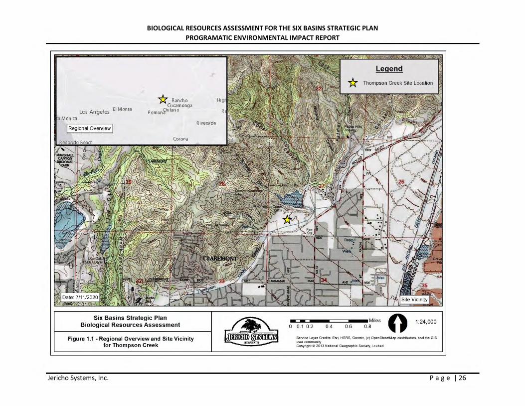
The Six Basins area occurs within the larger San Gabriel Valley region. Projects identified in the Strategic Plan will be developed within the cities of Claremont, La Verne, Upland, and Pomona. The Six Basins are six interconnected groundwater basins located along the base of the San Gabriel Mountains. The basins are Canyon Basin, Upper Claremont Heights Basin (UCHB), Lower Claremont Heights Basin (LCHB), Pomona Basin, Live Oak Basin and Ganesha Basin. The limits of the Six Basins area are the San Gabriel Mountains to the north, the San Jose Hills to the south, the Main San Gabriel Basin to the west, and the Chino Basin to the east. The boundary of the Six Basins occurs within the San Dimas, Ontario, and Mt. Baldy USGS quadrangles. (Figures 1 and 1.1in Appendix A).
1.2 PROJECT DESCRIPTION
The Six Basins Strategic Plan proposes (currently) ten projects that fall under four goals: 1) Enhance water supplies, 2) Enhance basin management, 3) Protect and enhance water quality, 4) Equitably finance the strategic plan.
During initial analysis, two proposed projects were determined to have impacts to biological resources:
1) Enhance Stormwater Recharge at the San Antonio Spreading Grounds 2) Enhance Stormwater Recharge at the Thompson Creek Spreading Grounds
1.2.1 San Antonio Spreading Grounds Project Description
The Pomona Valley Protective Association (PVPA), formed in 1910, is the underlying landowner in the San Antonio Creek Wash. The total area of the San Antonio Spreading Grounds (SASG) is about 1.4 square miles or 980 acres. In 1956, in response to flood events in 1937 and 1938, the USACE completed construction of the San Antonio Dam, including facilities to convey water captured behind the dam to the SASG. By 1960, the San Antonio Channel below the dam was lined with concrete. Facilities developed within the SASG are used for flood control, monitoring of surface-water discharge, and diversion of surface water for recharge. In addition to the two areas below the dam used for groundwater recharge by the
BIOLOGICAL RESOURCES ASSESSMENT FOR THE SIX BASINS STRATEGIC PLAN PROGRAMATIC ENVIRONMENTAL IMPACT REPORT
Jericho Systems, Inc. P a g e | 4
Los Angeles County Flood Control District (LACFCD) and PVPA respectively, the SASG area is disturbed by an electrical transmission line with towers and concrete footings, numerous unpaved roads, and some gabion structures to slow flood water for percolation. Current Operations
Runoff from the San Antonio Creek watershed that is exceeds what can be diverted and used by the San Antonio Water Company (SAWCo) and the City of Pomona at the 60/40 splitter is captured behind the San Antonio Dam. Except under the most critical conditions, water impounded behind the Dam is discharged in a controlled manner into the Pomona Valley Protective Association (PVPA) diversion works. The diversion works consist of six slide gates that divert water into the SASG, each with a capacity to divert up to 200 cfs. Two gates on the west side of the diversion works direct water to the Los Angeles County side of the SASG through a 72-inch diameter reinforced concrete pipeline. Four gates on the east side of the diversion works direct water to the San Bernardino County side of the SASG through two 72-inch diameter reinforced concrete pipelines. Flow meters are installed in each 72-inch pipeline to record the diversions to the SASG. Discharge from the Dam that exceeds the PVPA’s diversion capacity by-passes the diversion works and enters the concrete-lined San Antonio Creek Channel. Water discharged to the concrete-lined San Antonio Creek Channel has one more opportunity to be diverted to the SASG via the Lower San Bernardino Turnout. The turnout is a drop-inlet structure that diverts water to the San Bernardino County side of the SASG. When the gate is fully open, this turnout can divert water at a maximum rate of approximately 300 cfs. The Lower San Bernardino Turnout is not metered by the PVPA.
Based on PVPA records, from 1961 to 2015 annual diversions to the SASG ranged from 0 to 33,370 acre-ft/yr. Based on historical discharge measurements made by the U.S. Army Corps of Engineers (USACE), the Watermaster has estimated that the volume of storm water discharged from San Antonio Dam that was not diverted by the PVPA ranged from a low of 4 acre-ft/yr to a maximum of about 44,900 acre-ft/yr. However, based on anecdotal information from the USACE, the discharge measurements at the Dam are not accurate in low-flow conditions and may over-estimate outflow from the Dam under such conditions.
Proposed Project
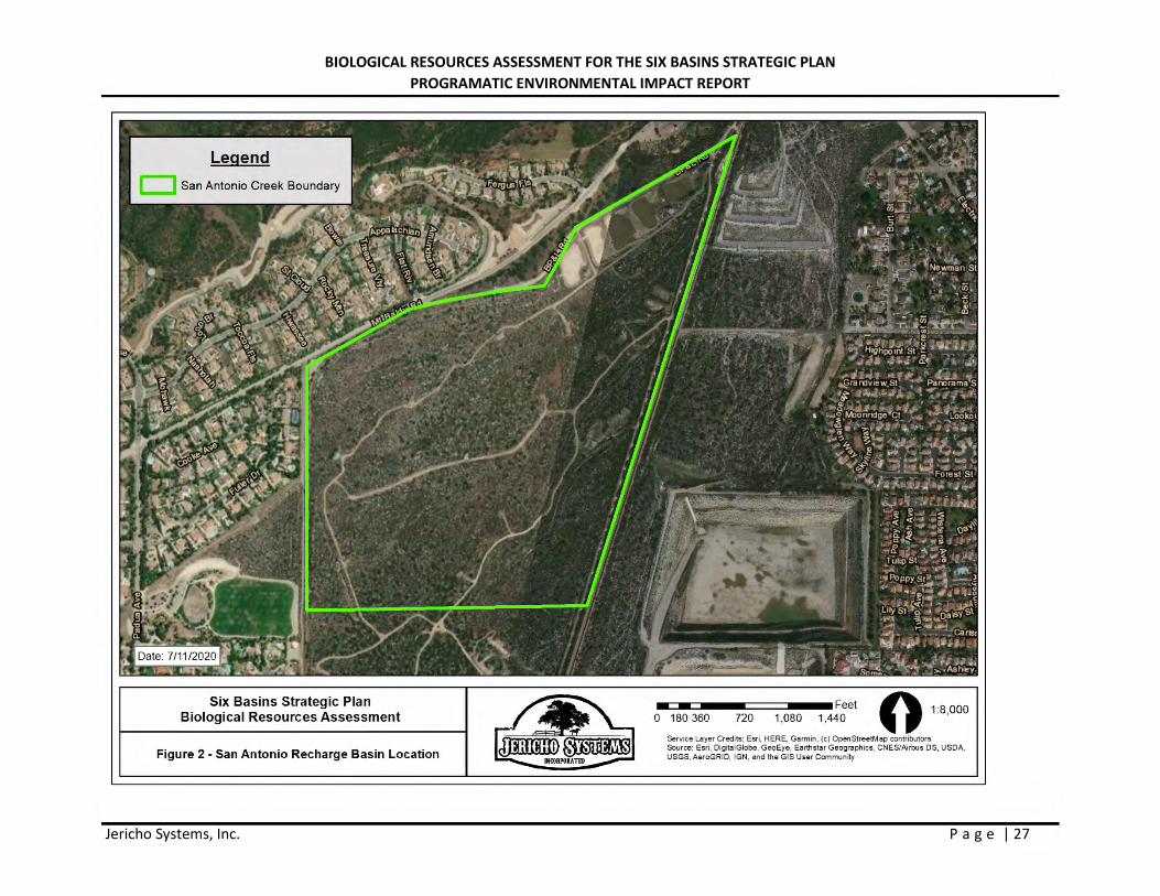
The Strategic Plan calculated the area of the SASG south of the San Antonio Dam as being approximately 980 acres. The eastern side of the San Antonio Creek channel is largely developed with an aggregate mining operation including existing pits, internal roads, and a processing plant. The proposed project is to enhance stormwater recharge at the SASG by developing a new recharge basin of approximately 50 acres to a depth of approximately 200 feet. The area within the SASG that is the subject of this Biological Resources Assessment is approximately 195 acres generally located west of the San Antonio Creek channel, north of East Pumelo Drive, and south of the existing Los Angeles County Flood Control District (LACFCD) recharge basins (see Figure 2 for location of existing basins). The purpose of the study is to characterize existing conditions within this larger area in order to evaluate an optimal site to locate the approximately 50-acre recharge basin. Excavated material from the site would be crushed on site then conveyed easterly across the SASG to the existing Holliday Rock aggregate mine site located on in the SASG on the east side of the San Antonio Creek Channel.
There are three limitations on total diversions to the SASG for recharge: the physical capacity of the diversion works, the recharge capacity of the spreading grounds, and the requirement in the Judgment to manage recharge to avoid high groundwater conditions. The recharge capacity at the SASG under its

BIOLOGICAL RESOURCES ASSESSMENT FOR THE SIX BASINS STRATEGIC PLAN PROGRAMATIC ENVIRONMENTAL IMPACT REPORT
Jericho Systems, Inc. P a g e | 5
current configuration of unlined channels, berms, ponds, deep mining pits, and unimproved land is not precisely known. In addition, the amount of stormwater available for capture is not well understood, so the optimal facilities and operating schemes to accomplish recharge enhancement cannot yet be defined. The first step in the development of the ultimate location of the new recharge basin is to implement a monitoring program to improve the characterization of the water available for diversion and the factors that limit recharge capacity.
1.2.2 Thompson Creek Spreading Grounds Project Description
Current Operations
After the Pomona Valley Protective Association (PVPA) was formed in 1910, the Thompson Creek Spreading Grounds project area was purchased to enhance recharge of the Six Basins by capturing surface-water runoff generated in the Thompson Creek watershed. In 1931, the LACFCD obtained easements in the TCSG for the construction of Thompson Creek Dam and its associated facilities for flood-control purposes. Runoff generated from the Thompson Creek watershed enters the PVPA property through a diversion structure upstream of the Thompson Creek dam. The diversion structure and dam are operated by the Los Angeles County Flood Control District (LACFD) in cooperation with PVPA. At the diversion structure, stormwater can be diverted to the reservoir behind the dam and/or the PVPA’s conveyance ditch that subsequently discharges to the Thompson Creek Spreading Grounds (TCSG) through a tunnel with a capacity of approximately 75 cfs. Water that accumulates behind the Thompson Creek Dam does not contribute to the recharge of the Six Basins because the dam is partly grouted to bedrock and the reservoir is not maintained for recharge. The PVPA requests the LACFCD to divert as much stormwater as possible into the TCSG, but the diversion is constrained by the LACFCD operating rules that focus primarily on flood control operations.
Based on PVPA records, from 2000 to 2015 annual diversions to the TCSG ranged from 0 to 269 acre-ft/yr. Based on historical discharge measurements made by the LACFD, Watermaster has estimated that the volume of stormwater captured at or discharged from Thompson Creek Dam, and therefore not diverted by the PVPA, ranged from a low of 3 acre-ft/yr to a maximum of about 1,634 acre-ft/yr.
Project Description
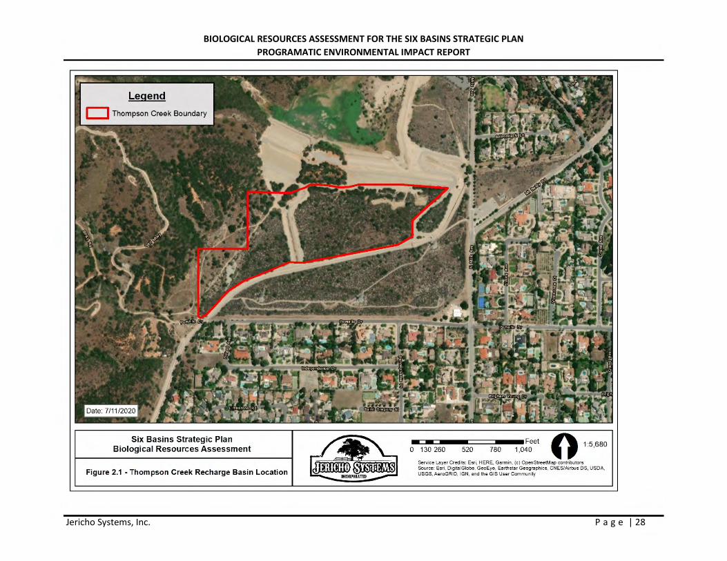
The proposed project is to enhance stormwater recharge at the TCSG. The ability to increase recharge is constrained by the diversion capacity of the conveyance facilities to the TCSG, the recharge capacity of the TCSG, and the requirement in the Judgment to manage recharge to avoid high groundwater conditions. Neither the recharge capacity, the amount of stormwater available for capture, nor the hydrogeology underlying the TCSG are well understood and so the optimal facilities and operating schemes to accomplish recharge enhancement cannot yet be defined. The first step in the development of alternatives to enhance recharge is to implement a monitoring program to improve the characterization water available for diversion and the of the factors that limit recharge capacity. However, PVPA has identified an approximately 25-acre site within the TCSG and around the existing Coyote Pits (small recharge basins), where the new recharge basins would be excavated to a depth of up to 20 feet. This expansion would impact existing habitat.
BIOLOGICAL RESOURCES ASSESSMENT FOR THE SIX BASINS STRATEGIC PLAN PROGRAMATIC ENVIRONMENTAL IMPACT REPORT
Jericho Systems, Inc. P a g e | 6
2.0 – METHODOLOGY
2.1 LITERATURE REVIEW
Prior to performing the field survey, existing documentation relevant to the SASG and TCSG Project sites was reviewed. The most recent records of the California Natural Diversity Database (CNDDB) managed by CDFW (CDFW 2020), the USFWS Critical Habitat Mapper (USFWS 2020) and the California Native Plant Society’s Electronic Inventory (CNPSEI) of Rare and Endangered Vascular Plants of California (CNPS 2020) were reviewed for the following quadrangles containing and surrounding the Project site: Mt. Baldy and Ontario, USGS 7.5-minute quadrangles. The Ontario quad was included in this search due to the Projects proximity to that quad. These databases contain records of reported occurrences of federal- or state-listed endangered or threatened species, California Species of Concern (SSC), or otherwise special status species or habitats that may occur within or in the immediate vicinity of the Project sites.
2.2 SOILS
Before conducting the surveys, soil maps for San Bernardino County were referenced online to determine the types of soil found within the Project site. Soils were determined in accordance with categories set forth by the United States Department of Agriculture (USDA) Soil Conservation Service and by referencing the USDA Natural Resources Conservation Service (NRCS) Web Soil Survey (USDA 2020).
2.3 BIOLOGICAL RECONNAISSANCE-LEVEL SURVEY
For this report, the primary area of focus were those areas identified during Project discussions that have progressed through the planning process enough to fully analyze potential impacts. This includes the potential 50-acre site at the SASG and the 25-acre site at the TCSG. Jericho biologist, CJ Fotheringham surveyed the site on June 26, 2019 and July 3 and 11, 2019. Jericho Biologist Craig Lawrey conducted a field verification visit on June 6, 2020 to confirm site conditions were the same. Then on February 9, 2021, Tom McGill, PhD, conducted an additional field verification visit to confirm site conditions were similar.
The general reconnaissance survey within the Project study areas (project sites plus surrounding area) was to identify the potential for the occurrence of special status species, vegetation communities, or habitats that could support special status wildlife species. For example, the project study area for the SASG was the larger 195 acres within which the approximately 50-acre recharge basin could be developed. The surveys were conducted on foot, throughout the Project sites between 0800 and 1200 hours on survey days. Weather conditions during the June 26 survey included temperatures ranging from 64 to 84 degrees Fahrenheit, with no cloud cover, no precipitation, 7 to 16 mile per hour winds. Weather conditions during the July 3 survey included temperatures ranging from 64 to 93 degrees Fahrenheit, with clear skies, no precipitation, and wind speeds ranged from 7 to 17 miles per hour. And weather conditions during the July 11 survey included temperatures ranging from 64 to 99 degrees Fahrenheit, with clear skies, no precipitation, and wind speeds ranged from 6 to 13 miles per hour. Photographs of the Project sites were taken to document existing conditions (Appendix B).
BIOLOGICAL RESOURCES ASSESSMENT FOR THE SIX BASINS STRATEGIC PLAN PROGRAMATIC ENVIRONMENTAL IMPACT REPORT
Jericho Systems, Inc. P a g e | 7
2.4 JURISDICTIONAL FEATURES
A general assessment of jurisdictional waters regulated by the United States Army Corps of Engineers (USACE), Regional Water Quality Control Board (RWQCB), and CDFW was conducted for the proposed Project area. Pursuant to Section 404 of the Clean Water Act, USACE regulates the discharge of dredged and/or fill material into waters of the United States. The State of California (State) regulates the discharge of material into waters of the State pursuant to Section 401 of the Clean Water Act and the California Porter- Cologne Water Quality Control Act (California Water Code, Division 7, §13000 et seq.). Pursuant to Division 2, Chapter 6, Sections 1600-1602 of the California Fish and Game Code, CDFW regulates all diversions, obstructions, or changes to the natural flow or bed, channel, or bank of any river, stream, or lake, which supports fish or wildlife. The assessment was conducted by a desktop survey through the USGS National Hydrography Dataset for hydrological connectivity. Additional discussion of the regulatory framework is provided in Appendix C.
2.4.1 VEGETATION
All plant species observed within the Project study areas were recorded. Vegetation communities were identified, qualitatively described, and mapped onto a high-resolution imagery aerial photograph. Plant communities were determined in accordance with the Manual of California Vegetation, Second Edition (Sawyer et al. 2009). Plant nomenclature follows that of The Jepson Manual, Second Edition (Baldwin et al. 2012). A comprehensive list of the plant species observed during the survey is provided in Appendix D. Additionally Figures 3 and 3.1 in appendix A show the vegetation communities present on-site.
2.4.2 WILDLIFE
All wildlife and wildlife signs observed and detected, including tracks, scat, carcasses, burrows, excavations, and vocalizations, were recorded. Additional survey time was spent in those habitats most likely to be utilized by wildlife (native vegetation, wildlife trails, etc.) or in habitats with the potential to support state- and/or federally listed or otherwise special status species. Notes were made on the general habitat types, species observed, and the conditions of the Project sites. A comprehensive list of the wildlife species observed during the survey is provided in Appendix D.
SECTION 3.0 – RESULTS
3.1 LITERATURE REVIEW RESULTS
According to the CNDDB, CNPSEI, and other relevant literature and databases, 47 sensitive species, 10 listed species and 5 sensitive habitats, have been documented in the Mt. Baldy and Ontario quads. This list of sensitive species and habitats includes any State and/or federally listed threatened or endangered species, CDFW designated Species of Special Concern (SSC) and otherwise Special Animals. “Special Animals” is a general term that refers to all of the taxa the CNDDB is interested in tracking, regardless of their legal or protection status. This list is also referred to as the list of “species at risk” or “special status species.” The CDFW considers the taxa on this list to be those of greatest conservation need.
An analysis of the likelihood for the occurrence of all CNDDB sensitive species documented in the Mt. Baldy and Ontario quad is provided in Table 2, in Appendix D. This analysis takes into account species range as well as documentation within the vicinity of the project study areas and includes the habitat
BIOLOGICAL RESOURCES ASSESSMENT FOR THE SIX BASINS STRATEGIC PLAN PROGRAMATIC ENVIRONMENTAL IMPACT REPORT
Jericho Systems, Inc. P a g e | 8
requirements for each species and the potential for their occurrence on the Project sites, based on required habitat elements and range relative to the current site conditions. According to the databases, no sensitive habitat, including USFWS designated critical habitat, occurs within or adjacent to the project sites.
3.1.1 SOILS
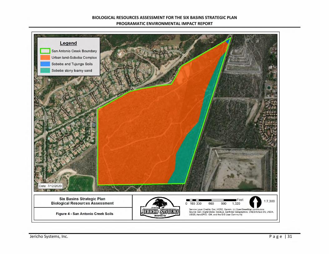
After review of USDA Soil Conservation Service and by referencing the USDA NRCS Web Soil Survey (USDA 2020), it was determined that the Project study areas are located within the Los Angeles County, California Southeastern Part CA696. Based on the results of the database search, four (4) soils types were observed in the area (Figure 4 and Figure 4.1):
San Antonio Spreading Grounds
Soboba and Tujunga soils, 0 to 5 percent slopes (1266). This soil is excessively drained with a very high capacity to transmit water. This soil consists of alluvium derived from granite, typically ranges in elevation from 400 to 2,350 feet amsl and is not considered prime farmland.
Soboba stony loamy sand, 2 to 9 percent slopes (SpCsb). This soil is excessively drained with a high to very high capacity to transmit water. This soil consists of discontinuous human-transported material over alluvium derived from granite, typically ranges in elevation from 960 to 3,690 feet amsl and is not considered prime farmland.
Urban land – Soboba complex, 0 to 5 percent slopes (1006). This soil is somewhat excessively drained with a high to very high capacity to transmit water. This soil consists of alluvium derived from granite sources, typically ranges in elevation from 310 to 2,080 feet amsl and is not considered prime farmland.
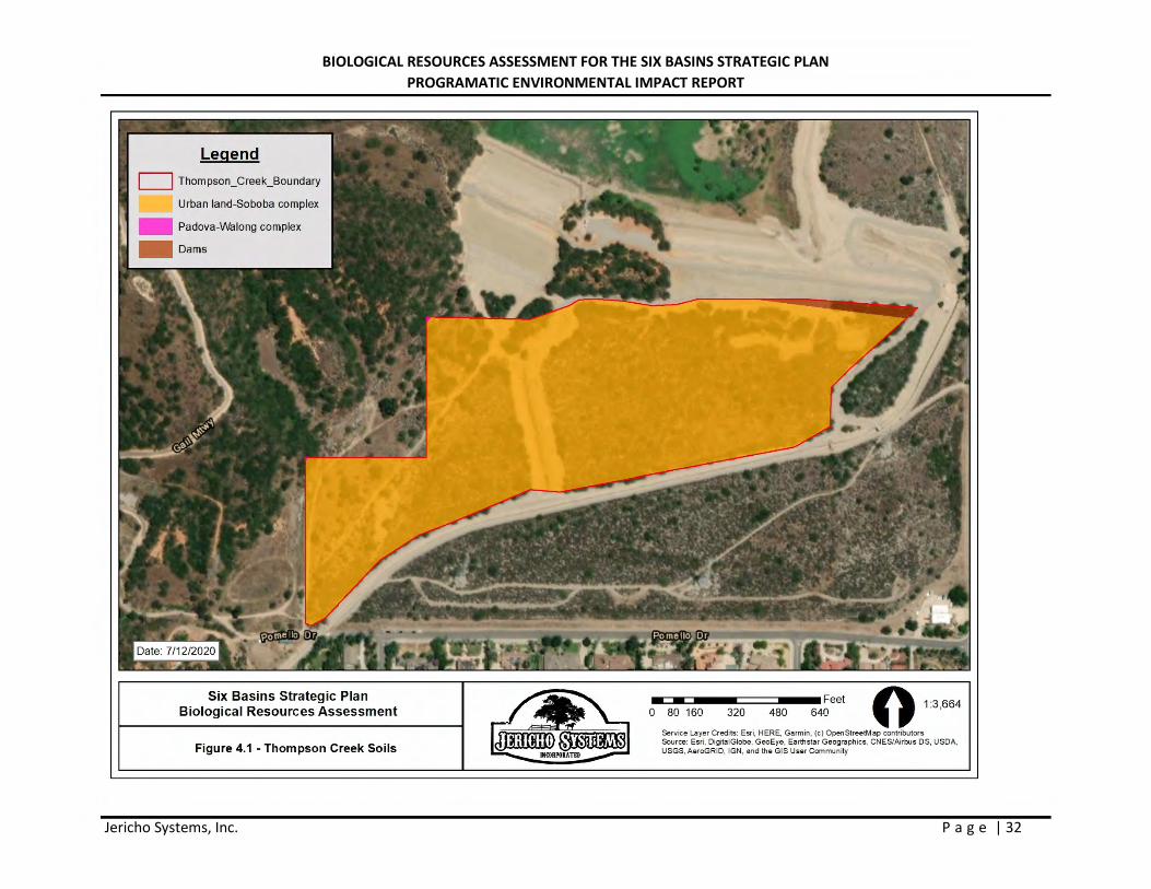
Thompson Creek Spreading Grounds
Urban land – Soboba complex, 0 to 5 percent slopes (1006). This soil is somewhat excessively drained with a high to very high capacity to transmit water. This soil consists of alluvium derived from granite sources, typically ranges in elevation from 310 to 2,080 feet amsl and is not considered prime farmland.
Padova-Walong complex, 30 to 85 percent slopes (1160). This soil is well drained with a very low to low capacity to transmit water. This soil consists of residuum weathered from gneiss, typically ranges in elevation from 600 to 2,930 feet amsl and is not considered prime farmland.
Dam. This project directly abuts the Thompson Creek Dam. As such a small portion of the soil within the Project footprint is classified as Dam. This soil type is used as a classification for man-made structures and not a description of the material used to construct the dam.
3.1.2 SENSITIVE HABITATS
Riversidian Alluvial Fan Sage Scrub
Riversidean alluvial fan sage scrub is a Mediterranean shrubland type that occurs in washes and on gently sloping alluvial fans subject to scour during major storm events. Fluvial processes are needed to maintain the openness of the habitat and to deposit sand soils utilized by many of the wildlife species associated with RAFSS habitat. Alluvial plant species are made up predominantly of drought-deciduous soft-leaved shrubs. Scalebroom (Lepidospartum squamatum) generally is regarded as an indicator of RAFSS habitat.
BIOLOGICAL RESOURCES ASSESSMENT FOR THE SIX BASINS STRATEGIC PLAN PROGRAMATIC ENVIRONMENTAL IMPACT REPORT
Jericho Systems, Inc. P a g e | 9
In addition to scalebroom, alluvial scrub plant species include white sage (Salvia apiana), redberry (Rhamnus crocea), California buckwheat, Spanish bayonet, California croton (Croton californicus), cholla (Opuntia spp.), tarragon (Artemisia dracunculus), yerba santa (Eriodictyon spp.), mule fat, and mountain-mahogany.
RAFSS habitat is classified by three major phases: pioneer, intermediate and mature. Pioneer RAFSS occur within an active streambed and up onto the first bench outside the active streambed. Pioneer RAFSS is routinely flooded during large storm events that help maintain the openness of the habitat which usually exhibits plant cover between 10 and 30 percent. Intermediate RAFSS occurs outside of the active streambed, usually on the secondary and tertiary benches above the streambed. Intermediate RAFSS habitat is not subjected to routine flooding but instead is scoured by flood waters during major storm events. Scouring maintains the openness of the habitat between 30 to 60 percent. Mature RAFSS habitat is not subject to routine or major storm events but is within the 100-year floodplain and can receive flood waters and scouring during extreme storm events which usually resets mature RAFSS to intermediate or pioneer RAFSS habitat phases. RAFSS habitat on fringes of a wash system or outside the100-year floodplain are not exposed to scouring and continue to mature (senescence) into woodier vegetation normally associated with chaparral habitats. Both Ceanothus crassisfolius and Ceanothus leucodermus, chaparral species, were identified within the SASG and TCSG project sites. Plant cover in mature RAFSS habitat usually exceeds 75 percent. The lack of open habitat in mature RAFSS precludes many of the sensitive species associated with pioneer and intermediate RAFSS habitats from occurring.
3.1.3 SPECIAL STATUS SPECIES BACKGROUND
Animals
arroyo Toad
The arroyo toad is a small, stocky, warty toad that is about 2 to 3 inches (in) (5.1 to 7.6 centimeters (cm)) in length. They are found in low gradient, medium-to-large streams and rivers with intermittent and perennial flow in coastal and desert drainages in central and southern California, and Baja California, Mexico. Arroyo toads occupy aquatic, riparian, and upland habitats in the remaining suitable drainages within its range. Arroyo toads are breeding habitat specialists and require slow-moving streams that are composed of sandy soils with sandy streamside terraces. Suitable habitat for the arroyo toad is created and maintained by periodic flooding and scouring that modify stream channels, redistribute channel sediments, and alter pool location and form. These habitat requirements are largely dependent upon natural hydrological cycles and scouring events, as well as the presence of perennial or intermittent water sources. Due to several decades of surface mining operations in the SASG, combined with ongoing flood control activities in both the SASG and TCSG to protect downstream residential developments, habitat for arroyo toad has been severely impacted locally and no longer occurs within the project study areas.
foothill yellow-legged frog
The foothill yellow-legged frog occurs in the Coast Ranges from the Oregon border south to the Transverse Mountains in Los Angeles Co., in most of northern California west of the Cascade crest, and along the western flank of the Sierra south to Kern Co. Livezey (1963) reported an isolated population in San Joaquin Co. on the floor of the Central Valley. Isolated populations are also known from the mountains of Los Angeles County. Its elevation range extends from near sea level to 1940 m (6370 ft) in the Sierra (Jennings
BIOLOGICAL RESOURCES ASSESSMENT FOR THE SIX BASINS STRATEGIC PLAN PROGRAMATIC ENVIRONMENTAL IMPACT REPORT
Jericho Systems, Inc. P a g e | 10
and Hayes 1994). The foothill yellow-legged frog is found in or near rocky streams in a variety of habitats, including valley-foothill hardwood, valley-foothill hardwood-conifer, valley-foothill riparian, ponderosa pine, mixed conifer, coastal scrub, mixed chaparral, and wet meadow types.
Adults eat both aquatic and terrestrial invertebrates. Adult insects appear to be favored, but snails, and pieces of molted skin have also been found in stomach samples (Fitch 1936). Tadpoles probably graze on algae and diatoms along rocky stream bottoms. Adults often bask on exposed rock surfaces near streams. When disturbed, they dive into the water and take refuge under submerged rocks or sediments. During periods of inactivity, especially during cold weather, individuals seek cover under rocks in the streams or on shore within a few meters of water. Egg clusters are attached to gravel or rocks in moving water near stream margins. Unlike most other ranid frogs in California, this species is rarely encountered (even on rainy nights) far from permanent water. Tadpoles require water for at least three or four months while completing their aquatic development. Foothill yellow-legged frogs are found in or near rocky streams in a variety of habitats. These habitat requirements are largely dependent upon natural hydrological cycles and scouring events, as well as the presence of perennial or intermittent water sources. Due to several decades of surface mining operations in the SASG, combined with ongoing flood control activities in both the SASG and TCSG to protect downstream residential developments, habitat for foothill yellow-legged frog is no longer present in the project area.
southern mountain yellow-legged frog
The mountain yellow-legged frog is a moderate-sized (approximately 40 to 80 millimeters (mm) [1.5 to 3.25 inches] snout-vent length) ranid frog. As is common with ranid frogs, females average slightly larger than males, and males have a swollen, darkened thumb base. Adult coloration is highly variable, with a dorsal pattern ranging from discrete dark spots that can be few and large, to smaller and more numerous spots with a mixture of sizes and shapes. Irregular lichen-like patches, or a poorly defined reticulum, may also be present. The dorsal coloration is usually a mix of brown and yellow, but often with gray, red, or green-brown; some individuals may be a dark brown with little pattern. Dorsolateral folds are present, but not usually prominent. The venter and undersurfaces of the hind limbs are yellow, with ranges in hue from pale lemon yellow to an intense sun yellow. The throat is white or yellow, sometimes with a mottling of dark pigment. This frog lacks vocal sacs, and the tympanum is smoother and the toe tips darker than those of the foothill-yellow legged frog (Rana boylii), with which it may be confused. The mountain yellow-legged frog produces an odiferous secretion when disturbed.
Mountain yellow-legged frogs in the Sierra Nevada live in high mountain lakes, ponds, tarns, and streams--largely in areas that were glaciated as recently as 10,000 years ago. Alpine lakes used by mountain yellow-legged frogs usually have open shorelines, margins that are grassy or muddy and have a depth greater than 2.5 meters (greater than 8.2 feet). Adults are typically found sitting on rocks along the shoreline, usually where there is little or no vegetation. Larvae are often distributed in the warm water shallow areas along the shoreline during the daytime. Mountain yellow-legged frogs also use stream habitats, especially in the northern part of their range. These habitat requirements are largely dependent upon natural hydrological cycles and scouring events, as well as the presence of perennial or intermittent water sources. Due to several decades of surface mining operations in the SASG, combined with ongoing flood control activities in both the SASG and TCSG to protect downstream residential developments, habitat for southern mountain yellow-legged frog is no longer present in the project area.
BIOLOGICAL RESOURCES ASSESSMENT FOR THE SIX BASINS STRATEGIC PLAN PROGRAMATIC ENVIRONMENTAL IMPACT REPORT
Jericho Systems, Inc. P a g e | 11
Coastal California gnatcatcher
The coastal California gnatcatcher (Polioptila californica californica) (CAGN) is a small, non-migratory songbird (passerine) that occurs along the Pacific coastal regions of southern California and northern Baja California, Mexico, in or near coastal scrub vegetation communities. It is a federally threatened species with restricted habitat requirements, being an obligate resident of coastal sage scrub habitats that are dominated by California sage brush. This species generally occurs below 750 feet elevation in coastal regions and below 1,500 feet inland. According to J. Atwood and J. Bolsinger (1992), 99 percent of all California gnatcatcher observations are in areas with elevations below 950 feet. There are reported occurrences of California gnatcatcher up to 1,600 feet elevation (500 meters) (Davis and McKernan, 1998).
The range and distribution of California gnatcatcher is closely aligned with coastal scrub vegetation. This vegetation is typified by low (less than 1 meter (3 feet)), shrub and sub-shrub species that are often drought deciduous.
The SASG and TCSG project study areas range in elevation from 1,600 to 2,000 feet above msl, which is outside the preferred elevational range of California gnatcatcher. Ninety-nine percent of all California gnatcatcher observations occur below 950 feet above msl. California gnatcatcher’s preferred habitat is coastal sage scrub dominated by California sage brush. The project site does not support coastal sage scrub habitat. Instead, it supports a mix of various alluvial scrub habitats, dominated by three alliances: Eriogonum fasciculatum shrubland alliance (California buckwheat scrub), Malosma laurina shrubland alliance (Laurel sumac scrub) and Artemisia californica shrubland alliance (California sagebrush scrub). The dominant plant species is Laurel sumac with plant coverage exceeding 75 percent. The dominance of larger woody shrubs and tree species combined with the dense plant cover in this area provide very low-quality habitat for the California gnatcatcher. Additionally, the project area is outside the species elevational ranges. The last CNDDB sighting of California gnatcatcher in the foothills of the San Gabriel Mountains north of the cities of Claremont and Upland occurred over a hundred years ago in 1918.
Given that the project area elevational range is above the species preferred elevational range, the native alliances inhabiting this area provide very low-quality, plus the lack of any observation of California gnatcatcher in this area of the San Gabriel Mountain since 1918 and the long-standing use of this area for flood control activities and groundwater charging, it is highly unlikely that the area supports this species. The site is presumed to be unoccupied and focused surveys are not recommended.
Santa Ana sucker
Santa Ana sucker is a small, short-lived member of the sucker family of fishes (Catostomidae), named so primarily because of the downward orientation and anatomy of their mouth parts, which allow them to suck up algae, small invertebrates, and other organic matter with their fleshy, protrusible (extendable) lips (Moyle 2002, p. 179). Santa Ana sucker was described in 1908 by Snyder as Pantosteus santa-anae from the Santa Ana River near Riverside, California (Snyder 1908, p. 33). Smith (1966, pp. 53–58) amended the specific name to eliminate the hyphen and relegated Pantosteus to a subgenus of Catostomus, which represented a new combination. Recent work has been conducted to investigate the phylogenetic relationships between suckers in western North America (Unmack et al. 2014), but there is still some uncertainty where Catostomus santaanae would be placed. Currently, the taxonomic classification of Santa Ana sucker is Catostomus santaanae and has not changed since it was listed.
BIOLOGICAL RESOURCES ASSESSMENT FOR THE SIX BASINS STRATEGIC PLAN PROGRAMATIC ENVIRONMENTAL IMPACT REPORT
Jericho Systems, Inc. P a g e | 12
Santa Ana suckers are generally less than 6.3 inches (in) (16 centimeters (cm)) in length; however, they have been collected at lengths up to 8 in (20.3 cm) (RCRCD 2010, p. 3). Males and females appear to grow at an equivalent rate (Greenfield et al. 1970, p. 174; Moyle 2002, p. 183). Their jaws have cartilaginous scraping edges inside the lips. Their color is silvery-white on the belly and dark gray on the sides and back, with irregular dorsal blotches on the sides and faint patterns of pigmentation arranged in lateral stripes. Membranes connecting the rays of the caudal (tail) fin are pigmented, but the anal and pelvic fins usually lack pigmentation (Moyle 2002, p. 182). Spawning tubercles (raised growths on sexually mature fish), particularly at the beginning of the breeding season, are present on most parts of the body of breeding males and are heaviest on the anal fin, caudal fin, and lower half of the caudal peduncle (narrow region of body immediately in front of the caudal fin). Female suckers grow tubercles on the caudal fin and caudal peduncle (Moyle 2002, pp. 182–183) (USFWS, 2020).
Santa Ana sucker are found in perennial streams and rivers in southern California, primarily the Los Angeles River, Santa Ana River, San Gabriel River, and the Santa Clara River. None of the streams or creeks in the project area provide sufficient flows of water to support Santa Ana sucker.
San Bernardino kangaroo rat
The federally-listed as endangered SBKR is one of three recognized subspecies of Merriam’s kangaroo rat (D. merriami) in California. The Merriam’s kangaroo rat is a small, burrowing rodent species that can be found within inland valleys and deserts of southwest United States of America and northern Mexico. The Dulzura kangaroo rat (Dipodomys simulans), the Pacific kangaroo rat (Dipodomys agilis) and the Stephens kangaroo rat (Dipodomys stephensi) occur in areas occupied by SBKR, but these other species have a wider habitat range. The SBKR, however, has a restricted southern California distribution, confined to certain inland valley scrub communities and, more particularly, to scrub communities occurring along rivers, streams, and drainages within the San Bernardino, Menifee, and San Jacinto valleys. Most of these drainages have been historically altered due to a variety of reasons including, mining, off-road vehicle use, road and housing development, and flood control efforts. This increased use of river floodplain resources resulted in a reduction in both the amount and quality of habitat available for the SBKR.
The USFWS listed the SBKR as endangered on September 24, 1998 and set aside 33,295 acres of critical habitat for the SBKR in 2002. The USFWS then revised that decision in 2008 after a lawsuit and cut the designation down to 7,779 acres in Riverside and San Bernardino counties. On January 10, 2011, a federal court struck down the 2008 designation. The ruling concluded that the USFWS improperly relied on “core habitat” to define critical habitat for the SBKR rather than specifying the physical and biological features essential for the kangaroo rat’s conservation, as the law requires. The ruling reinstated the 2002 designation. The 2002 critical habitat rule for SBKR defined four Primary Constituent Elements (PCEs) that are essential to the conservation of SBKR. These PCEs are as follows: 1) Soil series consisting predominantly of sand, loamy sand, sandy loam, or loam; 2) Alluvial sage scrub and associated vegetation, such as coastal sage scrub and chamise chaparral, with a moderately open canopy; 3) River, creek, stream, and wash channels; alluvial fans; floodplains; floodplain benches and terraces; and historic braided channels that are subject to dynamic geomorphological and hydrological processes typical of fluvial systems within the historical range of the San Bernardino kangaroo rat; and 4) Upland areas proximal to floodplains with suitable habitat.
BIOLOGICAL RESOURCES ASSESSMENT FOR THE SIX BASINS STRATEGIC PLAN PROGRAMATIC ENVIRONMENTAL IMPACT REPORT
Jericho Systems, Inc. P a g e | 13
Flood control activities in the San Gabriel Mountains has confined most stormwater flows to constructed flood control channels. Scouring of the adjacent bench habitat areas has been severely limited. Additionally, the movement and deposit of sandy soils associated with flood waters no longer occurs in the area. Without exposure to floodwaters, scouring no longer occurs and sands soils are no longer deposited. Most of the suitable habitat for SBKR has been removed from the San Gabriel foothills. Habitats within the foothills of the San Gabriel Mountains have become very rocky with little sandy soils. Without scouring, vegetation is maturing or converting into woodier plant species with plant cover exceeding 75 percent. The project areas no longer support suitable SBKR habitat.
burowing owl
The burrowing owl (BUOW) is a ground dwelling owl typically found in arid prairies, fields, and open areas where vegetation is sparse and low to the ground. The BUOW is heavily dependent upon the presence of mammal burrows, with ground squirrel burrows being a common choice, in its habitat to provide shelter from predators, inclement weather and to provide a nesting place (Coulombe 1971). They are also known to make use of human-created structures, such as cement culverts and pipes, for burrows. BUOW spend a great deal of time standing on dirt mounds at the entrance to a burrow or perched on a fence post or other low to the ground perch from which they hunt for prey. They feed primarily on insects such as grasshoppers, June beetles, and moths, but will also take small rodents, birds, and reptiles. They are active during the day and night but are considered a crepuscular owl; generally observed in the early morning hours or at twilight. The breeding season for BUOW is February 1 through August 31.
Throughout its range, the BUOW is vulnerable to habitat loss, predation, vehicular collisions, and destruction of burrow sites and poisoning of ground squirrels (Grinnell and Miller 1944, Zarn 1974, Remsen 1978). BUOW have disappeared from significant portions of their range in the last 15 years and, overall, nearly 60% of the breeding groups of owls known to have existed in California during the 1980s had disappeared by the early 1990s (Burrowing Owl Consortium 1993). The BUOW is not listed under the State or federal ESA but is considered both a State and federal SSC. The BUOW is a migratory bird protected by the international treaty under the Migratory Bird Treaty Act of 1918 and by State law under the California Fish and Game Code (CDFG Code #3513 & #3503.5).
Habitats within the foothills of the San Gabriel Mountains have become very rocky with little sandy soils. Due to the rockiness of the habitat and lack of soils for burrowing by ground squirrels, there are no burrows available for BUOW within the project areas. Additionally, without scouring, vegetation is maturing or converting into woodier plant species with plant species densities exceeding 75 percent. The dense vegetation precludes the line-of-sight opportunities needed by BUOW for foraging and avoidance of predators. The project areas do not provide suitable BUOW habitat.
Plants
Nevin’s barberry
Nevin’s barberry (Berneris nevinii) is a California endangered plant species, which means that killing or possession of plants collected from the wild is prohibited by the California Endangered Species Act (CESA). Nevin’s barberry is also listed as endangered under the federal Endangered Species Act. Nevin’s barberry is an evergreen shrub, historically found at scattered locations in Los Angeles, San Bernardino, Riverside, and possibly San Diego Counties. The species is widely available in the nursery trade, and cultivated
BIOLOGICAL RESOURCES ASSESSMENT FOR THE SIX BASINS STRATEGIC PLAN PROGRAMATIC ENVIRONMENTAL IMPACT REPORT
Jericho Systems, Inc. P a g e | 14
Nevin’s barberry plants have been introduced outside of the species’ native range. Nevin’s barberry is found in a variety of different topographical conditions ranging from nearly flat sandy washes, terraces, and canyon floors to ridges and mountain summits. Nevin’s barberry is also associated with mesic habitats and plant communities such as alluvial scrub, chamise chaparral, coastal sage scrub, oak woodland, and riparian scrub or woodland. Data also suggests that Nevin’s barberry may require long periods between fires for successful population growth. At the time of this webpage posting, the California Natural Diversity Database reports 21 natural occurrences of Nevin’s barberry presumed to still exist in southern California, and a majority of these occurrences consist of less than five individual plants.
Plummer’s mariposa-lily
Calochortus plummerae (Plummer’s mariposa-lily) is a species of mariposa lily known by the common name Plummer's mariposa lily. It is endemic to Southern California where it is found along the coast and inland hills. It is a member of the chaparral plant community. It produces thin, branching stems and a few long curling leaves. Atop the stem is a lily bloom with long, pointed sepals and petals which may be up to 4 centimeters long. The petals are pink, lavender, or white with a wide yellow band across the middle. They are hairy inside and sometimes fringed with hairs. The center contains large whitish or yellowish anthers. The fruit capsule is up to 8 centimeters long (CalFlora, 2020).
Plummer’s mariposa lily is restricted to southern California and found at elevations of up to 5,580 feet and has pink flowers covered with yellow hairs. It is most often found in chaparral or coastal scrub ecosystems and sometimes found in grasslands, oak woodlands, or pine woodlands at the southern fringe of the Los Padres National Forest.
thread-leaved brodiaea
Thread-leaved brodiaea is a California endangered plant species, which means that killing or possession of plants collected from the wild is prohibited by the California Endangered Species Act (CESA). This species is also listed as threatened under the federal Endangered Species Act. Thread-leaved brodiaea is a member of the brodiaea family (Themidaceae) and is a perennial bulbiferous herb. It produces several linear leaves from an underground corm, and blue to red-purple flowers on a leafless stalk. This species typically grows in herbaceous plant communities such as grassland communities, alkali playa, and in vernal pools. In some locations, thread-leaved brodiaea grows in open areas associated with coastal sage scrub. The range of this species extends from the foothills of the San Gabriel Mountains at Glendora in Los Angeles County, east to Arrowhead Hot Springs in the western foothills of the San Bernardino Mountains in San Bernardino County, and south through eastern Orange and western Riverside Counties to the City of San Diego. At the time of this webpage posting, the California Natural Diversity Database reports 103 natural occurrences of this species that are presumed to still exist (CDFW, 2013).
slender-horned spineflower
The State- and federally-listed as endangered slender-horned spineflower (spineflower) is an annual plant in the Polygonaceae (buckwheat family). Plants have a distinctive basal rosette of leaves ranging from 3 to 8 centimeters (1.2 to 3.1 inches) in diameter. The leaves frequently become reddish at maturity. The flower stalks are branched and erect 3 to 10 centimeters (1.2 to 4 inches) tall and the flowers are white to pink in color. This spineflower is found in drought prone habitats where germination is likely related to
BIOLOGICAL RESOURCES ASSESSMENT FOR THE SIX BASINS STRATEGIC PLAN PROGRAMATIC ENVIRONMENTAL IMPACT REPORT
Jericho Systems, Inc. P a g e | 15
rainfall. This spineflower is typically found in alluvial fan scrub on benches and terraces away from active channels in areas receiving little surface disturbance from flooding, but subject to sheet or overland flows (Boyd et al. 1989; Rey-Vizgirdas 1994; Wood and Wells 1997). Within San Bernardino County, there are currently only eight (8) occurrences of this species known to be extant, within three (3) drainages; the upper Santa Ana River, Lytle Creek, and Cajon Canyon (USFWS 2010). In Los Angeles County there are only 11 recorded occurrences for this species. This spineflower typically blooms between April and June. Individual plants are difficult to detect because they are small and occur in relatively small, isolated patches across often extensive floodplain habitat. Additionally, plant densities may be low during drought conditions.
3.1.3 JURISDICTIONAL WATERS
Aerial imagery of the project sites in the SASG and TCSG was examined and compared with the surrounding USGS 7.5-minute topographic quadrangle maps to identify drainage features within the survey area as indicated from topographic changes, blue-line features, or visible drainage patterns. The U.S. Fish and Wildlife Service National Wetland Inventory and Environmental Protection Agency (EPA) Water Program “My Waters” data layers were also reviewed to determine whether any hydrologic features and wetland areas had been documented within the vicinity of the site. Similarly, the Soil maps from the U.S. Department of Agriculture (USDA) - Natural Resources Conservation Service (NRCS) Web Soil Survey (USDA 2018) were reviewed to identify the soil series on-site and to check if they have been identified regionally as hydric soils. Upstream and downstream connectivity of waterways (if present) was reviewed in the field, on aerial imagery, and topographic maps to determine jurisdictional status. No obvious signs of jurisdictional features occur within the SASG and TCSG project sites.
3.2 FIELD STUDY RESULTS
3.2.1 HABITAT
San Antonio Spreading Grounds
The approximately 980-acre SASG is developed with aggregate mine pits, electricity distribution towers/lines, access roads, catch basins and associated water conveyance infrastructure. Native vegetation occurs only in undisturbed areas of the SASG.
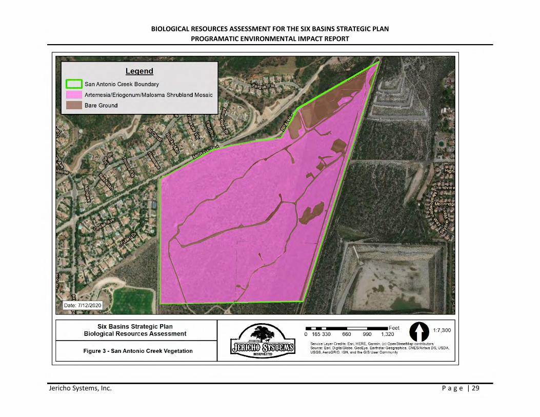
The proposed new recharge basin on approximately 50 acres within the larger 195-acre project study area to a depth of approximately 200 feet. This area is generally located in the upper reach of the SASG, below the San Antonio Dam and the existing LACFCD recharge basins along the west side of the SASG. The habitat within the larger 195-acre area consists of a mix of Eriogonum fasciculatum Shrubland Alliance (California buckwheat scrub), Malosma laurina Shrubland Alliance (Laurel sumac scrub), and Artemisia californica Shrubland Alliance (California sagebrush scrub). The California buckwheat scrub and Laurel sumac scrub are the two dominant plant communities. These two plant communities have been removed from the 100-year floodplain since the early 1900s due to flood control and water recharge activities associated and no longer receive flood waters and scouring during extreme storm events. Storm events scour out vegetation and reset alluvial plant communities to younger, more open plant communities. Due to the lack of flooding and scouring, habitats at the SASG have continued to mature (senesced) into woodier vegetation normally associated with chaparral habitats. Plant cover is dense, exceeding 75
BIOLOGICAL RESOURCES ASSESSMENT FOR THE SIX BASINS STRATEGIC PLAN PROGRAMATIC ENVIRONMENTAL IMPACT REPORT
Jericho Systems, Inc. P a g e | 16
percent, with many of the larger plant exceeding 10 feet in height. The lack of open habitat and taller vegetation preclude the presence of many of the sensitive species found within the alluvial scrub habitats in the foothills of the San Gabriel Mountains. The area is no longer subject to flood events needed to support open intermediate RAFSS habitat required by most plant and wildlife species associated with RAFSS habitat.
Thompson Creek Spreading Grounds
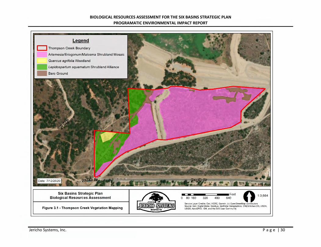
The habitat at the TCSG project area consists of alluvial habitat that has three alliances: Eriogonum fasciculatum Shrubland Alliance (California buckwheat scrub), Malosma laurina Shrubland Alliance (Laurel sumac scrub), and Artemisia californica Shrubland Alliance (California sagebrush scrub). In addition, several scalebroom (Lepidospartum squamatum) plants as well as coast live oak trees (Quercus agrifolia) were observed a dirt road at the far western boundary of the site. Table 1 in Appendix D contains a list all plants found on-site during the field surveys. Portions of the site have been used as a spreading ground for water recharge at the base of Thompson Creek Dam for decades. The entire site is also bisected by dirt access roads and the outlet channel for the dam. The area proposed for expansion of the TCSG is located south of the dam and north of the Thompson Creek concrete-lined channel.
3.2.2 SENSITIVE HABITATS
Riversidian Alluvial Fan Sage Scrub (RAFSS)
San Antonio Spreading Grounds
The CNDDB mapped this area as supporting RAFSS habitat. As discussed above, Riversidean alluvial fan sage scrub occurs in washes and on gently sloping alluvial fans subject to scour during major storm events. Fluvial processes are needed to maintain the openness of the habitat and to deposit sand soils utilized by many of the wildlife species associated with RAFSS habitat. Alluvial plant species are made up predominantly of drought-deciduous soft-leaved shrubs. Scalebroom (Lepidospartum squamatum) generally is regarded as an indicator of RAFSS habitat. In addition to scalebroom, alluvial scrub plant species include white sage (Salvia apiana), redberry (Rhamnus crocea), California buckwheat, Spanish bayonet, California croton (Croton californicus), cholla (Opuntia spp.), tarragon (Artemisia dracunculus), yerba santa (Eriodictyon spp.), mule fat, and mountain-mahogany. RAFSS habitat is classified by three major phases: pioneer, intermediate and mature. Pioneer RASS occur within active streambed and up onto the first bench outside the active streambed. Pioneer RAFSS is routinely flooded during large storm events which help maintain the openness of the habitat which usually exhibits plant cover between 10 and 30 percent. Intermediate RAFSS occurs outside of the active streambed, usually on the secondary and tertiary benches of above the streambed. Intermediate RAFSS habitat is not subjected to routine flooding but is scoured by flood waters during major storm events. Scouring maintains the openness of the habitat between 30 to 50 percent. Mature RAFSS habitat is not normally subject to major storm events since it is usually found at the edges of the 100-year floodplain and only receives flood waters during extreme storm events which resets mature RAFSS to intermediate or pioneer RAFSS habitat phases. RAFSS habitat no longer exists within 100-year floodplain, as a result of flood control and water recharge activities such as occurs at the SASG, are not exposed to scouring and have continued to mature (type convert) over decades into woodier vegetative structure normally associated with chaparral habitats. Two
BIOLOGICAL RESOURCES ASSESSMENT FOR THE SIX BASINS STRATEGIC PLAN PROGRAMATIC ENVIRONMENTAL IMPACT REPORT
Jericho Systems, Inc. P a g e | 17
species of ceanothus (Ceanothus crassifolius and Ceanothus leucodermis), chaparral species, were identified on the project sites. Plant cover in these mature alluvial habitats usually exceeds 75 percent. This lack of open habitat in mature RAFSS precludes many of the sensitive species associated with the less dense areas classified as pioneer and intermediate RAFSS habitats from occurring.
Thompson Creek Spreading Grounds
Riversidean alluvial fan sage scrub has not been historically documented within the TCSG project study area. However, during the field visit this habitat was noted as being present within the western portion of the project site (Figure 3.1 in Appendix A).
3.2.3 WILDLIFE
Species observed or otherwise detected on or in the vicinity of the SASG and TCSG project study areass during the surveys included common raven (Corvus corax), Anna’s hummingbird (Calypte anna), house sparrow (Passer domesticus), house finch (Haemorhous mexicanus), and desert cottontail (Sylvilagus audubonii).
The project areas are located within an undeveloped area of the city of Claremont. Portions of both project areas have been disturbed by humans and are surrounded by a mixture of residential development and disturbed undeveloped land. There is some habitat within the proposed project footprint, as well as the immediate surrounding area, that is suitable for some sensitive species identified in the CNDDB search (Table 2 in Appendix D).
3.2.4 SPECIAL STATUS SPECIES
No State and/or federally listed threatened or endangered species or other sensitive species were observed on-site during surveys.
Animals
arroyo Toad
The habitat onsite is consistent of upland scrub habitat. This species requires sandy wash soil and annual water flows that are sustained long enough for the species to reproduce. The water flow within the sites has been channelized into earthen rock lined channels or concrete lined channels. Therefore, no suitable habitat is present for this species and it is not likely to occur on either the SASG or TCSG project areas.
foothill yellow-legged frog
This species is found in a number of different habitats. One of which does occur on site, sage scrub. However, this species also needs a permanent water source. Due to the existing dam in both locations and the ground water recharge facilities in both project area, this species is considered absent from the as they lack a source of permanent water.
BIOLOGICAL RESOURCES ASSESSMENT FOR THE SIX BASINS STRATEGIC PLAN PROGRAMATIC ENVIRONMENTAL IMPACT REPORT
Jericho Systems, Inc. P a g e | 18
southern mountain yellow-legged frog
Although this species does occur within the Mt. Baldy USGS quad, there is no suitable habitat for this species present on either site. This species is typically found on the banks of mountain lakes and streams that do not dry out in the summer. Therefore, this species is absent from the SASG and TCSG sites.
Coastal California gnatcatcher
California gnatcatcher is a federally threatened species with restricted habitat requirements, being an obligate resident of coastal sage scrub habitats that are dominated by California sage brush. This species generally occurs below 750 feet elevation in coastal regions and below 1,500 feet inland. According to J. Atwood and J. Bolsinger (1992), 99 percent of all California gnatcatcher observations are in areas with elevations below 950 feet. There are reported occurrences of California gnatcatcher up to 1,600 feet elevation (500 meters) (Davis and McKernan, 1998).
The SASG and TCSG project study areas range in elevation from 1,600 to 2,000 feet above msl. California gnatcatcher’s preferred habitat is coastal sage scrub dominated by California sage brush. The SASG project site does not support coastal sage scrub habitat. Instead, it supports mature RAFFS habitat dominated by Laurel sumac and other large woody shrub species associated with chaparral habitat. The last CNDDB sighting of California gnatcatcher in the area was over a hundred years ago in 1918.
Although no protocol surveys were conducted for this species, the lack of suitable habitat and the location outside the species elevational typical range, plus the lack of a Californian gnatcatcher observation in the area in over 100 years, provides evidence that the species can be presumed to be absent from the project study areas.
Santa Ana sucker
This species has been documented within the Mt. Baldy USGS quad as recently as 2006. However, both the SASG project site and the TCSG project site are outside the watercourse where this species is found. Additionally, the sites occur within upland scrub habitat and do not contain the water that this species requires, and this species was not observed on site during the survey. Therefore, this species is considered absent from the project areas.
San Bernardino kangaroo rat
Suitable habitat for this species does not occur on either project area. The scrub habitat is dense and does not contain sandy soils for this species to burrow into. Additionally, the project areas are west of the species typical range and the project areas are not within critical habitat for this species. Although no protocol trapping was conducted for this species, the lack of suitable habitat and the location outside the typical range, exclude this species from occupying either site. Therefore, this species is not likely to be present on site.
burowing owl
The vegetation within both project areas is quite dense with little to no open space and no grassland or open fields. Suitable habitat for BUOW does not occur within the either project area. Both areas contain
BIOLOGICAL RESOURCES ASSESSMENT FOR THE SIX BASINS STRATEGIC PLAN PROGRAMATIC ENVIRONMENTAL IMPACT REPORT
Jericho Systems, Inc. P a g e | 19
host burrow species, such as the California ground squirrel. However, this species was not observed during field visits. Therefore, BUOW is considered absent from the SASG and TCSG project study areas.
Plants
Nevin’s barberry
Both sites contain suitable habitat for this species. Because this species was noted in the literature search, focused surveys were completed during the blooming period for this species (March-June). Jericho Botanist CJ Fotheringham conducted surveys on foot with 100 percent visual coverage of the project study areas. This species was not observed in either project area. As such, this species is absent from the project areas.
Plummer’s mariposa-lily
Both project areas contain suitable habitat for this species. Surveys were conducted during the appropriate blooming period for this species (May-July). This species was not observed during the field visits. As, such this species is considered absent from the project areas.
thread-leaved brodiaea
Both sites contain suitable habitat for this species. Surveys were conducted during the appropriate blooming period for this species (March-June). This species was not observed during the field visits. As, such this species is considered absent from the project areas.
slender-horned spineflower
Both project areas contain suitable habitat for this species. Surveys were conducted during the appropriate blooming period for this species (April-June). This species was not observed during the filed visits. As, such this species is considered absent from the project areas.
Designated Critical Habitat
The site is not located within or adjacent any USFWS designated Critical Habitat. No further action is required.
Nesting Birds
The project sites and immediate surrounding areas contains habitat suitable for nesting birds. Nesting bird surveys should be conducted prior to any construction activities taking place, including clear and grubbing, during the nesting season to avoid potentially taking any birds or active nests. In general, impacts to all bird species (common and special status) can be avoided by conducting work outside of the nesting season (generally March 15th to September 15th), and conducting a worker awareness training. However, if all work cannot be conducted outside of the nesting season, a project-specific Nesting Bird Management Plan can be prepared to determine suitable buffers.
3.2.5 JURISDICTIONAL WATERS
Waters of the United States and Waters of the State
BIOLOGICAL RESOURCES ASSESSMENT FOR THE SIX BASINS STRATEGIC PLAN PROGRAMATIC ENVIRONMENTAL IMPACT REPORT
Jericho Systems, Inc. P a g e | 20
The USACE has the authority to permit the discharge of dredged or fill material in Waters of the U.S. under Section 404 CWA. While the Regional Water Quality Board has authority over the discharge of dredged or fill material in Waters of the State under Section 401 CWA as well as the Porter-Cologne Water Quality Control Act. The Project area was surveyed with 100 percent visual coverage and no drainage features were present on site. As such, the subject parcel does not contain any wetlands, waters of the U.S., or Waters of the State.
Fish and Game Code Section 1602 - State Lake and/or Streambed
The CDFW asserts jurisdiction over any drainage feature that contains a definable bed and bank or associated riparian vegetation. The SASG and TCSG project areas were surveyed with 100 percent visual coverage and no definable bed or bank features exist on the project site. As such, the subject properties do not contain any areas under CDFW jurisdiction.
Section 4.0 - CONCLUSIONS AND RECOMMENDATIONS
Wildlife and Plants
Based on the literature review and personal observations made in the immediate vicinity, no State and/or federally listed threatened or endangered species are documented/or expected to occur within the project study areas. No other sensitive species were observed within the project area or buffer area. Impacts to federally or state listed species are not likely to occur.
Sensitive Habitats
The SASG project area is largely comprised of RAFSS habitat. There is currently approximately 139 acres of RAFSS habitat on-site. Impacts to this habitat will likely require consultation with CDFW and require mitigation.
The TCSG project area does contain RAFSS habitat that is proposed to be impacted by the construction of the recharge basins. There is approximately 3.77 acres of RAFSS within the TCSG project area. Impacts to this habitat will likely require mitigation and consultation with CDFW.
coastal California gnatcatcher
Although no protocol surveys were conducted for this species, the lack of suitable habitat and the location outside the typical range, plus the lack of observations within five miles of the project sites in over 100 years provides strong evidence that this species is absent from the project sites. Therefore, this species is not likely to be present within either project study area.
Nesting Birds
Vegetation suitable for nesting birds does exist within the project sites and adjacent areas. As discussed, most birds are protected by the MBTA. In general, impacts to all bird species (common and special status) can be avoided by conducting work outside of the nesting season, which is generally March 15th to September 15th. If all work cannot be conducted outside of nesting season, a pre-construction nesting bird survey should be conducted by an avian biologist to determine the nesting status on site. If no nests are found, no further action would be required. If any active nests are identified within the action area, then a project-specific Nesting Bird Management Plan would be prepared. The plan would outline monitoring
BIOLOGICAL RESOURCES ASSESSMENT FOR THE SIX BASINS STRATEGIC PLAN PROGRAMATIC ENVIRONMENTAL IMPACT REPORT
Jericho Systems, Inc. P a g e | 21
requirements and possible buffer strategies. No-work buffer area would be based on the species, nesting stage, nest location, presence of visual buffers, proximity, intensity and duration of activity in relationship to the nest.
Please do not hesitate to contact me at 909-915-5900 should you have any questions or require further information.
Sincerely,
Shay Lawrey Ecologist/Regulatory Specialist Appendices:
Appendix A – Figures Appendix B – Site Photos Appendix C – Regulatory Framework Appendix D – Tables
BIOLOGICAL RESOURCES ASSESSMENT FOR THE SIX BASINS STRATEGIC PLAN PROGRAMATIC ENVIRONMENTAL IMPACT REPORT
Jericho Systems, Inc. P a g e | 22
Section 5 – REFERENCES
Baldwin, B.G., D.H. Goldman, D.J. Keil, R. Patterson, and T.J. Rosatti, and D.H. Wilken (editors) 2012 The Jepson Manual: Vascular Plants of California, Second Edition. University of California Press, Berkeley, CA.
Barbour, M.G., J.H. Burk, W.D. Pitts, F.S. Gilliam, and M.W. Schwartz. 1999 Terrestrial Plant
Ecology, Third Edition. Addison Wesley Longman, Inc. Menlo Park, CA. California Department of Fish and Wildlife (CDFW) 2020 California Natural Diversity Database (CNDDB).
RareFind Version 3.1.0. Database Query for the Mt. Baldy and Ontario, California USGS 7.5 minute quadrangles. Wildlife and Habitat Data Analysis Branch. [Accessed: June 2020]
California Department of Fish and Game. 1995. Staff report on burrowing owl mitigation. Memo from
C.F. Raysbrook, Interim Director to Biologist, Environmental Services Division, Department of Fish and Game. Sacramento, CA.
California Department of Fish and Game (CDFG). 2012. Staff Report on Burrowing Owl Mitigation. State
of California Natural Resources Agency. March 7, 2012.
California Department of Fish and Wildlife (CDFW). Nevin’s barberry species profile. https://wildlife.ca.gov/Conservation/Plants/Endangered/Berberis-nevinii (Accessed: June 27, 2020)
California Department of Fish and Wildlife (CDFW). California Wildlife Habitat Relationships System,
https://nrm.dfg.ca.gov/FileHandler.ashx?DocumentID=1500 California Department of Fish and Wildlife (CDFW). Southern Mountain Yellow-legged Frog.
https://wildlife.ca.gov/Regions/6/Amphibians/Mountain-Yellow-legged-Frog California Department of Fish and Wildlife (CDFW). Thread-leaved brodiaea.
https://wildlife.ca.gov/Conservation/Plants/Endangered/Brodiaea-filifolia California Native Plant Society (CNPS) 2020 Inventory of Rare and Endangered Plants (online edition, v8-
03 0.39). Rare Plant Scientific Advisory Committee, California Native Plant Society, Sacramento, California. Website http://www.rareplants.cnps.org for the Mt. Baldy and Ontario, California USGS 7.5 minute quadrangles; [Accessed: June 2020].
National Audubon Society. California Black Rail, https://www.audubon.org/field-guide/bird/black-rail
(Accessed: June 27, 2020) National Audubon Society. Swainson’s Hawk, https://www.audubon.org/field-guide/bird/swainsons-
hawk (Accessed: June 27, 2020) Sawyer, J.O., Jr., T. Keeler-Wolf, J. Evens 2009 A Manual of California Vegetation, Second Edition. California Native Plant Society, Sacramento,
CA.
BIOLOGICAL RESOURCES ASSESSMENT FOR THE SIX BASINS STRATEGIC PLAN PROGRAMATIC ENVIRONMENTAL IMPACT REPORT
Jericho Systems, Inc. P a g e | 23
U.S. Department of Fish and Wildlife, Draft Recovery Plan for the Santa Ana Sucker. https://www.fws.gov/carlsbad/TEspecies/Recovery/documents/Draft%20Recovery%20Plan%20for%20the%20Santa%20Ana%20Sucker.pdf
U.S. Department of Agriculture (USDA) 2020 Soil Survey Staff, Natural Resources Conservation Service, United States Department of Agriculture. Official Soil Series Descriptions [Online Edition]. Website https://websoilsurvey.sc.egov.usda.gov/App/WebSoilSurvey.aspx [Accessed April 2020].
Western Riverside Multiple Species Habitat Conservation Plan, 2003: Section 3.0 Environmental Setting/Affected Environment, https://rctlma.org/Portals/0/mshcp/volume4/03.html

BIOLOGICAL RESOURCES ASSESSMENT FOR THE SIX BASINS STRATEGIC PLAN PROGRAMATIC ENVIRONMENTAL IMPACT REPORT
Jericho Systems, Inc. P a g e | 24
Appendix A - Figures
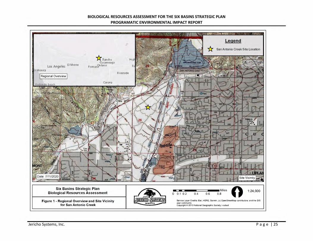
BIOLOGICAL RESOURCES ASSESSMENT FOR THE SIX BASINS STRATEGIC PLAN PROGRAMATIC ENVIRONMENTAL IMPACT REPORT
Jericho Systems, Inc. P a g e | 25
Los Ange les El Monte
Monica
I Regional Overview I
* Ran cho Cucamonga
Pomon fi>ntari o
Six Basins Strategic Plan Biological Resources Assessment
Figure 1 • Regional Overview and Site Vicinity for San Antonio Creek
Riverside
~~ -0
Legend
San Antonio Creek Site Location
- Miles 0 1:24,000 0.1 0.2 0.4 0.6 0.8
Service Layer Credi ts: Esri, HERE, Garmin, (c) OpenStreetM ap contributors, end the GIS user community Copyright:C 2013 National Geographic Society, i-cubed
BIOLOGICAL RESOURCES ASSESSMENT FOR THE SIX BASINS STRATEGIC PLAN PROGRAMATIC ENVIRONMENTAL IMPACT REPORT
Jericho Systems, Inc. P a g e | 26
Los Angeles El Monte
Monica
I Regional Overview I
* Rancho Cucamonga Pomonfi>ntario
Six Basins Strategic Plan Biological Resources Assessment
Figure 1.1 - Regional Overview and Site Vicinity for Thompson Creek
Riverside
~~ -0
Legend * Thompson Creek Site Location
- Miles 0 1:24,000 0.1 0.2 0.4 0.6 0.8
Service Layer Credi ts: Esri, HERE, Garmin, (c) OpenStreetM ap contributors, end the GIS user community Copyright:C 2013 National Geographic Society, i-cubed
BIOLOGICAL RESOURCES ASSESSMENT FOR THE SIX BASINS STRATEGIC PLAN PROGRAMATIC ENVIRONMENTAL IMPACT REPORT
Jericho Systems, Inc. P a g e | 27
Six Basins Strategic Plan Biological Resources Assessment
Figure 2 - San Antonio Recharge Basin Location
M M Feet O 1 8 000 0 180 360 720 1,080 1,440 : '
Service Layer Credits: Esri, HERE, Garmin, (c} OpenStreetMe.p contributors Source: Esri, DigitalGlobe, GeoEye, Earthstar Geographies, CNES/Airbus OS, USDA, USGS, AeroGRID, IGN, and the G IS User Community
BIOLOGICAL RESOURCES ASSESSMENT FOR THE SIX BASINS STRATEGIC PLAN PROGRAMATIC ENVIRONMENTAL IMPACT REPORT
Jericho Systems, Inc. P a g e | 28
Legend
Six Basins Strategic Plan Biological Resources Assessment
Figure 2.1 - Thompson Creek Recharge Basin Location
--0 130 260 520 780 Feet
1,040 0 15,680
Service Layer Credits: Esri, HERE, Garmin, (c} OpenStreetMe.p contributors Source: Esri, DigitalGlobe, GeoEye, Earthstar Geographies, CNES/Airbus OS, USDA, USGS, AeroGRID, IGN, and the G IS User Community
BIOLOGICAL RESOURCES ASSESSMENT FOR THE SIX BASINS STRATEGIC PLAN PROGRAMATIC ENVIRONMENTAL IMPACT REPORT
Jericho Systems, Inc. P a g e | 29
Legend
San Antonio Creek Boundary
Artemesia/Eriogonum/Malosma Shrubland Mosaic
Six Basins Strategic Plan Biological Resources Assessment
Figure 3 - San Antonio Creek Vegetation
M M Feet O 1 7 300 0 165 330 660 990 1,320 : '
Service Layer Credits: Esri, HERE, Garmin, (c} OpenStreetMe.p contributors Source: Esri, Digita lGlobe, GeoEye, Earthstar Geographies, CNES/Airbus OS, USDA, USGS, AeroGRID, IGN, and the G IS User Community
BIOLOGICAL RESOURCES ASSESSMENT FOR THE SIX BASINS STRATEGIC PLAN PROGRAMATIC ENVIRONMENTAL IMPACT REPORT
Jericho Systems, Inc. P a g e | 30
Legend
c:::J Thompson Creek Boundary
Artemesia/Eriogonum/Malosma Shrubland Mosaic
Quercus agrifolia Woodland
~ Lepidosparlum squamatum Shrubland Alliance
1111111 Bare Ground
Six Basins Strategic Plan Biological Resources Assessment
Figure 3.1 -Thompson Creek Vegetation Mapping
-- Feet 640 0 13,664 0 80 160 320 480
Service Layer Credits: Esri, HERE, Garmin, (c} OpenStreetMe.p contributors Source: Esri, DigitalGlobe, GeoEye, Earthstar Geographies, CNES/Airbus OS, USDA, USGS, AeroGRID, IGN, and the G IS User Community
BIOLOGICAL RESOURCES ASSESSMENT FOR THE SIX BASINS STRATEGIC PLAN PROGRAMATIC ENVIRONMENTAL IMPACT REPORT
Jericho Systems, Inc. P a g e | 31
Legend
San Antonio Creek Boundary
Urban land-Soboba Complex
Six Basins Strategic Plan Biological Resources Assessment
Figure 4 - San Antonio Creek Soils
M M Feet O 1 7 300 0 165 330 660 990 1,320 : '
Service Layer Credits: Esri, HERE, Garmin, (c} OpenStreetMe.p contributors Source: Esri, DigitalGlobe, GeoEye, Earthstar Geographies, CNES/Airbus OS, USDA, USGS, AeroGRID, IGN, and the G IS User Community
BIOLOGICAL RESOURCES ASSESSMENT FOR THE SIX BASINS STRATEGIC PLAN PROGRAMATIC ENVIRONMENTAL IMPACT REPORT
Jericho Systems, Inc. P a g e | 32
Legend
D Thompson_Creek_Boundary
Urban land-Soboba complex
- Padova-walong complex
Six Basins Strategic Plan Biological Resources Assessment
Figure 4.1 -Thompson Creek Soils
M M Feet O 1 3 664 0 80 160 320 480 640 : '
Service Layer Credits: Esri, HERE, Garmin, (c} OpenStreetMe.p contributors Source: Esri, DigitalGlobe, GeoEye, Earthstar Geographies, CNES/Airbus OS, USDA, USGS, AeroGRID, IGN, and the G IS User Community
BIOLOGICAL RESOURCES ASSESSMENT FOR THE SIX BASINS STRATEGIC PLAN PROGRAMATIC ENVIRONMENTAL IMPACT REPORT
Jericho Systems, Inc. P a g e | 33
Appendix B - Photos
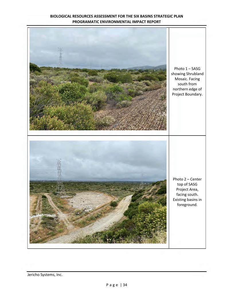
BIOLOGICAL RESOURCES ASSESSMENT FOR THE SIX BASINS STRATEGIC PLAN PROGRAMATIC ENVIRONMENTAL IMPACT REPORT
Jericho Systems, Inc. P a g e | 34
Photo 1 – SASG showing Shrubland
Mosaic. Facing south from
northern edge of Project Boundary.
Photo 2 – Center top of SASG
Project Area, facing south.
Existing basins in foreground.
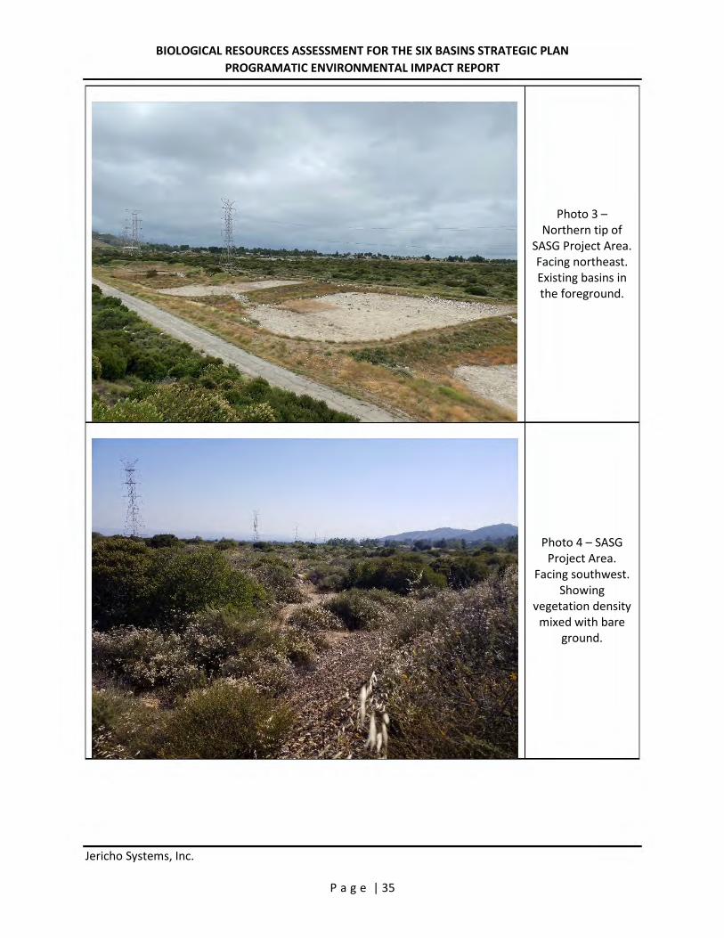
BIOLOGICAL RESOURCES ASSESSMENT FOR THE SIX BASINS STRATEGIC PLAN PROGRAMATIC ENVIRONMENTAL IMPACT REPORT
Jericho Systems, Inc. P a g e | 35
Photo 3 – Northern tip of
SASG Project Area. Facing northeast. Existing basins in the foreground.
Photo 4 – SASG Project Area.
Facing southwest. Showing
vegetation density mixed with bare
ground.
I

BIOLOGICAL RESOURCES ASSESSMENT FOR THE SIX BASINS STRATEGIC PLAN PROGRAMATIC ENVIRONMENTAL IMPACT REPORT
Jericho Systems, Inc. P a g e | 36
Photo 5 – TCSG Project Area. Center facing
west. Showing Shrubland Mosaic
and Oak Woodlands.
Photo 6 – TCSG Project Area. Center facing
northeast. Showing existing outlet earthen
channel in foreground.
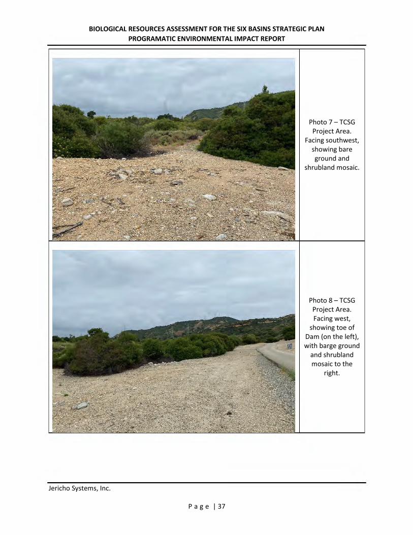
BIOLOGICAL RESOURCES ASSESSMENT FOR THE SIX BASINS STRATEGIC PLAN PROGRAMATIC ENVIRONMENTAL IMPACT REPORT
Jericho Systems, Inc. P a g e | 37
Photo 7 – TCSG Project Area.
Facing southwest, showing bare ground and
shrubland mosaic.
Photo 8 – TCSG Project Area. Facing west,
showing toe of Dam (on the left), with barge ground
and shrubland mosaic to the
right.
BIOLOGICAL RESOURCES ASSESSMENT FOR THE SIX BASINS STRATEGIC PLAN PROGRAMATIC ENVIRONMENTAL IMPACT REPORT
Jericho Systems, Inc. P a g e | 38
Appendix C – Regulatory Framework
BIOLOGICAL RESOURCES ASSESSMENT FOR THE SIX BASINS STRATEGIC PLAN PROGRAMATIC ENVIRONMENTAL IMPACT REPORT
Jericho Systems, Inc. P a g e | 39
1.1 FEDERAL JURISDICTION
1.1.1 United States Army Corps of Engineers
Pursuant to Section 404 of the CWA, the United States Army Corps of Engineers (USACE) regulates the discharge of dredged and/or fill material into waters of the United States. The term “waters of the United States” is defined by 33 Code of Federal Regulations (CFR) Part 328 and currently includes: (1) all navigable waters (including all waters subject to the ebb and flow of the tide), (2) all interstate waters and wetlands, (3) all other waters (e.g., lakes, rivers, intermittent streams) that could affect interstate or foreign commerce, (4) all impoundments of waters mentioned above, (5) all tributaries to waters mentioned above, (6) the territorial seas, and (7) all wetlands adjacent to waters mentioned above. Waters of the United States do not include (1) waste treatment systems, including treatment ponds or lagoons designed to meet the requirements of the Clean Water Act (CWA), and (2) prior converted cropland. Waters of the United States typically are separated into two types: (1) wetlands and (2) “other waters” (non-wetlands) of the United States. Wetlands are defined by 33 CFR 328.3(b) as “those areas that are inundated or saturated by surface or ground water at a frequency and duration sufficient to support … a prevalence of vegetation typically adapted for life in saturated soil conditions.” In 1987, USACE published a manual (1987 Wetland Manual) to guide its field personnel in determining jurisdictional wetland boundaries. This manual was amended in 2008 to the USACE 2008 Regional Supplement to the Corps of Engineers Wetland Delineation Manual: Arid West Region (Version 2.0) (2008 Arid West Supplement). Currently, the 1987 Wetland Manual and the 2008 Arid West Supplement provide the legally accepted methodology for identification and delineation of USACE-jurisdictional wetlands in southern California. In the absence of wetlands, the limits of USACE jurisdiction in nontidal waters, including intermittent Relatively Permanent Water (RPW) streams, extend to the Ordinary High Water Mark (OHWM), which is defined by 33 CFR 328.3(e) as:
… that line on the shore established by the fluctuation of water and indicated by physical characteristics such as clear, natural line impressed on the bank, shelving, changes in the character of soil, destruction of terrestrial vegetation, the presence of litter and debris, or other appropriate means that consider the characteristics of the surrounding areas.
On January 9, 2001, the U.S. Supreme Court ruled (in Solid Waste Agency of Northern Cook County v. U.S. Army Corps of Engineers) (SWANCC) that USACE jurisdiction does not extend to previously regulated isolated waters, including but not limited to isolated ponds, reservoirs, and wetlands. Examples of isolated waters that are affected by this ruling include vernal pools, stock ponds, lakes (without outlets), playa lakes, and desert washes that are not tributary to navigable or interstate waters or to other jurisdictional waters. A joint legal memorandum by EPA and USACE was signed on January 15, 2003.
BIOLOGICAL RESOURCES ASSESSMENT FOR THE SIX BASINS STRATEGIC PLAN PROGRAMATIC ENVIRONMENTAL IMPACT REPORT
Jericho Systems, Inc. P a g e | 40
In May 2007, USACE and EPA jointly published and authorized the use of the Jurisdictional Determination Form Instructional Guidebook (USACE 2007). The form and guidebook define how to determine if an area is USACE jurisdictional and if a significant nexus exists per the Rapanos decision. A nexus must have more than insubstantial and speculative effects on the downstream TNW to be considered a significant nexus. This guidebook is updated by the 2008 Arid West Supplement, the 2010 Updated Datasheet for the Identification of the Ordinary High Water Mark (OHWM) in the Arid West Region of the Western United States, and the 2011 Ordinary High Flows and the Stage-Discharge Relationship in the Arid West Region. A joint guidance by EPA and USACE was issued on June 5, 2007, and revised on December 2, 2008, is consistent with the Supreme Court’s decision in the consolidated cases Rapanos v. United States and Carabell v. United States (126 S. Ct. 2208 [2006]) (Rapanos), which addresses the jurisdiction over waters of the United States under the CWA (33 U.S.C. §1251 et seq.). A draft guidance was circulated in April 2011 to supercede both the 2003 SWANCC guidance and 2008 Rapanos decision; however, this guidance is not finalized and lacks the force of law. USACE will continue to assert jurisdiction over Traditionally Navigable Waters (TNWs), wetlands adjacent to TNW, non-navigable tributaries of TNW that are Relatively Permanent Waters (RPW) where the tributaries typically flow year-round or have continuous flow at least seasonally (e.g., typically three months), and wetlands that directly abut such tributaries. USACE generally will not assert jurisdiction over swales or erosional features (e.g., gullies or small washes characterized by low volume, infrequent, or short duration flow) or nontidal drainage ditches (including roadside ditches) that are (1) excavated wholly in and draining only uplands and (2) that do not carry a relatively permanent flow of water. USACE defines a drainage ditch as:
A linear excavation or depression constructed for the purpose of conveying surface runoff or groundwater from one area to another. An “upland drainage ditch” is a drainage ditch constructed entirely in uplands (i.e., not in waters of the United States) and is not a water of the United States, unless it becomes tidal or otherwise extends the ordinary high water line of existing waters of the United States.
Furthermore, USACE generally does not consider “[a]rtificially irrigated areas which would revert to upland if the irrigation ceased” to be subject to their jurisdiction. Such irrigation ditches are linear excavations constructed for the purpose of conveying agricultural water from the adjacent fields. Therefore, such agricultural ditches are not considered to be subject to USACE jurisdiction. USACE will use fact-specific analysis to determine whether waters have a significant nexus with (1) TNW for nonnavigable tributaries that are not relatively permanent (non-RPW); (2) wetlands adjacent to nonnavigable tributaries that are not relatively permanent; and (3) wetlands adjacent to, but that do not directly abut, a relatively permanent nonnavigable tributary. According to USACE, “a significant nexus analysis will assess the flow characteristics and functions of the tributary itself and the functions performed by all wetlands adjacent to the tributary to
BIOLOGICAL RESOURCES ASSESSMENT FOR THE SIX BASINS STRATEGIC PLAN PROGRAMATIC ENVIRONMENTAL IMPACT REPORT
Jericho Systems, Inc. P a g e | 41
determine if they significantly affect the chemical, physical and biological integrity of downstream traditional navigable waters,” including consideration of hydrologic and ecologic factors. A primary component of this determination lies in establishing the connectivity or lack of connectivity of the subject drainages to a TNW. 1.2 STATE JURISDICTION
The State of California (State) regulates discharge of material into waters of the State pursuant to Section 401 of the CWA as well as the California Porter-Cologne Water Quality Control Act (Porter-Cologne; California Water Code, Division 7, §13000 et seq.). Waters of the State are defined by Porter-Cologne as “any surface water or groundwater, including saline waters, within the boundaries of the state” (Water Code Section 13050(e)). Waters of the State broadly includes all waters within the State’s boundaries (public or private), including waters in both natural and artificial channels. 1.2.1 Regional Water Quality Control Board Under Porter-Cologne, the State Water Resources Control Board (SWRCB) and the local Regional Water Quality Control Boards (RWQCB) regulate the discharge of waste into waters of the State. Discharges of waste include “fill, any material resulting from human activity, or any other ‘discharge’ that may directly or indirectly impact ‘waters of the state.’” Porter-Cologne reserves the right for the State to regulate activities that could affect the quantity and/or quality of surface and/or groundwaters, including isolated wetlands, within the State. Wetlands were defined as waters of the State if they demonstrated both wetland hydrology and hydric soils. Waters of the State determined to be jurisdictional for these purposes require, if impacted, waste discharge requirements (WDRs). When an activity results in fill or discharge directly below the OHWM of jurisdictional waters of the United States (federal jurisdiction), including wetlands, a CWA Section 401 Water Quality Certification is required. If a proposed project is not subject to CWA Section 401 certification but involves activities that may result in a discharge to waters of the State, the project may still be regulated under Porter-Cologne and may be subject to waste discharge requirements. In cases where waters apply to both CWA and Porter-Cologne, RWQCB may consolidate permitting requirements to one permit. 1.2.2 California Department of Fish and Wildlife
Pursuant to Division 2, Chapter 6, Sections 1600-1602 of the California Fish and Game Code, the California Department of Fish and Wildlife (CDFW) regulates all diversions, obstructions, or changes to the natural flow or bed, channel, or bank of any river, stream, or lake, which supports fish or wildlife. CDFW defines a “stream” (including creeks and rivers) as “a body of water that flows at least periodically or intermittently through a bed or channel having banks and supports fish or other
BIOLOGICAL RESOURCES ASSESSMENT FOR THE SIX BASINS STRATEGIC PLAN PROGRAMATIC ENVIRONMENTAL IMPACT REPORT
Jericho Systems, Inc. P a g e | 42
aquatic life. This includes watercourses having surface or subsurface flow that supports or has supported riparian vegetation” (California Code of Regulations, Title 14, Section 1.72). The jurisdiction of CDFW may include areas in or near intermittent streams, ephemeral streams, rivers, creeks, dry washes, sloughs, blue-line streams that are indicated on USGS maps, watercourses that may contain subsurface flows, or within the flood plain of a water body. CDFW’s definition of “lake” includes “natural lakes or man-made reservoirs.” CDFW limits of jurisdiction typically include the maximum extents of the uppermost bank-to-bank distance and/or the outermost extent of riparian vegetation dripline, whichever measurement is greater. In a CDFW guidance of stream processes and forms in dryland watersheds (Vyverberg 2010), streams are identified as having one or more channels that may all be active or receive water only during some high flow event. Subordinate features, such as low flow channels, active channels, banks associated with secondary channels, floodplains, and stream-associated vegetation, may occur within the bounds of a single, larger channel. The water course is defined by the topography or elevations of land that confine a stream to a definite course when its waters rise to their highest level. A watercourse is defined as a stream with boundaries defined by the maximal extent or expression on the landscape even though flow may otherwise be intermittent or ephemeral. Artificial waterways such as ditches (including roadside ditches), canals, aqueducts, irrigation ditches, and other artificially created water conveyance systems also may be under the jurisdiction of CDFW. CDFW may claim jurisdiction over these features based on the presence of habitat characteristics suitable to support aquatic life, riparian vegetation, and/or stream-dependent terrestrial wildlife. As with natural waterways, the limit of CDFW jurisdiction of artificial waterways includes the uppermost bank-to-bank distance and/or the outermost extent of riparian vegetation dripline, whichever measurement is greater. CDFW does not have jurisdiction over wetlands but has jurisdiction to protect against a net loss of wetlands. CDFW supports the wetland criteria recognized by USFWS; one or more indicators of wetland conditions must exist for wetlands conditions to be considered present. The following is the USFWS accepted definition of a wetland:
Wetlands are lands transitional between terrestrial and aquatic systems where the water table is usually at or near the surface or the land is covered by shallow water. For purposes of this classification, wetlands must have one or more of the following three attributes: (1) at least periodically, the lands supports hydrophytes, (2) the substrate is predominantly undrained hydric soil; and (3) the substrate is nonsoil and is saturated withwater or covered by shallow water at some time during the growing season of each year (Cowardin et al. 1979).
In A Clarification of the U.S. Fish and Wildlife Service’s Wetland Definition (Tiner 1989), the USFWS definition was further clarified “that in order for any area to be classified as wetland by the Service, the area must be periodically saturated or covered by shallow water, whether wetland vegetation and/or hydric soils are present or not; this hydrologic requirement is
BIOLOGICAL RESOURCES ASSESSMENT FOR THE SIX BASINS STRATEGIC PLAN PROGRAMATIC ENVIRONMENTAL IMPACT REPORT
Jericho Systems, Inc. P a g e | 43
addressed in the first sentence of the definition.” When considering whether an action would result in a net loss of wetlands, CDFW will extend jurisdiction to USFWS-defined wetland conditions where such conditions exist within the riparian vegetation that is associated with a stream or lake and does not depend on whether those features meet the three-parameter USACE methodology of wetland determination. If impacts to wetlands under the jurisdiction of CDFW are unavoidable, a mitigation plan will be implemented in coordination with CDFW to support the CDFW policy of “no net loss” of wetland habitat.
BIOLOGICAL RESOURCES ASSESSMENT FOR THE SIX BASINS STRATEGIC PLAN PROGRAMATIC ENVIRONMENTAL IMPACT REPORT
Jericho Systems, Inc. P a g e | 44
Appendix D – Tables
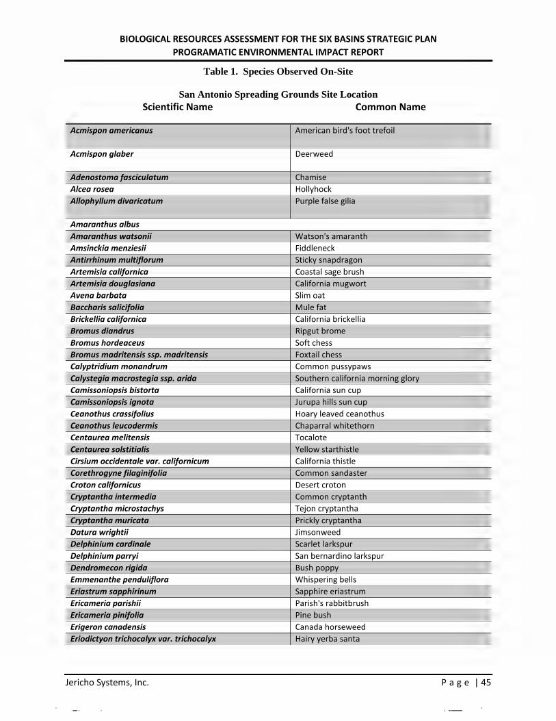
BIOLOGICAL RESOURCES ASSESSMENT FOR THE SIX BASINS STRATEGIC PLAN PROGRAMATIC ENVIRONMENTAL IMPACT REPORT
Jericho Systems, Inc. P a g e | 45
Table 1. Species Observed On-Site
San Antonio Spreading Grounds Site Location Scientific Name Common Name
Acmispon americanus American bird's foot trefoil
Acmispon glaber Deerweed
Adenostoma fasciculatum Chamise Alcea rosea Hollyhock Allophyllum divaricatum Purple false gilia
Amaranthus albus Amaranthus watsonii Watson's amaranth Amsinckia menziesii Fiddleneck Antirrhinum multiflorum Sticky snapdragon Artemisia californica Coastal sage brush Artemisia douglasiana California mugwort Avena barbata Slim oat Baccharis salicifolia Mule fat Brickellia californica California brickellia Bromus diandrus Ripgut brome Bromus hordeaceus Soft chess Bromus madritensis ssp. madritensis Foxtail chess Calyptridium monandrum Common pussypaws Calystegia macrostegia ssp. arida Southern california morning glory Camissoniopsis bistorta California sun cup Camissoniopsis ignota Jurupa hills sun cup Ceanothus crassifolius Hoary leaved ceanothus Ceanothus leucodermis Chaparral whitethorn Centaurea melitensis Tocalote Centaurea solstitialis Yellow starthistle Cirsium occidentale var. californicum California thistle Corethrogyne filaginifolia Common sandaster Croton californicus Desert croton Cryptantha intermedia Common cryptanth Cryptantha microstachys Tejon cryptantha Cryptantha muricata Prickly cryptantha Datura wrightii Jimsonweed Delphinium cardinale Scarlet larkspur Delphinium parryi San bernardino larkspur Dendromecon rigida Bush poppy Emmenanthe penduliflora Whispering bells Eriastrum sapphirinum Sapphire eriastrum Ericameria parishii Parish's rabbitbrush Ericameria pinifolia Pine bush Erigeron canadensis Canada horseweed Eriodictyon trichocalyx var. trichocalyx Hairy yerba santa
l I
l r !
I I
I I
I I
l l
l l
l l
I l
I l
I l
r l
r l
r l
I I
I I
I I
l l
I l
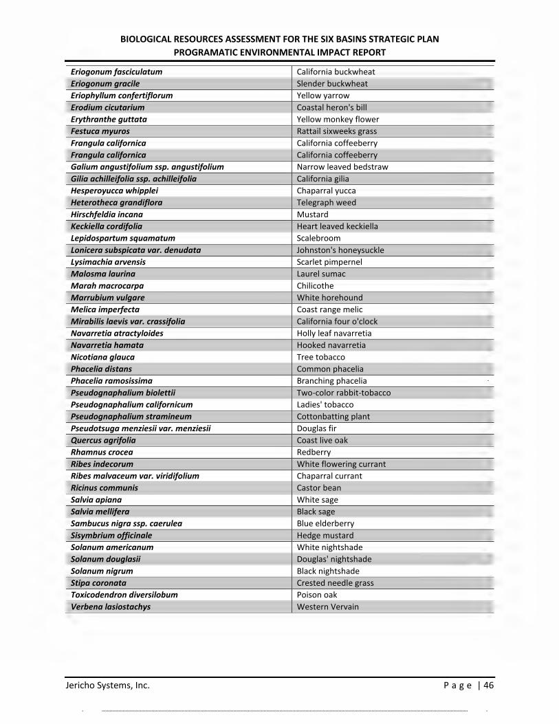
BIOLOGICAL RESOURCES ASSESSMENT FOR THE SIX BASINS STRATEGIC PLAN PROGRAMATIC ENVIRONMENTAL IMPACT REPORT
Jericho Systems, Inc. P a g e | 46
Eriogonum fasciculatum California buckwheat Eriogonum gracile Slender buckwheat Eriophyllum confertiflorum Yellow yarrow Erodium cicutarium Coastal heron's bill Erythranthe guttata Yellow monkey flower Festuca myuros Rattail sixweeks grass Frangula californica California coffeeberry Frangula californica California coffeeberry Galium angustifolium ssp. angustifolium Narrow leaved bedstraw Gilia achilleifolia ssp. achilleifolia California gilia Hesperoyucca whipplei Chaparral yucca Heterotheca grandiflora Telegraph weed Hirschfeldia incana Mustard Keckiella cordifolia Heart leaved keckiella Lepidospartum squamatum Scalebroom Lonicera subspicata var. denudata Johnston's honeysuckle Lysimachia arvensis Scarlet pimpernel Malosma laurina Laurel sumac Marah macrocarpa Chilicothe Marrubium vulgare White horehound Melica imperfecta Coast range melic Mirabilis laevis var. crassifolia California four o'clock Navarretia atractyloides Holly leaf navarretia Navarretia hamata Hooked navarretia Nicotiana glauca Tree tobacco Phacelia distans Common phacelia Phacelia ramosissima Branching phacelia Pseudognaphalium biolettii Two-color rabbit-tobacco Pseudognaphalium californicum Ladies' tobacco Pseudognaphalium stramineum Cottonbatting plant Pseudotsuga menziesii var. menziesii Douglas fir Quercus agrifolia Coast live oak Rhamnus crocea Redberry Ribes indecorum White flowering currant Ribes malvaceum var. viridifolium Chaparral currant Ricinus communis Castor bean Salvia apiana White sage Salvia mellifera Black sage Sambucus nigra ssp. caerulea Blue elderberry Sisymbrium officinale Hedge mustard Solanum americanum White nightshade Solanum douglasii Douglas' nightshade Solanum nigrum Black nightshade Stipa coronata Crested needle grass Toxicodendron diversilobum Poison oak Verbena lasiostachys Western Vervain
r l
I I
l l
l l
l l
l l
I l
I l
I l
I l
r l
r l
r l
I I
I I
l j
l l
l l
I l
I l
I l
I l
r l
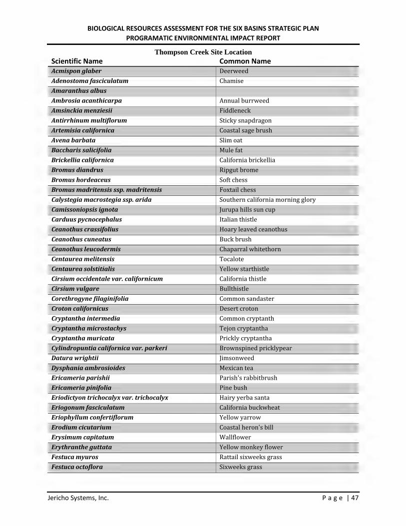
BIOLOGICAL RESOURCES ASSESSMENT FOR THE SIX BASINS STRATEGIC PLAN PROGRAMATIC ENVIRONMENTAL IMPACT REPORT
Jericho Systems, Inc. P a g e | 47
Thompson Creek Site Location Scientific Name Common Name Acmispon glaber Deerweed Adenostoma fasciculatum Chamise Amaranthus albus
Ambrosia acanthicarpa Annual burrweed Amsinckia menziesii Fiddleneck Antirrhinum multiflorum Sticky snapdragon Artemisia californica Coastal sage brush Avena barbata Slim oat Baccharis salicifolia Mule fat Brickellia californica California brickellia Bromus diandrus Ripgut brome Bromus hordeaceus Soft chess Bromus madritensis ssp. madritensis Foxtail chess Calystegia macrostegia ssp. arida Southern california morning glory Camissoniopsis ignota Jurupa hills sun cup Carduus pycnocephalus Italian thistle Ceanothus crassifolius Hoary leaved ceanothus Ceanothus cuneatus Buck brush Ceanothus leucodermis Chaparral whitethorn Centaurea melitensis Tocalote Centaurea solstitialis Yellow starthistle Cirsium occidentale var. californicum California thistle Cirsium vulgare Bullthistle Corethrogyne filaginifolia Common sandaster Croton californicus Desert croton Cryptantha intermedia Common cryptanth Cryptantha microstachys Tejon cryptantha Cryptantha muricata Prickly cryptantha Cylindropuntia californica var. parkeri Brownspined pricklypear Datura wrightii Jimsonweed Dysphania ambrosioides Mexican tea Ericameria parishii Parish's rabbitbrush Ericameria pinifolia Pine bush Eriodictyon trichocalyx var. trichocalyx Hairy yerba santa Eriogonum fasciculatum California buckwheat Eriophyllum confertiflorum Yellow yarrow Erodium cicutarium Coastal heron's bill Erysimum capitatum Wallflower Erythranthe guttata Yellow monkey flower Festuca myuros Rattail sixweeks grass Festuca octoflora Sixweeks grass
l I
I I
l I
l I
l I
I I
l I
l I
I I
I I
I I
I I
I I
I I
r I
r I
r I
r I
r I
r I
I I
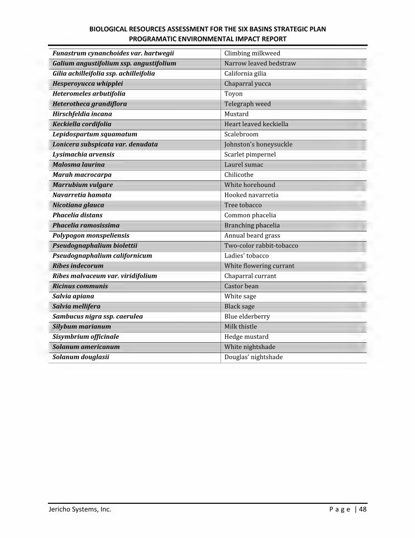
BIOLOGICAL RESOURCES ASSESSMENT FOR THE SIX BASINS STRATEGIC PLAN PROGRAMATIC ENVIRONMENTAL IMPACT REPORT
Jericho Systems, Inc. P a g e | 48
Funastrum cynanchoides var. hartwegii Climbing milkweed Galium angustifolium ssp. angustifolium Narrow leaved bedstraw Gilia achilleifolia ssp. achilleifolia California gilia Hesperoyucca whipplei Chaparral yucca Heteromeles arbutifolia Toyon Heterotheca grandiflora Telegraph weed Hirschfeldia incana Mustard Keckiella cordifolia Heart leaved keckiella Lepidospartum squamatum Scalebroom Lonicera subspicata var. denudata Johnston's honeysuckle Lysimachia arvensis Scarlet pimpernel Malosma laurina Laurel sumac Marah macrocarpa Chilicothe Marrubium vulgare White horehound Navarretia hamata Hooked navarretia Nicotiana glauca Tree tobacco Phacelia distans Common phacelia Phacelia ramosissima Branching phacelia Polypogon monspeliensis Annual beard grass Pseudognaphalium biolettii Two-color rabbit-tobacco Pseudognaphalium californicum Ladies' tobacco Ribes indecorum White flowering currant Ribes malvaceum var. viridifolium Chaparral currant Ricinus communis Castor bean Salvia apiana White sage Salvia mellifera Black sage Sambucus nigra ssp. caerulea Blue elderberry Silybum marianum Milk thistle Sisymbrium officinale Hedge mustard Solanum americanum White nightshade Solanum douglasii Douglas' nightshade
r I
r I
I I
I I
I I
l I
I I
l I
l I
l I
I I
l I
l I
I I
I I

BIOLOGICAL RESOURCES ASSESSMENT FOR THE SIX BASINS STRATEGIC PLAN PROGRAMATIC ENVIRONMENTAL IMPACT REPORT
Jericho Systems, Inc. P a g e | 49
Table 2 – CNDDB Potential to Occur
Scientific Name Common Name
Federal and State Listing Other Status Habitat Occurrence Potential
Aimophila ruficeps canescens
southern California rufous-crowned sparrow None, None G5T3, S3, CDFW-WL
Resident in Southern California coastal sage scrub and sparse mixed chaparral. Frequents relatively steep, often rocky hillsides with grass and forb patches.
There is no suitable habitat for this species on site. Occurrence potential for this species is low.
Anaxyrus californicus arroyo toad
Endangered, None
G2G3, S2S3, CDFW-SSC
Semi-arid regions near washes or intermittent streams, including valley-foothill and desert riparian, desert wash, etc. Rivers with sandy banks, willows, cottonwoods, and sycamores; loose, gravelly areas of streams in drier parts of range.
There is no suitable habitat for this species on site. Occurrence potential for this species is low.
Anniella stebbinsi
southern California legless lizard None, None G3, S3, CDFW-SSC
Generally south of the Transverse Range, extending to northwestern Baja California. Occurs in sandy or loose loamy soils under sparse vegetation. Disjunct populations in the Tehachapi and Piute Mountains in Kern County. Variety of habitats; generally in moist, loose soil. They prefer soils with a high moisture content.
There is no suitable habitat for this species on site. Occurrence potential for this species is low.
Antrozous pallidus pallid bat None, None G5, S3, CDFW-SSC
Deserts, grasslands, shrublands, woodlands and forests. Most common in open, dry habitats with rocky areas for roosting. Roosts must protect bats from high temperatures. Very sensitive to disturbance of roosting sites.
There is no suitable habitat for this species on site. Occurrence potential for this species is low.
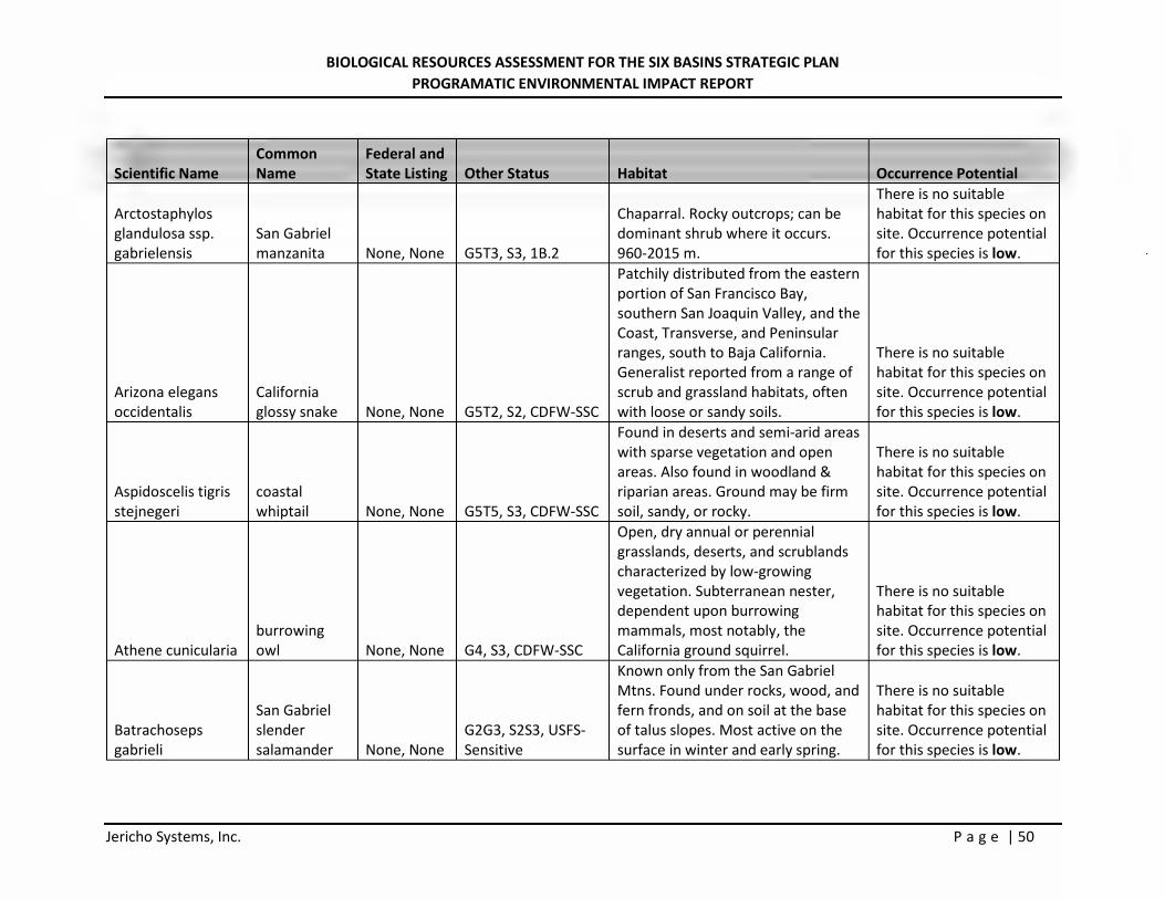
BIOLOGICAL RESOURCES ASSESSMENT FOR THE SIX BASINS STRATEGIC PLAN PROGRAMATIC ENVIRONMENTAL IMPACT REPORT
Jericho Systems, Inc. P a g e | 50
Scientific Name Common Name
Federal and State Listing Other Status Habitat Occurrence Potential
Arctostaphylos glandulosa ssp. gabrielensis
San Gabriel manzanita None, None G5T3, S3, 1B.2
Chaparral. Rocky outcrops; can be dominant shrub where it occurs. 960-2015 m.
There is no suitable habitat for this species on site. Occurrence potential for this species is low.
Arizona elegans occidentalis
California glossy snake None, None G5T2, S2, CDFW-SSC
Patchily distributed from the eastern portion of San Francisco Bay, southern San Joaquin Valley, and the Coast, Transverse, and Peninsular ranges, south to Baja California. Generalist reported from a range of scrub and grassland habitats, often with loose or sandy soils.
There is no suitable habitat for this species on site. Occurrence potential for this species is low.
Aspidoscelis tigris stejnegeri
coastal whiptail None, None G5T5, S3, CDFW-SSC
Found in deserts and semi-arid areas with sparse vegetation and open areas. Also found in woodland & riparian areas. Ground may be firm soil, sandy, or rocky.
There is no suitable habitat for this species on site. Occurrence potential for this species is low.
Athene cunicularia burrowing owl None, None G4, S3, CDFW-SSC
Open, dry annual or perennial grasslands, deserts, and scrublands characterized by low-growing vegetation. Subterranean nester, dependent upon burrowing mammals, most notably, the California ground squirrel.
There is no suitable habitat for this species on site. Occurrence potential for this species is low.
Batrachoseps gabrieli
San Gabriel slender salamander None, None
G2G3, S2S3, USFS-Sensitive
Known only from the San Gabriel Mtns. Found under rocks, wood, and fern fronds, and on soil at the base of talus slopes. Most active on the surface in winter and early spring.
There is no suitable habitat for this species on site. Occurrence potential for this species is low.
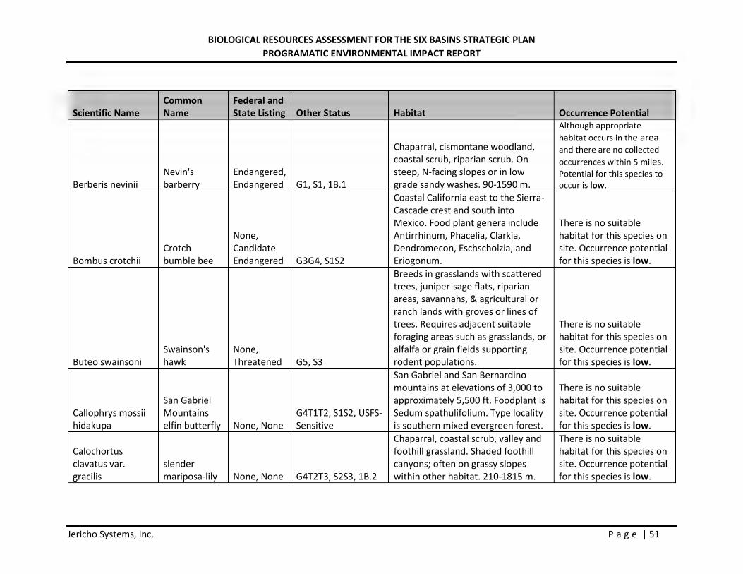
BIOLOGICAL RESOURCES ASSESSMENT FOR THE SIX BASINS STRATEGIC PLAN PROGRAMATIC ENVIRONMENTAL IMPACT REPORT
Jericho Systems, Inc. P a g e | 51
Scientific Name Common Name
Federal and State Listing Other Status Habitat Occurrence Potential
Berberis nevinii Nevin's barberry
Endangered, Endangered G1, S1, 1B.1
Chaparral, cismontane woodland, coastal scrub, riparian scrub. On steep, N-facing slopes or in low grade sandy washes. 90-1590 m.
Although appropriate habitat occurs in the area and there are no collected occurrences within 5 miles. Potential for this species to occur is low.
Bombus crotchii Crotch bumble bee
None, Candidate Endangered G3G4, S1S2
Coastal California east to the Sierra-Cascade crest and south into Mexico. Food plant genera include Antirrhinum, Phacelia, Clarkia, Dendromecon, Eschscholzia, and Eriogonum.
There is no suitable habitat for this species on site. Occurrence potential for this species is low.
Buteo swainsoni Swainson's hawk
None, Threatened G5, S3
Breeds in grasslands with scattered trees, juniper-sage flats, riparian areas, savannahs, & agricultural or ranch lands with groves or lines of trees. Requires adjacent suitable foraging areas such as grasslands, or alfalfa or grain fields supporting rodent populations.
There is no suitable habitat for this species on site. Occurrence potential for this species is low.
Callophrys mossii hidakupa
San Gabriel Mountains elfin butterfly None, None
G4T1T2, S1S2, USFS-Sensitive
San Gabriel and San Bernardino mountains at elevations of 3,000 to approximately 5,500 ft. Foodplant is Sedum spathulifolium. Type locality is southern mixed evergreen forest.
There is no suitable habitat for this species on site. Occurrence potential for this species is low.
Calochortus clavatus var. gracilis
slender mariposa-lily None, None G4T2T3, S2S3, 1B.2
Chaparral, coastal scrub, valley and foothill grassland. Shaded foothill canyons; often on grassy slopes within other habitat. 210-1815 m.
There is no suitable habitat for this species on site. Occurrence potential for this species is low.
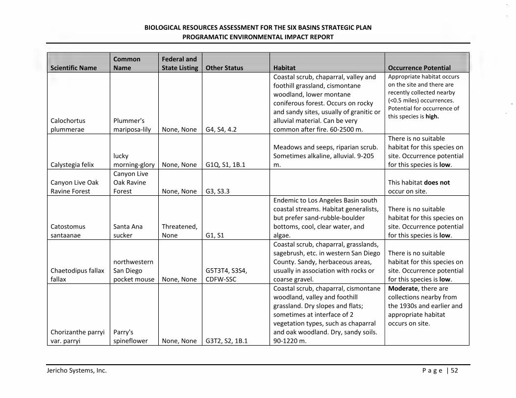
BIOLOGICAL RESOURCES ASSESSMENT FOR THE SIX BASINS STRATEGIC PLAN PROGRAMATIC ENVIRONMENTAL IMPACT REPORT
Jericho Systems, Inc. P a g e | 52
Scientific Name Common Name
Federal and State Listing Other Status Habitat Occurrence Potential
Calochortus plummerae
Plummer's mariposa-lily None, None G4, S4, 4.2
Coastal scrub, chaparral, valley and foothill grassland, cismontane woodland, lower montane coniferous forest. Occurs on rocky and sandy sites, usually of granitic or alluvial material. Can be very common after fire. 60-2500 m.
Appropriate habitat occurs on the site and there are recently collected nearby (<0.5 miles) occurrences. Potential for occurrence of this species is high.
Calystegia felix lucky morning-glory None, None G1Q, S1, 1B.1
Meadows and seeps, riparian scrub. Sometimes alkaline, alluvial. 9-205 m.
There is no suitable habitat for this species on site. Occurrence potential for this species is low.
Canyon Live Oak Ravine Forest
Canyon Live Oak Ravine Forest None, None G3, S3.3
This habitat does not occur on site.
Catostomus santaanae
Santa Ana sucker
Threatened, None G1, S1
Endemic to Los Angeles Basin south coastal streams. Habitat generalists, but prefer sand-rubble-boulder bottoms, cool, clear water, and algae.
There is no suitable habitat for this species on site. Occurrence potential for this species is low.
Chaetodipus fallax fallax
northwestern San Diego pocket mouse None, None
G5T3T4, S3S4, CDFW-SSC
Coastal scrub, chaparral, grasslands, sagebrush, etc. in western San Diego County. Sandy, herbaceous areas, usually in association with rocks or coarse gravel.
There is no suitable habitat for this species on site. Occurrence potential for this species is low.
Chorizanthe parryi var. parryi
Parry's spineflower None, None G3T2, S2, 1B.1
Coastal scrub, chaparral, cismontane woodland, valley and foothill grassland. Dry slopes and flats; sometimes at interface of 2 vegetation types, such as chaparral and oak woodland. Dry, sandy soils. 90-1220 m.
Moderate, there are collections nearby from the 1930s and earlier and appropriate habitat occurs on site.
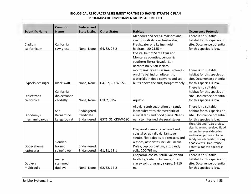
BIOLOGICAL RESOURCES ASSESSMENT FOR THE SIX BASINS STRATEGIC PLAN PROGRAMATIC ENVIRONMENTAL IMPACT REPORT
Jericho Systems, Inc. P a g e | 53
Scientific Name Common Name
Federal and State Listing Other Status Habitat Occurrence Potential
Cladium californicum
California saw-grass None, None G4, S2, 2B.2
Meadows and seeps, marshes and swamps (alkaline or freshwater). Freshwater or alkaline moist habitats. -20-2135 m.
There is no suitable habitat for this species on site. Occurrence potential for this species is low.
Cypseloides niger black swift None, None G4, S2, CDFW-SSC
Coastal belt of Santa Cruz and Monterey counties; central & southern Sierra Nevada; San Bernardino & San Jacinto mountains. Breeds in small colonies on cliffs behind or adjacent to waterfalls in deep canyons and sea-bluffs above the surf; forages widely.
There is no suitable habitat for this species on site. Occurrence potential for this species is low.
Diplectrona californica
California diplectronan caddisfly None, None G1G2, S1S2 Aquatic
There is no suitable habitat for this species on site. Occurrence potential for this species is low.
Dipodomys merriami parvus
San Bernardino kangaroo rat
Endangered, Candidate Endangered G5T1, S1, CDFW-SSC
Alluvial scrub vegetation on sandy loam substrates characteristic of alluvial fans and flood plains. Needs early to intermediate seral stages.
There is no suitable habitat for this species on site. Occurrence potential for this species is low.
Dodecahema leptoceras
slender-horned spineflower
Endangered, Endangered G1, S1, 1B.1
Chaparral, cismontane woodland, coastal scrub (alluvial fan sage scrub). Flood deposited terraces and washes; associates include Encelia, Dalea, Lepidospartum, etc. Sandy soils. 200-765 m.
The SASG and TCSG project sites have not received flood waters in several decades and no longer has suitable sandy soils deposited during flood events. Occurrence potential for this species is low.
Dudleya multicaulis
many-stemmed dudleya None, None G2, S2, 1B.2
Chaparral, coastal scrub, valley and foothill grassland. In heavy, often clayey soils or grassy slopes. 1-910 m.
There is no suitable habitat for this species on site. Occurrence potential for this species is low.
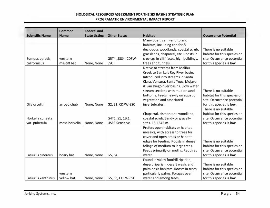
BIOLOGICAL RESOURCES ASSESSMENT FOR THE SIX BASINS STRATEGIC PLAN PROGRAMATIC ENVIRONMENTAL IMPACT REPORT
Jericho Systems, Inc. P a g e | 54
Scientific Name Common Name
Federal and State Listing Other Status Habitat Occurrence Potential
Eumops perotis californicus
western mastiff bat None, None
G5T4, S3S4, CDFW-SSC
Many open, semi-arid to arid habitats, including conifer & deciduous woodlands, coastal scrub, grasslands, chaparral, etc. Roosts in crevices in cliff faces, high buildings, trees and tunnels.
There is no suitable habitat for this species on site. Occurrence potential for this species is low.
Gila orcuttii arroyo chub None, None G2, S2, CDFW-SSC
Native to streams from Malibu Creek to San Luis Rey River basin. Introduced into streams in Santa Clara, Ventura, Santa Ynez, Mojave & San Diego river basins. Slow water stream sections with mud or sand bottoms. Feeds heavily on aquatic vegetation and associated invertebrates.
There is no suitable habitat for this species on site. Occurrence potential for this species is low.
Horkelia cuneata var. puberula mesa horkelia None, None
G4T1, S1, 1B.1, USFS-Sensitive
Chaparral, cismontane woodland, coastal scrub. Sandy or gravelly sites. 15-1645 m.
There is no suitable habitat for this species on site. Occurrence potential for this species is low.
Lasiurus cinereus hoary bat None, None G5, S4
Prefers open habitats or habitat mosaics, with access to trees for cover and open areas or habitat edges for feeding. Roosts in dense foliage of medium to large trees. Feeds primarily on moths. Requires water.
There is no suitable habitat for this species on site. Occurrence potential for this species is low.
Lasiurus xanthinus western yellow bat None, None G5, S3, CDFW-SSC
Found in valley foothill riparian, desert riparian, desert wash, and palm oasis habitats. Roosts in trees, particularly palms. Forages over water and among trees.
There is no suitable habitat for this species on site. Occurrence potential for this species is low.
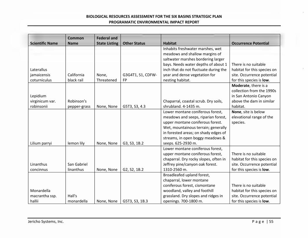
BIOLOGICAL RESOURCES ASSESSMENT FOR THE SIX BASINS STRATEGIC PLAN PROGRAMATIC ENVIRONMENTAL IMPACT REPORT
Jericho Systems, Inc. P a g e | 55
Scientific Name Common Name
Federal and State Listing Other Status Habitat Occurrence Potential
Laterallus jamaicensis coturniculus
California black rail
None, Threatened
G3G4T1, S1, CDFW-FP
Inhabits freshwater marshes, wet meadows and shallow margins of saltwater marshes bordering larger bays. Needs water depths of about 1 inch that do not fluctuate during the year and dense vegetation for nesting habitat.
There is no suitable habitat for this species on site. Occurrence potential for this species is low.
Lepidium virginicum var. robinsonii
Robinson's pepper-grass None, None G5T3, S3, 4.3
Chaparral, coastal scrub. Dry soils, shrubland. 4-1435 m.
Moderate, there is a collection from the 1990s in San Antonio Canyon above the dam in similar habitat.
Lilium parryi lemon lily None, None G3, S3, 1B.2
Lower montane coniferous forest, meadows and seeps, riparian forest, upper montane coniferous forest. Wet, mountainous terrain; generally in forested areas; on shady edges of streams, in open boggy meadows & seeps. 625-2930 m.
None, site is below elevational range of the species.
Linanthus concinnus
San Gabriel linanthus None, None G2, S2, 1B.2
Lower montane coniferous forest, upper montane coniferous forest, chaparral. Dry rocky slopes, often in Jeffrey pine/canyon oak forest. 1310-2560 m.
There is no suitable habitat for this species on site. Occurrence potential for this species is low.
Monardella macrantha ssp. hallii
Hall's monardella None, None G5T3, S3, 1B.3
Broadleafed upland forest, chaparral, lower montane coniferous forest, cismontane woodland, valley and foothill grassland. Dry slopes and ridges in openings. 700-1800 m.
There is no suitable habitat for this species on site. Occurrence potential for this species is low.
BIOLOGICAL RESOURCES ASSESSMENT FOR THE SIX BASINS STRATEGIC PLAN PROGRAMATIC ENVIRONMENTAL IMPACT REPORT
Jericho Systems, Inc. P a g e | 56
Scientific Name Common Name
Federal and State Listing Other Status Habitat Occurrence Potential
Muhlenbergia californica
California muhly None, None G4, S4, 4.3
Coastal scrub, chaparral, lower montane coniferous forest, meadows and seeps. Usually found near streams or seeps. 100-2000 m.
There is no suitable habitat for this species on site. Occurrence potential for this species is low.
Muhlenbergia utilis aparejo grass None, None G4, S2S3, 2B.2
Meadows and seeps, marshes and swamps, chaparral, coastal scrub, cismontane woodland. Sometimes alkaline, sometimes serpentinite. 25-2325 m.
There is no suitable habitat for this species on site. Occurrence potential for this species is low.
Navarretia prostrata
prostrate vernal pool navarretia None, None G2, S2, 1B.2
Coastal scrub, valley and foothill grassland, vernal pools, meadows and seeps. Alkaline soils in grassland, or in vernal pools. Mesic, alkaline sites. 3-1235 m.
There is no suitable habitat for this species on site. Occurrence potential for this species is low.
Neotoma lepida intermedia
San Diego desert woodrat None, None
G5T3T4, S3S4, CDFW-SSC
Coastal scrub of Southern California from San Diego County to San Luis Obispo County. Moderate to dense canopies preferred. They are particularly abundant in rock outcrops, rocky cliffs, and slopes.
There is no suitable habitat for this species on site. Occurrence potential for this species is low.
Nyctinomops macrotis
big free-tailed bat None, None G5, S3, CDFW-SSC
Low-lying arid areas in Southern California. Need high cliffs or rocky outcrops for roosting sites. Feeds principally on large moths.
There is no suitable habitat for this species on site. Occurrence potential for this species is low.
Oreonana vestita
woolly mountain-parsley None, None G3, S3, 1B.3
Subalpine coniferous forest, upper montane coniferous forest, lower montane coniferous forest. High ridges; on scree, talus, or gravel. 800-3370 m.
There is no suitable habitat for this species on site. Occurrence potential for this species is low.
BIOLOGICAL RESOURCES ASSESSMENT FOR THE SIX BASINS STRATEGIC PLAN PROGRAMATIC ENVIRONMENTAL IMPACT REPORT
Jericho Systems, Inc. P a g e | 57
Scientific Name Common Name
Federal and State Listing Other Status Habitat Occurrence Potential
Orobanche valida ssp. valida
Rock Creek broomrape None, None
G4T2, S2, 1B.2, USFS-Sensitive
Chaparral, pinyon and juniper woodland. On slopes of loose decomposed granite; parasitic on various chaparral shrubs. 975-1985 m.
There is no suitable habitat for this species on site. Occurrence potential for this species is low.
Ovis canadensis nelsoni
desert bighorn sheep None, None G4T4, S3, CDFW-FP
Widely distributed from the White Mtns in Mono Co. to the Chocolate Mts in Imperial Co. Open, rocky, steep areas with available water and herbaceous forage.
There is no suitable habitat for this species on site. Occurrence potential for this species is low.
Phrynosoma blainvillii
coast horned lizard None, None
G3G4, S3S4, CDFW-SSC
Frequents a wide variety of habitats, most common in lowlands along sandy washes with scattered low bushes. Open areas for sunning, bushes for cover, patches of loose soil for burial, and abundant supply of ants and other insects.
There is no suitable habitat for this species on site. Occurrence potential for this species is low.
Polioptila californica californica
coastal California gnatcatcher
Threatened, None
G4G5T2Q, S2, CDFW-SSC
Obligate, permanent resident of coastal sage scrub below 2500 ft in Southern California. Low, coastal sage scrub in arid washes, on mesas and slopes. Not all areas classified as coastal sage scrub are occupied.
The sites are above the species preferred elevational range, the onsite vegetation provides very low quality habitat There has been no observation of CAGN in this area of the San Gabriel mountains since 1918. Occurrence potential for this species is low.
BIOLOGICAL RESOURCES ASSESSMENT FOR THE SIX BASINS STRATEGIC PLAN PROGRAMATIC ENVIRONMENTAL IMPACT REPORT
Jericho Systems, Inc. P a g e | 58
Scientific Name Common Name
Federal and State Listing Other Status Habitat Occurrence Potential
Pseudognaphalium leucocephalum
white rabbit-tobacco None, None G4, S2, 2B.2
Riparian woodland, cismontane woodland, coastal scrub, chaparral. Sandy, gravelly sites. 35-515 m.
There is no suitable habitat for this species on site. Occurrence potential for this species is low.
Rana boylii
foothill yellow-legged frog
None, Endangered G3, S3, CDFW-SSC
Partly-shaded, shallow streams and riffles with a rocky substrate in a variety of habitats. Needs at least some cobble-sized substrate for egg-laying. Needs at least 15 weeks to attain metamorphosis.
There is no suitable habitat for this species on site. Occurrence potential for this species is low.
Rana muscosa
southern mountain yellow-legged frog
Endangered, Endangered G1, S1, CDFW-WL
Federal listing refers to populations in the San Gabriel, San Jacinto and San Bernardino mountains (southern DPS). Northern DPS was determined to warrant listing as endangered, Apr 2014, effective Jun 30, 2014. Always encountered within a few feet of water. Tadpoles may require 2 - 4 yrs to complete their aquatic development.
There is no suitable habitat for this species on site. Occurrence potential for this species is low.
Riversidian Alluvial Fan Sage Scrub
Riversidian Alluvial Fan Sage Scrub
None, None G1, S1.1 Coastal scrub
A mature phase of this habitat occurs onsite which is no longer subject to flood events and has limited habitat value for RAFSS associated species.
Sidalcea neomexicana
salt spring checkerbloom None, None
G4, S2, 2B.2, USFS-Sensitive
Playas, chaparral, coastal scrub, lower montane coniferous forest, Mojavean desert scrub. Alkali springs and marshes. 3-2380 m.
There is no suitable habitat for this species on site. Occurrence potential for this species is low.
BIOLOGICAL RESOURCES ASSESSMENT FOR THE SIX BASINS STRATEGIC PLAN PROGRAMATIC ENVIRONMENTAL IMPACT REPORT
Jericho Systems, Inc. P a g e | 59
Scientific Name Common Name
Federal and State Listing Other Status Habitat Occurrence Potential
Southern California Arroyo Chub/Santa Ana Sucker Stream
Southern California Arroyo Chub/Santa Ana Sucker Stream None, None GNR, SNR
This habitat does not occur on site.
Southern Coast Live Oak Riparian Forest
Southern Coast Live Oak Riparian Forest None, None G4, S4 Riparian forest
This habitat does not occur on site.
Southern Sycamore Alder Riparian Woodland
Southern Sycamore Alder Riparian Woodland None, None G4, S4 Riparian woodland
This habitat does not occur on site.
Spea hammondii western spadefoot None, None G3, S3, CDFW-SSC
Occurs primarily in grassland habitats, but can be found in valley-foothill hardwood woodlands. Vernal pools are essential for breeding and egg-laying.
There is no suitable habitat for this species on site. Occurrence potential for this species is low.
Symphyotrichum defoliatum
San Bernardino aster None, None G2, S2, 1B.2
Meadows and seeps, cismontane woodland, coastal scrub, lower montane coniferous forest, marshes and swamps, valley and foothill grassland. Vernally mesic grassland or near ditches, streams and springs; disturbed areas. 3-2045 m.
There is no suitable habitat for this species on site. Occurrence potential for this species is low.
Symphyotrichum greatae Greata's aster None, None G2, S2, 1B.3
Chaparral, cismontane woodland, broadleafed upland forest, lower montane coniferous forest, riparian woodland. Mesic canyons. 335-2015 m.
Low, there is no appropriate habitat (mesic canyons) on site.
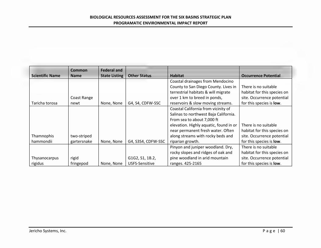
BIOLOGICAL RESOURCES ASSESSMENT FOR THE SIX BASINS STRATEGIC PLAN PROGRAMATIC ENVIRONMENTAL IMPACT REPORT
Jericho Systems, Inc. P a g e | 60
Scientific Name Common Name
Federal and State Listing Other Status Habitat Occurrence Potential
Taricha torosa Coast Range newt None, None G4, S4, CDFW-SSC
Coastal drainages from Mendocino County to San Diego County. Lives in terrestrial habitats & will migrate over 1 km to breed in ponds, reservoirs & slow moving streams.
There is no suitable habitat for this species on site. Occurrence potential for this species is low.
Thamnophis hammondii
two-striped gartersnake None, None G4, S3S4, CDFW-SSC
Coastal California from vicinity of Salinas to northwest Baja California. From sea to about 7,000 ft elevation. Highly aquatic, found in or near permanent fresh water. Often along streams with rocky beds and riparian growth.
There is no suitable habitat for this species on site. Occurrence potential for this species is low.
Thysanocarpus rigidus
rigid fringepod None, None
G1G2, S1, 1B.2, USFS-Sensitive
Pinyon and juniper woodland. Dry, rocky slopes and ridges of oak and pine woodland in arid mountain ranges. 425-2165
There is no suitable habitat for this species on site. Occurrence potential for this species is low.
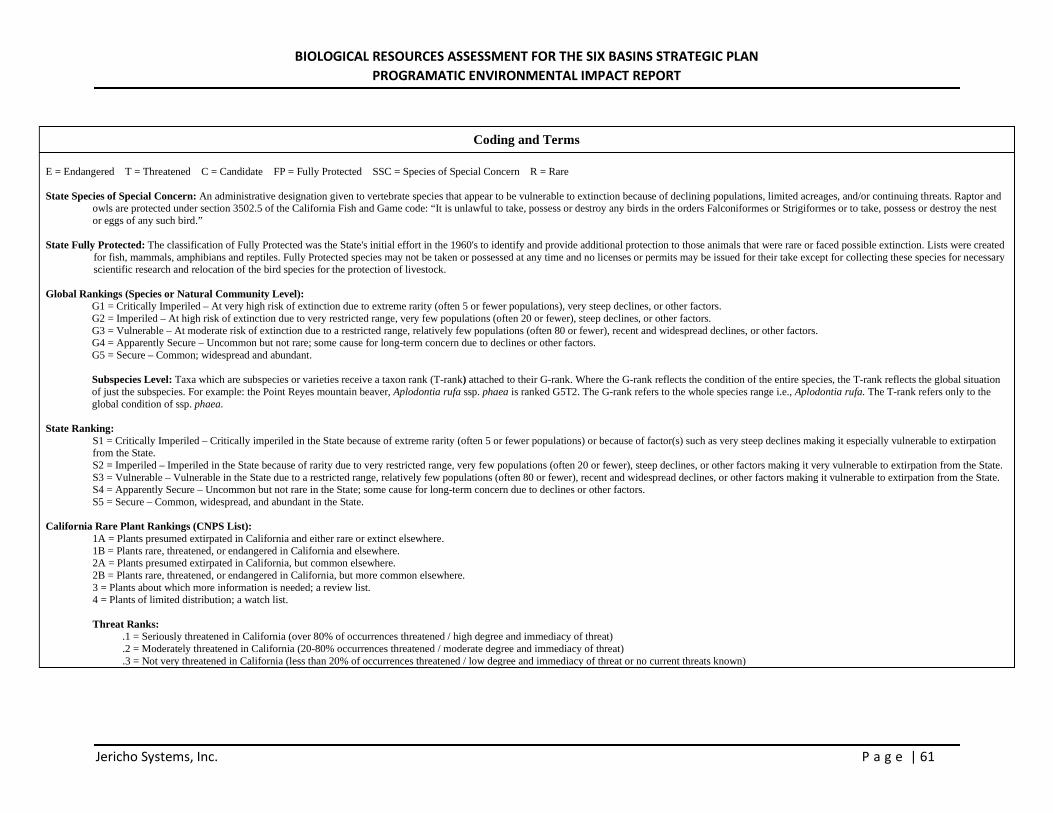
BIOLOGICAL RESOURCES ASSESSMENT FOR THE SIX BASINS STRATEGIC PLAN PROGRAMATIC ENVIRONMENTAL IMPACT REPORT
Jericho Systems, Inc. P a g e | 61
Coding and Terms E = Endangered T = Threatened C = Candidate FP = Fully Protected SSC = Species of Special Concern R = Rare State Species of Special Concern: An administrative designation given to vertebrate species that appear to be vulnerable to extinction because of declining populations, limited acreages, and/or continuing threats. Raptor and
owls are protected under section 3502.5 of the California Fish and Game code: “It is unlawful to take, possess or destroy any birds in the orders Falconiformes or Strigiformes or to take, possess or destroy the nest or eggs of any such bird.”
State Fully Protected: The classification of Fully Protected was the State's initial effort in the 1960's to identify and provide additional protection to those animals that were rare or faced possible extinction. Lists were created
for fish, mammals, amphibians and reptiles. Fully Protected species may not be taken or possessed at any time and no licenses or permits may be issued for their take except for collecting these species for necessary scientific research and relocation of the bird species for the protection of livestock.
Global Rankings (Species or Natural Community Level):
G1 = Critically Imperiled – At very high risk of extinction due to extreme rarity (often 5 or fewer populations), very steep declines, or other factors. G2 = Imperiled – At high risk of extinction due to very restricted range, very few populations (often 20 or fewer), steep declines, or other factors. G3 = Vulnerable – At moderate risk of extinction due to a restricted range, relatively few populations (often 80 or fewer), recent and widespread declines, or other factors. G4 = Apparently Secure – Uncommon but not rare; some cause for long-term concern due to declines or other factors. G5 = Secure – Common; widespread and abundant. Subspecies Level: Taxa which are subspecies or varieties receive a taxon rank (T-rank) attached to their G-rank. Where the G-rank reflects the condition of the entire species, the T-rank reflects the global situation of just the subspecies. For example: the Point Reyes mountain beaver, Aplodontia rufa ssp. phaea is ranked G5T2. The G-rank refers to the whole species range i.e., Aplodontia rufa. The T-rank refers only to the global condition of ssp. phaea.
State Ranking:
S1 = Critically Imperiled – Critically imperiled in the State because of extreme rarity (often 5 or fewer populations) or because of factor(s) such as very steep declines making it especially vulnerable to extirpation from the State. S2 = Imperiled – Imperiled in the State because of rarity due to very restricted range, very few populations (often 20 or fewer), steep declines, or other factors making it very vulnerable to extirpation from the State. S3 = Vulnerable – Vulnerable in the State due to a restricted range, relatively few populations (often 80 or fewer), recent and widespread declines, or other factors making it vulnerable to extirpation from the State. S4 = Apparently Secure – Uncommon but not rare in the State; some cause for long-term concern due to declines or other factors. S5 = Secure – Common, widespread, and abundant in the State.
California Rare Plant Rankings (CNPS List): 1A = Plants presumed extirpated in California and either rare or extinct elsewhere. 1B = Plants rare, threatened, or endangered in California and elsewhere. 2A = Plants presumed extirpated in California, but common elsewhere. 2B = Plants rare, threatened, or endangered in California, but more common elsewhere. 3 = Plants about which more information is needed; a review list. 4 = Plants of limited distribution; a watch list.
Threat Ranks:
.1 = Seriously threatened in California (over 80% of occurrences threatened / high degree and immediacy of threat)
.2 = Moderately threatened in California (20-80% occurrences threatened / moderate degree and immediacy of threat)
.3 = Not very threatened in California (less than 20% of occurrences threatened / low degree and immediacy of threat or no current threats known)
Related Documents