Appendix B: Pedestrian Priority Model Update, Pedestrian Study Areas and Routes

Welcome message from author
This document is posted to help you gain knowledge. Please leave a comment to let me know what you think about it! Share it to your friends and learn new things together.
Transcript
App
endi
x B:
Ped
estr
ian
Prio
rity
Mod
el
Upd
ate,
Ped
estr
ian
Stud
y A
reas
and
Rou
tes
Alta Planning + Design2
CITY OF SAN DIEGO
Pedestrian Master Plan
Phases 2 & 3
Technical Memorandum for Pedestrian Priority Model Update, Study Areas and Route Types
April 23, 2010
Appendix B: Pedestrian Priority Model Update, Pedestrian Study Areas and Routes
City of San Diego 3
Final Draft Pedestrian Master Plan
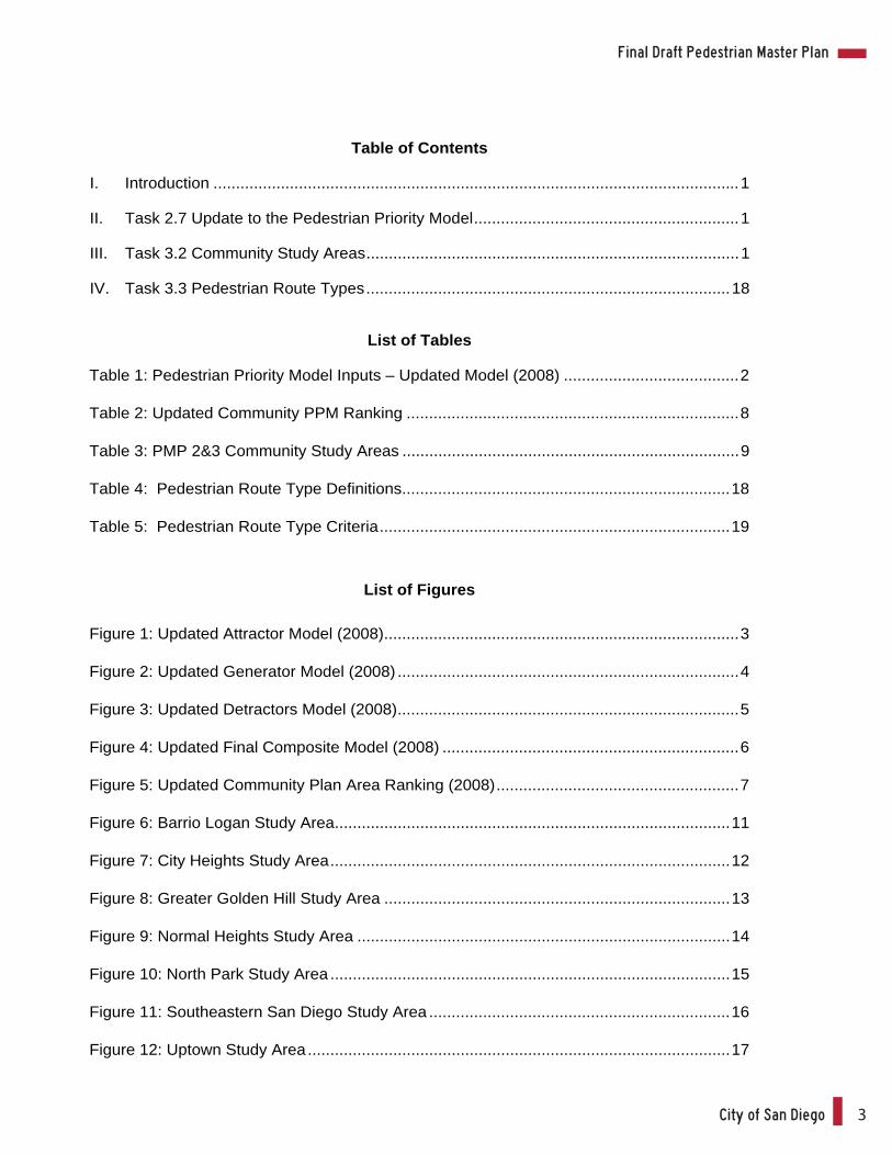
Table of Contents
I. Introduction .....................................................................................................................1
II. Task 2.7 Update to the Pedestrian Priority Model...........................................................1
III. Task 3.2 Community Study Areas...................................................................................1
IV. Task 3.3 Pedestrian Route Types.................................................................................18
List of Tables
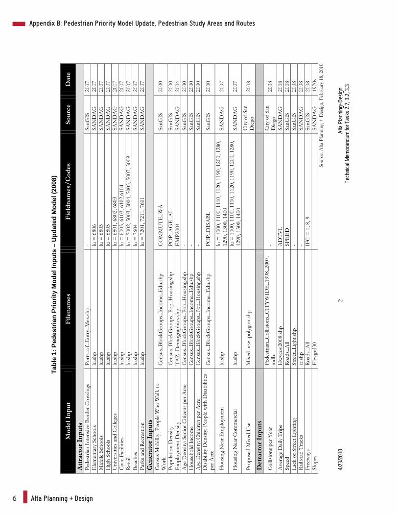
Table 1: Pedestrian Priority Model Inputs – Updated Model (2008) .......................................2
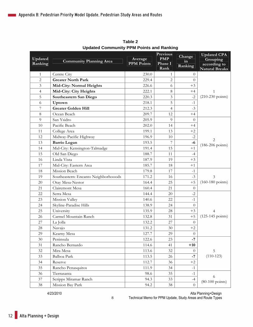
Table 2: Updated Community PPM Ranking ..........................................................................8
Table 3: PMP 2&3 Community Study Areas ...........................................................................9
Table 4: Pedestrian Route Type Definitions.........................................................................18
Table 5: Pedestrian Route Type Criteria..............................................................................19
List of Figures
Figure 1: Updated Attractor Model (2008)...............................................................................3
Figure 2: Updated Generator Model (2008) ............................................................................4
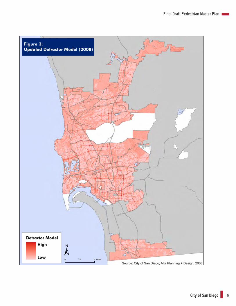
Figure 3: Updated Detractors Model (2008)............................................................................5
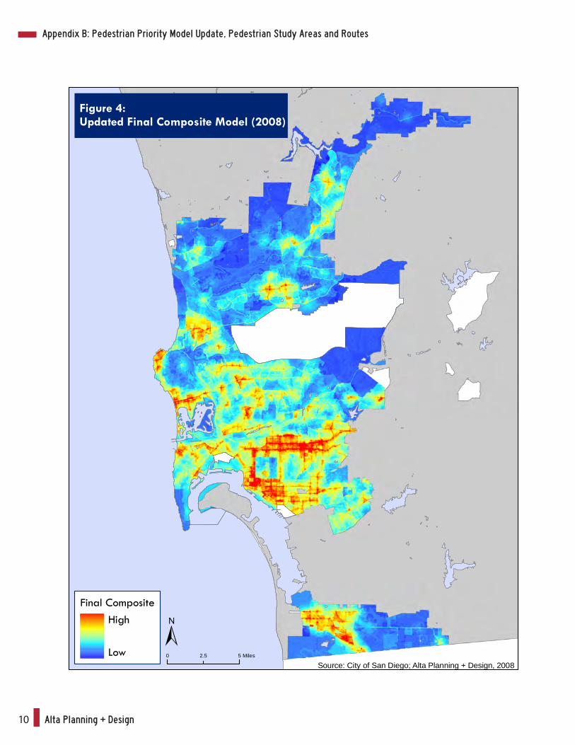
Figure 4: Updated Final Composite Model (2008) ..................................................................6
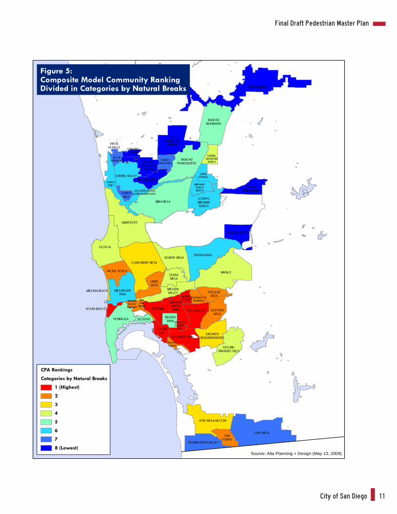
Figure 5: Updated Community Plan Area Ranking (2008)......................................................7
Figure 6: Barrio Logan Study Area........................................................................................11
Figure 7: City Heights Study Area.........................................................................................12
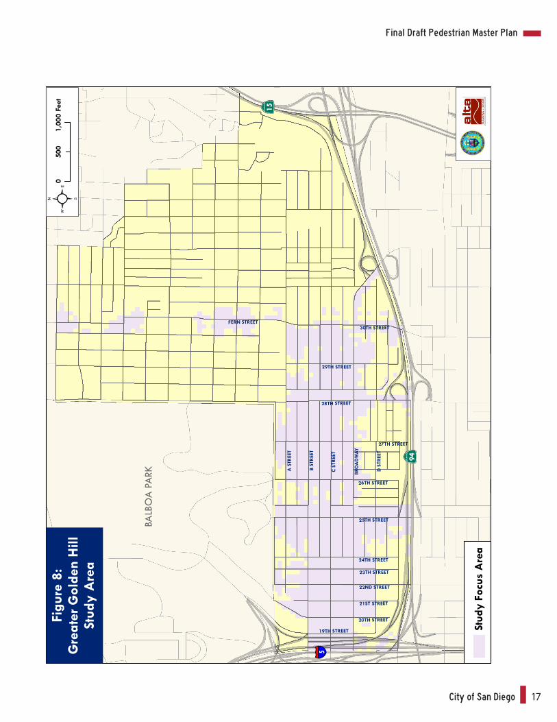
Figure 8: Greater Golden Hill Study Area .............................................................................13
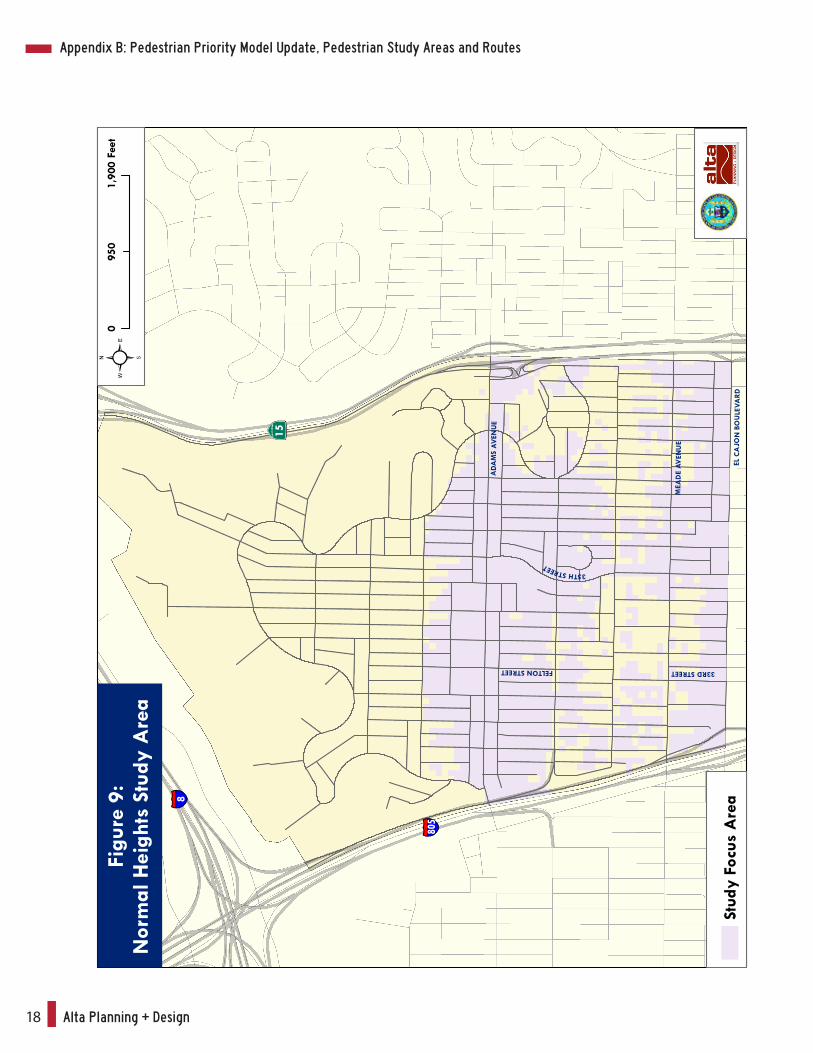
Figure 9: Normal Heights Study Area ...................................................................................14
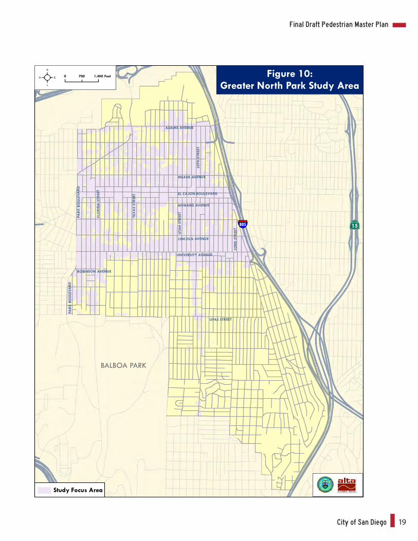
Figure 10: North Park Study Area .........................................................................................15
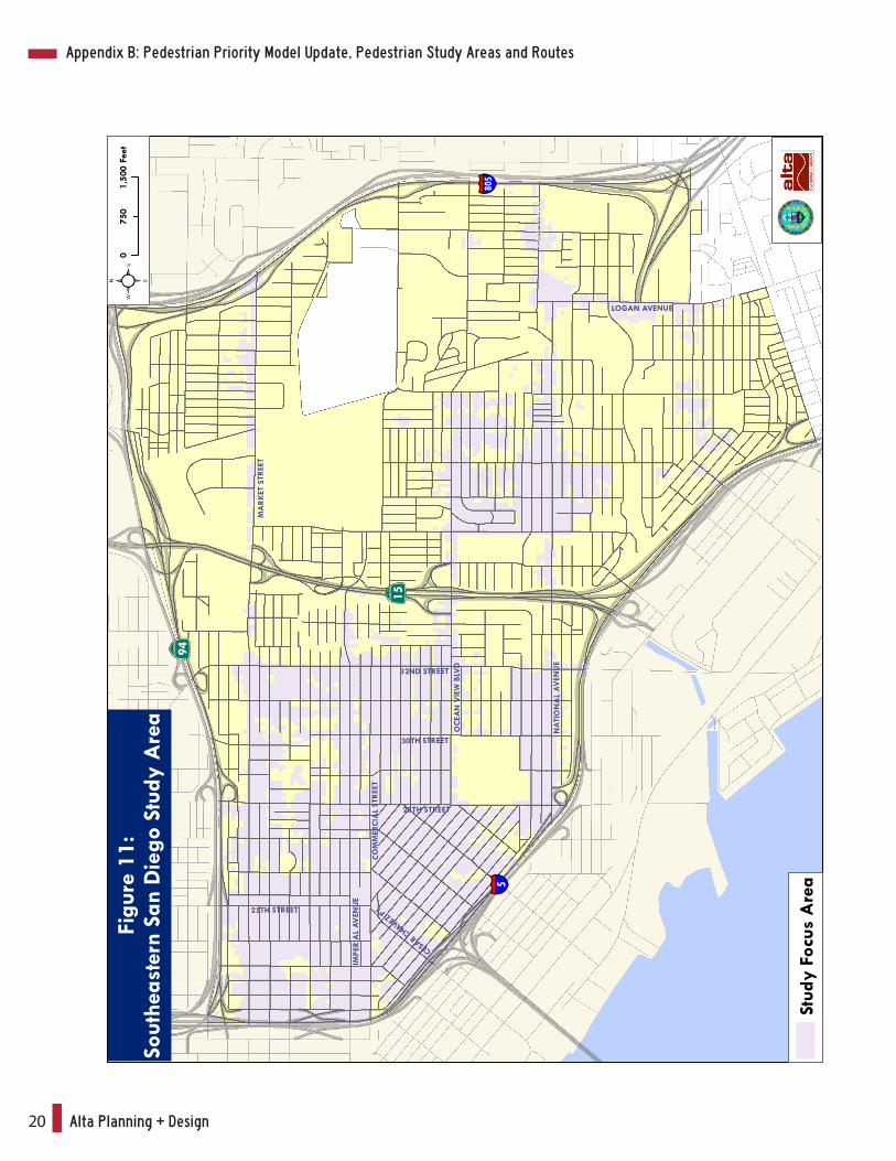
Figure 11: Southeastern San Diego Study Area ...................................................................16
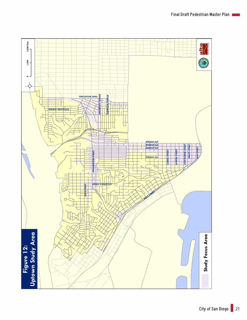
Figure 12: Uptown Study Area ..............................................................................................17
Alta Planning + Design4
4/23/2010 Alta Planning+Design ii Technical Memorandum for PPM Update, Study Areas and Route Types
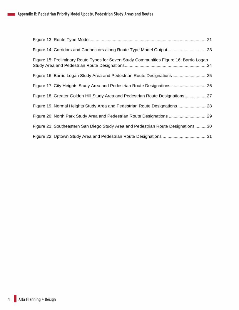
Figure 13: Route Type Model................................................................................................21
Figure 14: Corridors and Connectors along Route Type Model Output................................23
Figure 15: Preliminary Route Types for Seven Study Communities Figure 16: Barrio Logan Study Area and Pedestrian Route Designations...................................................................24
Figure 16: Barrio Logan Study Area and Pedestrian Route Designations ............................25
Figure 17: City Heights Study Area and Pedestrian Route Designations .............................26
Figure 18: Greater Golden Hill Study Area and Pedestrian Route Designations..................27
Figure 19: Normal Heights Study Area and Pedestrian Route Designations........................28
Figure 20: North Park Study Area and Pedestrian Route Designations ...............................29
Figure 21: Southeastern San Diego Study Area and Pedestrian Route Designations .........30
Figure 22: Uptown Study Area and Pedestrian Route Designations ....................................31
Appendix B: Pedestrian Priority Model Update, Pedestrian Study Areas and Routes
City of San Diego 5
Final Draft Pedestrian Master Plan
1 Alta Planning+Design Technical Memorandum for PPM Update, Study Areas and Route Types
I. Introduction
This report summarizes methodologies and outcomes associated with the following three key
San Diego Pedestrian Master Plan Phases 2 & 3 (PMP 2&3) tasks:
Task 2.7 – Update the City of San Diego’s Pedestrian Priority Model (PPM),
Task 3.2 – Pedestrian Study Areas, and
Task 3.3 – Pedestrian Routes
II. Task 2.7 Update to the Pedestrian Priority Model
The PPM was updated as part of the PMP 2&3 project due to the fact that several of the data
inputs were out of date since the PMP Phase I project. In particular, the location of transit stops
and ridership levels, land uses, traffic counts, and pedestrian crashes have more recent data
available than was used during the PMP Phase 1 effort. Table 1 displays the source and date for
all inputs used in the attractor, generator and detractor submodels for the purposes of updating
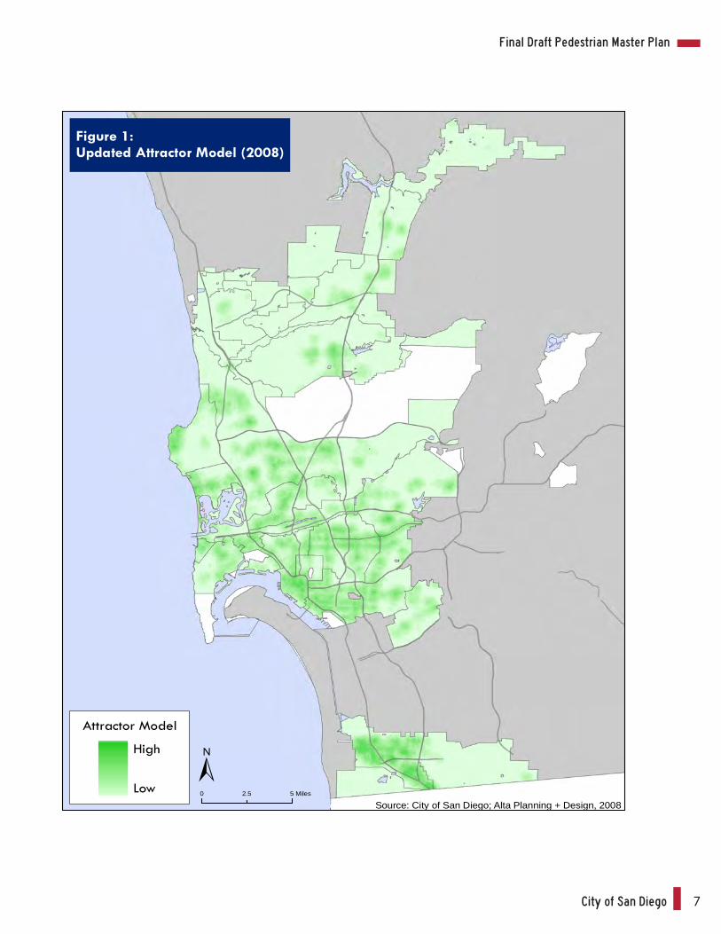
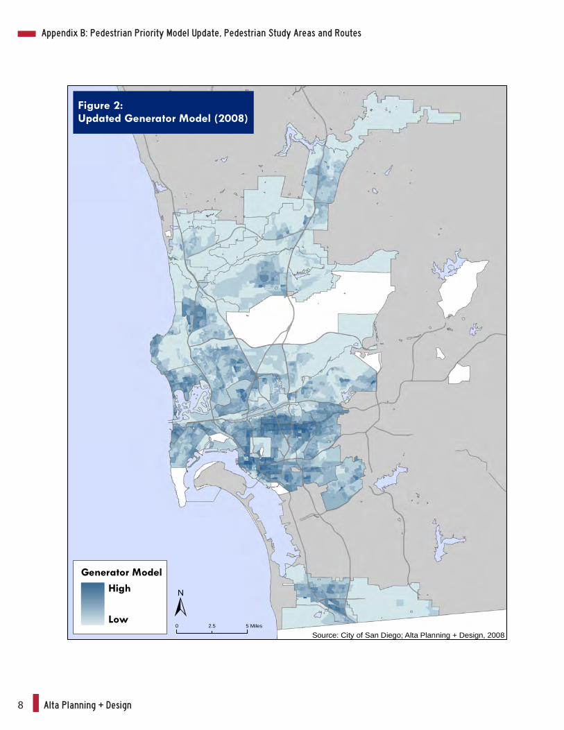
the PPM. Figures 1 through 4 display the output from each of the updated submodels as well
as the final composite priority model. Table 2 shows the updated ranking of Community Plan
Areas based upon the updated PPM, while Figure 5 displays the updated Community Plan Area
rankings across the jurisdiction.
III. Task 3.2 Community Study Areas
The PMP 2&3 study areas are defined in part by high PPM locations and in part by pedestrian
route designations within the community. This section presents an overview of high PPM
locations for each community and summarizes these areas in terms of study area acreage and
percentage of the community represented in the study area.
Using the updated model, high PPM locations are defined as those areas of the community that
intersect PPM raster grids whose values fall within the top 50 percent of the range of PPM
values.
Alta Planning + Design6
4/23/2
010
2
Alta
Plan
ning+
Desig
n
Te
chnic
al Me
mora
ndum
for T
asks
2.7,
3.2, 3
.3
Tabl
e 1:
Ped
estr
ian
Prio
rity
Mod
el In
puts
– U
pdat
ed M
odel
(200
8)
Mod
el I
nput
Fi
lena
mes
Fi
eldn
ames
/Cod
es
Sour
ce
Dat
e
Att
ract
or I
nput
s Pe
dest
rian
Inte
nsiv
e Bo
rder
Cro
ssin
gs
Ports
_of_
Ent
ry_M
ex.sh
p -
SanG
IS
2007
E
lemen
tary
Sch
ools
lu.sh
p lu
= 6
806
SAN
DA
G
2007
M
iddl
e Sc
hool
s lu
.shp
lu =
680
5 SA
ND
AG
20
07
Hig
h Sc
hool
s lu
.shp
lu =
680
5 SA
ND
AG
20
07
Uni
vers
ities
and
Col
leges
lu
.shp
lu =
680
1, 6
802,
680
3 SA
ND
AG
20
07
Civi
c Fa
ciliti
es
lu.sh
p lu
= 6
003,
610
3, 6
102,
6104
SA
ND
AG
20
07
Reta
il
lu.sh
p lu
= 5
002,
500
3, 5
004,
500
5, 5
007,
500
9 SA
ND
AG
20
07
Beac
hes
lu.sh
p lu
= 7
604
SAN
DA
G
2007
Pa
rks a
nd R
ecre
atio
n lu
.shp
lu =
720
1, 7
211,
760
1 SA
ND
AG
20
07
Gen
erat
or I
nput
s Ce
nsus
Mob
ility
: Peo
ple
Who
Walk
to
Wor
k Ce
nsus
_Blo
ckG
roup
s_In
com
e_E
du.sh
p CO
MM
UTE
_WA
Sa
nGIS
20
00
Popu
latio
n D
ensit
y Ce
nsus
_Blo
ckG
roup
s_Po
p_H
ousin
g.sh
p PO
P_A
GE
_AL
SanG
IS
2000
E
mpl
oym
ent D
ensit
y TA
Z_D
emog
raph
ics.sh
p E
MP2
004
SAN
DA
G
2004
A
ge D
ensit
y: Se
nior
Citi
zens
per
Acr
e Ce
nsus
_Blo
ckG
roup
s_Po
p_H
ousin
g.sh
p -
SanG
IS
2000
H
ouse
hold
Inco
me
Cens
us_B
lock
Gro
ups_
Inco
me_
Edu
.shp
- Sa
nGIS
20
00
Age
Den
sity:
Child
ren
per A
cre
Cens
us_B
lock
Gro
ups_
Pop_
Hou
sing.
shp
- Sa
nGIS
20
00
Disa
bilit
y D
ensit
y: Pe
ople
with
Disa
bilit
ies
per A
cre
Cens
us_B
lock
Gro
ups_
Inco
me_
Edu
.shp
POP_
DIS
ABL
Sa
nGIS
20
00
Hou
sing
Nea
r Em
ploy
men
t lu
.shp
lu =
100
0, 1
100,
111
0, 1
120,
119
0, 1
200,
128
0,
1290
, 130
0, 1
400
SAN
DA
G
2007
Hou
sing
Nea
r Com
mer
cial
lu.sh
p lu
= 1
000,
110
0, 1
110,
112
0, 1
190,
120
0, 1
280,
12
90, 1
300,
140
0 SA
ND
AG
20
07
Prop
osed
Mix
ed U
se
Mix
ed_u
se_p
olyg
on.sh
p -
City
of S
an
Dieg
o 20
08
Det
ract
or I
nput
s
Co
llisio
ns p
er Y
ear
Pede
stria
n_Co
llisio
ns_C
ITY
WID
E_1
998_
2007
.m
db
- Ci
ty o
f San
D
iego
2008
Ave
rage
Dail
y Tr
ips
Hw
ycov
2008
.shp
AD
TVL
SAN
DA
G
2008
Sp
eed
Road
s_A
ll SP
EE
D
SanG
IS
2008
La
ck o
f Stre
et L
ight
ing
Stre
et_L
ight
.shp
- Sa
nGIS
20
08
Railr
oad
Trac
ks
rr.sh
p -
SAN
DA
G
2008
Fr
eew
ays
Road
s_A
ll IF
C =
1, 8
, 9
SanG
IS
2008
Sl
opes
E
levgr
d30
- SA
ND
AG
19
70s
Sour
ce: A
lta P
lanni
ng +
Des
ign,
Feb
ruar
y 18
, 201
0
Appendix B: Pedestrian Priority Model Update, Pedestrian Study Areas and Routes
City of San Diego 7
Final Draft Pedestrian Master Plan
Figure 1:Updated Attractor Model (2008)
Source: City of San Diego; Alta Planning + Design, 20080 52.5 Miles
Attractor Model
High
Low
Alta Planning + Design8
Figure 2:Updated Generator Model (2008)
Generator ModelHigh
LowSource: City of San Diego; Alta Planning + Design, 2008
0 52.5 Miles
Appendix B: Pedestrian Priority Model Update, Pedestrian Study Areas and Routes
City of San Diego 9
Final Draft Pedestrian Master Plan
Figure 3:Updated Detractor Model (2008)
Source: City of San Diego; Alta Planning + Design, 20080 52.5 Miles
Detractor ModelHigh
Low
Alta Planning + Design10
Figure 4:Updated Final Composite Model (2008)
Final CompositeHigh
LowSource: City of San Diego; Alta Planning + Design, 2008
0 52.5 Miles
Appendix B: Pedestrian Priority Model Update, Pedestrian Study Areas and Routes
City of San Diego 11
Final Draft Pedestrian Master Plan
NAVAJO
MIRA MESA
OTAY MESA
SAN PASQUAL
UNIVERSITY
LA JOLLA
TIERRASANTA
PENINSULA
CLAIREMONT MESAKEARNY MESA
UPTOWN
CARMEL VALLEY
OTAY MESA-NESTOR
LINDAVISTA
EAST ELLIOTT
MISSIONVALLEY
PACIFIC BEACHSERRAMESA
TIJUANA RIVER VALLEY
DEL MAR MESA
COLLEGEAREA
RESERVE
RANCHOBERNARDO
RANCHOPENASQUITOS
MISSION BAYPARK
BLACKMOUNTAIN
RANCH
TORREYPINES
SKYLINE-PARADISE HILLS
SCRIPPSMIRAMAR
RANCH
SANYSIDRO
RANCHOENCANTADA
CITY HEIGHTS EASTERNAREA
CENTRECITY
GREATERNORTHPARK
SABRESPRINGS
PACIFICHIGHLANDS
RANCH
BALBOAPARK
ENCANTONEIGHBORHOODS
MIRAMARRANCHNORTH
TORREYHIGHLANDS
SOUTHEASTERN
TORREYHILLS
CARMELMOUNTAIN
RANCHNCFUA
SUBAREA II
OCEAN BEACH
BARRIOLOGAN
MIDWAY-PACIFIC
HIGHWAY
KENSINGTON-TALMADGE
GREATERGOLDEN
HILL
NORMALHEIGHTS
LOS PENASQUITOSCANYON PRESERVE
FAIRBANKSCOUNTRY
CLUB
OLDSAN
DIEGO
MISSION BEACH
VIA DELA VALLE
Figure 5:Composite Model Community RankingDivided in Categories by Natural Breaks
CPA Rankings
Categories by Natural Breaks
1 (Highest)
2
3
4
5
6
7
8 (Lowest)Source: Alta Planning + Design (May 13, 2009)
Alta Planning + Design12
4/23/2010 Alta Planning+Design 8 Technical Memo for PPM Update, Study Areas and Route Types
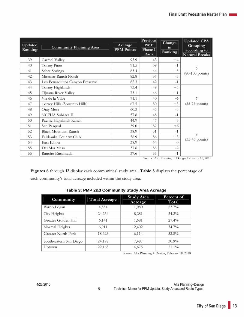
Table 2 Updated Community PPM Points and Ranking
Updated Ranking Community Planning Area Average
PPM Points
Previous PMP
Phase I Rank
Change in
Ranking
Updated CPA Grouping
according to Natural Breaks
1 Centre City 230.0 1 0 2 Greater North Park 229.4 2 0 3 Mid-City: Normal Heights 226.6 6 +3 4 Mid-City: City Heights 222.1 8 +4 5 Southeastern San Diego 220.3 3 -2 6 Uptown 218.1 5 -1 7 Greater Golden Hill 212.3 4 -3 8 Ocean Beach 209.7 12 +4
1 (210-230 points)
9 San Ysidro 205.9 9 0 10 Pacific Beach 202.0 14 +4 11 College Area 199.1 13 +2 12 Midway-Pacific Highway 196.9 10 -2 13 Barrio Logan 193.5 7 -6 14 Mid-City: Kensington-Talmadge 191.4 15 +1 15 Old San Diego 188.7 11 -4 16 Linda Vista 187.9 19 +3 17 Mid-City: Eastern Area 185.7 18 +1
2 (186-206 points)
18 Mission Beach 179.8 17 -1 19 Southeastern: Encanto Neighborhooods 171.2 16 -3 20 Otay Mesa-Nestor 164.4 25 +5 21 Clairemont Mesa 160.4 21 0
3 (160-180 points)
22 Serra Mesa 144.4 20 -2 23 Mission Valley 140.6 22 -1 24 Skyline-Paradise Hills 138.9 24 0 25 University 135.9 28 +3 26 Carmel Mountain Ranch 132.8 31 +5 27 La Jolla 132.2 27 0 28 Navajo 131.2 30 +2 29 Kearny Mesa 127.7 29 0
4 (125-145 points)
30 Peninsula 122.6 23 -7 31 Rancho Bernardo 114.6 41 +10 32 Mira Mesa 113.6 32 0 33 Balboa Park 113.5 26 -7 34 Reserve 112.7 36 +2 35 Rancho Penasquitos 111.9 34 -1
5 (110-123)
36 Tierrasanta 98.6 35 -1 37 Scripps Miramar Ranch 94.3 33 -4 38 Mission Bay Park 94.2 38 0
6 (80-100 points)
Appendix B: Pedestrian Priority Model Update, Pedestrian Study Areas and Routes
City of San Diego 13
Final Draft Pedestrian Master Plan
4/23/2010 Alta Planning+Design 9 Technical Memo for PPM Update, Study Areas and Route Types
Updated Ranking Community Planning Area Average
PPM Points
Previous PMP
Phase I Rank
Change in
Ranking
Updated CPA Grouping
according to Natural Breaks
39 Carmel Valley 93.9 43 +4 40 Torrey Pines 91.5 39 -1 41 Sabre Springs 83.4 44 +3 42 Miramar Ranch North 82.8 37 -5 43 Los Penasquitos Canyon Preserve 82.3 42 -1
6 (80-100 points)
44 Torrey Highlands 73.4 49 +5 45 Tijuana River Valley 73.1 46 +1 46 Via de la Valle 71.1 40 -6 47 Torrey Hills (Sorrento Hills) 67.5 50 +3 48 Otay Mesa 60.3 45 -3 49 NCFUA Subarea II 57.8 48 -1
7 (55-75 points)
50 Pacific Highlands Ranch 44.9 47 -3 51 San Pasqual 39.0 57 +6 52 Black Mountain Ranch 38.9 51 -1 53 Fairbanks Country Club 38.9 56 +3 54 East Elliott 38.9 54 0 55 Del Mar Mesa 37.6 53 -2 56 Rancho Encantada 37.6 55 -1
8 (35-45 points)
Source: Alta Planning + Design, February 18, 2010
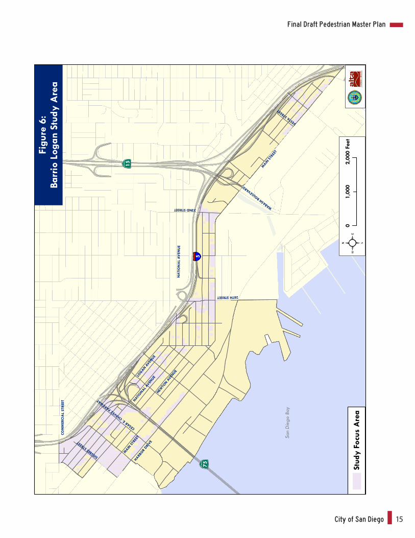
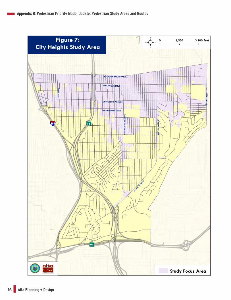
Figures 6 through 12 display each communities’ study area. Table 3 displays the percentage of
each community’s total acreage included within the study area.
Table 3: PMP 2&3 Community Study Area Acreage
Community Total Acreage Study Area Acreage
Percent of Total
Barrio Logan 4,554 1,080 23.7%
City Heights 24,234 8,281 34.2%
Greater Golden Hill 6,141 1,681 27.4%
Normal Heights 6,911 2,402 34.7%
Greater North Park 18,623 6,114 32.8%
Southeastern San Diego 24,178 7,487 30.9% Uptown 22,168 4,675 21.1%
Source: Alta Planning + Design, February 18, 2010
Alta Planning + Design14
4/23/2010 Alta Planning+Design 10 Technical Memo for PPM Update, Study Areas and Route Types
The ultimate definition of each community’s study area however is also dependent on the
pedestrian route types that traverse the community. Pedestrian route type definitions and
assignments to community roadways are discussed in the next section.
Appendix B: Pedestrian Priority Model Update, Pedestrian Study Areas and Routes
City of San Diego 15
Final Draft Pedestrian Master Plan
NATIONAL A
VENUE
CESAR E.
CHAVEZ PA
RKWAYHA
RBOR
DRIVE
MAIN
STRE
ET
MAIN
STRE
ET
28TH STREET
32ND STREET WABASH
BOULEVARD
NA
TIO
NA
L A
VEN
UE
VESTA
STREE
T
SIGSB
EE ST
REET
COM
MER
CIA
L ST
REET
15
755
San
Die
go B
ay
LOGAN A
VENUE
NEWTO
N AVE
NUE
Figu
re 6
:Ba
rrio
Log
an S
tudy
Are
a
Stud
y Fo
cus
Are
a
01,
900
950
Feet
02,
000
1,00
0Fe
et
Alta Planning + Design16
0 3,1001,550 Feet
EL CAJON BOULEVARD
ORANGE AVENUE
UNIVERSITY AVENUE
WIGHTMAN STREET
FAIR
MO
UN
T A
VEN
UE
EUC
LID
AV
ENU
E
5 4TH
STR
EET
HOME
AVEN
UE
35TH
STR
EET
805 15
94
Figure 7:City Heights Study Area
Study Focus Area
Appendix B: Pedestrian Priority Model Update, Pedestrian Study Areas and Routes
City of San Diego 17
Final Draft Pedestrian Master Plan
BRO
AD
WA
Y
25TH STREET
30TH STREET
28TH STREET
FERN STREET
Figu
re 8
:G
reat
er G
olde
n H
illSt
udy
Are
a
5
94
19TH STREET
B ST
REE
T
C S
TREE
T
BALB
OA
PARK
15
29TH STREET
27TH STREET
26TH STREET
24TH STREET
23TH STREET
22ND STREET
21ST STREET
20TH STREET
D S
TREE
T
A S
TREE
T
Stud
y Fo
cus
Are
a
01,
000
500
Feet
Alta Planning + Design18
Figu
re 9
:N
orm
al H
eigh
ts S
tudy
Are
a
AD
AM
S A
VEN
UE
ME A
DE
AV
ENU
E
EL C
AJO
N B
OU
LEVA
RD
35TH STREET
33RD STREETFELTON STREET
01,
900
950
Feet
805
15
8
Stud
y Fo
cus
Are
a
Appendix B: Pedestrian Priority Model Update, Pedestrian Study Areas and Routes
City of San Diego 19
Final Draft Pedestrian Master Plan
UNIVERSITY AVENUE
LINCOLN AVENUE
HOWARD AVENUE
EL CAJON BOULEVARD
MEADE AVENUE
ADAMS AVENUE
PAR
K B
OU
LEVA
RD
PAR
K B
OU
LEVA
RD
TEX
AS
STR
EET
UTA
H S
TREE
T
30TH
STR
EET
32N
D S
TREE
T
UPAS STREET
Figure 10:Greater North Park Study Area
ROBINSON AVENUE
FLO
RID
A S
TREE
T
15805
8
BALBOA PARK
Study Focus Area
0 1,400700 Feet
Alta Planning + Design20
OC
EAN
VIE
W B
LVD
CO
MM
ERC
IAL
STR
EET
25TH STREET
30TH STREET
28TH STREET
NA
TIO
NA
L A
VEN
UE
IMPE
RIA
L A
VEN
UE
CESAR CHAVEZ
PYM
AR
KET
STR
EET
32ND STREET
805
94
15
43R
D S
TREE
T
LOGAN AVENUE
01,
500
750
Feet
5
Stud
y Fo
cus
Are
a
Figu
re 1
1:So
uthe
aste
rn S
an D
iego
Stu
dy A
rea
Appendix B: Pedestrian Priority Model Update, Pedestrian Study Areas and Routes
City of San Diego 21
Final Draft Pedestrian Master Plan
02,
500
1,25
0Fe
et
UN
IVER
SITY
AV
ENU
E
WA
SHIN
GTO
N S
TREE
T
4TH AVENUE
6TH AVENUE5TH AVENUE
PARK BOULEVARD
ROBI
NSO
N A
VEN
UE
1ST AVENUE
INDIA ST
REET
LAU
REL
STR
EET
LEW
IS S
TREE
T GOLDFINCH STREET
CLEVELAND AVENUE
ELM
STR
EET
GR
APE
STR
E ET
HA
WTH
ORN
E ST
REE
T
JUN
IPER
STR
EET
Stud
y Fo
cus
Are
a
Figu
re 1
2:U
ptow
n St
udy
Are
a
Alta Planning + Design22
4/23/2010 Alta Planning+Design 18 Technical Memo for PPM Update, Study Areas and Route Types
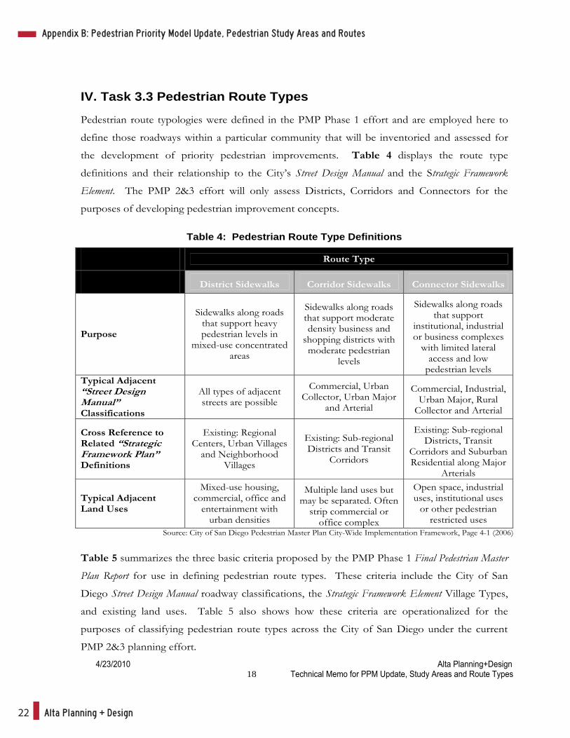
IV. Task 3.3 Pedestrian Route Types
Pedestrian route typologies were defined in the PMP Phase 1 effort and are employed here to
define those roadways within a particular community that will be inventoried and assessed for
the development of priority pedestrian improvements. Table 4 displays the route type
definitions and their relationship to the City’s Street Design Manual and the Strategic Framework
Element. The PMP 2&3 effort will only assess Districts, Corridors and Connectors for the
purposes of developing pedestrian improvement concepts.
Table 4: Pedestrian Route Type Definitions
Route Type
District Sidewalks Corridor Sidewalks Connector Sidewalks
Purpose
Sidewalks along roads that support heavy pedestrian levels in
mixed-use concentrated areas
Sidewalks along roads that support moderate density business and
shopping districts with moderate pedestrian
levels
Sidewalks along roads that support
institutional, industrial or business complexes
with limited lateral access and low
pedestrian levels Typical Adjacent “Street Design Manual” Classifications
All types of adjacent streets are possible
Commercial, Urban Collector, Urban Major
and Arterial
Commercial, Industrial, Urban Major, Rural
Collector and Arterial
Cross Reference to Related “Strategic Framework Plan” Definitions
Existing: Regional Centers, Urban Villages
and Neighborhood Villages
Existing: Sub-regional Districts and Transit
Corridors
Existing: Sub-regional Districts, Transit
Corridors and Suburban Residential along Major
Arterials
Typical Adjacent Land Uses
Mixed-use housing, commercial, office and
entertainment with urban densities
Multiple land uses but may be separated. Often
strip commercial or office complex
Open space, industrial uses, institutional uses
or other pedestrian restricted uses
Source: City of San Diego Pedestrian Master Plan City-Wide Implementation Framework, Page 4-1 (2006)
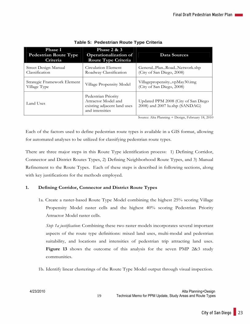
Table 5 summarizes the three basic criteria proposed by the PMP Phase 1 Final Pedestrian Master
Plan Report for use in defining pedestrian route types. These criteria include the City of San
Diego Street Design Manual roadway classifications, the Strategic Framework Element Village Types,
and existing land uses. Table 5 also shows how these criteria are operationalized for the
purposes of classifying pedestrian route types across the City of San Diego under the current
PMP 2&3 planning effort.
Appendix B: Pedestrian Priority Model Update, Pedestrian Study Areas and Routes
City of San Diego 23
Final Draft Pedestrian Master Plan
4/23/2010 Alta Planning+Design 19 Technical Memo for PPM Update, Study Areas and Route Types
Table 5: Pedestrian Route Type Criteria
Phase I Pedestrian Route Type
Criteria
Phase 2 & 3 Operationalization of Route Type Criteria
Data Sources
Street Design Manual Classification
Circulation Element Roadway Classification
General_Plan_Road_Network.shp (City of San Diego, 2008)
Strategic Framework Element Village Type Village Propensity Model Villagepropensity_vpMay30.img
(City of San Diego, 2008)
Land Uses
Pedestrian Priority Attractor Model and existing adjacent land uses and intensities
Updated PPM 2008 (City of San Diego 2008) and 2007 lu.shp (SANDAG)
Source: Alta Planning + Design, February 18, 2010
Each of the factors used to define pedestrian route types is available in a GIS format, allowing
for automated analyses to be utilized for classifying pedestrian route types.
There are three major steps in this Route Type identification process: 1) Defining Corridor,
Connector and District Routes Types, 2) Defining Neighborhood Route Types, and 3) Manual
Refinement to the Route Types. Each of these steps is described in following sections, along
with key justifications for the methods employed.
1. Defining Corridor, Connector and District Route Types
1a. Create a raster-based Route Type Model combining the highest 25% scoring Village
Propensity Model raster cells and the highest 40% scoring Pedestrian Priority
Attractor Model raster cells.
Step 1a justification: Combining these two raster models incorporates several important
aspects of the route type definitions: mixed land uses, multi-modal and pedestrian
suitability, and locations and intensities of pedestrian trip attracting land uses.
Figure 13 shows the outcome of this analysis for the seven PMP 2&3 study
communities.
1b. Identify linear clusterings of the Route Type Model output through visual inspection.
Alta Planning + Design24
2/24/2011 Alta Planning+Design 20 Technical Memo for PPM Update, Study Areas and Route Types
1c. Overlay the circulation element roadways on the Route Type Model output and
assess the relationship between the linear clusterings of the Route Type Model
output and the locations of the circulation element roadways. Corridors and
Connectors are primarily distinguished by the fact that Corridors are very directly
related to the linear clusterings of the Route Type Model, while Connectors are not.
Corridors are defined along circulation element roadways that run continuous along
linear clusterings of the Route Type Model output, ensuring adjacency to the types of
land uses and expected pedestrian activity associated with Corridor routes.
Connectors are defined along circulation element roadways that may touch or
traverse the Route Type Model output, but are not primarily correlated with the
linear clusterings.
1d. Preliminary District route type locations will be considered at locations where two
Corridor routes intersect, indicating high levels of land use types and pedestrian
activity associated with Districts. District locations will be finalized in the last step of
this process when manual refinements take place.
Steps 1b-1d justification: Output from the Route Type Model clearly shows linear
clusterings of pedestrian attracting land uses, mixed land uses and locations with high
levels of pedestrian suitability. The ability of the Route Type Model output for
distinguishing between Corridors and Connectors was confirmed by comparing
existing land uses located adjacent to the routes – especially open space, industrial,
and institutional land uses – which are a key distinguishing characteristic between
Corridors and Connectors. Connectors are mostly adjacent to open space,
residential, industrial or institutional land uses, while Corridors would typically be
adjacent to commercial land uses. Local knowledge about areas with moderate to
high levels of pedestrian activity was also used to confirm the Route Type Model
output capability to distinguish Corridors from Connectors. These assessments
supported the conclusion that the Route Type Model does successfully distinguish
between Corridors and Connectors.
Appendix B: Pedestrian Priority Model Update, Pedestrian Study Areas and Routes

City of San Diego 25
Final Draft Pedestrian Master Plan
Figu
re 1
3:Ro
ute
Type
Mod
el
805
15
5
94
816
3
Hig
h V
illag
e Pr
open
sity
(To
p 25
%)
Hig
h A
ttrac
tors
Mod
el S
core
(To
p 40
%)
Pede
stria
n Pl
an C
omm
uniti
es
Com
bine
d H
igh
Vill
age
Prop
ensi
ty /
Hig
h A
ttrac
tor
Alta Planning + Design26
2/24/2011 Alta Planning+Design 22 Technical Memo for PPM Update, Study Areas and Route Types
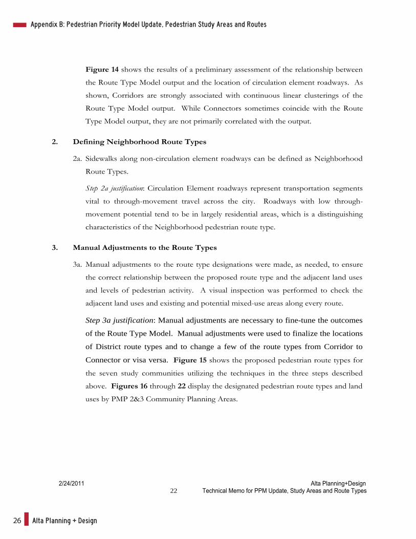
Figure 14 shows the results of a preliminary assessment of the relationship between
the Route Type Model output and the location of circulation element roadways. As
shown, Corridors are strongly associated with continuous linear clusterings of the
Route Type Model output. While Connectors sometimes coincide with the Route
Type Model output, they are not primarily correlated with the output.
2. Defining Neighborhood Route Types
2a. Sidewalks along non-circulation element roadways can be defined as Neighborhood
Route Types.
Step 2a justification: Circulation Element roadways represent transportation segments
vital to through-movement travel across the city. Roadways with low through-
movement potential tend to be in largely residential areas, which is a distinguishing
characteristics of the Neighborhood pedestrian route type.
3. Manual Adjustments to the Route Types
3a. Manual adjustments to the route type designations were made, as needed, to ensure
the correct relationship between the proposed route type and the adjacent land uses
and levels of pedestrian activity. A visual inspection was performed to check the
adjacent land uses and existing and potential mixed-use areas along every route.
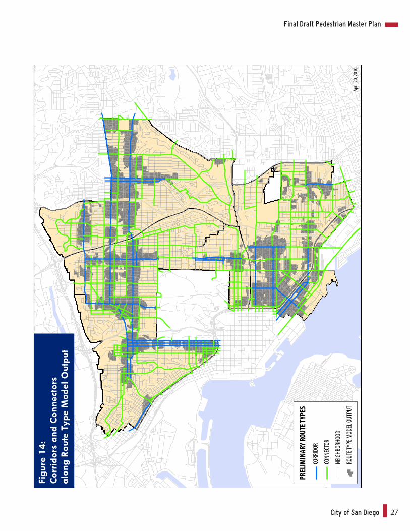
Step 3a justification: Manual adjustments are necessary to fine-tune the outcomes
of the Route Type Model. Manual adjustments were used to finalize the locations
of District route types and to change a few of the route types from Corridor to
Connector or visa versa. Figure 15 shows the proposed pedestrian route types for
the seven study communities utilizing the techniques in the three steps described
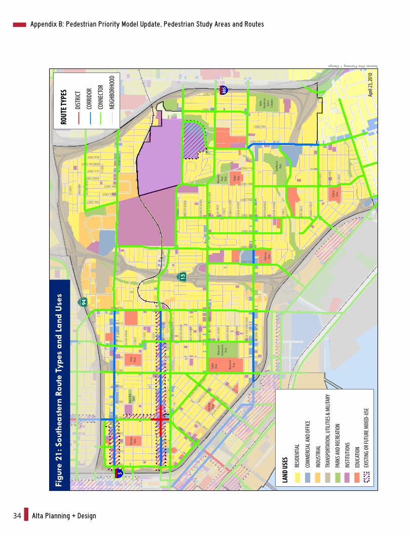
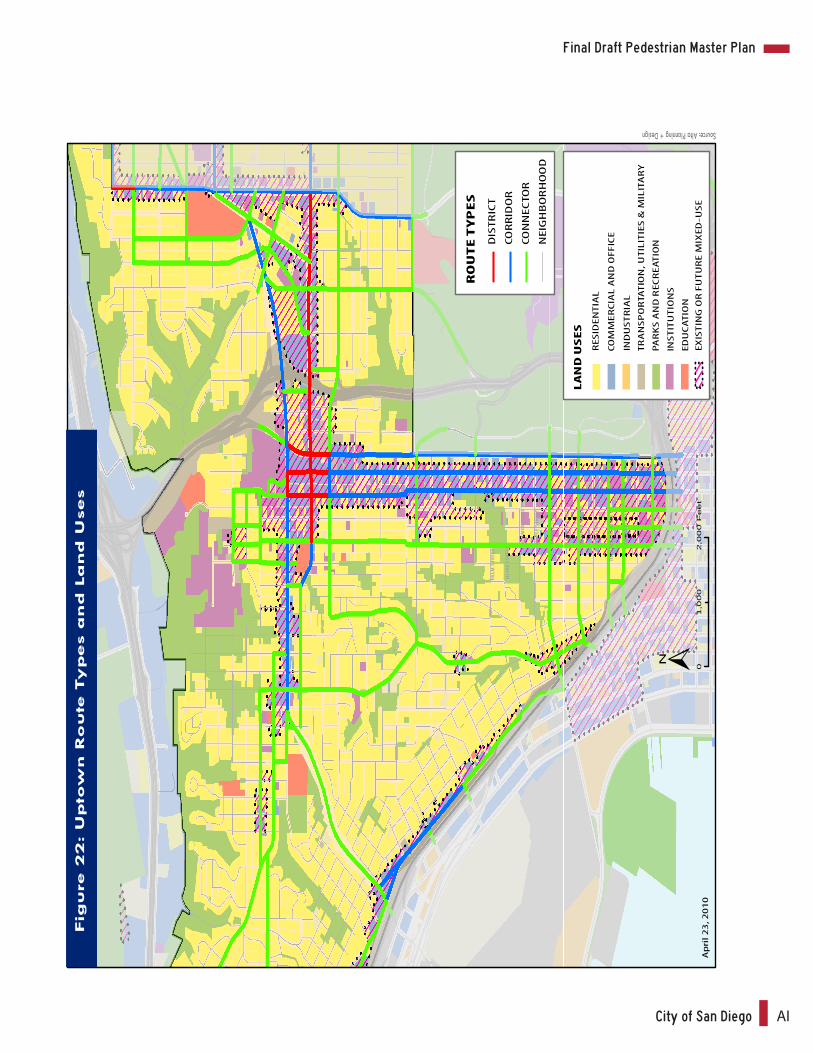
above. Figures 16 through 22 display the designated pedestrian route types and land
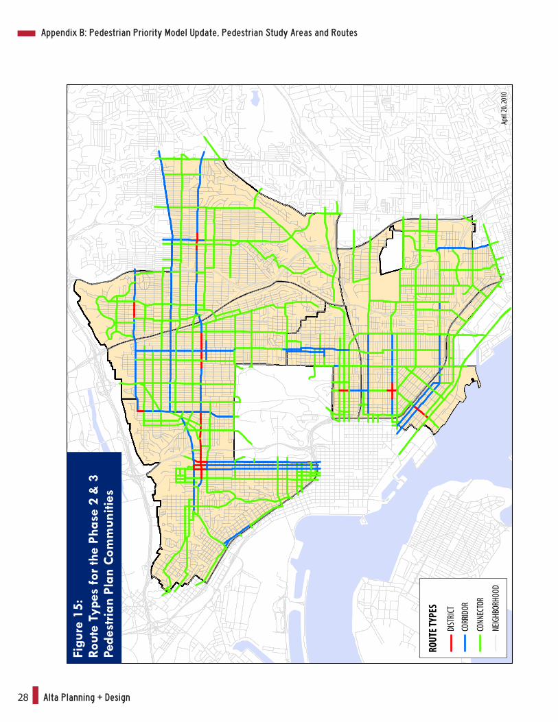
uses by PMP 2&3 Community Planning Areas.
Appendix B: Pedestrian Priority Model Update, Pedestrian Study Areas and Routes
City of San Diego 27
Final Draft Pedestrian Master Plan
Figu
re 1
4:Co
rrid
ors
and
Con
nect
ors
alon
g Ro
ute
Type
Mod
el O
utpu
t
PREL
IMIN
ARY R
OUTE
TYPE
S
CORR
IDOR
CONN
ECTO
R
NEIG
HBOR
HOOD
ROUT
E TYP
E MOD
EL OU
TPUT
April
20, 2
010
Alta Planning + Design28
Figu
re 1
5:Ro
ute
Type
s fo
r the
Pha
se 2
& 3
Pede
stria
n Pl
an C
omm
uniti
es
ROUT
E TYP
ES
DIST
RICT
CORR
IDOR
CONN
ECTO
R
NEIG
HBOR
HOOD
April
20, 2
010
Appendix B: Pedestrian Priority Model Update, Pedestrian Study Areas and Routes
City of San Diego 29
Final Draft Pedestrian Master Plan
15
75
5
098
049
0Fe
et
San
Dieg
o Ba
y
COMM
ERCI
AL ST
REET LOGA
N AVEN
UENAT
IONAL A
VENUE NEW
TON AVEN
UEMAIN ST
REET
HARBO
R DRIV
E
SIGSBEE S
TREET
16th STREET
BEARDSLEY STR
EET
CESAR E C
HAVEZ PARKWAY
EVANS ST
REET
SAMPSON STREET
SICARD STREET
BOST
ON AV
ENUE
NEWT
ON AV
ENUE
NATIO
NAL A
VENU
E
27th STREET
28th STREET
29th STREET
30th STREET
31st STREET
32nd STREET
MAIN
STRE
ET
26th STREET
RIGEL STREET
THOR STREET
UNA STREET
VESTA STR
EET WODEN STREET
DALBER
GIA STREE
TMAIN ST
REET
SIVA STR
EET
WABASH BOULEVARD
BAY FR
ONT STRE
ET
BELT S
TREET
HARB
OR D
RI VE
Chica
noPa
rk
Cros
byStr
eet
Park
Perk
insEle
m.Sch
ool
Source: Alta Planning + Design
RESID
ENTIA
L
COM
MERC
IAL A
ND O
FFICE
INDU
STRI
AL
TRAN
SPOR
TATIO
N, U
TILITI
ES &
MILI
TARY
PARK
S AND
RECR
EATIO
N
INST
ITUTIO
NS
EDUC
ATIO
N
LAND
USE
S
EXIST
ING
OR FU
TURE
MIX
ED-U
SE
Figu
re 1
6: B
arrio
Log
an R
oute
Typ
es a
nd L
and
Use
s
April
23, 2
010
ROUT
E TYP
ES
DIST
RICT
CORR
IDOR
CONN
ECTO
R
NEIG
HBOR
HOOD
Alta Planning + Design30
15
805
94
15
805
Colinadel SolParkCentral
Elem.School
EdisonElem.School
EuclidElem.School
HamiltonElem.School
MarshallElem.School
RowanElem.School
RosaParksElem.School
City HeightsVillageCommunity Park
WilsonMiddleSchool
Monroe ClarkMiddleSchool
Parkde laCruz
AzaleaPark
UNIVERSITY AVENUE
EL CAJON BOULEVARD
POLK AVENUE
ORANGE AVENUE
WIGHTMAN STREET
LANDIS STREET
41st
STRE
ET
MARL
BORO
UGH
STRE
ET
42nd
STRE
ET
VAN
DYKE
AVEN
UE
DWIGHT STREET
MYRTLE AVENUE
THORN STREET
REDWOOD STREET
QUINCE STREET
43rd
STRE
ET
44th
STRE
ET
FAIR
MOUN
T AVE
NUE
HIGH
LAND
AVEN
UE
45th
STRE
ET
CHAM
OUNE
AVEN
UE
46th
STRE
ET
MENL
O AV
ENUE
47th
STRE
ET
EUCL
ID AV
ENUE
48th
STRE
ET
ESTR
ELLA
AVEN
UE
49th
STRE
ET
WINO
NA AV
ENUE
50th
STRE
ET
ALTA
DENA
AVEN
UE
51st
STRE
ET
52nd
STRE
ET
54th
STRE
ET
HOME AVEN
UE
FEDE RAL BOULEVARD
PARRO
T STRE
ET
39th
STRE
ET
MIDV
ALE D
RIVE
REXF
ORD
DRIV
E
CREN
SHAW
STRE
ET
TULIP
STRE
ET
GATEWAY DRIVE
EUCLID AVENUE
RIDGE
VIEW DR
IVE
FAI RM OUNT AVENUE
0 2,0001,000 Feet
33rd
STRE
ET
34th
STRE
ET
FELTO
N ST
REET
SWIFT
AVEN
UE
35th
STRE
ET
37th
STRE
ET
38th
STRE
ET
39th
STRE
ET
40th
STRE
ET
CENT
RAL A
VENU
E
CHER
OKEE
AVEN
UE
WILS
ON AV
ENUE
36th
STRE
ET
RESIDENTIAL
COMMERCIAL AND OFFICE
INDUSTRIAL
TRANSPORTATION, UTILITIES & MILITARY
PARKS AND RECREATION
INSTITUTIONS
EDUCATION
LAND USES
EXISTING OR FUTURE MIXED-USE
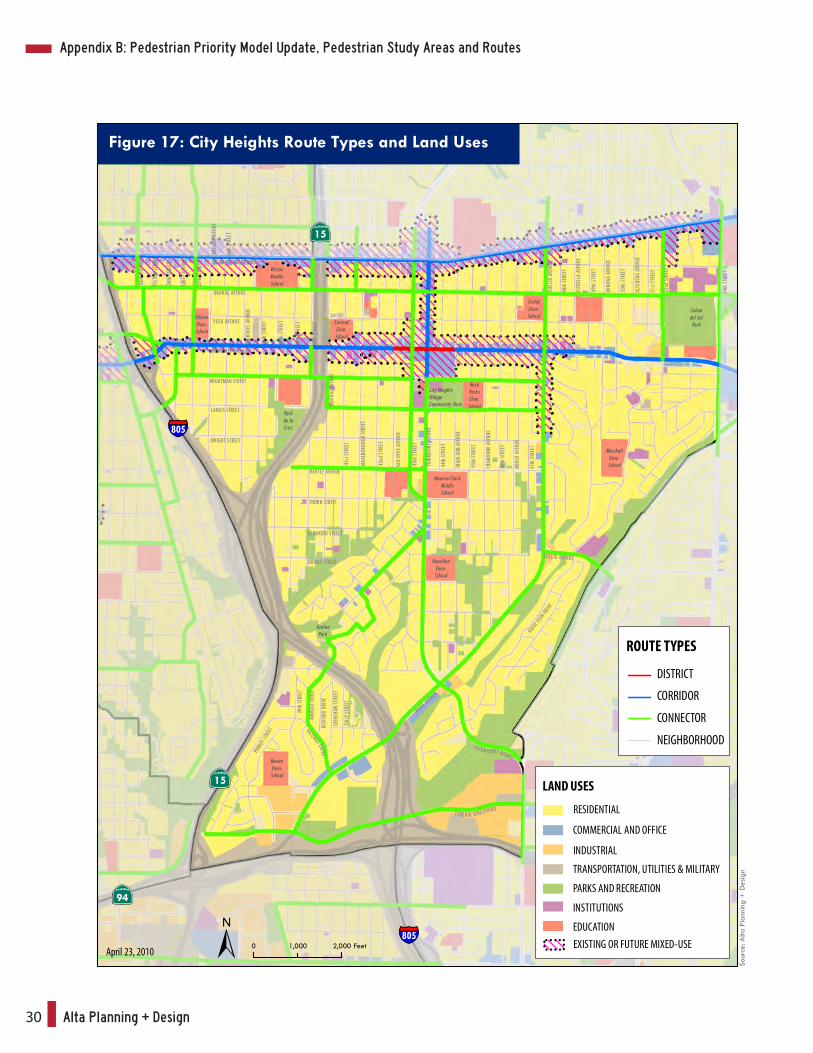
Figure 17: City Heights Route Types and Land Uses
April 23, 2010
ROUTE TYPES
DISTRICT
CORRIDOR
CONNECTOR
NEIGHBORHOODSo
urce
: Alta
Pla
nnin
g +
Des
ign
Appendix B: Pedestrian Priority Model Update, Pedestrian Study Areas and Routes
City of San Diego 31
Final Draft Pedestrian Master Plan
19th STREET
RUSS
BOUL
EVAR
D
A STR
EET
B STR
EET
C STR
EET
BROA
DWAY
E STR
EET
F STR
EET
20th STREET
21st STREET
22nd STREET
23rd STREET
24th STREET
25th STREET
26th STREET
27th STREET
28th STREET
GLENDALE AVENUE
29th STREET
30th STREET
31st STREET
EDGEMONT STREET
32nd STREET
33rd STREET
34th STREET
FERN STREET
30th STREET
ASH
STRE
ET
BEEC
H ST
REET
CEDA
R STR
EET
DATE
STRE
ET
ELM
STRE
ET
FIR ST
REET
GRAP
E STR
EET
HAWT
HORN
STRE
ET
IVY ST
REET
JUNI
PER S
TREE
T
BANCROFT STREET
33rd STREET
FELTON STREET
GREGORY STREET
15
5
94
BALB
OAPA
RK
Albe
rt Ein
stein
Acad
emies
Golde
n Hill
Eleme
ntar
ySch
ool
099
049
5Fe
et
RESID
ENTIA
L
COM
MERC
IAL A
ND O
FFICE
INDU
STRI
AL
TRAN
SPOR
TATIO
N, U
TILITI
ES &
MILI
TARY
PARK
S AND
RECR
EATIO
N
INST
ITUTIO
NS
EDUC
ATIO
N
LAND
USE
S
EXIST
ING
OR FU
TURE
MIX
ED-U
SE
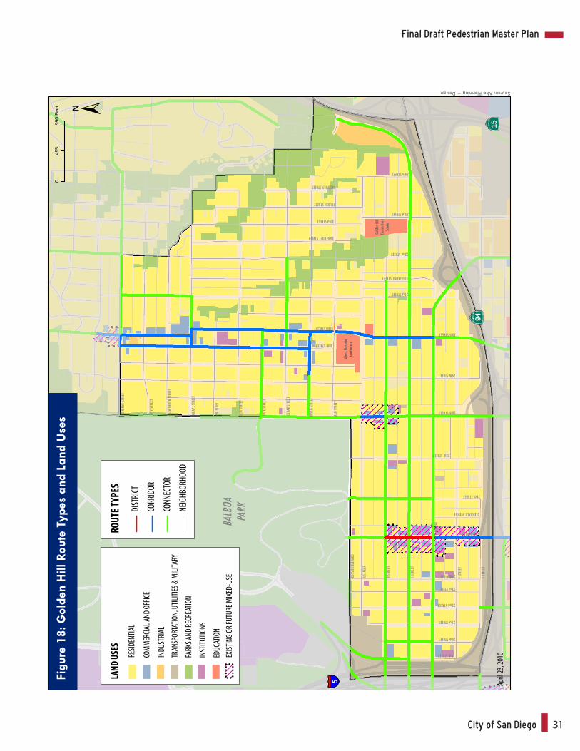
Figu
re 1
8: G
olde
n H
ill R
oute
Typ
es a
nd L
and
Use
s
April
23, 2
010
ROUT
E TYP
ES
DIST
RICT
CORR
IDOR
CONN
ECTO
R
NEIG
HBOR
HOOD
Source: Alta Planning + Design
Alta Planning + Design32
AdamsAvenue
Park
39th StreetNeighborhood
Park
AdamsElementary
SchoolNormal Heights
ElementarySchool
ADAMS AVENUE
COLLIER AVENUE
COPLEY AVENUE
MADISON AVENUE
MONROE AVENUE
MEADE AVENUE
32nd
STRE
ET
33rd
STRE
ET
34th
STRE
ET
36th
STRE
ET
37th
STRE
ET
38th
STRE
ET
39th
STRE
ET
BANC
ROFT
STRE
ET
FELTO
N ST
REET
34th
STRE
ET
FELTO
N ST
REET
33rd
STRE
ET
33rd
PLAC
E
HAWL
EY BO
ULEV
ARD
SWIFT
AVEN
UE
35th
STRE
ET
WILS
ON AV
ENUE
38th
STRE
ET
39th
STRE
ET
McCL
INTO
CK ST
REET
CHER
OKEE
AVEN
UE
37th
STRE
ET
CHER
OKEE
AVEN
UE
36th
STRE
ET
WILS
ON AV
ENUE
EAST MOUNTAIN VIEW DRIVE
NORT
H MOU
NTAIN VIE
W DRIVE
EL CAJON BOULEVARD
35th
STRE
ET
HAWL
EY BO
ULEV
ARD
BENT
ON PL
ACE
EUGENE PLACE
LITCHFIELD ROADKENMORE TRAIL WE
ST M
OUNT
AIN V
IEW DRIV
E
Sour
ce: A
lta P
lann
ing
+ D
esig
n (O
ctob
er 2
008)
805
15
8
RESIDENTIAL
COMMERCIAL AND OFFICE
INDUSTRIAL
TRANSPORTATION, UTILITIES & MILITARY
PARKS AND RECREATION
INSTITUTIONS
EDUCATION
LAND USES
EXISTING OR FUTURE MIXED-USE
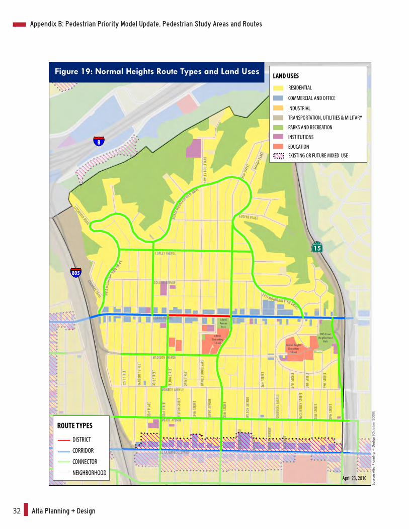
Figure 19: Normal Heights Route Types and Land Uses
April 23, 2010
ROUTE TYPES
DISTRICT
CORRIDOR
CONNECTOR
NEIGHBORHOOD
Sour
ce: A
lta P
lann
ing
+ D
esig
n
Appendix B: Pedestrian Priority Model Update, Pedestrian Study Areas and Routes
City of San Diego 33
Final Draft Pedestrian Master Plan
ADAMS AVENUE
FLOR
IDA
STRE
ET
MADISON AVENUE
MONROE AVENUE
MEADE AVENUE
EL CAJON BOULEVARD
HOWARD AVENUE
POLK AVENUE
LINCOLN AVENUE
UNIVERSITY AVENUE
ALAB
AMA
STRE
ET
MISS
ISSIP
PI ST
REET
LOUI
SIANA
STRE
ET
TEXA
S STR
EET
ARIZ
ONA S
TREE
T
HAMI
LTON
STRE
ET
OREG
ON ST
REET
IDAH
O ST
REET
UTAH
STRE
ET
KANS
AS ST
REET
30th
STRE
ET
OHIO
STRE
ET
ILLIN
OIS S
TREE
T
ROBINSON AVENUE
MYRTLE AVENUE
UPAS STREET
WIGHTMAN STREET
LANDIS STREET
DWIGHT STREET
NORTH PARK WAY
GUNN STREET
LANDIS STREET
DWIGHT STREET
CAPPS STREET
MYRTLE AVENUE
RAY S
TREE
T
GRIM
AVEN
UE
31st
STRE
ET
HERM
AN AV
ENUE
32nd
STRE
ET
BANC
ROFT
STRE
ET
BOUNDARY STREETNILE STREET
VANCOUVER AVENUE
PALM STREET
THORN STREET
REDWOOD STREET
NUTMEG STREET
MAPLE STREET
LAUREL STREET
JUNIPER STREET
30th
STRE
ET
31st
STRE
ET
32nd
STRE
ET
BANC
ROFT
STRE
ET
33rd
STRE
ET
FELTO
N ST
REET
GREG
ORY S
TREE
T
34th
STRE
ET
QUINCE STREET
THORN STREET
REDWOOD STREET
QUINCE STREET
MAPLE STREET
MISSION AVENUE
MontclairPark
NorthPark
Comm-unityPark
Morley FieldSports Complex
St. AugustineHigh School
McKinleyElementary
School
Balboa ParkMunicipal
Golf Course
BALBOAPARK
0 975487.5 Feet
PARK
BOUL
EVAR
D
GEOR
GIA
STRE
ET
PARK
BOUL
EVAR
DIN
DIAN
A ST
REET
UPAS STREET
15
15
805
805
RESIDENTIAL
COMMERCIAL AND OFFICE
INDUSTRIAL
TRANSPORTATION, UTILITIES & MILITARY
PARKS AND RECREATION
INSTITUTIONS
EDUCATION
LAND USES
EXISTING OR FUTURE MIXED-USE
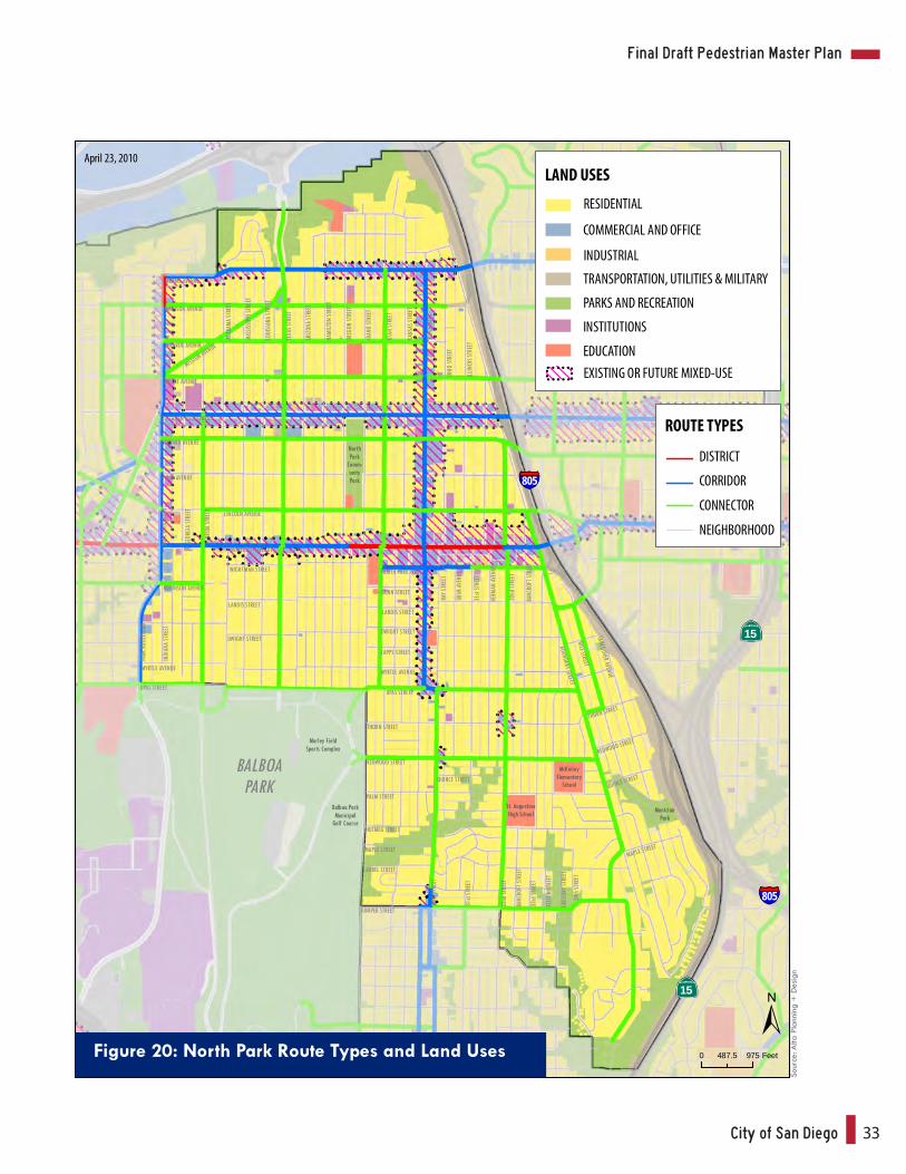
Figure 20: North Park Route Types and Land Uses
ROUTE TYPES
DISTRICT
CORRIDOR
CONNECTOR
NEIGHBORHOOD
April 23, 2010
Sour
ce: A
lta P
lann
ing
+ D
esig
n
Alta Planning + Design34
805
94
15
5
Memo
rial
Comm
unity
Park
Gran
t Hill
Park
Sout
hcre
stPa
rk
Willie
Hend
erso
nSp
orts
Comp
lex
Moun
tain
View
Park
Sher
man
Elem.
King
Elem.
Burb
ank
Elem.
Loga
nEle
m.
Memo
rial
Prep
.
Emer
son
Elem.
Bake
rEle
m.
Balbo
aEle
m.
MARK
ET ST
REET
ISLAN
D AV
ENUE
J STR
EET
K STR
EET
L STR
EET
IMPE
RIAL
AVEN
UE
COMM
ERCI
AL ST
REET
WEBS
TER A
VENU
E
CLAY
AVEN
UE
FRAN
KLIN
AVEN
UE
19th STREET
21th STREET
24th STREET
25th STREET
26th STREET
27th STREET
28th STREET
31st STREET
32nd STREET
CESAR CHAVEZ PARKWAY
OCEA
N VIE
W BO
ULEV
ARD
DEWEY STREET KEARN
Y AVEN
UE
JULIAN A
VENUEHA
RRISO
N AVEN
UE
OCEAN V
IEW BO
ULEVARD
VALL
E AVE
NUE
MART
IN AV
ENUE
GREE
LY AV
ENUE
OCEA
N VIE
W BO
ULEV
ARD
NATIO
NAL A
VENU
E
29th STREETIM
PERI
AL AV
ENUE
WEBS
TER A
VENU
E
FRAN
KLIN
AVEN
UE
OCEA
N VIE
W BO
ULEV
ARD
TEAK
STRE
ET
35th STREET
36th STREET
37th STREET
38th STREET
39th STREET
40th STREET
41st STREET
43rd STREET
T STR
EET
FLOR
ENCE
STRE
ET
LOGA
N AV
ENUE
C STR
EET
BROA
DWAY
HILL
TOP S
TREE
T
F STR
EET
39th STREET
RAVEN STREET
41st STREET
MORRISON STREET
42nd STREET
40th STREET
QUAIL STREET
MARK
ET ST
REET
45th STREET
46th STREET
NEWT
ONAV
ENUE
BOST
ON AV
ENUE
Z STR
EET
NATIO
NAL A
VENU
E
BETA
STRE
ET
GAMM
A ST
REET
DELTA
STRE
ET
EPSIL
ON ST
REET
ETA
STRE
ET
44th STREET
Source: Alta Planning + Design
SAMPSON STREET
SICARD STREET
RESID
ENTIA
L
COM
MERC
IAL A
ND O
FFICE
INDU
STRI
AL
TRAN
SPOR
TATIO
N, U
TILITI
ES &
MILI
TARY
PARK
S AND
RECR
EATIO
N
INST
ITUTIO
NS
EDUC
ATIO
N
LAND
USE
S
EXIST
ING
OR FU
TURE
MIX
ED-U
SE
Figu
re 2
1: S
outh
east
ern
Rout
e Ty
pes
and
Land
Use
s
April
23, 2
010
ROUT
E TYP
ES
DIST
RICT
CORR
IDOR
CONN
ECTO
R
NEIG
HBOR
HOOD
Appendix B: Pedestrian Priority Model Update, Pedestrian Study Areas and Routes
City of San Diego AI
Final Draft Pedestrian Master Plan
PALM
STR
EET
OLI
VE
STR
EET
NU
TMEG
STR
EET
MA
PLE
STR
EET
LAU
REL
STREE
T
KA
LMIA
STR
EET
JUN
IPER
STR
EET
IVY S
TREE
T
HAW
THO
RN
E S
TREE
T
GRA
PE
STREET
10/2
0/0
90
2,0
00
1,0
00
Fee
t
RES
IDE
NT
IAL
COM
ME
RC
IAL
AN
D O
FFIC
E
IND
US
TR
IAL
TRA
NS
PO
RTA
TIO
N, U
TILI
TIE
S &
MIL
ITA
RY
PAR
KS
AN
D R
ECR
EA
TIO
N
INS
TIT
UT
ION
S
EDU
CA
TIO
N
LA
ND
US
ES
EXIS
TIN
G O
R F
UT
UR
E M
IXED
-US
E
Fig
ure
22
: U
pto
wn R
oute
Ty
pes a
nd L
and
Uses
RO
UT
E T
YP
ES
DIS
TRIC
T
COR
RID
OR
CON
NE
CTO
R
NEI
GH
BO
RH
OO
D
Ap
ril
23
, 20
10
Source: Alta Planning + Design

Related Documents


