FINAL APPENDIX B E+C Highway Network Technical Memorandum May 2006 Prepared for: Prepared by:

Welcome message from author
This document is posted to help you gain knowledge. Please leave a comment to let me know what you think about it! Share it to your friends and learn new things together.
Transcript

FINAL
APPENDIX B
E+C Highway Network Technical Memorandum
May 2006 Prepared for: Prepared by:
P. O. Box 1526 703 Crossover Road Tupelo, MS 38802
Phone (662) 842-7381 Fax (662) 844-4564 www.cookcoggin.com
Page 1 of 10
E&C Highway NetworkTechnical Memorandum
To: Jim Lee, PE/HDR Project Manager
From: James W. Epps, PhD, PE, PTOE (Cook Coggin) Project: Tupelo RR Relocation Planning Study
CC:
Date: 18 November 2005 Job No:

P. O. Box 1526 703 Crossover Road Tupelo, MS 38802
Phone(662) 842-7381 Fax (662) 844-4564 www.cookcoggin.com
Page 2 of 10
Table of Contents Section No. Page No. 1.0 PURPOSE 3 2.0 GENERAL MAP DESCRIPTION 3 2.1 Sources of Information 3 2.2 Contents 3 2.3 Scale 4 2.4 Compatibility 4 3.0 ROADWAY CLASSIFICATIONS 4 3.1 Existing Primary Federal/State Highways 4 3.2 Committed Primary Federal/State Highways 5 3.3 Secondary State Highways 6 3.4 Existing County Highways/City Streets 6 3.5 Committed City Streets 7 3.6 PUL Site Infrastructure 8 4.0 SUMMARY 9

P. O. Box 1526 703 Crossover Road Tupelo, MS 38802
Phone(662) 842-7381 Fax (662) 844-4564 www.cookcoggin.com
Page 3 of 10
1.0 PURPOSE The Mississippi Department of Transportation (MDOT) has retained HDR Engineering, Inc., including its team of sub-consultants (HDR Team), to provide a Railroad Relocation Planning and Environmental Study. The purpose of this project is to identify, develop, and evaluate potential alternatives for rerouting existing railroads from the central business district of the City of Tupelo, Mississippi. Additionally, the project shall secure a record of decision for the Environmental Impact Statement (EIS). Multiple deliverables identified in the Scope of Services require an inventory and evaluation of the existing and committed roadway network within the proposed study area. In addition to this document, the major deliverable associated with the existing and committed roadway network is a large-scale graphic that will depict the entire roadway network in the study area. In addition to the existing roadways, the committed roadway developments as perceived by the Tupelo Major Thoroughfare Program Oversight and Lobbying Committee; as advanced by the Vision 21 Highway Program of the Mississippi Department of Transportation; and as proposed as a part of the Project Wellspring development of the Pontotoc/Union/Lee Counties PUL Alliance, are also provided. 2.0 GENERAL MAP DESCRIPTION The generated graphic of the existing and committed (EC) roadway systems of the proposed study area of approximately 485 square miles is intended to illustrate the complete existing roadway system and provide an indication of where future committed development will provide additional roadway infrastructure. This graphic document is provided in hard copy as a full scale 30-inch by 30-inch drawing, and electronically as a Microstation DGN file as well as a Adobe PDF file. 2.1 Sources of Information
The Lee County portion of the EC Roadway Systems map was originally generated from US Geological Survey (USGS) quadrangle maps and highway maps from the Mississippi Department of Transportation. This map has been updated continuously as development was advanced over the years. The Pontotoc County and Union County portions of the map were secured from roadway maps from the Mississippi Department of Transportation. The committed state highways in Pontotoc and Lee Counties were located from construction plans and from drawings of the Vision 21 Program as provided by the Mississippi Department of Transportation. The committed local roadways and streets in the Tupelo area were provided from planned drawings from the Tupelo Major Thoroughfare Program Oversight and Lobbying Committee. The committed transportation infrastructure for the Project Wellspring development were provided by the Pontotoc/Union/Lee Counties (PUL) Alliance Supersite Development Evaluation: Draft Report of Preliminary Engineering Services (Cook Coggin Engineers, Inc., January 2004). The traffic volume data were derived from the 2004 AADT maps for Tupelo, Lee County, Pontotoc County and Union County, as produced by the Planning Division of the Mississippi Department of Transportation. These maps are available on the MDOT internet web site, and the traffic data as derived from the maps are subject to the precision disclaimer as provided on the site. 2.2 Contents The EC Roadway Systems map contains a complete record of the existing and committed highway and

P. O. Box 1526 703 Crossover Road Tupelo, MS 38802
Phone(662) 842-7381 Fax (662) 844-4564 www.cookcoggin.com
Page 4 of 10
rail infrastructures in the proposed study area in Lee, Pontotoc and Union Counties. The various functional classifications of highway systems are provided on individual layers within the drawing file so that a user may examine selected combinations of roadway classes by simply turning the layers on and off. The selected drawing layers are as follows: 0. Base Map Features
1. Primary Federal/State Highway System (solid: existing; dashed: committed) 2. Secondary State Highway System 3. County Highway System 4. City Street System (solid: existing; dashed: committed) 5. Committed Tupelo Thoroughfare Program 6. Committed PUL Site Infrastructure 2.3 Scale The scale of the full-scale map of existing and committed highway system infrastructure in the proposed study area of Lee, Pontotoc and Union Counties is one inch = one mile (5,280 feet). The scale is indicated in the upper right corner of the map. 2.4 Compatibility The graphic system as advanced has been developed in a Microstation DGN (version 8) format. This format is universally accepted graphic/CADD format, and could be imported into most integrated mapping systems, including ArcMap (version 9.x). Adobe PDF files are provided as version 7.0. 3.0 ROADWAY FUNCTIONAL CLASSIFICATIONS Six (6) different roadway classifications are presented in the existing/committed (EC) roadway system graphic. Each of the roadway classifications is presented on a particular drawing layer on the master drawing based on its functional classification. Within the same drawing layer, a solid (or double solid) line is used to indicate an existing highway, while a broken (or double broken) line is used to indicate an existing highway. The first drawing layer provides all of the Primary Federal and State highways in the study area. A primary highway is defined as all federal highways and the state highways that have four or more lanes. The second classification includes the Secondary State highways, which include the remainder of the state highways that are two lanes in width. The third classification is the County highways, and the fourth classification includes the City Streets. The fifth classification includes only the committed local streets, and has only the local streets identified in the Tupelo Major Thoroughfare Program Phase 4 plan of study. The final classification is the planned roadway system for the PUL Wellspring Site development along US Highway 78 at Blue Springs just west of Sherman, MS. Each of these roadway classifications are discussed in detail relative to their impacts on the relocation of one or more of the railroad lines in the affected study area. 3.1 Existing Primary Federal/State Highways There are three (3) existing federal highways in the study area. US Highway 78 is a four-lane rural principal arterial which provides a 70-mph speed limit with complete control of access, and traverses the

P. O. Box 1526 703 Crossover Road Tupelo, MS 38802
Phone(662) 842-7381 Fax (662) 844-4564 www.cookcoggin.com
Page 5 of 10
northern portion of the study area from west to east. In 2004, average daily traffic (ADT) volumes along this section of highway ranged from 20,000 to 23,000 vehicles per day. This highway is a designated part of the National Highway System, and has been proposed to be Interstate Highway 22, connecting Memphis, TN, to Birmingham, AL. When certain designated improvements have been made to the alignment in the three adjoining states, the Interstate designation will become a reality. US Highway 45 is a four-lane rural principal arterial with a 65-mph speed limit and partial control of access. The highway runs along the eastern boundary of the proposed study area from south to north. The 2004 ADT volumes along this section of highway ranges from 23,000 to 31,000 vpd. This highway is also a designated part of the National Highway System, and was widened and improved in the state’s 1987 Highway Program. The Natchez Trace Parkway is a 444-mile two-lane highway that is maintained by the National Park Service and links Natchez, MS, to Nashville, TN. Commercial truck traffic is prohibited on this scenic highway that provides a 50-mph speed limit and partial control of access. Numerous camping grounds, picnic areas, biking and hiking trails, scenic overlooks and designated historical sites line this highway throughout its length. 2004 ADT volumes ranged from 4,700 to 7,400 vpd along this highway as it traversed the proposed study area along the western edge of the Tupelo city limits. 3.2 Committed Primary Federal/State Highways Vision 21 is the Mississippi Department of Transportation construction program which outlines a 45-year plan for improving the state’s highway system as authorized by the 2002 Mississippi State Legislature. There are three state highways located within the proposed study area that are scheduled for construction in the Vision 21 program. Two of these highways, MS Highways 9 and 15, are existing highways that will be widened and improved, while the third, MS Highway 76, will be a new four-lane divided alignment from MS Highway 6 near Pontotoc, MS, to MS Highway 45 south of Tupelo. MS Highway 9 is scheduled to be widened to a four-lane divided alignment from MS 6 east of Pontotoc along the existing alignment to the intersection of US Highway 78 near Sherman, MS. Preliminary plans for the project have been developed by the MDOT, but right-of-way acquisitions have not as yet begun. Projected ADT volumes along the proposed alignment are expected to average 9,000 vpd near the intersection with US 78. MS Highway 15 is an existing two-lane highway which traverses the state from the Tennessee line in Tippah County to the Mississippi Gulf Coast near Biloxi, MS. The Vision 21 program calls a four-lane divided alignment to be provided with 65-mph design speeds. In the proposed study area, the 17-mile section of MS 15 from Pontotoc to New Albany in Union County is included, and currently, right-of-way acquisitions have begun. Projected ADT volumes along the proposed alignment are expected to average 12,000 vpd. MS Highway 76 is a new four-lane divided alignment that will connect the widened and improved MS Highway 6 west of Pontotoc and US Highway 45 south of Tupelo. Construction of the westernmost portion of the highway from MS 6 to MS Highway 9 has already been completed and is currently open to traffic. Construction contracts for the 6-mile section from MS 9 to MS 342 have been let, and construction is scheduled to be completed in September 2006. Construction contracts for the three remaining sections of the project from MS 342 to US 45 are all scheduled to be let from March to June 2006.

P. O. Box 1526 703 Crossover Road Tupelo, MS 38802
Phone(662) 842-7381 Fax (662) 844-4564 www.cookcoggin.com
Page 6 of 10
3.3 Secondary State Highways There are four (4) predominate secondary state highways in the proposed study area. Two of these highways are former federal highways that were relocated and improved to multi-lane, limited-access facilities. MS Highway 178 is the old two-lane alignment of US 78 and parallels the current US 78 alignment from the Tennessee state line to the Alabama state line. In the proposed study area, MS 178 is a two-lane highway from Sherman, MS to the western city limits of Tupelo. In Tupelo, through the central portion of the proposed study area, MS 178 (McCullough Boulevard) was widened to five lanes with a 55-mph speed limit as a part of the Tupelo Major Thoroughfare Program Phase 3. On the east side of Tupelo, MS 178 follows East Main Street as a four-lane highway, and then continues to the eastern boundary of the city limits as a two-lane highway. In 2004, ADT volumes were 3,300 vpd between Sherman and Belden, 18,000 vpd on McCullough Boulevard, and 7,100 vpd at the eastern city limits of Tupelo. MS Highway 145 is the old two-lane alignment of US Highway 45 and parallels the current US 45 alignment from Verona, MS north through Booneville, MS. In the proposed study area, MS 45 is a 4 and 5 lane highway from Verona north to the northern boundary of the Tupelo city limits. In Tupelo, through the central portion of the proposed study area, MS 145 (Gloster Street) was widened to five lanes with a 45-mph speed limit as a part of the Tupelo Major Thoroughfare Program Phases 1 and 2. North of Tupelo, MS 145 parallels US 45 as a two-lane highway through the cities of Saltillo, Guntown, Baldwyn and Booneville. 2004 ADT volumes ranged from 11,000 vpd in Verona to 22,000 vpd at Tupelo’s Crosstown (intersection of Main and Gloster) and 19,000 vpd at Barnes Crossing Road. MS Highway 6 is a rural principal arterial that traverses the state from Clarksdale, MS east to Tupelo and then southeast to its terminus in Amory, MS. In Lee and Pontotoc Counties, MS Highway 6 lies along the southern boundary of the proposed study area. In Pontotoc County, MS 6 is a two-lane alignment with a 55-mph speed limit to the Tupelo city limits. From the intersection of Coley Road to the intersection of Gloster Street (Crosstown), MS 6 (West Main Street) has been widened to five lanes with 45-mph and 35-mph speed limits as a part of the Tupelo Major Thoroughfare Program Phase 2. Through the Tupelo central business district (CBD), MS 6 is a four-lane street with on-street parking provided on both sides of the street. From the eastern boundary of the Tupelo CBD, MS 6 (East Main Street) has been widened to a four-lane boulevard with 11-foot lanes, a 13-foot median and parking on the south side of the street. From East Main Street, MS 6 turns south and provides a two-lane alignment to the City of Nettleton, and then continues into Monroe County to Amory, MS. The 2004 ADT at the Pontotoc/Lee county line was 9,900 vpd, while the 2004 ADT along West Main Street was 17,000 vpd. The 2004 ADT was 17,000 vpd along East Main Street, 6,500 vpd at the intersection of Eason Boulevard and 5,700 vpd at the southern boundary of the city limits. MS Highway 9 is a two-lane minor arterial with a 55-mph speed limit and connects the Cities of Pontotoc and Sherman, then continues to Blue Springs and on to the northeast in Union County. From Blue Springs, MS 9 is a rural collector through Union County to the intersection of MS Highway 30. The 2004 ADT of MS 9 is 6,600 vpd near the community of Endville, 5,300 vpd at the intersection of US Highway 78 at Sherman, and 1,700 vpd north of Blue Springs. 3.4 Existing County Highways/City Streets There are numerous local city streets and county highways in the proposed study area. For the most part,

P. O. Box 1526 703 Crossover Road Tupelo, MS 38802
Phone(662) 842-7381 Fax (662) 844-4564 www.cookcoggin.com
Page 7 of 10
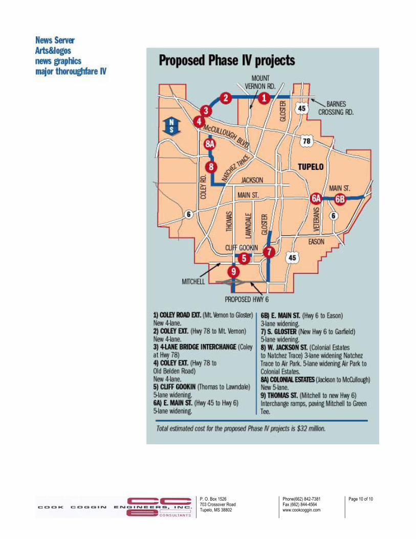
these roadways are two-lane alignments with speed limits in the 40-55 mph range, and carry traffic volumes of 300 vpd to several thousand vpd. Three of the more notable local roadways in the proposed study area are Coley Road, Cliff Gookin Boulevard and Eason Boulevard. These three roadways combine to provide a circumferential minor arterial around the western, southern and eastern boundaries of the Tupelo city limits. Coley Road is currently under construction as a part of the Tupelo Major Thoroughfare Program Phase 3, and when completed, will provide a five-lane alignment with a continuous left-turn lane from West Main Street (MS 6) north to McCullough Boulevard (MS 178). Current ADT volumes on Coley Road average 12,000 vpd. Cliff Gookin Boulevard is the continuation of Coley Road to the south from West Main Street. The western portion of Cliff Gookin Boulevard is currently under construction as a part of the Tupelo Major Thoroughfare Program Phase 3, and the finished alignment will provide five lanes with a continuous left-turn lane from West Main Street to the Natchez Trace Parkway. From the Natchez Trace Parkway to South Thomas Street, Cliff Gookin will provide only four lanes with turn lanes only provided at the intersections. From South Thomas Street to Lawndale Drive, Cliff Gookin will again provide a five-lane cross-section. From Lawndale Drive to South Gloster Street, Cliff Gookin has been widened to five lanes as a part of the Tupelo Major Thoroughfare Program Phase 3. Current ADT volumes on Cliff Gookin Boulevard range from 12,000 vpd at South Thomas Street to 11,000 vpd at South Gloster Street. Eason Boulevard is the continuation of Cliff Gookin Boulevard to the east from South Gloster Street, and crosses MS Highway 45, Town Creek, and MS Highway 6, before terminating at the intersection of East Main Street near the eastern Tupelo city limits. From South Gloster Street to Green Street, Eason Boulevard has recently been widened to five lanes with a continuous left-turn lane as a part of the Tupelo Major Thoroughfare Program Phase 3. From Green Street to the Town Creek Bridge, Eason Boulevard provides a five-lane alignment as a part of the TMTP Phase 1. The section of Eason Boulevard from Town Creek to East Main Street is currently under construction as a part of the TMTP Phase 3, and will provide a five-lane section with a continuous left-turn lane. Current ADT volumes on Eason Boulevard are 10,000 vpd between South Gloster Street and Green Street, 24,000 vpd near the intersection of MS Highway 45, 16,000 vpd across Town Creek, and 7,000 vpd near the intersection of East Main Street (MS 178). 3.5 Committed City Streets The Tupelo Major Thoroughfare Program Phase 4 involves the improvement of several existing local streets and also the construction of a new alignment from the northern terminus of Coley Road to the north over US 78 and following the northern city limits to the east over the Natchez Trace Parkway and tying into Barnes Crossing Road (attached map on page 10). The Phase 4 projects will be funded by a city referendum vote in June 2006, and planning/design/construction will be performed from 2006-2011. Three (3) widening and improvement projects involve the following: (1) East Main Street from US 45 to MS 6, (2) West Jackson Street from the Natchez Trace to McCullough Boulevard, and (3) South Gloster Street from Garfield Street to Green Street/MS 76. All of these projects will involve the widening of the existing street to provide either a three-lane or five-lane section with a continuous turn lane. The expected cost of the program is approximately $ 32.4 million.
P. O. Box 1526 703 Crossover Road Tupelo, MS 38802
Phone(662) 842-7381 Fax (662) 844-4564 www.cookcoggin.com
Page 8 of 10
East Main Street from US 45 to MS 6 is currently a 3,600-foot section of city street that provides four lanes with turn lanes only provided at the intersections. Commercial businesses line both sides of the busy street that carries an average ADT of approximately 17,000 vpd. The major portion of the work will involve the widening of two existing bridges over the Town Creek. West Jackson Street is a two-lane minor arterial that begins at Front Street on the east side of the Tupelo CBD and continues to the western city limits. The proposed three-lane section of West Jackson Street to be improved would begin at the Natchez Trace and continue to the intersection of Airpark Road. A five-lane section would extend from Airpark Drive west to the Tupelo airport, and then turn north to intersect McCullough Boulevard. Currently West Jackson Street carries an average ADT of 6,800 vpd from the Natchez Trace to Coley Road. South Gloster Street from Crosstown (West Main Street) to Garfield Street was widened to five-lanes with a continuous turn lane in the Tupelo Major Thoroughfare Program Phase 1. From Garfield Street south to the city limits, South Gloster is a narrow four-lane street with numerous businesses on both sides of the street. In the Phase 4 project, it is proposed to provide a five-lane section with a continuous turn lane from Garfield Street south to the intersection of Green Street where the proposed MS 76 alignment crosses towards US 45. The current ADT volumes over these sections of South Gloster Street range from 15,000 vpd to 20,000 vpd. The final project of the TMTP Phase 4 work involves the provision of a new four-lane divided alignment from Coley Road north across US 78 and the Natchez Trace Parkway to the Barnes Crossing Road. Currently traffic can access the Barnes Crossing mall area from either US Highway 45 or North Gloster Street. Access to this area is only provided from US 78 through US 45 to Barnes Crossing Road. The current ADT volume on Barnes Crossing Road is 19,000 vpd, while the current ADT on North Gloster Street is also 19,000 vpd. The proposed alignment will provide a third point of access for the mall area and is intended to alleviate the severe congestion along both North Gloster Street and Barnes Crossing Road at the entrances to the mall area. The proposed alignment is approximately 5.5 miles long, and is expected to cost 3.6 PUL Site Infrastructure Major economic development often requires a substantial investment in the provision of transportation infrastructure. Access roads, frontage roads and major freeway interchanges are some of the infrastructure requirements of the site development for a major industrial or commercial venture. The PUL (Pontotoc/Union/Lee Counties) Alliance’s Wellspring Project is such a development. A 1,200-acre site near Blue Springs, MS, just off US Highway 78 has been selected and is currently being advanced as a potential site for a major automobile manufacturing industry. In addition to the new roadway construction, improvements are also proposed for two existing interchanges on US 78 at Blue Springs and Sherman. A new interchange to provide access from US 78 to the site is also proposed between the two existing interchanges. A four-lane frontage road is proposed to connect the three interchanges on the south side of the US 78, and multi-lane access roads from the frontage road provide access to the site itself. The expected ADT volumes on the various roadways ranged from 5,600 vpd to 7,800 vpd.

P. O. Box 1526 703 Crossover Road Tupelo, MS 38802
Phone(662) 842-7381 Fax (662) 844-4564 www.cookcoggin.com
Page 9 of 10
4.0 SUMMARY The existing and committed highway infrastructure of the proposed study area was compiled on a single drawing file with multiple layers. This map was developed from previously generated highway maps of the area, USGS quadrangle maps, highway maps from the Mississippi Department of Transportation, and from maps and drawings from various local governmental and private agencies. Six (6) primary drawing layers provided for the functional classes of highways and streets in the proposed study area, as follows: (1) Primary federal/state highways, (2) Secondary state highways, (3) County highways, (4) City Streets, (5) Committed city streets, and (6) PUL Site infrastructure. The major highway infrastructure in the proposed study area consists of a complete access-controlled freeway, at least four (4) partial access-controlled principal arterials and a minimum of ten (10) multi-lane non-access controlled highways and/or streets. The typical average ADT volumes for these facilities range from approximately 10,000 vpd to 20,000 vpd.
P. O. Box 1526 703 Crossover Road Tupelo, MS 38802
Phone(662) 842-7381 Fax (662) 844-4564 www.cookcoggin.com
Page 10 of 10
Related Documents