APPENDIX B ANALYSIS OF ACTIVE TRAVEL CONSULTATION LOCATION DETAILS COMMENTING ABOUT ISSUE COMMENTING ABOUT HOW MADE BETTER? OTHER COMMENTS RESPONSE OF COUNCIL Llanharan, former opencast mine {2 comments / likes} Walking and shared cycle path. Rights of way remain closed 20 years after site recovered from use as mine. Remove barriers, Improve path surface, Better signage, Better enforcement. There are a number of rights of way marked on RCT's own maps that remain fenced off years after a mining operation ceased. There is no active travel alternative linking Llanharan and Llanilid. Reinstatement would also provide an alternative route to Llanharry, Pencoed and other settlements in Vale of Glamorgan and Bridgend county areas. Llanharan opencast site. Always promised part would be preserved as a country park for the surrounding villages that tolerated the opencast workings. It’s more heavily populated than those days and a large green space for activity is needed more than ever. Proposed new active travel routes to serve Llanharan, Llanhari and Llanilid are highlighted in the INM. Routes link communities with either Pencoed (west) and / or Pontyclun (east). All new, proposed developments will be required to implement walking and cycling infrastructure. NO CHANGE TO INM A465 between Hirwaun & Baverstocks Junction {3 comments / likes} Walking and shared cycle path. No safe link between cycle paths. More cycle routes. Cycling from Hirwaun towards Merthyr on the B road past the Crematorium is a safe cycle route. On reaching the Baverstocks junction no path is available except the treacherous A465 to reach Merthyr. Someone else has commented on this previously but I would reiterate this is extremely dangerous for cyclist to be forced to ride the A465 and there does appear to be room/old road to adopt for a cycle path taking you down to Swansea Road on right of A465. I ride my horse here, Cycle and walk. It would be great if the forestry barrier was widened or an access gate for the horse would be better. I can ride from here to Llwynon reservoir. This is a cross boundary issue which will be brought to the attention of Merthyr Tydfil CBC. The dualling of the A465 is a Welsh Government scheme. The Council has been in discussion with the Welsh Government and Future Valleys Consortium over the alignment of a proposed active travel route in the area. NO CHANGE TO INM A4058, Porth {2 comments / likes} Road. Lack of safe route for cycling. Slow down traffic, More cycle routes. I use this road for my commute and it is the worst road in the Rhondda in terms of safety. The cars and large lorries speed and close pass you as a cyclist. The crossings for pedestrians create pinch The Council is progressing a study to identify a proposed alignment of a new active travel route

Welcome message from author
This document is posted to help you gain knowledge. Please leave a comment to let me know what you think about it! Share it to your friends and learn new things together.
Transcript
APPENDIX B
ANALYSIS OF ACTIVE TRAVEL CONSULTATIONLOCATION DETAILS
COMMENTING ABOUT
ISSUE COMMENTING ABOUT
HOW MADE BETTER?
OTHER COMMENTS RESPONSE OF COUNCIL
Llanharan, former opencast mine
{2 comments / likes}
Walking and shared cycle path.
Rights of way remain closed 20 years after site recovered from use as mine.
Remove barriers, Improve path surface, Better signage, Better enforcement.
There are a number of rights of way marked on RCT's own maps that remain fenced off years after a mining operation ceased. There is no active travel alternative linking Llanharan and Llanilid. Reinstatement would also provide an alternative route to Llanharry, Pencoed and other settlements in Vale of Glamorgan and Bridgend county areas.Llanharan opencast site. Always promised part would be preserved as a country park for the surrounding villages that tolerated the opencast workings. It’s more heavily populated than those days and a large green space for activity is needed more than ever.
Proposed new active travel routes to serve Llanharan, Llanhari and Llanilid are highlighted in the INM. Routes link communities with either Pencoed (west) and / or Pontyclun (east). All new, proposed developments will be required to implement walking and cycling infrastructure.NO CHANGE TO INM
A465 between Hirwaun & Baverstocks Junction
{3 comments / likes}
Walking and shared cycle path.
No safe link between cycle paths.
More cycle routes. Cycling from Hirwaun towards Merthyr on the B road past the Crematorium is a safe cycle route. On reaching the Baverstocks junction no path is available except the treacherous A465 to reach Merthyr.Someone else has commented on this previously but I would reiterate this is extremely dangerous for cyclist to be forced to ride the A465 and there does appear to be room/old road to adopt for a cycle path taking you down to Swansea Road on right of A465.I ride my horse here, Cycle and walk. It would be great if the forestry barrier was widened or an access gate for the horse would be better. I can ride from here to Llwynon reservoir.
This is a cross boundary issue which will be brought to the attention of Merthyr Tydfil CBC. The dualling of the A465 is a Welsh Government scheme. The Council has been in discussion with the Welsh Government and Future Valleys Consortium over the alignment of a proposed active travel route in the area.NO CHANGE TO INM
A4058, Porth
{2 comments / likes}
Road. Lack of safe route for cycling.
Slow down traffic, More cycle routes.
I use this road for my commute and it is the worst road in the Rhondda in terms of safety. The cars and large lorries speed and close pass you as a cyclist. The crossings for pedestrians create pinch
The Council is progressing a study to identify a proposed alignment of a new active travel route
points for cars to swipe you on a bike. The foot path that runs along this road has been closed. The wider sections are increased to 40 and 60 mph which cause extra danger to cyclists and here there are room for protected cycleways but none have been installed. All of the A4058 is incredibly dangerous to use as a vulnerable road user. The speed and also the behaviour of road users is downright unacceptable this includes a number of buses that use this road.
along the Rhondda Fawr from Porth to Blaencwm.NO CHANGE TO INM
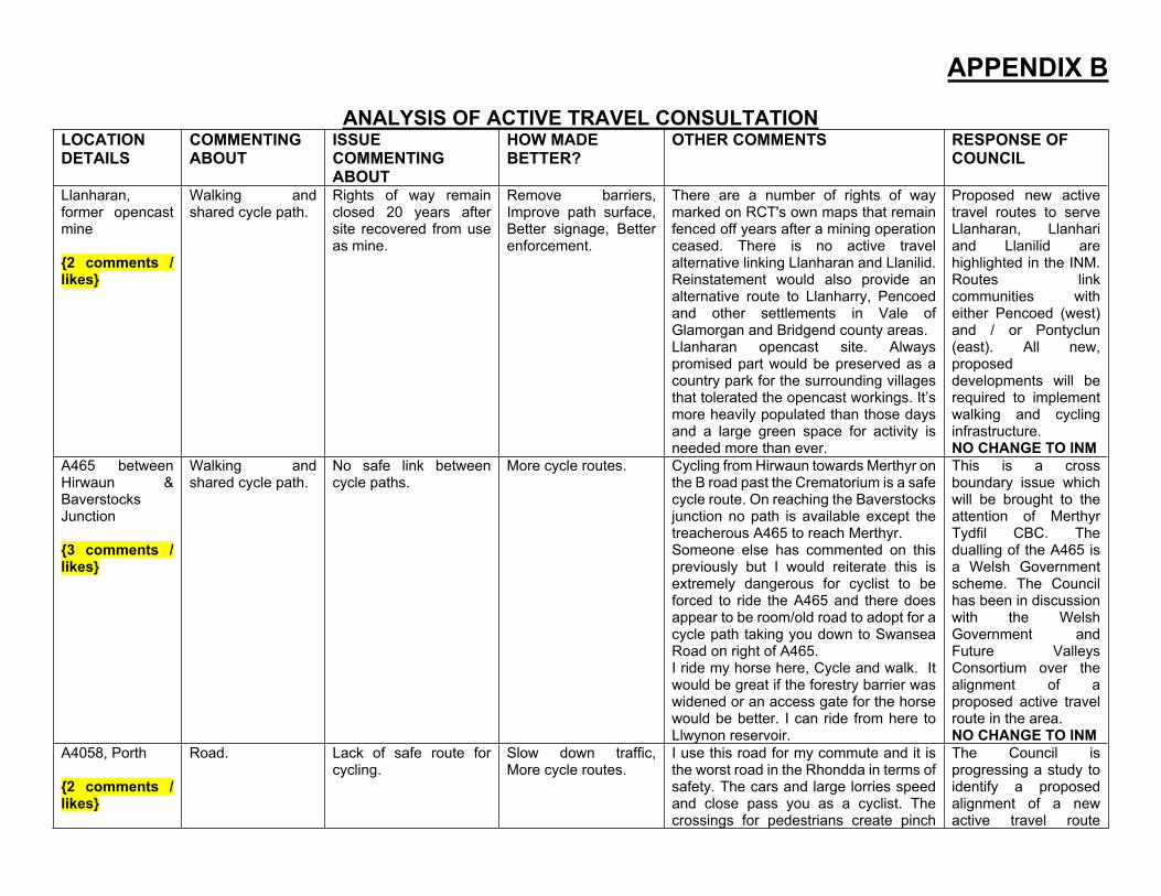
Tonteg, Tonteg Road, Power Station Hill, TIE
Upper Boat Roundabout
Church Village / Llantwit Fardre Community Route
{20 comments / likes}
Walking and shared cycle path. Road. Crossing. Pavement.
Lack of safe route for walking. Lack of safe route for cycling. Hard to cross the road.
Behaviour of other path users. Heavy traffic. Speeding.
More cycle routes, widen footpath, pavement.
Safer Junction. Add/improve crossings. There is no pedestrian crossing and crossing three lanes is dangerous.
Better enforcement. Better signage. Slow down traffic.
The junction is difficult to cross at times as a pedestrian/cyclist. The whole route from here up Tonteg Road/Powerstation Hill through the Industrial Estate needs to be looked at to see how it could be improved for the benefit of walkers/cyclists.Widen paths to at least 3m to allow cycles and scooters (children) to use. Network can be improved so people can access Dr surgery, church village shops, schools without having to use main road or drive around.A cycle and walking route could easily be installed by using road verge, installing dropped kerbs / raised table crossings. Close 1 road entrance to make vehicles use the dedicated turning lane by the petrol garage. Sub station fencing can be set back and 1 parking bay removed at Welsh Gov owned officers.Continue path on river embankment.Create a pedestrian & cycle bridge over river Taff. Add to network map.This would link Tonteg to Hawthorn avoiding long route around. Links the cycle path off Powerstation Hill to the path off Cardiff Road.There is an URGENT need to address provision of cycling facilities on Tonteg Road - connecting the shared path on Powerstation Hill to Treforest Industrial Estate. Travelling from Tonteg to
The Council is progressing the outcome of a study to identify safe and convenient active travel links between the Church Village Community Route, Upper Boat (via the Roundabout to the Taff Trail) and Trefforest Industrial Estate. Also, potential new links from nearby communities to the CVCR. Comments noted and will be considered as part of the development of this study. The Council will consider installing signage along the Community Route asking users to show more considerate behaviour.UPDATE INM
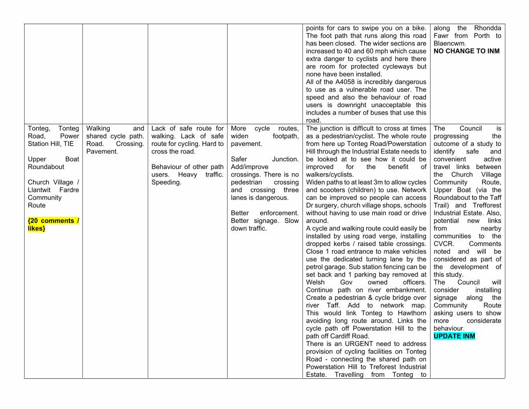
Treforest: At current the shared path comes to an end at bottom of Powerstation Hill and a drop kerb is the only provision that forces cyclists to merge with traffic coming down the hill [often at speeds of 40-60mph] - it is very dangerous situation and often results in close-passes as cars maintain speed and attempt to pass due to wide road that encourages this behaviour - even with oncoming traffic. Travelling from Treforest to Tonteg: There is no current provision other than to cycle on the road - although a lot of cyclists choose to cycle on the pavement on this stretch as it is so intimidating. There is a dropped kerb situated just before the railway bridge to that is supposed to allow cyclists to cross onto the shared path - but the location is ridiculously dangerous with fast oncoming traffic and traffic behind often speeding up/looking to overtake. I commute this route daily and have only tried this several times but have stopped doing so as it is so exposed and dangerous. I currently cross the road by the petrol station and cycle up the footpath until I get to the shared path. There is a marked turning area but this is exposed with no protection from traffic in either direction. Once crossed I have to lift my bike onto the pavement at the junction as there are no dropped kerb facilities on this entire stretch - which must be breach of the equality/access act. The road and junction here are ridiculously wide - there is plenty of scope for a dedicated shared path to connect the shared path on Powerstation Hill to the shared path on Treforest Industrial Estate. Building a high quality shared path on this section would be a cost efficient, direct and convenient access route for walking & cycling with many benefits for the local community. It could also provide a direct link to the NCN route
8/Taff Trail for commuters wanting to access a traffic-free cycle route to Cardiff, Caerphilly & Pontypridd.This is a link road between the Church Village bypass cycle lane and the Taff Trail or shared footpath along the A4045 - critical cycle access from Church Village/ Llantwit Fardre and Cardiff/ Caerphilly. The cycle path ends, forcing cycles onto choked road, and involves at least one crossing to get back onto protected cycle route (at Upper Boat). Is even more awkward the other way - cyclists must take right turn off road into unmarked gate at bottom of Power Station Hill, across descending traffic. Kerbs through the estate are not dropped, so unconfident/young riders cannot bypass the road on footpath.This is a complete block to young and unconfident riders wanting to ride from Church Village to Cardiff, and is unpleasant / intimidating to pedestrians given the volume of traffic, high kerbs and busy turnings. Diversion is several miles through Treforest.Drivers race from these lights to get to A470 and if you are crossing dangerous as no indication if lights are about to change. Pedestrians and cyclists are at risk here. Daft thing is there is time enough lapsed for pedestrian crossing and there are dropped down kerbs. God knows how a disabled person would cross!I would like to see the cycle path join up to the Taff Trail as at the moment it really doesn't get you very far and is unsafe for families to try and make the link on bikes. This would also be a great safe commuter route for people to cycle to Cardiff for work.Walking for children, elderly and walking dogs dangerous due to speed of some cyclists. Most are compliant and slow down for walkers but others are using it
as a race track. I know someone who’s dog was killed by a cyclist speeding on there, next time it could be a child.My dog was killed by a speeding cyclist on this route. I have brought the issue of speeding cyclists up with my local councillor and nothing has been done. In fact, the gate system to slow them down has been removed. The numbers on electric bikes have increased and they have no thought of walkers and dog walkers with their speed. Only matter of time before elderly or child will be run over! Path users need to be more considerate of each other as it is a community path not a lycra clad race course. If road cyclists want to speed they need to use road.I use the Church Village bypass daily while walking my dog. In general its fantastic but on occasions dogs mess is a big issue. Also as its a mixed cycle/ walk path cyclist travel at speed and don’t make you aware of their presence. A simple ring of the bell would help. Maybe solar panel low level lighting would allow the path to be used during dark hours.The Church Village Community Route is a walking and cycling trail. Plus the Church Village Community Route leaflet, published by RCTCBC promotes running /jogging. However, many dog walker users persist in using path with dogs off lead which is extremely dangerous. I recently fell over a dog off lead which led to a broken arm. This not only put me in discomfort and much limitation for several weeks but also extra pressure on NHS who were amazing when (still are) assisting me. I am a dog owner myself and rarely use the community route due to the persistence of other dog users with dogs off lead.I have cycled with my family quite a few times over in Bristol. I have noticed that on their cycle tracks, every few miles
there were white lines. This encouraged all users to stay to the left and be aware at path junctions. It felt very safe especially as the path was very busy and being used by both cyclists and walkers in equal measure. This would be great on the shared paths around RCT.The path is not lit at all and is used a lot. The paths are very icy and especially the bridges over the A473 are perilousCyclists speeding and no warning to ensure children and dogs safe. The bypass shared path is great in the daylight, however, I do not feel safe walking there in the darkness, lighting would make the bypass path feel a lot safer. There is also a lot of ice half way between Tonteg and Church Village during the winter which makes the stretch of pathway unsafe, a grit box at this location or someone to grit it through the winter would be a great benefit.There is a section of path where the drainage has become blocked / overgrown which results in continuous surface water across the path - at moment 3 or 4 sections each 3-5 metres wide. In winter these sections freeze over with black/sheet ice and make it very dangerous for all path users to use the path safely. I have already seen numerous cyclists come off their bikes on this section. If this 100m section of trail between end of bridge over A473 and Pound Farm lane was surfaced and gate redesigned cyclists could use this route to gain access to the Tref Ind Estate avoiding the very dangerous Tonteg Road at bottom of Power Station Hill and the junction with no pedestrian crossing lights at start of estate by Upper Boat PH.
Llanharan, A473
{6 comments / likes}
Pavement/footpath, Cycle lane (on road), Cycle path (off road), Road.
Poor lighting, Hard to cross the road, Lack of safe route for walking,
More cycle routes, Widen footpath / pavement, Connect
No safe active travel route connecting Llanharan to Talbot Green, Pontyclun and rest of county via A473 route.
The Council is currently progressing the findings of a study to design and
Lack of safe route for cycling, Heavy traffic.Overgrown public footpaths.
pavements, Improve path surface.
Path in bad repair. Having to cross busy road more than once, as no continuation of pavement. Path needs widening so that cyclists & walkers are able to use it safely.A safe cycle/walking route is needed. The initial stretch where the path is on the northern side is ok (crossing is difficult) but when the path crosses to the eastern side as you get closer to L’Oréal it is too narrow and dangerous.There are several public footpath signs in the Llanharan/Llantrisant area but many of the paths are overgrown. I would like to see the paths cleared and signed appropriately.
construct a safe, new active travel route through Llanharan between Bridgend CBC boundary and Talbot Green. Details will be referred for the attention of the Council’s Parks and Countryside Section.NO CHANGE TO INM
Llanharan, Brynna, Llanbad Fach Farm
Pavement./ footpath.
Poor signage / route hard to find.
Better signage. Better enforcement.
Many footpaths in the area are not signposted and therefore not used. Please increase signage on all paths.
Comments noted.Details will be referred for the attention of the Council’s Parks and Countryside Section.NO CHANGE TO INM
Llanharan, Llanharry Road
{2 comments / likes}
Road Lack of safe route for walking, Lack of safe route for cycling, Heavy traffic. Poor lighting. Hard to cross the road
More cycle routes, Improve path surface, Connect pavements, Widen footpath / pavement.
No safe active travel route connecting Llanharan with Llanharry.Need a path to join the 2 villages, so able to go for walks along this road, also cyclists are able to use as well. Lack of lighting as well.
Comments noted. They will need to be considered during future new developments in the area and construction of the proposed new bypass.NO CHANGE TO INM
Llanhari, Green Lane
Unregistered bridleway.
Lack of safe route for walking.
Clear vegetation. This is an ideal project for safe walking and cycling route.
Comments noted. Outside focus of current active travel measures and legislation.NO CHANGE TO INM
Llanhari, Llanharry Road, Stryd Sulrian
{4 comments / likes}
Pavement / footpath.
Lack of safe route for walking. Heavy traffic. Speeding.
Improve path surface. Slow down traffic. Widen footpath / pavement.
The footpath has always been too narrow & is unsafe. It is especially hard to use the footpath from Llanharry to Brynsadler safely with social distancing as the path is too narrow. I push a baby in a pram down the pathway which is difficult & there is nowhere safe to move safely when passing other people. You can only walk in single file on the path. The traffic
Comments noted for future consideration and will require a site visit. The Council’s INM currently shows proposals for a new active travel route between Llanhari and Pontyclun.
on the road is driving too fast when I walk. The grassed area could be reduced to make room for a wider safer path.Pathway from Brynsadler to Llanharry only fit for single walker at a time. Remove grass verge and this will widen path. With more people now actively out walking social distancing is a problem.We now have two new estates in the area and with increased numbers it has become apparent the lack of decent and applicable footpaths. The main road from Llanharry to Pontyclun / Brynsadler has the opportunity to be a main artery connecting the large new build housing estate with the local village facilities, driving additional trade into the village and reducing congestion and car parking issues. Currently the path is too narrow, at points the hedges grow into the path restricting it even more. If you meet someone coming the other way, or are pushing a pram, it’s extremely difficult to pass, particularly given current social distancing. The need to then cross a very busy road on a blind bend when you come in to Brynsadler is also an issue given how quickly cars drive along this road. A wider footpath, appropriate crossing and possibly a cycle route would make the walk into Pontyclun much more pleasant and safer.
RCT INM S3NO CHANGE TO INM
Llanhari, Elms Farm
Pavement / footpath.
Hard to cross the road. Lack of safe route for walking. Bus stop position.
Add dropped kerbs. Improve path surface. Widen footpath / pavement.
Remove all grass that’s overgrown on pavements thus making pavements very narrow from Elms Farm to Brynsadler / Pontyclun and other direction to Llanharry. Bus stop is in a ridiculous spot, on a blind bend (ask bus drivers who complain as they do an emergency stop while you are hanging out into the road to try and stop it.) It consists of a few paving slabs and can only be reached from the opposite side of the road with no proper access.
Details will be referred for the attention of the Council’s Highways Maintenance and Traffic Management Sections. The Council’s INM currently shows proposals for a new active travel route between Llanhari and Pontyclun.RCT INM S3
NO CHANGE TO INMLlanhari, Llanharry Road
{5 comments / likes}
Walking & cycling shared path (off road). Pavement / footpath. Cycle path (off road).
Poor lighting. Lack of safe route for cycling. Speeding. Hard to cross the road.Barriers to access. Behaviour of road users. Heavy traffic. No access to bridleway necessitating on road riding.
More cycle routes. Slow down traffic. Widen footpath / pavement. Improve path surface.Add bridleway route and provide access to existing pathways using footpath/cycle routes.
There is currently no safe cycle route linking Elms Farm and Llanharry to Pontyclun. The current path is narrow, uneven and too close to the road with cars regularly speeding on this stretch. I would like to see a widened footpath and additional cycle lane with a safe crossing area for adults and children to cycle or walk to Pontyclun safely.Horse riders are losing access to off road riding at a time when 2 horses a week are dying in RTA’ and riders are being left injured and traumatised. We are more vulnerable than cyclists on the road yet get less consideration. This is concerning given how many children ride. We are near Coed Trecastell yet can’t get access due to barriers to prevent off road motorcycles.
The Council’s INM currently shows proposals for a new active travel route between Llanhari and Pontyclun.RCT INM S3NO CHANGE TO INM
Aberdare, Dare Valley Country Park
{10 comments / likes}
Road Lack of safe off road riding for horse-riders in whole area.Behaviour of road users. Lack of safe route for walking.
More routes available, more signage for motorists to slow down for horses, Better enforcement. Slow down traffic.
This area is brilliant for both cyclists and walkers. I enjoy the paths available to both. But also as a horse rider, I feel totally unsafe riding in this area. There does not seem to be a safe place to take horses, where bikes aren't whizzing around, nor where motorised trail bikes are noisily speeding on off road tracks.The access road to the Country Park from Heol y Mynydd is a problem for walkers and children on bikes etc. Speed bumps already exist but drivers tend to speed up between bumps. Two way traffic leaves little space for walking safely.Poor signage on the walking routes, the colours need repainting on the routes and the directional discs needs to be renewed. The main drive to Dare Valley Country Park is too busy. 1000’s of cars speed up this 10mph road (the speed bumps are very spaced out and drivers speed up in between- more needed). The majority do this just to have a coffee or let their kids play at the visitor centre. There needs to
Active travel measures are focussed on walking and cycling journeys that are non recreational to key facilities and destinations.Details will be forwarded for the attention of the Council’s Parks and Countryside Section.
NO CHANGE TO INM
be improved signage to remind that once they come through those gates they are IN A PARK, people are walking, children are playing, there are bikes, dogs etc. it is not a main road to a cafe. Perhaps parking bays could be painted at the rear of Harlech Place and Highland Place to encourage drivers to park and walk instead. Cars travel far too fast. There is a 10 mph speed limit but it’s largely ignored with drivers driving to close to pedestrians at around three times that. Please enforce the speed limit with an average speed check.Now that the new bike track dominates the mountain in the Country Park, most of the old and well loved horse riding routes are now unsafe and/or impossible to ride on. It would be lovely to have some designated tracks for the horses so the riders in the area can still enjoy the Country Park out of the way of the busy areas by the lakes. Please make provision for off road motorised vehicles that speed on the very few areas of good off-road horse riding, ignoring signs of non-motorised vehicles. Too many stony, tarmac tracks, some grassy slopes without off road motor bikes, would be greatly appreciated. Also better maps of bridleways, as not all shown on OS explorer maps, nor council maps.
Llanharan, New Road
{3 comments / likes}
RoadPavement / footpath
Lack of safe route for walking, Poor lighting. Lack of safe route for cycling. Heavy traffic. Speeding.
More cycle routes, Pedestrianise, Widen footpath / pavement, Connect pavements.Slow down traffic. Provide safe foot and cycle route.
Very dangerous to walk between Bryncae and Pencoed. There needs to be a path built. The bends on A473 (locally known as 'Cow Corner') are currently very unsafe for pedestrians and cyclists. As more houses will be built on the Parc Llanilid development I think the provision of a safe route westwards for pedestrians and cyclists should be given a high priority. This route leads into BCBC with the greatly expanding College campus less
The Council is currently progressing the findings of a study to design and construct a safe, new active travel route through Llanharan and Bryncae between Bridgend CBC boundary and Talbot Green.NO CHANGE TO INM
than a mile away. Also Pencoed shops and railway station are not much further.It is a death area waiting to happen.
Llanharan & Bryncae, Bridgend Road
{8 comments / likes}
Crossing. RoadPavement / footpath.Cycle path (off road).
Speeding. Behaviour of road users. Hard to cross the road. Pavement parking.Lack of wheelchair accessible paths and adequate drop kerbs.Lack of safe route for cycling.
Slow down traffic, Add / improve crossings.More facilities for disabled. Add dropped kerbs. More cycle routes.Improve path surface.
It needs a puffin crossing.The level of traffic is so bad it is impossible to cross the road safely. This applies from The Square through to The Coop. Investment in several sage crossing points is required, not just stop points but puffin crossings.Pavements in RCT are improving. Walks with pebbles are utterly ridiculous. All pavements should be wheelchair friendly, smooth, no bumps, no holes and adequate drop kerbs for wheelchair users. Walking paths need to be the same, it’s no good advertising lots of cycle trails and walking trails if they’re uneven, not smooth, covered in stones and pebbles and completely inaccessible for wheelchairs. Not inclusive to all residents.My wife is disabled and uses a mobility scooter we are unable to use this around the village due to a lack of dropped kerbs. It seems they are putting them in by the new developments. There are also fitted around the upper part of the village but not along Bridgend Road area.Cars continually park on the pavement and are a nuisance to pedestrians, the road needs yellow lines.Having given up ownership of rear lane along Bridgend Road to RCT in 1989 I thought they would maintain lane to a satisfactory standard. It is a disgrace and requires new tarmac.
The Council is currently progressing the findings of a study to design and construct a safe, new active travel route through Llanharan. Other works to improve the safety of cyclists and pedestrians on the current A473 will be considered as part of the construction of the new bypass.Other details will be brought to the attention of the Council’s Highways Section.NO CHANGE TO INM
Llanharan, Robert Street
Crossing. Hard to cross the road. Add / improve crossings.
I gather that the Council is investigating pedestrian crossings in the village. With the speed and volume of traffic a crossing is required here.
Works to improve the safety of cyclists and pedestrians on the current A474 will be considered as part of the construction of the new bypass.NO CHANGE TO INM
Llanharan, Park View CloseTrivallis alleyway steps
Pavement / footpath. Alleyway and steps access to homes.
Poor lighting. Behaviour of road users. Lack of safe route for walking. Pavement parking
Improve path surface. More facilities for disabled. Widen footpath / pavement. Better enforcement. Wider steps. Hand railings each side of steps. Lighting on steps and alleyway.
Poor dangerous access to homes. Algae on steps make slippery. Always litter and rubbish on steps. Steps too narrow for a foot to fit on. Steps need widening and repairing as crumbling. Need hand rails each side. Need light on steps. Need light repaired in alley way as doesn't currently work.
Comments noted. Not an active travel matter, details will be brought to the attention of the local housing associationNO CHANGE TO INM
Llanharan, A473 Crossing Hard to cross the road. Heavy traffic.
Slow down traffic. Add/improve crossings. Improve path surface. Connect pavements.
It can take ages to cross the road here due to constant traffic flow to Penprysg roundabout, which will only get heavier as more new houses are occupied. Controlled pedestrian/cycle crossing needed.
The Council is currently progressing the findings of a study to design and construct a safe, new active travel route through Llanharan. Other works to improve the safety of cyclists and pedestrians on the current A473 will be considered as part of the construction of the new bypass.NO CHANGE TO INM
Llanharan, A473 to Pencoed {5 comments / likes}
Pavement / footpath. Road
Lack of safe route for cycling. Pavement / footpath.Heavy traffic. Speeding. Behaviour of road users. Poor lighting.
Widen footpath / pavement. More cycle routes.Create a pavement and a safe place to walk/run/cycle.
Active travel route needed to join up with the new routes in Pencoed. Very dangerous at the bends. No path but widely used.Cycle up and down this road every day as I cycle to work at all times of day, work shifts. Desperately needs lighting. Very popular cycling route for clubs passing via Cardiff and Bridgend and badly needs a separate cycle path next to pavement. More than enough room for one.Cycle path between Brynna to Pencoed and Brynna to Talbot Green,to link up with the cycle path to Treforest, Taff Trail etc. Pencoed cycle path would link to Bridgend. Cycle path 4 has definate lack of off road routes in this area. You can cycle from SA1 in Swansea to Pembrey Country Park all on cycle paths.It would be sensible to create a safer and shorter route to connect Bryncae / Llanharan area with Pencoed and the
The Council is currently progressing the findings of a study to design and construct a safe, new active travel route through Llanharan and Bryncae between Bridgend CBC boundary and Talbot Green.NO CHANGE TO INM
surrounding area without having to go all the way round via Brynna and the steep hill. Especially when out with children.
Llanharan, Dan y Graig Road
{2 comments / likes}
Road. Lack of safe route for walking.Lack of safe route for cycling.
Improve path surface. The is a highway, but the surface is very rough and dangerous to negotiate on foot, cycling and on horseback. Please could this important route be maintained to provide a safe surface?Very dangerous path due to rough, stony surface.
Comments noted. Details will be brought to the attention of the Council’s Parks and Countryside Section.NO CHANGE TO INM
Llanharan, Brynna Road
{3 comments / likes}
Pavement / footpath. Walking & cycling shared path (off road). Crossing.
Street furniture. Poor lighting. Speeding. Hard to cross road.
Remove pavement clutter. Remove barriers. Better signage. Better enforcement. Slow down traffic. Add / improve crossing.
Removal of gate.In a 30 mph area, most vehicles go much faster, making it dangerous to cross on foot, cycling and horse-riding.No safe crossing place here below Hillcrest. Lots of children catch the school bus here for various schools. The speeding traffic makes it difficult and scary for the children to cross. Even secondary school children struggle here in the mornings. we occasionally have a speed trap van here but not often enough. A proper crossing would be better.
The Council is currently progressing the findings of a study to design and construct a safe, new active travel route through Llanharan. Comments will be considered as part of this study. Other works to improve the safety of cyclists and pedestrians on the existing A473 through Llanharan will be considered as part of the construction of the new bypass.NO CHANGE TO INM
Llanharan & Brynna, Brynna Road
{5 comments / likes}
Road.Walking & cycling shared path (off road). Horse access.
Bad road surface. Speeding. Behaviour of road users.Barriers to access. Horse access.
Remove aggressive speed bumps. Slow down traffic.Restrict traffic or close road.
The speed bumps are destroying car suspension that I have to drive along here everyday. Even travelling well under the speed limit feels very aggressive. I'm sure they are not within the legal dimensions.Traffic calming measures removed when road resurfaced, despite the fact that play area is on the opposite side of the road to most of the housing on Brynna Road. Measures need to be reintroduced to reduce speed on traffic to allow safe crossing of road for children.I fear for my life on this road due to the speed of some users. There are lots of people/families using this road. It gets worse in the evenings.
Details will be referred to the Council’s Traffic Management Section. The focus of active travel measures and legislation is on walking and cycling, making non-recreational journeys to key destinations and facilities.NO CHANGE TO INM
I live and regularly use my horse to access other area of the locality. I have been doing this for 20 yrs. Over the period there has been a significant increase in traffic due to development. I am entitled to use my horse the same as any other active traveller. I would like you consider making provisions for safer travel for all horse riders in this community.
Llanharan, Church Street
Footpath. Poor signage / route hard to find.
Better signage. Remove barriers.
Many footpaths around Brynna are not used due to poor signage and dilapidated stiles.
Comments noted. Details will be referred for the attention of the Council’s Parks and Countryside Section.NO CHANGE TO INM
Llanharan, William St
Road Bad potholes that reappear every year. The one to the left of the speed cushion by Leyshons is dangerous when cycling up the hill.
Repair pothole. -------- Comments noted. Details will be referred to the Council’s Highways Maintenance Section.NO CHANGE TO INM
Llanharan, path between Gellifedi Rise and Meadow Rise {3 comments / likes}
Pavement / footpath
Barriers to access.
Dropped kerbs not flush with carriageway.
Remove barriers. Remove kissing gate. Hard to access an otherwise very useful link with a pushchair.Kerbs are dropped but still have a significant upstand from the carriageway. Making them flush would improve access to the path into Meadow Rise for people with pushchairs.
Comments noted. Details will be referred to the Council’s Highways Maintenance Section.NO CHANGE TO INM
Llanharan, The Square{2 comments / likes}
Road, crossing Heavy traffic. Dangerous bollards.
Safer Junction. Better signage.
The bollards in The Square have been hit numerous times. They are difficult to see when pulling out of the shops layby. Better signage would work or moving them up slightly.
Comments noted. Issues will be considered following the construction of the Llanharan bypass.Other details will be referred to the Council’s Highways Maintenance Section.NO CHANGE TO INM
Llanharan, Chapel Hill
{2 comments / likes}
Walking & cycling shared path (off road). Road.
Barriers to access. Street furniture.
Remove barriers. Replace chicane barriers with bollards to make the uphill journey much easier for people on bikes or with pushchairs.This could be an easier route off Brynna Road to access the bridleway via Brynna Woods nature reserve. However there is
Comments noted. Details will be referred for the attention of the Council’s Parks and Countryside Section.NO CHANGE TO INM
a metal barrier half way down restricting access for horses. There could also be clear signage to the bridleway.
Llanharan, A473
{13 comments / likes}
Road. Pavement / footpath
Hard to cross the road. Lack of safe route for cycling. Lack of safe route for walking. Poor lighting. Poor signage / route hard to find. Poor lighting.Heavy traffic. Speed of traffic.
Remove pavement clutter. Better signage. Widen footpath / pavement. Improve path surface.
This road needs a lot of work. The speed limit is 60mph but regularly see motorists doing 30mph and causing major traffic disruption. Better national speed limit signs would help. Better lighting is needed also as it's very dark, especially for pedestrians. The walking path between Llanharan and Llantrisant is very dangerous, having to cross near a bend. Also, the footpath is badly damaged by tree roots and is very uneven. Very dangerous for joggers or pedestrians who may trip into oncoming traffic.The speed limit on this road is 60mph, which makes the road very hard to cross, the pavements are very narrow and the surface of the pavements is really bad. Pushing a pushchair along them is very difficult. There are also many places where the hedge has encroached onto the pavement making them even more difficult to navigate. The lighting along this road is basically non existent for the most part.We as a family walk this road nearly every day with a pushchair and a 2 year old, as it is the main commute road from Llanharan to Talbot Green. We also run, cycle and commute to work via this road, the path surface is in terrible condition, especially on the s bend, the path is extremely narrow just about takes the width of a pushchair, there is no lighting either, with cars able to hit 60mph this is no safe place to be walking with a child. We really need it widened and re surfaced, with designated cycle facilities, how someone hasn't already been hurt is a miracle. A safe crossing is needed also. There is plenty of room along this road to widen and make safe, we walk all local
The Council is currently progressing the findings of a study to design and construct a safe, new active travel route through Llanharan and onwards towards Talbot Green. Comments will be considered as part of this study.Other works to improve the safety of cyclists and pedestrians on the current A473 will be considered as part of the construction of the new bypass. Maintenance issues will be referred to the Highways Maintenance Section of the Council.NO CHANGE TO INM
routes in the area and this is by far the worst. Surface is dangerous and very uneven in places, narrow and at points traffic is very close to pedestrians. You can feel the drag with it being a high speed road. Seriously needs re-doing before there is a major incident.We walk this road everyday and it's so dangerous. To take a pushchair, with a 2 year old, as the only walking commute to Talbot Green and Pontyclun. Waiting to cross with cars going 60mph! The surface of the pavement is really bad on the nasty bend and if it floods near the 2 houses, it's horrific. This is a matter of urgency with families, walkers and runners using the route every single day to get steps in and go to work. A widened path and protective barriers are needed... and I'm not sure why the road is a 60mph, could easily be less and wouldn't cause any transport back-up.Having lived in several parts of RCT over the years, this is quite easily the scariest section of road on which to cycle, run or walk, particularly after dusk. There is no lighting which means that vehicles use full beams, the road is 60mph meaning it's difficult to cross and the pavements are inappropriate for use. This road, combined with the poor active travel network between Bryncae and Pencoed, basically means that Llanharan is cut off from RCT and Bridgend.
Talbot Green, A473 & Fanheulog{2 comments / likes}
Road. Crossing. Pavement/footpath
Lack of safe route for cycling. Speeding. Behaviour of road users. Lack of safe route for walking. Heavy traffic. Hard to cross the road. Poor lighting.
Better signage. Widen footpath / pavement. Add/improve crossings. Slow down traffic. Improve path surface. Connect pavements
This is a really scary place to cross, it's a 60mph unlit road with a nearby bend. Not safe at all. A safe pedestrian & cycle route between Llanharan and Talbot Green is very badly needed.
The Council is currently progressing the findings of a study to design and construct a safe, new active travel route through Llanharan, between Bridgend CBC boundary and Talbot Green. Comments will be
considered as part of this study.NO CHANGE TO INM
Llantrisant, Talbot Road
Crossing. Road. Hard to cross the road. Behaviour of road users. Heavy traffic. Lack of safe route for walking.
Add / improve crossings. Add dropped kerbs. Slow down traffic. Safer Junction.
There is.no crossing to get over Talbot Road. I use this junction frequently as my child attends Penygawsi primary school. There are pedestrian crossings on all the other junctions off the A4119 crossroads except where I have placed this pin. So you would need to use all the other crossings (about 5 I believe) to just get across here. They take so long to cross, it adds about 5 minutes and can be stressful with young children as the pedestrian crossings are already very narrow at the A4119 junctions and with prams etc. There is limited places to stand when you're in the middle waiting for the green man. I've often seen cars confuse the junctions and light patterns and go through red lights and it scares me having to cross with young children. Better junctions and pedestrian crossings are needed here and mechanism to slow down drivers.
Details will be referred to the Council’s Traffic Management Section.NO CHANGE TO INM
Talbot Green, A473
{2 comments likes}
Pavement / footpath.
Heavy traffic. Poor path surface.Lack of safe route for walking. Hard to cross the road.
Improve path surface.Add/improve crossings. Widen footpath / pavement. More cycle routes.
Path surface is extremely uneven. Considering the footway is narrow and unlit, this is dangerous. Improved pedestrian and cycle facilities needed as a matter of urgency.Access to this Public Footpath is dangerous, but. the route is lovely along the river, and away from the busy tarmac route on the other side of the river. Walking from Talbot Green direction, the pavements are narrow, and traffic approaches from behind, so is hard to cross safely.
Comments noted. A site visit is to be undertaken to examine further.NO CHANGE TO INM
Beddau, Tynant Road
Road. Hard to cross the road. Add / improve crossings.
Install a new crossing on this desire line to the school. Install cycle zebra. Upgrade path to Moorland Crescent.
Comments noted. A site visit is to be undertaken to examine further.NO CHANGE TO INM
Beddau, Woodland Road
-------- Lack of safe route for walking. Lack of safe route for cycling.
More cycle routes. Improve path surface.
Widen and resurface uneven paving. Add dropped kerb. Straighten path to the footbridge to improve sightlines and poor
The Council is currently progressing the findings of a study
visual environment. Link to Llantrisant Road, Llantwit Fardre.
to identify new active travel links from nearby communities to the Church Village Community Route.NO CHANGE TO INM
Beddau,Brynteg Lane
Road. Speeding. Lack of safe route for walking. Lack of safe route for cycling.
Restrict traffic or close road.
Filter lane with a bollard to give the lane to active travel and residents only. Could be ANPR camera enforced so residents keep full access.
Comments noted. However, not considered to be an active travel matter.NO CHANGE TO INM
Beddau, Church Village Community Route
{3 comments / likes}
Walking & cycling shared path (off road)
Barriers to access. Remove barriers. Some of the barriers on the community route have been removed but some still remain. If any of these barriers are left in, then they render the entire route inaccessible for anyone on a non-standard cycle/with a child seat/trailer/pushchair/wheelchair/mobility scooter. These barriers are not compliant with the active travel guidance and Equality Act and need to be removed.The whole of the bypass route is unlit, making it unsafe to use in the evenings or early morning. There are also several barriers along the route making it unsuitable for us with a double buggy, and with bikes with child carriers. It would also be unsuitable for wheelchair users.
This matter has been considered by the Council, in consultation with local Members, on a site by site basis. Agreed for barriers to remain.NO CHANGE TO INM
Llanharan, near film studios
{5 comments / likes}
Walking & cycling shared path (off road)
Lack of safe route for walking.Lack of safe route for cycling.
Widen footpath / pavement. Connect pavements. Improve path surface. More cycle routes. Improve crossings.
This is a busy road section with no pavement. It stops people walking to Llanharan.With the cycle paths at Dragon studios and the new housing developments, plus at Pencoed, it is disappointing that the two towns aren't connected with a safe active travel route.No pavement around the bends. Very dangerous to walk. Needs pavement to create a safe space for pedestrians.Would like a safe cycle/walking path from the Dragon Studio to the Penybont Rd roundabout.
The Council is currently progressing the findings of a study to design and construct a safe, new active travel route through Llanharan, between Bridgend CBC boundary and Talbot Green.NO CHANGE TO INM
Llanharan, Heol Cynllan
Walking & cycling shared path (off road)
Behaviour of other path users. Lack of safe route for walking. Heavy traffic.
More cycle routes. Improve path surface. Widen footpath /
Pavements in a terrible state & narrow in areas from Llanharan to Talbot Green. Not wide enough for pedestrians & bicycles. Llanharan needs the bypass
See previous comments regarding proposed new active travel route in the area
pavement. Restrict traffic or close road.
urgently, which has been promised for years.
and works associated with the planned bypass.NO CHANGE TO INM
Talbot Green, Shopping Park
{5 comments / likes}
Junction. Walking & cycling shared path (off road)Pavement / footpath crossing
Hard to cross the road. Poor signage / route hard to find. Lack of safe route for cycling.Hard to cross the road. Lack of safe route for walking.
Safer Junction. Add dropped kerbs. Better signage. Slow down traffic. Add/improve crossings.Remove barriers. Widen footpath / pavement. Connect pavements.
Talbot Road/A4119 Junction by Talbot Green Shopping Park & 'Cycle Lane'. This is a completely car-centric junction and a nightmare to cross as a pedestrian and the cycle lane is inaccessible & intimidating to use. The number of light controlled pedestrian islands on one junction is ridiculous and the time it takes to cross the junction on foot is a nightmare - with many people getting frustrated and crossing independent of the light procedures. There is a cycle path marked on the map alongside A4119 [North] but it is not connected to anything and its proximity to two very fast lanes of moving traffic make it very intimidating to use. It is also too narrow to allow pedestrians & cyclists to pass each other safely.Please construct an easier and quicker walking route between the two retail parks. As a pedestrian you have to go all the way around the outside of the parks. If there was a cut through to Tesco that would be much easier. In addition it is not a nice route to walk along the A4119 the traffic is heavy it is noisy and dusty and polluted. It doesn’t feel very safe either at times connecting the retail parks would make it easier to visit all the shops without driving round one to the other. Also connect up to Tesco etc from the new cycle and walking path.This is low-traffic access from Llantrisant Community Route through to Talbot Green Shopping Park and Tesco Extra via Burgess Crescent. Access from this route across the roundabout to Tesco could be improved for cycles, and access to the underpass from the shopping park could be improved - at the moment, the transition from road to underpass is
Comments noted. The Council’s INM has identified a proposed new active travel route running parallel with the A4119 to reach the Retail Park.RCT INM S14NO CHANGE TO INM
awkward, occurring on a left-hand junction, both discouraging dismounting and making the transition over the kerb challenging.The Llantrisant Community Route has access points where you can leave the route to go to the Retail Park, but there are no footpaths into the Retail Park so people cross the grass bank and climb over the fence into McDonald's. A proper footpath would be very well used.The road in and out of the Retail Park has no pedestrian crossing facility, and you have to look in all directions for oncoming traffic and cars come from all directions. The approaches are filtered, and there are no lights visible to give you a clue if it's safe to cross. I have a teenager with a learning disability, and he could use pedestrian crossings safely such as pelican crossings, but this is just a gamble. It could seriously limit his independence or safety.
Church Village, junction of Main Road & Station Road
Junction Hard to cross the road. Change light phasing. Station Road only has pavement on the east side. Pedestrians who cannot cross quickly are unable to get from the east side of St Illtyd's Road or (more commonly an issue as there is no additional zebra crossing) from the north side of Main Road to the west side of Station Road in a single lights phase. The pedestrian phase could be changed to occur twice per cycle (before and after the two-way Main Road phase) or a longer pedestrian phase with diagonal crossing could be made. Additionally, the pelican crossing on the west side of the junction over Main Road currently resets without a crossing phase if the button is pushed during the Main Road traffic phase.
Comments noted. The Council is currently progressing the findings of a study to identify new active travel links from nearby communities to the Church Village Community Route. Comments will be considered as part of this study.NO CHANGE TO INM
Church Village, Main Road
Road Poor air quality. Create a drop-off zone for Garth Olwg near the bypass.
The junction of Main Road and Station Road is unable to cope with traffic delivering children to and from school, leaving cars idling on the roads for substantial periods every schoolday.
Comments regarding drop off points will be referred to the Council’s Education Department.
Drop-off/park and walk areas should be made and used near the road that has sufficient capacity for these vehicles and that is not near residential areas, i.e. the bypass. Once traffic drops, active travel will be more attractive for children who are able to undertake it. This should be part of a combined active travel plan for pupils/parents at all schools in the area.
Other comments will be considered as part of the study being progressed by the Council to identify links from nearby communities to the Church Village Community Route.NO CHANGE TO INM
Taffs Well, Cardiff Road
{7 comments / likes}
Cycle parking. Cycle lane (on road). Road. Junction. Crossing. Pavement / footpath.
Lack of secure bike parking. Behaviour of road users. Speeding. Heavy traffic.Poor air quality. Hard to cross the road. Pavement parking. Speeding. Lack of safe route for walking. The trucks from the metro.
Add cycle parking.Restrict traffic or close road. Slow down traffic. Add / improve crossings. Widen pavement / footpath.
Proper bike stands at Taffs Well Stn are too far away to be any use for those of us who shop in Taffs Well, and the rubbish wheel benders that the Co-op have are unusable.No reason to allow rat running through Cardiff Road now that there are two ways around this street ie - the A470 and the expensive new link through the industrial estate on the other side of the railway. Use bus gates to turn Taffs Well centre into a LTN.It’s basically waiting for someone to die on this road!! lost forgotten area of RCT not Cardiff and not considered RCT.Cars speed after the lights here.Taffs Well is a lovely place which could be so much better, it is a hotspot and through road for local cyclists and riders using the Taff Trail. The main road could be enhanced by restricting the flow of vehicle traffic by making Cardiff Road a one way system and widening the pavements and creating a dedicated cycle lane. Also by planting trees and improved parking would make the environment better for all.Add public bikes like the next bikes in Cardiff and facilities to lock bikes.Install raised cycle zebra. Realign so it links the lane to the railway station and the bridge. Install build out to allow safer, shorter crossing. Wider path can allow cycling over crossing and up to the bridge.
Comments noted. Details will be referred for the attention of the Council’s Traffic Management Section.NO CHANGE TO INM
Llanharan, rail station
Cycle parking Lack of secure bike parking.
Add cycle parking. Secure, covered cycle parking at the station would be useful.
Details will be brought to the attention of Transport for Wales who manage this station.NO CHANGE TO INM
Rhigos & Hirwaun, Rhigos Road
{3 comments / likes}
Road. Lack of safe route for cycling. Heavy traffic.
Slow down traffic. More cycle routes.
Fast wide 50mph road (which many drivers do 70mph+ on) but no provision for cyclists other than a few white bike tramp stamps embossed on the road. Ridiculous!! Plenty of space to shrink the carriageway and put a cycle track in between Rhigos village and the Industrial Estate at least.There is good provision down in the Neath Valley, and up at Hirwaun, but a safe and attractive link between the two is missing.Rhigos Road between Rhigos and Hirwaun is very dangerous for cycling. There are wide footpaths which very few people actually use for walking. Why isn't it clearly made available for both cyclist and walkers to use with big signs. The road is often used by groups of cyclists especially at the weekend, but they are treated very badly by motorists. Local drivers can drive fast and up close to cyclists. Please try and do something about it as the new Zip wire is opening soon and this could be a huge boost to the local economy. Around Hirwaun cycle and walking paths routes are hard to find and don't have very clear signage.
Improvements to NCN 46 between Rhigos and Hirwaun, to comply with current active travel standards, have been identified by the Council.NO CHANGE TO INM
Taffs Well, A4054
{4 comments / likes}
Pavement / footpath
Lack of safe route for walking. Lack of safe route for cycling.
Widen footpath / pavement. Slow down traffic. More facilities for disabled.
Ridiculously narrow shared pavement - with barely enough room for one person on a traditional bicycle never mind mixing bikes and pedestrians. Difficult sharp right angled turns needed at the crossing point at Cemetery Road. Whole Cemetery Road/A4054 Junction and linked junction from A4054 to railway station needs to be reconfigured to allow better/safer more convenient bike and pedestrian journeys.
Issue is being examined by the Council. Will coincide with proposal by Cardiff CC to upgrade Taff Trail at boundary with RCT and works to Taff Trail associated with the construction (by Transport for Wales) of new Metro depot in Taffs Well.
This is very popular cyclist crossing, as it is part of the Taff Trail cycle path. It should be made clearer to road users that there are cyclists crossing this point, preferably with road markings.Crossing could also be made safer with a zebra crossing (or similar markings).I realise that this is a cross-council section with Cardiff - but the section between here and Tongwynlais is one of the most dangerous bits of the Taff Trail. A really good off-road path spits you out onto a busy main road and then leaves you to cross the Taffs Well A470 roundabout. If you're not a confident cyclist then you pretty much have no option but to get off and walk.In an ideal world, some way would be found to route the Taff Trail away from the roundabout completely - and also bypass Tongwynlais - but if not, serious consideration needs to be given to how this section can be made a lot safer.Road is very dangerous for disabled users, particularly those who are visually impaired or use walking aids.
NO CHANGE TO INM
Church Village, Garth Olwg School
Cycle lane (on road). Walking & cycling shared path (off road). Cycle path (off road).
Lack of safe route for cycling.
Add/improve crossings. More cycle routes.
My children live in Pontypridd and go to school in Garth Olwg. There is a cycle path on probably about 60% of the route between Ponty town and the school. If a cycle path could be added that goes from the top of Power Station Hill to the school gates, then it would be possible for the many students who live in Ponty to cycle to school safely which would be great for physical and mental health.
Comments noted. The Council is progressing the outcome of a study to identify safe and convenient active travel links between local communities and the Church Village Community Route.NO CHANGE TO INM
B4595 Pavement / footpath
Narrow footpath. Widen footpath / pavement, Slow down traffic.
The pavement is very narrow in parts meaning traffic passes very close to pedestrians and it can feel very unsafe. The community path between Power Station Hill and the University is a fantastic alternative in daylight hours, but not really accessible at night.
Comments noted. The Council currently does not provide lighting on an off road active travel route due to major issues of vandalism. The B4595 is not an active travel route, an existing route runs parallel.
NO CHANGE TO INMCwmbach, path under road to ASDA
------- ------- ------- Continue this path under the access road and South linking to the Cynon Trail.
Comments noted. The Council’s INM has identified a proposed new active travel route between Aberdare and Cwmbach.RCT INM S5NO CHANGE TO INM
Cwmbach, roundabout
Cycle lane (on road). Walking & cycling shared path (off road).
Lack of safe route for walking. Lack of safe route for cycling.
Safer Junction. Add / improve crossings. More cycle routes. Pedestrianise.
This is a dangerous crossing as it’s too hard to see approaching traffic. Also cycling through Cwmbach feels unsafe compared to the trails into Aberdare and up to Mountain Ash.
Comments noted. This section of the Cynon Trail has been identified for improvements to bring up to current active travel standards.NO CHANGE TO INM
Cwmbach, Old Tram Road running from behind Fairfield Close past Pincroft up to Werfa
On Tram Road adjacent to end of Cennarth Drive, Cwmbach
{2 comments / likes}
Walking & cycling shared path (off road)
Houses encroaching the gardens on public access and not maintained by LA.
Development of houses. Concerned that land is being encroached upon and access and public footpath.
Better enforcement. At a time when children and adults need access to open spaces house development is taking place in an area which should be protected as a public footpath. Concerned that land will be encroached and claimed by the developer. Impact on flora and fauna, access and health.
Comments noted. Details will be brought to the attention of the Council’s Parks and Countryside Section.NO CHANGE TO INM
Trefforest Industrial Estate, Main Avenue, Oxford Street
{2 comments / likes}
Walking & cycling shared path (off road). Crossing. Pavement/footpath.
Hard to cross the road. Lack of safe route for cycling. Heavy traffic. Speeding.
Slow down traffic. More cycle routes.Improve path surface. Safer Junction.
There is a missing section of cycle route between Trefforest Industrial Estate (near the day centre) and the roundabout off Oxford Street/Cardiff Road. This forces you to cross the A4054 and travel along the road for 100m or so before crossing back joining the path. The road is busy and doesn’t feel safe.The shared path along Main Avenue is intersected by around a dozen junctions northbound and south bound. Traffic on these junctions have, or assert right of way over cyclists. Providing right of way to cyclists on the shared path over
Details will be discussed with the Council’s Traffic Management Section. The Council is examining the findings of a study covering the provision of additional active travel links within TIE, in the vicinity of Coleg y Cymoedd and Oxford Street.UPDATE INM
junction users would improve its viability. Currently most commuting cyclists user the road instead.
Tonypandy, Mid Rhondda Field
Walking & cycling shared path (off road). Field
Barriers to access. Improve path surface. Widen footpath / pavement. Remove barriers. Restrict traffic or close road. More facilities for disabled.
The path around the outside of the field is perfect for walking and cycling but it's not maintained.
Details will be referred to the Council’s Parks and Countryside Section.NO CHANGE TO INM
Nantgarw, Penrhos Cutting Taff Trail
Walking & cycling shared path (off road).
Barriers to access. Horse access. This section of the Taff Trail has a horse route separated from cyclists and walkers. Whilst this is a lovely route in Summer, during the Winter it becomes flooded and often icy. The barriers on the cycle route have been removed to improve access for those with disabilities so could easily accommodate horses. The rest of this section of the Taff Trail is a multi-user route so everyone is used to seeing horses and cyclists, walkers and riders get along with no issues. It makes little sense why this short section is prohibited to horses as the width doesn’t differ from the following section. If this was opened to horses it would make an enormous difference to riders accessing the wonderful forestry routes near Castell Coch and the Wenallt during the Winter months.
Comments noted. However, focus of active travel measures and legislation is on non-recreational walking and cycling journeys to key destinations and facilities.NO CHANGE TO INM
Taffs Well, near river
Pavement / footpath.
Lack of safe route for walking. Street furniture.
Improve path surface. More seating.
Lovely place right by the river, steep path to the river and add more seating along the river bank.
Comments noted. Details will be referred for the attention of the Council’s Parks and Countryside Section.NO CHANGE TO INM
Nantgarw and Taffs Well, Taff Trail
{10 comments / likes}
Walking & cycling shared path (off road)
Poor lighting. Lack of safe route for cycling. Lack of safe route for walking.Barriers to access. Behaviour of other path users. Parking.
Remove barriers.Better signage. Signs to instruct dog walker about Highway code rule 56.
Great cycle path, shared path with horses and pedestrians, dedicated lane needed and lighting. Dark, isolated, lonely threatening place for a single woman to be. Completely unacceptable as a transport route.Very poor dark and lonely stretch of path, often filthy from leaf mulch and mud or flooded by overflowing streams.Where the trail starts here there is a barrier. This is one of those low ones that
It is the Council’s aspiration to upgrade sections of the Taff Trail in the Taffs Well area to meet current active travel standards.The Council is examining the installation of signage to request users of the
cyclists are supposed to be able to ride/push through but angle and incline make this one awkward you hit your pedals and could cause accident. Some cyclists ride around it to the right on mud but not very easy. Remove this obstacle please.NHS front line worker has been told to f off by a number of speeding cyclists when walking her dog. It's very often used as a race track.95% of dog walkers are fine but odd owner allows animals off the lead with no control. Recently owner of dog off lead out of control told me "you can ring your bell all you like it’s a dog it doesn't understand" Signs stating Highway Code rule 56 would help reduce potential danger to dogs and cyclists or eventually a serious accident might occur. Needed on all trail by Rhydyfelin section and Church Village bypass biggest concerns. Highway Code - Rule 56. Dogs. Do not let a dog out on the road on its own. Keep it on a short lead when walking on the pavement, road or path shared with cyclists or horse riders.Connect the Taff Trail from Longwood Forest all the way to Treforest Ind estate through Taffs Well allowing people to commute to and from Cardiff and Pontypridd easier. Opening up this beautiful area and opportunity to enjoy a riverside walk / cycle path.Excellent path but remove the illegal barriers that prevent, prams, wheelchairs, trikes, trailers! Sweep path more regularly please as this is a main commuting route and it gets filthy for all the winter months due to lack of maintenance.Add bollards to prevent parking on the cyclepath by Taffs Well Rugby Club. Only a problem on weekend during rugby games. Also open the gate if possible to create a link to Moy Road / Cardiff Road.
Taff Trail to show more consideration to other users.Lighting is not provided along segregated cycle routes in open countryside due to problems of vandalism and ecology issues.The Council is progressing a study to identify potential active travel links in the southern part of the Industrial Estate, in the vicinity of Coleg y Cymoedd campus, the new DWP office and proposed rail station and Park and Ride site.The Council has been considering the selective removal of access barriers, in consultation with local Members.NO CHANGE TO INM
Blaencwm
{2 comments / likes}
Cycle Path (off road).
Behaviour of other path users. Lack of safe route for walking. Pavement parking.
Slow down traffic. Better enforcement. Barriers should be added.
I walk Blaencwm at least 3 times daily with my dog and always have done since living here, the reason we moved here was because it’s such a quiet peaceful place as I know is the same reason for other people living here too. At the moment the paths are totally unsafe for pedestrian and dogs as every other footstep you take you risk getting wiped off your feet by cyclists and bikers that do not respect pedestrians. Also the parking is disgraceful. People are driving to Blaencwm to then start their bike ride. Blaencwm is a very small village which is being ruined by the amount of traffic bought to the area.Slow down traffic through village but with sensor sign not sleeping policemen. Cyclists need to be separate/demarcated from walkers. Better enforcement of off-road visitors e.g. Van loads of quad bikes and scrambler bikes parked up on bus terminus - noise, erosion, mud - conflict with cyclists, walkers and dog owners e.g. Scramblers using forestry foot paths.
Comments noted. The main focus of active travel measures and legislation is on non-recreational journeys.Any incidents of anti social behaviour will be reported to the Police.NO CHANGE TO INM
Treherbert, Blaenrhondda Road and Railway station
Blaencwm
Rhondda Fawr
Rail Tunnel
{23 comments / likes}
Walking & cycling shared path (off road)
Lack of safe route for cycling.
More cycle routes.The tunnel and connecting route needs to be included as an active travel route, more to benefit the residents of the Upper Afan Valley with improved access to shops, buses, trains and other services.Better connection needed.The Rhondda Tunnel needs to be opened to allow cyclists and walkers access to the Gwynfi Valley, Lack of safe route for walking.
The upper Rhondda Fawr needs a cycle path from The old Stelco Hardy site to Treherbert Railway Station to link with the existing path at Everest factory. This could use the old railway line. It would allow almost traffic free cycling to Treorchy.Open the tunnel to help rejuvenate Rhondda Fawr. The comments have been stopped at Porttalbot, Neath...I'm campaigning here now to get this bloody tunnel finished.A direct route along the old railway route to Blaencwm should be built here. It could join up with the route that is constructed near to the Everest factory. It's heart breaking that out of all the coal lines there's so much lost. I've realised I've taken the other valleys multiple old rail line cycle routes for granted. There's the small section of Barry Sidings and the
Comments noted. The Council is progressing the findings of a study to identify the alignment of a proposed, new active travel route along the Rhondda Fawr from Porth to the mouth of the disused rail tunnel at Blaencwm.The Council is also progressing a business case into the possible re-opening of the disused rail tunnel (between the Rhondda Fawr and Gwynfi Valley) for walkers and cyclists.
Fach, but with limited traffic free arteries the Fawr is running out of options. I'd like to see the suggestions back on the table for a cycleway following the rail line as it reduces to single track north of Porth (linking Barry Sidings right through to the Tunnel).Needs a trail up this Rhondda Valley like other valleys. The Welsh Government needs to take ownership so that any plans to reopen the tunnel can move forward.The Rhondda Fawr is the only valley that doesn't have a dedicated cycle path. I would like to see the Rhondda Tunnel reopened as a walking and cycling tunnel, along with a suitable cycle path from the tunnel to Porth joining with the Taff Trail. This would solve numerous issues, not only providing a cycle path but would increase tourism to the Rhondda with the Tunnel creating the longest cycle tunnel in Europe. I believe opening the Rhondda Tunnel as a walking/cycling facility will enhance tourism and improve the economy of our beautiful valley. This could be the start of great things for the future of our valley and its population.Re-open the Rhondda tunnel, it will transform the top of the valley in the Rhondda and Gwynfi valleys.The Upper Rhondda has the potential to attract many tourists, walkers and cyclists to the area. We need a forward looking and engaged policy of regeneration for the area. And the Tunnel would be a fantastic attraction and addition to the wide area.The former Blaenrhondda station site is currently a foot/cycle path but the existing path could be improved with better signage and by using the former railway line, could connect cyclists and walkers to train services at Treherbert.The station site itself is a piece of local
NO CHANGE TO INM
history which is overlooked and could benefit from an information board and perhaps benches. This would be of interest to visitors especially if the nearby Rhondda Tunnel is reopened.Open the Rhondda Tunnel, it will bring visitors and money to the upper valleys. The Rhondda Tunnel . together with the Cearau and Abernant tunnels will make the valleys into a cycling " must visit "location. Please do something for the future, open up the tunnels and connect Blaencwm to Porth via a decent / safe cycle route as other proactive local authorities have recently done.
Tonyrefail, Pembroke Street
End of cycle path up from Talbot Green
{2 comments / likes}
Cycle path (off road)
Lack of safe route for cycling.
More cycle routes. We have cycle route 4 that comes down the lane past Pant Y Seren but then joins a busy road. At the end of Pembroke Street there's an existing rough path that links to the former Coed Ely Colliery site and then on to the cycle path passed the hospital and down to Talbot Green. By developing & incorporating this rough path it can join the existing off road cycle route and provide a much needed safe cycleway for the public.Cycle paths stop here should go up the valley plenty of room to do this.
Comments noted. The INM includes a proposed new active travel route between Tonyrefail and Talbot Green. RCT INM S24NO CHANGE TO INM
Tonyrefail, NCN 4
Cycle path (off road)
Lack of safe route for cycling.
Improve path surface. The upkeep of this path from Hendreforgan to the boundary with Bridgend CBC towards Blackmill is non existent. Erosion and lack of maintenance makes this part of the national route difficult for all but mountain bikes.
Comments noted. Details will be referred for the attention of the Council’s Parks and Countryside Section.NO CHANGE TO INM
Aberdare, railway line to Hirwaun
Walking & cycling shared path (off road)
Lack of safe route for cycling.
More cycle routes. Construct a walking and cycling route alongside the proposed railway link between Hirwaun and Aberdare. Easy and cheap to be constructed at the same time as the railway.
Details will be brought to the attention of Transport for Wales who are undertaking a study into the re-opening of this railway line.NO CHANGE TO INM
Cilfynydd, Taff Trail and Lady Windsor Trail
{4 comments / likes}
Walking & cycling shared path (off road)
Flooding after supposed repairs. Tree roots undermine path surface.
Raise Trail, so rain just runs off.Resolve issues with source of flooding from the Nant Caedudwg south of Pontypridd High School.Improve path surface.
Signage requesting reporting of trial bikes to 101 is hardly a deterrent to those who ride their motor bikes along the cycle path as a short cut between Cilfynydd and Glyncoch / Ynysybwl.Tree roots have lifted up surface on this section of Taff Trail for about 50 metres. It is particularly bad and may cause a cyclist to fall.
The Council has secured funding from the Welsh Government to alter the alignment of this section of the Taff Trail to make it more resilient from flooding. The issue of off-road biking is a matter of police enforcement.UPDATE INM
Porth, Rhondda Fach Trail
{4 comments / lakes}
Cycle path (off road)
Trail closed for 9 months. Have to use dangerous road.
Clear landslide to re-open Trail.
About time this was sorted - main road detour is extremely dangerous!Fix the issue and reopen the path. It cost more to fence off the area than it would have to fix the issue in the first place. Instead of shifting blame around do your jobs.Path has been closed due to a landslide for a year. Make Trail safe for users & re-open asap.It’s essential the Maerdy Ferndale Tylorstown route (all routes in fact) has easy access for the emergency services. All trees and overgrowth should be cut right back if too close to the pathways, which is apparent on the stretch running alongside Greenwood Park. Where possible, gates / barriers should be put up in correct places to stop motor cycles and quads, with signage displaying imposing fines for those who abuse these paths for walkers and cyclists.Encourage local people to help look after the pathways. Once the route pathways have been adequately resurfaced, new seating put in place, signage with informative information, we’ll have something to respect and be proud of.
Comments noted. Extensive remedial work is currently being undertaken by the Council.The Council endeavours to maintain all its active travel routes to current standards.The issue of installing access barriers must consider equality and disability issues as well as tackling the problems of anti social behaviour.NO CHANGE TO INM
Treherbert, Cwmsaerbren Street
Walking & cycling shared path (off road)
Barriers to access. Remove barriers. The barriers on this path prevents horse riders from accessing safe off road riding. Now Equestrians are forced to cross the main road several times to get to the safe off road riding that we need as much as cyclists and walkers. The Welsh
Comments noted. However, active travel legislation and measures primarily focus on pedestrians and cyclists only, for
Government have stated that all barriers must be removed and all paths MUST BE MULTI USER FRIENDLY and that includes Equestrians.
non-recreational purposes.NO CHANGE TO INM
Nantgarw, A468And Oxford Street
{2 comments / likes}
Pavement / footpath
Hard to cross the road. Poor lighting. Heavy traffic. Poor signage / route hard to find. Barriers to access. Lack of safe route for walking.
Add/improve crossings. Widen footpath / pavement.
It's virtually Impossible to access the GE Nantgarw site by foot. The road is too busy to cross during morning/evening commute directly in front of the entrance. If you cross at the Nantgarw Pelican crossing there is no pavement alongside the A468 to the site entrance.Alternative route into the Taff Trail from Nantgarw. It is not maintained and very hard and dangerous to access because of this. It could be adapted as a cycle and pedestrian route into the homes and businesses of Nantgarw and Trefforest estate without taking the larger detour up the hill towards Caerphilly.
Comments noted. A site visit will be undertaken to examine further.The Council is progressing a study to identify a network of active travel routes in the southern part of Trefforest Industrial Estate to provide links to key facilities.UPDATE INM
Trallwn, entrance, exit roundabout and Middle Street
{4 comments / likes}
Pavement / footpath. Junction. Road.
Behaviour of other path users. Poor lighting. Street furniture. Lack of traffic lights and yellow box doesn't cover both lanes. Speeding. Heavy traffic. Behaviour of road users.
Safer Junction. Traffic lights installed or yellow box extended over both lanesBetter enforcement. Slow down traffic. Restrict traffic or close road.
I don’t live in Trallwn but I often have to walk here to go to the parcel delivery point. While I’m commenting on my area I thought I’d make a comment on here. It stinks, and I mean I’m gagging because of the dog mess - poop and piss. I have to dodge it constantly. I just want to say to the people of Trallwn, this isn’t normal and I don’t know if you’ve normalised to it or what but there is no area I know that smells and looks this bad with dog poo.It is a nightmare to get out of this junction and get to work, this drives people to use Fish Lane as a means of getting to work on time - this isn't great as the lane isn't wide enough if there are pedestrians with prams or a dog walker like myself and it's access only.The speed limit is 20mph and we have speed bumps on the road. Despite that people continue to speed and some vehicles are so heavy that the house shakes. There are a lot of families with young children, elderly people, cyclists using Taff Trail and pets in this area. Last year a cyclist was hit off his bike and the
Comments noted. Issue relating to littering will be brought to the attention of the Council’s Civil Enforcement Team.It is illegal to cycle on the footway and any instances should be reported to the local PCSOs.NO CHANGE TO INM
driver didn't stop, the person knocked my door for assistance.Cyclists using Middle St ride on the pavement going against the one way system instead of using West St or East St and ride far too fast when using Fish Lane.
Trallwn, Bonvilston Road
{2 comments / likes}
Road. Lack of safe route for cycling. No signage to the Taff Trail connector between Trallwn end and restart in Rhydfelin.Speeding. The roads around Trallwn need to be looked at as they are crumbling away causing pot holes. The worst roads are Bonvilston Road, Coedpenmaen Road, Dodington Place and Thurston Road. Also drivers speed around Trallwn making it very dangerous for other drivers, pedestrians, and cyclists.
Improve path surface. More cycle routes.Repaint lane striping. Improve path surface. Better enforcement. Better signage.
Signage is poor along the route and it is often confusing for those who do not know the way. The trail signs should be named as there are many trails and people often get confused and go to the wrong side of the river and end up using the paths alongside Rhydfelin Rugby Club. Additional signage for the Taff Trail would improve navigation for those cycling from Cardiff all the way to Merthyr and beyond. The additions would help a tricky connecting sector for those unsure of the route. Re-surface the roads and maybe add big 20mph signs on the roads so drivers take notice that the roads are 20mph as they clearly disregard the signs and speed bumps around Trallwn.
Comments noted. Improved signage has previously been installed by the Council. Concerns over the speed of traffic should be brought to the attention of the Police.NO CHANGE TO INM
Aberdare, Cynon Trail
Walking & cycling shared path (off road)
Barriers to access. Remove barriers. It is difficult to cycle this path as you need to stop all the time to go through the barriers. It is already difficult having to share access with walkers and dogs who are not very mindful of their surroundings.
Comments noted. The selective removal of barriers at this location had previously been examined by the Council, in consultation with local Members. It was agreed that they should remain.NO CHANGE TO INM
Tonypandy, Glyncornel
Road. Cycle lane (on road). Walking & cycling shared path (off road)
Lack of safe route for cycling. Barriers to access.
Better signage. Improve path surface. More cycle routes. Add/improve crossings
Within the Rhondda Fawr valley there are no appropriate cycle paths that are off road and cover the length of the valley. This in turn means that for both work and pleasure I need to drive somewhere, which is not great for the environment. There are small sections but this is often on the road and not appropriate for most of my client base. This valley is missing
The Council is progressing the findings of a study to identify the alignment of a proposed, new active travel route along the Rhondda Fawr from Porth to the mouth of the disused
cycle tracks that are found in all surrounding valleys (Taff Trail, Cynon Trail and Rhondda Fach trail as examples). Ensuring a cycle path is built and established will allow easy and safe access to cycling for a range of people and also in turn will have positive effects on health and mental health.
rail tunnel at Blaencwm.NO CHANGE TO INM
Ferndale Walking & cycling shared path (off road)
Encourage use of available paths.
More cycle routes. It would be good now that more people are walking and cycling to have local maps of suggested round trips, with signage, similar to the Loops and Links project developed some years ago.
Comments noted. Details will be brought to the attention of the Council’s Parks and Countryside Section.NO CHANGE TO INM
Ystrad, Gelligaled Park
{2 comments / likes}
Cycle path (off road).Walking & cycling shared path (off road).
Barriers to access.Lack of safe route for walking. Behaviour of road users. Speeding.
Remove barriers.Better signage. Slow down traffic. Better enforcement
Not sure how much was spent creating this cycle route [along existing roads / footpaths] but why leave a gate unchanged half way along it that is very difficult (impossible for some) to get a bike through it?There are 5 mph signage in Park area - insufficient from Sherwood entry - cyclists take very little notice- perhaps note will be taken when someone is seriously injured? - No enforcement visible??
Comments noted. The resolution of this matter is still being considered by the Council due to ongoing problems of anti social behaviour..NO CHANGE TO INM
Ferndale, Maerdy Reservoir
Walking & cycling shared path (off road). Pavement/footpath
Poor drainage. ---------- Needs to be looked at, holds a lot of water in the rain and can become unsafe. It is a popular route for walkers, runners, cyclists and in need of some TLC.
Details will be referred to the Council’s Parks & Countryside Section.NO CHANGE TO INM
Groesfaen, Mwyndy, A4119
{2 comments / likes}
Crossing. Hard to cross the road. Lack of safe route for cycling, Heavy traffic. Speeding. Behaviour of road users.
Slow down traffic. Better enforcement.
The link from Miskin to the community route past Arthur Llewellyn Jenkins is dangerous. Despite the reduction in speed limit cars still treat the section between corner park and the A4117/A473 roundabout like a race track. Permanent Speed cameras in both directions and a further reduction in speed limit would benefit safety.Aspirational route needed for future housing developments. Route to cycleways in new housing sites via farm track and the footpath and track through Miskin Mill and Miskin Cricket ground.
Comments noted.Details will be referred to the Council’s Traffic Management Section.NO CHANGE TO INM
Pontypridd, Graigwen Woods
Walking paths. Behaviour of other path users. Speeding.
Better enforcement. Stop off road scramblers. Details should be reported for the
attention of the Police to enforce.NO CHANGE TO INM
Ferndale, Rhondda Fach Trail
{2 comments / likes}
Walking & cycling shared path (off road)
Since Dwr Cymru have dug up the path from Ferndale to Maerdy they have put it back full of big stones not fine stones. This is hard on your feet and causes you to twist your ankle.
The path needs to be put right with good surface to enable people to walk without injuring themselves.Get Dwr Cymru to fix the path.
Dwr Cymru have left the path in a worst state than it was before.
Comments noted and will be considered as part of the Council’s plans to improve this active travel route to meet current standards.NO CHANGE TO INM
Miskin, B4264
{5 comments / likes}
Crossing. Road. Hard to cross the road. Speeding.Lack of safe route for cycling.
Slow down traffic. Better signage. Improve surface.More cycle routes.
This is a very dangerous and difficult road to cross as a pedestrian or cyclist which is necessary to gain access to community cycle/walkway that passes through Talbot Green.This is a natural crossing point from Miskin village to the housing behind and visa versa, especially for children. It is a blind bend and speeding traffic make this a very dangerous place to cross. The speed of the traffic along this stretch up to the back of the Catholic church is often well in excess of the limit.Traffic is consistently well in excess of the 30mph limit as they come around the blind bend from Pontyclun. This is a crossing point for access to the main village and church.The road is very potholed and in autumn in particular very dangerous due to trees shedding fruit and leaves.Install protected cycle lanes with removal of central hatching to provide space on carriageway. Pop-up style lanes on both sides of road protected by rubber kerbs and wands. Provides links to school, shops and railway station.
Details will be referred for the attention of the Council’s Traffic Management and Highways Maintenance Sections. Comments will also be considered as part of a future study to develop a network of active travel routes in the area.NO CHANGE TO INM
Miskin, Ffordd Cefn yr Hendy
{7 comments / likes}
Cycle lane (on road).Pavement / footpath. Road.
Lack of safe route for cycling.Pedestrian barrier required for safety.Lack of safe route for walking. Speed of traffic. Hard to cross the road. Behaviour of road users.
More cycle routes.Improve path surface. Widen footpath / pavement. Lighting.Slow down traffic. Better enforcement.
The speed of traffic on the main road through the housing estate is very fast, especially during term time with increased traffic to the school. The junction in and out of Maes Y Wennol can be perilous due to this. Crossing this road is also very dangerous - I have had several near misses. I have also lost a cat
Comments noted. A site visit will be undertaken to examine further.Details will be referred for the attention of the Council’s Traffic Management Section
due to this and worry about the risk to the children living on the estate. The speed limit should be reduced to 20 mph and speed bumps installed. This road is the primary way to get from Llantrisant to YGGG Llantrisant and doesn't feel safe to cycle along with children. A cycle lane or combined pavement cycle lane would help. A pedestrian barrier is required to stop children running up Maesywennol Lane onto Heol Cefn yr Hendy, I have witnessed a number of near misses. The other lanes along this route have pedestrian barriers fitted.There is a wooded area in Miskin that is used from the new estates to walk to the play park in the Hendy Estate as a short cut to walking to Pontyclun village. The area has mainly makeshift paths and no lighting. Better paths could make this less muddy and safer from trips and falls in bad weather. Lighting could make it much safer for all residents, especially lone women, and the school children who use it to walk to Yr Pant. There is only a pavement on one side of the road. There are no speed signs on display throughout the whole of Miskin village even though there is a school there. Cars speed up and down the hill. There needs to be speed signs, 20 mph limit. Crossing near the school. During the summer months houses allow their trees to grow onto the pavement which means pavements are narrow and it becomes dangerous for pedestrians.Many children have to walk this way and the path is a disgrace it’s too muddy to use. Children end up dirty before school. Installation of average speed cameras through the village to slow traffic down.
who are currently progressing plans to implement a 20mph speed limit in the Miskin area.NO CHANGE TO INM
Llantrisant, Miskin & Talbot Green,A4119
Pavement / footpath. Crossing road. Junction.
Lack of safe route for walking. Lack of safe route for cycling. Hard to cross the road.
Add barrier between dual carriageway and pavement.
Perfect location for a 'Cyclops' junction to improve crossing for pedestrians and provide protected cycleway. Continue
Details will be brought to the attention of the Council’s Traffic Management Section.
{50 comments / likes}
Speeding. Heavy traffic. Behaviour of road users.
Widen footpath / pavement. Add / improve crossings. Safer junction. Footbridge needed or pedestrian controlled lights.
cyclepath from hospital to community route alongside A4119.A safe crossing point in order to cross the A4119 to Arthur Llewelyn Jenkins and back. There are no safe crossings over the A4119. It requires a pedestrian crossing with traffic lights to stop the traffic. The road is 50mph but many vehicles ignore this. It is terrifying to cross as an adult let alone with children. There have been pedestrian fatalities on the junction over the years and desperately needs addressing.There needs to be links between Miskin, Talbot Green and PontyclunThe walk along A4119 to Talbot green is horrendous the pavement narrows by the lay-by it is unsafe we need a cycle path and safe walking routes for children to Y Pant. The air is poor my daughter has asthma why should she walk along the polluted dangerous road. There needs to be a thorough assessment for this whole area especially if you continue to build houses. It is not easy to cycle from Miskin to Pontyclun or on to Talbot Green. There is no safe route either along the A4119 nor along Heol Miskin and A4222. The traffic is very heavy it’s just about manageable for a competent adult but very hairy with children or young adults. It’s not possible to easily cycle to the shopping areas so we drive instead and it is difficult to easily connect up to the cycling routes at Talbot Green. Please extend the cycle route/cycle lanes along here. Children are not able to cycle safely to school either. Please improve provision and reduce speed limit.RCT needs to plan in advance to link a cycle path to the high quality separated off-road path being developed along Llantrisant Road into Cardiff. This route should be added to the network map to
The Council’s INM has identified a proposed new active travel route between Llantrisant / Talbot Green and Mwyndy and between Llantrisant / Talbot Green and the Royal Glamorgan Hospital. Comments will be considered as part of a future study. RCT INM S14
NO CHANGE TO INM
ensure any developments along Llantrisant Road include the cycle route. The network map needs to include plans to improve the Castle Mynach junction to include separated cycleways to connect to the cycleways being constructed along Llantrisant Road into Cardiff. It should include connections to a cycle route along the A4119 into Talbot Green and link to any transport hub, be it at J.34 or Cardiff Gate.This pavement is in heavy use between the village of Talbot Green and the Hospital. It’s only a matter of time before a vehicle loses control at 50mph or higher and hits pedestrians or cyclists commuting. Pavement not wide enough for cyclists to pass pedestrians.A cycle route needs to be developed along the length of the A4119 linking eventually with the separated cycleways along Llantrisant Road. There are currently no pedestrian crossings across the A4119 so crossings for both pedestrians and cyclists should be installed.There's a footpath that runs alongside the cemetery and another that runs behind it. This short stretch that runs alongside the A4119 is nerve-wracking with young kids as you have to walk single file on the verge. It would be great if you could add a safer crossing here or at Arthur Llewellyn Jenkins as crossing this road is what prevents me cycling with my children from Llantrisant to get to YGGG Llantrisant.Crossing on A4119 is extremely dangerous with deaths and road accidents in recent years. Traffic needs to be slowed with average speed cameras between roundabouts at Matalan and M4 (both sides of road). Also need better protection for pedestrians - barriers at crossings and improved lighting.
The dual carriageway is busy making it a very dangerous place for pedestrians to cross. Lives have been lost here and no improvements made to make crossing safer.Crossing over the A4119 is difficult between Miskin village and Arthur Llewellyn Jenkins to join up to the cycle path to Pontypridd. Even though it’s a 40MPH people do not listen. Petrified with little people on bikes.This road is extremely dangerous to cross. Motorists speed on this road constantly. A footbridge is needed along with speed cameras. At night all you can hear is cars racing up and down this stretch. My children are aged 14 and 11 and are forbidden from crossing this road as it is unsafe. This road is extremely dangerous. A footbridge is needed to enable people to cross safely. Motorists are speeding up and down this stretch all the time and at night it sounds like a race track. It is frightening to try and cross it. It’s a very regular route for many families wanting to walk from Miskin over towards cross Inn and all the footpaths in the fields. It’s terrifying crossing the road there with children.There is no safe way to cross this high speed dual carriageway. This carriageway links walkers and cyclists to the community paths and cycle routes in Talbot Green area and onward to Church Village bypass. Urgently requires a footbridge for safe crossing. No more traffic light junctions - keep traffic flowing, but keep pedestrians and cyclists (many families with young children) away from the speeding traffic.You take your life in your hands when crossing this junction, either as a pedestrian or in a vehicle. Cars drive too fast, too close, and ignore the right to turn by driving up behind you. As a pedestrian
it is also very dangerous. There have been many accidents and a few fatalities sadly. Only time it runs smoothly is when the speed camera van is there.There needs to be safe pedestrian crossing from BETS Garage side to the Arthur Llewelyn Jenkins side. This will be particularly important when/if the Barn pub reopens as families from Miskin side (mine included) often walk down to the Barn in the summer and have to cross the busy A4119. I suggest a permanent camera, perhaps centrally that swivels. Also considering the amount of new house building proposed and no infrastructure to support, perhaps traffic lights to support the safe road crossing of traffic and pedestrians.After an accident where a father and son lost their lives, the speed limit was reduced but occasionally there are speed cameras so people still speed as there is no permanent deterrent. It is not safe to cross so a bridge would be the safest thing. There are currently only two safe places to cross this extremely busy dual carriageway. There is an underpass by the Tesco Superstore and a cycle path also by the Superstore. Although there is a very large residential area closer to the motorway junction there are no safe ways to cross this road from Miskin to access to the nearest dedicated cycle/ community route which is about 1 mile away. An extension to the cycle path from Cross Inn to Mwyndy Cross and over the A4119 via a footbridge would be a very welcome improvement. Very difficult to cross this very busy road to join the cycle path. 2 deaths at this spot crossing the road. Permanent speed cameras are required to slow traffic and
a pedestrian crossing is essential to cross from Mwyndy to Cefn y Parc.
Tonyrefail,A4119
Williamstown, Primary School
{3 comments / likes}
Walking & cycling shared path (off road). Road. Cycle lane (on road).
Heavy traffic. Behaviour of road users. Lack of safe route for walking. Poor lighting. Poor air quality. Lack of safe route for cycling.
More cycle routes, Develop a cycle / walking route along the length of the A4119. Slow down traffic.
Develop a cycle lane along the A4119 making a cycle journey for both work travel and leisure/fitness/wellbeing safe from existing vehicle users. Should extend from Llantrisant Road through to Tonyrefail and then continue through to the Rhondda Fawr (joining Coed Ely to Tonypandy being the priority) and then continue a cycle route through the length of the Rhondda Fawr Valley joining the Bwlch and Rhigos Mountains. Where cycle lanes cannot be developed along the A4119 or develop cycle/walking routes alongside the A4119 joining up existing cycle routes between Coed Ely/Tonyrefail and the Rhondda Valleys.Lots of people commute on this road for work at the industrial estates (Council offices, glass factory and school). There is no cycle route to this site and indeed for this whole area. The A4119 road is busy and vehicles travel very fast thus very dangerous for cyclists. In addition this whole area is extremely difficult to access for non-drivers - no bus stops either.The A4119 is a busy road. In wet weather it becomes a river, as at least half the drains are blocked. Ditches/troughs would be easier to maintain and clear. And can the grass verges be turned into cycle paths on both sides of the road. Separating bikes from cars, and removing the hideous necessity for the council to block the road and cut the grass.
Comments noted. The INM includes a proposed new active travel route between Tonypandy, Tonyrefail and Talbot Green. RCT INM S23, S24 and S28NO CHANGE TO INM
Dinas, A4058 Road. Cycle lane (on road)
Heavy traffic. Poor air quality. Lack of safe route for cycling. Speeding. Behaviour of road users.
More cycle routes. Slow down traffic.
I use this road to cycle for my commute to Ty Elai council offices in Williamstown. There is no cycle route and can feel very dangerous with the road being so busy and speeding vehicles and the heavy air pollution.
The INM includes a proposed new network of active travel routes in the area to make this journey safer by bicycle. RCT INM N10, S28 & S35
NO CHANGE TO INMTrefforest, bridge linking Trefforest with Rhydfelin
Walking & cycling shared path (off road).
Lack of safe route for cycling. Lack of safe route for walking.
Connect pavements. More cycle routes. Widen footpath / pavement. Add dropped kerbs.
Path that links Meadow Street to Rhydfelin, well used by locals as a short cut to Trefforest Railway and could link to Trefforest cycle path to Tonteg and safer cycle link to Taff Trail at Pontypridd Park.
Comments noted and will be examined further.NO CHANGE TO INM
Ferndale, High Street
{2 comments / likes}
Cycle parking. Cycle lane (on road)
Lack of safe route for cycling. No bike parking.
Widen footpath / pavement. Restrict traffic or close road. Add cycle parking.
No bike parking here even though it's part of the Taff Trail and a lot of users stop to use the shops etc.Lots of cyclists use this town for a stop while using the Taff Trail to use shops etc. No cycle parking or cycle lane.
Comments noted. 2 cycle storage stands are provided at junction of High Street and Lake Street, Ferndale. Details are on the Council’s website.NO CHANGE TO INM
Hawthorn, Cardiff Road
{2 comments / likes}
Road. Pavement parking.Speeding. Heavy traffic. Hard to cross the road. Behaviour of road users.
Consistent enforcement. More facilities for disabled. Add / improve crossings. Improve path surface. Safer Junction. Better enforcement. Slow down traffic.
Street junctions always have cars parked on them. Can't see the road when pulling out of side streets to main road.
Comments noted. Focus of active travel measures and legislation is on walking and cycling journeys that are non-recreational to local destinations and facilities.NO CHANGE TO INM
Rhydfelin Pavement / footpath. Road.
Behaviour of road users. Speeding. Pavement parking. Poor signage / route hard to find.
Slow down traffic. Safer Junction. Better signage.
We have raised a few times that when we leave the property we have to come down Morien Crescent and there is a blind junction at the end of it. The hedge does get trimmed to improve visibility but often it is very unclear and we have had near misses. There needs to be a sign warning of a junction, the problem is it's totally unclear to road users who don't know the area as it is almost invisible on approach and drivers are usually travelling at 35 - 40 mph on a 30mph road. Also leading to Duffryn Road vans / large cars park both sides of the road (Ilan) and this is obstructive and dangerous. Finally the parking outside Spar is not parking but makeshift and is an accident waiting to happen as people reverse into oncoming traffic! It is a shame as it's a bit like an obstacle course around here but I love the area.
Comments noted. Details will be referred for the attention of the Council’s Traffic Management and Highways Maintenance Sections.NO CHANGE TO INM
Rhydfelin, Dynea Road
Pavement / footpath.
Hard to cross the road. Behaviour of road users. Speeding. Heavy traffic.
Safer Junction. Add / improve crossings.
Pedestrians from Rhydfelin struggle to cross the T Junction safely to access Tesco Upper Boat. Traffic is very fast and there are lots of corner cutters.
Comments noted. Details will be forwarded for the attention of the Council’s Traffic Management Section.NO CHANGE TO INM
Rhydfelin, Tonteg Road
{3 comments / likes}
Pavement / footpath
Heavy traffic. Lack of safe route for walking. Poor lighting.
Widen footpath / pavement. Slow down traffic. More cycle routes. Add dropped kerbs. Improve path surface. Safer Junction. Add / improve crossings.
Pavement narrows opposite car dealerships, this area is popular with people walking from offices to Greggs and walking into Tonteg and Rhydfelin. Cycle path would be a great addition.As part of an integrated transport network route development, introduce a cycle/footbridge over the River Taff here from Hawthorn to Tonteg Road. This would cut off an awful busy corner through the Estate and make life more pleasant for commuters and those exercising. It would add to the amenities of the area and increase off-road walking/cycling routes.
Comments noted. The Council is progressing the outcome of a study to identify safe and convenient active travel links between the Church Village Community Route, Hawthorn, Upper Boat (via the Roundabout to the Taff Trail) and Trefforest Industrial Estate.NO CHANGE TO INM
Llantrisant, Westhill Drive
Pavement / footpath. Walking & cycling shared path (off road).
Behaviour of other path users.
Better signage. Better enforcement.
Enforcing rules to get people to pick up their dog’s poo. It is an issue on the community path and pavements in my area. I am constantly looking down to check. I also have children and they unfortunately stepped in dog poo a number of times.
Comments noted. Details will be brought to the attention of the Council’s Civil Enforcement Team. The Council will consider installing signage asking users of the Community Route to show more considerate behaviour.NO CHANGE TO INM
Llantrisant, Coed Ely Cycle Path
Cycle path (off road).
Barriers to access. Allow horses. Please change the category of this footpath so that riders may be permitted to use it. It is an EXCELLENT local amenity that I for one am glad of, but horse riders are repeatedly forgotten about with access yet no one wants us on the road?! Us included! Please consider the provision of Bridleways and changing the classification of this route so we may use to exercise our horses off road. Merthyr Mawr charges for access to the sand dunes, perhaps the Council are
Comments noted. Focus of active travel measures and legislation is on walking and cycling journeys for non-recreational reasons to local destinations and facilities.NO CHANGE TO INM
missing a lucrative trick in offering horse owners the opportunity to buy a permit to ride these routes.
Llantrisant, Mountain Road through Smilog / Common
Road. Heavy traffic. Lack of safe route for walking. Behaviour of road users.
Slow down traffic. Block road.
The mountain road through the Smilog is dangerous for all countryside users. It is used frequently as a rat run meaning not only are people driving faster than the road reasonably allows but the volume of traffic is prohibitive to countryside use. It is dangerous to walk, cycle or ride a horse along this road - all uses which are synonymous and reasonable to expect along a country Lane. Block the access at the Smilog and make drivers use the perfectly good road past the hospital.
Comments noted.NO CHANGE TO INM
Llantrisant, Heol Illtyd
Cycle lane (on road). Road. Walking & cycling shared path (off road).
Behaviour of road users. Behaviour of other path users. Heavy traffic. Pavement parking. Speeding. Lack of safe route for cycling.
Better enforcement. Slow down traffic. More cycle routes. Widen footpath / pavement. Restrict traffic or close road. Repaint lane striping. More facilities for disabled. Safer Junction.
To get people out walking, running and cycling roads, country lanes and footpaths need to be safer, speed restrictions in force on roads, bike lanes on roads as well as bike lanes on public footpaths so no accidents happen between walkers, cyclists, runners and dog walkers. Everybody at some point will need to cross some type of busy road to get to a path. Safety is a concern and I believe it is achievable to make it more safer for all.
Comments noted.NO CHANGE TO INM
Llantrisant, Forest Road
Road Heavy traffic. Speeding. Lack of safe route for cycling. Behaviour of road users.
Slow down traffic. Better enforcement. Restrict traffic or close road.
This is a great link road to go North and avoid the busy and dangerous dual carriageway. However, the speed and volume of traffic using this as a cut through/rat run is getting out of hand. Traffic is heavy and commuting times and travelling through here at speed.
Comments noted. Issues relating to the speed of traffic should be reported to the Police.NO CHANGE TO INM
Llantrisant, RoundaboutCross Inn RoadRhiwsaeson Road
{7 comments / likes}
Pavement / footpath.Walking & cycling shared path (off road).
Lack of safe route for walking.Surface condition.Lack of safe route for cycling.
Widen footpath / pavement. Connect pavements.Improve path surface.More cycle routes.
The pavement stops on the South side of Cross Inn Road (or at least narrows to be pointless), forcing you to cross the road, and cross back again if you then head towards the Penny Farthing / Co-op.The public footpath off Cross Inn Road provides nice link onto the Llantrisant Community route, but wet and muddy at all but the driest of times. Would like to use this to go to the shops, and alternative route is all around the houses and down Cardiff Road, or left at the
Comments noted. A site visit will be undertaken to examine further.Details will be referred for the attention of the Council’s Traffic Management Section.NO CHANGE TO INM
Cross Inn, to the new access by the old railway bridge and double back, which adds a fair length to the trip. Not seeking tarmac, just drier / cleaner surface please.There is a short cut through to the community route here that is very muddy. A short pathway would be a great help.This country lane forms a proposed route linking Cross Inn to Rhiwsaeson to Creigiau using railway path and onward via Cardiff's proposed cycleway network.Reduce speed of lane, add signage, re-surface and keep hedge low for visibility.Add a surfaced link to the Community Route and cycle zebra across centre island.The railway path here is very well used and if upgraded could link Llantrisant to Creigiau with access to the shops in Talbot Green or to the forthcoming transport interchange and cycleways in Creigiau.Very dangerous mini roundabout that does not meet design standards. 3 lane entry and multilane exit is not appropriate for a mini roundabout and should urgently be reduced with bollards creating single lane entry and exist prior to a more significant redesign to reduce vehicle speed. Multiple vehicle collisions into cyclists (see DfT collision data).Reduce speed of Cross Inn to Llantrisant to 20mph to encourage motor vehicles to use the bypass.
Llantrisant, Dan Caerlan and general area
{3 comments / likes}
Traffic slow down. Behaviour of road users. Lack safe route for horses.Not enough bridleways and shared paths.
-------- More bridle paths please ...open up old railway lane which in recent years has been redesigned a footpath with gates locked by owners.Shared paths for horse riders.Communication between the British Horse Society and active bridleway routes have been taking place. We would like to see Active Travel Plans including horse riders, providing safe off road
The focus of active travel measures and legislation is on promoting short distance, non- recreational walking and cycling journeys.NO CHANGE TO INM
riding and so preventing casualties amongst equestrians.
Llantrisant, former railway line
------- ------- ------- Aspirational route using former railway line across the Common linking the employment and hospital areas with the community route at Brynteg / Beddau. Would be an active travel route that cuts off Talbot Green but also an amazing recreational route preserving the heritage of our old railway alignments.
Comments noted. A site visit will be undertaken to examine further.UPDATE INM
Llantrisant, A473
{3 comments / likes}
Crossing. Junction. Hard to cross the road. Add / improve crossings. Slow down traffic..
As there are 2 lanes of traffic approaching the roundabout from the East (Beddau), it can be hard to cross this road as vehicles tend to approach the roundabout quite quickly. Adding a crossing would help people heading from Cross Inn toward Rhiwsaeson or vice versa.This is a hard place to cross the road. This section connects the Llantrisant Community Route with the path that runs along the river adjacent to Y Pant school. It's a busy stretch of road in both directions and crossing with young children is difficult due to there being 2 lanes and the speed of traffic.We have been asking for years for a traffic calming or pedestrian crossing here by this roundabout, but were told that as there had not been any fatalities, it is not considered dangerous. It is unsafe to cross the road if you are approaching the place to cross, whether it is from the Cross Inn pub direction or from the Maes yr Haul/Main Road direction. Cars speed around the corner without looking. We have already raised this issue several times with RCT and a local councillor. It is unsafe to cross and it is used by a lot of people, including school children being dropped off at the bus stop.
Comments noted. Details will be brought to the attention of the Council’s Traffic Management Section.NO CHANGE TO INM
Talbot Green, Forest Hills
Right of way.Walking & cycling shared path (off road).
Barriers to access.Lack of safe route for cycling.
Remove barriers.More cycle routes.
The access to the footpath has a large boulder making it difficult to pass through a very narrow access as the owner of the land has a metal gate which fills the
Comments noted. This suggestion as an active travel route has been previously
{3 comments / likes}
opening. Why can’t a small gate or style be fitted as this pathway can join up to the new cycle track alongside. Also it is a very ancient walk previously used by the miners walking to work.Complete the cyclepath between Lanelay Hall and Royal Glam Hospital. If route cannot go to Forest Hills Drive, use NRW forestry and consider exit onto lane or through Lanelay Hall overflow care park (with negotiation with owner).This particular section of this path is very steep and muddy. It's hard to walk down, and impossible to cycle. It would be a great addition to the local routes if this specific section was easier to navigate.
examined by the Council but was deemed not feasible.Details will be referred for the attention of the Council’s Parks and Countryside Section.NO CHANGE TO INM
Llantrisant, Community Route
Walking & cycling shared path (off road).
Barriers to access. Remove barriers. PLEASE REMOVE REMAINING ACCESS BARRIERS. Despite good work carried out recently to remove access barriers on the Church Village Community Route - there remain 5 barriers in place between Gwaunmeisgyn and Cross Inn - where the new Llantrisant Community Path begins. It is scandalous that these remain in place and prevent equal access for users and local community on this section. It must be a direct breach of the equality & access act and there is no valid argument for the barriers. Both the Church Village Community Path & Llantrisant Community Path see very high rates of usage by a wide cross section of the community - especially with excellent access links to Llantrisant / Talbot Green Retail Park.
The Council has been examining the selective removal of access barriers at certain locations on a case by case basis. Following consultation with local Members, it was agreed that the barriers should remainNO CHANGE TO INM
Llantrisant, Community Route
{7 comments / likes}
Walking & cycling shared path (off road).
Behaviour of other path users.Poor lighting. Litter.
Educate dog owners that the path isn’t just their personal dog walking path, it’s shared and their dogs should be under control at all times.Add lighting. Add more litter bins.
Dog walkers along the community route as their personal path. Dogs off lead, zig zagging without any control. Owners often on their phone or just ignorant of other users. Dog faeces all over the path. This causes a danger for children on bikes and walking especially if they don’t like dogs.Adding lighting along this route would make it feel much safer after dark. It's
Comments noted. The Council will consider installing signage along the Community Route asking users to show more considerate behaviour. Lighting is not normally provided along off-road active travel
commonly used to access Aldi etc from Penygawsi.There has understandably been an increased use of the community path during lockdown. This is a valuable resource for people in the community but there is a lot of litter and dog fouling which does spoil it. Also the lighting is very poor as sometimes I have to walk when it is dark.Extending the already fantastic Llantrisant Community Route along the old railway line through Rhiwsaeson and on to Creigiau would potentially make it easier to get to Cardiff. The path is well used but there’s lots of rubbish in the bushes and streams and hardly any bins.Continue the new community route along the short section of remaining rail line and alongside road to join the riverside path. This would complete a continuous route to the Pontyclun path without having to use the narrow steep bridge that does not meet Active Travel standards. It would also avoid the very poorly installed 3 stage staggered crossing. Finishing this route would allow full access for trike, wheelchair and trailer users. Would also allow route to continue on to Llanharan via the river path to Laneley Hall.
routes due to ecology issues and problems of vandalism.Suggestion about extending Community Route to Efail Isaf and beyond towards Cardiff will be considered further by the Council and will require a site visit.The Council’s INM has identified a network of new routes in the Llantrisant and Talbot Green area to form a continuous network of links to local communities such as Llanharan and Llanhari.
UPDATE INM
Llantrisant, Burgess Crescent
Road. Lack of safe route for cycling. Lack of safe route for walking. Heavy traffic. Speeding.
Restrict traffic or close road.
Create a school street restricting access from before the access to the community route.
Comments noted. Details will be referred for the attention of the Council’s Traffic Management Section.NO CHANGE TO INM
Llantrisant, A4119, Stinkpot Hill
{2 comments / likes}
Road Poor air quality. Behaviour of road users. Heavy traffic. Lack of safe route for cycling. Speeding. Lack of safe route for walking.
Slow down traffic. More cycle routes.
Very dangerous route for cyclists and no pavement for walking. No cycle lane and no cycle route. Fast vehicles and poor air quality.Horrible and dangerous road for cyclists and pedestrians. This whole route between Llantrisant and Tonypandy is dangerous for cyclists due to fast traffic
Comments noted. The INM includes a proposed new active travel route between Tonyrefail and Talbot Green. RCT INM S24. An existing shared use off-road route currently
and no cycle lanes. Particularly this area known as Stinkpot Hill.
exists near this section of the A4119 but issues relating to road safety will be addressed as part of proposals to dual this section of the A4119.NO CHANGE TO INM
Tylorstown, Woodland Road
Walking & cycling shared path (off road).
Barriers to access. Lack of safe route for walking.
Remove barriers. Can't wait for you to finish the path between Tylorstown and Ferndale via the river.
Comments noted. New route is included in the INM. RCT INM C1.NO CHANGE TO INM
Tonyrefail, Beechwood Drive
Road. Walking & cycling shared path (off road).
Poor signage / route hard to find.
More cycle routes. Better signage. Improve path surface. Connect pavements.
Cyclists are risking their safety and may cause dangers to moving traffic whilst using fast roads, SEWTRA have provided off road cycle paths but cyclists either appear to ignore them or are unaware of those routes. They are often better, shorter and flatter routes. It may be poor signage to those designated cycle paths or poorly lit or poor surfaces which prevent their use. It is not appropriate or safe to provide designated cycle paths on major roads where cyclists could be fatally injured or killed. The path between Llantrisant and beyond Church Village beside the A4073 should be the standard for other cycle paths to ensure greater use.
Comments noted.NO CHANGE TO INM
Church Village Community Route
Walking & cycling shared path (off road). Cycle path (off road).
Behaviour of other path users. Council signage needed as per highway code - "dogs on leads please".
Better signage. Many dog owners endanger cyclists either through ignorance or deliberately - signs on Trail would help safety of dogs, owners and cyclists. Maybe just quote the Highway Code? Department for Transport The Highway Code - Rule 56 Dogs. Do not let a dog out on the road on its own. Keep it on a short lead when walking on the pavement, road or path shared with cyclists or horse riders.
Comments noted. The Council is considering installing signage asking users of the active travel routes to show more considerate behaviour towards others.NO CHANGE TO INM
Pontypridd, Circular Walk
Walking & cycling shared path (off road).
Lack of safe route for walking. Poor signage / route hard to find.
Better signage. Once off the road and on off-road path there is no signpost to direct you up the mountain, where to go up to the trig point on top of Eglyws mountain. It appears just to be a sheep track and very difficult to navigate where exactly you need to fork back on yourself .
Comments noted. The focus of active travel measures and legislation is on non-recreational journeys.NO CHANGE TO INM
Pontypridd, Llantrisant Road
{2 comments / likes}
Pavement / footpath.
Lack of safe route for walking. Speeding.
Slow down traffic. Connect pavements.
The pavement between the roundabout for Rowan Gardens and the lights at the Cadwallader site is shocking. Very uneven, hazardous to run along. It appears unfinished, although it’s been that way for years.The pavement between the end of Danycoedcae Rd and The Highlands Estate is incomplete forcing pedestrians to walk along a busy, steep and narrow section of road. This route is regularly used by walkers and local pedestrians and is currently highly dangerous.
Comments noted. Details will be referred for the attention of the Council’s Highways Maintenance Section.NO CHANGE TO INM
Pontypridd, Barry Sidings
{6 comments / likes}
Cycle path (off road). Country Park.
Poor signage / route hard to find. Lack of safe route for cycling. Barriers to access. Behaviour of other users.
More cycle routes. Remove barriers. Ban alcohol.
Footpath Bridge vandalised please repair.Speed limits should be considered. Barry Sidings consists of a number of off-road mountain bike trails which are used by thousands in the local community and beyond. If the Council were to follow similar systems to those in Afan Argoed, Coed y Brenin, Glyncorrwg, and Cwmcarn etc, these facilities would also be world class and would attract huge numbers of active visitors. Mountain bikers generally tend to look for accommodation in the area if travelling to ride, and spend a fair amount of money during the course of their stays. This would provide a huge cash boost, and large numbers of cycle tourists to Pontypridd if the mountain bike trails were managed in a manner consistent with other similar locations across Wales.The current width restriction makes it difficult to get through with a bicycle without lifting and twisting the handlebars. Replace with a single bollard. Improve path surface. Widen footpath / pavement. More frequent clearing of shrubs, debris on path to allow people to cross without the need for one party to stop / stand in bushes / reduce to single file. Dangerous for walkers & cyclists sharing the same path.
Comments noted. However, active travel legislation primarily focuses on non-recreational walking or cycling journeys to key facilities and trip attractors.Details will be referred for the attention of the Council’s Parks and Countryside Section.The Council has successfully secured funding to improve this section of NCN 881.NO CHANGE TO INM
Trefforest, University / Crematorium entrance to Taff Trail
Walking & cycling shared path (off road).
Street furniture. -------- As a popular entrance to the Taff Trail from the North, this would be a perfect place for a dog poo bin. Walking northbound into Pontypridd Park from here, the next is nearly 1mile away.
Comments noted. Details will be brought to the attention of the Council’s Street Cleansing Team.NO CHANGE TO INM
Pontypridd, Eglwysilan Mountain
Pavement / footpath.
Street furniture. -------- On a beautiful location such as this, there aren't any dog poo bins around. It is quite tempting to leave my dog's waste amongst the fields with all the sheep/horse poo especially as I have to carry it for miles till I find the next bin. Please help us to encourage people to pick up their dog’s waste and be responsible pet owners.
Comments noted. Details will be brought to the attention of the Council’s Street Cleansing Team.Not the focus of active travel measures as this location is not along a designated active travel route.NO CHANGE TO INM
Clydach Vale Cycle path (off road).
Lack of safe route for cycling.
More cycle routes. I live in Clydach Vale, where there is an abundance of off road space not being utilised. Clydach Vale Country Park is a prime location for a purpose built cycle route and family trail which would bring in much needed tourist, and deter the use of off road bike in the area if the park is busy. Also Clydach Vale should be linked to a cycle path which runs the length of the Rhondda Fawr, which would link into the Taff Trail, the same investment that the other valleys have been fortunate enough to receive!!I cycle to work from Tonypandy to Caerphilly, and the roads between there and Pontypridd are desperate for a cycle lane. Trehafod is so dangerous with limited lighting in places, it’s terrible road surface and particularly narrow stretch between the Heritage Park and Barry Sidings. It’s a fatality waiting to happen!!
The INM contains a proposal to construct a new active travel route between Clydach Vale and Tonypandy. RCT INM S10. It is intended that this route will connect with a proposed new active travel route along the Rhondda Fawr.NO CHANGE TO INM
Pontyclun, A4222
{2 comments / likes}
Road. Road surface.No roundabout to turn around.
Improve surface. Add roundabouts at either end of street similar to Talbot Green.
Road surface up the hill and down near the quarry is in a dreadful state of repair. Riding this on a bike is awful. I can only presume the quarry traffic has a high impact on the road surface.When driving here there is nowhere to turn other than to use the residential streets. This is not safe. Mini
Comments noted although they primarily relate to driving and not active travel.Details will be brought to the attention of the Council’s Highways Maintenance Section.
roundabouts at either end of the shopping area (like Talbot Green) would be very helpful.
NO CHANGE TO INM
Pontyclun, Heol Miskin
{2 comments / likes}
Road. Crossing / pavement / footpath.
Hard to cross the road. Lack of safe route for walking. Heavy traffic. Speed of traffic.
Add / improve crossings. Widen footpath / pavement. Slow down traffic.
Difficult to cross at this junction especially with children. Cars and trucks travel at speed and it is hard to see. Would benefit from a crossing. Such a busy stretch with drivers speeding through to connect to link rd/M4. Very popular with families, dog walkers, joggers and cyclists but drivers seem to think it is fine to speed through a residential area!
Comments noted. Details will be referred for the attention of the Council’s Traffic Management Section.NO CHANGE TO INM
Pontyclun, railway crossing
Pavement / footpath
Lack of safe route for walking.
Widen footpath / pavement. Remove pavement clutter. More facilities for disabled.
The crossing is to access two large housing estates with mostly young families. There is no clear separation for wheelchairs and prams to cross the railway without putting themselves in dangers. The pavement on the west side next to the footbridge is too narrow for prams and wheelchairs. The pavement on the east side is more like an access road to an industrial unit and ends 10 metres north of the crossing. Which means prams and wheelchair users have to cross the railway on the road or cross the road with very little visibility. It is very dangerous.
Comments noted. Responsibility for crossings over the railway is with Network Rail. A site visit will be undertaken to examine further.NO CHANGE TO INM
Pontyclun Walking & cycling shared path (off road). Cycle path (off road).
Hard to cross the road. Setup of crossing.
Add / improve crossings. Widen footpath / pavement. Remove barriers. Connect pavements.
The new cycle route is fantastic! But I feel this section needs to either be better connected to the Pontyclun section and improved road crossing as this was difficult to navigate on a bike. When crossing over the footbridge re-joining the road was a pain with the busy junction.
Comments noted. A site visit will be undertaken to examine further.NO CHANGE TO INM
Pontyclun, Station Terrace, High Street, Station Approach & Cowbridge Road, Brynsadler
{8 comments likes}
Pavement / footpath. Road.
Lack of safe route for cycling. Lack of safe route for walking. Hard to cross the road.Behaviour of road users. Heavy traffic. Pavement parking.
Widen footpath / pavement. More cycle routes. Add dropped kerbs.Remove pavement clutter.
Travelling through Pontyclun is one of the most dangerous routes currently to access further into the Vale or back into RCT at busy times. It is heavily congested with parking around Tesco a particular issue. Many here park where they shouldn’t be with bottlenecks leading to close encounters with vehicles.
Comments noted. Details will be referred for the attention of the Council’s Highways and Traffic Management Sections.A site visit will be undertaken to examine further.
The road is extremely busy and barely wide enough for two cars to pass, making it a hostile section of road for slower road users such as cyclists. The pavement is tight, and at the top it's barely shoulder width! Widen footpath to allow for shared use. Install a separate cyclepath alongside footpath (Station side).Allow cycling on existing wide bridge footpath. Connect to paths that allow cycling on Station Terrace and Station Approach.Widen footpath outside Shepherds Vets by removing the 2 parking spaces to allow a path wide enough for shared use. This will allow safe cycle from one side of the station to the other via the road bridge and proposed path on Station Terrace.Ample parking for vets exists in public car park opposite.The footpath here ends for a period forcing you to either walk in the road or cross to the other side. Even though the speed limit has been reduced to 30mph the traffic, especially the lorries from the quarry, travel through there at speed making the crossing precarious. It is difficult to manoeuvre a wheelchair off the kerb on the grass side of the junction due to the angle. It is necessary to use the grass and then drop off the kerb. Drop kerbs are needed.The angle that this pavement joins the road prohibits wheelchairs (and most pushchairs) from using it. Therefore it is necessary to walk onto the road at the entrance to Talygarn Manor and walk into the approaching traffic to cross this road.
NO CHANGE TO INM
Trealaw Cycle lane (on road).
Lack of safe route for cycling.
More cycle routes. Add cycle parking.
Lots of students, parents, school staff travel on this road for Porth Community School. More people would commute by bike if this road was safer for cyclists by adding cycle lanes for example.
Comments noted. The INM contains proposals for a new active travel route along the Rhondda Fawr.NO CHANGE TO INM
Tylorstown Road Heavy traffic. Poor air quality. Hard to cross the road.
Add / improve crossings.
---------- Comments noted.NO CHANGE TO INM
Tylorstown Cycle lane (on road). Cycle path (off road). Cycle parking. Walking & cycling shared path (off road).
Poor signage / route hard to find. Lack of secure bike parking. Lack of safe route for cycling. Lack of safe route for walking.
More cycle routes. Add cycle parking. Improve path surface. Better signage. More seating.
Improvements required on Taff Trail and improved connectivity to town centre and its amenities. Food, drink toilets. Signage required and seating.
Comments noted. The Council has identified improvements along sections of the Taff Trail to bring the route up to current active travel standards.NO CHANGE TO INM
Maerdy, former Colliery Site
Cycle path (off road). Walking & cycling shared path (off road).
Lack of safe route for cycling.
More cycle routes. Could the whole former Maerdy Colliery site be redeveloped into a bike park of sort or mountain bike tracks that could be used by bikers / cyclists. This could then join up with Bike Park Wales Merthyr, Glyncorrwg Ponds and Afan Argoed. This will also improve access and facilities for the new zip wire on the former Tower Colliery site and the Rhondda Tunnel.
Focus of active travel legislation and measures is on non-recreational walking and cycling journeys.NO CHANGE TO INM
Brynna, Meadow Rise, Brynna Road, Hillcrest, Hawthorn Park {3 comments / likes}
Crossing. Cycle lane.
Hard to cross the road.Heavy traffic. Lack of safe route for cycling.
Add dropped kerbs.More cycle routes.
Install protected cycle lanes with removal of central hatching to provide space on carriageway. Pop-up style lanes on both sides of road protected by rubber kerbs and wands.
The Council has considered the findings of a study which examined the provision of an active travel route between Llanharan and Bridgend CBC boundary via Brynna.Other details will be referred for the attention of the Council’s Highways Section.NO CHANGE TO INM
Gelli, Industrial Estate
{2 comments / likes}
Walking & cycling shared path (off road). Cycle parking. Cycle lane (on road).
Lack of safe route for cycling. Heavy traffic. Behaviour of other path users. Speeding. Poor air quality. Behaviour of road users. Poor lighting.
More cycle routes. Slow down traffic.
We need more safer cycle routes also better education for cyclists and motorists as how to share the roads.If the cycle lanes are to remain then the roads should be made one way for traffic. There is currently not enough room for two way traffic and a cycle lane and the current layout is making it extremely dangerous for cyclists.
Comments noted. The INM contains proposals for a new active travel route along the Rhondda Fawr. The Council will consider improvements to sections of existing
active travel routes in the area.NO CHANGE TO INM
Abercynon, Taff Trail,B4275
{4 comments / likes}
Crossing. Lack of safe route for cycling. Hard to cross the road. Poor signage / route hard to find.
Safer Junction. Slow down traffic. Crossing.Set lights to recognise cyclists.
The crossing of the Taff Trail at this point is really poor. A proper crossing is required to get walkers and cyclists across the section of the B4275 between the fire station and Martin's Terrace. The road is plenty wide enough to accommodate vehicle traffic (slowed appropriately) and a new segregated cycle lane along with a safe crossing place to safely link the two sections of the Taff Trail.As another person has commented RCT traffic lights do not change for cyclists.If you cycle up to these lights you can wait and wait but they will not change to green until a car comes up behind you. Someone told me there are weight sensors in road not sure if that is true but one Sunday morning I deliberately waited 5 minutes and nothing happened. Cyclists are forced to carefully go through red lights obviously not the thing to do. Someone else mentions this is case elsewhere in RCT?Provide more dog litter bins. Should be available at all access points to Taff Trail including access from Navigation Park.
Comments noted. The Council has proposals to improve sections of the Taff Trail to meet current active travel standards. Other details will be brought to the attention of the Council’s Traffic Management Section.NO CHANGE TO INM
Tylorstown, Bryn Terrace
Walking & cycling shared path (off road).
Lack of safe route for walking.
More cycle routes. ---------- Comments noted.NO CHANGE TO INM
Pontypridd, town centre inc Taff Street
{6 comments / likes}
Cycle lane (on road). Junction. Road.Cycle parking.
Poor signage / route hard to find. Behaviour of road users. Lack of safe route for cycling.Lack of secure bike parking.
Restrict traffic or close road. Add / improve crossings.Add cycle parking.
Lots of cyclists would stop here from Taff Trail. No secure bike parking.Need a designated cycle route northwards up or alongside Taff St (against one way traffic flow) to allow cyclists to return from the railway station to Ynysangharad Park or other parts of town.The section between this pin and Ynysangharad Park has several issues 1) The route is confusing and poorly signposted.2) Cyclists are vulnerable to poor driving
Comments noted. The Council has proposals to improve sections of the Taff Trail to meet current active travel standards. It has also commissioned a study to identify new and improved active travel links to and within Pontypridd town centre.NO CHANGE TO INM
behaviour in the residential streets. Would be good to see a clearly defined path mapped out on the road, with priority given to cyclists at junctions.Need secure, publically visible cycle lock-up points along the main shopping area.The crossing of the Taff Trail from Fish Lane to Ynysangharad Park across Bridge Street is dangerous. If you don't know the road you come down a steep-ish narrow road (Fish Lane) and are suddenly straight on top of a main road which you can't see until last minute. There is no signage to indicate this is about to happen and even at relatively low speeds this is really unsafe for both cyclists and pedestrians who may inadvertently step in front of cyclists here. The road crossing on Bridge Street should be changed (and moved nearer to Fish Lane) so that it incorporates a crossing designed with separate crossing lanes from both cyclists and pedestrians - with push buttons for both. This should feed into separate bike and pedestrian lanes into the park to avoid conflict.
Penycoedcae, Maindy Road
Walking & cycling shared path (off road).
Poor signage / route hard to find, Lack of safe route for walking.
Improve path surface. Better signage.
More signage to walking routes along Maindy Road and Black Road. Walking paths available are overgrown in some areas so can't be accessed safely also poor signage to routes. Lane roads need safer walking paths and more monitoring in area needed for rubbish being dumped along these lanes.
Details will be referred for the attention of the Council’s Highways and Environmental Health Sections.NO CHANGE TO INM
Pontypridd, Lanpark Road
Pavement / footpath. Road. Junction.
---------- Improve path surface. Safer Junction.
The pavements have been made unsafe around the corner from my house due to construction workers lorries. We also have a lot of potholes in the roads.
Comments noted. Details will be brought to the attention of the Council’s Highways Section.NO CHANGE TO INM
Pontypridd, Rhydfelin Alexon Way{2 comments / likes}
Pavement / footpath.
Lack of safe route for walking.
Widen footpath / pavement.
The pathway leads into the river bank and is very messy and dangerous, the mud is boggy.There is a footpath along the river bank, but it is not properly connected through to the Alexon Way estate. The path goes so
Comments noted. The primary focus of active travel measures and legislation is on walking and cycling for
far and stops at a fence. It all looks a bit of a mess, and involves scrambling up/down a steep muddy bank to continue the walk. Needs sorting out so that everyone can use it, but also recognising community safety concerns.The mud in the wet weather is so bad all that is needed is bark or mulchin. The area leading down to the steps that have been broken and need replacing as it is very slippery going downhill bark would make such a difference.
non-recreational journeys.NO CHANGE TO INM
Pontypridd, Taff Trail
{3 comments / likes}
Cycle lane (on road).Walking & cycling shared path (off road).Behaviour of other users.
Lack of safe route for cycling.Path quality.
More cycle routes. Safer Junction. Add/improve crossings. Better enforcement.Improve path surface.
The section of the Taff Trail between the bridge across the A470 next to this pin and the Uni of South Wales is dangerous. It puts you on a 40mph road which has speeding issues and the only alternative is a very narrow pavement. The lack of a crossing by the footbridge means that slow cyclists and walkers have a dangerous crossing here, especially with fast moving traffic coming round a relatively blind bend.Behaviour of other path users, uncontrolled dogs, not on a lead.Very beautiful part of Taff Trail, under-utilised. Improve the path for road bikes. I think the Taff Trail could be better utilised and promoted north of Cardiff.
Comments noted. The Council has proposals to improve sections of the Taff Trail to meet current active travel standards.NO CHANGE TO INM
Pontypridd, near Sainsburys superstore
Walking & cycling shared path (off road).
Hard to cross the road. -------- Extend the cyclepath towards The Broadway or provide a crossing for west bound cyclists.
Comments noted. Site visit will be undertaken to examine further.NO CHANGE TO INM
Pontypridd, Laundry Road
-------- -------- More cycle routes. Re-route NCN 881 on this path rather than using the hilly route up Sardis Road with multiple road crossings.Route should go through / around park to Pwllgwaun Road. Explore upgrading bridge to Ysgol Evan James to allow public use & access to the edge of Lidl car park. Route to Pontypridd via a new toucan crossing to Millfield Car Park and create a protected cycle lane through the car park and on Rhondda Road. Then
Comments noted. The Council is progressing a study to identify safe and convenient active travel routes to and within Pontypridd town centre. The comments will be considered as part of this study.NO CHANGE TO INM
route via the service road in front of Trivallis office to Mill Street.
RhydfelinPath from Upper Boat to Taff Trail
{2 comments / likes}
Walking & cycling shared path (off road).
Lack of safe route for cycling. Poor lighting.
Improve path surface. Extremely poor link to/from the Taff Trail, almost impossible to cycle up and a challenge for anyone but mountain bikers coming down. Improvements here would allow cyclists to break their journey and access the retail parks for refreshment.This path is a well used route to Tesco and Midway Retail Park. Path is not well maintained. Rubbish, surface, lighting, vegetation etc.
Comments noted. It is the intention of the Council to upgrade sections of the Taff Trail and its links to meet current active travel standards.NO CHANGE TO INM
Rhydfelin
{3 comments / likes}
Walking & cycling shared path (off road).
Barriers to access.Street furniture.
Remove barriers. Add / improve crossings.More litter bins.
There are lots of barriers on this section (Uni of South Wales to Nantgarw) that make it either hard or impossible for anyone with non-standard bikes, wider buggies or wheelchairs to access the path. These need to be removed or the designs revisited to make them more accessible. Also wherever the Taff Trail crosses residential roads, the roads should be redesigned to give priority to the Taff Trail rather than cars.The section of Taff Trail between Dynea Road and Nantgarw only has Dog Poo bins on either end. This stretch is 2.6miles without a single bin. As a regular walker of this stretch, I can see the appeal of leaving behind my dog's waste, however, instead, I carry it miles until the next bin. There are plenty of sections where the path is near the road for collections.
Comments noted. The Council has proposals to improve sections of the Taff Trail to meet current active travel standards.Removal of barriers is being considered by the Council, in consultation with local Members, on a site by site basis. However, at some locations, it has been agreed that the barriers should remain because of the problems of anti social behaviour.The provision of additional dog waste bins will be brought to the attention of the Council’s Street Cleansing Team.NO CHANGE TO INM
Treorchy
{2 comments / likes}
Walking & cycling shared path (off road).
Poor signage / route hard to find.Lack of safe route for cycling.
Better signage. More cycle routes.
There are lots of walks in the area but people miss out as most walks are poorly marked or have no signs at all. We need better signage, an app or local maps to make better use of our mountains and to encourage visitors (when safe). All this talk of opening the tunnel in Blaencwm for cycling, yet there is no proper safe off road cycling route in this
Focus of active travel legislation and measures is on non-recreational walking and cycling journeys.The INM contains proposals for a new active travel route
valley that can link us to and from the Taff Trail.
along the Rhondda Fawr.Other details will be brought to the attention of the Council’s Parks and Countryside Section.NO CHANGE TO INM
Efail Isaf, Heol y Creigiau
{4 comments / likes}
Road. Heavy traffic. Lack of safe route for walking. Speeding. Lack of safe route for cycling. Behaviour of road users.
Slow down traffic. Better enforcement.
This is an amazing path and could be surfaced and continued to the Heol Dowlais road bridge. Eventually this route could link the wider Church Village route to Creigiau and would be the most direct active travel route to Cardiff via the new cycleways or transport hub.Road speed impact on walking & cycling: Currently national speed limit (60mph) but lane is regularly used by walkers, cyclists and horse riders. Reduce speed limit to 40mph. Also explore re-opening short blocked section of former railway line to link to existing railway path to Creigiau.The former railway path should be added to the network map to create an active travel route to the transport interchange at Creigiau. The recent planning application for housing around this railway line shows that it needs to be added to the network map to ensure potential developers integrate this as an active travel corridor.This road is becoming more dangerous for horse riders, cyclists & cars due to people speeding & driving poorly with undue care to other road users on a road which is a country road, which is narrow, lots of blind bends. People are rude & ignorant to horse riders & cyclists .Speed limit needs reducing for everyone safety before someone dies!!
Comments noted. A site visit will be undertaken regarding a proposed new active travel route.UPDATE INM
Efail Isaf, Heol Dowlais
Road. Hard to cross the road. Lack of safe route for walking.
Connect pavements. Build out.
Road bridge over railway has no footway. Install bollards or priority build out to reduce carriageway to one lane giving remaining space to pedestrians.
Details will be referred for the attention of the Council’s Traffic Management Section.NO CHANGE TO INM
Efail Isaf, Station Road
Walking & cycling shared path (off road).
Heavy traffic. Hard to cross the road. Speeding.
Safer Junction. Add / improve crossings.
Very difficult and dangerous to cross road here with very poor design.Off slip from roundabout encourages fast driving speeds. Narrow exit to reduce driving speed. Crossing could have zebra priority for pedestrians / cyclists or a raised crossing. Two lanes onto roundabout should be narrowed to one lane to make it easier to cross the road.Motor traffic speed and capacity has been prioritised above pedestrians and cyclists. This is a significant block to young people using the community route with independence.
Details will be referred for the attention of the Council’s Traffic Management Section.NO CHANGE TO INM
Efail Isaf, Heol y Parc
{2 comments / likes}
Pavement / footpath.
Poor signage / route hard to find.
Better signage. Better enforcement.
This could be a much better signed path via the farm to The Garth mountain. I live in Church Village but can't ever see another route via OS paths up to the Garth. I have to drive round to the other side by Pentyrch causing emissions. This is a Right of Way, I believe, but at present it looks like you are walking through private property and not allowed. I use the OS app and there are several footpaths in the area across private land that are completely inaccessible.
Comments noted. Details will be referred to the Council’s Parks and Countryside Section.NO CHANGE TO INM
Church Village, Salem Lane, Main Road
{2 comments / likes}
Crossing. Hard to cross the road. Heavy traffic. Speeding.Behaviour of drivers.
Slow down traffic. Add / improve crossings.
My son attends Gwauncelyn Primary School and with other pupils we often try to cross the main road by the Hollybush Inn. There really should be a zebra or pelican crossing here as it is an accident waiting to happen. It is the quickest, best lit route back to the housing estates of Dan y Deri and Dyffryn Dowlais but very poorly accessed.
Details will be referred to the Council’s Traffic Management Section. Comments about a new active travel link will be considered as part of the study that the Council is currently progressing which is focussing on links to/from and extending the CVCR.NO CHANGE TO INM
Aberaman, North View Terrace
Walking & cycling shared path (off road).
Behaviour of other path users. Speeding.
Better enforcement. There is a large number of paths in the area, some official rights of way others historic. All are abused by off road motorbikes who have no regard for other users.
Comments noted. Details will be referred to the Council’s Parks and Countryside Section.NO CHANGE TO INM
Treherbert, Tynewydd
Treorchy
{2 comments / likes}
Walking & cycling shared path (off road).
Lack of safe route for cycling. Barriers to access. Poor lighting. Lack of safe route for walking.
More cycle routes. Widen footpath / pavement.
To have some bike routes up our mountains would be amazing we have a lovely area in Blaenrhondda and Blaencwm that could be used for off road bikes.Large parts on walk to mountain top have been washed away/damaged following last year’s heavy rain. This section is also not well maintained by NRW in general as lots growth blocking paths.
Focus of active travel legislation and measures is on non-recreational walking and cycling journeys.The INM contains proposals for a new active travel route along the Rhondda Fawr.NO CHANGE TO INM
Talbot Green, Talbot Road and Lanelay Road
{5 comments / likes}
Crossing. Road.Pavement / footpath.
Hard to cross the road. Heavy traffic. Lack of safe route for cycling. Lak of safe route for walking.
Add / improve crossings. Safer Junction.More cycle routes. Widen pavement / footpath.
We can’t access the new cycle path without crossing this road and there is no pedestrian junction on this side of the road. It would really help if this had a pedestrian crossing. Use the wide area of wasted road space and some parking spots to create a bidirectional cycleway from Talbot Green shops to the proposed cycleway alongside A4119.Create protected cycle lanes through the main town centre. Consider time restricted motor vehicles access or bus gate to prevent through traffic. The bypass is perfectly adequate to handle through traffic. Install zebra crossings.Remove the barrier to the river side path.Upgrade the riverside path by widening. Consider grade separated path with pedestrians using space alongside property boundaries and cycle track through the area of overgrowth. Dropped kerb and raised table to allow transition and crossing to the existing cyclepath.Create a link from the Pontyclun riverside path to the Talbot Green Community Route by using the wide verge alongside the A473 so the unsuitable bridge and road crossings can be avoided. When there was no vegetation here approx 5 years ago it was obvious there was plenty of room to link the two paths.
The Council is progressing a study to develop an active travel route from the CVCR through Talbot Green and Llanharan to the Bridgend CBC boundary. These comments will be considered as part of this study.A site visit will be undertaken to examine several of the comments further.UPDATE INM
Cwmparc, Conway Road
Walking & cycling shared path (off
Speeding. Lack of safe route for cycling.
More cycle routes. ---------- The INM contains proposals for a new
road). Cycle path (off road). Cycle lane (on road).
active travel route between Cwmparc and Treorchy. RCT INM S34NO CHANGE TO INM
Cwmparc, Parc Road
Walking & cycling shared path (off road).
Lack of secure bike parking. Poor signage / route hard to find. Lack of safe route for cycling.
Slow down traffic. Better signage. More cycle routes. Add cycle parking.
Amazing walks. The old railway line could be used for walkers and cyclists. From Maindy to top of Cwmparc.
The INM contains proposals for a new active travel route between Cwmparc and Treorchy. RCT INM S34NO CHANGE TO INM
Ystrad, Redfield Street
Cycle path (off road). Cycle lane (on road)
Lack of safe route for cycling.
More cycle routes. Lack of any suitable cycle routes to enable safe family riding up and down the valley from my home location. What has been provided is only ok from the gate by Ystrad Station to the other side of Gelligaled Park. The gate left behind is just plain ridiculous and having a cycle lane like the ones running through the industrial estate ending by a less than ideal junction are poorly thought out. More money and better thought process and there is actually someway a cycle path could be provided as a safe route for cyclists and not affecting drivers.
Focus of active travel legislation and measures is on non-recreational walking and cycling journeys.The INM contains proposals for a new active travel route along the Rhondda Fawr.NO CHANGE TO INM
Pontypridd, Glyncoch, Berw Road
Blanche Street
{6 comments / likes}
Walking & cycling shared path (off road). Road. Crossing. Pavement / Footpath.
Lack of safe route for cycling. Lack of safe route for walking. Behaviour of other path users. Speeding, heavy traffic. Poor air quality.
Improve path surface. Safer Junction. Better enforcement. Widen footpath / pavement. Better signage. Add / improve crossings.
Better enforcement. Open bridge back up to Trallwn.
The speeding traffic, air pollution since the white bridge closed is appalling!!! Very dangerous because traffic is so close to the pavement.... it’s only a matter of time before there’s a serious accident involving a pedestrian. Something needs to change!!Improved pathways would allow all ages of walkers and cyclists to have better access to secondary school as well as better access to Pontypridd and to wider cycle routes including the Taff Trail. Currently part of footpath floods regularly and is very muddy and uncared for. Every year getting worse. With closure of White Bridge to cars and pedestrians, improved walking and cycling access to Pontypridd and wider areas would be a plus. Also lockdowns encouraging more use of paths, therefore improvements
Comments noted. The INM contains proposals for a new active travel route between Glyncoch and Pontypridd. RCT INM S38Other comments will be brought to the attention of the Council’s Traffic Management Section. NO CHANGE TO INM
and better access and maybe some points of interest would help people’s wellbeing, fitness and mental health.Traffic is awful currently on Berw Road as the bridge to Trallwn was damaged in storm Dennis in Feb 2020. The increase in traffic as a result is terrible. Huge queues; speeding; Very loud; heavy traffic; dangerous to walk on with pushchair; difficult to park...the list goes on. It’s incredibly unsafe. I’m a mother with baby in a pushchair and it’s dangerous to walk on the pavement on my own street (Berw Road). Quarry traffic is very heavy and comes to close to the pavement. It’s scary.The traffic on the road has doubled since the White Bridge shut. Several collisions near my house, the days when the quarry traffic is heavy are unbearable.
Pontypridd, Pentrebach Road
{5 comments / likes}
Cycle lane (on road). Crossing. Road.
Behaviour of road users. Lack of safe route for walking, Speeding, Heavy traffic, Lack of safe route for cycling, Hard to cross the road.Pavement parking.
Add dropped kerbs. Widen footpath / pavement. Slow down traffic. More cycle routes. Better enforcement.
This section of the Taff Trail uses the A4054 rather than the pavements due to their narrowness. Many road users speed on this section, despite it being a 30mph road, much to the despair of the homeowners who live there. It is a busy section of road and it is dangerous for those cycling the Taff Trail due to the speeding cars. Some cyclists use the pavement, which means pedestrians are put at risk. The road needs improvement for all the users, especially the residents who have experienced damage to their cars, and on one occasion to a house.The use of average speed cameras would be a better use than occasionally having a camera van on the straight part where there are no houses as traffic still speed round the bends towards Merthyr Road. Off road parking for the residents of Pentrebach Road, this would clear the hazards that parked cars on the main road does. Pentrebach Road needs improvement for cycling. Dedicated lanes are needed
Details noted and will be brought to the attention of the Council’s Traffic Management Section.The Council is planning to improve sections of the Taff Trail in order to bring these sections up to current active travel standards.NO CHANGE TO INM
ideally. It's horrible to ride that section from Glyntaff to Cilfynydd. Widen footpath to allow cycling (also widening waiting area for toucan crossing). This should be the main route for NCN 4 and 8 avoiding the on road section of Pentrebach Road.
Llwydcoed, Cwmynyinton Road
Road. Cycle lane (on road)
Heavy traffic. Behaviour of road users. Lack of safe route for cycling.
-------- Traffic on this route will get busier when A465 junctions are replaced as part of dialling. There is a lack of safe cycling provision (or pedestrian) and traffic travels quickly on unlit, twisty and undulating roads between Llwydcoed and the Crematorium.
The dualling of the A465 is a Welsh Government scheme. The Council has been in discussion with the Welsh Government and Future Valleys Consortium over the alignment of a proposed active travel route in the area.NO CHANGE TO INM
Pontypridd, Graigwen Road
{3 comments / likes}
Junction. Road. Crossing. Pavement / footpath.
Lack of safe route for walking. Hard to cross the road. Pavement parking.
Add / improve crossings. Add dropped kerbs. Slow down traffic. Better signage. Connect pavements. Better enforcement.
It is very dangerous to cross the road from Llwynmadoc Street to the other side of the street. There is one dropped kerb higher up but one is needed lower down too as the kerb is very high for those with mobility issues or crossing with a pram.Place double yellow line on both sides of Graigwen Hill and then enforce. Resurface road surface and DO NOT just put new tarmac on top of existing damaged and worn out road.Vehicles parking on the junction with Beech Villas, on double yellow lines. Dangerous crossing the road here due to cars parked on either side and opposite side of road to junction. Cannot see traffic coming down or up the main road when exiting junction.
Comments noted. Details will be brought to the attention of the Council’s Traffic Management and Highways Sections and Civil Enforcement TeamNO CHANGE TO INM
Pontypridd, The Graig
Walking & cycling shared path (off road). Pavement / footpath.
Lack of safe route for cycling. Lack of safe route for walking. Behaviour of other path users.
Connect pavements. More cycle routes. Slow down traffic. Better signage.
Areas around Penycoedcae need short extensions to join pavements up as no safe walking routes available. Also slower traffic measures where no pavements exist and warning signs as a matter of urgency.
Details noted and will be brought to the attention of the Council’s Traffic Management Section.A site visit will be undertaken to examine missing sections of footway.
NO CHANGE TO INMPontypridd, General
{2 comments / likes}
Pavement / footpath. Walking & cycling shared path (off road).
Barriers to access. Pavement parking. Speeding. Behaviour of road users.
Remove barriers. Restrict traffic or close road. Slow down traffic.
Shared use paths with barriers are not the way forward. We need dedicated cycle lanes. Cars parked on pavement is dangerously inconsiderate to pedestrians. I cycle, walk and drive. Cycling feels least safe because of inconsiderate road users.Very dangerous here for cyclists.
Comments noted. The Council is progressing a study to identify safe and convenient active travel routes to and within the town centre.NO CHANGE TO INM
Pontypridd, Whiterock Close
{2 comments / likes}
Road. Pavement / footpath.
Behaviour of road users. Speeding. Pavement parking.
Slow down traffic. Improve path surface. Stop pavement parking
There is a major problem with speeding, and it is a concern for many residents. We would like traffic calming measures and a reduced speed limit. It is a miracle no one has been seriously injured. There have been a number of car accidents.Some footpaths are old and need replacing. Many have weeds and moss that are overgrown and slippery. Major problem is pavement parking meaning that wheelchair users and people with prams, or just walkers, have to move to the road.
Details noted and will be brought to the attention of the Council’s Traffic Management Section.NO CHANGE TO INM
Pontypridd, Ynysybwl Road
{5 comments / likes}
Pavement / footpath.
Lack of safe route for walking. Heavy traffic. Air quality.
Widen footpath / pavement. More facilities for the disabled.
The bridge over the railway is the direct walking route from Glyncoch / Coed y Cwm / Ynysybwl to Pontypridd town centre. The pavement narrows here to a width of about 40cm. It is impossible to use this route with a pushchair, pram or wheelchair without going onto the busy road. There are a large number of people living within a 1 hour walking distance of town that would like to use the route so the issue should be addressed urgently. Due to the presence of parked cars, traffic flow has to alternate on this part of the road. This could be enforced using traffic lights to make the bridge one way. This would allow for widening the pavement. Making the bridge one way would also ensure that the weight capacity of the bridge is not exceeded when two lorries pass over it simultaneously.I am passing on comments that we have gathered by the Glyncoch Tenants and Residents Association. The interactive
The Council’s INM has identified the provision of a new, high quality active travel route between Glyncoch and Pontypridd.RCT INM S38The Council has also commissioned a study to identify new active travel links within and to/from Pontypridd town centre. The comments will be considered as part of this study.NO CHANGE TO INM
network map includes an active-travel route RCT-INM-S38 between Glyncoch and Pontypridd although a route alignment for this was not determined. Given the lack of a safe footpath along Ynysybwl Road/Berw Road we believe that the priority for an off-road route should be increased to satisfy demand from the residents of Glyncoch and Coed-y-Cwm. There would also be advantages for cyclists in being able to cycle directly into Pontypridd to connect with trains and other active travel routes.Part of B4273 is Berw Road HILL, narrow pavements. With intelligent approach a new access route alongside the Cardiff/Merthyr railway line be utilised. Sufficient area to links cycle and footpath route to be established.
Pontypridd, Coronation Terrace
Cycle lane (on road).
Lack of safe route for cycling. Heavy traffic. Lack of safe route for walking.
More cycle routes. Safer Junction. Improve path surface.
I think with the number of people taken up running there should a survey carried for this group.
Comments noted. NO CHANGE TO INM
Pontypridd, Pantygraigwen Road
Pavement / footpath
Lack of safe route for walking
Add / improve crossings
It is very dangerous to cross. Especially difficult with a pushchair.
Comments noted. NO CHANGE TO INM
Tonypandy, Parc Gellifaelog
Walking & cycling shared path (off road)
Poor Drainage, needs barrier to stop motorcycles and quads.
Improve path surface. The access lane adjacent to Parc Gellifaelog connecting it to the main coal road needs to have a barrier to prevent access to quads and off-road vehicles.In addition with improved drainage the road system would be an excellent all year round walking or biking path connecting both lakes.
Details noted and will be brought to the attention of the Council’s Traffic Management Section.NO CHANGE TO INM
Aberdare, Top of Graig Place
-------- Behaviour of road users. Heavy traffic.
Slow down traffic, Better signage.
For many years traffic coming down the hill often see this as their right of way. They don't slow down and most days cars are often at logger head over who's right of way it is. Cars coming up have nowhere to pull in due to the parking of residents. Is there anyway there can be a stop sign at the top for motorists coming down so traffic can flow better through this part of the road? It's just a suggestion but almost everyday motorists are swearing at each other and blocking the
Details noted and will be brought to the attention of the Council’s Traffic Management Section.NO CHANGE TO INM
road because they so often won't wait at the top for a few seconds.
Pontypridd, The Parade
{2 comments / likes}
Cycle lane (on road)Crossing
Poor signage / route hard to find.Pavement parking. Heavy traffic. Lack of safe route for walking. Behaviour of road users. Hard to cross the road.
Better signage.Safer Junction. Add / improve crossings. Better enforcement
Cyclists often go up The Parade the wrong way of the one way system, this is an accident waiting to happen, particularly by the end of Ralph Street as the road bends and cars can’t always see bikes in the middle of the road. There needs to be better signage for bikes not to cycle towards the Taff Trail using The Parade.It is difficult to cross safely here, especially with a pram. Cars frequently park on the corner to access the chemist and chip shop, and make safe crossing almost impossible.
Comments noted. The Council has identified improvements to sections of the Taff Trail in order to bring these sections up to current active travel standards.NO CHANGE TO INM
Pontypridd, Pencerrig Street
Pavement / footpath.
Street furniture. Removal of bench. The bench has views over Pontypridd and is a nice place to pass the time, however, it has long been used as a meeting place for drug deals! Rubbish is also left on and under it almost daily.
Comments noted. Problems of anti-social behaviour will be reported to the Police.NO CHANGE TO INM
Pontypridd, Ynysangharad Park
{3 comments / likes}
Walking & cycling shared path (off road). Pavement / footpath.
Edging of pavement on this section of path in Ynysangharad Park is breaking away. This caused me to trip and fracture my arm in September 2020. Poor signage.
Improve path surface. Better signage.
The path going from the new bridge down towards the Lido, it is falling away on the right hand side due to tree roots and needs to be re-edged. I fell badly here and broke my arm.Unclear route for cyclists crossing through Ponty for Taff Trail route 8.This section has no cycling signs which is unbelievable on a path that allows motor vehicles and has separate footways for pedestrians. Remove restriction on cycling.
Comments noted. Details will be brought to the attention of the Council’s Parks and Countryside Section.However, this NCN route is signed throughout the Park.NO CHANGE TO INM
Pontypridd, Bridge Street
Crossing Hard to cross the road. Widen footpath / pavement.
The island in the middle of the crossing is not big enough. Bikes cross here and if there is one pram it gets jammed. It is not possible to social distance when crossing the road. It needs to be removed and have one uninterrupted crossing like by the museum.
Details noted and will be brought to the attention of the Council’s Traffic Management Section.NO CHANGE TO INM
Ystrad, Tyntyla Terrace
Walking & cycling shared path (off road). Cycle path (off road)
Lack of safe route for cycling. Lack of safe route for walking.
Better signage. More cycle routes.
Better lighting in Gelligaled Park for evening walks, better patrols for anti social behaviour. More off road running routes that may be used by beginners, not all can get onto the mountain routes,
Focus of active travel legislation and measures is on non-recreational walking and cycling journeys.
utilise the trails by Glyncornel for mountain bike space/off road running.
Details will be brought to the attention of the Council’s Parks and Countryside Section.NO CHANGE TO INM
Llanharan Walking & cycling shared path (off road)
I would like to suggest a new possible Active Travel Route for consideration.
-------- It would be very useful to have a new route from the south side of Llanharan Station heading west alongside the main railway line to Bryncae Community Centre then west to the Trenos railway crossing. This would provide a safe off road route from the Parc Llanilid housing development and other housing in Bryncae to Llanharan Station. I would suggest that this route be for pedestrians, cyclists and horse riders as it starts on a current bridleway PSM44 and would link to the proposed bridleway bridge at Trenos crossing.
Comments noted. A site visit will be undertaken to examine further.UPDATE INM
Treherbert, Wyndham Street, St Albans Terrace
Pavement / footpath. Crossing
Lack of safe route for walking. Hard to cross the road.
Connect pavements. Widen footpath / pavement. Add / improve crossings. Safer Junction.
There is no pavement along the section of Wyndham Street from the old Blaenrhondda Station site to St Albans Terrace on one side of the road. There is also no obvious pedestrian crossing. Better road markings and/or crossings here could encourage more pedestrians to use the route. The only grocery shop in walking distance from the Blaenrhondda/Blaencwm road area is on this stretch of road and involves crossing the road twice to use the pavements, which can be dangerous especially for elderly residents.
Comments noted. A site visit will be undertaken to examine further.The Council has identified a proposed, new active travel route along the Rhondda Fawr in its INM.RCT INM C6, W2, W11NO CHANGE TO INM
Penywaun – Llwydcoed - Trecynon, Tramroad
{4 comments / likes}
Walking & cycling shared path (off road). Horseriding.
Lack of safe route for cycling. Poor lighting. Lack of safe route for walking.Barriers to access.Lack of access for horseriders.
Remove barriers.Add safe access for horseriders.Street furniture.
Dark, scary, intimidating horrible place to be. Transport routes like this directly discriminate against women, the old and anyone who isn’t a 6 foot rugby forward who isn't afraid of being ambushed.Why on earth is there no access from the School to the Tramroad? If the Tramroad is part of an active travel network - it should be enabling access to facilities like schools.The safer way of riding into Llwydcoed is via this route (Savannah Road), horses are too big and heavy for the bridge so
Comments noted. The Council has identified improvements to sections of the Cynon Trail in order to bring the entire length of this route up to current active travel standards.UPDATE INM
we go through the river under it otherwise we would have to go to the roundabout at the bottom of Llwydcoed. If the trees one side of the bank were cut down better or the banking made less steep there would be a much safer route for the horses to go through and is easier than replacing a bridge.More lighting and a dog bin on crossing the foot bridge from Llwydcoed to the Tramroad.
Trallwn, Coedpenmaen Road
Pavement / footpath. Cycle path (off road). Road.
Lack of safe route for walking. Lack of safe route for cycling. Parking is terrible in the street.
Improve path surface. Better enforcement. Safer Junction.
Coedpenmaen Road is used by pedestrians and cyclists all day, every day to access the Taff Trail that is located at the end of the street. You have cyclists who stupidly use the pavements to cycle instead of using the roads. This is dangerous to the residents of Coedpenmaen Road who could walk out of their house and into a cyclist(s). The road is fairly busy which makes it difficult for both cyclists and road users. The parking is also terrible in the street to the point where people park irresponsibly on the junction North of Bonvilston Road where you cannot see any incoming traffic or cyclists! I think Coedpenmaen Road should be made safer for residents, cyclists and pedestrians.
The Council is looking at implementing changes to the route of the Taff Trail within Trallwn.NO CHANGE TO INM
Trehafod -------- Lack of safe route for walking. Rubbish / dog fowling.
Better enforcement. The problem of rubbish / fly-tipping is not exclusive to this area. The problem exists throughout the valley(s). If we are to attract visitors to our valley we need to clean it up.
Comments noted. NO CHANGE TO INM
Tylorstown, Woodlands Road
Walking & cycling shared path (off road).
Lack of safe route for cycling. Barriers to access. Poor lighting. Behaviour of road users. Poor signage / route hard to find. Behaviour of other path users. Hard to cross the road.
Add dropped kerbs. Add cycle parking. Add / improve crossings. Improve path surface. More cycle routes. Better enforcement.
Could you move the cycle path to the railway side please.
Comments noted. A public exhibition and consultation was held over options for a new alignment and the outcome was agreed. The INM contains details of the proposed route extension to Maerdy.RCT INM C1NO CHANGE TO INM
Pontypridd, Lewis Terrace
Road Speeding. Pavement parking. Poor air quality. Hard to cross the road.
Better enforcement. Slow down traffic. Add / improve crossings.
The traffic on Berw Road has increased hugely since the White Bridge has been closed. I often push a double pram and the pavement is often blocked by parked vehicles so I have to walk around them on the road. My eldest son is nearly at the age where he could walk to school by himself but there are no safe crossing points. We could do with a pedestrian crossing. This might also slow the traffic down. Cars often park on the very corner of Berw Road where it meets Lewis Terrace despite the double yellow lines. This makes it very dangerous for drivers to turn onto Berw Road from Lewis Terrace. I often have to edge out to see round a parked vehicle, causing oncoming traffic to go onto the wrong side of the road to avoid me.
Details noted and will be brought to the attention of the Council’s Traffic Management Section.The INM contains details of a proposed new active travel route between Pontypridd and Glyncoch.RCT INM S38NO CHANGE TO INM
Abercynon, Station Road
{2 comments / likes}
Pavement / footpath. Street lighting
Poor lighting. Improve Lighting. Walking between Abercynon station and village/housing late at night or winter is dangerous due to lack of lighting. Hard to see ahead and avoid litter, dog mess etc.The route from the village to the train station is poor with uneven pavement, and no lighting. It makes it feel unsafe to access the train station from the village especially in the dark.
Comments noted. Details will be referred for the attention of the Council’s Street Lighting Section.NO CHANGE TO INM
Abercynon, Path & footbridge that links Leisure Centre and Abercynon Rd
{2 comments / likes}
Pavement / footpath
Poor lighting. Footpath and footbridge is not often maintained and is often muddy and covered in litter and dog mess.
Improve path surface. Improve lighting and regularly cut back trees, bushes etc and improve drainage.
The footpath and footbridge linking Abercynon Leisure Centre and Abercynon Road has poor lighting so is difficult to see litter, dog mess etc. The trees and bushes along the path are often overgrown and in winter shed their leaves which make the path muddy and slippery. Improved drainage on the path and bridge would help.There is no pavement to connect one side of the village to another. No safe route across here to the sports centre, park, playing field or Cynon Trail.
Comments noted. A site visit will be undertaken to examine further.NO CHANGE TO INM
Abercynon, Lane connecting Park Lane and the Beeches Houses
Pavement / footpath
Poor lighting. Litter and dog mess.
Improve lighting and better enforcement.
The lane linking Park View and The Beeches Houses is poorly lit. It can be dangerous to walk at night and in winter. Also harder to avoid litter and dog's mess.
Comments noted. This lane is not situated along a designated active travel route.NO CHANGE TO INM
Abercynon, Abercynon Road adjunct to Grovers Field
Pavement / footpath. Over hanging trees and lack of pavements, making it dangerous for pedestrians.
Risks to both pedestrians and vehicles.
Connect pavements. Widen footpath / pavement.
---------- Comments noted. A site visit will be undertaken to examine further.NO CHANGE TO INM
Abercynon, end of Greenfield Terrace
Pavement / footpath.
Lack of safe route for walking.
Connect pavements. This part of the road doesn't have pavements but it is commonly used to get to the Cynon Trail. It would be wonderful if there could be a pavement along the stretch from the traffic lights to the end of the road. Thank you.
Comments noted. A site visit will be undertaken to examine further.NO CHANGE TO INM
Abercynon, Argyle Street and Taff Trail
{2 comments / likes}
Walking & cycling shared path (off road).
Poor lighting. Behaviour of other path users. Fly tipping/rubbish. Quads use the Taff Trail causing damage and presenting hazards to pedestrians.
-------- Put up barriers to prevent quads/off-road bikes from accessing the Trail.I use this Trail regularly and I am concerned with the speed of vehicle users on the road. This is a National Cycle path, which has shared use for residents, and there is no signage at all to alert drivers of the cycles and walkers using the path. Measures need to be put in place to slow vehicle users down considerably.
Comments noted. A number of access barriers have been removed by the Council at various locations in RCT in order to comply with equalities and disability legislation. Any illegal incidents involving quad bikes will be reported to the Police.NO CHANGE TO INM
Abercynon, Lock Street
Road. Heavy traffic. Speeding. Behaviour of road users.
Slow down traffic. Speed humps please. Details noted and will be brought to the attention of the Council’s Traffic Management Section.NO CHANGE TO INM
Abercynon, Feeder Bridge
Crossing. Pavement / footpath.
Barriers to access. Lack of safe route for walking. Lack of safe route for cycling.
-------- The bridge has been closed for over a year with no date issued for reopening. This is a key route to access the Taff Trail via active travel and key shops and services.
Comments noted. Details will be brought to the attention of the Council’s Highways Section.NO CHANGE TO INM
Aberdare, Aberdare Park
{3 comments / likes}
Cycling in Aberdare Park.
Pavement / footpath
Being allowed to cycle in the park.
Poor lighting. Lack of safe route for walking
-------- As a resident and user of Aberdare Park I have been monitoring the usage of the Park I think it would be of benefit to have a cycle route in the Park. I understand that cycling is not currently allowed and understand the impact that this has on dog walkers, walkers and other park
Comments noted and will be examined further by the Council, although cycling through Aberdare Park is currently illegal under local by-laws.
users but I believe that if there was a proper cycle route on the main roadways around the Park segregated it would allow cyclists to use the Park. This has been requested previously through consultation I have undertaken during park events and as I see cyclists in there (mainly children) it would be of benefit to protect all users by providing a route to avoid any collisions.There should be a safe cycle route through Aberdare Park. The roads are wide enough and the neighbouring roads are hazardous for cycles.One of the many entrances to Aberdare Park from Landare but this could do with some work, there is a lot of overgrowth which needs to be attended too.
Other details will be brought to the attention of the Council’s Parks and Countryside Section. NO CHANGE TO INM
Aberdare, Cynon TrailYnys Fields
{4 comments / likes}
Walking & cycling shared path (off road).
Flooding in various parts.
-------- Drainage needs to repaired or put in place in various areas.In winter mud and pools of water.This part of the Cynon Trail from the bottom of Tudor Terrace to the bottom of Meirion Street, is very often cluttered with litter on each side, it is a lovely wide area to walk in and plenty of room when others are passing. There has been some works carried out down there but I think it could be much better.The Cynon Trail is used by my family and me between Gadlys and Penywaun for exercise. My children are going to start school in Penywaun. This would be an ideal cycle route home however with off road bikes, drunk individuals and poorly lit areas I would not consider this which is a shame. Crossing the road near the chicken factory is also an issue.To be fair, improvements have been made several times, but have not completely alleviated the issue.
Comments noted. Details about the build-up of litter will be brought to the attention of the Council’s Street Cleansing Team.Incidents involving anti-social behaviour will be reported to the Police.NO CHANGE TO INM
Aberdare, Trecynon - Penywaun
Walking & cycling shared path (off road). Cycle path (off road)
Lack of safe route for cycling. Lack of safe route for walking.
Improve path surface. Connect pavements. Pedestrianise. More cycle routes.
I was wondering whether RCT are prepared to look at the old Gamlyn line running from bottom of Cwmdare Hill to Penywaun. This can also connect with Dawkins Lane and the Tramroad via
Comments noted but it will be necessary to examine whether this proposed active travel route will be feasible.
Cwmnantyrwch. I have asked other RCT departments about clearing up these areas to provide good walking/cycling routes. I know that the proposed new road link to the A465 in the discussion phase. But surely a tie up with the work required for this development could make the line etc improvement a possibility and may even reduce cost implications. I also understand RCT are looking at old highway links that are no longer being maintained.
UPDATE INM
Cwmbach - Abernant – Llwydcoed
{3 comments / likes}
Walking & cycling shared path (off road)
-------- Improve path surface. This route is used by runners, walkers and bikers as well as horses and joins communities safely with no need for transport. Off road vehicles are using this route and are not respectful of other users. Path is not maintained in some areas.Often impassable due to flooding and mud.Needs resurfacing. Muddy from Penyard Estate to Abernant.
Comments noted. The focus of active travel measures and legislation is on non- recreational journeys to key facilities and destinations.Incidents of anti-social behaviour will be reported to the Police.NO CHANGE TO INM
Aberdare, Cwmaman,Entrance to Gwynno Forest from Coed Cae
Mountain path (near bridge crossing Aman River){2 comments / likes}
Pavement / footpath. Walking & cycling shared path (off road).
Lack of safe route for walking. Lack of safe route for cycling.
More cycle routes. Better enforcement.Improve path surface.
This is a well used foot / cycle path that has been badly eroded by repeated group motorbike use and is no longer a safe / functional footpath.A popular walk near the Falcon pub, lovely views. However the path either side of the bridge is eroded and very unsafe, especially in low light. Also there is normally a lot of litter in this area.
Comments noted. The focus of active travel measures and legislation is on non- recreational journeys to key facilities and destinations.Details will be brought to the attention of the Council’s Parks and Countryside Section.NO CHANGE TO INM
Aberdare, Old Parish Road
Road. Walking & cycling shared path (off road)
Lack of safe route for cycling. Lack of safe route for walking.
Improve path surface. More cycle routes.
Improve the surface to the old Parish Road linking Abernant to Heolgerrig thereby creating safe and improved means to travel between Aberdare and Merthyr whilst avoiding the Llwydcoed and Heads of Valley danger spots which remain unusable to walkers and bikes. Also a lot easier, quicker to achieve and a lot less expensive than restoring the Cwmbach Tunnel which will end up being a money pit!
Comments noted but proposed active travel route may not be considered feasible due to the estimated cost of construction, gradient and isolated location.UPDATE INM
Aberdare, Top of Blaennantygroes Cwmbach, Old railway line leading to Merthyr
{2 comments / likes}
Cycle path (off road). Pavement / footpath. Walking & cycling shared path (off road)
Barriers to access. More cycle routes. Cynon Merthyr link up through Cwmbach Tunnel would create safe cycling and pedestrian route to Merthyr. Heard recently that potentially the old Aberrant Tunnel to reopen... I think it would be a brilliant idea and will make a massive difference to the area - it’s a shame to leave such a gem go to waste!
The Council is progressing a business case into the possible re-opening of the disused rail tunnel (between the Cynon Valley and Merthyr Tydfil) for walkers and cyclists.NO CHANGE TO INM
Aberdare, Forge Place
Road. Behaviour of road users. Slow down traffic. Traffic speeding to Golf Club Non Covid times - golf club members total disregard for walkers. Lockdown car park by gates to Golf Club being used by people selling drugs from cars. Practice pitch shelter being used by youths smoking drugs. Path around golf course, up to track being ruined by off road bikes. Forge Place being blighted by rubbish and bins being left out by residents of Fothergill Street.
Comments noted. Incidents of anti-social behaviour will be reported to the Police.NO CHANGE TO INM
Aberdare, Cwmaman, The Globe Inn
Nature Trail
{2 comments / likes}
Walking & cycling shared path (off road).
Behaviour of other path users. Lack of safe route for walking. Cleanliness of footpath
Improve path surface. Better enforcement.
Dog fouling. Inconsiderate runners & cyclists. Tree roots causing surface to breakdown. Council workmen dragging mud onto footpath with their vehicles. Lack of proper drainage especially during heavy rain which causes flooding. Maybe regular sweeping by Council.The end of the Nature Trail comes to end before it joins the road leaving walkers, runners of all ages needing to cross a very muddy, slippery, water logged patch to get to the road. I walk this walk daily and get very annoyed that we got a lovely Nature Trail and tarmaced path and suddenly stops and to get to the road to continue or back into Glynhaford you got to put yourself in danger to walk through a muddy, slippery, water logged patch. Why can’t the path be continued to the road?
Comments noted. The focus of active travel measures and legislation is on non recreational walking and cycling journeys to key destinations and facilities.NO CHANGE TO INM
Hirwaun near Police Station
Walking & cycling shared path (off road).
Lack of safe route for walking.
-------- The bridge going onto the iron works / village green. We've been told the money is there for this improvement. It's been 2 years that we haven't been able to use the bridge. Going through the iron works
Comments noted. The focus of active travel measures and legislation is on non recreational walking
is impossible in this weather, the muck etc. And very dangerous. The bridge is behind the Hirwaun police station. Thanks.
and cycling journeys to key destinations and facilities.NO CHANGE TO INM
Aberdare, Glan Road
{2 comments / likes}
Road. Behaviour of road users. Pavement parking. Speeding. Heavy traffic. Lack of safe route for walking.
Slow down traffic. Better enforcement. More facilities for disabled.
I have lived in the area for 5 years now. I am so grateful to be living on the doorstep of one of the best parks in the local authority but am saddened by road users. Glan Road is a highly used road where Landare/Cwmdare and schools are accessible from, as such this is a main route for those people, however there is no safety in place on this long stretch of road. Over the years I understand residents have asked for speed humps or something to slow road users down as the speeds some drivers travel can be quite alarming. Aberdare Park is a very popular park and used regularly on a daily basis, as such the volume of traffic is always high. During the times when there are events on at the Park the area becomes very congested and parking is a huge issue, when there is a large car park at Gadlys Pit which is very accessible for park users, providing the signage was good.When cars park in the parking bays the occupants then have to walk on the road to access the Park. Cars speed down and make it dangerous for these occupants, mainly with prams and young children. If you cycle, you have to move out to the centre of the road making it dangerous with oncoming traffic, often speeding up Glan Road.
Details noted and will be brought to the attention of the Council’s Traffic Management Section. A 20mph zone is currently being implemented along Glan Road.NO CHANGE TO INM
Aberdare Bypass, A4059
B4276 junction in Trecynon
{4 comments / likes}
Crossing.Walking & cycling shared path (off road).
Heavy traffic. Hard to cross the road.Lack of safe route for walking. Lack of safe route for cycling.
Add / improve crossings.More cycle routes. Add / improve crossings. Connect pavements. Slow down traffic.
Children and families often find it difficult to cross road to get to McDonalds.There is no pedestrian access from Aberdare train station to McDonald's or Tesco other than going through town. People regularly walk from Station or College to McDonald's along road and are forced to use the grass verge and run across bypass to avoid traffic. Needs proper lit path. Why not build a proper off
Comments noted. An alternative route for cyclists, parallel to the A4059, exists through Robertstown and a continuous route (as part of the Cynon Trail) is planned through Cwmbach.NO CHANGE TO INM
road cycle path all way alongside the bypass from Aberdare to Cwmbach? The verge is plenty wide enough.Create a short section of cycle and walking path alongside bypass road. Linking the path over the river to the Ynys to the existing path alongside the bypass to the Asda roundabout junction.This 'crossing' (B4276 junction) is near a blind bend with two lanes of fast traffic merging from the south, and merging traffic from the north and east. There is a central refuge, but at peak times it's often very difficult to cross in two stages, never mind in one go.
A4059 Cycle path (off road). Walking & cycling shared path (off road). Road
Poor signage / route hard to find.
Better signage. The main cycle path between Cwmbach and Mountain Ash, and onwards towards Abercynon, is not used by cyclists, this is a very safe route which is off road but the majority of Road Cyclists (drop handles in old terms) insist on using this high speed road, an accident waiting to happen. There is a perfectly usable cycle path on the pavement but it’s not used, not sure if it is signage or if the dropped kerbs with skinny tyres??? I just don’t get it, why do they ride on the road, it’s crazy when there’s a cycle path.
Comments noted. NO CHANGE TO INM
Cwmaman,Treneol
Road. Potential Landslide. ---------- There is a section of this road, which backs on to houses and part of the land has come away, I would assume it is only a matter of time before it will eventually slip away. I personally would say this should be addressed as a matter of urgency.
Details noted and will be brought to the attention of the Council’s Highways Maintenance Section.NO CHANGE TO INM
Cwmbach, Canal Road
Canal towpath. Pavement / footpath. Walking & cycling shared path (off road).
Lack of safe route for walking.
Better signage. Remove pavement clutter. More seating.
This is a beautiful walk and is very popular with locals and dog walkers. There is no seating, lack of dog waste bins and the canal and overgrowth could do with a good tidy up. This area has a potential to attract visitors, if only it were drastically improved, especially with the Nature Reserve not so far away.
Comments noted. The focus of active travel measures is on non- recreational walking and cycling journeys to key facilities and destinations.This route forms part of the Cynon Trail and the details will be referred for the attention of the
Council’s Highways Maintenance and Parks and Countryside Sections.NO CHANGE TO INM
Llwydcoed, access road to recycling centre
Pavement / footpath.
Lack of safe route for walking. Poor lighting.
Widen footpath / pavement. Improve path surface.
There is no pavement on this section of road which is really busy and no lighting which means you have to walk along this road to gain access to the Community Recycling Centre Road. Then it is hard to access the walk route past the farm on the entrance of the road up to the landfill which if you had access could walk and cycle up to and around the back of the landfill and back down into Abernant.
Comments noted. The focus of active travel measures and legislation is on non recreational walking and cycling journeys to key destinations and facilities.NO CHANGE TO INM
Aberdare, Glan Road and Lane at Gadlys Street and Oxford Street
Pavement / footpath. Road. Junction. Walking & cycling shared path (off road). Crossing
Lack of safe route for walking, Heavy traffic. Speeding. Hard to cross the road. Barriers to access.
Connect pavements. Safer Junction. Improve path surface. Add / improve crossings
The Glan Road disabled car park entrance to Aberdare Park has no crossing point. This is used as the main entrance by hundreds of park users daily and also by pupils of St. John’s and Aberdare Park Primary. There are high speed cars and there is NO CROSSING. Also, the Lane that connects the Park to Gadlys Street and Oxford St is unsafe for pedestrians and is unacceptable/ dangerous for wheelchairs and buggies. (Flooded, uneven, trip hazards etc) Again, this is used by school pupils as a safe walking route to the rear gates of St John’s School and also by disabled users of the Gadlys Resource Centre who use this to connect to Afon Dar Close and Maelgwyn Terrace.
Comments noted. A site visit will be undertaken to examine further.Details will be input into a study that the Council is progressing to identify new and improved active travel links to/from and within Aberdare town centre.NO CHANGE TO INM
Aberdare, roundabout near Little Theatre{2 comments / likes}
CrossingCycle lane (on road).
Lack of safe route for walking. Lack of safe route for cycling. Hard to cross the road. Heavy traffic. Behaviour of road users. Speeding.
Safer Junction. Add / improve crossings. Slow down traffic. Better enforcement.
Difficult to cross at rush hour in any direction.The whole main road is used like a race track in the evenings and early mornings by the kitted up car owners with the loud engines too.
Comments noted. Details will be brought to the attention of the Council’s Traffic Management Section. NO CHANGE TO INM
Aberdare, Bwllfa Mountain/Tarren-Y-Bwllfa
Walking & cycling shared path (off road). Pavement / footpath.
Behaviour of other path users. Behaviour of road users. Poor signage / route hard to find.
Better signage. Both walkers and cyclists being disrespectful and not realising that Bwllfa Mountain is in fact privately owned. It is not owned by Dare Valley Country Park. More signs need to be put up to advertise that it is indeed private land. Always a
Comments noted. The focus of active travel measures is on non- recreational walking and cycling journeys to key facilities and destinations.
minority that disrespect it and makes it unfair for the people that do respect it!
NO CHANGE TO INM
Aberdare, Nant Hir Reservoir
Pavement / footpath. Road. Cycle parking
-------- Better signage. Connect pavements.
Ride horses, cycle and walk here. Fishermen can be very unfriendly and the footpath at the end of the last reservoir the old sty needs replacing. I wish there was access for the horses to continue on the footpath it really should be upgraded due to the new road plans ( the widening of the A465 + the Aberdare bypass) if this was made a multi-use route it would take you to Hirwaun and access to better riding & cycling in RCT.
Comments noted. The focus of active travel measures is on non- recreational walking and cycling journeys to key facilities and destinations.Details will be brought to the attention of the Council’s Parks and Countryside Section.NO CHANGE TO INM
Hirwaun Lack of signposting on local walks.
Poor signage / route hard to find.
Better signage. Lack of signs in general walks throughout the valley, particularly Hirwaun and Penderyn. Also Merthyr CBC advertise lots of virtual walking challenges, why can’t RCT?
Comments noted. The focus of active travel measures is on non- recreational walking and cycling journeys to key facilities and destinations. Details will be brought to the attention of the Council’s Parks and Countryside Section.NO CHANGE TO INM
Aberdare,Cardiff Road
Pavement / footpath
Lack of safe route for walking.
Widen footpath / pavement.
Path alongside road is too narrow for people to pass safely so risk of getting hit by lorry or van wing mirrors.
Comments noted. A site visit will be undertaken to examine further.NO CHANGE TO INM
Aberdare, Landare
Crossing. Pavement / footpath. Cycle lane (on road). Wheelchair accessible paths and kerbs.
Lack of safe route for walking. Lack of safe route for cycling. Poor lighting. Poor signage / route hard to find. Pavement parking. Hard to cross the road. Not wheelchair suitable at all.
Add dropped kerbs. Connect pavements. Improve path surface. Widen footpath / pavement. Remove barriers. Add / improve crossings. More facilities for disabled.
The paths for wheelchairs are appalling. Not maintained, no drop kerbside, not wide enough, no access on to paths. The attitude of Councillor Morgan and Crimmings have always been arrogant and dismissive.
Comments noted but no specific location for improvements have been identified.NO CHANGE TO INM
Aberdare, Cemetery Road between Park Lane and Cwmdare Road
Road. Heavy traffic. Behaviour of road users.
Better enforcement. Over recent years there has been a massive increase in on road parking along this stretch. With lots of vehicles parked on both sides this has made the road particularly narrow, busy and dangerous as the useable road is
Details noted and will be brought to the attention of the Council’s Traffic Management Section.NO CHANGE TO INM
reduced. I’m sure there used to be yellow lines / restrictions on one side and this wasn’t an issue, but with so many cars and work vans now it’s an accident waiting to happen. There also lots of parking within and around the junction of Iestyn Street.
Aberdare, Godreaman
Road. Street furniture. Heavy traffic. Hard to cross the road. Pavement parking. Lack of safe route for cycling. Lack of safe route for walking. Speeding.
Repaint lane striping, Remove pavement clutter. Restrict traffic or close road. Safer Junction. Add / improve crossings. More facilities for disabled. Better enforcement.
One of the most common problems Is pavement parking which usually blocks the route meaning I have to walk out into the road where there is oncoming traffic making it dangerous for me as I’m sight impaired.
Details noted and will be brought to the attention of the local Police as this is an enforcement issue.NO CHANGE TO INM
Aberdare, town centre
Cycle parking. Road.
Lack of safe route for cycling. Lack of secure bike parking.
Pedestrianise. Restrict traffic or close road. Slow down traffic. Add cycle parking.
No secure bike parking and no safe cycling lane through town centre.
The Council is currently undertaking a study into developing new active travel routes to/from and within Aberdare town centre. These comments will be included as part of this study.UPDATE INM
Aberdare, Bryn Eithin
Pavement / footpath. Walking & cycling shared path (off road).
Barriers to access. ---------- A resident has fenced off the public footpath to the Country Park via Redwood Drive (accessed via turning bay at very bottom of street). The path has been fenced off to steal extra garden.
Details noted and will be brought to the attention of the Council’s Parks and Countryside Section.NO CHANGE TO INM
Aberdare, route leading off Pen y Bryn Street
Walking & cycling shared path (off road).
Lack of safe route for walking, Lack of safe route for cycling. Lack of safe route for horse riding.
Improve path surface. The road is very uneven and not safe for not only walking but for cycling or horse riding.
Comments noted. The focus of active travel measures is on non- recreational journeys to key facilities and destinations.NO CHANGE TO INM
Aberdare, Nant Moel Uchaf footpath to Nantmoel Farm
Walking & cycling shared path (off road), would love to horse ride.
Barriers to access. Widen footpath / pavement. Improve path surface. Better signage. More cycle routes, multi-use.
Please make this a multi-use trail. Also update gates. Due to new road this would be a great addition for horse riders there are 3 liveries along this route.
Comments noted. The focus of active travel measures and legislation is on non- recreational walking and cycling journeys to
key facilities and destinations.NO CHANGE TO INM
Beddau, Heol y Beddau
Cycle path (off road).
Lack of safe route for cycling.
Widen footpath / pavement. More cycle routes.
Install a cycle path to the school. Lots of room alongside Heol-y-Beddau.
Comments noted. A site visit will be undertaken to examine further.UPDATE INM
Tonteg, field off Pound Farm Lane
Walking & cycling shared path (off road).
Lack of safe route for cycling. Lack of safe route for walking.
More cycle routes. Add to cycle / walking route to network map. Install a path up the side of the field (purchase 3-4m wide corridor) to connect the white bridge to the lane to create a straight, direct cycle route between Tonteg Community Route and Treforest Industrial Estate.
The Council is progressing the outcome of a study to identify safe and convenient active travel links between the Church Village Community Route, Upper Boat (via the Roundabout to the Taff Trail) and Trefforest Industrial Estate. Also, potential new links from nearby communities to the CVCR.UPDATE INM
Tonteg, Crossroads bottom of Tonteg at Llantwit Road
{3 comments / likes}
Walking & cycling shared path (off road). Road. Crossing. Junction
Lack of safe route for cycling. Barriers to access. Traffic lights.
Safer Junction. More cycle routes.
Many traffic lights in RCT don’t recognise cyclists waiting. If you are a cyclist at these lights you will wait until a car waits behind you for them to change otherwise you sit there waiting other lights seem to recognise cyclists.The staggered crossing is horrible to manoeuvre as it is on a hill so very dangerous for children. Also light phases prioritise motor vehicles. Re-prioritise phasing so both sides go green together to prevent having to stop half way, look over shoulder and start on a hill! Make sensors react to presence of cycles and give priority of motor traffic phase. Eventually replace staggered crossing with single phase direct crossing. Just under the railway bridge at the bottom of Power Station Hill is it possible to install a cycle path to the south east running roughly along the railway line
Comments noted. The Council is progressing a study to develop a continuous active travel route from the CVCR across Powerstation Hill to Upper Boat and TIE. Details regarding the traffic lights will be brought to the attention of the Council’s Traffic Management Section.UPDATE INM
that would connect up with Willowford Road? Also, from the same point could you install a cycle path running North West that would connect up to the Treforest tin works site? This would create a traffic free loop in conjunction with the Treforest - Tonteg cycle path.
Church Village, 20 Brookdale Court
-------- Lack of safe route for cycling.
More cycle routes. There is a network of old disused railway lines within RCT that could be developed into walking/cycling routes.
Comments noted. The Council is progressing the outcome of a study to identify safe and convenient active travel links from nearby communities to the Church Village Community Route.NO CHANGE TO INM
Llantwit Fardre, B4595 towards Beddau between Lloyd's Bank and bus shelter opp Old East Glam Hospital site.
Pavement / footpath.
Lack of safe route for walking.
Improve path surface. Path is very uneven, easy to trip on and there is a large dip in the pavement just past bus shelter.
Comments noted. Details will be brought to the attention of the Council’s Highways Maintenance Section.NO CHANGE TO INM
Tonteg, Fairmound Place
Walking & cycling shared path (off road).
Flooding of cycle/ pedestrian path on the section between Fairmound Place and the crossbar gate.
---------- Improved drainage with better maintenance of side verges and raised surface path.
Comments noted. Details will be brought to the attention of the Council’s Highways Maintenance Section.NO CHANGE TO INM
Tonteg, B4595 one way section along Llantwit Road
{2 comments / likes}
Road. Cycle path (off road).
Lack of safe route for cycling.
---------- Cycleroute two way or just in the opposite direction to one way traffic. Used a lot by cyclists to avoid hilly detour via B4595 and Tonteg Road to Church Road.The Trefforest to Tonteg cycle path needs to connect by footbridge to Meadow Street over the train track so that the residents in Rhydyfelin can finally be connected to the cycle route that runs from Treff Uni to Church Village and beyond. Rhydyfelin isn’t connected to this path at all and that’s unfair to the residents here. To access the path we have to navigate a dangerous bridge by the university and the cars queueing to go into the uni car park. It’s so dangerous
Comments noted. The Council is progressing the outcome of a study to identify safe and convenient active travel links from nearby communities to the Church Village Community Route and extending the CVCR beyond Tonteg.UPDATE INM
and puts me and other people off doing it. It would take a footbridge that straddled the train line and field and connect to Meadow Street. Please look ino this for us in Rhydyfelin. We need to be connected like everyone else.
Tonteg, Church Road
Junction. With current phase traffic lights (all traffic on stop at same time), allow diagonal crossing and cyclists to emerge from Llantwit road (contra flow to traffic).
Add / improve crossings. More cycle routes.
---------- Comments noted. The Council is progressing the outcome of a study to identify safe and convenient active travel links from nearby communities to the Church Village Community Route and extending the CVCR beyond Tonteg.NO CHANGE TO INM
Church Village, Llantrisant Road near Texaco Garage
Pavement / footpath
Hard to cross the road. Improve path surface. Widen footpath / pavement.
No pavement on one side of road so pedestrians have to cross without a crossing. Then, the pavement is really narrow and around an almost blind corner. Gets worse in Summer when hedgerows grow over path. It's a route to Maesybryn Primary and Garth Olwg so used by children frequently and is dangerous.
Comments noted. A site visit will be undertaken to examine further. Other details will be brought to the attention of the Council’s Highways Section.NO CHANGE TO INM
Church Village, various locationsand Main Road
{2 comments / likes}
Walking & cycling shared path (off road).
Lack of safe route for walking.
Improve path surface.Connect pavements.
With hundreds of new houses being built and section 106 money around, now is the time to upgrade the existing right of way between the excellent by-pass cycling / walking route and the numerous estates in Church Village i.e. from Butterfly Park. The existing route via Crown Hill or Station Road simply isn't good enough and is a barrier to anyone wanting to exercise / walk. The existing right of way is impassable for 6 months of the year due to ground conditions. Pavements too narrow in some locations and disappear in others.
Comments noted. Details will be brought to the attention of the Council’s Parks and Countryside Section.NO CHANGE TO INM
Church Village, Heol Creigiau
Road. Speeding. Behaviour of road users.
Slow down traffic. -------- Comments noted. Details will be brought to the attention of the Council’s Traffic Management Section.
NO CHANGE TO INMFerndale, Rear of Taff Street
{2 comments / likes}
Walking & cycling shared path (off road).
Lack of safe route for cycling. Lack of safe route for walking.Poor air quality. Behaviour of other path users. Dog fouling and fly tipping.
Restrict traffic or close road.
Too many vehicles using cycle path including off road motorcycles.Ferndale has lovely walks but is neglected as far as litter dog fouling and fly tipping is concerned. People come from all over to walk along the rear of Taff street and follow the river but its blighted by litter etc.
Comments noted. Incidents of anti-social behaviour will be reported to the Police and the Council’s Streetcare Enforcement Team.NO CHANGE TO INM
Ferndale -------- -------- -------- There is a community group aiming to reinstate the old railway here as a heritage railway and they also want to create a foot/cyclepath at the same time. Should this not be encouraged as it will also create potential jobs and tourism?
Comments noted.NO CHANGE TO INM
Ferndale, trail from Maerdy to Pontygwaith{5 comments / likes}
Walking & cycling shared path (off road).
Lack of safe route for cycling. Lack of safe route for walking.
Improve path surface. Widen footpath / pavement.Better signage. More seating.
Improvement/resurfacing of existing path needed from Maerdy to Pontygwaith.Seating and historical information would add to the pleasures of walking.I would be more than happy to supply the historical information along the walking/ cycling path from Maerdy, through FERNDALE and Tylorstown.Path uneven, surface uncomfortable to walk/ run and cycle on. I live in this area and use this path to walk/cycle to Maerdy and it needs resurfacing so it can be made easier for people with prams and the people who cycle up to Maerdy reservoir. It would be nice if everyone had access to this path as it's a beautiful place to go for local exercise.
Comments noted. The route beyond Maerdy to the reservoir is not a designated active travel route as it is used for recreational purposes.Details will be brought to the attention of the Council’s Parks and Countryside Section.NO CHANGE TO INM
Ferndale Walking & cycling shared path (off road).
Lack of safe route for cycling. Lack of safe route for walking. Heavy traffic. Speeding.
More cycle routes. I feel there are no Cycle routes / paths / lanes in the Rhondda, this makes it very dangerous when cycling, due to the road conditions (pot holes and road surface) and the volumes of traffic.
The Council is developing proposals for a network of active travel routes in the two Rhondda valleys to provide access to key facilities and destinations.NO CHANGE TO INM
Hirwaun, Steam Coal Lane near Trenant
Pavement / footpath.Horse riding.
All overgrown and unable to get through.Hard to cross the road. Speeding. Heavy traffic.
Improve path surface. Grass and hedges need cutting.
The road is busy majority of traffic travels far too fast and is intimidating when people aren’t correctly and safely passing us on the horses. A sign for
Comments noted. Details will be brought to the attention of the
{2 comments / likes}
Behaviour of road users. Lack of safe access for riding horses to Tram Road or into Hirwaun
Add / improve crossings. Better signage. Better enforcement. Slow down traffic.
horses would be helpful as well as a better accessible crossing for us on horses.
Council’s Parks and Countryside Section.NO CHANGE TO INM
Hirwaun Walking & cycling shared path (off road).
Behaviour of road users. Behaviour of other path users.
Shared use. Better signage.
In response to other comments on here, I agree cyclists should use bells and I always do as a cyclist but would point out that pedestrians and dog walkers also have a responsibility to be aware of things around them and there are some rules already out there that perhaps LA's could display on signs on shared trails. Highway Code Rule 56 - Dogs. Do not let a dog out on the road on its own. Keep it on a short lead when walking on the pavement, road or path shared with cyclists or horse riders. To be honest people in Hirwaun and valleys in general are very courteous to each other and it's more of an issue on trails around Cardiff unfortunately.
Comments noted. The Council will consider installing signage along the Community Routes asking users to show more considerate behaviour.NO CHANGE TO INM
Hirwaun, Junction off Keepers Lane
Public footpath / trail.
Barriers to access. Farmer denies access despite this footpath being recognised on a map.
--------- Educate the local farmer about access rights !
Comments noted.NO CHANGE TO INM
Rhigos, Entrance to Zip World
Junction. Behaviour of road users. Poor signage / route hard to find. Heavy traffic.
Safer Junction. Better signage.
The entrance to the new Zip World needs a radical rethink. It’s on a blind corner of a busy main road. It either needs to be re-aligned for better visibility for all road users (lots of traffic and cyclists use this route), or possibly completely modified into a roundabout with wide visual splays. Having travelled this route for 20 years this is an accident waiting to happen, tourists unfamiliar with the road will be hesitant while turning with the risk of a car or HGV rounding the blind corner at 60mph.
Comments noted. Details will be brought to the attention of the Council’s Highways Development Control Section.NO CHANGE TO INM
Hirwaun, A465
Meadow Lane / Cwmynysminton Road
Junction.
Underpass.
Lack of safe route for walking. Lack of safe route for cycling. Heavy traffic. Hard to cross the road.
Add / improve crossings.Slow down traffic.
Trying to cross three lanes of traffic (national speed limit applies) without even a central refuge is dangerous at best, and almost impossible at peak times. When (if) the A465 is dualled throughout, this will be FOUR lanes of
The dualling of the A465 is a Welsh Government scheme. The Council has been in discussion with the Welsh Government
Underpass
{3 comments / likes}
Behaviour of road users. Poor lighting.
traffic. Has any thought been given to access for pedestrians and/or cyclists wishing to cross from the Hirwaun side to the Llwydcoed side?The traffic approaching the roundabout is far too fast and often spooks the horses mainly the lorries, the underpass often has smashed glass and other debris under it, making it dangerous. The underpass isn’t maintained or cleaned often as it’s always full of rubbish and glass, during the day it’s dark when you are under it and struggle to see on the horses what’s on the floor.This is difficult as the underpass isn’t suitable for bigger horses meaning we have to ride around the roundabout with the speed and volume of traffic causes safety issues.
and Future Valleys Consortium over the alignment of a proposed active travel route in the area.NO CHANGE TO INM
Hirwaun, Brecon Road
Walking & cycling shared path (off road).
Lack of safe route for walking.
-------- Clean up The Old Ironworks. It is a blue plaque site and people are unable to walk. When I was younger it was immaculate. You were able to see the river, and the site itself. There is absolutely nowhere in Hirwaun to go and it’s such a shame that it’s been left to go to rack and ruin. We need to see Hirwaun back as it was, thriving and a very pretty village.
Comments noted. However, this is not considered to be an active travel issue as the comments are focussing on recreational journeys.NO CHANGE TO INM
Hirwaun, Cynon Terrace
Horseriding. Behaviour of road users. Parked cars.
Safer Junction. Add / improve crossings.
This street causes a lot of issues with the parked cars more often than not people are driving at us on horses pushing us out of the way. If we were in a car they wouldn’t do this lack of respect for the rules of the road and how to safely pass horses. Signage would be useful or something to make the road easier to see especially riding down it they fly round the blind bend almost got hit by a car last week.
Comments noted. The provision of signage will be considered further.NO CHANGE TO INM
Hirwaun, Tramroad to the Chicken Factory
{2 comments / likes}
Horseriding. Behaviour of other path users. Barriers to access. Fly tipping.
Improve path surface. Safer access for horses.
The Tramroad we have issues with dog walkers who don’t have dogs on leads, the lack of light which makes it intimidating, the use of the Tramroad by motorbikes, the step overs for the horses
Comments noted. It is the Council’s intention to undertake improvements in order to bring this route up to
are full of rocks and other rubbish, there is often smashed glass and fly tipping.The ground is very stony and uneven, it does become slippery, have a lot of issues with people walking dogs off leads even with the signage telling them to keep them on leads.
current active travel standards.NO CHANGE TO INM
Mountain Ash Cycle lane (on road).
Lack of safe route for cycling.
More cycle routes. RCT needs to make the roads safer for cyclists. For the purpose of commuting there are Zero safe cycling routes. The Taff/Cynon Trail is lovely but not really suitable for commuting to school or work. Have you done a survey to see how many comprehensive children cycle to school? I’m guessing this percentage would be worryingly low AND the reason would be because the community do not feel the roads are safe for cycling. Also, it is near impossible for the vast majority of the valleys communities to cycle using a traditional bike due to the hills, we are setting people up to fail. There should be an e-bike scheme available either to convert bikes to e—bikes or to purchase e-bikes at a lower cost than the thousands of pounds they currently cost. Using a bike to commute to work or school is non-existent in our valleys this is mainly due to very poor infrastructure and a lack of suitable bikes or e-bikes. With the support of a grant I would love to set up a cycle refurbishment programme in RCT to convert traditional bikes into e-bikes.
Comments noted.NO CHANGE TO INM
Mountain Ash, Former Cresselly Junction station
Walking & cycling shared path (off road).
-------- More seating. Love the walks along the river right through to Pontypridd and also around the marshland behind ASDA. But the occasional seat would help (recognising the negatives). And so much litter - that is really sad. Plastics all over the place.
Comments noted. The focus of active travel measures is on non- recreational journeys to key facilities and destinations. However, it is recognised that the provision of seating at regular intervals along a route is an important facility for walkers and cyclists.
NO CHANGE TO INMMountain Ash,Cynon Trail
{3 comments / likes}
Walking & cycling shared path (off road).
Lack of safe route for walking.Poor lighting.
Cycle bells.Improved visibility of road edge.
As a dog walker I walk regular from Mountain Ash to Abercynon on Cynon Trail. A lot of cyclists don’t use bells to warn you they are coming, they are on top of you before you know it annoying when you got a dog on a lead. I have to keep looking behind me, they should be made to have a bell or something to let you know they are coming, not having to jump out of their way, it happens quite regularly.Cyclists should use a bell or something on Cynon Trail. Been out today they are not giving people warning when coming, especially those walking with dogs.Especially during poor weather, the sides of the road on the stretch between Mountain Ash and Cwmbach has very poor visibility and is an accident waiting to happen. I am a frequent user of this road and cycle path and this winter it has noticeably deteriorated. I feel that it is only a matter of time until a serious accident happens. Ideally I would like some proactive work done rather than reactive - anyone who uses the road sees how dangerous it is.
Comments noted. The Council will consider installing signage along the Community Routes asking users to show more considerate behaviour. A site visit will be undertaken to examine issues further.NO CHANGE TO INM
Mountain Ash, Victor Street
Walking & cycling shared path (off road).
Dog mess bags in trees. ---------- I'm not against people walking their dogs on mountain roads but why do some people seem to think it is ok to bag the dog mess then hang the bag on the branches of the trees nearest the path. Please take it away with you.
Comments noted.NO CHANGE TO INM
Mountain Ash, London Street
Walking & cycling shared path (off road).
Lack of safe route for walking. Lack of safe route for cycling.
Widen footpath / pavement. Slow down traffic.
Make pavements wider so people can walk and cycle as the roads are not safe to ride on.
Comments noted. Cycling is not permitted on pavements and at many locations in RCT, there are physical constraints which can restrict the scope to widen pavements.NO CHANGE TO INM
Penrhiwceiber, Morris Avenue
Pavement / footpath.
Pavement parking. Parking on yellow lines blocking junctions.
Safer Junction. Better enforcement.
My Grandchildren OFTEN have to walk in the middle of the road, in the dark due to pavements being blocked by vehicles being parked on. It is very dangerous at junctions due to people parking on yellow lines blocking view when trying to pull out into traffic. RCTCBC & SWP completely ignore the problem.
Comments noted. Details will be brought to the attention of South Wales Police as this is an enforcement issue.NO CHANGE TO INM
Pentre, access road adjacent to Griffin Park allotments
Walking & cycling shared path (off road).
Lack of safe route for cycling. Poor lighting. Lack of safe route for walking.
Improve path surface. Safer Junction. Better signage.
This section of road is used by many as a walkway / cycle route. The surface is extremely poor with multiple potholes in it. Lighting is non- existent.
Comments noted. They will be considered by the Council as part of the study to identify a safe and suitable alignment for a new active travel route along the Rhondda Fawr.NO CHANGE TO INM
Pentre, Maindy Road
Road. Lack of safe route for cycling. Poor lighting.
More cycle routes. Speeding deathtrap. Needs traffic calming measures.
Comments noted. Details will be brought to the attention of South Wales Police as this is an enforcement issue.Other details will be brought to the attention of the Council’s Traffic Management Section.NO CHANGE TO INM
Pentre, mountain Walking & cycling shared path (off road).
Lack of safe route for walking. Lack of safe route for cycling.
More cycle routes. On the bike down Pentre mountain and the work they have done up there is a mess by resource wales. Had to walk down as it was too dangerous. They have ripped the path apart and nearly broke my neck.
Comments noted. The focus of active travel measures is on non- recreational journeys to key facilities and destinations. Details will be brought to the attention of the Council’s Parks and Countryside Section.NO CHANGE TO INM
Pentre, Llewellyn Place
Crossing. Heavy traffic. Speeding. Lack of safe route for cycling. Hard to cross the road.
Add / improve crossings. Slow down traffic. Upper Rhondda bypass.
---------- Comments noted.NO CHANGE TO INM
Pentre, GelliBronllwyn Road
Pavement / footpath.
Pavement parking. Behaviour of road users.
Better enforcement. This road has effectively become a single carriageway because of residents
Comments noted. Details will be referred
consistently parking on the double yellow lines on the south side of the road (parking on the northern side of the road is not restricted). They seem to believe that it is perfectly fine to park half on the pavement and half on the road and so obstruct both the pavement and the road. This belief is reinforced by the failure of Rhondda Borough Council to take any action to keep the road clear of this dangerous (to both pedestrians and motorists) parking.
for the attention of the Council’s Traffic Management Section.NO CHANGE TO INM
Nantgarw Cycle path (off road). Cycle parking. Walking & cycling shared path (off road). Cycle lane (on road).
Lack of safe route for walking. Behaviour of other path users. Barriers to access. Hard to cross the road. Lack of safe route for cycling.
Widen footpath / pavement. More cycle routes. Add / improve crossings. Add cycle parking.
I commute from Senghenydd to Nantgarw by cycling or running every day.(6 miles) A big issue is the lack of cycle lanes in the Caerphilly area. To make this type of travel work all councils have to work together. It doesn't matter how safe or well equipped RCT is. If people can’t get there safely you have lost them. I have brought this to CBCCs attention. RCT is lucky to have the Taff Trail. It is perfect for walking and cycling but it does need a designated cycle only path. In the winter when it gets dark at 16.00 the Trail is too dark to use as a commute. It needs lighting. It also needs clear signs so people know where to come off the Trail to get to places. I would like to use leisure centres in RCT but I feel there are no safe places to leave a bike. The bars provided are not fit for purpose as they do not protect the bike from vandalism which is a big problem. A modern cycle bike that is used to commute costs upwards of £1000. A bike cage would solve this issue. Cages and lockers should be put in every shopping centre. If you really want to encourage this sort of transport you should work with other councils and the Welsh Assembly to abolish VAT on new bikes. The cycle to work scheme only works if you pay a lot of tax on your wages. If you don’t pay much tax you don’t save anything. It's a middle income benefit. Make clean
Comments noted. The Council is actively looking at measures to improve the Taff Trail for users and ensure sections comply with current standards.NO CHANGE TO INM
transport cheap and accessible to everyone.
Penygraig, Nantgwyn Street
Walking & cycling shared path (off road).
Hard to cross the road. Add / improve crossings.
Crossing the road from Coedely to Glamorgan footpath is very difficult and dangerous.
Comments noted. Details will be referred for the attention of the Council’s Traffic Management Section.The Council’s INM contains details of proposed new active travel routes through Penygraig.RCT INM S23 and S35NO CHANGE TO INM
Ton Pentre, Bailey Street
Cycle lane (on road).
Lack of safe route for cycling.
More cycle routes. I feel upper Rhondda would benefit from a cycle route off road from the top of the valley to the bottom. More people would cycle to work. It’s dangerous on the main road as traffic is busy and many have a disregard for cyclists.
The Council is progressing the findings of a study to identify the alignment of a proposed, new active travel route along the Rhondda Fawr from Porth to the mouth of the disused rail tunnel at Blaencwm.NO CHANGE TO INM
Ynysybwl Road safety. Pavement parking. Poor lighting. Heavy traffic. Speeding. Behaviour of road users.
Slow down traffic. Add / improve crossings. Better enforcement. Add dropped kerbs. Improve path surface.
There are many pavements in Ynysybwl that are uneven and cracked which is an issue for anyone walking on them. There is only one crossing in the whole of the village and no safe route to school. Parking on pavements and junctions is a major issue and the main street gets congested every day. The current road system does not support the volume of traffic and the authority should be looking at road safety in a more pro active way such as they have in Abercynon and Graigwen recently.
Comments noted. Details will be referred for the attention of the Council’s Traffic Management Section. It is the intention of the Council to improve sections of the local active travel routes in Ynysybwl to meet current standards.NO CHANGE TO INM
Ynysybwl, Lady Windsor Trail
{5 comments / likes}
Walking & cycling shared path (off road).
Lack of safe route for cycling. Barriers to access. Behaviour of other path users.Poor drainage washed mud from mountain.
Widen footpath / pavement. More cycle routes. Remove barriers.
Clear and improve drainage.Lots of signs missing and path impassable at points. I don’t think the barriers should be removed because they are there to stop motorcycles but perhaps they could be moved or altered. They are very difficult
Comments noted. The Council is considering the installation of signage and surface markings requesting users of the active travel routes to show
to get through on a bicycle - you pretty much have to get off and push which considering it’s labelled as a cycle path seems counter productive - and they are on a slope - would be much easier to navigate if they were further up on the flat and perhaps a bit wider. The lack of segregation of walkers particularly with loose dogs and cyclists makes cycling more difficult and dangerous. The pedestrians seem to be quite hostile to people trying to cycle and do not control their dogs adequately. Coming off the Lady Windsor Trail at the back of Coed-y-Cwm to get to the Taff Trail involves crossing Abercynon Road by the sewage treatment works - this is a dangerous place to cross as traffic comes from around a corner under a bridge and is sometimes upon you before you know it. As you get onto the Taff Trail (heading to Pontypridd) soon after, there is a big flooded area which seems to be related to the river rather than rain as it’s pretty much always flooded even when the weather is dry. Dog fouling is an issue all along both of these paths and dog owners seem to let their dogs off the lead all the time making cycling quite difficult - would be better if they could be separated somehow. The Trail I believe was provided by Sustrans. The heavy rain has caused part of the old coal tip to open up and there are two very wide trenches which have allowed rocks and mud to wash across the trail making it very difficult to cycle on but also for prams, mobility scooters and those who have difficulty with their mobility. Rubbish along the Trail is a huge issue and more could be done to keep the area free from litter.
more considerate behaviour.
The Council has successfully secured funding to re-align a section of the Taff Trail away from the river, in the vicinity of the High School. Completion of these works will ensure that this section of the Taff Trail is more resilient during inclement weather.
Site visit will be undertaken to assess the extent of the washed debris along the Trail.UPDATE INM
Ynysybwl, Windsor Place
Cycle lane (on road).
Lack of safe route for cycling.
More cycle routes. Need to connect up existing cycle trail at end of old colliery site up towards Llanwonno which would provide good cycle access to the Rhondda and
Comments noted. The focus of active travel measures and legislation is on short
{2 comments / likes}
Mountain Ash. Currently high speed narrow roads with no cycle provision or safety.This end of the Trail has been left in a terrible state by the contractor that done sewerage repairs just off Trail. They took vehicles down that were too wide and churned grass verge up, this with off road motorcycles have churned it up it’s now like a swamp. No other part of Trail looks like this it’s a disgrace.
distance, non recreational journeys to key facilities and destinations.NO CHANGE TO INM
Trefforest, Meadow Street nr Allotments
Walking & cycling shared path (off road). Pavement / footpath. Cycle path (off road).
Lack of safe route for cycling. Poor lighting. Lack of safe route for walking.
Improve path surface. More cycle routes. More facilities for disabled. More seating.
Road/pavement surface is in a very poor state. Full of potholes. lighting is poor. Unsafe for all users especially disabled people.
Comments noted. Details will be brought to the attention of the Council’s Highways Maintenance Section.NO CHANGE TO INM
Ynyshir, McColls Crossing Hard to cross the road. Move the crossing or replace with lights.
Every single time I try to cross at this pedestrian crossing, cars just ignore and run through. I have nearly been run over countless times. I know this has been brought up with the Council a lot, isn’t it going to take someone actually being knocked down on the crossing before they act??
Comments noted. Details will be referred for the attention of the Council’s Traffic Management Section.NO CHANGE TO INM
Llantwit Fardre, Main Road
Near Tesco, Texaco and Scotts Diner
Former Nippa site
{4 comments / likes}
Pavement / footpath.
Lack of safe route for walking.
Improve path surface.Add/improve crossings. Slow down traffic.
The path surface is dangerous. Very rough and it is well used. I was running and tripped and fell into the busy road. You could cross and walk through the estate towards Tesco but not a crossing area.Path is very unsafe, uneven and dangerous. Cars also speed along this road. Better pavement surface and adequate crossing for pedestrians would make this route safer.There is ample width of road verge to install separate cycleway here from the new houses on the old Nippa site to Garth Olwg school. The developer should be made to install the section of cycleway at the front of their development as per the new houses on Llantrisant Road, Creigiau.
Comments noted. They will be considered as part of the study the Council is progressing to develop new active travel links from local communities to the Church Village Community Route.NO CHANGE TO INM
Llantwit Fardre Primary School
Pavement / footpath.
Lack of safe route for cycling.
--------- Widen path by moving school fence to allow a wider path (3m). Also cut corner
Comments noted. A site visit will be
off to make it easier to use.A wider path can be used by children to scoot or cycle to school.Path is also very well used by children on bikes trying to avoid the dangerous main road.
undertaken to examine further. NO CHANGE TO INM
Llantwit Fardre,St Annes Drive
Walking & cycling shared path (off road).
Lack of safe route for cycling. Lack of safe route for walking.
More cycle routes. Link St Annes Drive to Community Route using strip of land which is in ownership of field owner. Run path up boundary of field.
The Council is progressing a study to identify potential active travel links from local communities to the Church Village Community Route.UPDATE INM
Llantwit Fardre, Station Road
{2 comments / likes}
Walking & cycling shared path (off road).
Lack of safe route for walking. Lack of safe route for cycling.
Improve path surface. More cycle routes.
Add a short section of path between end of street and Station Road. A short section of path here will make walking and cycling more convenient to access bus stops or the community route.
The Council is progressing a study to identify potential active travel links from local communities to the Church Village Community Route.UPDATE INM
Llantwit Fardre, PROW
Pavement / footpath.
--------- Improve path surface. This is a muddy path but forms a direct link between Llantwit Fardre and the community route. Please upgrade at least to a compact stone surface, ideally sealed that can be used by cycles and on foot. Forms a good half way access point to serve the residents of Meadow Farm to use the wider active travel network.
The Council is progressing a study to identify potential active travel links from local communities to the Church Village Community Route.UPDATE INM
Llantwit Fardre, Crown Hill
{4 comments / likes}
Pavement / footpath. Crossing.
Lack of safe route for cycling. Poor lighting.Behaviour of road users.Speeding. Hard to cross road.
Improve path surface. Widen footpath / pavement. More cycle routes.Slow down traffic. Add / improve crossings.
Reinstate legal public right of way with negotiation with land owner to create a direct straightened path across former bus depot. Could be fenced 3m path with owner access across path. Existing path was diverted around bus depot and is narrow, poorly lit, poor surface and intimidating. A direct path could be wider and allow quicker access to bus services on main road and quicker access to Maes y Bryn School. It would permit cycling. Land owner could be compensated by giving part of old path back in exchange so land swap is neutral.
Comments noted.Details will be referred for the attention of the Council’s Traffic Management Section. The comments will also be considered as part of the study the Council is progressing to develop new active travel links from local communities to the Church Village Community Route.NO CHANGE TO INM
Crossing for walking & cycle route: Install raised cycle zebra crossing. Very difficult to cross due to speeding cars and poor visibility due to hedge. Very dangerous for young people learning to become independent and using Community Route.Install raised zebra crossing. Make road 20mph down to Ship Inn. Traffic is very fast and vehicles dominate this busy pedestrian area. Difficult to cross road to use bus stops or access school.Install bollards / filter junction. Add dropped kerbs. This has become the dominant entrance for vehicles accessing Crown Hill since the bypass was built so a quiet residential road has become very busy. Restrict access to residents only so the main junction is used again. This will create a quieter safer route to school via York Drive as the route previously was. Also, it was very odd that the build out did not include dropped kerbs. Install a raised table / continuous footway to join footways or install dropped kerbs.
Llantwit Fardre, Cadwal Court
---------- Poor lighting. Pavement parking. Street furniture. Adopt the road, number of unfixed issues, street light foundation unsafe and streetlight at an angle, chipped kerbs, dropped manhole covers.
Better signage, Repaint lane striping, Improve path surface. Adopt the road.
The estate is unadopted, the road is breaking down, manhole covers are sinking, streetlights are out, streetlight foundations at risk and one is cracked leading to leaning lamp post.
Comments noted. Details will be brought to the attention of the Council’s Highways Development Control Section. NO CHANGE TO INM
Llantwit Fardre, footpath
Pavement / footpath. Walking & cycling shared path (off road).
Lack of safe route for walking. Lack of safe route for cycling.
Widen footpath / pavement. More cycle routes. Improve path surface.
Turning this path into a shared use surfaced path should be a priority. Excellent access to Garth Olwg school, bus stops and Church Village shops.
The Council is progressing a study to identify potential active travel links from local communities to the Church Village Community Route.UPDATE INM
Llantwit Fardre, Leisure Centre
Walking & cycling shared path (off road).
Barriers to access. Lack of safe route for cycling. Poor lighting. Poor
Remove barriers. Improve path surface. Add cycle parking.
Replace gate with lockable bollard.Review all paths off Central Park and upgrade for active travel. Review car
Comments noted. The Council is progressing a study to identify new
signage / route hard to find. Lack of safe route for walking. Lack of secure bike parking.
More cycle routes. Better signage.
park safety. There is a network of paths around central park which could be widened to allow cycling and direction signage installed to make Central Park a central point of routes that avoid the main road but access Tonteg to Church Village. Cycle parking needed by the surgery, leisure centre and soon to be built rugby club.
active travel links between local communities and the Church Village Community Route.UPDATE INM
Llantwit Fardre, Croescade Road
Pavement / footpath
Behaviour of road users, Lack of safe route for walking.
Slow down traffic. Restrict traffic or close road. Repaint lane striping.
This lane is used by walkers, cyclists, horseriders. Drivers speed up and down the lane without due care and attention to others not in motor vehicles. It is very dangerous.
Comments noted. Details will be reported to South Wales Police as this is an enforcement issue.NO CHANGE TO INM
Upper Boat, Midway Retail Park
{5 comments / likes}
Pavement / footpath. Road. Junction. Crossing.
Heavy traffic. Lack of safe route for walking. Hard to cross the road. Speeding. Lack of safe route for cycling. Behaviour of road users.
Connect pavements. Add / improve crossings. Add dropped kerbs. Safer junction.
While travelling through a green light from Main Ave on a bike/in a car northwards there is no traffic lights on the A473 to stop cars. There have been numerous time when cars don't stop and have caused/nearly caused accidents. This junction feels incredibly unsafe on foot or by bike. Main Avenue would benefit from Dutch style two way dedicated cycle lanes. It is wide enough to accommodate such an improvement. Pedestrian access to Midway Retail Park is highly desirable but due to road layout, missing footpaths and no pedestrian crossing it can be VERY dangerous.There is currently no pedestrian access to Mid-Way Retail Park - the pavement does not continue along access road into the retail area and there is no crossing point from the main pavement or/and drop kerbs. This is a clear discrimination preventing access for all user groups. There is also no dedicated or secure cycle parking on the site. The proximity of this Retail Park to the NCN/Taff Trail that serves as a direct access link to nearby communities and should be improved for all user groups to be able to walk or cycle when visiting the Retail Park.This is a signed access point to the NCN Taff Trail but the path surface and
Comments noted. The Council is progressing the outcome of a study to identify safe and convenient active travel links between the Church Village Community Route, Upper Boat (via the Roundabout to the Taff Trail) and Trefforest Industrial Estate.NO CHANGE TO INM
accessibility makes it unusable for majority of user groups. It is not up to active travel route standard of any sort. The current surface is steep, rocky and muddy - it is difficult for anyone to use especially after rain when the path is muddier and slippier than usual. The steepness of the path makes it particularly difficult for wheelchair users or those carrying any load from visiting the Retail Park for shopping. There is currently no drop kerb at the access point nor a connecting drop kerb/crossing point to the pavement that provides access to the Retail Park. The roundabout also has no crossing points for pedestrians.
Penygraig Walking & cycling shared path (off road).
Lack of safe route for cycling.
More cycle routes. I would like to see a cycle/footpath running the length from Clydach Vale to Llantrisant. Making it safe to walk or cycle.
The INM contains proposals for network of active travel routes in RCT including a continuous link between Clydach Vale and Llantrisant.RCT INM S10, S19, S23, S24, S28NO CHANGE TO INM
Wattstown and Stanleytown
Pavement / footpath. Walking & cycling shared path (off road).
Lack of safe route for walking. Barriers to access. Council have not maintained this route for years. Now unwalkable.
Improve path surface. The supposedly maintained right of way has not been maintained by the Council whatsoever. It is in such a state that it is unusable. It is no surprise that we are not in the dropdown box either as we seem to be the forgotten part of RCT.
Comments noted. Details will be brought to the attention of the Council’s Parks and Countryside Section.NO CHANGE TO INM
Blaencwm, Bridleway, The Cape Road
Walking & cycling shared path (off road).
Barriers to access. SAFE off road horse riding. To be treated equally as cyclists.
Remove barriers. Improve path surface.
R O W For all. PATHS FOR ALL . Including Equestrians. ALL barriers removed as stated by the Welsh Government. Paths for everyone, including Equestrians, as stated by the Welsh Government.
The focus of active travel measures and legislation is on walking and cycling for non-recreational journeys.NO CHANGE TO INM
Glyntaff, Cemetery Road
Crossing. Cycle lane (on road). Junction.
Lack of safe route for cycling.
Safer Junction. Dangerous junction for cyclists coming from Taff Trail and poor signage.
Comments noted. A site visit will be undertaken to examine further. NO CHANGE TO INM
TIE, Willowford Road
Road. Cycle lane (on road).
Hard to cross road. Heavy traffic. Speeding.
Restrict traffic or close road. More cycle
Close junctions so vehicles use the signalised junction. With the new traffic
Comments noted. A site visit will be

{4 comments / likes}
routes. Improve path surface.
light junction to the South, the other junctions should be closed due to the poor safety record off the dual carriageway. This will also make the cycle / walking crossings safer and they can be built with continuous crossings. Keep lane closed to motor traffic.This has created a good route for cycling and walking that is more direct than using Powerstation Hill. If the path is surfaced to the white bridge it is a very good commuting and leisure route. E-bikes make this a viable route despite the steep hill.Surely Willowford Road could be promoted as part of a 'Taff Trail 2' idea, to complement the existing Trail. Considering it is on the Taff. It could be a handy link from Gwaelod which is popular with cyclists, it is not a very busy road, and could link to the Tonteg and Church Village routes etc. This is a very useful river crossing that is poorly advertised - makes Trefforest Estate railway station a handy one for Ty Dysgu, CYC etc. but advertised route is to walk all the way to Upper Boat. Some room to improve accessibility / cycle access on stairs up to Willowford Road?
undertaken to examine further. Details can be used to inform the study the Council is progressing which involves the development of new active travel links from local communities to the Church Village Community Route and extending the CVCR to TIE and Upper Boat.NO CHANGE TO INM
Trefforest, Park Street
{2 comments / likes}
Crossing. Hard to cross the road. Heavy traffic.
Add dropped kerbs. Remove barriers. Add / improve crossings.
Needs dropped kerbs, barrier removal and zebra crossings. This area should be dominated by pedestrians and a walkable area to Uni, shops, schools and train station etc. 20mph helped but due to the volume of traffic it is still a motor dominated area with speeding and long waits to cross the road.Install a zebra crossing here.Very difficult to cross the road which widens and becomes a dual carriageway in what is effectively a shopping street.
Comments noted.Details will be referred for the attention of the Council’s Traffic Management Section.NO CHANGE TO INM
Nantgarw, Oxford Street
Walking & cycling shared path (off road).
Lack of safe route for cycling. Lack of safe route for walking.
More cycle routes. Remove barriers.
Complete the missing section of cycle path to connect the Industrial. Estate path and the former railway path. Remove barriers to allow trailers and
The Council is progressing the findings of a study to identify new active travel links in the
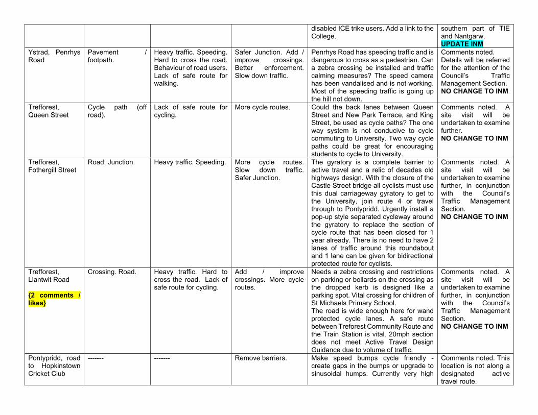
disabled ICE trike users. Add a link to the College.
southern part of TIE and Nantgarw.UPDATE INM
Ystrad, Penrhys Road
Pavement / footpath.
Heavy traffic. Speeding. Hard to cross the road. Behaviour of road users. Lack of safe route for walking.
Safer Junction. Add / improve crossings. Better enforcement. Slow down traffic.
Penrhys Road has speeding traffic and is dangerous to cross as a pedestrian. Can a zebra crossing be installed and traffic calming measures? The speed camera has been vandalised and is not working. Most of the speeding traffic is going up the hill not down.
Comments noted.Details will be referred for the attention of the Council’s Traffic Management Section.NO CHANGE TO INM
Trefforest, Queen Street
Cycle path (off road).
Lack of safe route for cycling.
More cycle routes. Could the back lanes between Queen Street and New Park Terrace, and King Street, be used as cycle paths? The one way system is not conducive to cycle commuting to University. Two way cycle paths could be great for encouraging students to cycle to University.
Comments noted. A site visit will be undertaken to examine further. NO CHANGE TO INM
Trefforest, Fothergill Street
Road. Junction. Heavy traffic. Speeding. More cycle routes. Slow down traffic. Safer Junction.
The gyratory is a complete barrier to active travel and a relic of decades old highways design. With the closure of the Castle Street bridge all cyclists must use this dual carriageway gyratory to get to the University, join route 4 or travel through to Pontypridd. Urgently install a pop-up style separated cycleway around the gyratory to replace the section of cycle route that has been closed for 1 year already. There is no need to have 2 lanes of traffic around this roundabout and 1 lane can be given for bidirectional protected route for cyclists.
Comments noted. A site visit will be undertaken to examine further, in conjunction with the Council’s Traffic Management Section.NO CHANGE TO INM
Trefforest, Llantwit Road
{2 comments / likes}
Crossing. Road. Heavy traffic. Hard to cross the road. Lack of safe route for cycling.
Add / improve crossings. More cycle routes.
Needs a zebra crossing and restrictions on parking or bollards on the crossing as the dropped kerb is designed like a parking spot. Vital crossing for children of St Michaels Primary School.The road is wide enough here for wand protected cycle lanes. A safe route between Treforest Community Route and the Train Station is vital. 20mph section does not meet Active Travel Design Guidance due to volume of traffic.
Comments noted. A site visit will be undertaken to examine further, in conjunction with the Council’s Traffic Management Section.NO CHANGE TO INM
Pontypridd, road to Hopkinstown Cricket Club
------- ------- Remove barriers. Make speed bumps cycle friendly - create gaps in the bumps or upgrade to sinusoidal humps. Currently very high
Comments noted. This location is not along a designated active travel route.
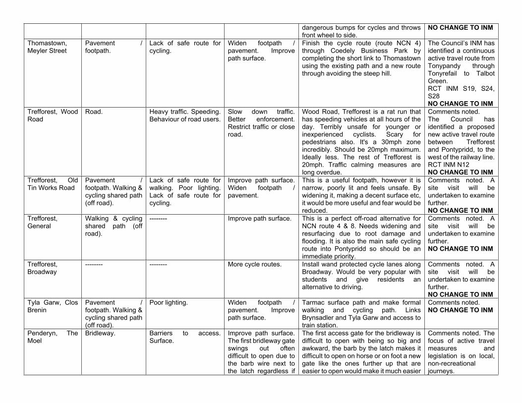
dangerous bumps for cycles and throws front wheel to side.
NO CHANGE TO INM
Thomastown, Meyler Street
Pavement / footpath.
Lack of safe route for cycling.
Widen footpath / pavement. Improve path surface.
Finish the cycle route (route NCN 4) through Coedely Business Park by completing the short link to Thomastown using the existing path and a new route through avoiding the steep hill.
The Council’s INM has identified a continuous active travel route from Tonypandy through Tonyrefail to Talbot Green.RCT INM S19, S24, S28NO CHANGE TO INM
Trefforest, Wood Road
Road. Heavy traffic. Speeding. Behaviour of road users.
Slow down traffic. Better enforcement. Restrict traffic or close road.
Wood Road, Trefforest is a rat run that has speeding vehicles at all hours of the day. Terribly unsafe for younger or inexperienced cyclists. Scary for pedestrians also. It's a 30mph zone incredibly. Should be 20mph maximum. Ideally less. The rest of Trefforest is 20mph. Traffic calming measures are long overdue.
Comments noted.The Council has identified a proposed new active travel route between Trefforest and Pontypridd, to the west of the railway line.RCT INM N12NO CHANGE TO INM
Trefforest, Old Tin Works Road
Pavement / footpath. Walking & cycling shared path (off road).
Lack of safe route for walking. Poor lighting. Lack of safe route for cycling.
Improve path surface. Widen footpath / pavement.
This is a useful footpath, however it is narrow, poorly lit and feels unsafe. By widening it, making a decent surface etc, it would be more useful and fear would be reduced.
Comments noted. A site visit will be undertaken to examine further. NO CHANGE TO INM
Trefforest, General
Walking & cycling shared path (off road).
-------- Improve path surface. This is a perfect off-road alternative for NCN route 4 & 8. Needs widening and resurfacing due to root damage and flooding. It is also the main safe cycling route into Pontypridd so should be an immediate priority.
Comments noted. A site visit will be undertaken to examine further.NO CHANGE TO INM
Trefforest, Broadway
-------- -------- More cycle routes. Install wand protected cycle lanes along Broadway. Would be very popular with students and give residents an alternative to driving.
Comments noted. A site visit will be undertaken to examine further. NO CHANGE TO INM
Tyla Garw, Clos Brenin
Pavement / footpath. Walking & cycling shared path (off road).
Poor lighting. Widen footpath / pavement. Improve path surface.
Tarmac surface path and make formal walking and cycling path. Links Brynsadler and Tyla Garw and access to train station.
Comments noted.NO CHANGE TO INM
Penderyn, The Moel
Bridleway. Barriers to access. Surface.
Improve path surface. The first bridleway gate swings out often difficult to open due to the barb wire next to the latch regardless if
The first access gate for the bridleway is difficult to open with being so big and awkward, the barb by the latch makes it difficult to open on horse or on foot a new gate like the ones further up that are easier to open would make it much easier
Comments noted. The focus of active travel measures and legislation is on local, non-recreational journeys.
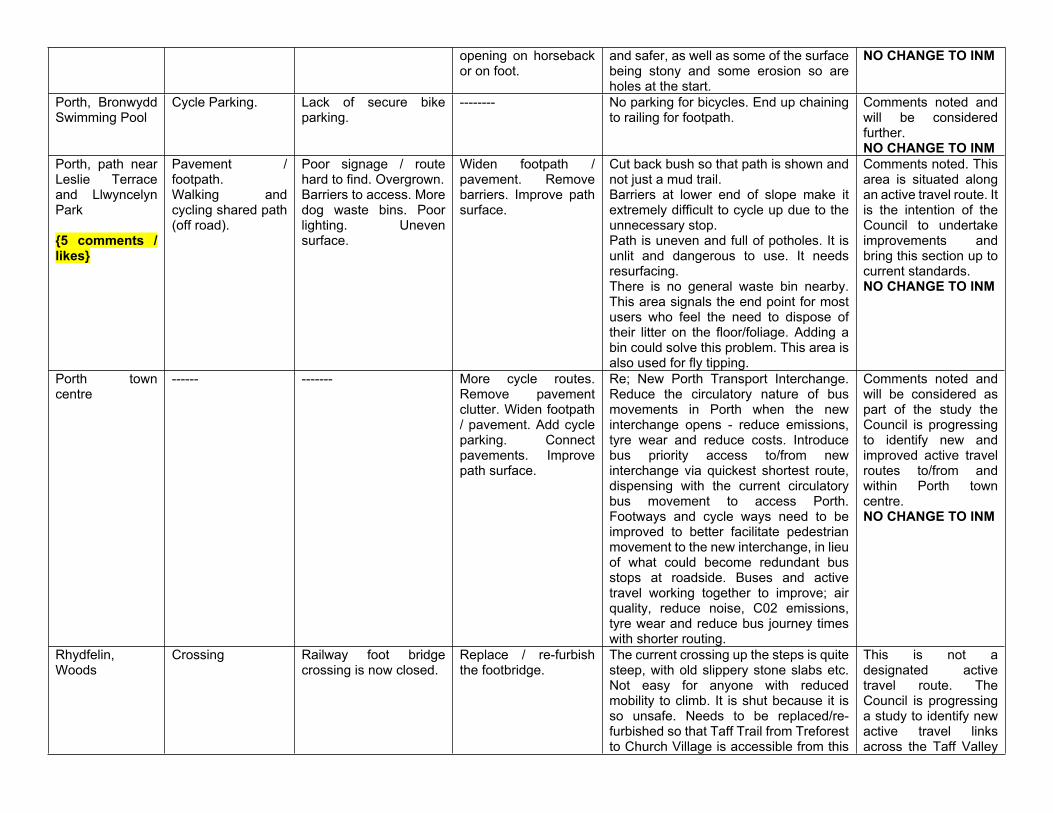
opening on horseback or on foot.
and safer, as well as some of the surface being stony and some erosion so are holes at the start.
NO CHANGE TO INM
Porth, Bronwydd Swimming Pool
Cycle Parking. Lack of secure bike parking.
-------- No parking for bicycles. End up chaining to railing for footpath.
Comments noted and will be considered further.NO CHANGE TO INM
Porth, path near Leslie Terrace and Llwyncelyn Park
{5 comments / likes}
Pavement / footpath.Walking and cycling shared path (off road).
Poor signage / route hard to find. Overgrown.Barriers to access. More dog waste bins. Poor lighting. Uneven surface.
Widen footpath / pavement. Remove barriers. Improve path surface.
Cut back bush so that path is shown and not just a mud trail. Barriers at lower end of slope make it extremely difficult to cycle up due to the unnecessary stop.Path is uneven and full of potholes. It is unlit and dangerous to use. It needs resurfacing.There is no general waste bin nearby. This area signals the end point for most users who feel the need to dispose of their litter on the floor/foliage. Adding a bin could solve this problem. This area is also used for fly tipping.
Comments noted. This area is situated along an active travel route. It is the intention of the Council to undertake improvements and bring this section up to current standards.NO CHANGE TO INM
Porth town centre
------ ------- More cycle routes. Remove pavement clutter. Widen footpath / pavement. Add cycle parking. Connect pavements. Improve path surface.
Re; New Porth Transport Interchange. Reduce the circulatory nature of bus movements in Porth when the new interchange opens - reduce emissions, tyre wear and reduce costs. Introduce bus priority access to/from new interchange via quickest shortest route, dispensing with the current circulatory bus movement to access Porth. Footways and cycle ways need to be improved to better facilitate pedestrian movement to the new interchange, in lieu of what could become redundant bus stops at roadside. Buses and active travel working together to improve; air quality, reduce noise, C02 emissions, tyre wear and reduce bus journey times with shorter routing.
Comments noted and will be considered as part of the study the Council is progressing to identify new and improved active travel routes to/from and within Porth town centre.NO CHANGE TO INM
Rhydfelin, Woods
Crossing Railway foot bridge crossing is now closed.
Replace / re-furbish the footbridge.
The current crossing up the steps is quite steep, with old slippery stone slabs etc. Not easy for anyone with reduced mobility to climb. It is shut because it is so unsafe. Needs to be replaced/re-furbished so that Taff Trail from Treforest to Church Village is accessible from this
This is not a designated active travel route. The Council is progressing a study to identify new active travel links across the Taff Valley
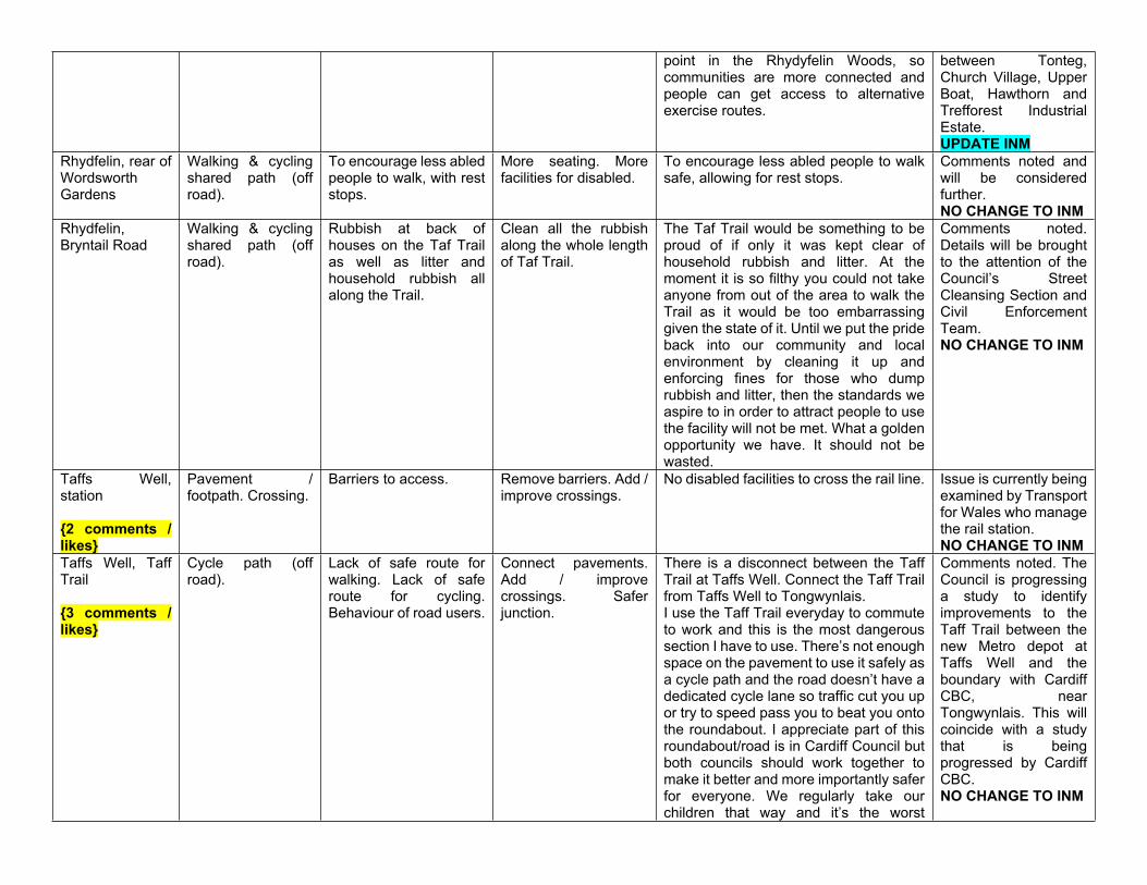
point in the Rhydyfelin Woods, so communities are more connected and people can get access to alternative exercise routes.
between Tonteg, Church Village, Upper Boat, Hawthorn and Trefforest Industrial Estate.UPDATE INM
Rhydfelin, rear of Wordsworth Gardens
Walking & cycling shared path (off road).
To encourage less abled people to walk, with rest stops.
More seating. More facilities for disabled.
To encourage less abled people to walk safe, allowing for rest stops.
Comments noted and will be considered further. NO CHANGE TO INM
Rhydfelin, Bryntail Road
Walking & cycling shared path (off road).
Rubbish at back of houses on the Taf Trail as well as litter and household rubbish all along the Trail.
Clean all the rubbish along the whole length of Taf Trail.
The Taf Trail would be something to be proud of if only it was kept clear of household rubbish and litter. At the moment it is so filthy you could not take anyone from out of the area to walk the Trail as it would be too embarrassing given the state of it. Until we put the pride back into our community and local environment by cleaning it up and enforcing fines for those who dump rubbish and litter, then the standards we aspire to in order to attract people to use the facility will not be met. What a golden opportunity we have. It should not be wasted.
Comments noted. Details will be brought to the attention of the Council’s Street Cleansing Section and Civil Enforcement Team.NO CHANGE TO INM
Taffs Well, station
{2 comments / likes}
Pavement / footpath. Crossing.
Barriers to access. Remove barriers. Add / improve crossings.
No disabled facilities to cross the rail line. Issue is currently being examined by Transport for Wales who manage the rail station.NO CHANGE TO INM
Taffs Well, Taff Trail
{3 comments / likes}
Cycle path (off road).
Lack of safe route for walking. Lack of safe route for cycling. Behaviour of road users.
Connect pavements. Add / improve crossings. Safer junction.
There is a disconnect between the Taff Trail at Taffs Well. Connect the Taff Trail from Taffs Well to Tongwynlais.I use the Taff Trail everyday to commute to work and this is the most dangerous section I have to use. There’s not enough space on the pavement to use it safely as a cycle path and the road doesn’t have a dedicated cycle lane so traffic cut you up or try to speed pass you to beat you onto the roundabout. I appreciate part of this roundabout/road is in Cardiff Council but both councils should work together to make it better and more importantly safer for everyone. We regularly take our children that way and it’s the worst
Comments noted. The Council is progressing a study to identify improvements to the Taff Trail between the new Metro depot at Taffs Well and the boundary with Cardiff CBC, near Tongwynlais. This will coincide with a study that is being progressed by Cardiff CBC.NO CHANGE TO INM
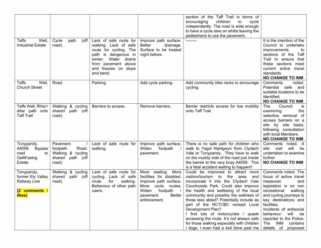
section of the Taff Trail in terms of encouraging children to cycle independently. The road is wide enough to have a cycle lane on whilst leaving the pedestrians to use the pavement.
Taffs Well, Industrial Estate
Cycle path (off road).
Lack of safe route for walking. Lack of safe route for cycling. The path is dangerous in winter. Water drains from pavement above and freezes on slope and bend.
Improve path surface. Better drainage. Surface to be treated night before.
-------- It is the intention of the Council to undertake improvements to sections of the Taff Trail to ensure that these sections meet current active travel standards.NO CHANGE TO INM
Taffs Well, Church Street
Road. Parking. Add cycle parking. Add community bike racks to encourage cycling.
Comments noted. Potential safe and suitable locations to be identified.NO CHANGE TO INM
Taffs Well, Rhiw’r ddar path onto Taff Trail
Walking & cycling shared path (off road).
Barriers to access. Remove barriers. Barrier restricts access for low mobility onto Taff Trail.
The Council is examining the selective removal of access barriers on a site by site basis, following consultation with local Members.NO CHANGE TO INM
Tonypandy, A4058 Bypass road to GelliFaelog Estate
Pavement / footpath. Road. Walking & cycling shared path (off road).
Lack of safe route for walking.
Improve path surface. Widen footpath / pavement.
There is no safe path for children who walk to Ysgol Nantgwyn from Clydach Vale or Tonypandy. They have to walk on the muddy side of the road just inside the barrier to the very busy A4058. This is a fatal accident waiting to happen!!
Comments noted. A site visit will be undertaken to examine further.NO CHANGE TO INM
Tonypandy, former Ely Valley Railway Line
{2 comments / likes}
Walking & cycling shared path (off road).
Lack of safe route for cycling. Lack of safe route for walking. Behaviour of other path users.
More seating. More facilities for disabled. Improve path surface. More cycle routes. Widen footpath / pavement. Better enforcement.
Could be improved to attract more visitors/tourism to the area and incorporate it into the Clydach Vale Countryside Park. Could also improve the health and wellbeing of the local community and possibly the wellness of those less abled? Potentially include as part of the RCTCBC revised Local Development Plan? I find lots of motorcycles / quads accessing the route. It’s not always safe for those walking especially with children / dogs. I even had a 4x4 drive past me
Comments noted. The focus of active travel measures and legislation is on non recreational walking and cycling journeys to key destinations and facilities.Incidents of antisocial behaviour will be reported to the Police. The INM contains details of proposed
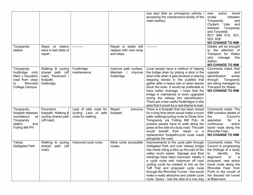
one day! (Not an emergency vehicle / accessing the maintenance facility of the mast nearby).
new active travel routes between Tonypandy and Clydach Vale and between Tonypandy and Tonyrefail.RCT INM S10, S21, S23, S28NO CHANGE TO INM
Tonypandy, station
Steps at station were in bad state of repair.
---------- Repair or better still replace with new ramp and steps.
---------- Details will be brought to the attention of Transport for Wales who manage this station.NO CHANGE TO INM
Tonypandy, footbridge onto Nant y Gwyddon road from close to Rhondda College Campus
Walking & cycling shared path (off road). Pavement / footpath, footbridge.
Footbridge maintenance.
Improve path surface. Maintain / improve footbridge.
Local people have a method of helping the bridge drain by poking a stick in the drain hole when it gets blocked or placing stepping stones in the puddles that gather after a heavy rain or when leaves block the drain. It would be preferable to have better drainage. I hope that the bridge is maintained or even upgraded during the railway line electrification.There are a few useful footbridges in this area that it would be a real shame to lose.
Comments noted. Rail upgrade and electrification works through Tonypandy are being managed by Transport for Wales.NO CHANGE TO INM
Tonypandy, footpath between roundabout at Tonypandy station and Fulling Mill PH
Pavement / footpath. Walking & cycling shared path (off road).
Lack of safe route for cycling. Lack of safe route for walking.
Repair previous footpath.
There is a footpath that has been closed for a long time which would make a much safer walking/cycling route to Dinas from Tonypandy via Fulling Mill Pub. At present people have to walk along the grass at the side of a busy road. The path would benefit from repair or a replacement footpath/cycle route made alongside the road.
Comments noted. The INM contains details of the Council’s aspiration for a continuous active travel route along the Rhondda Fawr.NO CHANGE TO INM
Ystrad, Gelligaled Park
Walking & cycling shared path (off road).
Improved cycle route. More cycle accessible routes.
Improvements to the cycle path through Gelligaled Park and over railway bridge has made riding a bike up this part of the valley much easier. Signage and floor markings have been improved. Ideally if a cycle route with maximum off road cycling could be created to link up the Taff Trail and proposed cycle route through the Rhondda Tunnel - this would make a really attractive and usable cycle route. Query - has the idea of a one way
Comments noted. The Council is progressing the findings of a study to identify the alignment of a proposed, new active travel route along the Rhondda Fawr from Porth to the mouth of the disused rail tunnel at Blaencwm.
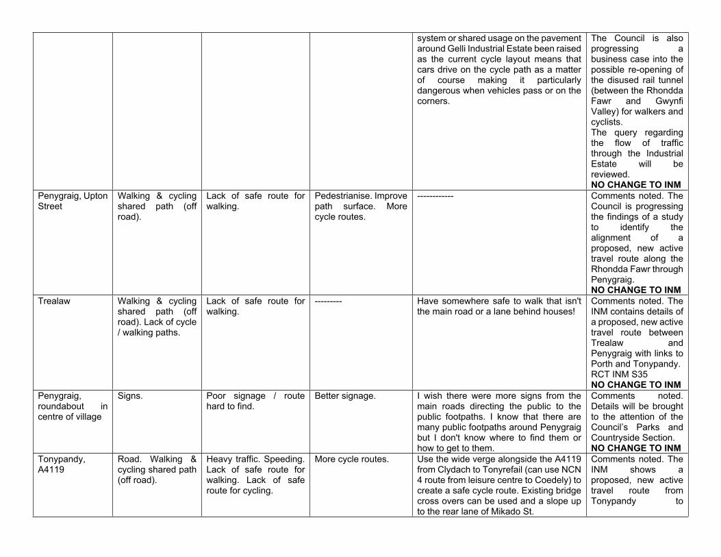
system or shared usage on the pavement around Gelli Industrial Estate been raised as the current cycle layout means that cars drive on the cycle path as a matter of course making it particularly dangerous when vehicles pass or on the corners.
The Council is also progressing a business case into the possible re-opening of the disused rail tunnel (between the Rhondda Fawr and Gwynfi Valley) for walkers and cyclists.The query regarding the flow of traffic through the Industrial Estate will be reviewed.NO CHANGE TO INM
Penygraig, Upton Street
Walking & cycling shared path (off road).
Lack of safe route for walking.
Pedestrianise. Improve path surface. More cycle routes.
------------ Comments noted. The Council is progressing the findings of a study to identify the alignment of a proposed, new active travel route along the Rhondda Fawr through Penygraig.NO CHANGE TO INM
Trealaw Walking & cycling shared path (off road). Lack of cycle / walking paths.
Lack of safe route for walking.
--------- Have somewhere safe to walk that isn't the main road or a lane behind houses!
Comments noted. The INM contains details of a proposed, new active travel route between Trealaw and Penygraig with links to Porth and Tonypandy.RCT INM S35NO CHANGE TO INM
Penygraig, roundabout in centre of village
Signs. Poor signage / route hard to find.
Better signage. I wish there were more signs from the main roads directing the public to the public footpaths. I know that there are many public footpaths around Penygraig but I don't know where to find them or how to get to them.
Comments noted. Details will be brought to the attention of the Council’s Parks and Countryside Section.NO CHANGE TO INM
Tonypandy, A4119
Road. Walking & cycling shared path (off road).
Heavy traffic. Speeding. Lack of safe route for walking. Lack of safe route for cycling.
More cycle routes. Use the wide verge alongside the A4119 from Clydach to Tonyrefail (can use NCN 4 route from leisure centre to Coedely) to create a safe cycle route. Existing bridge cross overs can be used and a slope up to the rear lane of Mikado St.
Comments noted. The INM shows a proposed, new active travel route from Tonypandy to
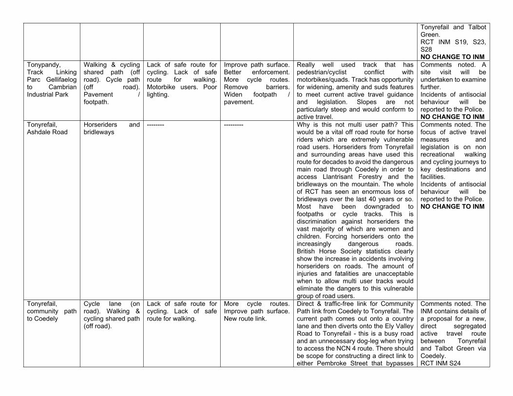
Tonyrefail and Talbot Green.RCT INM S19, S23, S28NO CHANGE TO INM
Tonypandy, Track Linking Parc Gellifaelog to Cambrian Industrial Park
Walking & cycling shared path (off road). Cycle path (off road). Pavement / footpath.
Lack of safe route for cycling. Lack of safe route for walking. Motorbike users. Poor lighting.
Improve path surface. Better enforcement. More cycle routes. Remove barriers. Widen footpath / pavement.
Really well used track that has pedestrian/cyclist conflict with motorbikes/quads. Track has opportunity for widening, amenity and suds features to meet current active travel guidance and legislation. Slopes are not particularly steep and would conform to active travel.
Comments noted. A site visit will be undertaken to examine further. Incidents of antisocial behaviour will be reported to the Police.NO CHANGE TO INM
Tonyrefail, Ashdale Road
Horseriders and bridleways
-------- --------- Why is this not multi user path? This would be a vital off road route for horse riders which are extremely vulnerable road users. Horseriders from Tonyrefail and surrounding areas have used this route for decades to avoid the dangerous main road through Coedely in order to access Llantrisant Forestry and the bridleways on the mountain. The whole of RCT has seen an enormous loss of bridleways over the last 40 years or so. Most have been downgraded to footpaths or cycle tracks. This is discrimination against horseriders the vast majority of which are women and children. Forcing horseriders onto the increasingly dangerous roads.British Horse Society statistics clearly show the increase in accidents involving horseriders on roads. The amount of injuries and fatalities are unacceptable when to allow multi user tracks would eliminate the dangers to this vulnerable group of road users.
Comments noted. The focus of active travel measures and legislation is on non recreational walking and cycling journeys to key destinations and facilities.Incidents of antisocial behaviour will be reported to the Police.NO CHANGE TO INM
Tonyrefail, community path to Coedely
Cycle lane (on road). Walking & cycling shared path (off road).
Lack of safe route for cycling. Lack of safe route for walking.
More cycle routes. Improve path surface. New route link.
Direct & traffic-free link for Community Path link from Coedely to Tonyrefail. The current path comes out onto a country lane and then diverts onto the Ely Valley Road to Tonyrefail - this is a busy road and an unnecessary dog-leg when trying to access the NCN 4 route. There should be scope for constructing a direct link to either Pembroke Street that bypasses
Comments noted. The INM contains details of a proposal for a new, direct segregated active travel route between Tonyrefail and Talbot Green via Coedely.RCT INM S24
the steep incline. A direct link would be a considerable improvement and provide even greater accessibility to an already very popular walking & cycling link for the local community.
NO CHANGE TO INM
Tonyrefail, Parc Erin
Walking & cycling shared path (off road).
Barriers to access. More cycle routes. The route between Tonyrefail and Blackmill is accessible only by the trawl road to the turbines. This is a difficult often mucky climb to the top of the hill to join the cycle track. Why not explore running the route past the factory and the public house down to the valley beyond, and connect to the existing route further down? This would be extremely helpful to facilitate both leisure and commuting to Bridgend or up to Garw Valley. This would also encourage many road cyclists who endanger themselves on the hilly and winding roads between Tonyrefail / Gilfach and Blackmill away from this difficult highway route. This would be an advantageous investment, by encouraging safety, health and leisure benefits. One further note - there is a need for an off road route alongside the link between Parc Erin and the Tonyrefail bypass. The existing route is poor, indirect, often overgrown and not naturally surveilled as a new route alongside the road could be. These improvements would be welcomed by many.
Comments noted. This route is primarily in open countryside and does not serve any key facilities. The focus of active travel measures is on short distance walking and cycling journeys for non recreational purposes.The INM contains details of a new active travel route from new housing developments in this part of Tonyrefail to the centre and links to proposed new routes to the north and south.RCT INM S30NO CHANGE TO INM
Treherbert, station
Walking & cycling shared path (off road).
Lack of safe route for walking. Lack of safe route for cycling.
Improve path surface. Connect pavements.
There is a good path and route but finishes 3/4 way to old Stelco site where it then becomes rough, muddy and poor. Extend path/track as this then provides pedestrian and bike route from Treherbert station to Blaencwm /Blaenrhondda junction.
Comments noted. Suggestion will be considered when determining the alignment of a proposed new active travel route along the Rhondda Fawr.NO CHANGE TO INM
Treherbert, Ynyswen, Cwmcybrin St
Barriers to access. Walking & cycling shared path (off road).
Remove barriers. Widen footpath / pavement. More facilities for disabled.
I wold like these barriers to be removed to allow large wheelchairs, mobility scooters and horses to access this path, that will allow people to be safe off road. The Welsh Government have stated that
Comments noted. The focus of active travel measures and legislation is on non
all barriers must be removed, to allow access for ALL and that includes EQUESTRIANS. So it would be a great safe off road access for many people.
recreational walking and cycling journeys.NO CHANGE TO INM
Treorchy, Bute Street
{2 comments / likes}
Junction. Heavy traffic. Remove traffic lights and replace with a mini roundabout.
The pedestrian crossings should be moved to areas by the Post Office, the Lion and the Parc and Dare theatre. Several years ago the traffic lights were off for several months with the result that traffic flowed smoothly, there were no accidents and pedestrians managed with no issues. This needs to be an urgent priority for this Council.The current situation is causing huge tailbacks of traffic adding to air pollution and blocking the road to emergency vehicles.
Comments noted. Details will be brought to the attention of the Council’s Traffic Management Section.NO CHANGE TO INM
Treorchy, Cwmparc Road
Crossing. Hard to cross the road. Behaviour of road users.
Add / improve crossing.
The zebra crossing either needs to be manned to ensure that children can be crossed in a controlled way or the crossing converted to a light controlled crossing so that there is less risk of accidents. Children either run across when it is quiet or, when a train or bus has dropped off 100’s, cross in an unsafe manner on and around the crossing in a surge. This also adds to congestion.
Comments noted. Details will be brought to the attention of the Council’s Traffic Management Section.NO CHANGE TO INM
Treorchy
{7 comments / likes}
Cycle path (off road). Walking and cycling shared path (off road).
Lack of safe route for cycling. Lack of safe route for walking. Lack of secure bike parking.
More cycle routes. There are no designated cycle routes in the Rhondda valley (confirmed by your website) including in Treorchy where I live. I have a young family & are trying to abide by the ‘stay at home’ guidance but there are no cycle paths for my young children in this area. The Rhondda & it’s residents are forgotten once more!A serious lack of safe family cycle paths in the Treorchy area. Would be lovely to have a nice flat route to take three kids on their bikes.I work in the local school and many children/ families have commented on the lack of facilities and safe areas for children. The owner of the local bike shop has also discussed this issue with myself.We need safe cycle routes in the upper Rhondda area for all ages to access and
Comments noted. The INM contains proposals for a new active travel route along the Rhondda Fawr through Treorchy.NO CHANGE TO INM
clearly marked walking routes on our mountain paths.We are one of the only valleys not to have a cycle or walking path. In normal times my family and I drive to other valley paths/coastal paths to ride/skate/walk /run/scoot. Now we’re unable to drive for exercise this is impossible with small children whom I do not want near the very busy main roads. Please, please can something be done about this in the near future to benefit people for generations to come.It would be lovely to have a safe path to walk or cycle from Gelli/Ystrad all the way to the top of the valley.
Treorchy, Iceland store
Road. Pavement. Pavement parking. Heavy traffic. Behaviour of other path users.
Better enforcement. Iceland has a regular delivery lorry which parks outside the front despite loading restrictions at peak traffic times. The large HGV faces into oncoming traffic, blocks a turning lane, and makes the crossing and traffic lights at Stag Square dangerous, particularly at the start of the school day. There needs to be strong enforcement, especially as Iceland actually has a loading bay at rear of store.
Details will be reported to the Council’s Civil Enforcement Team and South Wales Police as this is an enforcement issue.NO CHANGE TO INM
Treorchy, River Terrace
Pavement / footpath.
Pavement surface is being uplifted by tree roots.
-------- -------- Details will be brought to the attention of the Council’s Highways Maintenance Section.NO CHANGE TO INM
Treorchy, Pentre Road
Walking & cycling shared path (off road).
Behaviour of other path users.
More cycle routes. Paths are being completely destroyed by off road bikes. They frequent this path almost every weekend and it has ruined the paths up and down the mountain. Solution PUT UP BETTER GATES!! It would also be nice if there were a paved/tarmac path up and down the valley to join Treherbert to the Taff Trail. Would attract tourism and would increase footfall in pubs, shops and cafes. (not right now due to lock down but in the future). This would be a massive boost to this valley and is greatly needed.
Comments noted. Incidents of anti social behaviour will be reported to the Police.The INM contains proposals for a new active travel route along the Rhondda Fawr through Treorchy.Other details will be referred for the attention of the
Council’s Parks and Countryside Section.NO CHANGE TO INM
Treorchy, Woodlands Pentre Road
Pavement / footpath.
Pavement parking. Lack of safe route for walking. Speeding. Behaviour of other path users. Lack of safe route for cycling.
Safer Junction. Widen footpath / pavement. Add dropped kerbs.
Comments noted. The Council is progressing a study to identify the alignment of a proposed new active travel route along the Rhondda Fawr.Details of pavement parking will be reported to South Wales Police as this is an enforcement issue.NO CHANGE TO INM
Treorchy, Path between bottom of bridge and industrial estate (NCN 882)
Walking & cycling shared path (off road).
Poor lighting. Poor signage / route hard to find.
Widen footpath / pavement. Add dropped kerbs.
This part of the cycle path is too narrow. Always a clash of priority between walkers and cyclists on the path as it is barely wide enough for a single walker. Also, the exit onto the industrial estate needs a dropped kerb.
Comments noted. Site visit will be undertaken to Cae Mawr Industrial Estate to examine further.The Council is progressing a study to identify the alignment of a proposed new active travel route along the Rhondda Fawr through Treorchy.NO CHANGE TO INM
Tylorstown, St Gwynno Forest
------- Lack of safe route for walking.
-------- Off road motorbikes are wrecking this lovely area.
This location is not on an active travel route. Details will be brought to the attention of Natural Resources Wales who manage the forest.NO CHANGE TO INM
Tylorstown, river
{2 comments / likes}
Walking & cycling shared path (off road).
Lack of safe route for walking. Barriers to access.
Remove barriers. Improve path surface.
The path down the river is currently blocked with fallen trees and a large section of the path is blocked off with fences due to the work being done on the river. There is currently limited places to take my dog for a walk off the lead/away from the road. Also, there is not one single dog waste bin down the river.
Comments noted and will be considered further following completion of works along the river. The request for waste bins and repairs will be brought to the attention
Hendrefadog site doesn’t have a dog waste bin either, which is another popular dog walking area.Fix the gate that previously used to be here, over time it's rotted, and off-road bikers have taken it away to make the path accessible for them.
of the Council’s Street Cleansing and Highways Maintenance Teams.NO CHANGE TO INM
Penrhys, Saint Mary’s Field
Recreation Field. Behaviour of other path users. Lack of safe route for walking. Poor lighting.
Improve path surface. Add gates/barriers.
Christmas time there was multiple quad and off-road bikes using this field, and have destroyed the ground and the turf, which is now very unpleasant for dog walkers/ walkers who use this path daily. Especially now in wintertime due to the wet weather. Some gates/barriers by the St Mary statue entrance and over the other side towards the golf club would be beneficial. There are also no dog waste bins anywhere around this area which is also frustrating. Some street lights would also make many residents feel much safer who regularly walk here with their dogs.
Comments noted. This location is not on an active travel route. Details will be brought to the attention of the Council’s Parks and Countryside and Street Lighting Sections.Incidents of anti social behaviour should be reported to the Police.NO CHANGE TO INM
Tylorstown, Rhondda Fach Leisure Centre
Cycle parking. Lack of secure bike parking.
Add cycle parking. ---------- Comments noted and will be considered further.NO CHANGE TO INM
Tylorstown Surgery, Ferndale Road
Road. Pavement / footpath. Crossing.
Speeding. Hard to cross the road. Heavy traffic.
Add / improve crossings.
It’s extremely difficult for people to cross the road from the Old Police Station side of the road across to Tylorstown Surgery and back especially for older people. As this area is on a hill, traffic can move quickly up and down. Can a pedestrian crossing be put here with lights so people can cross safely?
Comments noted. Details will be brought to the attention of the Council’s Traffic Management Section.NO CHANGE TO INM
General ------- ------- ------- As somebody whom is a very keen lifelong cyclist most people are cautious and polite but I have found that often people and cyclists don't mix that well on certain bike/walk paths: Examples include: Dogs and leads - Many dog lovers use the cycle paths as excuses to let their pets run free thinking it’s a field on more than one occasion I have had a few words with dog lovers regarding whose right of way it is - make sure dogs are
Comments noted. The Council is considering installing signage on many active travel routes asking users to show more considerate behaviour towards other users of the routes. NO CHANGE TO INM
kept on leads on mixed paths and it must be signposted and enforced as much as possible! Other users - routes are used for all quite rightly too but sometimes children or walkers will drift into the path of cyclists often unaware of the implications once again arguments have occurred on right of way - put a white line down the middle of the route indicating a cyclist side and a pedestrian side - this works as well as its going to work for example, Swansea/mumbles route has such a line, no confusion you know which side your supposed to be on! Simple costs effective actions that make the journey for whichever stakeholder more enjoyable and safer.
Aberdare, junction The Grove and Herbert Street
Walking & cycling shared path (off road). Pavement /footpath.
Barriers to access. Possibly removing steps with a ramp to improve access for wheelchairs and pushchairs.
This path then leads on to the Dare Aman line where there are again steps to access the line which could be replaced by a ramp. The Dare Aman line is a very popular and lovely place to walk or cycle but access to it can be difficult for some.
Comments noted. This is not a designated active travel route. The focus of active travel measures is on walking and cycling journeys that are non recreational. Details will be brought to the attention of the Council’s Parks and Countryside Section.NO CHANGE TO INM
Pontyclun, Llantrisant Road
Walking & cycling shared path (off road).
Lack of safe route for cycling.
More cycle routes. Whilst the investment in our single cycle and walking route from the station to Cross Inn, there seems to be no plan that provides safe cycling routes for most residents of Pontyclun to access local schools or the retail sites which exist both in Pontyclun and Talbot Green. As a result there is severe congestion as these facilities are accessed by car - and this over-use of the care provides an even greater disincentive for walking and cycling.
The INM contains proposals for a network of new active travel routes in the Pontyclun and Talbot Green areas.RCT INM C7, N7, N9, S1, S4, S14, S42NO CHANGE TO INM
Pentyrch -------- --------- --------- Pentyrch connects several very nice walking and cycling routes without much traffic. Could these be upgraded to an
Comments will be forwarded to Cardiff CBC.NO CHANGE TO INM
official status on Sustrans etc. with some signs?
Beddau Road. Lack of safe route for walking.
Connect pavements. The pavement ends sharply near a bend, the traffic races along both ways as a rat run forcing pedestrians into the hedge and mud. There is room on the other side to make a pathway so as to connect with the road which leads down to the Brynteg Green estate and the Community route. Failing the viability of a path, a 20mph limit on the stretch coming into Beddau and traffic calming until the start of the pavement would help.
Comments noted. A site visit will be undertaken to examine further.NO CHANGE TO INM
Efail Isaf, Ffordd y Capel
Lack of safe and comfortable cycle routes from the village to other places.
Lack of safe route for cycling.
More cycle routes. Restrict traffic or close road. Add/improve crossings. Some existing community routes are still guarded by barriers through which most cycles cannot pass without dismounting. It would be safer for cyclists and dogs if owners could be asked to keep their pets on a lead. Add cycle parking.
It would be good if there was a community route to Taffs Well along the river bank from Upper Boat since it is not very easy to access the Taff Trail if you live south of the river. Most of the properties that back onto the river seem to have enough space at their rear to make this practical. If you like walking or cycling and live in my village you probably find yourself using the country lanes. Many of these routes are spoiled by the amount of traffic that use them. These routes could be improved by restricting their use by heavy goods lorries, by reduced speed limits and by better road surface maintenance.
Comments will be considered further. A site visit will be undertaken regarding proposed new active travel routes in the area.NO CHANGE TO INM
Talbot Green, Cowbridge Road
Road. Lack of safe route for cycling. Hard to cross the road. Heavy traffic.
More cycle routes. Add / improve crossings.
Install protected cycle lanes with removal of central hatching and turning / 3rd lane to provide space on carriageway. Pop-up style lanes on both sides of road protected by rubber kerbs and wands. Vital for safe cycle access to Y Pant school and shops.
Comments noted. A site visit will be undertaken to examine further, in conjunction with the Council’s Traffic Management Section.NO CHANGE TO INM
Tonyrefail and Penrhiwfer
Pavement / footpath.
Lack of safe route for walking.
Connect pavements. This route is used by young and old and can be dangerous to walk along due the speed and amount of traffic you experience when walking or cycling.
Comments noted. The INM contains details of a proposed new active travel route between Penrhiwfer and Tonyrefail.RCT INM S28NO CHANGE TO INM
Miskin, Miskin Manor
-------- -------- -------- Negotiate access for a cycle route between Miksin and Groesfaen and on to Cardiff via Cricket Club access.
Comments noted. A site visit will be undertaken to examine further.NO CHANGE TO INM
Related Documents