Draft 2019 TIP June 18, 2018 APPENDIX A – 5 Air Quality Conformity Analysis MTC Resolution No. 4374

Welcome message from author
This document is posted to help you gain knowledge. Please leave a comment to let me know what you think about it! Share it to your friends and learn new things together.
Transcript

Draft 2019 TIP June 18, 2018
APPENDIX A – 5
Air Quality Conformity Analysis
MTC Resolution No. 4374

Draft Transportation-Air Quality Conformity Analysis for the Amended Plan
Bay Area and the 2019 Transportation Improvement Program
Draft: June 6, 2018
June 2018
Bay Area Metro Center
375 Beale Street San Francisco, CA 94105
(415) 778-6700 phone [email protected] e-mail www.mtc.ca.gov web

2 0 1 9 T r a n s p o r a t i o n I m p r o v e m e n t P r o g r a m P a g e | i
Project Staff
Ken Kirkey, Director, Planning
Harold Brazil, Project Manager
Planning & Programming and Allocations Staff
Mallory Atkinson
Adam Crenshaw
Ben Espinoza
Ross McKeown
Flavia Tsang
Lisa Zorn

2 0 1 9 T r a n s p o r a t i o n I m p r o v e m e n t P r o g r a m P a g e | ii
Table of Contents
List of Tables ............................................................................................................................................ iii
List of Figures ........................................................................................................................................... iv
I. Introduction ....................................................................................................................................1
Purpose of Conformity Analysis ................................................................................................................ 1
Status of Regional Transportation Plan .................................................................................................... 3
Status of Transportation Improvement Program ..................................................................................... 4
II. Bay Area Air Pollutant Designations ................................................................................................4
National 1-Hour Ozone Standard .............................................................................................................. 4
National 8-Hour Ozone Standard .............................................................................................................. 5
National PM2.5 Standard ............................................................................................................................ 6
National 8-Hour Carbon Monoxide Standard ........................................................................................... 7
Approved Motor Vehicle Emissions Budgets and Conformity Tests ........................................................ 7
III. Conformity Analysis & Results .......................................................................................................9
Approach to Conformity Analysis ............................................................................................................. 9
Analysis Years .......................................................................................................................................... 10
Consultation Process ............................................................................................................................... 10
Comparison of Motor Vehicle Emissions to Budgets .............................................................................. 11
Baseline Year Emissions Test for PM2.5 ................................................................................................... 13
IV. Transportation Control Measures ................................................................................................ 15
History of Transportation Control Measures .......................................................................................... 15
Status of Transportation Control Measures ........................................................................................... 16
V. Response to Public Comments ...................................................................................................... 19
VI. Conformity Findings .................................................................................................................... 20
Appendix A1. List of Projects in the Draft 2019 Transportation Improvement Program
Appendix A2. List of Projects in the Draft 2019 Transportation Improvement Program with Updated
Conformity Analysis Years
Appendix B. List of Projects in Amended Plan Bay Area 2040
Appendix C. Conformity Approach for MTC’s Updated Long-Range Regional Transportation Plan and
Sustainable Communities Strategy (RTP/SCS) Memo
Appendix D. Travel Modeling Report
Appendix E. List of Transportation Control Measures (TCM) Projects
Appendix F. Methodology for Bay Area Conformity Determinations

2 0 1 9 T r a n s p o r a t i o n I m p r o v e m e n t P r o g r a m P a g e | iii
List of Tables Table 1: VOC and NOX Emissions Budgets from 2001 Ozone Attainment Plan (tons/day) ......................... 11
Table 2: Vehicle Activity Forecasts .............................................................................................................. 11
Table 3: Emissions Budget Comparisons for Ozone Precursors – Summertime Conditions (tons/day) ..... 12
Table 4: Emission Reductions for Transportation Control Measures A – E in State Implementation Plan
(tons/day) .................................................................................................................................................... 13
Table 5: Vehicle Activity Forecasts for the PM2.5 Baseline Year Test .......................................................... 13
Table 6: Emissions Comparison for the PM2.5 Baseline Year Test ............................................................... 13
Table 7: Transportation Control Measure in the State Implementation Plan ............................................ 16
Table 8: Implementation Status of Federal Transportation Control Measures for Ozone (A – E) ............. 17

2 0 1 9 T r a n s p o r a t i o n I m p r o v e m e n t P r o g r a m P a g e | iv
List of Figures Figure 1: Map of the Non-Attainment Area for the San Francisco Bay Area ................................................ 2
Figure 2: Emissions Budget Comparisons for Ozone Precursors ................................................................ 12
Figure 3: Baseline Year Emissions Test for PM2.5 ........................................................................................ 14
Figure 4: Baseline Year Emissions Test for Wintertime NOX ....................................................................... 14

2 0 1 9 T r a n s p o r a t i o n I m p r o v e m e n t P r o g r a m P a g e | 1
I. Introduction The Metropolitan Transportation Commission (MTC) prepares a transportation-air quality conformity
analysis (“conformity analysis”) when it amends or updates its Regional Transportation Plan (RTP),
and/or updates its Transportation Improvement Program (TIP), or adds or deletes regionally significant,
non-exempt projects into the TIP.
The purpose of this conformity analysis is to reconform the Amended RTP (“Plan Bay Area 2040”) and to
conform the 2019 TIP in accordance with the latest U.S. Environmental Protection Agency (EPA)
transportation conformity regulations and the Bay Area Conformity State Implementation Plan
(Conformity SIP), which is also known as the Bay Area Air Quality Conformity Protocol (MTC Resolution
No. 3757). This conformity analysis addresses the 2008 national ambient air quality standard (NAAQS)
for 8-hour ozone, the 8-hour national carbon monoxide standard, and the 2006 national 24-hour fine
particulate matter (PM2.5) standard.
This report explains the basis for the conformity analysis and provides the results used by MTC to make
a positive conformity finding for the Amended Plan Bay Area 2040 and the 2019 TIP.
Purpose of Conformity Analysis The Federal Clean Air Act, as amended in 1990 (CAAA) outlines requirements for ensuring that federal
transportation plans, programs, and projects are consistent with (“conform to”) the purpose of the SIP.
Conformity to the purpose of the SIP means that transportation activities will not cause new air quality
violations, worsen existing violations, or delay timely attainment of the relevant national ambient air
quality standards. A conformity finding demonstrates that the total emissions projected for a
transportation plan (“RTP”) or program (“TIP”) are within the emissions limits ("budgets") established by
the SIP, and that transportation control measures (TCMs) are implemented in a timely fashion.
Conformity requirements apply in all non-attainment and maintenance areas for transportation-related
criteria pollutants and related precursor emissions. For the Bay Area, the criteria pollutants to be
addressed are ground-level ozone, carbon monoxide, and PM2.5; and the precursor pollutants to be
addressed include volatile organic compounds (VOC) and oxides of nitrogen (NOX) for ozone and for
PM2.5. EPA’s most recent revisions to its transportation conformity regulations to implement the 1990
Federal Clean Air Act section 176 were published in the Federal Register on March 14, 20121.
Metropolitan Planning Organizations (MPOs) such as MTC are required to follow these regulations, and
any other procedures and criteria contained in the EPA-approved Conformity SIP (Transportation-Air
Quality Conformity Protocol) for the Bay Area. In the Bay Area, procedures were first adopted in
September 1994 to comply with the 1990 CAAA. Four subsequent amendments to the transportation
conformity procedures in August 1995, November 1995, August 1997, and July 2006 have been adopted
by the three co-lead agencies (MTC, Association of Bay Area Governments (ABAG), and Bay Area Air
Quality Management District (BAAQMD)). MTC Resolution 3757 represents the latest San Francisco Bay
Area Transportation-Air Quality Conformity Protocol adopted by the three agencies in July 2006. Acting
on behalf of the three agencies, the BAAQMD submitted this latest Protocol to California Air Resources
Board (CARB) as a revision to the Bay Area Conformity SIP. CARB approved this proposed revision to the
1 The current version of the regulations is available on EPA’s Transportation Conformity website at https://www.epa.gov/state-and-local-transportation/current-law-regulations-and-guidance-state-and-local-transportation

2 0 1 9 T r a n s p o r a t i o n I m p r o v e m e n t P r o g r a m P a g e | 2
Figure 1: Map of the Non-Attainment Area for the San Francisco Bay Area

2 0 1 9 T r a n s p o r a t i o n I m p r o v e m e n t P r o g r a m P a g e | 3
Bay Area’s Conformity SIP in December 2006 and transmitted it to EPA for final action. EPA approved the
Bay Area Conformity SIP in December 2007 (40 CFR Part 52).
These regulations and resolutions state in part that, MTC cannot approve any transportation plan,
program, or project unless these activities conform to the purpose of the federal air quality plan.
"Transportation plan" refers to the RTP. "Program" refers to the TIP, which is a financially realistic set of
highway and transit projects to be funded over the next four years. A "transportation project" is any
highway or transit improvement, which is included in the RTP and TIP and requires funding or approval
from the Federal Highway Administration (FHWA) or the Federal Transit Administration (FTA).
Conformity regulations also affect regionally significant non-federally funded projects which must be
included in a conforming transportation plan (“RTP”) and program (“TIP”).
Status of Regional Transportation Plan A regional transportation plan, or RTP, is a plan which includes both long-range and short-range
strategies and actions that lead to the development of an integrated multimodal transportation system
to facilitate the safe and efficient movement of people and goods in addressing current and future
transportation demand. State law requires that RTP’s include a Sustainable Communities Strategy (SCS)
to identify a forecasted land use development pattern that when integrated with the future
transportation system will meet the region’s greenhouse gas reduction target set by CARB. As required
by federal and state planning regulations, the RTP covers a minimum planning horizon of 20 years and is
updated every four years in areas which do not meet federal air quality standards (“non-attainment”).
The RTP is financially constrained to ensure project costs do not exceed regionally expected
transportation revenues over the planning horizon. Once adopted, the RTP guides the development of
the TIP for the region.
The San Francisco Bay Area’s RTP/SCS is called Plan Bay Area 2040 (“the Plan”), was originally adopted in
July 2017, and is an update to Plan Bay Area (2013). Plan Bay Area 2040 represents a strategic
investment strategy to maintain existing transportation infrastructure, service, and system performance
for Bay Area travelers through horizon year 2040. It includes a regional transportation investment
strategy and subsequent list of highway, transit, local roadway, bicycle, and pedestrian projects
identified through regional and local transportation planning processes. In addition, Plan Bay Area 2040
includes a focused growth land use pattern designed to reduce passenger vehicle travel in an effort to
meet the region’s greenhouse gas reduction target set by CARB.
Starting with the current state of the region, Plan Bay Area 2040 describes its goals, a proposed growth
pattern and supporting transportation investment strategy, and key actions needed to address ongoing
and long-term regional challenges. The Plan also includes supplemental reports for additional details.
These documents and the adopted Plan can be found at http://2040.planbayarea.org/reports.
In March 2018, MTC and ABAG amended Plan Bay Area 2040 to modify the scope and project cost of the
U.S. Highway 101 Managed Lanes Project in San Mateo County (RTPID 17-06-0007). The amendment
updated the cost, clarified the project description, and modified lane configuration assumptions along
the U.S. Highway 101 corridor to accommodate an Express Lane. In addition, the amendment increased
the total project cost to $534 million. The Commission approved the Transportation-Air Quality
Conformity Analysis for Amended Plan Bay Area 2040 and Amended 2017 Transportation Improvement
Program on March 28, 2018 (MTC Resolution No. 4325). The FHWA and FTA approved MTC’s conformity
determination for the Amended Plan Bay Area 2040 and the Amended 2017 TIP on May 17, 2018.

2 0 1 9 T r a n s p o r a t i o n I m p r o v e m e n t P r o g r a m P a g e | 4
This conformity analysis will serve to demonstrate that the Amended Plan Bay Area 2040 conforms to
the SIP. Refer to Appendix B for a detailed list of projects included in the Amended Plan Bay Area 2040.
Status of Transportation Improvement Program The federally required transportation improvement program, or TIP, is a comprehensive listing of
surface transportation projects for the San Francisco Bay Area that receive federal funds, are subject to
a federally required action, or are regionally significant. MTC, as the federally designated MPO, prepares
and adopts the TIP at least once every four years. The TIP covers a four-year period and must be
financially constrained by year, meaning that the amount of dollars committed to the projects (also
referred as “programmed”) must not exceed the amount of dollars estimated to be available. Adoption
of the TIP must be accompanied by an air quality conformity analysis and finding, and all projects
included in the TIP must be derived from and/or be consistent with the RTP.
The 2019 TIP contains approximately 800 projects totaling about $13.2 billion over the four-year period
from fiscal year 2019-20 to 2021-22. This conformity analysis serves to conform the Draft 2019 TIP and
Amended Plan Bay Area 2040.
Refer to Appendix A1 for a detailed listing of projects/programs in the Draft 2019 TIP. Note that specific
funding sources are identified in the TIP itself. Appendix A2 list the projects in the Draft 2019 TIP with
updated conformity analysis years.
II. Bay Area Air Pollutant Designations
National 1-Hour Ozone Standard The Bay Area was initially designated as nonattainment for ozone on March 3, 1978. On November 6,
1991, the EPA designated the Bay Area as a moderate ozone non-attainment area. Based on “clean” air
monitoring data from 1990 to 1992, the co-lead agencies—BAAQMD, MTC, and ABAG— determined
that the Bay Area was attaining the 1-hour ozone standard and requested that CARB forward a re-
designation request and an ozone maintenance plan to EPA.
On May 25, 1995, after evaluating 1990-1992 monitoring data and determining that the Bay Area had
continued to attain the standard, the EPA re-designated the Bay Area as an ozone maintenance area.
Shortly thereafter, the area began violating the standard again and on July 10, 1998, the EPA published a
Notice of Final Rulemaking re-designating the Bay Area back to an ozone non-attainment area. This
action became effective on August 10, 1998.
The re-designation to nonattainment triggered an obligation for the State to submit a SIP revision
designed to provide for attainment of the 1-hour ozone NAAQS by November 15, 2000. This revision
(the San Francisco Bay Area Ozone Attainment Plan for the 1-hour National Ozone Standard – June 1999
or “1999 Plan”) was partially approved and partially disapproved by EPA on September 20, 2001 in
conjunction with a determination that the area had failed to attain by the November 2000 deadline. The
attainment demonstration and its associated motor vehicle emissions budgets were among the plan
elements that were disapproved.
As a result of the EPA’s finding of failure to attain and partial disapproval of the 1999 Plan, the State was
required to submit a SIP revision for the Bay Area to EPA by September 20, 2002 that included an

2 0 1 9 T r a n s p o r a t i o n I m p r o v e m e n t P r o g r a m P a g e | 5
updated volatile organic compounds (VOC) and nitrogen oxides (NOX) emissions inventory, new
transportation conformity budgets, and provided for attainment of the 1-hour ozone standard no later
than September 20, 2006. On November 1, 2001, CARB approved the San Francisco Bay Area 2001
Ozone Attainment Plan for the 1-Hour National Ozone Standard (2001 Plan) as a revision to the SIP. The
BAAQMD and its co-lead agencies, (MTC and ABAG) adopted the 2001 Plan on October 26, 2001.
The 2001 Plan contains a control strategy with seven stationary source measures, five transportation
control measures (TCMs), and eleven further-study measures. In the 2001 Plan, the District also
committed to strengthening the then existing Smog Check program by requesting the State Bureau of
Automotive Repair to implement two VOC-reducing program elements. The new measures and on-going
programs will provide 271 tons per day of combined VOC and NOx emission reductions between 2000
and 2006. The 2001 Plan also included an attainment assessment based on Bay Area data.
On November 30, 2001, ARB submitted the 2001 Plan, which included VOC and NOx motor vehicle
emissions budgets (164.0 tons per day (tpd) and 270.3 tpd, respectively) for the 2006 attainment year,
to EPA for approval as a revision to the California SIP. To support the on-road motor vehicle emission
inventory and transportation conformity budgets in the Plan, CARB also transmitted the San Francisco
Bay Area-EMFAC2000 model to EPA for approval for the Bay Area ozone non-attainment area. On
February 14, 2002, the EPA found the motor vehicle emissions budgets in the 2001 Plan adequate for
transportation conformity purposes, based on its preliminary determination that the plan provided for
timely attainment of the 1-hour ozone standard.
On April 22, 2004, based on air quality monitoring data from the 2001, 2002, and 2003 ozone season,
EPA determined that Bay Area had attained the national 1-hour ozone standard. s. Because of this
determination, requirements for some of the elements of the 2001 Ozone Attainment Plan, submitted
to EPA to demonstrate attainment of the 1-hour standard, were suspended. The determination of
attainment did not mean the Bay Area had been re-designated as an attainment area for the 1-hour
standard. To be re-designated, the region would have had to submit a formal re-designation request to
EPA, along with a maintenance plan showing how the region would continue to attain the standard for
ten years. However, this re-designation request was no longer necessary upon the establishment of the
new national 8-hour ozone standard.
National 8-Hour Ozone Standard In July 1997, EPA revised the ozone standard, setting it to 80 parts per billion (ppb) in concentration-
based specifically on the 3-year average of the annual 4th highest daily maximum 8-hour ozone
concentrations. In April 2004, EPA issued final designations for attainment and non-attainment areas. In
June 2004, EPA formally designated the Bay Area as a non-attainment area for national 8-hour ozone
and classified the region as “marginal” based on five classes of non-attainment areas for ozone, ranging
from marginal to extreme.
In March 2008, EPA lowered the national 8-hour ozone standard from 80 ppb to 75 ppb. On March 12,
2009, CARB submitted its recommendations for area designations for the revised national 8-hour ozone
standard. These recommendations were based on ozone air quality data collected during 2006 through
2008. The CARB recommended that the Bay Area be designated as non-attainment for the national 8-
hour ozone standard. EPA had one year to review the recommendations and were to notify states by
November 12, 2009, if they planned to modify the state-recommended areas. EPA issued final
designations by March 12, 2010, based on more up to date monitoring data.

2 0 1 9 T r a n s p o r a t i o n I m p r o v e m e n t P r o g r a m P a g e | 6
On October 1, 2015, EPA strengthened the NAAQS for ground-level ozone to 70 ppb, based on extensive
scientific evidence about ozone’s effects on public health and welfare. The updated standards will
improve public health protection, particularly for at-risk groups including children, older adults, people
of all ages who have lung diseases such as asthma, and people who are active outdoors, especially
outdoor workers. They also will improve the health of trees, plants and ecosystems.
Proposed implementation rule for the 2015 ozone standard was published November 17, 2016 (81 FR
81276) and proposed a framework for nonattainment area classifications and SIP requirements. In
addition, the proposed rule follows the approach adopted for the previous Classifications Rule and SIP
Requirements Rule (SRR) for the 2008 ozone NAAQS.
In September 2016, CARB recommended to EPA that the San Francisco Bay Area be in nonattainment for
the 70 ppb 2015 ozone NAAQS. EPA concurred with CARB’s recommendation and on April 30, 2018, EPA
completed area designations for most of the United States (including the San Francisco Bay Area). These
final designations will take effect 60 days after the notice is published in the Federal Register.
In addition, because marginal 8-hour ozone areas are not required to submit an attainment
demonstration SIPs (containing on-road motor vehicle emission budgets required to demonstrate
conformity), the conformity finding in this report is based on the approved 1-hour ozone on-road motor
vehicle emission budgets contained in the Bay Area’s 2001 Plan.
National PM2.5 Standard In 1987, The EPA established a standard for particle pollution equal to or smaller than 10 micrometers in
diameter. A decade later, the 1997 revision to the standard set the stage for change, when a separate
standard was set for fine particulate matter (particles that are 2.5 micrometers in diameter and smaller).
Citing the link between serious health problems and premature death in people with heart or lung
disease, the 1997 revision ultimately distinguished and set forth regulation on particle pollutants known
as particulate matter 2.5 (PM2.5) and particulate matter 10 (PM10). Based on air quality monitoring data,
the Bay Area was found to be attaining the 1997 PM2.5 standards.
In 2006, the EPA revised the air quality standards for particle pollution. The 24-hour PM2.5 standard was
strengthened by lowering the level from 65 micrograms per cubic meter (µg/m³) to 35 µg/ m³. The
annual fine particle standard at 15 µg/ m³ remained the same. Also, in 2006, the EPA published a final
rule that established transportation conformity criteria and procedures to determine transportation
projects that required analysis for local air quality impacts for PM2.5 in non-attainment and maintenance
areas. The newly established criteria and procedures require that those areas designated as
nonattainment areas must undergo a regional conformity analysis for PM2.5. Furthermore, the
procedures also mandate that areas designated as non-attainment must complete an additional project-
level PM2.5 hot-spot analysis of localized impacts for transportation projects of air quality concern.
On December 14, 2009, EPA designated the Bay Area as non-attainment for the national 24-hour PM2.5
standard based upon violations of the standard over the three-year period from 2007 through 2009.
Pursuant to the Clean Air Act, the Bay Area and MTC were subject to the requirement (beginning on
December 14, 2010) to demonstrate that the RTP and TIP conformed to the SIP. In addition, beginning
on December 14, 2010, certain roadway and transit projects that involve significant levels of diesel
vehicle traffic needed to prepare PM2.5 hot-spot analyses.
2 0 1 9 T r a n s p o r a t i o n I m p r o v e m e n t P r o g r a m P a g e | 7
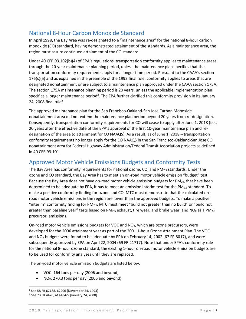
National 8-Hour Carbon Monoxide Standard In April 1998, the Bay Area was re-designated to a “maintenance area” for the national 8-hour carbon
monoxide (CO) standard, having demonstrated attainment of the standards. As a maintenance area, the
region must assure continued attainment of the CO standard.
Under 40 CFR 93.102(b)(4) of EPA’s regulations, transportation conformity applies to maintenance areas
through the 20-year maintenance planning period, unless the maintenance plan specifies that the
transportation conformity requirements apply for a longer time period. Pursuant to the CAAA’s section
176(c)(5) and as explained in the preamble of the 1993 final rule, conformity applies to areas that are
designated nonattainment or are subject to a maintenance plan approved under the CAAA section 175A.
The section 175A maintenance planning period is 20 years, unless the applicable implementation plan
specifies a longer maintenance period2. The EPA further clarified this conformity provision in its January
24, 2008 final rule3.
The approved maintenance plan for the San Francisco-Oakland-San Jose Carbon Monoxide
nonattainment area did not extend the maintenance plan period beyond 20 years from re-designation.
Consequently, transportation conformity requirements for CO will cease to apply after June 1, 2018 (i.e.,
20 years after the effective date of the EPA’s approval of the first 10-year maintenance plan and re-
designation of the area to attainment for CO NAAQS). As a result, as of June 1, 2018 – transportation
conformity requirements no longer apply for the CO NAAQS in the San Francisco-Oakland-San Jose CO
nonattainment area for Federal Highway Administration/Federal Transit Association projects as defined
in 40 CFR 93.101.
Approved Motor Vehicle Emissions Budgets and Conformity Tests The Bay Area has conformity requirements for national ozone, CO, and PM2.5 standards. Under the
ozone and CO standard, the Bay Area has to meet an on-road motor vehicle emission “budget” test.
Because the Bay Area does not have on-road motor vehicle emission budgets for PM2.5 that have been
determined to be adequate by EPA, it has to meet an emission interim test for the PM2.5 standard. To
make a positive conformity finding for ozone and CO, MTC must demonstrate that the calculated on-
road motor vehicle emissions in the region are lower than the approved budgets. To make a positive
“interim” conformity finding for PM2.5, MTC must meet “build not greater than no build” or “build not
greater than baseline year” tests based on PM2.5 exhaust, tire wear, and brake wear, and NOX as a PM2.5
precursor, emissions.
On-road motor vehicle emissions budgets for VOC and NOX, which are ozone precursors, were
developed for the 2006 attainment year as part of the 2001 1-hour Ozone Attainment Plan. The VOC
and NOX budgets were found to be adequate by EPA on February 14, 2002 (67 FR 8017), and were
subsequently approved by EPA on April 22, 2004 (69 FR 21717). Note that under EPA’s conformity rule
for the national 8-hour ozone standard, the existing 1-hour on-road motor vehicle emission budgets are
to be used for conformity analyses until they are replaced.
The on-road motor vehicle emission budgets are listed below:
VOC: 164 tons per day (2006 and beyond)
NOX: 270.3 tons per day (2006 and beyond)
2 See 58 FR 62188, 62206 (November 24, 1993) 3 See 73 FR 4420, at 4434-5 (January 24, 2008)

2 0 1 9 T r a n s p o r a t i o n I m p r o v e m e n t P r o g r a m P a g e | 8
For PM2.5, initially the Bay Area was required to prepare a SIP by December 2012 to show how the
region would attain the standard by December 2014. In addition, although the Bay Area was designated
as non-attainment for the national 24-hour PM2.5 standard based on monitoring data for the 2006-2008
period, the region exceeded the standard by only a slight margin.
Monitoring data shows that the Bay Area currently meets the national standards for both annual and
24-hour PM2.5 levels. However, because the health effects of PM are serious and far-reaching, and no
safe threshold of exposure to PM has yet been identified, it is important that we continue efforts to
further reduce PM emissions and concentrations.4
Under US EPA guidelines, a region with monitoring data showing that it currently attains an air quality
standard can submit a “re-designation request” and a “maintenance plan” in lieu of a SIP attainment
plan. However, the BAAQMD believes that it would be premature to submit a PM2.5 re-designation
request for the Bay Area at this time. Instead, the BAAQMD has pursued another option provided by US
EPA guidelines for areas with monitoring data showing that they currently meet the PM2.5 standard. In
December 2011, CARB submitted a “clean data finding” request on behalf of the Bay Area. On January 9,
2013, EPA took final action and determined that the Bay Area attained the 2006 24-hour PM2.5 standard.
EPA’s determination was based on complete, quality-assured, and certified ambient air monitoring data
showing that the area monitored attainment based on the 2009-2011 monitoring period. Based on
EPA’s determination, the requirements for the Bay Area to submit an attainment demonstration,
together with RACMs, an RFP plan, and contingency measures for failure to meet RFP and attainment
deadlines are suspended for so long as the region continues to attain the 2006 24-hour PM2.5 standard.
Since an approved on-road motor vehicle emissions budget for PM2.5 is not available for use in this
conformity analysis, MTC must complete one of the two interim emissions tests:
the build-no-greater-than-no-build test (“build/no-build test”) found at 40 CFR 93.119(e)(1), or
the no-greater-than-baseline year emissions test (“baseline year test”), described at 40 CFR
93.119(e)(2).
Per the interagency consultation via the Air Quality Conformity Task Force meeting dated May 28, 2015,
MTC elected to use the “baseline year test”. In this test, conformity is demonstrated if in each analysis
year, the RTP or TIP (the “build” scenarios) on-road motor vehicle emissions are less than or equal to
emissions in the “baseline year” emission inventory. The “baseline year” for the 2006 24-hour PM2.5
standard is the year 20085.
Under a determination of conformity, the following criteria are applied:
1. The latest planning assumptions and emission models are used.
The transportation plan (“RTP”) and program (“TIP”) pass an emissions budget test using a
budget that has been found adequate by EPA or an interim emissions test when budgets have
not been
established.
2. The transportation (“RTP”) and program (“TIP”) provide for the timely implementation of
4 See BAAQMD’s 2017 Clean Air Plan: Spare the Air, Cool the Climate at: http://www.baaqmd.gov/~/media/files/planning-and-research/plans/2017-clean-air-plan/attachment-a_-proposed-final-cap-vol-1-pdf.pdf?la=en 5 Additional information is available here: https://www.epa.gov/state-and-local-transportation/baseline-year-baseline-year-test-40-cfr-93119

2 0 1 9 T r a n s p o r a t i o n I m p r o v e m e n t P r o g r a m P a g e | 9
TCMs.
3. Interagency and public consultation is part of the process.
III. Conformity Analysis & Results
Approach to Conformity Analysis The latest planning assumptions were used when preparing this conformity analysis. Regional estimates
of future travel data were estimated using MTC’s land use model (referred to as “Bay Area UrbanSim”)
and travel model (referred to as “Travel Model One”). This integrated model framework allows for
analysis of how transportation projects affect the surrounding land use pattern, as well as how changes
to residential and commercial activity affect transportation demand. Travel Model One (version 0.6)
released in July 2016, is calibrated to year 2000 conditions and validated against year 2000, year 2005,
and year 2010 conditions. The model generates spatially- and temporally specific estimates of travel
data—roadway usage and speed. This travel data is input into CARB’s latest EMission FACtors
(EMFAC2014) model to estimate on-road motor vehicle emissions.
In 2016, MTC updated the method by which Amended Plan Bay Area programmatic category projects
are assessed and represented in Travel Model One in the analysis years between the year 2040 (the
Horizon Year for the Amended Plan Bay Area) and the 2019 TIP. Please see Appendix C for the complete
approach (for regional conformity modeling purposes) description.
The EMFAC2014 model shows how California on-road motor vehicle emissions have changed over time
and are projected to change in the future. This information helps CARB evaluate prospective control
programs and determine the most effective, science-based proposals for protecting the environment.
EMFAC2014 includes the latest data on California’s car and truck fleets and travel activity. The model
also reflects the emissions benefits of CARB’s recent rulemakings, including on-road diesel fleet rules,
Advanced Clean Car Standards, and the Smartway/Phase I Heavy Duty Vehicle Greenhouse Gas
Regulation. The model includes updates to truck emission factors based on the latest test data. More
details about the updates in emissions calculation methodologies and data are available in the
EMFAC2014 Technical Support Document.6
Bay Area UrbanSim7 and Travel Model One are responsive to numerous inputs, including demographic,
pricing, travel behavior, and highway and transit network assumptions. For this conformity analysis, the
two models use demographic and highway and transit network assumptions consistent with the
Amended Plan Bay Area 20408. Highway and transit networks were updated for each analysis year to
reflect investments in the Amended Plan Bay Area 2040 (see Appendix B) and the 2019 TIP (see
Appendix A1 and A2). Pricing assumptions applied in Travel Model One include projected parking prices,
gasoline and non-gasoline auto operating costs, fuel economy, bridge tolls, transit fares, and express
lanes. Travel behavior assumptions include trip peaking factors, vehicle occupancy factors, and
estimates of interregional commuters. Refer to Appendix D for detailed travel modeling assumptions
used in this conformity analysis.9
6 Additional information is available here: http://www.arb.ca.gov/msei/categories.htm 7 Additional information is available here: http://2040.planbayarea.org/sites/default/files/2017-
07/Land_Use_Modeling_PBA2040_Supplemental%20Report_7-2017.pdf 8 Additional information is available here: http://www.planbayarea.org/2040-plan/final-preferred-scenario 9 Additional information is available here: http://2040.planbayarea.org/sites/default/files/2017-07/Travel_Modeling_PBA2040_Supplemental%20Report_7-2017_0.pdf

2 0 1 9 T r a n s p o r a t i o n I m p r o v e m e n t P r o g r a m P a g e | 10
Regional vehicle miles traveled (VMT) and engine starts (which are needed for emission calculations) are
forecasted using a combination of output from Travel Model One and base year (2010) EMFAC2014
default VMT information provided by the CARB. For conformity purposes, MTC continues to employ the
agreed to protocol for estimating VMT with updated 2010 base year data.
A separate process was used to develop demographic assumptions for the PM2.5 “baseline year” of
2008. Bay Area UrbanSim generates Transportation Analysis Zone (TAZ)-level data set in 5-year
increments. The calculation of data for the interim year 2008 requires a multi-stop process. First,
regional control totals for each attribute are calculated using straight-line extrapolations between the
two adjacent 5-year increments (2005 and 2010). Next, each TAZ's share of the regional total is
calculated by extrapolation of the two adjacent 5-year increments. Finally, individual TAZ totals are
calculated by multiplying the interim year TAZ share of the regional total by the regional control total.
Analysis Years The analysis years for the budget and baseline year tests are to be a year within five years from the date
the analysis is done, the horizon year of the RTP and intermediate years as necessary so that analysis
years are not more than ten years apart. For this conformity analysis, the analysis years 2020, 2030 and
2040 for the 2008 ozone and 2006 PM2.5 standards. For CO, the analysis years are 2018, 2020, 2030 and
2040. Travel data for year 2018 were interpolated between forecasted 2015 and 2020 travel data. MTC
used Travel Model One to forecast travel data for the 2020, 2030 and 2040 analysis years. The
forecasted travel data for each analysis year were then input into the EMFAC2014 model to calculate
on-road motor vehicle emissions.
Consultation Process MTC has consulted on the preparation of this conformity analysis and other conformity related issues
with the Bay Area’s Air Quality Conformity Task Force. The Conformity Task Force is composed of
representatives of EPA, CARB, FHWA, FTA, Caltrans, MTC, BAAQMD, ABAG, the nine county Congestion
Management Agencies, and Bay Area transit operators. The Conformity Task Force reviews the analysis
assumptions, consults on TCM implementation issues, and reviews the results of the conformity
analysis. The task force meetings are open to the public. Topics covered in past meetings of the Air
Quality Conformity Task Force include the following:
April 2018
PM2.5 Project-Level Conformity Interagency Consultations
Approach to Draft Conformity Analysis for the 2019 Transportation Improvement Program and
Amended Plan Bay Area 2040
MTC/SACOG Air Quality Planning/Conformity MOU Revision
2020 and 2022 Congestion Mitigation and Air Quality (CMAQ) Performance Targets
May 2018
PM2.5 Project-Level Conformity Interagency Consultations
Update on the Conformity Analysis for the 2019 Transportation Improvement Program and the
Amended Plan Bay Area
This document is part of the Final Amended Plan Bay Area 2040 scenario planning/development effort and the technical methods and assumptions used in this effort are consistent with what is applied in this conformity analysis.

2 0 1 9 T r a n s p o r a t i o n I m p r o v e m e n t P r o g r a m P a g e | 11
Comparison of Motor Vehicle Emissions to Budgets As explained earlier, on-road motor vehicle emissions budgets are established in the SIP for VOCs and
NOX. To make a positive conformity finding, the regional on-road motor vehicle emissions must be equal
to or less than these budgets. The results of the vehicle activity forecasts and on-road motor vehicle
emission calculations are described in the following section.
Ozone Motor Vehicle Emission Budgets For VOC and NOX, the on-road motor vehicle emission budget also reflects anticipated emission
reductions from five Transportation Control Measures (TCMs) incorporated in the 2001 Ozone
Attainment Plan (Table 1).
Table 1: VOC and NOX Emissions Budgets from 2001 Ozone Attainment Plan (tons/day)
VOC
2006 On Road Motor Vehicle Emissions 168.5 2006 Mobile Source Control Measure Benefits (4.0)
2006 TCM Benefits (0.5)
2006 Emissions Budget 164.0
NOX
2006 On Road Motor Vehicle Emissions 271.0 2006 TCM Benefits (0.7)
2006 Emissions Budget 270.3
The vehicle activity forecasts by analysis year for the Amended Plan Bay Area 2040 and the 2019 TIP (the
“build” scenarios) are shown in Table 2. Travel data (from MTC’s Travel Model One) was input into
CARB’s EMFAC2014 emissions model, thereby generating regional vehicle activity and emissions
estimates.
The analysis years for the budget and baseline year tests are to be a year within five years from the date
the analysis is done, the horizon year of the RTP and intermediate years as necessary so that analysis
years are not more than ten years apart. For this conformity analysis, the analysis years 2020, 2030 and
2040 for the 2008 ozone and 2006 PM2.5 standards. Travel data for 2020, 2030 and 2040 were
forecasted by Travel Model One. The forecasted travel data for each analysis year were then input into
the EMFAC2014 model to calculate on-road motor vehicle emissions.
Table 2: Vehicle Activity Forecasts
2020 2030 2040
Vehicles in use 4,699,352 5,503,145 6,227,537 Daily VMT (1000s) 167,420 182,510 195,533 Daily Engine Starts 29,309,833 34,101,662 38,493,145
Comparison of Estimated Regional On-Road Motor Vehicle Emissions to the Ozone
Precursor Budgets The vehicle activity forecasts for the Amended Plan Bay Area 2040 and the 2019 TIP, Table 2, are
converted to emission estimates by MTC using EMFAC2014. Tables 3 compare the results of the various
analyses with the applicable budgets. The analyses indicate that the on-road motor vehicle emissions

2 0 1 9 T r a n s p o r a t i o n I m p r o v e m e n t P r o g r a m P a g e | 12
are substantially below the budget, due in large part to the effects of cleaner vehicles in the California
fleet and the enhanced Smog Check program now in effect in the Bay Area and reflected in the
EMFAC2014 model.
Table 3: Emissions Budget Comparisons for Ozone Precursors – Summertime Conditions (tons/day)
Year VOC Budget1 On-Road Motor Vehicles VOC TCMs2 Net Emissions
2020 164.0 36.00 (0.3) 35.70 2030 164.0 24.04 (0.3) 23.74 2040 164.0 18.51 (0.3) 18.21
Year NOX Budget On-Road Motor Vehicles NOX TCMs2 Net Emissions
2020 270.3 65.14 (0.5) 64.64 2030 270.3 32.88 (0.5) 32.38 2040 270.3 28.94 (0.5) 28.44
1 2001 Ozone Attainment Plan 2 The transit services for TCM A Regional Express Bus Program were modeled. The emission benefits from TCM A are therefore
included in the On-Road Motor Vehicles VOC and NOX emission inventories for 2006 and beyond.
Figure 2: Emissions Budget Comparisons for Ozone Precursors

2 0 1 9 T r a n s p o r a t i o n I m p r o v e m e n t P r o g r a m P a g e | 13
The estimated effectiveness of the various TCMs, given their current implementation status is shown in
Table 4. TCMs A through E are fully implemented. They have achieved the required cumulative total
emission reductions of 0.5 tons per day of VOC and 0.7 tons per day of NOX by 2006.
Table 4: Emission Reductions for Transportation Control Measures A – E in State Implementation Plan (tons/day)
TCM VOC Emission Reductions through
December 2006
NOX Emission Reductions through
December 2006
TCM A: Regional Express Bus Program 0.20 0.20 TCM B: Bicycle/Pedestrian Program 0.04 0.03 TCM C: Transportation for Livable Communities 0.08 0.12 TCM D: Expansion of Freeway Service Patrol 0.10 0.25 TCM E: Transit Access to Airports 0.09 0.13 Total Reductions 0.5 0.7
Baseline Year Emissions Test for PM2.5 For the baseline year test, emissions for both directly emitted PM2.5 and NOX (as the precursor to PM2.5
emissions) were compared to the analysis years of 2020, 2030 and 2040. The analysis used inputs for the
winter season, during which the Bay Area experiences its highest levels of PM2.5 concentrations.
The vehicle activity forecasts by analysis year for the Amended Plan Bay Area 2040 and the 2019 TIP (the
“build” scenarios) are shown in Table 5. Travel data (from MTC’s Travel Model One) was input into
CARB’s EMFAC2014 emissions model, thereby generating regional vehicle activity and emissions
estimates.
Table 6 presents the results of the Baseline Year test for the PM2.5 emissions and the NOX precursor for
the 2006 24-hour PM2.5 standard. Regional conformity analyses must be completed for directly emitted
PM2.5 (40 CFR 93.102(b)(1)). Directly emitted PM2.5 includes exhaust, brake and tire wear emissions.
Table 5: Vehicle Activity Forecasts for the PM2.5 Baseline Year Test
2008 Baseline Year
2020
2030
2040
Vehicles in Use 4,631,001 4,699,352 5,503,145 6,227,537 Daily VMT (1000s) 154,100 167,420 182,510 195,533 Engine Starts 29,299,933 29,309,833 34,101,662 38,493,145
Table 6: Emissions Comparison for the PM2.5 Baseline Year Test
2008 Baseline Year
2020
2030
2040
PM2.5 8.26 4.53 4.44 4.60 NOX 194.58 60.09 27.12 23.06
1 Emissions for wintertime only

2 0 1 9 T r a n s p o r a t i o n I m p r o v e m e n t P r o g r a m P a g e | 14
Figure 3: Baseline Year Emissions Test for PM2.5
Figure 4: Baseline Year Emissions Test for Wintertime NOX

2 0 1 9 T r a n s p o r a t i o n I m p r o v e m e n t P r o g r a m P a g e | 15
IV. Transportation Control Measures
History of Transportation Control Measures TCMs are strategies to reduce vehicle emissions. They include such strategies as improved transit service
and transit coordination, ridesharing services and new carpool lanes, signal timing, freeway incident
management, increased gas taxes and bridge tolls to encourage use of alternative modes, etc. The
original set of TCMs plus the five most recent TCMs (A-E) have been fully implemented. The TCMs were
added over successive revisions to the SIP (see Table 8). For more information on TCMs 1-28, which are
completed, see the Transportation-Air Quality Conformity Analysis for the 2001 Regional Transportation
Plan and FY 2001 Transportation Improvement Program Amendment 01-32 (February 2002). This report
can be found in the MTC/ABAG Library.
Twelve (12) ozone measures were originally listed in the 1982 Bay Area Air Quality Plan.
In response to a 1990 lawsuit in the federal District Court, sixteen (16) additional TCMs were
subsequently adopted by MTC in February 1990 as contingency measures to bring the region
back on the “Reasonable Further Progress” (RFP) line. The Federal District order issued on
May 11, 1992, found that these contingency TCMs were sufficient to bring the region back on
the RFP track anticipated in the SIP. These measures became part of the SIP when EPA approved
the 1994 Ozone Maintenance Plan.
Two (2) transportation control measures from the 1982 Bay Area Air Quality Plan apply to
Carbon Monoxide control strategies, for which the region is in attainment with the federal
standard, and primarily targeted downtown San Jose (which had the most significant CO
problem at that time.) MTC also adopted a set of TCM enhancements in November 1991 to
eliminate a shortfall in regional carbon monoxide emissions identified in the District Court’s
April 19, 1991, order. Carbon monoxide standards have been achieved primarily through the use
of oxygenated/reformulated fuels in cars and with improvements in the Smog Check program.
As part of EPA’s partial approval/partial disapproval of the 1999 Ozone Attainment Plan, four (4)
TCMs were deleted from the ozone plan (but two of these remain in the Carbon Monoxide
Maintenance Plan).
Five (5) new TCMs were adopted as part of the new 2001 1-Hour Ozone Attainment Plan and
were fully funded in the 2001 TIP and 2001 Regional Transportation Plan.
With respect to TCM 2 from the 1982 SIP, there was a protracted debate, leading to a citizens lawsuit in
federal court, about the obligations associated with this TCM. On April 6, 2004, MTC prevailed in the
U.S. Court of Appeals for the Ninth Circuit which concluded that TCM 2 does not impose any additional
enforceable obligation on MTC to increase ridership on public transit ridership by 15% over 1982-83
levels by November 2006 (Bayview Hunters Point Community Advocates v. Metropolitan Transportation
Com’n, (2004 WL 728247, 4 Cal. Daily Op. Serv. 2919, 2004 Daily Journal D.A.R. 4209, 9th Cir.(Cal.), Apr
06, 2004)). Thus TCM 2 has been resolved, and there are no further implementation issues to address in
this TCM.

2 0 1 9 T r a n s p o r a t i o n I m p r o v e m e n t P r o g r a m P a g e | 16
Table 7: Transportation Control Measure in the State Implementation Plan
TCM Description
Original TCMs from 1982 Bay Area Air Quality Plan TCM 1 Reaffirm Commitment to 28 percent Transit Ridership Increase Between 1978 and 1983 TCM 2 Support Post-1983 Improvements in the Operators’ Five-Year Plans and, After
Consultation with the Operators, Adopt Ridership Increase Target for the Period 1983 through 1987
TCM 3 Seek to Expand and Improve Public Transit Beyond Committed Levels TCM 4 High Occupancy Vehicle (HOV) Lanes and Ramp Metering
TCM 5 Support RIDES Efforts TCM 61 Continue Efforts to Obtain Funding to Support Long Range Transit Improvements TCM 7 Preferential Parking TCM 8 Shared Use Park and Ride Lots TCM 9 Expand Commute Alternatives Program TCM 10 Information Program for Local Governments TCM 112 Gasoline Conservation Awareness Program (GasCAP) TCM 122 Santa Clara County Commuter Transportation Program
Contingency Plan TCMs Adopted by MTC in February 1990 (MTC Resolution 2131) TCM 13 Increase Bridge Tolls to $1.00 on All Bridges TCM 14 Bay Bridge Surcharge of $1.00 TCM 15 Increase State Gas Tax by 9 Cents TCM 161 Implement MTC Resolution 1876, Revised — New Rail Starts TCM 17 Continue Post-Earthquake Transit Services TCM 18 Sacramento-Bay Area Amtrak Service TCM 19 Upgrade Caltrain Service TCM 20 Regional HOV System Plan TCM 21 Regional Transit Coordination TCM 22 Expand Regional Transit Connection Ticket Distribution TCM 23 Employer Audits TCM 24 Expand Signal Timing Program to New Cities TCM 25 Maintain Existing Signal Timing Programs TCM 26 Incident Management on Bay Area Freeways TCM 27 Update MTC Guidance on Development of Local TSM Programs TCM 28 Local Transportation Systems Management (TSM) Initiatives
New TCMs in 2001 Ozone Attainment Plan TCM A Regional Express Bus Program TCM B Bicycle/Pedestrian Program TCM C Transportation for Livable Communities TCM D Expansion of Freeway Service Patrol TCM E Transit Access to Airports
1 Deleted by EPA action from ozone plan 2 Deleted by EPA action from ozone plan, but retained in Carbon Monoxide Maintenance Plan. Source: Bay Area Air Quality Management District, Metropolitan Transportation Commission, 2001.
Status of Transportation Control Measures TCMs A-E were approved into the SIP as part of EPA’s Finding of Attainment for the San Francisco Bay
Area (April 2004). The conformity analysis must demonstrate that TCMs are being implemented on
schedule (40 CFR 93.113). TCMs A-E have specific implementation steps which are used to determine
progress in advancing these TCMs (see Table 9). TCMs A-E are now fully implemented.

2 0 1 9 T r a n s p o r t a t i o n I m p r o v e m e n t P r o g r a m P a g e | 17
Table 8: Implementation Status of Federal Transportation Control Measures for Ozone (A – E)
# TCM Description Ozone Attainment Plan Implementation Schedule
Implementation Status
A Regional Express Bus Program
Program includes purchase of approximately 90 low emission buses to operate new or enhanced express bus services. Buses will meet all applicable CARB standards, and will include particulate traps or filters. MTC will approve $40 million in funding to various transit operators for bus acquisition. Program assumes transit operators can sustain service for a five-year period. Actual emission reductions will be determined based on routes selected by MTC.
FY 2003. Complete once $40 million in funding pursuant to Government Code Section 14556.40 is approved by the California Transportation Commission and obligated by bus operators
$40 million for this program was allocated by the CTC in August 2001. The participating transit operators have ordered and received a total of 94 buses. All buses are currently in operations. TCM A is fully implemented.
B Bicycle / Pedestrian Program
Fund high priority projects in countywide plans consistent with TDA funding availability. MTC would fund only projects that are exempt from CEQA, have no significant environmental impacts, or adequately mitigate any adverse environmental impacts. Actual emission reductions will be determined based on the projects funded.
FY 2004 – 2006. Complete once $15 million in TDA Article 3 is allocated by MTC.
MTC allocated over $20 million in TDA Article 3 funds during FY2004, FY2005, and FY2006. TCM B is fully implemented.
C Transportation for Livable Communities (TLC)
Program provides planning grants, technical assistance, and capital grants to help cities and nonprofit agencies link transportation projects with community plans. MTC would fund only projects that are exempt from CEQA, have no significant environmental impacts, or adequately mitigate any adverse environmental impacts. Actual emission
FY 2004 – 2006. Complete once $27 million in TLC grant funding is approved by MTC
In December 2003, the Commission reaffirmed its commitment of $27 million annually over 25 years for the TLC program as part of Phase 1 of the Transportation 2030 Plan. MTC and the county Congestion Management Agencies (CMAs) have approved over $27 million in TLC grant funding by FY 2006. In November 2004, MTC approved $500,000 for regional TLC

2 0 1 9 T r a n s p o r t a t i o n I m p r o v e m e n t P r o g r a m P a g e | 18
reductions will be based on the projects funded.
Community Design Planning Program, and in December 2004, MTC approved $18.4 million in TLC funding for the regional TLC Capital program. As of December 2006, CMAs in Alameda, Marin and Sonoma counties approved an additional $12.4 million in their county-level TLC Capital programs for a regional total of $31.2 million. TCM C is fully implemented.
D Additional Freeway Service Patrol
Operation of 55 lane miles of new roving tow truck patrols beyond routes which existed in 2000. TCM commitment would be satisfied by any combination for routes adding 55 miles. Tow trucks used in service are new vehicles meeting all applicable CARB standards.
FY 2001. Complete by maintaining increase in FSP mileage through December 2006
FSP continues to maintain the operation of the 55 lane miles of new roving tow truck coverage. This level of service was maintained through 2006. FSP continues to expand its service areas. TCM D is fully implemented. .
E Transit Access to Airports
Take credit for emission reductions from air passengers who use BART to SFO, as these reductions are not included in the Baseline.
BART – SFO service to start in FY 2003. Complete by maintaining service through December 2006
Service began June 2003. Service adjustments have been made since start of revenue service. The BART to SFO service has been maintained through 2006 and is continued. TCM E is fully implemented.

2 0 1 9 T r a n s p o r t a t i o n I m p r o v e m e n t P r o g r a m P a g e | 19
V. Response to Public Comments To be updated.

2 0 1 9 T r a n s p o r t a t i o n I m p r o v e m e n t P r o g r a m P a g e | 20
VI. Conformity Findings Based on the analysis, the following conformity findings are made:
This conformity assessment was conducted consistent with EPA's transportation conformity
regulations and with the Bay Area Air Quality Conformity Protocol adopted by MTC as Resolution No.
4374.
The Amended Plan Bay Area 2040 and the 2019 Transportation Improvement Program, as amended
by Revisions Number 2018-XX, provide for implementation of TCMs pursuant to the following federal
regulation:
(1) An examination of the specific steps and funding source(s) needed to fully implement each TCM
indicates that TCMs which are eligible for funding under title 23 U.S.C. or the Federal Transit Laws
are on or ahead of the schedule established in the applicable implementation plan, or, if such TCMs
are behind the schedule established in the applicable implementation plan, the MPO and DOT have
determined that past obstacles to implementation of the TCMs have been identified and have been
or are being overcome, and that all State and local agencies with influence over approvals or
funding for TCMs are given maximum priority to approval or funding to TCMs over other projects
within their control, including projects in locations outside the non-attainment or maintenance area.
(2) If TCMs in the applicable implementation plan have previously been programmed for Federal
funding but the funds have not been obligated and the TCMs are behind the schedule in the
implementation plan, then the TIP cannot be found to conform if the funds intended for those TCMs
are reallocated to projects in the TIP other than TCMs, or if there are no other TCMs in the TIP, if
the funds are reallocated to projects in the TIP other than projects which are eligible for Federal
funding intended for air quality improvements projects, e.g., the Congestion Mitigation and Air
Quality Improvement Program.
(3) Nothing in the TIP may interfere with the implementation of any TCM in the applicable
implementation plan. (40 CFR Part 93.113(c)).
For the two ground-level ozone precursors (VOC and NOx), motor vehicle emissions in the Amended
Plan Bay Area 2040 and the 2018 Transportation Improvement Program, as amended by Revisions
Number 2018-XX are lower than the applicable motor vehicle emission budgets for the 2008 national
8- hour ozone standard.
For PM2.5 and NOx, the Baseline Year test shows that the motor vehicle emissions are lower under the
Build scenario for the various analysis years when compared to the baseline year emissions scenario.

Appendix A-1
List of Projects in the Draft 2019 TIP

List of Projects in the 2019 Transportation Improvement ProgramSorted by Air Quality Conformity Status, County and Sponsor
Appendix A1
* Projects with conformity analysis years of 2040 reference programmatic projects or projects with a completion date after 2030 in Plan Bay Area 2040 1 of 55
County Sponsor TIP ID Project Title Project Description Description of Change Air Quality Description RTP-ID
Conformity
Analysis Year*
Alameda AC Transit ALA150004 AC Transit: East Bay Bus
Rapid Transit
Alameda County: Along Broadway/ International/E
14th corridor from Oakland to San Leandro:
Implement BRT including 34 stations, transit
signal priority, level-boarding, shelters, off-board
ticketing,
2019 TIP Update - Update funding plan NON-EXEMPT 17-01-0060 2020
Alameda ACE ALA170042 ACE Platform Extensions ACE System: At Pleasanton, Livermore, Vasco,
Tracy, and Manteca stations: Extend existing ACE
platforms to accommodate longer train sets
2019 TIP Update - Update funding plan NON-EXEMPT - Not Regionally
Significant Project
17-01-0008 2040
Alameda ACTC ALA050014 SR 84 Expressway
Widening
In Livermore: Widen Route 84 from Jack London
Blvd. to Pigeon Pass.
2019 TIP Update. Keep in the 2019 TIP
for informational purposes - project is not
complete.
NON-EXEMPT 17-01-0032 2020
Alameda ACTC ALA050019 I-880 North Safety
Improvements
Oakland: I-880 between 23rd Ave to 29th Ave:
Reconfigure Interchange, including new ramps.
2019 TIP Update - Retain in TIP for
informational purposes as project is
ongoing
NON-EXEMPT 17-01-0031 2020
Alameda ACTC ALA070009 Oakland/Alameda
Freeway Access Project
Oakland and Alameda: Between Oak Street and
Union Street: Reconfigure interchange and
intersections to improve connections between I-
880, the Posey and Webster tubes and the
downtown Oakland
2019 TIP Update - Update funding plan NON-EXEMPT 17-01-0030 2030
Alameda ACTC ALA110002 I-880/Industrial Parkway
West Interchange
In Hayward: At I-880/Industrial Parkway West:
Reconstruct interchange, add on/off-ramp lanes,
widen ramp lanes, provide HOV bypass lanes and
routine accommodation for bicyclists and
pedestrians.
2019 TIP Update - Update funding plan NON-EXEMPT 17-01-0023 2030
Alameda ACTC ALA130034 I-680 NB HOV/HOT Lane Route I-680: from South of Auto Mall Parkway to
State Route 84 in Alameda County: Construct NB
HOV/HOT Lane.
2019 TIP Update - Retain in TIP for
informational purposes as project is
ongoing
NON-EXEMPT 17-10-0058 2020
Alameda ACTC ALA150001 Rte 84 Widening, south
of Ruby Hill Dr to I-680
In Alameda County, on State Route 84 from south
of Ruby Hill Drive to I-680, upgrade from 2-lane
conventional highway to 4-lane expressway, make
operational improvements to SR84/I-680 I/C and
2019 TIP Update NON-EXEMPT 17-01-0029 2030
Alameda ACTC ALA150008 East Bay Greenway Alameda County: Generally along the BART
alignment from Lake Merritt BART station to South
Hayward BART station: Install a trail facility
consisting of Class I & Class IV bikeway facilities.
Includes 2 road
2019 TIP Update - Update funding plan NON-EXEMPT - Not Regionally
Significant Project
17-01-0001 2040
Alameda ACTC ALA170001 State Route 262 (Mission
Blvd) Improvements
In Fremont: Mission Blvd/I-680 IC: widen Mission
Blvd to 3 lanes each direction through IC, rebuild
the NB and SB I-680 on and off ramps
2019 TIP Update. Project completion
scheduled for 2028. (FMS menus end at
2025).
NON-EXEMPT 17-01-0020 2030
Alameda ACTC ALA170004 I-880/West Winton
Avenue Interchange
Hayward: At I-880/West Winton Avenue I/C:
Reconstruct I/C including reconfiguration of
eastbound to southbound on ramp and new
connection to Southland Mall Drive
2019 TIP Update - Update funding plan NON-EXEMPT 17-01-0041 2030
Alameda ACTC ALA170005 I-880/Whipple Rd
Industrial Pkwy SW I/C
Imps
In Union City/Hayward: at I-880/Whipple Rd
Interchange: Implement full interchange
improvements including northbound off-ramp,
surface street improvements and realignment, and
bike/ped
2019 TIP Update - Update funding plan NON-EXEMPT 17-01-0021 2030
Alameda ACTC ALA170008 I-580/680 Interchange
HOV/HOT Widening
Alameda County: On I-580 between Hacienda Dr.
and San Ramon/Foothill Road and on I-680
between Stoneridge Dr. and Amado: Widen to add
one HOV/HOT lane for WB 580 to SB 680 and NB
680 to EB
2019 TIP Update - Update the funding
plan to add $5M in Sales Tax and $109M
in RTP-LRP and reprogram funds
between years and phases
NON-EXEMPT 17-01-0028 2030

List of Projects in the 2019 Transportation Improvement ProgramSorted by Air Quality Conformity Status, County and Sponsor
Appendix A1
* Projects with conformity analysis years of 2040 reference programmatic projects or projects with a completion date after 2030 in Plan Bay Area 2040 2 of 55
County Sponsor TIP ID Project Title Project Description Description of Change Air Quality Description RTP-ID
Conformity
Analysis Year*
Alameda ACTC ALA170009 Widen I-680 NB Imprv
SB for EL: SR-84 to
Alcosta
Alameda County: NB I-680 from SR-84 to Alcosta
Blvd: Widen for express lanes; SB I-680 from SR-
84 to Alcosta Blvd: express lane improvements.
Project also references RTP ID 17-01-0014
2019 TIP Update - Update scope and
funding
NON-EXEMPT 17-10-0058 2020
Alameda ACTC ALA170010 I-880 NB HOV/HOT:
North of Hacienda to
Hegenberger
Alameda County: I-880 in the northbound direction
from north of Hacienda Ave to Hegenberger Road:
Widen to provide one HOV/express lane
2019 TIP Update - Update the funding
plan to reprogram funds between years
and phases
NON-EXEMPT 17-10-0057 2030
Alameda ACTC ALA170086 7th Street Grade
Separation West
Oakland: Within the Port: Implement road and rail
improvements, realign and grade separate 7th St
and Maritime intersection, reconstruct and widen
multi-use path; Between Joint Intermodal Terminal
and
2019 TIP Update NON-EXEMPT 17-01-0015 2040
Alameda ACTC ALA978004 East-West Connector in
Fremont & Union City
In Fremont & Union City: From I-880 to Route 238
(Mission Blvd); Construct new 4-lane roadway and
widen existing roadways. Project is phased.
2019 TIP Update. NON-EXEMPT 17-01-0047 2030
Alameda Alameda ALA170049 Central Avenue Safety
Improvements
Alameda: On Central Ave from Main St to
Sherman St: Implement multimodal street
improvements including reduction from 4 to 3
lanes, a center turn lane, bike lanes, a 2-way
separated bikeway, 2 traffic
2019 TIP Update NON-EXEMPT - Not Regionally
Significant Project
17-01-0004 2040
Alameda BAIFA ALA170006 ALA-880 Express Lanes In Alameda/Santa Clara Counties: On I-880 from
Hegenberger to Dixon Landing (Southbound) and
Dixon Landing to Lewelling (Northbound): Convert
HOV lanes to express lanes. Project also
references
2019 TIP Update - Retain in TIP for
informational purposes as project is
ongoing
NON-EXEMPT 17-10-0052 2020
Alameda BART ALA110003 Hayward Shop and Yard
Expansion
BART: Hayward Shop and Yard: Expansion facility
to accommodate additional rail vehicles for
storage, maintenance and repair.
2019 TIP Update - Retain in TIP for
informational purposes as project is
ongoing
NON-EXEMPT 17-10-0064 2040
Alameda BART ALA130032 BART Metro Priority
Track Elements
BART: In Lafayette, Dublin and Millbrae: Provide
three critical track extensions in order to provide
the BART system with additional operational
flexibility and additional capacity, all within existing
right-of-
2019 TIP Update - Retain in TIP for
informational purposes as project is
ongoing
NON-EXEMPT 17-10-0005 2030
Alameda BART ALA170044 Bay Fair Connection BART: At and near Bay Fair Station: Modify
station and approaches to add one or more
additional tracks and one or more passenger
platforms for improved train service and
operational flexibility
2019 TIP Update NON-EXEMPT 17-10-0005 2030
Alameda Berkeley ALA130026 Shattuck Complete
Streets and De-couplet
Berkeley: Shattuck Ave, Shattuck Square and
Berkeley Square from Allston Way to University
Ave intersection: Reconfigure travel lanes and
parking, repair pavement and make other
improvements
2019 TIP Update - Retain in TIP for
informational purposes as project is
ongoing
NON-EXEMPT - Not Regionally
Significant Project
17-01-0004 2040
Alameda Dublin ALA130005 Dougherty Road widening Dublin: Dougherty Road from Sierra Lane to North
City Limit: Widen from 4 lanes to 6 lanes
2019 TIP Update - Retain in TIP for
informational purposes as project is
ongoing
NON-EXEMPT 17-01-0053 2020
Alameda Dublin ALA130006 Dublin Boulevard
widening
In Dublin: Dublin Blvd between Sierra Court and
Dublin Court: Widenfrom 4 lanes to 6 lanes and
install Class II bike lanes
2019 TIP Update - Update funding plan NON-EXEMPT 17-01-0057 2020
Alameda Dublin ALA150003 Dublin Blvd. - North
Canyons Pkwy Extension
Alameda County, Dublin and Livermore: Dublin
Blvd-North Canyons Parkway from Fallon Rd to
Croak Rd: Construct six lane extension; Dublin
Blvd-North Canyons Parkway from Croak Rd to
Doolan Rd:
2019 TIP Update - Update scope and
funding
NON-EXEMPT 17-01-0048 2030

List of Projects in the 2019 Transportation Improvement ProgramSorted by Air Quality Conformity Status, County and Sponsor
Appendix A1
* Projects with conformity analysis years of 2040 reference programmatic projects or projects with a completion date after 2030 in Plan Bay Area 2040 3 of 55
County Sponsor TIP ID Project Title Project Description Description of Change Air Quality Description RTP-ID
Conformity
Analysis Year*
Alameda Dublin ALA170045 I-580 Interchange Imps at
Hacienda/Fallon Rd, Ph 2
Dublin: I580/Fallon Rd IC: Ph 2 - Reconstruct
overcrossing to widen to 4 lanes in each direction,
reconstruct and widen ramps, add bike/ped imps;
I580 Hacienda Dr IC: Reconstruct overcrossing to
add NB
2019 TIP Update NON-EXEMPT 17-01-0038 2030
Alameda Fremont ALA130025 Fremont City Center Multi-
Modal Improvements
Fremont: Capitol Ave from State St to Fremont
Blvd: Construct roadway extension; Various
locations around Fremont City Center and
Fremont BART Station: Implement multi-modal
improvements to
2019 TIP Update - Retain in TIP for
informational purposes as project is
ongoing
NON-EXEMPT - Not Regionally
Significant Project
17-01-0004 2040
Alameda Hayward ALA090016 Rt 92/Clawiter/Whitesell
Interchange
Improvements
Hayward: Rt 92/Clawiter Rd: Upgrade existing
Clawiter interchange. Add ramps and overcrossing
for Whitesell St. extension. Signalize ramp
intersections.
2019 TIP Update NON-EXEMPT 17-01-0036 2030
Alameda Hayward ALA090020 I-880 Auxiliary lanes at
Industrial Parkway
Hayward: I-880 NB between Industrial Pkwy and
Alameda Creek; I-808 SB between Industrial Pkwy
and Whipple Rd: Construct auxiliary lanes
2019 TIP Update NON-EXEMPT 17-01-0007 2040
Alameda Hayward ALA170046 I-880/A Street
Interchange
Reconstruction
Hayward: I-880/A St. I/C: Reconstruct interchange
to widen A St from 5 to 6 lanes, add bike lanes,
and provide additional lane capacity for potential
future freeway widening, modify signals and
2019 TIP Update - Update funding plan NON-EXEMPT 17-01-0024 2030
Alameda MTC ALA110104 Bay Bridge Park Oakland: At the Oakland Touchdown of the new
East Span of the Bay Bridge: Bay Bridge Park
(Project previously titled "SFOBB Gateway Park")
2019 TIP Update NON-EXEMPT 17-01-0001 2040
Alameda MTC ALA170011 Bay Bridge Forward -
West Grand HOV/Bus
Only Lane
In Oakland: Grand Avenue on-ramp: Convert
shoulder to Bus/HOV only lane
2019 TIP Update - Update funding plan NON-EXEMPT - Not Regionally
Significant Project
17-10-0033 2040
Alameda Oakland ALA110046 Oakland Army Base
Infrastructure
Improvements
In Oakland: At former Oakland Army Base:
Implementing Army Base Infrastructure Master
Plan including TCIF funded OHIT improvements
implemented by City of Oakland. For the related
Port project, see
2019 TIP Update NON-EXEMPT 17-01-0016 2040
Alameda Oakland ALA130014 7th Street West Oakland
Transit Village, Phase II
In Oakland: On 7th Street between Wood Street
and Peralta Street: Construct road diet, bicycle
lanes, sidewalk enhancement, pedestrian
amenities, traffic signal mods, street and
pedestrian lights, storm
2019 TIP Update - Update funding plan
and retain in TIP for informational
purposes as project is ongoing
NON-EXEMPT - Not Regionally
Significant Project
17-01-0001 2040
Alameda Oakland ALA150042 Oakland: Telegraph Ave
Bike/Ped Imps and Road
Diet
HSIP7-04-014: In Oakland: Telegraph Ave from
29th to 45th St: Install crosswalk enhancements,
painted bulb-outs, and painted median refuges;
from 29th to 41st St: Implement road diet with
buffered
2019 TIP Update - Update funding plan NON-EXEMPT - Not Regionally
Significant Project
17-01-0001 2040
Alameda Oakland ALA150043 Oakland: Shattuck and
Claremont Bike/Ped Imps
HSIP7-04-016 Oakland: On Claremont from
Telegraph to Clifton: Implement road diet with bike
lanes; Shattuck at 49th, 51St, 59th St, Alactraz:
Construct crosswalk enhancements, RRFBs, bulb-
out,
2019 TIP Update - Update funding plan NON-EXEMPT - Not Regionally
Significant Project
17-01-0004 2040
Alameda Oakland ALA150047 Oakland: Telegraph
Avenue Complete Streets
Oakland: on Telegraph Avenue between 20th St
and 41st St: Implement complete street project
inc. road diet, buffered bike lanes, ped crossing
improvements, bulbouts, bus boarding islands,
traffic signal
2019 TIP Update NON-EXEMPT - Not Regionally
Significant Project
17-01-0004 2040
Alameda Oakland ALA170052 Oakland Fruitvale Ave
Bike/Ped Imprvmnts H8-
04-014
Oakland: Fruitvale Ave from E 10th St to E 23th
St: H8-04-014 Install crosswalk enhancements,
RRFBs, signal upgrades and modifications,
signing, striping, markings. Implement road diet,
parking lane
2019 TIP Update NON-EXEMPT - Not Regionally
Significant Project
17-01-0004 2040

List of Projects in the 2019 Transportation Improvement ProgramSorted by Air Quality Conformity Status, County and Sponsor
Appendix A1
* Projects with conformity analysis years of 2040 reference programmatic projects or projects with a completion date after 2030 in Plan Bay Area 2040 4 of 55
County Sponsor TIP ID Project Title Project Description Description of Change Air Quality Description RTP-ID
Conformity
Analysis Year*
Alameda Oakland ALA991081 42nd Ave. & High St. I-
880 Access Improv.
Oakland: In the vicinity of the I-880/42nd & High
interchange: Widening and re-alignment of local
streets Including modified traffic signals and
intersection improvements.
2019 TIP Update - Update funding plan NON-EXEMPT 17-01-0043 2020
Contra Costa Antioch CC-070008 Laurel Road Extension Antioch: On Laurel Road between Kirk Lane and
SR4 Bypass: Construct new 4 lane divided
extension with bike lanes, sidewalks, and bus
stops.
2019 TIP Update NON-EXEMPT 17-02-0007 2040
Contra Costa Antioch CC-070009 Slatten Ranch Road
Extension Phase I
Antioch: Slatten Ranch Road between Hillcrest
Avenue to Wicklow Road: Phase I - Construct new
4 lane road.
2019 TIP Update NON-EXEMPT 17-02-0007 2040
Contra Costa BAIFA CC-170002 CC-680 Northern
Segment Express Lane -
Southbound
Contra Costa County: On I-680 Southbound from
Benicia-Martinez Toll Plaza to El Cerro: Convert
HOV to express lanes and add/modify express
lane elements. Project also references RTP ID 17-
10-0054
2019 TIP Update NON-EXEMPT 17-10-0049 2020
Contra Costa BART CC-050025 E-BART - East Contra
Costa Rail Extension
Pittsburg/Antioch: East Contra Costa County:
Extend Rail Service from the Pittsburg/Bay Point
Station into eastern Contra Costa County
2019 TIP Update - Retain in the TIP for
informational purposes
NON-EXEMPT 17-02-0047 2020
Contra Costa BART CC-130002 eBART Railroad Avenue
Station
Pittsburg: on eBART corridor at Railroad Ave:
Design and construction of station
2019 TIP Update - Retain in TIP for
informational purposes as project is
ongoing
NON-EXEMPT 17-02-0047 2020
Contra Costa Brentwood CC-070011 Brentwood Boulevard
Widening - North (Phase
I)
Brentwood: Brentwood Boulevard from
Havenwood Avenue to Homecoming Way: Phase
I-Widen from 2 to 4 lanes including a new parallel
bridge over Marsh Creek, traffic signal
modifications, and utilities
2019 TIP Update - Update funding plan NON-EXEMPT 17-02-0030 2030
Contra Costa Brentwood CC-070078 John Muir Parkway
Extension: Ph. II
Brentwood: John Muir Parkway northerly from
Briones Valley Rd to a logical termini on Concord
Avenue: Extend roadway(1 lane + 1 bike lane per
direction).
2019 TIP Update NON-EXEMPT 17-02-0007 2040
Contra Costa Brentwood CC-170015 Brentwood Boulevard
Widening - North (Phase
II)
Brentwood: Brentwood Blvd. between
Homecoming Way and Lone Tree Way: Widen
existing roadway from 2 to 4 lanes
2019 TIP Update NON-EXEMPT 17-02-0030 2030
Contra Costa CC County CC-050030 Vasco Road Safety
Improvements
Contra Costa County: Vasco Road from Walnut
Blvd to the Alameda/Contra Costa County line:
widen road and place concrete median barrier for
2.5 miles. Phase 1 completed a 1 mile widening
segment.
2019 TIP Update NON-EXEMPT 17-02-0004 2040
Contra Costa CC County CC-070075 Kirker Pass Road NB
Truck Climbing Lanes
Unincorporated Contra Costa County: On Kirker
Pass Road from Clearbrook Drive to
approximately 1,000 feet beyond the crest of
Kirker Pass Road; Construct northbound truck
climbing lane and paved
2019 TIP Update NON-EXEMPT 17-02-0014 2020
Contra Costa CC County CC-070081 Byron Highway - Vasco
Road Connection
Contra Costa County: between Byron Highway
and Vasco Road: Construct an east-west
connection road
2019 TIP Update NON-EXEMPT 17-02-0015 2040
Contra Costa CC County CC-170016 Camino Tassajara
Realignment, S of
Windemere Pkwy
Contra Costa County: Camino Tassajara between
Windemere Parkway and the City of Dublin:
Realign curves and widen road to four lanes
2019 TIP Update - Update scope and
funding
NON-EXEMPT 17-02-0033 2030
Contra Costa CCTA CC-010023 I-680/SR 4 I/C
Reconstruction - Phases1
& 2
Contra Costa Acounty: I-680/SR4 I/C: Reconstruct
I/C, provide 2 lane direct connector from NB 680
to WB SR4 w/slip ramps at Pacheco Blvd, and 2
lane direct WB SR4 to SB I-680. Phases 1 and 2.
Env Doc
2019 TIP Update - Update funding plan NON-EXEMPT 17-02-0019 2030
Contra Costa CCTA CC-050028 I-680 SB HOV Lane
Completion
Contra Costa County: I-680 from North Main
Street to Livorna in the southbound direction:
Construct a HOV lane
2019 TIP Update - Update funding plan NON-EXEMPT 17-02-0022 2020

List of Projects in the 2019 Transportation Improvement ProgramSorted by Air Quality Conformity Status, County and Sponsor
Appendix A1
* Projects with conformity analysis years of 2040 reference programmatic projects or projects with a completion date after 2030 in Plan Bay Area 2040 5 of 55
County Sponsor TIP ID Project Title Project Description Description of Change Air Quality Description RTP-ID
Conformity
Analysis Year*
Contra Costa CCTA CC-070035 Reconstruct I-80/San
Pablo Dam Rd
Interchange
San Pablo: I-80/San Pablo Dam Rd I/C:
Reconstruct I/C-relocating WB El Portal on-ramp
to the full I/C northwards, providing access to
McBryde through a new road from SPDR I/C, and
replacing Riverside
2019 TIP Update - Update the funding
plan
NON-EXEMPT 17-02-0021 2030
Contra Costa CCTA CC-130046 I-680 / SR 4 Interchange
Reconstruction - Phase 3
In Pacheco: At the I 680/Route 4 interchange:
Widen SR4 in the median to provide a third lane in
each direction from Morello Avenue to Port
Chicago (SR242). Work includes widening of
bridges within
2019 TIP Update NON-EXEMPT 17-02-0019 2030
Contra Costa CCTA CC-150009 CCTA - Carshare 4 All Contra Costa County: Various locations: Expand
carshare access at transit locations and conduct
outreach
2019 TIP Update - Retain in TIP for
informational purposes as project is
ongoing
NON-EXEMPT - Not Regionally
Significant Project
17-10-0015 2040
Contra Costa CCTA CC-150013 SR 4 Integrated Corridor
Management
Contra Costa County: Along SR 4 between I-80 in
Hercules to the SR 4/SR 160 Interchange in the
City of Antioch: Implement Integrated Corridor
Management along corridor.
2019 TIP Update NON-EXEMPT 17-02-0010 2030
Contra Costa CCTA CC-170017 I-680 NB Exp Lane
Conversion/HOV Ext &
Op Imp
Contra Costa County: NB I680 from Livorna Rd to
SR242: Extend HOV lane; NB I680 from Livorna
to Benicia-Martinez Bridge: Convert HOV to EL;
NB I680 from N Main St to Treat Blvd and from
Livorna Rd to
2019 TIP Update NON-EXEMPT 17-02-0012 2030
Contra Costa CCTA CC-170018 SR-4 Operational
Improvements - Initial
Phases
Contra Costa County: On SR-4 between I-680 and
Bailey Road: Implement operational improvements
including adding general purpose and auxiliary
lanes at various locations
2019 TIP Update NON-EXEMPT 17-02-0020 2030
Contra Costa CCTA CC-170061 I-680 Bus On Shoulder In Contra Costa County: On I-680 between
Ygnacio Valley Rd and Alcosta Blvd: Increase bus
service efficiency by implementing bus operations
on shoulder (BOS)
2019 TIP Update NON-EXEMPT 17-02-0051 2030
Contra Costa Concord CC-070024 SR 242 / Clayton Road
Interchange
Improvements
Concord: At the SR242/Clayton Rd Interchange:
Construct NB on-ramp and SB off-ramp
2019 TIP Update - Update funding plan NON-EXEMPT 17-02-0016 2030
Contra Costa Concord CC-090026 Ygnacio Valley Road
Widening
Concord: Ygnacio Valley Road from Michigan
Boulevard to Cowell Road: widen from 4 lanes to 6
lanes
2019 TIP Update - Update the funding
plan
NON-EXEMPT 17-02-0032 2030
Contra Costa Concord CC-130006 Concord BART Station
Bike/Ped Access
Improvements
Concord: Near the Downtown Concord BART
Station: Implement bike/ped access
improvements including road diets, buffered bike
lanes (0.7 mi), Class 2 bike lanes (0.6 mi), and
Class 3 bike routes (0.1
2019 TIP Update - Added $585,000 of
Local Funds to project.
NON-EXEMPT - Not Regionally
Significant Project
17-02-0003 2040
Contra Costa Danville CC-170001 San Ramon Valley Blvd
Lane Addition and
Overlay
In Danville: On San Ramon Blvd between Jewel
Terrace and Podva Rd: Lane addition and
rehabilitate roadway.
2019 TIP Update NON-EXEMPT 17-02-0052 2020
Contra Costa El Cerrito CC-070046 El Cerrito del Norte Area
TOD Complete Street
Imps
El Cerrito: El Cerrito del Norte BART Station Area:
Complete Streets improvements to access,
circulation and safety for bicyclists, pedestrians,
local and regional bus, rapid bus, and automobile
connections
2019 TIP Update NON-EXEMPT - Not Regionally
Significant Project
17-02-0005 2040
Contra Costa Hercules CC-030002 Hercules Intercity Rail
Station
In Hercules: At future train station: Install multi-use
trails, utility relocation, track improvements,
construct rail station, and parking facility.
2019 TIP Update - Update funding plan
and scope
NON-EXEMPT 17-02-0039 2030
Contra Costa Martinez CC-030004 Martinez Intermodal
Station Parking
Expansion
Martinez: At the Martinez Intermodal Station:
Expand parking from 175 spaces to 600 spaces.
Project includes adding a pedestrian and a
vehicular bridge to access the parking lot.
2019 TIP Update - Retain in TIP for
informational purposes as project is
ongoing
NON-EXEMPT - Not Regionally
Significant Project
17-02-0009 2040

List of Projects in the 2019 Transportation Improvement ProgramSorted by Air Quality Conformity Status, County and Sponsor
Appendix A1
* Projects with conformity analysis years of 2040 reference programmatic projects or projects with a completion date after 2030 in Plan Bay Area 2040 6 of 55
County Sponsor TIP ID Project Title Project Description Description of Change Air Quality Description RTP-ID
Conformity
Analysis Year*
Contra Costa Oakley CC-170019 Civic Center Railroad
Platform Park & Ride
Complex
Oakley: Main Street between 2nd Street and
O'Hara Avenue: Build 2 parking lots for multi-
modal park, ride, and transit activities. Lots will
serve train riders for a future train platform which
includes
2019 TIP Update NON-EXEMPT 17-02-0046 2030
Contra Costa Pittsburg CC-130039 Pittsburg Multimodal
Transit Station Access
Imps.
In Pittsburg: At the Northeast corner of Railroad
Ave and California Ave: Construct a Kiss-n-Ride
lot, add a right-turn lane on California Ave and
improve multi-modal access to eBART station.
2019 TIP Update - Retain in TIP for
informational purposes as project is
ongoing
NON-EXEMPT - Not Regionally
Significant Project
17-02-0005 2040
Contra Costa Richmond CC-050076 I-80/Central Avenue -
Local Portion
Richmond: I-80/Central Ave Interchange: Connect
Pierce St to San Mateo and relocate signal at
Pierce/Central to San Mateo/Central intersection.
2019 TIP Update - Update scope and
funding
NON-EXEMPT - Not Regionally
Significant Project
17-02-0026 2030
Contra Costa San Ramon CC-090019 Bollinger Canyon Road
Widening (Alcosta to
SRVB)
San Ramon: Bollinger Canyon Road between
Alcosta Blvd and San Ramon Valley Blvd: Widen
from six to eight lanes. Project is phased.
2019 TIP Update - Retain in TIP for
informational purposes as project is
ongoing
NON-EXEMPT 17-02-0007 2040
Contra Costa San Ramon CC-190001 Crow Canyon Road
(Alcosta to Indian Rice)
Widening
San Ramon: Crow Canyon Rd from Alcosta Blvd
to Indian Rice Rd: Widen to three lanes in each
direction
2019 TIP Update - new project NON-EXEMPT 17-02-0007 2040
Contra Costa WETA CC-070062 Richmond Ferry Service WETA: Between Richmond and San Francisco:
Implement new ferry transit service
2019 TIP Update NON-EXEMPT 17-02-0042 2020
Marin GGBHTD MRN130001 Larkspur Ferry Terminal
Parking Garage
In Larkspur: At the Larkspur Ferry Terminal
(LFT): Planning studies for a new three story
parking structure
2019 TIP Update - Update funding plan NON-EXEMPT - Not Regionally
Significant Project
17-03-0014 2040
Marin GGBHTD MRN190001 Golden Gate Ferry: New
Vessel
GGBHTD: 1 vechicle: Purchase a new, 450-
passenger, high-speed ferry vessel to continue to
provide expanded commute service from Larkspur
and Tiburon to San Francisco.
2019 TIP Update - new project NON-EXEMPT 17-10-0010 2030
Marin Marin County MRN110035 Mountain View Rd Bridge
Replacement - 27C0154
Marin County: On Mountain View Rd. over San
Geronimo Creek (Bridge No. 27C0154) near the
intersection with Sir Francis Drake Blvd: Replace
existing one-lane bridge with a new two-lane
bridge
2019 TIP Update NON-EXEMPT - Not Regionally
Significant Project
17-10-0024 2040
Marin MTC MRN150009 Richmond-San Rafael
Bridge Access
Improvements
In Contra Costa and Marin Counties: On I-
580/Richmond-San Rafael Bridge: Convert
existing shoulders to an automobile travel lane
(EB) and a bike/ped path, construct bike/ped path
in Contra Costa
2019 TIP Update - Update funding plan NON-EXEMPT 17-10-0036 2020
Marin Novato MRN070006 Novato Boulevard
Widening, Diablo to Grant
Novato: Novato Blvd between Diablo and Grant
Ave.: Improvements to roadway including
including widening existing two/three lanes to four
lanes and adding turn lanes, bike lanes, curbs,
and sidewalks.
2019 TIP Update NON-EXEMPT 17-03-0011 2030
Marin San
Anselmo
MRN110032 San Anselmo - Center
Blvd Bridge Replace
(27C0079)
San Anselmo: Center Blvd Bridge over San
Anselmo Creek, at Sycamore Ave: Replace
existing 2 lane bridge with 3 lane bridge
2019 TIP Update NON-EXEMPT - Not Regionally
Significant Project
17-10-0024 2040
Marin TAM MRN050034 US 101 HOV Lanes -
Marin-Sonoma Narrows
(Marin)
Marin and Sonoma Counties: From SR 37 in
Novato to Old Redwood Highway in Petaluma;
Convert expressway to freeway and widen to 6
lanes for HOV lanes.
2019 TIP Update NON-EXEMPT 17-03-0006 2030
Multi-County BAIFA REG130004 Regional Express Lane
Network
SF Bay Area: Regionwide: Program-level project
costs to support the Regional Express Lane
Network deployment including program (planning,
coordination, & management), centralized toll
system,
2019 TIP Update - Retain in TIP for
informational purposes as project is
ongoing
NON-EXEMPT 17-10-0054 2040

List of Projects in the 2019 Transportation Improvement ProgramSorted by Air Quality Conformity Status, County and Sponsor
Appendix A1
* Projects with conformity analysis years of 2040 reference programmatic projects or projects with a completion date after 2030 in Plan Bay Area 2040 7 of 55
County Sponsor TIP ID Project Title Project Description Description of Change Air Quality Description RTP-ID
Conformity
Analysis Year*
Multi-County BAIFA VAR170003 ALA/CC-80 and Bay
Bridge Approach Express
Lanes
In Alameda/Contra Costa counties: On I-80 from
the Carquinez Bridge to Powell and the Bay Bridge
Approaches: Convert HOV lanes to express lanes.
Project also references RTP ID 17-10-0045.
2019 TIP Update NON-EXEMPT 17-10-0053 2030
Multi-County BART REG090037 BART: Railcar
Procurement Program
BART: Procure 790 Railcars (includes the
replacement of 669 Railcars)
2019 TIP Update NON-EXEMPT 17-10-0006 2040
Multi-County BART REG170017 BART Transbay Core
Capacity Improvements
BART: Systemwide: Implement communication-
based train control (CBTC) system, expand rail
car fleet by 306 vehicles, add traction power
substations (5); At Hayward Maintenance
Complex; Expand
2019 TIP Update - Update funding plan NON-EXEMPT 17-10-0006 2040
Multi-County Caltrans REG150001 Oakland to San Jose
Double Track (Segment
2A)
Between Oakland and San Jose: On UPRR Niles
subdivision from MP 6 to MP 35, and the Coast
subdivision MP 13 to MP 35, and on the Caltrain
Right of Way MP 44 to MP 48: Construct a second
mainline
2019 TIP Update NON-EXEMPT 17-01-0026 2040
Multi-County MTC REG170004 Bay Bridge Forward -
Commuter Parking
Initiative
Albany and Oakland: At I-80/Buchanan Ave, I-
880/High St, I-880/Fruitvale: Establish commuter
parking in East Bay including parking
management technologies, to encourage carpool
and express bus
2019 TIP Update NON-EXEMPT - Not Regionally
Significant Project
17-10-0033 2040
Multi-County MTC REG170005 Bay Bridge Forward -
Flexible On-Demand
Transit
SF Bay Area: Region-Wide: Provide on-demand
transit services between East Bay and San
Francisco, including related supportive
transportation demand management strategies.
2019 TIP Update - Retain in TIP for
informational purposes as project is
ongoing
NON-EXEMPT - Not Regionally
Significant Project
17-10-0033 2040
Multi-County MTC REG170011 Innovative Deployments
to Enhance Arterials: Cat
2
SF Bay Area: Regionwide: Deploy advanced
technologies along arterials to enhance mobility
and safety across all modes, with a focus on
Connected/Automated vehicles, including
demonstration/pilot
2019 TIP Update NON-EXEMPT - Not Regionally
Significant Project
17-10-0033 2040
Multi-County MTC REG170012 Shared Use Mobility SF Bay Area: Regionwide: Implement innovative
projects & initiatives that promote shared forms of
technology-based transportation options, may
include pilot microtransit programs of no more
than five
2019 TIP Update NON-EXEMPT 17-10-0033 2040
Multi-County MTC REG170015 Innovative Deployments
to Enhance Arterials: Cat
1
SF Bay Area: Region-wide: Deploy advanced
technologies along arterial to enhance mobility and
safety across all modes, including
demonstration/pilot queue jump lanes no longer
than one quarter mile
2019 TIP Update - Update funding plan NON-EXEMPT - Not Regionally
Significant Project
17-10-0033 2040
Multi-County MTC VAR170013 Bay Bridge Forward -
Casual Carpool
San Francisco and the East Bay: Along I-80
corridor: Establish and improve casual carpool
pick-up locations at key locations in San Francisco
and along I-80 and in East Bay.
2019 TIP Update - Update funding plan NON-EXEMPT - Not Regionally
Significant Project
17-10-0033 2040
Multi-County MTC VAR170021 Freeway Performance
Program: I-880 Corridor
Alameda & Santa Clara Counties: I-880 from I-280
to I-80: Deliver operational strategies including
adaptive ramp metering, advanced tech,
arterial/transit priority signal upgrades & higher
vehicle
2019 TIP Update NON-EXEMPT 17-10-0033 2040
Multi-County MTC VAR170023 Freeway Performance
Program: SR-84
Alameda & San Mateo Counties; SR-84 from I-
880 to US-101; Deliver operational strategies
including adaptive ramp metering, advanced
technologies, arterial/transit priority signal
upgrades, & higher
2019 TIP Update NON-EXEMPT 17-10-0033 2040
Multi-County SMART SON090002 Sonoma Marin Area Rail
Corridor
Between Sonoma and Marin Counties: On NWP
rail line: Implement passenger rail service and non-
motorized pathway. Project also references RTP
ID 22001
2019 TIP Update - Update the funding
plan
NON-EXEMPT 17-03-0015 2020

List of Projects in the 2019 Transportation Improvement ProgramSorted by Air Quality Conformity Status, County and Sponsor
Appendix A1
* Projects with conformity analysis years of 2040 reference programmatic projects or projects with a completion date after 2030 in Plan Bay Area 2040 8 of 55
County Sponsor TIP ID Project Title Project Description Description of Change Air Quality Description RTP-ID
Conformity
Analysis Year*
Multi-County WETA MTC050027 Ferry Service - Berkeley WETA: Berkeley: Provide ferry service from
Berkeley to San Francisco.
2019 TIP Update NON-EXEMPT 17-10-0042 2030
Multi-County WETA MTC050029 SF Ferry
Terminal/Berthing
Facilities
San Francisco: At the Ferry Terminal: Construct
additional ferry docking/berthing facilities in the
South Basin to improve ferry access and support
WETA berthing/maintenance operational needs.
Project is
2019 TIP Update - Update funding plan NON-EXEMPT 17-05-0018 2040
Napa American
Canyon
NAP110029 Eucalyptus Drive
Realignment Complete
Streets
American Canyon: Eucalyptus Dr. from Theresa
Rd to Hwy 29: Extend roadway and reconfigure
intersection of Eucalyptus Dr and Hwy 29 and
Eucalyptus Drive and Theresa Road. Create
complete street
2019 TIP Update - Update the funding
plan
NON-EXEMPT - Not Regionally
Significant Project
17-04-0004 2040
Napa American
Canyon
NAP130006 Devlin Road and Vine
Trail Extension
American Canyon: Devlin Road from the southern
terminus 2,500 feet south to Green Island Road:
Construct roadway extension and Class I
multipurpose path
2019 TIP Update NON-EXEMPT - Not Regionally
Significant Project
17-04-0004 2040
Napa NVTA NAP050009 Park & Ride Lots in Napa
County
Napa County: American Canyon, and Calistoga/St.
Helena/Yountville: Construct Park and Ride Lots.
Various existing Park and Ride Lots: Construct
improvements
2019 TIP Update NON-EXEMPT 17-04-0006 2040
Napa NVTA NAP170003 NVTA- Vine Transit Bus
Maintenance Facility
Napa County: At an 8 acre site in south Napa
County: Construct a new transit maintenance
facility for Vine Transit operations
2019 TIP Update - Update funding plan NON-EXEMPT - Not Regionally
Significant Project
17-04-0006 2040
San Francisco Port of SF SF-130021 Pier 70 19th Street &
Illinois Street Sidewalk
San Francisco: 19th St to 20th St (via Georgia St):
Extend roadway and install bike/ped
improvements.
2019 TIP Update NON-EXEMPT - Not Regionally
Significant Project
17-05-0008 2040
San Francisco Port of SF SF-170001 Mission Bay Ferry
Terminal
San Francisco: At the eastern terminus of 16th St:
Construct new ferry landing to service San
Francisco Mission Bay and Central Waterfront as
a part of the Bay area ferry transit system
2019 TIP Update - Update funding plan NON-EXEMPT 17-05-0019 2030
San Francisco SF County
TA
SF-110049 Treasure Island
Congestion Pricing
Program
San Francisco: Treasure Island: Implement
Congestion Pricing Program. project is phased
2019 TIP Update NON-EXEMPT 17-05-0030 2030
San Francisco SF County
TA
SF-130004 Treasure Is/Yerba Buena
Is Street Improvements
San Francisco: On Treasure Island: Implement
Treasure Island/Yerba Buena Island street
network Project includes a new street network,
traffic calming, bike & pedestrian improvements,
streetscape and
2019 TIP Update - Update funding plan NON-EXEMPT 17-05-0030 2030
San Francisco SF County
TA
SF-130005 Treasure Island Pricing
Mobility Improvements
San Francisco: On Treasure Island: Pricing
Program Mobility Improvements including Transit
Capital and maintenance improvements. The
project is phased
2019 TIP Update - Update funding plan NON-EXEMPT - Not Regionally
Significant Project
17-05-0030 2030
San Francisco SF County
TA
SF-130008 HOV/HOT Lanes on
U.S.101 and I-280 in SF
San Francisco: On US 101 from SF/SM County
line to I-280 interchange and on I-280 from US
101 interchange to 6th Street offramp: Convert an
existing mixed traffic lane and/or shoulder/excess
ROW in
2019 TIP Update NON-EXEMPT 17-05-0020 2030
San Francisco SF County
TA
SF-130017 SF Downtown
Congestion Pricing
San Francisco: In the downtown area: Implement
a demonstration value pricing (tolls and incentives)
program
2019 TIP Update - Update funding plan NON-EXEMPT 17-05-0029 2030
San Francisco SF County
TA
SF-150008 Quint-Jerrold Connector
Road
San Francisco: From Oakdale Ave to Jerrold Ave:
Provide an alternate access route between
Oakdale and Jerrold Avenues and across the
Caltrain tracks, to be coordinated with Caltrain's
Quint Street Bridge
2019 TIP Update - Update funding plan NON-EXEMPT - Not Regionally
Significant Project
17-05-0008 2040
San Francisco SF County
TA
SF-991030 US 101 Doyle Drive
Replacement
San Francisco: US 101 (Doyle Drive) from
Lombard Street/Richardson Avenue to Route 1
Interchange; Replace/rehabilitate roadway.
2019 TIP Update - Update the funding
plan
NON-EXEMPT 17-05-0022 2020

List of Projects in the 2019 Transportation Improvement ProgramSorted by Air Quality Conformity Status, County and Sponsor
Appendix A1
* Projects with conformity analysis years of 2040 reference programmatic projects or projects with a completion date after 2030 in Plan Bay Area 2040 9 of 55
County Sponsor TIP ID Project Title Project Description Description of Change Air Quality Description RTP-ID
Conformity
Analysis Year*
San Francisco SF DPW SF-010038 Bayview Transportation
Improvements
In San Francisco: From US 101 to the Hunters
Point Shipyard along: 25th, I280-Illinois; Cesar
Chavez, US101-Illinois; Illinois, 25th-Cargo;
Cargo, Illinois-Jennings; Jennings, Cargo-Evans;
Evans, Cesar
2019 TIP Update - Update the funding
plan
NON-EXEMPT 17-05-0008 2040
San Francisco SF DPW SF-090004 Harney Way Roadway
Widening
San Francisco: Harney Way from US 101 to
Jamestown: Improvements including right-of-way
engineering, land acquisition for future widening of
roadway, design, landscaping and sidewalk
improvements,
2019 TIP Update - Update funding plan NON-EXEMPT 17-05-0008 2040
San Francisco SF DPW SF-110006 Hunters Pt Shipyard and
Candlestick Pt Local
Roads
In San Francisco: Hunters Point Shipyard and
Candlestick Point: Implement new local streets to
support multi-modal mixed use development. The
project is phased.
2019 TIP Update NON-EXEMPT 17-05-0027 2040
San Francisco SF DPW SF-130001 SF- Better Market Street
Transportation Elements
In San Francisco: Market St from Steuart St to
Octavia Blvd: improve roadway, including
resurfacing, sidewalk and transit boarding
improvements, transit connections, traffic signals,
transportation
2019 TIP Update - Update funding plan NON-EXEMPT 17-05-0016 2030
San Francisco SF DPW SF-130006 Southeast Waterfront
Transportation
Improvements
San Francisco: Between HP Shipyard and
Candlestick Pt: improve roadways to facilitate 5-
mile, multi-modal corridor, connecting project area
with the Bayshore Intermodal Station. Project
development and
2019 TIP Update NON-EXEMPT 17-05-0031 2040
San Francisco SF DPW SF-130007 HOPE SF Street Network
- Hunters View
San Francisco: Hunters View in Southeast:
Realign streets and add new streets at public
housing sites with new affordable housing units to
improve transit, walking, and biking. Project is
phased. Phase I
2019 TIP Update NON-EXEMPT - Not Regionally
Significant Project
17-05-0008 2040
San Francisco SF DPW SF-130011 SF- Second Street
Complete Streets and
Road Diet
In San Francisco: On Second Street between
Market and King; Design and construct a complete
streets project including the removal of a vehicular
travel lane from Market to Townsend
2019 TIP Update - Retain in TIP for
informational purposes as project is
ongoing
NON-EXEMPT - Not Regionally
Significant Project
17-05-0004 2040
San Francisco SF DPW SF-170013 HOPE SF Street Network
- Sunnydale and Potrero
San Francisco: Sunnydale and Potrero
neighborhoods: Construct new and realigned
street networks throughout the two remaining
HOPE SF sites, including traffic calming
pedestrian and bike network, and
2019 TIP Update - Update funding plan NON-EXEMPT - Not Regionally
Significant Project
17-05-0008 2040
San Francisco SFMTA SF-010037 SF Muni Third St LRT
Phase 2 - New Central
Subway
San Francisco: North-south alignment under 4th
St. to Market, then under Geary to Stockton &
under Stockton to Clay St; Extend the Light Rail
line project includes procurement of four LRVs.
2019 TIP Update - Retain in TIP for
informational purposes as project is
ongoing
NON-EXEMPT 17-10-0038 2030
San Francisco SFMTA SF-070003 Historic Streetcar
Extension to Fort Mason
San Francisco: From Fisherman''s Wharf through
National Park Service lands in Aquatic Park to
Fort Mason: Extend the E-line or the current F-line
service.
2019 TIP Update - Update funding plan NON-EXEMPT 17-05-0042 2030
San Francisco SFMTA SF-070004 Geary Bus Rapid Transit San Francisco: Along the Geary corridor between
34th Avenue and Market Street: Design and
implement transit performance and safety
improvements
2019 TIP Update - Update the funding
plan and clarify scope and phasing
NON-EXEMPT 17-05-0021 2030
San Francisco SFMTA SF-090012 Additional Light Rail
Vehicles to Expand Muni
Rail
SFMTA: LRV Fleet: Procure approximately 109
expansion LRVs.
2019 TIP Update - Update scope and
funding plan
NON-EXEMPT 17-05-0013 2040
San Francisco SFMTA SF-090016 Transit Center in Hunters
Point
Muni:Transit Center in Hunters Point; Construct 10
bays, Low-level platform, Operator restroom, bus
shelters,Electrical ductbank for MUNI power,etc
2019 TIP Update - Update funding plan NON-EXEMPT 17-05-0031 2040

List of Projects in the 2019 Transportation Improvement ProgramSorted by Air Quality Conformity Status, County and Sponsor
Appendix A1
* Projects with conformity analysis years of 2040 reference programmatic projects or projects with a completion date after 2030 in Plan Bay Area 2040 10 of 55
County Sponsor TIP ID Project Title Project Description Description of Change Air Quality Description RTP-ID
Conformity
Analysis Year*
San Francisco SFMTA SF-090018 Oakdale-Palou Interim
High-Capacity Bus
Corridor
San Francisco: On the Palou Ave corridor:
Implement Transit Preferential improvements,
including bus bulbs, up to six traffic signals with
transit signal priority, new bus shelters and
pedestrian safety
2019 TIP Update NON-EXEMPT 17-05-0010 2040
San Francisco SFMTA SF-090020 Geneva Harney BRT
Infrastructure: Central
Segment
SFMTA: From Executive Park/Harney Way under
US 101 to SF/Daly City line on Geneva Avenue:
Construct bus rapid transit facilities
2019 TIP Update - Update funding plan NON-EXEMPT 17-05-0032 2030
San Francisco SFMTA SF-090023 Geneva Harney BRT
Infrastructure: Eastern
Segment
SFMTA: Bayview and Hunters Point: from
Executive Park/Harney Way to Hunters Point
Transit Center via Candlestick/Hunters Pt.
Shipyard development: Construct extension of
Geneva Harney BRT
2019 TIP Update - Update funding plan NON-EXEMPT 17-05-0032 2030
San Francisco TBJPA SF-010015 Transbay Term/Caltrain
Downtown Ext - Ph.1
San Francisco: Transbay Transit Center;
Replacement and expansion of the terminal at the
present site.
2019 TIP Update - Retain in TIP for
informational purposes as project is
ongoing and update the funding plan to
include actual total SF Sales Tax
allocations
NON-EXEMPT 17-10-0039 2020
San Francisco TBJPA SF-050002 Transbay
Terminal/Caltrain
Downtown Ext: Ph. 2
San Francisco: From Fourth/Townsend to new
Transit Center: Extend Caltrain commuter rail
service
2019 TIP Update - update funding plan to
include commitments of Other Local and
SF Sales Tax funds
NON-EXEMPT 17-10-0038 2030
San Mateo Brisbane SM-090004 US 101/Candlestick
Interchange
In San Mateo County: U.S. 101/Candlestick Point
Interchange: Planning and environmental studies
for interchange reconfiguration to allow for safer
and better flow of traffic
2019 TIP Update - Update funding plan NON-EXEMPT 17-06-0021 2040
San Mateo Burlingame SM-130021 Carolan Ave Complete
Streets and Road Diet
Burlingame: Carolan Ave between Broadway and
Oak Grove Ave: Implement road diet by
converting a 4-lane roadway into a 2-lane roadway
with a center turn lane, Class II bike lanes, and
intersection
2019 TIP Update - Retain in TIP as
project is ongoing
NON-EXEMPT - Not Regionally
Significant Project
17-06-0003 2040
San Mateo Caltrain SM-070008 Caltrain South Terminal
Phase II and III
San Jose: Just north of Diridon Station: Phase II -
Construct an additional mainline track and new
signal controls; Just south of Diridon Station:
Phase III - install an additional mainline track and
signal
2019 TIP Update - Retain in TIP for
informational purposes as project is
ongoing
NON-EXEMPT 17-07-0065 2040
San Mateo Caltrain SM-190002 Peninsula Corridor
Electrification Expansion
Caltrain: Electric Multiple Unit (EMU) fleet: Expand
fleet through procurement of an additional 40
vehicles.
2019 TIP Update - Add new project NON-EXEMPT 17-07-0065 2040
San Mateo CCAG SM-150017 US101 Managed Lanes:
Santa Clara Co-S of
Grand Ave
San Mateo County: On US101 from 2 miles south
of the Santa Clara County Line to 0.3 miles south
of Grand Ave I/C: Install Express Lanes. Use
existing aux lanes where possible and add aux
lanes where
2019 TIP Update - Update funding plan NON-EXEMPT 17-07-0075 2030
San Mateo Half Moon
Bay
SM-090015 Route 1 improvements in
Half Moon Bay
Half Moon Bay: On SR-1: Improve safety,
including adding protected turn lanes, adding
through lanes, and new ped/bike path; SR-1 from
N. Main to Kehoe: Extend four lane configuration;
Frontage Rd and
2019 TIP Update NON-EXEMPT 17-06-0023 2030
San Mateo Pacifica SM-170004 Manor Drive
Overcrossing and Milagra
On Ramp
In Pacifica: Hwy 1 and Manor Drive I/C: Widen the
existing overcrossing; Hwy 1 and Milagra:
Construct a new on-ramp; Both intersections:
install signals
2019 TIP Update - Update funding plan NON-EXEMPT 17-06-0004 2040
San Mateo Redwood
City
SM-050027 US 101 / Woodside
Interchange Improvement
Redwood City: US101/Woodside Rd Interchange:
Reconstruct and reconfigure interchange including
direct-connect flyover ramp to Veterans Blvd;
Seaport Blvd and SR84 from US101/SR84
separation to
2019 TIP Update NON-EXEMPT 17-06-0010 2030
San Mateo Redwood
City
SM-090007 Blomquist Street
Extension
In Redwood City: On Blomquist Street from
Seaport Blvd to Bair Island Road: Extend
roadway. Project may be phased.
2019 TIP Update - Update funding plan NON-EXEMPT 17-06-0040 2030

List of Projects in the 2019 Transportation Improvement ProgramSorted by Air Quality Conformity Status, County and Sponsor
Appendix A1
* Projects with conformity analysis years of 2040 reference programmatic projects or projects with a completion date after 2030 in Plan Bay Area 2040 11 of 55
County Sponsor TIP ID Project Title Project Description Description of Change Air Quality Description RTP-ID
Conformity
Analysis Year*
San Mateo Redwood
City
SM-110002 Redwood City Ferry
Service
SF Bay Area: Between Redwood City and San
Francisco: Environmental clearance and design of
ferry transit service
2019 TIP Update - Change project
sponsor and update funding plan
NON-EXEMPT 17-06-0030 2040
San Mateo SamTrans SM-190003 SamTrans Express Bus
Service
San Mateo, San Francisco and Santa Clara
Counties: On the US-101 Corridor: Implement a
network of four express bus routes
2019 TIP Update - add new non-exempt
project
NON-EXEMPT 17-10-0033 2040
San Mateo San Mateo SM-090014 Improve US 101
operations near Rte 92
City of San Mateo: On US 101 near Route 92:
Operational improvements
2019 TIP Update NON-EXEMPT 17-06-0009 2040
San Mateo San Mateo SM-170011 US 101/Peninsula
Avenue Interchange
Improvements
San Mateo: US-101 at Peninsula Ave and East
Poplar Ave: Convert a partial interchange to a full
interchange by adding new southbound on- and off-
ramps and closing the southbound on- and off-
ramps
2019 TIP Update NON-EXEMPT 17-06-0012 2030
San Mateo SMCTA SM-090009 US 101 Aux lanes from
Sierra Point to SF Cnty
Line
San Mateo County: On US 101 from Sierra Point
to SF County Line; Construct auxiliary lanes or
managed lanes. Project also references RTP ID
240060 for managed lanes
2019 TIP Update NON-EXEMPT 17-06-0008 2030
San Mateo SSF SM-110003 US 101/Produce Avenue
Interchange
South San Francisco: On US Highway 101 from
Utah Avenue on the east side to the vicinity of
Produce Avenue on the west side: Construct a
local interchange
2019 TIP Update NON-EXEMPT 17-06-0011 2030
Santa Clara San Jose SCL030006 US 101/Blossom Hill
Interchange
Improvements
San Jose: At US101/Blossom Hill I/C: Reconstruct
I/C including the widening of Blossom Hill Rd,
signal upgrades and other modifications to
eliminate congestion caused by merge and weave
problems and
2019 TIP Update NON-EXEMPT 17-07-0038 2030
Santa Clara San Jose SCL070004 US 101 / Mabury New
Interchange
San Jose: US 101/Mabury interchange at the
location of the existing Talyor St overpass:
Construct full interchange.
2019 TIP Update NON-EXEMPT 17-07-0027 2030
Santa Clara San Jose SCL110006 San Jose - Autumn
Street Extension
In San Jose: Autumn St between Julian Street and
San Carlos Street: Widen, partially realign, and
extend Autumn Street to adequately
accommodate projected traffic demand.
2019 TIP Update NON-EXEMPT 17-07-0005 2040
Santa Clara San Jose SCL190001 US 101/Old Oakland
Road Interchange
improvements
Oakland Rd - Commercial St to US 101: Widen to
8 lanes; Commercial St - Oakland Rd to
Berryessa Rd: Add turn lanes; Commercial St -
Berryessa Rd to Mabury Rd: Extend roadway: US
101 ramps: Widen
2019 TIP Update - new project NON-EXEMPT 17-07-0039 2030
Santa Clara Santa Clara
Co
SCL090017 Montague Expwy
Widening - Trade Zone-I-
680
Santa Clara County: Montague Expressway
between Trade Zone and I-680: Widen roadway to
8 lanes
2019 TIP Update - Update the funding
plan
NON-EXEMPT 17-07-0005 2040
Santa Clara Santa Clara
Co
SCL110007 San Tomas Expressway
Widening
Santa Clara County: San Tomas Expressway
between El Camino Real and Homestead Road:
Phase I widening; San Tomas Expressway
between Homestead Road and Stevens Creek
Blvd: Phase II widening
2019 TIP Update - Update the funding
plan and clarify phasing
NON-EXEMPT 17-07-0078 2030
Santa Clara VTA BRT030001 BART - Berryessa to San
Jose Extension
In San Jose: From Berryessa Station to San Jose
and Santa Clara: Extend BART line
2019 TIP Update - Update funding plan NON-EXEMPT 17-07-0012 2030
Santa Clara VTA SCL050009 Eastridge to BART
Regional Connector
San Jose: At the Eastridge Transit Center: Ph I
(completed) ¿ Improve and expand transit center;
Capitol Expwy Light Rail from Alum Rock Transit
Center to Eastridge Transit Center: Ph II - Extend
light rail,
2019 TIP Update - Update scope to
reflect phasing and update funding
NON-EXEMPT 17-07-0061 2030
Santa Clara VTA SCL090016 SR 152 New Alignment Santa Clara/ San Benito counties: SR152 between
US101 and SR156: Complete PA&ED for new
alignment the highway.
2019 TIP Update - Update funding plan NON-EXEMPT 17-07-0022 2040
Santa Clara VTA SCL090030 SR 85 Express Lanes In Santa Clara County: Implement roadway pricing
on SR 85 carpool lane from US 101 in San Jose to
US 101 in Mountain View.
2019 TIP Update NON-EXEMPT 17-07-0074 2030

List of Projects in the 2019 Transportation Improvement ProgramSorted by Air Quality Conformity Status, County and Sponsor
Appendix A1
* Projects with conformity analysis years of 2040 reference programmatic projects or projects with a completion date after 2030 in Plan Bay Area 2040 12 of 55
County Sponsor TIP ID Project Title Project Description Description of Change Air Quality Description RTP-ID
Conformity
Analysis Year*
Santa Clara VTA SCL090040 LRT Extension to Vasona
Junction and Double
Track
Campbell and San Jose: From the existing
Winchester Station to a new Vasona Junction
Station, near Route 85: Extend the light-rail line
and double-track single-track sections of the
Vasona line
2019 TIP Update - Update scope and
funding
NON-EXEMPT 17-07-0062 2030
Santa Clara VTA SCL110002 Santa Clara County - US
101 Express Lanes
In Santa Clara County: From Cochrane Rd. in
Morgan Hill to San Mateo County line in Palo Alto:
Implement roadway pricing on US 101 carpool
lane
2019 TIP Update NON-EXEMPT 17-07-0075 2030
Santa Clara VTA SCL110005 BART - Warm Springs to
Berryessa Extension
Santa Clara County: From Warm Springs to the
Berryessa Station in San Jose: Extend BART
2019 TIP Update NON-EXEMPT 17-07-0077 2020
Santa Clara VTA SCL110008 SR 237 Express Lanes:
North 1st St to Mathilda
Ave
In Santa Clara County: On SR-237 from Mathilda
Ave to North 1st St.: Implement roadway pricing
carpool lane; On SR-237 from I-880 to Mathilda
Avenue: Operational Improvements in terms of
restriping
2019 TIP Update - Update funding plan NON-EXEMPT 17-07-0070 2030
Santa Clara VTA SCL130001 SR 237/US 101/Mathilda
Interchange Modifications
In Sunnyvale: US 101/Mathilda and SR
237/Mathilda interchanges: Modify interchanges to
relieve congestion and improve traffic operations
for all modes
2019 TIP Update NON-EXEMPT 17-07-0033 2030
Santa Clara VTA SCL150018 Peery Park Rides In Sunnyvale: Peery Park area: Implement flexible
transit service as part of a trip reduction strategy.
2019 TIP Update - Retain in TIP for
informational purposes as project is
ongoing
NON-EXEMPT - Not Regionally
Significant Project
17-10-0015 2040
Santa Clara VTA SCL190002 I-280/Foothill Expressway
Off Ramp Improvement
Santa Clara County: NB I-280/Foothill Expressway
interchange: Widen off ramp to add one additional
lane
2019 TIP Update NON-EXEMPT 17-07-0079 2040
Santa Clara VTA SCL190004 I-280 HOV - San Mateo
County line to Magdalena
Ave
Santa Clara County: On I-280 in both directions
from Magdalena Avenue in Los Altos Hills to the
San Mateo County Line: Construct new HOV lane
2019 TIP Update NON-EXEMPT 17-07-0028 2030
Santa Clara VTA SCL190005 SR 237 WB Auxiliary
Lane fr McCarthy to
North 1st
Santa Clara County: SR 237 between McCarthy
Boulevard and North First Street: Add westbound
auxiliary lane
2019 TIP Update - new project NON-EXEMPT 17-07-0068 2030
Santa Clara VTA SCL190006 Double Lane Southbound
US 101 off-ramp to SB
SR 87
Santa Clara: Southbound US 101 to Southbound
Route 87: Widen the existing connector ramp to
add one additional traffic lane and construct and
install Traffic Monitoring Station (TMC)
2019 TIP Update NON-EXEMPT 17-07-0044 2020
Santa Clara VTA SCL190007 US 101/Zanker Road-
Skyport Drive-N. Fourth
St. Imp
San Jose: US101 at Zanker Rd/Skyport Dr./N. 4th
St: Construct a new overcrossing over US 101
connecting Zanker Rd to Skyport Dr-N. Fourth St
to create a new north-south corridor parallel to N.
First St
2019 TIP Update NON-EXEMPT 17-10-0023 2040
Santa Clara VTA SCL190008 US 101/De L Cruz Blvd -
Trimble Road I/C Imp
Santa Clara: At the US101/De La Cruz
Blvd/Trimble Rd IC: Modify interchange into a
partial cloverleaf.
2019 TIP Update NON-EXEMPT 17-07-0031 2030
Santa Clara VTA SCL190009 Calaveras Boulevard
Widening
Milpitas: Calaveras Blvd. overpass at UPRR
tracks from Abel St to Town Center Blvd: Widen
from 4 to 6 lanes and modify signing, striping and
signals
2019 TIP Update - new project NON-EXEMPT 17-07-0051 2030
Santa Clara VTA SCL190010 US 101/Buena Vista
Avenue Interchange
Improvement
Gilroy: At Buena Vista Ave. overcrossing at US
101: Construct a complete interchange by
widening the overcrossing structure and adding
new northbound and southbound on and off
ramps.
2019 TIP Update - new project NON-EXEMPT 17-07-0035 2030
Santa Clara VTA SCL190011 I-280/Wolfe Road
Interchange Improvement
Cupertino: I-280/Wolfe Road Interchange: Modify
to relieve congestion and improve local circulation.
2019 TIP Update - new project NON-EXEMPT 17-07-0026 2030

List of Projects in the 2019 Transportation Improvement ProgramSorted by Air Quality Conformity Status, County and Sponsor
Appendix A1
* Projects with conformity analysis years of 2040 reference programmatic projects or projects with a completion date after 2030 in Plan Bay Area 2040 13 of 55
County Sponsor TIP ID Project Title Project Description Description of Change Air Quality Description RTP-ID
Conformity
Analysis Year*
Santa Clara VTA SCL190014 SR 17 Corridor
Congestion Relief in Los
Gatos
Los Gatos: On both directions of SR 17 from Lark
Ave to south of SR 9 IC: Construct aux lanes
including modifications to on-ramps and off-ramps
to improve operations and relieve congestion;
Along SR-
2019 TIP Update - new project NON-EXEMPT 17-07-0067 2030
Solano Dixon SOL050009 Parkway Blvd/UPRR
Grade Separation
In Dixon: Parkway Blvd from Valley Glen Dr. to Pitt
School Rd: Construct new 4 lane roadway and
overcrossing of UPRR & Porter Rd; Pitt School Rd
from south of Hillview Drive to Porter Rd: widen
shoulders
2019 TIP Update NON-EXEMPT - Not Regionally
Significant Project
17-08-0007 2040
Solano Fairfield SOL030002 Fairfield/Vacaville
Intermodal Rail Station
In Fairfield: Capitol Corridor: Construct train
station with passenger platforms, pedestrian
undercrossing, highway overcrossing, park and
ride lot,bike and other station facilities. Project is
phased.
2019 TIP Update - Update funding plan NON-EXEMPT 17-08-0015 2030
Solano Fairfield SOL110007 Fairfield Transportation
Center - Phase 3
In Fairfield: Fairfield Transportation Center:
Construct second parking structure with
approximately 600 automobile parking spaces and
access improvements.
2019 TIP Update NON-EXEMPT 17-08-0015 2030
Solano MTC SOL110001 I-80 Express Lanes -
Fairfield & Vacaville Ph
I&II
I-80 in Solano County from Red Top Rd to I-505:
Convert existing HOV to HOT & Construct new
HOT lanes from Air Base Parkway to I-505.
Project also references RTP ID 230660
2019 TIP Update NON-EXEMPT 17-10-0044 2030
Solano Solano
County
SOL090015 Redwood-Fairgrounds Dr
Interchange Imps
Solano County: I-80 Redwood St. I/C and SR-
37/Fairgrounds Dr. I/C: Implement I/C and safety
improvements; Fairgrounds Dr. from Redwood St.
to SR-37: Remove left turn lane and widen to add
one lane
2019 TIP Update - Update funding plan NON-EXEMPT 17-08-0010 2030
Solano STA SOL070020 I-80/I-680/SR 12
Interchange Project
Fairfield: I-80/I-680/Route 12 IC: Ph-1 Improve IC,
including connecting I-80 to SR 12 W, I-680 NB to
SR 12W (Jameson Canyon), I-80 to I-680 (+
Express Lane Direct connectors), build local IC
and build
2019 TIP Update NON-EXEMPT 17-08-0009 2040
Solano STA SOL110004 Jepson: Walters Rd Ext -
Peabody Rd Widening
Solano County: Jepson Parkway segment:
Walters Road Extension, Peabody Widening.
2019 TIP Update NON-EXEMPT 17-08-0012 2030
Solano STA SOL110005 Jepson: Leisure Town
Road from Vanden to
Commerce
Jepson Parkway segment: Leisure Town Road
from Vanden Road to Commerce. Project is
phased
2019 TIP Update NON-EXEMPT 17-08-0012 2030
Solano STA SOL110006 Jepson: Leisure Town
Road Phase 1B and 1C
Vacaville: (Phase 1B) Leisure Town Rd from
Elmira Rd to Sequoia and (Phase 1C) from
Sequoia Dr to Horse Creek: Widen to 4 lanes with
multiuse sidewalk and safety improvements
2019 TIP Update - Update scope and
funding
NON-EXEMPT 17-08-0012 2030
Sonoma Santa Rosa SON150006 US 101 Hearn Ave
Interchange
Santa Rosa: US 101/Hearn Avenue over-
crossing/interchange: Replace the US 101/Hearn
Avenue over-crossing/interchange with a new over
crossing/interchange including bike lanes,
sidewalks, and re-
2019 TIP Update NON-EXEMPT 17-09-0010 2030
Sonoma Son Co TA SON070004 US 101 Marin/Sonoma
Narrows (Sonoma)
Marin and Sonoma Counties (Sonoma County
Portion): From SR37 in Novato to Old Redwood
Highway in Petaluma: convert expressway to
freeway; Between Lakeville Highway and East
Washigton Street:
2019 TIP Update NON-EXEMPT 17-09-0006 2030
Sonoma Son Co TA SON150010 Santa Rosa Car Share Santa Rosa: Various locations: Establish nine car
share vehicles at four pods.
2019 TIP Update - Retain in TIP for
informational purposes as project is
ongoing
NON-EXEMPT - Not Regionally
Significant Project
17-10-0015 2040

List of Projects in the 2019 Transportation Improvement ProgramSorted by Air Quality Conformity Status, County and Sponsor
Appendix A1
* Projects with conformity analysis years of 2040 reference programmatic projects or projects with a completion date after 2030 in Plan Bay Area 2040 14 of 55
County Sponsor TIP ID Project Title Project Description Description of Change Air Quality Description RTP-ID
Conformity
Analysis Year*
Alameda AC Transit ALA010034 AC Transit: Facilities
Upgrade
AC Transit: Systemwide: Agency's facilities &
equipment upgrades.
2019 TIP Update - Retain in TIP for
informational purposes as project is
ongoing
EXEMPT (40 CFR 93.126) -
Reconstruction or renovation of transit
buildings and structures (e.g., rail
17-10-0026 2040
Alameda AC Transit ALA150020 AC Transit: South County
Corridors
AC Transit: South Alameda County Major
Corridors: Travel time improvements including
Adaptive Traffic Control Systems, corridor-wide
Transit Signal Priority, signal coordination and
relocation of key bus
2019 TIP Update - Update funding plan EXEMPT (40 CFR 93.128) - Traffic
signal synchronization projects
17-01-0007 2040
Alameda AC Transit ALA150038 AC Transit: Purchase
(10) Double-Deck Diesel
Buses
AC Transit: (10) Double-Deck Diesel Buses:
Purchase buses to replace buses in existing fleet
2019 TIP Update - Retain in TIP for
informational purposes as project is
ongoing
EXEMPT (40 CFR 93.126) -
Purchase of new buses and rail cars
to replace existing vehicles or for
17-10-0026 2040
Alameda AC Transit ALA150039 AC Transit: Purchase
(10) 40' Buses-Fuel Cell
ZEB
AC Transit: 10 vehicles: Replace 10 40ft urban
diesel buses with Zero-emission fuel cell buses
2019 TIP Update EXEMPT (40 CFR 93.126) -
Purchase of new buses and rail cars
to replace existing vehicles or for
17-10-0026 2040
Alameda AC Transit ALA150045 AC Transit: PM -
Exchange for 40ft Fuel
Cell ZEB
AC Transit: Preventive maintenance program,
including maintenance of buses and facilities.
Project is in exchange for local funds to replace 10
(of 102 in sub-fleet) 40ft urban diesel buses with
Zero-
2019 TIP Update - Retain in TIP for
informational purposes as project is
ongoing
EXEMPT (40 CFR 93.126) -
Rehabilitation of transit vehicles
17-10-0026 2040
Alameda AC Transit ALA150052 AC Transit: SFOBB
Forward
AC Transit: 14 replacement and 5 new buses:
Rehab 14 buses and purchase 5 new double-
decker buses to expand transbay service.
Includes 1 year of operating funding.
2019 TIP Update - Update funding plan EXEMPT (40 CFR 93.126) -
Purchase of new buses and rail cars
to replace existing vehicles or for
17-10-0033 2040
Alameda AC Transit ALA170027 AC Transit: Purchase 10
Double-Decker Buses
AC Transit: 10 Double-Decker Buses: Purchase
buses for transbay service
2019 TIP Update EXEMPT (40 CFR 93.126) -
Purchase of new buses and rail cars
to replace existing vehicles or for
17-10-0026 2040
Alameda AC Transit ALA170028 AC Transit: Purchase
(35) 40ft Diesel Buses
AC Transit: 35 40-ft Diesel Buses: Purchase
replacement buses to keep AC Transit's fleet in a
state of good repair
2019 TIP Update - Retain in TIP for
informational purposes as project is
ongoing
EXEMPT (40 CFR 93.126) -
Purchase of new buses and rail cars
to replace existing vehicles or for
17-10-0026 2040
Alameda AC Transit ALA170029 AC Transit: Preventive
Maintenance (Swap)
AC Transit: Systemwide: Preventive Maintenance
(federal funding is provided for this project in
exchange for AC Transit's commitment to Replace
5 40' Urban Buses - Battery using local funds)
2019 TIP Update EXEMPT (40 CFR 93.126) -
Rehabilitation of transit vehicles
17-10-0026 2040
Alameda AC Transit ALA170030 AC Transit: Preventive
Maintenance (Deferred
Comp)
AC Transit: Systemwide: Preventive Maintenance
(funding is incentive for delaying bus purchases)
2019 TIP Update - Retain in TIP for
informational purposes as project is
ongoing
EXEMPT (40 CFR 93.126) -
Rehabilitation of transit vehicles
17-10-0026 2040
Alameda AC Transit ALA170031 AC Transit: Replace (27)
40ft Urban Buses -
Hybrid
AC Transit: (27) 40ft Urban Buses - Hybrid:
Purchase replacement buses
2019 TIP Update EXEMPT (40 CFR 93.126) -
Purchase of new buses and rail cars
to replace existing vehicles or for
17-10-0026 2040
Alameda AC Transit ALA170032 AC Transit: Purchase 19
60-ft Artic Urban Buses
AC Transit: 19 vehicles: Purchase 19 60-ft
Articulated Urban Buses
2019 TIP Update - Retain in TIP for
informational purposes as project is
ongoing
EXEMPT (40 CFR 93.126) -
Purchase of new buses and rail cars
to replace existing vehicles or for
17-10-0026 2040
Alameda AC Transit ALA170038 AC Transit: Replace (6)
24ft Cut-Away Vans
AC Transit: (6) 24ft Cut-Away Vans: Replace vans 2019 TIP Update EXEMPT (40 CFR 93.126) -
Purchase of new buses and rail cars
to replace existing vehicles or for
17-10-0026 2040
Alameda AC Transit ALA170041 AC Transit: 5 Battery
Electric Bus purchase
AC Transit: 5 buses: Purchase 5 New Flyer
battery electric buses with 5 depot charging
stations and installation. Includes consulting PM
support from CTE.
2019 TIP Update EXEMPT (40 CFR 93.126) -
Purchase of new buses and rail cars
to replace existing vehicles or for
17-10-0026 2040

List of Projects in the 2019 Transportation Improvement ProgramSorted by Air Quality Conformity Status, County and Sponsor
Appendix A1
* Projects with conformity analysis years of 2040 reference programmatic projects or projects with a completion date after 2030 in Plan Bay Area 2040 15 of 55
County Sponsor TIP ID Project Title Project Description Description of Change Air Quality Description RTP-ID
Conformity
Analysis Year*
Alameda AC Transit ALA170059 San Pablo and Telegraph
Ave Rapid Bus Upgrades
AC Transit: Various locations on the San Pablo
and Telegraph Ave Corridors: Implement rapid
bus improvements including TSP upgrades, signal
coordination, the relocation of key bus stops; On
Telegraph
2019 TIP Update EXEMPT (40 CFR 93.126) - Projects
that correct, improve, or eliminate a
hazardous location or feature
17-10-0003 2030
Alameda AC Transit ALA170080 AC Transit: Purchase
(10) 24ft Cut-aways
AC Transit:(10) 24ft Cut-away vans: Purchase
vehicles to replace existing fleet at end-of-life.
2019 TIP Update EXEMPT (40 CFR 93.126) -
Purchase of new buses and rail cars
to replace existing vehicles or for
17-10-0026 2040
Alameda AC Transit ALA170081 AC Transit: Purchase
(24) 60ft Artic Hybrid
Buses
AC Transit: 24 vehicles: Purchase (24) 60ft Artic
Hybrid Buses. Replace existing bus fleet to keep
fleet in state of good repair.
2019 TIP Update EXEMPT (40 CFR 93.126) -
Purchase of new buses and rail cars
to replace existing vehicles or for
17-10-0026 2040
Alameda AC Transit ALA170082 AC Transit: Purchase
(59) 40ft Diesel Buses
AC Transit: Purchase (59) 40-ft Diesel Buses:
Purchase buses to keep AC Transit's fleet in a
state of good repair.
2019 TIP Update - Retain in TIP for
informational purposes as project is
ongoing
EXEMPT (40 CFR 93.126) -
Purchase of new buses and rail cars
to replace existing vehicles or for
17-10-0026 2040
Alameda AC Transit ALA990052 AC Transit: Paratransit
Van Replacement
AC Transit: Paratransit fleet: Amortized cost of
replacing vans used for paratransit service. Vans
are operated and replaced by paratransit
contractor. FTA funds programmed annually in
lieu of
2019 TIP Update EXEMPT (40 CFR 93.126) -
Purchase of support vehicles
17-10-0026 2040
Alameda AC Transit ALA990076 AC Transit: ADA
Paratransit Assistance
AC Transit: Systemwide: ADA Paratransit
Operating Subsidy.
2019 TIP Update EXEMPT (40 CFR 93.126) -
Operating assistance to transit
agencies
17-01-0002 2040
Alameda ACE ALA010056 ACE Track
Improvements.
ACE: From Stockton to San Jose: Corridor
improvements for signaling, grade crossing, track
and other cost associated
2019 TIP Update. Project should be
carried forward for informational purposes
as additional federal funding is expected.
EXEMPT (40 CFR 93.126) -
Rehabilitation or reconstruction of
track structures, track, and trackbed
in
17-01-0008 2040
Alameda ACE ALA110099 ACE Preventative
Maintenance
ACE Rail: Systemwide: Preventative maintenance
activities for ACE service and associated
equipment, functions, and facilities.
2019 TIP Update. Project should be
carried forward for informational purposes
as additional federal funding is expected.
EXEMPT (40 CFR 93.126) -
Operating assistance to transit
agencies
17-10-0026 2040
Alameda ACE ALA170048 ACE Fixed Guideway
(Capital Lease)
ACE: Along ACE Corridor: Capital Lease
payments required to operate along Union Pacific
corridor
2019 TIP Update EXEMPT (40 CFR 93.126) -
Operating assistance to transit
agencies
17-10-0027 2040
Alameda ACE ALA170056 ACE - Locomotive
Procurement
ACE: Systemwide: Purchase two locomotives to
replace existing equipment
2019 TIP Update - Update funding plan EXEMPT (40 CFR 93.126) -
Purchase of new buses and rail cars
to replace existing vehicles or for
17-10-0026 2040
Alameda ACE ALA170079 ACE: Railcar Midlife
Overhaul
ACE: System-wide: Perform midlife overhaul of
existing ACE railcars to extend useful life.
2019 TIP Update - Update funding plan EXEMPT (40 CFR 93.126) -
Rehabilitation of transit vehicles
17-10-0026 2040
Alameda ACTC ALA050079 I-80 Gilman Interchange
Reconfiguration
Berkeley: On Gilman Avenue at I-80: Reconfigure
interchange providing dual roundabout at the
entrance & exits from I-80 as well as the
Eastshore Highway and West Frontage Rd and
bike/ped
2019 TIP Update EXEMPT (40 CFR 93.127) - Changes
in vertical and horizontal alignment
17-01-0040 2040
Alameda ACTC ALA110033 Alameda County Safe
Routes to School
Alameda County: Countywide: SR2S Program
including education & outreach in various K-12
schools, ridesharing, & project development.
2019 TIP Update EXEMPT (40 CFR 93.126) - Grants
for training and research programs
17-01-0003 2040
Alameda ACTC ALA170002 I-80/Ashby Avenue
Interchange
Improvements
Alameda County: I-80/Ashby IC: Reconstruct the
interchange including constructing new bridge, two
roundabouts and bike/ped improvements
2019 TIP Update EXEMPT (40 CFR 93.127) -
Interchange reconfiguration projects
17-01-0037 2040
Alameda ACTC ALA170085 7th Street Grade
Separation East
Oakland: 7th St and rail tracks between I880 and
Maritime St in the Port of Oakland: Reconstruct
the existing 7th St underpass on an adjacent
alignment, rail tracks, and other rail infrastructure.
No through
2019 TIP Update EXEMPT (40 CFR 93.127) - Changes
in vertical and horizontal alignment
17-01-0015 2040

List of Projects in the 2019 Transportation Improvement ProgramSorted by Air Quality Conformity Status, County and Sponsor
Appendix A1
* Projects with conformity analysis years of 2040 reference programmatic projects or projects with a completion date after 2030 in Plan Bay Area 2040 16 of 55
County Sponsor TIP ID Project Title Project Description Description of Change Air Quality Description RTP-ID
Conformity
Analysis Year*
Alameda ACTC ALA170087 Freight Intelligent
Transportation System
(FITS)
Oakland: In the Port of Oakland and surrounding
areas: Implement ITS improvements, signal
systems, and other technologies to cost-effectively
manage truck arrivals and improve incident
response
2019 TIP Update EXEMPT (40 CFR 93.127) -
Intersection signalization projects at
individual intersections
17-01-0026 2040
Alameda Alameda ALA150007 Cross Alameda Trail
(includes SRTS
component)
City of Alameda: Between Webster St and
Sherman St: Construct a new trail with an on-
street portion.
2019 TIP Update - Retain in TIP for
informational purposes as project is
ongoing
EXEMPT (40 CFR 93.126) - Bicycle
and pedestrian facilities
17-01-0001 2040
Alameda Alameda ALA170073 Clement Avenue
Complete Streets
Alameda: On Clement Avenue between Broadway
and Grand St: Complete street improvements
including Class II bike lanes, curb extensions,
flashing beacons, bus shelters, sidewalk/curb
ramp
2019 TIP Update EXEMPT (40 CFR 93.126) - Bicycle
and pedestrian facilities
17-01-0004 2040
Alameda Alameda ALA170074 Alameda City-Wide
Pavement Rehabilitation
Alameda: Buena Vista Ave from Willow St to Park
St and Kofman Pkwy from Tralee Ln to
Aughinbaugh Way: Resurface and rehabilitate
pavement
2019 TIP Update EXEMPT (40 CFR 93.126) -
Pavement resurfacing and/or
rehabilitation
17-01-0022 2040
Alameda Alameda
County
ALA010003 Crow Canyon Safety
Improvements
Alameda County: On Crow Canyon Road from I-
580 north to the Alameda/Contra Costa County
line: Safety improvements, shoulder widening and
curve realignment.
2019 TIP Update EXEMPT (40 CFR 93.126) - Shoulder
improvements
17-01-0003 2040
Alameda Alameda
County
ALA030002 Alameda: Vasco Road
Safety Improvements
Livermore: On Vasco Road from 1,000' South of
Dalton Ave to CC County line; Realign roadway,
provide standard shoulder widths, install median
barriers and add truck-climbing lanes. (Total
length of
2019 TIP Update EXEMPT (40 CFR 93.126) - Truck
climbing lanes outside the urbanized
area
17-01-0003 2040
Alameda Alameda
County
ALA050035 Cherryland/Ashland/Castr
oValley/Fairview BikePed
Cherryland, Ashland, Castro Valley, Fairview, San
Lorenzo and other Unincorporated Areas of
Alameda County: Various Locations: Sidewalk,
bike lanes and other safety improvements in the
vicinity of
2019 TIP Update EXEMPT (40 CFR 93.126) - Bicycle
and pedestrian facilities
17-01-0001 2040
Alameda Alameda
County
ALA090022 Estuary Bridges Seismic
Retrofit and Repairs
Oakland: 3 Oakland Estuary bridges: Seismic
retrofit and repairs
2019 TIP Update - Update funding plan EXEMPT (40 CFR 93.126) - Widening
narrow pavements or reconstructing
bridges (no additional travel
17-10-0024 2040
Alameda Alameda
County
ALA090023 Fruitvale Ave Roadway
Bridge Lifeline
Alameda County: Fruitvale Roadway Bridge:
Retrofit bridge to a lifeline facility
2019 TIP Update EXEMPT (40 CFR 93.126) - Widening
narrow pavements or reconstructing
bridges (no additional travel
17-10-0024 2040
Alameda Alameda
County
ALA130018 Alameda Co-Various
Streets and Roads
Preservation
Unincorporated Alameda County: Various
roadways: Rehabilitate pavement
2019 TIP Update - Update funding plan EXEMPT (40 CFR 93.126) -
Pavement resurfacing and/or
rehabilitation
17-10-0022 2040
Alameda Alameda
County
ALA150002 Niles Canyon Rd (SR
84)/Pleas-Sunol Rd Inter.
Imps
In Sunol Area: At Niles Canyon Rd(SR 84),
Pleasanton Sunol Rd and Paloma Rd intersection:
intersection improvements at the four corners
includeing installation of a traffic signal, shoulder
improvements
2019 TIP Update - Update funding plan EXEMPT (40 CFR 93.127) -
Intersection signalization projects at
individual intersections
17-01-0003 2040
Alameda Alameda
County
ALA170047 Active Oakland: A
Comprehensive SR2S
Program
Oakland: In Oakland Unified School District's most
disadvantages schools: Promote walking and
cycling
2019 TIP Update EXEMPT (40 CFR 93.126) - Grants
for training and research programs
17-01-0002 2040
Alameda Albany ALA170088 San Pablo Ave &
Buchanan St Pedestrian
Imps.
Albany: Various Locations on Buchanan St and
San Pablo Ave: Streetscape improvements
including medians, bulb outs, signal modifications,
striping of high visibility crosswalks. Project is
phased.
2019 TIP Update EXEMPT (40 CFR 93.126) - Projects
that correct, improve, or eliminate a
hazardous location or feature
17-01-0022 2040
Alameda BART ALA090065 BART: Fare Collection
Equipment
BART: Systemwide: Acquire and install fare
collection equipment.
2019 TIP Update EXEMPT (40 CFR 93.126) -
Purchase of operating equipment for
vehicles (e.g., radios, fareboxes, lifts,
17-10-0026 2040

List of Projects in the 2019 Transportation Improvement ProgramSorted by Air Quality Conformity Status, County and Sponsor
Appendix A1
* Projects with conformity analysis years of 2040 reference programmatic projects or projects with a completion date after 2030 in Plan Bay Area 2040 17 of 55
County Sponsor TIP ID Project Title Project Description Description of Change Air Quality Description RTP-ID
Conformity
Analysis Year*
Alameda BART ALA090068 MacArthur BART Plaza
Remodel
Oakland: MacArthur BART Station: Renovate the
entry plaza
2019 TIP Update - Retain in TIP for
informational purposes as project is
ongoing
EXEMPT (40 CFR 93.126) -
Reconstruction or renovation of transit
buildings and structures (e.g., rail
17-01-0004 2040
Alameda BART ALA110032 Downtown Berkeley
BART Plaza/Transit Area
Imps.
In Berkeley: Area around Downtown Berkeley
BART Station: Streetscape improvements;
design/construction of custom bus shelter, canopy
design for 5 secondary BART entries and
construction of one;
2019 TIP Update - Retain in TIP for
informational purposes as project is
ongoing
EXEMPT (40 CFR 93.126) -
Transportation enhancement activities
(except rehabilitation and operation
17-01-0004 2040
Alameda BART ALA170055 19th Street BART Station
Modernization-GO
Uptown
In Oakland: At the 19th Street BART Station and
adjacent public realm: Implement station and
streetscape improvements
2019 TIP Update - Update funding plan EXEMPT (40 CFR 93.126) -
Reconstruction or renovation of transit
buildings and structures (e.g., rail
17-10-0063 2040
Alameda Berkeley ALA130028 Hearst Avenue Complete
Streets
In Berkeley: Hearst St from Shattuck Ave to
Gayley/La Loma: Implement access and safety
improvements to Downtown Berkeley PDA for all
modes, includes a road diet from Shattuck Ave to
Euclid Ave
2019 TIP Update - Retain in TIP for
informational purposes as project is
ongoing
EXEMPT (40 CFR 93.126) - Projects
that correct, improve, or eliminate a
hazardous location or feature
17-01-0004 2040
Alameda Berkeley ALA130035 Bay Trail Shoreline
Access Staging Area
Project
Berkeley: Berkeley Marina: Construct segment 3
of Bay Trail Extension, construct new public
restroom, and renovate existing public parking
area and windsurf staging area.
2019 TIP Update - Retain in TIP for
informational purposes as project is
ongoing
EXEMPT (40 CFR 93.126) - Bicycle
and pedestrian facilities
17-01-0001 2040
Alameda Berkeley ALA150048 9th St Bicycle Blvd
Extension Pathway Ph II
In Berkeley: Between the 9th Street Bicycle
Boulevard (south of Heinz Avenue) and Murray
Street: Install a shared-use path
2019 TIP Update - Retain in TIP for
informational purposes as project is
ongoing
EXEMPT (40 CFR 93.126) - Bicycle
and pedestrian facilities
17-01-0001 2040
Alameda Berkeley ALA150049 goBerkeley Residential
Shared Parking Pilot
In Berkeley: In residential areas adjacent to
Southside/Telegraph and Elmwood goBerkeley
program areas: Implement parking pricing pilot; In
pilot areas: Implement TDM strategies and
outreach focused on
2019 TIP Update - Retain in TIP for
informational purposes as project is
ongoing
EXEMPT (40 CFR 93.126) - Grants
for training and research programs
17-01-0002 2040
Alameda Berkeley ALA170054 John Muir Safe Routes to
School
Berkeley: Along Claremont south of Ashby near
John Muir School: Install speed feedback signs; At
the intersection of Claremont and Claremont
Crescent: Implement crossing improvements
2019 TIP Update EXEMPT (40 CFR 93.126) - Bicycle
and pedestrian facilities
17-01-0001 2040
Alameda Berkeley ALA170067 Southside Complete
Streets & Transit
Improvement
Berkeley: Various locations south of UC Berkeley:
Construct two-way cycle tracks, signal mods,
transit imps and TSP, loading zone imps,
pedestrian safety imps, and repaving; On
Telegraph from Channing
2019 TIP Update EXEMPT (40 CFR 93.126) - Projects
that correct, improve, or eliminate a
hazardous location or feature
17-01-0004 2040
Alameda Berkeley ALA190002 Sacramento Street
Complete Streets
Improvements
Berkeley: On Sacramento Street at 4 intersections
(Virginia, Delaware, University, & Addison):
Construct bike/ped crossing improvements; On
Acton between Virginia & Delaware and on
Delaware between
Add new ATP project to the TIP. EXEMPT (40 CFR 93.126) - Bicycle
and pedestrian facilities
17-01-0001 2040
Alameda Caltrans ALA170060 GL: Alameda County -
TOS-Mobility
Alameda County: Various Locations: Projects are
consistent with 40 CFR Part 93.126 Exempt
Tables 2 and 40 CFR Part 93.127 Table 3
categories
2019 TIP Update EXEMPT (40 CFR 93.126) - Projects
that correct, improve, or eliminate a
hazardous location or feature
17-10-0033 2040
Alameda Dublin ALA170062 Dublin Blvd Rehabilitation Dublin: Segments of Dublin Boulevard from
Scarlet Drive to Hacienda Drive: Rehabilitate
pavement
2019 TIP Update - Update funding plan EXEMPT (40 CFR 93.126) -
Pavement resurfacing and/or
rehabilitation
17-01-0064 2040
Alameda EB Reg Park
Dis
ALA170077 Doolittle Drive Bay Trail Oakland: Along Doolittle Dr. from the MLK
Regional Shoreline Center near Langley Street
2,300 feet to the north end of the existing SF Bay
Trail at the fishing dock, north of Swan Way:
Construct SF Bay
2019 TIP Update EXEMPT (40 CFR 93.126) - Bicycle
and pedestrian facilities
17-01-0001 2040

List of Projects in the 2019 Transportation Improvement ProgramSorted by Air Quality Conformity Status, County and Sponsor
Appendix A1
* Projects with conformity analysis years of 2040 reference programmatic projects or projects with a completion date after 2030 in Plan Bay Area 2040 18 of 55
County Sponsor TIP ID Project Title Project Description Description of Change Air Quality Description RTP-ID
Conformity
Analysis Year*
Alameda Emeryville ALA170050 Emeryville Greenway
Crossing Improvements
Emeryville: Greenway trail crossings at 65th, 66th,
and 67th: Improve crossings with raised
crosswalks, RRFBs, parking adjustments and
signage and add bike share station
2019 TIP Update EXEMPT (40 CFR 93.126) - Bicycle
and pedestrian facilities
17-01-0001 2040
Alameda Emeryville ALA170072 Frontage Rd, 65th St and
Powell St Pavement
Maint
Emeryville: Various Locations on Frontage Road,
65th St, Powell St: Pavement maintenance
2019 TIP Update EXEMPT (40 CFR 93.126) -
Pavement resurfacing and/or
rehabilitation
17-01-0064 2040
Alameda Fremont ALA130001 Widen Kato Rd from
Warren Avenue to
Milmont Drive
Fremont: Kato Road from Warren Avenue to
Milmont Drive: Widen to provide left turn pockets,
median island improvements, bike lanes on both
sides of the roadway, and modify traffic signal at
Kato
2019 TIP Update - Update scope and
funding
EXEMPT (40 CFR 93.127) -
Intersection channelization projects
17-01-0006 2040
Alameda Fremont ALA170069 City of Fremont
Pavement Rehabilitation
Fremont: Various Locations: Rehabilitate
pavement and implement bike/ped improvements
2019 TIP Update EXEMPT (40 CFR 93.126) -
Pavement resurfacing and/or
rehabilitation
17-01-0064 2040
Alameda Fremont ALA170076 Complete Streets
Upgrade of Relinquished
SR84
Fremont: Thornton Ave (Blacow Rd to Fremont
Blvd), Fremont Blvd (Alder Ave to Mattos Dr) and
Peralta Blvd (Fremont Blvd to Sequoia Rd):
Implement complete streets improvements; On
Peralta Blvd
2019 TIP Update EXEMPT (40 CFR 93.126) - Projects
that correct, improve, or eliminate a
hazardous location or feature
17-01-0004 2040
Alameda Hayward ALA170065 Hayward - Main Street
Complete Street
Hayward: Main St from Mc Keever to D St:
Reduce roadway from 4 to 2 lanes, construct bike
lanes, widen sidewalks and add complete street
elements
2019 TIP Update EXEMPT (40 CFR 93.126) - Projects
that correct, improve, or eliminate a
hazardous location or feature
17-01-0004 2040
Alameda Hayward ALA170066 Winton Ave Complete
Street
Hayward: On Winton Ave from Hesperian Blvd to
Santa Clara St: Rehabilitate pavement, upgrade
curb ramps and streetlights; On Winton Ave just
east of Santa Clara St: Landscape median
2019 TIP Update EXEMPT (40 CFR 93.126) -
Pavement resurfacing and/or
rehabilitation
17-01-0004 2040
Alameda LAVTA ALA030030 LAVTA: Preventive
Maintenance
LAVTA: Systemwide: Preventive Maintenance
Program for Agency Fleet.
2019 TIP Update - Retain in TIP for
informational purposes as project is
ongoing
EXEMPT (40 CFR 93.126) -
Rehabilitation of transit vehicles
17-10-0026 2040
Alameda LAVTA ALA150031 LAVTA: Replacement
(11) 40' Hybrid Buses
LAVTA: 11 40' hybrid buses: Purchase buses to
replace diesel buses that have exceeded their
useful life
2019 TIP Update EXEMPT (40 CFR 93.126) -
Purchase of new buses and rail cars
to replace existing vehicles or for
17-10-0026 2040
Alameda LAVTA ALA150032 LAVTA: Replacement (9)
30' Hybrid Buses
LAVTA: 9 vehicles: Purchase nine (9) 30' hybrid
buses to replace diesel buses that have exceeded
their useful life
2019 TIP Update - Retain in TIP for
informational purposes as project is
ongoing
EXEMPT (40 CFR 93.126) -
Purchase of new buses and rail cars
to replace existing vehicles or for
17-10-0026 2040
Alameda LAVTA ALA150033 LAVTA: Service Vehicles
(2) Trucks
LAVTA: 2 vehicles: Purchase two service trucks
for use in maintenance yard and along the Wheels
bus lines.
2019 TIP Update EXEMPT (40 CFR 93.126) -
Purchase of support vehicles
17-10-0026 2040
Alameda LAVTA ALA150035 LAVTA: Farebox
Replacement
LAVTA: New Buses: Install farebox devices
compliant with Clipper technology
2019 TIP Update - Retain in TIP for
informational purposes as project is
ongoing
EXEMPT (40 CFR 93.126) -
Purchase of operating equipment for
vehicles (e.g., radios, fareboxes, lifts,
17-10-0028 2040
Alameda LAVTA ALA150036 LAVTA: Service Vehicles
(3) Road Supervisor
LAVTA: 3 support vehicles: Purchase 3 vehicles
for road supervisors' use when providing roadside
assistance to the fixed-route fleet. Outfit with tools
and equipment necessary to perform maintenance
of
2019 TIP Update EXEMPT (40 CFR 93.126) -
Purchase of support vehicles
17-10-0026 2040
Alameda LAVTA ALA150037 LAVTA: Service Vehicles
(4) shift trade
LAVTA: 4 vehicles: Purchase 4 vehicles outfitted
with tools and equipment necessary to perform
maintenance of signs and shelters along fixed-
routes for road supervisors' use when providing
roadside
2019 TIP Update - Retain in TIP for
informational purposes as project is
ongoing
EXEMPT (40 CFR 93.126) -
Purchase of support vehicles
17-10-0026 2040

List of Projects in the 2019 Transportation Improvement ProgramSorted by Air Quality Conformity Status, County and Sponsor
Appendix A1
* Projects with conformity analysis years of 2040 reference programmatic projects or projects with a completion date after 2030 in Plan Bay Area 2040 19 of 55
County Sponsor TIP ID Project Title Project Description Description of Change Air Quality Description RTP-ID
Conformity
Analysis Year*
Alameda LAVTA ALA170091 Livermore Transit Center
Rehab and Improvement
LAVTA: Downtown Livermore Transit Center:
Rehabilitate and improve the center by replacing
or rehabilitating assets past their useful life
including failed pavement, area security lighting,
passenger
2019 TIP Update EXEMPT (40 CFR 93.126) -
Reconstruction or renovation of transit
buildings and structures (e.g., rail
17-01-0008 2040
Alameda LAVTA ALA990077 LAVTA: ADA Paratransit
Operating Subsidy
LAVTA: ADA Paratransit Operating Subsidy 2019 TIP Update EXEMPT (40 CFR 93.126) -
Operating assistance to transit
agencies
17-01-0002 2040
Alameda Livermore ALA170068 Livermore Pavement
Rehabilitation - MTS
Routes
Livermore: Various Locations: Repair and/or
rehabilitate pavement
2019 TIP Update EXEMPT (40 CFR 93.126) -
Pavement resurfacing and/or
rehabilitation
17-01-0064 2040
Alameda MTC ALA130030 Improved Bike/Ped
Access to East Span of
SFOBB
In Oakland: In the vicinity of the East Span of the
San Francisco-Oakland Bay Bridge: Construct
improved bicycle and pedestrian access. Project
is phased.
2019 TIP Update - Update funding plan EXEMPT (40 CFR 93.126) - Bicycle
and pedestrian facilities
17-01-0001 2040
Alameda MTC ALA170007 Regional Planning
Activities and PPM -
Alameda
Alameda: Regional Planning Activities and
Planning, Programming and Monitoring (PPM)
2019 TIP Update EXEMPT (40 CFR 93.126) - Planning
and technical studies
17-10-0023 2040
Alameda MTC ALA170012 Bay Bridge Forward-
Commuter Parking
Access Imps.
Albany and Oakland: Adjacent to Park and Ride
lots at I-80/Buchanan Ave, I-880/High St, I-
880/Fruitvale: Bicycle/pedestrian/bus stop
improvements to facilitate safer access to and
from lots; toll credits
2019 TIP Update EXEMPT (40 CFR 93.126) - Bicycle
and pedestrian facilities
17-01-0003 2040
Alameda MTC ALA170040 I-880 Integrated Corridor
Management North
Segment
Alameda County: I-880 corridor from I-880/I-980
IC to I-880/Davis St. IC: Install intelligent
transportation system infrastructure to facilitate the
active management of traffic that naturally diverts
onto
2019 TIP Update - Retain in TIP for
informational purposes as project is
ongoing
EXEMPT (40 CFR 93.126) - Traffic
control devices and operating
assistance other than signalization
17-10-0013 2040
Alameda MTC ALA170057 I-880 Integrated Corridor
Management - Central
Alameda County: I-880 Corridor from Davis St in
San Leandro to Whipple Rd in Union City: Identify
how existing and planned incident management
strategies and operations can be better
coordinated and
2019 TIP Update - Update funding plan EXEMPT (40 CFR 93.126) - Traffic
control devices and operating
assistance other than signalization
17-10-0031 2040
Alameda MTC ALA170058 Bay Bridge Forward:
West Grand TSP
In Oakland: Various locations on the West Grand
Ave Corridor between Maritime and Northgate;
Implement transit signal priority for AC Transit
vehicles.
2019 TIP Update - Retain in TIP for
informational purposes as project is
ongoing
EXEMPT (40 CFR 93.126) - Traffic
control devices and operating
assistance other than signalization
17-10-0033 2040
Alameda Newark ALA010052 Central Avenue Railroad
Overpass at UPRR
Newark: On Central Avenue at the Union Pacific
Railroad tracks: Construct grade separation. No
new lanes. Project is phased.
2019 TIP Update EXEMPT (40 CFR 93.126) -
Railroad/highway crossing
17-01-0003 2040
Alameda Newark ALA170061 Thornton Avenue
Pavement Rehabilitation
Newark: On Thornton Ave between Spruce and
Hickory St: Rehabilitate pavement
2019 TIP Update EXEMPT (40 CFR 93.126) -
Pavement resurfacing and/or
rehabilitation
17-01-0064 2040
Alameda Oakland ALA070039 Oakland Waterfront Bay
Trail
Oakland: From Emeryville border to San Leandro
border; Construct new segments of the Bay Trail.
2019 TIP Update EXEMPT (40 CFR 93.126) - Bicycle
and pedestrian facilities
17-01-0001 2040
Alameda Oakland ALA110072 Lake Merritt
Improvement Project
In Oakland: Adjacent to Lake Merritt: Reconfigure
roadways and construct paths, walls, structures,
lighting, parking and landscaping; no added
capacity
2019 TIP Update - Retain in TIP for
informational purposes as project is
ongoing
EXEMPT (40 CFR 93.126) - Bicycle
and pedestrian facilities
17-01-0004 2040
Alameda Oakland ALA130003 Lake Merritt to Bay Trail
Bike/Ped Bridge
Oakland: Over Embarcadero and UPRR tracks
under I880 between the Estuary and Lake Merritt
along the Channel: Construct ADA accessible
bicycle pedestrian bridge to link Bay Trail to Lake
Merritt.
2019 TIP Update - Update funding plan EXEMPT (40 CFR 93.126) - Bicycle
and pedestrian facilities
17-01-0001 2040
Alameda Oakland ALA130024 Lakeside Complete
Streets and Road Diet
Oakland: Along Harrison Street and Lakeside
Drive between 19th Street and Grand Avenue:
implement road diet and install bike and
pedestrian facilities
2019 TIP Update - Update funding plan EXEMPT (40 CFR 93.126) - Projects
that correct, improve, or eliminate a
hazardous location or feature
17-01-0001 2040

List of Projects in the 2019 Transportation Improvement ProgramSorted by Air Quality Conformity Status, County and Sponsor
Appendix A1
* Projects with conformity analysis years of 2040 reference programmatic projects or projects with a completion date after 2030 in Plan Bay Area 2040 20 of 55
County Sponsor TIP ID Project Title Project Description Description of Change Air Quality Description RTP-ID
Conformity
Analysis Year*
Alameda Oakland ALA150010 International Boulevard
Improvement Project
Oakland: International Boulevard (1st Ave to
Durant) and East 12th Street (1st Ave to 14th
Ave): Install pedestrian scale lighting along the
corridor, repair sidewalk damage, and install curb
ramps.
2019 TIP Update. Project is not complete. EXEMPT (40 CFR 93.126) - Lighting
improvements
17-01-0001 2040
Alameda Oakland ALA150012 Laurel Access to Mills,
Maxwell Park and
Seminary
Oakland: MacArthur Boulevard from High St to
Simmons St: Implement bicycle and pedestrian
improvements
2019 TIP Update - Update funding plan
and retain in the TIP for informational
purposes as the project is ongoing
EXEMPT (40 CFR 93.127) -
Intersection channelization projects
17-01-0007 2040
Alameda Oakland ALA150044 19th St BART to Lake
Merritt Urban Greenway
In Oakland: Between Broadway and Harrison
Street: Improvements include sidewalk widening
and bulbouts, ped crossing improvements,
bikelanes, new traffic signals and signal mods,
street/ped lighting,
2019 TIP Update EXEMPT (40 CFR 93.127) -
Intersection signalization projects at
individual intersections
17-01-0004 2040
Alameda Oakland ALA150050 Oakland Parking and
Mobility Management
Project
Oakland: Montclair and select areas of Downtown:
Implement demand-responsive parking
management and transportation demand
management initiatives
2019 TIP Update - Retain in TIP for
informational purposes as project is
ongoing
EXEMPT (40 CFR 93.126) - Grants
for training and research programs
17-01-0002 2040
Alameda Oakland ALA170043 Oakland - 14th Street
Safe Routes in the City
In Oakland: On 14th St between Brush St and Oak
St: Reduce travel lanes from 4 to 2, add paved
Class IV protected bicycle lanes; transit boarding
islands; improve ped facilities including refuges,
crossings,
2019 TIP Update EXEMPT (40 CFR 93.126) - Projects
that correct, improve, or eliminate a
hazardous location or feature
17-01-0004 2040
Alameda Oakland ALA170051 Fruitvale Alive Gap
Closure Project
In Oakland: On Fruitvale Ave between Alameda
Ave and E. 12th: Install class 4 cycle tracks and
landscaped buffers, widen sidewalks, improve ped
crossings, add ped scale lighting, reconfigure
conflicting
2019 TIP Update EXEMPT (40 CFR 93.127) -
Intersection channelization projects
17-01-0001 2040
Alameda Oakland ALA170053 Oakland 35th Ave
Bike/Ped Improvements
H8-04-015
Oakland: 35th Ave from San Leandro St to Sutter
St: H8-04-015 Install crossing enhancements,
HAWKs, RRFBs, signal upgrades/modifications,
signing, striping, markings; 35th Ave from Int Blvd
to E 12th
2019 TIP Update EXEMPT (40 CFR 93.126) - Projects
that correct, improve, or eliminate a
hazardous location or feature
17-01-0004 2040
Alameda Oakland ALA170063 Lakeside Family Streets In Oakland: On Harrison St between 20th St and
27th St, and along Grand Ave from west of
Harrison to east of Bay Place: install cycle track,
parking protected bikeways and protected
intersection; On
2019 TIP Update EXEMPT (40 CFR 93.126) - Projects
that correct, improve, or eliminate a
hazardous location or feature
17-01-0004 2040
Alameda Oakland ALA170064 Oakland LSR Paving In Oakland: Citywide: Implement paving
Improvements including pavement resurfacing,
bicycle transportation, curb, gutter, drainage,
sidewalks, pedestrian safety, and ADA compliant
curb ramps
2019 TIP Update - Update the funding
plan
EXEMPT (40 CFR 93.126) -
Pavement resurfacing and/or
rehabilitation
17-01-0064 2040
Alameda Oakland ALA170078 Oakland - Crossing to
Safety
Oakland: At Park Blvd/Excelsior Ave-Grosvenor
Place and Park Blvd/13th Ave-East 38th St:
Provide sidewalks and shorter pedestrian
crossings; At the Park Blvd intersection near Edna
Brewer Middle School:
2019 TIP Update EXEMPT (40 CFR 93.126) - Projects
that correct, improve, or eliminate a
hazardous location or feature
17-01-0003 2040
Alameda Piedmont ALA170084 Piedmont - Oakland
Avenue Improvements
Piedmont: Oakland Ave between Grand Ave and
western city limits: Pavement rehabilitation and
installation of bicycle and pedestrian safety
improvements
2019 TIP Update. EXEMPT (40 CFR 93.126) - Projects
that correct, improve, or eliminate a
hazardous location or feature
17-01-0022 2040
Alameda Pleasanton ALA170070 Pavement Rehabilitation
Hacienda Business Park
Pleasanton: Various locations near the Hacienda
Business Park: Pavement rehabilitation and
bike/ped improvements
2019 TIP Update. EXEMPT (40 CFR 93.126) -
Pavement resurfacing and/or
rehabilitation
17-01-0064 2040
Alameda San Leandro ALA050002 SR 185- E. 14th St/
Hesperian Blvd/150th
Ave
San Leandro: 150th/E. 14th/Hesperian: Construct
NB left turn Ln from Hesperian to E.14th, EB left
turn Ln from E.14th to 150th Av & SB Ln from
Hesperian to 150th and other traffic circulation
2019 TIP Update - Update funding plan EXEMPT (40 CFR 93.127) -
Intersection channelization projects
17-01-0007 2040

List of Projects in the 2019 Transportation Improvement ProgramSorted by Air Quality Conformity Status, County and Sponsor
Appendix A1
* Projects with conformity analysis years of 2040 reference programmatic projects or projects with a completion date after 2030 in Plan Bay Area 2040 21 of 55
County Sponsor TIP ID Project Title Project Description Description of Change Air Quality Description RTP-ID
Conformity
Analysis Year*
Alameda San Leandro ALA170075 San Leandro Washington
Avenue Rehabilitation
San Leandro: Washington Ave from W. Juana Ave
to Castro St: Reconstruct roadway
2019 TIP Update EXEMPT (40 CFR 93.126) -
Pavement resurfacing and/or
rehabilitation
17-01-0022 2040
Alameda Union C
Transit
ALA150046 Union City Transit Rehab
Two (2) Transit Buses
Union City Transit: Two (2) compressed natural
gas (CNG) buses from 2008 that are now at their
mid-life service expectancy: Rehabilitate vehicles:
The vehicles have the potential to serve the transit
agency
2019 TIP Update - Retain in TIP for
informational purposes as project is
ongoing
EXEMPT (40 CFR 93.126) -
Rehabilitation of transit vehicles
17-10-0026 2040
Alameda Union C
Transit
ALA170013 Union City Transit Travel
Time Improvements
Union City: South Alameda County Major
Corridors: Travel time improvements including
Adaptive Traffic Control Systems, corridor-wide
Transit Signal Priority, signal coordination and
relocation of key bus
2019 TIP Update EXEMPT (40 CFR 93.128) - Traffic
signal synchronization projects
17-01-0007 2040
Alameda Union C
Transit
ALA170014 Union City Paratransit
Van Procurement
Union City Transit: Six (6) 2009 compressed
natural gas (CNG) vans: Replace as they have
reached the end of their useful life.
2019 TIP Update EXEMPT (40 CFR 93.126) -
Purchase of new buses and rail cars
to replace existing vehicles or for
17-10-0026 2040
Alameda Union C
Transit
ALA170015 Union City Transit:
Replace Paratransit
Sedan
Union City Transit: 1 vehicle: Replace one (1)
Union City Paratransit sedan with one (1) van
2019 TIP Update EXEMPT (40 CFR 93.126) -
Purchase of new buses and rail cars
to replace existing vehicles or for
17-10-0026 2040
Alameda Union C
Transit
ALA170039 Union City: ADA
Paratransit Operating
Subsidy
Union City Transit: Systemwide: ADA Paratransit
Operating Assistance
2019 TIP Update - Update funding plan EXEMPT (40 CFR 93.126) -
Operating assistance to transit
agencies
17-01-0002 2040
Alameda Union C
Transit
ALA170092 Union City Replace
Heavy-Duty Transit
Vehicles
Union City Transit: 2 vehicles: Replace two (2)
Heavy-Duty Compressed Natural Gas (CNG)
Transit Vehicles and procure associated
equipment
2019 TIP Update EXEMPT (40 CFR 93.126) -
Purchase of new buses and rail cars
to replace existing vehicles or for
17-10-0026 2040
Alameda Union City ALA170071 Union City-Dyer Street
Pavement Rehabilitation
Union City: On Dyer St from Alvarado Blvd to
Deborah Dr: Rehabilitate pavement
2019 TIP Update EXEMPT (40 CFR 93.126) -
Pavement resurfacing and/or
rehabilitation
17-01-0064 2040
Contra Costa Antioch CC-170035 Antioch - L Street
Pathway to Transit
Antioch: On L Street from Hwy 4 to Antioch
Marina: Widen street in various locations and
restripe to provide continuous bike lanes and
sidewalks, upgrade existing traffic signals, install
new bus shelters
2019 TIP Update EXEMPT (40 CFR 93.126) - Bicycle
and pedestrian facilities
17-02-0003 2040
Contra Costa Antioch CC-170036 Antioch Pavement
Rehabilitation
In Antioch: On various roadways: Pavement
Rehabilitation (Grind/overlay, plug pavement base
failures, and/or cape seal) replace concrete curb
ramps, curbs and sidewalks, replace traffic signal
loops, place
2019 TIP Update EXEMPT (40 CFR 93.126) -
Pavement resurfacing and/or
rehabilitation
17-10-0022 2040
Contra Costa BART CC-110082 Walnut Creek BART
TOD Access
Improvements
Walnut Creek: In the vicinity of the Walnut Creek
BART Station: construct public access
improvements that are part of the proposed transit-
oriented development
2019 TIP Update EXEMPT (40 CFR 93.126) -
Transportation enhancement activities
(except rehabilitation and operation
17-02-0043 2040
Contra Costa BART CC-150019 Concord Yard Wheel
Truing Facility
BART: Concord Yard: Construct a wheel truing
facility which will house a dual-guage wheel truing
machine to service both BART and eBART vehicle
wheels.
2019 TIP Update - Retain in TIP as
project is ongoing
EXEMPT (40 CFR 93.126) -
Purchase of office, shop, and
operating equipment for existing
facilities
17-10-0026 2040
Contra Costa BART CC-170024 El Cerrito del Norte
BART Station
Modernization
BART: El Cerrito del Norte BART Station:
Modernize the station including expanding the
station to relieve crowding, improve accessibility,
reduce fare evasion, and enhance the customer
experience.
2019 TIP Update - Retain in TIP for
informational purposes as project is
ongoing
EXEMPT (40 CFR 93.126) -
Reconstruction or renovation of transit
buildings and structures (e.g., rail
17-10-0032 2040
Contra Costa BART CC-170060 Concord BART Station
Modernization
Concord: In and around the Concord BART
Station: Make capacity, access, placemaking, and
state-of-good repair, improvements based on
BART's 2016 Station Modernization Plan.
2019 TIP Update EXEMPT (40 CFR 93.126) -
Reconstruction or renovation of transit
buildings and structures (e.g., rail
17-10-0032 2040

List of Projects in the 2019 Transportation Improvement ProgramSorted by Air Quality Conformity Status, County and Sponsor
Appendix A1
* Projects with conformity analysis years of 2040 reference programmatic projects or projects with a completion date after 2030 in Plan Bay Area 2040 22 of 55
County Sponsor TIP ID Project Title Project Description Description of Change Air Quality Description RTP-ID
Conformity
Analysis Year*
Contra Costa Brentwood CC-070013 Lone Tree Way
Undercrossing
Brentwood: On Lone Tree Way at the UPRR
track: Construct 4-lane grade separation
undercrossing.
2019 TIP Update - Update scope and
funding
EXEMPT (40 CFR 93.126) -
Railroad/highway crossing
17-02-0035 2030
Contra Costa Brentwood CC-170034 Brentwood Various
Streets and Roads
Preservation
In Brentwood: Various locations: Pavement
preservation
2019 TIP Update EXEMPT (40 CFR 93.126) -
Pavement resurfacing and/or
rehabilitation
17-10-0022 2040
Contra Costa CC County CC-130001 Bailey Road-State Route
4 Interchange
In Bay Point: At the Bailey Road-State Route 4
interchange; modify ramps and Bailey Road to
improve bicycle and pedestrian circulation. Project
is phased.
2019 TIP Update EXEMPT (40 CFR 93.127) -
Interchange reconfiguration projects
17-02-0020 2030
Contra Costa CC County CC-130003 Bailey Road Bike and
Pedestrian Improvements
Bay Point: Bailey Rd from Willow Pass Rd to SR
4: Improve bicycle and pedestrian accessibility.
Improvements will expand sidewalks and
construct uniform bike lanes to create a corridor
conducive to all
2019 TIP Update EXEMPT (40 CFR 93.126) - Bicycle
and pedestrian facilities
17-02-0003 2040
Contra Costa CC County CC-130027 Port Chicago Hwy/Willow
Pass Rd Bike Ped
Upgrades
Bay Point: Near the intersection of Port Chicago
Hwy and Willow Pass Rd: Install bike lane,
sidewalk, curb and gutter, bike/ped access
improvements, and intersection channelization
2019 TIP Update. Archive project. (final
closeout pending)
EXEMPT (40 CFR 93.127) -
Intersection channelization projects
17-02-0005 2040
Contra Costa CC County CC-150010 CC County - Rio Vista
Elementary Ped
Connection
Contra Costa County: On Pacifica Avenue
between Mariners Cove Drive and Wharf Drive:
Install sidewalks, bike lanes, flashing beacons,
speed feedback sign, retaining wall and drainage
improvements and
2019 TIP Update. EXEMPT (40 CFR 93.126) - Bicycle
and pedestrian facilities
17-02-0003 2040
Contra Costa CC County CC-170020 Fred Jackson Way First
Mile/Last Mile Connection
In Richmond: On Fred Jackson Way from Grove
Avenue to Wildcat Creek Trail: Construct ADA
accessible sidewalks with street trees; and from
Wildcat Creek to Brookside Dr: Construct
pedestrian path and
2019 TIP Update EXEMPT (40 CFR 93.126) - Bicycle
and pedestrian facilities
17-02-0003 2040
Contra Costa CC County CC-170021 Pacheco Blvd Sidewalk
Gap Closure Phase 3
In Martinez: Adjacent to Las Juntas Elementary
School and across Vine Hill Creek on Pacheco
Boulevard: Close a gap in sidewalk infrastructure
and extend a 6' x 8' concrete culvert
2019 TIP Update EXEMPT (40 CFR 93.126) - Bicycle
and pedestrian facilities
17-02-0003 2040
Contra Costa CC County CC-170027 Local Streets and Roads
Preservation Project -
CCC
Contra Costa County: Various local streets and
roads: Pavement preservation
2019 TIP Update - Review of in-process
application
EXEMPT (40 CFR 93.126) -
Pavement resurfacing and/or
rehabilitation
17-10-0022 2040
Contra Costa CC County CC-170028 Kirker Pass Road Open
Grade Overlay
Contra Costa County: On Kirker Pass Rd from the
Concord City Limits to approximately 140 feet east
of the driveway to 6141 Kirker Pass Rd: Pavement
rehabilitation
2019 TIP Update EXEMPT (40 CFR 93.126) -
Pavement resurfacing and/or
rehabilitation
17-10-0022 2040
Contra Costa CC County CC-170029 West County Walk and
Bike Leaders
Contra Costa County: At 7 high schools in West
Contra Costa: Provide comprehensive bicycle and
pedestrian education, encouragement, and
engagement activities to foster a walk-and-bike-to-
school
2019 TIP Update EXEMPT (40 CFR 93.126) - Grants
for training and research programs
17-02-0003 2040
Contra Costa CCCTA CC-130045 CCCTA: Access
Improvements
Implementation
CCCTA: Various bus stops system-wide:
Implement bicycle and pedestrian access
improvements identified in County Connection's
Access Improvement Study.
2019 TIP Update - Retain in TIP for
informational purposes as project is
ongoing
EXEMPT (40 CFR 93.126) - Bicycle
and pedestrian facilities
17-02-0003 2040
Contra Costa CCCTA CC-150006 CCCTA: Replace 18 30'
Buses
CCCTA: 18 vehicles: Replace 18 30' Heavy Duty
Diesel buses that have reached the end of their
useful life, four (4) of the diesel buses will be
replaced with four (4) electric buses.
2019 TIP Update - Retain in TIP for
informational purposes as project is
ongoing
EXEMPT (40 CFR 93.126) -
Purchase of new buses and rail cars
to replace existing vehicles or for
17-10-0026 2040
Contra Costa CCCTA CC-150007 CCCTA: Replace 13 35'
Buses
CCCTA: 13 vehicles: Replace 13 35' Heavy Duty
Diesel Buses that have reached the end of their
useful life.
2019 TIP Update EXEMPT (40 CFR 93.126) -
Purchase of new buses and rail cars
to replace existing vehicles or for
17-10-0026 2040

List of Projects in the 2019 Transportation Improvement ProgramSorted by Air Quality Conformity Status, County and Sponsor
Appendix A1
* Projects with conformity analysis years of 2040 reference programmatic projects or projects with a completion date after 2030 in Plan Bay Area 2040 23 of 55
County Sponsor TIP ID Project Title Project Description Description of Change Air Quality Description RTP-ID
Conformity
Analysis Year*
Contra Costa CCCTA CC-150012 REMIX Software
Implementation Project
County Connection: Systemwide: Integrate REMIX
mapping software into County Connection's
planning process.
2019 TIP Update - Retain in TIP for
informational purposes as project is
ongoing
EXEMPT (40 CFR 93.126) -
Purchase of office, shop, and
operating equipment for existing
facilities
17-02-0009 2040
Contra Costa CCCTA CC-170051 CCCTA Replace 42 Ford
Cutaways - 22"
CCCTA: 42 Ford Cutaways - 22': Replace
vehicles
2019 TIP Update EXEMPT (40 CFR 93.126) -
Purchase of new buses and rail cars
to replace existing vehicles or for
17-10-0026 2040
Contra Costa CCCTA CC-170053 CCCTA Replace 3
Gasoline 7-Year
Paratransit Vans
CCCTA: Fleetwide: Replace paratransit vehicles
that have reached the end of the their useful life.
2019 TIP Update EXEMPT (40 CFR 93.126) -
Purchase of new buses and rail cars
to replace existing vehicles or for
17-10-0026 2040
Contra Costa CCCTA CC-99T001 CCCTA: ADA Paratransit
Assistance
CCCTA: Systemwide: ADA Paratransit Assistance
to transit agency.
2019 TIP Update EXEMPT (40 CFR 93.126) -
Operating assistance to transit
agencies
17-10-0027 2040
Contra Costa CCTA CC-070067 Mokelumne Trail
Bike/Ped Overcrossing
Brentwood: Near the Mokelumne Trail at State
Route 4 in Brentwood: Construct a pedestrian and
bicycle overcrossing.
2019 TIP Update - Update the funding
plan
EXEMPT (40 CFR 93.126) - Bicycle
and pedestrian facilities
17-02-0003 2040
Contra Costa CCTA CC-110066 SR 239 - New State
Highway Study
SR 239 between SR4 in Brentwood and I-205 in
Tracy: Conduct environmental and design studies
to create a new alignment for SR239 and develop
corridor improvements from Brentwood to Tracy.
2019 TIP Update - Update funding plan EXEMPT (40 CFR 93.126) - Planning
activities conducted pursuant to titles
23 and 49 U.S.C
17-02-0017 2040
Contra Costa CCTA CC-170062 I-680 Advanced
Techologies
Contra Costa County: I-680 from the Solano
County line to the Alameda County line: Deploy a
suite of technology-based solutions to maximize
the efficiency of I-680.
2019 TIP Update EXEMPT (40 CFR 93.126) - Traffic
control devices and operating
assistance other than signalization
17-02-0051 2030
Contra Costa Clayton CC-170047 Clayton Neighborhood
Street Rehab
In Clayton: On various neighborhood streets:
Pavement maintenance and rehabilitation including
replacing pavement markings
2019 TIP Update EXEMPT (40 CFR 93.126) -
Pavement resurfacing and/or
rehabilitation
17-10-0022 2040
Contra Costa Concord CC-170022 Commerce Ave
Complete Streets
Concord: Along Commerce Ave: Upgrade street
to Complete Streets standards including installing
a Class III bike route, reconstruct asphalt
pavement , ADA compliant sidewalk
improvements, improved
2019 TIP Update EXEMPT (40 CFR 93.126) -
Pavement resurfacing and/or
rehabilitation
17-02-0005 2040
Contra Costa Concord CC-170037 Concord Willow Pass
Road Repaving and 6th
St SRTS
In Concord: On Willow Pass Rd between Galindo
St and San Vincente Dr: Rehabilitate pavement,
repair sidewalk, and install ADA curb ramps; On
6th Street between Concord Blvd and nearly
Willow Pass
2019 TIP Update EXEMPT (40 CFR 93.126) -
Pavement resurfacing and/or
rehabilitation
17-10-0022 2040
Contra Costa Concord CC-170039 Monument Boulevard
Class I Path
In Concord: Monument Blvd from Systron Dr to
Cowell Rd and Cowell Rd from Monument Blvd to
Mesa St: Install a Class I path and related
improvements at signalized intersections
2019 TIP Update EXEMPT (40 CFR 93.126) - Bicycle
and pedestrian facilities
17-02-0003 2040
Contra Costa Concord CC-170050 Downtown Corridors
Bike/Pedestrian
Improvements
Concord: Various locations:Implement bicycle and
pedestrian safety improvements to three corridors
connecting Downtown Concord to regional transit,
senior housing, and low income communities.
2019 TIP Update EXEMPT (40 CFR 93.126) - Projects
that correct, improve, or eliminate a
hazardous location or feature
17-02-0003 2040
Contra Costa Danville CC-090001 Diablo Road Imps. -
Green Valley to Avenida
Neuva
Danville: Diablo Rd at Clydesdale Dr: add EB left
turn pocket; Diablo Rd from Green Valley to
Avenida: Drainage improvements, replace 1300
LF retaining wall, overlay roadway, replace
guardrail
2019 TIP Update EXEMPT (40 CFR 93.127) -
Intersection channelization projects
17-02-0008 2040
Contra Costa Danville CC-130023 Danville Various Streets
and Roads Preservation
Danville: Sycamore Valley Road from Camino
Ramon to San Ramon Valley Boulevard including
the bus loop within the adjoining Park-and-Ride
Lot, and El Cerro Boulevard from El Pintado Road
to just east
2019 TIP Update - Retain in TIP for
informational purposes as project is
ongoing
EXEMPT (40 CFR 93.126) -
Pavement resurfacing and/or
rehabilitation
17-10-0022 2040

List of Projects in the 2019 Transportation Improvement ProgramSorted by Air Quality Conformity Status, County and Sponsor
Appendix A1
* Projects with conformity analysis years of 2040 reference programmatic projects or projects with a completion date after 2030 in Plan Bay Area 2040 24 of 55
County Sponsor TIP ID Project Title Project Description Description of Change Air Quality Description RTP-ID
Conformity
Analysis Year*
Contra Costa Danville CC-130038 Vista Grande Street
Pedestrian
Improvements/SR2S
Danville: Vista Grande Street between Camino
Tassajara and Diablo Road/Vista Grande
Elmentary School: Construct separated asphalt
concrete pathway and safety enhancements to
provide direct ped/bike
2019 TIP Update - Retain in TIP for
informational purposes as project is
ongoing
EXEMPT (40 CFR 93.126) - Bicycle
and pedestrian facilities
17-02-0003 2040
Contra Costa Danville CC-170058 Camino Ramon
Improvements
In Danville: On Camino Ramon between Kelley
Lane and Fostoria Way: Rehabilitate roadway
2019 TIP Update EXEMPT (40 CFR 93.126) -
Pavement resurfacing and/or
rehabilitation
17-10-0022 2040
Contra Costa EB Reg Park
Dis
CC-070033 Conta Costa Parks
Bike/Ped Trail
Improvements
Contra Costa County: Various County Parks;
Various bicycle and pedestrian trail improvements.
Construction will be done in different phases.
2019 TIP Update - Update funding plan EXEMPT (40 CFR 93.126) - Bicycle
and pedestrian facilities
17-02-0003 2040
Contra Costa EB Reg Park
Dis
CC-130050 SF Bay Trail, Pinole
Shores to Bay Front Park
Pinole: Between Pinole Shores and Bayfront Park,
approximately 0.5-mile: Construct a section of the
San Francisco Bay Trail. Project is phased
2019 TIP Update EXEMPT (40 CFR 93.126) - Bicycle
and pedestrian facilities
17-02-0003 2040
Contra Costa ECCTA CC-030035 Tri-Delta: ADA Operating
Assistance
Tridelta: Systemwide: Operating assistance to
fund ADA Set Aside requirement
2019 TIP Update EXEMPT (40 CFR 93.126) -
Operating assistance to transit
agencies
17-02-0001 2040
Contra Costa ECCTA CC-070092 ECCTA: Transit Bus
Replacements
Tri-Delta Transit: Fleetwide: Replacement
Revenue Vehicles and associated farebox
equipment
2019 TIP Update - Retain in TIP for
informational purposes as project is
ongoing
EXEMPT (40 CFR 93.126) -
Purchase of new buses and rail cars
to replace existing vehicles or for
17-10-0026 2040
Contra Costa ECCTA CC-150020 ECCTA: Non-ADA
Paratransit to FR
Incentive Program
ECCTA: Systemwide: Use outreach, travel training
and fare incentives to move non-ADA paratransit
users to on demand, alternative transportation
services.
2019 TIP Update - Retain in TIP for
informational purposes as project is
ongoing
EXEMPT (40 CFR 93.126) -
Transportation enhancement activities
(except rehabilitation and operation
17-02-0001 2040
Contra Costa ECCTA CC-170052 TriDelta Clipper 2 Digital
Communication
Equipment
TriDelta: System-wide: Procure & install Clipper II
compatible communication equipment for entire
MB fleet
2019 TIP Update - Retain in TIP for
informational purposes as project is
ongoing
EXEMPT (40 CFR 93.126) -
Purchase of operating equipment for
vehicles (e.g., radios, fareboxes, lifts,
17-10-0028 2040
Contra Costa El Cerrito CC-130024 Ohlone Greenway Station
Area Bike/Ped
Improvements
El Cerrito: On Ohlone Greenway at El Cerrito del
Norte & Plaza BART Stations & at intersections of
Hill, Cutting, Central & Fairmount, widen path &
improve ped & bike facilities.
2019 TIP Update - Update funding plan EXEMPT (40 CFR 93.126) - Bicycle
and pedestrian facilities
17-02-0003 2040
Contra Costa El Cerrito CC-170030 Carlson Blvd and Central
Ave Pavement Rehab
In El Cerrito: On Central Ave from Santa Clara
Ave to San Pablo Ave and Carlson Blvd from
Central Ave to the northern city limits: Rehabilitate
roadway including existing Class II bike lanes and
pedestrian
2019 TIP Update - Update funding plan EXEMPT (40 CFR 93.126) -
Pavement resurfacing and/or
rehabilitation
17-10-0022 2040
Contra Costa Hercules CC-170043 Hercules -
Sycamore/Willow
Pavement Rehabilitation
In Hercules: Sycamore Ave from Civic Dr to
Willow/Palm Ave and Willow Ave from Mariners
Pointe to the SR4 overcrossing: Pavement
rehabilitation
2019 TIP Update EXEMPT (40 CFR 93.126) -
Pavement resurfacing and/or
rehabilitation
17-10-0022 2040
Contra Costa Lafayette CC-170033 Pleasant Hill Rd
Pavement Rehab &
Maintenance
In Lafayette: On Pleasant Hill Rd between Mt
Diablo Blvd and Taylor Blvd: Rehabilitate roadway,
including adjacent ramp, curb, gutter, and
sidewalk repairs.
2019 TIP Update EXEMPT (40 CFR 93.126) -
Pavement resurfacing and/or
rehabilitation
17-10-0022 2040
Contra Costa Martinez CC-130025 Martinez Various Streets
and Roads Preservation
Martinez: Various Streets and Roads: Rehab and
reconstruction of roadways, modify curb ramps to
meet current ADA standards, including
constructing bulb-outs where there is insufficient
room and
2019 TIP Update - Retain in TIP for
informational purposes as project is
ongoing
EXEMPT (40 CFR 93.126) -
Pavement resurfacing and/or
rehabilitation
17-10-0022 2040
Contra Costa Martinez CC-170059 Martinez Downtown
Streets Rehabilitation
Martinez: Various streets in the Downtown Core
Area (in or adjacent to the Downtown PDA):
Pavement Rehabilitation
2019 TIP Update EXEMPT (40 CFR 93.126) -
Pavement resurfacing and/or
rehabilitation
17-10-0023 2040

List of Projects in the 2019 Transportation Improvement ProgramSorted by Air Quality Conformity Status, County and Sponsor
Appendix A1
* Projects with conformity analysis years of 2040 reference programmatic projects or projects with a completion date after 2030 in Plan Bay Area 2040 25 of 55
County Sponsor TIP ID Project Title Project Description Description of Change Air Quality Description RTP-ID
Conformity
Analysis Year*
Contra Costa Moraga CC-170046 Moraga Way and
Canyon/Camino Pablo
Improvements
Moraga: Moraga Way from Moraga Rd to Ivy Dr:
Resurface, close sidewalk gap, and improve bike
facilities; Canyon Rd & Camino Pablo intersection:
Install crosswalk improvements; Canyon Rd from
2019 TIP Update EXEMPT (40 CFR 93.126) - Projects
that correct, improve, or eliminate a
hazardous location or feature
17-10-0022 2040
Contra Costa MTC CC-170004 Regional Planning
Activities and PPM - CC
County
Contra Costa: Regional Planning Activities and
Planning, Programming and Monitoring (PPM)
2019 TIP Update EXEMPT (40 CFR 93.126) - Planning
activities conducted pursuant to titles
23 and 49 U.S.C
17-10-0023 2040
Contra Costa Oakley CC-170041 Oakley Street Repair and
Resurfacing
Oakley: Vintage Parkway: Rehabilitate including
new curb ramps and striping
2019 TIP Update EXEMPT (40 CFR 93.126) -
Pavement resurfacing and/or
rehabilitation
17-10-0022 2040
Contra Costa Orinda CC-170032 Orinda Way Pavement
Rehabilitation
Orinda: Orinda Way between cul de sac near
Santa Maria Way and Camino Pablo through the
Orinda Village downtown district: Perform
pavement rehabilitation/maintenance including
required upgrades for
2019 TIP Update EXEMPT (40 CFR 93.126) -
Pavement resurfacing and/or
rehabilitation
17-10-0022 2040
Contra Costa Pinole CC-170048 Pinole - San Pablo
Avenue Rehabilitation
In Pinole: On San Pablo Avenue from City Limits
to Pinole Shores Dr: Rehabilitate roadway and
make accessibility upgrades as warranted
2019 TIP Update EXEMPT (40 CFR 93.126) -
Pavement resurfacing and/or
rehabilitation
17-10-0022 2040
Contra Costa Pittsburg CC-170040 Pittsburg BART
Pedestrian and Bicycle
Connectivity
In Pittsburg: On California Ave, Bliss Ave, and
Railroad Ave in the vicinity of the Pittsburg Center
eBART station: Construct Class I and IV bikeways
and associated improvements
2019 TIP Update EXEMPT (40 CFR 93.126) - Bicycle
and pedestrian facilities
17-02-0005 2040
Contra Costa Pittsburg CC-170042 City of Pittsburg
Pavement Improvements
In Pittsburg: On West Leland Rd from Woodhill Rd
to Railroad Ave and on Loveridge Rd from
Buchanan Rd to Pittsburg-Antioch Highway:
Rehabilitate roadway
2019 TIP Update EXEMPT (40 CFR 93.126) -
Pavement resurfacing and/or
rehabilitation
17-10-0022 2040
Contra Costa Pittsburg CC-170049 Pittsburg Active Transp.
and Safe Routes Plan
Pittsburg: Citywide: Identify and prioritize citywide
bicycle and pedestrian improvements that would
increase safety, accessibility, and connectivity
between housing, schools, transit, parks,
community
2019 TIP Update EXEMPT (40 CFR 93.126) - Planning
activities conducted pursuant to titles
23 and 49 U.S.C
17-02-0003 2040
Contra Costa Pleasant Hill CC-170044 Pleasant Hill Road
Improvements
In Pleasant Hill: Along Pleasant Hill Rd between
Taylor Blvd and Gregory Ln: Pavement
rehabilitation, install new bike lanes, repair
sidewalk, modify signals, and landscape medians
2019 TIP Update EXEMPT (40 CFR 93.126) -
Pavement resurfacing and/or
rehabilitation
17-02-0005 2040
Contra Costa Richmond CC-130047 37th Street Bicycle &
Pedestrian Improvements
Richmond: On 37th St from Cerritto Ave to Center
Ave: Install bike lanes and pedestrian countdown
heads and upgrade traffic signals; On 37th from
Barrett to Center: Implement road diet with one
lane
2019 TIP Update - Update funding plan EXEMPT (40 CFR 93.126) - Projects
that correct, improve, or eliminate a
hazardous location or feature
17-02-0003 2040
Contra Costa Richmond CC-150016 The Yellow Brick Road in
Richmond's Iron Triangle
Richmond: Various locations outlined in the the
Yellow Brick Road Plan: Implement bike/ped
improvements
2019 TIP Update EXEMPT (40 CFR 93.126) - Bicycle
and pedestrian facilities
17-02-0003 2040
Contra Costa Richmond CC-170056 Lincoln Elementary SRTS
Pedestrian
Enhancements
In Richmond: Along Chanslor, 5th St and 6th St
near Lincoln School and at Chanslor Ave and 4th
St: Pedestrian enhancements to improve the
safety for school children by adding median
refuges and curb
2019 TIP Update EXEMPT (40 CFR 93.126) - Projects
that correct, improve, or eliminate a
hazardous location or feature
17-02-0003 2040
Contra Costa Richmond CC-170057 Richmond: Citywide
Pavement Rehab ADA
Improvement
Richmond: Various locations: Pavement
rehabilitation, and ADA, bicycle facility, pedestrian
safety, and vehicular efficiency improvements
2019 TIP Update EXEMPT (40 CFR 93.126) -
Pavement resurfacing and/or
rehabilitation
17-10-0022 2040
Contra Costa San Pablo CC-130032 San Pablo Avenue
Bicycle and Ped
Improvements
San Pablo and Richmond: San Pablo Ave from
Rumrill Blvd to La Puerta Rd: Reconfigure travel
lanes, install sidewalks, bike lanes, lighting,
medians, signals, modify existing medians and
traffic signals, build
2019 TIP Update - Retain in TIP for
informational purposes as project is
ongoing
EXEMPT (40 CFR 93.127) -
Intersection signalization projects at
individual intersections
17-02-0003 2040

List of Projects in the 2019 Transportation Improvement ProgramSorted by Air Quality Conformity Status, County and Sponsor
Appendix A1
* Projects with conformity analysis years of 2040 reference programmatic projects or projects with a completion date after 2030 in Plan Bay Area 2040 26 of 55
County Sponsor TIP ID Project Title Project Description Description of Change Air Quality Description RTP-ID
Conformity
Analysis Year*
Contra Costa San Pablo CC-150017 Rumrill Blvd Complete
Streets Improvements
San Pablo: Along Rumrill Boulevard between San
Pablo Avenue to the North and Costa Avenue to
the South: Complete Streets Improvements and
road diet
2019 TIP Update - Update funding plan EXEMPT (40 CFR 93.126) - Projects
that correct, improve, or eliminate a
hazardous location or feature
17-02-0005 2040
Contra Costa San Pablo CC-170031 San Pablo - Market
Street Pavement
Rehabilitation
San Pablo: On Market Street between Church
Lane and 23rd Street: Rehabilitate roadway
2019 TIP Update EXEMPT (40 CFR 93.126) -
Pavement resurfacing and/or
rehabilitation
17-10-0022 2040
Contra Costa San Ramon CC-170014 Iron Horse Trail Bike and
Pedestrian Overcrossing
San Ramon: At the intersections of Bollinger
Canyon Road and the Iron Horse Trail: Construct
bicycle/pedestrian overcrossing
2019 TIP Update EXEMPT (40 CFR 93.126) - Bicycle
and pedestrian facilities
17-02-0003 2040
Contra Costa San Ramon CC-170026 San Ramon Valley Street
Smarts
San Ramon Valley: At elementary, middle and
high schools: Bicycle, Pedestrian and traffic safety
education
2019 TIP Update - Update funding plan EXEMPT (40 CFR 93.126) - Grants
for training and research programs
17-02-0003 2040
Contra Costa San Ramon CC-170045 Alcosta Boulevard
Pavement Rehab
In San Ramon: On Alcosta Blvd (southbound and
northbound) from Montevideo Drive to Fircrest
Lane: Rehabilitate roadway including stripping for
class 3 bike path
2019 TIP Update EXEMPT (40 CFR 93.126) -
Pavement resurfacing and/or
rehabilitation
17-10-0022 2040
Contra Costa Walnut
Creek
CC-150018 Walnut Creek-Parking
Guidance System Pilot
Walnut Creek: Downtown core area: Implement
Parking Guidance System connected to all public
parking in downtown core area.
2019 TIP Update - Retain this project in
the TIP as it is ongoing
EXEMPT (40 CFR 93.126) -
Directional and informational signs
17-02-0008 2040
Contra Costa Walnut
Creek
CC-170025 Walnut Creek-N. Main St
Rehab - I680 to California
Walnut Creek: North Main Street between the
Interstate 680 Overpass and California Boulevard:
Rehabilitate Roadway
2019 TIP Update EXEMPT (40 CFR 93.126) -
Pavement resurfacing and/or
rehabilitation
17-10-0022 2040
Contra Costa Walnut
Creek
CC-170038 Ygancio Valley & Oak
Grove Road
Rehabilitation
Walnut Creek: Ygnacio Valley Rd from Civic Dr to
San Carlos Dr, Oak Grove Rd from Ygnacio
Valley Rd to Mitchell Rd: Rehab pavement,
striping, adjust covers, ADA upgrades and install
video detection at
2019 TIP Update EXEMPT (40 CFR 93.126) -
Pavement resurfacing and/or
rehabilitation
17-10-0022 2040
Contra Costa WCCTA CC-030025 WCCTA: Preventive
Maintenance Program
WestCat: Systemwide: Operating assistance to
aid agency with preventive maintenance activities
of its fleet.
2019 TIP Update EXEMPT (40 CFR 93.126) -
Operating assistance to transit
agencies
17-10-0026 2040
Contra Costa WCCTA CC-150015 WestCAT: Purchase (1)
Fast Fare Electronic
Farebox
WestCAT: 1 vehicle: Purchase and Install (1)
FastFare Electronic Farebox for (1) 40 ft Revenue
Vehicle
2019 TIP Update EXEMPT (40 CFR 93.126) -
Purchase of operating equipment for
vehicles (e.g., radios, fareboxes, lifts,
17-02-0009 2040
Contra Costa WCCTA CC-150021 WestCAT - AVL System
with APC Element.
Western Contra Costa Transit Authority
(WestCAT): Systemwide: Purchase and install a
new AVL system including automatic passenger
counting (APC)
2019 TIP Update - Retain in TIP for
informational purposes as project is
ongoing
EXEMPT (40 CFR 93.126) -
Purchase of operating equipment for
vehicles (e.g., radios, fareboxes, lifts,
17-02-0009 2040
Contra Costa WCCTA CC-170006 WestCAT: Replace (2)
2002 40ft Revenue
Vehicles
WestCAT: 2 vehicles: Replace (2) 2002 40 ft
Revenue Vehicles with similar vehicles
2019 TIP Update - Retain in TIP for
informational purposes as project is
ongoing
EXEMPT (40 CFR 93.126) -
Purchase of new buses and rail cars
to replace existing vehicles or for
17-10-0026 2040
Contra Costa WCCTA CC-170007 WestCAT: Purchase 2
Fast Fare Electronic
Fareboxes
WestCAT: 2 vehicles: Purchase and Install (2)
FastFare Electronic Fareboxes
2019 TIP Update EXEMPT (40 CFR 93.126) -
Purchase of operating equipment for
vehicles (e.g., radios, fareboxes, lifts,
17-02-0009 2040
Contra Costa WCCTA CC-170008 WestCAT Replace (6)
2008 35ft Revenue
Vehicles
WCCTA: (6) 2008 Revenue Vehicles: Purchase
replacement vehicles
2019 TIP Update EXEMPT (40 CFR 93.126) -
Purchase of new buses and rail cars
to replace existing vehicles or for
17-10-0026 2040
Contra Costa WCCTA CC-170009 WestCAT: Purchase (6)
Electronic Fareboxes
WestCAT: For (6) replacement 2008 35 ft revenue
veicles: Purchase (6) Electronic Fare boxes
2019 TIP Update EXEMPT (40 CFR 93.126) -
Purchase of operating equipment for
vehicles (e.g., radios, fareboxes, lifts,
17-10-0026 2040
Contra Costa WCCTA CC-170010 WestCAT Replace 5 35ft
and 4 40ft Vehicles
WestCAT: (5) 2007 35ft and (4) 2002 40 ft
Revenue vehicles: Purchase replacement vehicles
2019 TIP Update EXEMPT (40 CFR 93.126) -
Purchase of new buses and rail cars
to replace existing vehicles or for
17-10-0026 2040

List of Projects in the 2019 Transportation Improvement ProgramSorted by Air Quality Conformity Status, County and Sponsor
Appendix A1
* Projects with conformity analysis years of 2040 reference programmatic projects or projects with a completion date after 2030 in Plan Bay Area 2040 27 of 55
County Sponsor TIP ID Project Title Project Description Description of Change Air Quality Description RTP-ID
Conformity
Analysis Year*
Contra Costa WCCTA CC-170011 WestCAT: Purchase (9)
Electronic Fareboxe
WestCAT: 9 vehicles: Purchase of (9) Electronic
Fareboxes
2019 TIP Update EXEMPT (40 CFR 93.126) -
Purchase of operating equipment for
vehicles (e.g., radios, fareboxes, lifts,
17-10-0026 2040
Contra Costa WCCTA CC-170012 WestCAT - Replace (2)
DAR MiniVans
WestCAT: 2 vehicles: Replace MiniVans (2007)
with Cut Away DAR vehicles
2019 TIP Update EXEMPT (40 CFR 93.126) -
Purchase of new buses and rail cars
to replace existing vehicles or for
17-10-0026 2040
Contra Costa WCCTA CC-170013 WestCAT: Purchase of
(2) Radio Systems
WestCat: Radio systems: Purchase of (2) Radio
systems for (2) Cut Away Van's
2019 TIP Update EXEMPT (40 CFR 93.126) -
Purchase of operating equipment for
vehicles (e.g., radios, fareboxes, lifts,
17-10-0026 2040
Contra Costa WCCTA CC-990045 WestCat: ADA
Paratransit Operating
Subsidy
WestCAT: Systemwide: ADA Paratransit
Operating Subsidy
2019 TIP Update EXEMPT (40 CFR 93.126) -
Operating assistance to transit
agencies
17-02-0001 2040
Marin Caltrans MRN170018 GL: Marin County - TOS-
Mobility
Marin County: Various Locations: Projects are
consistent with 40 CFR Part 93.126 Exempt
Tables 2 and 40 CFR Part 93.127 Table 3
categories
2019 TIP Update EXEMPT (40 CFR 93.126) - Projects
that correct, improve, or eliminate a
hazardous location or feature
17-10-0033 2040
Marin Corte
Madera
MRN170019 Corte Madera-Paradise
Drive Multiuse Path
Corte Madera: Along Paradise Dr. between San
Clemente Dr. and Seawolf Passage: Extend
multiuse pathway
2019 TIP Update EXEMPT (40 CFR 93.126) - Bicycle
and pedestrian facilities
17-03-0001 2040
Marin Corte
Madera
MRN170023 Central Marin Regional
Pathway Gap Closure
Corte Madera: On the west side of US 101 along
Nellen Ave and Wornum Dr: separated pedestrian
and bicycle facilities including protected bikeway,
sidewalk and a pedestrian refuge island with
walkway,
2019 TIP Update EXEMPT (40 CFR 93.126) - Bicycle
and pedestrian facilities
17-03-0001 2040
Marin Fairfax MRN130009 Parkade Circulation and
Safety Improvements
Fairfax: Between Sir Francis Drake Boulevard,
Pacheco Avenue, Claus Drive and Broadway:
Improve bicycle, pedestrian, transit, and vehicular
circulation and safety around and through the
Parkade in
2019 TIP Update EXEMPT (40 CFR 93.127) - Bus
terminals and transfer points
17-03-0005 2040
Marin GGBHTD MRN030010 GGBHTD: Fixed
Guideway Connectors
Golden Gate Ferry: Systemwide: Replace/rehab
fixed guideway connectors such as floats, floating
barges, ramps, and gangways
2019 TIP Update EXEMPT (40 CFR 93.126) -
Reconstruction or renovation of transit
buildings and structures (e.g., rail
17-10-0026 2040
Marin GGBHTD MRN050018 Golden Gate Bridge
Seismic Retrofit, Phase
3B
SF/Marin County: Golden Gate Bridge; Seismic
retrofit of the Golden Gate Bridge - construction of
suspension span, south pier and fender.
2019 TIP Update - Update the funding
plan
EXEMPT (40 CFR 93.126) - Widening
narrow pavements or reconstructing
bridges (no additional travel
17-10-0009 2040
Marin GGBHTD MRN050019 Golden Gate Bridge-
Suicide Deterrent
SafetyBarrier
Golden Gate Bridge: Build suicide deterrent
system. Including design & Environmental
analysis, plus analysis of alternatives & wind
tunnel tests to ensure the feasibility of designs and
build deterrent
2019 TIP Update EXEMPT (40 CFR 93.126) - Safer
non-Federal-aid system roads
17-10-0009 2040
Marin GGBHTD MRN050025 GGBHTD: Facilities
Rehabilitation
GGBHTD: Systemwide: Rehabilitate agency's
maintenance and operating facilities and replace
heavy duty operating and maintenance equipment.
2019 TIP Update EXEMPT (40 CFR 93.126) -
Reconstruction or renovation of transit
buildings and structures (e.g., rail
17-10-0026 2040
Marin GGBHTD MRN110045 GGBHTD: Replace 7 -
40' Diesel Buses
GGBHTD: Seven (7) 40' Diesel Buses: Replace
vehicles
2019 TIP Update - Update funding plan EXEMPT (40 CFR 93.126) -
Purchase of new buses and rail cars
to replace existing vehicles or for
17-10-0026 2040
Marin GGBHTD MRN130015 GGBHTD - Transit
Systems Enhancements
GGBHTD: Systemwide: systems, technology and
communication enhancements to transit fleet and
facilites.
2019 TIP Update EXEMPT (40 CFR 93.126) -
Transportation enhancement activities
(except rehabilitation and operation
17-03-0005 2040
Marin GGBHTD MRN150005 MS Sonoma Ferry Boat
Refurbishment
GGBHTD: MS Sonoma: Refurbish 38-year old
ferry vessel and lease replacement vessel to
continue service while the vessel is in dry dock.
2019 TIP Update EXEMPT (40 CFR 93.126) -
Rehabilitation of transit vehicles
17-10-0026 2040

List of Projects in the 2019 Transportation Improvement ProgramSorted by Air Quality Conformity Status, County and Sponsor
Appendix A1
* Projects with conformity analysis years of 2040 reference programmatic projects or projects with a completion date after 2030 in Plan Bay Area 2040 28 of 55
County Sponsor TIP ID Project Title Project Description Description of Change Air Quality Description RTP-ID
Conformity
Analysis Year*
Marin GGBHTD MRN150014 GGBHTD Ferry Major
Components Rehab
GGBHTD: Systemwide: Ferry Rehab, replace
major ferry components such as navigation
systems, dry-dock, hull, interior, life saving
equipment, propulsion and other ferry
components.
2019 TIP Update - Update funding plan EXEMPT (40 CFR 93.126) -
Rehabilitation of transit vehicles
17-10-0026 2040
Marin GGBHTD MRN150015 GGBHTD Ferry
Propulsion Systems
Replacement
GGBHTD: Systemwide: Ferry propulsion systems-
replacement of power distribution systems,
propellers, engines, generators, gear boxes, etc.
for Golden Gate Ferry vessels.
2019 TIP Update EXEMPT (40 CFR 93.126) -
Rehabilitation of transit vehicles
17-10-0026 2040
Marin GGBHTD MRN170008 GGBHTD: Replace 67
Diesel Buses with Hybrid
Buses
GGBHTD: Systemwide: Routine replacement of
67 standard diesel-powered revenue vehicles that
have reached end of useful life with diesel-electric
hybrid buses
2019 TIP Update - Update funding plan EXEMPT (40 CFR 93.126) -
Purchase of new buses and rail cars
to replace existing vehicles or for
17-10-0026 2040
Marin GGBHTD MRN170009 GGBHTD: Replace
Paratransit Vehicles
GGBHTD: Fleetwide: Replace paratransit vehicles 2019 TIP Update - Update funding plan EXEMPT (40 CFR 93.126) -
Purchase of new buses and rail cars
to replace existing vehicles or for
17-10-0026 2040
Marin GGBHTD MRN170010 GGBHTD: Purchase 7
Hybrid Buses
GGBHTD: 6 diesel 45' buses: Replace with hybrid
40' buses; purchase 1 additional hybrid 40' bus.
2019 TIP Update EXEMPT (40 CFR 93.126) -
Purchase of new buses and rail cars
to replace existing vehicles or for
17-10-0026 2040
Marin GGBHTD MRN170013 San Rafael Transit
Center Relocation
In San Rafael: San Rafael Transit Center:
Relocate the existing San Rafael Transit Center
(SRTC) to accommodate the extension of SMART
service to Larkspur
2019 TIP Update - Update funding plan EXEMPT (40 CFR 93.127) - Bus
terminals and transfer points
17-03-0013 2040
Marin GGBHTD MRN170024 Replace 14 - 22' Gas
Body-on-Chassis
Vehicles
GGBHTD: 14 paratransit vehicles: Routine
replacement of paratransit vehicles that have
reached end of useful life
2019 TIP Update EXEMPT (40 CFR 93.126) -
Purchase of new buses and rail cars
to replace existing vehicles or for
17-10-0026 2040
Marin GGBHTD MRN970016 Golden Gate Bridge
Seismic Retrofit, Ph: 1-
3A
San Francisco /Marin Counties: Golden Gate
Bridge; Seismic retrofit of the Golden Gate Bridge -
construction on north and south approach
viaducts, and Ft. Point Arch.
2019 TIP Update - Update the funding
plan
EXEMPT (40 CFR 93.126) - Widening
narrow pavements or reconstructing
bridges (no additional travel
17-10-0009 2040
Marin GGBHTD MRN990017 GGBHTD: Ferry Channel
& Berth Dredging
Golden Gate Ferry: From San Francisco to Marin
County: Dredge ferry channel and berth.
2019 TIP Update EXEMPT (40 CFR 93.126) -
Reconstruction or renovation of transit
buildings and structures (e.g., rail
17-10-0026 2040
Marin Marin County MRN070019 Marin Parklands Visitor
Access, Phase 2
Marin County: Pacific Way bridge at Big Lagoon:
Reconstruct bridge and widen to add bike lanes.
No added motor-vehicle capacity
2019 TIP Update - Retain in TIP for
informational purposes as project is
ongoing
EXEMPT (40 CFR 93.126) - Bicycle
and pedestrian facilities
17-03-0001 2040
Marin Marin County MRN170027 Hicks
Valley/MarshallPetaluma/
Wilson Hill Rd Rehab
Marin County: Hicks Valley Rd from Point Reyes-
Petaluma Rd to Marshall-Petaluma Rd, Wilson Hill
Rd from Marshall-Petaluma Rd to Chileno Valley
Rd, Marshall-Petaluma Rd from Hicks Valley Rd
(milepost
2019 TIP Update EXEMPT (40 CFR 93.126) -
Pavement resurfacing and/or
rehabilitation
17-10-0022 2040
Marin MCTD MRN110040 MCTD Preventive
Maintenance
Marin Transit: Systemwide: Bus Transit
Preventative maintenance
2019 TIP Update EXEMPT (40 CFR 93.126) -
Rehabilitation of transit vehicles
17-10-0026 2040
Marin MCTD MRN110041 Marin Transit Low
Income Youth Pass
Program
Marin Transit: Systemwide: Provide low-income
youth free bus passes. Other local funds are made
available for this project by applying STP/CMAQ
funding available through the TPI program to
2019 TIP Update - Retain in TIP for
informational purposes as project is
ongoing
EXEMPT (40 CFR 93.126) -
Continuation of ride-sharing and van-
pooling promotion activities at
17-10-0027 2040
Marin MCTD MRN110047 MCTD: ADA Paratransit
Assistance
MCTD: Systemwide: ADA Paratransit Assistance
to transit agency.
2019 TIP Update EXEMPT (40 CFR 93.126) -
Operating assistance to transit
agencies
17-10-0027 2040
Marin MCTD MRN150003 MCTD: On Board Vehicle
Equipment
MCTD: Farebox: Install fareboxes on 62
paratransit vehicles and Dial-A-Ride vehicles.
Replace fareboxes on 18 fixed route vehicles
vehicles
2019 TIP Update EXEMPT (40 CFR 93.126) -
Purchase of operating equipment for
vehicles (e.g., radios, fareboxes, lifts,
17-03-0005 2040

List of Projects in the 2019 Transportation Improvement ProgramSorted by Air Quality Conformity Status, County and Sponsor
Appendix A1
* Projects with conformity analysis years of 2040 reference programmatic projects or projects with a completion date after 2030 in Plan Bay Area 2040 29 of 55
County Sponsor TIP ID Project Title Project Description Description of Change Air Quality Description RTP-ID
Conformity
Analysis Year*
Marin MCTD MRN150010 MCTD - Relocate Transit
Maintenance Facility
In North Eastern Marin County: Relocate
contractor maintenance facilities in a centralized
location, including bus parking and three
maintenance bays.
2019 TIP Update EXEMPT (40 CFR 93.126) -
Construction of new bus or rail
storage/maintenance facilities
categorically
17-10-0026 2040
Marin MCTD MRN150011 MCTD- Replace Shuttle
Vehicles
MCTD: 12 shuttle buses: Purchase buses to
replace ones that are beyond their useful life
2019 TIP Update EXEMPT (40 CFR 93.126) -
Purchase of new buses and rail cars
to replace existing vehicles or for
17-10-0026 2040
Marin MCTD MRN150012 MCTD - Replace 13 -40ft
Buses
MCTD: 13 40ft vehicles: Replace vehicles that are
beyond their useful life
2019 TIP Update - Retain in TIP for
informational purposes as project is
ongoing
EXEMPT (40 CFR 93.126) -
Purchase of new buses and rail cars
to replace existing vehicles or for
17-10-0026 2040
Marin MCTD MRN150013 MCTD - Emergency
Radio System
MCTD: Fleetwide: Replace radio system on fixed
route shuttles and rural service to meet
emergency radio requirements.
2019 TIP Update EXEMPT (40 CFR 93.126) -
Purchase of operating equipment for
vehicles (e.g., radios, fareboxes, lifts,
17-10-0026 2040
Marin MCTD MRN170003 MCTD: Replace
Paratransit Vehicles
MCTD: 19 Paratransit Vehicles: Replace vehicles 2019 TIP Update - Retain in TIP for
informational purposes as project is
ongoing
EXEMPT (40 CFR 93.126) -
Purchase of new buses and rail cars
to replace existing vehicles or for
17-10-0026 2040
Marin MCTD MRN170004 MCTD: Replace
Paratransit Vehicles with
Vans
MCTD: 3 vehicles: Replace two Paratransit
Vehicles with Vans and purchase a third vehicle as
a non-revenue support vehicle
2019 TIP Update EXEMPT (40 CFR 93.126) -
Purchase of new buses and rail cars
to replace existing vehicles or for
17-10-0026 2040
Marin MCTD MRN170005 MCTD: Replace Rural
Cutaway Vehicles
MCTD: Four (4) Rural Cutaway Vehicles:
Purchase replacement vehicles
2019 TIP Update EXEMPT (40 CFR 93.126) -
Purchase of new buses and rail cars
to replace existing vehicles or for
17-10-0026 2040
Marin MCTD MRN170006 MCTD: Replace
Articulated Vehicles
MCTD: System-wide: Replace Articulated
Vehicles
2019 TIP Update EXEMPT (40 CFR 93.126) -
Purchase of new buses and rail cars
to replace existing vehicles or for
17-10-0026 2040
Marin MCTD MRN170007 MCTD-Replace diesel
vehicles
MCTD: 2- 2008 35ft diesel vehicles: Replace
vehicles
2019 TIP Update EXEMPT (40 CFR 93.126) -
Purchase of new buses and rail cars
to replace existing vehicles or for
17-10-0026 2040
Marin MTC MRN170001 Regional Planning
Activities and PPM -
Marin
Marin: Regional Planning Activities and Planning,
Programming and Monitoring (PPM)
2019 TIP Update EXEMPT (40 CFR 93.126) - Planning
activities conducted pursuant to titles
23 and 49 U.S.C
17-10-0023 2040
Marin Natl Park
Svc
MRN170028 Fort Baker's Vista Point
Trail
Golden Gate National Recreation Area: Between
the Dana Bowers Vista Point Parking Area and
both Fort Baker and Sausalito: Construct the Vista
Point Trail, a new multi-use segment of the Bay
Trail.
2019 TIP Update EXEMPT (40 CFR 93.126) - Bicycle
and pedestrian facilities
17-03-0001 2040
Marin Novato MRN150016 Vineyard Road
Improvements
Novato: Vineyard Road from Wilson Avenue to
Sutro Avenue: Perform pavement rehabilitation,
install bicycle lanes, and property owner-funded
frontage improvements
2019 TIP Update - Update funding plan EXEMPT (40 CFR 93.126) -
Pavement resurfacing and/or
rehabilitation
17-10-0022 2040
Marin Novato MRN170017 Novato Downtown
SMART Station
Commuter Lot
Novato: At the future Downtown SMART Station:
Construct parking lot improvements to the former
railroad depot site
2019 TIP Update EXEMPT (40 CFR 93.126) - Lighting
improvements
17-03-0005 2040
Marin Novato MRN170022 Novato-Measure A Group
10 Pavement
Rehabilitation
In the City of Novato: Nave Dr from Alameda Del
Prado to Bel Marin Keys Blvd and Bel Marin Keys
Blvd from Nave Dr to Galli Dr: Pavement
Rehabilitation
2019 TIP Update - Update the funding
plan
EXEMPT (40 CFR 93.126) -
Pavement resurfacing and/or
rehabilitation
17-10-0022 2040
Marin Novato MRN170026 Hill Recreation Area
Improvements
Novato: At the Hill Recreation Area: Add a
network of bicycle and pedestrian walkways and
multi-purpose pathways to preserve and enhance
an existing park to increase recreational
opportunities
2019 TIP Update EXEMPT (40 CFR 93.126) - Bicycle
and pedestrian facilities
17-03-0001 2040

List of Projects in the 2019 Transportation Improvement ProgramSorted by Air Quality Conformity Status, County and Sponsor
Appendix A1
* Projects with conformity analysis years of 2040 reference programmatic projects or projects with a completion date after 2030 in Plan Bay Area 2040 30 of 55
County Sponsor TIP ID Project Title Project Description Description of Change Air Quality Description RTP-ID
Conformity
Analysis Year*
Marin Novato MRN170029 Carmel Open Space
Acquisition
Novato: Within the Carmel Open Space: Acquire a
private parcel for use as a Priority Conservation
Area
2019 TIP Update EXEMPT (40 CFR 93.126) -
Acquisition of scenic easements
17-03-0003 2040
Marin San
Anselmo
MRN130013 Sunny Hill Ridge and Red
Hill Trails
In San Anselmo: Near Sunny Hill and Red Hill:
Construct three miles of hiking trails
2019 TIP Update - Retain project in the
TIP as it is in the process of being closed
out
EXEMPT (40 CFR 93.126) - Bicycle
and pedestrian facilities
17-03-0001 2040
Marin San
Anselmo
MRN170020 San Anselmo Bike Spine San Anselmo: In the vicinity of St. Anselm School,
Wade Thomas ES, Sir Francis Drake HS, and
Brookside ES: Install shared lane markings,
roadway striping, school bike route signs, crossing
enhancements
2019 TIP Update EXEMPT (40 CFR 93.126) - Bicycle
and pedestrian facilities
17-03-0001 2040
Marin San
Anselmo
MRN170021 Sir Francis Drake Blvd
Pavement Rehabilitation
In the Town of San Anselmo: On Sir Francis
Drake Boulevard between Center Boulevard/Red
Hill Avenue (The Hub) and Bolinas Avenue:
Rehabilitate existing roadway pavements and
install intersection
2019 TIP Update EXEMPT (40 CFR 93.126) -
Pavement resurfacing and/or
rehabilitation
17-10-0022 2040
Marin San Rafael MRN130005 San Rafael Transit
Center Pedestrian
Access Imps.
San Rafael: In the vicinity of the Bettini Transit
Center and the future SMART station: Upgrade
existing traffic signal equipment to be compliant
with rail and improve pedestrian facilities
2019 TIP Update - Retain in TIP for
informational purposes as project is
ongoing
EXEMPT (40 CFR 93.127) -
Intersection signalization projects at
individual intersections
17-03-0016 2040
Marin San Rafael MRN150008 Grand Avenue Bicycle
Pedestrian Improvements
San Rafael: Grand Ave accross the San Rafael
Canal: Construct bridge and sidewalk
improvements for bicyclists and pedestrians
2019 TIP Update - Update funding plan EXEMPT (40 CFR 93.126) - Bicycle
and pedestrian facilities
17-03-0001 2040
Marin San Rafael MRN170012 Francisco Boulevard East
Sidewalk Widening
In San Rafael: Francisco Blvd East and Grand
Ave from Vivian St to Second St: Widen existing
sidewalk and construct a pedestrian/bicyclist
bridge over the Canal Waterway and a sidewalk
on the west side of
2019 TIP Update EXEMPT (40 CFR 93.126) - Bicycle
and pedestrian facilities
17-03-0001 2040
Marin San Rafael MRN170016 Francisco Blvd West
Multi-Use Pathway
San Rafael: On Francisco Blvd West between
Second St. and Anderson Dr.: Construct a multi-
use path.
2019 TIP Update - Update funding plan EXEMPT (40 CFR 93.126) - Bicycle
and pedestrian facilities
17-09-0018 2020
Marin Sausalito MRN110010 Sausalito - Bridgeway/US
101 Off Ramp Bicycle
Imps
Sausalito: Highway 101 Off Ramp/Bridgeway/Gate
6 Intersection: Implement bicycle improvements
2019 TIP Update EXEMPT (40 CFR 93.126) - Bicycle
and pedestrian facilities
17-03-0001 2040
Marin TAM MRN170011 North-South Greenway
Gap Closure
Marin County: Northern Segment: US101 off-ramp
over Corte Madera Creek and along Old Redwood
Highway to US101 overcrossing: widen to add
bike/ped path. Southern Segment: From Northern
2019 TIP Update EXEMPT (40 CFR 93.126) - Bicycle
and pedestrian facilities
17-03-0001 2040
Multi-County ACE REG110044 ACE Positive Train
Control
ACE: System-wide: Install an advanced train
control system that allows for automated collision
prevention, improved manual collision prevention,
and improved headways.
2019 TIP Update EXEMPT (40 CFR 93.126) -
Construction or renovation of power,
signal, and communications systems
17-10-0026 2040
Multi-County BAAQMD REG170019 Spare the Air San Francisco Bay Area: Region-wide: Spare the
Air Campaign - Inform/educate the public about
ozone problems, notify when Spare the Air days
are called and encourage use of transit,
ridesharing, etc
2019 TIP Update EXEMPT (40 CFR 93.126) -
Operating assistance to transit
agencies
17-10-0015 2040
Multi-County BAAQMD REG170020 Electric Vehicle
Programs and Outreach
San Francisco Bay Area: Inform/educate the
public about electric vehicles, infrastructure and
purchasing programs.
2019 TIP Update EXEMPT (40 CFR 93.126) - Grants
for training and research programs
17-10-0015 2040
Multi-County BAAQMD REG170021 Electric Vehicle
Infrastructure/Vehicle
Buyback
SF Bay Area: Regionwide: Install EV charging
stations along transportation corridors, at
workplaces, MUDs and park and ride lots. Scrap
operable 1994 and older vehicles and provide
funding for EV
2019 TIP Update EXEMPT (40 CFR 93.126) -
Transportation enhancement activities
(except rehabilitation and operation
17-10-0015 2040
Multi-County BART BRT030004 BART Train Control
Renovation
BART: Systemwide: Replace obsolete elements
and subsystems of the train control system.
2019 TIP Update EXEMPT (40 CFR 93.126) -
Reconstruction or renovation of transit
buildings and structures (e.g., rail
17-10-0005 2030

List of Projects in the 2019 Transportation Improvement ProgramSorted by Air Quality Conformity Status, County and Sponsor
Appendix A1
* Projects with conformity analysis years of 2040 reference programmatic projects or projects with a completion date after 2030 in Plan Bay Area 2040 31 of 55
County Sponsor TIP ID Project Title Project Description Description of Change Air Quality Description RTP-ID
Conformity
Analysis Year*
Multi-County BART BRT030005 BART: Traction Power
System Renovation
BART: Systemwide: Replace obsolete elements
and subsystems of the traction power system to
maintain and improve reliability and safety
2019 TIP Update EXEMPT (40 CFR 93.126) -
Reconstruction or renovation of transit
buildings and structures (e.g., rail
17-10-0005 2030
Multi-County BART BRT97100B BART: Rail, Way and
Structures Program
BART: Systemwide: Replace worn out mainline
rail and make other timely reinvestments in way.
2019 TIP Update EXEMPT (40 CFR 93.126) -
Rehabilitation or reconstruction of
track structures, track, and trackbed
in
17-10-0026 2040
Multi-County BART BRT99T01B BART:ADA Paratransit
Capital Accessibility
Improve
BART: At various stations: Capital Access
Improvements Program including, station elevator
improvements, installation of hands-free
emergency telephones, and tactile stair tread
replacement
2019 TIP Update EXEMPT (40 CFR 93.126) -
Operating assistance to transit
agencies
17-10-0005 2030
Multi-County BART REG050020 BART Car Exchange
(Preventive Maintenance)
BART: Systemwide: Preventive maintenance
program, including maintenance of rail cars and
other system components in exchange for local
funds to the BART car replacement reserve.
2019 TIP Update - Retain in TIP for
informational purposes as project is
ongoing
EXEMPT (40 CFR 93.126) -
Rehabilitation of transit vehicles
17-10-0026 2040
Multi-County BART REG150005 Transit-Oriented
Development Pilot
Planning Progra
Oakland and San Francisco: Around BART
Stations: Develop a comprehensive TOD strategy
that fills the remaining gaps in transportation
management and development implementation in
the Transbay
2019 TIP Update - Retain in TIP for
informational purposes as project is
ongoing
EXEMPT (40 CFR 93.126) - Planning
and technical studies
17-10-0011 2040
Multi-County BART REG170008 BART Integrated Carpool
to Transit Access
Program
BART: Systemwide: Program to better integrate
carpool access to public transit by matching
carpools through an app. The app facilitates
carpool matching, payment, and parking space
reservation at the
2019 TIP Update - Retain in TIP for
informational purposes as project is
ongoing
EXEMPT (40 CFR 93.126) -
Continuation of ride-sharing and van-
pooling promotion activities at
17-01-0002 2040
Multi-County BART REG170009 BART Train Seat
Modification
BART: On up to 360 existing BART cars: Remove
7 seats to provide immediate relief for passengers
in the peak period commute hours
2019 TIP Update EXEMPT (40 CFR 93.126) -
Rehabilitation of transit vehicles
17-10-0005 2030
Multi-County Caltrain REG090051 Caltrain: Revenue
Vehicle Rehab Program
Caltrain: Systemwide: Provide overhauls and
repairs/replacements to key components of the
Caltrain rolling stock to maintain it in a state of
good repair.
2019 TIP Update EXEMPT (40 CFR 93.126) -
Rehabilitation of transit vehicles
17-10-0026 2040
Multi-County Caltrain REG110030 Caltrain Positive Train
Control System
Caltrain: Systemwide: Implement PTC, an
advanced train control system that allows for
automated collision prevention, and improved
manual collision prevention.
2019 TIP Update - Retain in TIP for
informational purposes as project is
ongoing
EXEMPT (40 CFR 93.126) -
Construction or renovation of power,
signal, and communications systems
17-10-0008 2030
Multi-County Caltrain SM-050041 Caltrain:
Signal/Communication
Rehab. & Upgrades
Caltrain: Systemwide: Rehabilitate existing signal
system and upgrade/replace communication
equipment.
2019 TIP Update EXEMPT (40 CFR 93.126) -
Construction or renovation of power,
signal, and communications systems
17-10-0026 2040
Multi-County Caltrans REG110041 GL: FTA Non-Urbanized
Formula Program
GL: FTA Section 5311 Non-Urbanized Formula
Program, Non-ITS portion. Projects include capital
and operating assistance, capital and preventive
maintenance. Projects consistent with 40 CFR
Part 93.126,
2019 TIP Update - Retain in TIP for
informational purposes as project is
ongoing
EXEMPT (40 CFR 93.126) -
Operating assistance to transit
agencies
17-10-0027 2040
Multi-County Caltrans REG150002 GL: FTA 5311 Rural Area
FY15
GL: FTA Section 5311 Rural Area Program, Non-
ITS portion. Projects include capital and operating
assistance. Projects consistent with 40 CFR Part
93.126 Exempt Table 2
2019 TIP Update - Retain in TIP for
informational purposes as project is
ongoing
EXEMPT (40 CFR 93.126) -
Operating assistance to transit
agencies
17-10-0027 2040
Multi-County Caltrans VAR170002 GL: Highway Safety
Improvement Program
GL: Safety Imprv - Highway Safety Improvement
Program: Projects are consistent with 40 CFR
Part 93.126 Exempt Tables 2 and Table 3
categories.
2019 TIP Update - Update the funding
plan and back-up listing to reflect the
latest information from Caltrans
EXEMPT (40 CFR 93.126) - Highway
Safety Improvement Program
implementation
17-10-0025 2040
Multi-County Caltrans VAR170004 GL: Pavement
Resurfacing/Rehab SHS -
Highway Maint
GL: Pavement Resurf/Rehab State Highway
System - Highway Maintenance. Projects are
consistent with 40 CFR Part 93.126 Exempt
Tables 2 and Table 3 categories - Pavement
resurfacing and/or
2019 TIP Update - Retain in TIP for
informational purposes as project is
ongoing
EXEMPT (40 CFR 93.126) -
Pavement resurfacing and/or
rehabilitation
17-10-0025 2040

List of Projects in the 2019 Transportation Improvement ProgramSorted by Air Quality Conformity Status, County and Sponsor
Appendix A1
* Projects with conformity analysis years of 2040 reference programmatic projects or projects with a completion date after 2030 in Plan Bay Area 2040 32 of 55
County Sponsor TIP ID Project Title Project Description Description of Change Air Quality Description RTP-ID
Conformity
Analysis Year*
Multi-County Caltrans VAR170005 GL: Safety Improvements
- SHOPP Mobility
Program
SF Bay Area: Various Locations: Projects are
consistent with 40 CFR Part 93.126 Exempt
Tables 2 and Table 3 categories
2019 TIP Update - Update the funding
plan and back-up listing
EXEMPT (40 CFR 93.126) - Traffic
control devices and operating
assistance other than signalization
17-10-0013 2040
Multi-County Caltrans VAR170006 GL: Pavement
Resurf./Rehab - SHOPP
Roadway Presv.
Regionwide: Various Locations: Projects
consistent with 40CFR93.126 Exempt Tables 2
categories - Pavement resurfacing and/or
rehabilitation, Emergency relief (23 U.S.C. 125),
Widening narrow
2019 TIP Update - Update the funding
plan and back-up listing
EXEMPT (40 CFR 93.126) -
Pavement resurfacing and/or
rehabilitation
17-10-0025 2040
Multi-County Caltrans VAR170007 GL: Safety Imprv. -
SHOPP Collision
Reduction
Regionwide: Various Locations: Projects are
consistent with 40 CFR Part 93.126 Exempt
Tables 2 and Table 3 categories
2019 TIP Update - Update the funding
plan and back-up listing
EXEMPT (40 CFR 93.126) -
Guardrails, median barriers, crash
cushions
17-10-0025 2040
Multi-County Caltrans VAR170008 GL: Emergency Repair -
SHOPP Emergency
Response
Regionwide: Various Locations: Projects are
consistent with 40 CFR Part 93.126 Exempt
Tables 2 categories
2019 TIP Update - Update the funding
plan and back-up listing
EXEMPT (40 CFR 93.126) - Repair of
damage caused by natural disasters,
civil unrest, or terrorist acts,
17-10-0025 2040
Multi-County Caltrans VAR170009 GL: Safety Improvements
- SHOPP Mandates
Regionwide: Various Locations: Projects are
consistent with 40 CFR Part 93.126 Exempt
Tables 2 and Table 3 categories
2019 TIP Update - Update the funding
plan and back-up listing
EXEMPT (40 CFR 93.126) - Bicycle
and pedestrian facilities
17-10-0025 2040
Multi-County Caltrans VAR170010 GL: Bridge Rehab and
Reconstruction - SHOPP
Regionwide: Various Locations: Projects are
consistent with 40 CFR Part 93.126 Exempt
Tables 2 categories - Widening narrow pavements
or reconstructing bridges (no additional travel
lanes).
2019 TIP Update - Update funding plan
and back-up listing
EXEMPT (40 CFR 93.126) - Widening
narrow pavements or reconstructing
bridges (no additional travel
17-10-0024 2040
Multi-County Caltrans VAR170011 GL: Shoulder Imprv -
SHOPP Roadside
Preservation
Regionwide: Various Locations: Projects are
consistent with 40 CFR Part 93.126 Exempt
Tables 2 categories - Fencing,Safety roadside rest
areas
2019 TIP Update - Update funding plan
and back-up listing
EXEMPT (40 CFR 93.126) -
Plantings, landscaping, etc
17-10-0025 2040
Multi-County Caltrans VAR170012 GL: Bridge Rehab/Recon.
- Local Hwy Bridge
Program
GL: Local Bridge Rehab/Recon. - Local Highway
Bridge Program(HBP) or Highway Bridge
Replacement and Rehabilitation (HBRR). Projects
are consistent with 40 CFR Part 93.126 Exempt
Tables 2 categories.
2019 TIP Update EXEMPT (40 CFR 93.126) - Widening
narrow pavements or reconstructing
bridges (no additional travel
17-10-0024 2040
Multi-County Caltrans VAR170017 GL: Railroad-Highway
Crossing
GL: Railroad/Highway Crossings. Projects are
consistent with 40 CFR 93.126 Exempt Tables 2
categories - Railroad/highway crossing
2019 TIP Update - Retain in TIP for
informational purposes as projects are
ongoing
EXEMPT (40 CFR 93.126) -
Railroad/highway crossing
17-10-0025 2040
Multi-County MTC MTC050001 Bay Area Commuter
Benefits Program
San Francisco Bay Area: Region wide: Implement
the Bay Area Commuter Benefits Program. Toll
credits applied in lieu of match
2019 TIP Update EXEMPT (40 CFR 93.126) -
Continuation of ride-sharing and van-
pooling promotion activities at
17-10-0015 2040
Multi-County MTC REG090039 Regional Streets and
Roads Program
SF Bay Area: Regionwide: Regional Streets and
Roads Program including providing assistance to
Bay Area agencies to implement & maintain
computerized pavement management system
(PMS),
2019 TIP Update - Update funding plan EXEMPT (40 CFR 93.126) - Planning
activities conducted pursuant to titles
23 and 49 U.S.C
17-10-0022 2040
Multi-County MTC REG090042 511 Traveler Information SF Bay Area: Regionwide: Provides multimodal,
accurate, reliable, and accessible traveler
information on multiple dissemination platforms,
serves as the go-to source during major
disruptions and
2019 TIP Update - Retain in TIP for
informational purposes as project is
ongoing
EXEMPT (40 CFR 93.126) -
Directional and informational signs
17-10-0029 2040
Multi-County MTC REG090045 Clipper Fare Collection
System
San Francisco Bay Area: Regionwide: Design,
build, operate and maintain the Clipper fare
collection system. Note: Translink became
Clipper on 6/16/10.
2019 TIP Update - Retain in TIP for
informational purposes as project is
ongoing
EXEMPT (40 CFR 93.126) -
Purchase of operating equipment for
vehicles (e.g., radios, fareboxes, lifts,
17-10-0028 2040
Multi-County MTC REG110039 GL: 5307 JARC Set-
aside FY13-FY14 Large
UA
GL: 5307 JARC Set-aside FY13 Large UA.
Various 5307 (former JARC) projects in large
urbanized areas. Project is consistent with 40 CFR
Part 93.126, 127, 128, Exempt Tables 2 & 3.
2019 TIP Update EXEMPT (40 CFR 93.126) -
Operating assistance to transit
agencies
17-10-0011 2040

List of Projects in the 2019 Transportation Improvement ProgramSorted by Air Quality Conformity Status, County and Sponsor
Appendix A1
* Projects with conformity analysis years of 2040 reference programmatic projects or projects with a completion date after 2030 in Plan Bay Area 2040 33 of 55
County Sponsor TIP ID Project Title Project Description Description of Change Air Quality Description RTP-ID
Conformity
Analysis Year*
Multi-County MTC REG130001 Toll Bridge Maintenance Region-wide: Seven state-owned toll bridges:
routine maintenance of bridge facilities
2019 TIP Update - Update funding plan EXEMPT (40 CFR 93.126) - Widening
narrow pavements or reconstructing
bridges (no additional travel
17-10-0024 2040
Multi-County MTC REG130002 Toll Bridge Rehabilitation
Program
Bay Area: On 7 state-owned toll bridges:
Rehabilitation program
2019 TIP Update - Update funding plan EXEMPT (40 CFR 93.126) - Widening
narrow pavements or reconstructing
bridges (no additional travel
17-10-0024 2040
Multi-County MTC REG130005 Bay Area Housing
Initiatives
SF Bay Area: Regionwide: Establish land
acquisition and land banking financing fund and
Bay Area Preservation Pilot to maximize the
production and preservation of affordable housing
near transit stations;
2019 TIP Update EXEMPT (40 CFR 93.126) - Grants
for training and research programs
17-10-0011 2040
Multi-County MTC REG150004 GL: Lifeline Cycle 4 5307
JARC
GL: 5307 JARC Set-aside FY13 Small UA and
FY14-FY16 Large and Small UA. Various 5307
(former JARC) projects in large and small
urbanized areas. Project is consistent with 40 CFR
Part 93.126 Exempt
2019 TIP Update - Update funding plan EXEMPT (40 CFR 93.126) -
Operating assistance to transit
agencies
17-10-0011 2040
Multi-County MTC REG170001 Regional Planning
Activities and PPM - MTC
Regional: Regional Planning Activities and
Planning, Programming and Monitoring (PPM)
2019 TIP Update EXEMPT (40 CFR 93.126) - Planning
activities conducted pursuant to titles
23 and 49 U.S.C
17-10-0023 2040
Multi-County MTC REG170002 Transportation
Management Systems
SF Bay Area: Regionwide: Implement a collective
approach to freeway operations and management,
including field devices, response to incidents, and
traffic management systems and software; Along
the I-
2019 TIP Update - Update funding plan EXEMPT (40 CFR 93.126) - Traffic
control devices and operating
assistance other than signalization
17-10-0013 2040
Multi-County MTC REG170003 511 Carpool and Vanpool
Programs
SF Bay Area: Regionwide: Operate Carpool and
Vanpool Programs. Toll credits applied in lieu of
match; non-federal funds are non-participating
2019 TIP Update - Update funding plan EXEMPT (40 CFR 93.126) -
Continuation of ride-sharing and van-
pooling promotion activities at
17-10-0029 2040
Multi-County MTC REG170006 Spare the Air Youth Regional: Education and Outreach: Program
designed to reduce greenhouse gas emissions
and vehicle miles traveled through education and
encouragement programs for youth and families.
2019 TIP Update - Retain in TIP for
informational purposes as project is
ongoing
EXEMPT (40 CFR 93.126) - Grants
for training and research programs
17-10-0015 2040
Multi-County MTC REG170007 Incident Management
Program
SF Bay Area: Regionwide: Manage congestion by
implementing strategies to enhance mobility and
safety, and reduce the impacts of traffic incidents,
including advanced transportation management
2019 TIP Update - Retain in TIP for
informational purposes as project is
ongoing
EXEMPT (40 CFR 93.126) - Traffic
control devices and operating
assistance other than signalization
17-10-0013 2040
Multi-County MTC REG170010 Reg. Prog. for Arterial
System Synchronization
SF Bay Area: Regionwide: Develop plans to guide
arterial system integration and operations
investments, and provide project management
and traffic engineering/tech assistance (including
procuring traffic
2019 TIP Update EXEMPT (40 CFR 93.128) - Traffic
signal synchronization projects
17-10-0033 2040
Multi-County MTC REG170013 511 Next Gen SF Bay Area: Regionwide: Provide free multi-
modal traveler information via multiple platforms.
Given the public's increasing reliance on private
sector services, 511 will focus on being a data
provider to
2019 TIP Update - Update funding plan EXEMPT (40 CFR 93.126) -
Directional and informational signs
17-10-0029 2040
Multi-County MTC REG170014 Active Operations
Management
SF Bay Area: Regionwide: Planning and design
assessments of various multi-modal operational
projects and policies.
2019 TIP Update EXEMPT (40 CFR 93.126) - Traffic
control devices and operating
assistance other than signalization
17-10-0033 2040
Multi-County MTC REG170016 Regional Planning - PDA
Implementation
SF Bay Area: Regionwide: Planning Assistance to
support transportation investments and improve
their performance in priority development areas.
2019 TIP Update - Update funding plan EXEMPT (40 CFR 93.126) - Planning
activities conducted pursuant to titles
23 and 49 U.S.C
17-10-0021 2040

List of Projects in the 2019 Transportation Improvement ProgramSorted by Air Quality Conformity Status, County and Sponsor
Appendix A1
* Projects with conformity analysis years of 2040 reference programmatic projects or projects with a completion date after 2030 in Plan Bay Area 2040 34 of 55
County Sponsor TIP ID Project Title Project Description Description of Change Air Quality Description RTP-ID
Conformity
Analysis Year*
Multi-County MTC REG170018 Connected & Automated
Vehicles
SF Bay Area: Regionwide: Deploy demonstration
CV/AV technologies to prepare the region for
future connected and automated vehicles and
support strategies, including technical assistance
2019 TIP Update EXEMPT (40 CFR 93.126) - Grants
for training and research programs
17-10-0033 2040
Multi-County MTC REG170022 Clipper® 2.0 Fare
Payment System
SF Bay Area: Regionwide: Implement a wholesale
replacement of the Clipper backend system and
all customer facing fare devices, modernization of
retail and customer service, and expansion of
ways to
2019 TIP Update EXEMPT (40 CFR 93.126) -
Purchase of office, shop, and
operating equipment for existing
facilities
17-10-0028 2040
Multi-County MTC REG170023 TCP Financing
Repayment Obligations
SF Bay Area: Regionwide: Repayment of principal
balance and interest costs associated with
securitization of future FTA formula fund
apportionments. Also references RTP IDs 17-10-
0006 and 17-10-
2019 TIP Update EXEMPT (40 CFR 93.126) -
Purchase of new buses and rail cars
to replace existing vehicles or for
17-10-0016 2040
Multi-County MTC REG170024 Bay Bridge Forward-
Commuter Parking
Initiative O&M
Albany and Oakland: I-80/Buchanan Ave, I-
880/High St, and I-880/Fruitvale: operations and
maintenance of commuter parking facilities
2019 TIP Update EXEMPT (40 CFR 93.126) -
Continuation of ride-sharing and van-
pooling promotion activities at
17-10-0033 2040
Multi-County MTC REG170025 Community Based
Transportation Planning
SF Bay Area: Regionwide: Develop and/or update
locally-led plans to address the mobility needs of
low-income household's in the region's 35
Communities of Concern (CBTP)
2019 TIP Update EXEMPT (40 CFR 93.126) - Planning
and technical studies
17-10-0011 2041
Multi-County MTC REG170027 Targeted Transportation
Alternatives
SF Bay Area: Region-wide: Implement a digitally-
based personalized travel assistance program that
provides targeted audiences with travel
information to shift from solo driving to sustainable
forms of
2019 TIP Update EXEMPT (40 CFR 93.126) - Grants
for training and research programs
17-10-0015 2040
Multi-County MTC REG170028 Regional Car Sharing SF Bay Area: Region-wide: Implement strategies
to grow carsharing in the Bay Area including
developing policies and regulations, increasing the
number of carshare vehicles, developing
incentives and
2019 TIP Update - Update funding plan EXEMPT (40 CFR 93.126) - Grants
for training and research programs
17-10-0015 2040
Multi-County MTC VAR150001 GL: FTA 5311 Rural Area
FY16
GL: FTA Section 5311 Rural Area Program, Non-
ITS portion. Projects include capital and operating
assistance. Projects consistent with 40 CFR Part
93.126 Exempt Table 2
2019 TIP Update - Update funding plan EXEMPT (40 CFR 93.126) -
Operating assistance to transit
agencies
17-10-0027 2040
Multi-County MTC VAR170014 Bay Bridge Forward -
Integrated Bridge
Corridor
Alameda County: Deploy ITS that integrate with
SFOBB toll bridge metering lights system and
Smart I-80 to improve traffic flow and information
dissemination for users of the I-80, I-580, and I-
880 bridge
2019 TIP Update EXEMPT (40 CFR 93.126) - Traffic
control devices and operating
assistance other than signalization
17-10-0033 2040
Multi-County MTC VAR170018 GL: FTA 5311 Rural Area
FY17
GL: FTA Section 5311 Rural Area Program, Non-
ITS portion. Projects include capital and operating
assistance. Projects consistent with 40 CFR Part
93.126 Exempt Table 2
2019 TIP Update EXEMPT (40 CFR 93.126) -
Operating assistance to transit
agencies
17-10-0026 2040
Multi-County MTC VAR170019 GL: FTA 5311 Rural Area
FY18
SF Bay Area: Regionwide: GL FTA Section 5311
Rural Area Program, Non-ITS portion. Projects
include capital and operating assistance. Projects
consistent with 40 CFR Part 93.126 Exempt Table
2
2019 TIP Update EXEMPT (40 CFR 93.126) -
Operating assistance to transit
agencies
17-10-0026 2040
Multi-County MTC VAR170020 GL: FTA Section 5310
Program FY15, FY16 and
FY17
Region-Wide: Eld. & persons with Disabilities.
Prog Lump Sum Listing; Project incl. Veh.
replacements, minor expansion & office equip.
Consist with 40 CFR Part 93.126
2019 TIP Update - Update funding plan EXEMPT (40 CFR 93.126) -
Operating assistance to transit
agencies
17-10-0027 2040
Multi-County MTC VAR170024 Bike Share Capital
Program
Fremont, Richmond, and Marin and Sonoma
Counties, along the SMART Corridor: Various
Locations: Implement bike / bicycle sharing
2019 TIP Update - Update funding plan EXEMPT (40 CFR 93.126) - Bicycle
and pedestrian facilities
17-01-0001 2040

List of Projects in the 2019 Transportation Improvement ProgramSorted by Air Quality Conformity Status, County and Sponsor
Appendix A1
* Projects with conformity analysis years of 2040 reference programmatic projects or projects with a completion date after 2030 in Plan Bay Area 2040 35 of 55
County Sponsor TIP ID Project Title Project Description Description of Change Air Quality Description RTP-ID
Conformity
Analysis Year*
Multi-County WETA REG090054 WETA: Ferry Channel &
Berth Dredging
WETA: Various service areas: Dredge ferry
channel, ferry basin and berth
2019 TIP Update EXEMPT (40 CFR 93.126) -
Rehabilitation or reconstruction of
track structures, track, and trackbed
in
17-10-0026 2040
Multi-County WETA REG090055 WETA: Ferry Propulsion
System Replacement
WETA: Fleetwide: A mid-life overhaul is scheduled
when a ferry reaches approximately 12.5 years of
service life. Equipment service hours and specific
vessel needs may affect the timing of the projects.
2019 TIP Update - Retain in TIP for
informational purposes as project is
ongoing
EXEMPT (40 CFR 93.126) -
Rehabilitation of transit vehicles
17-10-0026 2040
Multi-County WETA REG090057 WETA: Ferry Major
Component
Rehab/Replacement
WETA: Fleetwide: Rehabilitate and/or
replacement major ferry components including
shafts, propellers, navigation systems, onboard
monitoring and alarm systems, interior
components, boarding
2019 TIP Update EXEMPT (40 CFR 93.126) -
Rehabilitation of transit vehicles
17-10-0026 2040
Multi-County WETA REG090067 WETA: Fixed Guideway
Connectors
WETA: Various locations: This project will
replace/rehab fixed guideway connectors such as
floats, floating barges, ramps and gangways
throughout the system.
2019 TIP Update EXEMPT (40 CFR 93.126) -
Reconstruction or renovation of transit
buildings and structures (e.g., rail
17-10-0026 2040
Multi-County WETA REG110020 WETA: Facilities
Rehabilitation
WETA: Various Locations: Rehabilitate ferry
facilities in order to maintain existing transit
services.
2019 TIP Update - Retain in TIP for
informational purposes as project is
ongoing
EXEMPT (40 CFR 93.126) -
Reconstruction or renovation of transit
buildings and structures (e.g., rail
17-10-0026 2040
Napa American
Canyon
NAP170006 Green Island Road Class
I
American Canyon: Green Island Road in the
Green Island Industrial District (GRID): Construct
new Class 1 multi-use trail.
2019 TIP Update EXEMPT (40 CFR 93.126) - Bicycle
and pedestrian facilities
17-04-0001 2040
Napa Calistoga NAP150001 SR 128 and Petrified
Forest Intersection Imp
In Calistoga: On SR 128 and Petrified Forest
Road, convert 4-way stop controlled intersection
to a traffic signal.
2019 TIP Update EXEMPT (40 CFR 93.127) -
Intersection signalization projects at
individual intersections
17-04-0002 2040
Napa MTC NAP170001 Regional Planning
Activities and PPM -
Napa
Napa: Countywide: Regional Planning Activities
and Planning, Programming and Monitoring (PPM)
2019 TIP Update EXEMPT (40 CFR 93.126) - Planning
activities conducted pursuant to titles
23 and 49 U.S.C
17-10-0023 2040
Napa Napa NAP110028 California Boulevard
Roundabouts
City of Napa: At First Street/ California Blvd. and
Second Street/ California Blvd: Construct
roundabouts Caltrans: Construct roundabout at
Northbound off-ramp of SR 29 and First Street
2019 TIP Update - Update funding plan EXEMPT (40 CFR 93.127) -
Intersection channelization projects
17-04-0005 2040
Napa Napa NAP130004 State Route 29 Bicycle &
Pedestrian
Undercrossing
Napa: On the North side of Napa Creek under
Highway 29: Construct a Class 1 bicycle and
pedestrian path
2019 TIP Update EXEMPT (40 CFR 93.126) - Bicycle
and pedestrian facilities
17-04-0001 2040
Napa Napa NAP170007 Vine Trail Gap Closure -
Soscol Avenue Corridor
Napa: Between Third St and Vallejo St in
Downtown Napa: Construct a Class I multi-use
trail to close a gap in the Napa Valley Vine Trail
2019 TIP Update - Update funding plan EXEMPT (40 CFR 93.126) - Bicycle
and pedestrian facilities
17-04-0001 2040
Napa Napa NAP170009 Silverado Trail Five-Way
Intersection
Improvements
In City of Napa: At the intersection of Silverado
Trail, Third St, Coombsville Rd, and East Ave:
Construct roundabout
2019 TIP Update EXEMPT (40 CFR 93.127) -
Intersection channelization projects
17-04-0005 2040
Napa Napa County NAP110026 Hardin Rd Bridge
Replacement - 21C0058
Napa County: On Harding Rd at Maxwell Creek,
1.6M SE of Pope Cyn Rd: Replace existing one
lane bridge with new 2-lane bridge to meet
standards
2019 TIP Update - Update the funding
plan
EXEMPT (40 CFR 93.126) - Projects
that correct, improve, or eliminate a
hazardous location or feature
17-10-0024 2040
Napa Napa County NAP110027 Loma Vista Dr Bridge
Replacement - 21C0080
Napa County: Loma Vista Dr over Soda Creek,
1.4 miles north of Silverado Trail: replace existing
one lane bridge with new two lane bridge to meet
standards
2019 TIP Update - Update funding plan EXEMPT (40 CFR 93.126) - Projects
that correct, improve, or eliminate a
hazardous location or feature
17-10-0024 2040
Napa Napa County NAP130003 Airport Boulevard
Rehabilitation
In Napa County: On Airport Boulevard between
SR 29 and Napa County Airport: Rehabilitate
roadway and retrofit curb ramps at 3 intersections,
retaining existing Class II bicycle lanes.
2019 TIP Update EXEMPT (40 CFR 93.126) -
Pavement resurfacing and/or
rehabilitation
17-10-0022 2040

List of Projects in the 2019 Transportation Improvement ProgramSorted by Air Quality Conformity Status, County and Sponsor
Appendix A1
* Projects with conformity analysis years of 2040 reference programmatic projects or projects with a completion date after 2030 in Plan Bay Area 2040 36 of 55
County Sponsor TIP ID Project Title Project Description Description of Change Air Quality Description RTP-ID
Conformity
Analysis Year*
Napa Napa County NAP170002 Napa County: 2014
Earthquake Pavement
Repair
In Napa County: On various federal-aid system
roads: Repair pavement damage caused by 2014
earthquake.
2019 TIP Update - Update funding plan EXEMPT (40 CFR 93.126) - Repair of
damage caused by natural disasters,
civil unrest, or terrorist acts,
17-10-0022 2040
Napa Napa County NAP170008 Silverado Trail Phase L
Rehab
Napa County: On Silverado Trail from Oak Knoll
Ave to Hardman Ave: Rehabilitate existing asphalt
concrete pavement, retain existing Class II bicycle
lanes, replace existing rumble dots (audible
pavement
2019 TIP Update and move STP (PCA)
and STIP funding out a year to FY 20/21
EXEMPT (40 CFR 93.126) -
Pavement resurfacing and/or
rehabilitation
17-10-0022 2040
Napa NVTA NAP030004 NVTA: ADA Operating
Assistance
Napa: Systemwide: ADA operating assistance for
paratransit service
2019 TIP Update EXEMPT (40 CFR 93.126) -
Operating assistance to transit
agencies
17-10-0027 2040
Napa NVTA NAP090003 SR 12/29/221 Soscol
Junction Interchange
Imps.
In Napa County: At SR-221/SR-29 I/C: Construct
new southbound Route 221 to southbound Route
29 flyover (including auxiliary lane to Route
12/Route 29)
2019 TIP Update EXEMPT (40 CFR 93.126) - Planning
and technical studies
17-04-0009 2040
Napa NVTA NAP090005 NVTA: Replace Rolling
Stock
NVTA: Fleetwide: Replace rolling stock for fixed-
route, paratransit, and community shuttle fleet.
2019 TIP Update EXEMPT (40 CFR 93.126) -
Purchase of new buses and rail cars
to replace existing vehicles or for
17-10-0026 2040
Napa NVTA NAP090008 NVTA Equipment
Replacement and
Upgrades
NVTA: Napa Vine service area: Replacement and
upgrades to transit equipment
2019 TIP Update EXEMPT (40 CFR 93.126) -
Purchase of office, shop, and
operating equipment for existing
facilities
17-10-0026 2040
Napa NVTA NAP110014 Napa Valley Vine Trail
Design and Construction
Napa County: Various locations: Design and
construction of individual segments of Vine Trail.
2019 TIP Update - Retain in TIP for
informational purposes as project is
ongoing
EXEMPT (40 CFR 93.126) - Bicycle
and pedestrian facilities
17-04-0001 2040
Napa NVTA NAP150003 Napa Valley Vine Trail
Calistoga-St. Helena
Seg.
In Napa County: From Calistoga to St. Helena:
Construct multi-use trail
2019 TIP Update EXEMPT (40 CFR 93.126) - Bicycle
and pedestrian facilities
17-04-0001 2040
Napa NVTA NAP170004 Napa County Safe
Routes to Schools
Napa County: County-wide: Safe Routes to
Schools Program, Non-Infrastructure
2019 TIP Update EXEMPT (40 CFR 93.126) - Grants
for training and research programs
17-04-0001 2040
Napa NVTA NAP970010 Napa Vine Operating
Assistance
Napa Vine: Systemwide: Operating assistance to
support transit routes and services.
2019 TIP Update EXEMPT (40 CFR 93.126) -
Operating assistance to transit
agencies
17-10-0027 2040
Napa Saint Helena NAP170005 Main Street St. Helena
Pedestrian Improvements
Saint Helena: Along Main Street (SR29) from
Mitchell Dr to Pine St: Replace and upgrade
pedestrian facilities and install traffic calming
devices
2019 TIP Update EXEMPT (40 CFR 93.126) - Projects
that correct, improve, or eliminate a
hazardous location or feature
17-04-0003 2040
Napa Yountville NAP130008 Hopper Creek Pedestrian
Bridge and Path Project
Yountville: Along Hopper Creek from Oak Circle
Open Space to Mission St: Construct multi-use
pathway and a pedestrian bridge across Hopper
Creek
2019 TIP Update EXEMPT (40 CFR 93.126) - Bicycle
and pedestrian facilities
17-04-0001 2040
San Francisco BART SF-050014 BART/MUNI Direct
Connection Platform
BART/MUNI: Powell Street Station: Provide a
direct connection between BART & MUNI.
2019 TIP Update EXEMPT (40 CFR 93.126) - Bicycle
and pedestrian facilities
17-05-0010 2040
San Francisco BART SF-170016 Embarcadero Stn: New
North-Side Platform
Elevator
San Francisco: Embarcadero BART: Procure and
install a new elevator on the east end of the
station, expand paid area to include the new
elevator, dedicate existing elevator to Muni use
100%, project is
2019 TIP Update EXEMPT (40 CFR 93.126) -
Purchase of office, shop, and
operating equipment for existing
facilities
17-10-0005 2030
San Francisco GGBHTD SF-170022 GGBHTD: Replace 2
Paratransit Vehicles
GGBHTD: 2 Paratransit Vehicles: Purchase
replacement vehicles
2019 TIP Update EXEMPT (40 CFR 93.126) -
Purchase of new buses and rail cars
to replace existing vehicles or for
17-10-0026 2040
San Francisco MTC SF-170002 Regional Planning
Activities and PPM - SF
County
San Francisco: Regional Planning Activities and
Planning, Programming and Monitoring (PPM)
2019 TIP Update EXEMPT (40 CFR 93.126) - Planning
activities conducted pursuant to titles
23 and 49 U.S.C
17-10-0023 2040

List of Projects in the 2019 Transportation Improvement ProgramSorted by Air Quality Conformity Status, County and Sponsor
Appendix A1
* Projects with conformity analysis years of 2040 reference programmatic projects or projects with a completion date after 2030 in Plan Bay Area 2040 37 of 55
County Sponsor TIP ID Project Title Project Description Description of Change Air Quality Description RTP-ID
Conformity
Analysis Year*
San Francisco MTC SF-170003 Bay Bridge Forward-
Sterling/Bryant St
Managed Lane
Sterling/Bryant St. and Regionwide: Pilot Vehicle
Occupancy Detection (VOD) technology and
increased CHP enforcement at Sterling and other
pilot sites, support planned HOV lanes to bridge;
convert HOV
2019 TIP Update - Update funding plan EXEMPT (40 CFR 93.126) - Traffic
control devices and operating
assistance other than signalization
17-10-0033 2040
San Francisco Port of SF SF-070009 Embarcadero Corridor
Transportation
Improvements
San Francisco: Embarcadero corridor (China
Basin & Fisherman''s Wharf): Improvements to
transit services including signage, parking
management strategies, bike/ped improvements &
other outreach
2019 TIP Update - Update funding plan EXEMPT (40 CFR 93.126) -
Directional and informational signs
17-05-0002 2040
San Francisco Port of SF SF-170012 Cargo Way and Amador
Street Improvements
In San Francisco: On Cargo Way from Jennings to
3rd Street and Amador Street from Illinois Street
to 2,300 ft. east; design and construct a complete
street project.
2019 TIP Update - Update funding plan EXEMPT (40 CFR 93.126) -
Pavement resurfacing and/or
rehabilitation
17-05-0014 2030
San Francisco SF County
TA
SF-070027 Yerba Buena Island (YBI)
Ramp Improvements
San Francisco: Existing on and off ramps at the
Yerba Buena Island (YBI) interchange at US I-80:
Reconst ramps; On the west side of the Island:
Rehabilitate existing deficient bridges.
2019 TIP Update EXEMPT (40 CFR 93.127) -
Interchange reconfiguration projects
17-05-0023 2020
San Francisco SF County
TA
SF-090011 Oakdale Caltrain Station San Francisco: Oakdale near Palou: Planning,
preliminary engineering, and environmental work
for a new Caltrain station and transit service
adjustments to serve station.
2019 TIP Update EXEMPT (40 CFR 93.126) - Planning
activities conducted pursuant to titles
23 and 49 U.S.C
17-05-0028 2040
San Francisco SF County
TA
SF-130010 Construct Treasure
Island Bus Terminal
Facility
San Francisco: Treasure Island: Construct
Treasure Island Bus Terminal Facility
2019 TIP Update - Update funding plan EXEMPT (40 CFR 93.127) - Bus
terminals and transfer points
17-05-0030 2030
San Francisco SF County
TA
SF-150013 SB I-280 Off-Ramp at
Ocean Ave Realignment
San Francisco: I-280/Ocean Avenue Interchange:
Realign the southbound I-280 off-ramp to Ocean
Avenue into a T intersection with a new signal on
Ocean Avenue
2019 TIP Update EXEMPT (40 CFR 93.127) -
Interchange reconfiguration projects
17-05-0009 2040
San Francisco SF DPW SF-110005 Great Highway
Restoration
San Francisco: Great Highway From Sloat to
Skyline Hwy: Ph 1. Restore and stabilize roadway,
stop bluff slides, and protect infrastructure. Phase
2. Implement road diet by closing remaining SB
lane and
2019 TIP Update - Retain in TIP for
informational purposes as project is
ongoing
EXEMPT (40 CFR 93.126) -
Pavement resurfacing and/or
rehabilitation
17-10-0022 2040
San Francisco SF DPW SF-150001 John Yehall Chin Safe
Routes to School
In San Francisco: 5 intersections near 350
Broadway Street: Construct curb extensions.2019 TIP Update EXEMPT (40 CFR 93.126) - Bicycle
and pedestrian facilities
17-05-0003 2040
San Francisco SFDPH SF-150017 SF Safe Routes to
School 2017-2019
San Francisco: Citywide: Implement a pilot
proposal that includes innovative educational,
encouragement, and evaluation activities and
deliverables to increase safe walking and biking
by schoolchildren
2019 TIP Update EXEMPT (40 CFR 93.126) - Grants
for training and research programs
17-05-0003 2040
San Francisco SFMTA SF-030013 SFMTA: Wayside Fare
Collection Equipment
SFMTA: Systemwide: Replacement of life-expired
fare collection equipment.
2019 TIP Update EXEMPT (40 CFR 93.126) -
Purchase of operating equipment for
vehicles (e.g., radios, fareboxes, lifts,
17-10-0026 2040
San Francisco SFMTA SF-050024 SFMTA:Train Control &
Trolley Signal
Rehab/Replace
SFMTA: Systemwide: Rehabilitate or replace
elements of the ATCS Wayside/Central Train
Control & Rail/Bus Signal Systems.
2019 TIP Update - Update funding plan EXEMPT (40 CFR 93.126) -
Rehabilitation or reconstruction of
track structures, track, and trackbed
in
17-10-0026 2040
San Francisco SFMTA SF-090035 SFMTA: Paratransit
Vehicle Replacements
SFMTA: Paratransit service across San
Francisco: preserve service and replace 84
paratransit vehicles
2019 TIP Update - Update funding plan EXEMPT (40 CFR 93.126) -
Purchase of new buses and rail cars
to replace existing vehicles or for
17-10-0026 2040
San Francisco SFMTA SF-150005 SFMTA - Replacement of
40' Motor Coaches
SFMTA: 40' Neoplan Buses: Replace 40' Neoplan
Buses originally in service in 2002 with (85)
40'hybrid buses.
2019 TIP Update - Retain in TIP for
informational purposes as project is
ongoing
EXEMPT (40 CFR 93.126) -
Purchase of new buses and rail cars
to replace existing vehicles or for
17-10-0026 2040

List of Projects in the 2019 Transportation Improvement ProgramSorted by Air Quality Conformity Status, County and Sponsor
Appendix A1
* Projects with conformity analysis years of 2040 reference programmatic projects or projects with a completion date after 2030 in Plan Bay Area 2040 38 of 55
County Sponsor TIP ID Project Title Project Description Description of Change Air Quality Description RTP-ID
Conformity
Analysis Year*
San Francisco SFMTA SF-150006 SFMTA Replacement of
60' Motor Coaches
SFMTA: 60' Neoplan Buses: Replace 98 60'
Neoplan Buses diesel buses originally in service in
2002 with 98 60' hybrid buses.
2019 TIP Update - Update funding plan EXEMPT (40 CFR 93.126) -
Purchase of new buses and rail cars
to replace existing vehicles or for
17-10-0026 2040
San Francisco SFMTA SF-150007 SFMTA Farebox
Replacement
SFMTA: Systemwide: Refurbish or purchase
existing fareboxes and necessary support
equipment to improve reliability, functionality, and
the overall customer experience.
2019 TIP Update EXEMPT (40 CFR 93.126) -
Purchase of operating equipment for
vehicles (e.g., radios, fareboxes, lifts,
17-10-0026 2040
San Francisco SFMTA SF-170004 SFMTA: Replacement of
40' Trolley Coaches
SFMTA: Systemwide: Purchase 40' replacement
trolley coaches for the existing aging coaches.
2019 TIP Update - Update funding plan EXEMPT (40 CFR 93.126) -
Purchase of new buses and rail cars
to replace existing vehicles or for
17-10-0026 2040
San Francisco SFMTA SF-170006 SFMTA: Station-area Ped
and Bike Access
Improvemnt
SFMTA: Citywide: Reconfigure station areas to
provide pedestrians and bicyclists more space to
improve access
2019 TIP Update EXEMPT (40 CFR 93.126) - Bicycle
and pedestrian facilities
17-05-0001 2040
San Francisco SFMTA SF-170008 SFMTA: Replace 35
Paratransit Cutaway
Vans
SFMTA: 35 vehicles: Replace 35 paratransit
cutaway vans
2019 TIP Update - Add new project EXEMPT (40 CFR 93.126) -
Purchase of new buses and rail cars
to replace existing vehicles or for
17-10-0026 2040
San Francisco SFMTA SF-170014 SF - Powell Street Safety
Project
In SF: Powell Street from Ellis to Post: Improve
pedestrian safety and reduce sidewalk crowding to
encourage more people to walk, especially to jobs.
2019 TIP Update EXEMPT (40 CFR 93.126) - Bicycle
and pedestrian facilities
17-05-0001 2040
San Francisco SFMTA SF-170017 Vision Zero SF: Safer
Intersections
San Francisco Citywide: Education and outreach
program targeting unsafe left turns in
intersections.
2019 TIP Update: Funds have been
allocated by CTC/Caltrans and will not be
seeking additional federal funds. Archive.
EXEMPT (40 CFR 93.126) - Projects
that correct, improve, or eliminate a
hazardous location or feature
17-05-0003 2040
San Francisco SFMTA SF-170018 SFMTA: 60' Motor Coach
Mid-Life Overhaul
SFMTA: Existing 60' New Flyer motor coaches:
Mid-life overhaul
2019 TIP Update - Update funding plan EXEMPT (40 CFR 93.126) -
Rehabilitation of transit vehicles
17-10-0026 2040
San Francisco SFMTA SF-170019 SFMTA: 40' Motor Coach
Mid-Life Overhaul
SFMTA: Existing New Flyer 40' motor coaches:
Rehabilitate/conduct mid-life overhaul
2019 TIP Update EXEMPT (40 CFR 93.126) -
Rehabilitation of transit vehicles
17-10-0026 2040
San Francisco SFMTA SF-170020 SFMTA: Replacement of
30' Motor Coaches
SFMTA: Fleetwide: Replace the Orion 30'
renewable diesel electric hybrid vehicles that were
procured in year 2007.
2019 TIP Update - Update funding plan EXEMPT (40 CFR 93.126) -
Purchase of new buses and rail cars
to replace existing vehicles or for
17-10-0026 2040
San Francisco SFMTA SF-170021 SFMTA: Rehab Historic
Streetcars
SFMTA: Fleet of historic streetcars: Rehabilitate
vehicles
2019 TIP Update - Update the funding
plan
EXEMPT (40 CFR 93.126) -
Rehabilitation of transit vehicles
17-10-0026 2040
San Francisco SFMTA SF-170023 SF Safe Routes to
School Non-Infrastrure
Project
San Francisco: Citywide: Coordinate school
transportation services, including planning,
operations, education, outreach and capital
improvement activities. It will improve the safety
of students who walk
2019 TIP Update EXEMPT (40 CFR 93.126) - Grants
for training and research programs
17-05-0003 2040
San Francisco SFMTA SF-95037B SF Muni Rail
Replacement Program
SFMTA: Systemwide: Phased design and
replacement of trackway, rail replacement,
grinding, ultrasonic testing, track fastener, special
trackwork, and related systems serving light rail
and cable car lines.
2019 TIP Update - Update funding plan EXEMPT (40 CFR 93.126) -
Rehabilitation or reconstruction of
track structures, track, and trackbed
in
17-10-0026 2040
San Francisco SFMTA SF-970073 SFMTA: Cable Car
Vehicle Renovation
Program
SFMTA: Cable car fleet: Overhaul and reconstruct
the cable car fleet to maintain system reliability
and productivity. Project is phased.
2019 TIP Update - Update funding plan EXEMPT (40 CFR 93.126) -
Rehabilitation of transit vehicles
17-10-0026 2040
San Francisco SFMTA SF-970170 SFMTA: Overhead Line
Recon. & Traction Power
Prog
SFMTA: Systemwide: Improve Trolley Poles,
Overhead Contact System, Rail Traction Power
that provides power to Muni, based on evaluation
of the Muni Track and Traction Power Condition
Assessment,
2019 TIP Update - Update funding plan EXEMPT (40 CFR 93.126) -
Reconstruction or renovation of transit
buildings and structures (e.g., rail
17-10-0026 2040
San Francisco SFMTA SF-990022 SFMTA: ADA Paratransit
operating support
Muni: ADA Paratransit Operating Subsidy.;
provides funding for increased van/taxi services to
people with disabilities who are prevented from
using Muni's fixed route services.
2019 TIP Update EXEMPT (40 CFR 93.126) -
Operating assistance to transit
agencies
17-05-0002 2040

List of Projects in the 2019 Transportation Improvement ProgramSorted by Air Quality Conformity Status, County and Sponsor
Appendix A1
* Projects with conformity analysis years of 2040 reference programmatic projects or projects with a completion date after 2030 in Plan Bay Area 2040 39 of 55
County Sponsor TIP ID Project Title Project Description Description of Change Air Quality Description RTP-ID
Conformity
Analysis Year*
San Francisco SFMTA SF-99T002 Cable Car Traction
Power & Guideway
Rehab
SFMTA: Cable Car System: Traction power and
guideway rehab-repair various guideway, track
curves, frogs, sheaves, replace Barn 12KV,
switchgear, DC Motor, mechanical and
infrastructure to improve the
2019 TIP Update - Update funding plan EXEMPT (40 CFR 93.126) -
Rehabilitation or reconstruction of
track structures, track, and trackbed
in
17-10-0026 2040
San Francisco TBJPA SF-070029 Transbay Transit Center -
TIFIA Loan Debt Service
San Francisco, Transbay Transit Center: TIFIA
Loan debt service for Phase 1 & 2. Update annual
debt service amounts based on TIFIA loan
agreement.
2019 TIP Update - Update funding plan EXEMPT (40 CFR 93.126) - Planning
and technical studies
17-10-0017 2040
San Francisco WETA SF-110053 WETA: Replace Ferry
Vessels
WETA: All existing ferry vessels for WETA:
Replace vessels when they reach the end of their
useful life of 25 years
2019 TIP Update EXEMPT (40 CFR 93.126) -
Purchase of new buses and rail cars
to replace existing vehicles or for
17-10-0026 2040
San Mateo Atherton SM-170018 Atherton - Middlefield
Road Class II Bike Lanes
Atherton: On Middlefield Rd between San Mateo
County and City of Menlo Park: Widen pavement
to include striping for class II bike path
2018 TIP Update - Update funding plan EXEMPT (40 CFR 93.126) - Projects
that correct, improve, or eliminate a
hazardous location or feature
17-06-0001 2040
San Mateo BART SM-050005 BART: Preventive
Maintenance
BART: Systemwide: Preventive Maintenance 2019 TIP Update - Retain in TIP for
informational purposes as project is
ongoing
EXEMPT (40 CFR 93.126) -
Rehabilitation of transit vehicles
17-10-0026 2040
San Mateo BART SM-130029 Daly City BART Station
Intermodal Improvements
Daly City: At Daly City BART Station: Improve
transit operations; pedestrian & bicycle access;
and safety & patron experience
2019 TIP Update EXEMPT (40 CFR 93.127) - Bus
terminals and transfer points
17-06-0002 2040
San Mateo Belmont SM-170042 Ralston Avenue Corridor
Segment 3
Belmont: Ralston Ave from South Rd to Alameda
de las Pulgas: Implement bicycle and pedestrian
improvements
2019 TIP Update EXEMPT (40 CFR 93.126) - Bicycle
and pedestrian facilities
17-06-0001 2040
San Mateo Belmont SM-170043 Belmont Pavement
Preservation
Belmont: Various streets and roads: Pavement
preservation
2019 TIP Update EXEMPT (40 CFR 93.126) -
Pavement resurfacing and/or
rehabilitation
17-10-0022 2040
San Mateo Brisbane SM-170019 Brisbane - Tunnel Ave
Rehabilitation
Brisbane: Tunnel Ave from northern city limits
(N/O Beatty Ave) to 1500 ft. south: Rehabilitate
pavement
2019 TIP Update EXEMPT (40 CFR 93.126) -
Pavement resurfacing and/or
rehabilitation
17-10-0022 2040
San Mateo Brisbane SM-170041 Crocker Trail Commuter
Connectivity Upgrades
Brisbane: On Crocker Trail bounded by Bayshore
Blvd, S Hill Dr, W Hill Dr and Mission Blue Dr:
Resurface trail
2019 TIP Update EXEMPT (40 CFR 93.126) - Bicycle
and pedestrian facilities
17-06-0001 2040
San Mateo Burlingame SM-170015 Hoover School Area
Sidewalk Impvts (Summit
Dr.)
Burlingame: Summit Dr from Hillside Circle to
Easton Dr and immediately adjacent to the new
Hoover Elementary School: Construct sidewalk
and bicycle improvements
2019 TIP Update EXEMPT (40 CFR 93.126) - Bicycle
and pedestrian facilities
17-06-0002 2040
San Mateo Burlingame SM-170020 Burlingame: Broadway
PDA Lighting
Improvements
Burlingame: Along the Broadway corridor within
the business district: Replace aging pedestrian
street lighting with new, safer, brighter lighting
2019 TIP Update EXEMPT (40 CFR 93.126) - Lighting
improvements
17-06-0003 2040
San Mateo Burlingame SM-170021 Burlingame Street
Resurfacing
Burlingame: Various streets and roads: Roadway
resurfacing
2019 TIP Update EXEMPT (40 CFR 93.126) -
Pavement resurfacing and/or
rehabilitation
17-10-0022 2040
San Mateo Caltrain SF-010028 Caltrain Electrification Caltrain: From San Francisco to Gilroy:
Electrification of the caltrain corridor from San
Francisco to Tamien, including caternary poles,
wires, power supply, track and signals, and
Electric Multiple Units
2019 TIP Update EXEMPT (40 CFR 93.126) -
Construction or renovation of power,
signal, and communications systems
17-10-0008 2030
San Mateo Caltrain SM-03006B Caltrain: Systemwide
Track Rehab & Related
Struct.
Caltrain: Systemwide: Rehabilitate and replace
existing track, track structures and related civil
infrastructure
2019 TIP Update EXEMPT (40 CFR 93.126) -
Rehabilitation or reconstruction of
track structures, track, and trackbed
in
17-10-0026 2040
San Mateo Caltrain SM-050040 Caltrain: ADA Operating
Set-aside
Caltrain: Systemwide: Set-aside for ADA needs 2019 TIP Update - Clarify scope EXEMPT (40 CFR 93.126) -
Operating assistance to transit
agencies
17-10-0027 2040

List of Projects in the 2019 Transportation Improvement ProgramSorted by Air Quality Conformity Status, County and Sponsor
Appendix A1
* Projects with conformity analysis years of 2040 reference programmatic projects or projects with a completion date after 2030 in Plan Bay Area 2040 40 of 55
County Sponsor TIP ID Project Title Project Description Description of Change Air Quality Description RTP-ID
Conformity
Analysis Year*
San Mateo Caltrain SM-130026 Caltrain Control Point
Installation
Caltrain: On the mainline in San Carlos: Install a
new control point (rail crossover)
2019 TIP Update - Retain in TIP for
informational purposes as project is
ongoing
EXEMPT (40 CFR 93.126) -
Rehabilitation or reconstruction of
track structures, track, and trackbed
in
17-10-0026 2040
San Mateo Caltrain SM-170005 South San Francisco
Caltrain Station
Improvements
South San Francisco: SSF Caltrain Station:
Demolish and reconstruct the existing station with
a new ADA compliant station that meets current
Caltrain standards
2019 TIP Update EXEMPT (40 CFR 93.126) -
Reconstruction or renovation of transit
buildings and structures (e.g., rail
17-10-0026 2040
San Mateo Caltrain SM-170010 Caltrain TVM Rehab and
Clipper Functionality
Caltrain: Systemwide: 45 existing TVM machines:
Refurbish and incorporate Clipper functionality.
2019 TIP Update EXEMPT (40 CFR 93.126) -
Purchase of office, shop, and
operating equipment for existing
facilities
17-10-0026 2040
San Mateo Caltrans SM-110047 SR92/El Camino Real
(SR82) Ramp
Modifications
San Mateo: At the SR92/El Camino Real (SR82)
interchange: Modify existing on/off rampsto
improve the ingress and egress of the
interchange.
2019 TIP Update - Retain in TIP for
informational purposes as project is
ongoing
EXEMPT (40 CFR 93.127) -
Interchange reconfiguration projects
17-06-0019 2020
San Mateo CCAG SM-070002 San Mateo Countywide
ITS Improvements
San Mateo County: County-wide; ITS
improvements at various locations in San Mateo
County.
2019 TIP Update EXEMPT (40 CFR 93.126) - Traffic
control devices and operating
assistance other than signalization
17-06-0006 2040
San Mateo CCAG SM-110022 San Mateo County SR2S
Program
San Mateo County: Countywide: Provide
modularized safe routes to school programs and
projects that focuses on education,
encouragement, evaluation and enforcement
components to all interested
2019 TIP Update - Retain in TIP for
informational purposes as project is
ongoing
EXEMPT (40 CFR 93.126) - Grants
for training and research programs
17-06-0002 2040
San Mateo CCAG SM-170046 ITS Improvements in San
Mateo County Northern
Citi
San Mateo County: Along the US 101 corridor
from Smart Corridors Ph 1 limits to the SF County
line, and on I-280 from I-380 to the San Francisco
County Line: Implement ITS Improvements in San
Mateo
2019 TIP Update EXEMPT (40 CFR 93.126) - Traffic
control devices and operating
assistance other than signalization
17-06-0006 2040
San Mateo Colma SM-170022 Colma - Mission Road
Bike/Ped Improvements
Colma: Mission Rd between El Camino Real and
Lawndale Blvd: Implement safety related
improvements for pedestrians, bicyclists and
vehicles
2019 TIP Update - Update funding plan EXEMPT (40 CFR 93.126) - Bicycle
and pedestrian facilities
17-06-0001 2040
San Mateo Daly City SM-150012 Daly City Central Corridor
Bike/Ped Safety Imprmnt
In Daly City: On Junipero Serra Blvd and
Eastmoor Ave/San Pedro Rd/E Market St/Guad
Cyn Pkwy: Install bike and ped improvements; In
Daly City/Uninc San Mateo County: On west side
of Mission St/El
2019 TIP Update EXEMPT (40 CFR 93.126) - Bicycle
and pedestrian facilities
17-06-0001 2040
San Mateo Daly City SM-170023 Daly City Street
Resurfacing and Slurry
Seal
Daly City: Various streets and roads: Pavement
preservation
2019 TIP Update EXEMPT (40 CFR 93.126) -
Pavement resurfacing and/or
rehabilitation
17-10-0022 2040
San Mateo East Palo
Alto
SM-070004 Bay Rd Bicycle/Ped
Improvements Phase II &
III
E. Palo Alto: On Bay Rd btw Clarke/Illinois & Tara
Rd (Ph II) & btw Tara Rd & Bay Trail (Ph.
III);Improvements including resurface,
streetscape, bike lanes, & other
improvements.HPP #706 (remainder
2019 TIP Update - Update funding plan EXEMPT (40 CFR 93.126) -
Pavement resurfacing and/or
rehabilitation
17-06-0003 2040
San Mateo East Palo
Alto
SM-070006 US 101 University Ave
Interchange
Improvements
E. Palo Alto: On University Ave across US 101
btw Woodland Ave and Donahoe St: Construct
Bike Lane, modify NB and SB off-ramps and
intersections with overcrossing with no new lanes
for off-ramps. HPP
2019 TIP Update - Update funding plan EXEMPT (40 CFR 93.126) - Bicycle
and pedestrian facilities
17-06-0005 2040
San Mateo East Palo
Alto
SM-130028 US-101
Pedestrian/Bicycle
Overcrossing
East Palo Alto: Between Clarke Avenue and
Newell Road: Install a Pedestrian/Bicycle
Overcrossing of US-101 to connect the west-side
with the east-side of East Palo Alto for safe
pedestrian/bicycle access.
2019 TIP Update EXEMPT (40 CFR 93.126) - Bicycle
and pedestrian facilities
17-06-0001 2040
San Mateo East Palo
Alto
SM-170024 East Palo Alto Citywide
Street Resurfacing
East Palo Alto: Various streets and roads:
Rehabilitate roadway
2019 TIP Update EXEMPT (40 CFR 93.126) -
Pavement resurfacing and/or
rehabilitation
17-10-0022 2040

List of Projects in the 2019 Transportation Improvement ProgramSorted by Air Quality Conformity Status, County and Sponsor
Appendix A1
* Projects with conformity analysis years of 2040 reference programmatic projects or projects with a completion date after 2030 in Plan Bay Area 2040 41 of 55
County Sponsor TIP ID Project Title Project Description Description of Change Air Quality Description RTP-ID
Conformity
Analysis Year*
San Mateo Foster City SM-170025 Foster City - Pavement
Rehabilitation
Foster City: Various streets and roads: Pavement
rehabilitation
2019 TIP Update EXEMPT (40 CFR 93.126) -
Pavement resurfacing and/or
rehabilitation
17-10-0022 2040
San Mateo Half Moon
Bay
SM-170013 Half Moon Bay - Poplar
Complete Streets
Half Moon Bay: On Poplar St from Main St to
Railroad Ave: Implement complete street
improvements
2019 TIP Update EXEMPT (40 CFR 93.126) - Bicycle
and pedestrian facilities
17-06-0001 2040
San Mateo Hillsborough SM-170026 Hillsborough Street
Resurfacing
Hillsborough: Various roadways: Resurfacing and
preventative maintenance
2019 TIP Update EXEMPT (40 CFR 93.126) -
Pavement resurfacing and/or
rehabilitation
17-10-0022 2040
San Mateo Menlo Park SM-010047 US 101 / Willow Road
Interchange
Reconstruction
Menlo Park: US 101 at Willow Road Interchange:
Reconstruct and reconfigure interchange (No
additional travel lanes).
2019 TIP Update EXEMPT (40 CFR 93.127) - Changes
in vertical and horizontal alignment
17-06-0014 2020
San Mateo Menlo Park SM-170027 Menlo Park - Santa Cruz
and Middle Avenues
Rehab
Menlo Park: Santa Cruz Ave between Olive St and
Orange Ave and Middle Ave between Olive St and
San Mateo Dr: Pavement Rehabilitation and
installation of rectangular rapid flashing beacon
2019 TIP Update EXEMPT (40 CFR 93.126) -
Pavement resurfacing and/or
rehabilitation
17-10-0022 2040
San Mateo Millbrae SM-050053 US 101 Millbrae Ave
Bike/Ped Bridge
Millbrae: Across US 101 north of and adjacent to
the existing Millbrae Avenue bridge; Construct a
new 10-ft wide Class 1 mixed-use bike/ped
overcrossing.
2019 TIP Update - Update funding plan EXEMPT (40 CFR 93.126) - Bicycle
and pedestrian facilities
17-06-0001 2040
San Mateo Millbrae SM-170028 Millbrae Street
Rehabilitation
Millbrea: Various streets and roads: Pavement
rehabilitation
2019 TIP Update EXEMPT (40 CFR 93.126) -
Pavement resurfacing and/or
rehabilitation
17-10-0022 2040
San Mateo MTC SM-170002 Regional Planning
Activities and PPM - San
Mateo
San Mateo: Regional Planning Activities and
Planning, Programming and Monitoring (PPM)
2019 TIP Update EXEMPT (40 CFR 93.126) - Planning
activities conducted pursuant to titles
23 and 49 U.S.C
17-10-0023 2040
San Mateo Pacifica SM-130016 Palmetto Avenue
Streetscape
Pacifica: Palmetto Avenue from Bella Vista
Avenue to Clarendon Road: Pavement
rehabilitation and pedestrian sidewalk
improvements.
2019 TIP Update - Retain in TIP for
informational purposes as project is
ongoing
EXEMPT (40 CFR 93.126) - Bicycle
and pedestrian facilities
17-06-0003 2040
San Mateo Pacifica SM-170029 Pacifica - Palmetto
Sidewalk Extension
Pacifica: Along the coastal west side of Palmetto
Ave from Westline Dr. to 1,400 feet south:
Construct new concrete sidewalk.
2019 TIP Update EXEMPT (40 CFR 93.126) - Bicycle
and pedestrian facilities
17-06-0001 2040
San Mateo Pacifica SM-170030 Pacifica Citywide Curb
Ramps
Pacifica: At various locations throughout the city:
Install new curb ramps
2019 TIP Update EXEMPT (40 CFR 93.126) - Projects
that correct, improve, or eliminate a
hazardous location or feature
17-10-0022 2040
San Mateo Pacifica SM-170031 Pacifica Pavement
Rehabilitation
Pacifica: Various streets and roads: Rehabilitate
pavement
2019 TIP Update EXEMPT (40 CFR 93.126) -
Pavement resurfacing and/or
rehabilitation
17-10-0022 2040
San Mateo Portola
Valley
SM-170044 Portola Valley Street
Preservation
Portola Valley: Various streets and roads:
Pavement preservation
2019 TIP Update EXEMPT (40 CFR 93.126) -
Pavement resurfacing and/or
rehabilitation
17-10-0022 2040
San Mateo Redwood
City
SM-110065 Middlefield Rd and
Woodside Rd
Intersection Improv
In Redwood City: At the intersection of Middlefield
Rd and Woodside Rd: modify intersection to
provide pedestrian facilities.
2019 TIP Update EXEMPT (40 CFR 93.127) -
Intersection channelization projects
17-06-0005 2040
San Mateo Redwood
City
SM-130022 Middlefield Road Bicycle /
Ped Improvements
In Redwood City: on Middlefield Road between
Main Street and Woodside Road: Modify roadway
and utilities as needed to widen sidewalks and
improve bike and pedestrian amenities. No vehicle
travel
2019 TIP Update - Update scope EXEMPT (40 CFR 93.126) - Bicycle
and pedestrian facilities
17-06-0003 2040
San Mateo Redwood
City
SM-170032 Redwood City Pavement
Preservation
Redwood City: Twin Dolphin Parkway from Marine
Parkway to Redwood Shores Parkway: Pavement
preservation
2019 TIP Update EXEMPT (40 CFR 93.126) -
Pavement resurfacing and/or
rehabilitation
17-10-0022 2040
San Mateo Redwood
City
SM-170045 US 101/Woodside Road
Class 1 Bikeway
Redwood City: East of Union Pacific Railroad
between the intersections of Chestnut St/Veterans
Blvd and Blomquist St/Seaport Blvd: Construct
approximately 1,800 linear feet of new Class 1
path
2019 TIP Update EXEMPT (40 CFR 93.126) - Bicycle
and pedestrian facilities
17-06-0001 2040

List of Projects in the 2019 Transportation Improvement ProgramSorted by Air Quality Conformity Status, County and Sponsor
Appendix A1
* Projects with conformity analysis years of 2040 reference programmatic projects or projects with a completion date after 2030 in Plan Bay Area 2040 42 of 55
County Sponsor TIP ID Project Title Project Description Description of Change Air Quality Description RTP-ID
Conformity
Analysis Year*
San Mateo SamTrans SM-030023 SAMTRANS: Preventive
Maintenance
SamTrans: Fleetwide: Preventative maintenance
program
2019 TIP Update - Retain in TIP for
informational purposes as project is
ongoing
EXEMPT (40 CFR 93.126) -
Rehabilitation of transit vehicles
17-10-0026 2040
San Mateo SamTrans SM-070049 SAMTRANS
Facility/Equipment
Rehab/Replacement
SAMTRANS: Systemwide: Operating/maintenance
facility/equip rehab/replacement, including the
provision of facility improvements for admin,
maintenance, and operations at the Central
Administrative
2019 TIP Update - and update
performance measures
EXEMPT (40 CFR 93.126) -
Purchase of operating equipment for
vehicles (e.g., radios, fareboxes, lifts,
17-10-0026 2040
San Mateo SamTrans SM-150010 SamTrans - Replacement
of Cutaway Buses
SamTrans: Readi-Wheels Paratransit service:
Purchase replacement cutaway buses
2019 TIP Update EXEMPT (40 CFR 93.126) -
Purchase of new buses and rail cars
to replace existing vehicles or for
17-10-0026 2040
San Mateo SamTrans SM-150011 SamTrans - Purchase of
Replacement Minivans
SamTrans: Purchase ten new replacement
minivans used for ADA Paratransit service
2019 TIP Update EXEMPT (40 CFR 93.126) -
Purchase of new buses and rail cars
to replace existing vehicles or for
17-10-0026 2040
San Mateo SamTrans SM-170008 El Camino Real Traffic
Signal Priority Project
San Mateo County: On El Camino Real (State
Route 82) from the Palo Alto Caltrain Station to
the Daly City BART Station: Install Traffic Signal
Priority system
2019 TIP Update - Retain in TIP for
informational purposes as project is
ongoing
EXEMPT (40 CFR 93.126) - Traffic
control devices and operating
assistance other than signalization
17-06-0029 2040
San Mateo SamTrans SM-990026 SAMTRANS: ADA
Paratransit Operating
Subsidy
SamTrans: Systemwide: ADA Paratransit
Operating Subsidy.
2019 TIP Update EXEMPT (40 CFR 93.126) -
Operating assistance to transit
agencies
17-10-0027 2040
San Mateo San Bruno SM-130019 San Bruno Ave Street
Medians Improvements
San Bruno: San Bruno Ave from Elm Ave to I-280:
Implement pedestrian improvement including curb
ramps, speed radar display signs, demolish
existing landscape and replace and replace
existing spray
2019 TIP Update - Retain in TIP for
informational purposes as project is
ongoing
EXEMPT (40 CFR 93.126) - Bicycle
and pedestrian facilities
17-06-0001 2040
San Mateo San Bruno SM-170017 Huntington Transit
Corridor Bike/Ped
Improvements
San Bruno: On Huntington Ave from San Bruno
Ave to the entrance of the Centennial Way Trail:
Implement pavement preservation and bike/ped
facilities including converting the rightmost lane on
2019 TIP Update EXEMPT (40 CFR 93.126) - Bicycle
and pedestrian facilities
17-06-0003 2040
San Mateo San Bruno SM-170033 Huntington/San Antonio
Street Rehabilitation
San Bruno: Huntington Ave between San Mateo
Ave and San Felipe Ave, and San Antonio Ave
between San Felipe Ave and Santa Inez Ave:
pavement rehabilitation and preventive
maintenance
2019 TIP Update EXEMPT (40 CFR 93.126) -
Pavement resurfacing and/or
rehabilitation
17-10-0022 2040
San Mateo San Carlos SM-170034 Ped Enhancements
Arroyo/Cedar &
Hemlock/Orange
San Carlos: At the intersections of Arroyo Ave and
Cedar St and Hemlock St and Orange Ave and
the Postman Walkway: Implement safety
improvements
2019 TIP Update EXEMPT (40 CFR 93.126) - Bicycle
and pedestrian facilities
17-06-0001 2040
San Mateo San Carlos SM-170035 Cedar and Brittan Ave
Pavement Rehab
San Carlos: On Cedar Street, between San Carlos
Avenue and the City of Belmont, and Brittan
Avenue, between Elm Street and El Camino Real:
Rehabilitate pavement and install ADA compliant
facilities
2019 TIP Update EXEMPT (40 CFR 93.126) -
Pavement resurfacing and/or
rehabilitation
17-10-0022 2040
San Mateo San Carlos SM-190001 Brittan Ave. Widening
Project
San Carlos: At the intersection of Brittan and
Industrial Road: Widen to accommodate three
new left turn pockets
2019 TIP Update - new project EXEMPT (40 CFR 93.127) -
Intersection channelization projects
17-06-0004 2040
San Mateo San Mateo SM-130020 San Mateo Citywide
Crosswalk Improvements
City of San Mateo: Various locations citywide:
Install new high visibility crosswalks or upgrade
existing crosswalks
2019 TIP Update EXEMPT (40 CFR 93.126) - Bicycle
and pedestrian facilities
17-06-0001 2040
San Mateo San Mateo SM-150002 City of San Mateo SR2S
Program
City of San Mateo: Within a 0.1 to 0.5 mile radius
around each of the 15 elementary and middle
schools in the City: Develop and Implement a Safe
Routes to School Program
2019 TIP Update EXEMPT (40 CFR 93.126) - Bicycle
and pedestrian facilities
17-06-0002 2040

List of Projects in the 2019 Transportation Improvement ProgramSorted by Air Quality Conformity Status, County and Sponsor
Appendix A1
* Projects with conformity analysis years of 2040 reference programmatic projects or projects with a completion date after 2030 in Plan Bay Area 2040 43 of 55
County Sponsor TIP ID Project Title Project Description Description of Change Air Quality Description RTP-ID
Conformity
Analysis Year*
San Mateo San Mateo SM-150016 San Mateo Downtown
Parking Tech
Implementation
In San Mateo: Various Locations Downtown:
Replace existing parking meters, and pay stations
and install parking availability signs at City
facilities.
2019 TIP Update - Retain in TIP for
informational purposes as project is
ongoing
EXEMPT (40 CFR 93.126) -
Directional and informational signs
17-10-0015 2040
San Mateo San Mateo SM-170006 East Hillsdale Boulevard
Ped/Bike Overcrossing
City of San Mateo: Over US 101 at the US
101/Hillsdale Boulevard Interchange: Construct
pedestrian and bicycle overcrossing
2019 TIP Update EXEMPT (40 CFR 93.126) - Bicycle
and pedestrian facilities
17-06-0001 2040
San Mateo San Mateo SM-170038 North San Mateo Drive
Sustainable Streets
San Mateo: on San Mateo Dr from Peninsula Ave
to Baldwin Ave: Install Class II bike lanes, curb
extensions, enhanced striping & signage,
upgraded traffic signals with ped countdown, ped
scale lighting,
2019 TIP Update EXEMPT (40 CFR 93.126) - Projects
that correct, improve, or eliminate a
hazardous location or feature
17-06-0001 2040
San Mateo San Mateo SM-170039 Laurie Meadows
Ped/Bike Safety
Improvements
San Mateo: Various locations in the Laurie
Meadows neighborhood: Implement bike/ped
safety improvements; On Laurie Meadows Dr from
near Pacific Blvd to Woodbridge Circle: Implement
road diet
2019 TIP Update EXEMPT (40 CFR 93.126) - Projects
that correct, improve, or eliminate a
hazardous location or feature
17-06-0001 2040
San Mateo San Mateo SM-170040 San Mateo Street
Rehabilitation
San Mateo: Various streets and roads: Resurface
and/or rehabilitate the roadway, implement bicycle
elements and upgrade ADA ramps
2019 TIP Update EXEMPT (40 CFR 93.126) -
Pavement resurfacing and/or
rehabilitation
17-10-0022 2040
San Mateo San Mateo
Co
SM-130032 Midcoast Multi-Modal
Trail
San Mateo County: On Highway 1 from Mirada
Road in Miramar to Coronado Street in El
Granada: Construct 4,537 feet of multi-use trail.
2019 TIP Update - Update funding plan EXEMPT (40 CFR 93.126) - Bicycle
and pedestrian facilities
17-06-0001 2040
San Mateo San Mateo
Co
SM-150013 RWC 2020 Sustainable
Transportation
Encouragement
San Mateo County: In and around Redwood City:
Safe Routes to School walk and bike audits,
encouragement and education programs and
community-wide transportation mode share
change evaluation.
2019 TIP Update EXEMPT (40 CFR 93.126) - Grants
for training and research programs
17-06-0002 2040
San Mateo San Mateo
Co
SM-170001 Hwy 1 Congestion &
Safety improvement
Project
In San Mateo County along 7 miles of Highway 1
between Pacifica in the north and Half Moon Bay
in the south; Install raised medians, left turn lanes,
acceleration lanes, and pedestrian crossings.
2019 TIP Update - Update funding plan EXEMPT (40 CFR 93.127) -
Intersection channelization projects
17-06-0005 2040
San Mateo San Mateo
Co
SM-170012 Canada Road and
Edgewood Road
Resurfacing
San Mateo County: Edgewood Rd between 0.17
mi west of Crestview Dr to Cervantes Rd and
Canada Rd between the NB and SB 280 off- and
on-ramps: Resurface pavement including overlay,
pavement
2019 TIP Update EXEMPT (40 CFR 93.126) -
Pavement resurfacing and/or
rehabilitation
17-10-0022 2040
San Mateo San Mateo
Co
SM-170014 San Mateo Countywide
Pavement Maintenance
San Mateo County: Various streets and roads
county-wide: Pavement maintenance
2019 TIP Update EXEMPT (40 CFR 93.126) -
Pavement resurfacing and/or
rehabilitation
17-10-0022 2040
San Mateo San Mateo
County
SM-150014 Safe Routes to School for
Health and Wellness
San Mateo County: Countywide: Implement a non-
infrastructure educational program to increase the
number of children who bike and walk to school
with a focus on long term sustainability. Other
State
2019 TIP Update - Retain in TIP as
project is ongoing
EXEMPT (40 CFR 93.126) - Grants
for training and research programs
17-06-0002 2040
San Mateo SF
City/County
SM-130031 Southern Skyline Blvd.
Ridge Trail Extension
San Mateo County: On the east side of SR-35
"Upper Skyline Blvd" between the intersection of
Hwy 92 and Hwy 35 southward approximately 6
miles to the SFPUC Peninsula Watershed:
Construct Southern
2019 TIP Update EXEMPT (40 CFR 93.126) - Bicycle
and pedestrian facilities
17-06-0001 2040
San Mateo SSF SM-130003 SSF Citywide Sidewalk
Gap Closure Project
South San Francisco: Various Streets: closes
gaps in the existing pedestrian infrastructure
2019 TIP Update - Retain in TIP for
informational purposes as project is
ongoing
EXEMPT (40 CFR 93.126) - Bicycle
and pedestrian facilities
17-06-0001 2040
San Mateo SSF SM-130013 SSF Grand Blvd Project:
Chestnut to Arroyo
SSF: El Camino Real between Chestnut
Ave/Westborough Blvd to Arroyo Ave: Design and
construct improved pedestrian crossings with
corner bulbouts, median refuges, expanded bus
stop areas and new
2019 TIP Update - Retain in TIP as
project is ongoing
EXEMPT (40 CFR 93.126) - Bicycle
and pedestrian facilities
17-06-0003 2040

List of Projects in the 2019 Transportation Improvement ProgramSorted by Air Quality Conformity Status, County and Sponsor
Appendix A1
* Projects with conformity analysis years of 2040 reference programmatic projects or projects with a completion date after 2030 in Plan Bay Area 2040 44 of 55
County Sponsor TIP ID Project Title Project Description Description of Change Air Quality Description RTP-ID
Conformity
Analysis Year*
San Mateo SSF SM-130030 SSF Grand Blvd Project:
Kaiser Way to McLellan
South San Francisco: Along El Camino Real
between Kaiser Way and McLellan Drive:
Implement bike and pedestrian enhancements,
street trees, rain gardens and median landscaping
as well as
2019 TIP Update. In coordination with
TIP ID SM-130013
EXEMPT (40 CFR 93.126) -
Transportation enhancement activities
(except rehabilitation and operation
17-06-0003 2040
San Mateo SSF SM-150015 SSF Linden/Spruce Ave
Traffic Calming
Improvements
In South San Francisco: On Linden Avenue from
California Ave to Miller Avenue and on Spruce Ave
from Maple Ave to Lux Ave: install
pedestrian/bicycling safety improvements
including a class 3 bikeway.
2019 TIP Update EXEMPT (40 CFR 93.126) - Bicycle
and pedestrian facilities
17-06-0001 2040
San Mateo SSF SM-170016 SSF Grand Boulevard
(Phase III)
South San Francisco: El Camino Real from Arroyo
Dr to Kaiser Way: Implement Grand Boulevard
Complete Streets improvements
2019 TIP Update EXEMPT (40 CFR 93.126) - Bicycle
and pedestrian facilities
17-06-0003 2040
San Mateo SSF SM-170036 SSF Pavement
Rehabilitation
South San Francisco: Various locations:
Pavement Rehabilitation
2019 TIP Update EXEMPT (40 CFR 93.126) -
Pavement resurfacing and/or
rehabilitation
17-10-0022 2040
San Mateo Woodside SM-170009 Woodside School Safety
Pathway Phase 3
Woodside: Along SR-84 from Woodside
Elementary to west of the intersection with Canada
Rd: Create a pathway, paved shoulders for bikes
and extend the current multi-use pathway
improvements; near
2019 TIP Update EXEMPT (40 CFR 93.126) - Bicycle
and pedestrian facilities
17-06-0001 2040
San Mateo Woodside SM-170037 Woodside Road
Rehabilitation
Woodside: Mountain Home Road from Woodside
Road to Portola Road: Pavement rehabilitation
2019 TIP Update EXEMPT (40 CFR 93.126) -
Pavement resurfacing and/or
rehabilitation
17-10-0022 2040
Santa Clara Campbell SCL170035 Campbell - Winchester
Blvd Overlay
Campbell: On Winchester Blvd from northern city
limit near Rosemary Ln to southern city limit at
Knowles Dr and Campbell Ave from Jeffers Way
to Winchester Blvd: Install asphalt concrete
overlay
2019 TIP Update EXEMPT (40 CFR 93.126) -
Pavement resurfacing and/or
rehabilitation
17-10-0022 2040
Santa Clara Campbell SCL170036 Eden Avenue Sidewalk
Improvements
Campbell: On Eden Avenue between Hamilton
Avenue and north city limits: Install sidewalk, curb,
gutter, curb ramps, flashing beacon system, storm
drain inlet, pipes, striping, signs and other
2019 TIP Update EXEMPT (40 CFR 93.126) - Bicycle
and pedestrian facilities
17-07-0001 2040
Santa Clara Cupertino SCL170037 Cupertino Pavement
Maintenance Phase 2
Cupertino: Various Locations: Rehabilitate
pavement
2019 TIP Update EXEMPT (40 CFR 93.126) -
Pavement resurfacing and/or
rehabilitation
17-10-0022 2040
Santa Clara Gilroy SCL170058 Downtown Monterey
Road Rehabilitation
Gilroy: Monterey Road between 1st Street and 8th
Street: Pavement preservation including
rehabilitation, resurfacing, roadway reconstruction,
and/or spot reconstruction
2019 TIP Update - Update funding plan EXEMPT (40 CFR 93.126) -
Pavement resurfacing and/or
rehabilitation
17-10-0022 2040
Santa Clara Los Altos SCL170034 Los Altos: Miramonte Ave
Bike and Ped Access
Imps
In Los Altos: Miramonte Ave from City Limit
(Covington) to Berry: Install new sidewalk and
buffered Class II bike lanes, along with improving
crosswalks and rechannelize traffic. Project is
phased.
2019 TIP Update - Update funding plan EXEMPT (40 CFR 93.126) - Bicycle
and pedestrian facilities
17-07-0001 2040
Santa Clara Los Altos SCL170038 Los Altos: Fremont Ave
Pavement Preservation
Los Altos: Fremont Ave between Grant Rd and
Stevens Creek (City Limit): Rehabilitate roadway
2019 TIP Update EXEMPT (40 CFR 93.126) -
Pavement resurfacing and/or
rehabilitation
17-10-0022 2040
Santa Clara Los Gatos SCL170028 Los Gatos Creek Trail to
Hwy 9 Trailhead
Connector
In Los Gatos: The Los Gatos Creek Trail to the
north and south sides of Highway 9 between the
Highway 17 interchange and University Ave:
Construct bike and pedestrian connector
2019 TIP Update EXEMPT (40 CFR 93.126) - Bicycle
and pedestrian facilities
17-07-0001 2040
Santa Clara Milpitas SCL170039 Milpitas Street
Resurfacing
Milpitas: Various streets and roads: Rehabilitate
roadway and upgrade ADA and bicycle facilities
2019 TIP Update EXEMPT (40 CFR 93.126) -
Pavement resurfacing and/or
rehabilitation
17-10-0022 2040

List of Projects in the 2019 Transportation Improvement ProgramSorted by Air Quality Conformity Status, County and Sponsor
Appendix A1
* Projects with conformity analysis years of 2040 reference programmatic projects or projects with a completion date after 2030 in Plan Bay Area 2040 45 of 55
County Sponsor TIP ID Project Title Project Description Description of Change Air Quality Description RTP-ID
Conformity
Analysis Year*
Santa Clara Morgan Hill SCL170063 Dunne Avenue Pavement
Rehabilitation
Morgan Hill: E Dunne Ave between lower Thomas
Grade and Flaming Oaks Dr and between upper
Thomas Grade and Holiday Dr, and Holiday Drive
from E Dunne Ave to 2,500 linear feet east toward
2019 TIP Update EXEMPT (40 CFR 93.126) -
Pavement resurfacing and/or
rehabilitation
17-07-0004 2040
Santa Clara Mountain
View
SCL170040 West Middlefield Road
Improvements
Mountain View: W. Middlefield Rd between
Rengstorff Ave and N. Shoreline Blvd: Resurface
roadway and reconstruct the median island
2019 TIP Update EXEMPT (40 CFR 93.126) -
Pavement resurfacing and/or
rehabilitation
17-10-0022 2040
Santa Clara MTC SCL170001 Regional Planning
Activities and PPM -
Santa Clara
Santa Clara: Regional Planning Activities and
Planning, Programming and Monitoring (PPM)
2019 TIP Update EXEMPT (40 CFR 93.126) - Planning
activities conducted pursuant to titles
23 and 49 U.S.C
17-10-0023 2040
Santa Clara Palo Alto SCL130041 Adobe Creek/ Highway
101 Bicycle Pedestrian
Bridge
Palo Alto: Where US 101 crosses Adobe Creek:
Construct Bike/Ped Bridge. Project is phased.
2019 TIP Update EXEMPT (40 CFR 93.126) - Bicycle
and pedestrian facilities
17-07-0001 2040
Santa Clara Palo Alto SCL170003 Palo Alto: Bay Area Fair
Value
CommutingMoDSandbox
In Palo Alto: Reduce Bay Area SOV commute
share by using Fair Share Commuting (FVC),
consisting of: Enterprise Commute Trip Reduction
(ECTR) software; Mobility Aggregation (MobAg);
parking feebate;
2019 TIP Update - Update funding plan EXEMPT (40 CFR 93.126) - Grants
for training and research programs
17-10-0015 2040
Santa Clara Palo Alto SCL170021 North Ventura
Coordinated Area Plan
Palo Alto: In proximity to the California Avenue
Caltrain station, the California Avenue business
district, El Camino Real and the Stanford
Research Park: Develop a comprehensive
planning document similar
2019 TIP Update EXEMPT (40 CFR 93.126) - Planning
and technical studies
17-10-0021 2040
Santa Clara Palo Alto SCL170041 Palo Alto Street
Resurfacing
In Palo Alto: Various streets and roads: Resurface
roadways
2019 TIP Update EXEMPT (40 CFR 93.126) -
Pavement resurfacing and/or
rehabilitation
17-10-0022 2040
Santa Clara Palo Alto SCL170051 Palo Alto-El Camino Real
Ped Safety &
Streetscape
In Palo Alto: On El Camino Real between Stanford
Ave and Grant Ave: Install complete streets
improvements focused on pedestrian safety,
enhanced bus operations, and new urban design
amenities.
2019 TIP Update EXEMPT (40 CFR 93.126) - Projects
that correct, improve, or eliminate a
hazardous location or feature
17-07-0001 2040
Santa Clara Palo Alto SCL170053 Waverley, E. Meadow &
Fabian Enhanced
Bikeways
Palo Alto: Waverley Multi-Use Path: Widen and
upgrade path; E Meadow Dr from Alma to Fabian:
Protected bike facility; Fabian Way from East
Meadow Dr to E Charleston: Reconfigures
roadway with a travel
2019 TIP Update EXEMPT (40 CFR 93.126) - Projects
that correct, improve, or eliminate a
hazardous location or feature
17-07-0001 2040
Santa Clara San Jose SCL050082 Bay Trail Reach 9 & 9B In San Jose: Near Gold Street to the existing San
Tomas Aquino Creek Trail; Design and construct
1.2 miles of commuter/transportation trail,
pedestrian bridge, and underpasses with safety
and
2019 TIP Update EXEMPT (40 CFR 93.126) - Bicycle
and pedestrian facilities
17-07-0001 2040
Santa Clara San Jose SCL050083 Coyote Creek Trail (Hwy
237-Story Rd)
In San Jose: from Highway 237 to Story Road;
Master plan entire system, design and
construction of the trail.
2019 TIP Update EXEMPT (40 CFR 93.126) - Bicycle
and pedestrian facilities
17-07-0001 2040
Santa Clara San Jose SCL090004 Almaden Ave & Vine St
Safety Improvements
In San Jose: Almaden Ave and Vine St: Construct
pedestrian safety improvements.
2019 TIP Update EXEMPT (40 CFR 93.126) - Bicycle
and pedestrian facilities
17-07-0001 2040
Santa Clara San Jose SCL110029 San Jose: Los Gatos
Creek Reach 5
Underpass
In San Jose: Los Gatos Creek Trail between
Auzerais Ave and Montgomery/Bird Ave:
Construct Los Gatos Creek Trail (Reach 5b/c).
2019 TIP Update EXEMPT (40 CFR 93.126) - Bicycle
and pedestrian facilities
17-07-0001 2040
Santa Clara San Jose SCL110107 San Jose: Road Rehab
and Ped. Facilities
In San Jose: On various streets: Rehabilitate
roadway and construct pedestrian facilities.
2019 TIP Update - Retain in TIP for
informational purposes as project is
ongoing
EXEMPT (40 CFR 93.126) -
Pavement resurfacing and/or
rehabilitation
17-10-0022 2040
Santa Clara San Jose SCL130004 San Jose - Better
Bikeways
San Jose: Various locations in downtown:
Implement a network of bikeways
2019 TIP Update - Update project scope
and funding plan
EXEMPT (40 CFR 93.126) - Bicycle
and pedestrian facilities
17-07-0003 2040

List of Projects in the 2019 Transportation Improvement ProgramSorted by Air Quality Conformity Status, County and Sponsor
Appendix A1
* Projects with conformity analysis years of 2040 reference programmatic projects or projects with a completion date after 2030 in Plan Bay Area 2040 46 of 55
County Sponsor TIP ID Project Title Project Description Description of Change Air Quality Description RTP-ID
Conformity
Analysis Year*
Santa Clara San Jose SCL130016 East San Jose Bikeways East San Jose: Various locations: make
improvements to the bikeway network including
the installation of new bikeways, traffic calming
features, bike-friendly signal detection and
pavement markings.
2019 TIP Update EXEMPT (40 CFR 93.126) - Bicycle
and pedestrian facilities
17-07-0001 2040
Santa Clara San Jose SCL170029 Tully Road Safety
Improvements
In San Jose: Tully Road between Monterey Road
and Capital Expressway: Implement safety
elements
2019 TIP Update EXEMPT (40 CFR 93.126) - Projects
that correct, improve, or eliminate a
hazardous location or feature
17-07-0064 2040
Santa Clara San Jose SCL170030 McKee Road Safety
Improvements
San Jose: On McKee Road between Route 101
and Toyon Ave: Implement safety improvements
2019 TIP Update - Update funding plan EXEMPT (40 CFR 93.126) - Projects
that correct, improve, or eliminate a
hazardous location or feature
17-07-0064 2040
Santa Clara San Jose SCL170031 Mt Pleasant Ped & Bike
Traffic Safety
Improvements
San Jose: Various locations in the Mount Pleasant
Area: Implement traffic safety improvements to
serve student populations of seven schools
2019 TIP Update EXEMPT (40 CFR 93.126) - Projects
that correct, improve, or eliminate a
hazardous location or feature
17-07-0064 2040
Santa Clara San Jose SCL170044 San Jose Pavement
Maintenance
San Jose: Various streets and roads: Pavement
maintenance and rehabilitation and build
pedestrian facilities
2019 TIP Update EXEMPT (40 CFR 93.126) -
Pavement resurfacing and/or
rehabilitation
17-10-0022 2040
Santa Clara San Jose SCL170060 DTSJ Mobility
Streetscape and Public
Life Plan
San Jose: Downtown PDA/Frame: Develop PDA
implementation plan
2019 TIP Update EXEMPT (40 CFR 93.126) - Planning
and technical studies
17-07-0003 2040
Santa Clara San Jose SCL170061 W San Carlos Urban
Village Streets
Improvements
San Jose: West San Carlos St between I-880 and
McEvoy St: Implement safety improvements
2019 TIP Update EXEMPT (40 CFR 93.126) - Projects
that correct, improve, or eliminate a
hazardous location or feature
17-07-0001 2040
Santa Clara San Jose SCL170062 East Side Alum Rock
(East of 680) Urban
Village
San Jose: On Alum Rock between I-680 and King
Road: Develop multi-modal transportation
implementation plan
2019 TIP Update EXEMPT (40 CFR 93.126) - Planning
and technical studies
17-07-0003 2040
Santa Clara Santa Clara SCL170042 Santa Clara Streets and
Roads Preservation
Santa Clara: Various streets and roads:
Rehabilitate and reconstruct pavement
2019 TIP Update EXEMPT (40 CFR 93.126) -
Pavement resurfacing and/or
rehabilitation
17-10-0022 2040
Santa Clara Santa Clara SCL170045 Saratoga Creek Trail
Phase 1
Santa Clara: Saratoga Creek Trail between
Homeridge Park and Central Park: Build a class I
bicycle and pedestrian trail
2019 TIP Update EXEMPT (40 CFR 93.126) - Bicycle
and pedestrian facilities
17-07-0001 2040
Santa Clara Santa Clara SCL170052 San Tomas Aquino
Creek Trail Underpass
In Santa Clara: San Tomas Aquino Creek Trail
between Tasman Dr and 1/4 mile south of
Tasman Dr: Construct bike/ped underpass.
2019 TIP Update EXEMPT (40 CFR 93.126) - Bicycle
and pedestrian facilities
17-07-0001 2040
Santa Clara Santa Clara SCL170055 Hetch-Hetchy Trail Phase
1
Santa Clara: On the Hetch-Hetchy right-of-way
from Stars and Stripes Dr to San Tomas Aquino
Creek and along the east bank of San Tomas
Aquino Creek from Hetch-Hetchy right-of-way to
Agnew Rd:
2019 TIP Update EXEMPT (40 CFR 93.126) - Bicycle
and pedestrian facilities
17-07-0001 2040
Santa Clara Santa Clara SCL170056 Santa Clara School
Access Improvements
Santa Clara: Various locations around Santa Clara
Schools: Implement bicycle and pedestrian access
improvements
2019 TIP Update EXEMPT (40 CFR 93.126) - Bicycle
and pedestrian facilities
17-07-0001 2040
Santa Clara Santa Clara
Co
SCL110108 Isabel Bridge
Replacement (37C0089)
In Santa Clara County: Isabel Bridge (Bridge No.
37C0089) on San Antonio Valley Road, 8.3 miles
east of Kincaid Rd: Replace existing one lane
bridge with a two-lane bridge
2019 TIP Update - Update funding plan EXEMPT (40 CFR 93.126) - Projects
that correct, improve, or eliminate a
hazardous location or feature
17-10-0024 2040
Santa Clara Santa Clara
Co
SCL130037 Capitol Expressway ITS
and Bike/Ped
Improvements
In San Jose: Capitol Expressway: Upgrade traffic
signals and ITS infrastructure and install
pedestrian sensors and bike detection at all
intersections to allow traffic responsive and
adaptive signal timing and
2019 TIP Update EXEMPT (40 CFR 93.126) - Traffic
control devices and operating
assistance other than signalization
17-07-0078 2030
Santa Clara Santa Clara
Co
SCL170019 Uvas Road Pavement
Rehabilitation
Santa Clara County: On the County maintained
portions of Uvas Rd: Pavement rehabilitation
2019 TIP Update EXEMPT (40 CFR 93.126) -
Pavement resurfacing and/or
rehabilitation
17-07-0004 2040

List of Projects in the 2019 Transportation Improvement ProgramSorted by Air Quality Conformity Status, County and Sponsor
Appendix A1
* Projects with conformity analysis years of 2040 reference programmatic projects or projects with a completion date after 2030 in Plan Bay Area 2040 47 of 55
County Sponsor TIP ID Project Title Project Description Description of Change Air Quality Description RTP-ID
Conformity
Analysis Year*
Santa Clara Santa Clara
Co
SCL170032 McKean Rd Pavement
Rehabilitation
Santa Clara County: On the County maintained
portions of McKean Road: Pavement rehabilitation
2019 TIP Update EXEMPT (40 CFR 93.126) -
Pavement resurfacing and/or
rehabilitation
17-07-0004 2040
Santa Clara Santa Clara
Co
SCL170033 Capitol Expressway
Pavement Rehabilitation
Santa Clara County: Capitol Expressway between
Copperfeild Ave to McLaughlin Avenue: Pavement
rehabilitation
2019 TIP Update EXEMPT (40 CFR 93.126) -
Pavement resurfacing and/or
rehabilitation
17-07-0004 2040
Santa Clara Saratoga SCL130026 Prospect Rd Complete
Streets
Saratoga: Prospect Road between
Saratoga/Sunnyvale Rd and Lawrence
Expressway and on Saratoga Ave between
Highway 85 to the City Limits to the north
(Lawrence Expressway): Reduce roads width to
2019 TIP Update EXEMPT (40 CFR 93.126) - Bicycle
and pedestrian facilities
17-07-0003 2040
Santa Clara Saratoga SCL170054 Saratoga Village
Crosswalks and Sidewalk
Rehab
In Saratoga: Along Big Basin Way between 6th
street and Hwy 9: Install curb bulbouts and
crosswalk and rehabilitate sidewalk.
2019 TIP Update EXEMPT (40 CFR 93.126) - Bicycle
and pedestrian facilities
17-07-0001 2040
Santa Clara Sunnyvale SCL170017 Sunnyvale SNAIL
Neighborhood
Improvements
In Sunnyvale: Various locations: Implement
bike/ped improvements, close slip lanes, add
bulbouts, install detection systems, ADA compliant
ped signals, enhance existing bike lanes to include
green bike
2019 TIP Update EXEMPT (40 CFR 93.127) -
Intersection channelization projects
17-07-0003 2040
Santa Clara Sunnyvale SCL170020 Bernardo Avenue Bicycle
Underpass
Sunnyvale: Between North and South Bernardo
Avenue under the Caltrain tracks: Construct
bicycle underpass
2019 TIP Update EXEMPT (40 CFR 93.126) - Bicycle
and pedestrian facilities
17-07-0001 2040
Santa Clara Sunnyvale SCL170022 Java Dr Road Diet and
Bike Lanes
Sunnyvale: On Java Dr from Mathilda to
Crossman: Construct approximately 5,000 linear
feet of Class II bike lanes each side via a road diet
2019 TIP Update EXEMPT (40 CFR 93.126) - Bicycle
and pedestrian facilities
17-07-0001 2040
Santa Clara Sunnyvale SCL170023 Peery Park "Sense of
Place" Improvements
Sunnyvale: Various locations in the Peery Park
Specific Area: Implement bike, pedestrian, and
transit improvements
2019 TIP Update - Update funding plan EXEMPT (40 CFR 93.126) - Bicycle
and pedestrian facilities
17-07-0003 2040
Santa Clara Sunnyvale SCL170024 East Sunnyvale Area
"Sense of Place"
Sunnyvale: Various locations in the East
Sunnyvale Sense of Place Plan Area: Implement
bike, pedestrian and transit access improvements
2019 TIP Update EXEMPT (40 CFR 93.126) - Bicycle
and pedestrian facilities
17-07-0003 2040
Santa Clara Sunnyvale SCL170025 Fair Oaks Avenue
Bikeway - Phase 2
Sunnyvale: Fair Oaks Ave from SR237 to Reed
Ave: Reconfigure to install Bikeway/routes
enhancements and close bikeway gaps
2019 TIP Update - Update funding plan EXEMPT (40 CFR 93.126) - Bicycle
and pedestrian facilities
17-07-0001 2040
Santa Clara Sunnyvale SCL170026 Lawerence Station Area
Sidewalks & Bike
Facilities
Sunnyvale: In the general area of the Lawrence
Station Area Plan: Install bike and pedestrian
improvements
2019 TIP Update - Update funding plan EXEMPT (40 CFR 93.126) - Bicycle
and pedestrian facilities
17-07-0001 2040
Santa Clara Sunnyvale SCL170027 Sunnyvale Traffic Signal
Upgrades/Replacements
Sunnyvale: Various intersections: Upgrade traffic
signals and intersections to have pedestrian-
friendly designs and improved bicycle detection for
the traffic signals.
2019 TIP Update EXEMPT (40 CFR 93.126) - Traffic
control devices and operating
assistance other than signalization
17-10-0022 2040
Santa Clara Sunnyvale SCL170043 Homestead Rd at
Homestead High School
Improvements
Sunnyvale: Various locations on Homestead Rd
near Homestead HS: Install safety improvements
and upgrade signals; On Homestead Rd from
McKenzie Dr to Mary Ave (south side) and from
Mary Ave to
2019 TIP Update EXEMPT (40 CFR 93.126) - Projects
that correct, improve, or eliminate a
hazardous location or feature
17-07-0001 2040
Santa Clara Sunnyvale SCL170057 Sunnyvale Ped and Bike
Infrastructure
Improvements
Sunnyvale: At various locations city-wide: Add
improvements to Bike/Ped infrastructure including
enhancing and/or installing signs, striping, ADA
compliant curb ramps and crossing safety
treatments
2019 TIP Update EXEMPT (40 CFR 93.126) - Bicycle
and pedestrian facilities
17-07-0001 2040
Santa Clara Sunnyvale SCL170059 Sunnyvale Safe Routes
to School Improvements
Sunnyvale: In the vicinity of Bishop Elementary
School: Install bike lanes, high visibility
crosswalks, raised crosswalks, and curb
extensions; Provide bicycle and pedestrian
education and encouragement
2019 TIP Update EXEMPT (40 CFR 93.126) - Projects
that correct, improve, or eliminate a
hazardous location or feature
17-07-0001 2040

List of Projects in the 2019 Transportation Improvement ProgramSorted by Air Quality Conformity Status, County and Sponsor
Appendix A1
* Projects with conformity analysis years of 2040 reference programmatic projects or projects with a completion date after 2030 in Plan Bay Area 2040 48 of 55
County Sponsor TIP ID Project Title Project Description Description of Change Air Quality Description RTP-ID
Conformity
Analysis Year*
Santa Clara VTA SCL050001 VTA: Standard & Small
Bus Replacement
VTA: Fleetwide: Standard and Small Bus
Replacement
2019 TIP Update EXEMPT (40 CFR 93.126) -
Purchase of new buses and rail cars
to replace existing vehicles or for
17-10-0026 2040
Santa Clara VTA SCL050002 VTA: Rail Replacement
Program
VTA: Throughout the Light Rail system: Replace
rails (no rail expansion).
2019 TIP Update - Update funding plan EXEMPT (40 CFR 93.126) -
Rehabilitation or reconstruction of
track structures, track, and trackbed
in
17-10-0026 2040
Santa Clara VTA SCL050046 VTA: ADA Operating Set
Aside
VTA: Systemwide: ADA operating assistance set
aside.
2019 TIP Update EXEMPT (40 CFR 93.126) -
Operating assistance to transit
agencies
17-10-0027 2040
Santa Clara VTA SCL050049 VTA: Rail Substation
Rehab/Replacement
VTA: Guadalupe Light Rail Corridor: Rehabilitate
electrical elements (such as disconnect switches,
DC breakers, etc.) of traction power substations.
2019 TIP Update EXEMPT (40 CFR 93.126) -
Construction or renovation of power,
signal, and communications systems
17-10-0026 2040
Santa Clara VTA SCL090044 VTA: TP OCS Rehab &
Replacement
VTA: Systemwide: Rehabilitate and replace
overhead catenary system (OCS) and associated
components
2019 TIP Update - Update funding plan EXEMPT (40 CFR 93.126) -
Construction or renovation of power,
signal, and communications systems
17-10-0026 2040
Santa Clara VTA SCL110099 VTA: Light Rail Bridge
and Structure - SG
Repair
VTA: Various Locations: Light rail bridge and
structure defect investigation and repair.
Stabilization measures to address Hamilton
structure settlement.
2019 TIP Update - Retain in TIP for
informational purposes as project is
ongoing
EXEMPT (40 CFR 93.126) -
Rehabilitation or reconstruction of
track structures, track, and trackbed
in
17-10-0026 2040
Santa Clara VTA SCL110104 VTA: Light Rail Track
Crossovers and Switches
VTA: In the light rail system: Add light rail
crossovers and switches to priority areas where
crossovers are not currently available to enhance
operational flexibility.
2019 TIP Update - Update funding plan EXEMPT (40 CFR 93.126) -
Rehabilitation or reconstruction of
track structures, track, and trackbed
in
17-10-0026 2040
Santa Clara VTA SCL110125 Local PDA Planning -
Santa Clara
Santa Clara County: Various Agencies: Planning
assistance pass through to local jurisdictions to
support transportation investments and improve
their performance in Priority Development Areas
(PDAs).
2019 TIP Update - Retain in TIP for
informational purposes as project is
ongoing
EXEMPT (40 CFR 93.126) - Planning
activities conducted pursuant to titles
23 and 49 U.S.C
17-10-0021 2040
Santa Clara VTA SCL130040 Montague Expy Ped
Bridge at Milpitas BART
Milpitas: At Milpitas BART Station over Montague
Expressway: Construct a pedestrian bridge.
Project is phased.
2019 TIP Update - update schedule. EXEMPT (40 CFR 93.126) - Bicycle
and pedestrian facilities
17-07-0001 2040
Santa Clara VTA SCL130044 I-880 Stevens Creek
Landscaping
San Jose: at the I-880/Stevens Creek
interchange: Provide landscaping.
2019 TIP Update - Retain in TIP for
informational purposes as project is
ongoing
EXEMPT (40 CFR 93.126) -
Plantings, landscaping, etc
17-10-0025 2040
Santa Clara VTA SCL150001 I-680 Soundwalls -
Capitol Expwy to Mueller
Ave
In San Jose: On I-680 between Capitol
Expressway and Mueller Avenue: Construct
soundwalls
2019 TIP Update EXEMPT (40 CFR 93.126) - Noise
attenuation
17-07-0064 2040
Santa Clara VTA SCL150005 VTA Train to Wayside
Communication System
Upgrade
VTA: Communications: Upgrade the existing DOS
based train-to-wayside communications (TWC)
system to a Windows based system while keeping
the original system's operational functionality.
2019 TIP Update - Retain in TIP for
informational purposes as project is
ongoing
EXEMPT (40 CFR 93.126) -
Purchase of operating equipment for
vehicles (e.g., radios, fareboxes, lifts,
17-10-0026 2040
Santa Clara VTA SCL150006 VTA: Back-up Power for
Elevated Stations
VTA: Various elevated stations: Replace the
generators and automatic power bypass switch for
elevated stations on the Guadalupe Light Rail line.
2019 TIP Update - Retain in TIP for
informational purposes as project is
ongoing
EXEMPT (40 CFR 93.126) -
Construction or renovation of power,
signal, and communications systems
17-10-0026 2040
Santa Clara VTA SCL150008 VTA Track Intrusion
Abatement
VTA: Various locations along trackway: Installation
of fencing, barriers, signage, flashing signs, and
pavement markings.
2019 TIP Update - Retain in TIP for
informational purposes as project is
ongoing
EXEMPT (40 CFR 93.126) -
Rehabilitation or reconstruction of
track structures, track, and trackbed
in
17-10-0026 2040
Santa Clara VTA SCL150014 I-280/Winchester Blvd
Interchange Improvement
San Jose: I-280/Winchester Interchange:
Construct improvements at the Winchester Blvd.
interchange and I-280/I-880/SR 17 freeway
connectors including the addition of ramps and a
fly-over and the
2019 TIP Update EXEMPT (40 CFR 93.127) -
Interchange reconfiguration projects
17-07-0025 2030

List of Projects in the 2019 Transportation Improvement ProgramSorted by Air Quality Conformity Status, County and Sponsor
Appendix A1
* Projects with conformity analysis years of 2040 reference programmatic projects or projects with a completion date after 2030 in Plan Bay Area 2040 49 of 55
County Sponsor TIP ID Project Title Project Description Description of Change Air Quality Description RTP-ID
Conformity
Analysis Year*
Santa Clara VTA SCL170002 VTA BART Phase II TOD
and Station Access
Planning
In Santa Clara County: In the vicinity of planned
BART stations: Perform study of TOD and Station
Access Planning.
2019 TIP Update - Retain in TIP for
informational purposes as project is
ongoing
EXEMPT (40 CFR 93.126) - Planning
and technical studies
17-10-0032 2040
Santa Clara VTA SCL170005 VTA: Paratransit Vehicle
Procurement
VTA: Paratransit Fleet: Procure vehicles and
associated equipment for paratransit services.
2019 TIP Update EXEMPT (40 CFR 93.126) -
Purchase of new buses and rail cars
to replace existing vehicles or for
17-10-0026 2040
Santa Clara VTA SCL170006 VTA: Replace Fault
Monitoring System on
LRVs
VTA: On Light Rail Vehicle Fleet: Upgrade Fault
Monitoring System (FMS) Network that is no
longer supported by the original equipment
manufacturer (OEM)
2019 TIP Update - Retain in TIP for
informational purposes as project is
ongoing
EXEMPT (40 CFR 93.126) -
Purchase of operating equipment for
vehicles (e.g., radios, fareboxes, lifts,
17-10-0026 2040
Santa Clara VTA SCL170007 VTA: Pedestrian Swing
Gates Replacement
VTA: At various pedestrian crossing locations
along the light rail system: Replace spring-hinge
pedestrian swing gates
2019 TIP Update EXEMPT (40 CFR 93.126) - Projects
that correct, improve, or eliminate a
hazardous location or feature
17-10-0026 2040
Santa Clara VTA SCL170008 VTA: Vasona Pedestrian
Back Gates
VTA: At several Vasona Light Rail Corridor
crossings: Install pedestrian gates. Scope
includes installation of automatic pedestrian gates,
swing gates and railings, minor civil improvements
and related signal
2019 TIP Update - Retain in TIP for
informational purposes as project is
ongoing
EXEMPT (40 CFR 93.126) - Projects
that correct, improve, or eliminate a
hazardous location or feature
17-07-0064 2040
Santa Clara VTA SCL170009 VTA: Chaboya Yard Well
Removal
VTA: At the Chaboya Bus Operating Division:
Obtain case closure and demolish the ground
water remediation system and wells
2019 TIP Update - Retain in TIP for
informational purposes as project is
ongoing
EXEMPT (40 CFR 93.126) -
Reconstruction or renovation of transit
buildings and structures (e.g., rail
17-10-0026 2040
Santa Clara VTA SCL170010 VTA: Guadalupe Train
Wash Replacement
VTA: Guadalupe Light Rail Division: Replace train
wash.
2019 TIP Update - Retain in TIP for
informational purposes as project is
ongoing
EXEMPT (40 CFR 93.126) -
Reconstruction or renovation of transit
buildings and structures (e.g., rail
17-10-0026 2040
Santa Clara VTA SCL170011 VTA: Upgrade Rail Grade
Crossing Control
Equipment
VTA: Various Locations: Replace existing rail
grade crossing equipment; such as controllers,
relays, and surge panels; that have become
obsolete.
2019 TIP Update - Retain in TIP for
informational purposes as project is
ongoing
EXEMPT (40 CFR 93.126) -
Construction or renovation of power,
signal, and communications systems
17-10-0026 2040
Santa Clara VTA SCL170012 Santa Clara Pocket
Track Light Rail
Interlocking
Santa Clara: At pocket light rail track near Levi's
Stadium: Implement interlocking improvements
2019 TIP Update - Retain in TIP for
informational purposes as project is
ongoing
EXEMPT (40 CFR 93.126) -
Construction or renovation of power,
signal, and communications systems
17-10-0026 2040
Santa Clara VTA SCL170046 VTA: Systemwide
Security Improvements
VTA: Systemwide: Implement safety
improvements
2019 TIP Update EXEMPT (40 CFR 93.126) - Projects
that correct, improve, or eliminate a
hazardous location or feature
17-10-0026 2040
Santa Clara VTA SCL170047 VTA: Non-Revenue
Vehicle Procurement
VTA: Systemwide: Acquire non-revenue vehicles
to replace existing units that have reached the end
of their useful life
2019 TIP Update EXEMPT (40 CFR 93.126) -
Purchase of support vehicles
17-10-0026 2040
Santa Clara VTA SCL170048 VTA: Light Rail Roadway
Protection System
VTA: On the VTA Light Rail System: Explore and
implement Roadway Worker Protection System
technologies to meet regulatory requirements
2019 TIP Update - Update funding plan EXEMPT (40 CFR 93.126) - Projects
that correct, improve, or eliminate a
hazardous location or feature
17-10-0026 2040
Santa Clara VTA SCL170049 VTA: SCADA Middleware
Replacement
VTA: Systemwide: Replace existing obsolete
middleware software with updated software to
ensure compatibility with other upgraded SCADA
software and SCADA components
2019 TIP Update - Retain in TIP for
informational purposes as project is
ongoing
EXEMPT (40 CFR 93.126) -
Purchase of office, shop, and
operating equipment for existing
facilities
17-10-0026 2040
Santa Clara VTA SCL170050 VTA: SCADA Control
Center System
Replacement
VTA: Systemwide: Provide upgrades to the
Supervisory Control and Data Acquisition
(SCADA) System hardware and software; At the
Control and Data Center: Facility expansion
2019 TIP Update EXEMPT (40 CFR 93.126) -
Construction or renovation of power,
signal, and communications systems
17-10-0026 2040
Santa Clara VTA SCL170064 I-280 Soundwalls - Bird
Avenue to Los Gatos
Creek
In San Jose: Along I-280 on both sides between
Bird Avenue and Los Gatos Creek Bridge:
Construct new soundwalls. Modifying the existing
irrigation system, landscaping, and traffic control
will be required
2019 TIP Update EXEMPT (40 CFR 93.126) - Noise
attenuation
17-07-0064 2040

List of Projects in the 2019 Transportation Improvement ProgramSorted by Air Quality Conformity Status, County and Sponsor
Appendix A1
* Projects with conformity analysis years of 2040 reference programmatic projects or projects with a completion date after 2030 in Plan Bay Area 2040 50 of 55
County Sponsor TIP ID Project Title Project Description Description of Change Air Quality Description RTP-ID
Conformity
Analysis Year*
Santa Clara VTA SCL170065 IDEA Cat 2: Valley
Transportation Authority
Palo Alto: At the Vetrans Administration Hospital:
Implement an automated micro-transit feeder pilot
project
2019 TIP Update EXEMPT (40 CFR 93.126) - Grants
for training and research programs
17-10-0033 2040
Santa Clara VTA SCL190003 Hwy. Transp Operations
System/FPI Phase 1 & 2
Santa Clara County: At various locations:
Implement Transportation Operations
System/Freeway Performance Initiative projects
2019 TIP Update - new project EXEMPT (40 CFR 93.126) - Traffic
control devices and operating
assistance other than signalization
17-07-0010 2040
Santa Clara VTA SCL190012 US 101/San Antonio
Rd/Charleston/Rengstorff
IC Imp
Mountain View and Palo Alto: US 101
interchanges at San Antonio and Charleston
Road/Rengstorff Avenue: Construct interchange
improvements include adding new auxiliary lane.
2019 TIP Update - new project EXEMPT (40 CFR 93.127) -
Interchange reconfiguration projects
17-07-0034 2030
Santa Clara VTA SCL190013 US 101/SR 25
Interchange - Phase 1
Santa Clara County: US 101 and SR 25
Interchange: Phase 1 Reconfigure a portion of the
overall interchange re-construction, focusing on
improving the movement from southbound US 101
to southbound
2019 TIP Update - new project EXEMPT (40 CFR 93.127) -
Interchange reconfiguration projects
17-07-0069 2030
Santa Clara VTA SCL190015 I-280/Saratoga Avenue
Interchange Improvement
San Jose: I-280/ Saratoga Ave Interchange:
Modify interchange to relieve congestion and
improve local circulation
2019 TIP Update - new project EXEMPT (40 CFR 93.127) -
Interchange reconfiguration projects
17-07-0029 2030
Santa Clara VTA SCL190016 I-280 NB Braided Ramps
btw Foothill Expwy & SR
85
Santa Clara County: On northbound I-280 between
Foothill Expressway and Route 85: Improve
braided ramps
2019 TIP Update - new project EXEMPT (40 CFR 93.127) -
Interchange reconfiguration projects
17-07-0030 2030
Santa Clara VTA SCL190017 I-680/ Alum Rock/ McKee
Road Interchange Imp
San Jose: At the I-680/ Alum Rock and I-680/
McKee Road interchanges: Reconfigure
interchanges, improve access for all modes of
transportation, improve traffic operations and
relieve congestion; In the
2019 TIP Update - new project EXEMPT (40 CFR 93.127) -
Interchange reconfiguration projects
17-07-0032 2030
Santa Clara VTA SCL990046 VTA: Preventive
Maintenance
VTA: Preventive Maintenance of agency's fleet. 2019 TIP Update - Retain in TIP for
informational purposes as project is
ongoing
EXEMPT (40 CFR 93.126) -
Rehabilitation of transit vehicles
17-10-0026 2040
Solano Benicia SOL170011 Benicia - Park Road
Improvements
Benicia: Park Road between I-780 and Bayshore
Road: Resurface roadway and construct Class
II/IV bicycle lane facilities and storm drain
improvements
2019 TIP Update EXEMPT (40 CFR 93.126) -
Pavement resurfacing and/or
rehabilitation
17-08-0002 2040
Solano Fairfield SOL010006 City of Fairfield Operating
Assistance
Fairfield: Systemwide: Transit operating
assistance
2019 TIP Update EXEMPT (40 CFR 93.126) -
Operating assistance to transit
agencies
17-10-0027 2040
Solano Fairfield SOL110041 Fairfield-Suisun
Intercity/Local Bus
Replacement
Fairfield: Systemwide: Replace local/intercity
buses that have exceeded their expected useful
life.
2019 TIP Update EXEMPT (40 CFR 93.126) -
Purchase of new buses and rail cars
to replace existing vehicles or for
17-10-0026 2040
Solano Fairfield SOL170006 East Tabor Tolenas
SR2S Sidewalk Gap
Closure
In Fairfield: On East Tabor Avenue (north side);
Construct sidewalk across the railroad tracks
including slight roadway widening. On Tolenas
Avenue (east side); widen the existing sidewalk.
2019 TIP Update EXEMPT (40 CFR 93.126) - Bicycle
and pedestrian facilities
17-08-0002 2040
Solano Fairfield SOL170010 Grange Middle School
Safe Routes to School
In Fairfield: On East Tabor Avenue, at the
intersections of Falcon Drive and blossom
Avenue: enhance bicycle and pedestrian safety
mobility.
2019 TIP Update EXEMPT (40 CFR 93.126) - Projects
that correct, improve, or eliminate a
hazardous location or feature
17-08-0004 2040
Solano MTC SOL170001 Regional Planning
Activities and PPM -
Solano
Solano County: County-wide: Regional Planning
Activities and Planning, Programming and
Monitoring (PPM)
2019 TIP Update EXEMPT (40 CFR 93.126) - Planning
activities conducted pursuant to titles
23 and 49 U.S.C
17-10-0023 2040
Solano Solano
County
SOL070012 Cordelia Hills Sky Valley Solano County: Cordelia Hill: Transportation
enhancements including upgrade of pedestrian
and bicycle corridors including open space
acquisition along Cordelia Hill Sky Valley and
McGary Road. Project is
2019 TIP Update EXEMPT (40 CFR 93.126) - Bicycle
and pedestrian facilities
17-08-0005 2040

List of Projects in the 2019 Transportation Improvement ProgramSorted by Air Quality Conformity Status, County and Sponsor
Appendix A1
* Projects with conformity analysis years of 2040 reference programmatic projects or projects with a completion date after 2030 in Plan Bay Area 2040 51 of 55
County Sponsor TIP ID Project Title Project Description Description of Change Air Quality Description RTP-ID
Conformity
Analysis Year*
Solano Solano
County
SOL130007 Suisun Vallley Bicycle
and Pedestrian Imps
Solano County: At Mankas Corner: Construct
staging area with bicycle and pedestrian
improvements; At Various Locations in Solano
County: Add a Class II bike lane to enhance bike
access to areas
2019 TIP Update EXEMPT (40 CFR 93.126) - Bicycle
and pedestrian facilities
17-08-0001 2040
Solano Solano
County
SOL170015 Solano County Roadway
Preservation
Solano County: On Midway Road from I80 to HWY
113: Apply Asphalt Rubber Chip Seal and Micro
Surface treatment
2019 TIP Update EXEMPT (40 CFR 93.126) -
Pavement resurfacing and/or
rehabilitation
17-10-0022 2040
Solano Solano
County
SOL170016 Solano County Farm to
Market Phase 3
Solano County: Various locations in Suisun Valley:
Construct a total of 4.6 miles of 6-foot class II bike
lanes
2019 TIP Update EXEMPT (40 CFR 93.126) - Bicycle
and pedestrian facilities
17-08-0002 2040
Solano SolTrans SOL070032 SolTrans: Preventive
Maintenance
SolTrans: Systemwide: Preventive maintenance of
vehicles and equipment necessary for the
maintenance of federally funded assets.
2019 TIP Update EXEMPT (40 CFR 93.126) -
Rehabilitation of transit vehicles
17-10-0026 2040
Solano SolTrans SOL090034 SolTrans: Bus
Replacement (Alternative
Fuel)
SolTrans: Eight 45' MCI commuter coaches:
Replace vehicles as they reach their useful life.
2019 TIP Update EXEMPT (40 CFR 93.126) -
Purchase of new buses and rail cars
to replace existing vehicles or for
17-10-0026 2040
Solano SolTrans SOL110025 SolTrans: ADA
Paratransit Operating
Subsidy
SolTrans: Systemwide: ADA Paratransit Operating
Subsidy
2019 TIP Update EXEMPT (40 CFR 93.126) -
Operating assistance to transit
agencies
17-10-0027 2040
Solano SolTrans SOL110040 SolTrans: Operating
Assistance
Solano County Transit: System-wide: Operating
Assistance
2019 TIP Update EXEMPT (40 CFR 93.126) -
Operating assistance to transit
agencies
17-10-0027 2040
Solano SolTrans SOL170002 SolTrans: Data
Management Technology
Enhancements
SolTrans: Systemwide: Procure data management
systems and software
2019 TIP Update EXEMPT (40 CFR 93.126) -
Purchase of office, shop, and
operating equipment for existing
facilities
17-10-0026 2040
Solano SolTrans SOL170003 Soltrans: Facilities and
Amenities Improvements
Soltrans: Systemwide: Facility and passenger
amenities improvements
2019 TIP Update - Retain in TIP for
informational purposes as project is
ongoing
EXEMPT (40 CFR 93.126) -
Construction of small passenger
shelters and information kiosks
17-10-0026 2040
Solano STA SOL110019 Solano Safe Routes to
School Program
In Solano County: Countywide: Implement
Countywide Solano Safe Routes to School
Program, including Planning, Education, and
Encouragement events and materials.
2019 TIP Update EXEMPT (40 CFR 93.126) -
Transportation enhancement activities
(except rehabilitation and operation
17-08-0004 2040
Solano STA SOL150003 SR12/Church Rd
Intersection
Improvements
Rio Vista: At SR12/Church Rd. Intersection: Add
Standard Shoulders, EB Left Turn Lane, WB
Acceleration Lane (720 ft) and Deceleration Lane
(300 ft), Remove Trees in Clear Recovery Zone
2019 TIP Update EXEMPT (40 CFR 93.127) -
Intersection channelization projects
17-08-0005 2040
Solano STA SOL150004 STA SR2S Infrastructure
& Non-infrastructure
Solano County: At 7 schools: Implement
pedestrian infrastructure improvements; At 26
schools throughout the Cities of Benicia, Rio Vista
& Vallejo: Providing education outreach
2019 TIP Update - Retain in TIP for
informational purposes as project is
ongoing
EXEMPT (40 CFR 93.126) - Bicycle
and pedestrian facilities
17-08-0004 2040
Solano STA SOL170009 Solano Mobility Call
Center
Solano County: County-wide: Operate call center
featuring in-person assistance for customers
related to transit, commuting, and mobility
services, including ADA, Clipper, and ride
matching, among others
2019 TIP Update - Update the funding
plan
EXEMPT (40 CFR 93.126) -
Operating assistance to transit
agencies
17-10-0027 2040
Solano Suisun City SOL170007 McCoy Creek Trail -
Phase 2
In Suisun City: Along the west bank of the McCoy
Creek canal and the north bank of the Laurel
Creek canal between Pintail Dr and Worley Rd:
Construct a Class I concrete pedestrian/bicycle
trail with a
2019 TIP Update EXEMPT (40 CFR 93.126) - Bicycle
and pedestrian facilities
17-08-0002 2040
Solano Suisun City SOL170014 New Railroad Avenue
Pavement Rehabilitation
In Suisun City: On the eastbound lanes on New
Railroad Avenue from Village Drive to Sunset
Avenue: Rehabilitate roadway including striping for
Class 2 bikeway.
2019 TIP Update EXEMPT (40 CFR 93.126) -
Pavement resurfacing and/or
rehabilitation
17-10-0022 2040

List of Projects in the 2019 Transportation Improvement ProgramSorted by Air Quality Conformity Status, County and Sponsor
Appendix A1
* Projects with conformity analysis years of 2040 reference programmatic projects or projects with a completion date after 2030 in Plan Bay Area 2040 52 of 55
County Sponsor TIP ID Project Title Project Description Description of Change Air Quality Description RTP-ID
Conformity
Analysis Year*
Solano Vacaville SOL010007 Vacaville Transit:
Operating Assistance
Vacaville Transit: System-wide: Operating
Assistance
2019 TIP Update EXEMPT (40 CFR 93.126) -
Operating assistance to transit
agencies
17-10-0027 2040
Solano Vacaville SOL130017 Transit Marketing and
Public Outreach
Vacaville: Citywide: Marketing and public outreach
of City Coach transit benefits
2019 TIP Update - Retain in TIP for
informational purposes as project is
ongoing
EXEMPT (40 CFR 93.126) - Grants
for training and research programs
17-10-0027 2040
Solano Vacaville SOL170012 Vacaville - Pavement
Preservation
Vacaville: Various streets and roads: edge grind,
overlay, perform curb ramp replacements and
striping
2019 TIP Update - Update funding plan EXEMPT (40 CFR 93.126) -
Pavement resurfacing and/or
rehabilitation
17-10-0022 2040
Solano Vacaville SOL170013 Vaca Valley/I505
Multimodal
Improvements
Vacaville: On Vaca Valley Parkway at E Monte
Vista Ave and I-505 ramps: Install roundabouts
and construct bicycle/pedestrian facilities over I-
505 connecting to existing facilities and ADA
improvements
2019 TIP Update EXEMPT (40 CFR 93.127) -
Intersection channelization projects
17-08-0008 2040
Solano Vallejo SOL110035 Vallejo Downtown
Streetscape
Vallejo: Various streets in the downtown area:
Pedestrian enhancements including traffic
calming, restriping, parking, signs, brick pavers,
street furniture and art. Project is phased
2019 TIP Update - Retain in TIP for
informational purposes as project is
ongoing
EXEMPT (40 CFR 93.126) -
Transportation enhancement activities
(except rehabilitation and operation
17-08-0002 2040
Solano Vallejo SOL110037 Sonoma Boulevard
Improvements HSIP5-04-
031
Vallejo: Sonoma Blvd. between York St. and
Kentucky St: Implement road diet-reduce travel
lanes from 4 to 2, add a two-way left turn lane or
median, and add bike lanes.
2019 TIP Update - Retain in TIP for
informational purposes as project is
ongoing
EXEMPT (40 CFR 93.126) - Projects
that correct, improve, or eliminate a
hazardous location or feature
17-08-0004 2040
Solano Vallejo SOL170008 Vallejo Bay Trail / Vine
Trail Gap Closure
In Vallejo: Between the existing Bay Trail to the
south and the Bay Trail and Napa Vine Trail in
American Canyon: Build multi-use path to close
the gap between the existing trail segments
2019 TIP Update EXEMPT (40 CFR 93.126) - Bicycle
and pedestrian facilities
17-08-0002 2040
Sonoma Cloverdale SON130016 Cloverdale - Safe Routes
to School Phase 2
Cloverdale: Various Locations: Construct
sidewalks and add Class II bike lanes
2019 TIP Update - Update funding plan EXEMPT (40 CFR 93.126) - Bicycle
and pedestrian facilities
17-09-0001 2040
Sonoma Cotati SON170015 E. Cotati Avenue Street
Rehabilitation Project
Cotati: E. Cotati Avenue from the railroad tracks
east to the City limits: Repave street, landscape
the median, update traffic signs, and repair and
restore sidewalks to ADA compliance
2019 TIP Update EXEMPT (40 CFR 93.126) -
Pavement resurfacing and/or
rehabilitation
17-10-0022 2040
Sonoma Healdsburg SON170024 Healdsburg Avenue
Complete Streets
Improvements
Healdsburg: On Healdsburg Ave from Powell Ave
to Passalaqua Rd: Implement complete streets
improvements for all modes of travel including
reducing travel lanes from 5 to 3
2019 TIP Update EXEMPT (40 CFR 93.126) - Projects
that correct, improve, or eliminate a
hazardous location or feature
17-09-0005 2040
Sonoma MTC SON170002 Regional Planning
Activities and PPM -
Sonoma
Sonoma County: Regional Planning Activities and
Planning, Programming and Monitoring (PPM)
2019 TIP Update EXEMPT (40 CFR 93.126) - Planning
activities conducted pursuant to titles
23 and 49 U.S.C
17-10-0023 2040
Sonoma Petaluma SON150007 Petaluma Transit: ADA
Set-Aside
Petaluma Transit: Annual ADA Set-Aside 2019 TIP Update EXEMPT (40 CFR 93.126) -
Operating assistance to transit
agencies
17-10-0027 2040
Sonoma Petaluma SON170005 Petaluma: Transit Yard &
Facilities Improvements
Petaluma: Transit Yard and Facility:
Improvements to enhance security and maintain a
state of good repair, including pavement repair
and upgrades, video surveillance system, office
security, yard lighting,
2019 TIP Update EXEMPT (40 CFR 93.126) -
Reconstruction or renovation of transit
buildings and structures (e.g., rail
17-10-0026 2040
Sonoma Petaluma SON170011 Petaluma Blvd South
Road Diet at E Street
Petaluma: Petaluma Blvd from E St to Crystal Ln:
Rehabilitate pavement, reconfigure lanes for
smoother traffic flow, and add class 2 bike lanes:
Petaluma Blvd from E St to Mountain View Ave:
Reduce lanes
2019 TIP Update EXEMPT (40 CFR 93.126) - Projects
that correct, improve, or eliminate a
hazardous location or feature
17-09-0001 2040

List of Projects in the 2019 Transportation Improvement ProgramSorted by Air Quality Conformity Status, County and Sponsor
Appendix A1
* Projects with conformity analysis years of 2040 reference programmatic projects or projects with a completion date after 2030 in Plan Bay Area 2040 53 of 55
County Sponsor TIP ID Project Title Project Description Description of Change Air Quality Description RTP-ID
Conformity
Analysis Year*
Sonoma Petaluma SON170017 Petaluma AVL Equipment Petaluma: Systemwide: Purchase AVL system
equipment for fixed route vehicle.
2019 TIP Update - Retain in TIP for
informational purposes as project is
ongoing
EXEMPT (40 CFR 93.126) -
Purchase of operating equipment for
vehicles (e.g., radios, fareboxes, lifts,
17-10-0026 2040
Sonoma Petaluma SON170018 Petaluma Purchase 1
Remanufactured Fixed
Route Bus
Petaluma: 1 bus: Purchase replacement
remanufactured 40' Fixed Route Bus
2019 TIP Update - Retain in TIP for
informational purposes as project is
ongoing
EXEMPT (40 CFR 93.126) -
Purchase of new buses and rail cars
to replace existing vehicles or for
17-10-0026 2040
Sonoma Petaluma SON170019 Petaluma Purchase
Service Vehicle
Petaluma: Systemwide: Purchase replacement
support car for use by staff in the field
2019 TIP Update - Retain in TIP for
informational purposes as project is
ongoing
EXEMPT (40 CFR 93.126) -
Purchase of support vehicles
17-10-0026 2040
Sonoma Petaluma SON170020 Petaluma: Replace 2
Paratransit Cutaways
Petaluma: Petaluma Paratransit: Replace two (2)
paratransit vans
2019 TIP Update - Retain in TIP for
informational purposes as project is
ongoing
EXEMPT (40 CFR 93.126) -
Purchase of new buses and rail cars
to replace existing vehicles or for
17-10-0026 2040
Sonoma Rohnert
Park
SON170016 Rohnert Park Various
Streets Rehabilitation
Rohnert Park: On State Farm Drive from Rohnert
Park Expressway to approximately 200 feet north
of Professional Center Drive: Rehabilitate roadway
2019 TIP Update EXEMPT (40 CFR 93.126) -
Pavement resurfacing and/or
rehabilitation
17-10-0022 2040
Sonoma Santa Rosa SON150003 Jennings Ave Bike & Ped
RR Crossing Corridor
In Santa Rosa: At Jennings Ave and SMART
railroad tracks: Construct a bicycle and pedestrian
crossing and develop a Safe Routes to School
service program focusing on education and
awareness for the
2019 TIP Update - Retain in TIP for
informational purposes as project is
ongoing
EXEMPT (40 CFR 93.126) - Bicycle
and pedestrian facilities
17-09-0001 2040
Sonoma Santa Rosa SON170012 Highway 101 Bicycle and
Pedestrian Bridge
Santa Rosa: Over Highway 101 in the vicinity of
the Santa Rosa Junior College and the
Coddingtown Mall: Construct a Class I shared-use
ADA accessible bicycle and pedestrian bridge
2019 TIP Update EXEMPT (40 CFR 93.126) - Bicycle
and pedestrian facilities
17-09-0001 2040
Sonoma Santa Rosa SON170023 Santa Rosa Pavement
Rehab of Various Streets
In Santa Rosa: Various locations: Pavement
rehabilitation; Various locations: Restripe
roadways to add Class II bike lanes
2019 TIP Update EXEMPT (40 CFR 93.126) -
Pavement resurfacing and/or
rehabilitation
17-10-0022 2040
Sonoma SantaRosa
Bus
SON030012 Santa Rosa City Bus:
Transit Enhancements
Santa Rosa: Various Locations: Upgrade and
improve transit facilities including amenities,
accessibility, ADA compliance, pedestrian and
bicycle access, and technology upgrades including
transit system
2019 TIP Update - Retain in TIP for
informational purposes as project is
ongoing
EXEMPT (40 CFR 93.126) -
Construction of small passenger
shelters and information kiosks
17-10-0026 2040
Sonoma SantaRosa
Bus
SON070020 Santa Rosa City Bus
Replacement Bus
Purchase
Santa Rosa CityBus: 9 vehicles: Purchase 5
Hybrid Electric Replacement Buses and 4 clean
diesel buses to replace aging fixed route buses to
replace fixed route buses
2019 TIP Update - Retain in TIP for
informational purposes as project is
ongoing
EXEMPT (40 CFR 93.126) -
Rehabilitation of transit vehicles
17-10-0026 2040
Sonoma SantaRosa
Bus
SON090023 Santa Rosa CityBus:
Operating Assistance
Santa Rosa CityBus: System-wide: Operating
Assistance to Transit Agency
2019 TIP Update EXEMPT (40 CFR 93.126) -
Operating assistance to transit
agencies
17-10-0027 2040
Sonoma SantaRosa
Bus
SON090024 Santa Rosa CityBus:
Preventative
Maintenance
Santa Rosa CityBus: Preventative Maintenance
program for agency fleet
2019 TIP Update EXEMPT (40 CFR 93.126) -
Rehabilitation of transit vehicles
17-10-0026 2040
Sonoma SantaRosa
Bus
SON150008 SantaRosa Bus: Bus
Replacement Purchase
SantaRosa Bus: 40' Fixed Route Vehicle: Replace
three aging 40' fixed route diesel buses for
operation purposes.
2019 TIP Update EXEMPT (40 CFR 93.126) -
Purchase of new buses and rail cars
to replace existing vehicles or for
17-10-0026 2040
Sonoma SantaRosa
Bus
SON150017 SRCityBus Non-Revenue
Vehicle and Capital
Equipmnt
Santa Rosa City Bus: At Transit Mall: Implement
transit enhancements, purchase a replacement
non-revenue vehicle, and rehab/renovate bus
stops for ADA compliance
2019 TIP Update - Retain in TIP for
informational purposes as project is
ongoing
EXEMPT (40 CFR 93.126) -
Purchase of support vehicles
17-10-0026 2040
Sonoma SantaRosa
Bus
SON150019 Implementation of
Reimagining CityBus
Santa Rosa CityBus: Systemwide: Operating
Assistance for implementing Reimagining CityBus
2019 TIP Update EXEMPT (40 CFR 93.126) -
Operating assistance to transit
agencies
17-10-0027 2040

List of Projects in the 2019 Transportation Improvement ProgramSorted by Air Quality Conformity Status, County and Sponsor
Appendix A1
* Projects with conformity analysis years of 2040 reference programmatic projects or projects with a completion date after 2030 in Plan Bay Area 2040 54 of 55
County Sponsor TIP ID Project Title Project Description Description of Change Air Quality Description RTP-ID
Conformity
Analysis Year*
Sonoma SantaRosa
Bus
SON170003 Santa Rosa CityBus-
paratransit operations
Santa Rosa CityBus: Provide operating assistance
to Santa Rosa Paratransit.
2019 TIP Update EXEMPT (40 CFR 93.126) -
Operating assistance to transit
agencies
17-10-0027 2040
Sonoma SantaRosa
Bus
SON170026 Santa Rosa CityBus:
Electric Bus
Replacement
Santa Rosa CityBus: Two 40-foot local transit
buses: Replace with two 40-foot electric buses
and purchase related charging equipment
2019 TIP Update EXEMPT (40 CFR 93.126) -
Purchase of new buses and rail cars
to replace existing vehicles or for
17-10-0026 2040
Sonoma Sebastopol SON170021 Bodega Avenue Bike
Lanes and Pavement
Rehab
Sebastopol: Bodega Ave from Pleasant Hill Ave to
High St: Rehabilitate pavement, fill in sidewalk
gaps, widen pavement, add bike lanes, and
implement pedestrian safety improvements
2019 TIP Update EXEMPT (40 CFR 93.126) -
Pavement resurfacing and/or
rehabilitation
17-09-0001 2040
Sonoma Son Co Reg
Park
SON110050 Central Sonoma Valley
Trail
In the unincorporated area of Sonoma County:
Near City of Sonoma from Larson Park to Flowery
Elementary School and along Verano Avenue from
Sonoma Creek to Main Street: construct 0.42
miles of a
2019 TIP Update - Retain in TIP for
informational purposes as project is
ongoing
EXEMPT (40 CFR 93.126) - Bicycle
and pedestrian facilities
17-09-0001 2040
Sonoma Son Co Reg
Park
SON170025 Joe Rodota Trail Bridge
Replacement
Sonoma County: On the Joe Rodota Trail near the
City of Sebastopol: Remove and replace two
deteriorating bicycle and pedestrian bridges
2019 TIP Update - Update funding plan EXEMPT (40 CFR 93.126) - Bicycle
and pedestrian facilities
17-09-0001 2040
Sonoma Son Co TA SON150009 Highway 116/121
Intersection Improvement
Project
Sonoma County: Southwest of the City of Sonoma
at the intersection of State Routes 116, and 121,
and Bonneau Road: Improve intersection
2019 TIP Update EXEMPT (40 CFR 93.127) -
Intersection signalization projects at
individual intersections
17-09-0005 2040
Sonoma Son Co TA SON170009 Sonoma County - County-
Wide SRTS Program
Sonoma County: Countywide: Safe Routes to
Schools Education Program in schools, while
encouraging schools to lead their own ongoing
programs, with a goal of increasing active or
shared modes of
2019 TIP Update EXEMPT (40 CFR 93.126) - Grants
for training and research programs
17-09-0001 2040
Sonoma Son Co
Transit
SON030005 Sonoma Co Transit:
Preventive Maintenance
Program
Sonoma County Transit: Preventive maintenance
program for agency fleet.
2019 TIP Update EXEMPT (40 CFR 93.126) -
Rehabilitation of transit vehicles
17-10-0026 2040
Sonoma Son Co
Transit
SON150012 Sonoma County Transit:
Replacement CNG
Buses
Sonoma County Transit: two vehicles: Replace
two 40-foot compressed natural gas (CNG)-fueled
buses.
2019 TIP Update EXEMPT (40 CFR 93.126) -
Purchase of new buses and rail cars
to replace existing vehicles or for
17-10-0026 2040
Sonoma Son Co
Transit
SON150013 Sonoma County Transit:
Replace 2006 CNG
Buses
Sonoma County Transit: 5 vehicles: Replace five
40-foot CNG-fueled buses.
2019 TIP Update EXEMPT (40 CFR 93.126) -
Purchase of new buses and rail cars
to replace existing vehicles or for
17-10-0026 2040
Sonoma Son Co
Transit
SON170006 Sonoma County Transit:
Replace 2009 CNG
Buses
Sonoma County Transit: Three 40-foot CNG-
Fueled Buses: Replace with similar buses
2019 TIP Update EXEMPT (40 CFR 93.126) -
Purchase of new buses and rail cars
to replace existing vehicles or for
17-10-0026 2040
Sonoma Sonoma City SON170022 Fryer Creek Pedestrian
and Bicycle Bridge
Sonoma: At Newcomb Street over Fryer Creek:
Construct a new bicycle and pedestrian bridge and
path as well as circulation and accessibility
improvements to Newcomb Street and Fryer
Creek Drive.
2019 TIP Update - Update funding plan EXEMPT (40 CFR 93.126) - Bicycle
and pedestrian facilities
17-09-0001 2040
Sonoma Sonoma
County
SON070026 Rehab King Ridge Bridge
over Austin Crk 20C0433
In Sonoma County: On King Ridge Road, 2.3mi
North of Fort Ross Road; rehabilitate one-lane
bridge to 2 lanes and scour countermeasure
2019 TIP Update - Update the funding
plan
EXEMPT (40 CFR 93.126) - Projects
that correct, improve, or eliminate a
hazardous location or feature
17-10-0024 2040
Sonoma Sonoma
County
SON090001 Replace Geysers Rd
Bridge over Sulpher Crk
20C0005
In Sonoma County: On Geysers Road at Sulfur
Creek: Replace single lane bridge with two lane
bridge (Geysers Road Bridge 20C0005)
2019 TIP Update EXEMPT (40 CFR 93.126) - Projects
that correct, improve, or eliminate a
hazardous location or feature
17-10-0024 2040

List of Projects in the 2019 Transportation Improvement ProgramSorted by Air Quality Conformity Status, County and Sponsor
Appendix A1
* Projects with conformity analysis years of 2040 reference programmatic projects or projects with a completion date after 2030 in Plan Bay Area 2040 55 of 55
County Sponsor TIP ID Project Title Project Description Description of Change Air Quality Description RTP-ID
Conformity
Analysis Year*
Sonoma Sonoma
County
SON090025 Replace Chalk Hill Bridge
over Maacama Crk
20C0242
In Sonoma County: Bridge no. 20C0242, on Chalk
Hill Rd, Over Maacama Creek, 1 Mi S of HWY:
Replace existing spandrel arch bridge with
approach spans with new bridge
2019 TIP Update EXEMPT (40 CFR 93.126) - Projects
that correct, improve, or eliminate a
hazardous location or feature
17-10-0024 2040
Sonoma Sonoma
County
SON090026 Replace Lambert Bridge
over Dry Creek 20C0248
HBP: In Sonoma: Replace existing through truss
bridge (Bridge No. 20C0248, Lambert Bridge
Road, Over Dry Creek,0.4 Mi W of Dry Creek
Rd.), that is in poor condition and has sesimic
deficiencies with
2019 TIP Update - Update funding plan EXEMPT (40 CFR 93.126) - Projects
that correct, improve, or eliminate a
hazardous location or feature
17-10-0024 2040
Sonoma Sonoma
County
SON090027 Replace W Dry Creek Rd
Bridge over Pena Ck
20C0407
Sonoma County: On West Dry Creek Road, at
Pena Creek: Replace existing one-lane bridge
(Bridge No. 20C0407) with new two-lane bridge.
2019 TIP Update EXEMPT (40 CFR 93.126) - Projects
that correct, improve, or eliminate a
hazardous location or feature
17-10-0024 2040
Sonoma Sonoma
County
SON110026 Replace Freestone Flat
Bridge over Salmon
20C0440
In Sonoma: Bridge No.20C0440,Freestone Flat
Road Bridge over Salmon Creek, 0.2 Mi E.
Bohemian Way: Replace existing one-lane bridge
with a new two-lane bridge
2019 TIP Update - Update funding plan EXEMPT (40 CFR 93.126) - Projects
that correct, improve, or eliminate a
hazardous location or feature
17-10-0024 2040
Sonoma Sonoma
County
SON130010 Sonoma County Various
Streets & Roads
Preservation
Sonoma County: Various locations: Rehabilitate
pavement
2019 TIP Update EXEMPT (40 CFR 93.126) -
Pavement resurfacing and/or
rehabilitation
17-10-0022 2040
Sonoma Sonoma
County
SON130015 Bodega Highway
Pavement Rehabilitation
Bodega Hwy: Beginning at the intersection of
Sexton Lane and ending at the Sebastopol City
Limits: The Project length is approximately 2
miles. The scope of work will includes pavement
rehabilitation,
2019 TIP Update - Retain in TIP for
informational purposes as project is
ongoing
EXEMPT (40 CFR 93.126) -
Pavement resurfacing and/or
rehabilitation
17-10-0022 2040
Sonoma Sonoma
County
SON150011 Sonoma SRTS High
School Pilot
In Sonoma County: Countywide: Safe routes to
school high school pilot program to shift mode
away from single family vehicular trips to
bicycle/pedestrian/carpooling/bussing.
2019 TIP Update EXEMPT (40 CFR 93.126) - Grants
for training and research programs
17-10-0015 2040
Sonoma Sonoma
County
SON170010 Sonoma County - River
Road Pavement Rehab
Sonoma County: River Rd from Trenton-
Healdsburg Rd to just west of the SMART right-of-
way (PM 19.77 to 24.60): Rehabilitation of
pavement and striping for bike lanes
2019 TIP Update EXEMPT (40 CFR 93.126) -
Pavement resurfacing and/or
rehabilitation
17-10-0022 2040
Sonoma Sonoma
County
SON170013 Rehabilitaiton of Various
Roads in Sonoma County
Sonoma County: Various streets and roads:
Preserve and rehabilitate pavement and improve
pedestrian and bike access
2019 TIP Update EXEMPT (40 CFR 93.126) -
Pavement resurfacing and/or
rehabilitation
17-10-0022 2040
Sonoma Sonoma
County
SON170014 Crocker Bridge Bike and
Pedestrian Passage
Sonoma County: On existing north piers of
Crocker Bridge: Construct a Class 1 bicycle and
ped facility
2019 TIP Update EXEMPT (40 CFR 93.126) - Bicycle
and pedestrian facilities
17-09-0001 2040
Sonoma Windsor SON130012 Conde Ln/Johnson St
Pedestrian Improvements
In Town of Windsor: At the intersection of Conde
Lane and Johnson Street: Realign intersection to
eliminate stop signs on Conde Lane. Johnson
Street becomes right in and right out only. Add
RRFB
2019 TIP Update - Retain in TIP as
project is ongoing
EXEMPT (40 CFR 93.127) -
Intersection signalization projects at
individual intersections
17-09-0005 2040
Sonoma Windsor SON130013 Bell Rd/Market
St/Windsor River Rd Ped
Improvement
In Windsor: At the intersection of Bell Road-
Market Street and Windsor River Road: Install a
traffic signal and install pedestrian and bicycle
signal equipment.
2019 TIP Update - Retain in TIP for
informational purposes as project is
ongoing
EXEMPT (40 CFR 93.127) -
Intersection signalization projects at
individual intersections
17-09-0001 2040
Sonoma Windsor SON170001 Windsor River
Road/Windsor Road
Intersection Imps
Windsor: At the Windsor River Road/Windsor
Road/SMART intersection: Construct rail crossing
safety improvements, multi-use path, pedestrian
and vehicle traffic improvements.
2019 TIP Update EXEMPT (40 CFR 93.126) -
Railroad/highway crossing
17-09-0003 2040

Appendix A-2
List of Projects in the Draft 2019 TIP with Updated Conformity
Analysis Years

List of Projects in the Draft 2019 Transportation Improvement Program with Updated Conformity Analysis Years Appendix A2
* Projects with conformity analysis years of 2040 reference programmatic projects or projects with a completion date after 2030 in Plan Bay Area 2040 1 of 1
County Sponsor TIP ID Project Title Project Description Description of Change Air Quality Description RTP-ID
Conformity
Analysis Year*
Alameda ACTC ALA130034 I-680 NB HOV/HOT Lane Route I-680: from South of Auto Mall Parkway to
State Route 84 in Alameda County: Construct NB
HOV/HOT Lane.
2019 TIP Update - Retain in TIP for
informational purposes as project is
ongoing
NON-EXEMPT 17-10-0058 2020
Alameda ACTC ALA170009 Widen I-680 NB Imprv
SB for EL: SR-84 to
Alcosta
Alameda County: NB I-680 from SR-84 to Alcosta
Blvd: Widen for express lanes; SB I-680 from SR-
84 to Alcosta Blvd: express lane improvements.
Project also references RTP ID 17-01-0014
2019 TIP Update - Update scope and
funding
NON-EXEMPT 17-10-0058 2020
Contra Costa BAIFA CC-170002 CC-680 Northern
Segment Express Lane -
Southbound
Contra Costa County: On I-680 Southbound from
Benicia-Martinez Toll Plaza to El Cerro: Convert
HOV to express lanes and add/modify express
lane elements. Project also references RTP ID 17-
10-0054
2019 TIP Update NON-EXEMPT 17-10-0049 2020
Sonoma Santa Rosa SON150006 US 101 Hearn Ave
Interchange
Santa Rosa: US 101/Hearn Avenue over-
crossing/interchange: Replace the US 101/Hearn
Avenue over-crossing/interchange with a new over
crossing/interchange including bike lanes,
sidewalks, and re-
2019 TIP Update NON-EXEMPT 17-09-0010 2030

Appendix B
List of Projects in Amended Plan Bay Area 2040

List of Projects in Amended Plan Bay Area 2040 Appendix B
1 of 23
Complete and Operational By:
RTPIDCounty/ Sponsor
Title Description 2020 2030 2040Included in the Model?
Referenced in the 2019
TIP
17-01-0001 Alameda Bicycle and Pedestrian Program
Projects in this category are new bicycle (on-street and off-street) and pedestrian facilities, and facilities that connect existing network gaps, including but not limited to projects that would implement these components on the following facilities: Alameda Point Trail, Bay Trail Connections and Gap Closures, East Bay Greenway, Iron Horse Trail Crossing, Union City Boulevard, Pierce Street, Shattuck Avenue, 7th Street Transit Village, Lake Merritt BART, Lakeside Complete Streets, Peralta and MLK Boulevard
Yes
17-01-0002 AlamedaClimate Program: TDM and Emission Reduction Technology
Projects in this category implement strategies and programs that reduce emissions, encourage alternative transportation modes, and manage transportation demand including but not limited to projects such as TDM program implementation, parking management, local area shuttle and paratransit services
Yes
17-01-0003 Alameda County Safety, Security and OtherProjects in this category address safety, security and other needs, including but not limited to projects such as Central Avenue Overpass, BART Security Program
Yes
17-01-0004 Alameda Multimodal StreetscapeProjects in this category implement multimodal or complete streets elements, including but not limited to projects such as Grimmer Boulevard Greenway, Telegraph Avenue Complete Streets, West Grand Avenue Complete Streets, Hearst Avenue Compete Streets
Yes
17-01-0005 Alameda PDA PlanningThis category includes planning studies supporting the region’s PDA framework and connecting transportation and land use
17-01-0006 Alameda Minor Roadway ExpansionsThis category includes roadway capacity increasing projects (new roadways or widening/extensions of existing roadways) on minor roads such as Clement Avenue, Mariner Square, Mitchell Street, Scarlett Drive, Stoneridge Drive, Kato Road
Yes
17-01-0007 Alameda Roadway OperationsThis category includes projects that improve roadway, intersection, or interchange operations, ITS, as well as other transportation system management
Yes
17-01-0008 Alameda Minor Transit Improvements
This category includes minor projects that improve or complement existing transit operations including but not limited to projects such as rapid bus service in Alameda Point, the Bernal Park and Ride, Line 51 project completion and capital replacement, Newark Transit Station improvements, and Dumbarton Corridor Area Transportation Improvements
Yes
17-01-0009 Alameda New Alameda Point Ferry Terminal Provide for new ferry terminal at Seaplane Lagoon Yes Yes Yes
17-01-0014 AlamedaI-680 Southbound Express Lanes (SR-237 to SR-84) Upgrades
To upgrade the existing toll system for the I-680 southbound express lane project. Additionally, it would also result in upgrades to the existing pavement for a near continuous access express lanes facility.
17-01-0015 Alameda 7th Street Grade Separation EastProject replaces the substandard 7th St. roadway & pedestrian underpass at the north end of Railport Oakland Intermodal Yard (RO-IY). The new, depressed roadway allows for new rail crossings to improve connections to the future OHIT IY and project completes a missing segment of the Bay Trail.
Yes
17-01-0016 AlamedaOakland Army Base transportation infrastructure improvements
Constructs public improvements for trade, logistics and ancillary maritime services that promote cleaner modes of transportation, efficient goods movement, congestion relief on countywide freight corridors, new jobs, and fulfills a mandate to reduce truck trips through the West Oakland community.
Yes
17-01-0017 AlamedaOuter Harbor Intermodal Terminal (OHIT) Phases 2 and 3
OHIT consists of 3 phases. Phase 1, for the lead, support and manifest tracks, is under construction. Phase 2 has two intermodal tracks; Phase 3 has six intermodal tracks and electric cranes. The Project enables a shift of cargo from truck to rail to maximize the Port’s operational potential.
17-01-0018 Alameda 7th Street Grade Separation WestThe Project creates a new elevated intersection at 7th & Maritime Streets, and provides new rail access between the Oakland Army Base and the Oakland International Gateway. The Project shifts cargo from truck to rail, reduces truck congestion and emissions, and improves public access.
17-01-0019 Alameda I-580 Integrated Corridor Mobility (ICM)This project implements multiple traffic operation systems and strategies that will address the challenges of traffic congestion in the corridor. The project will install new and upgrade existing corridor management elements along Interstate 580. Full ICM depends on extending North Canyons Parkway to Dublin Boulevard (RTPID 17-01-0048)
Yes Yes Yes
17-01-0020 AlamedaSR-262 Mission Boulevard Cross Connector Improvements
This project will increase mobility between I-680 and I-880 by widening Mission to 3 lanes in each direction throughout the I-680 interchange, rebuild the NB and SB 680 on and off ramps, and potentially grade separate Mission Blvd. from Mohave Dr. and Warm Springs Blvd.
Yes Yes Yes Yes
17-01-0021 AlamedaI-880 Whipple Road Interchange Improvements
Full interchange improvements at Whipple Road/I-880, including northbound off-ramp, surface street improvements and realignment
Yes Yes Yes Yes

List of Projects in Amended Plan Bay Area 2040 Appendix B
2 of 23
Complete and Operational By:
RTPIDCounty/ Sponsor
Title Description 2020 2030 2040Included in the Model?
Referenced in the 2019
TIP
17-01-0022 Alameda Outer Harbor Turning BasinThe project will upgrade the existing Outer Harbor Turning Basin (OHTB) at the Port of Oakland from 1,650' to 1,920' in diameter to handle ships up to 1.320' long.
Yes
17-01-0023 AlamedaI-880 Industrial Parkway Interchange Reconstruction
Reconstruct the I-880/Industrial Parkway interchange to provide a northbound off-ramp and a southbound HOV bypass lane on the southbound loop off-ramp. Reconstruct the bridge over I-880.
Yes Yes Yes Yes
17-01-0024 Alameda I-880 A Street Interchange ReconstructionReconstruct interchange to widen A Street from 5 lanes to 6 lanes and add bike lanes, and provide additional lane capacity for potential future freeway widening. Project also involves modifying signals and reconfiguring intersections to improve truck-turning maneuvers.
Yes Yes Yes Yes
17-01-0025 Alameda Oakland International Airport Perimeter DikeThis project will upgrade and improve the 4.5 mile long dike protecting OAK, terminal and other facilities, roadways, transit services & trails connecting Alameda and San Leandro. Includes seismic stabilization, FEMA compliance, and protection against climate change and sea level rise.
17-01-0026 Alameda Minor Freight Improvements Programmatic
This program includes projects that improve freight operations and reduce impacts of freight activity. This includes but is not limited to railroad quiet zones, multimodal safety projects at crossings, freight corridor upgrades, ITS improvements, terminal lighting, seismic monitoring, rail connections between Oakland and Niles Subdivisions, truck parking facilities, rail platforms, and other projects that would implement the Alameda CTC Goods Movement plan.
Yes
17-01-0027 Alameda Middle Harbor Road ImprovementsThis project identifies & implements solutions to the traffic circulation issues on Middle Harbor Rd. Solutions may include dedicated queue or turn lanes, signalization, and relocation or reconfiguration of terminal gates and recommendations for Adeline St. Bridge reconfiguration as appropriate.
17-01-0028 AlamedaI-580/I-680 Interchange: Project Development and Phase 1 Short-term OperationalImprovements
Improve capacity, operations and safety at the interchange, primarily in the westbound direction approaching the interchange. This project includes the Phase 1 short-term operational improvements.
Yes Yes Yes Yes
17-01-0029 AlamedaSR-84/I-680 Interchange Improvements andSR-84 Widening
Construct interchange improvements for the Route 84/I-680 Interchange, widen Route 84 from Pigeon Pass to I-680 and construct aux lanes on I-680 between Andrade and Route 84.
Yes Yes Yes Yes
17-01-0030 AlamedaI-880 Broadway/Jackson Interchange Improvements
The project proposes to improve connectivity between I-880/I-980 and Alameda and Oakland. Improvements include reconfiguration of existing ramps, demolition of existing ones, and construction of new ramps.
Yes Yes Yes Yes
17-01-0031 AlamedaI-880 at 23rd/29th Avenue Interchange Improvements
Provide improvements to NB I-880 at 23rd and 29th Avenue interchange by improving the freeway on- and off-ramp geometrics, replacing the overcrossings, and modifying local streets, landscape enhancement, and construction of a soundwall.
Yes Yes Yes Yes Yes
17-01-0032 AlamedaSR-84 Widening (Ruby Hill Drive to Concannon Boulevard)
The Route Expressway - South Segment involves widening a 2.4 mile section of SR 84 (Isabel Ave) from Ruby Hill Drive to Concannon Boulevard from two lanes to four lanes.
Yes Yes Yes Yes Yes
17-01-0033 Alameda I-580 Vasco Road Interchange ImprovementsModify I-580/Vasco Rd interchange. Widen I-580 overcrossing and add new loop ramp in southwest quadrant. Includes widening Vasco Road to 8 lanes between Northfront Road and Las Positas Road and other local roadway improvements.
Yes Yes Yes
17-01-0034 AlamedaI-580 Greenville Road Interchange Improvements
Construct a new interchange at I-580/Greenville Road to replace the existing interchange. Project will include widening the undercrossing to provide six lanes, and constructing ramps to achieve a modified partial cloverleaf interchange design.
Yes Yes Yes
17-01-0035 Alameda I-580 First Street Interchange ImprovementsReconstruct and modify the I-580/First Street interchange into partial cloverleaf design with 6-lanes on First Street over I-580.
Yes Yes Yes
17-01-0036 AlamedaSR-92/Clawiter Road/Whitesell Street Interchange Improvements
The project would reconstruct the SR-92/Clawiter Rd interchange to create the SR-92/Whitesell St interchange, addressing truck traffic access needs by: reconfiguring Clawiter/SR 92 interchange, creating new access to SR 92 at Whitesell St, and consolidating access for these two local roads.
Yes Yes Yes Yes
17-01-0037 AlamedaAshby I-80 Interchange with Bicycle and Pedestrian Ramps
Reconstruct the Ashby Avenue interchange, including construction of a new bridge to replace existing bridges, a roundabout interchange, and bicycle/pedestrian access over the I-80 freeway at the Ashby-Shellmound interchange.
Yes
17-01-0038 AlamedaI-580 Interchange Improvement at Hacienda/Fallon Road - Phase 2
1-580/Fallon Rd I/C Improvements (Phase 2): Reconstruct overcrossing to add lanes I-580 Hacienda Dr I/C Improvements: Reconstruct overcrossing to add lanes
Yes Yes Yes Yes
17-01-0039 AlamedaI-580 SR-84/Isabel Interchange ImprovementsPhase 2
Complete ultimate improvements at I-580/Isabel/State Route 84 Interchange to provide 6-lanes over I-580 at the Isabel/State Route 84 Interchange and 4-lanes over I-580 at the Portola Avenue flyover.
Yes Yes Yes

List of Projects in Amended Plan Bay Area 2040 Appendix B
3 of 23
Complete and Operational By:
RTPIDCounty/ Sponsor
Title Description 2020 2030 2040Included in the Model?
Referenced in the 2019
TIP
17-01-0040 Alameda I-80 Gilman Street Interchange ImprovementsThe proposed project is located in northwest Berkeley and will reconfigure the I-80/Gilman interchange. The limits for the freeway and ramp traffic operations would include I-80 from east of Buchanan Street to west of University Avenue.
Yes
17-01-0041 AlamedaI-880 Winton Avenue Interchange Improvements
This project proposes to modify the existing Winton Avenue/I-880 cloverleaf interchange to a partial cloverleaf interchange, implement Complete Street per Caltrans HDM and provide direct access to Southland Mall.
Yes Yes Yes Yes
17-01-0042 AlamedaI-680 Overcrossing Widening and Improvements (at Stoneridge Drive)
Widen Stoneridge Drive overcrossing at I-680 constructing third westbound lane Yes Yes Yes
17-01-0043 Alameda42nd Ave & High St Access Improvement at I-880 On/Off Ramp
Adjacent I-880/High St, project will widen and extend existing local roads; improve vehicles level of service, pedestrian & ADA accessibility, access to ramps/Alameda; expand the region’s bike route; eliminate circuitous traffic and congestion near I-880, promote redevelopment in the Estuary Area.
Yes Yes Yes Yes Yes
17-01-0044 Alameda I-680 Sunol Interchange Modification Signalize Sunol @ I-680 Interchange ramps and widen Southbound on ramp Yes Yes Yes Yes
17-01-0045 Alameda Santa Rita Road I-580 Overcrossing WideningWiden Southbound Santa Rita Road overcrossing at I-580 constructing third southbound through lane at PimlicoDrive and second on ramp lane to I-580 eastbound.
Yes Yes Yes
17-01-0046 Alameda Coliseum City Transit HubThe project is a consolidated multi-modal transit hub at the existing Coliseum BART station and Amtrak Station for patrons of the future Coliseum City Transit-Oriented Development. Includes pedestrian concourse and replacement for 1000 BART parking spaces which may be shared with other uses.
17-01-0047 AlamedaI-880 to Mission Boulevard East-West Connector
Improved east-west connection between I-880 and Route 238 (Mission Blvd.) comprised of a combination of new roadways along preserved ROW and improvements to existing roadways and intersections along Decoto Road, Fremont Boulevard, Paseo Padre Parkway, Alvarado-Niles Road and Mission Boulevard.
Yes Yes Yes Yes
17-01-0048 AlamedaDublin Boulevard - North Canyons Parkway Extension
This project will update the currently planned project by incorporating multimodal travel, and construct the street extension to connect Dublin Blvd. in Dublin with North Canyons Parkway in Livermore at Doolan Road. The existing RTP project lacks the current State, regional, and local priorities. This project was carried forward from RTPIDs 21473, 240392.
Yes Yes Yes Yes
17-01-0049 AlamedaFruitvale Avenue (Miller Sweeney) Lifeline Bridge Project
Replace the existing vehicular bridge with one structure that can provide the only Lifeline access from Alameda. Provide dedicated transit lanes, bike lanes, median and sidewalks.
17-01-0050 AlamedaSR-84 Mowry Avenue Widening (Peralta Blvd to Mission Blvd)
Widen Mowry Ave from Peralta Blvd to Mission Blvd (State Route 84) from two to four lanes and install bike lanes and sidewalks on both sides of the street.
Yes Yes Yes
17-01-0051 AlamedaTassajara Road Widening from N. Dublin Ranch Drive to City Limit
This project will widen Tassajara Road from existing 2 lanes to 4 lanes between N/ Dublin Ranch Drive to City limit with C C County. It would add new bike lanes, construct/upgrade bus stops, and add missing sidewalks, ADA ramps, curb and gutter. Traffic signals will be upgraded.
Yes Yes Yes
17-01-0052 AlamedaAuto Mall Parkway Widening and Improvements
Widen Auto Mall Parkway from four lanes to six lanes between I880 and I680 including intersection improvements and widening of the Auto Mall bridge over UPRR.
Yes Yes Yes
17-01-0053 Alameda Dougherty Road WideningThis project will complete 1.83 mile of widening of Dougherty Rd. from 4 lanes to 6 lanes from Dublin Blvd. to the county line. Some of the improvements include; class II bike lanes, landscaped median islands, street lighting, traffic signal modifications, and 1.4 miles of Bike/Ped. Class I trail.
Yes Yes Yes Yes Yes
17-01-0054 AlamedaUnion City Boulevard Widening (Whipple toCity Limit)
Widen Union City Boulevard to three travel lanes in each direction from Whipple Road to the City limits with Hayward.
Yes Yes Yes
17-01-0055 AlamedaSR-84 Peralta Boulevard Widening (Fremont Blvd to Mowry Ave)
This project will widen Peralta Blvd (State Route 84) to four lanes with continuous bike lanes and sidewalks on both sides of the road from Fremont Blvd to Mowry Ave.
Yes Yes Yes
17-01-0056 AlamedaThornton Avenue Widening (GatewayBoulevard to Hickory Street)
The project will widen this undivided two-lane section of Thornton Avenue to a four-lane divided arterial street. Yes Yes Yes
17-01-0057 AlamedaDublin Boulevard Widening - Sierra Court to Dublin Court
This project proposes to widen Dublin Boulevard from Sierra Court to Dublin Court in the westbound direction from two to three lanes in the City of Dublin. This project also includes the construction of Class II bike lanes.
Yes Yes Yes Yes Yes
17-01-0058 Alameda Irvington BART StationConstruct a new BART station in Irvington PDA in Fremont on Osgood Road near Washington Boulevard as called for in the 2014 Alameda County Transportation Expenditure Plan
Yes Yes Yes
17-01-0059 Alameda Union City Intermodal Station Phase 4Phase 4 is an at grade intermodal station to serve both AMTRAK, ACE and future Dumbarton Rail with elevated tracks and passengers platforms.

List of Projects in Amended Plan Bay Area 2040 Appendix B
4 of 23
Complete and Operational By:
RTPIDCounty/ Sponsor
Title Description 2020 2030 2040Included in the Model?
Referenced in the 2019
TIP
17-01-0060 Alameda East Bay BRTA 9.5 mile BRT line from downtown Oakland to the San Leandro BART station on International Blvd and East 14th St. with 80% dedicated lanes; 27 new hybrid buses; 34 level-boarding platform stations; real time arrival information; and transit signal priority. It also includes parking mitigations.
Yes Yes Yes Yes Yes
17-01-0061 Alameda Ralph Appezzato Memorial Parkway BRTTo create BRT infrastructure between Webster Street and the Alameda Point PDA, connecting future residents and workers on the former base (as well as existing Alameda residents) to downtown Oakland and BART via Webster Street Tube. The BRT's Alameda term
Yes Yes Yes Yes
17-01-0062 AlamedaBART to Livermore/ACE Project Development and Construction Reserve
BART is preparing a project-level Environmental Impact Report evaluating five alternatives for the BART to Livermore Extension Project. BART extension to Isabel Avenue, DMU/EMU to Isabel Avenue, Express Bus/BRT, Enhanced Bus, and No-build.
17-01-0063 Alameda Broadway Shuttle ExpansionPlanning and environmental analysis of the Broadway Shuttle Expansion project which seeks to extend the shuttle route and service hours, and upgrade the project to an Enhanced Bus or Electric Streetcar line to enhance transit circulation and mobility, and catalyze mixed-use TOD and economic develop
17-01-0064 Alameda Additional Local Road Preservation/RehabAdditional funding for local streets and roads maintenance in Oakland from the City of Oakland Measure KK (Nov. 2016 ballot measure)
Yes
17-02-0001Contra Costa
Access and Mobility Program
This category includes projects that improve access and mobility for people with disabilities, low-income residents, and seniors, such as West County Low-Income School Bus Program, paratransit through Contra Costa County, information and outreach projects, dial-a-ride, guaranteed ride home, non-operational transit capital enhancements (i.e. bus shelters), local shuttles, lighting and security projects, and discounted transit passes.
Yes
17-02-0002Contra Costa
Innovative Transportation TechnologyThis category includes projects that would implement technological advances for transportation such as connected vehicle, autonomous vehicle, and other innovations.
17-02-0003Contra Costa
Bicycle and Pedestrian ProgramProjects in this category are new bicycle (on-street and off-street) and pedestrian facilities, and facilities that connect existing network gaps, such as Lamorinda Bicycle and Pedestrian Program, Wildcat Creek Trail, and Contra Costa County's Safe Routes to School Program
Yes
17-02-0004Contra Costa
County Safety, Security and OtherProjects in this category address safety, security and other needs such as Lone Tree Way Undercrossing, Marsh Creek Road Curve Realignment, Cutting/Carlson grade crossing improvements, San Pablo Avenue overcrossing, Vasco Road safety improvement, and Viera Avenue Realignment
Yes
17-02-0005Contra Costa
Multimodal StreetscapeProjects in this category implement complete streets improvements to roadways throughout Contra Costa County, such as on San Pablo Avenue, near the Del Norte and Concord BART stations, and in PDAs.
Yes
17-02-0007Contra Costa
Minor Roadway ExpansionsFunds future widening and extensions of non-regionally significant roadways such as John Muir Parkway, Slatten Ranch Road, James Donlon Blvd, Hillcrest Avenue, Sand Creek Road, San Jose Avenue and other roads throughout Contra Costa County
Yes
17-02-0008Contra Costa
Roadway OperationsProjects in this category improve roadway operations through technology and management systems on roads throughout Contra Costa County such as Clayton Road, Treat Boulevard, Contra Costa Boulevard, St. Mary's Road, Alhambra Avenue, Mt. Diablo Boulevard, roads in downtown Lafayette and Gateway/Lamorinda Traffic Program
Yes
17-02-0009Contra Costa
Minor Transit ImprovementsProjects in this category improve or complement existing transit operations through rolling stock, park and ride lots, express bus service expansion, technology upgrades, bus transit preferential measures, eBART support service and school bus programs
Yes
17-02-0010Contra Costa
SR4 Integrated Corridor MobilitySR4 Integrated Corridor Mobility from I-80 to SR160, including adaptive ramp metering, advanced traveler information, arterial management system, freeway management system, connected vehicle applications
Yes Yes Yes Yes
17-02-0011Contra Costa
I-80 ICM Project Operations and MaintenanceI-80 Integrated Corridor Mobility (ICM) Project Operations and Management - Local Portion - Maintenance in Contra Costa; This project will implement Adaptive Ramp Metering (ARM) and Active Traffic Management (ATM)strategies will be employed to reduction congestion and provide incident management capabilities.
Yes Yes Yes Yes
17-02-0012Contra Costa
I-680 Northbound Managed Lane Completion through 680/24 and OperationalImprovements between N. Main and Treat Blvd
I-680 carpool lane completion thru 680/24 interchange and operational Improvements between N. Main and Treat Blvd
Yes Yes Yes Yes

List of Projects in Amended Plan Bay Area 2040 Appendix B
5 of 23
Complete and Operational By:
RTPIDCounty/ Sponsor
Title Description 2020 2030 2040Included in the Model?
Referenced in the 2019
TIP
17-02-0013Contra Costa
I-680 Northbound HOV lane extension between N. Main and SR-242
Provides an HOV lane in the northbound direction between N. Main and SR242, which will shorten a gap in the HOV network which currently exists between Livorna and SR242.
Yes Yes Yes
17-02-0014Contra Costa
Kirker Pass Road Northbound Truck Climbing Lane, Clearbrook Drive to Crest of Kirker Pass Road
This project will add NB truck climbing lane from Clearbrook Drive in the City of Concord to a point 1,000 beyond the crest of Kirker Pass Road. The addition will include a 12-foot dedicated truck climbing lane and a Class II bike lane within an 8-foot paved shoulder.
Yes Yes Yes Yes Yes
17-02-0015Contra Costa
Vasco Road Byron Highway Connector RoadNew road between Vasco Road and Byron Highway that increases access to the Byron Airport. Road will be 1 lane per direction with at grade intersections at both end. Project is formerly named: SR-239: Airport Connector
Yes Yes Yes
17-02-0016Contra Costa
Construct SR 242/Clayton Road on and off-ramps
Construct on and off-ramp for SR 242 at Clayton Road Yes Yes Yes Yes
17-02-0017Contra Costa
SR-239 Feasibility Studies and Project Development
Environmental and design study to construct a new State Route connecting SR4 to Interstates 205/580 near Tracy. Route alignment is not yet defined.
Yes
17-02-0019Contra Costa
I-680/SR4 Interchange Improvements - Phases1-3
Improve I-680/SR4 interchange by implementing: direct connectors for NB I-680 to WB SR4 (Ph1) & WB SR4 to SB I-680 (Ph2), & widening SR4 btw SR242 & Morello from 2 to 3 lanes per direction (Ph3). The 2-lane direct connectors will replace a single lane loop ramp & a single lane diagonal ramp, respectively.
Yes Yes Yes Yes
17-02-0020Contra Costa
SR-4 Operational Improvements - Initial PhasesVarious operational improvements on SR-4 between SR-242 and Bailey Road, including adding auxiliary lanes in strategic locations along this corridor
Yes Yes Yes Yes
17-02-0021Contra Costa
Reconstruct I-80/San Pablo Dam Road Interchange
Phase 1 includes relocating El Portal Dr. on-ramp to WB I-80 to the north, extending the auxiliary lane along WB I-80 between San Pablo Dam Rd off-ramp and El Portal Dr on-ramp, and reconstructing the Riverside Ave pedestrian overcrossing. Phase 2 includes modifications to McBryde and SPDR I/C & Includes provisions for bicyclists and pedestrians on San Pablo Dam Rd.
Yes Yes Yes Yes
17-02-0022Contra Costa
I-680 Southbound HOV Lane between N. Main and Livorna
Through the I-680/SR 24 Interchange, this project adds an HOV lane on I-680 SB, through minor widening and restriping to narrower lanes. Existing number of mixed flow lanes will be kept the same.
Yes Yes Yes Yes Yes
17-02-0023Contra Costa
State Route 4 Widening and Balfour Road IC Construction
Construct SR4 Bypass interchange at Balfour Rd and Widen SR4 from 2 to 4 lanes. Yes Yes Yes Yes
17-02-0024Contra Costa
I-80/SR-4 Interchange Improvements - New Eastbound Willow Avenue Ramps
New SR4 eastbound offramp and onramp at Willow north of Palm Avenue and removal of Willow Hook Ramps Yes Yes Yes
17-02-0026Contra Costa
I-80/Central Avenue Interchange Modification - Phases 1 & 2
Construct new signals and changeable message signs to redirect I-80 westbound on-ramp traffic during weekend peak periods to I-580, connect Pierce Street to San Mateo Street to relocate the traffic signal at Pierce Street/Central Avenue to the San Mateo Street/Central Avenue intersection, and construct other necessary improvements.
Yes Yes Yes Yes
17-02-0027Contra Costa
Construct Additional Auxiliary Lanes on I-680 - South of I-680/SR-24 Interchange
Additional I-680 NB and SB auxiliary lanes south of I-680/SR 24 Interchange, including the following locations: Alcosta Road to Bollinger Canyon Road; El Cerro Blvd to El Pintado Road; El Pintado Road to Stone Valley Road; Stone Valley Road to Livorna Road; and Livorna Road to Rudgear Road.
Yes Yes Yes Yes
17-02-0028Contra Costa
I-80 Eastbound and Westbound Pinole Valley Road On-ramp Improvement
Improve conditions for merging onto the I-80 mainline from the eastbound and westbound Pinole Valley Road on-ramps to address vehicles accelerating uphill after stopping at ramp meter.
Yes Yes Yes
17-02-0029Contra Costa
Eastbound SR-24: Construct Auxiliary Lane, Wilder Road to Camino Pablo
Construct auxiliary lane along eastbound Highway 24 from on-ramp at Wilder Road to downtown Orinda off-ramp at Moraga Way/Camino Pablo/Brookwood Road
Yes Yes Yes
17-02-0030Contra Costa
Widen Brentwood Boulevard - Havenwood Way to north city limit; and Chestnut to Fir
Project would widen Lone Tree Way from 2 to 4 lanes for approximately 2400 linear feet. It also includes bike lanes, median islands, curb, gutter, sidewalk street lights and landscaping.
Yes Yes Yes Yes
17-02-0031Contra Costa
Widen Willow Pass Road, Lynwood Drive to SR 4
Widen Willow Pass Road from Lynwood Drive to State Route 4 from two lanes to four lanes and implement Complete Streets Improvements
Yes Yes Yes
17-02-0032Contra Costa
Widen Ygnacio Valley Road-Kirker Pass Road, Cowell to Michigan
Widen Ygnacio Valley Road from Michigan Blvd to Cowell Road from four lanes to six lanes and implement Complete Streets improvements
Yes Yes Yes Yes
17-02-0033Contra Costa
Widen Camino Tassajara Road, Windemere to County Line
Widen Camino Tassajara Road from 2-lanes to 4-lanes, including 8-foot paved shoulders and Class II bike lanes in both directions from Windemere Parkway to the Alameda/Contra Costa County Line.
Yes Yes Yes Yes

List of Projects in Amended Plan Bay Area 2040 Appendix B
6 of 23
Complete and Operational By:
RTPIDCounty/ Sponsor
Title Description 2020 2030 2040Included in the Model?
Referenced in the 2019
TIP
17-02-0034Contra Costa
West Leland Road ExtensionConstruct new 4-lane arterial roadway with raised median, class 2 bike lanes, and sidewalks from San Marco Boulevard to Willow Pass Road, with a design speed of 55 mph.
Yes Yes Yes Yes
17-02-0035Contra Costa
Lone Tree Way Widening Widen Lone Tree Way to 4-lanes in order to match section west of O'Hara Avenue. Yes Yes Yes Yes
17-02-0036Contra Costa
Pittsburg-Antioch Highway Widening Widen existing 2-lane arterial roadway to 4-lane arterial with turning lanes at appropriate locations. Yes Yes Yes Yes
17-02-0037Contra Costa
Widen Main St, SR 160 to Big Break Rd Widen Main Street from Highway 160 to Big Break Road from 4 lanes to 6 lanes. Yes Yes Yes
17-02-0038Contra Costa
Main Street Bypass Construct Main Street Downtown Bypass road between Vintage Parkway and 2nd Street. Yes Yes Yes Yes
17-02-0039Contra Costa
Hercules Train Station - All Phases
Implement all phases of the Hercules Train Station including extending John Muir Parkway with box culvert over North Channel and Bayfront Boulevard with bridge over Refugio Creek, eliminating gap in the Bay Trail West Segment by installing new trail connecting to new rail station, relocating fuel oil & fiber optic lines, constructing transit loop promenade and civic plaza, constructing parking structure, and conducting track/signal work
Yes Yes Yes Yes
17-02-0040Contra Costa
Martinez Intermodal Project: Phase 3Constructs Martinez Intermodal Station (Phase 3), which includes an additional 425 spaces and auto/ped bridges (on top of planned 200 interim spaces).
17-02-0041Contra Costa
Privately Run Ferry Service including Small-Scale (non-WETA complying) Landside Improvements from Antioch, Martinez, and Hercules to San Francisco
Implement new ferry service from Antioch, Martinez, and Hercules to San Francisco. Project cost includes landside improvements and privately run ferry service, which would be provided at a lower cost than standard WETA service. Ferry service is only included in the Plan from 2020 to 2035.
Yes Yes Yes
17-02-0042Contra Costa
Richmond-San Francisco Ferry ServiceImplements ferry service from Richmond to San Francisco as identified in the Water Transit Authority's Implementation and Operations Plan.
Yes Yes Yes Yes Yes
17-02-0043Contra Costa
BART Capacity, Access and Parking Improvements
Includes projects that improve BART station capacity and implement access and parking improvement at Contra Costa BART station
Yes
17-02-0044Contra Costa
Landside Improvements for Richmond Ferry Service
Construct landside improvements for Richmond ferry service, including expanded parking.
17-02-0045Contra Costa
El Cerrito del Norte BART Station Modernization, Phase 1
Project will provide improvements including, but not limited to: expansion of the paid area of the station, including a new station agent booth and new fare gatesnew elevators and stairwells within the paid area providing access to the platform new passenger restrooms, new public art installations
17-02-0046Contra Costa
Civic Center Railroad Platform Park & Ride Complex
The proposed project is the construction of an approximately 800-foot train platform along the San Joaquin Service line, which would be located north of Main Street in Oakley, between 2nd Street and O’Hara Avenue. Approximately 300 surface parking spaces, distributed in two parking lots to avoid one large surface lot off Main Street, will be included to support Park & Ride activities as well as future train riders.
Yes Yes Yes Yes
17-02-0047Contra Costa
East County Rail Extension (eBART), Phase 1Construction of rail extension eastward from Pittsburg-Bay Point BART station with Phase 1 terminus at Hillcrest Avenue in Antioch.
Yes Yes Yes Yes Yes
17-02-0049Contra Costa
West County High Capacity Transit Investment Study Implementation - Phase 1
Environmental, engineering and initial implementation work associated with the recommendations from the study.
17-02-0050Contra Costa
Brentwood Intermodal Transit CenterThis project is a PNR facility in the City of Brentwood providing a transit connection to the current eBART terminus in Antioch. Tri-Delta transit would provide direct bus service from this facility which could serve as a future eBART station site in the future.
Yes Yes Yes
17-02-0051Contra Costa
I-680 Transit Improvements including ExpressBus Service, ITS components, and Park & Ride Lots
I-680 Transit Improvements including Express Bus Service, ITS components, and Park & Ride Lots along the I-680 corridor from Dublin to Martinez
Yes Yes Yes Yes
17-02-0052Contra Costa
Widen San Ramon Valley Boulevard from 2 to 4 lanes - Jewel Terrace to Podva Road
Widen San Ramon Valley Boulevard from 2 to 4 lanes - Jewel Terrace to Podva Road Yes Yes Yes Yes Yes
17-03-0001 Marin Bicycle and Pedestrian ProgramProjects in this category are new bicycle (on-street and off-street) and pedestrian facilities, and facilities that connect existing network gaps throughout Marin County
Yes

List of Projects in Amended Plan Bay Area 2040 Appendix B
7 of 23
Complete and Operational By:
RTPIDCounty/ Sponsor
Title Description 2020 2030 2040Included in the Model?
Referenced in the 2019
TIP
17-03-0002 MarinClimate Program: TDM and Emission Reduction Technology
Projects in this category implement strategies and programs that reduce emissions, encourage alternative transportation modes, and manage transportation demand including but not limited to projects such as TDM program implementation, parking management, local area shuttle and paratransit services
17-03-0003 Marin County Safety, Security and OtherProjects in this category address safety and security needs including safe routes to school and coastal flood mitigation projects
Yes
17-03-0004 Marin Roadway OperationsProjects in this category improve roadway operations through technology and management systems on roads throughout Marin County including Sir Francis Drake and other local corridor enhancements
17-03-0005 Marin Minor Transit ImprovementsProjects in this category improve or complement existing transit operations through transit management systems, bus maintenance facility relocation, local bus and ferry service expansion, countywide bus stop improvements and access improvements to SMART stations, among other bus transit capital and facility projects
Yes
17-03-0006 MarinImplement Marin Sonoma Narrows HOV Lane and corridor improvements Phase 2 (Marin County)
Extend US 101 HOV lane from Atherton Avenue to Marin/Sonoma County line in the northbound direction and from Rowland Boulevard to Marin/Sonoma County line in southbound direction. This project will complete the HOV lane system in Marin County from Richardson Bay Bridge to Marin/Sonoma County line.
Yes Yes Yes Yes
17-03-0007 MarinUS 101/580 Interchange Direct Connector - PAED
Study, design and connection for a two lane direct connector northbound US 101 to eastbound HWY 580. The project would entail PSR, PAED and construction of a direct freeway to freeway interchange instead of local arterials. Study includes 580 westbound to south US 101.
17-03-0008 Marin Tiburon East Blithedale Interchange - PAED Planning and environmental assessment of alternatives to improve the US 101/Tiburon Boulevard interchange
17-03-0009 MarinAccess Improvements to Richmond San Rafael Bridge
Shift eastbound lane reduction 1,000 feet to the east on SFD and Improve shoulders from Larkspur Landing Circle to Anderson Drive. Improve bicycle access from Anderson Drive to Main Street. Add additional thru capacity at Bellam Boulevard off ramp from northbound 101 eastbound Interstate 580. Widen northbound Bellam off-ramp from US 101 to two lanes.
Yes Yes Yes Yes
17-03-0010 Marin Highway Improvement StudiesOperational and capacity enhancement studies to address safety, sea level rise, and congestion on US 101, HWY 1 and HWY 37. primarily focused on Interchange and ramp modifications as well as mainline improvements. PSRs level studies are funded, PAED and advanced outreach flexibility.
17-03-0011 MarinWiden Novato Boulevard between Diablo Avenue and Grant Avenue
Widen Novato Blvd. between Diablo Ave. and Grant Ave. to accommodate future growth and enable roadway system to operate safely and efficiently, per City's General Plan.
Yes Yes Yes Yes
17-03-0012 MarinSir Francis Drake Boulevard/Red Hill Avenue/Center Boulevard (known as "The Hub") - project development
Alternatives analysis, environmental and design of interchange improvements to this congested intersection. This study will include the study of a potential roundabout and improvements to this major arterial.
17-03-0013 MarinSan Rafael Transit Center (SRTC) Relocation Project
This project involves the full or partial relocation of the Bettini Transit Center/San Rafael Transit Center (SRTC). Relocating the existing transit center is necessary because SMART rail bi-sects the transit center, which eliminates one existing bus platform and renders the remaining platforms of the transit service unusable in whole or in part.
Yes
17-03-0014 MarinLarkspur Ferry Terminal Parking Garage - Planning Study
This project would provide environmental, design, engineering and construction of a parking garage to augment existing inadequate parking at the Larkspur Ferry Terminal (LFT) and improve parking, traffic and pedestrian circulation around and within LFT. The parking garage would increase parking capacity from by approximately 36%, from 1,800 to 2,450 parking spaces.
Yes
17-03-0015 MarinSMART Downtown San Rafael to Larkspur Rail Extension
Extend rail from Downtown San Rafael 2.2 miles to Larkspur SMART Station. Yes Yes Yes Yes Yes
17-03-0016 Marin Multimodal Streetscape Projects in this category implement multimodal or complete streets elements Yes
17-04-0001 Napa Bicycle and Pedestrian ProgramCountywide bicycle network expansion, countywide bicycle network maintenance & rehabilitation, countywide pedestrian network enhancements, maintenance, rehabilitation and expansion. Also, includes countywide SRTS infrastructure and non-infrastructure projects/programs.
Yes
17-04-0002 Napa County Safety, Security and Other Railroad crossing safety upgrades, corridor and Safety Improvements Yes17-04-0003 Napa Multimodal Streetscape Complete streets implementation and street reconstruction. Yes

List of Projects in Amended Plan Bay Area 2040 Appendix B
8 of 23
Complete and Operational By:
RTPIDCounty/ Sponsor
Title Description 2020 2030 2040Included in the Model?
Referenced in the 2019
TIP
17-04-0004 Napa Minor Roadway ExpansionsAdditional road capacity and extensions including bridge construction throughout Napa County and including along Devlin Road and Eucalyptus Drive
Yes
17-04-0005 Napa Roadway OperationsIntersection improvements and modifications, roadway capacity enhancements, including SR 221 and Soscol Avenue, and other City of Napa intersection improvements
Yes
17-04-0006 Napa Minor Transit ImprovementsEnhanced and expanded transit services, improved commuter amenities, Vine transit maintenance and fueling station, transit fleet expansion, new transit and vehicle technology, improved signage and enhanced transit stops.
Yes
17-04-0007 NapaCountywide Intelligent Transportation Systems Program
Technology and signalization integration, coordination and improvements.
17-04-0008 Napa State Route 29 Improvements
Construct SR29 to a 6-lane Parkway with improved conditions for all travel modes from Napa Junction Road to South Kelly Road and increase capacity in SR-29 from 4 lanes to 6 lanes in unincorporated Napa County, between South Kelly Road and SR 12 Jameson Canyon Road, as well as other operational and intersection improvements along the SR 29 corridor countywide.
Yes Yes Yes
17-04-0009 Napa Soscol Junction Improvements at SR-29/SR-221/ Soscol Ferry Road. Yes
17-04-0010 Napa SR29 GatewayConstruct SR29 to 6-lanes for cars and improved conditions for other travel modes from American Canyon Road to Napa Junction Road
Yes Yes Yes
17-05-0001San Francisco
Bicycle and Pedestrian ProgramProjects in this category are new bicycle (on-street and off-street) and pedestrian facilities, and facilities that connect existing network gaps, including Second Street Complete Streets project
Yes
17-05-0002San Francisco
Climate Program: TDM and Emission Reduction Technology
Projects in this category implement strategies and programs that reduce emissions, encourage alternative transportation modes, and manage transportation demand including but not limited to projects such as TDM program implementation, parking management, local area shuttle and paratransit services
Yes
17-05-0003San Francisco
County Safety, Security and OtherProjects in this category address safety and security needs including Vision Zero improvements at ramps, local road safety and security, India Basin roadway transportation improvements, and transit safety and security
Yes
17-05-0004SanFrancisco
Multimodal Streetscape Projects in this category implement multimodal or complete streets elements in San Francisco Yes
17-05-0005SanFrancisco
PDA PlanningThis category includes planning studies supporting the region’s PDA framework and connecting transportation and land use
17-05-0007SanFrancisco
Transit Preservation/RehabilitationThis project provides additional funding to transit capital preservation and rehabilitation beyond what is included in the regional transit capital project (RTPID 17-10-0026)
17-05-0008SanFrancisco
Minor Roadway Expansions
This project implements roadway capacity changes to minor roads throughout San Francisco including Transit Center District Plan, Transbay Redevelopment Plan Street Network, Balboa Reservoir Street Network, Central SoMa Plan Network Changes, Central Waterfront/Pier 70 Street Network, Harney Way, HOPE SF Street Networks, Mission Bay, Mission Rock, Parkmerced, Schlage Lock, Treasure Island, Bayview, Rincon Hill, and along the Great Highway
Yes
17-05-0009SanFrancisco
Roadway Operations This project includes local road intersection improvements Yes
17-05-0010San Francisco
Minor Transit ImprovementsThis project includes the transit performance initiative, transit management systems, minor transit improvements, Muni fare programs, maintenance facility projects, and transit preferential improvements
Yes
17-05-0011SanFrancisco
San Francisco Late Night Transportation Improvements
New routes and increased frequency for all-night regional and local bus service, including Muni, AC Transit, Golden Gate Transit, and SamTrans routes. This is a pilot for 5 years.
Yes
17-05-0012SanFrancisco
SFgo Integrated Transportation Management System
SFgo™ is San Francisco's Citywide ITS program. It identifies signalized and non-signalized intersections located along arterials and the Muni transit system and prioritizes them for ITS upgrades, such as controllers, cabinets, transit signal priority, fiber optic or wireless communications, traffic cameras, and variable message signs. Also improves arterial safety and pedestrian safety.

List of Projects in Amended Plan Bay Area 2040 Appendix B
9 of 23
Complete and Operational By:
RTPIDCounty/ Sponsor
Title Description 2020 2030 2040Included in the Model?
Referenced in the 2019
TIP
17-05-0013SanFrancisco
Expand SFMTA Transit Fleet
This project entails future expansion of the SFMTA transit fleet and needed facilities to house and maintain transit vehicles. The purpose is to meet projected future transit demand, as indicated in the SFMTA Transit Fleet Plan. It will facilitate the future provision of additional service through the procurement of transit vehicles as well as the development of needed modern transit facilities. This also includes the expansion vehicles for Geary BRT (RTPID 17-05-0021) and does not include expansion vehicles for Central Subway, which are in RTPITD 17-05-0041.
Yes Yes Yes
17-05-0014San Francisco
Muni Forward (Transit Effectiveness Project)Includes transit priority improvements along Rapid and High Frequency transit corridors, service increases, transfer and terminal investments, overhead wire changes, and street improvements in support of Vision Zero.
Yes Yes Yes Yes
17-05-0015San Francisco
Rail Capacity Long Term Planning and Conceptual Design - All
Rail capacity long term planning and conceptual design for Muni, BART, and Caltrain. Planning and conceptual engineering phase for study of major corridor and infrastructure investments along existing and potential expansion rail corridors that either expand the system or provide significant increases in operating capacity to the existing rail system.
17-05-0016San Francisco
Better Market Street - Transportation Elements
Improve Market Street between Steuart Street and Octavia Boulevard. Includes resurfacing, sidewalk improvements, way-finding, lighting, landscaping, transit boarding islands, transit connections, traffic signals, transportation circulation changes, and utility relocation and upgrade.
Yes Yes Yes Yes
17-05-0017San Francisco
Core Capacity Implementation - Planning and Conceptual Engineering
Advance planning and evaluation of recommendations that emerge from the Core Capacity Transit Study. Examples of projects under consideration include HOV lanes on the Bay Bridge for buses and carpools; BART/Muni/Caltrain tunnel turnbacks, crossover tracks, grade separations, or other operational improvements; and a second transbay transit crossing.
17-05-0018SanFrancisco
Downtown San Francisco Ferry Terminal Expansion - Phase II
Expansion of berthing facilities along North Basin of Downtown San Francisco Ferry Terminal. Yes
17-05-0019SanFrancisco
Establish new ferry terminal at Mission Bay 16th Street
Establish New Ferry terminal to serve Mission Bay and Central Waterfront neighborhoods Yes Yes Yes Yes
17-05-0020SanFrancisco
HOV/HOT Lanes on U.S. 101 and I-280 in San Francisco
Phase 1 (full implementation): Convert an existing mixed traffic lane and/or shoulder/excess ROW in each direction to HOV 3+ lanes on US 101 from SF/SM County line to I-280 interchange and on I-280 from US 101 interchange to 6th Street off ramp to enhance carpool and transit operations during peak periods.Phase 2 (planning and environmental review only): Convert Phase 1 HOV lanes to HOT/Express Lanes. Express transit to be funded with HOT lane revenues.
Yes Yes Yes Yes
17-05-0021SanFrancisco
Geary Boulevard Bus Rapid Transit
Implement Geary Bus Rapid Transit (BRT) to improve service between Market Street and Point Lobos Avenue. This proposal includes dedicated bus lanes, enhanced platforms, new bus passing zones, adjustments to local bus stops, turn lane restrictions, new signalization with Transit Signal Priority, real-time arrival information, low-floor buses, and safety improvements in support of Vision Zero. Expansion vehicles are included in RTPID 17-05-0013.
Yes Yes Yes Yes
17-05-0022SanFrancisco
Presidio Parkway
Reconstruct Doyle Drive with standard lane widths, shoulders, and a median barrier. Reconstruct interchange at State Route 1 and State Route 101 and add an auxiliary lanes between this interchange and Richardson Avenue. Transit access will be improved through the provision of extended bus bays near Gorgas Avenue to accommodate multiple transit providers, and well defined pedestrian routes. Post 2017 costs reflect annual SHOPP contributions for operations and maintenance.
Yes Yes Yes Yes Yes
17-05-0023San Francisco
Yerba Buena Island (YBI) I-80 Interchange Improvement
Includes two major components: 1) On the east side of the island, the I-80/YBI Ramps project will construct new westbound on- and off- ramps to the new Eastern Span of the Bay Bridge; 2) On the west side of the island, the YBI West-Side Bridges Retrofit project will seismically retrofit the existing bridge structures.
Yes Yes Yes Yes Yes
17-05-0024San Francisco
Balboa Park Station Area - Southbound I-280 Off-Ramp Realignment at Ocean Avenue
This project will realign the existing uncontrolled southbound I-280 off-ramp to Ocean Avenue into a T-intersection and construct a new traffic signal on Ocean Avenue to control the off-ramp.
Yes Yes Yes Yes

List of Projects in Amended Plan Bay Area 2040 Appendix B
10 of 23
Complete and Operational By:
RTPIDCounty/ Sponsor
Title Description 2020 2030 2040Included in the Model?
Referenced in the 2019
TIP
17-05-0025San Francisco
Balboa Park Station Area - Closure of Northbound I-280 On-Ramp from Geneva Avenue
This project would study and implement closure of the northbound I-280 on-ramp from Geneva Avenue to improve safety. Closure of the ramp would initially be a pilot project, if possible, depending on the results of traffic studies. The linked on-ramp from Ocean Avenue would remain open.
Yes Yes Yes Yes
17-05-0026San Francisco
Bayshore Station Multimodal Planning and Design
Planning, Preliminary Engineering, and Environmental Review to re-locate the Bayshore Caltrain station and potentially extend the T-Line to the station. The project would also include inter-modal facilities and additional supporting structures and utilities.
17-05-0027SanFrancisco
Hunters Point Shipyard and Candlestick Point Local Roads Phase 1
Build new local streets within the Hunters Point Shipyard and Candlestick Point area. Yes Yes Yes
17-05-0028SanFrancisco
Southeast San Francisco Caltrain Station - Environmental
Planning and environmental analysis of Caltrain infill station to replace Paul Ave Station in Southeast San Francisco (e.g. Oakdale).
Yes
17-05-0029San Francisco
Downtown Value Pricing/Incentives - Pilot, Transit Service, Supportive Infrastructure
A set of street improvements to support transit operations and cycling and pedestrian safety and comfort to support the anticipated mode shift due to the implementation of congestion pricing.
Yes Yes Yes Yes
17-05-0030San Francisco
Treasure Island Mobility Management Program: Intermodal Terminal, Congestion Toll, Transit Service, Transit Capital
New ferry service between San Francisco and Treasure Island; AC Transit service between Treasure Island and Oakland; shuttle service on-Island; bike share on-Island; priced-managed parking on-Island; Travel Demand Management program.
Yes Yes Yes Yes
17-05-0031SanFrancisco
Southeast Waterfront Transportation Improvements - Phase 1
Create a 5 mile multi-modal corridor of streets, transit facilities, pedestrian paths, and dedicated bicycle lanes to link the Candlestick/Hunters Point Shipyard project area to BART, T-Third light rail, Caltrain, local bus lines and future ferry service. A BRT system (included in a RTPID 17-05-0032) would use exclusive transit right-of-way, station and shelter facilities, and transit signal priority infrastructure. This project also includes express bus and enhances transit service between the Southeast Waterfront and downtown San Francisco.
Yes Yes Yes
17-05-0032SanFrancisco
Geneva-Harney Bus Rapid Transit
Provides exclusive bus lanes, transit signal priority, and high-quality stations along Geneva Avenue (from Santos St to Executive Park Blvd), Harney Way, and Crisp Avenue, and terminating at the Hunters Point Shipyard Center. The project includes pedestrian and bicycle improvements in support of Vision Zero and connects with Muni Forward transit priority improvements west of Santos Street. This is the near-term alternative that does not rely on the full extension of Harney Way across US 101.
Yes Yes Yes Yes
17-05-0033SanFrancisco
Van Ness Avenue Bus Rapid Transit
Implement Van Ness Avenue Bus Rapid Transit (Van Ness BRT) to improve approximately two miles of a major north-south urban arterial in San Francisco. Project would include a dedicated lane for BRT buses in each direction between Mission and Lombard Streets. There will be nine BRT stations, with platforms on both sides for right-side passenger boarding and drop-off.
Yes Yes Yes Yes
17-05-0034SanFrancisco
Arena Transit Capacity Improvements
Identifies transit improvements needed to accommodate growth in Mission Bay. Improvements might include track crossovers to allow for trains to be staged; a 6-inch raised area along existing tracks; a platform extension to accommodate crowds; other trackway modifications; and a traction power study to ensure that the power grid can accommodate a large number of idling vehicles.
17-05-0035San Francisco
EN Trips: All ComponentsImplement streetscape improvements on Folsom Street between 5th and 11th Streets and on Howard Street between 4th and 11th Streets. On Folsom Street, a bi-directional cycle track, new transit bulbs and bus bulbs at intersections, and new signals would be
Yes Yes Yes Yes
17-05-0036SanFrancisco
Regional/Local Express Bus to Support Express Lanes in SF
A 5-year regional/local express bus pilot to provide service to/from downtown San Francisco to/from San Francisco neighborhoods, Marin, Contra Costa, Alameda, San Mateo and Santa Clara counties to complement other freeway corridor management strategies. Some service to be funded with HOT lane revenues. See HOV/HOT Lanes on U.S. 101 and I-280 in San Francisco project. Includes vehicles.
Yes
17-05-0037San Francisco
Parkmerced Transportation ImprovementsImplements transportation improvements for the Parkmerced development including enhanced transit service, pedestrian and bicycle facilities, intersection improvements, parking management, carshare and bikehare stations
Yes Yes Yes

List of Projects in Amended Plan Bay Area 2040 Appendix B
11 of 23
Complete and Operational By:
RTPIDCounty/ Sponsor
Title Description 2020 2030 2040Included in the Model?
Referenced in the 2019
TIP
17-05-0039SanFrancisco
Geneva Light Rail Phase I: Operational Improvements, Planning and Environmental
Planning and environmental analysis of extension of light rail track 2.7 miles along Geneva Avenue from the Green Railyard to Bayshore Boulevard and then to the existing T-Third terminus at Sunnydale Station. Project would increase operational flexibility, system resiliency, and provide a southern east west rail connection. Phase included in Plan Bay Area 2040 is for non-revenue service.
17-05-0040San Francisco
T-Third Mission Bay Loop
Connect the rail turnouts from the existing tracks on Third Street at 18th and 19th Streets with additional rail and overhead contact wire system on 18th, Illinois and 19th Streets. The loop would allow trains to turn around for special events and during peak periods to accommodate additional service between Mission Bay and the Market Street Muni Metro.
Yes Yes Yes Yes
17-05-0041SanFrancisco
T-Third Phase II: Central Subway
Extends the Third Street Light Rail line north from King Street along Third Street, entering a new Central Subway near Bryant Street and running under Geary and Stockton Streets to Stockton & Clay Streets in Chinatown. New underground stations will be located at Moscone Center, Third & Market Streets, Union Square, and Clay Street in Chinatown. Includes procurement of four LRVs.
Yes Yes Yes Yes
17-05-0042SanFrancisco
Historic Streetcar Extension - Fort Mason to 4th & King
The project would extend historic streetcar service by extending either the E-line or the F-line service from Fisherman’s Wharf to Fort Mason, using the historic railway tunnel between Van Ness Ave. and the Fort Mason Center. The project will seek non-transit specific funds and will seek to improve the historic streetcar operation as an attractive service for tourists and visitors.
Yes Yes Yes Yes
17-06-0001 San Mateo Bicycle and Pedestrian ProgramProjects in this category are new bicycle (on-street and off-street) and pedestrian facilities, and facilities that connect existing network gaps, including but not limited to new multi-purpose pedestrian/bicycle bridges over US 101 and sidewalk gap closures
Yes
17-06-0002 San Mateo County Safety, Security and OtherProjects in this category address safety and security needs of San Mateo County including county-wide implementation of Safe Routes to School Program
Yes
17-06-0003 San Mateo Multimodal StreetscapeProjects in this category implement multimodal or complete streets elements, including but not limited to projects along facilities such as El Camino Real, Bay Road, Ralston Avenue, University Avenue, Middlefield Road, Palmetto Avenue, Mission Street, Geneva Avenue, and Carolan Avenue
Yes
17-06-0004 San Mateo Minor Roadway ExpansionsThis category includes roadway capacity increasing projects (new roadways, widening or extensions of existing roadways) on minor roads such as Blomquist Street, California Drive, Railroad Avenue, Manor Drive, and Alameda de las Pulgas
Yes
17-06-0005 San Mateo Roadway OperationsCounty-wide Implementation of non-capacity Increasing local road Intersection modifications and channelization countywideCounty-wide implementation of local circulation improvements and traffic management programs countywide
Yes
17-06-0006 San MateoCounty-wide Intelligent Transportation System (ITS) and Traffic Operation System Improvements
Installation of transportation system management improvements such as Intelligent Transportation System (ITS) elements and TOS equipment throughout San Mateo County.
Yes
17-06-0007 San MateoU.S. 101 Managed Lanes Project in San Mateo County
Modify US 101 to accommodate an Express Lane from approximately 2 miles south of the Santa Clara County Line to Grand Avenue interchange near the I-380 interchange. Work may include shoulder modification, ramp modifications, and interchange modifications to accommodate an extra lane. Work will be phased.
Yes Yes Yes
17-06-0008 San Mateo
Add northbound and southbound modified auxiliary lanes and/ or implementation of managed lanes on U.S. 101 from I-380 to San Francisco County line
Add northbound and southbound modified auxiliary lanes and/or implementation of managed lanes on U.S. 101 from I-380 to San Francisco County line.
Yes Yes Yes Yes
17-06-0009 San MateoImprove operations at U.S. 101 near Route 92 - Phased
US 101 operational improvements near Route 92. Project may have phased construction. Yes
17-06-0010 San Mateo Improve U.S. 101/Woodside Road interchange Modifies the Woodside Road Interchange at US 101. Yes Yes Yes Yes

List of Projects in Amended Plan Bay Area 2040 Appendix B
12 of 23
Complete and Operational By:
RTPIDCounty/ Sponsor
Title Description 2020 2030 2040Included in the Model?
Referenced in the 2019
TIP
17-06-0011 San Mateo US 101 Produce Avenue Interchange
Construct a new interchange on US 101 at Produce Avenue, connecting Utah Avenue on the east side of US 101 to San Mateo Avenue on the west side of US 101. This will allow for reconfiguration of the existing southbound ramps at Produce Ave and Airport Blvd, as well incorporation of the northbound off- and on- ramps at S. Airport Blvd into the interchange design.
Yes Yes Yes Yes
17-06-0012 San Mateo U.S. 101 Interchange at Peninsula AvenueConstruct southbound on and off ramps to US 101 at Peninsula Ave to add on and off ramps from southbound 101.
Yes Yes Yes Yes
17-06-0013 San Mateo Reconstruct U.S. 101/Broadway interchange Reconstructs the US 101/Broadway interchange. Yes Yes Yes Yes
17-06-0014 San Mateo Reconstruct U.S. 101/Willow Road interchangeThe project proposes to reconstruct the existing US 101/Willow Road (Route 114) Interchange within the existing alignment to a partial cloverleaf interchange. Project includes class I bike paths and class II bike lanes.
Yes Yes Yes Yes Yes
17-06-0015 San MateoConstruct auxiliary lanes (one in each direction) on U.S. 101 from Marsh Road to Embarcadero Road
Add northbound and southbound auxiliary lanes. Yes Yes Yes Yes
17-06-0016 San MateoImprove access to and from the west side of Dumbarton Bridge on Route 84 connecting to U.S. 101 per Gateway 2020 Study - Phased
Improve access to /from the west side of Dumbarton Bridge (Route 84 connecting to U.S. 101) per Gateway 2020 Study (Phased implementation of short term projects. Environmental phase only for long term projects).
Yes Yes
17-06-0017 San MateoRoute 101/Holly St Interchange AccessImprovements
The proposed project would convert the existing full cloverleaf configuration to a partial cloverleaf design by eliminating two of the existing loop off-ramps of the interchange, and realign the diagonal on- and off-ramps into signalized T-intersections with local streets. A new pedestrian and bicycle over crossing will be constructed in the south side of Holly Street Interchange.
Yes Yes Yes Yes
17-06-0018 San MateoImprove local access at I-280/I-380 from Sneath Lane to San Bruno Avenue to I-380 - Environmental only
Environmental assessment of local access improvements at the existing I-280 / I-380 interchange located in the City of San Bruno. The project would provide access to I-380 from the two main east-west secondary roads of Sneath Lane and San Bruno Avenue.
17-06-0019 San MateoState Route 92-82 (El Camino) Interchange Improvement
Widen the existing ramps and reconfigure the existing interchange from a full cloverleaf to a partial cloverleaf. Pedestrian and bicycle improvements would be included as part of the project.
Yes Yes Yes Yes Yes
17-06-0020 San Mateo
Hwy 1 operational & safety improvements in County Midcoast (acceleration/deceleration lanes; turn lanes; bike lanes; pedestrian crossings; and trails)
Operational and safety improvements for vehicles, bicycles, and pedestrians, along the Highway 1 corridor between Half Moon Bay and Pacifica. This could include acceleration lanes, deceleration lanes, turn lanes, bike lanes, enhanced crossings, and trail network improvements.
Yes Yes Yes Yes
17-06-0021 San MateoEnvironmental Studies for 101/Candlestick Interchange
Planning and environmental analysis of the reconstruction of 101/Candlestick Interchange to full all-directional interchange with a single point cross street connection. Project would provide all-direction ramp movements controlled by new signalized intersections at the cross street connections. Interchange would join an improved Harney Way to the east, and would join the Geneva Avenue Extension to the west. Accommodate E/W crossing of planned BRT facility.
Yes
17-06-0022 San MateoWestbound slow vehicle lane on Route 92 between Route 35 and I-280 - Environmental Phase
Planning and environmental analysis of a westbound slow vehicle lane on Route 92 between Route 35 and I-280
17-06-0023 San Mateo Route 1 Improvements in Half Moon BayIn Half Moon Bay, On Route 1: Improve safety and reduce congestion by providing protected left and right turn lanes, warranted traffic signals, two through lanes only at signalized intersections, bike lanes, pathways, bus stops, traffic signal interconnects, safety lighting, median and channelization improvements.
Yes Yes Yes Yes
17-06-0024 San MateoReconstruct U.S. 101/Sierra Point Parkway interchange (includes extension of Lagoon Way to U.S. 101)
Reconstruct a partial interchange and provide improved access to Brisbane, Bayshore Blvd and proposed Brisbane Baylands project. Lagoon Way extension connects to the reconstructed interchange and provides improved access to Brisbane, Daly City, and the pending 600-acre Brisbane Baylands development.
Yes Yes Yes
17-06-0025 San MateoUS 101/University Ave. Interchange Improvements
On University Avenue across US-101, between Woodland Avenue and Donohoe Street; Add bike lanes and sidewalk and modify the NB and SB off-ramps to eliminate pedestrian/bicycle conflicts and improve traffic operations.

List of Projects in Amended Plan Bay Area 2040 Appendix B
13 of 23
Complete and Operational By:
RTPIDCounty/ Sponsor
Title Description 2020 2030 2040Included in the Model?
Referenced in the 2019
TIP
17-06-0026 San MateoImplement incentive programs to support transit-oriented development
Implement an incentive programs to support transit-oriented developments in San Mateo County.
17-06-0027 San Mateo
Implement supporting infrastructure and Automated Transit Signal Priority to support SamTrans express rapid bus service along El Camino Real
This project will institute necessary infrastructure and Automated Transit Signal Priority necessary to accommodate express rapid bus service along the length of El Camino Real from Palo Alto to Daly City.
17-06-0028 San MateoMake incremental increase in SamTransparatransit service - Phase
Expansion of curb-to-curb paratransit fleet and service for eligible users, compliant with ADA requirements, based on projected future demand.
17-06-0029 San MateoAdd new rolling stock and infrastructure to support SamTrans bus rapid transit along El Camino Real- Phase
This project will institute new rolling stock and infrastructure necessary to accommodate BRT along El Camino Real Yes Yes Yes
17-06-0030 San MateoEnvironmental Clearance and Design of the Redwood City Ferry Terminal and Service
Planning and environmental analysis of the construction of a new ferry terminal, purchase of 3 new high-speed ferry vessels, and operation of new ferry service between Redwood City and San Francisco.
Yes
17-06-0031 San MateoImplement Redwood City Street Car - Planning Phase
Planning and environmental analysis of Redwood City Street Car Construction and Implementation
17-06-0032 San MateoRoute 1 San Pedro Creek Bridge Replacement and Creek Widening Project
Replace San Pedro Creek Bridge on CA 1 with a longer bridge and widen the creek channel for 100 year storm flow capacity. Provide for a class 1 multi-purpose trail on the eastern side.
Yes Yes Yes Yes
17-06-0033 San MateoWiden Route 92 between SR 1 and Pilarcitos Creek alignment, includes widening of travel lanes and shoulders
Widens shoulders and travel lanes to standard widths. Straighten curves at few locations. Yes Yes Yes
17-06-0034 San MateoConstruct Route 1 (Calera Parkway) northbound and southbound lanes from Fassler Avenue to Westport Drive in Pacifica
The Calera Parkway project will widen Highway 1 from four lanes to six lanes, from approximately 1,500 feet south of Fassler Avenue to approximately 2,300 feet north of Reina Del Mar Avenue, a distance of 1.3 miles, and will add a 16€™ wide landscaped median between concrete barriers from San Marlo Way to Reina Del Mar Avenue
Yes Yes
17-06-0035 San Mateo I-280 improvements near D Street exit Improve the on and off-ramps and approaches for I-280 near the D Street exit in Daly City
17-06-0036 San MateoWiden Skyline Boulevard (Route 35) to 4-lane roadway from I-280 to Sneath Lane - Phased
Widens Skyline Blvd. (SR 35) between I-280 and Sneath Lane. It is currently the last portion of what is otherwise a four lane roadway along Skyline Blvd. The project widens approximately 1.3 miles of the roadway into four lanes.
Yes Yes
17-06-0037 San Mateo
Widen Millbrae Avenue between Rollins Road and U.S. 101 soutbound on-ramp and resurface intersection of Millbrae Avenue and Rollins Road
Widen Millbrae Avenue between Rollins Road and US101 Southbound On Ramp and resurface the intersection of Millbrae Avenue and Rollins Road.
Yes Yes Yes
17-06-0038 San Mateo
Construct a 6-lane arterial from Geneva Avenue/Bayshore Boulevard intersection to U.S. 101/Candlestick Point interchange - Environmental phase
Planning and environmental analysis of a 6-lane arterial from the Geneva Avenue at Bayshore Boulevard to 101/Candlestick Interchange. Grade separation at the Caltrain and Tunnel Ave, Class II bike lanes, on-street parking (travel lanes during peak periods), and sidewalks. Sections will be reserved for an exclusive lane BRT facility that connects to the Bayshore Multimodal Station and provides through service to BART Balboa Station.
17-06-0039 San Mateo Grade SeparationsThis project includes grade separations of the Caltrain right of way at approximately 2 to 3 high priority locations in San Mateo County, including 25th Avenue. This project is based on San Mateo County’s Measure A grade separation category.
17-06-0040 San MateoExtend Blomquist Street over Redwood Creek to East Bayshore and Bair Island Road
Redwood City Blomquist Street Extension and Blomquist Bridge over Redwood Creek Yes Yes Yes Yes
17-07-0001 Santa Clara Bicycle and Pedestrian ProgramProjects in this category are new bicycle (on-street and off-street) and pedestrian facilities, and facilities that connect existing network gaps, including downtown San Jose Bike Lanes
Yes
17-07-0002 Santa Clara Caltrain Grade SeparationsThis project includes grade separations of the Caltrain right of way at priority locations throughout Santa Clara County

List of Projects in Amended Plan Bay Area 2040 Appendix B
14 of 23
Complete and Operational By:
RTPIDCounty/ Sponsor
Title Description 2020 2030 2040Included in the Model?
Referenced in the 2019
TIP
17-07-0003 Santa Clara Multimodal Streetscape
Projects in this category implement multimodal or complete streets elements throughout Santa Clara County including but not limited to Los Gatos Boulevard, Monterey Road, Shoreline Boulevard, Stevens Creek Road, Downtown Sunnyvale Complete Streets, Wedgewood Avenue, West San Carlos, and Winchester Boulevard. This category also includes intersection improvements for non-expressways in Santa Clara County.
Yes
17-07-0004 Santa Clara Additional Local Road Preservation/RehabThis project provides additional funding to local streets and roads preservation and rehabilitation beyond what is included in the regional local roads maintenance project (RTPID 17-10-0022)
Yes
17-07-0005 Santa Clara Minor Roadway Expansions
This category includes roadway capacity increasing projects (new roadways or widening/extensions of existing roadways) on minor roads throughout Santa Clara County such as Buena Vista Avenue, bridges over US 101 in Gilroy, Blossom Hill Road, Lark Avenue, Pollard Road, Union Avenue, Butterfield Road, San Antonio Road, Charcot Avenue, King Road, Montague Expressway, San Carlos Street, Zanker Road, Coleman Avenue, Autumn Street, Winchester Boulevard, Center Avenue, DeWitt Avenue, Hill Road, Wastonville Road, Mary Avenue, and Wildwood Avenue
Yes
17-07-0007 Santa Clara Affordable Fare ProgramProgram objective is to increase ridership by reducing the cost of transit services for low-income populations including seniors, persons with disabilities, youth and students.
17-07-0008 Santa ClaraImplement System Operations and Management Program for Santa Clara County
This program includes projects that use technology to improve operation and management of the overall transportation system. These new technologies are collectively referred as Intelligent Transportation Systems.
17-07-0009 Santa ClaraSR 87 Technology-based Corridor Improvements
Improvements in San Jose to address mainline congestion and system reliability through the implementation of technology-based operational improvements to the freeway.
17-07-0010 Santa ClaraHwy. Transportation Operations System/Freeway Performance Initiative Phase 1 & 2
Implement Freeway Performance Initiative projects for Santa Clara County, which includes freeway ITS infrastructure, arterial management, incident management, emergency preparedness, and operations and maintenance of ITS infrastructure.
Yes
17-07-0012 Santa ClaraBART Silicon Valley Extension - San Jose (Berryessa) to Santa Clara
The Berryessa Station to San Jose Extension Project would physically extend BART from the future BART Berryessa Station in San Jose to Downtown San Jose and then into Santa Clara. Project includes four new stations - Alum Rock, Downtown San Jose, Diridon, and Santa Clara. Project cost includes operating expenses - escalated capital cost is $5.175 billion.
Yes Yes Yes Yes
17-07-0013 Santa Clara Implement El Camino Rapid Transit ProjectImplement Rapid line 522 improvements in the El Camino Real/The Alameda corridor including: dedicated guideways, signal prioritization, low-floor boarding, ticket vending machines, premium stations, real-time information, and specialized vehicles.
Yes Yes Yes
17-07-0021 Santa Clara Alviso Wetlands DoubletrackProvide double track section on the UPRR Coast Subdivision from the Alameda County line to the vicinity of State Route 237. The improvements are expected to include double-tracking the segment running over the Alviso Wetlands.
Yes Yes Yes
17-07-0022 Santa ClaraEnvironmental Studies for SR-152 New Alignment
Project includes further environmental and planning studies for the SR-152 corridor, including a new alignment and potential toll options.
Yes
17-07-0023 Santa ClaraUS 101/Zanker Rd./Skyport Dr./Fourth St. Interchange Improvements
Construct a new interchange at U.S. 101/Zanker Road/Skyport Drive/Fourth Street Yes Yes Yes
17-07-0024 Santa Clara Lawrence/Stevens Creek/I-280 Interchange Lawrence/Stevens Creek/I-280 Interchange: Provide direct connections between Lawrence Expressway and I-280 Yes Yes Yes
17-07-0025 Santa ClaraI-280/Winchester Blvd Interchange Improvements
Improve I-280/ Winchester Blvd Interchange to relieve congestion and improve operations and local circulation. Yes Yes Yes Yes
17-07-0026 Santa Clara I-280/Wolfe Road Interchange Improvements Modify I-280/Wolfe Road Interchange to relieve congestion and improve local circulation. Yes Yes Yes Yes
17-07-0027 Santa ClaraUS 101/Mabury Rd./Taylor St. Interchange Improvements
Construct interchange at U.S. 101/Mabury Road/Taylor Street Yes Yes Yes Yes
17-07-0028 Santa ClaraI-280 New HOV Lane from San Mateo County line to Magdalena Avenue
New HOV lane added to I-280 from existing HOV lane at Magdalena Avenue to the San Mateo County Line. Requires constructing a new lane.
Yes Yes Yes Yes
17-07-0029 Santa ClaraI-280/Saratoga Avenue Interchange Improvements
Modify I-280/ Saratoga Avenue Interchange to relieve congestion and improve local circulation Yes Yes Yes Yes
17-07-0030 Santa ClaraI-280 Northbound Braided Ramps between Foothill Expressway and SR 85
Improve braided ramps on northbound I-280 between Foothill Expressway and Route 85. Yes Yes Yes Yes

List of Projects in Amended Plan Bay Area 2040 Appendix B
15 of 23
Complete and Operational By:
RTPIDCounty/ Sponsor
Title Description 2020 2030 2040Included in the Model?
Referenced in the 2019
TIP
17-07-0031 Santa ClaraUS 101 Southbound/Trimble Rd./De La Cruz Blvd./Central Expressway Interchange Improvements
Improve interchange at U.S. 101 southbound Trimble Road/De la Cruz Boulevard/Central Expressway. Yes Yes Yes Yes
17-07-0032 Santa ClaraI-680/ Alum Rock/ McKee Road Interchange Improvements
Reconfigure interchange, improve access for all modes of transportation, improve traffic operations and relieve congestion at the I-680/ Alum Rock and I-680/ McKee Road interchanges. Construct an Express Bus Station in the Median of I-680 to connect buses using HOV or Express Lanes with Santa Clara Alum Rock BRT Station.
Yes Yes Yes Yes
17-07-0033 Santa ClaraSR 237/Mathilda Ave. and US 101/Mathilda Ave. Interchange Improvement
The project proposes to improve local road operations on Mathilda Avenue in the City of Sunnyvale from Almanor Avenue to Innovation Way, including on- and off-ramp improvements at the State Route (SR) 237/Mathilda Avenue and US 101/Mathilda Avenue interchanges.
Yes Yes Yes Yes
17-07-0034 Santa ClaraUS 101 Interchanges Improvements: San Antonio Rd. to Charleston Rd./Rengstorff Ave.
Improve U.S. 101 interchanges at San Antonio Road to Charleston Road/Rengstorff Avenue including new auxiliary lane.
Yes Yes Yes Yes
17-07-0035 Santa ClaraUS 101/Buena Vista Ave. Interchange Improvements
Construct a full interchange at US 101 and Buena Vista Avenue in Gilroy. The interchange includes a flyover southbound on-ramp to braid with the existing truck exit at the CHP Inspection Station. Off-ramp diagonal ramps will be constructed.
Yes Yes Yes Yes
17-07-0036 Santa ClaraSR 85 Northbound to Eastbound SR 237 Connector Ramp and Northbound SR 85 Auxiliary Lane
Widen off-ramp from Northbound SR 85 to SR 237 Eastbound to two lanes; construct auxiliary lane on Eastbound SR 237 between SR 85 on-ramp to Middlefield Rd.; construct braid off-ramp on Eastbound SR 237 between SR 85 and Dana St.
Yes Yes Yes
17-07-0037 Santa ClaraSR 85/El Camino Real Interchange Improvements
Improve SR 85 auxiliary lanes between El Camino Real and SR 237, and SR 85/El Camino Real interchange. Yes Yes Yes
17-07-0038 Santa ClaraUS 101/Blossom Hill Rd. Interchange Improvements
Widen interchange at U.S. 101/Blossom Hill Road. Yes Yes Yes Yes
17-07-0039 Santa ClaraUS 101/Old Oakland Rd. Interchange Improvements
Improve interchange at U.S. 101/Old Oakland Road. Yes Yes Yes Yes
17-07-0040 Santa ClaraUS 101/Shoreline Blvd. Interchange Improvements
Interchange improvements at Shoreline Boulevard. Yes
17-07-0042 Santa ClaraSR 237/Great America Parkway WB Off- Ramps Improvements
Modify WB off-ramps at the SR 237/Great America Parkway interchange to improve traffic operations and relieve congestion.
Yes Yes Yes
17-07-0043 Santa ClaraSR 237/El Camino Real/Grant Rd. Intersection Improvements
Widen Westbound SR 237 within the existing median to extend both of the left-turn lanes; lengthen the Northbound El Camino Real right-turn lane onto SR 237 starting the lane at Yuba Drive; widen the Southbound El Camino Real left-turn lane within the existing median; and construct a right-turn lane on Southbound El Camino Real for traffic accessing Westbound Grant Rd.
Yes Yes Yes
17-07-0044 Santa ClaraDouble Lane Southbound US 101 off-ramp toSouthbound SR 87
Widen Southbound US 101 freeway connector to Southbound SR 87 to add a second lane and install TOS. Yes Yes Yes Yes Yes
17-07-0051 Santa ClaraWiden Calaveras Blvd. overpass from 4 to 6 lanes
Replaces the existing four lane bridge, which currently has a single sidewalk and no bicycle lane over the Union Pacific (UP) Railroad tracks, to a six lane bridge. Project will also add sidewalks and bicycle lanes in both directions.
Yes Yes Yes Yes
17-07-0056 Santa Clara Bus Stop Improvements Enhance transit waiting environments by improving accessibility and amenities at VTA bus stops.
17-07-0057 Santa Clara Frequent Core Bus Network - 15 minutes Provide 15-minute all day bus service on VTA's highest ridership routes Yes Yes Yes Yes
17-07-0058 Santa ClaraSR 85 Corridor Improvements - reserve amount
This program will fund corridor transit studies that improve transit connectivity and reduce traffic congestion in this corridor. It also includes a reserve amount for future projects along SR 85 that would be funded with Measure B sales tax revenue.
17-07-0059 Santa Clara Implement Stevens Creek Rapid Transit ProjectImplement Rapid Transit improvements in the Stevens Creek corridor including: dedicated guideways, signal prioritization, low-floor boarding, ticket vending machines, premium BRT stations, real-time information, and specialized vehicles.
Yes Yes Yes
17-07-0060 Santa ClaraNorth First Street light rail speed Improvements
This project would improve light rail service and reliability along North First Street. Some of the problems in this area include signal timing issues, slow speeds (maximum speed currently restricted to 35mph), and unscheduled stops. Fencing along this corridor would allow maximum speeds to increase to 45 mph combined with improvements to signal timing.
Yes Yes Yes

List of Projects in Amended Plan Bay Area 2040 Appendix B
16 of 23
Complete and Operational By:
RTPIDCounty/ Sponsor
Title Description 2020 2030 2040Included in the Model?
Referenced in the 2019
TIP
17-07-0061 Santa ClaraExtend Capitol Expressway light rail to Eastridge Transit Center - Phase II
Extends the Capitol Avenue light rail line 2.6 miles from the existing Alum Rock Transit Center to a rebuilt Eastridge Transit Center. Includes the removal of HOV lanes on Capitol Expressway between Capitol Avenue and Tully Road in San Jose.
Yes Yes Yes Yes
17-07-0062 Santa ClaraExtend light-rail transit from Winchester Station to Route 85 (Vasona Junction)
Extends light rail from Winchester Station to Route 85 (Vasona Junction). Yes Yes Yes Yes
17-07-0063 Santa ClaraMineta San Jose International Airport APM connector - planning and environmental
Conduct planning and design work on a proposed project that would provide a transit link to San Jose International Airport using automated People Mover (APM) technology.
17-07-0064 Santa Clara County Safety, Security, Noise and OtherNoise abatement program countywide - This project will implement noise reduction projects throughout Santa Clara County.
Yes
17-07-0065 Santa Clara Caltrain Station and Service EnhancementsProjects to improve Caltrain service, system performance and stations including full EMU conversion, longer vehicles, longer platforms, level boarding, parking improvements, bike facilities, transit connectivity, other station enhancements and track reconfigurations.
Yes
17-07-0066 Santa Clara Future Transit Corridor Studies This program includes future transit corridor studies throughout Santa Clara County.
17-07-0067 Santa Clara SR 17 Corridor Congestion Relief in Los Gatos
Operational improvements for the SR 17 Corridor, including upgrading Highway 17/Highway 9 interchange to improve pedestrian and bicycle safety, mobility, and roadway operations; deploying advanced transportation technology to reduce freeway cut thru traffic in Los Gatos, including traffic signal control system upgrades in Los Gatos, traveler information system, advanced ramp metering systems and multi-modal congestion relief solutions
Yes Yes Yes Yes
17-07-0068 Santa Clara237 WB Additional Lane from McCarthy to North First
Corridor Improvements in the cities of San Jose, Santa Clara and Milpitas to address mainline congestion and regional connectivity by the addition of SR 237 westbound auxiliary lane between McCarthy Boulevard and North First Street
Yes Yes Yes Yes
17-07-0069 Santa Clara US 101/SR 25 InterchangeThe project consists of reconfiguring the interchange at US 101 and SR 25 just south of the City of Gilroy in Santa Clara County, connecting SR 25 and Santa Teresa Boulevard, and widening the existing freeway from 4 to 6 lanes from the Monterey Street interchange to the US 101/SR 25 interchange.
Yes Yes Yes Yes
17-07-0070 Santa ClaraSR 237 Express Lanes: North First St. toMathilda Ave.
Convert HOV to express lane in both directions Yes Yes Yes Yes
17-07-0074 Santa ClaraSR 85 Express Lanes: US 101 (South San Jose) to Mountain View
SR 85 typically has 1 HOV lane and 2 general purpose lanes in both directions with auxiliary lane in some segments. Project will convert existing HOV lane to express lane and add a second express lane between SR 87 and I-280 in both directions.
Yes Yes Yes Yes
17-07-0075 Santa ClaraUS 101 Express Lanes: Whipple Ave. in San Mateo County to Cochrane Road in Morgan Hill
Convert HOV Lanes to express lane and add a second express lane in some segments. Yes Yes Yes Yes
17-07-0076 Santa ClaraSanta Clara County Express Lanes Operationsand Maintenance
This program includes operations and maintenance for the Santa Clara County (VTA) Express Lanes.
17-07-0077 Santa ClaraBART – Warm Springs to Berryessa Extension (SVBX)
The project entails design, ROW, construction, equipment and Rolling Stock procurements necessary to extend BART to the future Berryessa Station in San Jose. Improvements will include track, bridges, traction electrification, stations, parking areas, fare vending equipment and other ancillary operating and/or maintenance equipment.
Yes Yes Yes Yes Yes
17-07-0078 Santa ClaraEnvision Expressway (Tier 1 Expressway Plan) Major and Minor Projects
Various operational and capacity improvements to expressways in Santa Clara County comprising the Tier 1 investments from the Santa Clara County Expressway Plan. These projects include capacity improvements for Almaden Expressway, Capitol Expressway, Foothill Expressway, Lawrence Expressway, Montague Expressway, Oregon-Page Mill Expressway, San Tomas Expressway, Santa Teresa Boulevard. This project also includes the following ITS/Signal upgrades: Replace/upgrade/add fiber optic lines; upgrade equipment for new technologies; systemwide pedestrian sensors; enhance/replace bicycle and vehicle detection with new technologies on the County expressways
VARIES Yes Yes Yes Yes
17-07-0079 Santa Clara Envision Highway Minor ProjectsIncludes: 1-280 NB Second exit lane to Foothill Expressway; SR 17 SB/Hamilton Ave Off-Ramp widening; San Tomas expressway at SR-17 Improvements; US101/SR 152 10th Street Ramp and Intersection Improvements; and Charcot Avenue Extension over I-880
Yes

List of Projects in Amended Plan Bay Area 2040 Appendix B
17 of 23
Complete and Operational By:
RTPIDCounty/ Sponsor
Title Description 2020 2030 2040Included in the Model?
Referenced in the 2019
TIP
17-07-0080 Santa ClaraAlum Rock/Santa Clara Street Bus Rapid Transit
Implement Rapid Transit improvements in the Santa Clara/Alum Rock route, including: dedicated guideways, signal prioritization, ticket vending machines, premium stations, real-time information, and specialized vehicles.
Yes Yes Yes Yes
17-07-0081 Santa Clara I-880 Express Lanes: SR-237 to US-101 Convert existing HOV lane to an express lane in both directions between SR 237 and US 101 Yes Yes Yes
17-07-0082 Santa Clara SR-87 Express Lanes: I-880 to SR-85 Convert existing HOV lane to an express lane in both directions between I-880 and SR-85 Yes Yes Yes
17-07-0083 Santa Clara I-680 Express Lanes: SR-237 to US-101 Convert existing general purpose lane to an express lane in both directions between SR-237 and US-101 Yes Yes Yes
17-07-0084 Santa ClaraI-280 Express Lanes: US-101 to Magdalena Avenue
Convert existing HOV lane to an express lane in both directions between US 101 and Magdalena Avenue Yes Yes Yes
17-07-0085 Santa ClaraSanta Clara County Express Lanes - Environmental and Design Phase for Future Segments
This program includes environmental and design phases for future express lane segments in Santa Clara County, including along I-880, US 101 south of Morgan Hill, and for Highway 17
17-07-0086 Santa Clara Santa Clara County Express Lanes - Reserve This program includes future revenue from express lanes in Santa Clara County
17-07-0087 Santa ClaraWiden San Tomas Expressway to 8 Lanes from Stevens Creek Blvd to Campbell Ave
Widen San Tomas Expressway from 6 to 8 Lanes from Stevens Creek Blvd to Campbell Ave. Yes Yes Yes
17-07-0088 Santa ClaraSenter Road Widening from Umbarger toLewis
Widening Senter Road between Umbarger Rd. and Lewis Rd. from 4 to 6 lanes with improved bicycle/ped facilities and install median landscaping.
Yes Yes Yes
17-07-0089 Santa Clara South Bascom Complete StreetsOn South Bascom Ave. from Parkmoor Ave. to Southwest Expressway reduce the road to two lanes and make bicycle and pedestrian improvements in the corridor.
Yes Yes Yes
17-07-0090 Santa Clara Widen Brokaw Bridge over Coyote Creek Widen north side of the bridge to add on additional through traffic lane on westbound Brokow Road.
17-07-0091 Santa ClaraWiden Oakland Road from 4-lanes to 6-lanes between U.S. 101 and Montague Expressway
Widens Oakland Rd. from 4 to 6 lanes between US 101 and Montague Expwy. Also provides median island landscaping and operational improvements in roadway corridor.
Yes Yes Yes
17-08-0001 Solano Access and Mobility ProgramThis category includes projects that improve access and mobility for people with disabilities, low-income residents, and seniors, including providing Lifeline transit service countywide and providing transit service to seniors and individuals with disabilities separate from Lifeline
Yes
17-08-0002 Solano Bicycle and Pedestrian ProgramProjects in this category are new bicycle (on-street and off-street) and pedestrian facilities, and facilities that connect existing network gaps
Yes
17-08-0003 SolanoClimate Program: TDM and Emission Reduction Technology
Projects in this category implement strategies and programs that reduce emissions, encourage alternative transportation modes, and manage transportation demand including but not limited to projects such as TDM program implementation, parking management, local area shuttle and paratransit services
17-08-0004 Solano County Safety, Security and OtherProjects in this category address safety, security and other needs. This project includes safety improvements to state highways throughout Solano County. This also includes countywide Safe Routes to School projects.
Yes
17-08-0005 Solano Multimodal Streetscape Projects in this category implement multimodal or complete streets elements Yes
17-08-0006 Solano PDA PlanningThis category includes planning studies supporting the region’s PDA framework and connecting transportation and land use
17-08-0007 Solano Minor Roadway ExpansionsThis category includes roadway capacity increasing projects (new roadways or widening/extensions of existing roadways) on minor roads throughout Solano County
Yes
17-08-0008 Solano Roadway OperationsThis category includes projects that improve roadway, intersection, or interchange operations, ITS, as well as other transportation system management. This project also includes a realigning SR 113 around downtown Dixon to I-80.
Yes
17-08-0009 Solano I-80/I-680/SR12 Interchange (Packages 2-7)Packages 2-7 provide direct connectivity from I-680 NB to SR12 WB, widens I-680 and I-80 near the interchange, and improves connections to Red Top road off-ramp. Express lane direct connectors are included in RTPID 17-10-0061.
Yes Yes Yes

List of Projects in Amended Plan Bay Area 2040 Appendix B
18 of 23
Complete and Operational By:
RTPIDCounty/ Sponsor
Title Description 2020 2030 2040Included in the Model?
Referenced in the 2019
TIP
17-08-0010 SolanoImprove interchanges and widen roadways serving Solano County Fairgrounds, including Redwood Parkway
Improvements to interchanges and widening of roadways serving the Solano County Fairgrounds, including Redwood Parkway.
Yes Yes Yes Yes
17-08-0011 SolanoProvide auxiliary lanes on I-80 in eastbound and westbound directions from I-680 to Airbase Parkway
Project provides Auxiliary Lanes on I-80 in the EB & WB directions from I-680 to Airbase Parkway; and removes the I-80/Auto Mall hook ramps and C-D road slip-ramp;
Yes Yes Yes
17-08-0012 SolanoConstruct 4-lane Jepson Parkway from Route 12 to Leisure Town Road at I-80
Constructs phase 2,3,4,6,7,8 and 10. Road costs only - bike and other special enhancements assumed from other programs (i.e. Regional Bicycle Program).
Yes Yes Yes Yes
17-08-0013 SolanoConduct planning and design studies along SR-12 corridor in Solano County
Conduct planning and design studies related to improvements from I-80 to the Rio Vista Bridge
17-08-0014 SolanoConstruct train station building and support facilities at the new Fairfield / Vacaville multimodal station
Construct train station building and expanded bicycle access for the new multimodal center serving the Capitol Corridor.
Yes Yes Yes Yes
17-08-0015 Solano Solano MLIP Support ProjectsConstruct projects and operate programs to support implementation of the MLIP. Projects include expansion of transit centers, including in Vallejo and Fairfield, and new bus stops served by Solano Express; construction or expansion of Park and Ride facilities; and, replacement and maintenance of intercity buses.
Yes Yes Yes Yes
17-08-0016 Solano Vallejo Station Parking Structure Phase BVallejo: Baylink Ferry Terminal; Construct two phased parking structure to consolidate surface parking for ferry patrons; create a pedestrian link between bus transit facility and existing ferry terminal building adjacent to ferry parking structure.
17-08-0017 Solano I-80 WB Truck Scales
Project upgrades existing truck scales on WB I-80 in Solano County. Existing westbound truck scales are located on the most congested freeway segment of I-80 in Solano County. Scales are outdated and cannot process the current and future truck volumes on WB I-80. Trucks are slow to enter and leave the scales because of short ramps, adding to existing traffic congestion and safety issues on I-80.
17-09-0001 Sonoma Bicycle and Pedestrian ProgramProjects in this category are new bicycle (on-street and off-street) and pedestrian facilities, and facilities that connect existing network gaps
Yes
17-09-0002 Sonoma SMART Rail Freight ImprovementsImprovements along publicly-owned SMART rail right-of-way to accommodate rail freight services and expansions. Programmatic category that could include freight spurs, Positive Train Control/systems and crossing upgrades, track and sidings expansions and bridge improvements.
17-09-0003 Sonoma Multimodal Streetscape Projects in this category implement multimodal or complete streets elements. Yes
17-09-0004 Sonoma Minor Roadway ExpansionsThis category includes roadway capacity increasing projects (new roadways or widening/extensions of existing roadways) on minor roads such as Airport Boulevard, Caulfield Lane, Bodway Parkway, Brickway Blvd/Laughlin Rd, Corby Avenue, Dowdell Avenue, Fulton Road, Old Redwood Highway, River Road, Snyder Lane, and Jaguar Way
17-09-0005 Sonoma Roadway Operations
This category includes projects that improve roadway, intersection, or interchange operations, ITS, as well as other transportation system management. This project also includes landscaping along US 101 HOV lanes, intersection improvements at Route 116/Route 121, local circulation in Penn Grove, Sonoma Boulevard Improvements, among other operational improvements throughout Sonoma County.
Yes
17-09-0006 SonomaImplement Marin Sonoma Narrows Phase 2 (Sonoma County)
Adds 1 HOV lane in each direction to US 101 from Old Redwood Highway in Petaluma to the Marin/Sonoma County line making the freeway 6 lanes wide. It includes widening and replacing the Hwy 116 separation bridges.
Yes Yes Yes Yes
17-09-0008 Sonoma Arata Lane InterchangeConstruction of the Northbound on-ramp to US 101 will complete the Arata Lane interchange with US 101. This project also includes the relocation of a portion of Los Amigos Road north of Arata Lane. Rights of way have been obtained in prior phases.
Yes Yes Yes
17-09-0009 SonomaCotati US 101/Railroad Avenue Improvements (incl. Penngrove)
This project is the creation of a new south bound off ramp and north bound on ramp at Railroad Avenue. There continues to be growth outside of Cotati and Penngrove that will exacerbate traffic in both Penngrove and in downtown Cotati, as these are the only options to access US 101. Improvements would include safety improvements on Railroad Avenue from Petaluma Hill to US 101.
Yes Yes

List of Projects in Amended Plan Bay Area 2040 Appendix B
19 of 23
Complete and Operational By:
RTPIDCounty/ Sponsor
Title Description 2020 2030 2040Included in the Model?
Referenced in the 2019
TIP
17-09-0010 Sonoma Hearn Avenue Interchange
The project would replace the existing Hearn Avenue overcrossing bridge with a new bridge to accommodate four traffic lanes with bike lanes and sidewalks on both sides of the roadway. The project would also increase the bridge height clearance and improve ramp connections to US 101 and provide continuous bike lanes and sidewalks between Corby Avenue and Santa Rosa Avenue
Yes Yes Yes Yes
17-09-0011 Sonoma Shiloh Road Interchange ReconstructionReconstruct the Shiloh Road/US 101 interchange to provide two lanes in each direction. It is anticipated that the existing over crossing will be replaced and ramps reconfigured. It is expected that 60% of project costs will come from federal, state or regional funds.
Yes Yes
17-09-0012 SonomaCotati Highway 116 Cotati Corridor Improvements
This project is a widening of Highway 116 between US 101 and Stony Point Road, including phased closure of driveway access to 116, the addition of signalized intersections, new bike lanes, and new sidewalk to improve the vehicle LOS, improve the safety of 116 for all modes of transportation, and create safe new corridors for pedestrian and bicyclists.
Yes Yes Yes Yes
17-09-0013 SonomaPetaluma Crosstown Connector and Rainier Interchange
Extend Rainier Avenue from current terminus at McDowell Boulevard westerly with a bridge crossing over the railroad tracks and the Petaluma River to a terminate at Petaluma Boulevard North. A second phase of work will construct a new interchange with the 101.
Yes Yes Yes
17-09-0014 SonomaFarmers Lane extension between Bennett Valley Rd and Yolanda Avenue
Construct new road with travel lanes, bike lanes and sidewalks. Expand bike, pedestrian, transit, and vehicle improvements in Southeast Santa Rosa.
Yes Yes Yes
17-09-0015 SonomaRoad Diet Extension - Petaluma Boulevard South
Reduce Petaluma Boulevard from E-Street to Crystal Lane (Roundabout) from 4 through lanes to 2 through lanes and a two-way-left-turn-lane
Yes Yes Yes Yes
17-09-0016 Sonoma SMART Petaluma Infill Station Construct a second SMART station in the City of Petaluma including associated amenities. Yes Yes Yes Yes
17-09-0017 SonomaEnhance bus service frequencies in Sonoma County
Enhance transit to achieve a 50% increase in bus service countywide - this includes Sonoma County Transit, Santa Rosa CityBus, Petaluma Transit. Project also includes BRT-like facilities in Santa Rosa.
Yes Yes Yes Yes
17-09-0018 SonomaSMART Rail Extension to Windsor + Environmental to Cloverdale + Bike Path
Project extends SMART from the Sonoma Airport to Windsor, implements the SMART bike path, and includes additional environmental/planning assessment of extending SMART to Healdsburg and Cloverdale.
Yes Yes Yes Yes Yes
17-10-0001 AC TransitAC Transit Fleet Expansion and Major Corridors
Purchases rolling stock for enhanced transbay, local, or express services. Yes Yes Yes
17-10-0003 AC Transit San Pablo Avenue BRT
Project implements BRT along San Pablo Avenue in Alameda and Contra Costa counties. This includes a bus-only lane from 20th Street to Ashby Avenue in Alameda County and from Richmond Parkway Center to Central Avenue in Contra Costa County. Project also includes enhanced real-time info, queue jump lanes where bus-only lane is not proposed, new buses and on-board equipment, and passenger amenities.
Yes Yes Yes Yes
17-10-0004 AC TransitEnvironmental Studies for Bay Bridge Contraflow Lane
This project includes further environmental and planning studies for the proposed Bay Bridge Contraflow lane, which would convert an EB lane on the bottom deck of the Bay Bridge into a peak-period WB lane in the AM period. This lane would likely be used by buses and carpool vehicles.
17-10-0005 BART BART Metro Program + Bay Fair Connector
Investments in support of the region's Sustainable Communities Strategy, including studies of a future Transbay Corridor rail crossing.Capital: Turnbacks/crossovers/tail track extensions (24th St, Lafayette, Glen Park, Millbrae, Dublin, Daly City, Richmond, South Hayward); Station capacity improvements (platform doors at 4 downtown SF stations, additional stairs/escalators/elevatorsOperating: 12-minute headways on all lines in the peak period (instead of current 15-minutes)Bay Fair Connector: Modify BART Bay Fair Station and approaches to add one or more additional tracks and one or more passenger platforms for efficient train service and operational flexibility. Includes station modernization, modifications to switches, tracks, crossovers, train control, signaling, traction power, etc.
Yes Yes Yes Yes

List of Projects in Amended Plan Bay Area 2040 Appendix B
20 of 23
Complete and Operational By:
RTPIDCounty/ Sponsor
Title Description 2020 2030 2040Included in the Model?
Referenced in the 2019
TIP
17-10-0006 BART BART Transbay Core Capacity Project
The Transbay Corridor Core Capacity Project is a multi-pronged effort to address capacity issues in the Transbay corridor and is in coordination with the BART Metro Program project. The project elements are:• Communication-based train control (CBTC) system to safely enable closer headways and allow BART to operate more frequent service (12 minute frequencies);• Expansion of the rail car fleet by 306 vehicles to add cars to existing trains and operate more frequent trains;• Added traction power substations to allow more frequent service;• Expansion of the Hayward Maintenance Complex (HMC) to provide storage and maintenance capability for the expanded fleet;• Other (Unallocated contingency)Financing cost is included in RTPID 17-10-0016.
Yes
17-10-0007 CAHSR California HSR in the Bay Area This project implements the segment of California High Speed Rail that is in the Bay Area. Yes Yes Yes
17-10-0008 Caltrain Caltrain Electrification Phase 1 + CBOSS
The Peninsula Corridor Electrification Project (PCEP) includes the electrification of the Caltrain corridor between San Francisco and San Jose, the procurement of new, Electric Multiple Unit rolling stock, and an increase in the Caltrain service levels. This project also includes CBOSS, which is the Communications Based Overlay Signal System (CBOSS) Positive Train Control necessary to monitor and control train movements as well as increase safety.
Yes Yes Yes Yes
17-10-0009 GGBHTD Golden Gate Bridge Capital and Operations This program includes operations and maintenance for the Golden Gate Bridge. Yes
17-10-0010 GGBHTD Bus and Ferry Service ExpansionThis program includes planned bus and ferry expansion projects such as new express bus service between East Santa Rosa and San Francisco; between Richmond and San Rafael; and between Central Marin and West San Francisco. This program also includes off-site parking and an additional Larkspur Ferry crossing.
Yes Yes Yes Yes
17-10-0011Multi-County
Lifeline, Community Based Transportation Program, and Mobility Management
The Lifeline Transportation Program funds priority projects identified by residents in MTC’s Communities of Concern through locally crafted Community-Based Transportation Plans. Projects can include community shuttles, transit services, streetscape improvements and bus stop amenities. Additionally, this program includes $90 million for a future mobility management program. Mobility management enables communities to monitor transportation needs and to link individuals to appropriate, cost-efficient travel options
Yes
17-10-0012Multi-County
Means-Based Fare Study Implementation
This program would implement the recommendations from MTC's Means-Based Fare Study, which launched in 2015 to determine if a transit fare program based on household income would be feasible and effective. This study will identify possible fare structures and payment methods, eligible recipients, overall program costs, and potential technical challenges.
17-10-0013Multi-County
Transportation Management Systems
This program replaces and rehabilitates the physical ramp meters, induction loops and cameras used to manage traffic real-time and to collect traffic data for planning purposes. This program also maintains and replaces telecommunication networks connecting all field devices with potential to transition from copper lines to fiber optics. Related to the SHOPP program (RTPID 17-10-0025)
Yes
17-10-0014Multi-County
Bay Trail - non toll bridge segmentsThis program would complete the Bay Trail along the shoreline. This program does not include the segments of the Bay Trail that would cross the Bay via toll bridges.
17-10-0015Multi-County
Climate Program: TDM and Emission Reduction Technology
MTC’s Climate Initiatives Program includes transportation demand management (TDM) strategies, car sharing, vanpool incentives, alternative fuel/vehicle initiatives, targeted transportation alternatives, trip caps and commuter benefits ordinances.
Yes
17-10-0016Multi-County
Cost Contingency and FinancingThis program includes future financing costs for capital projects such as for BART's Transbay Core Capacity Project (RTPID 17-10-0006). It also would cover contingency for major capital projects, if needed.
Yes
17-10-0017Multi-County
Capital Projects Debt ServiceThis program includes on-going payments to debt service resulting from past financing of revenue, especially for bridge toll and sales tax revenue sources.
Yes
17-10-0018Multi-County
Goods Movement Clean Fuels and Impact Reduction Program
Program for implementing recommendations of the Freight Emission Reduction Action Plan and developing programs for impact reduction in neighborhoods with high levels of freight activity.
17-10-0019Multi-County
Goods Movement Technology ProgramProgram for deploying communications infrastructure to increase active traffic management along freight corridors and to/from the Port of Oakland

List of Projects in Amended Plan Bay Area 2040 Appendix B
21 of 23
Complete and Operational By:
RTPIDCounty/ Sponsor
Title Description 2020 2030 2040Included in the Model?
Referenced in the 2019
TIP
17-10-0020Multi-County
New/Small Starts ReserveThis is a reserve for future FTA funds (Section 5309) that are referred to as New Starts, Small Starts, or Core Capacity funding. This reserve is for future transit projects eligible for these funds and that serve the North or East Bay.
17-10-0021Multi-County
Priority Development Area (PDA) Planning Grants
This program includes Priority Development Area (PDA) Planning Grants and associated programs Yes
17-10-0022Multi-County
Local and Streets and Roads - Existing Conditions
This program includes local streets and roads maintenance throughout the region, including pavement and non-pavement assets
Yes
17-10-0023Multi-County
Local Streets and Roads - Operations This program includes on-going operations of the local streets and roads throughout the region Yes
17-10-0024Multi-County
Regional and Local Bridges - Exisiting Conditions
This program includes operations and maintenance of regional and local bridges. Golden Gate Bridge operations and maintenance is in a separate program (RTPID 17-10-0009)
Yes
17-10-0025Multi-County
Regional State Highways - Existing ConditionsThis program includes operations and maintenance of the state highways within the Bay Area. This program generally implements the SHOPP, which also includes minor mobility enhancements and management systems.
Yes
17-10-0026Multi-County
Regional Transit Capital - Existing Conditions
This program includes capital maintenance and replacement funding for the region's transit operators. Types of projects in this category mostly include replacing vehicles and fixed-guideway assets like rail that have a direct impact on service. To a lesser extent, this program includes station upgrades and replacing other assets that do not directly affect revenue service.
Yes
17-10-0027Multi-County
Regional Transit OperationsThis program covers the costs to operate the Bay Area's existing transit service every year through the Plan horizon.
Yes
17-10-0028Multi-County
Clipper This program covers annual operating costs of Clipper as well as the upgrade of Clipper to Clipper 2.0. Yes
17-10-0029Multi-County
511 Traveler Information ProgramThis program covers the 511 program in the Bay Area. 511 includes a transit trip planner, real-time transit information, up-to-the minute traffic information, carpool and vanpool formation services and parking information.
Yes
17-10-0030Multi-County
SAFE Freeway PatrolThis program covers MTC's Service Authority for Freeways and Expressways, or SAFE, program. MTC-SAFE manages the Bay Area’s fleet of Freeway Service Patrol tow trucks and roadside call boxes.
17-10-0031Multi-County
Regional Transportation Emergency Management Program
This program enhances first responders’ capabilities to clear traffic incidents and respond to major emergencies through integrated corridor management.
Yes
17-10-0032Multi-County
Regional Rail Station Modernization and Access Improvements
This program includes station modernization and access improvements for rail station throughout the region. Yes
17-10-0033Multi-County
Bay Area Forward
This program includes a variety of operational and multimodal improvements, including: active traffic management - upgrades to all existing ramp meters to adaptive, implementing hard shoulder running lanes, contra-flow lanes, queue warning, and ramp modifications; arterial operations - implementation of traditional time-of-day signal timing coordination, adaptive traffic signal control systems, transit signal priority, real-time traffic monitoring devices, ped/bike detection, queue-jump lanes, etc; connected vehicles - pilot deployments of vehicle-to-infrastructure (V2I) strategies; Managed Lanes Implementation Plan - pilot express bus service for routes not currently served by operators; expands park-and-ride facilities throughout the region; and supports pilot deployment of shared-mobility solutions.
VARIES VARIES VARIES Yes Yes
17-10-0034Multi-County
San Francisco-Oakland Bay Bridge West Span Bicycle, Pedestrian, and Maintenance Path - Environmental Only
This project continues environmental and design work on the proposed bicycle, pedestrian, and maintenance path on the west span of the Bay Bridge.
17-10-0036Multi-County
I-580 Access Improvements Project
Project converts the right shoulder of the Richmond-San Rafael Bridge to a third freeway lane from the Sir Francis Drake Blvd. on-ramp in Marin County to the Marine Street (Richmond Parkway/Point Richmond) exit in Contra Costa County. Project also constructs a path on the north side of I-580, including the upper deck of the Richmond-San Rafael Bridge, with concrete barriers to separate bicyclists and pedestrians from westbound freeway traffic.
Yes Yes Yes Yes Yes
17-10-0037Multi-County
Highway 37 Improvements and Sea Level Rise Mitigation PSR
Prepare multi-county study, to PID standard, on improvements to SR 37 to accommodate future sea level rise and existing congestion

List of Projects in Amended Plan Bay Area 2040 Appendix B
22 of 23
Complete and Operational By:
RTPIDCounty/ Sponsor
Title Description 2020 2030 2040Included in the Model?
Referenced in the 2019
TIP
17-10-0038 TJPACaltrain/HSR Downtown San Francisco Extension
The Downtown Rail Extension (DTX) will extend Caltrain commuter rail from its current terminus at Fourth and King streets and deliver the California High-Speed Rail Authority’s future high-speed service to the new Transit Center. The 1.95-mile rail extension will be constructed principally below grade underneath Townsend and Second streets. The design includes an underground station at Fourth and Townsend streets, utility relocations, rail systems work, and structures for emergency exit, ventilation at six locations along the alignment, and an underground pedestrian bridge connecting the Transbay Terminal to the Embarcadero BART station. Cost includes operating expenses - capital cost is $3.999 billion
Yes Yes Yes Yes
17-10-0039 TJPAImplement Transbay Transit Center/Caltrain Downtown Extension (Phase 1 - Transbay Transit Center)
The project has 3 components: (1) new Transbay Transit Center built on the site of the former Transbay Terminal in downtown San Francisco serving 11 transportation systems; (2) extension of Caltrain commuter rail service from its current San Francisco terminus at 4th & King Streets to a new underground terminus; and (3) establishment of a Redevelopment Area Plan with related development projects.
Yes Yes Yes Yes Yes
17-10-0040 WETA North Bay Ferry Service EnhancementPurchase and operate 2 new ferry vessels for WETA North Bay ferry services. Project increases frequency for the Richmond-SF and Vallejo-SF ferry lines.
Yes Yes Yes
17-10-0041 WETA Central Bay Ferry Service EnhancementPurchase and operate 2 new ferry vessels for WETA Central Bay ferry services. Project increases frequency for the Oakland-Alameda-SF ferry line and the Harbor Bay-SF ferry line.
Yes Yes Yes
17-10-0042 WETA Albany/Berkeley Ferry TerminalConstruct a new Berkeley/Albany ferry terminal, purchase 2 new ferry vessels, operate new ferry service between Berkeley/Albany and San Francisco.
Yes Yes Yes Yes
17-10-0043Multi-County
Regional Carpool Program
This program includes carpool outreach and promotion, supporting vanpools, positioning the program to rely on private sector ridematching apps, and other services. The Regional Carpool Program will support carpoolers during the launch of Bay Area Express Lanes, promote carpooling and vanpooling along high-priority congested travel corridors, and grow first/last mile carpool solutions to transit, consistent with its annual work plan. Includes MTC staff costs.
17-10-0044Multi-County
I-80 Express Lanes in both directions: Airbase Parkway to Red Top Road
Express Lanes on I-80 in Solano County from Red Top Road to Air Base Parkway - convert existing HOV lanes to express lanes
Yes Yes Yes Yes
17-10-0045Multi-County
I-80 Express Lanes: Westbound Bay Bridge Approaches
Express Lanes on the four westbound SFOBB bridge approaches: (1) I-80 direct connector from Powell Street to SFOBB metering lights (1.8 miles); (2) I-580 from I-80 junction to metering lights (1 mile); (3) I-880/880S direct connector from 14th Street to metering lights (1.5 miles); (4) West Grand Ave/I-880 direct connector to metering lights (0.7 miles) - convert existing HOV lanes to express lanes
Yes Yes Yes
17-10-0047Multi-County
I-680 Express Lanes: Northbound from Marina Vista to SR 242
Express Lanes on I-680 northbound from SR-242 to Marina Vista. Convert existing HOV lane to express lanes. Yes Yes Yes
17-10-0048Multi-County
I-680 Express Lanes: Southbound from Marina Vista to Rudgear
Express Lanes on I-680 southbound from Marina Vista to Rudgear Rd. Convert existing and future SB HOV lane to express lane. Future SB HOV lane from North Main to Livorna/Rudgear is in RTPID 17-02-0022
Yes Yes Yes
17-10-0049Multi-County
I-680 Express Lanes in both directions:Livorna/Rudgear to Alcosta
Express lanes on I-680 in Contra Costa County from Alcosta Road to Livorna northbound and to Rudgear southbound - convert existing HOV lanes to express lanes
Yes Yes Yes Yes Yes
17-10-0050Multi-County
SR-84 Express Lanes: Westbound from I-880 to Dumbarton Bridge Toll Plaza
Express Lanes on Route 84 westbound in Alameda County from I-880 through Dumbarton Bridge toll plaza - convert existing HOV lane to express lane
Yes Yes Yes Yes
17-10-0051Multi-County
SR-92 Express Lanes: Westbound from Hesperian to San Mateo Bridge Toll Plaza
Express Lanes Route 92 WB in Alameda County from Hesperian Boulevard through San Mateo-Hayward Bridge toll plaza - convert existing HOV lane to express lane
Yes Yes Yes Yes
17-10-0052Multi-County
I-880 Express Lanes in both directions:Hegenberger/Lewelling to SR-237
Express lane on I-880 in Alameda County from Lewelling Blvd to SR 237 Direct Connector in northbound direction, Hegenberger Rd to SR 237 Direct Connector in the southbound direction- convert existing HOV lanes to express lanes.
Yes Yes Yes Yes Yes
17-10-0053Multi-County
I-80 Express Lanes in both directions:Carquinez Bridge to Bay Bridge
Express Lanes on westbound I-80 from Carquinez Bridge Toll Plaza to Powell St Direct Connector on eastbound I-80 from Powell St Direct Connector to Cummings Skyway. Add new express lane on eastbound I-80 from Cummings Skyway to Carquinez Bridge.
Yes Yes Yes Yes
17-10-0054Multi-County
MTC Express Lane Program CostIncludes non-corridor activities such as centralized toll system activities, start-up program management, contingency and capitalized O&M.
Yes
17-10-0055Multi-County
East and North Bay Express Lanes Operations and Maintenance
This program includes on-going operations and maintenance for the express lanes in the East and North Bay counties

List of Projects in Amended Plan Bay Area 2040 Appendix B
23 of 23
Complete and Operational By:
RTPIDCounty/ Sponsor
Title Description 2020 2030 2040Included in the Model?
Referenced in the 2019
TIP
17-10-0056Multi-County
East and North Bay Express Lanes Reserve This program includes future revenue from express lanes in the East and North Bay counties
17-10-0057Multi-County
I-880 Express Lanes: Northbound fromHegenberger to Lewelling and bridge improvements
I-880 Northbound express lane from Lewelling Blvd to Hegenberger Rd. and reconstruct bridges at Davis Street and Marina Boulevard - widen to add an express lane and reconstruct bridges
Yes Yes Yes Yes
17-10-0058Multi-County
I-680 Express Lanes: Northbound from SR-84 to SR-237
Express lanes on I-680 in the northbound direction from SR-84 to SR-237 which involves constructing a new lane. Yes Yes Yes Yes Yes
17-10-0059Multi-County
I-80 Express Lanes in both directions: Airbase Parkway to I-505
I-80 Solano Express Lanes from Air Base to I-505-widen to add an express lane in each direction Yes Yes Yes Yes
17-10-0060Multi-County
I-680 Express Lanes: Northbound fromRudgear to SR 242 and operationalimprovements
Widen I-680 for a new northbound express lane between N. Main Street and Route 242 and implement operational improvements on I-680 from Rudgear to N. Main. This project complements the NB HOV lane extension through the 680/24 interchange and from N. Main to SR 242 as well as operational improvements included in RTPIDs 17-02-0012 and 17-02-0013.
Yes Yes Yes
17-10-0061Multi-County
I-680 Express Lanes: I-80 westbound to I-680 southbound and I-680 northbound to I-80 eastbound direct connectors
Express lanes on I-680/I-80 interchange in Solano County - widen to add express lane direct connectors I-80 westbound to I-680 southbound and I-680 northbound to I-80 eastbound. This complements the larger interchange project of RTPID 17-08-0009.
Yes Yes Yes
17-10-0062Multi-County
East and North Bay Express Lanes - Environmental and Design Phases for Future Segments
This program includes environmental and design phases for future express lane segments in Alameda and Solano counties, including along I-80, I-680, and I-580
17-10-0063 BART BART Seismic Safety AugmentationAlternatives analysis and design associated with the Berkeley Hills Tunnel plus design of the A-Line structural augmentation / improvement to operability standards.
Yes
17-10-0064 BART Hayward Maintenance Complex Phase 1
This project increases maintenance capacity as part of its Fleet of the Future program as well as to support increased service for the Berryessa Extension. This Phase I project involves constructing an outdoor storage area for maintenance and engineering materials and equipment, building track access to new maintenance facilities from the existing mainline, and improving access for BART maintenance operations.
Yes

Appendix C: Conformity Approach for MTC’s Updated Long-Range Regional
Transportation Plan and Sustainable Communities Strategy (RTP/SCS) Memo

MTC-Internal Communication/ Deliberation
C:\Users\anoelt\Downloads\Conformity Modeling Tech Approach.docx
Approach to Transportation Conformity
Introduction The Metropolitan Transportation Commission (MTC) prepares a transportation air quality conformity analysis when it amends or updates its long-range regional transportation plan and sustainable communities strategy (RTP/SCS). The purpose of this conformity analysis is to conform the RTP/SCS in accordance with the latest U.S. Environmental Protection Agency (EPA) transportation conformity regulations and the Bay Area Conformity State Implementation Plan (Conformity SIP), which is also known as the Bay Area Air Quality Conformity Protocol (MTC Resolution No. 3757). In order to develop our RTP/SCS, we conduct a “call for projects” to identify candidate transportation projects/programs for consideration in the RTP/SCS. We then conduct a project performance assessment to evaluate uncommitted, regionally significant (total cost greater than $100 million), capacity increasing projects expected to open during the RTP/SCS planning horizon (2040, 24-years). This assessment discloses findings on the merits of individual projects, and is an importatnt step in identifying regional investment prorities and developing the fiscally constrained RTP/SCS. This technical memorandum describes the approach we will take to define and model regionally significant, non-exempt projects in the RTP/SCS conformity analysis.
Technical Approach Our general approach to the conformity analysis will be to begin with the adopted 2017 TIP, and to add the fiscally constrained, regionally significant, non-exempt RTP/SCS projects. The purpose of this approach is to:
Streamline the conformity analysis;
Ensure consistency with the adopted TIP;
Assess the impacts of regionally significant, long-range projects; and,
Provide flexibility for project delivery of non-regionally significant projects.
Regionally Significant Projects We will assess and represent all regionally significant projects in the conformity analysis, and we will identify them as individual projects in the RTP/SCS. In terms of the RTP/SCS project preformance assessment, we have defined regionally significant as capacity increasing projects with a total cost greater than $100 million. For consistency, we will ensure that all projects subject to the project performance assessment are assessed and represented in the conformity analysis, to the extend these projects are included in the fiscally constrained adopted RTP/SCS. We have expanded the definition of regional significance for both street and highway projects and public transit projects for the conformity anlaysis. For street and highway projects, regional significance will be based on the National Highway System (NHS) as designated by Caltrans1. We will designate all projects that expand or extend the NHS as regionally significant. The NHS classification consists of:
(A) The Interstate System; (B) Principal Arterials;
1 For more information on the NHS, visit http://dot.ca.gov/hq/tsip/hseb/nhs.html.

MTC-Internal Communication/ Deliberation Conformity Modeling Tech Approach
Plan Bay Area 2040 Page 2 of 4
(C) Intermodal Connectors: Highways that provide motor vehicle access between the NHS and major intermodal transprotation facilities;
(D) STRAHNET (Strategic Highway Network): The network of highways important to U.S. strategic defense; and,
(E) STRAHNET Connectors: Connectors to major military installations. As for public transit, we will designate all projects to expand or extend fixed guideway systems as regionally significant. We will define the term fixed guideway based on the Federal code, and we intend it to mean a public transportation facility:
(A) Using and occupying a separate right-of-way for the exclusive use of public transportation; (B) Using rail; (C) Using a fixed catenary system; (D) For a passenger ferry system; or (E) For a bus rapid transit system (BRT).
Non-Regionally Significant and Exempt Projects We will not assess or represent exempt2 or non-regionally significant projects in the conformtiy analysis, nor will we identify them by name in the RTP/SCS. Instead, we will use programmatic categories to represent a type or similar types of exempt projects, which will be listed in the RTP/SCS by county, transit operator or regionally.
2 For a list of exempt project types, see Tables 1 & 2.

MTC-Internal Communication/ Deliberation Conformity Modeling Tech Approach
Plan Bay Area 2040 Page 3 of 4
Table 1. Project Types Exempt from the Requirement to Determine Conformity Project Type RTP/SCS Programmatic Category
Safety
Railroad/highway crossing. Safety and Security
Projects that correct, improve, or eliminate a hazardous location or feature.
Safer non-Federal-aid system roads.
Shoulder improvements.
Increasing sight distance.
Highway Safety Improvement Program implementation.
Traffic control devices and operating assistance other than signalization projects.
Railroad/highway crossing warning devices.
Guardrails, median barriers, crash cushions.
Pavement resurfacing and/or rehabilitation. Preservation/Rehabilitation
Pavement marking. Safety and Security
Emergency relief (23 U.S.C. 125).
Fencing. Safety and Security
Skid treatments.
Safety roadside rest areas.
Adding medians.
Truck climbing lanes outside the urbanized area.
Lighting improvements.
Widening narrow pavements or reconstructing bridges (no additional travel lanes).
Emergency truck pullovers.
Mass Transit Operating assistance to transit agencies. Routine Operations and Maintenance
Purchase of support vehicles. Preservation/Rehabilitation
Rehabilitation of transit vehicles.
Purchase of office, shop, and operating equipment for existing facilities.
Purchase of operating equipment for vehicles (e.g., radios, fareboxes, lifts, etc.).
Construction or renovation of power, signal, and communications systems. Management Systems
Construction of small passenger shelters and information kiosks. Minor Transit Improvements
Reconstruction or renovation of transit buildings and structures (e.g., rail or bus buildings, storage and maintenance facilities, stations, terminals, and ancillary structures).
Preservation/Rehabilitation
Rehabilitation or reconstruction of track structures, track, and trackbed in existing rights-of-way.
Purchase of new buses and rail cars to replace existing vehicles or for minor expansions of the fleet1.
Construction of new bus or rail storage/maintenance facilities categorically excluded in 23 CFR part 771.
Air Quality
Continuation of ride-sharing and van-pooling promotion activities at current levels.
Travel Demand Management
Bicycle and pedestrian facilities. New Bicycle and Pedestrian Facilities or Multimodal Streetscape Improvements
Other
Specific activities which do not involve or lead directly to construction, such as: Planning
Planning and technical studies.
Grants for training and research programs.
Planning activities conducted pursuant to titles 23 and 49 U.S.C.
Federal-aid systems revisions.

MTC-Internal Communication/ Deliberation Conformity Modeling Tech Approach
Plan Bay Area 2040 Page 4 of 4
Engineering to assess social, economic, and environmental effects of the proposed action or alternatives to that action.
Noise attenuation. Minor Highway Improvements
Emergency or hardship advance land acquisitions (23 CFR 710.503). Land Use
Acquisition of scenic easements. Minor Highway Improvements
Plantings, landscaping, etc. Multimodal Streetscape Improvements or Minor Highway Improvements or Minor Transit Improvements
Sign removal. Minor Highway Improvements
Directional and informational signs.
Transportation enhancement activities (except rehabilitation and operation of historic transportation buildings, structures, or facilities).
Repair of damage caused by natural disasters, civil unrest, or terrorist acts, except projects involving substantial functional, locational or capacity changes.
Table 2. Project Types Exempt from Regional Emissions Analyses (§93.127)
Project Type RTP/SCS Programmatic Category
Intersection channelization projects. Intersection Improvements
Intersection signalization projects at individual intersections.
Interchange reconfiguration projects. Interchange Modification (no additional capacity)
Changes in vertical and horizontal alignment. Safety and Security
Truck size and weight inspection stations. Minor Freight Improvements
Bus terminals and transfer points. Minor Transit Improvements

EXAMPLES: Plan Bay Area Project Entry: RTPID 22607 - Widen and extend major streets, and improve interchanges in east Contra Costa County There are four projects being implemented through the Draft 2017 TIP (June 17, 2016) referencing RTPID 22607, see below. Examples 1 & 2
Example 3
Example 4

Appendix D Travel Modeling Report (Plan Bay Area 2040: Final Supplemental Report)

TRAVEL MODELING REPORT
FINAL SUPPLEMENTAL REPORT
JULY 2017
Metropolitan Transportation Commission
Association of Bay Area Governments

Metropolitan Transportation Commission
Jake Mackenzie, ChairSonoma County and Cities
Scott Haggerty, Vice ChairAlameda County
Alicia C. AguirreCities of San Mateo County
Tom AzumbradoU.S. Department of Housing and Urban Development
Jeannie BruinsCities of Santa Clara County
Damon ConnollyMarin County and Cities
Dave CorteseSanta Clara County
Carol Dutra-VernaciCities of Alameda County
Dorene M. GiacopiniU.S. Department of Transportation
Federal D. GloverContra Costa County
Anne W. HalstedSan Francisco Bay Conservation and Development Commission
Nick JosefowitzSan Francisco Mayor’s Appointee
Jane Kim City and County of San Francisco
Sam LiccardoSan Jose Mayor’s Appointee
Alfredo Pedroza Napa County and Cities
Julie PierceAssociation of Bay Area Governments
Bijan SartipiCalifornia State Transportation Agency
Libby SchaafOakland Mayor’s Appointee
Warren Slocum San Mateo County
James P. SperingSolano County and Cities
Amy R. WorthCities of Contra Costa County
Association of Bay Area Governments
Councilmember Julie Pierce ABAG PresidentCity of Clayton
Supervisor David Rabbitt ABAG Vice PresidentCounty of Sonoma
Representatives From Each CountySupervisor Scott HaggertyAlameda
Supervisor Nathan MileyAlameda
Supervisor Candace AndersenContra Costa
Supervisor Karen MitchoffContra Costa
Supervisor Dennis RodoniMarin
Supervisor Belia RamosNapa
Supervisor Norman YeeSan Francisco
Supervisor David CanepaSan Mateo
Supervisor Dave PineSan Mateo
Supervisor Cindy ChavezSanta Clara
Supervisor David CorteseSanta Clara
Supervisor Erin HanniganSolano
Representatives From Cities in Each CountyMayor Trish SpencerCity of Alameda / Alameda
Mayor Barbara HallidayCity of Hayward / Alameda
Vice Mayor Dave Hudson City of San Ramon / Contra Costa
Councilmember Pat Eklund City of Novato / Marin
Mayor Leon GarciaCity of American Canyon / Napa
Mayor Edwin LeeCity and County of San Francisco
John Rahaim, Planning DirectorCity and County of San Francisco
Todd Rufo, Director, Economic and Workforce Development, Office of the MayorCity and County of San Francisco
Mayor Wayne LeeCity of Millbrae / San Mateo
Mayor Pradeep GuptaCity of South San Francisco / San Mateo
Mayor Liz GibbonsCity of Campbell / Santa Clara
Mayor Greg ScharffCity of Palo Alto / Santa Clara
Mayor Len AugustineCity of Vacaville / Solano
Mayor Jake MackenzieCity of Rohnert Park / Sonoma
Councilmember Annie Campbell Washington City of Oakland / Alameda
Councilmember Lynette Gibson McElhaney City of Oakland / Alameda
Councilmember Abel Guillen City of Oakland / Alameda
Councilmember Raul Peralez City of San Jose / Santa Clara
Councilmember Sergio Jimenez City of San Jose / Santa Clara
Councilmember Lan Diep City of San Jose / Santa Clara
Advisory MembersWilliam KissingerRegional Water Quality Control Board

Plan Bay Area 2040: Final Travel Modeling Report
July 2017
Bay Area Metro Center
375 Beale Street San Francisco, CA 94105
(415) 778-6700 phone (415) 820-7900 [email protected] e-mail [email protected] www.mtc.ca.gov web www.abag.ca.gov

P l a n B a y A r e a 2 0 4 0 P a g e | i
Project Staff Ken Kirkey Director, Planning
Lisa Zorn Assistant Director, Planning
Therese Trivedi Principal Planner
Rupinder Singh Associate Planner
Benjamin Espinosa Associate Planner
Harold Brazil Associate Planner
Krute Singa Climate Initiatives Program Manager

P l a n B a y A r e a 2 0 4 0 P a g e | ii
Table of Contents Executive Summary ............................................................................................................................. 1
Chapter 1: Analytical Tools ................................................................................................................... 2
Population Synthesizer ............................................................................................................................. 2
Travel Model ............................................................................................................................................. 2
Vehicle Emissions Model ........................................................................................................................... 5
Chapter 2: Input Assumptions .............................................................................................................. 5
Land Use .................................................................................................................................................... 6
Roadway Supply ...................................................................................................................................... 11
Transit Supply .......................................................................................................................................... 14
Prices ....................................................................................................................................................... 17
Value of Time ...................................................................................................................................... 17
Bridge Tolls .......................................................................................................................................... 18
Express Lane Tolls ............................................................................................................................... 20
Transit Fares ........................................................................................................................................ 25
Parking Prices ...................................................................................................................................... 25
Perceived Automobile Operating Cost and Gas Tax ........................................................................... 26
Cordon Tolls ........................................................................................................................................ 27
Other Key Assumptions ........................................................................................................................... 27
Chapter 3: Key Results ....................................................................................................................... 28
Performance Targets and Equity Analysis ............................................................................................... 28
Automobile Ownership ........................................................................................................................... 29
Activity Location Decisions ...................................................................................................................... 29
Travel Mode Choice Decisions ................................................................................................................ 31
Aggregate Transit Demand Estimates ..................................................................................................... 33
Roadway Utilization and Congestion Estimates ..................................................................................... 35
Appendix A: Off-Model Emission Reduction Estimates ....................................................................... 38

P l a n B a y A r e a 2 0 4 0 P a g e | iii
List of Tables Table 1: Simulations by Year and Alternative ............................................................................................... 6 Table 2: Demographic Statistics of Control and Simulated Populations ...................................................... 7 Table 3: Year 2015 Common Peak Period Bridge Tolls† .............................................................................. 19 Table 4: Common Peak Period Bridge Tolls for Proposed Plan, Main Streets, Big Cities, and EEJ Alternatives† ................................................................................................................................................ 20 Table 5: Year 2015 Common Transit Fares ................................................................................................. 25 Table 6: Perceived Automobile Operating Cost Calculations ..................................................................... 27

P l a n B a y A r e a 2 0 4 0 P a g e | iv
List of Figures Figure 1: Historical and Forecasted Person Type Distributions for Proposed Plan Alternative ................... 9 Figure 2: Year 2040 Person Type Distributions ........................................................................................... 10 Figure 3: Year 2040 Growth in Roadway Lane Miles Available to Automobiles Relative to 2015 ............. 12 Figure 4: Growth in Roadway Lane Miles Available to Automobiles for Proposed Plan Alternative ......... 13 Figure 5: Year 2040 Growth in Transit Passenger Seat Miles from 2015 ................................................... 15 Figure 6: Year 2040 Growth in Transit Passenger Seat Miles from 2015 for Proposed Plan ...................... 16 Figure 7: Value of Time Distribution by Household Income ....................................................................... 18 Figure 8: Morning Commute Express Lane Prices for No Project ............................................................... 21 Figure 9: Morning Commute Express Lane Prices for Proposed Plan Alternative ...................................... 22 Figure 10: Morning Commute Express Lane Prices for Main Streets Alternative ...................................... 23 Figure 11: Morning Commute Express Lane Prices for Big Cities and EEJ Alternatives .............................. 24 Figure 12: Work at Home Observations, Trends and Forecasts ................................................................. 28 Figure 13: Year 2040 Automobile Ownership Results ................................................................................ 29 Figure 14: Year 2040 Average Trip Distance ............................................................................................... 30 Figure 15: Year 2040 Average Trip Distance for Travel on Work Tours ...................................................... 30 Figure 16: Year 2040 Automobile Mode Shares for All Travel .................................................................... 32 Figure 17: Year 2040 Non-Automobile Mode Shares for All Travel ............................................................ 32 Figure 18: Year 2040 Typical Weekday Transit Boardings by Technology .................................................. 34 Figure 19: Year 2040 Vehicle Miles Traveled per Hour by Time Period ..................................................... 36 Figure 20: Year 2040 Average Vehicle Speeds on Freeways ....................................................................... 37

P l a n B a y A r e a 2 0 4 0 P a g e | 1
Executive Summary This supplementary report presents selected technical results from the analysis of alternatives performed in support of the Metropolitan Transportation Commission’s (MTC’s) and the Association of Bay Area Governments’ (ABAG’s) Plan Bay Area 2040 environmental impact report (EIR). A brief overview of the technical methods used in the analysis, as well as a brief description of the key assumptions made for each alternative, precede the presentation of results.

P l a n B a y A r e a 2 0 4 0 P a g e | 2
Chapter 1: Analytical Tools MTC uses an analytical tool known as a travel model (also known as a travel demand model or travel forecasting model) to first describe the reaction of travelers to transportation projects and policies and then to quantify the impact of cumulative individual decisions on the Bay Area’s transportation networks and environment. MTC’s travel model is briefly described below, along with two supporting tools: a population synthesizer and a vehicle emissions model.
Population Synthesizer MTC’s travel model is an agent-based simulation. The “agents” in our case are individual households, further described by the people who form each household. In this way, the travel model attempts to simulate the behavior of the individuals and the households who carry out their daily activities in a setting described by the input land development patterns and input transportation projects and policies. In order to use this type of simulation, each agent must be characterized in a fair amount of detail.
Software programs that create lists of households and persons for travel model simulations are known as population synthesizers. MTC’s population synthesizer attempts to locate households described in the 2000 Decennial Census Public Micro-sample (PUMS) data (i.e., those who responded to the old “long forms” used by the Census Bureau to collect detailed household information) in such a way that when looking at the population along specific dimensions spatially (at a level of detail below which the PUMS data is reported), the aggregate sums more or less match those predicted by other Census summary tables (when synthesizing historical populations) or the land use projections made by our land use modeling tools/procedures (when forecasting populations). For example, if our land use tools project that 60 households containing 100 workers and 45 children will live in spatial unit X in the year 2035, the population synthesizer will locate 60 PUMS households in spatial unit X and will select households in such a way that, when summing across households, the number of workers is close to 100 and the number of children is close to 45.
MTC’s population synthesizer “controls” (i.e., minimizes the discrepancy between the synthetic population results and the historical Census results or the land use forecasts) along the following dimensions:
1. Household “type”, i.e. individual household unit or non-institutionalized group quarters (e.g., college dorm);
2. Household income category; 3. Age of the head of household; 4. Number of people in the household; 5. Number of children under age 17 in the household; 6. Number of employees in the household; and, 7. Number of units in the household’s physical dwelling (one or more than one, as in an apartment
building).
Travel Model Travel models are frequently updated. As such, a bit of detail as to which version of a given travel model is used for a given analysis is useful. The current analysis uses MTC’s Travel Model One (version 0.6),

P l a n B a y A r e a 2 0 4 0 P a g e | 3
released in July 2016, calibrated to year 2000 conditions and validated against year 2000, 2005, 2010 and 2015 conditions1.
Travel Model One is of the so-called “activity-based” archetype. The model is a partial agent-based simulation in which the agents are the households and people who reside in the Bay Area. The simulation is partial because it does not include the simulation of individual behavior of passenger, commercial, and transit vehicles on roadways and transit facilities (though the model system does simulate the behavior of aggregations of vehicles and transit riders). In regional planning work, the travel model is used to simulate a typical weekday – when school is in session, the weather is pleasant, and no major accidents or incidents disrupt the transportation system.
The model system operates on a synthetic population that includes households and people representing each actual household and person in the nine-county Bay Area – in both historical and prospective years. Travelers move through a space segmented into “travel analysis zones”2 and, in so doing, use the transportation system. The model system simulates a series of travel-related choices for each household and for each person within each household. These choices3 are as follows (organized sequentially):
1. Usual workplace and school location – Each worker, student, and working student in the synthetic population selects a travel analysis zone in which to work or attend school (or, for working students, one zone to work and another in which to attend school).
2. Household automobile ownership – Each household, given its location and socio-demographics, as well as each member’s work and/or school locations (i.e., given the preceding simulation results), decides how many vehicles to own.
3. Daily activity pattern – Each household chooses the daily activity pattern of each household member, the choices being (a) go to work or school, (b) leave the house, but not for work or school, or (c) stay at home.
4. Work/school tour4 frequency and scheduling – Each worker, student, and working student decides how many round-trips they will make to work and/or school and then schedules a time to leave for, as well as return home from, work and/or school.
5. Joint non-mandatory5 tour frequency, party size, participation, destination, and scheduling – Each household selects the number and type (e.g., to eat, to visit friends) of “joint” (defined as two or more members of the same household traveling together for the duration of the tour) non-mandatory (for purposes other than work or school) round trips in which to engage, then
1 Additional information is available here: http://analytics.mtc.ca.gov/foswiki/Main/Development. 2 An interactive map of these geographies is available here: http://analytics.mtc.ca.gov/foswiki/Main/TravelModelOneGeographies. 3 These “choices”, which often are not really choices at all (the term is part of travel model jargon), are simulated in a random utility framework – background information is available here: https://en.wikipedia.org/wiki/Choice_modelling. 4 A “tour” is defined as a round trip from and back to either home or the workplace. 5 Travel modeling practice use the term “mandatory” to describe work and school travel and “non-mandatory” to refer to other types of travel (e.g., to the grocery store); we use this jargon as well to communicate efficiently with others in our space. We neither assume nor believe that all non-work/school-related travel is non-mandatory or optional.
P l a n B a y A r e a 2 0 4 0 P a g e | 4
determines which members of the household will participate, where, and at what time the tour (i.e., the time leaving and the time returning home) will occur.
6. Non-mandatory tour frequency, destination, and scheduling – Each person determines the number and type of non-mandatory (e.g., to eat, to shop) round trips to engage in during the model day, where to engage in these tours, and at what time to leave and return home.
7. Tour travel mode – The tour-level travel mode choice (e.g., drive alone, walk, take transit) decision is simulated separately for each tour and represents the best mode of travel for the round trip.
8. Stop frequency and location – Each traveler or group of travelers (for joint travel) decide whether to make a stop on an outbound (from home) or inbound (to home) leg of a travel tour, and if a stop is to be made, where the stop is made, all given the round trip tour mode choice decision.
9. Trip travel model – A trip is a portion of a tour, either from the tour origin to the tour destination, the tour origin to a stop, a stop to another stop, or a stop to a tour destination. A separate mode choice decision is simulated for each trip; this decision is made with awareness of the prior tour mode choice decision.
10. Assignment – Vehicle trips for each synthetic traveler are aggregated into time-of-day-specific matrices (i.e., tables of trips segmented by origin and destination) that are assigned via the standard static user equilibrium procedures to the highway network. Transit trips are assigned to time-of-day-specific transit networks.
The Travel Model One system inherits without significant modification the representation of interregional and commercial vehicle travel from MTC’s previous travel model system (commonly referred to as BAYCAST or BAYCAST-90). Specifically, commercial vehicle demand is represented using methods developed for Caltrans and Alameda County as part of the Interstate 880 Intermodal Corridor Study conducted in 1982 and the Quick Response Freight Manual developed by the United States Department of Transportation in 1996. When combined, these methods estimate four classes of commercial travel, specifically: “very small” trucks, which are two-axle/four-tire vehicles; “small” trucks, which are two-axle/six-tire vehicles; “medium” trucks, which are three-axle vehicles; and, “combination” trucks, which are truck/trailer combinations with four or more axles.
Reconciling travel demand with available transportation supply is particularly difficult near the boundaries of planning regions because little is assumed to be known (in deference to efficiency – the model must have boundaries) about the land development patterns – the primary driver of demand – or supply details beyond these boundaries. The typical approach to representing this interregional travel is to first estimate the demand at each location where a major transportation facility intersects the boundary and to then distribute this demand to locations either within the planning region (which results in so-called “internal/external” travel) or to other boundary locations (“external/external” travel). MTC uses this typical approach and informs the process with Census journey-to-work flows (from the 2000 Decennial Census, specifically), which are allocated via simple method to represent flows to and from MTC’s travel analysis zones and 21 boundary locations, as well as the flows between boundary locations.
The travel of air passengers to and from the Bay Area’s airports is represented with static (across alternatives), year-specific vehicle trip tables. These trip tables are based on air passenger survey data

P l a n B a y A r e a 2 0 4 0 P a g e | 5
collected in 2006 and planning information developed as part of MTC’s Regional Airport Planning Study6. Similarly, the travel of high speed rail passengers to and from the Bay Area’s expected high speed rail stations is represented with static (across alternatives), year-specific vehicle trip tables. The high speed rail demand estimates are derived from the California High Speed Rail Authority’s 2016 Business Plan7.
Vehicle Emissions Model The MTC travel model generates spatially- and temporally-specific estimates of vehicle usage and speed for a typical weekday. This information is then input into an emissions model to estimate emitted criteria pollutants as well as emitted carbon dioxide (used as a proxy for all greenhouse gases). For the current analysis, MTC used the EMFAC 2014 version of the California Air Resources Board emissions factor software8.
Chapter 2: Input Assumptions In total, 12 scenarios were simulated. Selected results are presented and discussed in the remainder of the document. Four categories of scenarios are included, as follows: historical, no action, planned action, and alternative actions. Historical scenarios are labeled by their year and include Year 2005 and Year 2015. The no action alternative is referred to as “No Project”; No Project simulations were performed for a 2040 forecast year. The planned action is referred to as the “Proposed Plan” (often abbreviated as “Plan”) alternative; Proposed Plan Simulations were performed for 2020, 2030, 2035, and 2040. Three separate alternative scenarios are included, and are labeled “Main Streets”, “Big Cities”, and “Environment, Equity, and Jobs” (“EEJ”). Year 2040 simulations were conducted for each of these alternatives. The various simulation years serve different purposes: historical years demonstrate the model’s ability to adequately replicate reality9 and provide the reader data for a familiar scenario; the California Air Resources Board established greenhouse gas targets for 2020 and 2035; the transportation plan, as guided by federal regulations, extends to 2040; and, air quality regulations require a 2030 simulation.
The above scenarios differ across four dimensions, namely: land use, roadway supply, transit supply, and prices. By land use, we mean the locations of households and jobs (of different types). Roadway supply is the physical network upon which automobiles, trucks, transit vehicles, bicycles, and pedestrians travel. Transit supply refers to the facilities upon which public transit vehicles travel (the roadway, along rail lines, ferry routes, and other dedicated infrastructure), as well as the stop locations, routes, and frequency of transit service. Prices include the monetary fees users are charged to board transit vehicles, cross bridges, operate and park private vehicles, and use express (also known as high occupancy toll) lanes.
In the remainder of this chapter, each of the six scenarios (the rows in Table 1) are discussed, organized by the above four dimensions; additional notes on “other assumptions” concludes the section. This organization should allow the reader to compare the input assumptions across scenarios.
6 Additional information is available here: http://mtc.ca.gov/our-work/plans-projects/economic-vitality/regional-airport-plan. 7 Additional information is available here: http://hsr.ca.gov/docs/about/business_plans/2016_BusinessPlan.pdf. 8 Additional information is available here: http://www.arb.ca.gov/msei/msei.htm. 9 Details of this “validation” process are available here: http://analytics.mtc.ca.gov/foswiki/Main/Development.

P l a n B a y A r e a 2 0 4 0 P a g e | 6
Table 1: Simulations by Year and Alternative
Alternative Simulation Year
2005 2015 2020 2030 2035 2040
Historical
No Project
Proposed Plan
Main Streets
Big Cities
Environment, Equity, and Jobs
Land Use Additional information regarding the land development patterns is available in the companion supplementary report, Summary of Predicted Land Use Responses. Here, we provide a handful of details regarding the transformation of these land use inputs into the information needed by the travel model.
Prior to executing the travel model, the land development inputs provided by ABAG (control totals) and the UrbanSim model (distribution details) are run through the MTC population synthesizer as described above. The journey from control totals through UrbanSim and through the population synthesizer introduces very minor inconsistencies between the ABAG-estimated regional control totals, which are carried through UrbanSim, and the totals implied by the synthetic population. These inconsistencies are presented in Table 2.

P l a n B a y A r e a 2 0 4 0 P a g e | 7
Table 2: Demographic Statistics of Control and Simulated Populations
Alternative Year
Households Population
ABAG Results Synthetic
Population Percent
Difference† ABAG
Results Synthetic
Population Percent
Difference Households Group
Quarters
Historical 2015 2,760,000 133,000 2,875,000 -0.6% 7,571,000 7,571,000 0.0%
No Project 2040 3,427,000 176,000 3,579,000 -0.7% 9,628,000 9,567,000 -0.6%
Proposed Plan 2040 3,427,000 176,000 3,579,000 -0.7% 9,628,000 9,561,000 -0.7%
Main Streets 2040 3,427,000 176,000 3,579,000 -0.7% 9,628,000 9,563,000 -0.7%
Big Cities 2040 3,427,000 176,000 3,579,000 -0.7% 9,628,000 9,554,000 -0.8%
EEJ 2040 3,427,000 176,000 3,579,000 -0.7% 9,628,000 9,559,000 -0.7%
† – Individuals living in group quarters are considered individual households in the synthetic population and, subsequently, the travel model.

P l a n B a y A r e a 2 0 4 0 P a g e | 8
A key function of the population synthesizer is to identify each member of the representative populous with one of eight “person type” labels. Each person in the synthetic population is identified as a full-time worker, part-time worker, college student, non-working adult, retired person, driving-age student, non-driving-age student, or child too young for school. The travel model relies on these person type classifications, along with myriad other variables, to predict behavior.
Figure 1 shows the distribution of person types for the historical scenarios and the Proposed Plan alternative, from years 2005 to 2040. Interesting aspects of these distributions, which are driven by assumptions embedded in ABAG’s regional forecast, are as follows:
− The share of full-time workers peaks in 2015; − The share of retired workers steadily increases from 2005 to 2040; and, − The person type shares are effectively identical.
Figure 2 shows the distribution of person types across the five forecast year alternatives for year 2040.

P l a n B a y A r e a 2 0 4 0 P a g e | 9
Figure 1: Historical and Forecasted Person Type Distributions for Proposed Plan Alternative

P l a n B a y A r e a 2 0 4 0 P a g e | 10
Figure 2: Year 2040 Person Type Distributions

P l a n B a y A r e a 2 0 4 0 P a g e | 11
Roadway Supply The historical scenarios for 2005 and 2015 have a representation of roadways that reflect infrastructure that was in place in 2005 and 2015.
The No Project alternative includes projects that are either in place in 2016 or are “committed” per MTC policy. The Proposed Plan alternative includes the roadway projects included in the transportation investment strategy, which is discussed in detail elsewhere.
The Main Streets and Big Cities alternative roadway projects were detailed to MTC’s Planning Committee in May 201610.
The Environment, Equity, and Jobs alternative starts with the No Project alternative roadway network and then adds the Proposed Plan alternative’s bus rapid transit (BRT) infrastructure and the Columbus Day Initiative intelligent transportation systems scheme. No other uncommitted roadway projects are included in the EEJ alternative.
A graphical depiction of the changes in the roadway network is presented in Figure 3 below. The chart shows the change in lane-miles (e.g., a one-mile segment of a four-lane road is four lane-miles) available to automobiles in year 2040 relative to year 2015. San Francisco County shows a decrease in lane-miles, s some roadway segments are converted to dedicated bus ways. Figure 4 shows the change in lane-miles over time for the Proposed Plan alternative.
10 For additional details, please see https://mtc.legistar.com/View.ashx?M=F&ID=4446887&GUID=31890CF7-8A5A-4A54-BA45-4466DEF7831B.

P l a n B a y A r e a 2 0 4 0 P a g e | 12
Figure 3: Year 2040 Growth in Roadway Lane Miles Available to Automobiles Relative to 2015

P l a n B a y A r e a 2 0 4 0 P a g e | 13
Figure 4: Growth in Roadway Lane Miles Available to Automobiles for Proposed Plan Alternative

P l a n B a y A r e a 2 0 4 0 P a g e | 14
Transit Supply The historical scenarios for 2005 and 2015 reflect service in these years.
The No Project alternative begins with 2015 service levels and adds projects that are committed per MTC policy. The Proposed Plan alternative begins with 2015 service levels and adds both the committed projects as well as those included in the transportation investment strategy.
The Main Streets and Big Cities alternative transit projects were detailed to MTC’s Planning Committee in May 201611.
The Environment, Equity and Jobs alternative begins with the Proposed Plan transit network and increases transit service frequency in some suburban areas.
A graphical depiction of these changes in transit service is presented in Figure 5 below. The chart shows the change in seat-miles (e.g., a one-mile segment of a bus with 40 seats is 40 seat-miles) in year 2040 compared to year 2015 across alternatives. Figure 6 shows the change in seat-miles over time for the Proposed Plan Alternative.
11 Ibid.

P l a n B a y A r e a 2 0 4 0 P a g e | 15
Figure 5: Year 2040 Growth in Transit Passenger Seat Miles from 2015

P l a n B a y A r e a 2 0 4 0 P a g e | 16
Figure 6: Year 2040 Growth in Transit Passenger Seat Miles from 2015 for Proposed Plan

P l a n B a y A r e a 2 0 4 0 P a g e | 17
Prices The travel model system includes probabilistic models in which travelers select the best travel mode (e.g., automobile, transit, bicycle, etc.) for each of their daily tours (round trips) and trips. One consideration of this choice is the trade-off between saving time and saving money. For example, a traveler may have two realistic options for traveling to work: (i) driving, which would take 40 minutes (round trip) and cost $10 for parking; or, (ii) taking transit, which would take 90 minutes (round trip) and cost $4 in bus fare ($2 each way). The mode choice model structure, as estimated in the early 2000s, includes coefficients that dictate how different travelers in different contexts make decisions regarding saving time versus saving money. These model coefficients value time in units consistent with year 2000 dollars, i.e. the model itself – not an exogenous input to the model – values time relative to costs in year 2000 dollars. Because re-estimating model coefficients is “expensive” (in terms of staff time and/or consultant resources), it is done infrequently, which, in effect, “locks in” the dollar year in which prices are input to the travel model. To use the model’s coefficients properly, all prices must be input in year 2000 dollars. In the remainder of this document, prices are presented both in (close to) current year dollars, to give the reader an intuitive sense as to the scale of the input prices, as well as year 2000 dollars, which are the units required by the model coefficients.
Six different types of prices are explicitly represented in the travel model: (i) bridge tolls; (ii) express lane tolls; (iii) transit fares; (iv) parking fees; (v) perceived automobile operating cost and gas taxes; and (vi) cordon tolls. A brief discussion on how the model determines each synthetic traveler’s value of time is presented next, after which the input assumptions across each of these price categories are presented.
Value of Time The model coefficients that link the value of time with the other components of decision utilities remain constant between the baseline and forecast years, with the one exception of the coefficients on travel cost. These coefficients are a function of each synthetic individual’s value of time, a number drawn, in both the historical and forecast year simulations, from one of four log-normal distributions (see Figure 7). The means of these distributions are a function of each traveler’s household income. The value of time for children in a household is equal to two-thirds that of an adult. The means and shapes of these distributions remain constant across forecast years and scenarios.

P l a n B a y A r e a 2 0 4 0 P a g e | 18
Figure 7: Value of Time Distribution by Household Income
Bridge Tolls The bridge tolls assumed in the year 2015 baseline scenario are shown below in Table 3. Please note that Table 3 includes the price of tolls in year 2015 expressed in both year 2000 and year 2015 dollars.
The No Project alternative assumes the toll schedule in place as of July 1, 201212. This schedule is consistent with the year 2015 tolls presented in Table 3.
The bridge tolls assumed in the Proposed Plan, Main Streets, Big Cities and Equity, Environment, and Jobs alternatives are summarized in Table 4. Again, the price of tolls in year 2040 are expressed in year 2000 and year 2015 dollars.
12 Complete details are available here: http://bata.mtc.ca.gov/getting-around#/.

P l a n B a y A r e a 2 0 4 0 P a g e | 19
Table 3: Year 2015 Common Peak Period Bridge Tolls†
Bridge 2-axle, single occupant toll 2-axle, carpool* toll
$2000 $2015 $2000 $2015
San Francisco/Oakland Bay Bridge $4.82 $6.00 $2.01 $2.50
Antioch Bridge $4.02 $5.00 $2.01 $2.50
Benicia/Martinez Bridge $4.02 $5.00 $2.01 $2.50
Carquinez Bridge $4.02 $5.00 $2.01 $2.50
Dumbarton Bridge $4.02 $5.00 $2.01 $2.50
Richmond/San Rafael Bridge $4.02 $5.00 $2.01 $2.50
San Mateo Bridge $4.02 $5.00 $2.01 $2.50
Golden Gate Bridge $4.02 $5.00 $2.41 $3.00
† – The full toll schedule includes off-peak tolls and tolls for 3- or more axle vehicles. * – Carpools are defined as either two-or-more- or three-or-more-occupant vehicles, depending on the bridge, and only receive a discount during the morning and evening commute periods (source: bata.mtc.ca.gov; goldengatebridge.org).

P l a n B a y A r e a 2 0 4 0 P a g e | 20
Table 4: Common Peak Period Bridge Tolls for Proposed Plan, Main Streets, Big Cities, and EEJ Alternatives†
Bridge 2-axle, single occupant toll 2-axle, carpool* toll
$2000 $2015 $2000 $2015
San Francisco/Oakland Bay Bridge $5.72 $8.00 $2.86 $4.00
Antioch Bridge $5.01 $7.00 $2.50 $3.50
Benicia/Martinez Bridge $5.01 $7.00 $2.50 $3.50
Carquinez Bridge $5.01 $7.00 $2.50 $3.50
Dumbarton Bridge $5.01 $7.00 $2.50 $3.50
Richmond/San Rafael Bridge $5.01 $7.00 $2.50 $3.50
San Mateo Bridge $5.01 $7.00 $2.50 $3.50
Golden Gate Bridge $4.47 $6.25 $3.04 $4.25
† – The full toll schedule includes off-peak tolls and tolls for 3- or more axle vehicles. * – Carpools are defined as either two-or-more- or three-or-more-occupant vehicles, depending on the bridge, and only receive a discount during the morning and evening commute periods (source: bata.mtc.ca.gov; goldengatebridge.org).
Express Lane Tolls MTC’s travel model explicitly represents the choice of travelers to pay a toll to use an express lane (i.e., a high-occupancy toll lane) in exchange for the time savings offered by the facility relative to the parallel free lanes. To exploit this functionality, the analyst must assign a travel price by time of day and vehicle class on each express lane link in the network. To efficiently and transparently simulate the impacts of the express lanes on behavior, we segment the express lane network in the scenarios into logical segments, with each segment receiving a time-of-day-specific per mile fee. To illustrate the detail involved in this coding, Figure 8, Figure 9, Figure 10, and Figure 11 (abstractly) present the morning commute period price for the year 2040 simulations. Please note that the simulated prices are not perfectly optimal – meaning, MTC did not analyze each corridor iteratively to find the price that maximized a pre-defined operational goal. Rather, the prices are adjusted a handful of times in an attempt to keep congestion low and utilization high. Importantly, the prices are held constant over four-hour morning (6 to 10 am) and evening (4 to 7 pm) commute periods. MTC’s travel model assumes that congestion is uniform over the entire four-hour commute periods. We know this is not true, but make this assumption as a simplification. The peak one-hour within the four-hour commute period would require a higher toll than those simulated in the model.

P l a n B a y A r e a 2 0 4 0 P a g e | 21
Figure 8: Morning Commute Express Lane Prices for No Project
Low toll price
Medium toll price
High toll price

P l a n B a y A r e a 2 0 4 0 P a g e | 22
Figure 9: Morning Commute Express Lane Prices for Proposed Plan Alternative

P l a n B a y A r e a 2 0 4 0 P a g e | 23
Figure 10: Morning Commute Express Lane Prices for Main Streets Alternative
Low toll price
Medium toll price
High toll price

P l a n B a y A r e a 2 0 4 0 P a g e | 24
Figure 11: Morning Commute Express Lane Prices for Big Cities and EEJ Alternatives

P l a n B a y A r e a 2 0 4 0 P a g e | 25
Transit Fares The forecast year transit networks pivot off a year 2015 baseline network, i.e. the alternatives begin with 2015 conditions and add/remove service to represent the various alternatives. The transit fares in 2015 are assumed to remain constant (in real terms) in all of the forecast years. We are therefore explicitly assuming that transit fares will keep pace with inflation and that transit fares will be as expensive in the forecast year as they are today, relative to parking prices, bridge tolls, etc. As a simplification, we assume travelers pay the cash fare to ride each transit service. Table 5 includes fare prices in year 2015 expressed in both year 2000 and year 2015 dollars (i.e., the table does not include information about the cost of taking transit in the year 2000).
Table 5: Year 2015 Common Transit Fares
Base fare
Operator $2000 $2015
San Francisco Municipal Transportation Agency (Muni) $1.57 $2.25
Alameda/Contra Costa Transit (AC Transit) – Local buses $1.47 $2.10
Santa Clara Valley Transportation Authority (VTA) – Local buses $1.40 $2.00
Santa Clara Valley Transportation Authority (VTA) – Express buses $2.80 $4.00
San Mateo County Transit (SamTrans) – Local buses $1.40 $2.00
Golden Gate Transit – Marin County to San Francisco Service $3.67 $5.25
County Connection (CCCTA) $1.40 $2.00
Tri-Delta Transit $1.40 $2.00
Livermore Amador Valley Transit Authority (Wheels, LAVTA) $1.40 $2.00
Note: this is a sample, rather than an exhaustive list, of Bay Area transit providers and fares.
Parking Prices The travel model segments space into travel analysis zones (TAZs). Simulated travelers move between TAZs and, in so doing, burden the transportation network. Parking costs are applied at the TAZ-level: travelers going to zone X in an automobile must pay the parking cost assumed for zone X.
The travel model uses hourly parking rates for daily/long-term (those going to work or school) and hourly/short-term parkers. The long-term hourly rate for daily parkers represents the advertised monthly parking rate, averaged for all lots in a given TAZ, scaled by 22 days per month, then scaled by 8

P l a n B a y A r e a 2 0 4 0 P a g e | 26
hours per day; the short-term hourly rate is the advertised hourly rate – generally higher than the rate daily parkers pay – averaged for all lots in a given TAZ. Priced parking in the Bay Area generally occurs in greater downtown San Francisco, downtown Oakland, Berkeley, downtown San Jose, and Palo Alto.
When forecasting, we assume that parking prices change over time per a simple model: parking cost increases linearly with employment density. Across the scenarios, therefore, the parking charges vary with employment density.
Perceived Automobile Operating Cost and Gas Tax When deciding between traveling in a private automobile or on a transit vehicle (or by walking, bicycling, etc.), MTC assumes travelers consider the cost of operating and maintaining, but not owning and insuring, their automobiles. The following three inputs are used to determine the perceived automobile operating cost: average fuel price, average fleet-wide fuel economy, and non-fuel related operating and maintenance costs.
In an effort to improve consistency among regional planning efforts across the state, the Regional Targets Advisory Committee (formed per Senate Bill 375) recommended that California’s metropolitan planning organizations (MPOs) use consistent assumptions for fuel price and for the computation of automobile operating cost in long range planning. Using forecasts generated by the United States Department of Energy (DOE) in the summer of 2013 (and expressed in year 2010 dollars), the MPOs agreed13 to procedures to consistently estimate forecast year fuel and non-fuel-related prices. The average fleet-wide fuel economy implied by the EMFAC 2014 software is used to represent the average fleet-wide fuel economy. A summary of our assumptions are presented below in Table 6. Note that the prices in Table 6 are presented in year 2015 (i.e., current year) dollars, year 2010 dollars (the units used in the above referenced documentation), and year 2000 dollars (units of the travel model).
In all of the year 2040 scenarios save the No Project, a regional gas tax of 10 cents per gallon ($2015 dollars) is assumed.
13 Please see the memorandum titled “Automobile Operating Cost for the Second Round of Sustainable Communities Strategies” dated October 13, 2014.

P l a n B a y A r e a 2 0 4 0 P a g e | 27
Table 6: Perceived Automobile Operating Cost Calculations
Analysis Year
Measure 2010 2040
Average fuel price (Year 2000 dollars per gallon) $2.51 $4.21
Average fuel price (Year 2010 dollars per gallon) $3.17 $5.26
Average fuel price (Year 2015 dollars per gallon) $3.61 $6.06
EMFAC-implied fuel economy (miles per gallon) 20.10 42.36
Non-fuel-related operating cost ($2000 per mile) $0.04 $0.07
Non-fuel-related operating cost ($2010 per mile) $0.05 $0.09
Non-fuel-related operating cost ($2015 per mile) $0.06 $0.10
Perceived automobile operating cost ($2000 per mile) † $0.17 $0.17
Perceived automobile operating cost ($2010 per mile) † $0.21 $0.22
Perceived automobile operating cost ($2015 per mile) † $0.24 $0.24
† – Sum of the fuel-related operating cost (fuel price divided by fuel economy) and non-fuel-related operating cost.
Cordon Tolls The Proposed Plan, Big Cities and EEJ scenarios include a cordon toll in San Francisco. The scheme requires all vehicles to pay a $6 (in 2015 dollars) fee to enter or leave the greater downtown San Francisco area during the evening commute period. The cordoned area is bounded by Laguna Street to the west, 18th Street to the south, and the San Francisco Bay to the north and east.
Other Key Assumptions Technology currently allows large numbers of Bay Area residents to work at home. In the forecast years, MTC assumes the trend of workers working at home revealed in Census data from 1980 through 2014 will continue through 2040. Figure 12 presents the historical data, the trend, and the MTC forecasts. These telecommuting assumptions are the same across all year 2040 scenarios, including the No Project.

P l a n B a y A r e a 2 0 4 0 P a g e | 28
Figure 12: Work at Home Observations, Trends and Forecasts
Chapter 3: Key Results Selected travel model results across a variety of dimensions are summarized and discussed here. The presented results are not exhaustive and are intended only to give the reader a general sense of the expected behavioral changes in response to differing input assumptions across scenarios.
Performance Targets and Equity Analysis The purpose of this document is to describe the response of travelers to the projects and policies implemented in the scenarios described in the previous section. Information from the travel model is also used to help assess the performance of each of the scenarios per agency-adopted targets. This information is described in MTC’s May 2016 Planning Committee memorandum14.
Information from the travel model also is used to analyze how different populations are impacted by the investments and policies included in each alternative. This information is described in MTC’s May 2016 Planning Committee memorandum15.
14 Available here: http://mtc.legistar.com/gateway.aspx?M=F&ID=a78d1547-7db3-4dd2-afdb-2d14fe3aec71.pdf 15 Ibid.

P l a n B a y A r e a 2 0 4 0 P a g e | 29
Automobile Ownership Figure 13 presents the automobile ownership rates across the four scenarios in the year 2040 simulations as well as year 2015. The differences across scenarios are not dramatic. A key finding is the general increase in zero automobile households in the Proposed Plan, Big Cities and EEJ scenarios.
Figure 13: Year 2040 Automobile Ownership Results
Activity Location Decisions Figure 14 and Figure 15 present the average trip distance by travel mode for all travel and for trips on work tours, respectively. The key finding here is that the Big Cities scenario brings activities slightly closer together, when compared to the 2015 baseline.

P l a n B a y A r e a 2 0 4 0 P a g e | 30
Figure 14: Year 2040 Average Trip Distance
Figure 15: Year 2040 Average Trip Distance for Travel on Work Tours

P l a n B a y A r e a 2 0 4 0 P a g e | 31
Travel Mode Choice Decisions The means by which a traveler gets from point A to point B is referred to as the travel mode. Within MTC’s representation of travel behavior, five automobile-based modal options are considered, specifically:
• traveling alone in a private automobile and opting not to pay to use an express lane (“single occupant, no HOT”), an option only available to those in households who own at least one automobile;
• traveling alone in a private automobile and opting to pay to use an express lane (“single occupant, pay to use HOT”), an option only available to those who both own a car and whose journey would benefit from using the express lane facility (e.g., this option is not available to those driving through a residential neighborhood to drop a child at school);
• traveling with one passenger in a private automobile and opting not to pay to use an express lane (“two occupants, no HOT) (these travelers can use carpool lanes for which they are eligible), an option available to all households;
• traveling with one passenger in a private automobile and opting to pay to use an express lane (“two occupants, pay to use HOT”), an option available to all households provided they would benefit from using an express lane (if the express lane facility which benefits travelers allows two-occupant vehicles to travel for free, than these travelers are categorized as “two occupants, no HOT”); and,
• traveling with two or more passengers in a private automobile (“three-or-more occupants”) – these travelers are allowed to travel for free on express lane facilities across all the scenarios (as well as carpool facilities).
The travel model explicitly considers numerous non-automobile options which are collapsed in these summaries into the following four options: transit, getting to and from by foot (“walk to transit”); transit, getting to or from in an automobile (“drive to transit”); walk; and, bicycle.
Figure 16 and Figure 17 present the share of trips made by various travel modes. Figure 16 shows shares of travel in automobiles by occupancy category as well as by willingness to pay to use an express lane. Overall, mode shares shift slightly towards transit in the four project scenarios compared with a slight shift towards auto travel in the No Project scenario. Figure 17 presents companion results for non-automobile travel modes, including public transit, walking, and bicycling. Here, we see a slight increase in walk-to-transit in the Big Cities and EEJ scenarios, which reflects the scenarios’ increase in transit service and increasingly efficient land development patterns.

P l a n B a y A r e a 2 0 4 0 P a g e | 32
Figure 16: Year 2040 Automobile Mode Shares for All Travel
Figure 17: Year 2040 Non-Automobile Mode Shares for All Travel

P l a n B a y A r e a 2 0 4 0 P a g e | 33
Aggregate Transit Demand Estimates Bay Area residents choosing to travel by transit are explicitly assigned to a specific transit route. As a means of organizing the modeling results, MTC groups transit lines into the following technology-specific categories:
• Local bus: standard, fixed-route bus service, of the kind a traveler may take to and from a neighborhood grocery store or to work, as well as so-called “bus rapid transit” service.
• Express bus: longer distance service typically provided in over-the-road coaches. Golden Gate Transit, for example, provides express bus service between Marin County and Downtown San Francisco.
• Light rail: represented in the Bay Area by San Francisco’s Muni Metro and streetcar services (F-Market and E-Caltrain), as well as Santa Clara Valley Transportation Authority’s light rail service.
• Heavy rail: another name for the Bay Area Rapid Transit (BART) service. • Commuter rail: longer distance rail service typically operating in dedicated right-of-way,
including Caltrain, Sonoma-Marin Area Rail Transit (SMART), Amtrak’s Capitol Corridor, and Altamont Commuter Express.
Figure 18 presents the estimates of transit boardings by these categories on the typical weekday simulated by the travel model. Ridership increases from about 2.3 million daily boardings in 2015 to over 3 million daily boardings in all project scenarios, and over 3.4 million boardings in the 2040 Big Cities scenario.

P l a n B a y A r e a 2 0 4 0 P a g e | 34
Figure 18: Year 2040 Typical Weekday Transit Boardings by Technology

P l a n B a y A r e a 2 0 4 0 P a g e | 35
Roadway Utilization and Congestion Estimates Trips made by automobile are first aggregated into matrices identifying each trip’s origin and destination, and then “assigned” to a representation of the Bay Area’s roadway network. The assignment process iteratively determines the shortest path between each origin-destination pair, shifting some number of trips to each iteration’s shortest path, until the network reaches a certain level of equilibrium – defined as a state in which travelers cannot change to a lower “cost” route (where cost includes monetary and non-monetary (time) expenditures). Several measures of interest are generated by the assignment process, including vehicle miles traveled, delay, and average travel speed.
Please note that MTC maintains three separate estimates of the quantity of vehicle miles traveled (VMT), as follows:
(1) the quantity assigned directly to the highway network; (2) the quantity (1) plus so-called “intra-zonal” VMT (i.e., travel that occurs at a geographic scale
finer than the travel model’s network representation), which is computed off-line; and, (3) the quantity (2) adjusted to match the VMT the California Air Resources Board (CARB) believes
takes place in the Bay Area (a number slightly higher than MTC’s estimate).
In this document, the VMT identified as (1) in the above list is presented.
Figure 19 first segments VMT into five time periods and then scales the VMT by the number of hours in each time period. The result is the intensity of VMT by time of day as well as the increase in VMT from 2015 to 2040. Overall, VMT varies only slightly across the year 2040 alternatives, with the Big Cities and EEJ scenarios having the lowest VMT.
Figure 20 presents the average freeway speed across scenarios. Looking at the speeds during the morning and evening commute periods, we see a reduction in speed (or, said another way, an increase in congestion) from the year 2015 scenario to the year 2040 No Project scenario. Each of the alternatives improves freeway speeds.

P l a n B a y A r e a 2 0 4 0 P a g e | 36
Figure 19: Year 2040 Vehicle Miles Traveled per Hour by Time Period

P l a n B a y A r e a 2 0 4 0 P a g e | 37
Figure 20: Year 2040 Average Vehicle Speeds on Freeways

38
Appendix A: Off-Model Emission Reduction Estimates
Off-Model Emission Reduction Estimates MTC, with consultant assistance, prepared off-model analyses of various strategies, referred to as climate initiatives, anticipated to produce measurable per-capita greenhouse gas (GHG) emission reductions. Investments are made in programs that will accelerate the adoption of clean vehicle technologies and promote the use of sustainable travel modes. The 2013 Plan Bay Area included an analysis of a variety of off-model strategies. In 2015, MTC reassessed the current strategies and explored new ones for inclusion in the update to Plan, Plan Bay Area 2040. This assessment took into account findings from the implemented strategies and review of new and emerging strategies not included in Plan Bay Area. Based on the ICF assessment, MTC plans to include many of the climate strategies that were included in Plan Bay Area, namely:
• Commuter Benefits Ordinance; • Car Sharing; • Vanpools and Employer Shuttles; • Regional Electric Vehicle Charger Network; • Vehicle Buyback and PEV Incentive; • Clean Vehicles Feebate Program; and • Smart Driving.
Strategies not currently captured by MTC’s travel model were added to the Plan update:
• Targeted Transportation Alternatives; • Trip Caps; • Bike Share; and • Bicycle Infrastructure.
Each Climate Policy Initiative is summarized in the following pages, including a description of the project objective, contextual background, assumptions and methodology, analytic steps and results.
Emission Rates To calculate the carbon dioxide (CO2) emissions reductions from the Climate Policy Initiatives, the California Emissions Model (EMFAC) trip end emission rates and exhaust per mile emission rates for light and medium duty vehicles were used. The regional average rates for annual CO2 emissions from light and medium duty vehicles are applied to the calculated trip reductions and VMT reductions, which are summarized in the individual policy descriptions below. In order to compare results with SB 375’s regional GHG emissions targets derived using EMFAC2007, EMFAC2014 GHG emissions outputs have been converted to EMFAC2007 equivalents by applying an adjustment methodology in accordance with ARB staff’s guidance and consultation for the off-model analysis in order to derive the CO2 emission factors used in the 2020 and 2035 CO2 reduction estimates. Unadjusted EMFAC2014 outputs were used to create emission factors for 2040 CO2 reduction

39
estimates. Table 1 summarizes the CO2 emission factors used for passenger vehicles. Except where otherwise noted, we use these factors throughout our analysis. Table 1: CO2 emission factors
2020 (based on EMFAC2007
equivalents)
2035 (based on EMFAC2007
equivalents)
2040 (based on EMFAC2014
outputs)
CO2 Exhaust Emission Rate (grams per mile)
386.45
389.19
386.75
CO2 Trip End Emission Rate (grams per trip)
80.75
79.09
85.80
Commuter Benefits Ordinance
In fall 2012, Senate Bill (SB) 1339 authorized the Bay Area Air Quality Management District (Air District) and MTC to adopt and implement a regional commuter benefits ordinance in the San Francisco Bay Area on a pilot basis through December 31, 2016. The goal of the pilot was to promote the use of transit and other sustainable commute modes in order to reduce single‐occupant vehicle commute trips, traffic congestion, GHG and other pollutants. After completion of the pilot, MTC and the Air District achieved bi‐partisan support in the State Legislature, and SB 1128 was signed by Governor Brown on September 22, 2016. SB 1128 extends the provisions of the Commuter Benefits Ordinance (CBO), establishing the pilot program permanently. MTC and the Air District continue to jointly administer the program and implement the law. The CBO requires employers with 50 or more full‐time employees in the Bay Area to offer their employees incentives to commute to work by modes other than driving alone. Employers can choose to offer one of the following options in order to make sustainable commute modes more attractive to their employees:
Pre‐Tax Benefit ‐ allows employees to exclude their transit or vanpooling expenses from taxable income (IRS Code Section 132 (f));
Employer‐Provided Subsidy ‐ provides a subsidy to reduce or cover employees’ monthly transit or vanpool costs;
Employer‐Provided Transit ‐ provides a free or low‐cost transit service for employees, such as a bus, shuttle or vanpool service; or
Alternative Commuter Benefit ‐ provides an alternative commuter benefit that is as effective in reducing single‐occupancy commute trips as Options 1, 2 or 3.
Off‐model analysis is necessary to capture CO2 reductions from the CBO because MTC’s last household travel survey, which informs its model, was conducted in 2010, and does not capture the impacts of new strategies that change travel behavior such as this one. The CBO might be captured by a future model once it has been implemented to the extent that the options offered through the ordinance influence people’s behavior in a way that can be captured by the travel surveys, and once the model framework has been altered to include inputs that are reflective of the CBO.

40
Assumptions and methodology In Plan Bay Area, CO2 reductions due to the CBO were projected based on research and evidence from
similar efforts, particularly San Francisco’s CBO, which has been in effect in since 2009. In 2015, MTC
completed an evaluation of the CBO based on a random sample survey of over 1,400 Bay Area
employees.1 In the update to the Plan, Plan Bay Area 2040, the same methodology is applied to estimate
CO2 reductions as in the previous Plan, but the assumptions are based on MTC’s evaluation.
CBOs encourage employees to shift from driving alone to taking transit, carpooling, bicycling or walking
by offering incentives to cover the costs of using these modes or by providing shuttle/vanpool service. In
order to quantify the benefits, the number of employees covered by the CBO and the corresponding
VMT reduction are estimated.
Additionally, the number of employees at businesses that begin to offer benefits due to the CBO are
estimated for each of the 34 superdistricts in MTC’s travel model. The total number of employees in
each superdistrict for each scenario‐year was also collected and compared to the current Dun and
Bradstreet size of business data to identify the percentage of employees in each superdistrict that work
at businesses with 50 or more employees subject to the CBO. Region‐wide, slightly over 50 percent of
employees work at establishments with 50 or more employees, though the percentages range from 31%
to 68 percent for individual superdistricts. Since some employers already offer the types of benefits
described in the legislation, the methodology estimated the percentage of employees who do not
already receive the benefits, which includes all new employees (i.e., employees added between 2015
and the scenario year) and a percentage of current (2015) employees. In 2009, the City and County of
San Francisco enacted a CBO and found that 46 percent of employers already offered one of the
required benefits prior to implementation of the city’s ordinance.2 Accordingly, 54 percent of current
employees in the Bay Area are assumed to be receiving new benefits as a result of the CBO. This is a
conservative estimate when applied to areas outside of San Francisco which is well‐served by transit and
other options to driving alone, and has many progressive employers who are more likely to offer their
workers benefits to take advantage of these options independent of a CBO. The results were summed
across all superdistricts within each of the nine Bay Area counties to estimate the total number of
employees that receive benefits due to the CBO at the county level.
From MTC’s evaluation of the CBO, which included a survey of employees, the county‐level estimates of
the percentage of employees who are aware that their employer offers a CBO program and the
percentage of employees who reduce at least one SOV trip due to the CBO were determined. The
methodology assumes that as time passes, all employers will comply with the CBO and all employees
will be aware of the benefits available to them. These findings were applied to the average regional
reduction in vehicle trips and VMT for employees who respond to the CBO to estimate VMT reductions.
Table 2 summarizes the evaluation results used in the analysis.
1 Bay Area Air Quality Management District, Metropolitan Transportation Commission. Bay Area Commuter Benefits Program, Report to the California Legislature. February 2016. http://www.baaqmd.gov/~/media/files/planning‐and‐research/commuter‐benefits‐program/reports/commuter‐benefits‐report.pdf 2 Data supplied by the San Francisco Department of Environment.

41
Table 2: Summary of CBO evaluation findings3
County
% of eligible employees who reduce SOV trips due to
CBO
% of eligible employees who are aware of CBO benefits
% of eligible employees who reduce SOV trips due to
CBO (adjusted)
Average yearly trip reductions for employees who reduce SOV trips
Average yearly VMT reductions for employees who reduce SOV trips
Alameda 4.5% 51.5% 8.7% 36.0 697.5
Contra Costa 7.6% 43.8% 17.4% 36.0 697.5
Marin 7.0% 32.0% 21.9% 36.0 697.5
Napa 8.8% 42.4% 20.8% 36.0 697.5
San Francisco 7.1% 75.0% 9.5% 36.0 697.5
San Mateo 8.8% 53.8% 16.4% 36.0 697.5
Santa Clara 6.4% 56.2% 11.4% 36.0 697.5
Solano 0.0% 28.0% 0.0% 36.0 697.5
Sonoma 0.0% 21.8% 0.0% 36.0 697.5
Analysis steps To calculate CO2 reductions due to the CBO, the methodology:
1. Identified the current and future number of employees for each MTC superdistrict. 2. Subtracted current from future employees to calculate the number of new employees for each
MTC superdistrict. 3. Multiplied the number of current employees by the estimated percentage of employees who do
not currently receive commuter benefits (54%) and added the result to the number of new employees to calculate the total number of employees who do not currently receive commuter benefits.
4. Multiplied the result by the percentage of employees in each superdistrict that are currently employed at businesses with over 50 employees to estimate the total number of employees who are newly eligible for CBO benefits in each superdistrict.
5. Summed results across all superdistricts within each county. 6. Multiplied the result by the adjusted percentage of eligible employees in each county who
reduce drive‐alone trips due to the CBO (see Table 2) and summed results across all counties to estimate the total number of employees who change behavior due to the CBO.
7. Multiplied the result by the average annual reduction in vehicle trips and VMT per affected employee (see Table 2) to estimate total annual reduction in vehicle trips and VMT.
8. Summed the product of trip‐end emission rates and daily vehicle trip reductions and the product of exhaust emission rates and daily VMT reductions to calculate total CO2 emission reductions.
Results Table 3 and Table 4 summarize the CO2 reductions due to the CBO.
Table 3: Daily CO2 emissions reductions due to CBO (short tons)
EIR Alternative 2020 2035 2040
Proposed Plan 296 328 340
3 MTC Climate Initiatives Program Evaluation: Commuter Benefits Ordinance, Prepared for MTC by True North Consulting, 2015. A summary of findings is available at http://mtccms01.prod.acquia‐sites.com/sites/default/files/CIP%20Evaluation%20Summary%20Report_7‐13‐15_FINAL.pdf.

42
Main Streets 297 329 343
Big Cities 297 327 339
EEJ 297 327 340
Table 4: Per capita CO2 emissions reductions from 2005 baseline due to CBO (percent)
EIR Alternative 2020 2035 2040
Proposed Plan ‐0.36% ‐0.35% ‐0.34%
Main Streets ‐0.36% ‐0.35% ‐0.35%
Big Cities ‐0.36% ‐0.35% ‐0.34%
EEJ ‐0.36% ‐0.35% ‐0.34%
Car Sharing
Car sharing allows individuals to rent vehicles by the minute or by the hour, thus giving them access to
an automobile without the costs and responsibilities of individual ownership. Car sharing is growing
rapidly in the Bay Area through traditional for‐profit/non‐profit services (City CarShare/Carma, Zipcar,
UHaul Car Share, Enterprise CarShare), peer‐to‐peer car sharing (Getaround, RelayRides) and one‐way
car share services (Scoot, some preliminary offerings from Zipcar).
Traditional car sharing businesses operate on a membership basis. Users pay an annual fee in addition to
hourly and sometimes per‐mile rates. Gas, maintenance, parking, insurance and 24‐hour access are
included in the membership and usage rates. The pricing scheme is set up to encourage the use of the
vehicles for errands, airport pickups and other short trips. For trips longer than one day, it is usually less
expensive to rent a vehicle through a car rental agency. Traditional car sharing models are most
effective for households in neighborhoods that are served by high‐quality transit where vehicles are only
infrequently needed. After joining a car sharing program, households in these neighborhoods can
sometimes shed one or more vehicles due to the variety of modes accessible to them and the occasional
use of a car sharing vehicle. In less dense neighborhoods, car sharing may allow a two‐ or three‐car
family to shed one car by making a vehicle accessible for the rare instances that multiple vehicles are
needed at the same time. Car sharing can also help to enable and expand the trend of younger
generations putting off obtaining licenses at age 16 and purchasing vehicles. In general, car sharing
members are required to have a clean driving record and be over the age of 18 in order to join.
Businesses can also sign up for business memberships to avoid maintaining or reduce the size of a
company fleet of vehicles.
Peer‐to‐peer car sharing (also known as P2P) allows an individual to rent out his/her private vehicle
when not in use. Participation in this car sharing model generates income for the owner and provides a
wide range of vehicle types and prices to the renter. Peer‐to‐peer is similar to the traditional car sharing
model insofar as vehicles need to be returned to the starting location, but differ in that they are more
likely to succeed than traditional car sharing in less dense, suburban neighborhoods.4 This is because
the service is providing additional income to the vehicle owner, and the usage does not need to be high
4 Hampshire, R. and C. Gaites, Peer‐to‐peer Carsharing: Market Analysis and Potential Growth, Transportation Research Record 2217, 2011.

43
enough to completely offset the vehicle ownership costs. One peer‐to‐peer company, Getaround, was
launched in 2011 and has built a rapidly growing network of vehicles, including in the Bay Area cities of
San Francisco, Berkeley and Oakland.
One‐way car sharing allows a driver to pick up a vehicle in one location and drop it off at another—in
some cases a dedicated pod; in others, wherever is convenient within a set geographic area. This model
could allow an individual who takes transit to work to then pick up a vehicle and run errands on her way
home. This model also allows vehicles to turn over more frequently since users can drive to an event,
park the car, let someone else rent it and then pick up a different vehicle nearby for their return trip,
which can lead to higher utilization of vehicles. Some of the more widespread one‐way car sharing
services include Car2Go, operated by Mercedes‐Benz, and ZipCar’s one‐way service, both of which
currently operate in seven cities. Scoot, a one‐way scooter sharing system, currently operates in San
Francisco.
Car sharing has positioned itself to cause a major shift in the market, but it is not captured in MTC’s
travel model, and accordingly is accounted for off‐model. Car sharing reduces emissions in two primary
ways: by lowering the average VMT of members and by allowing trips to be taken with more fuel‐
efficient vehicles than would have been used without car sharing. While shared transportation modes
are becoming ever more popular and car sharing may continue to increase absent any intervention by
MTC, MTC will be helping to accelerate expansion through this program. MTC could offer grants to fund
a variety of efforts to encourage car sharing, potentially including opening new traditional car sharing
offices or pods in underserved communities, developing parking codes that remove barriers to one‐way
car sharing and marketing and outreach programs.
Assumptions and methodology CO2 reductions due to car sharing are based on the number of Bay Area residents who are in the age
groups likely to adopt car sharing and who live in communities that are compact enough to promote
shared use. Research shows that adults between the ages of 20 and 64 are most likely to adopt car
sharing, and estimates that between 10 percent5 and 13 percent6 of the eligible population in more
compact areas when car sharing is available. With the introduction of one‐way and peer‐to‐peer car
sharing, as well as the implementation of regional strategies to support car sharing, adoption rates are
assumed to reach 14 percent of the eligible population in dense urban areas (i.e., areas with at least ten
people per residential acre) by 2035, while three percent of the eligible population could adopt car
sharing by 2035 in suburban areas. Table 5 below summarizes the assumptions with respect to adoption
rates.
5 Zipcar. http://www.zipcar.com/is‐it#greenbenefits. Accessed March 20, 2017. 6 Zhou, B., Kockelman, K, and Gao, R. "Opportunities for and Impacts of Carsharing: A Survey of the Austin, Texas Market", TRB, 2009.

44
Table 5: Car sharing adoption rates
Scenario year
Adoption rates in urban areas (>10 people/res acre)
Adoption rates in suburban areas (<10 people/res acre)
2020 12% 0%
2035 14% 3%
2040 14% 3%
Research by Robert Cervero7 indicates that on average traditional car share members drive seven fewer
miles per day than non‐members. This is mostly due to the members who shed a vehicle after joining car
sharing. Their daily VMT drops substantially and outweighs the increase in VMT from car share members
that previously did not have access to a vehicle. In addition to this reduction in VMT, when members
drive in car share vehicles, their per‐mile emissions are lower because car share vehicles are more fuel
efficient than the average vehicle. Research by Martin and Shaheen8 shows that the car share fleet uses
29 percent less fuel per mile than the passenger vehicle fleet in general, a difference assumed to persist
through 2040. The same paper also shows that on average, members of traditional car sharing programs
drive an average of 1,200 miles in car sharing vehicles per year. Also assumed is annual car share
mileage will remain constant over time.
Although there are currently no one‐way car sharing programs in the Bay Area, it is expected that this
model will emerge over the coming years. Recent research suggest that while one‐way car sharing still
reduces CO2 emissions, but not as much as traditional car sharing. For this analysis, it is assumed that
one‐way car sharing is not yet widespread in the Bay Area in 2020. However, by 2035, it is assumed that
20 percent of Bay Area car sharing members will be participating in a one‐way car sharing program
rather than a traditional program, and by 2040 this figure will increase to 25 percent. Table 6
summarizes these assumptions.
Table 6: One‐way car sharing participation rates
2020 2035 2040
Percent of car share members that participate in one‐way car sharing (rather than traditional programs)
0% 20% 25%
New research by Martin and Shaheen9 indicates that on average one‐way car share members drive 1.07
fewer miles per day than non‐members. Additionally, the one‐way car sharing fleet uses 45 percent less
fuel per mile, a difference assumed to persist through 2040. The same paper also shows that on
average, members of traditional car sharing programs drive an average of 104 miles in car sharing
vehicles per year. This mileage is also assumed to remain constant over time.
7 Cervero, Golub, and Nee, "City CarShare: Longer‐Term Travel‐Demand and Car Ownership Impacts", July 2006, TRB 2007 Annual Meeting paper. 8 Martin, Elliot, and Susan Shaheen, “Greenhouse Gas Emission Impacts of Carshaing in North America,” 2010, Mineta Transportation Institute. MTI Report 09‐11. 9 Martin, Elliot, and Susan Shaheen, "Impacts of Car2Go on Vehicle Ownership, Modal Shift, Vehicle Miles Traveled, and Greenhouse Gas Emissions", July 2016, Working Paper.

45
Analysis steps To calculate the CO2 emission reductions due to car sharing, the methodology:
1. Calculated the residential density of every TAZ (transportation analysis zone) during the scenario
year by dividing the total population by the residential acres.
2. Summed the total car sharing eligible population (between the ages of 20 and 64) for urban
areas (TAZs with a population density greater than 10 residents per residential acre) and for
suburban areas (TAZs with a population density greater than 10 residents per residential acre).
3. Calculated total future car share membership population by multiplying the factors in Table 5 by
the total car sharing eligible population in urban and suburban areas, respectively.
4. Applied the percentages in Table 6 above to determine the number of members in both
traditional and one‐way car sharing services.
5. Calculated the daily VMT reduction by multiplying the miles shed per day per member (7 miles
in traditional car sharing programs, and 1.07 miles in one‐way car sharing programs) to the
number of members of each service type and summed the result across both service types.
6. Multiplied daily VMT reductions by exhaust emission rates to calculate CO2 emission reductions due to car share members driving less.
7. Calculated the total annual miles driven in car share vehicles in the Bay Area by multiplying the
car sharing member estimates for traditional and one‐way car sharing by 1,200 annual miles,
and 104 annual miles respectively. This was divided by the assumed number of travel days/year
(250) to determine daily VMT for vehicles in each car share service type.
8. Multiplied daily VMT for vehicles in each car share service type by the vehicle efficiency gains for
each service type (29% for traditional services and 45% for one‐way services) and by exhaust
emission rates to estimate CO2 reductions due to car share members driving more efficient
vehicles.
9. Summed CO2 emission reductions due to car share members driving less (Step 6) and CO2
reductions due to car share members driving more efficient vehicles (Step 8) to estimate total
CO2 reductions due to car sharing.
Results Table 7 and Table 8 summarize the CO2 reductions due to car sharing.
Table 7: Daily CO2 emissions reductions due to car sharing (short tons)
EIR Alternative 2020 2035 2040
Proposed Plan ‐1,713 ‐1,935 ‐1,900 Main Streets ‐1,709 ‐1,936 ‐1,900 Big Cities ‐1,694 ‐1,925 ‐1,895 EEJ ‐1,713 ‐1,936 ‐1,901

46
Table 8: Per capita CO2 emissions reductions from 2005 baseline due to car sharing (percent)
EIR Alternative 2020 2035 2040
Proposed Plan ‐2.09% ‐2.06% ‐1.92% Main Streets ‐2.09% ‐2.06% ‐1.92% Big Cities ‐2.07% ‐2.05% ‐1.91% EEJ ‐2.09% ‐2.06% ‐1.92%
Vanpools and Employer Shuttles
Vanpool MTC has coordinated a vanpool program since 1981 to encourage alternative commutes and reduce
congestion and emissions. To date, MTC’s 511 vanpool program recruitment has consisted of online
passenger and driver matching, employer outreach, up to $500 for startup fees, empty seat subsidies to
encourage continued participation when a passenger is lost, free bridge tolls, and various other
incentives. With these basic incentives there is an operational vanpool fleet in the Bay Area of over 515
vans. Since vanpools are not represented in MTC’s travel model, the travel model cannot be used to
assess the impacts of expanding the vanpool program, and therefore is captured off‐model.
Employer shuttles In addition to these traditional vanpools, there has been explosive growth in the number of employer‐
provided shuttles in the Bay Area. These shuttles are used as a recruiting tool and they allow for
increased worker productivity due to the onboard wireless internet, thus turning commute time into
productive time. Rough estimates indicate that the technology company shuttles that operate between
San Francisco and Silicon Valley transport close to 17,500 people per workday.10 The Google shuttle
alone carried over 9,000 employees to work on peak days in 2015.11 Google’s shuttle system began as a
vanpool in 2006 and rapidly grew into the current system. Prior to the SB 375 CO2 emissions baseline
year (2005) there were very few employer provided shuttles in the region. For purposes of this analysis
there are assumed to have been no shuttles prior to 2005.
There are private shuttles running through all parts of the Bay Area including some that connect the East
Bay and San Mateo County to Silicon Valley, some that operate just within San Francisco and San José,
and others from BART and Caltrain stations to corporate campuses. These shuttles are not represented
in MTC’s travel model, and the 2010 travel survey that informs the model does not reflect the rapid
growth in employer shuttles in recent years nor its impact on travel patterns, and therefore shuttles are
accounted for off‐model. To be conservative, the 17,500 daily employer operated shuttle riders from
10 Based on Stamen’s estimate that San Francisco shuttles carry approximately equal to 35% of Caltrain ridership levels (https://hi.stamen.com/the‐city‐from‐the‐valley‐57e835ee3dc6#.4ic9o338l). Obtaining shuttle ridership levels is extremely difficult due to the confidential nature of the information since businesses use these shuttles as a recruiting tool. In the month prior to Stamen releasing their work, Caltrain reported ridership levels of 50,000 passengers per weekday. 11 Google. 2016. Environmental Report, https://environment.google/projects/environmental‐report‐2016/. Accessed March 20, 2017

47
San Francisco to the Silicon Valley are assumed to account for all employer operated shuttle riders in the
Bay Area.
Figure 1: Employer‐operated shuttles running from San Francisco to Silicon Valley12
12 Source: Stamen Design. The City from the Valley. 2012. https://hi.stamen.com/the‐city‐from‐the‐valley‐57e835ee3dc6#.ifn458frg

48
Assumptions and Methodology
Vanpools MTC plans to implement a vanpool program similar to programs already in operation in San Diego, Los
Angeles, Denver, Arizona and elsewhere. San Diego’s program began in 2001 and saw five to ten percent
growth in the vanpool fleet every year through fiscal year 2013. LA Metro began its program in 2007 and
the vanpool fleet has grown about 14 percent per year. MTC assumes the incentives these program
provided will increase the Bay Area’s vanpool fleet, increasing the number of vans in 2020 to 700 and
doubling the 2013 fleet by 2035 (this equates to 1,030 vanpools), after which the number of vanpools
would stabilize. The sustained fleet of 1,030 vans is slightly more than the 1996 peak of 900 vans.
Accordingly, MTC plans to reevaluate the incentive package to reduce monthly operating costs.
Over time, the vanpool incentive is expected to become self‐funding. This is accomplished by reporting
the ridership mileage to the National Transit Database (NTD) which returns funding to the region for
transit. Cities such as San Diego, Los Angeles, Denver and Arizona have found that NTD reporting of
vanpool data returns more money to a jurisdiction than the amount spent to offset vanpool costs. For
example, the Northern Virginia Transportation Commission found that failure to report vanpool data in
the Washington, D.C. metropolitan area resulted in a $6‐$8 million loss per year, and that each $1
invested would have returned more than $2 in transit funds.13 Los Angeles spends $7 million annually to
off‐set vanpool costs and brings back $20 million in additional transit funding.14 While the amount
returned varies depending on the number of passenger miles travelled; vanpools that log more miles
and carry more passengers have higher returns. MTC estimates that for every $1 spent on vanpools, it
could expect a return of about $1.40 in transit funds.
Along with the increased subsidy, the methodology assumes that vanpools have an average of 10.8
passengers and roundtrip distance of 110 miles, both of which are expected to remain constant over
time. In order to account for the emissions from the vanpool van itself, the calculations only account for
9.8 passengers in the van. Reducing the vanpool size is a simplified proxy for the emissions from the
shared van.
The population that shifts to vanpools is expected to be consistent with the general population’s
commute mode share. Emissions reduced from a commuter switching from a single occupancy vehicle
(SOV) are assumed to be 100 percent. Emissions reduced from a commuter switching from a two person
carpool are assumed to be 50 percent. Emissions reduced from a commuter switching from a 3+ person
carpool are assumed to be 33 percent. Shifts from other modes (walking, biking, or transit modes) are
not assumed to reduce CO2 emissions, because these modes emit fewer CO2 emissions per mile than
vanpools. In reality, it is unlikely that anyone would shift from walking or biking, which are typically
short‐distance modes, to a long‐distance vanpool trip, and MTC focuses on providing vanpools for
routes that are not currently well‐served by transit. However, assuming consistency with the general
commute mode share produces a conservative estimate of CO2 reductions.
13 Northern Virginia Transportation Commission; FTA Section 5307 Earnings Potential from Vanpools in DC Metropolitan Region; Revised: August 7, 2009. 14 MTC October 2014 interview with LA Metro program manager, Jamie Carrington.

49
Since the baseline year for the SB 375 CO2 emissions reduction target is 2005, the current vanpool fleet
of 515 vans is not included in the analysis; only growth above and beyond 515 vans is included in the
calculations.
Employer shuttles Increases in the shuttle fleet from 2013 forward is assumed to be caused by companies meeting the
requirements of the Commuter Benefit Ordinance (CBO). However, the benefits of existing shuttles are
analyzed as the CBO program evaluation found that 46 percent of employers were already offering a
benefit prior to the ordinance. The CBO therefore does not estimate the CO2 reductions associated with
these travelers. Some of these commuters take transit, which is captured in MTC’s travel model.
However, those who take shuttles are not captured in the model, and for this reason, the benefits of the
existing shuttles are analyzed. To be conservative, the 17,500 daily employer operated shuttle riders
from San Francisco to the Silicon Valley are assumed to account for all employer operated shuttle riders
in the Bay Area.
The shuttles are assumed to carry an average of 30 passengers15 and that the average round trip
commute on a shuttle is 40 miles.16 The assumption is if shuttle service was unavailable, the passenger
commute mode split would mirror that of the general population. This is a conservative estimate given
that some sources suggest shuttle riders would be likely to otherwise drive. For example, San Francisco
County’s survey of shuttle riders, which indicated that 63 percent of shuttle riders would have otherwise
driven alone to work,17 while the countywide drive‐alone mode share is closer to 43 percent.18
Also accounted for are emissions from shuttle vehicles, assuming that they emit CO2 at the same rate as
urban buses. This likely overestimates emissions from shuttles since the shuttle fleet incorporates a
range of vehicle sizes and the employers who have taken a proactive approach to sustainable
transportation often strive to use the cleanest vehicles and fuels available. The exhaust emission rate
extracted from EMFAC and used for 2020 shuttles is 2,265 grams/mile. The 2035 exhaust emission rate
is 2,112 grams/mile, and the 2040 rate is 1,988 grams/mile.
Analysis steps
Vanpool To calculate the CO2 emission reductions due to vanpools, the methodology:
1. Multiplied the projected increase in vanpools by the number of passengers (minus the driver) to
obtain number of vanpool participants.
2. Estimated the number of vehicle round trips reduced by vanpools, accounting for the previous
mode selection of the vanpool participants by multiplying the number of vanpool participants by
15 SFCTA Strategic Analysis Report (SAR) 08/09‐2. The Role of Shuttle Services in San Francisco’s Transportation System. http://www.sfcta.org/sites/default/files/content/Planning/Shuttles/Final_SAR_08‐09_2_Shuttles_062811.pdf Most shuttles have a capacity of 25 passengers but the large employers operated shuttles that seat 50 to 70 passengers. An average capacity of 30 passengers per shuttle seems reasonable. 16 Many shuttles operate from BART or Caltrain to employers offices. For this analysis the average round trip commute length includes a passenger’s travel on transit since that is part of their low emission commute. 17 SFCTA Strategic Analysis Report (SAR) 08/09‐2. The Role of Shuttle Services in San Francisco’s Transportation System. http://www.sfcta.org/sites/default/files/content/Planning/Shuttles/Final_SAR_08‐09_2_Shuttles_062811.pdf 18 See https://factfinder.census.gov/faces/tableservices/jsf/pages/productview.xhtml?src=bkmk.

50
each of the vehicle mode shares and an adjustment factor that accounts for the number of
passengers and summed the results (i.e., vanpool participants * drive alone mode share * 1 +
vanpool participants * 2 person carpool mode share * 0.5 + vanpool participants * 3 person
carpool mode share * 0.33).
3. Multiplied the number of vehicle round trips reduced by 2 to estimate the daily one‐way vehicle
trips reduced.
4. Multiplied the number of vehicle round trips reduced by the round trip vanpool mileage to
obtain daily VMT reduced.
5. Summed the product of trip‐end emission rates and daily vehicle trip reductions and the product of exhaust emission rates and daily VMT reductions to calculate total CO2 emission reductions.
Employer Shuttles To calculate the CO2 emission reductions due to employer shuttles, the methodology:
1. Estimated the number of vehicle round trips reduced by employee shuttles, accounting for the
previous mode selection of the shuttle riders by multiplying the number of shuttle riders by
each of the vehicle mode shares and an adjustment factor that accounts for the number of
passengers and summed the results (i.e., shuttle riders * drive alone mode share * 1 + shuttle
riders * 2 person carpool mode share * 0.5 + shuttle riders * 3 person carpool mode share *
0.33).
2. Multiplied the number of vehicle round trips reduced by 2 to estimate the daily one‐way vehicle
trips reduced.
3. Multiplied the number of vehicle round trips reduced by the average round trip shuttle mileage
to obtain daily VMT reduced.
4. Summed the product of trip‐end emission rates and daily vehicle trip reductions and the product of exhaust emission rates and daily VMT reductions to calculate total CO2 emission reductions due to shuttle riders.
5. Calculated the minimum number of shuttle trips required to transport the shuttle riders by
dividing the number of shuttle passengers by the average shuttle capacity.
6. Multiplied the number of shuttle trips by the round trip mileage of the shuttles to calculate the
minimum shuttle VMT needed to serve the passengers.
7. Multiplied the shuttle VMT by the EMFAC emission rates for urban buses to obtain the shuttle
vehicle emissions.
8. Subtracted the shuttle vehicle emissions (step 7) from the emissions reductions due to shuttle
riders (step 4) to obtain the net emissions reduced.
Results Table 9 and Table 10 summarize the combined CO2 reductions due to vanpools and employer shuttles.
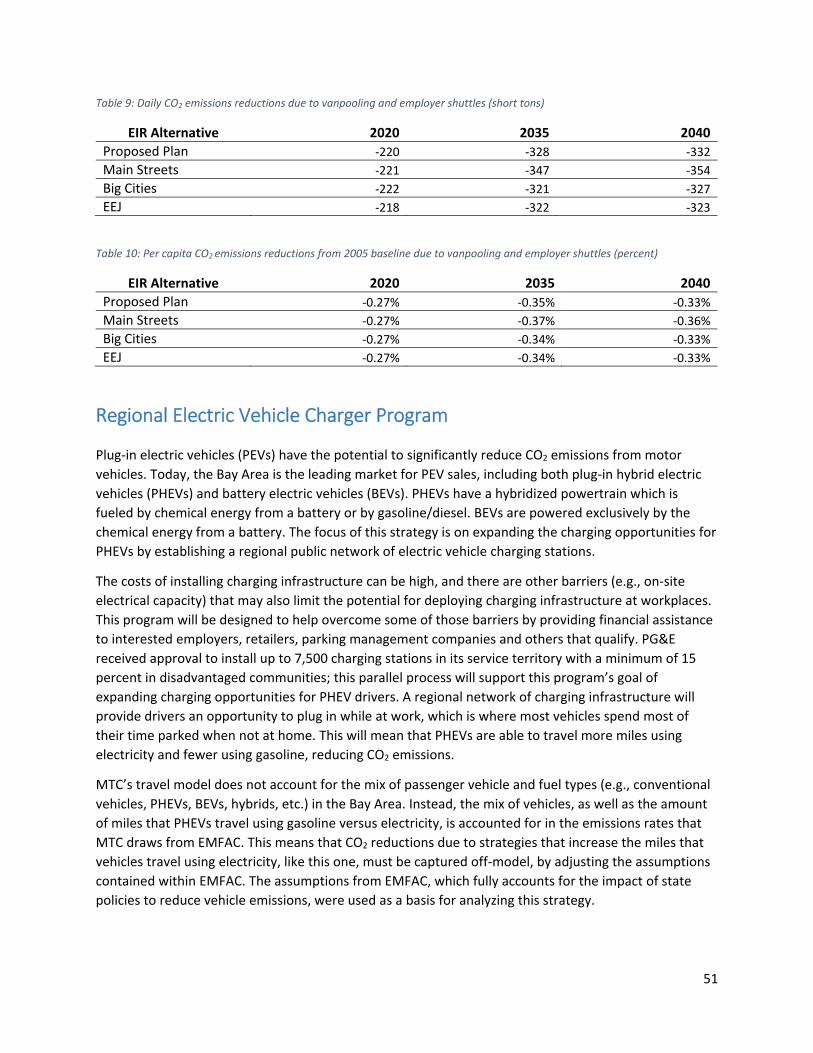
51
Table 9: Daily CO2 emissions reductions due to vanpooling and employer shuttles (short tons)
EIR Alternative 2020 2035 2040
Proposed Plan ‐220 ‐328 ‐332 Main Streets ‐221 ‐347 ‐354 Big Cities ‐222 ‐321 ‐327 EEJ ‐218 ‐322 ‐323
Table 10: Per capita CO2 emissions reductions from 2005 baseline due to vanpooling and employer shuttles (percent)
EIR Alternative 2020 2035 2040
Proposed Plan ‐0.27% ‐0.35% ‐0.33% Main Streets ‐0.27% ‐0.37% ‐0.36% Big Cities ‐0.27% ‐0.34% ‐0.33% EEJ ‐0.27% ‐0.34% ‐0.33%
Regional Electric Vehicle Charger Program
Plug‐in electric vehicles (PEVs) have the potential to significantly reduce CO2 emissions from motor
vehicles. Today, the Bay Area is the leading market for PEV sales, including both plug‐in hybrid electric
vehicles (PHEVs) and battery electric vehicles (BEVs). PHEVs have a hybridized powertrain which is
fueled by chemical energy from a battery or by gasoline/diesel. BEVs are powered exclusively by the
chemical energy from a battery. The focus of this strategy is on expanding the charging opportunities for
PHEVs by establishing a regional public network of electric vehicle charging stations.
The costs of installing charging infrastructure can be high, and there are other barriers (e.g., on‐site
electrical capacity) that may also limit the potential for deploying charging infrastructure at workplaces.
This program will be designed to help overcome some of those barriers by providing financial assistance
to interested employers, retailers, parking management companies and others that qualify. PG&E
received approval to install up to 7,500 charging stations in its service territory with a minimum of 15
percent in disadvantaged communities; this parallel process will support this program’s goal of
expanding charging opportunities for PHEV drivers. A regional network of charging infrastructure will
provide drivers an opportunity to plug in while at work, which is where most vehicles spend most of
their time parked when not at home. This will mean that PHEVs are able to travel more miles using
electricity and fewer using gasoline, reducing CO2 emissions.
MTC’s travel model does not account for the mix of passenger vehicle and fuel types (e.g., conventional
vehicles, PHEVs, BEVs, hybrids, etc.) in the Bay Area. Instead, the mix of vehicles, as well as the amount
of miles that PHEVs travel using gasoline versus electricity, is accounted for in the emissions rates that
MTC draws from EMFAC. This means that CO2 reductions due to strategies that increase the miles that
vehicles travel using electricity, like this one, must be captured off‐model, by adjusting the assumptions
contained within EMFAC. The assumptions from EMFAC, which fully accounts for the impact of state
policies to reduce vehicle emissions, were used as a basis for analyzing this strategy.

52
Assumptions and methodology The Plan Bay Area analysis was revised to account for improved fuel economy estimates, updated
vehicle populations, and new vehicle sales in the Bay Area based on data included in EMFAC. PG&E’s
expected investment to deploy 7,500 chargers in the Bay Area was also incorporated along with the
assumption that MTC would fund additional chargers after PG&E’s initial investment. The analysis
assumes a total of 76,000 chargers deployed, roughly one charger for every five PHEVs, which would
enable all of these PHEVs to be able to plug in at work if multiple vehicles are able to plug into a single
charger over the course of a day).
In the baseline, it was assumed that 40 percent of miles traveled by PHEVs would be in charge‐depleting
mode, i.e., electric miles instead of gasoline‐powered miles. This comes from EMFAC, which indicates
that:
[CARB] staff modeled PHEVs as having a 25‐mile all‐electric range, which equates to a
utility factor of 0.40. For the average commute, this would mean that 40 percent of the
VMT could be from all‐electric, and 60 percent would be from gasoline operations.19
This percentage is assumed to increase to 80 percent due to the Regional Charger Program. PHEVs have
what is referred to as an all‐electric range of between ten and fifty miles. For instance, the Ford C‐MAX
Energi has an all‐electric range of 21 miles; the first‐generation Chevrolet Volt has an all‐electric range of
38 miles; and the second‐generation Volt has a range of 53 miles. Data from The EV Project20 and a
paper from GM engineers21 indicate that drivers of the Chevrolet Volt, a proxy for a PHEV with a 40‐mile
range (PHEV‐40), are able to drive about 74 percent of their total miles in EV‐mode without support
from the internal combustion engine. Data from Ford Motor Company22 indicate that vehicles in their
Energi line, including the C‐Max and Fusion, both of which are proxies for a PHEV with a 20‐mile range
(PHEV‐20), travel about 33 percent of miles using electricity. ICF estimates that the current market is
about 50/50 for PHEV‐20/PHEV‐40 today. Note that these values represent driver behavior during the
early stages of charging infrastructure deployment, during which there has been no substantial
dedicated effort to maximize eVMT. In other words, absent any concerted effort to deploy charging
infrastructure to maximize electric miles, the average PHEV is likely traveling about 54 percent of its
miles using electricity.
A network of regional charging infrastructure will further increase the percentage of miles that PHEVs
travel in electric mode and the methodology assumes:
Each charger deployed through the Regional Charger Network serves multiple vehicles each day over the course of a four‐hour charging shift
The chargers deployed are Level 2 chargers that deliver electricity with a rating of 5 kW; and The average electric vehicle consumes 0.35 kWh/mi.
19 California Air Resources Board, EMFAC2014 Volume III – Technical Documentation v1.0.7, May 2015. Available online at http://www.arb.ca.gov/msei/downloads/emfac2014/emfac2014‐vol3‐technical‐documentation‐052015.pdf. 20 EV Project, Quarterly Reports e.g., http://www.theevproject.com/cms-assets/documents/127233-901153.q2-2013-rpt.pdf. 21 Duhon, A., Sevel, K., Tarnowsky, S., and Savagian, P., "Chevrolet Volt Electric Utilization," SAE Int. J. Alt. Power. 4(2):269‐276, 2015. 22 Proceedings EVS29, Montreal.

53
A ratio of approximately one charger for every five vehicles over the program years is assumed,
consistent with charger‐to‐vehicle ratios estimated by Electric Power Research Institute (EPRI) for
workplace and public charging opportunities and research conducted by ICF regarding charging
optimization.23
These assumptions mean that these chargers would provide enough electricity to power 57 electric
miles per day. Given that there are expected to be 420,000 PHEVs in the Bay Area in 2035 and 76,000
chargers funded through this program, this is equivalent to ten electric miles per PHEV per day.
According to EMFAC, the average vehicle travels an average of 31 miles per day, so this additional
electricity amounts to 32 percent of miles traveled. Given that the charger program is designed to fill
gaps in charging opportunities, this is added to the baseline of 54 percent eVMT, which equals 86
percent. Even though there is the potential for improvements in the parameters that form the basis for
the assumptions used to derive the additional eVMT potential of the regional charger network—battery
sizing, vehicle efficiency, charger utilization, power delivered—over the next several decades, a
conservative 80 percent eVMT assumption is used.
It is conceivable that the increased availability of chargers could increase the sales of BEVs in addition to
increasing the percentage of electric miles for PHEVs, but this effect is not included in the calculations to
be conservative.
Analysis steps To determine the CO2 emission reductions from charging infrastructure deployment throughout the
region, the methodology:
1. Modified the percentage of miles traveled in charge depleting mode from the baseline 40% to 80%.
2. Determined the CO2 emissions reduction. a. The CO2 emissions attributable to PHEVs are based on how many miles each vehicle
spends in each mode (charge depleting or gas/diesel). b. The CO2 emission reductions are determined as the difference between the emissions
attributable to the PHEV versus the emission that would have otherwise occurred using an average conventional gasoline vehicle.
3. Made no changes to the VMT.
Results Table 11 and Table 12 summarize the CO2 reductions due to the Regional Charger Program.
23 D. Bowermaster, EPRI. How Much Electric Vehicle Charging is Needed? California Plug‐in Electric Vehicle Collaborative Meeting, August 2012.

54
Table 11: Daily CO2 emissions reductions due to the Regional Charger Program (short tons)
EIR Alternative 2020 2035 2040
Proposed Plan ‐252 ‐1,188 ‐1,287
Main Streets ‐252 ‐1,188 ‐1,287
Big Cities ‐252 ‐1,188 ‐1,287
EEJ ‐252 ‐1,188 ‐1,287
Table 12: Per capita CO2 emissions reductions from 2005 baseline due to the Regional Charger Program (percent)
EIR Alternative 2020 2035 2040
Proposed Plan ‐0.35% ‐1.42% ‐1.46% Main Streets ‐0.35% ‐1.42% ‐1.46% Big Cities ‐0.35% ‐1.42% ‐1.46% EEJ ‐0.35% ‐1.42% ‐1.46%
Emission reductions are consistent across all EIR alternatives since the analysis does not rely on inputs
from MTC’s travel model.
Vehicle Buyback & PEV Incentive
Plug‐in electric vehicles (PEVs) are being adopted at significant levels today in the Bay Area, and the Zero
Emission Vehicle (ZEV) Program and the Low‐Carbon Fuel Standard in California are regulatory drivers
for advanced vehicle technologies and alternative fuels. However, despite the near‐term success of PEVs
in the Bay Area, PEV sales are still relatively small, representing just 3.5 percent of total new light‐duty
vehicle sales. There is also some uncertainty regarding the medium‐ to long‐term availability of PEV
purchase incentives; for example, California’s Clean Vehicle Rebate Program changed in 2016 to adjust
incentives based on household income, and the federal tax credit could change in future tax reform.
Furthermore, one of the main drivers today for PEV sales, particularly for PHEVs, is HOV lane access:
PHEVs are eligible for the green sticker and BEVs are eligible for the white sticker and qualify for HOV
lane access through January 1, 2019. Although the California Air Resources Board (CARB) has continued
to expand the number of HOV stickers for PEVs, it is likely that they will be limited and eventually
discontinued, as they were for non‐plug‐in hybrid vehicles.
This program can provide a combination of an incentive of up to $2,500 to purchase a PEV along with
the buyback of older, less efficient vehicles. This is intended to extend the market for PEVs into a
broader range of income classes. Most analysts agree that the first adopters of PEVs are generally higher
income individuals who own their homes, and in many cases, own or have owned a hybrid electric
vehicle (e.g., a Toyota Prius). The higher purchase price of PEVs makes it difficult for middle and low
income consumers to purchase them. Older and wealthier individuals tend to buy more new vehicles
than other cross‐sections of the population. This demographic also tends to buy newer cars more
frequently. Furthermore, research from IHS Markit has shown that owners of both new and used
vehicles are holding on to their vehicles longer, the scrappage rate has flattened, and the average age of
vehicles has increased; the researchers forecast that the population of oldest vehicles (16 or more years)

55
will grow the fastest, increasing by 30% by 2021.24 Additionally, CARB estimates that half of cars live to
be 15 years old and one quarter live to be 20 years old. Interestingly, if a vehicle does survive to 20,
there is a 40 percent chance it will be on the road for another ten years after that.25 This will impact the
turnover of the fleet significantly and may slow the purchase of new vehicles, including plug‐in electric
vehicles.
The vehicle buyback program seeks to accelerate fleet turnover while also incentivizing the purchase of
advanced vehicle technology. The program will be designed to target older vehicles meeting a certain
fuel economy threshold (as measured via miles per gallon, MPG) for scrapping, and will be coordinated
with the Air District’s Vehicle BuyBack Program. The consumer is only eligible for the program if the new
vehicle being purchased is a PHEV or BEV. The incentive amount will vary with the fuel economy of the
vehicle being traded in (measured in MPG) as well as the vehicle type being purchased (e.g., PHEV or
BEV). Depending on the fuel economy threshold set by the program, the combination vehicle buyback
and incentive program is intended to induce demand in middle and lower income brackets that might
otherwise delay car purchasing, purchase a new conventional vehicle or purchase a used vehicle.
MTC’s travel model does not account for the mix of passenger vehicle and fuel types (e.g., conventional
vehicles, PHEVs, BEVs, hybrids, etc.) in the Bay Area. Instead, the mix of vehicles is accounted for in the
emissions rates that MTC draws from EMFAC. This means that CO2 reductions due to strategies that
increase the proportion of clean vehicles in the passenger fleet, like this one, must be captured off‐
model, by adjusting the assumptions contained within EMFAC. The assumptions from EMFAC, which
fully accounts for the impact of state policies to reduce vehicle emissions, were used as a basis for
analyzing this strategy.
Assumptions and Methodology The analysis was updated from Plan Bay Area to account for improved fuel economy estimates, updated
vehicle populations, and new vehicle sales in the Bay Area based on data included in EMFAC.
We made the following assumptions in this methodology:
Implementation of this program will begin in 2020.
94,000 additional PEVs will be on the road by 2035. This is a modest annual increase of about 1.5% in new vehicle sales attributable to the buyback incentive program.
For the initial analysis, the deployed vehicles are evenly split between PHEVs and BEVs.
The average incentive levels are $1,500 per PHEV and $2,500 per BEV. However, the actual incentive will vary based on the MPG of the vehicle being traded in as well as the technology of the vehicle being purchased.
Analysis steps
24 ”Vehicles Getting Older: Average Age of Light Cars and Trucks in U.S. Rises Again in 2016 to 11.6 Year, IHS Markit Says.” Press release from IHS Markit, November 2016. Available online at: http://news.ihsmarkit.com/press‐release/automotive/vehicles‐getting‐older‐average‐age‐light‐cars‐and‐trucks‐us‐rises‐again‐201 25 Report to the California Legislature, Accelerated Light‐Duty Vehicle Retirement Program. http://www.arb.ca.gov/research/apr/reports/l2070.pdf. Accessed March 20, 2013.

56
To calculate CO2 reductions due to the introduction of PEVs, the methodology:
1. Determined the difference between the daily CO2 emissions attributable to the PEV versus the emissions that would have otherwise occurred using an average conventional gasoline vehicle. For PHEVs this depends on the assumed proportion of time spent in charge depleting mode versus gas/diesel mode.
2. Multiplied the result by the number of new PEVs expected to be deployed due to the program.
Results Table 11 and Table 12 summarize the CO2 reductions due to the Vehicle Buyback and PEV Incentive
Program.
Table 13: Daily CO2 emissions reductions due to the Vehicle Buyback and PEV Incentive Program (short tons)
EIR Alternative 2020 2035 2040
Proposed Plan 0 ‐363 ‐234 Main Streets 0 ‐363 ‐234 Big Cities 0 ‐363 ‐234 EEJ 0 ‐363 ‐234
Table 14: Per capita CO2 emissions reductions from 2005 baseline due to the Vehicle Buyback and PEV Incentive Program (percent)
EIR Alternative 2020 2035 2040
Proposed Plan 0% ‐0.44% ‐0.27% Main Streets 0% ‐0.44% ‐0.27% Big Cities 0% ‐0.44% ‐0.27% EEJ 0% ‐0.44% ‐0.27%
Emissions reductions will be realized after 2020, which is when program implementation is planned.
Emissions reductions are consistent across all EIR alternatives because the analysis does not rely on
inputs from the travel model.
Clean Vehicles Feebate Program
Originally coined in the 1990s, feebate programs are envisioned as a revenue‐neutral approach to shift
buying habits in the transportation and energy sectors. MTC is proposing to use a feebate program to
incentivize consumers to scrap older vehicles and purchase higher performing, cleaner vehicles. A
feebate program uses a combination of fees and rebates to change consumer behavior. Consumers
purchasing a vehicle that emit more carbon dioxide on a gram per mile basis than a defined standard are
assessed a fee at the point of purchase. These fees are used to provide rebates to consumers that
purchase vehicles that emit less CO2 on a gram per mile basis than the defined standard.
Feebates have been used with some success in other countries, including Denmark, France, the
Netherlands and Norway. The structure of a feebate program for California was studied in considerable

57
detail for CARB.26 In fact, California has come close to implementing a statewide feebate program on
multiple occasions through legislative efforts – the first time in the early 1990s and more recently in
2008. Feebate programs have been proposed as a legislative initiative (e.g., AB 493 Ruskin in 2007),
whereby implementation authority would be delegated to CARB and the State Board of Equalization,
and a feebate program is not dissimilar from the fee that was approved by the Legislature via AB 434
(Sher, Chapter 807, Statutes of 1991) establishing the Transportation Fund for Clean Air (TFCA). Moving
forward, MTC will engage with CARB and the Air District to determine how the program would be
implemented and how to progress legislation prior to the start of the program. The feebate program
would require legislation to provide regional agencies with the authority to implement it.
MTC’s travel model does not account for the mix of passenger vehicle and fuel types (e.g., conventional
vehicles, PHEVs, BEVs, hybrids, etc.) in the Bay Area. Instead, the mix of vehicles is accounted for in the
emissions rates that MTC draws from EMFAC. This means that CO2 reductions due to strategies that
increase the proportion of clean vehicles in the passenger fleet, like this one, must be captured off‐
model, by adjusting the assumptions contained within EMFAC. The assumptions from EMFAC, which
fully accounts for the impact of state policies to reduce vehicle emissions, were used as a basis for
analyzing this strategy.
Assumptions and methodology The analysis draws heavily from results reported by Bunche & Greene’s feebate analysis for CARB. The
lower‐end estimate of impact of feebates on average fuel economy (1.6 percent) from their analysis is
assumed. The major benefits of the feebate programs are attributable to the first several years of the
program. In their report, the authors state, "In later years the level of CO2 emissions reduction relative to
the standard diminishes as the standard becomes more stringent."
It is assumed that the feebate program is introduced in 2020 and that there are not any increases in fuel
economy standards at the state or national level after 2025. To maintain consistency with the Bunch &
Greene study, this analysis assumes a $20 per g/mi feebate rate in a single benchmark system. Based on
a sensitivity analysis performed by Bunch & Greene, an increase to $30 per g/mi feebate rate will yield a
50 percent increase in CO2 reductions.
Since Plan Bay Area, the analysis was updated to account for improved fuel economy estimates,
updated vehicle populations, and new vehicle sales in the Bay Area based on data included in EMFAC.
Analysis steps To calculate the CO2 emission reductions due to the Clean Vehicles Feebate Program, the methodology:
1. Estimated the improvement in fuel economy (back‐calculated based on grams per mile estimates) of the new vehicle fleet due to the feebate program. Maximum improvement at the outset of the program is about 2.9%; by 2040, the improvement is reduced to 0.1%.
2. Based on vehicle turnover, estimated the modified fuel economy of entire fleet after the change to improved fuel economy of new vehicles as of 2020 due to the feebate program.
26 Greene, David L. & Bunch, David S., “Potential design, implementation, and benefits of a feebate program for new passenger vehicles in California”, Prepared for the California Air Resources Board, Contract UCD 08‐312, February 2011.

58
3. Calculated the differential in well‐to‐wheels CO2 emissions27 of the modified fleet versus baseline fleet.
Results Table 15 and Table 16 summarize the CO2 reductions due to the Clean Vehicles Feebate Program.
Table 15: Daily CO2 emissions reductions due to the Clean Vehicles Feebate Program (short tons)
EIR Alternative 2020 2035 2040
Proposed Plan 0 ‐682 ‐446 Main Streets 0 ‐682 ‐446 Big Cities 0 ‐682 ‐446 EEJ 0 ‐682 ‐446
Table 16: Per capita CO2 emissions reductions from 2005 baseline due to the Clean Vehicles Feebate Program (percent)
EIR Alternative 2020 2035 2040
Proposed Plan 0% ‐0.82% ‐0.51% Main Streets 0% ‐0.82% ‐0.51% Big Cities 0% ‐0.82% ‐0.51% EEJ 0% ‐0.82% ‐0.51% No Project 0% ‐0.82% ‐0.51%
Emission reductions will be realized after 2020, which is when program implementation is planned.
Emission reductions are consistent across all EIR alternatives because the analysis does not rely on
inputs from the travel model.
Smart Driving
When discussing transportation sector CO2 reduction strategies, experts often refer to a three‐legged
stool consisting of vehicle technology, cleaner fuels and driver behavior. California’s state agencies are
leading the way on the first two legs, and SB 375 focuses on a key approach to changing driver behavior,
reducing VMT by investing in alternatives to driving, locating housing closer to jobs and creating
complete communities. In addition to changing how much someone drives, people can change how they drive through training in the techniques of smart driving. Smart driving behaviors are easy‐to‐implement
actions (e.g., change in driving style, vehicle maintenance, etc.) that any driver can do. Research shows
that it is possible to affect significant and swift reduction in emissions through behavior change.28 MTC’s
27 Well‐to‐wheels (WTW) analysis refers to lifecycle analysis applied to transportation fuels and their use in vehicles. The analysis includes, for instance, resource extraction, fuel production, delivery of the fuel to vehicle, and end use of fuel in vehicle operations. 28 See http://assets.511.org/pdf/drivesmart/Smart‐Driving‐Resource‐Guide.pdf for a MTC’s review of relevant research.

59
Smart Driving campaign reduces CO2 emissions by promoting the driver behaviors that have been shown
most effective in improving vehicle efficiency.
This strategy builds on series of previous actions by MTC. From 2013 to 2015, MTC conducted a pilot
smart driving campaign that consisted of three core programs, which MTC evaluated to understand
which approaches produce the most significant CO2 reductions:29
Fuel economy meters
Smart driving lessons
Smartphone app
In 2015, MTC expanded its smart driving investments into a region‐wide program called Drive Smart Bay
Area. The program development and implementation included:
Selecting a smart driving in‐vehicle device to distribute to drivers
Developing a marketing strategy
Developing a program website and video
Establishing two device purchasing options
Implementing the marketing strategy
As part of Plan Bay Area 2040, MTC is assessing the program’s evaluation report prior to further
implementation of the Drive Smart Bay Area program. Off‐model analysis is necessary to capture CO2
reductions due to this strategy because most of the behaviors promoted through Drive Smart Bay Area
reduce vehicle emission rates, which come from EMFAC, not from MTC’s travel model.
Assumptions and methodology Implementation of the smart driving program is assumed to begin in 2020. Gas prices are currently
relatively low, which would mean less consumer interest in the program and fewer CO2 reductions if it
were implemented today. It is assumed that gas prices will rise again by 2020 to the level that they were
at when MTC completed its initial evaluations of the strategies discussed below, and remain at least that
level thereafter. Therefore the changes to emission rates due to smart driving behaviors are assumed to
be constant over time.
Smart driving educational campaign In February 2011, MTC conducted a Baseline Climate Initiatives Survey that asked Bay Area residents
about the ease of adopting various smart driving behaviors.30 Of the respondents, 55 percent stated
that it would be very easy or easy to practice “smooth acceleration and deceleration and staying at or
below the speed limit.” The U.S. Department of Energy reports that rapid acceleration and deceleration,
and speeding can lead to fuel economy reductions from five percent on city streets to 33 percent on
29 MTC Climate Initiatives Program Evaluation: Smart Driving, Prepared for MTC by ICF, 2015. A summary of findings is available at: http://mtccms01.prod.acquia-
sites.com/sites/default/files/CIP%20Evaluation%20Summary%20Report_7-13-15_FINAL.pdf 30 MTC conducted a Baseline Climate Initiatives Survey in February 2011. It was a 15 minute random digit dial and cell phone sample of Bay Area driving age residents. It was offered in English, Mandarin, and Spanish and had an overall margin of error of ±3.5%

60
freeways,31 but current studies demonstrate a much lower average fuel economy savings of two to four
percent32 for smart driving behaviors.33 This analysis assumes a conservative fuel efficiency reduction
from smooth acceleration and deceleration of three percent.
60 percent of participants stated that it would be very easy or easy to practice “at least once per week,
link several trips together, such as going shopping and to the post office, which you would normally
make separately.” For this analysis, this statement is interpreted to mean the driver will link three
shopping trips per week due to the campaign (effectively reducing two trips).
The number of people to adopt smart driving behaviors is based on the survey results listed above and
other cost effectiveness assumptions related to marketing investments. Preliminary cost estimates
indicate that $1 million in advertising and education can purchase 8,000,000 TV views, 5,000,000 radio
listeners and 15,000,000 online hits. Since the public needs to see or hear an advertisement multiple
times before recognizing the message and being able to practice the requested behavior change; costs
assume twelve views are needed for to internalize the message.34 In order to reduce CO2 emissions,
potential adopters must also be capable of and motivated to make a change. For trip linking practices,
ten percent of potential adopters are assumed to adopt the behavior. For smooth acceleration and
deceleration, a more conservative assumption of five percent is used to avoid double counting the
benefits of the fuel economy meter distribution program (see below for more details).
Fuel economy meters Under this program, MTC would offer a rebate to consumers who purchase an on‐board diagnostics
(OBD)‐connected after‐market device similar to those made by Automatic and provided by MTC under
Drive Smart Bay Area and the ones tested in the initial smart driving pilots. Recent studies have
demonstrated an average fuel economy savings of two to four percent from smart driving education and
devices. The MTC‐funded smart driving pilot found that the installation of OBD‐connected smart driving
devices resulted in a 1.6 percent improvement in fuel economy; however the results are not statistically
significant because they fall within the background fluctuation in fuel economy that was observed
among the participating vehicles.35 MTC also funded a study at UC Davis to test a smart driving app with
different types of feedback. The most effective feedback mechanism (presenting the journey fuel
31 US Department of Energy, Office of Energy Efficiency and Renewable Energy, US Environmental Protection Agency, Model Year 2005 Fuel Efficiency Guide, DOE/EE‐0302 32 While recent studies have found a range in the potential fuel efficiency improvements from smart driving techniques from zero to 18%, the substantial range in results is likely due to shortcomings in the studies including: insufficient sample sizes, short study periods, variations in the testing environment (simulations or tracks versus real‐world driving conditions), and the lack of statistically significant findings. The 2‐4% range is seen in studies that overcome these issues. 33 Kurani, K., Stillwater, T., and Jones, M., 2013. Ecodrive I‐80: A Large Sample Fuel Economy Feedback Field Test: Final Report. Institute of Transportation Studies Report: ITS‐RR‐13‐15. Available at http://www.fueleconomy.gov/feg/pdfs/EcoDrive%20I‐80.pdf 34 The estimated number of views needed for the target audience to engage with the message varies dramatically by the medium and quality of the creative, but 12 views is seen as relatively standard conversion rate by marketing firms such as RHDG and Wit Media. 35 ICF. 2015. Climate Initiatives Program: Evaluation Summary Report. Available at: http://mtccms01.prod.acquia‐sites.com/sites/default/files/CIP%20Evaluation%20Summary%20Report_7‐13‐15_FINAL.pdf

61
economy in the center of the screen) had a statistically discernable effect of a 15.5 percent reduction in
fuel consumption; however, the sample size was small with approximately 18 people viewing that
version of feedback.36 Given these varied findings, a three percent fuel economy savings from OBD‐
connected devices is used.
The analysis assumes that MTC will distribute 900,000 OBD‐connected devices by 2035, covering roughly
30 percent of all Bay Area registered vehicles. This assumptions does not account for the fact that an
increasing number of vehicles, particularly hybrids, come with displays that show information such as
real‐time fuel efficiency, five‐minute‐average fuel efficiency, overall trip fuel efficiency, or simple
diagrams that indicate relative fuel efficiency.37 This may help to further accelerate the spread of smart
driving behaviors beyond the behavior change induced by the devices that MTC distributes.
Analysis steps
Smart driving educational campaign
Smooth acceleration and deceleration
In order to estimate CO2 reductions due to smooth acceleration and deceleration, the methodology:
1. Estimated the total number of media impressions by multiplying the media ad‐buy for smooth
acceleration and deceleration by the estimated number of impressions per million dollars of
media spend (28 million impressions/$1 million).
2. Estimated the number of residents who internalize the campaign messaging by dividing the total
media impressions by the estimated number of views required for engagement (12).
3. Estimated the number of potential adopters by multiplying the total number of residents who
internalized the campaign messaging by the percent of Bay Area residents who responded that
adopting smooth acceleration and deceleration behaviors would be easy or very easy.
4. Estimated the number of residents who adopt the behavior by multiplying the number of
potential adopters by the by the assumed adoption rate (5%).
5. Estimated the total daily VMT affected by the smart driving behavior by multiplying the number
of behavior adopters by the regional average daily VMT per capita.
6. Estimated the equivalent quantity of VMT reduced due to smooth acceleration and deceleration
by multiplying the total daily VMT affected by the assumed fuel efficiency savings of smooth
acceleration and deceleration (3%).
7. Calculate the CO2 emissions reduced by multiplying the equivalent VMT reduced by the EMFAC
exhaust emissions CO2 factor.
Trip linking
In order to estimate CO2 reductions due to trip linking, the methodology:
1. Repeated Steps 1‐4 of the smooth acceleration and deceleration calculations above, substituting
using the appropriate assumptions for trip linking, to estimate the number of residents who
adopt the behavior.
36 Ibid. 37 Barkenbus, Jack, 2010. Eco‐driving: An overlooked climate change initiative. Journal of Energy Policy, 38 (2010) 762–769.

62
2. Estimated the annual vehicle trips reduced by the behavior adopters by multiplying the total
number of behavior adopters by the assumed number of trips reduced per week (2) and the
number of weeks per year (52).
3. Calculated the total annual VMT reduced by multiplying the annual vehicle trips reduced by the
average length of a shopping trip in the region (approximately 4.6 miles; varies by year and
scenario).
4. Divided the results of steps 2 and 3 by the assumed number of driving days per year (300) to
calculate total daily trips and VMT reduced.
5. Summed the product of trip‐end emission rates and daily vehicle trip reductions and the product of exhaust emission rates and daily VMT reductions to calculate total CO2 emission reductions.
Fuel economy meters In order to estimate CO2 reductions due to trip linking, the methodology:
1. Estimated the total number of devices to be distributed by dividing the total investment by the
assumed price per device (including program management fees).
2. Calculated the total daily VMT affected by the smart driving behavior by multiplying the number
of behavior adopters by the regional average daily VMT per vehicle.
3. Estimated the equivalent quantity of VMT reduced due to fuel economy meters by multiplying
the total daily VMT by the assumed fuel efficiency savings of the fuel economy meters (3%).
4. Calculated the CO2 emissions reduced by multiplying the equivalent VMT reduced by the EMFAC
exhaust CO2 emissions factor.
Results Table 17 and Table 18 summarize the CO2 reductions due to MTC’s efforts to promote smart driving.
Table 17: Daily emissions reductions due to smart driving (short tons)
EIR Alternative 2020 2035 2040
Proposed Plan 0 ‐677 ‐669 Main Streets 0 ‐681 ‐677 Big Cities 0 ‐672 ‐663 EEJ 0 ‐662 ‐655
Table 18: Per capita emissions reductions from 2005 baseline due to smart driving (percent)
EIR Alternative 2020 2035 2040
Proposed Plan 0% ‐0.72% ‐0.67% Main Streets 0% ‐0.72% ‐0.68% Big Cities 0% ‐0.71% ‐0.67% EEJ 0% ‐0.70% ‐0.66%

63
Targeted Transportation Alternatives
Targeted transportation alternatives programs employ a variety of strategies, including individual travel
consultation, organized events, and distribution of outreach and informational materials to encourage
people to shift from driving alone to carpooling, transit, biking, or walking for any of their trips. These
programs are “targeted” because they tailor activities and materials to focus on the travel needs and
transportation options that are available in specific job centers or residential neighborhoods. Several
MPOs and large cities in the U.S. administer these programs, partnering with local governments, transit
agencies, employers and transportation management associations to customize projects to different
communities. Examples from other jurisdictions operating programs for ten years or more with positive
results include Portland Metro’s Regional Travel Options program, the City of Portland’s SmartTrips
program and the City of Seattle’s InMotion program.
In addition, several public agencies in the Bay Area currently have marketing programs in place. Two of
the Climate Initiative Innovative Grant pilot projects funded by MTC from 2011‐13, GoBerkeley and
Connect, Redwood City!, include targeted transportation alternatives components. The former involved
working with property managers to market travel options and provide free bus passes to residents of
multifamily transit‐oriented developments, while the latter included focused outreach to employers
with billboard and print advertising to promote alternatives to driving alone. These two projects were
among the most effective Climate Initiative projects at reducing CO2 emissions, and the targeted
transportation alternatives components of these projects stood out for their cost effectiveness and
results.
MTC’s Targeted Transportation Alternatives Program is considering a similar implementation approach
to Portland Metro’s Regional Travel Options grant program, which issues grants to public agencies,
transportation management associations, and non‐profits to implement projects that make it easier for
travelers to get around without driving alone.38
Off‐model analysis is necessary to capture CO2 reductions from targeted transportation alternatives
programs. MTC’s last travel survey which informs the travel model, was conducted in 2010, and does
not capture the impacts of new strategies that change travel behavior such as this one. These strategies
might be captured by a future model once they have been implemented to the extent that they
influence people’s behavior and can be captured by the travel surveys, and once the model framework
has been altered to include inputs that represent the presence of behavior change strategies.
Assumptions and Methodology Data from two community‐based travel marketing programs from the Portland, OR metropolitan area
was used to estimate CO2 reductions for a regional targeted transportation alternatives program in the
Bay Area. Since travel marketing programs are typically targeted toward employees or households; this
strategy includes both workplace and residential components, and uses data from different programs to
assess each component. Employee‐focused programs can be more cost‐effective at reaching workers
38 http://www.oregonmetro.gov/tools‐partners/grants‐and‐resources/travel‐options‐grants

64
who are concentrated at large employers, making outreach efficient. However, residential programs can
produce greater CO2 reductions per person reached because they affect all trips, not just commute trips.
Evaluation data from employer‐focused projects in Portland Metro’s Regional Travel Options program39
was used to assess the impact of programs that target employers and data from the City of Portland’s
SmartTrips program,40 which focuses on households, to assess the impacts of residential programs.
These are longstanding programs, and each has conducted multiple rounds of evaluation, with each
round covering multiple projects. Information was collected on the cost per year of marketing to an
individual household/employee, the percentage of residents/employees receiving program information
who change behavior (penetration rate), and the reduction in SOV mode share for those
residents/employees from evaluations of these two programs. These were then applied to the daily
number and distance of trips for all trips (for households) and for commute trips (for employees) to
estimate VMT impacts. Evaluations of targeted transportation alternatives programs typically focus on
impacts during the year after programs are implemented; long‐term evaluations that provide
information on how long behavior change persists due to marketing programs is not currently available.
Therefore, the methodology uses a conservative assumption that behavior change lasts for five years
before participants revert to their previous travel patterns. Table 19 summarizes these assumptions.
Table 19: Summary of Targeted Transportation Alternatives assumptions
Households Employees
Average cost per year of marketing to a household/employee $3.11 $4.34
Average penetration rate 29% 33%
Average reduction in SOV mode share among participants 11% 9%
Average daily one‐way driving trips affected 5.47 2
Average one‐way trip length (miles)41 6.4 10.6
Number of years for which behavior change persists42 5 5
MTC’s investment in this strategy is the primary input in the CO2 estimates. Based on the budget
available and the amount of CO2 reductions that it needs to achieve, MTC anticipates investing $2.15
million in this strategy per year, with $2 million going to residential programs and $150,000 going to
employee programs. Since this is a new strategy, MTC will be working with consultants to develop an
approach to implementation.
39 Metro, Regional Travel Options Program Evaluation Report, 2012, http://www.oregonmetro.gov/sites/default/files/appendix_d_rto_evaluation_2012.pdf. 40 Portland Bureau of Transportation, Past SmartTrips 2004‐2010, http://www.portlandoregon.gov/transportation/56703. 41 This is an output from MTC’s travel model, and the value varies for different scenarios and years. The values shown are for the Proposed Plan in 2035; values for other scenario/year combinations range from 6.2‐6.5 (household) and 10.2‐11.2 (employee) 42 For 2020, we used a value of 3 since the strategy will take effect in 2017, and will only have been in place for 3 years.

65
Analysis steps The amount of CO2 reductions that MTC realizes through this strategy depends on the amount that it
invests. To calculate CO2 reductions based on the amount invested, the methodology:
1. Allocated the investment between household and employee programs. 2. Divided the respective household/employee investments by the average cost per year of
marketing to a household/employee and multiplied by the penetration rate in order to calculate the total number of participants.
3. Multiplied the total number of participants by the average reduction in SOV mode share among participants and the average daily one‐way driving trips affected to calculate the average daily number of vehicle trips reduced due to programs funded that year.
4. Multiplied the average daily number of vehicle trips reduced by the number of years for which behavior change persists to estimate the total average daily number of vehicle trips reduced in any given year. This accounts for the fact that programs funded in previous years produce ongoing vehicle trip reductions.
5. Multiplied daily vehicle trips reduced by the average one‐way trip length to calculate the average daily VMT reductions.
6. Summed the product of trip‐end emission rates and daily vehicle trip reductions and the product of exhaust emission rates and daily VMT reductions to calculate total CO2 emission reductions.
Results Table 20 and Table 21 summarize the CO2 reductions due to Targeted Transportation Alternatives.
Table 20: Daily CO2 emissions reductions due to Targeted Transportation Alternatives (short tons)
EIR Alternative 2020 2035 2040
Proposed Plan ‐954 ‐1,604 ‐1,578 Main Streets ‐958 ‐1,598 ‐1,586 Big Cities ‐952 ‐1,581 ‐1,553 EEJ ‐948 ‐1,574 ‐1,552
Table 21: Per capita CO2 emissions reductions from 2005 baseline due to Targeted Transportation Alternatives (percent)
EIR Alternative 2020 2035 2040
Proposed Plan ‐1.17% ‐1.71% ‐1.59% Main Streets ‐1.17% ‐1.70% ‐1.60% Big Cities ‐1.16% ‐1.68% ‐1.57% EEJ ‐1.16% ‐1.67% ‐1.57%
Trip Caps
Trip caps set limits on the number of vehicle trips to and from workplaces, and enforce these limits via
regular traffic counts and penalties for non‐complying workplaces. By limiting the number of vehicle
trips to a level below unrestricted access, trip caps can reduce CO2 emissions. Local governments have
the ability to set trip caps on new development projects through development agreements, but their

66
authority to enact caps on existing development is more limited. Trip caps therefore typically focus on
minimizing the traffic impacts of new office or commercial development. Several South Bay cities,
including Mountain View, Sunnyvale, Cupertino and Menlo Park, have enacted trip caps,43 as has the
City of Los Angeles. Stanford University and Santa Clara County have had a trip cap in effect for over ten
years. Most of these caps focus on individual development projects, but Mountain View’s trip cap
covers an entire business district, providing a promising template for a program to encourage trip caps
in employment centers throughout the Bay Area.44 They are an increasingly popular strategy to reduce
vehicle trips in the Bay Area’s high‐growth employment centers, and MTC can promote their use
throughout the region, reducing CO2 emissions.
Trip caps complement, but do not duplicate, other commute transportation demand management
strategies included in the off‐model analysis, such as the Commuter Benefits Ordinance (CBO). These
other strategies act as “carrots” that provide employees incentives to use sustainable commute modes;
trip caps are a “stick” that require employers to reduce trips by employees or face fines. Trip caps also
apply to different employers than other TDM strategies; for example the CBO applies to all employers
with 50+ employees throughout the Bay Area whereas trip caps apply to all new businesses, regardless
of size, in designated employment areas. In order to implement trip caps across the region, MTC is
considering offering assistance to local governments through its existing planning grant programs.
Off‐model analysis is necessary to capture CO2 reductions from trip caps because MTC’s last travel
survey, which informs its model, was conducted in 2010, and does not capture the impacts of new
strategies that change travel behavior such as this one. These strategies might be captured by a future
model once they have been implemented to the extent that they influence people’s behavior in a way
that can be captured by the travel surveys, and once the model framework has been altered to include
inputs that represent the presence of behavior change strategies.
Assumptions and Methodology Estimating CO2 reductions due to trip caps involves multiplying the number of employees affected by
trip caps by the average reduction in vehicle trips for employees subject to caps, and then converting
the result to CO2 reductions.
In order to determine the number of employees affected, two assumptions were made where trip caps
can apply:
1. Trip caps generally apply in employment centers where there is a high enough concentration of businesses to justify the effort in adopting a cap. All traffic analysis zones (TAZs) with more jobs than residents are assumed to represent employment centers.
2. Trip caps are feasible in areas where there is a high enough density of jobs and land uses to support transit, carpooling and other sustainable commute options which is assumed to be the case in all TAZs designated as either urban or suburban in MTC’s travel model.
43 For a summary of South Bay trip cap programs, see Cities21, Palo Alto Comp Plan Transport Element, Extended Comments, September 1, 2015, http://www.cities21.org/cms/PA_Transp_Elem_C21.pdf. 44 City of Mountain View, North Bayshore Transportation Demand Management (TDM) Plan Guidelines, February 2015, http://www.mountainview.gov/civicax/filebank/blobdload.aspx?BlobID=15164.

67
Trip caps would apply to all new employees located in TAZs that met both of these criteria.
The next step was to determine the reduction in vehicle trips due to the trip cap. The baseline number
of vehicle trips per employee in each TAZ where trip caps apply were estimated. To this, the average
vehicle trip reduction from the City of Mountain View’s North Bayshore Transportation Demand
Management (TDM) Plan Guidelines was applied, which is based on a target of 45 percent drive‐alone
mode share and 10 percent carpool mode share.45 According to MTC’s travel model, the current regional
average carpool occupancy is 2.58 people per carpool, and the cap is equivalent to 0.98 vehicle trips per
employee per day. This represents a 40 percent decrease from the current level of 1.62 vehicle trips per
employee per day, which was calculated based on the current mode share for home‐based work trips to
the superdistrict containing the North Bayshore area—76 percent drive alone and 14 percent carpool,
according to MTC’s travel model.
The 40 percent reduction in the North Bayshore trip cap represents an average estimate for the
effectiveness of trip caps that should apply throughout the region, because it reflects both the
opportunities and challenges that will be present in many Bay Area locations. On one hand, the area is
experiencing high demand for commercial development and the City of Mountain View took a proactive
approach to minimizing the traffic impacts of new development through the trip cap. On the other hand,
the North Bayshore area is very challenging to serve with alternatives to driving given that it is cut off
from the rest of Mountain View by the Bayshore Freeway and is home to the Shoreline Amphitheatre,
the Google campus, and other land uses that are not conducive to walking, bicycling or transit.
Analysis steps To calculate CO2 reductions due to trip caps, the methodology:
1. Identified all TAZs where trip caps are likely to apply: urban and suburban TAZs with more jobs than households.
2. Identified the current drive‐alone and carpool mode share for home‐based work trips to each of the trip‐capped TAZs.
3. Calculated the average number of daily vehicle trips per employee in each trip‐capped TAZ by dividing carpool mode share by current average carpool occupancy, adding the result to the drive‐alone mode share, and multiplying the sum by two to account for round trips to and from work.
4. Estimated the reduction in daily vehicle trips per employee by applying the trip cap reduction factor derived from the Mountain View North Bayshore TDM Plan (40%) to the result of Step 4.
5. Multiplied the result of step 4 by the number of new employees projected for the TAZ between 2015 and the scenario year to estimate the total reduction in daily vehicle trips for each trip‐capped TAZ.
6. Multiplied the result of step 5 by the average trip distance for home‐based work trips for each trip‐capped TAZ to estimate the total reduction in daily VMT for each trip‐capped TAZ.
7. Summed the total reduction in daily vehicle trips across all trip‐capped TAZs. 8. Summed the total reduction in daily VMT across all trip‐capped TAZs. 9. Summed the product of trip‐end emission rates and daily vehicle trip reductions and the product
of exhaust emission rates and daily VMT reductions to calculate total CO2 emission reductions.
45 City of Mountain View 2015, p. 4‐3.

68
Results Table 22 and Table 23 summarize the CO2 reductions due to Trip Caps.
Table 22: Daily CO2 emissions reductions due to trip caps (short tons)
EIR Alternative 2020 2035 2040
Proposed Plan ‐120 ‐688 ‐856 Main Streets ‐150 ‐764 ‐1,111 Big Cities ‐143 ‐646 ‐836 EEJ ‐150 ‐622 ‐761
Table 23: Per capita CO2 emissions reductions from 2005 baseline due to trip caps (percent)
EIR Alternative 2020 2035 2040
Proposed Plan ‐0.15% ‐0.73% ‐0.86% Main Streets ‐0.18% ‐0.81% ‐1.12% Big Cities ‐0.18% ‐0.69% ‐0.84% EEJ ‐0.18% ‐0.66% ‐0.77%
Expanded Bike Share System
Bike share systems provide bicycles that members of the public can borrow and use for limited
durations (typically under a day) in exchange for a fee. In most systems, bike share bicycles must be
borrowed from and returned to designated docking stations, though some systems have payment
technology and locks mounted on bicycles to allow users to leave them anywhere in the service area. In
August 2013, in collaboration with MTC, the Air District implemented a bike share system in the Bay
Area on a limited pilot basis called Bay Area Bike Share (BABS). BABS consists of approximately 700 bikes
deployed across 70 stations; approximately half in San Francisco and the other half in South Bay cities.
Stations are located at key destinations such as transit hubs and employment and commercial areas. In
2015, Motivate, a private company, took over management of BABS, and with corporate sponsorship,
rebranded and will expand the system tenfold, including new service areas in the inner East Bay.46 MTC
will be promoting bike sharing through its existing or new outreach programs.
Bike share reduces CO2 emissions by enabling users to take short‐distance trips by bicycle instead of by
car, and in some cases bike share can eliminate longer trips by enabling users to connect to transit. As
the bike share system expands, further CO2 reductions will be realized. Motivate’s plans for the bike
share system are still evolving, but CO2 reductions are quantified based on information currently
available to MTC about the planned system.
Assumptions and methodology Based on information from Motivate, the criteria for service area expansion in Berkeley, Emeryville,
Oakland, San Francisco and San Jose includes transit‐rich, densely developed areas, in addition to some
targeted neighborhoods for equitable access. Since the service areas are still being decided, the priority
46 http://www.bayareabikeshare.com/expansion

69
development areas (PDAs) or areas in which most of the region’s growth is anticipated to occur, were
used to identify neighborhoods in each city that met these criteria. A contiguous bike share service area
was then mapped that included these neighborhoods. Summarized below are the boundaries of the
service area for each city:
Berkeley: bike share covers the area east of College Ave., south of Cedar St., west of 6th St., and
extends south to the city limits for contiguity with the Emeryville/Oakland bike share network.
Emeryville: bike share covers the entire city east of Interstate 80.
Oakland: North of Interstate 580, bike share covers the area west of College/Broadway. South of
Interstate 580, the bike share service area is bounded in the southeast by 55th Ave. and in the
southwest by 12th St. / San Leandro St., except for the area around Jack London square, where it
extends down to the harbor.
San Francisco: bike share covers most of the city, excluding hilly residential neighborhoods
around Twin Peaks / Mt. Sutro, the Sunset, industrial lands along the Bayfront, and major parks.
Though the Sunset meets the criteria for density and transit service, it was excluded as it is
isolated from the rest of the service area.
San Jose: bike share covers downtown and the residential neighborhoods surrounding it. The
service area is bounded by Interstates 680 and 101 in the northeast, Tully Rd. in the southeast,
Monterey Highway and Meridian Ave. in the west, and Berryessa Rd. and Hedding St. in the
northwest.
With these geographic areas mapped, the number of residents and jobs in each using 2010 Census and
Longitudinal Employer‐Household Dynamics data were calculated. Information from Motivate on the
approximate number of bikes in each city and the number of bikes per station was used to estimate the
number of planned stations for each city.
The Institute for Transportation and Development Policy (ITDP) Bike‐Share Planning Guide includes data
on the effectiveness (in terms of the number of trips per 1,000 residents) of different bike share systems
and compares effectiveness to different system characteristics.47 ITDP finds that station density best
explains bike share usage, and uses linear regression analysis to identify the relationship between
station density and effectiveness. ITDP’s data from U.S. systems was used to determine the equation
best describing the relationship between station density and daily trips per 1,000 residents for U.S.
systems:
Daily trips per 1,000 residents = 1.74 * station density + 17.2
This equation was then applied to the station density and number of residents in each bike share service
area to estimate the total number of bike share trips per day. Table 24 summarizes the data and
calculations for each service area.
47 Institute for Transportation and Development Policy, The Bike‐Share Planning Guide, Fig. 3, p. 45, https://www.itdp.org/the‐bike‐share‐planning‐guide‐2/.

70
Table 24: Summary of bike share service areas by city
City Number of bikes
Bikes per
station Total
stations Area (km2)
Stations per km2
Estimated daily bike share trips per 1000 residents
Current number of residents
Estimated current daily bike share trips (pop‐based)
Berkeley 400 10 40 11.5 3.5 23.1 79,090 1,823
Emeryville 100 10 10 2.6 3.8 23.7 8,596 204
Oakland 850 10 85 34.8 2.4 21.3 207,116 4,401
San Francisco 4,500 15 300 67.0 4.5 24.8 659,773 16,356
San Jose 1,000 10 100 46.3 2.2 20.8 188,213 3,907
Total 6,850
535 162 1,142,788 26,691
The average regional population growth was applied to estimate the number of bike share trips in each
scenario year. This results in a conservative estimate of bike share trips since bike share serves many of
the Bay Area’s highest‐growth communities.
The bike share trips were then converted to VMT reductions based on results from MTC’s evaluation of
BABS, which found that each bike share trip reduced an average of 1.3 VMT.48 Many bike share trips do
not reduce any VMT because they do not displace vehicle trips, while others only reduce short trips, but
the evaluation found that a significant share of bike share trips enables users to connect to transit,
eliminating longer trips.
Analysis steps To calculate CO2 reductions due to bike sharing, the methodology:
1. Identified a service area for each city with planned bike share and collected data on the area, number of planned bike share stations, and population for each service area.
2. Divided the number of bike share stations by the area of each service area to calculate the number of stations per square kilometer.
3. Applied a regression formula derived from ITDP to estimate the number of daily trips per 1,000 residents in each service area.
4. Multiplied the results by the number of residents in each area to estimate the number of daily bike share trips in each service area, and summed results across all service areas.
5. Multiplied total daily bike share trips by average population growth for the scenario year to estimate future total daily bike share trips.
6. Multiplied the result by the average VMT reduced per bike share trip to estimate total VMT reductions due to bike share.
7. Multiplied exhaust emission rates by daily VMT reductions to calculate total CO2 emission reductions.
48 MTC Climate Initiatives Program Evaluation: Pilot Bike‐sharing Program, Prepared for MTC by Eisen‐Letunic, 2015.

71
Results Table 25 and Table 26 summarize the CO2 reductions due to the expanded bike share system. CO2
reductions do vary slightly between the different EIR alternatives assessed, but the differences between
alternatives are not visible at the level of precision shown in the tables.
Table 25: Daily CO2 emissions reductions due to the expanded bike share system (short tons)
EIR Alternative 2020 2035 2040
Proposed Plan ‐18 ‐21 ‐22
Main Streets ‐18 ‐21 ‐22
Big Cities ‐18 ‐21 ‐22
EEJ ‐18 ‐21 ‐22
Table 26: Per capita CO2 emissions reductions from 2005 baseline due to the expanded bike share system (percent)
EIR Alternative 2020 2035 2040
Proposed Plan ‐0.02% ‐0.02% ‐0.02%
Main Streets ‐0.02% ‐0.02% ‐0.02%
Big Cities ‐0.02% ‐0.02% ‐0.02%
EEJ ‐0.02% ‐0.02% ‐0.02%
Expanded Bicycle Infrastructure
Bicycle infrastructure makes it safer, more convenient, and more pleasant for people to bike instead of
driving. Research has found that many people are interested in bicycling more, but are concerned about
being hit by motor vehicles.49 Building new infrastructure allows trips by bicycle instead of driving. As of
2005, the Bay Area had over 6,500 miles of bike lanes and trails, and this number is projected to
increase to over 11,300 miles by 2035, significantly increasing the number of bicyclists and reducing
VMT and CO2 emissions as a result. Off‐model analysis is required to account for CO2 reductions due to
improving bicycle infrastructure. MTC’s model estimates bicycle trips based on based on trip distance
alone, and does not capture the quality of bicycle infrastructure nor how infrastructure affects travel.
MTC’s Regional Bicycle Plan 2009 Update50 estimated the cumulative cost of building out the regional bikeway network as $1.4 billion dollars. Local governments are assumed to fund projects not included in the regional bikeway network.
49 Dill, J., and N. McNeil, Four Types of Cyclists? Testing a Typology to Better Understand Bicycling Behavior and Potential, Oregon Transportation Research and Education Consortium, August 10, 2012, http://web.pdx.edu/~jdill/Types_of_Cyclists_PSUWorkingPaper.pdf. 50 Metropolitan Transportation Commission. Regional Bicycle Plan for the San Francisco Bay Area 2009 Update. March 2009. http://www.pedbikeinfo.org/pdf/PlanDesign_SamplePlans_Region_SFBayArea2009.pdf

72
Assumptions and methodology In order to estimate CO2 reductions due to expanded bicycle infrastructure, current and planned bicycle
infrastructure in the region data was collected. Data on current infrastructure comes from MTC’s
Regional Bicycle Plan, which included an inventory of bicycle lanes and trails in the region. Data on
planned infrastructure comes from an inventory of planned local and regional facilities conducted in
2013, and may underestimate future infrastructure because it does not capture facilities included in
more recent plans. The impact on bicycle mode share was then estimated based on research conducted
by Dill and Carr,51 which estimates the absolute increase in bicycle mode share based on the number of
bicycle lane‐miles per square mile of land. Dill and Carr observed that if bike lane density increases by
one lane‐mile per square mile, bicycle mode share goes up by an absolute one percent, e.g., if the
baseline mode share is two percent, it will increase to three percent. This increase in bicycle mode share
was then converted to a reductions in vehicle trips, VMT and CO2 emissions.
Analysis steps To calculate CO2 reductions due to expanded bicycle infrastructure, the methodology:
1. Divided miles of current bicycle lanes by the land area of the region to calculate the current bicycle facility density, in terms of the number of bicycle lanes and trails per square mile.
2. Repeated the step above for the scenario year. 3. Calculated the percent change in bicycle facility density between the current and scenario year. 4. Divided the percent change in bicycle facility density by 100 to estimate the change in bicycle
mode share. 5. Multiplied the change in bicycle mode share by the baseline number of daily vehicle trips to
estimate the number of daily vehicle trips reduced. 6. Multiplied the result by the average length of bicycle trips for the scenario year to estimate the
average daily VMT reduced. 7. Summed the product of trip‐end emission rates and daily vehicle trip reductions and the product
of exhaust emission rates and daily VMT reductions to calculate total CO2 emission reductions.
Results Table 27 and Table 28 summarize the CO2 reductions due to expanded bicycle infrastructure.
Table 27: Daily CO2 emissions reductions due to expanded bicycle infrastructure (short tons)
EIR Alternative 2020 2035 2040
Proposed Plan ‐24 ‐50 ‐52
Main Streets ‐24 ‐51 ‐54
Big Cities ‐22 ‐48 ‐51
EEJ ‐24 ‐51 ‐53
51 Dill, J., and T. Carr. 2003, Bicycle Commuting and Facilities in Major U.S. Cities: If You Build Them, Commuters Will Use Them – Another Look, Transportation Research Board 1828, National Academy of Sciences, Washington, D.C.

73
Table 28: Per capita CO2 emissions reductions from 2005 baseline due to expanded bicycle infrastructure (percent)
EIR Alternative 2020 2035 2040
Proposed Plan ‐0.03% ‐0.05% ‐0.05%
Main Streets ‐0.03% ‐0.05% ‐0.05%
Big Cities ‐0.03% ‐0.05% ‐0.05%
EEJ ‐0.03% ‐0.05% ‐0.05%

Appendix E List of Transportation Control Measures (TCM) Projects

TCM A: Regional Express Bus
Regional Express Bus Program
Vehicle Deployment Throughout the Bay Area 1
February 18, 2009
Transit Operator Vehicle Type Serial Registration2
Funds Obligated Operating Agency Route Weekday Service Hours Weekend Service Hours
Over-The-Road 1M8PDMPA43P055640 3/25/2001 AC Transit Transbay - Bay, San Mateo, and Dumbarton Bridges 5:00 AM - 12:45 AM 5:30 AM - 12:50 AM
Over-The-Road 1M8PDMPA63P055641 3/25/2001 AC Transit Transbay - Bay, San Mateo, and Dumbarton Bridges 5:00 AM - 12:45 AM 5:30 AM - 12:50 AM
Over-The-Road 1M8PDMPA83P055642 3/25/2001 AC Transit Transbay - Bay, San Mateo, and Dumbarton Bridges 5:00 AM - 12:45 AM 5:30 AM - 12:50 AM
Over-The-Road 1M8PDMPAX3P055643 3/25/2001 AC Transit Transbay - Bay, San Mateo, and Dumbarton Bridges 5:00 AM - 12:45 AM 5:30 AM - 12:50 AM
Over-The-Road IM8PDMPA33P055645 3/25/2001 AC Transit Transbay - Bay, San Mateo, and Dumbarton Bridges 5:00 AM - 12:45 AM 5:30 AM - 12:50 AM
Over-The-Road 1M8PDMPA53P055646 3/25/2001 AC Transit Transbay - Bay, San Mateo, and Dumbarton Bridges 5:00 AM - 12:45 AM 5:30 AM - 12:50 AM
Over-The-Road 1M8PDMPA73P055647 3/25/2001 AC Transit Transbay - Bay, San Mateo, and Dumbarton Bridges 5:00 AM - 12:45 AM 5:30 AM - 12:50 AM
Over-The-Road 1M8PDMPA93P055648 3/25/2001 AC Transit Transbay - Bay, San Mateo, and Dumbarton Bridges 5:00 AM - 12:45 AM 5:30 AM - 12:50 AM
Over-The-Road 1M8PDMPA73P055650 3/25/2001 AC Transit Transbay - Bay, San Mateo, and Dumbarton Bridges 5:00 AM - 12:45 AM 5:30 AM - 12:50 AM
Over-The-Road 1M8PDMPA93P055621 3/25/2001 AC Transit Transbay - Bay, San Mateo, and Dumbarton Bridges 5:00 AM - 12:45 AM 5:30 AM - 12:50 AM
Over-The-Road 1M8PDMPA03P055652 3/25/2001 AC Transit Transbay - Bay, San Mateo, and Dumbarton Bridges 5:00 AM - 12:45 AM 5:30 AM - 12:50 AM
Over-The-Road 1M8PDMPA23P055653 3/25/2001 AC Transit Transbay - Bay, San Mateo, and Dumbarton Bridges 5:00 AM - 12:45 AM 5:30 AM - 12:50 AM
Over-The-Road 1M8PDMPA43P055654 3/25/2001 AC Transit Transbay - Bay, San Mateo, and Dumbarton Bridges 5:00 AM - 12:45 AM 5:30 AM - 12:50 AM
Over-The-Road 1M8PDMPA63P055655 3/25/2001 AC Transit Transbay - Bay, San Mateo, and Dumbarton Bridges 5:00 AM - 12:45 AM 5:30 AM - 12:50 AM
Over-The-Road 1M8PDMPAX3P055657 3/25/2001 AC Transit Transbay - Bay, San Mateo, and Dumbarton Bridges 5:00 AM - 12:45 AM 5:30 AM - 12:50 AM
Over-The-Road 1M8PDMPA13P055658 3/25/2001 AC Transit Transbay - Bay, San Mateo, and Dumbarton Bridges 5:00 AM - 12:45 AM 5:30 AM - 12:50 AM
Over-The-Road 1M8PDMPA33P055659 3/25/2001 AC Transit Transbay - Bay, San Mateo, and Dumbarton Bridges 5:00 AM - 12:45 AM 5:30 AM - 12:50 AM
Over-The-Road 1M8PDMPAX3P055660 3/25/2001 AC Transit Transbay - Bay, San Mateo, and Dumbarton Bridges 5:00 AM - 12:45 AM 5:30 AM - 12:50 AM
Over-The-Road 1M8PDMPA13P055661 3/25/2001 AC Transit Transbay - Bay, San Mateo, and Dumbarton Bridges 5:00 AM - 12:45 AM 5:30 AM - 12:50 AM
Over-The-Road IM8PDMPA73P055664 3/25/2001 AC Transit Transbay - Bay, San Mateo, and Dumbarton Bridges 5:00 AM - 12:45 AM 5:30 AM - 12:50 AM
Over-The-Road IM8PDMPA83P055656 3/25/2001 AC Transit Transbay - Bay, San Mateo, and Dumbarton Bridges 5:00 AM - 12:45 AM 5:30 AM - 12:50 AM
Over-The-Road IM8PDMPA03P055666 3/25/2001 AC Transit Transbay - Bay, San Mateo, and Dumbarton Bridges 5:00 AM - 12:45 AM 5:30 AM - 12:50 AM
Over-The-Road IM8PDMPA93P055665 3/25/2001 AC Transit Transbay - Bay, San Mateo, and Dumbarton Bridges 5:00 AM - 12:45 AM 5:30 AM - 12:50 AM
Over-The-Road IM8PDMPA53P055663 3/25/2001 AC Transit Transbay - Bay, San Mateo, and Dumbarton Bridges 5:00 AM - 12:45 AM 5:30 AM - 12:50 AM
Over-The-Road IM8PDMPA33P055662 3/25/2001 AC Transit Transbay - Bay, San Mateo, and Dumbarton Bridges 5:00 AM - 12:45 AM 5:30 AM - 12:50 AM
Over-The-Road IM8PDMPA23P055667 3/25/2001 AC Transit Transbay - Bay, San Mateo, and Dumbarton Bridges 5:00 AM - 12:45 AM 5:30 AM - 12:50 AM
Over-The-Road IM8PDMPA03P055649 3/25/2001 AC Transit Transbay - Bay, San Mateo, and Dumbarton Bridges 5:00 AM - 12:45 AM 5:30 AM - 12:50 AM
Over-The-Road 1M8PDMPAX3P055674 3/25/2001 AC Transit Transbay - Bay, San Mateo, and Dumbarton Bridges 5:00 AM - 12:45 AM 5:30 AM - 12:50 AM
Over-The-Road 1M8PDMPA43P055668 3/25/2001 AC Transit Transbay - Bay, San Mateo, and Dumbarton Bridges 5:00 AM - 12:45 AM 5:30 AM - 12:50 AM
Over-The-Road IM8PDMPA63P055669 3/25/2001 AC Transit Transbay - Bay, San Mateo, and Dumbarton Bridges 5:00 AM - 12:45 AM 5:30 AM - 12:50 AM
Over-The-Road 1M8PDMPA23P055670 3/25/2001 AC Transit Transbay - Bay, San Mateo, and Dumbarton Bridges 5:00 AM - 12:45 AM 5:30 AM - 12:50 AM
Over-The-Road 1M8PDMPA43P055671 3/25/2001 AC Transit Transbay - Bay, San Mateo, and Dumbarton Bridges 5:00 AM - 12:45 AM 5:30 AM - 12:50 AM
Over-The-Road 1M8PDMPA63P055672 3/25/2001 AC Transit Transbay - Bay, San Mateo, and Dumbarton Bridges 5:00 AM - 12:45 AM 5:30 AM - 12:50 AM
Over-The-Road IM8PDMPA83P055673 3/25/2001 AC Transit Transbay - Bay, San Mateo, and Dumbarton Bridges 5:00 AM - 12:45 AM 5:30 AM - 12:50 AM
Over-The-Road 1M8PDMPA33P055676 3/25/2001 AC Transit Transbay - Bay, San Mateo, and Dumbarton Bridges 5:00 AM - 12:45 AM 5:30 AM - 12:50 AM
Over-The-Road 1M8PDMPA53P055677 3/25/2001 AC Transit Transbay - Bay, San Mateo, and Dumbarton Bridges 5:00 AM - 12:45 AM 5:30 AM - 12:50 AM
Over-The-Road IM8PDMPA73P055678 3/25/2001 AC Transit Transbay - Bay, San Mateo, and Dumbarton Bridges 5:00 AM - 12:45 AM 5:30 AM - 12:50 AM
Over-The-Road 1M8PDMPA93P055679 3/25/2001 AC Transit Transbay - Bay, San Mateo, and Dumbarton Bridges 5:00 AM - 12:45 AM 5:30 AM - 12:50 AM
Over-The-Road 1M8PDMPA13P055675 3/25/2001 AC Transit Transbay - Bay, San Mateo, and Dumbarton Bridges 5:00 AM - 12:45 AM 5:30 AM - 12:50 AM
Suburban15GCD201531111916
1/27/2003
AC Transit - Transferred from
SamTrans4
Transbay - Bay, San Mateo, and Dumbarton Bridges 5:00 AM - 12:45 AM 5:30 AM - 12:50 AM
Suburban15GCD201731111917
1/27/2003
AC Transit - Transferred from
SamTrans4
Transbay - Bay, San Mateo, and Dumbarton Bridges 5:00 AM - 12:45 AM 5:30 AM - 12:50 AM
Suburban15GCD201931111918
1/27/2003
AC Transit - Transferred from
SamTrans4
Transbay - Bay, San Mateo, and Dumbarton Bridges 5:00 AM - 12:45 AM 5:30 AM - 12:50 AM
Suburban15GCD201031111919
1/27/2003
AC Transit - Transferred from
SamTrans4
Transbay - Bay, San Mateo, and Dumbarton Bridges 5:00 AM - 12:45 AM 5:30 AM - 12:50 AM
Suburban 15GDD271X21111662 3/25/2002 CCCTA 960B & 960C Mitchell Drive Park & Ride/Bishop Ranch 960B 5:15 AM - 7:51 PM 960C 6:15 AM - 7:50 PM
Suburban 15GDD271X21111663 3/25/2002 CCCTA 960B & 960C Mitchell Drive Park & Ride/Bishop Ranch 960B 5:15 AM - 7:51 PM 960C 6:15 AM - 7:50 PM
Suburban 15GDD271X21111664 3/25/2002 CCCTA 960B & 960C Mitchell Drive Park & Ride/Bishop Ranch 960B 5:15 AM - 7:51 PM 960C 6:15 AM - 7:50 PM
Suburban 15GDD271X21111665 3/25/2002 CCCTA 960B & 960C Mitchell Drive Park & Ride/Bishop Ranch 960B 5:15 AM - 7:51 PM 960C 6:15 AM - 7:50 PM
Suburban 15GDD271X21111666 3/25/2002 CCCTA 960B & 960C Mitchell Drive Park & Ride/Bishop Ranch 960B 5:15 AM - 7:51 PM 960C 6:15 AM - 7:50 PM
Suburban 15GDD271X21111667 3/25/2002 CCCTA 960B & 960C Mitchell Drive Park & Ride/Bishop Ranch 960B 5:15 AM - 7:51 PM 960C 6:15 AM - 7:50 PM
Suburban 15GDD271X21111668 3/25/2002 CCCTA 960B & 960C Mitchell Drive Park & Ride/Bishop Ranch 960B 5:15 AM - 7:51 PM 960C 6:15 AM - 7:50 PM
Suburban 15GDD271X21111669 3/25/2002 CCCTA 960B & 960C Mitchell Drive Park & Ride/Bishop Ranch 960B 5:15 AM - 7:51 PM 960C 6:15 AM - 7:50 PM
Suburban 15GDD271X21111670 3/25/2002 CCCTA 960B & 960C Mitchell Drive Park & Ride/Bishop Ranch 960B 5:15 AM - 7:51 PM 960C 6:15 AM - 7:50 PM
Suburban 15GDD271X21111671 3/25/2002 CCCTA 960B & 960C Mitchell Drive Park & Ride/Bishop Ranch 960B 5:15 AM - 7:51 PM 960C 6:15 AM - 7:50 PM
Suburban 15GDD271X21111672 3/25/2002 CCCTA 960B & 960C Mitchell Drive Park & Ride/Bishop Ranch 960B 5:15 AM - 7:51 PM 960C 6:15 AM - 7:50 PM
Suburban 15GDD271X21111673 3/25/2002 CCCTA 960B & 960C Mitchell Drive Park & Ride/Bishop Ranch 960B 5:15 AM - 7:51 PM 960C 6:15 AM - 7:50 PM
Suburban 15GDD271X21111674 3/25/2002 CCCTA 960B & 960C Mitchell Drive Park & Ride/Bishop Ranch 960B 5:15 AM - 7:51 PM 960C 6:15 AM - 7:50 PM
AC Transit3
CCCTA
February 19, 2009
Page 1 of 2

TCM A: Regional Express Bus
Regional Express Bus Program
Vehicle Deployment Throughout the Bay Area 1
February 18, 2009
Transit Operator Vehicle Type Serial Registration2
Funds Obligated Operating Agency Route Weekday Service Hours Weekend Service Hours
Over-The-Road 1M8PDMPA13P055949 11/14/2002 Fairfield-Suisun 40 Vacaville/Fairfield to Pleasant Hill/Walnut Creek BART 5:00 AM - 9:57 AM & 3:01 PM - 8:31 PM
Over-The-Road 1M8PDMPA83P055950 11/14/2002 Fairfield-Suisun 40 Vacaville/Fairfield to Pleasant Hill/Walnut Creek BART 5:00 AM - 9:57 AM & 3:01 PM - 8:31 PM
Suburban
15GCD201731111920
1/27/2003
Fairfield-Suisun - Transferred
from SamTrans4
30 Fairfield to Davis/Sacramento 6:08 AM - 7:05 PM Sat Only 8:03 AM - 4:43 PM
Suburban
15CGD201931111921
1/27/2003
Fairfield-Suisun - Transferred
from SamTrans4
30 Fairfield to Davis/Sacramento 6:08 AM - 7:05 PM Sat Only 8:03 AM - 4:43 PM
Over-The-Road 1M8PDMPA53PO55680 11/8/2002 Golden Gate 71 Novato/San Rafael/Marin City/San Francisco 6:35 AM - 8:27 PM Sat Only 6:59 AM - 7:28 PM
Over-The-Road 1M8PDMPA73P055681 11/8/2002 Golden Gate 71 Novato/San Rafael/Marin City/San Francisco 6:35 AM - 8:27 PM Sat Only 6:59 AM - 7:28 PM
Over-The-Road 1M8PDMPA93PO55682 11/8/2002 Golden Gate 72 Santa Rosa/Rohnert Park/Cotati/San Francisco 3:54 AM - 8:59 AM & 2:12 PM - 8:05 PM
Over-The-Road 1M8PDMPAO3PO55683 11/8/2002 Golden Gate 72 Santa Rosa/Rohnert Park/Cotati/San Francisco 3:54 AM - 8:59 AM & 2:12 PM - 8:05 PM
Over-The-Road 1M8PDMPA23PO55684 11/8/2002 Golden Gate 75 Santa Rosa/Rohnert Park/Cotati · Petaluma /Marin Civic Center/San Rafael 5:02 AM - 8:35 AM & 2:59 PM - 7:18 PM
Over-The-Road 1M8PDMPA43PO55685 11/8/2002 Golden Gate 75 Santa Rosa/Rohnert Park/Cotati · Petaluma /Marin Civic Center/San Rafael 5:02 AM - 8:35 AM & 2:59 PM - 7:18 PM
Suburban 15GDD271521110872 3/25/2002 LAVTA 70X Pleasanton - Walnut Creek Express 5:09 AM - 9:16 AM & 3:19 PM - 7:42 PM
Suburban 15GDD271721110873 3/25/2002 LAVTA 70X Pleasanton - Walnut Creek Express 5:09 AM - 9:16 AM & 3:19 PM - 7:42 PM
Suburban 15GDD271921110874 3/25/2002 LAVTA 70X Pleasanton - Walnut Creek Express 5:09 AM - 9:16 AM & 3:19 PM - 7:42 PM
Suburban 15GDD271021110875 3/25/2002 LAVTA 70X Pleasanton - Walnut Creek Express 5:09 AM - 9:16 AM & 3:19 PM - 7:42 PM
Suburban15GCD201631111911
1/27/2003
SamTrans Transfering to
NCPTA on 2/28/09 June 2009 - Calistoga/Yountville/Napa/American Canyon/Baylink Ferry Terminal 5:00 AM-6:30 PM; Peak Only
Suburban15GCD201831111912
1/27/2003
SamTrans Transfering to
NCPTA on 2/28/09 June 2009 - Calistoga/Yountville/Napa/American Canyon/Baylink Ferry Terminal 5:00 AM-6:30 PM; Peak Only
Over-The-Road 1M8PDMPA63P055686 11/8/2002 Tri-Delta 300 Express Commuter Service Brentwood/Pittsburg BART 4:15 AM - 9:07 PM
Over-The-Road 1M8PDMPA63P055687 11/8/2002 Tri-Delta 300 Express Commuter Service Brentwood/Pittsburg BART 4:15 AM - 9:07 PM
Over-The-Road 1M8PDMPA63P055688 11/8/2002 Tri-Delta 300 Express Commuter Service Brentwood/Pittsburg BART 4:15 AM - 9:07 PM
Over-The-Road 1M8PDMPA63P055689 11/8/2002 Tri-Delta 300 Express Commuter Service Brentwood/Pittsburg BART 4:15 AM - 9:07 PM
Over-The-Road 1M8PDMPA13P055627 11/14/2002 Leased to Fairfield-Suisun5 90 Fairfield/El Cerrito Del Norte BART 4:55 AM - 10:35 PM
Over-The-Road 1M8PDMPA33P055628 11/14/2002 Leased to Fairfield-Suisun5 90 Fairfield/El Cerrito Del Norte BART 4:55 AM - 10:35 PM
Over-The-Road 1M8PDMPA53P055629 11/14/2002 Vallejo 78 Vallejo/Benicia/Pleasant Hill BART/Walnut Creek BART 5:00 AM - 8:38 PM
Over-The-Road 1M8PDMPA13P055630 11/14/2002 Leased to Fairfield-Suisun5 90 Fairfield/El Cerrito Del Norte BART 4:55 AM - 10:35 PM
Over-The-Road 1M8PDMPA33P055631 11/14/2002 Leased to Fairfield-Suisun5 90 Fairfield/El Cerrito Del Norte BART 4:55 AM - 10:35 PM
Over-The-Road 1M8PDMPA53P055632 11/14/2002 Vallejo 78 Vallejo/Benicia/Pleasant Hill BART/Walnut Creek BART 5:00 AM - 8:38 PM
Over-The-Road 1M8PDMPA73P055633 11/14/2002 Vallejo 78 Vallejo/Benicia/Pleasant Hill BART/Walnut Creek BART 5:00 AM - 8:38 PM
Over-The-Road 1M8PDMPA93P055634 11/14/2002 Vallejo 78 Vallejo/Benicia/Pleasant Hill BART/Walnut Creek BART 5:00 AM - 8:38 PM
Over-The-Road 1M8PDMPA03P055635 11/14/2002 Vallejo 78 Vallejo/Benicia/Pleasant Hill BART/Walnut Creek BART 5:00 AM - 8:38 PM
Over-The-Road 1M8PDMPA23P055636 11/14/2002 Leased to Fairfield-Suisun5 90 Fairfield/El Cerrito Del Norte BART 4:55 AM - 10:35 PM
Over-The-Road 1M8PDMPA43P055637 11/14/2002 Leased to Fairfield-Suisun5 90 Fairfield/El Cerrito Del Norte BART 4:55 AM - 10:35 PM
Over-The-Road 1M8PDMPA83P055639 11/14/2002 Leased to Fairfield-Suisun5 90 Fairfield/El Cerrito Del Norte BART 4:55 AM - 10:35 PM
Suburban 15GCD211121111974 3/7/2002 WestCat 30Z Hercules Transit Center/Martinez/BART 5:59 AM - 8:03 PM
Suburban 15GCD211521111975 3/7/2002 WestCat 30Z Hercules Transit Center/Martinez/BART 5:59 AM - 8:03 PM
Suburban 15GCD211121111976 3/7/2002 WestCat 30Z Hercules Transit Center/Martinez/BART 5:59 AM - 8:03 PM
Suburban15GCD201X31111913
1/27/2003
WestCat - Transferred from
SamTrans4
LYNX Rodeo/Hercules/San Francisco Transbay Terminal 5:00 AM - 9:45 AM & 3:30 PM - 8:33 PM
Suburban15GCD201131111914
1/27/2003
WestCat - Transferred from
SamTrans4
LYNX Rodeo/Hercules/San Francisco Transbay Terminal 5:00 AM - 9:45 AM & 3:30 PM - 8:33 PM
Suburban 15GCD201331111915 1/27/2003 SamTrans4
LYNX Rodeo/Hercules/San Francisco Transbay Terminal 5:00 AM - 9:45 AM & 3:30 PM - 8:33 PM
Fairfield-Suisun
1. Please note: MTC does not currently have information compiled on cumulative operating hours for all of the TCRP buses. For projects where the buses have been assigned to routes receiving operating funds that are tied to required performance measures, MTC has data compiled
on the annual performance of those routes.
2. Each vehicle may be deployed on any of the approved routes listed for each operator.
3. Vehicles are deployed as needed for various routes on weekdays and weekends. All transbay service does not operate on weekends, but all vehicles may be deployed on weekend transbay service.
4. SamTrans REX service was discontinued in 2007 due to low ridership; all 11 TCRP vehicles purchased for the REX service were reallocated to AC Transit, Fairfield-Suisun Transit, WestCat, and NCTPA.
5. Route 90 service was transferred from Vallejo to Fairfield-Suisun Transit in 2006.
NCTPA
Golden Gate
Vallejo
WestCat
Tri-Delta
LAVTA
February 19, 2009
Page 2 of 2

SPONSOR PROJECT NAME AMOUNTFY 2003-04 Alameda County ADA Compliant Accessible Ramps 105,767$ FY 2003-04 Alameda County Tesla Road Bicycle Lanes 51,000$ FY 2003-04 City of Albany Manor Way Pedestrian Improvements 22,706$ FY 2003-04 City of Berkeley Bicycle Safety Education 30,000$ FY 2003-04 City of Berkeley Prepare plan for implementing future 31,033$ FY 2003-04 City of Fremont Bike Detectors, Bike Logo on Pavement, 128,989$ FY 2003-04 City of Hayward Installation of Wheelchair Ramps 84,198$ FY 2003-04 City of Livermore Complete Portion of S. Livermore Valley 97,301$ FY 2003-04 City of Newark Silliman Activity Center Pedestrian/ 59,158$ FY 2003-04 City of Oakland Bancroft Ave. Bike Lanes (96th - Durant) 96,000$ FY 2003-04 City of Oakland Citywide Ped. Curb Ramp Program - 295,266$ FY 2003-04 City of Oakland Lake Merritt 12th St. Dam Ped/Bike 116,000$ FY 2003-04 City of Oakland Pedestrian Bulb Outs-Highland & 100,000$ FY 2003-04 City of Oakland Walk/Bike Calif. Conf. - Alameda Co. 30,000$ FY 2003-04 City of Oakland West City of Oakland Bay Trail 289,000$ FY 2003-04 City of Piedmont Sidewalk Extension and Curb Cuts 6,506$ FY 2003-04 City of Pleasanton ADA Compliant Wheelchair Accessible 38,627$ FY 2003-04 City of San Leandro Install New Curb Cuts & Upgrade 40,000$ FY 2003-04 City of Brentwood Installation of Wheelchair Ramps 30,000$ FY 2003-04 City of Concord Iron Horse Trail Rte 242 Undercrossing 36,000$ FY 2003-04 City of Concord Wren Avenue Ped. Improvements 45,000$ FY 2003-04 Contra Costa County Bicycle/Pedestrian Safety Education 21,500$ FY 2003-04 Contra Costa County Olympic Blvd. Ped. Path Phase II 115,000$ FY 2003-04 City of Lafayette Hough Avenue Sidewalk 37,000$ FY 2003-04 City of Moraga Rheem Blvd./Moraga Rd. Intersection 66,100$ FY 2003-04 City of Pittsburg Polaris Drive Bike Facility 77,500$ FY 2003-04 City of San Ramon Dougherty Road Sidewalk 25,000$ FY 2003-04 Marin County Bicycle/Pedestrian Bridge 140,000$ FY 2003-04 Mill Valley Signage Project 7,200$ FY 2003-04 City of Novato Commuter Bikeway Connection 402,286$ FY 2003-04 City of Novato Hill Road Path Connection 60,000$ FY 2003-04 City of San Anselmo Purchase & Install Bicycle Racks 15,000$ FY 2003-04 Napa County Yountville Cross Rd. Bike Lane 150,000$ FY 2003-04 Yountville Yountville Cross Rd. Bike Lane 47,000$ FY 2003-04 City of Campbell Westmont Ave. Improvement Project 43,192$ FY 2003-04 City of Los Altos Fremont Ave. Sidewalk Phase III 15,781$ FY 2003-04 Los Altos Hills Paseo Del Roble Pedestrian Bridge 9,554$ FY 2003-04 City of Milpitas Calaveras Blvd. Sidewalk & Bike Path 36,895$ FY 2003-04 Mountain View Access Ramp Installation 24,905$ FY 2003-04 Mountain View Audible Ped. Signal Installations 16,500$ FY 2003-04 Mountain View Bicycle Path Construction 13,113$ FY 2003-04 Palo Alto Baffle Replacements: Calif. Ave. 15,993$ FY 2003-04 Palo Alto Homer Ave. Ped. Bicycle Undercrossing 293,000$ FY 2003-04 Palo Alto Ped. Walkway Lighted Warning System 20,000$ FY 2003-04 City of San Jose ADA Wheel Chair Curb & Ramp Install. 100,000$ FY 2003-04 City of San Jose Certified TDA Fiscal Audit 9,000$ FY 2003-04 City of San Jose Murdock Park Bridge over San Tomas 100,000$ FY 2003-04 City of San Jose Ped & Bike Facility Signing & Striping 100,000$ FY 2003-04 City of San Jose Ped & Bike Safety Education 50,000$ FY 2003-04 City of San Jose Pedro Street Sidewalk Improvement 124,434$ FY 2003-04 City of San Jose Street Sidewalk Improvement 147,435$ FY 2003-04 City of Santa Clara Certified TDA Fiscal Audit 5,000$ FY 2003-04 City of Santa Clara Install Bike & Ped. Improvements 61,815$ FY 2003-04 City of Santa Clara Update City's Existing Bike Plan & 3,900$ FY 2003-04 Santa Clara County Bike Detector @ various Intersections 58,118$
TDA ARTICLE 3 [Transportation Development Act Funds for Bicycle and Pedestrian Projects]TCM B: Bicycle/Pedestrian Program
TCM B 1 of 8

SPONSOR PROJECT NAME AMOUNT
TDA ARTICLE 3 [Transportation Development Act Funds for Bicycle and Pedestrian Projects]TCM B: Bicycle/Pedestrian Program
FY 2003-04 Santa Clara County Path along McKee Rd. bet Staples Ave. 50,000$ FY 2003-04 City of Saratoga Saratoga Avenue Walkway Project 17,254$ FY 2003-04 City of Sunnyvale Calabazas Creek Trail 50,152$ FY 2003-04 San Francisco City and County Bicycle Projects 404,000$ FY 2003-04 San Francisco City and County Pedestrian Projects 300,000$ FY 2003-04 City of Half Moon Bay Construct Rt. 92 Bicycle Lanes and 485,146$ FY 2003-04 City of Pacifica Milagra Drive Overcrossing at State 240,000$ FY 2003-04 City of San Bruno Crystal Springs Rd. Traffic Signal 20,000$ FY 2003-04 City of San Mateo Bikeway Detection Units 30,000$ FY 2003-04 City of San Mateo Regional Bayfront Trail Upgrade 150,000$ FY 2003-04 South San Francisco Construct San Francisco Bay Trail 100,000$ FY 2003-04 South San Francisco Orange Avenue Intersection Improve. 100,000$ FY 2003-04 City of Benicia Park Road Bike/Ped Improvements 160,000$ FY 2003-04 Solano County Dixon to Davis Bike Route 125,000$ FY 2003-04 City of Suisun City Central County Bikeway 25,000$ FY 2003-04 City of Healdsburg Foss Creek Northwestern Pacific Multi- 99,695$ FY 2003-04 City of Petaluma Washington Creek Multi-Use Path 175,000$ FY 2003-04 City of Santa Rosa Sonoma Ave. Bike Lanes Phase II 50,000$ FY 2003-04 Sonoma County Old Redwood Highway Class II Bike Lanes 350,000$ FY 2004-05 Alameda County Conduct a planning study & develop 38,000$ FY 2004-05 Alameda County Conduct bicycle plan study 59,650$ FY 2004-05 Alameda County Sign & stripe 0.6 miles of 6-foot wide 100,000$ FY 2004-05 City of Berkeley Contract with a qualified consultant 34,281$ FY 2004-05 City of Berkeley Educate children about bicycle safety 30,000$ FY 2004-05 City of Fremont Stripe bike lanes, modify bike lane 121,168$ FY 2004-05 City of Hayward Design & construct ADA wheel chair 88,925$ FY 2004-05 City of Newark Design & construct ADA wheel chair 27,009$ FY 2004-05 City of Piedmont Design & construct ADA wheel chair 6,852$ FY 2004-05 City of Pleasanton Preserve Golf Course 75,000$ FY 2004-05 City of San Leandro Install curb ramps, accessible ped. 41,438$ FY 2004-05 City of San Leandro Install curb ramps, accessible ped. 50,024$ FY 2004-05 City of San Leandro Install curb ramps, accessible ped. 8,000$ FY 2004-05 City of Antioch Improve curbs, ramps, crosswalk, signs 80,000$ FY 2004-05 City of Brentwood Install lighted crosswalk and flashing lights 31,500$ FY 2004-05 City of Concord Construct 500 ft of 4-to 6-foot wide bike/ped path 45,000$ FY 2004-05 City of El Cerrito Conduct a planning study for bicycle/ped needs 26,500$ FY 2004-05 City of Lafayette Construct 125 feet of 5-foot wide 10,000$ FY 2004-05 City of Martinez Replace the two existing unsafe bridges 90,000$ FY 2004-05 City of Orinda Develop a Lamorinda Trail Map & install 28,500$ FY 2004-05 City of Pittsburg Construct Class II and Class III 51,000$ FY 2004-05 City of Pittsburg Sign & stripe 3600 feet of 13-foot wide 52,000$ FY 2004-05 City of San Pablo Install bike/ped friendly lighting 45,100$ FY 2004-05 City of Walnut Creek Construct 2040 feet of asphalt walkway 95,000$ FY 2004-05 Contra Costa County Construct 344 feet of 4.5-foot wide bike/ped path 201,000$ FY 2004-05 Contra Costa County Construct 402 feet of 5-foot wide bike/ped path 158,928$ FY 2004-05 Contra Costa County Provide bicycle & pedestrian safety 20,000$ FY 2004-05 City of San Rafael Construct 6' wide sidewalk & stripe 207,710$ FY 2004-05 City of Sausalito Construct 6' wide sidewalk & stripe 186,290$ FY 2004-05 City of Calistoga Construct 1.0 miles of Class I bike-ped path 270,881$ FY 2004-05 City of Napa Construct 2.0 miles of Class I bikeway 149,727$ FY 2004-05 City of Campbell Construct Class II bike lockers at J.D. 24,308$ FY 2004-05 City of Campbell Widen & regrade bicycle/Pedestrian 515,600$ FY 2004-05 City of Cupertino Construct 1030' bike path 107,622$ FY 2004-05 City of Gilroy Complete 881' of Uvas Creek Class I 50,000$ FY 2004-05 City of Gilroy Refurbish & replace bikeway signs, etc 10,611$
TCM B 2 of 8

SPONSOR PROJECT NAME AMOUNT
TDA ARTICLE 3 [Transportation Development Act Funds for Bicycle and Pedestrian Projects]TCM B: Bicycle/Pedestrian Program
FY 2004-05 City of Gilroy Rehabilitate, resurface & stripe 2.5 mile path 60,666$ FY 2004-05 City of Los Altos Construct approx. 300' of concrete bike path 27,354$ FY 2004-05 City of Los Altos Replace approx. 2,800 lineal feet of bike path 17,580$ FY 2004-05 City of Los Gatos Design & construct solution to restore path 35,000$ FY 2004-05 City of Morgan Hill Install bicycle sensitive detector 36,000$ FY 2004-05 City of Mountain View Install countdown pedestrian signals 30,000$ FY 2004-05 City of Mountain View Install curb access ramps at Showers 2,381$ FY 2004-05 City of Mountain View Install curb access ramps at various 15,696$ FY 2004-05 City of Mountain View Purchase & install 14 bicycle lockers 14,506$ FY 2004-05 City of Palo Alto Construct raised pavement pedestrian path 50,000$ FY 2004-05 City of San Jose Construct 0.66 miles of Class I paved path 712,131$ FY 2004-05 City of San Jose Design & construct ADA wheel chair improvement 176,068$ FY 2004-05 City of San Jose Design & construct sidewalk for school 36,000$ FY 2004-05 City of San Jose Design & install 12' wide asphalt path 136,821$ FY 2004-05 City of San Jose Install median island ped. Refuge 185,000$ FY 2004-05 City of San Jose Install sidewalk, ADA curb ramps 90,000$ FY 2004-05 City of San Jose Provide bicycle & pedestrian safety 50,000$ FY 2004-05 City of San Jose Stripe crosswalks, paint pavements 100,000$ FY 2004-05 City of Santa Clara Perform an annual transportation 5,000$ FY 2004-05 City of Santa Clara Stripe crosswalks & paint pavements 62,148$ FY 2004-05 City of Saratoga Install continuous curb & gutter 19,357$ FY 2004-05 City of Sunnyvale Provide gates, signs, fencing and ramps 27,550$ FY 2004-05 Santa Clara County Construct a 3,300' by 5' walkway 63,403$ FY 2004-05 Santa Clara County Sign & restripe 8" stripe on shoulders 121,105$ FY 2004-05 SF City/County Bicycle safety brochures, maps, public education 31,500$ FY 2004-05 SF City/County Prelim. engineering (plan & design) of bike path 200,000$ FY 2004-05 SF City/County Purchase & install bicycle racks 95,000$ FY 2004-05 SF City/County Repair public sidewalks at various locations 115,000$ FY 2004-05 SF City/County Stripe & sign Class II bike lanes 188,500$ FY 2004-05 City of Benicia Final design plans, specs & estimate 124,573$ FY 2004-05 City of Suisun City Constr. 10' wide concrete bike path 86,000$ FY 2004-05 City of Vacaville, Transit Construct 3400 feet of Class I bike/Ped path 148,738$ FY 2004-05 Solano Transportation Authority (STA) Build bridge adjacent to existing path 76,000$ FY 2004-05 City of Petaluma Construction of pedestrian & bicycle path 54,876$ FY 2004-05 City of Rohnert Park Install 80' long bicycle & pedestrian path 160,000$ FY 2004-05 City of Santa Rosa Install directional signage & ADA signs 18,900$ FY 2004-05 County of Sonoma Construct 1.5 miles of Class I Bikeway 160,000$ FY 2004-05 County of Sonoma Conduct bicycle safety education workshop 10,000$ FY 2004-05 County of Sonoma Install 27 "Share Road" bicycle sign 15,000$ FY 2004-05 County of Sonoma Purchase 37 front loading bicycle 5,000$
FY 2005-06
San Carlos Class II bike lanes on Alameda de Las Pulgas and on Brittan Avenue; Class III bike lanes on Old County Road
20,000$
FY 2005-06
San MateoDesign of a pedestrian and bicycle bridge in the vicinity of the Hillsdale interchange of highway U.S. 101
100,000$
FY 2005-06
South San Francisco Bicycle and pedestrian crosswalk and signals at intersection of Spruce Ave. and South San Francisco Linear Park
150,000$
FY 2005-06
Half Moon Bay Construct 6600 foot Class I trail in the right of way of Highway 1 between Highway 92 and Higgins Purisima Rd.
220,000$
FY 2005-06
Brisbane Install 45 feet by 8 feet asphalt cement path adjacent to Shoreline Court; sign and restripe existing Class II bikeway
25,739$
TCM B 3 of 8

SPONSOR PROJECT NAME AMOUNT
TDA ARTICLE 3 [Transportation Development Act Funds for Bicycle and Pedestrian Projects]TCM B: Bicycle/Pedestrian Program
FY 2005-06South San Francisco Construct 363 feet by 12 feet asphalt bicycle and
pedestrian trail near the Oyster Point Marina36,000$
FY 2005-06
San BrunoConstruct a Class II bike lane in both directions of Sneath Lane from El Camino Real to Skyline Boulevard
60,000$
FY 2005-06Daly City Install bike lanes on Callan Blvd from King Dr to
Serramonte Blvd and along Serramonte Boulevard82,000$
FY 2005-06
BurlingameInstall bike lane directional signs at 52 locations along north-south bicycle routes throughout the city
17,400$
FY 2005-06
Burlingame Install an in-pavement lighted crosswalk system across Carolan Avenue at Morrell Avenue, including new push buttons
30,000$
FY 2005-06
Menlo Park Install video detection for bikes at 3 intersections: Willow at Middlefield, Marsh at Bohannon, Marsh at Bay
44,000$
FY 2005-06
San MateoInstall bridge railing fencing on the north side of the Nineteenth Avenue Bridge over highway U.S. 101
50,000$
FY 2005-06Menlo Park Create bicycle lanes on Bay Road between Berkeley
Avenue and Willow Road, plus signage13,600$
FY 2005-06San Mateo Install bike detection loops at: 3rd + Claremont, 3rd +
Delaware, 4th + Claremont, 4th + Delaware40,000$
FY 2005-06
Daly City Install in-pavement lights and warning signs: Park Plaza Dr. north of Belmar, and Mission St. at Evergreen Ave.
120,000$
FY 2005-06
San MateoInstall pedestrian countdown signal heads at 27 existing signalized intersections throughout the city
50,000$
FY 2005-06
Daly City Install pedestrian countdown signal heads at 15 signalized intersections; and audible warnings at 11 of them
20,000$
FY 2005-06
BurlingameInstall pedestrian countdown signal heads with audible pedestrian warnings at 8 signalized intersections
30,900$
FY 2005-06Menlo Park Create bicycle lanes on Middlefield Road between
Willow Road and San Francisquito Creek2,400$
FY 2005-06
San Mateo Install in-pavement lighted crosswalks: 5th Ave. at Central Park; Bovet Rd. betw. Borel Ave. and El Camino Real
110,000$
FY 2005-06
South San FranciscoInstall pedestrian countdown signal heads at 12 existing signalized intersections throughout the city
22,000$
FY 2005-06
County of San MateoBike detection loops, countdown signal heads with audible warnings, upgrade pedestrian signal actuators
80,509$
FY 2005-06
SebastopolConstruct .5 mile Class I trail between Joe Rodota trail and Sebastopol Avenue and Morris Street intersection
51,356$
FY 2005-06
Santa RosaConstruct connector ramp between Joe Rodota trail and Pierson Reach of Prince Memorial Greenway trail
350,000$
FY 2005-06
WindsorConstruct a 950 foot Class I trail within Keiser Park, including brdige crossing a tributary of Starr Creek
112,000$
TCM B 4 of 8

SPONSOR PROJECT NAME AMOUNT
TDA ARTICLE 3 [Transportation Development Act Funds for Bicycle and Pedestrian Projects]TCM B: Bicycle/Pedestrian Program
FY 2005-06
Contra Costa County, Health ServicesProvide bicycle and pedestrian safety education to low-income county residents, particularly children
20,000$
FY 2005-06
ConcordConstr't 500 foot Class I trail adjacent to Galindo Crk. + Ygnacio Valley Rd betw. Alberta Way + Pebble Glen Dr
60,000$
FY 2005-06
Lafayette 1030 feet x 5 feet sidewalk Sweet Dr. betw Walnut + Woodview; Woodview Dr. betw. St Mary's + Sweet Drive
110,000$
FY 2005-06
Antioch Construct curb ramps and sidewalks at Hillcrest Avenue, Somersville Road, "G" Street, and Dallas Ranch Road
110,000$
FY 2005-06
Brentwood Install pedestrian countdown signal heads + large diameter pedestrian push buttons at 12 signalized intersections
66,000$
FY 2005-06Contra Costa County, Public Works Construct 240 feet x 5 feet sidewalk and curb ramps on
Camino Tassajara and on Hansen Lane20,000$
FY 2005-06Orinda Replace 12 existing non-compliant curb ramps in
downtown Orinda with ADA compliant ramps 45,000$
FY 2005-06
San Pablo Install in-pavement lighted crosswalks: Market Avenue at 21st St.; 23rd St. at Wilcox Ave.; 23rd St. at Stanford Ave.
180,000$
FY 2005-06
Brentwood Restripe Minnesota Ave. bike lane; install lighted crosswalk; construct 1300 feet of sidewalk, curb and gutter
31,000$
FY 2005-06 San Francisco Public sidewalk repair and reconstruction 180,000$ FY 2005-06 San Francisco Preliminary engineering of curb ramps 270,000$
FY 2005-06
San Francisco Safety brochures, maps, public outreach concerning bicycle pavement arrows, hotline, and bicycle safety advertising
45,000$
FY 2005-06
San FranciscoPurchase and install bicycle racks at various locations in San Francisco as requested by the public
100,000$
FY 2005-06
San Francisco Stripe and sign bike lanes: Conservatory Drive East, San Jose Avenue ramps, Townsend Street, and elsewhere
305,000$
FY 2005-06 Berkeley Bicycle & Pedestrian Injury Prevention Program 30,000$
FY 2005-06Berkeley Ninth Street Bicycle Boulevard extension (Project from
FY01/02)135,000$
FY 2005-06Oakland ADA Compliant Wheelchair Accessible Ramps (Project
Completed FY01/02)294,548$
FY 2005-06Oakland Laurel Pedestrian Project, Phase I (Project Completed
FY01/02)200,000$
FY 2005-06Oakland MacArthur Blvd. Bicycle Lane Design (Project
Completed FY01/02)55,000$
FY 2005-06Oakland Grand Avenue Transit and Pedestrian Improvements
(Project from FY 04/05)245,847$
FY 2005-06Oakland ADA Compliant Wheelchair Accessible Ramps
Program121,144$
FY 2005-06 Oakland Market Street Bikeway 165,000$ FY 2005-06 Oakland Bancroft Bikeway Gap Closures 25,000$
FY 2005-06
Piedmont ADA Wheelchair Accessible Ramps and Pedestrian enhancements at Rose/Arroyo & Grand Ave
8,353$
FY 2005-06 Hayward ADA Wheelchair Accessible Ramps 109,309$
TCM B 5 of 8
SPONSOR PROJECT NAME AMOUNT
TDA ARTICLE 3 [Transportation Development Act Funds for Bicycle and Pedestrian Projects]TCM B: Bicycle/Pedestrian Program
FY 2005-06San Leandro Pedestrian Accessibility Improvements & Sidewalk Gap
Closures74,177$
FY 2005-06Fremont Citywide ADA Compliant Wheelchair Accessible
Ramps158,067$
FY 2005-06Newark History Center Complex Sidewalks and ADA
Wheelchair Accessible Ramps33,072$
FY 2005-06Union City San Francisco Bay Trail Specific Plan (Project
Completed FY01/02)63,585$
FY 2005-06 Dublin Bicycle Master Plan 45,144$ FY 2005-06 Livermore Chestnut and N. P Street Bicycle Lanes 113,044$
FY 2005-06Alameda Co. Congestion Management Agency
Alameda Countywide Bicycle Master Plan 20,000$
FY 2005-06County of Alameda Pedestrian Safety Improvements in the vicinity of
Schools75,775$
FY 2005-06County of Alameda Pedestrian Safety Improvement Projects - Sidewalk
Improvements75,600$
FY 2005-06County of Alameda Restriping Bicycle Lanes Along Various Roadways 30,000$
FY 2005-06Benicia Stripe and sign bike lanes: Military East between East
5th Street and Park Road25,000$
FY 2005-06Fairfield Design McGary Road segment of Solano Bikeway
Extension and complete extension feasibility study100,000$
FY 2005-06Suisun City Construct curb ramps and sidewalks at Whispering Bay
Lane and Francisco Dr.5,400$
FY 2005-06Suisun City Replace existing non-compliant curb ramps in
downtown Suisun City with ADA compliant ramps 11,856$
FY 2005-06
Solano County Reconstruct deck and railings, seismic retrofit, lighting and pathways to railroad trestle bridge over Putah Creek
180,000$
FY 2005-06
Campbell Implement bike lanes on Harriet Ave and Union Ave, Replace Los Gatos creek bridge, and widen Campbell Ave bridge
27,859$
FY 2005-06
Campbell Design and construct sidewalk and bike lanes and edge striping, curb and gutter along Westmont Avenue
39,992$
FY 2005-06
Campbell Widen Campbell Ave. bridge over Los Gatos Creek for bike lane and sidewalk; and reconstruct sidewalk under SR 17
240,000$
FY 2005-06
Cupertino Construct pedestrian and bicycle bridge across Interstate 280 along Mary Avenue between Homestead Rd and Meteor Dr
38,361$
FY 2005-06
Los Altos Hills Replace pedestrian bridge adjacent to the Foothill College entrance road connecting to El Monte Road
11,310$
FY 2005-06
Los Gatos Replace existing College Avenue sidewalk and fencing; and repair Los Gatos Creek Trail footbridge decking
20,000$
FY 2005-06Milpitas Install ADA pedestrian ramps with truncated dome
landings along suggested routes to schools47,112$
FY 2005-06
Morgan Hill Identify where additional bicycle and pedestrian trails can be established adjacent to creeks and streams
32,000$
FY 2005-06
Mountain View Bicycle boulevard from Mayfield Mall area to Stevens Creek Trail, including signs, markings and signal modifications
25,000$
TCM B 6 of 8

SPONSOR PROJECT NAME AMOUNT
TDA ARTICLE 3 [Transportation Development Act Funds for Bicycle and Pedestrian Projects]TCM B: Bicycle/Pedestrian Program
FY 2005-06Mountain View ADA Compliant Wheelchair Accessible Ramps
Program17,000$
FY 2005-06
Mountain View Produce bicycle and pedestrian education and awareness materials, and a new bike map and multilingual flyers
5,000$
FY 2005-06Mountain View Install "bikes wrong way" signs on existing poles along
California Street and adjacent streets5,217$
FY 2005-06
Palo Alto Bicycle boulevard along Maybell Ave and Donald Dr.: signs, markings, speed tables, & median refuge islands
75,000$
FY 2005-06San Jose Install sidewalk, curb and gutter to improve access to
Lynhaven Elementary School90,000$
FY 2005-06San Jose Install sidewalk, curb and gutter to fill gap on Borina
Ave. at Saratoga Ave.70,000$
FY 2005-06
San Jose Install sidewalk, curb and gutter to improve access on both sides of Yerba Buena Road at Thompson Creek
47,000$
FY 2005-06San Jose Install sidewalk, curb, gutter and ADA ramps on Carola
Avenue at Clarita Avenue110,000$
FY 2005-06
San Jose Install sidewalk, curb, gutter, pedestrian crossing and median island to provide access to Penitencia Creek County Park
62,000$
FY 2005-06San Jose Install sidewalk, curb and gutter on Senter Road at
Burke Street58,000$
FY 2005-06San Jose Install sidewalk, curb and gutter to improve access to
Toyon Elementary School45,000$
FY 2005-06San Jose Citywide ADA Compliant Wheelchair Accessible
Ramps100,000$
FY 2005-06
San Jose Sign and stripe bicycle and pedestrian facilities, including bike lanes, bike routes, crosswalks, and bike paths
58,397$
FY 2005-06
San Jose Provide bicycle and pedestrian safety education to elementary school children and adults, purchase educational material
35,000$
FY 2005-06
Santa Clara Install and maintain bicycle and pedestrian facilities, including bike lanes, bike routes, crosswalks, and bike paths
78,180$
FY 2005-06
Saratoga Acquire right-of-way to upgrade UPRR railroad crossing in a bulb configuration to allow bicycles to cross at 90 degrees
95,000$
FY 2005-06
Sunnyvale Improve Calabazas Creek Trail with additional gates, signs, fences, ramp modifications, and a bridge across creek
182,048$
FY 2005-06
County of Santa Clara Restripe four co. expressways' shoulders with 8 inch stripes and sign to allow functioning as bicycle shoulder
50,000$
FY 2005-06
Brentwood Crosswalk and sidewalk improvements on Minnesota Avenue between Deer Creek and Sand Creek
31,000$
FY 2005-06
Union City Construct 1750 feet by 15 feet textured decorative concrete sidewalks plus 5 foot bike lanes on both sides of 11th Street
53,142$
FY 2005-06
TAM Update and complete bicycle and pedestrian master plans countywide and for cities and towns in Marin County
160,000$
TCM B 7 of 8

SPONSOR PROJECT NAME AMOUNT
TDA ARTICLE 3 [Transportation Development Act Funds for Bicycle and Pedestrian Projects]TCM B: Bicycle/Pedestrian Program
FY 2005-06
Campbell Construct bike lanes on Harriet Avenue north of Westmont Avenue and on Union Avenue south of Campbell Avenue
24,308$
FY 2005-06
Larkspur Design + construct 13 ft wide Class I bike/pedestrian path and modify signals on Magnolia Ave. + Doherty Dr
136,668$
FY 2005-06
County of San Mateo Develop bike route data for GIS, integrate into countywide GIS files, and maintain bike route GIS data
40,000$
FY 2005-06
City of Napa Class I path along Napa Valley Wine Train right of way between Redwood Rd/SR 29 and Vallejo St/Soscol Av
85,271$
FY 2005-06American Canyon Construct bike lanes and Class I trail adjacent to
Commerce Boulevard34,729$
Total 21,785,915$
TCM B 8 of 8

Project Sponsor Project Title TLC Grant Alameda County
City of OaklandRevitalizing Foothill / Seminary: A Model for Oakland's Regional Transit Streets 75,000$
City of Berkeley Downtown Berkeley BART Plaza and Transit Area 75,000$ Contra Costa County
City of Lafayette BART-Downtown Lafayette Pedestrian Linkages Project 20,000$ San Francisco CountySan Jose/Guerrero Coalition to Save Our Streets The San Jose/Guerrero Neighborhood Plan 75,000$ San Mateo CountyRedwood City Transit Station Sub-area Precise Plan 71,760$
SamTrans
Transforming the El Camino Real to Link Caltrain Stations with Vibrant Downtowns in Redwood City, San Carlos and Belmont 63,840$
Santa Clara CountyCity of Sunnyvale Murphy Avenue Streetscape Revitalization 75,000$ Sonoma CountyCity of Santa Rosa Downtown Pedestrian Linkages Study 44,400$
Total 500,000$
Project Sponsor Project Title TLC Grant City of Oakland, CEDA Revive Chinatown – Phase 1 $ 2,200,000 City of Union CityPublic Works Dept.Richmond Redevelopment Agency Richmond Transit Village: Intermodal Transit Station $ 1,581,000 County of Marin Cal-Park Hill Tunnel Rehab and Class I Bikeway $ 1,500,000 City of Gilroy Monterey Streetscape Improvements – Fourth Street to
Sixth Street $ 2,500,000
City of Morgan Hill Morgan Hill – Depot Street Capital Improvements $ 2,627,000 Bay Area Rapid Transit District Daly City BART- St. Charles Pedestrian & Bike Project $ 501,000 City & Co. of San FranciscoDept. of Public WorksCity of South San Francisco BART Linear Park-Huntington Avenue to Orange Avenue $ 1,933,000
City of Vallejo Vallejo Station Pedestrian Links $ 2,071,000 City of Petaluma/Eden Housing Inc. Downtown River Apts Riverwalk and Streetscape
Improvements $ 358,000
Total $ 18,394,000
Contingency ProjectsCity of Union CityPublic Works Dept.
Union City Intermodal Station – West Plaza Enhancements $ 1,713,500
City of Oakland, CEDA MacArthur Transit Hub Streetscape Improvement Project $ 1,918,000
Town of Los GatosParks & Public Works Dept.City of San LeandroCommunity Dev. Dept.County of Contra Costa Redevelopment Agency
North Richmond Third Street Upgrades $ 1,966,000
Broadway Streetscape Improvements Project – Phase II $ 2,000,000
Streetscape & Gateway $ 2,400,000
East 14th Street South Area Revitalization Project – La Palma District
$ 1,600,000
TCM C: Transportation for Livable Communities
FY 2004-05 MTC TLC Planning Program
Union City Intermodal Station –Pedestrian connections and New East Plaza
$ 1,124,000
FY 2004-05 MTC TLC Capital Program
TCM C1 of 2

TCM C: Transportation for Livable Communities
Project Sponsor Project Title TLC Grant Town of Fairfax Center Boulevard Streetscape Redesign Project 500,000$ County of Marin Fireside Pedestrian and Traffic Safety Project 198,906$ Town of Corte Madera Bayside Trail Improvement Project 371,826$
Total 1,070,732$
Project Sponsor Project Title TLC Grant City of Oakland Coliseum BART Streetscape 500,000$ City of Oakland Oakland Coliseum Pedestrian Walkway 885,000$ City of Oakland W. Oakland Transit Village Streetscape Project 1,300,000$ City of Oakland MacArthur Entry Plaza & 40th Streetscape Project 1,147,000$ City of Berkeley Ashby/Ed Roberts Bicycle/Pedestrian Improvements 1,200,000$ City of Union City Pedestrian/Bicycle Improvements 2,000,000$
Total 7,032,000$
Project Sponsor Project Title TLC Grant City of Petaluma Petaluma Blvd. Pedestrian Enhancements 485,000$ City of Rohnert Park Rohnert Park City Center Drive Improvements 1,150,000$ Town of Windsor Windsor Pedestrian Enhancements & Traffic Calming 235,000$ Sonoma County Reg'l Parks Sonoma County Santa Rosa Creek Trail 550,000$ Town of Windsor Windsor Old Redwood Hwy Pedestrian Linkages 338,000$
Sonoma County Reg'l Parks Sonoma County Bodega Bay Bicycle & Pedestrian Trail 535,000$
City of Santa Rosa Santa Rosa Courthouse Square Off-Site Improvements & Gateway Street 1,000,000$ Total 4,293,000$
Grand Total 31,289,732$
FY 2005-06 Sonoma County TLC Capital Program
FY 2005-06 Marin County TLC Capital Program
FY 2005-06 Alameda County TLC Capital Program
TCM C2 of 2

TCM D: Additional Freeway Service Patrol
The Bay Area FSP is a joint project of the Metropolitan Transportation
Commission Service Authority for Freeways and Expressways (MTC SAFE), the
California Highway Patrol (CHP) and the California Department of Transportation
(Caltrans). The service is provided by private tow truck companies, selected
through a competitive bid process, under contract to MTC SAFE. During the
hours of operation, the vehicles and drivers are exclusively dedicated to
patrolling their freeway beat. The program is intended to augment the MTC
SAFE network of motorist-aid call boxes in the nine Bay Area counties.
Current Profile (as of February 2009)
A fleet of 83 trucks patrols some 550 miles of the Bay Area's freeways. Patrol
routes are selected based on several factors, including a high rate of traffic and
congestion, frequent accidents or stalls, and lack of shoulder space for disabled
vehicles.
The FSP tow trucks operate primarily during morning and afternoon commute
hours, generally from 6 a.m. to 9 a.m. or 10 a.m. and from 3 p.m. to 6 p.m. or 7
p.m., Monday through Friday. Weekend service is provided in Napa, as well as
seasonally along Highway 17, and in some other locations on Sunday.
FSP tow trucks are equipped for nearly any contingency. In addition to the
standard auto repair and towing equipment, they carry 5 gallons of diesel fuel, 5
gallons of unleaded gasoline, and 5 gallons of water, as well as an external
speaker and public address system.
Funding
The tow trucks are financed with federal, state and local moneys. Local funds
come from the MTC SAFE, which is financed by a $1 annual vehicle registration
fee in participating counties. The service costs approximately $7 million a year to
operate. Another $2 million is invested in sophisticated communications
equipment, including an automatic vehicle location system that enables CHP
and Caltrans to monitor the location of the trucks and improve dispatching
efficiency.
Implementation Plan
See the attached Implementation Plan, which is also available at:
http://www.fsp-bayarea.org/implementation_plan/Iplan.pdf

BAY AREA FREEWAY SERVICE PATROL PROGRAM Revised 06/01/07
BEAT BEATCALTRANS ONE WAY START ENDING SUNDAY # OF # OF # OF # OF NOTES TOTAL BEAT
ID CONTRACTOR COUNTY ROUTE LIMITS LENGTH DATE DATE AM MIDDAY PM PM TOW PICKUP FLATBED BACKUP CONTRACT ID(IN MILES) SHIFT SHIFT SHIFT SHIFT TRUCKS TRUCKS TRUCKS TRUCK HOURS
1 Redhill Towing ALA 980 Interstate 580 to Interstate 880 2.03 07/01/07 07/26/09 6:00-10:00 15:00-18:30 13:00-19:00 2 1 b 12,395 1ALA 880 7th Street to Jackson Street 2.04ALA 24 Interstate 580 to Contra Costa County Line 4.39CC 24 Contra Costa County Line to Oak Hill Road 6.25
CC/ALA 13 State Route 24 to Redwood Avenue (4.23) e
2 A-One Towing Service ALA 80 Powell Street to Contra Costa County Line 4.25 07/01/07 07/26/09 6:00-10:00 10:00-15:00 15:00-19:00 13:00 - 19:00 2 1 1 a, b, c 15,755 2
CC 80 Alameda County Line to San Pablo Dam Road 4.34
ALA/CC 580 Interstate 80 to Western Drive/Pt. Molate 6.01
3 Palace Garage ALA 880 Alvarado-Niles Road to State Route 238 7.66 06/25/07 06/26/11 06:00-10:00 15:00-19:00 13:00-19:00 2 b,c 17,132 3 ALA 92 Interstate 880 to Clawiter Road 1.91
4 Palace Garage ALA 880 Broadway to State Route 238 10.55 07/01/07 07/26/09 6:00-10:00 15:00-19:00 13:00-19:00 2 1 b 13,170 4ALA 238 Interstate 880 to Interstate 580 2.11
5 K&S Tow CC 680 Stone Valley Road to Marina Vista Road 13.89 07/02/07 07/04/11 06:00-09:00 14:00-18:30 2 1 1 b 22,523 5
CC 24 Oak Hill Road U/C to Interstate 680 2.876 B&A Body Works & Towing SM 101 State Route 92 to SF City Limit/101 to Foster City Boulevard 14.23 07/01/07 07/05/09 6:00-10:00 10:00-15:00 15:00-19:00 2 2 1 a, b 18,754 6
SM 92 Interstate 101 to Foster City Boulevard 1.47 7 Redhill Towing MRN 101 Alexander to 3rd Street/Irwin Street (Central San Rafael Exit) 10.28 07/03/05 07/06/08 6:00-10:00 15:00-19:00 13:00 - 19:00 2 1 b, c 13,090 7
MRN 580 Highway 101 to Interstate 580 San Quetin 1.608 Campbell's Towing SCL 101 Blossom Hill Road to Ellis Street 18.40 07/01/07 07/05/09 6:00-10:00 15:00-19:00 13:00 - 19:00 2 2 1 b, c 16,808 8
SCL 237 Highway 101 to Lawrence Expressway 2.12
9 Campbell's Towing SCL 280 Interstate 680/Highway 101 to Foothill Exp. 11.45 06/11/07 06/10/11 6:00-10:00 15:00-19:00 3 1 1 b 32,032 9SCL 85 Junction Route 280 to El Camino Real 3.3SCL 87 State Route 85 to Hwy. 101 9.22
10 Sunrise Enterprise 87 SCL-SM 101 Ellis Street to State Route 92 17.44 06/11/07 06/10/11 6:00-10:00 15:00-19:00 2 1 a, b 24,024 10SCL 92 Junction Route 101 to El Camino Real 0.93
11 B&A Body Works & Towing SF 101 Cesar Chavez to San Mateo Co. Line 2.92 06/11/07 06/12/11 6:00-10:00 10:00-15:00 15:00-19:00 10:00-16:00 2 a, b,c 22,473 11SF 280 San Mateo Co. Line to Highway 101 4.34SM 101 Harney Way to San Francisco Co. Line 0.41SM 280 Geneva/Ocean Avenue to San Francisco Co. Line 1.77
(Bridge Tow Coverage) SF 280 Highway 101/Interstate 280 Interchange to Sixth Street (3.2) e
(Bridge Tow Coverage) SF 80 Cesar Chavez to Interstate 80/Fourth Street (1.5) e12 Ken Betts Towing CC 80 San Pablo Dam Road to Cummings Skyway 8.39 07/09/07 07/10/11 6:00-10:00 10:00-15:00 15:00-19:00 13:00-19:00 2 a, b, c 22,473 1213 Bill's Towing MRN 101 Interstate 580 to Junction Route 37 9.13 06/25/07 06/26/11 6:00-10:00 14:30-18:30 13:30-18:30 2 b, c 17,282 1314 All Ways Tow & Transport ALA 880 Mowry Avenue to Alvarado Niles Road 5.84 07/01/07 07/24/09 6:00-10:00 15:00-19:00 2 b 8,272 14
ALA 84 Thornton Avenue to Interstate 880 2.26
15 Yarbrough Bros. Towing SON 101 Wilfred Avenue to River Road 10.8 07/02/07 07/01/11 6:30-9:30 15:30-18:30 1 6,006 15
16 Lima Tow SCL 17 Junction Route 9 to Summit Road 7.07 07/09/07 07/10/11 6:30-9:30 15:30-18:30See separate beat 16/SC schedule 1 b, c, f 7,974 16
17 Sierra Hart SOL 12 Interstate 80 to Napa Co. Line2.95 07/23/07 07/24/11 6:00-10:00 15:00 -19:00
8:00-16:30 Sat. & Sun. 1 wkdy, 2 wknd 1 wkdy 15,573
17NAP 12 Napa Co. Line to Sonoma Co. Line 11.60NAP 29 State Route 37 to Oakville Cross Road 24.0SON 12 Sonoma Co. Line to Junction 116 4.90NAP 29 Oakville Cross Road to State Route 128 (1.8) e
18 All Ways Tow & Transport SCL 880 Junction Route 237 to Alameda County Line 2.08 07/01/07 07/10/09 6:00-10:00 15:00-19:00 2 b 8,112 18ALA 880 SCL County Line to Mowry Avenue 7.18
19 Lima Tow SCL 880 Junction Route 237 to Junction Route 17 8.42 07/01/07 07/10/09 6:00-9:00 15:00-19:00 2 1 b 10,647 19SCL 17 Junction Interstate 880 to Junction Route 9 6.88SCL 237 Junction Interstate 880 to Lawrence Expressway 4.70
20 Nelson's Tow SM 280 Geneva/Ocean Avenue to Interstate 380 8.18 07/01/07 07/10/09 6:30-9:30 15:00-18:00 2 b 6,084 20SM 380 Interstate 280 to Highway 101 1.67
21 Matos Towing & Transport ALA 680 Scott Creek to Alcosta Boulevard 21.35 07/01/07 07/10/09 5:30-9:30 15:00-19:00 1 1 1 1 b 12,168 2122 Palace Garage ALA 580 Vasco Road to Santa Rita 8.25 07/23/07 07/24/11 5:30-9:30 15:30-19:00 13:00-19:00 2 1 b, c, d 25,685 22
ALA 580 Grant Line Road to Vasco Road 8.2323 Campbell's Towing SCL/ALA 680 Highway 101 to Scott Creek Road 10.17 07/01/07 07/10/09 5:30-9:30 15:00-19:00 2 b 8,112 2324 Roadrunner Tow SOL 680 Interstate 80 to Junction 780 14.30 07/23/07 07/22/11 6:00-9:00 15:30-18:30 1 g 6,036 24
SOL 780 Junction 680 to Junction 80 6.4225 B&D Towing CC 4 Hillcrest Avenue to Pacheco Blvd. 20.39 07/01/07 07/17/09 5:30-9:30 15:30-19:00 2 1 b 11,520 25
CC 242 State Route 4 to Interstate 680 3.4
26 A-One Tow Service ALA 580 Harrison Street/Oakland Avenue to Junction Route 238 13.47 07/01/07 07/17/09 6:30-9:30 15:30-18:30 1 1 b 6,144 26ALA 13 Redwood Avenue to Interstate 580 (0.0) e
27 Palace Garage ALA 580 Santa Rita Road to Junction 238 12.86 06/25/07 06/26/11 6:00-9:30 15:30-18:30 13:00-19:00 2 1 b,c 21,020 2728 Bill's Towing MRN/SON 101 State Route 37 to East Washington Boulevard 13.1 07/01/07 07/17/09 5:30-9:30 15:30-18:30 1 b 3,584 2829 Roadrunner Tow SOL 80 Magazine Street to Abernathy Road 14.04 07/09/07 07/10/11 6:00-9:00 15:30-18:30 13:00-19:00 2 b, c, h 15,020 29
0
30 Nelson's Tow SM 92 State Route 1 to Highway 280 8.03 07/23/07 07/22/11 6:00-9:30 15:30-18:30 2 b 13,013 30SM 280 Interstate 380 to State Route 92 10.20SM 92 Interstate 280 to Highway 101 4.83
31 Campbell's Towing SCL 101 Blossom Hill Road to East Dunne Avenue 12.6 07/01/07 07/19/09 6:00-9:00 16:00-19:00 13:00 - 19:00 2 b, c 6,900 3132 Dick's Automotive Transport SCL 85 Interstate 280 to Cottle Road 16.48 07/01/07 07/17/09 6:00-9:00 16:00-19:00 2 b 6,144 3233 Yarbrough Bros. Towing SON 101 East Washington Boulevard to Wilfred Avenue 10.26 07/24/05 07/20/08 6:00-9:00 15:30-18:30 1 b 4,482 3334 Vacaville Tow SOL 80 Abernathy Road to I-505 Vaca Valley Road 12.54 07/09/07 07/10/11 6:00-9:00 15:30-18:30 13:00-19:00 2 b, c, h 15,020 3435 Palace Garage CC 680 Alcosta Boulevard to Stone Valley Road 10.36 07/09/07 07/08/11 6:00-9:00 15:00-18:30 1 b 6,507 3536 Ken Betts Towing CC 4 Interstate 80 to Pacheco Blvd. 11.8 07/23/07 07/22/11 6:00-9:30 15:30-19:00 1 7,007 3637 Vacaville Tow SOL 80 Junction I-505 to Richards Blvd. 16.4 07/23/07 07/24/11 6:00-9:00 15:30-18:30 13:00-19:00 2 b, c, h 15,032 37
539.67 65 wkdy, 66 wknd 15 2 8 wkdy, 7 wknd 493,973
IMPLEMENTATION PLAN
LOCATION WEEKDAYS

TCM E: Transit Access to Airports
BART to San Francisco International Airport:
S. San Francisco: From Colma BART station to the new SFO station; Extend
BART system to the San Francisco International Airport.
BART Fares and Schedules
The latest BART fares and schedules (as of January 2008) can be found at:
http://www.bart.gov/guide/brochures.aspx
Service Adjustments
See attached document for service adjustments overtime since June 2003
through December 2006.

SFO Service Changes Over Time Below is a list and description of service changes that have been implemented since the San Francisco Extension opening on June 22, 2003 through December 31, 2006. Some of these changes are major system changes. Other changes are more minor involving train sizing. June 22, 2003 - SFO Initial Service Bay Point trains provide service to Millbrae during all hours of operation, all week. Dublin trains provide service to the San Francisco Airport (SFO) during all hours of operation, all week. These routes operate on 15 minute headways during the weekday, and on 20 minute headways during evenings and on weekends. A shuttle train provides service between Millbrae and SFO on 20 minute headways during all hours of operation, all week. In addition to the base 15 minute service, three AM peak period rush trains provide service from Bay Point to Daly City, then operate express from Daly City to SFO. These three trains return during the evening peak period and operate express from SFO to Daly City, then on to Bay Point.
1. Direct service to/from Millbrae and direct service to/from SFO 2. Peak rush trains provide Bay Point line passengers direct service to/from SFO during the peak
periods 3. 20 minute shuttle does not synch with the 15 minute base service during the day
February 9, 2004 Bay Point trains provide direct service to SFO, then continue to Millbrae. On the return trip these trains follow the same route back to Bay Point. This service route has been called the "Reverse L" service because the shape of the service on the SFO extension resembles a backward or reverse "L" shape. During the 3-1/2 hour AM and PM peak period on weekdays, Richmond trains provide direct service to Millbrae, then continue to SFO. On the return trip these trains follow the same route back to Richmond. This service route is referred to as the "L" service. The Richmond trains do not operate on the weekend. When the Richmond trains are operating on the extension during the week the Bay Point trains terminate at SFO and do not continue to Millbrae. At all other times (off-peak, evenings and weekends) the Bay Point trains complete the "Reverse L" service pattern. There are no other direct peak period rush trains. Service during the day (and during the peak rush) is 15 minutes, while evenings and weekends operate at 20 minute headways.
1. Provides for direct service on all extension routes to Millbrae and SFO, no need to transfer 2. 20 minute shuttle (during normal 15 minute service) replaced by 15 minute direct trains 3. During off-peak, evenings and weekends, direct service to Millbrae is through the SFO station
March 8, 2004 Train sizing adjustments: Train 361 increased from 4 to 5-car train off-peak. Train 441 changed to 10-car peak size for all PM trips instead of breaking to 5-car train on last trip. Other minor adjustments were made to the 200s and 500s. September 13, 2004 Bay Point trains provide direct service to SFO, then continue to Millbrae. This service provides "Reverse L" service and operates during all hours of operation, all week. During the 3 hour AM and PM peak period on weekdays, Richmond trains provide direct service to SFO, then continue to Millbrae in a "Reverse L" service configuration. During the 3 hour AM and PM peak period (weekdays only) the Richmond and Bay Point trains both provide service directly to and from Millbrae/SFO. The Richmond trains do not operate on the weekend. Service during the day on each route (and during the peak rush) is 15 minutes, while evenings and weekends operate at 20-minute headways.
1. Provides for direct service on all extension routes to Millbrae and SFO, no need to transfer

2. During all hours, direct service to Millbrae is through the SFO station (but is effectively every 7.5 minutes during the 3 hour AM and PM peak periods)
December 13, 2004 Train sizing adjustments were made to better match capacity with demand, generally to shorter trains. April 23, 2005 Train sizing adjustments: The 300 series trains on Saturday were increased from 8 to 9-car trains. June 13, 2005 Train lengths were generally shortened to an 8-car plan in two phases, in June and August, 2005, with peak size trains running all day on the Bay Point line. August 15, 2005 Second phase of implementing the “8-car” plan. September 12, 2005 Dublin trains provide direct service to SFO, then continue to Millbrae in a “Reverse L” service configuration. Only the Dublin trains will provide service to the extension on weekdays and weekends. Richmond and Bay Point trains will truncate at Daly City. Service during the day (and during the peak rush) is 15 minutes, while evenings and weekends operate at 20-minute headways. Although direct service from Bay Point has been replaced with this new service, the transfer time from a Bay Point base train to SFO train (from Dublin) is only 3-4 minutes in each direction. September 22, 2005 Extend service from Richmond and lengthen trains. Up to six consists will be lengthened from 4 to 8-car trains. Richmond trains to Daly City will be extended to Colma for two hours in the morning and two hours in the evening. October 10, 2005 The following adjustments were made: Weekday 100s - three trains lengthened 200s - one train lengthened, Make/Break timing changed 300s - several trains lengthened with a few trains reduced in size 400s - one train lengthened 500s - No change since September 22, 2005 (Make/Break timing) Saturday 300s - some trains lengthened Sunday 300s - some trains lengthened December 5, 2005 The following adjustments were made: Weekday 100s – 115 becomes the last AM Break train 300s – Train 323 and 363 increased from 8-car to 9-car trains Saturday 200s – All trains are now 6-car trains during the day

January 30/31, 2006e The following adjustments were made: Weekday 100 Series Trains (net +1) Train 101 +1 (9 to 10 cars) peak increase Train 115 off peak increase 4 to 5 cars 200 Series Trains (net 0) No change 300 Series Trains (net –2) Train 365 off peak decrease only on dispatches of 20:58, 22:19, and 23:38 Train 367 +1 (9 to 10 cars) off peak decrease only on dispatches of 21:18, 22:39, and 24:00 Train 371 –1 (10 to 9 cars) Train 377 –1 (10 to 9 cars) Train 381 –1 (10 to 9 cars) Train 331 -2 (10 to 8 cars) Train 335 +2 (8 to 10 cars) 400 Series Trains (net +2) Train 443 –1 (9 to 8 cars) for AM peak period only Train 445 +1 (8 to 9 cars) Train 453 –1 (9 to 8 cars) for PM peak period only Train 455 +2 (8 to 10 cars) and off peak increase 4 to 5 cars 500 Series Trains (net +10) Train 501 +1 (8 to 9 cars) peak increase and off peak increase 4 to 5 cars Train 503 +1 (8 to 9 cars) peak increase and off peak increase 4 to 5 cars Train 505 +1 (8 to 9 cars) peak increase Train 507 +1 (8 to 9 cars) peak increase Train 509 +1 (8 to 9 cars) peak increase Train 511 +1 (8 to 9 cars) peak increase Train 513 +1 (8 to 9 cars) peak increase and off peak decrease 8 to 5 cars Train 519 +1 (8 to 9 cars) peak increase Train 521 +1 (8 to 9 cars) peak increase and off peak increase 4 to 5 cars Train 523 +1 (8 to 9 cars) peak increase Saturday 100s – no change 200s – no change 300s – All 8-car trains are now 9-car trains 400s – no change 500s – Four trains increased from 4 to 5-cars (501, 505, 511, and 515) Sunday 200s – no change 300s – no change 500s – All trains 9-car midday and some offpeak increased from 4 to 5-cars (503, 505, and 515)

Appendix F Methodology for Bay Area Conformity Determinations

Winston H. HickoxAgency Secretary
The energy challenge facing California is real. Every Californian needs to take immediate action to reduce energy consumption.For a list of simple ways you can reduce demand and cut your energy costs, see our Website: http://www.arb.ca.gov.
California Environmental Protection Agency
Printed on Recycled Paper
Air Resources BoardAlan C. Lloyd, Ph.D.
Chairman1001 I Street • P.O. Box 2815 • Sacramento, California 95812 • www.arb.ca.gov
Gray DavisGovernor
November 30, 2001
Mr. Wayne NastriRegional AdministratorU.S. Environmental Protection AgencyRegion IX75 Hawthorne StreetSan Francisco, California 94105
Dear Mr. Nastri:
The Air Resources Board (ARB/Board) hereby transmits the Bay Area emission factormodel (SF Bay Area-EMFAC 2000) to the U.S. Environmental Protection Agency(U.S. EPA) for approval and use in the 2001 San Francisco Bay Area StateImplementation Plan (Bay Area SIP) and subsequent Bay Area conformitydeterminations.
SF Bay Area-EMFAC 2000 is tailored specifically to the San Francisco Bay Area. Theemission factors contained in SF Bay Area-EMFAC 2000, along with updated activitydata from the Metropolitan Transportation Commission (MTC), provide the basis for themobile source emissions budgets in the 2001 Bay Area SIP. SF Bay Area-EMFAC 2000 will be used for subsequent Bay Area conformity determinations. At apublic meeting on November 1, 2001 the ARB Board approved SF Bay Area-EMFAC2000 for these purposes following a 30-day public notice. At the time the Bay Area SIPwas being developed, this model was the most current emission factor model available.SF Bay Area-EMFAC 2000 was based on EMFAC2000. The documentation forEMFAC2000 was publicly available beginning in May 2000 and made available for useby the Bay Area Air Quality Management District when it began developing the2001 Bay Area SIP in November 2000.
The three Bay Area co-lead agencies responsible for developing the Bay Area SIP havecommitted to do a mid-course review of the Bay Area SIP by December 31, 2003 andrevise the 2001 SIP by March 2004. ARB has committed to submit the revisedBay Area SIP to U.S. EPA by April 15, 2004. The mid-course review will use the mostcurrent emission factor model available at that time to develop the mobile sourceemissions budgets. This model will be EMFAC2001 or its successor.

This transmittal provides documentation of the emission factors and activity data used inSF Bay Area-EMFAC 2000 to develop the 2001 Bay Area SIP. In addition, it includesthe methodology ARB will be using to conduct Bay Area conformity determinations.
SF Bay Area-EMFAC 2000 Emission Factor Model Documentation
Comparison between MVEI7F/7G and SF Bay Area-EMFAC 2000
The emission factors used in the SF Bay Area-EMFAC 2000 emission factor modelrepresent a major improvement over emission factors used in older models such asMVEI7F and MVEI7G. SF Bay Area-EMFAC 2000 exhaust hydrocarbon emission ratesare significantly higher than the emission rates included in the older models. Theincrease in exhaust hydrocarbon rates is mainly a result of the following changes:• More accurately reflecting real-world driving by using the Unified Cycle (UC) driving
cycle rather than the Federal Test Procedure (FTP);• Using new speed adjustment factors to better reflect how emissions change as
average driving speeds change;• Representing 45 model years, rather than only 35; and• Incorporating new vehicle test data.
Evaporative hydrocarbon emission rates in SF Bay Area-EMFAC 2000 are alsosignificantly higher than the older models’ emission rates. The most important changescausing the increase in evaporative hydrocarbon emission rates include:• Higher hot soak emission rates, especially for older catalyst-equipped vehicles;• Higher running loss emission rates, based on new data; and• Including emissions for vehicles with liquid fuel leaks.
Emission rates for oxides of nitrogen (NOx) are also significantly higher in SF Bay Area-EMFAC 2000 than in the older models. The increased estimates of NOx emission ratesare primarily due to the following changes:• Inclusion of “off-cycle NOx” (i.e., NOx emissions that were not represented in the
certification driving cycle); and• Incorporation of new vehicle test data for catalyst equipped passenger cars and light
trucks.
Incorporation of Latest Standards
SF Bay Area-EMFAC 2000 also includes the effects of recently adopted standards onthe emissions of the on-road fleet. The future year emission rates in SF Bay Area-EMFAC 2000 reflect the adopted standards described below.
Supplemental Federal Test ProcedureTwo supplemental test procedures to the FTP were adopted by the Board inJuly of 1997. These new standards are applicable to passenger cars, light-duty trucks,and medium-duty vehicles weighing 8,500 pounds or less. These standards require the

control of excess emission of hydrocarbon and oxides of nitrogen during “off-cycle”operations (high speed and hard acceleration), and excess emissions associated withthe use of air conditioning. The new standards are to be phased-in between2001 and 2005.
Low Emission Vehicles (LEVII)The second phase of Low Emission Vehicle Standards (LEVII) was adopted by theBoard in November of 1998. This action imposed more stringent hydrocarbon, carbonmonoxide, NOx and exhaust particulate matter emissions standards for passenger cars,light-duty trucks and medium-duty vehicles up to 14,000 pounds sold in Californiabeginning in 2003.
Near Zero Evaporative StandardsAlso in November 1998, the Board adopted new standards for the emissions ofevaporative hydrocarbons (diurnal, hot soak and resting loss). The standards werereduced from 2 grams per test (hot soak plus diurnal) for passenger cars, to 0.5 gramsper test.
New On-Road Motorcycle StandardsIn December of 1998, the Board adopted lower exhaust emission standards for on-roadmotorcycles. These standards, which may require future motorcycles to utilize catalyticconverters, are applicable to new motorcycles sold in California beginning in 2004.
Off-Cycle NOx MitigationIn a settlement reached between the federal government, the Air Resources Board andheavy-duty engine manufacturers, several mitigation measures were agreed toregarding off-cycle NOx emissions. In addition to ending the practice of defaulting to anadvanced timing condition during extended cruise operation, several manufacturershave agreed to perform “low emission” rebuilds for in-use engines. These rebuilds willlower the emissions of the in-use fleet.
New Exhaust Emissions Standards for Urban Transit BusesIn February of 2000, the Board adopted a regulation that allows transit agencies thechoice between either a diesel or alternative fuel “path” to lower emissions. Beginningin 2002, over the course of 10 years, this regulation requires increased introduction of

cleaner engine buses in transit agencies’ fleets, use of cleaner diesel fuel, retrofits toreduce exhaust particulate matter (PM) emissions from older diesel buses, and use ofzero-emission buses (ZEBs).
Public Review
The emission factors used in SF Bay Area-EMFAC 2000 were developed in a3-year process and were subject to public review and comment during three workshopsheld in 1998, 1999, and 2000. Throughout the comment period, ARB received a numberof written and verbal comments, which were addressed in the development of theemission factor model.
Further detail regarding the development of the SF Bay Area-EMFAC 2000 emissionfactor model may be found in the attached Technical Support Documentation. TheTechnical Support Documentation refers to broader work on the statewide EMFAC2000emission factor model, but also applies to the region specific SF Bay Area-EMFAC2000.
Activity Data Documentation
The Bay Area vehicle miles traveled (VMT), VMT growth rates, and VMT-speeddistributions incorporated into SF Bay Area-EMFAC 2000 represent the best currentactivity data estimates available. The derivation of these estimates are explainedbelow.
Vehicle Miles of Travel
Bay Area VMT estimates for calendar year 2000 are based on the ARB VMT estimationmethodology using mileage accrual rates derived from Smog Check odometer data andDepartment of Motor Vehicle vehicle populations (see Section 7 of the attachedTechnical Support Documentation for further detail on the ARB VMT estimationmethodology).
The decision to use ARB's VMT estimate instead of the VMT estimate from MTC'sBAYCAST-90 travel demand model for calendar year 2000 was made in an agreementbetween MTC and ARB. As Table 1 illustrates, MTC's 2000 VMT estimate for theregion is about 22 percent lower than both ARB and Caltrans' estimates. The ARB andCaltrans1 methods for estimating VMT were developed independently of each other, yetfall within 1 percent of each other.Additional justification for using the ARB VMT estimation methodology is found in theestimate of the number of miles driven by each vehicle per day (i.e., the mileage accrual
1 Caltrans' VMT estimate was taken from the annual “Motor Vehicle Stock, Travel, and Fuel Forecast”(MVSTAFF) report. The MVSTAFF report forecasts statewide VMT based on statewide vehiclepopulation data from the DMV, fuel consumption estimates from the Board of Equalization, and fueleconomy estimates derived from the national fuel economy standards. Statewide VMT estimates arethen disaggregated to the county level using county auto registration and road system mileage ratios.

rate). Table 2 compares mileage accrual rates from various data sources. MTC’sestimates appear too low to be consistent with odometer readings collected in theSmog Check program. MTC's mileage accrual estimates are 11 percent lower thanboth Caltrans' ARB's estimates for the Bay Area.
For the purposes of the 2001 Bay Area SIP, MTC agreed to use ARB's 2000 VMTestimate. It was also agreed that the difference in VMT between ARB's and MTC'scalendar year 2000 VMT estimates would be used as a "correction" for all futureanalysis years.
Caltrans MVSTAFF (2000)
2001 Bay Area SIP
MTC (4/01 data)
162,778,600159,642,000
124,687,465
-
20,000,000
40,000,000
60,000,000
80,000,000
100,000,000
120,000,000
140,000,000
160,000,000
180,000,000
Tota
l VM
T
Data Source
Table 1Bay Area Vehicle Miles of Travel (VMT)
Year 2000

Table 2Mileage Accrual Rate
Year 2000
32.11 32.14
28.46
26.00
27.00
28.00
29.00
30.00
31.00
32.00
33.00
Caltrans MVSTAFF (2000) 2001 Bay Area SIP MTC (2/01 data)
Data Source
VMT/
Veh-
day
VMT Growth Rates
In the agreement between ARB and MTC, ARB agreed to use MTC's VMT growth rateas implied by the VMT estimates produced by BAYCAST-90. The rationale for this isthat while ARB questions the level of travel in calendar year (CY) 2000 as estimated byMTC's travel demand model, ARB is not questioning future year growth projectionsincluded in the travel demand model.
VMT-Speed Distributions
The final pieces of activity data provided by MTC and incorporated into SF Bay Area-EMFAC 2000 are the VMT-speed distributions for two calendar years (2000 and 2005).Based on consultation between MTC and ARB staff, ARB incorporated the VMT-speeddistributions into SF Bay Area-EMFAC 2000 by applying CY2000 speed distributions toCYs 2000-2003, and CY2005 speed distributions to CYs 2004+.

Methodology for Bay Area Conformity Determinations
For all Bay Area conformity determinations based on the mobile source emissionsbudgets set in the Bay Area SIP (using SF Bay Area-EMFAC 2000), the following step-wise methodology will be followed:
1. MTC will submit to ARB updated VMT-speed distributions and updated VMTestimates by county for all relevant analysis years. ARB will follow the proceduresbelow for analysis years for which MTC does not submit new activity data (i.e. forwhich activity data does not change from MTC’s original SIP submittal):
• ARB will use the speed distributions submitted by MTC for the most recentcalendar year prior to the analysis year of interest. For example, if MTCsubmits new VMT-speed distributions for 2005 and 2010, but not for the 2006analysis year, the 2006 analysis year will use the speed distributionssubmitted for 2005. VMT-speed distributions will not be interpolated.
• The VMT estimate for each county will be interpolated using county-specificcompounded growth rates.2 The interpolated VMT will then be used for thefollowing steps.
2. ARB will calculate VMT for the portions of Sonoma and Solano Counties that fall inthe San Francisco (S.F.) Air Basin. This is necessary since the SIP budgets arebased on the S.F. Air Basin (which covers only the southern portions of Solano andSonoma Counties), while the MTC VMT estimates include the full nine Bay Areacounties. The county portions will be calculated by multiplying the full county VMTsubmitted by MTC by the VMT ratio (partial county/county) derived from SF BayArea-EMFAC 2000.3 In year 2000, about 71 percent of Solano County, and77 percent of Sonoma County VMT occurred in the S.F. Basin.
3. ARB will calculate the year 2000 difference in VMT between the VMT estimateincluded in the SF Bay Area-EMFAC 2000 runs4 and the VMT estimate submitted byMTC for conformity.5 The resulting differences by county represent the VMT“correction” between ARB and MTC’s VMT estimates.
4. The VMT correction will be added by county to the submitted VMT for all analysisyears, resulting in the “target” VMT estimate that will be used for the conformitymodeling runs.6
2 For example, 2006 VMT is interpolated from 2005 and 2010 VMT estimates submitted by MTC by thefollowing equation: VMT2006 = (VMT2010 / VMT2005)
0.2 * VMT20053 For the S.F. Basin portions of Solano and Sonoma County VMT:S.F. Basin County Portion VMTMTC = [S.F. Basin County Portion VMTSFBayArea-EMFAC2000 / Total County VMTSFBayArea-EMFAC2000] * Total County VMTMTC4 SF Bay Area-EMFAC 2000 calculates VMT based on Smog Check odometer readings and DMV vehicleregistration data for light duty vehicle classes, and instrumented truck data for the truck classes.5 VMT correctioncounty a = SIP VMTCY2000 – MTC VMTCY20006 Target VMTcounty a = MTC VMTcounty a + VMT correctioncounty a

5. The county-specific target VMT in the conformity modeling runs will be achieved inSF Bay Area-EMFAC 2000 by modifying the county-specific vehicle populations inSF Bay Area-EMFAC 2000 using the What-if-Scenario (WIS) option. Since vehiclepopulation and VMT are linearly related in SF Bay Area-EMFAC 2000, to obtain the“target” vehicle population, ARB staff will take the ratio between the SIP VMTestimates and the target VMT for each analysis year and apply them to the SIPvehicle population estimates for each respective analysis year.7
6. Once the target vehicle populations have been calculated, ARB staff will runSF Bay Area-EMFAC 2000 using the WIS option to adjust vehicle populations bycounty, and incorporate any updated speed distributions.
7. ARB staff will then apply control factors to the model output to adjust for emissionreduction measures not included in the SF Bay Area-EMFAC 2000 emission factormodel or changed since the model was developed.
8. Finally, ARB staff will compare the results to the SIP budgets for the conformitydemonstration.
If you have questions regarding this submittal, you may contact me at (916) 445-4383,or have your staff contact Ms. Cynthia Marvin, Chief of the Air Quality andTransportation Planning Branch, at (916) 322-7236.
Sincerely,
/s/
Michael P. KennyExecutive Officer
Enclosures
cc: See next page.
7 Target Veh Pop = [((Target VMT – SIP VMT) / SIP VMT) * SIP Veh Pop] + SIP Veh Pop

cc: (w/o Enclosures)Mr. Jack Broadbent, DirectorAir DivisionU.S. Environmental Protection AgencyRegion IX75 Hawthorne StreetSan Francisco, California 94105
Ms. Ellen Garvey, Executive OfficerBay Area Air Quality Management District939 Ellis StreetSan Francisco, California 94109
Mr. Steve Heminger, Executive DirectorMetropolitan Transportation Commission101 Eighth StreetOakland, California 94607
Mr. Eugene Leong, Executive OfficerAssociation of Bay Area Governments101 Eighth StreetOakland, California 94607
Ms. Cynthia MarvinAir Resources Board


1
January 2003
Recommended Methods for Use of EMFAC2002 To Develop Motor Vehicle Emissions Budgets and Assess Conformity
As the agency charged with estimating motor vehicle emissions for air quality plans, theAir Resources Board (ARB) has improved the EMFAC modeling tool for use incombination with estimates of vehicle population and activity to develop motor vehicleemissions budgets and assess transportation conformity. The most recent version ofthis tool, EMFAC2002, has been transmitted to the U.S. Environmental ProtectionAgency (U.S. EPA) for approval for use in State Implementation Plans (SIPs) andconformity assessments. This paper describes the recommended practices for ARB, airdistricts, metropolitan planning agencies (MPOs) and regional transportation planningagencies (RTPAs) to use vehicle activity in conjunction with EMFAC2002 emissionrates to calculate emissions budgets and conduct conformity assessments.
The vehicle activity indicators commonly used to develop emissions inventories arevehicle trips and vehicle miles of travel (VMT) by speed, vehicle class and time of day.Though not a direct measure of travel activity, vehicle population may also be a variablefor these purposes, as described below.
Vehicle trips. In California, MPOs and RTPAs use demographic forecasts and traveldemand models to develop estimates of current and future daily VMT, daily vehicle tripsand average travel speeds for links in the transportation network. ARB separatelyestimates daily vehicle trips, but defines trips as the number of times a vehicle isstarted, rather than a number of specific daily destinations. This distinction is important;ARB and U.S. EPA studies find that vehicles are started five to six times per day, whiletrips associated with destinations as reported through travel surveys and predicted intravel demand models occur three to four times per day. Because start emissions andthe duration of time between starts are crucial to emissions estimation, ARB equatesvehicle trips with vehicle starts. Though EMFAC2002 permits model users to alterestimates of vehicle trips used to estimate emissions, ARB recommends that themodel’s default estimates of vehicle trips (starts), developed from instrumented vehiclestudies, be used for air quality planning and conformity purposes.1 Alternatively, forvehicle classes where appropriate local data are made available for review through theinteragency consultation process, use of trip factoring or other methods to fully accountfor vehicle starts may be employed. Such alternative approaches should be discussedin the interagency consulation process.
1 An exception would occur when a user chooses to factor these start-based trips to account for tripreduction programs. EMFAC2002 start-based trips rather than destination-based trips should serve asthe baseline for this adjustment. The adjustment would be made through the What-If Scenario (WIS)function of EMFAC2002 as follows, where TRS denotes the trip reduction scenario:
WIS Input TRS Trips = EMFAC Default Trips * (RTPA TRS Trips / RTPA Baseline Trips)

2
Vehicle speeds. Most travel demand models provide output of estimated averagespeed by time period and link that may be summarized for use in EMFAC2002. Foreach major vehicle class and up to 24 hourly time periods, total VMT is divided into 13different speed “bins” (5 mph through 65 mph) and used as input to EMFAC2002. ARBrecommends continuation of this current practice to develop emissions budgets andassess conformity. Travel from intrazonal trips should be assigned to the appropriatespeed bin based on the speed assigned to that travel in the travel demand model. VMTfor each speed bin and time period can be used as input through the WIS function ofEMFAC2002. It is also possible to input this data specific to vehicle class if adequateand defensible local data are available.
Vehicle population. Vehicle trips (starts) in EMFAC2002 are estimated as a functionof the number of vehicles, or vehicle population, by county. The population of eachclass of motor vehicle is estimated and forecast from Department of Motor Vehicles(DMV) registration data. EMFAC2002 assumes there is a relationship between vehiclepopulation and VMT, carried through mileage accrual rates.2 In the default case, themodel assumes vehicle population * mileage accrual = VMT. ARB-preferred practice isto maintain this internal consistency, for reasons explained below.
Vehicle miles of travel. Daily VMT is both an emissions model input usually providedby MPOs/RTPAs and a model output used to estimate exhaust emissions. ARB staffreviews MPO/RTPA estimates of VMT and vehicle speeds, and supports theseestimates for use in air quality plans whenever we agree they are reasonable anddefensible. Use of the latest estimates of MPO/RTPA VMT and speeds in plandevelopment facilitates the subsequent federal transportation conformity process. Thisis particularly important for any year for which the plan creates emissions budgets, asconformity rules allow no emissions budget exceedance, regardless of how small. Asthere may be some variance between default EMFAC2002 VMT and more recentMPO/RTPA estimates to be used for SIP development, we are recommending aprocedure to more exactly incorporate into emissions budgets revised VMT estimatesfor emissions budget analysis years.
Although it is possible to directly input VMT into EMFAC2002 through the model’s WISfunction, it is generally not recommended to do this independent of vehicle populationbecause of the desire to properly estimate start and evaporative emissions tied to thesize of the vehicle fleet. A change in total forecasted miles of travel implies a changeeither in the number of vehicles traveling those miles or in mileage accrual rates. Forfuture years, we generally recommend making vehicle population the variable, ratherthan mileage accrual. Thus, VMT adjustment would usually occur through vehiclepopulation adjustment in the model’s WIS function, according to this formula:
WIS Input Population = EMFAC Default Population * (RTPA VMT / EMFAC Default VMT)
2 Accrual rates are miles traveled per year as a function of vehicle age, derived from the Bureau ofAutomotive Repair Smog Check database as described in Section 7.1 of the EMFAC2000 TechnicalSupport Document, found via http://www.arb.ca.gov/msei/on-road/latest_revisions.htm#pcaccrual.

3
The result of this modification is that emissions estimates more precisely incorporate thedaily VMT provided by each MPO/RTPA to calculate exhaust emissions, and vehiclepopulation is adjusted for consistency with this assumption of higher or lower VMT,providing similarly modified start and evaporative emissions.3 Though the emissionsimpact of using this approach will often be small, we believe the approach is appropriategiven the desire to fully reflect the impacts of changes in travel activity on all emissionsprocesses. Use of consistent methods in air quality plans and conformity assessmentswill both reduce potential conformity problems and preserve the integrity of the SIP andconformity processes.
Alternatively, local data may indicate that changes in VMT are tied more closely tochanges in household or business rates of travel than to changes in vehicle ownership.Or, improved travel demand modeling may project auto ownership rates with a highdegree of confidence. In such cases it may be appropriate to adjust total mileageaccrual rather than vehicle population. It is also possible to derive a modified VMTforecast from adjustments to both variables in EMFAC2002. Planning agencies areencouraged to present alternative approaches for consideration in the interagencyconsultation process.
Recommendations
1. ARB recommends that the EMFAC2002 default estimates of vehicle trips, basedon starts per day, be used for SIP development and conformity purposes. Modeldefaults for trips may be factored to account for trip reduction scenarios, butshould not be replaced with estimates that do not account for all vehicle starts.Alternative approaches, such as the factoring of travel demand model trip outputsfor appropriate classes to account for additional starts, may be consideredthrough interagency consultation.
2. We recommend continuation of current practices for input of latest speeddistributions for SIPs and conformity assessments. Travel from intrazonal tripsshould be assigned to the appropriate speed bin based on the speed assigned tothat travel in the travel demand model.
3. To fully reflect the impacts of modified VMT forecasts on all emissions processes,in the calculation of SIP emissions budgets, and in the assessment of conformitywith those budgets, vehicle population should be adjusted in EMFAC2002proportional to the estimated VMT change. Local circumstances mayalternatively support adjustment of mileage accrual rates, subject to interagencyconsultation.
3 After adjusting VMT through use of the population variable in the WIS function of EMFAC, a user whodesires to match VMT even more exactly (to the mile instead of the tens of miles) can then adjust VMT inthe WIS without disturbing the population adjustment. This is unlikely to have a discernible impact onemissions, however.
Related Documents