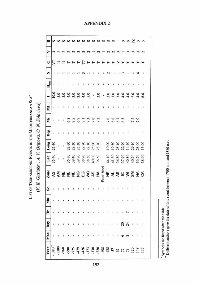
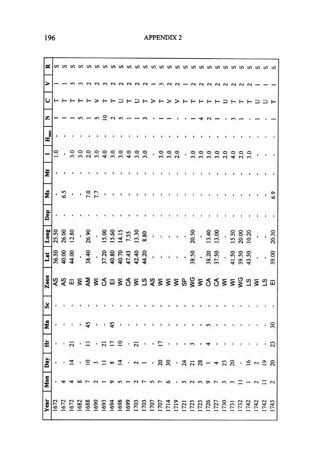
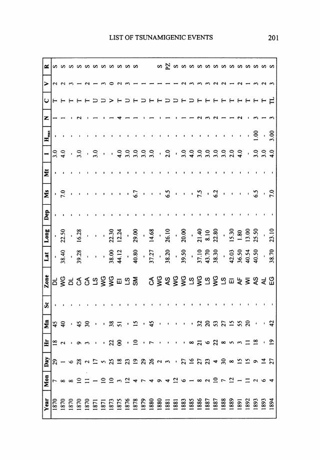
APPENDIX 1 MAIN PARAMETERS OF TSUNAMIS IN THE MEDITERRANEAN SEA • Coordinates Max. Cause of earthquake Magni- Site of intensity Reliabi- Year of or volcano, tude, manifestation of lity of tsunami deg. of tsunami tsunami data N I E M iiiiiiJ< The Sea of Marmara (SM) 120 E 40.7 29.1 7.2 2 p 447 E? 40.2 28.0. 7.3 4 LIR 542 - 40.3 27.8 6.8 4 L/R 558? 40.9 28.8 7.0 - p 740 E 40.7 29.3 7.3 3 L 975? ? - - - 3 p 1039 E? 38.4 27.3 6.8 - Q 1265 E 40.7 27.4 6.6 2 p 1332 E 40.9 28.9 6.8 3+ p 1344 E 40.8 28.8 6.9 4 LIR 1509 E 40.8 28.1 7.7 3- L 1646 E - - - 3 p 1766 E 40.8 29.0 6.5 2 p 1829 E 41.1 24.3 7.3 2 p 1857 E 40.2 29.0 - - Q 1878 E 40.8 29.0 6.7 3 QIP 1894 E 40.6 28.7 6.7 3 p 1912 E 40.6 27.2 7.6 - p 1999 E 40.7 29:8 7.4 - p North Greece (NG) ' -479 E 39.7 23.3 6.7 Chalkidiki Peninsula 3 L 1902 E 40.8 23.4 6.6 Thessaloniki 2 L 1928 E 40.8 26.8 6.2 Gulf of Strimon 2 p 1932 E 40.5 23.9 7.0 Chalkidiki Peninsula 3 R 1978 E 40.8 23.2 6.5 Gulf of Strimon 2- p East Greece (EG) -426 E? 38.9 22.7 7.1 Gulf of Euboea 4 L 426 E - - - Gulf of Euboea 4- L 552 E+L 38.4 22.3 7.1 Gulf of Euboea 4- p 1853 E 38.3 23.4 7.0 Gulf of Euboea 3+ p 1859 ? - - - Piraeus 2- Q 1894 E+L 38.7 23.1 7.0 Gulf of Euboea 4 R 1928 E+L 38.0 23.0 5.0 Chalkida 3 L 1956 E 39.3 23.1 5.6 Volos 3 L • Symbols are listed after the table. 183

Welcome message from author
This document is posted to help you gain knowledge. Please leave a comment to let me know what you think about it! Share it to your friends and learn new things together.
Transcript
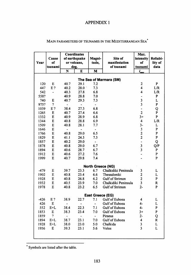
APPENDIX 1
MAIN PARAMETERS OF TSUNAMIS IN THE MEDITERRANEAN SEA •
Coordinates Max. Cause of earthquake Magni- Site of intensity Reliabi-
Year of or volcano, tude, manifestation of lity of tsunami deg. of tsunami tsunami data
N I E M iiiiiiJ<
The Sea of Marmara (SM) 120 E 40.7 29.1 7.2 2 p 447 E? 40.2 28.0. 7.3 4 LIR 542 - 40.3 27.8 6.8 4 L/R
558? 40.9 28.8 7.0 - p 740 E 40.7 29.3 7.3 3 L
975? ? - - - 3 p 1039 E? 38.4 27.3 6.8 - Q 1265 E 40.7 27.4 6.6 2 p 1332 E 40.9 28.9 6.8 3+ p 1344 E 40.8 28.8 6.9 4 LIR 1509 E 40.8 28.1 7.7 3- L 1646 E - - - 3 p 1766 E 40.8 29.0 6.5 2 p 1829 E 41.1 24.3 7.3 2 p 1857 E 40.2 29.0 - - Q 1878 E 40.8 29.0 6.7 3 QIP 1894 E 40.6 28.7 6.7 3 p 1912 E 40.6 27.2 7.6 - p 1999 E 40.7 29:8 7.4 - p
North Greece (NG) '
-479 E 39.7 23.3 6.7 Chalkidiki Peninsula 3 L 1902 E 40.8 23.4 6.6 Thessaloniki 2 L 1928 E 40.8 26.8 6.2 Gulf of Strimon 2 p 1932 E 40.5 23.9 7.0 Chalkidiki Peninsula 3 R 1978 E 40.8 23.2 6.5 Gulf of Strimon 2- p
East Greece (EG) -426 E? 38.9 22.7 7.1 Gulf of Euboea 4 L 426 E - - - Gulf of Euboea 4- L 552 E+L 38.4 22.3 7.1 Gulf of Euboea 4- p
1853 E 38.3 23.4 7.0 Gulf of Euboea 3+ p 1859 ? - - - Piraeus 2- Q 1894 E+L 38.7 23.1 7.0 Gulf of Euboea 4 R 1928 E+L 38.0 23.0 5.0 Chalkida 3 L 1956 E 39.3 23.1 5.6 Volos 3 L
• Symbols are listed after the table.
183

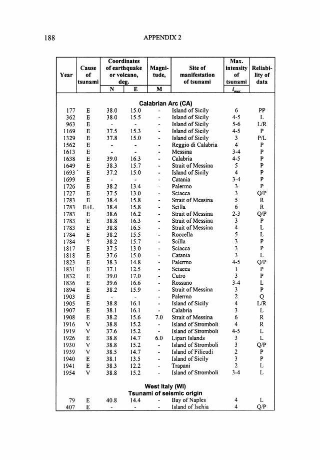
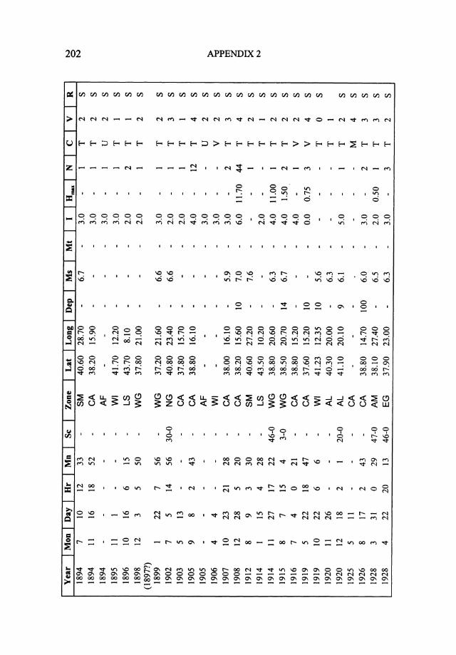
184 APPENDIX2
Coordinates Max. Cause of earthquake Magni- Site of intensity Reliabi-
Year of or volcano, tude, manifestation of lity of tsunami de2. of tsunami tsunami data
N l E M i,.DX Asia Minor (AM)
-1300 ? - - - Troy 5? p 1403 E? - - - South-Eastern shore 3 p 1489 E - - - Antalya 3 p
1667 E 38.4 27.1 6.6 Izmir 2 p
1688 E 38.4 26.9 7.0 Izmir 2 p 1846 E - - - Izmir 3? p
1851 E 36.5 28.7 7.2 Fethiye 3 L 1851 E? - - - Fethiye 3 L 1852 ? - - - Izmir 2-3 p
1852 E - - - Izmir 3 p
1928 E 38.1 27.4 6.5 Izmir 2 L 1961 ? 36.7 28.5 6.5 Izmir 2? L
Aegean Sea, islands (AS) -1380 V+E 36.4 25.4 - Island of Thira 10 R
-330 E 40.0 25.0 7.0 Island of Lirnnos - Q 62 V+E 36.5 25.4 6.7 Island of Thira 3 p
554 E 37.0 27.7 7.0 Island of Kos 4 L 1389 E 38.4 26.3 6.8 Island of Chios 3 p 1650 V+L 36.4 25.4 7.0 Island of Thira 7 R 1672 E 36.5 25.5 - Island of Thira - Q 1672 E 40.0 26.0 6.5 Island ofTenedos - Q 1738 E 36.8 24.4 6.5 Island of Milos 3 p
1856 E 38.4 26.2 6.6 Island of Chios 3+ p
1859 E 40.0 25.9 6.8 Island of lmroz 3 p 1866 E 38.3 26.3 6.8 Island of Chios 3 p
1866 E 36.4 25.3 6.0 Island of Thira 4 L 1867 E 39.2 26.4 7.0 Island of Lesvos 2 p
1881 E 38.2 26.1 6.5 Island of Chios 2+ p 1893 E 40.5 25.5 6.8 Island of Samothraki 3+ L 1933 E 36.7 27.2 6.4 Island of Kos 2 p 1949 E 38.6 26.3 6.7 Island of Chios 2 L 1956 E 36.7 25.8 7.5 Island of Amorgos 6 R 1956 E 36.6 25.7 6.9 Island of 5 p
Folegandros 1959 ? - - - Aegean Sea 3 p 1961 ? - - - Aegean Sea 3 p 1968 E+L 39.5 24.8 6.7 Island of Lirnnos 2 L 1983 E 40.1 24.8 - Island of Lirnnos 2+ p 1991 ? 37.7 26.3 - Aegean Sea 2 L 1991 ? 37.1 26.8 - Aegean Sea 3 R
Hellenic Arc, islands (HA) -220 E 36.5 28.2 7.2 Island of Rhodes 3 p
142 E 36.7 28.0 7.0 Island of Rhodes 4 L

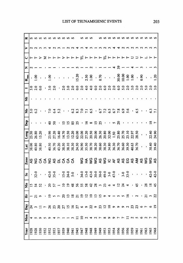
MAIN PARAMETERS OF TSUNAMIS 185
Coordinates Max. Cause of earthquake Magni- Site of intensity Reliabi-
Year of or volcano, tude, manifestation of lity of tsunami dtl2. of tsunami tsunami data
N I E M i_~
262 E - - - Island of Rhodes 4 Q 365 E 35.3 25.7 8.0 Island of Crete 4 R
1303 E 36.3 27.3 8.0 Island of Rhodes 4 L 1481 E 36.2 28.5 7.1 Island of Rhodes 3 PIL 1494 E 35.5 25.5 7.2 Island of Crete 2+ p
1508 E 35.0 25.5 7.1 Island of Crete 3 p
1601 E 35.5 25.5 - Island of Crete - QIP 1609 E 36.4 28.4 7.2 Island of Rhodes 4 p
1612 E 35.5 25.5 6.7 Island of Crete 5- p
1629 E 35.5 25.0 7.0 Island of Crete 3? p
1741 E 36.2 28.5 7.3 Island of Rhodes 4 p
1843 E? 36.3 27.6 6.5 Island of Chalki 4 p
1851 E - - - Island of Chalki 2 p
1856 E 35.5 26.0 8.3 Island of Crete 3+ p
1863 E 36.5 28.0 7.8 Island of Rhodes - Q 1866 E 36.0 24.0 6.0 Island ofKythira 4 L 1870 E - - - Port of Alexandria 3 L 1948 E 35.5 27.2 7.1 Island of Karpathos 4 R 1979 E? 34.6 24.1 5.8 Island of Crete 2 -
Island of Cyprus {IC) -23 E - - - 4 P/L 76 E - - - 4 Q
342 E - - - 3 Q 1202 E 34.3 33.0 6.6 4 P/L 1953 E 34.8 32.5 6.5 2-3 L
Near East (NE) -760 ? - - - Israel - Lebanon 3 p
-590 E - - 6.8 Siir 4 p
-525 E - - 7.5 Lebanon 2-3 p
-138 E? - - 7.0 Akko- Siir 3 p
348 E - - - Beirut 3 PIL 362 E? - - - Shore of the Dead 3 PIL
Sea 551 E - - 7.8 Tripolis 3 PIL 746 E - - - From Egypt to Syria 3 PIL 859 E - - - Samandagi 3 p
881 E? - - 6.5 Akko 2-3 Q 1032 E - - 6.9 Gaza 3 p
1034 E - - 6.2 Akko 4- p
1068 E - - - Israel 4 L 1114 E 36.5 36.0 7.0 Samandagi 3 p
1202 E - - - Syria 5 P/L 1534 E - - - Israel 3 QIP 1546 E - - - Gaza- Jaffa 3+ P/L

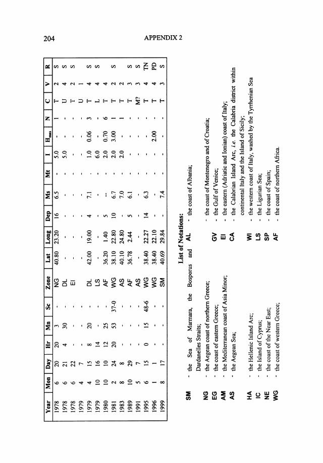
186 APPENDIX2
Coordinates Max. Cause of earthquake Magni- Site of intensity Reliabi-
Year of or volcano, tude, manifestation of lity of tsunami de£. of tsunami tsunami data
N I E M i,.QX 1752 E - - 7.0 Tripolis 3? p 1759 E - - - Akko 4- PIL 1822 E 36.0 36.0 7.1 Beirut 3 p
West Greece (WG) -373 E? 38.3 22.1 7.3 Gulf of Corinth 5 p 1402 E 38.2 22.7 7.0 Gulf of Corinth 5 p 1622 E 37.6 21.0 6.0 Island of Zakynthos - QIP 1633 E 37.6 21.0 6.9 Island of Zakynthos 3- p 1636 E 38.1 20.3 7.2 Island of Kefallonia 3 p 1723 E 38.5 20.5 - Island of Levkas 3? p 1732 E 39.5 20.0 - Island of Kerkyra 2- p
(Corfu) 1748 E 38.3 22.1 6.8 Gulf of Corinth 3 p 1791 E? 37.8 21.0 7.0 Ionian Sea 3 p 1804 E 38.3 21.8 6.7 Gulf of Patras 3 p 1817 E 38.3 22.1 6.8 Gulf of Corinth 3+ p 1820 E 38.8 20.8 6.6 Island of Levkas - -1820 E 37.7 21.1 6.9 Island of Zakynthos 3+ p 1821 E 37.8 21.3 6.5 Island of Zakynthos 4 p 1825 E? 38.8 20.7 6.8 Island of Levkas 3? p 1835 ? - - - Island of Zakynthos 2 p 1861 E+L 38.2 22.2 7.3 Gulf of Corinth 4 P/L 1862 E 38.3 22.3 - South Peloponnesus 2-3 p 1867 E 38.6 20.9 7.4 Island of Levkas 2 p 1867 E 36.4 22.2 7.1 South Peloponnesus 4 LIR 1869 E 38.8 20.7 6.9 Island of Levkas 3 p 1870 E 38.4 22.5 7.0 Gulf of Corinth 4 p 1873 L? 38.0 22.3 - Island of Zakynthos - -1881 ? - - - Gulf of Corinth - -1883 E 39.5 20.0 - Island of Kerkyra 3 p
(Corfu) 1886 E 37.1 21.4 7.5 South Peloponnesus 3 L 1887 E 38.3 22.8 - Gulf of Corinth 3 p 1888 E 38.2 22.1 6.1 Galaxidi 2 R 1898 E 37.8 21.0 - Island of Zakynthos 2+ p 1899 E 37.2 21.6 6.6 South Peloponnesus 3 PIL 1914 E 38.8 20.6 6.3 Island of Levkas 4 p 1915 E 38.5 20.7 6.7 Ionian Sea 3+ p 1947 E+L 36.9 22.0 7.0 South Peloponnesus 2+ L 1948 E 38.7 20.5 6.5 Island of Levkas 4 L 1953 E+L 38.3 20.8 7.2 Island of Ithaca 6 p 1963 L - - - Gulf of Corinth 5 L 1965 E 38.4 22.3 6.3 Gulf of Corinth 2 p 1981 E 38.2 23.0 6.7 Gulf of Corinth 2 R 1984 E 38.3 21.9 5.5 Sergoula 3 R
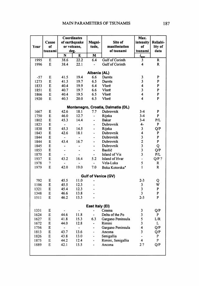
MAIN PARAMETERS OF TSUNAMIS 187
Coordinates Max. Cause of earthquake Magni- Site of intensity Reliabi-
Year of or volcano, tude, manifestation of lity of tsunami der. of tsunami tsunami data
N I E M i ...... 1995 E 38.6 22.2 6.4 Gulf of Corinth 3 R 1996 E 38.4 22.1 - Gulf of Corinth 4 R
Albania (AL) -57 E 41.5 19.4 6.6 Durres 3 p
1273 E 41.3 19.7 6.5 Durres 3 p 1833 E 40.4 19.9 6.4 VI ore 4 p 1851 E 40.7 19.7 6.6 Vlore 3 p 1866 E 40.4 19.5 6.5 Vlore 4 p 1920 E 40.3 20.0 6.3 Vlorl! 4 p
Montenegro, Croatia, Dalmatia (DL) 1667 E 42.6 18.1 7.7 Dubrovnik 3-4 p 1750 E 46.0 12.7 - Rijeka 3-4 p 1802 E 45.3 14.4 - Bakar 3-4 P/L 1823 E - - - Dubrovnik 4- p 1838 E 45.3 14.5 - Rijeka 3 Q/P 1843 E 42.6 18.1 - Dubrovnik 4 p 1844 E - - - Dubrovnik 3 p 1844 E 43.4 16.7 - Dubrovnik 2 p 1845 E - - - Dubrovnik 3 Q 1853 E - - - Baosic 3 Q/P 1870 E - - - Island of Vis 3 P/L 1937 E 43.2 16.4 5.2 Island ofHvar - QIP? 1978 ? - - - Vela-Luka 5 R 1979 E 42.0 19.0 7.0 Boka Kotorska• 1 R
Gulf of Venice (GV) 792 E 45.5 11.0 - 2-3 Q
1106 E 45.5 12.3 - 3 w 1321 E 45.4 12.3 - 3 p 1348 E 46.6 13.8 - 3 p 1511 E 46.2 13.3 - 2-3 p
East Italy (EI) 1331 E - - - Cesena 3 Q/P 1624 E 44.6 ll.8 - Delta of the Po 3 p 1627 E 41.8 15.3 6.3 Gargano Peninsula 5 L/R 1672 E 44.0 12.8 - Rimini 3 L 1756 E - - - Gargano Peninsula 4 QIP 1813 E 43.7 13.6 - Ancona 3 QIP 1826 E 43.8 13.0 - Senigallia - p 1875 E 44.2 12.4 - Rimini, Senigallia 4 p 1889 E 42.1 15.5 - Ancona 2? Q/P
188 APPENDIX2
Coordinates Max. Cause of earthquake Magni- Site of intensity Reliabi-
Year of or volcano, tude, manifestation of lity of tsunami dee. of tsunami tsunami data
N I E M iMnr
Calabrian Arc (CA) 177 E 38.0 15.0 - Island of Sicily 6 pp 362 E 38.0 15.5 - Island of Sicily 4-5 L 963 E - - - Island of Sicily 5-6 L/R
1169 E 37.5 15.3 - Island of Sicily 4-5 p 1329 E 37.8 15.0 - Island of Sicily 3 P/L 1562 E - - - Reggio di Calabria 4 p
1613 E - - - Messina 3-4 p 1638 E 39.0 16.3 - Calabria 4-5 p 1649 E 38.3 15.7 - Strait of Messina 5 p 1693. E 37.2 15.0 - Island of Sicily 4 p
1699 E - - - Catania 3-4 p
1726 E 38.2 13.4 - Palermo 3 p
1727 E 37.5 13.0 - Sciacca 3 QIP 1783 E 38.4 15.8 - Strait of Messina 5 R 1783 E+L 38.4 15.8 - Scilla 6 R 1783 E 38.6 16.2 - Strait of Messina 2-3 QIP 1783 E 38.8 16.3 - Strait of Messina 3 p
1783 E 38.8 16.5 - Strait of Messina 4 L 1784 E 38.2 15.5 - Roccella 5 L 1784 ? 38.2 15.7 - Scilla 3 p
1817 E 37.5 13.0 - Sciacca 3 p
1818 E 37.6 15.0 - Catania 3 L 1823 E 38.3 14.8 - Palermo 4-5 QIP 1831 E 37.1 12.5 - Sciacca I p
1832 E 39.0 17.0 - Cutro 3 p
1836 E 39.6 16.6 - Rossano 3-4 L 1894 E 38.2 15.9 - Strait of Messina 3 p 1903 E - - - Palermo 2 Q 1905 E 38.8 16.1 - Island of Sicily 4 L/R 1907 E 38.1 16.1 - Calabria 3 L 1908 E 38.2 15.6 7.0 Strait of Messina 6 R 1916 v 38.8 15.2 - Island of Stromboli 4 R 1919 v 37.6 15.2 - Island of Stromboli 4-5 L 1926 E 38.8 14.7 6.0 Lipari Islands 3 L 1930 v 38.8 15.2 - Island of Stromboli 3 QIP 1939 v 38.5 14.7 - Island of Filicudi 2 p 1940 E 38.1 13.5 - Island of Sicily 3 p
1941 E 38.3 12.2 - Trapani 2 L 1954 v 38.8 15.2 - Island of Stromboli 3-4 L
West Italy (WI) Tsunami of seismic origin
79 E 40.8 14.4 - Bay of Naples 4 L 407 E - - - Island of Ischia 4 Q/P

MAIN PARAMETERS OF TSUNAMIS 189
Coordinates Max. Cause of earthquake Magni- Site of intensity Reliabi-
Year of or volcano, tude, manifestation of lity of tsunami de2. of tsunami tsunami data
N l E M i,.., 1343 E - - - Bay of Naples 4 p
1456 E 41.3 14.7 - Bay of Naples 4 QIP 1538 E 40.8 14.2 - Pozzuoli 3-4 p 1594 E 40.7 14.2 - Pozzuoli 4-5 p
1631 E 40.8 14.4 - Bay of Naples 5 L 1682 E - - - Bay of Naples 3 L 1707 E - - - Bay of Naples 3 L 1714 E - - - Naples 3 p 1723 E - - - Bay of Naples 3 p 1760 E - - - Bay of Naples 3 QIP 1805 E 41.4 14.5 - Bay of Naples 2 p 1870 E - - - Tyrrhenian Sea 3-4 Q 1895 E 41.7 12.2 - Tyrrhenian Sea 2-3 QIP
Oscilations of the sea level of unknown origin (from the south to the north
1112 ? 40.7 14.5 - Bay of Naples 3-4 p
1690 v - - - Bay of Naples 3 p 1698 ? 40.7 14.5 - Bay of Naples 3 p
1730 ? - - - Bay of Naples 2-3 p 1804 ? - - - Bay ofNap1es 2-3 p 1813 ? 40.0 14.0 - Bay of Naples 2-3 P/L 1847 ? - - - Bay of Naples 2 p 1895 ? - - - Anzio 3-4 QIP 258 ? 42.0 12.5 - Estuary of the Tiber ' 4 p
1703 ? 42.4 13.3 - Estuary of the Tiber 2 p 1806 ? 41.7 12.7 - Nettuno 2 QIP
Ligurian Sea (LS) Tsunami of seismic origin
1564 E 44.0 7.3 - San Remo- Nice 4-5 p 1646 E 43.5 10.1 - Livomo 3 p 1703 E 44.2 8.8 - Genoa 3 p 1742 E 43.5 10.2 - Livomo 3 p 1751 E 44.2 9.2 - Genoa - San Remo p 1808 E 44.8 7.3 - Marseille P/L 1809 E 44.8 7.2 - Gulf of La Spezia p 1818 E 43.8 8.0 - Genoa - Antibes P/L 1818 E 44.8 10.4 - Genoa 2-3 p 1819 E 43.7 8.0 - Genoa 3 p 1828 E 44.8 9.2 - Genoa 3 p 1831 E 43.8 7.8 - San Remo 3 p 1846 E 43.3 10.7 - Livomo 3 P/L 1851 E - - - Livomo 2-3 QIP 1887 E 43.7 8.1 - Savona - Antibes 3 L/R 1888 E - - - San Remo 3 p
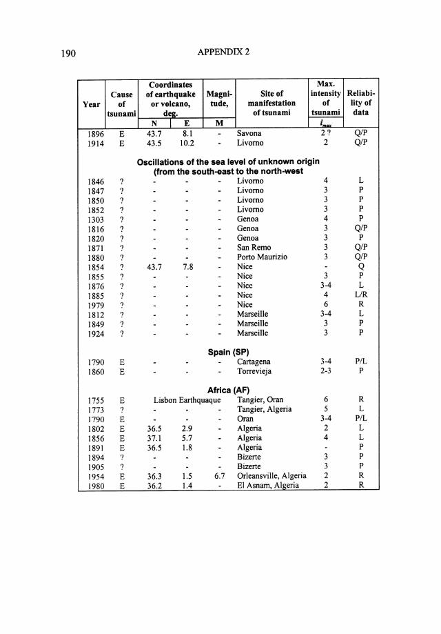
190 APPENDIX2
Coordinates Max. Cause of earthquake Magni- Site of intensity Reliabi-
Year of or volcano, tude, manifestation of lity of tsunami de2. of tsunami tsunami data
N I E M imiiX 1896 E 43.7 8.1 - Savona 2? QIP 1914 E 43.5 10.2 - Livorno 2 QIP
Oscillations of the sea level of unknown origin (from the south-east to the north-west
1846 ? - - - Livorno 4 L 1847 ? - - - Livorno 3 p
1850 ? - - - Livorno 3 p
1852 ? - - - Livorno 3 p
1303 ? - - - Genoa 4 p
1816 ? - - - Genoa 3 QIP 1820 ? - - - Genoa 3 p
1871 ? - - - SanRemo 3 QIP 1880 ? - - - Porto Maurizio 3 QIP 1854 ? 43.7 7.8 - Nice - Q 1855 ? - - - Nice 3 p
1876 ? - - - Nice 3-4 L 1885 ? - - - Nice 4 L/R 1979 ? - - - Nice 6 R 1812 ? - - - Marseille 3-4 L 1849 ? - - - Marseille 3 p
1924 ? - - - Marseille 3 p
Spain (SP) 1790 E - - - Cartagena 3-4 P/L 1860 E - - - Torrevieja 2-3 p
Africa (AF) 1755 E Lisbon Earthquaque Tangier, Oran 6 R 1773 ? - - - Tangier, Algeria 5 L 1790 E - - - Or an 3-4 P/L 1802 E 36.5 2.9 - Algeria 2 L 1856 E 37.1 5.7 - Algeria 4 L 1891 E 36.5 1.8 - Algeria - p
1894 ? - - - Bizerte 3 p
1905 ? - - - Bizerte 3 p
1954 E 36.3 1.5 6.7 Orleansville, Algeria 2 R 1980 E 36.2 1.4 - El Asnam, Algeria 2 R
MAIN PARAMETERS OF TSUNAMIS 191
Notes
1. A sign " - " before the year in the column "Year" implies that the penomenon took place in the era B.C.
2. Causes of tsunami: E earthquake; V volcanic eruption; L landslide; ? cause not found.
3. Signs + and - in the column "Max. intensity of tsunami" imply "slightly more" and "slightly less", respectively.
4. Reliability was estimated in accordance with a 5-grade scale: R reliable: an event was recorded at least by one gauge or
there exist many reliable visual observations; L likely: few reliable observations; P possible: it is difficult to evaluate whether the tsunami or
some other event (seiches, sea-quake, wind surge, and so on ... ) was observed
Q questionable: probably some other event, different from tsunami, took place, but the possibility of tsunami shouldn't be utterly excluded;
W - wrong: erroneous indication of tsunami. ,
LIS
T O
F T
SU
NA
MIG
EN
IC E
VE
NT
S I
N T
HE
ME
DIT
ER
RA
NE
AN
SE
A .
(V.
K.
Gus
iako
v, A
. V.
Osi
pova
, 0.
N S
olov
ieva
)
Year
I Mon
I Day
I Hr
I Mn
I Sc
I
Zone
I Lat
I Long
I De
p I M
s I M
t I I
IHm
axl N
I
c I
v I R
-1
380*
' -
--
--
AS
36.4
0 25
.40
--
-10
.0
--
VT
4
s -1
300
--
--
AM
--
--
-5.
0 -
1 u
2 s
-760
-
--
--
NE
--
--
-3.
0 -
1 u
2 s
-590
-
--
--
NE
36.7
0 22
.60
-6.
8 -
4.0
-1
T
2 s
-525
-
--
-NE
39
.40
22.3
0 -
7.5
-3.
0 -
1 T
2
s -4
79
--
--
-NG
39
.70
23.3
0 -
6.7
-3.
0 -
1 T
3
s -4
26
--
--
-EG
38
.90
22.7
0 -
7.1
-4.
0 -
3 T
I 3
s ?;
-373
-
--
--
WG
38
.30
22.1
0 -
7.3
-5.
0 -
1 T
2
s A
S 40
.00
25.0
0 7.
0 T
1
s '"0
r§l
-330
-
--
--
--
--
-~
-220
-
--
--
HA
36.5
0 28
.20
-7.
2 -
3.0
--
T
2 s
-198
-
--
East
Med
-
--
--
T
I s
~
-138
-
--
--
NE
44.1
0 10
.00
-7.
0 -
3.0
-2
T
2 s
N
-57
--
--
AL
41.3
0 19
.50
-6.
6 -
3.0
-1
T
2 s
62
--
--
-A
S 36
.50
25.4
0 -
6.7
-3.
0 -
1 v
3 77
6
20
--
-IC
37
.90
22.9
0 -
6.3
-4.
0 -
3 T
1
s 79
8
24
7 -
-W
I 40
.80
14.4
0 -
-4.
0 -
I T
3
s 12
0 -
--
--
SM
40.7
0 29
.10
-7.
2 -
2.0
--
T
3 P
Z
148
--
--
-HA
36
.70
28.0
0 -
7.0
-4.
0 -
4 T
3
s 17
7 -
--
CA
38.0
0 15
.00
--
6.0
--
T
2 s
' Sym
bols
are
lis
ted
afte
r th
e ta
ble.
'*
Dif
fere
nt a
utho
rs g
ive
the
date
of t
his
even
t bet
wee
n 17
00 B
.C.
and
13 8
0 B
.C.
Yea
r I M
on I
Day
I H
r I M
n I
Sc
I Z
one
I L
at
I L
ong
I D
ep
I M
s I
Mt
I I
IH
max
iNIC
IV
IR
25
8 -
--
--
WI
42.0
0 12
.50
--
4.0
-1
u 2
s 26
2 -
--
--
HA
41.9
0 12
.50
-3.
6 -
4.0
-1
T
2 s
342
7 -
--
IC
41.3
0 19
.50
--
--
-T
1
s 34
8 -
--
--
NE
41.9
0 12
.50
-4.
1 -
3.0
-2
T
2 s
362
--
--
-CA
38
.00
15.5
0 -
--
5.0
--
T
2 s
362
--
--
-NE
-
--
--
3.0
--
-1
s 36
5 7
21
--
-HA
35
.30
25.7
0 70
8.
0 -
4.0
-9
T
4 s
407
4 -
--
-W
I -
--
--
4.0
-1
T
2 s
t'""' -
426
--
--
-EG
-
--
--
4.0
--
T
3 s
Cll o-3
44
7 11
8
--
-SM
40
.20
28.0
0 -
7.3
-4.
0 -
1 T
3
s 0
543
9 6
SM
40.3
0 27
.80
6.8
4.0
4 T
3
s '"r
1 -
--
--
-o-3
55
1 7
7 -
--
EG
38.4
0 22
.30
-7.
1 -
4.0
-4
TL
2
s C
ll
551
7 9
--
-NE
40
.80
29.9
0 -
7.8
-3.
0 -
3 T
2
s ~
554
8 15
-
--
AS
37.0
0 27
.70
-7.
0 -
4.0
-3
T
3 s
558
12
14
SM
40.9
0 28
.80
7.0
T
2 s
--
--
--
--
-0
740
10
26
--
-SM
40
.70
29.3
0 -
7.3
-3.
0 -
2 T
3
s ~
746
I 18
NE
45
.40
12.2
5 4.
9 3.
0 T
2
s -
--
--
--
-n
792
4 30
-
--
GV
45.5
0 11
.00
--
-3.
0 -
-T
1
s ti1
<
803
12
19
--
-NE
36
.95
35.5
8 -
--
3.0
--
T
2 ~
859
--
--
-NE
36
.08
36.2
5 -
--
3.0
-1
T
2 s
o-3
881-
82
--
--
-N
E,A
F -
--
--
3.0
-3
-2
s C
ll
963
7 22
-
--
CA
--
--
-5.
0 -
-T
3
s 97
5 10
26
-
--
SM
41.0
4 28
.98
--
-3.
0 -
2 u
2 s
1032
3
6 -
--
NE
--
-6.
9 -
3.0
--
T
2 s
1034
I
4 -
--
NE
32.8
0 35
.53
-6.
2 -
4.0
-2
T
2 s
1039
2
2 -
--
SM
38.4
0 27
.30
-6.
8 -
--
T
I s
1050
-
--
--
AS
--
--
-v
3 s
1065
9
23
--
-SM
-
--
--
--
-T
3
s I
-\0 w
Yea
r R
10
68
--
--
--
-s
...... 'f
1106
3
--
-45
.50
12.3
0 -
--
-1
T
0 s
1112
6
20
--
-W
I 40
.00
14.0
0 -
--
4.0
-1
u 2
s 11
14
3 12
-
--
CA
36.5
0 36
.00
-7.
0 -
3.0
--
T
2 11
69
2 4
--
-CA
37
.50
15.3
0 -
7.0
-4.
0 -
1 T
3
s 11
69
2 11
-
--
CA
--
--
--
--
T
3 s
1172
-
--
--
CA
--
--
--
--
T
3 s
1202
5
22
--
-N
E
34.3
0 33
.00
-6.
6 -
4.0
-2
T
3 s
1265
8
11
--
-SM
40
.70
27.4
0 -
6.6
-2.
0 -
-T
2
PZ
12
73
3 -
--
-AL
41
.30
19.7
0 -
6.5
-3.
0 -
1 T
2
s 13
03
7 23
-
--
LS
30.0
5 31
.25
--
-4.
0 -
-u
2 s
1303
8
8 -
--
HA
36.1
0 29
.00
-8.
0 -
-4.
0 -
5 T
3
PC
13
21
--
--
-G
V
45.4
0 12
.30
--
-3.
0 -
1 T
2
s 13
29
6 28
-
--
CA
37.8
0 15
.00
--
-3.
0 -
1 T
2
s 13
31
3 13
-
--
El
44.1
7 12
.25
--
-3.
0 -
1 T
1
1332
2
12
--
-SM
-
--
--
3.0
-1
T
2 s
~ >< N
1343
11
25
-
--
WI
--
--
-4.
0 -
1 T
2
s 13
44
2 12
-
--
SM
40.8
0 28
.80
-6.
9 -
5.0
-2
T
4 s
1348
1
25
--
-G
V
46.6
0 13
.80
--
-3.
0 -
1 T
2
s 13
65
1 2
--
-AF
-
--
--
--
-T
3
s 13
89
3 20
-
--
AS
38.4
0 26
.30
-6.
8 -
3.0
-4
T
2 s
1402
6
--
--
WG
38
.11
22.4
1 -
7.0
-5.
0 -
1 T
2
PZ
I
1403
11
16
-
--
AM
--
--
3.0
-2
TV
2
s 14
56
12
4 -
--
WI
41.3
0 14
.70
--
-4.
0 -
1 T
2
s 14
81
5 3
--
-HA
36
.20
28.5
0 -
7.1
-3.
0 1.
80
1 T
2
s 14
81
10
3 -
-A
S 38
.20
28.5
0 -
7.1
-3.
0 -
-T
4
PC
14
94
7 1
--
HA
35.5
0 25
.50
-7.
2 -
3.0
-1
T
2 s
1508
5
29
--
-HA
35
.00
25.5
0 -
7.1
-3.
0 -
2 T
2
s

Yea
r I M
on I
Day
I
Hr
I M
n I
Sc
I Z
one
I L
at
I Lon
g I
Dep
I
Ms
I M
t I
I I H
max
I N
I
C
I V
I
R
I509
9
I4
--
-SM
40
.80
28.I
O
-7.
7 -
3.0
-I
T
3 s
I5II
3
26
--
-GV
46
.25
I3.3
0 IO
6.
0 -
3.0
-2
T
2 s
I534
-
--
--
NE
-
--
--
3.0
-I
T
2 s
I538
9
26
--
-W
I 40
.80
I4.2
0 -
--
4.0
-I
T
2 s
I546
I
I4
--
-N
E
38.3
0 25
.80
-6.
5 -
3.0
-4
T
3 s
I562
10
20
-
--
CA
40.5
0 I5
.50
--
-4.
0 -
I T
3
s I5
64
7 20
23
-
-LS
44
.00
7.30
-
--
4.0
-3
T
3 s
I594
-
--
--
WI
40.8
0 I4
.40
--
-5.
0 -
2 T
2
s I6
0I
--
--
-HA
35
.50
25.5
0 -
--
--
I T
2
s I6
09
4 -
--
-HA
36
.40
28.4
0 -
7.2
-4.
0 -
I T
2
PZ
I6
I2
I I
8 -
--
HA
35.5
0 25
.50
-6.
7 -
4.0
-I
T
2 s
I613
8
25
--
-CA
38
.83
I4.7
0 -
5.6
-4.
0 -
I T
2
s I6
22
5 5
--
-W
G 37
.60
21.0
0 -
6.6
--
-I
T
2 s
I624
3
I9
--
-E
l 44
.60
I I.8
0 -
--
3.0
-I
T
2 s
I627
7
30
--
-E
l 41
.80
I5.3
0 -
6.3
-5.
0 -
4 T
4
s I6
29
3 7
9 -
-HA
35
.50
25.0
0 70
7.
0 -
3.0
-I
T
2 s
1631
12
I7
-
--
WI
40.8
0 14
.40
--
-5.
0 -
5 T
3
s I6
33
I I
5 -
--
WG
37
.60
21.0
0 -
6.9
-3.
0 -
I T
2
s I6
36
9 30
-
--
WG
38.1
0 20
.30
--
-3.
0 -
I T
I
PZ
I6
38
3 27
-
--
CA
39.0
0 I6
.30
--
-5.
0 -
I T
2
s I6
46
4 5
20
--
LS
43.3
0 I0
.05
--
-3.
0 -
I T
2
s I6
46
4 5
--
-SM
-
--
--
4.0
-I
T
2 s
1649
I
--
--
CA
38.3
0 I5
.70
--
-5.
0 -
I T
2
s I6
50
9 29
I5
-
-A
S 36
.40
25.4
0 -
6.3
-6.
0 30
.00
6 V
L
4 s
I66I
4
22
--
-GV
-
--
--
3.0
--
T
3 s
I667
4
6 7
--
DL,G
V 42
.60
I8.I
O
-7.
7 -
4.0
-I
T
2 s
1667
II
30
-
--
AM
38.4
0 27
.IO
-
6.6
-2.
0 -
2 T
2
s 16
68
7 IO
-
--
AM
38.4
0 27
.IO
-
6.6
-2.
0 -
-T
3
PC
t:: Cll ~ ~ ~ ~ (1 ~ C
ll -\0 Vl
Yea
r 16
72
--
--
-16
72
4 -
--
-A
S 16
72
4 14
21
-
El
1682
8
--
-W
I 16
88
7 10
11
45
-
AM
1690
2
3 -
--
WI
1693
1
11
21
--
CA
1694
9
8 17
45
-
El
1698
5
14
10
--
WI
1699
1
--
--
CA
1703
2
2 21
-
-W
I 17
03
7 1
--
-LS
17
07
5 -
--
-A
S 17
07
7 20
17
-
-W
I 17
14
6 30
-
--
WI
1719
-
--
--
WI
1721
3
24
--
SP
1723
2
21
3 -
-W
G
1723
3
28
--
-W
I 17
26
9 1
4 5
-CA
17
27
7 4
--
-CA
17
30
3 23
-
--
WI
1731
3
20
--
-W
I 17
32
11
--
--
WG
17
42
1 16
-
-LS
17
42
2 2
--
-W
I 17
42
11
19
--
LS
1743
2
20
23
30
-E
l
--
--
40.0
0 26
.00
-6.
5 -
--
44.0
0 12
.80
--
-3.
0 -
--
--
-3.
0 -
38.4
0 26
.90
-7.
0 -
2.0
--
-7.
7 -
3.0
-37
.20
15.0
0 -
--
4.0
-40
.80
15.6
0 -
--
3.0
-40
.70
14.1
5 -
--
3.0
-47
.43
1.55
-
--
4.0
-42
.40
13.3
0 -
--
3.0
-44
.20
8.80
-
--
3.0
--
--
--
--
--
--
-3.
0 -
--
--
-3.
0 -
--
--
-2.
0 -
--
--
--
-38
.50
20.5
0 -
--
3.0
--
--
--
3.0
-38
.20
13.4
0 -
--
3.0
-37
.50
13.0
0 -
--
3.0
--
--
--
2.0
-41
.50
15.5
0 -
--
4.0
-39
.50
20.0
0 -
--
2.0
-43
.50
10.2
0 -
-3.
0 -
--
--
--
--
--
--
--
39.0
0 20
.30
-6.
9 -
--
1 1 T
5
T
1 T
5
v 10
T
2
T
5 u
1 T
1
u 3
T
-v
1 T
1
v -
v -
T
1 T
4
T
2 T
1
T
-u
3 T
1
T
-T
1
u -
u 1
T
1 3 3 2 2 3 2 2 2 2 2 1 3 2 2 1 2 2 2 2 2 2 2 2 1 1 1
R s s s s s s s s s s s s s s s s s s s s s s s s s s s s
.......
1.0
0'1 ~ ~ ~
N
Yea
r 17
48
--
-17
50
12
17
--
-DL
17
51
11
21
10
45
-LS
17
52
7 21
-
--
NE
17
56
10
22
15
30
-E
l 17
59
10
30
--
-N
E
1760
6
16
16
--
WI
1766
5
22
5 30
-
SM
1773
5
6 -
--
AF
1774
7
24
--
-LS
17
74
9 24
-
--
SP
1775
10
22
-
--
LS
1783
2
5 12
30
-
CA
1783
2
6 1
6 -
CA
1783
2
7 l3
20
-
CA
1783
3
1 1
30
-CA
17
83
3 28
1
15
-CA
17
84
1 7
--
-CA
17
84
1 19
-
--
CA
1790
10
9
--
-AF
17
91
11
2 21
-
-W
G
1794
-
--
--
I::G
18
02
1 4
7 -
-DL
18
02
ll
7 10
45
-
AF
1804
6
8 -
--
WG
18
04
7 31
22
-
-W
I 18
05
7 26
20
57
-
WI
1806
8
26
l3
20
-W
I
-12
.30
--
44.2
0 9.
20
--
--
-7.
0 37
.70
22.8
0 -
7.0
32.9
2 35
.07
--
--
--
40.8
0 29
.00
-6.
5
--
--
--
--
--
--
--
--
38.4
0 15
.80
l3
-38
.40
15.8
0 -
-38
.36
16.1
5 6
-38
.46
16.1
8 -
-38
.80
16.5
0 18
-
38.1
0 15
.30
--
38.1
5 15
.45
--
--
--
37.8
0 21
.00
-7.
0 38
.30
22.4
0.
-6.
7.
45.3
0 14
.40
--
36.5
0 2.
90
--
38.3
0 21
.80
-6.
7
--
--
41.4
0 14
.50
--
41.7
0 12
.70
--
--
-4.
0 -
1
-3.
0 -
1
-3.
0 -
1
-4.
0 -
1
-4.
0 8.
00
1
-3.
0 --
1
-2.
0 -
1
--
---
-3.
0 -
--
---
--
--
--
5.0
-14
-6.
0 -
14
-2.
0 -
--
3.0
--
--
-1
-5.
0 -
1 -
3.0
-3
-4.
0 -
2
-3.
0 -
3
--
--
-3.
0 -
4
-2.
0 -
1
-3.
0 -
1 -
3.0
-2
-2.
0 -
1
-2.
0 -
3
T
2 T
2
T
1
T
2 T
1
T
2 u
2 u
1 u
1 T
I 1
T
4 T
L
4 T
1
T
2 T
0
T
3 T
2
T
3 T
2
v 0
T
2 T
3
T
2 u
2 T
2
u 2
R s s s s s s s s s s s s s s s s s s s s P
Z
s s s s s s
t: ~ ~ ~ ~ .... 0 ~ (=)
tr1 ~ C
ll .... 1.
0 -.
.J
Yea
r I8
08
-I8
09
7 -
--
LS
I813
5
I7
--
WI
I8I7
I
I4
3 30
-
CA
I8I7
8
23
8 -
-W
G I8
I8
I -
--
-EG
I8
I8
2 20
I
30
-CA
I8
I8
2 23
I9
IO
-
LS
I8I8
I2
9
--
-LS
I8
I9
I 8
II
30
-LS
I8
20
3 I7
-
--
WG
I820
7
23
--
-LS
I8
20
I2
29
--
-W
G I8
2I
I 9
I8
45
-W
G I8
22
3 20
-
--
NE
I822
4
IO
--
-CA
I8
22
8 13
20
-
-NE
I8
23
3 5
I7
37
-CA
I8
23
8 20
-
--
DL
I823
IO
-
--
-DL
I8
25
I I9
II
45
-
WG
I826
3
I8
0 20
-
El
I828
IO
9
13
II
-LS
I8
29
5 23
-
--
SM
I83I
5
26
II
30
-LS
I8
3I
7 2
--
-CA
I8
32
3 8
I I5
-
CA
1833
I
I8
--
-AL
--
44.8
0 7.
20
--
40.0
0 I4
.00
--
37.5
0 13
.00
--
38.3
0 22
.IO
-6.
8
--
--
37.6
0 I5
.00
--
43.8
0 8.
00
--
44.7
5 I0
.40
--
43.7
0 8.
00
--
38.8
0 20
.80
-6.
6 -
--
-37
.70
2l.
l0
--
37.8
0 21
.30
-6.
5 -
--
-37
.45
I4.2
5 -
-36
.00
36.0
0 -
7.I
38.3
0 I4
.80
--
--
--
--
--
38.7
5 20
.75
-6.
8 43
.80
13.0
0 -
-44
.80
9.20
-
-41
.10
24.3
0 -
7.3
43.8
0 7.
80
--
37.0
5 I2
.30
--
39.0
0 I7
.00
-40
.40
19.9
0 -
6.4
--
-3.
0 -
-2.
0 -
3 -
3.0
-I
-3.
0 -
2 -
--
--
3.0
-2
-3.
0 -
3
-3.
0 -
I -
3.0
-I
--
-I
-3.
0 -
I
-3.
0 -
I
-4.
0 -
I -
--
--
--
--
3.0
-3
-5.
0 -
I -
4.0
-2
--
--
-3.
0 -
2 -
3.0
-I
-3.
0 -
I -
2.0
-2
-3.
0 -
I -
1.0
-I
3.0
-I
-4.
0 -
2
T
2 u
2 T
2
T
2 T
I
T
3 T
3
T
2 T
2
T
0 u
2 T
3
T
2 T
I
T
I T
2
T
2 T
2
T
0 T
2
T
2 T
2
T
2 T
2
T
2 T
2
T
2
s s s s s s s s s s s PZ
s s s s s s s s s s s s s
.....
\0
00
~ ><
N

Yea
r I M
oo I
Day
I H
r I
Mn
I Sc
I
Zon
e I
Lat
I L
ong
I D
ep I
Ms
I M
t I
I I H
_,. I
N
I C
I
V
I R
18
35
7 12
-
--
WG
-
--
--
2.0
-1
u 2
s 18
36
4 24
16
15
-
CA
39.6
0 16
.60
--
-4.
0 -
3 T
3
s 18
38
8 10
20
30
-
DL
45.3
0 14
.50
--
-3.
0 -
1 T
2
s 18
43
9 14
10
30
-
DL
42.6
0 18
.10
-6.
5 -
4.0
-2
T
2 s
1843
10
18
-
--
HA
36.3
0 27
.60
-6.
5 -
4.0
-2
T
2 s
1844
3
3 18
25
-
DL
--
--
-3.
0 -
1 T
2
s 18
44
3 22
10
13
-
DL
43.4
0 16
.70
--
-2.
0 -
1 T
2
s 18
45
6 18
-
--
CA
36.4
0 13
.44
--
--
--
T
1 s
1845
8
16
16
38
-DL
-
--
--
3.0
-1
T
1 s
1846
7
25
17
30
-AM
-
--
--
3.0
-1
T
2 s
1846
8
14
12
53
-LS
43
.40
10.6
0 5
6.1
-3.
0 -
2 T
3
s 18
46
8 26
17
23
-
LS
43.5
0 10
.50
--
-4.
0 -
1 u
3 s
1846
12
3
--
-LS
43
.30
10.7
0 -
--
3.0
-2
T
2 s
1847
8
26
--
-W
I -
--
--
2.0
-1
u 2
s 18
51
2 28
14
58
-
AM
36.5
0 28
.70
-7.
2 -
3.0
0.90
1
T
3 s
1851
4
3 17
-
-AM
-
--
--
3.0
-1
u 3
s 18
51
5 23
-
--
HA
--
--
-2.
0 -
-u
2 s
1851
7
28
18
33
-LS
43
.75
10.3
0 -
4.1
-2.
0 -
1 T
1
s 18
51
10
12
7 -
-AL
40
.70
19.7
0 -
6.6
-3.
0 0.
60
1 T
2
s 18
52
2 2
7 30
-
LS
--
--
-3.
0 -
1 v
2 s
1852
5
12
2 -
-AM
-
--
--
3.0
-1
u 2
s 18
52
9 8
22
30
-AM
-
--
--
3.0
-1
u 2
s 18
53
8 18
8
30
-EG
38
.30
23.4
0 -
7.0
-3.
0 -
1 T
2
s 18
53
12
11
16
15
-DL
-
--
--
3.0
-1
T
1 s
1854
2
29
--
-LS
-
--
--
--
-u
2 s
1854
12
29
2
45
-LS
43
.70
7.80
-
--
--
4 v
2 s
1855
5
18
14
--
LS
--
--
-3.
0 -
-u
2 s
1856
8
21
11
50
-AF
37
.10
5.70
-
--
4.0
-4
T
3 s
t: ~ ~ ~ ~ ("
) i -\0 \0
Yea
r I M
oo I
Day
I
Hr
I Mn
I Sc
I
Zon
e I
Lat
I L
ong
I D
ep I
Ms
I M
t I
I I H
ma•
I N
I
C
I V
I
R
1856
8
21
21
45
-AF
37
.10
5.70
-
--
--
-T
3
s 18
56
8 22
11
40
-
AF
37.1
0 5.
70
--
--
--
T
3 s
1856
10
12
0
45
-HA
35
.50
26.0
0 -
8.3
-3.
0 -
1 T
2
s 18
56
11
13
--
-A
S 38
.40
26.2
0 -
6.6
-3.
0 -
1 T
2
s 18
57
9 17
22
-
-SM
40
.20
29.0
0 -
--
--
1 T
1
s 18
59
8 21
11
55
-
AS
40.0
0 25
.90
-6.
3 -
3.0
-1
T
2 s
1859
10
20
-
--
EG
---
-'
--
2.0
-1
u 1
s \
1861
12
26
6
30
-W
G
38.2
0 22
.20
-7.
3 -
4.0
2.10
10
T
L
3 s
1862
1
1 8
45
-W
G
38.3
0 22
.30
--
-3.
0 -
2 T
2
s 18
63
3 22
22
15
-
HA
36.5
0 28
.00
-7.
8 -
--
1 T
1
s 18
66
1 2
11
--
AL
40.4
0 19
.50
-6.
5 -
4.0
-2
T
2 s
1866
1
6 -
--
AL
---
--
-3.
0 -
-u
3 18
66
1 19
12
30
A
S 38
.30
28.3
0 -
6.8
-3.
0 -
1 T
2
s 18
66
2 2
--
-A
S 38
.30
26.3
0 -
6.8
-3.
0 -
1 T
2
s 18
66
2 6
13
45
-HA
36
.00
23.0
0 -
6.3
-4.
0 8.
60
1 T
V
3 s
1866
3
3 18
-
-AL
-
--
--
3.0
--
T
1 18
66
3 6
--
-AL
-
--
6.3
-4.
0 -
2 T
3
s 18
66
3 13
18
-
-AL
40
.50
19.5
0 -
5.5
-3.
0 -
2 T
2
s 18
66
10
--
--
HA
--
--
--
--
T
1 s
1867
2
4 -
--
WG
38.3
9 20
.52
-7.
4 -
2.0
-1
u 1
PZ
1867
3
7 18
15
-
AS
39.2
0 26
.40
-7.
0 -
2.0
-1
T
2 s
1867
9
20
20
30
-W
G
36.4
0 22
.20
-7.
1 -
4.0
-20
T
4
s 18
67
10
4 -
--
WG
-
--
--
2.0
--
T
2 s
1867
11
19
21
-
-AM
-
--
--
--
u 1
s 18
68
9 5
2 -
-CA
-
--
--
--
-T
V
1 s
1869
9
9 -
--
AS
--
--
--
--
T
2 s
1869
12
28
3
10
-W
G 38
.80
20.7
0 -
6.9
-3.
0 -
1 T
2
s 18
70
6 24
18
45
-
HA
32.2
0 29
.60
-7.
2 -
3.0
-1
T
3 s
!
N
0 0 ~ ~ ~
N
Yea
r I M
on I
Day
I H
r I
Mn
I Sc
I
Zon
e I
Lat
I L
ong
I D
ep I
Ms
I M
t I
I I H
mu
I N
I
C
I V
I
R
1870
7
29
18
45
-DL
-
--
--
3.0
-1
T
2 s
1870
8
1 2
40
-W
G
38.4
0 22
.50
-7.
0 -
4.0
-1
T
2 s
1870
8
6 -
--
DL
--
--
--
--
T
3 s
1870
10
28
9
45
-CA
39
.28
16.2
8 -
--
3.0
-2
T
1 s
1870
11
.
2 3
30
-CA
-
--
--
--
-T
2
s 18
71
1 17
-
--
LS
--
--
-3.
0 -
1 u
1 s
1871
10
5
--
-W
G
--
--
--
--
u 3
s 18
73
10
25
22
38
-W
G
38.0
0 22
.30
--
--
-1
v 0
s 18
75
3 18
00
51
-
El
44.1
2 12
.24
--
-4.
0 -
4 T
2
s 18
76
12
23
--
-LS
-
--
--
3.0
-1
u 3
s 18
78
4 19
10
15
-
SM
40.8
0 29
.00
-6.
7 -
3.0
-1
T
1 s
1879
7
29
--
--
--
--
3.0
--
u 1
1880
4
26
7 45
-
CA
37.2
7 14
.68
--
-3.
0 -
1 T
1
1880
9
2 -
--
WG
-
--
--
--
-T
1
s 18
81
4 3
--
-A
S 38
.20
26.1
0 -
6.5
-2.
0 -
1 u
1 PZ
18
81
12
--
--
WG
-
--
--
--
-u
1 s
1883
6
27
--
-W
G
39.5
0 20
.00
--
-3.
0 -
1 T
2
s 18
85
I 16
8
--
LS
--
--
-4.
0 -
1 u
3 s
1886
8
27
21
32
-W
G
37.1
0 21
.40
-7.
5 -
3.0
-2
T
3 s
1887
2
23
6 20
-
LS
43.7
0 8.
10
--
-3.
0 -
3 T
3
s 18
87
10
4 22
53
-
WG
38
.30
22.8
0 -
6.2
-3.
0 -
2 T
2
s 18
88
7 30
8
27
-LS
-
--
--
3.0
-1
T
2 s
1889
12
8
5 15
-
El
42.0
3 15
.30
--
-2.
0 -
1 T
1
s 18
91
1 15
3
55
-AF
36
.50
1.80
-
--
4.0
-2
T
2 s
1892
11
15
11
20
-
WI
40.5
4 13
.00
--
--
--
T
1 s
1893
2
9 18
-
-A
S 40
.50
25.5
0 -
6.5
-3.
0 1.
00
3 T
3
s 18
93
6 14
-
--
AL
--
--
-3.
0 -
1 T
2
s 18
94
4 27
19
42
-
EG
38.7
0 23
.10
-7.
0 -
4.0
3.00
3
TL
3
s
t:: til ...., ~ I ~ ~ N
0 ....
Yea
r 18
94
-18
94
11
16
18
52
-CA
18
94
--
--
-AF
-
1895
11
1
--
-W
I 41
.70
1896
10
16
6
15
-LS
43
.70
1898
12
3
5 50
-
WG
37
.80
(189
7?)
1899
1
22
7 56
-
WG
37
.20
1902
7
5 14
56
30
-0
NG
40.8
0 19
03
5 13
-
--
CA
37.8
0 19
05
9 8
2 43
-
CA
38.8
0 19
05
--
--
-AF
-
1906
4
4 -
--
WI
-19
07
10
23
21
28
-CA
38
.00
1908
12
28
5
20
-CA
38
.20
1912
8
9 3
30
-SM
40
.60
1914
I
15
4 28
-
LS
43.5
0 19
14
II
27
17
22
46-0
W
G
38.8
0 19
15
8 7
15
4 3-
0 W
G
38.5
0 19
16
7 4
0 21
-
CA
38.8
0 19
19
5 22
18
47
-
CA
37.6
0 19
19
10
22
6 6
-W
I 41
.23
1920
II
26
-
--
AL
40.3
0 19
20
12
18
2 1
20-0
AL
41
.10
1925
5
11
--
-CA
-
1926
8
17
2 43
-
CA
38.8
0 19
28
3 31
0
29
47-0
AM
38
.10
1928
4
22
20
13
46-0
EG
37
.90
--
15.9
0 -
--
--
-3.
0 12
.20
--
-3.
0 8.
10
--
-2.
0 21
.00
--
-2.
0
21.6
0 -
6.6
-3.
0 23
.40
-6.
6 -
2.0
15.7
0 -
--
2.0
16.1
0 -
--
4.0
--
--
3.0
--
--
3.0
16.1
0 -
5.9
-3.
0 15
.60
10
7.0
-6.
0 27
.20
-7.
6 -
-10
.20
--
-2.
0 20
.60
-6.
3 -
4.0
20.7
0 14
6.
7 -
4.0
15.2
0 -
--
4.0
15.2
0 10
-
-0.
0 12
.35
10
5.6
--
20.0
0 -
6.3
--
20.1
0 9
6.1
-5.
0 -
--
-14
.70
100
6.0
-3.
0 27
.40
6.5
-2.
0 23
.00
-6.
3 3.
0 -----------
-
R
-s
-1
T
2 s
-1
u 2
s -
1 T
1
s -
2 T
1
s -
1 T
2
s
-1
T
2 s
-1
T
3 s
-1
T
1 s
-12
T
4
s -
-u
2 s
--
v 2
s -
2 T
3
s 11
.70
44
T
4 s
-1
T
2 s
--
T
I s
11.0
0 1
T
2 s
1.50
2
T
2 s
-I
v 2
s 0.
75
3 v
4 s
--
T
0 s
--
T
1
-1
T
2 s
--
M
4 s
-2
T
3 s
0.50
I
T
3 s
-3
T
2 s
------· ---------·
---------
N
0 N I x N
Yea
r 19
28
-19
28
5 21
54
32
-0
NG
40.8
0 19
30
9 11
9
52
-CA
38
.80
1932
5
7 -
--
CA
-19
32
9 26
19
20
42
-0
NG
40.5
0 19
33
4 23
5
57
35-0
AS
36
.70
1937
7
20
7 1
-D
L 43
.20
1939
1
27
20
10
15-0
CA
38
.50
1940
1
15
13
19
24-0
CA
38
.10
1941
3
16
18
48
5-0
CA
38.3
0 19
45
ll
27
21
56
-24
.50
1947
10
6
19
55
34-0
W
G 36
.90
1948
2
9 12
58
13
-0
HA
35.5
0 19
48
4 22
10
42
43
-0
WG
38.7
0 19
49
2 9
13
28
30-0
W
G 38
.20
1949
7
23
15
3 30
-0
AS
38.6
0 19
53
8 12
9
23
49-0
W
G 38
.30
1953
9
10
4 6
3-0
IC
34.8
0 19
54
9 9
1 4
47-0
AF
36
.30
1956
7
9 5
12
-AS
36
.70
1956
7
9 5
24
3-0
AS
36.6
0 19
56
11
2 16
4
33-0
EG
39
.30
1959
2
23
--
-AS
40
.63
1961
5
23
2 45
-
AM
36.7
0 19
61
6 6
--
-AS
-
1963
2
7 21
28
-
WG
-19
65
7 6
3 18
42
-0
WG
38.4
0 19
68
2 19
22
45
42
-0
AS
39.4
0
--
26.8
0 -
6.2
-2.
0 15
.20
--
-0.
0
--
--
-23
.90
40
7.0
-3.
0 27
.20
50
6.4
-2.
0 16
.40
-5.
2 -
-14
.70
15
--
2.0
13.5
0 15
-
-3.
0 12
.20
85
6.2
-2.
0 63
.00
25
8.3
-0.
0 22
.00
-7.
0 -
2.0
27.2
0 16
7.
1 -
4.0
20.5
0 8
6.5
-4.
0 20
.00
15
--
0.0
26.3
0 25
6.
7 -
2.0
20.8
0 -
7.2
-6.
0 32
.00
-6.
5 -
2.0
1.50
5
6.7
-2.
0 25
.80
20
7.8
-6.
0 25
.70
-6.
9 -
5.0
23.1
0 -
5.6
-2.
0 22
.97
--
-3.
0 28
.50
-6.
5 -
2.0
--
--
2.0
--
--
5.0
22.4
0 18
6.
3 -
2.0
24.9
0 7
7.1
-3.
0
-1.
00
1 -
1
--
1.00
1
-1
--
-1
-1
-1
15.2
0 5
-1
2.50
1
1.00
2
--
0.70
1
-1
-1
-4
30.0
0 39
10
.00
1 1.
00
1 1.
00
4
-1
0.90
3
--
-1
1.20
3
T v M
T
T
T v T
T
T
TL
T
T
T
T
T
L
T
T
T
T
T u u T
L
T
T
2 3 3 4 2 3 1 2 2 4 3 4 3 1 3 2 3 4 4 2 3 2 3 2 3 2 3
R s s s s s s s s s s s s s s s s s s s s s s s s s s
t: ~ ~ I ; C
ll
N
0 VJ
Yea
r I M
oo I
Day
I
Hr
I M
n I
Sc
I Z
one
I L
at I L
on
g I
Dep
I
Ms
I M
t I
I I H
mu
I N
I
C
I V
I
R
1978
19
78
1978
1979
19
79
1979
19
80
1981
19
83
1989
19
91
1995
19
96
1999
SM
NG
EG
AM
AS
HA
IC
NE
WG
6 6 6 4 4 10
10
2 8 10
5 6 1 8
20
20
3 -
NG
40
.80
23.2
0 16
6.
5 -
21
4 30
-
DL
--
--
-22
-
--
El
--
--
-7
--
--
--
--
15
8 20
-
DL
42.0
0 19
.00
4 7.
1
16
14
--
LS
--
--
-10
12
25
-
AF
36.2
0 1.
40
5 --
-24
20
53
37
-0
WG
38
.10
22.8
0 10
6.
7 -
8 -
--
AS
40.1
0 24
.80
-7.
0 -
29
--
-AF
36
.78
2.44
5
6.1
-7
--
-A
S -
--
--
15
0 15
48
-6
WG
38
.40
22.2
7 14
6.
3 -
1 -
--
WG
38
.40
22.1
0 -
--
17
--
-SM
40
.69
29.8
4 -
7.4
-
Lis
t of N
otat
ions
: -
the
Sea
o
f M
arm
ara,
th
e B
ospo
rus
and
AL
-th
e co
ast o
f Alb
ania
;
Dar
dane
lles
Str
aits
;
5.0
-1
5.0
--
--
--
--
1.0
0.06
3
6.0
--
2.0
0.70
6
2.0
3.00
1
2.0
-1
--
--
--
--
--
2.00
-
--
-
-th
e A
egea
n co
ast o
f nor
ther
n G
reec
e;
-th
e co
ast o
f Mon
tene
gro
and
of C
roat
ia;
-th
e co
ast o
f eas
tern
Gre
ece;
G
V
-th
e G
ulf o
f Ven
ice;
T u T u T
L
T
T
T
T
M? T
T
T
-th
e M
edit
erra
nean
coa
st o
f Asi
a M
inor
; E
l -
the
east
ern
(Adr
iati
c an
d Io
nian
) co
ast o
f Ita
ly;
2 s
4 s
2 s
1 4 s
4 s
4 2 s
2 3 s
3 s
4 T
N
4 PD
3
s
-th
e A
egea
n Se
a;
CA
-
the
Cal
abri
an I
slan
d A
rc,
i.e.
the
Cal
abri
a di
stri
ct w
ithi
n
cont
inen
tal
Ital
y an
d th
e Is
land
of S
icil
y;
-th
e H
elle
nic
Isla
nd A
rc;
WI
-th
e w
este
rn c
oast
of I
taly
, was
hed
by th
e T
yrrh
enia
n S
ea
-th
e Is
land
of C
ypru
s;
LS
-th
e L
igur
ian
Sea;
-th
e co
ast o
f the
Nea
r E
ast;
SP
-
the
coas
t of S
pain
;
-th
e co
ast o
f wes
tern
Gre
ece;
A
F -
the
coas
t of n
orth
ern
Afr
ica.
I I
N ~ ~ ~ ~
N
Not
e: S
ign
'-' i
n al
l col
umns
mea
ns t
hat t
his
para
met
er is
not
ava
ilab
le
EV
EN
T D
AT
E (
in G
MT
):
yea
r-ye
ar
mo
-m
onth
(fr
om 0
to 1
2)
day
-da
y (f
rom
1 to
31)
h
r -
hour
{fr
om 0
to 2
3)
min
-m
inut
e (f
rom
0 to
59)
se
c -
seco
nd (
from
0.0
to 5
9.9)
SO
UR
CE
LO
CA
TIO
N:
lat
-la
titu
de in
('-
'fo
r so
uth
lati
tude
) lo
ng -
long
itud
e (
'-'
for
wes
t lon
gitu
de)
dep
-so
urce
dep
th (
in k
m)
MA
GN
ITU
DE
S:
Ms
-su
rfac
e-w
ave
mag
nitu
de
Mt
-A
be's
tsun
ami m
agni
tude
[A
be,
1973
]
PA
RA
ME
TE
RS
OF
TS
UN
AM
I:
I -
tsun
ami i
nten
sity
on
Sie
berg
-A
mbr
asey
s-sc
ale
[Am
bras
eys,
1965
a],
and
Sol
ovie
v [1
972]
H
mu
-m
axim
um r
un-u
p he
ight
abo
ve m
ean
sea
leve
l (in
m)
N
-nu
mbe
r of a
vail
able
run
-up
mea
sure
men
ts
C
-ca
use
of t
he t
suna
mi:
L
=
land
slid
e (s
ubae
rial
or
subm
arin
e)
M
=
met
eoro
logi
cal
A
= as
tron
omic
al ti
de
T
= te
cton
ic (
eart
hqua
ke)
V
= vo
lcan
ic (v
olca
nic
erup
tion
) U
=
un
know
n
V
-va
lidi
ty o
f the
eve
nt:
4 =
defin
ite ts
unam
i (pr
obab
ilit
y ap
prox
imat
ely
1.0)
3
= pr
obab
le ts
unam
i (pr
obab
ilit
y ap
prox
imat
ely
0.75
) 2
= qu
esti
onab
le ts
unam
i (pr
obab
ilit
y ap
prox
imat
ely
0.50
) 1
= ve
ry d
oubt
ful t
suna
mi (
prob
abil
ity
appr
oxim
atel
y 0.
25)
0 =
fals
e en
try
(pro
babi
lity
clo
se to
0.0
0)
R
-m
ain
refe
renc
e fo
r th
e ev
ent
S =
Solo
viev
, et a
l., 1
997
PC
=
Pap
adop
oulo
s an
d C
halk
is,
1984
T
N=
IT
IC T
suna
mi N
ewsl
ette
r, 1
977-
1997
P
Z =
P
apaz
acho
s an
d P
apaz
acho
u, 1
997
t:: til ~ ~ I ~ (
)
ttl ~ til
IV
0 VI
APENDIX3
EQUIVALENTS OF THE INTERNATIONAL SYSTEM UNITS TO UNITS OF OTHER COUNTRIES AND TO EXTRA-SYSTEM UNITS
England Spain
English Units International Units Spanish Units~ International Units
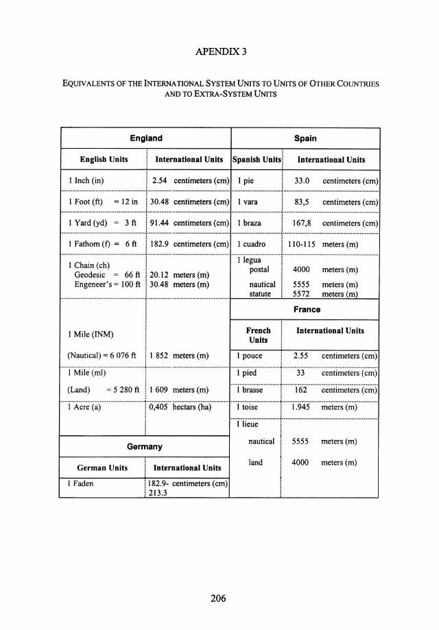
I Inch (in) 2.54 centimeters (em) I pie 33.0 centimeters (em) . . ...................................................................................................................................................................................... . .
I Foot (ft) = 12 in I 30.48 centimeters (em) I vara I 83,5 centimeters (em)
····~··;:~·~;~;····~·-··;·~·-··r~·;·.~···~~~~;:~~~~~-~~:; ····~--~~~~··········r···-~·~;·:~ .. ·····~~~~;:~~~~~-~~:;· I ~;~~;~ ~>~ ~~~~~ ;~~~:.~~~i I ;:~,~ ~;~i~~~~ :~~~:(~i I Chain ( ch) i 1 legua i
postal . 4000 meters (m) Geodesic = 66ft ! 20.12 meters (m) i Engeneer's =100ft i 30.48 meters (m) nautical i 5555 meters (m)
............................................... !............................................... statute i 5572 meters (m)
1 Mile (INM)
(Nautical)= 6 076 ft 1 852 meters (m)
French Units
1 pouce
France
International Units
2.55 centimeters (em) ···············································~ ·············································· ···························-~·-·····················································
::: (ml) ~ 5 280ft II 609 m~= (m) ; ::, j 13:2 -:=:;::=;=: ···············································~·-············································· ···························-~·-····················································· 1 Acre (a) i 0,405 hectars (ha) 1 toise i 1.945 meters (m) I .... i"iie~~ ............ J ..................................................... ..
~--------------~------------~ Germany
German Units
I Faden
International Units
182.9- centimeters (em) 213.3
206
nautical 5555 meters (m)
land 4000 meters (m)
REFERENCES
Abe, T. (1973) Tsunami and mechanism of great earthquakes. Phys. Earth & Planet. Inter., 7, 2, 143-153.
Ambraseys, N.N. (1960) The seismic sea wave of July 9, 1956 in the Greek Archipelago, J Geophys. Res., 65, (4), 1257-1265.
Ambraseys, N.N. (1961) On the seismicity of South-West Asia, Rev. Etude Calamites, Geneve, 37, 18-30.
Ambraseys, N.N. (1962) Data for the investigation of seismic sea-waves in the Eastern Mediterranean, Bull. Seism. Soc. Am., 52, (4), 895-913.
Ambraseys, N.N. (1965a) Data for the investigation of seismic sea-waves in Europe, Europ. Seism. Comm., Proc. Budapest Meet., 7-13 Sept., 1964, Seismicity of Europe, IUGG. Monographie, No 29, Paris, 78-81.
Ambraseys, N.N. (1965b) The seismic history of Cyprus, Rev. Union Int. Secours, March, (3), 25-48.
Ambraseys, N.N. (198la) Le tremblement de terre d'El-Asnam du 10.10.80, Actes des Journees Scientifiques sur le seisme d'El-Asnam du 10.10.80, Alger, 14-21.
Ambraseys, N.N. (198lb) The El-Asnam (Algeria) earthquake of 10 October 1980: Conclusions drawn from a field study,Am. J. Eng. Geol., 14, Part 2, 143-148.
Ambraseys, N.N. (1982) The seismicity of North Africa: The earthquake of 1856 at Jijeli, Algeria, Boll. Geofis. Teor. Appl., 24, (93), 31-37.
Ambraseys, N.N., and Finkel, C.F. (1987) The Saros-Marmara earthquake of 9 August 1912, Earthq. Eng. Struct. Dyn., 15, 189-211.
Ambraseys, N.N., and Vogt, J. (1988) Material for the investigation of the seismicity of the region of Algiers, Europ. Earthq. Eng., 3, 16-29.
Amokrane, M., Bedouchene, F., Benzerga, Z., et autres (1981) Le seisme d'Ech-Chelif du 10.10.1980 et sa relation avec le tectonique. Actes des Journees Scientifiques sur le seisme d'El-Asnam du 10.10.80, Alger, 56-64.
Annotated Bibliography on Tsunami (1964) IUGG. Monographie, No 27, Paris, 249 p. Antonopoulos, J. (1979) Catalogue of tsunamis in the Eastern Mediterranean from antiquity to
present time, Ann. Geofis., 32, 113-130. Antonopoulos, J. (1980a) Data from investigation on seismic sea-waves events in the Eastern
Mediterranean from the birth of Christ to 1980 A.D., Ann. Geofis., 33, (1 ), 141-248. Antonopoulos, J. (1980b) Data from investigation on seismic sea waves events in the Eastern
Mediterranean from antiquity to 500 A.D., Tsunami Newsletter XIII, (3), 27-37. Antonopoulos, J. (1990) Data for investigating tsunami activity in the Mediterranean Sea,
Science Tsunami Hazards, 8, (1), 39-52. Antonopoulos, J. ( 1992) The Great Minoan eruption of Thera Volcano and the ensuing tsunami
in the Greek Archipelago, Natural Hazards, 5, (2), 153-168. Baratta, M. (1894) II terremoto garganico del 1627, Boll. Soc. Geograf., Roma, Ser.III, 7, 399-
415. Baratta, M. (1897) Ancora sui terremoto garganico del 1627, Boll. Soc. Geograf, Roma, Ser.III,
10, 405-414. Baratta, M. ( 190 I) I Terremoti d'Italia, Fratelli Bocca, Torino, 949 p.
207
208 REFERENCES
Baratta, M. (1910) La catastrofe sismica ca1abro-messinese del 28 dicembre 1908, Relaz. Soc. Geograf Roma, (7).
Baratta, M. ( 1931) La fatale escursione Vesuviana di Plinio. Athenaeum, Studi periodici di letteratura e storia dell'antichita, Univ. di Pavia. Nuova Serie, 9, (1).
Baratta, M. (1936) I terremoti in Italia, R. Ace. Naz. Lincei, Pub/. Comm. Ita/. per lo studio delle grandi calamita. Le Monnier, Firenze, 6, (4), 180.
Basili, M., Calio, F., Cipollini, A., de Marco, R., de Simoni, B., Giacalone, P., Giorgetti, E., Marsan, P., Sabetta, F., Sano, T., and Sandona, P. (1979) 11 terremoto del Montenegro del 15 Aprile, Consiglio Superiore Lavori Pub/. Servizio Sismica, 66 p.
Bedosti, B., and Caputo, M. (1986) Primo aggiomamento del catalogo dei maremoti delle coste ltaliane, Atti Accad. Naz. Lincei, LXXX, Ser. VIII, 570-584.
Belousek, F.A. (1933) Grece. Raz de maree a !'embouchure de Ia riviere Struma, Ann. Commis. Etude Raz de Maree, 3, 61-62.
Ben-Menahem, A. (1979) Earthquake catalogue for the Middle East (92 B.C. -1980 A.D.), Boll. Geofis. Teor. App/., 21, (84), 245-313.
Berryat, J. (1761) Liste chronologique des eruptions des volcans, des tremblements de terre, etc., Collect. Acad. Partie Etrangere, ed. J. Desaint-Charles Saillant, Paris, 6, 468-675.
Bogdanovich, K.J. (1909) Earthquakes in Messina, 28 December, 1908 and San Francisco, 16 apri/1906, O.N. Popova Pub!. House, St. Petersburg, 108 p. (in Russian).
Caloi, P., Romualdi, G., and Spadea, M.C. (1970) Caratteristiche sismiche e geodinamiche della val Padana quali risultano dall'attivita sismica ivi verificatasi dall'Inizio dell'Era Volgare a tutto il 1969, Ann. Geofis., Roma, 23, (2, 3), 98, 135.
Campos-Romero, M.L. (1989) Sismicidad de Ia costa sudoccidental de Espana. Ana/isis y valoraci6n geografica de los posibles riesgos como consecuencia de los tsunamis en Ia zona, Doctoral Tesis, Univ. Complut. de Madrid, 734-753.
Campos-Romero, M.L. (1991) Tsunami hazard on the Spanish coasts of the Iberian Peninsula, Science Tsunami Hazards, 9, (1), 83-90.
Capuano, P., De Natale, G., Gasparini, P., Pingue, F., and Scarpa, R., (1988) A model for the 1908 Messina Straits (Italy) earthquake by inversion of levelling data. Bull. Seism. Soc. Am., 78, 1930-1947.
Caputo, M., and Caputo, R. (1989) Contribution for the study of tectonic activity of the Mediterranean Sea from volcanic activity at sea and new islands emerged in historic times. Science Tsunami Hazards, 7, (2), 79-102.
Caputo, M., and Faita, G.F. (1982) Statistical analysis of tsunamis of the Italian coasts, J Geophys. Res., 87, (1), 601-604.
Caputo, M., and Faita, G. (1984) Primo catalogo dei maremoti delle coste ltaliane. Atti Accademia Nazionale Lincei, Memorie, Classe Scienze Fisiche, Matematiche, Naturali, XVII, Ser. 7, 213-356.
Carpentin (1880) Note on the Earthquakes in Smyrna. Ann. Chimie et Physique, Ser. 5, 21, 300-338.
Carter, H. (1962) Translation of Herodotus, The Historiae of Herodotus ofHalicarnassus, Oxford Univ. Press, 617 p.
Catalogo dei Terremoti 1taliani dali'Anno 1000 al 1980 (1985) Postpischl D. (edt.), Consiglio Naz. Ricerche. Prog. Finalizzato Geodinamica. Bologna, 235 p.
Cavasino, A. (1935) I terremoti d'ltalia nel trentacinquennio 1899-1933, Appendice Ser.I/1, Mem. R. Ufficio Central. Meteorol. Geofis., Istit. Poligraf. Stato, Roma, IV.
Cazolis, P. (1498) Pilgrimage, Manuscript L-678, Library Trivulziana, Folio 986.

REFERENCES 209
Cistemas, A., Dorel, J., and Gaulon, R. (1982) Models of the complex source of the El Asnam earthquake, Bull. Seism. Soc. Am., 72, (6), 2245-2266.
Comninakis, P.E., and Papazachos, B.C. (1982) A Catalogue of Historical Earthquakes in Greece and the Surrounding Area for the period 479 B.C.- 1900 A.D., University of Thessaloniki, Publ. N!! 5, 24 p.
Crawley R. (1952) Translation of Thucidides, The History of the Peloponnesian War, Dent., London, 484 p.
Critikos, N.A. (1931) Grece. Le mouvement extraordinaire des man~es qui s'est manifeste dans l'Egee, Avril1928, Ann. Commis. Etude Raz de Maree, Paris, 1, 29-40.
Dalmacco, F. (1940) Sul terremoto delle Isole Eolie del27 Gennaio 1939, Geofis. Pura Appl. (1). Davison, C. (1936) Great Earthquakes, Thomas Murby, London. Defant, A. (1961) Physical Oceanography, Vol. 2, Pergamon Press, Oxford, 589 p. De Montessus de Ballore, F.J.B.M.B. (1906) La Geographie Sismologique. Les Tremblements de
Terre, Armand Colin (ed), Paris, 475 p. De Montessus de Ballore, F.J.B.M.B. (1923) Ethnographie Sismique et Volcanique, Honore
Champion, Paris, 206 p. De Montessus de Ballore, F.J.B.M.B. (1924) La Geologie Sismologique Sismologique. Les
Tremblements de Terre, Armand Colin, Paris, 488 p. De Panfilis, M., and Marcelli, L. (1968) 11 periodo sismico della Sicilia Occidentale iniziato il 14
Gennaio 1968, Ann. Geofis., Rorna, 21, (4), 343-422. De Sacy, S. (1810) Translation of Abd-Al-Latif: 1220, Relation d'Egypte, suivi de divers extraits
d'ecrivains orientaux et d'un etat des provinces et des villages de l'Egypte dans le XIVe siecle, L'lmprimerie Imperiale, Paris, 414-418.
Dominey-Howes, D.T.M. (1996a) The geomorphology and sedimentology of five tsunamis in the Aegean Sea region, Greece. Unpublished PhD Thesis, Coventry University, 272 p.
Dominey-Howes, D.T.M. (1996b) Sedimentary deposits associated with the July 9, 1956 Aegean Sea tsunami. Phys. Chern. Earth, 21, 51-55.
Dominey-Howes, D.T.M., Cundy, A., and Croudace, I. (2000) High ene5gy marine food deposits on Astypalaea Island, Greece: possible evidence for the A.D. 1956 southern Aegean tsunami. Marine Geology, 163,303-315.
Diick, J. (1904) Die Erdbeben von Konstantinopol, Die Erdbebenwarte, Laibach, 3, (6), 121-139. Earthquakes in the Aegean Sea (1956) Nature, 178, (4525), 125. Eastman, C.R. (1908) Dates of early Santorin and Ischian eruptions, Science, 27, (700), 855. El-Robrini, M., and Mauffret, A. (1985) Consequences of the El-Asnam earthquakes: Turbidity
currents and slumps on the Algerian margin (Western Mediterranean), Geo. Marine Lett., 5, 171-176.
Eva, C., and Rabinovich, A.B. (1997) The February 23, 1887 Tsunami recorded on the Ligurian coast, Western Mediterranean, Geophys. Res. Let., 24, (17), 2211-2214.
Feliciani, P., and Marcelli, L. (1965) 11 terremoto di Tolmezzo del26 Aprile 1959. I Parte: Venti secoli di storia sismica della regione Camica e dell'Italia Nord-Orientale, Ann. Geofis., Roma, 18, 165-207.
Forster, W.G. (1890) Earthquake origin, Trans. Seism. Soc. Japan, 15, 77. Fuchs, C.W. (1886) Statistik der Erdbeben von 1865 his 1885, Acad. Wissenschaflen, Wien, 92,
(3), 215-625. Galanopoulos, A. (1938) La Sismicite de l'Achaie et des regions voisines de Missolonghi et de
Naupacte, Gerl. Beitr. Geophys., Leipzig, 53, (1-3), 203-235. Galanopoulos, A. (1940) Die Seismizitiit von Elis, Gerl. Beitr. Geophys., Leipzig, 56, (1),
92-107.

210 REFERENCES
Galanopoulos, A. (1949) The Koroni (Messinia) earthquake of October 6, 1947, Bull. Seism. Soc. Am., 39, (1}, 33-39.
Galanopoulos, A. (1952) Die Seismizitlit der Insel Leukas, Allgemeine Historische Verbericht. Gerl. Beitr. Geophys., Leipzig, 62, (4}, 256-263.
Galanopoulos, A. (1953) Die Seismizitllt der Insel Leukas (II. Die Erdbeben von 22 April und 30 Juni 1948}, Gerl. Beitr. Geophys., Leipzig, 63, (1}, 1-15.
Galanopoulos, A. (1954) Die Seismizitllt der Insel Chios, Gerl. Beitr. Geophys., Leipzig, 65, (4), 253-264.
Galanopoulos, A. (1955) Earthquake geography of Greece, Ann. Geolog. Pays Hel/eniques, Athens, 6 (in Greek).
Galanopoulos, A. (1957a) Zur Bestimmung des Alters der Santorin-Kaldera, Neues Jb. Geol. Palaeontol. Mh., Stuttgart, 9, 419.
Galanopoulos, A. (1957b) The seismic sea wave of July 9, 1956, Prak. Akad. Athens, 32, 90-101 (in Greek).
Galanopou1os, A. (1960a) A catalog of shocks in Greece with intensity I> VI or magnitude M > 5 for the years 1801-1958, Seism. Lab. Rep., Athens Univ., 119 p.
Galanopoulos, A. ( 1960b) Tsunamis observed on the coasts of Greece from antiquity to present time, Ann. Geofis., Rome, 13, (3-4}, 369-386.
Galanopoulos, A. ( 1961) A catalog of shocks in Greece with intensity I > 7 for the years prior to 1800, Seism. Lab. Rep., Athens.Univ., 19 p.
Galanopou1os, A., and Bacon, E. (1969) Atlantis: The Truth behind the Legend, Thomas Nelson and Sons Ltd., London, 15 p.
Galanopoulos, A.A., Comninakis, P., and Delibasis, N. (1964) Tsunami generated by an earth slump set in motion without shock, Ann. Geol. Pays Helleniques, Athens.
Genessaux, M., Mauffret, A., and Pautot, G. (1980) Les glissements sous-marins de Ia pente continentale et la rupture des cables en Mer Ligure (Mediterranee occidentale), Acad. Sci. Paris, 240, ser. D, 14 Avril, 958-962.
Gentile, G., Renner, G., Riggio, A.M., Slejko, D., and Zacchigna, M. (1984) II terremoto del 26 Marzo 1511 nelle Alpi Orientali, Atti del Convegno Finalita ed Esperienze della Rete Sismometrica del Friuli-Venezia Giulia, Trieste, 231-243.
Gius, M. (I 933) Italie, Maree de tempete, Ann. Commis. Etude de Raz de Maree, Paris, 3, 66-70. Gorky M. (1909) The Earthquake in Calabria and Sicily 15128 December 1908, Tov. Znanie
Pub!. House, St. Petersburg, 1-141 (in Russian). Grablowitz, G. (1903) Remarks about the earthquake observation service on the Island of Ischia,
Die Erdbebenwarte, Laibach, Germany, 3, (1}, 1. Grandazzi, M. (1954) Earthquakes in the Ionian Islands in August 1953, Ann. Geograf (340),
450. Guidoboni, E., and Tinti, S. (1988) A review of the historical 1627 tsunami in the Southern
Adriatic, Science Tsunami Hazards, 6, (1), 11-16. Guidoboni, E., and Tinti, S. (1989) The largest historical tsunamis in the Northern Adriatic Sea:
A Critical Review, Science Tsunami Hazards, 7, (1}, 45-54. Hamilton, W. (1783) An account of the earthquakes which happened in Italy from February to
May 1783, Phil. Trans. Roy. Soc. London, 73, 169. Heck, N. (1947) List of seismic sea waves, Bull. Seism. Soc. Am., 37, (4), 269-286. Heiken, G., and McCoy, F. (1984) Caldera development during the Minoan eruption, Thera,
Cyclades, Greece,.!. Geophys. Res., 89, (B10), 8441-8462. Heezen, B.S., and Ewing, M. (1955) Orleansville earthquake and turbidity currents, Bull. Am.
Assoc. Petrol. Geol., 39, (12), 2505-2514.
REFERENCES 211
Heezen, B.S. (1957) 1908 Messina earthquake, tsunami, and turbidity current, Bull. Geol. Soc. Am., 68, (12), pt.2, 1743.
Hewitt, R. (1957) From Earthquake, Fire and Flood, Scribnerand Sons, New York, 215 p. ImbO, G. (1965) Catalogue of the active volcanoes of the world including solphatara fields,
Intern. Assoc. Volcano[. Pt. XVIII, Roma, Italy. Ippolito, F. (1783) Account of the earthquakes which happened in Calabria, March 28, 1783. In a
letter from Count Francesco Ippolito to Sir William Hamilton, Phil. Trans. Roy. Soc. London, Part 1, 1, 296-304.
Irving, A. (1909) The Italian Earthquake, Nature, 79,428-429. Ivashchenko, A.l. (1972) On recurrence of strong earthquakes in the Northwestern Part of the
Pacific Ocean for the last 50 years, Tsunami Waves, Proc. Sakhalin Complex Sci. Res. Inst., Far-Eastern Sci. Center, USSR Academy of Sciences, 29, 208-216 (in Russian).
Jones, H.L. (1966-1970) Translation of Strabo, The Geography of Strabo, Heinmann, London. Kallner-Amiran, D.A. (1951) A revised earthquake catalog of Palestine, Israel Explor.,
Jerusalem, 1, 223-246. Kallner-Amiran, D.A. (1952) A revised earthquake catalog of Palestine, Israel Explor.,
Jerusalem, 2, 48-65. 'Karnik, V. (1968) Seismicity of the European area, Praha Academia, Part I, D. Reidel Publ. Co.,
Dordrecht, 364 p. Kamik, V. (1971) Tsunamis. In: Seismicity of the European Area. Part II, D. Reidel Publ. Co.,
Dordrecht, 203-206. Kasumovic, M. (1963) Seizrnika Aktivnost Srednjeg Jadrana i Poslednji Notresi u Makarskom
Primmju, Geol. Vjesn., Zagreb, (16), 227-232 (in Serbian). Klenova, M.V. (1948) Marine Geology, Uchpedgiz, Moscow, 495 p. (in Russian). Knolles, R. (1603) The General History of the Turkey, E.A.Slipp, London, 476 p. Knudtzon, J. (1915) Die El-Amara Tafeln mit Einleitung und Erleuterungen. J. Hinrich, Leipzig,
v. 1., 625 p.; v. 2., 1017 p. Kolosenko, M.N. (1955) An earthquake at the Ionic Islands, Priroda (1), 128 (in Russian). Konstantin, K. (1909) The Earthquake in Sicily and Calabria, Moscow, 5-8 (in Russian). Kriimmel, 0. (1911) Handbuch der Ozeanographie, Stuttgart, Bd.2, 155 p. Koutitas, C.G., and Papadopoulos, G.A. (1998) Numerical simulation of the aseismically induced
tsunami of 7 February 1963 in the Western Corinthos Bay. Proc. Internat. Confer. Tsunamis, Paris, May 26-28, 1998,247-254.
Lacroix, M.A. (1909) Summary of some observations made by Ricco on the Sicily-Calabria earthquake, Comp. Ren. Acad. Sci., Paris, 148, 207-209.
Lambros, S. (1914) Collection of chronicles found in Rubrician monasteric manuscripts, Neos Hellinomnimon, Athens, 7, 123-313.
Le Moniteur (1790) Novembre 2 and Decembre 21, Paris. Levinson-Lessing, F.Y. (1924) Earthquake and measures against it, Academia, Leningrad, 64-
66, 73, 98 (in Russian). Magnaghi, A., and Touta, L. (1931) Onda meteorologica in Sicilia, Ann. Commis. Etude Raz de
Maree, Paris, (1), 53-54. Magnati, M. (1946) Tettonica e sismicita nella regione albanese Geofis. Pura Appl., 8, l-42. Mallet, R. ( 1850-1858) Report on the facts of earthquake phenomena, British Assoc. Advanc. Sci.
Part l, 1850, 89 p.; Part 2, 1852, 212 p.; Part 3, 1854; 326 p.; Part 4, 1858, 136 p.,J. Taylor Publ., London.
Mararnai, A., and Tinti, S. (1996) Study for a pilot monitoring and alarm system for the Calabrian Sicilian tsunamis. Phys. Chern. Earth, 21, 83-86.

212 REFERENCES
Marinatos, S. (1939) The volcanic destruction of Minoan Crete, Antiquity, 13, (52), 425-439. Marinos, G., and Melidonis N. (1959) On the amplitude of the tsunami originating in the
prehistoric eruption of Santorin, Greek Geol. Soc., 4, 210-218. Marinos G., and Melidonis N. (1961) Uber die Groesse des Beim Vorgeschichtlichen Ausbruchs
des Santorini-Vulkans Ausgeloesten Tsunamis, Bull. Griech. Geol. Ges. Athens, 4. Marshall, V. (1887) Die Erdbeben in Griechenland, Unsere Zeit., 1, 109. Martinelli, G. (1923) Un centro sismica a mare (contributo alia Geografia Sismica del Lazio),
Boll. Soc. Sism. Italiana, 24, Anno 1922-1923, Roma, 149-158. Masciari-Genoese, F. (1915) Concerning Antiseismic Construction. Venice Napoli, Milano,
93-103. Meghraoui, M., Philip H., Albarede F., and Cistemas, A. (1988) Trench investigations through
the trace of the 1980 El Asnam thrust fault: Evidence for paleoseismisity, Bull. Seism. Soc. Am., 78, (2), 979-999.
Mercalli, G. (1897) I terremoti della Liguria e del Piemonte, Memoria con Tre Tavole in Litografia. Tipografico Lanciano e Pinto, Napoli.
Mercalli, G. (1906) Alcuni risultati ottenuti dallo studio del terremoto Calabrese dell' 8 Settembre 1905, Nota letta all'Accademia Pontaniana nella tomata del 25 Novembre 1906. Atti. Ace. Pontaniana, 36.
Mercalli, G. (1908) Sui terremoto Calabrese del 23 Ottobre 1907 (nota preliminare), Boll. Soc. Sism.ltaliana, 13, Anno 1908- 1909, Roma.
Meyer, V. (1909) In Destroyed Messina, Tov. Znanie Publ. House, St. Petersburg, 147-230 (in Russian).
Mezcua, J., and Martinez Solares J.M. (1983) Sismicidad del area Ibero-Mogrebi, Inst. Geograf Nac., Publ. Madrid, 203, 299.
Mihailovic, J. (1927) Mouvements Seismiques Epiro-Albanais. Intern. Un. Geodesy Geophys.: Ser. B., Monographie et Travaux Sci., Belgrade, 1, 78.
Mihailovic, J. (1933) La Sismicite de Ia Mer de Marmara et de l'Asie Mineure. Intern. Un. Geodesy Geophys. II Ser. B. Monographie et Travaux Sci., Belgrade, 2, 26-27.
Mihailovic, J. (1935) Recent catastrophes in Albania, Ann. Geo/. Penins. Balk., Belgrade, 12, (2). Mihailovic, J. (1939) Seismicity of the Island of Hvar, Glas, Srpska Kraljevska Akadeimja
CLXXX, Prvi Razred, 89, B, Prirodnachke Nauke, Belgrade, 287-324 (In Serbian). Mihailovic, J. (1947) Caractere sismique de la cote sud de l'Adriatique Yougoslave. Acad. Serbe
Sc., Belgrade, 22. Milne, J. (1886) Earthquakes and other Earth Movements, 2nd ed. Kegan Paul and Trech,
London, 165 p. Miloh, T., and Striem, H.L. (1978) Tsunamis effects at coastal sites due to offshore faulting,
Tectonophysics, 46, 347-356. Minoura, K., Imamura, F., Kuran, U., Nakamura, T., Papadopoulos, G.A., Takahasi, T., and
Yalciner, A. C. (2000) Discovery of Minoan tsunami deposits. Geology, 28, 59-62. Mitzopoulos, C. (1900) The Earthquakes at Tripolis and Triphylia in 1898 and 1899, Petermanns
Mitteil, 46. 283. . Mongitore. A. (1743) Istoria cronologica de' terrimoti di Sicilia. Della Sicilia ricercata nelle
cose piu memorabili, Palermo, 2, 345-445. Montandon, F. (1953) Les Tremblements de Terre Destructeurs en Europe. Catalogue par
Territoires Sismiques, de /'An 1000 a 1940, Geneve, 195 p. Moreira, V.S. (1974) Earthquakes and tsunami in the European area, XIIIth Gen. Ass. Europ.
Seism. Commis., Bucharest, 12.
REFERENCES 213
Moreira, V.S. (1978) The earthquake in the region ofThessaloniki, Politics, Newspaper, June 22 &23.
Moreira, V.S. (1988) Historical and recent tsunamis in the European area, Science Tsunami Hazards, 6, (1}, 37-42.
Murty, T.S. (1977) Seismic Sea Waves- Tsunamis. Bull. Fish. Res. Board Canada 198, Ottawa, 337 p.
Ninkovich D., and Heezen B.C. (1965) Santorini Tephra. In: Submarine Geol. and Geophys. N!! 17, Colston Papers, Bristol, 17.
Oberhurnmer, E.A. (1903) Description of the Island of Cyprus based on historical data. T. Ackermann, Munchen, 137-146.
Oddone, G. (1923) Ricerche Teorico-Sperimentali suite Vibrazioni del Sottosuolo, Spoerri, Pisa. Oldham, R.D. (1909) The Italian earthquake, Nature, London 79, 287-288. Orlov, A.P. (1887) Earthquakes and Their Connection with Other Natural Phenomena, Kazan
State Univ., Kazan, 170 p. (in Russian). Ozsoy, E., and Onliiata. 0. (1982) Coastal amplification of tsunami waves in the Eastern
Mediterranean, J. Phys. Oceanogr., 12, (2}, 117-126. Papadopoulos, G.A. (1985) The volcanic hazard in Greece, Bull. Geol. Soc. Greece 17,316-323. Papadopoulos, G.A. (1993a) Seismic faulting and nonseismic tsunami generation in Greece.
Proc. IUGG/IOC Internat. Tsunami Symposium, Wakayama, August 23-27, 1993, 115-122. Papadopoulos, G.A. (1993b) On some exceptional seismic(?) sea-waves in the Greek
Archipelago, Science Tsunami Hazards, 11, (1}, 25-34. Papadopoulos, G.A. (1996) New observations about the near- field effects of the 9 July 1956
South Aegean large tsunami, Europ. Seismol. Commission 25th General Assembly, Reykjavik, Sept. 9-14, 1996, 150 (abstr.).
Papadopoulos, G.A. (1998a) EC Project GITEC-TWO- A Tsunami Catalogue of the area of Greece and Adjacent Seas. Inst. Geodynamics, Nat. Observatory Athens, Pub/. No. 8, October 1998, 18 p.
Papadopoulos, G.A. (1998b) A reconstruction of the 373 B.C. large earthquake in the western Corinthos Gulf. In: Proc. 2nd Internat. Conf on the Ancient Eliki, Aeghion, 1-3 Dec. 1995, Athens, 479-494.
Papadopoulos, G.A., and Chalkis, B.J. (1984) Tsunamis observed in Greece and the surrounding area from Antiquity up to the present times, Marine Geology, 56, 309-317.
Papadopoulos, G.A., and Dermentzopoulos, Th. (1998) A tsunami risk management pilot study in Heraklion, Crete lsi. Greece, Natural Hazards, 18, 91-118.
Papadopoulos, G.A., Dermentzopoulos, Th., and Koutitas, Ch. (1997) GITEC-TWO Midterm Scientific Report of the NOAGI. In: S. Tinti (ed.), Genesis and Impact of Tsunamis On The European Coasts - Tsunami Warning and Observations, Midterm Scientific Report Submitted to CEC, June 1997.
Papadopoulos, G.A., and Lefkopoulos, G., 1993. Magnitude- distance relations for liquefaction in soil from earthquakes. Bull. Seismol. Soc. Am., 83, 925-938.
Papadopoulos, G.A., Polymenakos, E., Tsimplis, M., and Vlachakis, G. (1992) An exceptional sea-wave observed in the Aegean: A geological or meteorological event? Ann. Geophys., Suppl., 1, 10, pt. I, 109.
Papadopoulos, G.A., Skafida, H.G., and Vassiliou, I.T. (1993) Nonlinearity of the magnitudefrequency relation in the Hellenic arc - trench system and the characteristic earthquake model. J. Geophys. Res., 98, 17737-17744.
Papazachos, B.C., and Dirnitriu P.P. (1991) Tsunamis in and near Greece and their relation to the earthquake focal mechanisms, Natural Hazards, 4, 161-170.
214 REFERENCES
Papazachos, B.C., Koutitas, C., Hatzidimitriou, P.M., Karacostas, B.G., and Papaioannou, C.A. (1985) Source and. short-distance propagation of the July 9, 1956 Southern Aegean tsunami, Marine Geology, 65, 343-351.
Papazachos, B.C., Koutitas, C., Hatzidirnitriou, P.M., Karacostas, B.G., and Papaioannou, C.A. (1986) Tsunami hazard in Greece and the surrounding area, Ann. Geophys., 4, (1 ), 79-90.
Papazachos B.C., and Papazachou, C.B. (1997) The Earthquakes of Greece, Editions ZITI, Thessaloniki, 304 p.
Pararas-Carayannis, G. (1973) The waves that destroyed the Minoan Empire, Sea Frontiers, 12, (2), 94-1 06.
Pararas-Carayannis, G. (1974) The waves that destroyed the Minoan Empire, Grolier Encyclopedia, Science Suppl., Man and His World, 314-321.
Pararas-Carayannis, G. (1988) The tsunami generated from the eruption of the Volcano of Santorin in the Bronze Age, Science Tsunami Hazards, 6, (1), 23-30.
Pararas-Carayannis, G. (1992) The tsunami generated from the eruption of the Volcano of Santorin in the Bronze Age, Natural Hazards, 5, 115-123.
Pavlov, A.P. (1924) The Nature of Earthquakes and Earthquakes .in Japan, Moscow, Gos. Izdvo, 16-18 (In Russian).
Pedini, P. (1744) Account of the earthquakes in Leghorn from the lOth to 27th of January, 1742, Phil. Trans. Roy. Soc. London, 42, 77-90.
Perissoratis, C., and Papadopoulos, G.A. (1999) Sediment instability and slumping in the southern Aegean Sea and the case history of the 1956 tsunami. Marine Geology, 161, 287-305.
Perrey, A. (1847) Note sur les tremblements de terre en Algerie et dans l'Afrique septentrionale, Mem. Acad. Sci. Arts Belles-Lett., Annees 1845-1846, Dijon, 299-479.
Perrey, A. (1848) Note sur les tremblements de terre ressentis en 1847, Mem. Acad. Sci. Arts Belles-Lett., Annees 1847-1848,68-115.
Perrey, A. (1850) Memoire sur les tremblements de terre ressentis dans Ia Penisule TurcoHellenique et en Syrie. Memoires Courtois et memoires des savants etrangers. Ac. Royale Sci., Lettres, Beaux-Arts de Belgique, t. XXIII, part 1, Bruxelles, 73 p.
Perrey, A. (1852) Note sur les tremblements de terre en 1850, avec supplements pour les annees anterieures. Mem. Acad. Sci. Arts Belles-Lett., Annee 1851, Dijon, 1-36.
Perrey, A. (1854a) Note sur les tremblements de terre en 1851, avec supplements pour les annees anterieures. Mem. Acad. Sci. Arts Belles-Lett., Annees 1852-1853, Dijon, 1-65.
Perrey, A. (1854b) Note sur les tremblements de terre en 1852, avec supplements pour les annees anteneures. Mem. Acad. Sci. Arts Belles-Lett., Annees 1852-1853, Dijon, 79-128.
Perrey, A. (1855a) Note sur les tremblements de terre en 1853 avec supplements pour les annees anterieures. Mem. Acad. Sci. Arts Belles-Lett., Annee 1854, Dijon, 55.
Perrey, A. (1855b) Note sur les tremblements de terre en 1854, avec supplements pour les annees anteriures. Bull. A cad. Lett. Sci. Bruxelles, 22, Ser.1, 526-572.
Perrey, A. (1856) Note sur les tremblement de terre en 1855, avec supplements pour les annees anteriures. Premiere partie, Bull. A cad. Lett. Sci. Bruxelles, 23, Ser.2, 23-68.
Perrey, A. (1857) Note sur les tremblements de terre ressentis en 1856, avec supplements pour les annees anterieures, Pt.2. Bull. Acad. Lett. Sci. Bruxelles. 24, Ser.2, 64-128.
Perrey, A. (1859) Note sur les tremblements de terre en 1856, avec supplements pour les annees anterieures, Mem. cour. Acad. Bruxelles, 8, 1-79.
Perrey, A. (1860) Note sur les tremblements de terre en 1857, avec supplements pour les annees anterieures, Mem. cour. Acad. Bruxelles, 10, 1-114.
REFERENCES 215
Perrey, A. (1862a) Note sur 1es tremb1ements de terre en 1859, avec supplements pour les annees anterieures, Mem. cour. Acad. Bruxelles, 13, 77.
Perrey, A. (1862b) Note sur les tremblements de terre en 1860, avec supplements pour les annees anterieures, Mem. cour. Acad. Bruxelles, 14, 74.
Perrey, A (1864a) Note sur les tremblements de terre en 1861, avec supplements pour les annees anterieures, Mem. cour. Acad. Bruxelles, 16, 112.
Perrey, A. (1864b) Note sur les tremblements de terre en 1862, avec supplements pour les annees anterieures, Mem. cour. Acad. Bruxelles, 16, 179.
Perrey, A. (1865) Note sur les tremblements de terre en 1863, avec supplements pour les annees anterieures, de 1843 a 1862, Mem. cour. Acad. Bruxelles, 17, 213.
Perrey, A. (1867) Note sur les tremblements de terre en 1865, avec supplements pour les annees anterieures, de 1843 a 1864, Mem. cour. Acad. Bruxelles, 19, 125.
Perrey, A. (1870) Note sur 1es tremb1ements de terre en 1866 et 1867 avec supplements pour les annees anterieures, de 1843 a 1865, Mem. cour. Acad. Bruxelles, 21, 233.
Perrey, A. (1872) Note sur les trembLements de terre en 1869, avec supplements pour les annees anterieures, de 1843 a 1868, Mem. cour. Acad. Bruxelles, 22, 116.
Perrey, A. (1873) Supplements aux notes sur les tremblements de terre ressentis de 1843 a 1868, Mem. cour. Acad. Bruxelles, 23, 70.
Perrey, A. (1875a) Note sur les tremblements de terre en 1870, avec supplements pour 1869, Mem. cour. Acad. Bruxelles, 24, 146.
Perrey, A. (1875b) Note sur les tremblements de terre en 1871, avec supplements pour les annees anterieures, de 1843 a 1870, Mem. cour. Acad. Bruxelles, 24, 143.
Piatanesi, A., and Tinti, S. (1998) A revision of the 1693 eastern Sicily earthquake and tsunami. J. Geophys. Res., 103, 2749-2758.
Pfannenstiel, M. (1960) Erlaeuterungen zu den Bathimetrischen Karten des Oestlichen Mittelmeeres, Bull. /nst. Oceanograph. Monaco, Monaco, 1192.
Platania, G. (1890) I fenomeni sottomarini durante l'eruzione di Vulcano (Eolie) ne11888-89, Atti Rendiconti Accademia Scienze, Lettere Arti Acireale, Nuova Serie, 1.
Platania, G. (1909) II maremoto dello Stretto di Messina del 28 dicembre 1908, Boll. Soc. Sism. Italiana, Rome, 13 (7), 369-458.
Platania, G. (1912) II maremoto del 23 ottobre 1907 in Calabria e Ia propagazione di onde di maremoto, Boll. Soc. Sism. Italiana, Rome, 16 (6), 166-174.
Platania, G. (1913) Oscillation of the sea in the Gulf of Catania, Boll. Acad. Gioenia Sci. Naturali Catania, 21 (27), 1.
Poniavin, I.D. (1965) Tsunami Waves, Gidrometeoizdat, Leningrad, 110 p. (in Russian). Rabinovich, A.B., and Monserrat, S. (1996) Meteorological tsunamis near the Balearic and Kuril
Islands: Descriptive and statistical analysis, Natural Hazards, 13, (1), 55-90. Rabinovich, A.B., and Monserrat, S. (1998) Generation of meteorological tsunamis (large
amplitude seiches) near the Balearic and Kuril Islands, Natural Hazards, 18, (1), 27-55. Radice, B. (1972) Translation of Pliny the Younger, Letters and Panegirycus, Harvard Univ.
Press, Heinmann, London, 1, 2. Radics, P. (1902) Earthquakes in Venice and the Bell Tower of St. Mark, Die Erdbebenwarte 2,
(5-6), 90. Rzadkiewicz, S., Heinrich, P., Savoye, B., and Bourillet, J.F. (1998) Numerical modelling of a
landslide tsunami: the 1979 Nice event (French Riviera), Intern. Conf Tsunamis, Paris, 83. Ribaric, V. (1979) The Idrija earthquake of March 26, 1511 - a reconstruction of some
seismological parameters,Tectonophysics, 53, 315-324. Ribaric, V. (1982) Seismicity of Slovenia. Catalog of earthquakes (792 A.D.-1981), Ljubljana.
216 REFERENCES
Ricco, A. (1909) Terremoto del Messinese e della Calabria al28 dicembre 1908, Bollettino Acad. Gioenia Sci. Naturali Catania, S.II, fasc. 6, 3-7.
Rothe, J-P. ( 1955) Le tremblement de terre d'Orleansville et Ia seismicite de 1 'Algerie (9 September 1954), La Nature, (3237), 9.
Ruegg, J., Kasser, M., Tarantola, A., Lepine, J.C., and Chouikrat, B. (1982) Deformations associated with the El- Asnam earthquake of I 0 October 1980: Geodetic determination of vertical and horizontal movements, Bull. Seismol. Soc. Amer., 72, (6), 2227-2244.
Savi, P. (1846) Relazione de'Fenomeni Presentati dai Terremoti di Toscana dell'Agosto 1846 e Considerazioni Teoretiche Sopra i Medesimi del Prof Cav. Paolo Savi, Tip. Nistri, Pisa.
Schaeffer, C. (1939) The Cuneiform Texts ofRas Shamra, British Academy, London, 22. Schaeffer, C. (1948) Stratigraphie compare et Chronologie de l'Asie Occidentale pour les Ill" et
II" Miltenaires, Oxford Univ. Press. Schmidt, J. (1881) Studien uber Vulcane und Erdbeben, Part 2, A.Georgi, Leipzig, 612 p. Senarmont, H. (1857) Analyse des documents recueillis sur les tremblements de terre ressentis en
Algerie du 21 Aoilt au 15 Octobre 1856, Camp. Ren. Acad. Sci., Paris, 44, 586-594. Shirokova, E.I. (1967) Conformity to general laws in the orientation of main strength in
earthquake centers of the Mediterranean Seismic Belt, Izvestiya, Earth Physics, (1), 12-23 (In Russian).
Shurygin, A.M. (1980) On Long-term Forecast of Major Tsunamis. Theorie and Operation Tsunami Forecast, Nauka, Moscow, 141-145 (In Russian).
Sieberg, A. (1923) Geologische, Physikalische und Angewandte Erdbeben Kunde, Jena, 572 p. Sieberg, A. (1932a) Untersuchungen uber Erdbeben und Bruschchollenbau im Ostlichen
Mittelmeergebiet. Denkschriffien der Medizin, Naturwiss, Gezellschaft zu Jena, 18, 2, Jena, 273.
Sieberg, A. (1932b) Die Erdbeben, Gutenberg's Handbuch der Geophysik, G. Bom-traeger, Berlin, 4, 775-812.
Shebalin, N. V. ( 197 4) Atlas of Isoseismal Maps, Part III of the Catalogue, UNESCO, Skopje. Skouphos, T. (1894) The Great Earthquake ofLokris on April20 and 27, Zeit. Ges. Erdk., Berlin,
29, 409-410. Soloviev, S.L. (1968) Tsunami problem and its importance for Kamchatka and Kuril Islands,
Tsunami Problem, Nauka, Moscow, 7-50 (In Russian). Soloviev, S.L. (1972) Recurrence of tsunamis in the Pacific Ocean, Tsunami Waves, Collection
of Works of SCRI FESC USSR, Yuzhno-Sakhalinsk, 29, 7-47 (In Russian). Soloviev, S.L. (1978) Main Information on tsunamis at the Pacific Coast of the USSR. Years
1737-1976, Tsunami Study in Open Ocean, Nauka, Moscow, 61-136 (In Russian). Soloviev, S.L. (1989) Mediterranean tsunamis and their comparison with Pacific tsunamis,
Izvestiya, Earth Physics, 25, (11). Soloviev, S.L. (1990) Tsunamigenic zones in the Mediterranean Sea, Natural Hazards, 3, (2),
183-202. Soloviev, S.L. (1993) Microseismicity of sea floor in the European seas, Ann. Geophys. Suppl.
II., 11, Pt. II, Oceans, Atmosphere, Hydrol. and Nonlinear Geophys, 330. Soloviev, S.L., Campos-Romero, M.L, and Plink, N.L. (1992) Orleansville tsunami of 1954 and
El- Asnam tsunami of 1980 in the Alboran Sea (Southwestern Mediterranean Sea), Izvestiya, Earth Physics, 28, (9), 739-760.
Soloviev, S.L., and Go, Ch.N. (1974) Catalogue ofTsunamis on the Western Shore of the Pacific Ocean, Nauka, Moscow, 309 p. (in Russian).
Soloviev, S.L., and Go, Ch.N. (1975). Catalogue of Tsunamis on the Eastern Shore of the Pacific Ocean. Nauka, Moscow, 204 p. (in Russian).
REFERENCES 217
Soloviev, S.L., and Go, Ch.N. (1984a) Catalogue of Tsunamis on the Western Shore of the Pacific Ocean, Canadian Trans!. Fish. Aquatic Sci., No. 5077, Ottawa, 439 p. (in English).
Soloviev, S.L., and Go, Ch.N. (1984b). Catalogue of Tsunamis on the Eastern Shore of the Pacific Ocean. Canadian Trans!. Fish. Aquatic Sci., No. 5078, Ottawa, 293 p. (in English).
Soloviev, S.L., Go, Ch.N., and Kim, Kh.S. (1986) Catalog of Tsunamis in the Pacific, 1969-1982. IGC AS USSR Pub!. House, 164 p. (in Russian).
Soloviev, S.L., Go, Ch.N., and Kim, Kh.S. (1992) Catalog of Tsunamis in the Pacific, 1969-1982. English translation by Amerind Pub!. Co., Pvt. Ltd, New Delhi, India, (1988); SGC AS USSR Pub!. House, Moscow, 208 p.
Soloviev, S.L., Go, Ch.N., Kim, Kh.S., Solovieva, O.N., and Shchetnikov, N.A. (1997) Tsunamis in the Mediterranean Sea; 2000 B.C.- 1991 A.D., Moscow, 139 p. (in Russian).
Soloviev, S.L., Karakaisis, G.F., Kovachev, S.A., Kuzin, l.P., Shoda, O.Yu., and Tassos, S.T. ( 1992) Microearthquake hypocenter determination in the Southern Aegean Sea from records of sea floor and landbased seismographs, Phys. Earth Planet Int., 75, (1/3), 177-183.
Solovieva, O.N., and Soloviev, S.L. (1968) New data on dynamics of seismic waves from the Kuril-Kamchatka Earthquakes, in Tsunami Problem, Nauka, Moscow, 73-96 (in Russian).
Sorrentino, I. (1734) Istoria del Monte Vesuvio, Napoli. The Italian Earthquake of December 28, 1908 (1909) Nature, 80,445. Tholozan, J. (1879) Sur les tremblements de terre qui ont eu lieu en !'Orient du vne au xvne
siecle, Camp. Rend. de l'Acad. Sci., 88, 1063-1006. Technener, R. (1861) The great earthquake and terrible ruin which occurred in Jerusalem and
neighbouring parts. Bull. du Bib/., Porte St. Marcel, 1861, January. Issue I, Paris, (12). Tinti, S. (1991) Assessment oftsunami hazard in the Italian Seas, Natural Hazards, 4, 267-283. Tinti, S. (1993) Evaluation of tsunami hazard in Calabria and eastern Sicily, Italy. Tsunamis in
the World, Advances in Natural and Technological Hazards Research, Vol.l, S. Tinti (edt.), Kluwer Academic Publishers, Dordrecht, The Netherlands, 141-157.
Tinti, S. (1997) Genesis and impact of tsunamis on the European coasts, A. Ghazi, and M. Yeroyanni (edts.), Seismic risk in the European Union, European Commission, Science, Research and Development, Environment and Climate Programme, EUR 16966 EN, Vol.l, 132-152.
Tinti, S., Armigliato, A., Bortolucci, E., and Piatanesi, A. (1999a) Identification of the source fault of the 1908 Messina earthquake through tsunami modelling. Is it a possible task? Phys. Chern. Earth, 24, 41 7-421.
Tinti, S., Baptista, M.A., Harbitz, C.B., and Maramai, A. (1999b) The unified European catalogue of tsunamis: a GITEC experience. Proc. Int. Conf tsunamis, Paris, 26-28 May 1998, 84-99.
Tinti, S., Bortolucci, E., and Vannini, C. (1997) A block-based theoretical model suited to gravitational sliding. Natural Hazards, 15, 31-49.
Tinti, S., Bortolucci, E., and Armigliato, A. (1999c) Numerical simulation of the landslideinduced tsunami of 1988 in Vulcano island, Italy. Bull. Volcano/. 61, 121-137.
Tinti, S., Gavagni, 1., and Piatanesi, A. (1994) A finite-element numerical approach for modelling tsunamis. Ann. Geofis., 37, 1009-1026.
Tinti, S., and Giuliani, D. (1983) The Messina Straits tsunami of December 28, 1908: A critical review of experimental data and observations, Nuovo Cimento, 60, (4), 429-442.
Tinti, S., and Guidoboni, E. (1988) Revision of the tsunamis occurred in 1783 in Calabria and Sicily (Italy), Science Tsunami Hazards, 6, (I), 17-22.
218 REFERENCES
Tinti, S., and Maramai, A. (1996) Catalogue of tsunamis generated in Italy and in Cote d'Azur, France: a step towards a unified catalogue of tsunamis in Europe. Ann. Geojis., 39, 1253-1299.
Tinti, S., and Maramai, A. (1999) Large tsunamis and tsunami hazard from the new Italian tsunami catalog. Phys. Chern. Earth, 24, 145-150.
Tinti, S., and Piatanesi, A. (1996a) Numerical simulations of the tsunami induced by the 1627 earthquake affecting Gargano, southern Italy. Journal of Geodynamics, 21, 141-160.
Tinti, S., and Piatanesi, A. (1996b) Finite-element simulations of the 5 February 1783 Calabrian tsunami. Phys. Chern. Earth, 21, 39-43.
Tinti, S., Romagnoli, C., and Bortolucci, E. (1999) Modeling a possible Holocenic landslideinduced tsunami at Stromboli volcano, Italy. Phys. Chern. Earth, 24, 423-429.
Tsunami Newsletter (1980) XIII, (1,3). Virolleaud, C. (1935) La revolte de Koser contre Baal, Revue Art Oriental Archeologie, Syrie,
Librairie Orient. P. Geuthner, Paris, 16, 29. Von Valvasor, LV. (1689) Die Ehre des Herzogthums Crain, Numberg, 4, Ch. 15, 248-249. Willis, B. (1928) Earthquakes in the Holy Land, Bull. Seism. Soc. Am., 18, (2) 73-103. Wright, C.W. (1909) The world's most cruel earthquake. National Geographic, 20, (4), 373-396. Y elles Chaouche, A. ( 1991) Coastal Algerian Earthquakes: A potential risk of tsunamis in
Western Mediterranean? Preliminary investigation, Science Tsunami Hazards, 9, (1), 47-54. Yielding, G., Jackson, J., King, G., Sinvhal, H., Vita-Finzi, C., and Wood, R. (1981) Relations
between surface deformation, fault geometry, seismicity and rupture characteristics during the El- Asnam (Algeria) earthquake of 10 October 1980, Earth Planet. Sci. Let., 56, 287-304.

INDEX OF GEOGRAPIDC NAMES
Codes of Countries
AG Algeria
AL Albania
AS Australia
AU Austria
BK Bosnia and Herzegovina
A
Accadia; IT; 55 Acerenza; IT; 41
BU
CA
CY
EG
FR
FI
GM
GR
HR
HU
ID
IS
IT
IZ
Bolgaria
Canada
Cyprus
Egypt
France
Finland
Germany
Greece
Croatia
Hungary
Indonesia
Israel
Italy
Iraq
Achaea (Achaia, Akhala); GR; Peloponnesus; 29
Aci Castello; IT; Sicily I.; 126 Aci Catena; IT; Sicily I.; 110 Aci Consolazione (ref); IT; Sicily I.; 75 Aci Platani (ref); IT; Sicily I.; 75 Aci S. Antonio; IT; Sicily I.; 75 Aci S. Filippo; IT; Sicily I.; 75 Aci Trezza, Island; IT; Sicily I.; 111, 126 Acireale; IT; Sicily I.; 110, 126 Acquaviva; IT; 41 Adalit+; AL; 136
219
JA Japan
JO Jordan
LE Lebanon
MC Macedonia
MO Morocco
MT Malta
MW Montenegro
PO Portugal
RO Romania
RU Russia
SI Slovenia
SP Spain
SR Serbia
SY Syria
sz Switzerland
TS Tunisia
TU Turkey
us United States
YO Yugoslavia
Adapazari iform. Adabazar); TU; 133 Adramyttium [see Edremit]; TU; 107 Adrianopolis (Hadrianopolis, see Edirne);
TU; 99,107 Adriatic Sea (It. Mare Adriatico, anc. Mare
Adriaticum, Adria); xvi, 5, 8, 25, 29, 32, 35, 37, 38, 39, 42, 47, 48, 52, 53, 55, 61, 62, 63, 72, 78, 79, 82, 83, 89, 92, 104, 105, 106, 112, 113, 114, 117, 119, 136, 142, 162
Aedepsos (Aedipsos, Aedypsos, Aedhipsos, Edipsos); GR; 23
Aegean Sea (Gk. Aigaion Pelagos); viii, xv, xvi, 1, 3, 4, 5, 12, 16, 17, 20, 21, 22, 24, 26,30,31,34,40,51,52,53,54,56, 75, 84,87,88,90,91,98,99, 100,103,105, 107, 110, 111, 119, 120, 123, 137, 138,
220 INDEX OF GEOGRAPHIC NAMES
140,141,142,144,145,153,157,158, 161, 170, 171, 173, 174, 176, 178, 184, 204
Aegina (Aigina, Aiyina, Egina), Islet; GR; Sardonic Gulf; 140
Aeolian islands [see Lipari islands]; IT; 182 Aermion•; GR; 140 Africa; 1, 12, 63, 71, 80, 121, 124, 153, 170,
190,204 Aghistro, Islet; GR; Samothraki 1.; 119 Agrilos (Agrili); GR; Peloponnesus; 116 Aiello (Aiello Calabro); IT; 50, 123 Aiyion (ref Aeghio, Aeigion, Aigion,
Aegium, Aeghion, Egio); GR; Peloponnesus; 62, 75, 101, 102, 113, 117, 134, 160, 171, 172
Akarnania (Acamania); GR; 111 Akko (En. Acre, Fr. Saint-Jean-d' Acre, Old
Test. Accho, New Test. Ptolemai:s); IS; 25, 33,34,37,38,63, 185,186
Akrotiri (Acrotition, Akrotyrion); GR; 101 Alaska, Peninsula; US; 19 Alassio; IT; 76 Albania (off Republic of Albania, Alb.
Shqipni, Shqipri, Shqipi!ri Republic); AL; 1, 8, 9, 12, 25, 37, 81, 89, 104, 105, 106, 109, 111, 112, 116, 119, 136, 187, 204
Albenga (anc. Album Ingaunum, Albingaunum); IT; 76
Alboran Sea (Western part of the Mediterranean Sea); 40, 57, 71, 72, 94, 96, 98, 100, 104, 118, 148, 149, 150, 151, 160, 164, 166, 169, 171
Alcamo; IT; Sicily 1.; 78 Alexandria (Ar. Al-Iskandariyah, El
Iskandariya); EG; 5, 29, 31, 33, 37, 38, 103, 111, 112, 128, 185
Alexandria Troas (Troas - Seaport of ancient Mysia); TU; 29
Alexandroupoli (Alexandroupolis); GR; 119, 139, 140
Algeciras; SP; 149, 152, 154, 165, 169 Algeria (Democratic and Popular Republic of
Algeria, Fr. Algerie); AG; 40, 72, 94, 95, 96,98, 118,148,150,164,171,190
Algiers (Fr. Alger, Ar. Al-Jazii.ir, Alger, El Djezii.ir, anc. lcosium); AG; 40, 63, 72, 94, 95, 96, 98, 118, 166, 171
Ali Marina; IT; Sicily 1.; 126 Alicante (anc. Lucentum); SP; 149, 150, 151,
154, 160, 161, 165, 166, 167, 168 Aliki, Cape; GR; Peloponnesus; 75 Alimia (Alimnia), Island; GR; 157 Alkyonides, Bay of; GR, Gulf of Corinth; 170
Almeria (anc. Unci, Portus Magnus); SP; 154,165,167,168
Alope•; GR; 23 Alponous•; GR; 23 Altilia (Altilia Cosenza); IT; 50 Amadhes; GR; Chios 1.; 145 Amantea; IT; 123, 135 Amfissa (Amphissa, Salonae); GR; 101, 112 Amnissos; GR; Crete 1.; 19 Amorgos, Island; GR; Cyclades Is.; xv, 153,
155,157,158,184 Amorgos, Strait; GR; 155 Amos (ref); IS, LE?; 22 Amur (Priamurye), Region; RU; vii Anafi (Anathy, Anaphe), Island; GR; SE
Cyclades Is.; 19 Ancona; IT; 117,187 Andria; IT; 47, 59 Andros, Island; GR; 138 Ankara (form. Angora, anc. Ancyra); TU;
176 Annaba (Bona,form. Bone, anc. Hippo or
Hippo Regius); AG; 96 Antalya (form. Adalia, anc. Attaleia, bib.
Attalia), Province; TU; 184 Antalya (Gulf of Adalia, Antalya Korfezi),
Gulf of; TU; 32 Antibes (anc. Antipolis); FR; 45, 76, 92, 117,
162, 189 Antikyma (Antikhima); GR; 112 Anti-Liban (Anti-Lebanon, anc. Antilibanus,
Ar. Al-Jabal ash Sharqi); LE, SY; 112 Antiochia (anc. Antioch, Gr. Antiochea,
Antakya, Antakiyah); TU; 33, 77 Antiparos (Andhiparos, Andiparos,
Andikaros), Island; GR; 156 Anzio (form. Porto d' Anzio, anc. Antium);
IT; 136,189 Apennines (It. Appennino, Lat. A penni nus
Mons), Mountain Range; IT; 10, 41, 56, 65, 67,84
Apennines Peninsula; IT; 12, 17 Aphrodesion (ref); TU; 30 Apice; IT; 41 Apricena; IT; 47 Apulia (Puglia, Fr. Le Puglie); IT; 59, 73 Aquila (L' Aquila, Aquila degli Abruzzi); IT;
56 Araby; poet, (Arabian Peninsula, Turk.
Arabistan); 31 Arahova (Arachova, Arakhova); GR; 112 Archangelos (Arhangelos); GR; Rhodes 1.;
103 Ardei (Ardea); IT; 74
INDEX OF GEOGRAPHIC NAMES 221
Arena; IT; 65 Areopolis (Areopoli); GR; Peloponnesus; 108 Argenta; IT; 47 Argolis (Argolikos Kolpos, Gulf ofNaupplia),
Gulf of; GR; 140, 157 Argos; GR; Peloponnesus; 106 Argostoli (Argostolion); GR; Kefallonia 1.;
109, 147 Ariano (Ariano Irpino,form. Ariano di
Puglia, anc. Aequum Tuticum); IT; 41, 55 Arno (anc. Amus), River; IT; 84 Arona; IT; 108 Arwild (Fr. lie Rouad, bib. Arvad, anc.
Aradus), Island; SY; 28 Ascoli Satriano; IT; 47 Ashdod (Gk. Azotos, Lat. Azotus); IS; 35 Ashkelon (Ashqelon, Ascalon); IS; 34 Asia Minor (Anatolia), Peninsula; 1, 3, 4, 12,
21, 27, 29, 30, 31, 40, 44, 53, 54, 84, 87, 88, 90, 99, 103, 105, 107, 110, 137, 141, 145,157,158,204
Asopos (Asopou), River; GR; 91 Aspromonte, Mt; IT; 65, 124 Astypalaia (Astypalaea, Astipalaia, It.
Stampalia), Island; GR; Dodecanese Is.; xv, 153, 155
Atalanti (Atalante, Atalandi, Atalante), Island; GR; 23, 120
Atalanti (Clonios•), Mt; GR; 91 Atalanti (Atalante, Atalandi, Atalante,
Talandonisi), town; GR; 23, 91 Athanio; GR; Levkas I.; 134 Athens (Athinai, Athina, anc. Athenae); GR;
xvi, 18, 75, 91, 107, 108, 109, 111, 112, 145, 146, 170, 173, 174
Athos (Ag. Athos, Ayion/Ayon Oros, Hagion Oros), Mt; GR; Chalkidiki Penin.; 142
Atlantic Ocean (anc. Oceanus Atlanticus); viii, 18
Atlantis (Legendary Island and State); 18 Atlas, Mts; MO; 22, 164 Attica (Attiki), District; GR; 91, 140 Augusta (Agosta); IT; Sicily I.; 54, 126, 182 Aulide; GR; 91 Australia; AS; viii Avellino (anc. Abellinum); IT; 55 Avernus (Lago d' Avemo, anc. Lacus
Avemus), Lake; IT; 44 Avlemonas; GR; Kythira 1.; 106, 107 Aydin (Aidin); TU; 103, 107 Ay. Efstratios (Ayios/Agios/Ayos/Hagios
Evstratios), Island; GR; 161
Ay. Konstantinos (ref St. Constantinos, Ayios/ Agios/ Ayos/Hagios Konstantinos ); GR; 120
Ay. Nikitas (Ayios/Agios/Ayos/Hagios Nikitas); GR; Levkas 1.; 134
Ay. Nikolaos (Ayios/ Agios/ Ayos/Hagios Nikolaos); GR; Ag. Efstratios 1.; 161
Ay. Nikolaos (Ayios/Agios/Ayos/Hagios Nikolaos); GR; Crete 1.; 156
Ay. Nikolaos (Ayios/Agios/Ayos/Hagios Nikolaos); GR; Levkas 1.; 133, 134
Ay. Petros (Ayios/Agios/Ayos/Hagios Petros); GR; Levkas 1.; 134, 145
Ay. Sostis• (Ayios/Agios/Ayos/Hagios Sostis•), Cape; GR; Zakynthos I.; 46, 49
Ay. Trias• (Ayia!Agia/Aya!Hagia Triada ?); GR; Crete I.; 19
Ayvalik (Aivali, anc. Heraclea); TU; 99, 107
B
Baalbek (Balabakk, anc. Heliopolis); LE; 37 Baba-Dag (Babadag, ref Mendos., Bubu-
Dag), Mt; TU; 88 Bagnara Calabra (Bagnara); IT; 65, 68, 70 Bagni di S. Giuliano; IT; 89 Bagnoli (Bagnoli Irpino ); IT; 55 Baikal, Lake; RU; viii Dakar (Bukkari, Buccari); HR; 72, 82, 187 Balearic islands (Sp. Islas Baleares); SP; xvi,
95, 124, 163 Balearic Sea; 121 Balkan Peninsula; 8 Banat; SR, HU, RO; 72 Baosic; MW; 92,187 Barbaro., Mt; IT; 44 Barberio; IT; 41 Barcelona (anc. Barcino, later Barcinona);
SP; 96, 163, 164 Bari (Bari delle Puglie, anc. Barium); IT; 55,
59, 81, 89, 109, 112 Barletta (anc. Barludi); IT; 59, 89 Baro•; MW, HR?; 162 Batna; AG; 95, 96, 97 Beirut (Beyrouth, anc. Beirutus); LE; 28, 31,
77, 103, 112, 185, 186 Beit Jala (Bayt Jiilii, bib. Gallim); JO; 36 Belluno; IT; 39 Belpasso; IT; Sicily 1.; 75 Belsito; IT; 50 Beni lder•; AG; 94, 96,97 Beni Rached; AG; 148 Beni-Khalil; AG; 72 Berati (now Berat, anc. Antipatria); AL; 89
222 INDEX OF GEOGRAPHIC NAMES
Bergamo (anc. Bergomum); IT; 29 Bern (Berne); SZ; 74 Betaissa (ref, Betaina?, El Betaina?); AG; 96 Bex; SZ; 93 Bianca•; MW ?; 92 Bianco; IT; 67 Bibbona; IT; 84 Biccari; IT; 41 Bisaccia; IT; 55 Bisceglie; IT; 162 Bisignano; IT; 123 Bitola (Bitolj or Monastir); MK; 89 Bivona•; IT; 124 Bizerte (Bizerta, anc. Hippo Zrytus); TU;
121, 124, 190 Black Sea (Euxine Sea, Chernoye More, Kara
Deniz, anc. Pontus or Pontus Euxinus); 100
Blida (El Boulai:da); AG; 72, 118 Boeotia (Voiotia); GR; 22, 29, 31,91 Bogomolje; HR; 143 Boka Kotorska•; HR; 162, 163, 187 Bologna (anc. Felsina, later Bononia); IT;
xvi, 8, 179 Bone [see Annaba]; AG; 95 Bordighera, Cape; IT; 92 Borgio; IT; 76 Bosnia (Sosna-Hercegovina, Bosnia
Herzegovina); BH; 78 Bosporus (Turk. Karadeniz Bogazi, Istanbul
Bogazi, anc. Bosporus Thracius, incorrect Bosphorus), Strait; 1, 30, 32, 34, 39, 42, 51,63,79,98, 100,114,204
Botrys (Votrys); LE; 31 Bou Saida; AG; 96, Bougie (now Bejala); AG; 95, 97 Boura; GR; 24 Bovino; IT; 47 Bozcaada (Gk. Tenedos), Island; TU; 99 Brae (Brach, It. Brazza), Island; HR; 113, 143 Bratai (Brataj, Bratajt); AL; 89 Briatico; IT; 123, 124 Briga Marina; IT; Sicily 1.; 126 Brignoles; FR; 93 Brindisi (Brundusium, anc.Brundisium); IT;
55,61,109 Bronte; IT; Sicily 1.; 75 Bruzzano, Cape; IT; 124 Bursa iform. Brusa or Brussa); TU; 98, 99,
114,133 Bussana; IT; 80 Butrint (Butrinto, Butrinti, anc. Buthrontum);
AL; 104 Biiyiikdere; TU; 99
Byzantine Empire (Eastern Roman Empire); 3
Byzantium [see Istanbul]; TU; 3, 39
c Cagliari (anc. Caralis, Carales ); IT; Sardinia
I.; 95, 97, 136 Cagnes (Cagnes-sur-Mer); FR; 92, 93 Cairo (Ar. AI Qilhirah or EI Qahira); EG; 37,
103, 111 Calabria (anc. Bruttium, le Calabrie),
Peninsula; IT; 1, 36, 43, 44, 50, 61, 63, 64, 65, 66, 67, 70, 73, 81, 111, 120, 123, 124, 126, 127, 132, 135, 137, 182, 188, 204
Calabrian Arc (Calabria and Sicily); IT; viii, 1, 10, 12, 27, 28, 36, 38, 44, 50, 61, 63, 64, 65, 66, 67, 70, 74, 75, 78, 80, 81, 83, 110, 113, 120, 123, 124, 125, 136, 141, 143,144,188,204
Calamizzi, Cape; IT; 44 Calope~ati; IT; 82 Caloveto; IT; 82 Campalla (ref), Mt; IT; 68 Campobasso; IT; 41 Canada; CA; xvi, xvii Canali*; IT; 92 Canary (Canaries, Sp. Islas Canarias) islands;
SP; 182 Candia [see Heracleon]; GR; Crete 1.; 38,
140 Cannes; FR; 93, 116, 117, 163 Cannitello; IT; 66, 120, 121, 124 Canosa (Canosa di Puglia); IT; 89 Capraia, Island; IT; 60 Capri (anc. Capreae), Island; IT; 73, 130, 135 Capua; IT; 55 Careri, River; IT; 124 Carinthia (Ger. K!irnten); AU; 72 Carloforte; IT; S. Pietro 1.; 95, 96, 97 Carmagnola; IT; 56 Carpanzano;IT;50 Cartagena (anc. Carthago Nova); SP; 71,
154, 167, 190 Casalduni; IT; 41 Casciana; IT; 84 Cassotis (ref); GR; 112 Castelbuono; IT; Sicily 1.; 78 Castelfiorentino; IT; 85 Castellamare di Stabia (Castellammare di
Stabia, anc. Stabiae); IT; 85 Castellaro; IT; 80 Castelluccio Valmaggiore; IT; 47
INDEX OF GEOGRAPHIC NAMES 223
Castelnuovo della Daunia; IT; 47 Castelnuovo di Cattaro (Serbo-Croat.
Hercegnovi or Herceg Novi); MW; 92 Catania (anc. Catana); IT; Sicily 1.; 36, 54,
56, 69, 75, 109, 111, 112, 126, 136, 188 Catanzaro; IT; 81,112,113,123,124,137 Catona; IT; 70 Caucasus (Rus. Kavkaz), Region; RU; ix Cecina, River; IT; 84 Cecina, town; IT; 59, 79 Cefalu (anc. Cephaloedium); IT; Sicily 1.; 78 Celenza; IT; 47 Cenaeon (ref), Cape; GR; 23 <;:ene; TU; 88 Cenide, Cape; IT; 66 Central Asia (Soviet. Part of U.S.S.R.
comprising the Uzbek, Turkmen, Tadzhik and Kirgiz Republics); U.S.S.R.; ix
Cerignola; IT; 47, 59, 89 Cerreto Sannita; IT; 41 Cervia; IT; 114 Cesena (anc. Caesena); IT; 187 Cesenatico; IT; 114 <;:e~me Peninsula; TU; 145, 146 Ceuta (Ar. Sebta); MO; 149, 152, 154 Chaeronea (in ruins); GR; 31 Chalki (Halki, Khalki, Khalkia), Island; GR;
83,88, 103,185 Chalkida (Chalkis, Khalkis, Chalcis,form.
Euripos); GR; Euboea 1.; 138, 140, 183 Chalkidiki (Chalcidice, Khalkidhiki,
Halkidiki), Peninsula; GR; 22, 183 Chams•; GR; 111 Chambery (anc. Camberiacum); FR; 93 Chania (Khania, Canea, Kanea); GR; Crete
1.; 109, 110, 156 Chedrac-Vigazi•; TU; 88 Chekfa; AG; 94, 97 Cheliff (Chelif, Sheliff, Oued Cheliff), River;
AG; 164 Cherchell (Shershell, anc. Caesarea); AG;
118,119 Chianolea (ref); IT; 67 Chieti; IT; 47 Chimara (Himare, Himara, Kheimara); AL;
106,119 Chiorges (ref); TU; 88 Chios (Khios, Chiou), Island; GR; 40, 98,
103, 105, 115, 139, 145, 157, 184 Chios (Khios, Chiou), town; GR; 40, 98, 105,
107, 145 Chisone, River; IT; 74 Chlemoutsi (Khlemoutsi); GR; 114 Christiane; GR; Peloponnesus; 144
Chrysi (Chryse), Island; GR; 24 Chrysos, Bay of; GR; 101, 102 Chrysos, town; GR; 112 Ciro; IT; 81 Cividale del Friuli (Cividale); IT; 42 Civitavecchia (anc. Centum Cellae, Trajani
Portus); IT; 49, 53, 54, 55, 58, 128, 129, 136
Collo; AG; 94, 97 Colvata•; GR; Levkas 1.; 134 Comba (ref); FR; 93 Combur (Kumbor); MW; 92 Conde Smendou; AG; 97 Conflenti Superiore; IT; 50 Constantine (anc. Cirta); AG; 95, 97 Constantinople [see Istanbul]; TU; 3, 29, 30,
31, 32, 34, 38, 39 Contemplazione; IT; Sicily 1.; 132 Copais (Kopals or Topolia, now dry), Lake;
GR;91 Cordoba (Cordova, Karmona, anc. Corduba);
SP; 164 Corigliano (Corigliano Calabro); IT; 82 Corinth (Korinthos, Korynthos, Corinthia),
city; GR; Peloponnesus; 75, 101, 102, 112, 113, 114, 137
Corinth (Gulf of Lepanto, Gk. Korinthiakos Kolpos, anc. Sinus Corinthiacus or Corynthiacos), Gulf of; GR; 7, 8, 14, 24, 31, 40, 62, 63, 75, 100, 101, 102, 112, 114, 115, 117, 160, 170, 171, 172, 173, 174,175,176,177,186,187
Corinth (lsthmos Korinthou), Isthmus of; GR; 23, 137, 140
Coronea (now Koroni); GR; Peloponnesus; 37
Corse (Corso, anc. Sacrum Promontorium), Cape; FR; Corsica 1.; 59, 60
Corsica (Fr. Corse), Island; FR; 64, 85, 117, 163
Corum (Chorum); TU; 42 Cosenza; IT;36, 113,123 Cosoleto; IT; 65 Courda (Oued Courda, ref Curdot), River;
AG;118 Coventry; UK; 176 Crespina; IT; 84 Crete (Gk. Kriti, Kri!ti!, anc. Creta, Candia),
Island; GR; ix, 4, 16, 17, 18, 19, 26, 29, 37, 38, 41, 42, 46, 49, 51, 98, 103, 109, 110, 111, 116, 138, 140, 156, 157, 158, 159, 162, 173, 175, 176, 185
Croatia (Croat. Hrvatska); HR; xvi, 1, 8, 9, 82, 142, 187, 204
224 INDEX OF GEOGRAPHIC NAMES
Cropalati; IT; 82 Crosia; IT; 82 Crotone (sometimes Cortone,anc. Crotona or
Croton); IT; 81, 124 Cush (Kush), Anc. Nubia; 37 Cutro; IT; 64, 81, 188 Cyclades (Gk. Kiklades, .Kikladhes), islands;
GR; 16, 18, 53, 109, 116 Cydonies (ref); GR, TU?; 107 Cynos; GR; 23 Cyprus (Gk. KYl"OS, Turk. .Kibris), Island;
CY; 1, 6, 7, 12, 18, 26, 28, 37, 44, 77, 104,111,147,185,204
Cythio• (Cythienne•); GR; Peloponnesus; 109
Cyzicus; TU; 30
D
Dalmatia (Serbo-Croat. Dalmacija), Region; YO, BK, HR; xvi, 12, 32, 33, 39, 52, 62, 72, 78, 82, 83, 92, 112, 113, 187
Damascus (Fr. Damas, Ar. Esh-Sham or Dimashq); SY; 36, 37,44
Daphus•; GR; 23 Dardanelles (Turk. <;anakkale Bogazi, anc.
Hellespontus or angl. Hellespont), Strait; 1, 30, 42, 99, 103, 112, 204
Dead Sea (Ar. Bahreit Lut, anc. Lacus Asphaltites); IS, JO; 28, 185
Delli (Delphoi, Delphoe,form. Pytho); GR; 101, 112
Delvinl! (Delvina); AL; 89 Demossari• (ref), River; GR; 134 Dhrama; GR; 142 Diakofto (Diakopton); GR; 100, 101 Diano Castello; IT; 76 Dijon (anc. Dibio); FR; 116 Dimotika (Dimotica, Didymoteikhon,
Dhidhimotikhon); GR; 99 Dinaric Mountain Range (Dinaric Alps, anc.
Alpes Dinaricae, Ita/. Alpi Dinariche, Serbo-Croat. Dinara Planina); Sl, HR, BK, MW, AL; 8, 162
Dionysioupolis (ref); TU; 30 Distoma (Dhistomon); GR; 112 Djebel El Khalia•, River; AG; 95, 97 Djebel Khaddida•; AG; 96 Djelfa; AG; 119 Djounda (ref), Island; TU; 107 Dodecanese (Gr. Dodekanissa, Dodekanisos,
Dhodhekanisos, anc. Dodecanessus), islands; GR; 83, 144
Doli; HR; 143
Dolianitika; GR; Peloponnesus; 172 Donje•; HR; 143 Doubia (Douvia); GR; 112, 160 Dovari (ref); TU; 88 Dragot (Dragoti); AL; 89, 104 Draguignan; FR; 93 Drosos (Dhrosos), Cape; GR; Peloponnesus;
108 Dubrovnik (Ragusa), Bay of; HR; 82 Dubrovnik (Ragusa), city; HR; 47, 52, 78,
82, 83, 89, 92, 113, 162, 187 Dukaj; AL; 81, 89, 104 Dura (ref) (Dhourali?, Durali ?); GR;
Peloponnesus; 115 Durres (Durazzo, anc. Epidamnus, later
Durrachium, Dyrrhachium); AL; 25, 37, 89,111,187
E
Eastem•sporades (sometimes this name is given to north-eastern Aegean islands. see Sporades], islands; GR; 53, 105
Ech-Cheliff (form.- Orleansville, later-AlAsnam, after 1980 earthquake- EchCheliff, Chief); AG; 164
Echinos (Ekhinos, ref Aechinos); GR; 23,31 Edipsos; GR; 111 Edirne (anc. Adrianopolis, Hadrianopolis);
TU;42,99, 133 Edremit (anc. Adramyttium, Addramittium,
Turk. Edremit KOrfezi), Gulf of; TU; 30, 133
Egadi (Egadi !sole, Aegadian islands, anc. Aegates) islands; IT; 144
Egypt (Ar. El Qutr el Masri, Misr, Mudraya, anc. Aegyptus); EG; 20, 29, 32, 33, 34, 35, 37, 38, 116, 128, 185
Ekengik (ref); TU; 88 El Affroun; AG; 118 El Arish (anc. Rhinocolura); EG; 20 El Asnam [see Ech-Chelift]; AG; 164, 166,
170,190 El Goufi (Oued El Goufi), River; AG; 94 El Krir•; AG; 118 El Kebir (Oued El Kebir), River; AG; 94 El Malah (Oued El Malah, ref Oued Mellah),
River; AG; 118 Elatia (Elateia, Drakhmani, anc. Elatea); GR;
23 Elba (Fr. Elbe, anc. Ilva, also Aethalia),
Island; IT; 85 Elbasan (Elbasani, Elbassan); AL; 89, 136 Elis (Elisa); GR; Peloponnesus; 75
INDEX OF GEOGRAPHIC NAMES 225
Elounda; GR; Crete 1.; 156 Elso•; HR; 143 Enez (ref Enos, anc. Aenus); TU; 99 England; UK; 206 Englouvi; GR; Levkas 1.; 145 Epidaurus (Epidavros ); GR; 29 Epirus (lpeiros, Ipiros, Epeiros); GR; 29 Epitalio (Epithalion); GR; 145 Erasinos, River; GR; Peloponnesus; 100 Eratini; GR; 172 Erineos, River; GR; Peloponnesus; 160 Ermioni; GR; 157 Etna (Sicilian Mongibello ), volcano; IT;
Sicily 1.; 36. 38, 65, 75, 110 Euboea (Evoikos Kolpos), Gulf of; GR; 30,
120,183 Euboea (Ewoia, Negroponte, Gr. Evia, Ebia),
Island; GR; 22, 23, 24, 31, 91, 137, 157, 161
Euboea (Evripos, Euripos, Egripos, Evoikos Kolpos), Strait; GR; 31, 91, 92
Europe; xv, 173, 174, 179, 180, 182 Evdhilos; GR; Ikaria 1.; 171 Evyiros (ref Eughiros); GR; Levkas 1.; 134
F
Faedis; IT; 42 Famagusta (Ammochostos), Bay of; CY;
Cyprus 1.; 28 Famagusta (Ammochostos, Turk. Magosa,
Gazimagusa), city; CY; Cyprus 1.; 44 Fandos• (ref); GR; Rhodes 1.; 103 Faneromeni; GR; 101 Far East (Far Eatem Region), Region; RU;
vii, ix Feriolo; IT; 108 Feroleto (Feroleto della Chiesa); IT; 50 Ferrara (anc. Forum Alieni); IT; 47 Fethiye (Makri, Mugla), Island, town; TU;
87, 184 Figline (Figline Vegliaturo ); IT; 50 Filfila (Oued Filfila), River; AG; 95 Filiatra (Philiatra); GR; Peloponnesus; 109,
116 Filicudi, Island; IT; Lipari Is.; 121, 143, 188 Finale (Finale Ligure); IT; 76 Finland; FI; viii Fiumarella, River; IT; 121, 128 Fiume [see Rijeka]; HR; 62, 72 Fiumicino; IT; 121 Florence (It. Firenze, anc. Florentia); IT; 59,
79, 85,89
Fo~a (Focha, I) Yenifo~a, New Focha, 2) Fo~a,
form. Eski Fo~a, Old Focha, anc. Phocaea); TU; 146
Foggia; IT; 81 Foiniki (Foinikion); GR; Karpathos 1.; 156 Folegandros, Island; GR; 157, 184 Formicola (ref), reef; IT; 68 Foro (ref form. Saro), River; IT; 48 Fortore, River; IT; 48 Fossa (ref); IT; 70 Francavilla di Fontana (Francavilla
Fontana); IT; 61 France (Republique Fran~aise, earlier Gaul,
Gaule, lat. Gallia); FR; viii, xvi, 44, 62, 74, 84, 86, 91, 92, 95, 103, 115, 116, 162, 206
Frascati; IT; 74 Friuli (Venezia Giulia, Ger. Friul, anc. Forum
Julii), Autonomous region; IT; 32, 39, 42
G
Gabbro; IT; 84 Gabia (ref); GR; Chios 1.; 145 Galata; TU; 42 Galati Marina; IT; Sicily 1.; 126 Galaxidi (Galaxidion), city; GR; 101, 102,
103, 112, 117, 186 Galaxidi (Galaxidion), Gulf of; GR; 160 Gallipoli [see Gelibolu], city; TU; 42 Gallipoli [see Gelibplu], Peninsula; TU; 99,
107, 132 Gallo, Cape; IT; Sicily 1.; 58 Garda (It. Lago di Garda, anc. Lacus
Benacus), Lake; IT; 110 Gardhena (Kerinia); GR; 100 Gargano (anc. Garganus), Peninsula; IT; 47,
48, 63, 117, 187 Gastonville (Salah Bouchaour); AG; 97 Gaza (Ar. Ghazze); IS; 34, 44, 185 Gazikily (ref Ganos); TU; 132 Gelibolu (angl. Gallipoli, an c. Gallipolis),
city; TU; 42 Gemona (Genona del Friuli); IT; 43 Geneva (Fr. Geneve, Ger. Genf, It. Ginevra);
SZ; 85, 93, 96, 97 Genoa, Gulf of; IT; 76, 93, 189, 190 Genoa (It. Genova, anc. Genua), city; IT; 47,
48, 63, 76, 77, 79, 80, 85, 94, 96, 97, 163 Genzano (Genzano di Roma); IT; 74 Germany; GM; 206 Giampileri Marina; IT; Sicily 1.; 126 Giardini; IT; Sicily 1.; 126 Giarre; IT; Sicily 1.; 110

226 INDEX OF GEOGRAPHIC NAMES
Gibraltar, city; UK/SP; 150 Gibraltar (Straits of Gibraltar, Lat. Fretum
Herculem, Ar. Bab al-Zakak), Strait; SP, MO,UK; 169
Ginostra; IT; 148 Gioia, Gulf of; IT; 65 Gioia Tauro; IT; 124 Githio (Githion, Yithion, Yithio); GR;
Peloponnesus; 109, 110 Giulianova; IT; 162 Gjirokaster (Gjinokaster, Gk. Argyrokastron,
It. Argirocastro); AL; 104 Giilciik; TU; 172 Golden Horn (Turk. Hali-;:), Bay of; TU; 42 Gorgona, Island; IT; 60, 85, 86 Gorizia (Ger. Gtirz); IT; 39 Gortis (Gortys, Gortin, Gortun, Gortynos,
anc. Gortyn, Gortyna); GR; Crete I.; 29 Gouraya; AG; 118, 119 Gournia (Goumes); GR; Crete I.; 19 Gozo (Maltese Chadex, Chawdex, anc.
Gaulus), Island; MT; Maltese Is.; 126 Graham, bank (betw. Sicily and Africa); 80 Grande Phocee (New Focha? see Fo-;:a); TU;
107 Grasse; FR; 92 Gravosa (Gruz, ref Gravesa); HR; 82, 84 Greece (Gk. Elias, anc. Hellas); GR; xiii, xv,
xvi, 1, 3, 4, 7, 8, 12, 19, 20, 22, 23, 29, 30, 31, 63, 71, 75, 77, 91, 100, 105, 110, 111, 112, 114, 115, 116, 117, 120, 122, 123, 130, 137, 138, 140, 141, 142, 144, 147, 153, 157, 158, 170, 171, 172, 173, 174, 175,176,178,180,183,186,204
Grennadi• (Genadio?); GR; Rhodes I.; 103 Grimaldi; IT; 50 Grotta; IT; Sicily I.; 126 Grottaminarda; IT; 55 Guardistallo; IT; 84 Guelma; AG; 95, 96, 97 Guidomandri Marina; IT; Sicily I.; 126
H
Hamah (Hama, bib. Hamath, clas. Epiphania); SY; 37
Hauran (Hawran, anc. Auranitis); SY; 36 Hebdomon; IT; 30 Helike (Helice, Eliki); GR; Peloponnesus; 24,
175 Hellenic Arc (South Greek islands); GR; viii,
1, 6, 7, 12, 16, 27, 29, 41, 42, 46, 49, 83, 98, 107, 111, 162, 184, 204
Heraclea (Heracleia, Irakleia, now Iraklia); GR; 23
Heracleon (Irakleio, Iraklion, Heraklion, Herakleion, It. Candia, anc. Heracleum); GR; Crete I.; 17, 38, 41, 46, 51, 98, 103, 139, 140, 156, 173, 175
Herculaneum (Ancient city of Roman Empire); IT; 10, 26
Herzogovina (Hercegovina); BH; 82 Holon (Kholon, ref Holots); IS; 35 Hvar (It. Lesina, anc. Pharos), Island; HR;
142, 143, 197
I
Iberian Peninsula (Iberia); SP, PO; xvi, 149, 166, 167
lerissos (Ierisos), Gulf of; GR; 142 Ierissos (lerisos), village; GR; 142 Ikaria (Nikaria, Nicaria, Kariot, anc. Icaria),
Island; GR; 146, 157, 171 Imroz (now Gok-;:eada or Gok-;:e, Gk. Imbros),
Island; TU; 99, 100, 184 Indian Ocean; viii Indonesia (off Republic oflndonesia,form.
Netherlands Indies, Netherlands East Indies, Dutch East Indies); ID; 21
Inousses islands; GR; 145 Ioannina (Yanina, Yannina, Serb. Janina);
GR; 89, 104, 134, 145 Ionia (Ancient distirct in Asia Minor); TU; 21 Ionian islands (anc. Heptanesus); GR; 46, 49,
57, 59, 71, 77, 79, 81, 108, 109, 110, 111, 114, 115, 122, 134, 144, 146, 147
Ionian Sea (Gk. Ionioi Nisoi, Lat. Mare Ionium); 7, 8, 14, 21, 24, 36, 46, 49, 57, 59, 62, 67, 69, 70, 73, 75, 76, 77, 79, 81, 100, 102, 105, 108, 110, 111, 112, 113, 114, 115, 116, 117, 122, 124, 133, 134, 144, 146, 160, 171, 181, 186
los (Nio), Island; GR; 51, 156, 157 Ischia (Isola d'Ischia, anc. Aenaria), Island;
IT; 30, 49, 188 Isernia (anc. Aesemia); IT; 41 Iskenderun (lskenderon,form. Alexandretta,
Fr. Alexandrette), city; TU; 7, 77 Iskinit (ref); TU; 99 Isnello; IT; Sicily I.; 78 Isola di Capo Rizzuto; IT; 81 Israel (off State iflsrael, anc. Israel or
Northern Kingdom); IS; 21, 22, 37, 185 Istanbul (form. Constantinople, anc.
Byzantium); TU; 42, 51, 52, 53, 63, 79, 98,99, 103,107,115,120,133
INDEX OF GEOGRAPHIC NAMES 227
Istria (lstra, Istrian Peninsula); HR; 32, 33, 43
Itala Marina; IT; Sicily 1.; 126 Italy (/tal. and Lat. Italia); IT; xv, xvi, 1, 3, 8,
9, 10, 12, 27, 29, 39, 41, 44, 47, 49, 50, 53, 55, 56, 57, 58, 59, 61, 62, 63, 64, 70, 73, 74, 76, 77, 79, 81, 84, 85, 86, 87, 89, 90, 91, 92, 108, 109, 110, 111, 112, 113, 114, 116, 117, 121, 125, 130, 133, 136, 162, 163, 174, 179, 180, 181, 182, 187, 188,204
ltanos; GR; Crete I.; 19 Itea, Bay of; GR; 161 Itea, village; GR; 101, 102, 103, 112 Ithaca (Ithaki, Ithakt!), Island; GR; 134, 145,
146, 147, 186 Izenzino (ref); GR; Peloponnesus; 108 Izmir (form. Smyrna, Smime), city; TU; 40,
84, 99, 103, 107, 111, 116, 137, 146, 157, 158, 184
Izmir (form. Smyrna, Smime), Province; TU; 40, 90, 104, 110
Izmir (form. Gulf of Smyrna, anc. Sinus Smymaeus), Gulf of; TU; 141,158
Izmit (Ismid, Kocaeli, anc. Astacus, later Nicomedia), city; TU; 32, 52, 53, 54, 114
Izmit (Gulf of lzmid), Gulf of; TU; 172
J
Jaffa [see Tel Aviv]; IS; 21, 43, 44, 185 Japan; JA; viii, xiii, 173, 176 Japan Sea; viii, x Jerusalem (Ar. Al-Quds esh Sherif, Heb.
Yerushalayim, anc. Hierosolyma); IS; 34, 37, 43, 44, 103
Jijel (Djidjelli, Jijeli, anc. lgilgili); AG; 94, 95,96,97
Joppolo; IT; 66 Jordan (form. Transjordan, off Hashemite
Kingdom of Jordan); 28 Jordan, River; IS, SY; 43, 44 Jubeil (Jubayl, Djebei'l, anc. Byblos); LE; 31 Julia (ref or Ferdinandea), Island; IT (betw.
Sicily and Africa); 80
K
Kalamaki (Kalamakion); GR; Peloponnesus; 101, 102
Kalamata (Kalamae, Kalamai, ref Calamata); GR; Peloponnesus; 109
Kalamitsi (Kalamitsion); GR; Levkas 1.; 145
Kalavryta (Kalavrita); GR; Peloponnesus; 101, 115
Kalymnos (Kalimnos, It. Calino, Calinmo, anc. Calymna, Calymnos), Island; GR; 156
Kalithea (ref Kalithies); GR; Rhodes I.; 103 Kalivya (Kalivia); GR; Peloponnesus; 114 Kamchatka, Peninsula; RU; xiii Kanina (Canina, Kanine, ref Kanino); AL;
81, 104, 106 Karabunara (Karbunare, Carbunara); AL; 89 Karaburun (Kara Burun), Peninsula; AL; 81,
104 Karagolfa (ref Caragolfa); TU; 88 Kardhiakavti (Kardhiakavtion); GR;
Peloponnesus; 114 Karistos (Carystus, Karistou); GR; Euboea I.;
137, 138, 157 Karpathos (/t. Scarpanto, anc. Carpathus or
Carpathos), Island; GR; Dodecanese Is.; 103, 144, 156, 185
Karpenision (Carpenisi, Carpenison); GR; 101
Kasaba (now Turgutlu); TU; 107 Kasos (It. Caso, anc. Casus), Island;
Dodecanese Is.; 103, 157 Kasos, Strait; GR; ix Kaspakas; GR; Limnos 1.; 161 Kassandra (Cassandra, anc. Pallene),
Peninsula; GR; Chalkidiki Penin.; 22 Kastris (ref); GR; 112 Kastro (Andiparos);' GR; Andiparos I.; 156 Katapola; GR; Amorgos 1.; 155 Kato Zakros; GR; Crete 1.; 19 Katsamba (ref); GR; Crete I.; 19 Kavakli; TU; 172 Kavala (Kavalla); GR; 140, 142 Kea (Keos, Tzia, anc. Ceos ), Island; GR; NW
Cyclades Is.; 51 Kefallonia (Kephall!nia, Kefallinia,
Cephalonia, anc. Cephaleina), Island; GR; 50, 107, 108, 109, 134, 145, 146, 147, 186
Kel~yre (Klisura, Kleisoura, Kelcyrl!); AL; 104
Kerkyra (Kerkira, Corfu, anc. Corcyra), Island; GR; 59, 79, 109, 110, 114, 115, 134, 145, 186
Kherba; AG; 118 Khersonisos (Litteraly ''peninsula" was
applied to sever/ peninsulas, The Chersonese, anc. Chersonesus, here see Gallipoli), Peninsula; TU; 39
Khortata; GR; Levkas 1.; 134
228 INDEX OF GEOGRAPHIC NAMES
Kilidibakhir (Kilid Bahr, Kildiirbahir, Kilitibahir); TU; Gallipoli Penin.; 99, 107
Kilini (Killini, Killinis); GR; Peloponnesus; 114
Kimolos (Cimolus, It. Argentiera), Island; GR; SW Cyclades Is.; 157
Kiparissi; GR; 23, 122 Kiparissia; GR; Peloponnesus; 134 Kirfis (Xerovouni); GR; 101 Kition (Kiti, anc. Cition); CY; Cyprus 1.; 26 Kleitoria (Klitoria); GR; Peloponnesus; 115 Klisura [see Kell:\yre]; AL; 81, 89 Knossos (Cnossus, Gnossus); GR; Crete I.;
17, 19, 26, 29 Kolea; AG; 72 Kolumbos (ref); GR; 51 Komilio; GR; Levkas 1.; 134 Kontaraena (ref); GR; Levkas I.; 134 Korcula (It. Curzola, anc. Corcyra Nigra),
Island; HR; 82 Kos (Cos, It. Coo), Island; GR; Dodecanese
Is.; 27, 3l, 32, 53, 142, 157, 184 Kos (Cos), town; GR; Kos 1.; 103 Koskinou; GR; Rhodes I.; 103 Kostrena; HR; 82 Kotor (Cataro); MW; 82 Krakatau (Krakaoa, Krakatao, Malay
Rakata), volcano-Island; ID; 21 Kraljevica; HR; 82 Kremasti (ref Cremasti); GR; Rhodes 1.; 103 Krk (It. Veglia), Island; HR; 82 Ksanti-Drlie; MC; 79 Kudhesi (Kudhes); AL; 104 Kuril islands; RU; vii, x Kurii-Kamchatka Island Arc (Kurile-
Kamchatka, Kurilo-Kamchatskaya Ostrovnaya Duga); RU; vii, ix, 13, 69
Kuru~;esme; TU; 98 Kurzola •; HR; 113 Kythira (Gr. Kithera, Kythera, Kithira, Lat.
Cythera, It. Cerigo ), Island; GR; Ionian Is.; 49, 106, 107, 109, 110, 157, 185
Kythira, Strait; GR; 173, 174, 175 Kythira, town; GR; Kythira 1.; 110
L
L'IIe Rousse (lie Rousse); FR; Corsica I.; 163
La Calle (now El Kala); AG; 95 La Salis, beach; FR; 162 La Spezia, Gulf of; IT; 74, 189 La Vesubie, River; FR; 44
Lacedaemon [see Sparta]; GR; Peloponnesus; 108
Laconia (Lakonia, Lakonias), Department; GR; Peloponnesus; 108, 109
Laconia (Lakonikos Kolpos), Gulf of; GR; Peloponnesus; 109, 110
Ladon (Ladonas), River; GR; Peloponnesus; 115
Latino•; IT; 41 Laki (Lakki), town; GR; Leros 1.; 156, 157,
159 Lalas (ref Lala, Sali); GR; Peloponnesus; 77 Lambiri (Lambirion); GR; 160 Lamia (Zituni); GR; Peloponnesus; 23, 112 Lanciano; IT; 47 Langada; GR; Chios 1.; 145 Lari; IT; 84 Larino; IT; 47 Larisa (Larissa, Yeni~ehir); GR; 23, 134, 145 Lastra (Lastra a Signa); IT; 59 Latakia (Ladikija, Ar. AI Liidhiqiyah, Fr.
Lattaquie, anc. Laodicea or Laodicea ad Mare); SY; 62,77
Lavarande (Sidi Lakhdar); AG; 118 Lavrio (Laurion, Lavrion, Laurium,
Lavreion), District; GR; 140 Lazio (Latium), District; IT; 136 Lazzaro; IT; 126, 128 Le Paillon (ref Paglione), River; FR; 94, 116,
163 Lebanon (Fr. Liban, Ar. Lubniin); LE; 22, 32,
36, 38, 44, 63, 103, 104, 185 Lebena (Levin, Lebin); GR; Crete 1.; 26 Leece; IT; 61, 81, 89 Lentini (Leontini); IT; Sicily I.; 36, 55 Lepanto [see Corinth], Gulf of; GR; 103 Leros (It. Lero), Island; GR; Dodecanese Is.;
156,157,158,159,171 Leros (It. Lero), town; GR; Leros 1.; 156 Lesina, Lagoon (now lake); IT; 48 Lesina, village; IT; 48 Lesina (ref Lessina, see Hvar), Island; HR;
112, 113 Lesvos (Lesbos, Mytilene, Mitylene, Mitilini),
Island; GR; Aegean Is.; 107, 146, 184 Leukatas (Levkatas, anc. Leucates), Mt; GR;
Levkas 1.; 134 Leukosis• (Levkos ?); GR; Peloponnesus;
115 Levadeia (Livadia, Levadhia, Livadia,
Lebadea); GR; 91 Levantian Sea (part of the Mediterranean Sea
between the shores of W Greece and W
INDEX OF GEOGRAPHIC NAMES 229
Egypt); 22, 25, 26, 28, 31, 32, 33, 34, 35, 36,43,44,62,63,77, 147
Levkas, city; GR; 76, 79, 111, 133, 134, 145, 186
Levkas (Leukas, Lefkas, Gr. Lefkada, Leukada, Levkada, anc. Leucadia, It. Santa Maura), Island; GR; 76, 79, 107, 109,111,133,134,144,145
Libya (Libia - Anc. Greek name for N Africa outside of Egypt, later, part of Africa immediately W of Egypt); 5
Libya (Libia, AI Libiyah, off Socialist People's Libyan Arab Jamahiriya); L Y; 15, 27, 29, 128
Lichades (Likhadhes, Lithadbes, Lihada), Island; GR; 23
Lidhorikion; GR; 101 Liguria, Adm. Reg.; IT; 117 Ligurian Sea (anc. Sinus Ligusticus); 1, 11,
12, 44, 56, 59, 61, 62, 64, 74, 76, 77, 79, 80, 84, 85, 86, 87, 89, 90, 91, 92, 94, 103, 113, 114, 115, 116, 117, 121, 133, 162, 189,204
Limassol (Limesos, Limasol, anc. Lemessus); CY; Cyprus 1.; 37
Limnos (U!mnos, Lenmos), Island; GR; 24, 99,107,138,139,161,170,184
Lipari, Island; IT; Lipari Is.; 135, 148 Lipari, town; IT; Lipari 1.; 143 Lipari islands (Isole Eolie, Aeolian islands,
anc. Aeoliae Insulae); IT; 10, 54, 67, 78, 120, 121, 124, 130, 135, 137, 141, 143, 148, 188
Lipsos (Leipsoi, It. Lisso, Lipso), Island; GR; Dodecanese Is.; 156
Lisbon (Port. Lisboa, anc. Olisipo also Felicitas Julia); PO; xvi
Lituya, Bay of; US; Alaska; 19 Livenza, River; IT; 43 Livisio (ref); TV; 88 Livorno (En. Leghorn), city; IT; 50, 59, 60,
61, 64, 76, 79, 84, 85, 86, 87, 89, 90, 91, 133, 189, 190
Livorno, River; IT; 68 Lixouri (Lixourion, Lixuri); GR; Kefallonia
1.; 108, 109 Ljubljana (Lyublyana, Ger. Laibach, anc.
Emona); SI; 72 Locorotondo; IT; 109 Locris (Lokris, Locrida, Lokrida), Region;
GR;120 Lombardy (It. Lombardia); IT; 39 Lorenzana; IT; 84, 87 Loutraki (Loutrakion); GR; 137
Lucca; IT; 85 Lucera; IT; 47 Lydia (Ancient Country in Asia Minor); TV;
21 Lysimachia (Lisimakhia, Lisimachia); GR;
39
M
Macchia; IT; Sicily 1.; 111 Macedon (Macedonian state - ancient country
and kingdom); GR, MC; 3, 22 Macedonia (Makedonia, Makedonija, anc.
Macedon); GK, MK; 79 Madonna del Lanto•; IT; 42 Maggiore (It. Lago Maggiore, anc. Verbanus
Lacus), Lake; IT; 108 Magizano; IT; 81 Magnesia (now Manisa, Manissa, anc.
Magnesia ad Sipylum); TV; 107 Magoulades; GR; Kerkyra I.; 134 Mahon (Ma6, En. Port Mahon, anc. Portus
Magonis); SP; Menorka I.; 95, 96, 97 Makarska (anc. Mocrum); HR; 143 Makri (Makry), Island; GR; Dodecanese Is.;
103 Makri [see Fethyie]; TV; 87 Malaga (anc. Malaca); SP; 5, 29, 64, 149,
150, 152, 154, 165, 167, 169 Malamocco, Island; IT; 35 Malamocco, town; IT; 35, 53 Malfa; IT; Salina 1.; 137 Malia (Mallia); GR; Crete 1.; 19 Maliacus (Maliakos, form. Gulf of Lamia,
Maliakos Kolpos, anc. Maliacus Sinus), Gulf of; GR; 22, 24, 31
Malito; IT; 50 Mallorca (Majorca, Fr. Majorque, anc.
Balearis Major), Island; SP; Balearic Is.; 95,96
Maligns; GR; Rhodes 1.; 103 Malta (anc. Melt), Island; MT; Maltese Is.;
54, 56, 61, 75, 95, 96, 104, 109, 111, 116, 126, 128, 129, 130, 150
Mandelieu (Mandelieu-La-Napoule); FR; 93 Manfredonia, Gulf of; IT; 48, 63 Manfredonia, town; IT; 48, 63 Mani; GR; Peloponnesus; 108 Mantua (It. Mantova); IT; 29, 49 Manzala (Ar. Manzala, Bahra el, Bahayrat
Manzilah), Lagoon or Lake; EG; 20 Mapoka (ref); GR; Peloponnesus; 115 Marachontora•; GR; Levkas 1.; 134 Marathias; GR; Peloponnesus; 160

230 INDEX OF GEOGRAPHIC NAMES
Marathon (Marathonas, Marathone, Marathonos); GR; 122
Marcedusa; IT; 81 Marikaj (Maricaj, Marikay, Marizaj); AL;
81, 89,104 Marina; IT; 124 Marina Grande; IT; 67, 68 Maritime Alps (Fr. Alpes Maritimes, It. Alpi
Maritime, anc. Alpes Maritimae), Mountain Range; IT, FR; 44
Marmara Sea (Turk. Marmara Denizi, anc. Propontis); 1, 4, 12, 27, 30, 32, 34, 37, 38, 39, 42, 51, 63, 79, 98, 114, 120, 132, 133, 183,204
Marmaris (Marmarice); TU; 103 Marmaro; GR; Chios I.; 145, 146 Marsala; IT; Sicily I.; 137, 142 Marseille (Marseilles, anc. Massilia); FR; 74,
76, 79, 80, 85, 86, 93, 150, 189, 190 Marslaforno; MT; Gozo I.; 126 Martirano;IT; 123 Masari• (ref); GR; Rhodes I.; 103 Mascali; IT; Sicily I.; 38, 54 Massaciuccoli, Lake; IT; 85 Mazara del Vallo; IT; Sicily I.; 141 Mediterranean Sea (anc. Mare Intemum);
xiii, xv, xviii, 1, 2, 10, 12, 13, 14, 15, 20, 25, 27, 29, 37, 46, 64, 71, 83, 104, 111, 148,164,165,180,181,183,192
Meganitas (Meganitos), River; 100 Megaspilaon (Megaspilain, Megaspilaion);
GR; Peloponnesus; 101 Mele, Cape; IT; 59 Melfi; IT; 55, 59 Meloria (Torre della Meloria), Island; IT; 60 Menfi; IT; Sicily I.; 74 Menorca (Minorca), Island; SP; Balearic Is.;
95 Menton (It. Mentone); FR; 93, 94, 116 Mersin (now I~el); TU; 103, 104 Mesopotamia (bib. Paddan-Aram); IZ; 31, 37 Messina (anc. Zancle, later Messana,
Messene), city; IT; Sicily I.; 36, 46, 51, 54, 55, 61, 64, 65, 66, 67, 69, 78, 83, 109, 111, 112, 116, 125, 126, 130, 131, 132, 135, 137, 188
Messina (anc. Siculum Fretum), Strait; IT; 10, 36, 51, 66, 67, 121, 125, 130, 181, 188
Messini (Messinia, Messenia, Messiniakos Kolpos,form. Gulf of Koronl!, Gulf of Kalamata), Gulf of; GR; Peloponnesus; 109,110
Messini (Messinia, Messenia), city; GR; Peloponnesus; 109, 116
Methana (Methanon); GR; Peloponnesus; 29, 37,140
Methone (Methoni); GR; Peloponnesus; 144 Metropolis (Ancient city); GR; Thira I.; 18,
20 Mezzo (ref Mozzo, Fr. Mejet, Otok, Lopud),
Island; HR; 52 Mila; AG; 95 Milan (Milano, anc. Mediolanium); IT; 62,
74,85 Milazzo (anc. Mylae); IT; Sicily I.; 124, 126 Mileto; IT; 65, 123 Miliana; AG; 118 Milos (Melos, It. Milo), Island; GR; Cyclades
Is.; 138, 140, 157, 184 Mirina; GR; Limnos I.; 161 Misilmeri; IT; Sicily I.; 143 Missia (Oued Missia), River; AG; 96 Mitidja•, Plain; AG; 72 Modena (anc. Mutina), Province; IT; 76 Molini, Cape; IT; Sicily I.; 126 Molise, Adm. Reg.; IT; 73 Monasina, Mt; IT; 67 Monastiraki; GR; Peloponnesus; 160 Montecatini (Montecatini Terme); IT; 85 Monteleone di Calabria (now Vibo
Valentia); IT; 64, 111, 123 Montenegro (Serbo-Croat. Crna Gora,
Tsemagora); MW; 1, 8, 9, 162, 187, 204 Monte-Nuove, volcano; IT; 43 Monteparano; IT; 81 Montescudaio; IT; 84 Montesegale; IT; 79 Montignano• (ref); IT; 48 Morea (Moria, Name ofPeloponnesus under
Roman Empire); GR; 73, 77 Moschylos, volcano; GR; Chrysi I.; 24 Moscow (Rus. Moskva); RU; ix, x, xiv, xvii Motta S. Anastasia; GR; Sicily I.; 75 Motta Sta Lucia; IT; 50 Moudros; GR; Limnos I.; 161 Mouzaia; AG; 118 Munich (MUnchen); GM; 100 Murcia, Province; SP; 164 Mycenae (Mikenes, Ancient city, ruined);
GR; Peloponnesus; 19 Mykonos (Mikonos), Island; GR; 138 Mykonos, village; GR; Mikonos I.; 138 Mytilini (Mytilini, Mitilini, Mytilene); GR;
Lesbos I.; 84, 99, 107, 108 Mytilenei (Mytilinoi, Mitilinii); GR; Samos
I.; 139
INDEX OF GEOGRAPHIC NAMES 231
N
Nablus (Nabulus, anc. Shechem, later Neapolis); IS; 34, 36, 44, 112
Nafpaktos (Navpaktos, Navpraktos, Navpracton, It. Lepanto, anc. Naupactus); GR; 31,101
Nafplio (Nafplion, Nauplion, Navplion); GR:; Peloponnesus; 139, 140
Naples, Bay of; IT; 10, 26, 35, 39, 41, 43, 45, 49, 53, 54, 55, 58, 63, 73, 74, 87, 124, 188, 189
Naples (Ita/. Napoli, anc. Neapolis), city; IT; 30,39,43,45,47,49,53,54,55,57,58, 59, 61, 63, 73, 74, 81, 82, 85, 87, 89, 124, 128, 129, 130, 136
Narta; AL; 81, 89, 104, 105 Naso; IT; Sicily 1.; 46, 55, 78 Nazilli; TU; 103 Neapoli (Neapolis); GR; Peloponnesus; 109 Near East (General term for the countries of
SW Asia); 1, 5, 6, 7, 12, 20, 21, 22, 25, 28, 31, 32, 33, 34, 35, 36, 40, 43, 44, 62, 63, 77,204
Nemi (anc. Nemorensis Lacus), Lake; IT; 74 Neohori (Neokhori, Neochori); GR;
Peloponnesus; 114 Nero, Cape; IT; 85 Nettuno; IT; 74, 136, 189 New Phocaea (Yeni Fo~a, Yenifo~a, see
Fo~a); TU; 40 Nicaea; (anc., Turk. Iznik, angl. Nice); TU;
34 Nicastro; IT; 50, 123 Nice (It. Nizza, anc. Nicaea); FR; 44, 76, 79,
93, 94, 95, 96, 97, 103, 114, 115, 117, 162, 163, 189, 190
Nicolidea•; TU; 34 Nicomedia [see Izmit]; TU; 27, 29 Nicosia (Lefkosia, Levkosia); CY; 37 Nicotera; IT; 65, 67 Nile (Lat. Nilus, Ar. AI-Bahr, Bahr-en-Nil),
River; EG; 20, 33, 38 Nirou-Hani•; GR; Crete 1.; 19 Nisyros (Niceros, Nysiros, Nisiros, Niseros,
It. Nisiro), Island; GR; Dodecanese Is.; 156
Nisida (anc. Nesis), Island; IT; 49 Nizza di Sicilia; IT; Sicily 1.; 126 Norcia (Nursia); IT; 56 Norway; NO; 180 Novara (anc. Novaria), city, prov.; IT; 93 Novosibirsk; RU; ix, xiii
Nydri (Nidhrion, Nidhri, Nidri, Nidrion); GR; Levkas 1.; 134
0
Odessus (anc., now Varna); BU; 30 Oesylos (ref); GR; Peloponnesus; 109 Ognina; IT; Sicilia; 126 Okhotsk Sea; RU; x Okum •; GR; 23 Olivadi; IT; 123 Oliveto; IT; 67 Ombla (Ombla Dubrovska, Rijeka); HR; 82 Oneglia; IT; 76, 93, 116, 117, 121 Opus (Opous); GR; 23 Opuzena; HR; 82 Oran; AG; 71, 150, 190 Orchomenos (Orhomenos, Orkhomenos);
GR; Peloponnesus; 23 Orciano (Orciano Pisano); IT; 84, 86 Oreon (Oreo); GR; Euboea 1.; 23 Orfani (Orfanou Kolpos, see Strymonic
Gulf), Gulf of; GR; 142 Orleansville iform., see Ech-Cheliff); AG;
118,148,149,164,190 Orobies (ref, now Rovies); GR; 23 Ouled Abdallakh•; AG; 96
p
Pace; IT; Sicily 1.; 126 Paci, Cape; IT; 69 Paci (ref), Mt; IT; 68 Pacific Ocean; vii, viii, 3, 7, 13, 15 Padua (It. Padova, anc. Patavium); IT; 43, 61 Pagania, Cape; GR; Peloponnesus; 109 Palaikastro (Palaikastron, Palekastro,
Paleokastro, ref Palaio-Kastro); GR; Crete 1.; 19, 156
Palermo (anc. Panormus, Panhormus); GR; Sicily 1.; 78, 80, 123, 136, 137, 143, 144, 188
Palestine (Lat. Palaestina, bib. Canaan), Region, SW Asia; IS, JO; 31, 33, 35, 36, 37,38,40,43,44,63
Pallene [see Kassandra], Peninsula; GR; Chalkidiki Penin.; 22
Pallene• (Potidaea ?), town; GR; Chalkidiki Penin.; 22
Palma de Mallorca (Palma, Palma de Majorca); SP; Mallorca 1.; xvii, 169
Palmarola, Island; IT; 119 Palmi; IT; 65, 121 Paludi; IT; 82

232 INDEX OF GEOGRAPHIC NAMES
Panarea (Panaria, anc. Euonymus), Island; IT; Lipari Is.; 135, 148
Panaya(ref); T1J;99 Pantanello (ref), Lake; IT; 69 Pantelleria, Island; IT; 80 Panyperu (Panioperu, Paniperion); GR;
Peloponnesus; 144 Paola; IT; 123 Papanice; IT; 81 Paphos (Pafos, anc. Paphus); CY; 26, 28,37 Paradiso; IT; Sicily I.; 126 Paraspolo (ref); IT; Sicily 1.; 75 Paris (anc. Lutetia, Luttetia Parisiorum); FR;
93 Parma; IT; 76 Parnassus (Pamassos Oros), Mt; GR; 101,
112 Passero, Cape; IT; Sicily 1.; 126 Paterno; IT; Sicily I.; 75 Patmos (Pathmos, It. Patmo), Island; GR; 51,
156 Patras (Patra, Patrei, Patrai, anc. Patrae ), city;
GR; Peloponnesus; 31, 73, 75, 77, 102, 105, 109, 113, 114, 115
Patras (Gulf of Patrai, Patral"kos Kolpos, anc. Sinus Caledonius), Gulf of; GR; 73, 77, 186
Patti; IT; Sicily I.; 78 Pegomas; FR; 93 Pekini (Pekin, Pequin, Pekinj); AL; 136 Pelinaion (Pelineo), Mts; GR; Chios I.; 146 Pellaro; IT; 120, 126, 128, 130 Pellice, River; IT; 74 Peloponnesus (Peloponnisos, Peloponnese,
Peloponnesus, Peloponnesos, in the Middle Ages - Morea), Peninsula; GR; 4, 29,38, 73, 75, 77,100,101,108,109, 115,116,122,144,157,186
Peloro; IT; 69 Peparithos; GR; 23 Pephkoulia (ref), Mt; GR; Levkas 1.; 134 Perpignan; FR; 116 Pesaro (anc. Pisaurum); IT; 79 Pe§tani (Pe§tan, Peshtani, Peshtan); AL; 81,
89, 104 Petalidi (Petalidhi, Petalidhion, Petalidion);
GR; Peloponnesus; 109 Petilia; IT; 81 Petite Phocee (ref, Old Focha ?, see F~a);
T1J; 107 Petrina; Gr; Peloponnesus; 109 Pezzo, Cape; IT; 128 Phalara• [see Stilis]; GR; 23 Phesnies; GR; 91
Philippeville [form., see Skikda]; AG; 97 Phlegraean Fields (Phlegraean Plain, Flegrei
Fields, It. Campi Flegrei), volcanic region; IT; 44
Piana (Piana della Limina); IT; 65 Piane Crati; IT; 50 Piccolo, Lagoon; IT; Capri I.; 135 Piedmont (It. Piemonte); IT; 56, 74 Pietra Lunga, reef; IT; 117 Pieve di Sta Luce; IT; 84 Pigadia; GR; Karpathos I.; 144 Pinerolo (Fr. Pinerol); IT; 74, 93 Piraeus (Peiraias, Piraievs, Peiraeus,
Piraieus); GR; 91, 100, 112, 138, 140, 157,158,183
Pirnaki (Prinakion); GR; 112 Pisa (anc. Pisae); IT; 39, 59, 85, 89, 90, 163 Pishve•; HR; 143 Pispilounda (Pispilounta); GR; Chios 1.; 145 Pitavski•, beach; HR; Hvar 1.; 143 Pitvom•; HR; 143 Pizzo (Pizzo di Calabria); IT; 50, 120, 124,
137 Plovdiv (Philippopolis, Filibe, anc.
Eumolpias); BU; 99 Po (anc. Padus, myth. Eridanus), River; IT;
47, 187 Po di Primaro, River; IT; Branch of Po
River; 47 Policastro; IT; 81 Pollara; IT; Salina I.; 137 Pompei (Pompeii, Ancient city of Roman
Empire); IT; 10, 26, 27 Ponza (Pontine, Ponzian, anc. Pontiae ),
Island; IT; Ponza Is.; 73, 119 Pordenone (Ge. Portenau); IT; 62, 116 Poro, Mt; IT; 123 Poros; GR; Levkas I.; 134 Portici; IT; 63, 74, 124 Porto Empedocle; IT; Sicily 1.; 126, 136 Porto Maurizio (Imperia); IT; 44, 76, 79, 93,
155, 190 Porto Scala; GR; Astypalaia 1.; 155 Portoferraio; IT; Elba 1.; 85 Portugal; PO; xvi, 180 Poseidonia (Posidhonia); GR; 170 Potamaki (ref), Bay of; GR; 102 Potenza (anc. Potentia); IT; 55, 81 Pothea•; GR; Kalymnos 1.; 156 Potidaea (Potidea, later Cassandreia); GR;
Kassandra Penin.; 22 Pounda; GR; Peloponnesus; 100 Pozzilo; IT; Sicily I.; 78

INDEX OF GEOGRAPHIC NAMES 233
Pozzuoli (anc. Puteoli, Dicaearchia); IT; 43, 45,189
Prasonisi (now islet), Cape; GR; Rhodes I.; 157
Preveza (Prebeza); GR; 79,111 Priamurye [see Amur Region]; RU; ix Primorye, Region; RU; vii, ix Princes (Kizil islands, Turk. Kizil Adalar,
anc. Demonesi Insulae) islands; TU; 34, 98
Proconnesus (anc., Proconesos, now Marmara), Island; TU; 37
Prodromos (ref); GR; Peloponnesus; 109 Provence (Lat. Provincia); FR; 44 Psara (lpsara, Psyra), Island; GR; 146 Psathopyrgos; GR; Peloponnesus; 160 Psira; GR; Crete I.; 19 Ptoon, Mt; GR; 91 Pulkovo; RU; 109 Punta del Pezzo; IT; 66 Punta della Guardia; IT; 119 Pylos (Pilos); GR; 116 Pyrgos (Pirgos); GR; Peloponnesus; 114
Q Quebec (Fr. Quebec); CA; xvi
R
Raamses [Ramses, see Tanis]; EG; 20 Ragusa [see Dubrovnik]; HR; 162 Ramah (Rama, anc. Arimathea, Arimathaea);
IS; 44 • Ramallah (Ram Allah); IS; 34, 35 Randazzo; IT; Sicily 1.; 75 Red Sea (anc. Sinus Arabicus, Mare
Erythraeum, Mare Rubrum); 20, 112 Reggio di Calabria (Reggio, Reggio
Calabria); IT; 44, 51, 64, 66, 67, 68, 112, 125,126,128,131,132,137,188
Resina (now Ercolano); IT; 74 Rethymno (Rethimnon, Rethymnon,
Rethymnos, Retymni!, Retimo); GR; Crete 1.; 156
Rhodes, city; GR; Rhodes I.; 27, 37, 41, 103 Rhodes (Rodhos, Rhodos, Rodos, Ita/. Rodi,
Lat. Rhodus), Island; GR; 5, 24, 27, 38, 41, 46, 59, 83, 87, 88, 103, 104, 105, 184, 185
Rialto; IT; 76 Rignano; IT; 47 Rijeka (Rieka, It. Fiume, Ger. Sankt Veit am
Flaum); HR; 62, 72, 82, 187
Rimini (anc. Arirninium); IT; 53, 114, 187 Rimouski; CA; xvi Rion (Rio, Rhion); GR; Peloponnesus; 101 Ripalta; IT; 47 Riparbella; IT; 84 Riposto; IT; Sicily I.; 126 Riva (Riva del Garda); IT; 110 Riviera; FR, IT; 62, 117,162 Rizzuto, Cape; IT; 67 Robertville (now Em Jez ed Chich); AG; 97 Rocca di Neto; IT; 81 Roccabernarda; IT; 81 Roccalumera; IT; Sicily 1.; 126 Roccapalumba; IT; Sicily I.; 78 Roccella lonica (Roccella); IT; 67, 70, 124,
188 Romagna (anc. Romania); IT; 52, 64 Rome (It., anc. Roma); IT; 27, 56, 64, 65, 73,
74,116 Rosignano (Rosignano Marittimo ); IT; 84 Rossano (anc. Roscianum); IT; 81, 82, 188 Russia (Rus. Rossia, off. Russian Federation);
RU; viii, xv, xvii
s S. Agata (S. Agata di Militello); IT; Sicily 1.;
78 S. Alessio (S. Alessio Siculo); IT; Sicily 1.;
128 S. Antonio; IT; Sicily I.; 111 S. Bartolo; IT; Stromboli I.; 135 S. Eufemia, Gulf of; IT; 123 S. Giorgio Ia Molara; IT; 73 S. Giovanni Rotondo; IT; 47 S. Magno sol Calore; IT; 55 S. Marco; IT; 47 S.Mauro; 81 S. Paolo di Civitate; IT; 47 S. Pietro, Island; IT; 95, 96, 97 S. Procopio; IT; 65 S. Regolo; IT; 84 S. Severo; IT; 47, 59 S. Vincenzo; IT; 85 Safsaf (Oued Safsaf), River; AG; 95, 97 Saida (Saida, Sayda, anc. Sidon, Zidon); LE;
22 Saida (Saida); AG; 119 Saint Arnaud (El Eulma); AG; 119 Sakhalin, Island; RU; vii, ix, x Salamina, Strait; GR; 158 Salamis (Byz. Constantia); CY; 26 Salentine (Salentina), Peninsula; IT; 61 Salerno (anc. Salernum); IT; 55, 91
234 INDEX OF GEOGRAPHIC NAMES
Salina (Didyme), Island; IT; Lipari Is.; 121, 135, 137, 143
Salmenikos (ref), Cape; GR; 160 Salza lrpina; IT; 55 Samandagi(Samandag); 111;33, 185 Sambiase; IT; 50 Sambuca (Sambuca di Sicilia); 75 Samos (Tur. Susam), Island; GR; Sporades;
139, 146 Samothraki (anc. Samothrace, Samothracia),
Island; GR; 20, 99, 119, 184 San Remo (Sanremo); IT; 44, 62, 76, 80, 113,
117, 121, 189, 190 Sannicandro; IT; 47, 48 Santorini [see Tbira], Island; GR; 16, 18, 56,
111 Santorini (Santorin), volcano; GR; Tbira I.;
4, 16, 17, 18, 19, 20, 21, 26, 34, 51, 56, 105, 155, 176
Sardinia (It. Sardegna), Island; IT; 85, 95, 96, 97, 116, 136, 163
Saros (Saros Korfezi), Gulf of; 111; 39, 132, 140
Sarpadja•; 111; 115 Sassari; IT; Sardinia 1.; 163 Savona; IT; 76,117,121,189,190 Sazanit (Sazan, It. Saseno, Sasseno, anc.
Sason), Island; AL; 81, 136 Scala Coeli; IT; 82 Scalea; IT; 124 Scandale; IT; 81 Sciacca; IT; Sicily 1.; 74, 80, 188 Scido; IT; 65 Scigliano Diano; IT; 50 Scilla (anc. Scyla, myth. Charybdis); IT; 64,
65,67,68,69, 70,120,188 Selianitika; GR; Peloponnesus; 160 Selinous, River; GR; Peloponnesus; 100 Selva; SP; Mallorca I.; 57 Sempione road (Simplon), Pass in Alps; SZ,
IT; 108 Sendai; JA; 176 Senigallia (anc. Sena Gallica); IT; 79, 114,
187 Senj (It. Segna, Hung. Zengg); HR; 82 Serbonis (Sirbonis, now dry land in Lower
Egypt near Suez Canal), Lagoon (Lake); EG; 20
Sergoula; GR; 170, 186 Serifos (Serithos, Seriphos), Island; GR; 27,
109, 157 Serracapriola; IT; 47 Sesoula (Sessoula), Islet; GR; Levkas 1.; 79 Sesto Calende; IT; 108
Setif (Stif); AG; 95, 96, 97 Shikotan, Island; RU; Kuril Is.; viii Shkoder (Shkodra, It. Sccutari, anc. Scodra);
AL; 109 Shkumbin (Shkurnbi), River; AL; 136 Sicily (/tal. and an c. Sicilia, Trinacria ),
Island; IT; xvi, 1, 4, 10, 27, 28, 29, 33, 36, 38, 46, 50, 54, 56, 58, 63, 64, 65, 74, 75, 78, 80, 81, 83, 109, 110, 123, 124, 125, 126, 127, 128, 130, 136, 137, 141, 143, 144,148,181,182,188,204
Sidi Amar; AG; 171 Sidney (Sidney, BC); CA; xvii Siena (anc. Siena Julia); IT; 85, 87 Sikinos (Sichinos), Island; GR; 51, 156, 158 Sikiona (Sikyon, Sicyon); GR; Peloponnesus;
101 Simeri; IT; 81 Simeto, River; IT; Sicily 1.; 75 Sinopoli; IT; 65 Sipan (Giuppana); HR; 82 Siponto; IT; 59 Skartia (Skarphia, Scarphia); GR; 23 Skikda iform. Philippeville); AG; 95 Skopelos, Island; GR; N. Sporades Is.; 23, 24,
157 Skyros (Skiros), Island; GR; N. Sporades Is.;
138 Siano; HR; 82 Smokthina (Smokthine); AL; 81, 89, 104 Smyrna [see Izmir]; 111; 34 Sofia (Sophya, anc. Sofiya); BU; 99 Sokoro; GR; Lipsos 1.; 156 Sorrento (anc. Surrentum); IT; 49, 53, 54, 55,
58,73 Souda (Soudha); GR; Crete 1.; 156, 157, 159 Souk Ahras (Suk Ahras); AG; 97 Southern Sporades (Dodecanese, Gk. Notiai
Sporadhes, see Spoprades), islands; GR; 32
Soveria (Soveria Mannelli); IT; 81 Spain (Span. Espafia, anc. Hispania); SP; 1, 5,
12, 29, 64, 71, 72, 100, 148, 164, 166, 170, 190, 204, 206
Sparta (Sparti, anc. Lacedaemon); GR; Peloponnesus; 109
Spartunta (ref); GR; Chios 1.; 145 Spercheios (Sperhios, Sperkhios), River; GR;
23 Spetses (Spetsai), Island; GR; 157 Spetses (Spetsai), town; GR; Spetses I.; 140 Split (Spljet, It. Spalato, anc. Spalatum); HR;
82, 113, 143
INDEX OF GEOGRAPHIC NAMES 235
Sporades (Two groups ofGreak islands in the Aegean Sea: Northern Sporades and Southern Sporades ), islands; GR; 24, 37
St. Paul; FR; 93 Sta Cristina; IT; 65 Sta Severina; IT; 81 Sta Sofia (Sta Sofia Cosenza); IT; 64 Sta Tecla; IT; Sicily 1.; 126 Sta Venerina; IT; Sicily I.; 111 Stabiae [see Castellamare di Stabia]; IT; 10,
26 Stari Grad (Starigrad, It. Cittavecchia); HR;
143 Stavraetos (ref Stavrota), Mt; GR; Levkas 1.;
134 Steia (Sitia); GR; Crete I.; 156 Stilo, Cape; IT; 69 Sto Stefano di Rogliano; IT; 50 Stora; AG; 95, 96, 97 Strasbourg (Ger. Strassburg, anc.
Argentoratum); FR; xvi Strezova (ref Stresowa), River; GR;
Peloponnesus; 115 Strimon (Strimoniko Kolpos, Strymonic Gulf,
Strimonikos Kolpos, Kolpos Orfanou, Gulf of Orfani, Gulf of Rendina, anc. Sinus Strymonicus), Gulf of; GR; 141, 183
Strimonas (Struma, Strymon), River; GR; 142
Strofades (Strophades, Strofadhes), islands; GR; 116
Stromboli (anc. Strongyle), Island; IT; Lipari Is.; 78, 121, 123, 135, 188
Stromboli, volcano; IT; Stromboli I.; 135, 141, 148, 182
Strongyli (Strongili), Island; GR; 17 Stylis (Stilis, ref Phalara ); GR; 23 Suden• (Saidon ?); GR; Peloponnesus; 101 Suez (Ar. As-Suways, El-Suweis); EG; 103 Siir [see Tyre]; LE; 22, 25, 185 Svirna•; HR; 143 Sykia (Sikia, Sikea); GR; Peloponnesus; 117 Symi (Syme, Simi), Island; GR; 103 Symi (Syme, Simi), town; GR; Symi I.; 27 Sypilos (ref), Mt; TU; 21 Syracuse (Siracusa, anc. Siracusae ); IT;
Sicily I.; 36, 54, 126, 137 Syria (Heb. Aram, Arab. Ash Sham, Esh
Sham, As Siiriyah, Souriya), Anc. country; SY, LE, IS, JO; 6, 16, 20, 28, 31, 32, 34, 35,37,38,39,40,62, 116,185
Syros (Siros, Syra), Island; GR; Cen. Cyclades Is.; 109, 110, 138, 140, 141
T
Tacina, River; IT; 81 Taggia; IT; 80 Talantonissi [see Atalanti]; GR; 23 Tangier (Tangiers, Fr., Ger., Sp. Tanger, Ar.
Tanjah, anc. Tingis); MO; 63, 104, 190 Tanis (bib. Zoan); 20 Taormina (anc. Tauromenium); IT; Sicily 1.;
36, 54,69 Taranto (anc. Tarentum); IT; 89 Tarcento; IT; 42 Tarfi (Tharphi, Tarphe); GR; 23,31 Tekirdag, Mts; TU; 132, 133 Tel Aviv (Tel Aviv-Yafo, Ar. Yafa, Heb.
Yafo, anc. Joppa); IS; 21, 43 Temeni (Temenion); GR; Peloponnesus; 101,
117 Tende, Col of; FR; 93 Tenedos (anc., see Bozcaada), Island; TU; 53,
99, 184 Tenes; AG; 98, 118, 148, 164 Tepelene (Tepeleni, Tepelena); AL; 81, 89,
104 Termini (Termini lmerese, anc. Thermae
Himerenses); IT; 78 Termoli; IT; 47, 48 Terracina (anc. Anxur, later Tarracina); IT;
74 Terranova Sappo Minulio; IT; 65 Terrapilata; IT; 78 Thermopyles (Thermopiles, Thermopilai,
anc. Thermopylae, Thermopilae); GR; 23, 112
Thessaloniki (Salonika, Saloniki, Tur. Selanik, anc. Therma, later Thessalonica); GR; 89, 99, 123, 139, 142, 158, 183
Thessaly (Gk. Thessalia); GR; 22, 89 Thesta (Festos, Faistos, Phaestos, Phastus );
GR; Crete 1.; 19 Thira (Thera,form. Santorin, anc. Thera,
Santorini), Island; GR; 4, 16, 17, 18, 19, 26, 34, 51, 53, 56, 105, 111, 155, 176, 184
Thira, town; GR; 155, 184 Thiva (Thivai, Thevai, anc. Theves or
Thebes); GR; 91 Thrace (Gk. Thraki, anc. Thracia); GR; 28,
30, 32,39 Thronium•; GR; 23 Tiber (It. Tevere, anc. Tiberis), River; IT;
189 Tilos (Telos), Island; GR; 24, 156, 157 Tolmino (Tolmin, Ger. Tolmein); SI; 42 Tolo (Tholos); GR; Peloponnesus; 139

236 INDEX OF GEOGRAPHIC NAMES
Torre Annunziata; IT; 73 Torre del Cavallo (ref); IT; 68 Torre del Greco; IT; 53, 54, 55, 58, 73, 74 Torre di Archirafi; IT; Sicily 1.; 126 Torre Faro (Torre del Faro); IT; Sicily I.; 64,
66, 68,69 Torrevieja; SP; 100, 190 Toulon (anc. Telo Maritus); FR; 79,93 Trani; IT; 47 Trapani (anc. Drepanum); IT; Sicily I.; 144,
188 Trebbiano; IT; 79 Trecastagni; IT; Sicily 1.; 111 Tremiti islands; IT; 117 Tresilico; IT; 65 Trevi; IT; 29 Treviso (anc. Tarvisium); IT; 39, 43 Trianda (Trianta); GR; Rhodes I.; 103 Trieste (Ger. Triest, Serbo-Croat. Trst, anc.
Tergeste, later Artemidorous); IT; xvi, 43,72,82
Trikala (Trikkala, anc. Tricca); GR; 145 Tripoli (Tripolis, Tripolitsa); GR;
Peloponnesus; 106, 109, 115, 134 Tripolis (Tripoli, TarAbulus esh Sham); LE;
31,44,62, 103,104,185,186 Tripti; GR; Peloponnesus; 101 Trivento; IT; 55 Trizonia; GR; 160 Troia; IT; 47 Tropea; IT; 120,123 Troy (Troia, Troja, Truva, Dlion, anc. Dlium);
TU;21,30, 184 Trypa; GR; Peloponnesus; 109 Tsoukalades; GR; Levkas 1.; 111 Tunis (Tunisia, Fr. Tunisie ); TS; 121, 124 Turani (Turan); AL; 81, 89, 104 Turin (It. Torino, anc. Taurasia, later Augusta
Taurinorum);IT;79,80,93 Turkey (Turk. TUrkiye); TU; 3, 172, 176 Tuscany (It. Toscana); IT; 59, 61, 84, 85, 86,
89 Tyre (Siir, Sour, anc. Tyrus); LE; 36 Tyrinth (Tirintha); GR; 19 Tyrrhenian Sea (Ita/. Mare Tirreno, anc.
Mare Tyrrhenum); viii, 1, 10, 12, 26, 27, 30, 35, 39, 41, 43, 45, 49, 50, 53, 54, 55, 56, 57, 58, 59, 63, 67, 70, 73, 74, 78, 87, 91, 113, 119, 120, 121, 123, 124, 128, 130, 135, 136, 137, 141, 143, 148, 189, 204
u Udine (anc. Utina); IT; 42, 62 Ugarit (ancient city at the site of modern Ras
Shamra); SY; 20 United Kingdom; UK; 176 Urup, Island; RU; Kuril Is.; vii, 69 U.S.A.; US; viii U.S.S.R.; SU; vii, ix Ustica, Island; IT; Sicilia; 135
v Valencia (anc. Valentia), Province; SP; 164 Valletta (Valetta); MT; Malta; 128, 129 Valli di Campotto, Lagoon; IT; Po River; 47 Valli di Comacchio, Lagoon; IT; Po River;
47 Valona [see Vlori!]; AL; 104 Valona [see Vlori!, Bay of], Bay of; AL; 81 Valymitika; GR; Peloponnesus; 100, 101 Var (It. Varo, anc. Varus), River; FR; 162 Vartholomio (Vartholomion); GR; 114 Vasiari (Vasjar); AL; 81, 89, 104 Vasiliki (Vassiliki); GR; Levkas I.; 134, 145 Vasto (anc. Histonium); IT; 47 Vati (Bati, Vatio, Vathy, Vation); GR;
Rhodes I.; 103 Vathi; GR; Ithaca 1.; 147 Vaticano,Cape;IT;65,121,124,135 Vel& (Velt!e); AL; 104 VeU!an (Velcanit); AL; 81,89 Vela-Luka (Velika Luka); HR; 187 Velletri; IT; 74 Veneto (Venezia Euganea); IT; 42,61 Venice (It. Venezia, Ger. Venedig, Lat.
Venetia), city; IT; 35, 38, 39, 43, 52, 128 Venice (It. Golfo di Venezia), Gulf of; IT; 1,
4, 8, 32, 35, 38, 39, 42, 52, 187, 204 Venice (It. Laguna Veneta), Lagoon of; IT; 43 Ventimiglia (Ventirnille); IT; 93· Ventotene, Island; IT; 73, 119 Venzone; IT; 42 Verona; IT; 29, 33, 39, 49 Vesuvius (Ita/. Vesuvio), volcano; IT; 10, 26,
35,49,53,54,55,57,65, 73,113,124 Viagrande; IT; Sicily I.; 75, 110 Vicarello; IT; 84 Vicenza (anc. Vicentia); IT; 39, 76 Vico Equense; IT; 124 Vietri (Vetri sui Mare); IT; 53, 54, 55, 58 Viki (Vikion); GR; Chios I.; 145 Villa S. Giovanni; IT; 66, 120, 128 Villabate; IT; Sicily 1.; 143
INDEX OF GEOGRAPHIC NAMES 237
Villanova•; GR; Rhodes I.; 103 Villebourg (now Lahrat); AG; 118 Villefranche (Yillefranche-sur-Mer); FR; 44 Vis (Lissa, anc. lssa), Island; HR; 112, 113,
143, 187 Vitoula (ref); GR; Peloponnesus; 109 Vitrinitsa (now Tolofon), Bay of; GR; 102 Vitrinitsa (now Tolofon), town; GR; 101 Vlacherna (Ylakherna, Ylaherna); GR; 114 Vlorl! (Alb. Gji-i-Ylort!s), Bay of; AL; 81,
106, 136, 187 Vlorl! (It. Yalona,Jorm. Avlona, anc. Aulon),
city; AL; 81, 89, 104, 105, 106, 111, 119 Vlorl!, Strait; AL; 106 Voghera; IT; 79 Volos (Bolos, Yolo), city; GR; 134, 158, 183 Volos (Bolos, Yolo, Pagasitikos Kolpos), Gulf
of; GR; 158 Volterra (anc. Yolaterrae); IT; 84, 86 Vouraikos (Yourai'kos), River; GR;
Peloponnesus; 100 Vournikas, Mt; GR; Levkas 1.; 134 Vrbnia• (Yrbje ?); HR; 143 Vrbovsko; HR; 143 Vrisnik; HR; 143 Vulcano (anc. Riera), Island; IT; 135, 182
X
Xilocastro (Xilokastro, Xilokastron); GR; Peloponnesus; 117
Xirolakkos (Xirolaka), Bay of; GR; 102
y
Yavne; IS; 35 Ydra (Idhra, Idra, Hydra, anc. Hydrea); GR;
Ydra I.; 140 Yialova (Yalova); TU; 98, 116 Yirka; IS; 36 Yuzhno-Sakhalinsk; RU; Sakalin I.; ix
z Zadar (It. Zara, anc. ladera); HR; 82 ~efat (Safad, Safed, Zafat); IS; 37 Zafferana (Zafferana Etnea); IT; Sicily I.; 75,
111 Zakynthos (Zakinthos, Zante, Zacynthus),
Island; GR; Ionian Is.; 46, 49, 71, 73, 77, 79, 81, 106, 109, 114, 116, 122, 130, 146, 186
Zakynthos, town; Gr; Zakynthos 1.; 77, 109 Zarbitza•; GR; Peloponnesus; 109 Zebdani (ref); LE; 112 Zhour (Oued Zhour), River; AG; 94

Advances in Natural and Technological Hazards Research
Series Editor: Prof. Dr. Mohammed I. EI-Sabh, Departement d'Oceanographie, Universite du Quebec a Rimouski, 310 Allee des Ursulines, Rimouski, Quebec, Canada G5L 3A 1
Publications
1. S. Tinti (ed.): Tsunamis in the World. Fifteenth International Tsunami Sym-posium (1991). 1993 ISBN 0-7923-2316-5
2. J. Nemer;, J.M. Nigg and F. Siccardi (eds.): Prediction and Perception of Natural Hazards. Symposium Perugia, Italy (1990). 1993
ISBN 0-7923-2355-6
3. M.l. EI-Sabh, T.S. Murty, S. Venkatesh, F. Siccardi and K. Andah (eds.): Recent Studies in Geophysical Hazards. 1994 ISBN 0-7923-2972-4
4. Y. Tsuchiya and N. Shuto (eds.): Tsunami: Progress in Prediction, Disaster Prevention and Warning. 1995 ISBN 0-7923-3483-3
5. A. Carrara and F. Guzzetti (eds.): Geographical Information Systems in Assessing Natural Hazards. 1995 ISBN 0-7923-3502-3
6. V. Schenk (ed.): Earthquake Hazard and Risk. 1996 ISBN 0-7923-4008-6
7. M.l. EI-Sabh, S. Venkatesh, H. Denis and T.S. Murty (eds.): Land-based and Marine Hazards. Scientific and Management Issues. 1996
ISBN 0-7923-4064-7
8. J.M. Gutteling and 0. Wiegman: Exploring Risk Communication. 1996 ISBN 0-7923-4065-5
9. G. Hebenstreit (ed.): Perspectives on Tsunami Hazard Reduction. Observa-tions, Theory and Planning. 1997 ISBN 0-7923-4811-7
1 0. C. Emdad Haque: Hazards in a Fickle Environment: Bangladesh. 1998 ISBN 0-7923-4869-9
11. F. Wenzel, D. Lungu and 0. Novak (eds.): Vrancea Earthquakes: Tectonics, Hazard and Risk Mitigation. 1999 ISBN 0-7923-5283-1
12. S. Balassanian, A. Cisternas and M. Melkumyan (eds.): Earthquake Hazard and Seismic Risk Reduction. 2000 ISBN 0-7923-6390-6
13. S.L. Soloviev, O.N. Solovieva, C.N. Go, K.S. Sim and N.A. Shchetnikov: Tsunamis in the Mediterranean Sea 2000 B.C. -2000 A.D. 2000
ISBN 0-7923-6548-8
Kluwer Academic Publishers - Dordrecht I Boston I London
Related Documents