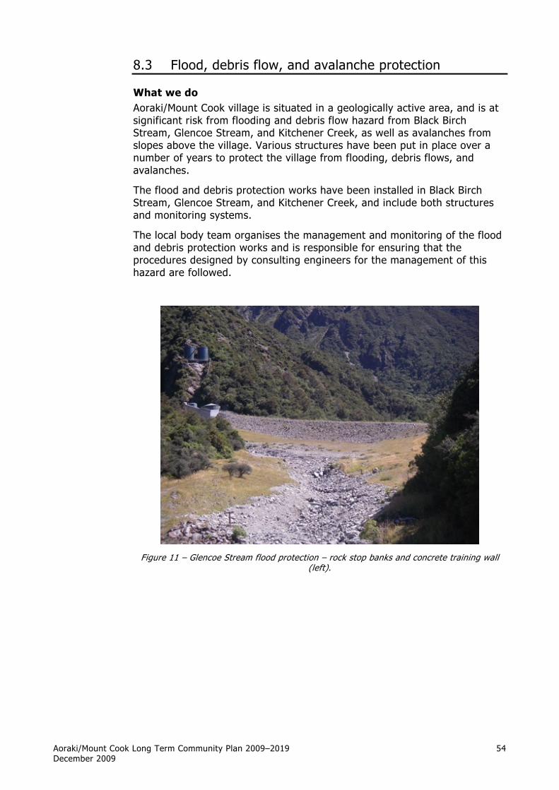
Aoraki/Mount Cook Long Term Community Plan 2009–2019 December 2009 54 8.3 Flood, debris flow, and avalanche protection What we do Aoraki/Mount Cook village is situated in a geologically active area, and is at significant risk from flooding and debris flow hazard from Black Birch Stream, Glencoe Stream, and Kitchener Creek, as well as avalanches from slopes above the village. Various structures have been put in place over a number of years to protect the village from flooding, debris flows, and avalanches. The flood and debris protection works have been installed in Black Birch Stream, Glencoe Stream, and Kitchener Creek, and include both structures and monitoring systems. The local body team organises the management and monitoring of the flood and debris protection works and is responsible for ensuring that the procedures designed by consulting engineers for the management of this hazard are followed. Figure 11 – Glencoe Stream flood protection – rock stop banks and concrete training wall (left).

Welcome message from author
This document is posted to help you gain knowledge. Please leave a comment to let me know what you think about it! Share it to your friends and learn new things together.
Transcript
Aoraki/Mount Cook Long Term Community Plan 2009–2019 December 2009
54
8.3 Flood, debris flow, and avalanche protection
What we do Aoraki/Mount Cook village is situated in a geologically active area, and is at significant risk from flooding and debris flow hazard from Black Birch Stream, Glencoe Stream, and Kitchener Creek, as well as avalanches from slopes above the village. Various structures have been put in place over a number of years to protect the village from flooding, debris flows, and avalanches.
The flood and debris protection works have been installed in Black Birch Stream, Glencoe Stream, and Kitchener Creek, and include both structures and monitoring systems.
The local body team organises the management and monitoring of the flood and debris protection works and is responsible for ensuring that the procedures designed by consulting engineers for the management of this hazard are followed.
Figure 11 – Glencoe Stream flood protection – rock stop banks and concrete training wall
(left).

Aoraki/Mount Cook Long Term Community Plan 2009–2019 December 2009
55
Why we do it The department, as the land manager of the park on behalf of the Crown, has statutory obligations around managing natural hazards. The following section outlines the background and history behind the natural hazards and existing mitigation measures to protect the Aoraki/Mount Cook village.
Early history of the park Aoraki/Mount Cook National Park was established in 1953 with the first National Parks Act. Before this there had been a number of reserves under specific gazettal notices dating from the late 1800s. The current Hermitage site, eventually to evolve into Aoraki/Mount Cook village, was always an integral part of these processes and became a part of the park in 1953.
The first Hermitage was constructed in 1884 at White Horse Hill and was destroyed by flooding in 1914. In the same year the second Hermitage was opened on the present site, which is a terrace obviously picked to avoid the known flood hazard. Construction had commenced in 1911. This Hermitage was destroyed by fire in 1957. The third and current Hermitage was built on the same site, and was operational by May 1958. Up till this time the village comprised the Hermitage itself and ancillary buildings for staff accommodation.
During the 1950s and 1960s, there was additional building activity by the Department of Lands and Survey, i.e. housing for ranger staff and a Park Headquarters. There were also the beginnings of other resident concessionaire activities, i.e. ski planes and the airline. The 1970s saw the introduction of a resident guiding company, youth hostel, school, shop, and post office. Black Birch Fan was developed for staff accommodation, both houses and blocks of single units. In the mid-1970s, an additional wing (the Wakefield wing) was constructed at the Hermitage. A new youth hostel and public shelter were built in the mid-1980s.
Statutory requirements The National Parks Act 1980 introduced the concept of amenities areas. The village has been managed as an amenity area since then and was finally gazetted as such in 1999.
Through the 1960s and 70s, when development was occurring, the Crown was exempt from many local authority statutory requirements especially in regard to building permits. The only requirement was that the local authority be notified. Within the park the private sector was not exempt from these requirements.
Flood hazards identified The first major test was in 1985 when the Mackenzie District Council, in conjunction with the Waitaki Catchment Commission, declined a building permit to the Youth Hostel Association until additional river protection work in Black Birch Stream was completed. This additional stop bank was financed by the Crown, and benefited several agencies buildings on Black Birch Fan. The new youth hostel was completed in 1987.
The Building Act 1991 ended the Crown’s exemption from statutory building requirements.
A complex situation arose in 1995 when the Mount Cook Residents Association applied for a building consent from the Mackenzie District

Aoraki/Mount Cook Long Term Community Plan 2009–2019 December 2009
56
Council to construct a community hall on Black Birch Fan adjacent to the Mount Cook School. The Council declined to issue the consent except under Section 36/2 of the Building Act 1991 because of the perceived risk of flooding or debris flow from Black Birch Stream. In the case of such an event, under Section 36/2 all liability would fall on the landowner, which in this case was the Crown (being a national park).
The department had no intention of accepting liability. There had been major events in Black Birch Stream in December 1979 and January 1994. On both occasions the lower village residents were evacuated as the structural mitigation only just contained the water flow.
With the declining of the building consent for the community hall, there was an immediate focus on potential risk throughout the village. For the first time, Glencoe Stream was identified as a potential hazard to the Hermitage complex. Kitchener Creek, immediately north of the village, previously had potential to spill over towards the Hermitage (Figure 12 – the Boxing Day flood of 1957). The catchment also had a history of being a major avalanche path.
Village upgrading At the same time, the department had begun a major process of upgrading a very ‘tired’ village to again become a showpiece as a national park entrance and tourist destination. This process was originally driven by the then Minister of Conservation and the Aoraki Conservation Board. This was a consultative process involving the department, Mackenzie District Council, village stakeholders, non-resident concessionaires, Mount Cook Residents Association, Ngāi Tahu, the Royal New Zealand Forest and Bird Protection Society, and Federated Mountain Clubs. There was also a core steering group.
Hazard assessment The process outlined above was well and truly diverted while the implications of Mackenzie District Council refusing to issue building consents, except under Section 36/2 of the Building Act 1991, were dealt with. What followed in 1995 was the completion of a major report: ‘Natural Hazard Assessment for Mount Cook/Aoraki Village and Environs’ by MJ McSaveney, TRH Davies & JD Gough, published by the Institute of Geological & Nuclear Sciences Limited (a Crown Research Institute).
They came up with a number of recommendations, a main one being that they felt unqualified to report on the hazard potential of Glencoe Stream, and indicated that overseas expertise in the alpine environment should be obtained.
A Canadian consortium, EBA were contracted to provide a hazard assessment and concept plans specifically for the Glencoe catchment. Meanwhile Royds Consulting (later to become Montgomery Watson) produced Geotechnical Report No. 2, Mount Cook village, 1996. This was a supplementary study to the IGNS 1995 report, and its purpose was to carry out preliminary design, estimate quantities and costs, and assign priorities to the work elements. The priority was Black Birch Fan to resolve the issue of the Mackenzie District Council withholding a building consent for the community hall.

Aoraki/Mount Cook Long Term Community Plan 2009–2019 December 2009
57
EBA’s proposals included a training wall and major stop bank on the northern side of Glencoe Stream to protect the Hermitage complex, a stop bank on the southern side of Glencoe Stream to protect the village centre, and a stop bank below Bowen Bush to protect Glencoe Lodge. The proposed structural mitigation also meant major alterations, and re-routing of services such as water supply and electrical cables.
Montgomery Watson was used by the department to complete all the plans and specifications, obtain resource consents from Canterbury Regional Council, and run the tender process for the contract. Works Civil Construction (now Works Infrastructure) accepted the tender and commenced work on site in April 1999.
Following major consultation and negotiation, the project was funded by the owners of the Hermitage complex, the major village concessionaire. This involved a trade-off with the Crown, and a subsequent agreement to enable the Hermitage owners to progress with a major development proposal within a planning envelope.
The geotechnical work was completed in May 2000 at a cost of $2 million, including the costs of earlier reports and engineering consultancy. Contributions were made by stakeholders towards paying off the interest and principal costs of the loan for the geotechnical works with approximately $720,000 being paid off the principal of the loan.
The geotechnical works were purchased from the owners of the Hermitage by the Crown in 2007, and are now managed by the department. At the time of purchase, the residual value of the assets was $1.1 million. Since purchase by the Crown, the department has paid the full costs of the capital charge and depreciation on the assets in recognition of the past contributions made by village stakeholders.
Figure 13 shows the areas within the village that are designated as flood zones with the existing flood protection works. These are the floodways and pooling areas that are designed into the geotechnical flood protection works (shown in Figure 14).

Aor
aki/
Mou
nt C
ook
Long
Ter
m C
omm
unit
y Pl
an 2
009–
2019
Dec
embe
r 20
09
58
Fi
gure
12
– Ao
raki
/Mou
nt C
ook
villa
ge f
ollo
win
g th
e Bo
Day
195
7 flo
od
Aoraki/Mount Cook Long Term Community Plan 2009–2019 December 2009
59
Managing the impacts of the activity The main impacts of the protection works are from the building of dykes and disturbance of natural processes in river and stream beds.
The department holds resource consent from Environment Canterbury as follows:
CRC981164 To place and reconstruct dykes in Black Birch and Glencoe Streams; to remove a footbridge over Glencoe Stream; and to excavate sand, gravel, and other natural material from the beds of Black Birch Stream, Glencoe Stream, and Kitchener Creek, at or about map references H36:7634-1437, H36:7589-1514 and H36:7595-1548: expires 25 February 2033.
Conditions of the resource consent ensure that the activity is done in a sustainable manner. Impacts on village residents from noise of rock dredging and construction are managed by time limits on these activities, which are permitted between the hours of 7 am and 8 pm only.

Aor
aki/
Mou
nt C
ook
Long
Ter
m C
omm
unit
y Pl
an 2
009–
2019
Dec
embe
r 20
09
60
Fi
gure
13
– V
illag
e flo
od z
ones
, sho
win
g th
e de
sign
ed fl
ood
and
debr
is fl
ow r
oute
s an
d ru
noff/
pool
ing
area
s

Aor
aki/
Mou
nt C
ook
Long
Ter
m C
omm
unit
y Pl
an 2
009–
2019
Dec
embe
r 20
09
61
Fi
gure
14
– Fl
ood-
prot
ectio
n st
ruct
ures
Aor
aki/
Mou
nt C
ook
Long
Ter
m C
omm
unit
y Pl
an 2
009–
2019
Dec
embe
r 20
09
62
Leve
ls o
f se
rvic
e
The
depa
rtm
ent,
thr
ough
the
loca
l bod
y, w
ill m
anag
e th
e ri
sk o
f flo
odin
g an
d de
bris
flo
ws
to t
he s
ervi
ce s
tand
ards
out
lined
bel
ow.
The
curr
ent
leve
l of
serv
ice
(whi
ch is
the
inte
nded
leve
l of
serv
ice)
pro
vide
d by
the
ass
ets
rela
tes
to t
he c
urre
nt e
nvir
onm
ent.
The
Aor
aki/
Mou
nt C
ook
regi
on is
dy
nam
ic g
eom
orph
ical
ly,
and
chan
ges
in c
limat
e or
cat
chm
ent
cond
ition
s co
uld
chan
ge t
he le
vel o
f se
rvic
e pr
ovid
ed.
Fun
ctio
n
Leve
l o
f se
rvic
e P
erfo
rman
ce s
tan
dar
ds
Ho
w w
e w
ill
mea
sure
th
is
To p
reve
nt a
t le
ast
a 1:
200-
year
flo
od a
nd d
ebri
s-flo
w e
vent
in
the
Gle
ncoe
cat
chm
ent
from
ca
usin
g da
mag
e in
the
vill
age.
To p
reve
nt a
t le
ast
a 1:
100-
year
flo
od e
vent
and
a 1
:50
year
de
bris
-flo
w e
vent
in t
he B
lack
Bi
rch
catc
hmen
t fr
om c
ausi
ng
dam
age
in t
he v
illag
e.
Prot
ection
of
the
villa
ge f
rom
flo
od
and
debr
is-f
low
ev
ents
.
To p
reve
nt a
t le
ast
a 1:
100-
year
flo
od a
nd d
ebri
s-flo
w e
vent
in
the
Kitc
hene
r, H
erm
itage
Cre
ek
and/
or G
over
nors
Bus
h ca
tchm
ents
fro
m c
ausi
ng d
amag
e in
the
vill
age.
Mai
nten
ance
and
mon
itori
ng o
f ge
otec
hnic
al
prot
ectio
n w
orks
and
geo
logi
cal h
azar
ds w
ill b
e ca
rrie
d ou
t as
per
the
Sta
ndar
d O
pera
ting
Pr
oced
ure
for
Aor
aki/
Mou
nt C
ook
Vill
age
Floo
d an
d D
ebri
s Fl
ow P
rote
ctio
n W
orks
.
All
wat
erw
ay a
nd f
lood
way
man
agem
ent
will
be
in
acco
rdan
ce w
ith t
he r
ecom
men
dation
of
the
haza
rd
asse
ssm
ent
and
geot
echn
ical
rep
orts
.
Even
ts a
t th
ese
leve
ls d
o no
t ca
use
any
dam
age
in
the
villa
ge a
nd a
re
cont
aine
d by
Flo
od a
nd
Deb
ris
Flow
pro
tect
ion
wor
ks.
Not
e: E
vent
s la
rger
tha
n th
ese
leve
ls m
ay c
ause
da
mag
e de
spite
the
pr
otec
tion
wor
k.

Aor
aki/
Mou
nt C
ook
Long
Ter
m C
omm
unit
y Pl
an 2
009–
2019
Dec
embe
r 20
09
63
Fun
ctio
n
Leve
l o
f se
rvic
e P
erfo
rman
ce s
tan
dar
ds
Ho
w w
e w
ill
mea
sure
th
is
Prot
ection
of
the
villa
ge f
rom
av
alan
ches
.
To p
rovi
de p
rote
ctio
n fr
om
aval
anch
es f
rom
the
Kitc
hene
r an
d Bl
ack
Bir
ch a
vala
nche
pat
hs
for
aval
anch
es u
p to
1:3
00-y
ear
even
ts.
An
aval
anch
e m
onito
ring
and
ass
essm
ent
SOP
(alo
ng t
he li
nes
of t
he f
lood
-mon
itori
ng S
OP)
is
deve
lope
d by
1 J
une
2010
.
An
asse
ssm
ent
of t
he li
kely
eff
ective
ness
of
the
Kitc
hene
r pr
otec
tion
wor
ks is
to
occu
r by
1
Nov
embe
r 20
09 a
nd im
plem
enta
tion
of it
s re
com
men
datio
ns s
tart
ed b
y 1
June
201
0.
Mon
itori
ng a
nd r
ecor
ding
of
aval
anch
e ev
ents
in
thes
e tw
o pa
ths
for
all e
vent
s gr
eate
r th
an s
ize
thre
e w
ill o
ccur
.
Even
ts a
t th
ese
leve
ls
are
cont
aine
d by
ge
otec
hnic
al p
rote
ctio
n w
orks
and
do
not
caus
e an
y da
mag
e in
the
vi
llage
.
Aoraki/Mount Cook Long Term Community Plan 2009–2019 December 2009
64
Asset information
Summary Concrete training wall at Glencoe Stream to protect the Hermitage
and water tank and treatment infrastructure.
Concrete training wall behind the old Alpine Guides base, to protect the buildings on the true right of Glencoe Stream around the petrol pumps, old shop, and Alpine Guides base.
Rock stop banks and dykes in Glencoe Stream, Black Birch Stream, and Kitchener Creek to protect the village from flood, rock debris and avalanche flows.
Fuse-plug spillway and secondary rock protection dykes below the village to contain any spilled flows.
Description of assets Flood and debris protection works in the Black Birch stream comprise a primary stop bank following the Black Birch Stream, and secondary stop banks to the southeast of the lower village, and around the department’s workshop. Further stop banks around the oxidation ponds are designed to protect the ponds in the event of the primary stop bank being breached.
The primary stop bank at Black Birch Stream has a weak spot where it intersects the secondary stop bank. This is designed as a ‘fuse plug’ spillway where water will be diverted into the secondary channel if there is a risk that the primary stop bank could be breached.
Flood and debris protection works in the Glencoe Stream comprise of a concrete training wall (visible to the left of the water tanks in Figure 3), and rock wall dykes extending down each side of the stream way to the road bridge in Bowen Drive (visible in the foreground of Figure 3). There is a lower dyke on the true right of the stream below Bowens Bush which prevents water and debris flows from getting to the Hermitage Glencoe Wing. The Glencoe dyke system is designed to constrain flows to the stream bed until below Bowen’s Bush where the water is intended to flow out the waterway towards Lower Terrace Road and to pool on the lower areas around Lower Terrace Road and the Glencoe Access Road.
A concrete training wall was built in 1984 at Governors Bush, behind the old Alpine Guides base, to protect that building and the petrol pumps.
Rock protection dykes were built in Kitchener Creek in 1957 following the Boxing Day storm (shown in Figure 12), which caused flows to be diverted towards the Hermitage. These were described by MWH consultants when assessed in 2003 to be two to three `indistinct’ stop banks several hundred metres in length and parallel to the main stream channel.
Significant risks and issues An avalanche hazard exists on the Kitchener Fan. The existing stop bank has had several size 4 avalanche events overtop it in the last 30 years. Avalanche debris from size 5 avalanche events have potential to affect the Hermitage, Chalets, Visitor Centre, and Old Mountaineers’ Café/Bar.

Aoraki/Mount Cook Long Term Community Plan 2009–2019 December 2009
65
Hazard from avalanche also exists in the Black Birch catchment. It’s expected that the existing flood and debris protection works should contain avalanche flows from Black Birch Stream.
Future demand The village and protection works have been planned with designated flood pathways and floodwater and debris pooling areas. These must be retained for this purpose in a natural undeveloped state. Any significant change to the layout of the village could potentially require changes to the flood-protection works.
No such change to the village layout is planned or anticipated in the next 10 years.
What we’re planning to do We’re planning further investigation of the avalanche hazard from Kitchener Creek. This is described under Levels of Service.
If a major upgrade or repair of any of the protection works is required, the department will seek funding from government.
Maintenance and operating Maintenance and inspection requirements for the geotechnical protection works are set out by the Standard Operating System (SOP) for the scheme. This is written for the department by MWH New Zealand, and these requirements are carried out by local body staff and/or consulting geologists or engineers as specified by the SOP.
Every six months the system is checked for visible damage and the level of streambed debris build-up is checked. Every five years, the scheme should be inspected by engineers and geologists, and the procedures reviewed. A helicopter survey of the upper catchments, including an experienced engineering geologist, is required every five years to assess, film, and map the debris load which could potentially come down as a debris flow.
Other maintenance and operating is reactive, depending on storm or earthquake events. The six-month monitoring process must be completed within one week of a flood in excess of a five-year return period. A review of the scheme is also recommended following any significant flood, debris flow or earthquake in which overtopping or extensive damage occurs to any of the primary structures.
Build-up of debris in the beds of the Black Birch and Glencoe Streams is removed as required to maintain the capacity of the streambeds to contain additional debris and flood flows in a flood event.
How it will be funded The flood, debris flow, and avalanche protection expenditure for the village will be recovered by general recovery funding principles. The capital value (QV valuations) of the concessionaires and the departments’ properties will be used to determine the allocation of expenses recovered.
The allocation of these expenses to be recovered will be determined by the capital value of the properties as a percentage of the total capital value of the occupied properties in the village. The expenses to be recovered will be invoiced quarterly.

Aor
aki/
Mou
nt C
ook
Long
Ter
m C
omm
unit
y Pl
an 2
009–
2019
Dec
embe
r 20
09
66
Fin
anci
al s
tate
men
ts
Fore
cast
Fore
cast
Fore
cast
Fore
cast
Fore
cast
Fore
cast
Fore
cast
Fore
cast
Fore
cast
Fore
cast
2009
/10
2010
/11
2011
/12
2012
/13
2013
/14
2014
/15
2015
/16
2016
/17
2017
/18
2018
/19
$ 00
0s$
000s
$ 00
0s$
000s
$ 00
0s$
000s
$ 00
0s$
000s
$ 00
0s$
000s
FLO
OD
, DEB
RIS
FLO
W A
ND
AV
ALAN
CH
E P
RO
TEC
TIO
N
Expe
nditu
re
Pers
onne
l1
11
22
22
22
2O
verh
eads
89
99
99
1010
1010
Ope
ratin
g17
1818
1819
1920
2021
21D
epre
ciat
ion
11
11
11
11
11
Fina
nce
00
00
00
00
00
Tota
l Exp
endi
ture
$28
$29
$29
$30
$30
$31
$32
$33
$33
$34
FLO
OD
MO
NIT
OR
ING
ASS
ETS
SUM
MAR
Y
Year
Expe
cted
Cos
tAc
cum
.An
nual
NB
VC
apita
lised
Life
Valu
eD
epn
Dep
nJu
n-09
$ 00
0s$
000s
$ 00
0s$
000s
LB A
sset
s - D
epre
ciat
ion
Levi
ed81
361
45LB
Ass
ets
- Dep
reci
atio
n Pa
id b
y D
OC
2,96
117
530
2,76
2
Fore
cast
Fut
ure
Acqu
isiti
ons
Ref
er a
lso
to S
ectio
n 12
for "
Ass
umpt
ion
and
Not
es" t
o fin
anci
al in
form
atio
n
FLO
OD
, DEB
RIS
FLO
W A
ND
AVA
LAN
CH
E PR
OTE
CTI
ON
Aora
ki-M
t Coo
k Lo
cal B
ody
STAT
EMEN
T O
F FI
NAN
CIA
L PE
RFO
RM
ANC
E10
Yea
r Ann
ual F
orec
ast t
o Ju
ne 2
019

Aoraki/Mount Cook Long Term Community Plan 2009–2019 December 2009
67
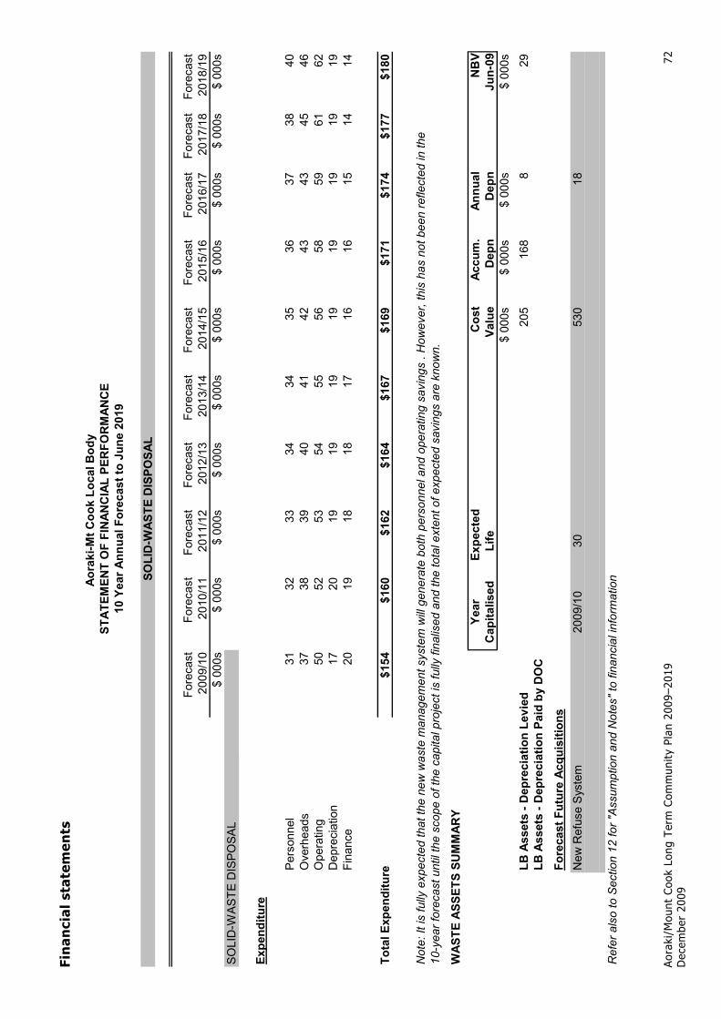
8.4 Solid-waste disposal
What we do The department provides a solid-waste removal service for the Aoraki/Mount Cook village. A significant upgrade of the solid-waste management system is planned for the 2009/10 financial year.
On completion of this project, the village will have a waste management system that will mesh with the region’s future waste management streams. It will maximise the economy of scale possible in the village and be flexible in its use of available transport providers, making significant cost savings. Once fully operational, the new system will reduce transport costs, manpower requirements, and waste handling. It will also provide a saving in carbon emissions by maximising waste tonnage per kilometre travelled. This system upgrade will be a significant improvement in resource recovery from the existing waste stream.
Figure 15 – Existing solid-waste truck and workshop facility

Aoraki/Mount Cook Long Term Community Plan 2009–2019 December 2009
68
Why we do it Due to the statutory requirements of the Conservation and National Parks Acts and the operational requirements of managing and doing business in a national park, the department is mandated to provide an environmentally sustainable solid-waste disposal and recycling recovery system.
Solid waste has the potential to cause significant pollution and visual impact in the Park. The isolation of Aoraki/Mount Cook means that transporting waste has potential to generate high carbon emissions. The present system also requires significant manpower to sort the waste which will be reduced by the new system.
The proposed solid-waste collection and removal system will ensure that it is dealt with appropriately and in a sustainable manner. The Mackenzie District Council has a target of achieving zero residual waste by 2014. The Aoraki/Mount Cook village solid-waste system will go a long way towards the village meeting this target by enabling all recyclable and compostable waste to be removed from the waste stream going to landfill.
Managing the impacts of the activity The largest impact of solid-waste removal is the level of transport required to move waste from the village to landfill or recycling facilities. Use of the proposed compactor system to compress waste, and ensuring that loads are full will reduce the amount of trips required for waste to landfill and the recycling plant. This will reduce carbon emissions.
The planned new system is current best practice for solid-waste disposal. There is potential to work together with other councils using this system to achieve efficiencies and cost savings for all involved. Neighbouring councils have been approached by the department and the Hermitage (as the largest concessionaire and contributor in the village) to see if they are interested in participating.
The contribution to the cost of the proposed solid-waste management service will be mandatory for all concessionaires in the village, to avoid impacts from the use of alternative systems. The proposed system is designed to mitigate and manage the effects of waste storage and transportation out of the village in the most environmentally friendly and cost-effective manner.
Allowing stakeholders to opt-out would undermine the integrity of the new system and increase the environmental footprint of solid-waste management in the village as a whole.

Aor
aki/
Mou
nt C
ook
Long
Ter
m C
omm
unit
y Pl
an 2
009–
2019
Dec
embe
r 20
09
69
Leve
ls o
f se
rvic
e
The
depa
rtm
ent
will
sup
ply
was
te d
ispo
sal a
nd r
emov
al t
o th
e se
rvic
e st
anda
rds
outli
ned
belo
w.
Fun
ctio
n
Leve
l o
f se
rvic
e P
erfo
rman
ce s
tan
dar
ds
Ho
w w
e w
ill
mea
sure
th
is
All
solid
was
te is
rem
oved
fro
m
the
villa
ge t
o th
e ap
prop
riat
e w
aste
str
eam
.
To p
rovi
de a
sol
id-w
aste
di
spos
al s
ervi
ce f
or t
he v
illag
e.
Was
te is
rem
oved
fro
m t
he
villa
ge t
o th
e ap
prop
riat
e w
aste
st
ream
.
Mon
itori
ng o
f w
aste
sys
tem
.
Ensu
re t
hat
was
te is
dir
ecte
d to
th
e co
rrec
t de
stin
atio
n.
Min
imis
atio
n of
sol
id w
aste
to
land
fill.
Enco
urag
e re
cycl
ing
and
reus
e,
and
was
te m
inim
isat
ion
at
sour
ce.
Am
ount
s of
sol
id w
aste
to
land
fill a
s a
prop
ortion
of
tota
l w
aste
red
uces
ove
r th
e 10
-yea
r pe
riod
.
Mon
itori
ng o
f si
ze a
nd
freq
uenc
y of
load
s to
land
fill.
Haz
ardo
us w
aste
. N
o fa
cilit
ies
will
be
prov
ided
for
th
e di
spos
al o
f so
lid w
aste
. N
ot a
pplic
able
. N
ot a
pplic
able
.
Rec
yclin
g an
d re
-use
. To
enc
oura
ge r
ecyc
ling
and
reus
e w
ithi
n th
e co
mm
unity
by
prov
idin
g a
way
for
the
co
mm
unity
to
recy
cle
and
reus
e.
Am
ount
s of
rec
ycla
ble
and
com
post
able
was
te a
s a
prop
ortion
of
tota
l was
te
incr
ease
s ov
er t
he 1
0 ye
ar
peri
od.
Mea
sure
men
t of
rec
yclin
g vo
lum
es.
Mon
itori
ng o
f w
aste
goi
ng in
to
the
land
fill t
o en
sure
tha
t do
es
not
incl
ude
recy
clab
le w
aste
.
Ille
gal d
umpi
ng.
To r
espo
nd t
o co
mpl
aint
s of
ill
egal
dum
ping
, an
d en
suri
ng
it’s
rem
oved
.
Ille
gally
dum
ped
was
te w
ithin
th
e vi
llage
is r
emov
ed w
ithin
on
e da
y.
Rep
orts
of
illeg
al d
umpi
ng w
ill
be k
ept.

Aoraki/Mount Cook Long Term Community Plan 2009–2019 December 2009
70
Asset information
Summary Current assets:
Park and village solid-waste bins.
Paper and cardboard press.
Roller doors and part of workshop buildings.
Rubbish truck (Ford N1017 9T).
Proposed assets (from 2009/10):
Park and village solid-waste bins.
4 x twist lock compactable solid-waste containers.
2 x 50-degree low-loading trip trailers.
1 x ̒Junior’ residual waste compactor plus electronic pressure control system.
1 x weighbridge.
Waste Transfer Station weatherproof building.
Putrescible collection vehicle (purchased from Aoraki Mount Cook Village Limited – the Hermitage).
6 glass mini-skips (purchased from the Hermitage).
Description of assets The existing local body assets for solid-waste disposal consist of a waste truck which is due for replacement, part of the workshop structure, a press for paper and cardboard, and bins for rubbish collection.
The truck, use of the workshop, and the existing paper press will no longer be required under the new system. The existing park and village bins will still be used.
The proposal will use a new purpose-built facility, located on Kitchener Drive (Figure 16), which will use a compactor-ram system to push waste into a purpose-built container, locked onto a tip trailer. Once the container reaches the maximum acceptable weight for road transport, it will be transported to the Redruth waste facility in Timaru by any available cartage contractor. The containers can take up to 38 cubic metres capacity or the maximum acceptable weight for road transport.
Recyclable waste (plastics, tin, and aluminium) will also be transported to Redruth by a similar system for automated sorting. Glass will be stored in existing mini-skips for transport out of the village as needed. Putrescible waste will be stored in mini-bins and transported to the Mackenzie District Council facility at Twizel using the Hermitage’s compactor vehicle. Transport is anticipated to be needed every two weeks for waste and every three weeks for recycling. The new system will require fewer trips to be made per cubic metre of solid waste.

Aoraki/Mount Cook Long Term Community Plan 2009–2019 December 2009
71
Figure 16 – The planned Resource Recovery Centre
Significant risks and issues No risks or issues have been identified at this time.
Future demand The system to be put in place in 2009/10 is expected to meet the foreseeable needs of the village for the term of this plan.
What we’re planning to do After the upgrade planned for 2009/10 is complete, no further significant investment is anticipated.
Maintenance and operating No significant maintenance is anticipated in the next three years, as most of the plant associated with solid waste will be almost new. Existing equipment will be maintained as required until the new waste system is in operation. Operational activities will ensure that the agreed levels of service are met.
How it will be funded The solid-waste disposal expenditure for the village will be recovered by user pays funding principles. The quantity of bins produced will be used to measure the usage by the concessionaires and the department’s properties in the village.
The allocation of these expenses to be recovered will be determined by the quantity of bins each quarter as a percentage of the total quantity of bins used by the village. The share of expenses to be recovered will be invoiced quarterly.
Aor
aki/
Mou
nt C
ook
Long
Ter
m C
omm
unit
y Pl
an 2
009–
2019
Dec
embe
r 20
09
72
Fin
anci
al s
tate
men
ts
Fore
cast
Fore
cast
Fore
cast
Fore
cast
Fore
cast
Fore
cast
Fore
cast
Fore
cast
Fore
cast
Fore
cast
2009
/10
2010
/11
2011
/12
2012
/13
2013
/14
2014
/15
2015
/16
2016
/17
2017
/18
2018
/19
$ 00
0s$
000s
$ 00
0s$
000s
$ 00
0s$
000s
$ 00
0s$
000s
$ 00
0s$
000s
SOLI
D-W
AST
E D
ISPO
SAL
Expe
nditu
re
Pers
onne
l31
3233
3434
3536
3738
40O
verh
eads
3738
3940
4142
4343
4546
Ope
ratin
g50
5253
5455
5658
5961
62D
epre
ciat
ion
1720
1919
1919
1919
1919
Fina
nce
2019
1818
1716
1615
1414
Tota
l Exp
endi
ture
$154
$160
$162
$164
$167
$169
$171
$174
$177
$180
Not
e: It
is fu
lly e
xpec
ted
that
the
new
was
te m
anag
emen
t sys
tem
will
gene
rate
bot
h pe
rson
nel a
nd o
pera
ting
savi
ngs
. How
ever
, thi
s ha
s no
t bee
n re
flect
ed in
the
10-y
ear f
orec
ast u
ntil
the
scop
e of
the
capi
tal p
roje
ct is
fully
fina
lised
and
the
tota
l ext
ent o
f exp
ecte
d sa
ving
s ar
e kn
own.
WAS
TE A
SSET
S SU
MM
ARY
Year
Expe
cted
Cos
tAc
cum
.An
nual
NB
VC
apita
lised
Life
Valu
eD
epn
Dep
nJu
n-09
$ 00
0s$
000s
$ 00
0s$
000s
LB A
sset
s - D
epre
ciat
ion
Levi
ed20
516
88
29LB
Ass
ets
- Dep
reci
atio
n Pa
id b
y D
OC
Fore
cast
Fut
ure
Acqu
isiti
ons
New
Ref
use
Syst
em20
09/1
030
530
18
Ref
er a
lso
to S
ectio
n 12
for "
Ass
umpt
ion
and
Not
es" t
o fin
anci
al in
form
atio
nSOLI
D-W
ASTE
DIS
POSA
L
Aora
ki-M
t Coo
k Lo
cal B
ody
STAT
EMEN
T O
F FI
NAN
CIA
L PE
RFO
RM
ANC
E10
Yea
r Ann
ual F
orec
ast t
o Ju
ne 2
019

Aoraki/Mount Cook Long Term Community Plan 2009–2019 December 2009
73
8.5 Roading
What we do Development in the village has created a set of roads to provide access for residents and the public to businesses within the village and to the residential area. Roads are designed to maximise the use of residential sites, meet the needs of emergency services, facilitate snow clearing, avoid build-up of ice or scouring where possible, remain usable during storms with a 1 in 10-year flooding frequency, blend into the natural landscape, and be adequately lit where necessary.
Roads comprise several elements: the surface (tar seal or gravel), the foundation that provides a solid base to the road, and water control (storm water drains and sumps). This activity also includes signage, storm water management, and traffic control/calming.
Who pays for what?
The department’s local body team manages and maintains all roads, footpaths, and street lighting in the Aoraki/Mount Cook village. Roading is funded through three different streams – department national park/visitor funding; department covering full costs of some local body roads; roads levied to stakeholders.
The department has decided that roads used by visitors to move around the village and to access the park will be managed as national park visitor assets.
Bowen Drive, Terrace Road, and Larch Grove Road (the ‘loop road’) are designated as national park rather than local body assets. Costs of the management of these roads are paid by the department as part of park management, and are not levied to stakeholders. Also, some minor local body roads, used primarily for the servicing of the water system, are not levied to stakeholders.
Figure 17 – Village loop road (Bowen Drive)

Aoraki/Mount Cook Long Term Community Plan 2009–2019 December 2009
74
Why we do it People need well-maintained roads to easily and safely get around the village. Roads are maintained to minimise hazards from the poor condition of road surfaces or unnecessary build-up of ice and snow in winter.
Hard surfaces such as roads need management of runoff in heavy rain. Sealed roads have storm water management in the form of kerb and channel, drains, and sumps.
Some roads within the village are used by both residents and visitors. In the past, all roads were managed and funded through the local body, but now funding of roads is split between local body and general department park management work.
Managing the impacts of the activity Environmental impacts of roading activity in the village are minimal. Any new road in the residential area or for access to any new commercial operation will need to have its effects assessed and mitigation measures will need to be put in place first. This will be managed as part of the concession application process.
Financial impacts of roading work will be minimised where possible by working with the New Zealand Transport Authority, and planning roading works in the village and around the park to combine projects. This will save considerable money for village stakeholders by sharing some of the fixed costs such as equipment relocation fees (estimated to be in the order of $20,000–30,000) with other works carried out by both the department and the New Zealand Transport Authority.
The department holds a resource consent from Environment Canterbury for the discharge of storm water from the car parking area around the Visitor Centre (consent CRC084612: expires 8 July 2043).
Related Documents


