1 Proiect Nr. 69 / 2012 “Implementation of a complex GIS for Ecosystem-based Management, through integrated monitoring and assessment of the biocoenosis status and its evolution trends in the fast changing environment at the Romanian coastal zone of the Black Sea” (“Implementarea unui Sistem Informatic Geografic pentru Managementul Ecosistemelor, prin integrarea, monitorizarea si evaluarea starii si tendintelor evolutive ale biocenozelor existente in mediul dinamic al zonei costiere romanesti”) Coordonator: Institutul National de Cercetare-Dezvoltare Marina “Grigore Antipa” Director de proiect: CS III Viorel Malciu [email protected] Cod Proiect: PN-II-PT-PCCA-2011-3.2-1427

Welcome message from author
This document is posted to help you gain knowledge. Please leave a comment to let me know what you think about it! Share it to your friends and learn new things together.
Transcript
1
Proiect Nr. 69 / 2012
“Implementation of a complex GIS for Ecosystem-based
Management, through integrated monitoring and assessment
of the biocoenosis status and its evolution trends in the fast
changing environment at the Romanian coastal zone of the
Black Sea”
(“Implementarea unui Sistem Informatic Geografic pentru
Managementul Ecosistemelor, prin integrarea, monitorizarea si
evaluarea starii si tendintelor evolutive ale biocenozelor
existente in mediul dinamic al zonei costiere romanesti”)
Coordonator: Institutul National de Cercetare-Dezvoltare Marina
“Grigore Antipa”
Director de proiect: CS III Viorel Malciu
Cod Proiect: PN-II-PT-PCCA-2011-3.2-1427

DATE INIŢIALE Parteneri în consorţiu:
- P1 – Siveco Romania
- P2 – UOC/Facultatea de stiintele naturii si Facultatea de Constructii
- P3 – UB/ Facultatea de Geografie
Adresa http://www.rmri.ro/WebPages/ECOMAGIS/index.html
www.rmri.ro
Buget: 2 964 284 lei
Perioada de desfasurare a proiectului: 2012 - 2016
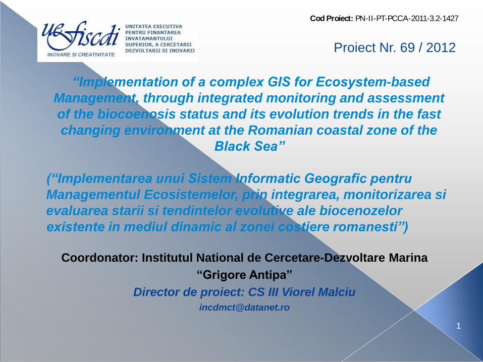
Elemente de noutate:
Implementarea tehnicilor de GIS/teledetectie in studiul proceselor specifice ZC/marine si costiere: se vor monitoriza la scari sinoptice procesele bio-geo-hidro-morfologice din imediata vecinatate a tarmului, sub dublul aspect, al interactiunii directe hidrologice si bio-geo-morfologice, dar si indirect, in ceea ce priveste impactul asupra activitatilor socio-economice aferente ZC, urmarindu-se un management eficient de risc, de la distanta, al ariilor vulnerabile/de interes economic, turistic/de pescuit/si de navigatie.
Punct de plecare in planificarea si gestiunea durabila a zonei marine/costiere pe baza unor tehnologii moderne, adaptate conditiilor particulare, sectoriale, ale tarmului romanesc al Marii Negre.
Beneficiarii rezultatelor si potentialul asociat, de aplicare in economie:
Autoritatile locale, Comitetul National al Zonei Costiere (CNZC) Ministerul Mediului si Padurilor (MMP), Ministerului Dezvoltării Regionale şi Turismului, Ministerul Transporturilor, Universitati/Institute de cercetare, Agentii de Protectia Mediului, Administratii/regii de stat: APC, ANR, ANAR/ABADL, DHM, NGOuri etc
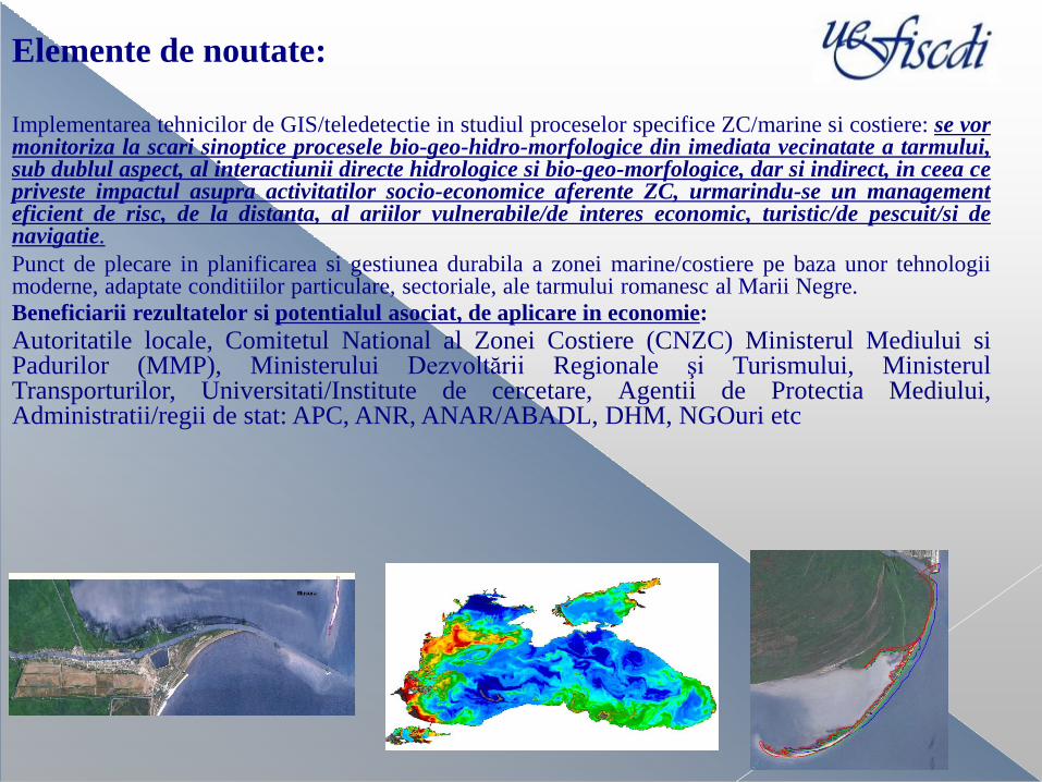
STADIUL DE REALIZARE AL PROIECTULUI IN 2012 (etape conform planului de realizare)
ETAPA DE EXECUTIE NR. 1/2012: ”Etapa I Studii de fundamentare asupra starii ecosystemelor marine si costiere din Bazinul NW al Marii Negre – constituirea bazei de date de referinta asupra ecosistemului marine si costier ”
Buget de stat: 81279lei
Achizitii realizate: •Atv, telemetru, echip. scufundare sezon rece
Activitate I.1 Evaluarea starii ecologice si a tendintelor de evolutie din cadrul ecosistemelor marine si costiere; Evaluarea calitatii/procesarea si analiza datelor si informatiilor disponibile Activitate I.2: Evaluarea proceselor/impactelor aferente zonelor vulnerabile; Caracterizarea cauzelor/regimului ecologic in zonele litorale turistice Activitatea I.3: Proiectarea conceptuala a sistemului informational de supraveghere/modelare, precum si a fluxului de date si informatii asociat bazei de date aferenta calitatii apelor/mediului marin si costier; Stabilirea metodelor tehnologice de dezvoltarea a sistemului informatic geografic suport
Clorofila a
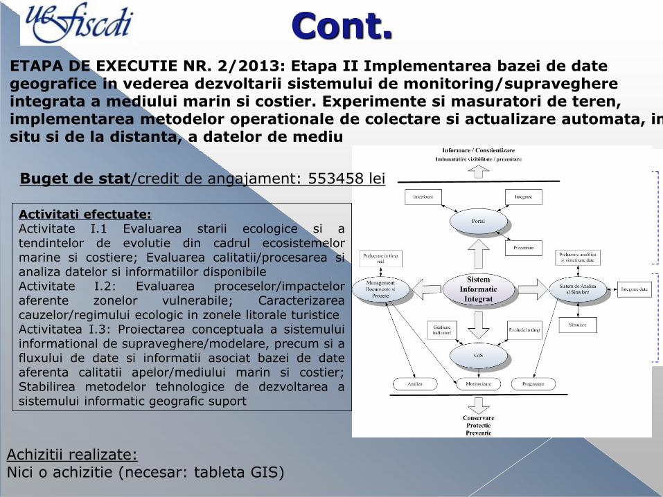
Cont. ETAPA DE EXECUTIE NR. 2/2013: Etapa II Implementarea bazei de date geografice in vederea dezvoltarii sistemului de monitoring/supraveghere integrata a mediului marin si costier. Experimente si masuratori de teren, implementarea metodelor operationale de colectare si actualizare automata, in situ si de la distanta, a datelor de mediu
Activitati efectuate: Activitate I.1 Evaluarea starii ecologice si a tendintelor de evolutie din cadrul ecosistemelor marine si costiere; Evaluarea calitatii/procesarea si analiza datelor si informatiilor disponibile Activitate I.2: Evaluarea proceselor/impactelor aferente zonelor vulnerabile; Caracterizarea cauzelor/regimului ecologic in zonele litorale turistice Activitatea I.3: Proiectarea conceptuala a sistemului informational de supraveghere/modelare, precum si a fluxului de date si informatii asociat bazei de date aferenta calitatii apelor/mediului marin si costier; Stabilirea metodelor tehnologice de dezvoltarea a sistemului informatic geografic suport
Achizitii realizate: Nici o achizitie (necesar: tableta GIS)
Buget de stat/credit de angajament: 553458 lei
Activitate in rerulare - Etapa 3/2014
Evaluarea vulnerabilitatii sistemului marin si costier romanesc si dezvoltarea demersurilor de
implementare a practicilor europene de gestiune integrata a zonei costiere/ICZM
Activitatatile proiectului vor fi conectate de activitatile RONOEDC (Romanian National
Oceanographic and Environmental Data Center) fiind un centru proiectat ca fiind conex cu
NODC in contextul sistemului international organaaaa
Astfel, prin legatura cu Centrul de competenta in domeniul teledetectiei Cosmomar, NODC si ii
va creste capacitatea operationala, asigurang atingerea Obiectivelor strategice ale acestuia în
conformitate cu principiile de IOC / IODE (http://www.iode.org):
• colectarea datelor si informatiilor oceanografice, arhivarea si furnizarea lor in vederea cresterii
eficientei utilizarii lor ;
• disponibilitate ridicata a datelor oceanografice de înaltă calitate pentru un grup mare de utilizatori;
• promovarea schimbului de date la nivel național / internațional.
RNODEC lucrează în strânsă colaborare cu alte departamente ale INCDM, în special cu
departamentul IT. Ocupandu-se cu diferite tipuri de date oceanografice personalului RNODEC
folosește expertiza stiintifica a expertilor din cadrul altor departamente ale INCDM.
Buget de stat: 515308 lei
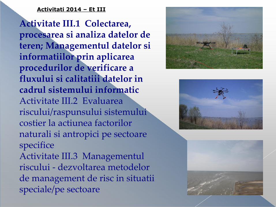
Activitate III.1 Colectarea, procesarea si analiza datelor de teren; Managementul datelor si informatiilor prin aplicarea procedurilor de verificare a fluxului si calitatiii datelor in cadrul sistemului informatic Activitate III.2 Evaluarea riscului/raspunsului sistemului costier la actiunea factorilor naturali si antropici pe sectoare specifice Activitate III.3 Managementul riscului - dezvoltarea metodelor de management de risc in situatii speciale/pe sectoare
Activitati 2014 – Et III
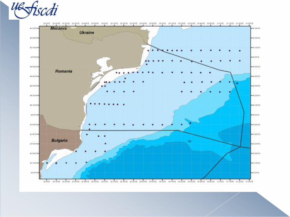
Rezultate: unitatea nordica de tarm: Delta Dunarii

Investigatii si masuratori la gurile Dunarii
04.04.14
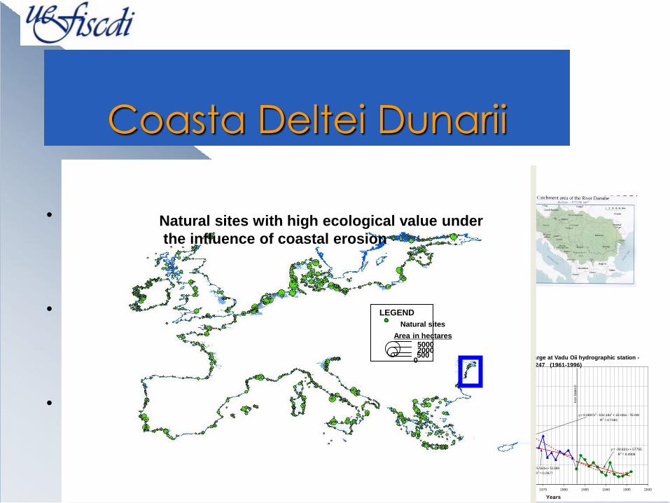
Coasta Deltei Dunarii
Main Causes of the Coastal Erosion :
• - the development of the hydrotehnical works on the main river courses, having as effect the decreasing of solid discharge of Danube river with more than 5070% (Bondar et al, 1992)
• - the extension of the navigation jetties and port breakwaters having as effect the deviation of coastal sediments drift through distancing/separation of their discharging point in the sea;
• - the sequential, superposed,
redundant development of
the hard coastal protection construction
Danube Sediment Discharge at Vadu Oii hydrographic station -
Km.247 (1961-1996)
y = 54.285x - 105108
R2 = 0.1492
y = -25.563x + 51386
R2 = 0.2977
y = -28.831x + 57755
R2 = 0.4908
y = 0.0897x3 - 532.18x
2 + 1E+06x - 7E+08
R2 = 0.7382
0
500
1000
1500
2000
2500
3000
1955 1960 1965 1970 1975 1980 1985 1990 1995 2000
Years
Se
dim
en
t D
isc
ha
rge
Rs
(K
g/s
)
Iro
n G
ate
s I
Iro
n G
ate
s II
Natural sites with high ecological value under
the influence of coastal erosion
Natural sites
0 500
5000 2000
Area in hectares
LEGEND
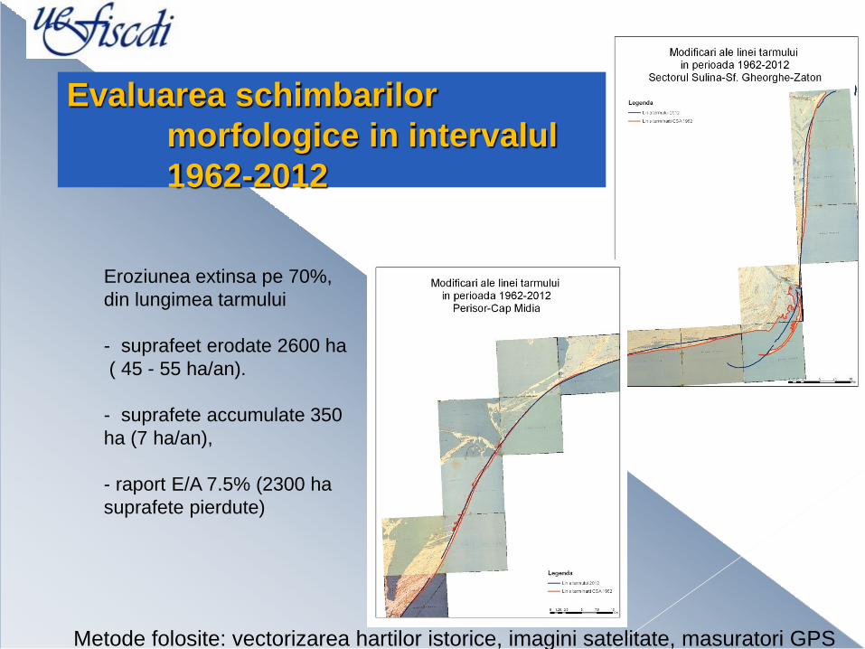
Evaluarea schimbarilor
morfologice in intervalul
1962-2012
Eroziunea extinsa pe 70%,
din lungimea tarmului
- suprafeet erodate 2600 ha
( 45 - 55 ha/an).
- suprafete accumulate 350
ha (7 ha/an),
- raport E/A 7.5% (2300 ha
suprafete pierdute)
Metode folosite: vectorizarea hartilor istorice, imagini satelitate, masuratori GPS

Cartarea liniei de tarm

Monitorizarea evenimentelor
ruperea Insulei Sahalin:
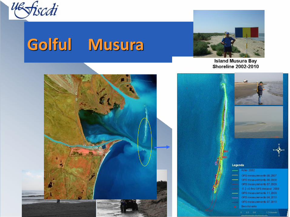
Golful Musura
04.04.14
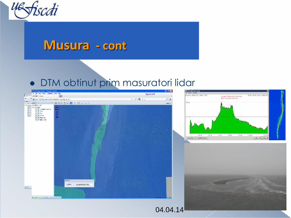
DTM obtinut prim masuratori lidar
Musura - cont

04.04.14
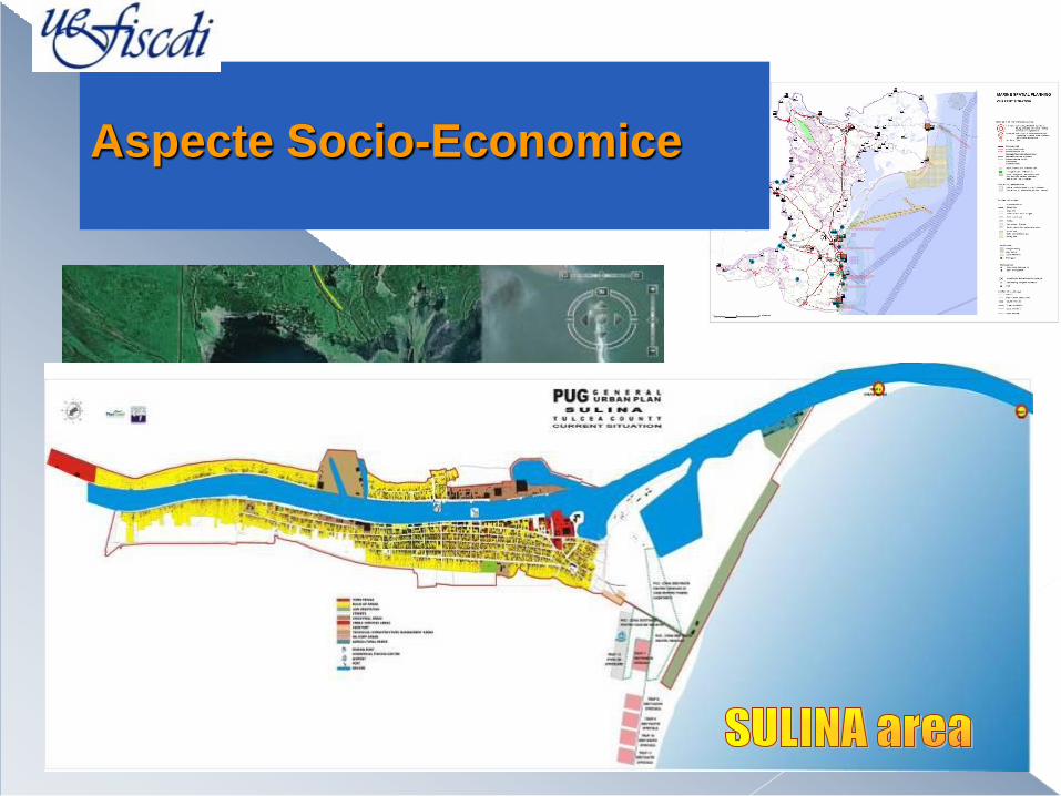
Aspecte Ecologice evaluate (zona Sulina/Musura )
Black Sea
Sulina Channel
Sulina
area
Aspecte Socio-Economice
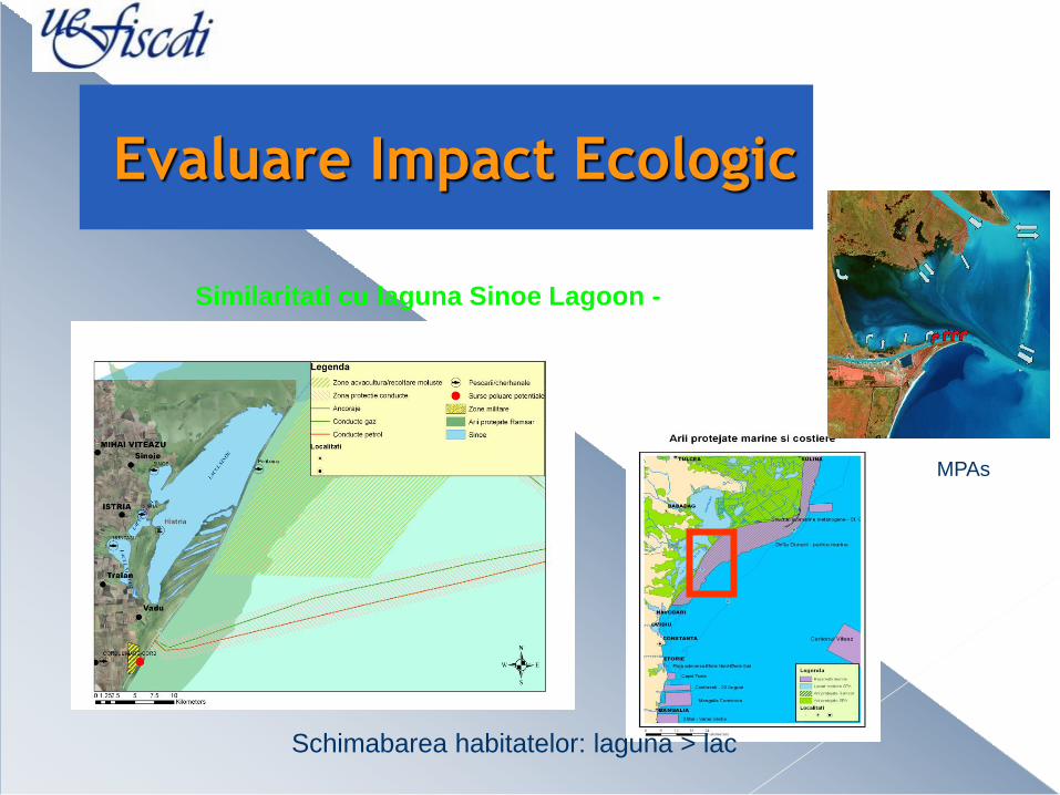
Evaluare Impact Ecologic
Peroada valului maxim si perioada valului semnificativ
(3/17/2006 - 5/27/2006), Tmax si T1/3
0
2
4
6
8
10
12
14
2006/3/4 2006/3/14 2006/3/24 2006/4/3 2006/4/13 2006/4/23 2006/5/3 2006/5/13 2006/5/23 2006/6/2
Inaltime valul
Val ul semni f i cat i vVal ul maxi m
MPAs
Similaritati cu laguna Sinoe Lagoon -
Schimabarea habitatelor: laguna > lac
04.04.14
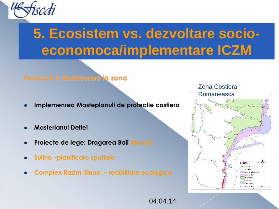
Proiecet in desfasurare in zona
Implemenrea Masteplanuli de protectie costiera
Masterlanul Deltei
Proiecte de lege: Dragarea Baii Musura
Sulina –planificare spatiala
Complex Razim-Sinoe – reabilitare ecologica
5. Ecosistem vs. dezvoltare socio-
economoca/implementare ICZM
Zona Costiera
Romaneasca
04.04.14
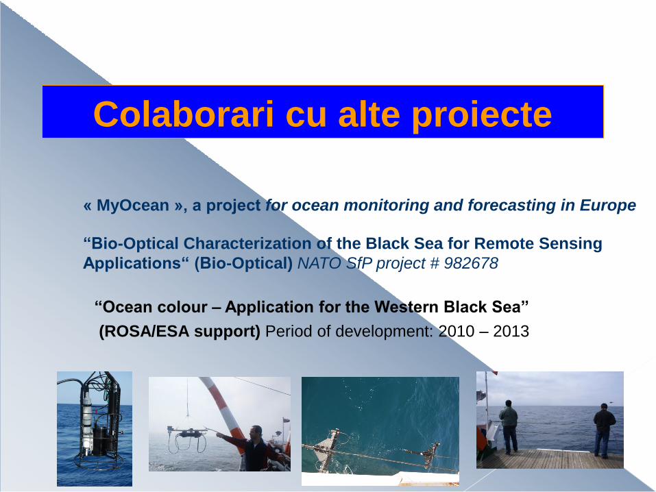
Colaborari cu alte proiecte
“Ocean colour – Application for the Western Black Sea”
(ROSA/ESA support) Period of development: 2010 – 2013
« MyOcean », a project for ocean monitoring and forecasting in Europe
“Bio-Optical Characterization of the Black Sea for Remote Sensing
Applications“ (Bio-Optical) NATO SfP project # 982678
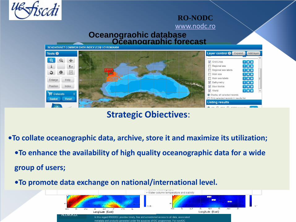
RO-NODC www.nodc.ro
Oceanographic forecast
Oceanograohic database
Strategic Obiectives:
•To collate oceanographic data, archive, store it and maximize its utilization;
•To enhance the availability of high quality oceanographic data for a wide
group of users;
•To promote data exchange on national/international level.

Distributii sezoniere ale parametrilor de calitate a apei
Clorofila: Chl_a

Distributii sezoniere ale parametrilor de calitate a apei
Materie anorganica in suspensie

Distributii sezoniere ale parametrilor de calitate a apei
Transparenta

Distributii sezoniere ale parametrilor de calitate a apei
Suspensiile totale: TSM

Participari la expeditii - Septembie 2012
EST Constanta 09.2012

04.04.14
Gloria AeroNet-OC site – Instalarea si operarea unui
radiometru oceanic

04.04.14
Gloria AeroNet-OC site
Site: Gloria
Location: Black Sea
Water type: Case-2 (sed. dom.)
Water depth: 50 m (height: 30 m)
Distance: ~20 nm
Period: 2010-present
Gloria
Platforma Gloria
SeaPRISM
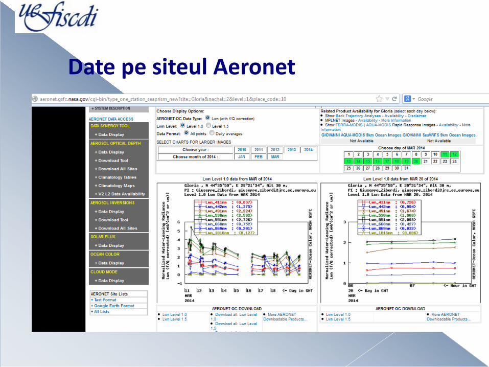
Date pe siteul Aeronet
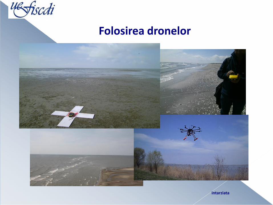
Folosirea dronelor
intarziata
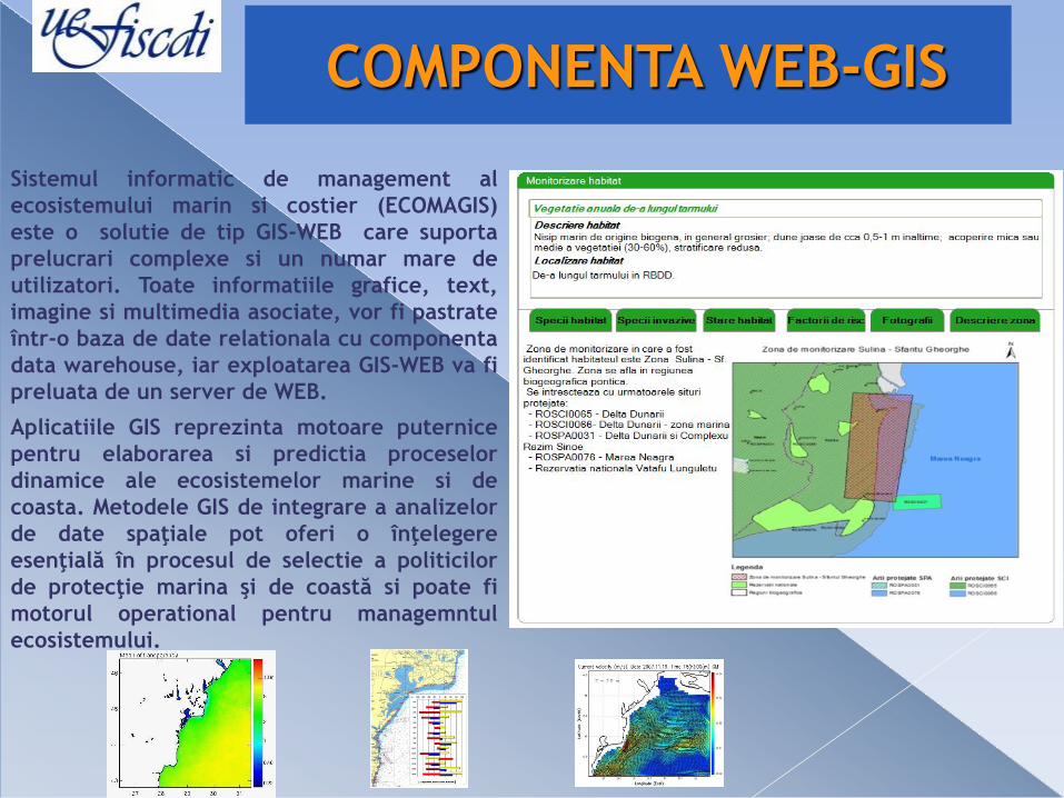
Sistemul informatic de management al
ecosistemului marin si costier (ECOMAGIS)
este o solutie de tip GIS-WEB care suporta
prelucrari complexe si un numar mare de
utilizatori. Toate informatiile grafice, text,
imagine si multimedia asociate, vor fi pastrate
într-o baza de date relationala cu componenta
data warehouse, iar exploatarea GIS-WEB va fi
preluata de un server de WEB.
Aplicatiile GIS reprezinta motoare puternice
pentru elaborarea si predictia proceselor
dinamice ale ecosistemelor marine si de
coasta. Metodele GIS de integrare a analizelor
de date spaţiale pot oferi o înţelegere
esenţială în procesul de selectie a politicilor
de protecţie marina şi de coastă si poate fi
motorul operational pentru managemntul
ecosistemului.
COMPONENTA WEB-GIS
Peroada valului maxim si perioada valului semnificativ
(3/17/2006 - 5/27/2006), Tmax si T1/3
0
2
4
6
8
10
12
14
2006/3/4 2006/3/14 2006/3/24 2006/4/3 2006/4/13 2006/4/23 2006/5/3 2006/5/13 2006/5/23 2006/6/2
Inaltime valul
Val ul semni f i cat i vVal ul maxi m
Peroada valului maxim si perioada valului semnificativ
(3/17/2006 - 5/27/2006), Tmax si T1/3
0
2
4
6
8
10
12
14
2006/3/4 2006/3/14 2006/3/24 2006/4/3 2006/4/13 2006/4/23 2006/5/3 2006/5/13 2006/5/23 2006/6/2
Inaltime valul
Val ul semni f i cat i vVal ul maxi m

Concluzii • Zona costiera romaneasca se confrunta cu probleme importante in implementarea
Directivelor Europene de mediu WFD/ICZM/MSPD.
• Implementarea legislatiei de mediu la nivel national are suportul proiectului Ecomagis prin intermediul institutiei in care ruleaza: INCDM
Rezultatele obtinute pana in perzent releva:
- Necesitaeta actiunilor de stopare a eroziunii la nivel regional, datorita impactului proceselor
costiere asupra ecosistemului/habitatelor costier
- Realizarea unui sistem de monitoring-modeling-management pentru controlul proceselor hidro-bio-geo-morfologice la coasta romaneasca
- Activitatile proiectului sunt desfasurate in directia implementarii unui astfel de sistem, implicand:
– colectarea de probe
– cartarea habitatelor
– Utilizarea mai buna a resurselor/produselor GIS&RS: suportul aplicatiilor web/WMS
– Diseminarea la diefrite manifestari reperzentative – ZC
– Colaborarile cu proiecte aferente ZC
Asimilarea tehnologiilor de investigare, procesare si furnizare a datelor si informatiilor aferente proceselor ecologice/geomorfologice costiere
04.04.14
Echipa proiectului multumeste
CNCS - UEFISCDI pentru evaluare corecta si finantarea proiectului :
PN-II-PT-PCCA-2011-3.2 1427
(ECOMAGIS/ nr. 69/2012)
Multumiri
Consortiul ECOMAGIS
Multumim pentru atentie!
Related Documents