Anticipated Climate Warming Effects on Bull Trout Habitats and Populations Across the Interior Columbia River Basin BRUCE E. RIEMAN 1 AND DANIEL ISAAK* U.S. Forest Service, Rocky Mountain Research Station, 322 East Front Street, Suite 401, Boise, Idaho 83702, USA SUSAN ADAMS U.S. Forest Service, Southern Research Station, 1000 Front Street, Oxford, Mississippi 38655, USA DONA HORAN,DAVID NAGEL, AND CHARLES LUCE U.S. Forest Service, Rocky Mountain Research Station, 322 East Front Street, Suite 401, Boise, Idaho 83702, USA DEBORAH MYERS 8870 Purple Sage Road, Middleton, Idaho 83644, USA Abstract.—A warming climate could profoundly affect the distribution and abundance of many fishes. Bull trout Salvelinus confluentus may be especially vulnerable to climate change given that spawning and early rearing are constrained by cold water temperatures creating a patchwork of natal headwater habitats across river networks. Because the size and connectivity of patches also appear to influence the persistence of local populations, climate warming could lead to increasing fragmentation of remaining habitats and accelerated decline of this species. We modeled the relationships between (1) the lower elevation limits of small bull trout and mean annual air temperature and (2) latitude and longitude across the species’ potential range within the interior Columbia River basin of the USA. We used our results to explore the implications of the climate warming expected in the next 50 or more years. We found a strong association between the lower elevation limits of bull trout distributions and longitude and latitude; this association was consistent with the patterns in mean annual air temperature. We concluded that climate does strongly influence regional and local bull trout distributions, and we estimated bull trout habitat response to a range of predicted climate warming effects. Warming over the range predicted could result in losses of 18–92% of thermally suitable natal habitat area and 27–99% of large (.10,000-ha) habitat patches, which suggests that population impacts may be disproportionate to the simple loss of habitat area. The predicted changes were not uniform across the species’ range, and some populations appear to face higher risks than others. These results could provide a foundation for regional prioritization in conservation management, although more detailed models are needed to prioritize actions at local scales. Distribution shifts in many species (Parmesan and Yohe 2003; Root et al. 2003) and environmental trends consistent with broad-scale warming (Mote et al. 2005a; Stewart et al. 2005; Westerling et al. 2006; Hamlet and Lettenmaier 2007) show that climate change is no longer an abstraction. Official statistics compiled by the Intergovernmental Panel on Climate Change (IPCC) suggest these trends were associated with a 0.68C warming during the 20th century (IPCC 2007). Predictions of future global climates suggest larger and faster changes, and current models project a minimum warming of 18C in mean annual or seasonal air temperatures over the next 50 years and possibly a 68C increase in 100 years (Boer et al. 1992; Kerr 1997; IPCC 2007). Similar scenarios hold for predictions downscaled to the Columbia River basin, where models project warming of 1–2.58C or more by 2050 (Leung et al. 2004; Mote et al. 2005b). A warming climate can have important effects on the regional distribution and local extent of habitats available to salmonids (Meisner 1990; Keleher and Rahel 1996; Nakano et al. 1996; Rahel et al. 1996) and other fishes (Shuter and Meisner 1992; Eaton and Scheller 1996) because local climates influence surface water (Stephan and Preud’homme 1993; Stoneman and Jones 1996; Mohseni and Stefan 1999) and ground- water temperatures (Meisner 1990; Shuter and Meisner 1992). For coldwater fishes near the southern margins * Corresponding author: [email protected] 1 Present address: Post Office Box 1541, Seeley Lake, Montana 59868, USA. Received February 8, 2007; accepted July 19, 2007 Published online November 5, 2007 1552 Transactions of the American Fisheries Society 136:1552–1565, 2007 Ó Copyright by the American Fisheries Society 2007 DOI: 10.1577/T07-028.1 [Article]

Welcome message from author
This document is posted to help you gain knowledge. Please leave a comment to let me know what you think about it! Share it to your friends and learn new things together.
Transcript

Anticipated Climate Warming Effects on Bull Trout Habitats andPopulations Across the Interior Columbia River Basin
BRUCE E. RIEMAN1
AND DANIEL ISAAK*U.S. Forest Service, Rocky Mountain Research Station,
322 East Front Street, Suite 401, Boise, Idaho 83702, USA
SUSAN ADAMS
U.S. Forest Service, Southern Research Station, 1000 Front Street, Oxford, Mississippi 38655, USA
DONA HORAN, DAVID NAGEL, AND CHARLES LUCE
U.S. Forest Service, Rocky Mountain Research Station,322 East Front Street, Suite 401, Boise, Idaho 83702, USA
DEBORAH MYERS
8870 Purple Sage Road, Middleton, Idaho 83644, USA
Abstract.—A warming climate could profoundly affect the distribution and abundance of many fishes. Bull
trout Salvelinus confluentus may be especially vulnerable to climate change given that spawning and early
rearing are constrained by cold water temperatures creating a patchwork of natal headwater habitats across
river networks. Because the size and connectivity of patches also appear to influence the persistence of local
populations, climate warming could lead to increasing fragmentation of remaining habitats and accelerated
decline of this species. We modeled the relationships between (1) the lower elevation limits of small bull trout
and mean annual air temperature and (2) latitude and longitude across the species’ potential range within the
interior Columbia River basin of the USA. We used our results to explore the implications of the climate
warming expected in the next 50 or more years. We found a strong association between the lower elevation
limits of bull trout distributions and longitude and latitude; this association was consistent with the patterns in
mean annual air temperature. We concluded that climate does strongly influence regional and local bull trout
distributions, and we estimated bull trout habitat response to a range of predicted climate warming effects.
Warming over the range predicted could result in losses of 18–92% of thermally suitable natal habitat area and
27–99% of large (.10,000-ha) habitat patches, which suggests that population impacts may be
disproportionate to the simple loss of habitat area. The predicted changes were not uniform across the
species’ range, and some populations appear to face higher risks than others. These results could provide a
foundation for regional prioritization in conservation management, although more detailed models are needed
to prioritize actions at local scales.
Distribution shifts in many species (Parmesan and
Yohe 2003; Root et al. 2003) and environmental trends
consistent with broad-scale warming (Mote et al.
2005a; Stewart et al. 2005; Westerling et al. 2006;
Hamlet and Lettenmaier 2007) show that climate
change is no longer an abstraction. Official statistics
compiled by the Intergovernmental Panel on Climate
Change (IPCC) suggest these trends were associated
with a 0.68C warming during the 20th century (IPCC
2007). Predictions of future global climates suggest
larger and faster changes, and current models project a
minimum warming of 18C in mean annual or seasonal
air temperatures over the next 50 years and possibly a
68C increase in 100 years (Boer et al. 1992; Kerr 1997;
IPCC 2007). Similar scenarios hold for predictions
downscaled to the Columbia River basin, where
models project warming of 1–2.58C or more by 2050
(Leung et al. 2004; Mote et al. 2005b).
A warming climate can have important effects on the
regional distribution and local extent of habitats
available to salmonids (Meisner 1990; Keleher and
Rahel 1996; Nakano et al. 1996; Rahel et al. 1996) and
other fishes (Shuter and Meisner 1992; Eaton and
Scheller 1996) because local climates influence surface
water (Stephan and Preud’homme 1993; Stoneman and
Jones 1996; Mohseni and Stefan 1999) and ground-
water temperatures (Meisner 1990; Shuter and Meisner
1992). For coldwater fishes near the southern margins
* Corresponding author: [email protected] Present address: Post Office Box 1541, Seeley Lake,
Montana 59868, USA.
Received February 8, 2007; accepted July 19, 2007Published online November 5, 2007
1552
Transactions of the American Fisheries Society 136:1552–1565, 2007� Copyright by the American Fisheries Society 2007DOI: 10.1577/T07-028.1
[Article]
of their range and areas with substantial elevational
relief (and thus gradients in local climate), warming
could restrict distributions to smaller and more isolated
fragments of suitable habitat (Flebbe 1993; Nakano et
al. 1996; Rahel et al. 1996). Several studies have
evaluated the potential effects of climate warming on
salmonids over broad geographic regions (.105 km2;
Meisner 1990; Eaton and Scheller 1996; Keleher and
Rahel 1996; Nakano et al. 1996; Flebbe et al. 2006;
Hari et al. 2006). However, only Flebbe et al. (2006)
considered both habitat area lost and habitat fragmen-
tation at this scale, and their analysis did not resolve
fragmentation at the level of individual stream
networks or local populations.
Bull trout Salvelinus confluentus within the Colum-
bia and Klamath River basins of the USA are a
relatively recent and controversial addition to the list of
species protected under the Endangered Species Act.
Bull trout remain widely distributed throughout their
potential range, but local extinctions, population
declines, and habitat loss are apparent (Rieman et al.
1997). Precise estimation of actual losses is restricted
by lack of distribution data on pre–Euro-American
influence as well as of broad-scale models of suitable
habitat (Rieman et al. 1997).
The optimal temperatures for bull trout appear to be
substantially lower than those for other salmonids
(Selong et al. 2001). Within-stream distributions of
juvenile bull trout have been strongly associated with
elevation and temperature (Dunham and Rieman 1999;
Paul and Post 2001; Dunham et al. 2003). Although
bull trout may move extensively and subadult or adult
individuals have been observed throughout larger river
basins (Rieman et al. 1997; Swanberg 1997; Muhlfeld
and Marotz 2005), juveniles and resident individuals
typically live in natal or associated tributary habitats for
several years (Pratt 1992; Rieman and McIntyre 1995;
Downs et al. 2006). The observed patterns lead us to
conclude that spawning and initial rearing areas are
constrained by temperature and define the spatial
structuring of local populations or habitat ‘‘patches’’
across larger river basins (Rieman and McIntyre 1995;
Dunham et al. 2002). Habitat patches in this sense
represent networks of thermally suitable habitat that
may lie in adjacent watersheds and are disconnected (or
fragmented) by intervening stream segments of sea-
sonally unsuitable habitat or by actual physical barriers.
Changes in habitat patch size and distribution are
expected to have important effects on the persistence
and dynamics of many species through the combined
effects on population size, connectivity, and dispersal
opportunities (Hanski and Simberloff 1997; Isaak et al.
2007). Rieman and McIntyre (1995) and Dunham and
Rieman (1999) found that occurrence of bull trout
populations was strongly associated with size and
isolation of habitat patches (as defined here). Similar
results have been observed for other chars (Morita and
Yamamoto 2002; Koizumi and Maekawa 2004), and
Isaak et al. (2007) showed that the size and isolation of
spawning patches may be even more important than
local habitat quality for the persistence of Chinook
salmon Oncorhynchus tshawytscha. Warming associ-
ated with climate change would presumably lead to
smaller and more isolated habitat patches for bull trout.
It also could lead to loss of populations (i.e., local
extinctions) that is disproportionate or accelerated
relative to the simple loss of watershed area. Addi-
tionally, because bull trout are distributed across a
broad range of environments and landforms of varied
relief, the effects of climate change may be more
pronounced in some regions than others.
In this paper we summarize the available informa-
tion on bull trout distributions in individual streams and
on mean annual air temperatures across the interior
Columbia River basin within the USA (hereafter
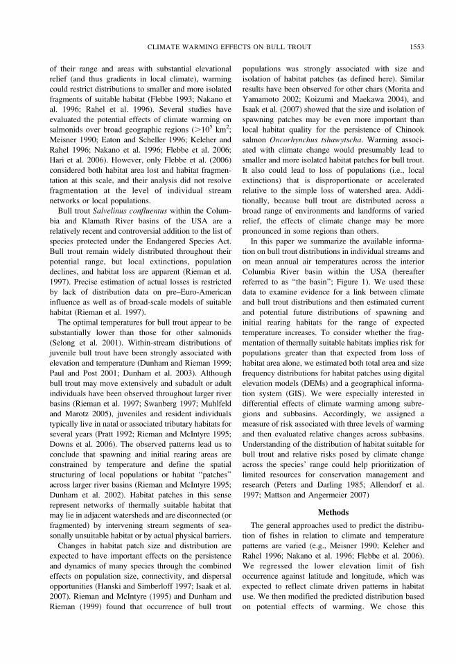
referred to as ‘‘the basin’’; Figure 1). We used these
data to examine evidence for a link between climate
and bull trout distributions and then estimated current
and potential future distributions of spawning and
initial rearing habitats for the range of expected
temperature increases. To consider whether the frag-
mentation of thermally suitable habitats implies risk for
populations greater than that expected from loss of
habitat area alone, we estimated both total area and size
frequency distributions for habitat patches using digital
elevation models (DEMs) and a geographical informa-
tion system (GIS). We were especially interested in
differential effects of climate warming among subre-
gions and subbasins. Accordingly, we assigned a
measure of risk associated with three levels of warming
and then evaluated relative changes across subbasins.
Understanding of the distribution of habitat suitable for
bull trout and relative risks posed by climate change
across the species’ range could help prioritization of
limited resources for conservation management and
research (Peters and Darling 1985; Allendorf et al.
1997; Mattson and Angermeier 2007)
Methods
The general approaches used to predict the distribu-
tion of fishes in relation to climate and temperature
patterns are varied (e.g., Meisner 1990; Keleher and
Rahel 1996; Nakano et al. 1996; Flebbe et al. 2006).
We regressed the lower elevation limit of fish
occurrence against latitude and longitude, which was
expected to reflect climate driven patterns in habitat
use. We then modified the predicted distribution based
on potential effects of warming. We chose this
CLIMATE WARMING EFFECTS ON BULL TROUT 1553
approach rather than directly modeling stream temper-
ature and a presumed critical thermal limit because
extensive data on fish distributions were available and
we did not have the stream-scale environmental detail
necessary to estimate stream temperatures directly. The
influence of climate also could vary across the species’
range because of interaction with other aspects of the
environment (Rieman et al. 2006), and our approach
allowed quantification of uncertainty in the estimates
associated with these effects.
Our approach can be outlined in five general steps:
(1) we summarized site-level observations of small bull
trout (,150 mm) to identify the lower elevation limits
of natal habitats across the basin; (2) we summarized
the mean annual air temperatures for weather stations
across the same area; (3) we regressed each set of
observations against longitude and latitude (and
elevation in the case of temperature) and compared
the coefficients in the two regression models to assess
whether climate could explain bull trout distributions;
(4) we used a GIS to map the area and size distributions
of thermally suitable habitat patches based on the
predicted distribution limits; and (5) we used the GIS to
explore changes in the distributions, area, and number
of suitable habitat patches by elevating lower distribu-
tion limits by three levels of warming that bounded the
range of recent predictions. We constrained our
analysis to the potential range of bull trout in the
basin, following Rieman et al. (1997). We considered
suitable patches to be the area of a watershed above the
predicted lower distribution limit of small bull trout
because these individuals are strongly associated with
natal habitat and a clear thermal gradient (Dunham and
Rieman 1999; Dunham et al. 2003). The details of each
step follow below.
Bull trout distribution.—We summarized observa-
tions of the occurrence of bull trout and brook trout
Salvelinus fontinalis (an invading species that may
displace bull trout) within streams sampled at multiple
sites along an elevation gradient throughout the basin
FIGURE 1.—Map of the interior Columbia River basin, showing the subregions (numbered and named after the dominant river)
used for predicting bull trout habitat under current and future climates. The locations of air temperature stations (times signs) and
of observations of lower elevation limits (circles) are also shown.
1554 RIEMAN ET AL.
(Figure 1). We obtained these observations directly
from biologists responsible for fish inventory or
monitoring and from published or archived data sets
with clearly defined and controlled sampling methods
(Platts 1974, 1979; Mauser 1986; Hoelscher and
Bjornn 1988; Mauser et al. 1988; Clancy 1993; Adams
1994; Dambacher and Jones 1997; Dunham et al.
2003). We screened only those streams that contained
bull trout smaller than 150 mm fork length (with the
exception of one data set in which the closest recorded
size break was 170 mm), streams with at least five
sample sites distributed across 500 m of elevation, and
sites represented by at least 45 m of sampled stream.
For one data set we combined into single sites groups
of three 15-m-long sites that were within 60 m of
elevation of each other. Elevations were recorded for
the midpoint of sites from 1:24,000 scale U.S.
Geological Survey (USGS) topographic maps.
From the initial screening we selected for analysis
only those streams in which there were at least two
sites without small bull trout below the site with the
lowest bull trout observation and at least two sites with
small bull trout above that site. We restricted our
sample rather than using the larger set of all lowest
observations (i.e., bounded or not) because the
appropriate model for the latter would require bound-
ary or quantile regression (e.g., Flebbe et al. 2006),
essentially forcing the model through the extreme
observations. We believe the lower bounds of bull trout
distributions among streams vary in response to
temperature and its interaction with other environmen-
tal conditions, such as the presence of brook trout
(Rieman et al. 2006). We assumed that changes in
temperature associated with climate could displace
other effects (e.g., brook trout would move up in
elevation as well) or that similar effects at higher
elevation would contribute to similar variability in the
lower bound. As a result, regression through the
extreme observations would produce an overly opti-
mistic average (i.e., fish at lower elevations) of bull
trout habitat use.
Mean annual air temperature.—We used ‘‘30-year
normals’’ (i.e., averages of the mean annual air
temperature for a 30-year period) from the period
1961 to 1990 to examine the regional spatial pattern in
climate. We obtained records for 191 permanent
weather stations distributed throughout the basin
(Figure 1) from the 1993, 1994, or 1996 NOAA
climatological data summaries for each state (e.g.,
NOAA 1993). We then determined 30-year normals by
taking the mean annual air temperature at a station in a
given year and substracting the ‘‘departure from
normal’’ reported for that year and station. We used
the normals for 1961–1990 to derive estimates
appropriate for the period of bull trout sampling and
to encompass any decadal variation in climate that
might obscure regional patterns observed over shorter
periods. All but three of our bull trout distribution
observations were from data gathered between 1972
and 1996. The last three observations were from 1999
to 2001. Although we recognized that warming
probably occurred over this time (e.g., Hari et al.
2006), we assumed that it had not substantively altered
regional patterns and a general association of air
temperature with elevation required by our analysis.
We chose mean annual air temperature as the
simplest measure of climate and its potential effects
on the species’ distribution. We used the annual mean
rather than summer mean because we were uncertain
what characteristics of a temperature regime actually
influence bull trout. Moreover, groundwater tempera-
ture is generally correlated with mean annual air
temperature (Meisner 1990; Flebbe 1993; Nakano et al.
1996), has been strongly associated with the distribu-
tions of other chars (Meisner 1990; Flebbe 1993;
Nakano et al. 1996), and has been shown to influence
the survival of embryos and early juvenile growth of
bull trout (McPhail and Murray 1979; Baxter 1997).
Air temperatures are correlated with stream surface
water temperatures (Rahel et al. 1996; BER unpub-
lished data), which have been associated with juvenile
bull trout distributions (Dunham et al. 2003) as well.
Regression models.—We used multiple linear re-
gression to model the lower elevation limit of bull trout
as a function of latitude and longitude (both in decimal
degrees). Because brook trout may displace bull trout
to higher elevations (Rieman et al. 2006), the presence
or absence of brook trout also was evaluated as a
categorical predictor. Although first-order interactions
were assessed, they were not significant and were
excluded from further consideration. Regression pa-
rameters were estimated using standard techniques that
assumed spatial independence among residuals and
were compared with estimates derived from spatial
autoregressive techniques (Cressie 1993). Unbiased
parameter estimates were obtained using restricted
maximum likelihood procedures in the MIXED
procedure in SAS (Littell et al. 1996). If residual
errors were spatially correlated, the autoregressive
models would provide the most accurate parameter
estimates (Cressie 1993). Comparisons between aspa-
tial and spatial models were made using likelihood
ratio tests (Littell et al. 1996).
Diagnostic tests of regression residuals suggested no
need for data transformations. Standardized residuals
indicated four outlying observations (.2 SD), which
were examined, found to be valid, and retained in the
analysis. Cook’s distance and DFFIT statistics indicat-
CLIMATE WARMING EFFECTS ON BULL TROUT 1555

ed these observations did not strongly affect parameter
estimates. Variance inflation factors less than 3
suggested that correlations among predictors did not
artificially inflate standard error estimates.
Regression models for mean annual air temperature
were developed using the same approach as for bull
trout distribution limits. Mean annual air temperature
was regressed against elevation, latitude, longitude, and
first-order interactions. Residuals were normally distrib-
uted but were slightly heteroscedastic. A log transfor-
mation of air temperatures exacerbated the problem, so
we proceeded with untransformed data. Standardized
residuals indicated six outliers, but no observation
strongly affected parameter estimates. Variance inflation
factors indicated no problems with multicollinearity.
Geographical information system analysis.—We
used a raster-based DEM along with rasterized latitude
and longitude coordinates and our regression models to
map potential bull trout habitat across the basin. The
DEM data were originally referenced to the geographic
coordinate system with a cell size of 3 arc seconds and
were transformed to the Albers equal-area coordinate
system with a spatial resolution of 90 m. Latitude and
longitude coordinates were assigned to each cell in the
raster with the same approximate spatial resolution and
then input into the bull trout regression equation, along
with the DEM data, to characterize each cell as at,
above, or below the lower limit of predicted habitat.
We converted the raster data to vector format so that
cells at the predicted lower limits were delineated by an
isopleth. The lower limit was then adjusted upward to
create isopleths reflecting an upward shift in elevation
with anticipated warming (see below).
We derived stream lines for the basin from the DEM
using TauDEM software (Tarboton 1997). We clipped
the DEM into 78 USGS fourth-level hydrologic unit
codes (HUCs) or subbasins to reduce the data volume
of the resultant GIS stream layers. TauDEM was run
for every individual HUC to derive stream lines. We
used these synthetic stream lines in the analysis
because they are spatially coregistered to the DEM
and because TauDEM generates a contributing area
attribute for the watershed of each stream segment. The
digital stream lines were overlain with each isopleth to
delineate potential bull trout habitats. We identified
watersheds that fell above the isopleth as thermally
suitable habitat patches and recorded the area and
number of patches.
Distributions and potential climate effects.—We
estimated the potential effects of climate warming by
manipulating the elevation limits of fish distributions
over a range bounding the predicted effects of warming
in the next 50 or more years. We used the regression
models and patch derivation procedure to develop the
recent or base habitat condition and three predictions of
suitable area and patch size frequency distributions. For
the base condition, we summarized results based on the
bull trout lower-limit regression model. We assumed
that as warming occurs, the lower limits of bull trout
will move up in elevation by an amount equivalent to
the mean lapse rate of air temperature (average change
in temperature for a unit change in elevation) estimated
from the temperature regressions. We then estimated
new patch areas and numbers as above. We assumed
that warming would not alter upper bounds of bull trout
distributions because there have been no clear lower
thermal limits (upper elevation limits) associated with
bull trout distributions, and small stream size appears to
be the more important upper constraint in headwater
streams (Dunham and Rieman 1999).
We estimated the total area of patches and the
number of patches of selected sizes. We summarized
predictions across the 78 subbasins and within 20
USGS third-level HUCs to reduce the complexity of
the subbasin pattern. The third-level HUCs are
formally known as basins, but we refer to these as
‘‘subregions’’ to avoid confusing our ‘‘subbasin’’ and
‘‘basin’’ definitions.
To visualize the patterns and anticipated risks of
climate change across the basin, we summarized patch
sizes for each subbasin. Based on analyses of bull trout
occurrence and patch size in the Boise River basin,
Idaho (Rieman and McIntyre 1995; Dunham and
Rieman 1999), we assumed that large patches
(.10,000 ha) would support local populations large
enough to have a high probability of persistence and
that small patches (,5,000 ha) would face a substan-
tially higher probability of local extinction. Multiple
local populations can help ensure the persistence of a
larger metapopulation (Hanski and Simberloff 1997),
and current guidance for bull trout recovery planning
suggests five or more local populations of modest size
will be necessary to ensure persistence of the species in
most of the larger core areas used for planning and
management (W. Fredenberg, U.S. Fish and Wildlife
Service, personal communication). Core areas are
generally consistent with our subbasins. We defined
subbasins having no medium (5,000–10,000 ha) or
large habitat patches as high risk. Subbasins having
five or more medium–large patches or two or more
large patches were designated as low risk. Subbasins
with an intermediate number of patches were consid-
ered at moderate risk.
ResultsRegression Models
Bull trout.—From an initial collection of 292
streams with bull trout, 76 (Figure 1) were retained
1556 RIEMAN ET AL.
for analysis based on our constraints defining the lower
elevation limit. Brook trout occurred in 29 of these
streams. Spatial autoregressive models for lower
elevation limits performed better than traditional
regression models, as indicated by the likelihood ratio
tests and smaller residual errors (Table 1). Except for
the brook trout effect, spatial models produced similar
parameter estimates to aspatial models. Standard errors
were usually larger in the spatial models, however,
which indicated spatial redundancy in the data that
aspatial models ignored. Models including a brook
trout effect performed best, but this effect was
relatively small (;50 m) and not statistically signif-
icant. Because brook trout status was unknown for
much of the potential distribution of bull trout across
the basin, we chose the simpler spatial model (no
brook trout) for consideration of potential climate
effects. Latitude and longitude were significant
predictors in all models and accounted for most of
the variation in bull trout lower elevation limits (R2 ’
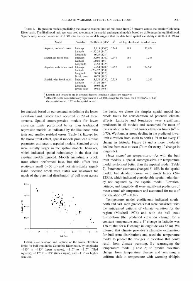
0.75). We found a strong decline in the predicted lower
limit elevation from south to north (191 m for every 18
change in latitude; Figure 2) and a more moderate
decline from east to west (74 m for every 18 change in
longitude).
Mean annual air temperature.—As with the bull
trout models, a spatial autoregressive air temperature
model performed better than the aspatial model (Table
2). Parameter estimates changed 5–15% in the spatial
model, but standard errors were much larger (24–
123%), which indicated considerable spatial redundan-
cy not captured by the aspatial model. Elevation,
latitude, and longitude all were significant predictors of
mean annual air temperature and accounted for most of
the variation (R2 ¼ 0.89).
Temperature model coefficients indicated south–
north and east–west gradients that were consistent with
the anticipated patterns of climate variation for the
region (Mitchell 1976) and with the bull trout
distribution (the predicted elevation change for a
constant temperature and a 18 change in latitude was
138 m; that for a 18 change in longitude was 88 m). We
inferred that climate provides a plausible explanation
for bull trout distributions and used the temperature
model to predict the changes in elevation that could
result from climate warming. By rearranging the
temperature model (Table 2) to predict elevation
change from temperature change and assuming a
uniform shift in temperature with warming (Halpin
TABLE 1.—Regression models predicting the lower elevation limit of bull trout from 76 streams across the interior Columbia
River basin. The likelihood ratio test was used to compare the spatial and aspatial models based on differences in log likelihood.
Significantly smaller values (P , 0.001) for the spatial models suggest that the data have spatial variability (Littell et al. 1996).
Model Variablea Coefficient (SE)b R2 �2 log likelihood Residual error
Aspatial, no brook trout Intercept 17,913 (1500) 0.745 983 33,674Latitude �192.24 (14.7)Longitude 66.29 (12.1)
Spatial, no brook trout Intercept 18,693 (1760) 0.744 966 1,248Latitude �190.80 (19.1)Longitude 73.58 (13.9)
Aspatial, with brook trout Intercept 17,754 (1480) 0.757 970 32,546Latitude �204.22 (15.8)Longitude 60.54 (12.2)Brook trout 90.74 (48.3)
Spatial, with brook trout Intercept 18,558 (1730) 0.753 955 1,549Latitude �197.56 (19.4)Longitude 69.95 (13.9)Brook trout 49.56 (39.5)
a Latitude and longitude are in decimal degrees (longitude values are negative).b All coefficients were statistically significant at a¼0.001, except for the brook trout effect (P¼0.06 in
the aspatial model, 0.22 in the spatial model).
FIGURE 2.—Elevation and latitude of the lower elevation
limits for bull trout in the Columbia River basin, by longitude:
�1138 to �1158 (open squares), �1158 to �1178 (filled
squares), �1178 to �1198 (times signs), and �1198 or higher
(circles).
CLIMATE WARMING EFFECTS ON BULL TROUT 1557
1997), we estimated that a 18C increase in temperature
equated to an increase in elevation of 161 m.
Accordingly, we used 100-m (;0.68C), 250-m
(;1.68C), and 800-m (;5.08C) elevation shifts to
bound the general predictions of climate warming and
estimate the effects on bull trout habitats as outlined
above.
Total Area and Patch Number
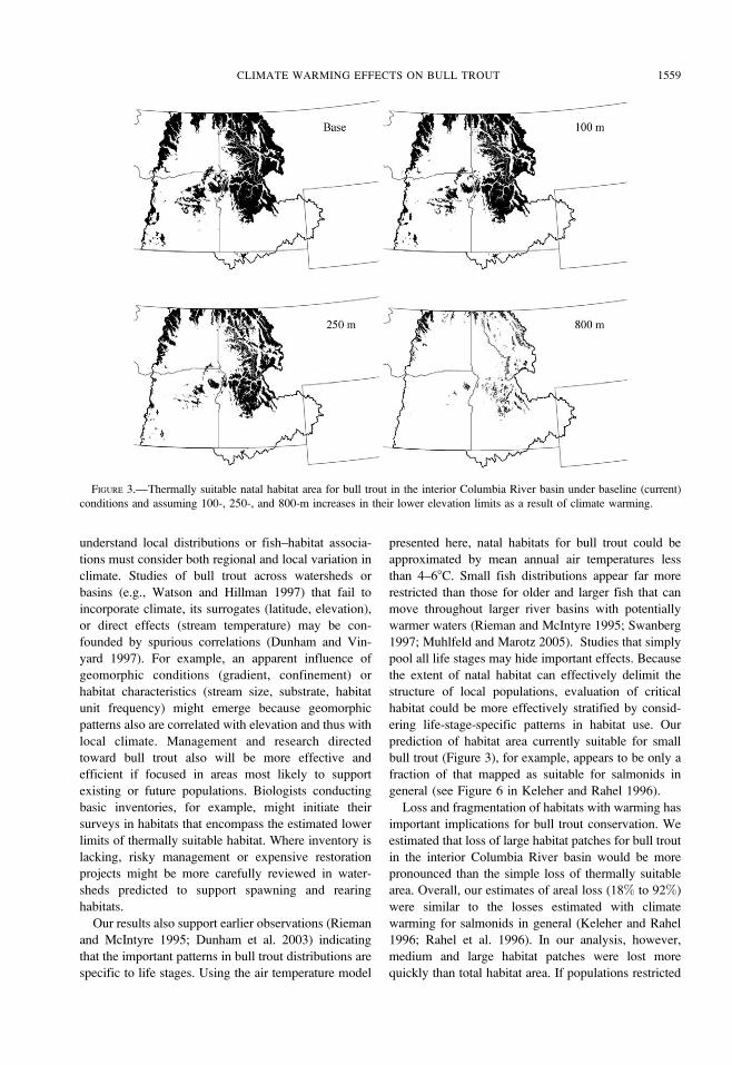
Estimates of the total suitable area with a 100-, 250-,
and 800-m rise in the distribution limits were about 82,
60, and 8%, respectively, of the area estimated for the
base condition (Figure 3). Relative changes in patch
area and number varied substantially across the
subregions (Figure 4). Relative loss of area was most
pronounced in the south-central part of the basin (i.e.,
subregions 7, 8, 9, 10, and 14), but the patterns did not
reflect a simple progression with warming or regional
gradients. Subregions 13 and 18, for example, appeared
to be more resistant to loss of area than other nearby
(i.e., south-central) subregions. Some subregions (e.g.,
5 and 18) lost relatively little area initially but
substantial area with more extreme warming, whereas
other subregions (e.g., 6) showed the reverse. In the
most extreme scenario, all but four subregions (3, 8, 5,
10) retained some suitable area, but only two (15 and
19) in the extreme northwestern part of the basin
retained more than 12% of the original area estimated
under current conditions.
Estimates of patch number produced changes similar
to but more dramatic than those for area. We predicted
that the total remaining number of large habitat patches
would be about 73% of the base number given an
elevation increase of 100 m, 36% for an increase of 250
m, and 0.6% for an increase of 800 m. For medium
patches, the numbers remaining were about 70% of the
base at 100 m, 40% at 250 m, and 0.9% at 800 m. Like
area, patch number varied across the basin (Figure 4).
In some cases the number of medium and large patches
changed little or even increased with the first steps in
the lower bound (e.g., patches 6, 15, 19), but that was a
result of even larger patches being fragmented into
multiple smaller ones (note the vertical axes are
truncated to one in Figure 4). The more general result
was a decline in number of medium or large patches
that was substantially more pronounced than the
decline in area (Figure 4). Risk, defined by absolute
number of medium or large patches, also varied
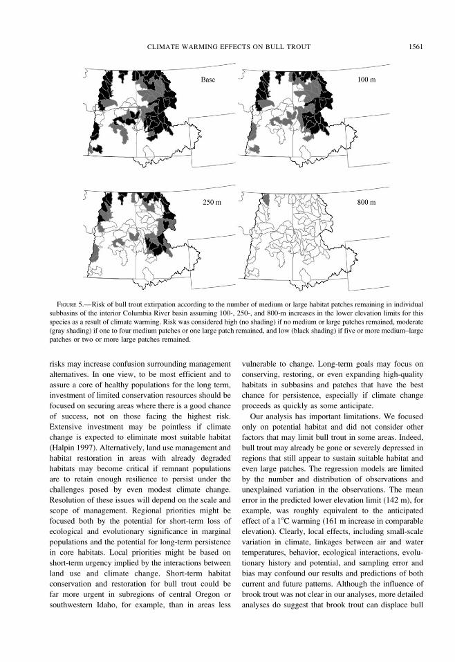
substantially across subbasins. Some subbasins, partic-
ularly in the south and central part of the basin, were
already at high risk in the base condition (Figure 5).
With limited or moderate warming, high and moderate
risk was extended throughout the southern and interior
part of the basin, although some refugia appeared to
remain in central Idaho and around the margins of the
basin to the north. Under the most extreme case,
anticipated risk was high through virtually the entire
basin.
Discussion
From our results and earlier work linking bull trout
distributions to thermal gradients, we conclude that
climate is, and will continue to be, an important factor
in the distribution of bull trout. Our results are
generally consistent with predictions for other chars
at mid latitudes (Meisner 1990; Flebbe 1994; Nakano
et al. 1996) and are also consistent with the view that
aquatic ecosystems are influenced by pattern and
processes across a hierarchy of scale (Fausch et al.
1994; Rabeni and Sowa 1996; Fausch et al. 2002). In
this case, climate is probably a primary constraint on
the distribution of bull trout through its effects on the
availability, distribution, and size of thermally suitable
habitats at both regional and landscape scales. Habitat
quality and interaction with other species such as brook
trout will have secondary influences at the scale of
individual stream reaches (Rieman et al. 2006).
Context, then, is important. Biologists working to
TABLE 2.—Regression models predicting the mean annual air temperature at 191 weather stations across the interior Columbia
River basin. The likelihood ratio test was used to compare the spatial and aspatial models based on differences in log likelihood.
A significantly smaller value (P , 0.001) for the spatial model suggests that the data have spatial variability (Littell et al. 1996).
Model Variablea Coefficient (SE)b R2 �2 log likelihood Residual error
Aspatial Intercept 60.184 (3.56) 0.892 465.9 0.584Latitude �0.7548 (0.0353)Longitude 0.1046 (0.0246)Elevation �0.00596 (0.000176)
Spatial Intercept 67.062 (6.94) 0.888 437.9 0.366Latitude �0.8618 (0.0786)Longitude 0.1193 (0.0503)Elevation �0.00625 (0.000218)
a Latitude and longitude are in decimal degrees (longitude values are negative); elevations are in
meters.b All coefficients were statistically significant at a ¼ 0.05.
1558 RIEMAN ET AL.
understand local distributions or fish–habitat associa-
tions must consider both regional and local variation in
climate. Studies of bull trout across watersheds or
basins (e.g., Watson and Hillman 1997) that fail to
incorporate climate, its surrogates (latitude, elevation),
or direct effects (stream temperature) may be con-
founded by spurious correlations (Dunham and Vin-
yard 1997). For example, an apparent influence of
geomorphic conditions (gradient, confinement) or
habitat characteristics (stream size, substrate, habitat
unit frequency) might emerge because geomorphic
patterns also are correlated with elevation and thus with
local climate. Management and research directed
toward bull trout also will be more effective and
efficient if focused in areas most likely to support
existing or future populations. Biologists conducting
basic inventories, for example, might initiate their
surveys in habitats that encompass the estimated lower
limits of thermally suitable habitat. Where inventory is
lacking, risky management or expensive restoration
projects might be more carefully reviewed in water-
sheds predicted to support spawning and rearing
habitats.
Our results also support earlier observations (Rieman
and McIntyre 1995; Dunham et al. 2003) indicating
that the important patterns in bull trout distributions are
specific to life stages. Using the air temperature model
presented here, natal habitats for bull trout could be
approximated by mean annual air temperatures less
than 4–68C. Small fish distributions appear far more
restricted than those for older and larger fish that can
move throughout larger river basins with potentially
warmer waters (Rieman and McIntyre 1995; Swanberg
1997; Muhlfeld and Marotz 2005). Studies that simply
pool all life stages may hide important effects. Because
the extent of natal habitat can effectively delimit the
structure of local populations, evaluation of critical
habitat could be more effectively stratified by consid-
ering life-stage-specific patterns in habitat use. Our
prediction of habitat area currently suitable for small
bull trout (Figure 3), for example, appears to be only a
fraction of that mapped as suitable for salmonids in
general (see Figure 6 in Keleher and Rahel 1996).
Loss and fragmentation of habitats with warming has
important implications for bull trout conservation. We
estimated that loss of large habitat patches for bull trout
in the interior Columbia River basin would be more
pronounced than the simple loss of thermally suitable
area. Overall, our estimates of areal loss (18% to 92%)
were similar to the losses estimated with climate
warming for salmonids in general (Keleher and Rahel
1996; Rahel et al. 1996). In our analysis, however,
medium and large habitat patches were lost more
quickly than total habitat area. If populations restricted
FIGURE 3.—Thermally suitable natal habitat area for bull trout in the interior Columbia River basin under baseline (current)
conditions and assuming 100-, 250-, and 800-m increases in their lower elevation limits as a result of climate warming.
CLIMATE WARMING EFFECTS ON BULL TROUT 1559

to smaller or more isolated patches of habitat are more
vulnerable to local extinction (Dunham et al. 1997;
Dunham and Rieman 1999; Morita and Yamamoto
2002; Rich et al. 2003; Isaak et al. 2007) losses could
proceed more quickly than implied by the loss of
thermally suitable area alone. Even limited warming
may produce dramatic increases in the extirpation of
local populations of bull trout in some areas of the
interior Columbia River basin.
The predicted changes with any warming varied
substantially across the basin. Owing to both local land
form (i.e., topographic relief) and geographic location
within the climatic gradient of the region, it appears
that some bull trout populations face higher risks than
others. The relative differences in existing conditions
and predicted changes among subregions and subba-
sins could be important in development of conservation
priorities. For example, the Jarbidge River subbasin on
the Idaho–Nevada border, other tributaries to the Snake
River near the Oregon, Washington, and Idaho borders,
and those associated with the northeastern flank of the
Cascades in Oregon (west-central portion of the basin)
appear to be at high risk already. If they are to persist
with climate warming, aggressive measures in habitat
conservation or restoration may be needed. This
assumes, of course, that mitigation of existing habitat
problems could also mitigate the risks associated with
climate change.
As the resources for conservation management are
limited and not expected to expand dramatically in the
foreseeable future, effective prioritization will be
important. Our results suggest moderate to high risks
will extend across the basin with even modest
warming. Consideration of ecological and evolutionary
significance, as well as risk related to climate change,
could highlight areas as regional priorities (Allendorf et
al. 1997). For example, by virtue of their extended
isolation from other bull trout populations and location
on the extreme margins of the species’ range, both the
Jarbidge and Klamath subregions could represent
distinct and thus evolutionarily important populations
(Leary et al. 1993; Lesica and Allendorf 1995; Rieman
et al. 1997) worthy of extraordinary efforts.
Effectively weighting and acting on the risks
associated with climate and other anthropogenic
changes will be no simple task. In some cases different
FIGURE 4.—Predicted changes (proportions remaining) of thermally suitable area for bull trout in the interior Columbia River
basin (black bars) and the number of habitat patches (hatched bars) of (A) medium (5,000–10,000 ha) and (B) large size
(.10,000 ha), by subregion assuming 100-, 250-, and 800-m increases in the species’ lower elevation limits as a result of climate
warming. Note that the changes in area are the same in both (A) and (B). The bars for patch number proportions exceeding 1.0 as
a result of larger patch fragmentation were truncated.
1560 RIEMAN ET AL.
risks may increase confusion surrounding management
alternatives. In one view, to be most efficient and to
assure a core of healthy populations for the long term,
investment of limited conservation resources should be
focused on securing areas where there is a good chance
of success, not on those facing the highest risk.
Extensive investment may be pointless if climate
change is expected to eliminate most suitable habitat
(Halpin 1997). Alternatively, land use management and
habitat restoration in areas with already degraded
habitats may become critical if remnant populations
are to retain enough resilience to persist under the
challenges posed by even modest climate change.
Resolution of these issues will depend on the scale and
scope of management. Regional priorities might be
focused both by the potential for short-term loss of
ecological and evolutionary significance in marginal
populations and the potential for long-term persistence
in core habitats. Local priorities might be based on
short-term urgency implied by the interactions between
land use and climate change. Short-term habitat
conservation and restoration for bull trout could be
far more urgent in subregions of central Oregon or
southwestern Idaho, for example, than in areas less
vulnerable to change. Long-term goals may focus on
conserving, restoring, or even expanding high-quality
habitats in subbasins and patches that have the best
chance for persistence, especially if climate change
proceeds as quickly as some anticipate.
Our analysis has important limitations. We focused
only on potential habitat and did not consider other
factors that may limit bull trout in some areas. Indeed,
bull trout may already be gone or severely depressed in
regions that still appear to sustain suitable habitat and
even large patches. The regression models are limited
by the number and distribution of observations and
unexplained variation in the observations. The mean
error in the predicted lower elevation limit (142 m), for
example, was roughly equivalent to the anticipated
effect of a 18C warming (161 m increase in comparable
elevation). Clearly, local effects, including small-scale
variation in climate, linkages between air and water
temperatures, behavior, ecological interactions, evolu-
tionary history and potential, and sampling error and
bias may confound our results and predictions of both
current and future patterns. Although the influence of
brook trout was not clear in our analyses, more detailed
analyses do suggest that brook trout can displace bull
FIGURE 5.—Risk of bull trout extirpation according to the number of medium or large habitat patches remaining in individual
subbasins of the interior Columbia River basin assuming 100-, 250-, and 800-m increases in the lower elevation limits for this
species as a result of climate warming. Risk was considered high (no shading) if no medium or large patches remained, moderate
(gray shading) if one to four medium patches or one large patch remained, and low (black shading) if five or more medium–large
patches or two or more large patches remained.
CLIMATE WARMING EFFECTS ON BULL TROUT 1561

trout (Rich et al. 2003; Rieman et al. 2006). Future
warming might favor an expanding invasion of species
like brook trout that could exacerbate our predicted
losses and fragmentation of bull trout habitats. Climate
changes also are anticipated to be more complex than a
uniform, vertical displacement of mean annual iso-
therms (Halpin 1997). Climate may warm more in
some regions than others (Leung et al. 2004). Important
changes are likely to include seasonal and spatial
patterns in precipitation that will in turn influence
patterns of stream flow and flooding (Lettenmaier et al.
1992; Poff et al. 1996; Stewart et al. 2005; Knowles et
al. 2006). Winter floods that can dramatically influence
the dynamics of fall-spawning fishes (Seegrist and
Gard 1972) like bull trout may become more common
in some areas (Lettenmaier et al. 1992). Others predict
increased frequency or extent of wildfire (McKenzie et
al. 2004; Westerling et al. 2006) that can directly
remove riparian vegetation or catalyze severe channel
disturbances such as debris flows (Luce 2005). Given
the large component of a stream heat budget driven by
solar radiation (Johnson 2003), riparian disturbances
may exacerbate stream warming beyond the direct
climate effect. Conceivably, the combined effects of
shrinking patch size and increasing frequency or
magnitude of stream channel disturbance could even
accelerate the rate of local extinctions beyond that
driven by temperature alone.
Our work is clearly a first approximation of the
potential influence of regional climate patterns on the
distribution of bull trout habitat and the risks that
implies. Our intent was to look for broad patterns and
compare relative effects of habitat loss and fragmen-
tation. We conclude that the effects of climate change
will be important and vary substantially across the
basin. We acknowledge the uncertainty and limited
resolution of our analysis. These results can serve as a
basis for regional discussion and more detailed study.
They should not be extrapolated directly, however, for
management of bull trout populations or habitats within
individual subbasins without consideration of the local
effects such as habitat degradation, hydrology and
stream temperature, migration barriers, and nonnative
species.
Most climate models have limited resolution,
making application at the watershed and landscape
scales problematic. Finer resolution extrapolations that
incorporate local drivers such as topographic effects are
now being developed (Bartlein et al. 1997; Ferguson
1997; Leung et al. 2004), and whole climate regimes
(i.e., temperature, precipitation and their seasonal
timing) offer an approach for more complete analyses
(Halpin 1997). Detailed studies of individual stream
networks and watersheds should provide better resolu-
tion of the local climatic, hydrologic (e.g., Lettenmaier
et al. 1992), and ecological processes likely to
influence the distribution and persistence of bull trout
at this scale and identify the sources of variability
underlying the uncertainty of general predictions.
Replication of existing data sets and representative
sampling based on probabilistic designs could help
resolve the rate of change that may already be
occurring and the accuracy of further predictions.
In the interim, efforts to study, conserve, and restore
bull trout populations and habitats will proceed based
on existing information, resources, and agency com-
mitment. The capability to do that work effectively and
efficiently will depend on an ability to focus and
prioritize resources. Climate patterns should be an
important consideration in any analysis. Our results
indicate that climate is a first-order determinant of bull
trout distributions. From this, we also infer that climate
warming may lead to an important loss of bull trout
habitats and that the resulting fragmentation can lead to
local extinctions more quickly than anticipated from a
simple loss of thermally suitable watershed area.
Occurrence and persistence of bull trout will vary with
climate gradients and with landscape characteristics
likely to modify local climate, stream temperatures, and
the extent of thermally suitable habitats within and
among streams across the species’ range.
Acknowledgments
Many people contributed information that made the
analysis possible. We are particularly indebted to B.
Sanborn, P. Murphy, D. Olsen, R. Pierce, G. Johnson,
T. Pearsons, and J. Dambacher for sharing their
unpublished data. R. King helped with coding of some
of the statistical analyses. J. Dunham and J. Peterson
provided early reviews that helped focus the paper. P.
Flebbe and two anonymous reviewers provided
constructive comments that helped improve the final
manuscript. The use of trade or firm names in this
paper is for reader information only and does not imply
endorsement by the U. S. Department of Agriculture of
any product or service.
References
Adams, S. B. 1994. Bull trout distribution and habitat use in
the Weiser River drainage, Idaho. Master’s thesis.
University of Idaho, Moscow.
Allendorf, F. W., D. W. Bayles, D. L. Bottom, K. P. Currens,
C. A. Frissell, D. Hankin, J. A. Lichatowich, W. Nehlsen,
P. C. Trotter, and T. H. Williams. 1997. Prioritizing
Pacific salmon stocks for conservation. Conservation
Biology 11:140–152.
Bartlein, P. J., C. Whitlock, and S. L. Shafer. 1997. Future
climate in the Yellowstone National Park region and its
1562 RIEMAN ET AL.
potential impact on vegetation. Conservation Biology
11:782–792.
Baxter, J. S. 1997. Aspects of the reproductive ecology of bull
trout in the Chowade River, British Columbia. Master’s
thesis. University of British Columbia, Vancouver.
Boer, G. J., N. A. McFarlane, and M. Lazare. 1992.
Greenhouse gas–induced climate change simulated with
the CCC second generation general circulation model.
Journal of Climate 5:1045–1077.
Clancy, C. G. 1993. Statewide fisheries investigation,
Bitterroot Forest inventory. Montana Department of
Fish, Wildlife and Parks, Job Completion Report F-46-
R-4, Helena.
Cressie, N. 1993. Statistics for spatial data, revised edition.
Wiley, New York.
Dambacher, J. M., and K. K. Jones. 1997. Stream habitat of
juvenile bull trout populations in Oregon and bench-
marks for habitat quality. Pages 353–360 in W. C.
Mackay, M. K. Brewin, and M. Monita, editors. Friends
of the Bull Trout conference proceedings. Trout
Unlimited, Canada, Calgary, Alberta.
Downs, C. C., D. Horan, E. Morgan-Harris, and R.
Jakubowski. 2006. Spawning demographics and juvenile
dispersal of an adfluvial bull trout population in Trestle
Creek, Idaho. North American Journal of Fisheries
Management 26:190–200.
Dunham, J. B., and B. E. Rieman. 1999. Metapopulation
structure of bull trout: influences of physical, biotic, and
geometrical landscape characteristics. Ecological Appli-
cations 9:642–655.
Dunham, J. B., B. E. Rieman, and G. L. Chandler. 2003.
Influences of temperature and environmental variables on
the distribution of bull trout at the southern margin of its
range. North American Journal of Fisheries Management
23:894–904.
Dunham, J. B., B. E. Rieman, and J. T. Peterson. 2002. Patch-
based models to predict species occurrence: lessons from
salmonid fishes in streams. Pages 327–334 in J. M. Scott,
P. J. Heglund, M. Morrison, M. Raphael, J. Haufler, and
B. Wall, editors. Predicting species occurrences: issues of
scale and accuracy. Island Press, Covelo, California.
Dunham, J. B., and G. L. Vinyard. 1997. Incorporating stream
level variability into analyses of site level fish habitat
relationships: some cautionary examples. Transactions of
the American Fisheries Society 126:323–329.
Dunham, J. B., G. L. Vinyard, and B. E. Rieman. 1997.
Habitat fragmentation and extinction risk of Lahontan
cutthroat trout. North American Journal of Fisheries
Management 17:1126–1133.
Eaton, J. G., and R. M. Scheller. 1996. Effects of climate
warming on fish thermal habitat in streams of the United
States. Limnology and Oceanography 41:1109–1115.
Fausch, K. D., S. Nakano, and K. Ishigaki. 1994. Distribution
of two congeneric charrs in streams of Hokkaido Island,
Japan: considering multiple factors across scales. Oeco-
logia 100:1–12.
Fausch, K. D., C. E. Torgersen, C. V. Baxter, and H. W. Li.
2002. Landscapes to riverscapes: bridging the gap
between research and conservation of stream fishes.
BioScience 52:483–498.
Ferguson, S. A. 1997. A climate change scenario for the
Columbia River basin. U.S. Forest Service, Pacific
Northwest Research Station, PNW RP 499, Portland,
Oregon.
Flebbe, P. A. 1993. Comment on Meisner (1990): Effect of
climatic warming on the southern margins of the native
range of brook trout, Salvelinus fontinalis. Canadian
Journal of Fisheries and Aquatic Sciences 50:883–884.
Flebbe, P. A. 1994. A regional view of the margin: salmonid
abundance and distribution in the southern Appalachian
mountains of North Carolina and Virginia. Transactions
of the American Fisheries Society 123:657–667.
Flebbe, P. A., L. D. Roghair, and J. L. Bruggink. 2006. Spatial
modeling to project southern Appalachian trout distribu-
tion in a warmer climate. Transactions of the American
Fisheries Society 135:1371–1382.
Halpin, P. N. 1997. Global climate change and natural area
protection management responses and research direc-
tions. Ecological Applications 7:828–843.
Hamlet, A. F., and D. P. Lettenmaier. 2007. Effects of 20th
century warming and climate variability on flood risk in
the western U.S. Water Resources Research 43(6):
W06427. DOI:10.1029/2006WR005099.
Hanski, I., and D. Simberloff. 1997. The metapopulation
approach, its history, conceptual domain, and application
to conservation. Pages 5–26 in I. A. Hanski and M. E.
Gilpin, editors. Metapopulation biology, ecology, genet-
ics, and evolution. Academic Press, San Diego, Cal-
ifornia.
Hari, R. E., D. M. Livingstone, R. Siber, P. Burkhardt-Holm,
and H. Guttinger. 2006. Consequences of climatic
change for water temperature and brown trout popula-
tions in alpine rivers and streams. Global Change
Biology 12:10–26.
Hoelscher, B., and T. C. Bjornn. 1988. Habitat, densities of
trout and char, and potential production in Pend Oreille
Lake tributaries. Idaho Department of Fish and Game,
Federal Aid in Fish Restoration, Project F-71-R-10,
Boise.
IPCC (Intergovernmental Panel on Climate Change). 2007.
Climate change 2007: the physical science basis.
Available: www.ipcc.ch. (February 2007).
Isaak, D. J., R. F. Thurow, B. E. Rieman, and J. B. Dunham.
2007. Relative roles of habitat size, connectivity, and
quality on Chinook salmon use of spawning patches.
Ecological Applications 17:352–364.
Johnson, S. L. 2003. Stream temperature: scaling of
observations and issues for modeling. Hydrological
Processes 17:497–499.
Keleher, C. J., and F. J. Rahel. 1996. Thermal limits to
salmonid distributions in the Rocky Mountain region and
potential habitat loss due to global warming: a geo-
graphic information system (GIS) approach. Transactions
of the American Fisheries Society 125:1–13.
Kerr, R. A. 1997. Greenhouse forecasting still cloudy. Science
276:1040–1042.
Knowles, N., M. D. Dettinger, and D. R. Cayan. 2006. Trends
in snowfall versus rainfall in the western United States.
Journal of Climate 19:4545–4559.
Koizumi, I., and K. Maekawa. 2004. Metapopulation structure
of stream-dwelling Dolly Varden charr inferred from
patterns of occurrence in the Sorachi River basin,
Hokkaido, Japan. Freshwater Biology 49:973–981.
Leary, R. F., F. W. Allendorf, and S. H. Forbes. 1993.
CLIMATE WARMING EFFECTS ON BULL TROUT 1563
Conservation genetics of bull trout in the Columbia and
Klamath river drainages. Conservation Biology 7:856–
865.
Lesica, P., and F. W. Allendorf. 1995. When are peripheral
populations valuable for conservation? Conservation
Biology 9:753–760.
Lettenmaier, D. P., L. W. Vail, S. B. Yabusaki, K. L.
Brettmann, and M. J. Scott. 1992. Sensitivity of Pacific
Northwest water resources to global warming. Northwest
Environmental Journal 8:265–283.
Leung, L. R., Y. Qian, X. Bian, W. W. Washington, J. Han,
and J. O. Roads. 2004. Midcentury ensemble regional
climate change for the western United States. Climatic
Change 62:75–113.
Littell, R. C., G. A. Milliken, W. W. Stroup, and R. D.
Wolfinger. 1996. SAS system for mixed models. SAS
Institute, Cary, North Carolina.
Luce, C. H. 2005. Fire effects on runoff generation processes.
Pages 1831–1838 in M. G. Anderson and J. J.
McDonnell, editors. Encyclopedia of hydrological sci-
ences, volume 3. Wiley, Chichester, UK.
Mattson, K. M., and P. L. Angermeier. 2007. Integrating
human impacts and ecological integrity into a risk-based
protocol for conservation planning. Environmental Man-
agement 39:125–138.
Mauser, G. R. 1986. Enhancement of trout in large north
Idaho lakes. Idaho Department of Fish and Game,
Federal Aid in Fish Restoration, Project F-73-R-8, Boise.
Mauser, G. R., R. W. Vogelsang, and C. L. Smith. 1988.
Enhancement of trout in large north Idaho lakes. Idaho
Department of Fish and Game, Federal Aid in Fish
Restoration, Study Completion Report, Project F-73-R-
10, Boise.
McKenzie, D., Z. Gedalof, D. L. Peterson, and P. Mote. 2004.
Climate change, wildfire, and conservation. Conservation
Biology 18:890–902.
McPhail, J. D., and C. B. Murray. 1979. The early life history
and ecology of Dolly Varden (Salvelinus malma) in the
upper Arrow Lakes. Department of Zoology and Institute
of Animal Resource Ecology, University of British
Columbia, Manuscript Report, Vancouver.
Meisner, J. D. 1990. Effect of climatic warming on the
southern margins of the native range of brook trout,
Salvelinus fontinalis. Canadian Journal of Fisheries and
Aquatic Sciences 47:1065–1070.
Mitchell, V. L. 1976. The regionalization of climate in the
western United States. Journal of Applied Meteorology
15:920–927.
Mohseni, O., and H. G. Stefan. 1999. Stream temperature–air
temperature relationship: a physical interpretation. Jour-
nal of Hydrology 218:128–141.
Morita, K., and S. Yamamoto. 2002. Effect of habitat
fragmentation by damming on the persistence of
stream-dwelling charr populations. Conservation Biology
16:1318–1323.
Mote, P. W., A. F. Hamlet, M. P. Clark, and D. P.
Lettenmaier. 2005a. Declining mountain snowpack in
western North America. Bulletin of the American
Meteorological Society 86:39–49.
Mote, P. W., E. Salathe, and C. Peacock. 2005b. Scenarios of
future climate for the Pacific Northwest. University of
Washington, Seattle.
Muhlfeld, C. C., and B. Marotz. 2005. Seasonal movement
and habitat use by subadult bull trout in the upper
Flathead River system, Montana. North American
Journal of Fisheries Management 25:797–810.
Nakano, S., F. Kitano, and K. Maekawa. 1996. Potential
fragmentation and loss of thermal habitats for charrs in
the Japanese archipelago due to climatic warming.
Freshwater Biology 36:711–722.
NOAA (National Oceanic and Atmospheric Administration).
1993. Climatological data annual summary, Idaho
96(13). NOAA, Asheville, North Carolina.
Parmesan, C., and G. Yohe. 2003. A globally coherent
fingerprint of climate change impacts across natural
systems. Nature (London) 421:37–42.
Paul, A. J., and J. R. Post. 2001. Spatial distribution of native
and nonnative salmonids in streams of the eastern slopes
of the Canadian Rocky Mountains. Transactions of the
American Fisheries Society 130:417–430.
Peters, R. L., and J. D. S. Darling. 1985. The greenhouse
effect and nature reserves. BioScience 35:707–717.
Platts, W. S. 1974. Geomorphic and aquatic conditions
influencing salmonids and stream classification in the
Salmon River drainage, Idaho, 1970–1972. U.S. Forest
Service, Progress Report III, Boise, Idaho.
Platts, W. S. 1979. Relationships among stream order, fish
populations, and aquatic geomorphology in an Idaho
river drainage. Fisheries 4(2):5–9.
Poff, N. L., S. Tokar, and P. Johnson. 1996. Stream
hydrological and ecological responses to climate change
assessed with an artificial neural network. Limnology
and Oceanography 41:857–863.
Pratt, K. L. 1992. A review of bull trout life history. Pages 5–9
in P. J. Howell and D. V. Buchanan, editors. Proceedings
of the Gearhart Mountain Bull Trout Workshop.
American Fisheries Society, Oregon Chapter, Corvallis.
Rabeni, C. F., and S. P. Sowa. 1996. Integrating biological
realism into habitat restoration and conservation strate-
gies for small streams. Canadian Journal of Fisheries and
Aquatic Sciences 53(Supplement 1):252–259.
Rahel, F. J., C. J. Keleher, and J. L. Anderson. 1996. Potential
habitat loss and population fragmentation for coldwater
fish in the North Platte River drainage of the Rocky
Mountains: response to climate warming. Limnology and
Oceanography 41:1116–1123.
Rich, C., T. McMahon, B. Rieman, and W. Thompson. 2003.
Influence of local habitat, watershed, and biotic features
on bull trout occurrence in Montana streams. Transac-
tions of the American Fisheries Society 132:1053–1064.
Rieman, B. E., D. C. Lee, and R. F. Thurow. 1997.
Distribution, status, and likely future trends of bull trout
within the Columbia River and Klamath River basins.
North American Journal of Fisheries Management
17:895–909.
Rieman, B. E., and J. D. McIntyre. 1995. Occurrence of bull
trout in naturally fragmented habitat patches of varied
size. Transactions of the American Fisheries Society
124:285–296.
Rieman, B. E., J. T. Peterson, and D. L. Myers. 2006. Have
brook trout displaced bull trout along longitudinal
gradients in central Idaho streams? Canadian Journal of
Fisheries and Aquatic Sciences 63:63–78.
Root, T. L., J. T. Price, K. R. Hall, S. H. Schneider, C.
1564 RIEMAN ET AL.

Rosenzweig, and J. A. Pounds. 2003. Fingerprints of
global warming on wild animals and plants. Nature
(London) 421:57–60.
Seegrist, D. W., and R. Gard. 1972. Effects of floods on trout
in Sagehen Creek, California. Transactions of the
American Fisheries Society 101:478–482.
Selong, J. H., T. E. McMahon, A. V. Zale, and F. T. Barrows.
2001. Effect of temperature on growth and survival of
bull trout, with application of an improved method for
determining thermal tolerance in fishes. Transactions of
the American Fisheries Society 130:1026–1037.
Shuter, B. J., and J. D. Meisner. 1992. Tools for assessing the
impact of climate change on freshwater fish populations.
Geojournal 28:7–20.
Stephan, H. G., and E. B. Preud’homme. 1993. Stream
temperature estimation from air temperatures. Water
Resources Bulletin 29:27–45.
Stewart, I. T., D. R. Cayan, and M. D. Dettinger. 2005.
Changes toward earlier streamflow timing across western
North America. Journal of Climate 18:1136–1155.
Stoneman, C. L., and M. J. Jones. 1996. A simple method to
classify stream thermal stability with single observations
of daily maximum water and air temperature. North
American Journal of Fisheries Management 16:728–737.
Swanberg, T. 1997. Movements of and habitat use by fluvial
bull trout in the Blackfoot River, Montana. Transactions
of the American Fisheries Society 126:735–746.
Tarboton, D. G. 1997. A new method for the determination of
flow directions and contributing areas in grid digital
elevation models. Water Resources Research 33:309–
319.
Watson, G., and T. W. Hillman. 1997. Factors contributing to
the distribution and abundance of bull trout: an
investigation of ecologic hierarchies. North American
Journal of Fisheries Management 17:237–252.
Westerling, A. L., H. G. Hidalgo, D. R. Cayan, and T. W.
Swetnam. 2006. Warming and earlier spring increases
western U.S. forest wildfire activity. Science 313:940–
943.
CLIMATE WARMING EFFECTS ON BULL TROUT 1565
Related Documents