·-- - . -- Department of Anthropology ANTHROJP>OLO<GH<CAlL JP AJP>EJR§ j ; UNIVERS I TY ARCHIVES l.... 71 I' ,-.. 1..) >-; r: c . 72 ;. NUMBER 72 AUGUST, 1964 (Glen Can y on Series Numb er 24) Historical Sites in Cataract and Narrow Canyons, and in Glen Canyon to California Bar By C. GREGORY CRAMPTON With an addendum of New Data in areas previousl y reported JESSE D. JENNINGS, Editor CAROL C. STOUT, Associate Editor UNIVERSITY OF UTAH PRESS SALT LAKE CITY --

Welcome message from author
This document is posted to help you gain knowledge. Please leave a comment to let me know what you think about it! Share it to your friends and learn new things together.
Transcript

·--- . --
Department of Anthropology
ANTHROJP>OLO<GH<CAlL JP AJP>EJR§
j
; UNIVERSITY ARCHIVES
l....
71 ..J~
I' ,-.. 1..) >-;
r: c . 72
;.
NUMBER 72 AUGUST, 1964
(Glen Canyon Series Number 24)
Historical Sites in Cataract
and Narrow Canyons, and in Glen Canyon
to California Bar
By C. GREGORY CRAMPTON
With an addendum of New Data
in areas previously reported
JESSE D. JENNINGS, Editor
CAROL C. STOUT, Associate Editor
UNIVERSITY OF UTAH PRESS
SALT LAKE CITY
~---~---------~~----~-----------·-· ·--------------------- --
..... '· r• - ·-~-~-·:! ~.-.
, i
HISTORICAL SITES IN CATARACT AND NARROW CANYONS,
AND IN GLEN CANYON TO CALIFORNIA BAR
by
C. Gregory ·Crampton ~- --
With an Addendum of New Data in
Areas Previously Reported
Number 72 (Glen Canyon Series Number 24) August 19 64
ANTHROPOLOGICAL PAPERS
Department of Anthropology
University of Utah
l tNIVERSlTY Of UTAH UBRAR1ES
PREFACE
This is the fourth (and last) volume devoted to a detailed study of the historical sites in the Lake Powell (Glen Canyon) Reservoir area and environs. The first two (Crampton, 1960, 1962) described representati ve sites from Lees Ferry to the mouth of Hansen Creek, 130 mi. upstream from Lees Ferry. This one reports historical sites in Cataract Canyon, Narrow Cany on, and from the head of Glen Canyon at the mouth of the Dirty Devil River down to California Bar opposite the mouth of Hansen Creek. The third report in the series, in press as this is being written, reports historical sites in th e canyon of the San Juan River from its mouth to the mouth of Chinle Creek, 132 mi. upstream.
Since the first two reports have been published some additional material has been obtained bearing upon sites already described and some new sites in areas covered by those reports have been discovered. These data are included as an addendum to this report.
The methods employed have been those used in the preparation o f the first three reports. The primary objective of the study has been to learn what historical areas and remains will be inundated by the waters of Lake Powell .. and to make a record of them (see Crampton, 1960, v -vii) . All known sites have been reported, but the list is doubtlessly incomplete. However, it is believed that the sampling has been broad enough to permit reconstruction of the history of the reservoir area without serious distortion.
With exception of those in the upper part of Cataract Canyon, the historical sites here are all within the reservoir area. The sites are described in the text approximately as they appear in downstream order. Numbers have been applied to historical sites consecutively as they have been located in the field. A single series of numbers has been used for all of the historical sites described in t he Lake Powell Reservoi r area and its immediate environs. Histori cal sites are indexed by number and name in the table of historical sites. A series of atlas sheets in the rear of the volume locates precisely all historical sites.
It is a pleasure to acknowledge the assistance of numerous individuals and institutions whose cooperation facilitated the field work and the preparatio n of this report:
H. L. Ales on, Teasdale, Utah; A. A. Baker, Associate Director, U. S1:
Geological Survey, Washington, D. C.; Carlyle Baker, Teasdale, Utah; Pearl . B. Baker, Green River, Utah; Frank A. Barrett , Dove Creek, Colorado; Jack Brennan, Salt Lake City; Alburn A. Brown, Wayne County Recorder and Clerk, Loa , Utah; Anne Stanton Burchard, New York City.
-v-
U.S. Bureau of Land Management, Salt Lake City: P. B. Mudgett, S. John Goldenstein , Frederick A. KUhlman, John R. Lowe, Arthur F. Michalicek , Robert G . Pruitt . U.S. Bureau of Reclamation , Salt Lake City: F. M. Clinton , Director; Herbert E. Simison, Special Services Officer ; W. L. Rusho, Public Information Specialist ; Stan Rasmussen , Photographer.
W. L . Chadwick, Vice President, Southern California Edison Company, ~os Angeles; the late Louis M. Chaffin, Payson, Utah; A . L. Chaffin, Teasdale Utah; Helen M. Crampton , Salt Lake City; Arthur L. Crawford , Assistant Di- · rector, Utah Geological and Mineralogical Survey, University of Utah; Mildred Deuel, Garfield Count y Recorder, Panguitch, Utah; G . W. Edgell , Whit e Canyor Utah; Hazel Ekker, Green River, Utah; Malcolm Ellingson, Salt Lake City.
Alys Freeze, Head, Western History Department , The Public Library , Denver; Parker Hamilton, Flagstaff; Don L. Harris , Salt Lake City; Jesse D. Jennings, Professor of Anthropology and Director, and Floyd W . Sharrock, Assistant Director, National Park Service-University of Utah Upper Colorado River Basin Salvage Project; Charles Kelly, Salt Lake City; Henry Lyman, Manti, Utah; Otis R. Marston, Berkeley, California; Scott J. Maughan, Salt Lake City; David E. Miller, Head, Department of History, University of Utah; A. R. Mortensen, Editor, The American West.
The Museum of Northern .A.rizona, Flagstaff: Edward B. Danson, Director; Alexander J. Lindsay, Jr., Archeologist-in-Charge, Glen Canyon Project, and his predecessor William Y. Adams; Christy G. Turner, II; Katherine
"--- Bartlett, Librarian and Curator of History . U.S. National Park Service: Charlie R. Steen, Regional Archeologist, Santa Fe; James M. Eden, Superintendent , John L . Mullady, Chief Ranger , and Arnold H. Gustavson , Park Landscape Architect, Glen Canyon National Recreation Area, Page, Arizona.
Floyd A. 0 1Neill, Price , Utah; Chauncey Powis, Information Officer, Utah Department of Highway s ; W. Dirk Raat, Salt Lake City; Merrill K. Ridd, Salt Lake City; Arleen Ruggeri, Moab, Utah.
El ayne Schwartz, Provo, Utah; Dwight L. Smith, Professor of History, Miami University, Oxford, Ohio; Marilyn M. Smolka, Editorial Assistant, The American West; Esther Somerville, Grand County Recorder, Moab, Utah; J . Ken Stithem, LaSal National Forest, Moab, Utah ; S. Lyman Tyler, Director of Libraries, Brigham Young University , Provo, Utah.
Utah State Historical Society, Salt Lake City: Everett L . Cooley, Director; John R. James, Jr., Librarian; Margaret Shepherd, Photographic Library, and all members of the staff. Arvilla E. Warren, San Juan County, Recorder, Monticello, Utah; Henry J. W ebb, Professor of English, University of Utah; Angus M. Woodbury, Professor Emeritus of Biology, University of Utah; J. Frank Wright, Blanding, Utah ; Nellie B. Young, Emery County Recorder, Castle Dale, Utah.
-vi-
" (
GaJ.le!'Y, ~ Bancroft ·
c' with fund:
T
U.s. Bur

igett, F
<:e"c.: ity: er; rapher.
·ibrary, sse D. ock, ~ ora do an, Salt
' Utah;
Di-
.. : leE ;I
n ·oj- . eh ne ~
=rin-·: t-
Land- ·
er, idd,
ory, The
ctor
l -
T )
ity
'.
I I I
The University of Utah Library; Henry E. Huntington Library and Art Gallery, San Marino, California; New York Public Library, New York City; Bancroft Library, University of California, Berkeley; Salt Lake Public Libr<?-ry.
Certain phases of the library research for this report were undertaken with funds provided by the University of Utah Research Fund.
The photographs inFigs. 7, 10, 12, 14 , 21 weretakenbyW. L. Rusho , U.S. Bureau of Reclamation, Salt Lake City.
-vii-
C. Gregory Cramp ton Department of History Universit y of Utah
'.

TABLE OF CONTENTS
PREFACE ......... .
LIST OF ILLUSTRATIONS
TABLE OF HISTORICAL SITES .
TABLE OF HISTORICAL NAMES
CATARACT CANYON
NARROW CANYON
GLEN <;ANYON.
ADDENDUM
BIBLIOGRAPHY
ILL UST RATIONS
ATLAS ..
-ix-
Page
v
X
xi
xii
1
19
21
65
73
81
99
'-----
Figure
1. 2.
3.
4. 5 .
6.
7 .
8.
9.
10. 11.
\.___ 12. 13 .
14.
15. 16. 17.
18.
19. 20.
21. 22.
23.
24.
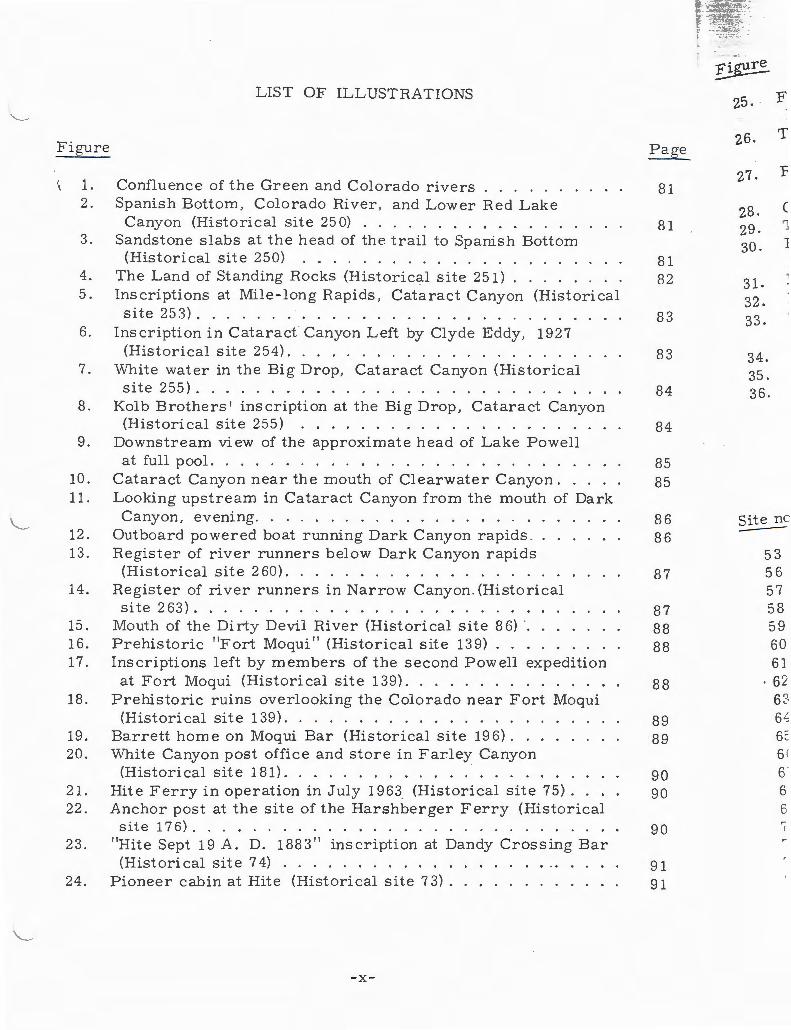
LIST OF ILLUSTRATIONS
Confluence of the Green and Colo rado rivers . . . . . . Spanish Bottom , Colo rado River , and Lower Red Lake
Canyon (Historical site 25 0) . . . . . . . . . . . . . . Sandstone slabs at the head of the trail to Spanish Bottom
(Historical si t e 250) . . . . . . . . . . . . . . . . ... The Land of Standing Rocks (Historical site 251) . . . . . Inscriptions at Mile-long Rapids, Cataract Canyon (Historical site 253) ........ .. . ...... ........ .
Inscription in Cataract Canyon Left by Clyde Eddy, 1927
Page
81
81
81 82
83
(Historical site 254). . . . . . . . . . . . . . . . . . . . 8 3 White water in the Big Drop , Cataract Canyon (Historical site 255). . . . . . . . . . . . . . . . . . . . . . . . . . 84
Kol b Brothers' inscription at the Big Drop, Cataract Canyon (Historical site 255) . . . . . . . . . . . . . . . . . . 84
Downstream view of the approximate head of Lake Powell at full pool. . . . . . . . . . . . . . . . . . . . . . . . .
Cataract Canyon near the mouth of Clearwater Canyon .. Looking upstream in Cataract Canyon from the mouth of Dark
Canyon, evening. . . . . . . . . . . . . . . . . . .. Outboard powered boat running Dark Canyon rapids . . Register of river runners below Dark Canyon rapids (Historical site 2 60). . . . . . . . . . . . . . . . . .
Register of river runners in Narrow Canyon . (Historical site263) .... . . .. ...... ...... .. .
Mouth of the Dirty Devil River (Historical site 8 6) ·. . . Prehistoric "Fort Moqui" (Historical site 139) .. Inscriptions left by members of the second Powell expedition
at Fort Moqui (Historical site 139) ............. . Prehistoric ruins overlooking the Colorado near Fort Moqui (Historical site 139) . . ............. . . .
Barrett home on Moqui Bar (Historical site 196) .. . White Canyon post office and store in Farley Canyon
(Historical site 181) .... . ............ . Hit e Ferry in operation in July 1963 (Historical site 7 5) . Anchor post at the site of the Harshberger Ferry (Historical
site 176) ....... ........ ............ . "Hite Sept 19 A. D. 1883" inscription at Dandy Crossing Bar (Historical site 74) ........... .
Pioneer cabin at Hite (Historical site 7 3) .... ..... .. .
-x-
85 85
86 86
87
87 88 88
88
89 89
90 90
90
91 91
tr~: t .·
~ 25. F
26. T
27. F
28. c 29. 1
30. J
31. 32. 33.
34. 35. 36.
Site nc
53 56 57 58 59 60 61
. 62 62 6,; 6~
6( 6' 6 6 ~
I

---·.• ·-
26.
27.
\ 28. 29. 30.
31. 32. 0 ') JJ•
34. 35. 36.
·te no. '---
53 56 57 58 59 60 6]
. 62 63 64 65 66 67 68 69 70 7] 72 73
First page from the Record Book of the White Canyon Mining District. . . . . . . . . . . . . . . . . . . . .
The "Governor's Mansion" at the Chaffin Ranch (Historical site72) .... · · · · ........ . ..... .. .
Remains of suspension flume across Trachyte Creek (Historical site 7 4). . . . . . . . . . . . . . . . . . .
Gold placer workings at Ticaboo Bar No . 2 (Historical site 63). The "Bank of Ticaboo " (Historical site 63). . . . . . . . . . Flume at outlet of "Lake Mary" Reservoir, Good Hope R·a,r
(Historical site 60) ... . ............ . Letterpress at Good Hope Bar (Historical site 60) .. . .. . Ryan C abin (Historical site 175) ........ .. . ... . Scraper at Olympia Bar , ore car and loading chute (background)
(H istorical site 58) . ... . . . ........ .. ..... . Adits in impacted gravel, California Bar (Historical site 53 ). Gr ave of A . G. Turner, California Bar (Historical site 53). California Bar and Glen Canyon (Historical site 53) .. ... .
TABLE OF HISTORICAL SITES
Page Site :no.
63 74 61 75 61 76 59 77
58 78
55 79
54 80
52 81 52 : 82
51 83 48 84
48 85 48 86
46 87
47 88
46 102
36 107
36 109
36 114
-xi-
Page
92
93
93 93 94
94 95 95
96 96 97 97
Page
36 34 42 36 31 31 44 43 43 25 26 27 24 27 55 59 57 61 48

Site no . Pag~ Site no. Page ~arne :;.:;---
. 139 27 193 48 }lobo Cany "----.... 171 59 194 48 }lospital C
175 58 195 62 Illinois Be: 17 6 36 19 6 32 l(nowles C 177 33 197 47 r..,and of Si 178 59 249 2 r..,onesom~ 179 54 250 4 r..,oper Ca 180 51 251 9 Mile -long 181 33 252 10 Mille Crc: 182 44 25 3 11 Monte Cr 183 46 254 12 Monte Cr 184 63 255 12 1'v1oqui F l 185 45 25 6 13 Narrow C 186 45 25 7 14 Narrow< 18 7 45 258 14 North W : 188 63 259 14 Olympia 189 57 260 15 pioneer 190 62 261 17 Red Can 191 54 262 19 The Rin 192 46 263 20 Ryan C 2
Schock
TABLE OF HISTORICAL NAMES
Name Page Name Page Site no
Bessie Bar. 55 Dandy Crossing Bar 36 7 Big Drop, The. 12 Dark Canyon . 15 18 Big Rock Rapid 45 Dirty Devil River 24 27 Bowdie Canyon. 14 D. Julien Inscription 14 29 Browns Bottom 27 Dorothy Bar 44 30 California Bar . 63 Eddy Inscription . 12 34 Cape Horn 47 Farley Canyon . 33 125 Cape Horn Bar. 48 Forgotten Canyon 63 136 Castle Butte Bar. 48 Fort Moqui. 27 131 Cedar Canyon 59 Four Mile Canyon 45 13 t Clearwater Canyon 14 Good Hope Bar . 55 26~
Confluence of the Green Grubstake Bar . 43 26 " and Colorado Rivers 2 Gypsum Canyon 13 26
Crescent Bar .. .. 26 Harshberger Ferry 36 2E Curiosity Flat 46 Rite 36 2( Dandy Crossing 34 Rite Inscription 57
-xii-

ge --- Page Name Page
8 ~ 63 Scorup Canyon ( canyon 47 (
g()spital Canyon 42 Seven Mile Creek 58 2'--nli.nois Bar · · · 44 Sheep Canyon. 17
2 .. - 'wles Canyon . · · · 61 Smith Fork . 61 1
r:d of Standing Rocks 9 Smith Fork Rapid 62 Lonesome Flat .. 46 Spanish Bottom . 4 Loper Cabin ·. . . 48 Sundog Bar. 61 Mile-long Rap1ds. 11 Swett Cabin 36
. Mille Crag Bend . 19 Tapestry Wall 59 .!\Ionte Cristo Bar 48 Ticaboo Bar No. 1 . 51 Monte Cristo Is l and 48 Ticaboo Bar 0. 2. 52 l\loqui Flat 32 Ticaboo Creek . 51 :\arrow Canyon Register. 20 Ticaboo Ranch . 52 :\arrow Gauge Flat . 46 Ticaboo Rapids 54 :Korth Wash. 25 Tilted Park . 10 Olympia Bar 59 Trachyte Bar . 36 Pioneer Placer. 54 Trachyte Creek 36 Red Canyon. 48 Two Mile Creek 45 The Rincon . 57 Warm Spring Creek 59 Ryan Cabin 58 White Canyon. 31 ' ·
Schock Bar . 43 Vlhite Canyon Post Office : ·
31 t· \ : ..
ADDENDUM
Site no. Page Name Pag e
7 69 Aztec Creek 66 18 69 Cane Bar. 69 27 69 Castl e Spring 69 29 66 Escalante River 65 30 68 Hoskaninni Road 71 34 65 Lees Back Bone 71
125 65 Rainbow Bridge 68 13 6 71 Wahweap Creek 69 137 71 Wild Horse Bar 69 138 71 Wilson Bar. 65 264 68 265 69 266 70 267 70 268 70
-xiii-

CATARACT CA r-YON
Historically Cataract Canyon is interesting primarily as a connecting link for river travelers between th e Green and the Colorado rivers, which come together at its head, and the pl acid and quiet waters of Narrow and Glen canyons below . But this was not an easy connection . Through Cataract the Colorado flows through a narrow canyon for 41 mi . Some of the wild est and roughest white water in the entire river system i s found here. The river drops 425 ft. --over 10ft. to the mile- -and there are over 40 rapids, or more than one to the mile. Cataract is the deepest canyon on the Colorado in Utah. It is about 1300 ft. deep at its head and over 2000 ft . near its mouth. The canyon walls are steep but few of t he precipitous cliff walls so characteristi c of Glen Canyon are seen. Rather the slopes are irregular and are composed of many ledges , giving a ragged and rough appearance to the canyo n . Only a few short tributaries come in on the right side but on the left there are anumber of profound, lateral canyons whose watercourses head on the lofty slopes of Elk Ridge.
Because of the numbers of men lost in its rapids C ata ract Canyon has been called the "graveyard of the Colorado. " Not only are the wat ers hazardous, but survivors from a boat wrecked in most places would find it extremely diffi cult to climb out of the canyon. On the other hand it is possible to walk along the bank of the river on both sides nearly everywhere throughout the ent ire length of the canyon .
There has been c onsiderable prospecting for minerals in Cataract C an yon but practically no evidence of actual mining was found. The principal industry in this spectacular gorge was the grazing of livestock in the valleys of s ome of the main tributaries and on the neighboring uplands. A related business enterprise was th e running of rustled cattle across Cataract , or in the country adjacent to it. There is more than a hint that the fur men r oaming the Rocky Mountain count r y in th e 1830's penetrated as far as the deep canyon of the Colorado in Utah . A fe w additional interests, including occupation by prehistoric man, were developed in Cataract and these will be touched upon in the si t e descriptions below .
The result of inaccessibility by land and hazardous wa t ers has been that fewe r men ha ve seen Cataract Canyon than have seen Narrow, Glen, and San Juan canyons , which, by comparison, were easily reached . Further, the other canyons c ontained more res ources attractive to adventurers .
-1-

Historical site 249: Confluence of the Colorado and Green rivers
The Colorado receives the waters of the Green River (Fig. 1) 216. 6 river miles above Lees Ferry in a region that until only recently has been re, mote and inaccessible except by boat. John Wesley Powell and his companions in 1869 were the first explorers of definite record to reach the confluence of the two rivers. George Y. Bradley in his important journal of the first Powell
\ voyage recorded that the explorers spent the days of July 16-19 camped in the ''Y'' between the two rivers; J. C . Sumner's diary of the trip is briefer at this point. Both have been edited by William Culp Darrah ( 194 7). Bradley records that on July 20 he and Powell climbed out of the canyon on the east side and obtained views of "curiously shaped spires and domes" all about them, a picture of "wild desolation. " They apparently reached a point high enough to see the multitude of eroded forms in the Needles country east and south of the con, ' fl uence. "VIlh erever we look, " said J. W. Powell in his account ( 1875, 58- 9) , "there is but a wilderness of rocks; deep gorges, where the rivers are lost . below cliffs and towers and pinnacles; and ten thousand strangely carved forms ; in every direction; · and beyond them , mountc...ins blending with the clouds. " The ' distant mountains were the towering peaks of the La Sal group astride the Utah, ' Colorado line near Moab. '
On his second expedition through the canyons of the Colorado Powell again stopped at the junction of the two rivers for several days- -September 15-20, 1871. Nearly all of the men on the second expedition kept diaries, and from this ample documentation we have a complete record of activities at the confluence and on through the canyons to Lees Ferry. Dellenbaugh (192 6), Thompson (Gregory, 1939), F. M. Bishop (Kelly, 1947), S. V. Jones (Gregory, 1948-49), John F. Steward (Darrah, 1948-1949), W. C. Powell (Kelly, 1948 - 1949) , and Beaman (1874) kept diaries during thei..: 1871 voyage and during later land explorations. John W. Pow ell's published version of the 1869 trip (1875) actually includes some data obtained on the 1871 trip , but nowhere does he acknowledge this, and his composite account has to be used with caution. J. W. Pow ell wrote practically nothing on the 18 71 voyage through the canyons, but this lack, for which he has been criticized, has been made up by the numerous diaries of his men, most of which, however, have not been published until recent times. Dellenbaugh's book (1926- first edition in 19 08) was the first substantial account in print of the 18 71 Powell voyage on the Colorado.
During the days spent at the confluence in mid-September 1871, Powell and several of the men climbed out on both sides of the river. On September 16, and again on the 17th, some of the party rowed up the Green about a mile, and by way of a short steep canyon on the right bank, they climbed up over 1200 ft . to top out in the picturesque country that Powell called "The Land of Standing Rocks" (see Historical site 251).
- 2-
~ east ~ ihe Nee "=' for sorr.
Needle= ~robabl dis cove nuence canyon 117). (
headed
iunctio ~ough 1
Bottorr in the 1
banks ;
tion ' 'l by Rot road C Browr seabo: had al make
then ; survE carri ershi Rive ; of th e Rite. railr surv · ably
uten pan

S.6
tence of _ -:-- st Powell ed in ~he
., a pic~htosee :· the con
J 5 8-9), := lost ed form Is. " The the Utah.:'
Jwell ober e s, and a' '<e
~ 6,...,....
ell royage of the
ut no~d
been ave di tion ge on _
ow ell ber 1ile,
of
On September 18 Powell and S. V. Jones climbed out of the canyon on the east side by way of a s te ep gulch . Once on top they were on the edge of the Needles country , which Powell had visited two years before. They walked ... o r some miles in a canyon (probably Red Lake Canyon--see U.S. G. S. , The ~eedles Quandrangle, 195 3) in which they saw signs of recent use by Indians , probably Utes, and found a trail leading out of the canyon to the east. They di scovered that the canyon emptied into the Colorado 4 or 5 mi. below the conflu e nce , which probably means that they were referring to Lower Red Lake Canyon (see Jones' s diary [Gregory, 1948-1949, 18-85]; Dellenbaugh, 1926, 117). (See Spanish Bottom: Historical s it e 25 0.)
The Powell expedition left the confluence on September 19 , 1871, and headed into Cataract Canyon, a name Powell had applied in 1869.
Doubtlessly, nearly all subsequent river voyagers have paused at the junction of the two rivers to consider their chances of making it through the rough w ater of Cataract below, for once past the first rapid, just below Spanish Bottom, there is no turning back- -at least in boats. (This was certainly t rue in the days before gasoline-powered craft. It is possible to walk a long the banks of th e Colorado River in Cat aract Cany on for long distances.)
On a boulder in the "Y" bet ween the rivers the Kolbs found an inscription "A81 t 50, Sta. D. C. C. & P . R. R. , "a record of the surv ey made in 1889 by Robert Brewster Stanton for the Denver , Colorado Canyon and Pacific Railroad (Kolb , 1914, 126). This company was organized in Denver by Frank M. Brown, who planned to construct a railroad line from Grand Junction to the seaboard through th e canyons of the Colorado Riv er. Robert B. St anton, who had already made a name for himself as an engineer, was hired by Brown to make th e survey and to determine the feasibility of the route .
This imaginative scheme attracted wide public attenti on at the time as the nation watched the progress of the Stanton survey . The first part of the survey, from Grand Junction in Colo rado to the mouth of the Green River , was carried out by Frank C. Kendrick . The main surveying party, under the leadership of Brown and consisti ng of 16 men riding in five boats , left from Green River, Utah in May 1889. They tied in with t he Kendrick survey at the m out h of the Green and with great difficulty carried it on through Cata rac t Canyon to B ite. The field notes kept by Stanton (1889-1890) during the course of the railroad survey re v eal that on May 30, 1889 , Stanton t ied in with Kendrick 's survey, station 8489+50, at the junction of the riv ers. The numbers had probably we athered somewhat by the ti me the Kolbs saw them.
On their way through Cat aract Canyon the Stanton survey party lost utens il s , supplies and t wo boats --and more bad luck follo w ed. At Hite the Party was divided. Brown and Stanton hurried on while W. H. Bush moved
-3-
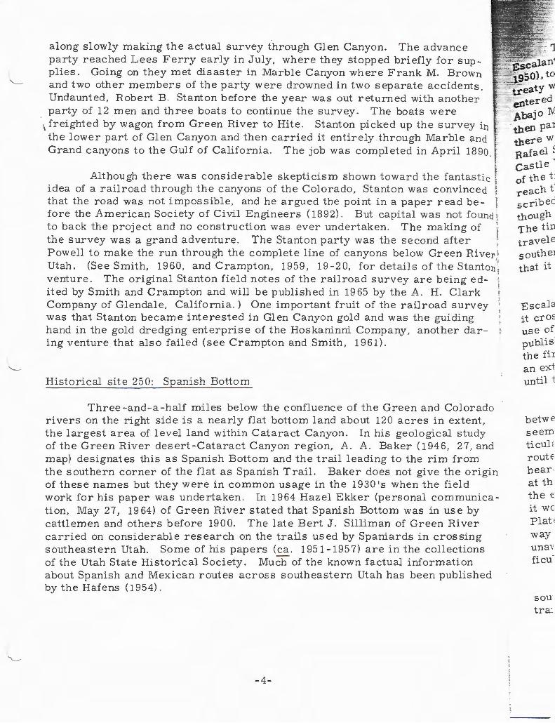
along slowly making the actual survey through Glen Canyon. The advance party reached Lees Ferry early in July, where they stopped briefly for supplies. Going on they met disaster in Marble Canyon where Frank M. Brown and two other members of the party were drowned in two separate accidents. Undaunted , Robert B. Stanton before the year was out returned with another party of 12 men and three boats to continue the survey. The boats were
w
.:.., ~tered -.-::·1\ baj 0 'N.
'I freighted by wagon from Green River to Hite . Stanton picked up the survey in the lower part of Glen Canyon and then carried it entirely through Marble and Grand canyons to the Gulf of Californ ia. The job was completed in April 1890 .
. then par
Although there was considerable skepticism shown toward the fantastic idea of a railroad through the canyons of the Colorado, Stanton was convinced that the road was not impossible, and he argued the point in a paper read be- . fore the American Society of Civil Engineers (1892). But capital was not found ; to back the project and no construction was ever undertaken. The making of ' the survey was a grand adventure. The Stanton party was the second after Powell to make the run through the complete line of canyons below Green River,: Utah. (See Smith, 1960, and Crampton, 1959, 19-20, for details of t he Stanton ; ventu re. The original Stanton field notes of the railroad survey are being ed- ' ited by Smith and Crampton and will be published in 19 65 by the A. H . Clark Company of Glendale, California.) One important fruit of the railroad survey was that Stanton became interested in Glen Canyon gold and was the guiding hand in the gold dredging enterprise of the Hoskaninni Company, another daring venture that also failed (see Crampton and Smith, 1961) .
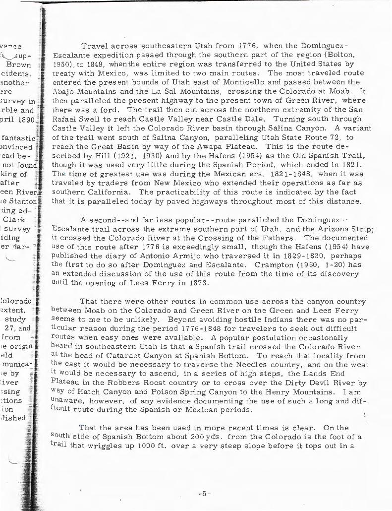
Historical site 250: Spanish Bottom
Three -and-a -half miles below the confluence of the Green and Colorado rivers on the right side is a nearly flat bottom land about 120 acres in extent, the largest area of level land within Cataract Canyon. In his geological study of the Green River desert-Cataract Canyon region, A. A. Baker (1946, 27, and map) designates thi s as Spanish Bottom and the trail leading to the rim from the southern corner of the flat as Spanish Trail. Baker does not give the origin of these names but they were in common usage in the 1930's when the field work for his paper was undertaken. In 1964 Hazel Ekker (personal communication, May 27, 19 64) of Green Riv er stated that Spanish Bottom was in use by cattlemen and others before 1900. The late Bert J. Silliman of Green Ri ver carried on considerable research on the trails used by Spaniards in crossing southeastern Utah. Some of his papers (ca. 1951-1957) are in the collections of the Utah State Historical Society. Much of the known factual information about Spanish and Mexican routes across southeastern Utah has been published by the Hafens ( 1954).
- 4 -
there w Rafael ~ castle . of the t: reach t -"'ribed !:''-
though The tin travele
50utheJ
that it
Escala it cro=: use of publiS the fir an ext until t
betwe seem ticul< route hear · at th the e it we Plat ( way una,· ficu
sou tra:
' 3Up-
Brown cidents.
.:mother ~re
ee n River,!' ,.,_ te Stanton :l : ing ed-Clark j
t survey -!l<
iding f er rlar- ~ r·
'--- <
· I:
~ olorado _( -: xtent, ~ 1:
study ; _ 27 , and (
from
; e by :iver >sing :tions
Travel across southeastern Utah from 177 6, when the Domingu ez Escalante expedition passed through the sou thern part of the region (Bolton, 1950), to 1848, when the entire region was t ransferred to the United States by t reaty with Mexico, was limited to two main routes. The most traveled route entered the present bounds of Utah east of Monticello and passed between the _-\bajo Mountains and the La Sal Mountains, crossing the Colorado at Moab. It then paralleled the present highway t o the present town of Green River, where there was a ford. The trail then cut across the northern extremity of the San Rafael Swell to reach Castle Valley near Castle D ale. T urning south through Castle Valley it left the Colorado River basin through Salina Canyon. A variant of the trail went south of Salina Canyon, paralleling Utah State Route 7 2, to reach the Great Basin by way of the Awapa Plateau. This is the route de scribed by Hill ( 1921, 19 30) and by the Hafens ( 1954) as the Old Spanish Trail, though it was used very little during the Spanish Period, which ended in 1821. T he time of greatest use was during the Mexican era, 1821-1848, when it was t raveled by traders from New Mexico who extended their operations as far as s outhern California. The practicability of this route is indicated by the fact that it is paralleled today by paved highways throughout most of this distance .
A second - - and far less popular- - route paralleled the Dominguez- Escalante trail across the extreme southern part of Utah , and the Arizona Strip; it crossed the Colorado River at the Crossing of the Fathers. The documented use of this route after 177 6 is exceedingly small, though the Hafens ( 195 4) have published the diary of Antonio Armijo who traversed it in 1829-1830, perhaps the first to do so after Dominguez and Escalante. Crampton ( 19 60 , 1 - 20) has an extended discussion of the use of this route from the time of its discovery until the opening of Lees F erry in 1873.
T hat there were other routes in common use across the canyon country betw een Moab on the Colorado and Green River on the Green and Lees Ferry seems to me to be unlikely. Beyond avoidi ng hostile Indians there was no par ticular reason during the period 1776 - 1848 for travelers to seek out difficult r outes when easy ones we re a vailable. A popular postulation occasionally heard in southeastern Utah is that a Spanish trail crossed the Colo rado Rive r at th e head of Cataract Canyon at Spanish Bottom. To reach that locality from the east it would be necessary to traverse the Needles country, and on the west :t wo uld be necessary to ascend, in a series of high steps , the Lands End P lateau in the Robbers Roost country or to cross over the Dirty Devil River by way of Hatch Canyon and Poison Spring Canyo n to the Henry Mountains. I am unaware, however, of any evidence documenting the use of such a long and difficult route during the Spanish or Mexican periods.
That the area has been used in more recent times is clear. On the south side of Spanish Bottom about 200 yds . from the Colo rado is the foot of a trail that wriggles up 1000 ft. over a very steep slope before it tops out in a
- 5-

forest of pinnacles in the Land of Standing Rocks (see Historical site 251). From the head of the trail there is a fine view of Spanish Bottom, the Colorado River, and Red Lake Canyon on the opposite side of the river (Fig. 2). The trail , though used infrequently , is plainl y visible and easily followed. Here and there a few built-up portions are to be seen. About 150ft. from the top at a s t eep, sharp bend there are 10 steps made of horizontally placed sandstone slabs (Fig. 3) and at another place a short distance above this there are four or five smaller slab steps. These steps would make it possibl e to drive live~ stock f rom the rim to the grassy flat of Spanish Bottom.
On the vertical surface of a ledge just abo ve the first series of slab steps there are a number of names inscribed and dated as early as 1904 . They were transcribed as follo ws :
E. Larson 1904 -- Prommel May 13, 1926 Jack Thomas E. D. Christensen E. Tribble 11 / 10 / 07 Jack Thomas Feb 9 1921 Joe Ross 1904 Jerry Page A. P. Mohr
10-10 '07 Carlie Mohr
Less Wareham Feb 10 , 1922 Neal Chaffin 1936 Feb 12 Paddy Ross Bennie Ross Joe Ross Nov-10-1907 V\Thite Aleson 1947 Roy Sessions 1947 Al Morton 7-28-47 NLC 34 M. Oppenheimer 1907
The name "Prommel " inscribed on the rocks at the head of the trail is doubtless that of one Harold W. C. Promm el , a consulting geologist , who in 1926 made a geological reconnaissance of the vast area from the Green River desert south to t he junction of the Dirty Devil River ·with the Colorado. Testifying about this survey in 1929, Prommel called the trail leading to the Colorado River at this point the "Old Spanish Trail" (Prommel, 1929, 995).
Hazel Ekker (personal communication, MC!-y 27, 19 64) reports that the Chaffin family ran cattle in the Ernie country, above the rim of Cataract , west of Spanish Bottom between about 1920 and 1943 when they sold out. She believes that the Chaffins used Spanish Bottom in their operations. ':(he inscribed name of "Neal Chaffin 19 3 6, " and "NLC 34" undoubtedly reflect this association .
A number of the names at the head of the trail are records of individuals who have ventured into the area from the river. At the extreme southern t ip of the flat at Spanish Bottom, and located on the northwest face of a big talus block of sandstone , is the following inscription in light paint:
-6-
twins 'in 1ss tiOD i: to de\
. Three appe ~ Ranc: u.S th EdWC. in th <
serif este F. F. call E that brin put '
: the 1
tole - and ·"' pow ·-.- art.
Mo< ThE deY cus
Ne er . a : R i

Here ~ he top at ndstone re four ve live-
922
·ail is ro in Uver resti-
c the
st 100 Steamer Major Powell May 24-93 - H Edwards H. F. Howard --Gr--
This is an interesting record of one of several attempts to commercialize the scenery of the river canyons between Moab and Green River through the use of power - driven - -and even hand -operated--boats. The Major Powell was indeed a ''steamer. " It was a boat about 35 ft. long with about an 8 ft. beam. An upright boiler powered two six-horsepower · engines; attached to twin screws. W . H. Edwards , who had been with the Stanton railroad survey in 1889 and who had also traveled through Cataract Canyon with the Best expedition in 1891, was one of the organizers of a small Denver company that planned to develop the tourist business in the canyons through the use of power craft. Three men--Edwards, H. F. Howard, and one Graham , those whose names appear on the rock- -brought the boat down the Green River from Wheeler's Ranch (about 25 mi. below the town of Green River), and the inscription tells us th ey arrived on March 24 , 189 3. In telling of these experiences later, Edwards ( 1929) recounted other trips in the Major Powell and other adventures in the canyon country of the Colorado River.
Joseph A. Ross (undoubtedly identical with the "Joe Ross" of the inscription at the head of the trail), a few years after Edwards, became interested in the potentialities of the canyon country tourist business. In 1901, for F · H. Sum meril of Denver , Ross boated down to Spanish Bottom, which he called "Cataract Bottoms," and actually surveyed the entire area. It appears that Summeril hoped to build a health resort, or sanitorium, in the locality and bring his clientele in by riverboat. A power-driven craft, the Undine, was put into operation but it was no match for the fluctuating river conditions on the Green and Colorado, and the enterprise failed. Joseph Ross later ( 1 929) told of these and other interesting experiences operating boats on the Green and Colorado rivers. Otis R. Marston ( 1960) has compiled a list of early Powerboat opera tors on the two rivers between Moab and Green River ; his article (p. 298) also contains a photograph of the steamer Major Powell. The }Ioab newspaper, The Times -Independent, which began publication in 189 6 as ~e Grand Valley Times, contains much information on the early attempts to oevelop by boat the scenic attractions of the river canyons. Ekker ( 1964) dis cusses I!)Owerboat freighting on the Colorado in the 1920's .
Across from Spanish Bottom, Red Lake Canyon, draining part of the ~eedles country, empties into the Colorado River at river mile 213. It is generally believed locally that Red Lake Canyon, also known as Butler Wash, was a route over which stock were driven, notably by rustlers, to the Colorado River. The animals were then forded or swum across the river to Spanish
- 7 -
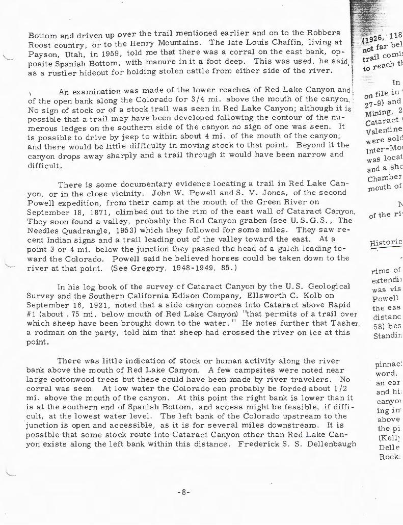
Bottom and driven up over the trail mentioned earlier and on to the Robbers Roost country, or to the Henry Mountains. The late Louis Chaffin, living at Payson, Utah, in 1959, told me that there was a corral on the east bank, opposite Spanish Bottom, with manure in it a foot deep. This was used, he said, as a rustler hideout for holding stolen cattle from either side of the river.
gz6, 118 ~ far bel ·-not .
An examination was made of the lower reaches of Red Lake Canyon and : I .
of the open bank along the Colorado for 3 I 4 mi. above the mouth of the canyon. No sign of stock or of a stock trail was seen in Red Lake Canyon; although it is possible that a trail may have been developed following the contour of the numerous ledges on the southern side of the canyon no sign of one was seen. It is possible to drive by jeep to within about 4 mi. of the mouth of the canyon; and there would be little difficulty in moving stock to that point. Beyond it the canyon drops away sharply and a trail through it would have been narrow and
difficult .
There is some documentary evidence locating a trail in Red Lake Canyon, or in the close vicinity . John W. Powell and S. V . Jones, of the second Powell expedition, from their camp at the mouth of the Green River on September 18, 1871, climbed out to the rim of the east wall of Cataract Canyon. They soon found a valley, probably the Red Canyon graben (see U.S. G. S., The Needles Quadrangle, 1953) which they followed for some miles. They saw recent Indian signs and a trail leading out of the valley toward the east. At a point 3 or 4 mi. below the junction they passed the head of a gulch leading toward the Colorado. Powell said he believed horses could be taken down to the river at that point. (See Gregory, 1948-1949, 85.)
In his log book of the survey cf Cataract Canyon by the U.S. Geological Survey and the Southern California Edison Company, Ellsworth C. Kolb on September 16, 1921, noted that a side canyon comes into Cataract above Rapid # 1 (about . 75 mi. below mouth of Red Lake Canyon) "that permits of a trail over which sheep have been brought down to the water . 11 He notes further that Tasher, a rodman on the party, told him that sheep had crossed the river on ice at this point.
There was little indication of stock or human activity along the river bank above the mouth of Red Lake Canyon. A few campsites were noted near large cottonwood trees but these could have been made by river travelers. No corral was seen. At low water the Colorado can probably be forded about 1/2 mi. above the mouth of the canyon. At this point the right bank is lower than it is at the southern end of Spanish Bottom, and access might be feasible, if difficult, at the lowest water level. The left bank of the Colorado upstream to the junction is open and accessible, as it is for several miles downstream. It is possible that some stock route into Cataract Canyon other than Red Lake Canyon exists along the left bank within this distance . FrederickS. S . Dellenbaugh
-8-
'l comlJ tral to reach tl
In
on file in ? 7 _g) and
;1ining. 2 cataract ( Valentine were sold Inter-Mo1 was locai. and a sh e Chamber mouth of
1'of the ri '
Historic
rims of extendi J was vis powell the eas distanc 58) bes Standir:
pinnae~
word, an ear and hi : canyo1 ing in above the p i (Kell ' Delle Rock .

lbhers
ver .
nyon a : cany mgh it the nu ~en. It
1
ll
{1926 , 118) of the second Powell expedition noted that on September 19, 1871, not far below their camp at the mouth of the Green River, they saw a beaten trail corning down a canyon on the left, showing that the Indians knew of a route to reach the junction of the rivers.
In addition to the above activities it appears from placer mining records en file in the Recorder's Office of Wayne County in Loa (Mining Record A, 2 - 7, 27 - 9) and in the Recorder's Office of San Juan County in Monticello (Book A , }lining. 296-7), that there was some prospecting ''above the first rapid in Cataract Canyon 11 in 18 92 and 189 3 . The locators were J . W. Menech, Lee
:_ Valentine, D. E. and G . W. L oomis. T he record shows that some of the claims •ere sold to the Green River Navigation Company and others were sold to the Inter - Mountain Mining and Improvement Co m pany of Kansas City. One claim was located a short distance below the second rapid on the east side of the river
d a short distance above the ''Salt Springs . 11 In 1901 R. C. Wheeler, F . Chambers , and others located the ''Powell Oil Placer'' about 6 mi. below the :nouth of the Green River (San Juan County , Mining Claims , C, 461).
No evidence of mining was seen in the Spanish Bottom area on either side o! the river.
orical site 251: Land of Standi Rocks
The grand forest of sandstone pinnacles and minarets surmounting both of Cataract C anyon for several miles below the mouth of the Green and
~~ending back for some distance from the canyon, particularly on the left side, 1;). _ \.isited by John W . Powell on both the 1869 and 1871 voyages . In 1869 .-'C;J;ell and Bradley (Darrah, 1947 , 52-53), and in 1871 Powell and Jones scaled
='-"''- """' ~ east wall of the canyon at or near the mouth of the Green and walked for
. ~~~nces through what has since been called the Needles country. Powell ( 1873, -·- · ::l.estowed an Indian name on it: Toorn'-pin wu-near' Tu-weap' (Land of
c.ng Rocks). Jones (Gregory , 1948 - 1949 , 85) called it a "Rock Forest.''
~-,..,- _ )learly all of the 1871 party climbed the west wall of the canyon to the ~::cl ed region called by Powell the Sinav - to-weap (spelled variously), a Ute
·:, -~ccording to Dellenbaugh.(1926, 117). The Utes , Dellenbaugh say s in e~~: l er work ( 1902 , 279) , refer to it as the Land of Standing Rocks. Powell · ""' men , in 187 L from their camp at the confluence reached the rim of the
·-''""·.·~ ·- by rowing up the Green River about 1 mi. to a short, steep canyon com lnto the river on the right . They climbed this and topped out about 1300 fB ~ the river where they spent two days (September 16- 17) exploring amid P~nacles and bare turreted rocks separated by open parks. W. C. Pow ell
y, 1948 - 1949, 325 - 6), John F . Steward (Darrah, 1948-1949 , 83-5), and en~a~gh (1902, 116 - 17) have interesting descriptions of the Land of Standing
Flg. 4). Beaman (1874) made a number of photographs .
- 9-

On their way through the canyons of the Colorado in 1911 the Kolb broth ers walked up to the Land of Standing Rocks following the same route as Powell party had taken in 1871. In his account of the voyage E. L. Kolb (1914, 121-3) has a description to match that left by Powell's men. He describes the "maze'' of rocks, which may be the origin of the term "The Maze" for the very intricat country adjacent to and draining off to the Green River north of the Land of Stan ding Rocks .
On September 20, 1871, Major Powell and Dellenbaugh, from a point 8 mi. downstream from the mouth of the Green River , again climbed out to the rim to the Land _of Standing Ro-:;ks , a hike that Dellenbaugh ( 1926, 119 -21) describes. See Carroll (1956) and Henderson (1957) for recent trips to the Needle: country and the Land of Standing Rr>cks .
Historical site 252 : Tilted Park
Centering at river mile 208 . 7 is a pleasant, open area in Cataract Canyon where two watercourses, Y Canyon and Cross Canyon, come in on the left and where an unnamed canyon debouches on the right. The cliffs on the right dip rather sharply away from the river toward the west; Francis M. Bishop , of the second Powell expedition, gave the place the appropriate name, "Tilted Park." Bishop made no entries in his diary (Kelly, 1947) but the name is recorded on his accurate manuscript map (Bishop, 1871) of the canyons of the Colorado made during the expedition of 1871. Bishop's map is very valuable in tracing the stopping places of the second Powell expedition , since he locates every campsite and every noon stop . The expedition camped September 19 on the left bank under a cottonwood tree .
An examination was made of the open bank on the left side of the river at the mouth of Y and Cross canyons where there are a number of cottonwood trees growing today. There was no sign of human activity in the area . Cross Canyon heads in the Beef Basin area south of Cataract Canyon, and there is some possibility that it may have offered an access route into Cataract. From the mouths of Cross and Y canyons it would probably be possible to drive stock upstream along the left bank of the Colorado 4. 3 mi. to the mouth of Red Lake Canyon opposite Spanish Bottom.
It was at this point or possibly below the rapids entering at mile 207 that the Kolbs in 1911 caught up with a lone trapper named Smith negotiating Cataract Canyon in a rowboat (Kolb, 1914, 132-7, and photograph).
-10-
I ! I ! i
I !
I l I
zo5 , t t can be 1/4 rD1
right t nurnbE ror th<
therD ;
tiOD 0
Bar: folh
sor gar pe <
tr , rn
· er. u-,

Kolb broth ; Powel ~ 121-3) 1e "maze ''
3. point 8 c to the -21) dehe Needl
tct Can - ~ ~he left -right
' hOp, Tilted is re-
a'me ocates 19 on
·iver ·ood ross LS
<' rom .;tock ~ake
7
; .
His t orical site 253: Mile-long Rapids
This is actually a series of continuous rapids in the Cat aract between mile 205 and 204 wh ere th e Colorado drops about 30 ft . To reach thi s point from the head of Cataract Canyon the ri v er voyager has traveled 12 mi. and come through as many rapids, most of t hem relativ e ly short. Mile-long Rapids has · presented a formidable challenge to river runners and not all have run the rapids successfully. The first •rapid!in · th e serie.s · .begins where the d ebris from Range Canyon, emptying into Cataract on the right , has dammed th e river and deflected the channel toward t he left bank.
On the ledges just above the mouth of Range Canyon, and opposit e mile 205 , there are a few inscriptions, most of them illegible. The letters D. E. can be deciphered, and nearby is what appears to be the date 4 - 11-91. About 1 I 4 mi. below the mouth of Range Canyon, where the channel is close to the right bank and where there are some large rocks in the rapids , there are a numb er of names inscribed. Probably everyone who has run through Cataract fo r the first time has stopped to investigate these rapids before attempting th em; some have left their signatures at this point- - mile 20 4 . 7 . An examination of the area revealed t he following names:
d . t Col. Gran. Canyon Mg Imp. Co. July 22, 1891 [ Figure of a boat labeled] No. 1 Wrecked. (Fig. 5). G . M Wright Sept . 16 1892 Jacobs W. H. E. F. G. Faatz Aug 27 189 - [ 1892 ?] NE 40 White f Olsen 194 7
Barry Goldwater ( 1940, 1 7) report s some of these names together with the following which I did not see :
Camp No . 7 Hell to pay, No. 1 is sunk and down Js . Best
Most of these inscriptio ns we re left by members of an expedition sponsored by the C olorado, Grand Canyon Mining & Improvem ent Co mpany, organized in Denv er, proba bly in 18 91, for t he purpose of ex plo ring and prosPecting in the canyons of the Colorado, including the Grand Canyon.
J . D . Best was in charge of t he expedition which consis ted of eight mer\ traveling in two boats . The party left Green River , Utah, and during the sum mer of 18 91 traveled through the canyons to Lees Ferry where the ri ver trip ended . A number of the men had had prior experience in the canyons; some of them had been with Stanton on the railroad survey .
- 11 -
At Mile-long Rapids the number 1 boat was pinned to a large rock (s
photograph in Marston, 1960, 290) and lost. This accident slowed the expe tion considerably since it was thereafter necessary for four of the men to w along the bank all the way to Bite; they were able to ride only when preci walls blocked their passage and they had to be ferried across the river by one remaining boat. Members of the party who left their names at MileRapids are: J. D. Best, in charge; John Jacobs , a boatman; the 11W. H. E. 11
probably W. H. Edwards. Edwards, as well as Elmer Kane and Harry McDonald , who were members of the expedition, testified of these and othe:r river experiences in 1929.
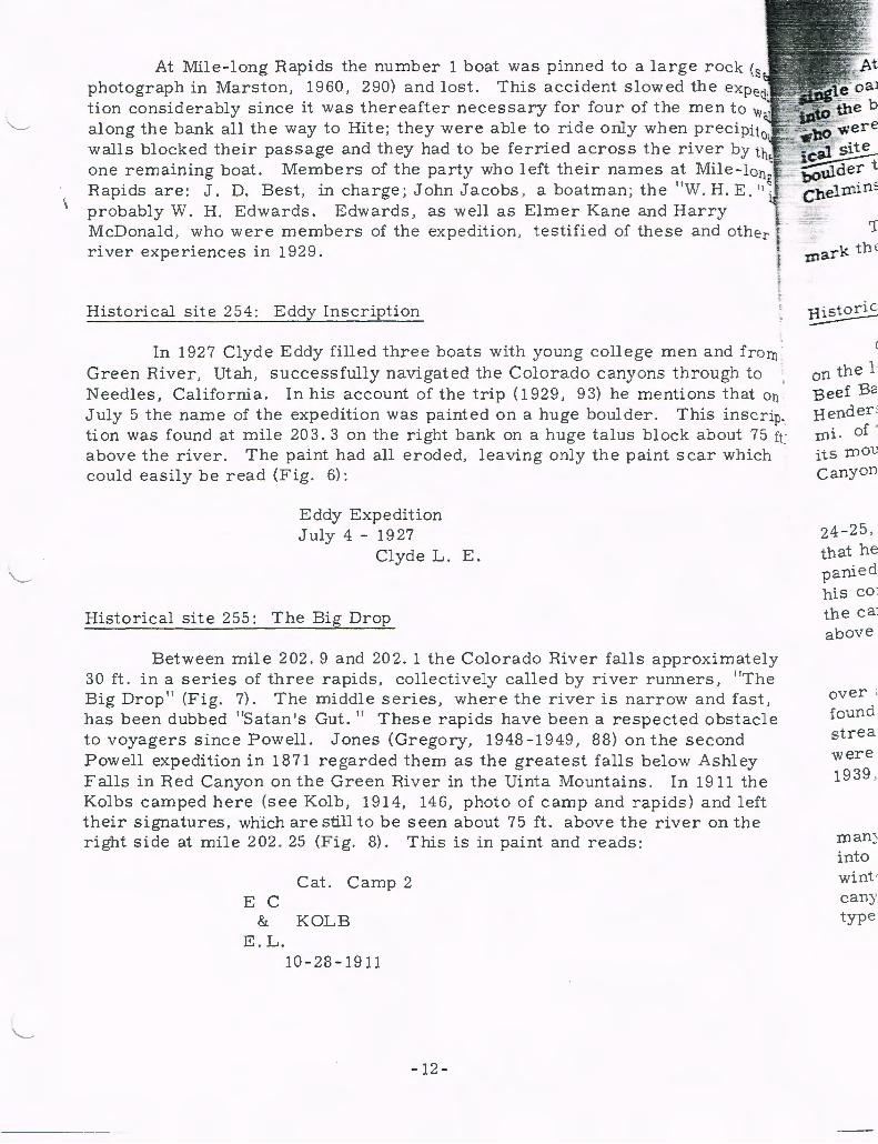
Historical site 254: Eddy Inscription
In 1927 Clyde Eddy filled three boats with young college men and from : Green River, Utah, successfully navigated the Colorado canyons through to Needles, California. In his account of the trip ( 1929, 9 3) he mentions that on July 5 the name of the expedition was painted on a huge boulder . This inscrip. tion was found at mile 203.3 on the right bank on a huge talus block about 75ft above the river. The paint had all eroded, leaving only the paint scar which could easily be read (Fig. 6):
Eddy Expedition July 4 - 1927
Clyde L. E.
Historical site 255: The Big Drop
Between mile 202. 9 and 202. 1 the Colorado River falls approximately 30 ft. in a series of three rapids, collectively called by river runners, 11 The Big Drop 11 (Fig. 7). The middle series, where the river is narrow and fast, has been dubbed 11Satan 1s Gut. 11 These rapids have been a respected obstacle to voyagers since Powell. Jones (Gregory, 1948-1949, 88) on the second Powell expedition in 1871 regarded them as the greatest falls below Ashley Falls in Red Canyon on the Green River in the Uinta Mountains. In 1911 the Kolbs camped here (see Kolb, 1914, 146, photo of camp and rapids) and left their signatures, which are still to be seen about 7 5 ft. above the river on the right side at mile 2 02. 25 (Fig. 8). This is in paint and reads:
Cat. Camp 2 E C
& KOLB E.L.
10-28-1911
-12-
T
~ark th e
on the 1· Beef B2 Bender : n1i . of -its roou canyon
24-25 , that he panied hiS C01
the ca' above
over ; foun d strea were 1939 ,
roan~
into wint · cany type

e rock (see expedi
:hen to wal . precipitou~
ver by the Mile -long -.H. E. " is rry end other
and from >ugh to s that on . .3 inscrip- f bout 75 ftJ r which I
I f f
mat ely "The fast,
stacle ~d
1ley l the · left the
f
I f
I I I· r
At the head of this series of rapids on the left bank at mile 202 . 9 a singl e oar has been set up on a rock wi t h names Hoover and Peterson burned into the blade. This commemorates the death of K. H . Hoov er and L. Peterson who were drowned, presumably in The Big Drop , on May 22 , 19 60 (see Historical site 261: Sheep Canyon). At mile 202. 7 on the left side, on a waterworn boul der that would be covered in high water , the names o f Vie [or Vic J & Dude Chelminski were chipped.
The foot of The Big Drop , where the river level reaches 3710 ft ., will mark the approximate head of Lake Powell at full pool (Fig. 9).
Historical site 256: Gypsum Canyon
Gypsum Canyon, entering the Colorado on the left at mile 196. 5, heads on the lofty slopes of the northern (the North Elks) half of Elk Ridge. Draining Beef Basin, it is one of the principal tributaries of Cataract Canyon (see Henderson, 1949, for a reconnaissance of the upper watershed). The lower 7 mi. of the canyon is a precipitous and narrow gorge which is 200 0 ft. deep at its mouth. Indeed, in the vicinity of the mouth of Gypsum Canyon Cataract Canyon reaches its maximum depth.
The second Powell expedition camped at the mouth of the canyon Sept ember . 24 -25 , 1871. John F. Steward (Darrah, 1948-1949 , 238 - 9) in his diary stated that he named the canyon. A. H. Thomps on (Gregory , 1939 , 51) , who accompanied Steward on a geological hike up the canyon, called it Steward Gulch after his companion. Members of the party found beds of gypsum and fossi l coral in the canyon. Powell and Dellenbaugh ( 19 26, 12 7) hiked out to a point 3 135 ft. above the river which they reached 7 or 8 mi. back from the rim of Cataract.
An examination was made of the mouth of Gypsum Canyon for a little ov er a mile from the Colorado. A small stream of good - tasting water was found about 3 I 4 mi. from the river but this disappeared another 1 I 4 m i . up stream . Big talus chunks of gypsum were noted. A doe antelope and fawn were seen and a horse sign a few y ears old was noted. Thompson (Gregory , 1939, 51) of the Powell party in 1871 saw mountain sheep at this locality .
In an interview in 1963 Henry Lyman, of Manti . Utah , who worked for many years for the Scorup-Sor.Jerville Catt' ~ Company, stated that a trail leads into Gypsum Canyon from the Beef Basin area . He said that stock ha ve been Wintered in the canyon. There is an extensive open area at the mouth of the cany on that supports a fairly good stand of grass and extensive beds of opuntia \.. type cactus. .
-1 3 -

Historical site 257: Clearwater Canyon
Clearwater Canyon is a very narrow gorge entering the Colorado on the right at mile 191.95. Cataract Canyon at this point is very narrow and its w tower upward about 1700 ft. (Fig. 10). Clearwater Canyon, named by the U.S G. S. mapping party in 1921 (E. C . Kolb, 1921, September 22), is believed to be identical with the canyon visited by the Powell party on September 26 , 1871 \and named by them 11Eden Canyon,'' as reported by Jones (Gregory, 1948 -1 949, 90 -1). Beaman (1874) and Thompson (Gregory, 1939) also commented on the ' extraordinary beauty of the narrow canyon, which was very narrow at its moun. but opened up into a wider area beyond. There were cottonwood trees, grass, ferns, running water, and the towering walls abo ve. Jones thought it to be the most wonderful place he ever saw. Dellenbaugh (1902, 280) has published Beaman's photograph of the mouth of the canyon .
An examination was made of the mouth of Clea r water Canyon on May 23, 1963 but there was insufficient time to explore the canyon. A short distance from the mouth there is a jump-up of about 30 ft . The narrow mouth described by Powell's diarists apparently was beyond this point. Thompson (Gregory, 1939, 51) mentions a shelf 30ft. high beyond which the little valley was to be found. Upstream a short distance from the mouth of Clearwater, at mile 192, the following names were found inscribed on a ledge close to the ground:
260: Dark Canyon.)
Russ Frazier
Tom Hatch W. J. Fahrni Frank Swain
Historical site 258: Bowdie Canyon
33/8/1
[For Swan?] (See Historical site
On a map made in 1921 during the course of the survey of the Colorado between the mouth of the Green and Lees Ferry by the U.S. Geological Survey in cooperation with the Southern California Edison Company this canyon, entering the Colorado on the left at mile 190. 6, carries the name Cadunk Canyon . For details of this survey see Historical site 261: Sheep Canyon.
Historical site 259: D. Julien Inscription
On June 20 , 1889, while carrying the railroad survey through Cataract Canyon, Robert B. Stanton discovered an incised inscription that read:
1 8 3 6 D. Julien
-1 4-
p
with neg< c:criptiOJ ~f Berk E ~ile 18
Green 1 'fhe Jul and is i date 18 canyon Julien are do l first P Uinta ' there : g:reat thougl: Ferri· demo' moun-,
Histc -princ with they a de tion bee: Her l as-,
_ ts wal 1e U . S. ed to
1871, 3- 1949, ::m the
;rass, be the :d
'lay 2 3, _nee cribed ~
ry, .; o be ::
192,
te
·ado ·vey ntern.
·act
-
The name was found in a section of the canyon where the cliff walls on either side rose directly from the water and where the name could have been made only from a boat. Stanton ( 1889, June 19- 20) locates the name with reference ~o his survey stations, which cannot now be determined accurately. But his description of the canyon is good enough that the location can be identified with that section of Cataract Canyon between mile 186. 2 and mile 185. 2. Through this mile the river is banked on either side by hard black rock rising from a few feet to 30 or 40 ft . above the water.
An examination of this section of the canyon was made on May 23, 1963, with negative results. High water, it is believed, may have obscured the inscription. Early in April . 1964, at a lower stage of water, Otis R. Marston, of Berkeley, California, discovered the name on the left bank at approximately mile 185. 5 .
D. Julien, who left his name inscribed at three other places along the Green River above its mouth, has been identified by Charles Kelly (19 33 a, b). The Julien inscription in Cataract Canyon is most probably an authentic one and is the oldest authentic date to have been found in the Lake Powell area . The date 1837 opposite the mouth of Lake Canyon (Crampton, 1962, 44 - 5) in Glen Canyon, also presumed to be authentic, may in some way be related to the Julien inscription in Cataract. These dates-- certainly those left by Julien- -are documents of the fur trapping era in the Rocky Mountains which reached its first peak during the years between 1820 and 1840, Robidoux' post in the · Uinta Basin was a known center for the mountain men who ranged south from there as far as the Gila River after beaver pelts. That the trappers entered the great canyons of the Colorado after these animals seems without question, though little evidence documenting this activity has been found. Warren A. Ferris , who spent the years 18 30 - 18 35 as a trapper in the Rocky Mountains, demonstrates in his book (Auerbach and Alter , 1940, 260) how completely the mountain men understood the intricate canyons of the Colorado.
~orical site 2 60: Dark Canyon
Dark Canyon, entering the Colorado on the left at mile 182. 8, is the Principal tributary in Cataract Canyon. Its numerous tributaries, interlocking With those of Gypsum Canyon, head on the high slopes of Elk Ridge , into which they have cut d8ep caDyons. In thE: ~ower 15 mi. of its course Dark Canyon is a deep and narrow gorge ranging in depth from 1500 to 2000 ft. The upper portion of the drainage has long been used as a cattle range, but the lower part has been little visited by man. From Kigalia Ranger Station on Elk Ridge Randall I.
Henderson (1946) and a group traveled 43 mi. to the mouth of the canyon, the · last 12 on foot.
- 15 -

The mouth of Dark Canyon is one of the more awesome places in Cataract Canyon. The mouth of Dark Canyon is narrow and dark and the walls of Cataract, approximately half a mile apart , are nearly 2000 ft. high (Fig . 11) . Direct sunlight reaches the spot only a few hours a day. The immensity of the canyon and the forces of nature that created it are at all times apparent.
1 The rapids at the mouth of Dark Canyon are among the most formidable
in Cataract. Debris and boulders from Dark Canyon have dammed and d eflected the river toward the right bank. In the distance of . 2 mi. the ri ver drops about 17 ft. over a curving channel full of boulders and rocks. ·whereas many river runners have portaged or lined Dark Canyon rapids , neoprene pontoons can navigate them and in recent years boat s powered with outboard motors have run all of the rapids in Cataract Canyon. The ride through Dark Canyon Rapids on a power boat can be a thrilling experience (Fig. 12) .
I ~
~ ~
f At the foot of Dark Canyon Rapids on the left side at mile 182. 7 there l
are inscribed a number of names on the rocks. These mainly are signatures l
of river parties who made the run through Cataract. Once through Dark Can- t yon Rapids the worst was over, although P owell in 1871 feared most of all the t
F rapids below Dark Canyon at approximately mile 182. 2. See the diaries of ( W. C . Powell (Kelly, 1948-1949, 332-3) and John Steward (Darrah, 1948-1949, tr
240-1) both for September 28, 1871. The names and the rocks below the rapids were transcribed as follows (Fig. !3): I
Amos Burg 10-7-38 Bob Barber l ! Pathe.:.Bray John Shubert i
Colorado River Expedition Frank B. Dodge !
Nov . 24. 1927 V. T. Herrick lVIaj. E. C. LaRue D. Dailey Leigh Smith V. Woodbur y Gl enn R. Kershner Nick Sarnoff Pat Gannon
[On square metal piece]:
Frank Swan Bus Hatch Dr. F . R . Frazier W. J. Fahrni Toni Hatch Aug [ ? ] 193 3 Buzz Holmstrom
11 - 1 -37 -- 10-7-38
-16-
Pansy Dog Con Rodin
Nevills Expedition July 2, 1938 July 1 7, 19 4 0 July 16, 1945
Don Harris Jack Brennan Erick Eliason Bert Loper
July, 1944
l
t i t I
l I I l f I ! i I I
there locati a me·,
more ing b . Calif
ners asse : able joun 1951
Hist
mil E wat ( strE rivE nigl vie> 194 oth• bac bui
15 f be , br nu

l fl
\....__ _; of ig. 11) 0
midable deflect drops .3 many 1toons 'Jrs 'anyon
here ures Can-
11 the of
:-1949, rapids ,
Ales on - 2 3 - 45
47 A. Hoyt
9 -1-53 Again in 9-2-55 Tom Hatch
10 - 31 - 11 Kolb Brothers
9 -28-2 1
W. Johnson 10-7 - 38
H. [ ? ] Chase L. Carter
10 -1 2-46 H. Chase M. G. Watts
6-25-47 W. Herwig ---
--
-
L. Harris J Brennan
L. Harris A. Maxwell
Bering Monroe 5-4-47
Just within and on the downstream side of the mouth of Dark Canyon there is a spring of good water hidden among redbud trees and brush. The location is marked by a. cairn of rocks located in the open; the cairn encloses a metal mailbox that contains the names, on paper , of recent visitors. A more extensive register of names originally placed in the mailbox and extending back into the 1940's is in the possession of Otis R. Marston of Berkeley, California.
Otis "Dock" Marston has assembled much information about river runners in the canyons of the Colorado. In two publications ( 1955 , 1960) , he has assembled valuable data on the subject and in a compilation ( 1949 - 1951) , available in the Grand Canyon National Park Library, he has brought together the journals and diaries of many of those who have run the Colorado from 1889 to 1951.
Historical site 261: Sheep Canyon
Sheep Canyon, a short tributary, enters the Colorado on the left at mile 177 near the foot of Cataract Canyon. Here the rapids end and the quiet water characteristic of Narrow Canyon and most of Glen Canyon appears. Upstream from the mouth of Sheep Canyon a wide, sandy beach has long attracted river travelers as a good camping place. Powell's party in 1871 spent the night of September 29 here. While Powell and Thompson climbed out to obtain views of the surrounding country Dellenbaugh ( 19 2 6, 13 2) , Steward (Darrah, 1948-1949, 242), and W. C. Powell (Kelly, 1948-1949, 333-4), report that the other members of the party found evidences of prehistoric people in caves just back of camp. They found corn and cobs, pottery, and part of a masonry wall built across the entrance to a smoke-blackened cave.
Just above the mouth of Sheep Canyon and back from the river about 150 yds . there is a low cliff in which there is a small smoke-blackened cave bearing the Museum of Northern Arizona's archeological site no. 7 171. A broken metate was noted. On the cliffs on both sides of the cave there are a number of names inscribed on the rock surfaces. Additional names are to be
-17-

seen along the ledges of a higher cliff perhaps 200 yds. from the mouth of Sheep Canyon. The following names were deciphered:
B. Monroe L. P.. B.
E. R. V.
5-1-4 7
Apr. 1886 [Possibl y Apr. 18 . 86] ?
S. Paige 1921 G. M. Wright O ct. 11, 189 2 A H R HM D
U.S.G.S. 9. 30. 21 J. H. Cl ogston L. B . Lint [plus skull and
cross bones] E. H . Rauch Stoudt - 2 1 Aleson 1945 E. C. Kolb E . H. Rauch
9-29-21
~ i •
At the extreme head of the beach and on a ledge about 35 ft. abov e and l overlooking the r iver the following inscription in black pai nt appear s : t ;
K H. Hoover - L. Peterson Lost
Cataract Canyon May 22, 1960
See Historical site 25 3: Mile -long Rapids for further reference to Hoover and Peterson.
Probably most of the names at Sheep Canyon represent downstream river travelers but the place was reasonably accessible by boat from the head of Glen Canyon where there was much gold prospect ing after 1883. The initia l s L. P. B . and E. R. V., which are faint (and the date following is faint er) , may be the record of upriver prospectors. In an interv iew in 19 60 Harry Ales on stated that some years before an associate had found some m iner's equipment , together with a pair of gold scal es, hidden at the mouth of Dark Cany on . Dark Canyon would certainly have been the practical upriver l imit to prospecting, but probably very few in the days before high-powered boats would have gone far above Sheep Canyon.
G. M. Wright , who signed his name at Sheep Canyon on October 11, 18 92 apparently had made the trip through Cataract because the same name and the date September 18, 1892, appear at Mile-long Rapids (Historical sit e 253). He was probably a prospector and there may be some relation to L. C. and G. \fiT. Wright who located the gold prospect at Wright Bar in Glen Canyon 25 mi. abov e Lees Ferry (Crampton, 1960, 89-90).
The surv eyors who made the splendid set of river maps (used as atlas sheets in t hese historical site reports) for the U . S. Geol ogical Surv ey and the
-18-
found s canyor negati' dividU< catarc rado i appeaJ the Kc (Kolb .. von r • "'
llisto -Shee· ity 0
side by n in l l MilE belo

1 of
ld
J
c '---
m head -
nenC Dark ng,
'ne
l}
the
Las
th
Southern California Edison Company in 1921 (see Cram pton, 1959, 68-9) are ·.vell represented on the rock register at Sheep Canyon .
In the archives of the Southern California Edison Company at Los _-\ngeles th ere are some records relating to the survey, including maps and photographs. One photograph shows E. C . LaRue painting the names of the personnel of the survey on a cliff wall in Cataract Canyon. The painted in scription reads:
U.S . G.S. 9-23-21 W. R. Chenoweth, Chief S. Paige Geologist E. L. LaRue Hydr. Eng. E. L. Kolb Boatman
E. C. Kolb Boatman E. H. Rauch, asst . John Clogs ton, Cook L Lint, Rodman H. C. Tasker " F. Stoudt 11
According to data on file with the photograph the inscription should be found at approximately mile 187. 1 on the left wall about 4 mi. above Dark Canyon. An examination of the cliff wall in that general vicinity was made with nega tive results. Apparently a majority of t he party inscribed their names individually at Sheep Canyon . Ellsworth C. Kolb kept a log of the survey in Cata ract Canyon (1921) and later (192 8) testified of his experiences on the Colorado including the 1911 run with his brother Emery, whose account of that trip appeared in 1914. After a four days 1 run through the Cataracts in that year th e Kolbs camped at the mouth of Sheep Canyon where they chiseled their names (Kolb, 1921, September 30). These names we re not found when the Sheep Canyon register was examined on May 24, 1963.
Historical site 262: Mille Crag Bend
This is a narrow bend over 3 mi. long at the foot of Cataract Canyon. Sheep Canyon (Historical si te 261) enters the canyon near the southern extremity of t he bend. Throughout its entire length, but particularly on t he upper side, the inner bank of the bend, rising 1500 ft. above the river, is surmounted by many pinnacles and crags which suggested the name to the Powell expedition in 1869 (Powell, 1870 , 23). The "Mille" is often misspelled (Millie, Mill, Mil e , etc.). Cataract Canyon ends at the lower end of Mille Crag Bend just belo w mile 175.
NARROW CANYON
Narrow Canyon named by Powell (1870, 23) in 1869 is a narrow, straight canyon about 5. 3 mi. in length. It extends from mile 174 . 8 to the mouth of the Dirty Devil River at mile 168. 5. The river is placid throughout this distance .
-1 9 -

Powell was probably so intrigued with even 5 mi. of straight canyon on a river where the canyon walls are usually curving that he settled on the name. Durin t hese 5 mi. the walls of th e canyon drop rapidly from nearly 1500 ft. at Mille g Crag Bend to a few feet at th e mouth of the Dirty Devil. The historical associa, tions of this canyon are few.
\Historical site 263: Narrow Canyo n Register
Under an overhanging rock on the left side at mile 17 3. 1 and about 40 ft. above the river, there are a number of names recording river parties (Fig. 14); they probably represent mainly successful runs through Cataract Canyon . The following names were noted:
[In Circle:] 1938 Exp. Buzz Holmstrom Willis D. Johnson Amos Burg
[In Circle:] 195 8 Willis Johnson Zeke G. Rider
The Davis Exp. '52 '53 Hyde 11-1-28
Blake Exp. 15 6 H . Elwyn H. Prescon
D. R. Malberg 8-60
HB Branting
Colorado Up River Expedition Harry Aleson - Bea Whittlesey
7-22-45
J. E. Schlump Ex - 1951
D. E . Griffith Isabell
J. A. Galloway 19.5 5
-20-
K. I. Ross Exp.
M. McLarty L. Langston
1955
9-2-53
C. L. Eddy 1927 The Eddy Expd ' T · , N
7-10-27
1927 Lucky Strike Harvard
Coe Notre 1927 Dame
"Powell" W. G. Adger R. F. Bartl F. L. Felton F . M. Blackwell J. · H . . Marshall
Rags
"Coronado" C. L. Eddy V. F. Carey C . McGregory R. H. Weatherhead
The Eddy Party
t
I 1
I f I I I I I
! i ! I
reco : paint Nevi othe: did! syst CraJ "Bu on t fro r of h
C& th ' sc of
"Dellenbaugh" P. M. Galloway E. L. Holt V. · C. Calloway B. A. Seagers
H . W. Lambert 1\ii. D.
Nevills Expedition Elzada V. Clover L. F . "Don" Harris W. Eugene Atkinson Lois Jotter Bill Gibson Norm Nevills
7 - 2 - 38
Nevills Expedition 7 - 20 - 40
Doris Nevills Norm Nevills Mildred Baker T. Southworth
9-2 - S - - C. Larabee H. Cutler D. Reed Anne Rosner B. Goldwater
Nevills Expedition 7 - 16 - 45
Ed Hudson Wayne McConkie Loel Marston Margaret Marston C. Reed Marston Maradel Marston Joan McLellan Norm Nevills
Apparently the register was begun by Clyde Eddy in 1927 who ( 1929, 124) records the fact that he stopped halfway through Narrow Canyon where his men painted their names on the rocks. Barry Goldwater (1940, 2 3) mentioned that )ievills on July 20, 1940 left the names of the party in Narrow Canyon where other scribblers had been at work . Norman D. Nevills of Mexican Hat, Utah, did much to popularize river running, 1936-1949, on the rivers of the Colorado sy stem. His most popular run was the San Juan River below Mexican Hat (see Crampton, 19 64, report on the historical sites in San Juan Canyon) . Haldane ' 'Buzz" Holmstrom, whose name appears on the register at Dark Canyon and on t he one at Narrow Canyon, in 1937 shot the entire string of canyons alone from Green River, Wyoming, to Lake Mead . Case ( 19 38) wrote up the account of his 52-day solo.
GLEN CANYON · ·~
The Dirty Devil is the point of separation between the short Narrow \ Canyon and Glen Canyon, 169 mi. long, and historically the most significant of · the canyons of the Colorado . Prior reports (Crampton, 1960, 1962) have de scribed a large number of the historical sites in Glen Canyon between the mouth of Hansen Creek and Lees Ferry, a distance of 130 mi. Within that area there
- 21 -
was a considerable variety in the origins of the sites reported--crossings by Indians, Spaniards, Mexicans and Americans; Indian utilization; mining and farming and related activities. In the 40 mi. stretch between the mouth of the
"----- Dirty Devil and Hansen Creek, most of the sites reported in the following pages had their origin in the gold mining boom that occurred in Glen Canyon following the arrival of Cass Hite in 1883.
Although men had talked for some time of finding mineral wealth in the canyon country of the Colorado River in Utah and in neighboring northern Arizona it was not until 1880, when Merrick and Mitchell reportedly found a rich mine somewhere in the Monument Valley-Navajo Mountain area, that men began to prospect intensively. Both men were killed by the Indians but rich samples of silver ore, it was said, were found by their bodies. Prospectors ranged out through the tangled country south of the San Juan River but no one seemed to be able to locate the Merrick-Mitchell mine. Cass Hite was one of those most persistent in the quest. He became friendly with a p owerful Navajo, Hoskininni, and tried to worm out of him the location of the silver mine , which some thought was secretly known to the Indians. Hoskininni told Hite that if he wanted some valuable mineral he could go to the great canyon of the Colorado where he would find gold in the river sands . Hoskininni was right. He and Hite, by way of White Canyon, journeyed to Glen Canyon and there found placer gold in the banks of the river. Hite extended his explorations in Glen Canyon and found gold in a number of places. There probably had been some inconsequential prospecting in the canyons of the Colorado River after Powell's second voyage, but it was Bite's discoveries that led to a gold rush to Glen Canyon and
"---- later to the San Juan Canyons.
The first phase of the gold rush in Glen Canyon lasted until about 1890; it was a mild rush and it gathered speed s l owly . The railroad survey by Robert B . Stanton for the Denver, Colorado Canyon, and Pacific Railroad Company, in 1889-18 90, attracted much attention to the canyon. The elaborate prospecting expedition of the Colorado, Grand Canyon, Mining & Improvement Company, that ran through Cataract and Glen canyons in 1891 is an illustration of the increasing interest in the mining potential of the canyons.
Late in 1892, and during the first months of 1893 , there was a genuine and excited rush to the San Juan River below Mexican Hat but it soon played out when the reports of big finds seemed to be exaggerated. However, the rush to the San Juan attracted wide attention to the canyons and men began to prospect them thoroughly. The second phase of gold mining in Glen Canyon followed the bursting of the San Juan bubble (though mining did continue there as long as it did in Glen Canyon.) Men found better diggings in Glen than they had on the San Juan and the boom in gold, sustained by the panic of 1893, the rise in the price of gold, and the discovery of rich fields elsewhere (Klondike, South Africa), which stimulated domestic prospecting, lasted until after the turn of the century.
-22-
t ~
i
l l
l t
t ..
' I I i f.
l I
' l \ t I ' I ! I !
I
pl< . flC
aL ne si
-· br t h th
- c t "G
rr fE s·
c
Y· D
P. (
. f ..

t ages Ning
he
3.
nen
r'S
of rajo, 1ich f he Jo
en -
9 0;
ng
n -
ne out to
~ct
the it
ice
By comparison with the stamped e to the Klondike the gold rush to Glen Cany on wa s small. Probably no more than 1000 men were to be found in the canyon at any one time. Gold was found all along the Colorado from the Dirty Devil to Lees Ferry, and on the San Juan Riv er, but little was found in the t ributaries. The most extensiv e (and best) diggings were found in the lateral grav el t erraces abov e Halls Crossing. Nowhere was any coarse gold found; it was everyw here ext rem ely fine- - gold dust. It was difficult to obtain by the s t andard pl acer mining methods of panning and sluicing because the ext remely fine flakes floated a way with the sand.
The problem of water supply to operate t he mines was serious. Nearly all of the diggings were located above the highest level of the river and it was necessary to lift water to them. Gravity diversion of the riv er was an impossibility ; only a few of the tributary streams could be used, and small reservoirs built in them either quickly filled with silt or washed out. Pumping water from th e river was usually a failure as the sand and silt in the water quickly wore out th e pumps. Many types of placer mining machinery were tried out in Glen Canyon but none of them were entirely successful. The most efficient method tu r ned out to be the shovel, some form of sluice, and the pan.
The Glen Canyon country was tough to prospect. The canyons, both the rnainstem and i.he long canyon t ributaries, were barriers . There were only a few t rails into the canyon and fewer wagon roads. Over these primitive routes supplies, equipment, lumber and foodstuffs had to be hauled in from the small communities peripheral to Glen Canyon. To a void the rapids of Cataract Canyon, goods brought by rail to Green River had to be hauled by wagon over 100 mi. to Glen Canyon. The Colorado in Glen Canyon was a major route of travel. All kinds of boats were used--rowboats , skiffs, rafts, scows, power craft (usually under-powered for upstream travel) and ev en sailboats.
Life in the Glen Canyon gold rush was a rough adventure in the open . :.VIen (and there were only a few women) , when they did not sleep under the open s ky, used tents and shacks, or they built dugouts. Some followed the custom of the prehistoric inhabitants and lived in recesses in the cliffs or under overhanging shelv es of rock. Lumber wa s e xpensiv e but the Colorado often provided it free in the form of driftwood. Drift also was used for fuel. A few people attempted gardens and some kept chickens. The riv er produced catfish of excel J. ent quality but wild game was scarce. Cattle, notably on the eastern side, Were often ranged into the canyon lands for winter rang e .
The only place in Glen Canyon that could be called a community was Bit e. There a post office was opened in 18 89. Cass Hite ' s relativ es- -brother1s John P. and Ben R. , and the latter's son, Homer J. Bite- -followed him into · Glen Canyon hoping to make their fortunes. One or another of t he Hites operated the post office and ran a small store until Cass Bite died in 1914 at his ranch at Ticaboo.
-23-

Before Cass Rite's death (he had lived in Glen Cany on most of the time since his arrival in 1883) interest in gold had waned but th i s was followed by a mild copper boom, 1905-1907. After Worl d War I there was a canyon count ry
'--- boom in oil prospecting, and during the Great Depression, 1929-19 39, there was again a revival in gold mining. An interest in t ourism began at the same time and this reached a peak after World War II. The uranium rush of the 1950's probably brought more men i nto the upper part of Gl en Cany on than h a d ever gone there looking for gold. By the time this report is published many of the evidences of these successi v e chapters in the his t ory of Gl en Cany on will hav e been cov ered by the rising waters of Lake Powell. Inasmuch as the placer gold mining took place altogether within the cany on, practically ev ery i mmovable physical v estige of that colorful era will be lost.
The background and the broad outlines of the Gl en Canyon mini ng rush and of subsequent events hav e been discussed in prior report s b y Cra mpt on (1959, 1960, 1962), and in a recent rep o r t on t he h is t orical s it es in the San Juan Cany on ( 19 64). Crampton and Smit h ( 19 61) hav e publi shed the diaries of Robert Brewster Stant on who, a ft er his rail road surv ey , undertook a gol d d redging operation in Glen Canyon, 1897-1902.
Historical site 8 6: Dirty Devil River
The Dirty Devil enters the Colorado River from the right 169. 5 mi. abov e Lees Ferry (Fig. 15). It is one of the longest and most interesting tribut aries of the Colorado within the Lake Powell area . Heading at Fish Lake and environs it breaches the Waterpocket Fold at Capit al Reef and at Hanksville picks up the Muddy River, which heads on the Wasatch Plateau and bisects the southern part of the San Rafael Swell ; then it drops int o a sinuous cany on t o reach the Colorado about 125 mi. from its source. Abov e the Muddy it is call ed the Fremont, below, the Dirty Devil.
The name ' 'Dirty Dev il Creek 11 or "Dirty Creek 11 was giv en to it b y the first Powell expedition in 18 69 when camp was made at it s mouth on July 28. On that date George Y. Bradley, John C. Sumner, and J. W. Powell (Darrah, 194 7, 55-6, 116, 127) all refer to the stream in diaries. Sumner noted the dirty , smelly water flowing out of the mouth at the time; Bradley not ed t hat it was sweeping far out into the Colorado . These remarks probably mean that Powell's party saw the stream when it was carrying a rich body of soupy, muddy wat er--a runoff from a summer shower somewhere on the drainage above. Much of the basin is bare rock and open desert and the runoff from summer showers may fill the stream with silt so thick it looks like liquid mud. Sumner later (Chalfant, 1932) claimed full credit for naming the Di r t y Dev il, for which he begged the Devil's pardon. Dellenbaugh (1926, 13 4) giv es Sumner credit for the name.
-2 4 -
t
I l t I
l I I i
i
\ I
I
\ !
-· con-Dirt a} or er,
::. bee Qu<' v;af
ing oil to pre
Bi
b e t h s : 0
0
s \ r f
r
In sharp contrast to the ragged, rough formations in Cataract Canyon, the rounded, hummocky sand stone atop the cliffs bel ow the Dirty Devil suggested t o Powell the name of Mound Canyon. This name he applied to that part of th e canyon from the Dirty Devil to the San Juan. Below the San Juan he applied the name of Monument Canyon. These two names, probably during the second expedition in 1871 , were replaced with the single name--Glen Cany on. Powell (1875, 7 2) tells why he chose the name.
During the gold mining period in Glen Canyon the Dirty Devil marked the practical upper limits of prospecting. It does not appear from any records or from physical evidence that any extensive placering took place above it. Robert B. Stanton in 1897, in anticipation of mining operations for the Hoskaninni Company, actually surveyed two dam sites in the narrow lower canyon of the Dirty Devil. He planned to use the dammed waters of the river downstream along the Colorado for mining purposes, and for the generation of electric power, (Crampton and Smith, 1961, 9 - 11). In recent times a gauging station has been maintained on the river about 3 mi. from the mouth (see U.S. G. S., Hite Quadrangle, 195 2) but it seemed to have been abandoned in 1962 when the site was visited. During the uranium boom of the 1950's there was much prospecting throughout the l ower canyon of the Dirty Devil. More recently it has been oil prospecting. A cable across the ri,·er about 1 mi. from the mouth was used to transport persons from one side to the other; it probably reflects this recent prospecting activity.
Historical site 8 3: North Wash
On October 1, 187 1, the second Powell expedition cached one of the boats, the Canonita, at the mouth of the Dirty Devil and then ran down to camp that night at the mouth of North Wash, which enters the Colorado on the right side at mile 167. 7. Powell was short of supplies and it was necessary to press on. The Canonita would be used next year when some of the party would return overland, pick up the boat and make a leisurely run down to Lees Ferry. On September 30 Powell and Thompson (Gregory, 19 39, 53 - 4) had walked up North Wash 4 mi. where they saw abundant evidence that Indians had been in it with horses within a few years. They also saw evidence of prehistoric man in the fo rm of broken pottery. The next year , with some difficulty , the overland party crossed the rugged country from Kanab and, staying east of the High Plateaus, reached the Henry Mountains and the head of North Wash, which they named Lost Creek Gulch. They rode down the canyon and on to the Dirty Devil Where they picked up the Canonita and went on. This was on June 26, 1872 (Dellenbaugh, 19 26, 20 6- 9) . Part of the party under the direction of A. H. Thompson returned overland to Kanab.
-25-

Thus was opened one of the principal entrances to Glen Canyon. During the mining period following the discovery of gold in Glen Canyon when the narne Crescent Creek was applied, it was used as a wagon route into the canyon. On his second expedition in 1889 Stanton used the cany on as a route to haul his boats and supplies to the river and found the road in it surpri s i n gly go od (Stanton, 1889-1890, 2 29- 31). When Stanton returned in 189 7 to begin mining
,operations for the Hoskaninni Company the road was in poor condition. By then I
the canyon was also known as North Wash, its present name (Crampton and Smith, 19 61, 7). The deriv ation of the present name is uncertain. It probabl y refers to t he fact that the headwaters of the stream or i ginat e on the n o r thern slopes of the Henry Mountains , specifically , Mt. Ellen. The name Crescent Creek is still retained there fo r the principal head stream.
In more rec ent times No rth Wash has been the locati on of Utah Stat e Route 95, a dirt road that has frequentl y washed out, since i t crosses the bed of t h e wash about 50 t imes in half as many miles . The canyon will be use d for part of its distance when the new Utah Stat e Route 95 is relocated to cross the Dirty Devil and a bridge is built across Narrow Canyon 2 or 3 mi. abov e the mouth of the Dirty Devil.
During the uranium boom of the 1950's there was intensive activity in the lower part of North Wash Canyon. Adits , short side roads, tailings , location monuments , and abandoned automobile bodies may be seen for approximately 8 mi. above the mouth .
' '--- On the upstream side of the mouth of North Wash, opposite mile 167. 75 and within 100 ft. of t he riv er, there is an ov erhanging rock on which the name, G. W. Lord, and ENG . hav e been inscribed. Some flint chippings indicate that the location may have been a prehistoric site.
Historical site 84: Crescent Bar
Also known as North Wash Bar this is a placer mining location that coincides with the extent of the gravel bar at the mouth of North Wash. At low water the bar may be seen extending from mile 167 . 3 to 167 . 8 ; at the high water runoff in the spring it may be nearly covered. There is littl e indication of any mining activity. There are the remains of a di t ch along the base of a l ow ledge below the mout h of North Wash. Hunt ( 195 3, 221) recorded small prospect pits at 6ft. and 110ft. above the river. In 1897, R. B. Stant on ran some tests for gold on the ri v er bar (Crampton and Smith, 1961, 10).
-26-
sta (Cr in ~
st u sur fe r wh
Cc. "h: ra e up go:
ra an si ( 19 16 or. B · w• th
o: rr rr
r i c

. , ,
.t
Historical site 8 7: Browns Bottom
Historical site 85
On the left bank between mile 168. 3 and 169. 3 there is a sandy terrace running up to 400 ft. in width. This is backed up by a low cliff 20 to 50 ft . high, above which there is an extensive gravel-capped bench extending from mile 166. 8 to 169. 1. Up to 100ft. or more wide, the bench overlooks the riv er and stands from 50 to 150 ft. above it. This area was previously report ed (Crampton, 195 9, 105) to consist of two sites, which are brought together here in a single description. No direct examination was made of this area but it was studied from high vantage points on the opposite side of the river . Informants supplied data about it. According to G. W. Edgell, who was operating the Hite ferry in 1960, the name commemorates John Brown, an early day s t ockman who was running cattle in the area before Hite arrived in 1883.
This gravel - capped bench or terrace is typical of those found in Glen Canyon and seen most frequently abov e the mouth of the San Juan River. These "high bars, " as they were called, are ancient gravels overlying sandstone terraces adjacent to the Colorado; of differing thicknesses , and occurring at levels up to 500 ft . above the river, they have been the s '"' urce of much of the placer gold found in Glen Canyo n .
Placer mining in this area goes back at least to 1897 when R. B . Stanton ran some tests for gold on this terrace. He called it Mikado Flat (Crampton and Smith, 19 61, 10). During the years of the Great Depression there was cons iderable placer mining on the site, according to Frank A. Barrett , who in 1962 was living at his winter home at the warm springs on the left bank at mile 164 . From the opposite side of the Colorado may be seen hoisting equipment on the gravel terrace at mile 167. 7, directly opposite the mouth of North Wash. Below this, at the river's edge, and behind a huge slump block of sandstone , a wood ladder is v isible. G. W. Edgell at Hite in 1960 stated that gravel from the terrace above was carried down to the river's edge for washing.
Historical site 1 39: Fort Moqui
Before the formation of Lake Powell, which has flooded the area, much of the history of the upper part of Glen Canyon centered in the area between th e mouth of White Canyon, entering the Colorado on the left at mile 162. 9 and the mouth ofT rachyt e Creek, entering the Colorado on the right at mile 1 61. 6.
The oldest evidences of man in this area are the numerous prehistoric remains in the form of petrographic art and structures. The boldest and most imposing prehistoric building stands on a prominent bl uff overlooking the mouth of White Canyon and the Colorado River . During the mining era in Glen Canyo n
-27-
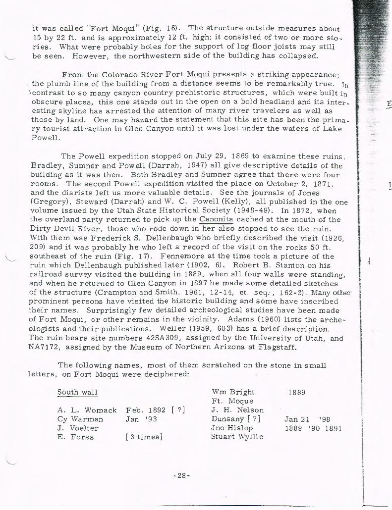
it was called "Fort Moqui 11 (Fig. 16). The structure outside measures about 15 by 22 ft. and is approximately 12ft. high; it consisted of two or more stories. What were probably holes for the support of log floor joists may still
'--~ be seen. However, the northwestern side of the building has collapsed.
From the Colorado River Fort Moqui presents a striking appearance; the plumb line of the building from a distance seems to be remarkably true. In
\contrast to so many canyon country prehistoric structures, which were built in obscure places, this one stands out in the open on a bold headland and its inter esting skyline has arrested the attention of many river travelers as well as those by land. One may hazard the statement that this site has been the primary tourist attraction in Glen Canyon until it was lost under the waters of Lake Powell.
The Powell expedition stopped on July 29, 18 69 to examine these ruins. Bradley, Sumner and Powell (Darrah, 1947) all give descriptive details of the building as it was then. Both Bradley and Sumner agree that there were four rooms. The second Powell expedition visited the place on October 2, 1871, and the diarists left us more valuable details. See the journals of Jones (Gregory), Steward (Darrah) and W. C. Powell (Kelly), all published in the one volume issued by the Utah State Historical Society ( 1948-49). In 1872, when the overland party returned to pick up the Canonita cached at the mouth of the Dirty Devil River, those who rode down in her also stopped to see the ruin. With them was FrederickS. Dellenbaugh who briefly described the visit (1926, 209) and it was probably he who left a record of the visit on the rocks 50 ft. southeast of the ruin (Fig. 17). Fennemore at the time took a picture of the ruin which Dellenbaugh published later ( 1902, 6). Robert B. Stanton on his railroad survey visited the building in 1889, when all four walls were standing, and when he returned to Glen Canyon in 1897 he made some detailed sketches of the structure (Crampton and Smith, 1961, 12-.14, et . seq., 162-3). Many other prominent persons have visited the historic building and some have inscribed their names. Surprisingly few detailed archeological studies have been made of Fort Moqui, or other remains in the vicinity. Adams ( 1960) lists the archeologists and their publications. Weller (1959 , 603) has a brief description. The ruin bears site numbers 42SA 309, assigned by the University of Utah, and NA 7172, assigned by the Museum of Northern Arizona at Flagstaff.
The following names, most of them scratched on the stone in small letters, on Fort Moqui were deciphered:
South wall
l\. L. Womack Feb. 1892 [ ?] Cy Warman Jan '93 J. Voelter E. Forss [ 3 times]
-28-
Wm Bright Ft. Moque J. H. Nelson Duns any [?] Jno Hislop Stuart \Vylli e
1889
Jan 21 '98 1889 '90 1891
1

--t: ~-.... _..,;-:'
.::
~ '
ld
F. [ ? ] JW 8 Nov 1891 F. A . Baker Feb. 11, 1917 A. K. Thurber 1888 H. S. Gillespie March 17, J. H. Brown Jan. ------J. F. Gilham March 17 C. M. Delgrov,.e
East wall
Jacobs 1891 c N L [ ? ] w Hitch --- Colo
May 17 1908 D. W. Lords
1899
90
W. H. Edwards ( Nov) 10 89
Inside walls
J. Gilson Geo. Gilham Mar. 19 1889
Wichita, Kan C. Cashmead D. J. J. Louis H. L---eln
- 1904 - Colo A Stoew D. E. Rickman W. Shafer March 19 18--CDE '97 Hall 188 5 D. P orter B. R. Hite Aug. 30 Jack Russell Feb. G. A. H Loward [ ? ] G. L. J ordan May E . L. Smith 19 22 R. v. Chamberlin D. Dehlin G M McComb Mantt Jensen
1894 19
1888 --889
1898 1914
11-17-22
J [ ? ] E. Hall Robert Rya --Frank Wilson A. F. Rennis 1893
-29-
Geo. L. Gillham ("Eureka") Nov 11
F. M. G. H.
Names on slab rock adjacent to fort on south
Andrew Ekkker [sic] E. Vier C. H. '20 Carl P. Nielson S. J. Cunningham Mar. 4 [ -- ?]
95' Glen Ekker J.P. Jones [-- ?] Nov. 7th. 1893 Gilson Lorin Turner Feb. 18 1906 Wm Bright 1889 A. L. F. MacDermott 3 - 30-1900 CR 26 Dec. 18 84 Gilham Nov . 88. J c Talman JoeWilker [?] H M C E. L. Smith 1922 Reub en Turner Oct --- 07 c. Vo [ i?] ot E. Forss R. E. Pryor Feb. 24 -- 1895
[Als o some deeply incised petroglyphs]
Names on rocks on point north of fort
G. A . Shaw - -- -- N. Y. 4- 11 - 15 H. W. Lobm [an?] NYC '15
Names on rocks 50 to 75 ft. south and east of fort
Bert Loper Grand Canyon Expedition · 1907
C. A. Gibbons [ ?] - 16 - 1897 Wm. Bright 1890

Andrew Ekker Nov 6 1907 H. J Rite Jan 9 1889 Hall 1885 Wm Hitch Ben Rite Aug: 30th 1888 J. Powell June 27th 1872
W. Ex . Ex. (Fig~ 17) Jack Lamb Feb . 20 1885 ------- Hit e A. L. Womack Feb . 1912
C . Goold W. D. J.
Jan 16th
Wes Heap 1881
189 7
[ name faint, date clear] 187 6 Jan. 16 1889 John P. Rit e St . Louis Mo
Ross Foote Reed Dec 13 ---93
[Numbers of petroglyphs were also not
Downs t ream about 300 ft. from Fort Moqui, on the same contour and overlooking the Colorado , there are a number of prehistoric ruins , petroglyphs , and Anglo names (Fig. 18). The following Anglo names were deciphered:
Glen Reid Frank Hatt Caineville, Utah
Nov. 1898 [?] J. A. Ketchum Jan 1893 J. M Hughes Mary Lee Johnson E . Kane
W. E. Bovier March 20 1889 By God
TWN WK G. C . Hartman Roy Despain
On the ledges on the same contour and across the mouth of \Vhite Canyon there are a number of prehistoric ruins easily visible from Fort Moqui. These consist of fragments of walls. Near these remains an occasional pictograph done in red paint is to be seen . These consist of circular shiel ds containing geometric designs. Of the three or four noted, only a few fragments of red paint remained, but the stain on the sandstone made by the paint was still visible. A few Anglo names were noted near the ruins:
JC BW HS MHB
T . Tucker C. R. Bacon T . J Knigt [ sic]
At one place a cameo-like figure of a human head had recently been chipped on the surface of a sandstone block. Robert B. Stanton in 1897 (Crampton and Smith, 1961, 12-14) found and photographed a number of prehistoric ruins in the mouth of White Canyon.
-30-
t i
f
I I l
... beer . Gler .:: foot
ther wid(
Nat whE
the rer tra: ere
yor ha' an< in§
Hi
m p c m ar hi s: c b p c I c (
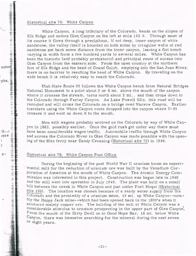
Historical site 79: Wnite Canyon
\Vhite Canyon, a long tributary of the Colorado , heads on the slopes of Elk Ridge and enters Glen Canyon on the left at mile 162. 9. Through most of its course it flows through a precipitous, if not deep, inner canyon of white sandstone; the valley itself is bounded on both sides by irregular walls of red sandstone set back some distance from the inner canyon, leaving a flat bench varying in width from a few hundred yards to several miles . White Canyon has been the historic (and probably prehistoric) and principal route of access into Glen Canyon from the eastern side. From the open country at the northern foot of Elk Ridge and the head of Grand Gulch, emptying into the San Juan River, there is no barrier to reaching the head of White Canyon. By traveling on the wide bench it is relatively easy to reach the Colorado.
Utah State Route 95 follows the White C anyon bench from Natural Bridges National Monument to a point about 5 or 6 mi. above the mouth of the canyon where it crosses the stream, turns north about 2 mi., and then drops down to the Colorado through Farley Canyon. As Lake Powell fills, this road will be rerouted and will eros s the Colorado on a bridge over Narrow Canyon. Earlier travelers using the White Canyon route dropped into the canyon where U - 95 crosses it and went on down it to the mouth.
Men with wagons probably arrived on the Colorado by way of White Can yon in 1883, possibly earlier . Once the gold rush got under way there must have been considerable wagon traffic. Automobile traffic through White Canyon and across the Colorado River in Glen Canyon was made possible with the opening of the Rite ferry near Dandy Crossing (Historical site 75) in 1946.
Historical site 78: White Canyon Post Office
During the beginning of the post World War II uranium boom an experimental mill for the reduction of uranium ore was built by the Vanadium Corporation of America at the mouth of White Canyon. The Atomic Energy Corn mission was interested in this project. Construction was begun late in 1948 and the mill went into operation in July 1949. The plant was built on a small hill between the creek in White Canyon and just under Fort Moqui (Historical sit e 139). The location was chosen because of a ready water supply from the Colorado and the proximity of a uranium mine, 15 mi. up White Canyon- - nota bly the Happy Jack mine- - which had been opened back in the 1890 1 s when it Produced mainly copper ore. The building of the mill at White Canyon was a considerable stimulus to uranium prospecting in the upper part of Glen Canyon\ From the mouth of the Dirty Devil on to Good Hope Bar, 18 mi. below White Canyon, there was intensive searching for the mineral during the next seven or eight years .
- 31 -

In an interview, Frank A. Barrett, long a resident of Glen Canyon, stated that before the mill shut down about mid-195 4, about 40 people we re ern, ployed there and 100 to 125 persons were regularly receiving mail. A small
"'-- boom camp, consisting of tents, tent houses, shacks and some fairly substan, tial homes, sprang up on the upstream side of the mouth of White Canyon wher there were several acres of flat, sandy ground. A post office, White Canyon ~:
, was established and a one-room schoolhouse accommodating 30 pupils was ' 'built.
By 195 8 the mill had been dismantled, and most of the population had moved away. Beyond an oil storage tank, a few small pieces of machinery anct the sandy tailings, the re was little to mark the site of the mill. By 1963 the "town11 of White Canyon had become a ghost; the post office had been moved to a location 2 mi. away in Farley Canyon (Historical site 181). (See also Histor ·. cal site 19 6: Moqui Flat.) ---:...
Historical site 196: Moqui Flat
Also known as White Canyon Bar, this is a flat sandy terrace a few feet above the Colorado extending along the left bank from the mouth of White Canyon to mile 165. 4, a distance of 2 1 I 2 mi. It is . 2 mi. wide in places and is backed up throughout this distance by an irregular line of steep , rocky s lopes 100 to 150 ft. above it on the east.
The name Moqui Flat dates back to the mmmg era. Robert B . Stanton used the name in his diary in 1897 (Crampton and Smith, 1961, 11-14). The n?.me White Canyon Bar dates from the opening of the uranium mill at the mouth of White Canyon (Historical site 78: White Canyon Post Office). The lower end of the flat, for over a mile abov e the mouth of Farley Canyon, served as a "suburb 11 of White Canyon . A number of houses were built there along the base of the ledges on the eastern side of the flat. At mile 164. 3, in the mouth of a short gulch, there are the remains of two shacks, a ten tho use, and much a bandoned machinery and dimension lumber. The machinery is of the kind that might have come from the uranium mill.
A dirt airstrip 3 I 4 mi. long, centering at mile 164, was built when the uranium mill was operating at White Canyon. It was still in use early in 19 64; mail delivered to the White Canyon Post Office was brought in by plane .
On Moqui Bar at mile 164 . 5 is a ranch built by Frank A. Barrett (Fig. 19). Mr. Barrett was interviewed at his place on April 27, 1963. He said he came into Gl en Canyon in March 1937 at a time when no one was li -v"ing on the east side of the ri v er in this area . He located here because of a water supply . Nearby is a warm spring that has been dammed, and a small reservoi r has been create d. The controll ed flow fro m the reservoi r is enough to irrigate
-32-
i
l I l 1
-""""' -- ft.
Bi
th fr oi 1
F (J
b c v

th i
e
a small orchard of fruit trees south of the house. From a distance the Barrett place is marked by a handsome line of tall green poplar trees that stand out in sharp contrast to the nearby bare soil north and south of the ranch and t he sandstone bluffs to the east of it. Located immediately on t he ri v er bank, the Barrett place consists of a house, small adjacent buildings and amount s of heavy farm machinery .
A short distance northeast of the Barrett ranch is another house, owned byE. A. Williams. At this location a ;spring of water. .has been developed and a large water tank has been installed for storage. Near the house pens for ani mals, many odds and ends of machinery and other objects were noted.
Historical site 177
On a huge block of sandstone balanced· on the edge of the bluff about 150 ft . above Moqui Flat at mile 16 3. 7, there are some prehistoric shield -type petroglyphs and some Anglo names, deciphered as follows:
B. Hite c . c. Snow Jan 11th 1889
H R [ ? ] Sept 4 189 8
J. c. Glem [ ? ]
Historical site 181: Farley Canyon
Farley Canyon, draining a short watershed of bare soil and rock, enters the Colorado at mile 163. 1. Utah State Route 95 reaches the Colorado River from the east by this canyon; it will, however, be rerouted and will swing north of the Farley Canyon drainage to cross a bridge over Narrow Canyon. About 1 1 I 2 mi. from the mouth a spring of good water, know n as Farley Spring, comes into Farley Canyon from the north . Just below this the White Canyon Post Office was established after the uranium mill at the mouth of White Cany on (Historical site 78) was dismantled. Until he was forced to close down in 19 64 by the rising waters of Lake Powell, G. W. Edgell, ow ner and proprietor, operated a store, where cold drinks , limited stocks of groceries and gasoline were a v ailable (Fig . 20). In addition to his responsibilities as postmaster and s t orekeeper , "Woody " Edgell also operated the Hite ferry. With ample supplies of water Woody was able to maintain a small lawn in front of his trailer court home adjacent to the store.
According to Frank A. Barrett, long a resident of Glen Canyon (see Bistorical site 196), the canyon derives its name from Tom Farley who ran cattle in the region in the 1880's and 1890's. In the Records of the White Canyon
- 33 -
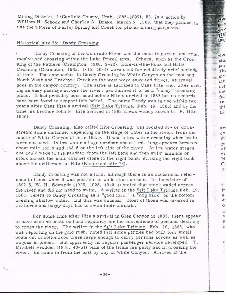
Mining District, I (Garfield County, Utah, 1885-1897), 83, is a notice by William H. Schock and Charles A. Drake, March 5, 1889, that they planned to use the waters of Farley Spring and Creek for placer mining purposes.
Historical site 75: Dandy Crossing
Dandy Crossing of the Colorado River was the most important and corn, monly used crossing within the Lake Powell area. Others , such as the Crossing of the Fathers (Crampton, 19 60, 9-20), Hole-in-the-Rock and Halls Crossing (Crampton, 1962, 1-15, 50-4) were used for relatively brief periods of time. The approaches to Dandy Crossing by White Canyon on the east and North Was h and Trachyte Creek on the west were easy and direct, as travel goes in the canyo n country. The name is ascribed to Cass B ite who, after making an easy passage across the riv er, proclaimed it to be a "dandy" crossing place. It had probably been used before Bite's arrival in 1883 but no records have been found to support this belief. The name Dandy was in use within two years after Cass Bite's arrival (Salt Lake Tribune, Feb . 19, 1885) and by the time his brother John P. Bite arriv ed in 18 88 it was widely known (J. P . B ite, 1929).
Dandy Crossing, also called Bite Crossing, was located up- or downstream some distance, depending on the stage of water in the river , from the mouth of White Canyon at mile 162. 9. It was a low water crossing when boats were not used. In low water a huge sandbar about 1 mi. long appears between about mile 162. 5 and 163. 5 on the left side of the river. At low water stages one could wade to the sandbar from the left bank and then swim animals or stock across the main channel close to th e right bank, striking the right bank above the settlement at Bite (Historical site 73).
Dandy Crossing was not a ford, although there is an occasional reference to times when it was possible to wade stock across. In the winter of 1892-3, W. H. Edwards (1929, 1928, 1940-l) stated that stock waded across the river and did not need to swim. A writer in the Salt Lake Tribune, Feb. 19, 1885, refers to Dandy Crossing as a "good ford, 11 a "hog back " on the bottom creating shallow water. But this was unusual. Most of those who crossed in the horse and buggy days had to swim their animals.
For some time after Bite's arrival in Glen Canyon in 1883, there appear to have been no boats on hand regularly for the convenience of persons desiring to cross the river. The writer in the Salt Lake Tribune, Feb. 19, 1885, who was reporting on the gold rush, noted that some parties had built four small boats out of cottonwood trees l arge enough to carry persons across as well as wagons in pieces. But apparently no regular passenger serv ice developed. T. Mitchell Prudden (1906, 43-51) tells of the trials his party had in crossing the river. He came in from the east by way of White Canyon. Arrived at the
-34-
I
' l ' f
I ' I I
I I i I I
I I
..
nin sur anc for ac : thi (K
gu wJ· ve M Cl
CJ' o ·
n s

nn-3 -
ds d
g [s
1 0
1e
l; e,
k
19,
ri ver he fired a shot to attract those on the other side. When he had done so he y elled to them to send the boat across. The reply was, "They a in 1t no boat; y e can 1t git over." Upstream, where the Harshberger ferry (Historical sit e 17 6) was later put into operation, they found a 10 - ft . , leaky boat with which th ey managed to get their gear across and to tow the animals.
Charles Siringo (1927, 212-14, 234), Pinkerton and Union Pacific detec tive , tells of using Dandy Crossing in pursuit of outlaws . Certainly Dandy Cross i ng was a better one than that at Spanish Bottom (Historical site 250), and it seems accurate to say that it was probably used by outlaws more frequently. The approaches by way of White Canyon, North Wash or Trachyte Creek were direct and relatively easy. And after the arrival of Hite in 1883 and the beginning of the Glen Canyon gold rush there was something of an opportunity to get supplies - - plus small likelihood of running into the law. Operatives like Siringo, and peace officers, seemed to have come into the canyon only when they were following a trail. Kelly ( 195 9, 151) writes of rustlers driving stolen cattle across the river in herds of 500 head; Hickman (1924) says much the same th ing. Matt Warner, for a time one of the Wild Bunch on Robbers Roost wrote (King, 1940) of the use made of Dandy Crossing by assorted outlaws.
The horse and wagon years lasted well into the 20th centur y in the Hit e area ; it was not until 1946 that a reasonably good dirt road for automobiles was completed across the canyon country between Hanksville and Blanding by way of White Canyon and North Wash. The formal opening of this road and the inauguration of regular auto ferry service took place at Hite on September 17 , 1946 , wh en Utah Governor Herbert B . Maw and other dignitaries were present. A verbatim record of the ceremonies and speeches by Harry Aleson and Governor Maw and others, together with photographs, has been preserved (Rice , 1946) . Charles Kelly ( 194 7) wrote an article on the new road and ferry; Muench ( 1952) wrote one after the ferry had been in operation a few years.
The opening of this route was the work of local citizens living in the te rminal towns, Utah state agencies, and of A. L. Chaffin , who moved to Hite in 1932 (see Historical site 72: Trachyte Bar). Chaffin before 1946 had man aged to open a road of sorts following the wagon route up North Wash, and he even put a crude ferry into operation. A. L . Chaffin built the ferry put into operation in 1946, a pontoon craft , ingeniously powered with an autom obile engi ne that pulled itself across the riv er guided by a cable. Some of the equipment used in the construction of the ferry was brought by Chaffin from mining sites down river. The tightener for the pull cable on the ferry had originally been the bull wheel on the drilling rig at Oil Seep Bar (Crampton, 1962, 35- 6).
\
The ferry was put in operation below Dandy Crossing at mile 162. 5 in an elbow bend in the river. The right bank approach was right at the settlement of Hite (Historical site 73). Although it was remodeled a number of times, the ferry remained in operation (Fig. 21) until June 5, 1964, when it was taken out of service in public ceremonies sponsored by the Utah Department of
- 35-
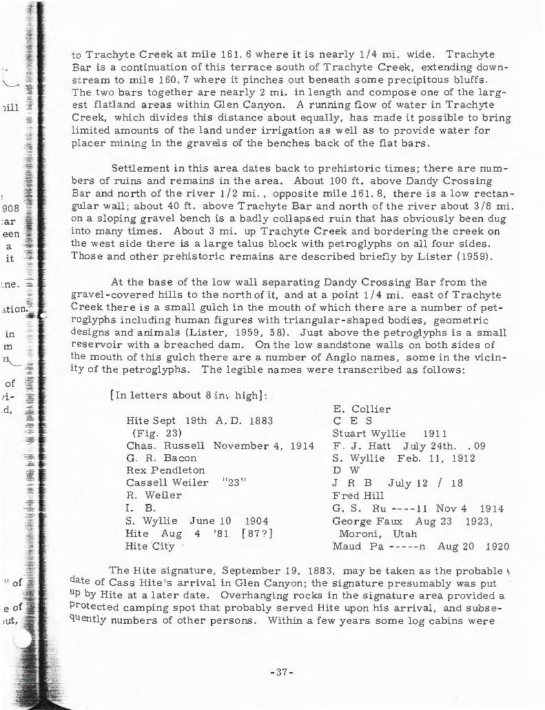
a -it
~ ne.
in m
of rid,
to Trachyte Creek at mile 161. 6 where it is nearly 114 mi . wide. Trachyte Bar is a continuation of this terrace south of Trachyte Creek, extending downstream to mile 160. 7 where it pinches out beneath some precipitous bluffs. The two bars together are nearly 2 mi. in length and compose one of the largest flatland areas within Glen Canyon. A running flow of water in Trachyte Creek, which divides this distance about equally, has made it possible to bring limited amounts of the land under irrigation as well as to provide water for placer mining in the gravels of the benches back of the flat bars.
Settlement in this area dates back to prehistoric times; there are numbers of ruins and remains in the area. About 100 ft. above Dandy Cross ing Bar and north of the river 112 mi., opposite mile .161. 8, there is a low rectangular wall; about 40ft. above Trachyte Bar and north of the river about 318 mi. on a sloping gravel bench is a badly collapsed ruin that has obviously been dug into many times. About 3 mi. up Trachyte Creek and bordering the creek on the west side there is a large talus block with petroglyphs on all four sides. Those and other prehistoric remains are described briefly by Lister ( 195 9).
At the base of the low wall separating Dandy Crossing Bar from the gravel -covered hills to the north ofit, and at a point 1 I 4 mi. east of Trachyte Creek there is a small gulch in the mouth of which there are a number of petroglyphs including human figures with triangular -shaped bodies, geometric designs and animals (Lister, 1959, 58). Just above the petroglyphs is a small reservoir with a breached darn. On the low sandstone walls on both sides of the mouth of this gulch there are a number of Anglo names, some in the vicinity of the petroglyphs. The legible names were transcribed as follows:
[In letters about 8 in ·.: high]:
Bite Sept 19th A . D. 1883 (Fig. 23)
Chas. Russell November 4, 1914 G. R. Bacon Rex Pendleton Cassell Weiler " 23" R. Weiler I. B. S. Wyllie June 10 1904 Hit e Aug 4 '8 1 [ 8 7 ? J Hite City
E. Collier C E S Stuart Wyllie 1911 F. J. Hatt July 24th. . 09 S. Wyllie Feb. 11, 1912 D W J R B July 12 I 18 Fred Hill G. S. R u --- -11 Nov 4 19 14 George Faux Aug 23 1923,
Moroni, Utah Maud Pa-----n Aug 20 1920
The Rite signature, September 19, 1883, may be taken as the probable 1,
date of Cass Bite's arrival in Glen Canyon; the signature presumably was put up by Hite at a later date. Overhanging rocks in the signature area provided a Protected camping spot that probably served Rite upon his arrival, and subsequently numbers of other persons. Within a few years sorn e log cabins were
-37-

put up at the present location of Rite on the river bank at mile 162. 5. This Was just below Dandy Crossing (Historical site 75) and precisely at the right bank terminus of the Rite ferry.
In an interview in 19 60 A. L. Chaffin, of Teasdale, Utah, said that pro b. ably the first white occupant of the Rite area was one Joshua Swett, a sqaw man and alledgedly a horse thief who stole animals on one side of the river and sold' \hem on the other. Chaffin said that Swett arrived in 1872 and built a log cabin at the mouth of Swett Creek, a tributary ,of Trachyte Creek 4 mi. above the mouth . When Cass Rite arrived Swett 1 eft and Rite, according to Chaffin, moved the Swett cabin down to Rite , where it was the first permanent building. This building has remained standing ever since, and it has been the principal visible remainder of the original location of Rite (Fig. 24). It is about 200 ft. upstream from the modern buildings. An examination was made of the area at the mouth of Swett Creek but no remains were found; Hunt (1953, 24) refers to a cabin there .
The old cabin of notched log construction measured 9 by 12 ft. inside dimension; it had one window and one door. Old photographs of Rite show the cabin in its present position. A. L. Chaffin stated in 1960 that when additional buildings were put up at Rite the old cabin was converted into a cook shack. Nearby the foundations outlines of another building about 15 by 25 ft. were noted; bits of iron and purple glass were also seen among the brush that has grown up over the site. North of the cabin about 75 ft. there are the remains of a stone-walled dugout room used for storage purposes.
As the result of Cass Rite's discovery of gold in Glen Canyon in 1883 and the subsequent arriv al of numbers of men in the canyo n a post office wa s established at Rite in June or July 18 89 . Horner J. Rite was named the first postmaster , a position that he held until 1896 when he was succeeded by his uncle John P. Rite. John held the position until the post office was discontin ued in 1914, the year that Cass Rite died at his Ticaboo Ranch (Historical site 62). Both Horner and John Rite in 1929 testified of their experience in Glen Canyon. The Hites operated a small store in conjunction with the post office to serve the miners and others who carne through. The post office and store were most appreciated by river parties corning through the cany ons who receiv ed mail there and news of the outside world . Throughout all the time it operated the mail was brought in by horseback from the railhead at Green River, a distance of about 120 mi.
Rite was also the headquart ers for the Henry Mountains and the White Canyon mining districts. Far removed from the county seats covering Glen Canyon and having no l aws to guide them in the location and working of mining claims, the miners and prospectors promptly made their own. On December 3, 1883, meeting at Hermit Brown's mine, nine men, including Cass Rite , Secretary, and Lewis P. Brown, Chairman , formulated a set of l aws governing
-38-
i.~ pre. nia
-.
thE of -
Bi' Bi· cO' fol lVIc
;;. re · Cc m : fi: in cc M fi ec
b h. e 0
a E
I 1

ob- :: an, ~ d -in ~
t he Henry Mountains Mining District. The boundaries of this district extended fr om the mouth of the Dirty Devil to Halls Crossing and included all of the Henry Mountains. The laws specified the amount of "discovery work' ' to hold a claim; penalties for "claim jumping" were set out; qualifications for membership in t he district were given; and regulations governing amendments were specified.
In 1887 the White Canyon Mining District, with a similar set of regulat ions, was organized (Cass Hite, Secretary ). This adjoined the Henry Mount ains Mining District at the Colorado River and included an area of comparable s i ze east o f it. The Glen Canyon miners, of course, followed federal mining s t atutes but to them they added their own regulations. This had been common practice in the remote mining districts in the American West since the California gold rush, 1848-1858.
The regulations of the two districts specified that claims located within t hem might be recorded in the books maintained for the purpose by the recorder of the district. The original records of the White Cany on Mining District , Cass Hite , recorder, with entries also by John P. Hite, Ben R. Hite , Horner J. Hit e , George L. Gilham, and others have been preserved . In two volumes, covering the period from 1885 - 1897, they are on fi l e in the Recorder's Office for Garfield County at Panguitch, Utah. No similar record for the Henry Mountains Mining District has been found. A review of the two volumes of the records of the White Canyon district reveals that locations on both sides of the Colorado in Glen Canyon were filed therein. The two books constitute a pri mary source of information on mining in Glen Canyon during the period. The first page of volume 1 is reproduced in Fig. 25. After 1897, with somewhat improv ed transportation, mining location notices were filed in the appropriate county recorders' offices. The rules and regulations of the Henry Mountains Mining District can be found in Deeds A ( 18 83 - 1884), Recorder's Office, Garfield County, Panguitch ; that of the White Canyon Mining District in Miscellaneous Record B (1884 - 1906), Recorder's Office, San Juan County , Monticello .
A considerable amount of mining was done in the Hite area during the boom period before the turn of the century, particularly on the gravel - capped hill s above Dandy Crossing Bar, although the better mining localities appar ently were farther downstream. The grav el terraces are notable on both sides of t he Colorado belo w No rth Wash and are particularly prominent in the Rite area on both sides of the mouth of Trachyte Creek. Hunt (1953 , 221) reports evidence of placer mining at the bars about Hite up to 250 ft . above the river. Immediately north of Hite about 1 I 4 mi . and at a level about 100 ft. above it there is considerable evidence of placer mining. In this area are visible the remains of a ditch used to convey water to this locality from the west, perhaps\ as far away as Trachyte Creek, although the ditch could not be traced that far. In an int erview in 1960 A . L . Chaffin, of Teasdale, Utah, stated that Cass Bite had brought water from Trachyte Creek to put on this bar . He said an elaborate trestle had been built, in one place over 1000 ft . long and rising over 50 ft. high, to convey water in a flume. When heavy winds blew over the
- 39-

structure the enterprise was temporarily abandoned. The ditch winds about on contour and it is apparent in places that flumes had been built to carry the watel' across gulleys. Small pieces of boards were noticed in these places but no flume sections were found.
About 1 1/4 mi. up Trachyte Creek there is a small reservoi r at the _mouth of a short canyon draining into the creek from the northeast. Above this 'reservoir for a distance of about 1 mi. there is a ditch paralleling the creek; it reaches the grade of the creek in about that distance, wher e at one time there was probably some sort of diversion dam. The reservoir was dry when it was examined on March 19, 1962 and it did not appear that water had been brought through the intake ditch for some tim e. It was not clear from thes e physical remains where released water would go other than be returned to the bed of the stream.
Trachyte Creek, named by A. H. Thompson (1875, 141) of the Powell Survey in 1872, drains portions of all of the peaks of the Henry Mountains except Mt. Pennell. The lower 15 mi. of the creek flows through a steep but passable canyon that served as one of the main entryways for wagons into Glen Canyon during the gold rush years. Its bed was rockier than that of North Wash, and more subject to flooding, and it was eventually abandoned as a wagon route in favor of North Wash. Through its lower canyon course flows a constant stream of water but this sinks into the coarse gravel near the mouth, which is frequently dry on the surface. Cass Rite is reported to have made the initial gold discovery in the mouth of the creek (Gregory and Moore, 193 L 14 7). Robert B . Stanto n in 1897 planned to dam Trachyte Creek and use its waters as far down Glen Canyon as 20 mi. (Crampton and Smith, 1961, 19-20).
The removal of the post office from Bite in 1914 marks the end of the initial boom period in Glen Canyon engendered by the discovery of gold years before. Thereafter the population of the canyon declined to very small numbers, increasing only as various developing interests- -oil prospecting, for example, in the 1920's --brought them back again. Rising and descending interest in Glen Canyon was probably always reflected in the small settlement at Bite, the principal entrance to the upper part of the canyon. During the Great Depression that began in 1929, there was a new wave of interest in the gold potentialities of the canyon and numbers of prospectors worked along the river below Bite confining their operations, largely, to the bars that had been developed at an earlier day.
A. L. Chaffin, in an interv iew in 19 60 , stated that he had mined for gold in Glen Canyon around the turn of the century and returned to the area during the depression. In 19 3 2 he bought out the interests of Orrin Snow and built a comfortabl e ranch on Trach:y-t e Bar. The ranch was located about 1/2 mi. west of Trachyte Creek and about . 2 mi. from the Colorado River at mile 161. 3 at the foot of a gravel-covered bench. Upon beginnings a l ready made before he arrived Chaffin developed the property extensively.
-40-
' .
~-,.
-·
wa: pe~
ro' crl tirr
Tr I
1 / be· to th 1
ju :
pl St
ar he
a 1
1' H 2
e c c r 1: 1

:dl
rs
he 1rs nr
r
When the Chaffin Ranch was examined in 1960, 1961 and 1962 it was abandoned. The physical improvements consisted of a two -room house about 15 by 24ft. (half of adobe), a large tool shed and machine shop, and a complex of animal pens and corrals (some covered) for the confinement of cattle and horses, chickens and pigs. The pigpen was made of upright slabs of sandstone; a small chicken house was in the form of a miniature log cabin. The buildings were surrounded by shade trees and rose bushes, and grapevines , and there was evidence of a lawn. Nearby were six rows of fruit trees including figs, pears, and other species. Toward the river away from the ranch were more rows of fig and other fruit trees, and between the ranch house and Trachyte Creek there were perhaps 20 to 25 acres of irrigated land, probably at one time in alfalfa.
Irrigation water for the Chaffin Ranch was supplied by ditches from Trachyte Creek and from a small reservoir on the west side of the creek about 1/ 2 mi. from the mouth. The system of ditches for the irrigation of the fields between the creek and the ranch was clearly evident and a trunk line ditch ran to the area above the ranch and to an area below it toward the river where there were a few more fruit trees (apricot?). Ther e was a small pond area just below the animal corrals.
Odds and ends of farming equipment (harrow, seeder, rake, scraper, plough, mower, wagon parts) and castoff objects indicative of a nearly selfsufficient home and ranch in a remote area were scattered all about (machine and automobile parts , harness, wire, lumber, a barrel for making wine, household equipment, water wheel, iron stove).
The formal ceremonies for the opening of the Hanksville-Blanding road and the inauguration of the ferry were held at the Chaffin Ranch on September 17, 194 6 (Rice, 194 6). To provide suitable accommodations for Governor Herbert B. Maw , a one-room frame building was built for the occasion (Fig. 2 6). This, the "Governor 's Mansion, " still stands at the Chaffin Ranch.
West of the Chaffin Ranch to the end of Trachyte Bar there are other e•:idences of human activity. About 500 ft. southwest of the Chaffin place is a crud e shack of recent vintage near the river at mile 161. 1. Below this, of Older date, the foundations for a water wheel and a 50 ft. long guy cable were ~0 -ed in a very brushy part of the bar at mile 160. 8. Along the base of the 0 -Uffs at the extreme lower end of the bar there are evidences of recent urani:J tn prospecting including a ditch and short adits.
A. L. Chaffin, in addition to the improvements made at his ranch at Trachyte Bar, also put up some more modern buildings at Hite about 200ft. do wnstream from the old site and about 75 ft. below the right bank approach to the ferry. These consisted of a three-room house with an adjacent tool Shed and machine shop, and a building to serve the public beneath which there
-41-
was basement storage. Farther downstream under willow trees along the rive bank three tent houses were built for the use of the traveling public. There t
was a spot of lawn, a garden plot, and when I first saw the place in 1949 it was a charming oasis. During the last few years before being flooded by Lake Powell these buildings were not in active use, though G. W. Edgell at White Canyon maintained them and made the limited facilities available to tourists, mainly river parties who used the site as a point of departure for the down stream run. Trailer houses and odds and ends of equipment including that used in ferry operation and road maintenance remained at the site in 1963 .
For some time a weather station was maintained at Hite, and this equip. ment, consisting of wind and rain gauges, was in place in April 19 63. Atop the gravel benches 1/4 mi. north of Hite is a modern frame house with asbestos siding and an aluminum roof, said locally to have been built by the U. S. gov ernment. It was not occupied in 1963.
Along the river bank on D8ndy Crossing Bar between Hite and the mouth of Trachyte Creek there are a number of recent houses and other development s of recent date. At one time water to irrigate some of this flatland was brought from the same trunk ditch used to supply water to the Chaffin Ranch. Water was carried across Trachyte Creek in a suspension flume (Fig. 27) and was then conveyed in an open ditch 3 I 4 mi. with feeder ditches located within this distance. The most extensive spread along the river on Dandy Crossing Bar is the Ruben Nielsen ranch at mile 162. 1 consisting of about 20 acres, some of it under cultivation, including grape vines and fruit trees. Dark green poplar trees, in sharp contrast to the red cliffs, mar~ the location of the ranch from a distance. The living quarters consisted of three tent houses, and there was much equipment old and new about the place when it was visited in 19F2. Part of the Nielsen place then was being used to park boats and equipment belonging to the 11 J ohannes Colorado River Safaris 11 at Price, Utah. At mile 161. 8 a pueblo-type structure and a partly built hogan - type building, a shed and a dugout were noted. These had the appearance of having been built as some sort of resort. Just upstream from the mouth of Trachyte Creek there was a box-type building of recent construction and a 50- gallon water tank mounted on a stand 15 ft. high. Both of these latter places were abandoned in 19 62.
Historical site 7 6: Hospital Canyon
This is a short northern canyon tributary of Trachyte Creek about 2 mi. above its mouth. It is reported by Hunt (1953, 23) to have been used by residents in the Hite area as an easily fenced area in which to keep sick cattle.
- 42-
2;- be
- t o D·
_ _,_ B:
- K tt St p · d (~
1

3
Juth ~ ~Jilr-
~nts ~,
)ught ~ r 3
~-
i s ~
tr ~ -~
·JrD ... ... 1as ;;;
~ ·art ~:..
.:,..
_ug- -;· : t of -~
type -~
nd -.:
Historical site 82: Schock Bar
This is a flat sandy terrace extending along the right bank from mile 166 . S to mile 165. 7; it is known lo cally as Schock Bar after W. H. Schock who prospected extensi v ely in Glen Canyon. His name is identified with other places downstream (see Crampt on , 1962 , 34-9). The only sign of placer gold mining at the site was in the form of prospect pits on rounded grav el knolls bordering t he bar at about mile 166. 3. Near the river bank at mile 166. 2 there are two stone chimney s standing, facing each other about 3 6 ft. apart, all that remains of a dwelling. This is named the Kohler cabin on the topographic map accompanying Hunt 1 s work on the Henry Mountains ( 195 3).
The cabin may have been built or used at one time by A. F. Kohler who was killed by Cass Hite in a gun fight at Green River. Bad blood had developed between the two men. Kohler had been in Glen Canyon since 1889 and is known to have done placer mining in the North Wash area (see Hunt , 1953, 17). In Denver Kohler seems to have discouraged certain capitalists from investing in Rite's gold properties in Glen Canyon. In Green River on September 9, 1891 , Kohler publicly threatened to kill Hite and when the latter went to ask him about th e t hreats a gun fight resulted. The ev ent was reported in the Salt Lake Tribune September 10-11; the trial, held at Provo, Ut ah, was reported in the same paper, February 27-March 10, 1892; sentenced to 12 years for second degree murder, Hite was pardoned by Governor Caleb W . West on November 29, 1893 (Salt Lake Tribune, November 30, 189 3).
The Harshberger ferry (Historical site 17 6) was located on Schock Bar.
Historical site 81: Grubstake Bar ·
Grubs take Bar consists of a narrow gravel-covered bank between mile 160 . 4 and 161 on the l eft side of the Colorado together with a large island, submerged when the river is at high tide and separated from the shore by a narrow , shallow channel at other times . A placer mining site, it is sometimes confused ·.v- ith the adjoining Dorothy Bar (Historical site 80).
The only evidence of mining on the bar is at the extreme upper end, at tnile 161 , where there are extensive workings. Sev eral timbered adits have been driven into the gravel terrace and into the gravel bank of the river. In 19 62 the shell of a 15 by 20 ft. board cabin was standing, and a profusion of Odds and ends of mining equipment and household effects were scattered about. Four small fig trees and three mulberry trees were growing nearby. At the Y'l ver's edge a wooden hopper for holding gravel and two rotary gravel screens Were noted near large amounts of tailings. A shop area was located near one Of the adits. West of the dwelling about 300ft. the stone foundations of another cabin and a fireplace were seen. A set of three iron wheels on one axle was noted in this area.
-43-

The placer workings at this site and most of the odds and ends scattered about are of fairly recent date, perhaps about 15 to 20 years. Hunt (1953, 221) states that the Grubstake was being worked in 1939 . The late Louis Chaffin in an interview in 1959 said that the Grubstake claim is where Cass Rite first mined. According to Chaffin he tunneled into the gravel bank for the best values See also Historical site 80: Dorothy Bar.
Historical site 80: Dorothy Bar
This is a wide gravel bar on the left side of the river between mile 159. 4 and 160. 4. It adjoins the Grubstake Bar (Historical site 81), with which it has been confused, on the north. It is probable that the name Dorothy Bar may hav e been the earlier name applied to both areas. The name appears in the Records of the White Canyon Mining District, I (Garfield County, 1887-1890, 30) in 188 8 but Grubstake Bar does not appear in the earlier records. The onl y sign of mining activity noted was at mile 159. 6 where a uranium prospect was located. This consisted of a long adit driven into the talus slope 1/4 mi. from the riv er. See also Historical site 182 : Illinois Bar.
Historical site 182: Illinois Bar
This is a long gravel bar on the left side between mile 158. 2 and 158. 8. It is separated from the actual bank of the river by a narrow channel which, when the river is high, would make of the bar an island. Illinois Bar was the name commonly employed , 189 7-1901, the years when Robert B. Stanton was engaged in mining operations for the Hos kaninni Company. In his diary Stanton mentions the bar a number of times as an important pl acer mining locality (Crampton and Smith, 1961, 21 , 29, 55 , 58, 140).
There is no evidence remaining of placer mining on the bar itself; it is subject to flooding at the highest stages of the river.
This entire section of the river on both sides below Rite has been extensively prospected during the uranium boom of the 1950's. There is much evidence of prospecting: roads have been bulldozed along steep hillsides; claim stakes are frequently seen; small adits and dumps appear here and there. A long adit has been driven into the bank at Dorothy Bar (see Histo.rical site 80), and at the lower end of Illinois Bar, mile 158. 2, there is an extensive uranium operation in the base of the steep talus slope. A long adit has been driven into the bluff; tracks for ore cars were in place and there were several of the cars about; a water pipe and air v ent 'Nere in place in the adit; a trailer house was located at the campsite nearby; there were numbers of prospect pits in the area. From appearances on August 2 , 1961, when the site was visited, the camp had been used within the last year or two . A road from the mouth of
- 44 -
--

0 ~-
"------- ;-,_ .1e
lS
:1ton _
is
ten- <
;;-i-n A O),
\rhi t e Canyon reaches this location by winding about the steep slopes on the side of the canyon; a branch of it leads to the uranium prospect on Dorothy Bar.
Historical site 187: Big Rock Rapid
At mile 158. 1 in the channel of the Colorado near the left bank, there is a huge block of sand stone. The boulder delta of Fourmile Creek, on the right side, deflects the channel against the block. At low river stages there is a short rapid that was somewhat troublesome in rowboat days because of the big rock in the channel. It is mentioned by name by Stanton on November 10, 1897 (Crampton and Smith, 1961, 23, 152).
Historical site 186 : Two Mile Creek
Two Mile Creek heads on the eastern slopes of Mt. Holmes in the Henry Mountains and enters the Colorado on the right at mile 15 9. 5. The name derives from the fact that it is exactly 2 mi. below Hite.
Historical site 185: Four Mile Canyon
Four Mile Canyon heads on the slopes of Mt. Ellsworth and Mt. Holmes in the Henry Mountains and reaches the Colorado on the right at mile 158. That it is about 4 mi. (actually 4. 5) below Hite probably accounts . for the name, a usage that extends back at least to 1893 (Garfield County, Records of the White Canyon Mining District, II, 177).
An old graded road crosses the creek bed near the mouth of the canyon (see Historical site 69: Cape Horn). On a sandstone block alongside this road , on the upstream side of the canyon, is the inscription "4 Mile. " There is a crude gate and fence across this road about . 1 mi. upstream from the mouth of the creek. About 1/4 mi . downstream from the creek on t wo huge talus sandstone blocks there are a few petroglyphs. On a flat at the mouth of the cany on a crude hitching rack for horses was noted.
There was no sign of mining activity near the mouth of the canyon. Robert B. Stanton, on November 29, 1899, mentions an Eli Flat near Four Mile Canyon (Crampton and Smith, 19 61, 9 3). This might be the narrow sandy terrace extending downstream from the mouth about 1 / 2 mi.
-45-
Historical site 192
At mile 156.5 on the left bank on a rocky ledge at the river's edge a cor, roded pump and wire hose were found. This was on August 3, 1961, at a low state of water. Downstream 100ft. from this location a gear shift knob was seen protruding from the water indicating an automobile engine . It was not ap,
_parent why this equipment was in this location; there are no prospects on the bank which is steep and full of ledges. There may have been some placer min, ing on the gravels of the river bottom at this point at an even lower stage of water .
Historical site 70: Curiosity Flat
·· Bi -
This is an open, flat, sandy bar between mile 155 . 8 and 156.4 on the ir left bank. Although the name dates from the placer mining period, no indicati on B of this activity was seen . (Erroneously reported as Lonesome Flat by Crampton, t l 1959, 103; see Historical site 183.) The name is used as early as 1889 in a mining location notice (Garfield County, Records of the White Canyon Mining District , I , 146-7); it also appears in Stanton's Hoskaninni Papers for 1897 and 1 1898 (Crampton and Smith, 1961, 21-4 58-9). 1
Historical site 183: Lonesome F lat
This is a long, open bar between mile 156 .8 and mile 157 . 3 on the right bank. It is mentioned in the literature of the gold mining period by Stanton (Crampton and Smith, 1961, 21-4) but there was no indi<"'ation of any mining activity. A few location stakes placed by recent uranium prospectors were noted.
Historical site 68: Narrow Gauge Flat
This is a long, narrow, sandy terrace between mile 153. 7 and 155. 1 on th e left side of the Colorado. Low bluffs about 50 ft. high border the terrace a short distance back from the river . The name dates from the placer mining period in Glen Canyon but an examination of the central portion of the bar, where there are considerable amounts of gravel in the bank, revealed no sign of gold mining. On both sides of th e mouth of Scorup Canyon, entering the Colorado at mile 15 4. 5, there are several petroglyphs and some red pictographs on the occasional smooth surfaces of the bluffs. Robert B. Stanton, who noted the name in his diary November 12, 18 , 1897, also mentioned these petrogl yphs and sketched some of them in his notebook (Crampton and Smith, 1961 , 23-4 , Fig. 7). See Lipe , et al. (1960, 132 - 40) , for an archeological investigation of the site.
- 46 -
c
n
n a
phS :d
Historical site 197: Scorup Canyon
This is a short canyon entering the Colorado on the left at mile 154. 5, bisecting Narrow Gauge Flat (Historical site 68). It was probably named after J. A. Scorup, pioneer cattleman in San Juan County, who ran cattle in this area before the end of the 19th century.
Historical site 69: Cape Horn
Cape Horn, or The Horn, describes a long U -s haped bend in the Colorado 3 mi. long between mile 154 and mile 157. The distance across the neck of the loop, called the "Notch, " is less than 1 I 2 mi. The name Cape Horn dates from the gold mining period; it appears in 1888 in a location notice in the Records of the White Canyon Mining District , I (Garfield County, 103 -4) . Beyond a few prospect holes 50 to 60 ft. above the river at the extreme end of the loop at mile 155. 8, no sign of mining activity was noted.
As part of the assessment work undertaken for the Hoskaninni Company, 1898 - 1900, R obert B. Stanton unde rtook the construction of a wagon road from Hite down the right side of the river to Cape Horn. It was 10ft . wide and cut out of solid rock in places . This road may still be seen in a number of places ; it crosses T wo Mile Creek near the mouth and is very close to the bank of the river on down to Four Mile Canyon. Portions of it were brought back into active use during the uranium boom in the 1950's. For details on the Stanton road see Crampton and Smith (1961, 94 - 5, 111, 132). In 1897 and 1898 Stanton had staked out all of Glen Canyon from a point above Hite to Lees Ferry. His plan was to install a pilot gold dredging plant and if this were successful, he would then install others up and down the ri ver at selected points. The assessment work1 such as the road building below Hite , and at Hole - in-the -Rock and Lees Ferry (see Crampton, 19 60, 19 62) was designed to h old the large number of mining claims in accordance with federal mining law and to prepare for the in stallation of additional dredges . The enterprise was a failure , however. Crampton and Smith (1961) have edited the diaries and field notebooks Stanton maintained during the course of this spectacular enterprise, 1897-1901. They throw much light on the general mining picture in Glen Canyon during this time.
As far as it went the Stanton road below Hite paralleled a trail that was used by the mining population in Glen Canyon in traveling to and from Hite for mail and supplies. The trail, shown on River Maps Sheets J and K, followed along the right bank from Bite downstream to Seven Mile Creek, a distance of 23 1 I 2 mi. The trail went up the canyon of Seven Mile Creek where it topped
1'
out about a m ile from the mouth.
-47-
Historical site 193: Cape Horn Bar
Cape Horn Bar is a narrow, gravel-capped terrace on the southeastern '"-- side of Cape Horn extending from mile 155. 1 to mile 154. 3. No indication of
mining activity was seen on the bar.
Historical site 114: Monte Cris t o Island
Also known as Island No. 1, this is a gravel island nearly 1 /2 mi. long (mile 152-152. 45) . At the highest levels the island may be entirely covered with water but most of the t ime it is exposed. At low stages there may remain only a shallow channel between the island and the right bank; the main channel of the Colorado flows close to the left bank under the very shadow of the spectacular landmark known as Castle Butte. In the Records of the White Canyon Mining District it appears that the "Mont e Cristo Placer Mine'' was discovered by Cass Bite and others on April 2, 1887 (Garfield County, I, 23). The site was relocated thereafter a number of times; Stanton (Crampton and Smith, 1961, 25) mentions it in 1897.
Since the gold mining period all evidence of placering or other activity has been obliterated by successive flooding. A piece of heavy sheet metal was seen near the river's edge on the east side of the island at about mil e 152. 3.
Historical site 67: Monte Cristo Bar
Monte Cristo Bar consists of an ext ensive area of gravel-capped terraces and hills extending from about 152.5 to mile 151 on the right side of the riv er. An examination of the ce:1tral portion of th e bar rev ealed what appeared to be recent uranium prospecting at mile 151. 6; this was about 1 I 4 mi. from the river and 35 to 40ft. abo v e it. Short sections of road were seen nearby. Hunt (1953, 221) reports small gold prospect pits in the area at 100 and 200ft. levels above the Colorado.
·.<
Historical site 194: Red Canyon
Historical site 66: Castle Butte Bar
Historical site 65: Loper Cabin
Red Canyon, a l so called Redd Canyon, is a long tributary of th e Colorado heading in the Red House Cliffs and draining the back of a westward dipping plateau that separates it from Whit e Canyon. It enters th e Colorado at mile 149. 8. Throughout Red Canyon the v ivid bare rock, red predominating, is
-48-
a.r ·- B :
- £ ! _,_ sc
"'-'
fr - n
_,.. __ . 6 ~ - il - &
a: l\
-~
c ~
-. l c f
. g
in l
6L
f . s
\___
1ces
,nt ·els
... _
-
:: ..
exposed. During the uranium rush in the 1950's the canyon was accessible to j eeps from head to mouth; it was possible to cross a low divide in the Red House Cliffs, near Red House Spring, to reach the head of the canyon ; another access route was from White Canyon by way of Happy Jack mine, the Blue Notch and Blue Notch Canyon. A trail along and near the left bank of the Colo rado reaches the mouth of Red Canyon from Dandy Crossing (Historical site 75). Owing to ease of accessibility the canyon has been one of the gateways into Glen Canyon, though not matching vVhite Canyon in importance (Historical site 79) upstream .
Some of the earliest recorded mining locations in the Glen Canyon area are identified with Red C anyon . On November 9, 10 , 11, 20, 1884, Lewis P. Brown, George and Willard Brinkerhoff, A . M. Lyman, S. M. and E. C. Behunin and Geo r ge Baker located several lode claims in "Moque Canon" southeast of Dandy C rossing. No mention is made of the name Red Canyon but from the description of the locations it seems clear that " Moque " is the name t hen applied to Red Canyon. One of the claims refers to "Moque Spring, " 5 or 6 mi . southeast of Dandy Crossing. This might refer to a large warm spring in the bed of Red Canyon wash about 3 mi. above the mouth and about 7 or 8 airl ine miles from Hit e . These notices are in (San Juan County , 1884 - 1906) Miscellaneous Book B , 1-3 . one of those early claims appeared to have been close to the Colorado River .
Upstream from the mouth of Red Canyon, between mile 151 and mile 150 there is a flat, sandy terrace , ranging up to 500ft. in width, backed up by a gravel bench sloping from a height of a few feet at the lower end to about 10 0 ft. above the river at mile 151. T hese two features bear the name Castle Butte Bar (also called Adams B ar and Red Canyon Bar). The name comes from the towering Castle Butte that dominates the site from a position 1 mi. to the northeast of it.
The human history of the region bordering the Colorado dates back about 800 years when in Pueblo III times prehistoric Anasazis came in to farm in the area. While there they built a complex of buildings, the remains of which have attracted visitors since Powell's arrival in 18 69. See Adams ( 1960, 18) for a list of these visitors. The ruins consist of a small L - shaped, two s tory pueblo flanking a large pit house or kiva located on top and near the edge of t he gravel terrace at mile 150. 3. The walls of the puebl o from the river s t and out on the sky line and have thus attracted many river travelers . Below the pueblo, against the ledges dividing the gravel bench from the sandy ter races, the ancient I ndians built a line of cliff rooms, some of which were of two stories. As a part of the salvage operations in Gl en Canyon the University of Utah Department of Anthropology has ex cavated and reported on these re mains, which have been called the Loper Ruin (Lipe, 1960, 114 - 35). Robert B. Stanton in 1897 made some sketches of the ruins (Crampton and Smith, 19 61, 2 6- 7) 1 64).
- 49 -
During the gold placer mining period the gravel benche~ of Cas tle Butte Bar were prospected; at mile 151 high on the bluff overlooking the Colorado and extending back for some distance there are extensive gravel diggings. The name Red Canyon appears in a gold placer location notice in 1885 (Garfield County, Records of the White Canyon Mining District, I , 3). Albert "Bert 11
Loper, well known river man in later years, from about 1909 to 1914 (Baker, n. d. , 43 - 6) , worked at this site and at that time probably undertook m ost of ·the developments, the remains of which may still be seen . Gravel to be washect was scraped into an ore car (in place in 19 62) and rolled on wooden tracks to the edge of the bluff 100ft. above the ri v er; the gravel was there dumped into a chute that woul d carry it to the edge of a second ledge . At that point the descending gravel could be deflected to a large cone of gravel immediately on the river bank or into a hopper; that in the hopper, presumably, would be the firs t to be w ashed for gold content .
To obtain water for their placer mining operation Loper is said to have dammed Red Canyon Creek (Baker, n. d. , 43). The remains of a ditch are to be seen extending some distance up Red Canyon. The ditch swung sharply around a point at the mouth of the canyon and then followed along the base of the bluff supporting the gravel benches above to the placer site at the river 1 s edge at mile 151. It is possible that water might have been pumped from the riv er . for mining purposes. It was evident that a large amount of gravel had been washed at this site and there was still gravel in the hopper, which had nearly collapsed. Small pieces of screening used in sluice boxes were found at the location. Hunt ( 195 3, 17, 221), reports that Castle Butte Bar was one of the productive gold bars in Glen Canyon; Bert Loper reported to them that he obtained values up to 61 cents per yard at the mine.
Jus t upstream from the mouth of Red Canyon at mile 150. 1, attractively situated under the shade of cottonwoods and within 100 ft. of the river bank, is the Loper Cabin. This is a one -room structure about 11 by 15 ft. made of square hewn logs. It faces east ; there are three windows and a stone fireplace is located on the west side. Adjoining the cabin on the north side is a small, roofed room built of sandstone slabs to serve as a storage room. Adj oining the cabin on the west are the rock slab foundations, .in varying heights, of another cabin 11 by 15ft. This may have been an older structure (see Fig. 39, Crampton, 1959).
Actually, Bert Loper , though one of the best known, was only one of several occupants. The cabin may have been built by one A. P. Adams who was resident at the mouth of Red Canyon where he was prospecting about the turn of the century. Bert moved to the site in 1909 and stayed there alone until 1914. He named the place the 11Hermitage. 11 He brought in a few pieces of farm machinery and with water from the ditch that also supplied his placer mine at the head of Castle Butte Bar he irrigated an acre or two near the cabin. The furrowed rows east of the cabin may be seen clearly . Subsequent occupants
-5 0 -
ou 10 hO sv -
~. c c R
...,.. ... :-
ol w
A s; E

Historical site 63: Ticaboo Bar No. 2
.~--- .... ., Historical site 62: Ticaboo Ranch
./ ....... _,.
Ticaboo Creek drains the eastern slopes of Mt. Ellsworth in the Henry Mountains; in its middle reaches the creek and its tributaries flow through
\deeply entrenched canyons but for ov er 1 mi. above the mouth the cany on walls are 1 / 2 mi. to 1 mi. apart and the stream flows through a relatively open Valle. It enters the Colorado ov er an enormous boulder delta at mile 148. 4 . J.
Along the right bank in Glen Canyon on either side of the mouth of Ticaboo Creek there are extensive gra vel-covered benches and small hills. These extend from about mile 146. 8 to a point opposite the Loper Cabin at mile 151. These grav el bars hav e been rather extensively prospected and at a few places extensive placer mining operations have occurred. The area is particularly identified with t he Rite brothers, and especially Cass Rite, who spent much of the rest of his life there after his arrival in Glen Canyon in 1883.
The grav el bars were early given the name Ticaboo, or Tickaboo. A placer rriine on Ticaboo Bar, opposite the mouth of Red Canyon, was discovered on March 7, 1885, by Cass Rite , JosephS. Burgess, and Mike Monahan, and recorded in the (Garfield County) Records of the White Canyon Mining District, I , 3. To distinguish it from Ticaboo Bar No. 2 below the mouth of Ticaboo Creek, the upstream bar at some later date was called Ticaboo Bar No . 1.
At a number of places on Ticaboo Bar No . 1 there are prospect pits and shallow trenches, indications of prospecting. These may be seen alongside the trail between Rite and Sev en Mile Creek (see Historical site 69). At the river's edge at about mile 149. 4, nearly opposit e the mouth of Red Canyon, there is a short ditch and evidence of placer mining. River water was probably used for washing at this location. Indications of recent uranium prospecting were noted upstream a short distance from the mouth of Ticaboo Creek.
Ticaboo Bar No. 2 (Fig. 28) was discovered by Cass Rite and JosephS. Burgess on July 15, 1885, and recorded by them, along with an adjoining placer, the Potosi , located the same day, in the (Garfield County) Records of the \Vhite Canyon IVIining District, I, 4, 5. Today the entire bar between Ticaboo Creek and extending downstream nearly 2 mi. is called Ticaboo Bar No. 2. There are prospect areas within this distance but the most important mining area is at mile 14 7. 7 . Here, just back from the river's edge, there has been extensive trenching and scraping, and large amounts of gravel have been dumped down the bank and into the river. One trench, from which large amounts of gravel have been excavated, was over 10ft. deep. Odd pieces of equipment--pipe, broken shovel, tongs, etc. --were found lying about.
-52-
:~-::- dl ·...:-~ or ~--
O"l ~
0
0 - s -~ f:
'J t

ry
.lls _ :Uley.•
ca- _i ~s e ·tJ 1. :::es
of
\ ered 1d ict,
I
and the
rer'S .
3 a [or ,ted -
"1 s. -acer. hite ~ ek e are .
n the :-· 3. ve -~
Immediately on the bank of the river at this pomt was a small one -room cabin made of assorted pieces of driftwood, complete with small fireplace. This was the location, identical with the original location of Ticaboo Bar No . 2, that Cass Hite called the "Bank of Ticaboo" (Fig. 29), because, as he is reported to have said, he had a lot of gold on deposit there (Hunt, 1953, 17, 24, 221). Hite was very active in promoting his placer interests in Glen Canyon, and the Bank of Ticaboo was an easy place to show prospective clients the values to be obtained from Colorado River gravels. Hite appears to have been a strong believer in the rule that it is easier to mine gold out of an investor's pocket than it is out of the ground. Robert B. Stanton, who visited the Bank of Ticaboo during his railroad survey, reported in 1899 that there was a pumping plant in operation at T icaboo Bar No. 2 and that the gravel was producing 38 cents in gold per yard (Crampton and Smith, 19 61, 80). Stanton planned to use the water of Trachyte Creek for mining purposes (Crampton and Smith, 1961, 19-20). Sometime during the placer mining period a ditch about 1 mi. long was built from a point on Ticaboo C reek about 1 I 2 mi. above the mouth to the Bank of Ticaboo. The ditch may easily be seen as it follows the contour of the gravel benches .
At the point where Ticaboo Creek emerges from a narrow canyon about 1 mi. from the Colorado River, Cass Hite established a home--usually called Ticaboo Ranch--where he lived much of the time that he was in Glen Canyon after 1883. There, in an open area of about 3 acres alongside Ticaboo Creek, he built a cabin, the chimney of which is still standing (Crampton, 1959, Fig. 22). From the foundations of the walls the cabin on the outside measured about 18 by 33 ft. and may have consisted of more than one room . Adjoining the cabin on the west side the foundations of a smaller room, probably used for storage, were visible. Scattered about the cabin area were odd objects: cast iron cook stove, shovel, length of pipe, a crudely made wooden chair, a skin board, a trunk, a wooden drag for leveling ground, and dimension lumber.
The flat on which the cabin is located was fenced; the western portion at the base of the cliff required no fencing. Sections of the barbed wire were still in place. South and west of the cabin a few feet and close to Ticaboo Creek was a barbed wire fence corral and adjacent to it a fenced vineyard . A few of the vines, though they had not been irrigated in years, still clung to life. When Julius Stone (1932 , 79 - 80) visited Cass Hite at Ticaboo Ranch, October 23, 1909, his host treated him to grapes, melons fresh off the vine, and was given a sackful of raisins to take along.
West of the corral and vineyard a few feet is a huge talus block covered\ With petroglyphs on the eastern face and just west of this on the trail leading into Ticaboo Canyon is another rock with the name "Hite" incised upon it.
- 53 -

Hite undoubtedly relied on the waters of Ticaboo Creek for culinary purposes and for irrigation. Normally the creek is running the year around above the cabin a short distance but it sinks into the sand below the mouth of the nar-
"-- row canyon and comes to the surface only in a few bedrock locations . Above the cabin about 3 / 4 mi. there is a good stream of water dropping over a low waterfall. At that point the creek has cut through a thin wall on a bend and left a hanging meander that has been used as a corral in recent times . In an inter-o/iew in 1960 Carlyle Baker, of Teasdale, Utah, stated that there is a trail down Ticaboo Canyon from the uplands and that cattle have been winte r ed there . Numerous deer tracks were seen in the canyon and in May 1961 a doe was seen at the edge of the Colorado below the mouth of Ticaboo at mile 14 7. 5.
In 1914 Cass Hite died at his ranch at Ticaboo and is buried th ere. The grave is marked by a rectangular enclosure composed of boards nailed to four post s (see photograph in Kelly, 1940) . Another grave alongside that of Hite, and with a similar enclosure, is reported to be the resting place of one De Linn, according to Harry Aleson, of Teasdale, Utah.
Historical site 191: Ticaboo Rapids
This is a stretch of fast water, mile 148. 6 to mile 148, where the Colorado, forced toward the left bank by the huge fan of boulders at the mouth of Ticaboo Creek, drops down about 6 ft. It is a good , bumpy ride at any stage of water . The site is usually called Big Ticaboo Rapids or Ticaboo Rapids No. · 2, to distinguish it from a smaller and confusing (in low water) stretch of fast water below the mouth of Red Canyon called Little Ticaboo Rapids , or Ticaboo Rapids No. 1. See Robert B. Stanton's evaluation of these and other rapids (Crampton and Smith, 1961, 151 - 6).
Historical site 179
At mile 147. 9 on the left bank and within about 75 ft. of the Colorado there are a number of petroglyphs on a l arge block of sandstone. These consist of geometric designs, bear claws, hands, bird tracks, etc. , some of which are covered with 11desert varnish. 11 Robert B. Stanton made sketches of these petroglyphs on November 29, 189 7 (Crampton and Smith, 19 61, 27). Turner ( 19 63) has made a thorough-going study of petrographs in the Glen Canyon region.
Historical site 61: Pioneer Placer
The Pioneer P lacer, adjoining Ticaboo Bar N"o. 2 on the right bank of the Colo rado, was discovered b y J. R. Bush and Allen Osment, February 10, 1889, according to the (Garfiel d County) Records of the White Canyon Mining
-5 4 -
I "- I
,t
o-
-~
I i I
District, I, 68, 150-2. According to Hunt (1953 , 17) this is one of two patented claims in Glen Canyon. An examinat ion of Mineral Survey Plat #3523, in the Survey Office of the Bureau of Land Management, Salt Lake City, rev eals that the Pioneer Placer, 7100 ft. from mineral survey marker no. 2 (see Crampton and Smith, 1961, 165) located at Good Hope Bar was patented in 1909 . This dist ance north of Good Hope Bar (Historical site 60) would fix this ground at about mile 147. The plat shows cuts and pits near the bank of the river. Some placer diggings were noted on the bank at approximatel y mile 14 7. 1 but no detailed examination was made of the site.
Historical site 88: Bessie Bar
This is a large gravel island near the right bank between mile 146. 7 and mile 146. 3. It may be entirely submerged during the highest stages of water; at low stages a narrow channel separates it from the right bank. At mile 146. 7 there are six 8 in. pipes standing in a row across the island at right angles to the Colorado Ri v er. These are believed to have been drill test locations made by Robert B. Stanton, November 9-28, 189 8, when he was testing various locations in Glen Canyon to determine the feasibility of his dredging scheme (Crampton and Smith , 1961, 59-61, Fig. 11).
Historical site 60: Good Hope Bar
Also known as Good Hope, this is an extended open sandy and gravel bar on the inside of an elbow bend in the Colorado River on the right bank between mile 145. 3 and mile 144. It figured prominently in the gold placer mining history of Glen Canyon as the location of a number of ventures . In the (Garfield County) Records of the White Canyon Mining District, I, 2 , it is rev ealed that J. S. Burgess and Cass Hite discovered the Good Hope Placer Mine on February 17 , 1887. Cass and his brothers retained an interest in the property for some time and took others in with them to help dev elop it. When } in late 1897, Robert B . Stanton was surveying and staking the canyon in the vicinity, the Good Hope Placer Mining Company, of which Ben Hite was superintendent , had
. been organized (Crampton and Smith, 1961, 18 , 36). According to Mineral Surv ey Plat 3447 on file in the Surv ey Offic e of the Bureau of Land Management , Salt Lake City , four claims at Good Hope Bar were patented t o the Good Hope Placer Mining Company in 1902. A monument bearing the number of the patent and "USLM No. 2" (U.S. Location Monument) was set up at Good Hope Bar (see Fig. 9 , Crampton and Smith, 1961) when the surv ey was made on the grou nd by A . D . Ferron in August 189 7; the surv ey of the patented ground ma1de l a t er at Pioneer P l acer (Historical site 61) was tied in to this monument .
-55-
'-
The survey plat of the Good Hope property made in 1897 shows the irnprovern ents as they were at that time. An area of placer workings is shown adjacent to which there is the ''Lake Mary Reservoir" held by two darns, one 184ft. long and the other 200ft . long. At the river's edge a water wheel 40ft. high is indicated; this delivered water by way of a flume 700 ft. long to the placer area and to the reservoir. During the course of his surveys and staking of claims in Glen Canyon preliminary to the formation of the Hoskaninni Company, Robert B. Stanton, in December 1897, spent several days, including Christmas , in the vicinity of Good Hope Bar; he mentions the reservoir, flume and water wheel (see Crampton and Smith, 1961, 18, 32 - 8, 80) . }iunt (1953 , 17, 221) has data on the history and workings, as do Butler, et al. (1920, 638) .
\A.1ith this data at hand an examination was made of the Good Hope Bar. At the extreme upstream end of the bar , at mile 145 . 4, some iron rings were found attached to a huge talus block at the water's edge. These , below the high water mark, were used obviously for mooring boats. The main placer mining operation on Good Hope Bar was located at the upper end of t he bar opposite mile 145 . 3 about . 1 mi. from the river's edge and at the foot of a southern point of Good Hope Mesa.
Vi' ith a dry bed "Lake Mary Reservoir, " about an acre in extent, was seen together with the two darns. One, several feet high on the eastern side, darns the mouth of a shallow gulch that composed the natural drainage; the second darn, on the south, was to prevent overflow into the placer areas. A cut through the gravel bank adjacent to the reservoir permitted the flow of water by gravity to the area where gravel was to be washed. A section of flume in place near the mouth of this cut suggests that the sluicing may have taken place just below the cut (Fig. 30). The placering area consisted of piles of gravel, cuts, pits and trenches.
From the data on the survey plat it was possible to trace the 700 ft. course of the flume that led from the water wheel located at the river's edge. The wheel would have been located at about mile 145. 1. According to Stanton's diary (Crampton and Smith, 1961, 18), a canal, into which water was deflected from a point upstream, had been dug along the right bank of the river. Water from the canal would then operate the "Egyptian" wheel and fill the buckets, which would empty into the flume 40 ft . above the river, or canal, level. Noth ing is to be seen where the wheel was located but it is possible to follow the course of the flume for about 300 ft. in the vicinity of the area . Bits and pieces of weathered flume and standards are to be seen here and there . When I first visited this site in 1949 some of the flume supports were still standing. Hunt (1953, 221) states that the water wheel at Good Hope Bar was later moved to Olympia Bar (Historical site S 8).
East of the placer area and near a grove of small oaks was the headquarters of the operation. A roofless rock wall dugout cabin about 12 by 15 ft. was to be seen and in an adjacent shop area a profusion of ·equipment, tools,
-56-
f
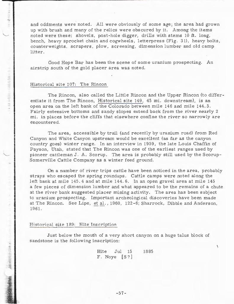
--~
and oddments were noted. All were obviously of some age; the area had grown up with brush and many of th e relics were obscured by it. Among the items noted were these: shovel s, post-hole digger, drills with sterns 10 ft. long, bench, heavy sprocket chain and cogwheels , letterpress (Fig. 31), heavy bolts, counterweights , scrapers, plow, screening, dim ens ion lurnb er and old camp litt er.
Good Hope Bar has been the scene of some uranium prospecting. An airstrip south of the gold placer area was noted.
Historical site 107: The Rincon
The Rincon, also called the Little Rincon and the Upper Rincon (to differentiate it from The Rincon, Historical site 149, 45 mi. downstream), is an open area on the left bank of the Colorado betw een mile 146 and mile 144.5 . Fairly extensiv e bottoms and sandy s lopes extend back from the riv er nearly 2 mi. in places before the cliffs that e l sewhere confine the river so narrowly are encountered.
The area, accessible by trail (and recently by uranium road) from Red Cany on and White Canyon upstream would be excellent (as far as the cany on country goes) winter range. In an interview in 1959, the late Louis Chaffin of Payson, Utah, stated that The Rincon was one of the earliest ranges used by pioneer cattleman J. A. Scorup. The area is probably still used by the S corupSornerville Cattle Company as a winter feed ground .
On a number of river trips cattle have been noticed in the area, probably strays who escaped the spring roundups. Cattle camps were noted along the left bank at mile 145. 4 and at mile 144. 6. In an open grav el area at mile 145 a few pieces of dim ens ion lumber and what appeared to be the remains of a chute at the river bank suggested placer mining activity. The area has been subject to uranium prospecting. Important archeological disco veries have been made at The Rincon. See Lipe, et al., 1960 , 122-6; Sharrock, Dibble and Anderson, 19 61.
H istorical site 189 : Hite Inscription
Just below the mouth of a very short canyon on a huge talus block of sandstone is the following inscription:
Hite Jul F . Noye
15 [ s?]
- 57-
1885
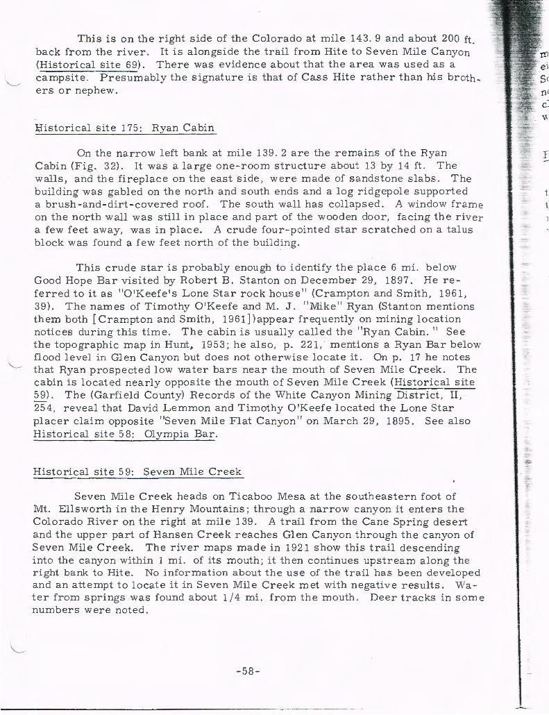
This is on the right side of the Colorado at mile 143. 9 and about 200 ft. back from the river. It is alongside the trail from Rite to Seven Mile Canyon (Historical site 69). There was evidence about that the area was used as a campsite. Presumably the signature is that of Cass Rite rather than his brothers or nephew.
I;Iistorical site 175: Ryan Cabin
On the narrow left bank at mile 139 . 2 are the remains of the Ryan Cabin (Fig. 32). It was a large one-room structure about 13 by 14 ft. The walls, and the fireplace on the east side, were made of sandstone slabs. The building was gabled on the north and south ends and a log ridgepole supported a brush -and-dirt -covered roof. The south wall has collapsed. A window frame on the north wall was still in place and part of the wooden door, facing the river a few feet away, was in place. A crude four-pointed star scratched on a talus block was found a few feet north of the building.
This crude star is probably enough to identify the place 6 mi. below Good Hope Bar visited by Robert B. Stanton on December 29, 1897. He referred to it as 11 0 1Keefe 1 s Lone Star rockhouse 11 (Crampton and Smith, 1961 , 39). The names of Timothy 0 1Keefe and M. J. 11 Mi ke 11 Ryan (Stanton mentions them both [Crampton and Smith, 1961]) appear frequently on mining location notices during this time. The cabin is usually called the 11 Ryan Cabin. 11 See the topographic map in Hunt, 1953; he also, p. 221, · mentions a Ryan Bar below flood level in Glen Canyon but does not otherwise locate it. On p. 17 he notes that Ryan prospected low water bars near the mouth of Seven Mile Creek. The cabin is located nearly opposite the mouth of Seven Mile Creek (Historical site 59). The (Garfield County) Records of the White Canyon Mining District, II, 25 4, reveal that David Lemmon and Timothy 0 1Keefe located the Lone Star placer claim opposite 11Seven Mile Flat Canyon 11 on March 29, 1895. See also Historical site 58: Olympia Bar.
Historical site 59: Seven Mile Creek
Seven Mile Creek heads on Ticaboo Mesa at the southeastern foot of Mt. Ellsworth in the Henry Mountains; through a narrow canyon it enters the Colorado River on the right at mile 139. A trail from the Cane Spring desert and the upper part of Hansen Creek reaches Glen Canyon through the canyon of Seven Mile Creek. The river maps made in 1921 show this trail descending into the canyon within 1 mi. of its mouth; it then continues upstream along the right bank to Hite. No information about the use of the trail has been developed and an attempt to locate it in Seven Mile Creek met with negative results. Water from springs was found about 1/4 mi. from the mouth. Deer tracks in some numbers were noted.
-58-
,.

Hunt ( 195 3, 17) mentions low water gravel bars worked during t he gold mining period in Gl en Canyon. An examination of the extensiv e terrace on either side of the mouth of Seven Mile Creek rev ealed only a sandy surface. Some grav el was noted in the river near the mouth of t he creek. In a location notice dated March 29, 1895, Lemmon and 0 1 Keefe locate the Lone Star placer claim on the opposite bank; in the notice they refer to 11Seven Mile Flat Canyon 11
which is 7 mi. below Good Hope Bar (see Historical site 175: Ryan Cabin) .
Historical site 171: Cedar Canyon
Cedar Canyon heads on the back of Mancos Mesa and enters the Colorado through a canyon with low walls at mile 136.7. In an intricate system of upper tributaries it drains the northern end of 1:hat lofty mesa. Within 200 yds. of the mouth there is a jump-up that normally can be bypassed but when the canyon was visited on August 5, 1961, the mouth was full of soupy quicksand from a recent flood.
Historical site 102: Warm Spring Creek
Warm Spring Creek is a short tributary entering the Colorado River through a canyon on the right at mile 13 6. 6. Hunt ( 195 3, 24) mentions that the name was given by early prospectors although no warm springs are known in the canyon. Abundant supplies of cool running water near the mouth of the can yon have long been used by river parties traveling through Glen Canyon.
Historical site 178 : Tapestry Wall
This is a magnificent 800 ft. high cliff forming the right bank of Glen Canyon from mile 136. 4 to mile 135. 4. From a low talus slope it rises almost vertically and on the bend of the river it may be seen for some distance in ei ther direction . The name was suggested by stains made by water running down the cliff and carrying with it sediment and minerals. The black-on -red effect in vertical streaks is common to the Glen Canyon cliffs, of which this is a fine example. The name was in use in 1897 when R. B. Stanton passed by (Crampton and Smith, 1961, 39) .
Historical site 58: Olympia Bar
Olympia Bar, also called Olympic Bar , consists of a series of gravel covered terraces on the left side of the Colorado between mile 136 and mile 135. 3. The terraces range in height up to about 200 ft. above the Colorado and at all levels they have been prospected. At two places extensive placer mining
-5 9 -
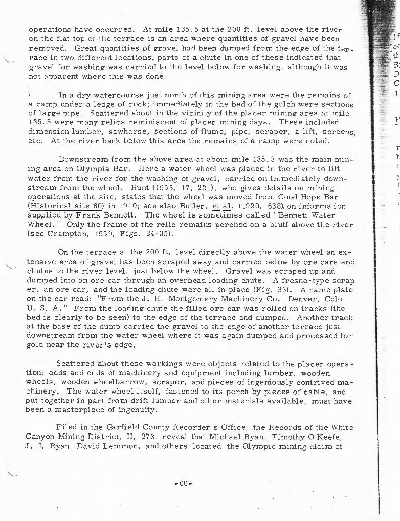
operations have occurred. At mile 135. 5 at the 200 ft. level above the river on the flat top of the terrace is an area where quantities of gravel have been removed. Great quantities of gravel had been dumped from the edge of the ter race in two different locations; parts of a chute in one of these indicated that gravel for washing was carried to the level below for washing, although it was not apparent where this was done.
In a dry watercourse just north of this mining area were the remains of a camp under a ledge of rock; immediately in the bed of the gulch were sections of large pipe. Scattered about in the vicinity of the placer mining area at mile 135. 5 were many relics reminiscent of placer mining days. These included dimension lumber, sawhorse, sections of flume, pipe , scraper , a lift, screens , etc. At the river bank below this area the remains of a camp were noted.
Downstream from the above area at about mile 135. 3 was the main mining area on Olympia Bar. Here a water wheel was placed in the river to lift water from the river for the washing of gravel, carried on immediately downstream from the wheel. Hunt ( 195 3, 17, 221), who gives details on mining operations at the site, states that the wheel was moved from Good Hope Bar (Historical site 60) in 191 0; see also Butler, et al. ( 1920, 63 8), on information supplied by Frank Bennett. The wheel is sometimes called " Bennett Water Wheel.'' Only the frame of the relic remains perched on a bluff above the river (see Crampton, 1959, Figs. 34-35).
On the te rrace at the 200 ft. level directly abov e the water wheel an extensive area of gravel has been scraped away and carried below by ore cars and chutes to the river level, just below the wheel. Gravel was scraped up and dumped into an ore car through an overhead loading chute. A fresno-type scraper, an ore car, and the loading chute were all in pl ace (Fig. 33). A name plate on the car read: "From the J. H . Montgomery Machinery Co. Denver, Colo U. S. A. " From the loading chute the filled ore car was rolled on tracks (the bed is clearly to be seen) to the edge of the terrace and dumped. Another track at the base of the dump carried the gravel to the edge of another terrace just downstream from the water wheel where it was again dumped and processed for gold near the river's edge.
Scattered about these workings were objects related to the placer operation: odds and ends of machinery and equipment including lumber, wooden wheels, wooden wheelbarrow, scraper, and pieces of ingeniously contrived machinery. The water wheel itself, fastened to its perch by pieces of cable, and put together in part from drift lumber and other materials available, must have been a masterpiece of ingenuity.
Filed in the Garfield County Recorder's Office , the Records of the White Canyon Mining District, II, 27 3, reveal that Michael Ryan, Timothy 0 'Keefe, J. J. Ryan, David Lemmon, and others l ocated the Olympic mining claim of
-60-
I
I l
I I
.,.,...,_ -;;. .. 4i· ,._ '"-"' -:~- p
--r t
'

s
r
lp e
k
r
l. -
e
160 acres, a claim previously known as the $_anta Rosa. The claim was recorded January 11, 1896. The names of O'Keefe and Ryan are identified with the stone house upstream, opposite the mouth of Seven Mile Creek, known as Ryan's Cabin (Historical site 175) . Robert B. Stanton noted the site on December 30, 1897, when he referred to O'Keefe's camp 4 mi. below Ryan's Cabin at the Amphitheater and Rozetta bars (Crampton and Smith, 1961, 39, 141). Doubtless, others have worked the bar since.
Historical site 109: Knowles Canyon
Knowles Canyon, about 6 mi. long, enters the Colorado on the left at mile 134. 4. The lower 3/4 mi. of the canyon is narrow and deeply entrenched but above that it opens out somewhat; the watercourse is wide and the floor of the canyon is dotted with cottonwood trees. It was reported that Knowles Canyon has been accessible to cattle. Upon examination a rough cattle trail was found running along the northern side of the canyon, and within 1/2 mi. of the mouth a crude pole gate was found at a narrow place. The Knowles brothers are reported to have been early day cattlemen in San Juan County.
Historical site 56: Sundog Bar
This bar consists of a series of rounded gravel hills and slopes nsmg from the Colorado between mile 134 and mile 133 . 2. Although the area appears to have been staked and claimed many times during the gold rush years in Glen Canyon, an examination of the northern half of the bar revealed no sign of placer mining activity. Hunt (1953, 17, 221) reports placer operations at the 40ft. and 155 ft. levels.
Historical site 57 : Smith Fork
Smith Fork heads on the southern slopes of Mt. Ellsworth in the Henry Mountains and enters the Colorado on the right through a canyon about 400 ft. deep at mile 132+. When the lower part of the canyon was examined in August 1961, there was a fine stream of cool water flowing on the open floor of the canyon amid shady cottonwood trees.
The name of Smiths Creek and Smiths Fork appear in the (Garfield County) Records of the White Canyon Mining District, I, 19-20, as early as 1888, along with the names of Albert , Archie, F. M . , and A . F. Smith, who claim water from the creek and placer mines in Glen Canyon above and below the mouth of the creek. Hunt ( 195 3, 23) states that the stream was named after the Smith brothers who prospected Sundog Bar (Historical site 56) and Smith
-61-

Bar at Hansen Creek (Historical sites 52 and 54, see Crampton, 1962, 76-9). An examination of the lower part of the canyon revealed no sign of mining activity.
Hist orical site 190
Smith Fork divid es a wide sandy terrace that extends from mile 132 . 6 to mile 131. 5. At the extreme upper end of the bar there are some narrow , rocky ledges close to the riv er 1 s edge and in places lightly overlain with gravel, A few prospect pits w ere noted in this grav el. ~
Below the m outh of Smith Fork about 100 yds. a remarkable panel of petroglyphs is to be seen on the cliff wall. This and other archeological remains in the area, including ex cavations, are reported in Lipe , et al., 1960. Downstream for 10 0 y ds. from the main petrogly ph panel s there are other scat tered petrogly phs, some near excavated ruins. The following Anglo names and inscriptions on the cliff were noted:
Frank Gibbons Clear Water Corn No. 9 No. 9 Oak Placer
The follo wing inscription probably sums up the experience of many gold miners in Glen Canyon.
P. DeVries 17 March 1912 N. Holland Europa thought he was going to get rich in the U S A but . . . did not
Hist orical site 195: Smith Fork Rapid
In the Colorado at the mouth of Smith Fork there are extensive gravel bars ; just bel ow these bedrock is exposed on t he surface. At low water lev els the riffles formed by the gravel, and the exposed ledges, have been hazardous to navigation- -even to boats of shallow draft. Robert B. St anton, on December 1, 1898, in these rapids wrecked a big boat carrying his gold testing equipment (Crampton and Smith, 1961, 61).
-62-
.·
c r t
t
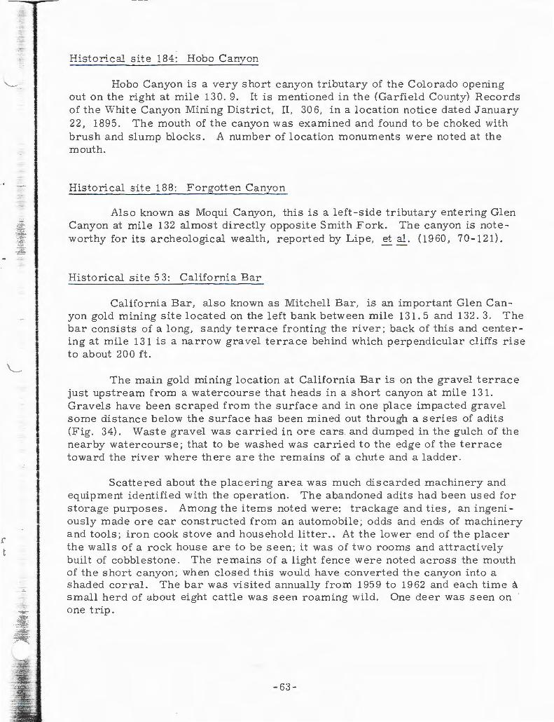
I I I
Historical site 184: Hobo Canyon
Hobo Canyon is a very short canyon tributary of the Colorado opening out on the right at mile 130. 9. It is mentioned in the (Garfield County) Records of the White Canyon Mining District, II, 306, in a location notice dated January 22 , 1895. The mouth of the canyon was examined and found to be choked with brush and slump blocks . A number of location monuments were noted at the mouth.
Historical site 188: Forgotten Canyon
Also known as Moqui Canyon, this is a left-side tributary entering Glen Canyon at mile 132 almost directly opposite Smith Fork. The canyon is noteworthy for its archeological wealth, reported by Lipe, et al. (1960, 70-121).
Historical site 53: California Bar
California Bar, also known as Mitchell Bar, is an important Glen Canyon gold mining site located on the left bank between mile 131. 5 and 132. 3. The bar consists of a long, sandy terrace fronting the river; back of this and center ing at mile 131 is a narrow gravel terrace behind which perpendicular cliffs rise to about 20 0 ft.
The main gold mining location at California Bar is on the gravel terrace just upstream from a watercourse that heads in a short canyon at mile 131. Gravels have been scraped from the surface and in one place impacted gravel some distance below the surface has been mined out through a series of adits (Fig. 34) . Waste gravel was carried in ore cars and dumped in the gulch of the nearby watercourse; that to be washed was carried to the edge of the terrace toward the river where there are the remains of a chute and a ladder.
Scattered about the placering area was much discarded machinery and equipment identified with the operation. The abandoned adits had been used for storage purposes. Among the items noted were: trackage and ties, an ingeniously made ore car constructed from an automobile; odds and ends of machinery and tools; iron cook stove and household litter . . At the lower end of the placer the walls of a rock house are to be seen; it was of two rooms and attractively built of cobblestone. The remains of a light fence were noted across the mouth of the short canyon ; when closed this would have converted the canyon into a shaded corral. The bar was visited annually from 1959 to 1962 and each time a small herd of about eight cattle was seen roaming wild. One deer was seen on one trip.
- 63-

Upstream about 1000 ft. on the gravel terrace there is another Pla mining area, though far smaller than that at mile 131. At the base of the~ race at this locality is an enormous steam boiler. Scattered about in the v~ ity was another smaller boiler, pipe , a heavy jack, and lengths of pipe anct
1
\..__ fittings.
Near the main placer area at mile 131 a grave was found --at one tim · protected by soldered pipe (Fig. 35). Scratched on the concrete head marke e
\were the following words: t
In Memory of A. G. Tuner [Turner] Died April 23 19 23 Age 69 K. P. Lobge [Lodge] 398 Sharon P.A.
A. G . Turner was a prospector whose name appears occasionally on location notices in Glen Canyon.
The name California Bar appears in the (Garfield County) Records of the White Canyon Mining District, I , 47 , as early as 1888 when it was clai med by Hawthorn, Brown, Keeler and Haskell. It subsequently passed into many other hands. Hunt (1953, 17, 221) mentions some details of i t s history. Ben Loper and Louis Chaffin worked at different times at California Bar. The l at e Louis Chaffin stated in an interview in 1960 that supplies and equipment destined for California Bar were brought into Glen Canyon by way of Hansen Creek and then boated across the river from Smith Bar (Historical sites 54, 52, see Crampton, 19 62, 7 6 -9). Chaffin said on one occasion that at low water he was able to drive a team and wagon across the river. He said he thought California Bar to have been one of the richest in Glen Canyon. R. B. Stanton in 1899 said that $30,000 had been taken out of California Bar (Crampton and Smith, 1961 , 79).
At the extreme upper end of California Bar, opposite Smith Fork Rapids, starting from a slickrock bench about 7 5 ft. abov e the riv er, there is a series of picked out steps (over a pecked out prehistoric series) by which one, with some agility, could reach the top of the cliff about 50 ft. above. From a somewhat lower level one may follow the slickrock around and upstream to a point overlooking the mouth of Forgotten Canyon (Historical site 188). Where the ledge pinches out there are a dozen picked out steps, on a nearl y perpendicul ar cliff, which lead down to the flat at the mouth of the canyon. By use of this route it would be possible to pass along the left bank and avoid the river, which runs against the cliffside in high water at the Smith Fork Rapids (Historical sit e 195). The view of California Bar and Glen Canyon from this trail is excellent (Fig. 36).
For sites in Glen Canyon below California Bar see Crampton, 19 62, and 1960.
-64-
l

3,
ce
ADDENDUM OF NEW DATA RELATING TO AREAS COVERED IN PREVIOUS REPORTS
Field work and library study undertaken sine e the publication of the first two historical site studies (Crampton, 1960 , 1962) for the Glen Canyon region have produced some new data relating to some of those sites. This is set out below. The original reports should be consulted for fuller information for each of the sites. New sites within the areas covered by the first two reports are indicated by an asterisk (*).
Historical site 125: Wilson Bar
According to the (Garfield County) Records of the White Canyon Mining District, II, 211, this was also known as Willow Bar. The lower half of the bar below the mouth of Stanton Canyon was edged with tall and stately willow trees. See Crampton ( 19 62, 64 -8).
Historical site 34: Escalante River
The serpentine, deeply incised lower canyon of the Escalante River will be inundated by Lake Powell at full pool to a point about 1 mi. beyond the mouth of Coyote Creek, a distance of over 7 mi. from the mouth. Within this distance a number of canyon tributaries enter the parent stream from both right and left. To the west these head on the Escalante Desert at the base of the Kaiparowits Plateau and to the east they head on the slopes of the Waterpocket Fold . The entire lower drainage of the river, a region characterized by slickrock and canyons but with occasional areas of grazing land, was made known in detail first by cattlemen living in communities at the base of the High Plateaus, namely, Escalante , Boulder, and the area about Capitol Reef National Monument.
Trails known best to stockmen who have developed them cross the lower Escalante drainage from the Escalante River desert to the Waterpocket Fold to the Hall Creek drainage (see Crampton, 19 62, 28 - 9 ). It is reportedly possible to travel the bed of the Escalante River on horseback from the crossing of Utah State Route 54. A cattle trail into the canyon from the west is said to exist in Clear Creek, a tributary about 3 mi. from the mouth of the river . The best known entrance to the lower Escalante canyon is by way of Davis Gulch,about 8
1
mi. from the mouth of the river; a trail passable to stock has been constructed and enters the gulch about 3 mi. from its mouth, above the maximum level of the reservoir. Upstream from Davis Gulch, Coyote Creek and Harris Wash offer additional entrances to the Escalante from the west . By Davis Gulch, and
-65-

possibly also by the Clear Creek trail, to say nothing of the upper accessible tributaries, cattle could be moved into the bed of the- Escalante and thence to the Waterpocket Fold, and adjacent locations, by way of a trail leaving the Escalante canyon near its mouth and following Glen Canyon to Long Canyon (see Crampton, 19 62 , 28- 9).
, It was in Davis Gulch that the youthful explorer Everett Ruess was last I
seen. Traveling alone with two burros, Ruess, 20, in November 1934, entered the gulch by way of the cattle trail. After exploring some of the prehistoric ruins in the canyon he disappeared; his two burros were located in Davis Gulch but no trace of the boy has ever been found. His disappearance in this remot e area, though one well known to local stockmen, has become the greatest my stery of the Glen Canyon region. Some of Ruess's writing was brought out in book form in 195 0; there is a foreword by Hugh Lacy giving some of the circumstances of his disappearance. Archeological investigations in Davis Gulch were carried out by Gunnerson (1959) in 1957. See also Lister (1959) for other 1957 archeological investigations in the lower basin of the Escalante River.
A number of natural bridges, arches, and windows exist in the canyon tributaries of the Escalante and in the walls of the main canyon, though none span the river itself. · See Moore ( 1955) for photographs and locations of the main arches. One of these, Gregory Natural Bridge, named after the geologist Herbert E. Gregory, spans the canyon of Fifty Mile Creek about 3/4 mi. from its mouth and will be lost under the waters of Lake Powell. Fifty Mile Creek is about 10 mi. from the mouth of the Escalante River , which it enters from the west. An arch in the lower part of Davis Gulch, about 2 mi. from its mouth, will be close to the edge of the reservoir at full pool. _
There is much confusion concerning the names of the bridges and arches in the Escalante drainage. Probably all of these features were first seen by pioneer cattlemen operating from Escalante and neighboring communities but the first names applied to them, if any, were not perpetuated on the printed page. The result has been that later arrivals have "discovered" them again and still later -comers have again ''discovered'' them. One of the earliest to locate any of the bridges in the Escalante drainage was Miser (1924) whose map, where two of the bridges appear, probably reflects discoveries made during the mapping undertaken in 19 21 by the U.S. Geological Survey in cooperation with the Southern California Edison Company.
Historical site 29: Aztec Creek
The mouth of Aztec Creek was an important stopping place for river travelers from the mining days in Glen Canyon until it was inundated by the rising waters of Lake Powell. Numbers of those who visited the location inscribed their names in a large al cove just above the mouth of and on the north side of
-66-
--
n
F
~
i -
r --~ .. .. :i
-'!!" .,.,-~
_ .;._.
!._
t ~
3 -. -
£'th, ·.
~ s
d
th e creek. At the lower end of the alcove were located the three presumably prehistoric pillars reported by Crampton ( 1960, 98-10 0 , Fig. 35) which were one of the attractions of the site.
The following names in this alcov e were transcribed after the technical si t e report (Crampton, 19 60) was published:
Hislop 1891 H. M. Judd 8114 109 J. G. Tr ----- 1895 R B - M V 705 Jas Black Feb Don Beaure - ard 1909 G M. Wright Nov 1892 E C. Kolb Oct 20 11 E. L. Kolb Aug. 30 13
W. H. Ramsaur and
W. W. Jones 8 I 25 - 22
Lute C. Ramsaur L.A. Cal Aug. 24. 22
L. M. Bowers Aug. 2 d. 1930 [?] E. P. Hunt P 0 D 1878 [1898? spurious?]
A few petroglyphs of wild sheep were noted at the lower end of the alcov e near the prehistoric pillars.
On the same side of the creek about 350 yds. from the mouth and alongside the trail to Rainbow Bridge there is a huge sandstone block on which some illegible names had been inscribed. One date, 1880, probably spurious, was noted .
The inscription of "N. M. Judd 9 I 14 I 09" is that of Neil Judd, one of the party who discovered Rainbow Bridge on that date. After arriving at the bridge Judd and several others of the Cummings -Douglass party walked down to the mouth of Aztec Creek where Judd left his name. Donald Beauregard, who also inscribed his name, was one of the discovery party.
On a rock immediately at the mouth of Aztec Creek, and on the upstream side, the following inscription was noted:
A G I W M MER [Wimmer]
The name is followed by symbols representing an arch, diamond and anchor . During the mapping of Glen Canyon by the U.S . Geological Survey in cooperation with the Southern California Edison Company in 1921 (Crampton, 1959, 69) supplies were brought in to the surveyors by T . C . Wimmer . Having missed the mouth of Aztec Creek on one trip, Wimmer, on a second trip in \ 1921 , brought along a can of yellow paint and on the cliff on the right side painted the words "Rainbow Bridge T. C. Wimmer'' in letters 8ft. high. Freeman (1924 , 162-3) reports the inscription as "Bridge Canyon- T. C . Wimmer. 11
After a number of trips through Glen Canyon we finally discovered this inscription in the early morning light on August 12, 1962 at mile 68. 7. The paint had entirely weathered away, leaving only the paint stain--and this was only faintly visible.
-67-

On the right cliff wall in the canyon of Aztec Creek , about 1 mi. below the mouth of Bridge Canyon, the following chiseled inscription was found:
Kolb 10-6-21.
On the cliff wall on the upstream side of the mouth of Bridge Canyon the ~ollowing names were inscribed:
Kolb Lynn Coon G. L. L. KEN
Historical site 3 0: Rainbow Bridge
On the cliff side directly west of Rainbow Bridge and some distance above it the following inscription has been picked in the rock: 11J. Wetherill Aug 14 1909. 11 This was the date of the discovery of Rainbow Bridge by the Cummings-Douglass party (Crampton, 1959, 78-9), of which John Wetherill was a guide. Wetherill , however, had not been to the bridge before. The entire party was guided to it by the Paiute Indian Nasja-begay, whose contribution in this regard is recognized in the bronze plaque set in a cliff wall alongside the trail and just a few yards upstream from the bridge. This handsome plaque, sculptured by Jo Mora, was a gift of Raymond Armsby of Burlingame, California. It was put in place September 22, 1927. (See the Rainbow Bridge Visitors Register for that date.)
It has been reported that another Wetherill inscription is located on the east side of Bridge Canyon in an alcove directly east of the bridge.
~' Historical site 2 64
On the right side at mile 63. 9 Balanced Rock Canyon enters the Colorado. The name has recently been applied by river runners who have located an area where numbers of rounded rocks on a thin gravel terrace have been left standing on small pedestals of sand and other smaller rocks, as the supporting matrix of the terrace has been eroded leaving the bedrock exposed. This is an area less than 100 ft. square about 60 ft. above the Colorado on the upstream side of the canyon and back about 0. 1 mi. from the river 1 s edge at mile 64. Somewhat below the balanced rock area on a rounded knob overlooking the Col orado, the following picked inscription was found on a horizontal surface:
1H 1911
-68-
J
I i I I f ! i t

e
n
e,'-
io.
The inscription was deeply incised in the soft sandstone and had weathered badly over the years.
Historical site 27: Wild Horse Bar
E. C. Kolb, in his 1921 logbook, noted that on October 7, 1921 , the U.S . Geological Survey party, of which he was a member, saw a dappled gray wild horse on this bar. This undoubtedly accounts for the origin of the name, which appeared for the first time on the river maps made in 1921 by the U . S . Geological Survey in cooperation with the Southern California Edison Company. See Crampton, 1960, 79 - 81.
Historical site 7: Cane Bar
Overlooking Cane Bar at mile 40 . 8, about 100 yds. from the Colorado and about 50 ft . above it, is a shallow cave in which several names were inscribed in the soft, flaky sandstone. Those legible were:
J. E. Riding 1919 W. V. Lay Escalante Roy White Monte Marshall
· See C rampton 1960, 59-66.
'~' Historical site 265: Castle Spring
Located in the SW 1 I 4 Sec 34 T43S R8E SLBM, this spring has been developed as a watering place for winter range cattle. A pipe feeds a steady, if small, flow of water into two adjoining tanks. The spring is located adjacent to the road that originally ran to Kane Creek and is within sight of the spectacular mass known as Castle Rock 3/4 mi. southeast of it. See Crampton, 1960, Atlas Sheet 21, for location.
Historical site 18: Wahweap Creek
In addition to the historical data given in Crampton (1960, 68 - 9) the lower basin of Wahweap Creek has long figured prominently as a watering place. for winter range cattle. Wiregrass Spring in Sec 29 T43S R8E SLBM, over 10 mi. from the mouth of the creek, and near the head of the reservoir area , was a permanent source. South of Lone Rock about 3/4 mi. a winter cattle camp
, - 69-

was built adjacent to a windmill located near the west bank of normally dry wash . Water was pumped in this manner to fill a large watering tank; a one , room house and corrals were adjacent to the tank.
':' Historical site 266
This is a gold placer mining site on the right bank between mile 11. 8 and mile 11. 9. It consists of a narrow gravel te rrace about 10 ft. above the extreme high water mark. There is evidence of considerable placer mining. A piston-type 11 3 E 11 horsepower engine used for pumping water has tumbled off its original mounting and lies perched precariously on a steep bluff above th e river's edge. The remains of about 50 ft. of webbed hose we re noted; this was used to convey water to the diggings from which a number of yards of gravel had been removed. The remains of a crude fireplace and a tent square were seen.
':' Historical site 267
At mile 10. 4 on the right side of the Colorado at the base of the canyon wall are inscribed two names:
F. G. Faatz G. M. Wright
Nov. 16, 1892 Nove. 16, 1892
Numbers of petroglyphs were noted in the vicinity.
See Historical sites 253, 261, in th:.: main body of this report for additional reference to these persons, and Crampton, 1960 , 89-90.
~, Historical site 2 68
On the left side of the Colorado at mile 1 . 9 there is a deep alcove situated some distance back from the river. In this place the following names were found incised in the soft sandstone:
A. Colton 1889 Hislop Joseph Mangum M. A Aug. 25 , 1892
-70-
--= ~~ r i -=--~ rr ~ dl ~- n ""'\!i-" =~ r -~ ~
--
I
.- as --~.;._.. '"' ~ :~-· ~-~··
_;;;_;-:-
\............
. ate~ )und
Historical site 136: Hoskaninni Road
From the location of Lees Ferry at mile 0, the HoskaninDi Company, in which Robert Brewster Stanton was engineer and field superintendent, in 1899 constructed a road 10 ft. wide 1 1 I 2 mi. upstream along the left bank. This was part of the general assessment work undertaken to hold the company's Glen Canyon claims, which extended in one contiguous series from Lees Ferry to above Hite 162 mi. upstream. See Crampton and Smith, 196 L 104-5.
The remains of this road are clearly visible and may easily be followed. Construction over the lower mile across soft and sandy slopes at the foot of the Echo P eaks was generally easy and the road stayed some distance above the river. As the builders approached Fall Creek, which enters the Colorado at mile 1. 6, they were forced to make extensive cuts through the ledges as they descended to the bed of Fall Creek, which was reached at its mouth. There the road ended. A few names were inscribed on the ledges at the end of the road. The legible ones were:
William Carpenter Nov. 14, 1900 L . F. Archer Oct
Historical site 137: Lees Back Bone
2 '04
Only briefly mentioned by Crampton (1960, 76) Lees Back Bone is an eastward slipping slope west of the location of Lees Ferry at mile 0. The original left bank road from the ferry ascended this rather steep slope about 1 1/2 mi. before it leveled out. Then the route turned south at the base of the Echo Cliffs and soon reached comparatively easy going paralleling the present U.S. Highway 89A. This road was improved by the Hoskaninni Company in 1899 (see Crampton and Smith, 19 61, 104 -5). A later route practicable for automobiles was dug out of the soft, shaly cliffside of the "Back Bone" overlooking the Colorado River and the rapids of the Paria River. This precarious road was used until 1929 when the Navajo Bridge over Marble Canyon, 6 mi . below Lees Ferry, was completed.
~' Historical site 138
From U. S. Highway 89A (about 1 1/2 mi . from Navajo Bridge over Marble Canyon) it is possible to drive a pickup truck or jeep over the ol d auto- 1
'
mobile road to the left bank approach to Lees Ferry. One may dri ve north about 4 mi . to a point where the road has eroded away at the edge of the cliff ov erlooking the Colorado and at the base of Lees Back Bone (see Historical site IE) . At this point there is a large isolated rock alongside the road in which
-71-
there are inscribed some of the names of early_ automobile travelers and p05 ,
sibly others. It was a campsite area, and odds and ends of ancient automobil e parts about suggest that encampment may have been forced upon those who hact broken down.
The Lees Ferry area is historically highly significant in Colorado Rive:r history but only a superficial examination of it has been made here and by
\ Crampton (1960, 94 -7) since it falls outside the Lake Powell Reservoir area.. ~
~
- 72-

BIBLIOGRAPHY
Adams, William Y. 1960 Ninety Years of Glen Canyon Archeology, 1869 - 1959. Museum of
Northern Arizona Bulletin, No. 33, Glen Cany on Series, No. 2.
Auerbach, Herbert S., and J. Cecil Alter, Eds. 1940 Life in the Rocky Mountains, 1830-1835, by Warren Angus Ferris .
Rocky Mountain Boo k Shop, Salt Lake City .
Baker, Arthur A. 1946 Geology of the Green River Desert -Cataract Canyon Region: Emery,
Wayne , and Garfield Counties , Utah. U.S. Geological Survey Bulletin, No . 951.
Baker, Pearl n. d. Trail on the Wat er. Unpublished MS, in possession of Pearl
Baker, Green Ri ver, Utah.
Beaman, E. 0. 1874 The Canon of the Colorado, and the Moquis Pueblos : A Wild Ride
through the Canons and Rapids; A Visit to the Seven Cities of the Desert ; Glimpses of Mormon Life. Appleton's Journal, Vol. 15 , April 18-May 30.
Bell, William A. 1870 New Tracks in North America; a Journal of Travel and Adventure
Whilst Engaged in the Survey for a Southern Railroad to the Pacific Ocean during 1867-8. (2nd edition) Chapman and Hall, London.
Bernheimer, Charles L. 1922- Field Notes , Expeditions 1922, 1923 , 1924, 1926 , 1927 , 1929 , 1930. 19 30 Typescript, Utah State Historical Society, Salt Lake City, Utah.
Bishop , F. M. 1871 Map of the Second Powell Expedition on the Green and Colorado
Rivers. Unpublished MS, Utah State Historical Society, Sal t Lake City, Utah.
Bolton, Herbert E. 1950 Pageant in the Wilderness, the Story of the Escalante Expedition to
the Interior Basin, 177 6, Including the Diary and Itinerary of Father Escalante. Utah State Historical Society, Salt Lake City , Utah.
-73-
Butler, B. S., et al. 1920 The Ore Deposits of Utah. U.S. Geological Survey Professional
Papers , No. 111.
Carroll, W. G. 1956 Jeep Trail into Utah's Rugged Needles Country. _D_e_s_e_r_t_M--=.:a:Q.g..:::.azi n
~· Vol. 19, No. 11, pp. 5-9.
Case, Robert 0. 1938 He Shot the Colorado Alone. Saturday Evening Post, February 26
Chalfant, James M., Ed. 1932 Colorado River Controversies, by Robert Brewster Stanton.
Crampton, 1959
19 60
19 62
1964
Crampton, 1961
Dodd, Mead and Co., New York.
C. Gregory Outline History of the Glen Canyon Region, 1776-1922. Universitv of Utah Anthropological Papers, No. 42, Glen Canyon Series, No. 9.
Historical Sites in Glen Canyon, Mouth of San Juan River to Lees Ferry. University of Utah Anthropological Papers, No. 46, Glen Canyon Series, No. 12.
Historical Sites in Glen Canyon, Mouth of Hansen Creek to Mouth of San Juan River. University of Utah Anthropological Papers , No . 61, Glen Canyon Series, No. 17.
The San Juan Canyon Historical Sites. University of Utah Anthropological Papers, No . 70, Glen Canyon Series, No. 22.
C. Gregory, and Dwight L. Smith, Eds. The Hoskaninni Papers, Mining in Glen Canyon, 1897-1902, by Robert B. Stanton. University of Utah Anthropological Papers, 54, Glen Canyon Series, No. 15.
No.
Darrah, 1947
William C., Ed. The Exploration of the Colorado River in 18 69 [Including the Journals of J. W. Powell, George Y. Bradley, and J. C. Sumner, Together with other Original Documents, Including Biographical Sketches and Preparations for a Second Expedition]. Utah Historical Quarterly, Vol. 15, pp. 1-153.
-74-

J
2
-~ ~~ ........ -=r~
; -~~7
n -~;: -~
-Io.
1948 -1949
John F. Steward [and] Journal of John F. Steward, May 22-November 3, 1871 [with sketches of] Beaman, Fennemore, Hillers, Dellenbaugh, Johnson and Hattan [and] Three Letters by Andrew Hall. Utah Historical Quarterly, Vol. 15, pp. 175 -251 ; Vol. 16, pp. 491 -5 08.
Dellenbaugh, FrederickS. S. 1902 The Romance of the Colorado River: the Story of Its Discovery in
15 40, with an Account of the Later Explorations, and with Special Reference to the Voyage of Powell Through the Line of the Great Canyons . G. P. Putnam 's Sons, New York.
1926 A Canyon Voyage; the Narrative of the Second Powell Expedition Down the Green-Colorado River from Wyoming, and the Explorations on Land, in the Years 1871 and 1872. Yale University Press, New Haven.
Eddy, Clyde 1929 Down the World's Most Dangerous River. Frederick A. Stokes,
New York .
Edwards, W. H. 1929 Testimony ... United States vs Utah, Supreme Court of the United
States, October Term, 1929, No. 15, Original (Typescript, Utah State Historical Society), Vols. 10-11, pp. 1892-1981.
Ekker, Barbara B. 1964 Freighting on th'e Colorado: Reminiscences of Virgil Fay Baldwin .
Utah Historical Quarterly, Vol. 32, pp. 122-9.
Freeman, Lewis R. 1924 Down the Grand Canyon. William Heineman, London.
Garfield County, Utah 1883- Deeds, A. Unpublished MS, Recorder's Office, Panguitch, Utah. 1884
1885-1897
Records of the White Canyon Mining District, Garfield and San Juan Counties, Utah Territory, Cass Hite, Recorder [entries also by John P. Hite, Ben R. Hite, Horner J. Hite, George L. Gillham, and others]. 2 vols. Unpublished MS, Recorder's Office, Panguitch, Utah.
Goldwater, Barry 1940 A Journey Down the Green and Colorado Rivers , 1940. A. Walker
Publishing Co. , Phoenix.
-75-

Gregory, Herbert E., Ed. 1939 Diary of Almon Harris Thompson, Geographer,
Colorado River of the West and Its Tributaries, Historical Quarterly, Vol. 7, pp. 3-138.
Explorations of the 18 7 1- 18 7 5 . Utah -
1948-1949
Stephen Vandiver Jones [and] Journal of Stephen Vandiver Jones, April 21, 1871-December 14, 1872. Utah Historical Quarterly, Vols. 16, 17, pp. 11-174.
Gregory, Herbert E., and Raymond C. Moore 1931 The Kaiparowits Region, a Geographic and Geologic Reconnaissance
of Parts of Utah and Arizona. U.S. Geological Survey Professional Papers, No. 164.
Gunnerson, James H. 1959 1957 Excavations, Glen Canyon Area. University of Utah Anthro
pological Papers, No. 43, Glen Canyon Series, No. 10.
Hafen, Leroy R. , and Ann W. Hafen 1954 Old Spanish Trail: Santa Fe to Los Angeles; with Extracts from
Contemporary Records and Including Diaries of Antonio Armijo and Orville Pratt. Arthur H. Clark, Glendale.
Harshberger, Benjamin D. 1929 Testimony ... United States vs Utah, Supreme Court of the United
States, October Term, 1929, No. 15, Original (Typescript, Utah State Historical Society), Vol. 13 , pp. 2500-21.
Henderson, Randall 1946 We Explored Dark Canyon. Desert Magazine, Vol. 10, No. 2,
pp. 5-9.
1949 19 Days on Utah Trails. Desert Magazine, Vol. 12, No. 12, pp. 5-11; Vol. 13, No. 1, pp. 19-25.
1952 Glen Canyon Voyage. Desert Magazine, Vol. 15, No. 10, pp. 7-12.
1957 We Camped in the Land of the Standing Rocks. Desert Magazine, Vol. 20, No. 10, pp. 5-11.
Hickman, Joe 1924 Tales of the Trails. Improvement Era, Vol. 27, February,
pp. 305-12.
-76-
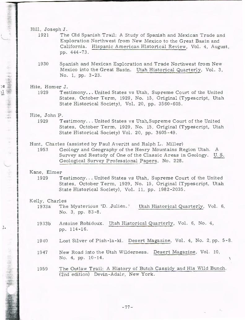
~e -ir: ,_1 T~
2.
·= f
-..,-· ~~;
:::.: ~ ~ :.::::.-
Hill, Joseph J. 1921 The Old Spanish Trail: A Study of Spanish and Mexican Trade and
Exploration ::'-Jorthwest from New Mexico to the Great Bas in and California . Hispanic American Historical Review, Vol. 4, August , pp. 444-73.
1930 Spanish and M exican Exploratio n and Trade Northwest from New Mexico into the Great Basin. Utah Historical Quart erly, Vol. 3, No. L pp. 3 - 2 3 .
Hite, Homer J. 1929 Testimony ... United States v s Utah, Supreme Court of the United
States , October Term , 19 29, No. 15, Original (Typescript, Utah State Historical Society) , Vol. 20, pp. 3560-605.
Hite, John P. 1929 Testimony ... United States vs Utah,Supreme Court of the United
States, October Term , 1929 , No. 15 , Original (Typescript, Utah State Historical Society) Vol. 20, pp. 3605-49.
Hunt , Charles (assisted by Paul Averitt and Ralph L . Miller) 1953 Geology and Geography of the Henry Mountains Region Utah. A
Survey and Restudy of One of the Classic Areas in Geology. U.S. Geological Sur~~)' Pr~fessional ~aper~ , No. 228.
Kane, Elmer 1929 Testimony ... United States vs Utah, Supreme Court of the United
States , October Term, 1929, No. 15, Original (Typescript, Utah State Historical Society) , Vol. 11, pp. 1982-2 035 .
Kelly, Charles 1933a The Mysterious 'D . . J ulien . '
No. 3, pp . 8 3 - 8 . Utah Historical Quarterly, Vol. 6,
1933b Antoine Robi doux. Utah Historical Quarterly , Vol. 6, No. 4 , pp. 114-16.
1940 L ost Sil ver of Pish- la -ki . Desert Magazine, Vol. 4, No. 2, pp. 5-8.
1947
1959
New Road into th e Utah Wilderness. Desert Magazine , Vol. 10, No. 4, pp . 1 0 - 1 4 .
The Outlaw Trail : A History of Butch Cassidy and His Wild Bunch. (2nd edition) Devin-Adair, New York.
-77-
\

Kelly, Charles, Ed. 194 7 Captain Francis Marion Bishop's Journal, August 15, 187 0-June
3, 1872. Utah Historical Quarterly, Vol. 15 , pp. 159-240.
1948-1949
Walter Clement Powell [and] Journal of W. C. Powell, April 2l 1871-December 7, 1872. Utah Historical Quarterly, Vols. 16, ' 17, pp. 253-478.
King, Murray E. 1940 Last of the Bandit Riders , by Matt Warner (as told to Murray E.
King). Caxton Printers , Caldw ell, Idaho.
Kolb, Ellsworth C. 1921 L og of Cataract Canyon Survey, September 3-0ctober 13, 1921.
Field Note Book 24 62. Unpubl ished MS , Southern Califo rnia Edison Company, Los Angeles.
1929 Testimony ... United States vs Utah, Supreme Court of the United States, October Term, 1929, No. 15, Original (Typescript, Utah State Historical Society), Vol. 4, pp. 763-877.
Kolb, E. L. 1914 Through the Grand Canyon from Wyoming to Mexico.
Company, New York.
Lipe, William D.
Macmillan
19 60 1958 Excavations, Glen Canyon Area. University of Utah Anthropo logical Papers, No. 44, Glen Cany on Series, No. 11.
Lipe , William D., et al. 1960 1959 Excavations, Glen Canyon Area. University of Utah Anthro
pological Papers, No. 49, Glen Cany on Series, No. 13.
Lister, Robert H. 1958 The Glen Canyon Survey in 195 7. University of Utah Anthro
pological Papers, No. 30, Glen Canyon Series, No. 1.
1959 The Glen Canyon Right Bank Survey. In ''The Glen Canyon Archeological Surv ey ,'' Don D. Fowler, et ar- Univ ersity of Utah i\nthropological Papers, No. 39 , Glen Canyon Series, No. 6, Pt. 1, pp. 27-162.
Loper, Bert 1929 Testimony ... United States vs Utah, Supreme Court of the United
States, October Term, 1929, No. 15, Original (Typescript, Utah State Historical Society), Vols. 12 -13, pp. 2306-448.
-78-

Harry McDonald, 1929 Testimony ... United States vs Utah, Supreme Court of the United
States, October Term, 1929, No. 15, Original (T;rpescript, Utah State Historical Society), Vol. 12, pp. 2150-229.
Marston, Otis R., Comp. 1949- Colorado River Journals and Diaries, 1889-1951. 2 vols. Type-1951 script, Reference Library, Grand Canyon National Park.
Marston, Otis R. 1955 Fast Water. In This is Dinosaur ... , Wallace Stegner (Ed.),
pp. 58-70. Alfred A. Knopf, New York.
19 60 River Runners: Fast Water Navigation. Utah Historical Quarterly, Vol. 2 8 , No.. 3, pp . 2 9 1 - 3 0 8 .
Miser, Hugh D. 1924 The San Juan Canyon, Southeastern Utah; A Geographic and Hydro
graphic Reconnaissance.. U.S. Geological Survey Water Supply Papers, No. 5 38 .
Moore, W. Robert . 1955 Escalante: Utah's River of Arches. National Geographic Magazine,
Vol. 108, No. 3, pp. 399-425.
Muench, Joyce R. 1952 They Run the Ferry at Hite . Desert Magazine, Vol. 15, No. 2,
pp. 22-6.
Powell, John W. 1870 ... Report on ... Explorations of the Rio Colorado in 1869. In New
Tracks in North America, William A. Bell, pp. 559-64. (2nd edi-tion) Chapman and Hall, London. Reprinted in Utah Historical Quarterly, Vol. 15 (1947), pp. 21-7. (The latter is cited here.)
1875 Exploration of the Colorado River of the West and Its Tributaries. U.S. Government Printing Office, Washington.
Prommel, Harold W. C. 1929 Testimony ... United States vs Utah, Supreme Court of the United
States, October Term, 1929, No. 15, Original (Typescript, Utah State Historical Society) , Vols. 5, 6, pp. 988-1040.
-79-

Prudden, T. Mitchell 1906 On the Great American Plateau , Wanderings Among Cany ons and
Buttes in the Land of the Cliff-dweller and the Indian of To-day .G. P. Putnam 1S Sons, New York and London.
Rice, William E. 1946 Hite September 17, 1946. Unpublished MS, Copy in Utah State
Historical Society. (mimeographed)
Ross, Joseph A. 19 29 Testimony ... United States vs Utah, Supreme Court of the United
St ates , October Term, 1929, No. 15, Original (Typescript, Utah State Hist orical Society) , Vol. 5 , pp. 4195 - 270.
Ruess , Everett 1950 On Desert Trails with Everett Ruess, with introduction by Hugh
Lacy and foreword by Randall Henderson . . Desert Magazine Press , Palm Desert, California .
Salt Lake Tribune February 19, 1885 ; September 10-11, 1891; February 27-March 10 , 1892 ; November 30, 1893. Salt Lake City, Utah.
San Juan County, Utah 1884- Miscellaneous Record, B. Unpublished MS, Recorder's Office, 1906 Monticello, Utah.
1891-1894
Book A, Mining . Unpublished MS, Recorder's Office, Monticello, Utah .
1901 Mining Claims, C. Unpublished MS, Recorder's Office, Monticello, Utah.
Scorup, Stena 1944 J . A. Scorup: A Utah Cattleman. (privately printed)
Sharrock, Floyd \A.., DavidS. Dibble and Keith M. Anderson 1961 The Creeping Dune Irrigation Site in Glen Canyon, Utah.
American Antiquity, Vol. 27, No . 2, pp. 188-202.
Silliman, Bert J. ca. 1951 - Papers. Unpublished MS, Utah State Historical Society, 1957 Salt Lake City.
Siringo , C harles l\. 1927 Riata and Spurs; the Story of a Lifetime Spent in the Saddl e as
Cowboy and Det ective. Houghton Mifflin Co. , Bost on .
-80-
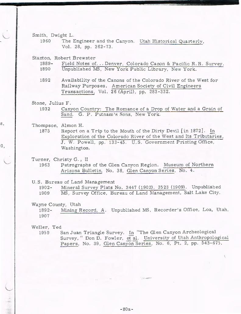
I
S,
0,
Smith, Dwight L. 1960 The Engineer and the Cany on. Utah Historica. Quarterly ,
Vol. 28, pp. 262 - 73.
Stanton, Robert Brewster 1889 - Field Notes of. .. Denver , Colorado Canon & Pacific R. R. Surv ey . 1890 Unpublished 1\IIS, New York Public Library, New York.
1892 Availability of the Canons of the Colorado River of the West for Railway Purposes. American Society of Civil Engineers Transactions, Vol. 26 (April), pp. 283 - 332.
Stone, Julius F. 1932 Canyon Country: The Romance of a Drop of Water and a Grain of
Sand. G. P. Putnam's Sons, New York.
Thompson, Almon H. 1875 Report on a Trip to the Mouth of the Dirty Devil [in 1872]. In
Exploration of the Colorado River of the West and Its Tributaries, J. W . Powell, pp. 133 - 45. U.S. Government Printing Office, Washington.
Turner, Christy G. J II 1963 Petrographs of the Glen Canyon Region. Museum of Northern
Arizona Bulletin, No. 38, Glen Canyon Series, No. 4.
U.S. Bureau of Land Management 1902 - Mineral Survey Plats No. 3447 (1902) , 3523 (1909). Unpublished 1909 1\IIS, Surv ey Office , Bureau of Land Management , Salt Lake City.
Wayne County, Utah 1892 - Mining Record, A. Unpublished MS, Recorder's Office, Loa, Utah . 1907
Weller, Ted 195 9 San Juan Triangle Survey. In "The Glen Canyon Archeological
Survey, " Don D. Fowler, etal. University of Utah Anthropological Papers , No. 39, Glen CanyonSeries, No. 6, Pt. 2, pp. 543-67:> .
• ... -0-.... ~-
-80a-

- 82 -
f f
·.; ~ ... ,!·· ·. ·' ... : . ... . ·
~ ~ .. -: .:.:
._. (f)
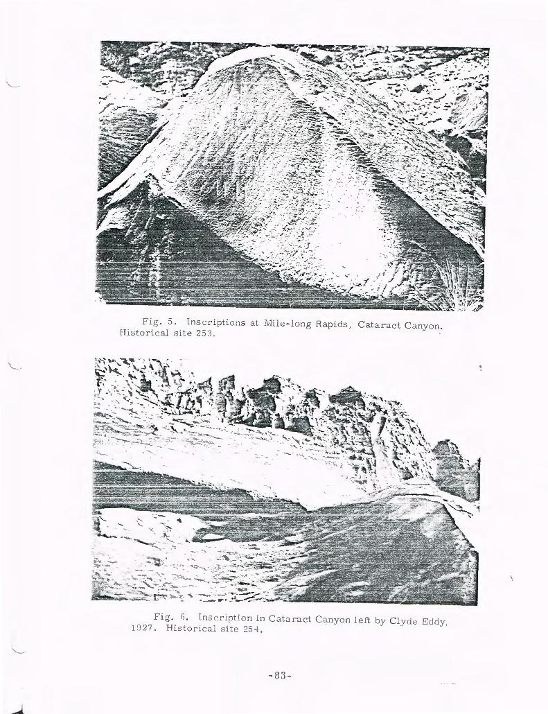
Fig . J . Inscriptions at i.Vlile - long Rapids, Cataract Canyon . His to deal site 25 3 .
Fig . f) . Ins cription in Co.taract C a nyon left by Clyde Eddy, 1927 . Historical site 25-L
- 83 -

Fig. 7. \Vhite Water in The Big Drop, Historical site 255. Cataract Canyon.
Fig . 8 . Kolb Brothers' inscription at T he Big Drop, Cataract Canyon. Historical site 255.
- 84 -
1

i
ijl -"' 'P'"
l i ! i i
I I l
I l l f
.-, ~~ .. -. ---. --~ -
Fig. 9. Downstream from a point above The Big Drop. This will be the approximate head of Lake Powell at full pool.
F ig. 10. Cataract Canyon near the mouth of Clearwater Canyon .
-85-
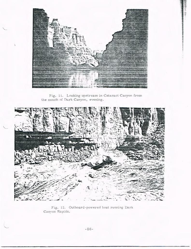
Fig . 11 . Looking upstream in C ata ract C anyon from the m ouih of Dark Canyon , evening .
-._
•. ·t
~ . -
.-: ~~:::~~~~*~~~8 ~. -~~:_~~- · • r ~' :~ ·. ~~'~" "'•-~-~~~~ ~
Fig. 12. Outboarc.i - powered boat running Dark Can~·on Rapi d s .
- 8 6-
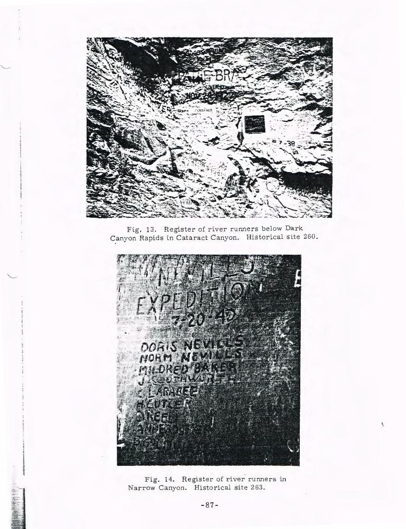
Fig . 13. Register of river runners below Dark Canyon Rapids in Cataract Canyon . Historical site 260.
Fig . 14 . Register of river runners in Narrow Canyon. Historical site 2 63.
- 87 -

Fig . 15 . l\IIouth of the Dirty Devil Rive r . Historical site 86 .
Fig . 16. Prehistoric "Fort lV!oqui. " Historic2.l site 139 .
- 88 -
r ~-.·, J ~--:;:-- ..... ::;-. ... • ~ . '
- ... -
-.
Fig . 17 . Inscription left by members of the second Powell ex pedition on the rocks ne2.r prehis toric "Fort IVIoqui." Powell's trip down the Colorado in 1871, and his land survey the following yea r, w2.s sometimes known 2.s the " \\"estern E>..'})lo ring Expedition . " Historical site 139 .
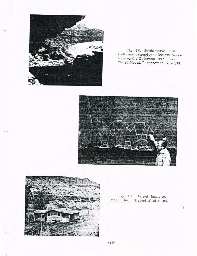
Fig. 18. Prehistoric ruins (left) and petroglyphs (below) overlooking the Colorado River near " Fort Moqui. " Historical site 139.
Fig. 19. Barrett home on Moqu i Bar. Historical site 196 .
-89-
Fig. 21. in July 1963. the east side site 75.
Hite Ferry in operation Photograph taken from
of the river. Historical
Fig . 22 . A nchor post o.t the site of the Harshberger Ferry at mile 165 . 8 on the right bank. Historical site 176 .
-90-
Fig. 20 . White Canyon post office and store in Farley Canyon. Historical site 181 .
~
" i I i J
i I I l i ;
------~ - - :
Fig . 23. " Hite Sept 19 .-\. D. 1883 " in scription at Dandy Crossing Bar. Historical site 7-L
Fig . 24. Pioneer cabin at Hite . Histo rical site 73 .
- 9 1-
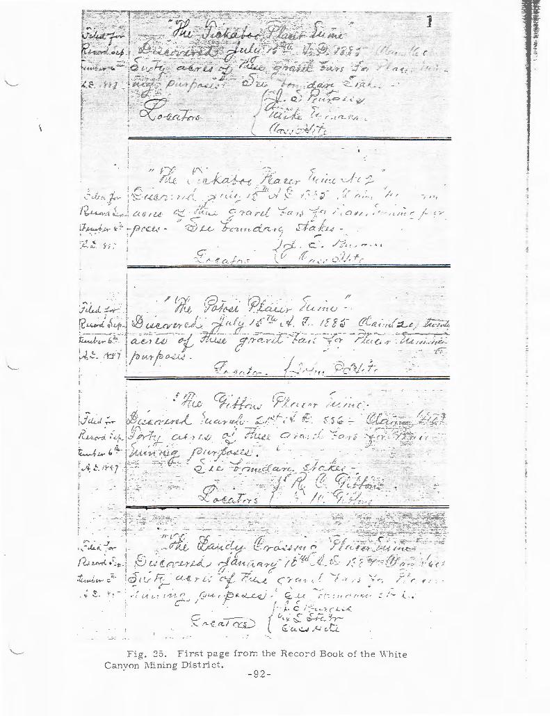
' r--;:.~· r.;:_.-; _r2. i ~'-:
('"'. '
il_, f o. .. !-~
;
-J ... . ~ LA
c-
~ ' . ~. r
f , .. -._/
_ .. C< ;I '
/ , It'(..
,', r,, . "i I I,
,-/, r. ,t / , ~ .... / I. I~
- - r ,... .11 ,, _,. ;; 1 -,; · ......... , . ;~::_:; ,Lt...-
"--r' C'C i t! ~cit''/. ·J ~- ~J:o f r ~·
,.-
;""' '-·
-: ..:_ r--1' (.t_./- 11 ·'
-- j . -, ... , :-- ·:.:;. --::...··- .-.
V' . . J : ... - :k. r, :cry-
J - ·--/I' t _.,.. ·"
.. _.~ ~-~ ~ , ' r .
J r!.,; ~·.-r{ ~ \ .. 1;. i -\~:> L-./ in.-J;. r .L--t1~/ I - ,
·~~W~!.T ;:11
• :d I ~ ;7 <1-
... "" '' . '
;""'
~ .. / 'L ·1 a_j ry_0
I I ?--<'
( ( ,
c_ '
/ -;:, , hT
~}_/~;; -(( . /I
' .
r / {-<./:tC
! [ 2 ~-
' ,.,.
' . -T :'
1?1 . / . . , _ ~..-··-«r· ,t.: ~( / tf t. · .-;~.
- ..... - ... ~ - ~- - · ·-- ; ;---.,.. .. ---:----t..."~"-4 ,• /! ,/ // (", .
,.---
/ ... ,. 1.--......... ·/t.-l , ,. I - - • • ·.
( c .; / / , , : .< 7
~ --U.
·' ( I I,
r / / -/
;.. . C / ~ :. L 4 r ( J..... .,. /.~
(..;. y. ~ i--j ":C~ ~~-~ u. ..:....; / -...' e-G:.
0 'r r { , r
'
'_1:.' /· ~-
·:7''5..: ~~:, ( -r_ =:· ~-
"'· --· -·-· -· -::·· .... ,_
I : . t; (
' .· > ; -.:~ ,
' r y .
I,
Fig . :25 . Firs t page fro :r.~ the R ecord Book of t he White Canyon l\lini ng District .
- 92 -
l
' f !
J
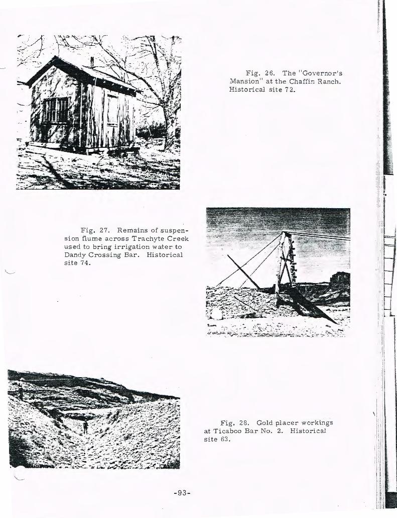
Fig. 27. Remains of suspension flume ac ross Trachyte Creek used to bring irrigation wate r to Dandy Crossing Bar. Historical site 74.
-93-
Fig. 26. The " Gove r nor' s Mansion" at the Chaffin Ranch . Historical site i 2.
Fig. 28. Gold placer workings at Ticaboo Bar No. 2. Historical site 63.

Fig . 29 .
Fig . ervo ir a t
T he " Bank of Ticaboo . " His tor ical site 63.
--. ---·
30 . F l ume a t outlet of " Lake I\'lary " res Good Hope B2.:- . Historical site 60 .
- 94 -

Fig. 31. Letterpress at Good Hope Bar. Historical site 60.
Fig. 32. Ryan Cabin. Historical site 175.
-95-
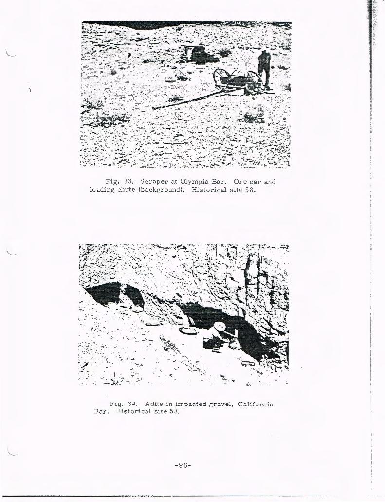
- .
Fig. 33 . Scraper at Olympia Bar. Ore car and loading chute (background). Historical site 58 .
··· ..... ... I .""- _ .......
~~~.:7·-~ --- ~ ~ --~ . .. ) .. ~ -; : . ~ . . · . .. --,... , .· .. ...
- ..... __
{ ·-_ , ' ;; ' ;; -- - :- J ---,..w: "\ - - .·
,.. : ,-- ~ ~ ~-
..... . - .. ) ·_·
Fig. 34 . Adits in impacted grav el, California Bar . Historical site 53 .
- 9 6-
l I i
·.:.-.

Fig. 35. Grave of A. G. Timer [Turner], Glen Canyon prospector, at California Bar. Historical site 53.
Fig. 36. California Bar and Glen Canyon from trail at head of bar. Historical site 53.
-97-

ATLAS SHOWING THE HISTORICAL SITES ALONG
THE COLORADO RIVER IN THE GLEN CANYON RESERVOIR
AREA (LAKE POWELL) AND ENVIRONS
Sheets 1 to 9
Head of Cataract Canyon to California Bar in Glen Canyon
The top of each sheet is north : approximate mean
magnetic declination of 15 1 I 2 degrees East in 1921.
Base is "Plan ... of the Colorado Riv er , Lees
Ferry, Arizona to Mouth of Green River, Utah; San
Juan Riv er, Mouth to Chinle Creek, Utah; and Cer
tain Tributaries, 11 surveyed by the U.S. Geological
Survey in co ope ration with the Southern California
Edison Company in 1921 , published by the U . S.
Geological Survey in 19 21.
-99-

;::.ve; 1-'.a.p Shee't Y.
Land of Standine Rock e
~
Spanish Bottom
HS 250
-100-
z 0
>z
0
Lower Red Lake Can,.von
5 c Q. I e. 11'"1 , I . - •
H ISTORICAL S ITES IN THE GLEN CANYON DAM
RESERVOIR AREA AND ENVIRON S I
t ~ i 1 . I .l:
t )
i I I !
I I
' j i I ! ! I
I ! i
I
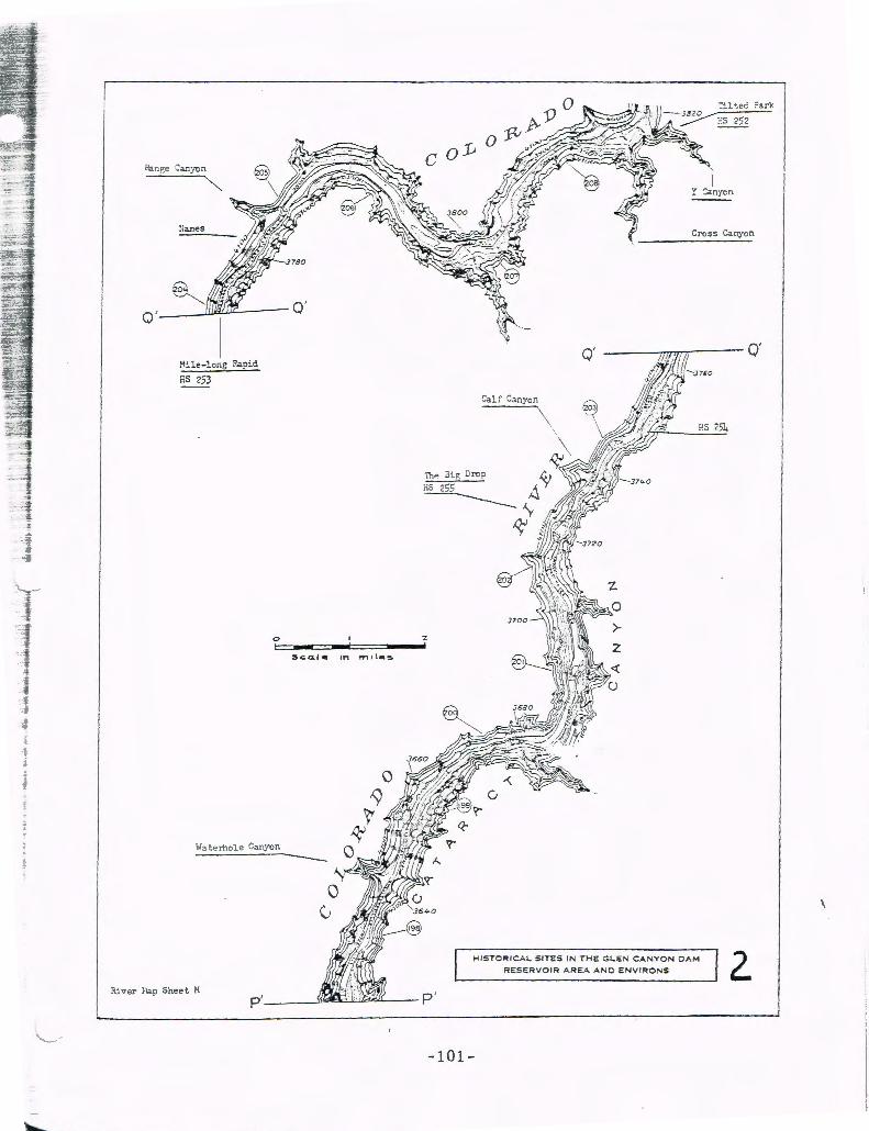
,, •. ar.es Cross Canyon
__ JlJBJ~-- Q'
m.-J, """ HS 253 . 750
Q'
Cal!~ Canyon
T i i
. f
H~t,ernole Canyon ---HISTOR ICAL SITES IN T
RESERVOIR ARE:E G LE N CANYON 0 AN O ENVIRONS AM 2. River Hap Sheet H
-101-

0
0
0 '
S.c;.o l c. IM ,., II C.,.
S:Jllen l."'lsc:-intion
ES 259
o·
Canyon Gypsum
liS 256
Bowd ic Ct yon
---~::;:~~~~~HI:E~G~~~ENCANYONCAM t- R I CA~ S ITES I N T NC ENV I RONS HISTO RESERVOIR AREA A
-102-
i
t j t t I
i t
I I-t
i I I
! !
I
l i
I I I

0
I - ~
Hille Crag Bend
HS 262
~ I
-103-
HISTORICAL S IT::":;S~~;;-;-:::-:----==-AReA AND E NVI RONS DAM ESERVOIR - LEN CANYON
R =. IN THE G
Dark Canyon
HS 260
0 '
4
< 'V-0
>-z
Ri ve r ~~ao She · et L
0 '

0 I
ci ~--~~--~==~--~T Sc.a. / e ~ n
-104 -
, '•\. '.
HISTORICAL SITES IN THE RESERVOIR AREA A GLEN CANYON DAM 5
NO ENVIRONS
Dirty Devil Ti i ver
/ '
~~~~~~-J~~"" @)
P.S 85
Riv er ~..ap Sheet L
I I i t I I J I
I I I l f
l I
I 1 i I I

HISTORICAL SITES IN THE GLEN CANYON CAM
RESERVOIR AREA ANO ENVIRONS
0
~Gdle tn mt i «S.
!-ios-;:>i tal Can:ron
HS 76
( site
Trachyte
~
Cre ek
Fou r Hile Canyon
HS 185
River l'.a? Sheet K
Hoqui :l.at
~.s 196
-105-
3ar
:larshb
HS 176
Gaupe Flat
Scorup Canyo ~ HS 197

fu ver Map Sheet J
Monte Cristo I sland
HSllU
~!onte Cris to
Castle Butte Bar
l:S 66
Looer Cabin liS 65
Ti.caboo Bar J;o , HS 64
Bessie Bar
H'
-106-
Red Canyon HS 194
0 2
Sc.a.lc 11"1 male'S.
RESERVOIR AR EA AND ENVIRONS 7
I f l J
'

S~ven HUe
-107-
?.ive'!" }:.ap Sheet J
~i te Insc~iption
ES 189
0 I
I - ....... Sed l e 1,., "2
I
HISTORICAL SITES I N THE GLEN CANYON DAM
RESERVOIR AREA AND ENVI RONS B
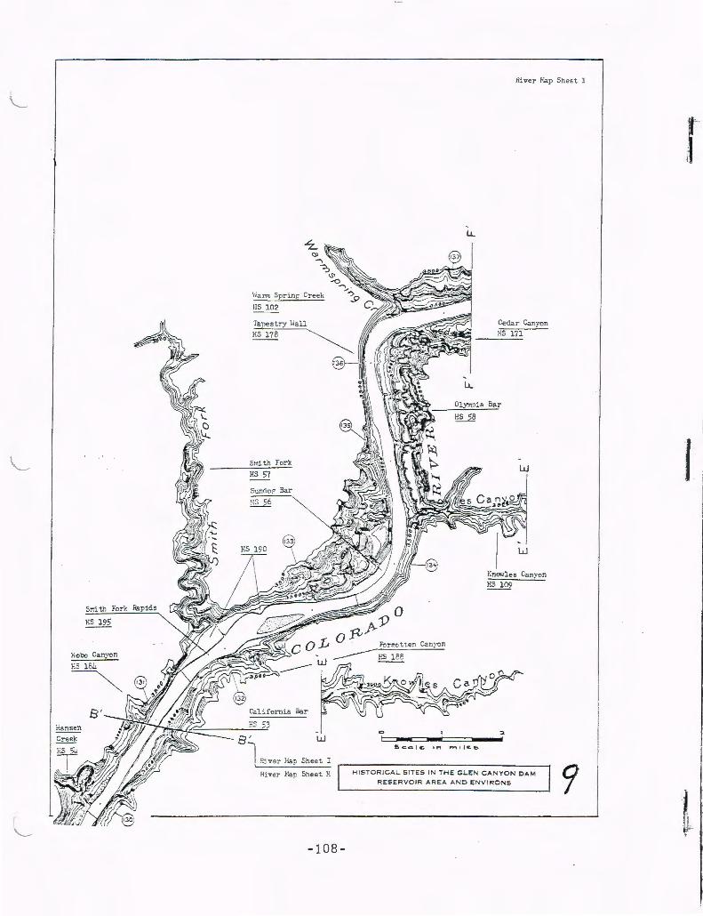
S:r.i th Fork
~ C:-eek
\·iann Sprinr; Creek
HS 102
Snith Fork
P.S 57
SunOop Bar
HS 56
Sheet :
H~ ve:- Fa~ Sheet. !-:
-108-
LL
-'liver Eap Shee t 1
Ceda r Canyon
HS 171
Olympia Bar
C> I--£co l e.. ,..., l"'r"' ll «.&
w
w
Kno•des Canyon HS 109
2
HISTORICAL SITES IN THE G LEN C ANYON DAM
RESERVOIR AR E A AND ENVI RONS
r
1
! '

.. -..... _.._ -~-I Published by University of Utah Pr~ss . ·
\
(Numbers 1-9 bound under one cover, $3.25)
I. Prehistoric Exchange in Ucah, by Carling Malouf (1939), pp. 1-6, 2 fiaa.
12. Archeological Surue, of W estern Ucah, by Jack R Rudy (1953), 190 pp., 62 figs. Out of print. • . . . . .
13. In the Beginning: A Navaho Cr.;,tiem M,rh , by Stanley A. Fishier (1953), 130 pp. Out of print.
14. Archeological Surue, of the lA Sal Mountain Area, by Alice Hum (1953), 248 pp., 89 figs., 3 rabies. Out of print. .:.£i?' ;!
15. A Scud, in Culture Contact and Culture Change: The Whicerock Utes in Transirie>n, by Gottfr ied 0. Lang (1953), 76 pp., 2 figs., 6 tables. Out of print.
16. The Garris<>n Site, by Dee C. Taylor (1954), 66 pp., 20 fig.o. ~.~1.25.
- ·~ ·
.. ~7'"··· .• - ---::~- ~-
~ -~ _...,_,.,._ .. ,__ .. ,.,-... --.......... ,.,. ·'---~ ----------- ·-·-·-:-·--:.~
(Numbers 32-33 bo.und ~nder o'ne c~ver: Out of print.) .-.,, J~. __ :_ •
40. Ecological Studie; o/ Flora ~nd Fauna in Glen Can,on, by Angus W. Wood. bury, ec al. (1959), 233 pp., 57 figs. $2.50. (Glen Canyon Series, No. 7)
'11. The Coombs Site, by Roberr H. Lister, J. Richard Ambler and Florence C. Lister (bound separately in three parts), $6.00. Single copieo: PART I (1959), ...: 126 pp. , 43 figs., 14 tables, $1.50. PART II (1960), 299 pp., 85 figs., 60 tables. $3.50. PART III (1961), 1+1 pp., 2 appendiceo, 15 figs., 14 tables, $2.25. (Glen --- ·· Cuny on Series, N':_ 8? _ .. ~ -;.c ·' ~-.... - ~ ·-~· _
'12. Outline History of the Glen Can,on Region 1776-19Z2, by C. Gregory Crampton (1959), 155 pp., 50 fig.o. $2.00. (Glen Canyon Series, No. 9)
43. 1957 Excauatioru, Glen Can,em Ar<Ll, by Jame• H. Gunnerson (1959), 179 pp., '18 fig.o., 21 tableo. $2.25. (Glen Canyon Series. No. 10)
(Numbers 17-_19 bound under one cover, $1.00) .. +t. 1958 Exca;ations, Glen. Can,on Area, bv Will · -s_~n . L.ipe (19ro), 25i P,P., - · .. . 2 appendices, 70 figs., 23 tables. $3.C.'J. · .-.·,o, .. :~~. -· . · '·-ies, No. 11)
17. Nortl em the Utah uw ·o; Eward A. Palmer, 1866-1877, by Robert F. ~·-:-o;:···U. A Surue, of Veg~;;;i.;;-.;- th; 'i ..... > --· ••• -,>. 6zlgus M.
18. ~:i:·~:::s;~~~,;..· w;;i;~;;;~r~;:;:~~~--~- Jack ~- ;uz ·(195'1), 28 _::;·~ ·_ ~b>- "!' . pp. 16 figs . • --~:,: · .• -~- •·· -~ · ~ · • · . . . • _ • 46.
1•
19. Human Sk.Zecal Material /TOm Deadman Caue, Utah, by J<>hn Buetmer- · ·. • < Janusch (1954), 9 pp., 4 figs. "· , ;
· 20, Archeological Excaooti;;,_. in . Bee/ Basin,'' Utah,- by Jack R Rudy (1955), 109 . - . "7· j ! pp., 39 figs. , 12 tables. $1.50. . ___ • . . _ J ~
21. Archeological Investigations i~ Nine Mile Can,e>n , Utah: a Republication , 48
' ; E j j ij J, ~\, ,,l[•R ft:,J1
:'11_,, J& ,},1 r)_('\H l't'E·J,.-5-
by John Gillin (1955), 45 pp., 31 figs. $1.00. 'i I i l\ '\ ~· l ~ i 51 ~.j; '~ , .•. ·. • .;J.9''!" 1' •• , ,\; .
22. Archeolon of Zion Park, by Albert H . Schroeder (1955), 212 pp. , '18 figs., 49. , 23 tables. $2.25. ·I US
23. U te Rorschach Per/e>rmances with Notes e>n Field Methods, by Paul A. 72 Hauck (1955) , 18 pp. $.50. 50. j DO •
24. Early Man in the Columbia lnrermoncane Prooince, by Richard D. Daugh. my (1956) , 123 pp. , 4 tables. Out of print.
25. Archeological Excauations in !rem Counr, , Utah, by Oement W. Meighan, et al. (1956), 134 pp., 63 figs., 20 tables. $2.25. . .
26. Papers of the ·Third Great Basin Archeological Conference, by Fay-Cooper Cole, et al. (1956), 96 pp., 17 figs. $1.50.
27. Danger Cave, by Jesse D . Jenning.> (1957), 340 pp., 8 appendices; 246 fig.o., 31 tables. $6.00.
28. Archeological Surv.; of the Freme>nt Areo , ' by James H. Gunneroon (1957), ISS pp., 30 figs., 6 tables. $3 .00. . . '· . •
29. Two FTrntonc Site$~ Their Position-i~ Southwestern Prehistory, by Dee C. Taylor (1957), 196 pp., 57 figs., 15 rabies. $3.50. . . . ~ .
' ~-:Suroi; i~:J~57, by Roberc ·H_-Li~-(195a). 57 pp., 2'1 (Glen Canyon Series, No. 1) ,. ;4.~"""J< J~. • " t:
• • ••· C.. ;--" •• '="-o~'-~ "·.r '/ •. ~'-~c" !'•'-':= Resources of the Gkn Reservoir ,
11 fig.o. Can·
J
i 5t. l
I I
52.1 ,_ l 53. j
1 !
NON-CI:?.CULATlN€7

(Numbers 57-58 bound under one cover, $2.00) 57. Carnegie Musoum Collection From South<tZ.st Utah , by Floyd W . Sharrock
and Edward G. Keane (1962) , 7i pp., 18 fig,., 1 cable. (Olen Canyon Serle•, No. 16)
58. A Preliminary Sur~•' of the Fontrn.e lle Re<ervoir, \V,aming , by David S. Dib~ l e and Kent C. Day (1962), 48 pp., 7 figs., 3 cables. (Upper Colorado Series, No. 7)
59. Ecological Stud ies af the Flora and Fauna of the Curecanti Reserooir Basins, Western Colorado. by Angus M. Woodbury, et al. (1 962) , 291 pp. , 20 fig,. , 13 table>. ~.00. (Upper Colorado Series, No. 8)
60. M iscellaneous Col lected Papers , by ]arne• H. Gunnerson, David M. Pendergast and Keith M. Anderson (196Z) , 170 pp., +4 fig,., 5 cables. $2.75.
61. Historical Situ in Olen Can, on, Mouth of Haruen Creek to Mouth af San Juan Ri~er . by C. Gregory Crampton (1962), 128 pp., 38 fi gs., 5 atlas shee<5, 1 table. $1.00. (Olen Canyon Series, No. 17)
62. Ci~il~ations in Desert lAn.d.s , edited by Richard B. Woodbury (1962), 9'1 pp., 3 figs. $1.50.
63. 1961 Exca~tioru, Olen Can1on Area , by Floyd W. Sharroclc, Kent C. Day and David S. Dibble (1963) , 401 pp., ~ appendices, 93 figs., 20 cable.. $5.50. (Glen Canyon Serie5, No. 18)
(Nos. 64, 65, 66 bound under one cover, $4.50) 6-1. 1961 Exca~tions, Hc.TTis Wash, Utah, by Don D. Fowler (1963), 110 pp.,
33 figs. , 2 cables. (Olen Canyon Series, No. 19)
65. Archeological Sur~e, of the Flam ing Gorge Reser~oir Area, W,oming-Utah , by Kent C . Day and DavidS. Dibble, wirh addenda by David M. Penderga!t and Kent C. Day (1963), 118 pp., 19 figs., 3 tables. (Upper Colorado Series, No.9)
66. 1961 Exca~t ions , Ka iparowits Plateau , Utah, by Don D. Fowler and C. Melvin Aiken. (1963), 110 pp., 2 appendiceo, 55 fig,. , 2 rableo. (Glen Canyon Scncs, No. ZO)
67. Washo Indians of California and Ne~ada, Warren L. d'A:evedo, ed. (196-1), 1C8 pp., annorared bibliography. $2.75.
68. Hava.supai Religion and M1tholov, by Carma Lee Smithson and Robert C. Euler (196-1), 120 pp. $2.00.
69. Southern Paiute Erhnoloo, by Isabel T . Kelly (196-1) , 214 pp., foldout map, 7 figs., bibliography. $2.85. (Olen Canyon Serie>, No. 21)
70. T he San Juan Can7on Historical Sites, by C. G regory Crampton (196-1), 92 pp., 8 maps, 15 figs., bibl iography. $1.i5. (Olen Canyon Series, No. 22) ·
71. Kaiparowits Plat<au and O len Can,on PrehistorJ: An Interpretation Based on Ceramics , by Florence C. Li ster (196-1), 91 pp. $1.75. (Glen Canyon Series, No. 23)
Related Documents


