Annexure 12 Registration & License Application

Welcome message from author
This document is posted to help you gain knowledge. Please leave a comment to let me know what you think about it! Share it to your friends and learn new things together.
Transcript
Annexure 12
Registration & License Application
&
PropertyProperty Name Area
ha
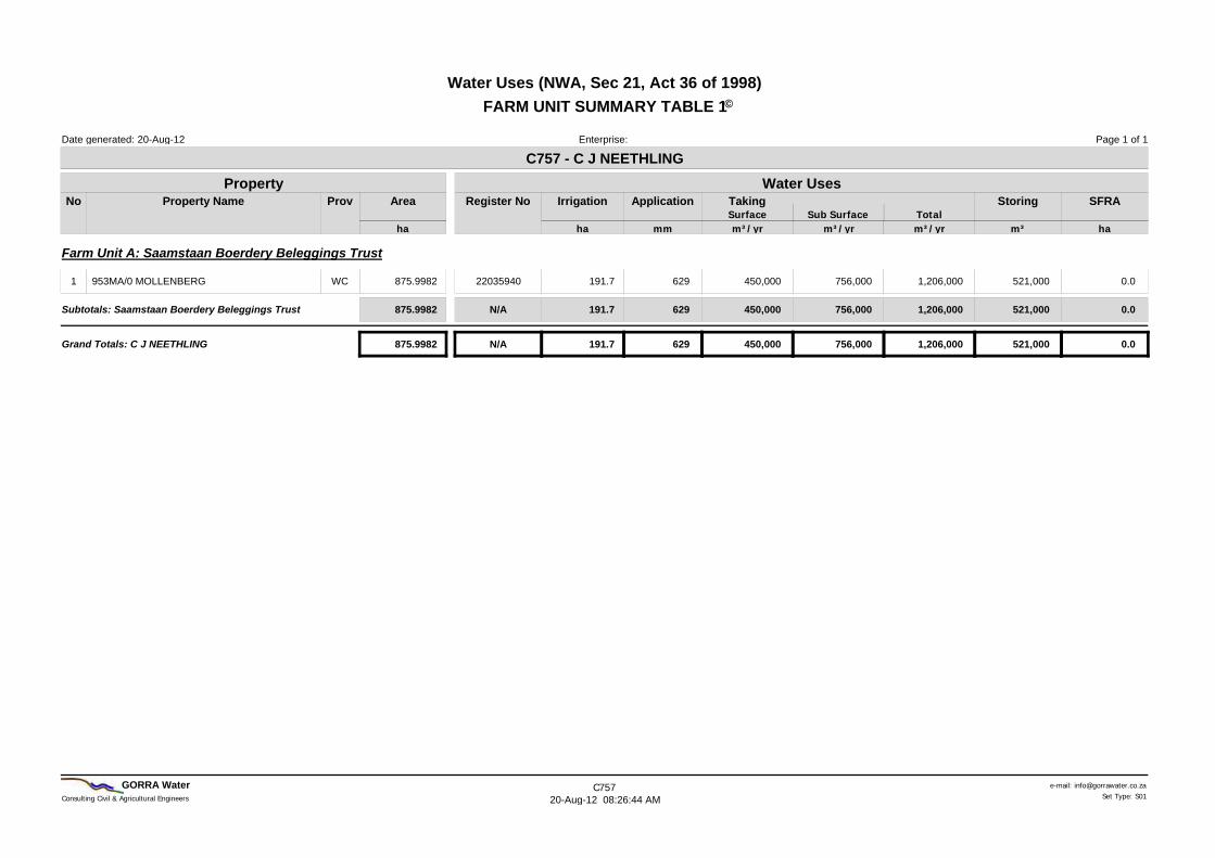
Water UsesC757 - C J NEETHLING
Register No Irrigation
ha
Application
mm
Page 1 of 1
SurfaceStoring
Sub Surface TotalNo
20-Aug-12
SFRA
ha
Date generated:
Water Uses (NWA, Sec 21, Act 36 of 1998)FARM UNIT SUMMARY TABLE 1
Enterprise:
©
m³/yr m³/yr m³/yr m³
TakingProv
Farm Unit A: Saamstaan Boerdery Beleggings Trust
953MA/0 MOLLENBERG 875.9982 22035940 191.7 629 1,206,000 521,000450,000 756,0001 0.0WC
Subtotals: Saamstaan Boerdery Beleggings Trust 875.9982 191.7 1,206,000 521,000629N/A 450,000 756,000 0.0
Grand Totals: C J NEETHLING 875.9982 191.7 1,206,000 521,000N/A 629 450,000 756,000 0.0
Consulting Civil & Agricultural Engineers
e-mail: [email protected] Water C75720-Aug-12 08:26:44 AM Set Type: S01
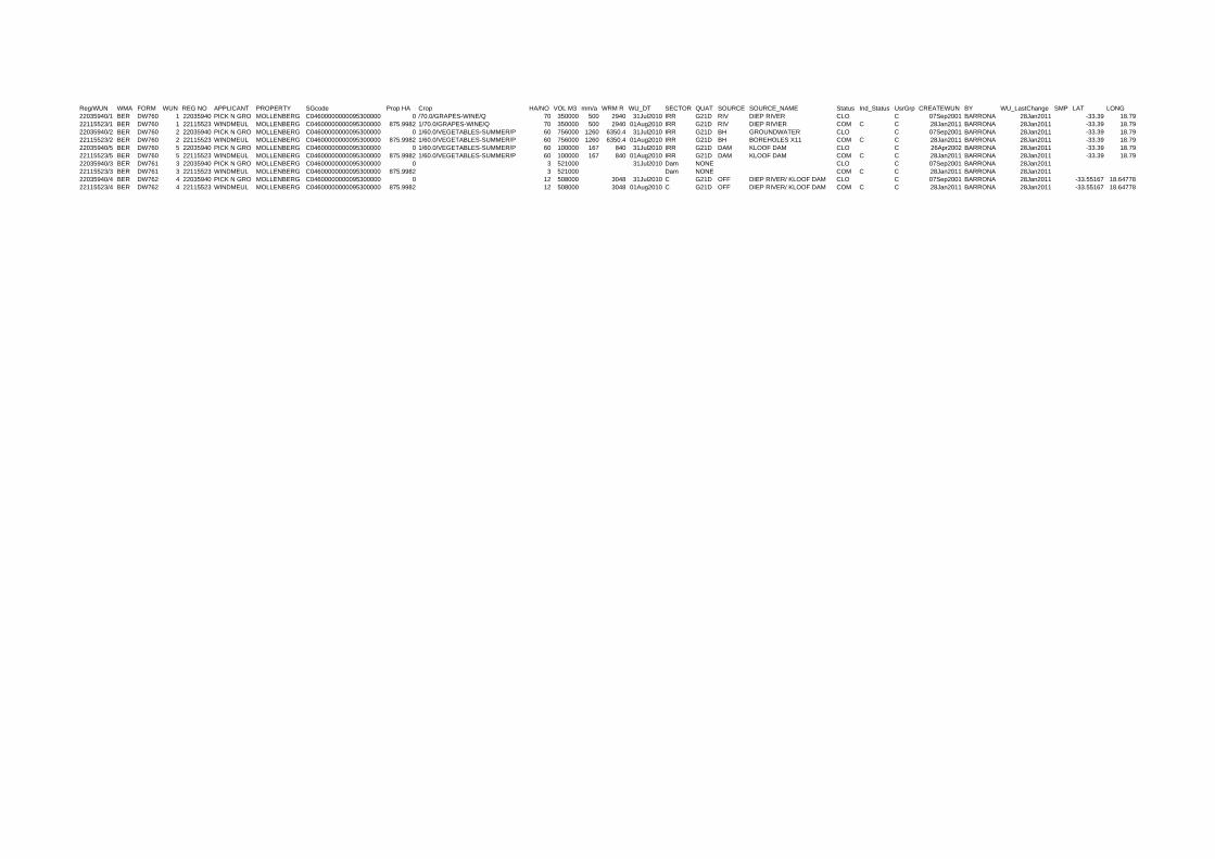
Reg/WUN WMA FORM WUN REG NO APPLICANT PROPERTY SGcode Prop HA Crop HA/NO VOL M3 mm/a WRM R WU_DT SECTOR QUAT SOURCE SOURCE_NAME Status Ind_Status UsrGrp CREATEWUN BY WU_LastChange SMP LAT LONG22035940/1 BER DW760 1 22035940 PICK N GRO MOLLENBERG C04600000000095300000 0 /70.0/GRAPES-WINE/Q 70 350000 500 2940 31Jul2010 IRR G21D RIV DIEP RIVER CLO C 07Sep2001 BARRONA 28Jan2011 -33.39 18.7922115523/1 BER DW760 1 22115523 WINDMEUL MOLLENBERG C04600000000095300000 875.9982 1/70.0/GRAPES-WINE/Q 70 350000 500 2940 01Aug2010 IRR G21D RIV DIEP RIVIER COM C C 28Jan2011 BARRONA 28Jan2011 -33.39 18.7922035940/2 BER DW760 2 22035940 PICK N GRO MOLLENBERG C04600000000095300000 0 1/60.0/VEGETABLES-SUMMER/P 60 756000 1260 6350.4 31Jul2010 IRR G21D BH GROUNDWATER CLO C 07Sep2001 BARRONA 28Jan2011 -33.39 18.7922115523/2 BER DW760 2 22115523 WINDMEUL MOLLENBERG C04600000000095300000 875.9982 1/60.0/VEGETABLES-SUMMER/P 60 756000 1260 6350.4 01Aug2010 IRR G21D BH BOREHOLES X11 COM C C 28Jan2011 BARRONA 28Jan2011 -33.39 18.7922035940/5 BER DW760 5 22035940 PICK N GRO MOLLENBERG C04600000000095300000 0 1/60.0/VEGETABLES-SUMMER/P 60 100000 167 840 31Jul2010 IRR G21D DAM KLOOF DAM CLO C 26Apr2002 BARRONA 28Jan2011 -33.39 18.7922115523/5 BER DW760 5 22115523 WINDMEUL MOLLENBERG C04600000000095300000 875.9982 1/60.0/VEGETABLES-SUMMER/P 60 100000 167 840 01Aug2010 IRR G21D DAM KLOOF DAM COM C C 28Jan2011 BARRONA 28Jan2011 -33.39 18.7922035940/3 BER DW761 3 22035940 PICK N GRO MOLLENBERG C04600000000095300000 0 3 521000 31Jul2010 Dam NONE CLO C 07Sep2001 BARRONA 28Jan201122115523/3 BER DW761 3 22115523 WINDMEUL MOLLENBERG C04600000000095300000 875.9982 3 521000 Dam NONE COM C C 28Jan2011 BARRONA 28Jan201122035940/4 BER DW762 4 22035940 PICK N GRO MOLLENBERG C04600000000095300000 0 12 508000 3048 31Jul2010 C G21D OFF DIEP RIVER/ KLOOF DAM CLO C 07Sep2001 BARRONA 28Jan2011 -33.55167 18.6477822115523/4 BER DW762 4 22115523 WINDMEUL MOLLENBERG C04600000000095300000 875.9982 12 508000 3048 01Aug2010 C G21D OFF DIEP RIVER/ KLOOF DAM COM C C 28Jan2011 BARRONA 28Jan2011 -33.55167 18.64778

SAAMSTAAN BELEGGINGS TRUST 953MA/0 MOLLENBERGGorra Water875.9982 haC757A Reg No: 22035940
Water Use Statement as at 16-Mar-12 Report No: WURMS-001 Ver1.3
Applicant1.Applicant Name: SAAMSTAAN BELEGGINGS TRUST
ID / Business Reg No: 6774/96
Registered Owners2.DW756 / DW758 DW902
Tel(w): 022 4872037
Postal Address: PO Box 130
Malmesbury 7300
E-mail: [email protected]
Property3. DW901
Property Description: 953MA/0 MOLLENBERG
Registration District: Malmesbury
Area (ha): 875.9982
Contact Person4. DW756 / DW758
Taking of Water Sec 21(a) DW760 - Taking water from a water resource.
Contact Name:
Tel(w):
Cell No:
E-mail:
Mr CJ Neethling
022 4872037
0824536662
[email protected] No: 22035940
Supplementary Data: Irrigation DW787 - Irrigated Field and Crop Information.
5a.
Latest RLN No: n/a Fax No: 022 4872037
Cadastral Code: C04600000000095300000
General Authorisations for Taking:
Quaternary:
WMA:
G21D
Berg
Surface Water: Excluded - 0 m³, Ground Water: Zone D - 150m³/ha/yr = 131 400 m³/yr
(Gazette No 26187, Notice No 399, dated 26 March 2004)
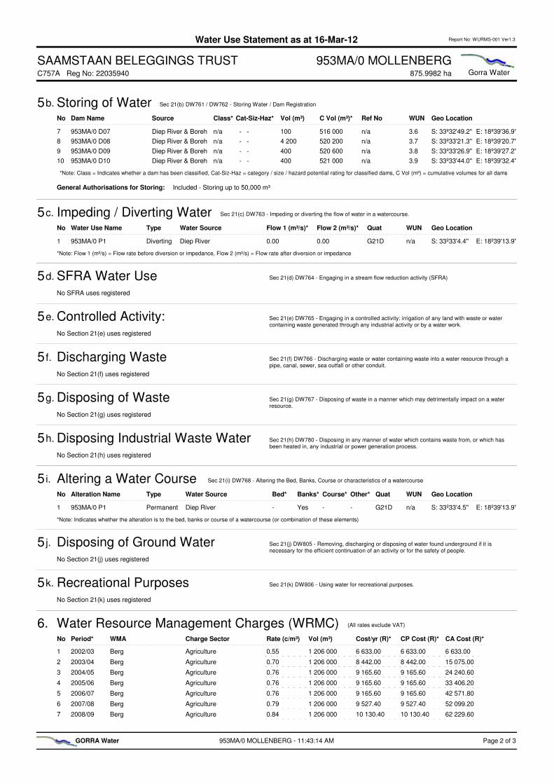
Dam Name Class* Vol (m³)No Geo LocationRef No WUNC Vol (m³)*Source Cat-Siz-Haz*
Storing of Water Sec 21(b) DW761 / DW762 - Storing Water / Dam Registration5b.
953MA/0 D01 Kloof Dam Yes 508 0001 S: 33º33'6.5'' E: 18º38'49.6''12/2/G202/89 4508 0002 - S - SDiep River & Boreh
953MA/0 D02 n/a 7502 S: 33º32'57.0'' E: 18º38'0.8''n/a 3.1508 750 - - Diep River & Boreh
953MA/0 D03 n/a 4 6003 S: 33º33'26.1'' E: 18º38'11.2''n/a 3.2513 350 - - Diep River & Boreh
953MA/0 D04 n/a 4004 S: 33º33'17.8'' E: 18º37'53.5''n/a 3.3513 750 - - Diep River & Boreh
953MA/0 D05 n/a 8005 S: 33º32'50.2'' E: 18º38'42.1''n/a 3.4514 550 - - Diep River & Boreh
953MA/0 D06 n/a 1 3506 S: 33º33'48.6'' E: 18º37'49.1''n/a 3.5515 900 - - Diep River & Boreh
Name Vol (m³)No Geo LocationQuat WUNC Vol (m³)Type Sector Source
953MA/0 D1 Runoff 100 0001 S: 33º33'6.5'' E: 18º38'49.6''G21D 5100 000Surface Agri: Irrigation
953MA/0 P1 Diep River 350 0002 S: 33º33'4.5'' E: 18º39'13.9''G21D 1450 000Surface Agri: Irrigation
Sub Total for Surface Water: 450 000
953MA/0 B1 Sub Surface Water 400 0003 S: 33º33'12.6'' E: 18º38'51.0''G21D 2.1850 000Sub-Surf Agri: Irrigation
953MA/0 B2 Sub Surface Water 200 0004 S: 33º33'27.5'' E: 18º38'50.8''G21D 2.21 050 000Sub-Surf Agri: Irrigation
953MA/0 B3 Sub Surface Water 156 0005 S: 33º32'50.3'' E: 18º39'4.4''G21D 2.31 206 000Sub-Surf Agri: Irrigation
Sub Total for Sub-Surface Water: 756 000
Grand Total for Taking of water: 1 206 000
No Land No System Resource Type Area (ha)* CL Area* CA Area*Resource NameCrop RF%*
L011 MIELIES Centre pivot River/Borehole Diep River 22.30 22.30 22.30100
L022 MIELIES Centre pivot River/Borehole Diep River 21.40 21.40 43.70100
L033 MIELIES Centre pivot River/Borehole Diep River 20.44 20.44 64.14100
L054 MIELIES Sprinkler: Quick-cou River/Borehole Diep River 25.80 25.80 89.94100
L075 MIELIES Centre pivot River/Borehole Diep River 20.20 20.20 110.14100
L116 MIELIES Sprinkler: Quick-cou River/Borehole Diep River 3.40 3.40 113.54100
L127 MIELIES Sprinkler: Quick-cou River/Borehole Diep River 3.70 3.70 117.24100
L138 MIELIES Sprinkler: Quick-cou River/Borehole Diep River 6.05 6.05 123.29100
L149 MIELIES Sprinkler: Quick-cou River/Borehole Diep River 5.90 5.90 129.19100
L1510 MIELIES Sprinkler: Quick-cou River/Borehole Diep River 2.85 2.85 132.04100
L1711 MIELIES Sprinkler: Quick-cou River/Borehole Diep River 11.40 11.40 143.44100
L1812 MIELIES Sprinkler: Quick-cou River/Borehole Diep River 29.90 29.90 173.34100
L1913 MIELIES Sprinkler: Quick-cou River/Borehole Diep River 18.40 18.40 191.74100
*Note: RF% = Rotation Factor %, Area (ha) = individual land area in ha irrigated under the specified resource, CL Area = total cumulative area in ha for an individual land,
CA Area = total cumulative area in ha for all irrigated lands
No Owner Name ID / Bus Reg No ShareDeed No
Saamstaan Beleggings Trust
1 6774/96 100 %T33180/1970
953MA/0 MOLLENBERG - 11:43:14 AM Page 1 of 3GORRA Water
SAAMSTAAN BELEGGINGS TRUST 953MA/0 MOLLENBERGGorra Water875.9982 haC757A Reg No: 22035940
Water Use Statement as at 16-Mar-12 Report No: WURMS-001 Ver1.3
General Authorisations for Storing: Included - Storing up to 50,000 m³
SFRA Water Use5d. Sec 21(d) DW764 - Engaging in a stream flow reduction activity (SFRA)
Controlled Activity: Waste Irrigation5e. Sec 21(e) DW765 - Engaging in a controlled activity: irrigation of any land with waste or water containing waste generated through any industrial activity or by a water work.
Discharging Waste5 f. Sec 21(f) DW766 - Discharging waste or water containing waste into a water resource through a pipe, canal, sewer, sea outfall or other conduit.
Disposing of Waste5g. Sec 21(g) DW767 - Disposing of waste in a manner which may detrimentally impact on a water resource.
Disposing Industrial Waste Water5h. Sec 21(h) DW780 - Disposing in any manner of water which contains waste from, or which has been heated in, any industrial or power generation process.
Disposing of Ground Water5 j. Sec 21(j) DW805 - Removing, discharging or disposing of water found underground if it is necessary for the efficient continuation of an activity or for the safety of people.
Recreational Purposes5k. Sec 21(k) DW806 - Using water for recreational purposes.
No SFRA uses registered
No Section 21(e) uses registered
No Section 21(f) uses registered
No Section 21(g) uses registered
No Section 21(h) uses registered
No Section 21(j) uses registered
No Section 21(k) uses registered
Dam Name Class* Vol (m³)No Geo LocationRef No WUNC Vol (m³)*Source Cat-Siz-Haz*
Storing of Water Sec 21(b) DW761 / DW762 - Storing Water / Dam Registration5b.
953MA/0 D07 n/a 1007 S: 33º32'49.2'' E: 18º39'36.9''n/a 3.6516 000 - - Diep River & Boreh
953MA/0 D08 n/a 4 2008 S: 33º33'21.3'' E: 18º39'20.7''n/a 3.7520 200 - - Diep River & Boreh
953MA/0 D09 n/a 4009 S: 33º33'26.9'' E: 18º39'27.2''n/a 3.8520 600 - - Diep River & Boreh
953MA/0 D10 n/a 40010 S: 33º33'44.0'' E: 18º39'32.4''n/a 3.9521 000 - - Diep River & Boreh
*Note: Class = Indicates whether a dam has been classified, Cat-Siz-Haz = category / size / hazard potential rating for classified dams, C Vol (m³) = cumulative volumes for all dams
No Period* Charge Sector Rate (c/m³) Vol (m³) Cost/yr (R)* CP Cost (R)*WMA CA Cost (R)*
Water Resource Management Charges (WRMC)6. (All rates exclude VAT)
Berg1 2002/03 Agriculture 0.55 1 206 000 6 633.00 6 633.00 6 633.00
Berg2 2003/04 Agriculture 0.70 1 206 000 8 442.00 8 442.00 15 075.00
Berg3 2004/05 Agriculture 0.76 1 206 000 9 165.60 9 165.60 24 240.60
Berg4 2005/06 Agriculture 0.76 1 206 000 9 165.60 9 165.60 33 406.20
Berg5 2006/07 Agriculture 0.76 1 206 000 9 165.60 9 165.60 42 571.80
Berg6 2007/08 Agriculture 0.79 1 206 000 9 527.40 9 527.40 52 099.20
Berg7 2008/09 Agriculture 0.84 1 206 000 10 130.40 10 130.40 62 229.60
Water Use Name Type Flow 1 (m³/s)*No Geo LocationQuat WUNWater Source
Impeding / Diverting Water Sec 21(c) DW763 - Impeding or diverting the flow of water in a watercourse.5c.
Flow 2 (m³/s)*
953MA/0 P1 Diverting 0.001 S: 33º33'4.4'' E: 18º39'13.9''G21D n/aDiep River 0.00
*Note: Flow 1 (m³/s) = Flow rate before diversion or impedance, Flow 2 (m³/s) = Flow rate after diversion or impedance
Alteration Name TypeNo Geo LocationQuat WUNWater Source
Altering a Water Course Sec 21(i) DW768 - Altering the Bed, Banks, Course or characteristics of a watercourse5 i.
Bed* Banks* Course* Other*
953MA/0 P1 Permanent1 S: 33º33'4.5'' E: 18º39'13.9''G21D n/aDiep River - Yes - -
*Note: Indicates whether the alteration is to the bed, banks or course of a watercourse (or combination of these elements)
953MA/0 MOLLENBERG - 11:43:14 AM Page 2 of 3GORRA Water
User
Text Box
SAAMSTAAN BELEGGINGS TRUST 953MA/0 MOLLENBERGGorra Water875.9982 haC757A Reg No: 22035940
Water Use Statement as at 16-Mar-12 Report No: WURMS-001 Ver1.3
No Period* Charge Sector Rate (c/m³) Vol (m³) Cost/yr (R)* CP Cost (R)*WMA CA Cost (R)*
Water Resource Management Charges (WRMC)6. (All rates exclude VAT)
Berg8 2009/10 Agriculture 0.94 1 206 000 11 336.40 11 336.40 73 566.00
Berg9 2010/11 Agriculture 1.23 1 206 000 14 833.80 14 833.80 88 399.80
Berg10 2011/12 Agriculture 1.35 1 206 000 16 281.00 16 281.00 104 680.80
Cost/yr (R) = water use cost per year for the specified sector, CP Cost (R) = cumulative costs per year for all sectors, CA Cost (R) = cumulative water use costs for all years
Period = 12 months from 1 April to 31 March of the following year
*Note:
No Note Description
Notes7.
1 953MA/0: 953 = Farm Number, MA = Malmesbury Registration District, 0 = Portion 0 of Farm 953 (portion 0 also called the remainder)
2 953MA/0: Licence Application Submitted for Sec 21(a),(b),(c),(e2),(i)
3 953MA/0: Total Storage = 521000 m³ in 10 dams of which Kloof Dam contributes 508000 m³. The remaining 13000 m³ storage has been divided among the remaining 9 dams in proportion to their respective areas.
953MA/0 MOLLENBERG - 11:43:14 AM Page 3 of 3GORRA Water

DW 758
Applicant
Page 1 of 64
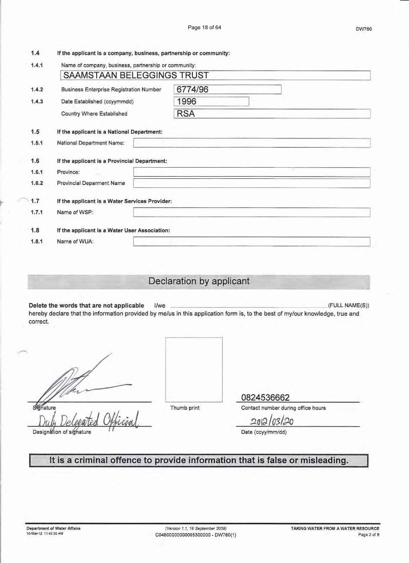
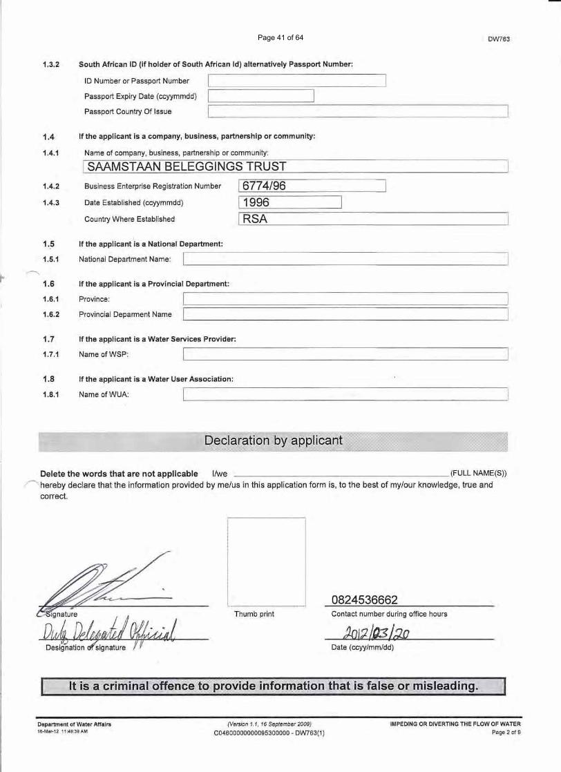
REGISTRATION/LICENSING PART 1 COMPANY, BUSINESS, PARTNERSHIP OR
GENERAL INFORMATION
SAAMSTAAN BELEGGINGS TRUST
water affairs
DW758
22035940Formal amendmentXNew registration
Department:Water AffairsREPUBLIC OF SOUTH AFRICA
1.
Mark the applicable option(s) with an X and/or complete details where applicable/available.
Indicate the nature of this application:
Minor change
Registration Number
PARTICULARS OF THE APPLICANT2.
Name of company, business, partnership or community:3.1
COMMUNITY, NATIONAL OR PROVINCIALGOVERNMENT
Application for:(Mark one block with an X)
XNational or provincial government (complete part 4,5,6,7 and 8 excl. 8.1.2)
Company, business, partnership or community (complete part 3,5,6,7 and 8)
PARTICULARS OF THE COMPANY, BUSINESS, PARTNERSHIP OR COMMUNITY3.
Trading name if different from name of company, business, partnership or community:3.2
Type of enterprise:
08 Article 21 (Association Inc.
06 Public Company (Ltd)3.3(Mark one block with an X)
under Article 21 of the CompanyAct No. 61 of 1973)
07 Private Company (Pty) Ltd
09 Limited By Guarantee
10 External Company 11 External Company underarticle 21 of the Company ActNo. 61 of 1973
21 Incorporated (Inc)20 Transvaal Ordinance
22 Unlimited 23 Close Corporation (CC)
Parastatal X Trust
Other [i.e. non-CIPRO Company types (e.g. Churches, Schools,Community Groups, etc.) excluding Trust and Parastatal]
Business enterprise registration number:3.4 6774/96Date established:3.5 1996(ccyy/mm/dd)
Country where established:3.6 RSAVAT registration number:3.7 4440109165
(Version 1.1, 16 September 2009)
L757Page 1 of 5
Department of Water Affairs REGISTRATION/LICENSING PART 121-Mar-12 2:31:55 PM C04600000000095300000LA
Page 2 of 64
Administrator
Rectangle
DW758
MrCJ
CONTACT PERSON DETAILS6.
Title
Name
6.1
6.2
NeethlingSurname6.3
Telephone6.4
Cell Phone Number6.5
Fax6.6
e-mailPreferred Form Of Communication6.8
National Department:4.1
PARTICULARS OF NATIONAL OR PROVINCIAL GOVERNMENT4.
a) Provincial Department:4.2
b) Province:
Postal Address:5.1
APPLICANT CONTACT DETAILS5.
Postal Code
PO Box 130Malmesbury
7300Street Address5.2
Postal Code
(only if different from postal address):
Contact telephone number during office hours5.3
Alternative contact number
Area/cell code Number Ext022 4872037
Area/cell code Number Ext082 4536662
Area/cell code Number Ext022 4872037
Area/cell code Number082 4536662
Area/cell code Number Ext022 4872037
(Version 1.1, 16 September 2009)
L757Page 2 of 5
Department of Water Affairs REGISTRATION/LICENSING PART 121-Mar-12 2:31:55 PM C04600000000095300000LA
Page 3 of 64
DW758
Surname of delegated person: Title:
I Neethling I MrInitials: I CJ I
10 number:
Passport number:(if not holder of South African ID)
Expiry date (ccyy/rnm/dd):
Delete the words that are not applicable IIwe (FULL NAME(S))
'~hereby declare that the information provided by me/us in this application form is, to the best of my/our knowledge, true andcorrect.
0824536662Thumb print Contact number during office hours
Date (ccyy/mm/dd)
Department of Water Affairs16-Mar-12 11:44:17 AM
C757
REGISTRATION/LICENSING PART 1
Page 3 of 5
(Version 1.1, 16 September 2009)
C046-0000-00000953-00000
Page 4 of 64
DW758
LIST OF PART 2 DOCUMENTS (WATER USE RELATED FORMS)7.
Mark with an X which of the following documents have been submitted with this application
DW760 NWA-Section 21(a)XDW761 NWA-Section 21(b)XDW762 NWA-Section 21(b)XDW763 NWA-Section 21(c)XDW764 NWA-Section 21(d)
DW765 NWA-Section 21(e)
DW766 NWA-Section 21(f)
DW767 NWA-Section 21(g)
DW768 NWA-Section 21(i)XDW780 NWA-Section 21(h)
DW805 NWA-Section 21(j)
DW806 NWA-Section 21(k)
DW901 Property or properties where water use occursXDW902 Details of property ownerXDW903 Actual/Monitored waste discharge details NWA-Section 21(f/h)
DW904 Actual/Monitored waste discharge details NWA-Section 21(e/g)
THIS SECTION IS RESERVED FOR OFFICE USE ONLY8.
WMA for billing *19Billing information8.1
8.1.1
* Water Management Area Codes
01 Limpopo02 Luvuvhu/Letaba03 Crocodile (W), Marico04 Olifants
05 Inkomati06 Usutu-Mhlatuze07 Thukela08 Upper Vaal
09 Middle Vaal10 Lower Vaal11 Mvoti-Umzimkulu12 Mzimvubu-Keiskamma
13 Upper Orange14 Lower Orange15 Fish-Tsitsikamma16 Gouritz
17 Olifants/Doorn18 Breede19 Berg
8.1.2 District Municipal Establishment Levy Payable Yes No
8.2 Mark with an X which of the following documents have been submitted with this application
Certified copy of South African identity document
Certified copy of passport
(Version 1.1, 16 September 2009)
L757Page 4 of 5
Department of Water Affairs REGISTRATION/LICENSING PART 121-Mar-12 2:31:55 PM C04600000000095300000LA
Page 5 of 64
Administrator
Text Box
X
DW758
File number (i.e. Office Hardcopy Register File No)
Received by:
Surname
Initials
Position / Rank
Signature
Date stamp of receiving office
Water Use Register Number
Date (ccyy/mm/dd)
Captured on NRWU database
Captured by:
Surname
Initials
Signature
Quality Assurance Executed by:
Surname Initials
Position / Rank
Signature Date (ccyy/mm/dd)
(Version 1.1, 16 September 2009)
L757Page 5 of 5
Department of Water Affairs REGISTRATION/LICENSING PART 121-Mar-12 2:31:55 PM C04600000000095300000LA
Page 6 of 64
DW 901 Property
Page 7 of 64
SUPPLEMENTARY WATER USE INFORMATION
water affairs
DW901
Department:Water AffairsREPUBLIC OF SOUTH AFRICA
PROPERTY WHERE WATER USE OCCURSDW901 serves to address the following: The property (or properties) where water use(s) is to take place.
Complete one DW901 form for each property impacted / applicable to a water use registration application.
Should more than one property owner be applicable to a "property where water use occurs" an additional DW902 must be completed for eac
additional property owner.
•
•
953MA/0 MOLLENBERG
Property where water use takes place (farm, stand or community): description as per the Deeds Act if applicable, or name1.1
PROPERTY WHERE WATER USE(S) OCCURS1.
agricultural holding, farm, township, town or city.
Registration Date (ccyymmdd): 20110727
Property Type1.2 (mark only one with an X)
Exclusive Use Areas (EUA)
Agricultural Holding
Sectional Scheme (To obtain EUA
Sectional Scheme Unit
Unspecified
FarmXErf
Sectional Scheme (To obtain units
Township
Unsurveyed
If the property is unsurveyed, complete the following:1.3
a) Surname and initials of leader of village, community or tribal authority
Initials
b) Local Authority
c) Magisterial District
d) Tribal Authority/Council
&/or
&/or
If the property is not equal to unsurveyed, complete the following:1.4
a) Deeds Office Cape Townb) Registration Division Malmesburyc) Property No (i.e. Farm No./Erf No./Holding Area No./Scheme N 953d) Portion of Property 0e) Title Deed Number T40658/2011
(Version 1.1, 16 September 2009)
Page 1 of 3Department of Water Affairs Details of property where water use occurs21-Mar-12 2:32:22 PM C04600000000095300000LA
Page 8 of 64

Property Area Size1.5
f) Surveyor-General Cadastral Code
1 3 4 5-C 0000 00000953 00000
1.
2.
3.
4.
5.
Note:
Refers to the Surveyor's-General Office (T = Pretoria, F = Free State, C = Cape Town, N = Kwazulu-Natal)
Major Code (Registration Division)
Minor Code
Property No (i.e. Farm No./Erf No./Holding Area No./Scheme No.)
Portion Number
All fields "left padded with 0"
2046 - - -
875.9982 X HectaresMeasure Unit: Square Metres Acres
Ownership of the property1.6 (mark only one with an X)
X Property owned by applicant (100% Share value)
Property owned by applicant (Share value less than 100%)
Property leased by applicant
The property is communal land
PROPERTY OWNER RELATIONSHIP2.
Individual (Identity Number or
Passport Number)
Company, Business, Partnership or Communit
(Business Enterprise Registration Number)
Property Owner Name Property Owner
Document Number
(Owner's Title Deed
Reference Number)
Property Owner and Property
Relationship Date
From: To:
Owner Share
DW901
Value %
n/a 6774/96 Saamstaan Beleggings Trust T40658/2011 n/a n/a 100.00
(Version 1.1, 16 September 2009)
Page 2 of 3Department of Water Affairs Details of property where water use occurs21-Mar-12 2:32:23 PM C04600000000095300000LA
Page 9 of 64
DW901
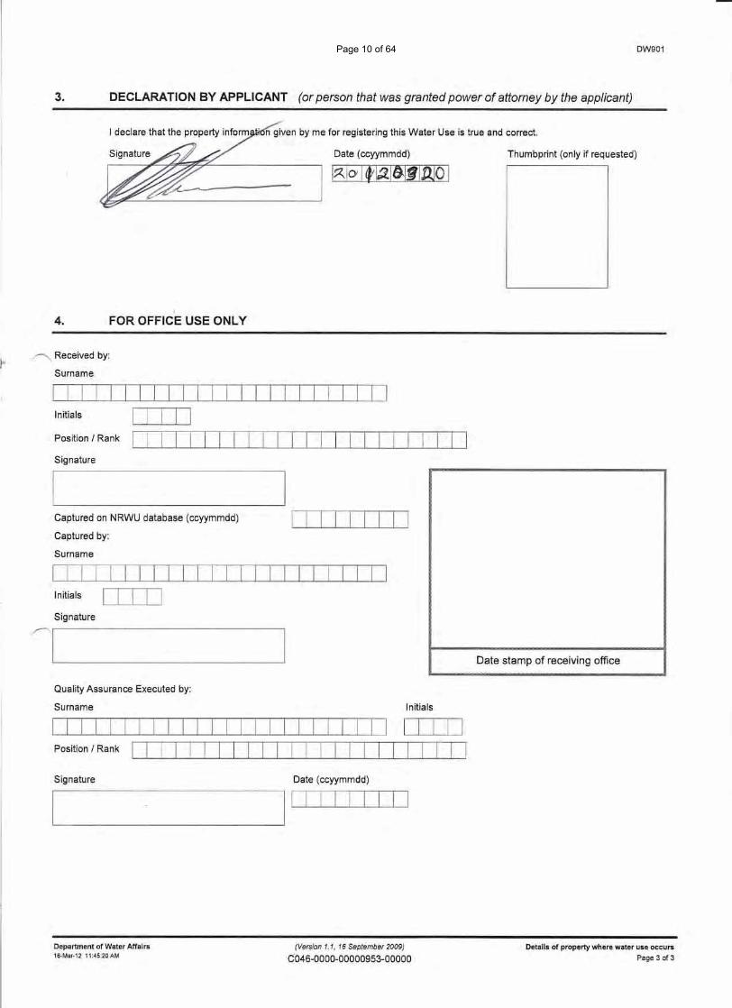
3. DECLARATION BY APPLICANT (or person that was granted power of attorney by the applicant)
n given by me for registering this Water Use is true and correct.
Date (ccyymmdd)- Thumbprint (only if requested)
I
4. FOR OFFICE USE ONLY
r">; Received by:
Surname
Initials ITIIJPosition / Rank
Signature
~ 1
Date stamp of receiving office
Captured on NRWU database (ccyymmdd)
Captured by:
Surname
ITIIIIIJJ
Initials ITIIJSignature
Quality Assurance Executed by:
Surname Initials
Signature Date (ccyymmdd)
"--- I ITIIIIIJJ
Department of Water Affairs16-Mar-1211:45:20AM
(Version 1.1, 16 September 2009)
C046-0000-00000953-00000Details of property where water use occurs
Page 3 of 3
Page 10 of 64
DW 902 Registered owner
Page 11 of 64
SUPPLEMENTARY WATER USE INFORMATION
DW902
Department:
REPUBLIC OF SOUTH AFRICA
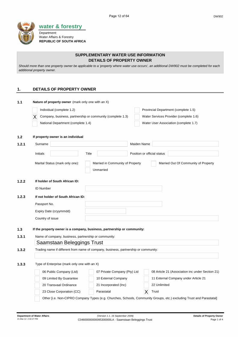
DETAILS OF PROPERTY OWNERShould more than one property owner be applicable to a 'property where water use occurs', an additional DW902 must be completed for each
DETAILS OF PROPERTY OWNER1.
Nature of property owner1.1 (mark only one with an X)
Company, business, partnership or community (complete 1.3)XIndividual (complete 1.2)
Water Services Provider (complete 1.6)
Provincial Department (complete 1.5)
If property owner is an individual1.2
Surname
Name of company, business, partnership or community:
Saamstaan Beleggings Trust
additional property owner.
National Department (complete 1.4) Water User Association (complete 1.7)
1.2.1 Maiden Name
Initials Title Position or official status
Marital Status (mark only one):
Unmarried
Married in Community of Property Married Out Of Community of Property
If holder of South African ID:1.2.2
ID Number
If not holder of South African ID:
Passport No.
Expiry Date (ccyymmdd)
Country of issue
If the property owner is a company, business, partnership or community:1.3
1.3.1
Trading name if different from name of company, business, partnership or community:1.3.2
Type of Enterprise (mark only one with an X)1.3.3
09 Limited By Guarantee
06 Public Company (Ltd)
20 Transvaal Ordinance
23 Close Corporation (CC)
Other [i.e. Non-CIPRO Company Types (e.g. Churches, Schools, Community Groups, etc.) excluding Trust and Parastatal]
10 External Company
07 Private Company (Pty) Ltd
21 Incorporated (Inc)
Parastatal
11 External Company under Article 21
08 Article 21 (Association inc under Section 21)
22 Unlimited
TrustX
water & forestry
Water Affairs & Forestry
1.2.3
(Version 1.1, 16 September 2009)
Page 1 of 4Department of Water Affairs Details of Property Owner21-Mar-12 2:32:27 PM C04600000000095300000LA - Saamstaan Beleggings Trust
Page 12 of 64
DW902
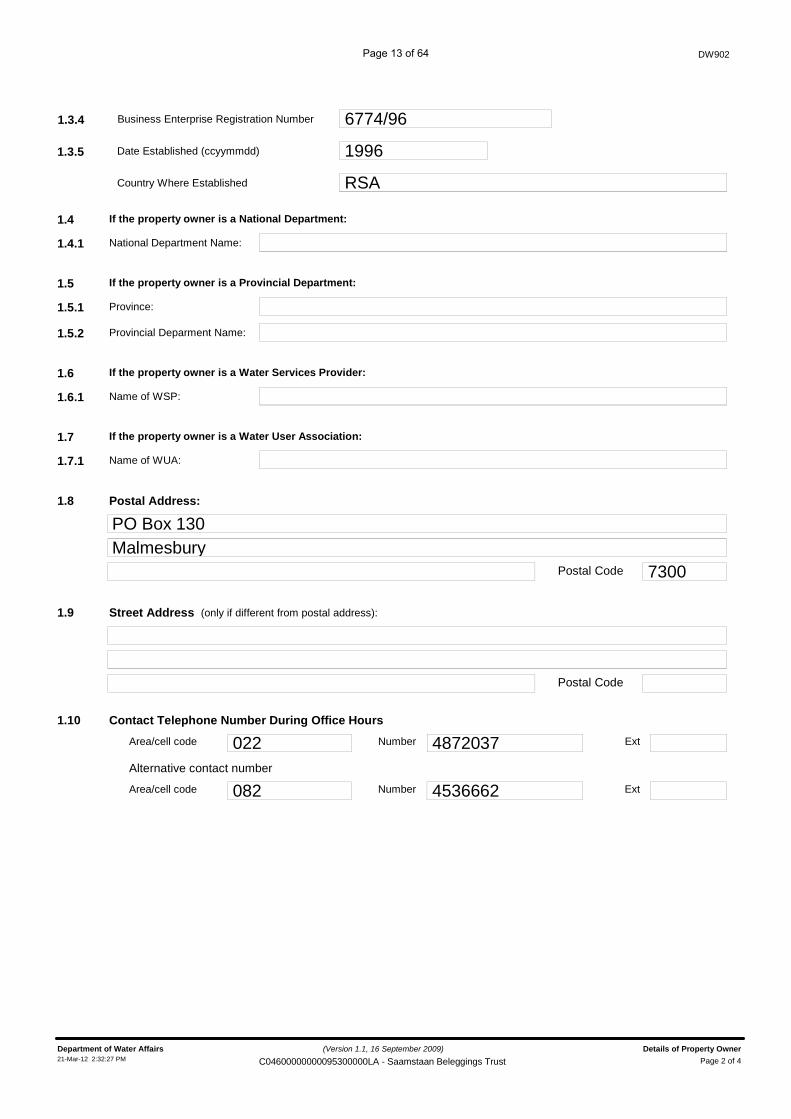
1.3.4 Business Enterprise Registration Number 6774/96
1.3.5 Date Established (ccyymmdd) 1996
Country Where Established RSA
If the property owner is a National Department:1.4
National Department Name:1.4.1
If the property owner is a Provincial Department:1.5
Province:1.5.1
Provincial Deparment Name:1.5.2
If the property owner is a Water Services Provider:1.6
Name of WSP:1.6.1
If the property owner is a Water User Association:1.7
Name of WUA:1.7.1
Postal Address:1.8
Postal Code
PO Box 130Malmesbury
7300
Street Address1.9
Postal Code
(only if different from postal address):
Contact Telephone Number During Office Hours1.10
Alternative contact number
Area/cell code Number Ext022 4872037
Area/cell code Number Ext082 4536662
(Version 1.1, 16 September 2009)
Page 2 of 4Department of Water Affairs Details of Property Owner21-Mar-12 2:32:27 PM C04600000000095300000LA - Saamstaan Beleggings Trust
Page 13 of 64
DW902
2. DECLARATION BY PROPERTY OWNER
2.1 Property owner or delegated person:
Surname INeethlingTitle Ic..:.M-'-'-'--r _Initials iCJ
ID number
2.2 If not a holder of South African10:
Passport No
Expiry Date(ccyymmdd)
Country of issue ______________________________________J2.3 Position or officialstatus:
ITrustee2.4 I declare that the applicant defined in this application has lawful access to the property and carry out the water use activity or acti
related to this application.
Date (ccyymmdd)
~
Thumbprint (only if requested)--------
3. LIST OF ATTACHED DOCUMENTS (mark each document type attached with an X)
3.1 [Xl Certified copy of identity document or passport.
3.2 [Z] Certified copy of Property Owner Document [refer Section 2 of DW901 (Property Title Deed or Deeds printout)].
3.3 D Certified copy of lease agreement (refer paragraph 1.6 of DW901)
3.4 [Xl Certified copy of the "power of attorney" or appropriate supporting documentation
Department of Water Affairs (Version 1.1. 16 September 2009) Details of Property Owner
Page 14 of 64
FOR OFFICE USE ONLY4.
DW902
Received by:
Surname
Initials
Position / Rank
Signature
Date stamp of receiving office
Captured on NRWU database (ccyymmdd)
Captured by:
Surname
Initials
Signature
Quality Assurance Executed by:
Surname Initials
Position / Rank
Signature Date (ccyymmdd)
(Version 1.1, 16 September 2009)
Page 4 of 4Department of Water Affairs Details of Property Owner21-Mar-12 2:32:28 PM C04600000000095300000LA - Saamstaan Beleggings Trust
Page 15 of 64
DW 760 Taking
Page 16 of 64
water affairs
DW760
Department:Water AffairsREPUBLIC OF SOUTH AFRICA
������������� ��������
����� ����������������������������������
��������� !�"��#������$���������
Mark the applicable option(s) with an X and/or complete details where applicable/available
�% ����������&���� �
�%� ����������������� ������������������ ����������������������������� ������������� ��� ���� ���������
���� �!���� ������� ������������ ��"��#��!�������� ���# $��� �������� ��"�� �!������ ��%
X Yes No
22035940����� ���������
1Licence Related WU
�#��������$�
��� �# $��$�������
�#��&�� ����� � �
Applicant Type1.2 (mark only one block with X)
Company, business, partnership or community (complete 1.4)XIndividual (complete 1.3)
Water Services Provider (complete 1.7)
Provincial Department (complete 1.6)
If the applicant is an individual1.3
National Department (complete 1.5) Water User Association (complete 1.8)
InitialsTitle Surname1.3.1
South African ID (if holder of South African Id) alternatively Passport Number:1.3.2
ID Number or Passport Number
Passport Expiry Date (ccyymmdd)
Passport Country Of Issue
For office use only
Allocated Reg. No. WU No.
(Version 1.1, 16 September 2009)
Page 1 of 8Department of Water Affairs TAKING WATER FROM A WATER RESOURCE21-Mar-12 2:32:34 PM C04600000000095300000LA - DW760(1)
Page 17 of 64
Administrator
Rectangle
DW760
1.4 If the applicant is a company, business, partnership or community:
1.4.1 Name of company, business, partnership or community:
I SAAMSTAAN BELEGGINGS TRUST1.4.2 Business Enterprise Registration Number I 6774/96~========~----1.4.3 Date Established (ccyymmdd) 11996~~======~----------------~Country Where Established I RSA~~~--------------------------------------------
1.5
1.5.1
1.6
1.6.1
1.6.2
I~ ~1.7
1.7.1
1.8
1.8.1
If the applicant is a National Department:-------------------------------------------------------------
National Department Name:
If the applicant is a Provincial Department:
Province:
Provincial Deparment Name
If the applicant is aWater Services Provider:-------------------------------------------------------------
Name ofWSP:
If the applicant is a Water User Association:
Name ofWUA:
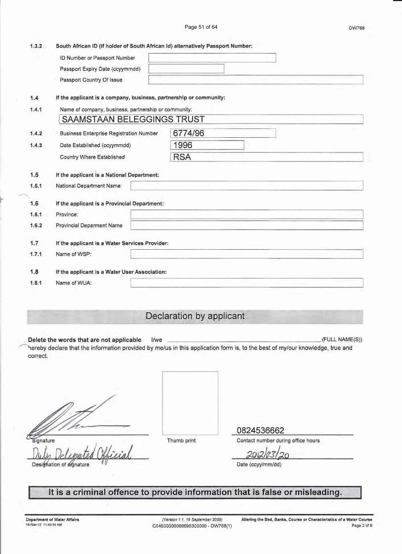
Delete the words that are not applicable I/we (FULL NAME(S))hereby declare that the information provided by me/us in this application form is, to the best of my/our knowledge, true andcorrect.
0824536662Thumb print Contact number during office hours
Date (ccyy/mm/dd)
Department of Water Affairs16-Mar-12 11:45:30 AM
(Version 1.1, 16 September 2009)
C04600000000095300000 - DW760(1)TAKING WATER FROM A WATER RESOURCE
Page 2 of 8
Page 18 of 64
Datum Type:
(Mark only one box with an X)
Full Temporary TransferIf yes, mark with an X the Succession / Transfer Type
Permanent Transfer
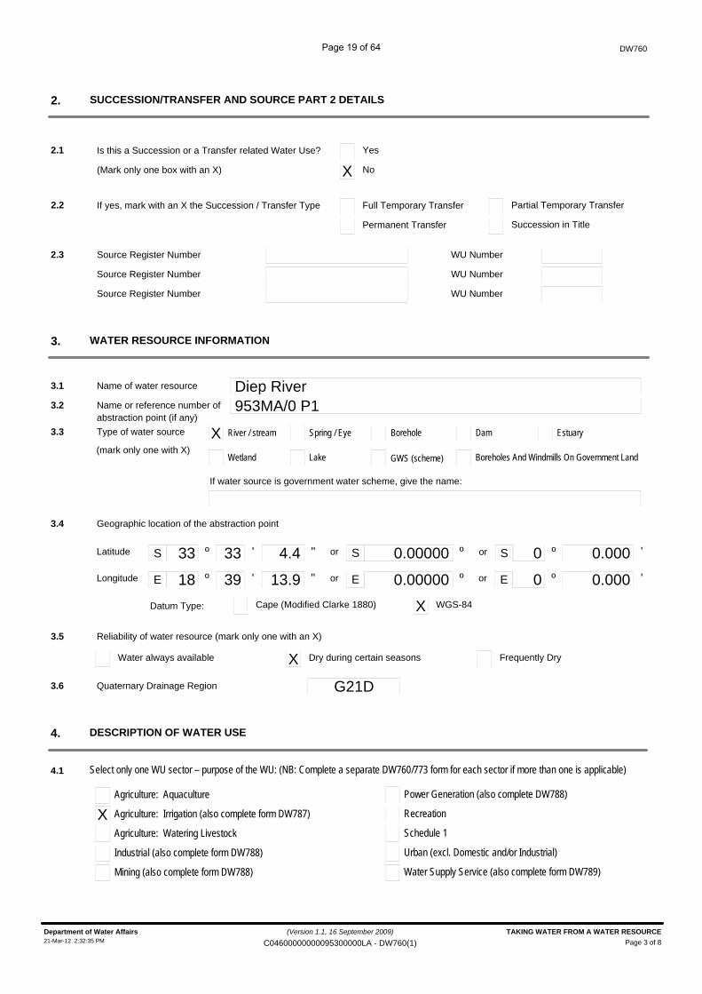
Is this a Succession or a Transfer related Water Use?
DW760
SUCCESSION/TRANSFER AND SOURCE PART 2 DETAILS2.
2.1 Yes
X No
2.2 Partial Temporary Transfer
Succession in Title
Source Register Number2.3 WU Number
Source Register Number WU Number
Source Register Number WU Number
WATER RESOURCE INFORMATION3.
Name of water resource Diep River3.1
Name or reference number of 953MA/0 P13.2abstraction point (if any)
3.3 X River / streamType of water source Spring / Eye Borehole Dam Estuary
Wetland Lake GWS (scheme) Boreholes And Windmills On Government Land
If water source is government water scheme, give the name:
3.4 Geographic location of the abstraction point
S º ' " S ºor
E º ' " E º
33 33 4.4 0.00000 0.000
18 39 13.9 0.00000 0.000
º
º or
or
or
'
'
S
E
0
0
Latitude
Longitude
Cape (Modified Clarke 1880) X WGS-84
3.5 Reliability of water resource (mark only one with an X)
Water always available X Dry during certain seasons Frequently Dry
Quaternary Drainage Region G21D3.6
DESCRIPTION OF WATER USE4.
4.1 Select only one WU sector – purpose of the WU: (NB: Complete a separate DW760/773 form for each sector if more than one is applicable)
Agriculture: Aquaculture
X Agriculture: Irrigation (also complete form DW787)
Agriculture: Watering Livestock
Industrial (also complete form DW788)
Mining (also complete form DW788)
Power Generation (also complete DW788)
Recreation
Schedule 1
Urban (excl. Domestic and/or Industrial)
Water Supply Service (also complete form DW789)
(mark only one with X)
(Version 1.1, 16 September 2009)
Page 3 of 8Department of Water Affairs TAKING WATER FROM A WATER RESOURCE21-Mar-12 2:32:35 PM C04600000000095300000LA - DW760(1)
Page 19 of 64
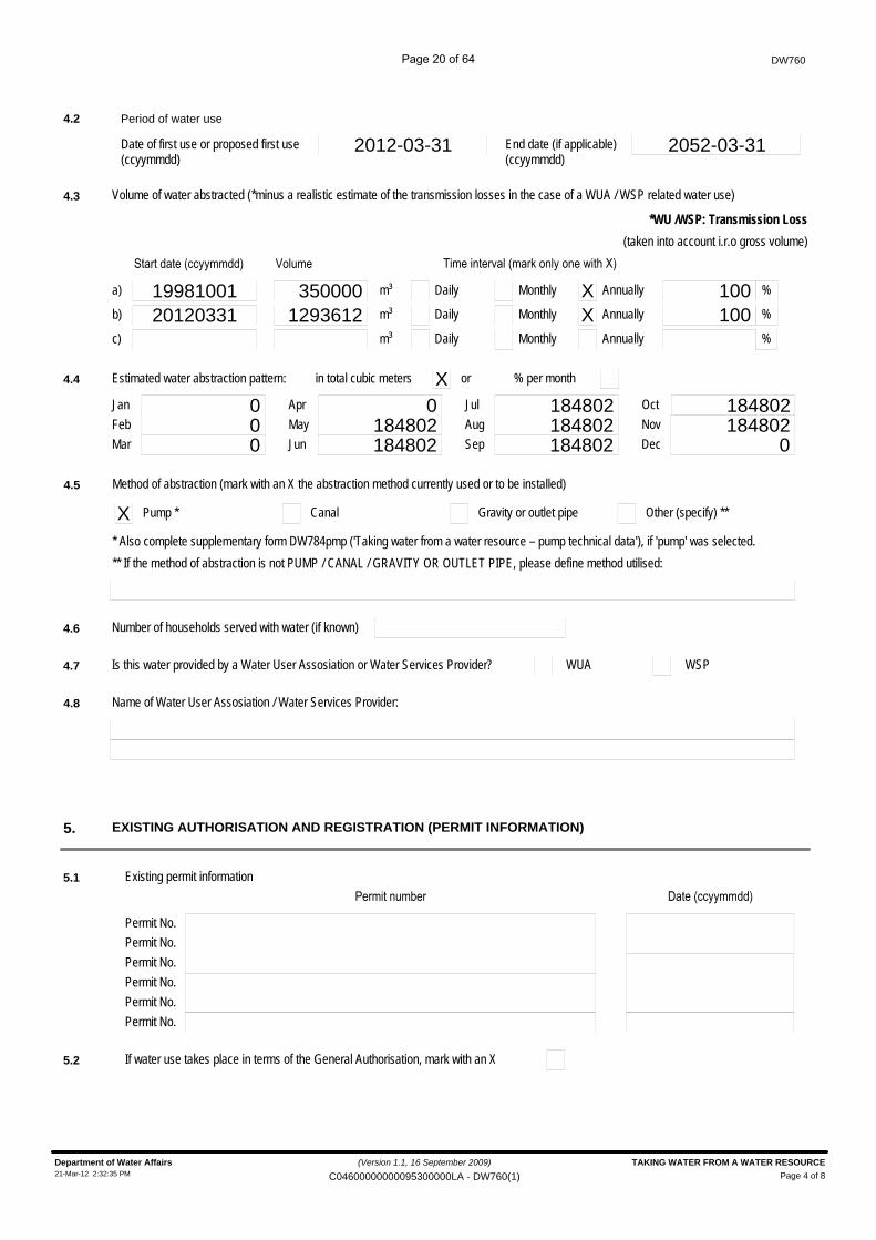
4.2 Period of water use
Date of first use or proposed first use 2012-03-31(ccyymmdd)
End date (if applicable)(ccyymmdd)
2052-03-31
EXISTING AUTHORISATION AND REGISTRATION (PERMIT INFORMATION)5.
4.3 Volume of water abstracted (*minus a realistic estimate of the transmission losses in the case of a WUA / WSP related water use)
*WU /WSP: Transmission Loss
(taken into account i.r.o gross volume)'����������$$������%
19981001a)
20120331b)
c)
(����
3500001293612
m³
m³
m³
Daily
Daily
Daily
Monthly
Monthly
Monthly
X Annually
X Annually
Annually
) ��� ���������*���������� ���+%
100100
%
%
%
4.4 Estimated water abstraction pattern: in total cubic meters X or % per month
0Jan 0Apr 184802Jul 184802Oct0Feb 184802May 184802Aug 184802Nov0Mar 184802Jun 184802Sep 0Dec
4.5 Method of abstraction (mark with an X the abstraction method currently used or to be installed)
X Pump * Canal Gravity or outlet pipe Other (specify) **
* Also complete supplementary form DW784pmp ('Taking water from a water resource – pump technical data'), if 'pump' was selected.** If the method of abstraction is not PUMP / CANAL / GRAVITY OR OUTLET PIPE, please define method utilised:
4.6 Number of households served with water (if known)
4.7 Is this water provided by a Water User Assosiation or Water Services Provider? WUA WSP
4.8 Name of Water User Assosiation / Water Services Provider:
5.1 Existing permit information
Permit No.
,�� ������� ������$$������%
Permit No.Permit No.Permit No.Permit No.Permit No.
5.2 If water use takes place in terms of the General Authorisation, mark with an X
DW760
(Version 1.1, 16 September 2009)
Page 4 of 8Department of Water Affairs TAKING WATER FROM A WATER RESOURCE21-Mar-12 2:32:35 PM C04600000000095300000LA - DW760(1)
Page 20 of 64
DW760
SUBSIDY DETAILS6.
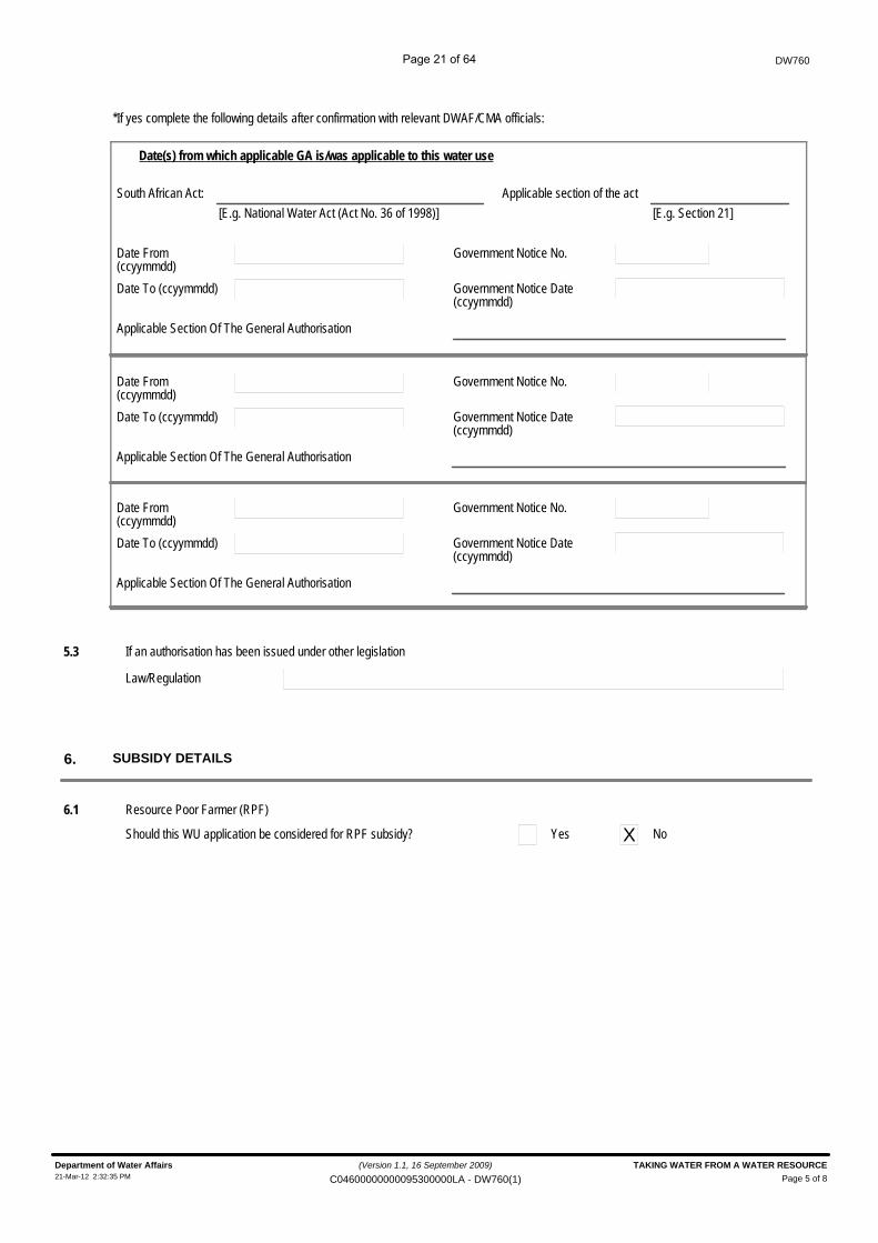
6.1 Resource Poor Farmer (RPF)
Should this WU application be considered for RPF subsidy? Yes X No
*If yes complete the following details after confirmation with relevant DWAF/CMA officials:
Date(s) from which applicable GA is/was applicable to this water use
South African Act: Applicable section of the act[E.g. National Water Act (Act No. 36 of 1998)] [E.g. Section 21]
Date From(ccyymmdd)Date To (ccyymmdd)
Government Notice No.
Government Notice Date(ccyymmdd)
Applicable Section Of The General Authorisation
Date From(ccyymmdd)Date To (ccyymmdd)
Government Notice No.
Government Notice Date(ccyymmdd)
Applicable Section Of The General Authorisation
Date From(ccyymmdd)Date To (ccyymmdd)
Government Notice No.
Government Notice Date(ccyymmdd)
Applicable Section Of The General Authorisation
5.3 If an authorisation has been issued under other legislation
Law/Regulation
(Version 1.1, 16 September 2009)
Page 5 of 8Department of Water Affairs TAKING WATER FROM A WATER RESOURCE21-Mar-12 2:32:35 PM C04600000000095300000LA - DW760(1)
Page 21 of 64
Tribal Authority/Council (if applicable)
Property Number
Portion of property
Surveyor-General Cadastral Code
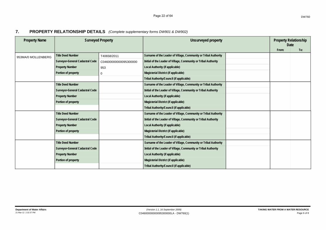
PROPERTY RELATIONSHIP DETAILS7.
Property Name
DW760
(Complete supplementary forms DW901 & DW902)
Surveyed Property
Title Deed Number
Local Authority (if applicable)
Magisterial District (if applicable)
Initial of the Leader of Village, Community or Tribal Authority
Unsurveyed property
Surname of the Leader of Village, Community or Tribal Authority
Property RelationshipDate
From: To:
Tribal Authority/Council (if applicable)
Property Number
Portion of property
Surveyor-General Cadastral Code
Title Deed Number
Local Authority (if applicable)
Magisterial District (if applicable)
Initial of the Leader of Village, Community or Tribal Authority
Surname of the Leader of Village, Community or Tribal Authority
T40658/2011
C04600000000095300000
953
0
953MA/0 MOLLENBERG
(Version 1.1, 16 September 2009)
Page 6 of 8Department of Water Affairs TAKING WATER FROM A WATER RESOURCE21-Mar-12 2:32:37 PM C04600000000095300000LA - DW760(1)
Page 22 of 64
DW760
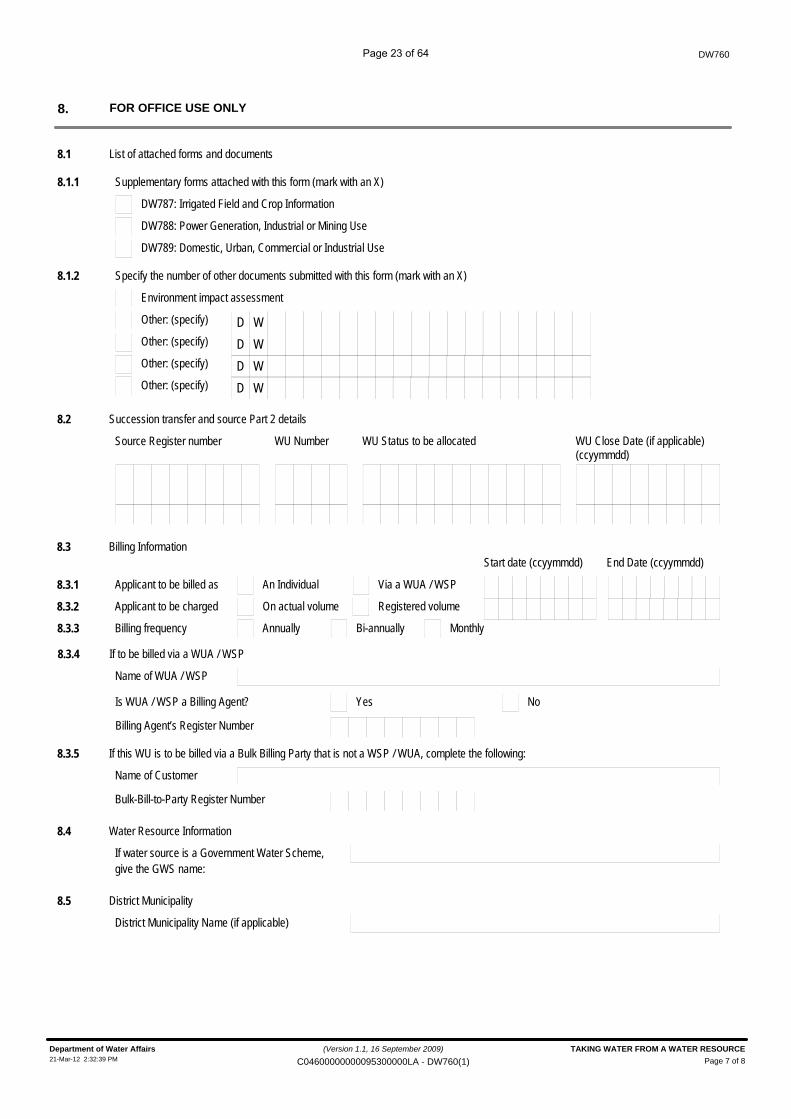
FOR OFFICE USE ONLY8.
8.1 List of attached forms and documents
8.1.1 Supplementary forms attached with this form (mark with an X)
DW787: Irrigated Field and Crop Information
DW788: Power Generation, Industrial or Mining Use
DW789: Domestic, Urban, Commercial or Industrial Use
8.1.2 Specify the number of other documents submitted with this form (mark with an X)
Environment impact assessment
Other: (specify) D WOther: (specify) D WOther: (specify) D WOther: (specify) D W
8.2 Succession transfer and source Part 2 details
Source Register number WU Number WU Status to be allocated WU Close Date (if applicable)(ccyymmdd)
8.3 Billing Information
8.3.1 An IndividualApplicant to be billed as Via a WUA / WSP
Start date (ccyymmdd) End Date (ccyymmdd)
8.3.2 On actual volumeApplicant to be charged Registered volume
8.3.3 AnnuallyBilling frequency Bi-annually Monthly
8.3.4 If to be billed via a WUA / WSP
Name of WUA / WSP
YesIs WUA / WSP a Billing Agent? No
Billing Agent’s Register Number
8.3.5 If this WU is to be billed via a Bulk Billing Party that is not a WSP / WUA, complete the following:
Name of Customer
Bulk-Bill-to-Party Register Number
8.4 Water Resource Information
If water source is a Government Water Scheme,give the GWS name:
8.5 District Municipality
District Municipality Name (if applicable)
(Version 1.1, 16 September 2009)
Page 7 of 8Department of Water Affairs TAKING WATER FROM A WATER RESOURCE21-Mar-12 2:32:39 PM C04600000000095300000LA - DW760(1)
Page 23 of 64
DW760
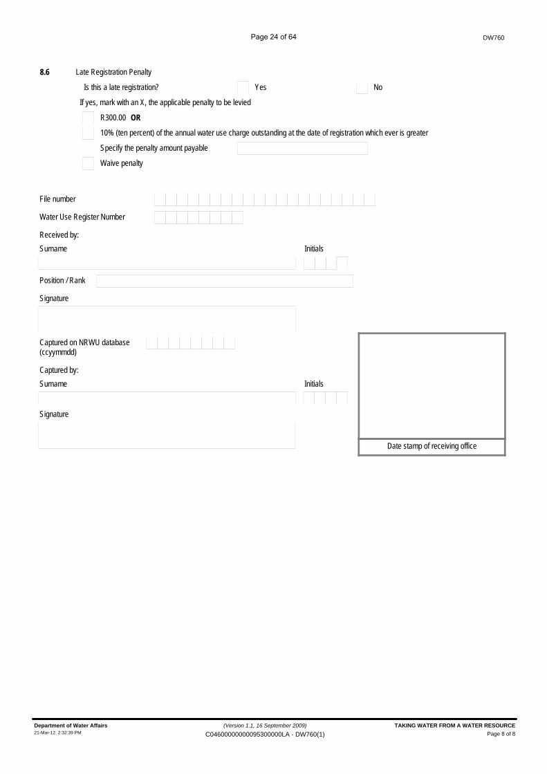
8.6 Late Registration Penalty
YesIs this a late registration? No
If yes, mark with an X, the applicable penalty to be levied
R300.00 OR
10% (ten percent) of the annual water use charge outstanding at the date of registration which ever is greater
Specify the penalty amount payable
Waive penalty
File number
Received by:Surname Initials
Position / Rank
Signature
Date stamp of receiving office
Water Use Register Number
(ccyymmdd)Captured on NRWU database
Captured by:Surname Initials
Signature
(Version 1.1, 16 September 2009)
Page 8 of 8Department of Water Affairs TAKING WATER FROM A WATER RESOURCE21-Mar-12 2:32:39 PM C04600000000095300000LA - DW760(1)
Page 24 of 64

DW 762 Storing
Page 25 of 64
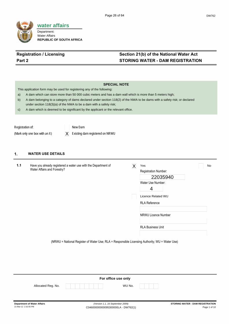
water affairs
DW762
Department:Water AffairsREPUBLIC OF SOUTH AFRICA
������������� ��������
����� ��������������������������������
����������� �!��"������#���������
SPECIAL NOTE
�$ ������%�������� �
�$� ����������������� ������������������ ����������������������������� ������������� ��� ���� ���������
���� �!���� ������� ������������ ��"��#��!�������� ���# $��� �������� ��"�� �!������ ��%
X Yes No
22035940����� ���������
4Licence Related WU
�#��������$�
��� �# $��$�������
�#��&�� ����� � �
For office use only
Allocated Reg. No. WU No.
This application form may be used for registering any of the following:
a) A dam which can store more than 50 000 cubic meters and has a dam wall which is more than 5 meters high;
b) A dam belonging to a category of dams declared under section 118(2) of the NWA to be dams with a safety risk; or declaredunder section 118(3)(a) of the NWA to be a dam with a safety risk;
c) A dam which is deemed to be significant by the applicant or the relevant office.
(Mark only one box with an X)
Registration of: New Dam
X Existing dam registered on NRWU
(Version 1.1, 16 September 2009)
Page 1 of 10Department of Water Affairs STORING WATER - DAM REGISTRATION21-Mar-12 2:32:55 PM C04600000000095300000LA - DW762(1)
Page 26 of 64
Administrator
Rectangle
DW762
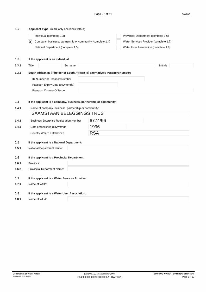
Applicant Type1.2 (mark only one block with X)
Company, business, partnership or community (complete 1.4)XIndividual (complete 1.3)
Water Services Provider (complete 1.7)
Provincial Department (complete 1.6)
If the applicant is an individual1.3
National Department (complete 1.5) Water User Association (complete 1.8)
InitialsTitle Surname1.3.1
South African ID (if holder of South African Id) alternatively Passport Number:1.3.2
ID Number or Passport Number
Passport Expiry Date (ccyymmdd)
Passport Country Of Issue
Name of company, business, partnership or community:
SAAMSTAAN BELEGGINGS TRUST
If the applicant is a company, business, partnership or community:1.4
1.4.1
1.4.2 Business Enterprise Registration Number 6774/961.4.3 Date Established (ccyymmdd) 1996
Country Where Established RSA
If the applicant is a National Department:1.5
National Department Name:1.5.1
If the applicant is a Provincial Department:1.6
Province:1.6.1
Provincial Deparment Name:1.6.2
If the applicant is a Water Services Provider:1.7
Name of WSP:1.7.1
If the applicant is a Water User Association:1.8
Name of WUA:1.8.1
(Version 1.1, 16 September 2009)
Page 2 of 10Department of Water Affairs STORING WATER - DAM REGISTRATION21-Mar-12 2:32:55 PM C04600000000095300000LA - DW762(1)
Page 27 of 64
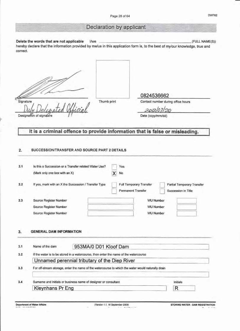
DW762
Delete the words that are not applicable l/we (FULL NAME(S»
hereby declare that the information provided by me/us in this application form is, to the best of my/our knowledge, true andcorrect.
0824536662Signature "
D"P,J, ~JJ 0fIw;JThumb print Contact number during office hours
I"Date (ccyy/mm/dd)
It is a criminaloffence to provide infonnation that is false ormisieading.
2. SUCCESSIONlTRANSFER AND SOURCE PART 2 DETAILS
2.1 Is this a Succession or a Transfer related Water Use? DYes
[Xl No(Mark only one box with an X)
2.2 If yes, mark with an X the Succession I Transfer Type U Full Temporary Transfer
D Permanent Transfer
D Partial Temporary Transfer
D Succession in Title
2.3 Source Register Number
Source Register Number
Source Register Number
WU Number
WU Number
WU Number
Name of the dam
3. GENERAL DAM INFORMATION
3.1 !953MA/O 001 Kloof Dam3.2 If the water is to be stored in a watercourse, then enter the name of the watercourse
I Unnamed perennial tributary of the Diep River3.3 For off-stream storage, enter the name of the watercourse to which the water would naturally drain
3.4 Surname and initials or business name of designer or consultant Initials
I Kleynhans Pr Eng IR
Department of Water Affairs (Version 1.1, 16 September 2009) STORING WATER· DAM REGISTRATION
Page 28 of 64
DW762
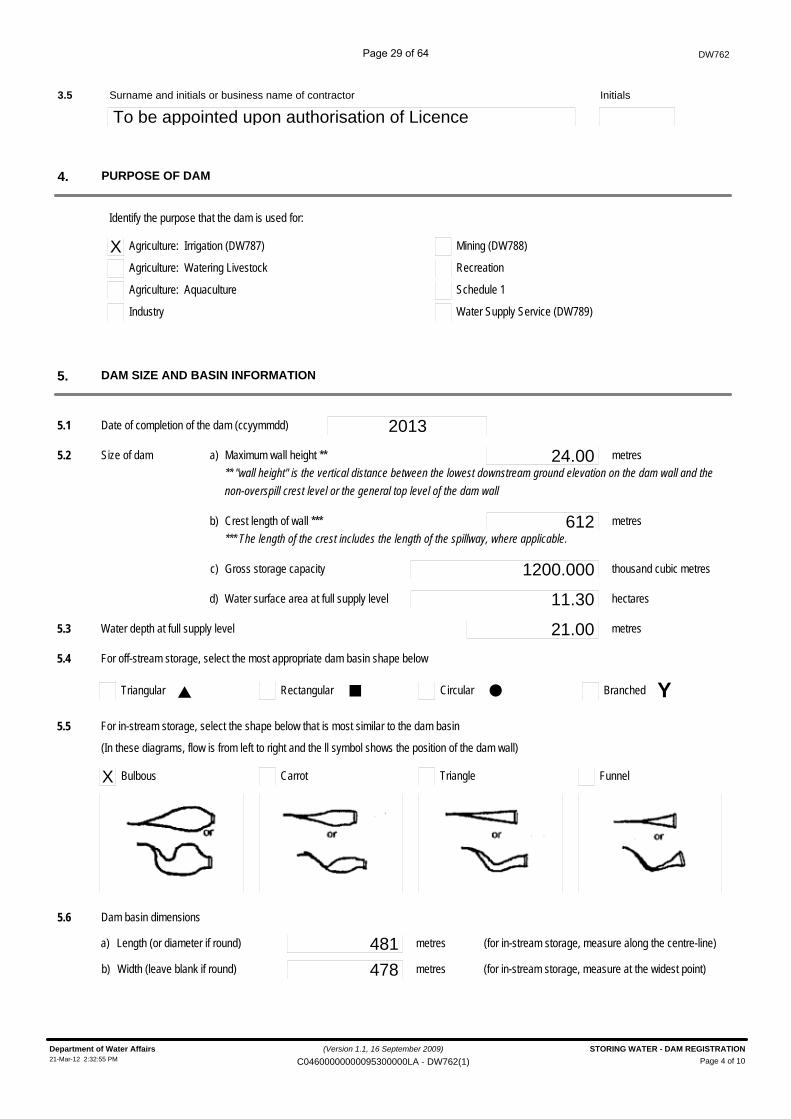
Surname and initials or business name of contractor3.5
To be appointed upon authorisation of LicenceInitials
PURPOSE OF DAM4.
Identify the purpose that the dam is used for:
X Agriculture: Irrigation (DW787)
Agriculture: Watering Livestock
Agriculture: Aquaculture
Industry
Mining (DW788)
Recreation
Schedule 1
Water Supply Service (DW789)
DAM SIZE AND BASIN INFORMATION5.
5.1 Date of completion of the dam (ccyymmdd) 20135.2 Size of dam a) Maximum wall height ** 24.00
** "wall height" is the vertical distance between the lowest downstream ground elevation on the dam wall and the
non-overspill crest level or the general top level of the dam wall
metres
b) Crest length of wall *** 612*** The length of the crest includes the length of the spillway, where applicable.
metres
c) Gross storage capacity 1200.000 thousand cubic metres
d) Water surface area at full supply level 11.30 hectares
5.3 Water depth at full supply level 21.00 metres
5.4 For off-stream storage, select the most appropriate dam basin shape below
Triangular BranchedRectangular Circular
5.5 For in-stream storage, select the shape below that is most similar to the dam basin
X Bulbous FunnelCarrot Triangle
p ¢ l Y
(In these diagrams, flow is from left to right and the ll symbol shows the position of the dam wall)
5.6 Dam basin dimensions
481 metresa) Length (or diameter if round) (for in-stream storage, measure along the centre-line)
478 metresb) Width (leave blank if round) (for in-stream storage, measure at the widest point)
(Version 1.1, 16 September 2009)
Page 4 of 10Department of Water Affairs STORING WATER - DAM REGISTRATION21-Mar-12 2:32:55 PM C04600000000095300000LA - DW762(1)
Page 29 of 64
DW762
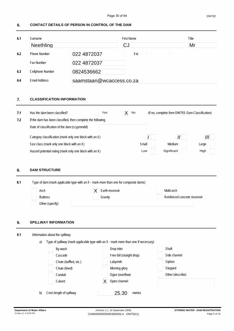
CONTACT DETAILS OF PERSON IN CONTROL OF THE DAM6.
6.2 Phone Number 022 4872037
Neethling CJ6.1 Surname First Name
MrTitle
Ext
Fax Number 022 48720376.3 Cellphone Number 08245366626.4 Email Address [email protected]
CLASSIFICATION INFORMATION7.
7.1 Has the dam been classified? Yes X No (if no, complete form DW793: Dam Classification)
7.2 If the dam has been classified, then complete the following
Date of classification of the dam (ccyymmdd)
Category classification (mark only one block with an X)
Size class (mark only one block with an X)
Hazard potential rating (mark only one block with an X)
ISmall
Low
IIMedium
Significant
IIILarge
High
DAM STRUCTURE8.
Type of dam (mark applicable type with an X - mark more than one for composite dams)
Arch
Buttress
Other (specify)
X Earth reservoir
Gravity
8.1
Multi-arch
Reinforced concrete reservoir
SPILLWAY INFORMATION9.
Information about the spillway9.1
a) Type of spillway (mark applicable type with an X - mark more than one if necessary)
By-wash
Cascade
Chute (baffled, etc.)
Chute (lined)
Conduit
Culvert
Drop inlet
Free fall (straight drop)
Labyrinth
Morning glory
Ogee (overflow)
X Open channel
Shaft
Side channel
Siphon
Stepped
Other (describe)
b) Crest length of spillway 25.30 metres
(Version 1.1, 16 September 2009)
Page 5 of 10Department of Water Affairs STORING WATER - DAM REGISTRATION21-Mar-12 2:32:55 PM C04600000000095300000LA - DW762(1)
Page 30 of 64
DW762
c) Description of spillway gates, if any
Details on any auxillary or second spillwayd)Location ("left bank", "saddle", etc.)
Nature or type of spillway
Crest length of auxillary spillway metres
9.2 Does the dam structure incorporate a fish ladder or fish Yes X No
way?
LOCATION OF DAM10.
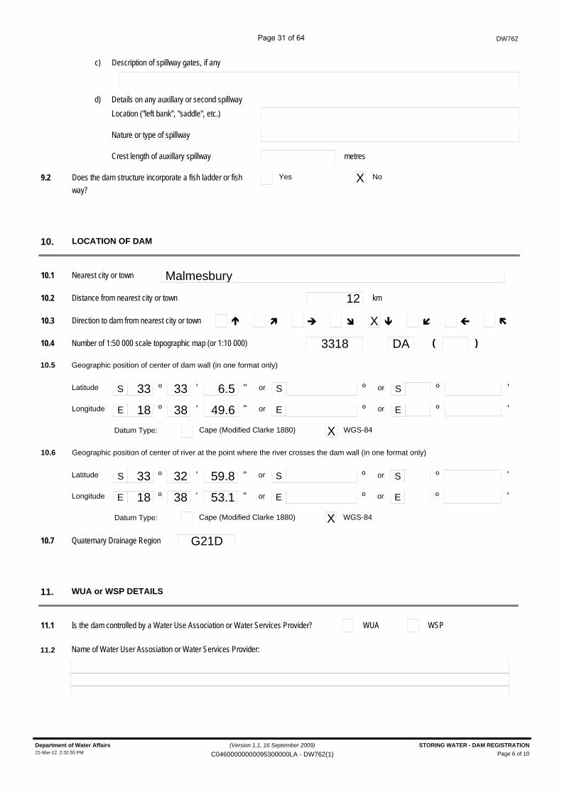
10.1 Nearest city or town Malmesbury
10.2 Distance from nearest city or town 12 km
10.3 Direction to dam from nearest city or town é ì è î X ê í ç ë
10.4 Number of 1:50 000 scale topographic map (or 1:10 000) 3318 DA )(
Datum Type:
10.5 Geographic position of center of dam wall (in one format only)
S º ' " S ºor
E º ' " E º
33 33 6.5
18 38 49.6
º
º or
or
or
'
'
S
E
Latitude
Longitude
Cape (Modified Clarke 1880) X WGS-84
Datum Type:
10.6 Geographic position of center of river at the point where the river crosses the dam wall (in one format only)
S º ' " S ºor
E º ' " E º
33 32 59.8
18 38 53.1
º
º or
or
or
'
'
S
E
Latitude
Longitude
Cape (Modified Clarke 1880) X WGS-84
10.7 Quaternary Drainage Region G21D
WUA or WSP DETAILS11.
11.1 Is the dam controlled by a Water Use Association or Water Services Provider? WUA WSP
11.2 Name of Water User Assosiation or Water Services Provider:
(Version 1.1, 16 September 2009)
Page 6 of 10Department of Water Affairs STORING WATER - DAM REGISTRATION21-Mar-12 2:32:55 PM C04600000000095300000LA - DW762(1)
Page 31 of 64
DW762
EXISTING AUTHORISATION12.
12.1 Existing permit information
12/2/G202/89Permit No.
'�� ������� ������$$������%
Permit No.Permit No.Permit No.Permit No.Permit No.
12.2 If water use takes place in terms of the General Authorisation, mark with an X
*If yes complete the following details after confirmation with relevant DWAF/CMA officials:
Date(s) from which applicable GA is/was applicable to this water use
South African Act: Applicable section of the act[E.g. National Water Act (Act No. 36 of 1998)] [E.g. Section 21]
Date From(ccyymmdd)Date To (ccyymmdd)
Government Notice No.
Government Notice Date(ccyymmdd)
Applicable Section Of The General Authorisation
Date From(ccyymmdd)Date To (ccyymmdd)
Government Notice No.
Government Notice Date(ccyymmdd)
Applicable Section Of The General Authorisation
Date From(ccyymmdd)Date To (ccyymmdd)
Government Notice No.
Government Notice Date(ccyymmdd)
Applicable Section Of The General Authorisation
12.3 If an authorisation has been issued under other legislation
Law/Regulation WULA to increase 12/2/G202/89 to 1.2 Million m³
(Version 1.1, 16 September 2009)
Page 7 of 10Department of Water Affairs STORING WATER - DAM REGISTRATION21-Mar-12 2:32:55 PM C04600000000095300000LA - DW762(1)
Page 32 of 64
Tribal Authority/Council (if applicable)
Property Number
Portion of property
Surveyor-General Cadastral Code
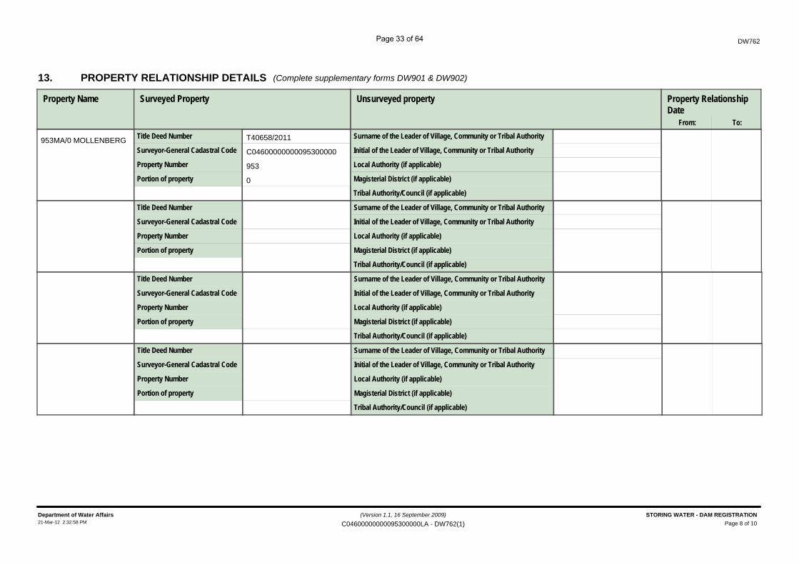
PROPERTY RELATIONSHIP DETAILS13.
Property Name
DW762
(Complete supplementary forms DW901 & DW902)
Surveyed Property
Title Deed Number
Local Authority (if applicable)
Magisterial District (if applicable)
Initial of the Leader of Village, Community or Tribal Authority
Unsurveyed property
Surname of the Leader of Village, Community or Tribal Authority
Property RelationshipDate
From: To:
Tribal Authority/Council (if applicable)
Property Number
Portion of property
Surveyor-General Cadastral Code
Title Deed Number
Local Authority (if applicable)
Magisterial District (if applicable)
Initial of the Leader of Village, Community or Tribal Authority
Surname of the Leader of Village, Community or Tribal Authority
Tribal Authority/Council (if applicable)
Property Number
Portion of property
Surveyor-General Cadastral Code
Title Deed Number
Local Authority (if applicable)
Magisterial District (if applicable)
Initial of the Leader of Village, Community or Tribal Authority
Surname of the Leader of Village, Community or Tribal Authority
Tribal Authority/Council (if applicable)
Property Number
Portion of property
Surveyor-General Cadastral Code
Title Deed Number
Local Authority (if applicable)
Magisterial District (if applicable)
Initial of the Leader of Village, Community or Tribal Authority
Surname of the Leader of Village, Community or Tribal Authority
T40658/2011
C04600000000095300000
953
0
953MA/0 MOLLENBERG
(Version 1.1, 16 September 2009)
Page 8 of 10Department of Water Affairs STORING WATER - DAM REGISTRATION21-Mar-12 2:32:58 PM C04600000000095300000LA - DW762(1)
Page 33 of 64
DW762
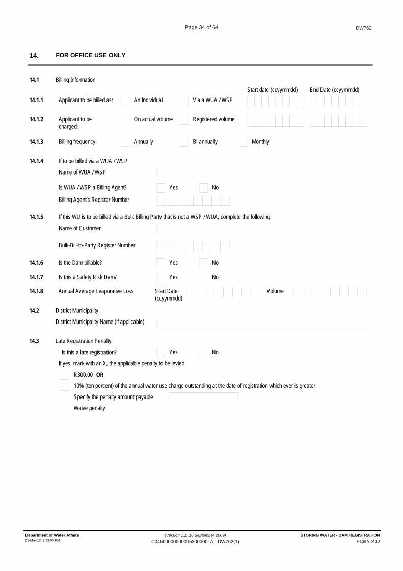
FOR OFFICE USE ONLY14.
14.1 Billing Information
14.1.1 An IndividualApplicant to be billed as: Via a WUA / WSPStart date (ccyymmdd) End Date (ccyymmdd)
14.1.2 On actual volumeApplicant to be charged:
Registered volume
14.1.3 AnnuallyBilling frequency: Bi-annually Monthly
14.1.4 If to be billed via a WUA / WSP
Name of WUA / WSP
YesIs WUA / WSP a Billing Agent? No
Billing Agent’s Register Number
14.1.5 If this WU is to be billed via a Bulk Billing Party that is not a WSP / WUA, complete the following:
Name of Customer
Bulk-Bill-to-Party Register Number
14.2 District Municipality
District Municipality Name (if applicable)
YesIs the Dam billable? No14.1.6
YesIs this a Safety Risk Dam? No14.1.7
Annual Average Evaporative Loss14.1.8 Start Date(ccyymmdd)
Volume
14.3 Late Registration Penalty
Is this a late registration?
If yes, mark with an X, the applicable penalty to be levied
R300.00 OR
10% (ten percent) of the annual water use charge outstanding at the date of registration which ever is greater
Specify the penalty amount payable
Waive penalty
Yes No
(Version 1.1, 16 September 2009)
Page 9 of 10Department of Water Affairs STORING WATER - DAM REGISTRATION21-Mar-12 2:33:00 PM C04600000000095300000LA - DW762(1)
Page 34 of 64
DW762
File number
Received by:Surname Initials
Position / Rank
Signature
Date stamp of receiving office
Water Use Register Number
(ccyymmdd)Captured on NRWU database
Captured by:Surname Initials
Signature
(Version 1.1, 16 September 2009)
Page 10 of 10Department of Water Affairs STORING WATER - DAM REGISTRATION21-Mar-12 2:33:00 PM C04600000000095300000LA - DW762(1)
Page 35 of 64

DW 793
Dam Classification
Page 36 of 64
S-dam(cls) DW 793E
version 1 of 2009-12-15 p 1 of 2
SUPPLEMENTARY WATER USE INFORMATION
STORING WATER
DAM CLASSIFICATION
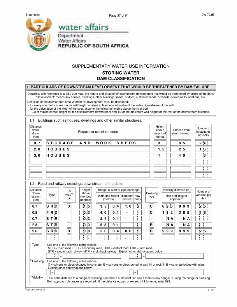
1. PARTICULARS OF DOWNSTREAM DEVELOPMENT THAT WOULD BE THREATENED BY DAM FAILURE
Describe, with reference to a 1:50 000 map, the nature and situation of downstream development that would be threatened by failure of the dam. “Development” means any houses, dwellings, other buildings, roads, bridges, cultivated lands, orchards, powerline foundations, etc.
Definition of the downstream area wherein all development must be described: - for every one metre of maximum wall height, analyse at least one kilometre of the valley downstream of the wall - for the calculation of the width of the strip, assume the following heights above the river bed:
2/3 of maximum wall height for the first kilometre downstream and 1/2 of the maximum wall height for the rest of the downstream distance.
1.1 Buildings such as houses, dwellings and other similar structures:
Distance down-stream (km)
Purpose or use of structure
Height above
river bed (metres)
Distance from river (metres)
Number of inhabitants
or users
0. 7 S T O R A G E A N D W O R K S H E D S 3 8 5 2 4
2. 0 H O U S E S 1. 5 2 5 1 5
3. 0 H O U S E S 1 4 0 6
1.2 Road and railway crossings downstream of the dam:
Bridge, culvert or pipe openings Visibility distance (m)
Distance down-stream (km)
Type1
Tar road?
(X)
Height above
river bed (metres)
width and height (metres)
diameter (metres)
how many
Crossing type
2
first and second approach
3
Number of vehicles per
day
0.7 S R D X 1. 5 3. 5 0. 4 1. 0 2 C 6 9 0 9 9 9 2 5
0.8 F R D 0. 3 4. 0 0. 1 - - C 1 1 2 3 8 5 1 8
0.7 S T R 0. 3 2. 4 0. 1 - - - N A N A
2.5 S T R 0. 3 5. 8 0. 1 - - B N A N A
2.6 S R D X 0. 8 5. 6 0. 4 0. 8 3 B 9 9 9 9 9 9 2 5
. . . .
1 Type Use one of the following abbreviations: MRD = main road, SRD = secondary road, DRD = district road, FRD = farm road, STR = single track railway, MTR = multi-track railway. Explain other abbreviations below:
= =
2 Crossing Use one of the following abbreviations: C = culverts or pipes encased in concrete, E = culverts or pipes buried in earthfill or rockfill, B = concrete bridge with piers. Explain other abbreviations below:
= =
3 Visibility This is the distance to a bridge or crossing from where a motorist can see if there is any danger in using the bridge or crossing. Both approach distances are required. If the distance equals or exceeds 1 kilometre, enter 999.
Page 37 of 64
S-dam(cls) DW 793E
version 1 of 2009-12-15 p 2 of 2
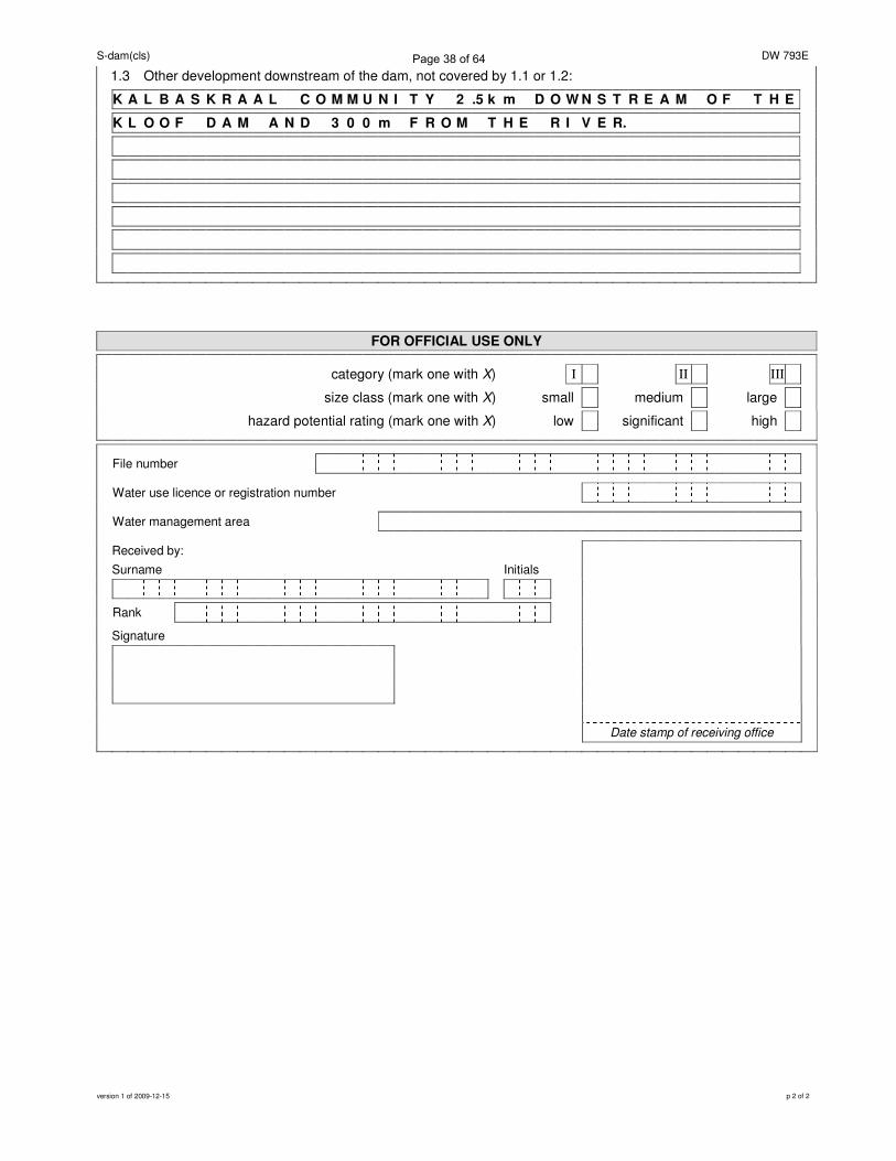
1.3 Other development downstream of the dam, not covered by 1.1 or 1.2:
K A L B A S K R A A L C O M M U N I T Y 2 .5 k m D O W N S T R E A M O F T H E
K L O O F D A M A N D 3 0 0 m F R O M T H E R I V E R.
FOR OFFICIAL USE ONLY
category (mark one with X)_ I II III
size class (mark one with X)_ small_ medium_ large_
hazard potential rating (mark one with X)_ low_ significant_ high_
File number
Water use licence or registration number
Water management area
Received by:
Surname Initials
Rank
Signature
Date stamp of receiving office
Page 38 of 64

DW 763 Impeding
Page 39 of 64
water affairs
DW763
Department:Water AffairsREPUBLIC OF SOUTH AFRICA
������������� ��������
����� ��������������������������� �����
����������� �!��"������#������$��
SPECIAL NOTE
�% �����$ �������$����
�%� ����������������� ������������������ ����������������������������� ������������� ��� ���� ���������
���� �!���� ������� ������������ ��"��#��!�������� ���# $��� �������� ��"�� �!������ ��%
X Yes No
22035940����� ���������
Licence Related WU
�#��������$�
��� �# $��$�������
�#��&�� ����� � �
Applicant Type1.2 (mark only one block with X)
Company, business, partnership or community (complete 1.4)XIndividual (complete 1.3)
Water Services Provider (complete 1.7)
Provincial Department (complete 1.6)
If the applicant is an individual1.3
National Department (complete 1.5) Water User Association (complete 1.8)
InitialsTitle Surname1.3.1
For office use only
Allocated Reg. No. WU No.
�$�������$��$���&�'���
This form is not applicable to any structure that is capable of containing, storing or impounding water.
For these structures, please complete form DW762
'�(���������� ������� ����%�� ������)����*��$����������� ���������� $���*��� ���
(Version 1.1, 16 September 2009)
Page 1 of 9Department of Water Affairs IMPEDING OR DIVERTING THE FLOW OF WATER21-Mar-12 2:33:06 PM C04600000000095300000LA - DW763(1)
Page 40 of 64
Administrator
Rectangle
DW763
1.3.2 South African ID (if holder of South African Id) alternatively Passport Number:
ID Number or Passport Number
Passport Expiry Date (ccyymmdd)
Passport Country Of Issue
1.4 If the applicant is a company, business, partnership or community:
1.4.1 Name of company, business, partnership or community:
1 SAAMSTAAN BELEGGINGS TRUST1.4.2 Business Enterprise Registration Number 16774/96~~======~----1.4.3 Date Established (ccyymmdd) 11996~~======~------------------Country Where Established 1 RSA-------------------------------------------------------
I
1.5 If the applicant is a National Department:~-----------------------------------------------------------------
1.5.1 National Department Name:
~1.6 If the applicant is a Provincial Department:
1.6.1 Province:
1.6.2 Provincial Deparment Name
1.7 If the applicant is a Water Services Provider:
1.7.1 Name ofWSP:
1.8 If the applicant is a Water User Association:
1.8.1 Name of WUA:
Delete the words that are not applicable l!we (FULL NAME(S))
~hereby declare that the information provided by me/us in this application form is, to the best of my/our knowledge, true andcorrect.
0824536662Thumb print Contact number during office hours
Date (ccyy/mm/dd)
Department of Water Affairs16-Mar-12 11 :49:39 AM
(Version 1.1, 16 September 2009) IMPEDING OR DIVERTING THE FLOW OF WATER
C04600000000095300000 - DW763(1) Page 2 of 9
Page 41 of 64
Datum Type:
(Mark only one box with an X)
If yes, complete the following source details:
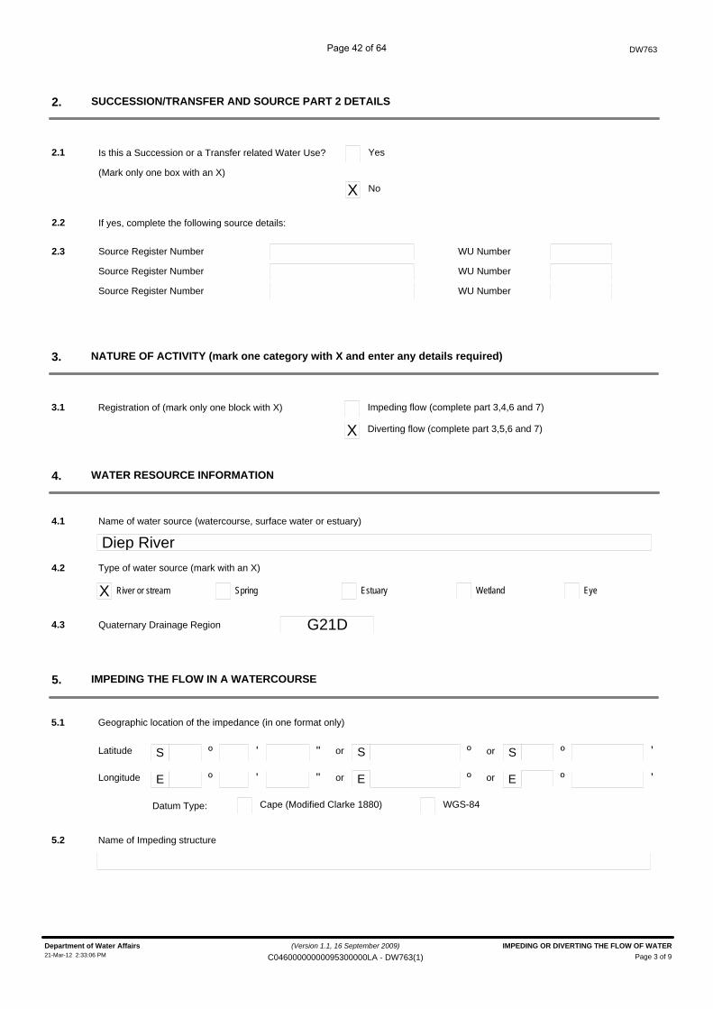
Is this a Succession or a Transfer related Water Use?
DW763
SUCCESSION/TRANSFER AND SOURCE PART 2 DETAILS2.
2.1 Yes
X No
2.2
Source Register Number2.3 WU Number
Source Register Number WU Number
Source Register Number WU Number
WATER RESOURCE INFORMATION4.
Name of water source (watercourse, surface water or estuary)
Diep River4.1
4.2
X River or stream
Type of water source (mark with an X)
Spring Estuary Wetland Eye
5.1 Geographic location of the impedance (in one format only)
S º ' " S ºor
E º ' " E º
º
º or
or
or
'
'
S
E
Latitude
Longitude
Cape (Modified Clarke 1880) WGS-84
Quaternary Drainage Region G21D4.3
Registration of (mark only one block with X)
NATURE OF ACTIVITY (mark one category with X and enter any details required)3.
3.1 Impeding flow (complete part 3,4,6 and 7)
X Diverting flow (complete part 3,5,6 and 7)
IMPEDING THE FLOW IN A WATERCOURSE5.
Name of Impeding structure5.2
(Version 1.1, 16 September 2009)
Page 3 of 9Department of Water Affairs IMPEDING OR DIVERTING THE FLOW OF WATER21-Mar-12 2:33:06 PM C04600000000095300000LA - DW763(1)
Page 42 of 64
Datum Type:
DW763
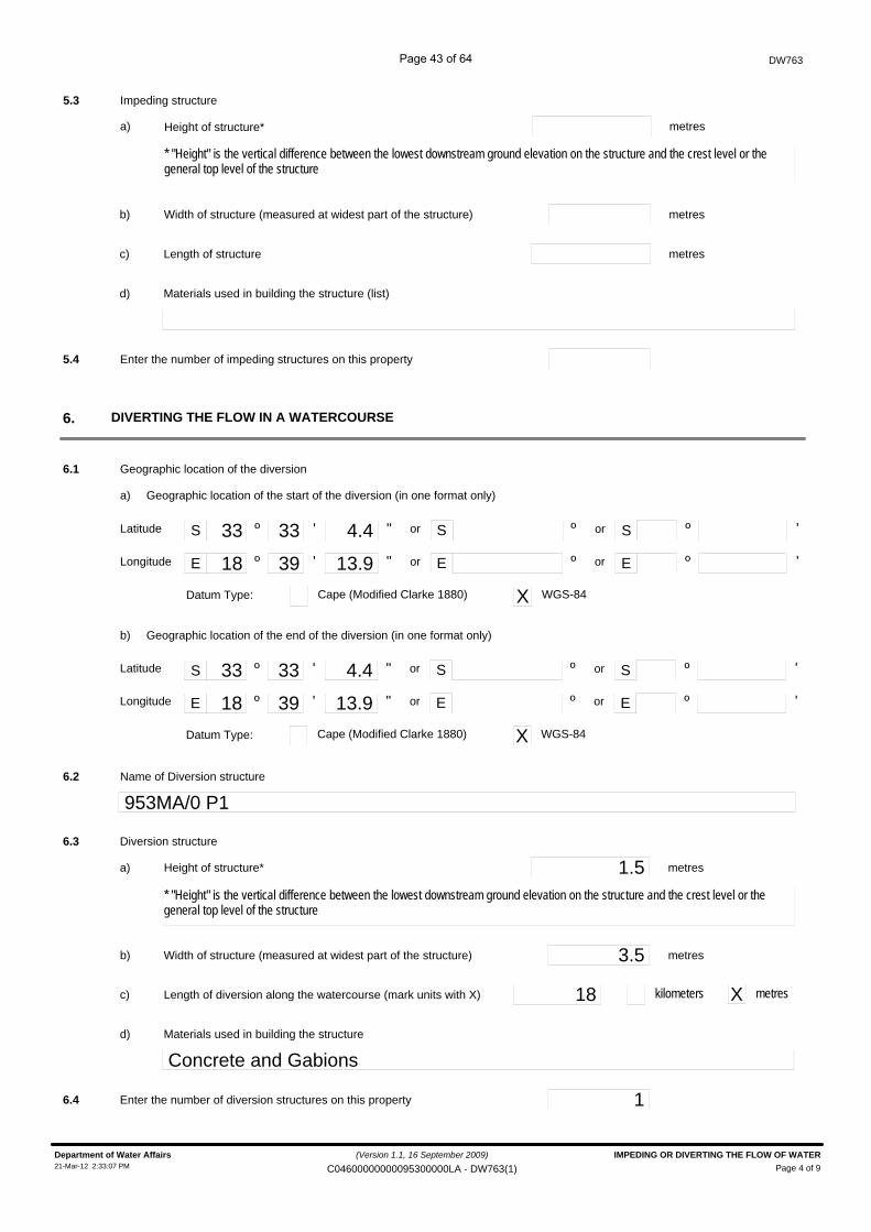
Height of structure*
5.3 Impeding structure
S º ' " S ºor
E º ' " E º
33 33 4.4
18 39 13.9
º
º or
or
or
'
'
S
E
Latitude
Longitude
Cape (Modified Clarke 1880) X WGS-84
DIVERTING THE FLOW IN A WATERCOURSE6.
Name of Diversion structure
953MA/0 P16.2
metresa)
* "Height" is the vertical difference between the lowest downstream ground elevation on the structure and the crest level or the general top level of the structure
Width of structure (measured at widest part of the structure) metresb)
Length of structure metresc)
Materials used in building the structure (list)d)
5.4 Enter the number of impeding structures on this property
6.1 Geographic location of the diversion
Geographic location of the start of the diversion (in one format only)a)
Datum Type:
S º ' " S ºor
E º ' " E º
33 33 4.4
18 39 13.9
º
º or
or
or
'
'
S
E
Latitude
Longitude
Cape (Modified Clarke 1880) X WGS-84
Geographic location of the end of the diversion (in one format only)b)
Height of structure* 1.56.3 Diversion structure
metresa)
* "Height" is the vertical difference between the lowest downstream ground elevation on the structure and the crest level or the general top level of the structure
Width of structure (measured at widest part of the structure) 3.5 metresb)
Length of diversion along the watercourse (mark units with X) 18c)
Materials used in building the structured)
Concrete and Gabions
6.4 Enter the number of diversion structures on this property 1
kilometers X metres
(Version 1.1, 16 September 2009)
Page 4 of 9Department of Water Affairs IMPEDING OR DIVERTING THE FLOW OF WATER21-Mar-12 2:33:07 PM C04600000000095300000LA - DW763(1)
Page 43 of 64
DW763
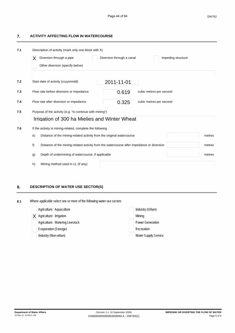
X Diversion through a pipe
ACTIVITY AFFECTING FLOW IN WATERCOURSE7.
7.1 Description of activity (mark only one block with X)
Distance of the mining-related activity from the original watercourse
7.6 If the activity is mining-related, complete the following
metrese)
7.2 Start date of activity (ccyymmdd) 2011-11-01
Diversion through a canal Impeding structure
Other diversion (specify below)
7.3 Flow rate before diversion or impedance 0.619 cubic metres per second
7.4 Flow rate after diversion or impedance 0.325 cubic metres per second
Purpose of the activity (e.g. "to continue with mining")
Irrigation of 300 ha Mielies and Winter Wheat7.5
Distance of the mining-related activity from the watercourse after impedance or diversion metresf)
Depth of undermining of watercourse, if applicable metresg)
Mining method used in c), (if any)h)
DESCRIPTION OF WATER USE SECTOR(S)8.
8.1 Where applicable select one or more of the following water use sectors
Agriculture: Aquaculture
X Agriculture: Irrigation
Agriculture: Watering Livestock
Evaporation (Storage)
Industry (Non-urban)
Industry (Urban)
Mining
Power Generation
Recreation
Water Supply Service
(Version 1.1, 16 September 2009)Page 5 of 9
Department of Water Affairs IMPEDING OR DIVERTING THE FLOW OF WATER22-Mar-12 10:59:21 AM C04600000000095300000LA - DW763(1)
Page 44 of 64
DW763
EXISTING AUTHORISATION9.
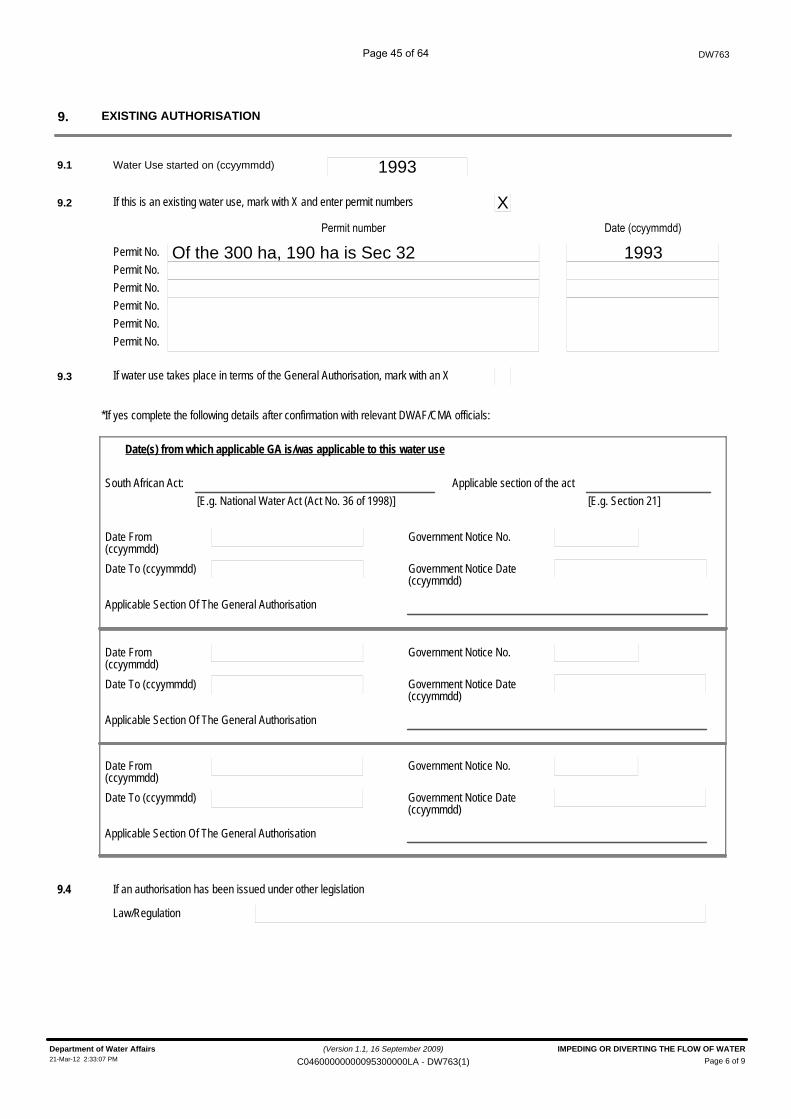
9.1 Water Use started on (ccyymmdd) 1993
Of the 300 ha, 190 ha is Sec 32Permit No.
+�� �������
1993������$$������%
Permit No.Permit No.Permit No.Permit No.Permit No.
9.3 If water use takes place in terms of the General Authorisation, mark with an X
9.2 If this is an existing water use, mark with X and enter permit numbers X
*If yes complete the following details after confirmation with relevant DWAF/CMA officials:
Date(s) from which applicable GA is/was applicable to this water use
South African Act: Applicable section of the act[E.g. National Water Act (Act No. 36 of 1998)] [E.g. Section 21]
Date From(ccyymmdd)Date To (ccyymmdd)
Government Notice No.
Government Notice Date(ccyymmdd)
Applicable Section Of The General Authorisation
Date From(ccyymmdd)Date To (ccyymmdd)
Government Notice No.
Government Notice Date(ccyymmdd)
Applicable Section Of The General Authorisation
Date From(ccyymmdd)Date To (ccyymmdd)
Government Notice No.
Government Notice Date(ccyymmdd)
Applicable Section Of The General Authorisation
9.4 If an authorisation has been issued under other legislation
Law/Regulation
(Version 1.1, 16 September 2009)
Page 6 of 9Department of Water Affairs IMPEDING OR DIVERTING THE FLOW OF WATER21-Mar-12 2:33:07 PM C04600000000095300000LA - DW763(1)
Page 45 of 64

Tribal Authority/Council (if applicable)
Property Number
Portion of property
Surveyor-General Cadastral Code
PROPERTY RELATIONSHIP DETAILS10.
Property Name
DW763
(Complete supplementary forms DW901 & DW902)
Surveyed Property
Title Deed Number
Local Authority (if applicable)
Magisterial District (if applicable)
Initial of the Leader of Village, Community or Tribal Authority
Unsurveyed property
Surname of the Leader of Village, Community or Tribal Authority
Property RelationshipDate
From: To:
Tribal Authority/Council (if applicable)
Property Number
Portion of property
Surveyor-General Cadastral Code
Title Deed Number
Local Authority (if applicable)
Magisterial District (if applicable)
Initial of the Leader of Village, Community or Tribal Authority
Surname of the Leader of Village, Community or Tribal Authority
Tribal Authority/Council (if applicable)
Property Number
Portion of property
Surveyor-General Cadastral Code
Title Deed Number
Local Authority (if applicable)
Magisterial District (if applicable)
Initial of the Leader of Village, Community or Tribal Authority
Surname of the Leader of Village, Community or Tribal Authority
Tribal Authority/Council (if applicable)
Property Number
Portion of property
Surveyor-General Cadastral Code
Title Deed Number
Local Authority (if applicable)
Magisterial District (if applicable)
Initial of the Leader of Village, Community or Tribal Authority
Surname of the Leader of Village, Community or Tribal Authority
T40658/2011
C04600000000095300000
953
0
953MA/0 MOLLENBERG
(Version 1.1, 16 September 2009)
Page 7 of 9Department of Water Affairs IMPEDING OR DIVERTING THE FLOW OF WATER21-Mar-12 2:33:09 PM C04600000000095300000LA - DW763(1)
Page 46 of 64
DW763
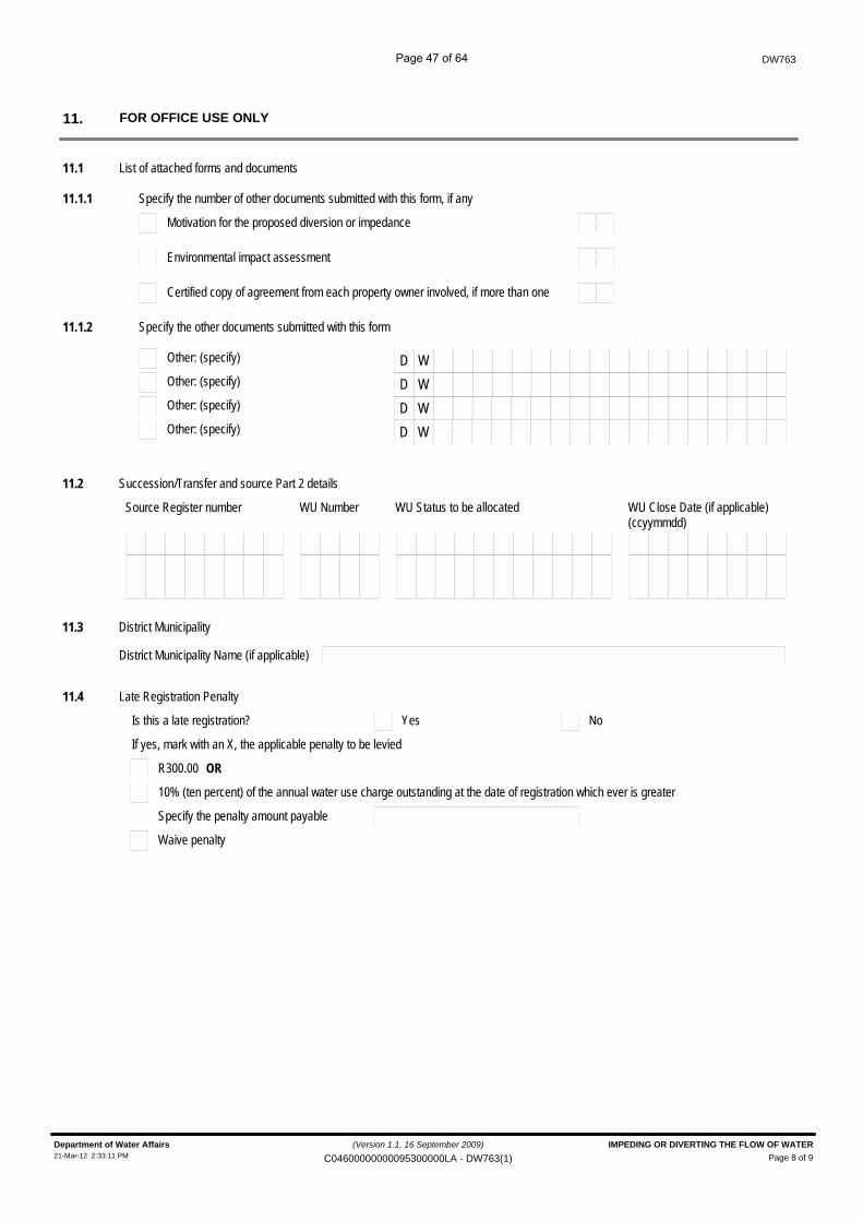
FOR OFFICE USE ONLY11.
11.1 List of attached forms and documents
11.1.1 Specify the number of other documents submitted with this form, if any
Motivation for the proposed diversion or impedance
Environmental impact assessment
Certified copy of agreement from each property owner involved, if more than one
11.1.2 Specify the other documents submitted with this form
Other: (specify) D WOther: (specify) D WOther: (specify) D WOther: (specify) D W
11.2 Succession/Transfer and source Part 2 details
Source Register number WU Number WU Status to be allocated WU Close Date (if applicable)(ccyymmdd)
11.3 District Municipality
District Municipality Name (if applicable)
11.4 Late Registration Penalty
YesIs this a late registration? No
If yes, mark with an X, the applicable penalty to be levied
R300.00 OR
10% (ten percent) of the annual water use charge outstanding at the date of registration which ever is greater
Specify the penalty amount payable
Waive penalty
(Version 1.1, 16 September 2009)
Page 8 of 9Department of Water Affairs IMPEDING OR DIVERTING THE FLOW OF WATER21-Mar-12 2:33:11 PM C04600000000095300000LA - DW763(1)
Page 47 of 64
DW763
File number
Received by:Surname Initials
Position / Rank
Signature
Date stamp of receiving office
Water Use Register Number
(ccyymmdd)Captured on NRWU database
Captured by:Surname Initials
Signature
(Version 1.1, 16 September 2009)
Page 9 of 9Department of Water Affairs IMPEDING OR DIVERTING THE FLOW OF WATER21-Mar-12 2:33:12 PM C04600000000095300000LA - DW763(1)
Page 48 of 64

DW 768 Altering
Page 49 of 64
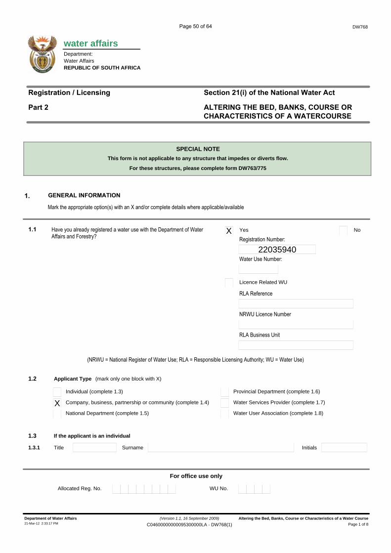
water affairs
DW768
Department:Water AffairsREPUBLIC OF SOUTH AFRICA
������������� ��������
����� � ��������������������������������
�������� !�"�#��$������%�&�������
SPECIAL NOTE
' ������ ���(��)�����
' ����������������� ������������������ ����������������������������� ������������� ��� ���� ���������
���� �!���� ������� ������������ ��"��#��!�������� ���# $��� �������� ��"�� �!������ ��%
X Yes No
22035940����� ���������
Licence Related WU
�#��������$�
��� �# $��$�������
�#��&�� ����� � �
Applicant Type1.2 (mark only one block with X)
Company, business, partnership or community (complete 1.4)XIndividual (complete 1.3)
Water Services Provider (complete 1.7)
Provincial Department (complete 1.6)
If the applicant is an individual1.3
National Department (complete 1.5) Water User Association (complete 1.8)
InitialsTitle Surname1.3.1
For office use only
Allocated Reg. No. WU No.
�����������������(���&����������
This form is not applicable to any structure that impedes or diverts flow.
For these structures, please complete form DW763/775
'�(���������� ������� ����%�� ������)����*��$����������� ���������� $���*��� ���
(Version 1.1, 16 September 2009)
Page 1 of 8Department of Water Affairs Altering the Bed, Banks, Course or Characteristics of a Water Course21-Mar-12 2:33:17 PM C04600000000095300000LA - DW768(1)
Page 50 of 64
Administrator
Rectangle
DW768
ID Number or Passport Number
1.3.2 South African ID (if holder of South African Id) alternatively Passport Number:
Passport Expiry Date (ccyymmdd)
Passport Country Of Issue
1.4 If the applicant is a company, business, partnership or community:
1.4.1 Name of company, business, partnership or community:
1 SAAMSTAAN BELEGGINGS TRUST1.4.2 Business Enterprise Registration Number 16774/96~~======~----1.4.3 Date Established (ccyymmdd) 11996~~======~------------------Country Where Established 1 RSA------------------------------------------------------~
I
1.5 If the applicant is a National Department:
1.5.1 National Department Name:
I"r>.
I 1.6 If the applicant is a Provincial Department:
I 1.6.1 Province:f1.6.2 Provincial Deparment Name
1.7 If the applicant is a Water Services Provider:
1.7.1 Name ofWSP:
1.8 If the applicant is a Water User Association:
1.8.1 Name ofWUA:
Delete the words that are not applicable IIwe (FULL NAME(S))
f'l-]ereby declare that the information provided by me/us in this application form is, to the best of my/our knowledge, true andcorrect.
Desi ation of . nature
0824536662Thumb print Contact number during office hours
2P{~J~3~oDate (ccyy/mm/dd)
Department of Water Affairs16-Mar-12 11 :49;54 AM
(Version 1.1, 16 September 2009) Altering the Bed, Banks, Course or Characteristics of a Water Course
C04600000000095300000 - DW768(1) Page 2 of 8
Page 51 of 64
(Mark only one box with an X)
If yes, complete the following source details:
Is this a "succession-in-title" related Water Use?
DW768
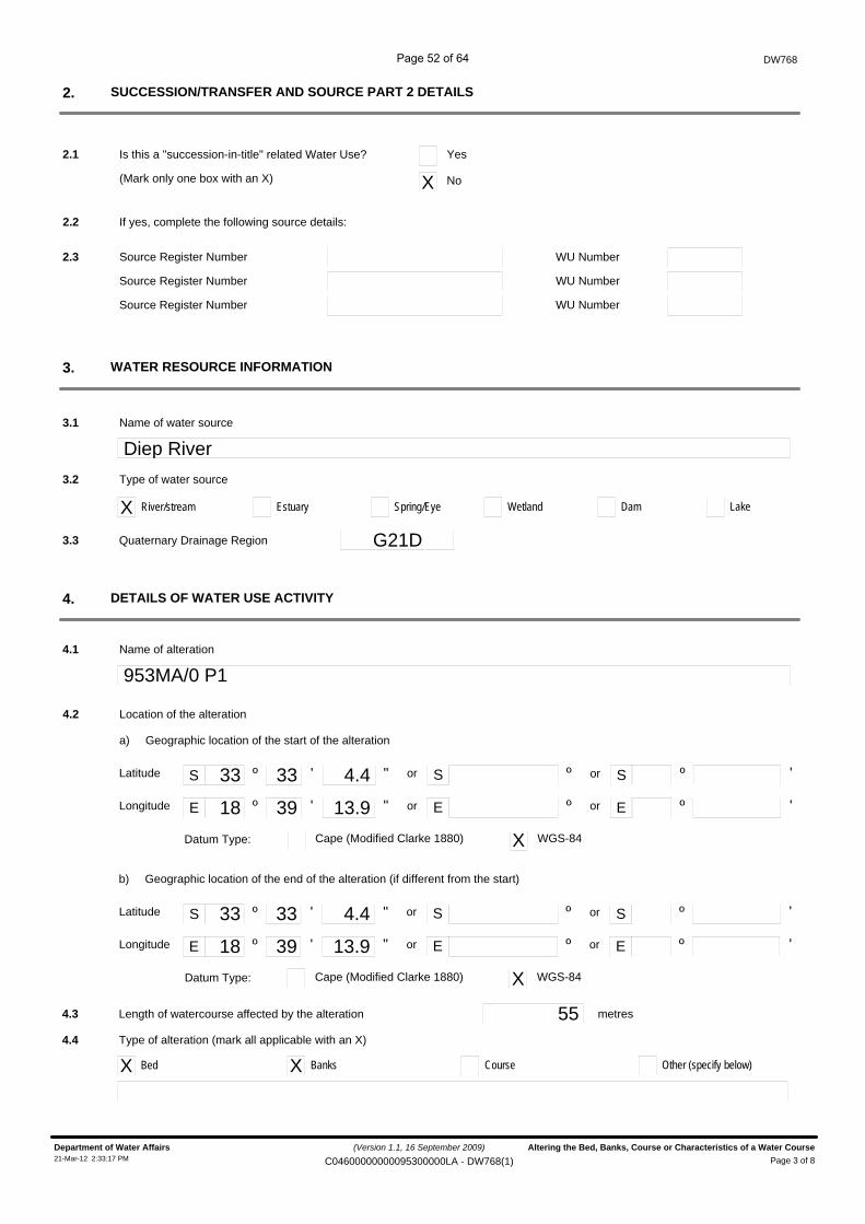
SUCCESSION/TRANSFER AND SOURCE PART 2 DETAILS2.
2.1 Yes
X No
2.2
Source Register Number2.3 WU Number
Source Register Number WU Number
Source Register Number WU Number
WATER RESOURCE INFORMATION3.
Name of water source
Diep River3.1
3.2
X River/stream
Type of water source
Estuary Spring/Eye Wetland Dam
Quaternary Drainage Region G21D3.3
DETAILS OF WATER USE ACTIVITY4.
Name of alteration
953MA/0 P14.1
Lake
Datum Type:
S º ' " S ºor
E º ' " E º
33 33 4.4
18 39 13.9
º
º or
or
or
'
'
S
E
Latitude
Longitude
Cape (Modified Clarke 1880) X WGS-84
4.2 Location of the alteration
Geographic location of the start of the alterationa)
Datum Type:
S º ' " S ºor
E º ' " E º
33 33 4.4
18 39 13.9
º
º or
or
or
'
'
S
E
Latitude
Longitude
Cape (Modified Clarke 1880) X WGS-84
Geographic location of the end of the alteration (if different from the start)b)
Length of watercourse affected by the alteration 55 metres4.3
4.4
X Bed
Type of alteration (mark all applicable with an X)
X Banks Course Other (specify below)
(Version 1.1, 16 September 2009)
Page 3 of 8Department of Water Affairs Altering the Bed, Banks, Course or Characteristics of a Water Course21-Mar-12 2:33:17 PM C04600000000095300000LA - DW768(1)
Page 52 of 64
DW768
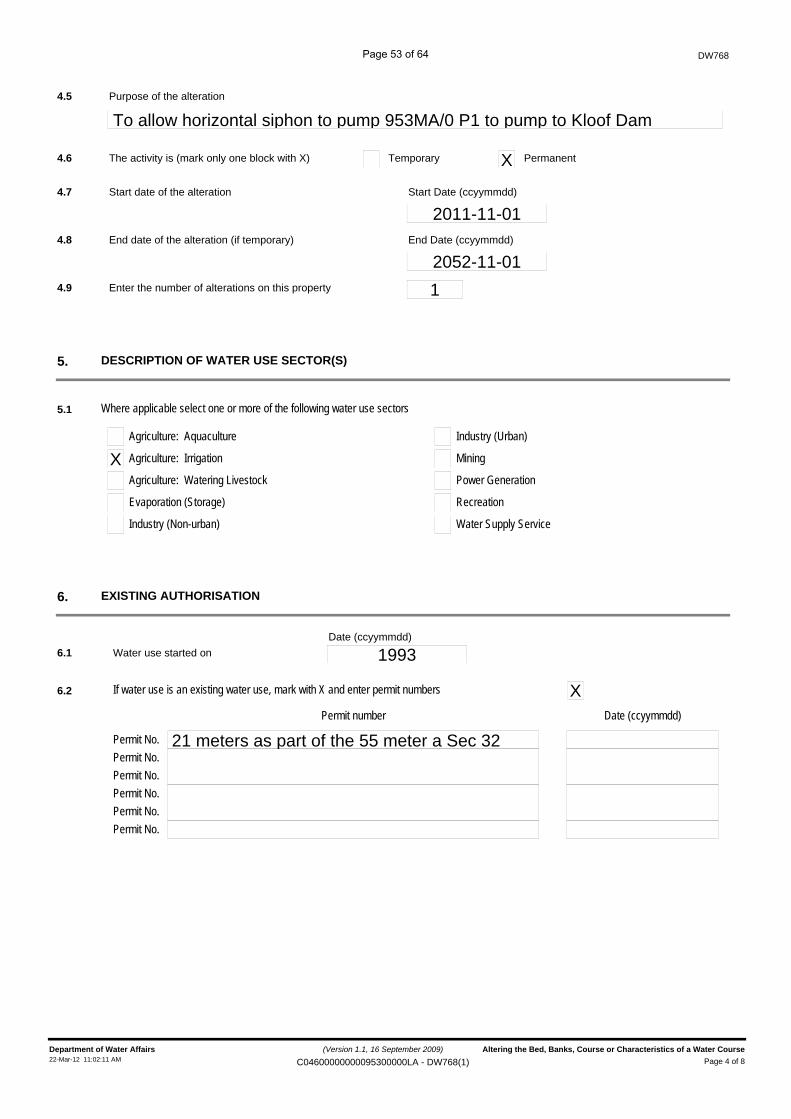
DESCRIPTION OF WATER USE SECTOR(S)5.
5.1 Where applicable select one or more of the following water use sectors
Agriculture: Aquaculture
X Agriculture: Irrigation
Agriculture: Watering Livestock
Evaporation (Storage)
Industry (Non-urban)
Industry (Urban)
Mining
Power Generation
Recreation
Water Supply Service
Purpose of the alteration
To allow horizontal siphon to pump 953MA/0 P1 to pump to Kloof Dam4.5
The activity is (mark only one block with X) X4.6 Temporary Permanent
4.7 Start date of the alteration
2011-11-01Start Date (ccyymmdd)
4.8 End date of the alteration (if temporary)
2052-11-01End Date (ccyymmdd)
EXISTING AUTHORISATION6.
6.1 Water use started on 1993
21 meters as part of the 55 meter a Sec 32Permit No.
Permit number Date (ccyymmdd)
Permit No.Permit No.Permit No.Permit No.Permit No.
6.2 If water use is an existing water use, mark with X and enter permit numbers X
Date (ccyymmdd)
4.9 Enter the number of alterations on this property 1
(Version 1.1, 16 September 2009)Page 4 of 8
Department of Water Affairs Altering the Bed, Banks, Course or Characteristics of a Water Course22-Mar-12 11:02:11 AM C04600000000095300000LA - DW768(1)
Page 53 of 64
DW768
6.3 If water use is in terms of the General Authorisation, mark with X
*If yes complete the following details after confirmation with relevant DWAF/CMA officials:
Date(s) from which applicable GA is/was applicable to this water use
South African Act: Applicable section of the act[E.g. National Water Act (Act No. 36 of 1998)] [E.g. Section 21]
Date From(ccyymmdd)Date To (ccyymmdd)
Government Notice No.
Government Notice Date(ccyymmdd)
Applicable Section Of The General Authorisation
Date From(ccyymmdd)Date To (ccyymmdd)
Government Notice No.
Government Notice Date(ccyymmdd)
Applicable Section Of The General Authorisation
Date From(ccyymmdd)Date To (ccyymmdd)
Government Notice No.
Government Notice Date(ccyymmdd)
Applicable Section Of The General Authorisation
6.4 If an authorisation has been issued under other legislation
Law/Regulation
(Version 1.1, 16 September 2009)
Page 5 of 8Department of Water Affairs Altering the Bed, Banks, Course or Characteristics of a Water Course21-Mar-12 2:33:17 PM C04600000000095300000LA - DW768(1)
Page 54 of 64

Tribal Authority/Council (if applicable)
Property Number
Portion of property
Surveyor-General Cadastral Code
PROPERTY RELATIONSHIP DETAILS7.
Property Name
DW768
(Complete supplementary forms DW901 & DW902)
Surveyed Property
Title Deed Number
Local Authority (if applicable)
Magisterial District (if applicable)
Initial of the Leader of Village, Community or Tribal Authority
Unsurveyed property
Surname of the Leader of Village, Community or Tribal Authority
Property RelationshipDate
From: To:
Tribal Authority/Council (if applicable)
Property Number
Portion of property
Surveyor-General Cadastral Code
Title Deed Number
Local Authority (if applicable)
Magisterial District (if applicable)
Initial of the Leader of Village, Community or Tribal Authority
Surname of the Leader of Village, Community or Tribal Authority
Tribal Authority/Council (if applicable)
Property Number
Portion of property
Surveyor-General Cadastral Code
Title Deed Number
Local Authority (if applicable)
Magisterial District (if applicable)
Initial of the Leader of Village, Community or Tribal Authority
Surname of the Leader of Village, Community or Tribal Authority
Tribal Authority/Council (if applicable)
Property Number
Portion of property
Surveyor-General Cadastral Code
Title Deed Number
Local Authority (if applicable)
Magisterial District (if applicable)
Initial of the Leader of Village, Community or Tribal Authority
Surname of the Leader of Village, Community or Tribal Authority
T40658/2011
C04600000000095300000
953
0
953MA/0 MOLLENBERG
(Version 1.1, 16 September 2009)
Page 6 of 8Department of Water Affairs Altering the Bed, Banks, Course or Characteristics of a Water Course21-Mar-12 2:33:20 PM C04600000000095300000LA - DW768(1)
Page 55 of 64
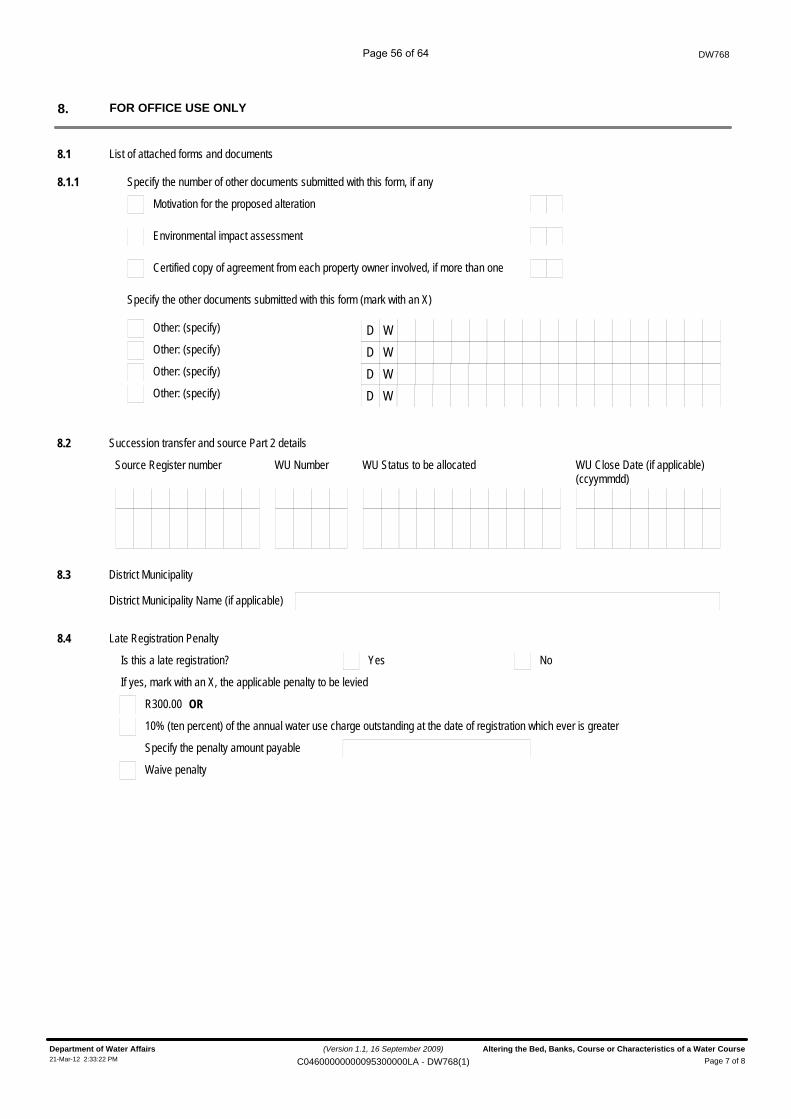
DW768
FOR OFFICE USE ONLY8.
8.1 List of attached forms and documents
8.1.1 Specify the number of other documents submitted with this form, if any
Motivation for the proposed alteration
Environmental impact assessment
Certified copy of agreement from each property owner involved, if more than one
Specify the other documents submitted with this form (mark with an X)
Other: (specify) D WOther: (specify) D WOther: (specify) D WOther: (specify) D W
8.2 Succession transfer and source Part 2 details
Source Register number WU Number WU Status to be allocated WU Close Date (if applicable)(ccyymmdd)
8.3 District Municipality
District Municipality Name (if applicable)
8.4 Late Registration Penalty
YesIs this a late registration? No
If yes, mark with an X, the applicable penalty to be levied
R300.00 OR
10% (ten percent) of the annual water use charge outstanding at the date of registration which ever is greater
Specify the penalty amount payable
Waive penalty
(Version 1.1, 16 September 2009)
Page 7 of 8Department of Water Affairs Altering the Bed, Banks, Course or Characteristics of a Water Course21-Mar-12 2:33:22 PM C04600000000095300000LA - DW768(1)
Page 56 of 64
DW768
File number
Received by:Surname Initials
Position / Rank
Signature
Date stamp of receiving office
Water Use Register Number
(ccyymmdd)Captured on NRWU database
Captured by:Surname Initials
Signature
(Version 1.1, 16 September 2009)
Page 8 of 8Department of Water Affairs Altering the Bed, Banks, Course or Characteristics of a Water Course21-Mar-12 2:33:22 PM C04600000000095300000LA - DW768(1)
Page 57 of 64
DW 784
Pump technical data
Page 58 of 64
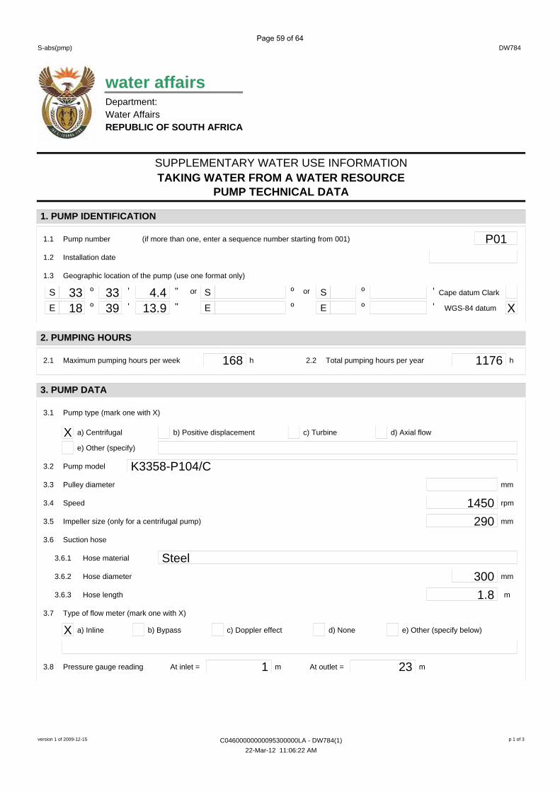
SUPPLEMENTARY WATER USE INFORMATION
DW784S-abs(pmp)
TAKING WATER FROM A WATER RESOURCEPUMP TECHNICAL DATA
water affairsDepartment:Water AffairsREPUBLIC OF SOUTH AFRICA
1. PUMP IDENTIFICATION
1.1 Pump number P01
S º ' " S ºor
E º ' " E º33 33 4.418 39 13.9
ºº
or ''
SE
(if more than one, enter a sequence number starting from 001)
1.2 Installation date
1.3 Geographic location of the pump (use one format only)
Cape datum Clark
XWGS-84 datum
2. PUMPING HOURS
2.1 Maximum pumping hours per week 168 h 2.2 Total pumping hours per year 1176 h
3. PUMP DATA
3.1 Pump type (mark one with X)
X a) Centrifugal b) Positive displacement c) Turbine d) Axial flow
e) Other (specify)
3.2 Pump model K3358-P104/C3.3 Pulley diameter mm
3.4 Speed 1450 rpm
3.5 Impeller size (only for a centrifugal pump) 290 mm
3.6 Suction hose
3.6.1 Hose material Steel3.6.2 Hose diameter 300 mm
3.6.3 Hose length 1.8 m
3.7 Type of flow meter (mark one with X)
X a) Inline b) Bypass c) Doppler effect d) None e) Other (specify below)
3.8 Pressure gauge reading 1 mAt inlet = 23 mAt outlet =
version 1 of 2009-12-15 C04600000000095300000LA - DW784(1) p 1 of 3
22-Mar-12 11:06:22 AM
Page 59 of 64
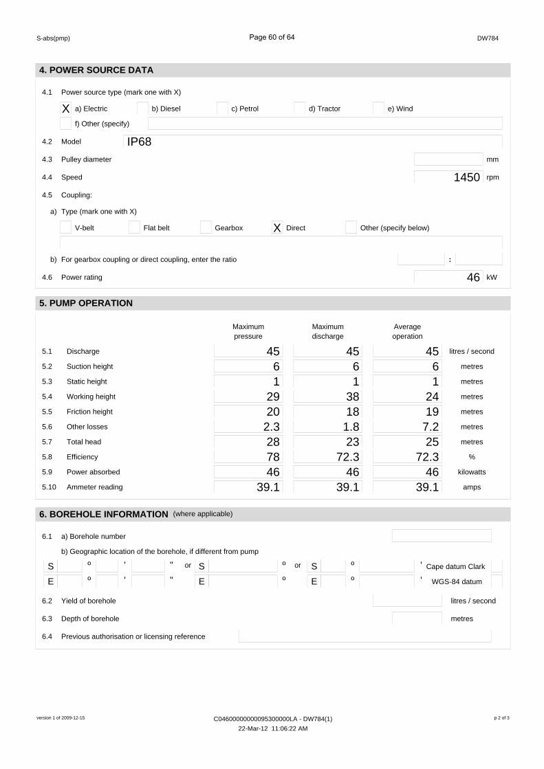
DW784S-abs(pmp)
4. POWER SOURCE DATA
4.1 Power source type (mark one with X)
X a) Electric b) Diesel c) Petrol d) Tractor
f) Other (specify)
e) Wind
4.2 Model IP684.3 Pulley diameter mm
4.4 Speed 1450 rpm
4.5 Coupling:
a) Type (mark one with X)
V-belt Flat belt Gearbox X Direct Other (specify below)
b) For gearbox coupling or direct coupling, enter the ratio :
4.6 Power rating 46 kW
5. PUMP OPERATION
5.1 Discharge
5.2 Suction height
45 litres / second45 45
Maximumpressure
Maximumdischarge
Averageoperation
6 metres6 65.3 Static height 1 metres1 15.4 Working height 29 metres38 245.5 Friction height 20 metres18 195.6 Other losses 2.3 metres1.8 7.25.7 Total head 28 metres23 255.8 Efficiency 78 %72.3 72.35.9 Power absorbed 46 kilowatts46 465.10 Ammeter reading 39.1 amps39.1 39.1
6. BOREHOLE INFORMATION
6.1
S º ' " S ºor
E º ' " E ººº
or ''
SE
b) Geographic location of the borehole, if different from pump
Cape datum Clark
WGS-84 datum
(where applicable)
a) Borehole number
6.2 Yield of borehole litres / second
6.3 Depth of borehole metres
6.4 Previous authorisation or licensing reference
version 1 of 2009-12-15 C04600000000095300000LA - DW784(1) p 2 of 3
22-Mar-12 11:06:22 AM
Page 60 of 64
DW784
7. ESKOM TRANSFORMER
7.1
S º ' " S ºor
E º ' " E ººº
or ''
SE
b) Geographic location of the transformer, if different from pump
Cape datum Clark
WGS-84 datum
(where applicable)
a) ESKOM reference number
7.2 Power rating of the transformer kVA
S-abs(pmp)
FOR OFFICIAL USE ONLY
File number
Water use licence or registration number
Received by:Surname Initials
Rank
Signature
Captured by:Initials
Date stamp of receiving office
Water Management Area
version 1 of 2009-12-15 C04600000000095300000LA - DW784(1) p 3 of 3
22-Mar-12 11:06:22 AM
Page 61 of 64

DW 787 Irrigation
Page 62 of 64
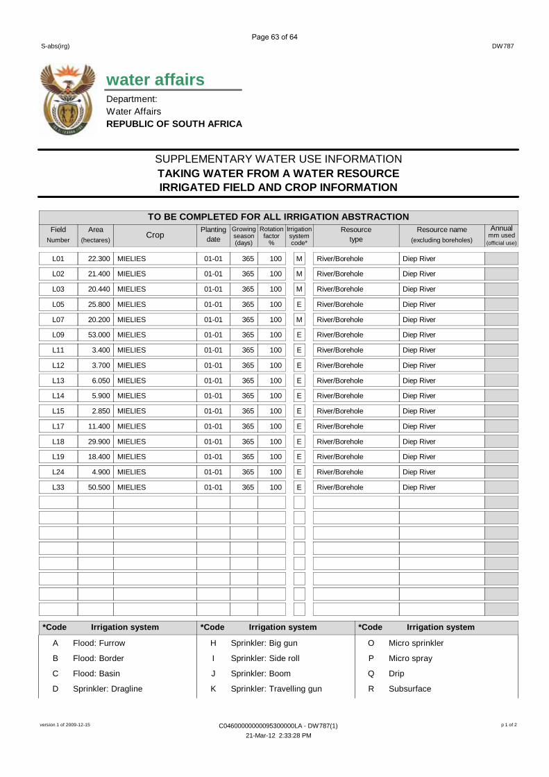
SUPPLEMENTARY WATER USE INFORMATION
DW787S-abs(irg)
TO BE COMPLETED FOR ALL IRRIGATION ABSTRACTION
TAKING WATER FROM A WATER RESOURCEIRRIGATED FIELD AND CROP INFORMATION
FieldNumber
Area(hectares)
CropPlanting
dateGrowingseason(days)
Rotationfactor
%
Irrigationsystemcode*
Resourcetype
Resource name(excluding boreholes)
Annualmm used
*Code Irrigation system *Code Irrigation system *Code Irrigation system
A Flood: Furrow
B Flood: Border
C Flood: Basin
D Sprinkler: Dragline
H Sprinkler: Big gun
I Sprinkler: Side roll
J Sprinkler: Boom
K Sprinkler: Travelling gun
O Micro sprinkler
P Micro spray
Q Drip
R Subsurface
water affairsDepartment:Water AffairsREPUBLIC OF SOUTH AFRICA
(official use)
L01 22.300 MIELIES 01-01 365 100 M River/Borehole Diep River
L02 21.400 MIELIES 01-01 365 100 M River/Borehole Diep River
L03 20.440 MIELIES 01-01 365 100 M River/Borehole Diep River
L05 25.800 MIELIES 01-01 365 100 E River/Borehole Diep River
L07 20.200 MIELIES 01-01 365 100 M River/Borehole Diep River
L09 53.000 MIELIES 01-01 365 100 E River/Borehole Diep River
L11 3.400 MIELIES 01-01 365 100 E River/Borehole Diep River
L12 3.700 MIELIES 01-01 365 100 E River/Borehole Diep River
L13 6.050 MIELIES 01-01 365 100 E River/Borehole Diep River
L14 5.900 MIELIES 01-01 365 100 E River/Borehole Diep River
L15 2.850 MIELIES 01-01 365 100 E River/Borehole Diep River
L17 11.400 MIELIES 01-01 365 100 E River/Borehole Diep River
L18 29.900 MIELIES 01-01 365 100 E River/Borehole Diep River
L19 18.400 MIELIES 01-01 365 100 E River/Borehole Diep River
L24 4.900 MIELIES 01-01 365 100 E River/Borehole Diep River
L33 50.500 MIELIES 01-01 365 100 E River/Borehole Diep River
version 1 of 2009-12-15 C04600000000095300000LA - DW787(1) p 1 of 2
21-Mar-12 2:33:28 PM
Page 63 of 64
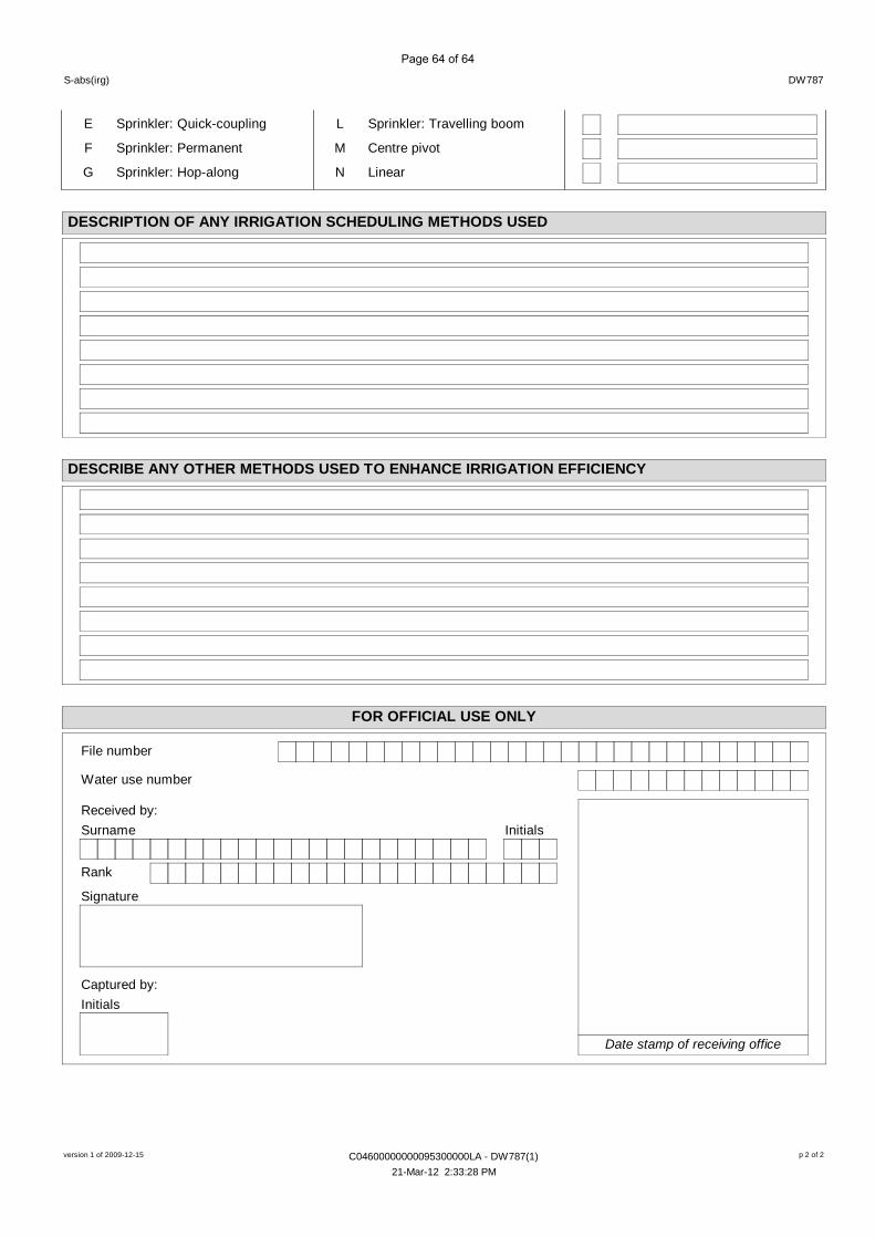
DW787S-abs(irg)
DESCRIPTION OF ANY IRRIGATION SCHEDULING METHODS USED
FOR OFFICIAL USE ONLY
File number
Water use number
Received by:Surname Initials
Rank
Signature
Captured by:Initials
Date stamp of receiving office
DESCRIBE ANY OTHER METHODS USED TO ENHANCE IRRIGATION EFFICIENCY
E Sprinkler: Quick-coupling
F Sprinkler: Permanent
G Sprinkler: Hop-along
L Sprinkler: Travelling boom
M Centre pivot
N Linear
version 1 of 2009-12-15 C04600000000095300000LA - DW787(1) p 2 of 2
21-Mar-12 2:33:28 PM
Page 64 of 64
1
Freshwater Comment for Proposed abstraction Farm 953, Malmesbury December 2011
TABLE OF CONTENTS
1. Background 2
2. Terms of Reference 2
3. Methodology, Assumptions and Limitations of the Study 2
4. Use of the Report 3
5. Study Overview 3
5.1. Overview of Study Area 3
5.2. Project and Activity Description 4
6. Environmental Water Requirements 4
7. Assessment of Impact of Proposed Abstraction on Reserve Requirements 9
8. Conclusion and Recommendations 9
9. References 10
APPENDIX 1: Qualifications of Specialist Consultant and Declaration of Independence
2
Freshwater Comment for Proposed abstraction Farm 953, Malmesbury December 2011
1. BACKGROUND
The owner of Farm 953 Malmesbury has an existing authorization to abstract 525 742 m3 of
water from the Diep River and store it in an off-channel dam. He wishes to increase the amount
abstracted to 1 219 932 m3. The farm is situated immediately north-west of Kalbaskraal.
This report is intended to provide input relating to the environmental flow requirement for the Diep
River at the abstraction point and an assessment of the impact of the proposed increase in
abstraction volume on the downstream aquatic ecosystem.
2. TERMS OF REFERENCE
The suggested work programme is given below:
Task 1: Desktop assessment to determine ecological status of relevant water body
Task 2: Determine Reserve for proposed abstraction point
Task 3: Compile report and recommendations
3. LIMITATIONS AND ASSUMPTIONS OF THE STUDY
Input into this report was informed by a desktop assessment of existing freshwater ecosystem
information for the study area. The instream flow determination was undertaken at a desktop
level utilising the guidelines for the South African methodologies for water resource protection as
outlined in the documentation “Resource Directed Measures for Protection of Water Resources”
(DWAF, 1999).
Limitations and uncertainties often exist within the various techniques adopted to assess the
condition of ecosystems. The following limitations apply to the techniques and methodology
utilized to undertake this study:
Analysis of the freshwater ecosystems was undertaken at a desktop level and did not
involve any field assessment work only data from the RiversDatabase and available
literature; and
Environmental flow recommendations were made using the Desktop Reserve Model and
extrapolating it to the respective catchment. They provide recommendations on the flow
requirements for a desirable state of aquatic ecosystem functioning only and do not
include any determination of the water balance or recommendations regarding
downstream water user requirements.
3
Freshwater Comment for Proposed abstraction Farm 953, Malmesbury December 2011
4. USE OF THIS REPORT
This report reflects the professional judgment of its author. The full and unedited content of this
should be presented to the client. Any summary of these findings should only be produced in
consultation with the author.
5. STUDY OVERVIEW
5.1. Overview of the Study Area
The abstraction site is situated on the Farm 953, Malmesbury (Figure 1). The farm is north of
Kalbaskraal, which is 50km north of Cape Town and 13km south of Malmesbury. The
surrounding area is predominantly rural with farming of livestock and the cultivation of winter
rainfall crops, such as wheat. The area is largely underlain by Malmesbury shales which give it its
gently undulating landscape. Numerous tributaries, perennial and non- perennial, drain the
surrounding area into the Diep River.
The Diep River originates in the Perdeberg and Riebeek-Kasteel Mountains to the east and north
of Malmesbury and flows in a south-easterly direction for approximately 65km before broadening
out near the coast to form Rietvlei on the Table Bay coastline. The catchment area is
approximately 1 360 km2 and is located in a winter rainfall region. The mean annual precipitation
over the northern half of the catchment is 515mm of which about 63% falls in the months May to
August. The river tends to dry up in summer with the discharge of treated wastewater from the
Malmesbury Wastewater Treatment Works (WWTW) contributing to most of the flow during the
dry period. The Diep River near Kalbaskraal is largely modified as a result of upstream urban and
farming activities with its channel mostly lined by exotic eucalyptus trees.
Figure 1. A topographical (3318DA) map of the study area
Abstraction point
4
Freshwater Comment for Proposed abstraction Farm 953, Malmesbury December 2011
5.2. Activity Description
The owner of Farm 953 Malmesbury (see attached diagram) wishes to increase his existing run-
of-river abstraction from the Diep River from 525 742 m3/a to 1 219 932 m3/a. A low weir has
been constructed in the river to enable to abstraction of the water from the river. The abstracted
water will be stored in an off-channel dam for irrigation purposes.
6. Environmental Water Requirements
According to the categories established for the Desktop Reserve determination for the
Department of Water Affairs quaternary catchment G21D, the ecological importance and
sensitivity category of the Diep River is moderate and the present ecological status category is D
(Largely modified). The Desired ecological status for the G21D quaternary is C (moderately
modified). This section provides recommendations on the environmental flow requirements that
should be achieved in the Diep River at the abstraction weir. The Desktop Reserve model was
utilized to generate the flow requirements and extrapolated to the catchment area for the
abstraction point
The Diep River catchment (Figure 2) above the diversion weir is approximately 169km2, which
equates to about 35% of the incremental catchment size for G21D. The Reserve output for G21D
was extrapolated to this smaller catchment.
Figure 2. Catchment area of the proposed abstraction site (yellow)
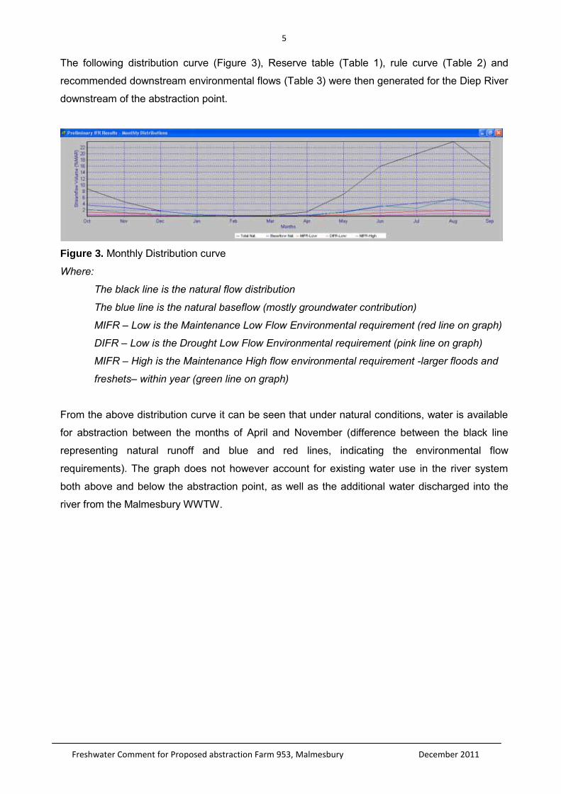
5
Freshwater Comment for Proposed abstraction Farm 953, Malmesbury December 2011
The following distribution curve (Figure 3), Reserve table (Table 1), rule curve (Table 2) and
recommended downstream environmental flows (Table 3) were then generated for the Diep River
downstream of the abstraction point.
Figure 3. Monthly Distribution curve
Where:
The black line is the natural flow distribution
The blue line is the natural baseflow (mostly groundwater contribution)
MIFR – Low is the Maintenance Low Flow Environmental requirement (red line on graph)
DIFR – Low is the Drought Low Flow Environmental requirement (pink line on graph)
MIFR – High is the Maintenance High flow environmental requirement -larger floods and
freshets– within year (green line on graph)
From the above distribution curve it can be seen that under natural conditions, water is available
for abstraction between the months of April and November (difference between the black line
representing natural runoff and blue and red lines, indicating the environmental flow
requirements). The graph does not however account for existing water use in the river system
both above and below the abstraction point, as well as the additional water discharged into the
river from the Malmesbury WWTW.
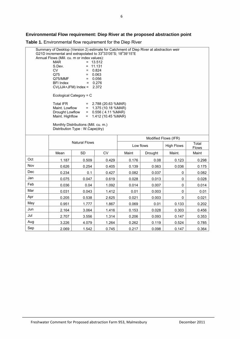
6
Freshwater Comment for Proposed abstraction Farm 953, Malmesbury December 2011
Environmental Flow requirement: Diep River at the proposed abstraction point
Table 1. Environmental flow requirement for the Diep River Summary of Desktop (Version 2) estimate for Catchment of Diep River at abstraction weir G21D incremental and extrapolated to 33o33’05”S; 18o39’15”E Annual Flows (Mill. cu. m or index values):
MAR = 13.512 S.Dev. = 11.131 CV = 0.824 Q75 = 0.063 Q75/MMF = 0.056 BFI Index = 0.276 CV(JJA+JFM) Index = 2.372 Ecological Category = C Total IFR = 2.788 (20.63 %MAR) Maint. Lowflow = 1.375 (10.18 %MAR) Drought Lowflow = 0.556 ( 4.11 %MAR) Maint. Highflow = 1.412 (10.45 %MAR) Monthly Distributions (Mill. cu. m.) Distribution Type : W.Cape(dry)
Natural Flows
Modified Flows (IFR)
Low flows High Flows Total Flows
Mean SD CV Maint Drought Maint. Maint
Oct 1.187 0.509 0.429 0.176 0.08 0.123 0.298 Nov 0.626 0.254 0.405 0.139 0.063 0.036 0.175 Dec 0.234 0.1 0.427 0.082 0.037 0 0.082 Jan 0.075 0.047 0.619 0.028 0.013 0 0.028 Feb 0.036 0.04 1.092 0.014 0.007 0 0.014 Mar 0.031 0.043 1.412 0.01 0.003 0 0.01 Apr 0.205 0.538 2.625 0.021 0.003 0 0.021 May 0.951 1.777 1.867 0.069 0.01 0.133 0.202 Jun 2.164 3.064 1.416 0.153 0.028 0.303 0.456 Jul 2.707 3.556 1.314 0.206 0.093 0.147 0.353 Aug 3.226 4.079 1.264 0.262 0.119 0.524 0.785 Sep 2.069 1.542 0.745 0.217 0.098 0.147 0.364
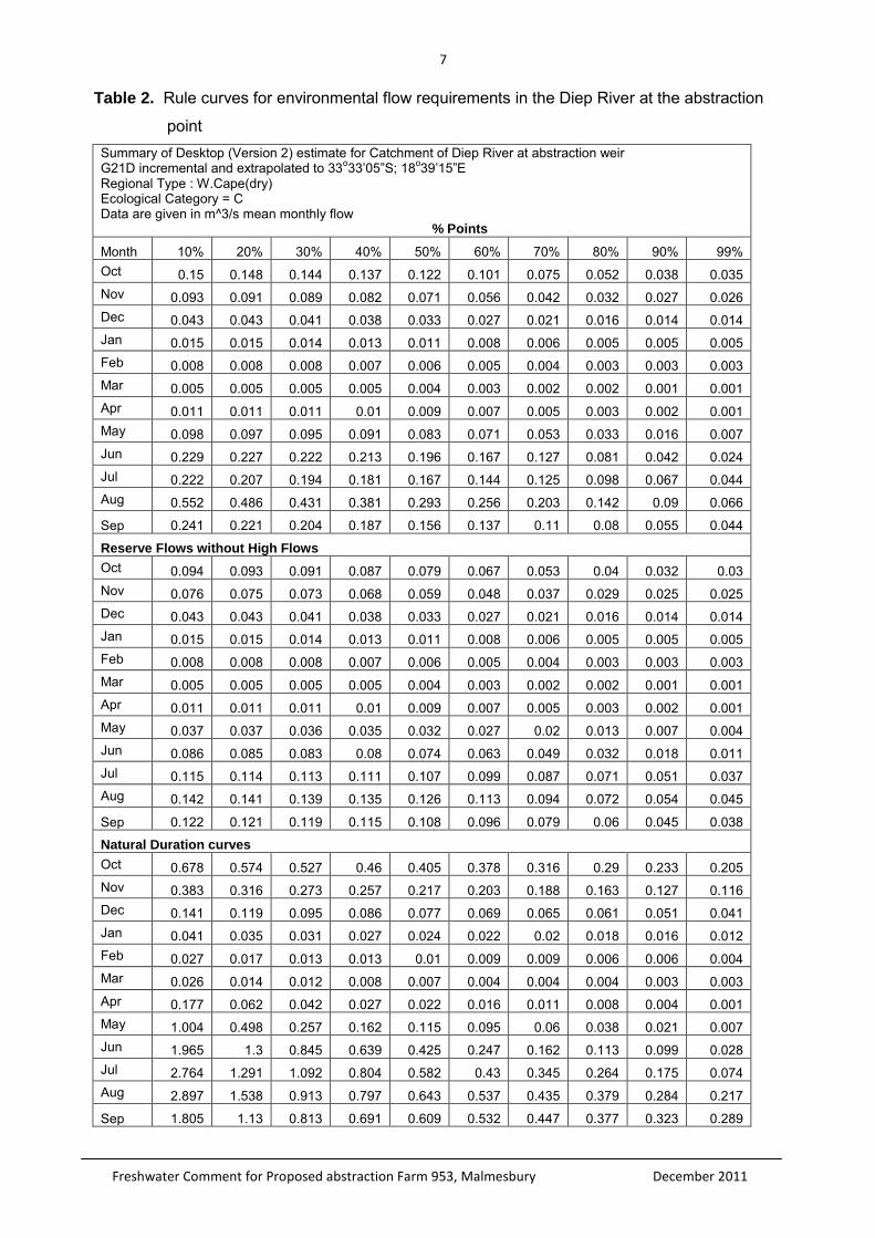
7
Freshwater Comment for Proposed abstraction Farm 953, Malmesbury December 2011
Table 2. Rule curves for environmental flow requirements in the Diep River at the abstraction
point Summary of Desktop (Version 2) estimate for Catchment of Diep River at abstraction weir G21D incremental and extrapolated to 33o33’05”S; 18o39’15”E Regional Type : W.Cape(dry) Ecological Category = C Data are given in m^3/s mean monthly flow % Points
Month 10% 20% 30% 40% 50% 60% 70% 80% 90% 99% Oct 0.15 0.148 0.144 0.137 0.122 0.101 0.075 0.052 0.038 0.035 Nov 0.093 0.091 0.089 0.082 0.071 0.056 0.042 0.032 0.027 0.026 Dec 0.043 0.043 0.041 0.038 0.033 0.027 0.021 0.016 0.014 0.014 Jan 0.015 0.015 0.014 0.013 0.011 0.008 0.006 0.005 0.005 0.005 Feb 0.008 0.008 0.008 0.007 0.006 0.005 0.004 0.003 0.003 0.003 Mar 0.005 0.005 0.005 0.005 0.004 0.003 0.002 0.002 0.001 0.001 Apr 0.011 0.011 0.011 0.01 0.009 0.007 0.005 0.003 0.002 0.001 May 0.098 0.097 0.095 0.091 0.083 0.071 0.053 0.033 0.016 0.007 Jun 0.229 0.227 0.222 0.213 0.196 0.167 0.127 0.081 0.042 0.024 Jul 0.222 0.207 0.194 0.181 0.167 0.144 0.125 0.098 0.067 0.044 Aug 0.552 0.486 0.431 0.381 0.293 0.256 0.203 0.142 0.09 0.066
Sep 0.241 0.221 0.204 0.187 0.156 0.137 0.11 0.08 0.055 0.044
Reserve Flows without High Flows Oct 0.094 0.093 0.091 0.087 0.079 0.067 0.053 0.04 0.032 0.03 Nov 0.076 0.075 0.073 0.068 0.059 0.048 0.037 0.029 0.025 0.025 Dec 0.043 0.043 0.041 0.038 0.033 0.027 0.021 0.016 0.014 0.014 Jan 0.015 0.015 0.014 0.013 0.011 0.008 0.006 0.005 0.005 0.005 Feb 0.008 0.008 0.008 0.007 0.006 0.005 0.004 0.003 0.003 0.003 Mar 0.005 0.005 0.005 0.005 0.004 0.003 0.002 0.002 0.001 0.001 Apr 0.011 0.011 0.011 0.01 0.009 0.007 0.005 0.003 0.002 0.001 May 0.037 0.037 0.036 0.035 0.032 0.027 0.02 0.013 0.007 0.004 Jun 0.086 0.085 0.083 0.08 0.074 0.063 0.049 0.032 0.018 0.011 Jul 0.115 0.114 0.113 0.111 0.107 0.099 0.087 0.071 0.051 0.037 Aug 0.142 0.141 0.139 0.135 0.126 0.113 0.094 0.072 0.054 0.045
Sep 0.122 0.121 0.119 0.115 0.108 0.096 0.079 0.06 0.045 0.038
Natural Duration curves Oct 0.678 0.574 0.527 0.46 0.405 0.378 0.316 0.29 0.233 0.205 Nov 0.383 0.316 0.273 0.257 0.217 0.203 0.188 0.163 0.127 0.116 Dec 0.141 0.119 0.095 0.086 0.077 0.069 0.065 0.061 0.051 0.041 Jan 0.041 0.035 0.031 0.027 0.024 0.022 0.02 0.018 0.016 0.012 Feb 0.027 0.017 0.013 0.013 0.01 0.009 0.009 0.006 0.006 0.004 Mar 0.026 0.014 0.012 0.008 0.007 0.004 0.004 0.004 0.003 0.003 Apr 0.177 0.062 0.042 0.027 0.022 0.016 0.011 0.008 0.004 0.001 May 1.004 0.498 0.257 0.162 0.115 0.095 0.06 0.038 0.021 0.007 Jun 1.965 1.3 0.845 0.639 0.425 0.247 0.162 0.113 0.099 0.028 Jul 2.764 1.291 1.092 0.804 0.582 0.43 0.345 0.264 0.175 0.074 Aug 2.897 1.538 0.913 0.797 0.643 0.537 0.435 0.379 0.284 0.217
Sep 1.805 1.13 0.813 0.691 0.609 0.532 0.447 0.377 0.323 0.289
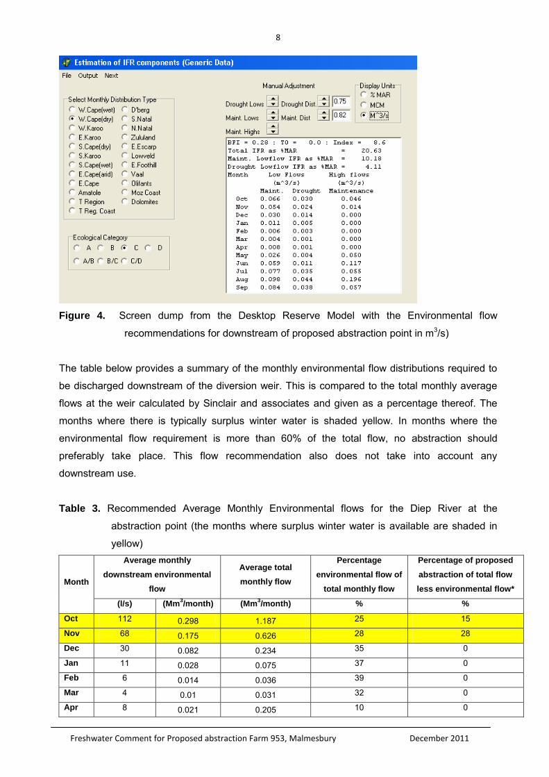
8
Freshwater Comment for Proposed abstraction Farm 953, Malmesbury December 2011
Figure 4. Screen dump from the Desktop Reserve Model with the Environmental flow
recommendations for downstream of proposed abstraction point in m3/s)
The table below provides a summary of the monthly environmental flow distributions required to
be discharged downstream of the diversion weir. This is compared to the total monthly average
flows at the weir calculated by Sinclair and associates and given as a percentage thereof. The
months where there is typically surplus winter water is shaded yellow. In months where the
environmental flow requirement is more than 60% of the total flow, no abstraction should
preferably take place. This flow recommendation also does not take into account any
downstream use.
Table 3. Recommended Average Monthly Environmental flows for the Diep River at the
abstraction point (the months where surplus winter water is available are shaded in
yellow)
Month
Average monthly
downstream environmental
flow
Average total
monthly flow
Percentage
environmental flow of
total monthly flow
Percentage of proposed
abstraction of total flow
less environmental flow*
(l/s) (Mm3/month) (Mm
3/month) % %
Oct 112 0.298 1.187 25 15
Nov 68 0.175 0.626 28 28
Dec 30 0.082 0.234 35 0
Jan 11 0.028 0.075 37 0
Feb 6 0.014 0.036 39 0
Mar 4 0.01 0.031 32 0
Apr 8 0.021 0.205 10 0
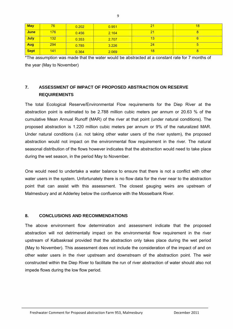
9
Freshwater Comment for Proposed abstraction Farm 953, Malmesbury December 2011
May 76 0.202 0.951 21 18
June 176 0.456 2.164 21 8
July 132 0.353 2.707 13 6
Aug 294 0.785 3.226 24 5
Sept 141 0.364 2.069 18 8
*The assumption was made that the water would be abstracted at a constant rate for 7 months of
the year (May to November)
7. ASSESSMENT OF IMPACT OF PROPOSED ABSTRACTION ON RESERVE
REQUIREMENTS
The total Ecological Reserve/Environmental Flow requirements for the Diep River at the
abstraction point is estimated to be 2.788 million cubic meters per annum or 20.63 % of the
cumulative Mean Annual Runoff (MAR) of the river at that point (under natural conditions). The
proposed abstraction is 1.220 million cubic meters per annum or 9% of the naturalized MAR.
Under natural conditions (i.e. not taking other water users of the river system), the proposed
abstraction would not impact on the environmental flow requirement in the river. The natural
seasonal distribution of the flows however indicates that the abstraction would need to take place
during the wet season, in the period May to November.
One would need to undertake a water balance to ensure that there is not a conflict with other
water users in the system. Unfortunately there is no flow data for the river near to the abstraction
point that can assist with this assessment. The closest gauging weirs are upstream of
Malmesbury and at Adderley below the confluence with the Mosselbank River.
8. CONCLUSIONS AND RECOMMENDATIONS
The above environment flow determination and assessment indicate that the proposed
abstraction will not detrimentally impact on the environmental flow requirement in the river
upstream of Kalbaskraal provided that the abstraction only takes place during the wet period
(May to November). This assessment does not include the consideration of the impact of and on
other water users in the river upstream and downstream of the abstraction point. The weir
constructed within the Diep River to facilitate the run of river abstraction of water should also not
impede flows during the low flow period.
10
Freshwater Comment for Proposed abstraction Farm 953, Malmesbury December 2011
9. REFERENCES
Department of Water Affairs and Forestry. (1999). Resource Directed Measures for Protection of
Water Resources. Volume 3: River Ecosystems Version 1.0. Resource Directed Measures for
Protection of Water Resources, Pretoria, South Africa.
Department of Water Affairs and Forestry. (2007). River Ecoclassification: Manual for Ecostatus
Determination (Version 2). Water Research Commission Report Number KV 168/05. Pretoria.
River Health Programme. (2004). State of River Report for the Diep, Hout Bay, Lourens and
Palmiet.
11
Freshwater Comment for Proposed abstraction Farm 953, Malmesbury December 2011
APPENDIX 1: QUALIFICATIONS OF SPECIALIST CONSULTANT
Contact details: 60 Dummer Street, Somerset West, 7130
Name: Antonia Belcher
Profession: Aquatic Scientist (Pr. Nat. Sc. 400040/10)
Fields of Expertise: Specialist in river and wetland monitoring and reporting
Relevant work experience:
Due to my involvement in the development and implementation of the River Health Programme in
the Western Cape, I have been a key part of the team that has undertaken six catchment or area
wide ‘state-of-river’ assessments as well as routine monitoring and specialised assessments of
rivers and wetlands in all the major catchments for the Western Cape.
Relevant publications:
Belcher, A. 2008. Ecological Assessment of the Vlermuiskelderskloof Spruit. Proposed
construction of an instream dam, Farm 143 Portion 4, Napier.
Belcher, A. 2009. Freshwater Assessment input into the Environmental Management Plan
for Moorreesburg and Malmesbury.
Belcher, A. 2009. Freshwater Assessment for the Proposed Raising of Lushof Dam, Prince
Alfred Hamlet
Belcher, A. 2010. Freshwater Assessment for the Proposed Dam at L’Ormarins, Portions 1
and 4 of Farm 1206, Riebeeksrivier, in the District of Malmesbury
Belcher, A. 2010. Freshwater Assessment for the Proposed Dam at L’Ormarins,
Franschhoek
Belcher, A. 2011. Freshwater Assessment for the Proposed Fourth Kloof Diversion Scheme
Belcher, A. 2011. Freshwater Assessment for the Proposed Dam at Welvaart 443, Ceres
Belcher, A. 2011. Freshwater Assessment: Mapoteng Water Supply Infrastructure Project
Environmental Management Plan
DECLARATION OF INDEPENDENCE
I, Toni Belcher, do hereby declare that I have no conflict of interest related to the work of this
report. Specifically, I declare that I have no personal financial interests in the property and/or
development being assessed in this report, and that I have no personal or financial connections
to the relevant property owners, developers, planners, financiers or consultants of the
development. I declare that the opinion expressed in this report is my own and a true reflection of
my professional expertise.
T. Belcher Print Name Signature Date: 5 December 2011
Related Documents


