Placer County Town of Loomis Annex D-1 Local Hazard Mitigation Plan Update June 2021 Annex D Town of Loomis D.1 Introduction This Annex details the hazard mitigation planning elements specific to the Town of Loomis, a previously participating jurisdiction to the 2016 Placer County Local Hazard Mitigation Plan (LHMP) Update. This Annex is not intended to be a standalone document, but appends to and supplements the information contained in the Base Plan document. As such, all sections of the Base Plan, including the planning process and other procedural requirements apply to and were met by the Town. This Annex provides additional information specific to Loomis, with a focus on providing additional details on the risk assessment and mitigation strategy for this community. D.2 Planning Process As described above, Loomis followed the planning process detailed in Chapter 3 of the Base Plan. In addition to providing representation on the Placer County Hazard Mitigation Planning Committee (HMPC), the Town formulated their own internal planning team to support the broader planning process requirements. Internal planning participants, their positions, and how they participated in the planning process are shown in Table D-1. Additional details on Plan participation and Town representatives are included in Appendix A. Table D-1 Town of Loomis – Planning Team Name Position/Title How Participated Mary Beth Van Voorhis Planning Director Reviewed LHMP planning process and contributed to updated details David Strock Director of Public Works Reviewed LHMP planning process and contributed to updated details Carol Parker Administrative Analyst Reviewed LHMP planning process and contributed to updated details Sean Burke Building Official Reviewed LHMP planning process and contributed to updated details Merrill Buck Town Engineer- Consultant Reviewed LHMP planning process and contributed to updated details Sean Rabé Town Manager Reviewed LHMP planning process and contributed to updated details Brad Donohue Special Project Coordinator- Consultant Reviewed LHMP planning process and contributed to updated details Coordination with other community planning efforts is paramount to the successful implementation of this LHMP Update. This section provides information on how the Town integrated the previously approved 2016 Plan into existing planning mechanisms and programs. Specifically, the Town incorporated into or implemented the 2016 LHMP through other plans and programs shown in Table D-2.

Welcome message from author
This document is posted to help you gain knowledge. Please leave a comment to let me know what you think about it! Share it to your friends and learn new things together.
Transcript
Placer County Town of Loomis Annex D-1 Local Hazard Mitigation Plan Update June 2021
Annex D Town of Loomis
D.1 Introduction
This Annex details the hazard mitigation planning elements specific to the Town of Loomis, a previously
participating jurisdiction to the 2016 Placer County Local Hazard Mitigation Plan (LHMP) Update. This
Annex is not intended to be a standalone document, but appends to and supplements the information
contained in the Base Plan document. As such, all sections of the Base Plan, including the planning process
and other procedural requirements apply to and were met by the Town. This Annex provides additional
information specific to Loomis, with a focus on providing additional details on the risk assessment and
mitigation strategy for this community.
D.2 Planning Process
As described above, Loomis followed the planning process detailed in Chapter 3 of the Base Plan. In
addition to providing representation on the Placer County Hazard Mitigation Planning Committee (HMPC),
the Town formulated their own internal planning team to support the broader planning process
requirements. Internal planning participants, their positions, and how they participated in the planning
process are shown in Table D-1. Additional details on Plan participation and Town representatives are
included in Appendix A.
Table D-1 Town of Loomis – Planning Team
Name Position/Title How Participated
Mary Beth Van Voorhis
Planning Director Reviewed LHMP planning process and contributed to updated details
David Strock Director of Public Works
Reviewed LHMP planning process and contributed to updated details
Carol Parker Administrative Analyst
Reviewed LHMP planning process and contributed to updated details
Sean Burke Building Official Reviewed LHMP planning process and contributed to updated details
Merrill Buck Town Engineer-Consultant
Reviewed LHMP planning process and contributed to updated details
Sean Rabé Town Manager Reviewed LHMP planning process and contributed to updated details
Brad Donohue Special Project Coordinator-Consultant
Reviewed LHMP planning process and contributed to updated details
Coordination with other community planning efforts is paramount to the successful implementation of this
LHMP Update. This section provides information on how the Town integrated the previously approved
2016 Plan into existing planning mechanisms and programs. Specifically, the Town incorporated into or
implemented the 2016 LHMP through other plans and programs shown in Table D-2.
Placer County Town of Loomis Annex D-2 Local Hazard Mitigation Plan Update June 2021
Table D-2 2016 LHMP Incorporation
Planning Mechanism 2016 LHMP Was Incorporated/Implemented In.
Details: How was it incorporated?
N/A The City had no related planning mechanisms since 2016.
D.3 Community Profile
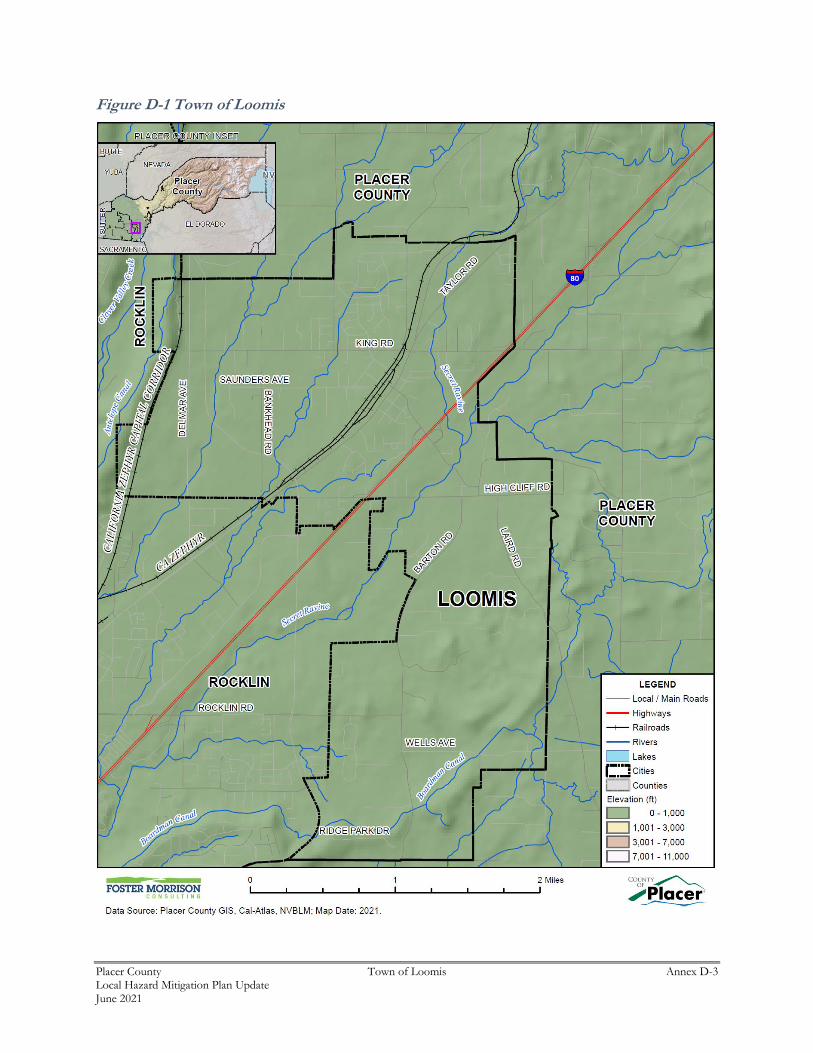
The community profile for the Town of Loomis is detailed in the following sections. Figure D-1 displays
a Town map and the location of Loomis within Placer County.
Placer County Town of Loomis Annex D-3 Local Hazard Mitigation Plan Update June 2021
Figure D-1 Town of Loomis
Placer County Town of Loomis Annex D-4 Local Hazard Mitigation Plan Update June 2021
D.3.1. Geography and Climate
Loomis is a small, semi-rural community located in rapidly urbanizing western Placer County in
California’s Central Valley. The Town is located approximately 25 miles northeast of the City of
Sacramento, along Interstate 80. Loomis is in the western portion of the Loomis Basin, an 80-square mile
area of the Placer County foothills. The town ranges in elevation from approximately 399 to 625 feet above
msl and covers an area of about 7.3 square miles. Stream drainages in the area include Antelope Creek and
Secret Ravine.
Interstate 80, traversing northeast through the center of Town, divides Loomis into two distinct areas. The
area north of I-80 contains all the community’s existing retail, office and industrial development, as well
as higher density residential development, bounded by larger semi-rural residential lots. The area south of
I-80 is almost exclusively rural and residential in character.
Loomis’ average temperatures range from the mid 80°F to mid 90°F during the summer to the mid 30°F to
high 40°F during the winter. Loomis receives an average of 36.51 inches of rain annually and only an
occasional dusting of snow in the winter.
D.3.2. History
As early as 1825, trappers and hunters following the American River came into the Loomis basin. Like the
beginnings of many cities in Placer County, Loomis began as a mining town, but soon became a booming
center of the fruit-growing industry, supporting many packinghouses. During the 1850s miners worked
along Secret Ravine and farmers and ranchers began to move into the Loomis area. The Town was
established in 1850, but not incorporated until 1984. The Central Pacific Railroad was constructed through
Loomis in 1864. By 1872 the transcontinental link was completed and helped to expand the market for
fruits, which were being produced on a commercial scale. For several years, fruit from the Loomis area
was world renowned for its quality. Eventually disease destroyed many orchards established in the late
1800s and fruit production declined significantly. Today it is a very small part of the town’s economy.
D.3.3. Economy
US Census estimates show economic characteristics for the Town of Loomis. These are shown in Table
D-3 and Table D-4. Mean household income in the Town was $121,508. Median household income in the
Town was $83,162.
Table D-3 Town of Loomis – Civilian Employed Population 16 years and Over
Industry Estimated Employment
Percent
Agriculture, forestry, fishing and hunting, and mining 0 0.0%
Construction 392 12.8%
Manufacturing 235 7.7%
Wholesale trade 41 1.3%
Retail trade 502 16.4%
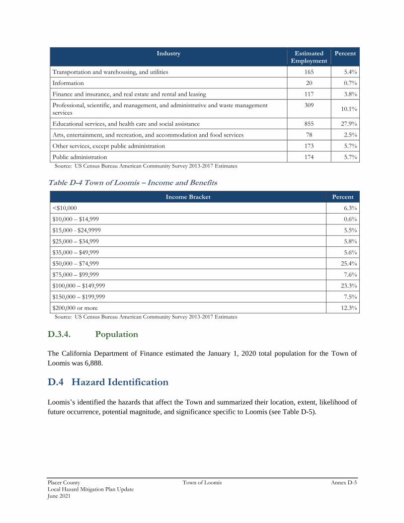
Placer County Town of Loomis Annex D-5 Local Hazard Mitigation Plan Update June 2021
Industry Estimated Employment
Percent
Transportation and warehousing, and utilities 165 5.4%
Information 20 0.7%
Finance and insurance, and real estate and rental and leasing 117 3.8%
Professional, scientific, and management, and administrative and waste management services
309 10.1%
Educational services, and health care and social assistance 855 27.9%
Arts, entertainment, and recreation, and accommodation and food services 78 2.5%
Other services, except public administration 173 5.7%
Public administration 174 5.7%
Source: US Census Bureau American Community Survey 2013-2017 Estimates
Table D-4 Town of Loomis – Income and Benefits
Income Bracket Percent
<$10,000 6.3%
$10,000 – $14,999 0.6%
$15,000 - $24,9999 5.5%
$25,000 – $34,999 5.8%
$35,000 – $49,999 5.6%
$50,000 – $74,999 25.4%
$75,000 – $99,999 7.6%
$100,000 – $149,999 23.3%
$150,000 – $199,999 7.5%
$200,000 or more 12.3%
Source: US Census Bureau American Community Survey 2013-2017 Estimates
D.3.4. Population
The California Department of Finance estimated the January 1, 2020 total population for the Town of
Loomis was 6,888.
D.4 Hazard Identification
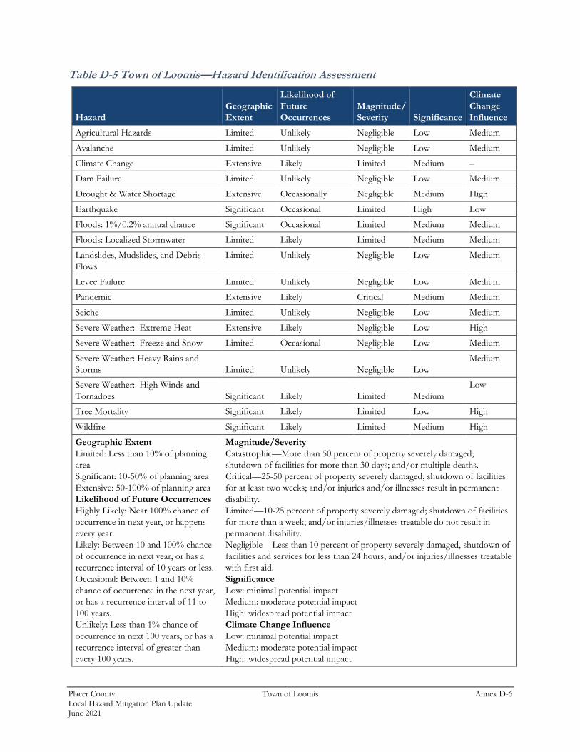
Loomis’s identified the hazards that affect the Town and summarized their location, extent, likelihood of
future occurrence, potential magnitude, and significance specific to Loomis (see Table D-5).
Placer County Town of Loomis Annex D-6 Local Hazard Mitigation Plan Update June 2021
Table D-5 Town of Loomis—Hazard Identification Assessment
Hazard
Geographic
Extent
Likelihood of
Future
Occurrences
Magnitude/
Severity Significance
Climate
Change
Influence
Agricultural Hazards Limited Unlikely Negligible Low Medium
Avalanche Limited Unlikely Negligible Low Medium
Climate Change Extensive Likely Limited Medium –
Dam Failure Limited Unlikely Negligible Low Medium
Drought & Water Shortage Extensive Occasionally Negligible Medium High
Earthquake Significant Occasional Limited High Low
Floods: 1%/0.2% annual chance Significant Occasional Limited Medium Medium
Floods: Localized Stormwater Limited Likely Limited Medium Medium
Landslides, Mudslides, and Debris
Flows
Limited Unlikely Negligible Low Medium
Levee Failure Limited Unlikely Negligible Low Medium
Pandemic Extensive Likely Critical Medium Medium
Seiche Limited Unlikely Negligible Low Medium
Severe Weather: Extreme Heat Extensive Likely Negligible Low High
Severe Weather: Freeze and Snow Limited Occasional Negligible Low Medium
Severe Weather: Heavy Rains and
Storms Limited Unlikely Negligible Low
Medium
Severe Weather: High Winds and
Tornadoes Significant Likely Limited Medium
Low
Tree Mortality Significant Likely Limited Low High
Wildfire Significant Likely Limited Medium High
Geographic Extent
Limited: Less than 10% of planning
area
Significant: 10-50% of planning area
Extensive: 50-100% of planning area
Likelihood of Future Occurrences
Highly Likely: Near 100% chance of
occurrence in next year, or happens
every year.
Likely: Between 10 and 100% chance
of occurrence in next year, or has a
recurrence interval of 10 years or less.
Occasional: Between 1 and 10%
chance of occurrence in the next year,
or has a recurrence interval of 11 to
100 years.
Unlikely: Less than 1% chance of
occurrence in next 100 years, or has a
recurrence interval of greater than
every 100 years.
Magnitude/Severity
Catastrophic—More than 50 percent of property severely damaged;
shutdown of facilities for more than 30 days; and/or multiple deaths.
Critical—25-50 percent of property severely damaged; shutdown of facilities
for at least two weeks; and/or injuries and/or illnesses result in permanent
disability.
Limited—10-25 percent of property severely damaged; shutdown of facilities
for more than a week; and/or injuries/illnesses treatable do not result in
permanent disability.
Negligible—Less than 10 percent of property severely damaged, shutdown of
facilities and services for less than 24 hours; and/or injuries/illnesses treatable
with first aid.
Significance
Low: minimal potential impact
Medium: moderate potential impact
High: widespread potential impact
Climate Change Influence
Low: minimal potential impact
Medium: moderate potential impact
High: widespread potential impact
Placer County Town of Loomis Annex D-7 Local Hazard Mitigation Plan Update June 2021
D.5 Hazard Profile and Vulnerability Assessment
The intent of this section is to profile Loomis’s hazards and assess the Town’s vulnerability separate from
that of the Placer County Planning Area as a whole, which has already been assessed in Section 4.3 Hazard
Profiles and Vulnerability Assessment in the Base Plan. The hazard profiles in the Base Plan discuss overall
impacts to the Placer County Planning Area and describes the hazard problem description, hazard location
and extent, magnitude/severity, previous occurrences of hazard events and the likelihood of future
occurrences. Hazard profile information specific to the Town is included in this Annex. This vulnerability
assessment analyzes the property, population, critical facilities, and other assets at risk to hazards ranked
of medium or high significance specific to the Town (as identified in the Significance column of Table D-5)
and also includes a vulnerability assessment to the three primary hazards to the State of California:
earthquake, flood, and wildfire. For more information about how hazards affect the County as a whole, see
Chapter 4 Risk Assessment in the Base Plan.
D.5.1. Hazard Profiles
Each hazard vulnerability assessment in Section D.5.3, includes a hazard profile/problem description as to
how each medium or high significant hazard affects the Town and includes information on past hazard
occurrences and the likelihood of future hazard occurrence. The intent of this section is to provide
jurisdictional specific information on hazards and further describes how the hazards and risks differ across
the Placer County Planning Area.
D.5.2. Vulnerability Assessment and Assets at Risk
This section identifies Loomis’s total assets at risk, including values at risk, populations at risk, critical
facilities and infrastructure, natural resources, and historic and cultural resources. Growth and development
trends are also presented for the community. This data is not hazard specific, but is representative of total
assets at risk within the community.
Values at Risk
The following data from the Placer County Assessor’s Office is based on the 2020 Assessor’s data. The
methodology used to derive property values is the same as in Section 4.3.1 of the Base Plan. This data
should only be used as a guideline to overall values in the County, as the information has some limitations.
The most significant limitations are created by Proposition 13 and the Williamson Act as detailed in the
Base Plan. With respect to Proposition 13, instead of adjusting property values annually, the values are not
adjusted or assessed at fair market value until a property transfer occurs. As a result, overall value
information is most likely low and does not reflect current market value of properties within the County. It
is also important to note, in the event of a disaster, it is generally the value of the infrastructure or
improvements to the land that is of concern or at risk. Generally, the land itself is not a loss. However,
depending on the type of hazard and impact of any given hazard event, land values may be adversely
affected; thus, land values are included as appropriate. Table D-6 shows the 2020 Assessor’s values and
content replacement values (e.g., the values at risk) broken down by property type for the Town.

Placer County Town of Loomis Annex D-8 Local Hazard Mitigation Plan Update June 2021
Table D-6 Town of Loomis – Total Values at Risk by Property Use
Property Use Total Parcel Count
Improved Parcel Count
Total Land Value
Improved Structure Value
Estimated Contents Value
Total Value
Agricultural 1 1 $13,875 $109,235 $109,235 $232,345
Commercial 132 86 $42,718,862 $51,275,670 $51,275,670 $145,270,202
Industrial 132 114 $19,276,129 $54,492,331 $81,738,498 $155,506,958
Institutional 30 16 $2,596,293 $15,229,453 $15,229,453 $33,055,199
Miscellaneous 284 10 $28,153,573 $7,523,815 $7,523,815 $43,201,203
Natural / Open Space 26 4 $1,681,942 $2,385,381 $2,385,381 $6,452,704
Residential 2,390 2,321 $315,108,683 $687,552,151 $343,776,063 $1,346,436,897
Loomis Total 2,995 2,552 $409,549,357 $818,568,036 $502,038,115 $1,730,155,508
Source: Placer County 2020 Parcel/Assessor’s Data
Critical Facilities and Infrastructure
Critical facilities and infrastructure are those buildings and infrastructure that are crucial to a community.
Should these be damaged, it makes it more difficult for the community to respond to and recover from a
disaster. For purposes of this plan, a critical facility is defined as:
Any facility, including without limitation, a structure, infrastructure, property, equipment or service, that if
adversely affected during a hazard event may result in severe consequences to public health and safety or interrupt
essential services and operations for the community at any time before, during and after the hazard event.
This definition was refined by separating out three classes of critical facilities as further described in Section
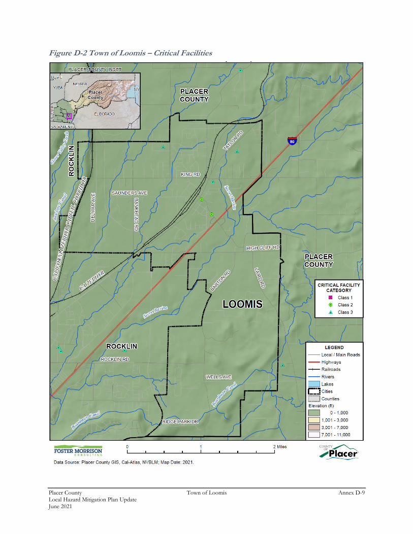
4.3.1 of the base plan. An inventory of critical facilities in the Town of Loomis from Placer County GIS is
shown on Figure D-2 and detailed in Table D-7. Details of critical facility definition, type, name, address,
and jurisdiction by hazard zone are listed in Appendix F.
Placer County Town of Loomis Annex D-9 Local Hazard Mitigation Plan Update June 2021
Figure D-2 Town of Loomis – Critical Facilities
Placer County Town of Loomis Annex D-10 Local Hazard Mitigation Plan Update June 2021
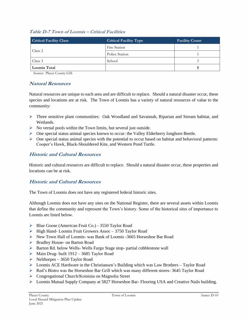
Table D-7 Town of Loomis – Critical Facilities
Critical Facility Class Critical Facility Type Facility Count
Class 2 Fire Station 1
Police Station 1
Class 3 School 3
Loomis Total 5
Source: Placer County GIS
Natural Resources
Natural resources are unique to each area and are difficult to replace. Should a natural disaster occur, these
species and locations are at risk. The Town of Loomis has a variety of natural resources of value to the
community:
➢ Three sensitive plant communities: Oak Woodland and Savannah, Riparian and Stream habitat, and
Wetlands.
➢ No vernal pools within the Town limits, but several just outside.
➢ One special status animal species known to occur: the Valley Elderberry longhorn Beetle.
➢ One special status animal species with the potential to occur based on habitat and behavioral patterns:
Cooper’s Hawk, Black-Shouldered Kite, and Western Pond Turtle.
Historic and Cultural Resources
Historic and cultural resources are difficult to replace. Should a natural disaster occur, these properties and
locations can be at risk.
Historic and Cultural Resources
The Town of Loomis does not have any registered federal historic sites.
Although Loomis does not have any sites on the National Register, there are several assets within Loomis
that define the community and represent the Town’s history. Some of the historical sites of importance to
Loomis are listed below.
➢ Blue Goose (American Fruit Co.) - 3550 Taylor Road
➢ High Hand- Loomis Fruit Growers Assoc – 3750 Taylor Road
➢ New Town Hall of Loomis- was Bank of Loomis -3665 Horseshoe Bar Road
➢ Bradley House- on Barton Road
➢ Barton Rd. below Wells- Wells Fargo Stage stop- partial cobblestone wall
➢ Main Drug- built 1912 – 3685 Taylor Road
➢ Nelthorpes – 3650 Taylor Road
➢ Loomis ACE Hardware in the Christiansen’s Building which was Law Brothers – Taylor Road
➢ Red’s Bistro was the Horseshoe Bar Grill which was many different stores- 3645 Taylor Road
➢ Congregational Church/Koininia on Magnolia Street
➢ Loomis Mutual Supply Company at 5827 Horseshoe Bar- Flooring USA and Creative Nails building.
Placer County Town of Loomis Annex D-11 Local Hazard Mitigation Plan Update June 2021
➢ Most structures on Taylor Road between Walnut St. and Horseshoe Bar- all rebuilt shortly after 1915
fire.
➢ Nute/Barton Road house was built in 1891.
➢ Crossley/Turner cabin/barn- still upright
Growth and Development Trends
As part of the planning process, the HMPC looked at changes in growth and development, both past and
future, and examined these changes in the context of hazard-prone areas, and how the changes in growth
and development affect loss estimates and vulnerability over time. Information from the Town of Loomis
General Plan 2013-2021 Housing Element, the California Department of Finance, the US Census Bureau
form the basis of this discussion.
Historic Population Trends and Current Population
Population growth can increase the number of people living in hazard prone areas. Loomis has generally
seen slow and steady growth, with the exception of the 1980s which saw large growth. Loomis has seen
growth rates as shown in Table D-8.
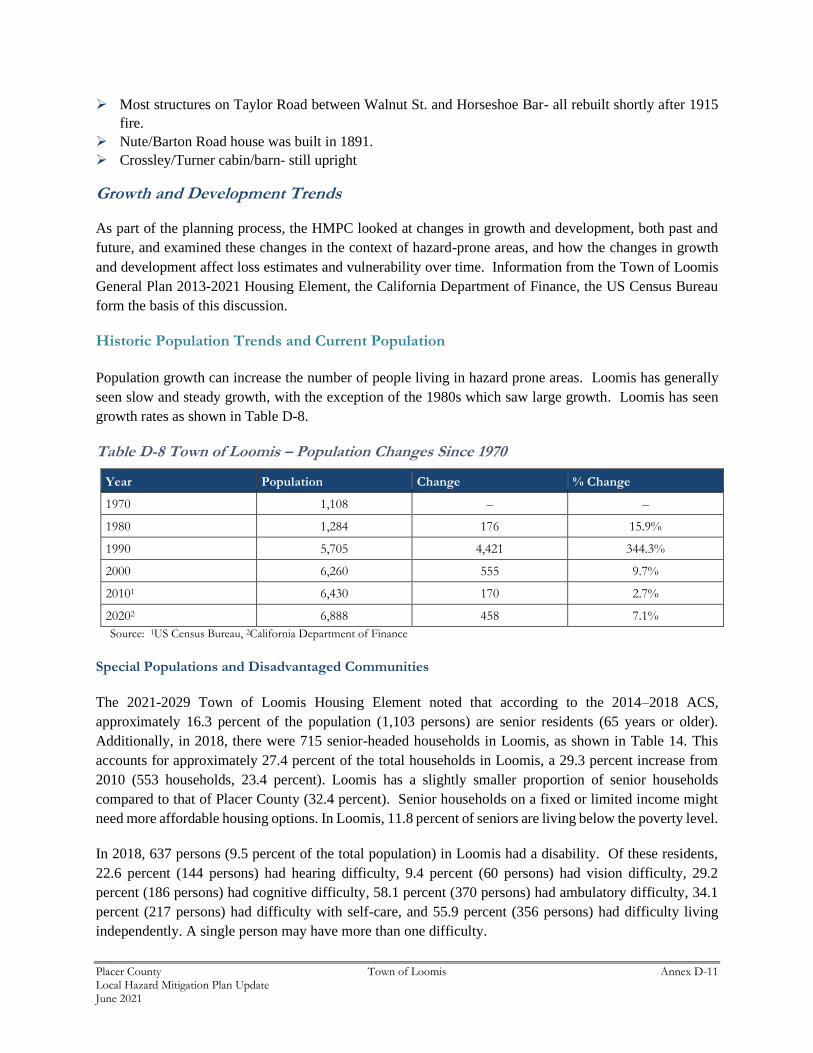
Table D-8 Town of Loomis – Population Changes Since 1970
Year Population Change % Change
1970 1,108 – –
1980 1,284 176 15.9%
1990 5,705 4,421 344.3%
2000 6,260 555 9.7%
20101 6,430 170 2.7%
20202 6,888 458 7.1%
Source: 1US Census Bureau, 2California Department of Finance
Special Populations and Disadvantaged Communities
The 2021-2029 Town of Loomis Housing Element noted that according to the 2014–2018 ACS,
approximately 16.3 percent of the population (1,103 persons) are senior residents (65 years or older).
Additionally, in 2018, there were 715 senior-headed households in Loomis, as shown in Table 14. This
accounts for approximately 27.4 percent of the total households in Loomis, a 29.3 percent increase from
2010 (553 households, 23.4 percent). Loomis has a slightly smaller proportion of senior households
compared to that of Placer County (32.4 percent). Senior households on a fixed or limited income might
need more affordable housing options. In Loomis, 11.8 percent of seniors are living below the poverty level.
In 2018, 637 persons (9.5 percent of the total population) in Loomis had a disability. Of these residents,
22.6 percent (144 persons) had hearing difficulty, 9.4 percent (60 persons) had vision difficulty, 29.2
percent (186 persons) had cognitive difficulty, 58.1 percent (370 persons) had ambulatory difficulty, 34.1
percent (217 persons) had difficulty with self-care, and 55.9 percent (356 persons) had difficulty living
independently. A single person may have more than one difficulty.
Placer County Town of Loomis Annex D-12 Local Hazard Mitigation Plan Update June 2021
It is estimated that there is only one homeless individual on any given day in Looms. The single homeless
individual counted in the Town of Loomis identified as male and reported having been in Loomis for five
years or more.
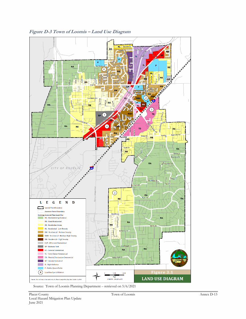
Land Use
State planning law requires that the land use element of a general plan include a statement of the standard
population density, building intensity, and allowed uses for the various land use designations in the plan
(Government Code Section 65302(a)). The Town’s land use designations are generally described below
and mapped on the Land Use Diagram (Figure D-3). The Loomis Municipal Code provides detailed land
use and development standards for development.
With this General Plan, a variety of new land use designations have been established to reflect the more
mixed and, in some cases, more intense land uses envisioned for Loomis. New mixed-use designations
provide the opportunity for a combination of residential, commercial, and office uses on a single site,
depending on the designation. Future land use for the Town of Loomis from the Town of Loomis General
Plan Land Use Element is shown on Figure D-3.
Placer County Town of Loomis Annex D-13 Local Hazard Mitigation Plan Update June 2021
Figure D-3 Town of Loomis – Land Use Diagram
Source: Town of Loomis Planning Department – retrieved on 5/6/2021
Placer County Town of Loomis Annex D-14 Local Hazard Mitigation Plan Update June 2021
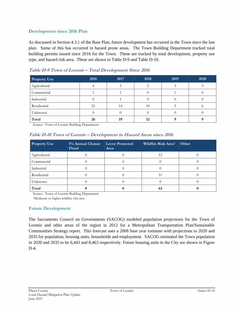
Development since 2016 Plan
As discussed in Section 4.3.1 of the Base Plan, future development has occurred in the Town since the last
plan. Some of this has occurred in hazard prone areas. The Town Building Department tracked total
building permits issued since 2016 for the Town. These are tracked by total development, property use
type, and hazard risk area. These are shown in Table D-9 and Table D-10.
Table D-9 Town of Loomis – Total Development Since 2016
Property Use 2016 2017 2018 2019 2020
Agricultural 4 3 2 3 3
Commercial 1 1 0 1 0
Industrial 0 1 0 0 0
Residential 21 14 10 5 6
Unknown 0 0 0 0 0
Total 26 19 12 9 9
Source: Town of Loomis Building Department
Table D-10 Town of Loomis – Development in Hazard Areas since 2016
Property Use 1% Annual Chance Flood
Levee Protected Area
Wildfire Risk Area1 Other
Agricultural 0 0 12 0
Commercial 0 0 0 0
Industrial 0 0 0 0
Residential 0 0 51 0
Unknown 0 0 0 0
Total 0 0 63 0
Source: Town of Loomis Building Department 1Moderate or higher wildfire risk area
Future Development
The Sacramento Council on Governments (SACOG) modeled population projections for the Town of
Loomis and other areas of the region in 2012 for a Metropolitan Transportation Plan/Sustainable
Communities Strategy report. This forecast uses a 2008 base year estimate with projections to 2020 and
2035 for population, housing units, households and employment. SACOG estimated the Town population
in 2020 and 2035 to be 6,443 and 8,463 respectively. Future housing units in the City are shown in Figure
D-4.
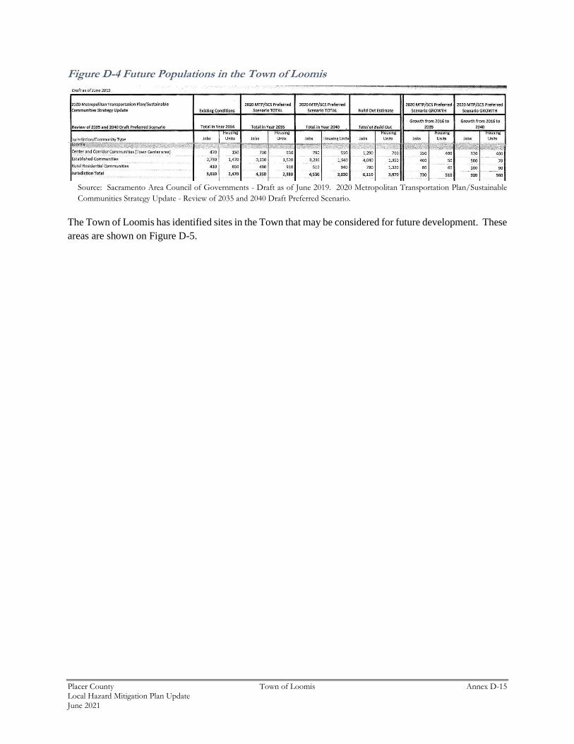
Placer County Town of Loomis Annex D-15 Local Hazard Mitigation Plan Update June 2021
Figure D-4 Future Populations in the Town of Loomis
Source: Sacramento Area Council of Governments - Draft as of June 2019. 2020 Metropolitan Transportation Plan/Sustainable
Communities Strategy Update - Review of 2035 and 2040 Draft Preferred Scenario.
The Town of Loomis has identified sites in the Town that may be considered for future development. These
areas are shown on Figure D-5.
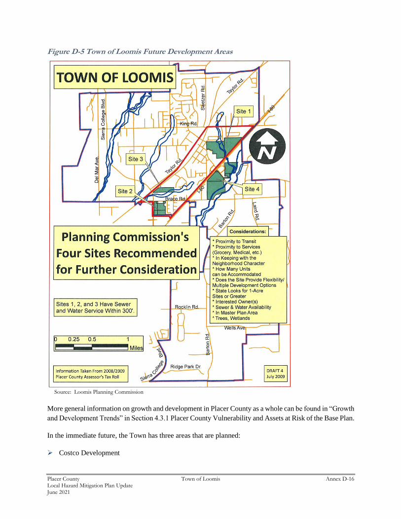
Placer County Town of Loomis Annex D-16 Local Hazard Mitigation Plan Update June 2021
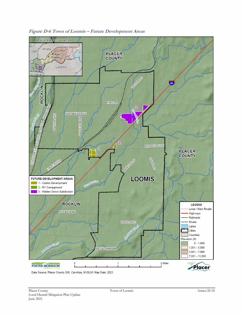
Figure D-5 Town of Loomis Future Development Areas
Source: Loomis Planning Commission
More general information on growth and development in Placer County as a whole can be found in “Growth
and Development Trends” in Section 4.3.1 Placer County Vulnerability and Assets at Risk of the Base Plan.
In the immediate future, the Town has three areas that are planned:
➢ Costco Development
Placer County Town of Loomis Annex D-17 Local Hazard Mitigation Plan Update June 2021
➢ RV Campground (37 campsites on a minimum of 1,800 sq.ft. each for weekend, full time, and part-
time RV travelers)
➢ Hidden Grove Subdivision
GIS Analysis
Using GIS, the following methodology was used in determining parcel counts and acreages with future
development projects in the Town of Loomis. Future development areas in the Town were provided in
mapped format by the Town. 3 areas were provided. Using the GIS parcel spatial file for each of these
areas, the 3 areas and 14 parcels associated with future development projects for which the analysis was to
be performed were identified. Utilizing the future development project spatial layer, the parcel centroid
data was intersected to determine the parcel counts within each area. Figure D-6 shows the locations of
future development areas the Town is planning to develop. Table D-11 shows the parcels and acreages of
each future development area in the Town.
Placer County Town of Loomis Annex D-18 Local Hazard Mitigation Plan Update June 2021
Figure D-6 Town of Loomis – Future Development Areas
Placer County Town of Loomis Annex D-19 Local Hazard Mitigation Plan Update June 2021
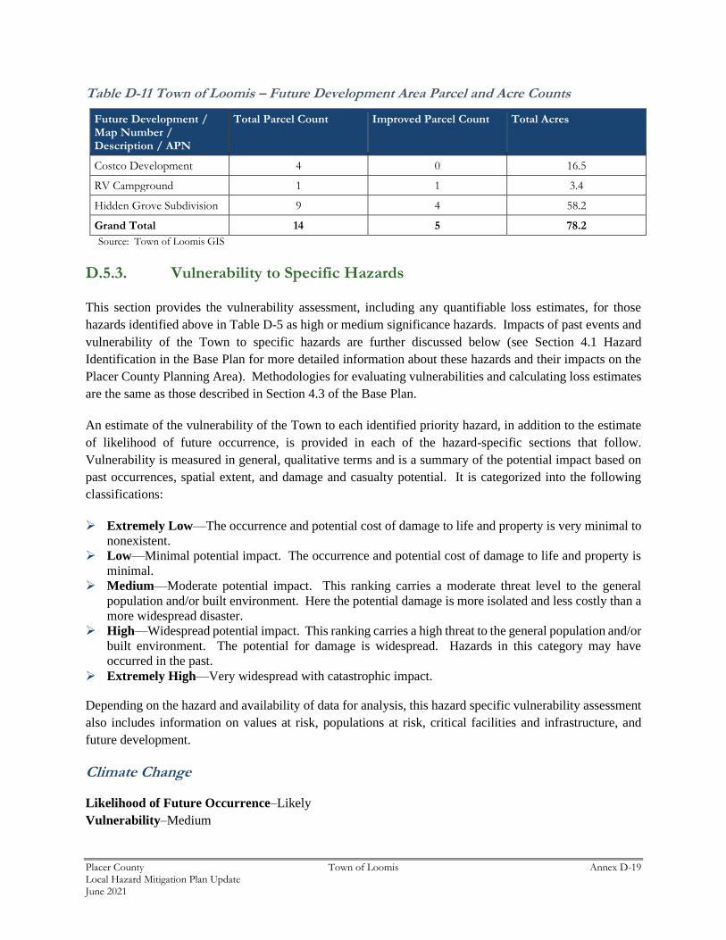
Table D-11 Town of Loomis – Future Development Area Parcel and Acre Counts
Future Development / Map Number / Description / APN
Total Parcel Count Improved Parcel Count Total Acres
Costco Development 4 0 16.5
RV Campground 1 1 3.4
Hidden Grove Subdivision 9 4 58.2
Grand Total 14 5 78.2
Source: Town of Loomis GIS
D.5.3. Vulnerability to Specific Hazards
This section provides the vulnerability assessment, including any quantifiable loss estimates, for those
hazards identified above in Table D-5 as high or medium significance hazards. Impacts of past events and
vulnerability of the Town to specific hazards are further discussed below (see Section 4.1 Hazard
Identification in the Base Plan for more detailed information about these hazards and their impacts on the
Placer County Planning Area). Methodologies for evaluating vulnerabilities and calculating loss estimates
are the same as those described in Section 4.3 of the Base Plan.
An estimate of the vulnerability of the Town to each identified priority hazard, in addition to the estimate
of likelihood of future occurrence, is provided in each of the hazard-specific sections that follow.
Vulnerability is measured in general, qualitative terms and is a summary of the potential impact based on
past occurrences, spatial extent, and damage and casualty potential. It is categorized into the following
classifications:
➢ Extremely Low—The occurrence and potential cost of damage to life and property is very minimal to
nonexistent.
➢ Low—Minimal potential impact. The occurrence and potential cost of damage to life and property is
minimal.
➢ Medium—Moderate potential impact. This ranking carries a moderate threat level to the general
population and/or built environment. Here the potential damage is more isolated and less costly than a
more widespread disaster.
➢ High—Widespread potential impact. This ranking carries a high threat to the general population and/or
built environment. The potential for damage is widespread. Hazards in this category may have
occurred in the past.
➢ Extremely High—Very widespread with catastrophic impact.
Depending on the hazard and availability of data for analysis, this hazard specific vulnerability assessment
also includes information on values at risk, populations at risk, critical facilities and infrastructure, and
future development.
Climate Change
Likelihood of Future Occurrence–Likely
Vulnerability–Medium
Placer County Town of Loomis Annex D-20 Local Hazard Mitigation Plan Update June 2021
Hazard Profile and Problem Description
Climate change adaptation is a key priority of the State of California. The 2018 State of California Multi-
Hazard Mitigation Plan stated that climate change is already affecting California. Sea levels have risen by
as much as seven inches along the California coast over the last century, increasing erosion and pressure
on the state’s infrastructure, water supplies, and natural resources. The State has also seen increased
average temperatures, more extreme hot days, fewer cold nights, a lengthening of the growing season, shifts
in the water cycle with less winter precipitation falling as snow, and earlier runoff of both snowmelt and
rainwater in the year. In addition to changes in average temperatures, sea level, and precipitation patterns,
the intensity of extreme weather events is also changing.
In Placer County and the Town, the HMPC noted that each year it seems to get a bit warmer each year.
Location and Extent
Climate change is a global phenomenon. It is expected to affect the whole of the Town, Placer County, and
State of California. There is no scale to measure the extent of climate change. Climate change exacerbates
other hazards, such as drought, extreme heat, flooding, wildfire, and others. The speed of onset of climate
change is very slow. The duration of climate change is not yet known, but is feared to be tens to hundreds
of years.
Past Occurrences
Climate change has never been directly linked to any declared disasters. While the Town noted that climate
change is of concern, no specific impacts of climate change could be recalled. The Town and HMPC
members noted that the strength of storms does seem to be increasing and the temperatures are getting
hotter. The Town also noted that Public Safety Power Shutoff events have increased – which could be
related to climate change.
Vulnerability to and Impacts from Climate Change
The California Adaptation Planning Guide (APG) prepared by California OES and CNRA was developed
to provide guidance and support for local governments and regional collaboratives to address the
unavoidable consequences of climate change. California’s APG: Understanding Regional Characteristics
has divided California into 11 different regions based on political boundaries, projected climate impacts,
existing environmental setting, socioeconomic factors and regional designations. Placer County falls within
the North Sierra Region characterized as a sparsely settled mountainous region where the region’s economy
is primarily tourism-based. The region is rich in natural resources, biodiversity, and is the source for the
majority of water used by the state. This information can be used to guide climate adaptation planning in
the Town and Placer County Planning Area.
The California APG: Understanding Regional Characteristics identified the following impacts specific to
the North Sierra region in which the Placer County Planning Area is part of:
➢ Temperature increases
➢ Increased duration of high temperatures
Placer County Town of Loomis Annex D-21 Local Hazard Mitigation Plan Update June 2021
➢ Decreased precipitation
➢ Reduced snowpack
➢ Reduced tourism
➢ Ecosystem change
➢ Sensitive species stress
➢ Increased wildfire
Future Development
The Town could see population fluctuations as a result of climate impacts relative to those experienced in
other regions, and these fluctuations are expected to impact demand for housing and other development.
While there are currently no formal studies of specific migration patterns expected to impact the Town and
County region, climate-induced migration was recognized within the UNFCCC Conference of Parties Paris
Agreement of 2015 and is expected to be the focus of future studies.
Drought & Water Shortage
Likelihood of Future Occurrence–Occasional
Vulnerability–Medium
Hazard Profile and Problem Description
Drought is a complex issue involving many factors—it occurs when a normal amount of precipitation and
snow is not available to satisfy an area’s usual water-consuming activities. Drought can often be defined
regionally based on its effects. Drought is different than many of the other natural hazards in that it is not
a distinct event and usually has a slow onset. Drought can severely impact a region both physically and
economically. Drought affects different sectors in different ways and with varying intensities. Adequate
water is the most critical issue and is critical for agriculture, manufacturing, tourism, recreation, and
commercial and domestic use. As the population in the area continues to grow, so will the demand for
water.
Location and Extent
Drought and water shortage are regional phenomenon. The whole of the County, as well as the whole of
the Town, is at risk. The US Drought Monitor categorizes drought conditions with the following scale:
➢ None
➢ D0 – Abnormally dry
➢ D1 – Moderate Drought
➢ D2 – Severe Drought
➢ D3 – Extreme drought
➢ D4 – Exceptional drought
Drought has a slow speed of onset and a variable duration. Drought can last for a short period of time,
which does not usually affect water shortages and for longer periods. Should a drought last for a long
period of time, water shortage becomes a larger issue. Current drought conditions in the Town and the
County are shown in Section 4.2.11 of the Base Plan.
Placer County Town of Loomis Annex D-22 Local Hazard Mitigation Plan Update June 2021
Past Occurrences
There have been two state and one federal disaster declaration from drought. This can be seen in Table
D-12.
Table D-12 Placer County – State and Federal Drought Disaster Declarations 1950-2020
Disaster Type State Declarations Federal Declarations
Count Years Count Years
Drought 1 2014 1 1977
Source: Cal OES, FEMA
Since drought is a regional phenomenon, past occurrences of drought for the Town are the same as those
for the County and includes 4 multi-year droughts since 1950. Details on past drought occurrences can be
found in Section 4.2.11 of the Base Plan.
Vulnerability to and Impacts from Drought and Water Shortage
Based on historical information, the occurrence of drought in California, including the Town, is cyclical,
driven by weather patterns. Drought has occurred in the past and will occur in the future. Periods of actual
drought with adverse impacts can vary in duration, and the period between droughts can be extended.
Although an area may be under an extended dry period, determining when it becomes a drought is based
on impacts to individual water users.
The vulnerability of the Town to drought is Town-wide, but impacts may vary and include reduction in
water supply and an increase in dry fuels. The potential for a reduction in water supply during drought
conditions generally leads to both mandated and voluntary conservation measures during extended
droughts. During these times, the costs of water can also increase. The increased dry fuels and fuel loads
associated with drought conditions can also result in an increased fire danger. In areas of extremely dry
fuels, the intensity and speed of fires can be significant. Water supply and flows for fire suppression can
also be an issue during extended droughts.
Other qualitative impacts associated with drought in the planning area are those related to water intensive
activities such as, municipal usage, commerce, tourism, recreation and agricultural use. Drought conditions
can also cause soil to compact and not absorb water well, potentially making an area more susceptible to
flooding.
With more precipitation likely falling as rain instead of snow in the Sierra’s, and warmer temperatures
causing decreased snowfall to melt faster and earlier, water supply is likely to become more unreliable. In
addition, drought and water shortage is predicted to become more common. This means less water available
for use over the long run, and additional challenges for water supply reliability, especially during periods
of extended drought.
Water sources for the Town is the Placer County Water District, (PCWD) and Private groundwater wells.
The Town also noted that drought causes increase fire hazards around the City, impacts to outdoor activities,
dead and fallen trees. The City noted it has no emergency reserve to deal with drought impacts.
Placer County Town of Loomis Annex D-23 Local Hazard Mitigation Plan Update June 2021
Future Development
As the population in the area continues to grow, so will the demand for water. Ongoing planning will be
needed by the Town and water agencies to account for population growth and increased future water
demands.
Earthquake
Likelihood of Future Occurrence–Occasional
Vulnerability–High
Hazard Profile and Problem Description
An earthquake is caused by a sudden slip on a fault. Stresses in the earth’s outer layer push the sides of the
fault together. Stress builds up, and the rocks slip suddenly, releasing energy in waves that travel through
the earth’s crust and cause the shaking that is felt during an earthquake. Earthquakes can cause structural
damage, injury, and loss of life, as well as damage to infrastructure networks, such as water, power, gas,
communication, and transportation. Earthquakes may also cause collateral emergencies including dam and
levee failures, seiches, hazmat incidents, fires, avalanches, and landslides. The degree of damage depends
on many interrelated factors. Among these are: the magnitude, focal depth, distance from the causative
fault, source mechanism, duration of shaking, high rock accelerations, type of surface deposits or bedrock,
degree of consolidation of surface deposits, presence of high groundwater, topography, and the design,
type, and quality of building construction.
Location and Extent
Since earthquakes are regional events, the whole of the Town is at risk to earthquake. Loomis and the
surrounding area at lower risk from significant seismic and geologic hazards. Although portions of western
and eastern Placer County are located in a seismically active region, no known faults actually go through
any of the cities or towns.
The amount of energy released during an earthquake is usually expressed as a magnitude and is measured
directly from the earthquake as recorded on seismographs. An earthquake’s magnitude is expressed in
whole numbers and decimals (e.g., 6.8). Seismologists have developed several magnitude scales, as
discussed in Section 4.2.12 of the Base Plan.
Another measure of earthquake severity is intensity. Intensity is an expression of the amount of shaking at
any given location on the ground surface. Seismic shaking is typically the greatest cause of losses to
structures during earthquakes. The Town is located in an area where few earthquakes of significant
magnitude occur, so both magnitude and intensity of earthquakes are expected to remain low. Seismic
shaking maps for the area show the Town falls within a low shake risk.
Past Occurrences
The Town noted no past occurrences of earthquakes or that affected the Town in any meaningful way.
Placer County Town of Loomis Annex D-24 Local Hazard Mitigation Plan Update June 2021
Vulnerability to and Impacts from Earthquake
The combination of plate tectonics and associated California coastal mountain range building geology
generates earthquake as a result of the periodic release of tectonic stresses. Placer County’s mountainous
terrain lies in the center of the North American and Pacific tectonic plate activity. There have been
earthquakes as a result of this activity in the historic past, and there will continue to be earthquakes in the
future of the California north coastal mountain region.
Fault ruptures itself contributes very little to damage unless the structure or system element crosses the
active fault; however, liquefaction can occur further from the source of the earthquake. In general, newer
construction is more earthquake resistant than older construction due to enforcement of improved building
codes. Manufactured housing is very susceptible to damage because their foundation systems are rarely
braced for earthquake motions. Locally generated earthquake motions and associated liquefaction, even
from very moderate events, tend to be more damaging to smaller buildings, especially those constructed of
unreinforced masonry (URM) and soft story buildings. A number of the buildings in Loomis’ downtown
are URM. The HMPC was not certain of how many there are or if there are others outside of the downtown
area.
The Uniform Building Code (UBC) identifies four seismic zones in the United States. The zones are
numbered one through four, with Zone 4 representing the highest level of seismic hazard. The UBC
establishes more stringent construction standards for areas within Zones 3 and 4. All of California lies
within either Zone 3 or Zone 4. The Town of Loomis is within the less hazardous Zone 3.
Earthquake vulnerability is primarily based on population and the built environment. Urban areas in high
seismic hazard zones are the most vulnerable, while uninhabited areas are less vulnerable.
Impacts from earthquake in the Town will vary depending on the fault that the earthquake occurs on, the
depth of the earthquake strike, and the intensity of shaking. Large events could cause damages to
infrastructure, critical facilities, residential and commercial properties, and possible injuries or loss of life.
Among the most significant effect of an earthquake would likely be to the transportation system in the
Town. Local bridges may be susceptible earthquakes. The railroad and freeway may also be affected by
earthquakes. Many of the buildings in Loomis are only one and two stories, and may be impacted to a lesser
extent. Damage to critical facilities and infrastructure are always a concern during earthquake events.
Earthquake Analysis
Due to the regional effects of an earthquake, a Hazus earthquake analysis was performed on a countywide
basis. This can be found in Section 4.3.11 of the Base Plan. While these runs were not done specific to the
Town, maps showing damage in the County show greater areas of damage near the cities in the County.
This is because more built out urban are the generally the most vulnerable, while more rural and sparsely
populated areas are less vulnerable to an earthquake event.
Placer County Town of Loomis Annex D-25 Local Hazard Mitigation Plan Update June 2021
Future Development
Although new growth and development corridors would fall in the area affected by earthquake, given the
small chance of major earthquake and the building codes in effect, development in the earthquake area will
continue to occur. The Town enforces the state building code, which mandates construction techniques
that minimize seismic hazards. Future development in the Town is subject to these building codes.
Flood: 1%/0.2% Annual Chance
Likelihood of Future Occurrence–Occasional/Unlikely
Vulnerability–Medium
Hazard Profile and Problem Description
This hazard analyzes the FEMA DFIRM 1% and 0.2% annual chance floods. These tend to be the larger
floods that can occur in the County or in the Town, and have caused damages in the past. Flooding is a
significant problem in Placer County and the Town. Historically, the Town has been at risk to flooding
primarily during the winter and spring months when river systems in the County swell with heavy rainfall
and snowmelt runoff. Normally, storm floodwaters are kept within defined limits by a variety of storm
drainage and flood control measures. Occasionally, extended heavy rains result in floodwaters that exceed
normal high-water boundaries and cause damage. Flooding has occurred both within the 1% and 0.2%
annual chance floodplains and in other localized areas.
As previously described in Section 4.2.13 of the Base Plan, the Placer County Planning Area and the Town
of Loomis have been subject to historical flooding. Loomis is traversed by several stream systems and is
at risk to the 1% and 0.2% flood.
Location and Extent
The Safety Element of Loomis’ General Plan notes that flooding has been a minor hazard because of the
Town’s relatively elevated location compared to downstream localities. However, the DFIRM does identify
portions of Loomis that could be inundated in the event of 100- and 500-year floods from several creeks
that flow through the Town (Antelope Creek, Secret Ravine, and Sucker Ravine and their tributaries). The
Town of Loomis has areas located in the 1% and 0.2% annual chance flood zones. This is seen in Figure
D-7.
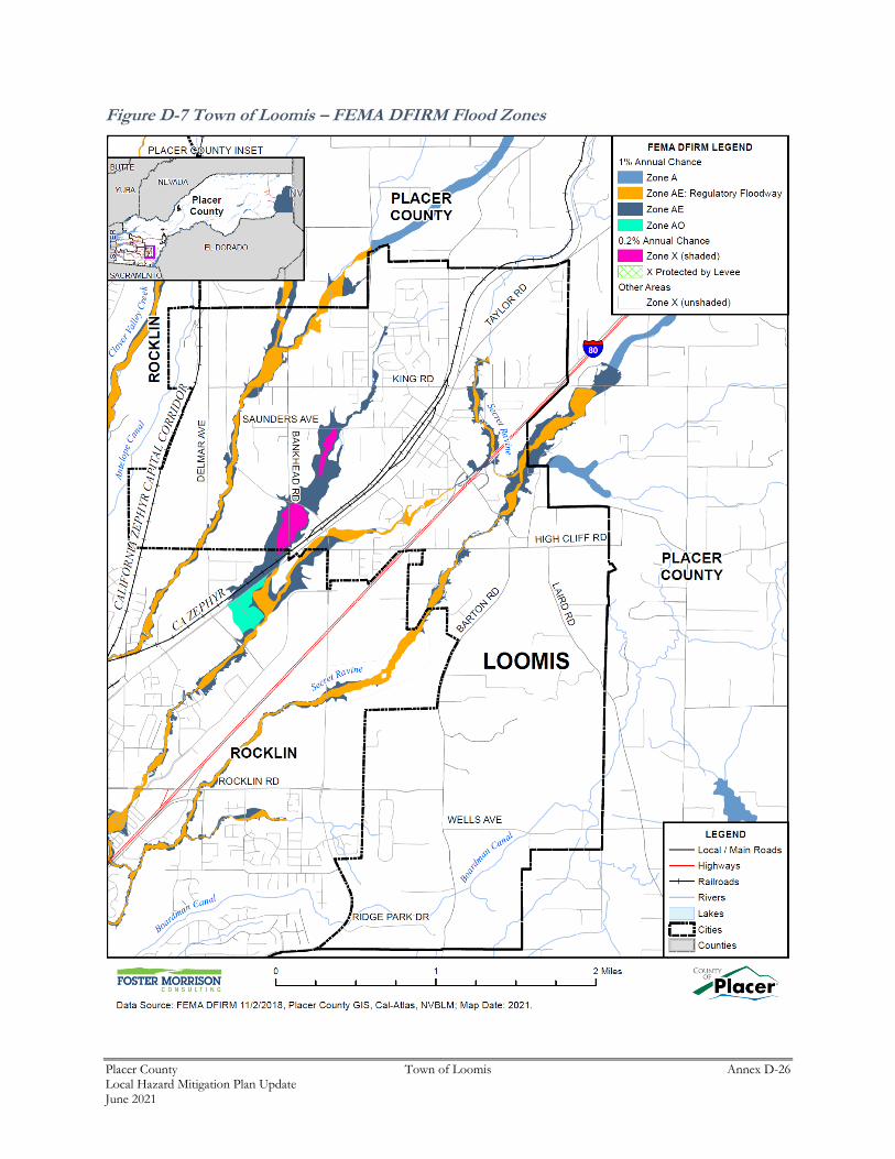
Placer County Town of Loomis Annex D-26 Local Hazard Mitigation Plan Update June 2021
Figure D-7 Town of Loomis – FEMA DFIRM Flood Zones
Placer County Town of Loomis Annex D-27 Local Hazard Mitigation Plan Update June 2021
Table D-13 details the DFIRM mapped flood zones located within the Town.
Table D-13 Town of Loomis– DFIRM Flood Hazard Zones
Flood Zone Description Flood Zone Present in Town of Loomis
A 1% annual chance flooding: No base flood elevations provided
AE 1% annual chance flooding: Base flood elevations provided
X
AE Floodway 1% annual chance flood: Regulatory floodway; Base flood elevations provided
X
AO 1% annual chance flooding: sheet flow areas. BFEs derived from detailed hydraulic analyses are shown in this zone.
Shaded X 0.2% annual chance flooding: The areas between the limits of the 1% annual chance flood and the 0.2-percent-annual-chance (or 500-year) flood
X
X Protected by Levee Areas protected by levees from 1% annual chance flood event. Levee protection places these areas in the 0.2% annual chance flood zone.
X (unshaded) No flood hazard X
Source: FEMA
Additionally, flood extents can generally be measured in volume, velocity, and depths of flooding.
Expected flood depths in the Town vary, depending on the nature and extent of a flood event; specific
depths are unknown. Flood durations in the Town tend to be short to medium term, or until either the storm
drainage system can catch up or flood waters move downstream. Flooding in the Town tends to have a
shorter speed of onset, due to the amount of water that flows through the Town.
Geographical flood extents for the Town from the FEMA DFIRMs are shown in Table D-14.
Table D-14 Town of Loomis – Geographical DFIRM Flood Zone Extents
Flood Zone Total Acres % of Total Acres
Improved Acres
% of Total Improved
Acres
Unimproved Acres
% of Total Unimproved
Acres
1% Annual Chance
224 4.9% 155 4.8% 69 5.2%
0.2% Annual Chance
26 0.6% 23 0.7% 3 0.2%
Other Areas 4,310 94.5% 3,068 94.5% 1,243 94.5%
Total 4,561 100.0% 3,246 100.0% 1,315 100.0%
Source: FEMA DFIRM 11/2/2018
Placer County Town of Loomis Annex D-28 Local Hazard Mitigation Plan Update June 2021
Past Occurrences
A list of state and federal disaster declarations for Placer County from flooding is shown on Table D-15.
These events also likely affected the Town to some degree.
Table D-15 Placer County – State and Federal Disaster Declarations from Flood 1950-2020
Disaster Type Federal Declarations State Declarations
Count Years Count Years
Flood (including heavy rains and storms)
16 1950, 1955, 1958 (twice), 1962, 1963, 1969, 1973, 1980, 1983, 1986, 1995 (twice), 1997, 2008, 2017
13 1955, 1958, 1962, 1964, 1969, 1983, 1986, 1995 (twice), 1997, 2006 (twice), 2017
Source: Cal OES, FEMA
Vulnerability to and Impacts from Flood
Floods have been a part of the Town’s historical past and will continue to be so in the future. During winter
months, long periods of precipitation and the timing of that precipitation are critical in determining the
threat of flood, and these characteristics further dictate the potential for widespread structural and property
damages. Predominantly, the effects of flooding are generally confined to areas near the waterways of the
County. As waterways grow in size from local drainages, so grows the threat of flood and dimensions of
the threat. This threatens structures in the floodplain. Structures can also be damaged from trees falling as
a result of water-saturated soils. Electrical power outages happen, and the interruption of power causes
major problems. Loss of power is usually a precursor to closure of governmental offices and community
businesses. Public schools may also be required to close or be placed on a delayed start schedule. Roads
can be damaged and closed, causing safety and evacuation issues. People may be swept away in
floodwaters, causing injuries or deaths.
Floods are among the costliest natural disasters in terms of human hardship and economic loss nationwide.
Floods can cause substantial damage to structures, landscapes, and utilities as well as life safety issues.
Floods can be extremely dangerous, and even six inches of moving water can knock over a person given a
strong current. During a flood, people can also suffer heart attacks or electrocution due to electrical
equipment short outs. Floodwaters can transport large objects downstream which can damage or remove
stationary structures. Ground saturation can result in instability, collapse, or other damage. Objects can
also be buried or destroyed through sediment deposition. Floodwaters can also break utility lines and
interrupt services. Standing water can cause damage to crops, roads, foundations, and electrical circuits.
Direct impacts, such as drowning, can be limited with adequate warning and public education about what
to do during floods. Other problems connected with flooding and stormwater runoff include erosion,
sedimentation, degradation of water quality, loss of environmental resources, and economic impacts
Assets at Risk
Based on the vulnerability of Loomis to the flood hazard, the sections that follow describes significant
assets at risk in the Town of Loomis. This section includes the values at risk, flooded acres, population at
risk, and critical facilities at risk.
Placer County Town of Loomis Annex D-29 Local Hazard Mitigation Plan Update June 2021
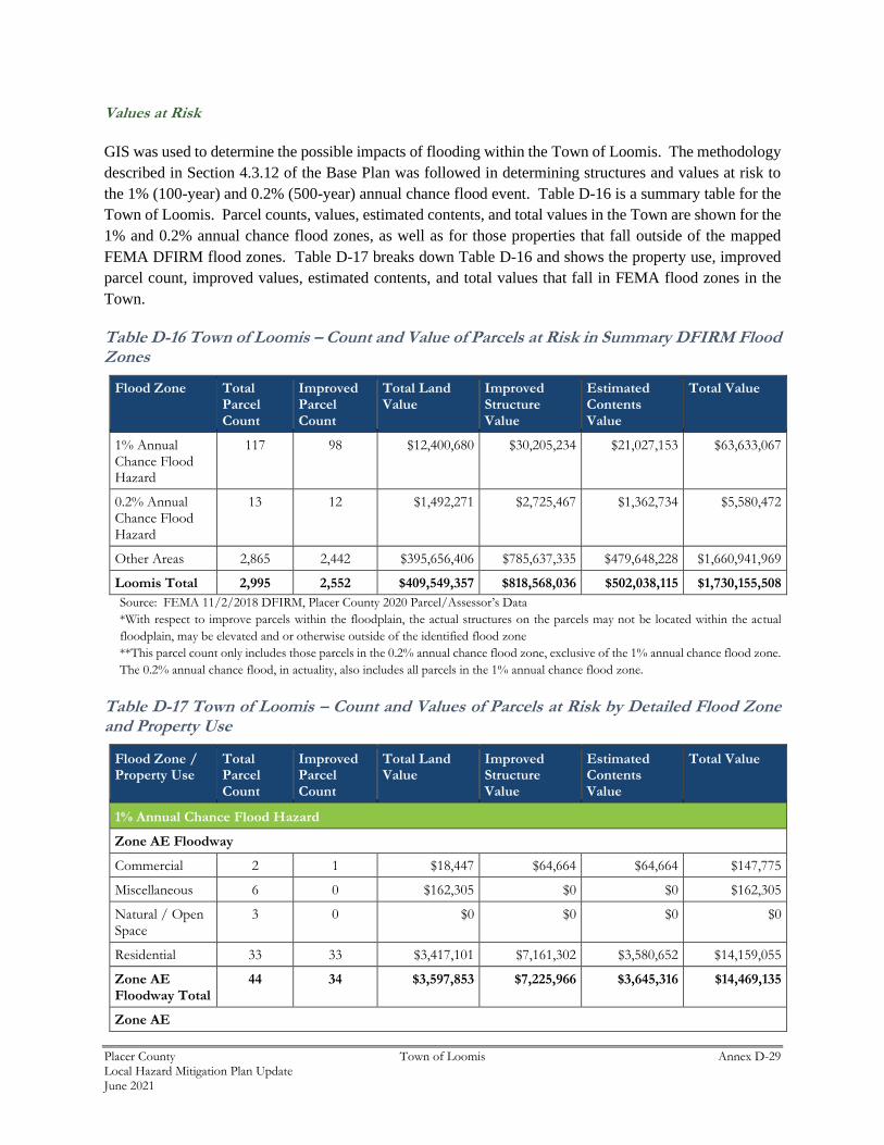
Values at Risk
GIS was used to determine the possible impacts of flooding within the Town of Loomis. The methodology
described in Section 4.3.12 of the Base Plan was followed in determining structures and values at risk to
the 1% (100-year) and 0.2% (500-year) annual chance flood event. Table D-16 is a summary table for the
Town of Loomis. Parcel counts, values, estimated contents, and total values in the Town are shown for the
1% and 0.2% annual chance flood zones, as well as for those properties that fall outside of the mapped
FEMA DFIRM flood zones. Table D-17 breaks down Table D-16 and shows the property use, improved
parcel count, improved values, estimated contents, and total values that fall in FEMA flood zones in the
Town.
Table D-16 Town of Loomis – Count and Value of Parcels at Risk in Summary DFIRM Flood Zones
Flood Zone Total Parcel Count
Improved Parcel Count
Total Land Value
Improved Structure Value
Estimated Contents Value
Total Value
1% Annual Chance Flood Hazard
117 98 $12,400,680 $30,205,234 $21,027,153 $63,633,067
0.2% Annual Chance Flood Hazard
13 12 $1,492,271 $2,725,467 $1,362,734 $5,580,472
Other Areas 2,865 2,442 $395,656,406 $785,637,335 $479,648,228 $1,660,941,969
Loomis Total 2,995 2,552 $409,549,357 $818,568,036 $502,038,115 $1,730,155,508
Source: FEMA 11/2/2018 DFIRM, Placer County 2020 Parcel/Assessor’s Data
*With respect to improve parcels within the floodplain, the actual structures on the parcels may not be located within the actual
floodplain, may be elevated and or otherwise outside of the identified flood zone
**This parcel count only includes those parcels in the 0.2% annual chance flood zone, exclusive of the 1% annual chance flood zone.
The 0.2% annual chance flood, in actuality, also includes all parcels in the 1% annual chance flood zone.
Table D-17 Town of Loomis – Count and Values of Parcels at Risk by Detailed Flood Zone and Property Use
Flood Zone / Property Use
Total Parcel Count
Improved Parcel Count
Total Land Value
Improved Structure Value
Estimated Contents Value
Total Value
1% Annual Chance Flood Hazard
Zone AE Floodway
Commercial 2 1 $18,447 $64,664 $64,664 $147,775
Miscellaneous 6 0 $162,305 $0 $0 $162,305
Natural / Open Space
3 0 $0 $0 $0 $0
Residential 33 33 $3,417,101 $7,161,302 $3,580,652 $14,159,055
Zone AE Floodway Total
44 34 $3,597,853 $7,225,966 $3,645,316 $14,469,135
Zone AE
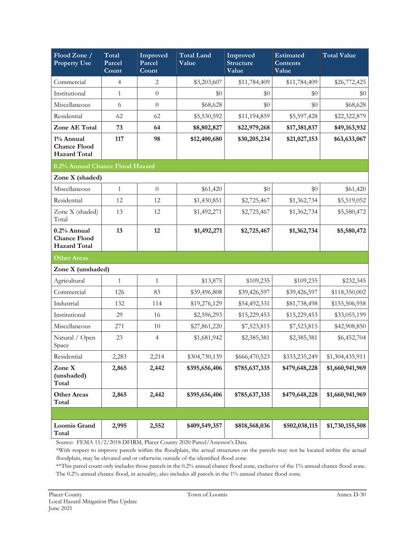
Placer County Town of Loomis Annex D-30 Local Hazard Mitigation Plan Update June 2021
Flood Zone / Property Use
Total Parcel Count
Improved Parcel Count
Total Land Value
Improved Structure Value
Estimated Contents Value
Total Value
Commercial 4 2 $3,203,607 $11,784,409 $11,784,409 $26,772,425
Institutional 1 0 $0 $0 $0 $0
Miscellaneous 6 0 $68,628 $0 $0 $68,628
Residential 62 62 $5,530,592 $11,194,859 $5,597,428 $22,322,879
Zone AE Total 73 64 $8,802,827 $22,979,268 $17,381,837 $49,163,932
1% Annual Chance Flood Hazard Total
117 98 $12,400,680 $30,205,234 $21,027,153 $63,633,067
0.2% Annual Chance Flood Hazard
Zone X (shaded)
Miscellaneous 1 0 $61,420 $0 $0 $61,420
Residential 12 12 $1,430,851 $2,725,467 $1,362,734 $5,519,052
Zone X (shaded) Total
13 12 $1,492,271 $2,725,467 $1,362,734 $5,580,472
0.2% Annual Chance Flood Hazard Total
13 12 $1,492,271 $2,725,467 $1,362,734 $5,580,472
Other Areas
Zone X (unshaded)
Agricultural 1 1 $13,875 $109,235 $109,235 $232,345
Commercial 126 83 $39,496,808 $39,426,597 $39,426,597 $118,350,002
Industrial 132 114 $19,276,129 $54,492,331 $81,738,498 $155,506,958
Institutional 29 16 $2,596,293 $15,229,453 $15,229,453 $33,055,199
Miscellaneous 271 10 $27,861,220 $7,523,815 $7,523,815 $42,908,850
Natural / Open Space
23 4 $1,681,942 $2,385,381 $2,385,381 $6,452,704
Residential 2,283 2,214 $304,730,139 $666,470,523 $333,235,249 $1,304,435,911
Zone X (unshaded) Total
2,865 2,442 $395,656,406 $785,637,335 $479,648,228 $1,660,941,969
Other Areas Total
2,865 2,442 $395,656,406 $785,637,335 $479,648,228 $1,660,941,969
Loomis Grand Total
2,995 2,552 $409,549,357 $818,568,036 $502,038,115 $1,730,155,508
Source: FEMA 11/2/2018 DFIRM, Placer County 2020 Parcel/Assessor’s Data
*With respect to improve parcels within the floodplain, the actual structures on the parcels may not be located within the actual
floodplain, may be elevated and or otherwise outside of the identified flood zone
**This parcel count only includes those parcels in the 0.2% annual chance flood zone, exclusive of the 1% annual chance flood zone.
The 0.2% annual chance flood, in actuality, also includes all parcels in the 1% annual chance flood zone.
Placer County Town of Loomis Annex D-31 Local Hazard Mitigation Plan Update June 2021
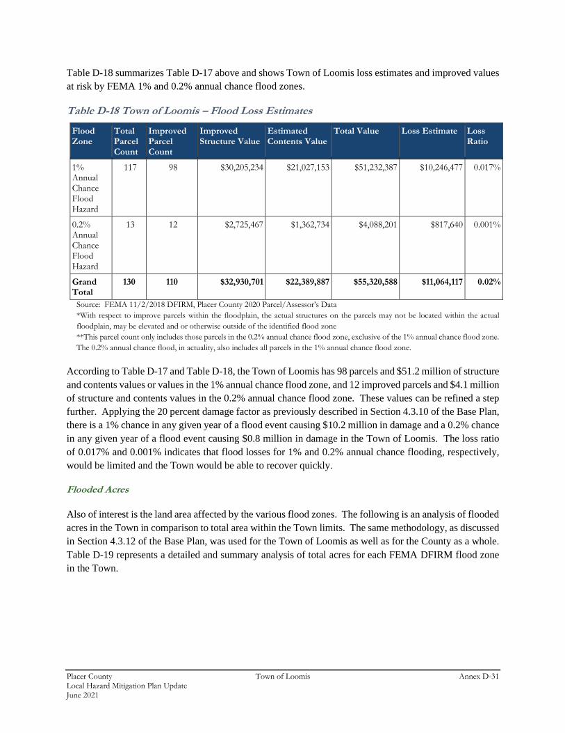
Table D-18 summarizes Table D-17 above and shows Town of Loomis loss estimates and improved values
at risk by FEMA 1% and 0.2% annual chance flood zones.
Table D-18 Town of Loomis – Flood Loss Estimates
Flood Zone
Total Parcel Count
Improved Parcel Count
Improved Structure Value
Estimated Contents Value
Total Value Loss Estimate Loss Ratio
1% Annual Chance Flood Hazard
117 98 $30,205,234 $21,027,153 $51,232,387 $10,246,477 0.017%
0.2% Annual Chance Flood Hazard
13 12 $2,725,467 $1,362,734 $4,088,201 $817,640 0.001%
Grand Total
130 110 $32,930,701 $22,389,887 $55,320,588 $11,064,117 0.02%
Source: FEMA 11/2/2018 DFIRM, Placer County 2020 Parcel/Assessor’s Data
*With respect to improve parcels within the floodplain, the actual structures on the parcels may not be located within the actual
floodplain, may be elevated and or otherwise outside of the identified flood zone
**This parcel count only includes those parcels in the 0.2% annual chance flood zone, exclusive of the 1% annual chance flood zone.
The 0.2% annual chance flood, in actuality, also includes all parcels in the 1% annual chance flood zone.
According to Table D-17 and Table D-18, the Town of Loomis has 98 parcels and $51.2 million of structure
and contents values or values in the 1% annual chance flood zone, and 12 improved parcels and $4.1 million
of structure and contents values in the 0.2% annual chance flood zone. These values can be refined a step
further. Applying the 20 percent damage factor as previously described in Section 4.3.10 of the Base Plan,
there is a 1% chance in any given year of a flood event causing $10.2 million in damage and a 0.2% chance
in any given year of a flood event causing $0.8 million in damage in the Town of Loomis. The loss ratio
of 0.017% and 0.001% indicates that flood losses for 1% and 0.2% annual chance flooding, respectively,
would be limited and the Town would be able to recover quickly.
Flooded Acres
Also of interest is the land area affected by the various flood zones. The following is an analysis of flooded
acres in the Town in comparison to total area within the Town limits. The same methodology, as discussed
in Section 4.3.12 of the Base Plan, was used for the Town of Loomis as well as for the County as a whole.
Table D-19 represents a detailed and summary analysis of total acres for each FEMA DFIRM flood zone
in the Town.
Placer County Town of Loomis Annex D-32 Local Hazard Mitigation Plan Update June 2021
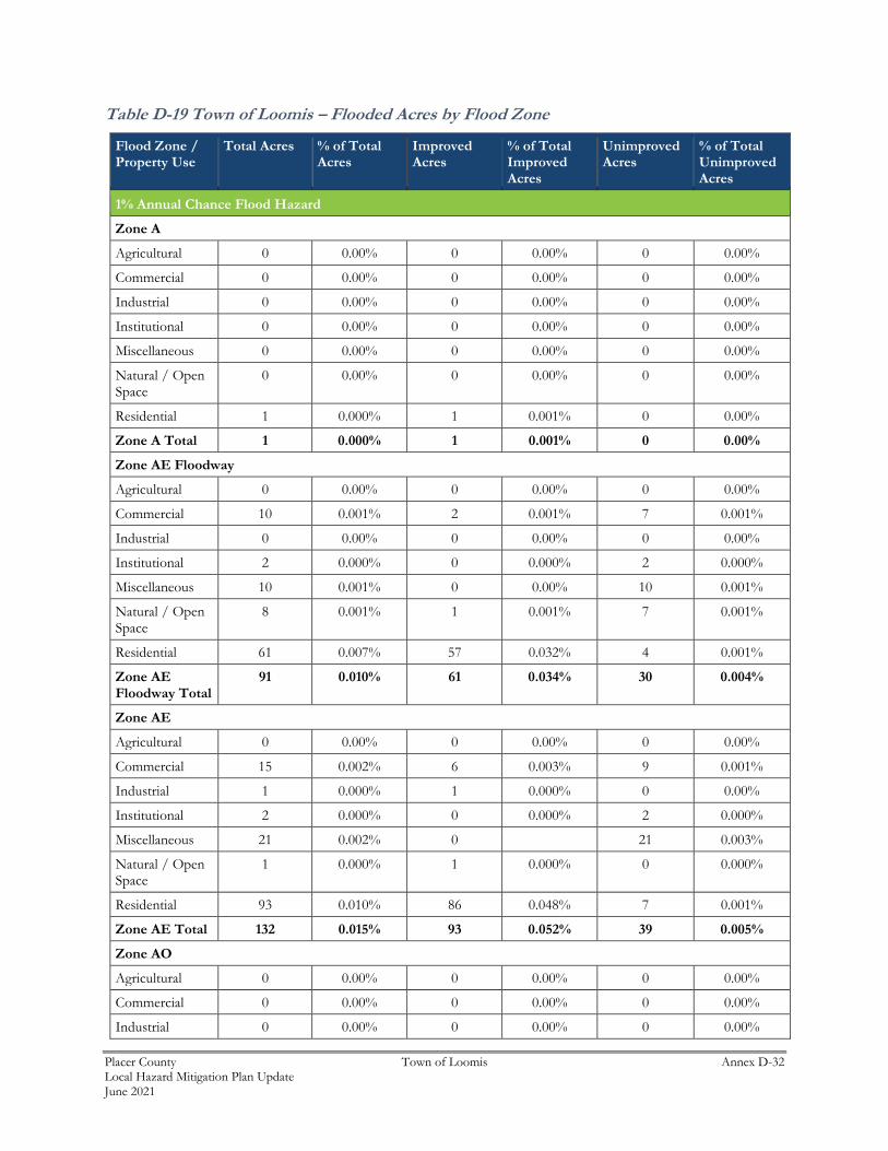
Table D-19 Town of Loomis – Flooded Acres by Flood Zone
Flood Zone / Property Use
Total Acres % of Total Acres
Improved Acres
% of Total Improved Acres
Unimproved Acres
% of Total Unimproved Acres
1% Annual Chance Flood Hazard
Zone A
Agricultural 0 0.00% 0 0.00% 0 0.00%
Commercial 0 0.00% 0 0.00% 0 0.00%
Industrial 0 0.00% 0 0.00% 0 0.00%
Institutional 0 0.00% 0 0.00% 0 0.00%
Miscellaneous 0 0.00% 0 0.00% 0 0.00%
Natural / Open Space
0 0.00% 0 0.00% 0 0.00%
Residential 1 0.000% 1 0.001% 0 0.00%
Zone A Total 1 0.000% 1 0.001% 0 0.00%
Zone AE Floodway
Agricultural 0 0.00% 0 0.00% 0 0.00%
Commercial 10 0.001% 2 0.001% 7 0.001%
Industrial 0 0.00% 0 0.00% 0 0.00%
Institutional 2 0.000% 0 0.000% 2 0.000%
Miscellaneous 10 0.001% 0 0.00% 10 0.001%
Natural / Open Space
8 0.001% 1 0.001% 7 0.001%
Residential 61 0.007% 57 0.032% 4 0.001%
Zone AE Floodway Total
91 0.010% 61 0.034% 30 0.004%
Zone AE
Agricultural 0 0.00% 0 0.00% 0 0.00%
Commercial 15 0.002% 6 0.003% 9 0.001%
Industrial 1 0.000% 1 0.000% 0 0.00%
Institutional 2 0.000% 0 0.000% 2 0.000%
Miscellaneous 21 0.002% 0 21 0.003%
Natural / Open Space
1 0.000% 1 0.000% 0 0.000%
Residential 93 0.010% 86 0.048% 7 0.001%
Zone AE Total 132 0.015% 93 0.052% 39 0.005%
Zone AO
Agricultural 0 0.00% 0 0.00% 0 0.00%
Commercial 0 0.00% 0 0.00% 0 0.00%
Industrial 0 0.00% 0 0.00% 0 0.00%
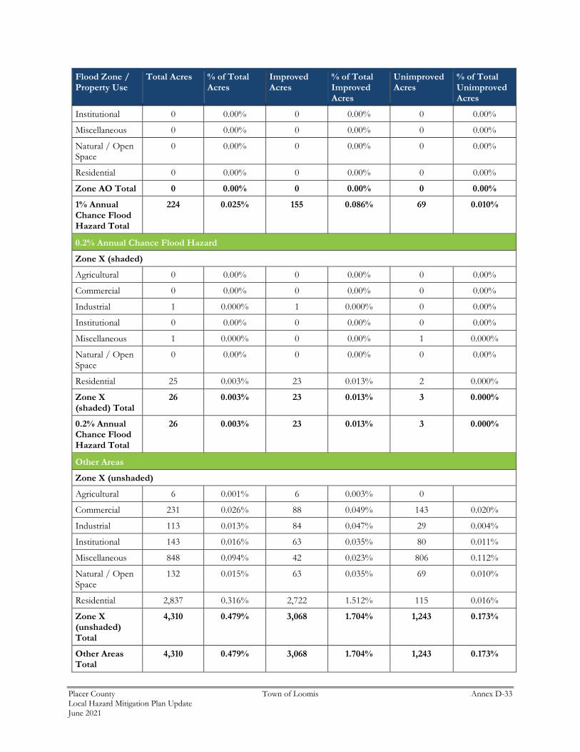
Placer County Town of Loomis Annex D-33 Local Hazard Mitigation Plan Update June 2021
Flood Zone / Property Use
Total Acres % of Total Acres
Improved Acres
% of Total Improved Acres
Unimproved Acres
% of Total Unimproved Acres
Institutional 0 0.00% 0 0.00% 0 0.00%
Miscellaneous 0 0.00% 0 0.00% 0 0.00%
Natural / Open Space
0 0.00% 0 0.00% 0 0.00%
Residential 0 0.00% 0 0.00% 0 0.00%
Zone AO Total 0 0.00% 0 0.00% 0 0.00%
1% Annual Chance Flood Hazard Total
224 0.025% 155 0.086% 69 0.010%
0.2% Annual Chance Flood Hazard
Zone X (shaded)
Agricultural 0 0.00% 0 0.00% 0 0.00%
Commercial 0 0.00% 0 0.00% 0 0.00%
Industrial 1 0.000% 1 0.000% 0 0.00%
Institutional 0 0.00% 0 0.00% 0 0.00%
Miscellaneous 1 0.000% 0 0.00% 1 0.000%
Natural / Open Space
0 0.00% 0 0.00% 0 0.00%
Residential 25 0.003% 23 0.013% 2 0.000%
Zone X (shaded) Total
26 0.003% 23 0.013% 3 0.000%
0.2% Annual Chance Flood Hazard Total
26 0.003% 23 0.013% 3 0.000%
Other Areas
Zone X (unshaded)
Agricultural 6 0.001% 6 0.003% 0
Commercial 231 0.026% 88 0.049% 143 0.020%
Industrial 113 0.013% 84 0.047% 29 0.004%
Institutional 143 0.016% 63 0.035% 80 0.011%
Miscellaneous 848 0.094% 42 0.023% 806 0.112%
Natural / Open Space
132 0.015% 63 0.035% 69 0.010%
Residential 2,837 0.316% 2,722 1.512% 115 0.016%
Zone X (unshaded) Total
4,310 0.479% 3,068 1.704% 1,243 0.173%
Other Areas Total
4,310 0.479% 3,068 1.704% 1,243 0.173%
Placer County Town of Loomis Annex D-34 Local Hazard Mitigation Plan Update June 2021
Flood Zone / Property Use
Total Acres % of Total Acres
Improved Acres
% of Total Improved Acres
Unimproved Acres
% of Total Unimproved Acres
Loomis Grand Total
4,561 0.507% 3,246 1.803% 1,315 0.183%
Source: FEMA 11/2/2018 DFIRM
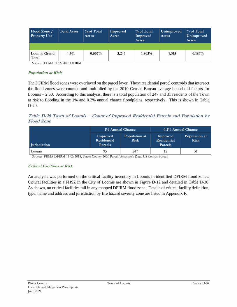
Population at Risk
The DFIRM flood zones were overlayed on the parcel layer. Those residential parcel centroids that intersect
the flood zones were counted and multiplied by the 2010 Census Bureau average household factors for
Loomis – 2.60. According to this analysis, there is a total population of 247 and 31 residents of the Town
at risk to flooding in the 1% and 0.2% annual chance floodplains, respectively. This is shown in Table
D-20.
Table D-20 Town of Loomis – Count of Improved Residential Parcels and Population by Flood Zone
Jurisdiction
1% Annual Chance 0.2% Annual Chance
Improved Residential
Parcels
Population at Risk
Improved Residential
Parcels
Population at Risk
Loomis 95 247 12 31
Source: FEMA DFIRM 11/2/2018, Placer County 2020 Parcel/Assessor’s Data, US Census Bureau
Critical Facilities at Risk
An analysis was performed on the critical facility inventory in Loomis in identified DFIRM flood zones.
Critical facilities in a FHSZ in the City of Loomis are shown in Figure D-12 and detailed in Table D-30.
As shown, no critical facilities fall in any mapped DFIRM flood zone. Details of critical facility definition,
type, name and address and jurisdiction by fire hazard severity zone are listed in Appendix F.
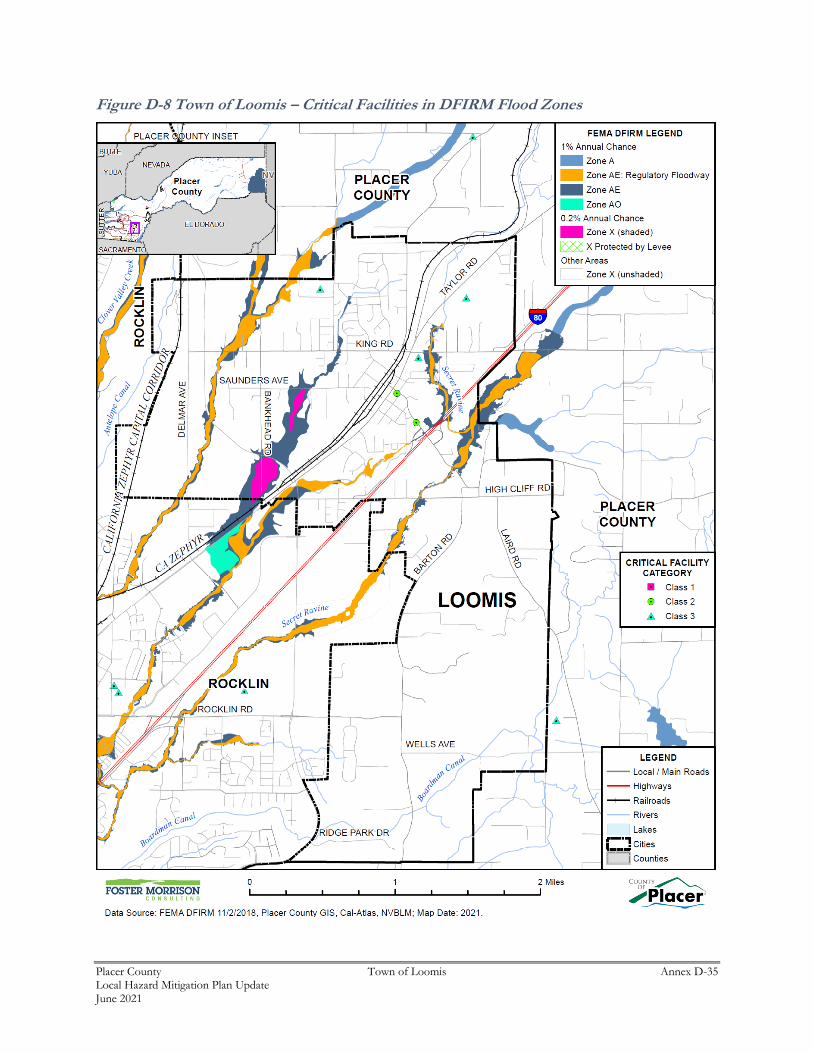
Placer County Town of Loomis Annex D-35 Local Hazard Mitigation Plan Update June 2021
Figure D-8 Town of Loomis – Critical Facilities in DFIRM Flood Zones
Placer County Town of Loomis Annex D-36 Local Hazard Mitigation Plan Update June 2021
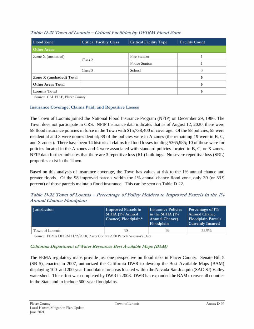
Table D-21 Town of Loomis – Critical Facilities by DFIRM Flood Zone
Flood Zone Critical Facility Class Critical Facility Type Facility Count
Other Areas
Zone X (unshaded) Class 2
Fire Station 1
Police Station 1
Class 3 School 3
Zone X (unshaded) Total 5
Other Areas Total 5
Loomis Total 5
Source: CAL FIRE, Placer County
Insurance Coverage, Claims Paid, and Repetitive Losses
The Town of Loomis joined the National Flood Insurance Program (NFIP) on December 29, 1986. The
Town does not participate in CRS. NFIP Insurance data indicates that as of August 12, 2020, there were
58 flood insurance policies in force in the Town with $15,738,400 of coverage. Of the 58 policies, 55 were
residential and 3 were nonresidential; 39 of the policies were in A zones (the remaining 19 were in B, C,
and X zones). There have been 14 historical claims for flood losses totaling $365,985; 10 of these were for
policies located in the A zones and 4 were associated with standard policies located in B, C, or X zones.
NFIP data further indicates that there are 3 repetitive loss (RL) buildings. No severe repetitive loss (SRL)
properties exist in the Town.
Based on this analysis of insurance coverage, the Town has values at risk to the 1% annual chance and
greater floods. Of the 98 improved parcels within the 1% annual chance flood zone, only 39 (or 33.9
percent) of those parcels maintain flood insurance. This can be seen on Table D-22.
Table D-22 Town of Loomis – Percentage of Policy Holders to Improved Parcels in the 1% Annual Chance Floodplain
Jurisdiction Improved Parcels in SFHA (1% Annual Chance) Floodplain*
Insurance Policies in the SFHA (1% Annual Chance) Floodplain
Percentage of 1% Annual Chance Floodplain Parcels Currently Insured
Town of Loomis 98 39 33.9%
Source: FEMA DFIRM 11/2/2018, Placer County 2020 Parcel/Assessor’s Data
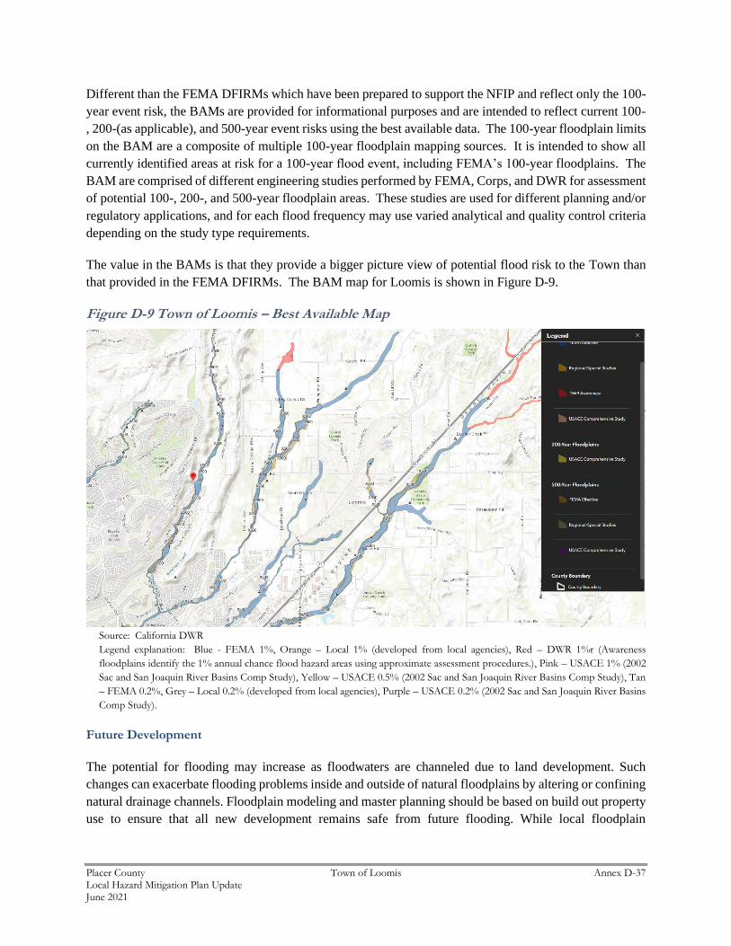
California Department of Water Resources Best Available Maps (BAM)
The FEMA regulatory maps provide just one perspective on flood risks in Placer County. Senate Bill 5
(SB 5), enacted in 2007, authorized the California DWR to develop the Best Available Maps (BAM)
displaying 100- and 200-year floodplains for areas located within the Nevada-San Joaquin (SAC-SJ) Valley
watershed. This effort was completed by DWR in 2008. DWR has expanded the BAM to cover all counties
in the State and to include 500-year floodplains.
Placer County Town of Loomis Annex D-37 Local Hazard Mitigation Plan Update June 2021
Different than the FEMA DFIRMs which have been prepared to support the NFIP and reflect only the 100-
year event risk, the BAMs are provided for informational purposes and are intended to reflect current 100-
, 200-(as applicable), and 500-year event risks using the best available data. The 100-year floodplain limits
on the BAM are a composite of multiple 100-year floodplain mapping sources. It is intended to show all
currently identified areas at risk for a 100-year flood event, including FEMA’s 100-year floodplains. The
BAM are comprised of different engineering studies performed by FEMA, Corps, and DWR for assessment
of potential 100-, 200-, and 500-year floodplain areas. These studies are used for different planning and/or
regulatory applications, and for each flood frequency may use varied analytical and quality control criteria
depending on the study type requirements.
The value in the BAMs is that they provide a bigger picture view of potential flood risk to the Town than
that provided in the FEMA DFIRMs. The BAM map for Loomis is shown in Figure D-9.
Figure D-9 Town of Loomis – Best Available Map
Source: California DWR
Legend explanation: Blue - FEMA 1%, Orange – Local 1% (developed from local agencies), Red – DWR 1%r (Awareness
floodplains identify the 1% annual chance flood hazard areas using approximate assessment procedures.), Pink – USACE 1% (2002
Sac and San Joaquin River Basins Comp Study), Yellow – USACE 0.5% (2002 Sac and San Joaquin River Basins Comp Study), Tan
– FEMA 0.2%, Grey – Local 0.2% (developed from local agencies), Purple – USACE 0.2% (2002 Sac and San Joaquin River Basins
Comp Study).
Future Development
The potential for flooding may increase as floodwaters are channeled due to land development. Such
changes can exacerbate flooding problems inside and outside of natural floodplains by altering or confining
natural drainage channels. Floodplain modeling and master planning should be based on build out property
use to ensure that all new development remains safe from future flooding. While local floodplain
Placer County Town of Loomis Annex D-38 Local Hazard Mitigation Plan Update June 2021
management, stormwater management, and water quality regulations and policies address these changes on
a site-by-site basis, their cumulative effects can have a negative impact on the overall floodplain.
Development in the floodplain is discouraged and required to obtain approval from FEMA for
modifications in the floodplain.
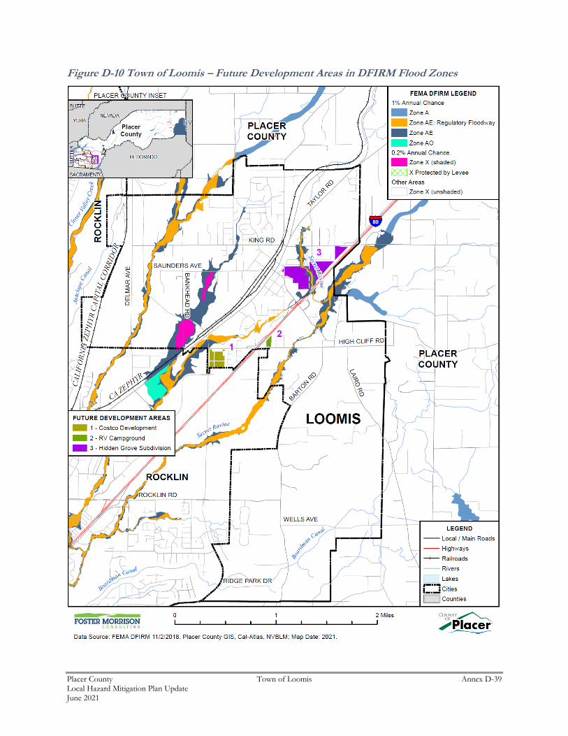
GIS Analysis
The Town provided Future Development Areas were used as the basis for the inventory of future
development areas for the Town. Utilizing the future development project spatial layer, the parcel centroid
data was intersected to determine the parcel counts within each area. Figure D-10 shows the locations of
future development areas the Town is planning to develop on the FEMA DFIRM. As shown on Figure
D-10, no future development areas fall in DFIRM flood zones, as such no tabular analysis was performed.
Placer County Town of Loomis Annex D-39 Local Hazard Mitigation Plan Update June 2021
Figure D-10 Town of Loomis – Future Development Areas in DFIRM Flood Zones
Placer County Town of Loomis Annex D-40 Local Hazard Mitigation Plan Update June 2021
Flood: Localized Stormwater Flooding
Likelihood of Future Occurrence–Likely
Vulnerability–Medium
Hazard Profile and Problem Description
Flooding occurs in areas other than the FEMA mapped 1% and 0.2% annual chance floodplains. Flooding
may be from drainages not studied by FEMA, lack of or inadequate drainage infrastructure, or inadequate
maintenance. Localized, stormwater flooding occurs throughout the County during the rainy season from
November through April. Prolonged heavy rainfall contributes to a large volume of runoff resulting in high
peak flows of moderate duration.
Location and Extent
The Town of Loomis is subject to localized flooding throughout the Town. Flood extents are usually
measured in areas affected, velocity of flooding, and depths of flooding. Expected flood depths in the Town
vary by location. Flood durations in the Town tend to be short to medium term, or until either the storm
drainage system can catch up or flood waters move downstream. Localized flooding in the Town tends to
have a shorter speed of onset, especially when antecedent rainfall has soaked the ground and reduced its
capacity to absorb additional moisture.
Local drainage problems exist because of outdated, inadequately-sized culverts and bridges that impede
high water flows, including culverts under Interstate 80; the Horseshoe Bar Road crossing over Secret
Ravine; the railroad and Taylor Road crossing of Sucker Ravine; and crossings of Antelope Creek and its
tributaries.
Past Occurrences
The Town noted the following past occurrences of localized flooding:
In the 1995 floods, local flooding did cause damage to the floors of a few buildings. The 2005 New Year’s
Eve flooding created significant problems in various areas of the Town. A small, localized flooding event
in November 2020 occurred due to a blockage in canal running under Arcadia street. A small amount of
damage (under $25,000) was reported.
Vulnerability to and Impacts from Localized Flooding
Historically, much of the growth in the Town and County has occurred adjacent to streams, resulting in
significant damages to property, and losses from disruption of community activities when the streams
overflow. Additional development in the watersheds of these streams affects both the frequency and
duration of damaging floods through an increase in stormwater runoff.
The Town tracks localized flooding areas. Affected localized flood areas identified by the Town of Loomis
are summarized in Table D-23.
Placer County Town of Loomis Annex D-41 Local Hazard Mitigation Plan Update June 2021
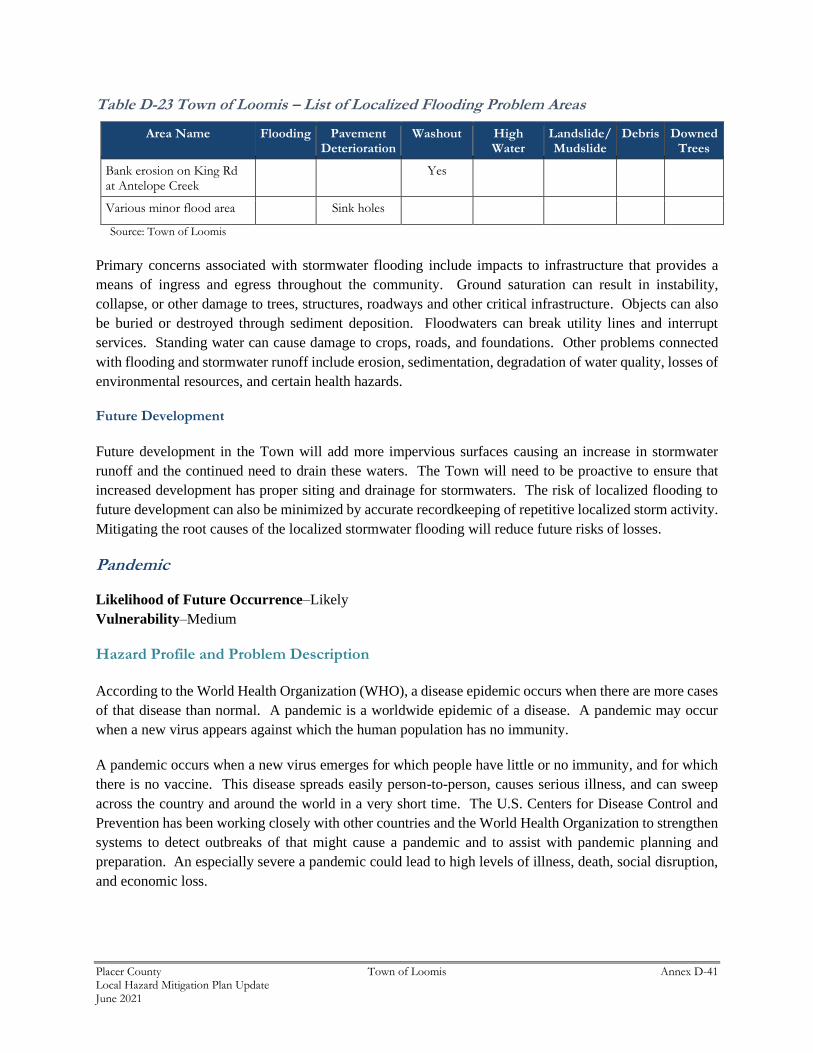
Table D-23 Town of Loomis – List of Localized Flooding Problem Areas
Area Name Flooding Pavement Deterioration
Washout High Water
Landslide/ Mudslide
Debris Downed Trees
Bank erosion on King Rd at Antelope Creek
Yes
Various minor flood area Sink holes
Source: Town of Loomis
Primary concerns associated with stormwater flooding include impacts to infrastructure that provides a
means of ingress and egress throughout the community. Ground saturation can result in instability,
collapse, or other damage to trees, structures, roadways and other critical infrastructure. Objects can also
be buried or destroyed through sediment deposition. Floodwaters can break utility lines and interrupt
services. Standing water can cause damage to crops, roads, and foundations. Other problems connected
with flooding and stormwater runoff include erosion, sedimentation, degradation of water quality, losses of
environmental resources, and certain health hazards.
Future Development
Future development in the Town will add more impervious surfaces causing an increase in stormwater
runoff and the continued need to drain these waters. The Town will need to be proactive to ensure that
increased development has proper siting and drainage for stormwaters. The risk of localized flooding to
future development can also be minimized by accurate recordkeeping of repetitive localized storm activity.
Mitigating the root causes of the localized stormwater flooding will reduce future risks of losses.
Pandemic
Likelihood of Future Occurrence–Likely
Vulnerability–Medium
Hazard Profile and Problem Description
According to the World Health Organization (WHO), a disease epidemic occurs when there are more cases
of that disease than normal. A pandemic is a worldwide epidemic of a disease. A pandemic may occur
when a new virus appears against which the human population has no immunity.
A pandemic occurs when a new virus emerges for which people have little or no immunity, and for which
there is no vaccine. This disease spreads easily person-to-person, causes serious illness, and can sweep
across the country and around the world in a very short time. The U.S. Centers for Disease Control and
Prevention has been working closely with other countries and the World Health Organization to strengthen
systems to detect outbreaks of that might cause a pandemic and to assist with pandemic planning and
preparation. An especially severe a pandemic could lead to high levels of illness, death, social disruption,
and economic loss.
Placer County Town of Loomis Annex D-42 Local Hazard Mitigation Plan Update June 2021
Location and Extent
During a pandemic, the whole of the Town, County, and surrounding region is at risk, as pandemic is a
regional, national, and international event. The speed of onset of pandemic is usually short, while the
duration is variable, but can last for more than a year as shown in the 1918/1919 Spanish Flu and the current
COVID-19 pandemic. There is no scientific scale to measure the magnitude of pandemic. Pandemics are
usually measured in numbers affected by the pandemic, and by number who die from complications from
the pandemic.
Past Occurrences
There has been one state and federal disaster declaration due to pandemic, as shown in Table D-24.
Table D-24 Placer County – State and Federal Pandemic Disaster Declarations 1950-2020
Disaster Type Federal Declarations State Declarations
Count Years Count Years
Pandemic 1 2020 1 2020
Source: Cal OES, FEMA
The 20th century saw three outbreaks of pandemic flu.
➢ The 1918-1919 Influenza Pandemic (H1N1)
➢ The February 1957-1958 Influenza Pandemic (H2N2)
➢ The 1968 Influenza Pandemic (H3N2)
To date, the 21st century has seen two acknowledged pandemics.
➢ 2009 Swine Flu (H1N1)
➢ 2019/2020 COVID 19
The HMPC noted that in terms of impacts to the Town, a few smaller businesses closed and a small decrease
in sales tax revenue occurred. Those impacts were relatively minor, however.
Vulnerability to and Impacts from Pandemic
Pandemic has and will continue to have impacts on human health in the region. A pandemic occurs when
a new virus emerges for which there is little or no immunity in the human population; the virus causes
serious illness and spreads easily from person-to-person worldwide. There are several strategies that public
health officials can use to combat a pandemic. Constant surveillance regarding current pandemic, use of
infection control techniques, and administration of vaccines once they become available. Citizens can help
prevent spread of a pandemic by staying home, or “self-quarantining,” if they suspect they are infected.
Pandemic does not affect the buildings, critical facilities, and infrastructure in the Town. Pandemic can
have varying levels of impact to the citizens of the Town and greater County, depending on the nature of
the pandemic.
Placer County Town of Loomis Annex D-43 Local Hazard Mitigation Plan Update June 2021
Impacts could range from school and business closings to the interruption of basic services such as public
transportation, health care, and the delivery of food and essential medicines. Hospitalizations and deaths
can occur, especially to the elderly or those with pre-existing underlying conditions. As seen with Covid-
19, multiple businesses were forced to close temporarily (some permanently) an unemployment rose
significantly. Supply chains for food can be interrupted. Prisons may need to release prisoners to comply
with social distance standards.
The Town’s biggest vulnerabilities from COVID-19 is the potential impact to staff – particularly Public
Works. If one of the Public Works employees got sick, the department would need to potentially quarantine
the entire department. This actually happened twice in 2020/2021. Other vulnerabilities are the ongoing
economic impact to the Town with a loss of sales tax revenue.
Future Development
Future development is not expected to be significantly impacted by this hazard, though population growth
in the Town could increase exposure to a pandemic, and increase the ability of each disease to be transmitted
among the population of the Town. If the median age of Town residents continues to increase, vulnerability
to pandemic diseases may increase, due to the fact that these diseases are often more deadly to senior
citizens.
Severe Weather: Heavy Rains and Storms
Likelihood of Future Occurrence–Likely
Vulnerability–Medium
Hazard Profile and Problem Description
Storms in the Town occur annually and are generally characterized by heavy rain often accompanied by
strong winds and sometimes lightning and hail. Approximately 10 percent of the thunderstorms that occur
each year in the United States are classified as severe. A thunderstorm is classified as severe when it
contains one or more of the following phenomena: hail that is three-quarters of an inch or greater, winds in
excess of 50 knots (57.5 mph), or a tornado. Heavy precipitation in the Town falls mainly in the fall, winter,
and spring months. Wind often accompanies these storms; hail and lightning are rare in the Town.
Location and Extent
Heavy rain events occur on a regional basis. Rains and storms can occur in any location of the Town. All
portions of the Town are at risk to heavy rains. Most of the severe rains occur during the fall, winter, and
spring months. There is no scale by which heavy rains and severe storms are measured. Magnitude of
storms is measured often in rainfall and damages. The speed of onset of heavy rains can be short, but
accurate weather prediction mechanisms often let the public know of upcoming events. Hail and lightning
are rare in the Town and Placer County. Duration of severe storms in California, Placer County, and the
Town can range from minutes to hours to days. Information on precipitation extremes can be found in
Section 4.2.3 of the Base Plan.
Placer County Town of Loomis Annex D-44 Local Hazard Mitigation Plan Update June 2021
Past Occurrences
According to historical hazard data, severe weather, including heavy rains and storms, is an annual
occurrence in the Town. This is the cause of many of the federal disaster declarations related to flooding.
Vulnerability to and Impacts from Heavy Rain and Storms
Heavy rain and severe storms are the most frequent type of severe weather occurrences in the Town. These
events can cause significant and localized flooding. Elongated events, or events that occur during times
where the ground is already saturated can cause 1% and 0.2% annual chance flooding. Wind often
accompanies these storms and has caused damage in the past. Hail and lightning are rare in the Town, but
also can cause damage, with lightning occasionally igniting wildfires.
Actual damage associated with the effects of severe weather include impacts to property, critical facilities
(such as utilities), and life safety. Heavy rains and storms often result in flooding creating significant issues.
Roads can become impassable and ground saturation can result in instability, collapse, or other damage to
trees, structures, roadways and other critical infrastructure. Floodwaters and downed trees can break
utilities and interrupt services.
Future Development
Building codes in the Town ensure that new development is built to current building standards, which
should reduce the risk to future development in the Town from heavy rains and storms. New critical
facilities such as communications towers and others should be built to withstand hail damage, lightning,
and thunderstorm winds. With adherence to development standards, future losses to new development
should be minimal.
Wildfire
Likelihood of Future Occurrence–Likely
Vulnerability–Medium
Hazard Profile and Problem Description
Wildland fire and the risk of a conflagration is an ongoing concern for the Town of Loomis. Throughout
California, communities are increasingly concerned about wildfire safety as increased development in the
foothills and mountain areas and subsequent fire control practices have affected the natural cycle of the
ecosystem. Wildland fires affect grass, forest, and brushlands, as well as any structures located within
them. Where there is human access to wildland areas the risk of fire increases due to a greater chance for
human carelessness and historical fire management practices. Historically, the fire season extends from
early spring through late fall of each year during the hotter, dryer months; however, in recent years, the risk
of wildfire has become a year around concern. Fire conditions arise from a combination of high
temperatures, low moisture content in the air and fuel, accumulation of vegetation, and high winds. These
high winds can result in red flag days, and can result in Public Safety Power Shutoff (PSPS) events in the
Town. While wildfire risk has predominantly been associated with more remote forested areas and wildland
urban interface (WUI) areas, significant wildfires can also occur in more populated, urban areas.
Placer County Town of Loomis Annex D-45 Local Hazard Mitigation Plan Update June 2021
Location and Extent
Wildfire can affect all areas of the Town. CAL FIRE has estimated that the risk varies across the Town
and has created maps showing risk variance. Following the methodology described in Section 4.3.19 of
the Base Plan, wildfire maps for the Town of Loomis were created. Figure D-11 shows the CAL FIRE
FHSZ in the Town. As shown on the maps, fire hazard severity zones within the Town range from urban
unzoned to high.

Placer County Town of Loomis Annex D-46 Local Hazard Mitigation Plan Update June 2021
Figure D-11 Town of Loomis – Fire Hazard Severity Zone
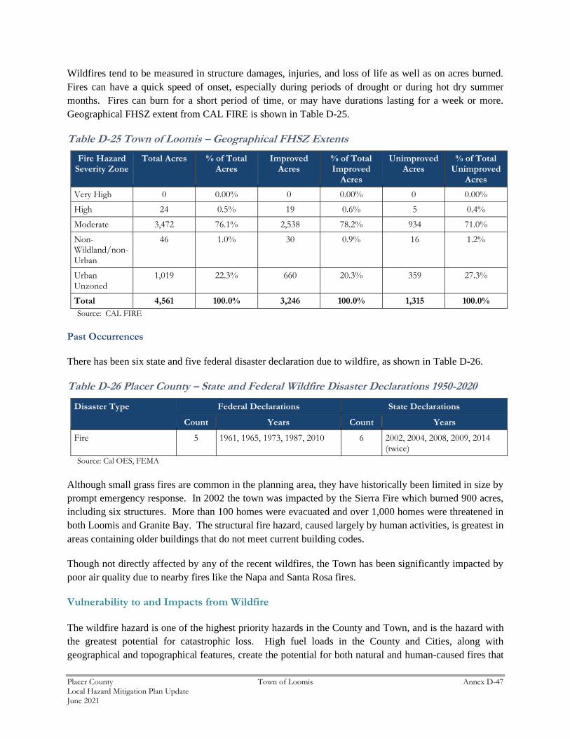
Placer County Town of Loomis Annex D-47 Local Hazard Mitigation Plan Update June 2021
Wildfires tend to be measured in structure damages, injuries, and loss of life as well as on acres burned.
Fires can have a quick speed of onset, especially during periods of drought or during hot dry summer
months. Fires can burn for a short period of time, or may have durations lasting for a week or more.
Geographical FHSZ extent from CAL FIRE is shown in Table D-25.
Table D-25 Town of Loomis – Geographical FHSZ Extents
Fire Hazard Severity Zone
Total Acres % of Total Acres
Improved Acres
% of Total Improved
Acres
Unimproved Acres
% of Total Unimproved
Acres
Very High 0 0.00% 0 0.00% 0 0.00%
High 24 0.5% 19 0.6% 5 0.4%
Moderate 3,472 76.1% 2,538 78.2% 934 71.0%
Non-Wildland/non-Urban
46 1.0% 30 0.9% 16 1.2%
Urban Unzoned
1,019 22.3% 660 20.3% 359 27.3%
Total 4,561 100.0% 3,246 100.0% 1,315 100.0%
Source: CAL FIRE
Past Occurrences
There has been six state and five federal disaster declaration due to wildfire, as shown in Table D-26.
Table D-26 Placer County – State and Federal Wildfire Disaster Declarations 1950-2020
Disaster Type Federal Declarations State Declarations
Count Years Count Years
Fire 5 1961, 1965, 1973, 1987, 2010 6 2002, 2004, 2008, 2009, 2014 (twice)
Source: Cal OES, FEMA
Although small grass fires are common in the planning area, they have historically been limited in size by
prompt emergency response. In 2002 the town was impacted by the Sierra Fire which burned 900 acres,
including six structures. More than 100 homes were evacuated and over 1,000 homes were threatened in
both Loomis and Granite Bay. The structural fire hazard, caused largely by human activities, is greatest in
areas containing older buildings that do not meet current building codes.
Though not directly affected by any of the recent wildfires, the Town has been significantly impacted by
poor air quality due to nearby fires like the Napa and Santa Rosa fires.
Vulnerability to and Impacts from Wildfire
The wildfire hazard is one of the highest priority hazards in the County and Town, and is the hazard with
the greatest potential for catastrophic loss. High fuel loads in the County and Cities, along with
geographical and topographical features, create the potential for both natural and human-caused fires that
Placer County Town of Loomis Annex D-48 Local Hazard Mitigation Plan Update June 2021
can result in loss of life and property. These factors, combined with natural weather conditions common
to the area, including periods of drought, high temperatures, low relative humidity, and periodic winds, can
result in frequent and sometimes catastrophic fires. The more urbanized areas within the County are not
immune from fire. The dry vegetation and hot and sometimes windy weather, combined with continued
growth in the WUI areas, results in an increase in the number of ignitions. Any fire, once ignited, has the
potential to quickly become a large, out-of-control fire. As development continues throughout the County
and Town, especially in these interface areas, the risk and vulnerability to wildfires will likely increase.
Loomis is not immune to numerous types of grass and brush fires and any one of them may accelerate into
an urban interface wildfire. Such a situation could lead to evacuation of large portions of the population
and the potential for significant loss of personal property, structures, and open lands. The natural fuels
available in or near the Town vary greatly in the rate and intensity of burning. Fires in heavy brush and
stands of trees burn with great intensity but more slowly than in dry grass and leaves. Dense fuels will
propagate fire better than sparse fuels. The HMPC noted that the biggest areas of concerns are on the south
side of the freeway and the areas on both side of Sierra College Blvd., north of Taylor Road.
Potential impacts from wildfire include loss of life and injuries; damage to structures and other
improvements, natural and cultural resources, croplands, and timber; and loss of recreational opportunities.
Wildfires can cause short-term and long-term disruption to the Town. Fires can have devastating effects
on watersheds through loss of vegetation and soil erosion, which may impact the Town by changing runoff
patterns, increasing sedimentation, reducing natural and reservoir water storage capacity, and degrading
water quality. Fires can also affect air quality in the Town; smoke and air pollution from wildfires can be
a severe health hazard.
Although the physical damages and casualties arising from wildland-urban interface fires may be severe, it
is important to recognize that they also cause significant economic impacts by resulting in a loss of function
of buildings and infrastructure. Economic impacts of loss of transportation and utility services may include
traffic delays/detours from road and bridge closures and loss of electric power, potable water, and
wastewater services. Schools and businesses can be forced to close for extended periods of time. Recently,
the threat of wildfire, combined with the potential for high winds, heat, and low humidity, has caused PG&E
to initiate a PSPS which can also significantly impact a community through loss of services, business
closures, and other impacts associated with loss of power for an extended period. There is one senior center
in Town that would be negatively impacted with a PSPS. The stoplight-controlled intersections did not
have batteries for backup, but those have been resolved. Future PSPS concerns are the potential impacts to
different business sectors: loss of product at grocery stores; loss of product at restaurants; and the inability
for businesses to operate. The Town noted only one PSPS event, and that only lasted for a few hours.
In addition, catastrophic wildfire can create favorable conditions for other hazards such as flooding,
landslides, and erosion during the rainy season.
Based on the vulnerability of the Town of Loomis to the wildfire hazard, the sections that follow describes
significant assets at risk in the Town.
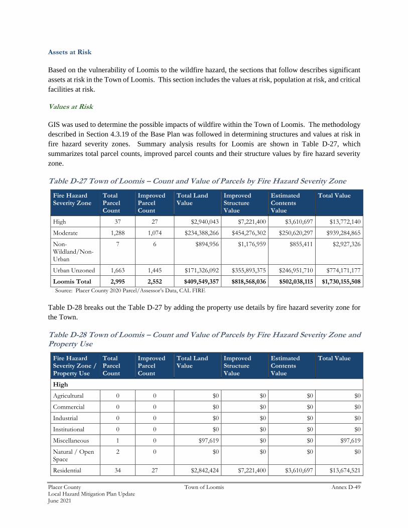
Placer County Town of Loomis Annex D-49 Local Hazard Mitigation Plan Update June 2021
Assets at Risk
Based on the vulnerability of Loomis to the wildfire hazard, the sections that follow describes significant
assets at risk in the Town of Loomis. This section includes the values at risk, population at risk, and critical
facilities at risk.
Values at Risk
GIS was used to determine the possible impacts of wildfire within the Town of Loomis. The methodology
described in Section 4.3.19 of the Base Plan was followed in determining structures and values at risk in
fire hazard severity zones. Summary analysis results for Loomis are shown in Table D-27, which
summarizes total parcel counts, improved parcel counts and their structure values by fire hazard severity
zone.
Table D-27 Town of Loomis – Count and Value of Parcels by Fire Hazard Severity Zone
Fire Hazard Severity Zone
Total Parcel Count
Improved Parcel Count
Total Land Value
Improved Structure Value
Estimated Contents Value
Total Value
High 37 27 $2,940,043 $7,221,400 $3,610,697 $13,772,140
Moderate 1,288 1,074 $234,388,266 $454,276,302 $250,620,297 $939,284,865
Non-Wildland/Non-Urban
7 6 $894,956 $1,176,959 $855,411 $2,927,326
Urban Unzoned 1,663 1,445 $171,326,092 $355,893,375 $246,951,710 $774,171,177
Loomis Total 2,995 2,552 $409,549,357 $818,568,036 $502,038,115 $1,730,155,508
Source: Placer County 2020 Parcel/Assessor’s Data, CAL FIRE
Table D-28 breaks out the Table D-27 by adding the property use details by fire hazard severity zone for
the Town.
Table D-28 Town of Loomis – Count and Value of Parcels by Fire Hazard Severity Zone and Property Use
Fire Hazard Severity Zone / Property Use
Total Parcel Count
Improved Parcel Count
Total Land Value
Improved Structure Value
Estimated Contents Value
Total Value
High
Agricultural 0 0 $0 $0 $0 $0
Commercial 0 0 $0 $0 $0 $0
Industrial 0 0 $0 $0 $0 $0
Institutional 0 0 $0 $0 $0 $0
Miscellaneous 1 0 $97,619 $0 $0 $97,619
Natural / Open Space
2 0 $0 $0 $0 $0
Residential 34 27 $2,842,424 $7,221,400 $3,610,697 $13,674,521
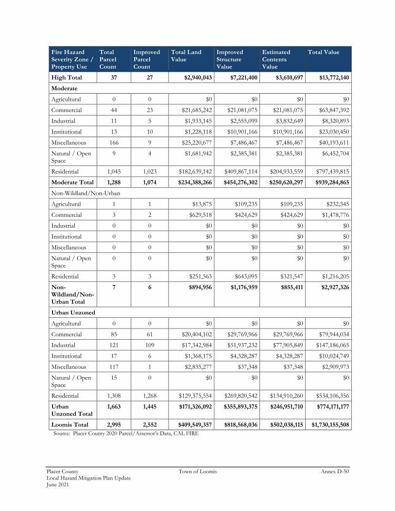
Placer County Town of Loomis Annex D-50 Local Hazard Mitigation Plan Update June 2021
Fire Hazard Severity Zone / Property Use
Total Parcel Count
Improved Parcel Count
Total Land Value
Improved Structure Value
Estimated Contents Value
Total Value
High Total 37 27 $2,940,043 $7,221,400 $3,610,697 $13,772,140
Moderate
Agricultural 0 0 $0 $0 $0 $0
Commercial 44 23 $21,685,242 $21,081,075 $21,081,075 $63,847,392
Industrial 11 5 $1,933,145 $2,555,099 $3,832,649 $8,320,893
Institutional 13 10 $1,228,118 $10,901,166 $10,901,166 $23,030,450
Miscellaneous 166 9 $25,220,677 $7,486,467 $7,486,467 $40,193,611
Natural / Open Space
9 4 $1,681,942 $2,385,381 $2,385,381 $6,452,704
Residential 1,045 1,023 $182,639,142 $409,867,114 $204,933,559 $797,439,815
Moderate Total 1,288 1,074 $234,388,266 $454,276,302 $250,620,297 $939,284,865
Non-Wildland/Non-Urban
Agricultural 1 1 $13,875 $109,235 $109,235 $232,345
Commercial 3 2 $629,518 $424,629 $424,629 $1,478,776
Industrial 0 0 $0 $0 $0 $0
Institutional 0 0 $0 $0 $0 $0
Miscellaneous 0 0 $0 $0 $0 $0
Natural / Open Space
0 0 $0 $0 $0 $0
Residential 3 3 $251,563 $643,095 $321,547 $1,216,205
Non-Wildland/Non-Urban Total
7 6 $894,956 $1,176,959 $855,411 $2,927,326
Urban Unzoned
Agricultural 0 0 $0 $0 $0 $0
Commercial 85 61 $20,404,102 $29,769,966 $29,769,966 $79,944,034
Industrial 121 109 $17,342,984 $51,937,232 $77,905,849 $147,186,065
Institutional 17 6 $1,368,175 $4,328,287 $4,328,287 $10,024,749
Miscellaneous 117 1 $2,835,277 $37,348 $37,348 $2,909,973
Natural / Open Space
15 0 $0 $0 $0 $0
Residential 1,308 1,268 $129,375,554 $269,820,542 $134,910,260 $534,106,356
Urban Unzoned Total
1,663 1,445 $171,326,092 $355,893,375 $246,951,710 $774,171,177
Loomis Total 2,995 2,552 $409,549,357 $818,568,036 $502,038,115 $1,730,155,508
Source: Placer County 2020 Parcel/Assessor’s Data, CAL FIRE
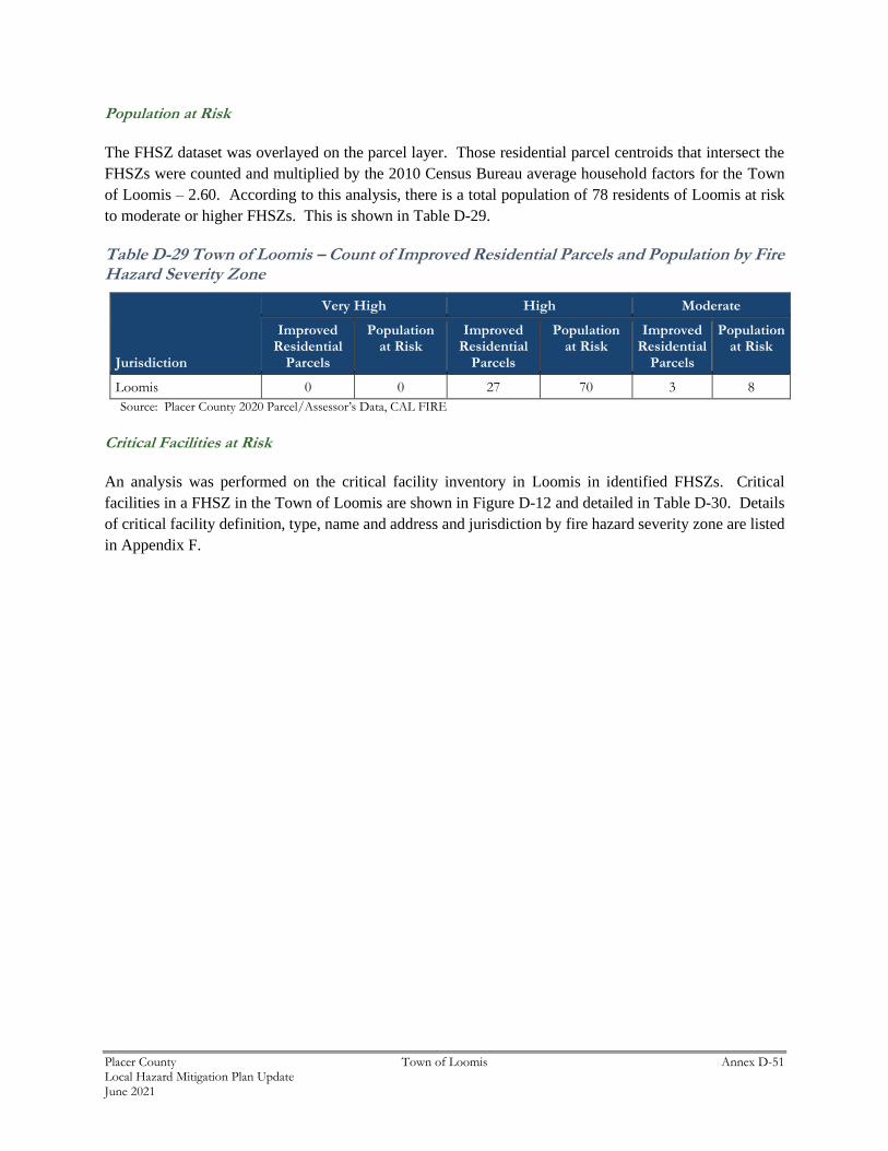
Placer County Town of Loomis Annex D-51 Local Hazard Mitigation Plan Update June 2021
Population at Risk
The FHSZ dataset was overlayed on the parcel layer. Those residential parcel centroids that intersect the
FHSZs were counted and multiplied by the 2010 Census Bureau average household factors for the Town
of Loomis – 2.60. According to this analysis, there is a total population of 78 residents of Loomis at risk
to moderate or higher FHSZs. This is shown in Table D-29.
Table D-29 Town of Loomis – Count of Improved Residential Parcels and Population by Fire Hazard Severity Zone
Jurisdiction
Very High High Moderate
Improved Residential
Parcels
Population at Risk
Improved Residential
Parcels
Population at Risk
Improved Residential
Parcels
Population at Risk
Loomis 0 0 27 70 3 8
Source: Placer County 2020 Parcel/Assessor’s Data, CAL FIRE
Critical Facilities at Risk
An analysis was performed on the critical facility inventory in Loomis in identified FHSZs. Critical
facilities in a FHSZ in the Town of Loomis are shown in Figure D-12 and detailed in Table D-30. Details
of critical facility definition, type, name and address and jurisdiction by fire hazard severity zone are listed
in Appendix F.
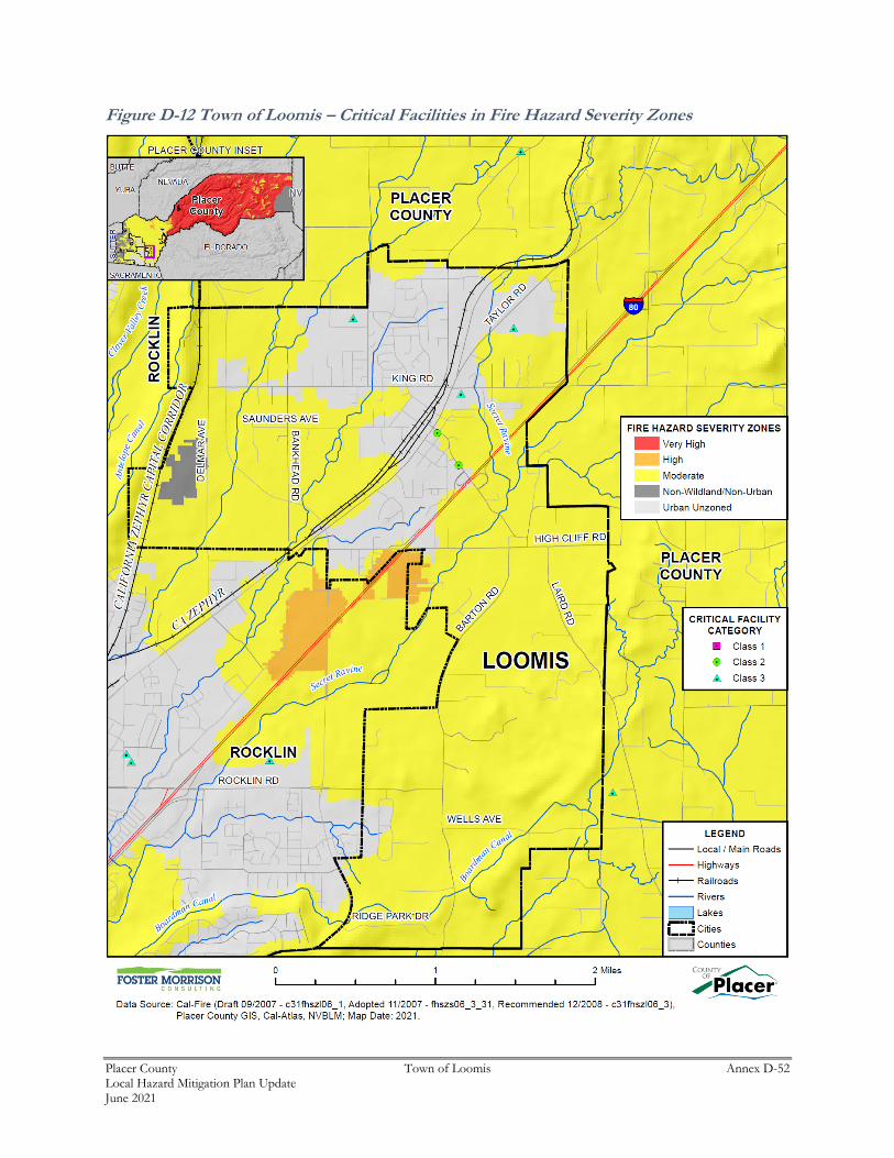
Placer County Town of Loomis Annex D-52 Local Hazard Mitigation Plan Update June 2021
Figure D-12 Town of Loomis – Critical Facilities in Fire Hazard Severity Zones
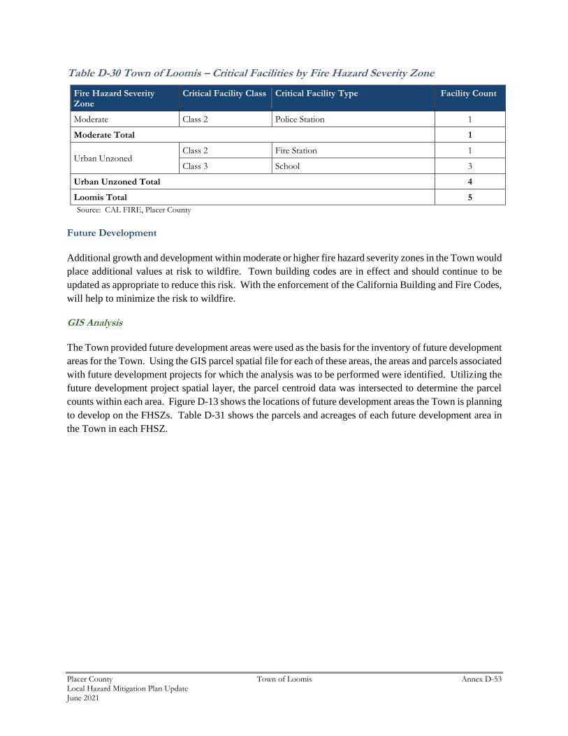
Placer County Town of Loomis Annex D-53 Local Hazard Mitigation Plan Update June 2021
Table D-30 Town of Loomis – Critical Facilities by Fire Hazard Severity Zone
Fire Hazard Severity Zone
Critical Facility Class Critical Facility Type Facility Count
Moderate Class 2 Police Station 1
Moderate Total 1
Urban Unzoned Class 2 Fire Station 1
Class 3 School 3
Urban Unzoned Total 4
Loomis Total 5
Source: CAL FIRE, Placer County
Future Development
Additional growth and development within moderate or higher fire hazard severity zones in the Town would
place additional values at risk to wildfire. Town building codes are in effect and should continue to be
updated as appropriate to reduce this risk. With the enforcement of the California Building and Fire Codes,
will help to minimize the risk to wildfire.
GIS Analysis
The Town provided future development areas were used as the basis for the inventory of future development
areas for the Town. Using the GIS parcel spatial file for each of these areas, the areas and parcels associated
with future development projects for which the analysis was to be performed were identified. Utilizing the
future development project spatial layer, the parcel centroid data was intersected to determine the parcel
counts within each area. Figure D-13 shows the locations of future development areas the Town is planning
to develop on the FHSZs. Table D-31 shows the parcels and acreages of each future development area in
the Town in each FHSZ.
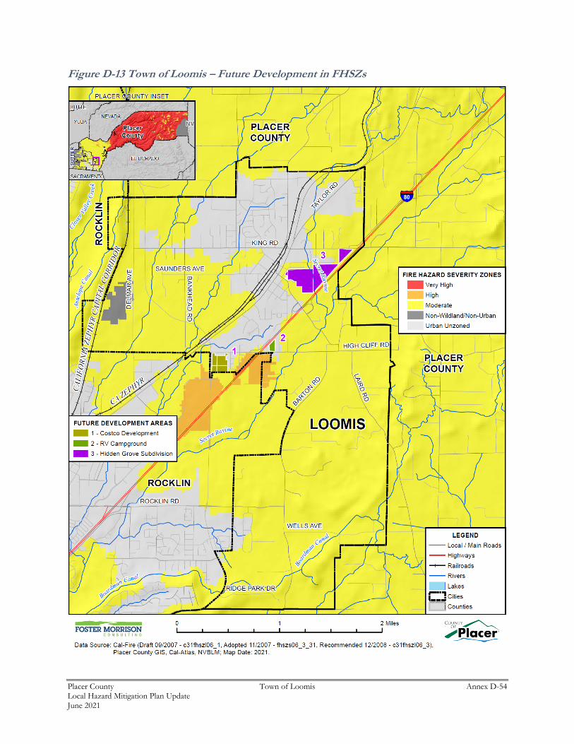
Placer County Town of Loomis Annex D-54 Local Hazard Mitigation Plan Update June 2021
Figure D-13 Town of Loomis – Future Development in FHSZs
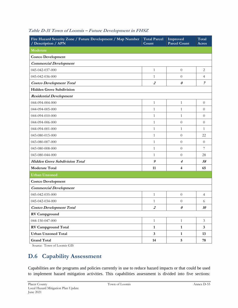
Placer County Town of Loomis Annex D-55 Local Hazard Mitigation Plan Update June 2021
Table D-31 Town of Loomis – Future Development in FHSZ
Fire Hazard Severity Zone / Future Development / Map Number / Description / APN
Total Parcel Count
Improved Parcel Count
Total Acres
Moderate
Costco Development
Commercial Development
045-042-037-000 1 0 2
045-042-036-000 1 0 4
Costco Development Total 2 0 7
Hidden Grove Subdivision
Residential Development
044-094-004-000 1 1 0
044-094-005-000 1 1 0
044-094-010-000 1 1 0
044-094-006-000 1 0 0
044-094-001-000 1 1 1
043-080-015-000 1 0 22
043-080-007-000 1 0 0
043-080-008-000 1 0 7
043-080-044-000 1 0 28
Hidden Grove Subdivision Total 9 4 58
Moderate Total 11 4 65
Urban Unzoned
Costco Development
Commercial Development
045-042-035-000 1 0 4
045-042-034-000 1 0 6
Costco Development Total 2 0 10
RV Campground
044-150-047-000 1 1 3
RV Campground Total 1 1 3
Urban Unzoned Total 3 1 13
Grand Total 14 5 78
Source: Town of Loomis GIS
D.6 Capability Assessment
Capabilities are the programs and policies currently in use to reduce hazard impacts or that could be used
to implement hazard mitigation activities. This capabilities assessment is divided into five sections:
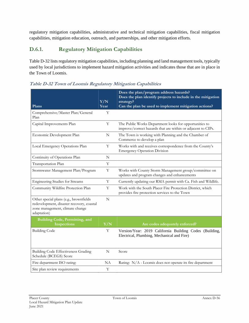
Placer County Town of Loomis Annex D-56 Local Hazard Mitigation Plan Update June 2021
regulatory mitigation capabilities, administrative and technical mitigation capabilities, fiscal mitigation
capabilities, mitigation education, outreach, and partnerships, and other mitigation efforts.
D.6.1. Regulatory Mitigation Capabilities
Table D-32 lists regulatory mitigation capabilities, including planning and land management tools, typically
used by local jurisdictions to implement hazard mitigation activities and indicates those that are in place in
the Town of Loomis.
Table D-32 Town of Loomis Regulatory Mitigation Capabilities
Plans Y/N Year
Does the plan/program address hazards? Does the plan identify projects to include in the mitigation strategy? Can the plan be used to implement mitigation actions?
Comprehensive/Master Plan/General Plan
Y
Capital Improvements Plan Y The Public Works Department looks for opportunities to improve/correct hazards that are within or adjacent to CIPs.
Economic Development Plan N The Town is working with Planning and the Chamber of Commerce to develop a plan
Local Emergency Operations Plan Y Works with and receives correspondence from the County’s Emergency Operation Division
Continuity of Operations Plan N
Transportation Plan Y
Stormwater Management Plan/Program Y Works with County Storm Management group/committee on updates and program changes and enhancements
Engineering Studies for Streams Y Currently updating our RMA permit with Ca. Fish and Wildlife.
Community Wildfire Protection Plan Y Work with the South Placer Fire Protection District, which provides fire protection services to the Town
Other special plans (e.g., brownfields redevelopment, disaster recovery, coastal zone management, climate change adaptation)
N
Building Code, Permitting, and Inspections Y/N Are codes adequately enforced?
Building Code Y Version/Year: 2019 California Building Codes (Building,
Electrical, Plumbing, Mechanical and Fire)
Building Code Effectiveness Grading Schedule (BCEGS) Score
N Score
Fire department ISO rating: NA Rating: N/A - Loomis does not operate its fire department
Site plan review requirements Y
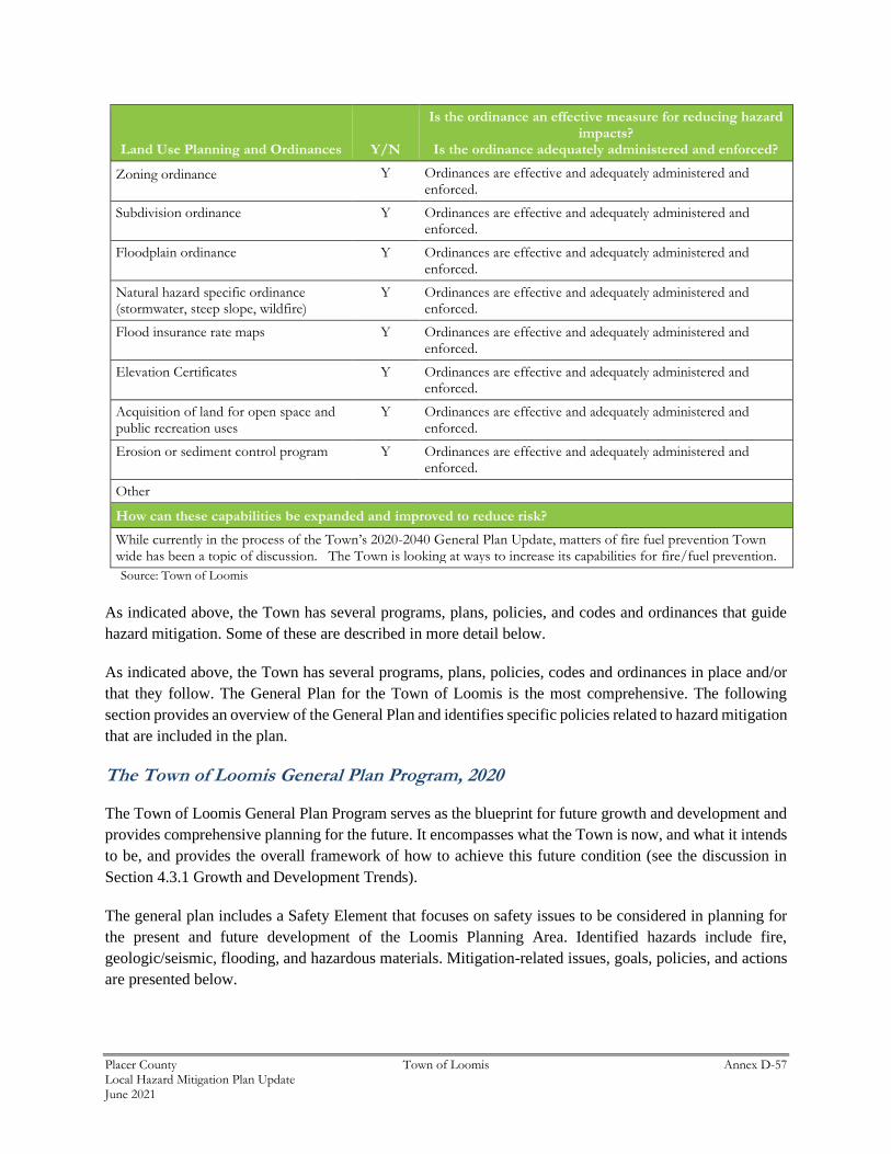
Placer County Town of Loomis Annex D-57 Local Hazard Mitigation Plan Update June 2021
Land Use Planning and Ordinances Y/N
Is the ordinance an effective measure for reducing hazard impacts?
Is the ordinance adequately administered and enforced?
Zoning ordinance Y Ordinances are effective and adequately administered and enforced.
Subdivision ordinance Y Ordinances are effective and adequately administered and enforced.
Floodplain ordinance Y Ordinances are effective and adequately administered and enforced.
Natural hazard specific ordinance (stormwater, steep slope, wildfire)
Y Ordinances are effective and adequately administered and enforced.
Flood insurance rate maps Y Ordinances are effective and adequately administered and enforced.
Elevation Certificates Y Ordinances are effective and adequately administered and enforced.
Acquisition of land for open space and public recreation uses
Y Ordinances are effective and adequately administered and enforced.
Erosion or sediment control program Y Ordinances are effective and adequately administered and enforced.
Other
How can these capabilities be expanded and improved to reduce risk?
While currently in the process of the Town’s 2020-2040 General Plan Update, matters of fire fuel prevention Town wide has been a topic of discussion. The Town is looking at ways to increase its capabilities for fire/fuel prevention.
Source: Town of Loomis
As indicated above, the Town has several programs, plans, policies, and codes and ordinances that guide
hazard mitigation. Some of these are described in more detail below.
As indicated above, the Town has several programs, plans, policies, codes and ordinances in place and/or
that they follow. The General Plan for the Town of Loomis is the most comprehensive. The following
section provides an overview of the General Plan and identifies specific policies related to hazard mitigation
that are included in the plan.
The Town of Loomis General Plan Program, 2020
The Town of Loomis General Plan Program serves as the blueprint for future growth and development and
provides comprehensive planning for the future. It encompasses what the Town is now, and what it intends
to be, and provides the overall framework of how to achieve this future condition (see the discussion in
Section 4.3.1 Growth and Development Trends).
The general plan includes a Safety Element that focuses on safety issues to be considered in planning for
the present and future development of the Loomis Planning Area. Identified hazards include fire,
geologic/seismic, flooding, and hazardous materials. Mitigation-related issues, goals, policies, and actions
are presented below.
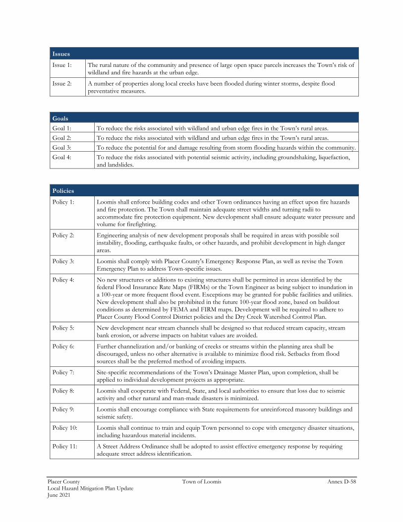
Placer County Town of Loomis Annex D-58 Local Hazard Mitigation Plan Update June 2021
Issues
Issue 1: The rural nature of the community and presence of large open space parcels increases the Town’s risk of wildland and fire hazards at the urban edge.
Issue 2: A number of properties along local creeks have been flooded during winter storms, despite flood preventative measures.
Goals
Goal 1: To reduce the risks associated with wildland and urban edge fires in the Town’s rural areas.
Goal 2: To reduce the risks associated with wildland and urban edge fires in the Town’s rural areas.
Goal 3: To reduce the potential for and damage resulting from storm flooding hazards within the community.
Goal 4: To reduce the risks associated with potential seismic activity, including groundshaking, liquefaction, and landslides.
Policies
Policy 1: Loomis shall enforce building codes and other Town ordinances having an effect upon fire hazards and fire protection. The Town shall maintain adequate street widths and turning radii to accommodate fire protection equipment. New development shall ensure adequate water pressure and volume for firefighting.
Policy 2: Engineering analysis of new development proposals shall be required in areas with possible soil instability, flooding, earthquake faults, or other hazards, and prohibit development in high danger areas.
Policy 3: Loomis shall comply with Placer County's Emergency Response Plan, as well as revise the Town Emergency Plan to address Town-specific issues.
Policy 4: No new structures or additions to existing structures shall be permitted in areas identified by the federal Flood Insurance Rate Maps (FIRMs) or the Town Engineer as being subject to inundation in a 100-year or more frequent flood event. Exceptions may be granted for public facilities and utilities. New development shall also be prohibited in the future 100-year flood zone, based on buildout conditions as determined by FEMA and FIRM maps. Development will be required to adhere to Placer County Flood Control District policies and the Dry Creek Watershed Control Plan.
Policy 5: New development near stream channels shall be designed so that reduced stream capacity, stream bank erosion, or adverse impacts on habitat values are avoided.
Policy 6: Further channelization and/or banking of creeks or streams within the planning area shall be discouraged, unless no other alternative is available to minimize flood risk. Setbacks from flood sources shall be the preferred method of avoiding impacts.
Policy 7: Site-specific recommendations of the Town’s Drainage Master Plan, upon completion, shall be applied to individual development projects as appropriate.
Policy 8: Loomis shall cooperate with Federal, State, and local authorities to ensure that loss due to seismic activity and other natural and man-made disasters is minimized.
Policy 9: Loomis shall encourage compliance with State requirements for unreinforced masonry buildings and seismic safety.
Policy 10: Loomis shall continue to train and equip Town personnel to cope with emergency disaster situations, including hazardous material incidents.
Policy 11: A Street Address Ordinance shall be adopted to assist effective emergency response by requiring adequate street address identification.
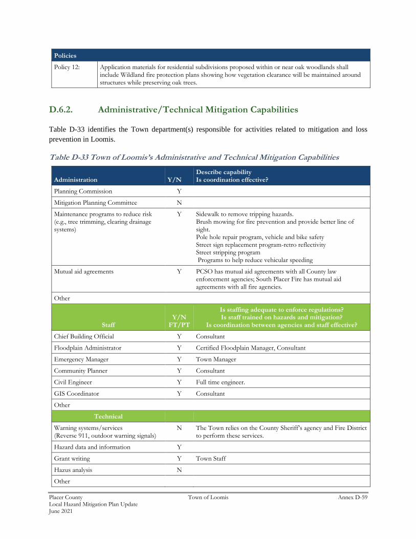
Placer County Town of Loomis Annex D-59 Local Hazard Mitigation Plan Update June 2021
Policies
Policy 12: Application materials for residential subdivisions proposed within or near oak woodlands shall include Wildland fire protection plans showing how vegetation clearance will be maintained around structures while preserving oak trees.
D.6.2. Administrative/Technical Mitigation Capabilities
Table D-33 identifies the Town department(s) responsible for activities related to mitigation and loss
prevention in Loomis.
Table D-33 Town of Loomis’s Administrative and Technical Mitigation Capabilities
Administration Y/N Describe capability Is coordination effective?
Planning Commission Y
Mitigation Planning Committee N
Maintenance programs to reduce risk (e.g., tree trimming, clearing drainage systems)
Y Sidewalk to remove tripping hazards. Brush mowing for fire prevention and provide better line of sight. Pole hole repair program, vehicle and bike safety Street sign replacement program-retro reflectivity Street stripping program Programs to help reduce vehicular speeding
Mutual aid agreements Y PCSO has mutual aid agreements with all County law enforcement agencies; South Placer Fire has mutual aid agreements with all fire agencies.
Other
Staff Y/N
FT/PT
Is staffing adequate to enforce regulations? Is staff trained on hazards and mitigation?
Is coordination between agencies and staff effective?
Chief Building Official Y Consultant
Floodplain Administrator Y Certified Floodplain Manager, Consultant
Emergency Manager Y Town Manager
Community Planner Y Consultant
Civil Engineer Y Full time engineer.
GIS Coordinator Y Consultant
Other
Technical
Warning systems/services (Reverse 911, outdoor warning signals)
N The Town relies on the County Sheriff’s agency and Fire District to perform these services.
Hazard data and information Y
Grant writing Y Town Staff
Hazus analysis N
Other
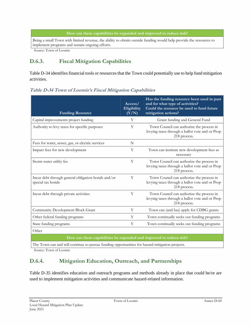
Placer County Town of Loomis Annex D-60 Local Hazard Mitigation Plan Update June 2021
How can these capabilities be expanded and improved to reduce risk?
Being a small Town with limited revenue, the ability to obtain outside funding would help provide the resources to implement programs and sustain ongoing efforts.
Source: Town of Loomis
D.6.3. Fiscal Mitigation Capabilities
Table D-34 identifies financial tools or resources that the Town could potentially use to help fund mitigation
activities.
Table D-34 Town of Loomis’s Fiscal Mitigation Capabilities
Funding Resource
Access/ Eligibility
(Y/N)
Has the funding resource been used in past and for what type of activities? Could the resource be used to fund future mitigation actions?
Capital improvements project funding Y Grant funding and General Fund
Authority to levy taxes for specific purposes Y Town Council can authorize the process in levying taxes through a ballot vote and or Prop
218 process.
Fees for water, sewer, gas, or electric services N
Impact fees for new development Y Town can institute new development fees as necessary
Storm water utility fee Y Town Council can authorize the process in levying taxes through a ballot vote and or Prop
218 process.
Incur debt through general obligation bonds and/or special tax bonds
Y Town Council can authorize the process in levying taxes through a ballot vote and or Prop
218 process.
Incur debt through private activities Y Town Council can authorize the process in levying taxes through a ballot vote and or Prop
218 process.
Community Development Block Grant Y Town can (and has) apply for CDBG grants
Other federal funding programs Y Town continually seeks out funding programs
State funding programs Y Town continually seeks out funding programs
Other
How can these capabilities be expanded and improved to reduce risk?
The Town can and will continue to pursue funding opportunities for hazard mitigation projects.
Source: Town of Loomis
D.6.4. Mitigation Education, Outreach, and Partnerships
Table D-35 identifies education and outreach programs and methods already in place that could be/or are
used to implement mitigation activities and communicate hazard-related information.
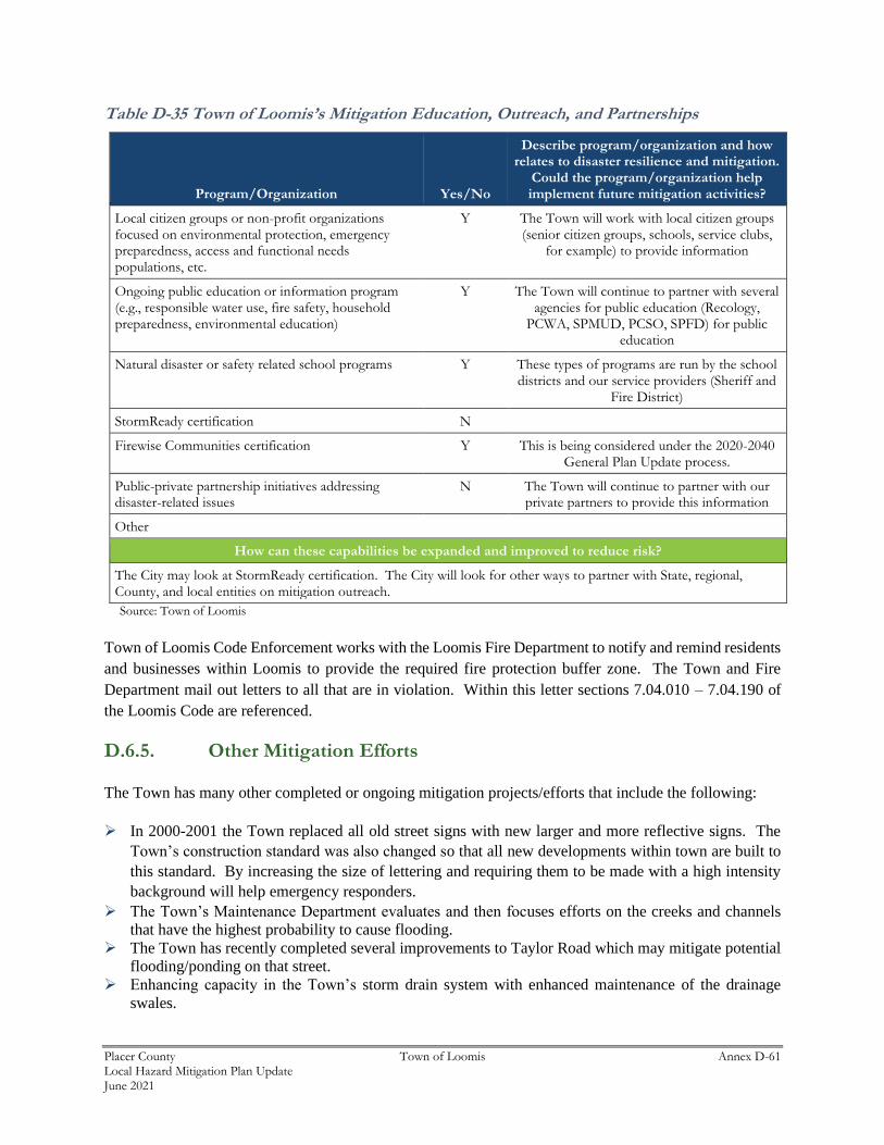
Placer County Town of Loomis Annex D-61 Local Hazard Mitigation Plan Update June 2021
Table D-35 Town of Loomis’s Mitigation Education, Outreach, and Partnerships
Program/Organization Yes/No
Describe program/organization and how relates to disaster resilience and mitigation.
Could the program/organization help implement future mitigation activities?
Local citizen groups or non-profit organizations focused on environmental protection, emergency preparedness, access and functional needs populations, etc.
Y The Town will work with local citizen groups (senior citizen groups, schools, service clubs,
for example) to provide information
Ongoing public education or information program (e.g., responsible water use, fire safety, household preparedness, environmental education)
Y The Town will continue to partner with several agencies for public education (Recology,
PCWA, SPMUD, PCSO, SPFD) for public education
Natural disaster or safety related school programs Y These types of programs are run by the school districts and our service providers (Sheriff and
Fire District)
StormReady certification N
Firewise Communities certification Y This is being considered under the 2020-2040 General Plan Update process.
Public-private partnership initiatives addressing disaster-related issues
N The Town will continue to partner with our private partners to provide this information
Other
How can these capabilities be expanded and improved to reduce risk?
The City may look at StormReady certification. The City will look for other ways to partner with State, regional, County, and local entities on mitigation outreach.
Source: Town of Loomis
Town of Loomis Code Enforcement works with the Loomis Fire Department to notify and remind residents
and businesses within Loomis to provide the required fire protection buffer zone. The Town and Fire
Department mail out letters to all that are in violation. Within this letter sections 7.04.010 – 7.04.190 of
the Loomis Code are referenced.
D.6.5. Other Mitigation Efforts
The Town has many other completed or ongoing mitigation projects/efforts that include the following:
➢ In 2000-2001 the Town replaced all old street signs with new larger and more reflective signs. The
Town’s construction standard was also changed so that all new developments within town are built to
this standard. By increasing the size of lettering and requiring them to be made with a high intensity
background will help emergency responders.
➢ The Town’s Maintenance Department evaluates and then focuses efforts on the creeks and channels
that have the highest probability to cause flooding.
➢ The Town has recently completed several improvements to Taylor Road which may mitigate potential
flooding/ponding on that street.
➢ Enhancing capacity in the Town’s storm drain system with enhanced maintenance of the drainage
swales.
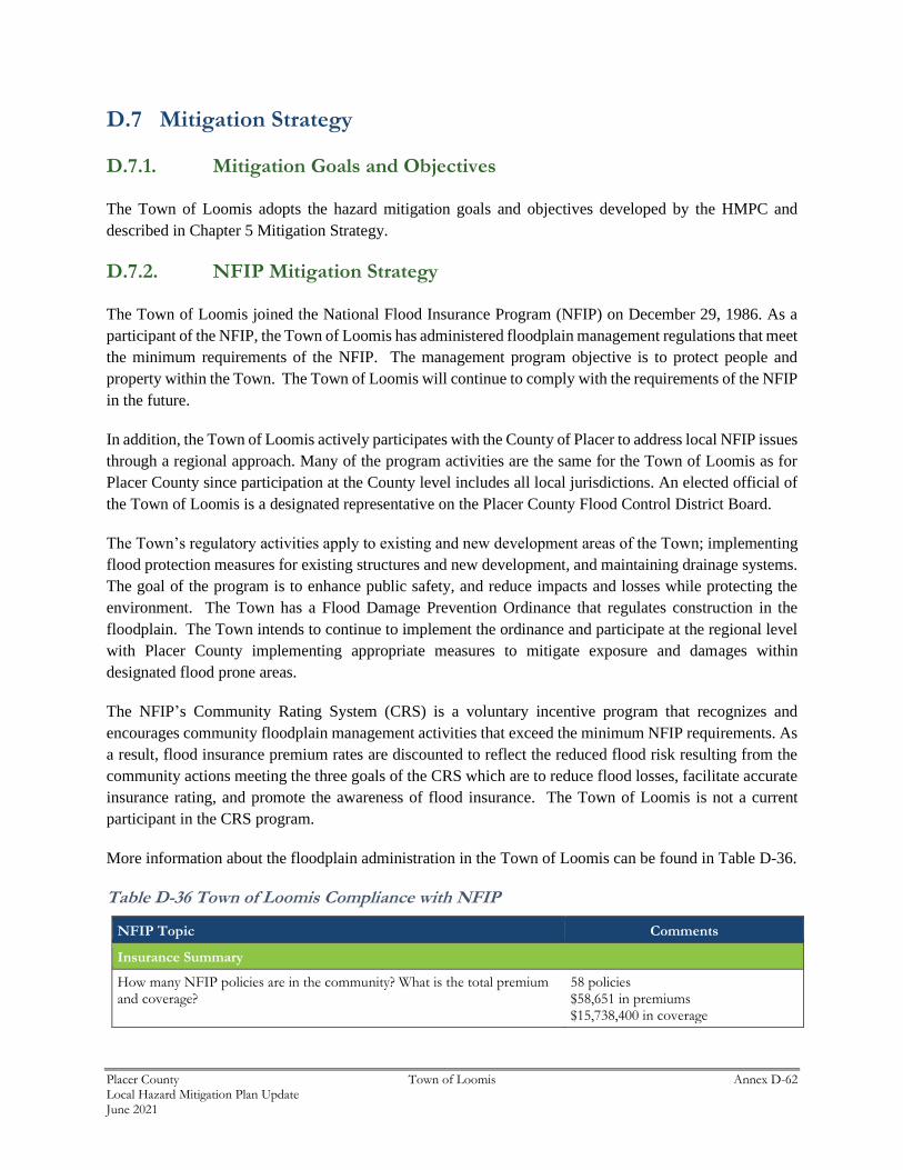
Placer County Town of Loomis Annex D-62 Local Hazard Mitigation Plan Update June 2021
D.7 Mitigation Strategy
D.7.1. Mitigation Goals and Objectives
The Town of Loomis adopts the hazard mitigation goals and objectives developed by the HMPC and
described in Chapter 5 Mitigation Strategy.
D.7.2. NFIP Mitigation Strategy
The Town of Loomis joined the National Flood Insurance Program (NFIP) on December 29, 1986. As a
participant of the NFIP, the Town of Loomis has administered floodplain management regulations that meet
the minimum requirements of the NFIP. The management program objective is to protect people and
property within the Town. The Town of Loomis will continue to comply with the requirements of the NFIP
in the future.
In addition, the Town of Loomis actively participates with the County of Placer to address local NFIP issues
through a regional approach. Many of the program activities are the same for the Town of Loomis as for
Placer County since participation at the County level includes all local jurisdictions. An elected official of
the Town of Loomis is a designated representative on the Placer County Flood Control District Board.
The Town’s regulatory activities apply to existing and new development areas of the Town; implementing
flood protection measures for existing structures and new development, and maintaining drainage systems.
The goal of the program is to enhance public safety, and reduce impacts and losses while protecting the
environment. The Town has a Flood Damage Prevention Ordinance that regulates construction in the
floodplain. The Town intends to continue to implement the ordinance and participate at the regional level
with Placer County implementing appropriate measures to mitigate exposure and damages within
designated flood prone areas.
The NFIP’s Community Rating System (CRS) is a voluntary incentive program that recognizes and
encourages community floodplain management activities that exceed the minimum NFIP requirements. As
a result, flood insurance premium rates are discounted to reflect the reduced flood risk resulting from the
community actions meeting the three goals of the CRS which are to reduce flood losses, facilitate accurate
insurance rating, and promote the awareness of flood insurance. The Town of Loomis is not a current
participant in the CRS program.
More information about the floodplain administration in the Town of Loomis can be found in Table D-36.
Table D-36 Town of Loomis Compliance with NFIP
NFIP Topic Comments
Insurance Summary
How many NFIP policies are in the community? What is the total premium and coverage?
58 policies $58,651 in premiums $15,738,400 in coverage
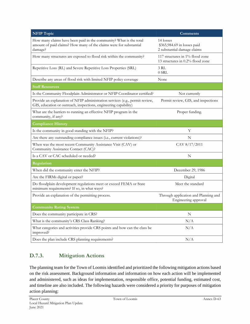
Placer County Town of Loomis Annex D-63 Local Hazard Mitigation Plan Update June 2021
NFIP Topic Comments
How many claims have been paid in the community? What is the total amount of paid claims? How many of the claims were for substantial damage?
14 losses $365,984.69 in losses paid 2 substantial damage claims
How many structures are exposed to flood risk within the community? 117 structures in 1% flood zone 13 structures in 0.2% flood zone
Repetitive Loss (RL) and Severe Repetitive Loss Properties (SRL) 3 RL 0 SRL
Describe any areas of flood risk with limited NFIP policy coverage None
Staff Resources
Is the Community Floodplain Administrator or NFIP Coordinator certified? Not currently
Provide an explanation of NFIP administration services (e.g., permit review, GIS, education or outreach, inspections, engineering capability)
Permit review, GIS, and inspections
What are the barriers to running an effective NFIP program in the community, if any?
Proper funding.
Compliance History
Is the community in good standing with the NFIP? Y
Are there any outstanding compliance issues (i.e., current violations)? N
When was the most recent Community Assistance Visit (CAV) or Community Assistance Contact (CAC)?
CAV 8/17/2011
Is a CAV or CAC scheduled or needed? N
Regulation
When did the community enter the NFIP? December 29, 1986
Are the FIRMs digital or paper? Digital
Do floodplain development regulations meet or exceed FEMA or State minimum requirements? If so, in what ways?
Meet the standard
Provide an explanation of the permitting process. Through application and Planning and Engineering approval
Community Rating System
Does the community participate in CRS? N
What is the community’s CRS Class Ranking? N/A
What categories and activities provide CRS points and how can the class be improved?
N/A
Does the plan include CRS planning requirements? N/A
D.7.3. Mitigation Actions
The planning team for the Town of Loomis identified and prioritized the following mitigation actions based
on the risk assessment. Background information and information on how each action will be implemented
and administered, such as ideas for implementation, responsible office, potential funding, estimated cost,
and timeline are also included. The following hazards were considered a priority for purposes of mitigation
action planning:
Placer County Town of Loomis Annex D-64 Local Hazard Mitigation Plan Update June 2021
➢ Climate Change
➢ Drought & Water Shortage
➢ Earthquake
➢ Floods: 1%/0.2% annual chance
➢ Floods: Localized Stormwater
➢ Pandemic
➢ Severe Weather: Heavy Rains and Storms
➢ Tree Mortality
➢ Wildfire
It should be noted that many of the projects submitted by each jurisdiction in Table 5-4 in the Base Plan
benefit all jurisdictions whether or not they are the lead agency. Further, many of these mitigation efforts
are collaborative efforts among multiple local, state, and federal agencies. In addition, the countywide
public outreach action, as well as many of the emergency services actions, apply to all hazards regardless
of hazard priority. Collectively, this multi-jurisdictional mitigation strategy includes only those actions and
projects which reflect the actual priorities and capacity of each jurisdiction to implement over the next 5-
years covered by this plan. It should further be noted, that although a jurisdiction may not have specific
projects identified for each priority hazard for the five year coverage of this planning process, each
jurisdiction has focused on identifying those projects which are realistic and reasonable for them to
implement and would like to preserve their hazard priorities should future projects be identified where the
implementing jurisdiction has the future capacity to implement.
Multi-Hazard Actions
Action 1. Integrate Local Hazard Mitigation Plan into Safety Element of General Plan
Hazards Addressed: Multi-hazard (Climate Change, Drought & Water Shortage, Earthquake, Floods:
1%/0.2% annual chance, Floods: Localized Stormwater, Pandemic, Severe Weather: Heavy Rains and
Storms, Tree Mortality, Wildfire)
Goals Addressed: 1, 2, 3, 4, 5, 6, 7
Issue/Background: Local jurisdictional reimbursement for mitigation projects and cost recovery after a
disaster is guided by Government Code Section 8685.9 (AB 2140).
Project Description: Specifically, this section requires that each jurisdiction adopt a local hazard
mitigation plan (LHMP) in accordance with the federal Disaster Mitigation Act of 2000 as part of the Safety
Element of its General Plan. Adoption of the LHMP into the Safety Element of the General Plan may be
by reference or incorporation.
Other Alternatives: No action
Existing Planning Mechanisms through which Action will be Implemented: Safety Element of General
Plan
Responsible Office: Town of Loomis Planning Department
Placer County Town of Loomis Annex D-65 Local Hazard Mitigation Plan Update June 2021
Priority (H, M, L): High
Cost Estimate: Jurisdictional board/staff time
Potential Funding: Local budgets
Benefits (avoided Losses): Incorporation of an adopted LHMP into the Safety Element of the General
Plan will help jurisdictions maximize the cost recovery potential following a disaster.
Schedule: As soon as possible
Action 2. Enhance Public Education and Awareness of Natural Hazards and Public
Understanding of Disaster Preparedness
Hazards Addressed: Multi-hazard (Climate Change, Drought & Water Shortage, Earthquake, Floods:
1%/0.2% annual chance, Floods: Localized Stormwater, Pandemic, Severe Weather: Heavy Rains and
Storms, Tree Mortality, Wildfire)
Goals Addressed: 1, 2, 3, 4, 5, 6, 7
Issue/Background: The Town and County play a key role in public outreach/education efforts to
communicate the potential risk and vulnerability of their community to the effects of natural hazards. A
comprehensive multi-hazard public education program will better inform the community of natural hazards
of concern and actions the public can take to be better prepared for the next natural disaster event.
Project Description: A comprehensive multi-hazard outreach program will ascertain both broad and
targeted educational needs throughout the community. The Town will work with the County and other
agencies as appropriate to develop timely and consistent annual outreach messages in order to communicate
the risk and vulnerability of natural hazards of concern to the community. This includes measures the
public can take to be better prepared and to reduce the damages and other impacts from a hazard event.
The public outreach effort will leverage and build upon existing mechanisms.
Other Alternatives: Continue public information activities currently in place.
Existing Planning Mechanism(s) through which Action Will Be Implemented: Existing County
outreach programs will be reviewed for effectiveness and leveraged and expanded upon to reach the broader
region.
Responsible Office: Town of Loomis in partnership with the County
Priority (H, M, L): High
Cost Estimate: Annual costs to be determined, and will depend on the scope and frequency of activities
and events as well as volunteer participation
Placer County Town of Loomis Annex D-66 Local Hazard Mitigation Plan Update June 2021
Benefits (Losses Avoided): Increase residents’ knowledge of potential hazards and activities required to
mitigate hazards and be better prepared. Protect lives and reduce damages, relatively low cost to
implement.
Potential Funding: Local budgets, grant funds
Timeline: Ongoing/Annual public awareness campaign
Action 3. Renewal Of Town of Loomis RMA permit
Hazards Addressed: Climate Change, Flood, Localized Flood, Heavy Rain and Storms
Goals Addressed: 1, 2, 3, 4, 5, 6, 7
Issue/Background: To be able to maintain and perform simple maintenance on the various drainage
channels, the Town needs to have a Routine Maintenance Agreement (RMA) permit form Ca. Fish and
Wildlife.
Project Description: Permit will allow Town Staff and contractors to perform maintenance activities to
provide proper drainage flow.
Other Alternatives: N/A
Existing Planning Mechanism(s) through which Action Will Be Implemented: N/A
Responsible Agency/ Department/Partners: Town of Loomis Department of Public Works
Cost Estimate: $50,000
Benefits (Losses Avoided): Potentially avoid flooding issues through scheduled maintenance
Potential Funding: General Fund
Timeline: 2 to 3 months
Project Priority (H, M, L): H
Action 4. Climate Change Mitigation
Hazards Addressed: Climate Change and all hazards exacerbated by Climate Change
Goals Addressed: 1, 2, 3, 4, 5, 6, 7
Issue/Background: With the noticeable change of weather patterns, it has become more noticeable that
our community needs to be more prepared in regard to differing weather patterns, such as longer dry and
heat seasons and on the opposite longer wet and cooling seasons. If this trend is becoming our new normal,
the challenge will to be to educate the local population on how to be prepared.
Placer County Town of Loomis Annex D-67 Local Hazard Mitigation Plan Update June 2021
Project Description: Establish an educational awareness outreach programs on how to educate the
residential and business community about extreme temperature changes and the dangers that are posed to
a community when they do not protect themselves or the community around them.
Other Alternatives: Work with other jurisdictions to promote Best Management Practices regarding
preparedness for extreme weather changes.
Existing Planning Mechanism(s) through which Action Will Be Implemented: Using the Town’s
residential and commercial data base to correspond to the residents and businesses with educational
information regarding climate change hazards, also to communicate who to correspond if help or assistance
is needed.
Responsible Agency/ Department/Partners: Town of Loomis, Placer County Fire District, Placer County
Sheriff’s Department
Cost Estimate: Annual outreach and materials, $20,000
Benefits (Losses Avoided): If individuals are prepared, there will be less draw down on first responders.
Potential Funding: Grants, General Fund
Timeline: 1 to 2 years
Project Priority (H, M, L): H
Action 5. Drought and Water Shortage Mitigation
Hazards Addressed: Climate Change, Drought, lack of potable water
Goals Addressed: 1, 2, 3, 4, 5, 6, 7
Issue/Background: During the last decade areas in California have witnessed and suffered through the
lack of potable water due to long periods of drought. The issue that has become obvious is with the lack of
water, both businesses and residents have to be petter prepared to live with less and better prepared on how
to do more with less.
Project Description: Establish Town wide water conservation polices and best management practices that
incorporate Town, residents, businesses, and those who utilize groundwater. Establish a retro fit water
supply program, Encourage drought resistant landscaping, promote groundwater recharging efforts.
Other Alternatives: No action.
Existing Planning Mechanism(s) through which Action Will Be Implemented: City Manager and
Public Works Departments establishing polices with in their department on how to conserve water use.
Responsible Agency/ Department/Partners: Town of Loomis, Placer County Water District, Town
Administration, Public Works, and Planning Departments

Placer County Town of Loomis Annex D-68 Local Hazard Mitigation Plan Update June 2021
Cost Estimate: Annual cost to keep current and up to date, $50,000
Benefits (Losses Avoided): Preserving water for human and vegetation (food crops) during drought
conditions.
Potential Funding: Grants, partnership with water purveyor, General fund
Timeline: 1 to 2 years to get project partners in place to sustain the drought program
Project Priority (H, M, L): H
Action 6. Earthquake Mitigation and Preparedness
Hazards Addressed: Earthquakes
Goals Addressed: 1, 2, 3, 4, 5, 6, 7
Issue/Background: Earthquakes come without notice, the damage that can occur can be sever, collapse of
buildings, liquefaction and landslides, loss of essential infrastructure, property damage and death.
Project Description: Establish programs that can assist residents and businesses on how to prepare for,
during, and post-earthquake.
Other Alternatives: No action
Existing Planning Mechanism(s) through which Action Will Be Implemented: Establish a safety
committee that can provide strategies, draft polity for Town Council to adopt to equip staff and community
on next steps in a seismic event. Provide outreach materials to community on how to prepare for during an
earthquake, what to do and what not to do. Establish simulated earthquake drills through an emergency
operation center (EOC) scenario.
Create action plan for failed utilities.
Work with the building department to review building inventory in Town that may be vulnerable to
earthquake damage such as unreinforced masonry structures, public and private buildings that were built
prior to earthquake standards. Review facilities that have generators and elevators that they are properly
braced. Map on GIS those structures that are at risk during a seismic event.
Create programs to distribute earthquake hardware items such as hot water heater straps, gas and water
keys/wrenches to shut off hose gas and water lines to home.
Responsible Agency/ Department/Partners: Town of Loomis, Loomis Public Works, Building, Planning
and Administrative Departments Placer County Fire District, Placer County Sheriff Department, Local
utility companies,
Cost Estimate: Annual $25,000
Placer County Town of Loomis Annex D-69 Local Hazard Mitigation Plan Update June 2021
Benefits (Losses Avoided): First is to save lives, second is hopefully minimize property damage
Potential Funding: Grant programs, utility companies’ contribution to the Earthquake awareness program
and outreach, local businesses, General fund
Timeline: 5 to 10 years
Project Priority (H, M, L): H
Action 7. Pandemic/Epidemic Mitigation
Hazards Addressed: Pandemic, Virus outbreaks, Flu strains, food contamination
Goals Addressed: 1, 2, 3, 4, 5, 6, 7
Issue/Background: Recently the COVID 19 outbreak brought an awareness to the community that
protocols, policies and a greater community awareness needs to be in place for future virus outbreaks that
may rise to the level of Pandemic or epidemic status.
Project Description: Provide a community outreach program that can assist in what to do and not what to
do in a pandemic/epidemic outbreak. Provide hot lines for residents and businesses to help navigate through
the various changes that take place during an outbreak. Provide local updates vis local website, mailers and
local CCTV events. Stockpile and provide personal protective equipment (PPE) and sanitary cleaning
supplies.
Other Alternatives: Continue with public information activities currently in place
Existing Planning Mechanism(s) through which Action Will Be Implemented: Continue to review and
update local outreach materials and outreach efforts.
Responsible Agency/ Department/Partners: Town of Loomis working with County and State Health
Department/
Local health providers and vendor for PPE
Cost Estimate: Annual costs are determined by the outbreak event, annual cost for stockpiling PPE in the
range of $2000 to $3000
Benefits (Losses Avoided): Being prepared will help save lives and keep community informed and
educated on what to do.
Potential Funding: Local contributions from businesses and health organizations, Grant opportunities,
General fund
Timeline: Ongoing
Project Priority (H, M, L): H
Placer County Town of Loomis Annex D-70 Local Hazard Mitigation Plan Update June 2021
Action 8. Severe Weather - Heavy Rains Mitigation
Hazards Addressed: Climate Change, Flooding, Landslides, erosion,
Goals Addressed: 1, 2, 3, 4, 5, 6, 7
Issue/Background: With Climate Change prolonged heavy rains can be anticipated. When such severe
weather is encountered, the public and businesses are fronted with flooding, landslides and severe erosion
activity. Drainage channels to move the water to larger bodies of water are compromised, private and public
properties are susceptible severe damage and total loss, lives can also be compromised. Utilities are also
compromised with power outages.
Project Description: Conduct weather risk analysis of drainage channels, hillside embankments that may
be vulnerable to landslide, liquefaction, or erosion. Identify at risk members of the Loomis population who
may need assistance during severe weather and heavy rain events. Provide outreach to the community
through the Town website, mailers and updates at public meetings on how to respond to such events.
Other Alternatives: Continue with Public outreach efforts to inform residents and public
Existing Planning Mechanism(s) through which Action Will Be Implemented: Outreach efforts will
be administered through the Town of Loomis’s Administrative Department.
Responsible Agency/ Department/Partners: Town of Loomis City Manager’s Office, Loomis Public
Works, Placer County Fire District, County Sheriff, local utility companies
Cost Estimate: General fund,
Benefits (Losses Avoided): Having an educational and outreach process in place will help preserve lives
and property.
Potential Funding: Grant funding and local funds
Timeline: Ongoing, continued work on public awareness
Project Priority (H, M, L): M
Action 9. Tree Mortality Mitigation
Hazards Addressed: Falling trees, Tree Mortality, Wildfires
Goals Addressed: 1, 2, 3, 4, 5, 6, 7
Issue/Background: Dead and diseased trees left unattended can become fuel for wildfires, when within
the right of Way, they can become a hazard to the public who live and travel in the path of the ailing or
dead trees. Dying or dead tree can largely be contributed to Climate Change.
Placer County Town of Loomis Annex D-71 Local Hazard Mitigation Plan Update June 2021
Project Description: Survey the Town’s tree population around Town, evaluate the current health of tress
that make the Right of Way vulnerable to potential life-threatening conditions during inclement weather
events and also public and private property damage. The survey process would include evaluating the trees,
tagging, and posting on the GIS system.
Other Alternatives: No Action
Existing Planning Mechanism(s) through which Action Will Be Implemented: Amend existing or
establish new tree ordinances that have provisions to enforce landowners to maintain the tree population on
their property, remove dying or dead trees so as not to produce a hazard. Public works to provide an
inventory of street and park trees and the health of those trees and an action plan to maintain or remove
trees.
Responsible Agency/ Department/Partners: Town of Loomis Public Works and Planning Departments.
Cost Estimate: Annual costs to maintain public trees, $25,000 to $30,000, cost to outreach and educate
private landowners on tree mortality, $10,000.
Benefits (Losses Avoided): Remove dying or diseased trees will assist in trees not causing damage and
or harm to the public or property dame. It will also assist in not providing fuel for wildfires.
Potential Funding: Local funding, General fund, parks grant
Timeline: Ongoing
Project Priority (H, M, L): M
Action 10. Wildfire Mitigation
Hazards Addressed: Tree Mortality, Wildfire
Goals Addressed: 1, 2, 3, 4, 5, 6, 7
Issue/Background: Wildfires have increased over the years due to lack of forest management, weather
conditions, unmaintained utilities. Wildfires have been the cause of huge loss of property and loss of life.
Project Description: The project would include identifying wildfire hazard areas. It would include
establishing local policies and a comprehensive plan to provide safety for those who reside in potential
wildfire areas. Require fire resistance construction in proposed high fire risk areas and amend local building
coded to reflect those enhancements. Policies that promote defensible space programs to reduce fire risk
around structures, create program to remove and replace flammable vegetation with less flammable
vegetation.
Other Alternatives: No action
Placer County Town of Loomis Annex D-72 Local Hazard Mitigation Plan Update June 2021
Existing Planning Mechanism(s) through which Action Will Be Implemented: Revise zoning maps to
reflect high risk areas. Revise building codes to reflect fire resistant building materials in high risk fire
areas.
Responsible Agency/ Department/Partners: Town of Loomis’s Planning and Building Department,
Placer County Fire District.
Cost Estimate: With in annual operation Budget, annual outreach material - $5,000
Benefits (Losses Avoided): Preservation of Life and property
Potential Funding: Local funding, grant opportunities, general fund
Timeline: 1 to 2 years to get project running, ongoing after that start up period
Project Priority (H, M, L): High
Related Documents