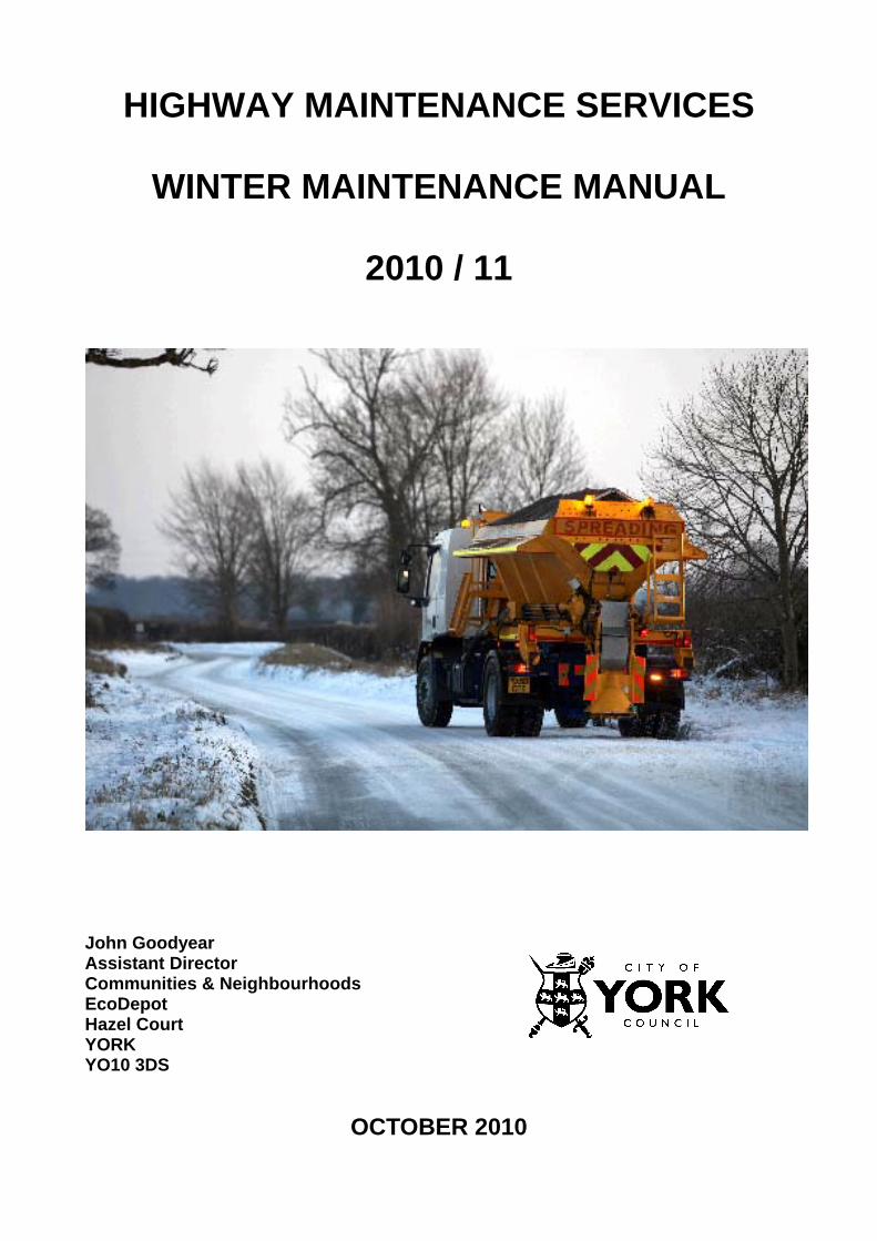
HIGHWAY MAINTENANCE SERVICES WINTER MAINTENANCE MANUAL 2010 / 11 John Goodyear Assistant Director Communities & Neighbourhoods EcoDepot Hazel Court YORK YO10 3DS OCTOBER 2010

Welcome message from author
This document is posted to help you gain knowledge. Please leave a comment to let me know what you think about it! Share it to your friends and learn new things together.
Transcript
HIGHWAY MAINTENANCE SERVICES
WINTER MAINTENANCE MANUAL
2010 / 11
John Goodyear Assistant Director Communities & Neighbourhoods EcoDepot Hazel Court YORK YO10 3DS
OCTOBER 2010

C O N T E N T S
1. STATEMENT OF SERVICE 2. ROLES AND COMMUNICATION 3. OPERATIONAL PROCEDURE 4. EQUIPMENT 5. MATERIALS 6. WEATHER FORECASTING 7. SPECIFICATION 8. EXTREME WEATHER POLICY 9. CROSS BOUNDARY ARRANGEMENTS 10 ELDERLY PERSONS’ HOMES, LOCAL SHOPPING AREAS AND SCHOOLS ANNEXES 1 WINTER MAINTENANCE DUTY OFFICER ROTA 2 OPERATIONS INSTRUCTION FORM 3 DEPT. OF TRANSPORT CIRCULAR ROADS No 18/77 4 TREATMENT LOG 5 NETWORK TREATMENT PRIMARY ROUTES 6 PRIORITY SNOW CLEARING NETWORK 7 PRIMARY GRIT ROUTE MAPS 8 STREETS INCLUDED ON PRIMARY GRITTING ROUTES 9 DESCRIPTIVE PRIMARY GRITTING ROUTES 10 FOOTWAY SNOW CLEARANCE AND PRECAUTIONARY TREATMENT 11 SCHEDULE OF SALT BIN LOCATIONS 12 SCHEDULE OF OFF ROAD CYCLE ROUTE TREATMENT 13 DECISION MAKING FLOW CHARTS
14 WINTER MAINTENANCE GROUP CONTACT DETAILS (NOTE: RESTRICTED CIRCULATION DOCUMENT)
15 WEATHER STATION LOCATION PLAN 16 STREETS INCLUDED ON SECONDARY GRITTING ROUTES 17 TEMPORARY SALT BAGS 18 DEFINITIONS OF TERMS USED IN OPEN ROAD FORECASTS 19 CIRCULATION LIST
1.0 STATEMENT OF THE SERVICE 1.1 The aim of the winter maintenance service is, as far as is reasonably possible, to
allow the safe movement of traffic, pedestrians and cyclists, on York roads, footways and cycleways in times of adverse winter weather. It also seeks to keep delays and accidents to a minimum.
1.2 The service uses MeteoGroup for weather forecasting and Vaisala Ice Prediction
Service. A Communities & Neighbourhoods Duty Officer determines what precautionary action to take and when to deploy the operational resources for clearing of snow and ice.
1.3 The winter maintenance season for York is between 1st November and 31st March,
however, monitoring of the weather will begin in October and extend through until April.
1.4 In times of exceptionally severe weather conditions, the Winter Maintenance Group
will be convened to co-ordinate the winter maintenance service. (See Annex 14) 1.5 Precautionary treatment will be undertaken before ice forms or snow settles on the
highway. The precautionary treatment will only be to footways and carriageways on the defined network, which excludes most footways, cycleways and all car parks. Snow clearance is based on a priority network for carriageways and footways. The treatment is co-ordinated with the NYCC, East Riding and the Highways Agency (A-one+) to ensure a reasonable continuity of treatment, this does not necessarily mean that similar treatments will apply.
If there is a formal diversion route in place for traffic management reasons this
route will be treated for the duration of the diversion. 1.6 The treatments are:- - precautionary treatment by lorry mounted spreaders of Safecote on the primary
gritting routes; - clearance of snow on carriageways by ploughing and when necessary, the
application of Safecote and/or grit sand; - clearance of snow and ice on footways by powered footway snow ploughs and
shovelling and, where necessary, the application of salt and grit sand; - clearance of snow and ice on footstreet carriageways by trailer gritter and snow
ploughs;
- approximately 265 salt bins located throughout the area for resident use on footways.
- temporary salt bags placed in predefined locations when instructed by the
Winter Maintenance Group
1.7 Primary gritting routes include
- all classified roads - links between villages and main roads - public transport and school bus routes - access roads to park and ride sites.
1.6 Secondary gritting routes include
- roads with minimum width 5m that are not regularly obstructed by parked cars - links between other roads (no cul de sacs) - roads serving areas of dense population, care homes or schools - form part of a logical route
Secondary routes will only be treated when instructed by the Winter Maintenance Group.
1.7 The service will issue information to its customers to keep them advised of the
action being taken and the level of service expected. This will be done as publicity through the media, displays and leaflets, and Ward Committees.
2.0 ROLES AND COMMUNICATION Roles 2.1 Communities & Neighbourhoods are responsible for the management operation
and co-ordination of the winter maintenance service. They will monitor the weather and respond to changing conditions. A Duty Officer is responsible for decision making and issuing of instructions to the Operations Supervisor for treatments . Communities & Neighbourhoods are also responsible for monitoring and reviewing the service to the benefit of the City Council customers and, as far as possible, provide an information service and advice about the service.
Communication 2.2 Road conditions in winter can change very quickly. It is vital that effective liaison
and communication exists between the Weather Centre, Duty Officer, Operations Supervisor, Police, media, Emergency Services, public transport, NYCC, A-one+ and Council Members.
2.3 The Duty Officer and Operations Supervisor will communicate by email, fax and
telephone, but particularly by telephone out of hours, Bank Holidays and weekends. See Annex 2 for rotas and telephone numbers. Duty Officers and Supervisors will keep mobile telephones operational at all times so that quick contact can be made when necessary.
2.4 The Duty Officer will issue an instruction using Form A (see Annex 3) every day
(except Bank Holidays and weekends) to the Supervisor as soon as possible after the midday forecast is issued. Subsequent instructions may be issued by telephone and confirmed as soon as possible using Form A.
2.5 The midday instruction will be emailed or faxed to NYCC, East Riding and A-one+
Operational Units. 2.6 At the judgement of the Duty Officer, Press Releases will be issued for immediate
release to Radio York and Minster FM when it is appropriate for the travelling public to be made aware of sudden changes in weather and the action being taken. This may be by telephone.
2.7 Any calls received by the Customer Centre concerning winter maintenance should
be referred to the Duty Officer. 2.8 In times of prolonged severe weather, the press and radio will be advised when the
Winter Maintenance Group has been convened and regular updates on the service will be issued to the media.
2.9 In October each year a leaflet, advising of the winter maintenance service is
produced and is available throughout the winter season in all the Council’s libraries and Departmental receptions.
2.10 The information contained within this leaflet is also placed on the council web site. 2.11 Customers are made aware of the existence of the leaflet and web site information
in October via ward newsletters and posters on notice boards.

2.12 In times of severe weather, the Duty Officer will contact the public transport team to advise them of any problems and the actions being taken.

3.0 OPERATIONAL PROCEDURE 3.1 Pre Season Activities Highway Maintenance Services - Order service from MeteoGroup. - Order service from Vaisala. - Review previous season. - Review and amend routes for treatment and snow
clearance. - Review and amend Winter Maintenance Manual. - Prepare Duty Officer rotas. - Co-ordinate with adjacent Authorities/Agencies. - Advise Police of arrangements. - Inspection of vehicles and materials. - Agree communications. - Issue pre season Instructions to Operations. - Establish communications with media. - Publish information leaflet advising the public of the
service. 3.2 Operations - Establish stockpiles of materials. - Servicing of plant and equipment. - Review and amend routes. - Carry out driver training. - Calibration of spreaders. - Order new salt bins as instructed. - Put out salt bins and fill. - Prepare Supervisor/Driver rotas. - Prepare Supervisor/Footway Operatives rotas (Dec to Feb
only incl) - Review Method Statement.
- Carry out trial runs on routes. Winter Season Daily Activities 3.3 Highway Maintenance Services - Check weather forecast -early morning -early afternoon -early evening -late evening - Take advice from MeteoGroup. - Make decision on proposed action. - Issue Report/Instruction to: - Operations - NYCC/A-one+ - Convene the Winter Maintenance Group (when necessary). - Carry out network inspections. - Issue publicity releases (when necessary). - Accept telephone reports/requests and issue instructions. - Weekend arrangement - Duty Officer to advise
Supervisor by telephone - Co-ordinate winter maintenance activities. 3.4 Operations - Accept instructions from Duty Officer. - Mobilise: - Drivers - Gritters - Loaders - Fitters - Labour - Carry out treatment. - Advise Duty Officer of problems. - Advise Duty Officer when treatment complete. - Complete treatment logs. (see Annex 6) - Complete daily reports. - Telephone reports/requests diverted to Duty Officer.
- Prepare equipment for next action. - Carry out start and mid season calibration of spreaders. - Attend Winter Maintenance Group. - Refill salt bins as instructed by Duty Officer. 3.5 Post Season Activities - Stand down Supervisor/Duty Officer. - Carry out post season overhaul of equipment. - Take in salt bins, clean and store. - Carry out review of service. 3.6 Carriageways Treatment
Primary Routes - Treatment of route network as drawings in Annex 5. - Priority snow clearing network as drawing in Annex 6. - Routes as drawings 1 to 10 in Annex 7. - Streets included in routes as Annex 8. - Speed of spreading Optimum gritting at 30mph., where permitted and
where applicable - Precautionary treatment 10g/m2. - Pre-snow treatment 15g/m2 (x 2 dependant upon when salting last
taken place). - Post-snow salting 15g/m2 to 30g/m2. - Target times 1 hour mobilisation time. 2 hours treatment time. - Mobilisation time time taken from receipt of instruction to leaving
depot. - Treatment time time from leaving depot to completion of
treatment. Secondary Routes - Route network as drawing in Annex 16
- Streets included in routes as Annex 16. - Treatment as specified by Winter Maintenance Group 3.7 Footways Treatment - Treatment when the temperature is expected to remain below Zero up to
12 noon the following day. - Treatment when there are prolonged temperatures of Zero or less and before
and after heavy snow. - Salt bins located through the area for self-help. - Snow clearance by powered footway ploughs, shovelling as instructed by Duty
Officer. - Application of sand/salt as instructed by Duty Officer. - Application of Safecote to footways by manual salt spreaders. Priority Footways Annex 10 Footstreets and routes from Railway Station/Car Parks Acomb Haxby Old School Court William Plows Avenue Wentworth Road Scarcroft Hill St Helen’s Road Bishopthorpe Road Clarence Street / Wigginton Road Schedule of salt bin locations Annex 11 Schedule of temporary salt bag locations Annex 17 3.8 Off Road Cycle Route Treatment
- Spreading of grit sand to all cycle routes at start of winter period - Repeat application to high priority network first then medium priority network
depending on resources available - Snow clearance carried out to network in order of priority - All treatment carried out in consultation with Council Cycling Officer
- Schedule of Cycle Routes Annex 12 3.9 For standard conditions and actions and chart showing the decision making
process See Annex 13.
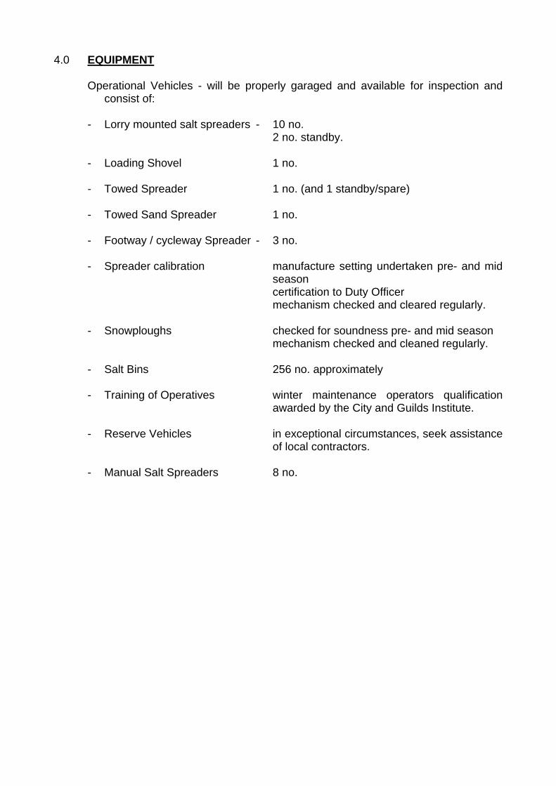
4.0 EQUIPMENT Operational Vehicles - will be properly garaged and available for inspection and
consist of: - Lorry mounted salt spreaders - 10 no. 2 no. standby. - Loading Shovel 1 no. - Towed Spreader 1 no. (and 1 standby/spare) - Towed Sand Spreader 1 no. - Footway / cycleway Spreader - 3 no. - Spreader calibration manufacture setting undertaken pre- and mid
season certification to Duty Officer mechanism checked and cleared regularly. - Snowploughs checked for soundness pre- and mid season mechanism checked and cleaned regularly. - Salt Bins 256 no. approximately - Training of Operatives winter maintenance operators qualification
awarded by the City and Guilds Institute. - Reserve Vehicles in exceptional circumstances, seek assistance
of local contractors. - Manual Salt Spreaders 8 no.
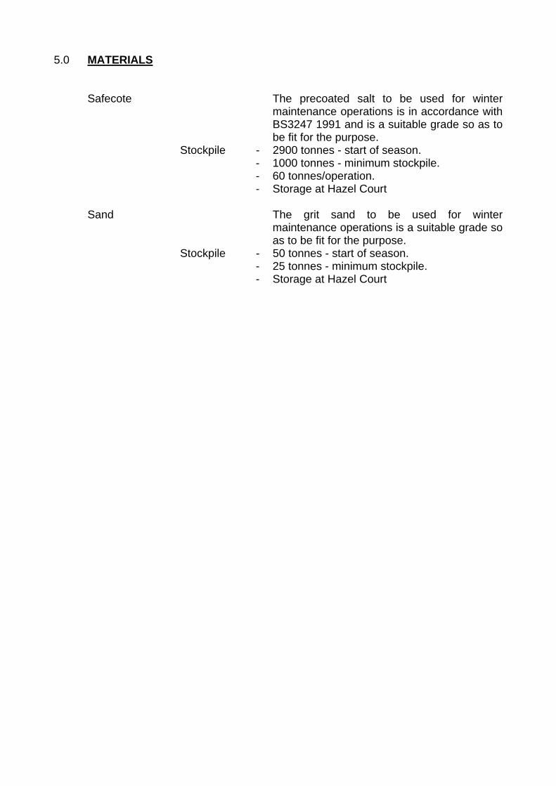
5.0 MATERIALS Safecote The precoated salt to be used for winter
maintenance operations is in accordance with BS3247 1991 and is a suitable grade so as to be fit for the purpose.
Stockpile - 2900 tonnes - start of season. - 1000 tonnes - minimum stockpile. - 60 tonnes/operation. - Storage at Hazel Court Sand The grit sand to be used for winter
maintenance operations is a suitable grade so as to be fit for the purpose.
Stockpile - 50 tonnes - start of season. - 25 tonnes - minimum stockpile. - Storage at Hazel Court

6.0 WEATHER FORECASTING 6.1 During the winter season the weather forecasting service will be provided by the
MeteoGroup Roadcast or similar organisation. 6.2 Forecast Procedure Weather forecasts are web based and provided by MeteoGroup which operates on
GMT throughout the year. 6.3 Mon - Fri Office Hours A 24 hour advanced forecast is available for the Duty Officer at around 1 pm and a
decision can then be made by the Duty Officer whether or not to treat the network but this is dependant on the confidence level of MeteoGroup Roadcast forecast. If a decision is made to carry out treatment then the Duty Officer will make the necessary arrangements with the supervisor. However if the forecast is marginal, a further update is obtained at 1800 hours. Again depending on the confidence level of the MeteoGroup forecast a decision is taken at this time. If the forecast is still marginal the Duty Officer will monitor the weather using a home based laptop computer and action treatment if required.
6.4 Mon - Fri outside office hours, weekends and public holidays. The procedure is as outlined in 6.3 except that the Duty Officer uses the dedicated
home based laptop computer. The Duty Officer will inform the operations supervisor by telephone as soon as the decision is made. The Duty Officer will also update Senior Officers and the Directorate elected member.
6.5 All forecasts and decisions are logged on a hard paper file for record purposes and
to be used should a third party public liability claim subsequently arise as a result of winter weather.
6.6 A Consultancy Service is provided by the MeteoGroup Forecaster and the Duty
Officer must make good use of this service especially when the need arises to discuss marginal forecasts, when we can expect significant levels of snowfall or anything whatsoever which will aid the Duty Officer in the decision making process.
6.7 Significant changes to the forecast. The MeteoGroup Roadcast office will notify the Duty Officer immediately if there is
a significant change to any earlier forecast. This can be done at the 1800 hours electronic update or by telephone. If this change occurs out of office hours the forecaster will telephone the Duty Officer on their home and/or mobile telephone. A significant change is defined as a 2 degree difference in temperature or a change in temperature or an unforeseen precipitation forecast.
7.0 SPECIFICATION Precautionary Salting 7.1 Precautionary salting shall only be carried out on defined roads and footways,
normally under the following circumstances: a) on wet roads where a weather forecast indicates that freezing conditions may
occur. b) on roads where a hoarfrost is predicted (this occurs when the road surface
temperature is below zero and at or below dew point). c) in the absence of forecast information when falling temperatures reach +1°C
providing that account has been taken of the prevailing humidity, residual salinity and cloud cover - advice should be sought from the MeteoGroup Roadcast in the event of any doubt about these matters.
7.2 The decision making process is contained in Annex 13 of this manual. 7.3 Meteorological information will be obtained direct from the MeteoGroup Roadcast
office and/or via Vaisala. 7.4 Precautionary treatment shall be carried out at a minimum rate of 10g/m². When
freezing conditions occur, or are expected to occur after rain, precautionary salting rates shall be increased to 15g/m² or 20g/m² in exceptional conditions. In these conditions treatment shall be delayed to reduce loss of salt by run off unless freezing conditions coincide with rainfall.
7.5 Where ice and/or snow has formed on the road surface, Safecote shall be spread
at a rate of 2 x 15g/m². In these conditions priority shall be given to high category roads (Annex 6).
7.6 In the event of sustained low temperatures account shall be taken of the need to
increase the rate of spread of salt by approximately 1.0g/m² for every 1°C drop in temperature below -5°. Below -11°C the action of salt is ineffective.
7.7 Water from thawing snow can spread across the carriageway and freeze.
Additional treatment may be required to deal with this (based on Duty Officers instructions).
Black Ice 7.8 Black Ice forms when roads and footways, which have not been treated, are
covered with a film of water after rainfall or with melting snow and there is a sharp drop in temperature (a sudden loss of cloud cover) and a thin sheet of ice forms on the surface. Under these conditions the action of Safecote will be less effective and sand will need to be spread on the surface, this will be done at the Duty Officers instruction.
Snow Clearing 7.9 Operational Stages For the purposes of this plan, there are three operational stages in snow clearing:
Stage 1 Light Falls of undisturbed accumulation of snow reaching a depth less than 35mm
Stage 2 Moderate Falls of snow reaching a depth of from 35mm to 100mm, or light falls associated with drifting.
Stage 3 Heavy Falls of over 100mm or moderate fall associated with drifting. 7.10 When continuous snow is forecast the precautionary spreading rate shall be
increased to a continuous 15g/m² or 20g/m² depending on the anticipated severity of the snowfall. The presence of Safecote will melt the initial snowfall and provide a wet surface beneath subsequent snow, thus easing the work of ploughing. The Duty Officer will provide advice on the spread rate.
7.11 When a light snowfall occurs and precautionary treatment has not been carried out,
dispersal may be effected by spreading Safecote at a rate of up to 2 x 15g/m². Where a succession of treatment runs are undertaken prior to or during snowfall these are to be clockwise then anti-clockwise and repeating as required, directed by WMDO. The action of traffic will accelerate this process. It will not normally be necessary to plough except where local drifting has occurred.
7.12 Road ploughing shall be undertaken as soon as the depth of snow exceeds 35mm,
with the use of side blades, supplemented by Safecote spread at the rate of 15g/m². Only in exceptional circumstances should repeated applications of Safecote be used as an alternative to ploughing in rural areas. In urban areas where problems may be experienced in ploughing the carriageway due to a build up of snow in channels it may be necessary to make more than one salting run.
7.13 When heavy snowfalls occur it may be found useful to plough continuously, to
prevent build up and compaction by traffic. Such ploughing can be combined with simultaneous treatment at 15g/m². However once snow depths of 120mm have been reached, when tackling snowdrifts or on gradients, it may be necessary to continue ploughing without Safecote treatment. In these conditions the weight of a Safecote load will aid vehicle traction. In certain circumstances snow may be loaded into vehicles and removed from site to allow the carriageway to be cleared (based on Duty Officer's instructions). Any snow removed within the City Centre will be taken to the River Ouse for disposal.
7.14 In the event of such extreme conditions that road blockages due to snow are likely
to occur throughout the City, resources shall be concentrated on the defined snow clearance routes (Annex 6).
7.15 The decision making process in the event of snow clearing operations is contained
in Annex 13 of this manual. 7.16 Ploughing should be carried out to avoid the creation of irregular windows in the
carriageway and the build up of snow across road junctions, against gates, bridge parapets, fences and walls. This applies particularly to level crossings where close co-operation with the railway service provider must be maintained.
7.17 If hard packed snow conditions should occur sharp sand or small aggregate can be
spread through tailboard or by towed gritters. Reversion to Safecote should be made as soon as possible since abrasives contribute little to the removal of snow and ice and may block drains and gullies.
7.18 Every effort should be made to remove slush from carriageways by the use of side
blades particularly when the current weather forecast indicates that freezing conditions are expected.
7.19 With regards to snow clearance at railway level crossings, from bridges over
railway and rail systems and from roads in the vicinity of railways the Council does comply with the guidance given in the Department of Transport Circular Roads No. 18/77. A copy of this is attached in Annex 3.
Treatment of Footways 7.20 Precautionary treatment of some strategic footways will be carried out when the
footways are expected to remain below Zero up to 12noon the following day and or where there is a prolonged period of Sub-Zero temperatures, or when snow is forecast to fall and give accumulations. (See Annex 10 for details).
7.21 In central urban areas and at other approved locations shown in Annex 10 the
treatment of snow or heavy frost may be carried out by the application of Safecote or a grit/Safecote mixture as and when directed by the Duty Officer. Snow exceeding 25mm in depth should be removed prior to this treatment. Only in prolonged adverse weather conditions should treatment be extended to other footways.
7.22 If Black Ice forms at locations around the City Centre the Duty Officers will make an
early decision whether to apply grit sand to the affected areas. 7.23 Highway Maintenance Services have established a priority listing of footways to be
treated in accordance with item 3.7 and shown in Annex 10. 7.24 Communities & Neighbourhoods will have men on standby for footway treatment
between the period December to February (inclusive). The remainder of time will be similar subject to WMDO's discretion or if occasional treatment needed manned by volunteers of Communities & Neighbourhoods .
Safecote 7.25 Rock salt pre-coated with Safecote complying with British Standard BS3247.1991
shall be used for the winter maintenance of the defined roads. BS3247.1991 specifies the essential properties of the salt and includes details of test procedures for determining these properties.
7.26 Reserves of Safecote will be held within the general stockpiles contained in
Communities & Neighbourhoods, Hazel Court depot. 7.27 Safecote will be made available from 1 October each year by Communities &
Neighbourhoods Operations for use until the conclusion of the winter maintenance period (generally 30 April the following year) or as directed by the Winter Maintenance Duty Officer.
7.28 During this period it will be Communities & Neighbourhoods Operations responsibility to ensure that the Safecote is maintained in a suitable condition to ensure its correct application by Communities & Neighbourhoods Operations winter maintenance vehicles to the road surface.
7.29 The Safecote moisture content will vary dependent on the method of storage used
and Communities & Neighbourhoods Operations shall take action as necessary to maintain the Safecote to the requirements of BS3247.1991, during the period of responsibility.
7.30 Safecote, when evenly distributed across the carriageway surface, will offer
protection against the formation of ice generally in accordance with the details given below:
Rate of Application Minimum Temperature
10/15 g/m² -3/-4°C 15/20 g/m² -4/-6°C 25/30 g/m² -10/-12°C
7.31 In exceptional circumstances Communities & Neighbourhoods Operations will be
required to apply an abrasive aggregate either separately or in addition to rock salt as directed by the Duty Officer.
Restriction in salt supply 7.32 In order to conserve salt stocks in times of restricted supply the following mixes will
be introduced when levels drop to:
Stock level Location Mix (salt:grit sand) 1000t All routes 3:1 500t City centre routes (1,2,3,4,9)
Remaining higher speed routes 1:1 3:1
250t All routes 1:1
All these options will be ratified by the Winter Maintenance Group dependent on prevailing conditions and weather forecasts.
8.0 EXTREME WEATHER POLICY 8.1 Extreme weather is defined as being either
when snow is lying on the ground which is a minimum of 50 mm deep and the weather forecast is for severe conditions to last for more than 3 days or a prolonged cold spell is forecast, where temperatures remain below freezing for at least 5 days.
8.2 In the event of extreme weather the Winter Maintenance Group (WMG) will be
convened by the Director or Assistant Director of Communities and Neighbourhoods. The group will comprise representatives from
Adults, Children & Education Emergency Planning Highway Maintenance Marketing and Communications Network Management York Customer Centre IT & T
and will be chaired by the Director or Assistant Director of Communities and Neighbourhoods, or the Chief Executive.
8.3 A confidential list of names and contact details for members of the WMG is
included in Annex 14. It is the responsibility of the individual departments concerned to ensure that this list is kept up to date.
NOTE: ANNEX 14 IS A RESTRICTED CIRCULATION DOCUMENT 8.4 During the extreme weather, all road and footpath treatments carried out by City of
York Council (both on and off the public highway) will be coordinated by the WMG. 8.5 All operations instructed by the WMG will be dependant on resources of labour,
plant and materials available, including the availability of salt. 8.6 The WMG will instruct the treatment of secondary routes and footpaths. The
secondary route network is shown in Annex 16. The secondary footpaths will be defined by the WMG in accordance with prevailing conditions. Priority for secondary footpath treatment will be given to elderly persons’ homes, local shopping areas and schools, as listed in Section 10. The criteria for secondary footpath treatment will depend on the layout and use of each individual location.
8.7.1 The WMG will instruct the placement of temporary salt bags in the locations shown
in Annex 17. 8.7.2 The WMG will consider treatment of surface level car parks subject to the
availability of resources.

9.0 CROSS BOUNDARY ARRANGEMENTS 9.1 There are no cross boundary arrangements with A ONE + (Highways Agency),
East Riding of Yorkshire Council and North Yorkshire County Council. All routes are curtailed at the boundary.
10.1 POST OFFICE LOCATIONS
Acomb PO 65 Front Street, Acomb Tel: 798301 Beckfield Lane PO 147 Beckfield Lane Tel: 785910 Bishopthorpe PO 25-27 Main Street, Bishopthorpe Tel: 706186 Broadway PO 44 Broadway York Tel: 627290 Brockfield PO 60 Brockfield Park Drive Tel: 624768 Copmanthorpe PO 9 The Shopping Centre, Copmanthorpe Tel: 706287 Crichton Avenue PO 1 Intake Avenue Tel: 622804 Dringhouses PO 14 Tadcaster Road Tel : 706438 Dunnington PO 29 York Street, Dunnington Tel: 481320 Eastholme Drive PO Costcutter Store 20 Eastholme Drive Tel: 628391
Foss Mount PO 191-193 Huntington Road Tel: 624619 Haxby PO 41 The Village Tel: 763395 Heslington PO 13 Main Street, Heslington Tel: 412171 Heworth PO 73 East Parade Tel: 424641 Hopgrove PO Orchard Nurseries 48 Hopgrove Lane South Tel: 421153 Huntington PO 43 North Moor Road, Huntington Tel: 769180 Lendal PO 22 Lendal Tel: 0845 7223344 Market Place PO 4 Colliergate Tel: 651398 Melrosegate PO 204 Melrosegate Tel: 411964 Micklegate PO 95 Micklegate Tel: 622059
10/4/2010
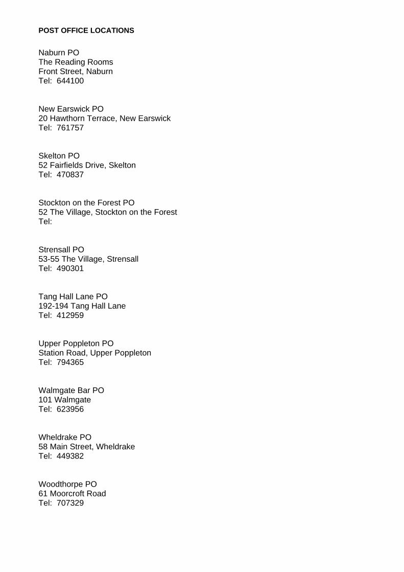
POST OFFICE LOCATIONS Naburn PO The Reading Rooms Front Street, Naburn Tel: 644100 New Earswick PO 20 Hawthorn Terrace, New Earswick Tel: 761757 Skelton PO 52 Fairfields Drive, Skelton Tel: 470837 Stockton on the Forest PO 52 The Village, Stockton on the Forest Tel: Strensall PO 53-55 The Village, Strensall Tel: 490301 Tang Hall Lane PO 192-194 Tang Hall Lane Tel: 412959 Upper Poppleton PO Station Road, Upper Poppleton Tel: 794365 Walmgate Bar PO 101 Walmgate Tel: 623956 Wheldrake PO 58 Main Street, Wheldrake Tel: 449382 Woodthorpe PO 61 Moorcroft Road Tel: 707329
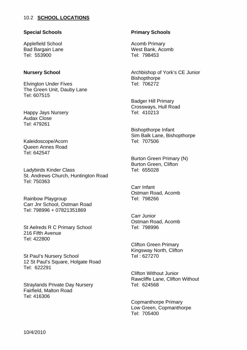
10.2 SCHOOL LOCATIONS
Special Schools Applefield School Bad Bargain Lane Tel: 553900 Nursery School Elvington Under Fives The Green Unit, Dauby Lane Tel: 607515 Happy Jays Nursery Audax Close Tel: 479261 Kaleidoscope/Acorn Queen Annes Road Tel: 642547 Ladybirds Kinder Class St. Andrews Church, Huntington Road Tel: 750363 Rainbow Playgroup Carr Jnr School, Ostman Road Tel: 798996 + 07821351869 St Aelreds R C Primary School 216 Fifth Avenue Tel: 422800 St Paul’s Nursery School 12 St Paul’s Square, Holgate Road Tel: 622291 Straylands Private Day Nursery Fairfield, Malton Road Tel: 416306
Primary Schools Acomb Primary West Bank, Acomb Tel: 798453 Archbishop of York’s CE Junior Bishopthorpe Tel: 706272 Badger Hill Primary Crossways, Hull Road Tel: 410213 Bishopthorpe Infant Sim Balk Lane, Bishopthorpe Tel: 707506 Burton Green Primary (N) Burton Green, Clifton Tel: 655028 Carr Infant Ostman Road, Acomb Tel: 798266 Carr Junior Ostman Road, Acomb Tel: 798996 Clifton Green Primary Kingsway North, Clifton Tel : 627270 Clifton Without Junior Rawcliffe Lane, Clifton Without Tel: 624568 Copmanthorpe Primary Low Green, Copmanthorpe Tel: 705400
10/4/2010
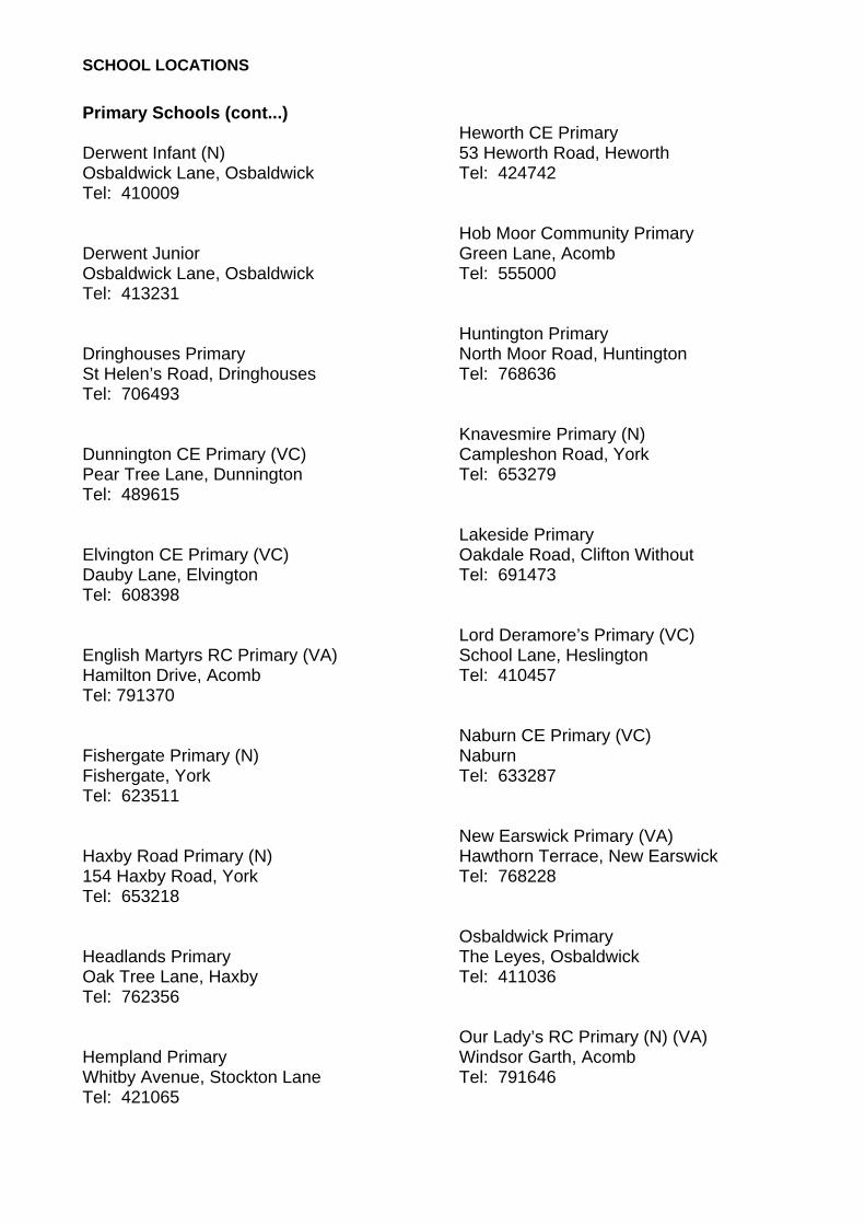
SCHOOL LOCATIONS Primary Schools (cont...) Derwent Infant (N) Osbaldwick Lane, Osbaldwick Tel: 410009 Derwent Junior Osbaldwick Lane, Osbaldwick Tel: 413231 Dringhouses Primary St Helen’s Road, Dringhouses Tel: 706493 Dunnington CE Primary (VC) Pear Tree Lane, Dunnington Tel: 489615 Elvington CE Primary (VC) Dauby Lane, Elvington Tel: 608398 English Martyrs RC Primary (VA) Hamilton Drive, Acomb Tel: 791370 Fishergate Primary (N) Fishergate, York Tel: 623511 Haxby Road Primary (N) 154 Haxby Road, York Tel: 653218 Headlands Primary Oak Tree Lane, Haxby Tel: 762356 Hempland Primary Whitby Avenue, Stockton Lane Tel: 421065
Heworth CE Primary 53 Heworth Road, Heworth Tel: 424742 Hob Moor Community Primary Green Lane, Acomb Tel: 555000 Huntington Primary North Moor Road, Huntington Tel: 768636 Knavesmire Primary (N) Campleshon Road, York Tel: 653279 Lakeside Primary Oakdale Road, Clifton Without Tel: 691473 Lord Deramore’s Primary (VC) School Lane, Heslington Tel: 410457 Naburn CE Primary (VC) Naburn Tel: 633287 New Earswick Primary (VA) Hawthorn Terrace, New Earswick Tel: 768228 Osbaldwick Primary The Leyes, Osbaldwick Tel: 411036 Our Lady’s RC Primary (N) (VA) Windsor Garth, Acomb Tel: 791646
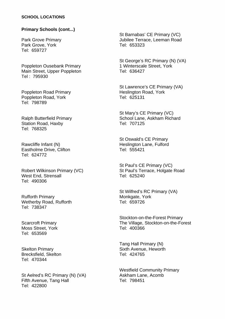
SCHOOL LOCATIONS Primary Schools (cont...) Park Grove Primary Park Grove, York Tel: 659727 Poppleton Ousebank Primary Main Street, Upper Poppleton Tel : 795930 Poppleton Road Primary Poppleton Road, York Tel: 798789 Ralph Butterfield Primary Station Road, Haxby Tel: 768325 Rawcliffe Infant (N) Eastholme Drive, Clifton Tel: 624772 Robert Wilkinson Primary (VC) West End, Strensall Tel: 490306 Rufforth Primary Wetherby Road, Rufforth Tel: 738347 Scarcroft Primary Moss Street, York Tel: 653569 Skelton Primary Brecksfield, Skelton Tel: 470344 St Aelred’s RC Primary (N) (VA) Fifth Avenue, Tang Hall Tel: 422800
St Barnabas’ CE Primary (VC) Jubilee Terrace, Leeman Road Tel: 653323 St George’s RC Primary (N) (VA) 1 Winterscale Street, York Tel: 636427 St Lawrence’s CE Primary (VA) Heslington Road, York Tel: 625131 St Mary’s CE Primary (VC) School Lane, Askham Richard Tel: 707125 St Oswald’s CE Primary Heslington Lane, Fulford Tel: 555421 St Paul’s CE Primary (VC) St Paul’s Terrace, Holgate Road Tel: 625240 St Wilfred’s RC Primary (VA) Monkgate, York Tel: 659726 Stockton-on-the-Forest Primary The Village, Stockton-on-the-Forest Tel: 400366 Tang Hall Primary (N) Sixth Avenue, Heworth Tel: 424765 Westfield Community Primary Askham Lane, Acomb Tel: 798451
SCHOOL LOCATIONS Primary Schools (cont...) Wheldrake with Thorganby CE Primary (VA) North Lane, Wheldrake Tel: 448564 Wigginton Primary Westfield Lane, Wigginton Tel: 761647 Woodthorpe Primary Summerfield Road, Woodthorpe Tel: 705462 Yearsley Grove Primary Yearsley Grove, Huntington Tel: 656681
Secondary Schools All Saints’ RC (VA) Nunnery Lane, York Tel: 647877 Archbishop Holgate’s CE School (VC) Hull Road, York Tel: 411341 Burnholme Community College Bad Bargain Lane, York Tel: 415906 Canon Lee School Rawcliffe Drive, York Tel: 560000 Fulford School Fulfordgate, Fulford Tel: 633300
Huntington School Huntington Road, York Tel: 752100 Joseph Rowntree School Haxby Road, New Earswick Tel: 552100 York High School Cornlands Road, Acomb Tel: 555000 Manor CE School (VA) Millfield Lane, York Tel: 798722 Millthorpe School Nunthorpe Avenue, York Tel: 686400
10.3 SHELTERED HOUSING LOCATIONS
City of York Council Marjorie Waite Court Evelyn Crescent, Clifton Tel: 612595/551871 Honeysuckle House Herdsman Road, Dringhouses Tel: 552624 Lovell House Wains Road, Dringhouses Tel: 552626 The Glebe The Manor Beeches, Dunnington Tel: 552617 Delwood Main Street, Fulford Tel: 552620 Glen Lodge 2 Sixth Avenue, Heworth Tel: 422837 Gale Farm Court Front Street, Acomb Tel: 552294 Alex Lyon House St Aelred’s Close, Fifth Avenue Tel: 552618 Barstow House St. Benedicts Road Tel: 654246 City Mills Skeldergate Tel: 552619
Helmsley House The Groves, March Street, York Tel: 552623 Moatside Court Lord Mayor’s Walk Tel: 552628 Lincoln Court Ascot Way, Windsor Garth Tel: 552622 Esplanade Court Marygate Tel: 552628 Bootham Square Bootham Square, York Tel: Warden Lorna 07767318131 Joseph Rowntree Housing Trust Sandacre Court Beckfield Tel: 781544 Dower Court William Plows Avenue Tel: 416650 Red Lodge New Earswick Tel: 762111 Old School Court Upper Poppleton Tel: 750700 York Housing Association Margaret Philipson Court Aldwark Tel: 632075
10/4/2010
SHELTERED HOUSING LOCATIONS
Bretgate Navigation Road Tel: 658171 Lichfield Court Albemarle Road Tel: 656044 Anchor Trust Saddlebrook Court Herman Walk, Foxwood Tel: 790696 Elm Tree Gardens Oak Rise, Acomb Tel: 789433 Guardian Court Water Lane, Clifton Tel: 652494 Barleyfields Shipton Road, Clifton Tel: 629879
10.4 CARE HOME LOCATIONS
Older People: Local Authority Homes Fordlands Road 1 Fordlands Road, Fulford Tel: 630048 Grove House 40-48 Penley’s Grove Street Tel: 628250 Haxby Hall York Road, Haxby Tel: 768944 Morrell House 388 Burton Stone Lane Tel: 658998 Oakhaven 144 Acomb Road Tel: 791599 Oliver House 20 Bishophill Junior Tel: 653301 Willow House Long Close Lane Tel: 630437 Windsor House 22 Ascot Way Tel: 798004 Woolnough House 52 Woolnough Avenue, Tang Hall Tel: 413656
Adults: Local Authority Homes 77 Flaxman Avenue Tang Hall Tel: 426428 Older People: Private & Voluntary Homes Broadway Lodge 151 Fulford Road Tel: 621884 Connaught Court The Royal Masonic Benevolent Institution St Oswald’s Road, Fulford Tel: 626238 Galtres Care Home LLP Ox Carr Lane, Strensall Tel: 491300 Grimston Court Residential Home Hull Road Tel: 489343 Ivy Lodge Retirement Home Briergate, Haxby Tel: 760629 Lamel Beeches JRHT. 105 Heslington Road Tel: 416904 Lime Tree House Chantry Green, Main Street, Upper Poppleton Tel: 795280
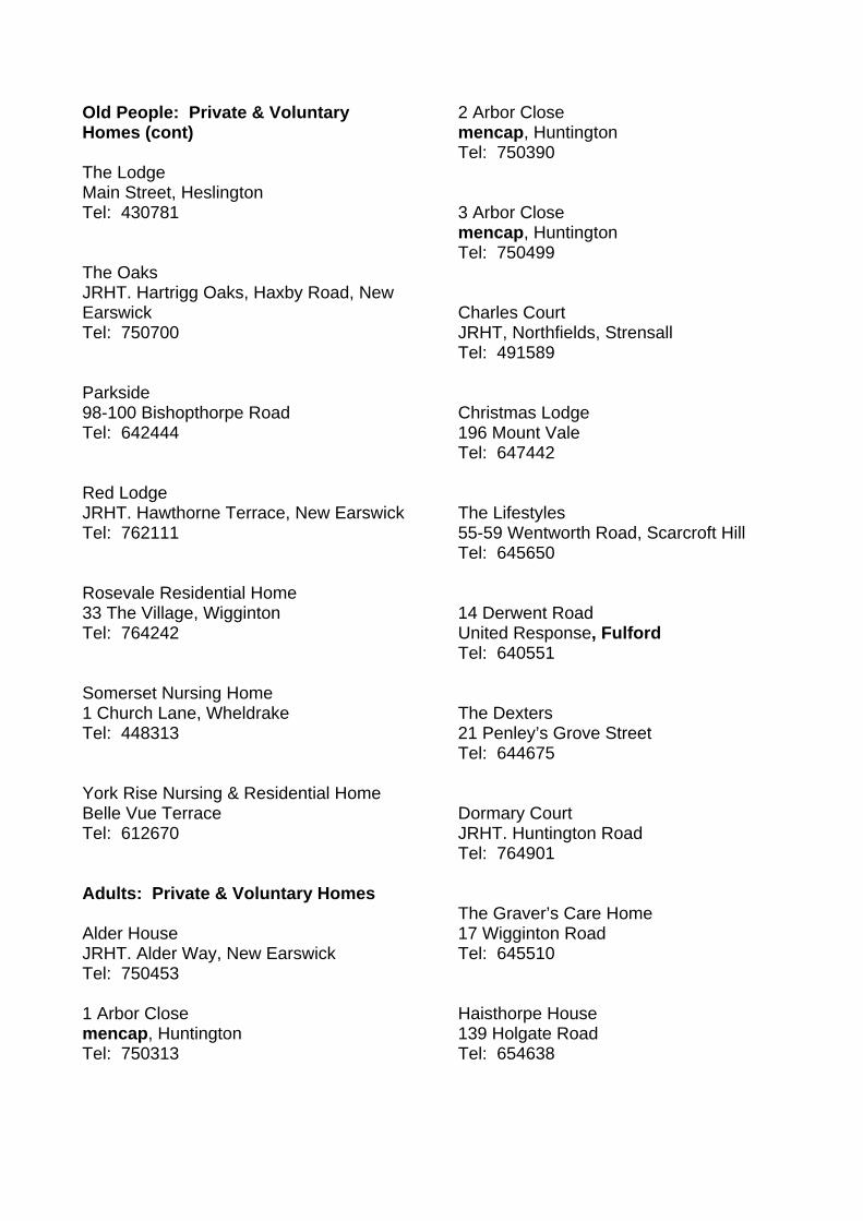
Old People: Private & Voluntary Homes (cont) The Lodge Main Street, Heslington Tel: 430781 The Oaks JRHT. Hartrigg Oaks, Haxby Road, New Earswick Tel: 750700 Parkside 98-100 Bishopthorpe Road Tel: 642444 Red Lodge JRHT. Hawthorne Terrace, New Earswick Tel: 762111 Rosevale Residential Home 33 The Village, Wigginton Tel: 764242 Somerset Nursing Home 1 Church Lane, Wheldrake Tel: 448313 York Rise Nursing & Residential Home Belle Vue Terrace Tel: 612670 Adults: Private & Voluntary Homes Alder House JRHT. Alder Way, New Earswick Tel: 750453 1 Arbor Close mencap, Huntington Tel: 750313
2 Arbor Close mencap, Huntington Tel: 750390 3 Arbor Close mencap, Huntington Tel: 750499 Charles Court JRHT, Northfields, Strensall Tel: 491589 Christmas Lodge 196 Mount Vale Tel: 647442 The Lifestyles 55-59 Wentworth Road, Scarcroft Hill Tel: 645650 14 Derwent Road United Response, Fulford Tel: 640551 The Dexters 21 Penley’s Grove Street Tel: 644675 Dormary Court JRHT. Huntington Road Tel: 764901 The Graver’s Care Home 17 Wigginton Road Tel: 645510 Haisthorpe House 139 Holgate Road Tel: 654638
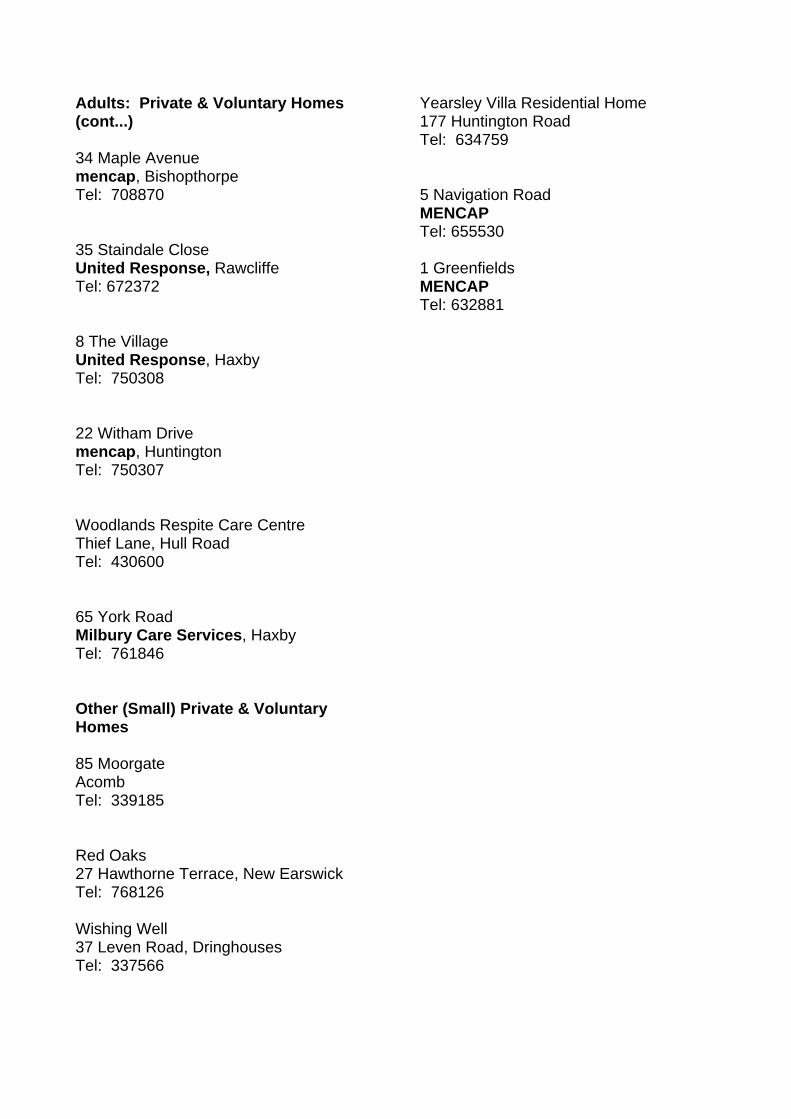
Adults: Private & Voluntary Homes (cont...) 34 Maple Avenue mencap, Bishopthorpe Tel: 708870 35 Staindale Close United Response, Rawcliffe Tel: 672372 8 The Village United Response, Haxby Tel: 750308 22 Witham Drive mencap, Huntington Tel: 750307 Woodlands Respite Care Centre Thief Lane, Hull Road Tel: 430600 65 York Road Milbury Care Services, Haxby Tel: 761846 Other (Small) Private & Voluntary Homes 85 Moorgate Acomb Tel: 339185 Red Oaks 27 Hawthorne Terrace, New Earswick Tel: 768126 Wishing Well 37 Leven Road, Dringhouses Tel: 337566
Yearsley Villa Residential Home 177 Huntington Road Tel: 634759 5 Navigation Road MENCAP Tel: 655530 1 Greenfields MENCAP Tel: 632881
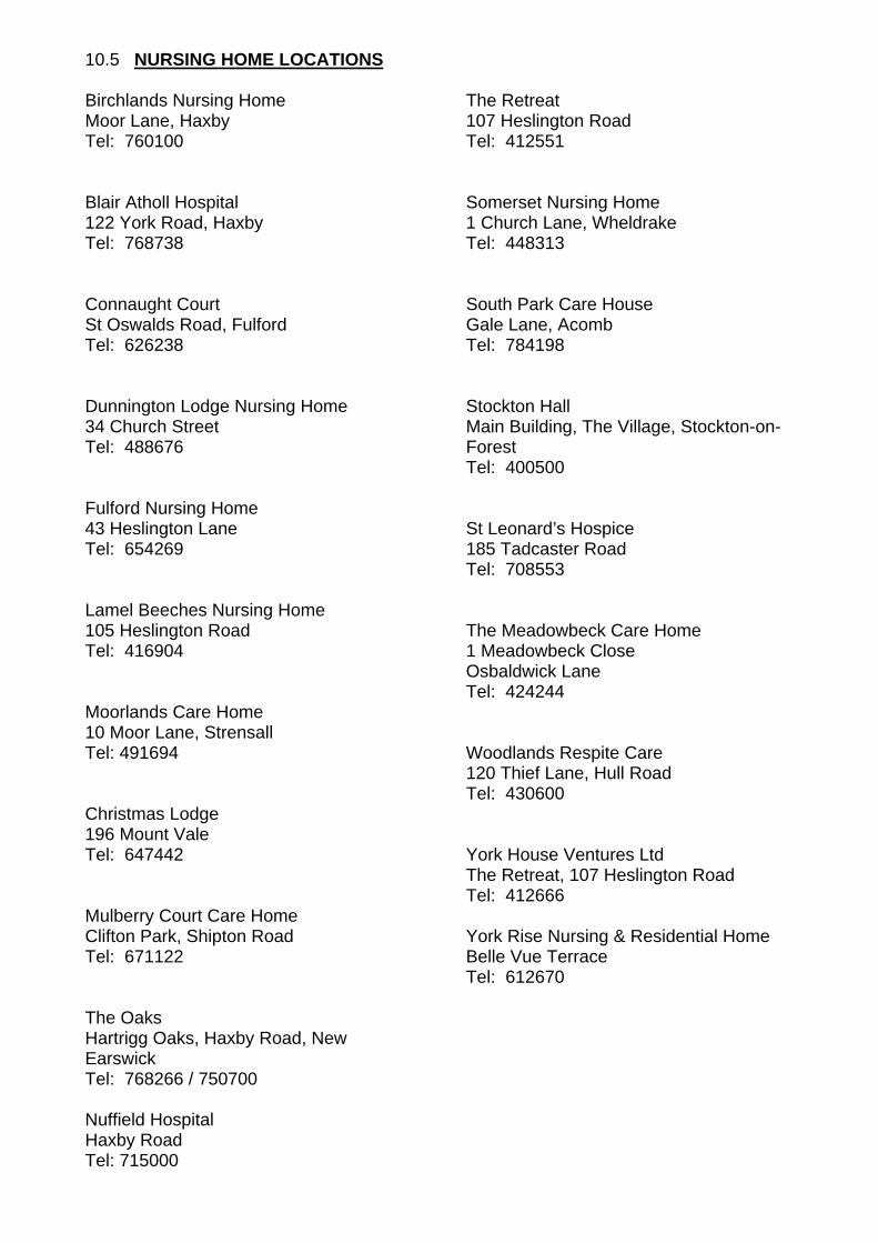
10.5 NURSING HOME LOCATIONS
Birchlands Nursing Home Moor Lane, Haxby Tel: 760100 Blair Atholl Hospital 122 York Road, Haxby Tel: 768738 Connaught Court St Oswalds Road, Fulford Tel: 626238 Dunnington Lodge Nursing Home 34 Church Street Tel: 488676 Fulford Nursing Home 43 Heslington Lane Tel: 654269 Lamel Beeches Nursing Home 105 Heslington Road Tel: 416904 Moorlands Care Home 10 Moor Lane, Strensall Tel: 491694 Christmas Lodge 196 Mount Vale Tel: 647442 Mulberry Court Care Home Clifton Park, Shipton Road Tel: 671122 The Oaks Hartrigg Oaks, Haxby Road, New Earswick Tel: 768266 / 750700 Nuffield Hospital Haxby Road Tel: 715000
The Retreat 107 Heslington Road Tel: 412551 Somerset Nursing Home 1 Church Lane, Wheldrake Tel: 448313 South Park Care House Gale Lane, Acomb Tel: 784198 Stockton Hall Main Building, The Village, Stockton-on-Forest Tel: 400500 St Leonard’s Hospice 185 Tadcaster Road Tel: 708553 The Meadowbeck Care Home 1 Meadowbeck Close Osbaldwick Lane Tel: 424244 Woodlands Respite Care 120 Thief Lane, Hull Road Tel: 430600 York House Ventures Ltd The Retreat, 107 Heslington Road Tel: 412666 York Rise Nursing & Residential Home Belle Vue Terrace Tel: 612670
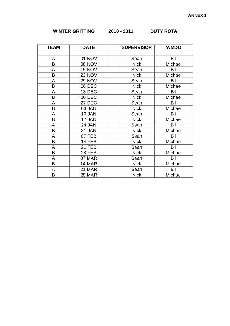
ANNEX 1
WINTER GRITTING 2010 - 2011 DUTY ROTA
TEAM DATE SUPERVISOR WMDO
A 01 NOV Sean Bill B 08 NOV Nick Michael A 15 NOV Sean Bill B 23 NOV Nick Michael A 29 NOV Sean Bill B 06 DEC Nick Michael A 13 DEC Sean Bill B 20 DEC Nick Michael A 27 DEC Sean Bill B 03 JAN Nick Michael A 10 JAN Sean Bill B 17 JAN Nick Michael A 24 JAN Sean Bill B 31 JAN Nick Michael A 07 FEB Sean Bill B 14 FEB Nick Michael A 21 FEB Sean Bill B 28 FEB Nick Michael A 07 MAR Sean Bill B 14 MAR Nick Michael A 21 MAR Sean Bill B 28 MAR Nick Michael

ANNEX 2
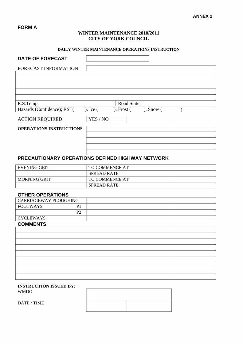
FORM A WINTER MAINTENANCE 2010/2011
CITY OF YORK COUNCIL
DAILY WINTER MAINTENANCE OPERATIONS INSTRUCTION
DATE OF FORECAST
FORECAST INFORMATION R.S.Temp: Road State: Hazards (Confidence); RST( ), Ice ( ), Frost ( ), Snow ( )
ACTION REQUIRED YES / NO OPERATIONS INSTRUCTIONS PRECAUTIONARY OPERATIONS DEFINED HIGHWAY NETWORK EVENING GRIT TO COMMENCE AT SPREAD RATE MORNING GRIT TO COMMENCE AT SPREAD RATE
OTHER OPERATIONS CARRIAGEWAY PLOUGHING FOOTWAYS P1 P2 CYCLEWAYS COMMENTS INSTRUCTION ISSUED BY: WMDO
DATE / TIME

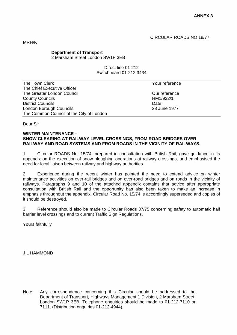
ANNEX 3
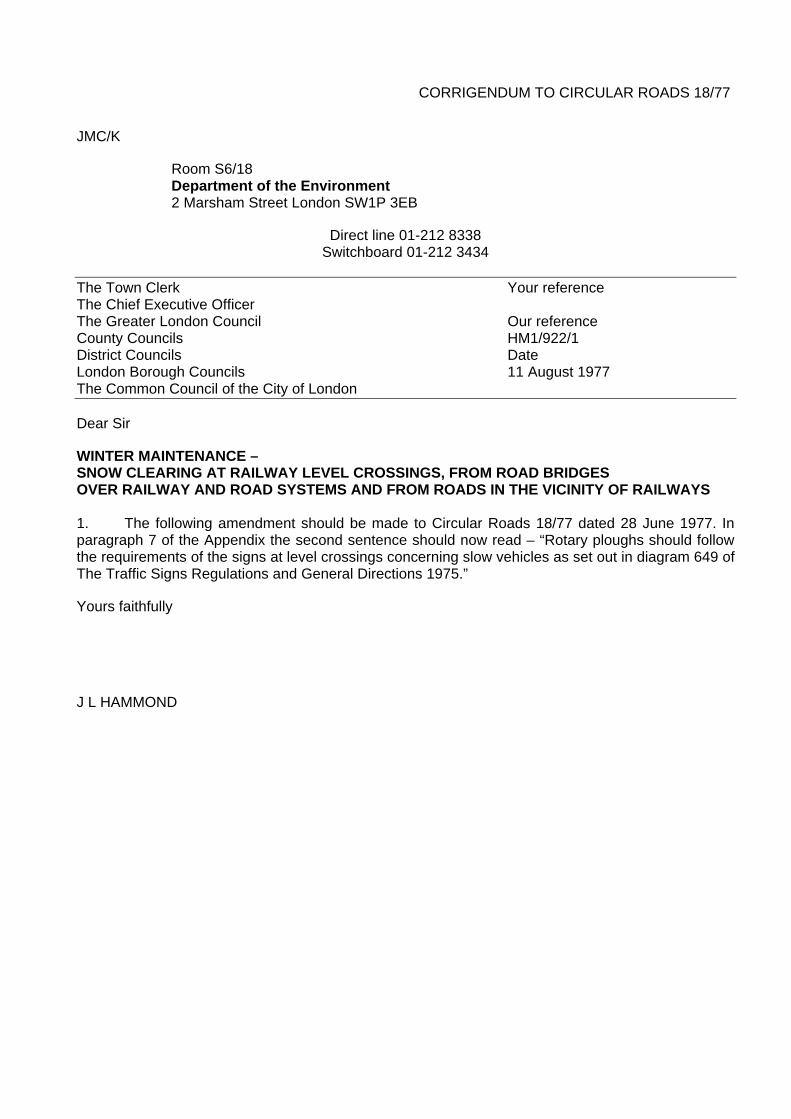
CIRCULAR ROADS NO 18/77 MRH/K
Department of Transport 2 Marsham Street London SW1P 3EB
Direct line 01-212
Switchboard 01-212 3434 The Town Clerk Your reference The Chief Executive Officer The Greater London Council Our reference County Councils HM1/922/1 District Councils Date London Borough Councils 28 June 1977 The Common Council of the City of London
Dear Sir
WINTER MAINTENANCE – SNOW CLEARING AT RAILWAY LEVEL CROSSINGS, FROM ROAD BRIDGES OVER RAILWAY AND ROAD SYSTEMS AND FROM ROADS IN THE VICINITY OF RAILWAYS. 1. Circular ROADS No. 15/74, prepared in consultation with British Rail, gave guidance in its appendix on the execution of snow ploughing operations at railway crossings, and emphasised the need for local liaison between railway and highway authorities. 2. Experience during the recent winter has pointed the need to extend advice on winter maintenance activities on over-rail bridges and on over-road bridges and on roads in the vicinity of railways. Paragraphs 9 and 10 of the attached appendix contains that advice after appropriate consultation with British Rail and the opportunity has also been taken to make an increase in emphasis throughout the appendix. Circular Road No. 15/74 is accordingly superseded and copies of it should be destroyed. 3. Reference should also be made to Circular Roads 37/75 concerning safety to automatic half barrier level crossings and to current Traffic Sign Regulations. Yours faithfully
J L HAMMOND
Note: Any correspondence concerning this Circular should be addressed to the Department of Transport, Highways Management 1 Division, 2 Marsham Street, London SW1P 3EB. Telephone enquiries should be made to 01-212-7110 or 7111. (Distribution enquiries 01-212-4944).
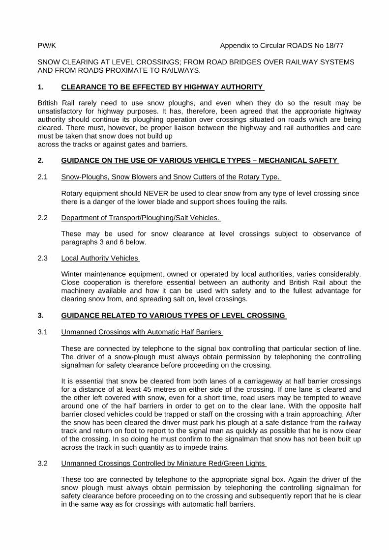
PW/K Appendix to Circular ROADS No 18/77 SNOW CLEARING AT LEVEL CROSSINGS; FROM ROAD BRIDGES OVER RAILWAY SYSTEMS AND FROM ROADS PROXIMATE TO RAILWAYS. 1. CLEARANCE TO BE EFFECTED BY HIGHWAY AUTHORITY
British Rail rarely need to use snow ploughs, and even when they do so the result may be unsatisfactory for highway purposes. It has, therefore, been agreed that the appropriate highway authority should continue its ploughing operation over crossings situated on roads which are being cleared. There must, however, be proper liaison between the highway and rail authorities and care must be taken that snow does not build up across the tracks or against gates and barriers.
2. GUIDANCE ON THE USE OF VARIOUS VEHICLE TYPES – MECHANICAL SAFETY 2.1 Snow-Ploughs, Snow Blowers and Snow Cutters of the Rotary Type.
Rotary equipment should NEVER be used to clear snow from any type of level crossing since there is a danger of the lower blade and support shoes fouling the rails.
2.2 Department of Transport/Ploughing/Salt Vehicles.
These may be used for snow clearance at level crossings subject to observance of paragraphs 3 and 6 below.
2.3 Local Authority Vehicles
Winter maintenance equipment, owned or operated by local authorities, varies considerably. Close cooperation is therefore essential between an authority and British Rail about the machinery available and how it can be used with safety and to the fullest advantage for clearing snow from, and spreading salt on, level crossings.
3. GUIDANCE RELATED TO VARIOUS TYPES OF LEVEL CROSSING 3.1 Unmanned Crossings with Automatic Half Barriers
These are connected by telephone to the signal box controlling that particular section of line. The driver of a snow-plough must always obtain permission by telephoning the controlling signalman for safety clearance before proceeding on the crossing.
It is essential that snow be cleared from both lanes of a carriageway at half barrier crossings for a distance of at least 45 metres on either side of the crossing. If one lane is cleared and the other left covered with snow, even for a short time, road users may be tempted to weave around one of the half barriers in order to get on to the clear lane. With the opposite half barrier closed vehicles could be trapped or staff on the crossing with a train approaching. After the snow has been cleared the driver must park his plough at a safe distance from the railway track and return on foot to report to the signal man as quickly as possible that he is now clear of the crossing. In so doing he must confirm to the signalman that snow has not been built up across the track in such quantity as to impede trains.
3.2 Unmanned Crossings Controlled by Miniature Red/Green Lights
These too are connected by telephone to the appropriate signal box. Again the driver of the snow plough must always obtain permission by telephoning the controlling signalman for safety clearance before proceeding on to the crossing and subsequently report that he is clear in the same way as for crossings with automatic half barriers.
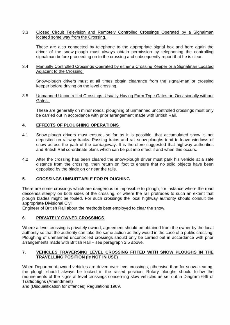
3.3 Closed Circuit Television and Remotely Controlled Crossings Operated by a Signalman
located some way from the Crossing. These are also connected by telephone to the appropriate signal box and here again the driver of the snow-plough must always obtain permission by telephoning the controlling signalman before proceeding on to the crossing and subsequently report that he is clear.
3.4 Manually Controlled Crossings Operated by either a Crossing Keeper or a Signalman Located
Adjacent to the Crossing Snow-plough drivers must at all times obtain clearance from the signal-man or crossing keeper before driving on the level crossing.
3.5 Unmanned Uncontrolled Crossings, Usually Having Farm Type Gates or, Occasionally without
Gates.
These are generally on minor roads; ploughing of unmanned uncontrolled crossings must only be carried out in accordance with prior arrangement made with British Rail.
4. EFFECTS OF PLOUGHING OPERATIONS 4.1 Snow-plough drivers must ensure, so far as it is possible, that accumulated snow is not
deposited on railway tracks. Passing trains and rail snow-ploughs tend to leave windows of snow across the path of the carriageway. It is therefore suggested that highway authorities and British Rail co-ordinate plans which can be put into effect if and when this occurs.
4.2 After the crossing has been cleared the snow-plough driver must park his vehicle at a safe
distance from the crossing, then return on foot to ensure that no solid objects have been deposited by the blade on or near the rails.
5. CROSSINGS UNSUITTABLE FOR PLOUGHING There are some crossings which are dangerous or impossible to plough; for instance where the road descends steeply on both sides of the crossing, or where the rail protrudes to such an extent that plough blades might be fouled. For such crossings the local highway authority should consult the appropriate Divisional Civil Engineer of British Rail about the methods best employed to clear the snow. 6. PRIVATELY OWNED CROSSINGS Where a level crossing is privately owned, agreement should be obtained from the owner by the local authority so that the authority can take the same action as they would in the case of a public crossing. Ploughing of unmanned uncontrolled crossings should only be carried out in accordance with prior arrangements made with British Rail – see paragraph 3.5 above. 7. VEHICLES TRAVERSING LEVEL CROSSING FITTED WITH SNOW PLOUGHS IN THE
TRAVELLING POSITION (ie NOT IN USE) When Department-owned vehicles are driven over level crossings, otherwise than for snow-clearing, the plough should always be locked in the raised position. Rotary ploughs should follow the requirements of the signs at level crossings concerning slow vehicles as set out in Diagram 649 of Traffic Signs (Amendment) and (Disqualification for offences) Regulations 1969.

8. GENERAL STANDARD OF CARE Apart from the operational requirements detailed above, highway authorities must take special care to ensure that the strictest safety precautions are taken when winter maintenance vehicles are negotiating level crossings. All snow-plough drivers must be conversant with provisions of the Highway Code and in particular those parts about the use of level crossings. 9. SNOW CLEARING FROM ROADS OVER OR NEAR RAILWAY LINES 9.1 Snow ploughs of all types can throw snow and slush distances of 10 to 15 metres (the rotary type even more) when driven at speed. Drivers of snow plough vehicles must, therefore, be made aware of road bridges over railways and stretches of road near to railways, where they should operate at an appropriate speed in order to prevent thrown snow building up on railway lines or becoming a hazard to passing trains. 9.2 Particular care must be taken where there is a danger of thrown snow damaging or creating an electrical path from overhead railway electric power lines. 9.3 Care must be taken to avoid packing snow against bridge parapets, fences or walls such that, for instance, children could climb nearer to and so tamper with overhead electric power lines. 10. SNOW CLEARING FROM ROADS OVER OTHER ROADS AND ON DUAL
CARRIAGEWAYS 10.1 The opportunity is taken to draw attention to similar problems in relation to road-over-road bridges where drivers of ploughs should be aware of the dangers of throwing snow on to the lower road which would become a hazard to traffic and pedestrians. 10.2 Excessive speed when ploughing snow on to the central reserves of dual carriageway roads can result in danger to oncoming traffic in the opposite carriageway. Drivers should adjust their speed to prevent this happening.
CORRIGENDUM TO CIRCULAR ROADS 18/77
JMC/K
Room S6/18 Department of the Environment 2 Marsham Street London SW1P 3EB
Direct line 01-212 8338 Switchboard 01-212 3434
The Town Clerk Your reference The Chief Executive Officer The Greater London Council Our reference County Councils HM1/922/1 District Councils Date London Borough Councils 11 August 1977 The Common Council of the City of London
Dear Sir
WINTER MAINTENANCE – SNOW CLEARING AT RAILWAY LEVEL CROSSINGS, FROM ROAD BRIDGES OVER RAILWAY AND ROAD SYSTEMS AND FROM ROADS IN THE VICINITY OF RAILWAYS 1. The following amendment should be made to Circular Roads 18/77 dated 28 June 1977. In paragraph 7 of the Appendix the second sentence should now read – “Rotary ploughs should follow the requirements of the signs at level crossings concerning slow vehicles as set out in diagram 649 of The Traffic Signs Regulations and General Directions 1975.”
Yours faithfully
J L HAMMOND
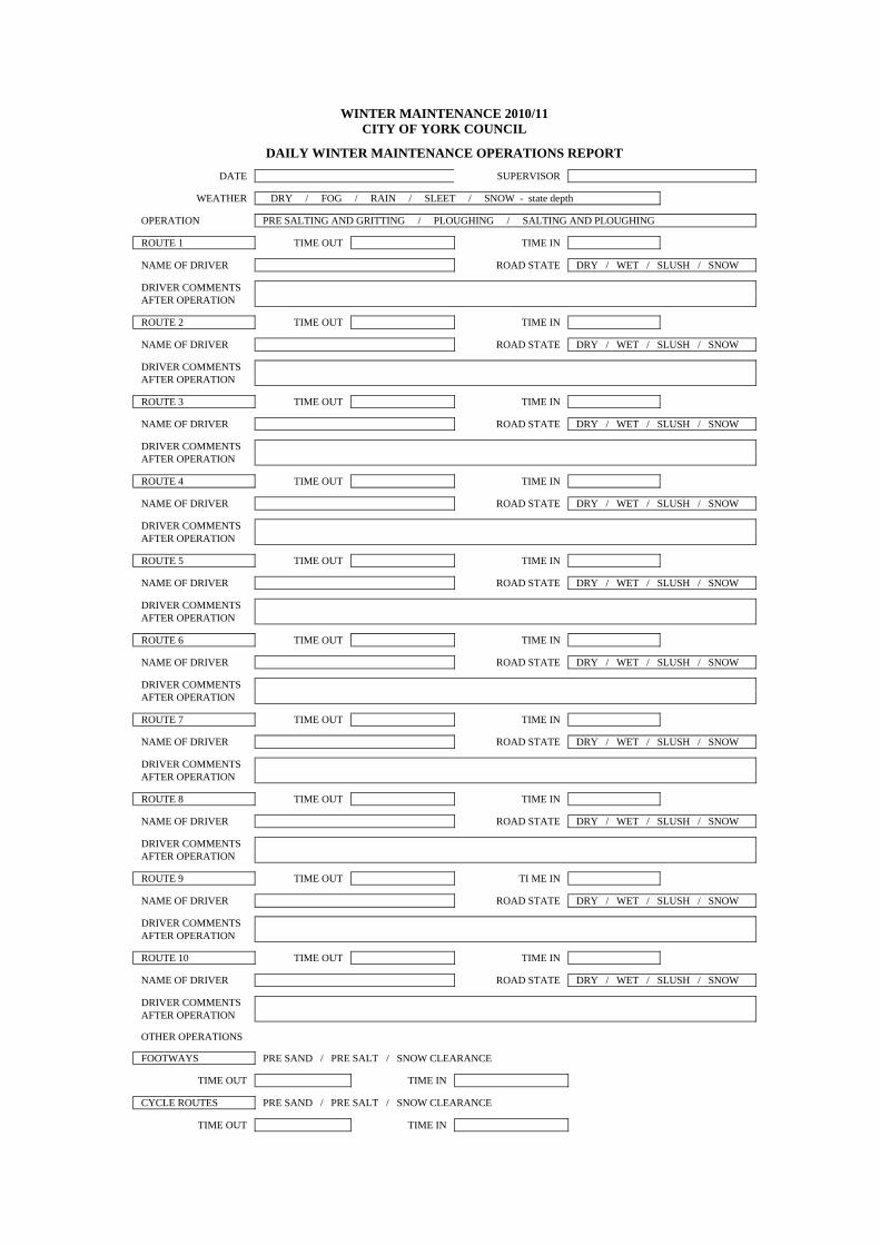
WINTER MAINTENANCE 2010/11 CITY OF YORK COUNCIL
DAILY WINTER M
AINTENANCE OPERATIONS REPORT
DATE SUPERVISOR
WEATHER DRY / FOG / RAIN / SLEET / SNOW - state depth OPERATION PRE SALTING AND GRITTING / PLOUGHING / SALTING AND PLOUGHING ROUTE 1 TIME OUT TIME IN NAME OF DRIVER ROAD STATE DRY / WET / SLUSH / SNOW DRIVER COMMENTS AFTER OPERATION
ROUTE 2 TIME OUT TIME IN NAME OF DRIVER ROAD STATE DRY / WET / SLUSH / SNOW DRIVER COMMENTS AFTER OPERATION
ROUTE 3 TIME OUT TIME IN NAME OF DRIVER ROAD STATE DRY / WET / SLUSH / SNOW DRIVER COMMENTS AFTER OPERATION
ROUTE 4 TIME OUT TIME IN NAME OF DRIVER ROAD STATE DRY / WET / SLUSH / SNOW DRIVER COMMENTS AFTER OPERATION
ROUTE 5 TIME OUT TIME IN NAME OF DRIVER ROAD STATE DRY / WET / SLUSH / SNOW DRIVER COMMENTS AFTER OPERATION
ROUTE 6 TIME OUT TIME IN NAME OF DRIVER ROAD STATE DRY / WET / SLUSH / SNOW DRIVER COMMENTS AFTER OPERATION
ROUTE 7 TIME OUT TIME IN NAME OF DRIVER ROAD STATE DRY / WET / SLUSH / SNOW DRIVER COMMENTS AFTER OPERATION
ROUTE 8 TIME OUT TIME IN NAME OF DRIVER ROAD STATE DRY / WET / SLUSH / SNOW DRIVER COMMENTS AFTER OPERATION
ROUTE 9 TIME OUT TI ME IN NAME OF DRIVER ROAD STATE DRY / WET / SLUSH / SNOW DRIVER COMMENTS AFTER OPERATION
ROUTE 10 TIME OUT TIME IN NAME OF DRIVER ROAD STATE DRY / WET / SLUSH / SNOW DRIVER COMMENTS AFTER OPERATION
OTHER OPERATIONS FOOTWAYS PRE SAND / PRE SALT / SNOW CLEARANCE
TIME OUT TIME IN CYCLE ROUTES PRE SAND / PRE SALT / SNOW CLEARANCE
TIME OUT TIME IN

±
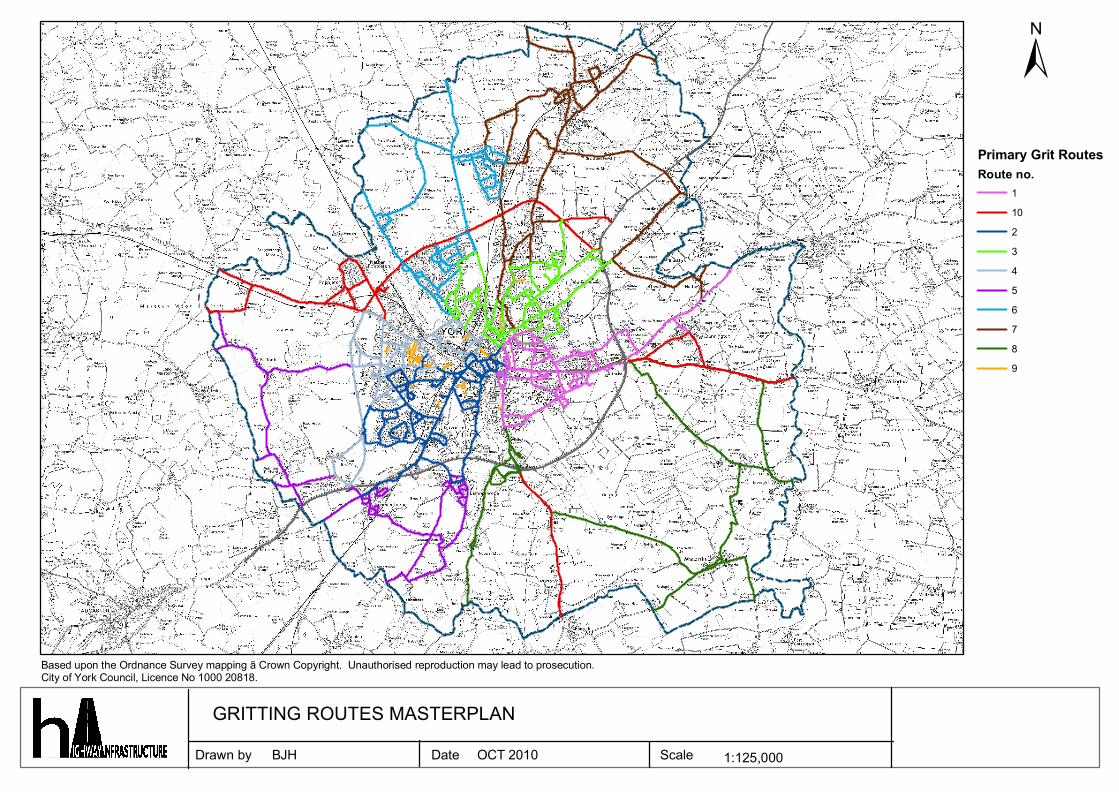
Drawn by Date Scale 1:125,000
Based upon the Ordnance Survey mapping ã Crown Copyright. Unauthorised reproduction may lead to prosecution.City of York Council, Licence No 1000 20818.
GRITTING ROUTES MASTERPLANBJH OCT 2010
Primary Grit RoutesRoute no.
11023456789
±
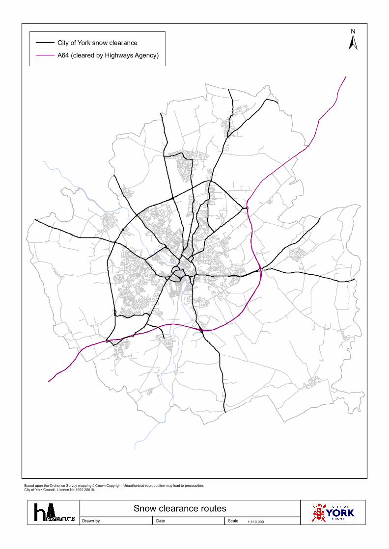
Drawn by Date Scale 1:110,000
Based upon the Ordnance Survey mapping ã Crown Copyright. Unauthorised reproduction may lead to prosecution.City of York Council, Licence No 1000 20818.
City of York snow clearanceA64 (cleared by Highways Agency)
Snow clearance routes
±
Drawn by Date Scale 1:40,000
Based upon the Ordnance Survey mapping ã Crown Copyright. Unauthorised reproduction may lead to prosecution.City of York Council, Licence No 1000 20818.
GRIT ROUTE 1BJH OCT 2010

±
Drawn by Date Scale 1:40,000
Based upon the Ordnance Survey mapping ã Crown Copyright. Unauthorised reproduction may lead to prosecution.City of York Council, Licence No 1000 20818.
GRIT ROUTE 2BJH OCT 2010
±
Drawn by Date Scale 1:40,000
Based upon the Ordnance Survey mapping ã Crown Copyright. Unauthorised reproduction may lead to prosecution.City of York Council, Licence No 1000 20818.
GRIT ROUTE 3BJH OCT 2010
±
Drawn by Date Scale 1:40,000
Based upon the Ordnance Survey mapping ã Crown Copyright. Unauthorised reproduction may lead to prosecution.City of York Council, Licence No 1000 20818.
GRIT ROUTE 4BJH OCT 2010
±
Drawn by Date Scale 1:50,000
Based upon the Ordnance Survey mapping ã Crown Copyright. Unauthorised reproduction may lead to prosecution.City of York Council, Licence No 1000 20818.
GRIT ROUTE 5BJH OCT 2010

±
Drawn by Date Scale 1:40,000
Based upon the Ordnance Survey mapping ã Crown Copyright. Unauthorised reproduction may lead to prosecution.City of York Council, Licence No 1000 20818.
GRIT ROUTE 6BJH OCT 2010
±
Drawn by Date Scale 1:45,000
Based upon the Ordnance Survey mapping ã Crown Copyright. Unauthorised reproduction may lead to prosecution.City of York Council, Licence No 1000 20818.
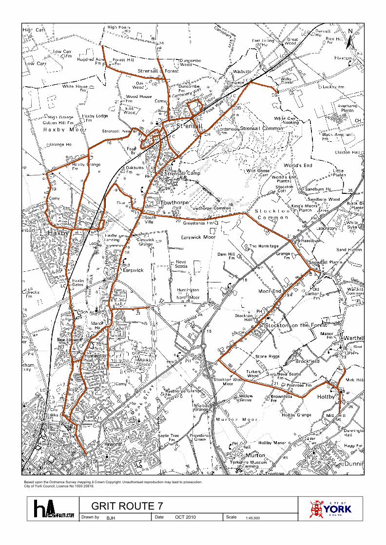
GRIT ROUTE 7BJH OCT 2010
±
Drawn by Date Scale 1:50,000
Based upon the Ordnance Survey mapping ã Crown Copyright. Unauthorised reproduction may lead to prosecution.City of York Council, Licence No 1000 20818.
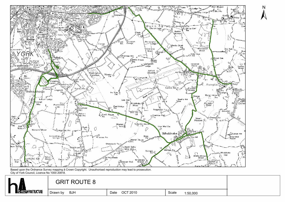
GRIT ROUTE 8BJH OCT 2010
±
Drawn by Date Scale 1:30,000
Based upon the Ordnance Survey mapping ã Crown Copyright. Unauthorised reproduction may lead to prosecution.City of York Council, Licence No 1000 20818.
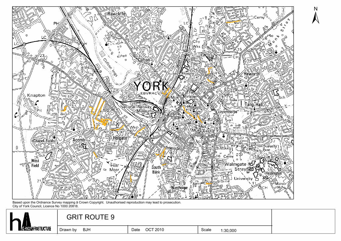
GRIT ROUTE 9BJH OCT 2010
±
Drawn by Date Scale 1:85,000
Based upon the Ordnance Survey mapping ã Crown Copyright. Unauthorised reproduction may lead to prosecution.City of York Council, Licence No 1000 20818.
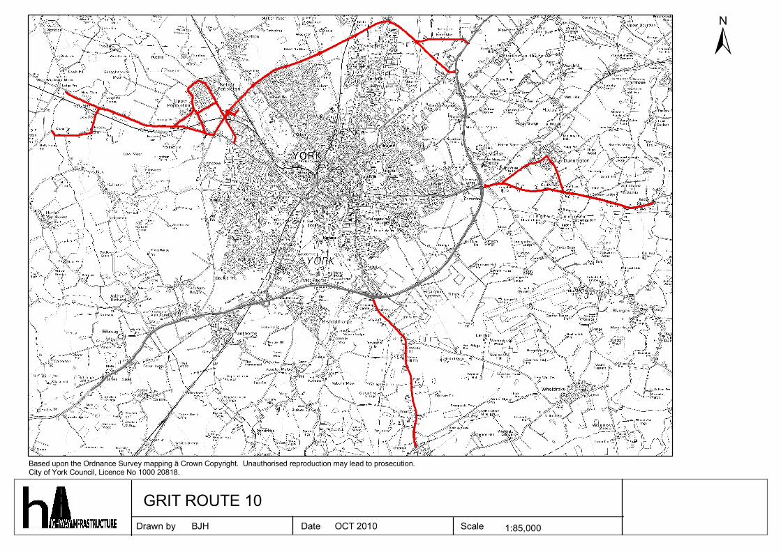
GRIT ROUTE 10BJH OCT 2010
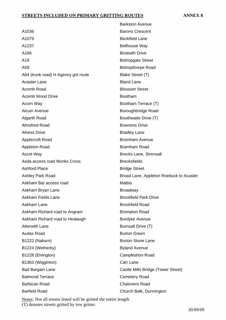
STREETS INCLUDED ON PRIMARY GRITTING ROUTES ANNEX 8
A1036
A1079
A1237
A166
A19
A59
A64 (trunk road) H Agency grit route
Acaster Lane
Acomb Road
Acomb Wood Drive
Acorn Way
Alcuin Avenue
Algarth Road
Almsford Road
Alness Drive
Applecroft Road
Appleton Road
Ascot Way
Asda access road Monks Cross
Ashford Place
Ashley Park Road
Askham Bar access road
Askham Bryan Lane
Askham Fields Lane
Askham Lane
Askham Richard road to Angram
Askham Richard road to Healaugh
Atterwith Lane
Audax Road
B1222 (Naburn)
B1224 (Wetherby)
B1228 (Elvington)
B1363 (Wigginton)
Bad Bargain Lane
Balmoral Terrace
Barbican Road
Barfield Road
Barkston Avenue
Barons Crescent
Beckfield Lane
Bellhouse Way
Birstwith Drive
Bishopgate Street
Bishopthorpe Road
Blake Street (T)
Bland Lane
Blossom Street
Bootham
Bootham Terrace (T)
Boroughbridge Road
Bouthwaite Drive (T)
Bowness Drive
Bradley Lane
Bramham Avenue
Bramham Road
Brecks Lane, Strensall
Brecksfields
Bridge Street
Broad Lane, Appleton Roebuck to Acaster
Malbis
Broadway
Brockfield Park Drive
Brockfield Road
Brompton Road
Burdyke Avenue
Burnsall Drive (T)
Burton Green
Burton Stone Lane
Byland Avenue
Campleshon Road
Carr Lane
Castle Mills Bridge (Tower Street)
Cemetery Road
Chaloners Road Church Balk, Dunnington
Notes(T) denotes streets gritted by tow gritter.
30/09/09
: Not all streets listed will be gritted the entire length.
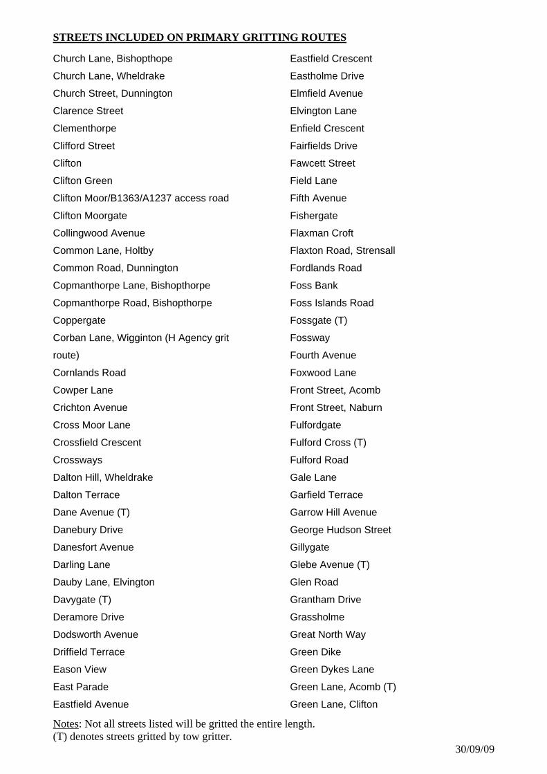
STREETS INCLUDED ON PRIMARY GRITTING ROUTES
Church Lane, Bishopthope
Church Lane, Wheldrake
Church Street, Dunnington
Clarence Street
Clementhorpe
Clifford Street
Clifton
Clifton Green
Clifton Moor/B1363/A1237 access road
Clifton Moorgate
Collingwood Avenue
Common Lane, Holtby
Common Road, Dunnington
Copmanthorpe Lane, Bishopthorpe
Copmanthorpe Road, Bishopthorpe
Coppergate
Corban Lane, Wigginton (H Agency grit
route)
Cornlands Road
Cowper Lane
Crichton Avenue
Cross Moor Lane
Crossfield Crescent
Crossways
Dalton Hill, Wheldrake
Dalton Terrace
Dane Avenue (T)
Danebury Drive
Danesfort Avenue
Darling Lane
Dauby Lane, Elvington
Davygate (T)
Deramore Drive
Dodsworth Avenue
Driffield Terrace
Eason View
East Parade
Eastfield Avenue
Eastfield Crescent
Eastholme Drive
Elmfield Avenue
Elvington Lane
Enfield Crescent
Fairfields Drive
Fawcett Street
Field Lane
Fifth Avenue
Fishergate
Flaxman Croft
Flaxton Road, Strensall
Fordlands Road
Foss Bank
Foss Islands Road
Fossgate (T)
Fossway
Fourth Avenue
Foxwood Lane
Front Street, Acomb
Front Street, Naburn
Fulfordgate
Fulford Cross (T)
Fulford Road
Gale Lane
Garfield Terrace
Garrow Hill Avenue
George Hudson Street
Gillygate
Glebe Avenue (T)
Glen Road
Grantham Drive
Grassholme
Great North Way
Green Dike
Green Dykes Lane
Green Lane, Acomb (T)
Green Lane, Clifton
Notes(T) denotes streets gritted by tow gritter.
30/09/09
: Not all streets listed will be gritted the entire length.
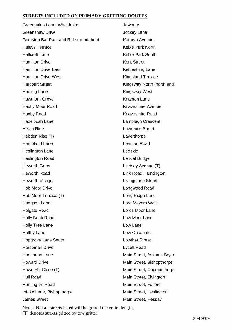
STREETS INCLUDED ON PRIMARY GRITTING ROUTES
Greengales Lane, Wheldrake
Greenshaw Drive
Grimston Bar Park and Ride roundabout
Haleys Terrace
Hallcroft Lane
Hamilton Drive
Hamilton Drive East
Hamilton Drive West
Harcourt Street
Hauling Lane
Hawthorn Grove
Haxby Moor Road
Haxby Road
Hazelbush Lane
Heath Ride
Hebden Rise (T)
Hempland Lane
Heslington Lane
Heslington Road
Heworth Green
Heworth Road
Heworth Village
Hob Moor Drive
Hob Moor Terrace (T)
Hodgson Lane
Holgate Road
Holly Bank Road
Holly Tree Lane
Holtby Lane
Hopgrove Lane South
Horseman Drive
Horseman Lane
Howard Drive
Howe Hill Close (T)
Hull Road
Huntington Road
Intake Lane, Bishopthorpe
James Street
Jewbury
Jockey Lane
Kathryn Avenue
Keble Park North
Keble Park South
Kent Street
Kettlestring Lane
Kingsland Terrace
Kingsway North (north end)
Kingsway West
Knapton Lane
Knavesmire Avenue
Knavesmire Road
Lamplugh Crescent
Lawrence Street
Layerthorpe
Leeman Road
Leeside
Lendal Bridge
Lindsey Avenue (T)
Link Road, Huntington
Livingstone Street
Longwood Road
Long Ridge Lane
Lord Mayors Walk
Lords Moor Lane
Low Moor Lane
Low Lane
Low Ousegate
Lowther Street
Lycett Road
Main Street, Askham Bryan
Main Street, Bishopthorpe
Main Street, Copmanthorpe
Main Street, Elvington
Main Street, Fulford
Main Street, Heslington
Main Street, Hessay
Notes(T) denotes streets gritted by tow gritter.
30/09/09
: Not all streets listed will be gritted the entire length.
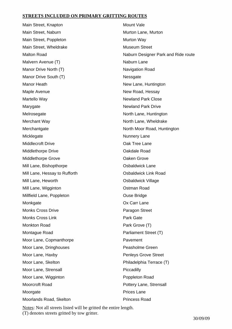
STREETS INCLUDED ON PRIMARY GRITTING ROUTES
Main Street, Knapton
Main Street, Naburn
Main Street, Poppleton
Main Street, Wheldrake
Malton Road
Malvern Avenue (T)
Manor Drive North (T)
Manor Drive South (T)
Manor Heath
Maple Avenue
Martello Way
Marygate
Melrosegate
Merchant Way
Merchantgate
Micklegate
Middlecroft Drive
Middlethorpe Drive
Middlethorpe Grove
Mill Lane, Bishopthorpe
Mill Lane, Hessay to Rufforth
Mill Lane, Heworth
Mill Lane, Wigginton
Millfield Lane, Poppleton
Monkgate
Monks Cross Drive
Monks Cross Link
Monkton Road
Montague Road
Moor Lane, Copmanthorpe
Moor Lane, Dringhouses
Moor Lane, Haxby
Moor Lane, Skelton
Moor Lane, Strensall
Moor Lane, Wigginton
Moorcroft Road
Moorgate
Moorlands Road, Skelton
Mount Vale
Murton Lane, Murton
Murton Way
Museum Street
Naburn Designer Park and Ride route
Naburn Lane
Navigation Road
Nessgate
New Lane, Huntington
New Road, Hessay
Newland Park Close
Newland Park Drive
North Lane, Huntington
North Lane, Wheldrake
North Moor Road, Huntington
Nunnery Lane
Oak Tree Lane
Oakdale Road
Oaken Grove
Osbaldwick Lane
Osbaldwick Link Road
Osbaldwick Village
Ostman Road
Ouse Bridge
Ox Carr Lane
Paragon Street
Park Gate
Park Grove (T)
Parliament Street (T)
Pavement
Peasholme Green
Penleys Grove Street
Philadelphia Terrace (T)
Piccadilly
Poppleton Road
Pottery Lane, Strensall
Prices Lane
Princess Road
Notes(T) denotes streets gritted by tow gritter.
30/09/09
: Not all streets listed will be gritted the entire length.

STREETS INCLUDED ON PRIMARY GRITTING ROUTES
Pulleyn Drive
Queen Annes Road (T)
Queen Street
Queen Victoria Street
Ramsey Avenue, Bishopthorpe
Ramsay Close (T)
Rawcliffe Bar park and ride access road
Rawcliffe Drive
Rawcliffe Lane
Ridgeway
Rivelin Way
Rougier Street
Ryecroft Avenue
Salisbury Road
Salisbury Terrace
Sandy Lane, Stockton On The Forest
Scarcroft Hill (T)
Scarcroft Road
School Lane, Askham Richard
School Lane, Copmanthorpe
School Lane, Heslington
Sefton Avenue
Selby Road
Sheriff Hutton Road to boundary
Shipton Road
Sim Balk Lane
Skeldergate
Skeldergate Bridge
Sowerby Road (T)
St. Denys Road
St. Giles Road
St. Giles Way
St. Helens Road
St. James Mount (T)
St. Leonards Place
St. Maurices Road
St. Nicholas Avenue (Naburn Shopping Site)
St. Stephens Road
Stamford Bridge Road
Station Avenue
Station Rise
Station Road
Station Road, Copmanthorpe
Station Road, Haxby
Station Road, Poppleton
Stillingfleet Road (B1222)
Stirling Road (Clifton Moor)
Stockhill Lane, Askham Richard
Stockton Lane
Straight Lane, Holtby
Stray Road
Straylands Grove
Strensall Road
Sussex Road
Stuart Road
Tadcaster Road
Tang Hall Lane
Temple Lane
Ten Thorn Lane, Knapton
Thanet Road
The Avenue, Clifton
The Green, Acomb
The Mount
The Stonebow
The Village, Haxby
The Village, Skelton
The Village, Stockton On The Forest
The Village, Strensall
The Village, Wigginton
Thief Lane
Thompson Drive
Thorganby Road
Top Lane
Tower Street
Townend Street
Towthorpe Moor Lane
Notes(T) denotes streets gritted by tow gritter.
30/09/09
: Not all streets listed will be gritted the entire length.

STREETS INCLUDED ON PRIMARY GRITTING ROUTES
Towthorpe Road
Tranby Avenue
Tudor Road
Turnmire Road
University Road
Usher Lane
Walmer Carr
Walmgate
Water End
Water Lane
Wentworth Road (T)
West Bank
West End, Strensall
West Nooks
West Pit Lane
West Thorpe
Westfield Lane
Westfield Road
Westminster Road
Wetherby Road
Wheatfield Lane
Wheldrake (Main Street to boundary at
Thicket)
Wheldrake Lane (to boundary towards
Escrick)
Wheldrake Lane (Wheldrake to Crockey Hill)
Wheldrake Lane (Wheldrake to Elvington)
Whip Ma Whop Ma Gate (T)
White Rose Way
Wigginton Road
Wilton Rise (T)
Windmill Lane
Windmill Rise (T)
Windsor Garth
Woodlands Grove
Woodlea Avenue
Woodlea Bank
Yarburgh Way
Yearsley Grove (T)
York Road, Acomb
York Road, Askham Bryan
York Road, Askham Richard
York Road, Dunnington
York Road, Elvington
York Road, Haxby
York Road, Naburn
York Road, Strensall
York Road, Wigginton
York Street, Dunnington
Notes(T) denotes streets gritted by tow gritter.
30/09/09
: Not all streets listed will be gritted the entire length.
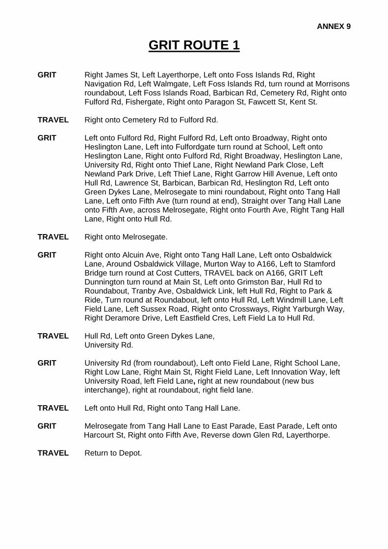
ANNEX 9
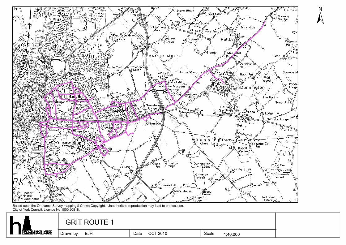
GRIT ROUTE 1 GRIT Right James St, Left Layerthorpe, Left onto Foss Islands Rd, Right
Navigation Rd, Left Walmgate, Left Foss Islands Rd, turn round at Morrisons roundabout, Left Foss Islands Road, Barbican Rd, Cemetery Rd, Right onto Fulford Rd, Fishergate, Right onto Paragon St, Fawcett St, Kent St.
TRAVEL Right onto Cemetery Rd to Fulford Rd. GRIT Left onto Fulford Rd, Right Fulford Rd, Left onto Broadway, Right onto
Heslington Lane, Left into Fulfordgate turn round at School, Left onto Heslington Lane, Right onto Fulford Rd, Right Broadway, Heslington Lane, University Rd, Right onto Thief Lane, Right Newland Park Close, Left Newland Park Drive, Left Thief Lane, Right Garrow Hill Avenue, Left onto Hull Rd, Lawrence St, Barbican, Barbican Rd, Heslington Rd, Left onto Green Dykes Lane, Melrosegate to mini roundabout, Right onto Tang Hall Lane, Left onto Fifth Ave (turn round at end), Straight over Tang Hall Lane onto Fifth Ave, across Melrosegate, Right onto Fourth Ave, Right Tang Hall Lane, Right onto Hull Rd.
TRAVEL Right onto Melrosegate. GRIT Right onto Alcuin Ave, Right onto Tang Hall Lane, Left onto Osbaldwick
Lane, Around Osbaldwick Village, Murton Way to A166, Left to Stamford Bridge turn round at Cost Cutters, TRAVEL back on A166, GRIT Left Dunnington turn round at Main St, Left onto Grimston Bar, Hull Rd to Roundabout, Tranby Ave, Osbaldwick Link, left Hull Rd, Right to Park & Ride, Turn round at Roundabout, left onto Hull Rd, Left Windmill Lane, Left Field Lane, Left Sussex Road, Right onto Crossways, Right Yarburgh Way, Right Deramore Drive, Left Eastfield Cres, Left Field La to Hull Rd.
TRAVEL Hull Rd, Left onto Green Dykes Lane, University Rd. GRIT University Rd (from roundabout), Left onto Field Lane, Right School Lane,
Right Low Lane, Right Main St, Right Field Lane, Left Innovation Way, left University Road, left Field Lane, right at new roundabout (new bus interchange), right at roundabout, right field lane.
TRAVEL Left onto Hull Rd, Right onto Tang Hall Lane. GRIT Melrosegate from Tang Hall Lane to East Parade, East Parade, Left onto
Harcourt St, Right onto Fifth Ave, Reverse down Glen Rd, Layerthorpe. TRAVEL Return to Depot.
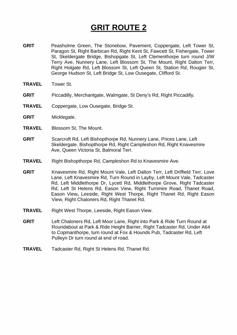
GRIT ROUTE 2 GRIT Peasholme Green, The Stonebow, Pavement, Coppergate, Left Tower St,
Paragon St, Right Barbican Rd, Right Kent St, Fawcett St, Fishergate, Tower St, Skeldergate Bridge, Bishopgate St, Left Clementhorpe turn round J/W Terry Ave, Nunnery Lane, Left Blossom St, The Mount, Right Dalton Terr, Right Holgate Rd, Left Blossom St, Left Queen St, Station Rd, Rougier St, George Hudson St, Left Bridge St, Low Ousegate, Clifford St.
TRAVEL Tower St. GRIT Piccadilly, Merchantgate, Walmgate, St Deny’s Rd, Right Piccadilly. TRAVEL Coppergate, Low Ousegate, Bridge St. GRIT Micklegate. TRAVEL Blossom St, The Mount. GRIT Scarcroft Rd, Left Bishopthorpe Rd, Nunnery Lane, Prices Lane, Left
Skeldergate. Bishopthorpe Rd, Right Campleshon Rd, Right Knavesmire Ave, Queen Victoria St, Balmoral Terr.
TRAVEL Right Bishopthorpe Rd, Campleshon Rd to Knavesmire Ave. GRIT Knavesmire Rd, Right Mount Vale, Left Dalton Terr, Left Driffield Terr, Love
Lane, Left Knavesmire Rd, Turn Round in Layby, Left Mount Vale, Tadcaster Rd, Left Middlethorpe Dr, Lycett Rd, Middlethorpe Grove, Right Tadcaster Rd, Left St Helens Rd, Eason View, Right Turnmire Road, Thanet Road, Eason View, Leeside, Right West Thorpe, Right Thanet Rd, Right Eason View, Right Chaloners Rd, Right Thanet Rd.
TRAVEL Right West Thorpe, Leeside, Right Eason View. GRIT Left Chaloners Rd, Left Moor Lane, Right into Park & Ride Turn Round at
Roundabout at Park & Ride Height Barrier, Right Tadcaster Rd, Under A64 to Copmanthorpe, turn round at Fox & Hounds Pub, Tadcaster Rd, Left Pulleyn Dr turn round at end of road.
TRAVEL Tadcaster Rd, Right St Helens Rd, Thanet Rd.
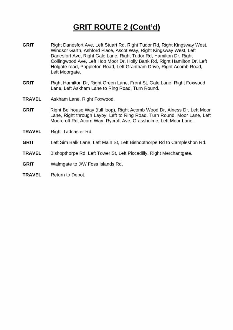
GRIT ROUTE 2 (Cont’d) GRIT Right Danesfort Ave, Left Stuart Rd, Right Tudor Rd, Right Kingsway West,
Windsor Garth, Ashford Place, Ascot Way, Right Kingsway West, Left Danesfort Ave, Right Gale Lane, Right Tudor Rd, Hamilton Dr, Right Collingwood Ave, Left Hob Moor Dr, Holly Bank Rd, Right Hamilton Dr, Left Holgate road, Poppleton Road, Left Grantham Drive, Right Acomb Road, Left Moorgate.
GRIT Right Hamilton Dr, Right Green Lane, Front St, Gale Lane, Right Foxwood
Lane, Left Askham Lane to Ring Road, Turn Round. TRAVEL Askham Lane, Right Foxwood. GRIT Right Bellhouse Way (full loop), Right Acomb Wood Dr, Alness Dr, Left Moor
Lane, Right through Layby, Left to Ring Road, Turn Round, Moor Lane, Left Moorcroft Rd, Acorn Way, Rycroft Ave, Grassholme, Left Moor Lane.
TRAVEL Right Tadcaster Rd. GRIT Left Sim Balk Lane, Left Main St, Left Bishopthorpe Rd to Campleshon Rd. TRAVEL Bishopthorpe Rd, Left Tower St, Left Piccadilly, Right Merchantgate. GRIT Walmgate to J/W Foss Islands Rd. TRAVEL Return to Depot.
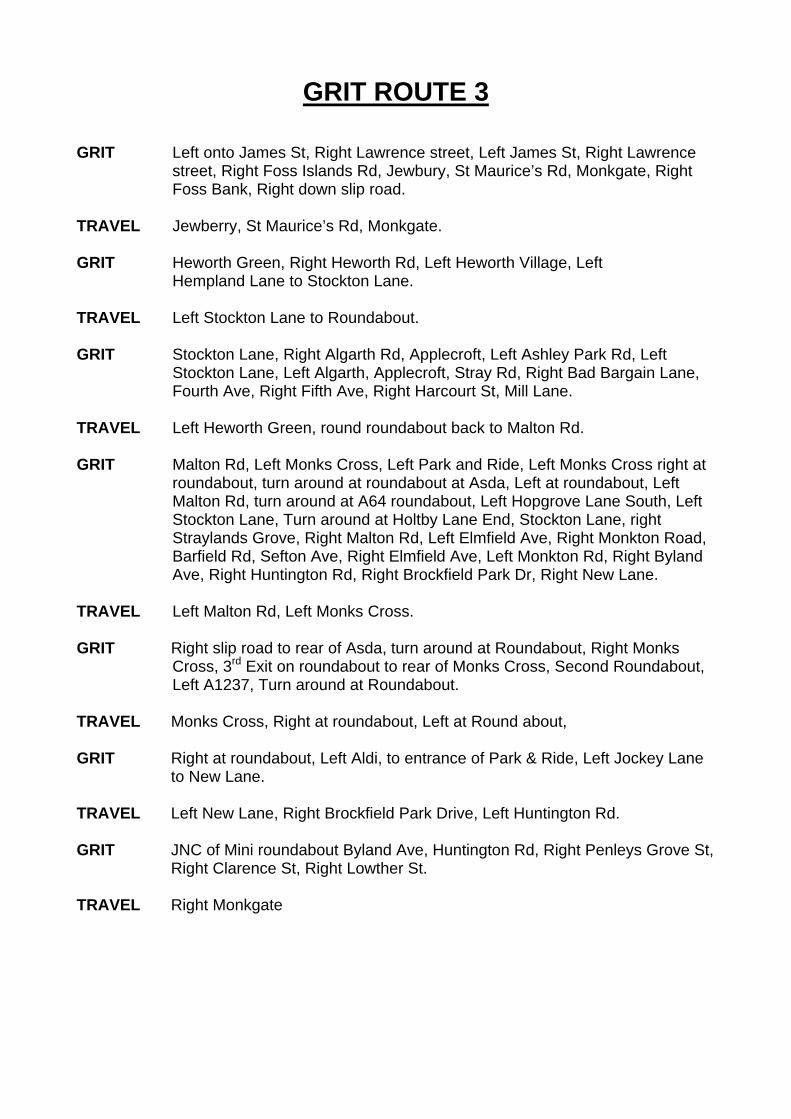
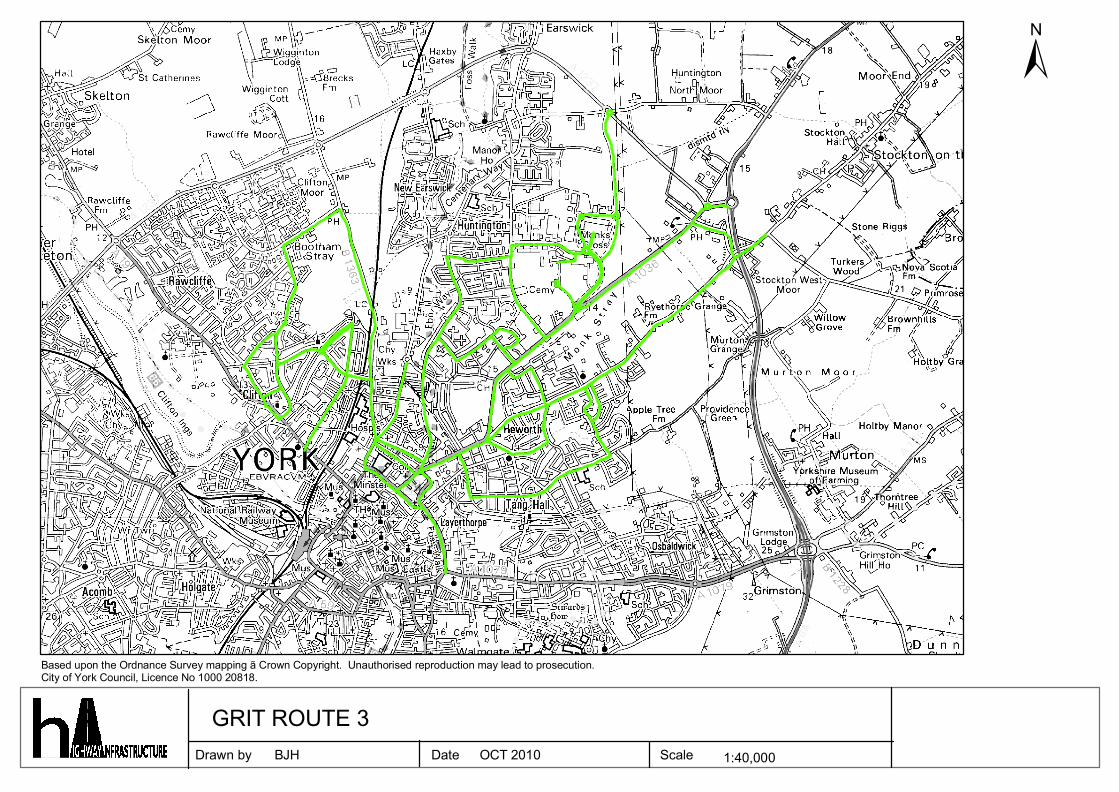
GRIT ROUTE 3 GRIT Left onto James St, Right Lawrence street, Left James St, Right Lawrence
street, Right Foss Islands Rd, Jewbury, St Maurice’s Rd, Monkgate, Right Foss Bank, Right down slip road.
TRAVEL Jewberry, St Maurice’s Rd, Monkgate. GRIT Heworth Green, Right Heworth Rd, Left Heworth Village, Left
Hempland Lane to Stockton Lane. TRAVEL Left Stockton Lane to Roundabout. GRIT Stockton Lane, Right Algarth Rd, Applecroft, Left Ashley Park Rd, Left
Stockton Lane, Left Algarth, Applecroft, Stray Rd, Right Bad Bargain Lane, Fourth Ave, Right Fifth Ave, Right Harcourt St, Mill Lane.
TRAVEL Left Heworth Green, round roundabout back to Malton Rd. GRIT Malton Rd, Left Monks Cross, Left Park and Ride, Left Monks Cross right at
roundabout, turn around at roundabout at Asda, Left at roundabout, Left Malton Rd, turn around at A64 roundabout, Left Hopgrove Lane South, Left Stockton Lane, Turn around at Holtby Lane End, Stockton Lane, right Straylands Grove, Right Malton Rd, Left Elmfield Ave, Right Monkton Road, Barfield Rd, Sefton Ave, Right Elmfield Ave, Left Monkton Rd, Right Byland Ave, Right Huntington Rd, Right Brockfield Park Dr, Right New Lane.
TRAVEL Left Malton Rd, Left Monks Cross. GRIT Right slip road to rear of Asda, turn around at Roundabout, Right Monks
Cross, 3rd Exit on roundabout to rear of Monks Cross, Second Roundabout, Left A1237, Turn around at Roundabout.
TRAVEL Monks Cross, Right at roundabout, Left at Round about, GRIT Right at roundabout, Left Aldi, to entrance of Park & Ride, Left Jockey Lane
to New Lane. TRAVEL Left New Lane, Right Brockfield Park Drive, Left Huntington Rd. GRIT JNC of Mini roundabout Byland Ave, Huntington Rd, Right Penleys Grove St,
Right Clarence St, Right Lowther St. TRAVEL Right Monkgate

GRIT ROUTE 3 (Cont’d) GRIT Right Lord Mayors Walk, Right Clarence St, Left Wigginton Rd, Left Clifton
Moorgate (Bumper Castle), Left Water Lane, Right Brompton Rd, Right Rawcliffe Lane, Right Rawcliffe Dr, Right Water Lane, Left Burdyke Ave, Round Roundabout, Left Burton Green, Right Burton Stone Lane.
TRAVEL Right Clifton. GRIT Right Water Lane. To bottom of Brompton Rd TRAVEL Right Burdyke Ave GRIT Crichton Ave. TRAVEL Right Wigginton Rd to J/W Haxby Rd. GRIT Haxby Rd from Wigginton Rd to Haleys Terr. TRAVEL Return to Depot.
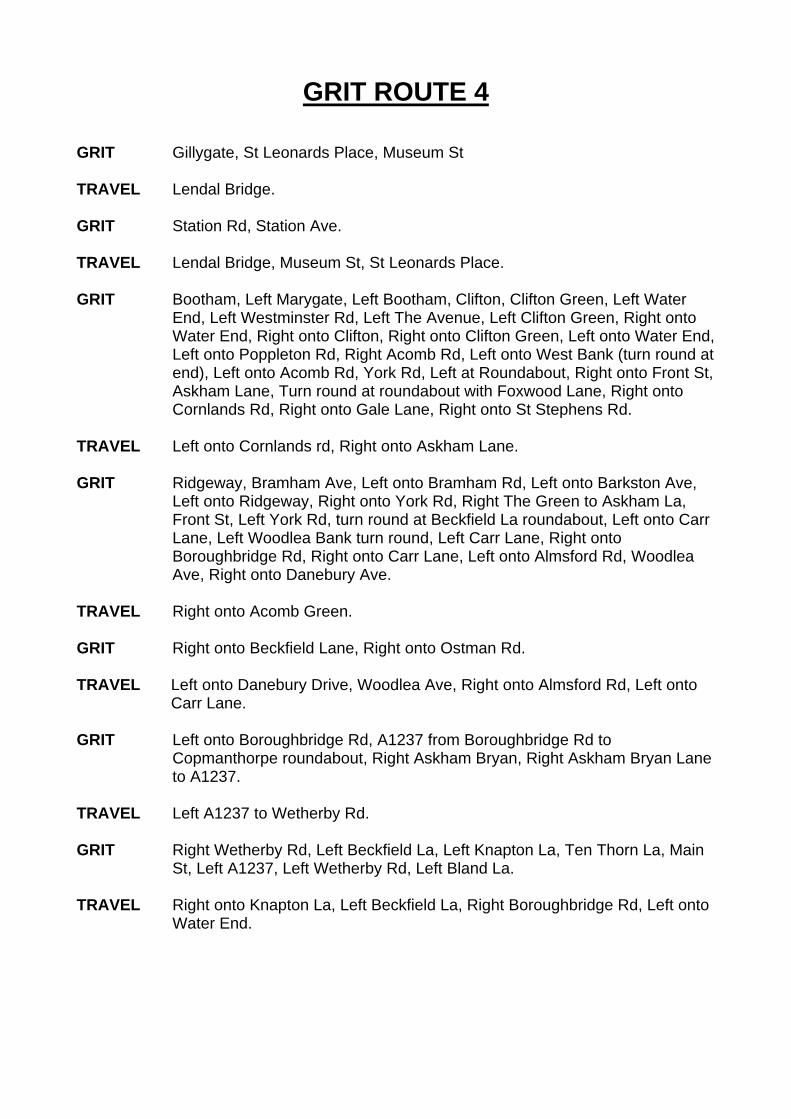
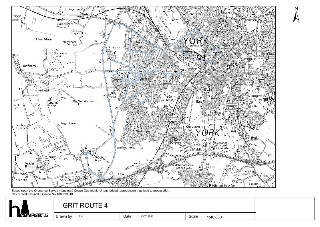
GRIT ROUTE 4 GRIT Gillygate, St Leonards Place, Museum St TRAVEL Lendal Bridge. GRIT Station Rd, Station Ave. TRAVEL Lendal Bridge, Museum St, St Leonards Place. GRIT Bootham, Left Marygate, Left Bootham, Clifton, Clifton Green, Left Water
End, Left Westminster Rd, Left The Avenue, Left Clifton Green, Right onto Water End, Right onto Clifton, Right onto Clifton Green, Left onto Water End, Left onto Poppleton Rd, Right Acomb Rd, Left onto West Bank (turn round at end), Left onto Acomb Rd, York Rd, Left at Roundabout, Right onto Front St, Askham Lane, Turn round at roundabout with Foxwood Lane, Right onto Cornlands Rd, Right onto Gale Lane, Right onto St Stephens Rd.
TRAVEL Left onto Cornlands rd, Right onto Askham Lane. GRIT Ridgeway, Bramham Ave, Left onto Bramham Rd, Left onto Barkston Ave,
Left onto Ridgeway, Right onto York Rd, Right The Green to Askham La, Front St, Left York Rd, turn round at Beckfield La roundabout, Left onto Carr Lane, Left Woodlea Bank turn round, Left Carr Lane, Right onto Boroughbridge Rd, Right onto Carr Lane, Left onto Almsford Rd, Woodlea Ave, Right onto Danebury Ave.
TRAVEL Right onto Acomb Green. GRIT Right onto Beckfield Lane, Right onto Ostman Rd. TRAVEL Left onto Danebury Drive, Woodlea Ave, Right onto Almsford Rd, Left onto
Carr Lane. GRIT Left onto Boroughbridge Rd, A1237 from Boroughbridge Rd to
Copmanthorpe roundabout, Right Askham Bryan, Right Askham Bryan Lane to A1237.
TRAVEL Left A1237 to Wetherby Rd. GRIT Right Wetherby Rd, Left Beckfield La, Left Knapton La, Ten Thorn La, Main
St, Left A1237, Left Wetherby Rd, Left Bland La. TRAVEL Right onto Knapton La, Left Beckfield La, Right Boroughbridge Rd, Left onto
Water End.
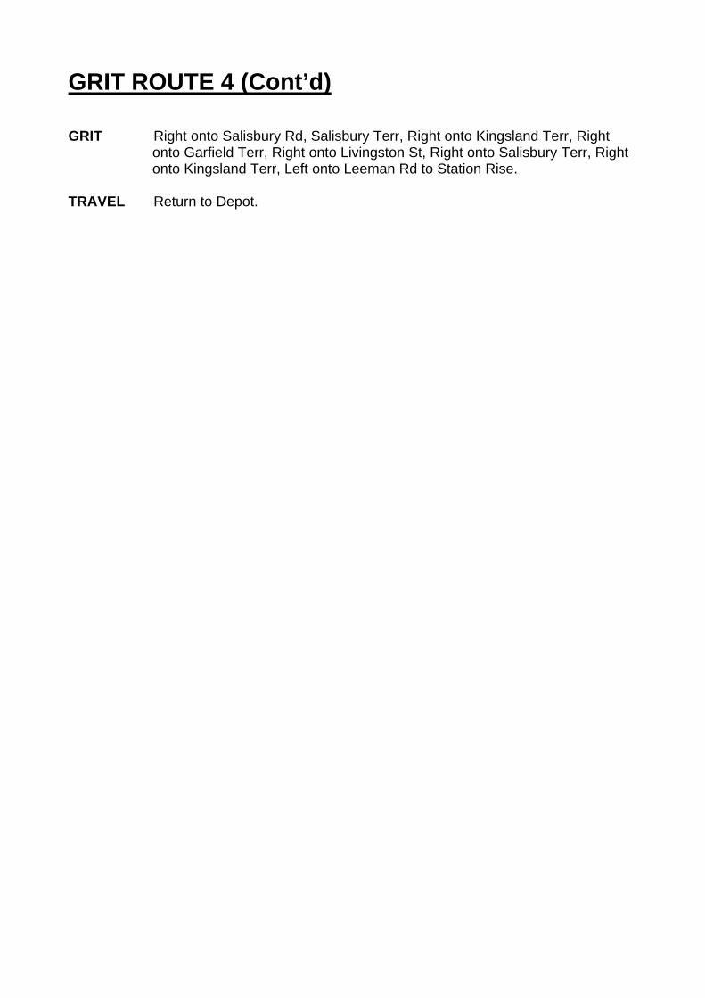
GRIT ROUTE 4 (Cont’d) GRIT Right onto Salisbury Rd, Salisbury Terr, Right onto Kingsland Terr, Right
onto Garfield Terr, Right onto Livingston St, Right onto Salisbury Terr, Right onto Kingsland Terr, Left onto Leeman Rd to Station Rise.
TRAVEL Return to Depot.
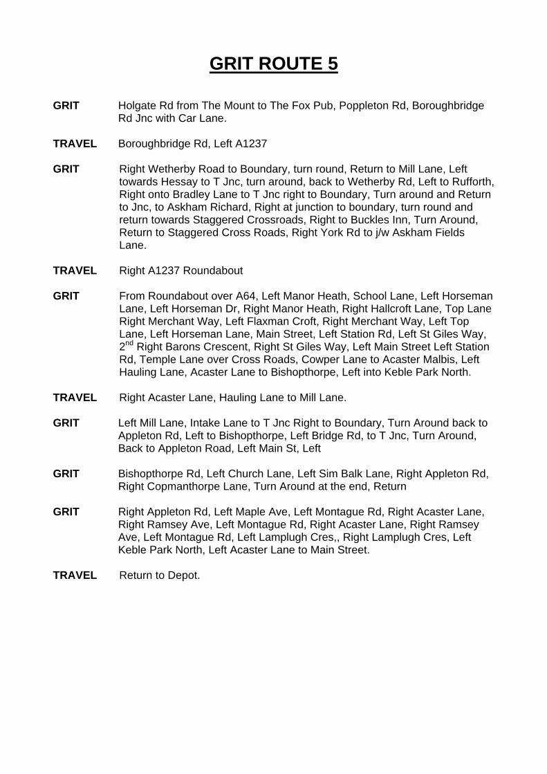
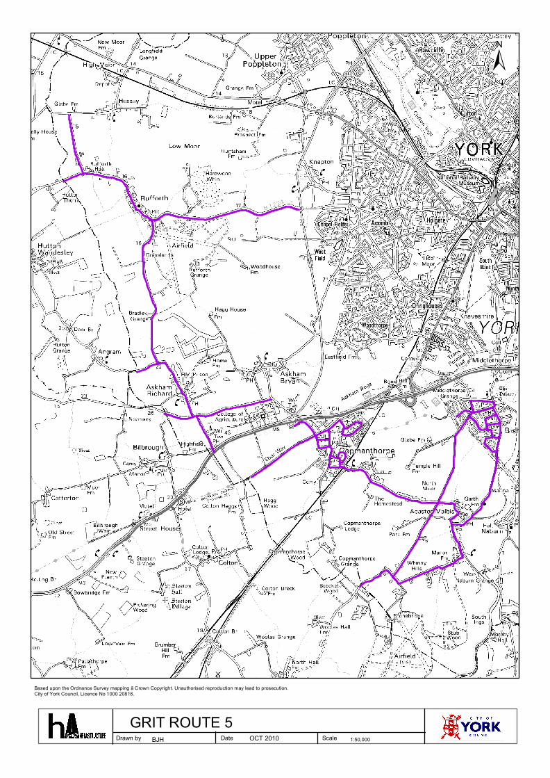
GRIT ROUTE 5 GRIT Holgate Rd from The Mount to The Fox Pub, Poppleton Rd, Boroughbridge
Rd Jnc with Car Lane. TRAVEL Boroughbridge Rd, Left A1237 GRIT Right Wetherby Road to Boundary, turn round, Return to Mill Lane, Left
towards Hessay to T Jnc, turn around, back to Wetherby Rd, Left to Rufforth, Right onto Bradley Lane to T Jnc right to Boundary, Turn around and Return to Jnc, to Askham Richard, Right at junction to boundary, turn round and return towards Staggered Crossroads, Right to Buckles Inn, Turn Around, Return to Staggered Cross Roads, Right York Rd to j/w Askham Fields Lane.
TRAVEL Right A1237 Roundabout GRIT From Roundabout over A64, Left Manor Heath, School Lane, Left Horseman
Lane, Left Horseman Dr, Right Manor Heath, Right Hallcroft Lane, Top Lane Right Merchant Way, Left Flaxman Croft, Right Merchant Way, Left Top Lane, Left Horseman Lane, Main Street, Left Station Rd, Left St Giles Way, 2nd Right Barons Crescent, Right St Giles Way, Left Main Street Left Station Rd, Temple Lane over Cross Roads, Cowper Lane to Acaster Malbis, Left Hauling Lane, Acaster Lane to Bishopthorpe, Left into Keble Park North.
TRAVEL Right Acaster Lane, Hauling Lane to Mill Lane. GRIT Left Mill Lane, Intake Lane to T Jnc Right to Boundary, Turn Around back to
Appleton Rd, Left to Bishopthorpe, Left Bridge Rd, to T Jnc, Turn Around, Back to Appleton Road, Left Main St, Left
GRIT Bishopthorpe Rd, Left Church Lane, Left Sim Balk Lane, Right Appleton Rd,
Right Copmanthorpe Lane, Turn Around at the end, Return GRIT Right Appleton Rd, Left Maple Ave, Left Montague Rd, Right Acaster Lane,
Right Ramsey Ave, Left Montague Rd, Right Acaster Lane, Right Ramsey Ave, Left Montague Rd, Left Lamplugh Cres,, Right Lamplugh Cres, Left Keble Park North, Left Acaster Lane to Main Street.
TRAVEL Return to Depot.
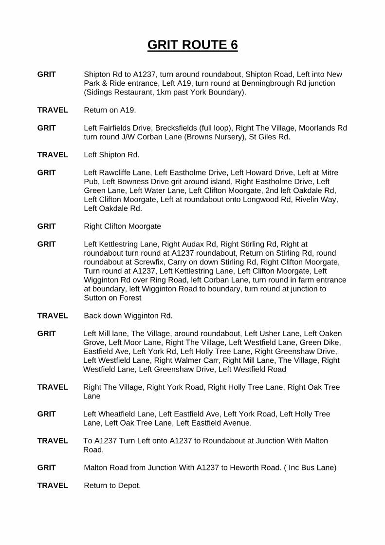
GRIT ROUTE 6 GRIT Shipton Rd to A1237, turn around roundabout, Shipton Road, Left into New
Park & Ride entrance, Left A19, turn round at Benningbrough Rd junction (Sidings Restaurant, 1km past York Boundary).
TRAVEL Return on A19. GRIT Left Fairfields Drive, Brecksfields (full loop), Right The Village, Moorlands Rd
turn round J/W Corban Lane (Browns Nursery), St Giles Rd. TRAVEL Left Shipton Rd. GRIT Left Rawcliffe Lane, Left Eastholme Drive, Left Howard Drive, Left at Mitre
Pub, Left Bowness Drive grit around island, Right Eastholme Drive, Left Green Lane, Left Water Lane, Left Clifton Moorgate, 2nd left Oakdale Rd, Left Clifton Moorgate, Left at roundabout onto Longwood Rd, Rivelin Way, Left Oakdale Rd.
GRIT Right Clifton Moorgate GRIT Left Kettlestring Lane, Right Audax Rd, Right Stirling Rd, Right at
roundabout turn round at A1237 roundabout, Return on Stirling Rd, round roundabout at Screwfix, Carry on down Stirling Rd, Right Clifton Moorgate, Turn round at A1237, Left Kettlestring Lane, Left Clifton Moorgate, Left Wigginton Rd over Ring Road, left Corban Lane, turn round in farm entrance at boundary, left Wigginton Road to boundary, turn round at junction to Sutton on Forest
TRAVEL Back down Wigginton Rd. GRIT Left Mill lane, The Village, around roundabout, Left Usher Lane, Left Oaken
Grove, Left Moor Lane, Right The Village, Left Westfield Lane, Green Dike, Eastfield Ave, Left York Rd, Left Holly Tree Lane, Right Greenshaw Drive, Left Westfield Lane, Right Walmer Carr, Right Mill Lane, The Village, Right Westfield Lane, Left Greenshaw Drive, Left Westfield Road
TRAVEL Right The Village, Right York Road, Right Holly Tree Lane, Right Oak Tree
Lane GRIT Left Wheatfield Lane, Left Eastfield Ave, Left York Road, Left Holly Tree
Lane, Left Oak Tree Lane, Left Eastfield Avenue. TRAVEL To A1237 Turn Left onto A1237 to Roundabout at Junction With Malton
Road. GRIT Malton Road from Junction With A1237 to Heworth Road. ( Inc Bus Lane) TRAVEL Return to Depot.
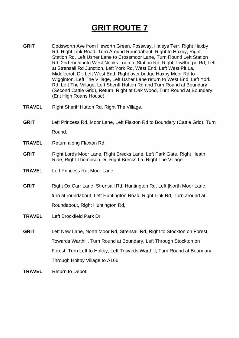
GRIT ROUTE 7 GRIT Dodsworth Ave from Heworth Green, Fossway, Haleys Terr, Right Haxby
Rd, Right Link Road, Turn Around Roundabout, Right to Haxby, Right Station Rd, Left Usher Lane to Crossmoor Lane, Turn Round Left Station Rd, 2nd Right into West Nooks Loop to Station Rd, Right Towthorpe Rd, Left at Strensall Rd Junction, Left York Rd, West End, Left West Pit La, Middlecroft Dr, Left West End, Right over bridge Haxby Moor Rd to Wigginton, Left The Village, Left Usher Lane return to West End, Left York Rd, Left The Village, Left Sheriff Hutton Rd and Turn Round at Boundary (Second Cattle Grid), Return, Right at Oak Wood, Turn Round at Boundary (Ent High Roans House).
TRAVEL Right Sheriff Hutton Rd, Right The Village.
GRIT Left Princess Rd, Moor Lane, Left Flaxton Rd to Boundary (Cattle Grid), Turn
Round. TRAVEL Return along Flaxton Rd. GRIT Right Lords Moor Lane, Right Brecks Lane, Left Park Gate, Right Heath
Ride, Right Thompson Dr, Right Brecks La, Right The Village. TRAVEL Left Princess Rd, Moor Lane.
GRIT Right Ox Carr Lane, Strensall Rd, Huntington Rd, Left |North Moor Lane,
turn at roundabout, Left Huntington Road, Right Link Rd, Turn around at
Roundabout, Right Huntington Rd, TRAVEL Left Brockfield Park Dr
GRIT Left New Lane, North Moor Rd, Strensall Rd, Right to Stockton on Forest,
Towards Warthill, Turn Round at Boundary, Left Through Stockton on
Forest, Turn Left to Holtby, Left Towards Warthill, Turn Round at Boundary,
Through Holtby Village to A166. TRAVEL Return to Depot.
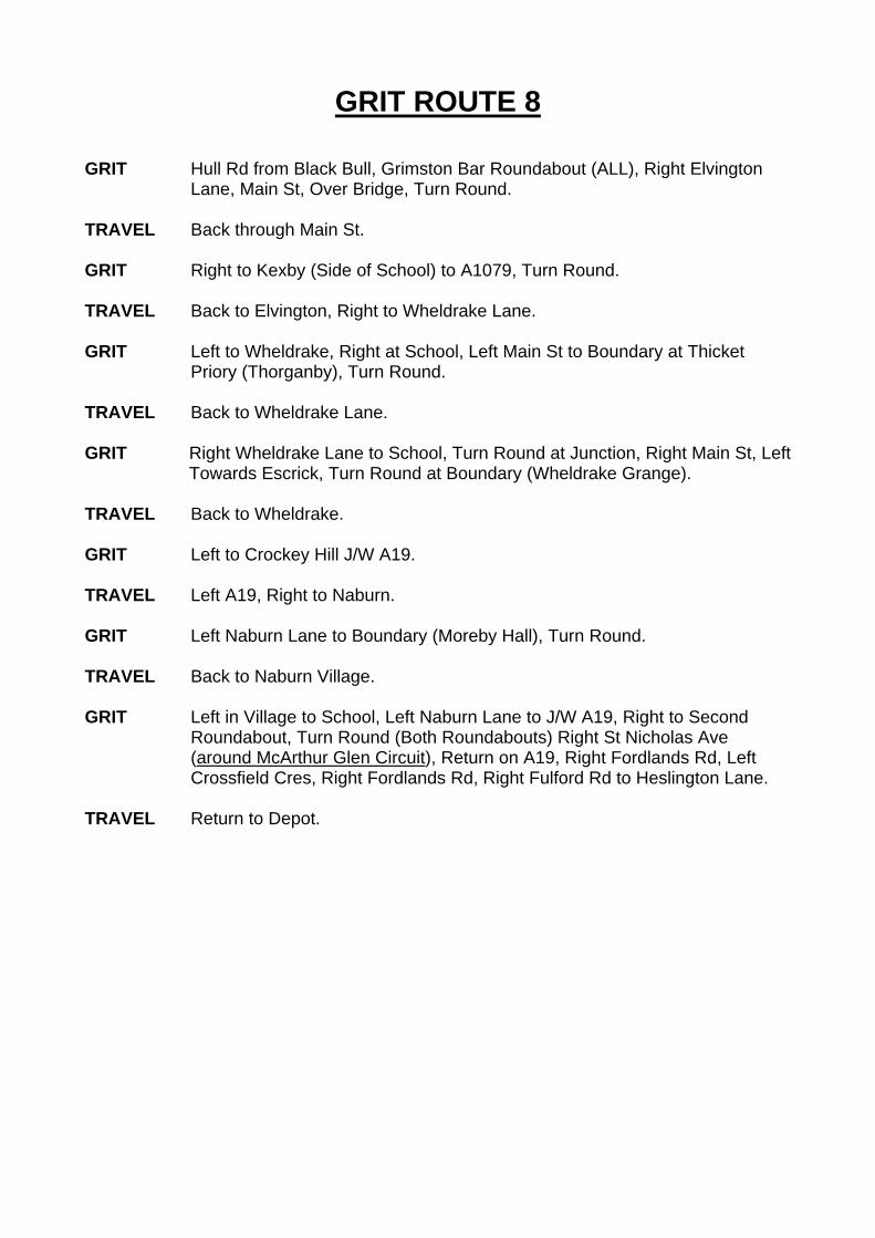
GRIT ROUTE 8 GRIT Hull Rd from Black Bull, Grimston Bar Roundabout (ALL), Right Elvington
Lane, Main St, Over Bridge, Turn Round. TRAVEL Back through Main St. GRIT Right to Kexby (Side of School) to A1079, Turn Round. TRAVEL Back to Elvington, Right to Wheldrake Lane. GRIT Left to Wheldrake, Right at School, Left Main St to Boundary at Thicket
Priory (Thorganby), Turn Round. TRAVEL Back to Wheldrake Lane. GRIT Right Wheldrake Lane to School, Turn Round at Junction, Right Main St, Left
Towards Escrick, Turn Round at Boundary (Wheldrake Grange). TRAVEL Back to Wheldrake. GRIT Left to Crockey Hill J/W A19. TRAVEL Left A19, Right to Naburn. GRIT Left Naburn Lane to Boundary (Moreby Hall), Turn Round. TRAVEL Back to Naburn Village. GRIT Left in Village to School, Left Naburn Lane to J/W A19, Right to Second
Roundabout, Turn Round (Both Roundabouts) Right St Nicholas Ave (around McArthur Glen Circuit), Return on A19, Right Fordlands Rd, Left Crossfield Cres, Right Fordlands Rd, Right Fulford Rd to Heslington Lane.
TRAVEL Return to Depot.
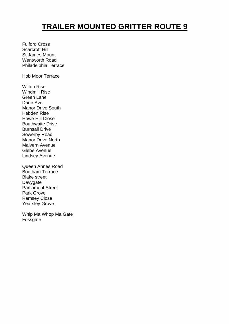
TRAILER MOUNTED GRITTER ROUTE 9 Fulford Cross Scarcroft Hill St James Mount Wentworth Road Philadelphia Terrace Hob Moor Terrace Wilton Rise Windmill Rise Green Lane Dane Ave Manor Drive South Hebden Rise Howe Hill Close Bouthwaite Drive Burnsall Drive Sowerby Road Manor Drive North Malvern Avenue Glebe Avenue Lindsey Avenue Queen Annes Road Bootham Terrace Blake street Davygate Parliament Street Park Grove Ramsey Close Yearsley Grove Whip Ma Whop Ma Gate Fossgate
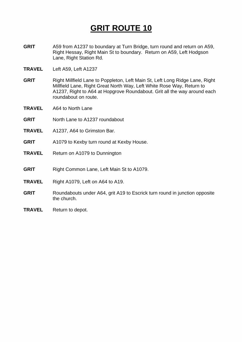
GRIT ROUTE 10 GRIT A59 from A1237 to boundary at Turn Bridge, turn round and return on A59,
Right Hessay, Right Main St to boundary. Return on A59, Left Hodgson Lane, Right Station Rd.
TRAVEL Left A59, Left A1237 GRIT Right Millfield Lane to Poppleton, Left Main St, Left Long Ridge Lane, Right
Millfield Lane, Right Great North Way, Left White Rose Way, Return to A1237, Right to A64 at Hopgrove Roundabout. Grit all the way around each roundabout on route.
TRAVEL A64 to North Lane GRIT North Lane to A1237 roundabout TRAVEL A1237, A64 to Grimston Bar. GRIT A1079 to Kexby turn round at Kexby House. TRAVEL Return on A1079 to Dunnington
GRIT Right Common Lane, Left Main St to A1079. TRAVEL Right A1079, Left on A64 to A19. GRIT Roundabouts under A64, grit A19 to Escrick turn round in junction opposite
the church. TRAVEL Return to depot.

ANNEX 10
FOOTWAY SNOW CLEARANCE & PRECAUTIONARY TREATMENT ROUTES Priority footways: City centre, footstreets and routes to station and car parks Front Street, Acomb Old School Court William Plows Avenue Wentworth Road, Scarcroft Hill St Helen's Road Bishopthorpe Road, shopping area Clarence Street and Wigginton Road, hospital frontage


±
Drawn by Date Scale 1:7,000
Based upon the Ordnance Survey mapping ã Crown Copyright. Unauthorised reproduction may lead to prosecution.City of York Council, Licence No 1000 20818.
Snow clearance - city centre footwaysOct 2010
Snow Clearance
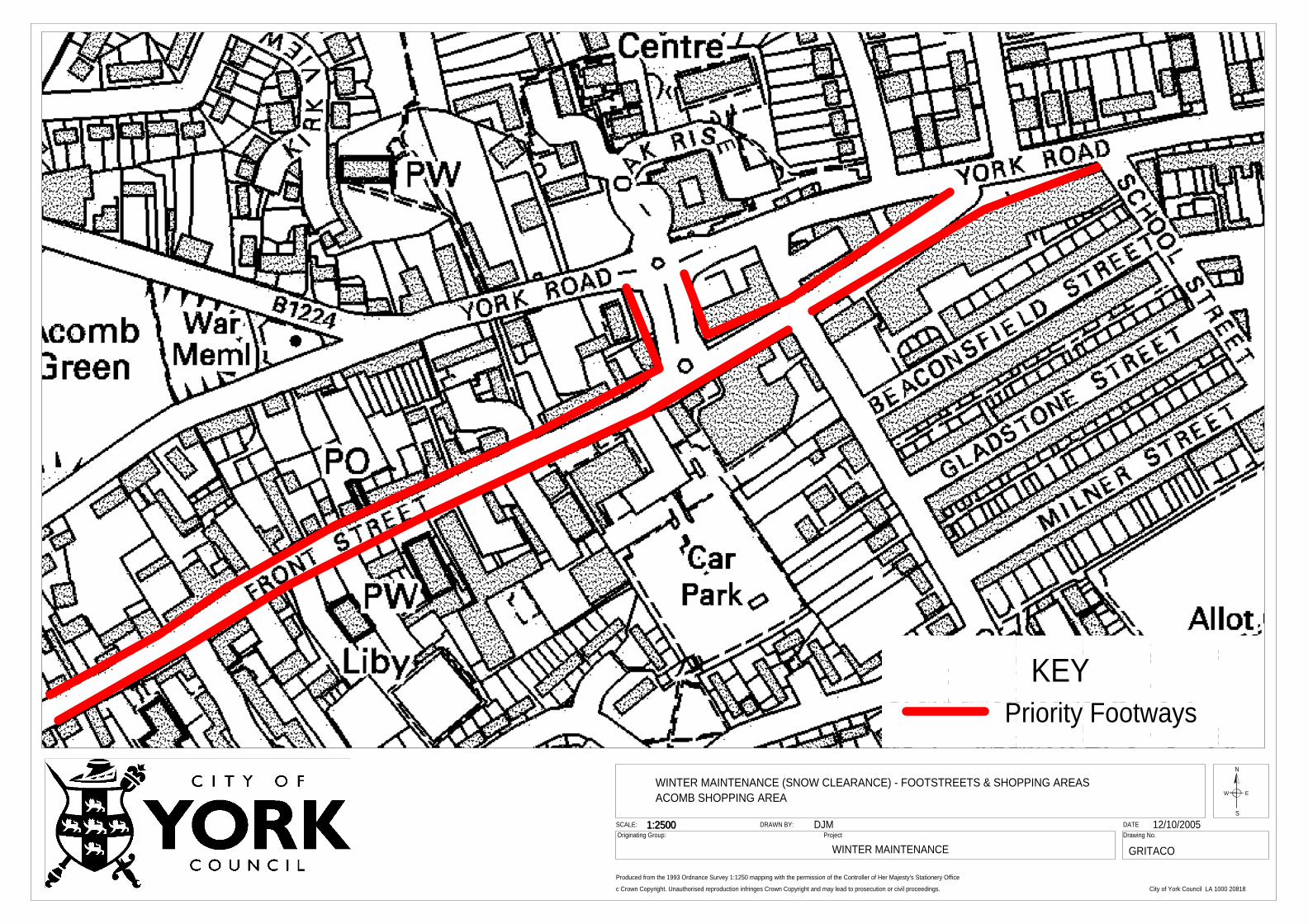
1:2500
WINTER MAINTENANCE
DATEDrawing No.
c Crown Copyright. Unauthorised reproduction infringes Crown Copyright and may lead to prosecution or civil proceedings.
Produced from the 1993 Ordnance Survey 1:1250 mapping with the permission of the Controller of Her Majesty's Stationery Office
Originating Group:SCALE: DRAWN BY:
Project
N
S
EW
DJM1:2500
KEY
WINTER MAINTENANCE (SNOW CLEARANCE) - FOOTSTREETS & SHOPPING AREASACOMB SHOPPING AREA
GRITACO
Priority Footways
12/10/2005
City of York Council LA 1000 20818
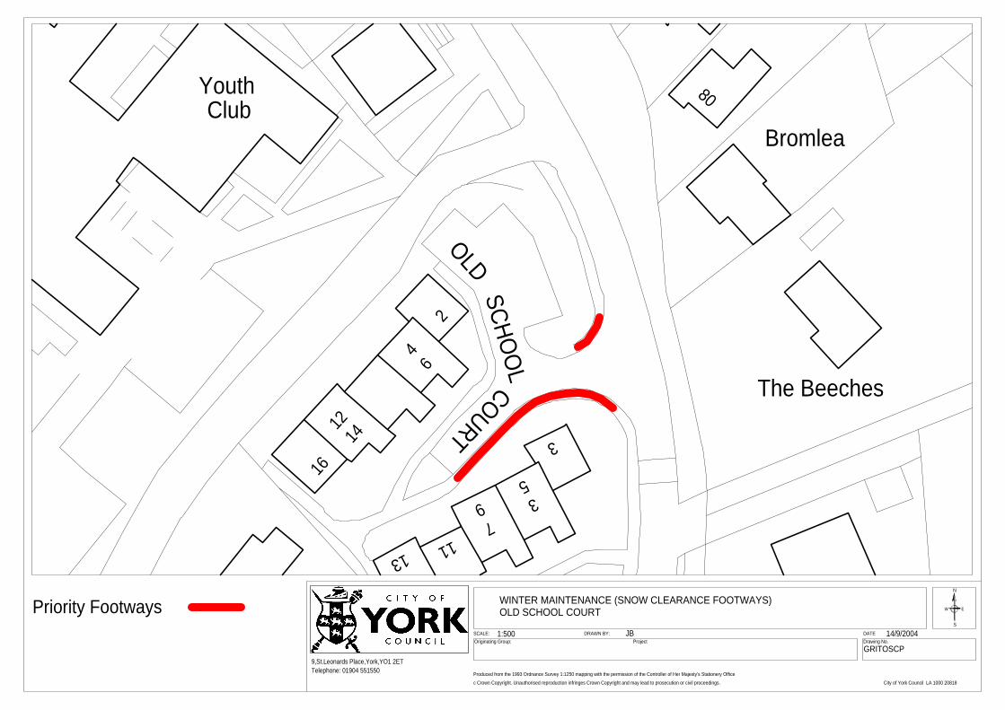
Club
26
14
4
1216
3
539
71113
80
Bromlea
The Beeches
Youth
DATEDrawing No.
c Crown Copyright. Unauthorised reproduction infringes Crown Copyright and may lead to prosecution or civil proceedings.
Produced from the 1993 Ordnance Survey 1:1250 mapping with the permission of the Controller of Her Majesty's Stationery Office
Originating Group:SCALE: DRAWN BY:
9,St.Leonards Place,York,YO1 2ET
ProjectJB1:500 14/9/2004
COURTSCHO
OL
OLD
N
S
EWWINTER MAINTENANCE (SNOW CLEARANCE FOOTWAYS)OLD SCHOOL COURTPriority Footways
Telephone: 01904 551550
City of York Council LA 1000 20818
GRITOSCP
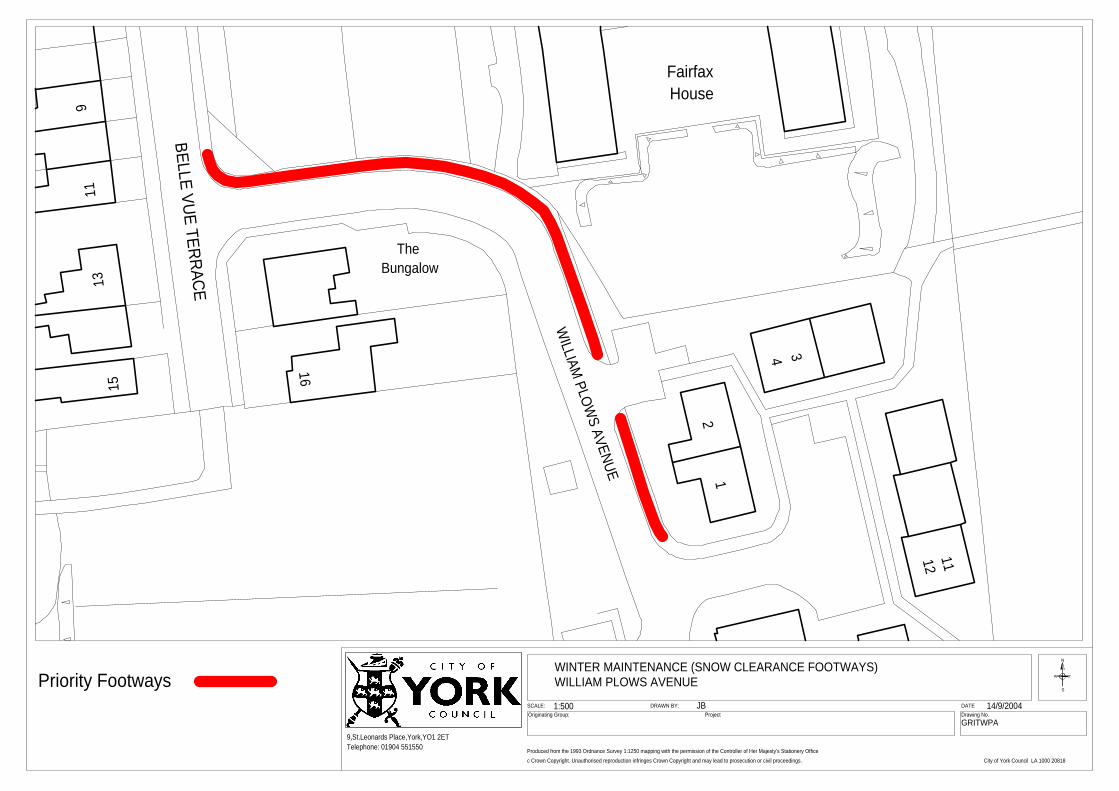
BELLE VUE TERRACE
911
1315
WILLIAM
PLOWS AVENUE
TheBungalow
12
4 3
1211
FairfaxHouse
16
DATEDrawing No.
c Crown Copyright. Unauthorised reproduction infringes Crown Copyright and may lead to prosecution or civil proceedings.
Produced from the 1993 Ordnance Survey 1:1250 mapping with the permission of the Controller of Her Majesty's Stationery Office
Originating Group:SCALE: DRAWN BY:
9,St.Leonards Place,York,YO1 2ET
ProjectJB1:500 14/9/2004
N
S
EW
WINTER MAINTENANCE (SNOW CLEARANCE FOOTWAYS)WILLIAM PLOWS AVENUEPriority Footways
City of York Council LA 1000 20818
Telephone: 01904 551550
GRITWPA
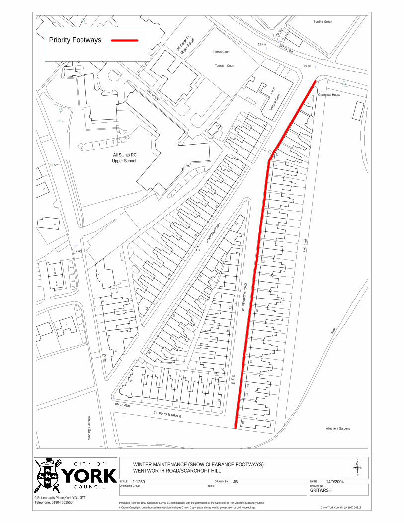
WINTER MAINTENANCE (SNOW CLEARANCE FOOTWAYS)WENTWORTH ROAD/SCARCROFT HILL
MILL MOUNT
13.1m
LB
WEN
TWO
R TH
R OAD
Path
(um
)
Path
Allotment G
ardens
TELFORD TERRACE
ElSubSta
Allotment Gardens
2
14
28
38
50
60
1
11
13
53
51
39
27
15
2
1218
2830
106
1
63
49
37
25
13
1
Tennis Court
1
3
SCAR
CROFT
HILL
15.0m
BM 15.42m
13
5755
All Saints RCUpper School
22
1 to
21La
ngton
Cou
rt
1 to
4 Grasmead House
17.4m
1
42
86
4
19.5m
2
Tennis Court
Bowling Green
Pavil
ion
13.4m BM 13.70m
Upper
Schoo
l
All Sain
ts RC
SCALEOriginating Group
DATEDrawing No.
c Crown Copyright. Unauthorised reproduction infringes Crown Copyright and may lead to prosecution or civil proceedings.
9,St.Leonards Place,York,YO1 2ET
Project
Produced from the 1993 Ordnance Survey 1:1250 mapping with the permission of the Controller of Her Majesty's Stationery Office
DRAWN BY JB1:1250 14/9/2004
N
S
EW
Priority Footways
GRITWRSH
City of York Council LA 1000 20818
Telephone: 01904 551550
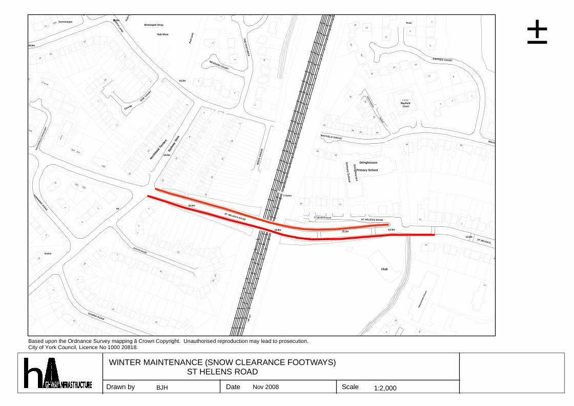
THANET ROAD
333
SOUT
HFIE
LD C
RES
CEN
T
Shelter
20
21a
10
1
13
7
NORTH LANE
20
Path
(um
)
CHASE
16
7Ra
ilway
Vie
w
27
3
MP
187
70
MAYFIELD GROVE
56
20
20
15
352
OR
CH
AR
D W
AY
13
24
13
14.0m
8
1
ST HELEN'S ROAD
S Gantry
ST HELEN'S ROAD
Terrace
16
2
9
47
2
2Nor
thfie
ld Te
rrace 12
19.8m
ST HELEN'S ROAD
53
11
1
17 to 20
2
1
14.9m
14
Hob Moor
1
15.5m
5
18
59
18
52
23
Club
AINTREE COURT
2121
1 to 4
4
8
LB
1
13
14.3m
Path
(um
)
1
MEADOW COURT
MO
OR
GR
OVE
10
16
Primary School
11
12
3
7
13.4mST HELEN'S
26
10
14
EASON ROAD
32
722
THE PASTUR
ES
13
15.2mPrim
ary School
Dringhouses
9
13.4m
15
Mayfield
MAYFIELD GROVE
15.8m1
TURNMIRE ROAD
12
3617
GOWER ROAD
363
7
1
5
Micklegate Stray
22
15
30
2
21
Dringhouses
14
44
KENS
ING
TON
COUR
T
1 to 12
8
19
33
7
Cornerways
359
354
1
SIDE C
OURT
25
42
1
2
North Eastern
16
12
45
Court
Posts
Abbe
yfie
lds
Hous
e
6
27
±
Drawn by Date Scale 1:2,000
Based upon the Ordnance Survey mapping ã Crown Copyright. Unauthorised reproduction may lead to prosecution.City of York Council, Licence No 1000 20818.
WINTER MAINTENANCE (SNOW CLEARANCE FOOTWAYS)ST HELENS ROAD
BJH Nov 2008
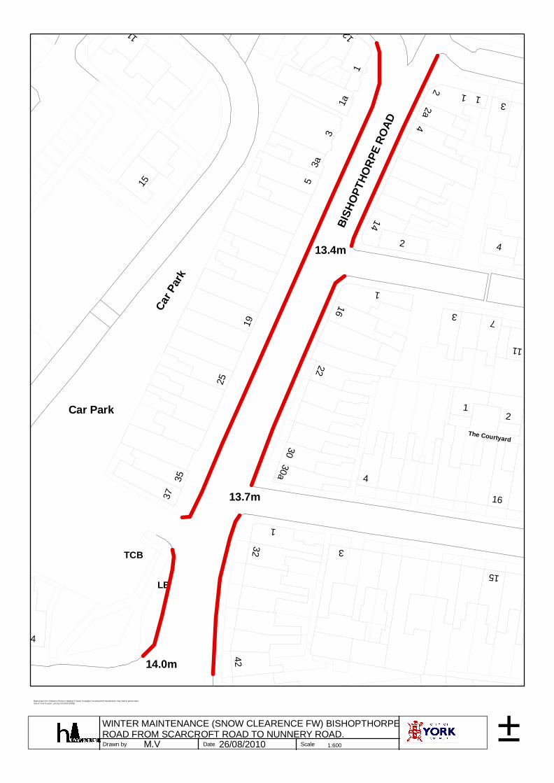
37
32
1
1
14.0m
35
25
1
3
161
14
Car Park
15
9 to 11
19
2
4
TCB
22
5
BISH
OPT
HORP
E RO
AD 4
7
LB
1
11
15
121
2a
3
1
13.7m
30
Car P
ark
3
13.4m2 4
42
30a
2
3a
16
1a
4
The Courtyard
3
±Drawn by Date Scale 1:600
Based upon the Ordnance Survey mapping ã Crown Copyright. Unauthorised reproduction may lead to prosecution.City of York Council, Licence No 1000 20818.
WINTER MAINTENANCE (SNOW CLEARENCE FW) BISHOPTHORPEROAD FROM SCARCROFT ROAD TO NUNNERY ROAD.
26/08/2010M.V
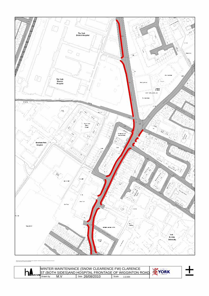
±Drawn by Date Scale 1:2,500
Based upon the Ordnance Survey mapping ã Crown Copyright. Unauthorised reproduction may lead to prosecution.City of York Council, Licence No 1000 20818.
WINTER MAINTENANCE (SNOW CLEARENCE FW) CLARENCEST (BOTH SIDES)AND HOSPITAL FRONTAGE OF WIGGINTON ROAD.
26/08/2010M.V
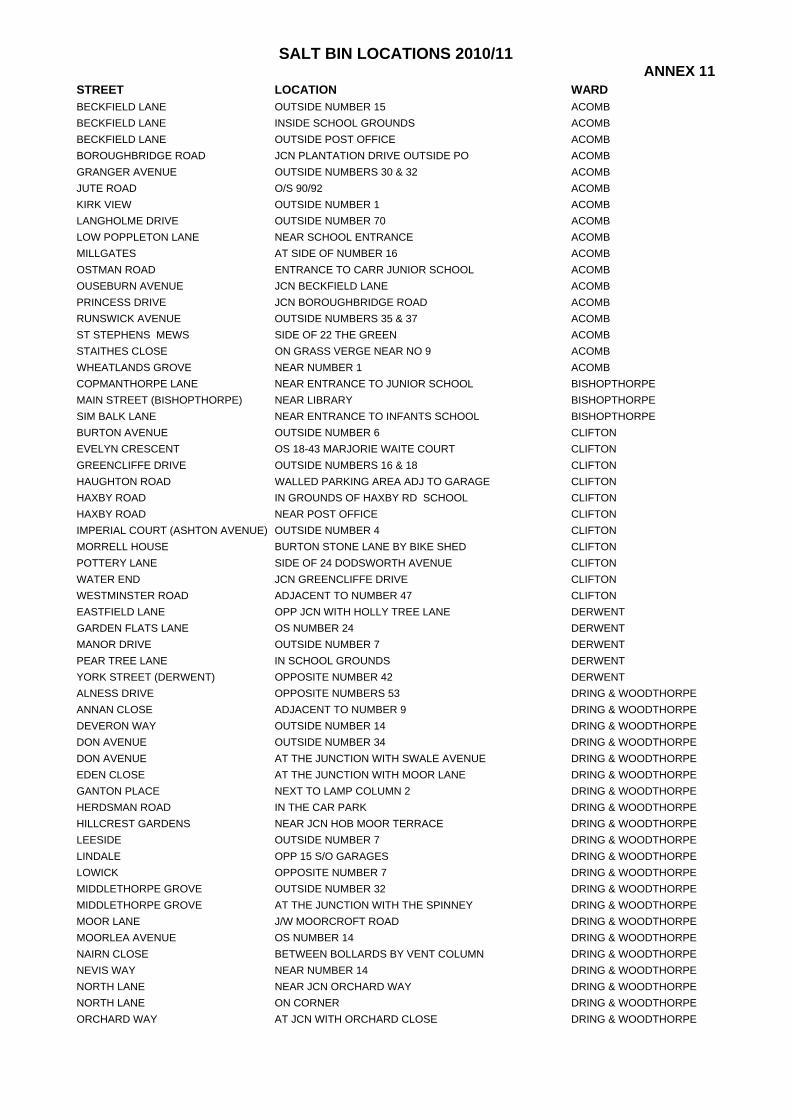
SALT BIN LOCATIONS 2010/11 ANNEX 11
STREET LOCATION WARD BECKFIELD LANE OUTSIDE NUMBER 15 ACOMB BECKFIELD LANE INSIDE SCHOOL GROUNDS ACOMB BECKFIELD LANE OUTSIDE POST OFFICE ACOMB BOROUGHBRIDGE ROAD JCN PLANTATION DRIVE OUTSIDE PO ACOMB GRANGER AVENUE OUTSIDE NUMBERS 30 & 32 ACOMB JUTE ROAD O/S 90/92 ACOMB KIRK VIEW OUTSIDE NUMBER 1 ACOMB LANGHOLME DRIVE OUTSIDE NUMBER 70 ACOMB LOW POPPLETON LANE NEAR SCHOOL ENTRANCE ACOMB MILLGATES AT SIDE OF NUMBER 16 ACOMB OSTMAN ROAD ENTRANCE TO CARR JUNIOR SCHOOL ACOMB OUSEBURN AVENUE JCN BECKFIELD LANE ACOMB PRINCESS DRIVE JCN BOROUGHBRIDGE ROAD ACOMB RUNSWICK AVENUE OUTSIDE NUMBERS 35 & 37 ACOMB ST STEPHENS MEWS SIDE OF 22 THE GREEN ACOMB STAITHES CLOSE ON GRASS VERGE NEAR NO 9 ACOMB WHEATLANDS GROVE NEAR NUMBER 1 ACOMB COPMANTHORPE LANE NEAR ENTRANCE TO JUNIOR SCHOOL BISHOPTHORPE MAIN STREET (BISHOPTHORPE) NEAR LIBRARY BISHOPTHORPE SIM BALK LANE NEAR ENTRANCE TO INFANTS SCHOOL BISHOPTHORPE BURTON AVENUE OUTSIDE NUMBER 6 CLIFTON EVELYN CRESCENT OS 18-43 MARJORIE WAITE COURT CLIFTON GREENCLIFFE DRIVE OUTSIDE NUMBERS 16 & 18 CLIFTON HAUGHTON ROAD WALLED PARKING AREA ADJ TO GARAGE CLIFTON HAXBY ROAD IN GROUNDS OF HAXBY RD SCHOOL CLIFTON HAXBY ROAD NEAR POST OFFICE CLIFTON IMPERIAL COURT (ASHTON AVENUE) OUTSIDE NUMBER 4 CLIFTON MORRELL HOUSE BURTON STONE LANE BY BIKE SHED CLIFTON POTTERY LANE SIDE OF 24 DODSWORTH AVENUE CLIFTON WATER END JCN GREENCLIFFE DRIVE CLIFTON WESTMINSTER ROAD ADJACENT TO NUMBER 47 CLIFTON EASTFIELD LANE OPP JCN WITH HOLLY TREE LANE DERWENT GARDEN FLATS LANE OS NUMBER 24 DERWENT MANOR DRIVE OUTSIDE NUMBER 7 DERWENT PEAR TREE LANE IN SCHOOL GROUNDS DERWENT YORK STREET (DERWENT) OPPOSITE NUMBER 42 DERWENT ALNESS DRIVE OPPOSITE NUMBERS 53 DRING & WOODTHORPEANNAN CLOSE ADJACENT TO NUMBER 9 DRING & WOODTHORPEDEVERON WAY OUTSIDE NUMBER 14 DRING & WOODTHORPEDON AVENUE OUTSIDE NUMBER 34 DRING & WOODTHORPEDON AVENUE AT THE JUNCTION WITH SWALE AVENUE DRING & WOODTHORPEEDEN CLOSE AT THE JUNCTION WITH MOOR LANE DRING & WOODTHORPEGANTON PLACE NEXT TO LAMP COLUMN 2 DRING & WOODTHORPEHERDSMAN ROAD IN THE CAR PARK DRING & WOODTHORPEHILLCREST GARDENS NEAR JCN HOB MOOR TERRACE DRING & WOODTHORPELEESIDE OUTSIDE NUMBER 7 DRING & WOODTHORPELINDALE OPP 15 S/O GARAGES DRING & WOODTHORPELOWICK OPPOSITE NUMBER 7 DRING & WOODTHORPEMIDDLETHORPE GROVE OUTSIDE NUMBER 32 DRING & WOODTHORPEMIDDLETHORPE GROVE AT THE JUNCTION WITH THE SPINNEY DRING & WOODTHORPEMOOR LANE J/W MOORCROFT ROAD DRING & WOODTHORPEMOORLEA AVENUE OS NUMBER 14 DRING & WOODTHORPENAIRN CLOSE BETWEEN BOLLARDS BY VENT COLUMN DRING & WOODTHORPENEVIS WAY NEAR NUMBER 14 DRING & WOODTHORPENORTH LANE NEAR JCN ORCHARD WAY DRING & WOODTHORPENORTH LANE ON CORNER DRING & WOODTHORPEORCHARD WAY AT JCN WITH ORCHARD CLOSE DRING & WOODTHORPE
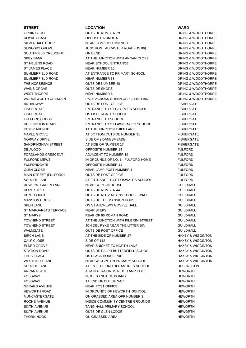
STREET LOCATION WARD ORRIN CLOSE OUTSIDE NUMBER 29 DRING & WOODTHORPEROYAL CHASE OPPOSITE NUMBE 6 DRING & WOODTHORPESILVERDALE COURT NEAR LAMP COLUMN NO 1 DRING & WOODTHORPESLINGSBY GROVE JUNCTION TADCASTER ROAD (OS 86) DRING & WOODTHORPESOUTHFIELD CRESCENT ON BEND DRING & WOODTHORPESPEY BANK AT THE JUNCTION WITH ANNAN CLOSE DRING & WOODTHORPEST HELENS ROAD NEAR SCHOOL ENTRANCE DRING & WOODTHORPEST JAMES PLACE NEAR NUMBER 10 DRING & WOODTHORPESUMMERFIELD ROAD AT ENTRANCE TO PRIMARY SCHOOL DRING & WOODTHORPESUMMERFIELD ROAD NEAR NUMBER 33 DRING & WOODTHORPETHE HORSESHOE OUTSIDE NUMBER 40 DRING & WOODTHORPEWAINS GROVE OUTSIDE SHOPS DRING & WOODTHORPEWEST THORPE NEAR NUMBER 5 DRING & WOODTHORPEWORDSWORTH CRESCENT PATH ACROSS GREEN OPP LITTER BIN DRING & WOODTHORPEBROADWAY OUTSIDE POST OFFICE FISHERGATE FISHERGATE ENTRANCE TO ST GEORGES SCHOOL FISHERGATE FISHERGATE OS FISHERGATE SCHOOL FISHERGATE FULFORD CROSS ENTRANCE TO SCHOOL FISHERGATE HESLINGTON ROAD ENTRANCE TO ST LAWRENCES SCHOOL FISHERGATE KEXBY AVENUE AT THE JUNCTION THIEF LANE FISHERGATE MAPLE GROVE AT BOTTOM OUTSIDE NUMBER 91 FISHERGATE NORWAY DRIVE SIDE OF 9 DANESMEADE FISHERGATE SANDRINGHAM STREET AT SIDE OF NUMBER 17 FISHERGATE DELWOOD OPPOSITE NUMBER 14 FULFORD FORDLANDS CRESCENT ADJACENT TO NUMBER 19 FULFORD FULFORD MEWS IN GROUNDS OF NO. 1 - FULFORD HOME FULFORD FULFORDGATE OPPOSITE NUMBER 11 FULFORD GLEN CLOSE NEAR LAMP POST NUMBER 1 FULFORD MAIN STREET (FULFORD) OUTSIDE POST OFFICE FULFORD SCHOOL LANE AT ENTRANCE TO ST OSWALDS SCHOOL FULFORD BOWLING GREEN LANE NEAR COPTON HOUSE GUILDHALL HOPE STREET OUTSIDE NUMBER 44 GUILDHALL HUNT COURT OUTSIDE NO. 2 AGAINST HOUSE WALL GUILDHALL MANSION HOUSE OUTSIDE THE MANSION HOUSE GUILDHALL SPEN LANE OS ST ANDREWS GOSPEL HALL GUILDHALL ST MARGARETS TERRACE NEAR STEPS GUILDHALL ST MARYS REAR OF 66 ROMAN ROAD GUILDHALL TOWNEND STREET AT THE JUNCTION WITH PILGRIM STREET GUILDHALL TOWNEND STREET JCN DEL PYKE NEAR THE LITTER BIN GUILDHALL WALMGATE OUTSIDE POST OFFICE GUILDHALL BIRCH LANE AT THE SIDE OF NUMBER 27 HAXBY & WIGGINTON CALF CLOSE SIDE OF 112 HAXBY & WIGGINTON ELDER GROVE NEAR SNICKET TO NORTH LANE HAXBY & WIGGINTON STATION ROAD OUTSIDE RALPH BUTTERFIELD SCHOOL HAXBY & WIGGINTON THE VILLAGE OS BLACK HORSE PUB HAXBY & WIGGINTON WESTFIELD LANE NEAR WIGGINTON PRIMARY SCHOOL HAXBY & WIGGINTON SCHOOL LANE AT ENT TO LORD DERAMORES SCHOOL HESLINGTON ARRAN PLACE AGAINST RAILINGS NEXT LAMP COL 3 HEWORTH FOSSWAY NEXT TO NOTICE BOARD HEWORTH FOSSWAY AT END OF CUL DE SAC HEWORTH GERARD AVENUE NEAR POST OFFICE HEWORTH HEWORTH ROAD IN GROUNDS OF HEWORTH SCHOOL HEWORTH MUNCASTERGATE ON GRASSED AREA OPP NUMBER 3 HEWORTH ROCHE AVENUE INSIDE COMMUNITY CENTRE GROUNDS HEWORTH SIXTH AVENUE TANG HALL PRIMARY SCHOOL HEWORTH SIXTH AVENUE OUTSIDE GLEN LODGE HEWORTH THORN NOOK ON GRASSED AREA HEWORTH
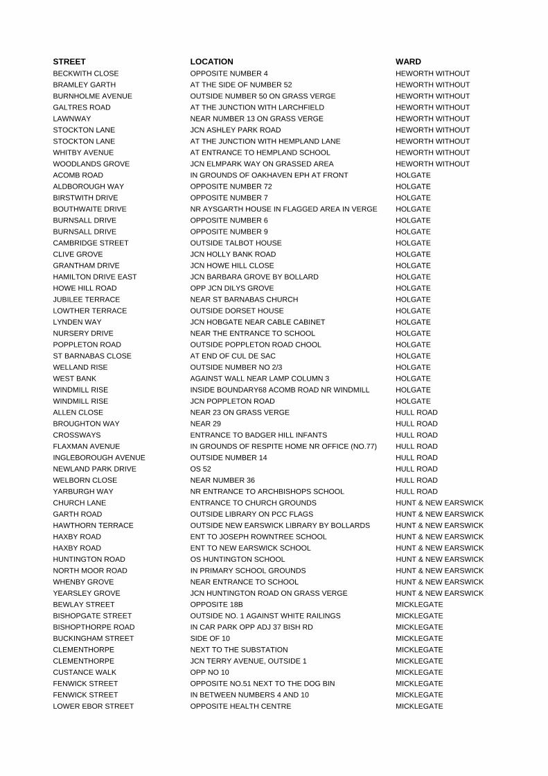
STREET LOCATION WARD BECKWITH CLOSE OPPOSITE NUMBER 4 HEWORTH WITHOUT BRAMLEY GARTH AT THE SIDE OF NUMBER 52 HEWORTH WITHOUT BURNHOLME AVENUE OUTSIDE NUMBER 50 ON GRASS VERGE HEWORTH WITHOUT GALTRES ROAD AT THE JUNCTION WITH LARCHFIELD HEWORTH WITHOUT LAWNWAY NEAR NUMBER 13 ON GRASS VERGE HEWORTH WITHOUT STOCKTON LANE JCN ASHLEY PARK ROAD HEWORTH WITHOUT STOCKTON LANE AT THE JUNCTION WITH HEMPLAND LANE HEWORTH WITHOUT WHITBY AVENUE AT ENTRANCE TO HEMPLAND SCHOOL HEWORTH WITHOUT WOODLANDS GROVE JCN ELMPARK WAY ON GRASSED AREA HEWORTH WITHOUT ACOMB ROAD IN GROUNDS OF OAKHAVEN EPH AT FRONT HOLGATE ALDBOROUGH WAY OPPOSITE NUMBER 72 HOLGATE BIRSTWITH DRIVE OPPOSITE NUMBER 7 HOLGATE BOUTHWAITE DRIVE NR AYSGARTH HOUSE IN FLAGGED AREA IN VERGE HOLGATE BURNSALL DRIVE OPPOSITE NUMBER 6 HOLGATE BURNSALL DRIVE OPPOSITE NUMBER 9 HOLGATE CAMBRIDGE STREET OUTSIDE TALBOT HOUSE HOLGATE CLIVE GROVE JCN HOLLY BANK ROAD HOLGATE GRANTHAM DRIVE JCN HOWE HILL CLOSE HOLGATE HAMILTON DRIVE EAST JCN BARBARA GROVE BY BOLLARD HOLGATE HOWE HILL ROAD OPP JCN DILYS GROVE HOLGATE JUBILEE TERRACE NEAR ST BARNABAS CHURCH HOLGATE LOWTHER TERRACE OUTSIDE DORSET HOUSE HOLGATE LYNDEN WAY JCN HOBGATE NEAR CABLE CABINET HOLGATE NURSERY DRIVE NEAR THE ENTRANCE TO SCHOOL HOLGATE POPPLETON ROAD OUTSIDE POPPLETON ROAD CHOOL HOLGATE ST BARNABAS CLOSE AT END OF CUL DE SAC HOLGATE WELLAND RISE OUTSIDE NUMBER NO 2/3 HOLGATE WEST BANK AGAINST WALL NEAR LAMP COLUMN 3 HOLGATE WINDMILL RISE INSIDE BOUNDARY68 ACOMB ROAD NR WINDMILL HOLGATE WINDMILL RISE JCN POPPLETON ROAD HOLGATE ALLEN CLOSE NEAR 23 ON GRASS VERGE HULL ROAD BROUGHTON WAY NEAR 29 HULL ROAD CROSSWAYS ENTRANCE TO BADGER HILL INFANTS HULL ROAD FLAXMAN AVENUE IN GROUNDS OF RESPITE HOME NR OFFICE (NO.77) HULL ROAD INGLEBOROUGH AVENUE OUTSIDE NUMBER 14 HULL ROAD NEWLAND PARK DRIVE OS 52 HULL ROAD WELBORN CLOSE NEAR NUMBER 36 HULL ROAD YARBURGH WAY NR ENTRANCE TO ARCHBISHOPS SCHOOL HULL ROAD CHURCH LANE ENTRANCE TO CHURCH GROUNDS HUNT & NEW EARSWICKGARTH ROAD OUTSIDE LIBRARY ON PCC FLAGS HUNT & NEW EARSWICKHAWTHORN TERRACE OUTSIDE NEW EARSWICK LIBRARY BY BOLLARDS HUNT & NEW EARSWICKHAXBY ROAD ENT TO JOSEPH ROWNTREE SCHOOL HUNT & NEW EARSWICKHAXBY ROAD ENT TO NEW EARSWICK SCHOOL HUNT & NEW EARSWICKHUNTINGTON ROAD OS HUNTINGTON SCHOOL HUNT & NEW EARSWICKNORTH MOOR ROAD IN PRIMARY SCHOOL GROUNDS HUNT & NEW EARSWICKWHENBY GROVE NEAR ENTRANCE TO SCHOOL HUNT & NEW EARSWICKYEARSLEY GROVE JCN HUNTINGTON ROAD ON GRASS VERGE HUNT & NEW EARSWICKBEWLAY STREET OPPOSITE 18B MICKLEGATE BISHOPGATE STREET OUTSIDE NO. 1 AGAINST WHITE RAILINGS MICKLEGATE BISHOPTHORPE ROAD IN CAR PARK OPP ADJ 37 BISH RD MICKLEGATE BUCKINGHAM STREET SIDE OF 10 MICKLEGATE CLEMENTHORPE NEXT TO THE SUBSTATION MICKLEGATE CLEMENTHORPE JCN TERRY AVENUE, OUTSIDE 1 MICKLEGATE CUSTANCE WALK OPP NO 10 MICKLEGATE FENWICK STREET OPPOSITE NO.51 NEXT TO THE DOG BIN MICKLEGATE FENWICK STREET IN BETWEEN NUMBERS 4 AND 10 MICKLEGATE LOWER EBOR STREET OPPOSITE HEALTH CENTRE MICKLEGATE
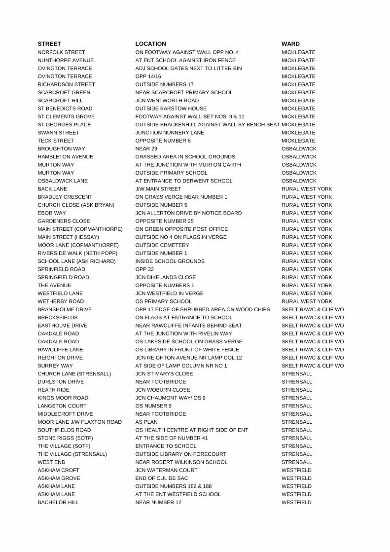
STREET LOCATION WARD NORFOLK STREET ON FOOTWAY AGAINST WALL OPP NO. 4 MICKLEGATE NUNTHORPE AVENUE AT ENT SCHOOL AGAINST IRON FENCE MICKLEGATE OVINGTON TERRACE ADJ SCHOOL GATES NEXT TO LITTER BIN MICKLEGATE OVINGTON TERRACE OPP 14/16 MICKLEGATE RICHARDSON STREET OUTSIDE NUMBERS 17 MICKLEGATE SCARCROFT GREEN NEAR SCARCROFT PRIMARY SCHOOL MICKLEGATE SCARCROFT HILL JCN WENTWORTH ROAD MICKLEGATE ST BENEDICTS ROAD OUTSIDE BARSTOW HOUSE MICKLEGATE ST CLEMENTS GROVE FOOTWAY AGAINST WALL BET NOS. 9 & 11 MICKLEGATE ST GEORGES PLACE OUTSIDE BRACKENHILL AGAINST WALL BY BENCH SEAT MICKLEGATE SWANN STREET JUNCTION NUNNERY LANE MICKLEGATE TECK STREET OPPOSITE NUMBER 6 MICKLEGATE BROUGHTON WAY NEAR 29 OSBALDWICK HAMBLETON AVENUE GRASSED AREA IN SCHOOL GROUNDS OSBALDWICK MURTON WAY AT THE JUNCTION WITH MURTON GARTH OSBALDWICK MURTON WAY OUTSIDE PRIMARY SCHOOL OSBALDWICK OSBALDWICK LANE AT ENTRANCE TO DERWENT SCHOOL OSBALDWICK BACK LANE J/W MAIN STREET RURAL WEST YORK BRADLEY CRESCENT ON GRASS VERGE NEAR NUMBER 1 RURAL WEST YORK CHURCH CLOSE (ASK BRYAN) OUTSIDE NUMBER 5 RURAL WEST YORK EBOR WAY JCN ALLERTON DRIVE BY NOTICE BOARD RURAL WEST YORK GARDENERS CLOSE OPPOSITE NUMBER 25 RURAL WEST YORK MAIN STREET (COPMANTHORPE) ON GREEN OPPOSITE POST OFFICE RURAL WEST YORK MAIN STREET (HESSAY) OUTSIDE NO 4 ON FLAGS IN VERGE RURAL WEST YORK MOOR LANE (COPMANTHORPE) OUTSIDE CEMETERY RURAL WEST YORK RIVERSIDE WALK (NETH POPP) OUTSIDE NUMBER 1 RURAL WEST YORK SCHOOL LANE (ASK RICHARD) INSIDE SCHOOL GROUNDS RURAL WEST YORK SPRINFIELD ROAD OPP 33 RURAL WEST YORK SPRINGFIELD ROAD JCN DIKELANDS CLOSE RURAL WEST YORK THE AVENUE OPPOSITE NUMBERS 1 RURAL WEST YORK WESTFIELD LANE JCN WESTFIELD IN VERGE RURAL WEST YORK WETHERBY ROAD OS PRIMARY SCHOOL RURAL WEST YORK BRANSHOLME DRIVE OPP 17 EDGE OF SHRUBBED AREA ON WOOD CHIPS SKELT RAWC & CLIF WOBRECKSFIELDS ON FLAGS AT ENTRANCE TO SCHOOL SKELT RAWC & CLIF WOEASTHOLME DRIVE NEAR RAWCLIFFE INFANTS BEHIND SEAT SKELT RAWC & CLIF WOOAKDALE ROAD AT THE JUNCTION WITH RIVELIN WAY SKELT RAWC & CLIF WOOAKDALE ROAD OS LAKESIDE SCHOOL ON GRASS VERGE SKELT RAWC & CLIF WORAWCLIFFE LANE OS LIBRARY IN FRONT OF WHITE FENCE SKELT RAWC & CLIF WOREIGHTON DRIVE JCN REIGHTON AVENUE NR LAMP COL 12 SKELT RAWC & CLIF WOSURREY WAY AT SIDE OF LAMP COLUMN NR NO 1 SKELT RAWC & CLIF WOCHURCH LANE (STRENSALL) JCN ST MARYS CLOSE STRENSALL DURLSTON DRIVE NEAR FOOTBRIDGE STRENSALL HEATH RIDE JCN WOBURN CLOSE STRENSALL KINGS MOOR ROAD JCN CHAUMONT WAY/ OS 9 STRENSALL LANGSTON COURT OS NUMBER 9 STRENSALL MIDDLECROFT DRIVE NEAR FOOTBRIDGE STRENSALL MOOR LANE J/W FLAXTON ROAD AS PLAN STRENSALL SOUTHFIELDS ROAD OS HEALTH CENTRE AT RIGHT SIDE OF ENT STRENSALL STONE RIGGS (SOTF) AT THE SIDE OF NUMBER 41 STRENSALL THE VILLAGE (SOTF) ENTRANCE TO SCHOOL STRENSALL THE VILLAGE (STRENSALL) OUTSIDE LIBRARY ON FORECOURT STRENSALL WEST END NEAR ROBERT WILKINSON SCHOOL STRENSALL ASKHAM CROFT JCN WATERMAN COURT WESTFIELD ASKHAM GROVE END OF CUL DE SAC WESTFIELD ASKHAM LANE OUTSIDE NUMBERS 186 & 188 WESTFIELD ASKHAM LANE AT THE ENT WESTFIELD SCHOOL WESTFIELD BACHELOR HILL NEAR NUMBER 12 WESTFIELD
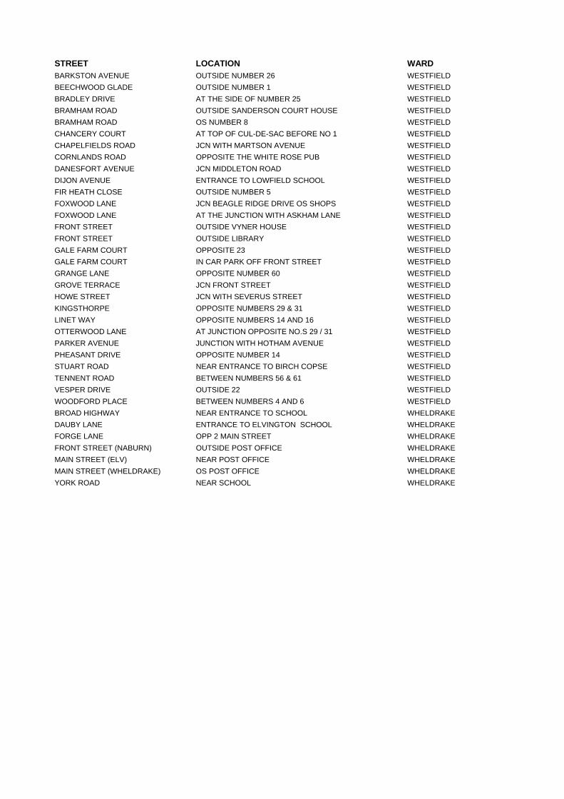
STREET LOCATION WARD BARKSTON AVENUE OUTSIDE NUMBER 26 WESTFIELD BEECHWOOD GLADE OUTSIDE NUMBER 1 WESTFIELD BRADLEY DRIVE AT THE SIDE OF NUMBER 25 WESTFIELD BRAMHAM ROAD OUTSIDE SANDERSON COURT HOUSE WESTFIELD BRAMHAM ROAD OS NUMBER 8 WESTFIELD CHANCERY COURT AT TOP OF CUL-DE-SAC BEFORE NO 1 WESTFIELD CHAPELFIELDS ROAD JCN WITH MARTSON AVENUE WESTFIELD CORNLANDS ROAD OPPOSITE THE WHITE ROSE PUB WESTFIELD DANESFORT AVENUE JCN MIDDLETON ROAD WESTFIELD DIJON AVENUE ENTRANCE TO LOWFIELD SCHOOL WESTFIELD FIR HEATH CLOSE OUTSIDE NUMBER 5 WESTFIELD FOXWOOD LANE JCN BEAGLE RIDGE DRIVE OS SHOPS WESTFIELD FOXWOOD LANE AT THE JUNCTION WITH ASKHAM LANE WESTFIELD FRONT STREET OUTSIDE VYNER HOUSE WESTFIELD FRONT STREET OUTSIDE LIBRARY WESTFIELD GALE FARM COURT OPPOSITE 23 WESTFIELD GALE FARM COURT IN CAR PARK OFF FRONT STREET WESTFIELD GRANGE LANE OPPOSITE NUMBER 60 WESTFIELD GROVE TERRACE JCN FRONT STREET WESTFIELD HOWE STREET JCN WITH SEVERUS STREET WESTFIELD KINGSTHORPE OPPOSITE NUMBERS 29 & 31 WESTFIELD LINET WAY OPPOSITE NUMBERS 14 AND 16 WESTFIELD OTTERWOOD LANE AT JUNCTION OPPOSITE NO.S 29 / 31 WESTFIELD PARKER AVENUE JUNCTION WITH HOTHAM AVENUE WESTFIELD PHEASANT DRIVE OPPOSITE NUMBER 14 WESTFIELD STUART ROAD NEAR ENTRANCE TO BIRCH COPSE WESTFIELD TENNENT ROAD BETWEEN NUMBERS 56 & 61 WESTFIELD VESPER DRIVE OUTSIDE 22 WESTFIELD WOODFORD PLACE BETWEEN NUMBERS 4 AND 6 WESTFIELD BROAD HIGHWAY NEAR ENTRANCE TO SCHOOL WHELDRAKE DAUBY LANE ENTRANCE TO ELVINGTON SCHOOL WHELDRAKE FORGE LANE OPP 2 MAIN STREET WHELDRAKE FRONT STREET (NABURN) OUTSIDE POST OFFICE WHELDRAKE MAIN STREET (ELV) NEAR POST OFFICE WHELDRAKE MAIN STREET (WHELDRAKE) OS POST OFFICE WHELDRAKE YORK ROAD NEAR SCHOOL WHELDRAKE

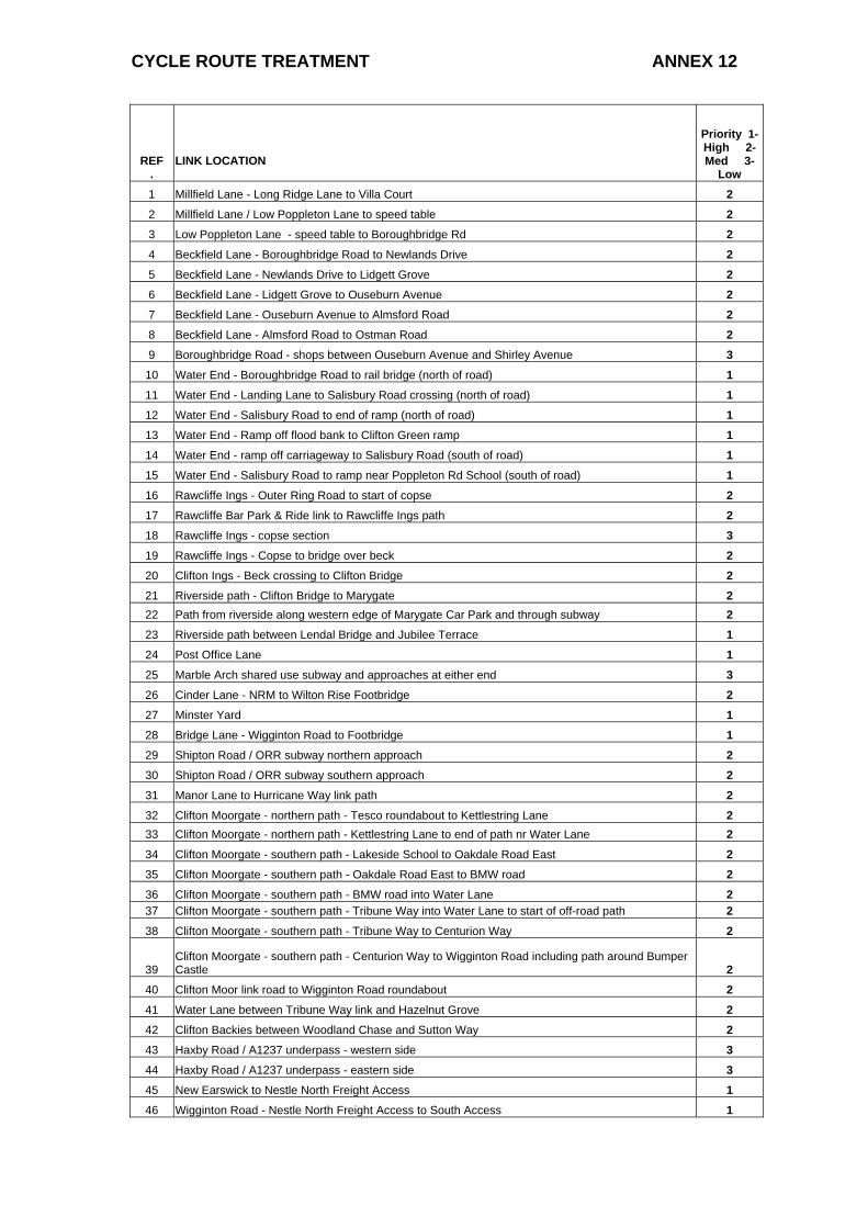
CYCLE ROUTE TREATMENT ANNEX 12
REF .
LINK LOCATION
Priority 1-High 2-Med 3-
Low 1 Millfield Lane - Long Ridge Lane to Villa Court 2 2 Millfield Lane / Low Poppleton Lane to speed table 2 3 Low Poppleton Lane - speed table to Boroughbridge Rd 2 4 Beckfield Lane - Boroughbridge Road to Newlands Drive 2 5 Beckfield Lane - Newlands Drive to Lidgett Grove 2 6 Beckfield Lane - Lidgett Grove to Ouseburn Avenue 2 7 Beckfield Lane - Ouseburn Avenue to Almsford Road 2 8 Beckfield Lane - Almsford Road to Ostman Road 2 9 Boroughbridge Road - shops between Ouseburn Avenue and Shirley Avenue 3
10 Water End - Boroughbridge Road to rail bridge (north of road) 1 11 Water End - Landing Lane to Salisbury Road crossing (north of road) 1 12 Water End - Salisbury Road to end of ramp (north of road) 1 13 Water End - Ramp off flood bank to Clifton Green ramp 1 14 Water End - ramp off carriageway to Salisbury Road (south of road) 1 15 Water End - Salisbury Road to ramp near Poppleton Rd School (south of road) 1 16 Rawcliffe Ings - Outer Ring Road to start of copse 2 17 Rawcliffe Bar Park & Ride link to Rawcliffe Ings path 2 18 Rawcliffe Ings - copse section 3 19 Rawcliffe Ings - Copse to bridge over beck 2 20 Clifton Ings - Beck crossing to Clifton Bridge 2 21 Riverside path - Clifton Bridge to Marygate 2 22 Path from riverside along western edge of Marygate Car Park and through subway 2 23 Riverside path between Lendal Bridge and Jubilee Terrace 1 24 Post Office Lane 1 25 Marble Arch shared use subway and approaches at either end 3 26 Cinder Lane - NRM to Wilton Rise Footbridge 2 27 Minster Yard 1 28 Bridge Lane - Wigginton Road to Footbridge 1 29 Shipton Road / ORR subway northern approach 2 30 Shipton Road / ORR subway southern approach 2 31 Manor Lane to Hurricane Way link path 2 32 Clifton Moorgate - northern path - Tesco roundabout to Kettlestring Lane 2 33 Clifton Moorgate - northern path - Kettlestring Lane to end of path nr Water Lane 2 34 Clifton Moorgate - southern path - Lakeside School to Oakdale Road East 2 35 Clifton Moorgate - southern path - Oakdale Road East to BMW road 2 36 Clifton Moorgate - southern path - BMW road into Water Lane 2 37 Clifton Moorgate - southern path - Tribune Way into Water Lane to start of off-road path 2 38 Clifton Moorgate - southern path - Tribune Way to Centurion Way 2
39 Clifton Moorgate - southern path - Centurion Way to Wigginton Road including path around Bumper Castle 2
40 Clifton Moor link road to Wigginton Road roundabout 2 41 Water Lane between Tribune Way link and Hazelnut Grove 2 42 Clifton Backies between Woodland Chase and Sutton Way 2 43 Haxby Road / A1237 underpass - western side 3 44 Haxby Road / A1237 underpass - eastern side 3 45 New Earswick to Nestle North Freight Access 1 46 Wigginton Road - Nestle North Freight Access to South Access 1
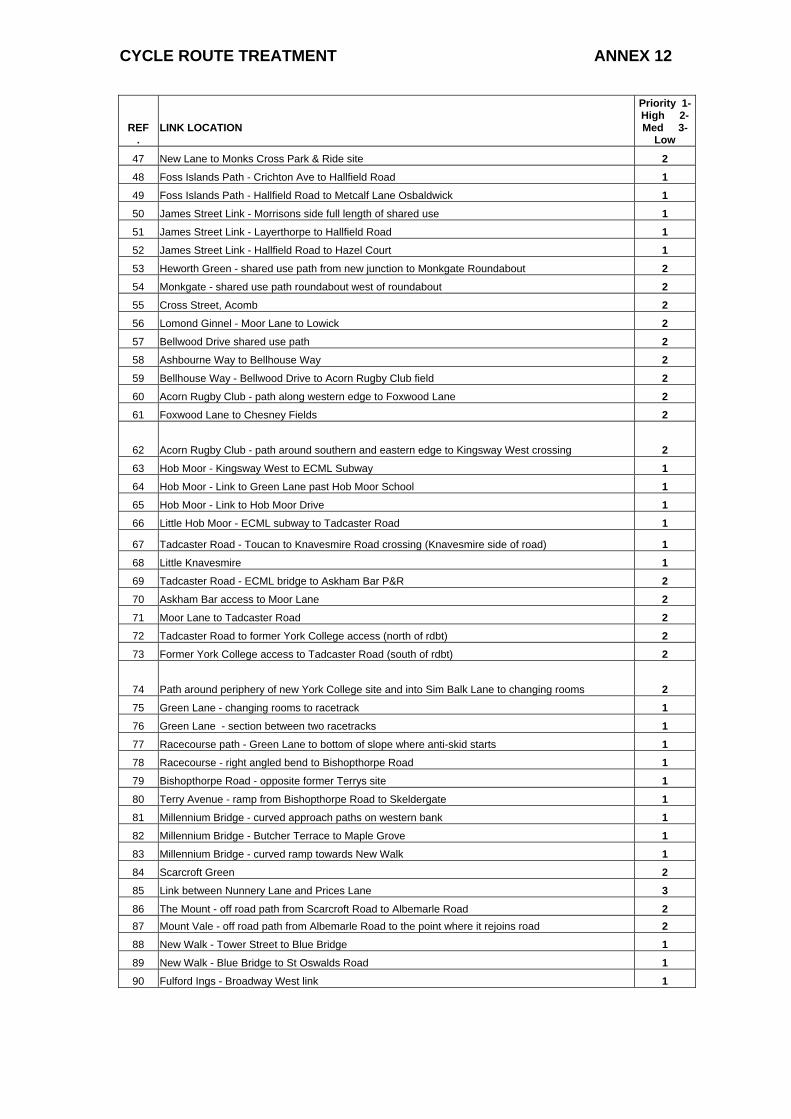
CYCLE ROUTE TREATMENT ANNEX 12
REF .
LINK LOCATION
Priority 1-High 2-Med 3-
Low
47 New Lane to Monks Cross Park & Ride site 2 48 Foss Islands Path - Crichton Ave to Hallfield Road 1 49 Foss Islands Path - Hallfield Road to Metcalf Lane Osbaldwick 1 50 James Street Link - Morrisons side full length of shared use 1 51 James Street Link - Layerthorpe to Hallfield Road 1 52 James Street Link - Hallfield Road to Hazel Court 1 53 Heworth Green - shared use path from new junction to Monkgate Roundabout 2 54 Monkgate - shared use path roundabout west of roundabout 2 55 Cross Street, Acomb 2 56 Lomond Ginnel - Moor Lane to Lowick 2 57 Bellwood Drive shared use path 2 58 Ashbourne Way to Bellhouse Way 2 59 Bellhouse Way - Bellwood Drive to Acorn Rugby Club field 2 60 Acorn Rugby Club - path along western edge to Foxwood Lane 2 61 Foxwood Lane to Chesney Fields 2
62 Acorn Rugby Club - path around southern and eastern edge to Kingsway West crossing 2 63 Hob Moor - Kingsway West to ECML Subway 1 64 Hob Moor - Link to Green Lane past Hob Moor School 1 65 Hob Moor - Link to Hob Moor Drive 1 66 Little Hob Moor - ECML subway to Tadcaster Road 1
67 Tadcaster Road - Toucan to Knavesmire Road crossing (Knavesmire side of road) 1 68 Little Knavesmire 1 69 Tadcaster Road - ECML bridge to Askham Bar P&R 2 70 Askham Bar access to Moor Lane 2 71 Moor Lane to Tadcaster Road 2 72 Tadcaster Road to former York College access (north of rdbt) 2 73 Former York College access to Tadcaster Road (south of rdbt) 2
74 Path around periphery of new York College site and into Sim Balk Lane to changing rooms 2 75 Green Lane - changing rooms to racetrack 1 76 Green Lane - section between two racetracks 1 77 Racecourse path - Green Lane to bottom of slope where anti-skid starts 1 78 Racecourse - right angled bend to Bishopthorpe Road 1 79 Bishopthorpe Road - opposite former Terrys site 1 80 Terry Avenue - ramp from Bishopthorpe Road to Skeldergate 1 81 Millennium Bridge - curved approach paths on western bank 1 82 Millennium Bridge - Butcher Terrace to Maple Grove 1 83 Millennium Bridge - curved ramp towards New Walk 1 84 Scarcroft Green 2 85 Link between Nunnery Lane and Prices Lane 3 86 The Mount - off road path from Scarcroft Road to Albemarle Road 2 87 Mount Vale - off road path from Albemarle Road to the point where it rejoins road 2 88 New Walk - Tower Street to Blue Bridge 1 89 New Walk - Blue Bridge to St Oswalds Road 1 90 Fulford Ings - Broadway West link 1
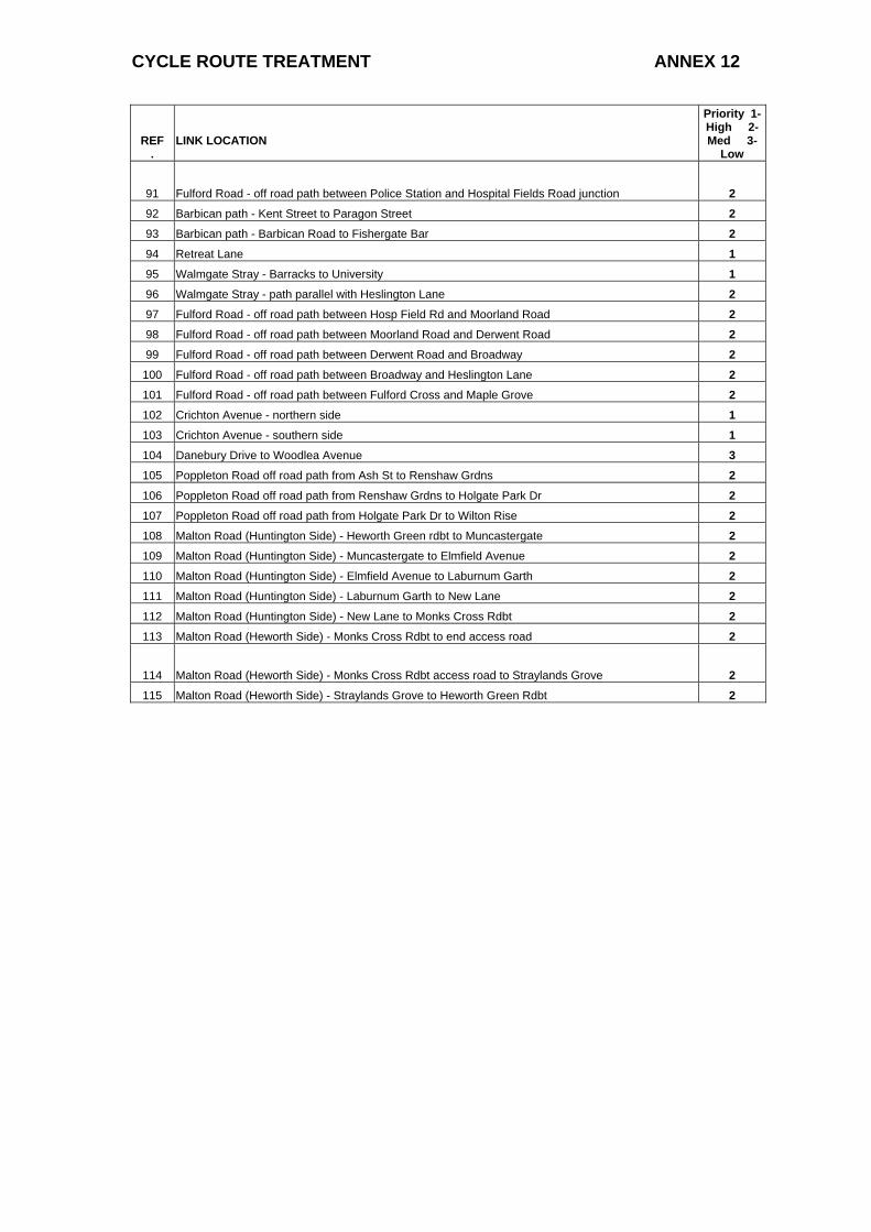
CYCLE ROUTE TREATMENT ANNEX 12
REF .
LINK LOCATION
Priority 1-High 2-Med 3-
Low
91 Fulford Road - off road path between Police Station and Hospital Fields Road junction 2 92 Barbican path - Kent Street to Paragon Street 2 93 Barbican path - Barbican Road to Fishergate Bar 2 94 Retreat Lane 1 95 Walmgate Stray - Barracks to University 1 96 Walmgate Stray - path parallel with Heslington Lane 2 97 Fulford Road - off road path between Hosp Field Rd and Moorland Road 2 98 Fulford Road - off road path between Moorland Road and Derwent Road 2 99 Fulford Road - off road path between Derwent Road and Broadway 2
100 Fulford Road - off road path between Broadway and Heslington Lane 2 101 Fulford Road - off road path between Fulford Cross and Maple Grove 2 102 Crichton Avenue - northern side 1 103 Crichton Avenue - southern side 1 104 Danebury Drive to Woodlea Avenue 3 105 Poppleton Road off road path from Ash St to Renshaw Grdns 2 106 Poppleton Road off road path from Renshaw Grdns to Holgate Park Dr 2 107 Poppleton Road off road path from Holgate Park Dr to Wilton Rise 2 108 Malton Road (Huntington Side) - Heworth Green rdbt to Muncastergate 2 109 Malton Road (Huntington Side) - Muncastergate to Elmfield Avenue 2 110 Malton Road (Huntington Side) - Elmfield Avenue to Laburnum Garth 2 111 Malton Road (Huntington Side) - Laburnum Garth to New Lane 2 112 Malton Road (Huntington Side) - New Lane to Monks Cross Rdbt 2 113 Malton Road (Heworth Side) - Monks Cross Rdbt to end access road 2
114 Malton Road (Heworth Side) - Monks Cross Rdbt access road to Straylands Grove 2 115 Malton Road (Heworth Side) - Straylands Grove to Heworth Green Rdbt 2
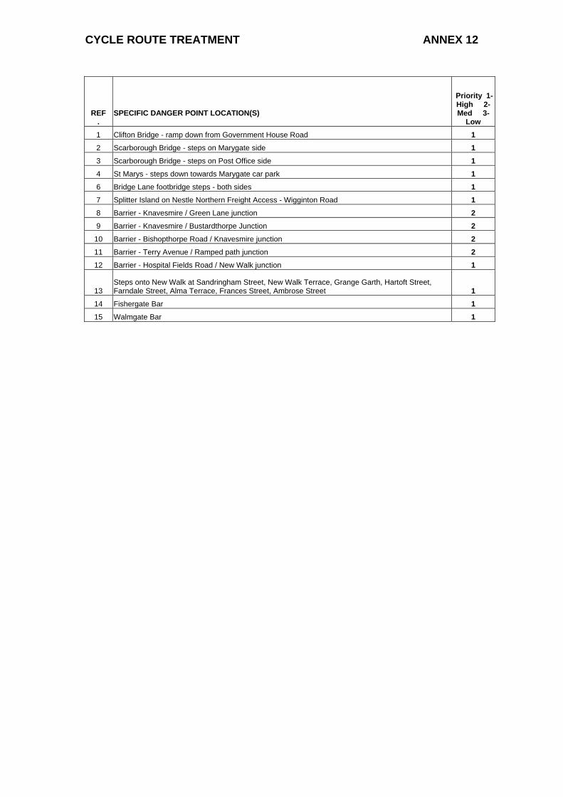
CYCLE ROUTE TREATMENT ANNEX 12
REF .
SPECIFIC DANGER POINT LOCATION(S)
Priority 1-High 2-Med 3-
Low 1 Clifton Bridge - ramp down from Government House Road 1 2 Scarborough Bridge - steps on Marygate side 1 3 Scarborough Bridge - steps on Post Office side 1 4 St Marys - steps down towards Marygate car park 1 6 Bridge Lane footbridge steps - both sides 1 7 Splitter Island on Nestle Northern Freight Access - Wigginton Road 1 8 Barrier - Knavesmire / Green Lane junction 2 9 Barrier - Knavesmire / Bustardthorpe Junction 2
10 Barrier - Bishopthorpe Road / Knavesmire junction 2 11 Barrier - Terry Avenue / Ramped path junction 2 12 Barrier - Hospital Fields Road / New Walk junction 1
13 Steps onto New Walk at Sandringham Street, New Walk Terrace, Grange Garth, Hartoft Street, Farndale Street, Alma Terrace, Frances Street, Ambrose Street 1
14 Fishergate Bar 1 15 Walmgate Bar 1
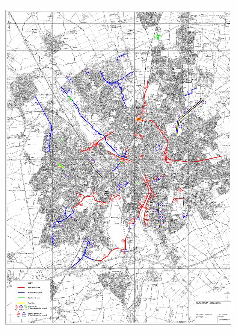
SCALE DRAWN BY DATE
Originating Group Drawing Number
AV1:10000
25
N
S
EW
13
14
15
1
2
3
4
12
6
65
89
9078
79
80
81
8266
67
83
26
84 85
86
87
96
95
94
93
88
9
11
10
72 77
92
23
24
22
48
49
5354
27
28
21
41
42
3635
47
37
38
39
33
40
43 44
18
19
16 17
30
31
32
34
29
10
9
2
4
5
1
6
7
8
3
1112
20
55
64
63
60
61
62
57 58
59
56 71
69
70
73
74 75
768
100
99
98
97
91
102
103
104
106
105
107
13
14
15
56 56 56
High Medium Low
KEY
9 9High Medium
High Priority Link
Medium Priority Link
Low Priority Link
New Link
Link Ref. No.(Priority denoted by border)
Danger Spot Ref. No.(Priority denoted by border)
46
45
7
Cycle Route Gritting 2010
50
51
52
68
109
108 115
110
111
114
112113
101
York
Transport Planning Unit
GRIT10PR.ECW
22/9/2010
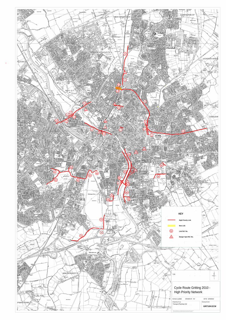
13
14
15
1
2
3
4
12
6
65
89
9078
79
80
81
8266
67
83
95
94
88
77
23
24
48
4927
28
10
1112
64
63
75
76
102
103
13
14
15
46
45
7
50
51
52
68
Produced from the 1993 Ordnance Survey 1:1250 mapping with the permission of the Controller of Her Majesty's Stationery Office
SCALE DRAWN BY DATE
Originating Group Drawing Number
© Crown Copyright. Unauthorised reproduction infringes Crown Copyright and may lead to prosecution or civil proceedings.
AV1:12500 22/9/2010
N
S
EWYork
Transport Planning Unit
High Priority Link
New Link
Link Ref. No.
Danger Spot Ref. No.
KEY
56
9
Cycle Route Gritting 2010 - High Priority Network
GRIT10HI.ECW
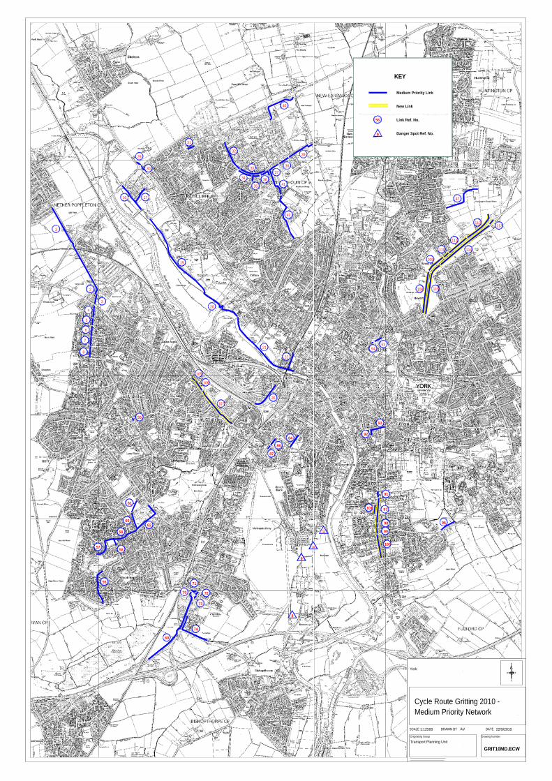
26
84
86
87
96
93
9
11
10
72
92
22
535421
41
42
3635
47
37
38
39
33
40
19
16 17
30
31
32
34
29
2
4
5
1
6
7
8
320
55
60
61
62
57 58
59
56 71
69
70
73
74
8
100
99
98
97
91
106
105
107
109
108 115
110
111
114
112113
101
56
9
Medium Priority Link
New Link
Link Ref. No.
Danger Spot Ref. No.
KEY
SCALE DRAWN BY DATE
Originating Group Drawing Number
AV1:12500 22/9/2010
Transport Planning Unit
YorkN
S
EW
Cycle Route Gritting 2010 - Medium Priority Network
GRIT10MD.ECW
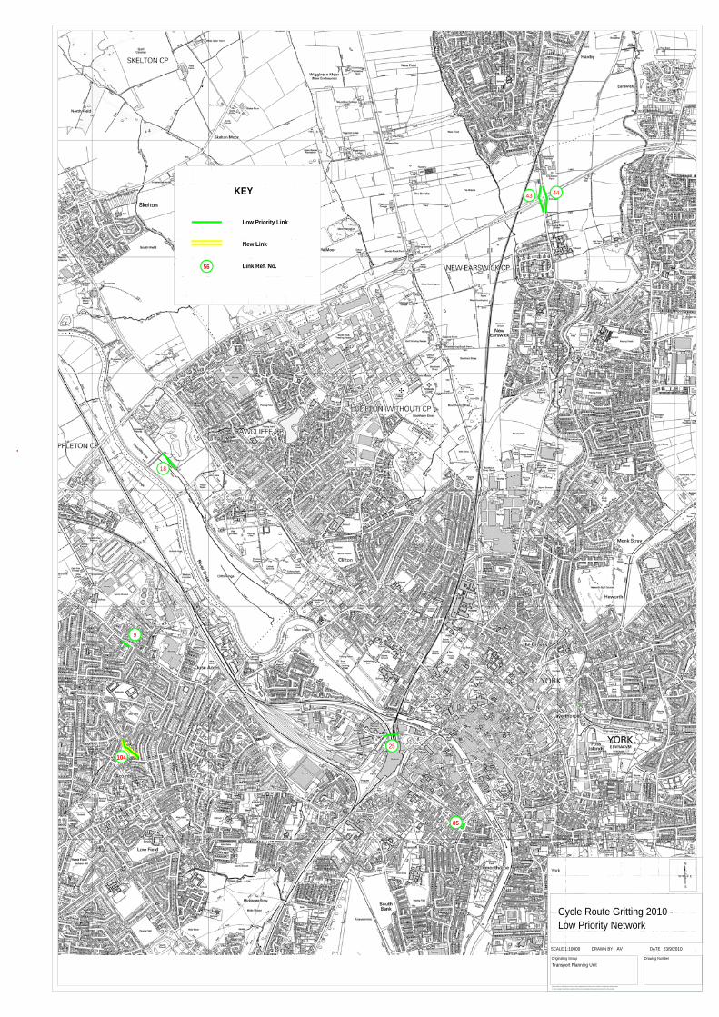
85
43 44
18
9
104
25
Produced from the 1993 Ordnance Survey 1:1250 mapping with the permission of the Controller of Her Majesty's Stationery Office
SCALE DRAWN BY DATE
Originating Group Drawing Number
© Crown Copyright. Unauthorised reproduction infringes Crown Copyright and may lead to prosecution or civil proceedings.
AV1:10000 23/9/2010
Transport Planning Unit
YorkN
S
EW
56
KEY
Low Priority Link
New Link
Link Ref. No.
Cycle Route Gritting 2010 -Low Priority Network
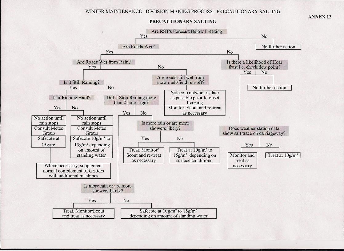
WINTER MAINTENANCE - DECISION MAKING PROCESS - PRECAUTIONARY SALTING
PRECAUTIONARY SALTINGI
Are RST's Forecast B~low FreezingYes I No
I 1-:----:-----,Are Roads Wet? I No further action IYes I No
1 1Are Roads Wet from Rain? Is there a likelihood ofHoar
Yes -I No frost i.e. check dew point?
I I ~Are roads still wet from
Is it Still Raining? snow melt/field run-off?Yes I No
1 1 Safecote network as lateIs it Raining Hard? Did it Stop Raining more as possible prior to onset
than 2 hours ago? freezinMonitor, Scout and re-treat
~ I as necessary- -- - .-
I INo action until No action until
rain stops rain stopsConsult Meteo Consult Meteo
Group GroupSafecote at Safecote 10g/m2 to15g/m2 15g/m" depending
on amount ofstanding water
Where necessary, supplementnormal complement of Gritters
with additional machines
Is more rain or are moreshowers likely?
I ITreat, Monitor/ Treat at 10g/m2 toScout and re-treat 15g/m- depending onas necessary surface conditions
Is more rain or are moreshowers likely?
Yes No
Treat, Monitor/Scoutand treat as necessar
ANNEX 13
Does weather station datashow salt trace on carriageway?
Yes NoI I Treat at 10g/m2 IMonitor and
treat asnecessary
II
I I
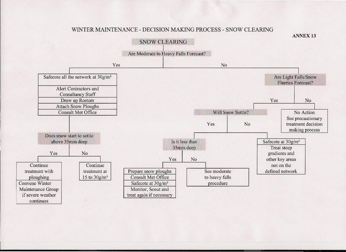
WINTER MAINTENANCE - DECISION MAKING PROCESS - SNOW CLEARING
Safecote all the network at 30g/m2
Alert Contractors andConsultancy StaffDraw up Rosters
Attach Snow PloughsConsult Met Office
- -Does snow start to settle
above 35mm deep
Yes No
Continuetreatment with
louzhin
Continuetreatment at15 to 30g/m2
Convene WinterMaintenance Group
if severe weathercontinues
SNOW CLEARINGI
Are Moderate to Heavy Falls Forecast?
ANNEX 13
aIls/Snowrecast?
No
o Actionrecautionaryent decisionnz nrocess
Is it less than35mmdeep
I IPrepare snow ploughs See moderate
Consult Met Office to heavy fallsSafecote at 30g/m2 procedureMonitor, Scout and
treat again if necessary
Safecote at 30g/m2Treat steep
gradients andother key areas
not on thedefined network

ANNEX 14
WINTER MAINTENANCE GROUP CONTACT DETAILS
CONFIDENTIAL

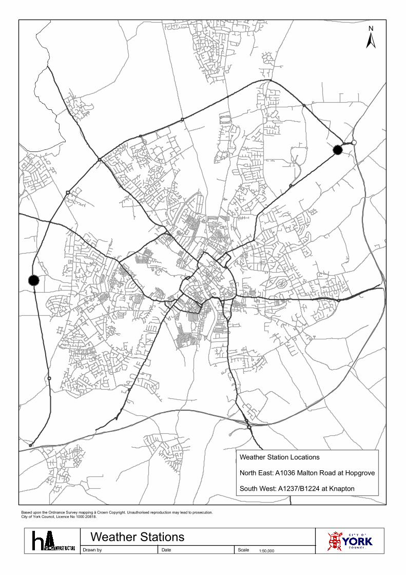
±
Drawn by Date Scale 1:50,000
Based upon the Ordnance Survey mapping ã Crown Copyright. Unauthorised reproduction may lead to prosecution.City of York Council, Licence No 1000 20818.
Weather Station LocationsNorth East: A1036 Malton Road at HopgroveSouth West: A1237/B1224 at Knapton
Weather Stations
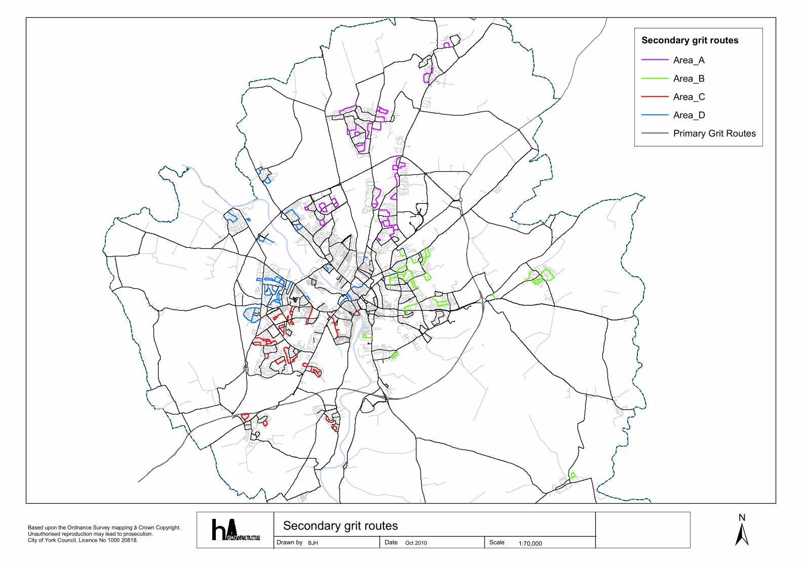
±Drawn by Date Scale 1:70,000
Based upon the Ordnance Survey mapping ã Crown Copyright. Unauthorised reproduction may lead to prosecution.City of York Council, Licence No 1000 20818.
Secondary grit routesArea_AArea_BArea_CArea_DPrimary Grit Routes
Secondary grit routesBJH Oct 2010
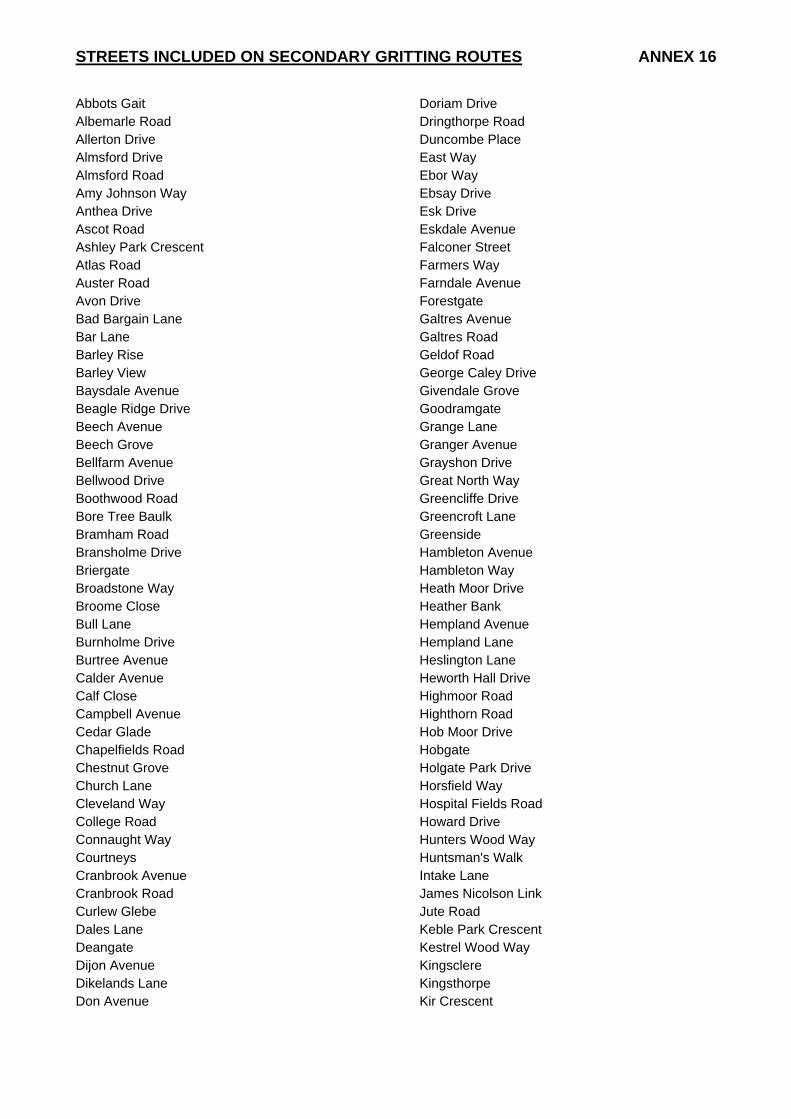
STREETS INCLUDED ON SECONDARY GRITTING ROUTES ANNEX 16
Abbots Gait Albemarle Road Allerton Drive Almsford Drive Almsford Road Amy Johnson Way Anthea Drive Ascot Road Ashley Park Crescent Atlas Road Auster Road Avon Drive Bad Bargain Lane Bar Lane Barley Rise Barley View Baysdale Avenue Beagle Ridge Drive Beech Avenue Beech Grove Bellfarm Avenue Bellwood Drive Boothwood Road Bore Tree Baulk Bramham Road Bransholme Drive Briergate Broadstone Way Broome Close Bull Lane Burnholme Drive Burtree Avenue Calder Avenue Calf Close Campbell Avenue Cedar Glade Chapelfields Road Chestnut Grove Church Lane Cleveland Way College Road Connaught Way Courtneys Cranbrook Avenue Cranbrook Road Curlew Glebe Dales Lane Deangate Dijon Avenue Dikelands Lane Don Avenue
Doriam Drive Dringthorpe Road Duncombe Place East Way Ebor Way Ebsay Drive Esk Drive Eskdale Avenue Falconer Street Farmers Way Farndale Avenue Forestgate Galtres Avenue Galtres Road Geldof Road George Caley Drive Givendale Grove Goodramgate Grange Lane Granger Avenue Grayshon Drive Great North Way Greencliffe Drive Greencroft Lane Greenside Hambleton Avenue Hambleton Way Heath Moor Drive Heather Bank Hempland Avenue Hempland Lane Heslington Lane Heworth Hall Drive Highmoor Road Highthorn Road Hob Moor Drive Hobgate Holgate Park Drive Horsfield Way Hospital Fields Road Howard Drive Hunters Wood Way Huntsman's Walk Intake Lane James Nicolson Link Jute Road Keble Park Crescent Kestrel Wood Way Kingsclere Kingsthorpe Kir Crescent
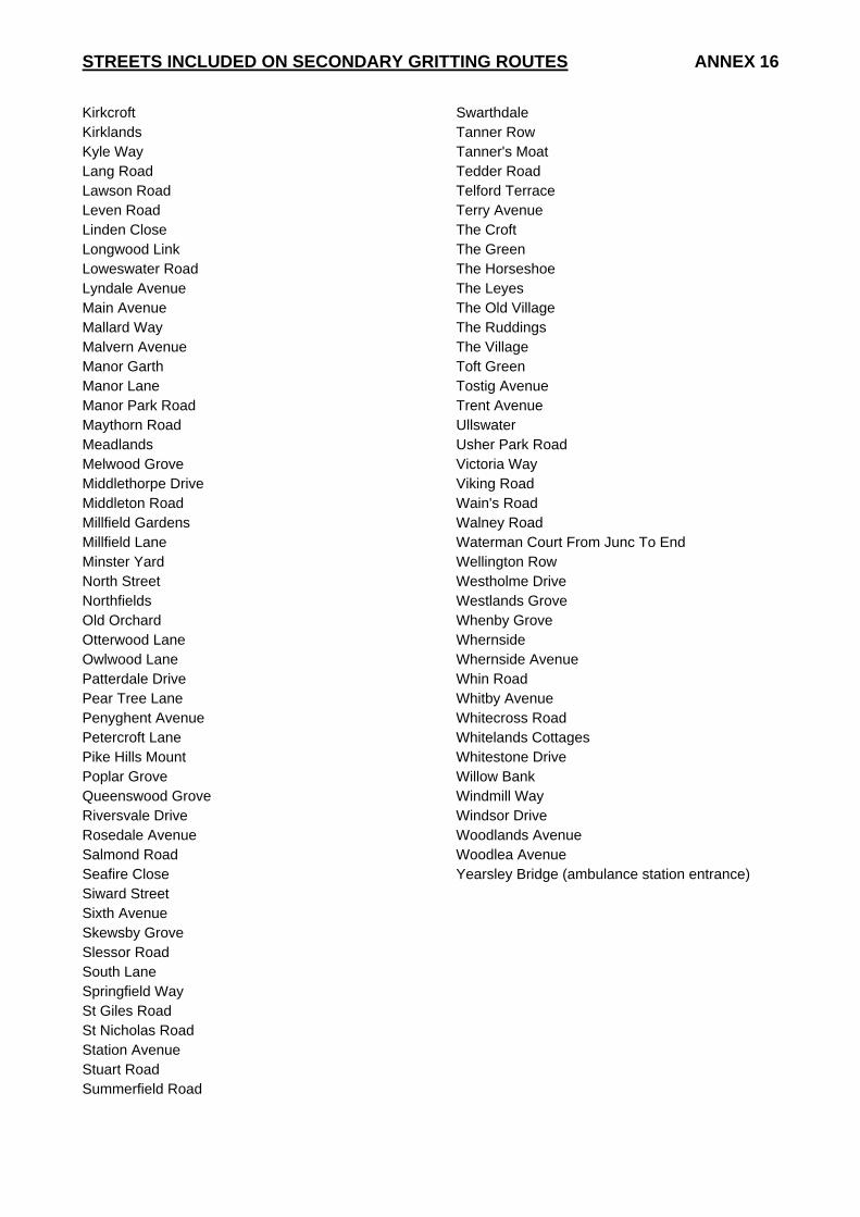
STREETS INCLUDED ON SECONDARY GRITTING ROUTES ANNEX 16
Kirkcroft Kirklands Kyle Way Lang Road Lawson Road Leven Road Linden Close Longwood Link Loweswater Road Lyndale Avenue Main Avenue Mallard Way Malvern Avenue Manor Garth Manor Lane Manor Park Road Maythorn Road Meadlands Melwood Grove Middlethorpe Drive Middleton Road Millfield Gardens Millfield Lane Minster Yard North Street Northfields Old Orchard Otterwood Lane Owlwood Lane Patterdale Drive Pear Tree Lane Penyghent Avenue Petercroft Lane Pike Hills Mount Poplar Grove Queenswood Grove Riversvale Drive Rosedale Avenue Salmond Road Seafire Close Siward Street Sixth Avenue Skewsby Grove Slessor Road South Lane Springfield Way St Giles Road St Nicholas Road Station Avenue Stuart Road Summerfield Road
Swarthdale Tanner Row Tanner's Moat Tedder Road Telford Terrace Terry Avenue The Croft The Green The Horseshoe The Leyes The Old Village The Ruddings The Village Toft Green Tostig Avenue Trent Avenue Ullswater Usher Park Road Victoria Way Viking Road Wain's Road Walney Road Waterman Court From Junc To End Wellington Row Westholme Drive Westlands Grove Whenby Grove Whernside Whernside Avenue Whin Road Whitby Avenue Whitecross Road Whitelands Cottages Whitestone Drive Willow Bank Windmill Way Windsor Drive Woodlands Avenue Woodlea Avenue Yearsley Bridge (ambulance station entrance)

TEMPORARY SALT BAGS ANNEX 17
Temporary salt bags will be placed in the following locations when instructed by the Winter Maintenance Group:
LOCATIONS WILL BE COMFIRMED WHEN CONSULTATION WITH WARD COMMITTEES IS COMPLETE
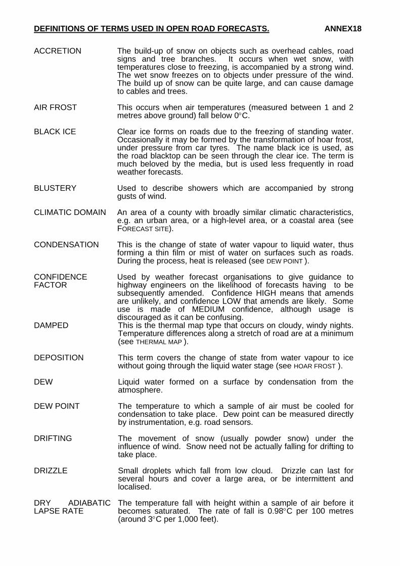
DEFINITIONS OF TERMS USED IN OPEN ROAD FORECASTS. ANNEX18
ACCRETION The build-up of snow on objects such as overhead cables, road signs and tree branches. It occurs when wet snow, with temperatures close to freezing, is accompanied by a strong wind. The wet snow freezes on to objects under pressure of the wind. The build up of snow can be quite large, and can cause damage to cables and trees.
AIR FROST This occurs when air temperatures (measured between 1 and 2
metres above ground) fall below 0°C. BLACK ICE Clear ice forms on roads due to the freezing of standing water.
Occasionally it may be formed by the transformation of hoar frost, under pressure from car tyres. The name black ice is used, as the road blacktop can be seen through the clear ice. The term is much beloved by the media, but is used less frequently in road weather forecasts.
BLUSTERY Used to describe showers which are accompanied by strong
gusts of wind. CLIMATIC DOMAIN An area of a county with broadly similar climatic characteristics,
e.g. an urban area, or a high-level area, or a coastal area (see FORECAST SITE).
CONDENSATION This is the change of state of water vapour to liquid water, thus
forming a thin film or mist of water on surfaces such as roads. During the process, heat is released (see DEW POINT ).
CONFIDENCE FACTOR
Used by weather forecast organisations to give guidance to highway engineers on the likelihood of forecasts having to be subsequently amended. Confidence HIGH means that amends are unlikely, and confidence LOW that amends are likely. Some use is made of MEDIUM confidence, although usage is discouraged as it can be confusing.
DAMPED This is the thermal map type that occurs on cloudy, windy nights. Temperature differences along a stretch of road are at a minimum (see THERMAL MAP ).
DEPOSITION This term covers the change of state from water vapour to ice
without going through the liquid water stage (see HOAR FROST ). DEW Liquid water formed on a surface by condensation from the
atmosphere. DEW POINT The temperature to which a sample of air must be cooled for
condensation to take place. Dew point can be measured directly by instrumentation, e.g. road sensors.
DRIFTING The movement of snow (usually powder snow) under the
influence of wind. Snow need not be actually falling for drifting to take place.
DRIZZLE Small droplets which fall from low cloud. Drizzle can last for
several hours and cover a large area, or be intermittent and localised.
DRY ADIABATIC LAPSE RATE
The temperature fall with height within a sample of air before it becomes saturated. The rate of fall is 0.98°C per 100 metres (around 3°C per 1,000 feet).
DRY FROST The road surface is at 0°C or below, with most roads expected to
be dry. However, ice may form due to seepage, burst pipes or in known hollows where moisture persists.
EVAPORATION The change of state from water to water vapour. The process
takes in heat and causes cooling (see LATENT HEAT ). EXTREME The thermal map type that occurs on calm, clear nights.
Temperature differences along a stretch of road tend to be at their maximum (see THERMAL MAP ).
FLASH FROST The rapid build up of hoar frost on roads around sunrise. Roads
can change from dry to a significant cover of hoar frost within 15 minutes (see HOAR FROST ).
FOG The suspension of water droplets in air at or close to the ground. FORECAST SITE A road sensor site for which a graphical forecast is provided. It is
usual to have one forecast site per climatic domain (see CLIMATIC DOMAIN )..
FREEZING FOG Fog which forms when air temperatures are below freezing. The fog droplets remain in the liquid state, but will freeze on contact with trees and other objects, and under some circumstances the road surface (see RIME ).
FREEZING POINT The temperature at which pure water will change to ice (although
strictly it is the temperature at which ice melts ), in practice, 0.0°C.
FREEZING RAIN / DRIZZLE
A very dangerous condition where raindrops (from warmer air aloft) fall on to surfaces below freezing, thus freezing instantly and causing widespread ice. Fortunately, rare in the UK. Most likely to occur at the end of a prolonged spell of cold weather.
FREQUENT Used in conjunction with showers. The term frequent showers
implies that nearly all areas will catch a shower, and many places will see more than one shower ( see ISOLATED and SCATTERED ).
FROST A generic term to cover temperatures below freezing. Where
these temperatures occur describes the type of frost (air frost, ground frost, road frost, etc. ). The rather loose term of 'frost' is rarely used in road weather forecasts without qualifying it. Note that the word frost does not supply deposition on a road surface. The deposition of ice crystals on to a road surface is known specifically as hoar frost (see HOAR FROST).
GALE Mean wind speed of 39 m.p.h. or more, or with gusts to 49 m.p.h.
or more. A severe gale has a mean wind of 45 m.p.h. or more, or has gusts to 70 m.p.h. or more.
GROUND FROST This term is used to describe occasions when temperatures on
the ground (as opposed to in the air ) fall below freezing. The official meteorological definition uses the temperature over short mown grass. The term has little relevance to winter maintenance, which is concerned specifically with road temperatures. The term 'ground frost' heard on media forecasts (TV, radio) does not guarantee that there will also be a road frost.
HAIL Precipitation in the form of balls or pieces of ice. Usually occurs
in showers. HOAR FROST Deposition of water vapour directly as ice on to ground surfaces.
The ice forms as white crystals and is usually highly visible. Hoar frost is more common over grass than on roads. Hoar frost on roads may quickly change to clear ice under pressure from car tyres.
ICE A generic term for frozen water. In winter maintenance terms
usually refers to clear ice on road surfaces (see BLACK ICE ). ICY PATCHES Used in road weather forecasts to indicate ice formation in prone
areas only (gutters, dips in the road surface, etc. ). ICY STRETCHES Used in road weather forecasts to indicate more-widespread ice. ISOLATED Used in conjunction with showers. Isolated showers implies that
most places will stay dry, but somewhere within the area of coverage a shower may occur (see FREQUENT and SCATTERED )
INTERMEDIATE The thermal map type that occurs on nights where cloud cover,
wind speed (or both) is variable. Road temperature differences tend to lie between the Damped and Extreme values (see THERMAL MAP).
INTERVAL Used to describe cloud breaks or amounts of sunshine, generally
of less than one hours duration. LATENT HEAT The quantity of heat absorbed or emitted, without change of
temperature, during a change of state of unit mass of a material. MARGINAL This describes nights where the road temperature is expected to
be very close to freezing (normally within 1°C ). PERIOD Used to describe the length of cloud breaks or amounts of
sunshine, generally of two hours or more duration. POWDER SNOW The form of snow that occurs when air temperatures are well
below freezing (-2°C or less ). This form of snow is very fine (like sugar crystals ), drifts very easily, but does not tend to stick to objects (no accretion ). It can be handled by snow blowers. Salt is usually less effective.
PRECIPITATION A general term which covers all water (or ice ) which 'falls' from
the skies. As well as rain, sleet, snow and hail it also includes dew, hoar frost and fog.
PRECIPITATION TYPE
The individual type of precipitation. In winter maintenance activities this will be one of rain, drizzle, sleet, wet snow, hail, freezing rain and freezing drizzle (see PRECIPITATION ).
PROLONGED Used to describe showers which merge together producing a
spell of continuous precipitation, generally lasting more than one hour and covering a relatively large area.
RAIN Water droplets which fall from clouds. Rain takes many forms,
and can be of many different intensities and durations. Within road weather forecasts there will often be differentiation between rain and showers, the former usually referring to longer-lived but light intensity precipitation, and the latter to short duration but heavy intensity.
RELATIVE HUMIDITY
This is the amount of actual water vapour held in a sample of air at a given temperature, divided by the maximum amount of water that could be held in that sample of air at that temperature, expressed as a percentage. Within fog or heavy rain, humidities may reach 100%. On a sunny, warm afternoon in summer, humidities may fall to 30%. On an average night in winter, humidities rarely fall below 80% (which is the minimum humidity at which salt crystals will start to absorb water ).
RIME Deposition of ice from freezing fog. It is a white form of ice,
similar to hoar frost, but has a finer (at times feathery ) structure. On roads, tends to be more of a problem at higher levels than lower levels.
RST Common abbreviation for road surface temperature. SATURATED Air is said to be saturated when, at a given temperature, it holds
the maximum amount of water vapour possible. Any cooling below its current temperature will result in condensation. The relative humidity of saturated air is 100%.
SATURATED ADIABATIC LAPSE RATE
The rate at which air temperature falls with height within saturated air, e.g. within fog or cloud. It is less than the dry adiabatic lapse rate, 0.49°C per 100 metres or around 1.5°C per 1,000 feet.
SCATTERED Used in conjunction with showers. Scattered showers imply that
a wide covering of showers across an area is expected. Most places will see a shower but one or two locations may stay dry (see FREQUENT and ISOLATED ).
SEEPAGE Leakage of ground water from roadside verges. Can cause roads
to become wet, when otherwise they would have stayed dry, possibly leading to ice formation later.
SHOWER A short spell of precipitation, generally less than an hour, and
covering a relatively small area. It can be assumed that a shower will be of rain unless qualified by the words snow, hail or wintry.
SLEET Partially melted snow. If precipitation becomes heavy, sleet may
readily turn to snow. SNOW A form of precipitation where tiny ice crystals bond together into
flakes. Snow can be either of the Wet or Powder forms. SPELL Used to describe the length of cloud breaks or amounts of
sunshine, generally between one and two hours duration.
THERMAL FINGERPRINT
The temperature trace along a road surface (usually recorded by an infrared thermometer during a thermal mapping run ). Regardless of the mean temperature of the trace, it shows the thermal characteristics of the road surface(warm and cold spots ).
THERMAL MAP The representation of relative variations in road surface minimum
temperature for each of the three weather categories, presented in colour bands (usually of 1°C ).
THERMAL MAP TYPE
Defined as damped, intermediate or extreme (see previous entries). When using thermal maps in the forecast mode, the weather forecast organisations will send the thermal map type with the ice prediction graph.
TREND The likely direction in which the weather is moving over the next
two to five days, e.g. 'turning much colder with night frosts' or 'remaining mild and windy'.
WASH OFF This occurs when rain is sufficiently heavy to remove salt solution
from the road surface. WATER VAPOUR Water in its gaseous state. WET SNOW Snow which falls with air temperatures close to freezing point. It
melts easily and can be very sticky (see ACCRETION ). It is more common in the UK than the other variant of powder snow.
WIDESPREAD Used to describe showers. Implies that nearly all areas will see a
shower and some areas may see more than one (see FREQUENT ).
WINTRY This term covers precipitation which contains ice in one of its
many variants (sleet, wet snow, hail ). The term is used extensively in media forecasts (e.g. 'wintry showers are expected, showers will turn wintry over hills' ). However, the term is ambiguous in road weather terms and hence any precipitation containing ice will be described more fully, with likely effects on the road.
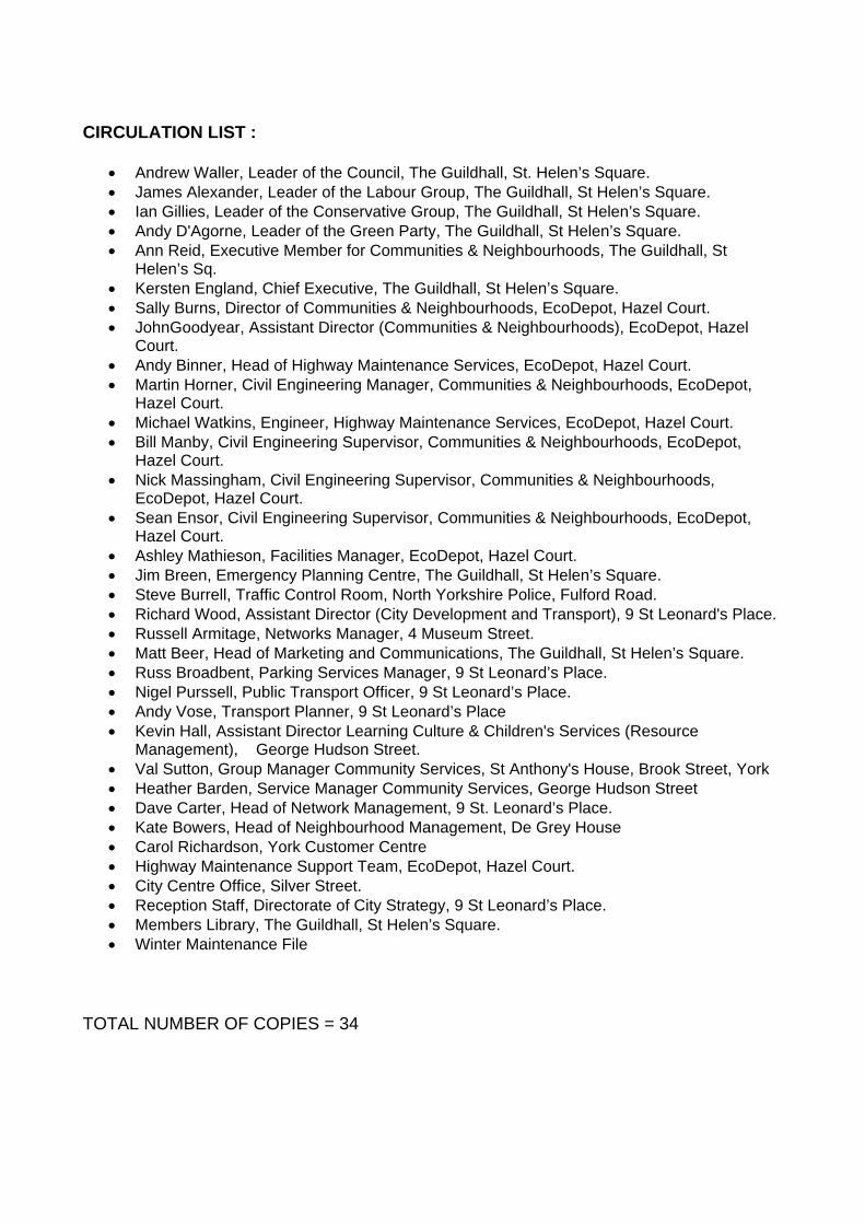
CIRCULATION LIST :
• Andrew Waller, Leader of the Council, The Guildhall, St. Helen’s Square. • James Alexander, Leader of the Labour Group, The Guildhall, St Helen’s Square. • Ian Gillies, Leader of the Conservative Group, The Guildhall, St Helen’s Square. • Andy D'Agorne, Leader of the Green Party, The Guildhall, St Helen’s Square. • Ann Reid, Executive Member for Communities & Neighbourhoods, The Guildhall, St
Helen’s Sq. • Kersten England, Chief Executive, The Guildhall, St Helen’s Square. • Sally Burns, Director of Communities & Neighbourhoods, EcoDepot, Hazel Court. • JohnGoodyear, Assistant Director (Communities & Neighbourhoods), EcoDepot, Hazel
Court. • Andy Binner, Head of Highway Maintenance Services, EcoDepot, Hazel Court. • Martin Horner, Civil Engineering Manager, Communities & Neighbourhoods, EcoDepot,
Hazel Court. • Michael Watkins, Engineer, Highway Maintenance Services, EcoDepot, Hazel Court. • Bill Manby, Civil Engineering Supervisor, Communities & Neighbourhoods, EcoDepot,
Hazel Court. • Nick Massingham, Civil Engineering Supervisor, Communities & Neighbourhoods,
EcoDepot, Hazel Court. • Sean Ensor, Civil Engineering Supervisor, Communities & Neighbourhoods, EcoDepot,
Hazel Court. • Ashley Mathieson, Facilities Manager, EcoDepot, Hazel Court. • Jim Breen, Emergency Planning Centre, The Guildhall, St Helen’s Square. • Steve Burrell, Traffic Control Room, North Yorkshire Police, Fulford Road. • Richard Wood, Assistant Director (City Development and Transport), 9 St Leonard's Place. • Russell Armitage, Networks Manager, 4 Museum Street. • Matt Beer, Head of Marketing and Communications, The Guildhall, St Helen’s Square. • Russ Broadbent, Parking Services Manager, 9 St Leonard’s Place. • Nigel Purssell, Public Transport Officer, 9 St Leonard’s Place. • Andy Vose, Transport Planner, 9 St Leonard’s Place • Kevin Hall, Assistant Director Learning Culture & Children's Services (Resource
Management), George Hudson Street. • Val Sutton, Group Manager Community Services, St Anthony's House, Brook Street, York • Heather Barden, Service Manager Community Services, George Hudson Street • Dave Carter, Head of Network Management, 9 St. Leonard’s Place. • Kate Bowers, Head of Neighbourhood Management, De Grey House • Carol Richardson, York Customer Centre • Highway Maintenance Support Team, EcoDepot, Hazel Court. • City Centre Office, Silver Street. • Reception Staff, Directorate of City Strategy, 9 St Leonard’s Place. • Members Library, The Guildhall, St Helen’s Square. • Winter Maintenance File
TOTAL NUMBER OF COPIES = 34
Related Documents