National Park Service U.S. Department of the Interior Natural Resource Stewardship and Science Aniakchak National Monument and Preserve Geologic Resources Inventory Report Natural Resource Report NPS/NRSS/GRD/NRR—2015/1033

Welcome message from author
This document is posted to help you gain knowledge. Please leave a comment to let me know what you think about it! Share it to your friends and learn new things together.
Transcript
National Park ServiceU.S. Department of the Interior
Natural Resource Stewardship and Science
Aniakchak National Monument and PreserveGeologic Resources Inventory ReportNatural Resource Report NPS/NRSS/GRD/NRR—2015/1033
SW maar
NE maar
New Cone
The Gates
Slag Heap
Half Cone
West Dome
BlackNose
WindyCone
Pumice Dome
Vulcan Dome
Blocky Cone
1931 Main Crater
Bolshoi DomeSurprise Lake
Birthday Pass
Vent Mountain
Surprise Cone
AniakchakPeak
Doublet Crater
AniakchakRiver
Cobweb lava flow
warmsprings
warm spring
TheGardenWall
PlentyBearCreek
BreezyCone
158°5'W
158°10'W
56°55'N
56°50'N
0 0.5 1 1.5 2Miles
0 0.5 1 1.5 2Kilometers
North
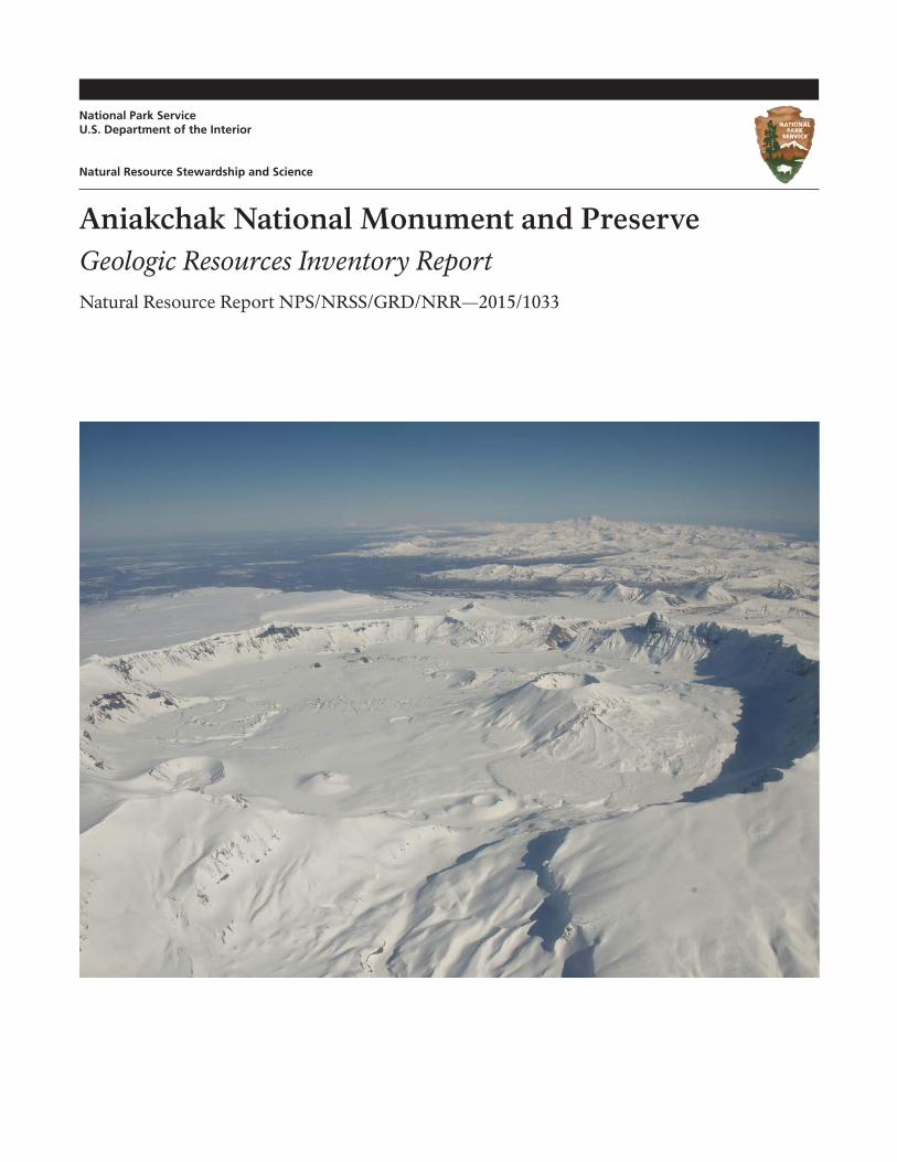
ON THE COVER: Aerial photograph of Aniakchak Crater in early spring. View is to the northeast with Birthday Pass in the foreground, Vent Mountain is the highest cone in the caldera on the right, the 1931 main crater is the second larg-est cone near the caldera wall on the left, and The Gates are in the background and left of the prominent peak known as Black Nose. NPS photograph by Roy Wood (10 March 2011).
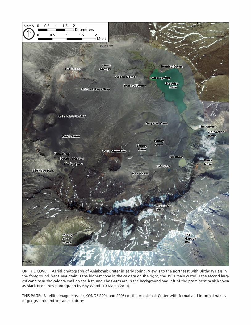
THIS PAGE: Satellite image mosaic (IKONOS 2004 and 2005) of the Aniakchak Crater with formal and informal names of geographic and volcanic features.
Aniakchak National Monument and PreserveGeologic Resources Inventory ReportNatural Resource Report NPS/NRSS/GRD/NRR—2015/1033
Chad Hults
National Park ServiceAlaska Regional Office 240 W. 5th Ave.Anchorage, AK 99501
Christina A. Neal
US Geological SurveyAlaska Volcano Observatory4210 University DriveAnchorage, AK 99508
September 2015
U.S. Department of the Interior National Park Service Natural Resource Stewardship and Science Fort Collins, Colorado
iiii
The National Park Service, Natural Resource Stewardship and Science office in Fort Collins, Colorado, publishes a range of reports that address natural resource topics. These reports are of interest and applicability to a broad audience in the National Park Service and others in natural resource management, including scientists, conservation and environmental constituencies, and the public.
The Natural Resource Report Series is used to disseminate comprehensive information and analysis about natural resources and related topics concerning lands managed by the National Park Service. The series supports the advancement of science, informed decision-making, and the achievement of the National Park Service mission. The series also provides a forum for presenting more lengthy results that may not be accepted by publications with page limitations.
All manuscripts in the series receive the appropriate level of peer review to ensure that the information is scientifically credible, technically accurate, appropriately written for the intended audience, and designed and published in a professional manner. This report received informal peer review by subject-matter experts who were not directly involved in the collection, analysis, or reporting of the data.
Views, statements, findings, conclusions, recommendations, and data in this report do not necessarily reflect views and policies of the National Park Service, U.S. Department of the Interior. Mention of trade names or commercial products does not constitute endorsement or recommendation for use by the U.S. Government.
This report is available from the Geologic Resources Inventory website (http://go.nps.gov/gripubs), and the Natural Resource Publications Management website (http://www.nature.nps.gov/publications/nrpm/). To receive this report in a format optimized for screen readers, please email [email protected].
Please cite this publication as:
Hults, C., and C. A. Neal. 2015. Aniakchak National Monument and Preserve: Geologic resources inventory report. Natural Resource Report NPS/NRSS/GRD/NRR—2015/1033. National Park Service, Fort Collins, Colorado.
NPS 181/129749, September 2015
iii
ContentsPage
Figures . . . . . . . . . . . . . . . . . . . . . . . . . . . . . . . . . . . . . . . . . . . . . . . . . . . . . . . . . . v
Tables . . . . . . . . . . . . . . . . . . . . . . . . . . . . . . . . . . . . . . . . . . . . . . . . . . . . . . . . . . vi
Plates (in pocket) . . . . . . . . . . . . . . . . . . . . . . . . . . . . . . . . . . . . . . . . . . . . . . . . . . . . vi
Executive Summary . . . . . . . . . . . . . . . . . . . . . . . . . . . . . . . . . . . . . . . . . . . . . . . . . . vii
Products and Acknowledgments . . . . .. . . . . . . . . . . . . . . . . . . . . . . . . . . . . . . . . . . . . . . xiGRI Products . . . . . . . . . . . . . . . . . . . . . . . . . . . . . . . . . . . . . . . . . . . . . . . . . . . . . . . . . . . . . . . . . . . . xi
Acknowledgments . . . . . . . . . . . . . . . . . . . . . . . . . . . . . . . . . . . . . . . . . . . . . . . . . . . . . . . . . . . . . . . . . xi
Geologic Setting and Significance . . . . . . . . . . . . . . . . . . . . . . . . . . . . . . . . . . . . . . . . . . . 1
Geologic Features and Processes . . . . .. . . . . . . . . . . . . . . . . . . . . . . . . . . . . . . . . . . . . . . 9Volcanic Eruptions and their Deposits . . . . . . . . . . . . . . . . . . . . . . . . . . . . . . . . . . . . . . . . . . . . . . . . . . . . . . . 9
Outburst Floods . . . . . . . . . . . . . . . . . . . . . . . . . . . . . . . . . . . . . . . . . . . . . . . . . . . . . . . . . . . . . . . . . 23
Geothermal Features . . . . . . . . . . . . . . . . . . . . . . . . . . . . . . . . . . . . . . . . . . . . . . . . . . . . . . . . . . . . . . 25
Nearby Holocene Volcanoes . . . . . . . . . . . . . . . . . . . . . . . . . . . . . . . . . . . . . . . . . . . . . . . . . . . . . . . . . . . 27
Older Bedrock . . . . . . . . . . . . . . . . . . . . . . . . . . . . . . . . . . . . . . . . . . . . . . . . . . . . . . . . . . . . . . . . . . 27
Landforms and Surficial Deposits . . . . . . . . . . . . . . . . . . . . . . . . . . . . . . . . . . . . . . . . . . . . . . . . . . . . . . . . 32
Geologic History . . . . . . . . . . . . . . . . . . . . . . . . . . . . . . . . . . . . . . . . . . . . . . . . . . . 35Jurassic Volcanic Arc and Sedimentary Rocks . . . . . . . . . . . . . . . . . . . . . . . . . . . . . . . . . . . . . . . . . . . . . . . . . . 35
Cretaceous Sedimentary Rocks and Unconformity . . . . . . . . . . . . . . . . . . . . . . . . . . . . . . . . . . . . . . . . . . . . . . . . 35
Terrane Translations . . . . . . . . . . . . . . . . . . . . . . . . . . . . . . . . . . . . . . . . . . . . . . . . . . . . . . . . . . . . . . . 35
Tertiary Sedimentary Rocks and Initiation of a New Volcanic Arc . . . . . . . . . . . . . . . . . . . . . . . . . . . . . . . . . . . . . . . . . 36
Quaternary Volcanism and Glaciation . . . . . . . . . . . . . . . . . . . . . . . . . . . . . . . . . . . . . . . . . . . . . . . . . . . . . . 36
Geologic Resource Management Issues . . . . . . . . . . . . . . . . . . . . . . . . . . . . . . . . . . . . . . . 39Geohazards . . . . . . . . . . . . . . . . . . . . . . . . . . . . . . . . . . . . . . . . . . . . . . . . . . . . . . . . . . . . . . . . . . . 39
Paleontological Resource Inventory, Monitoring, and Protection . . . . . . . . . . . . . . . . . . . . . . . . . . . . . . . . . . . . . . . . . 44
Geothermal Energy Development . . . . . . . . . . . . . . . . . . . . . . . . . . . . . . . . . . . . . . . . . . . . . . . . . . . . . . . . 45
Petroleum Development . . . . . . . . . . . . . . . . . . . . . . . . . . . . . . . . . . . . . . . . . . . . . . . . . . . . . . . . . . . . . 45
Mineral Extraction . . . . . . . . . . . . . . . . . . . . . . . . . . . . . . . . . . . . . . . . . . . . . . . . . . . . . . . . . . . . . . . . 46
Coastal Issues . . . . . . . . . . . . . . . . . . . . . . . . . . . . . . . . . . . . . . . . . . . . . . . . . . . . . . . . . . . . . . . . . . 46
Glacier Changes . . . . . . . . . . . . . . . . . . . . . . . . . . . . . . . . . . . . . . . . . . . . . . . . . . . . . . . . . . . . . . . . . 48
Crater Lake Level and Water Quality . . . . . . . . . . . . . . . . . . . . . . . . . . . . . . . . . . . . . . . . . . . . . . . . . . . . . . . 48
Potential Future Studies . . . . . . . . . . . . . . . . . . . . . . . . . . . . . . . . . . . . . . . . . . . . . . . . . . . . . . . . . . . . . 48
Geologic Map Data . . . . . . . . . . . . . . . . . . . . . . . . . . . . . . . . . . . . . . . . . . . . . . . . . . 51Geologic Maps . . . . . . . . . . . . . . . . . . . . . . . . . . . . . . . . . . . . . . . . . . . . . . . . . . . . . . . . . . . . . . . . . 51
Source Maps . . . . . . . . . . . . . . . . . . . . . . . . . . . . . . . . . . . . . . . . . . . . . . . . . . . . . . . . . . . . . . . . . . . 51
GRI GIS Data . . . . . . . . . . . . . . . . . . . . . . . . . . . . . . . . . . . . . . . . . . . . . . . . . . . . . . . . . . . . . . . . . . . 51
GRI Map Posters . . . . . . . . . . . . . . . . . . . . . . . . . . . . . . . . . . . . . . . . . . . . . . . . . . . . . . . . . . . . . . . . . 52
Map Unit Properties Tables . . . . . . . . . . . . . . . . . . . . . . . . . . . . . . . . . . . . . . . . . . . . . . . . . . . . . . . . . . . . 52
Use Constraints . . . . . . . . . . . . . . . . . . . . . . . . . . . . . . . . . . . . . . . . . . . . . . . . . . . . . . . . . . . . . . . . . 52
Glossary . . . . . . . . . . . . . . . . . . . . . . . . . . . . . . . . . . . . . . . . . . . . . . . . . . . . . . . . 55
Literature Cited . . . . . . . . . . . . . . . . . . . . . . . . . . . . . . . . . . . . . . . . . . . . . . . . . . . . 61
Additional References . . . . . . . . . . . . . . . . . . . . . . . . . . . . . . . . . . . . . . . . . . . . . . . . 67Geology of Alaska . . . . . . . . . . . . . . . . . . . . . . . . . . . . . . . . . . . . . . . . . . . . . . . . . . . . . . . . . . . . . . . . 67
Geology of National Park Service Areas . . . . . . . . . . . . . . . . . . . . . . . . . . . . . . . . . . . . . . . . . . . . . . . . . . . . . 67
NPS Resource Management Guidance and Documents . . . . . . . . . . . . . . . . . . . . . . . . . . . . . . . . . . . . . . . . . . . . . 67
Climate Change Resources . . . . . . . . . . . . . . . . . . . . . . . . . . . . . . . . . . . . . . . . . . . . . . . . . . . . . . . . . . . 67
Geological Surveys and Societies . . . . . . . . . . . . . . . . . . . . . . . . . . . . . . . . . . . . . . . . . . . . . . . . . . . . . . . . . 67
US Geological Survey Reference Tools . . . . . . . . . . . . . . . . . . . . . . . . . . . . . . . . . . . . . . . . . . . . . . . . . . . . . . 68
iv
Contents (continued)Page
Appendix A: Geologic Exploration History . . . . . . . . . . . . . . . . . . . . . . . . . . . . . . . . . . . . . 69
Appendix B: Administrative History Related to Geology . . . . .. . . . . . . . . . . . . . . . . . . . . . . . . 731920–1930s—Conservation Efforts . . . . . . . . . . . . . . . . . . . . . . . . . . . . . . . . . . . . . . . . . . . . . . . . . . . . . . . 73
3 May 1970—Proclaimed as Aniakchak Crater National Natural Landmark . . . . . . . . . . . . . . . . . . . . . . . . . . . . . . . . . . . 73
1 December 1978—Presidential Proclamation 4612 Establishing Aniakchak National Monument . . . . . . . . . . . . . . . . . . . . . . . . 73
2 December 1980—Alaska National Interest Lands Conservation Act (ANILCA) . . . . . . . . . . . . . . . . . . . . . . . . . . . . . . . . . 73
Appendix C: Geologic Resource Laws, Regulations, and Policies . . . . . . . . . . . . . . . . . . . . . . . . . 75
Appendix D: Scoping Participants . . . . . . . . . . . . . . . . . . . . . . . . . . . . . . . . . . . . . . . . . . 812005 Scoping Meeting Participants . . . . . . . . . . . . . . . . . . . . . . . . . . . . . . . . . . . . . . . . . . . . . . . . . . . . . . . 81
2014 NPS Meeting Participants . . . . . . . . . . . . . . . . . . . . . . . . . . . . . . . . . . . . . . . . . . . . . . . . . . . . . . . . . 82
2014 USGS-AVO Meeting Participants . . . . . . . . . . . . . . . . . . . . . . . . . . . . . . . . . . . . . . . . . . . . . . . . . . . . . . 82
Map Unit Properties Tables . . . . . . . . . . . . . . . . . . . . . . . . . . . . . . . . . . . . . . . . . . .in pocket
v
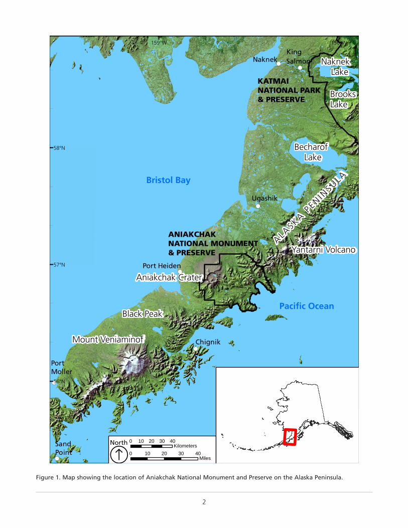
Figure 1. Map showing the location of Aniakchak National Monument and Preserve on the Alaska Peninsula. . . . . . . . . . . . . . . . . . . 2
Figure 2. Photograph of Aniakchak Crater. . . . . . . . . . . . . . . . . . . . . . . . . . . . . . . . . . . . . . . . . . . . . . . . . . . . . 3
Figure 3. Photograph of Bernard Hubbard with ice ax examining scoriaceous lava blocks in Aniakchak Crater (1931). . . . . . . . . . . . . . . 3
Figure 4. Map showing Holocene volcanoes . . . . . . . . . . . . . . . . . . . . . . . . . . . . . . . . . . . . . . . . . . . . . . . . . . . 4
Figure 5. Diagram showing a cross-section of oceanic crust subducting under continental crust . . . . . . . . . . . . . . . . . . . . . . . . . 4
Figure 6. Map showing earthquake epicenters greater than magnitude 3.0, colored by depth (1889 to present) . . . . . . . . . . . . . . . . . 5
Figure 7. Stratigraphic chart of rocks making up Aniakchak National Monument and Preserve and surrounding area. . . . . . . . . . . . . . . . 7
Figure 8. Map showing terranes of Alaska and adjacent Canadian regions showing major faults. . . . . . . . . . . . . . . . . . . . . . . . . . 7
Figure 9. Geologic time scale . . . . . . . . . . . . . . . . . . . . . . . . . . . . . . . . . . . . . . . . . . . . . . . . . . . . . . . . . . . 8
Figure 10. Diagram showing the formation of the Aniakchak caldera . . . . . . . . . . . . . . . . . . . . . . . . . . . . . . . . . . . . . 10
Figure 11. Diagram showing the explosiveness and eruption column heights of the different types of eruptions . . . . . . . . . . . . . . . . 10
Figure 12. Photographs of the Aniakchak II eruption ignimbrite . . . . . . . . . . . . . . . . . . . . . . . . . . . . . . . . . . . . . . . . . 12
Figure 13. Diagram showing the inferred effect of a tsunami from a pyroclastic flow entering Bristol Bay . . . . . . . . . . . . . . . . . . . . 13
Figure 14. Detailed geologic map of the Aniakchak Crater . . . . . . . . . . . . . . . . . . . . . . . . . . . . . . . . . . . . . . . . . . . 14
Figure 15. Reconnaissance level eruption history of Aniakchak volcano . . . . . . . . . . . . . . . . . . . . . . . . . . . . . . . . . . . . . 15
Figure 16. Photograph of Vulcan Dome . . . . . . . . . . . . . . . . . . . . . . . . . . . . . . . . . . . . . . . . . . . . . . . . . . . . . 16
Figure 17. Photograph of radial fracture patterns in andesite of Bolshoi Dome (left) and West Dome (right) . . . . . . . . . . . . . . . . . . 16
Figure 18. Aerial photograph of Vent Mountain with Aniakchak Peak on rim in the background . . . . . . . . . . . . . . . . . . . . . . . . 17
Figure 19. Photograph showing cross section of Half Cone . . . . . . . . . . . . . . . . . . . . . . . . . . . . . . . . . . . . . . . . . . . 17
Figure 20. Schematic stratigraphic column of intra-caldera stratigraphy. . . . . . . . . . . . . . . . . . . . . . . . . . . . . . . . . . . . . . 18
Figure 21. Satellite image (IKONOS 2005) of the Cobweb lava flow . . . . . . . . . . . . . . . . . . . . . . . . . . . . . . . . . . . . . . . 18
Figure 22. Photograph of the 1931 main crater . . . . . . . . . . . . . . . . . . . . . . . . . . . . . . . . . . . . . . . . . . . . . . . . . 19
Figure 23. Photograph probably from the Slag Heap cone . . . . . . . . . . . . . . . . . . . . . . . . . . . . . . . . . . . . . . . . . . . 20
Figure 24. Photograph of Black Nose Pumice overlying older lava flows along the caldera rim north of The Gates. . . . . . . . . . . . . . . . 21
Figure 25. Photograph of the Cabin Bluff exposure in Aniakchak Bay showing post-glacial tephra stratigraphy. . . . . . . . . . . . . . . . . 21
Figure 26. Photograph of lake terraces on the east side of Surprise Lake identified by McGimsey et al. (1994). . . . . . . . . . . . . . . . . . 22
Figure 27. Satellite image mosaic (IKONOS 2004 and 2005) showing the proposed maximum lake levels in the caldera. . . . . . . . . . . . . . 23
Figure 28. Photograph of geologist standing on a large boulder deposited by the caldera outburst flood . . . . . . . . . . . . . . . . . . . 23
Figure 29. Photograph of alluvial fan deposits from the caldera breakout flood along a cut bank of the Aniakchak River . . . . . . . . . . . . 23
Figure 30. Photographs comparing the notch in the rim of the NE maar prior to the 2010 outburst flood . . . . . . . . . . . . . . . . . . . . 24
Figure 31. Photographs of the inlet portion of the NE maar lake . . . . . . . . . . . . . . . . . . . . . . . . . . . . . . . . . . . . . . . . 24
Figure 32. Comparative photographs showing the 2010 flood deposits along the alluvial fan . . . . . . . . . . . . . . . . . . . . . . . . . . 25
Figure 33. Photographs of geothermal features in Aniakchak Crater . . . . . . . . . . . . . . . . . . . . . . . . . . . . . . . . . . . . . . . 26
Figure 34. Map showing Tertiary igneous rocks (Eocene to Miocene) along the Alaska Peninsula and into the Alaska Range. . . . . . . . . . . 28
Figure 35. Photographs of hadrosaur dinosaur tracks in the Chignik Formation. . . . . . . . . . . . . . . . . . . . . . . . . . . . . . . . . 29
Figure 36. Photograph of the south wall of The Gates . . . . . . . . . . . . . . . . . . . . . . . . . . . . . . . . . . . . . . . . . . . . . 30
Figure 37. Map showing the extent of the Naknek Formation along the Alaska Peninsula and southern Talkeetna Mountains. . . . . . . . . . 31
Figure 38. Photograph of Buchia (most likely B. concentrica) fossils, plant detritus, and possible plant impression . . . . . . . . . . . . . . . . 32
Figure 39. Diagram showing the types of glacial deposits created by receding glaciers . . . . . . . . . . . . . . . . . . . . . . . . . . . . . 32
Figure 40. Map showing the mapped glacial deposits of the Aniakchak area . . . . . . . . . . . . . . . . . . . . . . . . . . . . . . . . . . 33
Figure 41. Aerial photograph of beach berms at the mouth of the Aniakchak River . . . . . . . . . . . . . . . . . . . . . . . . . . . . . . . 34
Figure 42. Satellite image (IKONOS 2005) of the beach berms of Aniakchak Bay. . . . . . . . . . . . . . . . . . . . . . . . . . . . . . . . . 34
Figure 43. Wrangellia composite terrane translation history from the Late Triassic to the present . . . . . . . . . . . . . . . . . . . . . . . . 36
Figure 44. Diagram illustration of volcanic hazards. All are potential hazards in and around Aniakchak . . . . . . . . . . . . . . . . . . . . . 39
Figure 45. Map showing volcanic ash and pyroclastic flow deposits, and landslide and rockfall areas. . . . . . . . . . . . . . . . . . . . . . . 40
Figure 46. Photograph of AVO staff installing seismic station “Surprise Lake” (ANSL) within the Aniakchak caldera . . . . . . . . . . . . . . . 41
Figure 47. Map showing the locations of the AVO seismic network as of July 2015. . . . . . . . . . . . . . . . . . . . . . . . . . . . . . . 41
Figure 48. Map showing the probability of earthquake of magnitude 5.5 over the next 20 years in the Aniakchak area. . . . . . . . . . . . . 42
Figure 49. Photograph looking east at the north side of The Gates . . . . . . . . . . . . . . . . . . . . . . . . . . . . . . . . . . . . . . . 43
Page
Figures
vi
Figures (continued)Page
Figure 50. Map showing the extent of subsurface mineral rights within the boundary of the preserve. . . . . . . . . . . . . . . . . . . . . . 45
Figure 51. Map showing extent of original source geologic maps of the Aniakchak area by Detterman et al. . . . . . . . . . . . . . . . . . . 52
Figure 52. Geologic map of the Alaska Peninsula by Atwood (1911). . . . . . . . . . . . . . . . . . . . . . . . . . . . . . . . . . . . . . . 69
Figure 53. Portion of plate XLII from Smith (1925) showing a map of the Aniakchak Crater and vicinity. . . . . . . . . . . . . . . . . . . . . 70
Figure 54. Geologic map of the Aniakchak and Chignik areas by Knappen (1929). . . . . . . . . . . . . . . . . . . . . . . . . . . . . . . . 70
Figure 55. Part of the geologic map of the Alaska Peninsula by Burk (1965), showing the area around Aniakchak. . . . . . . . . . . . . . . . 71
TablesPage
Table 1. Volcanic explosivity index (VEI) . . . . . . . . . . . . . . . . . . . . . . . . . . . . . . . . . . . . . . . . . . . . . . . . . . . . . 11
Table 2. Simplified volcanic rock classification and characteristics . . . . . . . . . . . . . . . . . . . . . . . . . . . . . . . . . . . . . . . . 12
Table 3. Sea level rise projections based on IPCC (Intergovernmental Panel on Climate Change) and USACE (US Army Corps of Engineers) scenarios. . . . . . . . . . . . . . . . . . . . . . . . . . . . . . . . . . . . . . . . . . . . . . . . . . . . . . . . . . . . . . 47
Table 4. Geology data layers in the Aniakchak National Monument and Preserve GRI GIS data . . . . . . . . . . . . . . . . . . . . . . . . . 53
Plates (in pocket)
Plate 1. Bedrock geologic map of Aniakchak National Monument and Preserve.
Plate 2. Quaternary geologic map of Aniakchak National Monument and Preserve.
Plate 3. Geologic map cross section A–A’.
Plate 4. Panorama map of Aniakchak National Monument and Preserve.
vii
This GRI report was written for resource managers, interpretation and educational staff, and park visitors to support science-informed decision making and provide a detailed reference for understanding the geology of Aniakchak National Monument and Preserve. Chapters of the report discuss distinctive geologic features and processes leading to the present-day landscape, describe the geologic history, highlight geologic issues facing resource managers, identify topics of possible future study, and provide information about the GRI geologic map data. Plates 1 and 2 (in pocket) illustrate these data. Plate 3 (in pocket) is cross section A-A’ from Plate 1. The Map Unit Properties Tables (in pocket) summarize report content for each geologic map unit.
Aniakchak National Monument and Preserve, containing a historically active volcano, contains numerous geohazards including evidence of a catastrophic caldera-forming eruption, tsunamis, historic and ancient out-burst floods, landslides, and rock-falls. Aniakchak lies above the Aleutian mega-thrust, which causes numerous earthquakes and has the potential to produce very large earthquakes. In addition to these geohazards, the older bedrock of the park unit includes marine and nonmarine sedimentary rocks that contain numerous invertebrate fossils, plant fossils, and dinosaur tracks. Managing the risk from geohazards and protecting the fossils are primary management issues. However, the park contains rocks that provide data that suggest the formation of Aniakchak began far from its present position, was shaped by glacial erosion, and is being effected by on-going tectonics. These processes have produced the spectacular landforms of Aniakchak.
The primary geologic features and processes in Aniakchak are those derived from volcanic eruptions and their deposits.
● Aniakchak II, The Caldera Forming Eruption. The Aniakchak Crater is one of the best exposed calderas in the world. Aniakchak Crater formed 3,660 ± 70 years ago during a voluminous caldera-forming eruption that produced an estimated bulk volume of approximately 70 km3 (17 mi3) of volcanic material, consisting of extensive pyroclastic flows and pumice fall. So much magma was erupted from the underlying magma chamber that the summit of the mountain collapsed, forming the caldera. The eruption, called Aniakchak II, was among one of the largest in the world to have occurred during the Holocene Epoch (11,700 years ago to present). It has a volcanic explosivity index (VEI) of 6 (“colossal”) on a scale of 0–8. Significant ash fall occurred as much as 1,000 km (620 mi) to the north on the Seward Peninsula. Ash from the eruption traveled around the Northern Hemisphere; traces are found in Greenland ice cores. The eruption left an extensive rhyodacite pumice fall and an andesite ignimbrite that covers the flanks of the mountain and fills many of the surrounding valleys. Thickness in valley bottoms is as much as 100 m (330 ft). The pyroclastic flow from the eruption was so great that when it entered the water of Bristol Bay it formed a tsunami that inundated the north coast of the bay. Ash fall, also referred to as “fallout,” from the Aniakchak II eruption covered most of western Alaska, obliterating vegetation and wildlife. Evidence of human habitation in the Aniakchak area does not occur until about 1,500 years after the eruption, and 100 km (60 mi) to the northeast, in the Ugashik region, there was a 1,500 year hiatus in habitation, probably as a result of the eruption.
● Post-Caldera Eruption Features. Eruptions following the Aniakchak II eruption formed the volcanic features on the floor of the caldera,
Executive Summary
The Geologic Resources Inventory (GRI) is one of 12 inventories funded by the National Park Service (NPS) Inventory and Monitoring Program. The Geologic Resources Division of the NPS Natural Resource Stewardship and Science Directorate administers the GRI. This report synthesizes discussions from a scoping meeting for the parks of the Southwest Alaska Network in February 2005. The meeting was facilitated by the Geologic Resources Division to determine geologic resources, the status of geologic mapping, and geologic resource management issues and needs. A follow-up meeting was held with park and Alaska Regional Office staff in July 2014. This report is a companion document to the previously completed GRI digital geologic map data.
viii
including four subaqueous lava domes (Vulcan, West, Pumice, and Bolshoi), three tuff cones (Surprise, Windy, and Breezy), two composite cones (Vent Mountain and Half Cone), a cinder cone (Blocky Cone), and two maars (SW and NE). Aniakchak volcano most recently erupted from May to June 1931, producing pumice and ash fall in the area of Port Heiden and forming three significant features within the caldera: Main Crater, Doublet Crater, and Slag Heap lava flow.
● Pre-Caldera Eruption Deposits. The volcanic history of Aniakchak volcano goes back at least 850,000 years. Two very large Holocene eruptions formed deposits found below (older than) the Aniakchak II ignimbrite: Aniakchak I ignimbrite (from an eruption between approximately 10,700 and 8,200 years ago) and the Black Nose Pumice (from an eruption less than about 7,600 years old but older than the Aniakchak II eruption).
In addition to features and processes associated with volcanic eruptions and their deposits, Aniakchak National Monument and Preserve contains other significant geologic features and processes, including the following:
● Caldera Outburst Flood and its Deposits. The caldera filled with water, forming a large lake after the Aniakchak II eruption. Evidence for the lake includes subtle wave-cut terraces along the northeast wall of the caldera and lava domes that formed under water. The lake drained during a catastrophic outburst flood. The flood formed alluvial terraces containing very large clasts downstream of The Gates, and deposited large alluvial fans near the Aniakchak River and Albert Johnson Creek. Floodwaters scoured channels into bedrock in places along the Aniakchak River valley.
● 2010 Maar Breakout Flood. The NE maar contains a lake impounded by loose pumice. In 2010, the lake released catastrophically and flooded downstream into the Aniakchak River. The lake level dropped approximately 5 m (16 ft), and the flood eroded areas immediately downstream and deposited approximately 1.5 m (5 ft) of material on the alluvial fan near the Aniakchak River. The flood carried material into the Aniakchak River, which altered the rapids through The Gates and the river channel several miles downstream of The Gates.
● Geothermal Features. Aniakchak National Monument and Preserve is one of 16 National Park System units designated by the Geothermal Steam Act (30 U.S.C. § 1026(a)) as containing significant geothermal features. Aniakchak caldera itself is considered a significant feature. Within the crater, 15 warm springs discharge near the northeast side of Surprise Lake. Warm ground is present on the caldera floor.
● Nearby Holocene Volcanoes. Three Holocene volcanoes within 100 km (60 mi) of the monument and preserve include Yantarni Volcano on the east, the Black Peak caldera to the southwest, and Veniaminof Volcano farther southwest. Due to the proximity of these volcanoes, they present additional volcanic hazards to the park unit.
● Tertiary Igneous and Sedimentary Rocks. The Aniakchak area contains extensive Tertiary volcanic and volcaniclastic rocks from the Eocene and Miocene epochs (55–5 million years ago) and some small Tertiary intrusive bodies. These include rocks of the Meshik Volcanics. Directly underlying the Tertiary volcanic rocks are lower Tertiary sedimentary rocks of the Tolstoi Formation, which contain plant fossils and some shallow marine invertebrate fossils that indicate formation in a subtropical environment.
● Upper Cretaceous Nonmarine and Marine Sedimentary Rocks. The Tertiary rocks unconformably overlie Upper Cretaceous (75–66 million years ago) marine and nonmarine sedimentary rocks of the Chignik and Hoodoo formations, which are nonmarine to marginal marine sedimentary rocks. The Chignik Formation contains abundant plant fossils, minor marine invertebrate fossils, and dinosaur tracks.
● Lower Cretaceous Marine Sedimentary Rocks. Just outside of the Aniakchak Preserve boundary on the west side of the map area are two Lower Cretaceous marine sedimentary units, the Herendeen Formation and the Staniukovich Formation. These two units contain abundant marine invertebrate fossils. A major unconformity separates the Lower Cretaceous rocks from the Upper Cretaceous rocks.
● Upper Jurassic Marine Sedimentary Rocks. The Naknek Formation is the oldest, most extensive, and thickest of the Mesozoic marine sedimentary rocks in the Aniakchak area. It contains plant debris and marine invertebrate fossils.
ix
● Glaciers and Glaciations. Small alpine glaciers occur on Aniakchak Peak, on the south wall of the caldera, and in the Vent Mountain crater. Many of the glaciers, as well as stagnant patches of ice, are hard to recognize because they are covered by debris. Approximately 12,000 years ago during the last glacial maximum in Alaska, glaciers extended to the Pacific and Bristol Bay coasts. As these glaciers receded, they left glacial deposits in the form of moraines, kame topography, outwash plains, and pro-glacial lake deposits.
● Raised Marine Terraces and Beach Berms. After the last glacial maximum, isostatic rebound on the order of 15 m (49 ft) on the Bristol Bay side of the mountain crest and 28–30 m (92–98 ft) on the Pacific side is marked by raised marine wave-cut terraces, wave affected glacial moraines, and marine deposits. The amount of uplift attributable to isostatic rebound rather compared to tectonic forces is not clear, but glacial rebound is probably the dominant factor.
Geologic resource management issues identified by park managers, NPS Alaska Regional Office, US Geological Survey, or the NPS Geologic Resources Division include the following:
● Geohazards. The Aniakchak area is susceptible to the following geohazards: volcanic eruptions, earthquakes, rockfall, landslides, outburst floods, and tsunamis. Hazardous events in the area are frequent and affect large areas.
● Paleontological Resources Inventory, Monitoring, and Protection. Paleontological resources have only been studied at the reconnaissance level, but the potential for discovery is great. Invertebrate marine fossils are common in the Mesozoic marine sedimentary rocks, dinosaur tracks have been discovered in the Upper Cretaceous Chignik Formation, and plant fossils are abundant in the Upper Cretaceous and lower Tertiary nonmarine sedimentary rocks.
● Geothermal Energy Development. The Aniakchak region is an active volcanic area and thus has potential for geothermal energy. The likelihood of large geothermal energy development is low due to the remoteness of the area, associated challenging work environment, and potential hazards from volcanic activity.
● Petroleum Development and Mineral Extraction. The marine sedimentary rocks of the Alaska Peninsula have been the target of petroleum exploration since 1869, even though USGS reports in the 1920s concluded that the oil and gas potential is low. The state has extensive oil and gas lease tracts surrounding the north and northwest boundary of the monument and preserve, and the Koniag Corporation holds subsurface mineral rights to much of the western and southern parts of the preserve.
● Coastal Issues. Coastal features in Anaikchak National Monument and Preserve include 217 km (135 mi) of shoreline, raised marine terraces and beach berms. It is one of 118 parks servicewide that have been identified as potentially vulnerable to sea-level change. Sea level rise projections for Aniakchak range from 0.04 m (0.13 ft) by 2030 to 1.42 m (4.66 ft) by 2100 depending on modeling scenario. Geohazards may also impact coastal features and processes. The few coastal assets and infrastructure within Aniakchak National Monument and Preserve limits potential impacts to human structures.
● Glacier Changes. Within Aniakchak National Monument and Preserve, an Alaskawide glacier change study counted 16 glaciers overall on recent satellite imagery as opposed to 29 counted on the 1950s USGS topographic map although there is low reliability comparing modern sizes and extents to those mapped 60 years ago. Nevertheless recent Alaskawide glacier trends of negative mass balance, diminished ice cover, and reduced ice volume are expected to intensify in the coming decades.
● Crater Lake Level and Water Quality. Surprise Lake supports spawning and nursing habitat for sockeye salmon and arctic char. The water quality of the lake varies spatially and with changes in the meteorological conditions with strong influence from warm springs near their outlets. No salmon spawn on the warm spring side of the lake, but prefer the side of the lake near the crater wall where fresh groundwater flows into the lake.

xi
Products and Acknowledgments
The NPS Geologic Resources Division partners with institutions such as Colorado State University, the US Geological Survey, state geological surveys, local museums, and universities to develop GRI products. This section describes those products and acknowledges contributors to this report.
GRI ProductsThe objective of the Geologic Resources Inventory is to provide geologic map data and pertinent geologic information to support resource management and science-informed decision making in more than 270 natural resource parks throughout the National Park System. To realize this objective, the GRI team undertakes three tasks for each natural resource park: (1) conduct a scoping meeting and provide a summary document, (2) provide digital geologic map data in ageographic information system (GIS) format, and (3)provide a GRI report (this document). These productsare designed and written for nongeoscientists.
Scoping meetings bring together park staff and geologic experts to review and assess available geologic maps, develop a geologic mapping plan, and discuss geologic features, processes, and resource management issues that should be addressed in the GRI report. Following the scoping meeting, the GRI map team converts the geologic maps identified in the mapping plan to digital geologic map data in accordance with the GRI data model. After the map is completed, the GRI report team uses these data, as well as the scoping summary and additional research, to prepare the GRI report.
The compilation and use of natural resource information by park managers is called for in the 1998 National Parks Omnibus Management Act (section 204), 2006 National Park Service Management Policies, and the Natural Resources Inventory and Monitoring Guideline (NPS-75). The “Additional References” chapter and Appendix C provide links to these and other resource management documents and information.
Additional information regarding the GRI, including contact information, is available at http://go.nps.gov/gri. The current status and projected completion dates of products are available at http://go.nps.gov/gri_status.
AcknowledgmentsThe constructive reviews by Frederic Wilson and Game McGimsey improved the report. Thanks to Troy Hamon (NPS Natural Resources Manager) and Diane Chung (Superintendent) for cooperation during the initial preparations for the report. We also appreciate the time provided by the USGS Alaska Volcano Observatory staff (Charlie Bacon, Game McGimsey, Tom Miller, and Chris Waythomas) to meet and discuss the geology of the area and review an earlier draft. Historic materials were provided by Kathryn Myers (NPS Alaska Region Museum Curator). Historic photographs of Bernard Hubbard were provided by the Santa Clara University Library from the Bernard R. Hubbard, S.J. Alaskan Photographs, 1927–1961 collection. Additional thanks to Trista Thornberry-Ehrlich (Colorado State University) for providing some of the graphics used in this report. Julia Brunner and Jeremiah Kimbell (NPS Geologic Resources Division) reviewed the geothermal and petroleum development sections, respectively. Maria Caffrey (NPS Geologic Resources Division and University of Colorado) provided sea level rise projection data.
AuthorsChad Hults (NPS Alaska Regional Office) Christina Neal (USGS Alaska Volcano Observatory)
Review Frederic Wilson (USGS Alaska Science Center)Robert (Game) McGimsey (USGS Alaska Volcano Observatory) Jason Kenworthy (NPS Geologic Resources Division)
EditingKatie KellerLynn (Colorado State University)
Report Formatting and DistributionJason Kenworthy (NPS Geologic Resources Division) Rebecca Port (NPS Geologic Resources Division)
Source MapsDigital data provided by Frederic Wilson (USGS Alaska Science Center)

xii
GRI GIS Data ProductionJames Chappell (Colorado State University) Chad Hults (NPS Alaska Regional Office)
GRI Geologic Map Poster Design (Plates 1 and 2)Kari Lanphier (Colorado State University) Chad Hults (NPS Alaska Regional Office) Georgia Hybels (Colorado State University)
GRI Geologic Map Poster EditingGeorgia Hybels (Colorado State University) Rebecca Port (NPS Geologic Resources Division) Jason Kenworthy (NPS Geologic Resources Division)
1
Aniakchak National Monument and Preserve, located in the heart of the Alaska Peninsula (Figure 1; Plate 4), encompasses 244,226 ha or 2,442 km2 (603,497 ac or 943 mi2) of volcanic landscapes, glaciated mountains, and coastal landforms. The park unit is approximately 190 km (120 mi) from NPS headquarters in King Salmon, and approximately 650 km (400 mi) from Anchorage, the state’s largest city. Aniakchak is often considered one of the most remote park units managed by the National Park Service and receives the fewest visitors of any park (less than 300 visitors per year for the last 10 years). Most visitors access the area by passenger plane, landing on Surprise Lake in the caldera and floating down the Aniakchak River to the Pacific Ocean. Packrafts have provided a new, and increasingly popular, way to access the caldera by hiking up the north flank of the caldera from Port Heiden and floating down the Aniakchak River.
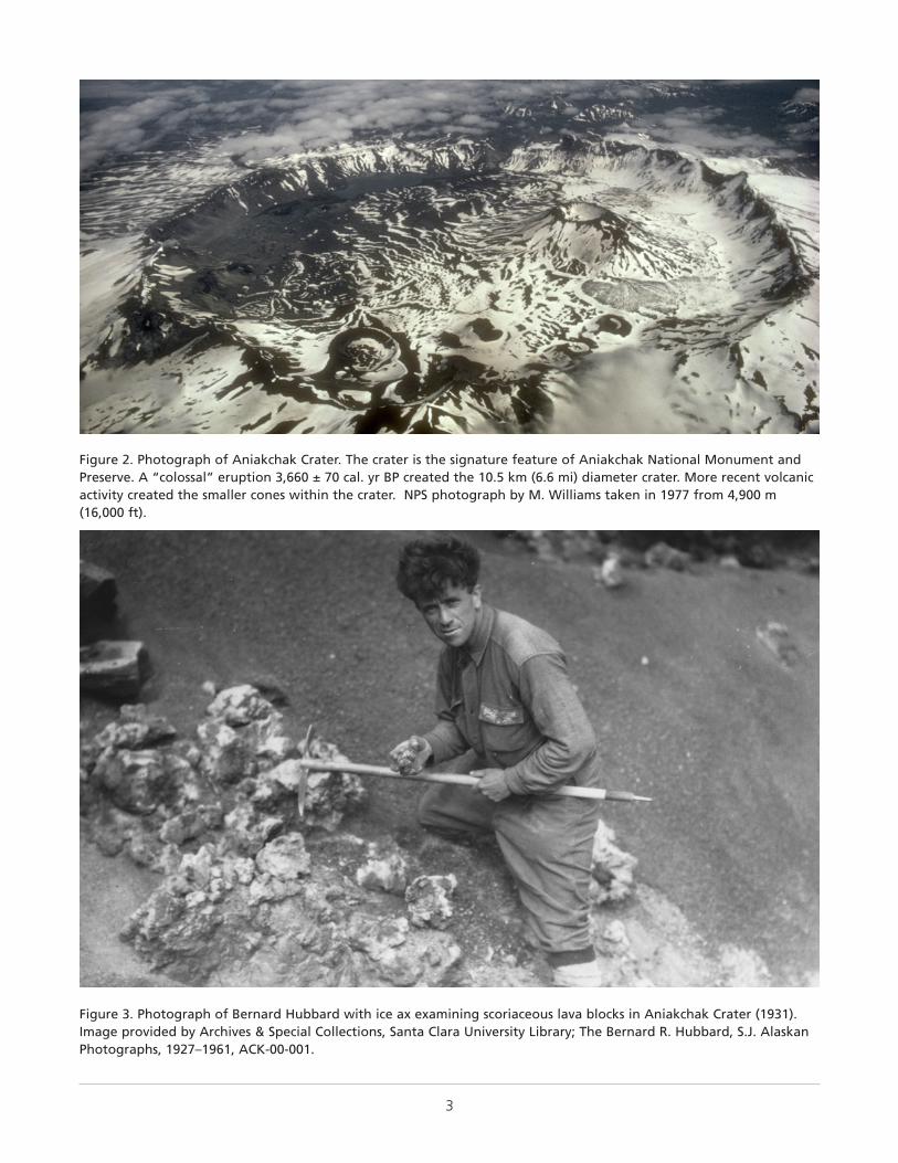
The Aniakchak Crater was recognized in 1922 when a USGS expedition led by Walter R. Smith hiked into the crater (Figure 2; Smith and Baker 1924; see Appendix A for a summary of the geologic exploration of the Aniakchak area). When the Smith (1925) report was published that described the caldera in detail, the caldera was instantly recognized as a unique natural geologic wonder. Smith (1925, p. 145) presented the following colorful description:
The once active scene of terrific earth convulsions is now almost oppressively silent. The coloration of the country is somber and together with the fretfully driven clouds tends to create a rather pleasing weirdness. Aniakchak Crater is one of the great natural curiosities of North America and is certainly worthy of further investigation.
Attention was focused on Aniakchak Crater in the 1930s because of popular lectures about the caldera by Bernard R. Hubbard, a professor of geology at Santa Clara University in California, and a Jesuit priest known as the “Glacier Priest” or “Father Hubbard.” Hubbard conducted exploration of the caldera in 1930, 1931, and 1932, spanning a major eruption in 1931 (Figure 3). He recorded pre- and post-eruption footage of the caldera, and during his 1932 expedition was the first person to land on Surprise Lake in an airplane. His lectures about
This chapter describes the regional geologic setting of Aniakchak National Monument and Preserve.
the caldera helped spur Horace M. Albright, the NPS director from 1929 to 1933, to propose that the area be preserved as a national monument (Norris 1996). The effort was stalled; however, because the acting USGS director, Julian D. Sears, stated in a letter to the NPS director that the survey “feels a keen interest in having as much of a region as possible kept open for free development” (Norris 1996, p. 429).
After many more years of effort, the National Park Service was successful at conserving the Aniakchak Crater and surrounding area when Secretary of the Interior Walter Hickel, former governor of Alaska, proclaimed it as a national natural landmark in 1970. Aniakchak National Monument was established in 1978 by President Jimmy Carter, who noted that the caldera, cinder cones, lava flows, and explosion pits are textbook examples of volcanic features. Two years later, the area was expanded to include the preserve and designate the Aniakchak River as a wild and scenic river by the passage of the Alaska National Interest Lands Conservation Act (ANILCA), which preserved the caldera and associated volcanic features in their natural state in order to interpret geological and biological processes for visitors. Appendix B includes additional information regarding the administrative history of monument and preserve.
The dominant landform of Aniakchak National Monument and Preserve is the large Aniakchak Crater. The crater was formed during an eruption 3,660 ± 70 cal. yr BP and contains younger volcanic features, the latest of which formed during an eruption in 1931. The volcanic deposits lie over older bedrock made up of Tertiary (66–3 million years ago) volcanic, intrusive, and sedimentary rocks; and late Mesozoic (161–66 million years ago) sedimentary rocks. The rocks of Aniakchak National Monument and Preserve record a complex history of volcanism and sedimentary rock deposition that spans the last 161 million years. These rocks and geomorphic features provide evidence for ancient plate tectonic motions of large portions of southern Alaska, and recent tectonically driven processes.
Aniakchak volcano is one of many Holocene (the past 11,700 years) volcanoes of the Aleutian volcanic
Geologic Setting and Significance
2
!(!(
!(
!(
!(
!(
!(
KATMAINATIONAL PARK& PRESERVE
ANIAKCHAKNATIONAL MONUMENT& PRESERVE
BrooksLake
Black Peak
Yantarni Volcano
Aniakchak Crater
Mount Veniaminof
Naknek Lake
Becharof Lake
Bristol Bay
Pacific Ocean
ALASKA PEN IN
SULA
NaknekKingSalmon
Hills
Chignik
Ugashik
SandPoint
Squaw
Port Heiden
PortMoller
156°W159°W
58°N
57°N
56°N
0 10 20 30 40Miles
0 10 20 30 40KilometersNorth
ÁFigure 1. Map showing the location of Aniakchak National Monument and Preserve on the Alaska Peninsula.
3
Figure 2. Photograph of Aniakchak Crater. The crater is the signature feature of Aniakchak National Monument and Preserve. A “colossal” eruption 3,660 ± 70 cal. yr BP created the 10.5 km (6.6 mi) diameter crater. More recent volcanic activity created the smaller cones within the crater. NPS photograph by M. Williams taken in 1977 from 4,900 m (16,000 ft).
Figure 3. Photograph of Bernard Hubbard with ice ax examining scoriaceous lava blocks in Aniakchak Crater (1931). Image provided by Archives & Special Collections, Santa Clara University Library; The Bernard R. Hubbard, S.J. Alaskan Photographs, 1927–1961, ACK-00-001.
4
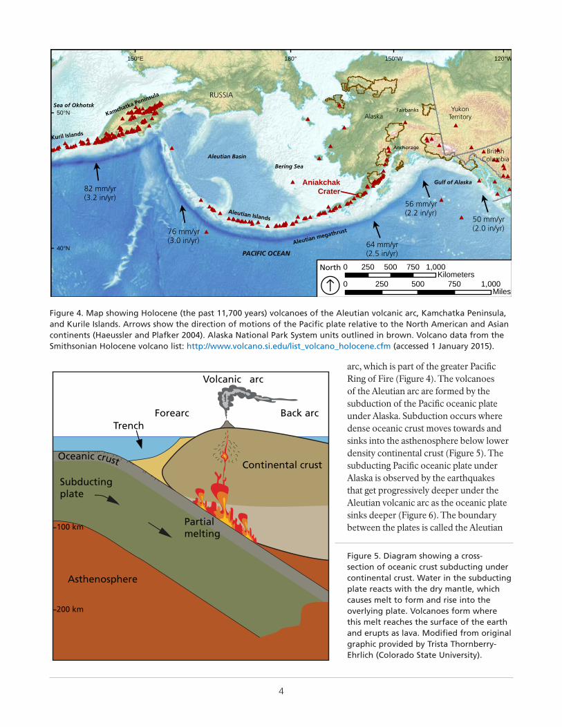
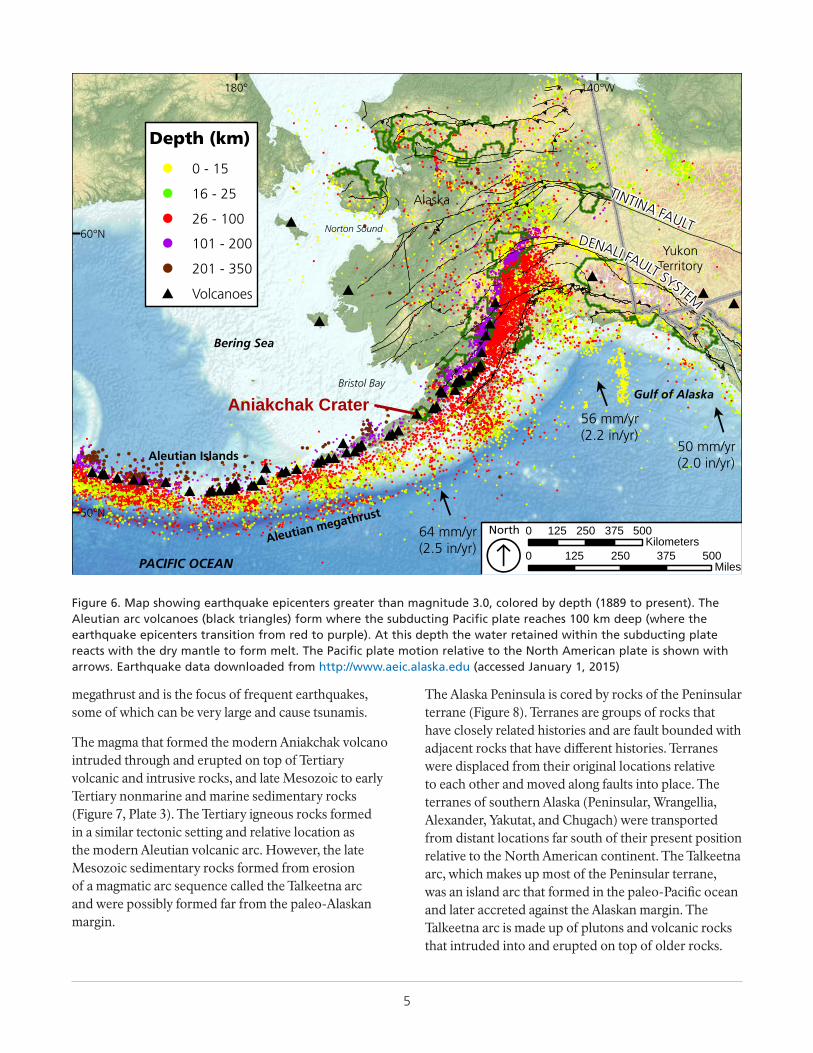
arc, which is part of the greater Pacific Ring of Fire (Figure 4). The volcanoes of the Aleutian arc are formed by the subduction of the Pacific oceanic plate under Alaska. Subduction occurs where dense oceanic crust moves towards and sinks into the asthenosphere below lower density continental crust (Figure 5). The subducting Pacific oceanic plate under Alaska is observed by the earthquakes that get progressively deeper under the Aleutian volcanic arc as the oceanic plate sinks deeper (Figure 6). The boundary between the plates is called the Aleutian
###############
############################ ########## ###
##################
#########
#
##
####
###############################################
######
############# #######
#########
############
########
###################
##
#
#
#
#
#
#
#
####
# #
##
#
## #
######
#
#
#
!(
!(
PACIFIC OCEAN
Bering Sea
Gulf of Alaska
AlaskaYukon
Territory
BritishColumbia
RUSSIA
Kuril Islands
Kamchatka Peninsula
Aleutian Basin
Aleutian Islands
Aleutian megathrust
Sea of Okhotsk
AniakchakCrater
Anchorage
Fairbanks
120°W150°W180°150°E
50°N
40°N
0 250 500 750 1,000Miles
North
ll
ll
l
50 mm/yr(2.0 in/yr)
56 mm/yr(2.2 in/yr)
64 mm/yr(2.5 in/yr)
76 mm/yr(3.0 in/yr)
82 mm/yr(3.2 in/yr)
0 250 500 750 1,000Kilometers
ÁFigure 4. Map showing Holocene (the past 11,700 years) volcanoes of the Aleutian volcanic arc, Kamchatka Peninsula, and Kurile Islands. Arrows show the direction of motions of the Pacific plate relative to the North American and Asian continents (Haeussler and Plafker 2004). Alaska National Park System units outlined in brown. Volcano data from the Smithsonian Holocene volcano list: http://www.volcano.si.edu/list_volcano_holocene.cfm (accessed 1 January 2015).
Oceanic crust Continental crust
Back arc
Volcanic arc
ForearcTrench
Subductingplate
Partial melting
Asthenosphere
100 km
200 km
Figure 5. Diagram showing a cross-section of oceanic crust subducting under continental crust. Water in the subducting plate reacts with the dry mantle, which causes melt to form and rise into the overlying plate. Volcanoes form where this melt reaches the surface of the earth and erupts as lava. Modified from original graphic provided by Trista Thornberry-Ehrlich (Colorado State University).
5
megathrust and is the focus of frequent earthquakes, some of which can be very large and cause tsunamis.
The magma that formed the modern Aniakchak volcano intruded through and erupted on top of Tertiary volcanic and intrusive rocks, and late Mesozoic to early Tertiary nonmarine and marine sedimentary rocks (Figure 7, Plate 3). The Tertiary igneous rocks formed in a similar tectonic setting and relative location as the modern Aleutian volcanic arc. However, the late Mesozoic sedimentary rocks formed from erosion of a magmatic arc sequence called the Talkeetna arc and were possibly formed far from the paleo-Alaskan margin.
The Alaska Peninsula is cored by rocks of the Peninsular terrane (Figure 8). Terranes are groups of rocks that have closely related histories and are fault bounded with adjacent rocks that have different histories. Terranes were displaced from their original locations relative to each other and moved along faults into place. The terranes of southern Alaska (Peninsular, Wrangellia, Alexander, Yakutat, and Chugach) were transported from distant locations far south of their present position relative to the North American continent. The Talkeetna arc, which makes up most of the Peninsular terrane, was an island arc that formed in the paleo-Pacific ocean and later accreted against the Alaskan margin. The Talkeetna arc is made up of plutons and volcanic rocks that intruded into and erupted on top of older rocks.
!
!
!!
!!
!
!!
!
!
!
!
!
!
!
!
!
!
!
!
!
!
!
!
!
!
!!
!
! !
!
!
!
!
!
!
!
!
!!
!
!
!
!
!
!
!
!!
!
!
!
!
!
!
! !
!
!
!
!
!
!
!!
!!
!
!
!
!!!!
!! !!
!
!
!
!
!
!
!
!
!
!
!
!
!
!
!
!!
!!
!
!
!
!
!
!
!
!
!
!!
!
!
!
!
!
!
!
!
!
!
!
!
!
!
!
!
!
!
!
!
!
!
!!
!
!
!
!
!
!
!
!
!
!!
!
!
!
!
!
!
!
!
!
!
!
!
!
!
!!
!
!
!!!!
!
!
!!
!
!
!
!
!
!
!
!
!
!
!
!
!
!!
!!
!!
!
!
!
!
!
!
! !!
!!
!
!
!!!
!
!
! !
!!
!
!
!
!
!
!
!!
!
!
!
!
!
!
!!
! !
!
!
!!
!!
!
!
!
!
!
!
!
!
!
!
!
!
!
!
!
!
!
!
!
!
!
!
!
!
!
!
!
!
!
!
!
!
!
!
!
!!
!
!
!
!
!
! !
!
!
!
!!
!
!
!
!!
!
!
!
!
!
!
!
!
!
!
!
!
!
!
!
!
!
!
!
!
!
!
!
!
!!
!
!
!
!
!
!
!
!
!
!
!
!
!
!!!
!!!
!
!!
!
! !
!
!
!
!
!
!
!!
!
!
!
!
!
!
!
!
!
!
! !
!
!
!
!
!
!
!
!
!
!
!
!
!
!
!
!
!
!
!!
!
!
!
!!
!
!
!
!
!
!
!
!
!
!
!
!
!
!
!
!
!
!
!
!
!
!
!
!
!
!
!
!!
!
!
!
!
!
!
!
!
!
!
!
!
!
!
!
! !
!!
!
!
!
!
!!
!
!
!
!!
!
!
!!
!
!
!
!
!
!
!
!
!
!
!
!
!
!
!
!
!
!
!
!
!!
!
!
!
!
!
!
!
!
!
!
!
!
!
!
!
!! !
!
!
!
!
!
!
!!
!
!
!
!!
!
!
!!
!
!
!
!
!
!
!
!
!
!
!
!
!
!
!!
!
!
!
!
!
!
!
!
!
!
!
!
!!
!
!
!
!
!
!
!
!!
!
!
!
!!
!
!
!
!
!
!
!
!
!
!
!
!
!
!!
!
!
!
!
!!
!
!
!
!
!
!
!! !
!
!
!
!
!
!
!!
!
!
!
!
!
!
!
!
!
!
!
!!
!
!
!
!
!
!!
!!
!
!
!
!
!
!
!
!
!
!
!
!
!
!
!!
!!
!
!
!
!
!
!
!
!
!
!
!
!
!!
!
!
!
!
!
!!
!
!
!
!
!
!
!
!
!
!
!!!
!
!
!
!
!
!
!
!!!
!
!
!
!
!
!
!
!
!
!
!!!!!
!
!
!
!
!
!
!
!!
!
!
!
!
!
!
!
!
!
!
!!
!
!
!
!
!
!
!
!
!!
!
!
!!!!
!
!
! !
!
!
!
!
!
!!
!
!
!!
!
!
!
!!
!
!
!!
!
!
!
!
!
!
!
!
!
!
!
!
!
!!
!
!
!
!!!
!
!
!
!
!
!
!
!
!
!
!
!
!!
!
!
!
!
!
!!!
!
!
!
!
!
!
!
!!
!!
!
!
!
!
!
!!
!
!
!
!
!
!
!
!
!
!!
!
!
!
!
!
!
!
!
!
!!
!
!
!
!
!
!
!
!
!
!
!
!
!
!
!
!
!
!
!!
!
!
!
!
!!
!
!
!
!
!
!
!
!
!
! !
!
!
!!
!
!
!
!
!
!
!
!
!!
!
!
!
!
!
!
!
!
!!
!
!
!
!
!
!
!
!
!
!
!
!
! !
!
!!!
!
!
!
!
!
!
!
!
!
!
!
!
!
!
!
!
!
!
!
!
!
!
!
!
!
!
!
!
!
!
!
!
!
!
!
!
!
!
!
!
!
!
!!
!
!
!
!!
!!
!
!!
!
!
!
!
!
!
!
!
!
!
!
!!
!
!
!
!
!
!
!
!
!
!
!
!
!
!
!
!
!
!
!
!
!
!
!
!
!
!
!
!
!
!
!
!
!
!
!
!
!
!
!
!!!
!
!!
!!
!!
!!
!
!
!!
!
!
!!
!!
!
!!!
!!
!
!
!
!!!!!
!
!
!!
!
!!!!!!!
!!
!!
!
!
!
!!
!
!!
!
!
!
!
!!!!
!
!
!
!
!
!
!
!!
!
!
!
!
!
!
!
!
!
!
!
!
!
!
!
!
!
!
!
!
!!
!
!
!
!
!
!
!
!
!
!
!
!
!
!
!
!
!!
!!
!!
!
!
!
!
!
!
!
!
!!
!
!
!
!
!
!
!
!
!
!!
!
!
!
!
!
!
!
!
!
!
!
!
!
!
!
!
!
!
!
!
!
!
!
!
!
!!
!
!
!
!
!
!
!
!
!
!
!
!
!
!
!
!
!
!
!
!
!
!
!
!
!
!
!
!
!
!
!
!
!
!
!
!
!
!
!
!
!
!
!
!
!
!
!
!
!
!
!
!
!
!
!!
!
!
!
!
!!
!
!
!
!
!
!
!
!
!
!
!!
!
!
!
!
!
!
!
!
!
!
!
!
!
!
!
!
!
!
!
!
!
!
!
!
!
!
!
!
!
!
!!
!
!
!
!
!
!
!
!
!
!
!
!
!
!
!
!
!
!
!
!
!
!
!!
!
!
!
!
!
!
!
!
!
!
!
!
!
!
!
!
!
!
!
!
!
!
!
!
!
!
!
!!
!
!
!
!
!
!
!
!
!
!
!
!!
!!
!
!
!
!
!
!
!
!
!
!
!
!
!
!
!
!
!
!
!
!!
!!
!
!
!!
!
!
!
!
!
!
!
!
!
!
!!
!
!!
!
!
!
!
!
!
!
!
!
!
!
!
!
!
!
!
!
!
!
!
!
!
!
!
!
!
!
!
!
!
!
!
!
!!
!
!
!
!
!
!
!
!
!
!
!
!
!
!!!!!
!
!
!
!
!
!
!
!
!
!
!
!
!
!
!
!
!
!!
!
!
!
!
! !!
!
!
!
!
!
!
!
!
!
!
!
!
!
!
!
!
!!
!
!
!
!
!
!
!
!
!
!
!
!
!
!
!
!
!!!
!
!
!
!
!
!
!
!
!!
!
!
!
!!
!!
!
!
!
!
!!
!
!
!
!
!
!
!
!
!
!
!
!
!
!
!
!
!
!
!
!
!
!
!
!
!
!
!
!
!
!
!
!
!
!
!
!
!
!
!
!!
!
!
!
!
!
!
!
!
!
!
!
!
!
!
!
!
!
!
!
!
!
!
!
!
!
!
!
!
!
!
!
!
!
!!
!
!
!
!
!
!
!
!
!
!!
!
!
!
!
!
!
!
!
!
!
!
!
!
!
!
!
!
!
!
!
!
!
! !!
!
!
!
!
!
!
!
!
!
!
!
!
!
!
!
!
!
!
!
!!
!
!
!
!
!
!
!
!
!!
!
!
!
!
!
!
!
!
! !
!
!
!
!
!
!
!
!
!
!
!
!
!
!
!
!
!
!
!
!
!
!
!
!
!
!
!
!
!
!!
!
!
!
!
!
!
!
!
!
!
!
!
!
!
!
!
!
!
!
!
!
!
!
!
!
!!
!
!
!
!
!
!
!
!
!
!
!
!
!
!
!!
!
!
!
!
!
!
!
!
!
!
!
!
!
!
!
!
!
!
!
!
!
!
!
!
!
!
!
!
!
!
!
!
!
! !
!
!
!
!
!!
!
!
!
!
!
!!
!
!
!
!
!
!
!
!
!
!
!
!
!
!
!
!
!
!
!
!
!
!
!
!
!
!
!
!!
!
!
!
!
!
!
!
!
!
!
!
!
!
!
!
!
!
!!
!
!
!
!!
!
!
!
!
!
!!
!
!
!
!
!
!
!
!
!
!!!
!!
!
!
!
!
!
!
!
!
!
!
!
!
!
!
!
!
!
!!!
!
!
!
!
!
!!
!
!
!
!
!!
!
!
!
!
!
!
!
!
!
!
!
!
!
!
!
!!
!
!
!
!
!
!
!
!
!
!
!!
!
!
!
!
!
!
!
!
!!!
!
!
!
!
!
!
!
!
!
!
!
!
!
!
!
!!!
!
!
!!!
!
!
!
!!!
!
!
!
!
!
!
!
!
!
!!
!!
!
!
!
!
!
!
!
!!
!
!
!
!
!!
!
!
!
!
!
!
!
!
!
!
!
!
!
!
!
!
!
!
!
!
!
!
!
!
!
!
!
!
!
!
!!
!
!
!
!
!
!
!
!
!
!
!
!
!
!
!
!
!
!
!
!
!
!
!!
! !!
!
!
!
!
!
!
!
! !
!
!
!
!
!
!
!
!
!
!
!
!
!
!!!
!
!
!
!
!
!
!
!
!
!!
!!
!
!!
!
!
!
!
!
!
!
!
!
!
!
!
!
!
!!
!
!
!
!
!
!
!
!
!
!
!
!
!
!
!
!
!
!
!
!
!
!
!
!
!
!
!
!
!
!
!!
!
!
!
!
!!
!
!
!
!
!
!
!
!
!
!
!
!
!
!
!
!
!
!
!
!
!!
!
!!
!
!
!
!
!
!
!
!
!
!
!
!
!
!!
!
!
!!
!
!
!
!
!
!
!
!
!
!
!
!
!
!
!
!
!
!!
!
!
!
!
!
!
!
!
!
!
!
!
! !!!
!
!
!
!
!
!
!
!
!
!
!
!
!
!
!
!
!
!
!
!
!
!
!
!
!
!
!
!
!
!
! !
!
!
!
!
!
!
!
!
!
!
!
!!
!
!
!
!
!
!
!
!
!
!
!
!
!!
!!!!
!
!
!
!
!
!
!
!
!
!!
! !
!
!
!
!
!!
!
!
!
!
!
!
!
!
!
!
!
!
!
!
!
!
!
!
!
!
!
!
!
!
!
!
!
!!
!
!!
!
!
!
!
!
!
!
!
!
!
!
!
!
!
!
!
!
!
!
!!
!
!!
!
!
!
!
!
!
!
!
!
!
!
!
!
!
!
!
!
!!
!
!
!!
!
!
!
!
!
!
!
!
!
!!
!
!
!
!
!
!
!
!!
!
!!
!
!
!
!
!
!
!
!
!
!
!
!
!
!
!
!
!
!
!
!
!
!
!
!
!
!
!
!
!!!
!
!
!
!
!
!
!
!
!
!
!
!
!
!
!
!
!
!
!
!
!
!
!!
!!
!
!
!
!
!
!
!
!
!
!
!
!
!
!
!
!
!
!
!
!
!
!
!
!!
!!
!
!
!
!
!
!
!
!
!
!
!
!
!
!
!
!
!
!
!
!
!
!! !
!
!
!
!
!
!
!
!
!
!
!
!
!
!
!
!
!
!
!
!
!
!
!
!
!
!
!
!
!
! !
!
!
!
!
!
!
!
!
!
!
!
!
!
!
!
!!!
!
!
!!
!
!
!
!
!
!
!
!
!
!
!
!
!
!
!
!
!
!
!
!
!
!
!
!
!
!
!
!
!
!!
!
!
!
!
!
!
!
!
!
!
!
!
!
!
!
!
!
!!
!
!
!
!
!!
!
!
!
!
!
!
!
!
!
!
!
!!
!
!
!
!
!
!
!
!
!
!
!
!
!
!!
!
!
!!
!
!
!
!
!
!
!
!
!!!
!
!!!!!
!
!
!
!!
!
!
!
!
!
!
!
!
!
!
!!
!
!
!
!
!
!
!
!
!
!
!
!
!
!!
!
!
!
!
!
!
!
!
!
!
!
!
!
!
!
!
!
!
!
!
!
!
!!
!
!
!
!
!
!
!
!
!
!
!
! !
!!
!
!!
!
!
!
!
!
!
!
!
!
!
!
!
!
!
!
!
!
!
!!
!
!
!
!
!
!
!
!!
!
!
!
!
!
!
!
!
!
!
!
!
!
!
!
!
!
!
!
!
!
!!!!
!
!
!!
!
!
!
!
!
!
!
!
!
!
!
!
!
!
!
!
!
!
!
!
!
!
!!
!
!!
!
!
!
!
!
!
!
!
!
!
!
!
!
!
!!!!
!
!
!
!
!!
!
!
!
!
!
!
!
!
!
!
!
!
!
!
!
!
!
!
!
!
!
!
!
!
!
!
!
!
!!
!
!
!
!
!
!
!
!
!
!
!
!!
!
!
!
!
!
!
!
!
!
!
!
!
!
!
!
!
!
!
!
!
!
!
!
!
!
!
!
!
!!
!
!
!
!
!
!
!!!
!
!
!
!
!
!
!
!
!
!
!
!
!
!
!
!
!
!
!
!
!
!
!
!
!
!
!
!
!
!
!
!
!
!
!
!
!
!
!
!
!
!
!
!
! !
!
!
!
!
!
!
!
!
!
!
!
!
!
!
!
!
!
!
!
!
!
!
!
!
!
!
!
!
!!
!
!
!
!
!
!
! !
!
!
!
!!
!!
!
!!
!
!
!
!
!
!
!
!!
!
!
!
!
!
!
!
!
!
!
!
!
!
!
!
!
!
!
!
!
!
!
!
!
!!
!
!
!
! !
!
!
!
!
!
!
!
!
!
!
!
!
!
!
!
!
!
!!
!
!
!
!
!
!
!
!
!
!
!
!
!
!
!
!
!
!
!
!
!
!
!
!
!
!
!
!
!
!!
!
!
!
!
!
!
!
!
!!
!
!
!
!
!
!
!!!!!!!
!
!!
!
!
!
!
!!
!
!
!!
!
!!
!
!!
!
!
!
!
!
!
!!
!
!!
!
!
!
!
!
!
!
!
!
!
!
!
!
!
!
!
!
!
!
!
!
!
!
!
!
!
!
!
!
!
!
!
!
!
!
!
!
!
!
!
!
!!
!
!
!
!
!
!
!
!
!
!!
!
!
!
!
!
!
!
!
!
!
!
!
!
!
!
!
!
!
!
!
!
!
!
!
!
!
!
!
!
!!
!
!
!
!
!
!
!
!
!
!
!
!
!!
!
!
!
!
!
!
!
!
!
!
!
!
!
!
!
!!
!
!
!
!
!!
!
!
!
!
!
!
!!
!
!
!
!
!!
!
!
!
!
!
!
!
!
!
!
!
!
!
!
!
!
!
!
!
!
!
!
!
!
!
!
!
!
!
!
!
!
!
!
!
!
!
!
!
!
!
!
!
!
!
!
!
!
!
!
!
!
!!
!
!
!
!
!!
!
!
!
!
!
!
!
!
!!
!
!
!
!
!
!
!!
!
!
!
!
!
!
!
!
!
!
!
!
!
!
!
!
!
!
!
!
!
!
!
!
!
!
!!
!
!!
!
!
!
!
!!
!
!
!!
!
!
!
!
!
!
!
!
!
!
!
!
!
!
!
!
!
!!
!
!
!
!
!
!
!
!
!
!
!
!
!
!
!
!
!!
!!
!
!
!
!
!
!
!
!
!
!!
!
!
!
!
!
!
!
!
!
!
!
!
!!
!
!
!
!
!
!
!
!
!
!!
!
!
!
!
!
!
!
!
!
!
!
!
!
!!
!
!
!!
!
!!!!!
!
!
!!!
!
!
!!
!
!
!
!
!
!
!
!
!
!
!
!
!!
!
!
!
!
!
!
!
!
!
!
!
!
!
!!!
!
!
!
!
!
!
!
!
!
!
!
!
!
!
!
! !
!
!
!
!
!!!
!
!
!
!
!
!
!
!
!
!
!
!
!
!
!
!
!!
!
!
!
!
!
!!
!
!
!
!
!
!
!
!
!
!
!
!
!
!
!
!
!
!
!
!!
!
!
!
!
!
!
!
!
!
!
!
!
!
!
!
!
!
!
!
!!
!
!
!
!
!
!
!
!
!
!
!
!
!
!
!
!
!
!
!
!
!
!
!
!
!
!
!!
!
!
!
!!
!
!
!
!
!
!
!
!
!
!
!
!
!
!
!
!
!
!
!
!
!
!
! !
!
!
!
!
!
!
!
!
!
!
!
!
!
!
!
!
!
!
!
!
!
!
!
!
!
!
!
!
!!
!
!
!
!
!
!
!
!
!
!
!
!
!
!
!
!
!
!!!!!
!
!
!
!
!
!
!
!
!!
!
!!
!
!
!
!
!
!
!
!
!
!
!
!
!
!
!
!
!
!
!
!
!
!
!
!
!
!
!
!
!
!
!
!
!
!
!
!
!
!
!
!
!
!
!
!
!
!
!!
!
!
!
!
!
!
!
!
!
!
!
!
!
!
!
!
!
!
!
!
!
!
!
!
!
!
!
!
!
!
!
!
!
!
!!
!
!
!
!
!
!
!
!
!
!
!
!
!
!
!
!
!
!
!
!
!
!
!
!!
!
!
!
!
!
!
!
!
!
!
! !
!
!
!
!
!
!
!
!
!
!
!
!
!
!
!
!!
!
!
!
!
!
!
!
!
!
!
!
!
!
!
!
!
!
!
!
!!
!
!
!
!
!
!
!
! !
!
!
!
!
!!
!
!
!
!
!
!
!
!
!
!
!
!
!
!
!
!
!
!!
!
!
!
!
!
!
!
!
!
!
!
!
!
!
!
!
!
! !
!
!
!
!
!
!
!
!
!
!
! !!
!!!
!
!!
!
!
!
!!
!!
!
!
!
!
!
!
!
!
!
!!
!
!!
!
!
!
!
!
!
!
!
!
!
!
!
!
!
!
!
!
!
!
!
!
!
!
!
!
!!
!
!
!
!
!
!
!
!
!
!
!
!
!
!
!
!
!
!
!
!
!
!
!
!
!
!
!!
!
!
!
!
!
!
!
!
!
!
!
!
!
!
!!
!
!
!
!!
!
!
!
!
!
!
!
!
!
!
!!
!
!
!
!
!
!
!
!
!
!
!
!
!
!
!
!
!
!
!
!
!
!
!
!
!
!
!
!
!
!
!
!
!
!
!
!
!
!
!
!
!
!
!
!
!
!
!
!
!
!
!
!
!
!
!!
!
!
!
!
!
!
!
!!
!!
!
!
!
!
!
!
!!
!
!
!
!
!
!
!
!
!
!
!
!
!
!
!
!
!
!
!
!
!
!
!
!
!
!
!
!
!
!
!
!
!
!
!
!
!
!
!
!
!
!
!
!
!
!
!
!
!
!
!
!
!
!
!
!
!
!
!
!
!
!
!
!
!
!
!
!
!
!!
!
!
!
!
!
!
!
!
!
!
!
!
!
!!
!
!
!
!
!
!
!
!
!
!
!
!
!
!
!
!
!
!
!
!
!
!
!
!
!
!
!!
!
!
!
!
!
!
!
!
!
!
!
!
!
!
!
!
!!
!
!
!!
!
!
!
!
!
!
!
!
!
!
!
!
!
!
!
!
!
!
!
!
!
!
!
!
!
!
!
!
!
!
!
!
!
!
!
!
!
!!
!
!
!
!
!
!!
!
!
!
!
!
!
!
!
!
!
!!
!
!
!
!
!!
!
!
!
!
!
!
!
!
!
!!
!
!
!
!
!
!
!
!
!
!
!
!
!
!
!
!
!
!
!
!
!
!
!
!
!
!
!
!
!
!
!
!
!
!
!
!
!
!
!
!
!!
!
!
!
!
!!
!
!
!
!
!
!
!
!
!
!
!
!
!
!
!
!
!
!
!
!
!
!
!
!
!
!
!
!!
!
!
!
!
!
!
!
!
!
!
!
!
!
!
!
!
!
!
!
!
!
!
!
!
!
!
!
!
!
!
!
!
!
!
!!
!
!
!
!
!
!
!
!
!
!!
!
!
!
!
!
!
!
!
!
!
!
!
!
!
!
!
!
!!
!
!
!
!
!
!
!
!
!
!
!
!
!
!
!!
!
!
!
!
!
!
!
!
!
! !
!
!
!!
!
!
!
!
!
!
!
!
!
!
!
!
!
!
!
!
!
!!
!
!
!
!
!
!
!
!
!
!
!!
!!
!
!
!
!
!
!
!
!
!!
!
!
!
!
!
!
!
!
!
!
!
!
!!
!
!
!
!
!
!
!
!
!
!
!
!
!
!
!
!
!
!
!
!
!
!
!
!
!
!
!
!
!
!!
!
!
!
!!
!
!!
!
!
!
!
!
!!
!
!
!
!
!
!
!
!
! !
!
!
!
!
!
!
!
!
!!
!
!
!
!
!
!
!
!
!
!
!
!
!
!
!
!
!
!
!
!
!
!
!
!
!
!
!
!
!
!
!
!
!
!
!
!
!
!
!
!
!!
!
!!
!
!
!
!
!
!
!
!
!
!
!
!
!
!
!
!
!
!
!
!
!
!
!
!
!
!
!
!
!
!
!!
!
!
!
!
!
!
!
!
!
!
!
!!
!
!
!
!
!
!
!
!
!
!
!
!
!!
!
!
!
!
!
!
!!
!
!
!
!
!
!
!
!
!
!
!
!
!
!
!
!
!
!
!
!
!
!
!
!
!!
!
!
!!
!
!
!
!
!
!
!
!
!
!
!
!
!
!
!!
!
!
!!
!
!
!
!
!
!
!
!
!
!
!
!
!
!
!
!
!
!
!
!
!
!
!
!
!
!
!
!
!
!
!
!
!
!
!
!!
!
!
!
!
!
!
!
!
!
!
!
!
!
!
!
!
!
!
!
!
!
!
!
!!
!
!
!
!
!
!
!
! !
!
!
!
!
!
!
!
!
!
!
!
!
!
!
!
!
!
!
!
!
!
!
!
!
!
!
!
!
!
!
!
!
!
!
!
!
!
!
!
!
!
!!
!
!
!
!
!
!
!
!!
!
!
!
!
!
!
!!!
!
!
!
!
!
!
!
!
!
!
!
!
!
!
!
!
!
!
!
!
!
!
!
!
!
!!
!
!
!
!
!
!
!
!
!
!
!
!
!
!
!
!
!
!
!
!
!
!
!
!
!
!
!
!
!
!
!
!
!
!
!
!
!!
!
!
!
!
!
!
!
!
!
!
!
!
!
!
!
!
!
!
!
!
!
!
!
!
!
!
!
!
!
!
!
!
!!
!
!!
!
!
!
!
!!
!!!
!
!
!
!
!
!
!
!
!
!
!
!
!!
!
!
!
!
!
!
!
!
!
!
!
!
!
!
!
!
!
!
!
!
!
!!
!
!
!
!
!
!
!
!
!
!
!
!
!
!
!
!
!
!
!
!
!
!!
!
!
!
!
!
!
!
!
!
!
!
!
!
!
!
!
!
!
!
!
!
!
!
!
!
!
!
!
!
!
!
!
!
!
!
!
!
!
!
!
!
!
!
!
!
!
!
!!
!
!
!
!
!!
!
!
!
!
!
!
!
!
!
!
!
!
!
!
!
!
!
!
!
!
!
!
!
!!
!
!
!
!
!
!
!
!
!
!
!
!
!
!
!
!
!
!
!
!
!
!
!
!
!
!
!
!
!
!
!
!
!
!
!
!
!
!
!!
!
!
!
!!
!
!
!
!
!
!
!!
!
!
!
!
!
!
!
!
!
!
!
!
!
!
!
!
!
!
!
!
!
!
!
!
! !
!
!
!
!
!
!
!
!
!
!
!
!!
!
!
!
!
!
!!
!
!
!
!
!
!
!
!
!
!
!
!
!
!
!
!
!
!
!
!
!
!
!
!
!!!!!!
!
!!!
!
!
!
!!!!!!
!
!
!
!
!
!!!!
!
!
!
!
!
!
!
!
!
!
!
!
!
!
!!
!
!
!!
!
!
!
!
!
!
!
!
!
!
!
!
!
!
!
!
!
!
!
!
!
!
!!
!
!
!
!
!
!
!
!
!
!
!
!
!
!
!
!
!
!
!
!
!
!
!
!
!
!
!
!
!
!
!
!
!
!
!
!
!
!
!
!
!
!
!
!
!
!
!
!
!
!
!
!!
!
!
!
!
!
!
!
!
!
!
!
!
!
!
!
!
!
!
!
!
!
!!
!
!
!
!
!
!
!
!
!
!
!
!
!
!
!
!
!
!
!
!
!
!
!
!
!
!
!
!
!
!
!
!
!
!
!
!
!
!!
!
!!
!
!
!
!
!
!
!!
!
!
!
!
!
!
!!
!
!
!
!
!
!
!
!
!!
!
!
!
!
!
!
!
!
!
! !
!
!
!
!
!
!
!
!
!
!
!
!
!
!
!
!
!
!
!!
!
!
!
!
!
!
!
!
!
!
!
!
!
!
!
!
!
!
!
!
!
!
!
!
!
!
!
!
!
!
!!
!
!
!
!
!
!
!
!
!
!
!
!
!
!
!
!
!
!
!
!!
!
!
!
!
!
!
!
!
!
!
!
!
!
!
!
!
!
!
!
!
!
!!
!
!
!
!
!
!
!
!
!
!
!
!
!!
!
!
!
!
!
!
!
!
!
!
!
!
!
!!
!
!
!!
!
!
!
!
!
!
!
!
!
!
!
!
!
!
!
!
!
!
!
!
!
!
!
!
!
!
!
!
!
!
!
!
!
!
!
!
!
!
!
!
!
!
!
!
!
!
!
!
!
!
!!!!!!!
!!!
!
!
!
!
!
!
!
!
!
!!
!
!
!
!
!
!
!
!
!
!
!
!
!
!
!
!
!
!
!
!
!
!
!
!
!
!
!
!
!
!!
!
!
!
!
!!
!
!
!
!!
!
!
!
!
!
!
!
!
!
!!
!
!
!
!!
!
!!
!
!
!
!
!
!
!
!
!
!
!
!
!
!
!
!
!
!
!
!
!
!
!
!
!
!
!
!
!
!
!
!
!
!
!
!
!
!
!
!
!
!
!
!
!!
!
!
!
!
!
!
!
!
!
!
!
!
!
!
!
!
!
!
!
! !
!
!
!
!
!
!
!
!
!
!
!!
!
!
!
!
!
!
!!
!
!
!
!
!
!
!
!
!
!
!
!
!
!
!
!
!
!
!!
!
!
!
!
!
!
!
!
!
!
!
!
!
!
!
!!
!!
!
!
!
!
!
!
!
!
!
!
!
!
!
!
!
!
!
!
!
!
!
!
!
!
!
!
!
!
!
!
!
!
!
!
!
!
!
!
!
!
!!!
!
! !
!!
!
!
!
!
!
!
!
!
!
!
!
!
!
!
!
!
!
!
!
!!
!
!
!
!
!
!
!
!
!!
!
!
!
!
!!
!
!
!
!
!
!
!
!
!
!
!
!
!
!
!
!
!
!
!
!
!
!
!
!
!
!
!
!
!
!
!
!
!
!
!
!
!
!
!
!
!
!
!
!
!
!
!
!
!
!
!
!
!
!
!
!
!
!
!
!
!
!
!
!
!
!
!
!
!
!
!
!
!
!
!
!
!
!
!
!
!
!
!
!
!
!
!
!
!
!
!
!
!
!
!
!
!
!
!
!
!
!
!
!
!
!
!
!
!
!
!
!
!
!
!
!
!
!!!
!
!
!
!
!
!
!
!
!
!
!
!
!
!
!
!
!
!
!
!
!
!
!
!
!
!
!
!
!
!
!
!!
!
!
!
!
!
!
!
!
!
!
!
!
!
!
!
!
!!
!
!!
!
!
!
!
!
!
!
!
!!
!
!
!
!
!
!
!
!
!
!
!
!
!
!
!
!
!
!
!
!
!!
!
!
!
!
!
!
!
!
!
!
!
!
!
!
!
!
!
!
!
!
!
!
!
!
!
!
! !
!
!
!
!
!
!
!
!
!
!
!
!
!
!
!
!
!
!
! !
!
!
!
!
!
!
!
!
!
!
!
!
!
!
!
!
!
!
!
!
!!
!
!
!
!
!
!
!
!
!
!
!
!
!
!
!
!
!
!
!
!
!
!
!
!
!
!
!
!
!
!
!
!
!
!
!
!
!
!
!
!
!
!
!
!
!
!
!
!
!
!
!
!
!
!!
!
!
!!
!!
!
!
!
!
!
!
!
!
!
!
!
!
!
!
!
!
!
!
!
!
!
!
!
!
!
!
!
!
!
! !
!
!
!
!
!
!
!
!!
!
!
!!
!!
!
!
!
!
!
!
!
!
!!
!
!
!
!! !
!
!
!
!
!
!!
!
!
!!!
!
!!
!
!!
!
!
!
!
! !
!
!
!
!
!
!
!
!
!
!
!
!
!
!
!
!
!
!! !!! !
!
!!!!!
!
!!
!
!
!!!
!!
!
!
!!!!
!
!
!
!
!
!
!
!
!
!
!
!
!
!
!
!
!
!
!
!
!
!
!
!
!
!!
!
!
!
!
!
!
!
!
!
!
!
!
!
!
!
!
!
!
!
!
!
!
!
!
!
!
!
!
!
!
!
!
!
!
!
!
!
!
!
!
!
!
!
!
!
!
!
!
!
!
!
!!
!
!
!
!!
!
!
!
!
!
!
!
!
!
!
!
!
!
!
!
!
!
!
!!
!
!!
!
!
!
!
!
!
!!
!
!
!
!
!
!
!
!
!
!
!
!
!
!!
!
!
!
!
!
!
!
!
!
!!
!
! !
!
!
!
!
!
!
!
!
!
!
!
!
!
!
!
!
!
!!
!
!
!!
!
!!
!
!
!!
!
!
!
!
!
!
!
!
!
!
!
!
!
!
!
!
!
!
!
!
!
!
!
!
!
!
!
!
!
!
!
!
!
!
!
!
!
!
!
!
!
!
!
!
!
!
!
!
!
!
!
!
!
!
!
!
!
!
!
!
!
!
!
!
!
!
!
!
!
!
!
!
!
!!
!
!
!
!!
!!
!
!
!
!
!
!
!
!
!
!
!
!
!
!
!
!!
!
!
!
!
!
!
!
!
!
!
!
!
!
!
!
!
!
!
!
!
!
!
!
!
!
!
!
!
!
!
!
!
!
!
!
!
!
!
!
!
!
!
!
!
!
!
!
!
!
!
!
!
!
!
!
!
!
!
!
!
!
!
!
!
!
!
!
!
!
!
!
!
!
!
!
!
!
!
!
!
!
!
!
!
!
!
!
!
!
!
!
!!
!
!
!!
!
!
!
!
!
!
!
!
!
!!
!
!
!
!
!
!
!
!
!
!
!
!
!
!!!!! !!!
!
!
!
!
!
!
!
!
!
!
!
!
!
!
!
!
!
!
!
! !
!
!
!
!
!
!
!
!
!
!
!
!
!
!
!!
!
!
!
!
!
!
!
!
!
!
!
!
!
!
!
!
!
!
!
!
!
!
!
!
!
!
!
!
!
!
!
!
!
!
!
!
!
!
!
!
!
!
!
!
!
!
!
!
!
!
!
!
!
!
!
!
!
!
!
!
!
!
!
!
!
!
!
!
!
!
!
!
!
!
!
!
!
!
!
!
!
!
!
!
!
!
!
!
!
!
!
!
!
!
!
!
!
!
!
!
!
!
!
!
!
!
!
!
!
!!
!
!
!!
!
!
!
!
!
!
!
!
!
!
!
!
!
!
!
!!!
!
!
!
!
!
!
!
!
! !
!
!
!
!
!
!
!
!
!
!
!
!
!
!
!
!
!
!
!!
!
!
!
!
!
!
!
!
!
!
!
!
!
!
!
!
!
!
!
!!
!
!
!
!
!
!
!
!
!
!
!
!
!
!
!
!
!
!!
!
!
!
!
!
!
!
!
!
!
!
!
!
!
!
!
!
!
!
!
!
!
!
!
!
!
!
!
!
!
!
!
!
!
!
!
!
!
!
!
!
!
!
!
!
!
!
!
!
!
!
!
!
!
!
!
!!
!
!
!
!
!
!
!
!
!
!
!
!
!!
!
!
!
!
!
!
!
!
!
!
!
!
!
!
!
!
!
!
!!
!
!
!
!!
!
!!
!
!
!
!
!
!
!
!
!
!
!
!
!
!
!
!
!
!!!
!
!
!!
!
!
!
!
!!
!
!
!!
!
!
!
!
!
!
!
!
!
!
!
!
!
!
!
!
!
!
!
!
!
!
!
!
!
!
!
!!
!
!
!
!
!
!
!!
!
!
!
!
!
!
!
!
!
!
!
!!
!
!!
!
!
!
!!
!
!
!
!
!
!
!
!
!
!
!
!
!
!!
!
!
!
!
!
!
!
!
!
!
!
!!!
!
!!
!
!
!
!
!
!!
!!
!
!!
!!
!
!
!
!
!
!
!
!
!
!
!
!
!
!
!
!
!
!
!
!
!!
!
!
!
!
!
!
!
!
!
!
!
!
!
!!
!
!!!
!
!
!
!
!
!
!
!
!
!
!
!
!
!
!
!
!!
!
!
!
!
!!
!
!
!
!
!
!
!
!
!
!
!
!
!
!
!
!
!
!
!
!
!
!!
! !
!
!!
!
!
!!
!
!
!
! !
!
!
!
!
!
!
!
!
!
!
!
!
!
!
!
!
!
!!
!
!
!
!
!
!
!
!
!
! !
!
!
!
!
!
!
!
!
!
!
!
!
!
!
!
!
!
!
!
!
!
!!
!
!
!
!
!
!
!
!
!
!
!
!
!
!
!
!
!
!
!
!
!
!
!
!
!
!
!
!
!
!
!
!
!
!
!
!
!
!
!!
!
!
!
!
!
!
!
!
!
!
!
!
!
!
!
!
!
!
!
!
!
!
!
!
!
!
!
!
!
!
!
!
!
!
!
!
!
!
!
!
!
!
!
!
!
!
!
!
!
!
!
!
!
!
!
!
!
!
!
!
!
!
!
!
!
!
!
!
!
!
!
!
!
!
!
!
!
!
!
!
!
!
!
!
!
!
!
!
!
!
!
!
!!
!
!
!
!
!
!
!!
!!
!
!
!!
!
!!!
!
!
!
!
!
!
!
!
!
!
!
!
!
!
!
!
!
!
!
!
!
!
!
!
!
!
!
!
!
!
!!
!
!
!
!
!
!
!
!
!
!
!
!
!
!
!
!
!
!
!
!
!
!
!
!!
!
!
!
!
!
!
!
!
!
!
!
!
!
!
!
!
!
!
!
!
!
!
!
!
!
!
!
!
!
!
!
!
!
!
!
!
!
!
!
!
!
!
!
!
!
!
!
!
!
!
!
!
!
!
!
!
!
!
!!!!
! !
!!! !
!!
!
!
!
!
!
!
!!
!
!
!
!!!
!
!
!
!
!
!
!
!
!
!
!
!
!
!
!
!!!
!!
!
!
!
!
!
!
!!
!
!
!
!
!
!
!
!
!
!
!
!!
!
!
!
!
!
!
!
!
!
!
!
!
!
!
!
!
!
!
!
!
!
!
!
!!
!
!
!
!
!
!
!
!
!!!
!
!
!
!
!
!
!
!
!!
!
!
!
!
!
!
!
!
!!
!
!
!
!
!
!
!
!
!
!
!
!
!
!!
!
!
!
!
!
!
!
!
!
!!
!
!
!
!
!
!
!!
!
!
!
!
!
!
!
!
!
!
!
!
!
!
!
!
!
!
!
!
!
!
!
!
!
!
!
!
!
!
!
!
!
!
! !
!
!
!
!
!
!
!!
!
!
!
! !
!
!
!
!
!!
!
!
!
!
!
!
!
!
!
!
!
!
!
!
!
!
!
!!
!
!!!!!!!
!
!
!
!
!
!
!
!
!
!
!
!
!
!
!
!
!
!
!
!
!
!
!
!
!
!
!
!
!
!
!
!
!
!
!
!
!
!
!
!!
!
!
!
!
!
!
!
!
!
!
!
!
!
!
!
!
!
!
!
!
!
!
!
!
!
!
!!
!
!
!
!!
!
!
!
!
!
!
!
!
!
!
!
!
!
!
!
!
!
!
!
!
!
!
!
!
!
!
!
!
!
! !
!
!
!
!
!
!
!
!
!
!
!
!
!
!
!
!
!
!
!
!
!
!
!
!
!!
!
!
!
!
!
!
!
!
!
!
!
!
!
!
!!
!
!
!
!
!
!
!
!
!
!
!
!
!
!
!
!
!
!
!
!
!
!
!
!
!
!
!
!
!!
!
!
!
!
!
!
!
!
!
!
!
!
!
!
!
!
!
!
!
!
!
!
!
!
!
!
!
!
! !!!!!!!!
!
!
!
!
!
!
!!
!
!
!
!
!
!
!
!
!
!
!
!
!
!
!
!
!
!
!
!
!
!
!
!
!
!!
!
!
!
!
!
!
!
!
!
!
!
!
!
!
!
!
!
!
!
!
!
!
!
!
!
!
!
!
!
!
!
!
!
!
!
!
!
!
!
!
!
!
!
!
!
!
!
!
!
!
!
!
!
!
!
!
!
!
!
!
!
!
!
!
!
!
!
!
!
!
!
!
!
!
!
!
!
!
!
!
!
!
!
!
!
!
!
!
!
!
!
!
!
!
!
!
!
!
!
!
!
!
!
!
!
!
!
!
!
!
!
!
!
!
!
!
!
!
!
!
!
!
!!
!
!
!
!
!!
!
!
!
!
!
!
!
!
!
!
!
!
!
!
!
!
! !
!
!
!
!
!
!!
!
!
!
!
!
!
!
!
!
!
!
!
!
!
!
!
!
!
!
!
!
!
!
!!
!
!
!
!
!
!
!
!
!
!
!
!
!
!
!
!
!
!
!
!
!
!
!
!
!
!
!
!
!
!
!!
!
!
!
!
!
!
!
!
!
!
!
!
!
!
!
!
!
!
!
!
!
!
!
!
!
!
!
!
!
!
!
!
!
!
!
!
!!
!
!
!
!
!
!
!!!
!
!!!
!!!
!
!
!
!!
!
!
!
!!
!
!
!
!
!
!
!
!
!
!
!
!
!!
!
!
!
!
!
!
!
!
!!
!
!
!
!
!
!
!
!
!
!
!
!
!
!
!
!!
!
!
!
!
!
!
!
!
!
!
!
!
!
!
!
!
!
!
!
!
!
!
!
!
!
!
!
!
!
!
!
!
!
!
!
!
!
!!
!
!
!
!
!
!
!
!
!
!
!
!
!
!!!!
!
!
!
!
!
!!!!
!
!!
!
!!!!!!!!
!
!
!
!
!
!
!
!
!
!
!
!
!
!
!
!
!
!
!
!
!
!!!
!
!
!
!!!
!
!
!
!
!
!
!
!
!
!
!
!
!
!!
!
!!
!
!
!
!
!
!
!
!
!
!
!
!
!
!
!
!
!
!
!
!
!
!
!
!
!
!
!
!!
!
!
!
!
!
!
!
!
!
!
! !
!!
!
!!
!
!
!
!
!
!
!!!!
!
!
!
!
!
!
!
!
!
!
!
!
!
!
!
!
!
!
!
!
!
!
!
!
!
!
!
!
!
!
!
!
!
!
!
!
!
!
!
!
!
!
!
!
!
!
!
!
!
!
!
!
!
!
!
!
!
!
!
!
!!
!
!
!
!
!
!! !
!
!
!
!
!
!
!
!
!
!
!
!
!
!
!
!
!
!
!
!
!
!
!
!!
!
!
!
!
!
!
!
!
!
!
!
!
!
!
!
!
!
!
!
!
!
!
!
!
!
!
!
!
!
!
!
!
!
!
!
!
!
!
!
!
!
!
!
!
!
!
!
!
!
!
!
!
!
!!!
!
!!
!
!
!
!
!
!
!
!
!
!
!
!
!
!
!
!
!
!
!
!
!
!
!
!
!
!
!
!
!
!
!
!
!
!
!!
!
!
!
!
!
!
!
!
!
!
!
!
!
!
!
!
!
!
!
!
!
!
!
!
!
!
!
!
!
!
!
!
!
!
!
!
!
!
!!!!
!
!!
!
!
!
!
!
!!!
!
!!
!
!
!
!
!
!
!
!
!
!
!
!
!
!
!
!
!
!
!
!
!
!
!
!
!
!
!
!
!
!
!
!
!
!
!
!
!
!
!
!
!
!
!
!
!
!
!
!
!
!
!
!
!
!
!
!
!
!
!
! !!
!
!
!
!
!
!
!
!
!
!
!
!
!
!!
!
!
!
!
!
!
!
!
!
!!
!
!
!
!!!
!
!!
!
!
!
!
!
!
!
!
!
!
!
!
!
!
!
!!
!
!
!
!
!
!
!
!
!
!
!
!
!!
!
!
!
!
!
!
!
!
!
!
!
!
!
!
!
!
!
!
!
!
!
!
!
!
!
!
!
!
!
!
!
!
!
!
!
!
!
!
!
!
!
!
!
!
!
!
!
!
!
!
!
!
!
!
!
!
!!!
!
!
!
!
!
!
!
!
!
!!!
!
!
!!
!
!
!
!
!
!
!
!
!
!
!
!
!
!
!
!
!
!
!
!
!
!
!
!
!
!!
!
!!
!
!
!
!
!!
!
!
!
!!
!
!
!
!
!
!
!!!!!!
!!
!
!
!
!
!
!
!
!
!
!
!
!
!
!
!
!
!
!
!
!!!
!
!!
!!!!!
!!!!!
!
!!
!
!!!!!!!!
!
!
!!!
!!
!!!!!!!!
!!!!!!!!!!!!
!
!!!!!!!
!
!!!
!
!!
!!
!
!
!
! !!!!!!!!
!
!!
!
!!
!
!
!
!
!
!!!!!
!
!
!
!
!
!!
!
!
!!
!
!
!
!
!
!
!
!
!! !!!
!
!!
!
!
!
!
!
!
!
!
!
!!!!!!
!
!
!
!
!
!
!
!
!
!
!
!
!
!
!
!
!
!
!
!
!
!
!
!
!
!
!
!
!
!
!
!!
!
!
!
!
!!
!
!
!
!
!
!
!
!
!
!
!
!!
!
!
!
!
!
!
!
!
!
!
!
!
!
!!
!
!
!
!
!
!
!
!
!
!
!
!
!
!
!
!
!
!
!
!
!!!
!
!
!
!
!
!
!
!
!
!
!
!
!
!
!
!
!
!!
!
!
!
!
!
!
!
!
!
!
!
!
!
!
!
!
!!
!
!
!!
!
!!!!
!
!
!
!
!
!
!
!
!
!
!
!
!
!
!
!
!
!
!!!!!
!
!
!!
!
!
!
!
!
!
!
!
!
!!
!
!
!
!
!
!
!
!
!
!
!
!
!
!
!
!
!
!
!!
!
!
!
!
!
!
!
!
!
!
!
!
!
!
!
!
!
!
!!
!
!
!
!
!
!
!
!
!
!
!
!!
!
!!
!
!
!
!
!
!
!!
!
!!!!
!
!
!
!
!
!
!!
!
!!
!
!
!
!
!
!
!
!
!
!
!
!
!
!
!
!
!
!!
!!
!
!
!
!
!
!
!
!
!
!
!
!
!
!
!
!
!
!
!
!
!
!!
!
!
!
!!!
!
!!
!
!
!
!
!
!
!
!
!!
!
!
!
!
!
!
!
!!
!
!
!
!
!
!
!
!
!
!
!
!
!
!
!
!
!
!
!
!
!
!
!
!
!
!!
!
!
!
!
!
!
!
!
!
!
!
!
!
!
!
!
!
!
!
!
!
!
!
!
!
!
!
!
!
!
!
!
!
!
!
!
!
!
!
!
!
!
! !
!
!
!
!
!
!
!
!
!
!
!
!
!
!
!
!
!
!
!
!
!
!
!
!
!
!
!
!
!
!
!
! !!
!
!
!
!
!
!
!
!
!!
!
!
!
!
!
!
!
!
!
!!
!
!
!
!
!
!
!!
!
!
!
!
!
!
! !
!
!
!
!
!
!
!
!
!
!
!
!
!
!
!
!!
!
!
!
!
!
!
!
!
!
!
!
!
!
!
!
!
!
!
!
!
!
!
!
!!
!
!
!!! !
!
!
!
!!!!!!!!!!!!
!!!!
!
!
!
!!! !!!
!
!
!
!
!
!!
!
!
!
!
!!!
!!!!
!
! !
!
!!
!!
!!
!
!!
!
!
!! !
!
! !
!
!!!
! !
!!
!!
!
!
!
!!
!
!
!!
!
!!!
!
!
!
!
! !!!
!!
!
!
! !!
!
!
!!!!
!
!!
!
!!!!
!
!
!
!
!
!
!!!
!!
!
!
!
!!!
!
!!!
!
!
!!!
!!
!
!
!
!
!
!
!
!!
!
!
!
!
!
!
!
!
!!
!
!
!!
!
!
!
!
! !
!
!!
!
!
!!
!!
!
!
!!
!!
!
!
!
!
!
!
! !!! !
!
!
!!
!
!
!! !
!!!
!
!
!
!
!
!
!
!
!
!
!
!
!
!!
!!
!
!
!
!!
!!!
!
!
!!
!
!
!
!
!! !
!!!
!
!
!
!
!
!
!
!
!
!
!
!!
!
!
!
!
!!
!
!
!
!
!
!
!!!
!
!
!!
!
!
!!!
!!
!
!
!
!
!
!!!
!
!
!
!
!
!
!
!
!
!! !
!
!
!
!
!
!
!
!
!
!
!
!
!
!
!!
!
!
!
!!
!
!
!
!
!
!
!
!
!
!
!
!
!
!
!
!
!
!
!
!
!
!
!!
!
!
!
!!
!
!!!
!
!
!!!
!
!
! !
!
!
!
!
!
!
!
!
!
!
!
!!
!
!
!
!
!
!!
!
!!
!!
!
!!!
!
!
!
!
!!!!
!
!
!
!
!
!
!
!
!
!
!
!
!
!
!
!!
!
!
!
!
!
!
!
!
!
!
!
!
!
!
!
!
!
!!!
!
!
!
!!
!!
!!!
!
!
!!
!!
!!!!
!
!!
!
!
!
!!!!
!
!
!
!
!
!
!
!
!
!
!
!
!!
!
!
!
!
! !
!
!
!
!
!
!
!!
!
!
!
!
!
!
!!
!
!
!
!
!
!
!
!
!
!
!
!
!
!!!!
!
!
!
!
!
!
!
!
!
!
!
!
!
!
!
!!
!
!
!!
!
!
!
!
!
!
!
!
!
!
!
!
!
!!
!
!!!
!
!
!!
!!
!!!!
!
!!
!!
!
!!!
!
!
!
!
!
!
!
!
!
!
!
!
!
!
!
!
!
!
!!
!
!
!
!
!
!
!
!
!
!
!
!
!
! !
!
!
!
!
!
!
!
!
!
!
!
!
!
!
!
!
!
!
!
!
!
!
!
!
!
!
!
!
!
!
!
!
!
!
!
!
!
!
!
!
!
!
!
!
!
!
!
!
!
!
!
!
!
!
!
!
!
!
!
!
!
!
!
!
!
!
!
!
!
!
!
!
!
!
!
!
!
!
!
!
!
!
!
!
!
!
!
!
!
!
!
!!
!
!
!
!
!
!
!
!
!
!
!
!
!
!
!
!
!
!
!
!
!
!
!
!
!
!!
!
!
!
!
!
!
!
!
!
!!
!
!!
!
!
!!
!
!
!
!
!
!
!!
!
!
!!
!
!
!
!
!!!
!
!
!
!
!
!
!
!
!
!
! !
!
!
!
!
!!
!
!
!
!
!
!
!
!
!
!!
!
!!!
!
!
!
!!
!
!
!
!
!
!
!
!
!
!
!
!!
!
!
!
!
!
!
!
!
!
!!
!
!
!
!!
!
!!
!
!!
! !!
!
!!
!
!
!
!
!
!
!
!
!
!
!
!
!
!
!
!
!!
!
!!
!
!
!
!
!
!
!
!!
!
!
!
!
!
!!
!
!
!
!
!
!
!
!
!
!
!
!
!
!
!
!
! !
!
!
!
!
!
!
!
!
!
!
!
!
!
!
!
!!
!
!
!
!
!
!
!
!
!!! !
!
!
!
!!
!
!
!
!
!
!
!!
!!!!
!
!
!
!
!
!
!
!
!
!
!
!
!
!!
!
!
!
!
!
!
!
!
!!
!
!
!
!
!
!!
!
!
!
!
!
!
!
!
!
!
!
!
!
!
!
!
!
!
!
!
!
!
!
!
!
!
!
!
!
!
!
!
!
!
!
!
!
!
!
!
!
!
!
!
!
!
!
!!
!
!!!!
!!
!
!
!
!
!
!
!
!
!
!
!
!
!!
!
!!
!
!
! !
!
!
!
!
!
!
!
!
!
!
!
!
!
!
!
!
!
!
!
!
!
!
! !
!
!!
!
!
!
!
!
!
!
!!!!!
!
!
!!
!
!
!
!
!
!
!
!
!
!
!!
!
!
!
!
!
!
!
!
!
!
!!!
!
!
!
! !!
!
!
!!!
!
!
!
!
!
!
!
!
!
!
!!
!
!
!
!
!
!
!
!
!
!
!
!
!
!
!
!
!
!
!
!
!
!
!
!
!
!
!
!
!
! !
!
!
!
!
!
!
!
!
!
!
!
!
!
!
!
!
!
!
!
!
!
!
!
!
!
!
!
!
!
!
!
!
!
!
!
!
!
!
!
!!!!
!
!!
!
!
!
!
!
!
!!!
!!!
!
!
!
!
!
!
!
!
!
!
!
!
!
!
!
!
!
!
!
!
!
!
!
!
!
!
!
!
!
!
!
!
!
!
!
!
!
!
!!
!
!
!
!
!
!
!
!
!
!
!
!!
!
!!!
!
!
!
!!
!
!
!
!
!
!
!
!
!
!
!
!
!
!
!
!
!
!
!
!
!
!
!
!!
!!
!
!
!
!
!
!
!
!
!
!
!
!
!
!
!
!
!
!
!
!
!
!
!
!
!
!
!
!
!
!
!
!
!
!
!
!
!
!
!
!
!
!
!
!
!
!
!
!
!
!
!
!
!
!
!
!
!
!!
!
!
!
!
!
!
!
!
!
!
!
!!
!
!
!
!
!
!
!
!
!
!
!!!
!
!
!
!
!
!!
!
!
!
!
!
!
!!
!
!
!
!
!
!
!
!
!
!
!
!
!
!
!
!
!
!
!
!
!
!
!
!
!
!
!
!
!
!
!
!
!
!
!
! !
!
!
!
!
!
!
!
!
!
!
!
!
!
!
!
!
!
!
!!!!
!
!
!
!
!
!!
!
!
!
!
!!
!
!
!
!
!
!!
!
!
!
!
!
!
!
!
!
!! !
!
!
!
!
!
!
!
!
!
!
!
!
!
!
!
!
!
!
!
!
!
!
!
!
!
!
!
!
!
!
!
!
!
!
!
!
!
!
!
!!
!
!!
!
!
!
!
! !
!
!
!
!
!
!
!
!!
!!
!
!
!
!
!
!
!
!
!
!
!
!
!
!
!
!
!
!
!
!
!
!
!
!
!
!
!
!
!
!
!
!
!
!
!!!
!
!
!!!
!
!!
!
!
!
!
!
!
!
!
!
!
!
!
!
!!
!
!
!
!
!
!
!
!
!
!
!
!
!
!
!
!
!
!
!
!
!
!
!
!
!
!
!
!
!
!
!
!
!
!
!
!
!
!
!
!
!
!
!
!
!
!
!
!!
!
!
! !
!
!
!
!
!!
!
!
!
!
!
!
!
!
!
!
!
!!
!
!
!
!
!
! !!
!
!
!
!
!
!
!
!
!
!!!
!!
!
!
!
!
!
!
!!
!
!
!!!!!!!
!!
! !
!!!!
!
!
!
!!
!!!!
!
!
!
!
!!!
!
!
!
!
!! !!!
!!!
!!
!
!
!
!
!
!! !
!
!
!
!
!
!
!
!
!
!
!
!
!
!!
!
!
!
!
!
!!
!
!
!
!
!!
!
!
!
!
!
!
!
!
!
!
!!!!
!
!
!
!
!
!
!
!
!
!
!
!
!!
!
!
!
!
!
!
!
!
!
!
!
!
!
!
!
!
!
!
!
!
!
!
!
!
!
!
!
!
!
!
!
!
!
!
!!
!
!
!
!
!
!
!
!
!
!
!
!
!
!
!
!
!
!
!
!
!
!
!
!
!
!
!!
!
!
!
!
!! !
!
!
!
!
!
!
!!
!
!
!
!
!
!
!
!
!
!
!
!
!
!!
!
!
!
!
!
!
!
!
!
!
!
!
!
!
!
!
!
!
!
!
!
!!
!
!
!
!
!
!!!
!
!!!
!
!!
!!
!
!!
!
!
!
!
!
!!
!
!
!
!
!
!
!
!
!
!
!
!
!
!
!
!
!
!
!
!
!!
!
!
!
!
!
!
!
!
!
!
!
!
!
!
!
!!!
!
!
!
!
!
!
!
!
!
!
!
!
!
!
!
!
!
!
!
!
!
!
!
!!
!!!
!
!
!
!
!
!
!
!
!
!
!
!
!
!
!
!
!
!
!
!
!
!
!
!
!
!
!
!!
!
!
!!
!
!
!
!
!
!
!!
!
!!
!
!
!
!
!
!
!
!
!!
!
!
!!!
!
!
!!!
!
!
!
!
!
!
!
!
!
!!
!
!
!
!
!
!
!
!
!
!
!
!
!
!
!
!
!
!
!
!
!
!
!
!
! !
!
!
!
!
!
!
!
!
!
!
!
!
!
!
!
!
!
!
!
!
!
!
!
!
!
!
!
!
!
!
!
!
!
!
!
!
!
!
!
!
!
!
!
!
!
!
!
!
!
!
!
!
!
!
!
!
!
!
!
!
!
!
!
!
!
!
!
!
!
!
!
!
!
!
!
!
!
!
!
!
!
!!
!
!!!
!
!
!!
!
!
!
!
!
!
!
!
!
!
!
!
!
!
!
!
!
!
!
!
!!
!
!
!
!
!
!
!
!
!
!
!
!
!
!
!
!
!!
!
!
!
!
!!
!
!
!
!
!
!
!
!
!
!
!
!
!
!
!
!
!
!
!
!
!!
!
!
!
!
!
!
!
!
!
!!!
!
!
!
!
!
!
!
!!
!
!!
!
!
!
!
!
!
!
!
!
!
!
!!
!
!
!
!
!
!
!
!
!
!
!
!!!
!
!
!
!
!
!
!
!
!
!
!
!
!
!
!
!
!
!
!
!
!
!
!
!
!
!
!
!
!
!
!
!
!
!
!
!
!
!
!
!
!!
!
!!
!
!
!
!
!
!
!
!
!
! !
!
!
!
!
!
!
!
!
!
!
!
!
!
!
!
!
!
! !
!
!
!
!
!
!
!
!
!
!
!
!
!
!
!
!
!
!
!
!
!
!
!
!
!
!
!
!
!
!
!
!
!
!
!
!
!
!
!
!
!
!
!
!
!
!
!!
!
!
!
!
!
!
!
!
!
!
!
!
!
!
!
!
!
!
!
!
!
!
!
!
!
!
!
!
!
!
!
!
!
!
!
!
!
!
!
!
!
!
!
!
!
!
!
!
!
!
!
!
!
!
!
!
!
!
!
!!!
!
!
!
!
!
!
!
!
!
!
!
!
!
!
!
!
!
!!
!
!
!
!
!
!
!
!
!
!
!
!
!
!
!
!
!
!
!
!
!
!
!
!
!
!
!
!
!
!
!
!
!
!
!
!
!
!
!
!
!
!
!
!
!
!
!
!!
!
!
!
!
!
!
!
!
!
!
!
!
!
!
!
!
!
!
!
!
!
!
!
!
!
! !
!
!
!
!
!
!
!
!
!
!
!
!
!
!
!
!
!
!
!
!
!!
!
!
!
!
!
!
!
!!
!
!
!
!
!
!
!
!
!
!
!
!
!
!
!
!
!
!
!
!
!
!
!
!
!
!
!
!
!
!
!
!
!
!
!
!
!
!
!
!
!!
!
!
!
!
!
!
!
!!
!
!
!
!
!!
!
!!
!
! !
!
!
!
! !
!
!
!
!
!
!
!
!
!
!
!
!
!
!
!
!
!
!
!
!
!
!
!
!
!
!
!!
!
!
!
!
!
!!
!
!!
!
!!
!
!
!
!
!
!
!
!
!
!
!
!
!
!
!
!
!
!
!
!
!
!
!
!
!
!
!
!
!
!
!
!
!
!
!
!
!
!
!
!
!
!
!
!!
!
!
!
!
!
!
!
!
!
!
!
!
!
!
!
!
!
!
!
!
!
!
!
!
!
!
!
!
!
!
!
!
!
!
!
!
!
!
!
!
!
!
!
!
!
!
!
!
!
!
!
!
!
!
!
!
!
!
!
!
!
!
!
!
!
!
!
!
!
!
!
!
!
!
!
!
!
!
!
!
!
!
!
!
!
!
!!
!!
!
!
!
!
!
!
!
!
!
!
!
!
!
!
!
!
!
!
!
!
!
!
!
!
!
!
!
!
!
!
!
!
!
!
!
!
!
!
!
!
!!
!
!
!
!
!
!
!
!
!!
!
!
!!
!
!
!
!
!
!
!
!
!
!
!
!
!
!
!
!
!
!
!
!
!
!
!!
!
!
!
!
!
!
!
!
!
!
!
!
!! !!!!!
!
!
!
!
!
!
!
!
!!
!
!!
!
!
!
!
!
!
!
!
!
!
!
!
!
!
!
!
!
!
!
!
!
!
!
!
!
!!
!
!!
!
!
!
!
!
!
!
!
!
!
!
!!!
!
!
!
!
!
!
!
!
!
!
!
!
!
!
!
!
!
!
!
!
!
!
!
!
!
!
! !
!
!
!
!
!
!
!
!
!
!
!
!!
!
!
!
!
!
!
!
!
!
!
!
!
!
!
!
!
!
!
!
!
!
!
!
!
!
!
!
!!
!
!
!
!
!
!!
!
!
!!
!
!
!
!
!
!
!
!
!
!
!
!
!
!
!
!
!
!
!
!
!
!
!
!
!
!
!
!
!
!
!
!
!
!
!
!
!
!
!
!
!
!
!
!
!
!
!
!
!
!
!
!
!
!
!!
!
!
!
!
!
!
!
!
!
!
!
!
!
!
!
!
!
!
!
!
!
!
!
!
!
!
!
!
!
!
!
!
!
!
!
!
!
!
!
!
!!
!
!
!
!
!
!
!
!
!
!
!
!
!
!!
!
!
!
!
!
!
!
!!
!
!!
!
!
!
!
!
!
!
!
!
!
!
!
!
!
!
!
!
!
!
!
!
!
!
!
!
!
!
!
!
!
!
!
!
!
!
!
!
!
!
!
!
!
!
!
!
!
!
!
!
!
!
!
!!!!
!
!
!
!
!!!
!
!
!
!
!
!
!
!
!
!
!
!
!
!
!
!
!
!
!
!
!
!
!
!
!
!
!
!
!
!
!
!
!
!
!
!
!
!!
!
!
!
!
!
!
!
!
!
!
!
!
!
!
!
!!
!
!
!
!!
!
!
!
!
!
!
!
!
!
!
!
!
!
!
!
!
!
!
!
!
!
!
!
!
!
!
!
!
!
!
!
!
!
!
!
!
!
!
!
! !
!
!
!
!
!
!
!
!
!
!
!
!
!
!
!
!
!
!
!
!
!
!
!
!
!
!
!
!
!
!
!
!
!
!
!
!
!
!
!
!
! !
!
!
!
!
!!
!
!
!
!
!
!
!
!
!
! !
!
!
!
!
!
!
!
!
!
!
!
!
!
!
!
!!!
!
!
!
!
!
!
!
!
!
!
!
!
!
!
!
!
!
!
!
!
!
!
!
!
!
!
!
!
!
!
!
!
!
!
!
!
!
!
!
!
!
!
!
!
!!
!
!
!
!
!
!
!
!
!
!
!
!
!
!
!
!
!
!
!
!
!
!
!
!
!
!
!
!
!
!
!
!
!
!
!
!
!
!
!!
!
!
!
!
!
!!
!
!
!
!
!
!
!
!!!
!!
!
!
!
!
!
!
!
!
!
!
!
!
!
!
!!
!
!
!
!
!
!
!
!
!!
!
!
!
!
!
!
!
!
!!
!
!
!
!
!
!
! !
!
!
!
!
!
!
!
!
!
!
!
!
!
!
!
!
!
!
!
!
!
!
!
!
!
!
!
!
!
!
!
!
!
!
!
!
!
!
!
!
!
!
!
!
!
!
!
!
!
!
!
!
!
!
!
!
!
!
!
!
!
!
!
!
!
!
!
!
!
!
!
!
!
!
!
!
!
!
!
!
!
!
!
!
!
!
!
!
!
!
!
!
!
!
!
!
!
!
!
!!
!
!
!
!
!
!
!
!
!
!
!
!
!
!
!
!
!
!
!
!
!
!
!
!
!
!
!
!
!!
!
!
!
!
!
!!
!
!!
!
!
!
!
!
!
!
!
!
!
!
!
!
!
!
!
!
!
!
!
!
!
!
!
!
!
!
!
!
!
!
!
!
!
!
!
!
!
!
!
!
!
!
!
!
!
!
!
!
!
!
!
!
!
!
!
!
!
!
!
!
!
!
!
!
!
!
!
!!
!
!
!
!
!
!!
!
!
!
!
!
!
!!
!
!
!
!
!
!
!
!
!
!
!
!
!
!
!
!
!
!
!
!
!
!
!
!!
!
!
!
!
!
!
!
!
!
!
!
!
!
!
!
!
!
!
!
!
!
!
!
!
!
!
!
!
!
!
!!
!!!
!
!
!
!
!
!
!
!
! !
!
!
!
!
!
!
!
!!
!
!!
!
!
!
!
!
!
!
!
!!
!
!
!
!
!
!
!
!
!
!
!
!
!
!
!
!
!
!
!
!
!
!
!
!
!
!
!
!
!
!
!
!!
!
!
!
!
!
!
!
!
!
!
!
!
!
!
!
!
!
!
!
!
!
!
!
!
!
!
!!
!
!
!
!
!
!
!
!
!
!
!
!
!
!
!
!
!
!
!
!
!
!
!
!
!
!
!
!
!
!
!
!
!
!
!
!
!
!
!
!
!
!
!
!
!
!
!!
!
!
!
!
!
!
!
!
!
!
!
!
!
!
!
!
!
!
!
!!
!
!
!
!
!
!
!
!
!
!
!!!!!!!
!
!
!
!!!!
!
!
!!
!
!
!
!
!!!!
!
!
!
!
!
!
!
!
!
!
!
!
!
!
!
!
!!!
!
!
!
!
!
!
!
!
!
!!
!
!
!
!
!
!
!
!
!
!
!
!
!
!
!!
!
!
!
!!
!
!
!
!
!
! !
!
!
!
!
!!
!
!
!
!!
!
!
!
!
!
!
!
!
!
!
!
!
!
!
!
!
!!
!
!
!
!
!
!
!
!
!
!
!
!
!
!
!
!
!
!
!
!
!
!
!
!
!
!
!
!
!
!
!
!
!
!
!
!
!
!
!
!
!
!
!
!
!
!
!
!
!
!
!!!!!!!!!!!!!!!
!
!!!
!
!!
!
!
!
!
!
!!!
!
!
!
!
!
!
!
!
!
!
!
!
!
!
!
!!! !
!!
!
!
!
!
!
!
!
!
!
!
!
!
!
!
!
!!
!!
!
!!
!
!
!
!
!
!
!
!
!
!
!
!
!
!
!
!
!!!
!
!
!
!
!
!!
!
!
!
!
!
!
!
!
!
!
!
!
!
!
!
!
!
!
!
!
!
!
!
!
!
!
!
!
!
!
!
!
!
!
!
!
!
!
!
!
!!
!
!
!
!
!
!
!
!
!
!
!
!
!
!
!
!
!
!
!
!
!
!
!
!
!
!
!
!
!!
!
!
!
!
!
!
!
!
!!
!
!
!
!
!
!
!
!
!
!
!
!
!!
!
!
!
!
!
!
!
!
! !
!
!
!
!
!
!
!
!
!
!!
!
!
!
!
!!
!
!!
!
!!
!
!
!!!!
!
!!
!
!!
!!!!!
!
!
!
!
!
!
!
!
!
!
!!!!
!
!
!
!
!!
!
! !
!
!
!
!
!
!
!
!
!
!
!
!
!
!
!
!!
!
!
!
!
!
!
!
!
!
!
!
!
!
!
!
!
!!
!
!
!
!
!
!
!
!
! !
!!
!
!!
!
!
!
!
!!
!
!
!
!
! !
!
!
!
!
!
!
!
!!
!
!
!
!
!
!
!
!
!
!
!
!
!
!
!
!
!
!
!
!!
!
!!
!!
!
!!
!
!!
!
!!
!
! !
!
!
!
!
!
!
!
!
!
!
!
!
!
!
!
!
!
!
!!
!
!
!
!
!
!
!
!
!!
!
!
!
!
!
!
!
!
!!
!
!
!
!
!
!
!
!
!
!
!
!
!
!
!
!
!
!
!
!!
!
!
!!
!
!
!
!
!!
!
!
!
!
!
!
!
!
!
!
!!
!
!
!
!
!
!
!
!
!
!
!
!
!
!
!
!
! !
!
!
!
!
!
!
!
!
!
!
!
!
!
!
!
!
!
!
!
! !
!
!
!
!
!
!
!
!
!
!
!
!
!
!!
!
!
!
!
!
!
!
!
!
!
!
!
!
!
!
!
!
!
!
!
!
!
!
! !
!!
!
!
!
!
!
!
!
!!!
!
!
!
!
!
!
!!
!
!
!
!
!
!
!
!
!
!!
!
!
!
!!!
!
!
!
!
!
!!
!
!
!
!
!
!
!
!
!
!
!
!
!
!
!
!
!
!
!
!
!
!
!
!
!
!
!
!
!
!
!
!
!
!
!
!
!
!
!
!
!
!
!
!
!
!
!
!
!
!
!
!
!
!
!
!
!
!
!
!
!
!
!
!
!
!
!
!
!
!
!
!
!
!
!!!!!
!
!
!
!
!
!
!
!
!
! !
!
!
!
!
!
!
!
!!
!
!
!
!!
!
!
!
!
!
!
!
!
!
!
!
!
!
!
!
!
!
!
!!
!
!
!
!
!
!
!
!
!
!
!
!
!
!
!
!
!
!
!
!
!
!
!
!
!
!
!
!
!
!
!
!
!
!
!!
!
!
!
!
!
!
!
!
!
!
!
!
!
!
!
!
!
!
!
!
!
!
!
!
!
!
!
!
!
!
!
!
!
!
!
!
!!
!
!
!
!
!!
!
!
!
!
!
!
!
!
!
!
!
!
!
!
!
!
!
!
!
!
!
!
!
!
!
!
!
!
!
!
!
!
!
!
!
!
!
!
!
!
!
!
!
!
!
!
!
!
!
!!
!
!
!
!
!
!
!
!
!
!
!
!
!
!
!
!
!
!
!
!
!
!
!
!
!
!
!
!
!
!
!
!
!
!
!
!
!
!
!
!
!
!
!
!
!
!
!
!
!
!
!
!
!
!
!
!
!
!
!
!
!
!
!
!
!
!
!
!
!
!
!
!
!
!
!
!
!
!
!
!
!
!
!
!
!
!!
!
!
!
!
!
!
!
!
!!
!
!
!
!
!!
!
!!
!
!
!
!
!
!
!
!
!
!
!!
!
!
!
!
!
!
!
!
!
!
!
!
!
!
!
!
!
!
!
!
!
!
!
!
!
!
!
!
!
!
!
!
!
!
!
!
!
!
!
!
!
!
!
!
!
!
!
!
!
!
!
!
!
!
!
!
!
!
!
!
!
!
!
!
!
!
!
!
!
!
!
!
!
!
!
!
!
!
!
!
!!
!
!
!
!
!
!!
!
!
!
!
!
!
!
!
!
!
!
!
!
!
!
!
!!
!
!
!!
!!
!
!
!
!
!
!
!
!
!
!
!
!
!
!
!
!
!
!
!
!
!
!
!
!
!
!
!
!!
!
!
!
!
!
!
!
!
!
!!
!
!
!
!
!
!
!
!
!!
!
!
!
!
!
!
!
!
!
!
!
!
!
!
!
!
!
!
!
!
!
!
!
!! !
!
!
!
!
!
!
!
!
!
!
!
!
!
!
!
!
!
!
!
!
!
!
!
!
!
!
!
!
!!
!
!!
!
!
!
!
!
!
!
!
!
!
!
!
!
!
!
!
!
!
!
!
!
!
!
!
!
!
!
!
!
!
!
!
!
!
!
!
!
!
!!
!
!
!
!
!
!
!!!
!
!
!
!
!
!
!
!
!
!
!
!
!
!
!
!
!
!
!
!
!
!
!
!
!
!
!
!
!
!
!
!
!
!
!
!
!
!
!
!
!
!
!
!
!
!
!! !
!
!!!! !
!
! !!
!
!
!
!
!
!
!
!
!
!
!
!
!
!
!
!
!
!
!
!
!
!
!
!
!
!
!
!
!!
!
!
!
!
!
!
!
!
!
! !
!
!
!
!
!
!
!
!
!
!
!
!
!
!
!
!
!
!
!
!
!
!
!
!
!
!
!
!
!
!
!
!
!
!!
!
!
!
!!
!
!
!
!
!
!
!
!
!
!
!
!
!
!
!
!
!
!
!
!
!
!!
!
!
!
!
!
!
!!
!
!
!
!
!
!
!
!
!
!!
!
!
!
!
!
!
!
!
!
!
!
!
!
!
!
!
!
!
!
!
!
!
!
!
!
!
!
!
!
!
!
!
!
!
!!
!
!
!
! !
!
!
!
!
!
!
! !
!
!
!
!
!
!
!
!
!
!
!
!
!
!
!
!
!
!
!
!
!!
!
!
!
!
!
!
!
!
!
!
!
!
!
!
!
!
!
!
!
!
!
!
!
!
!
!!
!
!
!
!
!
!
!
!
!
!
!
!
!
!
! !
!
!
!!!
!
!
!
!
!
!
!
!
!
!
!
!
!!!
!
!
!
!
!
!
!!
!
!
!
!
!
!
!
!
!
!
!
!
!
!
!
!
!
!
!
!
!
!
!
!
!
!
!
!
!
!
!
!
!
!
!
!
!
!
!
!
!
!
!
!
!
!
!
!
!
!
!
!
!
!
!
!
!
!
!
!
!
!
!
!
!!
!
!
!
!
!
!
!
!
!
!
!
!
!
!
!
!
!
!
!
!
! !
!
!
!
!
!
!
! !
!!
!
!
!
!
!
!
!
!
!
!
!
!
!
!
!
!
!
!
!
!
!
!
!
!
!
!
!
!
!
!
!
!
!
!
!
!!!
!!!
!
!
!
!
!
!
!
!
!
!
!
!
!
!
!
!
!
!
!
!
!
!
!
!
!
!
!
!
!
!
!
!
!
!
!
!
!
!
!
!
!
!
!
!
!
!!!
!
!
!
!
!
!
!
!
!
!
!
!!!
!
!
!
!
!
!
!
!
!
!
!
!!
!
!
!
!
!
!
!
!
!
!
!
!
!
!
!
!
!
!
!
!
!
!
!
!
!
!
!
!
!
!!
!
!
!
!
!
!
!
!
!
!
!
!
!
!
!
!
!
!
!
!
!
!
! !!
!
!
!
!
!
!
!
!
!
! !
!
!!
!
!
!
!
!
!
!
!
!
!
!
!
!
!
!
!
!
!
!
!
!
!
!
!
!
!
!
!
!
!
!
!
!
!
!
!
!
!
!
!
!
!
!
!
!
!
!
!
!
!
!
!!
!
!
!
!!
!
!
!
!
!
!
!
!
!
!
!
!
!
!
!
!
!
!
!
!
!
!
!
!
!
!!
!
!
!
!
!
!
!
!
!
!
!!
!
!
!
!
!
!
!
!
!
!
!
!
!
!
!
!
!
!
!
!
!
!
!
!
!
!
!
!
!
!
!
!
!
!
!!
!
!
!
!
!
!
!
!
!
!
!
!!
!
!
!
!
!
!
!
!
!
!
!
!
!
!
!
!
!
!
!!
!
!
!
!
!
!
!!!!!
!!!
!
!
!
!!
!
!
!!!!
!
!
!!
!!
!!
!
!
!
!!
!
!
!
!
!
!
!
!
!!!!!
!
!
!
!
!
!!
!
!
!
!
!
!!
!
!
!
!
!
!
!
!!
!
!
!
!
!
!!
!
!
!
!
!
!
!
!
!
!
!
!
!
!
!
!
!
!
!
!
!
!
!
!
!
!
!
!
!
!
!
!
!
!
!
!
!
!
!
!
!
!
!!
!
!
!
!
!
!
!
!
!!
!
!
!
!
!
!
!
!
!
!
!
!
!
!
!
!
!
!
!
!
!
!!
!
!
!
!
!
!
!
!
!
!
!
!
!
!
!!
!!
!
!
!
!
!
!
!
!
!
!
!
!
!
!
!
!
!
!!
!
!
!
!!
!
!
!
!
!
!!
!
!
!
!
!
!
!
!
!
!
!
!
!
!
!
!
!
!
!
!
!
!
!
!
!
!
!
!
!
!
!
!
!
!
!
!
!
!
!
!
!
!
!
!
!
!
!
!
!
!
!
!
!!
!
!
!
!!
!
!
!
!
!
!!!
!
!
!
!
!
!
!
!
!
!!
!
!
!!
!
!
!
!
!
!
!!!!
!
!
!
!
!
!
!
!
!
!
!
!
!
!
!
!
!
!
!
!
!!
!
!
!
!
!
!
!
!
!
!
!
!
!
!
!
!
!
!
!
!
!
!
!
!
!
!
!
!
!
!
!
!
!
!
!
!
!
!
!
!
!
!
!!
!
!
!
!
!
!
!
!
!
!
!
!
!
!
!
!
!
!
!
!
!
!
!
!
!
!
!
!
!
!
!
!
!
!
!
!
!
!
!
!
!
!
!
!!
!
!
!
!
!
!
!
!
!
!
!
!
!!
!
!
!!
!
!
!
!
!
!
!
!
!
!
!
!
!
!
!
!
!
!
!
!
!
!
!
!
!!
!
!
!
!
!
!
!
!
!
!
!
!!
!!
!
!
!
!
!!!
!
!
!
!
!
!
!!
!
!
!
!
!
!
!
!
! !!
!
!
!
!
!
!
!
!
!!
!
!!
!
!
!
!
!
!
!
!
!
!
!
!
!
!
!
!
!
!
!
!
!
!
!!!!
!
!
!!
!
!
!
!
!
!
!
!
!
!
!
!
!
!
!
!
!
!
!
!
!
!
!
!
!
!
!
!
!
!
!
!
!
!
!
!
!
!
!
!
!
!
!
!
!
!
!
!
!
!
!
!
!
!
!
!
!
!
!
!
!
!
!
!
!!
!
!
!
!
!
!
!
!
!
!
!
!
!
!
!
!
!
!
!
!
!
!
!
!
!
!!
!
!
!
!
!
!!!
!
!
!
!!
!
!
!
!
!
!
!!!!!!!
!
!
!
!
!
!
!
!
!
!
!
!
!
!
!
!
!
!
!
!
!
!
!
!!
!!
!
!
!
!
!
!
!
!
!
!
!
!
!!
!
!!
!
!
!
!
!
!
!
!
!
!
!
!
!
!
!
!!
!
!
!
!
!
!
!
!
!
!
!
!
!
!
!
!
!
!
!
!
!
!
!
!
!
!!
!
!
!
!
!
!
!
!
!
!!!
!
!
!
!
!
!
!
!
!
!
!
!
!!
! !
!
!
!
!
!
!
!!
!
!
!
!
!
!
!
!
!
!
!!
!
!
!
!
!
!
!
!
!
!
!!!
!
!
!
!
!
!
!
!
!
!
!
!
!
!
!
!
!
!
!
!
!
!
!
!
!
!
!
!
!
!
!
!
!
!
!
!
!
!
!
!
!!
!
!
!
!
!
!
!
!
!
!
!
!
!
!
!
!
!
!!
!
!
!
!
!
!
!
!
!!
!
!
!
!
!
!
!
!
!
!
!
!
!
!
!
!
!
!
!
!
!
!
!
!
!
!
!
!
!
!
!
!
!
!
!
!
!
!
!
!
!
!
!
!
!
!
!
!
!
!
!!
!
!!
!
!
!
!
!!
!
!
!
!
!
!
!
!
!!
!
!
!
!
!
!
!
!
!
!!
!
!
!
!
!
!
!
!
!
!
!!
!
!
!
!
!
!
!
!
!
!
!!
!
!
!
!
!
!
!
!
!
!
!
!
!
!
!
!
!
!
!
!
!
!
!
!
!
!
!
!
!
!
!
!
!
!
!
!
!
!
!
!
!
!
!
!
!
!
!
!
!
!
!
! ! !!!
!
!
!
!
!
!
!
!!
!
!
!!!
!
!
!
!
!
!
!
!
!
!
!
!
!
!
!
!
!
!
!
!
!
!
!!
!
!
!
!
!
!
!
!
!
!
!
!
!!
!
!
!!
!
!
!
!
!
!
!
!
!
!!
!
!
!
!
!
!
!
!
!
!
!
!!
!
!
!
!
!
!
!
!
!
!
!
!
!
!
!
!
!
!
!
!
!
!
!
!
!
!!
!
!
!
!
!
!!
!
!
!
!
!
!
!
!
!
!
!
!
!
!
!!
!
!
!
!
!
!!
!
!
!
!
!
!
!
!
!
!!
!
!!
!
!
!
!
!
!
!!
!
!
!
!
!
!
!
!
!
!
!
!
!
!
!
!
!
!
!
!
!
!
!
!
!
!
!
!
!
!
!
!
!
!
!
!
!
!
!
!
!
!
!
!
!
!
!
!
!
!
!
!
!
!
!
!!
!
!
!
!
!
!
!
!
!
!
!
!
!
!
!
!
!
!
!
!
!
!
!
!
!
!
!!
!!
!!
!
!
!
!!
!
!
!!
!
!
!
!
!
!
!
!
!
!
!
!
!
!
!
!
!
!
!
!
!
!
!
!
!
!
!
!
!!
!
!
!
!
!
!
!
!
!
!
!
!
!
!
!
!!!!!
!
!!
!
!!!
!
!!!!
!
!
!
!
!
!
!
!
!
!
!
!!
!
!
!
!
!
!
!
!
! !
!
!!
!
!
!
!
!
!
!
!
!!
!
!
!
!
!
!
!
!
!
!
!
!!
!
!
!
!!
!
!
!
!
!!
!
!
!
!
!
!
!
!
!
!!!
!
!!
!
!
!
!
!!
!
!
!
!
!
!
!!
!
!!!!!!
!
!!
!
!
!
!
!
!
!!
!
!
!
!
!
!
!
!
!
!
!
!
!
!
!
!
!
!
!
!
!
!
!
!
!
!
!
!
!
!
!
!
!
!
!
!
!
!
!
!
!
!
!
!
!
!
!
!
!
!
!
!
!
!
!
!
!
!
! !!
!
!
!
!
!
!
!
!
!
!
!
!
!
!
!
!
!
!
!
!
!
!
!
!
!
!!
!
!
!
!
!
!
!!!
!!! !!!
! !!
!
!
!
!
!
!
!!
!
!
!
!!!
!
!
!!
!
!
!
!
!
!
!
!
!
!
!!
!
!
!
!
!
!!!!!!
!!!!
!
!!!!
!!
!!!
! !!
!!!
!
!
!
!
!!
!
!
!
!
!
!
!
!!!
!
!
!!
!
!
!
!
!!
!
!!!!
!
!
!
!
!!
!!
!
!!
!!!
!
!
!
!!
!!
!
!!
!
!!
!
!
!!
!!
!!
!!
!
!
!!
!
!!
!!!
!!
!
!!!!
!
!
!
!
! !!
!
!!
!!!
!
!
!
!
!
!
!!
!!!
!
!!
!
!
!!!
!!
!
!
!
!
!
!
!
!
!!
!!!
!
!
!!!
!!
!
!!! !
!
!!!!
!
!
!
!
!
!
!!
!
!
!
!!
!!
!!
!
!
!!
!!!
!
!
!
!!
!
!!
!
!
!
!
!
!
!!
!!
!
!!
!!!
!
!!
!
!
!!
!
!
!
! !
!!
!
!!
!!
!!
!!
!
! !! !!!
!!
!!
!
!
!
!!
!
!
!
!
!
!
!
!!!
!
!!
!!
!!!
!
!
!!
!
!
!
! !
!
!
!
!!
!!
!!
!! !
!
!!
!!!
!
!!
!! !
!
!
!!
!
!!
!
!
!
!!!
!!
!
!
!
!
!
!
!!
!
!
!
!
!!
!
!!
!
!
!!!
!!
!
!
! !
!
!
!!
!
!!
!
!
!!
!
!
! !!!
!
!
!
!
!
!
!
!
!
!
!! !!
!!
!
!
!
!
!
!
!!
! !!
!
!
!!
!!
!
!
!
!!
!!!
!
!!
!
!
! !!
!
!!
!!
!! !!
!
!
!!
!!!
!
!
!
!
!! !
!
!
!
!!
!
!!!
!
!
!
!
!
!
!
!!
!
!
!
!!!!
!!
!
!
!
!!
! !!!
!
!!
!
!
!
!
!!
!!
!
!!
!!!
!
!
!
! !!
!!
!
!!
!
!
!!
!
!
!!
!
!!!!!! !! !
!
!!!!
!
!
!
!
!
!!
!
!
!
!
!!
!! !
!
!!
!
!!
!!
!
!
! !!!
!
!
!
!!
!
!
!
!
!!
!
!!
!
! !
!
!
!
!
!
!!
!
! !!
!
!!!
!!
!
!
!
!!
!
!
!!
!
! !
!
!
!
!
!
!
!!
!
!
!
!
!!
!
!
!
!
!
!
!!
!
!
!!!
!
!
!!
!
!
!
!
!
!
!
!
!
!!!!
!
!
!!
!
!
!
!
!
!
!!!
!
!
!
!
!
!
!
!
!
!!
!
!
!
!
!
!
!
!
!!!
!
!
!
!
!
! !!!!
!
!
!!
!
!
!
!!
!
!!
!
!
!
!
!
!
!
!
!!
!
!
!
!
!
!
!
!
!
!!
!
!
!!
!
!
!!
!
!
!
!
!
!
!
!
!
!
!
!
!
!
!
!
!
!
!
!
!
!
!
!
!
!
!
!
!
!
!
!
!
!
!!
!
!!
!
!
!
!
!
!
! !
!
!
!
!
!
!
!!
!
!!
!
!
!
!
!
!
!
!
!
!
!
!
!
!
!
!
!
!
!
!
!
!
!
! !
!
!!
!
!
!!
!
!
!
!
!
!
!
!
!
!
!
!
!
!
!
!
!
!
!
!
!
!
!
!
!
!
!
!
!
!
!
!
!
!
!!
!
!
!
!
! !
!!
!
!!
!
!
!
!
!
!!!
!
!
!
!
!
!
!
!
!
!
!
!
!
!
!
!
!
!
!
!
!
!
!!!!
!!
!
!
!
!
!
!!
!
!
!
!
!
!
!
!
!
!
!
!
!
!
!
!
!
!
!
!
!
!
!
!!!!
!
!!!!! !!!!!
!
!
!!!
!
!
!
!
!
!
!
!
!
!
!
!!
!!
!
!
!
!
!
!
!!!!
!
!
!!
!
!!
!
!!!
!
! !
!
!
!
!
!
!
!
!
!
!
!
!
!
!
!
!
!
!
!
!
!
!
!
!
!
!
!
!
!
!
!
!
!
!!
!
!
!
!
!!!!!
!
!
!!
!
!
!
!
!
!
!
!
!
!
!
!
!
!
!!
!
!
!
!
!
!
!!!!!
!
!
!
!
!
!
!
!
!
!!
!
!
!
!
!
!
!
!
!
!
!
!
!
!
!
!!
!
!
!
!
!!
!
!
!
!
!
!!!!
!
!
! !
!
!
!
!
!
!
!
!
!
!
!
!
!
!
!!
!
!!
!
!
!
!
!
!
!
!
!
!
!
!
!
!
!
!
!
!
!
!
!
!
!
!
!
!
!
!
!
!
!
!
!
!
!
!
!
!
!
!
!
!!
!
!
!
!
!
!
!
!
!
!
!
!
!
!
!
!
!
!
!!
!
!
!
!
!
!
!
!
!
!
!
!!
!
!
!
!
!
!
!
!
!
!
!
!
!
!
!
!
!!
!
!
!
!
!
!
!
!
!
!
!
!
!
!
!
!!
!
!
!
!
!
!
!
!
!
!
!
!
!
!
!
!
!
!
!
!
!
!!
!
!
!
!
!
!
!
!
!
!
!
!
!
!
!
!
!
!
!
!
!
!
!
!
!
!
!
!
!
!
!!
!
!
!
!
!
!
!
!
!
!!
!
!
!
!
!
!
!
!
!
!
!!
!
!
!
!
!
!
!
!
!
!!
!
!
!
!
!
!
!
!
!
!
!
!
!!!
!
!
!
!
!
!!
!
!
!
!
!
!
!
!!
!
!
!
!
!
!
!
!
!
!
!!!!
!
!
!!
!
!
!
!
!!
!
!
!
!
!
!
!
!
!
!!
!!
!
!
!
!
!
!
!
!
!!
!
!
!
!
!
!
!
!
!
!
!
!!
!
!
!!
!!!!!
!
!
!
!
!
!
!
!
!
!!
!
!
!
!
!
!
!
!
!
!
!
!
!
!
!
!
!
!
!
!
!
!
!
!
!!!!!
!
!
!
!
!
!
!
!
!
!
!
!
!
!!!
!
!
!
!
!!
!
!
!
!!!
!
!
!
!
!
!
!
!!
!
!
! !
!
!
!
!
!
!
!
!
!
!
!
!
!
!
!!
!
!
!
!
!
!
!
!
!
!
!
!
!
!
!
!
!!
!
!
!
!
!
!
!
!
!
!
!
!
!
!
!
!
!
!
!!!
!
!
!
!
!
!
!
!
!
!!
!
!
!
!!
!
!
!
!
!
!!
!
!
!
!
!
!
!
!
!
!
!
!
!
!
!
!
!
!
!
!
!
!
!
!!
!
!
!
!
!
!
!
!
!
!
!
!
!
!
!
!
!
!
!
!
!
!
!
!
!
!
!
!
!
!
!
!
!!!!!!!!!!!!!!
! !
!
!
!
!
!
!
!
!
!
!
!
!!!!
!
!
!
!
!!
!
!
!
!
!
!
!
!!
!
! !!
!
! !
!
!
!
!
! !
!
!
!
!
!!
!
!
!
!
!
!
!
!!
!
!
!
! !
!
!
!
!
!
!
!
!
!
!!
!
!
!
!
!
!
!
!
!!
!
!
!
!!
!
!
!
!
!
!!
!
!
!
!
!
!
!
!
!
!
!
!!
!
!!
!
!
!
!
!
!
!
!
!
!
!
!
!
!
!
!
!
!
!!
!
!
!!
!
!
!
!
!
!
!
!
!
!
!
!
!!
!
!
!
!
!
!!
!
!
!
!
!!
!
!
!
!
!
!
!
!
!
!
!
!
!
!
!
!
!
!
!
!
!
!
!
!
!
!
!
!
!
!
!
!
!
!
!
!
!!
!
!
!
!
!
!
!
!
!
!
!
!
!
!
!
!
!
!
!
!!
!
!
!
!
!!
!
!
!!
!
!
!
!
!
!
!
!!
!
!
!
!!
!
!
!
!
!
!
!
!!
!
!
!
!
!
!
!
!
!
!
!
!
!
!
!
!
!
!
!
!
!
!
!
!
!
!
!!
!
!
!
!
!
!
!
!
!
!
!
!
!
!
!
!
!
!
!
!
!
!
!
!
!
!
!
!
!
!!
!
!
!
!
!
!
!
!
!
!
!
!
!
!
!
!
!
!
!
!
!
!
!
! !
!
!
!
!
!
!
!
!
!
!
!
!
!
!
!
!
!
!
!
!
!
!
!
!
!
!
!
!
!
!!
!
!
!
!
!
!
!
!
!
!
!
!
!
!
!
!
!!
!
!
!
!
!
!
!
!
!
!
!
!
!
!
!
!
!!
!
!
!
!
!
!!
!
!!!
!
!
!
!
!
!
!
!
!
!
!
!
!
!!!
!
!
!
!!
!
!!!
!
!
!!
!
!
!
!
!
!!!!!
!
!
!
!!
!
!!
!
!
!
!
!
!
!!
!
!
!
!
!
!
!!
!
!
!
!
!!
!
!
!
!
!
!
!
!
!
!
!
!
!
!
!
!
!
!
!
!
!
!
!
!
!
!
!
!
!
!
!
!
!
!
!
!
!
!
!
!
!
!
!
!
!
!
!!
!
!
!
!
!!
!
!
!
!
!
!
!
!
!
!
!
!
!
!
!
!!
!
!!
!
!
!
!
!
!
!
!
!
!
!
!
!
!
!
!
!
!
!
!
!
!
!
!
!
!
!
!
!
!
!
!!!!
!
!
!
!!
!!
!
!
!
!
!
!
!!
!
!
!
!
!
!
!
!
!
!
!
!
!
!
!
!
!
!
!
!!
!
!
!!
!
!
!
!
!
!
!
!
!
!
!
!
!
!
!
!
!
!
!
!!
!
!
!
!
!
!
!
!
!
!!!
!
!
!
!
!
!!
!
!
!
!
!
!
!
!
!
!
!
!
!
!
!
!
!
!
!
!
!
!
!
!
!
!!
!
!
!
!
!!
!
!
!
!
!
!
!
!
!
!
!
!
!
!!
!
!
!
!
!
!
!
!
!
!
!
!
!
!
!
!
!
!
!
!
!
!
!
!
!
!
!
!
!
!
!
!
!
!
!
!
!
!
!
!
!
!
!
!
!
!
!!
!
!
!
!!
!
!
!
!
!
!
!
!
!
!!
!
!
!
!
!
!
!
!
!
!
!
!
!
!
!
!
!
!
!
!!!
!
!
!
!
!
!
!
!
!
!
!
!
!
!
!
!!
!
!
!!!!
!
!
!
!
!
!
!
!
!
!
!
!
!
!
!
!
!
!
!
!
!
!
!
!
!
!
!
!
!
!
!
!
!
!!
!
!
!
!
!
!
!
!
!
!
!
!!
!
!
!
!
!
!
!
!
!
!
!!
!
!
!
!
!
!
!
!
!
!
!
!
!
!
!
!
!!!
!
!
!
!!
!
!!
!
!
!
!
!
!
!
!
!
!
!
!
!
!
!
!
!
!
! !
!!
!
!
!
!
!
!
!
!
!
!
!
!
!
!
!
!
!
!
!
!
!
!
!
!
!
!
!!!
!
!
!
!
!
!
!
!
!
!
!
!
!
!
!
!
!
!
!
!
!
!
!
!
!!
!
!
!
!
!
!
!
!
!
!
!
!
!
!
!!!
!!
!
!
!
!
!
!
!
!
!!
!
!
!
!
!!!!
!
!!
!
!
!
!
!
!
!
!
!
!
!
!
!!
!
!
!
!
!
!
!
!
!
!
!
!
!
!
!
!
!
!
!
!
!
!
!
!
!
!
!
!
!
!
!
!
!!
!
!
!
!
!
!
!
!
!
!
!
!
!
!
!
!
!
!
!
!
!
!
!
!
!
!
!
!
!
!
!
!
!
!
!
!
!
!
!
!
!
!
!
!!
!
!
!
!
!
!!!
!
!
!
!
!
!
!
!
!
!
!
!
!
!
!
!!!
!
!
!
!
!
!
!
!
!!!
!
!!
!
!
!
!
!
!
!
!
!
!
!
!
!
!
!
!
!
!
!
!
!
!
!
!
!!
!
!
!
!
!
!
!
!
!
!!
!
!
!
!
!
!
!
!
!
!!
!
!
!
!
!
!! !
!
!
!
!
!
!
!
!
!
!
!
!
!
!
!
!
!
!
!
!
!
!
!
!
!!
!
!
!!
!
!
!
!
!
!
!
!
!
!
!
!
!
!
!
!
!!!
!
!!!
!
!
!
!!
!
!
!
!
!
!
!
!
!
!!
!!
!
!
!
! !!
!
!
!!
!!
!
!
!
!
!
!
!
!
!
!
!
!!
!
!
!
!
!
!
!
!
!
!
!
!
!
!
!
!
!
!
!
!
!
!
!
!!
!
!
!
!
!!
!
!
!
!
!
!
!
!!
!
!
!
!
!
!
!
!
!
!
!
!
!
!
!
!
!
!
!
!
!
!
!
!
!
!!
!
!
!
!
!
!
!
!
!
!
!
!
!
!
!
!
!
!
!
!
!!
!
!
!
!
!
!
!
!
!
!
!
!
!
!
!
!
!
!
!
!
!
!
!
!
!
!
!!
!
!
!
!
!
!
!!
!
!
!
!
!
!
!
!
!
!
!
!!
!
!
!
!
!
!
!
!
!
!
!
!
!!
!
!
!
!
!
!
!
!
!
!
!
!
!
!
!
!
!
!
!
!
! !
!
!
!
!
!
!
!
!
!
!
!
!
!
!
!
!
!
!
!
!
!
!
!
!
!
!
!
!
!
!
!
!
!
!
!
!
!
!
!
!
!!
!!
!
!
!
!
!
!
!
!
!
!
!
!
!
!
!!
!
!
!
!!
!
!
!
!
!
!
!
!
!
!
!
!
!
!
!
!
!
!
!
!
!
!
!
!
!
!
!
!!
!
!
!
!
!
!
!
!
!
!
!
!!
!
!
!
! !
!
!
!
!
!
!
!
!
!
!
!
!
!
!
!
!
!
!
! !
!
!
!!
!!!!
!
!
!
!
!!!!!
!
!
!
!
!!
!
!
!!
!
!!!
!
!
!
!
!
!
!
!
!
!
!
!
!
!
!
!
!
!
!
!
!
!
!
!
!
!
!
!
!
!
!
!
!
!
!
!
!
!
!
!
!
!
!
!
!!
!
!
!
!
!
!
!
!
!
!
!
!
!
!!
!
!
!!!
!
!
!
!
!
!
!
!
!
!
!
!
!
!
!
!
!
!
!
!
!
!
!
!
!
!
!
!
!!
!
!
!
!
!
!
!
!
!
!
!
!
!
!
!
!
!
!
!
!
!
!
!
!
!
!
!
!
!
!
!
!
!
!
!
!
!
!
!
!
!!
!
!
!
!
!
!
!
!
!
!
!
!!
!
!
!
!
!!!!
!
!
!
!
!
!
!
!
!
!
!
!
!!!
!
!!!!!!!!
!
! !!
!
!
!!
!
!
!
!
!
!
!
!
!
!
!
!
!
!
!
!
!
!
!
!
!
!
!!
!
!
!
!
!!
!
!
!
!
!
!
!
!
!
!
!
!
!
!
!
!
!
!
!
!
!
!
!
!
!
!
!
!
!
!
!
!!
!
!!
!
!
!
!
!
!
!
!
!
!
!
!
!
!
!
!
!!
!
!
!
!
!
!
!
!
!
!
!
!
!
!
!
!
!
!
!
!
!
!
!
!
!
!
!
!
!
!
!
!
!
!
!
!
!
!
!
!
!!
!
!
!
!
!
!
!
!
!
!
!
!
!
!
!
!
!
!!
!
!
!
!
!
!!
!
!
!
!
!
!
!
!
!
!!
!
!!
!
!
!
!
!
!
!
!
!!
!
!
!
!
!
!
!
!
!
!
!
!
!
!
!
!
!
!
!
!
!
!
! !!!!!!
!!!
!!
!!
! !!
!
!!
!
!
!!!!!!
!
!
!
!!
!
!
!!
!
!
!
!!
!
!!
!
! !
!
!
!
!
!
!
!
!
!
!
! !
!
!
!
!
!
!
!
!
!
!
!
!!
!
!
!
!
!!
!
!
!
!
!
!
!
!
!
!
!
!
!
!
!
!
!
!
!
!!
!
!
!
!
!
!
!
!
!
!
!
!
!
!
!
!
!
!
!
!
!
!
!
!
!
!
! !
!
!
!
!
!
!
!
!
!
!
!!!
!
!!!!!!!!!!!
!
!!!!!!!!!!!!!
!!!!!!!!
!!!
!
!
!
!
!
!
!
!
!
!
!
!!!!!!!!!!!!!!!
!!!!!!!!!!
!!!
!
! !!!
!
!
!
!
!! !!
!
!
!!
!
! !!
!
!!!!!
!
!
!
!
!
!
!
!
!
!
!!
!!
!
!
!!
!
!
!
!
!
!
!
!
!
!
!
!
!
!!
!
!
!
!
!
!
!
!
!
!
!
!
!
!
!
!
!
!
!
!
!
!
!!
!
!
!
!
!
!
!
!
!
!
!!
!
!
!
!!
!
!
!
!
!
!
!
!
!
!
!
!
!
!
!
!
!
!!
!
!
!
!
!
!
!
!
!!
!
!
!!
!!!!
!
!!!!!!!!
!!
!!
!
!
!
!!
!
!
! !
!
!
!
!
!
!
!
!
!
!
!
!
!!
!
!
!
!
!
!
!
!
!
!
!
!
!
!
!
!
!!
!
!
!
!
!
!
!
!
!
!
! !
!
!
!
!
!
!
!
!
!!
!!!
!
!
!! !
!
!!
!
!
!
!
!
!
!
!
!
!
!
!
!
!
!
!
!
!
!
!
!
!
!
!
!
!
!
!
!
!
!
!!
!!
!
!
!
!
!
!
!
!
!
!!!!
!
!!
!
!
!
!
!
!
! !
!
!
!
!
!!
!
!
!
!
!
!!
!
!
!
!
!
!
!
!!
!
!
!
!
!
!
!
!
!
!!!!!
!
!
!
!
!
!
!
!
!
!
!
!
!!
!
!
!
!
!
!
!
!
! !
!
!
!
!
!
!
!
!
!
!
!
!
!
!
!
!
!
!
!
!
!
!
!
!
!
!
!
!
!
!!!!
!
! !
!
!
!
!
!
!
!
!
!
!
!
!
!
!
!
!
!
!
!
!!
!
!!
!
!!
!
!
!
!
!!!
!
!
!
!
!
!
!
!
!
!
!!
!
!
!
!!
!
! !
!
!
!
!!
!
!
!
!
!
!
!
!
!!
!
!
!
!
!
!
!
!
!
!!
!
!
!!
!!
!
!
!
!
!
!
!
!
!!
!
!
!
!!!
!
!
!
!!
!
!
!
!
!
!
!
!
!
!
!
!
!
!
!
!
!
!
!
!
!!
!!!
!
!
!
!!!!!
!
!
!
!
!
!
!
!
!
!!
!
!
!
!
!!
!
!
!
!
!
!
!
!
!
!
!
!
!
!
!
!
!
!
!!
!
!
!
!
!
!!
!
!
!
!!
!
!
!
!
!!
!
! !
!
!
!
!
!
!
!
!
!
!
!!
!
!
!
!
!
!
!
!
!
!
!
!
!
!
!
!
!!
!
!
!
!
!!!
!
!
!
!
!
!
!
!
!
!
!!
!
!
!
!
!
!
!
!
!
!
!
!
!
!
!
!
!
!
!
!!
!
!!!
!
!
!
!
!
!
!
!
!
!
!
!
!
!
!!
!
!!
!!!!
!
!
!
!
!
!
!
!
!
!
!
!!!
!
!
!!
!
!
!
!
!
!
!
!
!
!
!
!
!
!
!
!!
!
!
!
!
!!
!
!
!
!!
!
!
!
!
++
+
+
+
+
+
+
+
+
+
+
+
+ +
++
+ + ++
+
++
+
+
+
++
+
+
,
,
+
,
+
+
++
+
+,
,
++
+
, ++
+
######## #
# ############
########
######
######
##############
##
#
#
##
#
PACIFIC OCEAN
Bering Sea
Gulf of Alaska
Alaska
YukonTerritory
Aleutian Islands
Aleutian megathrust
Bristol Bay
Norton Sound
Aniakchak Crater
DENALI FAULT SYSTEM
TINTINA FAULT
140°W180°
60°N
50°N
ll
l
50 mm/yr(2.0 in/yr)
56 mm/yr(2.2 in/yr)
64 mm/yr(2.5 in/yr) 0 125 250 375 500
Miles
North 0 125 250 375 500Kilometers
Á
Depth (km)
0 - 15
16 - 25
26 - 100
101 - 200
201 - 350
# Volcanoes
!
!
!
!
!
Figure 6. Map showing earthquake epicenters greater than magnitude 3.0, colored by depth (1889 to present). The Aleutian arc volcanoes (black triangles) form where the subducting Pacific plate reaches 100 km deep (where the earthquake epicenters transition from red to purple). At this depth the water retained within the subducting plate reacts with the dry mantle to form melt. The Pacific plate motion relative to the North American plate is shown with arrows. Earthquake data downloaded from http://www.aeic.alaska.edu (accessed January 1, 2015)
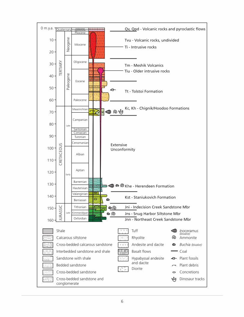
6
Jnn - Northeast Creek Sandstone Mbr
Jns - Snug Harbor Siltstone Mbr
Jni - Indecision Creek Sandstone Mbr
Kst - Staniukovich Formation
Khe - Herendeen Formation
Kc, Kh - Chignik/Hoodoo Formations
Tt - Tolstoi Formation
Tm - Meshik Volcanics
Tvu - Volcanic rocks, undivided
Qv, Qpd - Volcanic rocks and pyroclastic flows
ExtensiveUnconformity
Ti - Intrusive rocks
Tiu - Older intrusive rocks
Oxfordian
Kimmeridgian
Tithonian
Berriasian
Valanginian
Hauterivian
Barremian
Aptian
Albian
Cenomanian
TuronianConiacianSantonian
Campanian
Maastrichtian
160
150
140
130
120
110
100
90
80
70
Late
Early
Late
CRE
TAC
EOU
SJU
RASS
IC
60
50
40
30
20
10
0 m.y.a.
Paleocene
Eocene
Oligocene
Miocene
PliocenePleistoceneHoloceneQuaternary
TERT
IARY
Pale
ogen
eN
eoge
ne
Cross-bedded sandstone and conglomerate
Bedded sandstone
Sandstone with shale
Cross-bedded calcarous sandstone
Interbedded sandstone and shale
Tuff
Basalt flows
Rhyolite
Hypabyssal andesiteand dacite
Andesite and dacite
Diorite
Calcarous siltstone
Shale
Cross-bedded sandstone
Inoceramus(bivalve)
Concretions
Ammonite
Plant fossils
Buchia (bivalve)
Plant debris
Coal
Dinosaur tracks
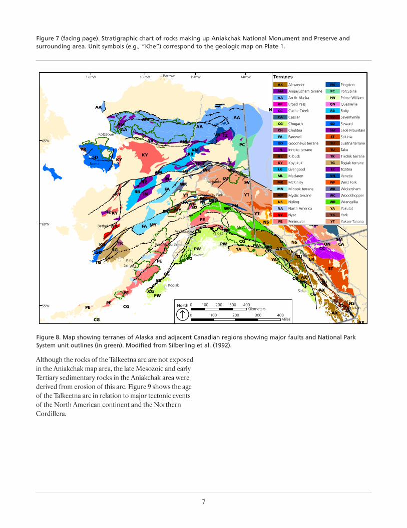
7
Figure 7 (facing page). Stratigraphic chart of rocks making up Aniakchak National Monument and Preserve and surrounding area. Unit symbols (e.g., “Khe”) correspond to the geologic map on Plate 1.
Although the rocks of the Talkeetna arc are not exposed in the Aniakchak map area, the late Mesozoic and early Tertiary sedimentary rocks in the Aniakchak area were derived from erosion of this arc. Figure 9 shows the age of the Talkeetna arc in relation to major tectonic events of the North American continent and the Northern Cordillera.
++++
+
+
+
+
+
+
+
+
+
+
+
+
++
+
+
+
+
+
++
++
+
+
+ + +
+ ++ +
+++++
++
+ ++
+
+
+ +
+
+++
++
+
+
,
,
,,
+
,,
+
+
+++
+++
+
+
++
+
,
,
,
,
+
++
+
++
+
+
+
,
,
,
,
+++
+
+
+
+
,
,
+
+,
,
,
!(
!(
!(
!(
!(
!(
!(
!(
!(
!(
!(
!(
!(
!(
!(
!(
!(
!(
!(
Nome
KingSalmon
Port Alsworth
Bethel
Kodiak
Dillingham
Gustavus
Anchorage
McKinley Park
Seward
McCarthy
Skagway
Juneau
Ketchikan
Sitka
Valdez
Fairbanks
Kotzebue
Barrow
NA
NA
AA
NA
AANAAA
AA
AMAM
VN TZ
PCAM
RBVN
AA
KY
TZSD
YK
TZ NAKY
WK WCLGAM
SVSV
IN
FARB
TZ WK
IN YTKY
CAYT
MK
QN
MLPN
SMSM
WR
YT
PNFA
YT
WFSU
MY
PESMNS
PN
FA
KYTZ
SMQN CANS
CGNY
TGPW
WRYAPW
PE
NS
AX
TUCG
YA
GDPW
CGTKKIL
CG
AX
PE
TUCG
WR
TG
CGAX
CGST
NSTU
PE
AX
CGPW
AX
PECGPE
CG
CC
MY
120°W130°W140°W150°W160°W170°W
65°N
60°N
55°N
TerranesAlexanderAX
Angayucham terraneAM
Arctic AlaskaAA
Broad PassBP
Cache CreekCC
CassiarCA
ChugachCG
ChulitnaCH
FarewellFA
Goodnews terraneGD
Innoko terraneIN
KilbuckKL
KoyukukKY
LivengoodLG
MaclarenML
McKinleyMK
Minook terraneMN
Mystic terraneMY
NislingNS
North AmericaNA
NyacNY
PeninsularPE
PingstonPN
PorcupinePC
Prince WilliamPW
QuesnelliaQN
RubyRB
SeventymileSV
SewardSD
Slide MountainSM
StikiniaST
Susitna terraneSU
TakuTU
Tikchik terraneTK
Togiak terraneTG
TozitnaTZ
VenetieVN
West ForkWF
WickershamWK
WoodchopperWC
WrangelliaWR
YakutatYA
YorkYK
Yukon-TananaYT
0 100 200 300 400Miles
0 100 200 300 400Kilometers
North
Á
Figure 8. Map showing terranes of Alaska and adjacent Canadian regions showing major faults and National Park System unit outlines (in green). Modified from Silberling et al. (1992).
8
Eon Era Period Epoch m.y.a.
Phan
ero
zoic
Pro
tero
zoic
Arc
hea
nH
adea
n
Cen
ozo
ic (
CZ)
Mes
ozo
ic (
MZ)
Pale
ozo
ic (
PZ)
Quaternary(Q)
Neogene(N)
Cretaceous (K)
Jurassic (J)
Triassic (Tr)
Permian (P)
Pennsylvanian (PN)
Mississippian (M)
Devonian (D)
Silurian (S)
Ordovician (O)
Cambrian (C)
Precambrian (PC, X, Y, Z)
Holocene (H)
Pleistocene (PE)
Pliocene (PL)
Miocene (MI)
Oligocene (OL)
Eocene (E)
Paleocene (EP)
2.6
5.3
23.0
33.9
56.0
145.0
201.3
298.9
323.2
358.9
419.2
443.4
485.4
2500
4000
4600
66.0
541.0
0.01
Paleogene(PG)Te
rtia
ry (
T)
252.2
Northern Cordillera Events Global Life Forms
Formation of the Earth
Mass extinction
Mass extinction
Ag
e o
f M
amm
als
Ag
e o
f R
epti
les
Ag
e o
fA
mp
hib
ian
sFi
shes
Mar
ine
Inve
rteb
rate
s
Modern humans
Spread of grassy ecosystems
Extinction of large mammals and birds
Early primates
Placental mammals
Early flowering plants
Dinosaurs diverse and abundant
First dinosaurs; first mammalsFlying reptiles
Sharks abundantFirst reptiles
Mass extinctionFirst amphibiansFirst forests (evergreens)
First land plantsMass extinctionPrimitive fishTrilobite maximumRise of corals
Complex multicelled organisms
Simple multicelled organisms
Early bacteria and algae (stromatolites)
Origin of life
Mass extinctionBreakup of Pangaea begins
Supercontinent Pangaea intact
Ancestral Rocky Mountains
Ice age glaciations; glacial outburst floods
Early shelled organisms
Coal-forming swamps
End of the ice ages
Alaska Range uplift
Kanektok Metamorphic Complex(oldest known rocks in Alaska )
Dextral strike-slip faulting
Early Brookian orogeny
Late Brookian orogeny
Brooks Range uplift
Proto-Aleutian volcanismSlab-window subduction (SCAK)
Extensive plutonism and volcanismin the Yukon-Tanana & Brooks Range
Mid-Cretaceous orogeny
Wales orogeny (SEAK)
Kakas orogeny (SEAK)
Sinistral strike-slip faulting
Ellsmerian orogeny
Extensive plutonism
Talkeetna arc
Figure 9. Geologic time scale showing the onset of major global evolutionary events and tectonic events of the North American continent and the Northern Cordillera. (SCAK, south-central Alaska; SEAK, southeast Alaska). The divisions of the geologic time scale are organized stratigraphically, with the oldest divisions at the bottom and the youngest at the top. GRI map abbreviations for each time division are in parentheses. Ages are millions of years ago (m.y.a.). Ages are from the International Commission on Stratigraphy (http://www.stratigraphy.org/index.php/ics-chart-timescale; accessed 7 May 2015).
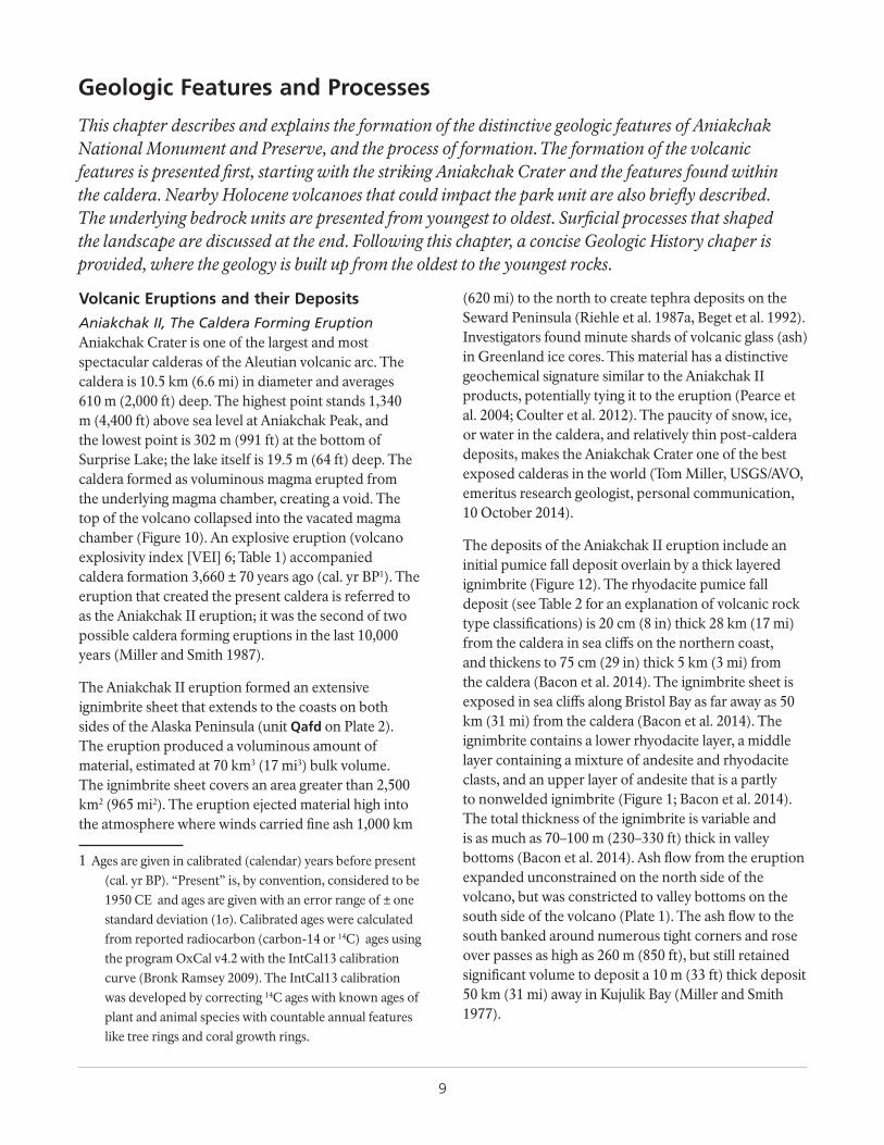
9
Geologic Features and Processes
This chapter describes and explains the formation of the distinctive geologic features of Aniakchak National Monument and Preserve, and the process of formation. The formation of the volcanic features is presented first, starting with the striking Aniakchak Crater and the features found within the caldera. Nearby Holocene volcanoes that could impact the park unit are also briefly described. The underlying bedrock units are presented from youngest to oldest. Surficial processes that shaped the landscape are discussed at the end. Following this chapter, a concise Geologic History chaper is provided, where the geology is built up from the oldest to the youngest rocks.
Volcanic Eruptions and their Deposits
Aniakchak II, The Caldera Forming EruptionAniakchak Crater is one of the largest and most spectacular calderas of the Aleutian volcanic arc. The caldera is 10.5 km (6.6 mi) in diameter and averages 610 m (2,000 ft) deep. The highest point stands 1,340 m (4,400 ft) above sea level at Aniakchak Peak, and the lowest point is 302 m (991 ft) at the bottom of Surprise Lake; the lake itself is 19.5 m (64 ft) deep. The caldera formed as voluminous magma erupted from the underlying magma chamber, creating a void. The top of the volcano collapsed into the vacated magma chamber (Figure 10). An explosive eruption (volcano explosivity index [VEI] 6; Table 1) accompanied caldera formation 3,660 ± 70 years ago (cal. yr BP1). The eruption that created the present caldera is referred to as the Aniakchak II eruption; it was the second of two possible caldera forming eruptions in the last 10,000 years (Miller and Smith 1987).
The Aniakchak II eruption formed an extensive ignimbrite sheet that extends to the coasts on both sides of the Alaska Peninsula (unit Qafd on Plate 2). The eruption produced a voluminous amount of material, estimated at 70 km3 (17 mi3) bulk volume. The ignimbrite sheet covers an area greater than 2,500 km2 (965 mi2). The eruption ejected material high into the atmosphere where winds carried fine ash 1,000 km
1 Ages are given in calibrated (calendar) years before present (cal. yr BP). “Present” is, by convention, considered to be 1950 CE and ages are given with an error range of ± one standard deviation (1σ). Calibrated ages were calculated from reported radiocarbon (carbon-14 or 14C) ages using the program OxCal v4.2 with the IntCal13 calibration curve (Bronk Ramsey 2009). The IntCal13 calibration was developed by correcting 14C ages with known ages of plant and animal species with countable annual features like tree rings and coral growth rings.
(620 mi) to the north to create tephra deposits on the Seward Peninsula (Riehle et al. 1987a, Beget et al. 1992). Investigators found minute shards of volcanic glass (ash) in Greenland ice cores. This material has a distinctive geochemical signature similar to the Aniakchak II products, potentially tying it to the eruption (Pearce et al. 2004; Coulter et al. 2012). The paucity of snow, ice, or water in the caldera, and relatively thin post-caldera deposits, makes the Aniakchak Crater one of the best exposed calderas in the world (Tom Miller, USGS/AVO, emeritus research geologist, personal communication, 10 October 2014).
The deposits of the Aniakchak II eruption include an initial pumice fall deposit overlain by a thick layered ignimbrite (Figure 12). The rhyodacite pumice fall deposit (see Table 2 for an explanation of volcanic rock type classifications) is 20 cm (8 in) thick 28 km (17 mi) from the caldera in sea cliffs on the northern coast, and thickens to 75 cm (29 in) thick 5 km (3 mi) from the caldera (Bacon et al. 2014). The ignimbrite sheet is exposed in sea cliffs along Bristol Bay as far away as 50 km (31 mi) from the caldera (Bacon et al. 2014). The ignimbrite contains a lower rhyodacite layer, a middle layer containing a mixture of andesite and rhyodacite clasts, and an upper layer of andesite that is a partly to nonwelded ignimbrite (Figure 1; Bacon et al. 2014). The total thickness of the ignimbrite is variable and is as much as 70–100 m (230–330 ft) thick in valley bottoms (Bacon et al. 2014). Ash flow from the eruption expanded unconstrained on the north side of the volcano, but was constricted to valley bottoms on the south side of the volcano (Plate 1). The ash flow to the south banked around numerous tight corners and rose over passes as high as 260 m (850 ft), but still retained significant volume to deposit a 10 m (33 ft) thick deposit 50 km (31 mi) away in Kujulik Bay (Miller and Smith 1977).
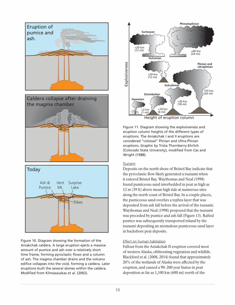
10
Tsunami
Effect on human habitation
Deposits on the north shore of Bristol Bay indicate that the pyroclastic flow likely generated a tsunami when it entered Bristol Bay. Waythomas and Neal (1998) found pumiceous sand interbedded in peat as high as 12 m (39 ft) above mean high tide at numerous sites along the north coast of Bristol Bay. In a couple places, the pumiceous sand overlies a tephra layer that was deposited from ash fall before the arrival of the tsunami. Waythomas and Neal (1998) proposed that the tsunami was preceded by pumice and ash fall (Figure 13). Rafted pumice was subsequently transported inland by the tsunami depositing an anomalous pumiceous sand layer in backshore peat deposits.
Fallout from the Aniakchak II eruption covered most of western Alaska, obliterating vegetation and wildlife. Blackford et al. (2008, 2014) found that approximately 20% of the wetlands of Alaska were affected by the eruption, and caused a 90–200 year hiatus in peat deposition as far as 1,100 km (680 mi) north of the
Eruption ofpumice andash.
Caldera collapse after drainingthe magma chamber.
Today
VentMt.
SurpriseLake
Ash &Pumice
Dikes
Figure 10. Diagram showing the formation of the Aniakchak caldera. A large eruption ejects a massive amount of pumice and ash over a relatively short time frame, forming pyroclastic flows and a column of ash. The magma chamber drains and the volcano edifice collapses into the void, forming a caldera. Later eruptions built the several domes within the caldera. Modified from Klimasauskas et al. (2002).
Height of eruption column
Exp
losi
ven
ess
Hawaiian
<2 km(1 mi)
Strombolian
<10 km(6 mi)
Sub-plinian
<30 km(18 mi)
Vulcanian
<20 km(12 mi)
Plinian andultraplinian
<55 km(34 mi)
Surtseyan
<20 km(12 mi)
Phreatoplinian
<40 km(24 mi)
Figure 11. Diagram showing the explosiveness and eruption column heights of the different types of eruptions. The Aniakchak I and II eruptions are considered “colossal” Plinian and Ultra-Plinian eruptions. Graphic by Trista Thornberry-Ehrlich (Colorado State University), modified from Cas and Wright (1988).
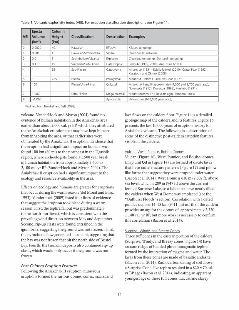
11
volcano. VanderHoek and Myron (2004) found no evidence of human habitation in the Aniakchak area earlier than about 2,000 cal. yr BP, which they attributed to the Aniakchak eruption that may have kept humans from inhabiting the area, or that earlier sites were obliterated by the Aniakchak II eruption. Evidence that the eruption had a significant impact on humans was found 100 km (60 mi) to the northeast in the Ugashik region, where archeologists found a 1,500 year break in human habitation from approximately 3,600 to 2,100 cal. yr BP (VanderHoek and Myron 2004). The Aniakchak II eruption had a significant impact to the ecology and resource availability in the area.
Effects on ecology and humans are greater for eruptions that occur during the warm season (del Moral and Bliss, 1993). Vanderhoek (2009) listed four lines of evidence that suggest the eruption took place during a warm season. First, the tephra fallout was predominately to the north-northwest, which is consistent with the prevailing wind direction between May and September. Second, rip-up clasts were found entrained in the ignimbrite, suggesting the ground was not frozen. Third, the pyroclastic flow generated a tsunami, suggesting that the bay was not frozen that hit the north side of Bristol Bay. Fourth, the tsunami deposits also contained rip-up clasts, which would only occur if the ground was not frozen.
Post-Caldera Eruption FeaturesFollowing the Aniakchak II eruption, numerous eruptions formed the various domes, cones, maars, and
lava flows on the caldera floor. Figure 14 is a detailed geologic map of the caldera and its features. Figure 15 presents the last 10,000 years of eruption history for Aniakchak volcano. The following is a description of some of the distinctive post-caldera eruption features visible in the caldera.
Vulcan, West, Pumice, Bolshoi DomesVulcan (Figure 16), West, Pumice, and Bolshoi domes, (map unit Qd in Figure 14) are formed of dacite lavas that have radial fracture patterns (Figure 17) and pillow like forms that suggest they were erupted under water (Bacon et al. 2014). West Dome is 610 m (2,002 ft) above sea level, which is 289 m (947 ft) above the current level of Surprise Lake, so a lake must have nearly filled the caldera when West Dome was emplaced (see the “Outburst Floods” section). Correlation with a dated pumice deposit 14–18 km (9–11 mi) north of the caldera provides an age for the domes of approximately 2,320 ± 140 cal. yr BP, but more work is necessary to confirm this correlation (Bacon et al. 2014).
Surprise, Windy, and Breezy ConesThree tuff cones in the eastern portion of the caldera (Surprise, Windy, and Breezy cones; Figure 14) have arcuate ridges of bedded phreatomagmatic tephra formed by the interaction of magma and water. The lavas from these cones are made of basaltic andesite (Bacon et al. 2014). Radiocarbon dating of soil above a Surprise Cone–like tephra resulted in a 820 ± 70 cal. yr BP age (Bacon et al. 2014), indicating an apparent youngest age of these tuff cones. Lacustrine clayey
Table 1. Volcanic explosivity index (VEI). For eruption classification descriptions see Figure 11.
VEIEjecta Volume (km3)
Column Height (km)
Classification Description Examples
0 0.00001 <0.1 Hawaiian Effusive Kilauea (ongoing)
1 0.001 1 Hawaiian/Strombolian Severe Stromboli (numerous)
2 0.01 5 Strombolian/Vulcanian Explosive Cleveland (ongoing), Shishaldin (ongoing)
3 0.1 15 Vulcanian/Sub-Plinian Catastrophic Redoubt (1989, 2009), Augustine (2003)
4 1 25 Sub-Plinian Cataclysmic Aniakchak (1931), Eyjafjallajökull (2010), Crater Peak (1992), Kasatochi and Okmok (2008)
5 10 >25 Plinian Paroxysmal Mount St. Helens (1980), Vesuvius (1979)
6 100 Plinian/Ultra-Plinian Colossal Aniakchak I and II (approximately 9,000 and 3,700 years ago), Novarupta (1912), Krakatoa (1883), Pinatubo (1991)
7 1,000 Ultra-Plinian Mega-colossal Mount Mazama (7,550 years ago), Tambora (1815)
8 >1,000 Apocalyptic Yellowstone (640,000 years ago),
Modified from Newhall and Self (1982)
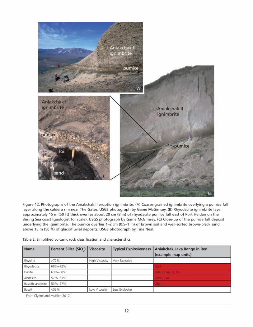
12
Figure 12. Photographs of the Aniakchak II eruption ignimbrite. (A) Coarse-grained ignimbrite overlying a pumice fall layer along the caldera rim near The Gates. USGS photograph by Game McGimsey. (B) Rhyodacite ignimbrite layer approximately 15 m (50 ft) thick overlies about 20 cm (8 in) of rhyodacite pumice fall east of Port Heiden on the Bering Sea coast (geologist for scale). USGS photograph by Game McGimsey. (C) Close-up of the pumice fall deposit underlying the ignimbrite. The pumice overlies 1–2 cm (0.5–1 in) of brown soil and well-sorted brown-black sand above 15 m (50 ft) of glaciofluvial deposits. USGS photograph by Tina Neal.
Table 2. Simplified volcanic rock classification and characteristics.
Name Percent Silica (SiO2) Viscosity Typical Explosiveness Aniakchak Lava Range in Red (example map units)
Rhyolite >72% High Viscosity Very Explosive
Rhyodacite 68%–72% Qpd
Dacite 63%–68% Qda, Qdap, Ti, Tvu
Andesite 57%–63% Qanp, Tvu
Basaltic andesite 53%–57% Qba
Basalt <53% Low Viscosity Less Explosive
From Clynne and Muffler (2010).
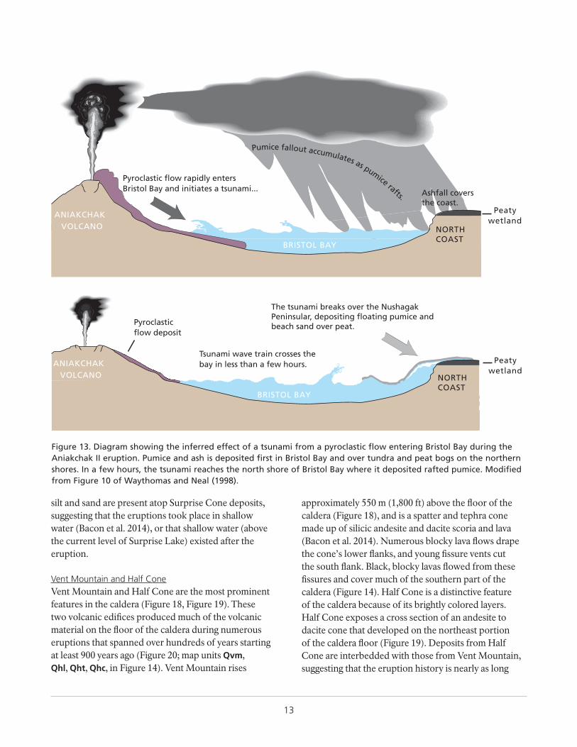
13
silt and sand are present atop Surprise Cone deposits, suggesting that the eruptions took place in shallow water (Bacon et al. 2014), or that shallow water (above the current level of Surprise Lake) existed after the eruption.
Vent Mountain and Half ConeVent Mountain and Half Cone are the most prominent features in the caldera (Figure 18, Figure 19). These two volcanic edifices produced much of the volcanic material on the floor of the caldera during numerous eruptions that spanned over hundreds of years starting at least 900 years ago (Figure 20; map units Qvm, Qhl, Qht, Qhc, in Figure 14). Vent Mountain rises
approximately 550 m (1,800 ft) above the floor of the caldera (Figure 18), and is a spatter and tephra cone made up of silicic andesite and dacite scoria and lava (Bacon et al. 2014). Numerous blocky lava flows drape the cone’s lower flanks, and young fissure vents cut the south flank. Black, blocky lavas flowed from these fissures and cover much of the southern part of the caldera (Figure 14). Half Cone is a distinctive feature of the caldera because of its brightly colored layers. Half Cone exposes a cross section of an andesite to dacite cone that developed on the northeast portion of the caldera floor (Figure 19). Deposits from Half Cone are interbedded with those from Vent Mountain, suggesting that the eruption history is nearly as long
BRISTOL BAY
ANIAKCHAKVOLCANO
BRISTOL BAY
ANIAKCHAKVOLCANO
Pyroclastic flow rapidly enters
Peatywetland
NORTHCOAST
Pyroclasticflow deposit
Tsunami wave train crosses thebay in less than a few hours. Peaty
wetland
Bristol Bay and initiates a tsunami...
The tsunami breaks over the Nushagak Peninsular, depositing floating pumice and beach sand over peat.
NORTHCOAST
Ashfall coversthe coast.
Pumice fallout accumulates as pumice rafts.
Figure 13. Diagram showing the inferred effect of a tsunami from a pyroclastic flow entering Bristol Bay during the Aniakchak II eruption. Pumice and ash is deposited first in Bristol Bay and over tundra and peat bogs on the northern shores. In a few hours, the tsunami reaches the north shore of Bristol Bay where it deposited rafted pumice. Modified from Figure 10 of Waythomas and Neal (1998).
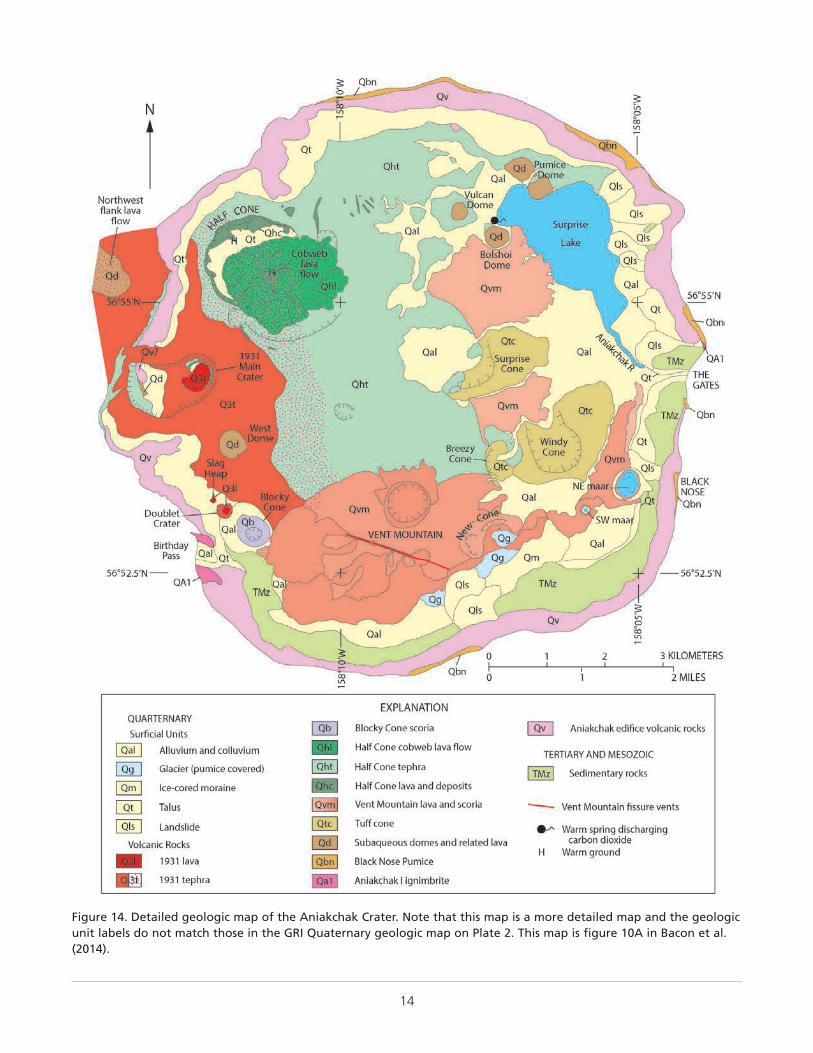
14
Figure 14. Detailed geologic map of the Aniakchak Crater. Note that this map is a more detailed map and the geologic unit labels do not match those in the GRI Quaternary geologic map on Plate 2. This map is figure 10A in Bacon et al. (2014).
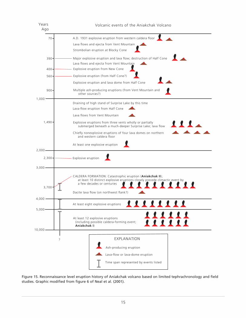
15
Ash-producing eruption
Lava-flow or lava-dome eruption
EXPLANATION
Time span represented by events listed
?
70
390
400
560
900
1,000
1,490
2,000
2,300
3,000
3,700
4,000
5,000
10,000
YearsAgo
Volcanic events of the Aniakchak Volcano
A.D. 1931 explosive eruption from western caldera floor
Lava flows and ejecta from Vent Mountain
Strombolian eruption at Blocky Cone
Major explosive eruption and lava flow; destruction of Half Cone
Lava flows and ejecta from Vent Mountain
Explosive eruption from New Cone
Explosive eruption (from Half Cone?)
Explosive eruption and lava dome from Half Cone
Multiple ash-producing eruptions (from Vent Mountain and other sources?)
Draining of high stand of Surprise Lake by this time
Lava-flow eruption from Half Cone
Lava flows from Vent Mountain
Explosive eruptions from three vents wholly or partially submerged beneath a much-deeper Surprise Lake; lava flow
Chiefly nonexplosive eruptions of four lava domes on northern and western caldera floor
At least one explosive eruption
Explosive eruption
CALDERA FORMATION: Catastrophic eruption (Aniakchak II); at least 10 distinct explosive eruptions closely precede climactic event by a few decades or centuries
Dacite lava flow (on northwest flank?)
At least eight explosive eruptions
At least 12 explosive eruptions (including possible caldera-forming event; Aniakchak I)
Figure 15. Reconnaissance level eruption history of Aniakchak volcano based on limited tephrachronology and field studies. Graphic modified from figure 6 of Neal et al. (2001).
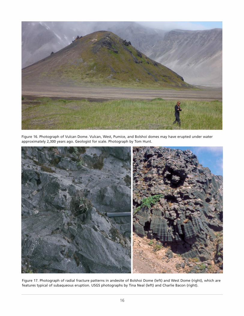
16
Figure 16. Photograph of Vulcan Dome. Vulcan, West, Pumice, and Bolshoi domes may have erupted under water approximately 2,300 years ago. Geologist for scale. Photograph by Tom Hunt.
Figure 17. Photograph of radial fracture patterns in andesite of Bolshoi Dome (left) and West Dome (right), which are features typical of subaqueous eruption. USGS photographs by Tina Neal (left) and Charlie Bacon (right).
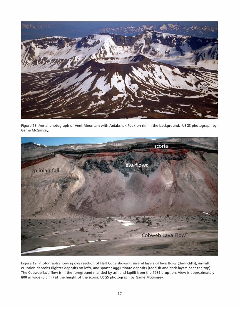
17
Figure 18. Aerial photograph of Vent Mountain with Aniakchak Peak on rim in the background. USGS photograph by Game McGimsey.
plinian falllava flows
scoria
Cobweb Lava Flow
Figure 19. Photograph showing cross section of Half Cone showing several layers of lava flows (dark cliffs), air-fall eruption deposits (lighter deposits on left), and spatter agglutinate deposits (reddish and dark layers near the top). The Cobweb lava flow is in the foreground mantled by ash and lapilli from the 1931 eruption. View is approximately 800 m wide (0.5 mi) at the height of the scoria. USGS photograph by Game McGimsey.
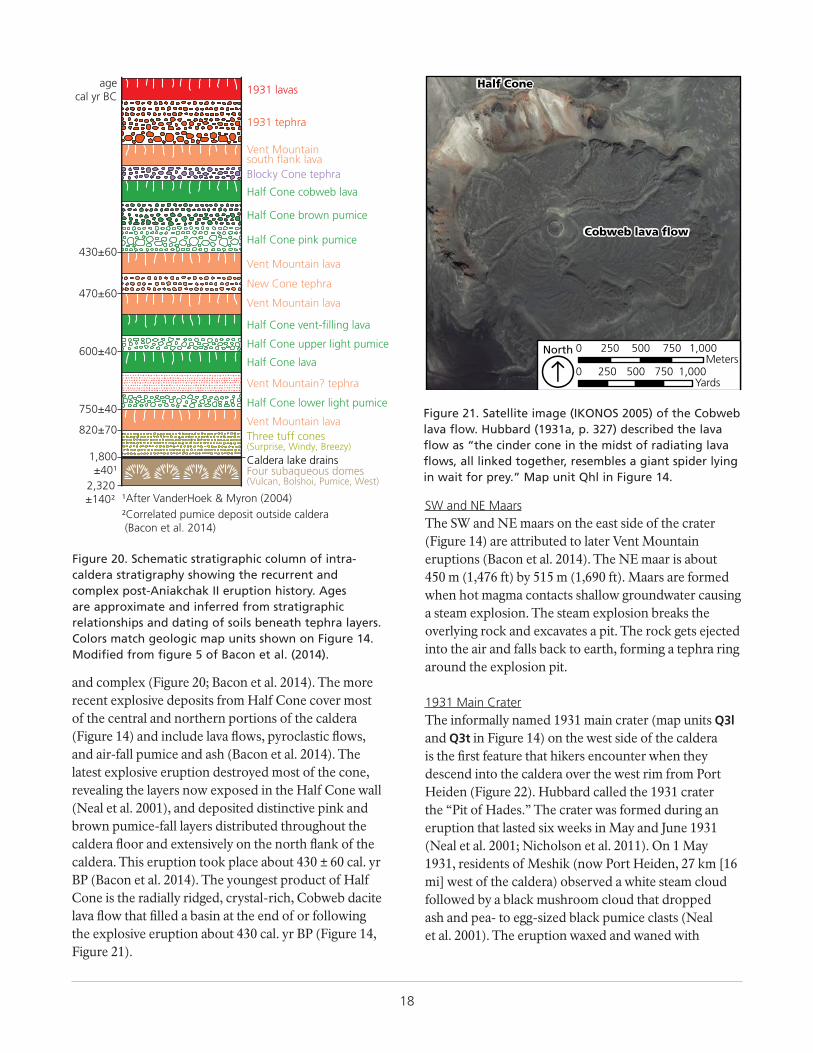
18
and complex (Figure 20; Bacon et al. 2014). The more recent explosive deposits from Half Cone cover most of the central and northern portions of the caldera (Figure 14) and include lava flows, pyroclastic flows, and air-fall pumice and ash (Bacon et al. 2014). The latest explosive eruption destroyed most of the cone, revealing the layers now exposed in the Half Cone wall (Neal et al. 2001), and deposited distinctive pink and brown pumice-fall layers distributed throughout the caldera floor and extensively on the north flank of the caldera. This eruption took place about 430 ± 60 cal. yr BP (Bacon et al. 2014). The youngest product of Half Cone is the radially ridged, crystal-rich, Cobweb dacite lava flow that filled a basin at the end of or following the explosive eruption about 430 cal. yr BP (Figure 14, Figure 21).
SW and NE MaarsThe SW and NE maars on the east side of the crater (Figure 14) are attributed to later Vent Mountain eruptions (Bacon et al. 2014). The NE maar is about 450 m (1,476 ft) by 515 m (1,690 ft). Maars are formed when hot magma contacts shallow groundwater causing a steam explosion. The steam explosion breaks the overlying rock and excavates a pit. The rock gets ejected into the air and falls back to earth, forming a tephra ring around the explosion pit.
1931 Main CraterThe informally named 1931 main crater (map units Q3l and Q3t in Figure 14) on the west side of the caldera is the first feature that hikers encounter when they descend into the caldera over the west rim from Port Heiden (Figure 22). Hubbard called the 1931 crater the “Pit of Hades.” The crater was formed during an eruption that lasted six weeks in May and June 1931 (Neal et al. 2001; Nicholson et al. 2011). On 1 May 1931, residents of Meshik (now Port Heiden, 27 km [16 mi] west of the caldera) observed a white steam cloud followed by a black mushroom cloud that dropped ash and pea- to egg-sized black pumice clasts (Neal et al. 2001). The eruption waxed and waned with
Half Cone lava
Half Cone upper light pumice
New Cone tephra
Half Cone brown pumice
Half Cone pink pumice
1931 lavas
1931 tephra
Vent Mountainsouth flank lavaBlocky Cone tephra
Half Cone cobweb lava
Vent Mountain lava
Half Cone lower light pumice
Vent Mountain? tephra
Vent Mountain lavaThree tuff cones(Surprise, Windy, Breezy)
Four subaqueous domes(Vulcan, Bolshoi, Pumice, West)
Vent Mountain lava
Half Cone vent-filling lava
Caldera lake drains
¹After VanderHoek & Myron (2004)
470±60
430±60
600±40
750±40
1,800±40¹
820±70
2,320±140²
²Correlated pumice deposit outside caldera (Bacon et al. 2014)
agecal yr BC
Figure 20. Schematic stratigraphic column of intra-caldera stratigraphy showing the recurrent and complex post-Aniakchak II eruption history. Ages are approximate and inferred from stratigraphic relationships and dating of soils beneath tephra layers. Colors match geologic map units shown on Figure 14. Modified from figure 5 of Bacon et al. (2014).
Half Cone
Cobweb lava flow
0 250 500 750 1,000Yards
0 250 500 750 1,000Meters
North
ÁFigure 21. Satellite image (IKONOS 2005) of the Cobweb lava flow. Hubbard (1931a, p. 327) described the lava flow as “the cinder cone in the midst of radiating lava flows, all linked together, resembles a giant spider lying in wait for prey.” Map unit Qhl in Figure 14.
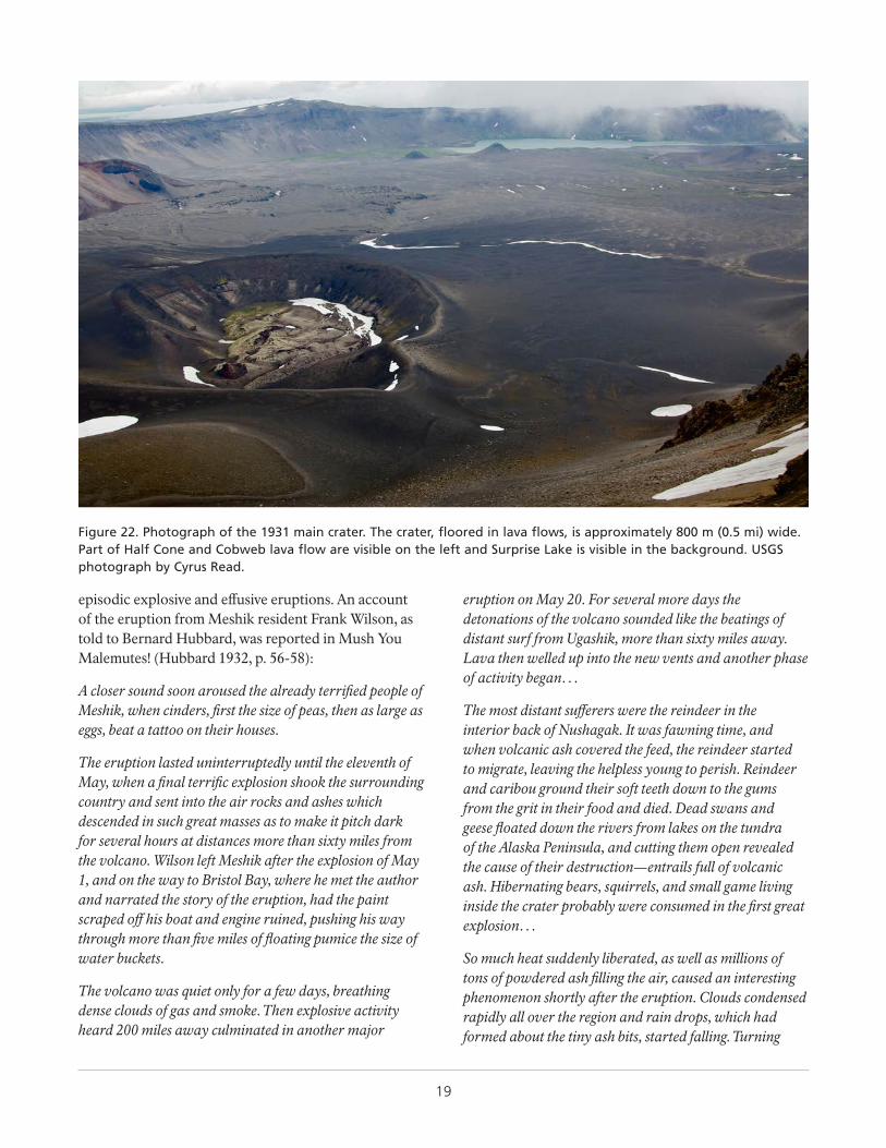
19
episodic explosive and effusive eruptions. An account of the eruption from Meshik resident Frank Wilson, as told to Bernard Hubbard, was reported in Mush You Malemutes! (Hubbard 1932, p. 56-58):
A closer sound soon aroused the already terrified people of Meshik, when cinders, first the size of peas, then as large as eggs, beat a tattoo on their houses.
The eruption lasted uninterruptedly until the eleventh of May, when a final terrific explosion shook the surrounding country and sent into the air rocks and ashes which descended in such great masses as to make it pitch dark for several hours at distances more than sixty miles from the volcano. Wilson left Meshik after the explosion of May 1, and on the way to Bristol Bay, where he met the author and narrated the story of the eruption, had the paint scraped off his boat and engine ruined, pushing his way through more than five miles of floating pumice the size of water buckets.
The volcano was quiet only for a few days, breathing dense clouds of gas and smoke. Then explosive activity heard 200 miles away culminated in another major
eruption on May 20. For several more days the detonations of the volcano sounded like the beatings of distant surf from Ugashik, more than sixty miles away. Lava then welled up into the new vents and another phase of activity began…
The most distant sufferers were the reindeer in the interior back of Nushagak. It was fawning time, and when volcanic ash covered the feed, the reindeer started to migrate, leaving the helpless young to perish. Reindeer and caribou ground their soft teeth down to the gums from the grit in their food and died. Dead swans and geese floated down the rivers from lakes on the tundra of the Alaska Peninsula, and cutting them open revealed the cause of their destruction—entrails full of volcanic ash. Hibernating bears, squirrels, and small game living inside the crater probably were consumed in the first great explosion…
So much heat suddenly liberated, as well as millions of tons of powdered ash filling the air, caused an interesting phenomenon shortly after the eruption. Clouds condensed rapidly all over the region and rain drops, which had formed about the tiny ash bits, started falling. Turning
Figure 22. Photograph of the 1931 main crater. The crater, floored in lava flows, is approximately 800 m (0.5 mi) wide. Part of Half Cone and Cobweb lava flow are visible on the left and Surprise Lake is visible in the background. USGS photograph by Cyrus Read.
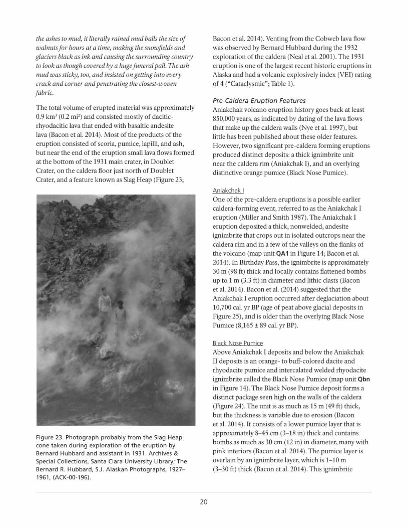
20
the ashes to mud, it literally rained mud balls the size of walnuts for hours at a time, making the snowfields and glaciers black as ink and causing the surrounding country to look as though covered by a huge funeral pall. The ash mud was sticky, too, and insisted on getting into every crack and corner and penetrating the closest-woven fabric.
The total volume of erupted material was approximately 0.9 km3 (0.2 mi2) and consisted mostly of dacitic-rhyodacitic lava that ended with basaltic andesite lava (Bacon et al. 2014). Most of the products of the eruption consisted of scoria, pumice, lapilli, and ash, but near the end of the eruption small lava flows formed at the bottom of the 1931 main crater, in Doublet Crater, on the caldera floor just north of Doublet Crater, and a feature known as Slag Heap (Figure 23;
Figure 23. Photograph probably from the Slag Heap cone taken during exploration of the eruption by Bernard Hubbard and assistant in 1931. Archives & Special Collections, Santa Clara University Library; The Bernard R. Hubbard, S.J. Alaskan Photographs, 1927–1961, (ACK-00-196).
Bacon et al. 2014). Venting from the Cobweb lava flow was observed by Bernard Hubbard during the 1932 exploration of the caldera (Neal et al. 2001). The 1931 eruption is one of the largest recent historic eruptions in Alaska and had a volcanic explosively index (VEI) rating of 4 (“Cataclysmic”; Table 1).
Pre-Caldera Eruption FeaturesAniakchak volcano eruption history goes back at least 850,000 years, as indicated by dating of the lava flows that make up the caldera walls (Nye et al. 1997), but little has been published about these older features. However, two significant pre-caldera forming eruptions produced distinct deposits: a thick ignimbrite unit near the caldera rim (Aniakchak I), and an overlying distinctive orange pumice (Black Nose Pumice).
Aniakchak IOne of the pre-caldera eruptions is a possible earlier caldera-forming event, referred to as the Aniakchak I eruption (Miller and Smith 1987). The Aniakchak I eruption deposited a thick, nonwelded, andesite ignimbrite that crops out in isolated outcrops near the caldera rim and in a few of the valleys on the flanks of the volcano (map unit QA1 in Figure 14; Bacon et al. 2014). In Birthday Pass, the ignimbrite is approximately 30 m (98 ft) thick and locally contains flattened bombs up to 1 m (3.3 ft) in diameter and lithic clasts (Bacon et al. 2014). Bacon et al. (2014) suggested that the Aniakchak I eruption occurred after deglaciation about 10,700 cal. yr BP (age of peat above glacial deposits in Figure 25), and is older than the overlying Black Nose Pumice (8,165 ± 89 cal. yr BP).
Black Nose PumiceAbove Aniakchak I deposits and below the Aniakchak II deposits is an orange- to buff-colored dacite and rhyodacite pumice and intercalated welded rhyodacite ignimbrite called the Black Nose Pumice (map unit Qbn in Figure 14). The Black Nose Pumice deposit forms a distinct package seen high on the walls of the caldera (Figure 24). The unit is as much as 15 m (49 ft) thick, but the thickness is variable due to erosion (Bacon et al. 2014). It consists of a lower pumice layer that is approximately 8–45 cm (3–18 in) thick and contains bombs as much as 30 cm (12 in) in diameter, many with pink interiors (Bacon et al. 2014). The pumice layer is overlain by an ignimbrite layer, which is 1–10 m (3–30 ft) thick (Bacon et al. 2014). This ignimbrite
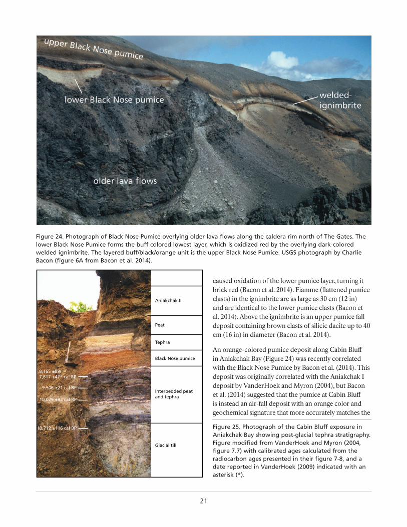
21
caused oxidation of the lower pumice layer, turning it brick red (Bacon et al. 2014). Fiamme (flattened pumice clasts) in the ignimbrite are as large as 30 cm (12 in) and are identical to the lower pumice clasts (Bacon et al. 2014). Above the ignimbrite is an upper pumice fall deposit containing brown clasts of silicic dacite up to 40 cm (16 in) in diameter (Bacon et al. 2014).
An orange-colored pumice deposit along Cabin Bluff in Aniakchak Bay (Figure 24) was recently correlated with the Black Nose Pumice by Bacon et al. (2014). This deposit was originally correlated with the Aniakchak I deposit by VanderHoek and Myron (2004), but Bacon et al. (2014) suggested that the pumice at Cabin Bluff is instead an air-fall deposit with an orange color and geochemical signature that more accurately matches the
Figure 24. Photograph of Black Nose Pumice overlying older lava flows along the caldera rim north of The Gates. The lower Black Nose Pumice forms the buff colored lowest layer, which is oxidized red by the overlying dark-colored welded ignimbrite. The layered buff/black/orange unit is the upper Black Nose Pumice. USGS photograph by Charlie Bacon (figure 6A from Bacon et al. 2014).
Aniakchak II
Peat
Tephra
Black Nose pumice
Interbedded peatand tephra
Glacial till
8,165 ±89/7,617 ±47* cal BP
9,506 ±21 cal BP
10,029 ±92 cal BP
10,712 ±116 cal BP Figure 25. Photograph of the Cabin Bluff exposure in Aniakchak Bay showing post-glacial tephra stratigraphy. Figure modified from VanderHoek and Myron (2004, figure 7.7) with calibrated ages calculated from the radiocarbon ages presented in their figure 7-8, and a date reported in VanderHoek (2009) indicated with an asterisk (*).
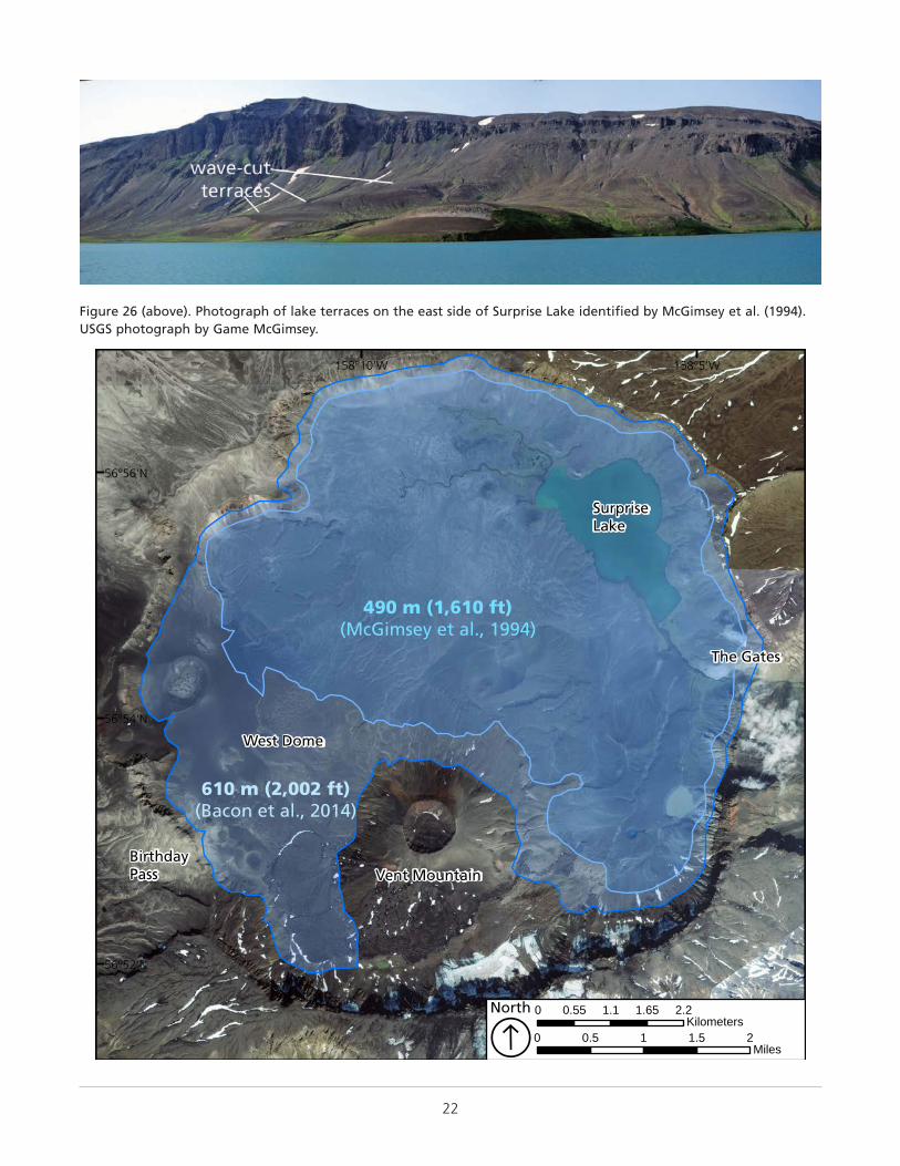
22
Figure 26 (above). Photograph of lake terraces on the east side of Surprise Lake identified by McGimsey et al. (1994). USGS photograph by Game McGimsey.
West Dome
BirthdayPass Vent Mountain
SurpriseLake
The Gates
610 m (2,002 ft)(Bacon et al., 2014)
490 m (1,610 ft)(McGimsey et al., 1994)
158°5'W158°10'W
56°56'N
56°54'N
56°52'N
0 0.5 1 1.5 2Miles
0 0.55 1.1 1.65 2.2Kilometers
North
Á
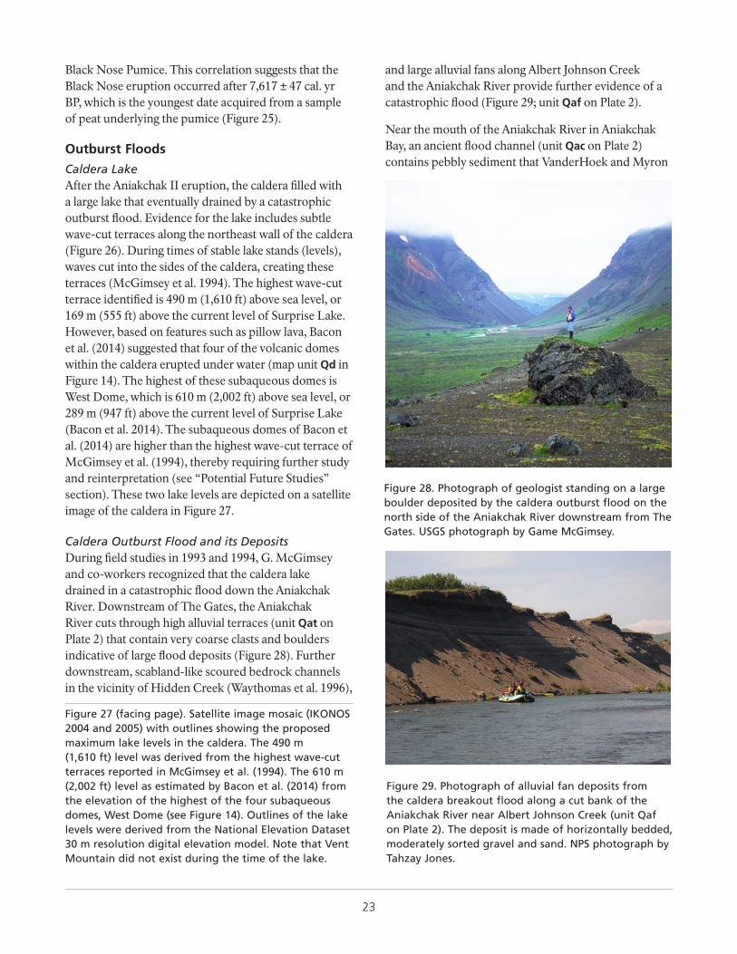
23
Figure 27 (facing page). Satellite image mosaic (IKONOS 2004 and 2005) with outlines showing the proposed maximum lake levels in the caldera. The 490 m (1,610 ft) level was derived from the highest wave-cut terraces reported in McGimsey et al. (1994). The 610 m (2,002 ft) level as estimated by Bacon et al. (2014) from the elevation of the highest of the four subaqueous domes, West Dome (see Figure 14). Outlines of the lake levels were derived from the National Elevation Dataset 30 m resolution digital elevation model. Note that Vent Mountain did not exist during the time of the lake.
Black Nose Pumice. This correlation suggests that the Black Nose eruption occurred after 7,617 ± 47 cal. yr BP, which is the youngest date acquired from a sample of peat underlying the pumice (Figure 25).
Outburst Floods
Caldera Lake After the Aniakchak II eruption, the caldera filled with a large lake that eventually drained by a catastrophic outburst flood. Evidence for the lake includes subtle wave-cut terraces along the northeast wall of the caldera (Figure 26). During times of stable lake stands (levels), waves cut into the sides of the caldera, creating these terraces (McGimsey et al. 1994). The highest wave-cut terrace identified is 490 m (1,610 ft) above sea level, or 169 m (555 ft) above the current level of Surprise Lake. However, based on features such as pillow lava, Bacon et al. (2014) suggested that four of the volcanic domes within the caldera erupted under water (map unit Qd in Figure 14). The highest of these subaqueous domes is West Dome, which is 610 m (2,002 ft) above sea level, or 289 m (947 ft) above the current level of Surprise Lake (Bacon et al. 2014). The subaqueous domes of Bacon et al. (2014) are higher than the highest wave-cut terrace of McGimsey et al. (1994), thereby requiring further study and reinterpretation (see “Potential Future Studies” section). These two lake levels are depicted on a satellite image of the caldera in Figure 27.
Caldera Outburst Flood and its DepositsDuring field studies in 1993 and 1994, G. McGimsey and co-workers recognized that the caldera lake drained in a catastrophic flood down the Aniakchak River. Downstream of The Gates, the Aniakchak River cuts through high alluvial terraces (unit Qat on Plate 2) that contain very coarse clasts and boulders indicative of large flood deposits (Figure 28). Further downstream, scabland-like scoured bedrock channels in the vicinity of Hidden Creek (Waythomas et al. 1996),
and large alluvial fans along Albert Johnson Creek and the Aniakchak River provide further evidence of a catastrophic flood (Figure 29; unit Qaf on Plate 2).
Near the mouth of the Aniakchak River in Aniakchak Bay, an ancient flood channel (unit Qac on Plate 2) contains pebbly sediment that VanderHoek and Myron
Figure 28. Photograph of geologist standing on a large boulder deposited by the caldera outburst flood on the north side of the Aniakchak River downstream from The Gates. USGS photograph by Game McGimsey.
Figure 29. Photograph of alluvial fan deposits from the caldera breakout flood along a cut bank of the Aniakchak River near Albert Johnson Creek (unit Qaf on Plate 2). The deposit is made of horizontally bedded, moderately sorted gravel and sand. NPS photograph by Tahzay Jones.
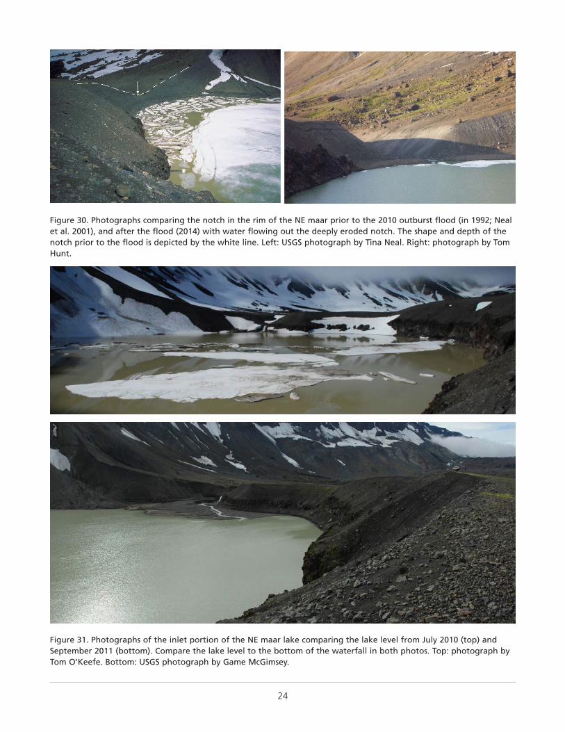
24
Figure 30. Photographs comparing the notch in the rim of the NE maar prior to the 2010 outburst flood (in 1992; Neal et al. 2001), and after the flood (2014) with water flowing out the deeply eroded notch. The shape and depth of the notch prior to the flood is depicted by the white line. Left: USGS photograph by Tina Neal. Right: photograph by Tom Hunt.
Figure 31. Photographs of the inlet portion of the NE maar lake comparing the lake level from July 2010 (top) and September 2011 (bottom). Compare the lake level to the bottom of the waterfall in both photos. Top: photograph by Tom O’Keefe. Bottom: USGS photograph by Game McGimsey.
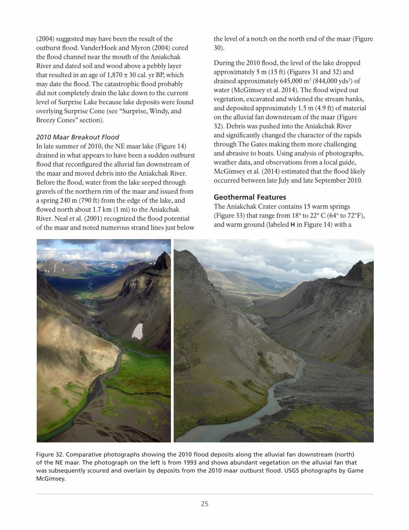
25
(2004) suggested may have been the result of the outburst flood. VanderHoek and Myron (2004) cored the flood channel near the mouth of the Aniakchak River and dated soil and wood above a pebbly layer that resulted in an age of 1,870 ± 30 cal. yr BP, which may date the flood. The catastrophic flood probably did not completely drain the lake down to the current level of Surprise Lake because lake deposits were found overlying Surprise Cone (see “Surprise, Windy, and Breezy Cones” section).
2010 Maar Breakout FloodIn late summer of 2010, the NE maar lake (Figure 14) drained in what appears to have been a sudden outburst flood that reconfigured the alluvial fan downstream of the maar and moved debris into the Aniakchak River. Before the flood, water from the lake seeped through gravels of the northern rim of the maar and issued from a spring 240 m (790 ft) from the edge of the lake, and flowed north about 1.7 km (1 mi) to the Aniakchak River. Neal et al. (2001) recognized the flood potential of the maar and noted numerous strand lines just below
the level of a notch on the north end of the maar (Figure 30).
During the 2010 flood, the level of the lake dropped approximately 5 m (15 ft) (Figures 31 and 32) and drained approximately 645,000 m3 (844,000 yds3) of water (McGimsey et al. 2014). The flood wiped out vegetation, excavated and widened the stream banks, and deposited approximately 1.5 m (4.9 ft) of material on the alluvial fan downstream of the maar (Figure 32). Debris was pushed into the Aniakchak River and significantly changed the character of the rapids through The Gates making them more challenging and abrasive to boats. Using analysis of photographs, weather data, and observations from a local guide, McGimsey et al. (2014) estimated that the flood likely occurred between late July and late September 2010.
Figure 32. Comparative photographs showing the 2010 flood deposits along the alluvial fan downstream (north) of the NE maar. The photograph on the left is from 1993 and shows abundant vegetation on the alluvial fan that was subsequently scoured and overlain by deposits from the 2010 maar outburst flood. USGS photographs by Game McGimsey.
Geothermal FeaturesThe Aniakchak Crater contains 15 warm springs (Figure 33) that range from 18° to 22° C (64° to 72°F), and warm ground (labeled H in Figure 14) with a
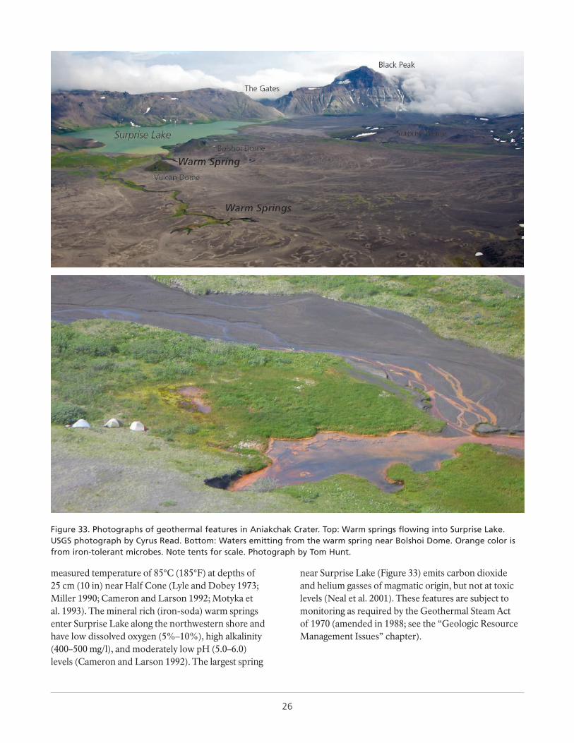
26
measured temperature of 85°C (185°F) at depths of 25 cm (10 in) near Half Cone (Lyle and Dobey 1973; Miller 1990; Cameron and Larson 1992; Motyka et al. 1993). The mineral rich (iron-soda) warm springs enter Surprise Lake along the northwestern shore and have low dissolved oxygen (5%–10%), high alkalinity (400–500 mg/l), and moderately low pH (5.0–6.0) levels (Cameron and Larson 1992). The largest spring
near Surprise Lake (Figure 33) emits carbon dioxide and helium gasses of magmatic origin, but not at toxic levels (Neal et al. 2001). These features are subject to monitoring as required by the Geothermal Steam Act of 1970 (amended in 1988; see the “Geologic Resource Management Issues” chapter).
Figure 33. Photographs of geothermal features in Aniakchak Crater. Top: Warm springs flowing into Surprise Lake. USGS photograph by Cyrus Read. Bottom: Waters emitting from the warm spring near Bolshoi Dome. Orange color is from iron-tolerant microbes. Note tents for scale. Photograph by Tom Hunt.
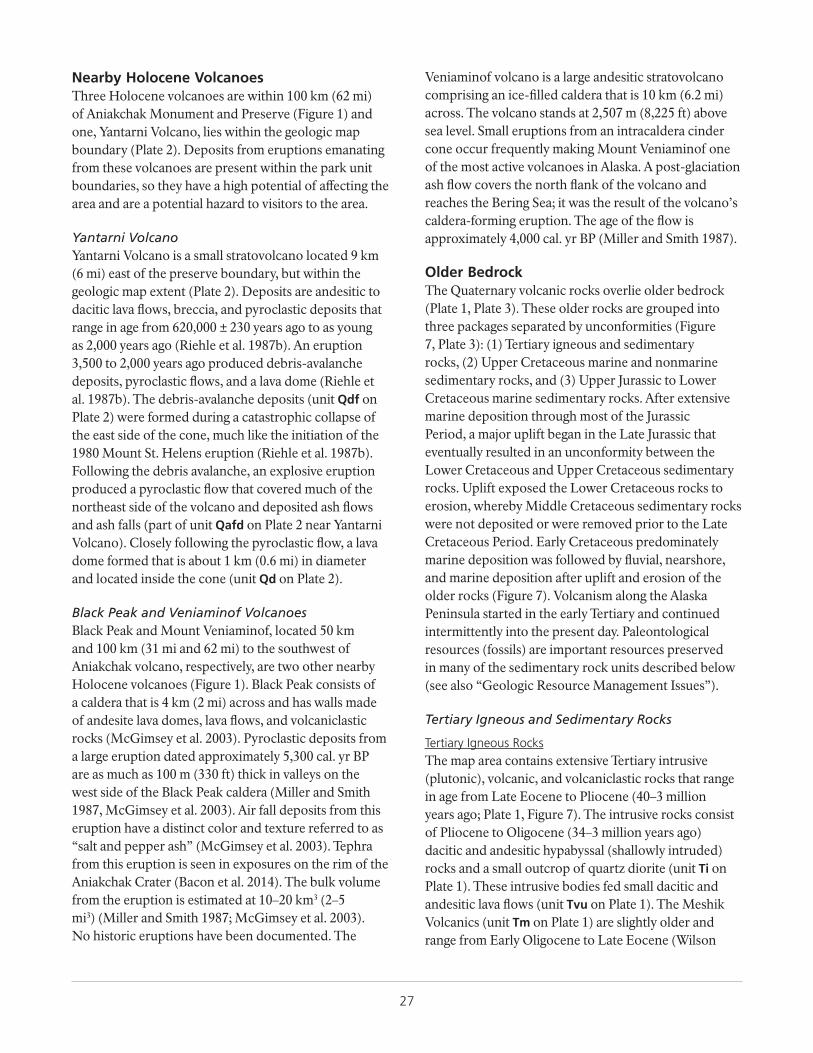
27
Nearby Holocene VolcanoesThree Holocene volcanoes are within 100 km (62 mi) of Aniakchak Monument and Preserve (Figure 1) and one, Yantarni Volcano, lies within the geologic map boundary (Plate 2). Deposits from eruptions emanating from these volcanoes are present within the park unit boundaries, so they have a high potential of affecting the area and are a potential hazard to visitors to the area.
Yantarni VolcanoYantarni Volcano is a small stratovolcano located 9 km (6 mi) east of the preserve boundary, but within the geologic map extent (Plate 2). Deposits are andesitic to dacitic lava flows, breccia, and pyroclastic deposits that range in age from 620,000 ± 230 years ago to as young as 2,000 years ago (Riehle et al. 1987b). An eruption 3,500 to 2,000 years ago produced debris-avalanche deposits, pyroclastic flows, and a lava dome (Riehle et al. 1987b). The debris-avalanche deposits (unit Qdf on Plate 2) were formed during a catastrophic collapse of the east side of the cone, much like the initiation of the 1980 Mount St. Helens eruption (Riehle et al. 1987b). Following the debris avalanche, an explosive eruption produced a pyroclastic flow that covered much of the northeast side of the volcano and deposited ash flows and ash falls (part of unit Qafd on Plate 2 near Yantarni Volcano). Closely following the pyroclastic flow, a lava dome formed that is about 1 km (0.6 mi) in diameter and located inside the cone (unit Qd on Plate 2).
Black Peak and Veniaminof VolcanoesBlack Peak and Mount Veniaminof, located 50 km and 100 km (31 mi and 62 mi) to the southwest of Aniakchak volcano, respectively, are two other nearby Holocene volcanoes (Figure 1). Black Peak consists of a caldera that is 4 km (2 mi) across and has walls made of andesite lava domes, lava flows, and volcaniclastic rocks (McGimsey et al. 2003). Pyroclastic deposits from a large eruption dated approximately 5,300 cal. yr BP are as much as 100 m (330 ft) thick in valleys on the west side of the Black Peak caldera (Miller and Smith 1987, McGimsey et al. 2003). Air fall deposits from this eruption have a distinct color and texture referred to as “salt and pepper ash” (McGimsey et al. 2003). Tephra from this eruption is seen in exposures on the rim of the Aniakchak Crater (Bacon et al. 2014). The bulk volume from the eruption is estimated at 10–20 km3 (2–5 mi3) (Miller and Smith 1987; McGimsey et al. 2003). No historic eruptions have been documented. The
Veniaminof volcano is a large andesitic stratovolcano comprising an ice-filled caldera that is 10 km (6.2 mi) across. The volcano stands at 2,507 m (8,225 ft) above sea level. Small eruptions from an intracaldera cinder cone occur frequently making Mount Veniaminof one of the most active volcanoes in Alaska. A post-glaciation ash flow covers the north flank of the volcano and reaches the Bering Sea; it was the result of the volcano’s caldera-forming eruption. The age of the flow is approximately 4,000 cal. yr BP (Miller and Smith 1987).
Older BedrockThe Quaternary volcanic rocks overlie older bedrock (Plate 1, Plate 3). These older rocks are grouped into three packages separated by unconformities (Figure 7, Plate 3): (1) Tertiary igneous and sedimentary rocks, (2) Upper Cretaceous marine and nonmarine sedimentary rocks, and (3) Upper Jurassic to Lower Cretaceous marine sedimentary rocks. After extensive marine deposition through most of the Jurassic Period, a major uplift began in the Late Jurassic that eventually resulted in an unconformity between the Lower Cretaceous and Upper Cretaceous sedimentary rocks. Uplift exposed the Lower Cretaceous rocks to erosion, whereby Middle Cretaceous sedimentary rocks were not deposited or were removed prior to the Late Cretaceous Period. Early Cretaceous predominately marine deposition was followed by fluvial, nearshore, and marine deposition after uplift and erosion of the older rocks (Figure 7). Volcanism along the Alaska Peninsula started in the early Tertiary and continued intermittently into the present day. Paleontological resources (fossils) are important resources preserved in many of the sedimentary rock units described below (see also “Geologic Resource Management Issues”).
Tertiary Igneous and Sedimentary Rocks
Tertiary Igneous RocksThe map area contains extensive Tertiary intrusive (plutonic), volcanic, and volcaniclastic rocks that range in age from Late Eocene to Pliocene (40–3 million years ago; Plate 1, Figure 7). The intrusive rocks consist of Pliocene to Oligocene (34–3 million years ago) dacitic and andesitic hypabyssal (shallowly intruded) rocks and a small outcrop of quartz diorite (unit Ti on Plate 1). These intrusive bodies fed small dacitic and andesitic lava flows (unit Tvu on Plate 1). The Meshik Volcanics (unit Tm on Plate 1) are slightly older and range from Early Oligocene to Late Eocene (Wilson
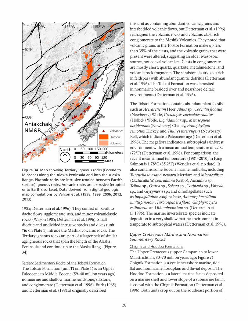
28
1985; Detterman et al. 1996). They consist of basalt to dacite flows, agglomerate, ash, and minor volcaniclastic rocks (Wilson 1985; Detterman et al. 1996). Small dioritic and undivided intrusive stocks and dikes (unit Tiu on Plate 1) intrude the Meshik volcanic rocks. The Tertiary igneous rocks are part of a larger belt of similar age igneous rocks that span the length of the Alaska Peninsula and continue up to the Alaska Range (Figure 34).
++
+
+
+
+
++
+
+
+
#
+
#
##
+
#
++
,
,
,,
#
,,
+++,
,
###
###
###
####
####
#
#
#
#
AniakchakNM&P Ala
ska
Peni
nsul
a
Alask
a Range
152°W156°W160°W
62°N
58°N
# Volcanoes
Plutonic
Volcanic
0 30 60 90 120Miles
0 50 100 150 200Kilometers
ÁNorth
Figure 34. Map showing Tertiary igneous rocks (Eocene to Miocene) along the Alaska Peninsula and into the Alaska Range. Plutonic rocks are intrusive (cooled beneath Earth’s surface) igneous rocks. Volcanic rocks are extrusive (erupted onto Earth’s surface). Data derived from digital geologic map compilations by Wilson et al. (1998, 1999, 2006, 2012, 2013).
Tertiary Sedimentary Rocks of the Tolstoi FormationThe Tolstoi Formation (unit Tt on Plate 1) is an Upper Paleocene to Middle Eocene (59–40 million years ago) nonmarine and shallow marine sandstone, siltstone, and conglomerate (Detterman et al. 1996). Burk (1965) and Detterman et al. (1981a) originally described
this unit as containing abundant volcanic grains and interbedded volcanic flows, but Detterman et al. (1996) reassigned the volcanic rocks and volcanic clast rich conglomerate to the Meshik Volcanics. They noted that volcanic grains in the Tolstoi Formation make up less than 35% of the clasts, and the volcanic grains that were present were altered, suggesting an older Mesozoic source, not coeval volcanism. Clasts in conglomerate are mostly chert, quartz, quartzite, metalimestone, and volcanic rock fragments. The sandstone is arkosic (rich in feldspar) with abundant granitic detritus (Detterman et al. 1996). The Tolstoi Formation was deposited in nonmarine braided river and nearshore deltaic environments (Detterman et al. 1996).
The Tolstoi Formation contains abundant plant fossils such as Acerarcticum Heer, Alnus sp., Cocculus flobella (Newberry) Wolfe, Grewiopsis curiculaecrodatus (Hollick) Wolfe, Liquidambar sp., Metasequoia occidentalis (Newberry) Chaney, Protophyllum semotum Hickey, and Thuires interruptus (Newberry) Bell, which indicate a Paleocene age (Detterman et al. 1996). The megaflora indicates a subtropical rainforest environment with a mean annual temperature of 22°C (72°F) (Detterman et al. 1996). For comparison, the recent mean annual temperature (1981–2010) in King Salmon is 1.78°C (35.2°F) (Wendler et al. no date). It also contains some Eocene marine mollusks, including Turritella uvasana stewarti Merriam and Microcallista (Costacallista) conradiana (Gabb), Nuculana sp., Tellina sp., Ostrea sp., Solena sp., Corbicula sp., Volsella sp., and Glycymeris sp.; and dinoflagellates such as Impagidinium californiense, Adnatosphaeridium multispinosom, Turbiosphaera filosa, Glaphyrocysta retiintexta, and Rhombodinium sp. (Detterman et al. 1996). The marine invertebrate species indicate deposition in a very shallow marine environment in temperate to subtropical waters (Detterman et al. 1996).
Upper Cretaceous Marine and Nonmarine Sedimentary Rocks
Chignik and Hoodoo FormationsThe Upper Cretaceous (upper Campanian to lower Maastrichtian, 80–70 million years ago; Figure 7) Chignik Formation is a cyclic nearshore marine, tidal flat and nonmarine floodplain and fluvial deposit. The Hoodoo Formation is a lateral marine facies deposited on a marine shelf and lower slope of a submarine fan; it is coeval with the Chignik Formation (Detterman et al. 1996). Both units crop out on the southeast portion of
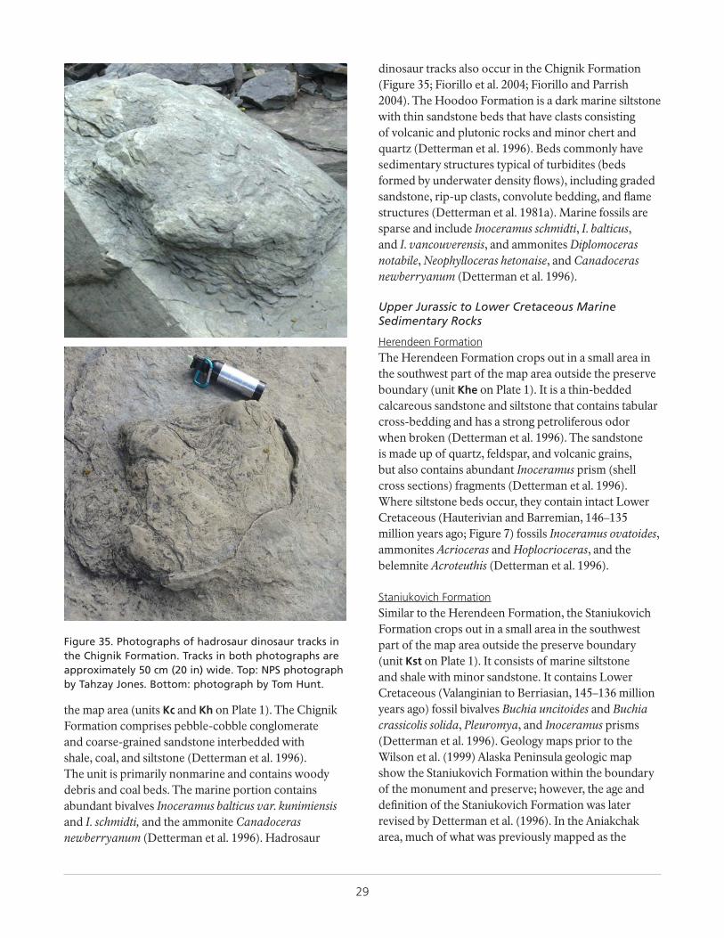
29
the map area (units Kc and Kh on Plate 1). The Chignik Formation comprises pebble-cobble conglomerate and coarse-grained sandstone interbedded with shale, coal, and siltstone (Detterman et al. 1996). The unit is primarily nonmarine and contains woody debris and coal beds. The marine portion contains abundant bivalves Inoceramus balticus var. kunimiensis and I. schmidti, and the ammonite Canadoceras newberryanum (Detterman et al. 1996). Hadrosaur
dinosaur tracks also occur in the Chignik Formation (Figure 35; Fiorillo et al. 2004; Fiorillo and Parrish 2004). The Hoodoo Formation is a dark marine siltstone with thin sandstone beds that have clasts consisting of volcanic and plutonic rocks and minor chert and quartz (Detterman et al. 1996). Beds commonly have sedimentary structures typical of turbidites (beds formed by underwater density flows), including graded sandstone, rip-up clasts, convolute bedding, and flame structures (Detterman et al. 1981a). Marine fossils are sparse and include Inoceramus schmidti, I. balticus, and I. vancouverensis, and ammonites Diplomoceras notabile, Neophylloceras hetonaise, and Canadoceras newberryanum (Detterman et al. 1996).
Upper Jurassic to Lower Cretaceous Marine Sedimentary Rocks
Herendeen FormationThe Herendeen Formation crops out in a small area in the southwest part of the map area outside the preserve boundary (unit Khe on Plate 1). It is a thin-bedded calcareous sandstone and siltstone that contains tabular cross-bedding and has a strong petroliferous odor when broken (Detterman et al. 1996). The sandstone is made up of quartz, feldspar, and volcanic grains, but also contains abundant Inoceramus prism (shell cross sections) fragments (Detterman et al. 1996). Where siltstone beds occur, they contain intact Lower Cretaceous (Hauterivian and Barremian, 146–135 million years ago; Figure 7) fossils Inoceramus ovatoides, ammonites Acrioceras and Hoplocrioceras, and the belemnite Acroteuthis (Detterman et al. 1996).
Staniukovich FormationSimilar to the Herendeen Formation, the Staniukovich Formation crops out in a small area in the southwest part of the map area outside the preserve boundary (unit Kst on Plate 1). It consists of marine siltstone and shale with minor sandstone. It contains Lower Cretaceous (Valanginian to Berriasian, 145–136 million years ago) fossil bivalves Buchia uncitoides and Buchia crassicolis solida, Pleuromya, and Inoceramus prisms (Detterman et al. 1996). Geology maps prior to the Wilson et al. (1999) Alaska Peninsula geologic map show the Staniukovich Formation within the boundary of the monument and preserve; however, the age and definition of the Staniukovich Formation was later revised by Detterman et al. (1996). In the Aniakchak area, much of what was previously mapped as the
Figure 35. Photographs of hadrosaur dinosaur tracks in the Chignik Formation. Tracks in both photographs are approximately 50 cm (20 in) wide. Top: NPS photograph by Tahzay Jones. Bottom: photograph by Tom Hunt.
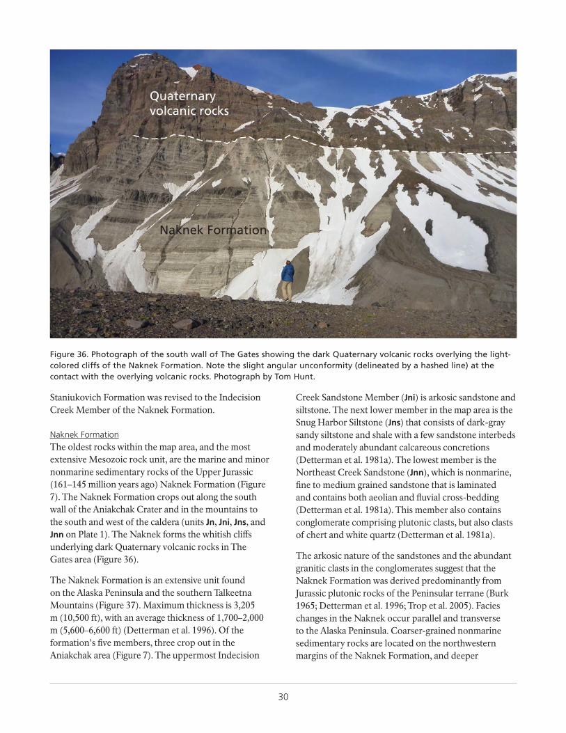
30
Staniukovich Formation was revised to the Indecision Creek Member of the Naknek Formation.
Naknek FormationThe oldest rocks within the map area, and the most extensive Mesozoic rock unit, are the marine and minor nonmarine sedimentary rocks of the Upper Jurassic (161–145 million years ago) Naknek Formation (Figure 7). The Naknek Formation crops out along the south wall of the Aniakchak Crater and in the mountains to the south and west of the caldera (units Jn, Jni, Jns, and Jnn on Plate 1). The Naknek forms the whitish cliffs underlying dark Quaternary volcanic rocks in The Gates area (Figure 36).
The Naknek Formation is an extensive unit found on the Alaska Peninsula and the southern Talkeetna Mountains (Figure 37). Maximum thickness is 3,205 m (10,500 ft), with an average thickness of 1,700–2,000 m (5,600–6,600 ft) (Detterman et al. 1996). Of the formation’s five members, three crop out in the Aniakchak area (Figure 7). The uppermost Indecision
Creek Sandstone Member (Jni) is arkosic sandstone and siltstone. The next lower member in the map area is the Snug Harbor Siltstone (Jns) that consists of dark-gray sandy siltstone and shale with a few sandstone interbeds and moderately abundant calcareous concretions (Detterman et al. 1981a). The lowest member is the Northeast Creek Sandstone (Jnn), which is nonmarine, fine to medium grained sandstone that is laminated and contains both aeolian and fluvial cross-bedding (Detterman et al. 1981a). This member also contains conglomerate comprising plutonic clasts, but also clasts of chert and white quartz (Detterman et al. 1981a).
The arkosic nature of the sandstones and the abundant granitic clasts in the conglomerates suggest that the Naknek Formation was derived predominantly from Jurassic plutonic rocks of the Peninsular terrane (Burk 1965; Detterman et al. 1996; Trop et al. 2005). Facies changes in the Naknek occur parallel and transverse to the Alaska Peninsula. Coarser-grained nonmarine sedimentary rocks are located on the northwestern margins of the Naknek Formation, and deeper
Quaternaryvolcanic rocks
Naknek Formation
Figure 36. Photograph of the south wall of The Gates showing the dark Quaternary volcanic rocks overlying the light-colored cliffs of the Naknek Formation. Note the slight angular unconformity (delineated by a hashed line) at the contact with the overlying volcanic rocks. Photograph by Tom Hunt.
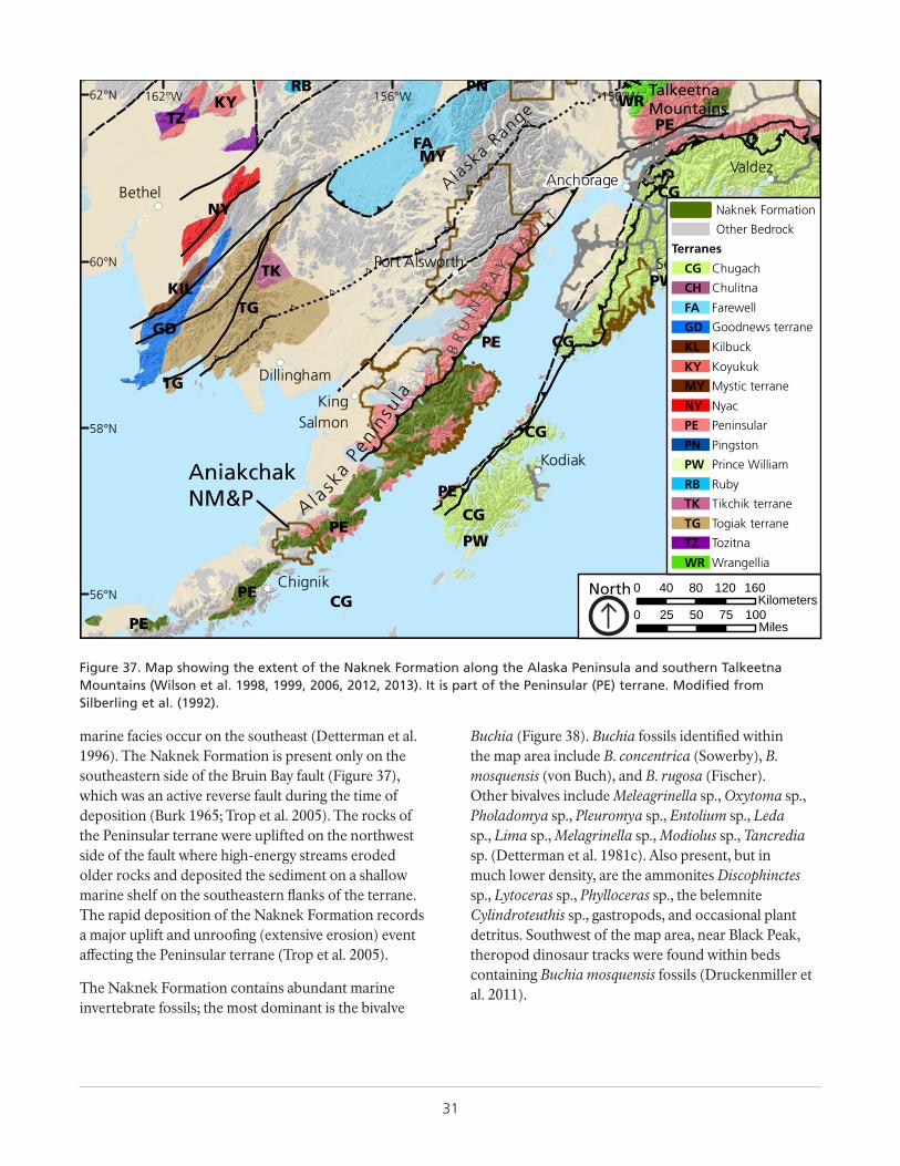
31
marine facies occur on the southeast (Detterman et al. 1996). The Naknek Formation is present only on the southeastern side of the Bruin Bay fault (Figure 37), which was an active reverse fault during the time of deposition (Burk 1965; Trop et al. 2005). The rocks of the Peninsular terrane were uplifted on the northwest side of the fault where high-energy streams eroded older rocks and deposited the sediment on a shallow marine shelf on the southeastern flanks of the terrane. The rapid deposition of the Naknek Formation records a major uplift and unroofing (extensive erosion) event affecting the Peninsular terrane (Trop et al. 2005).
The Naknek Formation contains abundant marine invertebrate fossils; the most dominant is the bivalve
Buchia (Figure 38). Buchia fossils identified within the map area include B. concentrica (Sowerby), B. mosquensis (von Buch), and B. rugosa (Fischer). Other bivalves include Meleagrinella sp., Oxytoma sp., Pholadomya sp., Pleuromya sp., Entolium sp., Leda sp., Lima sp., Melagrinella sp., Modiolus sp., Tancredia sp. (Detterman et al. 1981c). Also present, but in much lower density, are the ammonites Discophinctes sp., Lytoceras sp., Phylloceras sp., the belemnite Cylindroteuthis sp., gastropods, and occasional plant detritus. Southwest of the map area, near Black Peak, theropod dinosaur tracks were found within beds containing Buchia mosquensis fossils (Druckenmiller et al. 2011).
++
+++
+
+
+
+
+
+
+
+
+
+
+
+
+
+
+
+
+++
+
+
,
,
,
,,
,,
++
+ ++
+ +
,
,
!(
!(
!(
!(
!(
!(
!(
!(
!(
AniakchakNM&P Ala
ska
Peni
nsu l
a
Alask
a Range
TalkeetnaMountains
KingSalmon
Port Alsworth
Bethel
Kodiak
Chignik
Dillingham
Anchorage
Seward
Valdez
RBWR
PE
PN
FA
KYTZ
NY
TG
PW
PE
GD
CG
TKKIL PW
CGPE
TG
CG
CG
PE
PW
PECG
PE
MY
BR
UI N
BA
YF A
UL T
150°W156°W162°W62°N
60°N
58°N
56°N
Naknek Formation
Other Bedrock
Terranes
ChugachCG
ChulitnaCH
FarewellFA
Goodnews terraneGD
KilbuckKL
KoyukukKY
Mystic terraneMY
NyacNY
PeninsularPE
PingstonPN
Prince WilliamPW
RubyRB
Tikchik terraneTK
Togiak terraneTG
TozitnaTZ
WrangelliaWR
0 25 50 75 100Miles
0 40 80 120 160Kilometers
North
Figure 37. Map showing the extent of the Naknek Formation along the Alaska Peninsula and southern Talkeetna Mountains (Wilson et al. 1998, 1999, 2006, 2012, 2013). It is part of the Peninsular (PE) terrane. Modified from Silberling et al. (1992).
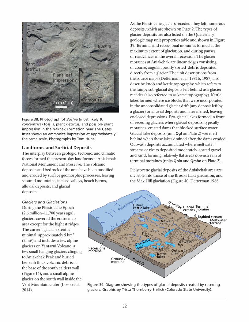
32
Figure 38. Photograph of Buchia (most likely B. concentrica) fossils, plant detritus, and possible plant impression in the Naknek Formation near The Gates. Inset shows an ammonite impression at approximately the same scale. Photographs by Tom Hunt.
Landforms and Surficial DepositsThe interplay between geologic, tectonic, and climatic forces formed the present-day landforms at Aniakchak National Monument and Preserve. The volcanic deposits and bedrock of the area have been modified and eroded by surface geomorphic processes, leaving scoured mountains, incised valleys, beach berms, alluvial deposits, and glacial deposits.
Glaciers and GlaciationsDuring the Pleistocene Epoch (2.6 million–11,700 years ago), glaciers covered the entire map area except for the highest ridges. The current glacial extent is minimal, approximately 5 km2 (2 mi2) and includes a few alpine glaciers on Yantarni Volcano, a few small hanging glaciers clinging to Aniakchak Peak and buried beneath thick volcanic debris at the base of the south caldera wall (Figure 14), and a small alpine glacier on the south wall inside the Vent Mountain crater (Loso et al. 2014).
As the Pleistocene glaciers receded, they left numerous deposits, which are shown on Plate 2. The types of glacier deposits are also listed on the Quaternary geologic map unit properties table and shown in Figure 39. Terminal and recessional moraines formed at the maximum extent of glaciation, and during pauses or readvances in the overall recession. The glacier moraines at Aniakchak are linear ridges consisting of coarse, angular, poorly sorted debris deposited directly from a glacier. The unit descriptions from the source maps (Detterman et al. 1981b, 1987) also describe knob and kettle topography, which refers to the lumpy sub-glacial deposits left behind as a glacier recedes (also referred to as kame topography). Kettle lakes formed where ice blocks that were incorporated in the unconsolidated glacier drift (any deposit left by a glacier) or alluvial deposits and later melted, leaving enclosed depressions. Pro-glacial lakes formed in front of receding glaciers where glacial deposits, typically moraines, created dams that blocked surface water. Glacial lake deposits (unit Qgl on Plate 2) were left behind when these lakes drained after the dams eroded. Outwash deposits accumulated where meltwater streams or rivers deposited moderately-sorted gravel and sand, forming relatively flat areas downstream of terminal moraines (units Qblo and Qmho on Plate 2).
Pleistocene glacial deposits of the Aniakchak area are divisible into those of the Brooks Lake glaciation, and the Mak Hill glaciation (Figure 40; Detterman 1986,
Retreatin
g glacier
Braided stream
Drumlins Terminalmoraine
Outwash plain
BedrockGround moraine
Recessionalmoraine
Futurekettle lake
Esker
Glacialerratics
Kames
Kettlelakes
MeltwaterterraceOutwash
delta
Outwash fanPro-glacial
lake
Figure 39. Diagram showing the types of glacial deposits created by receding glaciers. Graphic by Trista Thornberry-Ehrlich (Colorado State University).
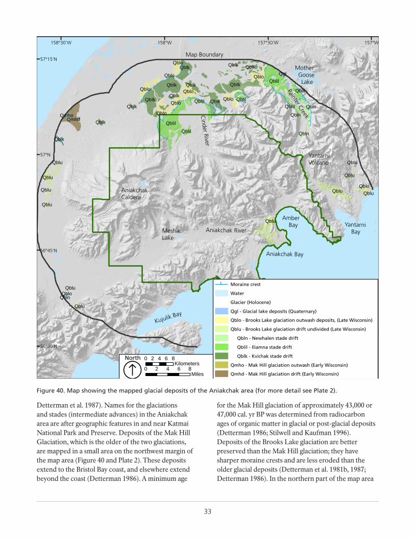
33
Detterman et al. 1987). Names for the glaciations and stades (intermediate advances) in the Aniakchak area are after geographic features in and near Katmai National Park and Preserve. Deposits of the Mak Hill Glaciation, which is the older of the two glaciations, are mapped in a small area on the northwest margin of the map area (Figure 40 and Plate 2). These deposits extend to the Bristol Bay coast, and elsewhere extend beyond the coast (Detterman 1986). A minimum age
for the Mak Hill glaciation of approximately 43,000 or 47,000 cal. yr BP was determined from radiocarbon ages of organic matter in glacial or post-glacial deposits (Detterman 1986; Stilwell and Kaufman 1996). Deposits of the Brooks Lake glaciation are better preserved than the Mak Hill glaciation; they have sharper moraine crests and are less eroded than the older glacial deposits (Detterman et al. 1981b, 1987; Detterman 1986). In the northern part of the map area
Mother Goose Lake
Amber Bay
AniakchakCaldera
Kujulik Bay
Aniakchak River
Cinder River
Painter Creek
YantarniVolcano
Yantarni BayMeshik
Lake
Aniakchak Bay
Map Boundary
Qblil
Qblil
Qblil
QblilQblil
Qblil
Qblil
Qblk
Qblk
QblkQblk
QblkQblk
Qblk Qblk
Qgl
Qblu
Qblu
Qblu
Qblu
Qblu
Qblu
Qblu
QbluQblu
Qblu
Qblu
Qbln
Qbln
Qbln
Qbln
Qblk
QblkQblkQblk
Qblo
Qblo
Qblo
Qblo
QbloQblo
Qblo
Qblo Qblo
Qblo
QmhdQmho
157°W157°30'W158°W158°30'W
57°15'N
57°N
56°45'N
56°30'N
Moraine crest
Water
Glacier (Holocene)
Qgl - Glacial lake deposits (Quaternary)
Qblo - Brooks Lake glaciation outwash deposits, (Late Wisconsin)
Qblu - Brooks Lake glaciation drift undivided (Late Wisconsin)
Qbln - Newhalen stade drift
Qblil - Iliamna stade drift
Qblk - Kvichak stade drift
Qmho - Mak Hill glaciation outwash (Early Wisconsin)
Qmhd - Mak Hill glaciation drift (Early Wisconsin)0 2 4 6 8
Miles
0 2 4 6 8Kilometers
ÁNorth
Figure 40. Map showing the mapped glacial deposits of the Aniakchak area (for more detail see Plate 2).
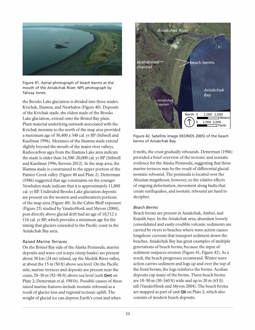
34
the Brooks Lake glaciation is divided into three stades: Kvichak, Iliamna, and Newhalen (Figure 40). Deposits of the Kvichak stade, the oldest stade of the Brooks Lake glaciation, extend onto the Bristol Bay plain. Plant material underlying outwash associated with the Kvichak moraine to the north of the map area provided a maximum age of 30,400 ± 340 cal. yr BP (Stilwell and Kaufman 1996). Moraines of the Iliamna stade extend slightly beyond the mouth of the major river valleys. Radiocarbon ages from the Iliamna Lake area indicate the stade is older than 16,500–20,000 cal. yr BP (Stilwell and Kaufman 1996; Stevens 2012). In the map area, the Iliamna stade is constrained to the upper portion of the Painter Creek valley (Figure 40 and Plate 2). Detterman (1986) suggested that age constraints on the younger Newhalen stade indicate that it is approximately 11,000 cal. yr BP. Undivided Brooks Lake glaciation deposits are present on the western and southeastern portions of the map area (Figure 40). In the Cabin Bluff exposure (Figure 25) studied by VanderHoek and Myron (2004), peat directly above glacial drift had an age of 10,712 ± 116 cal. yr BP, which provides a minimum age for the timing that glaciers extended to the Pacific coast in the Aniakchak Bay area.
Raised Marine TerracesOn the Bristol Bay side of the Alaska Peninsula, marine deposits and wave-cut scarps (steep banks) are present about 38 km (24 mi) inland, up the Meshik River valley, at about the 15 m (50 ft) above sea level. On the Pacific side, marine terraces and deposits are present near the coast, 28–30 m (92–98 ft) above sea level (unit Qmt on Plate 2; Detterman et al. 1981b). Possible causes of these raised marine features include isostatic rebound as a result of glacier loss and regional tectonic uplift. The weight of glacial ice can depress Earth’s crust and when
it melts, the crust gradually rebounds. Detterman (1986) provided a brief overview of the tectonic and isostatic evidence for the Alaska Peninsula, suggesting that these marine terraces may be the result of differential glacial isostatic rebound. The peninsula is located over the Aleutian megathrust; however, so the relative effects of ongoing deformation, movement along faults that create earthquakes, and isostatic rebound are hard to decipher.
Beach BermsBeach berms are present in Aniakchak, Amber, and Kujulik bays. In the Aniakchak area, abundant loosely consolidated and easily erodible volcanic sediments are carried by rivers to beaches where wave action causes longshore currents that transport sediment down the beaches. Aniakchak Bay has great examples of multiple generations of beach berms, because the input of sediment outpaces erosion (Figure 41, Figure 42). As a result, the beach progresses oceanward. Winter wave action carries sediment and logs up and over the top of the front berms; the logs reinforce the berms. Aeolian deposits cap many of the berms. These beach berms are 10–50 m (30–160 ft) wide and up to 20 m (65 ft) tall (VanderHoek and Myron 2004). The beach berms are mapped as part of unit Qb on Plate 2, which also consists of modern beach deposits.
Figure 41. Aerial photograph of beach berms at the mouth of the Aniakchak River. NPS photograph by Tahzay Jones.
0 1,000 2,000Yards
0 1,000 2,000Meters
ÁNorth
beach berms
AniakchakBay
Aniakchak River
AniakchakLagoon
abandonedchannel
Figure 42. Satellite image (IKONOS 2005) of the beach berms of Aniakchak Bay.
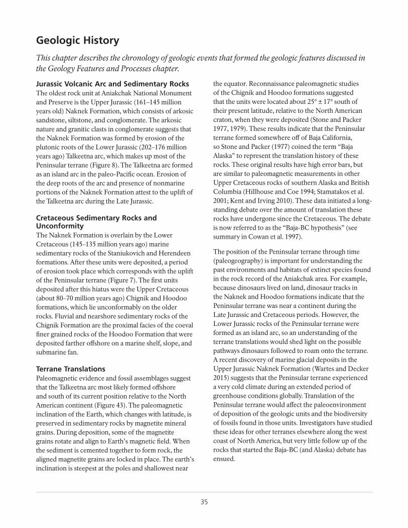
35
Geologic History
This chapter describes the chronology of geologic events that formed the geologic features discussed in the Geology Features and Processes chapter.
Jurassic Volcanic Arc and Sedimentary RocksThe oldest rock unit at Aniakchak National Monument and Preserve is the Upper Jurassic (161–145 million years old) Naknek Formation, which consists of arkosic sandstone, siltstone, and conglomerate. The arkosic nature and granitic clasts in conglomerate suggests that the Naknek Formation was formed by erosion of the plutonic roots of the Lower Jurassic (202–176 million years ago) Talkeetna arc, which makes up most of the Peninsular terrane (Figure 8). The Talkeetna arc formed as an island arc in the paleo-Pacific ocean. Erosion of the deep roots of the arc and presence of nonmarine portions of the Naknek Formation attest to the uplift of the Talkeetna arc during the Late Jurassic.
Cretaceous Sedimentary Rocks and UnconformityThe Naknek Formation is overlain by the Lower Cretaceous (145–135 million years ago) marine sedimentary rocks of the Staniukovich and Herendeen formations. After these units were deposited, a period of erosion took place which corresponds with the uplift of the Peninsular terrane (Figure 7). The first units deposited after this hiatus were the Upper Cretaceous (about 80–70 million years ago) Chignik and Hoodoo formations, which lie unconformably on the older rocks. Fluvial and nearshore sedimentary rocks of the Chignik Formation are the proximal facies of the coeval finer grained rocks of the Hoodoo Formation that were deposited farther offshore on a marine shelf, slope, and submarine fan.
Terrane TranslationsPaleomagnetic evidence and fossil assemblages suggest that the Talkeetna arc most likely formed offshore and south of its current position relative to the North American continent (Figure 43). The paleomagnetic inclination of the Earth, which changes with latitude, is preserved in sedimentary rocks by magnetite mineral grains. During deposition, some of the magnetite grains rotate and align to Earth’s magnetic field. When the sediment is cemented together to form rock, the aligned magnetite grains are locked in place. The earth’s inclination is steepest at the poles and shallowest near
the equator. Reconnaissance paleomagnetic studies of the Chignik and Hoodoo formations suggested that the units were located about 25° ± 17° south of their present latitude, relative to the North American craton, when they were deposited (Stone and Packer 1977, 1979). These results indicate that the Peninsular terrane formed somewhere off of Baja California, so Stone and Packer (1977) coined the term “Baja Alaska” to represent the translation history of these rocks. These original results have high error bars, but are similar to paleomagnetic measurements in other Upper Cretaceous rocks of southern Alaska and British Columbia (Hillhouse and Coe 1994; Stamatakos et al. 2001; Kent and Irving 2010). These data initiated a long-standing debate over the amount of translation these rocks have undergone since the Cretaceous. The debate is now referred to as the “Baja-BC hypothesis” (see summary in Cowan et al. 1997).
The position of the Peninsular terrane through time (paleogeography) is important for understanding the past environments and habitats of extinct species found in the rock record of the Aniakchak area. For example, because dinosaurs lived on land, dinosaur tracks in the Naknek and Hoodoo formations indicate that the Peninsular terrane was near a continent during the Late Jurassic and Cretaceous periods. However, the Lower Jurassic rocks of the Peninsular terrane were formed as an island arc, so an understanding of the terrane translations would shed light on the possible pathways dinosaurs followed to roam onto the terrane. A recent discovery of marine glacial deposits in the Upper Jurassic Naknek Formation (Wartes and Decker 2015) suggests that the Peninsular terrane experienced a very cold climate during an extended period of greenhouse conditions globally. Translation of the Peninsular terrane would affect the paleoenvironment of deposition of the geologic units and the biodiversity of fossils found in those units. Investigators have studied these ideas for other terranes elsewhere along the west coast of North America, but very little follow up of the rocks that started the Baja-BC (and Alaska) debate has ensued.
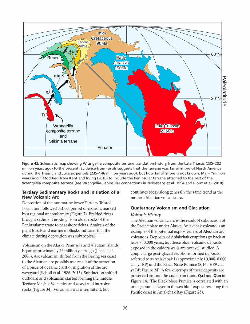
36
Paleolatitude
60°N
30°N
Equator
RecenteE
Eocene50Ma
Eocene50Ma
mid-K
mid-Cretaceous
90Ma
mid-Cretaceous
90Ma
EarlyJurassic190Ma
EarlyJurassic190Ma
Late Triassic225Ma
Late Triassic225Ma
Wrangelliacomposite terrane
andStikinia terrane
Figure 43. Schematic map showing Wrangellia composite terrane translation history from the Late Triassic (235–202 million years ago) to the present. Evidence from fossils suggests that the terrane was far offshore of North America during the Triassic and Jurassic periods (235–146 million years ago), but how far offshore is not known. Ma = “million years ago.” Modified from Kent and Irving (2010) to include the Peninsular terrane attached to the rest of the Wrangellia composite terrane (see Wrangellia-Peninsular connections in Nokleberg et al. 1994 and Rioux et al. 2010).
Tertiary Sedimentary Rocks and Initiation of a New Volcanic ArcDeposition of the nonmarine lower Tertiary Tolstoi Formation followed a short period of erosion, marked by a regional unconformity (Figure 7). Braided rivers brought sediment eroding from older rocks of the Peninsular terrane to nearshore deltas. Analysis of the plant fossils and marine mollusks indicates that the climate during deposition was subtropical.
Volcanism on the Alaska Peninsula and Aleutian Islands began approximately 46 million years ago (Jicha et al. 2006). Arc volcanism shifted from the Bering sea coast to the Aleutian arc possibly as a result of the accretion of a piece of oceanic crust or migration of the arc westward (Scholl et al. 1986, 2015). Subduction shifted outboard and volcanism started forming the middle Tertiary Meshik Volcanics and associated intrusive rocks (Figure 34). Volcanism was intermittent, but
continues today along generally the same trend as the modern Aleutian volcanic arc.
Quaternary Volcanism and Glaciation
Volcanic HistoryThe Aleutian volcanic arc is the result of subduction of the Pacific plate under Alaska. Aniakchak volcano is an example of the potential explosiveness of Aleutian arc volcanoes. Deposits of Aniakchak eruptions go back at least 850,000 years, but these older volcanic deposits exposed in the caldera walls are not well studied. A couple large post-glacial eruptions formed deposits referred to as Aniakchak I (approximately 10,000–8,000 cal. yr BP) and the Black Nose Pumice (8,165 ± 89 cal. yr BP; Figure 24). A few outcrops of these deposits are preserved around the crater rim (units Qa1 and Qbn in Figure 14). The Black Nose Pumice is correlated with an orange pumice layer in the sea bluff exposures along the Pacific coast in Aniakchak Bay (Figure 25).
37
The Aniakchak Crater formed during a massive caldera forming eruption 3,660 ± 70 cal. yr BP, referred to as the Aniakchak II event, which formed a thick ignimbrite sheet surrounding the volcano (unit Qafd on Plate 2) and ejected ash into the atmosphere that was carried by winds and deposited in peat bogs up to 1,000 km (620 mi) north on the Seward Peninsula. Traces of the ash were also found in Greenland ice cores. The massive pyroclastic flow from the eruption reached both coastlines, and upon entering Bristol Bay, it generated a tsunami that inundated the northern mainland coast (Figure 13). Fallout from the Aniakchak eruption obliterated vegetation and wildlife and probably resulted in a 1,500 year hiatus in human habitation in the area.
After the Aniakchak II eruption, water filled the caldera with a lake (Figure 27). Subaqueous eruptions emplaced four domes (Vulcan, West, Pumice, Bolshoi domes) under the lake. Possibly around 1,800 cal. yr BP, a great flood rushed out of the caldera through The Gates, scouring the valley of the Aniakchak River, depositing large alluvial terraces (unit Qat on Plate 2), and depositing large alluvial fans (unit Qaf on Plate 2). The floodwaters created a second channel at Aniakchak Bay (unit Qac on Plate 2).
Numerous eruptions after the flood formed many more volcanic domes, cones, maars, and dikes. Vent Mountain and Half Cone, which have erupted numerous times over the last 820 years, are the most prominent (Figure 20, Figure 14). The youngest feature is the 1931 crater and related vents (Figure 22) resulting from a six-week-long eruption, which was documented by Bernard Hubbard. This eruption was one of the largest historic eruptions in Alaska.
Glacial HistoryThe oldest glacial deposits are from the Mak Hill glaciation, which took place more than 44,000 cal. yr
BP. These deposits are exposed near the western edge of the map area (Figure 40; unit Qmhd on Plate 2). Most glacier deposits are younger and part of the Brooks Lake glaciation, which occurred 10,000 cal. yr BP or earlier.
Post-Glacial HistoryAfter retreat of the Pleistocene (2.6 million–11,700 years ago) glaciers, the land underneath rebounded after the weight of the ice was removed. The Pacific side, where precipitation was greatest and the glaciers were thickest, the land uplifted 28–30 m (92–98 ft), compared to the 15 m (50 ft) of uplift on the Bristol Bay side of the Alaska Peninsula where the glaciers were thinner. However, tectonic forces could also have caused some of the uplift. Tsunami deposits along the coast provide evidence of large earthquakes along the Pacific coast. Glaciers had a profound impact on the shape of the landscape, but since they receded, rivers and other erosive geomorphic processes have altered the landscape. After formation of the Aniakchak Crater, the caldera filled with water (Figure 27), which eventually breached catastrophically. The outburst flood dumped a massive amount of sediment along the modern Aniakchak River valley (Figure 28, Figure 29) and scoured what are now abandoned river channels (Qac on Plate 2). A much smaller outburst flood from the NE maar lake (Figure 30, Figure 31) scoured the alluvial fan (Figure 32) and modified the Aniakchak River for kilometers downstream of The Gates. Rivers have carried the easily eroded loose volcanic material to the coast, and where they reach bays, beach ridges have formed (Figure 41, Figure 42). Landslides mapped throughout the area (Qls on Plate 2) indicate a changing landscape. The Aniakchak area is a dynamic place with active geomorphic processes and volcanism, which created a dramatic but potentially dangerous landscape. Geohazards are described in the “Geologic Resource Management Issues” chapter.

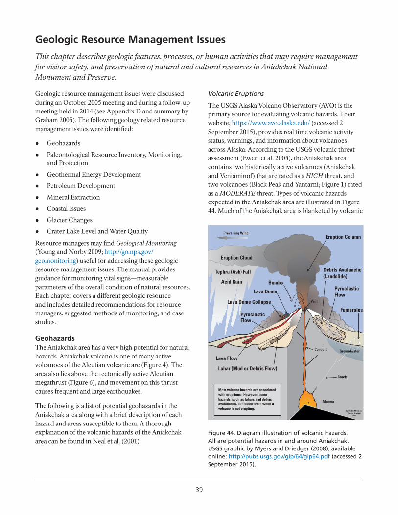
39
Geologic Resource Management Issues
This chapter describes geologic features, processes, or human activities that may require management for visitor safety, and preservation of natural and cultural resources in Aniakchak National Monument and Preserve.
Geologic resource management issues were discussed during an October 2005 meeting and during a follow-up meeting held in 2014 (see Appendix D and summary by Graham 2005). The following geology related resource management issues were identified:
● Geohazards
● Paleontological Resource Inventory, Monitoring, and Protection
● Geothermal Energy Development
● Petroleum Development
● Mineral Extraction
● Coastal Issues
● Glacier Changes
● Crater Lake Level and Water Quality
Resource managers may find Geological Monitoring (Young and Norby 2009; http://go.nps.gov/geomonitoring) useful for addressing these geologic resource management issues. The manual provides guidance for monitoring vital signs—measurable parameters of the overall condition of natural resources. Each chapter covers a different geologic resource and includes detailed recommendations for resource managers, suggested methods of monitoring, and case studies.
GeohazardsThe Aniakchak area has a very high potential for natural hazards. Aniakchak volcano is one of many active volcanoes of the Aleutian volcanic arc (Figure 4). The area also lies above the tectonically active Aleutian megathrust (Figure 6), and movement on this thrust causes frequent and large earthquakes.
The following is a list of potential geohazards in the Aniakchak area along with a brief description of each hazard and areas susceptible to them. A thorough explanation of the volcanic hazards of the Aniakchak area can be found in Neal et al. (2001).
Volcanic Eruptions
The USGS Alaska Volcano Observatory (AVO) is the primary source for evaluating volcanic hazards. Their website, https://www.avo.alaska.edu/ (accessed 2 September 2015), provides real time volcanic activity status, warnings, and information about volcanoes across Alaska. According to the USGS volcanic threat assessment (Ewert et al. 2005), the Aniakchak area contains two historically active volcanoes (Aniakchak and Veniaminof) that are rated as a HIGH threat, and two volcanoes (Black Peak and Yantarni; Figure 1) rated as a MODERATE threat. Types of volcanic hazards expected in the Aniakchak area are illustrated in Figure 44. Much of the Aniakchak area is blanketed by volcanic
Figure 44. Diagram illustration of volcanic hazards. All are potential hazards in and around Aniakchak. USGS graphic by Myers and Driedger (2008), available online: http://pubs.usgs.gov/gip/64/gip64.pdf (accessed 2 September 2015).
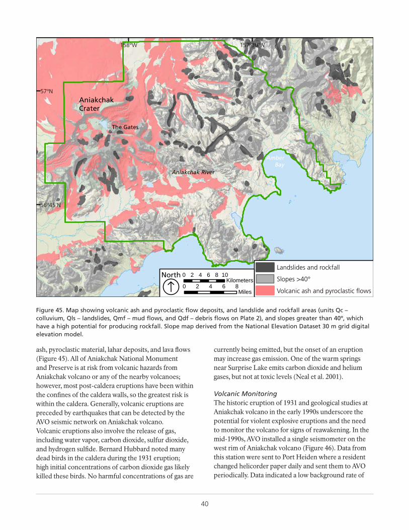
40
AniakchakCrater
The Gates
Aniakchak River
AmberBay
157°30'W158°W
57°N
56°45'N
Landslides and rockfall
Slopes >40°
Volcanic ash and pyroclastic flows0 2 4 6 8
Miles
0 2 4 6 8 10Kilometers
ÁNorth
Figure 45. Map showing volcanic ash and pyroclastic flow deposits, and landslide and rockfall areas (units Qc – colluvium, Qls – landslides, Qmf – mud flows, and Qdf – debris flows on Plate 2), and slopes greater than 40º, which have a high potential for producing rockfall. Slope map derived from the National Elevation Dataset 30 m grid digital elevation model.
ash, pyroclastic material, lahar deposits, and lava flows (Figure 45). All of Aniakchak National Monument and Preserve is at risk from volcanic hazards from Aniakchak volcano or any of the nearby volcanoes; however, most post-caldera eruptions have been within the confines of the caldera walls, so the greatest risk is within the caldera. Generally, volcanic eruptions are preceded by earthquakes that can be detected by the AVO seismic network on Aniakchak volcano.Volcanic eruptions also involve the release of gas, including water vapor, carbon dioxide, sulfur dioxide, and hydrogen sulfide. Bernard Hubbard noted many dead birds in the caldera during the 1931 eruption; high initial concentrations of carbon dioxide gas likely killed these birds. No harmful concentrations of gas are
currently being emitted, but the onset of an eruption may increase gas emission. One of the warm springs near Surprise Lake emits carbon dioxide and helium gases, but not at toxic levels (Neal et al. 2001).
Volcanic MonitoringThe historic eruption of 1931 and geological studies at Aniakchak volcano in the early 1990s underscore the potential for violent explosive eruptions and the need to monitor the volcano for signs of reawakening. In the mid-1990s, AVO installed a single seismometer on the west rim of Aniakchak volcano (Figure 46). Data from this station were sent to Port Heiden where a resident changed helicorder paper daily and sent them to AVO periodically. Data indicated a low background rate of
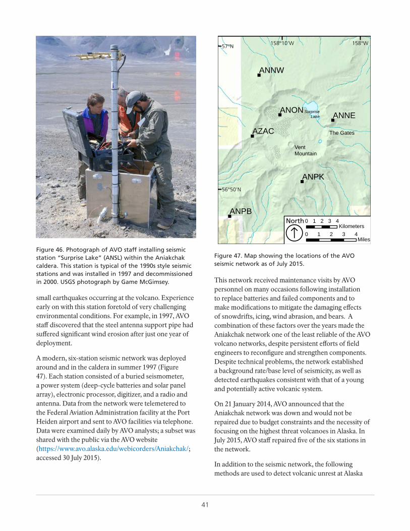
41
Figure 46. Photograph of AVO staff installing seismic station “Surprise Lake” (ANSL) within the Aniakchak caldera. This station is typical of the 1990s style seismic stations and was installed in 1997 and decommissioned in 2000. USGS photograph by Game McGimsey.
small earthquakes occurring at the volcano. Experience early on with this station foretold of very challenging environmental conditions. For example, in 1997, AVO staff discovered that the steel antenna support pipe had suffered significant wind erosion after just one year of deployment.
A modern, six-station seismic network was deployed around and in the caldera in summer 1997 (Figure 47). Each station consisted of a buried seismometer, a power system (deep-cycle batteries and solar panel array), electronic processor, digitizer, and a radio and antenna. Data from the network were telemetered to the Federal Aviation Administration facility at the Port Heiden airport and sent to AVO facilities via telephone. Data were examined daily by AVO analysts; a subset was shared with the public via the AVO website (https://www.avo.alaska.edu/webicorders/Aniakchak/; accessed 30 July 2015).
"
"
"
"
"
"
ANNE
ANNW
ANON
ANPB
ANPK
AZAC
158°W158°10'W57°N
56°50'N
0 1 2 3 4Miles
0 1 2 3 4Kilometers
ÁNorth
VentMountain
The Gates
SurpriseLake
Figure 47. Map showing the locations of the AVO seismic network as of July 2015.
This network received maintenance visits by AVO personnel on many occasions following installation to replace batteries and failed components and to make modifications to mitigate the damaging effects of snowdrifts, icing, wind abrasion, and bears. A combination of these factors over the years made the Aniakchak network one of the least reliable of the AVO volcano networks, despite persistent efforts of field engineers to reconfigure and strengthen components. Despite technical problems, the network established a background rate/base level of seismicity, as well as detected earthquakes consistent with that of a young and potentially active volcanic system.
On 21 January 2014, AVO announced that the Aniakchak network was down and would not be repaired due to budget constraints and the necessity of focusing on the highest threat volcanoes in Alaska. In July 2015, AVO staff repaired five of the six stations in the network.
In addition to the seismic network, the following methods are used to detect volcanic unrest at Alaska
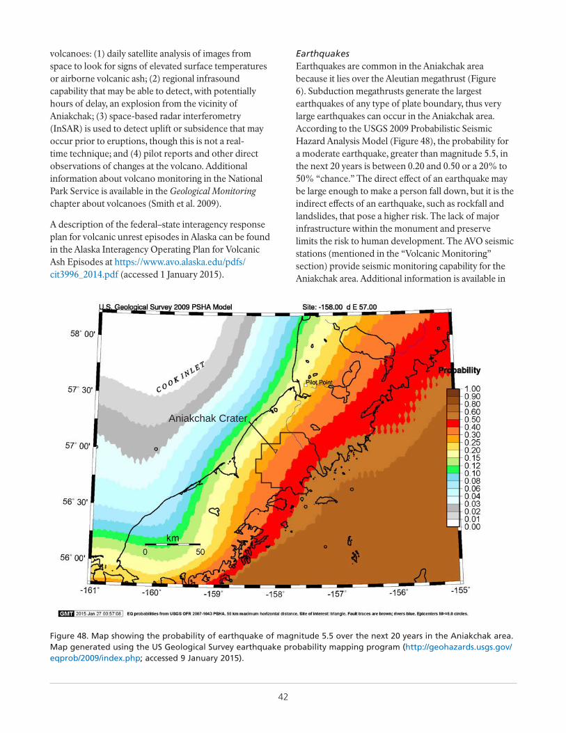
42
volcanoes: (1) daily satellite analysis of images from space to look for signs of elevated surface temperatures or airborne volcanic ash; (2) regional infrasound capability that may be able to detect, with potentially hours of delay, an explosion from the vicinity of Aniakchak; (3) space-based radar interferometry (InSAR) is used to detect uplift or subsidence that may occur prior to eruptions, though this is not a real-time technique; and (4) pilot reports and other direct observations of changes at the volcano. Additional information about volcano monitoring in the National Park Service is available in the Geological Monitoring chapter about volcanoes (Smith et al. 2009).
A description of the federal–state interagency response plan for volcanic unrest episodes in Alaska can be found in the Alaska Interagency Operating Plan for Volcanic Ash Episodes at https://www.avo.alaska.edu/pdfs/cit3996_2014.pdf (accessed 1 January 2015).
EarthquakesEarthquakes are common in the Aniakchak area because it lies over the Aleutian megathrust (Figure 6). Subduction megathrusts generate the largest earthquakes of any type of plate boundary, thus very large earthquakes can occur in the Aniakchak area. According to the USGS 2009 Probabilistic Seismic Hazard Analysis Model (Figure 48), the probability for a moderate earthquake, greater than magnitude 5.5, in the next 20 years is between 0.20 and 0.50 or a 20% to 50% “chance.” The direct effect of an earthquake may be large enough to make a person fall down, but it is the indirect effects of an earthquake, such as rockfall and landslides, that pose a higher risk. The lack of major infrastructure within the monument and preserve limits the risk to human development. The AVO seismic stations (mentioned in the “Volcanic Monitoring” section) provide seismic monitoring capability for the Aniakchak area. Additional information is available in
Aniakchak Crater
Figure 48. Map showing the probability of earthquake of magnitude 5.5 over the next 20 years in the Aniakchak area. Map generated using the US Geological Survey earthquake probability mapping program (http://geohazards.usgs.gov/eqprob/2009/index.php; accessed 9 January 2015).
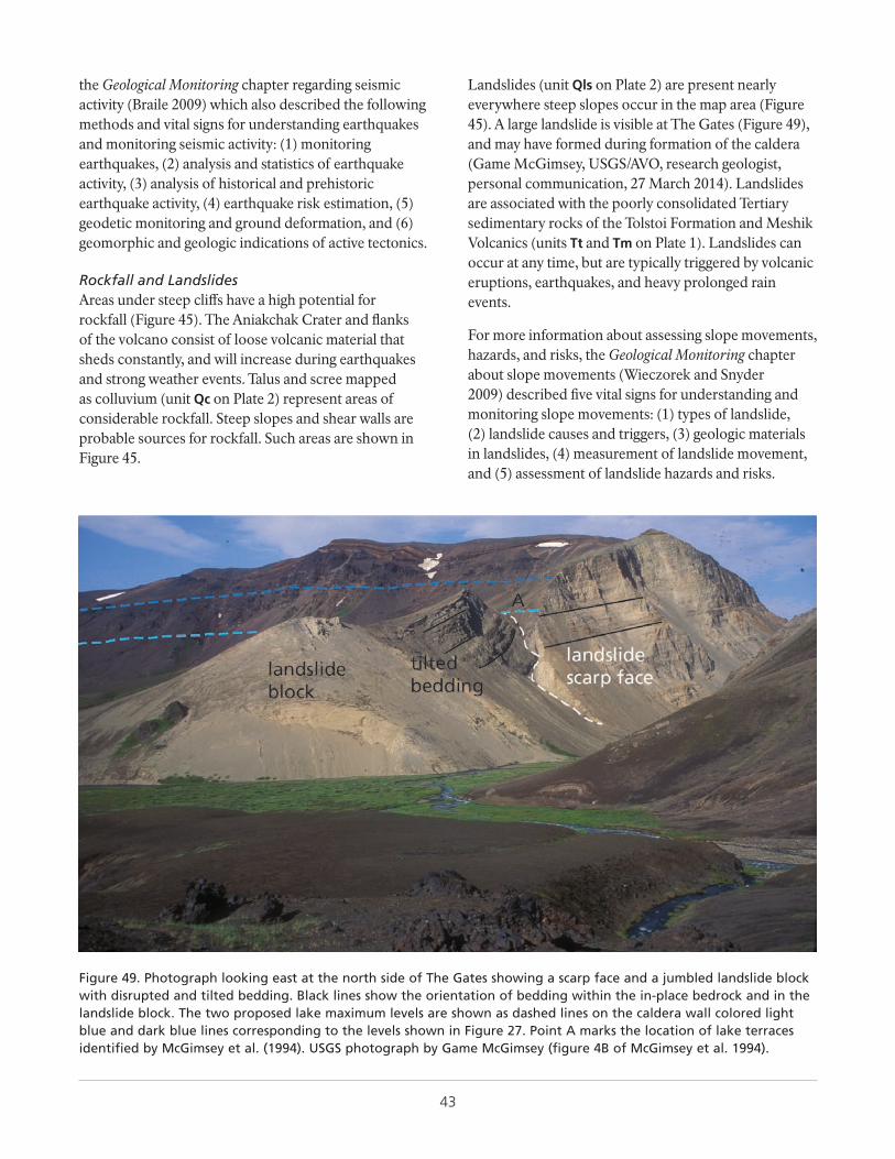
43
the Geological Monitoring chapter regarding seismic activity (Braile 2009) which also described the following methods and vital signs for understanding earthquakes and monitoring seismic activity: (1) monitoring earthquakes, (2) analysis and statistics of earthquake activity, (3) analysis of historical and prehistoric earthquake activity, (4) earthquake risk estimation, (5) geodetic monitoring and ground deformation, and (6) geomorphic and geologic indications of active tectonics.
Rockfall and LandslidesAreas under steep cliffs have a high potential for rockfall (Figure 45). The Aniakchak Crater and flanks of the volcano consist of loose volcanic material that sheds constantly, and will increase during earthquakes and strong weather events. Talus and scree mapped as colluvium (unit Qc on Plate 2) represent areas of considerable rockfall. Steep slopes and shear walls are probable sources for rockfall. Such areas are shown in Figure 45.
Landslides (unit Qls on Plate 2) are present nearly everywhere steep slopes occur in the map area (Figure 45). A large landslide is visible at The Gates (Figure 49), and may have formed during formation of the caldera (Game McGimsey, USGS/AVO, research geologist, personal communication, 27 March 2014). Landslides are associated with the poorly consolidated Tertiary sedimentary rocks of the Tolstoi Formation and Meshik Volcanics (units Tt and Tm on Plate 1). Landslides can occur at any time, but are typically triggered by volcanic eruptions, earthquakes, and heavy prolonged rain events.
For more information about assessing slope movements, hazards, and risks, the Geological Monitoring chapter about slope movements (Wieczorek and Snyder 2009) described five vital signs for understanding and monitoring slope movements: (1) types of landslide, (2) landslide causes and triggers, (3) geologic materials in landslides, (4) measurement of landslide movement, and (5) assessment of landslide hazards and risks.
Figure 49. Photograph looking east at the north side of The Gates showing a scarp face and a jumbled landslide block with disrupted and tilted bedding. Black lines show the orientation of bedding within the in-place bedrock and in the landslide block. The two proposed lake maximum levels are shown as dashed lines on the caldera wall colored light blue and dark blue lines corresponding to the levels shown in Figure 27. Point A marks the location of lake terraces identified by McGimsey et al. (1994). USGS photograph by Game McGimsey (figure 4B of McGimsey et al. 1994).
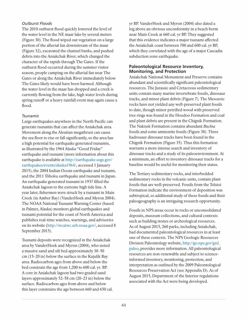
44
Outburst FloodsThe 2010 outburst flood quickly lowered the level of the water level in the NE maar lake by several meters (Figure 30). The flood wiped out vegetation on a large portion of the alluvial fan downstream of the maar (Figure 32), excavated the channel banks, and pushed debris into the Aniakchak River, which changed the character of the rapids through The Gates. If the outburst flood occurred during the summer visitor season, people camping on the alluvial fan near The Gates or along the Aniakchak River immediately below The Gates likely would have been harmed. Although the water level in the maar has dropped and a creek is currently flowing from the lake, high water levels during spring runoff or a heavy rainfall event may again cause a flood.
TsunamisLarge earthquakes anywhere in the North Pacific can generate tsunamis that can affect the Aniakchak area. Movement along the Aleutian megathrust can cause the sea floor to rise or fall significantly, so the area has a high potential for earthquake generated tsunamis, as illustrated by the 1964 Alaska “Good Friday” earthquake and tsunami (more information about this earthquake is available at http://earthquake.usgs.gov/earthquakes/events/alaska1964/, accessed 1 January 2015), the 2004 Indian Ocean earthquake and tsunami, and the 2011 Tōhoku earthquake and tsunami in Japan. An earthquake generated tsunami in 1937 filled the Aniakchak lagoon to the extreme high tide line. A year later, fishermen were struck by a tsunami in Main Creek (in Amber Bay) (VanderHoek and Myron 2004). The NOAA National Tsunami Warning Center (based in Palmer, Alaska) monitors global earthquakes and tsunami potential for the coast of North America and publishes real-time watches, warnings, and advisories on its website (http://wcatwc.arh.noaa.gov/, accessed 8 September 2015).
Tsunami deposits were recognized in the Aniakchak area by VanderHoek and Myron (2004), who noted a massive sand and silt bed approximately 38–50 cm (15–20 in) below the surface in the Kujulik Bay area. Radiocarbon ages from above and below the bed constrain the age from 1,200 to 600 cal. yr. BP. A core in Aniakchak lagoon had two graded sand layers approximately 52–58 cm (20–23 in) below the surface. Radiocarbon ages from above and below this layer constrains the age between 660 and 650 cal.
yr BP. VanderHoek and Myron (2004) also dated a log above an obvious unconformity in a beach berm near Main Creek at 660 cal. yr BP. They suggested that this evidence indicates a major tsunami affected the Aniakchak coast between 700 and 600 cal. yr BP, which they correlated with the age of a major Cascadia subduction zone earthquake.
Paleontological Resource Inventory, Monitoring, and ProtectionAniakchak National Monument and Preserve contains abundant and scientifically significant paleontological resources. The Jurassic and Cretaceous sedimentary units contain many marine invertebrate fossils, dinosaur tracks, and minor plant debris (Figure 7). The Mesozoic rocks have not yielded any well-preserved plant fossils to date, though minor petrified wood with preserved tree rings was found in the Hoodoo Formation and coal and plant debris are present in the Chignik Formation. The Naknek Formation contains abundant Buchia fossils and some ammonite fossils (Figure 38). Three hadrosaur dinosaur tracks have been found in the Chignik Formation (Figure 35). Thus this formation warrants a more intense search and inventory of dinosaur tracks and a study of its paleoenvironment. At a minimum, an effort to inventory dinosaur tracks for a baseline would be useful for monitoring their status.
The Tertiary sedimentary rocks, and interbedded sedimentary rocks in the volcanic units, contain plant fossils that are well-preserved. Fossils from the Tolstoi Formation indicate the environment of deposition was subtropical, so additional study of these fossils and their paleogeography is an intriguing research opportunity.
Fossils in NPS areas occur in rocks or unconsolidated deposits, museum collections, and cultural contexts such as building stones or archeological resources. As of August 2015, 260 parks, including Aniakchak, had documented paleontological resources in at least one of these contexts. The NPS Geologic Resources Division Paleontology website, http://go.nps.gov/grd_paleo, provides more information. All paleontological resources are non-renewable and subject to science-informed inventory, monitoring, protection, and interpretation as outlined by the 2009 Paleontological Resources Preservation Act (see Appendix D). As of August 2015, Department of the Interior regulations associated with the Act were being developed.
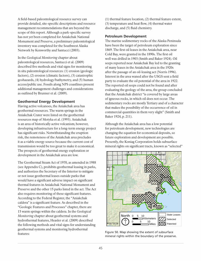
45
A field-based paleontological resource survey can provide detailed, site-specific descriptions and resource management recommendations that are beyond the scope of this report. Although a park-specific survey has not yet been completed for Aniakchak National Monument and Preserve, a preliminary paleontological inventory was completed for the Southwest Alaska Network by Kenworthy and Santucci (2003).
In the Geological Monitoring chapter about paleontological resources, Santucci et al. (2009) described five methods and vital signs for monitoring in situ paleontological resources: (1) erosion (geologic factors), (2) erosion (climatic factors), (3) catastrophic geohazards, (4) hydrology/bathymetry, and (5) human access/public use. Fossils along NPS coastlines present additional management challenges and considerations as outlined by Brunner et al. (2009).
Geothermal Energy DevelopmentHaving active volcanoes, the Aniakchak area has geothermal resources. The warm springs in the Aniakchak Crater were listed on the geothermal resources map of Motyka et al. (1993). Aniakchak is an area of historically active volcanism; however, developing infrastructure for a long-term energy project has significant risks. Notwithstanding the eruption risk, the remoteness of the Aniakchak area precludes it as a viable energy source because the current cost of transmission would be too great to make it economical. The prospects of geothermal energy exploration or development in the Aniakchak area are low.
The Geothermal Steam Act of 1970, as amended in 1988 (see Appendix C), prohibits geothermal leasing in parks, and authorizes the Secretary of the Interior to mitigate or not issue geothermal leases outside parks that would have a significant adverse impact on significant thermal features in Aniakchak National Monument and Preserve and the other 15 parks listed in the act. The Act also requires monitoring of these significant features. According to the Federal Register, the “Aniakchak caldera” is a significant feature. As described in the “Geologic Features and Processes” chapter, there are 15 warm springs within the caldera. In the Geological Monitoring chapter about geothermal systems and hydrothermal features, Heasler et al. (2009) described the following methods and vital signs for understanding geothermal systems and monitoring hydrothermal features:
(1) thermal feature location, (2) thermal feature extent, (3) temperature and heat flow, (4) thermal water discharge, and (5) fluid chemistry.
Petroleum DevelopmentThe marine sedimentary rocks of the Alaska Peninsula have been the target of petroleum exploration since 1869. The first oil leases in the Aniakchak area, near Cold Bay, were granted in the 1890s. The first oil well was drilled in 1903 (Smith and Baker 1924). Oil seeps reported near Aniakchak Bay led to the granting of many leases in the Aniakchak area in the 1920s after the passage of an oil-leasing act (Norris 1996). Interest in the area waned after the USGS sent a field party to evaluate the oil potential of the area in 1922. The reported oil seeps could not be found and after evaluating the geology of the area, the group concluded that the Aniakchak district “is covered by large areas of igneous rocks, in which oil does not occur. The sedimentary rocks are mostly Tertiary and of a character that makes the possibility of the occurrence of oil in commercial quantities in them very slight” (Smith and Baker 1924, p. 211).
Although the Aniakchak area has a low potential for petroleum development, new technologies are changing the equation for economical deposits, so future exploration and development are possible. Presently, the Koniag Corporation holds subsurface mineral rights on significant tracts, known as “selected”
157°30'W158°W
57°N
56°30'N
State Leases
Selected
Patented0 5 10
Miles
0 5 10Kilometers
North
Figure 50. Map showing the extent of subsurface mineral rights within the boundary of the preserve.
46
and “patented” areas within the preserve boundary (Figure 50). Also, many state oil leases are held outside the preserve boundary, mostly to the north (Figure 50). Although leases within the preserve can be developed, NPS regulations limit the impact that development would have on the park resources. Potential impacts include groundwater and surface water contamination, erosion and siltation, introduction of exotic plant species, reduction of wildlife habitat, impairment of viewsheds and night skies, excessive noise, and diminished air quality. Visitor safety and overall degradation of the visitor experience are particular concerns. The NPS Geologic Resources Division Energy and Minerals website, http://go.nps.gov/grd_energyminerals, provides additional information.
Mineral ExtractionStudies of the mineral resources in the Aniakchak area found a low to moderate mineral potential (Knappen 1929; Lyle and Dobey 1973; Cox et al. 1981). Five mineral occurrences are in the map area and are listed in the Alaska Resource Data File (records UG001, SW001, SW005, SW006, and SW008) at http://mrdata.usgs.gov/ardf/ (accessed 30 July 2015). They are also included in the GRI GIS data (“Mine Point Features” layer). Four are hydrothermally altered areas associated with Tertiary intrusive igneous bodies, and one is a placer claim area along the Aniakchak River. None of the sites have been developed and only one of the sites in the park unit boundary, on Cape Kumlik (SW001), was explored in the 1970s by a mining company that found only minor copper values. In addition, the Mike Prospect (UG001) outside the boundaries of the park unit was drilled in the 1970s but never developed. Outside the map area, the beaches on the Bristol Bay side of the peninsula have claims for potential heavy mineral deposits (see ARDF record BB001).
Some of the Koniag subsurface mineral rights tracts (Figure 50) allow for the extraction of materials for supporting oil development. Exploration for pumice deposits in the 1950s found that the Aniakchak area was a potential source of pumice, particularly along the beaches near the mouth of the Aniakchak River and in deposits on Bear Creek (Moxham 1952). However, the distance from Anchorage or other markets presently precludes economically viable extraction of pumice from the Aniakchak area.
Unlike most Alaska NPS units, there are no abandoned mineral lands (AML) features or sites documented within Aniakchak National Monument and Preserve (Burghardt et al. 2014).
Coastal IssuesThe raised marine terraces and beach berms are significant coastal features within Aniakchak (see “Geologic Features and Processes” chapter). In addition, Aniakchak National Monument and Preserve contains 217 km (135 mi) of shoreline (Curdts 2011). It is one of 118 parks servicewide that have been identified as potentially vulnerable to sea-level change. Geohazards (see “Geohazards” section), particularly tsunamis, may impact coastal features and processes. The NPS has developed a variety of databases and guidance for managing coastal resources and planning for the impacts of climate change. Refer to Appendix C for laws, regulations, and NPS policies pertaining to coastal resources. The few coastal assets and infrastructure within Aniakchak National Monument and Preserve limits potential impacts to human structures although those issues are pronounced elsewhere in the NPS. The 2006 monitoring plan for the Southwest Alaska Network (Bennett et al. 2006) did not establish a geomorphic coastal change monitoring plan for Aniakchak, although other parks in the network are monitored. Refer to the Marine Nearshore Monitoring website for additional information (http://science.nature.nps.gov/im/units/swan/monitor/nearshore.cfm?tab=0; accessed 4 September 2015).
Coastal Resource Management and PlanningThe NPS Coastal Adaptation Handbook (RM 39-3; in review, expected 2016) will provide climate change adaptation guidance to coastal park managers in the 118 parks that have been identified by their regional offices as potentially vulnerable to sea-level change. Focus topics will include NPS policies relevant to climate change, guidance on evaluating appropriate adaptation actions, and adaptation opportunities for planning, incident response, cultural resources, natural resources, facilities and assets, and infrastructure. The handbook will also provide guidance on developing communication and education materials about climate change impacts, and it will detail case studies of the many ways that individual parks are implementing adaptation strategies for threatened resources.
47
Additional Reference Manuals that guide coastal resource management include NPS Reference Manual #39-1: Ocean and Coastal Park Jurisdiction, which can provide insight for parks with boundaries that may shift with changing shorelines (available at http://www.nps.gov/applications/npspolicy/DOrders.cfm); and NPS Reference Manual #39-2: Beach Nourishment Guidance (Dallas et al. 2012) for planning and managing nourishment projects.
The NPS is also developing a cultural resources climate change response strategy that connects climate science with historic preservation planning. The summary report from the Preserving Coastal Heritage workshop in 2014 identified and described six climate change adaptation options for cultural resources and cultural landscapes (no active intervention; offset stressors; improve resilience; manage change; relocate or facilitiate movement; document and release). Additional information about the workshop, and associated presentations and reports, are available at https://sites.google.com/site/democlimcult/ (accessed 4 September 2015).
Coastal Resource DatasetsThe NPS Geologic Resources Division (GRD) and Climate Change Response Program (CCRP) are developing sea-level rise and storm surge data that parks can use for planning purposes over multiple time horizons. The project, led by Maria Caffrey of GRD, should be completed by 2016 and will analyze rates of sea level coupled with potential storm surge in 105 of the vulnerable parks in order to project, for each park, the combined elevations of storms surge and sea level by 2030, 2050, and 2100. For Aniakchak
National Monument and Preserve, the projections (Table 3) were created using various scenarios from the IPCC (Intergovernmental Panel on Climate Change) and USACE (US Army Corps of Engineers). There is a wide spread in projections particularly for the USACE data (calculated for Sand Point, Alaska) but the IPCC numbers do not account for land movement (e.g., see “Raised Marine Terraces” section; M. Caffrey, Research Associate, University of Colorado, written communication, 4 September 2015).
The NPS developed a report entitled Adapting To Climate Change in Coastal Parks: Estimating the Exposure of FMSS-Listed Park Assets to 1 m of Sea-Level Rise (Peek et al. 2015). This report includes the geospatial location and approximate elevation of over 10,000 assets in 40 coastal parks, based on information within the NPS Facilities Management Software System (FMSS) and supplemented with other datasets, collaboration with park staff, and field visits to locate assets. Assets were characterized based on their overall exposure to long-term (1 m) sea-level rise and associated storm vulnerability, and were categorized as having either high exposure or limited exposure to sea-level rise impacts. There are no coastal assets in Aniakchak National Monument and Preserve.
Parks can also consult suggested protocols such as the Geological Monitoring chapter about coastal features and processes defined in Bush and Young (2009), which described methods and vital signs for monitoring the following coastal features and processes: (1) shoreline change, (2) coastal dune geomorphology, (3) coastal vegetation cover, (4) topography/elevation, (5) composition of beach material, (6) wetland position/acreage, and (7) coastal wetland accretion.
Table 3. Sea level rise projections based on IPCC (Intergovernmental Panel on Climate Change) and USACE (US Army Corps of Engineers) scenarios.
Scenario 2030 (m) 2030 (ft) 2050 (m) 2050 (ft) 2100 (m) 2100 (ft)IPCC RCP 2.6 0.06 0.20 0.12 0.39 0.34 1.12
IPCC RCP 4.5 0.09 0.30 0.16 0.52 0.38 1.25
IPCC RCP 6.0 0.09 0.30 0.17 0.56 0.4 1.31
IPCC RCP 8.5 0.1 0.33 0.17 0.56 0.5 1.64
USACE Low (based on Sand Point, AK) 0.04 0.13 0.05 0.16 0.1 0.33
USACE Intermediate (based on Sand Point, AK) 0.07 0.23 0.14 0.46 0.42 1.38
USACE High (based on Sand Point, AK) 0.2 0.66 0.43 1.41 1.42 4.66
Table provided by Maria Caffrey, NPS GRD and University of Colorado, Research Associate, written communication, 4 September 2015). RCPs are “Representative Concentration Pathways” and are described online: http://sedac.ipcc-data.org/ddc/ar5_scenario_process/RCPs.html (accessed 4 September 2015).
48
The NPS Water Resources Division, Ocean and Coastal Resources Branch website (http://www.nature.nps.gov/water/oceancoastal/; accessed 4 September 2015) has additional information about servicewide programs and the resources and management programs at the ocean, coastal, and Great Lakes parks. Shoreline maps of each park, along with shoreline and water acreage statistics from Curdts (2011), are available at http://nature.nps.gov/water/oceancoastal/shorelinemaps.cfm (accessed 4 September 2015).
Glacier ChangesLoso et al. (2014) conducted an Alaskawide glacier change study that included Aniakchak National Monument and Preserve. They counted 16 glaciers overall in recent satellite imagery as opposed to 29 counted on the 1950s USGS topographic maps. However, the glacier area changed from 4.1 to 4.6 km2. Small glaciers on the eastern boundary of the park shrunk or disappeared, while glaciers in the caldera grew or were mapped for the first time in the satellite imagery. The changes measured have a low reliability, and in fact Loso et al. (2014, p. 44) state that “implied changes over time should, in [Aniakchak], be disregarded” because the air photos used for the topographic maps were taken early in the season when there were many snow fields that might have been interpreted as glaciers. Also, the caldera glaciers are covered with debris, so their extent is difficult to map.
Alaskawide, Loso et al. (2014) noted that the trend of warmer summers and wetter winters will continue for at least the next 50 years and warming will accelerate. Recent glacier trends of negative mass balance, diminished ice cover, and reduced ice volume will intensify (Loso et al. 2014). The Southwest Alaska Network does not include glacial extent as a monitorable vital sign for Aniakchak National Monument and Preserve (Bennett et al. 2006). More information about glaciers in other Southwest Alaska Network parks is available at the network website http://science.nature.nps.gov/im/units/swan/monitor/landscape.cfm?tab=1 (accessed 4 September 2015). Servicewide glacier monitoring techniques and vital signs were suggested by Karpilo (2009). Information about climate change in National Park Service and/or Alaska is available at the resources listed in the “Additional References” chapter.
Crater Lake Level and Water QualitySurprise Lake supports spawning and nursing habitat for sockeye salmon and arctic char (Cameron and Larson 1992). Cameron and Larson (1992) conducted a thorough lake and warm spring water quality and hydrologic study of the Aniakchak area. They measured the Surprise Lake height changes during one summer season and recorded a maximum variation of 15 cm after the largest rainstorm. They marked a rock along the lake as a reference point for future measurements. Cameron and Larson (1992) made a variety of water quality measurements that are only briefly summarized herein. The water quality of the lake varies spatially and with changes in the meteorological conditions. During the winter the lake is frozen over, so that precipitates (iron-oxide) from the warm springs are deposited near the spring mouth. These precipitates are quickly suspended after breakup when strong winds create waves that batter the shoreline. The warm springs have the strongest influence on the water quality near their outlets, but strong windstorms are effective at mixing and homogenizing the water chemistry. Water clarity is normally good until August when phytoplankton bloom. Temperature, conductance, alkalinity, and hardness are highest near the warm springs. Dissolved oxygen and pH are lowest near the warm springs. No salmon spawn on the warm spring side of the lake, but prefer the side of the lake near the crater wall where fresh groundwater flows into the lake (Hamon and Pavey 2012). Surface hydrology and freshwater chemistry are vital signs monitored for Aniakchak National Monument and Preserve as part of the Southwest Alaska Network monitoring plan (Bennett et al. 2006; see also the network’s Freshwater Flow Systems monitoring website at http://science.nature.nps.gov/im/units/swan/monitor/freshwater.cfm?tab=0 (accessed 4 September 2015). The NPS Water Resources Division is the servicewide contact for water quality issues (http://nature.nps.gov/water; accessed 4 September 2015).
Potential Future Studies
Aniakchak II EruptionThe Aniakchak II deposits have been studied only on a reconnaissance level. Little is known about the distribution, changing character, stratigraphy, and sedimentology of this world class ignimbrite. Previous studies have focused on petrology rather than physical processes, so a research opportunity is to investigate
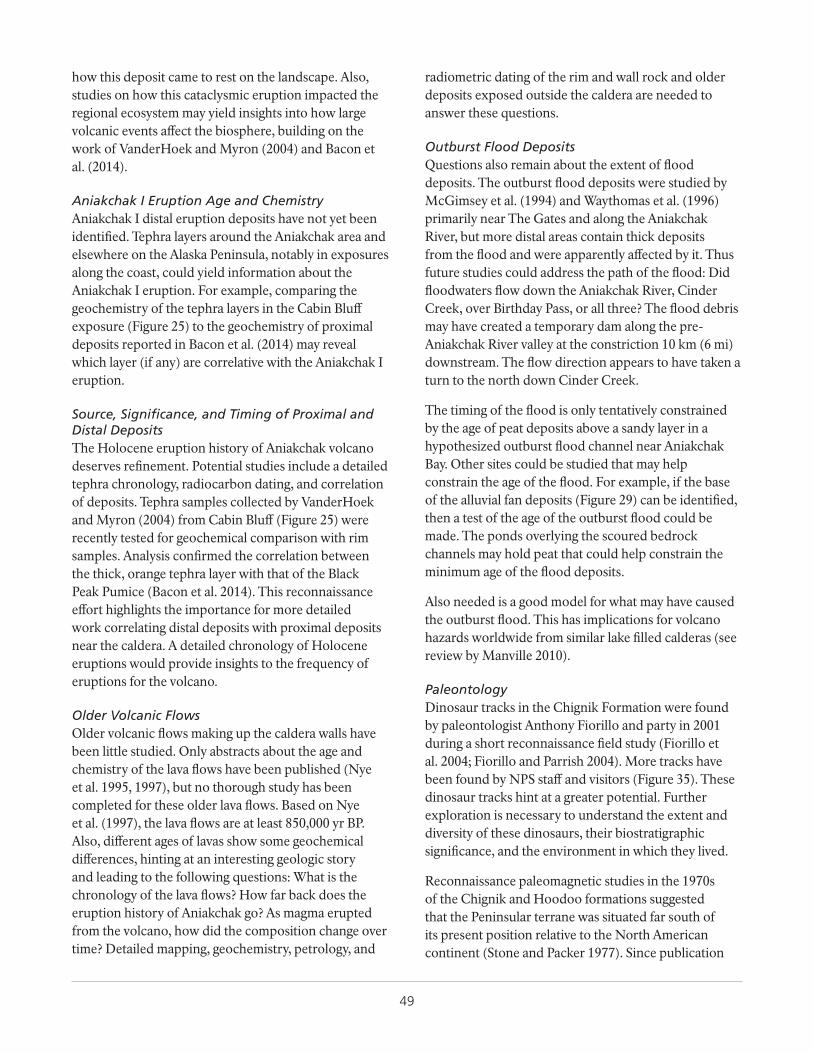
49
how this deposit came to rest on the landscape. Also, studies on how this cataclysmic eruption impacted the regional ecosystem may yield insights into how large volcanic events affect the biosphere, building on the work of VanderHoek and Myron (2004) and Bacon et al. (2014).
Aniakchak I Eruption Age and ChemistryAniakchak I distal eruption deposits have not yet been identified. Tephra layers around the Aniakchak area and elsewhere on the Alaska Peninsula, notably in exposures along the coast, could yield information about the Aniakchak I eruption. For example, comparing the geochemistry of the tephra layers in the Cabin Bluff exposure (Figure 25) to the geochemistry of proximal deposits reported in Bacon et al. (2014) may reveal which layer (if any) are correlative with the Aniakchak I eruption.
Source, Significance, and Timing of Proximal and Distal DepositsThe Holocene eruption history of Aniakchak volcano deserves refinement. Potential studies include a detailed tephra chronology, radiocarbon dating, and correlation of deposits. Tephra samples collected by VanderHoek and Myron (2004) from Cabin Bluff (Figure 25) were recently tested for geochemical comparison with rim samples. Analysis confirmed the correlation between the thick, orange tephra layer with that of the Black Peak Pumice (Bacon et al. 2014). This reconnaissance effort highlights the importance for more detailed work correlating distal deposits with proximal deposits near the caldera. A detailed chronology of Holocene eruptions would provide insights to the frequency of eruptions for the volcano.
Older Volcanic FlowsOlder volcanic flows making up the caldera walls have been little studied. Only abstracts about the age and chemistry of the lava flows have been published (Nye et al. 1995, 1997), but no thorough study has been completed for these older lava flows. Based on Nye et al. (1997), the lava flows are at least 850,000 yr BP. Also, different ages of lavas show some geochemical differences, hinting at an interesting geologic story and leading to the following questions: What is the chronology of the lava flows? How far back does the eruption history of Aniakchak go? As magma erupted from the volcano, how did the composition change over time? Detailed mapping, geochemistry, petrology, and
radiometric dating of the rim and wall rock and older deposits exposed outside the caldera are needed to answer these questions.
Outburst Flood DepositsQuestions also remain about the extent of flood deposits. The outburst flood deposits were studied by McGimsey et al. (1994) and Waythomas et al. (1996) primarily near The Gates and along the Aniakchak River, but more distal areas contain thick deposits from the flood and were apparently affected by it. Thus future studies could address the path of the flood: Did floodwaters flow down the Aniakchak River, Cinder Creek, over Birthday Pass, or all three? The flood debris may have created a temporary dam along the pre-Aniakchak River valley at the constriction 10 km (6 mi) downstream. The flow direction appears to have taken a turn to the north down Cinder Creek.
The timing of the flood is only tentatively constrained by the age of peat deposits above a sandy layer in a hypothesized outburst flood channel near Aniakchak Bay. Other sites could be studied that may help constrain the age of the flood. For example, if the base of the alluvial fan deposits (Figure 29) can be identified, then a test of the age of the outburst flood could be made. The ponds overlying the scoured bedrock channels may hold peat that could help constrain the minimum age of the flood deposits.
Also needed is a good model for what may have caused the outburst flood. This has implications for volcano hazards worldwide from similar lake filled calderas (see review by Manville 2010).
PaleontologyDinosaur tracks in the Chignik Formation were found by paleontologist Anthony Fiorillo and party in 2001 during a short reconnaissance field study (Fiorillo et al. 2004; Fiorillo and Parrish 2004). More tracks have been found by NPS staff and visitors (Figure 35). These dinosaur tracks hint at a greater potential. Further exploration is necessary to understand the extent and diversity of these dinosaurs, their biostratigraphic significance, and the environment in which they lived.
Reconnaissance paleomagnetic studies in the 1970s of the Chignik and Hoodoo formations suggested that the Peninsular terrane was situated far south of its present position relative to the North American continent (Stone and Packer 1977). Since publication
50
of these studies, better techniques have been developed to extract more reliable paleomagnetic data from sedimentary rocks. New investigation of the Chignik Formation is critical to understanding its paleogeography, latitude, and environment where these dinosaurs inhabited and left tracks.
The Naknek Formation has also produced dinosaur tracks near Black Lake, southwest of the Aniakchak area (Druckenmiller et al. 2011). The occurrence of plant fossils in the Naknek Formation in the map area suggests a potential for other types of fossils, possibly dinosaur tracks, in nearshore deposits.
The plant fossils and marine mollusks in the Tolstoi Formation indicate the unit was deposited in a warm climate (Detterman et al. 1996), and paleomagnetic data show the unit was far south of its present position relative to the North American continent (Stone and Packer 1977; Coe et al. 1985; Hillhouse and Coe 1994). The paleoenvironment and paleogeography of this unit warrants detailed study.
Detailed Surficial Geologic MapNew interferometric synthetic aperture radar (InSAR) digital elevation models are being collected for Alaska that have a 5 m (16 ft) pixel resolution, which is much better than the available 30 m (100 ft) pixel resolution DEM, and is good for 1:24,000 scale surficial mapping. Currently available surficial geologic maps were published at a 1:250,000 scale (Plate 2; Detterman et al. 1981b, 1987), so mapping using the new detailed DEM will be more detailed. A detailed surficial geologic map would be useful for evaluation of landslide and rockfall hazards; evaluation of parent material for soils mapping; mapping of outburst flood deposits, mapping volcanic features and deposits; coastal geomorphology studies; engineering properties for a potential ATV trail near the northern boundary of the preserve; and interpretation of marine terrace uplift and glacial histories.
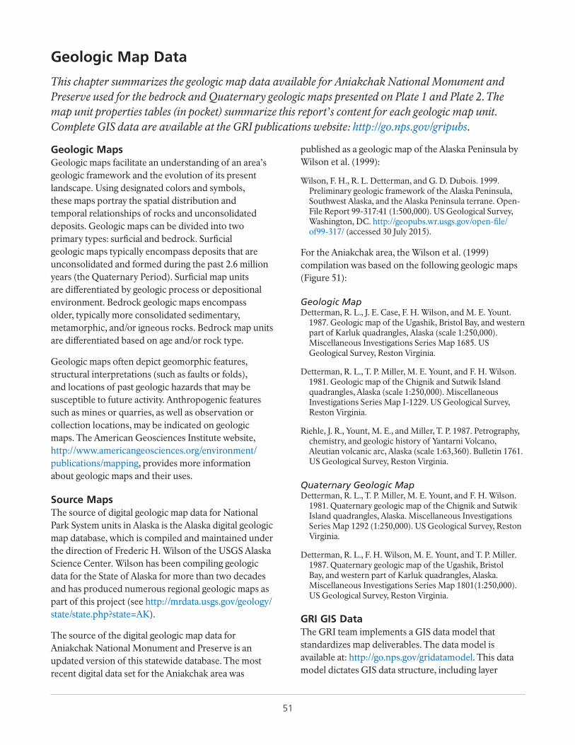
51
Geologic MapsGeologic maps facilitate an understanding of an area’s geologic framework and the evolution of its present landscape. Using designated colors and symbols, these maps portray the spatial distribution and temporal relationships of rocks and unconsolidated deposits. Geologic maps can be divided into two primary types: surficial and bedrock. Surficial geologic maps typically encompass deposits that are unconsolidated and formed during the past 2.6 million years (the Quaternary Period). Surficial map units are differentiated by geologic process or depositional environment. Bedrock geologic maps encompass older, typically more consolidated sedimentary, metamorphic, and/or igneous rocks. Bedrock map units are differentiated based on age and/or rock type.
Geologic maps often depict geomorphic features, structural interpretations (such as faults or folds), and locations of past geologic hazards that may be susceptible to future activity. Anthropogenic features such as mines or quarries, as well as observation or collection locations, may be indicated on geologic maps. The American Geosciences Institute website, http://www.americangeosciences.org/environment/publications/mapping, provides more information about geologic maps and their uses.
Source MapsThe source of digital geologic map data for National Park System units in Alaska is the Alaska digital geologic map database, which is compiled and maintained under the direction of Frederic H. Wilson of the USGS Alaska Science Center. Wilson has been compiling geologic data for the State of Alaska for more than two decades and has produced numerous regional geologic maps as part of this project (see http://mrdata.usgs.gov/geology/state/state.php?state=AK).
The source of the digital geologic map data for Aniakchak National Monument and Preserve is an updated version of this statewide database. The most recent digital data set for the Aniakchak area was
published as a geologic map of the Alaska Peninsula by Wilson et al. (1999):
Wilson, F. H., R. L. Detterman, and G. D. Dubois. 1999. Preliminary geologic framework of the Alaska Peninsula, Southwest Alaska, and the Alaska Peninsula terrane. Open-File Report 99-317:41 (1:500,000). US Geological Survey, Washington, DC. http://geopubs.wr.usgs.gov/open-file/of99-317/ (accessed 30 July 2015).
For the Aniakchak area, the Wilson et al. (1999) compilation was based on the following geologic maps (Figure 51):
Geologic MapDetterman, R. L., J. E. Case, F. H. Wilson, and M. E. Yount.
1987. Geologic map of the Ugashik, Bristol Bay, and western part of Karluk quadrangles, Alaska (scale 1:250,000). Miscellaneous Investigations Series Map 1685. US Geological Survey, Reston Virginia.
Detterman, R. L., T. P. Miller, M. E. Yount, and F. H. Wilson. 1981. Geologic map of the Chignik and Sutwik Island quadrangles, Alaska (scale 1:250,000). Miscellaneous Investigations Series Map I-1229. US Geological Survey, Reston Virginia.
Riehle, J. R., Yount, M. E., and Miller, T. P. 1987. Petrography, chemistry, and geologic history of Yantarni Volcano, Aleutian volcanic arc, Alaska (scale 1:63,360). Bulletin 1761. US Geological Survey, Reston Virginia.
Quaternary Geologic MapDetterman, R. L., T. P. Miller, M. E. Yount, and F. H. Wilson.
1981. Quaternary geologic map of the Chignik and Sutwik Island quadrangles, Alaska. Miscellaneous Investigations Series Map 1292 (1:250,000). US Geological Survey, Reston Virginia.
Detterman, R. L., F. H. Wilson, M. E. Yount, and T. P. Miller. 1987. Quaternary geologic map of the Ugashik, Bristol Bay, and western part of Karluk quadrangles, Alaska. Miscellaneous Investigations Series Map 1801(1:250,000). US Geological Survey, Reston Virginia.
GRI GIS DataThe GRI team implements a GIS data model that standardizes map deliverables. The data model is available at: http://go.nps.gov/gridatamodel. This data model dictates GIS data structure, including layer
Geologic Map Data
This chapter summarizes the geologic map data available for Aniakchak National Monument and Preserve used for the bedrock and Quaternary geologic maps presented on Plate 1 and Plate 2. The map unit properties tables (in pocket) summarize this report’s content for each geologic map unit. Complete GIS data are available at the GRI publications website: http://go.nps.gov/gripubs.
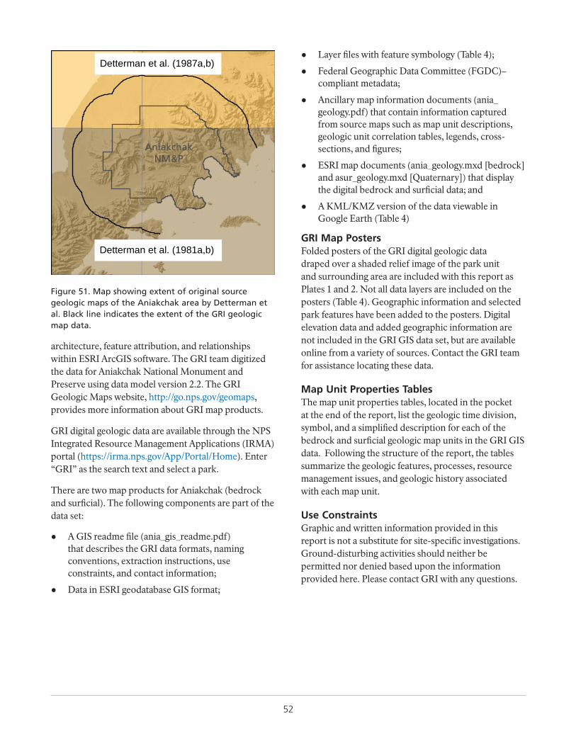
52
architecture, feature attribution, and relationships within ESRI ArcGIS software. The GRI team digitized the data for Aniakchak National Monument and Preserve using data model version 2.2. The GRI Geologic Maps website, http://go.nps.gov/geomaps, provides more information about GRI map products.
GRI digital geologic data are available through the NPS Integrated Resource Management Applications (IRMA) portal (https://irma.nps.gov/App/Portal/Home). Enter “GRI” as the search text and select a park.
There are two map products for Aniakchak (bedrock and surficial). The following components are part of the data set:
● A GIS readme file (ania_gis_readme.pdf) that describes the GRI data formats, naming conventions, extraction instructions, use constraints, and contact information;
● Data in ESRI geodatabase GIS format;
● Layer files with feature symbology (Table 4);
● Federal Geographic Data Committee (FGDC)–compliant metadata;
● Ancillary map information documents (ania_geology.pdf) that contain information captured from source maps such as map unit descriptions, geologic unit correlation tables, legends, cross-sections, and figures;
● ESRI map documents (ania_geology.mxd [bedrock] and asur_geology.mxd [Quaternary]) that display the digital bedrock and surficial data; and
● A KML/KMZ version of the data viewable in Google Earth (Table 4)
GRI Map PostersFolded posters of the GRI digital geologic data draped over a shaded relief image of the park unit and surrounding area are included with this report as Plates 1 and 2. Not all data layers are included on the posters (Table 4). Geographic information and selected park features have been added to the posters. Digital elevation data and added geographic information are not included in the GRI GIS data set, but are available online from a variety of sources. Contact the GRI team for assistance locating these data.
Map Unit Properties TablesThe map unit properties tables, located in the pocket at the end of the report, list the geologic time division, symbol, and a simplified description for each of the bedrock and surficial geologic map units in the GRI GIS data. Following the structure of the report, the tables summarize the geologic features, processes, resource management issues, and geologic history associated with each map unit.
Use ConstraintsGraphic and written information provided in this report is not a substitute for site-specific investigations. Ground-disturbing activities should neither be permitted nor denied based upon the information provided here. Please contact GRI with any questions.
AniakchakNM&P
Detterman et al. (1981a,b)
Detterman et al. (1987a,b)
Figure 51. Map showing extent of original source geologic maps of the Aniakchak area by Detterman et al. Black line indicates the extent of the GRI geologic map data.
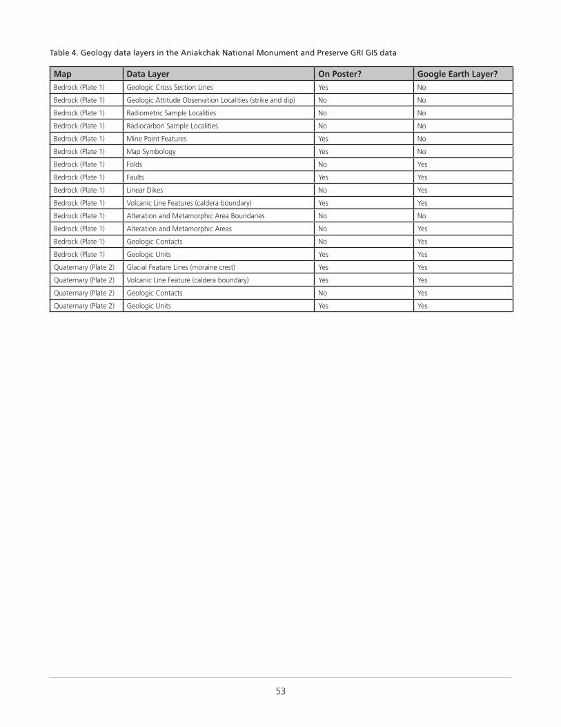
53
Table 4. Geology data layers in the Aniakchak National Monument and Preserve GRI GIS data
Map Data Layer On Poster? Google Earth Layer?Bedrock (Plate 1) Geologic Cross Section Lines Yes No
Bedrock (Plate 1) Geologic Attitude Observation Localities (strike and dip) No No
Bedrock (Plate 1) Radiometric Sample Localities No No
Bedrock (Plate 1) Radiocarbon Sample Localities No No
Bedrock (Plate 1) Mine Point Features Yes No
Bedrock (Plate 1) Map Symbology Yes No
Bedrock (Plate 1) Folds No Yes
Bedrock (Plate 1) Faults Yes Yes
Bedrock (Plate 1) Linear Dikes No Yes
Bedrock (Plate 1) Volcanic Line Features (caldera boundary) Yes Yes
Bedrock (Plate 1) Alteration and Metamorphic Area Boundaries No No
Bedrock (Plate 1) Alteration and Metamorphic Areas No Yes
Bedrock (Plate 1) Geologic Contacts No Yes
Bedrock (Plate 1) Geologic Units Yes Yes
Quaternary (Plate 2) Glacial Feature Lines (moraine crest) Yes Yes
Quaternary (Plate 2) Volcanic Line Feature (caldera boundary) Yes Yes
Quaternary (Plate 2) Geologic Contacts No Yes
Quaternary (Plate 2) Geologic Units Yes Yes

55
Glossary
These are brief definitions of selected geologic terms relevant to this report. Definitions are based on those in the American Geosciences Institute Glossary of Geology (5th edition; 2005). Additional terms are defined at http://geomaps.wr.usgs.gov/parks/misc/glossarya.html.
accretion (structural geology). The addition of island-arc or continental material to a continent via collision, welding, or suturing at a convergent plate boundary.
aeolian. Describes materials formed, eroded, or deposited by or related to the action of wind.
agglomerate. A consolidated pyroclastic rock made primarily of bombs. Roughly synonymous with spatter.
agglutinate. A welded pyroclastic deposit characterized by vitric material binding the individual clasts that commonly became fused while hot and viscous.
alluvial fan. A low, relatively flat to gently sloping, fan-shaped mass of loose rock material deposited by a stream, especially in a semiarid region, where a stream issues from a canyon onto a plain or broad valley floor.
alluvial terrace. A stream terrace composed of unconsolidated alluvium produced by a rejuvenated stream via renewed downcutting of the floodplain or valley floor, or by the covering of a terrace with alluvium.
alpine glacier. A small glacier in a mountain range (i.e., not an ice cap or ice sheet) that usually originates in a cirque and may flow down into a valley previously carved by a stream. Synonymous with “mountain glacier” and “valley glacier.”
ammonite. Any ammonoid belonging to the suborder Ammonitina, characterized by a thick, ornamental shell with sutures having finely divided lobes and saddles. Range: Jurassic to Cretaceous.
andesite. A volcanic rock characteristically medium dark in color and containing approximately 57%–63% silica and moderate amounts of iron and magnesium.
angular unconformity. An unconformity between two groups of rocks whose bedding planes are not parallel or in which the older, underlying rocks dip at a different angle (usually steeper) than the younger, overlying strata.
ash. Fine-grained material, less than 2 mm (0.08 in) across, ejected from a volcano.
asthenosphere. Earth’s relatively weak layer below the rigid lithosphere where isostatic adjustments take place, magmas may be generated, and seismic waves are strongly attenuated; part of the upper mantle.
avalanche. A large mass of snow, ice, soil, or rock, or a mixture of these materials, falling, sliding, or flowing very rapidly under the force of gravity; velocities may exceed 500 kph (300 mph). Commonly, in geologic writing, an avalanche other than a “snow avalanche” includes a descriptive term such as “debris avalanche.”
backshore. The upper or inner, usually dry, zone of a shore or beach. Also, the area lying immediately at the base of a sea cliff. Synonymous with “backbeach.”
bank. A submerged ridge of sand in the sea, a lake, or a river, usually exposed during low tide or low water.
basalt. A volcanic rock that is characteristically dark in color (gray to black), contains approximately 53% silica or less, and is rich in iron and magnesium.
basaltic andesite. A volcanic rock that is commonly dark gray to black and contains approximately 53%–57% silica.
basin (sedimentary). Any depression, from continental to local scale, into which sediments are deposited.
bathymetry. The measurement of ocean or lake depths and the charting of the topography of the ocean or lake floor.
beach. The unconsolidated material at the shoreline that covers a gently sloping zone, typically with a concave profile, extending landward from the low-water line to the place where there is a definite change in material or physiographic form (e.g., a cliff), or to the line of permanent vegetation (usually the effective limit of the highest
bed. The smallest sedimentary stratigraphic unit, commonly ranging in thickness from about 1 cm (0.4 in) to 1 to 2 m (40 to 80 in) and distinguishable from beds above and below.
bedding. Depositional layering or stratification of sediments.
bedrock. Solid rock that underlies unconsolidated sedimentary deposits and soil.
berm. A low, impermanent, nearly horizontal or landward-sloping bench, shelf, or ledge above the high-water line on a beach.
bivalve. Having a shell composed of two distinct, but equal or nearly equal, movable valves, which open and shut.
block. A pyroclast ejected in a solid state with a diameter greater than 64 mm (2.5 in).
block (fault). A segment of Earth’s crust bounded completely or partially by faults.
breccia. A coarse-grained, generally unsorted sedimentary rock consisting of cemented angular clasts more than 2 mm (0.08 in) across.
breccia (volcanic). A coarse-grained, generally unsorted volcanic rock consisting of partially welded angular fragments of ejected material.
calcareous. Describes a substance that contains calcium carbonate. When applied to a rock name it implies that as much as 50% of the rock is calcium carbonate.
caldera. A large, basin-shaped volcanic depression formed by collapse during an eruption.
cape. An extensive, somewhat rounded irregularity of land jutting out from the coast into a large body of water, either as a peninsula (e.g., Cape Cod, Massachusetts) or as a projecting point (e.g., Cape Hatteras, North Carolina). Also, the part of the projection extending farthest into the water.
56
channel. The bed of a stream or river. Also, a natural passageway or depression of perceptible extent containing continuously or periodically flowing water, or forming a connecting link between two bodies of water.
chert. An extremely hard sedimentary rock with conchoidal fracturing, consisting mostly of interlocking crystals of quartz.
chronology. The arrangement of events in their proper sequence in time.
cinder cone. A conical hill, commonly steep, ranging from tens to hundreds of meters tall, formed by the accumulation of solidified fragments of lava that fell around the vent during a basaltic or andesitic eruption.
clast. An individual constituent, grain, or fragment of a rock or unconsolidated deposit, produced by the mechanical or chemical disintegration of a larger rock mass.
coal. An organic sedimentary rock consisting of carbon, hydrogen, and oxygen, with some sulfur and nitrogen. Formed by the destructive distillation of plant remains under anaerobic and progressively rising pressures and temperatures.
coarse-grained. Describes a crystalline rock and texture in which the individual minerals are relatively large, specifically an igneous rock whose particles have an average diameter greater than 5 mm (0.2 in). Also, describes sediment or sedimentary rock and texture in which the individual constituents are easily seen with the unaided eye, specifically sediment or rock whose particles have an average diameter greater than 2 mm (0.08 in).
colluvium. A loose, heterogeneous, and incoherent mass of rock fragments and soil material deposited via surface runoff or slow continuous downslope creep; usually collects at the base of a slope or hillside, but includes loose material covering hillsides.
conglomerate. A coarse-grained, generally unsorted, sedimentary rock consisting of cemented, rounded clasts larger than 2 mm (0.08 in) in diameter.
contact. The surface between two types or ages of rocks.
continental. Formed on land rather than in the sea. Continental deposits may be of lake, swamp, wind, stream, or volcanic origin.
continental crust. Earth’s crust that is rich in silica and aluminum and underlies the continents and the continental shelves; ranges in thickness from about 25 km (15 mi) to more than 70 km (40 mi) under mountain ranges, averaging about 40 km (25 km) thick.
continental shelf. The shallowly submerged—covered by water depths of less than 200 m (660 ft)—part of a continental margin that extends from the shoreline to the continental slope.
continental slope. The relatively steep slope from the outer edge of the continental shelf down to the more gently sloping ocean depths of the continental rise or abyssal plain.
cordillera. An extensive assemblage of more or less parallel chains of mountains (together with their associated valleys, basins, plains, plateaus, rivers, and lakes), especially the main mountain axis of a continent.
craton. The relatively old and geologically stable interior of a continent.
cross-bedding. Uniform to highly varied sets of inclined beds deposited by wind or water that indicate flow conditions such as direction and depth.
crust. Earth’s outermost layer or shell.
dacite. A volcanic rock that is characteristically light in color and contains approximately 63%–68% silica and moderate amounts of sodium and potassium.
debris flow. A moving mass of rock fragments, soil, and mud, with more than half of the particles larger than sand size. Slow debris flows may move less that 1 m (3 ft) per year; rapid ones reach 160 kph (100 mph).
deformation. The process of folding, faulting, shearing, or fabric development in rocks as a result of Earth stresses.
detritus. Loose rock and mineral material that is worn off or removed by mechanical processes.
diorite. A coarse-grained, intrusive igneous rock characteristically containing plagioclase, as well as dark-colored amphibole (especially hornblende), pyroxene, and sometimes a small amount of quartz; diorite grades into monzodiorite with the addition of alkali feldspar.
discharge. The rate of flow of surface water or groundwater at a given moment, expressed as volume per unit of time.
dome. Any smoothly rounded landform or rock mass; more specifically, an elliptical uplift in which rocks dip gently away in all directions.
drainage. The manner in which the waters of an area flow off in surface streams or subsurface conduits; also, the processes of surface drainage of water from an area by streamflow and sheet flow, and the removal of excess water from soil by downward flow.
drainage basin. A region or area bounded by a drainage divide and occupied by a drainage system, specifically the tract of country that gathers water originating as precipitation and contributes it to a particular stream channel or system of channels, or to a lake, reservoir, or other body of water.
drift. All rock material (clay, silt, sand, gravel, and boulders) transported and deposited by a glacier, or by running water emanating from a glacier.
edifice. The constructional mass of a volcano.
effusive eruption. An eruption that produces mainly lava flows and domes.
erosion. The general process or group of processes that loosen, dissolve, wear away, and simultaneously move from one place to another, the materials of Earth’s crust; includes weathering, solution, abrasive actions, and transportation, but usually excludes slope movements.
explosive eruption. An energetic eruption that produces mainly ash, pumice, and fragmental ballistic debris.
fabric. The complete spatial and geometrical configuration of all components that make up a deformed rock, including texture, structure, and preferred orientation.
facies (sedimentary). The depositional or environmental conditions reflected in the sedimentary structures, textures, mineralogy, fossils, and other components of a sedimentary rock.
fault. A break in rock characterized by displacement of one side relative to the other.
57
feldspar. A group of abundant silicate (silicon + oxygen) minerals, comprising more than 60% of Earth’s crust and occurring in all types of rocks.
felsic. Derived from feldspar +silica to describe an igneous rock having abundant light-colored minerals such as quartz, feldspars, or muscovite; also, describes those minerals.
fiamme. From “fiamma,” meaning “flame” in Italian. Dark, vitric lenses in welded tuffs, averaging a few centimeters in length, perhaps formed by the collapse of fragments of pumice.
fissure vent. A volcanic conduit having the form of a crack or fissure at Earth’s surface.
flame structure. A wave- or flame-shaped plume of mud that squeezed irregularly upward into an overlying sedimentary layer.
floodplain. The surface or strip of relatively smooth land composed of alluvium and adjacent to a river channel, constructed by the present river in its existing regimen and covered with water when the river overflows its banks. A river has one floodplain and may have one or more terraces representing abandoned floodplains.
fluvial. Of or pertaining to a river or rivers.
fluvial channel. A natural passageway or depression produced by the action of a stream or river.
formation. Fundamental rock-stratigraphic unit that is mappable, lithologically distinct from adjoining strata, and has definable upper and lower contacts.
fossil. A remain, trace, or imprint of a plant or animal that has been preserved in the Earth’s crust since some past geologic time; loosely, any evidence of past life.
fracture. The breaking of a mineral other than along planes of cleavage. Also, any break in a rock such as a crack, joint, or fault.
geology. The study of Earth, including its origin, history, physical processes, components, and morphology.
geomorphology. The study of the general configuration of surface landforms and their relationships to underlying structures, and of the history of geologic changes as recorded by these surface features.
geothermal. Pertaining to the heat of the interior of the Earth.
gravel. An unconsolidated, natural accumulation of typically rounded rock fragments resulting from erosion; consists predominantly of particles larger than sand; that is, greater than 2 mm (1/12 in) across.
groundwater. That part of subsurface water that is in the zone of saturation, including underground streams.
heavy mineral. A detrital mineral from a sedimentary rock, having a specific gravity higher than a standard (usually 2.85). It is commonly a minor constituent or accessory mineral of the rock and less than 1% in most sands.
hoodoo. A bizarrely shaped column, pinnacle, or pillar of rock, commonly produced in a region of sporadic heavy rainfall by differential weathering or erosion of horizontal strata, facilitated by layers of varying hardness and joints.
hydrology. The study of liquid and solid water properties, circulation, and distribution, on and under the Earth’s
surface and in the atmosphere.
hypabyssal. Describes an igneous rock or intrusive body formed at shallow depth.
igneous. Describes a rock or mineral that solidified from molten or partly molten material; also, describes processes leading to, related to, or resulting from the formation of such rocks. One of the three main classes of rocks—igneous, metamorphic, and sedimentary.
ignimbrite. A pyroclastic flow deposit.
inlet. A small, narrow opening, recess, indentation, or other entrance into a shoreline through which water penetrates into the land; or a waterway entering a sea, lake, or river. Also, a short, narrow waterway between islands, or connecting a bay, lagoon, or similar body of water with a larger body of water.
intercalated. Describes the presence or insertion of a layer of material between layers of a different type.
intrusive. Pertaining to intrusion, both the process and the rock body.
island arc. A offshore, generally curved belt of volcanoes above a subduction zone.
kame. A mound, knob, or short irregular ridge, composed of stratified sand and gravel deposited by a subglacial stream as a fan or delta at the margin of a melting glacier.
karst. A type of topography that is formed on limestone, gypsum, and other soluble rocks, primarily by dissolution. It is characterized by sinkholes, caves, and underground drainage.
lacustrine. Describes a process, feature, or organism pertaining to, produced by, or inhabiting a lake.
lagoon. A narrow body of water that is parallel to the shore and between the mainland and a barrier island; characterized by minimal or no freshwater influx and limited tidal flux, which cause elevated salinities. Also, a shallow body of water enclosed or nearly enclosed within an atoll.
lahar. A mixture of water and volcanic debris that moves rapidly down the slope of a volcano, characterized by a substantial component (>50%) of fine-grained material that acts as a matrix to give the deposit the strength it needs to carry the bigger clasts.
landslide. A collective term covering a wide variety of slope-movement landforms and processes that involve the downslope transport of soil and rock material en masse under the influence of gravity.
lapilli. Pyroclastic materials ranging between 2 and 64 mm (0.08 and 2.5 in) across with no characteristic shape; may be either solidified or still viscous upon landing. An individual fragment is called a lapillus.
lava. Molten or solidified magma that has been extruded though a vent onto Earth’s surface.
lava dome. A steep-sided mass of viscous, commonly blocky, lava extruded from a vent; typically has a rounded top and covers a roughly circular area; may be isolated or associated with lobes or flows of lava from the same vent; typically silicic (rhyolite or dacite) in composition.
lithic. Described a medium-grained sedimentary rock or pyroclastic deposit that contains abundant fragments of previously formed rocks.
58
lithic tuff. A dense deposit of volcanic ash that includes fragments of previously formed rocks that solidified in a vent and were then ejected.
maar. A low-relief, broad volcanic crater formed by multiple shallow explosive eruptions. It is surrounded by a low-relief rim of fragmental material, and may be filled by water.
magma. Molten rock beneath Earth’s surface capable of intrusion and extrusion.
magmatic arc. An arcuate line of plutons, volcanic rocks, or active volcanoes formed at a convergent plate boundary.
magnetite. Iron oxide. An oxide mineral composed of oxygen and iron, Fe3O4; commonly contains manganese, nickel, chromium, and titanium. A very common and widely distributed accessory mineral in rocks of all kinds and as a “heavy mineral” in sand.
mantle. The zone of the Earth below the crust and above the core.
marine terrace. A relatively flat-topped, horizontal or gently inclined, surface of marine origin along a coast, commonly veneered by a marine deposit (typically silt, sand, or fine gravel).
member. A lithostratigraphic unit with definable contacts; a subdivision of a formation.
metamorphic. Pertaining to the process of metamorphism or to its results.
metamorphic rock. Any rock derived from preexisting rocks that was altered in response to marked changes in temperature, pressure, shearing stress, and chemical environment. One of the three main classes of rock—igneous, metamorphic, and sedimentary.
mineral. A naturally occurring inorganic crystalline solid with a definite chemical composition or compositional range.
moraine. A mound, ridge, or other distinct accumulation of unsorted, unstratified glacial drift, predominantly till, deposited mostly by direct action of a glacier.
mush. Partially crystallized magma.
oceanic crust. Earth’s crust that underlies the ocean basins and is rich in iron and magnesium; ranges in thickness from about 5 to 10 km (3 to 6 mi).
outcrop. Any part of a rock mass or formation that is exposed or “crops out” at Earth’s surface.
outwash. Glacial sediment transported and deposited by meltwater streams.
outwash plain. A broad, gently sloping sheet of outwash deposited by meltwater streams flowing from the front of or beyond a glacier, and formed by coalescing outwash fans.
oxidation. The process of combining with oxygen.
paleogeography. The study, description, and reconstruction of the physical landscape in past geologic periods.
paleontology. The study of the life and chronology of Earth’s geologic past based on the fossil record.
parent material. The unconsolidated organic and mineral material from which soil forms.
peat. An accumulation of partly decomposed plant remains
in swampy lowlands. It is an early stage or rank in the development of coal.
pebble. A small rounded rock, especially a waterworn stone, between 4 and 64 mm (0.16 and 2.5 in) across.
period. The fundamental unit of the worldwide geologic time scale. It is lower in rank than era and higher than epoch. The geochronologic unit during which the rocks of the corresponding system were formed.
phreatomagmatic. See “hydrovolcanic.”
placer. A concentrated deposit of minerals, usually heavy, such as gold, cassiterite, or rutile, in a beach or stream deposit.
placer mining. The extraction of metals or minerals from placers, usually involves running water.
plate boundary. A zone of seismic and tectonic activity along the edges of lithospheric plates, resulting from the relative motion among plates.
plate tectonics. A theory of global tectonics in which the lithosphere is divided into about 20 rigid plates that interact with one another at their boundaries, causing seismic and tectonic activity along these boundaries.
plutonic. Describes an igneous rock or intrusive body formed at great depth beneath Earth’s surface.
provenance. A place of origin, specifically the area from which the constituent materials of a sedimentary rock were derived.
pumice. A highly vesicular pyroclast with very low bulk density and thin vesicle walls.
pumiceous. Describes a texture of volcanic rock consisting of tiny gas holes such as in pumice; finer than scoriaceous.
pyroclastic. Describes clastic rock material formed by volcanic explosion or aerial expulsion from a vent; also, describes a rock texture of explosive origin. It is not synonymous with “volcanic.”
pyroclastic flow. A hot, typically >800°C (1,500°F), chaotic mixture of rock fragments, gas, and ash that travels rapidly (tens of meters per second) away from a volcanic vent or collapsing flow front.
quartz. Silicon dioxide, SiO2. The only silicate (silicon + oxygen) mineral consisting entirely of silicon and oxygen. Synonymous with “crystalline silica.”
quartzite. Metamorphosed quartz sandstone. A medium-grained, nonfoliated metamorphic rock composed mostly of quartz.
radiocarbon age. An isotopic age expressed in years and calculated from the quantitative determination of the amount of carbon-14 remaining in an organic material. Synonymous with “carbon-14 age.”
rebound. Upward flexing of Earth’s crust. Synonymous with “upwarping.”
reverse fault. A contractional high-angle (greater than 45°) dip-slip fault in which the hanging wall moves up relative to the footwall.
rhyodacite. A volcanic rock that contains approximately 68%–72% silica and is intermediate in composition between rhyolite and dacite.
rhyolite. A volcanic rock that is characteristically light in
59
color, contains approximately 72% or more of silica, and is rich in potassium and sodium.
rip-up clast. A mud clast (usually flat) that has been “ripped up” by currents from a semiconsolidated mud deposit, transported, and deposited elsewhere; commonly associated with a storm or other high-energy event.
rock. An aggregate of one or more minerals (e.g., granite), a body of undifferentiated mineral matter (e.g., obsidian), or a body of solid organic material (e.g., coal).
rockfall. The most rapid type of slope movement in which a newly detached fragment of bedrock of any size falls from a cliff or other very steep slope, traveling straight down or in a series of leaps and bounds down a slope.
sand. A clastic particle smaller than a granule and larger than a silt grain, with a diameter ranging from 1/16 to 2 mm (0.0025 to 0.08 in).
sandstone. Clastic sedimentary rock composed of predominantly sand-sized grains.
scarp. A steep cliff or topographic step resulting from displacement on a fault or as a result of slope movement or erosion. Synonymous with “escarpment.”
scoria. A bomb-size pyroclast that is irregular in form and generally very vesicular.
scoriaceous. Describes a texture of volcanic rock consisting of relatively large gas holes such as in vesicular basalt; coarser than pumiceous.
sediment. An eroded and deposited, unconsolidated accumulation of rock and mineral fragments.
sedimentary. Pertaining to or containing sediment.
sedimentary rock. A rock resulting from the consolidation of loose sediment that has accumulated in layers; it may be “clastic,” consisting of mechanically formed fragments of older rock; “chemical,” formed by precipitation from solution; or “organic,” consisting of the remains of plants and animals. One of the three main classes of rock—igneous, metamorphic, and sedimentary.
sedimentation. The process of forming or accumulating sediment into layers, including the separation of rock particles from parent rock, the transportation of these particles to the site of deposition, the actual deposition or settling of the particles, the chemical and other changes occurring in the sediment, and the ultimate consolidation of the sediment into solid rock.
seismic. Pertaining to an earthquake or Earth vibration, including those that are artificially induced.
seismicity. The phenomenon of movements in the Earth’s crust. Synonymous with “seismic activity.”
sequence. A succession of geologic events, processes, or rocks, arranged in chronologic order to show their relative position and age with respect to geologic history as a whole. Also, a rock-stratigraphic unit that is traceable over large areas and defined by sediment associated with a major sea level transgression–regression.
series. A chronostratigraphic unit next in rank below system and above stage; the rocks formed during an “epoch” of geologic time.
shale. A clastic sedimentary rock made of clay-sized particles and characterized by fissility.
shear. Deformation resulting from stresses that cause contiguous parts of a body to slide relatively to each other in a direction parallel to their plane of contact.
silica. Silicon dioxide, SiO2, an essential constituent of many minerals, occurring as crystalline quartz, cryptocrystalline chalcedony, and amorphous opal.
silicic. Describes a silica-rich igneous rock or magma.
silicic magma. Describes magma that contains more than 65% silica; generally viscous, gas-rich, and tends to erupt explosively.
silt. Clastic sedimentary material intermediate in size between fine-grained sand and coarse clay, 0.0039 to 0.063 mm (0.00015 to 0.0025 in) across.
siltstone. A clastic sedimentary rock composed of silt-sized grains.
slope. The inclined surface of any part of Earth’s surface, such as a hillslope. Also, a broad part of a continent descending into an ocean.
soil. The unconsolidated portion of the Earth’s crust modified through physical, chemical, and biotic processes into a medium capable of supporting plant growth.
sorted. Describes an unconsolidated sediment consisting of particles of essentially uniform size.
spatter. An accumulation of initially very fluid pyroclasts, usually stuck together, coating the surface around a vent.
spring. A place where groundwater flows naturally from a rock or the soil onto the land surface or into a body of surface water.
stratigraphic. Of or pertaining to strata.
stratigraphy. The geologic study of the origin, occurrence, distribution, classification, correlation, and age of rock layers, especially sedimentary rocks.
stratovolcano. A volcano that is constructed of alternating layers of lava and pyroclastic deposits, along with abundant dikes and sills. Viscous, high-silica lava may flow from fissures radiating from a central vent, from which pyroclastic material is ejected. Synonymous with “composite volcano.”
stream. Any body of water moving under gravity flow in a clearly confined channel.
stream channel. A long, narrow depression shaped by the concentrated flow of stream water.
stream terrace. A planar surface alongside a stream valley representing the remnants of an abandoned floodplain, stream bed, or valley floor produced during a former stage of erosion or deposition.
structure. The attitudes and relative positions of the rock masses of an area resulting from such processes as faulting, folding, and igneous intrusion.
subaqueous. Describes conditions and processes, or features and deposits, that exist or are situated in or under water.
subduction. The process of one lithospheric plate descending beneath another.
subduction zone. A long, narrow belt in which subduction takes place.
60
submarine. Something situated or living under the surface of the sea.
subsidence. The sudden sinking or gradual downward settling of part of Earth’s surface.
sulfide. A mineral group composed of sulfur plus an element or elements, for example, lead in galena, PbS, and iron in pyrite, FeS2.
tectonic. Describes a feature or process related to large-scale movement and deformation of Earth’s crust.
tectonics. The geologic study of the broad structural architecture and deformational processes of the lithosphere and asthenosphere.
tephra. A collective term used for all pyroclastic material, regardless of size, shape, or origin, ejected into the air during a volcanic eruption.
terrace. Any long, narrow, relatively level or gently inclined surface (i.e., a bench or steplike ledge) that is bounded along one edge by a steeper descending slope and along the other edge by a steeper ascending slope, thus breaking the continuity of the slope; commonly occurs along the margin and above the level of a body of water, marking a former water level.
terrane. A fault-bounded body of rock of regional extent, characterized by a geologic history different from that of contiguous terranes or bounding continents.
thermal. Pertaining to or caused by heat.
till. Unstratified drift deposited directly by a glacier without reworking by meltwater and consisting of a mixture of clay, silt, sand, gravel, and boulders ranging widely in size and shape.
topography. The general morphology of Earth’s surface, including relief and locations of natural and human-made features.
trend. The direction or bearing of an outcrop of a geologic feature such as an ore body, fold, or orogenic belt.
tuff. Consolidated or cemented volcanic ash and lapilli.
turbidite. Sediment or rock deposited from a turbidity current (underwater flow of sediment) and characterized by graded bedding, moderate sorting, and well-developed primary structures in the sequence noted by the Bouma cycle.
unconformity. A substantial break or gap in the geologic record where a rock unit is overlain by another that is not next in stratigraphic succession, resulting from either a change that caused deposition to cease for a considerable span of time or erosion with loss of the previously formed record.
uplift. A structurally high area in Earth’s crust produced by movement that raises the rocks.
vent. Any opening at Earth’s surface through which magma erupts or volcanic gases are emitted.
volcanic. Pertaining to the activities, structures, or rock types of a volcano. A synonym of extrusive.
volcanic arc. A large-scale (hundreds of kilometers) generally curved belt of volcanoes above a subduction zone.
volcaniclastic. Pertaining to all clastic volcanic materials formed by any process of fragmentation, dispersed by any kind of transporting agent, deposited in any environment, or mixed in any significant portion with nonvolcanic fragments.
volcanism. The processes by which magma and its associated gases rise into Earth’s crust and are extruded onto the surface and into the atmosphere.
warm spring. A thermal spring whose temperature is appreciably above the local mean annual atmospheric temperature, but below that of the human body.
welded tuff. A glass-rich pyroclastic rock that has been indurated by the welding together of glass shards under the combined action of the heat retained by the particles, the weight of overlying material, and hot gases. Cinders and bombs may also be welded together to form solid outcrops of rock.
61
Literature Cited
These references are cited in this report. Contact the Geologic Resources Division for assistance in obtaining them.
Atwood, W. W. 1911. Geology and mineral resources of parts of the Alaska Peninsula. Bulletin 467. US Geological Survey, Washington, DC.
Bacon, C. R., C. A. Neal, T. P. Miller, R. G. McGimsey, and C. J. Nye. 2014. Postglacial eruptive history, geochemistry, and recent seismicity of Aniakchak volcano, Alaska Peninsula. Professional Paper 1810. US Geological Survey, Washington, DC. http://pubs.usgs.gov/pp/1810/ (accessed 1 February 2015).
Beget, J. E., O. K. Mason, and P. M. Anderson. 1992. Age, extent and climatic significance of the c. 3400 BP Aniakchak tephra, western Alaska, USA. Holocene 2:51–56.
Bennett, A. J., W. L. Thompson, and D. C. Mortenson. 2006. Vital signs monitoring plan, Southwest Alaska Network. National Park Service, Anchorage, Alaska. http://science.nature.nps.gov/im/units/swan/monitor/index.cfm (accessed 4 September 2015).
Blackford, J. J., R. J. Payne, M. P. Heggen, A. de la Riva Caballero, and J. van der Plicht. 2014. Age and impacts of the caldera-forming Aniakchak II eruption in western Alaska. Quaternary Research 82:85–95.
Blackford, J., R. Payne, M. Presthus-Heggen, A. de la R. Caballero, and J. van der Plicht. 2008. Impacts of the c. 3,400 BP Aniakchak II eruption on a distal peatland. Geophysical Research Abstracts 10:1.
Braile, L.W. 2009. Seismic monitoring. Pages 229–244 in R. Young, R. and L. Norby, editors. Geological monitoring. Geological Society of America, Boulder, Colorado. http://nature.nps.gov/geology/monitoring/seismic.cfm (accessed 2 September 2015).
Bronk Ramsey, C. 2009. Bayesian analysis of radiocarbon dates. Radiocarbon 51:337–360.
Brunner, J., J. Kenworthy, and V. Santucci. 2009. Unauthorized fossil collecting from National Park Service shorelines: Servicewide policy and perspectives. Pages 319-323 in S. Weber, editor. Rethinking Protected Areas in a Changing World: Proceedings of the 2009 George Wright Society Biennial Conference on Parks, Protected Areas, and Cultural Sites. The George Wright Society, Hancock, Michigan. http://www.georgewright.org/0956brunner.pdf (accessed 7 January 2015).
Burghardt, J. E., E. S. Norby, and H. S. Pranger, II. 2014. Abandoned mineral lands in the National Park System: comprehensive inventory and assessment. Natural Resource Technical Report NPS/NRSS/GRD/NRTR—2014/906. National Park Service, Fort Collins, Colorado. http://nature.nps.gov/geology/aml/inventory/index.cfm (accessed 2 September 2015).
Burk, C. A. 1965. Geology of the Alaska Peninsula: island arc and continental margin. Memoir 99. Geological Society of America, Boulder, Colorado.
Cameron, W. A., and G. L. Larson. 1992. Baseline inventory of the aquatic resources of Aniakchak National Monument, Alaska. NPS/PNROSU/NRTR-92/03. National Park Service and Cooperative Park Studies Unit, Oregon State University, Corvallis, Oregon; and National Park Service, Pacific Northwest Region, Seattle, Washington.
Cas, R. A. F., and J. V. Wright. 1988. Volcanic Successions - Modern and Ancient. Unwin Hyman, London.
Clynne, M. A., and L. J. P. Muffler. 2010. Geologic map of Lassen Volcanic National Park and vicinity, California. Scientific Investigations Map 2899 (1:50,000). US Geological Survey, Reston, Virginia. http://pubs.usgs.gov/sim/2899/ (accessed 1 April 2014).
Coe, R. S., B. R. Globerman, P. W. Plumley, and G. A. Thrupp. 1985. Paleomagnetic results from Alaska and their tectonic implications. Pages 85–108 in D. G. Howell, editor. Tectonostratigraphic terranes of the Circum-Pacific region. Circum-Pacific Council for Energy and Mineral Resources Earth Science Series, Houston, Texas.
Coulter, S. E., J. R. Pilcher, G. Plunkett, M. Baillie, V. A. Hall, J. P. Steffensen, B. M. Vinther, H. B. Clausen, and S. J. Johnsen. 2012. Holocene tephras highlight complexity of volcanic signals in Greenland ice cores. Journal of Geophysical Research: Atmospheres 117 (D21303):11.
Cowan, D. S., M. T. Brandon, and J. I. Garver. 1997. Geological tests of hypotheses for large coastwise displacements: a critique illustrated by the Baja British Columbia controversy. American Journal of Science 297:117–173.
62
Cox, D. P., D. E. Detra, and R. L. Detterman. 1981. Mineral resource maps of the Chignik and Sutwik Island quadrangles, Alaska. Miscellaneous Field Studies Map 1053-K (1:250,000). US Geological Survey, Reston, Virginia.
Curdts, T. 2011. Shoreline length and water area in the ocean, coastal and Great Lakes parks: Updated statistics for shoreline miles and water acres (rev1b). Natural Resource Report NPS/WASO/NRR—2011/464. National Park Service, Fort Collins, Colorado. https://irma.nps.gov/App/Reference/Profile/2180595/ (accessed 4 September 2015).
Dallas, K., J. Eshleman, and R. Beavers. 2012. National Park Service beach nourishment guidance. Natural Resource Technical Report NPS/NRSS/GRD/NRTR—2012/581. National Park Service, Fort Collins, Colorado. https://irma.nps.gov/App/Reference/Profile/2185115 (accessed 4 September 2015).
Del Moral, R., and L. C. Bliss. 1993. Mechanisms of primary succession: Insights resulting from the eruption of Mount St. Helens. Pages 1–66 in M. Begmon and A. H. Fitter, editors. Advances in Ecological Research. Academic Press, San Diego California.
Detterman, R. L. 1986. Glaciation of the Alaska Peninsula. Pages 151–170 in T. D. Hamilton, K. M. Reed, and R. M. Thorson, editors. Glaciation in Alaska: the geologic record. Alaska Geological Society, Anchorage, Alaska.
Detterman, R. L., J. E. Case, S. E. Church, J. G. Frisken, F. H. Wilson, and M. E. Yount. 1990. The Alaska Mineral Resource Assessment Program: background information to accompany folio of geologic and resource maps of the Ugashik, Bristol Bay, and Western part of Karluk quadrangles, Alaska. Circular 1046. US Geological Survey, Reston, Virginia.
Detterman, R. L., J. E. Case, J. W. Miller, F. H. Wilson, and M. E. Yount. 1996. Stratigraphic framework of the Alaska Peninsula. Bulletin 1969-A. US Geological Survey, Reston, Virginia.
Detterman, R. L., and W. H. Miller Jr. 1987. Lithofacies fence diagrams of the upper Mesozoic, Alaska Peninsula (1:250,000). Open-File Report 87-668. US Geological Survey, Reston, Virginia.
Detterman, R. L., T. P. Miller, M. E. Yount, and F. H. Wilson. 1981a. Geologic map of the Chignik and Sutwik Island quadrangles, Alaska. Miscellaneous Investigations Series Map I-1229 (1:250,000). US Geological Survey, Reston, Virginia.
Detterman, R. L., T. P. Miller, M. E. Yount, and F. H. Wilson. 1981b. Quaternary geologic map of the Chignik and Sutwik Island quadrangles, Alaska. Miscellaneous Investigations Series Map 1292 (1:250,000). US Geological Survey, Reston, Virginia.
Detterman, R. L., F. H. Wilson, M. E. Yount, and T. P. Miller. 1987. Quaternary geologic map of the Ugashik, Bristol Bay, and western part of Karluk quadrangles, Alaska. Miscellaneous Investigations Series Map 1801(1:250,000). US Geological Survey, Reston, Virginia.
Detterman, R. L., M. E. Yount, and J. E. Case. 1981c. Megafossil sample locality map, check lists, and stratigraphic sections of the Chignik and Sutwik Island quadrangles, Alaska. Miscellaneous Field Studies Map MF-1053-N (2 sheets, 1:250,000). US Geological Survey, Reston, Virginia.
Druckenmiller, P. S., K. C. May, R. B. Blodgett, P. J. McCarthy, and S. J. Fowell. 2011. First record of Jurassic dinosaurs in Alaska from the Naknek Formation (Kimmeridgian-Tithonian), Peninsular terrane. Sixth International Conference on Arctic Margins. Fairbanks, Alaska 30 May to 2 June 2011.
Ewert, J. W., M. Guffanti, and T. L. Murray. 2005. An assessment of volcanic threat and monitoring capabilities in the United States: framework for a National Volcano Early Warning System. Open-File Report 2005-1164. US Geological Survey, Washington, DC. http://pubs.usgs.gov/of/2005/1164/ (accessed 1 January 2015).
Fiorillo, A. R., R. Kucinski, and T. Hamon. 2004. New frontiers, old fossils: recent dinosaur discoveries in Alaska national parks. Alaska Park Science 3:4–9.
Fiorillo, A. R., and J. T. Parrish. 2004. The first record of a Cretaceous dinosaur from southwestern Alaska. Cretaceous Research 25:453–458.
Graham, J. 2005. Southwest Alaska Network (SWAN) geologic resources management issues scoping summary. Colorado State University, Fort Collins, Colorado. http://www.nature.nps.gov/geology/inventory/gre_publications.cfm (accessed 31 July 2015).
Haeussler, P. J., and G. Plafker. 2004. Earthquakes in Alaska. Open-File Report 95-624. US Geological Survey, Reston, Virginia. http://pubs.usgs.gov/of/1995/0624/ (accessed 1 January 2015).
Hamon, T. R., and S. A. Pavey. 2012. Salmon in a volcanic landscape: How salmon survive and thrive on the Alaska Peninsula. Alaska Park Science 11(2):15–19.
63
Heasler, H. P., C. Jaworowski, and D. Foley. 2009. Geothermal systems and monitoring hydrothermal features. Pages 105–140 in R. Young and L. Norby, editors. Geological monitoring. Geological Society of America, Boulder, Colorado. http://nature.nps.gov/geology/monitoring/geothermal.cfm (accessed 2 September 2015).
Hillhouse, J. W., and R. S. Coe. 1994. Paleomagnetic data from Alaska. Pages 797–812 in G. Plafker and H. C. Berg, editors. The geology of Alaska. Volume G-1 in The geology of North America. Decade of North American Geology (DNAG). Geological Society of America, Boulder, Colorado.
Hubbard, B. R. 1931a. A world inside a mountain: Aniakchak, the new volcanic wonderland of the Alaska Peninsula, is explored. National Geographic 60:319–345.
Hubbard, B. R. 1931b. Geologic features of Aniakchak and Veniaminof craters, Alaska. Journal of the Washington Academy of Sciences 21:29–30.
Hubbard, B. R. 1932. Mush, You Malamutes! The America Press, New York, New York.
Jicha, B. R., D. W. Scholl, B. S. Singer, G. M. Yogodzinski, and S. M. Kay. 2006. Revised age of Aleutian island arc formation implies high rate of magma production. Geology 34:661–664.
Karpilo, R. D., Jr. 2009. Glacier monitoring techniques. Pages 141–162 in R. Young and L. Norby, editors. Geological monitoring. Geological Society of America, Boulder, Colorado. http://nature.nps.gov/geology/monitoring/glaciers.cfm (accessed 4 September 2015).
Kent, D. V., and E. Irving. 2010. Influence of inclination error in sedimentary rocks on the Triassic and Jurassic apparent pole wander path for North America and implications for Cordilleran tectonics. Journal of Geophysical Research 115.
Kenworthy, J., and Santucci, V. L. 2003. Paleontological Resource Inventory and Monitoring: Southwest Alaska Network. NPS Publication D-93. National Park Service, Fort Collins, Co. https://irma.nps.gov/App/Reference/Profile/590337 (accessed 31 July 2015).
Klimasauskas, E. P., C. R. Bacon, and J. Alexander. 2002. Mount Mazama and Crater Lake: growth and destruction of a Cascade volcano. Fact Sheet 092-02. US Geological Survey, Reston, Virginia. http://pubs.usgs.gov/fs/2002/fs092-02/ (accessed 2 April 2015).
Knappen, R. S. 1929. Geology and mineral resources of the Aniakchak District, Alaska. Pages 161–227 in Mineral resources of Alaska, report on progress of investigations in 1926. Bulletin 797-F. US Geological Survey, Reston, Virginia. http://pubs.usgs.gov/bul/0797f/report.pdf (accessed 31 July 2015).
Loso, M., A. Arendt, C. F. Larsen, J. Rich, and N. Murphy. 2014. Alaskan National Park Glaciers - Status and Trends: Final Report Natural Resource Technical Report NPS/AKRO/NRTR—2014/922. National Park Service, Fort Collins, Colorado. https://irma.nps.gov/App/Reference/Profile/2217472.
Lyle, W. M., and P. L. Dobey. 1973. Geologic and mineral evaluation of the Aniakchak River drainage, Alaska Peninsula, for wild and scenic river study (1:63,360). Open-File Report 26. Alaska Department of Natural Resources, Division of Geological & Geophysical Surveys, Fairbanks, Alaska.
Manville, V. 2010. An overview of break-out floods from intracaldera lakes. Global and Planetary Change 70:14–23.
McGimsey, R. G., J. Z. Maharrey, and C. A. Neal. 2014. 2011 Volcanic activity in Alaska: summary of events and response of the Alaska Volcano Observatory. Scientific Investigations Report 2014-5159. US Geological Survey, Reston, Virginia. http://pubs.usgs.gov/sir/2014/5159/ (accessed 26 February 2015).
McGimsey, R. G., C. A. Neal, J. N. Adleman, J. F. Larsen, and M. S. Ramsey. 2003. Black Peak caldera, Alaska: preliminary investigations of the ~4600 BP caldera-forming eruption and subsequent post-caldera activity. Eos 84:V42B–0342.
McGimsey, R. G., C. F. Waythomas, and C. A. Neal. 1994. High stand and catastrophic draining of intracaldera Surprise Lake, Aniakchak volcano, Alaska. Pages 59–71 in A. B. Till and T. E. Moore, editors. Geologic studies in Alaska by the US Geological Survey, 1993. Bulletin 2107. US Geological Survey, Reston, Virginia.
Miller, T. P. 1990. Fisher, Dutton, Emmons, Hague, Pavlov, Pavlov Sister, Black Peak, Aniakchak, Ugashik, Peulik, and Iliamna volcanoes. Pages 46–48, 51–54, 58–60. 63–64, and 80–81 in C. A. Wood and J. Kienle, editors. Volcanoes of North America. Cambridge University Press, New York.
Miller, T. P., and R. L. Smith. 1977. Spectacular mobility of ash flows around Aniakchak and Fisher calderas, Alaska. Geology 5:173–176.
64
Miller, T. P., and R. L. Smith. 1987. Late Quaternary caldera-forming eruptions in the eastern Aleutian arc, Alaska. Geology 15:434–438.
Motyka, R. J., S. A. Liss, C. J. Nye, and M. A. Moorman. 1993. Geothermal resources of the Aleutian arc. Alaska Department of Natural Resources, Division of Geological & Geophysical Surveys, Fairbanks, Alaska.
Moxham, R. M. 1952. Pumice deposits in the Alaska Peninsula-Cook Inlet region, Alaska. Open-File Report 52-103. US Geological Survey, Reston, Virginia.
Myers, B., and C. Driedger. 2008. Geologic hazards at volcanoes. General Information Product 64, ver. 1.0. US Geological Survey, Washington, DC. http://pubs.usgs.gov/gip/64/ (accessed 2 October 2014).
Neal, C. A., R. G. McGimsey, T. P. Miller, J. R. Riehle, and C. F. Waythomas. 2001. Preliminary volcano-hazard assessment for Aniakchak volcano, Alaska. Open-File Report 00-519. US Geological Survey, Washington, DC. http://pubs.er.usgs.gov/publication/ofr00519 (accessed 1 October 2014).
Newhall, C. G., and S. Self. 1982. The Volcanic Explosivity Index (VEI): an estimate of explosive magnitude for historical volcanism. Journal of Geophysical Research 87:1231–1238.
Nicholson, R. S., J. E. Gardner, and C. A. Neal. 2011. Variations in eruption style during the 1931 AD eruption of Aniakchak volcano, Alaska. Journal of Volcanology and Geothermal Research 207:69–82.
Nokleberg, W. J., G. Plafker, and F. H. Wilson. 1994. Geology of south-central Alaska. Pages 311–366 in G. Plafker and H. C. Berg, editors. The geology of Alaska. Volume G-1 in The geology of North America. Decade of North American Geology (DNAG). Geological Society of America, Boulder, Colorado.
Norris, F. B. 1996. Isolated paradise: an administrative history of Katmai and Aniakchak national park units. National Park Service, Alaska System Support Office, Anchorage, Alaska.
Nye, C. J., T. P. Miller, and P. W. Layer. 1997. Chemically and temporally distinct magma series at Aniakchak volcano and the role of crustal mixing. Abstract. EOS Transactions 78(46):816.
Nye, C. J., C. A. Neal, T. P. Miller, and R. G. McGimsey. 1995. Extreme tholeiitic to calcalkaline transition at Aniakchak volcano, east-central Aleutian arc. Geological Society of America Abstracts with Programs 27:69.
Pearce, N. J. G., J. A. Westgate, S. J. Preece, W. J. Eastwood, and W. T. Perkins. 2004. Identification of Aniakchak (Alaska) tephra in Greenland ice core challenges the 1645 BC date for Minoan eruption of Santorini. G3 Geochemistry, Geophysics, Geosystems 5(3):Q03005.
Riehle, J. R., C. E. Meyer, T. A. Ager, D. S. Kaufman, and R. E. Ackerman. 1987a. The Aniakchak tephra deposit, a late Holocene marker horizon in western Alaska. Pages 19–22 in T. D. Hamilton and J. P. Galloway, editors. Geologic studies in Alaska by the US Geological Survey during 1986. Circular 998. US Geological Survey, Reston, Virginia.
Riehle, J. R., M. E. Yount, and T. P. Miller. 1987b. Petrography, chemistry, and geologic history of Yantarni Volcano, Aleutian volcanic arc, Alaska (1:63,360). Bulletin 1761. US Geological Survey, Reston, Virginia.
Rioux, M., J. Mattinson, B. Hacker, P. Kelemen, J. Blusztajn, K. Hanghoj, and G. E. Gehrels. 2010. Intermediate to felsic middle crust in the accreted Talkeetna arc, the Alaska Peninsula and Kodiak Island, Alaska: an analogue for low-velocity middle crust in modern arcs. Tectonics 29 (TC3001):17 .
Santucci, V. L., J. P. Kenworthy, and A. L. Mims. 2009. Monitoring in situ paleontological resources. Pages 189–204 in R. Young and L. Norby, editors. Geological Monitoring. Geological Society of America, Boulder, Colorado. http://www.nature.nps.gov/geology/monitoring/paleo.cfm (accessed 1 September 2015).
Scholl, D. W., W. J. Nokleberg, J. W. H. Monger, T. K. Bundtzen, R. A. Price, and D. B. Stone. 2015. The oceanic crust of the Aleutian Basin is a large, tectonostratigraphic terrane accreted to the North America plate—evidence and IODP drilling to test this hypothesis. Geological Society of America Abstracts with Programs 47 (4):43.
Scholl, D. W., T. L. Vallier, and A. J. Stevenson. 1986. Terrane accretion, production, and continental growth: a perspective based on the origin and tectonic fate of the Aleutian–Bering Sea region. Geology 14:43–47.
Silberling, N. J., D. L. Jones, J. W. H. Monger, and P. J. Coney. 1992. Lithotectonic terrane map of the North American Cordillera. Miscellaneous Investigations Series I-2176. US Geological Survey, Reston, Virginia.
65
Smith, W. R. 1925. Aniakchak Crater, Alaska Peninsula. Pages 139–149 in Shorter Contributions to General Geology, 1923–1924. Professional Paper 132-J. US Geological Survey, Reston, Virginia.
Smith, W. R., and A. A. Baker. 1924. The Cold Bay-Chignik district. Pages 151–222 in Mineral resources of Alaska, report on progress of investigations in 1922. Bulletin 755-D. US Geological Survey, Washington, DC.
Smith, J. G., J. Dehn, R. P. Hoblitt, R. G. LaHusen, J. B. Lowenstern, S. C. Moran, L. McClelland, K. A. McGee, M. Nathenson, P. G. Okubo, J. S. Pallister, M. P. Poland, J. A. Power, D. J. Schneider, and T. W. Sisson. 2009. Volcano monitoring. Pages 273–305 in R. Young and L. Norby, editors. Geological monitoring. Geological Society of America, Boulder, Colorado. http://nature.nps.gov/geology/monitoring/volcanic.cfm (accessed 2 September 2015).
Spurr, J. E. 1900. A reconnaissance in southwestern Alaska. Pages 31–264 in C. D. Walcott, editor. Twentieth annual report of the United States Geological Survey, 1898–1899: Part VII—explorations in Alaska in 1898. US Geological Survey, Washington, DC.
Stamatakos, J. A., J. M. Trop, and K. D. Ridgway. 2001. Late Cretaceous paleogeography of Wrangellia: paleomagnetism of the MacColl Ridge Formation, southern Alaska, revisited. Geology 29:947–950.
Stevens, D. A. S. P. 2012. Pre-1912 glacial and volcanic history near Windy Creek, Katmai National Park and Preserve, Alaska. Alaska Park Science 11:47–51.
Stilwell, K. B., and D. S. Kaufman. 1996. Late Wisconsin glacial history of the Northern Alaska Peninsula, southwestern Alaska, USA. Arctic and Alpine Research 28:475–487.
Stone, D. B., and D. R. Packer. 1977. Tectonic implications of Alaska Peninsula paleomagnetic data. Tectonophysics 37:183–201.
Stone, D. B., and D. R. Packer. 1979. Paleomagnetic data from the Alaska Peninsula. Geological Society of America Bulletin 90:545-560.
Trop, J. M., D. A. Szuch, M. Rioux, and R. B. Blodgett. 2005. Sedimentology and provenance of the Upper Jurassic Naknek Formation, Talkeetna Mountains, Alaska; bearings on the accretionary tectonic history of the Wrangellia composite terrane. Geological Society of America Bulletin 117:570–588.
VanderHoek, R. 2009. The role of ecological barriers in the development of cultural boundaries during the later Holocene of the central Alaska Peninsula. Dissertation. University of Illinois at Urbana-Champaign, Urbana, Illinois.
VanderHoek, R., and R. Myron. 2004. Cultural remains from a catastrophic landscape, archeological overview and assessment. Research/resources management report AR/CRR-2004-47. National Park Service, Lake Clark-Katmai Studies Center, Anchorage, Alaska.
Wartes, M. A., and P. L. Decker. 2015. Late Jurassic glaciers during the Mesozoic greenhouse: evidence from the lower Naknek Formation, southern Alaska. Geological Society of America Abstracts with Programs 47 (4):8.
Watts, P., and C. F. Waythomas. 2003. Theoretical analysis of tsunami generation by pyroclastic flows. Journal of Geophysical Research 108 (B12, 2563):21.
Waythomas, C. F., and C. A. Neal. 1998. Tsunami generation by pyroclastic flow during the 3500-year BP caldera-forming eruption of Aniakchak volcano, Alaska. Bulletin of Volcanology 60:110–124.
Waythomas, C. F., J. S. Walder, R. G. McGimsey, and C. A. Neal. 1996. A catastrophic flood caused by drainage of a caldera lake at Aniakchak volcano, Alaska, and implications for volcanic hazards assessment. Geological Society of America Bulletin 108:861–871.
Wender, G., B. Moore, and K. Galloway. No date. The Climate of Alaska for 2012. Alaska Climate Research Center, Fairbanks, Alaska. http://climate.gi.alaska.edu/Statewide/2012/annual.html (accessed 1 September 2015).
Wieczorek, G. F. and J. B. Snyder. 2009. Monitoring slope movements. Pages 245–271 in R. Young and L. Norby, editors. Geological monitoring. Geological Society of America, Boulder, Colorado. http://nature.nps.gov/geology/monitoring/slopes.cfm (accessed 2 September 2015).
Wilson, F. H. 1985. The Meshik Arc—an Eocene to earliest Miocene magmatic arc on the Alaska Peninsula. Professional Report 88. Alaska Department of Natural Resources, Division of Geological & Geophysical Surveys, Fairbanks, Alaska.
Wilson, F. H., R. B. Blodgett, C. D. Blomé, S. Mohadjer, C. C. Preller, E. P. Klimasauskas, B. M. Gamble, and W. L. Coonrad. 2006. Preliminary reconnaissance bedrock geologic map for the northern Alaska Peninsula area, southwest Alaska (1:250,000). Open-File Report 2006-1303. US Geological Survey, Reston, Virginia. http://pubs.usgs.gov/of/2006/1303/ (accessed 1 April 2014).

66
Wilson, F. H., R. L. Detterman, and G. D. Dubois. 1999. Preliminary geologic framework of the Alaska Peninsula, Southwest Alaska, and the Alaska Peninsula terrane (1:500,000). Open-File Report 99-317. US Geological Survey, Reston, Virginia. http://geopubs.wr.usgs.gov/open-file/of99-317/ (accessed 1 April 2014).
Wilson, F. H., J. H. Dover, D. C. Bradley, F. R. Weber, T. K. Bundtzen, and P. J. Haeussler. 1998. Geologic map of Central (Interior) Alaska. Open-File Report 133a:63 (3 sheets, 1:500,000). US Geological Survey, Reston, Virginia. http://pubs.usgs.gov/of/1998/of98-133-a/ (accessed 1 April 2014).
Wilson, F. H., C. P. Hults, S. Mohadjer, and W. L. Coonrad. 2013. Reconnaissance geologic map of the Kuskokwim Bay region, southwest Alaska. Scientific Investigations Map 3100:46 (1:500,000, 1:300,000, 1:250,000). US Geological Survey, Reston, Virginia. http://pubs.usgs.gov/sim/3100/ (accessed 1 April 2014).
Wilson, F. H., C. P. Hults, H. R. Schmoll, P. J. Haeussler, J. M. Schmidt, L. A. Yehle, and K. A. Labay. 2012. Geologic map of the Cook Inlet region, Alaska, including parts of the Talkeetna, Talkeetna Mountains, Tyonek, Anchorage, Lake Clark, Kenai, Seward, Iliamna, Seldovia, Mount Katmai, and Afognak 1:250,000-scale quadrangles. Scientific Investigations Map 3153:76 (2 sheets, 1:250,000). US Geological Survey, Reston, Virginia. http://pubs.usgs.gov/sim/3153/ (accessed 1 April 2014).
Young, R., and L. Norby, editors. 2009. Geological monitoring. Geological Society of America, Boulder, Colorado. http://www.nature.nps.gov/geology/monitoring/index.cfm (accessed 1 September 2015).
67
Additional References
This chapter lists additional references, resources, and websites that may be of use to resource managers. Web addresses are valid as of August 2015. Refer to Appendix B for laws, regulations, and policies that apply to NPS geologic resources.
Geology of Alaska ● USGS Publications: http://pubs.er.usgs.gov/
● Alaska Division of Geological and Geophysical Surveys (and Alaska USGS) publications: http://dggs.alaska.gov/pubs/pubs.jsp
● Alaska Digital Geologic Maps: http://mrdata.usgs.gov/geology/state/alaska.html
● Alaska (Minerals) Resource Data File: http://ardf.wr.usgs.gov/
● Alaska Paleontology Database: http://www.alaskafossil.org/
Geology of National Park Service Areas ● NPS Geologic Resources Division
Energy and Minerals; Active Processes and Hazards; Geologic Heritage: http://nature.nps.gov/geology/
● NPS Geologic Resources Inventory: http://www.nature.nps.gov/geology/inventory/index.cfm.
● NPS Geoscientist-In-the-Parks (GIP) internship and guest scientist program: http://www.nature.nps.gov/geology/gip/index.cfm
● NPS Views program (geology-themed modules are available for Geologic Time, Paleontology, Glaciers, Caves and Karst, Coastal Geology, Volcanoes, and a variety of geologic parks): http://www.nature.nps.gov/views/
NPS Resource Management Guidance and Documents
● NPS Alaska Regional Office: http://www.nps.gov/akso/index.cfm
● Southwest Alaska Inventory and Monitoring Network: http://science.nature.nps.gov/im/units/swan/index.cfm
● Alaska Park Science Journal: http://www.nps.gov/akso/nature/science/ak_park_science/index.cfm
● Management Policies 2006 (Chapter 4: Natural resource management): http://www.nps.gov/policy/mp/policies.html
● 1998 National parks omnibus management act: http://www.gpo.gov/fdsys/pkg/PLAW-105publ391/pdf/PLAW-105publ391.pdf
● NPS-75: Natural resource inventory and monitoring guideline: http://www.nature.nps.gov/nps75/nps75.pdf
● NPS Natural resource management reference manual #77: http://www.nature.nps.gov/Rm77/
● Geologic monitoring manual (Young, R., and L. Norby, editors. 2009. Geological monitoring. Geological Society of America, Boulder, Colorado): http://nature.nps.gov/geology/monitoring/index.cfm
● NPS Technical Information Center (TIC) (Denver, Colorado; repository for technical documents): http://www.nps.gov/dsc/technicalinfocenter.htm
Climate Change Resources ● NPS Climate Change Response Program Resources:
http://www.nps.gov/subjects/climatechange/resources.htm
● US Global Change Research Program: http://globalchange.gov/home
● Intergovernmental Panel on Climate Change: http://www.ipcc.ch/
Geological Surveys and Societies ● Alaska Division of Geological and Geophysical
Surveys: http://dggs.alaska.gov/
● US Geological Survey: http://www.usgs.gov/
● Geological Society of America: http://www.geosociety.org/
● American Geophysical Union: http://sites.agu.org/
● American Geosciences Institute: http://www.americangeosciences.org/
● Association of American State Geologists: http://www.stategeologists.org/

68
US Geological Survey Reference Tools ● National geologic map database (NGMDB):
http://ngmdb.usgs.gov/
● Geologic names lexicon (GEOLEX; geologic unit nomenclature and summary): http://ngmdb.usgs.gov/Geolex/geolex_home.html
● Geographic names information system (GNIS; official listing of place names and geographic features): http://gnis.usgs.gov/
● GeoPDFs (download searchable PDFs of any topographic map in the United States): http://store.usgs.gov (click on “Map Locator”)
● Publications warehouse (many publications available online): http://pubs.er.usgs.gov
● Tapestry of time and terrain (descriptions of physiographic provinces): http://tapestry.usgs.gov/Default.html
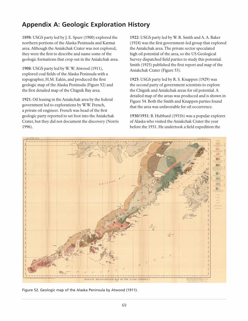
69
Appendix A: Geologic Exploration History
1898: USGS party led by J. E. Spurr (1900) explored the northern portions of the Alaska Peninsula and Katmai area. Although the Aniakchak Crater was not explored, they were the first to describe and name some of the geologic formations that crop out in the Aniakchak area.
1908: USGS party led by W. W. Atwood (1911), explored coal fields of the Alaska Peninsula with a topographer, H.M. Eakin, and produced the first geologic map of the Alaska Peninsula (Figure 52) and the first detailed map of the Chignik Bay area.
1921: Oil leasing in the Aniakchak area by the federal government led to explorations by W.W. French, a private oil engineer. French was head of the first geologic party reported to set foot into the Aniakchak Crater, but they did not document the discovery (Norris 1996).
1922: USGS party led by W. R. Smith and A. A. Baker (1924) was the first government-led group that explored the Aniakchak area. The private sector speculated high oil potential of the area, so the US Geological Survey dispatched field parties to study this potential. Smith (1925) published the first report and map of the Aniakchak Crater (Figure 53).
1925: USGS party led by R. S. Knappen (1929) was the second party of government scientists to explore the Chignik and Aniakchak areas for oil potential. A detailed map of the areas was produced and is shown in Figure 54. Both the Smith and Knappen parties found that the area was unfavorable for oil occurrence.
1930/1931: B. Hubbard (1931b) was a popular explorer of Alaska who visited the Aniakchak Crater the year before the 1931. He undertook a field expedition the
Figure 52. Geologic map of the Alaska Peninsula by Atwood (1911).
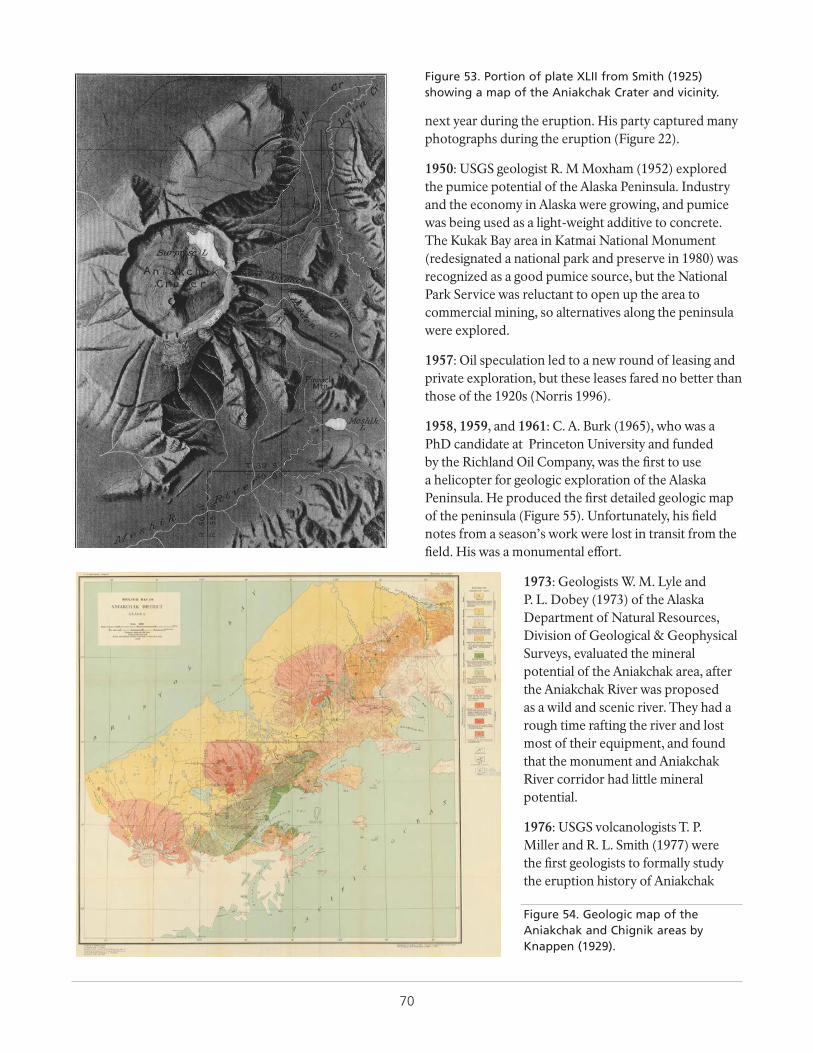
70
next year during the eruption. His party captured many photographs during the eruption (Figure 22).
1950: USGS geologist R. M Moxham (1952) explored the pumice potential of the Alaska Peninsula. Industry and the economy in Alaska were growing, and pumice was being used as a light-weight additive to concrete. The Kukak Bay area in Katmai National Monument (redesignated a national park and preserve in 1980) was recognized as a good pumice source, but the National Park Service was reluctant to open up the area to commercial mining, so alternatives along the peninsula were explored.
1957: Oil speculation led to a new round of leasing and private exploration, but these leases fared no better than those of the 1920s (Norris 1996).
1958, 1959, and 1961: C. A. Burk (1965), who was a PhD candidate at Princeton University and funded by the Richland Oil Company, was the first to use a helicopter for geologic exploration of the Alaska Peninsula. He produced the first detailed geologic map of the peninsula (Figure 55). Unfortunately, his field notes from a season’s work were lost in transit from the field. His was a monumental effort.
1973: Geologists W. M. Lyle and P. L. Dobey (1973) of the Alaska Department of Natural Resources, Division of Geological & Geophysical Surveys, evaluated the mineral potential of the Aniakchak area, after the Aniakchak River was proposed as a wild and scenic river. They had a rough time rafting the river and lost most of their equipment, and found that the monument and Aniakchak River corridor had little mineral potential.
1976: USGS volcanologists T. P. Miller and R. L. Smith (1977) were the first geologists to formally study the eruption history of Aniakchak
Figure 53. Portion of plate XLII from Smith (1925) showing a map of the Aniakchak Crater and vicinity.
Figure 54. Geologic map of the Aniakchak and Chignik areas by Knappen (1929).
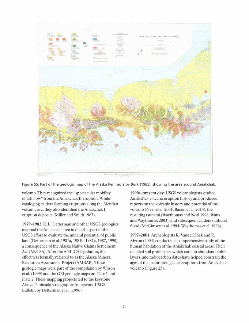
71
volcano. They recognized the “spectacular mobility of ash flow” from the Aniakchak II eruption. While cataloging caldera forming eruptions along the Aleutian volcanic arc, they also identified the Aniakchak I eruption deposits (Miller and Smith 1987).
1979–1982: R. L. Detterman and other USGS geologists mapped the Aniakchak area in detail as part of the USGS effort to evaluate the mineral potential of public land (Detterman et al. 1981a, 1981b, 1981c, 1987, 1990), a consequence of the Alaska Native Claims Settlement Act (ANCSA). After the ANILCA legislation, this effort was formally referred to as the Alaska Mineral Resources Assessment Project (AMRAP). These geologic maps were part of the compilation by Wilson et al. (1999) and the GRI geologic maps on Plate 1 and Plate 2. These mapping projects led to the keystone Alaska Peninsula stratigraphic framework USGS Bulletin by Detterman et al. (1996).
1990s–present day: USGS volcanologists studied Aniakchak volcano eruption history and produced reports on the volcanic history and potential of the volcano (Neal et al. 2001, Bacon et al. 2014), the resulting tsunami (Waythomas and Neal 1998; Watts and Waythomas 2003), and subsequent caldera outburst flood (McGimsey et al. 1994; Waythomas et al. 1996).
1997–2001: Archeologists R. VanderHoek and R. Myron (2004) conducted a comprehensive study of the human habitation of the Aniakchak coastal areas. Their detailed soil profile pits, which contain abundant tephra layers, and radiocarbon dates have helped constrain the ages of the major post-glacial eruptions from Aniakchak volcano (Figure 25).
Figure 55. Part of the geologic map of the Alaska Peninsula by Burk (1965), showing the area around Aniakchak.

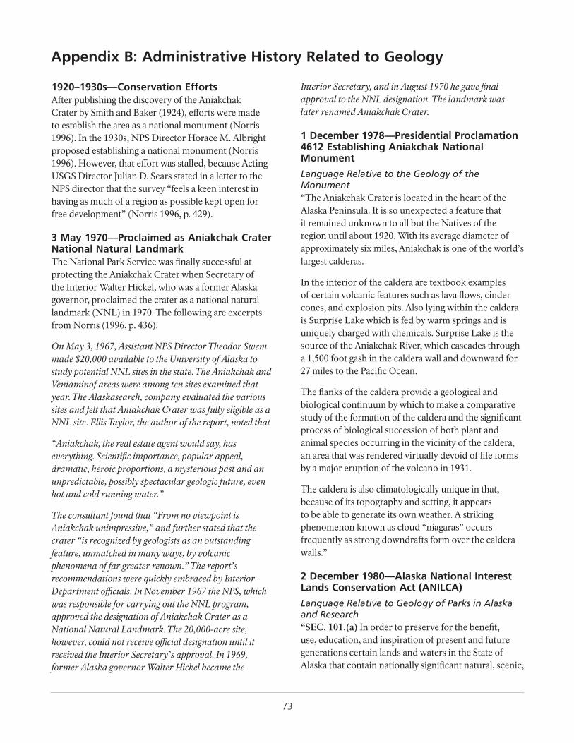
73
Appendix B: Administrative History Related to Geology
1920–1930s—Conservation EffortsAfter publishing the discovery of the Aniakchak Crater by Smith and Baker (1924), efforts were made to establish the area as a national monument (Norris 1996). In the 1930s, NPS Director Horace M. Albright proposed establishing a national monument (Norris 1996). However, that effort was stalled, because Acting USGS Director Julian D. Sears stated in a letter to the NPS director that the survey “feels a keen interest in having as much of a region as possible kept open for free development” (Norris 1996, p. 429).
3 May 1970—Proclaimed as Aniakchak Crater National Natural LandmarkThe National Park Service was finally successful at protecting the Aniakchak Crater when Secretary of the Interior Walter Hickel, who was a former Alaska governor, proclaimed the crater as a national natural landmark (NNL) in 1970. The following are excerpts from Norris (1996, p. 436):
On May 3, 1967, Assistant NPS Director Theodor Swem made $20,000 available to the University of Alaska to study potential NNL sites in the state. The Aniakchak and Veniaminof areas were among ten sites examined that year. The Alaskasearch, company evaluated the various sites and felt that Aniakchak Crater was fully eligible as a NNL site. Ellis Taylor, the author of the report, noted that
“Aniakchak, the real estate agent would say, has everything. Scientific importance, popular appeal, dramatic, heroic proportions, a mysterious past and an unpredictable, possibly spectacular geologic future, even hot and cold running water.”
The consultant found that “From no viewpoint is Aniakchak unimpressive,” and further stated that the crater “is recognized by geologists as an outstanding feature, unmatched in many ways, by volcanic phenomena of far greater renown.” The report’s recommendations were quickly embraced by Interior Department officials. In November 1967 the NPS, which was responsible for carrying out the NNL program, approved the designation of Aniakchak Crater as a National Natural Landmark. The 20,000-acre site, however, could not receive official designation until it received the Interior Secretary’s approval. In 1969, former Alaska governor Walter Hickel became the
Interior Secretary, and in August 1970 he gave final approval to the NNL designation. The landmark was later renamed Aniakchak Crater.
1 December 1978—Presidential Proclamation 4612 Establishing Aniakchak National Monument
Language Relative to the Geology of the Monument“The Aniakchak Crater is located in the heart of the Alaska Peninsula. It is so unexpected a feature that it remained unknown to all but the Natives of the region until about 1920. With its average diameter of approximately six miles, Aniakchak is one of the world’s largest calderas.
In the interior of the caldera are textbook examples of certain volcanic features such as lava flows, cinder cones, and explosion pits. Also lying within the caldera is Surprise Lake which is fed by warm springs and is uniquely charged with chemicals. Surprise Lake is the source of the Aniakchak River, which cascades through a 1,500 foot gash in the caldera wall and downward for 27 miles to the Pacific Ocean.
The flanks of the caldera provide a geological and biological continuum by which to make a comparative study of the formation of the caldera and the significant process of biological succession of both plant and animal species occurring in the vicinity of the caldera, an area that was rendered virtually devoid of life forms by a major eruption of the volcano in 1931.
The caldera is also climatologically unique in that, because of its topography and setting, it appears to be able to generate its own weather. A striking phenomenon known as cloud “niagaras” occurs frequently as strong downdrafts form over the caldera walls.”
2 December 1980—Alaska National Interest Lands Conservation Act (ANILCA)
Language Relative to Geology of Parks in Alaska and Research“SEC. 101.(a) In order to preserve for the benefit, use, education, and inspiration of present and future generations certain lands and waters in the State of Alaska that contain nationally significant natural, scenic,

74
historic, archeological, geological, scientific, wilderness, cultural, recreational, and wildlife values, the units described in the following titles are hereby established.
SEC. 101. (b) It is the intent of Congress in this Act to preserve unrivaled scenic and geological values associated with natural landscapes… and to maintain opportunities for scientific research and undisturbed ecosystems.”
Language Specific to Aniakchak“SEC. 201. The following areas are hereby established as units of the National Park System and shall be administered by the Secretary under the laws governing the administration of such lands and under the provisions of this Act:
(1) Aniakchak National Monument, containing approximated one hundred and thirty-eight thousand acres of public lands, and Aniakchak National Preserve, containing approximately three hundred and seventy-six thousand acres of public lands, as generally depicted on map numbered ANIA-90,005, and dated October 1978. The monument and preserve shall be managed for the following purposes, among others: To maintain the caldera and its associated volcanic features and landscape, including the Aniakchak River and other lakes and streams, in their natural state… to interpret geological and biological processes for visitors.”
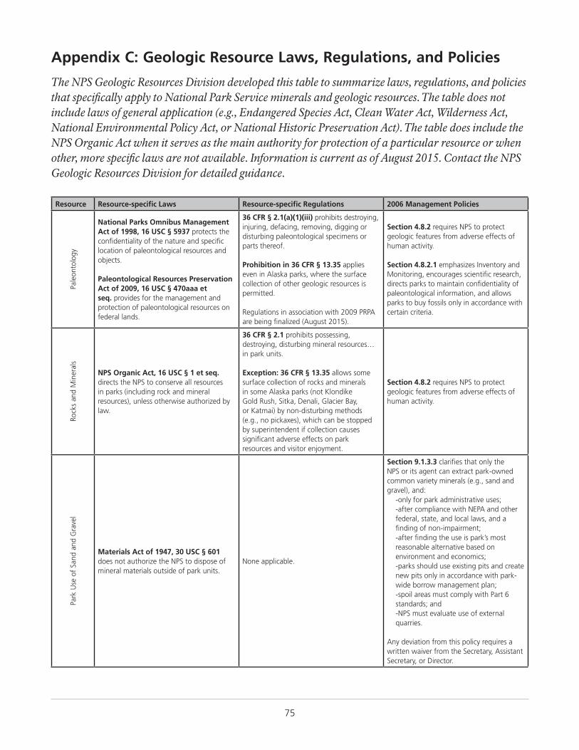
75
Appendix C: Geologic Resource Laws, Regulations, and Policies
The NPS Geologic Resources Division developed this table to summarize laws, regulations, and policies that specifically apply to National Park Service minerals and geologic resources. The table does not include laws of general application (e.g., Endangered Species Act, Clean Water Act, Wilderness Act, National Environmental Policy Act, or National Historic Preservation Act). The table does include the NPS Organic Act when it serves as the main authority for protection of a particular resource or when other, more specific laws are not available. Information is current as of August 2015. Contact the NPS Geologic Resources Division for detailed guidance.
Resource Resource-specific Laws Resource-specific Regulations 2006 Management Policies
Pale
onto
logy
National Parks Omnibus Management Act of 1998, 16 USC § 5937 protects the confidentiality of the nature and specific location of paleontological resources and objects.
Paleontological Resources Preservation Act of 2009, 16 USC § 470aaa et seq. provides for the management and protection of paleontological resources on federal lands.
36 CFR § 2.1(a)(1)(iii) prohibits destroying, injuring, defacing, removing, digging or disturbing paleontological specimens or parts thereof.
Prohibition in 36 CFR § 13.35 applies even in Alaska parks, where the surface collection of other geologic resources is permitted.
Regulations in association with 2009 PRPA are being finalized (August 2015).
Section 4.8.2 requires NPS to protect geologic features from adverse effects of human activity.
Section 4.8.2.1 emphasizes Inventory and Monitoring, encourages scientific research, directs parks to maintain confidentiality of paleontological information, and allows parks to buy fossils only in accordance with certain criteria.
Rock
s an
d M
iner
als
NPS Organic Act, 16 USC § 1 et seq. directs the NPS to conserve all resources in parks (including rock and mineral resources), unless otherwise authorized by law.
36 CFR § 2.1 prohibits possessing, destroying, disturbing mineral resources…in park units. Exception: 36 CFR § 13.35 allows some surface collection of rocks and minerals in some Alaska parks (not Klondike Gold Rush, Sitka, Denali, Glacier Bay, or Katmai) by non-disturbing methods (e.g., no pickaxes), which can be stopped by superintendent if collection causes significant adverse effects on park resources and visitor enjoyment.
Section 4.8.2 requires NPS to protect geologic features from adverse effects of human activity.
Park
Use
of
Sand
and
Gra
vel
Materials Act of 1947, 30 USC § 601 does not authorize the NPS to dispose of mineral materials outside of park units.
None applicable.
Section 9.1.3.3 clarifies that only the NPS or its agent can extract park-owned common variety minerals (e.g., sand and gravel), and:
-only for park administrative uses;-after compliance with NEPA and other federal, state, and local laws, and a finding of non-impairment;-after finding the use is park’s most reasonable alternative based on environment and economics;-parks should use existing pits and create new pits only in accordance with park-wide borrow management plan;-spoil areas must comply with Part 6 standards; and-NPS must evaluate use of external quarries.
Any deviation from this policy requires a written waiver from the Secretary, Assistant Secretary, or Director.
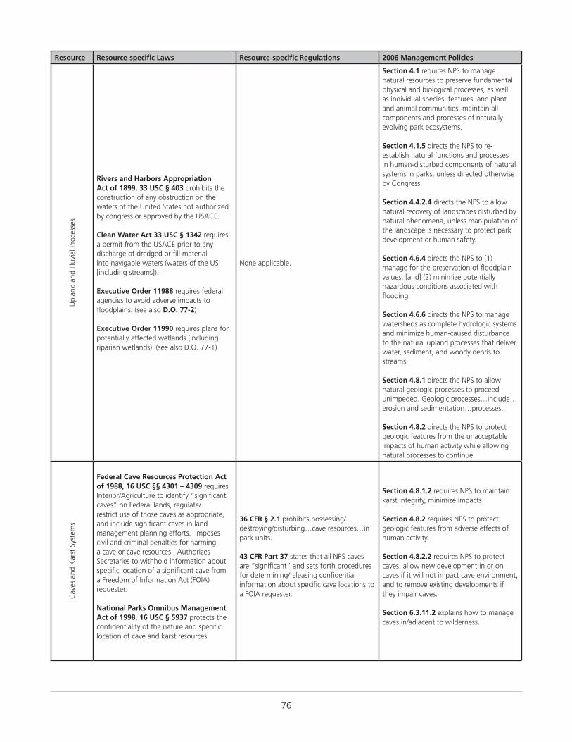
76
Resource Resource-specific Laws Resource-specific Regulations 2006 Management Policies
Upl
and
and
Fluv
ial P
roce
sses
Rivers and Harbors Appropriation Act of 1899, 33 USC § 403 prohibits the construction of any obstruction on the waters of the United States not authorized by congress or approved by the USACE.
Clean Water Act 33 USC § 1342 requires a permit from the USACE prior to any discharge of dredged or fill material into navigable waters (waters of the US [including streams]).
Executive Order 11988 requires federal agencies to avoid adverse impacts to floodplains. (see also D.O. 77-2)
Executive Order 11990 requires plans for potentially affected wetlands (including riparian wetlands). (see also D.O. 77-1)
None applicable.
Section 4.1 requires NPS to manage natural resources to preserve fundamental physical and biological processes, as well as individual species, features, and plant and animal communities; maintain all components and processes of naturally evolving park ecosystems.
Section 4.1.5 directs the NPS to re-establish natural functions and processes in human-disturbed components of natural systems in parks, unless directed otherwise by Congress.
Section 4.4.2.4 directs the NPS to allow natural recovery of landscapes disturbed by natural phenomena, unless manipulation of the landscape is necessary to protect park development or human safety.
Section 4.6.4 directs the NPS to (1) manage for the preservation of floodplain values; [and] (2) minimize potentially hazardous conditions associated with flooding.
Section 4.6.6 directs the NPS to manage watersheds as complete hydrologic systems and minimize human-caused disturbance to the natural upland processes that deliver water, sediment, and woody debris to streams.
Section 4.8.1 directs the NPS to allow natural geologic processes to proceed unimpeded. Geologic processes…include…erosion and sedimentation…processes.
Section 4.8.2 directs the NPS to protect geologic features from the unacceptable impacts of human activity while allowing natural processes to continue.
Cav
es a
nd K
arst
Sys
tem
s
Federal Cave Resources Protection Act of 1988, 16 USC §§ 4301 – 4309 requires Interior/Agriculture to identify “significant caves” on Federal lands, regulate/restrict use of those caves as appropriate, and include significant caves in land management planning efforts. Imposes civil and criminal penalties for harming a cave or cave resources. Authorizes Secretaries to withhold information about specific location of a significant cave from a Freedom of Information Act (FOIA) requester.
National Parks Omnibus Management Act of 1998, 16 USC § 5937 protects the confidentiality of the nature and specific location of cave and karst resources.
36 CFR § 2.1 prohibits possessing/ destroying/disturbing…cave resources…in park units.
43 CFR Part 37 states that all NPS caves are “significant” and sets forth procedures for determining/releasing confidential information about specific cave locations to a FOIA requester.
Section 4.8.1.2 requires NPS to maintain karst integrity, minimize impacts.
Section 4.8.2 requires NPS to protect geologic features from adverse effects of human activity.
Section 4.8.2.2 requires NPS to protect caves, allow new development in or on caves if it will not impact cave environment, and to remove existing developments if they impair caves.
Section 6.3.11.2 explains how to manage caves in/adjacent to wilderness.
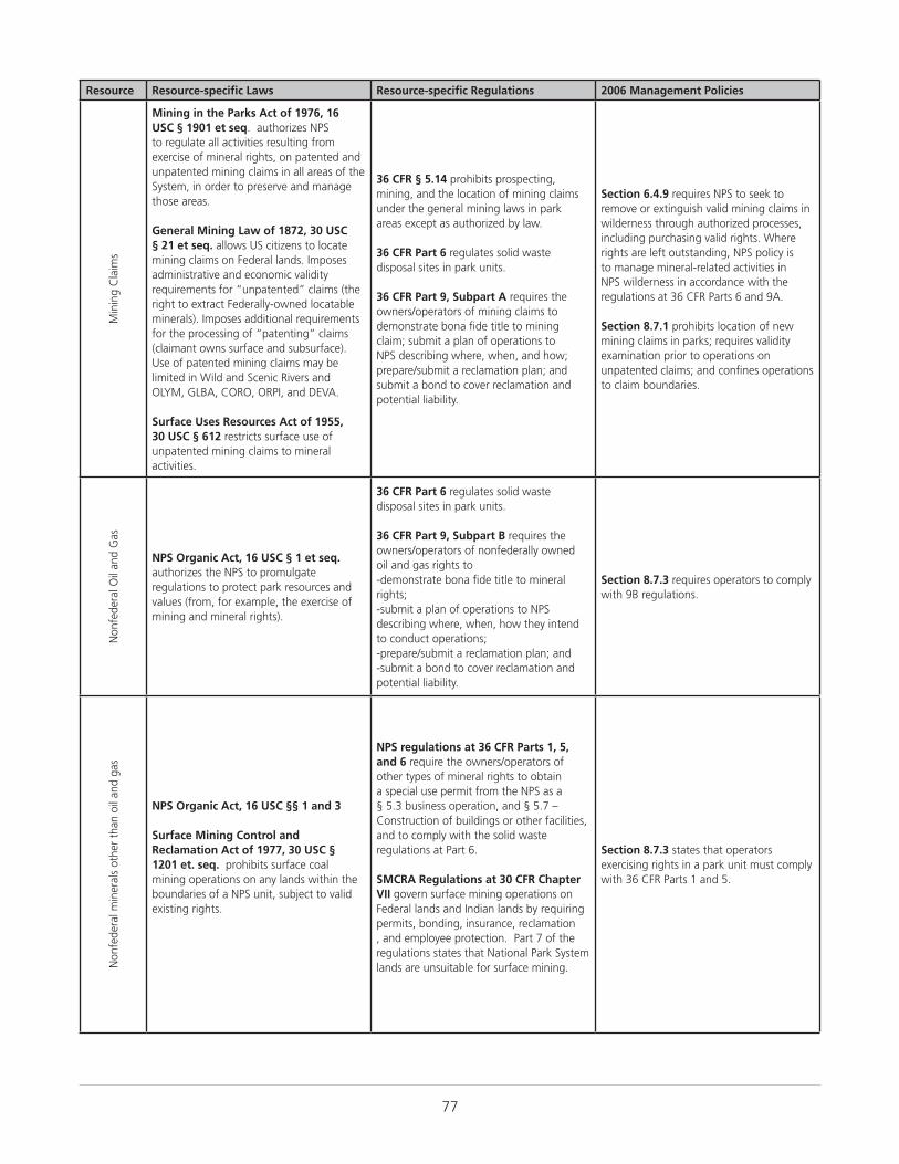
77
Resource Resource-specific Laws Resource-specific Regulations 2006 Management Policies
Min
ing
Cla
ims
Mining in the Parks Act of 1976, 16 USC § 1901 et seq. authorizes NPS to regulate all activities resulting from exercise of mineral rights, on patented and unpatented mining claims in all areas of the System, in order to preserve and manage those areas.
General Mining Law of 1872, 30 USC § 21 et seq. allows US citizens to locate mining claims on Federal lands. Imposes administrative and economic validity requirements for “unpatented” claims (the right to extract Federally-owned locatable minerals). Imposes additional requirements for the processing of “patenting” claims (claimant owns surface and subsurface). Use of patented mining claims may be limited in Wild and Scenic Rivers and OLYM, GLBA, CORO, ORPI, and DEVA.
Surface Uses Resources Act of 1955, 30 USC § 612 restricts surface use of unpatented mining claims to mineral activities.
36 CFR § 5.14 prohibits prospecting, mining, and the location of mining claims under the general mining laws in park areas except as authorized by law.
36 CFR Part 6 regulates solid waste disposal sites in park units.
36 CFR Part 9, Subpart A requires the owners/operators of mining claims to demonstrate bona fide title to mining claim; submit a plan of operations to NPS describing where, when, and how; prepare/submit a reclamation plan; and submit a bond to cover reclamation and potential liability.
Section 6.4.9 requires NPS to seek to remove or extinguish valid mining claims in wilderness through authorized processes, including purchasing valid rights. Where rights are left outstanding, NPS policy is to manage mineral-related activities in NPS wilderness in accordance with the regulations at 36 CFR Parts 6 and 9A.
Section 8.7.1 prohibits location of new mining claims in parks; requires validity examination prior to operations on unpatented claims; and confines operations to claim boundaries.
Non
fede
ral O
il an
d G
as
NPS Organic Act, 16 USC § 1 et seq. authorizes the NPS to promulgate regulations to protect park resources and values (from, for example, the exercise of mining and mineral rights).
36 CFR Part 6 regulates solid waste disposal sites in park units.
36 CFR Part 9, Subpart B requires the owners/operators of nonfederally owned oil and gas rights to-demonstrate bona fide title to mineral rights;-submit a plan of operations to NPS describing where, when, how they intend to conduct operations;-prepare/submit a reclamation plan; and -submit a bond to cover reclamation and potential liability.
Section 8.7.3 requires operators to comply with 9B regulations.
Non
fede
ral m
iner
als
othe
r th
an o
il an
d ga
s
NPS Organic Act, 16 USC §§ 1 and 3
Surface Mining Control and Reclamation Act of 1977, 30 USC § 1201 et. seq. prohibits surface coal mining operations on any lands within the boundaries of a NPS unit, subject to valid existing rights.
NPS regulations at 36 CFR Parts 1, 5, and 6 require the owners/operators of other types of mineral rights to obtain a special use permit from the NPS as a § 5.3 business operation, and § 5.7 – Construction of buildings or other facilities, and to comply with the solid waste regulations at Part 6.
SMCRA Regulations at 30 CFR Chapter VII govern surface mining operations on Federal lands and Indian lands by requiring permits, bonding, insurance, reclamation , and employee protection. Part 7 of the regulations states that National Park System lands are unsuitable for surface mining.
Section 8.7.3 states that operators exercising rights in a park unit must comply with 36 CFR Parts 1 and 5.
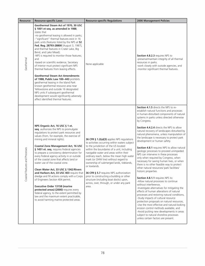
78
Resource Resource-specific Laws Resource-specific Regulations 2006 Management Policies
Geo
ther
mal
Geothermal Steam Act of 1970, 30 USC § 1001 et seq. as amended in 1988, states that-no geothermal leasing is allowed in parks;-“significant” thermal features exist in 16 park units (features listed by the NPS at 52 Fed. Reg. 28793-28800 [August 3, 1987], and thermal features in Crater Lake, Big Bend, and Lake Mead);-NPS is required to monitor those features; and-based on scientific evidence, Secretary of Interior must protect significant NPS thermal features from leasing effects.
Geothermal Steam Act Amendments of 1988, Public Law 100--443 prohibits geothermal leasing in the Island Park known geothermal resource area near Yellowstone and outside 16 designated NPS units if subsequent geothermal development would significantly adversely affect identified thermal features.
None applicable
Section 4.8.2.3 requires NPS to-preserve/maintain integrity of all thermal resources in parks.-work closely with outside agencies, and-monitor significant thermal features.
Coa
stal
Fea
ture
s an
d Pr
oces
ses
NPS Organic Act, 16 USC § 1 et. seq. authorizes the NPS to promulgate regulations to protect park resources and values (from, for example, the exercise of mining and mineral rights).
Coastal Zone Management Act, 16 USC § 1451 et. seq. requires Federal agencies to prepare a consistency determination for every Federal agency activity in or outside of the coastal zone that affects land or water use of the coastal zone.
Clean Water Act, 33 USC § 1342/Rivers and Harbors Act, 33 USC 403 require that dredge and fill actions comply with a Corps of Engineers Section 404 permit.
Executive Order 13158 (marine protected areas) (2000) requires every federal agency, to the extent permitted by law and the maximum extent practicable, to avoid harming marine protected areas.
36 CFR § 1.2(a)(3) applies NPS regulations to activities occurring within waters subject to the jurisdiction of the US located within the boundaries of a unit, including navigable water and areas within their ordinary reach, below the mean high water mark (or OHW line) without regard to ownership of submerged lands, tidelands, or lowlands.
36 CFR § 5.7 requires NPS authorization prior to constructing a building or other structure (including boat docks) upon, across, over, through, or under any park area.
Section 4.1.5 directs the NPS to re-establish natural functions and processes in human-disturbed components of natural systems in parks unless directed otherwise by Congress.
Section 4.4.2.4 directs the NPS to allow natural recovery of landscapes disturbed by natural phenomena, unless manipulation of the landscape is necessary to protect park development or human safety.
Section 4.8.1 requires NPS to allow natural geologic processes to proceed unimpeded. NPS can intervene in these processes only when required by Congress, when necessary for saving human lives, or when there is no other feasible way to protect other natural resources/ park facilities/historic properties.
Section 4.8.1.1 requires NPS to:-Allow natural processes to continue without interference, -Investigate alternatives for mitigating the effects of human alterations of natural processes and restoring natural conditions, -Study impacts of cultural resource protection proposals on natural resources, -Use the most effective and natural-looking erosion control methods available, and -Avoid putting new developments in areas subject to natural shoreline processes unless certain factors are present.
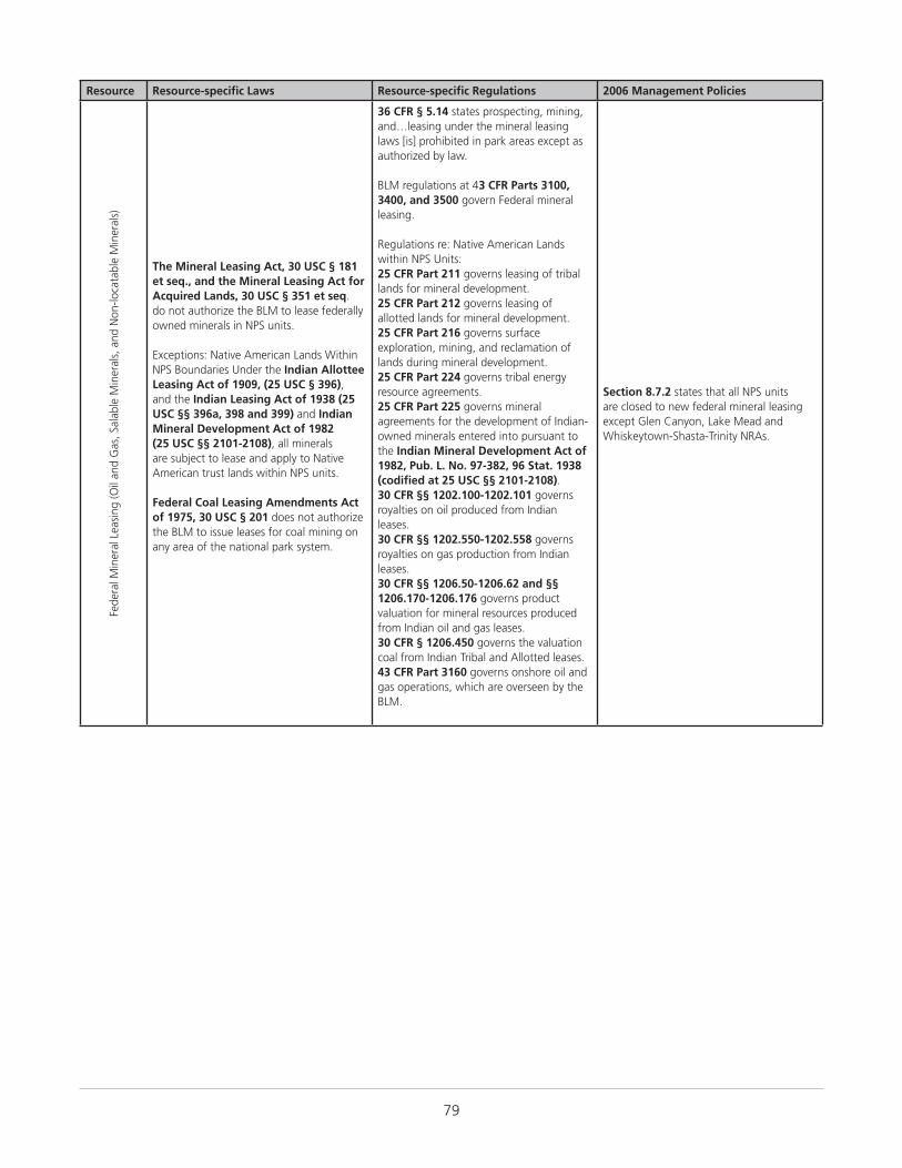
79
Resource Resource-specific Laws Resource-specific Regulations 2006 Management Policies
Fede
ral M
iner
al L
easi
ng (O
il an
d G
as, S
alab
le M
iner
als,
and
Non
-loca
tabl
e M
iner
als)
The Mineral Leasing Act, 30 USC § 181 et seq., and the Mineral Leasing Act for Acquired Lands, 30 USC § 351 et seq. do not authorize the BLM to lease federally owned minerals in NPS units.
Exceptions: Native American Lands Within NPS Boundaries Under the Indian Allottee Leasing Act of 1909, (25 USC § 396), and the Indian Leasing Act of 1938 (25 USC §§ 396a, 398 and 399) and Indian Mineral Development Act of 1982 (25 USC §§ 2101-2108), all minerals are subject to lease and apply to Native American trust lands within NPS units.
Federal Coal Leasing Amendments Act of 1975, 30 USC § 201 does not authorize the BLM to issue leases for coal mining on any area of the national park system.
36 CFR § 5.14 states prospecting, mining, and…leasing under the mineral leasing laws [is] prohibited in park areas except as authorized by law.
BLM regulations at 43 CFR Parts 3100, 3400, and 3500 govern Federal mineral leasing.
Regulations re: Native American Lands within NPS Units:25 CFR Part 211 governs leasing of tribal lands for mineral development. 25 CFR Part 212 governs leasing of allotted lands for mineral development. 25 CFR Part 216 governs surface exploration, mining, and reclamation of lands during mineral development. 25 CFR Part 224 governs tribal energy resource agreements.25 CFR Part 225 governs mineral agreements for the development of Indian-owned minerals entered into pursuant to the Indian Mineral Development Act of 1982, Pub. L. No. 97-382, 96 Stat. 1938 (codified at 25 USC §§ 2101-2108).30 CFR §§ 1202.100-1202.101 governs royalties on oil produced from Indian leases. 30 CFR §§ 1202.550-1202.558 governs royalties on gas production from Indian leases. 30 CFR §§ 1206.50-1206.62 and §§ 1206.170-1206.176 governs product valuation for mineral resources produced from Indian oil and gas leases. 30 CFR § 1206.450 governs the valuation coal from Indian Tribal and Allotted leases.43 CFR Part 3160 governs onshore oil and gas operations, which are overseen by the BLM.
Section 8.7.2 states that all NPS units are closed to new federal mineral leasing except Glen Canyon, Lake Mead and Whiskeytown-Shasta-Trinity NRAs.

80
Resource Resource-specific Laws Resource-specific Regulations 2006 Management Policies
Soils
Soil and Water Resources Conservation Act, 16 USC §§ 2011–2009 provides for the collection and analysis of soil and related resource data and the appraisal of the status, condition, and trends for these resources.
Farmland Protection Policy Act, 7 USC § 4201 et. seq. requires NPS to identify and take into account the adverse effects of Federal programs on the preservation of farmland; consider alternative actions, and assure that such Federal programs are compatible with State, unit of local government, and private programs and policies to protect farmland. NPS actions are subject to the FPPA if they may irreversibly convert farmland (directly or indirectly) to nonagricultural use and are completed by a Federal agency or with assistance from a Federal agency. Applicable projects require coordination with the Department of Agriculture’s Natural Resources Conservation Service (NRCS).
7 CFR Parts 610 and 611 are the US Department of Agriculture regulations for the Natural Resources Conservation Service. Part 610 governs the NRCS technical assistance program, soil erosion predictions, and the conservation of private grazing land. Part 611 governs soil surveys and cartographic operations. The NRCS works with the NPS through cooperative arrangements.
Section 4.8.2.4 requires NPS to-prevent unnatural erosion, removal, and contamination;-conduct soil surveys;-minimize unavoidable excavation; and-develop/follow written prescriptions (instructions).
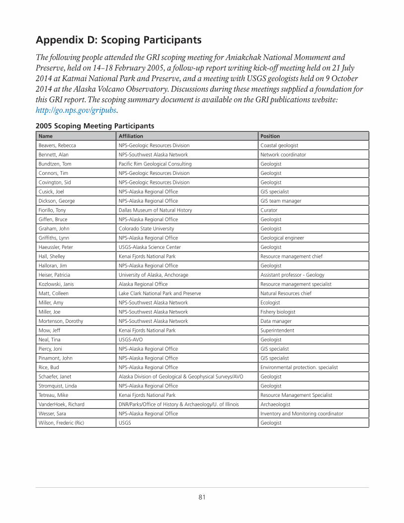
81
Appendix D: Scoping Participants
The following people attended the GRI scoping meeting for Aniakchak National Monument and Preserve, held on 14–18 February 2005, a follow-up report writing kick-off meeting held on 21 July 2014 at Katmai National Park and Preserve, and a meeting with USGS geologists held on 9 October 2014 at the Alaska Volcano Observatory. Discussions during these meetings supplied a foundation for this GRI report. The scoping summary document is available on the GRI publications website: http://go.nps.gov/gripubs.
2005 Scoping Meeting ParticipantsName Affiliation Position
Beavers, Rebecca NPS-Geologic Resources Division Coastal geologist
Bennett, Alan NPS-Southwest Alaska Network Network coordinator
Bundtzen, Tom Pacific Rim Geological Consulting Geologist
Connors, Tim NPS-Geologic Resources Division Geologist
Covington, Sid NPS-Geologic Resources Division Geologist
Cusick, Joel NPS-Alaska Regional Office GIS specialist
Dickson, George NPS-Alaska Regional Office GIS team manager
Fiorillo, Tony Dallas Museum of Natural History Curator
Giffen, Bruce NPS-Alaska Regional Office Geologist
Graham, John Colorado State University Geologist
Griffiths, Lynn NPS-Alaska Regional Office Geological engineer
Haeussler, Peter USGS-Alaska Science Center Geologist
Hall, Shelley Kenai Fjords National Park Resource management chief
Halloran, Jim NPS-Alaska Regional Office Geologist
Heiser, Patricia University of Alaska, Anchorage Assistant professor - Geology
Kozlowski, Janis Alaska Regional Office Resource management specialist
Matt, Colleen Lake Clark National Park and Preserve Natural Resources chief
Miller, Amy NPS-Southwest Alaska Network Ecologist
Miller, Joe NPS-Southwest Alaska Network Fishery biologist
Mortenson, Dorothy NPS-Southwest Alaska Network Data manager
Mow, Jeff Kenai Fjords National Park Superintendent
Neal, Tina USGS-AVO Geologist
Piercy, Joni NPS-Alaska Regional Office GIS specialist
Pinamont, John NPS-Alaska Regional Office GIS specialist
Rice, Bud NPS-Alaska Regional Office Environmental protection. specialist
Schaefer, Janet Alaska Division of Geological & Geophysical Surveys/AVO Geologist
Stromquist, Linda NPS-Alaska Regional Office Geologist
Tetreau, Mike Kenai Fjords National Park Resource Management Specialist
VanderHoek, Richard DNR/Parks/Office of History & Archaeology/U. of Illinois Archaeologist
Wesser, Sara NPS-Alaska Regional Office Inventory and Monitoring coordinator
Wilson, Frederic (Ric) USGS Geologist
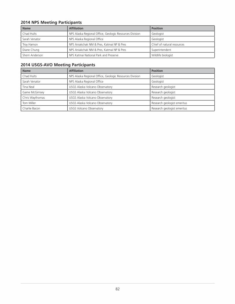
82
2014 NPS Meeting ParticipantsName Affiliation Position
Chad Hults NPS Alaska Regional Office, Geologic Resources Division Geologist
Sarah Venator NPS Alaska Regional Office Geologist
Troy Hamon NPS Aniakchak NM & Pres, Katmai NP & Pres Chief of natural resources
Diane Chung NPS Aniakchak NM & Pres, Katmai NP & Pres Superintendent
Sherri Anderson NPS Katmai National Park and Preserve Wildlife biologist
2014 USGS-AVO Meeting ParticipantsName Affiliation Position
Chad Hults NPS Alaska Regional Office, Geologic Resources Division Geologist
Sarah Venator NPS Alaska Regional Office Geologist
Tina Neal USGS Alaska Volcano Observatory Research geologist
Game McGimsey USGS Alaska Volcano Observatory Research geologist
Chris Waythomas USGS Alaska Volcano Observatory Research geologist
Tom Miller USGS Alaska Volcano Observatory Research geologist emeritus
Charlie Bacon USGS Volcano Observatory Research geologist emeritus

The Department of the Interior protects and manages the nation’s natural resources and cultural heritage; provides scientific and other information about those resources; and honors its special responsibilities to American Indians, Alaska Natives, and affiliated Island Communities.
NPS 181/129749, September 2015
Natural Resource Stewardship and Science
1201 Oak Ridge Drive, Suite 150
Fort Collins, Colorado 80525
www.nature.nps.gov
National Park ServiceU.S. Department of the Interior
EXPERIENCE YOUR AMERICA™
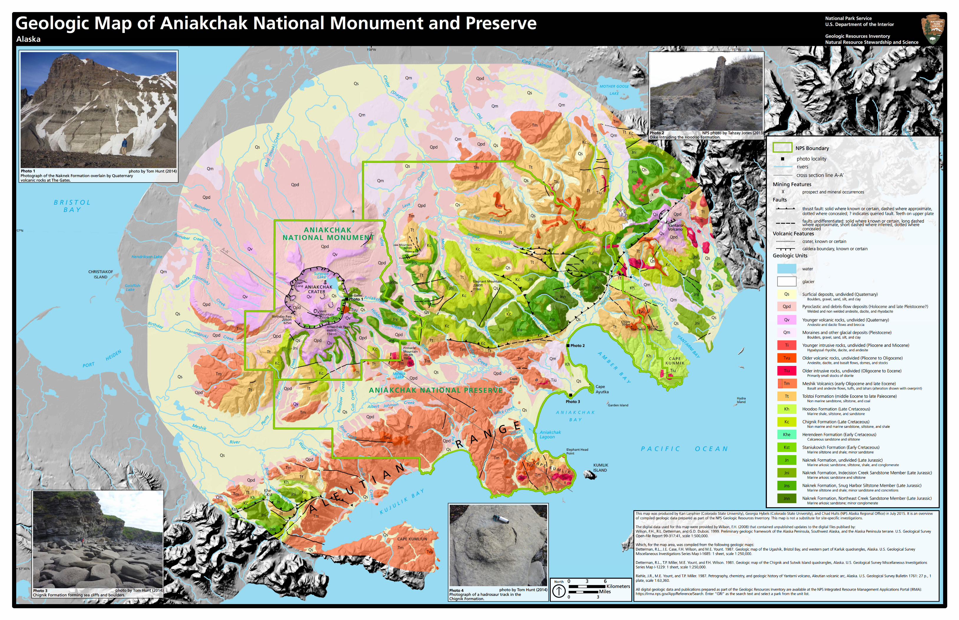
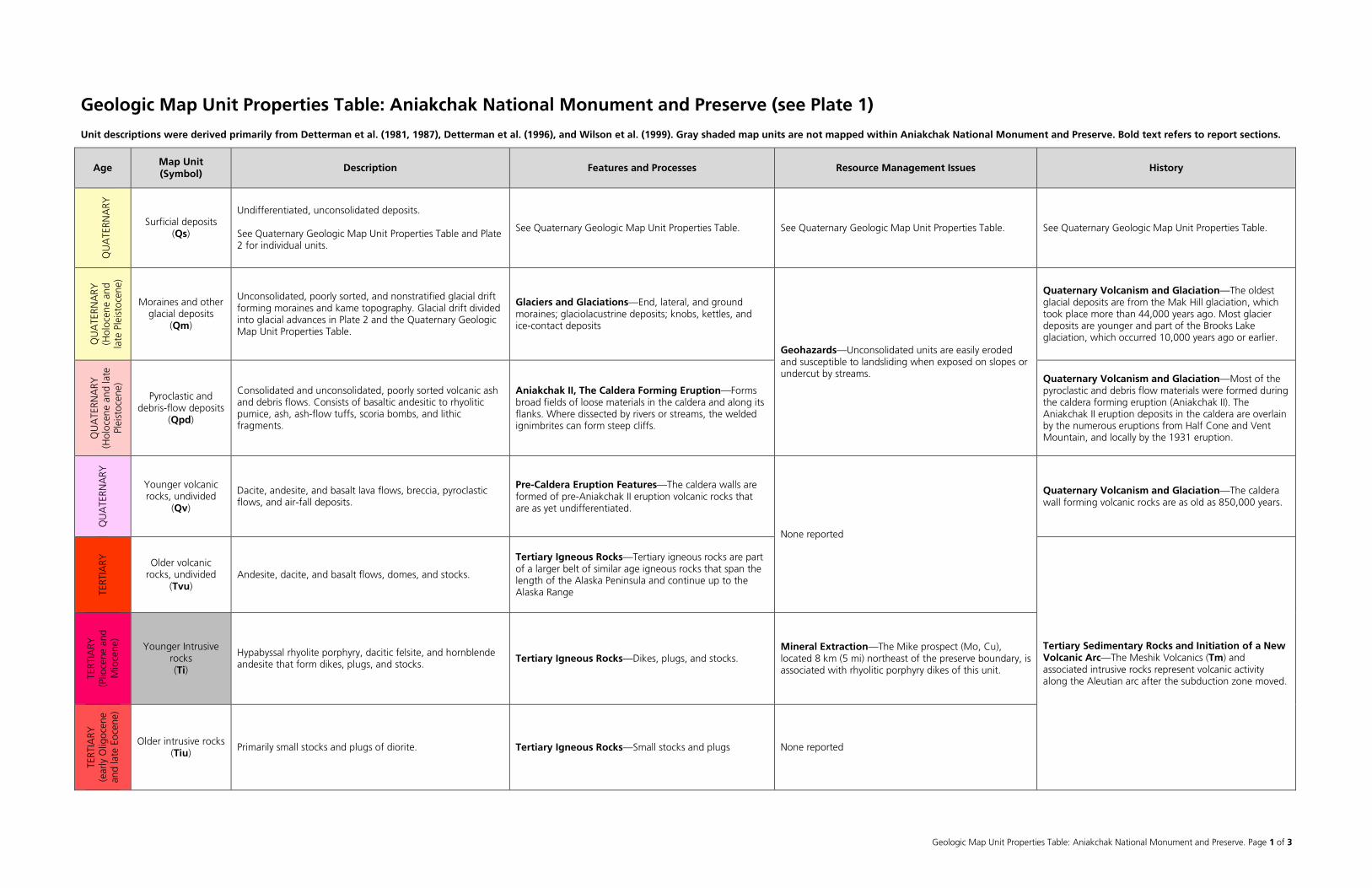
Geologic Map Unit Properties Table: Aniakchak National Monument and Preserve. Page 1 of 3
Geologic Map Unit Properties Table: Aniakchak National Monument and Preserve (see Plate 1)
Unit descriptions were derived primarily from Detterman et al. (1981, 1987), Detterman et al. (1996), and Wilson et al. (1999). Gray shaded map units are not mapped within Aniakchak National Monument and Preserve. Bold text refers to report sections.
Age Map Unit (Symbol) Description Features and Processes Resource Management Issues History
QU
ATE
RNA
RY
Surficial deposits (Qs)
Undifferentiated, unconsolidated deposits. See Quaternary Geologic Map Unit Properties Table and Plate 2 for individual units.
See Quaternary Geologic Map Unit Properties Table. See Quaternary Geologic Map Unit Properties Table. See Quaternary Geologic Map Unit Properties Table.
QU
ATE
RNA
RY
(Hol
ocen
e an
d la
te P
leis
toce
ne)
Moraines and other glacial deposits
(Qm)
Unconsolidated, poorly sorted, and nonstratified glacial drift forming moraines and kame topography. Glacial drift divided into glacial advances in Plate 2 and the Quaternary Geologic Map Unit Properties Table.
Glaciers and Glaciations—End, lateral, and ground moraines; glaciolacustrine deposits; knobs, kettles, and ice-contact deposits
Geohazards—Unconsolidated units are easily eroded and susceptible to landsliding when exposed on slopes or undercut by streams.
Quaternary Volcanism and Glaciation—The oldest glacial deposits are from the Mak Hill glaciation, which took place more than 44,000 years ago. Most glacier deposits are younger and part of the Brooks Lake glaciation, which occurred 10,000 years ago or earlier.
QU
ATE
RNA
RY
(Hol
ocen
e an
d la
te
Plei
stoc
ene)
Pyroclastic and debris-flow deposits
(Qpd)
Consolidated and unconsolidated, poorly sorted volcanic ash and debris flows. Consists of basaltic andesitic to rhyolitic pumice, ash, ash-flow tuffs, scoria bombs, and lithic fragments.
Aniakchak II, The Caldera Forming Eruption—Forms broad fields of loose materials in the caldera and along its flanks. Where dissected by rivers or streams, the welded ignimbrites can form steep cliffs.
Quaternary Volcanism and Glaciation—Most of the pyroclastic and debris flow materials were formed during the caldera forming eruption (Aniakchak II). The Aniakchak II eruption deposits in the caldera are overlain by the numerous eruptions from Half Cone and Vent Mountain, and locally by the 1931 eruption.
QU
ATE
RNA
RY
Younger volcanic rocks, undivided
(Qv)
Dacite, andesite, and basalt lava flows, breccia, pyroclastic flows, and air-fall deposits.
Pre-Caldera Eruption Features—The caldera walls are formed of pre-Aniakchak II eruption volcanic rocks that are as yet undifferentiated.
None reported
Quaternary Volcanism and Glaciation—The caldera wall forming volcanic rocks are as old as 850,000 years.
TERT
IARY
Older volcanic rocks, undivided
(Tvu) Andesite, dacite, and basalt flows, domes, and stocks.
Tertiary Igneous Rocks—Tertiary igneous rocks are part of a larger belt of similar age igneous rocks that span the length of the Alaska Peninsula and continue up to the Alaska Range
Tertiary Sedimentary Rocks and Initiation of a New Volcanic Arc—The Meshik Volcanics (Tm) and associated intrusive rocks represent volcanic activity along the Aleutian arc after the subduction zone moved. TE
RTIA
RY
(Plio
cene
and
M
ioce
ne)
Younger Intrusive rocks (Ti)
Hypabyssal rhyolite porphyry, dacitic felsite, and hornblende andesite that form dikes, plugs, and stocks. Tertiary Igneous Rocks—Dikes, plugs, and stocks.
Mineral Extraction—The Mike prospect (Mo, Cu), located 8 km (5 mi) northeast of the preserve boundary, is associated with rhyolitic porphyry dikes of this unit.
TERT
IARY
(e
arly
Olig
ocen
e an
d la
te E
ocen
e)
Older intrusive rocks (Tiu)
Primarily small stocks and plugs of diorite. Tertiary Igneous Rocks—Small stocks and plugs None reported
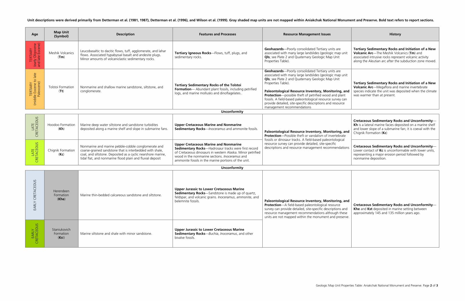
Unit descriptions were derived primarily from Detterman et al. (1981, 1987), Detterman et al. (1996), and Wilson et al. (1999). Gray shaded map units are not mapped within Aniakchak National Monument and Preserve. Bold text refers to report sections.
Geologic Map Unit Properties Table: Aniakchak National Monument and Preserve. Page 2 of 3
Age Map Unit (Symbol) Description Features and Processes Resource Management Issues History
TERT
IARY
(e
arly
Olig
ocen
e an
d la
te E
ocen
e)
Meshik Volcanics (Tm)
Leucobasaltic to dacitic flows, tuff, agglomerate, and lahar flows. Associated hypabyssal basalt and andesite plugs. Minor amounts of volcaniclastic sedimentary rocks.
Tertiary Igneous Rocks—Flows, tuff, plugs, and sedimentary rocks.
Geohazards—Poorly consolidated Tertiary units are associated with many large landslides (geologic map unit Qls; see Plate 2 and Quaternary Geologic Map Unit Properties Table).
Tertiary Sedimentary Rocks and Initiation of a New Volcanic Arc—The Meshik Volcanics (Tm) and associated intrusive rocks represent volcanic activity along the Aleutian arc after the subduction zone moved.
TERT
IARY
(m
iddl
e Eo
cene
to
late
Pa
leoc
ene)
Tolstoi Formation (Tt)
Nonmarine and shallow marine sandstone, siltstone, and conglomerate.
Tertiary Sedimentary Rocks of the Tolstoi Formation— Abundant plant fossils, including petrified logs, and marine mollusks and dinoflagelates..
Geohazards—Poorly consolidated Tertiary units are associated with many large landslides (geologic map unit Qls; see Plate 2 and Quaternary Geologic Map Unit Properties Table). Paleontological Resource Inventory, Monitoring, and Protection—possible theft of petrified wood and plant fossils. A field-based paleontological resource survey can provide detailed, site-specific descriptions and resource management recommendations
Tertiary Sedimentary Rocks and Initiation of a New Volcanic Arc—Megaflora and marine invertebrate species indicate the unit was deposited when the climate was warmer than at present.
Unconformity
LATE
C
RETA
CEO
US
Hoodoo Formation (Kh)
Marine deep water siltstone and sandstone turbidites deposited along a marine shelf and slope in submarine fans.
Upper Cretaceous Marine and Nonmarine Sedimentary Rocks—Inoceramus and ammonite fossils.
Paleontological Resource Inventory, Monitoring, and Protection—Possible theft or vandalism of invertebrate fossils or dinosaur tracks. A field-based paleontological resource survey can provide detailed, site-specific descriptions and resource management recommendations
Cretaceous Sedimentary Rocks and Unconformity—Kh is a lateral marine facies deposited on a marine shelf and lower slope of a submarine fan; it is coeval with the Chignik Formation (Kc)
LATE
C
RETA
CEO
US
Chignik Formation (Kc)
Nonmarine and marine pebble-cobble conglomerate and coarse-grained sandstone that is interbedded with shale, coal, and siltstone. Deposited as a cyclic nearshore marine, tidal flat, and nonmarine flood plain and fluvial deposit
Upper Cretaceous Marine and Nonmarine Sedimentary Rocks—Hadrosaur tracks were first record of Cretaceous dinosaurs in western Alaska. Minor petrified wood in the nonmarine sections. Inoceramus and ammonite fossils in the marine portions of the unit.
Cretaceous Sedimentary Rocks and Unconformity—Lower contact of Kc is unconformable with lower units, representing a major erosion period followed by nonmarine deposition.
Unconformity
EARL
Y C
RETA
CEO
US
Herendeen Formation
(Khe) Marine thin-bedded calcareous sandstone and siltstone.
Upper Jurassic to Lower Cretaceous Marine Sedimentary Rocks—Sandstone is made up of quartz, feldspar, and volcanic grains. Inoceramus, ammonite, and belemnite fossils. Paleontological Resource Inventory, Monitoring, and
Protection—A field-based paleontological resource survey can provide detailed, site-specific descriptions and resource management recommendations although these units are not mapped within the monument and preserve.
Cretaceous Sedimentary Rocks and Unconformity—Khe and Kst deposited in marine setting between approximately 145 and 135 million years ago.
EARL
Y
CRE
TAC
EOU
S
Staniukovich Formation
(Kst) Marine siltstone and shale with minor sandstone.
Upper Jurassic to Lower Cretaceous Marine Sedimentary Rocks—Buchia, Inoceramus, and other bivalve fossils.
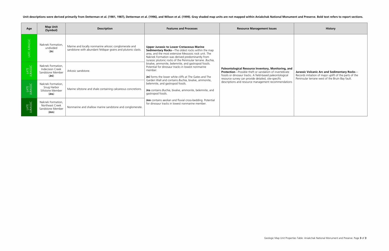
Unit descriptions were derived primarily from Detterman et al. (1981, 1987), Detterman et al. (1996), and Wilson et al. (1999). Gray shaded map units are not mapped within Aniakchak National Monument and Preserve. Bold text refers to report sections.
Geologic Map Unit Properties Table: Aniakchak National Monument and Preserve. Page 3 of 3
Age Map Unit (Symbol) Description Features and Processes Resource Management Issues History
LATE
JU
RASS
IC
Naknek Formation, undivided
(Jn)
Marine and locally nonmarine arkosic conglomerate and sandstone with abundant feldspar grains and plutonic clasts.
Upper Jurassic to Lower Cretaceous Marine Sedimentary Rocks—The oldest rocks within the map area, and the most extensive Mesozoic rock unit. The Naknek Formation was derived predominantly from Jurassic plutonic rocks of the Peninsular terrane. Buchia, bivalve, ammonite, belemnite, and gastropod fossils. Potential for dinosaur tracks in lowest nonmarine member. Jni forms the lower white cliffs at The Gates and The Garden Wall and contains Buchia, bivalve, ammonite, belemnite, and gastropod fossils. Jns contains Buchia, bivalve, ammonite, belemnite, and gastropod fossils. Jnn contains aeolian and fluvial cross-bedding. Potential for dinosaur tracks in lowest nonmarine member.
Paleontological Resource Inventory, Monitoring, and Protection—Possible theft or vandalism of invertebrate fossils or dinosaur tracks. A field-based paleontological resource survey can provide detailed, site-specific descriptions and resource management recommendations
Jurassic Volcanic Arc and Sedimentary Rocks—Records initiation of major uplift of the parts of the Peninsular terrane west of the Bruin Bay fault.
LATE
JU
RASS
IC
Naknek Formation, Indecision Creek
Sandstone Member (Jni)
Arkosic sandstone.
LATE
JU
RASS
IC
Naknek Formation, Snug Harbor
Siltstone Member (Jns)
Marine siltstone and shale containing calcareous concretions.
LATE
JU
RASS
IC
Naknek Formation, Northeast Creek
Sandstone Member (Jnn)
Nonmarine and shallow marine sandstone and conglomerate.
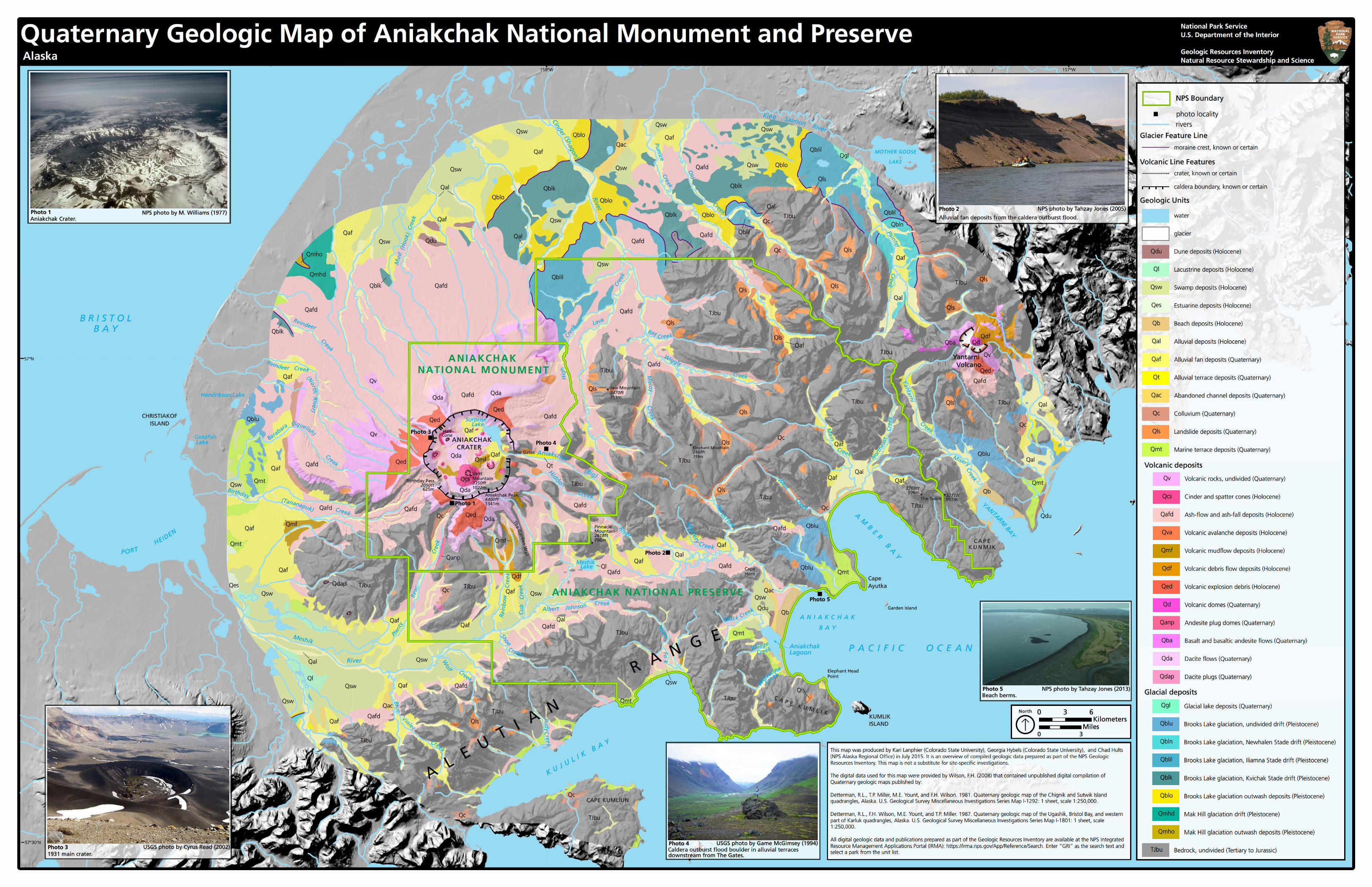
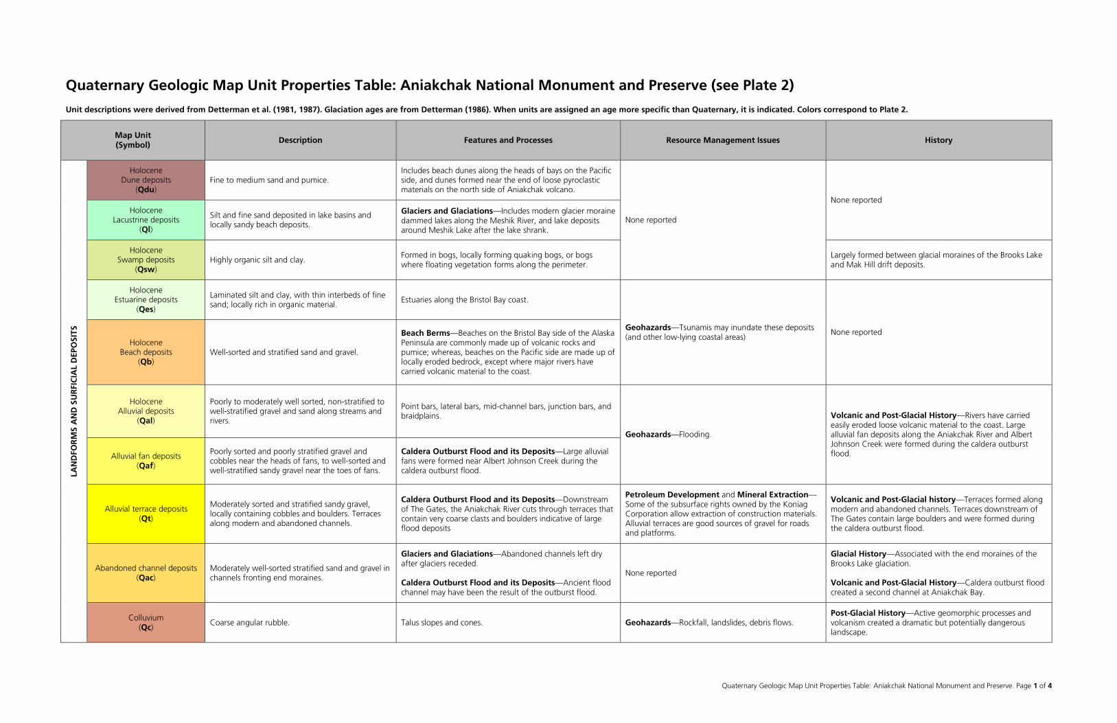
Quaternary Geologic Map Unit Properties Table: Aniakchak National Monument and Preserve. Page 1 of 4
Quaternary Geologic Map Unit Properties Table: Aniakchak National Monument and Preserve (see Plate 2)
Unit descriptions were derived from Detterman et al. (1981, 1987). Glaciation ages are from Detterman (1986). When units are assigned an age more specific than Quaternary, it is indicated. Colors correspond to Plate 2.
Map Unit (Symbol) Description Features and Processes Resource Management Issues History
LAN
DFO
RM
S A
ND
SU
RFI
CIA
L D
EPO
SITS
Holocene Dune deposits
(Qdu) Fine to medium sand and pumice.
Includes beach dunes along the heads of bays on the Pacific side, and dunes formed near the end of loose pyroclastic materials on the north side of Aniakchak volcano.
None reported
None reported Holocene
Lacustrine deposits (Ql)
Silt and fine sand deposited in lake basins and locally sandy beach deposits.
Glaciers and Glaciations—Includes modern glacier moraine dammed lakes along the Meshik River, and lake deposits around Meshik Lake after the lake shrank.
Holocene Swamp deposits
(Qsw) Highly organic silt and clay.
Formed in bogs, locally forming quaking bogs, or bogs where floating vegetation forms along the perimeter.
Largely formed between glacial moraines of the Brooks Lake and Mak Hill drift deposits.
Holocene Estuarine deposits
(Qes)
Laminated silt and clay, with thin interbeds of fine sand; locally rich in organic material.
Estuaries along the Bristol Bay coast.
Geohazards—Tsunamis may inundate these deposits (and other low-lying coastal areas)
None reported Holocene
Beach deposits (Qb)
Well-sorted and stratified sand and gravel.
Beach Berms—Beaches on the Bristol Bay side of the Alaska Peninsula are commonly made up of volcanic rocks and pumice; whereas, beaches on the Pacific side are made up of locally eroded bedrock, except where major rivers have carried volcanic material to the coast.
Holocene Alluvial deposits
(Qal)
Poorly to moderately well sorted, non-stratified to well-stratified gravel and sand along streams and rivers.
Point bars, lateral bars, mid-channel bars, junction bars, and braidplains.
Geohazards—Flooding.
Volcanic and Post-Glacial History—Rivers have carried easily eroded loose volcanic material to the coast. Large alluvial fan deposits along the Aniakchak River and Albert Johnson Creek were formed during the caldera outburst flood. Alluvial fan deposits
(Qaf)
Poorly sorted and poorly stratified gravel and cobbles near the heads of fans, to well-sorted and well-stratified sandy gravel near the toes of fans.
Caldera Outburst Flood and its Deposits—Large alluvial fans were formed near Albert Johnson Creek during the caldera outburst flood.
Alluvial terrace deposits (Qt)
Moderately sorted and stratified sandy gravel, locally containing cobbles and boulders. Terraces along modern and abandoned channels.
Caldera Outburst Flood and its Deposits—Downstream of The Gates, the Aniakchak River cuts through terraces that contain very coarse clasts and boulders indicative of large flood deposits
Petroleum Development and Mineral Extraction—Some of the subsurface rights owned by the Koniag Corporation allow extraction of construction materials. Alluvial terraces are good sources of gravel for roads and platforms.
Volcanic and Post-Glacial history—Terraces formed along modern and abandoned channels. Terraces downstream of The Gates contain large boulders and were formed during the caldera outburst flood.
Abandoned channel deposits (Qac)
Moderately well-sorted stratified sand and gravel in channels fronting end moraines.
Glaciers and Glaciations—Abandoned channels left dry after glaciers receded. Caldera Outburst Flood and its Deposits—Ancient flood channel may have been the result of the outburst flood.
None reported
Glacial History—Associated with the end moraines of the Brooks Lake glaciation. Volcanic and Post-Glacial History—Caldera outburst flood created a second channel at Aniakchak Bay.
Colluvium (Qc)
Coarse angular rubble. Talus slopes and cones. Geohazards—Rockfall, landslides, debris flows. Post-Glacial History—Active geomorphic processes and volcanism created a dramatic but potentially dangerous landscape.
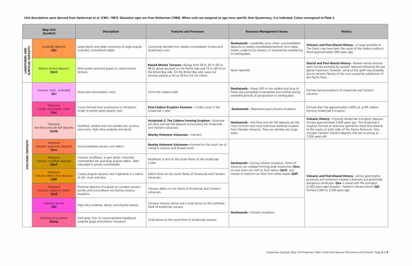
Unit descriptions were derived from Detterman et al. (1981, 1987). Glaciation ages are from Detterman (1986). When units are assigned an age more specific than Quaternary, it is indicated. Colors correspond to Plate 2.
Quaternary Geologic Map Unit Properties Table: Aniakchak National Monument and Preserve. Page 2 of 4
Map Unit (Symbol) Description Features and Processes Resource Management Issues History
LAN
DFO
RM
S A
ND
SU
RFI
CIA
L D
EPO
SITS
Landslide deposits (Qls)
Large blocks and slides consisting of large angular unsorted, unstratified rubble.
Commonly derived from weakly consolidated Tertiary and Quaternary units.
Geohazards—Landslides occur when unconsolidated deposits or weakly consolidated bedrock form steep slopes, undercut by streams, or loosened by weathering or earthquakes.
Volcanic and Post-Glacial History—A large landslide at The Gates may have been the cause of the caldera outburst flood approximately1,800 years ago.
Marine terrace deposits (Qmt)
Well-sorted sand and gravel on raised marine terraces.
Raised Marine Terraces—Range from 28 to 30 m (92 to 98 ft) above sea level on the Pacific side and 15 m (49 ft) on the Bristol Bay side. On the Bristol Bay side, wave cut terraces extend as far as 38 km (24 mi) inland.
None reported
Glacial and Post-Glacial History—Raised marine terraces were formed primarily by isostatic rebound following the last glacial maximum; however, some of the uplift was probably due to tectonic flexing of the crust caused by subduction of the Pacific Plate.
VO
LCA
NIC
DEP
OSI
TS
Volcanic rocks, undivided (Qv)
Flows and volcaniclastic rocks. Forms the caldera walls. Geohazards—Steep cliffs in the caldera and long its flanks are susceptible to landslides and rockfall during extended periods of precipitation or earthquakes.
Formed during eruptions of Aniakchak and Yantarni volcanos.
Holocene Cinder and spatter cones
(Qcs)
Cones formed from scoriaceous to vitrophyric cinder to bomb-sized volcanic rock.
Post-Caldera Eruption Features—Cinder cones in the Aniakchak Crater.
Geohazards—Represents past volcanic eruptions. Formed after the approximately 3,600 cal. yr BP caldera forming Aniakchak II eruption.
Holocene Ash-flow and ash-fall deposits
(Qafd)
Stratified, welded and non-welded ash, pumice, and scoria. High-silica andesite and dacite.
Aniakchak II, The Caldera Forming Eruption—Extensive ash-flow and ash-fall deposits surrounding the Aniakchak and Yantarni volcanoes. Nearby Holocene Volcanoes—Yantarni
Geohazards—Ash-flow and ash-fall deposits are the most common and most extensive materials erupted from Aleutian volcanos. They can sterilize very large areas.
Volcanic History—Primarily Aniakchak II eruption deposits formed approximately 3,600 years ago. The Aniakchak II eruption formed an extensive ignimbrite sheet that extends to the coasts on both sides of the Alaska Peninsula. Also includes Yantarni Volcano deposits that are as young as 2,000 years old.
Holocene Volcanic avalanche deposits
(Qva) Unconsolidated volcanic rock debris. Nearby Holocene Volcanoes—Formed on the south rim of
Yantarni Volcano and flowed south.
Geohazards—During volcanic eruptions, flanks of volcanos can collapse forming large avalanches (Qva), ice and snow can melt to form lahars (Qmf), and masses of material can flow from steep slopes (Qdf).
Volcanic and Post-Glacial History—Active geomorphic processes and volcanism created a dramatic but potentially dangerous landscape. Qva is coeval with the youngest (2,000 years ago) eruption. Yantarni Volcano dome (Qd) formed 2,000 to 3,500 years ago.
Holocene Volcanic mudflow deposits
(Qmf)
Volcanic mudflows, in part lahars. Unsorted, nonstratified ash and large angular debris. Well-indurated to poorly consolidated.
Mudflows in and on the south flanks of the Aniakchak Crater
Holocene Volcanic debris flow deposits
(Qdf)
Coarse angular volcanic rock fragments in a matrix of ash, mud, and lava.
Debris flows on the south flanks of Aniakchak and Yantarni volcanoes.
Holocene Volcanic explosion debris
(Qed)
Proximal deposits of angular to rounded volcanic bombs and scoria blown out during volcanic eruptions.
Volcanic debris on the flanks of Aniakchak and Yantarni volcanoes.
Volcanic domes (Qd) High-silica andesite, dacite, and rhyolite domes.
Yantarni Volcano dome and a small dome on the northeast flank of Aniakchak volcano.
Geohazards—Volcanic eruptions.
Andesite plug domes (Qanp)
Dark-gray, fine- to coarse-grained hypabyssal andesite plugs and shallow intrusions. Small dome on the south flank of Aniakchak volcano.
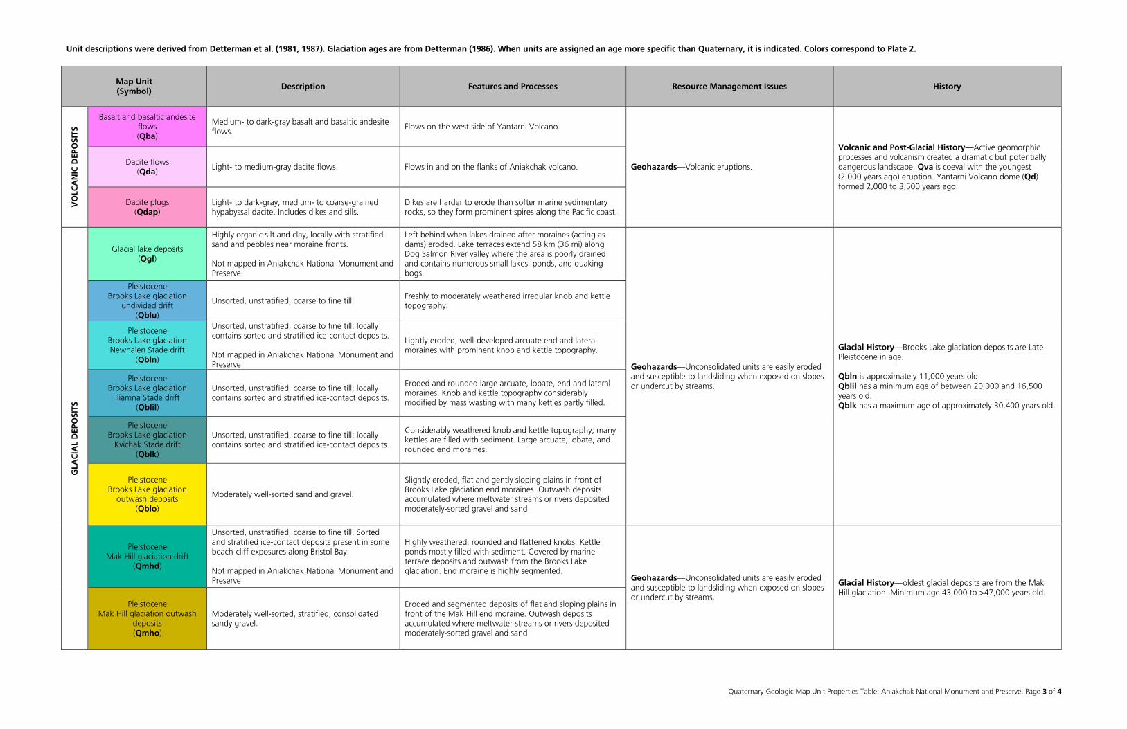
Unit descriptions were derived from Detterman et al. (1981, 1987). Glaciation ages are from Detterman (1986). When units are assigned an age more specific than Quaternary, it is indicated. Colors correspond to Plate 2.
Quaternary Geologic Map Unit Properties Table: Aniakchak National Monument and Preserve. Page 3 of 4
Map Unit (Symbol) Description Features and Processes Resource Management Issues History
VO
LCA
NIC
DEP
OSI
TS
Basalt and basaltic andesite flows (Qba)
Medium- to dark-gray basalt and basaltic andesite flows. Flows on the west side of Yantarni Volcano.
Geohazards—Volcanic eruptions.
Volcanic and Post-Glacial History—Active geomorphic processes and volcanism created a dramatic but potentially dangerous landscape. Qva is coeval with the youngest (2,000 years ago) eruption. Yantarni Volcano dome (Qd) formed 2,000 to 3,500 years ago.
Dacite flows (Qda)
Light- to medium-gray dacite flows. Flows in and on the flanks of Aniakchak volcano.
Dacite plugs (Qdap)
Light- to dark-gray, medium- to coarse-grained hypabyssal dacite. Includes dikes and sills.
Dikes are harder to erode than softer marine sedimentary rocks, so they form prominent spires along the Pacific coast.
GLA
CIA
L D
EPO
SITS
Glacial lake deposits (Qgl)
Highly organic silt and clay, locally with stratified sand and pebbles near moraine fronts. Not mapped in Aniakchak National Monument and Preserve.
Left behind when lakes drained after moraines (acting as dams) eroded. Lake terraces extend 58 km (36 mi) along Dog Salmon River valley where the area is poorly drained and contains numerous small lakes, ponds, and quaking bogs.
Geohazards—Unconsolidated units are easily eroded and susceptible to landsliding when exposed on slopes or undercut by streams.
Glacial History—Brooks Lake glaciation deposits are Late Pleistocene in age. Qbln is approximately 11,000 years old. Qblil has a minimum age of between 20,000 and 16,500 years old. Qblk has a maximum age of approximately 30,400 years old.
Pleistocene Brooks Lake glaciation
undivided drift (Qblu)
Unsorted, unstratified, coarse to fine till. Freshly to moderately weathered irregular knob and kettle topography.
Pleistocene Brooks Lake glaciation Newhalen Stade drift
(Qbln)
Unsorted, unstratified, coarse to fine till; locally contains sorted and stratified ice-contact deposits. Not mapped in Aniakchak National Monument and Preserve.
Lightly eroded, well-developed arcuate end and lateral moraines with prominent knob and kettle topography.
Pleistocene Brooks Lake glaciation
Iliamna Stade drift (Qblil)
Unsorted, unstratified, coarse to fine till; locally contains sorted and stratified ice-contact deposits.
Eroded and rounded large arcuate, lobate, end and lateral moraines. Knob and kettle topography considerably modified by mass wasting with many kettles partly filled.
Pleistocene Brooks Lake glaciation
Kvichak Stade drift (Qblk)
Unsorted, unstratified, coarse to fine till; locally contains sorted and stratified ice-contact deposits.
Considerably weathered knob and kettle topography; many kettles are filled with sediment. Large arcuate, lobate, and rounded end moraines.
Pleistocene Brooks Lake glaciation
outwash deposits (Qblo)
Moderately well-sorted sand and gravel.
Slightly eroded, flat and gently sloping plains in front of Brooks Lake glaciation end moraines. Outwash deposits accumulated where meltwater streams or rivers deposited moderately-sorted gravel and sand
Pleistocene Mak Hill glaciation drift
(Qmhd)
Unsorted, unstratified, coarse to fine till. Sorted and stratified ice-contact deposits present in some beach-cliff exposures along Bristol Bay. Not mapped in Aniakchak National Monument and Preserve.
Highly weathered, rounded and flattened knobs. Kettle ponds mostly filled with sediment. Covered by marine terrace deposits and outwash from the Brooks Lake glaciation. End moraine is highly segmented.
Geohazards—Unconsolidated units are easily eroded and susceptible to landsliding when exposed on slopes or undercut by streams.
Glacial History—oldest glacial deposits are from the Mak Hill glaciation. Minimum age 43,000 to >47,000 years old.
Pleistocene Mak Hill glaciation outwash
deposits (Qmho)
Moderately well-sorted, stratified, consolidated sandy gravel.
Eroded and segmented deposits of flat and sloping plains in front of the Mak Hill end moraine. Outwash deposits accumulated where meltwater streams or rivers deposited moderately-sorted gravel and sand

Unit descriptions were derived from Detterman et al. (1981, 1987). Glaciation ages are from Detterman (1986). When units are assigned an age more specific than Quaternary, it is indicated. Colors correspond to Plate 2.
Quaternary Geologic Map Unit Properties Table: Aniakchak National Monument and Preserve. Page 4 of 4
Map Unit (Symbol) Description Features and Processes Resource Management Issues History
TERTIARY to JURASSIC Bedrock, undivided
(TJbu)
Undifferentiated bedrock. See Geologic Map Units Properties Table and Plate 1 for individual units.
See Geologic Map Units Properties Table and Plate 1. See Geologic Map Units Properties Table and Plate 1. See Geologic Map Units Properties Table and Plate 1.
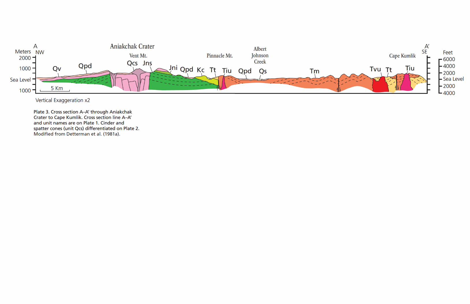
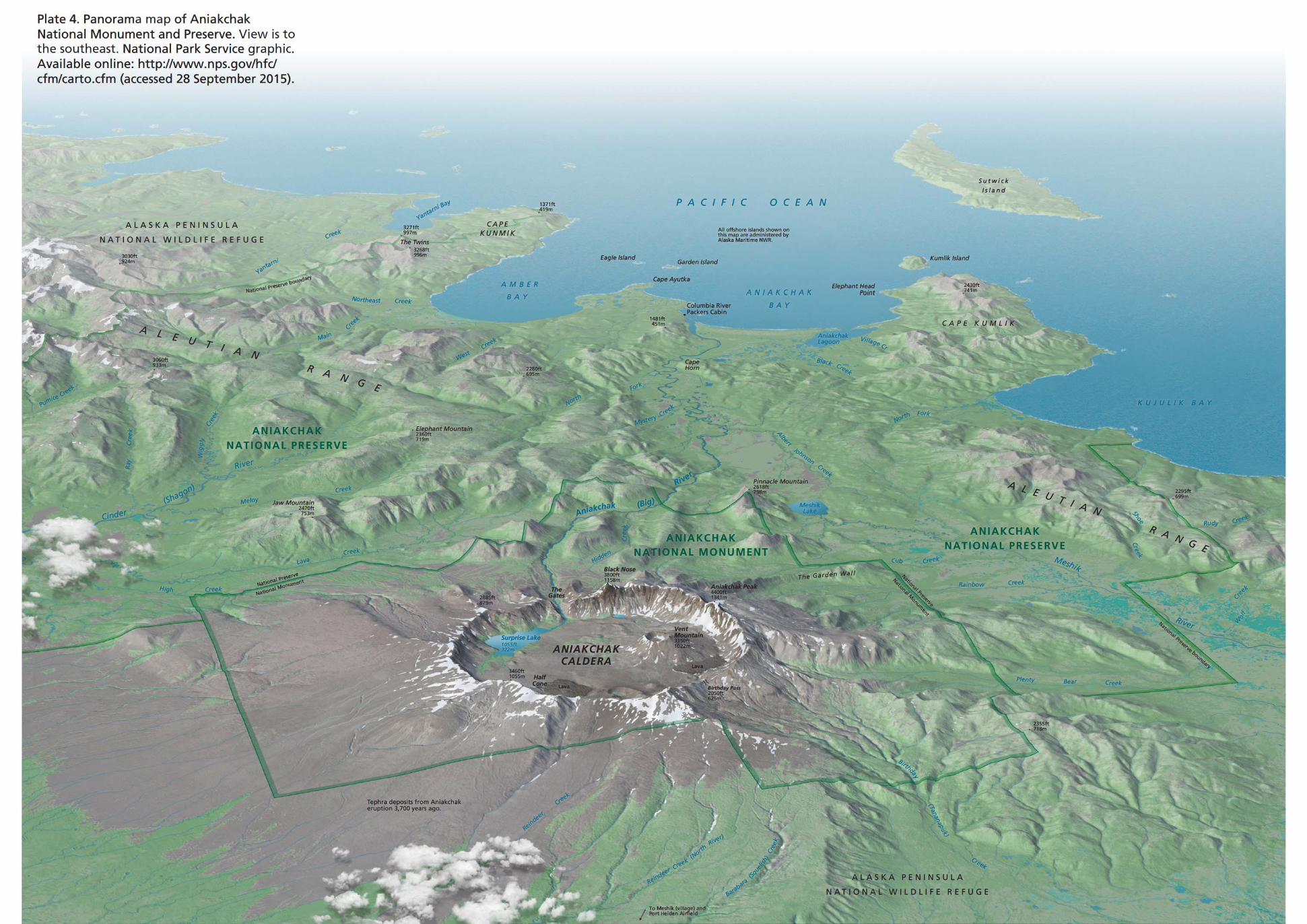
Related Documents