4- ^^^F J l \ 41P89NEee46 6 3.3987 BRYCE 010 DIAMOND DRILL REPORT BRISCOE-BRYCE GOLD PROSPECT BRYCE TOWNSHIP, ONTARIO 1981 for Yvanex Developments Limited and Windjammer Power and Gas Ltd. Toronto, Ontario, February, 1982. W. E. Brereton, P.Eng., MPH Consulting Limited.

Welcome message from author
This document is posted to help you gain knowledge. Please leave a comment to let me know what you think about it! Share it to your friends and learn new things together.
Transcript

4-^^^F
J
l
\
41P89NEee46 63.3987 BRYCE 010
DIAMOND DRILL REPORT
BRISCOE-BRYCE GOLD PROSPECT
BRYCE TOWNSHIP, ONTARIO
1981
for
Yvanex Developments Limited
and
Windjammer Power and Gas Ltd.
Toronto, Ontario, February, 1982.
W. E. Brereton, P.Eng., MPH Consulting Limited.

m SUMMARY
A gold exploration programme involving 4,489 ft. of diamond dril-
I ling in 13 holes has been completed on a 1,320 acre property in
Bryce Township, northeastern Ontario, for Windjammer Power and Gas
l Ltd. and Yvanex Developments Limited.
The claims encompass the former Briscoe-Bryce No. l Vein Zone gold
l prospect which saw limited production in the I960 1 s. The rock
that was milled reportedly graded in the 0.5 to 0.6 oz Au per ton
l range. The gold occurs in quartz-pyrite-chalcopyrite vein
m material within a steeply dipping shear structure which is appro
ximately conformable with host intermediate volcaniclastics. The
l shear is a strong, through-going feature which has been defined
over a strike length in excess of 850 m by the previous and pre-
I sent drilling and is open in both directions and to depth.
Pre-1940 surface trenching indicated three surface oreshoots as
l follows:
l
l
l
l
l
Oreshoot Length (ft) Width (ft) Grade (02 Au)
A 135 4.0 0.29
B 165 1.6 0.373
C 80 3.0 0.194

The 1981 drilling was carried out east of the old workings in a
previously relatively unexplored area. The grades in the 1981
drilling in this eastern sector are, in general, significantly
better than grades in the previous drilling under the old surface
workings.
Vein intersections on the No. l Vein Zone are summarized
following:
Hole No.
1
2
3
4
5
11
12A
13
Collar
1+OOE, 0+50S
2+OOE, 0+50S
3+08E, 0+25S
4+OOE, 0+1 5S
5+OOE, 0+25S
6+OOE, 0+80S
7+OOE, 0+40S
8+OOE, 0+40S
Intersection oz Au/ True Width (ft)
0.11 over 1.0 ft
0.41 over 3.2 ft
0.80 over 1.0 ft
0.73 Au, 0.56 Ag
Q.44% Cu over 1.6 ft
0.20 over 3.8 ft
0.05 over 1.7 ft
0.055 over 1.0 ft
Vertical Depth
200
243
145
129
99
247
248
0.155 over 3.5 ft (#2 vein) 236 0.27 over 0.8 ft (#1 vein) 269
The No. l or "main" vein shows a distinct stratigraphic control
being located in a chloritic tuffaceous unit in the basal portion
of a feldspar porphyritic crystal tuff which in turn is located
between two thick units of coarse intermediate volcanic breccia.
l
l
Gold values are closely restricted to a narrow, generally central,
quartz-sulphide vein within the shear. These high grade sections
often assay more than l oz Au per ton. Subordinate veins on
either side or sections of mineralized shear material generally do
not carry gold values.
Four holes were drilled elsewhere on the property to test geo
physical targets. No gold intersections of potential economic
significance were recorded. These holes were technically success
ful, however, in that the cause of the geophysical anomalies has
been explained in every case.
Several old trenches excavated by previous workers were located
and re-sampled. The trenches invariably expose quartz-pyrites
chalcopyrite vein material in chloritic shear zones. The veins
are generally very narrow and irregular. Values of up to 0.30 oz
Au per ton were recorded in selected grab samples. More syste
matic chip samples across vein structures returned low values.
Although none of the trench areas appear to have any immediate
economic significance, they do emphasize the widespread distri
bution of gold mineralization in the property area.
It is concluded that the No. l Vein Zone has potential to host an
economic tonnage of gold-bearing rock. The area between present
sections 0+00 and 5+OOmE is of greatest interest based on the work
to date. Potential grades of 0.20 oz Au per ton over mining
widths of 5 ft. are indicated.
A programme of additional diamond drilling totalling 7,100 ft is
recommended to further develop the economic potential of the No. l
Vein Zone with a minor amount of footage devoted to testing two
other geophysical targets on the property.

l l l l l l l l l l l l l l l l l l l
41P89NEW46 63.3967 BRYCE 010C
TABLE OF
PAGE
SUMMARY
1.0 INTRODUCTION l
2.0 HISTORY AND PREVIOUS WORK 2
3 . O PROPERTY 6
4.0 LOCATION, ACCESS AND INFRASTRUCTURE 8
5.0 DIAMOND DRILLING PROGRAMME - 1981 115.1 Drilling 115.2 Assaying 125.3 Other 13
6 . O GEOLOGY 146.1 General 146.2 Mineralization 16
7.0 DESCRIPTION OF PROPERTY GOLD OCCURRENCES 197.1 Contact Zone 19
7.1.1 Sampling - 1980 207.2 Briscoe-Bryce No. l Vein Zone 22
7.2.1 Sampling - 1980 24
8.0 DRILL RESULTS - 1981 268.1 Summary 268.2 Holes 1-5, 10-13; No. l Vein Zone 29
8.2.1 Lithology and Stratigraphy 298.2.2 Ore Microscopy 368.2.3 Discussion 37
8.3 Holes 6 to 9, Geophysical Targets 388.4 Trench Re-Sampling 41
9.0 CONCLUSIONS AND RECOMMENDATIONS 44
CERTIFICATE
REFERENCES
APPENDIX A - Assay Results - 1981 APPENDIX B - Drill Logs: Holes 81-1 to 81-13 APPENDIX C - Drill Sections: Holes 81-1 to 81-13 APPENDIX D - Photomicrographs
l lm l .O INTRODUCTION
l This report presents a summary of the results of a diamond dril
ling programme completed on the Briscoe-Bryce gold prospect in the
l
l
l
Kirkland Lake area of northeastern Ontario during 1981 on behalf
of Yvanex Developments Ltd. and Windjammer Power and Gas Ltd.
l The drilling was concentrated on the so-called "No. l Vein Zone".
This gold-bearing vein saw limited production approximately (100
l tons) in the I960 1 s. The rock that was milled reportedly graded
m in the 0.5 to 0.6 oz Au per ton range. The gold occurs in quartz-
sulphide vein material within a steeply dipping shear structure
l which is conformable with host intermediate pyroclastics.
l
l
Results of exploration completed both by previous workers and
within the context of the present programme prior to the 1981
drilling are presented following in summary fashion.
lThis report describes the drilling programme carried out, outlines
exploration results to date and presents recommendations for fur-
I ther exploration in the property area.
Expenditure details re OMEP programme OM81-6JV-7 are presented
under separate cover.
11l1111111111111111
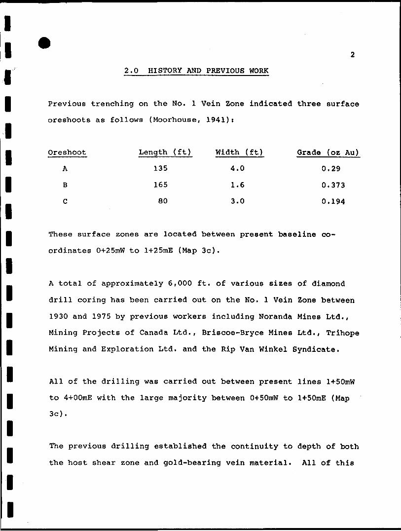
*2.0 HISTORY AND PREVIOUS WORK
Previous trenching on the No. 1 Vein Zone indicated
oreshoots as follows (Moorhouse, 1941):
Oreshoot Length (ft) Width (ft)
A 135 4.0
B 165 1.6
C 80 3.0
2
three surface
Grade (oz Au)
0.29
0,373
0.194
These surface zones are located between present baseline co
ordinates 0*25mW to l-*-25mE (Map 3c).
A total of approximately 6,000 ft. of various sizes
drill coring has been carried out on the No. 1 Vein
1930 and 1975 by previous workers including Noranda
Mining Projects of Canada Ltd., Briscoe-Bryce Mines
Mining and Exploration Ltd. and the Rip Van Winkel
All of the drilling was carried out between present
to 4+OOmE with the large majority between 0+SOmW to
3c).
The previous drilling established the continuity to
the host shear zone and gold-bearing vein material.
of diamond
Zone between
Mines Ltd.,
Ltd., Trihope
Syndicate.
lines H-50mW
1+SOmE (Map
depth of both
All of this

l lm drilling has been relatively shallow with vein intersections
generally in the range of 50 to 100 ft (15 to 30 ra) vertically
l below surface.
l
l
Previous drilling between 0+SOmW to O+TSmE established that the
mineralized structure here continues to depth with generally low
gold values present. The best value recorded was 0.53 o z Au per
l ton over 0.3 m (previous hole MP-6, Map 3c).
l
l
Drilling immediately to the east of the above returned higher gold
values and substantially increased amounts of vein material within
the shear structure. The zone appears to dip approximately 75 e S
l in this region relative to a more vertical dip in the area of the
headframe. A previous hole in the vicinity of present line 1+OOmE
" returned 0.22 oz Au per ton over 1.0 meters (Noranda hole N-l).
B Another hole immediately to the east returned a 5.5 m section of
shearing and vein material with one section averaging 0.06 oz Au
l over 1.95 m. Contained within this was a 0.3 m section which
returned 0.32 oz Au per ton.
l A previous hole on the vein at present 2*75mE intersected a 0.8 m
section which returned 0.51 oz Au. A hole 60 m east of the above
g intersected the vein and returned an assay of 0.15 oz Au over
. 0.8 m.
l
l

llm Other known and reported gold prospects within the present pro
perty include the Contact Zone, South Zone/ J.R. Campbell occur-
I rences and the H. Briscoe Jr. (Honeymoon Lake) occurrence.
l
l
A 1980 programme completed on behalf of Windjammer-Yvanex con
sisted of geological reconnaissance and surface trenching and
sampling along with a programme of linecutting and ground geo-
I physical surveying (magnetics, VLF-EM, Induced Polarization).
l
l
The 1980 trenching and sampling on the No. l Vein generally con
firmed previously indicated gold tenors. A systematic chip sample
in the shaft beneath the headframe on the previous "C" zone re-
I turned 0.414 oz Au per ton over 0.7 m. Six selected grab samples
returned 0.270, 0.184, 0.149, 0.254 and 0.02 oz Au per ton. A
l
3216 Ib bulk sample taken from the shaft by previous operators
reportedly averaged 0.38 oz Au, 1.10 oz Ag per ton.
l A 3.0 m chip sample taken in 1980 across a trench in the previous
"A" surface zone returned 0.204 oz Au per ton. A chip sample
B across a 0.3 m massive pyrite band in the trench returned 1.04 oz
U Au. A 2.6 m sample across the vein in the existing shaft in the
"A" zone returned 0.270 oz Au per ton. A previous 1990 Ib bulk
l sample from the shaft reportedly averaged 0.76 oz Au per ton.
l
l
l

5
Geophysically, there is a complex and very low amplitude IP res
ponse locally associated with the No. l Vein Zone. The PFE (per-
I cent frequency effect) signature improves to the east and to
depth. The host shear zone appears on some lines as a distinct
l anomaly in the IP resistivity data. The anomaly is indicative of
m a vertical source which extends to depth. There is a flanking
VLF-EM response associated with part of the No. l Vein Zone.
l There is no magnetic signature associated with the No. l Vein.
m Induced Polarization surveying over the Contact Zone to the north
M o f the No. l Vein Zone indicates a strong resistivity-PFE anomaly.
This zone represents the contact between Catherine Group basalts
l to the north and Skead Group volcaniclastics to the south. The IP
anomalies probably relate to pyrite-chalcopyrite mineralization
known to be present in the interflow sedimentary Contact Zone.
B There is a strong VLF response along the Contact Zone. Previous
drilling encountered low Au values.
lIt was concluded that results of the above exploration were suf-
ficiently encouraging to warrant an aggressive diamond drill
l evaluation of the property. A programme of 2500 ft of N-size dia
mond drilling in 9 holes, which subsequently became 4500 ft in 13
l holes, was therefore recommended with drilling to commence in
early April of 1981. The above drilling was completed and is the
" subject of this report.
l
l

6
l
l
l
l
l
l
l
l
l
l
l
l
l
l
l
l
3.O PROPERTY
The property on which exploration work was completed consists of
20 patented and unpatented mining claims and one half-lot in Bryce
Township, District of Timiskaming, Larder Lake Mining Division as
follows:
Claim No. T 25691 T 25692 T 25693 T 25694 T 25695 T 25696 T 25697 T 24227 T 24228 T 24229 L 578257 L 578261 L 578263 L 578264 L 578265 L 578266 L 579216 L 579217 L 579215 L 579218 North Half
NENWNENWSWNESESWSESENWNWSWNESESWNWSWNWNE
1/41/41/41/41/21/41/41/41/41/41/41/41/41/41/41/41/41/41/41/2
Lot 9
LocationNNNNNNNNNNSSSSSsNNSS
Con
1/21/21/21/21/21/21/21/21/21/21/21/21/21/21/21/21/21/21/21/2. 4
LotLotLotLotLotLotLotLotLotLotLotLotLotLotLotLotLotLotLotLot
1010111111121210111011121212121112121010
Con.Con.Con.Con.Con.Con.Con.Con.Con.Con.Con.Con.Con.Con.Con.Con.Con.Con.Con.Con.
44444444444444444444
StatusPatentedPatentedPatentedPatentedPatentedPatentedPatentedPatentedPatentedPatented
UnpatentedUnpatentedUnpatentedUnpatentedUnpatentedUnpatentedUnpatentedUnpatentedUnpatentedUnpatented
Patented
Surface rights are also held to patented claim T 24227.
The following nine claims are also held under option by Wind
jammer -Yvane x but were not worked on in the context of the present
programme:

l l l l l l l l l l l l l l l l
L 579219 L 579220 L 579221 L 579222 L 579223 L 579224 L 579225 L 585682 L 585683
NW 1/4 SE 1/4 SW 1/4 NW 1/4 NE 1/4 NW 1/4 SW 1/4 NE 1/4 SE 1/4
S 1/2 Lot S 1/2 Lot S 1/2 Lot S 1/2 Lot S 1/2 Lot N 1/2 Lot N 1/2 Lot S 1/2 Lot S 1/2 Lot
9 Con. 10 Con.9 Con.
12 Con. 12 Con.11 Con.12 Con. 9 Con. 9 Con.
444333344
Unpatented Unpatented Unpatented Unpatented Unpatented Unpatented Unpatented Unpatented Unpatented
8
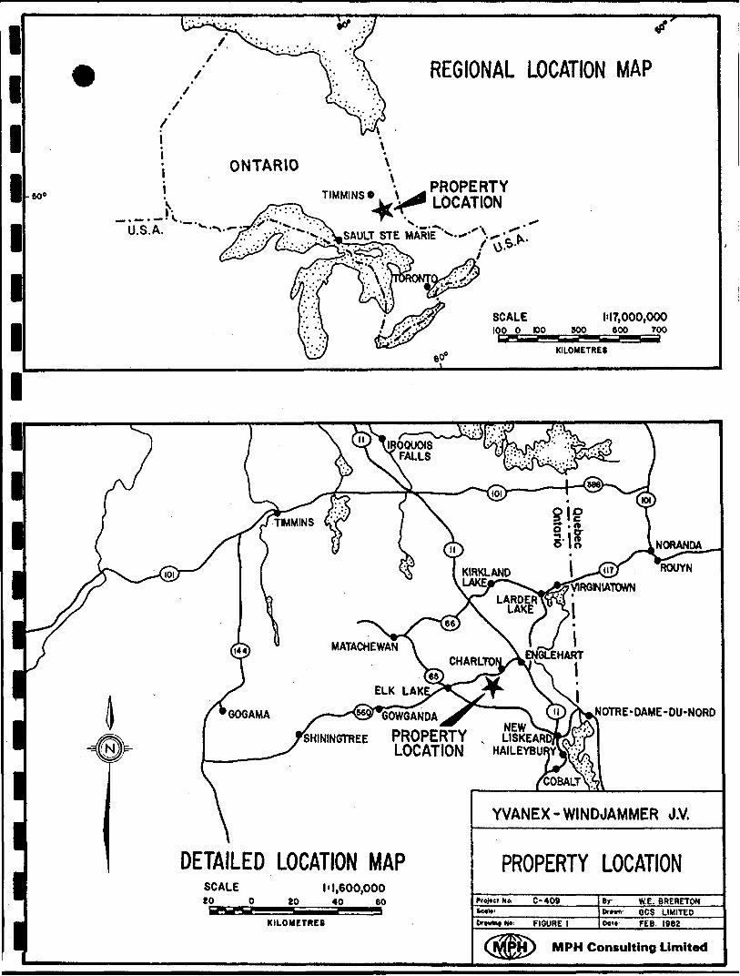
4.0 LOCATION, ACCESS AND INFRASTRUCTURE
The property is located some 30 miles (50 km) south of Kirkland
Lake in northeastern Ontario (Figure 1).
It is readily accessible via Highway 560 which leads to Charlton
from the TransCanada Highway, No. 11, at Englehart, Ontario. Con
cession roads and finally a bush road lead directly to the pro
perty from the end of Highway 560.
The one mile bush road to the property was constructed by former
operators and is best traversed by 4-wheel drive or all-terrain
vehicle.
Bush roads also lead into adjoining Tudhope Township from High
way 65, 4 miles south of the property at Leeville. Hydro
electric power and a spur-line of the Ontario Northland Railway
are located at Leeville. There is also hydro-electric power
transmission to the Hills Lake fish hatchery less than 5 miles by
road to the east.
lMiners and general labour are available from surrounding centres
l of service and supply such as Kirkland Lake, Elk Lake, Matachewan,
Earlton, Haileybury and Cobalt.
"
l
l
l
l
l
l 606
REGIONAL LOCATION MAP
ONTARIO
-.-.-IV...
PROPERTY LOCATION
U.S.A.
SCALE100 O tOO
1-17,000,000BOO 800 TOO
•d-L-Aai KILOMETRES
MATACHEWAN
ELK LAK
GOWGANDA NOTRE-DAME-OU-NORD
SHININGTREE PROPERTY v LISKEA LOCATION HAILEYBU
DETAILED LOCATION MAPSCALE 1 11,600,00020 O 80 40 60
KILOMETRES
YVANEX- WINDJAMMER J.V.
PROPERTY LOCATIONFroJtctN* C-409
FIGURE l
WE. BREBETON60S LIMITED
Os't FEB. I98Z
M PH Consulting Limited
l l j The closest gold mills potentially available at present for custom
milling are at Kirkland Lake (Macassa Division, Willroy Mines Ltd.
l - 40 miles by road via highways 573, 11 and 66) and at Virginia-
town (Kerr Addison Mines Ltd. - 50 miles by road via highways 624
and 66).
l
l
l
l
l
l
l
l
l
l
l
l
l
l
l l l
115.0 DIAMOND DRILLING PROGRAMME - 1981
l 5.1 Drilling
Drilling operations were carried out by Barron Diamond Dril
ling Ltd. of Haileybury, Ontario.
A total of 4,489 ft. of NQ drilling was completed in 14
l holes. One of the holes, No. 12, was lost in overburden and
had to be re-drilled as hole 12A so that a total of 13 holes
l was actually completed.
Core recovery was, in general, excellent. Recovery was poor
l in isolated instances where the rocks were heavily fractured
and sheared. Recovery in the No. l Vein Zone was very good.
l A few instances of locally poor recovery are a reflection of
open cavities in the vein rather than actual loss of core.
All drilling was carried out with a Longyear 38 machine sup
ported by a small tractor.
Drilling operations were completed in the period April 9 to
July 9, 1981.
Drill core is presently being stored in core racks in a cabin
I X on the property.
l lM The drilling programme was managed by MPH Consulting Limited
of Toronto on behalf of Windjammer and Yvanex.
l5.2 Assaying
l All assaying and analytical work was carried out by Swastika
m Laboratories Limited of Swastika, Ontario.
l Gold and silver determinations were made by fire assay tech
niques. Copper, along with occasional Pb and Zn, were deter-
I mined by atomic absorption.
Intersections of vein material were sampled in very short
l lengths, generally l ft. Such samples were completely pul
verized in the laboratory and two cuts taken for fire assay.
l
This minimized the effects of any erratic coarse gold and
provided for very uniform and representative assay results.
l Any core sections which appeared to have any Au potential
were split and assayed.
B Unused sample material has been collected from Swastika and
is being stored for possible future use.
lThe entire assay results for the 1981 programme are presented
l as Appendix A.
l

l l
13
5.3 Other
A minor progranune of trench re-sampling and geological recon-
l naissance was carried out in conjunction with the drilling.
l l l l l l l l l l l l l l l

14
6.O GEOLOGY
6.1 General
The property straddles the boundary between the Catherine
j Group and the Skead Group of earliest Precambrian (Archean)
mm metavolcanics. The Catherine Group is comprised of Mg-rich
and Fe-rich tholeiitic basalt flows with Fe-rich tholeiites
l predominating at the top of the group.
l The Skead Group consists mainly of massive calc-alkaline vol-
M canic fragmental rocks of basalt, andesite, dacite and rhyo-
lite composition. Some flows are present in the group. The
l fragmental rocks range from crystal tuff to tuff-breccia and
flow breccia. The coarser fragmental rocks contain a wide
l variety of felsic fragments. The main source of the volcanic
M ejecta appears to have been a large volcanic centre in Skead
Township to the north of the present property area. Recent
l government mapping has defined an additional volcanic centre
in the vicinity of Heather Lake immediately south of the
l present ground.
The contact between these two formations, the "Contact Zone"
l of previous workers, crosses the property in the vicinity of
detail baseline 4+OON. Present and previous work on the
l "Contact Zone" indicates that there is a major unit of inter-
l
l
l l j flow metasediments consisting of laminated cherty and
tuffaceous rocks containing pyrite and chalcopyrite sepa-
I rating the two formations.
m Porphyry and lamprophyre dykes intrude the volcanic rocks.
m An elliptical stock of feldspar porphyry containing several
gold veins is centered 2 miles east of the property. Another
l porphyry body located by recent government mapping occurs on
the west portion of the present property immediately south of
l Honeymoon Lake.
The Round Lake granitic batholith occurs directly north of
l the property area.
B Rock units on the property strike east-northeast and are
B steeply to vertically dipping. There is no evidence of any
fold closures in the immediate property area. Stratigraphic
l tops in the area are indicated to be to the southeast.
B The property is located between two major regional faults
H striking N40 0W, the Cross Lake Fault and the Montreal River
Fault. A study of the fracture pattern in Bryce Township in-
I dicates 3 prominent fracture directions; northwest, northeast
to east-northeast and north-south. A major northeast-
H trending airphotographic linear herein termed the "Sunday
l
l

16
Creek Linear" passes to the south of the property. These
fractures are important in that most of the gold minera
lization recognized to date in the area is controlled
by one of the above fracture directions, e.g. the Briscoe-
Bryce No. l Vein Zone along an east-northeast structure.
6.2 Mineralization
A 1941 Ontario Department of Mines report describes 34 gold
prospects in the Bryce-Robillard area (Moorhouse, 1941).
This author classified the more important gold occurrences
into a number of types according to structure and minera
lization as follows:
a) mineralized shear zones
b) mineralized porphyries
c) mineralized joints and shear zones in granite
The first group consists of deposits that occur ins
1) northeast-trending zones? (2) north-south zones and
3) northwest-trending zones. In the northeast-trending
zones, three types were recognized, i) those mineralized
with disseminated pyrite and other sulphides with quartz,
ii) those mineralized with massive pyrite * quartz and
iii) those mineralized with pyrite accompanied by chrome,
mica, and quartz.

17
The Briscoe-Bryce No. l Vein Zone would be an excellent
example of a mineralized shear zone of type ii).
There is an additional and very important type of gold occur
rence in the area, namely gold associated with laminated in
terflow sedimentary horizons consisting of cherty and tuf
faceous material containing stratiform laminae and dis
seminations and stringers of pyrite and chalcopyrite. These
units are typically sheared and show varying degrees of seri
citization, carbonatization and chloritization. This variety
would be analogous to Moorhouse's "mineralized shear zones of
type a-1". The Contact Zone on the Briscoe-Bryce property
and reported occurrences on the J.R. Campbell property would
be of this type. Much of the ore from some of the world's
major gold deposits such as Amoco's Detour deposit and the
Dome Mine at Timmins is or will be derived from orebodies of
this type.
The only serious attempt at commercial gold production in the
area was from the Briscoe-Bryce No. l Vein Zone. There are
no accurate records of the work but, according to Harold
Briscoe Sr., a total of approximately 100 tons of ore was
milled in a 60-75 ton per day mill installed on the property
in the mid 1960"s. The rock milled was taken from the dec
line and No. l and No. 2 shafts on the "A" and "C" zones res-

l lm pectively. Average grade of the mill feed is reported to
have been in the 0.5 to 0.6 oz per ton range. The operation
l appears to have been relatively crude. In any event, the
mill burned down in 1967 "before steady production had been
l achieved".
l
l
l
l
l
l
l
l
l
l
l
l
l
l

19
7.0 DESCRIPTION OF PROPERTY GOLD OCCURRENCES
There are several known and reported gold occurrences within the
confines of the present property area, the most important of which
are discussed following:
7.1 Contact Zone
During the early stages of prospecting in Bryce and Tudhope
Townships in the 1930's, considerable work was expended in
attempting to trench and sample a pyritic, carbonatized,
sericitized, silicified, sheared band of tuffaceous sedi
ments which occurs at the contact between the Catherine and
Skead Groups. This contact was apparently only exposed by
trenching in two locations along a strike length of over 3
miles. One of these trench localities was on claim T 25697,
now part of the property described herein. This so-called
"Bailey T-trench" was excavated in the 1930's and reportedly
returned 0.114 oz per ton Au across a width of 60 ft.
Five short holes were drilled in the T-trench area in 1939.
There were no Au values in the core above 0.02 oz per ton
although sludge samples reportedly returned up to 8 oz Au per
ton.

20
In 1967, two diamond drill holes were drilled 2100 ft. west-
southwest of Bailey's T-trench for Trihope Mining and
Exploration Co. to investigate a VLP-EM conductor on the
"Contact Zone". Although no ore values were reported, the
drilling did intersect bands of interflow tuffaceous and
cherty sediments with pyrite and up to ^ chalcopyrite.
In 1975, the Rip Van Winkel Syndicate investigated the zone
in the immediate area of the old Bailey Trench with a total
of 328.6 ft in two diamond drill holes. Both holes inter
sected the silicified, sericitized, pyritized "Contact Zone"
which varied in width from 13.3 ft. (Hole 1) to 30 ft. (Hole
2). Assay results were "disappointing" with the best value
being 0.03 oz Au over 10 ft.
7.1.1 Sampling - 1980
The Bailey T-trench was located during the 1980 explo
ration programme. An attempt to completely excavate
the old trench with a backhoe was only partially suc
cessful.
A portion of the actual contact zone was exposed im
mediately north of an old, cribbed, water-filled shaft
at the T-junction in the trench. All quartz *

21
sulphide mineralization was blasted and sampled.
There were no gold values of economic significance in
any of the samples with the highest value of 0.03 oz
Au per ton being from a thin massive pyrite band im
mediately adjoining the old shaft. It is probable
that the best mineralization is present at the bottom
of the shaft. This could not be sampled during the
present work as this area of the trench was beyond the
reach of the backhoe.
An additional trench to the north that reached bedrock
likewise failed to return any values of significance.
Although disappointingly low in an economic sense, the
values are in accord with previous drill results and
indicate that this interflow unit is distinctly ano
malous geochemically in gold. Such a unit may have
acted as a source rock or protore for subsequent gold
concentrations in favourable structures elsewhere
along this auriferous sulphidic unit.
The original assay value of 0.114 oz Au over 60 ft in
the Bailey T-trench must be totally discounted. If
real, it is possible that the value represented a sur-
l l l l
l
l
l
l
l
l
l
22
face enrichment not representative of the underlying
bedrock.
7.2 Briscoe-Bryce No. l Vein Zone
l The original showing was found by the Briscoe Brothers by
m trenching through clay after they had found mineralized auri
ferous float along the old wagon road in this vicinity in
l 1935. Between 1935 and 1957 much laborious trenching was
done between the present two shafts and eastward by hand,
l horse-drawn scoop or scraper and by drilling and blasting.
m Most of these old trenches reportedly never reached bedrock.
An eastward sloping, 40" decline was sunk at the west end of
l the surface workings (headframe - Map 3c) and a vertical
shaft was sunk and timbered to a depth of 32 ft. toward the
east end of the surface workings, above present hole 81-1.
In his 1941 report, Moorhouse notes that
"......after trenching had exposed the mineralized zonein some 15 pits...sampling indicated an ore shoot 450 ft. long and 3 to 4 ft. wide, averaging 0.20 to 0.28 ounces of gold per ton."
Subsequent workers determined that the surface zone,(between
present 0*25mW and 1+251HE on Map 3c), consisted of 3 indi-
vidual "oreshoots" as follows:
23
"A" Oreshoot - This was exposed on surface for a length of
135 ft. It is reported as averaging 0.29 oz Au per ton over
an average width of 4.0 ft. Mining Projects of Canada Ltd.
subsequently extended this oreshoot an additional 185 ft. to
the east by diamond drilling. Gold values in the drill-
M indicated extension are low being in the 0.04 to 0.06 oz per
ton range. Harold Briscoe Sr. showed the author assay
B results which indicated that a 1990 Ib bulk sample from the
shaft in the "A" zone returned 0.76 oz Au per ton and
B D.40% Cu. There was no silver assay performed.
"B" Oreshoot - This is located immediately west of "A" and is
l reported to average 0.373 oz gold per ton across an average
width of 1.6 ft. for a length of 165 ft.
lB "C" Oreshoot - This is reported as grading 0.194 oz Au per
ton across an average width of 3.0 ft. for a length of 80 ft.
B based on surface sampling. There is an approximately 60 ft.
section of "very low-grade material" separating the "B" and
l "C" oreshoots. A 3216 Ib bulk sample taken from the shaft in
m the "C" oreshoot returned 0.38 oz Au and 1.10 oz Ag per ton
according to old assay results. Additionally, it is reported
l that virtually every round in the decline exposed visible
gold.
l
l
l
l lm 7 .2.1 Sampling - 1980
Considerable difficulty was encountered in reaching
l bedrock with a backhoe in the vicinity of the pre
viously reported "A", "B" and "C" oreshoots. Clay
l
overburden in these areas is deeper than 15 ft., the
maximum penetration capability of the backhoe.
l Sampling at the top of the now filled-in #1 shaft
beneath the headframe appears to confirm previously
l indicated gold tenors. A 0.7 m chip sample across the
m vein exposed on the west wall of the shaft returned
0.414 oz Au per ton. Four selected grab samples re-
I turned 0.270, 0.184, 0.149 and 0.254 oz Au per ton.
Two massive pyrite grab samples from the decline re-
I turned Au values in the 0.02 oz range.
Sampling in the area of the No. 2 shaft on the "A"
l oreshoot (line 1+OOmE) returned the most encouragement
of the programme to date. A 3.0 m chip sample on the
B east wall of trench #5 on the vein at line 1+OOmE
B returned a weighted average of 0.204 oz per ton Au. A
2.6 m chip sample across the west face of the No. 2
l shaft returned a weighted average of 0.270 oz per ton
Au.
l
l
l lm Examination of selected grab sample values from within
the zone strongly suggested that the average grade in
l a bulk sample would be higher, possibly substantially
so, than the previous values. For example, in the
l above trench, the central 1.0 m chip sample returned
m only 0.002 oz Au yet a grab sample, #5, from within
this zone returned 0.63 oz Au per ton. Likewise, the
l northernmost chip sample returned 0.002 oz across
0.5 m yet two grab samples from within this zone
l returned 0.72 oz Au and 1.04 oz Au per ton respec-
m tively. The latter value represents a sample across a
0.3 m massive pyrite pod on the west side of the
l trench.
l Several old trenches excavated by previous workers were
j located and re-sampled during the 1981 drill programme.
The trenches invariably expose quartz-pyrite
l j- chalcopyrite vein material in chloritic shear zones.
The veins are generally very narrow and irregular.
B Values of up to 0.30 oz Au were recorded in selected
B grab samples. More systematic chip samples across the
vein structures returned low values. Although none of
l the trench areas appear to have any immediate economic
significance, they do emphasize the widespread distri-
bution of gold mineralization in the property area.
l
l
11
1 1 1 1 1 1 1 1 1 11 1 11111
t26
8.0 DRILL RESULTS - 1981
8.1 Summary
The 1981 drilling on the No. 1 Vein Zone in combination with
previous work has established that the vein extends from at
least 0+SOmW to 8+OOmE, a distance of 850 meters (2800 ft.).
The vein is open in both directions and to depth.
The present drilling was carried out on 100 m centres east of
the old surface workings towards a previously unexplored
area. The grades in the 1981 drilling in this eastern sector
are, in general, significantly better than grades in the
previous drilling under the old workings.
Drill results on the No. 1 Vein Zone are summarized
following:
Hole No. Collar (m) Intersection oz Au/ VerticalTrue Width (ft) Depth (ft)
1 1+OOE, 0+50S 0.11 over 1.0 ft 200
2 2+OOE, 0+50S 0.41 over 3.2 ft 243
3 3+08E, 0+25S 0.80 over 1.0 ft 145
4 4+OOE, 04-15S 0.73 Au, 0.56 Ag 129Q.44% Cu over 1.6 ft
5 5+OOE, 0+25S 0.20 over 3.8 ft 99
* 10 4+50E, 1+50S see below
11 6+OOE, 0+80S 0.05 over 1.7 ft 247

27
12 abandoned in overburden
12A 7+OOE, 0+40S 0.55 over 1.0 ft 248
13 8+OOE, 0+40S 0.155 over 3.5 ft 236(#2 vein)
0.27 over 0.8 ft 269 (#1 vein)
*It appears that Hole 10 did not intersect the No. l Vein
Zone. A narrow quartz-pyrite vein was intersected at the ap
proximate projected location of the vein at depth. A 1.0 ft
section returned 0.03 oz Au. Completion of subsequent Holes
11, 12 and 13, however, indicate that this is not the main
vein. It is therefore concluded that the dip of the main
vein steepens to vertical or, possibly to steep north at
depth in this region.
The No. l Vein Zone consists of narrow quartz-pyrite j^ chal
copyrite vein(s) occupying a strong shear structure in inter
mediate volcaniclastics. Individual veins are conformable
with the shearing which is in turn conformable with the host
rock units. Maximum width of gold-bearing vein material to
date is approximately 4 ft. Minimum width is l ft.
The No. l Vein Zone shows a distinct stratigraphic control,
being located in a chloritic tuffaceous unit in the basal
portion of an intermediate, ashy feldspar porphyritic vol-
ll 28
B caniclastic which is in turn located between two thick units
of coarse intermediate fragmental.
lGold values are closely restricted to a narrow, generally
l
central, quartz-sulphide vein within the shear i These high-
grade sections often assay more than l oz per ton Au.
l Subordinate veins on either side or sections of mineralized
shear material generally do not carry gold values.
j Carbonitization is ubiquitous within the shear along with
variable silicification, pyritization and sericitization.
l There may be some green chromian mica. The zone of shearing
and hydrothermal alteration may be up to 10 ft. or more in
B width.
lGold values generally show a 1:1 correlation with copper
l values. Textural relationships indicate that the Au-Ag-Cu
mineralization may be paragenetically later than the quartz-
pyrite mineralization.
lThere is minor sphalerite and galena within the vein zone.
lg The easternmost hole, 113, intersected a second Au vein iden-
tical to, but stratigraphically above the No. l Vein.
l
l

29
Further drilling will be required to delimit the two vein
structures.
Four holes were drilled elsewhere on the property to test
geophysical targets. No gold intersections of potential eco
nomic significance were recorded. These holes were techni
cally successful, however, in that the cause of the
geophysical anomalies has been adequately explained in every
case.
Logs and sections for the 1981 drilling are presented as
Appendices B and C respectively. Hole locations are shown on
Map 2c.
8.2 Holes 1-5, 10-13? No. l Vein Zone
8.2.1 Lithology and Stratigraphy
Diamond drilling during 1981 in the interval between
section 1+OOmE to 8+OOmE has defined a relatively con-
sistent volcaniclastic stratigraphic picture as out-
H lined (Appendix C).
lThe gold-bearing No. l Vein Zone is generally loca-
I lized within a chloritic to dacitic tuffaceous unit at
the base of an intermediate crystal tuff which in turn
l
l

ll 30
is sandwiched between two units of coarse intermediate
* volcanic breccia.
lThe host chloritic tuff is generally a grey to
l greenish-grey, fine-grained rock with greenish chlori-
. tic clots. The unit may be very similar to the over-
lying crystal tuff but missing the characteristic
l feldspar phenocrysts and crystal fragments. In
hole l, the upper contact of the chloritic tuff with
l the overlying crystal tuff is gradational while the
m lower contact with underlying coarse intermediate vol
canic breccia is sharp.
lThe chloritic tuff is well-bedded in hole 3 suggesting
l a waterlain origin for the rock. The chloritic tuff
m has also been the locus of a major shear zone, which
is in turn host to the No. l Vein, such that original
l textural structural features in the tuff have been
largely obliterated. The chloritic tuff varies from
l approximately l m to 5 m in true thickness.
The overlying unit of feldspar porphyritic crystal
l tuff is a generally massive, featureless ash tuff of
probable andesitic composition. An ash flow origin is
l
l

l l. suggested by the lack of internal organization or
structure in the unit.
lThe crystal tuff, in core/ consists of white plagio-
g clase crystals and darker green chloritic clots in a
chloritic matrix. There are scattered quartz eyes.
The rock is typically weakly carbonitized where tested
l with HC1. There may be local traces of pyrite on
slip/fracture surfaces, in veinlets with quartz-
I carbonate and as fine disseminations.
A weak schistosity may be present in the rock which
l appears to be grossly parallel to lithologic
contacts.
la* The tuff is variably fractured with the fractures
filled by one or more generations of quartz, carbonate
l
l
l
^ hematite.
There are occasional block-sized fragments of fine
grained, greyish dacitic volcanic within the tuff.
l Material identical to this crystal tuff forms an ashy
matrix to the overlying and underlying volcanic brec-
I cia units.
l
l

32
Where the determination can be made, the tuff varies
from 10 m (hole 13) to in excess of 60 m (hole 2) in
thickness. There is a general thinning of the unit to
the east which may be a reflection of initial deposi
tion on an irregular, pre-existing volcanic topo
graphy, possibly coupled with a volcanic source area
to the west.
Units of andesitic volcanic breccia, typically feld
spar porphyritic, overlie and underlie the proceeding
units of finer volcaniclastic material.
The overlying breccia unit was variously described as
a coarse andesitic fragmental, coarse fragmental
dacite, etc. in field logs. It consists of fragments
locally to 0.5 m or more of several types of feldspar
porphyry, dacitic and andesitic tuffs and fine-grained
dacitic volcanic in a feldspar porphyritic (andesitic)
crystal ash tuff matrix.
The rock is generally greenish-grey and may display a
crude parallelism of the major plane of rock clasts.
Rock fragments are typically angular to surrounded.
There are local traces of pyrite, often with quartz *
33
carbonate veinlets. The rock generally displays weak,
pervasive carbonatization.
The rounding of the fragments and lack of internal
organization is again an indication of a chaotic
debris or avalanche-flow type of deposit. There were
no obvious clast size gradations to suggest a trans
port direction. The coarseness of the rock suggests a
relatively proximal deposit. Its thickness is inde
terminate but, considering hole 10, is at least
locally greater than 50 m.
The coarse fragmental unit underlying the No. l Vein
Zone is essentially as that described above, i.e. a
coarse, intermediate, pyroclastic volcanic breccia
with a variable component of feldspar porphyritic
clasts. There may be minor pyrite and
quartz-carbonate veining.
The contact of this unit with the overlying tuffaceous
section may be very sharp, indicating a discrete
hiatus in volaniclastic deposition.
The No. l Vein Zone is expressed at surface as a well-
laminated quartz-pyrite-chalcopyrite vein(s) within a

34
zone of strong shearing up to 10 ft (3 m) or more in
width within intermediate tuff. There is an obvious
intense greenish chloritization associated with the
shearing.
In core, the No. l or "Main" Vein Zone consists of a
zone of strong shearing with associated chloriti
zation, carbonitization, silicification, sericiti
zation and pyritization along with some development of
probable fuschitic mica. There is variable chalco
pyrite within the vein material. As in the surface
exposures, the vein material is distinctly laminated
parallel to schistosity with alternating quartz (±
carbonate) and sulphide-rich bands or zones. Pyrite-
rich bands are typically 1-5 cm in width. The pyrite
is often of a medium-grained, granular aspect
and, in hole l, appears to float in fine, clear to
whitish quartz.
In this hole, minor chalcopyrite is present as fine
splashes in quartz and is generally separate from the
main pyrite zones. In hole 2, chalcopyrite fills
cracks and vugs in quartz.

35
It was often noted that individual pyrite-rich bands
are surrounded by narrow (l cm *) bleached alteration
halos. An intense light greenish sericite-fuschite(?)
-silica alteration also accompanies the vein material
in several holes, e.g. 5A.
There is minor sphalerite in the vein zone in hole 4.
The most easterly holes show an intense chert-like
silicification associated with the quartz-pyrite-
chalcopyrite vein material.
The vein zone intersections vary in width from less
than l m to approximately 3 m (hole 4). Not all of
the vein material carries Au values however. These
are typically closely restricted to a narrow, often
central section of the vein zone. Assay values here
are often in excess of l oz Au per ton. Detailed
assay data are presented on the drill logs with higher
values summarized in the proceeding section.
Drilling revealed the presence of two virtually iden
tical Au-bearing vein zones in hole 13. The present
interpretation indicates that the deeper of the two
corresponds to the No. l Vein. This would require
36
that the host structure has possibly "stepped-down"
" stratigraphy here or that an additional unit of coarse
B fragmental has appeared. This interpretation is
tentative and more drilling will be required for
l corroboration.
8.2.2 Ore Microscopy
l A total of 5 polished sections was cut from the No. l
Vein Zone, 3 from hole 2 and l each from holes 4
and 5, to assist in determining the nature of gold
occurrence, grain size, overall vein mineralogy, etc.
Vein mineralogy in the sections examined is extremely
simple, consisting of dominant pyrite with subordinate
l to nil chalcopyrite in mainly siliceous gangue.
Pyrite occurs as a mosaic of relatively coarse, inter-
I locking anhedral grains and as scattered grains or ag
gregates which typically show better developed crystal
l outlines. The pyrite typically shows evidence
m o f brittle fracture in the form of cracked and shat
tered grains and masses. There has been local dis-
I location of shattered fragments.
l
l
l

l l 37
Chalcopyrite, in amounts from l to 10%, occurs as
interstitial fillings between pyrite grains, as fil-
fl lings of cracks within pyrite, as rims on pyrite
grains and as discrete masses and blebs in siliceous
l gangue separate from pyrite.
' Three polished sections were cut in the vicinity of
l 341 ft. in hole 2. Six discrete grains of gold were
observed. These ranged in size from 15 to 100 mic-
J rons. The gold is very clearly associated with the
chalcopyrite occurring as discrete, angular grains
within the latter mineral. Appendix D presents
photomicrographs of gold grains from hole 2.
There was little or no chalcopyrite present in the
polished sections for holes 4 and 5. There was also
no gold observed.
There was no indication of a discrete silver phase.
l This element is probably associated with the gold as
m electrum.
l 8.2.3 Discussion
The microscopic information supports the megascopic
l conclusion that the Cu-Au-Ag mineralization, in its
l
l

l l l
l
l l
38
present form, is distinctly later than quartz-pyrite.
H Whether this truly represents a discrete, later stage
of Cu-Au-Ag mineralization or a re-distribution of
l existing elements during a metamorphic or defor-
mational event is uncertain. In any event, increased
Cu tenors should be directly associated with Au-Ag
B concentrations so that Cu may be a very valuable path
finder in further exploration.
l 8.3 Holes 6 to 9, Geophysical Targets
' None of the four holes drilled on Induced Polarization j^
l resistivity * VLF-EM targets away from the No. l Vein Zone
returned any gold intersections of significance.
l The holes are summarized as follows!
Hole No. Collar Target
6 2+50W, 2+20S strong IP-resistivity m feature
CommentslExtensive shearing in several zones accounts for the resis
tivity anomaly; there is sufficient disseminated pyrite to
explain IP. Twenty-four sections of mineralized core were
l l l l l
l l l l l
39
submitted for assay. Values ranged from nil to 0.002 oz Au
per ton with one value of 0.005 oz Au per ton.
Hole No. Collar Target
7 0+50W, 4+40S strong VLF anomalyin area of "South Zone" reported Au
l showing
Comments
l The VLF anomaly is due to a strong, 10 ft wide fault zone.
There is no significant mineralization in the hole. Eight
l samples of weakly mineralized rock were submitted for assay.
B Values ranged from nil to 0.002 oz Au per ton? five of the Cu
values are anomalous being in the 100 to 4300 ppm range. The
l Cu is present in hole 7 as very thin chalcopyrite-quartz-
carbonate veinlets.
lB Hole No. Collar Target
" 8 11+OOW, 5+25S IP target in vicinityof reported quartz-
I pyrite Au veins
Comments
Hole intersected numerous thin quartz-carb-py-cpy veinlets in
intermediate pyroclastics in explanation of IP effects; 10
sections of mineralized core were sent for assay; values

40
ranged from nil to 0.005 oz per ton Au with up to 1530 ppm
' Cu.
lHole No. Collar Target
l
l
l
5+OOW, 3+85N strong VLF-IP targeton Contact Zone
Comments
Hole intersected two interflow sedimentary units aggregating
28 ft core length with up to 25% pyrite in explanation of
VLF-IP anomalies? 11 samples submitted for assay returned
l negligible values (to 0.005 oz Au); Ag values ranged up to
0.04 oz which is geochemically anomalous; Cu values ranged up
l to 1530 ppm.
A polished section was cut from a very narrow intersection of
l heavy sulphide mineralization in the Contact Zone in hole 9.
Mineralogy consisted of pyrite-sphalerite-chalcopyrite in
B siliceous gangue. Pyrite forms scattered, often equant
B grains and appears to have crystallized early. Sphalerite
forms a narrow veinlet which transects the slide. Chalco-
I pyrite occurs mainly as small irregular blebs within spha-
lerite. Tiny rounded to elongate chalcopyrite blebs are dis-
' tinctly aligned along sphalerite crystallographic direction
l in some areas and appear to represent exsolution phenomena.
l
l
41
A small gold grain approximately 25 microns across was iden
tified within sphalerite (Appendix E).
8.4 Trench Re-Sampling
Previous surface workings in the form of old trenches and
pits were systematically located and sampled during the
course of the drilling.
Samples of quartzose vein material in old trenches at 3+25S
on line 2+0OW returned values of nil to 0.03 oz Au and trace
to 0.03 oz Ag per ton. These values are not considered sig
nificant.
Three samples of vein material from a trench at 3+65S, 1+OOW
all returned 0.01 oz Au and trace to 0.02 oz Ag. No further
work is warranted here.
A total of 14 selected grab samples was collected from an
irregular, narrow (6 inch), quartz vein zone containing
pyrite-chalcopyrite in an old trench at 44-755, 8+OOW. The
vein dips vertically and strikes approximately 070". Seven
of the samples returned Au values in the 0.15 to 0.30 oz per
ton range with nil to 0.04 oz Ag and up to 1530 ppm Au. A
6 ft chip sample straddling the vein across unmineralized
wallrock returned nil Au, Ag, 48 ppm Cu. These gold values
l l 42
attest to the widespread occurrence of gold mineralization on
B the property. They also underscore the distinct localization
M of gold values within the quartz-sulphide veins. However,
this particular occurrence is felt to be too narrow and gold
l distribution too irregular relative to the values obtained to
be of any immediate economic interest.
B Four selected grab samples were taken from an old trench near
4+47S, line 12+OOW. The trench exposes narrow quartz-
I pyrite-chalcopyrite veins in intermediate tuff. The veins
strike 070" and dip 80 0 N. Sample results were as follows:
Sample No. o z Au oz Ag ppm Cul
14937 0.01 0.47 9670
14938 0.10 0.38 11000(1. U)
14940 0.18 0.25 5180
H A 3 ft systematic chip sample across the mineralized zone
returned 0.005 oz Au, 0.13 oz Ag and 1260 ppm Cu.
l Gold values are therefore highly localized and this occur-
rence does not warrant any further action at this time.
lTwo samples from an old trench at 1+5 OS on line 14+OOW
l returned 0.05 oz Au, 0.16 oz Ag, 9300 ppm Cu and 0.19 oz Au,
l l 43
0.27 oz Ag and 11300 ppm (1.131;) Cu. The occurrence is
similar to the previous, i.e. very narrow and irregular zones
l of quartz-pyrite-chalcopyrite vein material. This occurrence
is not deemed to have any immediate economic potential.
l. The two foregoing occurrences are an indication of increased
gold tenors in the general Honeymoon Lake area and suggest
l that further exploration should be carried out in this
region.
l
l
l
l
l
l
l
l
l
l
l
l

l l l
l
44
9.0 CONCLUSIONS AND RECOMMENDATIONS
l The No. l Vein Zone is economically the most significant gold
occurrence on the property.
m The No. l Vein is a classic example of a so-called hydrothermal,
structurally-controlled epigenetic vein deposit. Examination of
l the vein indicates that the present quartz-sulphide mineralization
is a result of both the replacement of chloritic shear material
and open space filling. Abundant rusty vugs containing small
quartz crystals attest to the latter style of mineralization.
l There are typically some secondary structural features which con
trol the exact deposition of orebodies within the main fault or
l shear zone in deposits of this type elsewhere in the world. In
m some cases, oreshoots occupy fault intersection; others are in
open zones where the fault has changed attitude or formed
l branches, loop structures and feather joints. In other places,
ore is deposited when the fault crosses a contact between dif-
H fering rock types. Ore may also be deposited preferentially in
l one rock unit that has anomalous mechanical properties, such as
the ability to fracture more readily, relative to the surrounding
l strata.
l\
l
l
l l 45
In the case of the No. l Vein, it appears that there is a distinct
stratigraphic control to the vein material and host shear struc-
I ture, namely within a particular chloritic tuff unit at the
base of a feldspar porphyritic volcaniclastic unit. This may
l reflect on the genesis of the mineralization in that the present
vein may represent remobilization of a syngenetic auriferous
' interflow sediment during a hydrothermal /def ormat ional event in
l the area.
l Compilation and examination of previous work indicates that the
m No. l Vein Zone consists of two parallel structures in the west
" which merge to form a single vein zone in the area between lines
l 0+SOmE and 1+OOmE. The best widths and Au values to date are in
the vicinity of this junction, namely at the No. 2 shaft - No. 5
l trench area. The vein then appears to continue to the east as a
single structure which is wider and/or richer than the sub-veins
to the west.
lResults in hole 13 indicate that a second vein has appeared in the
J east. The potential junction area of these veins is located bet-
g ween present sections 7+OOE and 8+OOE. A concentration of vein
material may be present at this postulated junction.
lThe Britcana feldspar porphyry intrusive is located immediately to
l the northeast of the property. Favourable structural sites for

l l 46
gold deposition may have been created in the general area where
" the No. l Vein Zone intersects the intrusive, i.e. in the extreme
l northeast portion of the property.
J Exploration results to date on the No. l Vein Zone have been ex-
tremely encouraging. There appears to be definite potential for
an economic tonnage of gold-bearing vein material within the
l structure. The most encouragement to date has been in a 500 m
portion of the vein from sections 0+00 to 5+OOmE. Here, based on
l the limited drilling to date, potential is indicated for a tonnage
of vein material averaging approximately 0.20 oz Au per ton with
minor Ag, Cu over a mining width of 5 ft.
lIt is recommended that a programme of diamond drilling be under-
H
l
l
taken primarily to further explore the No. l Vein Zone. This
drilling should take the following form:
l a) No. l Vein Zone Stepout s
Holes should be drilled on 100 meter stepouts to test the
J inferred eastward extension of the vein to the east property
boundary as indicated on Map 2c. It is possible that the vein
' is offset to the south along the "Campbell Fault" between
l sections 12+OOmE and 13+OOmE. This would be determined during
the course of drilling.
l

l l l
47
These holes will probably average approximately 250 ft in
length at -55". A total of eight holes (2000 ft) should be
l budgeted for this drilling.
l l
b) Testing of No. l Vein Zone to Depth
The area between 0+00 and 5+OOmE should be tested to depth in
a series of -55 0 , 750 ft fill-in holes on sections 0+SOmE,
l 1+SOmE, 2+SOmE, 3+SOmE, 4+SOmE and 5+SOmE (6 holes,4500 ft).
This drilling will test the vein at an approximate vertical
l
depth of 500 ft. It may be possible to re-collar in and
deepen previous hole 10.
l Previous hole 81-1 did not intersect the well-developed mine
ralized zone exposed in trench 5 directly above the hole
B at surface (0.2 oz/10 ft). This suggests that this zone, if
B it does extend to depth, may have a plunge which is other than
at 90". This hypothesis will be tested further by the deep
l holes on sections 0+SOmE and 1+SOmE.
lc) Other Targets
B Two 300 ft, -50 0 holes should be drilled to test geophysical
targets remote from the No. l Vein Zone with the holes located
J at 4+lSmS, line 13+OOmE and 4+eOmN, line 10+SOmW (Map 2c).
l
l
l

l lm Total costs for the recommended 7100 ft drill programme should
be a maximum of approximately $284,000.00, inclusive of all
l direct drill costs, supervision, analytical, reporting,
travel, land management, etc.
m Drilling should recover N-size core. Slightly increased
footage costs are more than offset by the larger amount of
l rock recovered and the greater probability of getting core in
badly fractured or vuggy vein zones.
m The subordinate programme of geological mapping and trench
location and re-sampling should be continued to further
l develop a picture of the geological setting of Au minerali
zation in the area. Consideration should be given to ex-
I tending the existing line grid over the remainder of the claim
m group for geophysical/geological control.
l RespedtfuWty submitted,
l
• Toronto, Ontario, W.E. Brereton, P.Eng, January, 1982.
l
l
l
l
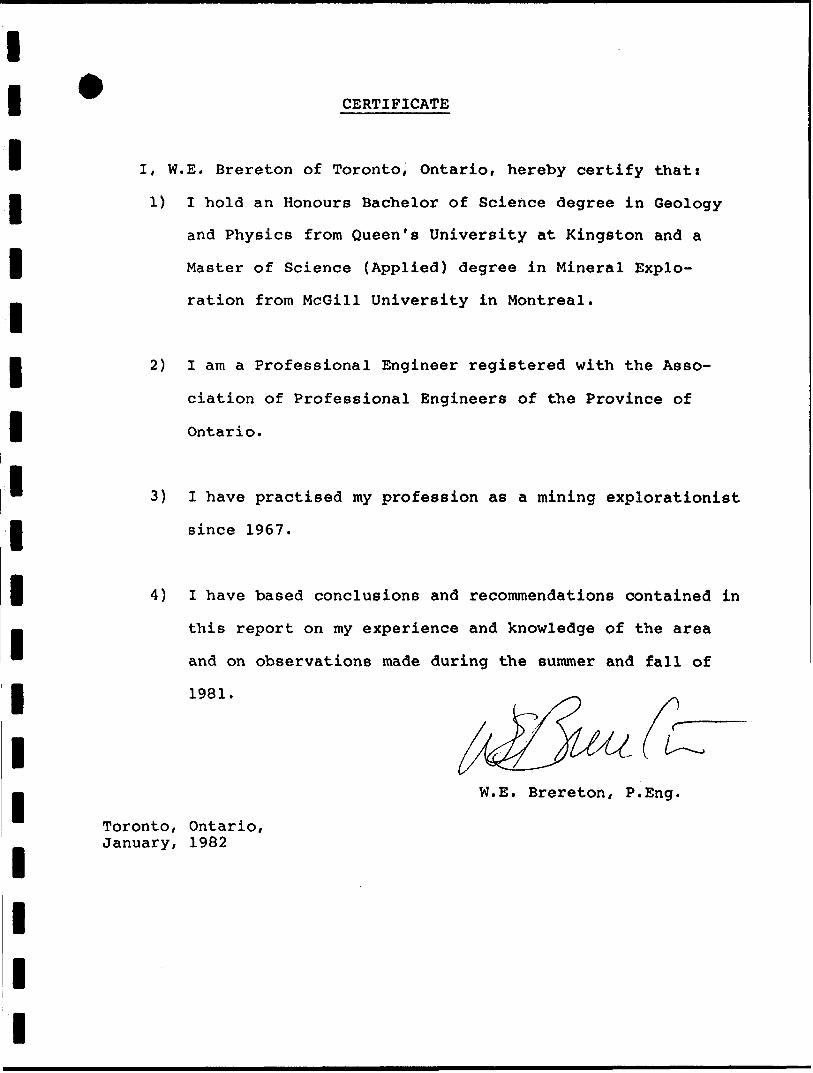
CERTIFICATE
I, W.E. Brereton of Toronto, Ontario, hereby certify that:
1) I hold an Honours Bachelor of Science degree in Geology
and Physics from Queen's University at Kingston and a
Master of Science (Applied) degree in Mineral Explo
ration from McGill University in Montreal.
2) I am a Professional Engineer registered with the Asso
ciation of Professional Engineers of the Province of
Ontario.
3) l have practised my profession as a mining explorationist
since 1967.
4) I have based conclusions and reconunendations contained in
this report on my experience and knowledge of the area
and on observations made during the summer and fall of
1981.
W.E. Brereton, P.Eng.
Toronto, Ontario, January, 1982
REFERENCESl1 Johns, G.W., Hoyle, Warren and Good, David. 1981: Precambrian
Geology of the Hill Lake Area, Bryce and Robillard Townships,
I Timiskaming District; Ontario Geological Survey Preliminary Map, p. 2415.
Moorhouse, W.W., 1941: Geology of the Bryce-Robillard Area jji ODM Annual Report, Vol. l, Part 4, 1941.
l
l
l
l
l
l
l
l
lit
l
ll l
o
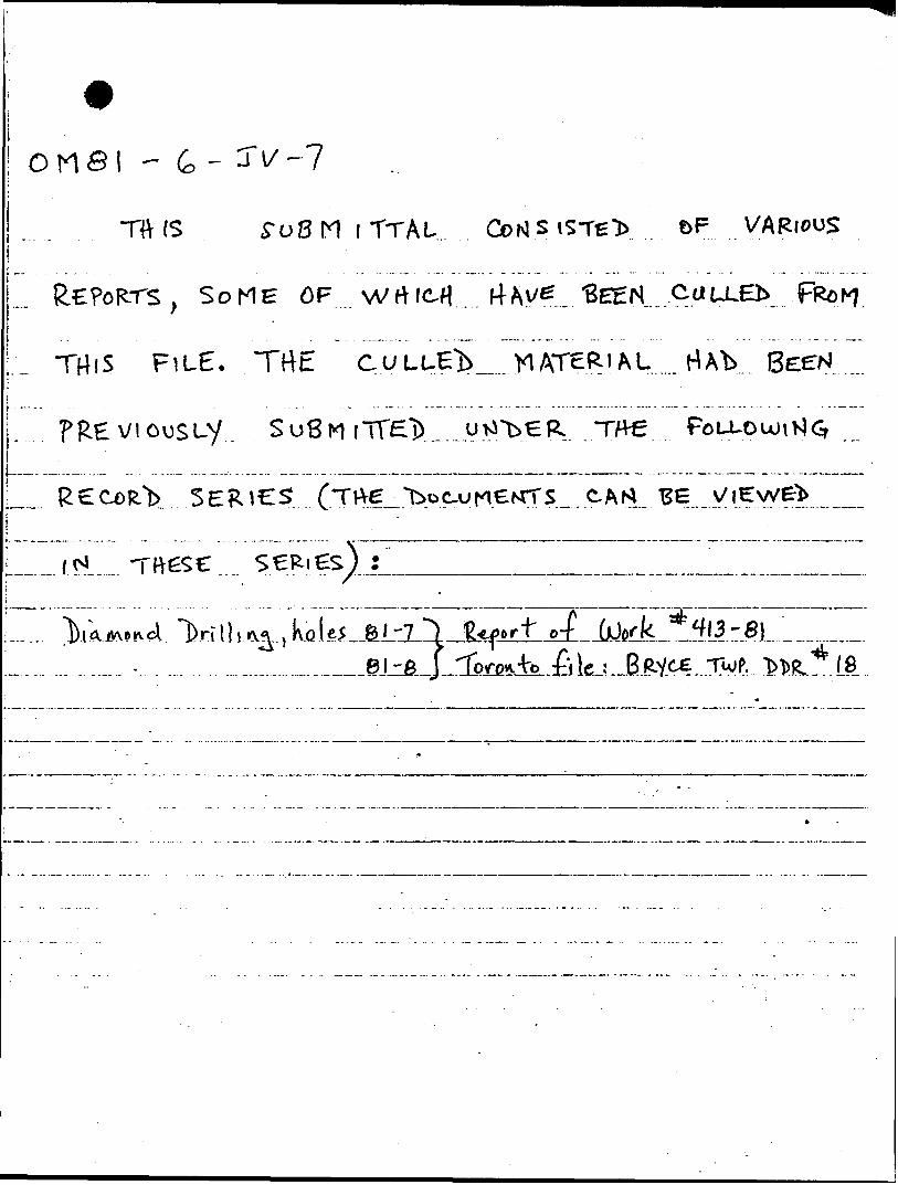
"HV(S itTAL.. &F
, SOME OF wrtM BEEN.. CULLED
FiuE. TrtE CULUE MATERIAL .....ri Ab.
-f

l l l l l l l l l l l l l l l l l l l
APPENDIX A
ASSAY RESULTS - 1981
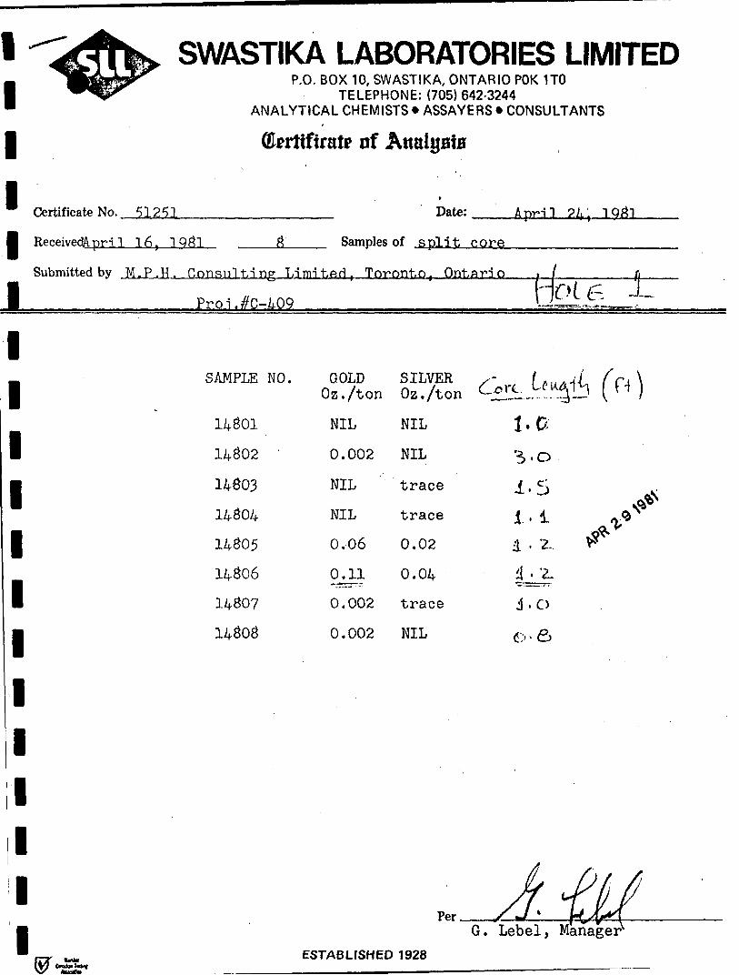
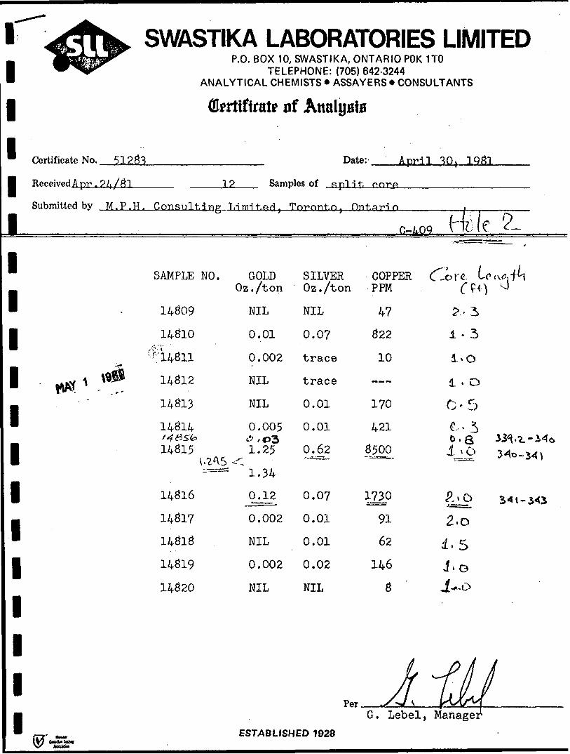
l l l ll ReceivedApri] 16, 1 Q#1
SWASTIKA LABORATORIES LIMITEDP.O. BOX 10, SWASTIKA, ONTARIO POK 1TO
TELEPHONE: (705) 642-3244 ANALYTICAL CHEMISTS * ASSAYERS * CONSULTANTS
(brttftaitt nf
Certificate No. 51251 Date: April ?4, 1
Samples of split core
Submitted by M.P.H ^ Consulting Limited, Toronto, Ontari
l Pro-L^C-jLOQ
J2———i-J———————fi—HOU-, i-
SAMPLE NO.
14801
14802 '
14803
14804
14805
14806
14807
14808
GOLD Oz./ton
NIL
0.002
NIL
NIL
0.06
0.11
0.002
0.002
SILVER Oz./ton
NIL
NIL
trace
trace
0.02
0.04
trace
NIL
.ore. W-y
i.a'5-0
^ (H—— \
d . Z.
J. O
A*
Per.G. Lebel, Manager
ESTABLISHED 1928
l
l
l
l Received Apr,
SWASTIKA LABORATORIES LIMITEDP.O. BOX 10, SWASTIKA, ONTARIO POK 1TO
TELEPHONE: (705)642-3244 ANALYTICAL CHEMISTS * ASSAYERS * CONSULTANTS
ffl*rtfftrat0 of Analyaia
Certificate No. 51233 Date: JLprJJ, 1Q31
12 Samples of s pi j t. norp
Submitted by M.P.H. Consulting T.-irm't.sd, Topont.n, nnt.ario
(4ile 5L
I
l
l
l
l
l
l
l
l
l
l
l
l
SAMPLE NO.
14309
14310
14313
14314
14315
14316
14317
14313
14319
14320
GOLD Oz./ton
NIL
0.01
0.002
NIL
NIL
0.005
'l!25
^1.34
0.12
0.002
NIL
0.002
NIL
SILVER COPPER Oz./ton PPM
NIL
0.07
trace
trace
0.01
0.01
0.62
0.07
0.01
0.01
0.02
NIL
47
322
10
170
421
35jOO
1730
91
62
146
3
l- 3
l . o 0-5
^ - 3
2.o
i.5 J.o
G. Lebel, ManageESTABLISHED 1 928
l l l l
SWASTIKA LABORATORIES LIMITEDP - Q - B OX 1 0 - SWASTIKA, ONTARIO POK 170
TELEPHONE: (705)642-3244 ANALYTICAL CHEMISTS * ASSAYERS * CONSULTANTS
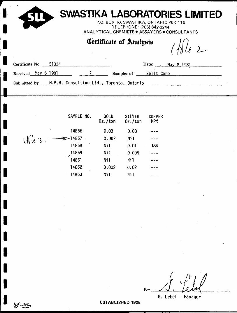
Okrtiftrat* iif Analyaia
Certificate No. 51334______________ Date:
Received May 6 1981____ 7_____ Samples of ——
Submitted by M.P.H. Consulting Ltd., Toronto. Ontario
Ma 8 1 Qfil
Split Core
1111111111111
SAMPLE NO.
14856
14857
14858
485914861
14862
14863
GOLD Oz./ton
0.030.002Nil
Nil
Nil
0.002Nil
SILVER Oz./ton
0.03
Nil
0.01
0.005
Nil
0.02Nil
COPPER PPM
184
G. Lebel - ManagerESTABLISHED 1928
l
l l l
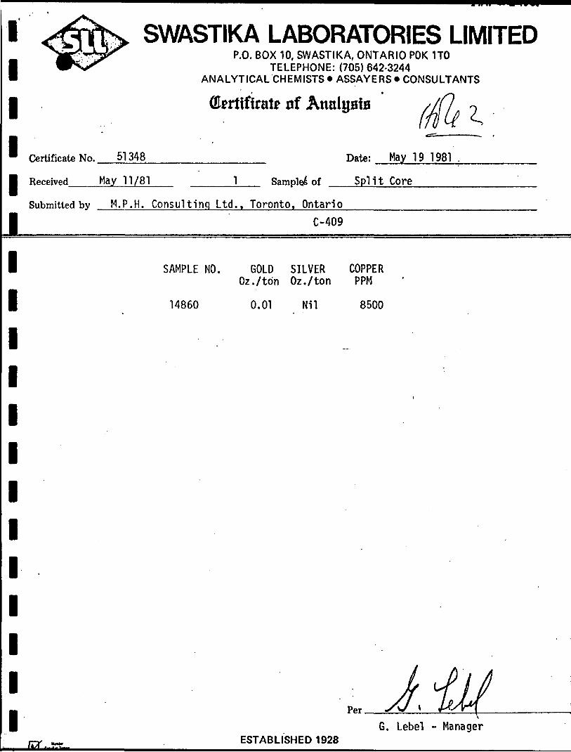
Certificate No. ^^^^,-^
l Received May 11/81
SWASTIKA LABORATORIES LIMITEDP.O. BOX 10, SWASTIKA, ONTARIO POK 1TO
TELEPHONE: (705) 642-3244 ANALYTICAL CHEMISTS* ASSAYERS* CONSULTANTS
i *
Qkrfiftrat? xrf Analysis
51348 Date: May 19 1981
1 Sampled of Split Core
Submitted by M.P.H. Consulting Ltd.. Toronto, Ontario
C-409
l
l
l
l
l
l
l
l
l
l
l
l
l
SAMPLE NO. GOLD SILVER COPPER Oz./ton Oz./ton PPM
14860 0.01 Nil 8500
6. Lebel - Manager
IST-JML- ESTABLISHEO 1 928
11111
^t-thfe, SWASTIKA LABORATORIES LIMITEDlEJBlB^^ P.O. BOX 10, SWASTIKA, ONTARIO POK 1TO^ Hyypr- TELEPHONE:
ANALYTICAL CHEMISTS *(705) 642-3244
ASSAYERS * CONSULTANTS
(Errtiftralr of AttalysiB
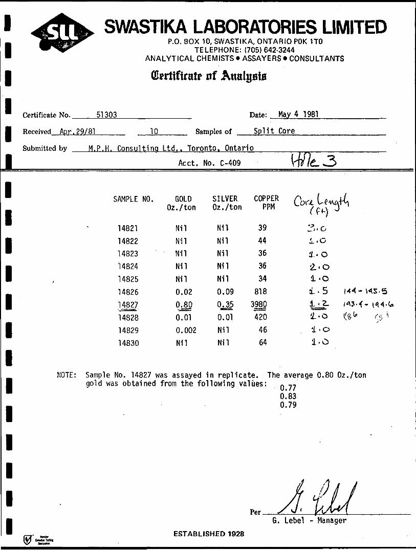
Certificate No. 51 303
Received Apr. 29/81 10 Samples of
Date: May 4 1981
Split Core
Submitted by M. P. H. Consultina Ltd.. Toronto. Ontario
l
1
1
1
1
1
1
1
1
1
1
1
1
1
Acct. No. C-409
SAMPLE NO. GOLD SILVEROz./ton Oz./ton
14821 Nil Nil
14822 Nil Nil
14823 Nil Nil
14824 Nil Nil
14825 Nil Nil
14826 0.02 0.09
14827 0.80 OJ5
14828 0.01 0.01
14829 0.002 Nil
14830 Nil Nil
W/fe. 3
COPPER A f * Jwu i **.^ A 1 p -4A /i T"Tylrt r\ii V.C/l-C V-CTVXI *l / fi \ \y'
39 3.0
44 1 . G
36 l. o
36 '2.*0
34 1*0
818 1.5 1^-^5-5
3980 1 'Z- /^3^- i^^-C*
420 1*0 fyb (^^
46 i . o64 l.O
NOTE: Sample No. 14827 was assayed in replicate. The average 0.80 Oz./tongold was obtained from the following values: Q ^ -,
__ ESTARI IRHFD 195*
0.830.79
1
y /i .
y/ Y /YpAr X s/' yJ(rV\
G. Lebel - Manager
i
11111i1111111111111
,A.K Sil
^^^r
•^•••^ m. m A *^,4^.*"fe m.m*m*±.m^.mmmm*^ m mm mm^fmm^m^
S, SWAS 1 IIVA LAbUKAI UKIbS LIMI 1 tUr p .o. BOX 10, SWASTIKA, ONTARIO POK 1TO
TELEPHONE: (705)642-3244ANALYTICAL CHEMISTS * ASSAYERS * CONSULTANTS
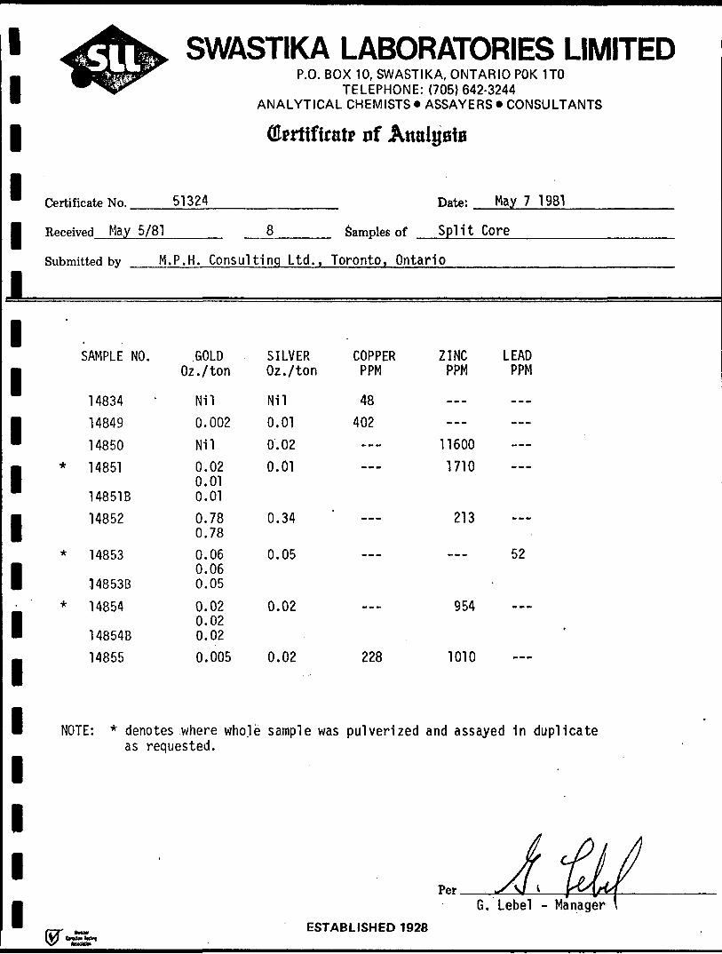
Certificate No. 51324
Received May 5/81
Submitted by
SAMPLE NO
1 48341484914850
* 14851
14851B14852
* 14853
14853B
* 14854
14854B
14855
M. P. H. Consulti
.GOLDOz./ton
Nil0.002Nil0.020.010.010.780.780.060.060.05
0.020.020.020.005
NOTE: * denotes where wholeas requested.
'
(fkriiftrate iif Analysis
Date: May 7 1981
8 Samples of Split Core
ng Ltd., Toronto, Ontario
SILVER COPPER ZINC LEADOz./ton PPM PPM PPM
Nil 480.01 4020.02 — 116000.01 — 1710
0.34 ' — 213
0.05 — — 52
0.02 — 954
0.02 228 1010
sample was pulverized and assayed in duplicate
/i *. *
A fits l \ 0 A t yPer *S\1 l Y*S\fW
6. Lebel - Manager lPRTARI I.QUPfl 1Q9R
1111111111111111111
Vfh^ SWASTIKA LABORATORIES LIMITEDiMllJLJJ^ p-0 - B OX 1 0' SWASTIKA, ONTARIO POK 1TOW^l^ TELEPHONE: (705) 642-3244
ANALYTICAL CHEMISTS *ASSAYERS* CONSULTANTS
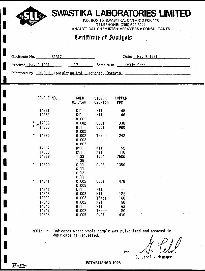
Certificate No.
Received Mav 4 1981
Submitted by M. P. H.
SAMPLE
1483114832
* ^ 14833* 14835
* 14836
148371483814839
* 14840
* 14841
14842148431484414845148461484714848
NOTE: *
.
Otertifirate of ,
51317
1 7 Samples
\nal80iB
Date: Mav 7 1981
of Split Core
Consulti no Ltd.. Toronto, Ontario
NO. GOLD SILVEROz./ton Oz./ton
Nil NilNil Nil0.0020.002 0.01Nil 0.01'0.0020.002 Trace0.0020.002Nil NilNil Nil1.33 1.041.350.11 0.080.110.12 0.110.002 0.010.005Nil Nil0.002 Nil0.002 Trace0.002 NilNil Nil0.002 Trace0.005 0.01
Indicates where whole sampleduplicate as requested.
ESTARI ISHEH
COPPERPPM
4846
330980
242
52no
7500
1350
,478
i 72160
506280
410
was pulverized and assayed iny .
Jf 7 IPP*r ^vA Y&W^
G. Lebel - Manager ) ia?ft
1 1 1 1 111 1 1 1 1 1 1 1 1 1 1 1 1
^•ftW SWASTIKA LABORATORIES LIMITED•fipPS^^ P.O. BOX 10, SWASTIKA, ONTARIO POK 1TO ^^P^ TELEPHONE: (705) 642-3244
ANALYTICAL CHEMISTS * ASSAYERS * CONSULTANTS
Ckrtifirate of Analyafa
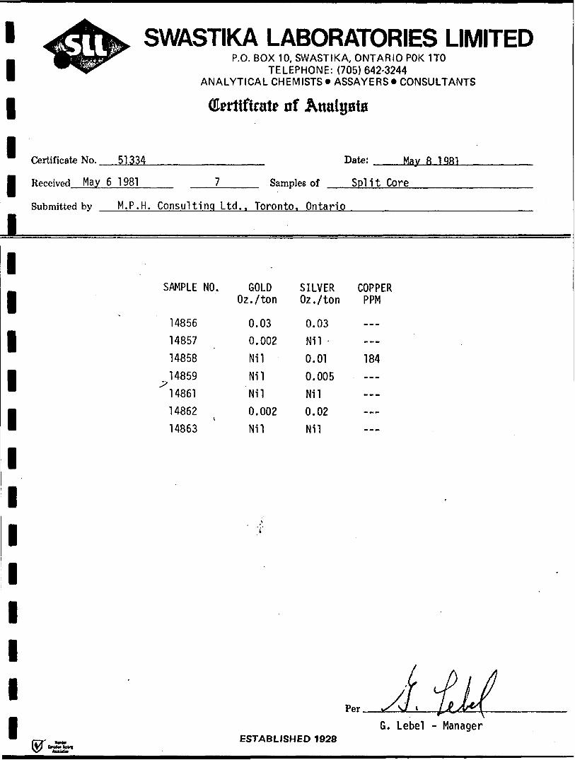
Certificate No. 51334 Date: May fi 1QR1
Received May 6 1 981 7 Samples of Sp! i t Core
Submitted bv M. P. H. Consulting Ltd.. Toronto
SAMPLE NO. GOLD Oz./ton
14856 0.03 14857 0.002 14858 Nil 14859 Nil 14861 Nil 14862 t 0.002 14863 Nil
'i
FRTARI I RU
. Ontario
SILVER COPPER Oz./ton PPM
0.03 Nil 0.01 184 0.005 Nil 0.02 Nil
JtlLfP*r ^/J * l***\
G. Lebel - Manager ipn iQ9ft

l l l
SWASTIKA LABORATORIES LIMITEDP.O. BOX 10, SWASTIKA, ONTARIO POK 1TO
TELEPHONE: (705) 642-3244 ANALYTICAL CHEMISTS * ASSAYERS * CONSULTANTS
flferttfirate nf Analysis
Certificate No. 51334 Date: Mav 8
Samples ofl Received May 6 1 981 7
Submitted by M.P.H. Consulting ltd;. Toronto. OntarioSplit Core
l l l l l l l l l l l l l
SAMPLE NO.
14856148571485814859
^148611486214863
GOLD Oi./ton
0.030.002MlMilNil0.002Nil
SILVER COPPER Oz./ton PPM0.03N110.010.005N110.02N11
184
ESTABLISHED 1 928G. Lebel - Manager
bain te&l
1111111111111111111
ST ,MAY2GM
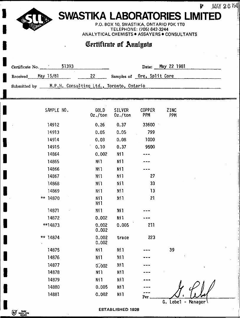
^•fh^ SWASTIKA LABORATORIES LIMITEDjjfcdigifepp^w*ip^
Certificate No.
Received May 15/81
Submitted by M. P. H
SAMPLE
14912
149131491414915148641486514866148671486814869
** 14870
1487114872
**14873
** 14874-
1487514876
1487714878
14879 14880 14881
P.O. BOX 10, SWASTIKA, ONTARIO POK 1TOTELEPHONE: (705)642-3244
ANALYTICAL CHEMISTS *ASSAYERS* CONSULTANTS
Gfcrtifintt? of Analysis
51393 Date: May 22 1981
22 Samples of Ore, Split Core
. Consulting Ltd., Toronto, Ontario
NO. GOLD SILVER COPPER ZINCOz./ton Oz./ton PPM PPM
0.26 0.37 336000.05 0.05 7990.03 0.08 10000.10 0.37 95000.002 Nil — !Nil NilNil NilNil Nil 27Nil Nil 33Nil Nil 13Nil Nil 21Nil Nil Nil
i
0.002 Nil0.002 0.005 ' 211 ;0.002 S0.002 trace 2230.002Nil Nil — 39
Nil Nil
Q! 002 Nil —Nil Nil
Nil Nil — . j 0.005 Nil — if {P tt fl
0.002 Nil ;;r" ^/J t \)jb\G. lebel - Manager \
CCTARI ICUPn 1QOD ,
W V
1 1 111
^•ftW SWASTIKA LABORATORIES LIMITEDjBs&iW^ P.O. BOX 10, SWASTIKA, ONTARIO POK 1TO W^ipr" TELEPHONE: (705)642-3244
ANALYTICAL CHEMISTS * ASSAYERS * CONSULTANTS
ffi? rtifiratp nf AnalyaiB
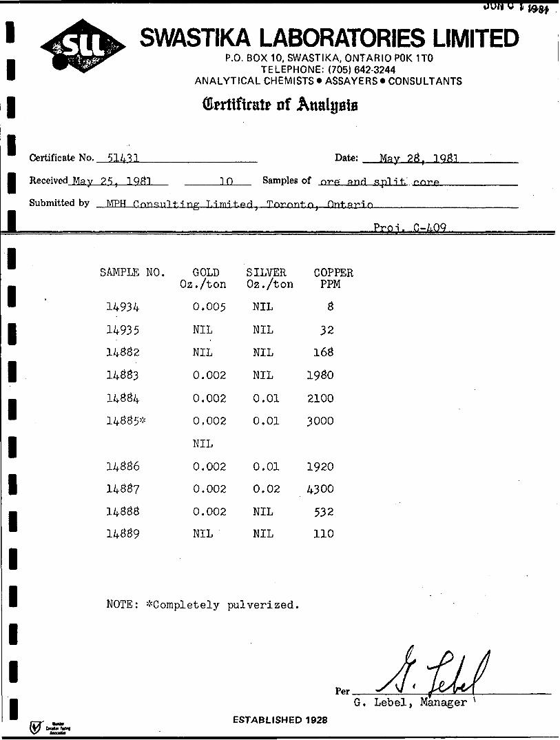
Certificate No. 51431
Received May 25, 1Q#1 T 0 Samples
Date: Mgy 23, 1Q31
of nrp and split, nnr-A*
Submitted by MPH P.nnsnl t. -i no- Litrrit.Prt. Trvrnnt.n. Pin-hat-in
|
1
1
1
1
1
1
1
1
1
1
1
1
1
SAMPLE NO. GOLDOz./ton
14934 0.005
14935 NIL
14332 NIL
14333 0.002
14334 0.002
14335* 0.002
NIL
14336 0.002
1433? 0.002
14333 0.002
14339 NIL
NOTE: ^Completely
SILVEROz./ton
NIL
NIL
NIL
NIL
0.01
0.01
0.01
0.02
NIL
NIL
pulverized.
PCTARI ICWPr
i
Pro i. 0-A.OQ
COPPERPPM
3
32
163
1930
2100
3000
1920
4300
532
110
... J.tLfG. Lebel, Manager ^
t IQ-JO
1 1 11111111111111111
^Jfh^ SWASTIKA LABORATORIES LIMITED|MBgMfi^^ P.O. BOX 1 0, SWASH K A, ONTAR IO POK 1 TO W *jjpr TELEPHONE: (705)642-3244
ANALYTICAL CHEMISTS *ASSAYERS* CONSULTANTS
Gfertiftrate of Analysis
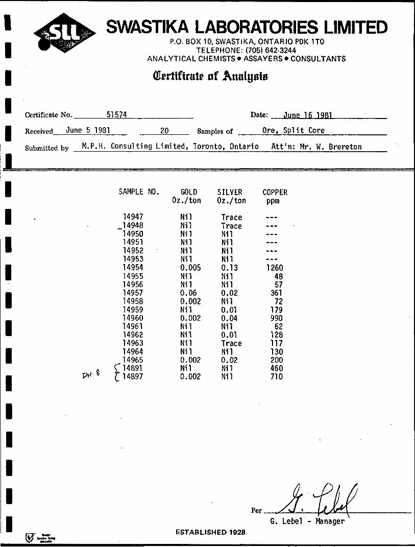
Certificate No. 51 574
Received June 5 1981
Submitted by M. P. H. Consult!
SAMPLE
149471494814950149511495214953149541495514956149571495814959149601496114962149631496414965
o C 14891JX- 8 f 14897
Date: June 16 1981
20 Samples of
ng Limited, Toronto, Ontario
NO. GOLDOz./ton
NilNilNilNilNilNil0.005NilNil0.060.002Nil0.002NilNilNilNil0.002Nil0.002
F.CTARI 1*
SILVEROz./ton
TraceTraceNilNilNilNil0.13NilNil0.02Nil0.010.04Nil0.01TraceNil0.02NilNil
Per
IMPn 1Q9ft
Ore, Split Core
Att'n: Mr. W. Brereton
COPPERppm
wwv
-----~......1 260
4857
36172
179990
62128117130200460710
k-PhfjA \JJ(G. Lebel - Manager
11111
Certificate No. —^——^-—
Received June l 1981
JUN f f miSWASTIKA LABORATORIES LIMITED
P.O. BOX 10, SWASTIKA, ONTARIO POK 1TOTELEPHONE: (705) 642-3244
ANALYTICAL CHEMISTS * ASSAYERS * CONSULTANTS
Qkrtifirate of
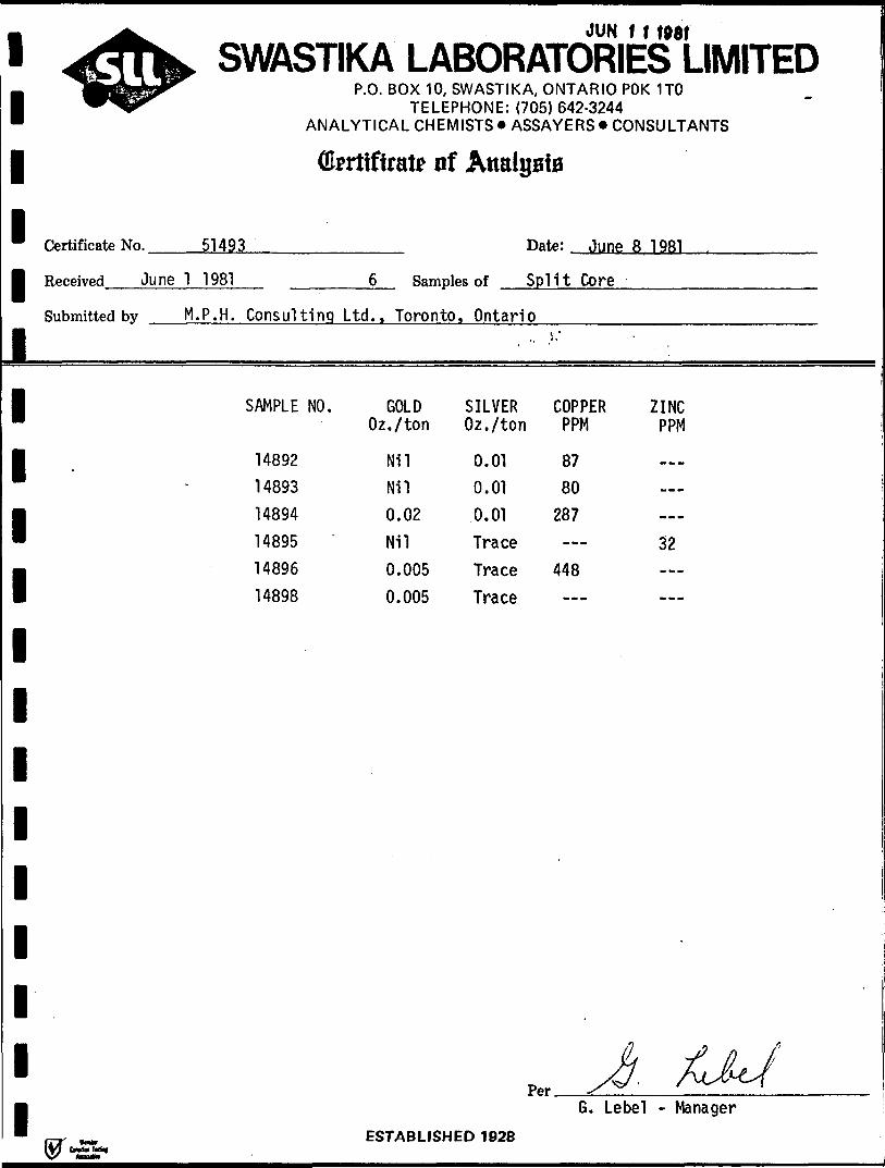
51493 Date: June 8 1981
Samples of Split Core
Submitted by M. P. H. Consulting Ltd., Toronto, Ontario
1111111111111
SAMPLE NO.
148921489314894148951489614898
GOLD Oz./ton
NilNil0.02Nil0.005
0.005
SILVER Oz./ton
0.010.010.01TraceTraceTrace
COPPER PPM
8780 287—
448
ZINC PPM
32
G. Lebel - ManagerESTABLISHED 1928
111111111l111111111
^ftfey SWASTIKA LABORATORIES LIMITED^Kjg*l"Ljp^
^•ffisB^ffiipW^IP^
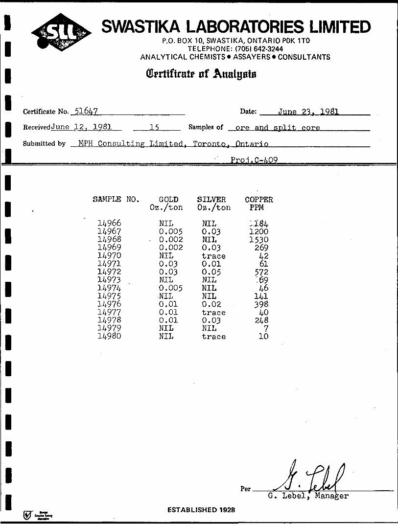
Certificate No. 51647
Received June 12, 1931
Submitted by MPH Consul
SAMPLE-
149661496714963149691497014971149721497314974149751497614977149731497914930
P.O. BOX 10, SWASTIKA, ONTARIO POK 1TOTELEPHONE: (705)642-3244
ANALYTICAL CHEMISTS * ASSAYERS * CONSULTANTS
(Errtifirate of AtmlysiB
Date: June 23 T 1931
15 Samples of ore and split core
ting Limited, Toronto, Ontario
Pro.i.C-409
NO. GOLD SILVER COPPEROz./ton Oz./ton PPM
NIL NIL :.i#40.005 0.03 1200
. 0.002 NIL 15300.002 0.03 269NIL trace 420.03 0.01 610.03 0.05 572NIL NIL :690.005 NIL 46NIL NIL 1410.01 0.02 3930.01 trace 400.01 0.03 243NIL NIL 7NIL trace 10
JkrfLfG. Lebel, Manager
FSTARI ISHFn 1Q9R
l
l
JUN o
SWASTIKA LABORATORIES LIMITEDP.O. BOX 10, SWASTIKA, ONTARIO POK 1TO
TELEPHONE: {705)642-3244 ANALYTICAL CHEMISTS * ASSAYERS * CONSULTANTS
Ok rttfirat* of
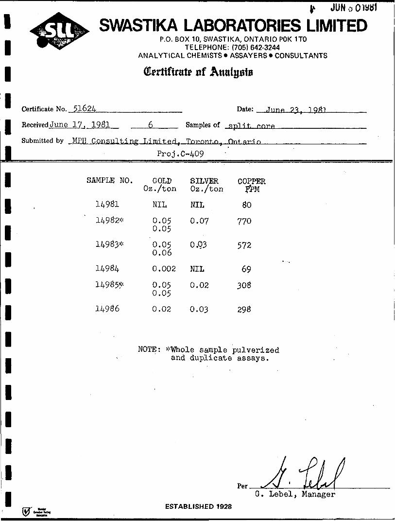
* Certificate No. 51624
l Received June 17. 1981
l
Date: June
Samples of split,
Submitted by MPH ..Consulting Limntgri, Tnrnnt.n,
Proj.C-409
SIMPLE NO. GOLD SILVER COPPER Oz./ton Oz./ton
14982*
14983*
14984
14985*
14986
NIL NIL 80
0.05 0.07 7700.05
0.05 O.Q3 572 0.06
0.002 NIL 69
0.05 0.02 3080.05
0.02 0.03 298
NOTE: *V7hole sample pulverized and duplicate assays.
G. Lebel, ManagerESTABLISHED 1 928

1111111111111111111
V-ftW SWASTIKA LABORATORIES LIMITEDjBj^sl^^ P.O. BOX 10, SWASTIKA, ONTARIO POK 1TO^ ̂ Jtpr T ELEPHONE: (705) 642-3244
ANALYTICAL CHEMISTS * ASSAYERS * CONSULTANTS
(Ekrtiftrat* nf Analyaia
Certificate No. 5172g Date: July 2
Received June 25, 19&1 3 Samples of split core
Submitted by MPH Consulting Limited, Toronto, Ontario
SAMPLE NO. GOLD SILVER COPPEROz./ton Oz./ton PPM
. 14994- 0.05 0.02" 4170.06
14995? 0.005 0.01 5500.005
14996 0.005 NIL 237
NOTE: * Pulverize whole sample.
,^'G. Lebel,
—.. FRTARI I.CMFft 1Q9ft
•IQSl
Manager
11111 111111111 1111 l
.^B^^BW M m m. *^.**r*mm * m i1 A ••fe^MK BB*k MMBM^VkBMBkBBB^Bk B BK m m BBB HB BHk.
^OTW SWASIIKA LAbUhAIUKItb LIMI 1 bU(SJjiiE^^ P.O. BOX 10, SWASTIKA, ONTARIO POK 1TO™ 1*P^ TELEPHONE: (705)642-3244
ANALYTICAL CHEMISTS * ASSAYERS * CONSULTANTS
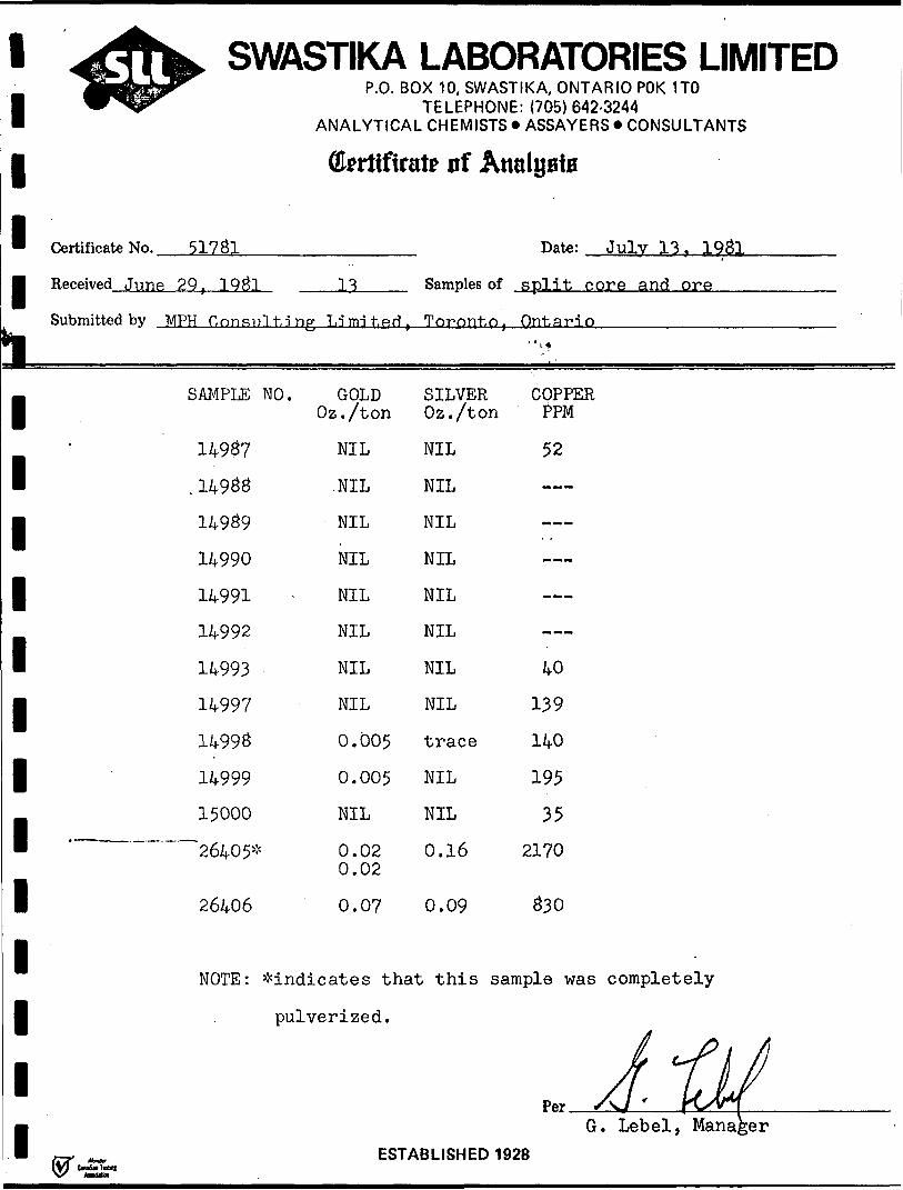
Certificate No. 51781
Received June 29, 1981
Cferttfirai
nSubmitted by MPH Consulting Ldmdted.
SAMPLE
14987
. 1498814989
149901499114992
1499314997 14998
1499915000
. — 26405*
26406
NOTE:
NO . GOLD Oz./ton
NIL
.NIL
NIL
NIL
NIL
NIL
NIL
NIL
0.005
0.005
NIL
0.02 0.02
0.07
^indicates that
pulverized.
te nf Au
Samples of
Toronto,
SILVER Oz./ton
NIL
NIL
NIL
NIL
NIL
NIL
NIL
NIL
trace
NIL
NIL
0.16
0.09
alBBiB
Date: Julv 13, 198l
split core and ore
Ontario- ' ), -*
COPPER PPM
52
---
——
40139
140
195
35 2170
830
this sample was completely
^A-MG. Lebel, Manager
r-, ^ ESTABLISHED 1928

1111111111111111111
i,
JUN 0 fi 1081
^•flK SWASTIKA LABORATORIES LIMITEDijiJBBjg^gr^^^n^ P.O. BOX 10, SWASTIKA, ONTARIO POK 1TO
TELEPHONE: (705) 642-3244ANALYTICAL CHEMISTS * ASSAYERS * CONSULTANTS
Certificate No. 51462
Received May 27, 1981
Submitted bv MPH Consulting
SAMPLE NO.
J4890
1493714938
149391494014941
14942
1494314944
1494514946
-
(Hrrtifiratr of Analyst*
Date: June 3, 1981
11 Samples of ore
Limited. Toronto, Ontario
Att: W. Brereton
GOLD SILVER COPPEROz./ton Oz./ton PPM
*-x.0.18 0.37 4270 ]
0.10 0.47 9670 (^jT^ 1
0.10 0.38 11000 /4fSoS CMooJ0.18 0.35 4650
\0.18 0.25 5180 J
0.05 0.16 9300 ") rj7^ ^JL
0.19 0.27 11300^5 USoS MHOOW^0.005 0.02 3430^
l .--r* \0.002 trace 1920 W ' l f̂ c^^c. n.'0.005 0.01 610 C400S (S-f-I^Vv/
1 ; 0.002 0.01 1850 J
•w*'
-
x
A wG\ Lebel, Manager
FCTARI I.CMPn 1Q9R

SWASTIKA LABORATORIES LIMITED1 w^&r
11™ Certificate No. 51 424
| Received Ms y ?1 , 1 Q Si
r.\j. o v^/x iv, ovvfAO iii\rv,vmir\niwrvix iivTELEPHONE: (705)642-3244
ANALYTICAL CHEMISTS * ASSAYERS * CONSULTANTS
(Ewtifirat? nf Atmlyaia
Date: May 27, 1981 .
IS Samples of ore
Submitted by MPH nonsnlt.inp T, i mi tad. Toronto. Ontario
|
1" SAMPLE NO. GOLD SILVER COPPER
1" , 14916
14917
1 14918 1491914920
1 14921 14922 14923
. 149241 14925" 14926*
1 14927 14928*
1 149291493014931
1 14932 14933
| NOTE :"
111
Oz./ton Oz./ton PPM— ~-
0.002 NIL 83 \0.26 0.04 411 \0.27 0.04 390 0.22 0.03 9460.22 0.02 448 ^-' ,0.002 NIL 40 V •'\fc\v2- k NIL NIL —— f 0.26 0.04 1530 7 yjorv ^4-^nu/0.17 0.03 567 -MT7S -^ OT^^VS/0.002 NIL 270.30 0.03 529
- 0.310.15 0.03 420 0.002 NIL 39NIL }0.11 0.05 177 __ J .0.005 0.01 15"^ {"T]- f ^^ L0.04 0.05 130 V J ^^ c ;0.01 0.02 12 ( ^4CnU/ 0.04 0.14 24003 Of2-**J ; 6 "^SOW
^'Indicates samples that werecompletely pulverized.
.XA 7^/G. Lebel, Manager ^
F^STARI t.QMPH 1Q9fiCXXlM fet*
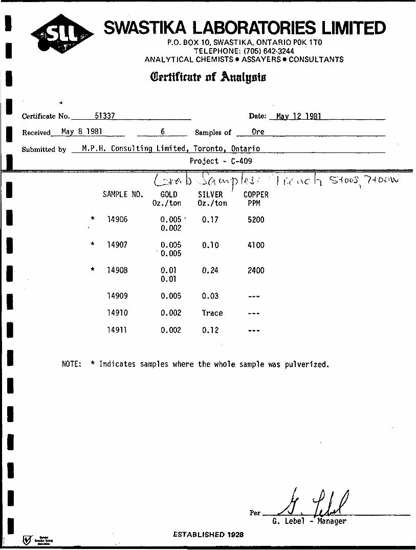
1111111111111111111
^ ^ OB •^•••K ̂ ^^IB ̂ ^^h.
^ftV SWASTIKA LABORATORIES LIMITEDiSaiS^^ P .O. BOX 10, SWASTIKA, ONTARIO POK 1TOV^^ TELEPHONE: (705)642-3244
ANALYTICAL CHEMISTS *ASSAYERS* CONSULTANTS
Qfcrtifirat* of Analysts
•4
Certificate No. 51337 Date: May 12 1981
Received May 8 1 981 6 Samples of Ore
Submitted bv M. P. H. Consulting Limited, Toronto, OntarioProject - C-409
i i i ^ . i , . - , - i i^ij\'^ D '-3 A l-v^'p H-*! " 1 (-( a c r\
SAMPLE NO. GOLD SILVER COPPEROz./ton Oz./ton PPM
* 14905 0.005' 0.17 52000.002
* 14907 0.005 0.10 41000.005
* 14908 0.01 0.24 24000.01
14909 0.005 0.03
14910 0.002 Trace
14911 0.002 0.12
NOTE: * Indicates samples where the whole sample was pulverized.
Js -f jP*r ^A/ v 1 14
^Do^7-(ooW
!/-^1G. Lebel -^Manager
PCTARI ICLJCn 1QOO(Mb. W*
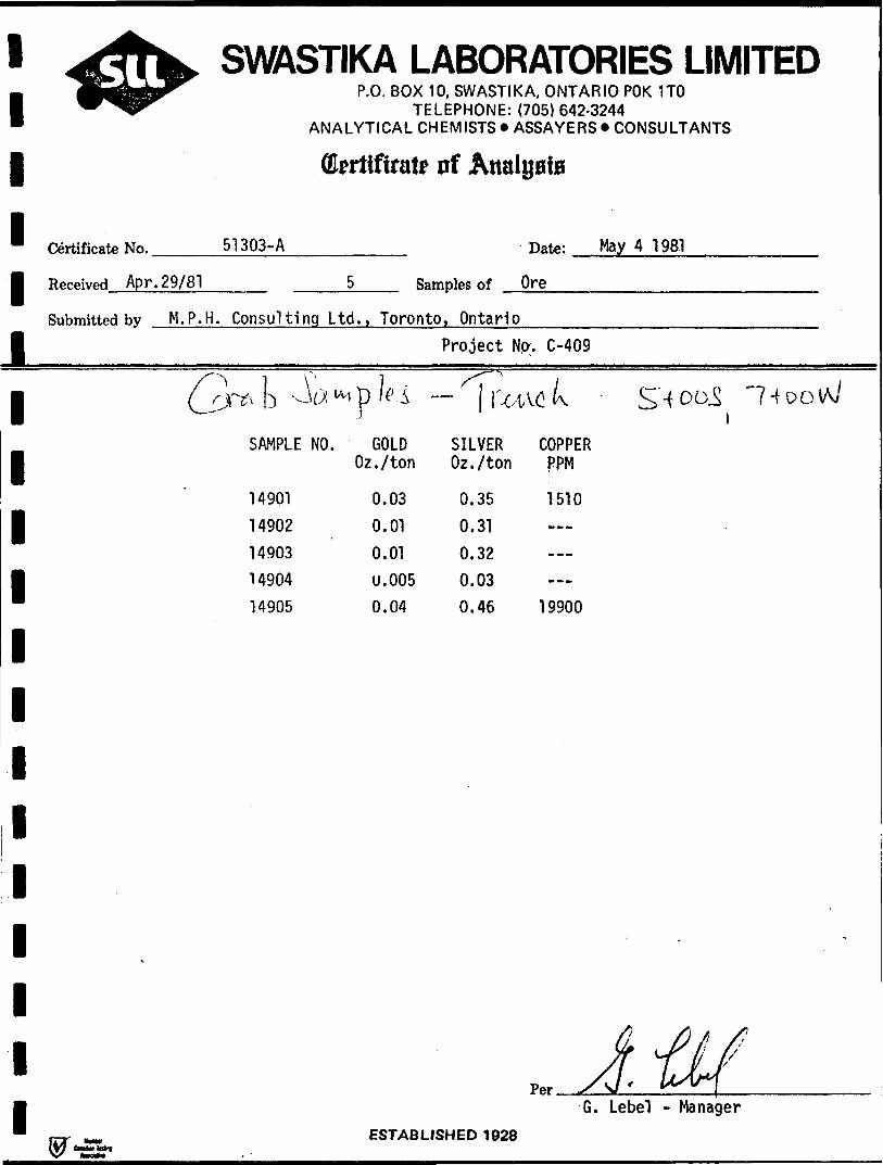
l l l l l l
SWASTIKA LABORATORIES LIMITEDP.O. BOX 10, SWASTIKA, ONTARIO POK 1TO
TELEPHONE: (705) 642-3244 ANALYTICAL CHEMISTS * ASSAYERS * CONSULTANTS
Qfcritfirate of
Certificate No. 51303-A
Received Apr. 29/81
Date: May 4 1981
Samples of Ore———.——————
Submitted by M.P.H. Consulting Ltd., Toronto. OntarioProject No-. C-409
k ^ M pSAMPLE NO.
1490114902149031490414905
. iGOLD
Oz./ton
0.030.010.01U.0050.04
- l r ^ Lt
SILVER COPPER Oz./ton PPM
0.350.310.320.030.46
l -i o o
1510
19900
lint*
G. Lebel - ManagerESTABLISHED 1928

1* Certificate No.
W SWASTIKA 1^^ P .O. BO)
ANALYTICAL
Okrtifiral
/n cJ \ r?p x 0/4. f
M Received July 9, 1931 6
i Submitted byii ij i
• 'it j^
MPH Consulting Li
SAMPLE NO.
26415
26416
26417
26413
26419
26420
mited,
GOLD Oz./ton
0.005
0.02
0.0050.002
NIL
NIL
LABOR)< 1 0, SWASTIKA TELEPHONE: {7C CHEMISTS* AS;
p nf Atralg,
rSamples of sp!
l
TORIES LIMITEDONTARIOPOK 1TO
)5) 642-3244 SAVERS* CONSULTANTS
ffi*
*ate: Julv 21, 1931
it core
Toronto, Ontario 1 rt
SILVER Oz./ton
0.01
0.01
trace
trace
trace
0.01
(^k i IS *
COPPER PPM
450 116
97
97
Per.G. Lebel, Manager
ESTABLISHED 1928

l l l
SWASTIKA LABORATORIES LIMITEDP.O. BOX 10, SWASTIKA, ONTARIO POK 1TO
TELEPHONE: (705) 642-3244 ANALYTICAL CHEMISTS *ASSAYERS* CONSULTANTS
drrtifiratr of Analysis
Certificate No. 51826 Date: July 21. 1981
l Received July 7, 1Q&1 Samples of split core
Submitted by MPH f.nn.qnl t,i ng T .i mi t. P-ri } Toronto, Ontario
l l l l i l l l l l l l l
SAMPLE NO.
26407*
2.4 S. S -^i- S
?, tt r - 2 s •v's
2 4?. S; - 2:43-53
26409*
26410
26411*
26412*
26413*
26414
GOLD ./ton
0.260.28
0.002
0.03
0.02
0.630.64
0.0050.002
0.040.04
0.12
SILVER COPPER Oz./ton PPM
0.23
trace
0.02
0.02
0.48
0.01
0.05
0.05
2400
93199
5973650
103
1170
305
i, 2.
1-0
3-o
NOTE: ^indicates that these samples were completely pulverized.
/.i.M /S-o'
G. Lebel, Manager
/ft)
ESTABLISHED 1 928du** fatal

l l l l l l l l l l l l l l l l l l l
APPENDIX B
DRILL LOGS: HOLES 81-1 to 81-13
DIAMOND DRILL RECORDHole No. 8 1 ~ 1
Hole No. 81-1Property Br i scoe-Bry ceTownch,p Bryceinr^lmn 1 + OOE
0 + 50Sloggedfiy W.BreretonCorel oration Core Shack ; 3+OOE , 0+
356 ft (107.8 m)1 engthBearing 340"Dip -50"Objective Test main zone under
surface trench
25N
Remarks Previous Noranda hole intersected o. 22 Au/3.8
Commenced April 11. 1981Completed April 14, 1981DriiiingCo Barron Dia.DrillindCoreRi7e NOCasing Left in Hole No
ft core len.orth.-
FootageFrom
0
34
To34 ft
134 ft
D E S C R 1 P
Dip: Collar - SO 0
Etch Test Depth Rdg. True
1. 150 ft 44 0
2. 350 ft 42 0
T 1 O N
OVERBURDEN
COARSE ANDESITIC FRAGMENTALqreenish-arey, generally crudely bedded with bedding defined by paral-lelism of major plane of fragments; fragments are predominantly ofblock and lapilli sized material which are typically sub-rounded torounded.Clast types include a med. gr. creamy to light-greyish, feldspar por-phyry, a dark feldspar-porphyry, and a light, fine-grained dacitic-looking volcanic and comprise 75% or more of the rock.Original f erromagnesians are altered to chlorite throughout; rock ingeneral shows weak carbonatization.Rock matrix consists of feldspar porphyritic (andesitic) crystal tuff.Unit is variably fractured; fractions are filled with quartz±carbonateveinlets .Fractures are of two predominant orientations with one set at approx.50" to 80 0 to c. a. and a second set at approximately 10 0 to 30" to c. a
Pyroclastic Bedding53 ft 40 0 to c. a.67 f t 45 0 to c. a .
1O7 f t- Aft 0 t-o r? . a -l Tfl f t- 4.^" to r? . a .
Trace to l-2% fine pvrite locally disseminated in unit as at 46 ft, 58ft.Thin hematite films on ioint and slip faces throughout unit.Local epidote patches and blebs 100-13098.3 ft:often cubic
ft.!X2in qtz veinlet at 20 0 to c. a. containing 1-2!* dissem.
pyrite mainly along fine fractures.
Sample No.
14801
1480:1
1480:
1480/
1480!
1480*
1480:
1480*
(ft) From
46
53
-97.5
236-'
277.:
281.;
282.'
287
(ft) To47
56
99*
238
278. E
282. i.
2B3.4
287 .i
(ft) Length1.0
3.0
1.5
1.1
1.2
1.2
1.0
0.8
Location Sketch
ozAu
nil
0.002
nil
nil
0.06;
0.11
0.02
O.OC
ozAg
nil
nil
tr
tr
0.02
0.09
tr
2 nil
N
Clai
Sea
lorth
mNo24227
e: r -
l
l
l
li
l l l l l l l l l l l l l
DIAMOND DRILL RECORD Note No.. Sheet No..
81-1
FootageFrom134
271
280.7
To271 ft
289.2
283.4
DESCRIPTION
ANDESITIC TO CHLORITIC CRYSTAL TUFFrelatively massive, featureless, coarse feldspar porphyritic crystaltuff. This material forms the matrix to above unit; contact with abovpyroclastic is marked by a 1 ft band of dark fine grained tuff or mud stone with quartz veining.The crystal tuff unit consists of white plagioclase crystals and da'rkgreen chlorite clots in a greenish chloritic matrix with scatteredquartz eyes. Rock is weakly carbonatized where tested with weak HC1.There is local, trace pyrite and variable hematite mainly on slip andfracture surfaces and in veinlets ± quartz-carbonate. There is anoticeable increase in hematization progressing down the hole.A weak schistosity is present generally at 60" to c. a.The tuff has been finely fractured with clear quartz ± carbonate andhematite forming hairline to 1/2 inch veinlets; one fracture set is at60 8 ro 80" to c. a.No appreciable sulphide association; there is a concentration of sili cification from 144 to 173; this veining is cut by later, thickerveinlets of white quartz, carbonate and hematite.JLby tt: B inch tragment of fine-grained volcanic (? ) showing chillededges against turt with 1* pyrite.175 ft: 2 inch quartz-carbonate-hematite vein zone alona local shearat JL5 0 to c. a.185 ft: 3 inch fraament of fine-grained volcanic.186.5 fti 1 inch vein of whLte quartz at 20" to c. a.209 ft: 1 inch qtz - carb. -hem. vein at 20" to c. a. with one smallcrystal chalcopyrite.221 ft: 1 inch atz-carb-hem vein at O 0 to 20 0 to c. a. as noted^ theseveinlets appear to be later than the foreqroincr fine, clear quartz-hematite filled fracturing.
CHLORITIC TUFFgradational upper contact with above, but sharp lower contact; green-grey, fine-gr rock with greenish chloritic clots similar to above tuffbut missing f sp phenos; becoming highly schistose toward vein zone(at 50% to c. a. ) .
MAIN VEIN ZONEzone of strong shearing ± chloritization, carbonatization, silicifica tion and pyritization., section from ' .281.6-282.2 is approximately 80** pyrite-quartz vein material; 1/2 inquartz pyrite veinlet at 282.9,; pyrite in the main vein is diatsihcttty
Sample No.
i
From To
*
Length
l l l l l l l l l l l l l l
DIAMOND DRILL RECORD Hote No.. Sheet No.
81-1
FootageFrom
289.2
To
356 ft
IS. f. f 4
^
DESCRIPTION
med gr granular and appears to float in fine, clear to whitish quartzwith chloritic slips; there is minor chalcopyrite as fine splashes inquartz generally separate from the main pyrite zones.283.4 - 284.4 ft: dacite fragment, very f. g., greyish with scattered c
vesicules; contains 1-3*?. pyrite incl thin diss. 1/4in band at lower contact which is sharp at 40 0 to c . s
INTERMEDIATE BLOCK AND LAPILLI TUFFgrey, dacitic-looking ; not as noticeably feldspar porphyritic as pyro clastic from 34 to 134 ft; matrix is essentially a fsp ppy xtal tuffbut most of fragments are dacitic to chloritic rocks rather than fspppy as in 34-134; fragments to 1 ft or more.
END *~*F HOI^E
Sample No.
uart2
.
From To Length.1 II.— 1 — — 1 ' ~--

l l l lll l l l l l l l
DIAMOND DRILL RECORDHoteNo...
81-2
Hole No 8 1 ~ 2Property Briscoe-Brycer^nch-p Bryceinr-inn 2 + OOE
0+50SloggwiRy W.BreretonCore i oration C Qr e Shack ; 3 + OOE , 0 + 2
Remarks
, pngfh 376 ft(113.9 m)Bearing 340 0Dip -50-Objective Test main vein zone
5N
Comment April 15, 1981Completed April 20, 1981rviiiingCo Barron Dia. DrillingCorn SIT* NQCasing 1 eft in Hoto No
-
FootageFrom
0
48
1O5
To48 fi
105 ft
335 fi
D E S C R 1 P
Dip: Cottar -50"
Etch Test Depth Rdg. True
1. 150 ft 46 0
2. 300 ft 42 0
T 1 O NOVERBURDEN
COARSE ANDESITIC FRAGMENTALconsists of fsp ppy fragments in finer, usually darker, fsp ppy ma trix; fragments generally lighter coloured and up to J. f t or more.74-76 qtz- C O 3 vein zone - split
ANDESITIC CRYSTAL TUFFm. g. fsp ppy rock with darker chloritic clots and whitish fsp pheno crysts; contains, at top of section, f. g., light greenish-grey da-citic - looking fragments which are typically speckled with Z-3%diss. py; there is minor hem on slip faces and scattered qtz-carbVe"lnlets , generally l"r at various angle to c. a.; these veinletsconsist of both white and finer veinlets of clear quartz. Lower con'contact is sharp and at 55" to c. a.124-125: shear zone; sericitized, chloritized; contains qtz-py vein-1 0 4- e 4- r* 1 -i n*"*lii m f t- i ';q -F*-. A" A stf-t+ir* f r-artc w {t- h 14 r? i e e nv
Core Angles: 115 ft - 45 0124 ft - 4O e248 ft - 65"
163—164 ft- few nartiallv diaested fraaments171 ft: 6" f .a- dacitic fraa.191—192 ft: atz— carb vein zone193 ft:226 ft:
1" chloritic zone z qtz2" atz — eo vein
241-242 ft: uartiallv diaested fragments186 ft onwards appearnce of qtz phenocrysts in addition to plagiccla
Sample No.
148091481014811148121481314814148151481614817148181481S1482C1485*1485S1485S1486CI486]
ses
(ft) From
73.7124 .5191.5
31C33C
338.734C343334365371
373.5339.2151. e149.1158.:128.6
(ft) To
76125,8192.5
311330.5
339341343336
366.5372
374.534C
152.8150. E158. S130.3
(ft) Length
2.31.31.01.00.50.31.02.02.01.51.01.00.81.20.80.60.7
Location Sketch t\
Clai
Sea
ozAu
nil0.01
).002nilnil
5.0051.2950.12
0.002nil
0.002nil0.03nilnil0.01nil
ozAg
nil0.07trtr
0.010.010.620.070.010.010.02nil
0.030.01
3.005nilnil
ppmCu
47822
10-
170421
85001730
9162
1468
—lS4—
.8500—
lorth
tm No 24227
le: 1"-
l l l
DIAMOND DRILL RECORD HoteNo. Sheet No..
81-2
FootageFrom
335
338.8
343
-
To
343 ft
343 ft
376 ft
376.ft
DESCRIPTION
277 ft: •lacitic fragl306-3O9 ft: darker,, fin^r grained fragmont-al section310-311 ff-.t 1* nv328.60330: 1-2* py in f sp ppy xtal tuff
CHLORITIC TUFF
MAIN VEIN ZONEzone of shearing and chloritization with heavy (80%) concentration ofquartz-pyrite vein material from 340-341.2 ft and scattered thinveinlets and disseminations over rest of zone.Section from 340-341.2 is distinctly banded parallel to schistosity,quartz is relatively clear and translucent containing tiny white crystal inclusions (plag?) . There is l-3*k chalcopyrite associated withthe quartz but generally removed from the pyrite; pyrite is medium-grained, granular as in hole 1.There is variable carbonate and sericite in the sheared/mineralizedarea; shearing and banding is at 45-50 0 to c. a. avg 48 0 . Individualpyrite-rich veinlets are typically surrounded by 1 cm bleached alteration halos; also, at 341 ft, cpy appears to be distinctly later thanqtz-py as the former fills later cracks and vugs in the quartz; thisveinlet is also somewhat vuggy with open cracks at right angles tove inlet- walls .
INTERMEDIATE BLOCK AND LAPILLI TUFFas in Sole 1 this section is noticeably less feldspar porphyriticthan overlying pyroclastic section.Note that overall section from 306 to 354 contains numerous narrow
cjenerallv unmineralized carb-qtz veinlets 1 mm - 1 cm in two mainsets - one fillina fractures at a hiah anale to c. a. and the secondat 20| and less.344 - 346 ft: tr py in coarse fragmental.365-366.8 ft: l-2@ scattered py cubes in sheared chloritic lapillituff.
END OF HOLE
Sample No. From To
*
Length
l l l l l l l l i i

l l l l l l l l l l l l l l
DIAMOND DRILL RECORDHole No R 1 -
Hole No 81-3Prnrwrtv Br i scoe-Bry C6Tn*nQhip Bryre
3 + 08E0 + 25S
loggedRy W.BreretonCoreLorafion Core Shack ; 3 + OOE , 0 + 2 !
Remarks
length 261 ft (79.1 m)Bearing 340"Dip -50"Objective Test main vein zone
IN
Cnmrm.nced April 21, 1981 nip: Collar ~50 0Completed April 22, 1981Drilling Co Barron Dia. Drillin jEtchTest Depth Rdg. TrueCore Sire NQCasing left in Hote No 1* 2 61 f t 4 7 "
.
FootageFrom
r\
48
184.7
To—— 48 fi
184.7
193.2'
D E S C R 1 P T 1 O N
ovpRR-j ppEN
Sample No.
14821ANDESITIC FELDSPAR PORPHYRITIC CRYSTAL TUPP 1becoming dacitic tuff towards base of section as prov holec. r,,-,*-*, L4822that f sp pheno crysts disappear over last 2 ft before lower- ™r,i-^trel. abundant fracturing at verv low angle to c. a. fillet vn-h ^f.CO 3 vein material with l-3% disseminated ovrite. some f r-a^ i-nr-oc .-.re tain muddymovement.
fault gouge material and are slickensided suaoestinn cnme
76 ft: faint schistosity at 50 e to c.pheno crysts and plag clots68 ft: 1'
.a. defined by alignment- n f f *sp
1 v.f.g, hard siliceous fragment, light greenish-arev-rhvol -itic82 ft, 87 ft: 2" and 8" qtz-carb-ep-hem veins97-100 ft.113-133 ft:± qtz ± ep
101-103 ft qtz-carb vein material ± l -2t py ajt O 0 to c^a.Fault Zone - zone of fracturing, brecciation and carb
veining; some vuggy sections, variable oxidation of rock± b leaching; negligible sulphide143.6-147.3 ft: strongly sheared and clet at 144.159 ft: 4"
6; shearing at 60" to c. a.rhloritiy.pd wlfh — 1 r qt7-py voin-
aphanitic light arev siliceous fraament-183.8-184.7 ft: dacite fragment - aphanitic, greeni sh-gr-ey v n-t, 4- rfine pyrite
INTERMEDIATE CRYSTAL TUFFpredominant chloritic clots with lesser plaa Dhenoervst-ej . nr-r- f n -dacitic fragments with some soft sediment-like rlefor-maf- i *in
. . - .
L4823
L4824
1 4825
L4826
4827
i.4857
L 4 828
L4829
14830
(ft) From
96
101
127
128
130
144
93.4
.94.6
234
102
123
(ft) To
99
102
128
130
131
.45.5
.94. 6
.95.3
235
103
124
(ft) Length
3.0
1.0
1.0
2.0
l.O
1.5
1.2
0.7
1.0
1.0
1.0
Location Sketch N
Clai
torth
t25692
Scale: 1" -
ozAu
nil
nil
nil
nil
nil
0.02
0.80
).002
0.01
J.002
nil
ozAg
nil
nil
nil
nil
nil
0.09
0.35
nil
0.01
nil
nil
ppmCu
39
44
36
36
34
818
3980
-
420
46
64
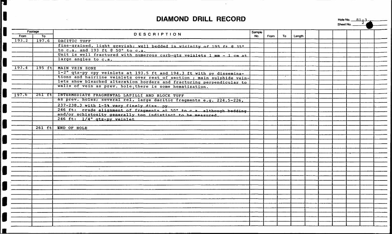
DIAMOND DRILL RECORD HoteNo.. Sheet No..
FoeFrom
193.2
193.4
197.6
tageTo
197.6
195 ft
261 ft
261 ft
DESCRIPTION
DACITIC TUFFfine-grained, light greyish: well bedded in virHnit-.y n f i qq f t- 0 TROto c. a. and 193 ft @ 50" to c. a.Unit is well fractured with numerous carb-qtz veinlets 1 mm - 1 cm atlarge angles to c. a.
MAIN VEIN ZONE1-2" qtz-py cpy veinlets at 193.5 ft and 194.3 ft with DV dissemina tions and hairline veinlets over rest of section ; main sulphide vein lets show bleached alteration borders and fracturing perpendicular towalls of vein as prev. hole^there is some hematization .
INTERMEDIATE FRAGMENTAL LAPILLI AND BLOCK TUFFas prev. holes; several rel, large dacitic fragments e.g. 224.5-226,237-238.3 with l-5% very finely rtice py
and/or schistositv generally too indisf--* n^t- *-o Ho mo^ ?ura/-!246 ft: 1/4" qtz-py veinlpt
END OF HOLE
-
SampleNo. From To Length

lDIAMOND DRILL RECORD
Hole No..
HOIPNOPrnp^ty Briscoe-BryceT —— hip Bryce
4 + 05E 1 oralinnO4-15S
1 ogged By W RTpr-o-hnn
rnrn 1 raatinn Core Shack : 3 + OOE r 0 + 2
Remarks
ipnjh 201 ft (60.9 m)Reanno 340"
nip -55"Objective Test main Vein Z0ne
5N
m*™** April 23, 1981 nip- CoHar - 55 0roofed A?ril 2 7 ' 1 98 1nriiiinnCo Barron Dia. Drilling Etch Test Depth Rdg. TrueCoreSi7e N2Casing left in Hole No ^ ' 201ft. 48 0
FootageFrom
n
Q fi
134
141
151
To96 ft
1 ~\A •Ft-
151 ft
151 ft
201 ft
2O1 ft
D E S C R 1 P T 1 O N
OVERBURDEN
FELDSPAR PORPHYRITIC CRYSTAL TUFFacrain . aradual disappearance of f SD ohenocrysts towards bottom ofsection alona with aooearance of aohanitic dacitic fraas (e. a. 131 ft)96 104 ft: core is badlv broken UD — some bleachina and carb veininaalona^f ractures at low anole to c. a. - probable fault zone.
INTERMEDIATE TUFFchloritic crystal tuff very similar to above i.e. missing the placrphenocrysts, along with finer-grained dark chloritic tuff; whole sec tion sheared and exact relationships obscured.MAIN VEIH ZONB141 ft:141-143 ft:143-145 ft:
145-147 ft:
147-151 ft:
1/2" qtz-py veinlet j shearing at 45 e to c. a.sheared intermediate tuff with chloritic clotsbadly broken up zone - 50%oxide - fault zone.40% qtz - py vein material
core recovery - abundant iron
; locally intensely bleachedwith original tuff completely altered to ser * chl -f qtz.highly sheared chloritic rock wi,th local narrow seams andveinlets of py and calcite ;minor sphalerite xtals assoc.with carb.
INTERMEDIATE LAPILLI AND BLOCK TUFF152 ft:minor qtz i
sch at 65 0 to c. a.py veining at 152-154 ft, 158-162 ft, 171.5-172.5 ft,
188-189 ft.END OF HOLE
Sample No.ami.4832.4833.4834.4835L4836.4837.4838.4839.4840.4841.4842.4843L4844.4845L4846U847L4848.4849i.4850
[ft) From1 1 ^136137139140141142143145146147
.31.5152149159157
.71.5
.78.5147150
(ft) To1 Tfi137139140141142143145146147149
.32.5154151161159
72.51.79. 5L47.5151
(ft) Length1 O1 -02.01.01.01.01.02.01.01.02.01.02.02.02.02.01.01.00.51.0
(
(
Location Sketch IV
Clai
Sea
ozAu
nil
niJ.002nilnil.002nilnil1.34o.i:.003nil.002.002.002nil.002.005.002nil
ozAg
nil
rH 10.01nil0.01trnilnil1.040.080.01nilniltrnilniltr0.010.0]o.o;
ppmCi
AR
4633048
98024252
11075001350478-72
160506280
410402- 3
lorth
tmNo 25691
e: 1"-
ppmZn
1,60(

l DIAMOND DRILL RECORDHole No. 81-5A
LI i Ki 81-5A Hole No.Briscoe-BryceProperty " J . ..Bryce
location 5 + OOE0-1-7=1?;
logfjwlRy W RT-oi-pi-rm
Core location Core Shack : 3 + OOE . 0 + 2
Remarlcs Lose 7 ^pieces - 5
length IR c; f i- ( ^Ifi 1 m)Bearing 340Din -50 0Objective Test main vein zone
5N
ft NW casing in initial atte
Commenced April 28, 1981Completed May 6, 1981DriiiingCo Barron Dia.DrillinaCore Sire NOCasing left in Hole No
mpt at hole
FootageFrom
0
74
132.5
137
To
74 ft
137 ft
-
137 ft
185 ft
185 ft
D E S C R 1 P
Dip: Collar -50 0
Etch Test Depth Rdg. True
1 185 ft 43"
T 1 O NOVERBURDEN
FELDSPAR PORPHYRITIC CRYSTAL TUFFa coarse' generally massive, green-grey crystal tuff of andesite corn-position as prev. holes88 - 90.3 ft: lost core mud seam - fault101 - 109 ft: coarser fragmental zone123-123.8 ft: narrow qtz-py veinlets with intense sericitic al
teration12b ft: 1/4" qtz-py veinlet in narrow shear at bU" to c. a.
MAIN VEIN ZONE132.5 - 134 ft: sheared but relatively barren chloritic tuff, broker
up134 - 135.5 ft: poor recovery - contains 20% qtz-pyritic vein ma-
terial as veinlets to 1/2" assoc. with intense lighlareenish sericitization ± fuschite (?)
135.5 - 137 ft: rusty, broken up zone with Fe oxide staining infracture surfaces - poor core recovery
INTERMEDIATE BLOCK TUFFcoarse andesitic pyroclastic fragmental as previous holes
END OF HOLE
Sample No.
14851
1485^
1485^
1485'
JL4SJ5J
(ft) From
132. E
133. E
134.1
135 e
122
(ft) To
133. E
134. E
135. E
l 1*"
123. E
(ft) Length
1.0
1.0
1.0
1 5
0.8
Location Sketch
ozAu
0.01
0.78
0.06
n 02
0.005
ozAg
0.01
0.34
0.05
Q 02
0.0^
N
Clai
Sea
ppmCu
-
-
-
228
*
Orth
tm Mn
e: 1"-
ppmZn
L710
213
-
Q^4
L010
l l
l l
l
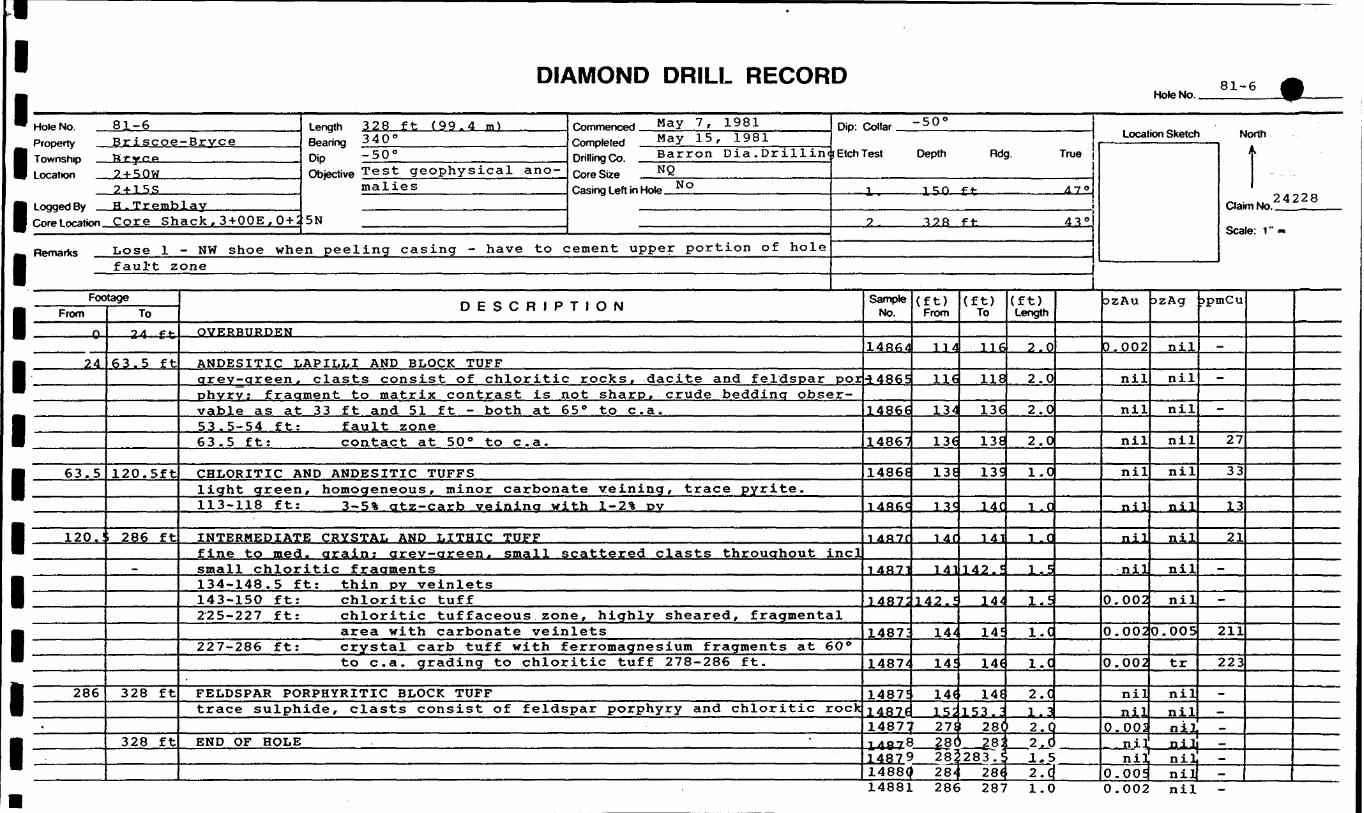
l l l l l l l l l l l l l l
DIAMOND DRILL RECORDMote No. —
81-6
Hole No 81-6Property Br i SCO6-Br VC6Township P f y r. p1 oration 2 + 50W
2 * 1 5 Slogged Ry H. TremblayCore Lor-ation Core Shack , 3 + OOE , 0 + 't
Length 328 ft (99.4 m)Bearina 340 0Dip -50'Objective Test geophysical ano
malies
5N
Remarks Lose 1 - NW shoe when peeling casing - have to c
Comment May 7, 1981 nin. Collar -50"complex May 15, 1981nriiiingco Barron Dia ,Drillin(tEtchTest Depth Rdg. TrueCoreSbe N O-Casing left in Hole N o 1 1^0 ft A 7 "
2. T2R ft- 43"
:ement upper portion of holef aul't zone
FootageFrom
Q
24
63.5
120.!
286
.
To
2-4 ft
63.5 ft
120.5ft
286 ft
—
328 ft
328 ft
D E S C R 1 P T 1 O N
OVERBURDEN
ANDESITIC LAPILLI AND BLOCK TUFFarev-areen , clasts consist of chloritic rocks, dacite and feldspar porohvrv; fraament to matrix contrast is not sharp, crude bedding obser vable as at 33 ft and 51 ft - both at 65 0 to c. a.53.5-54 ft:63.5 ft:
fault zonecontact at 50 0 to c. a.
CHLORITIC AND ANDESITIC TUFFSlight green, homogeneous, minor carbonate veining, trace pyrite.113-118 ft: 3— 5% atz— carb veinina wi th 1-2'fc DV
INTERMEDIATE CRYSTAL AND LITHIC TUFFfine to raed . arain: arev-areen. small scattered clasts throughout inclsmall chloritic fragments134-148.5 ft: thin pv veinlets143-150 ft:225-227 ft:
chloritic tuffchloritic tuffaceous zone, highly sheared, fragmentalarea with carbonate veinlets
227-286 ft: crystal carb tuff with f erromagnesium fragments at 60 0to c. a. grading to chloritic tuff 278-286 ft.
.FELDSPAR PORPHYRITIC BLOCK TUFFtrace sulphide, clasts consist of feldspar porphyry and chloritic rock
END OF HOLE
Sample No.
148&4
•14865
I486*
14867
14868
1 486C
1 4R7f
14871
1487:
1487'
1487/
1487!1467*
(ft) From
114
116
134
136
13E
13c
l 4f
(ft) To
116
ne136
13E
13S
14C
141j
1411142.?
142.!
144
14!
14(is:
14^
14!
14(
14(153 . "
14877 278 28(214978 } 8(14879 282
} 2 8;
1488Q 284 28(
(ft) Length
2.0
2.0
2.0
2.0
1.0
i r
l C
1.5
1.5
l.C
l.C
2. C1 . 32.02. C1.52.4
Location Sketch
DzAu
0.002
nil
nil
nil
nil
nil
nil
nil
0.002
0.002
0.002
nilnil
0.002
,zAg
nil
nil
nil
nil
nil
nil
nil
nil
nil
0.005
tr
nilnil
N
Clai
Sea
jpmCu
~.
—
-
27
33
13
21
—
-
211
223
-—
nil
nil nil0.005| nill
..——
orth K
t . 24228m No
e: 1"-
14881 286 287 1.0 0.002 nil -

DIAMOND DRILL RECORDHole No.
81-9
Hole No 81-9Property Br iscoe-B ry CPTownoh.p B rye eloratmn 5 + OOW
3 + 80NInggeriRy H.TremhlayCore t oration Cor e Shack ; 3+OOE . 0 + 2 !
Remarks .
326 ft (98.8 m)Bearino J 40 "
Dip -50"Objective Test aeophysical ano
malies on Contact Zon(
N
Commenced May 28 P 1981 Dip: Collar - ID 0Completed June 3 r 1 981nriiiinqCo Rarr-on n i x D T- i 11 i n jEtchTest Depth Rdg. TrueCore Size NQ
sCasing left in Hole No
-
FootageFrom
n
34
94
-
146
150
To34 f t
94 f t
146 ft
150 ft
161 ft
.
D E S C R 1 P T 1 O N
nvppRiTcnPN
INTERMEDIATE LAPILLI AND BLOCK TUFFfragments consist of dacite . andesite and feldspar porphyry along witfrblack chloritic clots and f raciments . fraament size to 10 inches, maxi—
veining from 47 to 52 ft* some hematitic staining along fracture sur faces, trace sulphide.45 - 57 ft: ash to lithic tuff finina up hole (implyina tops to
south)
ANDESITEdark areen. med to fine qr., even textured, somewhat tuffaceous lookincwith rare bandina at 60 0 to c. a.; upper and lower contacts sharp at 50'to c . a .137.5 ft: fine-gr. chloritic tuff band 2 inches thick at 60" to
c .a.141-141.5 ft: sericitic-chloritic tuff band at 45" to 70 e to c. a. witl
S-4% carb veining
TUFFACEOUS SEDIMENTSvery fine gr., greyish to locally cream-coloured, sericitic-onloriticsediment, tuff bedding at 60 0 to c. a.148 ft: 1 inch qtz vein or chert zone with 15** py ± cpy
ANDESITE TUFF AND TUFFACEOUS SEDIMENTmixed zone of fine-gr. andesitic tuff as 94-146 ft along with sericiticchloritic tuffaceous sediment
Sample No.
14956
14957
14958
14959
14960
14961
PL4962
14963
14964
14965
14966
—
(ft) From
146
L47.5
148. 5
197
L98.5
L99.5
210
211
231
234
29^7
(ft) To
L47.5
L48.5
150
1 QP. e;
L99.5
200.5
211
214
234
235
298
(ft) Length
1.5
1.0
1.5
l t;
1.0
i .0
1.0
3.0
3. O
1.0
1.0
Location Sketch Nlorth
tScale: 1 " -
ozAu
nil
0.06
).002
•n i 1
).002
nil
nil
nil
nil
).002
nil
ozAg
nil
0.02
nil
o m
0.04
nil
0.0
tr
nil
0.0
nil
ppmCt
57
361
72
170
990
62
. 128
117
130
: 200
184
l

DIAMOND DRILL RECORD Hole No. Sheet No.
FootageFrom
161
176
197
21C
To176 ft
197 ft
210 ft
326 ft
326 ft
DESCRIPTION
FELDSPAR PORPHYRY (CRYSTAL TUFF?)grey-green, med gr; massive, overall dacitic composition, upper andlower contacts sharp at 65 0 to 70 0 to c. a.
ANDESITIC TUFFfine gr. as 150-161; generally chloritic with very tine gr. portionsof chloritic-sericitic material194-197.3 ft: chloritic-sericitic tutt witn DiacK cnloritic llthlCT
fragments, carconate richjl* pyrite
BEDDED TUFF-SEDIMENTvery fine-gr. bedded carbonate to chlorite/sericite-ricn sediment;bedding at 60 0 to c. a.Carbonate-chertY bands 1/2 to 1 inch with 10*; to 25!* pyrite at 198 ft199 ft and 210 ft200.5 ft: graded bedding indicating tops up hole
PILLOW BASALTcarbonatized, chloritic, amygdular dark green, fine to very fine gr;generally 1-2^ pyrite as blebs and enhedral crystals throughout234 ft: li in massive band pyrite at 75 0 to c. a.
END OF HOLE
fc
Sample No.
.
From To
*
Length
l l l l l

DIAMOND DRILL RECORDHole No.. 81-10
Mn*.*, 8 1 ~ 10
1 nation 4 + 50E1 + 50S
loggedBy H.TremblavCore Location Core Shack ; 3 + OOE , 0 + 2
Remarks
length 716 ft (217 m )Bearing 3 4 0 0Dip - 5 0 0Objective Test main vein zone
5N
Commenced June 4 r 1981Completed .Tune 10 r 19R1Drilling Co Bf? r"rr)n n i a m-illinrjCore Size NQCasing Left in Hole No
FootageFrom
0
14
-
91
101
166
168.4
To14 ft
91 ft
101 ft
166 ft
168.4ft
186 ft
OVERBURDEN
D E S C R 1 P(0-18 casing)
Dip: ™" S 0 o Collar
Etch Test Depth Rdg. True
i. i nn f* 4 flo
2. 400 ft 46 0
3 fiqfi f f. - 4^o
T 1 O N
DACITE FRAGMENTAL TUFFgrey, feldspathic, porphyritic; fragments and tuffaceoiis matrixmaterial very similar.The fragment to matrix contrast is generally poor; fragments vary upto 8" but generally measure around 3".5% qtz-carbonate veins ( 1.5 cm) occur at -3O-45" to c. a.; trace py-rite.14 - 27 ft: open fractures because of dissolved carbonate veins
CHLORITIC TUFFmassive f .g . to v.f.g. chloritic, greyat 1OJL ' fo"-lU2 ft; trace sulphide; upperc .a. , lower contact at 50 0 to c. a.
JolacK; /" fsp porpnyry rragmentcontact irregular at oO" to
DACITE-ANDESITE FRAGMENTAL TUFFgrey to dark grey with blocks to 1 ft of feldspar porpnyntic dacitein a fine-grained matrix. The fragmentand the unit becomes more mafic than at
to matrix contrast is poor14-y J. .
MAFIC FLOW OR INTRUSOVEv.f.g. to f .g. black, chloritic, schistose at 45 0 to c. a. aatygdular-like with carbonate-hematite fillings; lower contact -banded at 35"to c. a. (sharp).
COARSE DACITE FRAGMENTALdark grey, v.f.g. to f. g. with feldspar porpnyry fragments in a r. g.andesitic matrix, fragment to matrix contrast poor as 101-166; tracesulphides , 5* qtz— carbonate veining.
Sample No.
14972
14973
14974
14975
14979
14980
(ft) From
535.9
536.9
623
595.5
366
369
(ft) To
536.9
536.9
626
598.5
369
372
(ft) Length
1.0
3.0
3.0
3.0
3.0
3.0
Location Sketch
ozAu
0.03
nil
).005
nil
nil
nil
ozAg
0.05
nil
nil
nil
nil
tr
North
IScale: 1"-*
ppmCu
572
69
46
141
7
10
l l l l l l l

DIAMOND DRILL RECORD Hole No. Sheet No.
FoeFrom
1RP
196.6
206
212
-
256
387
tageTo
196.fi
206 ft
212 ft
256 ft
387 ft
407 ft
DESCRIPTION
M AFT C FT.OW OR INTRUSIONdar-lr gr-een r \r f ej n h i 1 1 od i-onf-sct with star-like feldspar aggregatesin r-onl-T-al jw-ir f-, i rm - Also minor carbonate amygdules: upper contact ati^no. lower contact at 60 0 to c. a., both sharp.
DACITE FRAGMENTALas at l68.4 - 184 ft, carbonate-quartz veining b* irregularly aisuriDu-ted throughout.205-206 ft: brecciated contact - fault zone at 25" to c. a. Open
drusy carbonate fractures at 206 ft. Trace sulphides.
MAFIC DYKE OR FLOWas at 186-196*6" with f. g. contacts and f. g. center; 212 ft sharp con tacts at 75" to c. a., upper contact fault at 25 0 to c. a. - brecciated.
DACITE FRAGMENTALas at 168*4" - 186 ft; grey, with predominantly grey to pinKisn nemati-zed feldspar porphyry fragments in a f. g. green andesitic matrix. Poorfragment to matrix contrast. Pyrite trace - 5%; carbonate-qtz veinirregularly distributed throughout.
ANDESITE FRAGMENTALmixed derivative fragmental with feldspar porphyritic, creamy f. g. da cite and chloritic andesite (sometimes anygdular) fragments in a crys tal tuffaceous to chloritic tuffaceous matrix. Fragment to matrix con trast is good to excellent.256-268 ft: dark chloritic feldspar porphyritic fragments in a light
green m. g. crystalline fsp matrix; fragments up to b" butgenerally less than 3"; unsorted.
284.5-285.5* :broken core, highly fractured - fault zone256-306 ft: 2-3** carbonate-qtz-veining - trace sulphide366-372 ft: hematite-stained fracture minor pyrite - mostly unminera-
lized throughout344-348*6" mafic dyke(?) contacts at 4b 0 appear, 25" lower.
CRYSTAL TUFF FRAGMENTALmnro r-na-r^t*! y i-T-y si-a i l l n section of tuffaceous matrix with mixed frag-
-*Q7-dno ft-- t-wn seotiions of graded tuffs over 12-18" thickness indi cate tops UD hole
397 ft- 1" f. 9. tuff band at 50 0 to c. a., trace sulphides
SampleNo. From To
*
Length

f l l l l l l l l l l l l l
DIAMOND DRILL RECORD Hole No.. Sheet No..
81-10
FootageFrom
407
417
432
477
"
506
571
To417 ft
432 ft
477 ft
506 ft
571 ft
—
716 ft
DESCRIPTION
ANDESITE FRAGMENTALas at 256-387 ft: contacts gradational
CRYSTAL TUFF FRAGMENTALas at 387 — 407 ft exhibits graded bidding in 3 spparal-p 1 7 — IR- 7 on p c-
indicates tops up hoi pBedding indicated by elongation o-F fragments in graded bedding sec tions at 50-55" to c. a. - contacts yradational
ANDESITE FRAGMENTALas at 256-387 ft; fragments rarely exceed 3", 5 * predominantly car bonate veinina447'6"-450 ft: v.f.g. green mafic dyke with contacts at 70 0 to c. a.461-462"6": v.f.q. green mafic dyke with contacts at 70" to c. a.451-453 ft: qtz-carbonate-epidote zone at 20 0 to c. a.446-456 ft: brecciated andesite fragmental (chloritic, epidotic)
annealed
ANDESITE BLOCK TUFFas at 256-387 ft except fragments up to 2-3" in section 477-489; fragmen t s decrease in size quickly towards base of section
CRYSTAL TUFF - FRAGMENTAL ANDESITEmixed zone of andesite fragmental with mixed derivatives; fragmentsnot usually exceeding 3". Several sections of crystal lithic tuffindicate tops up hole. 3 -4* carbonate-quartz veining.
DACITIC CRYSTAL TUFFlight green, m. f. g. relatively even-textured with black chloriticfragments to 2 mm throughout. White sub hedral feldspar phenocrystsalso occur throughout along with round to angular quartz phenos636-636 '6 1': mineralized zone - three quartz-carbonate veins to
1 cm with coarse to fine-grained pyrite, minor cpyand a silver ^teluride rjmineral in one of the veins.'i1 h e vein with possible telurides has small, openfractures and contains more sulphides (lQ-15%) thanthe overall S-4% pyrite, minor cpy.
704-704'2": q.v. at 20-45" to c. a.598-599.5; 602-603; 613-617; 619-620 ft: dark grey f. g. mafic
dykes with generally irregular contacts: contactsat 619 ft-70 0 ; 620 ft-35 0
Sample No. From To
'
Length
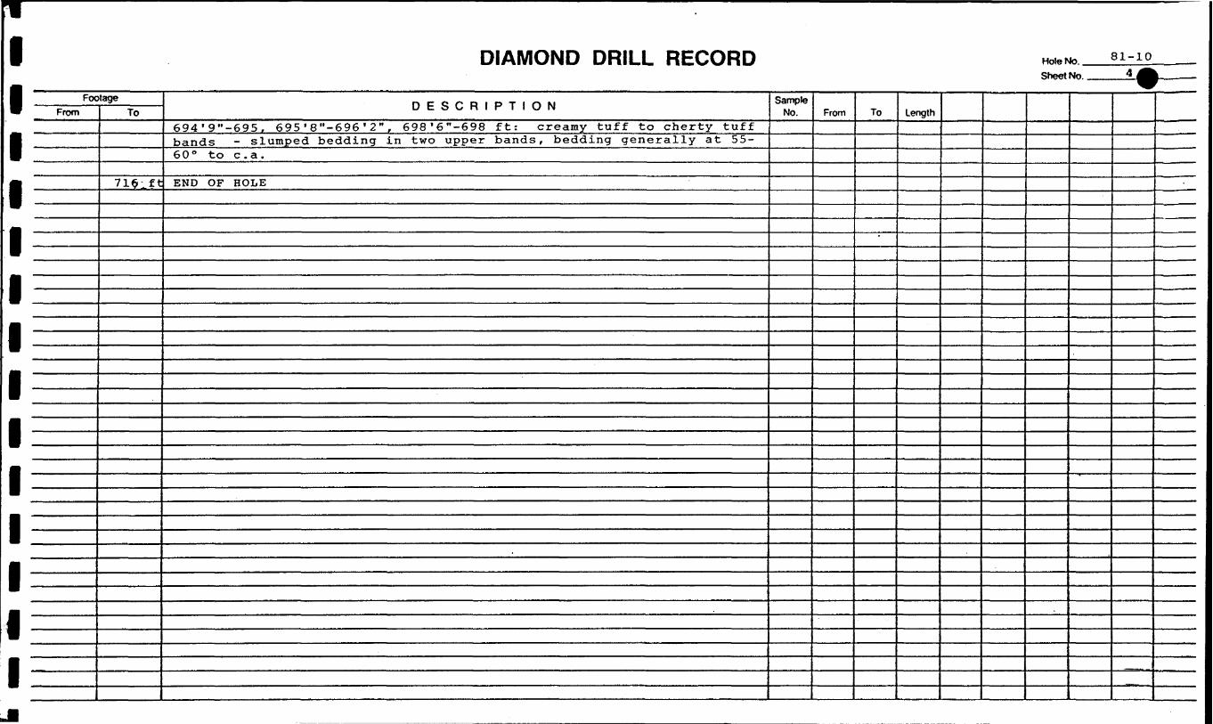
DIAMOND DRILL RECORD Hole No. . Sheet No..
81-10
FootageFrom To
715ift
DESCRIPTION694'9"-695, 695 ' 8"-696 ' 2" , 698'6"-698 ft: creamy tuff to cherty tuffbands - slumped bedding in two upper bands, bedding generally at 55-60" to c . a .
END OF HOLE
Sample No. From To
*
Length

DIAMOND DRILL RECORD81-11
Hole No Q 1 IT
Property Br i scoe-Brvc eT^wrKihip B r y C eInration 6 + OOE
0 + 80Si ogged By H . T r emb layCore Lor-ation Gore Shack ; 3 + OOE , 0 + 2 1
Remarks
44fo ft (1 Jb . 2 m) Length
Dip ^ 0Objective Test main V6in Z 0ne
IN
Commenced ,, J une -L J. , 1 J. Djn . Co||ar - D-
DriliingCo Barron Dia . Drillin jEtchTest Depth Rdg. TrueCore Sire 2Casing 1 eft in Note N O
-
FootageFrom
0
22
-
-
175
188
239
To22 f i
175 ft
188 fi
239 f i
266 ft
OVERBURDEN
D E S C R 1 P T 1 O N
FRAGMENTALqrey qreen
DACITEwith fraqments to 6 in but qenerallv less than 3 in. Fraq^
ments numerous and qenerallv liqht qrev in a dark arev matrix. Frag ments consist predominantly of f. q. dacite and andesite tuff withlesser med-qrained feldspar porphyry tuff.Open fractures 22 to 36 ft because of dissolved carbonate veinsCarbonate-qtz veins occur preominantly128-150 ft
22-41 ft (5%) .: abundant calcite and lesser calcite-quartz-epidote
generally at 45-70 0 to c. a.Minor pyrite
MAFIC DYKElight green, v.f. grained chilled contacts with epidot ized maficphenocrysts in central portion; 5% irregular carbonate veining, l-2%diss. pyrite - contact at 181-70 0 to c181-183.5 ft: fragmental as at 22-175Contact:Contact:
183.5-50 0 to c. a.188-20 0 to c. a.
Sample No.
.4981
.4982
.4983:
.4984
.4985:
.4986
.4987
.4988.a. lft 1.4989
ANDES HE ERAGMENIAl,chloritic andesite tuff, cream-coloured dacite and feldspar porphyryfragments in andesite matrix, unsorted3 in, fragments angular to sub-rounded
; to 6 in but predominantlyMinor carbonate veining and
trace pyrite
CHLORITIC ASH TUFF (Fragmental)mixed zone of f. g. to v.f. g. chloritic tuff with chloritic fragments
.4990
L4991
14992
L4993
26406
(ft) From
109
153.8
154.8
. 35i:
:74.2
261
271
271
258
358
366
175
.83.5
553.4
(ft) To
112
154.8
55.8
153.8
276
262
:74.2
!74.2
261
359
369
178
1.86.5
555.8
(ft) Length
3.0
1.0
1.0
2.8
1.8
1.0
3.2
3.2
3.0
1.0
3.0
3.O
3.0
2.4
Location Sketch
ozAu
nil
0.0!
0.0!
.002
0.0!
o.o;nil
nil
nil
nil
nil
nil
nil0.0'
ozAg
nil
0.07
o.o:nil
o.o;o.o:nil
nil
nil
nil
nil
nil
nil
O.OS
N
Clai
Sea
ppmCu
80
770
572
69
308
298
52
-
-
-
—
—
40
830
orth
tmNo 2f^(
e: 1"-
l
l
l l l l l
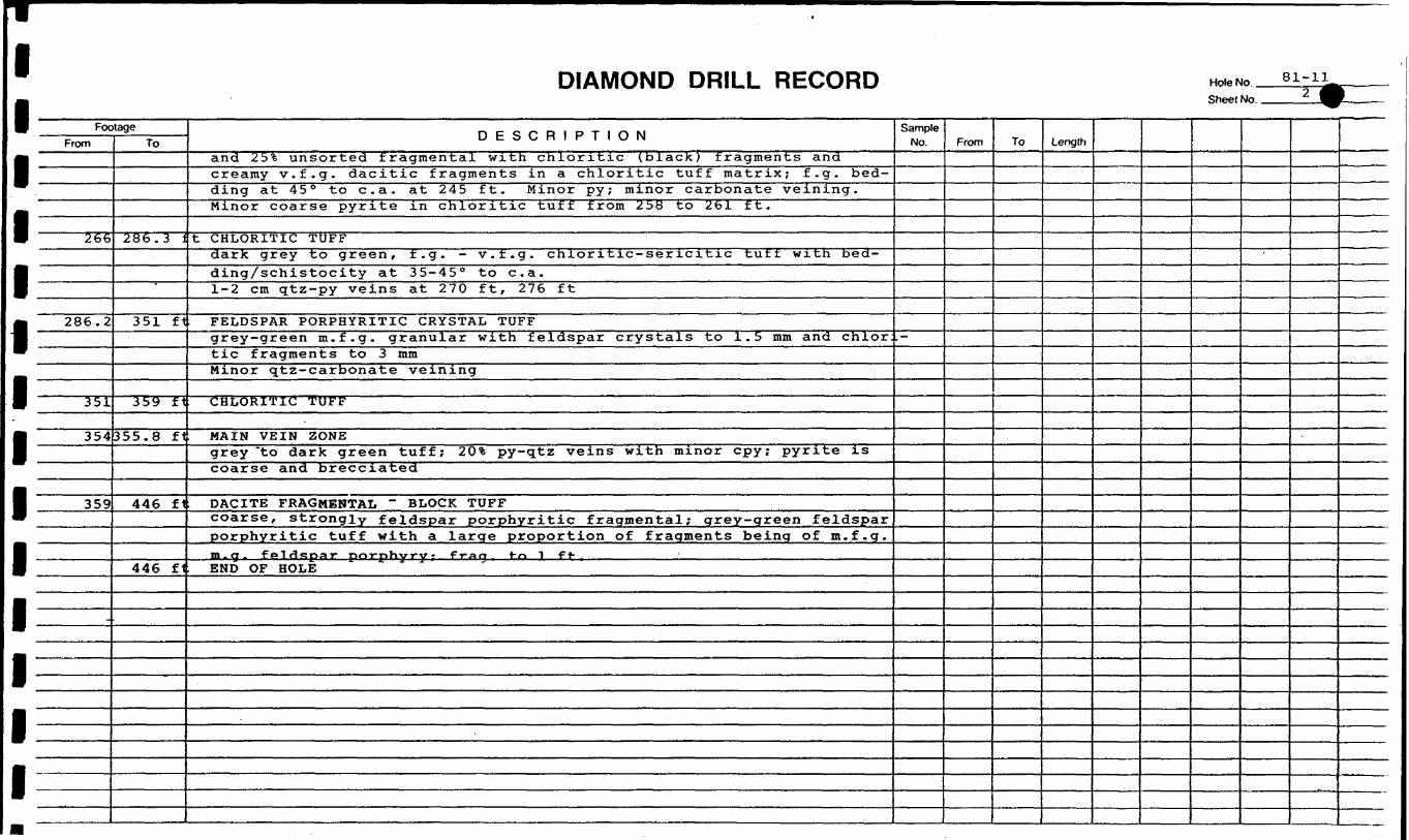
l l l l l l l l l l l l l l
DIAMOND DRILL RECORD Hole No Sheet No.
FootageFrom
266
286.2
351
354
359
To
286.3 i
351 ft
359 ft
355.8 ft
446 fi
446 fi
DESCRIPTIONand 2 5* unsorted fragmental with chloritic (black) fragments andcreamy v.f.g. dacitic fragments in a chloritic tuff matrix; f. g. bed ding at 45 0 to c. a. at 245 ft. Minor py; minor carbonate veining.Minor coarse pyrite in chloritic tuff from 258 to 261 ft.
t CHLORITIC TUFFdark grey to green, f. g. - v.f.g. chloritic-sericitic tuft with bed-ding/schistocity at 35-45 0 to c. a.1-2 cm qtz-py veins at 270 ft, 276 ft
FELDSPAR PORPHYRITIC CRYSTAL TUFFgrey-green m. f. g. granular with feldspar crystals to 1.5 mm and chlortic fragments to 3 mmMinor qtz-carbonate veining
CHLORITIC TUFF
MAIN VEIN ZONEgrey "to dark green tuff; 2 0* py-qtz veins with minor cpy; pyrite iscoarse and brecciated
DACITE FRAGMKNTAL ~ BLOCK TUFFcoarse, strongly feldspar porphyritic fragmental; grey-green feldsparporphyritic tuff with a large proportion of fragments being of m. f. g.m . cj . feldspar1 poT-pHyr-y - f ran t-n 1 f t-END OF HOLE
Sample No.
,—
From To Length
l l l l l l l l l l l llfi
DIAMOND DRILL RECORDHoleNo. 81-12A
HoloNo 81-12APrnnerty Br iscoe-BryceTownship Brycelocation 7 + OOE, O 4 OS~
toggpdBy 3 r TremblayCnro l or-ation Core Shack : 3 + OOE . 0 + 2 !
Remark.; Hole 81-12 lost in
,pnn,n 2 8y f t ^ 7 ' 5 ^
Bearina 3 4 O eDip -70 eObjective Test main vein zone
N
overburden at 154 ft.
Commenced JU ne 17., . ..198 J, Dip- Collar -7O 0Competed June 25, 1981Drilling Co Barron Dia .Drill i in. jEtchTest Depth Rdg. TrueCoreSLre NQCasing l eft in Hole N O
FootageFrom
0
123
130
133.6
To123 ft
130 ft
133.6'
259.6'
D E S C R 1 P T 1 O N
OVERBURDEN
FELDSPAR PORPHYRY TUFFgrey-green, m. g. tuff with feldspar phenocrysts to 1 mm and dark greetchloritic fragments. Generally even-textured.128'4" - 1 cm qtz vein with 1(^ coarse pyrite
CHLORITIC CHERTY TUFFfractured chloritic tuff zone with 10%as breccia
irregular qtz-carbonate veinsfilling with coarse granular pyrite cpy 1 - 2*!;.
l32 I-6" - 133'6": f-9-creamy c he^t band contorted with 1-2 mm laminaeot tine pyrite. Banding at O-20 0 to c. a.
FELDSPAR PORPHYRITIC CRYSTAL TUFF(minor coarser fragmental sections) grey-green, m. f. g. Generally even-textured with fsp phenocrysts to 1-2 mm and dark green chloritic maficminerals to 2-3 mm, irregular chloritic fragments to 5 mm; minor py rite152.6 - 154'6: broken core, fault zone in chert - 153'6" then in
tuff to 154'6"Coarse fragmental bands at: 172 ft - 175 ft consisting of a f. g.chloritic tuff matrix with feldspar porphyry fragments.Mineralized gtz-carb. veins occur at:145*6" - 145*8": gtz veins at 45 0 to c. a. with 10% granular pyrite.
minor cpy and minor grey mineral?188*3" - 188*6": qtz-pyrite zone at 35 0 to c. a.Coarse granular pyrite with minor bright green fuschite ? and lightgreen bleaching of tuff around vein.
Sample No.
14994
14995
14996
1499^
1AQQB
14995
1SOOC
(ft) From
274.5
241.5
127. S
130
IRfl
145
25O. e
(ft) To
276.2
243.1
128.7
133.9
1 OQ
1 46
251 ,c
(ft) Length1.7
1.6
0.8
3.9
1 n
1 -O
1-4^
Location Sketch
3Z AuD. 055
0.005
3.005
nil
n nn";
0-OQ5
nil
DZ Ag0.02
0.01
nil
nil
t- f-
ni 1
nil
North
Clai
Sea
jpmCu417
550
237
139
140
t Q 5
•^*
tmNo *6^1o- 1" —
l l l l l l l l l l l l l l
DIAMOND DRILL RECORD Hole No.. Sheet No.
81-12A
FootageFrom
259.5
274.6
276
X
To
276' ft
276 ft
287 ft
iJb / ft
DESCRIPTION
250*6" - 250*10"; oh 1 or it- i r f . g tuff band wa t-h 1cm ql-T-.-oar-hfinat-p' vpin
——————————————————— hematite — o tainod ; — S-% — f i g- 1 — pyrite — occurs — i-n — chloritict- 11 f f .
Carbonate and qtz veins occur throughout at 45-70 0 to c. a. with onlyminor pyrite except as noted above.
201-252': limonite and hematite stainina
CHLORITIC TUFFgrey to black and grey f. g. siliceous in sections but non porphyritic.Small lithic fragments observed in narrow sections.
MAIN VEIN ZONEat 45 " to c . a .274.6 - 275: chloritic tuff with l-2*fc pyrite275 - 276: siliceous tuff-quartz vein zone with ICK coarse py
rite mostly occurring in siliceous tuff. Hematitestringers also present (minor) .
DACITE FRAGMENTALt. g. to v.f.g. aacitic fragments (grey) in a r. g. chloritic matrixsuggests tuffaceous material tilling in Between fragments.
EtJt) OF HOLE
Sample No. From To Length
l l l l l l l l l l l l
DIAMOND DRILL RECORDHole No.. si-i:
Hole No 81-13Property Br i s coe -Br y c eTownch,p Brycelocation 8+OOE, 0 + 40S
1 onnpd Bv ™ * E * BlTGlTGtOn
Core Lor-ation Core Sfeack ; 3 + OOE r 0 + 2 1
Remarks
1 engthBearingrao -70"Objective Test main vein zone
.N
Comment ^6 26, 1981
Completed J^Y 6' 1 98 1nniiinoco Barron Dia. DrillingCoreSbe N2Casing Left in Hole N o
FootageFrom
0
102
160
172
208.5
To102 ft
160 ft
172 ft
208.5ft
263 ft
D E S C R 1 P
Dip: — 7O 0 Collar ' U
Etch Test Depth Rdg. True
1 157 69 0
2 328 65 0
T 1 O N
OVERBURDEN
FELDSPAR PORPHYRITIC BLOCK TUFFa coarse pyroclastic fragmental with fragments of light green-grey, fine-grainedvolcanic along with darker and coarser feldspar porphyry in an intermediate ash tuffmatrix110-111 ft: parting planes at very low angle to c. a.111-113 ft: 5% disseminated cubic pyrite125-127 ft: lost core155 ft: weak foliation at 45 0 to c. a.
IJCTTPRMEDIATE CRYSTAL TUFFcharacteristic liaht creamy crreenish-arev colour, relatively soft with abundantquartz — chlorite crystals and patches and lesser whitish feldspar crystals— uooer and lower contacts at 5 0 to 10" to c. a. Weak schistosity in aeneral at O0to c. a.
INTERMEDIATE BLOCK TUFFmainly dark feldspar porphyry fragments in a lighter green ashy matrix- perfectly gradational contacts with underlying unit
200 ft: schistosity at 250 to c. a.
INTERMEDIATE TUFFrelatively fine-grained; gradational contacts top and bottom, greenish in colour -rock is relatively hard, competent (difficult to split) and is not noticeablysheared
Sample No.
2fidO7
26408
2640S
26410
26411
2641;
26412
26414
26415
26416
26417
26418
26419
26420
(ft) From2Q.2
291
295.5
256.5
255. 5
353.6
257.5
212
219.7
125
310.9
296.5
289
293.2
(ft) To
2 Q 3 . 2
292
296.5
257.5
256. 5
243.5
260.5
213.5
220.7
127
311.8
300
292
296.5
(ft) Length
1 . 2
1.0
1.0
1.0
1.0
1.0
3.0
1.5
1.0
2.0
0.9
3.5
3.0
3.3
Location Sketch North
Sea
ozAu
O 27
0.002
0.03
0.02
0.635
0.003
0.04
0.12
3.005
0.02
3.005
3.002
nil
nil
szAg
O. 23
tr
0.02
0.02
0.48
0.01
0.05
0.05
0.01
0.01
tr
tr
tr
0.01
ppmCu
24OO
93
199
597
3650
103
1170*
305
98
450
116
97
84
97
f f^lvl \n/ y*rf ^^
te: V- """"*

DIAMOND DRILL RECORD Hole No. . Sheet No.
81-13
FootageFrom255.5
263
292
302
327
To260.5ft
292 ft
302 ft
327 ft
DESCRIPTION
VEIN ZONE f #2)narrow qtz-py-cpy zones in intermediate tuff; mineralized sections are carbonatizedand show a licrht areenish sericitization/silicification; pyrite often has a coarsegranular fractmental aspect as in previous holes. Discrete mineralized sectionsare as follows :
1/2 in at 254 ft.1/2 in at 254.5 ft.3 in at 255.5 ft.1/2 in at 256.5 ft.1/2 in at 259 ft.
INTERMEDIATE LAPILLI AND BLOCK TUFF268-269 ft atz-chl porphyry as 160-172 ft.275.5 ft 2 in. qtz-py vein zone at 45" to c. a.280 ft weak schistosity at 45 0 to c. a.285 ft 2 in. fragment of arevish. v.f .q, cherty rhvolitic material287-291 ft minor qtz - py veinina and accompanyina lioht areenish sericitization
VEIN ZONE (#1)sheared, mineralized zone in fine-grained intermediate tuff and chloritic tuff.There is locally intense shearincr - liaht areenish silicification/sericitizationand some carbonatization. Silicification has been very intense in some sectionsgiving rock a faint, ghost-like lamination.
292-293 ft qtz-carb zone with intense areenish chert-like silicification and1 in. ouartz-py-cpy vein
295 ft 1 in. qtz-pv-cpy vein
INTERMEDIATE HICOCK TOFFfragments of qtz-chl porphyry and feldspar porphyry are aenerally vague andindistinct
311-312 ft 34 quartr.-py material315 ft schistosity at 40" to c. a., there is some fracturing and qtz-carb
veinina over most of this sectionEND OF HOLE
Sample No. From To Length
l
ls
l
l
l
l
l
l

APPENDIX C
DRILL SECTIONS: HOLES 81-1 to 81-13

metres 0+5OS 0+25S Baseline 0+25N 0+5ON
me t r e s 81-1,-50 0
J+OOEjO+SOSTrenchO.20471Oft.
LEGEND
PRECAMBRIAN
Diabase, mafic dikes
Quartz ± Feldspar Porphyry
Chemical and Tuffaceous Interflow Metasediments 4a: chert, siliceous sediments 4b: iron formation 4cs sericitic-chloritic tuffaceous sediments
Ultramafic Metayolcanics
Intermediate Metavolcanics-"Skead Pyroclastics"2O: massive and porphyritic lava
BHi chloritic tuff, dacite tuff ^2ffi| feldspar porphyritic crystal tuff[T—Tjandesific to dacitic, often feldspar porphyritic l±±J lapilli and block tuff
|2f; j cherty tuff, chert; pyritic
Mafic Metavolcanics-"Catherine Basalts"
B Vein Zone : qtr-carb±py, cpy, Au, sp, chl, hem, ser
O.8O/2.0 oz. Au per ton X t rue width (ft.)
fS Schistosity
S S Bedding, indicating tops
Hole N-1 proj. to section
M/
YVANEX-WINDJAMMER J.V.
BRISCOE- BRYCE PROPERTYDIAMOND DRILL SECTION
HOLE 81-1l H. C-4O9
l -- 5OOW.E.BreretonGCS LtdAug. I98I
MPH Consulting Limited
metres O* 50S 0+ 25S Baseline 0 + 25N 0 + 50N
me t r es
— O
81-2- 500 2+OOE, O*SOS
— -25
—-5O
——75
Looking west
——IOO
2d
2c
2e
LEGEND
PRECAMBRIAN
10 l Diabase, mafic dikes
Quartz :t Feldspar Porphyry
Chemical and Tuffaceous Interflow Metasediments 4a: chert, s iliceous sediments 4b: iron formation 4C! sericitic-chloritic tuffaceous sediments
Ultramafic Metavolcanicsf
Intermediate Metavolcanics -"Skead Pyroclastics" 2a: massive and porphyritic lava
| chloritic tuff, dacite tuff feldspar porphyritic crystal tuff andesitic to dacitic, often feldspar porphyriticlapilli and block tuff cherty tuff, chert; pyritic
Mafic Metavolcanics-"Catherine Basalts"
V Vein Zone: qtz-carb±py, cpy, Au, sp, chl, hem, ser
O.8O/2.O oz. Au per ton / true width (ft.)
Schistosity
f f Bedding, indicating tops
YVANEX-WINDJAMMER J.V.
BRISCOE-BRYCE PROPERTYDIAMOND DRILL SECTION
HOLE 81-2Propel K* C-4O9
: 5OODraw.**
W. E.Breretoni: GCS L td
Aug. 1981
MPH Consulting Limited

metres O*25 S Baseline 25N
me t r es
—— O
81 - 3 - 500 3+08E, 0+25S
Q
0 + 50N 0 + 75N
— -25
— -50
79.1 m.
——75
Looking west
——100
LEGEND
PRECAMBRIAN
Diabase, mafic dikes
Quartz ± Feldspar Porphyry
Chemical and Tuffaceous Interflow Metasediments 4a: chert, siliceous sediments 46s iron formation 4c! sericitic-chloritic tuffaceous sediments
Ultramafic Metayolcanics
Intermediate Metavolcanics -"Skead Pyroclastics"2a: massive and porphyritic lava
@fl chloritic tuff, dacite tuff
jjZjtfj feldspar porphyritic crystal tuff
\ 9 l andesitic to dacitic, often feldspar porphyritic Ke'l lapilli and block tuff
\2f'-\ cherty tuff, chert; pyritic
Mafic Metavolcanics-"Catherine Basalts"
B Vein Zone : qtz-carbipy, cpy, Au, sp, chl, hem, ser
O.8O/2.0 oz. Au per ton / t rue width (ft.)
jf Schistosity
S S Bedding, indicating fops
YVANEX-WINDJAMMER J.V.
BRISCOE-BRYCE PROPERTYDIAMOND DRILL SECTION
HOLE 81-3Cr.|.et M* C-4O9
l -' 5OOW.E.Brerefon
i: GCS LtdOn A ug. I 98I
MPH Consulting Limited

m e tr es
— O
metres O * 25 S
Creek
Baseline
81-4,-55*4+055,0+155
0+25N 0 + 50N 0 + 75N
— -25
— -5O
—75
Looking west
— IOO
,0.73 Au; 0.56 Ag ; Q.44% Cu/.S ft. ,1.20XoZnX0.8ft.
61 m.
!
LEGEND
PRECAMBRIAN
Diabase, mafic dikes
Quartz ±. Feldspar Porphyry
Chemical and Tuffaceous Interflow Metasediments 4a: chert, siliceous sediments Ab5 iron formation 4cs sericitic-chloritic tuffaceous sediments
Ultramafic Metayolcanics
Intermediate Metavolcanics-"Skead Pyroclastics' 2a: massive and porphyritic lava
[chloritic tuff, dacite tuff S feldspar porphyritic crystal tuff -nandesitic to dacitic, often feldspar porphyritic
__l lapilli and block tuff |2f; | cherty tuff, chert; pyritic
Mafic Metavolcanics-"Catherine Basalts'
m Vein Zone: qtz-carb±py, cpy, Au, sp, chl, hem, ser
O.8O/2.0 oz. Au per ton X true width (ft.)
Schistosity
S S Bedding, indicating tops
YVANEX-WINDJAMMER J.V.
BRISCOE-BRYCE PROPERTYDIAMOND DRILL SECTION
HOLE 81-4M* C-4O9
Safe, -' 5OO
1d
W.E.BreretonGCS Ltd
DM. Aug. I98I
MPH Consulting Limited

metres 0+25 S Baseline 0+25N 0 + 50N 0 + 75IM 1+OON
m etr e s
8I-5, -500 5+OOE,0+25S
.O creek
—— -25
56.1m
— -5O
——75
Looking west
——loo
0.196 / 3 75 ft. intense greenish sericitization
10
LEGEND
PRECAMBRIAN
Diabase, mafic dikes
Quartz it Feldspar Porphyry
Chemical and Tuffaceous Interflow Metasediments 4a: chert, siliceous sediments 4b: i ron formation
sericitic-chloritic tuffaceous sediments
Ultramafic Metayolcanics
Intermediate Metavolcanics-"Skead Pyroclastics" 2o! massive and porphyritic lava
f2!c : l chloritic tuff, dacite tuff |.233-| feldspar porphyritic crystal tuff\ 9 l andesitic to dacitic, often feldspar porphyritic K8'! lapilli and block tuff|2f; | cherty tuff, chert; pyritic
Mafic Metavolcanics-"Catherine Basalts"
M Vein Zone: qtz-carb±py, cpy, Au, sp, chl, hem, ser
O.8O/2.O oz. Au per ton / t rue width (ft.)
Schistosity
S S Bedding, indicating tops
YVANEX-WINDJAMMER JY
BRISCOE-BRYCE PROPERTYDIAMOND DRILL SECTION
HOLE 81 -5 At H. C-409 WE Brereton
GCS Ltd| DM* Aug. I98I
MPH Consulting Limited

metres 2 + 25S 2 + OOS 75S H-5OS 1+25S
me t r es Outcrop - 2
— O
81-6,-50*2 + 50W, 2+15S
/
—— -25 Otz-carb veining 1-2"Xo py
—— -50
Outcrop - 2
2cThin py veinlets
2d
2c
2d
2e99.4m.
LEGEND
PRECAMBRIAN
Diabase, mafic dikes
Quartz ±. Feldspar Porphyry
Chemical and Tuffaceous Interflow Metasediments 4a: c hert, siliceous sediments 41^ i ron formation 4C' sericitic-chloritic tuffaceous sediments
Ultramafic Metavolcanics
Intermediate Metavolcanics -"Skead Pyroclastics'2.Q' massive and porphyritic lava
[chloritic tuff, dacite tuff (feldspar porphyritic crystal tuff landesitic to dacitic, often feldspar porphyritic
*~ lapilli and block tuff12f: | cherty tuff, chert; pyritic
Mafic Metavolcanics-"Catherine Basalts"
O Vein Zone: qtz-carb±py, cpy, Au^ sp, chl, hem, ser
o.eo/2.0 oz. Au per ton X t rue width (ft.)
Schistosity
S S Bedding, indicating tops
———75
Looking west
——IOO
YVANEX-WINDJAMMER J.V.
BRISCOE-BRYCE PROPERTYDIAMOND DRILL SECTION
HOLE 81-6K* C-409
l -- 500W.E.BrerefonGCS Ltd
On A ug. I98I
MPH Consulting Limited
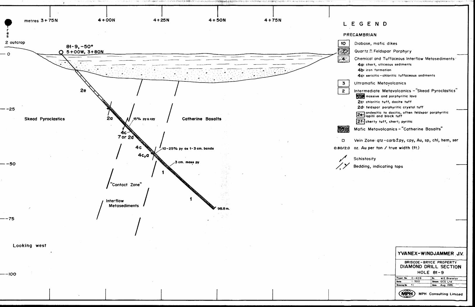
metres 31-75N 4 + OON 4f 25N 4 + 5ON 4 + 75N
re s
2 outcrop 81-9,-5O0 O 5-f-OOW, 3-fSON
— -25
Skead Pyroclastics
-50
——75
Interflow Metasediments
98.8m.
l
Catherine Basalts
IO-25% py as 1 -3cm. bands
LEGEND
PRECAMBRIAN
Diabase, mafic dikes
Quartz ± Feldspar Porphyry
Chemical and Tuffaceous Interflow Metasediments' 4a: c hert, siliceous sediments 45s i ron formation 4C! sericitic-chloritic tuffaceous sediments
Ultramafic Metavolcanics*
Intermediate Metavolcanics -"Skead Pyroclastics"JSSjffi massive and porphyritic lava2c: chloritic tuff, dacite tuff2d: feldspar porphyritic crystal tuff
rr—n andesitic to dacitic, often feldspar porphyriticl lapilli and block tuff
|2f: |cherty tuff, chert; pyritic
Mafic Metavolcanics-"Catherine Basalts"
O Vein Zone: qtz-carb±py, cpy, Au, sp, cbl, hem, ser
O.8O/2.O oz. Au per ton X true width (ft.)
Schistosity
S f Bedding, indicating tops
Looking west
—— IOO
YVANEX-WINDJAMMER J.V.
8RISCOE-BRYCE PROPERTYDIAMOND DRILL SECTION
HOLE 81-9RK C-4O9
Scab: l 5OO1 i
'r W.E.Breretoni: GCS Ltd
0*n Aug. I98I
M PH Consulting Limited

metres 1+5OS + OOS O-r5OS Baseline O + 50N OON
m et re s
— O
8I-IO,-5O0 Q4i-5OE,H-5OS
— -5O
— -IOO
———I5O
Looking west
Otz-carb ± py, cpy veins
— 200
LEGEND
PRECAMBRIAN
Diabase, mafic dikes
Quartz ±. Feldspar Porphyry
Chemical and Tuffaceous Interflow Metasediments 4fl: c hert, siliceous sediments
iron formation sericitic-chloritic tuffaceous sediments
Ultramafic Metavolcanics
Intermediate Metavolcanics -"Skead Pyroclastics' 2o: massive and porphyritic lava
\2G'\ chloritic tuff, dacite tuff ^Era feldspar porphyritic crystal tuff l~ l andesitic to dacitic, often feldspar porphyritic
l lapilli and block tuff cherty tuff, chert; pyritic
Mafic Metavolcanics-"Catherine Basalts'
O Vein Zone: qtz-carb±py, cpy, Au, sp, chl, hem, ser
O.80/2.O oz. Au per ton X true width (ft.)
Schistosity
f S Bedding, indicating tops
YVANEX-WINDJAMMER J.V.
BRISCOE-BRYCE PROPERTYDIAMOND DRILL SECTION
HOLE 81-10C-4O9l-' IOOO1,
WE Brtrttoni. GCS Ltd
DM., Aug. I98I
MPH Consulting Limited
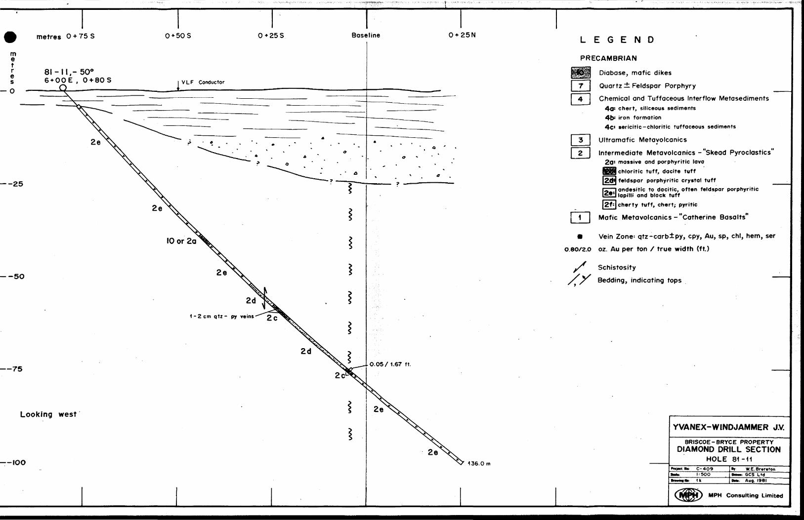
me t re s
— O
metres O * 75 S
8I-II.-500 6 + OOE , 0 + 80S
.Q.
O*50 S 0+25S Baseline 0 + 25N
VLF Conductor
— -25
--5O
——75
—— IOO
2d
1-2 cm q tz- py veins-
Looking west
136.0m
LEGEND
PRECAMBRIAN
Diabase, mafic dikes
Quartz i: Feldspar Porphyry
Chemical and Tuffaceous Interflow Metasediments 4a: chert, siliceous sediments 4lX iron formation 4c* sericitic-chloritic tuffaceous sediments
Ultramafic Metavolcanics4
Intermediate Metavolcanics-"Skead Pyroclastics' 2a: massive and porphyritic lava
chloritic tuff, dacite tuff feldspar porphyritic crystal tuffandesitic to dacitic, often feldspar porphyritic lapilli and block tuffcherty tuff, chert; pyritic
Mafic Metavolcanics-"Catherine Basalts"
m Vein Zone; qtz-carb±py, cpy, Au, sp, chl, hem, ser
O.8O/2.O oz. Au per ton f true width (ft.)
Schistosity
S S Bedding, indicating tops
YVANEX-WINDJAMMER J.V.
BRISCOE-BRYCE PROPERTYDIAMOND DRILL SECTION
HOLE 81-11C-4O9l: 500
* 1k
W.E.Br.r.tonGCS Ltd
Bm. Aug. I98I
MPH Consulting Limited

metres 0+75 S O* 50 S 0 + 25S Baseline
me t r e s
81-12,12a,- 500 7+OOE,0*40S
— -25
—— -50
———75
Hole 81 -12 (abandoned in overburden at 46.6m.)
qtz - py - ser * fuschite (
0.055/1,0 ft.
87.5m.
Looking west i
—IOO
LEGEND
PRECAMBRIAN
Diabase, mafic dikes
Quartz it Feldspar Porphyry
Chemical and Tuffaceous Interflow Metasediments4a: c hert, siliceous sediments
iron formation
4c: sericitic -chloritic tuffaceous sediments
Ultramafic Metavolcanicsm
Intermediate Metavolcanics -"Skead Pyroclastics 2a: massive and porphyritic lava jg^ chloritic tuff, dacite tuff [2dj feldspar porphyritic crystal tuffrL i andesitic to docitic, often feldspar porphyritic LZe*| iniiii and block tuff
m| cherty tuff, chert; pyritic
Mafic Metavolcanics -"Catherine Basalts"
M Vein Zone: qtz-carb±py, cpy, Au, sp, chl, hem, ser
O.8O/2.O oz. Au per ton / true width (ft.)
Schistosity
f f Bedding, indicating tops
YVANEX-WINDJAMMER J.V.
BRISCOE-BRYCE PROPERTYDUMOND DRILL SECTION
HOLE 81-12,12aC-4O91 = 500
1 l
W.E.BrtrttpnGCS Ltd
Orti Aug. I98I
MPH Consulting Limited
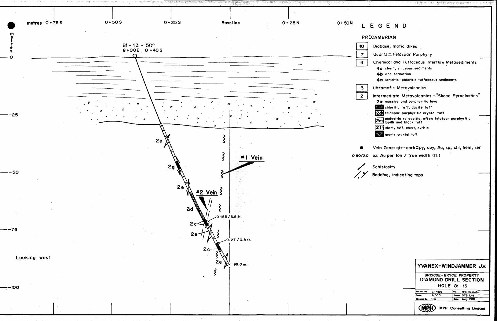
metres O*75S O* 50 S 0*258 Baseline 0+25N O-i-SON
me tr e s
—25
-5O
—75
81 - 13 - 5O0 8 + OOE , 0+40S
J3
Looking west99.0m.
— IOO
LEGEND
PRECAMBRIAN
Diabase, mafic dikes
Quartz ± Feldspar Porphyry
Chemical and Tuffaceous Interflow Metasediments 4a: chert, siliceous sediments 4b* i ron formation 4C: sericitic-chloritic tuffaceous sediments
Ultramafic Metavolcanics
Intermediate Metavolcanics -"Skead Pyroclastics'2.Q- massive and porphyritic lava
(chloritic tuff, dacite tuff
[feldspar porphyritic crystal tufflandesitic to dacitic, often feldspar porphyritic l lapilli and block tuffj Cherty tuff, Chert, pyritic
quo--*? crystal tuff
m Vein Zone; qtz-carb±py, cpy, Au, sp, chl, hem, ser
O.8O/2.0 oz. Au per ton / true width (ft.)
Schistosity
S S Bedding, indicating tops
YVANEX-WINDJAMMER J.V.
BRISCOE-BRYCE PROPERTYDIAMOND DRILL SECTION
HOLE 81-13C- 4091:500
Drawn* ib 1 m
W.E.BrtretonGCS LtdAug. 1981
M PH Consulting Limited
APPENDIX D
PHOTOMICROGRAPHS
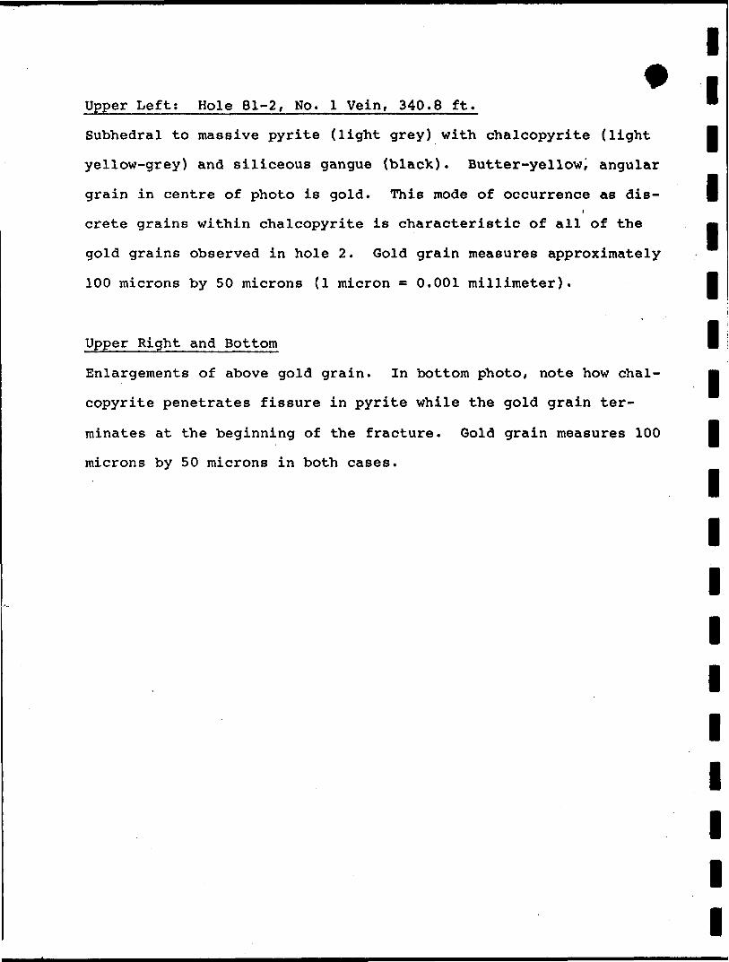
lUpper Left; Hole 81-2, No. l Vein, 340.8 ft. '
Subhedral to massive pyrite (light grey) with chalcopyrite (light l
yellow-grey) and siliceous gangue (black). Butter-yellow, angular
grain in centre of photo is gold. This mode of occurrence as dis- |
crete grains within chalcopyrite is characteristic of all of the mm
gold grains observed in hole 2. Gold grain measures approximately
100 microns by 50 microns (l micron ** 0 .001 millimeter). l
l
l
Upper Right and Bottom
Enlargements of above gold grain. In bottom photoi note how chal
copyrite penetrates fissure in pyrite while the gold grain ter
minates at the beginning of the fracture. Gold grain measures 100 l
microns by 50 microns in both cases.
l
l
l
l
l
l
l
l
l
"X
. mmm-
, illl
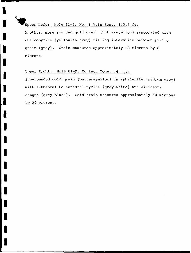
ll ^^Upper^J..eft1: Hole 81-2, No. l Vein Zone, 340.8 ft^
H Another, more rounded gold grain (butter-yellow) associated with
~ chalcopyrite (yellowish-grey) filling interstice between pyrite
B grain (grey). Grain measures approximately 18 microns by 8
microns.
lm Upper Right; Hole 81-9, Contact Zone, 148 ft.
Sub-rounded gold grain (butter-yellow) in sphalerite (medium grey)
l with subhedral to anhedral pyrite (grey-white) and siliceous
gangue (grey-black). Gold grain measures approximately 30 microns
J| by 20 microns.
l
l
l
l
l
l
l
l
l
l
l

Cam
pbel
l Fa
ult
Fela
spar
Por
phyr
y
quar
tz c
ryst
al a
sh t
uff,
carb
oniti
zed,
chl
oriti
tized
l
poss
ible
X ve
in of
fset
?
NO. 2
VEI
N Z
ON
EBR
ISCO
E-BR
YCE
NO. l
VEIN
ZO
NE
['[Co
ntac
t Zo
ne-5
5" 2
95 F
T—
9
5792
15
l \
l [5
7921
8^,.
•^ J
^578263,
-\
iaBR
YCE
TWP
2ft
qua
rtz-s
ulph
ide
in zo
ne
Au
Cont
act
Zone
Cath
erin
e G
roup
Bas
alt
Con.
IV
LE
GE
ND
VLF
-EM
D
ER
IVA
TIV
E
MA
P
Instr
urt
enf:
G
EO
NlC
S
EM
- 16
Sta
tion
:
SE
AT
TLE
W
AS
HIN
GT
ON
, F
RE
QU
EN
CY
le
-6
KH
z
366
FT
.0.1
0 to
0.1
8 oz
. ^
r\A
uXto
n.
I070
Cu\
\ (
^^
^ '
in na
rrow
q.
v.
Skea
d G
roup
Pyr
ocla
stic
s
410
VL
F-E
M
FIR
ST
D
ER
IVA
TIV
E
(Frc
r.
Inph
ase
Val
ues)
-10
CO
NTO
UR
IN
TE
RV
AL
(IO
QXo)
10C
ON
DU
CTO
R
AX
IS
WIT
H
DE
PT
H
(met
res)
TO
WN
SH
IP
BO
UN
DA
RY
CO
NC
ES
SIO
N
BO
UN
DA
RY
.—
LOT
LI
NE
__
. C
LA
IM
LIN
E
LA
KE
CR
EE
K
(Arr
ow
Indi
cate
s F
low
)
\AA
/ FA
ULT
AN
OM
ALO
US
IN
DU
CE
D
PO
LAR
IZA
TIO
N
ZON
E
UJ
^^P
- R
EP
OR
TE
D
QU
AR
TZ
-SU
LP
HID
E ±
GO
LD
OC
CU
RR
EN
CE
GE
OLO
GIC
AL
CO
NTA
CT
0.15
to
0.30
oz.
in
6 in
ch q
.v.81
-8
314
FT
DIA
MO
ND
D
RIL
L H
OLE
, 19
81;
com
plet
ed,
prop
osed
YVAN
EX -
WIN
DJAM
MER
J.V
BR
ISC
OE
- B
RY
CE
P
RO
PE
RT
Y
VLF-
EM
FIRS
T DE
RIVA
TIVE
AND
EX
PLOR
ATIO
N CO
MPILA
TION
Not
e U
pdat
ed
Nov.
81
Jan.
82
By
D. J
ON
ES
/W.B
RE
RE
TO
NPr
ojec
t No
: C
40
9
Date
: JA
NU
AR
Y, 1
981
MPH
C
onsu
lting
Lim
ited
O M
eP
8/-
41P89NE0046
63.3987
BRYCE

MA
P A
RE
AC
LAIM
A
RE
A
5792
I6|2
5696
i 25
^94
1256
.9,3
;.
25
i95
|feg
^ 5792
I5\"
J57
42'8
1578
265
J578
E66
I \
TRENCH # 6
CLAIM MAP
TRENCH
Bed
rock
no
t ex
pose
d
072
oz
Au, 0
.30
oz
Ag,
I56
o7c,
Cu
O 0
02
oz
Au
0.0
02
oz
A
uB
edro
ck
not
-exp
osed
N0.
2 SH
AFT
0.0
802
Au-—
—^.
^^
0.0
4/O
7m
——
04/O
.Sm
Nil
Au
TO 0
05/0
.45 m
0.6
3 o
z A
u. 0
.36
oz
Ag
Bed
rock
no
t ex
pose
d
0.2
6 o
z A
u,O
.I2oz
Ag,0
.52
0XoC
u
O 0
05
oz
Au
0.0
2 o
z A
u.0
.52
% C
uB
edro
ck
not
exp
ose
d
Sca
le
—
l- 10
02
3 4
5 6"
89
'0
Qua
rtz
vein
ing
Qua
rtz
bre
ccia
, m
inor
su
lphi
des
Mas
sive
py
rite
band
Bas
ic
volc
an
ics
Fol
iatio
n
Sel
ecte
d gr
ab
sam
ple
(oz
Au
,t o
z A
g,i
0XoC
u)
Chi
p sa
mpl
e (o
z. A
u/m
)
DETAILED SAMPLING
NO.
2 SHAFT
ZONE
OU
TC
RO
P
AR
EA
INT
ER
ME
DIA
TE
^
ME
TA
VO
LC
AN
ICS
L-
E
GM
P-7
B40
", 1
69'
TR
EN
CH
4
TR
EN
CH
(
5M
T
RE
NC
H7o
z A
uX2.
6m l
C
f
^^
v
QM
P-9
\l
45",
I2
6\
\ \T
RE
NC
H
TR
EN
CH
\ \
2 l
BA
SE
LIN
E
O
MP
-7A
550,
abon
.311
MP
-6
450,
156
MP
-450
0, 21
0'
450,
166
5910
0N
-345
", 2
O2.
6'6
7-6
59",
37
2(n
o in
form
atio
n av
aila
ble
)
N-4
450,
205
N-6
40",
218
'
75
-740",
198
.5'
N
D
Quart
z -
pyrite
ve
in
zone
(s
urf
ace)
Surf
ace
p
roje
ctio
n
of
shea
r i
vein
zo
neba
sed
on
prev
ious
dr
illin
g(I
5)~
dep
th
to su
rface
of
vert
ica
l pro
ject
ion
Pre
viou
s D
iam
ond
Dril
l H
ole
M N
oran
do
Min
es
Ltd
M
P M
iner
al
Pro
ject
s L
td.
75
Rip
V
on
Win
kel
Syn
dica
te76
T
riho
pe
M
inin
g
Au
valu
e (o
z pe
r to
n /s
am
ple
w
idth
in
m
etre
s re
po
rte
d
by
prev
ious
o
pe
rato
rs)
Sam
plin
g R
esul
t -
1980
VL
F-E
M
con
du
cto
r ax
es
Ano
mal
ous
Induce
d
Po
larizC
tion
Z
one
Mag
netic
co
ntou
r
Infe
rred 'fa
ult
or
shea
r zo
ne
Pro
pose
d D
iam
ond
Drill
Hol
e -
1981
"A"
/\
Sur
face
or
esho
ot
indi
cate
d by
pr
evio
us
sam
plin
g
tIC
ON
SON
/^
Bed
rock
no
t ex
pose
d
0.2
6 o
z A
u,0.
12oz
Ag
,0.5
20X
oCu
O 0
05
oz
Au
0.0
2 o
z A
u.0
.52%
Cu
Bed
rock
no
t ex
pose
d
Scale
—
h
100
l 23
45
6 7
a 9
' C
Qua
rtz
vem
mg
Qua
rtz
bre
ccia
, m
inor
su
lphi
des
Mas
sive
pyr
ite
band
Bas
ic
volc
an
ics
Folia
tion
Sele
cted
grab
sa
mpl
e (o
z A
u,i o
z A
g,i*y
0 C
u)
Chi
p sa
mpl
e (o
z, A
u/m
)
DETAILED SAMPLING
NO.
2 SHAFT
ZONE
OU
TC
RO
P
AR
EA
INT
ER
ME
DIA
TE
^ M
ET
AV
OL
CA
NIC
S
MP
-345
s, 1
96M
P-7
B40
", 1
69'
75-4
-45
", 1
43'
N-5
35
0,
219
TR
EN
CH
4
TR
EN
CH
f
TR
EN
CH
II
7oi
Au
/Zfim
.V
6M
P-8
40
0,
M7
NO
. l
SH
AF
T
BA
SE
LIN
E
'O7
5-5
-48
",9
6.8
MP
-7A
550,
abo
n.Jl
'M
P-6
45",
156
MP
-450
", 2
10'
N-2
450,
209
IMP
-245
", 16
6 59
10
0N
-345
0, 20
2.6
67
-65
9",
37
2(n
o in
form
atio
n ava
ilable
)
N-4
45",
205
75
-740
". 1
98.5
'
L-
0.8
0.27
oi
Au/?
6m
l l l
S94
00-
\
81-1
200S
N
Qua
rtz -
py
rite
vein
zo
ne
(sur
face
)
Sur
face
pr
ojec
tion
of
shea
r 7
vein
zo
neba
sed
on
prev
ious
dr
illin
g(1
5)-
de
pth
to
surf
ace
of v
ertic
al
proj
ectio
n
Pre
viou
s D
iam
ond
Drill
Hol
e N
Nor
ando
M
ines
L
td.
MP
Min
eral
P
roje
cts
Ltd
.75
R
ip
von
Win
kel
Syn
dica
te7
6
Trihope
Min
ing
Au
valu
e (o
z pe
r to
n /s
am
ple
w
idth
in
m
etre
s re
port
ed
by
prev
ious
o
pe
rato
rs)
Sam
plin
g R
esul
t -
1980
VLF
-EM
co
nduct
or
axes
Ano
mal
ous
Ind
uce
d
Pola
rizcfion
Zon
e
Mag
netic
co
ntou
r
Infe
rred
"fa
ult
or s
hear
zon
e
Pro
pose
d D
iam
ond
Drill
Hol
e -
1981
11
.11
l \
Surf
ace
ore
shoot
ind
ica
ted
by
pr
evio
us
sam
plin
g
Y V
AN
EX
-WIN
D JA
MM
ER
J.V.
BR
ISC
OE
-BR
YC
E
PR
OS
PE
CT
NO. l
VE
IN Z
ON
E-
DE
TA
IL
COMP
ILATI
ON63
-318
7P
roje
ct
No
C-4
.09
Scal
e:
l - 5
00
Dra
win
g N
o 3c
By N
O W
illou
ghby
/W. B
rere
lon
; Dr
awn
Cart
o-gr
aphi
cs
: Da
te
Janu
ary,
198
1
Con
sulti
ng L
imite
d
Related Documents