ANALYSIS OF HIGH RISK RURAL ROADS THROUGH GIS BASED CRASH MAPPING 2014 Mid-Continent Transportation Research Symposium Madison, WI - Thursday, August 21, 2014 1 Justin Shell Wisconsin Department of Transportation Steven T. Parker, Ph.D. University of Wisconsin- Madison TOPS Lab Session 1-C Traffic & Safety: Rural Safety Concerns

Welcome message from author
This document is posted to help you gain knowledge. Please leave a comment to let me know what you think about it! Share it to your friends and learn new things together.
Transcript

ANALYSIS OF HIGH RISK RURAL ROADS THROUGH GIS BASED
CRASH MAPPING
2014 Mid-Continent Transportation Research Symposium
Madison, WI - Thursday, August 21, 2014
1
Justin Shell Wisconsin Department of
Transportation
Steven T. Parker, Ph.D. University of Wisconsin-
Madison TOPS Lab
Session 1-C Traffic & Safety: Rural Safety Concerns

Outline
� WISCONSIN HRRR PROGRAM ◦ HISTORY AND OBJECTIVES
� HRRR STATEWIDE LIST IMPLEMENTATION ◦ METHODOLOGY AND RESULTS
� IMPLEMENTATION STATUS AND FUTURE
CONSIDERATIONS
2

Wisconsin HRRR Program
� High Risk Rural Roads (HRRR) � Established in SAFETEA-LU as a
mandatory set-aside in the Highway Safety Improvement Program (HSIP)
� Funding limited to locations with: ◦ Functional classifications of rural major collector,
rural minor collector, or rural local road ◦ Fatal or severe injury crash rate above statewide
average for functional classification � WisDOT focused on the local system
3

Wisconsin HRRR Program
� Applications followed traditional HSIP process ◦ Application submitted by local ◦ Project-specific safety evaluation ◦ 10% local funding match
� Two questions emerged: ◦ The “Reactive” vs. “Proactive” question ◦ The “Hotspot” vs. “Corridor” question
4

Wisconsin HRRR Program
� Three Pilot projects: ◦ County-level corridor analysis by: � Functional classification � Run-off-the-road type crashes ◦ Focused on low-cost safety countermeasures � e.g. –clear zone tree removal, chevron installation, rumble strips, beamguard end treatment upgrades
� County ranking based on crash rate ◦ Urban vs. Rural
� Statewide corridor analysis
5

� SCOPE AND OBJECTIVES ◦ STATEWIDE LIST OF TOP 10 HRRR CORRIDORS ◦ FOCUS ON: � RURAL MAJOR AND MINOR COLLECTORS � RUN-OFF-THE-ROAD CRASHES � FIVE YEARS OF CRASH DATA ◦ RANKING BASED ON CRASH RATES ◦ LEVERAGE NEW LRS CRASH MAP
6
HRRR Statewide List

� SOURCE DATA ◦ WISCONSIN LOCAL ROADS INFORMATION SYSTEM (WISLR) LRS � ROADWAY NETWORK � FUNCTIONAL CLASSIFICATIONS ◦ WISDOT MV4000 CRASH DATA ◦ WISDOT AADT TRAFFIC COUNT DATA
7
HRRR Statewide List
8
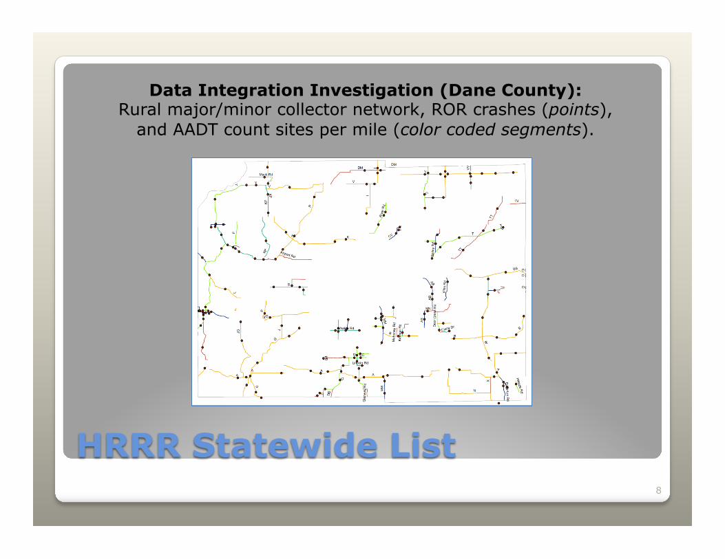
HRRR Statewide List
Data Integration Investigation (Dane County): Rural major/minor collector network, ROR crashes (points),
and AADT count sites per mile (color coded segments).

� “FILTERED KA CRASH RATE” RANKING ◦ BASIC FILTERS � SEGMENT LENGTH, CRASH COUNTS ◦ ABOVE AVERAGE CRASH DENSITY ◦ ABOVE AVERAGE CRASH RATES ◦ MINIMUM K+A CRASH COUNTS ◦ SORT BY K+A CRASH RATES
9
HRRR Statewide List

10
HRRR Statewide List

11
HRRR Statewide List
Statewide HRRR Map (left) and Pierce County
Highway O (below)

12
HRRR Statewide List
Columbia County Highway V
Data Validation

� SUMMARY AND CHALLENGES ◦ HOW TO SEGMENT � CHANGES IN FUNCTIONAL CLASS � CHANGES IN TRAFFIC VOLUME ◦ NO CRASH REPORT FIELD FOR ROR ◦ DATA QUALITY / AVAILABILITY FOR CRASH RATES ◦ STABILITY OF RANKING METHODOLOGY ◦ AUTOMATION
13
HRRR Statewide List

� STATEWIDE LIST SUPPORTS AGGREGATE COMPARATIVE ANALYSIS OF HRRR CRASH FACTORS
14
HRRR Research Opportunities
Example: Horizontal Road Terrain at Point of Impact

15
HRRR Project Implementation
2014
� Initially met skepticism, but this is understandable since historically these datasets were not available
� 7 of 10 corridors applied for funding � WisDOT has simplified and streamlined
the application process, giving locals access to additional safety funds

16
Future: Map 21 Considerations
� MAP-21 eliminated the mandatory set-aside for HRRR.
� But, requires additional funding (200% of FY09 set-aside) should crash rates increase over the most recent two-year period
� Why WisDOT will continue to manage a HRRR program ◦ Supports our local transportation system ◦ No studies under SAFETEA-LU HRRR

Wisconsin HRRR Program
Steven T. Parker UW-Madison TOPS Lab [email protected]
17
Justin Shell Wisconsin DOT
Questions?
Darren Schoer Wisconsin DOT HSIP Coordinator
Related Documents