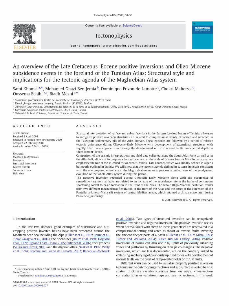
An overview of the Late Cretaceous–Eocene positive inversions and Oligo-Miocene subsidence events in the foreland of the Tunisian Atlas: Structural style and implications for the tectonic agenda of the Maghrebian Atlas system Sami Khomsi a, ⁎, Mohamed Ghazi Ben Jemia b , Dominique Frizon de Lamotte c , Chokri Maherssi d , Oussema Echihi a,e , Riadh Mezni a,e a Laboratoire géoressources, Centre des recherches et technologie des eaux. (CERTE). Tunis b Kuwait foreign petroleum company, Tunisia Limited (KUFPEC), Tunisia c Université Cergy Pontoise, Département des Sciences de la Terre et de l'Environnement (CNRS, UMR 7072), Neuville/Oise, 95 031 Cergy-Pontoise Cedex, France d Entreprise tunisienne d'activités pétrolières (ETAP), Tunis, Tunisia e Université de Tunis El Manar, Faculté des Sciences de Tunis, Tunisia abstract article info Article history: Received 3 April 2008 Received in revised form 19 February 2009 Accepted 22 February 2009 Available online 5 March 2009 Keywords: Maghreb geodynamics Paleogene Structural inversions Eastern Tunisia Subsurface data Field data Structural interpretation of surface and subsurface data in the Eastern foreland basins of Tunisia, allows us to recognize positive inversion structures, i.e. related to compressional events, expressed and recorded in the Paleogene sedimentary pile of the Atlas domain. These episodes are followed by a period of relative tectonic quiescence during Oligocene–Early Miocene with development of extensional structures with slightly tilted panels, grabens and locally the development of listric normal faults branched at depth on “décollement” levels. Comparison of the seismic interpretations and field data collected along the South Atlas Front as well as in the Atlas belt, allows us to propose a tectonic scenario at the scale of Eastern Tunisia Atlas. In particular, we emphasise the role of the so-called “Atlas event” (Middle–Late Eocene), which was initially defined in Algeria but poorly outlined in Tunisia. We will show that the tectonic agenda defined in Eastern Tunisia is consistent with the one proposed elsewhere in the Maghreb allowing us to propose a unified view of the geodynamic evolution of the whole Atlas system during this period. The negative inversion recorded during Oligocene–Early Miocene along with the occurrence of synsedimentary normal faults are related to an increase of the subsidence rate in the frame of continuous shortening coeval to basin formation in the front of the Atlas. The whole Oligo-Miocene evolution results from two different mechanisms: flexuration in the front of the Atlas and the onset of the extension of the Pantelleria–Linosa–Malta rift system of central Mediterranean, which attained a climax stage later during Pliocene–Quaternary. © 2009 Elsevier B.V. All rights reserved. 1. Introduction In the last two decades, good examples of subsurface and out- cropping positive inverted basins have been presented around the Mediterranean Sea including the Alps (Gillcrist et al., 1987; Roure et al., 1994; Ravaglia et al., 2006), the Apennines (Roure et al., 1991; Doglioni et al., 1999; Bigi and Costa-Pisani, 2005; Butler et al., 2006), the Pyrenees (Saura and Teixell, 2006) and the Algerian Atlas (Naak et al., 1992; Vially et al., 1994; Bracène and Frizon de Lamotte, 2002; Benaouali-Mebarek et al., 2006). Two types of structural inversion can be recognized: positive inversion and negative inversion. The positive inversion occurs when normal faults with steep or listric geometries are reactivated in a compressional setting and acted as thrust or reverse faults inverting the ancient deeper parts of a basin (Gillcrist et al., 1987; Mitra, 1993; Turner and Williams, 2004; Butler and Mc Caffrey, 2004). Positive inversions of basins can also occur by uplift of previously subsiding zones and platforms by thrusting on their paleo-margins. The negative inversions, which are less documented, are on the contrary linked to collapsing and burying of previously uplifted zones with development of normal faults on the crest of ramp-related folds or thrust faults. Different ways can be used to visualise properly positive inversion tectonics in the outcropping structures and subsurface inverted basins: spatial thickness variations versus time on maps, cross-section correlations, facies variation maps and seismic sections. In this work Tectonophysics 475 (2009) 38–58 ⁎ Corresponding author. 57 rue 7301 par avenue, Tahar Ben Ammar Menzah 9 B, 1013, Tunis, Tunisia. E-mail address: [email protected] (S. Khomsi). 0040-1951/$ – see front matter © 2009 Elsevier B.V. All rights reserved. doi:10.1016/j.tecto.2009.02.027 Contents lists available at ScienceDirect Tectonophysics journal homepage: www.elsevier.com/locate/tecto

Welcome message from author
This document is posted to help you gain knowledge. Please leave a comment to let me know what you think about it! Share it to your friends and learn new things together.
Transcript
Tectonophysics 475 (2009) 38–58
Contents lists available at ScienceDirect
Tectonophysics
j ourna l homepage: www.e lsev ie r.com/ locate / tecto
An overview of the Late Cretaceous–Eocene positive inversions and Oligo-Miocenesubsidence events in the foreland of the Tunisian Atlas: Structural style andimplications for the tectonic agenda of the Maghrebian Atlas system
Sami Khomsi a,⁎, Mohamed Ghazi Ben Jemia b, Dominique Frizon de Lamotte c, Chokri Maherssi d,Oussema Echihi a,e, Riadh Mezni a,e
a Laboratoire géoressources, Centre des recherches et technologie des eaux. (CERTE). Tunisb Kuwait foreign petroleum company, Tunisia Limited (KUFPEC), Tunisiac Université Cergy Pontoise, Département des Sciences de la Terre et de l'Environnement (CNRS, UMR 7072), Neuville/Oise, 95 031 Cergy-Pontoise Cedex, Franced Entreprise tunisienne d'activités pétrolières (ETAP), Tunis, Tunisiae Université de Tunis El Manar, Faculté des Sciences de Tunis, Tunisia
⁎ Corresponding author. 57 rue 7301 par avenue, TahaTunis, Tunisia.
E-mail address: [email protected] (S. Khomsi
0040-1951/$ – see front matter © 2009 Elsevier B.V. Aldoi:10.1016/j.tecto.2009.02.027
a b s t r a c t
a r t i c l e i n f oArticle history:Received 3 April 2008Received in revised form 19 February 2009Accepted 22 February 2009Available online 5 March 2009
Keywords:Maghreb geodynamicsPaleogeneStructural inversionsEastern TunisiaSubsurface dataField data
Structural interpretation of surface and subsurface data in the Eastern foreland basins of Tunisia, allows usto recognize positive inversion structures, i.e. related to compressional events, expressed and recorded inthe Paleogene sedimentary pile of the Atlas domain. These episodes are followed by a period of relativetectonic quiescence during Oligocene–Early Miocene with development of extensional structures withslightly tilted panels, grabens and locally the development of listric normal faults branched at depth on“décollement” levels.Comparison of the seismic interpretations and field data collected along the South Atlas Front as well as inthe Atlas belt, allows us to propose a tectonic scenario at the scale of Eastern Tunisia Atlas. In particular, weemphasise the role of the so-called “Atlas event” (Middle–Late Eocene), which was initially defined in Algeriabut poorly outlined in Tunisia. We will show that the tectonic agenda defined in Eastern Tunisia is consistentwith the one proposed elsewhere in the Maghreb allowing us to propose a unified view of the geodynamicevolution of the whole Atlas system during this period.The negative inversion recorded during Oligocene–Early Miocene along with the occurrence ofsynsedimentary normal faults are related to an increase of the subsidence rate in the frame of continuousshortening coeval to basin formation in the front of the Atlas. The whole Oligo-Miocene evolution resultsfrom two different mechanisms: flexuration in the front of the Atlas and the onset of the extension of thePantelleria–Linosa–Malta rift system of central Mediterranean, which attained a climax stage later duringPliocene–Quaternary.
© 2009 Elsevier B.V. All rights reserved.
1. Introduction
In the last two decades, good examples of subsurface and out-cropping positive inverted basins have been presented around theMediterranean Sea including the Alps (Gillcrist et al., 1987; Roure et al.,1994; Ravaglia et al., 2006), the Apennines (Roure et al., 1991; Doglioniet al.,1999; Bigi and Costa-Pisani, 2005; Butler et al., 2006), the Pyrenees(Saura and Teixell, 2006) and the Algerian Atlas (Naak et al.,1992; Viallyet al., 1994; Bracène and Frizon de Lamotte, 2002; Benaouali-Mebarek
r Ben AmmarMenzah 9 B,1013,
).
l rights reserved.
et al., 2006). Two types of structural inversion can be recognized:positive inversion and negative inversion. The positive inversion occurswhen normal faults with steep or listric geometries are reactivated in acompressional setting and acted as thrust or reverse faults invertingthe ancient deeper parts of a basin (Gillcrist et al., 1987; Mitra, 1993;Turner and Williams, 2004; Butler and Mc Caffrey, 2004). Positiveinversions of basins can also occur by uplift of previously subsidingzones and platforms by thrusting on their paleo-margins. The negativeinversions, which are less documented, are on the contrary linked tocollapsing andburyingof previously uplifted zoneswithdevelopmentofnormal faults on the crest of ramp-related folds or thrust faults.
Different ways can be used to visualise properly positive inversiontectonics in the outcropping structures and subsurface invertedbasins:spatial thickness variations versus time on maps, cross-sectioncorrelations, facies variation maps and seismic sections. In this work
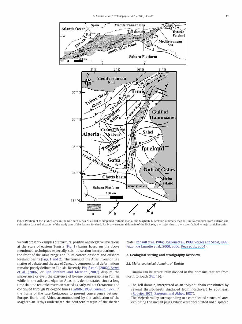
Fig. 1. Position of the studied area in the Northern Africa Atlas belt a: simplified tectonic map of the Maghreb, b: tectonic summary map of Tunisia compiled from outcrop andsubsurface data and situation of the study area of the Eastern foreland. For b: a — structural domain of the N–S axis, b — major thrust, c — major fault, d — major anticline axis.
39S. Khomsi et al. / Tectonophysics 475 (2009) 38–58
wewill present examples of structural positive andnegative inversionsat the scale of eastern Tunisia (Fig. 1) basins based on the abovementioned techniques especially seismic section interpretations, inthe front of the Atlas range and in its eastern onshore and offshoreforeland basins (Figs. 1 and 2). The timing of the Atlas inversion is amatter of debate and the age of Cenozoic compressional deformationsremains poorly defined in Tunisia. Recently, Piqué et al. (2002), Baggaet al. (2006) or Ben Ibrahim and Mercier (2007) dispute theimportance or even the existence of Eocene compressions in Tunisiawhile, in the adjacent Algerian Atlas, it is demonstrated since a longtime that the tectonic inversion started as early as Late Cretaceous andcontinued through Paleogene times (Laffitte, 1939; Guiraud, 1975) inthe frame of the Late Cretaceous to present convergence betweenEurope, Iberia and Africa, accommodated by the subduction of theMaghrebian Tethys underneath the southern margin of the Iberian
plate (Réhault et al.,1984; Doglioni et al.,1999; Vergés and Sabat,1999;Frizon de Lamotte et al., 2000, 2006; Roca et al., 2004).
2. Geological setting and stratigraphy overview
2.1. Major geological domains of Tunisia
Tunisia can be structurally divided in five domains that are fromnorth to south (Fig. 1b):
- The Tell domain, interpreted as an “Alpine” chain constituted byseveral thrust-sheets displaced from northwest to southeast(Rouvier, 1977; Zargouni and Abbès, 1987).
- The Mejerda valley corresponding to a complicated structural areaexhibiting Triassic salt plugs,whichweredecapitated anddisplaced
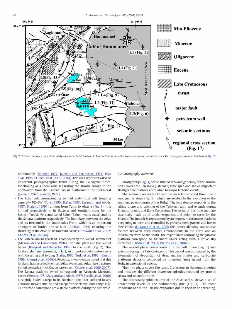
Fig. 2. Tectonic summary map of the study area in the Sahel foreland in Eastern Tunisia compiled from outcrop and subsurface data. For the regional cross section look at Fig. 17.
40 S. Khomsi et al. / Tectonophysics 475 (2009) 38–58
horizontally (Rouvier, 1977; Jauzein and Perthuisot, 1981; Rigoet al., 1996; El Euchi et al., 2002, 2004). This area represents also animportant paleogeographic trend during the Paleogene times,functioning as a shoal zone separating the Tunisia trough to thenorth-west from the Eastern Tunisia platforms to the south-east(Jauzein, 1967; Rouvier, 1977).
- The Atlas belt corresponding to fold and-thrust belt trendinggenerally NE–SW (Turki, 1985; Haller, 1983; Zargouni and Abbès,1987; Hlaiem, 1999) running from Tunis to Algeria (Fig. 1). It islimited respectively in its Eastern and Southern sides by theEastern Tunisia Foreland called Sahel (Sahel means coast) and bythe Sahara platform respectively. The boundary between the Atlasand its foreland is the South Atlas Front, which is an importantemergent or buried thrust fault (Coiffait, 1974) ensuring thethrusting of the Atlas on its foreland basins (Ainsworth et al., 2002;Khomsi et al., 2004a).
- The Eastern Tunisia Foreland is composed by the Gulf of Hammamet(Messaoudi and Hammouda, 1994), the Sahel plain and the Gulf ofGabes (Blanpied and Bellaiche, 1983) to the south (Fig. 2). Thisforeland domain represents, in fact, an important deformation zonewith thrusting and folding (Haller, 1983; Turki et al., 1988; Hlaiem,1999; Khomsi et al., 2004b). Recently, it was demonstrated that thisforeland has recorded themain Atlas events and Atlas like structuresburied beneath a thick Quaternary cover (Khomsi et al., 2006, 2007).
- The Sahara platform, which corresponds to Paleozoic–Mezosoicbasins (Busson,1971;Zargouni andAbbès,1987;Burollet et al., 2000)is slightly folded except in its Northern part that suffered locallyCenozoic movements. So and except for the North Chott Range (Fig.1), this zone corresponds to a stable platform during the Mesozoic.
2.2. Stratigraphy overview
Stratigraphy (Fig. 3) of the studied area and generally of the TunisiaAtlas covers the Triassic–Quaternary time span and shows importantstratigraphic hiatuses correlative to major tectonic events.
The sedimentary cover of the Tunisian Atlas recorded three majorgeodynamic steps (Fig. 3), which are related to the evolution of thesouthern paleo-margin of the Tethys. The first step corresponds to therifting phase and opening of the Tethyan realm and extends duringTriassic, Jurassic and Early Cretaceous. The series of this time span areessentially made up of sands, evaporites and dolomite rocks for theTriassic. The Jurassic is represented by an important carbonate platformdeepening to north and controlled by grabens, hemigrabens and horsts(see Frizon de Lamotte et al., 2009-this issue) allowing transitionalfacieses between deep marine environments to the north and aninternal platform to the south. The major faults controlling the Jurassicplatform correspond to basement faults acting with a strike slipmovement (Bédir et al., 2001; Khomsi et al., 2004b).
The second phase corresponds to a post-rift phase (Fig. 3) andextends during the Late Cretaceous. This period was dominated by thealternation of deposition of deep marine shales and carbonateplatforms deposits controlled by inherited faults issued from theTethyan extensional events.
The third phase covers the Latest Cretaceous to Quaternary periodand includes the different inversion episodes recorded by growthstrata and unconformities.
The lithostratigraphic column of the Atlas series, shows a set ofdetachment levels in the sedimentary pile (Fig. 3). The mostimportant one is the Triassic evaporites due to their wide spreading,
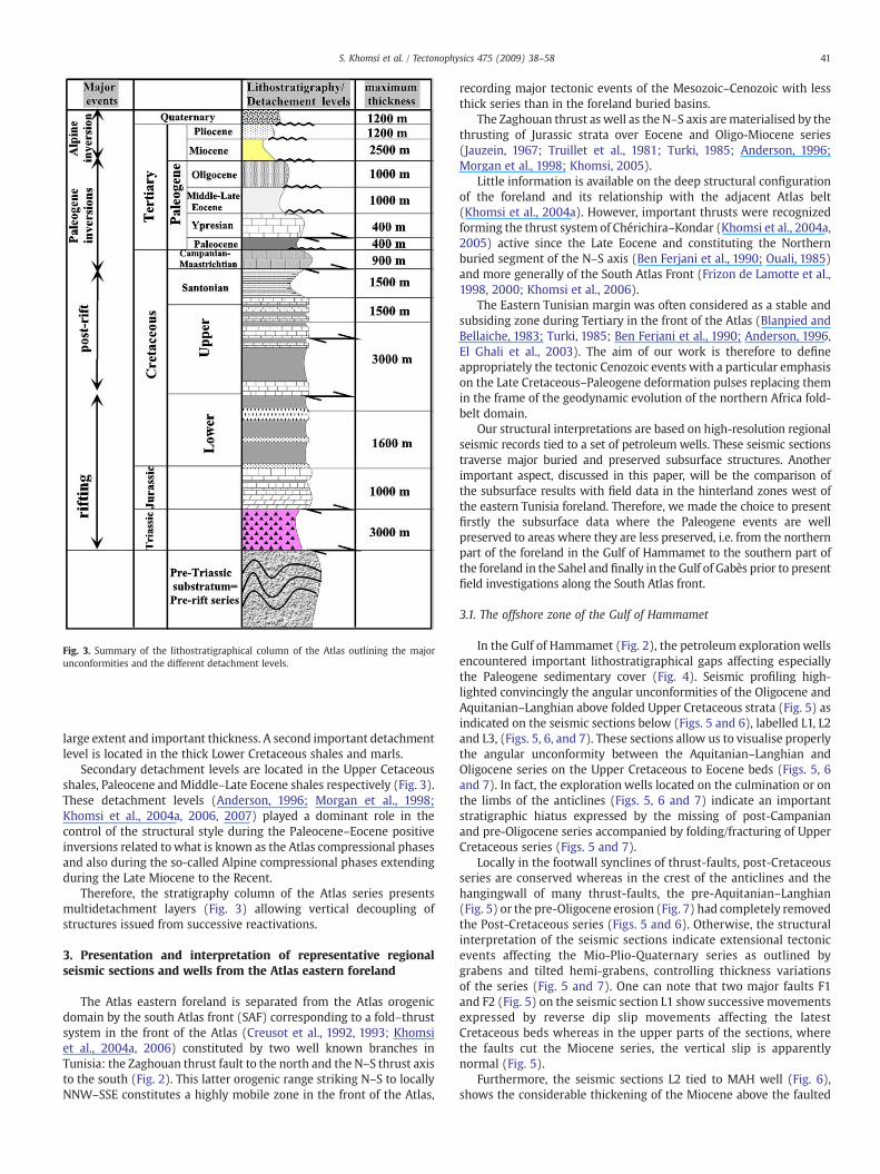
Fig. 3. Summary of the lithostratigraphical column of the Atlas outlining the majorunconformities and the different detachment levels.
41S. Khomsi et al. / Tectonophysics 475 (2009) 38–58
large extent and important thickness. A second important detachmentlevel is located in the thick Lower Cretaceous shales and marls.
Secondary detachment levels are located in the Upper Cetaceousshales, Paleocene and Middle–Late Eocene shales respectively (Fig. 3).These detachment levels (Anderson, 1996; Morgan et al., 1998;Khomsi et al., 2004a, 2006, 2007) played a dominant role in thecontrol of the structural style during the Paleocene–Eocene positiveinversions related towhat is known as the Atlas compressional phasesand also during the so-called Alpine compressional phases extendingduring the Late Miocene to the Recent.
Therefore, the stratigraphy column of the Atlas series presentsmultidetachment layers (Fig. 3) allowing vertical decoupling ofstructures issued from successive reactivations.
3. Presentation and interpretation of representative regionalseismic sections and wells from the Atlas eastern foreland
The Atlas eastern foreland is separated from the Atlas orogenicdomain by the south Atlas front (SAF) corresponding to a fold–thrustsystem in the front of the Atlas (Creusot et al., 1992, 1993; Khomsiet al., 2004a, 2006) constituted by two well known branches inTunisia: the Zaghouan thrust fault to the north and the N–S thrust axisto the south (Fig. 2). This latter orogenic range striking N–S to locallyNNW–SSE constitutes a highly mobile zone in the front of the Atlas,
recording major tectonic events of the Mesozoic–Cenozoic with lessthick series than in the foreland buried basins.
The Zaghouan thrust as well as the N–S axis arematerialised by thethrusting of Jurassic strata over Eocene and Oligo-Miocene series(Jauzein, 1967; Truillet et al., 1981; Turki, 1985; Anderson, 1996;Morgan et al., 1998; Khomsi, 2005).
Little information is available on the deep structural configurationof the foreland and its relationship with the adjacent Atlas belt(Khomsi et al., 2004a). However, important thrusts were recognizedforming the thrust system of Chérichira–Kondar (Khomsi et al., 2004a,2005) active since the Late Eocene and constituting the Northernburied segment of the N–S axis (Ben Ferjani et al., 1990; Ouali, 1985)and more generally of the South Atlas Front (Frizon de Lamotte et al.,1998, 2000; Khomsi et al., 2006).
The Eastern Tunisian margin was often considered as a stable andsubsiding zone during Tertiary in the front of the Atlas (Blanpied andBellaiche, 1983; Turki, 1985; Ben Ferjani et al., 1990; Anderson, 1996,El Ghali et al., 2003). The aim of our work is therefore to defineappropriately the tectonic Cenozoic events with a particular emphasison the Late Cretaceous–Paleogene deformation pulses replacing themin the frame of the geodynamic evolution of the northern Africa fold-belt domain.
Our structural interpretations are based on high-resolution regionalseismic records tied to a set of petroleum wells. These seismic sectionstraverse major buried and preserved subsurface structures. Anotherimportant aspect, discussed in this paper, will be the comparison ofthe subsurface results with field data in the hinterland zones west ofthe eastern Tunisia foreland. Therefore, we made the choice to presentfirstly the subsurface data where the Paleogene events are wellpreserved to areas where they are less preserved, i.e. from the northernpart of the foreland in the Gulf of Hammamet to the southern part ofthe foreland in the Sahel and finally in the Gulf of Gabès prior to presentfield investigations along the South Atlas front.
3.1. The offshore zone of the Gulf of Hammamet
In the Gulf of Hammamet (Fig. 2), the petroleum exploration wellsencountered important lithostratigraphical gaps affecting especiallythe Paleogene sedimentary cover (Fig. 4). Seismic profiling high-lighted convincingly the angular unconformities of the Oligocene andAquitanian–Langhian above folded Upper Cretaceous strata (Fig. 5) asindicated on the seismic sections below (Figs. 5 and 6), labelled L1, L2and L3, (Figs. 5, 6, and 7). These sections allow us to visualise properlythe angular unconformity between the Aquitanian–Langhian andOligocene series on the Upper Cretaceous to Eocene beds (Figs. 5, 6and 7). In fact, the exploration wells located on the culmination or onthe limbs of the anticlines (Figs. 5, 6 and 7) indicate an importantstratigraphic hiatus expressed by the missing of post-Campanianand pre-Oligocene series accompanied by folding/fracturing of UpperCretaceous series (Figs. 5 and 7).
Locally in the footwall synclines of thrust-faults, post-Cretaceousseries are conserved whereas in the crest of the anticlines and thehangingwall of many thrust-faults, the pre-Aquitanian–Langhian(Fig. 5) or the pre-Oligocene erosion (Fig. 7) had completely removedthe Post-Cretaceous series (Figs. 5 and 6). Otherwise, the structuralinterpretation of the seismic sections indicate extensional tectonicevents affecting the Mio-Plio-Quaternary series as outlined bygrabens and tilted hemi-grabens, controlling thickness variationsof the series (Fig. 5 and 7). One can note that two major faults F1and F2 (Fig. 5) on the seismic section L1 show successive movementsexpressed by reverse dip slip movements affecting the latestCretaceous beds whereas in the upper parts of the sections, wherethe faults cut the Miocene series, the vertical slip is apparentlynormal (Fig. 5).
Furthermore, the seismic sections L2 tied to MAH well (Fig. 6),shows the considerable thickening of the Miocene above the faulted

Fig. 4. Lithostratigraphic correlations of petroleumwells in the Gulf de Hammamet, showing themajor unconformities affecting the Paleogene cover. On the position mapwe indicatethe bathymetry of the sea floor.
42 S. Khomsi et al. / Tectonophysics 475 (2009) 38–58
and folded Upper Cretaceous series. The MAH well encountered2000 m of Miocene series indicating high amount of subsidenceduring this time span.
Laterally, around the MAH well, following the interpretations ofOuahchi et al. (1998), we note a thickening ofMiocene beds controlledby normal faults whereas the underlying Upper Cretaceous seriesconserve the same thickness along the seismic section (Fig. 6b). Thisleads to date with confidence the extensional tectonic structures asMiocene in age.
Seismic section L3 (Fig. 7) shows the existence of two maintectonic episodes; the most ancient one at an average two way traveltime of 2.0 s is represented by folded Upper Cretaceous strata withfold ramp anticlines. The second tectonic event interests the overlyingstrata and is expressed by tilted panels, hemi-grabens and grabenscovering Oligocene to Quaternary (Fig. 7). An important angularunconformity separates the two episodes. It is materialised by theerosion of Paleocene to Eocene strata on the culminations of theanticlines HA8 and HA9 (Fig. 7).
3.2. The Sahel zone
We analyse below regional seismic dip sections exhibiting themain inversion structures in the central part of the Sahel foreland.These lines are tied to a set of petroleum wells which allow us todefine many important Paleogene unconformities with importantpre-Oligocene-Miocene uplift and erosion (Fig. 8). We will continuethen, with seismic cross sections in the southern part prior topresenting seismic lines in the Kelbia–Enfidha zone in the north(Fig. 2).
3.2.1. Seismic lines L4 and L5 in the Kairouan–El Hdadja flexural basinThe seismic lines L4 (Fig. 9) and L5 (Fig. 10) are from the
easternmost part of the foreland onshore. They are important becausethey allowed us to visualize and define significant angular unconfor-
mities dating major tectonic events (Khomsi et al., 2006). In fact,angular unconformities (Fig. 9 and 10) affecting the Paleogenesedimentary cover, are clearly expressed on these lines.
The first important one corresponds to an angular–erosionalunconformity between the Ypresian limestones and the UpperCretaceous strata along the crest of the Alouan anticline. It is outlinedby the erosion of an important part of the Paleocene deep marineshales encountered in other petroleum wells in the zone. Thisunconformity outlines the occurrence of a Paleocene compressionalevent.
The second unconformity corresponds mainly to onlaps of Middle-Upper Eocene shales-limestones on the Ypresian and Campanianlimestones on the crest of the Alouan anticline (Fig. 9). It is worthnoting that the Middle–Late Eocene shales thin on the crestal part ofthis anticline whereas they thick laterally in the synclines footwallswhere they are apparently concordant on the underlying Ypresianseries. Petroleum wells drilled on the crest of the Alouan anticlineencountered hiatuses affecting the lower part of the Middle-UpperEocene. So it is obvious that the Middle-Upper Eocene seriescorrespond to syn-inversion strata in agreement with a positive upliftof the Alouan anticline.
Four petroleum wells were drilled close to the section L4 (Fig. 9).These are from south to north: A2, MS1, M1 and SS1 (Fig. 9). In theMS1 well, it is worth noting the thinning and pinch-out of theYpresian limestones on the crest of the structure of Alouan while itthicks in the synclines flanking the structure. The Oligocene serieswhich seal the underlying structures seem to be not folded but onlycut out by a set of normal faults (Fig. 9). This configuration leads toconsider the Oligocene as post-inversion series.
The gravity data summarized by the corrected Bouguer andresidual anomalies (Fig. 9) show enhanced gravity anomalies, whichallow us to reject the diapirism as a mechanism responsible for theanticlines shown on the seismic lines. However it still remainspossible to have high density evaporites (anhydrite).
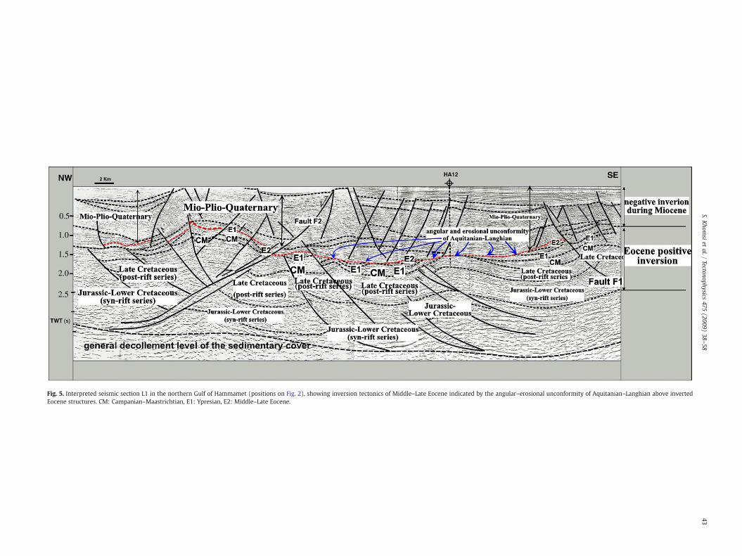
Fig. 5. Interpreted seismic section L1 in the northern Gulf of Hammamet (positions on Fig. 2), showing inversion tectonics of Middle–Late Eocene indicated by the angular–erosional unconformity of Aquitanian–Langhian above invertedEocene structures. CM: Campanian–Maastrichtian, E1: Ypresian, E2: Middle–Late Eocene.
43S.K
homsi
etal./
Tectonophysics475
(2009)38
–58
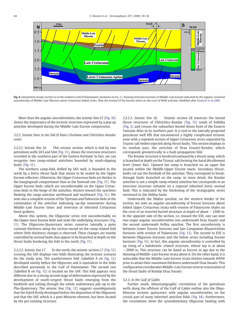
Fig. 6. Interpreted seismic section L2 in the southern Gulf of Hammamet (positions on Fig. 2), showing inversion tectonics of Middle–Late Eocene indicated by the angular–erosionalunconformity of Middle–Late Miocene above Cretaceous folded series. Note the erosion of the Eocene series on the crest of MAH anticline. Modified after Ouahchi et al.,1998.
44 S. Khomsi et al. / Tectonophysics 475 (2009) 38–58
More than the angular unconformities, the seismic line L5 (Fig. 10)shows the importance of the tectonic inversion expressed by a pop upanticline developed during the Middle–Late Eocene compression.
3.2.2. Seismic lines in the Sidi El Hani–Chorbane and Chérichira–Kondarzones
3.2.2.1. Seismic line L6. This seismic section, which is tied by twopetroleumwells SA3 and SA4 (Fig. 11), shows the inversion structuresrecorded in the southern part of the Eastern foreland. In fact, we canrecognise two ramp-related anticlines bounded by south-dippingfaults (Fig. 11).
The northern ramp-fold, drilled by SA3 well, is bounded to thenorth by a listric thrust fault that seems to be sealed by the UpperEocene reflectors. Otherwise, the Upper Cretaceous beds are thicker inthe hangingwall compartment than in the footwall one (Fig. 11). TheUpper Eocene beds, which are unconformable on the Upper Cretac-eous beds in the hinge of the anticline, thicken toward the synclinesflanking the ramp anticline northward and southward (Fig. 11). Wenote also a complete erosion of the Ypresian and Paleocene beds at theculmination of the anticline indicating up-dip movements duringMiddle–Late Eocene times and inversion of inherited Cretaceoushemi-grabens.
Above this system, the Oligocene series rest unconformably onthe Upper-most Eocene beds and seals the underlying structures (Fig.11). The Oligocene-Quaternary series conserve laterally a quiteconstant thickness along the section except on the ramp-related foldwhere little thickness changes is observed. These changes are mainlycontrolled by normal faults that appear to be branched at depth on thethrust faults bordering the fold to the north (Fig. 11).
3.2.2.2. Seismic line L7. To the north, the seismic section L7 (Fig. 12)crossing the SAF displays two folds illustrating the tectonic scenariofor the study area. The southernmost fold (labelled A on Fig. 12)developed mostly before the Oligocene and is equivalent to the foldsdescribed previously in the Gulf of Hammamet. The second one(labelled B on Fig. 12) is located on the SAF. This fold appears verydifferent due to a strong second stage of deformation expressed by thedevelopment of south-vergent thrust faults emerging from thebacklimb and cutting through the whole sedimentary pile up to thePlio-Quaternary. The seismic line (Fig. 12) suggests unambiguouslythat the fold B firstly developed before the deposition of the Oligoceneand that the SAF, which is a post-Miocene element, has been locatedby the pre-existing structure.
3.2.2.3. Seismic line L8. Seismic section L8 traverses the buriedthrust structures of Chérichira–Kondar (Fig. 13) south of Enfidha(Fig. 2) and crosses the subsurface buried thrust front of the EasternTunisian Atlas in its northern part. It is tied to the laterally projectedpetroleum well Kfb that encountered a highly complicated tectoniczone with a repeated section of Upper Cretaceous series separated byTriassic salt bodies injected along thrust faults. This section displays inits median part, the anticline of Draa Souatir-Kondar, whichcorresponds geometrically to a fault-propagation fold.
The Kondar structure is bordered eastward by a thrust ramp, whichis branched at depth on the Triassic salt forming the basal décollementlevel (lower flat). Upward the ramp is branched on an upper flatlocated within the Middle-Upper Eocene marls. Secondary thrust-faults cut out the forelimb of the anticline. They correspond to break-through faults branched on the ramp. In more detail, the Kondaranticline is not a simple ramp-related anticline but corresponds to aninversion structure initiated on a regional inherited listric normalfault. This is indicated by the thickening of the stratigraphic serieswestward in the Sbikha basin.
Underneath the Sbikha syncline, on the western border of thesection, we note an angular unconformity of Eocene horizons abovefolded Upper Cretaceous strata with erosion of Palaeocene shales onthe crest of an inverted buried structure at depth of about −2500 m.In the opposite side of the section, i.e. toward the ESE, one can notetwo major angular unconformities one underneath Draa Souatir andthe second underneath Kelbia syncline. The first unconformity isbetween Lower Eocene horizons and late Campanian-Maastrichtianhorizons with erosion of Palaeocene (Fig. 13). The second to ESE isbetween Oligocene horizons and the below series including Eocenehorizons (Fig. 13). In fact, this angular unconformity is controlled byup rising of a halokinetic related structure, whose top is at about−2000 m. This structure can be dated as Eocene in age due to thethinning of Middle–Late Eocene strata above it. On the other hand, it isnoticeable that the Middle–Late Eocene strata thicken towards WNWprior to attain theirmaximum thickness underneath Draa Souatir. Thisconfiguration corroboratesMiddle–Late Eocene reverse reactivation ofthe thrust faults of Kondar-Draa Souatir.
3.2.3. In the Gulf of GabèsFurther south, lithostratigraphic correlations of the petroleum
wells along the offshore of the Gulf of Gabès outline also the Oligo-Miocene tectonic quiescence with angular unconformities on thecrestal part of many inherited anticline folds (Fig. 14). Furthermore,the correlations show the synsedimentary Oligocene faulting with
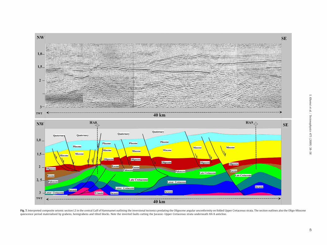
Fig. 7. Interpreted composite seismic section L3 in the central Gulf of Hammamet outlining the inversional tectonics predating the Oligocene angular unconformity on folded Upper Cretaceous strata. The section outlines also the Oligo-Miocenequiescence period materialised by grabens, hemigrabens and tilted blocks. Note the inverted faults cutting the Jurassic–Upper Cretaceous strata underneath HA 8 anticline.
45S.K
homsi
etal./
Tectonophysics475
(2009)38
–58
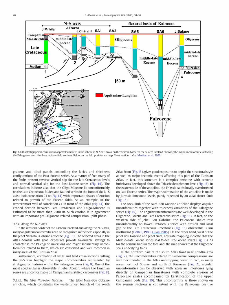
Fig. 8. Lithostratigraphical correlations of petroleumwells in the Sahel and N–S axis areas, on the western border of the eastern foreland, showing the major unconformities affectingthe Paleogene cover. Numbers indicate field sections. Below on the left: position on map. Cross section 1 after Martinez et al., 1990.
46 S. Khomsi et al. / Tectonophysics 475 (2009) 38–58
grabens and tilted panels controlling the facies and thicknessconfigurations of the Post-Eocene series. As a matter of fact, many ofthe faults present reverse vertical slip for the late Cretaceous levelsand normal vertical slip for the Post-Eocene series (Fig. 14). Thecorrelations indicate also that the Oligo-Miocene lie unconformablyon the Late Cretaceous folded and faulted series in the front of the N–Saxis (look correlation C1 on Fig. 14) with important phases of erosionrelated to growth of the Eocene folds. As an example, in thewesternmost well of correlation C1 in front of the Atlas (Fig. 14), theeroded section between Late Cretaceous and Oligo-Miocene isestimated to be more than 2500 m. Such erosion is in agreementwith an important pre-Oligocene related compression uplift phase.
3.2.4. Along the N–S axisIn thewestern border of the Eastern foreland and along theN–S axis,
many angular unconformities can be recognised in the field especially inthe Jebel Nara-Bou Gobrine anticline (Fig. 15). The selected areas in theAtlas domain with good exposures provide favourable settings tocharacterise the Paleogene inversions and major sedimentary uncon-formities related to them, which are conserved and well recorded inmany areas of the Tunisian Atlas.
Furthermore, correlation of wells and field cross-sections cuttingthe N–S axis highlight the major unconformities represented bystratigraphic hiatuses within the Paleogene cover (Fig. 8). One of themost spectacular is observable in Jebel Abeîdh, where the Langhianseries are unconformable on Campanian karstified carbonates (Fig. 8).
3.2.4.1. The Jebel Nara-Bou Gobrine. The Jebel Nara-Bou Gobrineanticline, which constitutes the westernmost branch of the South
Atlas Front (Fig.15), gives good exposures to depict the structural styleas well as major tectonic events affecting this part of the TunisianAtlas. In fact, this structure is a complex anticline with tectonicimbricates developed above the Triassic detachment level (Fig. 15). Inthe eastern side of the anticline, the Triassic salt is locally overthrustedon Late Eocene series. The major culmination of the anticline is madeby Jurassic limestone levels, partly repeated by an axial thrust fault(Fig. 15).
The back-limb of the Nara-Bou Gobrine anticline displays angularunconformities together with thickness variations of the Paleogeneseries (Fig. 15). The angular unconformities are well developed in theOligocene, Eocene and Late Cretaceous series (Fig. 15). In fact, on thewestern side of Jebel Bou Gobrine, the Paleocene shales restunconformably on lower Cretaceous series with erosion and localgap of the Late Cretaceous limestones (Fig. 15) observable 3 kmnorthward (Delteil, 1980; Ouali, 1985). On the other hand, west of theJebel Bou Gobrine and Jebel Nara, accurate mapping indicate that theMiddle–Late Eocene series seal folded Pre-Eocene strata (Fig. 15). Asfor the seismic lines in the foreland, the map shows that the Oligoceneseals underlying folds.
In the northern part of the south Atlas front near Enfidha area(Fig. 2), the unconformities related to Paleocene compressions arewell documented in the Atlas outcropping cover. In fact, in manyareas north of Sousse and north of Kairouan (Fig. 2), angularunconformities can be observed with Ypresian limestones lyingdirectly on Campanian limestones with complete erosion ofPaleocene shales accompanied by karstification of the upperCampanian beds (Fig. 16). This unconformity as those shown onthe seismic sections is consistent with the Paleocene positive

Fig. 9. Interpreted Seismic section L4 positioned on Fig. 2, inferred gravimetric curves parallel to section and lithostratigraphical correlations of petroleumwells cutting the section inthe Sahel. The gravimetric curves indicate that the halokinesis may not be the source of the anticlines recorded by the seismic section. These anticlines are shortening related. CM:Campanian–Maastrichtian, Pa: Paleocene, Yp: Ypresian.
47S. Khomsi et al. / Tectonophysics 475 (2009) 38–58
inversion responsible of important gaps (El Karoui-Yaakoub, 1999;Ben Ismail-Lattrache et al., 2000, 2001, El Ghali et al., 2003)interesting the Paleocene and the Eocene (El Ouardi, 1996; El Ouardiand Turki, 1995; El Karoui-Yaakoub, 1999; Saadi and Turki, 1995,Saadi, 1997). According to Fournie (1978), Ben Ismail-Lattrache andBobier (1996) and El Karoui-Yaakoub (1999) these gaps wereaccompanied by local emersions during the Paleocene–Eocene.
4. Discussion
4.1. Paleocene–Eocene positive inversion and Oligocene–Miocenequiescence event
In the Eastern foreland of the Tunisian Atlas (Pelagian domain)subsurface data show the existence of structural positive inversion

Fig.10. Interpreted Seismic section L5 positioned on Fig. 2, showing the Paleogene angular unconformities on the pop up anticline of Ganfouda, the seismic line shows the importanceof the tectonic inversion expressed by a pop up anticline coeval to the Middle–Late Eocene.CM: Campanian–Maastrichtian, Pa: Paleocene Yp: Ypresian.
48 S. Khomsi et al. / Tectonophysics 475 (2009) 38–58
leading to ramp-related folds developed over normal faults, likelyinherited from the Tethyan rifting, which lasted from Early Jurassic toMiddle Cretaceous (Turki, 1985; Bédir et al., 2001; Soussi and BenIsmail, 2000; Bouaziz et al., 2002). Growth strata indicate that positiveinversion began during the Late Cretaceous and acted continuouslythrough Paleocene and Eocene times (Frizon de Lamotte, 2005) with aparticular intensity during the Middle–Late Eocene (the so-called“Atlas event” of Laffitte, 1939).
A major unconformity separates the Oligocene and youngersedimentary rocks from the underlying strata. It is significant of acomplete change of the tectonic and sedimentary contexts. As amatter of fact, the sedimentary rocks turned from carbonate/shaly todetrital deposits (Van Houten, 1981; Hooberghs, 1995; Yaich et al.,2000; Khomsi et al., 2007) and the tectonic regime became dominatedby strong subsidence and normal faulting in the Atlas domain as wellas in the Tell displaced domain where the Numidian flysch presentsOligocene extensional synsedimentary deformation structures.
A second compressive event post-dating the Upper Miocene is wellexpressed along the SouthAtlas Front (Figs.14 and15). The effects of thissecond event remain weak in the eastern foreland of the Atlas systembut are ofmajor importance in theAtlas belt itself. A consequence is that,in many places in the Atlas, Paleogene growth strata have been more orless completely eroded along the back limbs of the anticlines (the onlylimb generally exposed in the field). This explains why this event hasnot been recognised by some workers (see discussion in Khomsi et al.,2007).
4.2. Regional cross section in the foreland domain
We summarize our interpretations with a structural cross-sectionthroughout the onshore foreland of Eastern Tunisia (Fig. 17). Thiscross-section striking NW–SE cuts the major outcropping and buriedstructures from the Zaghouan thrust system to Chorbane structure inthe south-east (Fig. 2) and deciphers the structural style and majorstructures of the region (Fig. 17). The structural style is dominated bythrusting in the north-western part in the Jebel Zaghouan thrust,
where Jurassic–Lower Cretaceous rocks overlie the Sibkha footwallsyncline (Fig. 17). More to the south, the Kondar anticline is thrustedover the Kelbia syncline. The thrust-fault is underlined by injectedTriassic salts (Fig. 17). The Kondar anticline is important because itclearly exhibits the superimposition of the two successive foldingevents. More to the south the Alouan and Sousse anticlines, sealed bythe Oligo-Miocene series, are typical of structures observed in theSahel and Gulf of Hammamet domains (Fig. 17). They illustrate whatwas likely the geometry of structures in the Atlas domain before thedevelopment of the late Miocene fold-belt. The mechanism respon-sible for the subsidence of the Oligo-Miocene basins and associatednormal faulting will be discussed below.
4.3. Paleogeography during Palaeogene times
The paleotectonic maps for the Lower Eocene to Miocene at thescale of whole Tunisia and surrounding areas (Fig. 18) specially inthe eastern foreland emphasises the general trends of the majoractive synsedimentary structures (Fig. 18). During Eocene times animportant part of Tunisia was emerged and corresponded to activethrust anticlines such as the Kasserine trend and Hairech shoal (Fig.18 a and b). Regarding their strikes, these structures are organisedin three sets: NE–SW, E–W and N–S. This latter is, in our opinion,due to the reorientation of the shortening direction along the N–Sinherited faults cutting the Pre-Triassic basement. The E–Wanticlines seem to be dominant in the foreland and Atlas domainswhereas the NE–SW folds dominate in the Tell domain in front ofthe Numidian flyschs. This configuration is mainly due to the NW–
SE trending Late Miocene shortening direction (Caire, 1971;Bouaziz et al., 2002; Chikhaoui, 2004), that activated NE–SW foldthrusts erasing the pre-Miocene trend that were acquired earlierduring Eocene times. So, we think that these E–W trendscorrespond to active Eocene folds admitting a shortening directionstriking N–S. This direction was reported by many studies based onmicrotectonic analysis in Eastern Tunisia (Letouzey and Trémo-lières, 1980; Bouaziz et al., 2002; Abbes, 2004; Khomsi, 2005) and
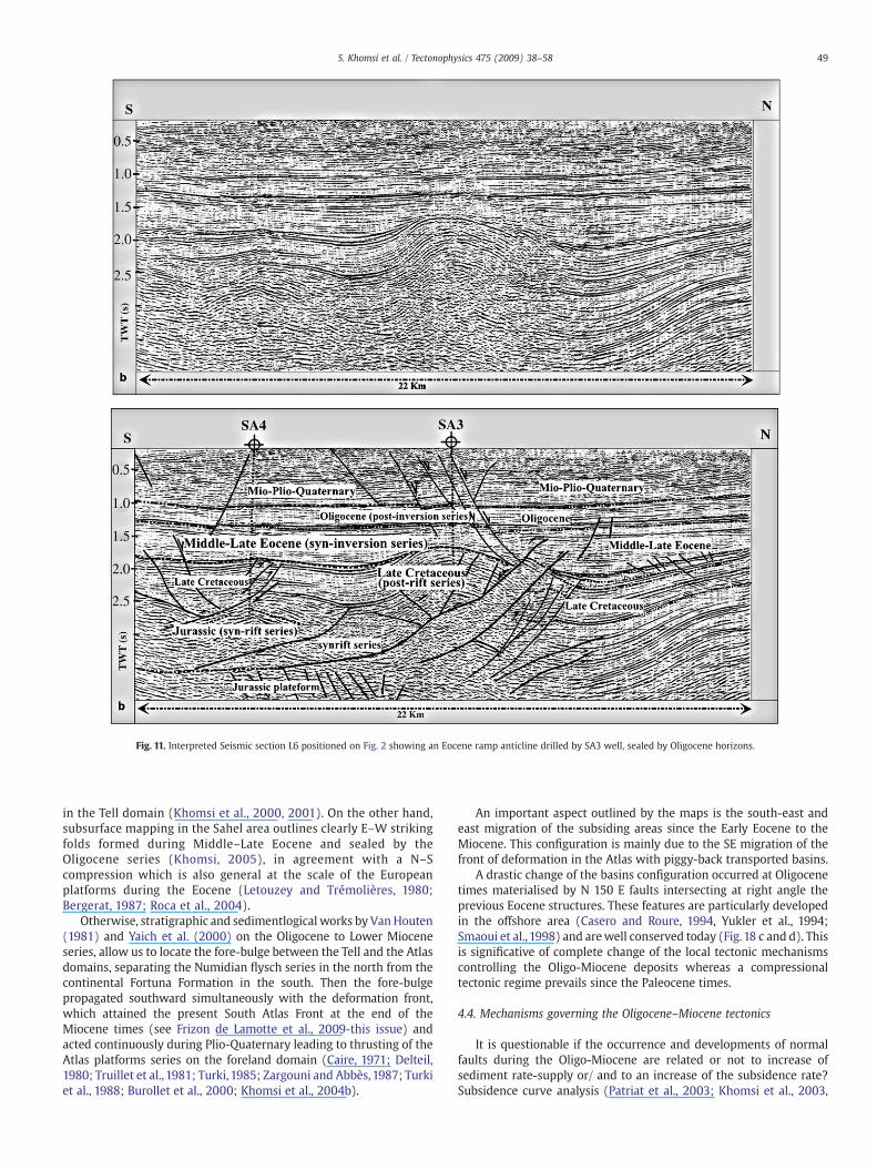
Fig. 11. Interpreted Seismic section L6 positioned on Fig. 2 showing an Eocene ramp anticline drilled by SA3 well, sealed by Oligocene horizons.
49S. Khomsi et al. / Tectonophysics 475 (2009) 38–58
in the Tell domain (Khomsi et al., 2000, 2001). On the other hand,subsurface mapping in the Sahel area outlines clearly E–W strikingfolds formed during Middle–Late Eocene and sealed by theOligocene series (Khomsi, 2005), in agreement with a N–Scompression which is also general at the scale of the Europeanplatforms during the Eocene (Letouzey and Trémolières, 1980;Bergerat, 1987; Roca et al., 2004).
Otherwise, stratigraphic and sedimentlogical works by VanHouten(1981) and Yaich et al. (2000) on the Oligocene to Lower Mioceneseries, allow us to locate the fore-bulge between the Tell and the Atlasdomains, separating the Numidian flysch series in the north from thecontinental Fortuna Formation in the south. Then the fore-bulgepropagated southward simultaneously with the deformation front,which attained the present South Atlas Front at the end of theMiocene times (see Frizon de Lamotte et al., 2009-this issue) andacted continuously during Plio-Quaternary leading to thrusting of theAtlas platforms series on the foreland domain (Caire, 1971; Delteil,1980; Truillet et al., 1981; Turki, 1985; Zargouni and Abbès,1987; Turkiet al., 1988; Burollet et al., 2000; Khomsi et al., 2004b).
An important aspect outlined by the maps is the south-east andeast migration of the subsiding areas since the Early Eocene to theMiocene. This configuration is mainly due to the SE migration of thefront of deformation in the Atlas with piggy-back transported basins.
A drastic change of the basins configuration occurred at Oligocenetimes materialised by N 150 E faults intersecting at right angle theprevious Eocene structures. These features are particularly developedin the offshore area (Casero and Roure, 1994, Yukler et al., 1994;Smaoui et al., 1998) and arewell conserved today (Fig.18 c and d). Thisis significative of complete change of the local tectonic mechanismscontrolling the Oligo-Miocene deposits whereas a compressionaltectonic regime prevails since the Paleocene times.
4.4. Mechanisms governing the Oligocene–Miocene tectonics
It is questionable if the occurrence and developments of normalfaults during the Oligo-Miocene are related or not to increase ofsediment rate-supply or/ and to an increase of the subsidence rate?Subsidence curve analysis (Patriat et al., 2003; Khomsi et al., 2003,
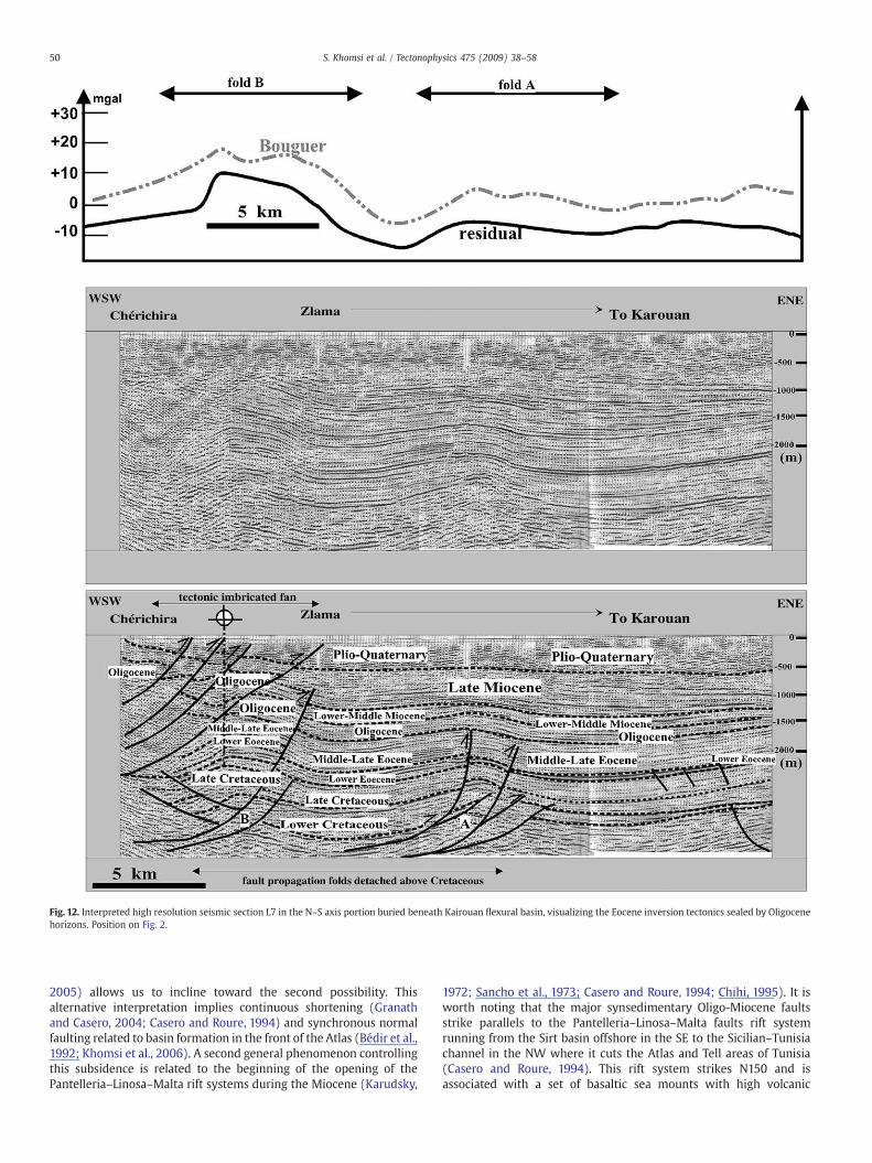
Fig. 12. Interpreted high resolution seismic section L7 in the N–S axis portion buried beneath Kairouan flexural basin, visualizing the Eocene inversion tectonics sealed by Oligocenehorizons. Position on Fig. 2.
50 S. Khomsi et al. / Tectonophysics 475 (2009) 38–58
2005) allows us to incline toward the second possibility. Thisalternative interpretation implies continuous shortening (Granathand Casero, 2004; Casero and Roure, 1994) and synchronous normalfaulting related to basin formation in the front of the Atlas (Bédir et al.,1992; Khomsi et al., 2006). A second general phenomenon controllingthis subsidence is related to the beginning of the opening of thePantelleria–Linosa–Malta rift systems during the Miocene (Karudsky,
1972; Sancho et al., 1973; Casero and Roure, 1994; Chihi, 1995). It isworth noting that the major synsedimentary Oligo-Miocene faultsstrike parallels to the Pantelleria–Linosa–Malta faults rift systemrunning from the Sirt basin offshore in the SE to the Sicilian–Tunisiachannel in the NW where it cuts the Atlas and Tell areas of Tunisia(Casero and Roure, 1994). This rift system strikes N150 and isassociated with a set of basaltic sea mounts with high volcanic
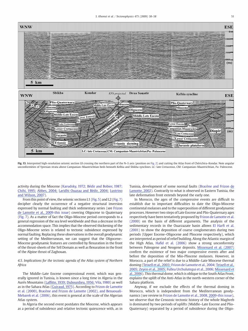
Fig. 13. Interpreted high-resolution seismic section L8 crossing the northern part of the N–S axis (position on Fig. 2) and cutting the Atlas front of Chérichira–Kondar. Note angularunconformities of Ypresian strata above Campanian–Maastrichtian beds beneath Kelbia and Sbikha synclines. LC: late Cretaceous, CM: Campanian–Maastrichtian, Pa: Paleocene.
51S. Khomsi et al. / Tectonophysics 475 (2009) 38–58
activity during the Miocene (Karudsky, 1972; Bédir and Bobier, 1987;Chihi, 1995; Abbes, 2004; Laridhi Ouazaa and Bédir, 2004; Lustrinoand Wilson, 2007).
From this point of view, the seismic sections L1 (Fig. 5) and L2 (Fig. 7)decipher clearly the occurrence of a negative structural inversionexpressed by normal faulting and thick sedimentary series (see Frizonde Lamotte et al., 2009-this issue) covering Oligocene to Quaternary(Fig. 7). As a matter of fact the Oligo-Miocene period corresponds to ageneral regression of the sea level worldwide and thus a decrease in theaccommodation space. This implies that the observed thickening of theOligo-Miocene series is related to tectonic subsidence expressed bynormal faulting. Replacing these observations in the overall geodynamicsetting of the Mediterranean, we can suggest that the Oligocene–Miocene geodynamic features are controlled by flexuration in the frontof the thrust-sheets of the Tell Domain aswell as flexuration in the frontof the Alpine thrust of Zaghouan.
4.5. Implications for the tectonic agenda of the Atlas system of NorthernAfrica
The Middle–Late Eocene compressional event, which was gen-erally ignored in Tunisia, is known since a long time in Algeria in theAurès Mountains (Laffitte, 1939; Dubourdieu, 1956; Vila, 1980) as wellas in the Sahara Atlas (Guiraud, 1975). According to Frizon de Lamotteet al. (2000), Bracène and Frizon de Lamotte (2002), and Benaouali-Mebarek et al. (2006), this event is general at the scale of the AlgerianAtlas system.
In Algeria the second event postdates the Miocene, which appearsas a period of subsidence and relative tectonic quiescence with, as in
Tunisia, development of some normal faults (Bracène and Frizon deLamotte, 2002). Contrarily to what is observed in Eastern Tunisia, thelate deformation front extends beyond the early one.
In Morocco, the ages of the compressive events are difficult toestablish due to important difficulties to date the Oligo-Miocenecontinentalmolasses and to the superposition of different geodynamicprocesses. However two steps of Late Eocene and Plio-Quaternary agesrespectively have been tentatively proposed by Frizon de Lamotte et al.(2000) on the basis of different arguments. The analysis of thesedimentary records in the Ouarzazate basin allows El Harfi et al.(2001) to show the deposition of coarse conglomerates during twoperiods (Upper Eocene–Oligocene and Pliocene respectively), whichare interpreted as period of relief building. Along the Atlanticmargin ofthe High Atlas, Hafid et al. (2006) show a strong unconformitybetween Paleogene and Neogene deposits. Missenard et al. (2007)confirm the existence of two major compressive events after andbefore the deposition of the Mio-Pliocene molasses. However, inMorocco, a part of the relief is due to a Middle–Late Miocene thermaldoming (Teixell et al., 2003; Frizonde Lamotte et al., 2004; Teixell et al.,2005; Zeyen et al., 2005; Fullea Urchulutegui et al., 2006; Missenard etal., 2006). This thermal dome,which is oblique to the SouthAtlas Front,explains the uplift of the Anti-Atlas in the north-western corner of theSahara platform.
Anyway, if we exclude the effects of the thermal doming inMorocco, which is independent from the Mediterranean geody-namics (see review in Frizon de Lamotte et al., 2008, 2009-this issue),we observe that the Cenozoic tectonic history of the whole Maghrebis dominated by two periods of uplifts (Middle–Late Eocene and Plio-Quaternary) separated by a period of subsidence during the Oligo-
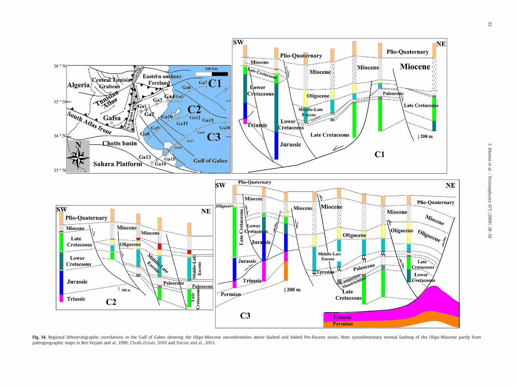
Fig. 14. Regional lithostratigraphic correlations in the Gulf of Gabes showing the Oligo-Miocene unconformities above faulted and folded Pre-Eocene series. Note synsedimentary normal faulting of the Oligo-Miocene partly frompaleogeographic maps in Ben Ferjani and al., 1990; Chulli-Zenati, 2000 and Patriat and al., 2003.
52S.K
homsi
etal./
Tectonophysics475
(2009)38
–58
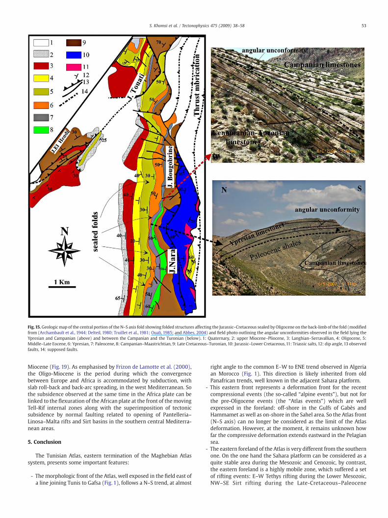
Fig.15.Geologic map of the central portion of the N–S axis fold showing folded structures affecting the Jurassic–Cretaceous sealed by Oligocene on the back-limb of the fold (modifiedfrom (Archambault et al., 1944; Delteil, 1980; Truillet et al., 1981; Ouali, 1985; and Abbes, 2004) and field photo outlining the angular unconformities observed in the field lying theYpresian and Campanian (above) and between the Campanian and the Turonian (below). 1: Quaternary, 2: upper Miocene–Pliocene, 3: Langhian–Serravallian, 4: Oligocene, 5:Middle–Late Eocene, 6: Ypresian, 7: Paleocene, 8: Campanian–Maastrichtian, 9: Late Cretaceous–Turonian, 10: Jurassic–Lower Cretaceous, 11: Triassic salts, 12: dip angle, 13 observedfaults, 14: supposed faults.
53S. Khomsi et al. / Tectonophysics 475 (2009) 38–58
Miocene (Fig. 19). As emphasised by Frizon de Lamotte et al. (2000),the Oligo-Miocene is the period during which the convergencebetween Europe and Africa is accommodated by subduction, withslab roll-back and back-arc spreading, in the west Mediterranean. Sothe subsidence observed at the same time in the Africa plate can belinked to the flexuration of the African plate at the front of themovingTell-Rif internal zones along with the superimposition of tectonicsubsidence by normal faulting related to opening of Pantelleria–Linosa–Malta rifts and Sirt basins in the southern central Mediterra-nean areas.
5. Conclusion
The Tunisian Atlas, eastern termination of the Maghebian Atlassystem, presents some important features:
- The morphologic front of the Atlas, well exposed in the field east ofa line joining Tunis to Gafsa (Fig. 1), follows a N–S trend, at almost
right angle to the common E–W to ENE trend observed in Algeriaan Morocco (Fig. 1). This direction is likely inherited from oldPanafrican trends, well known in the adjacent Sahara platform.
- This eastern front represents a deformation front for the recentcompressional events (the so-called “alpine events”), but not forthe pre-Oligocene events (the “Atlas events”) which are wellexpressed in the foreland: off-shore in the Gulfs of Gabès andHammamet as well as on-shore in the Sahel area. So the Atlas front(N–S axis) can no longer be considered as the limit of the Atlasdeformation. However, at the moment, it remains unknown howfar the compressive deformation extends eastward in the Pelagiansea.
- The eastern foreland of the Atlas is very different from the southernone. On the one hand the Sahara platform can be considered as aquite stable area during the Mesozoic and Cenozoic, by contrast,the eastern foreland is a highly mobile zone, which suffered a setof rifting events: E–W Tethys rifting during the Lower Mesozoic,NW–SE Sirt rifting during the Late-Cretaceous–Paleocene
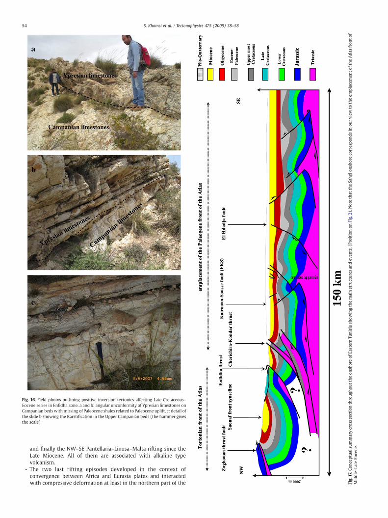
Fig. 16. Field photos outlining positive inversion tectonics affecting Late Cretaceous–Eocene series in Enfidha zone. a and b: angular unconformity of Ypresian limestones onCampanian beds with missing of Paleocene shales related to Paleocene uplift, c: detail ofthe slide b showing the Karstification in the Upper Campanian beds (the hammer givesthe scale).
Fig.17.C
onceptua
lsum
marycrosssectionthroug
hout
theon
shoreof
EasternTu
nisiash
owingthemainstructures
andev
ents.(Po
sition
onFig.
2).N
otethat
theSa
helo
nsho
reco
rrespo
ndsin
ourview
totheem
placem
ento
fthe
Atlas
fron
tof
Middle–
Late
Eocene
.
54 S. Khomsi et al. / Tectonophysics 475 (2009) 38–58
and finally the NW–SE Pantellaria–Linosa–Malta rifting since theLate Miocene. All of them are associated with alkaline typevolcanism.
- The two last rifting episodes developed in the context ofconvergence between Africa and Eurasia plates and interactedwith compressive deformation at least in the northern part of the
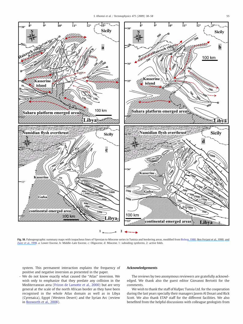
Fig. 18. Paleogeographic summary maps with isopachous lines of Ypresian to Miocene series in Tunisia and bordering areas, modified from Bishop, 1988; Ben Ferjani et al., 1990; andZaier et al., 1998. a: Lower Eocene, b: Middle–Late Eocene, c: Oligocene, d: Miocene. 1: subsiding synforms, 2: active folds.
55S. Khomsi et al. / Tectonophysics 475 (2009) 38–58
system. This permanent interaction explains the frequency ofpositive and negative inversion as presented in the paper.
- We do not know exactly what caused the “Atlas” inversion. Wewish only to emphasize that they predate any collision in theMediterranean area (Frizon de Lamotte et al., 2000) but are verygeneral at the scale of the north African border as they have beenrecognised in the whole Atlas domain as well as in Libya(Cyrenaica), Egypt (Western Desert) and the Syrian Arc (reviewin Bosworth et al., 2008).
Acknowledgements
The reviews by two anonymous reviewers are gratefully acknowl-edged. We thank also the guest editor Giovanni Bertotti for thecomments.
Wewish to thank the staff of Kufpec Tunsia Ltd. for the cooperationduring the last years specially their managers JasemAl Dosari and RickScott. We also thank ETAP staff for the different facilities. We alsobenefited from the helpful discussions with colleague geologists from
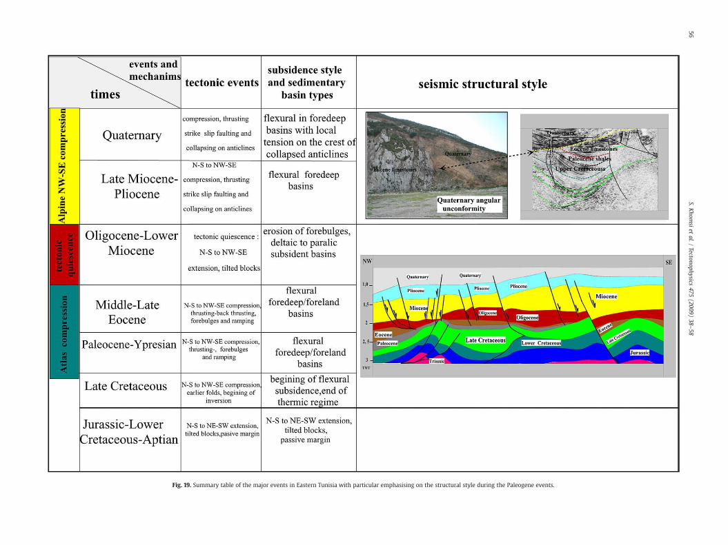
Fig. 19. Summary table of the major events in Eastern Tunisia with particular emphasising on the structural style during the Paleogene events.
56S.K
homsi
etal./
Tectonophysics475
(2009)38
–58
57S. Khomsi et al. / Tectonophysics 475 (2009) 38–58
the national company ETAP in the laboratory or in the fields, they aregratefully acknowledged.
References
Abbes, C., 2004. Structuration et évolutions tectono-sédimentaires mésozoïques etcénozoïques associées aux accidents reghmatiques à la jonction des margestéthysienne et nord-africaine (Chaîne nord-sud, Tunisie centrale). Thèse ès.Sciences., Université de Tunis, 437 pp.
Anderson, J.E., 1996. The Neogene structural evolution of the western margin of thePelagian Platform. Central Tunisia. Journal of structural geology 18, 819–833.
Ainsworth, C., Ben Jemia, M.G., Broadley, M., Cleverly, R., 2002. Integrated Satellite Studyof the North Kairouan Permit, Tunisia. Proceedings of the Eighth TunisianPetroleum and Production Conference. Etap Memoir n° 19, pp. 7–14.
Archambault, J.G., Castany, C., Gottis, H., Schoeller, 1944. Carte géologique de la Tunisie,n° 78, feuille de Hajeb El Aîoun. Service géologique de la Tunisie.
Bagga, M.A., Abdeljauoed, S., Mercier, E., 2006. La zone des nappes de Tunisie: unemarge méso-cénozoïque en blocs basculés modérément inversée (régionde Tabarka-Jendouba; Tunisie nord-occidentale). Bull. Soc. Géol. Fr, t. 177, n° 3,pp. 145–154.
Bédir, M., Bobier, C., 1987. Les grabens de Mahdia et Sidi Chérif (Tunisieorientale).Dynamique des fossés oligo-miocènes induits au toit d'anticlinauxcrétacés -éocènes par les jeux, au Néogène, de décrochement est-ouest et nord-sud. Bull.Soc. Géol. France 1143–1151 T III, n° 6.
Bédir, M., Zargouni, F., Tlig, S., Bobier, C., 1992. Subsurface geodynamics and petroleumgeology of a transform margin basin. The Sahel of Mahdia and El Jem (EasternTunisia): AAPG, v. 7, n°9, pp. 1417–1442.
Bédir, M., Boukadi, N., Tlig, S., Ben Timzal, F., Zitouni, L., Alouani, R., Slimane, F., Bobier, C.,Zargouni, F., 2001. Subsurface Mesozoic basins in the central Atlas of Tunisa:tectonics, sequence deposit distribution and hydrocarbon potential. AAPG BULL. 85,885–907 n°5.
Bergerat, F., 1987. Stress fields in the European Platform at the time of Africa–Eurasiacollision. Tectonics, 6, 2, 99–132.
Benaouali-Mebarek, N., Frizon de Lamotte, D., Roca, E., Barcène, R., Faure, R., Sassi, J.L.W.,Roure, F., 2006. Post-Cretaceous kinematics of the Atlas and Tell systems in centralAlgeria: Early foreland folding and subduction-related deformation. CR Geoscience,thematic issue: some recent developments on the geodynamics of the Maghreb,vol. 338, pp. 41–49.
Ben Ferjani, A., Burollet, P.F., Mejri, F., 1990. Petroleum geology of Tunisia. ETAP Memoireds, 194 pp.
Ben Ismail-Lattrache, K., 2000. Précision sur le passage Lutétien-Bartonien dans lesdépôts éocènes moyens en Tunisie centrale et Nord orientale. Rev. Micro pal.Vol. 43, n° 1–2, pp. 3–16.
Ben Ismail-Lattrache, K., Bobier, C., 1996. Etude biostratigraphique, paléoé-cologique etpaléo-biogéographique des séries éocènes (Yprésien-Lutétien basal) de Tunisiecentrale. géologie de l'Afrique et de l'Atlantique Nord. Elf Aquitaine Editions, Pau,France, pp. 563–575.
Ben Ismail-Lattrache, K., Bédir, M., Ayed, R., et Khomsi, S., 2001. Biostratigraphie,stratigraphie sismo-séquentielle et évènements tectoniques des dépôts paléocènes-éocènes entre zones de plateformes et de bassins en Tunisie orientale (région duSahel). Deuxième journées de Géologie du Sahel, ONM-INRST, pp. 52–55.
Ben Ibrahim, N., Mercier, E., , 2007. Comment on the paper: Mise en évidence ensubsurface d'événements compressifs Eocène moyen-supérieur en Tunisie orien-tale (Sahel): Généralité de la phase atlasique en Afrique du Nord. CR Géoscience,338, (2006), n° 1–2, pp. 41–49. C. R. Geoscience 339, pp. 171–172.
Bigi, S., Costa-Pisani, P., 2005. From a Peri-tethyan carbonate platform to a fold andthrust belt: an example from the central Apennines (Italy). Journal of structuralgeology 27, 523–539.
Bishop, W.P., 1988. Petroleum geology of East central Tunisia. A. A. P. G. Bull. 72,1033–1058.
Bracène, R., Frizon de Lamotte, D., 2002. The origin of intraplate deformation in the Atlassystem of western and central Algeria: from Jurassic rifting to Cenozoic–Quaternaryinversion. Tectonophysics 357, 207–226.
Blanpied, C., Bellaiche, G., 1983. The Jeffara trough (Pelagian sea); structural evolutionand tectonic significance. Marine Geol. 51, 1–10.
Bosworth,W., El-Haat, A.S., Helgeson, D.E., Burke, K., 2008. Cyrenaican “shock-absorber”and associated inversion strain shadow in the collision zone of northeast Africa.Geology 36, 695–698.
Bouaziz, S., Barrier, E., Soussi, M., Turki, M.M., Zouari, H., 2002. Tectonic evolution of thenorthern African margin in Tunisia from paleostress data and sedimentary record.Tectonophysics 357, 227–253.
Busson, G., 1971. Le Mésozoïque Saharien, Essai de synthèse des données de sondagesalgéro-tunisiens. CNRS Eds, centre de recherche sur les zones arides,10; 1–2, 810 pp.
Butler, R., Mc Caffrey, W.H., 2004. Nature of thrust zones in deep water sand-shalesequences: outcrop examples from the Champsuar sandstones of SE France.J. Struct. Geol. 21, 911–921.
Butler, R.W.H., Grasso, M., Tavarnelli, E., 2006. Structural inheritance in mountain belts:an Alpine–Apennine perspective. J. Struct. Geol. 28, 1893–1908.
Burollet, P.F., Mejri, F., Ben Kilani, H., 2000. What about the deep structures of Tunisia.Proceedings of the seventh Tunisian Petroleum and Production Conference. ETAPMemoir n° 16, pp. 167–178.
Caire, A., 1971. Chaînes alpines de la Méditerranée centrale (Algérie et Tunisieseptentrionales, Sicile, Calabre et Apennin méridional). Unesco Eds, tectonique del'Afrique (Sciences de la Terre), pp. 61–89.
Casero, P., Roure, F., 1994. Neogene deformations at the Sicilian–north African Plateboundary. In: Roure, François (Ed.), Peri-Tethyan platforms. Editions Technip, Paris,pp. 27–50.
Chihi, L.,1995. Les fossés néogènes à quaternaires de la Tunisie et de la mer pélagienne:étude structurale et signification dans le cadre géodynamique de la Méditerranéecentrale. Thèse es Sciences, Uni Tunis II, FST, 324 pp.
Chikhaoui, M., 2004. Contrôle tectonique de la sédimentation néogène dans la zone desDiapirs de Tunisie septentrionale. C. R. Geoscience 336, 1131–1136.
Chulli-Zenati, 2000. Structuration, hydrodynamisme et géothermie des niveauxréservoirs profonds de la tunisie orietale. Relation avec les accumulationsd'hydrocarbures. . Thèse de doctorat, FST, 225 pp.
Coiffait, P.F., 1974. Etude géologique de l'Atlas Tunisien à l'Ouest du Kairouanais.(Tunisie centrale). Thèse 3 Cycle, Paris VI. 131 pp.
Creusot, G., Mercier, E., Ouali, J., Turki, M.M., 1992. Héritage distensif synsédimentaire etstructuration chevauchante: apports de la modélisation du chevauchement alpinde Zaghouan (Atlas tunisien). C. R. Acad. Sci. Paris 314, 961–965 Ser. II.
Creusot, G., Mercier, E., Ouali, J., Tricart, P., 1993. La tectogenèse atlasique en Tunisiecentrale: Apport de la modélisation géométrique. Eclogae Geol. Helvetica 86/2,609–627.
Delteil, J., 1980. Le massif du Jebel Sidi Khalif: un exemple d'évolution structuralecomplexe en Tunisie centrale. Notes du service géologique, Travaux de géologietunisienne n° 14, pp. 11–26.
Doglioni, C., Fernandez, M., Gueguen, E., Sàbat, F., 1999. On the interference between theearly Apennines–Maghrebides back arc extension and the Alps-Betics orogen in theNeogene geodynamics of the western Mediterranean. Bol. Soc. Geo. Ital. 118, 75–89.
Dubourdieu, G., 1956. Etude géologique de la région de l'Ouenza (confins algéro-tunisiens). Service de la carte géologique de l'Algérie, n° 10. 660 pp.
El Euchi, H., Saidi, M., Fourati, L., Ghenima, R., Friha, J., Hammouda, F., Messaoudi, F.,2002. Northern Tunisia thrust belt: deformation models and hydrocarbon systems.Etap Memoir n° 19, pp. 143–189.
El Euchi, H., Saidi, M., Fourati, Marhessi, C., 2004. Northern Tunisia thrust belt:deformation models and hydrocarbon systems. In: Swennen, R., Roure, F., Granath,J.W. (Eds.), Deformation, fluid flow and reservoir appraisal in foreland fold-and-thrust belts: AAPG Hedberg Series, n°1, pp. 371–380.
El Ghali, A., Bobier, C., Zargouni, F., Krima, A., 2003. Les manifestations tectoniquessynsédimentaires associées à la compression éocène en Tunisie: implicationspaléogéographiques et structurales sur la marge Nord-Africaine. C. R. Geoscience335, 763–771.
El Harfi, A., Lang, J., Salomon, J., Chellai, E.H., 2001. Cenozoic sedimentary dynamics ofthe Ouarzazate foreland basin (Central High AtlasMountains, Morocco). Int. J. EarthSci. 90, 393–411. doi:10.1007/s005310000115.
El Karoui-Yaakoub, N., 1999. Le Paléocène en Tunisie septentrionale et centro-orientale:systématique, biostratigraphie des foraminifères et environnement de dépôts.Thèse de Doctorat. Uni de Tunis, FST, 356 p, 11 planches.
El Ouardi, H., 1996. L'halocinèse et rôle des décrochements dans l'évolutiongéodynamique de la partie médiane de la zone des dômes (Tunisie septentrionale).Thèse de Doctorat, Uni. Tunis II, 242 pp.
El Ouardi, H., Turki, M.M., 1995. Tectonique salifère polyphasée dans la région de MejezEl Bab-Testour (Zone des dômes, Tunisie septentrionale): contrôle de lasédimentation méso-cénozoïque. Geol. Médite., T XXII, n° 2, pp. 73–84.
Fournie, D., 1978. Nomenclature, lithostratigraphique des séries du Crétacé supérieur auTertiaire de Tunisie. Bull. Cent. Rech. Expl. Prod. Elf- Aquitaine 2 (1), 97–148 18 fig.
Frizon de Lamotte, D., 2005. About the Cenozoic inversion of the Atlas domain in NorthAfrica. C. R., Geosciences 337, 475–476.
Frizon de Lamotte, D., Mercier, E., Outtani, F., Addoum, B., Ghandriche, H., Ouali, J.,Bouaziz Andrieux, J., 1998. Structural inheritance and kinematics of foldingand thrusting along the front of the Eastern Atlas mountains (Algeria and Tunisia).In: S. Crasquin-Soleau & E. barrier (eds), Péri-Tethys memoir 3 (1998). Mém. Mus.natn. Hist, 177: 237–252.
Frizon de Lamotte, D., Saint Bézard, B., Barcène, R., 2000. The two main steps of the Atlasbuilding and geodynamics of the western Mediterranean. Tectonics 19, 740–761 n° 4.
Frizon de Lamotte, D., Crespo-Blanc, A., Saint-Bezar, B., Comas, M., Fernandez, M., Zeyen,H., Ayarza, P., Robert-Charrue, C., Chalouan, A., Zizi, M., Teixell, A., Arboleya, M.L.,Alvarez-Lobato, F., Julivert, M., Michard, A., 2004. TRASNSMED-transect I [Betics,Alboran Sea, Rif, Moroccan Meseta, High Atlas, Jbel Saghro, Tindouf basin]. In:Cavazza, W., Roure, F., Spakman, W., Stampfli, G.M., Ziegler, P.A. (Eds.), (2004) TheTRANSMED Atlas — The Mediterranean region from Crust to Mantle. Springer,Berlin, Heildelberg.
Frizon de Lamotte, D., Michard, A., Saddiqi, O., 2006. Some recent developments on thegeodynamics of the Maghreb. C. R. Géoscience 338, 1–10 n°1–2.
Frizon de Lamotte, D., Zizi, M., Missenard, Y., Hafid, M., El Azzouzi, M., Charriere, A.,Maury, R.C., Taki, Z., Benammi, M., Michard, A., 2008. The Atlas system. In: Michard,A., Saddiqi, O., Chalouan, A., Frizon de Lamotte, D. (Eds.), Continental Evolution: TheGeology of Morocco. Springer-Verlag, Berlin, Heidelberg, pp. 133–202.
Frizon de Lamotte, D., Leturmy, P., Missenard, Y., Khomsi, S., Ruiz, G., Saddiqi, O., Guillocheau,F., Michard, A., 2009. Mesozoic and Cenozoic vertical movements in the Atlassystem (Algeria, Morocco, Tunisia): an overview. Tectonophysics 475, 9–28 (this issue).
Fullea Urchulutegui, J., Fernandez, M., Zeyen, H., 2006. Lithospheric structure in theAtlantic–Mediterranean transition zone (southern Spain, northern Morocco): asimple approach from regional elevation and geoid data. C. R. Geoscience 338 (1–2),140–151.
Gillcrist, R., Coward, M., Mugnier, J.L., 1987. Structural inversion and its controls:examples from the Alpine foreland and the French Alps. Geodin. Acta1 1, 5–34.
Guiraud, R., 1975. L'évolution post-triasique de l'Avant-pays de la chaîne alpine enAlgérie, d'après l'étude du bassin du Hodna et des régions voisines. Rev. Geogr.Phys. Geol. Dyn. 17, 427–446.
58 S. Khomsi et al. / Tectonophysics 475 (2009) 38–58
Granath, J.W., Casero, P., 2004. Tectonic setting of the petroleum systems of Sicily. In:Swennen, R., Roure, F., Granath, J.W. (Eds.), Deformation, fluid flow and reservoirappraisal in foreland fold-and-thrust belts: AAPG Hedberg Series, n°1, pp. 391–411.
Hafid, M., Zizi, M., Bally, A.W., Ait Salem, A., 2006. Structural styles of the western onshoreandoffshore terminationof theHighAtlas,Morocco. C. R. Geoscience 338 (1–2), 50–64.
Haller, P. , 1983. Structure profonde du Sahel tunisien. Interprétation géodynamique.Thèse de troisième cycle, université de Besançon, 163 pp.
Hlaiem, A., 1999. Halokinesis and structural evolution of the major features in easternand southern Tunisian Atlas. Tectonophysics 306, 79–95.
Hooberghs, H.J.F., 1995. Synthèse sur la stratigraphie de l'Oligocène, Miocène et Pliocèneen Tunisie. Notes du service géologique de Tunisie, vol. 61, pp. 63–72.
Jauzein, A., 1967. Contribution à l'étude géologique des confins de la dorsale tunisienne.Tunisie septentrionale. Ann. Mines et géol., Tunisie, 415 pp.
Jauzein, A., Perthuisot, V., 1981. Accidents de socle et plissement de couverture. PremierCongr. Nat. Sa. de 'la terre. Tunis, pp. 39–48.
Karudsky, E.F.K., 1972. The straight of Sicily, a geophysical study, revue de géographiephysique et de géologie dynamique, vol. 14, pp. 11–28.
Khomsi, S., 2005. Géodynamique des bassins du Paléogène et des réservoirs associés duSahel et de Kairouan (Tunisie orientale): structuration, sismo-tectonique etorganisation séquentielle. Implications pétrolières. Thèse d'université, UniversitéTunis El Manar, Faculté des sciences de Tunis, 365 pp.
Khomsi, S., El Euchi, H., Turki, M.M., 2000. Déformations anté-Miocène moyen(Serravalien) dans la région des Amdouns (Tunisie septentrionale): caractérisation,contrôle de l'évolution tectono-sédimentaire postérieure et implications pétrolières.7th Tunisian Petroleum Exploration and Production Conference. ETAP, pp. 151–153.
Khomsi, S., Turki, M.M., Turki, D., 2001. Structural inheritance and tectono-sedimentaryanalysis. Amdoun Zone, North Tunisia, EAGE conference on geology and PetroleumGeology, Malta, 4 pages.
Khomsi, S., Bédir, M., Ben Jemia, M.G., 2003. Late Cretaceous–Lower Eocene Structuraland subsidence evolution. the Sahel margin, Tunisia, EAGE first conference onMediterranean/Africa Petroleum and Geosciences conference, Tunis, 4 pages.
Khomsi, S., Bédir, M., Ben Jemia, G.M., 2004a. Mise en évidence d'un nouveau front dechevauchement dans l'Atlas tunisien oriental de Tunisie par sismique réflexion.Contexte structural régional et rôle du Trias salifère. C. R. Géoscience, vol. 336,pp. 1401–1408 (With abridged English version).
Khomsi, S., Bédir, M., Ben Jemia, M.G., 2004b. Mise en évidence et analyse d'unestructure atlasique ennoyée au front de la chaîne alpine tunisienne. C.R. Géoscience,vol. 336, pp. 1293–1300 (With abridged English version).
Khomsi, S., Bédir, M., Ben Jemia, M.G., 2005. Structural style, petroleum habitats andthermal maturation related to Late Cretaceous–Paleogene basins in the NorthKairouan Permit. 9th Tunisian Petroleum Exploration and Production conference.EPS, 2004,, Applied Geochemistry and basin modeling, pp. 43–44.
Khomsi, S., Bédir, M., Soussi, M., Ben Jemia, M.G., Ben Ismail-Lattrache, K., 2006. Mise enévidence en subsurface d'événements compressifs Eocène moyen-supérieur enTunisie orientale (Sahel): Généralité de la phase atlasique en Afrique du Nord. C. R.Géoscience, vol. 338, pp. 41–49. n° 1–2, (With abridged English version).
Khomsi, S., Bédir, M., Soussi, M., Ben Jemia, M.G., Ben Ismail-Lattrache, K., , 2007. Reply toComment on the paper Mise en évidence en subsurface d'événements compressifsEocène moyen-supérieur en Tunisie orientale (Sahel): Généralité de la phaseatlasique en Afrique du Nord. CR Géoscience, 338, (2006), n° 1–2, pp 41–49, CRGéoscience, 339, pp. 173–177.
Laffitte, R., 1939. Etude géologique de l'Aurès, Thèse ès Sciences, Paris, Pub. Serv. Cartegéol. Algérie, nouv. Série, no. 46, t. I, 217 pp., et t. II, 281 pp.
Laridhi Ouazaa, N., Bédir, M., 2004. Les migrations tectono-magmatiques du Trias auMiocène sur la marge orientale de la Tunisie. Afr. Geosci. Rev. 11, 177–194.
Letouzey, J., Tremolières, P., 1980. Paleo-stress fields around the Mediterranean since theMesozoic derived from microtectonics: comparisons with plate tectonics data.Géologiedes chaînes issues de la Téthys, 26th C.G. I.MemBRGM, vol.115, pp. 261–273.
Lustrino, M., Wilson, M., 2007. The CircumMediterranean Anorogenic Cenozoic IgneousProvince. Earth Sci. Rev. 81, 1–68.
Martinez, C., Andrieux, J., Truillet, R., Ben Jemia, M.G., 1990. Les structuressynsédimentaires miocènes associées au décrochement dextre Mhrilla-Chérichira.(Tunisie centrale). Bull. Soc. Geol. France 8 (I), 167–176.
Messaoudi, F., Hammouda, F., 1994. Evènements structuraux et types de pièges dansl'offshore Nord-Est de la Tunisie. Etap Memoir n° 7, pp. 55–64.
Missenard, Y., Zeyen, H., Frizon de Lamotte, D., Leturmy, P., Petit, C., Sebrier, M., Saddiqi,O., 2006. Crustal versus Asthenospheric origin of the Relief of the Atlas Mountainsof Morocco. J. Geophys. Res. 111, B03401. doi:10.1029/2005JB003708.
Missenard, Y., Taki, Z., Frizon de Lamotte, D., Benammi, M., Hafid, M., Leturmy, P., Sebrier,M., 2007. Tectonic styles in the Marrakesh High Atlas (Morocco): the role ofheritage and mechanical stratigraphy. J Afr. Earth Sci. 48, 247–266.
Mitra, S., 1993. Geometry and Kinematic evolution of inversion structures. AmericanAssociation of Petroleum Geologists Bulletin. V. 77, n° 7, pp. 1159–1191.
Morgan, M.A., Grocott, J., Moody, R.T.J., 1998. The structural evolution of the Zaghouan-Ressas Structural Belt, northern Tunisia. In: Macgreggor, D.S., Moody, R.T.J., Clark-Lowes, D.D. (Eds.), Petroleum Geology of North Africa. Spec. Publ., No. 132.Geological society, London, pp. 405–422.
Naak, M., Peybernes, B., Fondecave-Wallez, M.J., 1992. Décrochevauchements synsédi-mentaires précoces et resédimentation de blocs jurassiques dans l'Eocène moyenhémiplégique de la Dorsale Kabyle du Djurdjura (Grande Kabylie, Algérie). C R A S,Paris, T 314, série II, pp. 815–819.
Ouali, J., 1985. Structure et évolution géodynamique du chaînon Nara-Sidi Khalif(Tunisie centrale). BCRD, Elf Aquitaine, vol. 9, pp. 155–182.
Ouahchi, A., M'Rabet, A., Lazreg, J., Messaoudi, F., Ouzaa, S., 1998. Early structuring,paleo-emersion and porosity development: a key for exploration of the Aptiancarbonate reservoirs in Tunisia. Etap Memoir n° 12, pp. 267–284.
Patriat, M., Ellouze, N., Dey, Z., Gauliera, J.M., Ben Kilani, H., 2003. The Hammamet,Gabes and Chotts basins (Tunisia): a review of the subsidence history. Sediment.Geol. 156, 241–262.
Piqué, A., Tricart, P., Laville, R.E., Bouaziz, S., Amrhar, S.M., Aït Ouali, R., 2002. TheMesozoic–Cenozoic Atlas belt (North Africa). Geodin. Acta 15, 159–208.
Ravaglia, A., Toscani, G., Fantoni, R., Seno, S., 2006. Mesozoic extension controlling theSouthern Alps thrust front geometry under the Po Plain, Italy: insights fromsandbox models. J. Struct. Geol. 28, 2084–2096.
Réhault, J.P., Boillot, G., Mauffret, A., 1984. The western Mediterranean basin geologicalevolution. Mar. Geol. 55, 447–477.
Rigo, L., Garde, S., El Euchi, H., Bandt, K., Tiffert, J., 1996. Mesozoic fractured reservoirs ina compressional structural model for the North-Eastern Tunisian Atlas Zone.Proceedings Tunisian Petroleum and Production Conference. ETAP Memoir n° 10,pp. 233–256.
Roca, E., Frizon de Lamotte, D., Mauffret, A., Bracene, R., Verges, J., Benaouali, N.,Fernandez, M., Munoz, J.A., Zeyen, H., 2004. Transmed-transcect II [Aquitaine basin,Pyrenees, Ebro basin, Catalan coastal ranges, Valancia trough, Balearic promontory,Algerian basin, Tell, Sahara Atlas, Sahara platform]. In: Cavazza, W., et al. (Ed.), TheTransmed Atlas—the Mediterranean region from Crust to Mantle. Springer, Berlin,Heildelberg.
Rouvier, H., 1977. Géologie de l'extrême Nord Tunisien: tectonique et paléogéographiesuperposées à l'extrémité orientale de la chaîne nord-maghrébine. Ann. Min etGeol, Tunisie, n° 29. 427 pp.
Roure, F., Casero, P., Vially, R., 1991. Growth processes and mélange formation in theSouthern Apennines accretionary wedge. Earth Planet. Sci. Lett. 102, 395–412.
Roure, F., Brun, J.P., Colletta, B., Vially, R., 1994. Multiphase extensional structures, faultreactivation and petroleum plays in the alpine foreland of southeast France. In:Mascle, A. (Ed.), hydrocarbon and petroleum geology of France, EAPG specialpublication, n° 4, pp. 246–268.
Saadi, M., 1997. Géodynamique des bassins sur relais de décrochements au Crétacé-Cénozoîque et géométrie des séquences génétiques du bassin oligo-aquitanien deSaouaf, Tunisie centro-orientale. Thèse d'université., Univ. Tunis II, 348 pp.
Saadi, M., Turki, M.M., 1995. Relais d'accidents décrochants et structures héritées. Casdes structures plissées subméridiennes en Tunisie centro-orientale. Géologieméditerranéenne, T. XXII, n° 3, pp. 153–168.
Sancho, J., Letouzey, J., Biju-Duval, B., Courrier, P., Montadert, L., Winnock, E., 1973. Newdata on the structure of the eastern Mediterranean from seismic reflection. EarthPlanet. Sci. Lett. 18, 189–204.
Saura, E., Teixell, A., 2006. Inversion of small basins: effects on structural variations atthe leading edge of the Axial Zone antiformal stack (Southern Pyrenees, Spain).J. Struct. Geol. 28, 1909–1920.
Smaoui, J., Masmoudi, N., M'rad, R., Ghariani, N., 1998. Fractured carbonate reservoirsand petroleum systems in North-eastern Tunisia. Etap Memoir n° 12, pp. 335–342.
Soussi, M., Ben Ismail, M.H., 2000. Platform Collapse and pelagic seamount facies:Jurassic development of Central Tunisia. Sediment. Geol. 133, 93–113.
Teixell, A., Arboleya, M.L., Julivert, M., Charroud, M., 2003. Tectonic shortening andtopography of the central High Atlas (Morocco). Tectonics 22 (1051), 1051.doi:10.1029/2002TC001460.
Teixell, A., Ayarza, P., Zeyen, H., Fernàndez, M., Arboleya, M.L., 2005. Effects of mantleupwelling in a compressional setting: the Atlas Mountains of Morocco. Terra Nova17, 456–461.
Turner, J., Williams, G., 2004. Sedimentary basin inversion and intra-plate shortening.Earth Sci. Rev. 65, 277–304.
Turki, M.M., 1985. Polycinématique et contrôle sédimentaire associé sur la cicatriceZaghouan Nebhana. Thèse Sci. Tunis, 252 pp.
Turki, M.M., Delteil, J., Truillet, R., Yaich, C., 1988. Les inversions tectoniques de la Tunisiecentro-septentrionale. BSGF 8 (3), 399–406.
Truillet, R., Zargouni, F., Delteil, J., 1981. La tectonique tangentielle dans l'axe Nord-Sud(Tunisie centrale). C. R. Acad. Sci. Paris, Ser. II 23, 50–54.
Van Houten, F.B., 1981. Mid-Cenozoic Fortuna formation (North-Eastern Tunisia), recordof late Alpine activity of North African cratonic margin. Actes du premier congrèsnational des sciences de la Terre, Tunis, Tome, vol. 2, pp. 225–230.
Vially, R., Letouzey, J., Bernard, M., Haddadi, N., Desforges, G., Askri, H., Boudjema, A.,1994. A basin inversion along the North African Margin. The Saharan Atlas(Algeria). In: Roure, F (Ed.), Peri-tethyan platforms. Technip, Paris, pp. 79–118.
Vila, J.M.,1980. La chaîne alpine d'Algérie orientale et des confines algéro-tunisiens, PhDthesis, Université Pierre-et-Marie-Curie (Paris), 665 pp.
Vergés, V., Sabat, F., 1999. Constraints on the western Mediterranean kinematicsevolution along a 100 Km transect from Iberia to Africa. In: Durand, B., Jolivet, L.,Horvat, F., Séranne, M. (Eds.), theMediterranean basins: Tertiary extensionwith theAlpine orogen. . Special publication, vol. 156. Geological Society, London, pp. 63–80.
Yaich, C., Hooyberghs, H.J.F., Durlet, C., Renard, M., 2000. Corrélation stratigraphiqueentre les unités oligo-miocènes de Tunisie centrale et le Numidien. CRAS, Paris,Sciences de la Terre et des Planètes, vol. 331, pp. 499–506.
Zaier, A., Beji-Sassi, A., Sassi, S., Moody, R.T., 1998. Basin evolution and deposition duringthe early Paleogene in Tunisia. Petroleum geology of North Africa. Specialpublication, vol. 4. Geological society, London, pp. 234–253.
Zargouni, F., Abbès, C., 1987. Zonation structurale de la Tunisie. Rev Sciences des laTerrre INRST, vol.6, pp. 63–69.
Zeyen, H., Ayarza, P., Fernàndez, M., Rimi, A., 2005. Lithospheric structure under thewestern African–European plate boundary: a transect across the Atlas Mountainsand the Gulf of Cadiz. Tectonics 24 (2), TC2001. doi:10.1029/2004TC001639.
Related Documents