111 an environmental history of the echoput barrows Chapter 5 A N ENVIRONMENTAL HISTORY OF THE E CHOPUT BARROWS Marieke Doorenbosch 5.1 Introduction The previous chapter presented the results of the partial excavation of the im- mediate surroundings of the barrows. In addition to this, a reconstruction of the prehistoric vegetation around the mounds is of great importance for grasping something of the place and role of the Echoput burial mounds in the wider (cul- tural) landscape. Analysis of pollen from the barrows is a way to achieve this. As set out in Chapter 1, the reconstruction of the environment around the barrows by means of pollen analysis was one of the most important goals of our fieldwork. This chapter will discuss the methods used, the sampling strategy and the results achieved. Particularly in the Netherlands, pollen analysis is of old a well-established re- search technique to reconstruct the vegetation history in the environment around barrows. The first analysis of pollen from prehistoric barrows already dates from before the Second World War. Environmental studies of barrows were initiated by Prof. van Giffen. His ideas were carried out and improved by prof. Waterbolk (Waterbolk 1954). Later on, prof. van Zeist (van Zeist 1967), prof. Groenman- van Waateringe and dr Casparie (Casparie/Groenman-van Waateringe 1980) en- larged the data base on barrows and improved their interpretation. Since then, the environmental analysis of barrows was carried out according to the routines set out by the four scientists mentioned. It has been thought for a long time that there was sufficient knowledge on 3 rd and 2 nd millennium cal. BC barrows, but recently it became clear that important information is still missing (Fontijn 2007b). Research by Casparie/Groenman van Waateringe (1980) and Groenman- Van Waateringe (2005), for example, indicated that barrows were built in open spaces. However, the origin of these open spaces is still unclear. An important part of the research project at the Echoput is to find out more about the landscape at the site the barrows were built: what did the landscape look like at that time? Was there indeed an open spot in the landscape before the mounds were built? What was the size of this open place and when and with which purpose was this open space created? It is well possible that there already was an open spot long before the barrow was built. If it was already there, it is an intriguing question what the purpose of this open place was. Was it, for example, part of an economic zone of the settlement? In order to deal with such questions, the vegetation that was grow- ing in the surroundings of the open space has to be reconstructed.

Welcome message from author
This document is posted to help you gain knowledge. Please leave a comment to let me know what you think about it! Share it to your friends and learn new things together.
Transcript
111an environmental history of the echoput barrows
Chapter 5
An environmentAl history of the Echoput bArrows
Marieke Doorenbosch
5.1 Introduction
The previous chapter presented the results of the partial excavation of the im-mediate surroundings of the barrows. In addition to this, a reconstruction of the prehistoric vegetation around the mounds is of great importance for grasping something of the place and role of the Echoput burial mounds in the wider (cul-tural) landscape. Analysis of pollen from the barrows is a way to achieve this. As set out in Chapter 1, the reconstruction of the environment around the barrows by means of pollen analysis was one of the most important goals of our fieldwork. This chapter will discuss the methods used, the sampling strategy and the results achieved.
Particularly in the Netherlands, pollen analysis is of old a well-established re-search technique to reconstruct the vegetation history in the environment around barrows. The first analysis of pollen from prehistoric barrows already dates from before the Second World War. Environmental studies of barrows were initiated by Prof. van Giffen. His ideas were carried out and improved by prof. Waterbolk (Waterbolk 1954). Later on, prof. van Zeist (van Zeist 1967), prof. Groenman-van Waateringe and dr Casparie (Casparie/Groenman-van Waateringe 1980) en-larged the data base on barrows and improved their interpretation. Since then, the environmental analysis of barrows was carried out according to the routines set out by the four scientists mentioned. It has been thought for a long time that there was sufficient knowledge on 3rd and 2nd millennium cal. BC barrows, but recently it became clear that important information is still missing (Fontijn 2007b). Research by Casparie/Groenman van Waateringe (1980) and Groenman- Van Waateringe (2005), for example, indicated that barrows were built in open spaces. However, the origin of these open spaces is still unclear. An important part of the research project at the Echoput is to find out more about the landscape at the site the barrows were built: what did the landscape look like at that time? Was there indeed an open spot in the landscape before the mounds were built? What was the size of this open place and when and with which purpose was this open space created? It is well possible that there already was an open spot long before the barrow was built. If it was already there, it is an intriguing question what the purpose of this open place was. Was it, for example, part of an economic zone of the settlement? In order to deal with such questions, the vegetation that was grow-ing in the surroundings of the open space has to be reconstructed.
112 iron age echoes
5.2 Present day environmental setting
The Echoput hill is somewhat deviant place in the local environment. It is one of the highest places in this part of the Veluwe (95 m + NAP). The Veluwe exhibits an average yearly precipitation sum which is considerably higher than in most parts of the Netherlands, since orographic precipitation occurs on the elevated parts, like at the Echoput. The moist air is forced to ascend where the landscape is elevated, causing the air to cool down, to form clouds and to rain out. The local (loamy) soil conditions prevents the water from draining off immediately, which makes the Echoput hill a very wet place. See for a more detailed description of the soils Chapter 1 and 4.
The surrounding area is covered with mixed forest (deciduous and coniferous forest). The deciduous forest consists mainly of oak coppice (Quercus sp.), with an undergrowth of blueberries (Vaccinium myrtillus) and grasses, but also birches (Betula sp) and beeches (Fagus sylvatica) are present. The coniferous forest consists mostly of pines (Pinus sp.), together with some Douglas-firs (Pseudotsuga men-ziesii) and Larches (Larix sp.). The barrows were almost invisibly located in the forest until 1999, when both barrows were consolidated. The above ground parts of the trees on and around the barrows were removed and they were covered with white sand to regain their presumed original shape.
5.3 Research method: Pollen sampling and analysis
Pollen precipitates on the surface every year and gets more or less evenly dis-tributed in the top soil. Pollen disappears due to corrosion and outwash, but normally there is an equilibrium between the supply and disappearance of pollen. Therefore, the pollen in the topsoil represents the vegetation of the regional and local surroundings of the period before. After a barrow was built, the surface with the pollen from the years before was sealed from the air. New pollen was prevented from precipitating on the surface and the corrosion and outwash of the pollen under the barrow was reduced. Analyses of the pollen in the old surface of a barrow provide information about the surrounding vegetation of the bar-row from the time before it was built. This principle has been used in order to reconstruct the landscape around the Echoput barrows. Both mounds were built on a Moder Podzol (Dutch classification: holtpodsol; section 1.9 and 4.3). They were constructed of still clearly visible sods, which were taken from a holtpodsol identical to the one that had formed in the soil they were placed on (see Chapter 2 and 3). The old surface was recognizable in the soil profile (Fig. 2.17, 2.18 and 3.7 - 3.8). For each mound, individual samples were collected from different locations in and under the barrows by Prof. C. Bakels and Ms Y. Achterkamp MA (University of Leiden, the Netherlands). From each mound several samples were taken from the old surface underneath the barrows, where the old surface was clearly visible. In addition several samples from the top (e.g. the old surface) of different well recognizable sods of both barrows were taken. Samples were also taken from the bottom of the ditch around barrow 1 and from the fill of a small pit that was found underneath barrow 1 (see Fig. 2.21 and 2.22 (V 267, put1; cf. section 2.5.12). For sampling, about ten cm3 of soil was collected by cutting a piece of soil out of about one cm high, five cm broad and two cm deep. From these samples a selection has been made to analyse, based on the quality (colour and texture) of the soil. An overview of samples that have been taken and which have been analysed can be seen in table 5.1. The location of the analysed samples in the barrows is given in Fig. 2.17 and 2.18 (mound 1) and Fig. 3.8 (mound 2).
113an environmental history of the echoput barrows
A rather new approach in the palynological research of barrows was applied in this investigation, by taking samples from the soil profile underneath the barrows. The samples from underneath barrow 2 have been analysed for this research. About ten cm3 of soil was collected every centimetre over a length of 30 cm, containing the A and most of the B horizon (see Fig. 2.17). The reason to do this is to provide a pollen diagram which shows the vegetation development in the period before the barrow was built. Ideally pollen diagrams are derived from samples taken from peat or lake sediments. The formation of peat and lake sediments is well known and is described as an accumulation of organic material. In each layer of sediment pollen were caught. There is no longer vertical movement of organic material and therefore pollen from the lower peat layers represents the oldest vegetation. Although in a mineral soil there has been no accumulation of material with each successive layer containing a successive period of pollen precipitation, there are reasons to believe that such a pollen series also represents consecutive periods of vegetation compositions (Havinga 1963). The consequences for the interpretation of a mineral soil pollen diagram will be further discussed in 5.6.
Another experimental approach was achieved by sampling the fill of the places where posts were dug in close to the barrows (see Chapter 4). Samples were taken from the fill at the bottom of these features, which had an average dept of 5-15 cm, so sampling took place around 35-50 cm below ground level. The main purpose of the pollen analyses was to find out whether these post traces could be dated and possibly be linked to the barrows. A selection of samples has been made to analyse, so different post features would be represented. See table 5.1 for all sampling locations and the selected samples that have been analysed. This approach of sampling and the consequences for the interpretation will be further discussed in section 5.7.
Pollen was extracted by adding potassium hydroxide to one cm3 of the sedi-ments to remove humic acids. To every sample five Lycopodium pills were added as a marker. Heavy liquid separation (specific gravity 2.0) was performed to sepa-rate the inorganic material from the organic material. Finally the samples were acetolysed with a mixture of sulphuric acid (H2SO4) and acetic anhydride, to remove the large plant remains. Grains were identified with the aid of the keys of Faegri et al.(1989), Moore et al. (1991), Punt et al. (1976-2009) supplemented by Reille (Reille 1992; 1995; 1998), several lists set up by van Geel (van Hoeve/Hendrikse 1998) and the reference collection of the Faculty of Archaeology of Leiden University. To calculate the spectra a pollen sum of ∑AP–Betula (van Zeist 1967) has been used. A minimum of 300 arboreal pollen grains (exclusive Betula) per sample have been counted.
5.4 Results
For barrow 1 four samples of the old surface, four sod samples, a sample taken from the ditch and a sample from a small pit underneath mound 1 have been ana-lysed (see table 5.1 and Fig. 2.17 and 2.18). Sample 2 from the old surface did not contain enough pollen to count, as well as the ditch sample and the sample from the pit. The remaining samples contained sufficiently preserved pollen. From bar-row 2 the three samples from the old surface and the three sod samples gave good results, although pollen preservation was relatively poor. From the pollen series that was taken the soil profile underneath barrow 2 results could be obtained from sample 1 until sample 25. Sample 25-29 were very poor in pollen numbers. The samples from the posthole features contained all very well preserved pollen. Below the results will be described.
114 iron age echoes
5.4.1 Pollen from the old surface underneath the mounds and from the sods
Fig. 5.1 shows pollen spectra from the sod and old surface samples from barrow 1 and 2. Spectra are given in % based on a tree pollen sum minus Betula pollen. In the total AP (=arboreal pollen) Betula is included. In the total NAP (=non arboreal pollen) spores are included, non pollen palynomorphs are excluded. As shown in Fig. 5.1, the two mounds show no remarkable differences and therefore they will be discussed together. Also no differences could be noted between the old surface and the sods of both mounds, so the result description below counts for both the old surface and the sod spectra. The percentage of non arboreal pollen (NAP) exceeds the percentage of arboreal pollen (AP) in all samples. Especially heath (Calluna vulgaris) and less but still in considerable amounts Poaceae show high percentages. The most abundant tree pollen types are Alnus (35-70%), Quercus (15-40%) and Corylus (15-25%). The presence of Carpinus in some of the spectra should be noted. Anthropogenic indicators (according to Behre 1986) are present in all the samples, with Plantago lanceolata and Asteraceae tubuliflorae as the most dominant. Non-pollen palynomorphs were mostly represented Sphagnum and moss features, but also Debarya glyptosperma and Zygnema type 314 (van Geel in: van Hoeve/Hendrikse 1998) are notable.
5.4.2 Pollen from the soil profile underneath mound 2
Fig. 5.2 shows the pollen diagram derived from the series of samples taken from underneath barrow 2. A percentage diagram is shown, with % based on a tree pollen sum minus Betula. In the AP (=arboreal pollen) Betula is included. In the total NAP (=non arboreal pollen) spores are included, non pollen palynomorphs are excluded. The zones described below are based on palynological changes in the diagram. This means they are not automatically chronological zones. For discus-sion about the zones, see below.
Zone 1
In this oldest part of the diagram a decrease in forest cover can be seen, 40% to 20%. The forest at the beginning of this period consisted mainly of Tilia, Quercus and Alnus. A decline of Tilia pollen is notable in this zone, as well as the appearance of Fagus pollen. The percentage of Alnus pollen shows an increase as well. Heath shows an expansion, as well as Poaceae. Anthropogenic indicators, like Plantago lanceolata, Artemisia and Asteraceae tubuliflorae are present in low amounts.
Zone 2
In zone 2 Tilia decreases further until almost no Tilia pollen was found anymore. Corylus shows an increase and the other tree species remain quite stable. Calluna vulgaris fluctuates between 100 and 200%, Poaceae between 50 and 100%. Anthropogenic indicators are present in higher amounts than in zone 1. The per-centages of ferns and mosses have decreased, as well as Sphagnum.
Zone 3
Zone 3 shows a peak of Tilia pollen and a decrease of Calluna vulgaris. This zone is based on the top samples taken from the soil profile and it is very well possible that part of the sod above the old surface has been included in these samples. This sod also contains a soil profile, similar to the soil profile underneath the barrow.

Vervangen door uitklapkaart


117an environmental history of the echoput barrows
As a consequence it is likely that these samples do not represent the youngest vegetation composition in this diagram, but older, comparable to part of zone 2 in the diagram.
In all samples from the soil profile particles of charcoal have been found.
5.4.3 Pollen from the post features
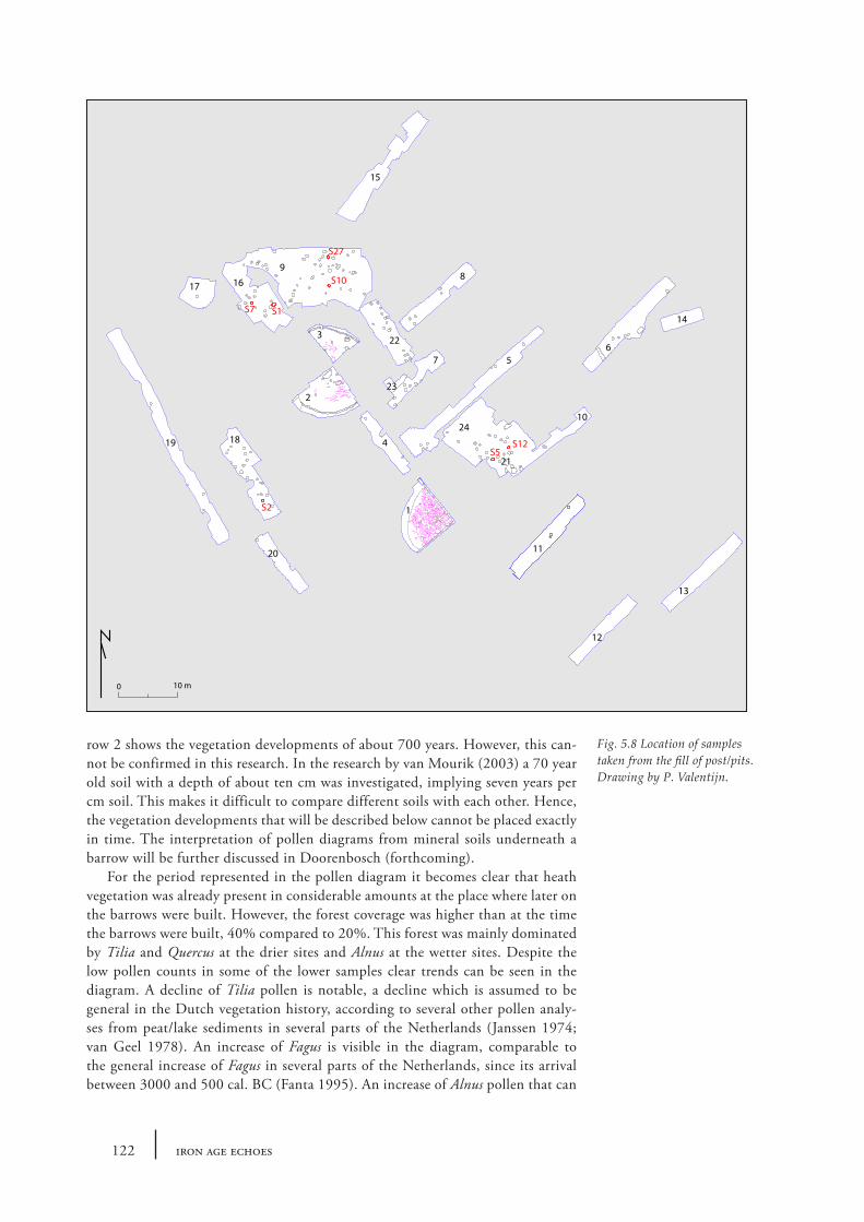
See Fig. 5.3, where spectra are given in % based on a tree pollen sum minus Betula pollen. In the total AP (=arboreal pollen) Betula is included. In the total NAP (=non arboreal pollen) spores are included, non pollen palynomorphs are excluded. The location of the features samples in indicated in Fig. 5.8.
Trench 9
A very low percentage of arboreal pollen grains, 15-20%, can be seen. The absence of Tilia is notable in comparison to the pollen spectra obtained from the barrows, as well as fairly high percentages of Fagus pollen and the presence of Carpinus. The herb pollen types are dominated by Calluna vulgaris, with percentages over 500%. Grasses show high percentages as well, around 70%. Anthropogenic indicators are present in low amounts, however, the amount of Secale is relatively high.
Trench 16
This spectrum shows also a low percentage of arboreal pollen, around 15%. Tilia is absent as well, Fagus and Carpinus are present in considerable amounts. Calluna vulgaris is again the dominating species, together with a high percentage of Poaceae. The presence of Fagopyrum and Centaurea cyanus should be noted.
Trench 18
This spectrum is similar to the spectrum from trench 16, except for a lower per-centage of Poaceae.
Trench 21
Also these spectra looks very much like the spectrum of trench 16 and 18, includ-ing the presence of Fagopyrum and Centaurea cyanus. Remarkable is the very high percentage of Calluna vulgaris in one of the spectra.
5.5 Discussion
5.5.1 Dating the barrows
The first point to make with regard to the palynological results is the resemblance between the two barrows. Pollen spectra from the old surfaces indicate a similar vegetation pattern at the time the barrows were built, which makes it likely that they were built in the same period. This is in line with what was expected on the basis of the C14-datings and general similarities between the mounds (cf. section 3.7). The occurrence of Carpinus suggests that this period can be placed in the Iron Age (Janssen 1974). Both their similarities as well as their Iron Age dating are in agreement with the excavation results (see Chapters 2 and 3). The latter show that the dating could be further specified to the late Middle or earlier Late Iron Age (Chapter 2 and 3).
118 iron age echoes
10 µm
10 µm
10 µm
10 µm
A B
C D
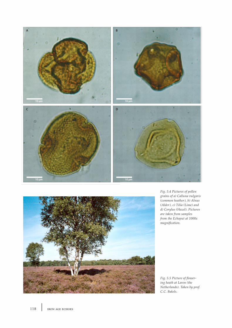
Fig. 5.4 Pictures of pollen grains of a) Calluna vulgaris (common heather), b) Alnus (Alder), c) Tilia (Lime) and d) Corylus (Hazel). Pictures are taken from samples from the Echoput at 1000x magnification.
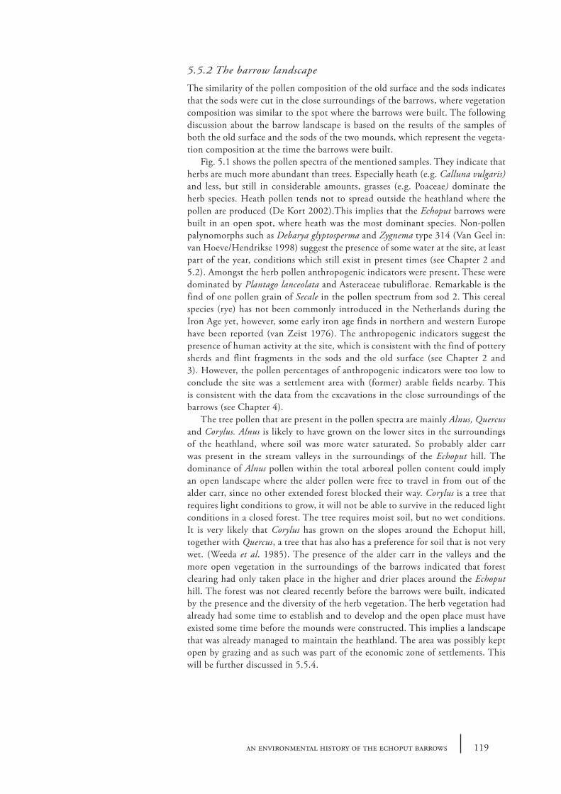
Fig. 5.5 Picture of flower-ing heath at Laren (the Netherlands). Taken by prof. C.C. Bakels.
119an environmental history of the echoput barrows
5.5.2 The barrow landscape
The similarity of the pollen composition of the old surface and the sods indicates that the sods were cut in the close surroundings of the barrows, where vegetation composition was similar to the spot where the barrows were built. The following discussion about the barrow landscape is based on the results of the samples of both the old surface and the sods of the two mounds, which represent the vegeta-tion composition at the time the barrows were built.
Fig. 5.1 shows the pollen spectra of the mentioned samples. They indicate that herbs are much more abundant than trees. Especially heath (e.g. Calluna vulgaris) and less, but still in considerable amounts, grasses (e.g. Poaceae) dominate the herb species. Heath pollen tends not to spread outside the heathland where the pollen are produced (De Kort 2002).This implies that the Echoput barrows were built in an open spot, where heath was the most dominant species. Non-pollen palynomorphs such as Debarya glyptosperma and Zygnema type 314 (Van Geel in: van Hoeve/Hendrikse 1998) suggest the presence of some water at the site, at least part of the year, conditions which still exist in present times (see Chapter 2 and 5.2). Amongst the herb pollen anthropogenic indicators were present. These were dominated by Plantago lanceolata and Asteraceae tubuliflorae. Remarkable is the find of one pollen grain of Secale in the pollen spectrum from sod 2. This cereal species (rye) has not been commonly introduced in the Netherlands during the Iron Age yet, however, some early iron age finds in northern and western Europe have been reported (van Zeist 1976). The anthropogenic indicators suggest the presence of human activity at the site, which is consistent with the find of pottery sherds and flint fragments in the sods and the old surface (see Chapter 2 and 3). However, the pollen percentages of anthropogenic indicators were too low to conclude the site was a settlement area with (former) arable fields nearby. This is consistent with the data from the excavations in the close surroundings of the barrows (see Chapter 4).
The tree pollen that are present in the pollen spectra are mainly Alnus, Quercus and Corylus. Alnus is likely to have grown on the lower sites in the surroundings of the heathland, where soil was more water saturated. So probably alder carr was present in the stream valleys in the surroundings of the Echoput hill. The dominance of Alnus pollen within the total arboreal pollen content could imply an open landscape where the alder pollen were free to travel in from out of the alder carr, since no other extended forest blocked their way. Corylus is a tree that requires light conditions to grow, it will not be able to survive in the reduced light conditions in a closed forest. The tree requires moist soil, but no wet conditions. It is very likely that Corylus has grown on the slopes around the Echoput hill, together with Quercus, a tree that has also has a preference for soil that is not very wet. (Weeda et al. 1985). The presence of the alder carr in the valleys and the more open vegetation in the surroundings of the barrows indicated that forest clearing had only taken place in the higher and drier places around the Echoput hill. The forest was not cleared recently before the barrows were built, indicated by the presence and the diversity of the herb vegetation. The herb vegetation had already had some time to establish and to develop and the open place must have existed some time before the mounds were constructed. This implies a landscape that was already managed to maintain the heathland. The area was possibly kept open by grazing and as such was part of the economic zone of settlements. This will be further discussed in 5.5.4.
120 iron age echoes
5.5.3 The impact of sod-cutting
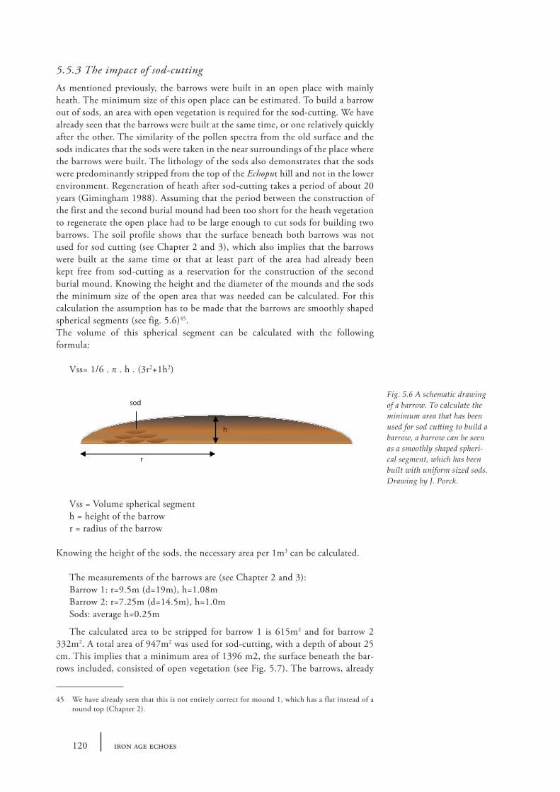
As mentioned previously, the barrows were built in an open place with mainly heath. The minimum size of this open place can be estimated. To build a barrow out of sods, an area with open vegetation is required for the sod-cutting. We have already seen that the barrows were built at the same time, or one relatively quickly after the other. The similarity of the pollen spectra from the old surface and the sods indicates that the sods were taken in the near surroundings of the place where the barrows were built. The lithology of the sods also demonstrates that the sods were predominantly stripped from the top of the Echoput hill and not in the lower environment. Regeneration of heath after sod-cutting takes a period of about 20 years (Gimingham 1988). Assuming that the period between the construction of the first and the second burial mound had been too short for the heath vegetation to regenerate the open place had to be large enough to cut sods for building two barrows. The soil profile shows that the surface beneath both barrows was not used for sod cutting (see Chapter 2 and 3), which also implies that the barrows were built at the same time or that at least part of the area had already been kept free from sod-cutting as a reservation for the construction of the second burial mound. Knowing the height and the diameter of the mounds and the sods the minimum size of the open area that was needed can be calculated. For this calculation the assumption has to be made that the barrows are smoothly shaped spherical segments (see fig. 5.6)45.The volume of this spherical segment can be calculated with the following formula:
Vss= 1/6 . π . h . (3r2+1h2)
Vss = Volume spherical segmenth = height of the barrowr = radius of the barrow
Knowing the height of the sods, the necessary area per 1m3 can be calculated.
The measurements of the barrows are (see Chapter 2 and 3):Barrow 1: r=9.5m (d=19m), h=1.08mBarrow 2: r=7.25m (d=14.5m), h=1.0mSods: average h=0.25m
The calculated area to be stripped for barrow 1 is 615m2 and for barrow 2 332m2. A total area of 947m2 was used for sod-cutting, with a depth of about 25 cm. This implies that a minimum area of 1396 m2, the surface beneath the bar-rows included, consisted of open vegetation (see Fig. 5.7). The barrows, already
45 We have already seen that this is not entirely correct for mound 1, which has a flat instead of a round top (Chapter 2).
Fig. 5.6 A schematic drawing of a barrow. To calculate the minimum area that has been used for sod cutting to build a barrow, a barrow can be seen as a smoothly shaped spheri-cal segment, which has been built with uniform sized sods. Drawing by J. Porck.
sod
h
r
121an environmental history of the echoput barrows
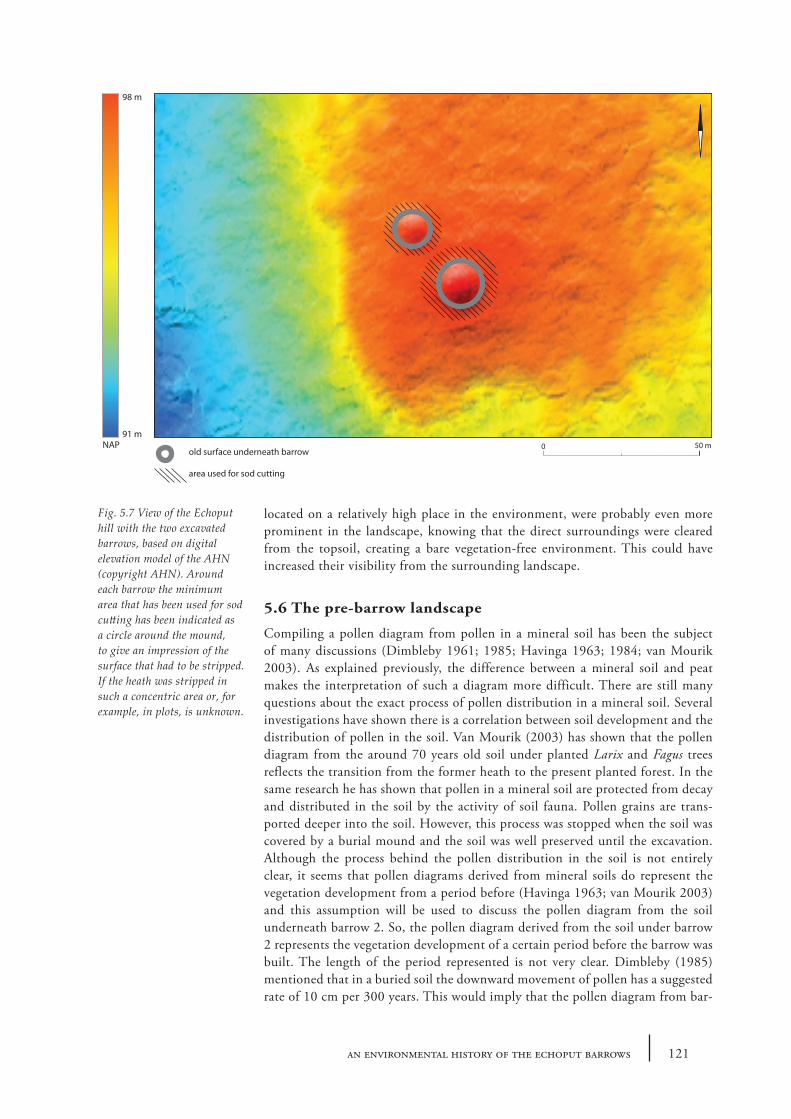
located on a relatively high place in the environment, were probably even more prominent in the landscape, knowing that the direct surroundings were cleared from the topsoil, creating a bare vegetation-free environment. This could have increased their visibility from the surrounding landscape.
5.6 The pre-barrow landscape
Compiling a pollen diagram from pollen in a mineral soil has been the subject of many discussions (Dimbleby 1961; 1985; Havinga 1963; 1984; van Mourik 2003). As explained previously, the difference between a mineral soil and peat makes the interpretation of such a diagram more difficult. There are still many questions about the exact process of pollen distribution in a mineral soil. Several investigations have shown there is a correlation between soil development and the distribution of pollen in the soil. Van Mourik (2003) has shown that the pollen diagram from the around 70 years old soil under planted Larix and Fagus trees reflects the transition from the former heath to the present planted forest. In the same research he has shown that pollen in a mineral soil are protected from decay and distributed in the soil by the activity of soil fauna. Pollen grains are trans-ported deeper into the soil. However, this process was stopped when the soil was covered by a burial mound and the soil was well preserved until the excavation. Although the process behind the pollen distribution in the soil is not entirely clear, it seems that pollen diagrams derived from mineral soils do represent the vegetation development from a period before (Havinga 1963; van Mourik 2003) and this assumption will be used to discuss the pollen diagram from the soil underneath barrow 2. So, the pollen diagram derived from the soil under barrow 2 represents the vegetation development of a certain period before the barrow was built. The length of the period represented is not very clear. Dimbleby (1985) mentioned that in a buried soil the downward movement of pollen has a suggested rate of 10 cm per 300 years. This would imply that the pollen diagram from bar-
Fig. 5.7 View of the Echoput hill with the two excavated barrows, based on digital elevation model of the AHN (copyright AHN). Around each barrow the minimum area that has been used for sod cutting has been indicated as a circle around the mound, to give an impression of the surface that had to be stripped. If the heath was stripped in such a concentric area or, for example, in plots, is unknown.
Old surface underneath barrow
Area used for sod cutting
0 25 50metersold surface underneath barrow
area used for sod cutting
50 m0
98 m
91 mNAP
122 iron age echoes
row 2 shows the vegetation developments of about 700 years. However, this can-not be confirmed in this research. In the research by van Mourik (2003) a 70 year old soil with a depth of about ten cm was investigated, implying seven years per cm soil. This makes it difficult to compare different soils with each other. Hence, the vegetation developments that will be described below cannot be placed exactly in time. The interpretation of pollen diagrams from mineral soils underneath a barrow will be further discussed in Doorenbosch (forthcoming).
For the period represented in the pollen diagram it becomes clear that heath vegetation was already present in considerable amounts at the place where later on the barrows were built. However, the forest coverage was higher than at the time the barrows were built, 40% compared to 20%. This forest was mainly dominated by Tilia and Quercus at the drier sites and Alnus at the wetter sites. Despite the low pollen counts in some of the lower samples clear trends can be seen in the diagram. A decline of Tilia pollen is notable, a decline which is assumed to be general in the Dutch vegetation history, according to several other pollen analy-ses from peat/lake sediments in several parts of the Netherlands (Janssen 1974; van Geel 1978). An increase of Fagus is visible in the diagram, comparable to the general increase of Fagus in several parts of the Netherlands, since its arrival between 3000 and 500 cal. BC (Fanta 1995). An increase of Alnus pollen that can
9
16 17
18 19
20
4
1
2
3
5
24
21
10
11
13
6
14
8
7
23
22
15
S27
S10
S1
S12S5
S7
S2
12
10 m0
Fig. 5.8 Location of samples taken from the fill of post/pits. Drawing by P. Valentijn.
123an environmental history of the echoput barrows
be noticed might be primarily related to the decrease of Tilia or could indicate an expansion of the wet forest. The decrease of forest cover seems to go hand in hand with an expansion of the heath vegetation. At the time the barrow was built vegetation was, at least locally, dominated by heath. However, it is not entirely clear how the open place was created and what it was used for in the period before the barrows were built. Indications of the presence of human activities at the site in several periods before the barrows were built are evidenced by finds from below and beyond the mounds, although they do certainly not hint at a very intensive use of this site in – say- the Bronze Age or early Iron Age (see previous chapters). The absence of cereal pollen grains and high amounts of arable weeds like Artemisia vulgaris in the diagram demonstrate that the location had not been used for crop cultivation. At this moment it is not entirely clear what the size of the heathland could have been, this subject will be further explored in the thesis of the author (Doorenbosch forthcoming). The minimum size of the heath must have been 1396 m2 (see 5.5.2). To maintain the heath, the landscape must have been managed. The amount of grasses (Poaceae) together with Plantago lanceolata, Asteraceae liguliflorae, Succisa and Galium type could be an indication that the heath land has been used as pasture (Hjelle 1999). The remains of charcoal found in all the pollen samples may also be an indication that humans burnt the heath vegetation (Karg 2008), a form of heath management that can be used to rejuve-nate the heath, possibly in combination with grazing by livestock.
5.7 Posts at the barrow site
The pollen spectra from the four possible structures (see section 4.6 – 4.8) that have been sampled have a different composition than the barrow spectra. The content of the post-hole fill spectra seems to be younger. This is implied by the amounts of Carpinus and Fagus, which had increased in comparison to the barrow pollen spectra. Both species show an increase during the Holocene vegetation development in the Netherlands since the Subatlantic period until the Medieval Period (Janssen 1974). Also the constant presence of Secale, which is known as a common crop in the Netherlands only since the Roman Period (Behre 1992), indicates a younger pollen composition. In addition, all posthole fills, with excep-tion of those from trench 9, contained pollen from Fagopyrum and Centaurea cyanus, which are only present in the Dutch pollen spectra from the Late Medieval period (Bakels 2000). The posthole fill pollen spectra indicate a landscape, prob-ably much younger than the barrow landscape, which was more open than during the time the barrows were built. The amount of Alnus had decreased. This implies deforestation of the lower sites as well, or a change in soil water content. The barrow site was at this time an open spot as well, but the character of the place had slightly changed compared to the barrow landscape. Calluna had expanded at the cost of the forest. The diversity and quantity of other herbs increased. At trench 21 a very high percentage of Calluna pollen can be seen, which is not vis-ible in any of the other samples. This could indicate a local abundance of heath, for example the covering of the roof of the structure could have been made of it. However, can the dating of the pollen spectra be coupled to the dating of the posts? In other words, can the posts also be dated in the Late Medieval Period? The following scenario may apply. A hole was dug into the soil, in which the post was placed. The posthole was then filled, probably with soil that came originally out of the hole. As has been described in the previous paragraph, pollen infiltration can take place in an uncovered soil, like happened in the soil underneath the barrows before they were built. This process had also taken place in the soil the posthole was dug into. This implies that the posthole fill contained a mixture of recent and
124 iron age echoes
older pollen (recent at the time the post was placed). After some time the post had decayed, leaving -together with the posthole fill- the well visible feature in the soil. Since the soil had not been buried, the development of the soil at the location of the posthole could now also continue, unlike the soil underneath the barrow. At the time of the excavation a holtpodsol had developed with a thick A horizon on top (see Chapter 4). It is likely that part of the posthole feature had been merged into this thick dark layer. However, under this A horizon (part of ) the posthole features were still clearly visible. This implies that the soil at this depth was still undisturbed, because the soil development had not reached this depth yet. In ad-dition, the pollen spectra did not show the recent vegetation type that is present in the Echoput area (e.g. Larix and Pseudotsuga, see 5.2), another indication that the soil was not mixed with the upper part. The pollen spectrum that was found in the samples taken from the still clearly visible posthole features would then represent the pollen mixture that was present in the original posthole fill. As described above, the pollen spectra from the posthole fills contained pollen types that were only known to be present in the Netherlands from the Roman Period and from the Late Medieval Period. This Medieval pollen could have come from the vegetation that was present at the Echoput hill at the time the posts were placed or they could have been infiltrated in the soil from some time before the posts were placed. The posts could then be dated in the Late Medieval Period or later (as a terminus post quem date). The pollen spectrum from the posthole fill from trench 9 lacked pol-len that indicates the Late Medieval Period and consequently the Roman Period can be determined as a terminus post quem date for this posthole. This discussion will be further exploited in Doorenbosch (forthcoming).
5.8 Veluwe barrows and heath
The barrows of the Echoput were built in an area with heath vegetation. Since the Neolithic heath vegetation could establish and expand in the Netherlands due to human influence. Forests were cleared for agricultural purposes and because the soil was impoverished, heath could expand (Casparie and Groenman- van Waateringe 1980; Berendsen 2005). The existence of heath at places where Veluwe barrows were built was already shown by Waterbolk (1954) and Casparie and Groenman- van Waateringe (1980). A more recent research in Apeldoorn by J.W. de Kort (2006) showed the presence of heath in the pollen spectra from a much older barrow than the Echoput mounds (probably late Neolithic).
5.9 In conclusion: the history of a barrow landscape
It is generally assumed that most barrows were built in open spaces in a forest area. However, the origin of these open spaces is hardly known. The pollen analyses of two barrows at the Echoput show the vegetation history of the open space from a period before the barrow were built. This showed that the clearing of the forest was indeed much older than the barrow building, as has been suggested in the introduction. When and how the open space was created is not known. From the beginning of the period our data represent the open spot has mainly been covered by heath vegetation mixed with grasses and several other herbs. The open space, surrounded by forest of Tilia and Quercus, has been used during at least some centuries by prehistoric man. The presence of anthropogenic indicators confirms the influence of prehistoric man in the environment. Mesolithic and Bell Beaker features have also been found, though it is not known if the forest had been cleared already by them. Although we did not uncover any evidence for a settlement outside the mounds, it is clear that the area has been used by
125an environmental history of the echoput barrows
prehistoric man. But what did they use the open place for since the Bronze Age? It is very likely that it was included in the economic zone of farming communi-ties as grazing grounds/pasture, keeping the vegetation open. Based on the high percentage of pollen from Poaceae, in combination with the presence of Plantago lanceolata, Asteraceae liguliflorae, Succisa and Galium type (Hjelle 1999), the use of this open spot as pasture is very plausible. Furthermore, regular burning of heath could have occurred, indicating that a form of heath management was used to keep the area open. At least the use of fire is indicated by the amounts of charcoal found in the pollen records. Before the barrows were built the open area seems to have been used solely as a place for the living, since no indications have been found that people were buried there. This changed when the burial mounds were constructed in the later Middle Iron Age or early Late Iron Age. At this time the vegetation surrounding the Echoput hill had changed. The Tilia dominated forest had decreased and forest with a more open character mainly consisting of Quercus and Corylus had taken its place. The heath at the open place at the top of the Echoput hill had expanded. This change in vegetation was probably due to human activities, like burning and grazing. The upper surface of a large part of the heathland at the Echoput hill was stripped in order to get sods for the construc-tion of the barrows. The surface where the barrows were going to be located was left untouched. Whether the barrows were built at exactly the same time or with a short period in between does not change the fact that both places had already been designated as barrow location based on the observation that the surface underneath both barrows were not used for sod-cutting. The two barrows must have been quite pronounced features in the landscape, while placed on one of the highest locations in the area, cleared from surrounding vegetation. It is unknown whether the surrounding landscape was kept open after the barrows were built. However, one of the mounds has been re-used again as a burial location (grave 1 and 2; Chapter 2 and 7).
In the Veluwe area, open spaces with usually heath vegetation have been chosen as location to build barrows. The origin and the use of these open places before the burial mounds were constructed are often not very clear. There are some ar-chaeological finds demonstrating that the open place had been used by people in the period before the barrow building. This research of the two barrows at the Echoput has shown part of the history of such an open place.
126 iron age echoes
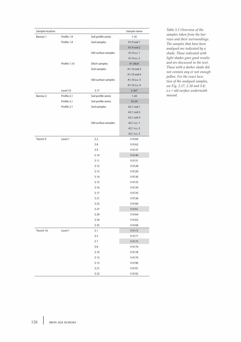
Table 5.1 Overview of the samples taken from the bar-rows and their surroundings. The samples that have been analysed are indicated by a shade. Those indicated with light shades gave good results and are discussed in the text. Those with a darker shade did not contain any or not enough pollen. For the exact loca-tion of the analysed samples, see Fig. 2.17, 2.18 and 3.8; o.s = old surface underneath mound.
Sample location Sample name
Barrow 1 Profile 1.9 Soil profile series 1-35
Profile 1.9 Sod samples A1.9 sod 1
A1.9 sod 2
Old surface samples A1.9 o.s. 1
A1.9 o.s. 2
Profile 1.10 Ditch samples A1 ditch
Sod samples A1.10 sod 3
A1.10 sod 4
Old surface samples A1.10 o.s. 3
A1.10 o.s. 4
Level 10 S 17 V 267
Barrow 2 Profile 2.1 Soil profile series 1-24
Profile 2.1 Soil profile series 25-29
Profile 2.1 Sod samples A2.1 sod 1
A2.1 sod 2
A2.1 sod 3
Old surface samples A2.1 o.s. 1
A2.1 o.s. 2
A2.1 o.s. 3
Trench 9 Level 1 S 2 V 0169
S 8 V 0163
S 9 V 0137
S 10 V 0140
S 11 V 0131
S 12 V 0128
S 13 V 0129
S 14 V 0130
S 15 V 0133
S 16 V 0134
S 17 V 0135
S 21 V 0136
S 25 V 0160
S 27 V 0161
S 29 V 0164
S 34 V 0165
S 35 V 0168
Trench 16 Level 1 S 1 V 0172
S 3 V 0171
S 7 V 0175
S 8 V 0176
S 10 V 0178
S 13 V 0179
S 15 V 0190
S 21 V 0191
S 23 V 0192

127an environmental history of the echoput barrows
Sample location Sample name
Trench 18 Level 1 S 2 V 0200
S 12 V 0194
S 15 V 0196
S 18 V 0198
Trench 21 Level 1 S 2 V 0293
S 3 V 0292
S 4 V 0291
S 5 V 0290
S 6 V 0288
S 7 V 0289
S 9 V 0287
S 10 V 0286
S 11 V 0285
S 12 V 0283
S 13 V 0282
S 14 V 0280
S 15 V 0279
S 16 V 0281
S 17 V 0278
S 18 V 0284
Trench 24 Level 1 S 1 V 0294
S 2 V 0296
S 3 V 0295
S 4 V 0297
S 5 V 0277
S 6 V 0276
S 7 V 0298

Related Documents


![Barrows Visit Dexfield2[1]](https://static.cupdf.com/doc/110x72/577ccfd91a28ab9e7890c044/barrows-visit-dexfield21.jpg)