An Astrologer's Map: A Relic of Late Antiquity Author(s): Evelyn Edson and Emilie Savage-Smith Reviewed work(s): Source: Imago Mundi, Vol. 52 (2000), pp. 7-29 Published by: Imago Mundi, Ltd. Stable URL: http://www.jstor.org/stable/1151475 . Accessed: 26/09/2012 16:52 Your use of the JSTOR archive indicates your acceptance of the Terms & Conditions of Use, available at . http://www.jstor.org/page/info/about/policies/terms.jsp . JSTOR is a not-for-profit service that helps scholars, researchers, and students discover, use, and build upon a wide range of content in a trusted digital archive. We use information technology and tools to increase productivity and facilitate new forms of scholarship. For more information about JSTOR, please contact [email protected]. . Imago Mundi, Ltd. is collaborating with JSTOR to digitize, preserve and extend access to Imago Mundi. http://www.jstor.org

Welcome message from author
This document is posted to help you gain knowledge. Please leave a comment to let me know what you think about it! Share it to your friends and learn new things together.
Transcript
An Astrologer's Map: A Relic of Late AntiquityAuthor(s): Evelyn Edson and Emilie Savage-SmithReviewed work(s):Source: Imago Mundi, Vol. 52 (2000), pp. 7-29Published by: Imago Mundi, Ltd.Stable URL: http://www.jstor.org/stable/1151475 .Accessed: 26/09/2012 16:52
Your use of the JSTOR archive indicates your acceptance of the Terms & Conditions of Use, available at .http://www.jstor.org/page/info/about/policies/terms.jsp
.JSTOR is a not-for-profit service that helps scholars, researchers, and students discover, use, and build upon a wide range ofcontent in a trusted digital archive. We use information technology and tools to increase productivity and facilitate new formsof scholarship. For more information about JSTOR, please contact [email protected].
.
Imago Mundi, Ltd. is collaborating with JSTOR to digitize, preserve and extend access to Imago Mundi.
http://www.jstor.org
An Astrologer's Map: A Relic of Late Antiquity
EVELYN EDSON and EMILIE SAVAGE-SMITH
ABSTRACT: A Greek map of the world, which includes a windrose, zones, places in and around Egypt, and hell, is studied in reference to its context: an anonymous astrological miscellany. Other examples of this map have been found in a second context, among anonymous scholia to Theon of Alexandria's commentary on Ptolemy's Handy Tables (Procheiroi kanones), which were also of use to astrologers. The selection of Egyptian place-names found on the map provides some clue to its possible origin, while the omission of the Mediterranean as well as the port of Alexandria is significant. Evidence suggests that the original map (known today only through later copies) is of an earlier date than the texts surrounding it, and that it may be one of the earliest world maps preserved from Late Antiquity.
KEYWORDS: astrolabe, astrology, astronomy, climates, Egypt, Greek cartography, hell, Ptolemy, windrose, zone map.
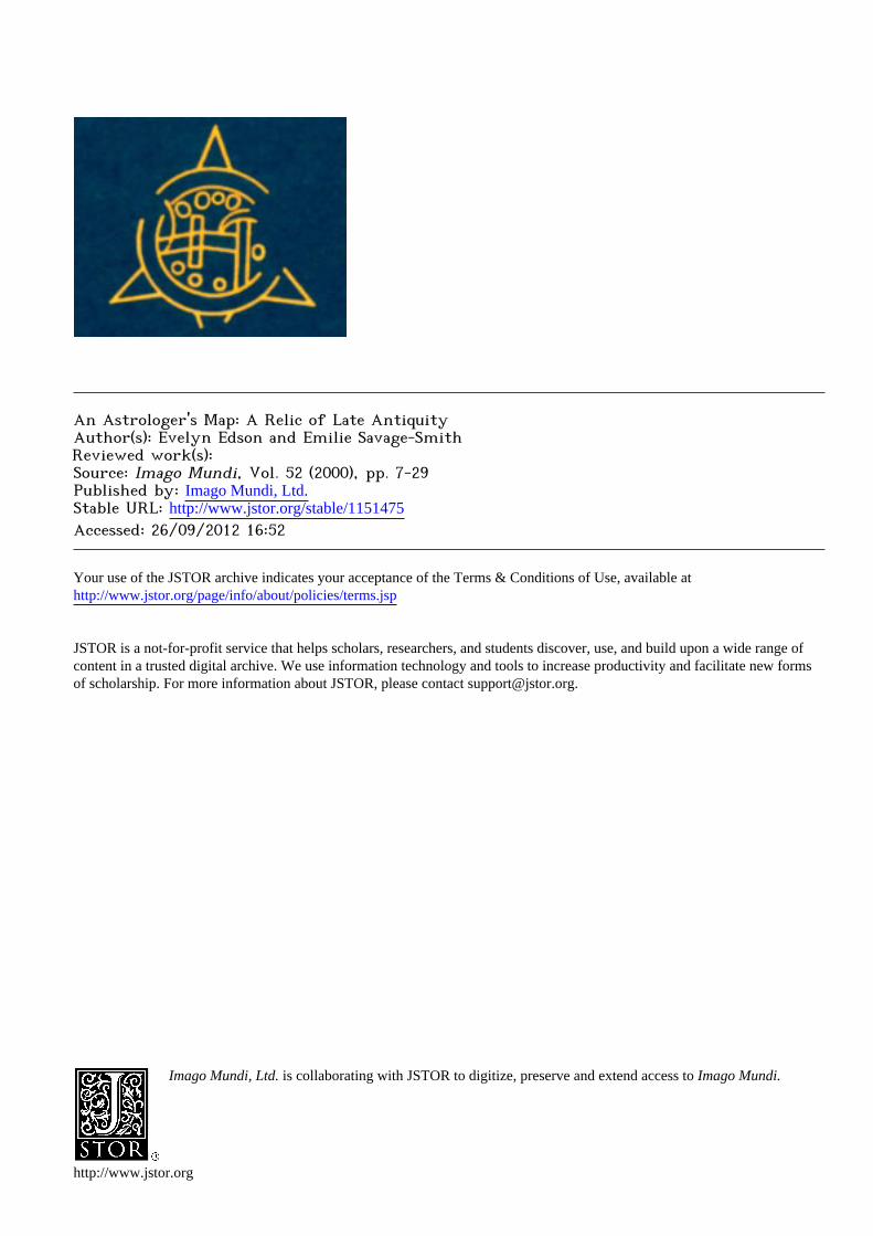
A world map was recently discovered among Greek astrological texts found in the midst of an Arabic
manuscript in the Bodleian Library, MS Marsh 42 (Fig. 1). 1 The Greek and Arabic texts, bound together in the seventeenth century, were tran- scribed by different copyists from different sources and are unrelated except in so far as they reflect the
general interests of the person who assembled
them, Jacob Golius (Jacob Gool), the leading Orientalist of seventeenth-century Europe.2 The map which is the focus of this article is surrounded by seventeen short Greek astrological tracts or diagrams.
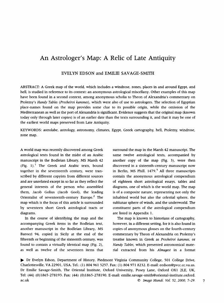
In the course of identifying the map and the
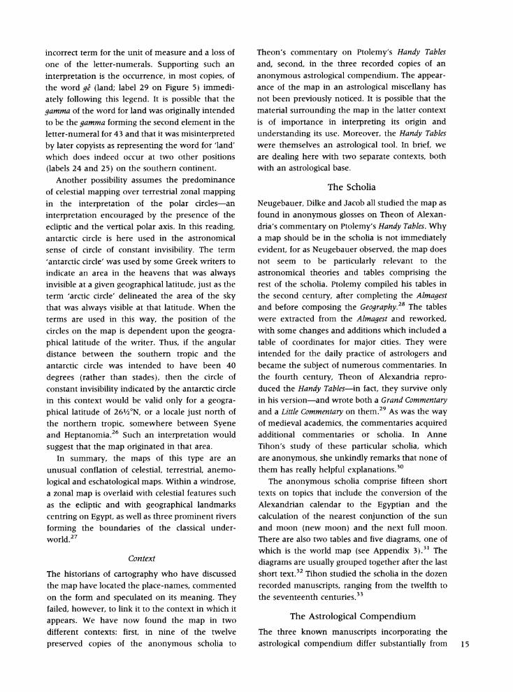
accompanying Greek items in the Bodleian text, another manuscript in the Bodleian Library, MS Barocci 94, copied in Sicily at the end of the fifteenth or beginning of the sixteenth century, was found to contain a virtually identical map (Fig. 2), as well as twelve of the seventeen items that
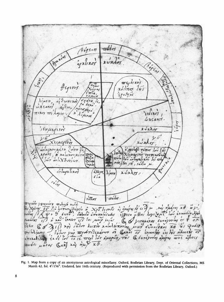
surround the map in the Marsh 42 manuscript. The same twelve astrological texts, accompanied by
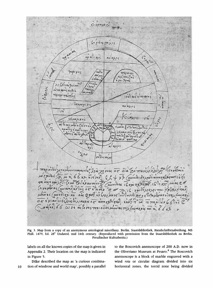
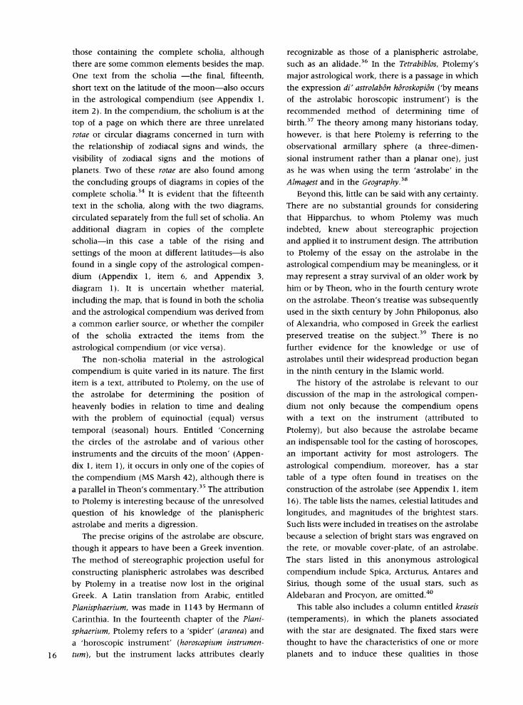
another copy of the map (Fig. 3), were then
discovered in a sixteenth-century manuscript now in Berlin, MS Phill. 1479.3 All three manuscripts contain the anonymous astrological compendium of eighteen short astrological essays, tables and
diagrams, one of which is the world map. The map is of a composite nature, representing not only the inhabited world but also the celestial sphere, the sublunar sphere of winds, and the underworld. The constituent parts of the astrological compendium are listed in Appendix 1.
The map is known to historians of cartography,
however, in a different setting, for it is also found in copies of anonymous glosses on the fourth-century commentary by Theon of Alexandria on Ptolemy's treatise known in Greek as Procheiroi kanones, or
Handy Tables, which presented astronomical mate- rial extracted from his Almagest in a format
* Dr Evelyn Edson, Department of History, Piedmont Virginia Community College, 501 College Drive, Charlottesville, VA 22901, USA. Tel.: (1) 804 961 5257. Fax: (1) 804 971 8232. E-mail: [email protected]. Dr Emilie Savage-Smith, The Oriental Institute, Oxford University, Pusey Lane, Oxford OXI 2LE, UK, Tel: (44) (0)1865-278193. Fax: (44) (0)1865-278190. E-mail: [email protected]. ac.uk ? Imago Mundi. Vol. 52, 2000, 7-29. 7
k 4
~~~~~4 W1.~I, :4*7 :4 4f '' c\ dp. wr6L ,Z' I/ /
j :'4' Ir' @ 4
k.0 (IA,,&#.tFfrr H4J 224 7 4{ ,w
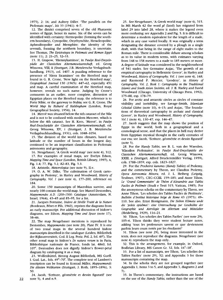
Fig 1 Ma fom a copy of an anonymous astrological miscellany. Oxford, Bd;ean Library, Dept. of Oriental Coll , M
Ma l 'b U , le 1h cuy.prod wh permissn frmthe B a Lbrary O
8Ff t ' J 4 f >-?
<;0-< ^> 7r#>,/X>444> %4*86VH(C} g~77 't {F ?<lp 0w 9#ffP Aes ^ h~~~~~~~~~~~~~~~~~~~~~~~~~~~~~r e Ll ,8 tr g v~~~~~~~~~~~~Al 4
1 \ , ^;r < S~~~~~~~~~~~~~~~~~~rJ ^ ;:Vt or ~~~~~~~~~~~~~~~~~~~~~ ?e~~~~~~r hs4Xsr <~~~~~~~~~~~~~t
tX ^ SX zf -> ~~~~~~~~~:::1? t: >S . + Xi?: +~~~~~~~~~~J ,
X X>;A-ew sV 00^ ,0X5l,,x , $DXX ,
j S s+E~t,- ; 4 * j--SS- A:
Fig.1. ap rom coy o ananonmou asroloica rxiscllan. Ofor, Bdlein Ibray, Dpt f Oentl Colecion, M
Marsh 42, fol. 4r/156b. Undatedw late 16th century. (Reproduced with pemiission from the Bodleian Library, Oxford.)~~~~~~~~~~~~~~~Ar
8~~~~~~~~
~~~~Aui g S\-i<;
g w I AW,. _, -e, o\ < fid),"
/ } ?4 X I4 4 V
4~~~~~~~1~~*
14~~~~~~~~~~~~~~~~~~~~1
I~~~~~~~A - /Au c) ro St #4. 6, - #.A
k??I14Zl' 1 4f,
-~ ~ ~ '7 e^r~fi 9s ffCrx .' 5W1 ' ?/
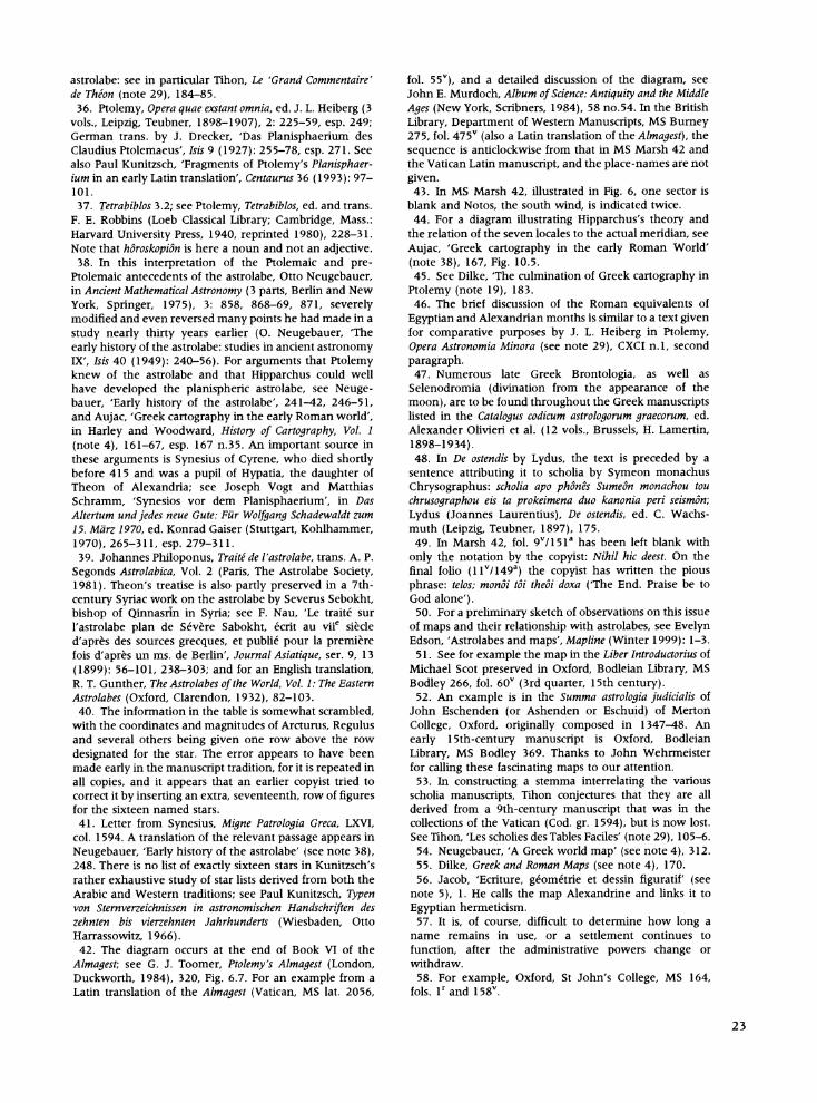
;V f4 C S4rCi t 11 Fi.2 a fro a cop otfannoyus asrolgia miclay Ofr, Bolea Liray Det;fWsemMnsrps
fo~~fffff .\, . ,, ,, S |~AfY >,*I,.,! '1
Fig. 2. Map from a copy of an anonymous astrological miscellany. Oxford, Bodleian Library, Dept. of Western Manuscripts, MS Barocci 94, fol. 118v. Undated, copied by Andreas Donas, presumably in Messina, Sicily, end of 15th or early 16th
century. (Reproduced with permission from the Bodleian Library, Oxford.)
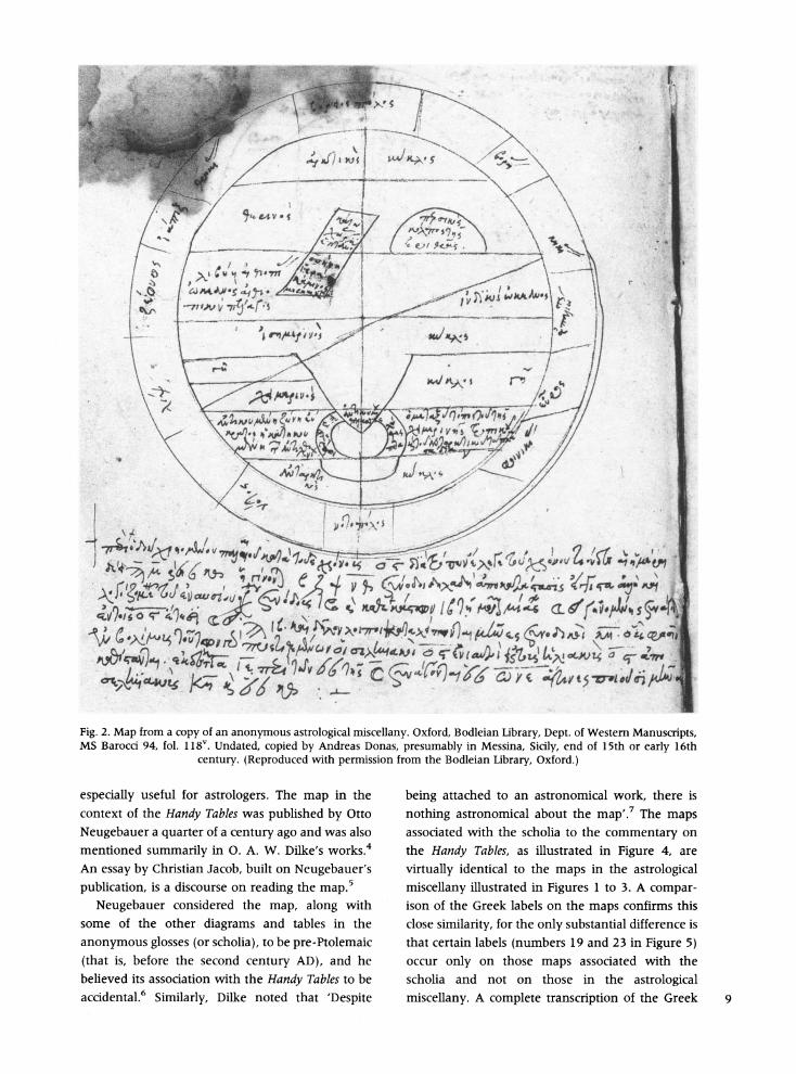
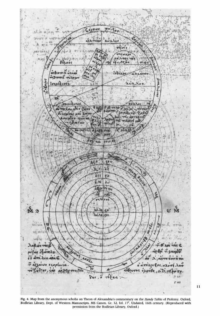
especially useful for astrologers. The map in the context of the Handy Tables was published by Otto Neugebauer a quarter of a century ago and was also mentioned summarily in 0. A. W. Dilke's works.4 An essay by Christian Jacob, built on Neugebauer's publication, is a discourse on reading the map.5
Neugebauer considered the map, along with some of the other diagrams and tables in the anonymous glosses (or scholia), to be pre-Ptolemaic (that is, before the second century AD), and he believed its association with the Handy Tables to be accidental.6 Similarly, Dilke noted that 'Despite
being attached to an astronomical work, there is nothing astronomical about the map'.7 The maps associated with the scholia to the commentary on the Handy Tables, as illustrated in Figure 4, are virtually identical to the maps in the astrological miscellany illustrated in Figures 1 to 3. A compar- ison of the Greek labels on the maps confirms this close similarity, for the only substantial difference is that certain labels (numbers 19 and 23 in Figure 5) occur only on those maps associated with the scholia and not on those in the astrological miscellany. A complete transcription of the Greek 9
24 U 4 4~~~~~~~~~~~~~~~~~~~~ 44~~~lkl"
AL O~~~~~~~~b~~~~Th~~~~~i~~~ 4~~~~7 4444 4~~~~~~~~~~~~~~~~~~~~~~~~~~~~~
V
44 ~~~~~~~~~~~~~~~~~~~~~~~~~~~~4:44444 ~ ~ ~ ~ ~ ~ ~ ~ ~ ~ ~~~~~~~~~~~~~~~~~~~~~~~~~~~~~~~i' 1
~~~~~~~M
* ~~~~~~~~~~~~~~~~~~~~~~~~~~~4W
4~~~~4 44% 424 ~~~~~~~~~~~~2
~~~~~~~ Aas~~~~~~~~~~~~~~~~~~~~~~~~~~w ~~~~~~~~~~~~~~~~ 444~~~~~~~~~~~~- ':aitn
~~~ *~
4Wq >W ?er jV 97~ c?~~~~~~~~' - ~~~~~~~ C~~~~~V' "~~~~~~~~ ~~~& ~
1' 44~~~~~~~~~~~~~~~~~pcfia in 1
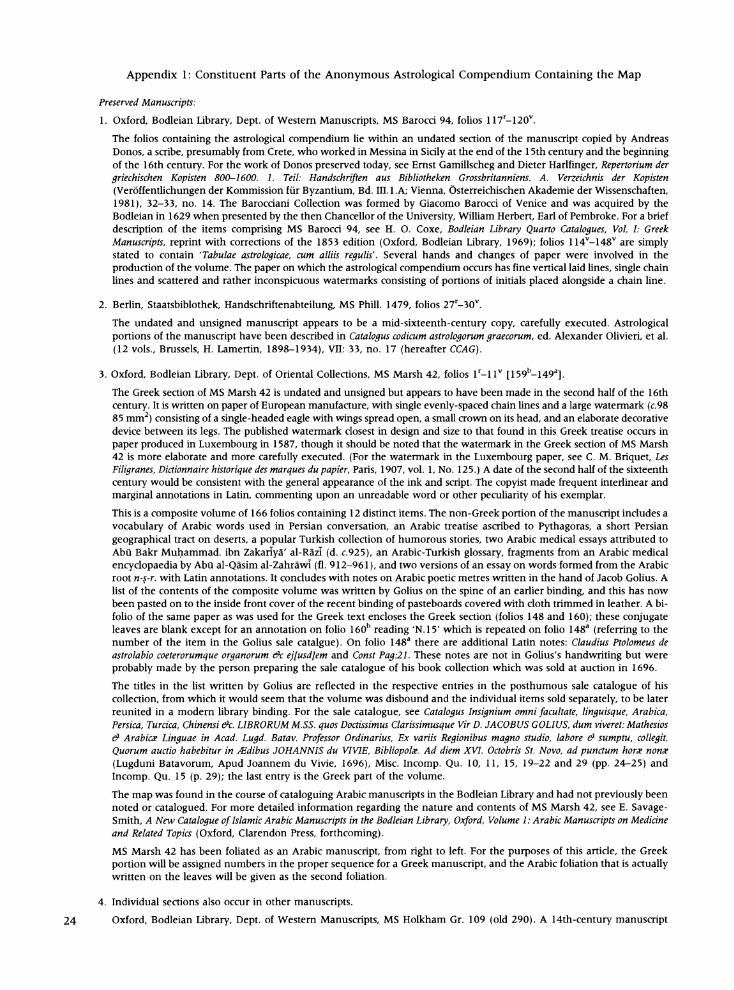
Fig. 3. Map from a copy of an anonymous astrological miscellany. Berlin, Staatsbibliothek, Handschniftenabteilung, MS Phill. 1479, fol. 28v Undated, mid 16th century. (Reproduced with permission from the Staatsbibliothek zu Berlin,
Preugischer Kulturbesitz.)
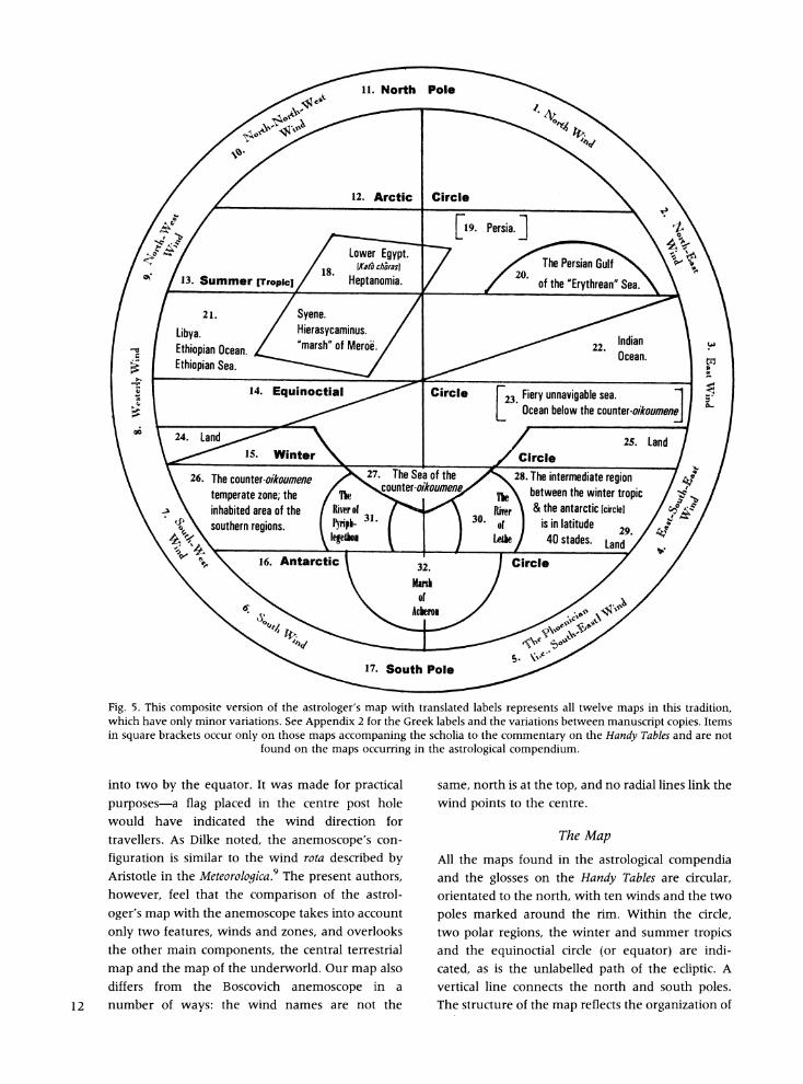
labels on all the known copies of the map is given in Appendix 2. Their location on the map is indicated in Figure 5.
Dilke described the map as 'a curious combina- 10 tion of windrose and world map', possibly a parallel
to the Boscovich anemoscope of 200 A.D. now in the Oliveriano Museum at Pesaro.8 The Boscovich anemoscope is a block of marble engraved with a wind rota or circular diagram divided into six horizontal zones, the torrid zone being divided
'A. Starts A. ' "
t~~~~~~~~~~~~~~~~~~~~~~~~~~~~~~~~t
4 ~~~~~~1149 4Q9
'~~~~~~~~~~~~~~~~~~~~~
',,~~~~~t~Ie;v,# 0'; ;t0 fi~ a fl00: X 0-; 9 ;Atif00 00i--ti; ~- 0
4 - w -;
7M -
47
Pig. Ma
Fig. 4. Map. from th anonymus schoiaoTheonrof Alexandrians comaryo Oxford.)
Bodlean Lbrar, Det. o Westrn Mnuscipts MS anon.Gr. 2, fl. 1r Udatd 1i-6th~ cetuy (Rprdce wt
southern regions. 31. Arcer &teaariti Circle [ceua b es
Fs
L Ocean bel~~~owe Eyt.he Ponersiaoumnff
WM3 o 24. in ltu 29. ld
Fig. 5. Ths . Suteversionofpthe aoersma. withtasated lbel ntse aElltere mp i t
whc\hv onl minorvratizons.See Appeni2fo thGrerok lbes ndth vaiation between mawnusctript cois Items
in uarb Ets Occ nl e marpshaofm i2the s iaeo e r othe anTables a areno \ tpan \ southernaroudons .tps or in th astrologicaldcompendium.
\4 W4\ 14. Equinoctial ! Circle Fir unaiabesa
Fi.54hscmoievrso fteatooe' mpwt rnltdlbl Oearsnt below thelvunermapsikmneti raiin
whic haeolyamnor 25iaios SeLpedx2frahnredaes n h aiton ewe aucrpoistm
in square bakthe ournonlyoonothose map acmnigthe Sea of the the Thmeintermediathe regind Talsad ro
founded re of the maps occrrn Rine th astrologicalicompendium.
into two by the equator. It was made for practical purposes-a flag placed in the centre post hole would have indicated the wind direction for travellers. As Dilke noted, the anemoscope's con- figuration is similar to the wind rota described by Aristotle in the Meteorologica.9 The present authors, however, feel that the comparison of the astrol- oger's map with the anemoscope takes into account only two features, winds and zones, and overlooks the other main components, the central terrestrial map and the map of the underworld. Our map also differs from the Boscovich anemoscope in a
12 number of ways: the wind names are not the
same, north is at the top, and no radial lines link the wind points to the centre.
The Map
All the maps found in the astrological compendia and the glosses on the Handy Tables are circular, orientated to the north, with ten winds and the two poles marked around the rim. Within the circle, two polar regions, the winter and summer tropics and the equinoctial circle (or equator) are indi- cated, as is the unlabelled path of the ecliptic. A vertical line connects the north and south poles. The structure of the map reflects the organization of
the heavens in Hellenistic astronomy with its zones, poles and oblique zodiac.'0 Indeed, unless such a
diagram is clearly labelled, it is difficult to tell
whether it is meant to be celestial or terrestrial. The ecliptic, however, represents a distinctly celestial phenomenon, having no terrestrial equivalent.
The geographical names on this map indicate
that elements of both a zonal and a celestial map have been superimposed on a world map. In the northern hemisphere one finds the land mass of Persia (indicated only on those maps associated with the glosses on the commentary on the Handy
Tables), and the Persian Gulf of the 'Erythrean' Sea (literally the Red Sea, but here used in its classical
meaning of Arabian Sea), with the Indian Ocean
indicated beneath. On the western side of the map there is Libya (or west bank of the Nile), the
Ethiopian Sea with the Ethiopian Ocean (west of
Africa). Written inside a quadrilateral frame are a
set of place-names in Egypt and Nubia, reading downward: Lower Egypt (Katd chbra or Katd chdras), Heptanomia (Heptanomia), and below the summer tropic, Syene (Syene), Hierasycaminus (Hiera Suka- minos), and the marsh of Meroe (Meroe limne).
All these places can be found in Ptolemy's
Geography, where he gives the latitudes as Hepta- nomia 29?50'-28?10', Syene 23050', Hierasycami-
nus 23040' and Meroe 16025'. KatO chbra, Lower
Egypt, is not assigned a specific latitude or range of latitudes, for Ptolemy used it only as a general way of describing the Nile delta as in phrases such as 'a low region around these rivers in which are provinces and important cities'." In the Geography, all are said to lie along roughly the same longitude line, 61 degrees east of the Fortunate Islands.
Heptanomia was a Roman administrative district of Middle Egypt, created early in the first century.'2
Syene was the ancient name of modern Aswan in southern Egypt, an important trading post renowned for its quarries. Astronomers in antiquity thought that Syene was located directly on the
Tropic of Cancer, where, at the summer solstice, the sun would be directly overhead. Eratosthenes
(c.275-194 BC) used this fact in his calculation of the circumference of the earth.
Hierasycaminus (modern al-Maharraqah) is located south of Syene in Nubia between Aswan and Abu Simbel, that is, between the first and second cataracts of the Nile. Shortly after 20 BC it
was established as a Roman river frontier, and it continued under Roman rule until 298, when Diocletian ordered the withdrawal from Hierasyca-
minus and established the frontier at Syene. 13
Meroe marsh refers to an area of land surrounded by marsh that lay between two junctions of
tributaries to the Nile: the junction of the White Nile (Bahr el-Abiad) with the true Nile and the junction of the Atbara River with the Nile.'4 In Ptolemaic and Roman times little was known of the
world south of Meroe at 16'25'N. In classical times
Meroe was usually called an island (which it was not), and was shown in this way on medieval maps, such as the Hereford Cathedral map. Three of the five Egyptian names (Katd chbra, Syene, Meroe) correspond to the names given to the climates of
the inhabited world by Ptolemy.' 5 The two remain-
ing places in Egypt (Heptanomia and Hierasycami- nus), as Neugebauer observed, are names of
administrative significance only and were already obsolete by the end of the Empire.'6 Their very
obscurity in preceding and succeeding centuries
leads one to speculate on a late imperial origin for
this map. The division of a circular map into six horizontal
areas separated by five lines (two polar circles, two
tropics and an equator) is similar to the design of a
zonal map. The latter, however, usually lacks the
ecliptic and the polar axis, both of which are found
on this map.'7 The zonal configuration of the earth was a development of Greek geographical theory, traditionally attributed to Parmenides in the sixth
century BC. According to this theory, which we still
employ, the spherical earth is divided into two
frigid or polar zones, two temperate zones and a torrid zone extending from the summer to the winter tropic on either side of the equator. The Greeks, securely located in the northern temperate zone, speculated that both the frigid and torrid zones were uninhabitable and probably impassable as well-at least, this was the idea put forward by Aristotle in Meteorologica. 18 The astronomer Ptolemy considered the parallel south of the equator that was opposite the parallel which passed through
Meroe, that is, 16'25'S, to be the southern limit of the inhabitable world, although he offered no opinion on living conditions beyond that line.'9
In the Latin West, zonal theory was made graphic in the Latin encyclopaedist Macrobius's Commentary on the Dream of Scipio. Writing in the late fourth century, he expounded on the Stoic idea of the universe and accompanied his work with a
group of diagrams, including a world map arranged by zones.20 A few geographical places were included on the map to indicate boundaries. 13
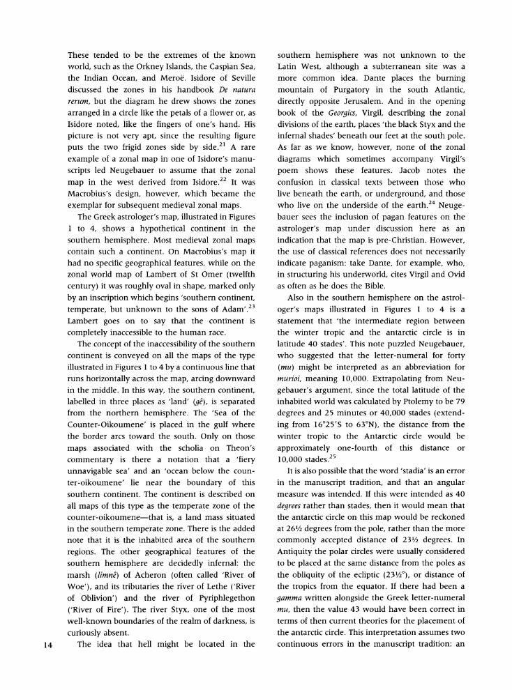
These tended to be the extremes of the known world, such as the Orkney Islands, the Caspian Sea, the Indian Ocean, and Meroe. Isidore of Seville discussed the zones in his handbook De natura rerum, but the diagram he drew shows the zones arranged in a circle like the petals of a flower or, as Isidore noted, like the fingers of one's hand. His picture is not very apt, since the resulting figure puts the two frigid zones side by side.2' A rare example of a zonal map in one of Isidore's manu- scripts led Neugebauer to assume that the zonal map in the west derived from Isidore.22 It was Macrobius's design, however, which became the exemplar for subsequent medieval zonal maps.
The Greek astrologer's map, illustrated in Figures 1 to 4, shows a hypothetical continent in the southern hemisphere. Most medieval zonal maps contain such a continent. On Macrobius's map it had no specific geographical features, while on the zonal world map of Lambert of St Omer (twelfth century) it was roughly oval in shape, marked only by an inscription which begins 'southern continent, temperate, but unknown to the sons of Adam'.23 Lambert goes on to say that the continent is completely inaccessible to the human race.
The concept of the inaccessibility of the southern continent is conveyed on all the maps of the type illustrated in Figures 1 to 4 by a continuous line that runs horizontally across the map, arcing downward in the middle. In this way, the southern continent, labelled in three places as 'land' (ge), is separated from the northern hemisphere. The 'Sea of the Counter-Oikoumene' is placed in the gulf where the border arcs toward the south. Only on those maps associated with the scholia on Theon's commentary is there a notation that a 'fiery unnavigable sea' and an 'ocean below the coun- ter-oikoumene' lie near the boundary of this southern continent. The continent is described on all maps of this type as the temperate zone of the counter-oikoumene-that is, a land mass situated in the southern temperate zone. There is the added note that it is the inhabited area of the southern regions. The other geographical features of the southern hemisphere are decidedly infernal: the marsh (limne) of Acheron (often called 'River of
Woe'), and its tributaries the river of Lethe ('River of Oblivion') and the river of Pyriphlegethon ('River of Fire'). The river Styx, one of the most well-known boundaries of the realm of darkness, is curiously absent.
14 The idea that hell might be located in the
southern hemisphere was not unknown to the Latin West, although a subterranean site was a more common idea. Dante places the burning mountain of Purgatory in the south Atlantic, directly opposite Jerusalem. And in the opening book of the Georgics, Virgil, describing the zonal divisions of the earth, places 'the black Styx and the infernal shades' beneath our feet at the south pole. As far as we know, however, none of the zonal diagrams which sometimes accompany Virgil's poem shows these features. Jacob notes the confusion in classical texts between those who live beneath the earth, or underground, and those who live on the underside of the earth.24 Neuge- bauer sees the inclusion of pagan features on the astrologer's map under discussion here as an indication that the map is pre-Christian. However, the use of classical references does not necessarily indicate paganism: take Dante, for example, who, in structuring his underworld, cites Virgil and Ovid as often as he does the Bible.
Also in the southern hemisphere on the astrol- oger's maps illustrated in Figures 1 to 4 is a statement that 'the intermediate region between the winter tropic and the antarctic circle is in latitude 40 stades'. This note puzzled Neugebauer, who suggested that the letter-numeral for forty (mu) might be interpreted as an abbreviation for murioi, meaning 10,000. Extrapolating from Neu- gebauer's argument, since the total latitude of the inhabited world was calculated by Ptolemy to be 79 degrees and 25 minutes or 40,000 stades (extend- ing from 16'25'S to 630N), the distance from the winter tropic to the Antarctic circle would be approximately one-fourth of this distance or 10,000 stades.25
It is also possible that the word 'stadia' is an error in the manuscript tradition, and that an angular measure was intended. If this were intended as 40 degrees rather than stades, then it would mean that the antarctic circle on this map would be reckoned at 26/2 degrees from the pole, rather than the more commonly accepted distance of 23/2 degrees. In Antiquity the polar circles were usually considered to be placed at the same distance from the poles as the obliquity of the ecliptic (231/20), or distance of the tropics from the equator. If there had been a gamma written alongside the Greek letter-numeral mu, then the value 43 would have been correct in terms of then current theories for the placement of the antarctic circle. This interpretation assumes two continuous errors in the manuscript tradition: an
incorrect term for the unit of measure and a loss of one of the letter-numerals. Supporting such an interpretation is the occurrence, in most copies, of the word ge' (land; label 29 on Figure 5) immedi- ately following this legend. It is possible that the
gamma of the word for land was originally intended to be the gamma forming the second element in the letter-numeral for 43 and that it was misinterpreted by later copyists as representing the word for 'land' which does indeed occur at two other positions (labels 24 and 25) on the southern continent.
Another possibility assumes the predominance
of celestial mapping over terrestrial zonal mapping in the interpretation of the polar circles-an interpretation encouraged by the presence of the
ecliptic and the vertical polar axis. In this reading, antarctic circle is here used in the astronomical sense of circle of constant invisibility. The term 'antarctic circle' was used by some Greek writers to indicate an area in the heavens that was always invisible at a given geographical latitude, just as the term 'arctic circle' delineated the area of the sky that was always visible at that latitude. When the terms are used in this way, the position of the
circles on the map is dependent upon the geogra- phical latitude of the writer. Thus, if the angular distance between the southern tropic and the antarctic circle was intended to have been 40
degrees (rather than stades), then the circle of constant invisibility indicated by the antarctic circle in this context would be valid only for a geogra- phical latitude of 261/2?N, or a locale just north of the northern tropic, somewhere between Syene
26 and Heptanomia. Such an interpretation would
suggest that the map originated in that area. In summary, the maps of this type are an
unusual conflation of celestial, terrestrial, anemo- logical and eschatological maps. Within a windrose, a zonal map is overlaid with celestial features such as the ecliptic and with geographical landmarks centring on Egypt, as well as three prominent rivers forming the boundaries of the classical under- world.27
Context
The historians of cartography who have discussed the map have located the place-names, commented on the form and speculated on its meaning. They failed, however, to link it to the context in which it appears. We have now found the map in two different contexts: first, in nine of the twelve preserved copies of the anonymous scholia to
Theon's commentary on Ptolemy's Handy Tables and, second, in the three recorded copies of an
anonymous astrological compendium. The appear- ance of the map in an astrological miscellany has not been previously noticed. It is possible that the material surrounding the map in the latter context is of importance in interpreting its origin and understanding its use. Moreover, the Handy Tables were themselves an astrological tool. In brief, we are dealing here with two separate contexts, both with an astrological base.
The Scholia
Neugebauer, Dilke and Jacob all studied the map as found in anonymous glosses on Theon of Alexan- dria's commentary on Ptolemy's Handy Tables. Why a map should be in the scholia is not immediately evident, for as Neugebauer observed, the map does not seem to be particularly relevant to the astronomical theories and tables comprising the rest of the scholia. Ptolemy compiled his tables in the second century, after completing the Almagest and before composing the Geography.28 The tables were extracted from the Almagest and reworked, with some changes and additions which included a table of coordinates for major cities. They were intended for the daily practice of astrologers and became the subject of numerous commentaries. In the fourth century, Theon of Alexandria repro- duced the Handy Tables-in fact, they survive only in his version-and wrote both a Grand Commentary and a Little Commentary on them.29 As was the way of medieval academics, the commentaries acquired additional commentaries or scholia. In Anne Tihon's study of these particular scholia, which are anonymous, she unkindly remarks that none of them has really helpful explanations.30
The anonymous scholia comprise fifteen short texts on topics that include the conversion of the Alexandrian calendar to the Egyptian and the calculation of the nearest conjunction of the sun and moon (new moon) and the next full moon. There are also two tables and five diagrams, one of which is the world map (see Appendix 3).31 The diagrams are usually grouped together after the last short text.32 Tihon studied the scholia in the dozen recorded manuscripts, ranging from the twelfth to
the seventeenth centuries.33
The Astrological Compendium
The three known manuscripts incorporating the astrological compendium differ substantially from 15
those containing the complete scholia, although there are some common elements besides the map. One text from the scholia -the final, fifteenth, short text on the latitude of the moon-also occurs in the astrological compendium (see Appendix 1, item 2). In the compendium, the scholium is at the top of a page on which there are three unrelated rotae or circular diagrams concerned in turn with the relationship of zodiacal signs and winds, the visibility of zodiacal signs and the motions of planets. Two of these rotae are also found among the concluding groups of diagrams in copies of the complete scholia.34 It is evident that the fifteenth text in the scholia, along with the two diagrams, circulated separately from the full set of scholia. An additional diagram in copies of the complete scholia-in this case a table of the rising and settings of the moon at different latitudes-is also found in a single copy of the astrological compen- dium (Appendix 1, item 6, and Appendix 3, diagram 1). It is uncertain whether material, including the map, that is found in both the scholia and the astrological compendium was derived from a common earlier source, or whether the compiler of the scholia extracted the items from the astrological compendium (or vice versa).
The non-scholia material in the astrological compendium is quite varied in its nature. The first item is a text, attributed to Ptolemy, on the use of the astrolabe for determining the position of heavenly bodies in relation to time and dealing with the problem of equinoctial (equal) versus
temporal (seasonal) hours. Entitled 'Concerning the circles of the astrolabe and of various other instruments and the circuits of the moon' (Appen- dix 1, item 1), it occurs in only one of the copies of the compendium (MS Marsh 42), although there is a parallel in Theon's commentary.35 The attribution to Ptolemy is interesting because of the unresolved question of his knowledge of the planispheric astrolabe and merits a digression.
The precise origins of the astrolabe are obscure, though it appears to have been a Greek invention. The method of stereographic projection useful for
constructing planispheric astrolabes was described by Ptolemy in a treatise now lost in the original Greek. A Latin translation from Arabic, entitled
Planisphaerium, was made in 1143 by Hermann of
Carinthia. In the fourteenth chapter of the Plani-
sphaerium, Ptolemy refers to a 'spider' (aranea) and a 'horoscopic instrument' (horoscopium instrumen-
16 tum), but the instrument lacks attributes clearly
recognizable as those of a planispheric astrolabe, such as an alidade.36 In the Tetrabiblos, Ptolemy's major astrological work, there is a passage in which the expression di' astrolabon horoskopion ('by means of the astrolabic horoscopic instrument') is the recommended method of determining time of birth.37 The theory among many historians today, however, is that here Ptolemy is referring to the observational armillary sphere (a three-dimen- sional instrument rather than a planar one), just as he was when using the term 'astrolabe' in the
Almagest and in the Geography.38 Beyond this, little can be said with any certainty.
There are no substantial grounds for considering that Hipparchus, to whom Ptolemy was much indebted, knew about stereographic projection and applied it to instrument design. The attribution to Ptolemy of the essay on the astrolabe in the astrological compendium may be meaningless, or it may represent a stray survival of an older work by him or by Theon, who in the fourth century wrote on the astrolabe. Theon's treatise was subsequently used in the sixth century by John Philoponus, also of Alexandria, who composed in Greek the earliest preserved treatise on the subject.39 There is no further evidence for the knowledge or use of astrolabes until their widespread production began in the ninth century in the Islamic world.
The history of the astrolabe is relevant to our discussion of the map in the astrological compen- dium not only because the compendium opens with a text on the instrument (attributed to Ptolemy), but also because the astrolabe became an indispensable tool for the casting of horoscopes, an important activity for most astrologers. The astrological compendium, moreover, has a star table of a type often found in treatises on the construction of the astrolabe (see Appendix 1, item 16). The table lists the names, celestial latitudes and longitudes, and magnitudes of the brightest stars. Such lists were included in treatises on the astrolabe because a selection of bright stars was engraved on the rete, or movable cover-plate, of an astrolabe. The stars listed in this anonymous astrological compendium include Spica, Arcturus, Antares and Sirius, though some of the usual stars, such as Aldebaran and Procyon, are omitted.40
This table also includes a column entitled kraseis
(temperaments), in which the planets associated with the star are designated. The fixed stars were
thought to have the characteristics of one or more planets and to induce these qualities in those
14AMS~i'r AA41.
*4 ~~~~~~~~~~~~~~~~~~~~~~~~~~
Ag
A~~~~~~~A
~~sK~ ~ ~ ?Y
'1~~~~~~~~~~~~~~~~~~~~~~~~11
Fig. 6. A circular representation, with south at the top, of the rising and setting points of the houses of the zodiac along the ecliptic in the seven different climates of the known world. The climates are indicated both by their names (given along the top half of the vertical diameter) and by the number of hours in their longest day, given along the lower half of the vertical diameter. Oxford, Bodleian Library, Dept. of Oriental Collections, MS Marsh 42, fol. 4v/ 1 56a. Undated,
late 16th century. (Reproduced with permission from the Bodleian Library, Oxford.)
persons born under their influence. The inclusion of this column on the chart indicates that it was intended for the astrological interpretation of the visibility of major stars. This particular list consists of sixteen stars, the same number mentioned in a
fourth-century document as the number on Ptole- my's supposed astrolabe, though the similarity may be only a coincidence.4'
Below the map in the astrological compendium there is a text of several lines unrelated to the 17
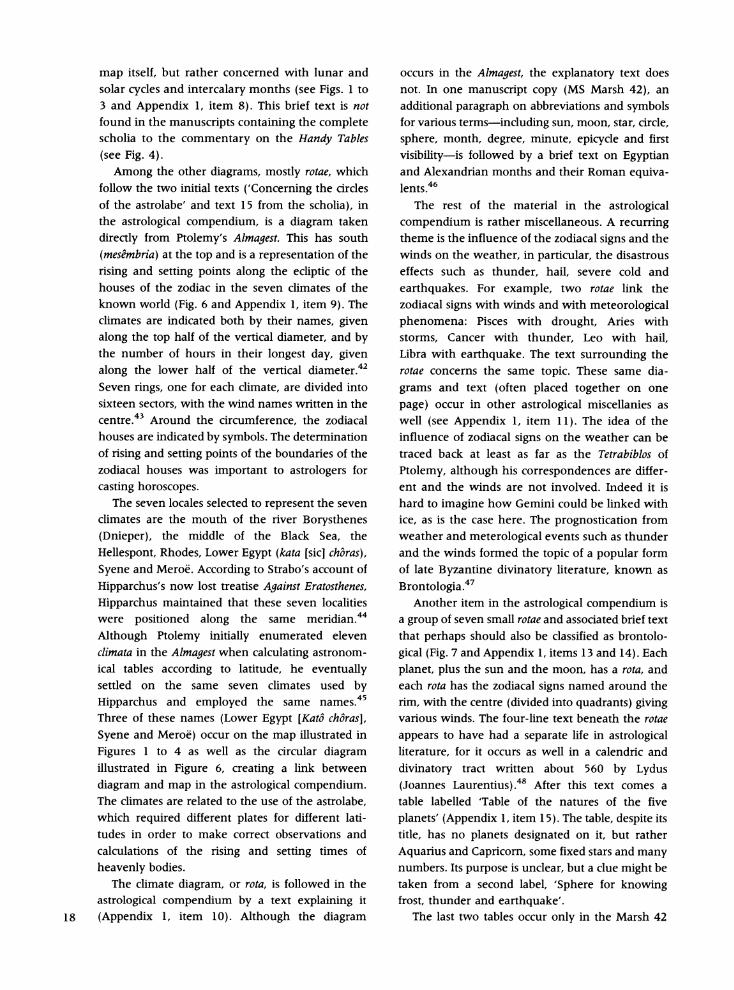
map itself, but rather concerned with lunar and solar cycles and intercalary months (see Figs. 1 to 3 and Appendix 1, item 8). This brief text is not found in the manuscripts containing the complete scholia to the commentary on the Handy Tables (see Fig. 4).
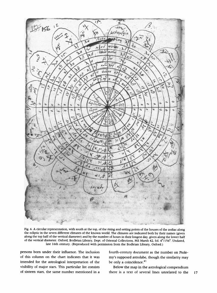
Among the other diagrams, mostly rotae, which follow the two initial texts ('Concerning the circles of the astrolabe' and text 15 from the scholia), in the astrological compendium, is a diagram taken directly from Ptolemy's Almagest. This has south (mesembria) at the top and is a representation of the rising and setting points along the ecliptic of the houses of the zodiac in the seven climates of the known world (Fig. 6 and Appendix 1, item 9). The climates are indicated both by their names, given along the top half of the vertical diameter, and by the number of hours in their longest day, given along the lower half of the vertical diameter.42 Seven rings, one for each climate, are divided into sixteen sectors, with the wind names written in the centre.43 Around the circumference, the zodiacal houses are indicated by symbols. The determination of rising and setting points of the boundaries of the zodiacal houses was important to astrologers for casting horoscopes.
The seven locales selected to represent the seven climates are the mouth of the river Borysthenes (Dnieper), the middle of the Black Sea, the Hellespont, Rhodes, Lower Egypt (kata [sic] choras), Syene and Meroe. According to Strabo's account of Hipparchus's now lost treatise Against Eratosthenes, Hipparchus maintained that these seven localities were positioned along the same meridian.44 Although Ptolemy initially enumerated eleven climata in the Almagest when calculating astronom- ical tables according to latitude, he eventually settled on the same seven climates used by Hipparchus and employed the same names.45 Three of these names (Lower Egypt [Kat6 choras], Syene and Meroe) occur on the map illustrated in Figures 1 to 4 as well as the circular diagram illustrated in Figure 6, creating a link between diagram and map in the astrological compendium. The climates are related to the use of the astrolabe, which required different plates for different lati- tudes in order to make correct observations and calculations of the rising and setting times of heavenly bodies.
The climate diagram, or rota, is followed in the astrological compendium by a text explaining it
18 (Appendix 1, item 10). Although the diagram
occurs in the Almagest, the explanatory text does not. In one manuscript copy (MS Marsh 42), an additional paragraph on abbreviations and symbols for various terms-including sun, moon, star, circle, sphere, month, degree, minute, epicycle and first visibility-is followed by a brief text on Egyptian and Alexandrian months and their Roman equiva- lents.46
The rest of the material in the astrological compendium is rather miscellaneous. A recurring theme is the influence of the zodiacal signs and the winds on the weather, in particular, the disastrous effects such as thunder, hail, severe cold and earthquakes. For example, two rotae link the zodiacal signs with winds and with meteorological phenomena: Pisces with drought, Aries with storms, Cancer with thunder, Leo with hail, Libra with earthquake. The text surrounding the rotae concerns the same topic. These same dia- grams and text (often placed together on one page) occur in other astrological miscellanies as well (see Appendix 1, item 11). The idea of the influence of zodiacal signs on the weather can be traced back at least as far as the Tetrabiblos of Ptolemy, although his correspondences are differ- ent and the winds are not involved. Indeed it is hard to imagine how Gemini could be linked with ice, as is the case here. The prognostication from weather and meterological events such as thunder and the winds formed the topic of a popular form of late Byzantine divinatory literature, known as Brontologia.47
Another item in the astrological compendium is a group of seven small rotae and associated brief text that perhaps should also be classified as brontolo- gical (Fig. 7 and Appendix 1, items 13 and 14). Each planet, plus the sun and the moon, has a rota, and each rota has the zodiacal signs named around the rim, with the centre (divided into quadrants) giving various winds. The four-line text beneath the rotae appears to have had a separate life in astrological literature, for it occurs as well in a calendric and divinatory tract written about 560 by Lydus (Joannes Laurentius).48 After this text comes a table labelled 'Table of the natures of the five planets' (Appendix 1, item 15). The table, despite its title, has no planets designated on it, but rather Aquarius and Capricorn, some fixed stars and many numbers. Its purpose is unclear, but a clue might be taken from a second label, 'Sphere for knowing frost, thunder and earthquake'.
The last two tables occur only in the Marsh 42
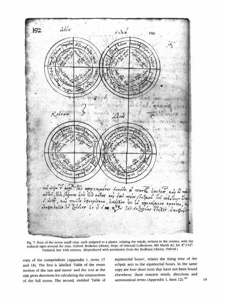
0 rt ' i1
> t 75
74' ~ ~ ~ ~ "f
4 4 :1
'reaf rC /fPC , s
Fig 7.For o th svens ll f Wat ahasindYtota lantf oreatin th wintst write inrtecnrtwt h
rAA
IL ~ ~ I-
zodiacal signs around the inms. Oxford, Bodleian Library, D)ept. of Oriental Collections, MS Marsh 42, fol. 8Vi1 52a. Undatedt late 16th century. (Reproduced with permission from the Bodleian Library, Oxford.)
copy of the compendium (Appendix 1, items 17
and 18). The first is labelled 'Table of the mean
motion of the sun and moon' and the text at the
side gives directions for calculating the conjunctions
of the full moon. The second, entitled 'Table of
equinoctial hours', relates the rising time of the
ecliptic arcs to the equinoctial hours. In the same
copy are four short texts that have not been found
elsewhere; these concern winds, directions and
astronomical terms (Appendix 1, item 12).4 19
Date and Provenance
The great figure of Ptolemy is a continuing presence throughout the astrological compendium, for he is named in the title of the opening text, a diagram is
taken from his Almagest, and there is material from
the scholia to Theon's commentary on his Handy
Tables. This may indicate nothing more than the need to cite his authority, for he loomed large in the imagination of medieval astronomers, even those
who knew little of his actual work. The association of a map with material con-
cerned with the astrolabe is an important feature of the astrological compendium that merits further attention. Although the association of map and astrolabe is unusual, it has parallels in other
contexts.50 Some knowledge of geography, espe-
cially the climates, was needed to make the plates
for the different latitudes in which an astrolabe might be used. When maps do appear in astro- nomical or astrological manuscripts, they fre-
quently use the zonal format of our map.5' In the Latin West specifically astrological maps also show
the influence of the signs of the zodiac or the planets on particular parts of the world.52 In the Renaissance the astrolabe became a surveying tool for map making, and it is not uncommon for
surveying exercises to be included in medieval
treatises on the use of the astrolabe. The original of the map under study here is
certainly of an early date. Tihon believes the scholia
with which it is often associated to be Egyptian and
to date from the end of the fifth to the beginning of
the sixth century. However, she also notes that
earlier material (for example, references to the solar
eclipse of 364) was incorporated into the scholia.53 Other elements, including the map, may be older, possibly predating Theon or even Ptolemy. The
persistent attachment to the astrological compen- dium of the fifteenth text of the scholia suggests that this individual scholium may have been
circulating separately before the anonymous author
compiled his glosses on Theon's text. Alternatively, the fifteenth scholium may have been extracted
from the rest of the glosses and placed in the
astrological compendium. Similar arguments hold for the other material shared between the scholia
and the astrological miscellany, including the map. Neugebauer suggested that the map itself was
made in Egypt during the Roman imperial period. His argument is based partly on the Egyptian place-
20 names and partly on his view that the pagan
description of the Underworld indicates a pre- Christian product.54 It should be noted, however, that even at the height of the Middle Ages, zonal maps seldom included theological material. In contrast to Neugebauer, Dilke suggested a date of the fifth to sixth century and Upper Egypt as a locus of production, presumably because neither Alex- andria nor even the Mediterranean is indicated on the map.55 It is indeed notable that the maker of the
prototype for this map chose to omit Alexandria, giving only the vague term for Lower Egypt, Katb chbras; the omission may suggest an orientation on the part of the mapmaker away from the scientific and learned communities of Alexandria. Most recently, Jacob gives the earliest date of all, from the first to the third century AD.56
The place-names given on the map-limited to Persia, Libya, and to five localities in Egypt- reinforce the idea of an Egyptian origin. Surely a significant factor in interpreting its origins is the fact that two of the five Egyptian place-names are part of the Roman administrative terminology. We
suggest that the occurrence of the Roman colony of Hierasycaminus provides a terminus ante quem and terminus post quem for the production of the original map. Hierasycaminus was established in 20 BC, so the map could not have originated prior to that time. It was abandoned by the Romans in 298, which means that its inclusion on a map con- structed many years later would have had little significance.57 It is reasonable, therefore, to spec- ulate that the map originated in Egypt sometime in
the second century or during the first part of the third century. This would make it considerably older than the textual scholia with which is it often associated, and older even than Theon's commen- tary on which the scholia are based. In short, the exemplar for the astrologer's map illustrated in
Figures 1 to 4 could represent one of the earliest maps preserved from Late Antiquity.
Most of the material in the astrological compen- dium-weather prognostication, aids to interpret- ing horoscopes, information on astrolabes and the
visibility of planets and stars-would have been of
interest to a practising astrologer, though one surely hopes he had more in his library. The different zones marked on the map are directly related to variation in daylight, seasons and
weather, while the ecliptic and the great and lesser circles defining the zones represent the same celestial circles drawn in stereographic projection
on the rete of an astrolabe, an essential tool for medieval astrologers. To what extent the astrolabe was actually used in Late Antiquity or the early Byzantine period is uncertain. The armillary sphere, however, was known before Ptolemy, and the structure of the map exactly reflects a flattened illustration of this instrument, even to the vertical bar connecting pole with pole. Such illustrations can be found in many astrological manuscripts.58
The presence of the wind rota as part of the map
links it to the numerous wind rotae in the astrological compendium. The winds were used as a way of indicating directions and geographical places, since most of them are named for the place from which
they blow, but winds also played a significant role in divination and forecasting weather.
The Greek map that we have been considering appears to be an unusually ancient survival of Hellenistic cartographical traditions into the Middle
Ages. Since a dozen almost identical versions of this
map survive, it must have been a widely accepted
image of the world. Comparing it with similar Latin
maps in the West gives us some idea of how the inherited material was adapted in East and West. The appearance of the map in astrological manu-
scripts alerts us to look for maps in other such
collections. It also suggests the function of the map: to orient users to their place in the world, both
geographically and cosmologically. Such orienta- tion was the goal of astrology, which linked events on earth to the movements of the heavens. The
knowledge of one's date and time of birth, or even
conception, established a relationship with the
positions of the planets and stars. These relation-
ships and consequent influences varied according to
geographical location as well. Like the astrological
compendium containing the map, Ptolemy's Handy Tables with their assorted commentaries and dia- grams were copied for use by astrologers. The nature and context of this composite map- representing as it does the celestial sphere, the sublunar sphere of winds, the inhabited world and the underworld-reinforces the idea that world
maps were philosophical rather than practical, providing a cosmic overview rather than informa- tion for some mundane journey.
Acknowledgements. The authors wish to thank the staffs of the Department of Oriental Collections and the Depart- ment of Western Manuscripts of the Bodleian Library, Oxford, and of the Handschriftenabteilung of the Staatsbi- bliothek zu Berlin, for their generous assistance in providing access to the manuscripts and copies for
publication. They also wish to thank the anonymous referee for useful suggestions.
Manuscript submitted July 1999. Revised paper received January 2000.
NOTES AND REFERENCES
1. For further details regarding MS Marsh 42, see Appendix 1.
2. For the life of Jacob Golius (d. 1667) and his manuscripts now in the Bodleian, see Emilie Savage- Smith and Colin Wakefield, 'Jacobus Golius and celestial cartography', in Learning, Language and Invention: Essays Presented to Francis Maddison, ed. W. D. Hackmann and A. J. Turner (Aldershot, Variorum, 1994), 238-60, esp. 250- 54.
3. For further details of MS Barocci 94 and MS Phill. 1479, see Appendix 1.
4. Otto N. Neugebauer, 'A Greek world map', in Le monde grec: Hommages a Claire Priaux, ed. Jean Bingen, Guy Cambier and Georges Nachtergael (Brussels, Editions de l'Universit6 de Bruxelles, 1975), 312-17 and plate III.2, where he mistakenly associates the map with Isidore of Seville. Neugebauer's work is cited in a footnote to Barbara Obrist's 'Wind diagrams and medieval cosmol- ogy', Speculum 72 (1997): 49, n.79. The map is not illustrated in the History of Cartography, Vol. 1: Cartography in Prehistoric, Ancient, and Medieval Europe and the Medi- terranean, ed. J. B. Harley and David Woodward (Chicago, University of Chicago Press, 1987), though it is mentioned in a footnote to the chapter by 0. A. W. Dilke, 'Itineraries and geographical maps in the early and late Roman Empire', 248 n.80. In an earlier work Dilke published a small illustration, with a brief description, of one of the maps associated with the scholia to the commentary on the Handy Tables (Venice, Biblioteca Marciana, Cod. gr. 314, fol. 222v)-the same example used by Neugebauer; see 0. A. W. Dilke, Greek and Roman Maps (Ithaca, Cornell University Press, 1985; Baltimore, Johns Hopkins Press, 1998), 170 and plate 29.
5. Christian Jacob, 'Ecriture, geometrie et dessin figur- atif: essai du lecture d'une carte grecque', Mappemonde, no. 1 (1988): 1-3. He reproduced the same example of the map as used by Neugebauer and Dilke.
6. Neugebauer, 'A Greek world map' (see note 4), 316. 7. Dilke, Greek and Roman Maps (see note 4), 170. 8. Ibid, and Dilke, 'Itineraries and geographical maps'
(see note 4), 248 n.80. 9. Aristotle, Meteorologica, trans. by H. D. P. Lee (Loeb
Classical Library; London, Heineman, 1952), II, vi. 10. See Emilie Savage-Smith, Islamicate Celestial Globes:
Their History, Construction, and Use (Smithsonian Studies in History and Technology 46; Washington, D.C., Smithso- nian Institution Press, 1985), 3-15; and Hans Georg Gundel, Zodiakos: Tierkreisbilder im Altertum (Kultur- geschichte der antiken Welt 54; Mainz am Rhein, Philipp von Zabern, 1992).
11. Claudius Ptolemy, The Geography of Claudius Ptolemy, translated by E. L. Stevenson (New York: Public Library, 1932; reprinted Dover Press, 1991), 102-4, 108; transla- tion taken from 102. Kata chora included the nomes of old Pharaonic Lower Egypt, minus the Memphite and, probably, the Letopolite nomes. See David J. Thomas, The Epistrategos in Ptolemaic and Roman Egypt (Abhandlun- gen der Rheinisch-Westfalischen Akademie der Wis- senschaften, Papyrologica Coloniensia, vi; Opladen, Rheinisch-Westfalischen Akademie der Wissenschaften, 21
1975), 2: 16; and Aubrey Diller. 'The parallels on the Ptolemaic maps', Isis 33 (1941): 4-7.
12. The district comprised seven of the old Pharaonic nomes of Egypt, hence its name. Six of the seven can be identified with certainty: Hermopolite (forming the south- ern boundary), Cynopolite, Oxyrhynchite, Heracleopolite, Aphroditopolite and Memphite; the identity of the seventh, forming the northern boundary, is uncertain. See Thomas, The Epistrategos in Ptolemaic and Roman Egypt (note 11), 2: 21-25, 32-33.
13. H. Grapow, 'Hierasykaminos', in Paulys Real-Encyclo- padie der Classischen Altertumswissenschaft, ed. Georg Wissowa, VIII, ii (Stuttgart, J.B. Metzlersche Verlagsbuch- handlung, 1913), col. 1407. A puzzling reference to the presence of 'Hiera Sicaminos' on the Hereford map is found in G. R. Crone, 'New light on the Hereford map', Geographical Journal 130 (1965): 447-62, especially 451 and map. A careful examination of the Hereford map, however, reveals no such name. Judging by Crone's comments in an earlier, more complete, discussion of Egyptian places on the Hereford map, the reference is to Porte Nibie, or the gateway to Nubia; see G. R. Crone, The World Map by Richard of Haldingham (London, Royal Geographical Society, 1954), 14.
14. Meroc was situated below the 6th cataract of the Nile and is not to be confused with modern Merowe, which is below the 4th cataract. See H. Kees, 'Meroc', in Paulys Real-Encyclopddie der Classischen Altertumswissenschaft, ed. Georg Wissowa, XV, i (Stuttgart, J. B. Metzlersche Verlagsbuchhandlung, 1931), cols. 1048-1054.
15. The division of the world into climates, based on latitude or the number of hours in the longest day, continued to be an important classification in Ptolemaic astronomy and geography.
16. Neugebauer, 'A Greek world map' (see note 4), 312. 17. For examples of zonal maps, see Evelyn Edson,
Mapping Time and Space (London, British Library, 1997), 6, Fig. 1.4; 77, Fig. 5.1; 82-83, Fig. 5.3.
18. Aristotle, Meteorologica (see note 9), II.v. 19. 0. A. W. Dilke, 'The culmination of Greek carto-
graphy in Ptolemy', in Harley and Woodward, History of Cartography, Vol. 1 (see note 4), 177-200, reference on 184. 20. Some 150 manuscripts of Macrobius survive, and
nearly 100 contain the world map. See Marcel Destombes, Mappemondes A.D. 1200-1500: Catalogue (Amsterdam, N. Israel, 1964), 43-45 and 85-95, for a list.
21. Jacques Fontaine, Isidore de Seville Traiti de la Nature (Bordeaux, Feret et Fils, 1960), reprints the diagrams from an early manuscript. For additional discussion of Isidore's diagrams, see Edson, Mapping Time and Space (note 17), 38-46. 22. The map Neugebauer mentions is reproduced by
Destombes, Mappemondes (see note 20), Plate IV. It is one of two zonal maps in the several hundred Isidore manuscripts described in the catalogue (Leiden, Bibliothek der Rijksunversiteit, Cod. E Leg. Periz. Fol. 2, fol. 49r). The other zonal map in Isidore's De natura rerum is in Paris, Bibliotheque nationale de France, fonds lat. 4860, fol. 107r. Destombes does not dignify Isidore's flower-petal diagram by cataloguing it as a map. 23. Wolfenbuttel, Herzog August Bibliothek, MS Guelf.
I. Gud. Lat., fols. 69v-70r. The complete text of Lambert's inscription can be found in Konrad Miller, Mappaemundi: Die altesten Weltkarten (Stuttgart, J. Roth, 1895-1896), 3: 50. 24. Jacob, 'Ecriture, geometrie et dessin figuratif' (see
note 5), 4 and n.9.
25. See Neugebauer, 'A Greek world map' (note 4), 315. In MS Marsh 42 the word ge (land) has migrated from label 29 into label 28, where it makes the legend even more confusing; see Appendix 2 and Fig. 5. It is difficult to determine a modern equivalent for the length of a stade, which in any case varied locally. It was originally a term designating the distance covered by a plough in a single draft, with that being in the range of eight stades to the Roman mile. There is considerable debate among scholars as to its value in modem terms, with estimates varying from 148 to 158 meters to a stade to 185 meters or more. A degree of latitude was considered in the neighbourhood of 541 stades. See Germaine Aujac, 'The growth of an empirical cartography in Hellenistic Greece', in Harley and Woodward, History of Cartography, Vol. 1 (see note 4), 148; and Raymond P. Mercier, 'Geodesy', in History of Cartography, Vol. 2, Book 1: Cartography in the Traditional Islamic and South Asian Societies, ed. J. B. Harley and David Woodward (Chicago, University of Chicago Press, 1992), 175-88, esp. 178-79. 26. For arctic and antarctic circles as circles of constant
visibility and invisibility, see Savage-Smith, Islamicate Celestial Globes (note 10), 6-15; and Aujac, 'The founda- tions of theoretical cartography in archaic and classical Greece', in Harley and Woodward, History of Cartography, Vol 1 (note 4), 130-47, esp. 146-47. 27. Jacob suggests that the map shows the position of
Egypt in the world, both in a geographical and a cosmological sense, and that the places in hell may derive from Egyptian mystical thought in the early centuries of our era; see Jacob, 'Ecriture, geometrie et dessin figuratif' (note 5). 28. For the Handy Tables, see B. L. van der Waerden,
'Klaudios Ptolemaios', in Paulys Real-Encyclopidie der Classischen Altertumswissenschaft, ed. Georg Wissowa, XXIII, a (Stuttgart, Alfred Druckenmuller Verlag, 1959), cols. 1788-1859, esp. cols. 1823-1827. 29. For the Procheiroi kanones (Handy Tables) of Ptolemy,
and the commentary by Theon, see Claudius Ptolemy, Opera Astronomia Minora, ed. J. L. Heiberg (Leipzig, Teubner, 1907), CXC-CCIII, 159-185; and Anne Tihon, Le 'Grand Commentaire' de Thion d'Alexandrie aux Tables Faciles de Ptolimie (Studi e Testi 315; Vatican, 1985). For the anonymous scholia on the commentary by Theon, see Anne Tihon, 'Les scholies des Tables Faciles de Ptolemee', Bulletin d'Institut historique belge de Rome 43 (1973): 49- 110. See also, Ernst Honigmann, Die Sieben Klimata unde die 'poleis episemoi': eine Untersuchung zur Geschichte der Geographie und Astrologie im Altertum und Mittelalter (Heidelberg, 1929), 116-21. 30. Tihon, 'Les scholies des Tables Faciles' (see note 29),
105-6. Tihon thinks they were student lecture notes, adding 'tous les professeurs savent ce que deviennent parfois leurs cours notes par les etudiants!'
31. Tihon (see note 29), being more interested in the texts, does not reproduce the diagrams. Neugebauer (see note 4) reproduces the map only.
32. This is the arrangement, for example, in Oxford, Bodleian Library, MS Canon Gr. 32, fols. 16v-18r.
33. For a list of manuscripts, see Tihon, 'Les scholies des Tables Faciles' (note 29), 52; and Appendix 3 for those manuscripts containing the map.
34. In the scholia they are not grouped together (see Appendix 1, items 3 to 5, and Appendix 3, diagrams 2 and 7).
35. In Theon's commentary, the instructions are based on the use of the Handy Tables, rather than the use of the 22
astrolabe: see in particular Tihon, Le 'Grand Commentaire' de Thion (note 29), 184-85.
36. Ptolemy, Opera quae exstant omnia, ed. J. L. Heiberg (3 vols., Leipzig, Teubner, 1898-1907), 2: 225-59, esp. 249; German trans. by J. Drecker, 'Das Planisphaerium des Claudius Ptolemaeus', Isis 9 (1927): 255-78, esp. 271. See also Paul Kunitzsch, 'Fragments of Ptolemy's Planisphaer- ium in an early Latin translation', Centaurus 36 (1993): 97- 101. 37. Tetrabiblos 3.2; see Ptolemy, Tetrabiblos, ed. and trans.
F. E. Robbins (Loeb Classical Library; Cambridge, Mass.: Harvard University Press, 1940, reprinted 1980), 228-31. Note that h6roskopi6n is here a noun and not an adjective.
38. In this interpretation of the Ptolemaic and pre- Ptolemaic antecedents of the astrolabe, Otto Neugebauer, in Ancient Mathematical Astronomy (3 parts, Berlin and New York, Springer, 1975), 3: 858, 868-69, 871, severely modified and even reversed many points he had made in a study nearly thirty years earlier (O. Neugebauer, 'The early history of the astrolabe: studies in ancient astronomy IX', Isis 40 (1949): 240-56). For arguments that Ptolemy knew of the astrolabe and that Hipparchus could well have developed the planispheric astrolabe, see Neuge- bauer, 'Early history of the astrolabe', 241-42, 246-51, and Aujac, 'Greek cartography in the early Roman world', in Harley and Woodward, History of Cartography, Vol. 1 (note 4), 161-67, esp. 167 n.35. An important source in these arguments is Synesius of Cyrene, who died shortly before 415 and was a pupil of Hypatia, the daughter of Theon of Alexandria; see Joseph Vogt and Matthias Schramm, 'Synesios vor dem Planisphaerium', in Das Altertum und jedes neue Gute: Fur Wolfgang Schadewaldt zum 15. Mdrz 1970, ed. Konrad Gaiser (Stuttgart, Kohlhammer, 1970), 265-311, esp. 279-311. 39. Johannes Philoponus, Traitt' de l'astrolabe, trans. A. P.
Segonds Astrolabica, Vol. 2 (Paris, The Astrolabe Society, 1981). Theon's treatise is also partly preserved in a 7th- century Syriac work on the astrolabe by Severus Sebokht, bishop of Qinnasrin in Syria; see F. Nau, 'Le traite sur l'astrolabe plan de Severe Sabokht, ecrit au viie sile d'apres des sources grecques, et publie pour la premiere fois d'apres un ms. de Berlin', Journal Asiatique, ser. 9, 13 (1899): 56-101, 238-303; and for an English translation, R. T. Gunther, The Astrolabes of the World, Vol. 1: The Eastern Astrolabes (Oxford, Clarendon, 1932), 82-103.
40. The information in the table is somewhat scrambled, with the coordinates and magnitudes of Arcturus, Regulus and several others being given one row above the row designated for the star. The error appears to have been made early in the manuscript tradition, for it is repeated in all copies, and it appears that an earlier copyist tried to correct it by inserting an extra, seventeenth, row of figures for the sixteen named stars. 41. Letter from Synesius, Migne Patrologia Greca, LXVI,
col. 1594. A translation of the relevant passage appears in Neugebauer, 'Early history of the astrolabe' (see note 38), 248. There is no list of exactly sixteen stars in Kunitzsch's rather exhaustive study of star lists derived from both the Arabic and Western traditions; see Paul Kunitzsch, Typen von Sternverzeichnissen in astronomischen Handschriften des zehnten bis vierzehnten Jahrhunderts (Wiesbaden, Otto Harrassowitz, 1966). 42. The diagram occurs at the end of Book VI of the
Almagest; see G. J. Toomer, Ptolemy's Almagest (London, Duckworth, 1984), 320, Fig. 6.7. For an example from a Latin translation of the Almagest (Vatican, MS lat. 2056,
fol. 55V), and a detailed discussion of the diagram, see John E. Murdoch, Album of Science: Antiquity and the Middle Ages (New York, Scribners, 1984), 58 no.54. In the British Library, Department of Western Manuscripts, MS Burney 275, fol. 475v (also a Latin translation of the Almagest), the sequence is anticlockwise from that in MS Marsh 42 and the Vatican Latin manuscript, and the place-names are not given. 43. In MS Marsh 42, illustrated in Fig. 6, one sector is
blank and Notos, the south wind, is indicated twice. 44. For a diagram illustrating Hipparchus's theory and
the relation of the seven locales to the actual meridian, see Aujac, 'Greek cartography in the early Roman World' (note 38), 167, Fig. 10.5. 45. See Dilke, 'The culmination of Greek cartography in
Ptolemy (note 19), 183. 46. The brief discussion of the Roman equivalents of
Egyptian and Alexandrian months is similar to a text given for comparative purposes by J. L. Heiberg in Ptolemy, Opera Astronomia Minora (see note 29), CXCI n.1, second paragraph. 47. Numerous late Greek Brontologia, as well as
Selenodromia (divination from the appearance of the moon), are to be found throughout the Greek manuscripts listed in the Catalogus codicum astrologorum graecorum, ed. Alexander Olivieri et al. (12 vols., Brussels, H. Lamertin, 1898-1934). 48. In De ostendis by Lydus, the text is preceded by a
sentence attributing it to scholia by Symeon monachus Chrysographus: scholia apo phones Sume6n monachou tou chrusographou eis ta prokeimena duo kanonia peri seismdn; Lydus (Joannes Laurentius), De ostendis, ed. C. Wachs- muth (Leipzig, Teubner, 1897), 175.
49. In Marsh 42, fol. 9V/151a has been left blank with only the notation by the copyist: Nihil hic deest. On the final folio (liv/149a) the copyist has written the pious phrase: telos; mon6i tci theoi doxa ('The End. Praise be to God alone').
50. For a preliminary sketch of observations on this issue of maps and their relationship with astrolabes, see Evelyn Edson, 'Astrolabes and maps', Mapline (Winter 1999): 1-3.
51. See for example the map in the Liber Introductorius of Michael Scot preserved in Oxford, Bodleian Library, MS Bodley 266, fol. 60v (3rd quarter, 15th century).
52. An example is in the Summa astrologia judicialis of John Eschenden (or Ashenden or Eschuid) of Merton College, Oxford, originally composed in 1347-48. An early 15th-century manuscript is Oxford, Bodleian Library, MS Bodley 369. Thanks to John Wehrmeister for calling these fascinating maps to our attention.
53. In constructing a stemma interrelating the various scholia manuscripts, Tihon conjectures that they are all derived from a 9th-century manuscript that was in the collections of the Vatican (Cod. gr. 1594), but is now lost. See Tihon, 'Les scholies des Tables Faciles' (note 29), 105-6.
54. Neugebauer, 'A Greek world map' (see note 4), 312. 55. Dilke, Greek and Roman Maps (see note 4), 170. 56. Jacob, 'Ecriture, geometrie et dessin figuratif' (see
note 5), 1. He calls the map Alexandrine and links it to Egyptian hermeticism.
57. It is, of course, difficult to determine how long a name remains in use, or a settlement continues to function, after the administrative powers change or withdraw.
58. For example, Oxford, St John's College, MS 164, fols. Irand 158v.
23
Appendix 1: Constituent Parts of the Anonymous Astrological Compendium Containing the Map
Preserved Manuscripts:
1. Oxford, Bodleian Library, Dept. of Western Manuscripts, MS Barocci 94, folios 117r-120.
The folios containing the astrological compendium lie within an undated section of the manuscript copied by Andreas Donos, a scribe, presumably from Crete, who worked in Messina in Sicily at the end of the 15th century and the beginning of the 16th century. For the work of Donos preserved today, see Ernst Gamillscheg and Dieter Harlfinger, Repertorium der griechischen Kopisten 800-1600. 1. Teil: Handschriften aus Bibliotheken Grossbritanniens. A. Verzeichnis der Kopisten (Veroffentlichungen der Kommission fur Byzantium, Bd. II.1 A; Vienna, Osterreichischen Akademie der Wissenschaften, 1981), 32-33, no. 14. The Barocciani Collection was formed by Giacomo Barocci of Venice and was acquired by the Bodleian in 1629 when presented by the then Chancellor of the University, William Herbert, Earl of Pembroke. For a brief description of the items comprising MS Barocci 94, see H. 0. Coxe, Bodleian Library Quarto Catalogues, Vol. I: Greek Manuscripts, reprint with corrections of the 1853 edition (Oxford, Bodleian Library, 1969); folios 114v-148v are simply stated to contain 'Tabulae astrologicae, cum allis regulis'. Several hands and changes of paper were involved in the production of the volume. The paper on which the astrological compendium occurs has fine vertical laid lines, single chain lines and scattered and rather inconspicuous watermarks consisting of portions of initials placed alongside a chain line.
2. Berlin, Staatsbiblothek, Handschriftenabteilung, MS Phill. 1479, folios 27r-30v.
The undated and unsigned manuscript appears to be a mid-sixteenth-century copy, carefully executed. Astrological portions of the manuscript have been described in Catalogus codicum astrologorum graecorum, ed. Alexander Olivieri, et al. (12 vols., Brussels, H. Lamertin, 1898-1934), VII: 33, no. 17 (hereafter CCAG).
3. Oxford, Bodleian Library, Dept. of Oriental Collections, MS Marsh 42, folios Ir-1 v [159b-149a].
The Greek section of MS Marsh 42 is undated and unsigned but appears to have been made in the second half of the 16th century. It is written on paper of European manufacture, with single evenly-spaced chain lines and a large watermark (c.98 85 mm2) consisting of a single-headed eagle with wings spread open, a small crown on its head, and an elaborate decorative device between its legs. The published watermark closest in design and size to that found in this Greek treatise occurs in paper produced in Luxembourg in 1587, though it should be noted that the watermark in the Greek section of MS Marsh 42 is more elaborate and more carefully executed. (For the watermark in the Luxembourg paper, see C. M. Briquet, Les Filigranes, Dictionnaire historique des marques du papier, Paris, 1907, vol. 1, No. 125.) A date of the second half of the sixteenth century would be consistent with the general appearance of the ink and script. The copyist made frequent interlinear and marginal annotations in Latin, commenting upon an unreadable word or other peculiarity of his exemplar.
This is a composite volume of 166 folios containing 12 distinct items. The non-Greek portion of the manuscript includes a vocabulary of Arabic words used in Persian conversation, an Arabic treatise ascribed to Pythagoras, a short Persian geographical tract on deserts, a popular Turkish collection of humorous stories, two Arabic medical essays attributed to Abfi Bakr Muhammad. ibn Zakariya' al-Razi (d. c.925), an Arabic-Turkish glossary, fragments from an Arabic medical encyclopaedia by Abfi al-Qdsim al-Zahrawi (fl. 912-961), and two versions of an essay on words formed from the Arabic root n-s-r. with Latin annotations. It concludes with notes on Arabic poetic metres written in the hand of Jacob Golius. A list of the contents of the composite volume was written by Golius on the spine of an earlier binding, and this has now been pasted on to the inside front cover of the recent binding of pasteboards covered with cloth trimmed in leather. A bi- folio of the same paper as was used for the Greek text encloses the Greek section (folios 148 and 160); these conjugate leaves are blank except for an annotation on folio 160b reading 'N. 15' which is repeated on folio 148a (referring to the number of the item in the Golius sale catalgue). On folio 148a there are additional Latin notes: Claudius Ptolomeus de astrolabio coeterorumque organorum e&c ej[usdlem and Const Pag:21. These notes are not in Golius's handwriting but were probably made by the person preparing the sale catalogue of his book collection which was sold at auction in 1696.
The titles in the list written by Golius are reflected in the respective entries in the posthumous sale catalogue of his collection, from which it would seem that the volume was disbound and the individual items sold separately, to be later reunited in a modem library binding. For the sale catalogue, see Catalogus Insignium omni facultate, linguisque, Arabica, Persica, Turcica, Chinensi e&c. LIBRORUM M.SS. quos Doctissimus Clarissimusque Vir D. JACOBUS GOLIUS, dum viveret: Mathesios & Arabicx Linguae in Acad. Lugd. Batav. Professor Ordinarius, Ex variis Regionibus magno studio, labore & sumptu, collegit. Quorum auctio habebitur in Aedibus JOHANNIS du VIVIE, Bibliopole. Ad diem XVI. Octobris St. Novo, ad punctum horx nonx (Lugduni Batavorum, Apud Joannem du Vivie, 1696), Misc. Incomp. Qu. 10, 11, 15, 19-22 and 29 (pp. 24-25) and Incomp. Qu. 15 (p. 29); the last entry is the Greek part of the volume.
The map was found in the course of cataloguing Arabic manuscripts in the Bodleian Library and had not previously been noted or catalogued. For more detailed information regarding the nature and contents of MS Marsh 42, see E. Savage- Smith, A New Catalogue of Islamic Arabic Manuscripts in the Bodleian Library, Oxford, Volume 1: Arabic Manuscripts on Medicine and Related Topics (Oxford, Clarendon Press, forthcoming).
MS Marsh 42 has been foliated as an Arabic manuscript, from right to left. For the purposes of this article, the Greek portion will be assigned numbers in the proper sequence for a Greek manuscript, and the Arabic foliation that is actually written on the leaves will be given as the second foliation.
4. Individual sections also occur in other manuscripts.
24 Oxford, Bodlejan Library, Dept. of Western Manuscripts, MS Holkham Gr. 109 (old 290). A 14th-century manuscript
that in the early 17th century was in the possession of two brothers, Markos and Joannes Morezenos, priests in Crete; see R. Barbour, 'Summary description of the Greek manuscripts from the library of Holkham Hall', The Bodleian Library Record 6 (1960): 591-613; see also CCAG, vol. IX, ii, 57-65, no. 65.
Paris, Bibliotheque nationale de France, fonds gr. 2491, copied before 1334; see CCAG, vol. VyI, iv, 42-44, no. 83.
Paris, Bibliotheque nationale de France, fonds gr. 2493 (undated, 16th-century); see CCAG, vol. VIII, iv, 44-45, no. 84.
Paris, Bibliotheque nationale de France, fonds suppl. gr. 1190 (undated, 15th-century); see CCAG, vol. VIII, iv, pp. 92-95, no. 118.
Florence, Biblioteca Laurentiana, Plut. 28, Cod. 34; see CCAG, vol. I, pp. 60-72, no. 12.
Escorial, Bibl. Monasterio de San Lorenzo el Real, MS I.R.14 (undated, 15th-century); see CCAG, vol. XI, i, pp. 3-28, no. 1).
The Contents of the Astrological Compendium:
The sequence of material in the following analysis is that in MS Marsh 42, which is the largest of the compendia.
1. Peri astrolabou kuklkn kai heterbn allbn organbn kai polbn selenes, Klaudiou Ptblemaiou ('Concerning the circles of the astrolabe and of various other instruments and the circuits of the moon, by Claudius Ptolemy')
Oxford, MS Marsh 42, folios Ir-2v/159 b-158a [No other copy yet located]
2. Scholium 15 to the commentary of Theon on the Handy Tables of Ptolemy. (See Appendix 3, text 15.)
Oxford, MS Marsh 42, folio 3r/ 157b (top) Oxford, MS Barocci 94, folio 118r (top) Berlin, MS Phill. 1479, folio 28r (top)
3. A rota having south at the top, zodiacal signs around the rim and winds in the centre. It is unrelated to the scholium, though it also occurs in manuscripts of the scholia, grouped separately with the diagrams (see Appendix 3, diagram 2).
Oxford, MS Marsh 42, folio 3r/ 157b (top diagram) Oxford, MS Barocci 94, folio 118r (top diagram, with two blank circles either side) Berlin, MS Phill. 1479, folio 28r (top diagram, with two blank circles either side)
4. A rota illustrating the visibility and invisibility of the zodiacal signs, which are indicated around the rim. It also occurs in manuscripts of the scholia, grouped separately with the diagrams (see Appendix 3, diagram 7).
Oxford, MS Marsh 42, folio 3r/ 157b (lower left diagram) Oxford, MS Barocci 94, folio 118r (middle diagram, with seasons omitted) Berlin, MS Phill. 1479, folio 28r (middle diagram, with seasons omitted)
5. Two overlapping circles enclosing a continuous text reading: 'diagram of the arrangement of uniform and equal motions of the planets in their courses, the sun around its circuit and course, and the moon and the earth'; none of the features is actually illustrated.
Oxford, MS Marsh 42, folio 3r/ 157b (lower right diagram) Oxford, MS Barocci 94, folio 118r (bottom) Berlin, MS Phill. 1479, folio 28r (bottom)
6. A table of the rising and setting of the moon at different latitudes. It also occurs in manuscripts of the scholia, grouped separately with the diagrams (see Appendix 3, diagram 1).
Oxford, MS Marsh 42, folio 3V/ 1 57a
7. Map. It also occurs in manuscripts of the scholia, grouped separately with the diagrams (see Appendix 3, diagram 3).
Oxford, MS Marsh 42, folio 4r/ 156b (illustrated in Fig. 1) Oxford, MS Barocci 94, folio 118v (illustrated in Fig. 2) Berlin, MS Phill. 1479, folio 28v (illustated in Fig. 3)
8. Text unrelated to map above.
Oxford, MS Marsh 42, folio 4r/ 156b (illustrated in Fig. 1, bottom) Oxford, MS Barocci 94, folio 118v (illustrated Fig. 2, bottom) Berlin, MS Phill. 1479, folio 28v (illustrated Fig. 3, bottom)
9. A circular diagram taken from the Ptolemy's Almagest (end of Book VI) giving the rising and setting points along the ecliptic of the zodiacal houses in the seven climates.
Oxford, MS Marsh 42, folio 4" 1 56a (illustrated in Fig. 6) Oxford, MS Barocci 94, folio 119" Berlin, MS Phill. 1479, folio 29" 25
10. Eis ten tou horizontos katastrophen: A text explaining the previous climate rota but not taken from the Almagest.
Oxford, MS Marsh 42, folios 5r-6v/155b-154a Oxford, MS Barocci 94, folio 1 19r (first 11 lines only) Berlin, MS Phill. 1479, folio 29r (first 11 lines only)
11. Two rotae linking winds with meteorological events.
Oxford, MS Marsh 42, folios 7r-7v/153b-153a Oxford, MS Barocci 94, folio 120r Berlin, MS Phill. 1479, folio 30r Oxford, MS Holkham Gr. 109 (old 290), folio 185r Paris, MS gr. 2491, folios 10r-10v Paris, MS gr. 2493, folios 1 16r-1 16v Paris, MS suppl. gr. 1190, folio 4v
12. A list of winds followed by the explanation of a few astronomical terms and a short discussion concerning cardinal points and directions. A different, later, hand has added short definitions of some astronomical and trigonometric terms used in calculating horoscopes, ending with titles of several books: biblion to legomenon procheiron, biblion legomenon exapterigon, biblion legomenon draon procheiron persikon, procheiron aiguptiakon.
Oxford, MS Marsh 42, folio 8r/ 152b [No other copies yet located.]
13. Seven small rotae, one for each planet, relating the zodiacal signs with the winds.
Oxford, MS Marsh 42, folios 8v-9r/ 1 52a-1 51b (partly illustrated Fig. 7) Oxford, MS Barocci 94, folio 120v (4 of 7 only) Berlin, MS Phill. 1479, folio 30v (4 of 7 only) Oxford, MS Holkham Gr. 109, folio 185v
14. A brief 4-line text on prognostication. It occurs also in manuscripts of De ostendis by Lydus; see Lydus (Joannes Laurentius), De ostendis, ed. C. Wachsmuth (Leipzig, Teubner, 1897), 175.
Oxford, MS Marsh 42, folio 8v/I 152a (illustrated in Fig. 7, bottom) Oxford, MS Barocci 94, folio 120v (bottom) Berlin, MS Phill. 1479, folio 30v (bottom) Oxford, MS Holkham Gr. 109, folio 185v Florence, Laur. Plut. 28, Cod. 34, folio 114v Escorial, MS I.R.14, folio 112v
15. A table labelled Kanonion ton phuseon ton e planeton ('Table of the natures of the five planets'), with a second label: di' his heurisketai cheim6n, brontai kai seismos.
Oxford, MS Marsh 42, folio Ir/ 150b [9v/151 a is blank except for Latin note: Nihil hic deest] Oxford, MS Barocci 94, folio 117r Berlin, MS Phill. 1479, folio 27r
16. Table of fixed stars titled: Kanonion asteron aplan6n.
Oxford, MS Marsh 42, folio 10v/ 1 50a Oxford, MS Barocci 94, folio 117v Berlin, MS Phill. 1479, folio 27v
17. Table labelled Kanonion meron homalon kineseon [sun-sign] kai [moon-sign] ('Table of the mean motion of the sun and moon').
Oxford, MS Marsh 42, folio I1 r/ 149b
[No other copies have been located.]
18. Table labelled Kanonion mias horas isemerines ('Table of equinoctial hours').
Oxford, MS Marsh 42, folio 11v/ 149a [No other copies have been located.]
26
Appendix 2: Greek Labels on Known Manuscript Copies of the Map
* Manuscripts not included in the list given by Otto N. Neugebauer, 'A Greek world map', in Le mondegrec: Hommages a Claire Priaux, ed. Jean Bingen, Guy Cambier, and Georges Nachtergael (Brussels, editions de l'Universit6 de Bruxelles, 1975), 312-17.
In an astrological compendium:
*B: Berlin, Staatsbibliothek, MS Phill. 1479 (fol. 28v); illustrated in Fig. 3 *OxB: Oxford, Bodleian Library, MS Barocci 94 (fol. 118v); illustrated in Fig. 2 *OxM: Oxford, Bodleian Library, MS Marsh 42 (fol. 4r/ 156b); illustrated in Fig. 1
In scholia to Theon's commentary on Ptolemy's Handy Tables:
La: Florence, Biblioteca Laurentiana, Cod. gr. 28.1 (fol. 177r) Lb: Florence, Biblioteca Laurentiana, Cod. gr. 28.7 (fol. 107r) Lc: Florence, Biblioteca Laurentiana, Cod. gr. 28.12 (fol. 296v) Ld: Florence, Biblioteca Laurentiana, Cod. gr. 28.47 (fol. 271v) M: Venice, Biblioteca Marciana, Cod. gr. 314 (fol. 222v) OxC: Oxford, Bodleian Library, MS Canon. Gr. 32 (fol. 17r); illustrated in Fig. 4 P: Paris, Bibliotheque nationale de France, fonds gr. 2390 (fol. 155V) Sc: Escorial, Bibl. Monasterio de San Lorenzo el Real, MS 4) I 5 = gr. 183 (fol. 31v) V: Vatican, Biblioteca Apostolica, Cod. gr. 183 (fol. 21r)
Above map: B and OxB have o Lcr1"/epLv6g [the equator]; this is probably a scribal error that occurs only in these two closely related manuscripts. In other copies, the word to-qgepta is occasionally written in the left or right margins near the equator but outside the map itself (see no. 14 below).
Winds: 1. (3oplag 2. KaLKfag 3. &7Atbrng-omitted in La, Ld, V, OxB. 4. dpog 5. 0ovdKfag-in La, Ld, V combined with y71 (no. 29). 6. v6Tog 7. A(fi 8. +tovpog 9. 1a& MTVf
10. OpaoKfag
Zones and polar regions: 11. (86peog ir6Aog [north pole]. 12. ?PKTlK~g KOKAO [arctic circle]. 13. OEplVbg TpOIlK6g [summer tropic]-B, OxB, OxM omit TpOIlK69.
14. 10o'qLEp&Vbg KOKAO [equinoctial circle]-on the margins of Ld and P the word lo[-qepta is written near no. 3 and in the margins of La, Ld, P. and V the word is written near no. 8.
15. XELIEPlVW6 KfKAOg [winter tropic]. 16. &VTapKTlKb9 KOKAo0 [antarctic circle]. 17. v6Tlog 7r6Aog [south pole].
World map: 18. inside the rectangle:
KaTW Xdpag [Kat6 Ch6ras] EIrTavo/Ifa [Heptanomia] avrqvn [Syene] lep? cTvKaILuvo9 [Hierasycaminos]-B and OxB read lEpa KaILVO9.
Aep67q AtuAv' [Meroe Marsh]-in La, P. and V Atuvq is replaced by AL/tfO; B and OxB read AEp6-q AIA. 19. Trepoa19 [Persia]-omitted in B, OxB, OxM. 20. ITEpOlK69 K6AkrOg Tg ipv(pa [Persian Gulf of the Erythrean Sea]-B and OxB read ipoLOpa' instead of ipvepag. 21. AL/tfO [Libya, or west bank of Nile]-omitted in Lb, M, OxC, and Sc; OxM reads AtuIvq.
alOLO&TlK6g (bKEaVv`g [Ethiopian Ocean]. a1OLOIrLK6V -irIAayog [Ethiopian Sea].
22. 1V&K69 cbKeav6g [Indian Ocean]. 23. &a'n-vpov irtAayog &iTrrAwTov [fiery unnavigible sea]-omitted in B, OxB, OxC, and OxM.
w)KfaVOg KaTII reV ?VTOlKoVJV-qV [ocean below the counter-oikoumene]-omitted in B, OxB, OxC, and OxM. 24. Y71 [land]. 25. Y71 [land]-omitted in Sc. 27
26. avTOLKov/dv7) 4@vi) EvKpaTog [the counter-oikoumene temperate zone]. h KaTOLKoVJItVq) TCV KaTaXOovCCv [the inhabited area of the southern regions]-KaTaxOovtcv is avTLXOovCIv in B, OxB, OxC, and OxM; A is replaced by Kal in OxC.
27. ) KaTa' Tv aVTioLKovJLdv-qv OaAaooa [sea of the counter-oikoumene]-omitted in OxM; La, P. and V add ucaTvT90A KaAeCTaL [it is called ??]; B and OxB read aVTolKov/Iqv VO&Aaooa only.
28. b IeTacv T06ITOg ToV XELIIEPLVOV TpOITlKOD Kal TOv &vTapKTLKov To -1aTeTl Taata 1 [the region between the winter tropic and the antarctic circle is in latitude 40 stades]-xe&I~epLvoD is XeLIuLpL1)S1 in B and OxB and Xe&L/.pEvSb in OxM; before Xe&L/.pLvov the word Tsg is added in B, M, OxB, OxC, and OxM; before YTabta the word y) is added in OxM.
29. y) [land]-omitted in B, OxB, and OxM.
Underworld: 30. ArjOqg 7JoOaAcq69 [River of Lethe]. 31. 7rvp&4Ae ytEwv -roTacqL6 [Pyriphlegethon River or fiery river]. 32. &Xepova~ae At[Irv [Marsh of Acheron]-omitted in B and OxB.
Appendix 3: Constituent Parts of the Anonymous Scholia on Theon's Commentary on the
Handy Tables of Ptolemy
Based upon Anne Tihon, 'Les scholies des Tables Faciles de Ptolem&e', Bulletin d Institut historique beige de Rome 43 (1973): 50-51. * Those items designated with an asterisk occur also in the astrological miscellany described in Appendix 1.
Texts:
1. Daily movements of sun and moon.
2. On the 'additions and subtractions' of the moon: relates to apparent variations in the rate of lunar motion, due to (according to Ptolemy) its position on its epicycle.
3-6. How to find the positions of the sun, moon and planets by geometry.
7. Conversion of the Alexandrian calendar to the Egyptian calendar.
8. How to convert time according to longitude.
9. The rising of the Dog-Star (Sirius).
10. How to find the next conjunction or full moon.
11. On the 'directions' of the planets.
12. How to know if the next syzygy [the two points in the moon's orbit when the moon lies in a straight line with the sun and the earth] is a conjunction or a full moon.
13. On the tables of the parallaxes.
14. On the movements of the planets.
*15. On the latitude of the moon.
Diagrams and tables (grouped separately following the texts): * 1. A table of the risings and settings of the moon at different latitudes.
*2. A rota having south at the top, zodiacal signs around the rim, and the winds in the centre.
*3. Map preserved in 9 of the 12 recorded copies of the scholia:
Oxford, Bodleian Library, MS Canon. Gr. 32, folio 17r (illustrated in Fig. 4) Escorial, Bibl. Monasterio de San Lorenzo el Real, MS 4 I V, folio 31" Florence, Biblioteca Laurentiana, Cod. gr. 28.1, folio 177r Florence, Biblioteca Laurentiana, Cod. gr. 28.7, folio 107' Florence, Biblioteca Laurentiana, Cod. gr. 28.12, folio 296v Florence, Biblioteca Laurentiana, Cod. gr. 28.47, folio 271v Paris, Bibliotheque Nationale, fonds gr. 2390, folio 155v Vatican, Biblioteca Apostolica, Cod. gr. 183, folio 21r Venice, Biblioteca Marciana, Cod. gr. 314, folio 222v
4. Figure representing the spheres of the planets (illustrated in Fig. 4)
5. Circular figure of epacts for each year of the 19-year cycle, accompanied by scholia dated either 824 or 522/23.
6. Table of rising and setting signs for the climate of Byzantium.
*7. A rota illustrating the visibility and invisibility of the zodiacal signs, which are indicated around the rim, with seasons 28 given at the centre.
Une carte astrologique: Une relique de l'Antiquite tardive Cet article presente une carte grecque du monde, oiu figurent une rose des vents, les zones climatiques, des positions a l'interieur et au voisinage de l'Egypte ainsi que les enfers, en la replasant dans son contexte: un
recueil anonyme de documents astrologiques. Des exemplaires de cette carte ont et retrouves dans un
contexte different, parmi les gloses anonymes du commentaire de Theon d'Alexandrie sur les 'Tables faciles' (Procheiroi kanones) de Ptolemee. La presence de noms de lieux egyptiens sur la carte donne un indice sur son origine, tout comme sont significatives les omissions de la Mer Mediterranee et du port d'Alexandrie. Selon toute apparence, la carte est ant6rieure au texte qui l'accompagne, et c'est probablement l'une des plus anciennes cartes du monde de l'Antiquite tardive qui ait et pr6servee.
Eine astrologische Karte: ein Original aus der Spdtantike Eine griechische Weltkarte, die eine Windrose, Zonen, Orte in und um Agypten sowie die Holle zeigt, wird in diesem Beitrag in ihrem Findzusammenhang, einem anonymen astrologischen Sammelband, untersucht. Weitere Exemplare dieser Karte finden sich auch in einem anderen Kontext: anonymen Erlauterungen zu Theon von Alexandrias Kommentar von Ptolemaus 'Handlichen Tafeln' (Procheiroi kanones), die ihrerseits von
Astrologen benutzt werden konnten. Aus der Auswahl der agyptischen Ortsnamen auf der Karte lassen sich Ruckschlusse auf ihre Herkunft ziehen, wobei auffallt, dag das Mittelmeer und der Hafen von Alexandria nicht dargestellt sind. Zusammenfassend ladt sich vermuten, dag die Karte fruher als der sie umgebende Text
entstanden ist und sie damit eine der altesten erhaltenen Weltkarten der Spatantike darstellt.
29
Related Documents


![The Astrologer's Apprentice [Issue 1]](https://static.cupdf.com/doc/110x72/5527b2f8497959f60f8b4b35/the-astrologers-apprentice-issue-1.jpg)