AN ARCHAEOLOGICAL WEB GIS APPLICATION BASED ON MAPSERVER AND POSTGIS M. A. Brovelli , D. Magni Politecnico di Milano, Polo Regionale di Como, via Valleggio 11, 22100 Como, Italy - (maria, diego)@geomatica.ing.unico.it KEY WORDS: Archaeology, Data processing, GPS survey, Spatial enabling support, Web based GIS ABSTRACT: The availability of cultural heritage information of a territory can lead to an improvement in its exploitation and preservation and to a greater fruition by the community. To this aim, a web GIS of Spina Verde - a natural and archaeological park in the northern part of Italy - has been designed and implemented. The main topic has been to create a tool easy to access and suitable both for domain experts, such as archaeologists or museums, and laypersons interested in the cultural assets of the area for educational or tourist purposes. Territorial and environmental information has been organised in two different parts, in order to provide a complete and exhaustive frame where the archaeological entities are located. The first one allows the analysis of the environmental aspects of the area, providing five groups of thematic maps; the second one deals with the study of the archaeological features, giving their position and their main characteristics. Data sources are both digital data (existing and in-situ acquired) and non digital. All data have been processed and loaded in the system as vector files, raster file and PostgreSQL DBMS tables. The whole system lives in a common web site, implemented in HTML language and exploiting MapServer for GIS functionalities and PostGIS for its connection with the PostgreSQL database. The improved functions are map browsing, single and multiple queries and archaeological features thematic views. RÉSUMÉ: La disponibilité des informations du patrimoine culturel d’un territoire peut porter des avantages pour sa jouissance et sa conservation de la parte de la communauté. Pour atteindre ce but, on a été projeté et implémenté le SIG Web de Spina Verde, un parc naturel et archéologique de l’Italie du nord. L’objectif principal a été la création d’un instrument qui peut être facilement accessible et utilisable soit pour les utilisateurs experts, comme les archéologues ou les musées, soit pour chaque personne intéressée de l’aspect culturel de la zone pour buts didactiques ou touristiques. Pour mieux décrire les restes archéologiques et la zone où ils se localisent, les informations territoriales ont été structurées en deux parties distinctes. Avec la première l’utilisateur peut analyser le territoire et l’environnement du parc par des cartes thématiques, tandis que, avec la deuxième, il peut étudier l’emplacement et les caractéristiques les plus importantes des restes archéologiques. Les sources des données sont soit numériques – existants et acquis dans le parc – soit pas numériques. Toutes les données ont été élaborées et chargées dans le système comme fichiers vectoriels, fichiers raster et tableaux du SGBD PostgreSQL. Tout le système est inséré dans un commun site Web, qui a été implémenté avec HTML et qui utilise MapServer pour les caractères fonctionnelles de SIG et PostGIS pour la connexion du SIG avec PostgreSQL. Les fonctions du programme sont la navigation de la carte, les interrogations singulières et multiples et les fiches thématiques des restes archéologiques. 1. PROJECT TARGETS AND ADOPTED SOLUTION Spina Verde is a little and wooded hill range behind the centre of the Como township, in Lombardy (northern Italy region). This environment differs from surrounding territory because of its altitude, which exceeds both the plain in the south and the hollow of the Como lake in the north, and its dense tree cover, which stands out in the man-made surroundings. The name of Spina Verde takes origin from these characteristics: in fact it means “green thorn” in Italian language. Besides this environmental peculiarity, the area also presents an important archaeological site, with a lot of preroman remains like rupestrian inscriptions, dwelling structures and rocky manufactures. These monuments are in reality a part of an ancient and greater complex known as Comum Oppidum, which stood not only on the Spina Verde hills but also in the plain at the foot of its southern slope. But since the Roman urbanisation the fates of flat Comum Oppidum and hilly Comum Oppidum separated: the former had continuous development during the centuries until the present aspect of the southern Como town suburbs today, whereas the latter had no new settlements or human activities to significantly modify the territory. In fact, settlements and activities such as the medieval Baradello castle, vineyards, Respaù farmhouses or more recent “baite” (little inns) and telecommunications repeaters didn’t alter the wooded character of this The International Archives of the Photogrammetry, Remote Sensing and Spatial Information Sciences, Vol. XXXIV, Part 5/W12 89

Welcome message from author
This document is posted to help you gain knowledge. Please leave a comment to let me know what you think about it! Share it to your friends and learn new things together.
Transcript
AN ARCHAEOLOGICAL WEB GIS APPLICATION BASED ON MAPSERVER AND POSTGIS
M. A. Brovelli , D. Magni
Politecnico di Milano, Polo Regionale di Como, via Valleggio 11, 22100 Como, Italy -
(maria, diego)@geomatica.ing.unico.it
KEY WORDS: Archaeology, Data processing, GPS survey, Spatial enabling support, Web based GIS ABSTRACT: The availability of cultural heritage information of a territory can lead to an improvement in its exploitation and preservation and to a greater fruition by the community. To this aim, a web GIS of Spina Verde - a natural and archaeological park in the northern part of Italy - has been designed and implemented. The main topic has been to create a tool easy to access and suitable both for domain experts, such as archaeologists or museums, and laypersons interested in the cultural assets of the area for educational or tourist purposes. Territorial and environmental information has been organised in two different parts, in order to provide a complete and exhaustive frame where the archaeological entities are located. The first one allows the analysis of the environmental aspects of the area, providing five groups of thematic maps; the second one deals with the study of the archaeological features, giving their position and their main characteristics. Data sources are both digital data (existing and in-situ acquired) and non digital. All data have been processed and loaded in the system as vector files, raster file and PostgreSQL DBMS tables. The whole system lives in a common web site, implemented in HTML language and exploiting MapServer for GIS functionalities and PostGIS for its connection with the PostgreSQL database. The improved functions are map browsing, single and multiple queries and archaeological features thematic views. RÉSUMÉ: La disponibilité des informations du patrimoine culturel d’un territoire peut porter des avantages pour sa jouissance et sa conservation de la parte de la communauté. Pour atteindre ce but, on a été projeté et implémenté le SIG Web de Spina Verde, un parc naturel et archéologique de l’Italie du nord. L’objectif principal a été la création d’un instrument qui peut être facilement accessible et utilisable soit pour les utilisateurs experts, comme les archéologues ou les musées, soit pour chaque personne intéressée de l’aspect culturel de la zone pour buts didactiques ou touristiques. Pour mieux décrire les restes archéologiques et la zone où ils se localisent, les informations territoriales ont été structurées en deux parties distinctes. Avec la première l’utilisateur peut analyser le territoire et l’environnement du parc par des cartes thématiques, tandis que, avec la deuxième, il peut étudier l’emplacement et les caractéristiques les plus importantes des restes archéologiques. Les sources des données sont soit numériques – existants et acquis dans le parc – soit pas numériques. Toutes les données ont été élaborées et chargées dans le système comme fichiers vectoriels, fichiers raster et tableaux du SGBD PostgreSQL. Tout le système est inséré dans un commun site Web, qui a été implémenté avec HTML et qui utilise MapServer pour les caractères fonctionnelles de SIG et PostGIS pour la connexion du SIG avec PostgreSQL. Les fonctions du programme sont la navigation de la carte, les interrogations singulières et multiples et les fiches thématiques des restes archéologiques.
1. PROJECT TARGETS AND ADOPTED SOLUTION
Spina Verde is a little and wooded hill range behind the centre of the Como township, in Lombardy (northern Italy region). This environment differs from surrounding territory because of its altitude, which exceeds both the plain in the south and the hollow of the Como lake in the north, and its dense tree cover, which stands out in the man-made surroundings. The name of Spina Verde takes origin from these characteristics: in fact it means “green thorn” in Italian language. Besides this environmental peculiarity, the area also presents an important archaeological site, with a lot of preroman remains like rupestrian inscriptions, dwelling structures and
rocky manufactures. These monuments are in reality a part of an ancient and greater complex known as Comum Oppidum, which stood not only on the Spina Verde hills but also in the plain at the foot of its southern slope. But since the Roman urbanisation the fates of flat Comum Oppidum and hilly Comum Oppidum separated: the former had continuous development during the centuries until the present aspect of the southern Como town suburbs today, whereas the latter had no new settlements or human activities to significantly modify the territory. In fact, settlements and activities such as the medieval Baradello castle, vineyards, Respaù farmhouses or more recent “baite” (little inns) and telecommunications repeaters didn’t alter the wooded character of this
The International Archives of the Photogrammetry, Remote Sensing and Spatial Information Sciences, Vol. XXXIV, Part 5/W12
89
environment, which can be still considered a “green lung” of the Como area. Since 1993 this hilly part of Comum Oppidum and the whole hill range of Spina Verde has been protected by the “Spina Verde di Como” Regional Park, but there are several problems which this park must confront: how to contrast hydrogeologic risk, woody decay, town expansion and pollution; how to safeguard natural and archaeological heritage; how to advertise these problems and this heritage. The work which will be explained in this paper would confront some of these problems, focusing on the archaeological remains study and exploitation. Three particular targets are aimed at: creating a tool for cartographic analyses and cataloguing of archaeological features, promoting the protection and the environmental exploitation of the Spina Verde park and reaching users of different and various interest. This idea comes from the thought that in order to protect and exploit a territorially connected resource it is necessary to analyse its characteristics with their geographic position or distribution. Moreover, we wanted to give a didactic slant to the tool to be realised, so that every kind of user can be reached by it, i.e. not only domain experts like archaeologists or park administrators, but also laymen, inhabitants or persons which are firstly knowing this area. Once the goals were established, we chose a web GIS as a possible solution: its name is ArchaeoGEW (Archaeological GIS Explored by Web). The “GIS part” of ArchaeoGEW allows to study the archaeological remains, their localisation and their relationships with the Spina Verde environment; the “web part” give to ArchaeoGEW a great accessibility by internet. To optimise the integration of these two aspects and to make the system didactic and user friendly, we also took particular care of the GIS functionalities implementation and of the GIS-containing internet site design.
2. WEB GIS BUILDING STEPS
To design, implement and test ArchaeoGEW, the following steps have been taken:
1. territory knowledge and data acquisition; 2. data analysis, database design and software choice; 3. data processing and software setting; 4. web GIS files implementation and data loading; 5. web GIS performances tests, software and data
processing improvement. The first step underlined some data availability problems, which can be grouped into the generic categories of data lack, data incompleteness and data non-uniformity. To analyse and deals with this situation some direct territorial inspections have been made. Once the available data and their formats and characteristics were known, the second step was the database design and the choice of the best software for interacting with those data and database. In this case “interacting” means not only how to load and manipulate data – read DBMS - but also how to display them in a GIS with a correct georeferencing – read GIS engine and spatial enabling support. So, the following step coincided with two parallel operations, data processing and software setting: all data have been processed for structuring the information they bring and converted in those formats which can be supported by the
chosen software, whereas the software has been set and implemented for its spatial functions, mutual interaction and web utilisation. Afterwards, all data calls have been loaded in their specific setting files and all software has been connected and inserted in a expressly implemented common web site. In this way the web GIS has been completed. The last step was to test the web GIS working, efficiency and effectiveness and consequently to improve data processing, software settings and implementation and web site pages design.
3. DATA SOURCES, PROCESSING AND LOADING
As said, the main object of interest of ArchaeoGEW are the Comum Oppidum archaeological remains and their cataloguing and cartographic displaying, so the entire system has been designed and implemented for receiving and using these data. There is also a second group of data, which gives information about the whole Spina Verde park and allows the analysis of the archaeological features in the territory where they stand. Later on, we indicate preroman archaeological data as COAD (Comum Oppidum Archaeological Data) and environmental and territorial data as SVPD (Spina Verde Park Data). 3.1 COAD sources and processing
At the beginning of the work there wasn’t any digital data describing Comum Oppidum archaeological site and remains, so a great data acquisition and data processing work was necessary. In particular, we used three different sources for COAD: - RAC data and in-situ inspections; - other cartographic and textual information; - GPS survey. 3.1.1 RAC data and in- situ inspections: RAC data were the starting-point of COAD. They come from two papers (Luraschi et al., 1969; Luraschi et al., 1973) of the archaeological journal named “Rivista Archeologica dell’Antica Provincia e Diocesi di Como”, usually shortened to “RAC”. These papers catalogue and describe every archaeological find discovered, spotted and studied at the end of XIX century and in the sixties and seventies of last century. Every archaeological find has its proper code, a number from 1 to 92, but only 47 of them belong to Spina Verde park and consequently are considered by ArchaeoGEW. On the other hand, other 25 remains have been indicated and considered by G.A.COM. (i.e. “Gruppo Archeologico Comasco”) archaeologists support: they are the remains which aren’t included in RAC catalogues because they stand out of RAC interest region or had not been discovered yet when the catalogues had been compiled. So, the total number of COAD archaeological remains is 72. Firstly three steps have been taken: a preliminary inspection of the Comum Oppidum territory and remains, a first reading of RAC catalogues and contacts with archaeologists studying the area. Using the previous information it was possible to do the COAD database conceptual design (Atzeni et al., 1999) and know which information we should acquire about remains and how to organise it. Starting from RAC papers and enclosed maps (scale 1:4000), a further step was to verify all available information and get the
The International Archives of the Photogrammetry, Remote Sensing and Spatial Information Sciences, Vol. XXXIV, Part 5/W12
90
missing one from in-situ inspections directed by archaeologists of G.A.COM. In this way an updating of RAC catalogue and its extension to other remains was possible: every archaeological find has been inspected with on-the-spot investigations including: - remains location check and georeferencing correction; - remains main characteristics check; - remains photograph taking. For checking remains locations, RAC cartography for RAC remains and Lombardy regional technical map (usually shortened to CTR) for the other ones have been used as starting-points, on which confirming or correcting the remains geographic position. In fact, there were cases of inexact position and even remains notified in RAC catalogues but not found anywhere on the ground because of landslides, too thick brushwood, wanted remains covering with earth or simply errors in the RAC source, especially for XIX century information. Moreover, the location of 28 remains has been taken by GPS survey, how it will be explained later. In this way every archaeological find coordinates have been taken; the coordinate system we use is Italian Gauss-Boaga (GB) system, with North coordinate in meters from Equator and East coordinate in meters from fuse central meridian with translation. ArchaeoGEW region of interest approximately extends between 5068000 and 5078000 meters on North coordinate and between 1498000 and 1512000 meters on East coordinate, in West fuse. The main characteristics of archaeological remains verified or acquired during the inspections are: - archaeological typology, - period, - finding out manner, - exploration level, - accessibility, - visibility degree, - conservation degree, - restoration, - presence of movable finds, - Gauss-Boaga coordinates, - orthometric height in meters. For each archaeological find these data have been stored with other information: find code; RAC code and name if they exist; locality and commune; method of georeferencing (by RAC, by CTR or by GPS survey) and references to RAC catalogues or other textual sources. All information has been inserted in a specific PostgreSQL DBMS table using SQL language and the previously fixed conceptual design for creating the table. In particular, this table has 28 fields and 89 records. The records number is bigger than the remains number because each record doesn’t coincide with a single find but it corresponds to the existence of a particular archaeological typology in a particular find. So, the primary key is a code of four numerals: the first three numerals identify the find code and the last numeral the archaeological typology. For example, the RAC find number 91 comprises both a wall and a hut bottom and it has been loaded in the table with two different records and two different values for the primary key: 9101 for the wall and 9102 for the hut bottom. At the end, we took also photographs for each find for using them in the web GIS query results pages.
3.1.2 Other cartographic and textual information: For the completion, updating and acquisition of information about archaeological remains it was also necessary to use other sources in addition to RAC catalogues and maps. One of these is CTR raster map at scale 1:10000, which we found useful for archaeological remains not included in RAC region of interest. Other used cartographies are ancient cadastral maps of Austrian Carl 6th Cadastre (1721) and of Cadastre of the Lombardo-Veneto Kingdom (XIX century); Italian Geographic Military Institute maps (generally at scale 1:25000) and provincial archaeological maps of Como province. Lastly archaeological and environmental books and papers were examined during the territory knowledge and database conceptual design steps. In particular, we concentrated on information about remains archaeological typology and period and Spina Verde territory peopling and use. 3.1.3 GPS survey: 28 archaeological remains have been georeferenced by GPS survey. These particular remains have been chosen to define an heterogeneous measures sample, being able to comprehend remains distributed on whole territory extension, located in different situations of woody covering or slant inclination and formed by different archaeological structures. Therefore, this GPS survey series can be considered a prototype for a possible complete campaign extended on all remains. However, the georeferencing coming from this GPS surveys is an effective information loaded in the remains PostgreSQL table. The receiver used for the GPS survey is the single frequency Trimble GeoExplorer3 and the main survey characteristics were observation period 15 min, sampling interval 5 sec, cut-off angle 15° and survey dates 13, 15, 18 March 2002. All raw data have been transferred and downloaded on PC using the software Trimble Path er Office 2.80 with which we made also the conversion from SSF data format to RINEX (Receiver INdipendent Exchange) data format. The obtained RINEX navigation and observation files (a pair of navigation file and observation file for each original SSF file) have been subsequently processed by the software Trimble GPSurvey 2.35a with data taken from the permanent GPS station of the Como regional pole of Politecnico di Milano. After a preliminary merging of permanent station data, adopted to fuse hourly data in more quickly to process daily data using ccrinexn and ccrinexo programs, 28 baselines have been defined between the permanent station and every archaeological find subjected to GPS survey. Thus, GPSurvey processed these data identifying and removing cycle slips and estimating the baseline components by double differences. So, the output data gives latitude ϕ and longitude λ in degrees and ellipsoidal height h in meters (WGS84 geodetic datum). At this point, the following steps have been necessary to transform these coordinates from WGS84 to Gauss-Boaga system, adopted in ArchaeoGEW: - conversion of planimetric coordinates: (a.) from WGS84
ϕ, λ to UTM North, East using the special function provided by the same GPSurvey; (b.) from UTM North, East to Gauss-Boaga North, East using Cartlab software;
- conversion of height from h (height from ellipsoid) to H (orthometric height, taken from geoid) using GEOGRASS, an extension of GRASS (Geographic Resources Analysis Support System) which allows to estimate the local value N of the geoid undulation.
The International Archives of the Photogrammetry, Remote Sensing and Spatial Information Sciences, Vol. XXXIV, Part 5/W12
91

Therefore, the obtained North and East Gauss-Boaga coordinates and orthometric height have been loaded in the archaeological remains PostgreSQL table. The whole GPS data processing is explained in Figure 1.
Figure 1. GPS survey data processing.
3.2 SVPD sources and processing
Unlike COAD, SVPD come mostly from existing digital data. In fact these are available from two particular sources: - vector environmental thematic maps from the preliminary
studies of the Spina Verde park territorial coordinating plan (in Italian “Piano Territoriale di Coordinamento”, shortened to PTCP);
- Lombardy regional technical map (CTR), both in raster and vector format.
These sources are the body of all Spina Verde territorial and environmental information and other sources (i.e. environmental papers and maps) have been used only for completing them. We can distinguish SVPD in two groups: - Comum Oppidum paths and highlights; - Spina Verde thematic maps. Comum Oppidum paths and highlights data are quite similar to COAD: in fact they refer to the same area and they are loaded in two PostgreSQL tables, one for paths and another one for highlights. Moreover, for some of these data it was necessary to verify the information by in-situ inspections. Their main source are PTCP data, which have been converted from vector format to PostgreSQL tables using PostGIS Data Loader. On the contrary, Spina Verde thematic maps have been maintained in their original format, vector or raster, and they are directly displayed by the web GIS. However, it was
necessary to process these data before loading and using them in ArchaeoGEW. For vector files, target format is shapefile, because it is the best supported format by the used GIS engine. CTR files conversion have been made with ESRI ArcView 3.1 and its GeoProcessing Wizard extension. The conversion steps are: conversion from originary Arc-Info E00 format to shapefile format using ESRI ArcView 3.1; merging of data coming from different tiles in a single file and fusion of features representing the same object, if necessary; limitation of data only to Spina Verde area. The conversion of PTCP files was more difficult: we used Intergraph GeoMedia Professional 4.0 to pass from original MapInfo format to shapefile format. To make this conversion it was necessary to specify the exact data geometry: point, line or area. So, when we had files with mixed geometry, we had an incorrect or sometimes impossible conversion. In these cases we adopted two different solutions: or digitising again the features of the bad converted file or trying to load the file with the original MapInfo format using the OGR connection library supported by the GIS engine. A small number of vector data file comes also from an AutoCAD DWG map and from shapefiles made during the work for adding information absent in PTCP and CTR sources. For raster files, all coming from CTR TIFF format source, three different processing steps have been done: 1) conversion from 2 bit to 8 bit colour depth, necessary for
the image libraries used by the GIS engine; 2) subdivision of 7 original raster files, named sections, in
53 more little subsections; this for increasing the raster image loading speed by the GIS engine (on the average a subsection is 160 KB against 2,5 MB of a section);
3) TIFF raster file georeferencing using specially implemented world files (WLD format).
At the end, the 235 SVPD data files loaded in ArchaeoGEW are: - 16 CTR files converted from Arc-Info E00 to shapefile
format; - 86 PTCP files converted from MapInfo to shapefile
format; - 5 PTCP files re-digitised; - 7 PTCP files loaded with OGR connection library; - 2 PostgreSQL tables created with PostGIS Data Loader; - 1 shapefile coming from DWG original file; - 12 ex-novo made shapefiles; - 53 raster files TIFF with their 53 respective world files.
4. THE WEB GIS COMPONENTS
Once the sources of all data are known and how they have been processed and stored, it is now possible to see the web GIS structure and how this information is used in it. ArchaeoGEW web GIS is formed by five different component programs: - Minnesota MapServer 3.6 GIS engine; - Apache 2.1 web server; - a browser, - PostgreSQL 7.2 DBMS, - PostGIS 0.7 DB spatially enabling support. Indeed to implement a web GIS only the GIS engine, the web server and the browser are enough; in fact, PostgreSQL and PostGIS are used because some data are stored in the system as
DATA LOADING IN PostgreSQL
DATABASE
ORTHOMETRIC HEIGHT
CALCULATION
COMO GPS PERMANENT
STATION RINEX DATA ACQUISITION
AND MERGING
DATA TRANSFER AND DOWNLOAD
COORDINATES CONVERSION TO GAUSS-BOAGA
SYSTEM
DATA PROCESSING
GPS SURVEY
TrimbleGeoExplorer3
Raw data file (SSF format)
GPS Pathfinder Office
.
3 1
Data file (RINEX format)
GPSurvey
.
ccrinexoccrinexn
.
Daily data RINEX files
Como GPS permanent station
Hourly dataRINEX files
3 1
GPSurvey
.
3 1
UTM North, East coordinates
GEOGRASS
Local geoidondulationestimate
3 1
.
3 1
Output data
3 1
3 1
φφ,λλcoordinates
Ellipsoidic height h
CartLab
Gauss-Boaga North, East coordinates
.
3 1
3 1
Orthometric height H
3 1
Archaeologicalremains table
. PostgreSQL
3 1
3 1
The International Archives of the Photogrammetry, Remote Sensing and Spatial Information Sciences, Vol. XXXIV, Part 5/W12
92
DB tables and not as simple vector or raster files which can be directly loaded by the GIS engine. 4.1 MapServer and the web GIS core
MapServer 3.6 is an open source program created by University of Minnesota and now developed by the TerraSIP project. It is the GIS engine of ArchaeoGEW: it acquires and processes requests coming from the user and returns him output results. MapServer consists of three different components: - the map file, - the template files, - the CGI program. The map file needs to set cartographic parameters, cartographic objects, data loading, classification, displaying and querying and graphic elements definition and use. It is implemented using a MapServer software’s built-in object oriented scripting language with which it is possible to design how to create and use the maps and their layers. In particular, in the map file Layer Objects the paths and connection types to data load are specified: there is a direct connection for shapefiles and raster files while more complex connections are necessary for other data file formats; among them, OGR connection (by OGR library) and PostGIS connection (by PostGIS program) are used in ArchaeoGEW respectively for MapInfo vector file and PostgreSQL tables. The template file is a common HTML page provided with MapServer specific parameters and variables. The template files are the files the user see by his browser, so they are implemented to present maps, cartographic objects, query and all other information which the web GIS designer want to offer to the user. The CGI program is the real engine of the web GIS: started up by the web server, it reads and processes both the map file settings and the template file user defined parameters or variables and returns the processed outputs as maps, cartographic objects, variables values and query results shown in the template files. Every CGI output is a temporary image or value updated at each CGI work session. 4.2 PostgreSQL, PostGIS and their interaction with MapServer
We saw that COAD and paths/highlights SVPD are stored as PostgreSQL tables; in this way PostgreSQL becomes an indispensable system component from which the web GIS loads data to be displayed in the maps; we said also that these tables are called by MapServer using the map file PostGIS connection. But obviously this loading couldn’t be possible if the tables are not georeferenced. In fact, each PostgreSQL table has been previously provided with a Geometry Column, in which every record has its spatial description by a pair of Gauss-Boaga North, East coordinates for each point forming the feature stored in the record; in this way the tables become “spatial tables”. The Geometry Column provided spatial information has been done by PostGIS: using the special AddGeometryColumn function for the archaeological remains table and automatically with PostGIS Data Loader for paths and highlights tables. So, for loading spatial tables it is enough to specify in a map file Layer Object: - the PostGIS connection type;
- the connection parameters, in particular the name of the database containing the spatial table to be loaded;
- the name of the spatial table and its Geometry Column; - the loading filter with the syntax used for a SQL query
WHERE clause. In this way MapServer accesses PostGIS/PostgreSQL data like any other PostgreSQL client and it can display PostgreSQL tables features using PostGIS as spatial enabling support.
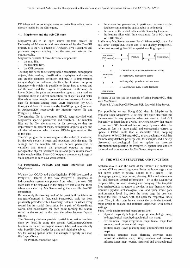
In figure 2 we can see an example of using PostgreSQL data with MapServer.
Figure 2. Using PostGIS/PostgreSQL data with MapServer. The possibility to use PostgreSQL data in MapServer is available since Mapserver 3.5 release: it’s quite clear that this improvement is very powerful when we need to load GIS frequently updated data in a web. For ArchaeoGEW that means to use web GIS functionalities on very dynamic data like COAD. In fact it’s more useful and conceptually correct to update a DBMS table than a shapefile! Thus, coupling MapServer to PostGIS/PostgreSQL, an archaeologist which has the necessary database privilege can, for example, add a newly discovered archaeological find or update an incorrect information manipulating the PostgreSQL spatial table and see the results of its operations by MapServer maps at once.
5. THE WEB GIS STRUCTURE AND FUNCTIONS
ArchaeoGEW is also the name of the internet site containing the web GIS we are talking about. From the home page a user can access either to several simple HTML pages - like photograph gallery, help online, glossary, links and references list and thematic textual information – or to the MapServer template files, for map viewing and querying. The template files ArchaeoGEW structure is divided in two thematic level: Comum Oppidum archaeological level and Spina Verde park environmental level. So, from the home page the user can choose the level to work with and open the respective index page. Then, in this page he can select the particular thematic maps group to analyse and initialise MapServer with default settings. Spina Verde environmental maps groups are: - physical maps (lythological map; geomorphologic map;
hydrogeological map; hydrogeological risk map); - environmental maps (vegetation map; faunal map; land
use map; environmental risk map); - political maps (town-planning map; environmental bonds
map); - economic activities maps (farming activities map;
industrial activities map; utility services and network infrastructures map; tourist, historical and archaeological
2 2
1 - Map viewing or querying parameters setting
2 - PostgreSQL data loading setting
3 - PostgreSQL georeferenced data return
4 - Map views or query results displaying
MapServer (GIS engine)
PostGIS PostgreSQL
1
1
user browser
web server
4
4
3 3
The International Archives of the Photogrammetry, Remote Sensing and Spatial Information Sciences, Vol. XXXIV, Part 5/W12
93

features map); communication lines maps (to-the-park accessibility map; in-the-park mobility map).
On one hand, for the archaeological level there is at the moment only one group of archaeological maps; they can be displayed using a specific criterion: - archaeological find code, - archaeological typology (see figure 3), - period, - conservation degree, - georeferencing method, and associated to tourist and environmental aspects: - paths and highlights, - geology, - vegetation, - land use and man-made activities, - environmental and town-planning bonds. A raster background taken from CTR is also available for each group. Then, after the initialisation the user can work with the proper MapServer template files and in particular he can use these provided functions: - layer selection; - feature displaying criteria selection; - map browsing (pan, zoom in, zoom out, predefined
views); - map queries (single queries or multiple queries). Query functions are especially useful for archaeological remains analysis. In fact the user can select a archaeological find with a mouse click and query it: ArchaeoGEW gives a query template file as result (see figure 4). This page allows the analysis of all information defined into COAD and stored in the PostgreSQL table. From this page it is also possible to see the position of the queried find and to have access to its photographs. On the other hand, with multiple queries the user can study the happening and the distribution of a particular characteristic or situation which occurs on the remains. Moreover, combining archaeological remains, paths and highlights multiple queries it is also possible to deal with the exploitation of the Comum Oppidum site.
Figure 3. Example of archaeological map template file.
Figure 4. Example of single query.
6. CONCLUSIONS
We think ArchaeoGEW can be considered a didactic and easily accessible tool for the study of archaeological remains and an example of MapServer-PostGIS/PostgreSQL combination. However, ArchaeoGEW is always open to future improvements, both for data increasing or updating and system new functions and extensions implementation. These improvements are obviously necessary for a real and continuous use of ArchaeoGEW, especially for being in step of archaeological research and territory and environment management.
7. REFERENCES
Atzeni, P., Ceri, S., Paraboschi, S. and Torloni, R., 1999. Basi di dati. McGraw-Hill, Milano. Brovelli M. A., Negretti M:, Saldarini C., 2000. Il nuovo sistema informativo geografico GEOGRASS per la stima locale del geoide. Bollettino di Geodesia e Scienze Affini, Anno LIX - N. 4 - Ottobre- Dicembre 2000, 311-333. Luraschi, G., Martinelli, P.U., Piovan, C., Frigerio, G.C. and Ricci F., 1969. Insediamenti di Como preromana: strutture ed aspetti. Rivista Archeologica dell’Antica Provincia e Diocesi di Como, 150-151. Luraschi, G., Martinelli, P.U., Piovan, C., Frigerio, G.C. and Ricci F., 1973. Insediamenti di Como preromana – aggiornamento. Rivista Archeologica dell’Antica Provincia e Diocesi di Como, 152-155. The PostgreSQL Development Team. 1998. PostgreSQL Tutorial (release 6.3).Thomas Lockhart - Indianapolis Ramsey, P., Refractions Research Inc, 2003. PostGIS Manual. http://postgis.refractions.net/documentation.php. (accessed 27 Feb 2003). Software Cartlab: www.sifet.it/cartlab.htm University of Minnesota, 2003. MapServer Documentation. http://mapserver.gis.umn.edu/doc.html. (accessed 25 Feb 2003).
The International Archives of the Photogrammetry, Remote Sensing and Spatial Information Sciences, Vol. XXXIV, Part 5/W12
94
Related Documents