An 1830s Map: Whose Map of the Mid-Murray River is it? Journal of The Australian and New Zealand Map Society Inc. 1 AN 1830s MAP: WHOSE MAP OF THE MID-MURRAY RIVER IS IT? Christine Kenyon 1 rom 1824 to 1836 there were three major European explorations that included the Murray River: Abstract: In 1836 Major Thomas Mitchell explored the Murray River upstream of its confluence with the Darling River. In 1837 and 1838 Edward Eyre, Joseph Hawdon with Charles Bonney, and then Captain Charles Sturt pioneered the stock route to Adelaide, along the Murray River. The chart of the Murray River presented below is held with Charles Sturt’s papers at the Bodleian Library, University of Oxford. This chart is an important historical document that provides valuable information about the country and vegetation along the Murray River valley at the time Europeans arrived in the region. It is possible this chart was loaned to Sturt for his 1838 journey and originated from a previous exploration of the region Keywords: Exploration, Major Thomas Mitchell, Captain Charles Sturt, overlanders, Murray River, landscape, vegetation, history. INTRODUCTION - In 1824, Hamilton Hume and William Hovell (Hovell & Hume 1831) travelled from New South Wales to Victoria, crossing a major river near the modern city of Albury (see Fig. 1.). Hovell named this the ‘Hume’ River. - In 1828, Captain Charles Sturt (C. Sturt 1833) explored the Murrumbidgee River and entered a ‘mighty river’ (at Boundary Bend, downstream of the modern city of Swan Hill) and named this river the ‘Murray’ River. - In 1836, Major Thomas Mitchell travelled down the Darling River and then explored the Murray River upstream of the confluence of these two rivers until he reached what he thought was the Goulburn River where extensive and flooded reed beds (near the modern town of Cohuna) prevented further progress (Mitchell 1839, Andrews 1986). He and his party then turned south to explore central and Western Victoria. Overlanders quickly followed these explorers driving stock from New South Wales and Port Philip to the new settlement of Adelaide. In 1837, Edward Eyre (Anon. 1915) overlanded stock from Port Phillip following the Wimmera River until he reached the Murray River. In early 1838, Joseph Hawdon (Packard 1997) with Charles Bonney (Bonney 1901) also overlanded stock from Port Philip to Adelaide, travelling along the Murray River from its junction with the Goulburn River. From May to July 1838, Charles Sturt overlanded stock from his property near Canberra to Albury and then travelled along the ‘Hume’ River, following Hawdon and Bonney’s tracks downstream of the Goulburn River confluence (C. Sturt 1838, N.G. Sturt 1899, C. Sturt 1990). Each of these travellers crossed the Murray River at what became known as Overland Corner, near the Darling River junction, and travelled directly to Adelaide. For Sturt, this was a private venture but as he wrote in his journal 1 Christine E. Kenyon is an Honorary Fellow in the School of Geography, University of Melbourne. Email: [email protected] F

Welcome message from author
This document is posted to help you gain knowledge. Please leave a comment to let me know what you think about it! Share it to your friends and learn new things together.
Transcript

An 1830s Map: Whose Map of the Mid-Murray River is it?
Journal of The Australian and New Zealand Map Society Inc.
1
AN 1830s MAP: WHOSE MAP OF THE MID-MURRAY RIVER IS IT? Christine Kenyon1
rom 1824 to 1836 there were three major European explorations that included the Murray River:
Abstract: In 1836 Major Thomas Mitchell explored the Murray River upstream of its confluence with the Darling River. In 1837 and 1838 Edward Eyre, Joseph Hawdon with Charles Bonney, and then Captain Charles Sturt pioneered the stock route to Adelaide, along the Murray River. The chart of the Murray River presented below is held with Charles Sturt’s papers at the Bodleian Library, University of Oxford. This chart is an important historical document that provides valuable information about the country and vegetation along the Murray River valley at the time Europeans arrived in the region. It is possible this chart was loaned to Sturt for his 1838 journey and originated from a previous exploration of the region
Keywords: Exploration, Major Thomas Mitchell, Captain Charles Sturt, overlanders, Murray River, landscape, vegetation, history.
INTRODUCTION
- In 1824, Hamilton Hume and William Hovell (Hovell & Hume 1831) travelled from New South Wales to Victoria, crossing a major river near the modern city of Albury (see Fig. 1.). Hovell named this the ‘Hume’ River. - In 1828, Captain Charles Sturt (C. Sturt 1833) explored the Murrumbidgee River and entered a ‘mighty river’ (at Boundary Bend, downstream of the modern city of Swan Hill) and named this river the ‘Murray’ River. - In 1836, Major Thomas Mitchell travelled down the Darling River and then explored the Murray River upstream of the confluence of these two rivers until he reached what he thought was the Goulburn River where extensive and flooded reed beds (near the modern town of Cohuna) prevented further progress (Mitchell 1839, Andrews 1986). He and his party then turned south to explore central and Western Victoria.
Overlanders quickly followed these explorers driving stock from New South Wales and Port Philip to the new settlement of Adelaide. In 1837, Edward Eyre (Anon. 1915) overlanded stock from Port Phillip following the Wimmera River until he reached the Murray River. In early 1838, Joseph Hawdon (Packard 1997) with Charles Bonney (Bonney 1901) also overlanded stock from Port Philip to Adelaide, travelling along the Murray River from its junction with the Goulburn River. From May to July 1838, Charles Sturt overlanded stock from his property near Canberra to Albury and then travelled along the ‘Hume’ River, following Hawdon and Bonney’s tracks downstream of the Goulburn River confluence (C. Sturt 1838, N.G. Sturt 1899, C. Sturt 1990). Each of these travellers crossed the Murray River at what became known as Overland Corner, near the Darling River junction, and travelled directly to Adelaide. For Sturt, this was a private venture but as he wrote in his journal 1 Christine E. Kenyon is an Honorary Fellow in the School of Geography, University of Melbourne. Email: [email protected]
F

The Globe, Number 76, 2015
Journal of The Australian and New Zealand Map Society Inc.
2
on page 133, “our tracing the Hume would extend our [uncertain?] knowledge of the Interior.” He intended to determine if the ‘Hume’ River was the same ‘mighty Murray’ he had entered from the Murrumbidgee River ten years previously. Part of the journal (C. Sturt 1838) and the sketches for this trip are known to be missing (Langley 1969). No chart of the ‘Hume’ River was presented with his report to the South Australian Governor (C. Sturt 1990) nor have Sturt’s biographers mentioned a chart (N.G. Sturt 1899, Langley 1969, Hart 1988). It is inconceivable that he would not have mapped this exploration journey. Also, it has been a puzzle as to why Sturt would remap the Murray River downstream of the Murrumbidgee River.
Figure 1. SE Australia showing the extent of the 1830s map and places mentioned in the text.
AIMS OF THIS PAPER In this paper, an unpublished chart, used by Charles Sturt on his 1838 journey (Fig. 2a.), is presented as an important historical document. The chart is described and its accuracy determined. The importance of the chart for our understanding of the landscape and vegetation patterns along this section of the Murray River in 1838 is assessed. The possible origin and ownership of the chart is discussed in conjunction with evidence from the journals of explorers, overlanders and other travellers. The names ‘Hume River’ and ‘Murray River’ are used to refer to the river upstream and downstream respectively, of its junction with the Murrumbidgee River as these were the names used in 1838.
THE CHART The original of the chart presented here is held at the Bodleian Library, University of Oxford with Charles Sturt’s journal and letters from his 1838 trip. By comparing this chart with one of the modern Murray River, major changes in the river course and the location of prominent cliff can be identified. The chart, at a scale of 1:63,360 (1 inch to 1 mile), and with latitude and longitude marked in 10′ intervals, follows the course of the ‘Hume’/Murray River from 35°20′S, 144°10′E to 34°10′S, 142°20′E, being the section between the modern towns of Cohuna and Mildura. The easternmost

An 1830s Map: Whose Map of the Mid-Murray River is it?
Journal of The Australian and New Zealand Map Society Inc.
3
Figure 2a. 1830s chart of the Murray River between the modern town of Cohuna and Mildura. The chart is annotated with landscape and vegetation descriptions. Published with kind permission of the Bodleian Library,
University of Oxford (Reference [RH] MS Austral S.4, fol310a).

The Globe, Number 76, 2015
Journal of The Australian and New Zealand Map Society Inc.
4
Figure 2b. Detail of the western third of the chart, between Mildura and Robinvale, showing annotations.

An 1830s Map: Whose Map of the Mid-Murray River is it?
Journal of The Australian and New Zealand Map Society Inc.
5
Figure 2c. Detail of the middle third of the chart, between Robinvale and the Murrumbidgee, showing annotations.

The Globe, Number 76, 2015
Journal of The Australian and New Zealand Map Society Inc.
6
Figure 2d. Detail of the eastern third of the chart, upstream of the Murrumbidgee, showing annotations. longitude line drawn on the map is given as 143°05′E and drawn close to the Murray/Murrumbidgee River junction (actual 34°43′S, 143°13′E). There are several calculations at different locations on the chart, and some of the longitude lines have been redrawn. The chart is rotated between 6° and 18° anticlockwise depending on location. Longitude calculations appear to be in error, lengthening the river course east-west between latitudes 34°30′S and 34°50′S possibly reflecting the difficulty in calculating longitude in the 19th century. In some sections the river appears elongated north-south. The reason for this is not known as latitude is relatively easy to calculate. Sturt’s campsites for 1, 2, 11-15 and 19 July are marked in a downstream (westerly) direction in different handwriting to other map annotations. There are several locations marked ‘MA’ close to the river, the meaning of which is unknown.
An 1830s Map: Whose Map of the Mid-Murray River is it?
Journal of The Australian and New Zealand Map Society Inc.
7
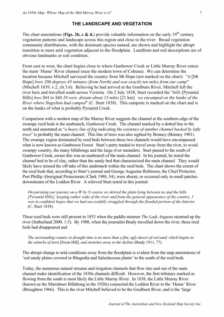
THE LANDSCAPE AND VEGETATION The chart annotations (Figs. 2b, c & d.) provide valuable information on the early 19th century vegetation patterns and landscape across this region and close to the river. Broad vegetation community distributions, with the dominant species named, are shown and highlight the abrupt transition to more arid vegetation adjacent to the floodplain. Landform and soil descriptions are of obvious landmarks or soil condition. From east to west, the chart begins close to where Gunbower Creek or Little Murray River enters the main ‘Hume’ River channel (near the modern town of Cohuna). We can determine the location because Mitchell surveyed the country from Mt Hope (not marked on the chart): “it [Mt Hope] bore 206 degrees 45 minutes (from North) and was exactly ten miles from our camp” (Mitchell 1839, v.2, ch.3.6). Believing he had arrived at the Goulburn River, Mitchell left the river here and travelled south across Victoria. On 2 July 1838, Sturt recorded the “hills [Pyramid Hills] bow S64 to S68.10 west. distant about 13 miles [21 km]. we encamped on the banks of the River where Stapylton had camped” (C. Sturt 1838). This campsite is marked on the chart and is on the banks of what is probably Pyramid Creek. Comparison with a modern map of the Murray River suggests the channel at the southern edge of the swampy reed beds is the anabranch, Gunbower Creek. The channel marked by a dotted line to the north and annotated as “a heavy line of fog indicating the existence of another channel backed by lofty trees” is probably the main channel. This line of trees was also sighted by Bonney (Bonney 1901). The swampy region dominated by reed beds between these two channels would have encompassed what is now known as Gunbower Forest. Sturt’s party tended to travel away from the river, to avoid swampy country, the many billabongs and the large river meanders. Sturt passed to the south of Gunbower Creek, aware this was an anabranch of the main channel. In his journal, he noted the channel bed to be of clay, rather than the sandy bed that characterized the main channel. They would likely have missed the off-take of this anabranch within the reed beds. The chart shows the extent of the reed beds that, according to Sturt’s journal and George Augustus Robinson, the Chief Protector, Port Phillip Aboriginal Protectorate (Clark 1988, 54), were absent, or occurred only in small patches downstream of the Loddon River. A relieved Sturt noted in this journal:
On pursuing our journey on a W by N course we skirted the plain lying between us and the hills [Pyramid Hills], keeping rather wide of the river and from the general appearance of the country, I was in confident hopes that we had successfully struggled through the flooded portion of the Interior (C. Sturt 1838).
These reed beds were still present in 1853 when the paddle-steamer The Lady Augusta steamed up the river (Sutherland 2000, 1:3). By 1908, when the journalist Brady travelled down the river, these reed beds had disappeared and
The surrounding country in drought time is no more than a flat, ugly desert of red sand, which begins in the suburbs of town [Swan Hill], and stretches away to the skyline (Brady 1911, 77).
The abrupt change to arid conditions away from the floodplain is evident from the map annotations of ‘red sandy plains covered in Rhagodia and Salsolaceous plants’ to the south of the reed beds. Today, the numerous natural streams and irrigation channels that flow into and out of the main channel make identification of the 1830s channels difficult. However, the first tributary marked as flowing from the south is most likely the Little Murray River. In 1838, the Little Murray River (known as the Marraboor Billabong in the 1920s) connected the Loddon River to the ‘Hume’ River (Broughton 1966). This is the river Mitchell believed to be the Goulburn River, and is the ‘large

The Globe, Number 76, 2015
Journal of The Australian and New Zealand Map Society Inc.
8
watercourse’ Sturt had to cross several times whilst making his way back to the ‘Hume’ River. Downstream of the Little Murray/Loddon River, the tributaries marked entering from the south, in order, are likely to be Burra Creek, Narcooyia Creek, the Karadoc Swamp Outlet Creek and two channels of the Chalka Creek. The northern Murrumbidgee River tributary is marked verifying to Sturt that his ‘Hume’ and Murray Rivers were the one river. The other tributary entering from the north is most likely Golgol Creek. The notation ‘river much broader’ indicates this section of the river is downstream of the junction with the Wakool River. Near the 11 July campsite, areas of ‘dense brushes’ and ‘dwarf box’ are shown on the chart. These were described by Sturt as ‘barren box scrub’. Mitchell wrote: “open forests of goborro, prevailed very generally nearer the river” (Mitchell 1839, 132). His deputy Stapylton identified the ‘goborro’ as black box (Eucalyptus largiflorens) (Andrews 1986). The ‘lofty cliffs 100 ft’ opposite ‘elevated sandy brushes terminating in bald precipices’ near Sturt’s 12 July campsite, are those near Robinvale. Downstream of the 19 July campsite near the Chalca Creek outlet, ‘scrub’ or ‘brushes’ and Salsolaceous plains signal more arid conditions. In his diary, Mitchell named this scrub ‘dumosa scrub’ (white mallee or Eucalyptus dumosa) growing with a spinfex-like grass (Triodia spp.) (Mitchell 1839, 122). Blandowski (1857, 127) provides a vivid description this country:
The remainder of the country in the neighbourhood of the Murray, consists of barren, stiff and firm clay flats of remarkable evenness, partly covered with box-trees or salsolae bushes, and in other parts with dense, impenetrable mallee scrub, easily distinguished at a great distance by its dirty looking, dark olive green leaves. Wherever the Mallee Scrub is met with, the soil is interspersed with numerous nodules of limestone. The bright green of cypress forests, with the duller aspect of the oak, growing on sand hummocks interrupts the monotony of the box-tree flats. Now and then a cluster of Eucalypti growing along the banks of the Billibong, and ornamenting the banks of the slowly flowing Murray, occasionally relieve the weary traveller…
These ‘mallee’ communities were still present in the 1920s (Broughton 1966, 95). Red sandhills separated by extensive grassy or saltbush-covered plains were also a feature of the country (Bonney 1901, Mitchell 1839). The traveller Wilson (1859, 33-34) described the sandhills downstream of Swan Hill in 1857: “At intervals, the sameness of the banks is diversified by a sort of sandhill, which runs down to the river’s edge, is of rather richer soil than that usually presenting itself” and “On these hills we find growing the Murray River pine”. ‘Casuarina’ and ‘scrub’ also grew on these sandhills. The Murray River pine was Callitris cupressiformis or C. gracilis subsp. murrayensis and the Casuarina Allocasuarina cristata.
MAPPING THE PRE-1788 VEGETATION COMMUNITIES The vegetation communities mapped by explorers and early settlers are considered to represent the vegetation communities managed by the Aboriginal people prior to European arrival. Reconstructions of vegetation communities from historical maps in Australia can be fraught due to the small scale of the maps, lack of detail and to changes in the meaning of terminology over time. We can sometimes gain a better idea of the vegetation from the journals of these travellers and others (Clark 1988, Wilson 1859). However, some of the difficulties in deciphering these early descriptions include the use of multiple common names for similar vegetation: Eucalyptus camaldulensis (river red gum) was called

An 1830s Map: Whose Map of the Mid-Murray River is it?
Journal of The Australian and New Zealand Map Society Inc.
9
‘blue gum’, Eucalyptus rostrata, ‘Yarra’ and ‘flooded gums’. Several terms were used for tree cover including: ‘brushes’, ‘dwarf box’, ‘wood’, ‘scrub’, ‘stunted timber’, ‘lofty tree’ and ‘open forest land’. Generally, written journal descriptions of vegetation communities were also broad, noting only the major components of a vegetation type, favouring the presence of grassy plains suitable for grazing - the major concern of settlers at that time. For example, Sturt described alluvial flats where “feed was abundant upon them as well as in the open forests, and the grass growing there in widely dispersed tufts” (C. Sturt 1838, 138) with no mention of the herb component of the grasslands. When Sturt entered the Murray River in 1828, he “found the calistemma in full flower, and in the richest profusion” along its banks (C. Sturt 1833). Mitchell was an excellent observer, describing and illustrating many new plants as he travelled, which assists our understanding of the plants present in his time (Mitchell 1839).
DISTRIBUTION OF EUCALYPTUS CAMALDULENSIS ALONG THE RIVER Were particular elements of the vegetation, such as Eucalyptus camaldulensis, not described because they were so obvious, or because they were of no interest, or because they were not present? Today, Eucalyptus camaldulensis grows continuously along the entire length of the river; on the river banks, on the floodplain within the flood levee banks, and dominates the forest at Gunbower Island. However, there is no chart annotation specifically for these trees although areas of ‘Box’ were recorded along this section of the river. There are other early descriptions of Eucalyptus camaldulensis forming lines along the river bank, having a discontinuous distribution along the river or growing at the edge of depressions or billabongs and that it was absent where grass plains extended to the river (Mitchell 1839, Brady 1911, Broughton 1966, Allen 1976, Andrews 1986). Mitchell often described river banks as being “distinguished by lines of lofty trees” (Mitchell in Andrews 1986, 103). Ludwig Becker’s 1860 painting Near our camp at Spewah depicts a grassy plain with a line of large trees, probably Eucalyptus camaldulensis, marking the river. Near the modern town of Swan Hill, Mitchell described a sea of reeds “bounded only by the horizon” where the Murray River “seemed to flow through that reedy expanse, unmarked in its course by trees or bushes, although one or two distant clumps of yarra [Eucalyptus camaldulensis] probably grew on the banks of the permanent stream. At two miles further on, these trees again grew plentifully, close under the berg” and while looking for the main channel “We found however, that the yarras only enclosed shallow lagoons” (Mitchell 1839, 136). Governor Young, in 1853, gave a similar description of this region:
a vast plain of reeds, without visible high land of any kind, or trees; the river course perfectly safe, open, and deep;… occasionally a fringe of high trees, and then another vast plain, entirely bare and open (Young in Bride 1983, 352).
By the late 1880s people began to note that the river red gum lining the banks was becoming more continuous and dense due to the construction of flood levee banks, locks and the Torrumbarry Weir (Sutherland 2000, v.2). Treeless sections of the river bank were still present in the 1920s, as Broughton described near Beveridge Island:
When we emerged from the green timber of our present river length of 25 miles, we entered on to a treeless plain through which the river and the big billabong forming Beveridge Island ran for several miles bare and undefined, in a strange contrast to all our previous sections (Broughton 1966, 138).

The Globe, Number 76, 2015
Journal of The Australian and New Zealand Map Society Inc.
10
Areas of box trees and scrub, close to the river, are shown on the chart. The change from box to Eucalyptus camaldulensis forest reflects the change in flood regime since European settlement. Black box establishes where floods are infrequent; today this is at the edge of the floodplain. Eucalyptus camaldulensis requires frequent and long flood events, hence its presence at the edges of billabongs and depressions – all areas of high and long flood frequency. The construction of levee banks, in the late 19th century, prevented flood waters from draining across the country. River regulation and high summer irrigation flows often result in summer rain rejection floods watering the floodplain, favouring Eucalyptus camaldulensis establishment. Another difficulty with this chart is determining where campsites are located because of the numerous tributaries and effluents in this region. In the 1830s the complexities of these channels were not understood.
WHO CREATED THIS CHART? A reading of the diaries of these travellers makes clear they exchanged the knowledge each had of the country and the fact they did not venture into ‘unknown’ country without maps and descriptions of what was already known. From his diary, it is clear Mitchell travelled with maps drawn by Oxley (Mitchell 1839, 38 & 43), Arrowsmith and from the Hume and Hovell expedition (Mitchell 1839, 181) which he used to locate his position and add information to his own maps. He certainly had access to Sturt’s descriptions of the Darling and Murray Rivers: “I recognised the view given in Captain Sturt’s work and the adjacent localities described by him” (Mitchell 1839, 82). Edward Eyre used Charles Sturt’s 1828 chart to find his way back to the Murray River after becoming lost, without water, after following erroneous directions given by Major Mitchell: “I decided on travelling downwards the Wimmera River of major Mitchell, feeling convinced, from its position in the chart, that it was the Lindesay of Captain Sturt” (Anon. 1915, 102). It appears that Hawdon and Bonney also had access to Mitchell’s maps (see next), or at least had been given detailed descriptions of the country by him, before they departed on their journey. They discovered Mitchell’s mistake in locating the Goulburn River:
Then the mistake he had fallen into was explained. The river flowing through extensive reed swamps, had formed two channels, and it was the junction of these two channels that he had mistaken for the junction of the Goulburn (Bonney 1901, 86-87).
It is unlikely the chart was prepared by Charles Sturt even though his 1838 campsites are marked and that it was stored with his papers in the Bodleian Library, University of Oxford. Mitchell, in 1836, was the first person to explore this section of the Murray River and the chart covers that section of the Murray River traversed by his party to where they turned south to explore central and western Victoria (Mitchell 1839). Sturt, in his journal, uses simple terms to describe trees, forests and woodlands; never expressions such as ‘lofty trees’ as used on the chart and by Mitchell in his journal. Why longitude is not marked to the east of the junction with the Murrumbidgee River is unclear. The typical survey lines included on Mitchell’s maps are not present and the elongation of longitude suggests that the chart may have been made by one of his survey team. However, along this section of the river, Mitchell dispatched his deputy Stapylton to find a route through the reed beds to the main river channel. It can be hypothesised that this section of the map was sketched by Stapylton, or taken from his descriptions. Charles Sturt was using a chart, prepared by Mitchell or one of his party in 1836 as, on seeing the Pyramid Hills, Sturt recorded in his journal: “Looking at the Chart I did not doubt these hills being those marked down by the Surveyor general as the first he ascended after crossing the country” (C. Sturt 1838).

An 1830s Map: Whose Map of the Mid-Murray River is it?
Journal of The Australian and New Zealand Map Society Inc.
11
CONCLUSION Although covering only a small section of Sturt’s 1838 journey, this is the section of chart that verified for Sturt the ‘Hume’ River at Albury was the same watercourse as his Murray River near Swan Hill. It is an important historical document recording the landscape and vegetation in the 1830s, prior to the rapid spread of European settlement in the region. The chart is unlikely to have been created by Sturt, and was possibly given, or loaned, to him by Major Mitchell and it has remained with Sturt’s papers and assumed to have been created by him. The story of the ownership of this chart highlights the difficulties in determining the origin of historical material and of assuming ownership of particular documents. The original papers, maps and illustrations of these travellers are often spread across institutions and are difficult to locate or access. It shows the importance of accessing the journals kept by these explorers and overlanders to use in conjunction with the chart. This chart adds to the information available from other historical sources and can be used to refine modern map reconstructions of pre-1788 vegetation communities along this section of the Murray River. From contemporaneous descriptions of the river, it appears the Eucalyptus camaldulensis forest that lines the river and floodplain today was not as widespread, dense or as continuous in the 1830s.
ACKNOWLEDGEMENTS Lucy McCann at the Bodleian Library, University of Oxford was most helpful in locating this chart and for looking for more information on its origins. The Bodleian Library kindly gave permission to publish this chart. Katrina Sandiford was instrumental in identifying the section of the Murray River covered by this map and in preparing modern maps for comparison. I am grateful to Brendan Whyte who encouraged me to publish this chart and its story, Ian Thomas who provided valuable comments on the manuscript, and to Simon Connor for his valuable comments and whose encouragement to find further evidence for the 1830s vegetation patterns along the Murray River led me to the realization the map was not created by Charles Sturt.

The Globe, Number 76, 2015
Journal of The Australian and New Zealand Map Society Inc.
12
REFERENCES ALLEN, J. (1976). Journal of an Experimental trip by the ‘Lady Augusta’, on the Murray River, Libraries Board
of South Australia. First published, C.G.E. Platts, Adelaide, 1853.
ANDREWS, E.J. (ed.) (1986). Stapylton: With Major Mitchell’s Australia Felix Expedition, 1836. Largely from the Journal of Granville William Chetwynd Stapylton, Blubber Head Press, Hobart.
ANON., (1915). “Importations of the First Stock Overland from New South Wales. Reprinted from South Australian Gazette of 1838”. Proceedings of the Royal Geographical Society of Australasia. South Australian Branch., XVII:99-112.
BECKER, L. (1860). Near our camp at Spewah, September 12 1860, Image H16486, State Library Victoria.
BLANDOWSKI, W. (1857). “Art. XV. — Recent Discoveries in Natural History on the Lower Murray”. Transactions of the Philosophical Society of Victoria. Online at http://digital.slv.vic.gov.au/view/action/singleViewer.do?dvs=1421209632810~647 [accessed 13 Jan 2015]
BONNEY, C. (1901). “Historical Records: Autobiographical Notes”. Proceedings of the Royal Geographical Society of Australasia, South Australian Branch, V:82-102.
BRADY, E.J. (1911). River Rovers, George Robertson and Company Pty Ltd, Melbourne.
BRIDE, T.F. (1983). Letters from Victorian Pioneers, Currey O’Neil.
BROUGHTON, G.W. (1966). Men of the Murray: A Surveyor’s Story, Rigby Limited, Adelaide.
CLARK, I.D. (1988). The Port Phillip Journals of George Augustus Robinson: 8 March - 7 April 1842 and 18 March - 29 April 1843. Dept. of Geography, Monash University, Melbourne.
HART, C. (1988). “Sturt and his Journeys” in H. Morphy, & E. Edwards, (eds.) Australia in Oxford. Stephen Austen and Sons Ltd, Hertfordshire.
HOVELL, W.H. & Hume, H. (1831). Journey of Discovery to Port Phillip, New South Wales by Messers, W.H. Hovel and Hamilton Hume in 1824 and 1825. W. Bland (ed.). A. Hill, Sydney. Online at http://gutenberg.net.au/ebooks04/0400371.txt [Accessed 22 October 2014].
LANGLEY, M. (1969). Sturt of the Murray, Father of Australian Exploration. Hale, London..
MITCHELL, T.L. (1839). Three Expeditions into the Interior of Eastern Australia. Vol.2. Boone, London.
PACKARD, B. (1997). Joseph Hawden, The First Overlander. Fast Books, Sydney.
STURT, C. (1833). Two expeditions into the Interior of Southern Australia, during the years 1828, 1829, 1839, and 1831: With Observations on the Soil, Climate, and General Resources of the Colony of New South Wales. Volume II. Smith, Elder & Co., London.
———. (1838). The Unpublished Journal of Charles Sturt’s 1838 Overlanding Expedition to Adelaide Following the Hume River. Charles Sturt Papers MS 9025 (photocopy). Held at the State Library Victoria.
———. (1990). An Account of a Journey to South Australia 1838. The report presented to Governor Gipps, in Sydney, 30 October 1838; now published with notes containing supplementary documents., Sullivan’s Cove, Adelaide.
STURT, Mrs N.G. (1899). Life of Charles Sturt Sometime Captain 39th Regiment and Australian Explorer, Smith Elder & Co., London.
SUTHERLAND, J. (2000). Murrabit, our Murrabit: The History of Why We’re How We Are. 2 vols., Richard Cambridge Printers Pty Ltd, Bendigo.
WILSON, E. (1859). Rambles in the Antipodes: A Series of Sketches of Moreton Bay, New Zealand, The Murray River and South Australia and the Overland Route, W.H. Smith & Son, London.
Related Documents