This document, a description of the New Jersey Ambient Air Monitoring Network for 2013, is available for public comment. Please e-mail public comments by June 28, 2013 to [email protected], or write to: Chief, Bureau of Air Monitoring New Jersey Department of Environmental Protection Mail Code: 401-07H PO Box 420 Trenton, NJ 08625-0420. June 2013 Ambient Air Monitoring Network Plan 2013 NEW JERSEY DEPARTMENT OF ENVIRONMENTAL PROTECTION Bureau of Air Monitoring WWW.NJAQINOW.NET

Welcome message from author
This document is posted to help you gain knowledge. Please leave a comment to let me know what you think about it! Share it to your friends and learn new things together.
Transcript

This document, a description of the New Jersey Ambient Air Monitoring Network for 2013, is available for public comment.
Please e-mail public comments by June 28, 2013 to [email protected], or write to:
Chief, Bureau of Air Monitoring New Jersey Department of Environmental Protection
Mail Code: 401-07H PO Box 420
Trenton, NJ 08625-0420.
June 2013
Ambient Air Monitoring
Network Plan 2013
NEW JERSEY DEPARTMENT OF ENVIRONMENTAL PROTECTION Bureau of Air Monitoring WWW.NJAQINOW.NET

NEW JERSEY AMBIENT AIR MONITORING NETWORK PLAN 2013 2
Table of Contents Section Page Number EXECUTIVE SUMMARY 03 INTRODUCTION 03 THE NEW JERSEY MONITORING NETWORK 04 CHANGES TO THE NETWORK 07 NEW JERSEY AIR MONITORING SITE DESCRIPTIONS 08 GLOSSARY OF ABBREVIATIONS AND TERMS 53 REFERENCES 55 APPENDIX A: VOLATILE ORGANIC COMPOUNDS 56 APPENDIX B: CARBONYLS 58 APPENDIX C: PM2.5 SPECIATION 59 APPENDIX D: OZONE PRECURSORS 61 APPENDIX E: BTEX COMPOUNDS 63 DISCLAIMER Mention of trade names, manufacturers or commercial products in this document does not constitute New Jersey Department of Environmental Protection endorsement or recommendation for use.

NEW JERSEY AMBIENT AIR MONITORING NETWORK PLAN 2013 3
EXECUTIVE SUMMARY The New Jersey Department of Environmental Protection (NJDEP) is required to submit a Network Plan to the U.S. Environmental Protection Agency (USEPA) every year. The plan provides a complete description of the monitoring network, and summarizes any changes made in the previous year and any planned within the next year. In summary: (1) in August 2012, barometric pressure, wind speed and wind direction were added to the group of meteorological sensors at the East Orange station, (2) in October 2012, the Bayonne station was temporarily shut down due to severe damage caused by Hurricane Sandy, (3) in December 2012, an acid deposition sampler was installed at Cattus Island County Park which is located on Barnegat Bay, and during that same month, the Millville monitoring shelter was temporarily shut down and replaced by a new shelter in March 2013, and (5) in January 2013, a BTEX analyzer (which measures near real-time benzene, toluene, ethylbenzene, and xylene), a Black Carbon analyzer, a volatile organic compound sampler and a fine particulate (PM2.5) speciation sampler were installed at the Camden Spruce Street station. Also in January 2013, a BTEX analyzer and a Black Carbon analyzer were installed at the Elizabeth Lab station, and a coarse particulate sampler was installed at Newark Firehouse. Later in 2013, the Bayonne station will be re-established with a new shelter. In the beginning of 2014, a new near-road Nitrogen Dioxide (NO2) station in Fort Lee will be established. On March 18, 2013, the revised annual average National Ambient Air Quality Standards (NAAQS) for fine particles at 12.0 micrograms per cubic meter (µg/m3) became effective. This rule requires the operation of a PM2.5 monitor by 2015 at the proposed near-road Fort Lee station. Also, New Jersey plans to replace older continuous fine particle analyzers in the field with newer real-time analyzers. INTRODUCTION In the Federal Register of October 17, 2006, the USEPA revised “Subpart B – Monitoring Network” of Part 58 – Ambient Surveillance Networks of Title 40 of the Code of Federal Regulations. Specifically, the NJDEP is required by the revised regulations to submit an Annual Monitoring Network Plan to the USEPA Region 2 Regional Administrator by July 1 of every year starting in 2007, and to have the Plan available for public inspection for at least 30 days prior to its submittal to the USEPA. The Plan should describe State and Local Air Monitoring Stations (SLAMS), National Core (NCore) stations, Speciation Trends Network (STN) stations, State speciation stations, Special Purpose Monitor (SPM) stations, and Photochemical Assessment Monitoring Stations (PAMS).
The regulations also require the NJDEP to submit an assessment of its Air Monitoring Network every 5 years starting July 1, 2010 and to have all NCore multi-pollutant stations operational by January 1, 2011. This 2013 Network Plan contains all the information required by the regulations, along with descriptions of the air monitoring sites, large and small scale maps of the monitoring stations, and a summary of the changes to the Air Monitoring Network that NJDEP expects to implement in the next two years. It is available for download from the Bureau of Air Monitoring’s website, www.njaqinow.net, or as a hardcopy by calling 609-292-0138.
Brigantine air monitoring site located in the Edwin B. Forsythe National Wildlife Refuge near Atlantic City

NEW JERSEY AMBIENT AIR MONITORING NETWORK PLAN 2013 4
THE NEW JERSEY AIR MONITORING NETWORK
The NJDEP is currently operating 39 air monitoring sites. Table 1 lists all the current monitoring sites along with the pollutants, categories of pollutants or meteorological parameters that are measured at each site. Figure 1 shows the locations of the monitoring sites across New Jersey. Several parameters, including carbon monoxide (CO), nitrogen dioxide (NO2), ozone (O3), sulfur dioxide (SO2), particulate matter, and meteorological parameters, are measured by instruments that automatically collect and analyze data instantaneously and continuously. The data is transmitted to a centralized computer system in Trenton, New Jersey, once every minute, thus providing near real-time data. For fine particles (particles smaller than 2.5 micrometers in diameter or PM2.5), inhalable particles (particles smaller than 10 micrometers in diameter or PM10), and PM coarse (particles between 2.5 micrometers in diameter and 10 micrometers in diameter) these instruments collect a sample over a 24-hour period. These samples are subsequently manually retrieved and then analyzed in a laboratory several days to a few weeks following their sample collection. PM2.5 concentrations are determined by both near real-time analyzers and manual samplers. The near real-time PM2.5 analyzers measure PM2.5 levels hourly, and the data is used, along with data from the other continuous pollutants, to
generate a rating of air quality called the Air Quality Index (AQI), which is updated hourly on the Bureau of Air Monitoring’s webpage. The manual PM2.5 sampler collects particles on a filter over a 24-hour period. The filter is retrieved following the completion of the sampling period and weighed in a laboratory. Data used for comparison to the NAAQS must be measured by USEPA-approved manual samplers or USEPA-approved near real-time analyzers. The NJDEP uses USEPA-approved manual samplers for comparison to the NAAQS. The NJDEP also monitors many other pollutants which are grouped together into categories by their method of sampling or analysis. These categories are listed in the headings of Table 1. Sites that monitor for ozone precursors, pollutants that affect ozone formation and destruction in the atmosphere, are part of the national Photochemical Assessment Monitoring Station (PAMS) program. Ozone precursors are frequently referred to as PAMS pollutants. Pollutants in the PM2.5-Speciation category include trace elements, heavy metals, and carbon compounds that are analyzed from PM2.5 particles. Volatile Organic Compounds (VOCs) and Carbonyls refer to selected carbon-based air pollutants that are analyzed from whole air samples or adsorbent media. The PM2.5-Speciation, VOC, and Carbonyls samples are collected by the NJDEP and are sent to USEPA-approved contract laboratories for analysis. NJ uses a BTEX analyzer (which measures near real-time benzene, toluene, ethylbenzene, and xylene) and an aethalometer which collects near real-time Black Carbon particles at a few urban sites. Finally, the NJDEP also measures acid deposition, mercury, and two surrogates for particle pollution: smoke shade and visibility as measured by a nephelometer.
USEPA-approved manual PM2.5 sampler on the roof of the Atlantic Cape Community College building in Atlantic City

NEW JERSEY AMBIENT AIR MONITORING NETWORK PLAN 2013 5
TABLE 1: SUMMARY OF CURRENT AND PROPOSED NEW JERSEY AIR MONITORING SITES C
O
NO
X
NO
y
O3
SO
2
Sm
oke S
hade
PM
2.5
PM
2.5-S
pecia
tio
n
Real-T
ime P
M2.5
PM
coars
e \
Lead
PM
10
Bla
ck C
arb
on
Vis
ibili
ty
O3 P
recurs
ors
-
PA
MS
VO
Cs \ C
arb
onyls
BT
EX
Acid
Depositio
n
Me
rcury
Te
mpera
ture
\
Rela
tive H
um
idity
Baro
me
tric
P
ressure
Win
d s
peed \
Directio
n
Sola
r R
adia
tio
n
Ancora State Hosp. Y
Atlantic City Y
Bayonne Y Y Y P P
Brigantine Y Y Y Y Y Y Y
Camden RRF Y
Camden Spruce St Y Y Y Y Y Y P Y Y Y
Cattus Island Y
Chester Y Y Y Y Y Y Y Y
Clarksboro Y
Colliers Mills Y
Columbia WMA Y Y Y Y Y Y Y Y
East Orange Y Y Y Y Y
Elizabeth Y Y Y
Elizabeth Lab Y Y Y Y Y Y Y Y Y Y Y Y
Elizabeth Mitchell Bldg
Y
Ewing Y
Flemington Y Y Y Y Y Y
Fort Lee P P P P P
Fort Lee Library Y
Gibbstown Y
Jersey City Y Y Y
Jersey City Firehouse
Y Y
Y Y
Leonia Y
Millville Y Y Y
Monmouth Univ. Y
Morristown Amb Squad
Y
New Brunswick Y Y Y Y Y
Newark Firehouse Y Y Y Y Y Y Y Y Y P Y P Y Y Y Y
Paterson Y
Pennsauken Y
Phillipsburg Y
Rahway Y Y
Ramapo Y
Rider University Y Y Y Y Y
Rutgers University Y Y Y Y Y Y Y
South Camden Y
Toms River Y
Trenton Y
Union City Y
Washington Crossing
Y
Y
TOTAL 6 9 1 16 9 3 21 5 11 1 2 2 3 1 4 2 3 4 6 6 7 5
Y - Current Parameter P - Proposed Site and Parameter
-Began measuring data in 2012 or 2013
-Temporary-shutdown in 2012 or 2013
-Temporary-shutdown in 2012 and re-started in 2013

NEW JERSEY AMBIENT AIR MONITORING NETWORK PLAN 2013 6
FIGURE 1: MAP OF THE CURRENT NEW JERSEY AIR MONITORING SITES

NEW JERSEY AMBIENT AIR MONITORING NETWORK PLAN 2013 7
CHANGES TO THE NETWORK On August 17, 2012, meteorological parameters (barometric pressure, wind speed, and wind direction) were added to the sensors at East Orange. On October 29, 2012, the shelter that housed the Bayonne Station was damaged by severe flooding due to Hurricane Sandy and a new shelter will be installed and should resume operations by the end of 2013. On December 4, 2012, an acid deposition sampler was installed at the Cattus Island site which is located at Cattus Island County Park in Toms River, New Jersey. Because the site is located in the Barnegat Bay Wildlife Management Area, it supports Governor Chris Christie’s Ten Point Comprehensive Plan of Action for the environmental restoration of Barnegat Bay. The Cattus Island site is also part of the National Atmospheric Deposition Program (NADP) network - http://nadp.sws.uiuc.edu/. On December 5, 2012, the Millville station was shut down because the shelter which housed the monitors needed to be replaced. A new shelter was installed and the Millville station resumed collecting data on March 3, 2013. On January 4, 2013, a PM coarse sampler was installed at Newark Firehouse. New Jersey plans to comply with EPA regulations by establishing a near-road site at Fort Lee which measures for CO, PM2.5 and NO2 by January 1, 2014. On January 1, 2013, NJDEP established a BTEX analyzer, which measures near real-time benzene, toluene, ethylbenzene, and xylene, and a Black Carbon analyzer at the Camden Spruce Street site. On January 2, 2013, both monitors were also installed at the Elizabeth Lab site. Future locations for BTEX and Black Carbon instruments are slated for Bayonne, Newark Firehouse and the proposed Fort Lee monitoring sites. Although the pollutants do not have federal standards, they are measurements of toxic air pollutants or indicators of diesel particulate matter that are prevalent in highly urbanized areas. From a public health perspective, these pollutants now seem to be of greater importance than many of our currently measured criteria air pollutants. This effort will provide a more comprehensive view of urban air pollution. On January 4, 2013, a VOC sampler was installed at Camden Spruce Street station, followed by a PM2.5 Speciation sampler on January 28, 2013.
Table 2: Network Changes, July 2012 – June 2013
Monitoring Site Parameter(s) Action Date
East Orange Wind Speed, Wind Direction, Barometric Pressure
Start-up 08/17/12
Bayonne NOx, O3 , SO2 Temporary-shutdown
10/29/12
Cattus Island Acid Deposition Start-up 12/04/12
Millville NOx, O3, Real-Time PM2.5
Temporary-shutdown
12/05/12
Camden Spruce Street
Black Carbon, BTEX Start-up 01/01/13
Elizabeth Lab Black Carbon, BTEX Start-up 01/02/13
Newark Firehouse PM coarse Start-up 01/04/13
Camden Spruce Street
VOC Start-up 01/04/13
Camden Spruce Street
PM2.5 Speciation Start-up 01/28/13
Millville O3 Re-start 03/01/13
Millville NOx Re-start 03/15/13

NEW JERSEY AMBIENT AIR MONITORING NETWORK PLAN 2013 8
In 2013, the NJDEP will begin deploying USEPA-approved Thermo 5014i Beta Attenuation real-time PM2.5 analyzers to replace older real-time PM2.5 analyzers. This will be an instrument upgrade because data from the new analyzers can be used for reporting real-time PM2.5 data to the AQI and for comparison to the NAAQS, while data from the older analyzers can only be used for reporting real-time PM2.5 data to the AQI. Upon deployment to monitoring stations, the Thermo 5014i analyzers will be classified as “Special Purpose Monitors” for a period of one to two years in order to evaluate the performance of these analyzers. During this period, the data will not be used for comparison to the NAAQS. NEW JERSEY AIR MONITORING SITE DESCRIPTIONS According to 40 CFR 58.10, the following elements for each existing and proposed air monitoring station must be included in New Jersey’s Network Plan: 1. the Air Quality Subsystem (AQS) site identification number, 2. the location, including street address and geographical coordinates, 3. the sampling and analysis methods for each measured parameter, 4. the operating schedules for each monitor, 5. any proposals to remove or move a monitoring station within a period of 18 months following Plan
submittal, 6. the monitoring objective and spatial scale of representativeness for each monitor as defined in
Appendix D to Part 58, 7. the identification of any sites that are suitable and sites that are not suitable for comparison against
the annual fine particle (PM2.5) National Ambient Air Quality Standards (NAAQS) as described in 40 CFR Part 58.30, and
8. the Metropolitan Statistical Area (MSA), Core-Based Statistical Area (CBSA), Combined Statistical Area (CSA) or other area represented by this monitor.
The next pages supply the above information for current and proposed New Jersey air monitoring sites. All abbreviations and terms are defined and explained in the Glossary following this section, and Appendices A through E provide additional information on Volatile Organic Compounds, Carbonyls, PM2.5 Speciation, ozone precursors and BTEX compounds.

NEW JERSEY AMBIENT AIR MONITORING NETWORK PLAN 2013 9
SITE INFORMATION
Site Name Ancora State Hospital
Address Ancora State Hospital, 202 Spring Garden Road
Municipality Winslow Township
AQS Code 34 007 1001
NJ County Camden
MSA/CSA Philadelphia-Camden-Wilmington CSA
Latitude 39.684250
Longitude -74.861491
Date Established 1/1/1966
Suitable for Comparison to
PM2.5 NAAQS? Not Applicable
PARAMETER SUMMARY
Parameter
AQS Parameter
Code
Sampling Instrument
Method of Analysis
AQS Method Code
AQS Sample
Frequency
AQS
Spatial Scale
AQS
Monitoring Objective
Ozone (O3) 44201 Dasibi 1008 Ultraviolet 056 Continuous Urban Population Exposure
Site Purpose To measure background concentrations for the southern part of New Jersey. May also measure maximum ozone concentrations downwind from the Philadelphia metropolitan area.
Plans for the next 18 months
No changes.
Other Comment Acid Deposition shut down December 31, 2011.

NEW JERSEY AMBIENT AIR MONITORING NETWORK PLAN 2013 10
SITE INFORMATION
Site Name Atlantic City
Address 1535 Bacharach Boulevard
Municipality Atlantic City
AQS Code 34 001 1006
NJ County Atlantic
MSA/CSA Atlantic City MSA
Latitude 39.363260
Longitude -74.431000
Date Established 7/27/2001
Suitable for Comparison to
PM2.5 NAAQS? Yes
PARAMETER SUMMARY
Parameter
AQS Parameter
Code
Sampling Instrument
Method of Analysis
AQS Method Code
AQS Sample
Frequency
AQS
Spatial Scale
AQS
Monitoring Objective
Fine Particles (PM2.5) 88101 Thermo 2025 Low-volume sequential sampler
Gravimetric 118 Every 3 days Neighborhood Population Exposure
Site Purpose To measure fine particle concentrations in the commercial area of Atlantic City.
Plans for the next 18 months
No changes.
Other Comment

NEW JERSEY AMBIENT AIR MONITORING NETWORK PLAN 2013 11
SITE INFORMATION
Site Name Bayonne
Address Veterans Park on Newark Bay, 25th Street near Park Road
Municipality Bayonne
AQS Code 34 017 0006
NJ County Hudson
MSA/CSA New York-Northeast New Jersey-Connecticut CSA
Latitude 40.670250
Longitude -74.126081
Date Established 1/1/1983
Suitable for Comparison to
PM2.5 NAAQS? Not Applicable
PARAMETER SUMMARY
Parameter
AQS Parameter
Code
Sampling Instrument
Method of Analysis
AQS Method Code
AQS Sample
Frequency
AQS
Spatial Scale
AQS
Monitoring Objective
Nitric Oxide (NO) 42601 TECO 42 Chemiluminescence 074 Continuous Urban Population Exposure
Nitrogen Dioxide (NO2) 42602 TECO 42 Chemiluminescence 074 Continuous Urban Population Exposure
Oxides of Nitrogen (NOx)
42603 TECO 42 Chemiluminescence 074 Continuous Urban Population Exposure
Ozone (O3) 44201 Dasibi 1008 Ultraviolet 056 Continuous Neighborhood Population Exposure
Sulfur Dioxide (SO2) 42401 TECO 43A Pulsed fluorescence 060 Continuous Neighborhood Population Exposure
Site Purpose To measure population exposure in the Hudson County area.
Plans for the next 18 months
Plan to add benzene, toluene, ethylbenzene, xylene (BTEX) analyzer and black carbon analyzer upon replacement of damaged shelter and restart of station.
Other Comment On 10/29/12, site was temporarily shut down due to damage from Hurricane Sandy.

NEW JERSEY AMBIENT AIR MONITORING NETWORK PLAN 2013 12
SITE INFORMATION
Site Name Brigantine
Address Edwin B. Forsythe National Wildlife Refuge Visitor Center, Great Creek Road
Municipality Galloway Township
AQS Code 34 001 0006
NJ County Atlantic
MSA/CSA Atlantic City MSA
Latitude 39.464872
Longitude -74.448736
Date Established 1/1/2007
Suitable for Comparison to
PM2.5 NAAQS? Yes
PARAMETER SUMMARY
Parameter
AQS Parameter
Code
Sampling Instrument
Method of Analysis
AQS Method Code
AQS Sample
Frequency
AQS
Spatial Scale
AQS
Monitoring Objective
Ozone (O3) 44201 TECO 49i Ultraviolet 047 Continuous Urban Background
Sulfur Dioxide (SO2) 42401 TECO 43iTLE Pulsed fluorescence 560 Continuous Urban Background
Fine Particles (PM2.5) 88101 Thermo 2025 Low-volume sequential sampler
Gravimetric 118 Every 3 days Urban Background
Real-time PM2.5 88500 R&P 1400 TEOM-FDMS Gravimetric, Total Atmospheric PM2.5
760 Continuous Urban Background
Real-time PM2.5 88502 R&P 1400 TEOM-FDMS Gravimetric, Acceptable PM2.5
703 Continuous Urban Background
Real-time PM2.5 88347 Nephelometer Light-scattering 011 Continuous Urban Background
Mercury (Hg) Tekran 2537A CVAF Spectrometry Hourly Urban Background
Acid Deposition Wet Deposition Collector Ion Chromatography Weekly Neighborhood Population Exposure
Site Purpose To measure pollutant concentrations and visibility in Class I areas.
Plans for the next 18 months
No changes.
Other Comment SO2 is measured by a “trace-level” analyzer. Also an IMPROVE station, part of NESCAUM visibility network, Real-time PM2.5 data by Nephelometer and Mercury data not submitted to USEPA’s AQS database, the US Fish & Wildlife Service collects a weekly Acid Deposition sample which is sent to the National Atmospheric Deposition Program (NADP) for analysis.
NEW JERSEY AMBIENT AIR MONITORING NETWORK PLAN 2013 13
SITE INFORMATION
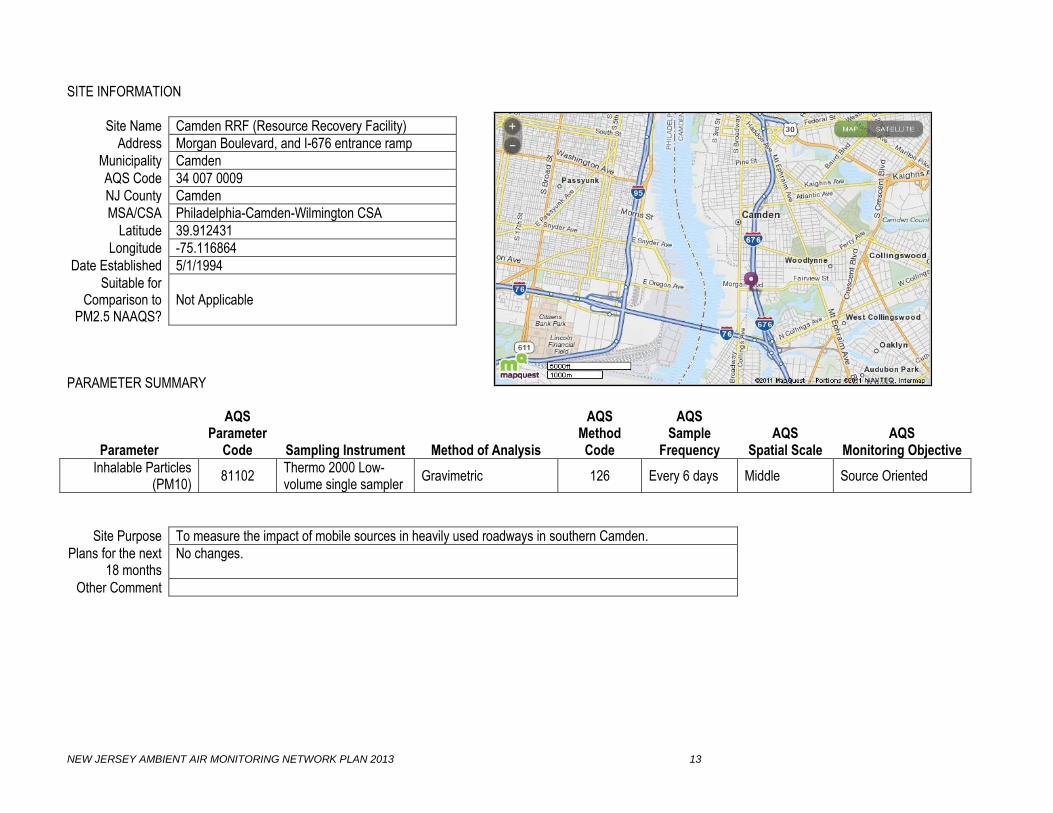
Site Name Camden RRF (Resource Recovery Facility)
Address Morgan Boulevard, and I-676 entrance ramp
Municipality Camden
AQS Code 34 007 0009
NJ County Camden
MSA/CSA Philadelphia-Camden-Wilmington CSA
Latitude 39.912431
Longitude -75.116864
Date Established 5/1/1994
Suitable for Comparison to
PM2.5 NAAQS? Not Applicable
PARAMETER SUMMARY
Parameter
AQS Parameter
Code
Sampling Instrument
Method of Analysis
AQS Method Code
AQS Sample
Frequency
AQS
Spatial Scale
AQS
Monitoring Objective
Inhalable Particles (PM10)
81102 Thermo 2000 Low-volume single sampler
Gravimetric 126 Every 6 days Middle Source Oriented
Site Purpose To measure the impact of mobile sources in heavily used roadways in southern Camden.
Plans for the next 18 months
No changes.
Other Comment

NEW JERSEY AMBIENT AIR MONITORING NETWORK PLAN 2013 14
SITE INFORMATION
Site Name Camden Spruce Street
Address Spruce St. near Locust St
Municipality Camden
AQS Code 34 007 0002
NJ County Camden
MSA/CSA Philadelphia-Camden-Wilmington CSA
Latitude 39.934446
Longitude -75.125291
Date Established 4/11/12
Suitable for Comparison to
PM2.5 NAAQS? Yes
PARAMETER SUMMARY
Parameter
AQS Parameter
Code
Sampling Instrument
Method of Analysis
AQS Method Code
AQS Sample
Frequency
AQS
Spatial Scale
AQS
Monitoring Objective
Carbon Monoxide (CO) 42101 TECO 48C Nondispersive-infrared 054 Continuous Neighborhood Population Exposure
Nitric Oxide (NO) 42601 TECO 42i Chemiluminescence 074 Continuous Neighborhood Population Exposure
Nitrogen Dioxide (NO2) 42602 TECO 42i Chemiluminescence 074 Continuous Neighborhood Population Exposure
Oxides of Nitrogen (NOx)
42603 TECO 42i Chemiluminescence 074 Continuous Neighborhood Population Exposure
Ozone (O3) 44201 TECO 49i Ultraviolet 047 Continuous Neighborhood Population Exposure
Sulfur Dioxide (SO2) 42401 TECO 43iTLE Pulsed fluorescence 560 Continuous Neighborhood Population Exposure
Fine Particles (PM2.5) 88101 Thermo 2025 Low-volume sequential sampler
Gravimetric 118 Every 3 days Neighborhood Population Exposure
PM2.5 Speciation Appendix C Met One XRF, IC, TOA App. C Every 3 days Neighborhood Population Exposure
Volatile Organic Compounds
Appendix A Canister TO-15 App. A Every 6 days Neighborhood Population Exposure
Carbonyls Appendix B DNPH cartridge TO-11A App. B Every 6 days Neighborhood Population Exposure
Black Carbon 84313 Teledyne API Model 633 Aethalometer
Optical absorption 861 Continuous Neighborhood Population Exposure
BTEX Appendix E Syntech Spectras BTEX analyzer GC 955
Auto GC-FID 132 Continuous Neighborhood Population Exposure
Continued on next page
NEW JERSEY AMBIENT AIR MONITORING NETWORK PLAN 2013 15
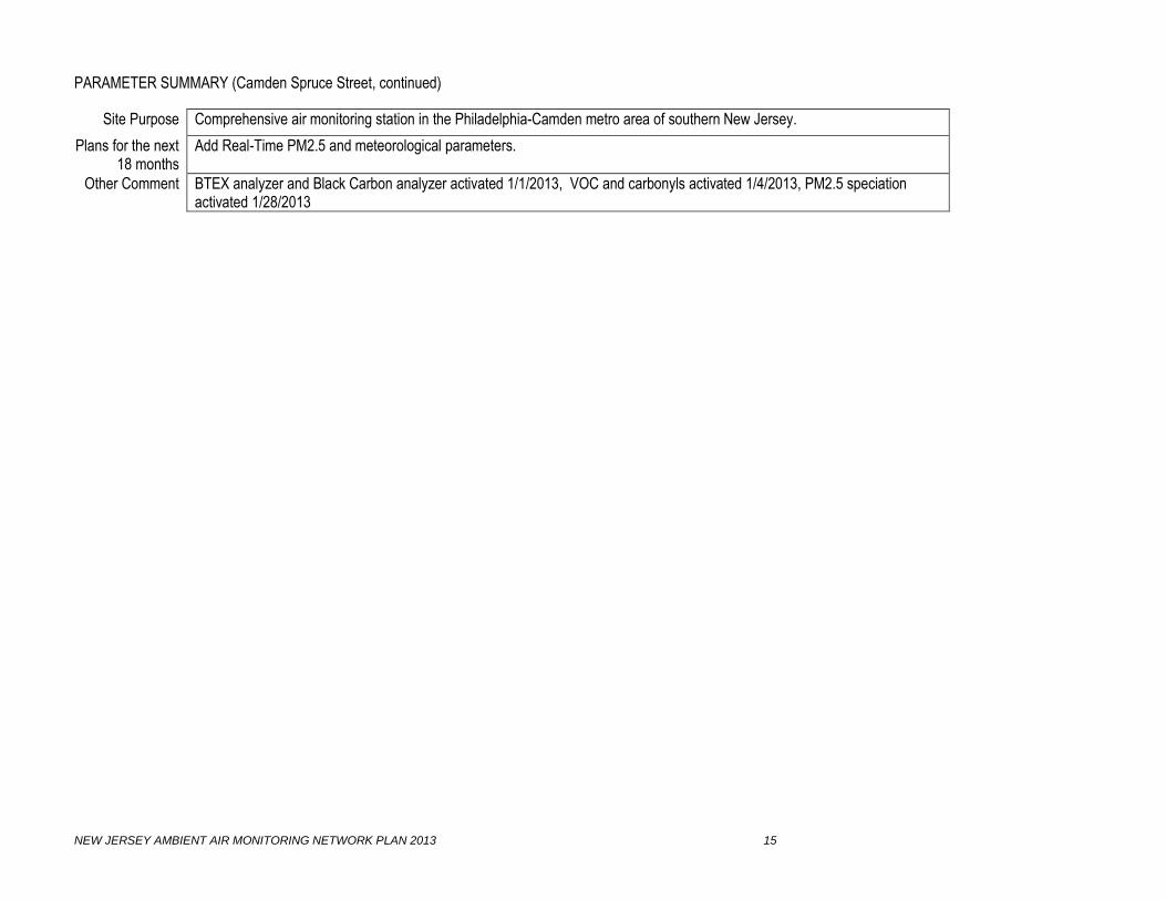
PARAMETER SUMMARY (Camden Spruce Street, continued)
Site Purpose Comprehensive air monitoring station in the Philadelphia-Camden metro area of southern New Jersey.
Plans for the next 18 months
Add Real-Time PM2.5 and meteorological parameters.
Other Comment BTEX analyzer and Black Carbon analyzer activated 1/1/2013, VOC and carbonyls activated 1/4/2013, PM2.5 speciation activated 1/28/2013

NEW JERSEY AMBIENT AIR MONITORING NETWORK PLAN 2013 16
SITE INFORMATION
Site Name Cattus Island
Address 1170 Cattus Island Blvd
Municipality Toms River
AQS Code None
NJ County Ocean
MSA/CSA New York-Northeast New Jersey-Connecticut CSA
Latitude 39.9894
Longitude -74.1344
Date Established 10/23/2012
Suitable for Comparison to
PM2.5 NAAQS? Not Applicable
PARAMETER SUMMARY
Parameter
AQS Parameter
Code
Sampling Instrument
Method of Analysis
AQS Method Code
AQS Sample
Frequency
AQS
Spatial Scale
AQS
Monitoring Objective
Acid Deposition Wet Deposition Collector Ion Chromatography Weekly Neighborhood Population Exposure
Site Purpose To measure population exposure and transported fine particle concentrations.
Plans for the next 18 months
No changes.
Other Comment Acid Deposition samples are sent to the National Atmospheric Deposition Program (NADP) for analysis. Acid Deposition data are not submitted by NJDEP or NADP to EPA’s AQS database.

NEW JERSEY AMBIENT AIR MONITORING NETWORK PLAN 2013 17
SITE INFORMATION
Site Name Chester
Address Building #1, Department of Public Works (DPW) off Route 513
Municipality Chester
AQS Code 34 027 3001
NJ County Morris
MSA/CSA New York-Northeast New Jersey-Connecticut CSA
Latitude 40.787628
Longitude -74.676301
Date Established 1/1/1978
Suitable for Comparison to
PM2.5 NAAQS? Yes
PARAMETER SUMMARY
Parameter
AQS Parameter
Code
Sampling Instrument
Method of Analysis
AQS Method Code
AQS Sample
Frequency
AQS
Spatial Scale
AQS
Monitoring Objective
Nitric Oxide (NO) 42601 TECO 42 Chemiluminescence 074 Continuous Urban Background
Nitrogen Dioxide (NO2) 42602 TECO 42 Chemiluminescence 074 Continuous Urban Background
Oxides of Nitrogen (NOx)
42603 TECO 42 Chemiluminescence 074 Continuous Urban Background
Ozone (O3) 44201 Dasibi 1008RS Ultraviolet 047 Continuous Urban Background
Sulfur Dioxide (SO2) 44201 TECO 43A Pulsed fluorescence 060 Continuous Urban Background
Fine Particles (PM2.5) 88101 Thermo 2025 Low-volume sequential sampler
Gravimetric 118 Every 3 days Urban Population Exposure
PM2.5 Speciation Appendix C Met One XRF, IC, TOA App. C Every 3 days Neighborhood Population Exposure
Volatile Organic Compounds
Appendix A Canister TO-15 App. A Every 6 days Neighborhood Population Exposure
Carbonyls Appendix B DNPH cartridge TO-11A App. B Every 6 days Neighborhood Population Exposure
Mercury (Hg) Tekran 2537A CVAF Spectrometry Hourly Neighborhood Population Exposure
Solar Radiation 63301 Qualimetrics Pyrometer 011 Continuous Neighborhood
Continued on next page

NEW JERSEY AMBIENT AIR MONITORING NETWORK PLAN 2013 18
PARAMETER SUMMARY (Chester, continued)
Site Purpose To measure background concentrations in northern New Jersey.
Plans for the next 18 months
No changes.
Other Comment Oxides of Nitrogen (NOx) data and Mercury data are not submitted to USEPA’s AQS database.

NEW JERSEY AMBIENT AIR MONITORING NETWORK PLAN 2013 19
SITE INFORMATION
Site Name Clarksboro
Address Clarksboro Shady Rest Home, Shady Lane and County House Road
Municipality East Greenwich Twp.
AQS Code 34 015 0002
NJ County Gloucester
MSA/CSA Philadelphia-Camden-Wilmington CSA
Latitude 39.800339
Longitude -75.212119
Date Established 1/1/1981
Suitable for Comparison to
PM2.5 NAAQS? Not Applicable
PARAMETER SUMMARY
Parameter
AQS Parameter
Code
Sampling Instrument
Method of Analysis
AQS Method Code
AQS Sample
Frequency
AQS
Spatial Scale
AQS
Monitoring Objective
Ozone (O3) 44201 TECO 49 Ultraviolet 047 Continuous Urban Highest Concentration
Site Purpose To measure highest concentrations of ozone downwind from Philadelphia metropolitan area.
Plans for the next 18 months
No changes.
Other Comment

NEW JERSEY AMBIENT AIR MONITORING NETWORK PLAN 2013 20
SITE INFORMATION
Site Name Colliers Mills
Address Colliers Mills Wildlife Management Area
Municipality Jackson Township
AQS Code 34 029 0006
NJ County Ocean
MSA/CSA New York-Northeast New Jersey-Connecticut CSA
Latitude 40.064830
Longitude -74.444050
Date Established 1/1/1985
Suitable for Comparison to
PM2.5 NAAQS? Not Applicable
PARAMETER SUMMARY
Parameter
AQS Parameter
Code
Sampling Instrument
Method of Analysis
AQS Method Code
AQS Sample
Frequency
AQS
Spatial Scale
AQS
Monitoring Objective
Ozone (O3) 44201 TECO 49 Ultraviolet 047 Continuous Urban Highest Concentration
Site Purpose To measure highest concentrations for ozone downwind from the Philadelphia metropolitan area and central New Jersey.
Plans for the next 18 months
No changes.
Other Comment

NEW JERSEY AMBIENT AIR MONITORING NETWORK PLAN 2013 21
SITE INFORMATION
Site Name Columbia WMA
Address Columbia Wildlife Management Area, Delaware Road
Municipality Knowlton Township
AQS Code 34 041 0007
NJ County Warren
MSA/CSA Allentown-Bethlehem-Easton-PA-NJ MSA
Latitude 40.924580
Longitude -75.067815
Date Established 9/23/2010
Suitable for Comparison to
PM2.5 NAAQS? Yes
PARAMETER SUMMARY
Parameter
AQS Parameter
Code
Sampling Instrument
Method of Analysis
AQS Method Code
AQS Sample
Frequency
AQS
Spatial Scale
AQS
Monitoring Objective
Nitric Oxide (NO) 42601 TECO 42i Chemiluminescence 074 Continuous Neighborhood Population Exposure
Nitrogen Dioxide (NO2) 42602 TECO 42i Chemiluminescence 074 Continuous Neighborhood Population Exposure
Oxides of Nitrogen (NOx)
42603 TECO 42i Chemiluminescence 074 Continuous Neighborhood Population Exposure
Ozone (O3) 44201 TECO 49i Ultraviolet 047 Continuous Neighborhood Population Exposure
Sulfur Dioxide (SO2) 42401 TECO 43iTLE Pulsed fluorescence 060 Continuous Neighborhood Highest Concentration
Fine Particles (PM2.5) 88101 Thermo 2025 Low-volume sequential sampler
Gravimetric 118 Every 3 days Neighborhood Population Exposure
Real-time PM2.5 88500 Thermo 1400 TEOM-FDMS
Gravimetric, Total atmospheric PM2.5
760 Continuous Neighborhood Population Exposure
Real-time PM2.5 88502 Thermo 1400 TEOM-FDMS
Gravimetric, Acceptable PM2.5
703 Continuous Neighborhood Population Exposure
Continued on next page

NEW JERSEY AMBIENT AIR MONITORING NETWORK PLAN 2013 22
PARAMETER SUMMARY (Columbia, continued)
Parameter
AQS Parameter
Code
Sampling Instrument
Method of Analysis
AQS Method Code
AQS Sample
Frequency
AQS
Spatial Scale
AQS
Monitoring Objective
Barometric Pressure 64101 Vaisala WXT Capacitive sensor 060 Continuous Neighborhood
Relative Humidity 62201 Vaisala WXT Capacitive sensor 060 Continuous Neighborhood
Temperature 62101 Vaisala WXT Capacitive sensor 060 Continuous Neighborhood
Wind Direction 61102 Vaisala WXT Ultrasonic sensor 060 Continuous Neighborhood
Wind Speed 61101 Vaisala WXT Ultrasonic sensor 060 Continuous Neighborhood
Site Purpose To measure population exposure for NO2, O3 and PM2.5; and highest concentrations for SO2.
Plans for the next 18 months
No changes.
Other Comment

NEW JERSEY AMBIENT AIR MONITORING NETWORK PLAN 2013 23
SITE INFORMATION
Site Name East Orange
Address Engine No. 2, Main Street and Greenwood Avenue
Municipality East Orange
AQS Code 34 013 1003
NJ County Essex
MSA/CSA New York-Northeast New Jersey-Connecticut CSA
Latitude 40.757501
Longitude -74.200500
Date Established 1/1/1980
Suitable for Comparison to
PM2.5 NAAQS? Not Applicable
PARAMETER SUMMARY
Parameter
AQS Parameter
Code
Sampling Instrument
Method of Analysis
AQS Method Code
AQS Sample
Frequency
AQS
Spatial Scale
AQS
Monitoring Objective
Carbon Monoxide (CO) 42101 TECO 48 Nondispersive-infrared 054 Continuous Neighborhood Highest Concentration
Nitric Oxide (NO) 42601 TECO 42 Chemiluminescence 074 Continuous Neighborhood Highest Concentration
Nitrogen Dioxide (NO2) 42602 TECO 42 Chemiluminescence 074 Continuous Neighborhood Highest Concentration
Oxides of Nitrogen (NOx)
42603 TECO 42 Chemiluminescence 074 Continuous Neighborhood Highest Concentration
Barometric Pressure 64101 Vaisala WXT Capacitive sensor 060 Continuous Neighborhood
Relative Humidity 62201 Vaisala WXT Capacitive sensor 060 Continuous Neighborhood
Temperature 62101 Vaisala WXT Capacitive sensor 060 Continuous Neighborhood
Wind Direction 61102 Vaisala WXT Ultrasonic sensor 060 Continuous Neighborhood
Wind Speed 61101 Vaisala WXT Ultrasonic sensor 060 Continuous Neighborhood
Site Purpose To measure population exposure in the East Orange and Newark areas.
Plans for the next 18 months
No changes.
Other Comment The CO, NO, NOx, Barometric Pressure, Relative Humidity, Temperature, Wind Direction and Wind Speed data are not submitted to USEPA’s AQS database. Wind Direction, Wind Speed, Barometric Pressure activated 8/17/2012

NEW JERSEY AMBIENT AIR MONITORING NETWORK PLAN 2013 24
SITE INFORMATION
Site Name Elizabeth
Address 7 Broad Street
Municipality Elizabeth
AQS Code 34 039 0003
NJ County Union
MSA/CSA New York-Northeast New Jersey-Connecticut CSA
Latitude 40.662389
Longitude -74.214817
Date Established 1/1/1970
Suitable for Comparison to
PM2.5 NAAQS? Not Applicable
PARAMETER SUMMARY
Parameter
AQS Parameter
Code
Sampling Instrument
Method of Analysis
AQS Method Code
AQS Sample
Frequency
AQS
Spatial Scale
AQS
Monitoring Objective
Carbon Monoxide (CO) 42101 TECO 48 Nondispersive-infrared 054 Continuous Micro Highest Concentration
Sulfur Dioxide (SO2) 42401 TECO 43A Pulsed fluorescence 060 Continuous Middle Population Exposure
Smoke Shade 11201 Wallace Fisher Tape sampler 081 Hourly Neighborhood Population Exposure
Site Purpose To measure the highest concentrations in the central commercial area of Elizabeth.
Plans for the next 18 months
No changes.
Other Comment Smoke Shade data is not submitted to USEPA’s AQS database.

NEW JERSEY AMBIENT AIR MONITORING NETWORK PLAN 2013 25
SITE INFORMATION
Site Name Elizabeth Lab
Address Interchange 13, New Jersey Turnpike
Municipality Elizabeth
AQS Code 34 039 0004
NJ County Union
MSA/CSA New York-Northeast New Jersey-Connecticut CSA
Latitude 40.641440
Longitude -74.208365
Date Established 1/1/1972
Suitable for Comparison to
PM2.5 NAAQS? Yes
PARAMETER SUMMARY
Parameter
AQS Parameter
Code
Sampling Instrument
Method of Analysis
AQS Method Code
AQS Sample
Frequency
AQS
Spatial Scale
AQS
Monitoring Objective
Carbon Monoxide (CO) 42101 TECO 48 Nondispersive-infrared 054 Continuous Neighborhood Highest Concentration
Nitric Oxide (NO) 42601 TECO 42 Chemiluminescence 074 Continuous Neighborhood Highest Concentration
Nitrogen Dioxide (NO2) 42602 TECO 42 Chemiluminescence 074 Continuous Neighborhood Highest Concentration
Oxides of Nitrogen (NOx)
42603 TECO 42 Chemiluminescence 074 Continuous Neighborhood Highest Concentration
Sulfur Dioxide (SO2) 42401 TECO 43A Pulsed fluorescence 060 Continuous Neighborhood Highest Concentration
Smoke Shade 11201 Wallace Fisher Tape sampler 081 Hourly Neighborhood Population Exposure
Fine Particles (PM2.5) 88101 Thermo 2025 Low-volume sequential sampler
Gravimetric 118 Daily Neighborhood Population Exposure
Real-time PM2.5 88500 Thermo 1400 TEOM-FDMS
Gravimetric, Total atmospheric PM2.5
760 Continuous Middle Scale Highest Concentration
Real-time PM2.5 88502 Thermo 1400 TEOM-FDMS
Gravimetric, Acceptable PM2.5
703 Continuous Middle Scale Highest Concentration
PM2.5 Speciation Appendix C Met One XRF, IC, TOA App. C Every 3 days Neighborhood Highest Concentration
Continued on next page

NEW JERSEY AMBIENT AIR MONITORING NETWORK PLAN 2013 26
PARAMETER SUMMARY (Elizabeth Lab, continued)
Parameter
AQS Parameter
Code
Sampling Instrument
Method of Analysis
AQS Method Code
AQS Sample
Frequency
AQS
Spatial Scale
AQS
Monitoring Objective
Volatile Organic Compounds
Appendix A Canister TO-15 App. A Every 6 days Neighborhood Population Exposure
Carbonyls Appendix B DNPH cartridge TO-11A App. B Every 6 days Neighborhood Population Exposure
Mercury (Hg) Tekran 2537A CVAF Spectrometry Hourly Neighborhood Population Exposure
Wind Direction 61102 Qualimetrics Wind vane 020 Continuous Neighborhood
Wind Speed 61101 Qualimetrics Anemometer 020 Continuous Neighborhood
Black Carbon 84313 Teledyne API Model 633 Aethalometer
Optical absorption 861 Continuous Neighborhood Population Exposure
BTEX Appendix E Syntech Spectras BTEX analyzer GC 955
Auto-GC PID 132 Continuous Neighborhood Population Exposure
Site Purpose The comprehensive air monitoring site in the northeast metropolitan region of New Jersey.
Plans for the next 18 months
No changes.
Other Comment PM2.5 is collocated for precision. CO, Nitric Oxide (NO), Oxides of Nitrogen (NOx), Smoke Shade, Wind Direction and Wind Speed data are not submitted to USEPA’s AQS database. BTEX analyzer and Black Carbon analyzer activated 1/2/2013.

NEW JERSEY AMBIENT AIR MONITORING NETWORK PLAN 2013 27
SITE INFORMATION
Site Name Elizabeth Mitchell Bldg
Address Mitchell Building, 500 North Broad Street
Municipality Elizabeth
AQS Code 34 039 0006
NJ County Union
MSA/CSA New York-Northeast New Jersey-Connecticut CSA
Latitude 40.673406
Longitude -74.213889
Date Established 1/1/1983
Suitable for Comparison to
PM2.5 NAAQS? Yes
PARAMETER SUMMARY
Parameter
AQS Parameter
Code
Sampling Instrument
Method of Analysis
AQS Method Code
AQS Sample
Frequency
AQS
Spatial Scale
AQS
Monitoring Objective
Fine Particles (PM2.5) 88101 Thermo 2025 Low-volume sequential sampler
Gravimetric 118 Every 3 days Neighborhood Population Exposure
Site Purpose To measure population exposure in the Elizabeth area.
Plans for the next 18 months
No changes.
Other Comment
NEW JERSEY AMBIENT AIR MONITORING NETWORK PLAN 2013 28
SITE INFORMATION
Site Name Ewing
Address Bureau of Air Monitoring Technical Center, 380 Scotch Road
Municipality Ewing
AQS Code 34 021 0010
NJ County Mercer
MSA/CSA Trenton-Ewing MSA
Latitude 40.287530
Longitude -74.807770
Date Established 1/1/2009
Suitable for Comparison to
PM2.5 NAAQS? No
PARAMETER SUMMARY
Parameter
AQS Parameter
Code
Sampling Instrument
Method of Analysis
AQS Method Code
AQS Sample
Frequency
AQS
Spatial Scale
AQS
Monitoring Objective
Real-time PM2.5 88500 Thermo 1400 TEOM-FDMS
Gravimetric, Total Atmospheric PM2.5
760 Continuous Neighborhood Population Exposure
Real-time PM2.5 88502 Thermo 1400 TEOM-FDMS
Gravimetric, Acceptable PM2.5
703 Continuous Neighborhood Population Exposure
Site Purpose To measure population exposure in the Mercer County area.
Plans for the next 18 months
No changes.
Other Comment

NEW JERSEY AMBIENT AIR MONITORING NETWORK PLAN 2013 29
SITE INFORMATION
Site Name Flemington
Address Raritan Township Municipal Utilities Authority, 365 Old York Road
Municipality Raritan Twp.
AQS Code 34 019 0001
NJ County Hunterdon
MSA/CSA New York-Northeast New Jersey-Connecticut CSA
Latitude 40.515262
Longitude -74.806671
Date Established 1/1/1980
Suitable for Comparison to
PM2.5 NAAQS? Not Applicable
PARAMETER SUMMARY
Parameter
AQS Parameter
Code
Sampling Instrument
Method of Analysis
AQS Method Code
AQS Sample
Frequency
AQS
Spatial Scale
AQS
Monitoring Objective
Ozone (O3) 44201 Dasibi 1008RS Ultraviolet 056 Continuous Urban Highest Concentration
Real-time PM2.5 88500 Thermo 1400 TEOM-FDMS
Gravimetric, Total Atmospheric PM2.5
760 Continuous Neighborhood Population Exposure
Real-time PM2.5 88502 Thermo 1400 TEOM-FDMS
Gravimetric, Acceptable PM2.5
703 Continuous Neighborhood Population Exposure
Barometric Pressure 64101 Qualimetrics Pressure transducer 011 Continuous Neighborhood
Relative Humidity 62201 Qualimetrics Capacitive sensor 013 Continuous Neighborhood
Solar Radiation 63301 Qualimetrics Pyrometer 011 Continuous Neighborhood
Temperature 62101 Qualimetrics Thermistor 020 Continuous Neighborhood
Wind Direction 61102 Qualimetrics Wind vane 020 Continuous Neighborhood
Wind Speed 61101 Qualimetrics Anemometer 020 Continuous Neighborhood
Site Purpose To measure ozone concentrations in the northwestern region of New Jersey.
Plans for the next 18 months
No changes.
Other Comment Barometric Pressure, Relative Humidity, Solar Radiation, Temperature, Wind Direction, and Wind Speed data are not submitted to USEPA’s AQS database.

NEW JERSEY AMBIENT AIR MONITORING NETWORK PLAN 2013 30
SITE INFORMATION
Site Name Fort Lee Library
Address Fort Lee Library, 320 Main Street
Municipality Fort Lee
AQS Code 34 003 0003
NJ County Bergen
MSA/CSA New York-Northeast New Jersey-Connecticut CSA
Latitude 40.852256
Longitude -73.973314
Date Established 1/23/1986
Suitable for Comparison to
PM2.5 NAAQS? Yes
PARAMETER SUMMARY
Parameter
AQS Parameter
Code
Sampling Instrument
Method of Analysis
AQS Method Code
AQS Sample
Frequency
AQS
Spatial Scale
AQS
Monitoring Objective
Fine Particles (PM2.5) 88101 Thermo 2025 Low-volume sequential sampler
Gravimetric 118 Every 3 days Neighborhood Population Exposure
Site Purpose To measure the population exposure in the Fort Lee area.
Plans for the next 18 months
No changes.
Other Comment

NEW JERSEY AMBIENT AIR MONITORING NETWORK PLAN 2013 31
SITE INFORMATION
Site Name Gibbstown
Address Municipal Maintenance Yard, North School Street, North of Morse Avenue
Municipality Greenwich Township
AQS Code 34 015 0004
NJ County Gloucester
MSA/CSA Philadelphia-Camden-Wilmington CSA
Latitude 39.830806
Longitude -75.284723
Date Established 2/2/2007
Suitable for Comparison to
PM2.5 NAAQS?
Yes
PARAMETER SUMMARY
Parameter
AQS Parameter
Code
Sampling Instrument
Method of Analysis
AQS Method Code
AQS Sample
Frequency
AQS
Spatial Scale
AQS
Monitoring Objective
Fine Particles (PM2.5) 88101 Thermo 2025 Low-volume sequential sampler
Gravimetric 118 Every 3 days Neighborhood Population Exposure
Site Purpose To measure population exposure in the Gibbstown area.
Plans for the next 18 months
No changes.
Other Comment
NEW JERSEY AMBIENT AIR MONITORING NETWORK PLAN 2013 32
SITE INFORMATION
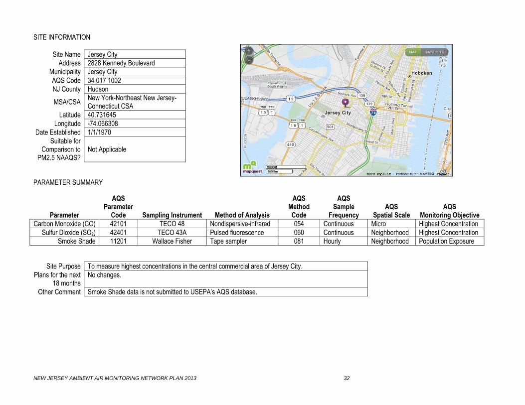
Site Name Jersey City
Address 2828 Kennedy Boulevard
Municipality Jersey City
AQS Code 34 017 1002
NJ County Hudson
MSA/CSA New York-Northeast New Jersey-Connecticut CSA
Latitude 40.731645
Longitude -74.066308
Date Established 1/1/1970
Suitable for Comparison to
PM2.5 NAAQS? Not Applicable
PARAMETER SUMMARY
Parameter
AQS Parameter
Code
Sampling Instrument
Method of Analysis
AQS Method Code
AQS Sample
Frequency
AQS
Spatial Scale
AQS
Monitoring Objective
Carbon Monoxide (CO) 42101 TECO 48 Nondispersive-infrared 054 Continuous Micro Highest Concentration
Sulfur Dioxide (SO2) 42401 TECO 43A Pulsed fluorescence 060 Continuous Neighborhood Highest Concentration
Smoke Shade 11201 Wallace Fisher Tape sampler 081 Hourly Neighborhood Population Exposure
Site Purpose To measure highest concentrations in the central commercial area of Jersey City.
Plans for the next 18 months
No changes.
Other Comment Smoke Shade data is not submitted to USEPA’s AQS database.

NEW JERSEY AMBIENT AIR MONITORING NETWORK PLAN 2013 33
SITE INFORMATION
Site Name Jersey City Firehouse
Address Consolidated Firehouse, 355 Newark Avenue
Municipality Jersey City
AQS Code 34 017 1003
NJ County Hudson
MSA/CSA New York-Northeast New Jersey-Connecticut CSA
Latitude 40.725454
Longitude -74.052290
Date Established 1/1/1967
Suitable for Comparison to
PM2.5 NAAQS? Yes
PARAMETER SUMMARY
Parameter
AQS Parameter
Code
Sampling Instrument
Method of Analysis
AQS Method Code
AQS Sample
Frequency
AQS
Spatial Scale
AQS
Monitoring Objective
Fine Particles (PM2.5) 88101 Thermo 2025 Low-volume sequential sampler
Gravimetric 118 Daily Neighborhood Population Exposure
Real-time PM2.5 88500 Thermo 1400 TEOM-FDMS
Gravimetric, Total Atmospheric PM2.5
760 Continuous Neighborhood Population Exposure
Real-time PM2.5 88502 Thermo 1400 TEOM-FDMS
Gravimetric, Acceptable PM2.5
703 Continuous Neighborhood Population Exposure
Inhalable Particles (PM10)
81102 Thermo 2000 Low-volume single sampler
Gravimetric 126 Every 6 days Neighborhood Highest Concentration
Site Purpose To measure population exposure in the Jersey City area.
Plans for the next 18 months
No changes.
Other Comment PM2.5 and PM10 are collocated for precision measurements; daily sampling began in 2007 for Fine Particles (AQS code 88101); prior to 2007, every 3 day sampling.

NEW JERSEY AMBIENT AIR MONITORING NETWORK PLAN 2013 34
SITE INFORMATION
Site Name Leonia
Address Overpeck Park, 40 Fort Lee Road
Municipality Leonia
AQS Code 34 003 0006
NJ County Bergen
MSA/CSA New York-Northeast New Jersey-Connecticut CSA
Latitude 40.870436
Longitude -73.991994
Date Established 12/7/2007
Suitable for Comparison to
PM2.5 NAAQS? Not Applicable
PARAMETER SUMMARY
Parameter
AQS Parameter
Code
Sampling Instrument
Method of Analysis
AQS Method Code
AQS Sample
Frequency
AQS
Spatial Scale
AQS
Monitoring Objective
Ozone (O3) 44201 Dasibi 1008 Ultraviolet 056 Continuous Neighborhood Population Exposure
Site Purpose To measure population exposure in the Leonia and Teaneck areas.
Plans for the next 18 months
No changes.
Other Comment

NEW JERSEY AMBIENT AIR MONITORING NETWORK PLAN 2013 35
SITE INFORMATION
Site Name Millville
Address Lincoln Avenue and Route 55, Northeast of Millville
Municipality Vineland
AQS Code 34 011 0007
NJ County Cumberland
MSA/CSA Vineland-Millville-Bridgeton MSA
Latitude 39.422273
Longitude -75.025204
Date Established 1/1/1983
Suitable for Comparison to
PM2.5 NAAQS? Not Applicable
PARAMETER SUMMARY
Parameter
AQS Parameter
Code
Sampling Instrument
Method of Analysis
AQS Method Code
AQS Sample
Frequency
AQS
Spatial Scale
AQS
Monitoring Objective
Nitric Oxide (NO) 42601 TECO 42 Chemiluminescence 074 Continuous Neighborhood Population Exposure
Nitrogen Dioxide (NO2) 42602 TECO 42 Chemiluminescence 074 Continuous Neighborhood Population Exposure
Oxides of Nitrogen (NOx)
42603 TECO 42 Chemiluminescence 074 Continuous Neighborhood Population Exposure
Ozone (O3) 44201 Dasibi 1008 Ultraviolet 056 Continuous Neighborhood Population Exposure
Real-time PM2.5 88500 Thermo 1400 TEOM-FDMS
Gravimetric, Total Atmospheric PM2.5
760 Continuous Neighborhood Population Exposure
Real-time PM2.5 88502 Thermo 1400 TEOM-FDMS
Gravimetric, Acceptable PM2.5
703 Continuous Neighborhood Population Exposure
Site Purpose To measure population exposure in the Vineland and Millville areas.
Plans for the next 18 months
Real-time PM2.5 will be re-started in 2013.
Other Comment NO, NO2, and NOx data are not submitted to USEPA’s AQS database. Station was temporarily shut down 12/05/2012. O3 was re-started on 3/1/2013, and NO, NO2 and NOx were re-started on 3/15/2013.
NEW JERSEY AMBIENT AIR MONITORING NETWORK PLAN 2013 36
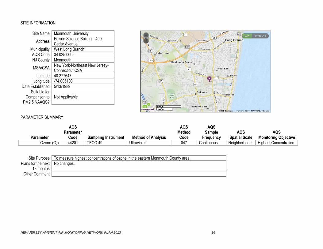
SITE INFORMATION
Site Name Monmouth University
Address Edison Science Building, 400 Cedar Avenue
Municipality West Long Branch
AQS Code 34 025 0005
NJ County Monmouth
MSA/CSA New York-Northeast New Jersey-Connecticut CSA
Latitude 40.277647
Longitude -74.005100
Date Established 5/13/1989
Suitable for Comparison to
PM2.5 NAAQS? Not Applicable
PARAMETER SUMMARY
Parameter
AQS Parameter
Code
Sampling Instrument
Method of Analysis
AQS Method Code
AQS Sample
Frequency
AQS
Spatial Scale
AQS
Monitoring Objective
Ozone (O3) 44201 TECO 49 Ultraviolet 047 Continuous Neighborhood Highest Concentration
Site Purpose To measure highest concentrations of ozone in the eastern Monmouth County area.
Plans for the next 18 months
No changes.
Other Comment

NEW JERSEY AMBIENT AIR MONITORING NETWORK PLAN 2013 37
SITE INFORMATION
Site Name Morristown Ambulance Squad
Address 16 Early Street
Municipality Morristown
AQS Code 34 027 0004
NJ County Morris
MSA/CSA New York-Northeast New Jersey-Connecticut CSA
Latitude 40.801211
Longitude -74.483433
Date Established 5/30/1999
Suitable for Comparison to
PM2.5 NAAQS? Yes
PARAMETER SUMMARY
Parameter
AQS Parameter
Code
Sampling Instrument
Method of Analysis
AQS Method Code
AQS Sample
Frequency
AQS
Spatial Scale
AQS
Monitoring Objective
Fine Particles (PM2.5) 88101 Thermo 2025 Low-volume sequential sampler
Gravimetric 118 Every 3 days Neighborhood Population Exposure
Site Purpose To measure population exposure in the Morristown area.
Plans for the next 18 months
No changes.
Other Comment PM2.5 was proposed to be shut down in 2010 Network Plan, but not approved by USEPA.
NEW JERSEY AMBIENT AIR MONITORING NETWORK PLAN 2013 38
SITE INFORMATION
Site Name New Brunswick
Address Cook College, Log Cabin Road near Horticulture Lab
Municipality North Brunswick Township
AQS Code 34 023 0006
NJ County Middlesex
MSA/CSA New York-Northeast New Jersey-Connecticut CSA
Latitude 40.472825
Longitude -74.422403
Date Established 1/1/1981
Suitable for Comparison to
PM2.5 NAAQS? Yes
PARAMETER SUMMARY
Parameter
AQS Parameter
Code
Sampling Instrument
Method of Analysis
AQS Method Code
AQS Sample
Frequency
AQS
Spatial Scale
AQS
Monitoring Objective
Fine Particles (PM2.5) 88101 Thermo 2025 Low-volume sequential sampler
Gravimetric 118 Every 3 days Neighborhood Population Exposure
Real-time PM2.5 88500 Thermo 1400 TEOM-FDMS
Gravimetric, Total Atmospheric PM2.5
760 Continuous Neighborhood Population Exposure
Real-time PM2.5 88502 Thermo 1400 TEOM-FDMS
Gravimetric, Acceptable PM2.5
703 Continuous Neighborhood Population Exposure
PM2.5 Speciation Appendix C Met One XRF, IC, TOA App. C Every 3 days Neighborhood Population Exposure
Volatile Organic Compounds
Appendix A Canister TO-15 App. A Every 6 days Neighborhood Population Exposure
Carbonyls Appendix B DNPH cartridge TO-11A App. B Every 6 days Neighborhood Population Exposure
Mercury (Hg) Tekran 2537A CVAF Spectrometry Hourly Neighborhood Population Exposure
Site Purpose To measure population exposure in the New Brunswick area.
Plans for the next 18 months
No changes.
Other Comment PM2.5 Speciation is collocated for precision. Mercury data not submitted to EPA’s AQS database.

NEW JERSEY AMBIENT AIR MONITORING NETWORK PLAN 2013 39
SITE INFORMATION
Site Name Newark Firehouse
Address 360 Clinton Avenue
Municipality Newark
AQS Code 34 013 0003
NJ County Essex
MSA/CSA New York-Northeast New Jersey-Connecticut CSA
Latitude 40.720989
Longitude -74.192892
Date Established 6/1/2009
Suitable for Comparison to
PM2.5 NAAQS? Yes
PARAMETER SUMMARY
Parameter
AQS Parameter
Code
Sampling Instrument
Method of Analysis
AQS Method Code
AQS Sample
Frequency
AQS
Spatial Scale
AQS
Monitoring Objective
Carbon Monoxide (CO) 42101 TECO 48iTLE Nondispersive-infrared
554 Continuous Neighborhood Population Exposure
Nitric Oxide (NO) 42601 TECO 42CY Chemiluminescence 574 Continuous Neighborhood Population Exposure
NOy-NO Difference 42612 TECO 42CY Chemiluminescence 574 Continuous Neighborhood Population Exposure
Total ReactiveOxides of Nitrogen (NOy)
42600 TECO 42CY Chemiluminescence 574 Continuous Neighborhood Population Exposure
Nitric Oxide (NO) 42601 TECO 42i Chemiluminescence 074 Continuous Neighborhood Population Exposure
Nitrogen Dioxide (NO2) 42602 TECO 42i Chemiluminescence 074 Continuous Neighborhood Population Exposure
Oxides of Nitrogen (NOx)
42603 TECO 42i Chemiluminescence 074 Continuous Neighborhood Population Exposure
Ozone (O3) 44201 TECO 49i Ultraviolet 047 Continuous Neighborhood Population Exposure
Sulfur Dioxide (SO2) 42401 TECO 43iTLE Pulsed fluorescence 560 Continuous Neighborhood Highest Concentration
Fine Particles (PM2.5) 88101 Thermo 2025 Low-volume sequential sampler
Gravimetric 118 Every 3 days Neighborhood Population Exposure
Lead (Pb) 85129 Thermo 2025 Low-volume sequential sampler
XRF with PM10 811 Every 6 days Neighborhood Population Exposure
Continued on next page

NEW JERSEY AMBIENT AIR MONITORING NETWORK PLAN 2013 40
PARAMETER SUMMARY (Newark Firehouse, continued)
Parameter
AQS Parameter
Code
Sampling Instrument
Method of Analysis
AQS Method Code
AQS Sample
Frequency
AQS
Spatial Scale
AQS
Monitoring Objective
Real-time PM2.5 88500 Thermo 1400 TEOM-FDMS
Gravimetric, Total atmospheric PM2.5
760 Continuous Neighborhood Population Exposure
PM coarse 86101 Thermo 2025 Sequential Sampler
Paired Gravimetric Difference
176 Every 3 days Neighborhood Population Exposure
Real-time PM2.5 88502 Thermo 1400 TEOM-FDMS
Gravimetric, Acceptable PM2.5
703 Continuous Neighborhood Population Exposure
PM2.5 Speciation Appendix C Met One XRF, IC, TOA App. C Every 3 days Neighborhood Population Exposure
Barometric Pressure 64101 Qualimetrics Pressure transducer 011 Continuous Neighborhood
Relative Humidity 62201 Qualimetrics Capacitive sensor 011 Continuous Neighborhood
Solar Radiation 63301 Qualimetrics Pyrometer 011 Continuous Neighborhood
Temperature 62101 Qualimetrics Thermistor 020 Continuous Neighborhood
Resultant Wind Direction
61104 Qualimetrics
Wind vane 020 Continuous Neighborhood
Resultant Wind Speed 61103 Qualimetrics Anemometer 020 Continuous Neighborhood
Site Purpose New Jersey’s NCore site.
Plans for the next 18 months
Plan to add BTEX analyzer and black carbon analyzer.
Other Comment CO and SO2 data are measured by “trace-level” analyzers. Pb monitor established on 01/04/2012, PM coarse established on 1/4/2013
NEW JERSEY AMBIENT AIR MONITORING NETWORK PLAN 2013 41
SITE INFORMATION
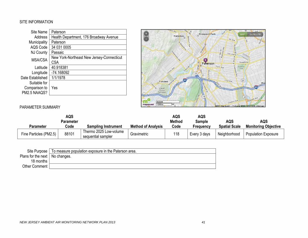
Site Name Paterson
Address Health Department, 176 Broadway Avenue
Municipality Paterson
AQS Code 34 031 0005
NJ County Passaic
MSA/CSA New York-Northeast New Jersey-Connecticut CSA
Latitude 40.918381
Longitude -74.168092
Date Established 1/1/1978
Suitable for Comparison to
PM2.5 NAAQS? Yes
PARAMETER SUMMARY
Parameter
AQS Parameter
Code
Sampling Instrument
Method of Analysis
AQS Method Code
AQS Sample
Frequency
AQS
Spatial Scale
AQS
Monitoring Objective
Fine Particles (PM2.5) 88101 Thermo 2025 Low-volume sequential sampler
Gravimetric 118 Every 3 days Neighborhood Population Exposure
Site Purpose To measure population exposure in the Paterson area.
Plans for the next 18 months
No changes.
Other Comment

NEW JERSEY AMBIENT AIR MONITORING NETWORK PLAN 2013 42
SITE INFORMATION
Site Name Pennsauken
Address Morris Delair Water Treatment Plant, off Griffith-Morgan Lane
Municipality Pennsauken
AQS Code 34 007 1007
NJ County Camden
MSA/CSA Philadelphia-Camden-Wilmington CSA
Latitude 39.989036
Longitude -75.050008
Date Established 9/1/1983
Suitable for Comparison to
PM2.5 NAAQS? Yes
PARAMETER SUMMARY
Parameter
AQS Parameter
Code
Sampling Instrument
Method of Analysis
AQS Method Code
AQS Sample
Frequency
AQS
Spatial Scale
AQS
Monitoring Objective
Fine Particles (PM2.5) 88101 Thermo 2025 Low-volume sequential sampler
Gravimetric 118 Every 3 days Neighborhood Population Exposure
Site Purpose To measure population exposure in the Pennsauken area.
Plans for the next 18 months
No changes.
Other Comment

NEW JERSEY AMBIENT AIR MONITORING NETWORK PLAN 2013 43
SITE INFORMATION
Site Name Phillipsburg
Address Municipal Building, 675 Corliss Avenue
Municipality Phillipsburg
AQS Code 34 041 0006
NJ County Warren
MSA/CSA Allentown-Bethlehem-Easton, PA-NJ MSA
Latitude 40.699207
Longitude -75.180525
Date Established 8/10/1999
Suitable for Comparison to
PM2.5 NAAQS? Yes
PARAMETER SUMMARY
Parameter
AQS Parameter
Code
Sampling Instrument
Method of Analysis
AQS Method Code
AQS Sample
Frequency
AQS
Spatial Scale
AQS
Monitoring Objective
Fine Particles (PM2.5) 88101 Thermo 2025 Low-volume sequential sampler
Gravimetric 118 Every 3 days Neighborhood Population Exposure
Site Purpose To measure population exposure in the Phillipsburg area, and to measure transported fine particle concentrations.
Plans for the next 18 months
No changes.
Other Comment

NEW JERSEY AMBIENT AIR MONITORING NETWORK PLAN 2013 44
SITE INFORMATION
Site Name Rahway
Address Fire Department Building, 1300 Main Street
Municipality Rahway
AQS Code 34 039 2003
NJ County Union
MSA/CSA New York-Northeast New Jersey-Connecticut CSA
Latitude 40.603943
Longitude -74.276174
Date Established 12/11/1999
Suitable for Comparison to
PM2.5 NAAQS? Yes
PARAMETER SUMMARY
Parameter
AQS Parameter
Code
Sampling Instrument
Method of Analysis
AQS Method Code
AQS Sample
Frequency
AQS
Spatial Scale
AQS
Monitoring Objective
Fine Particles (PM2.5) 88101 Thermo 2025 Low-volume sequential sampler
Gravimetric 118 Daily Neighborhood Population Exposure
Real-time PM2.5 88502 Thermo 1400 TEOM Gravimetric,
Acceptable PM2.5 711 Continuous Neighborhood Population Exposure
Site Purpose To measure population exposure in the Rahway area.
Plans for the next 18 months
No changes.
Other Comment TEOM analyzer is operating without the FDMS at 50o Celsius.

NEW JERSEY AMBIENT AIR MONITORING NETWORK PLAN 2013 45
SITE INFORMATION
Site Name Ramapo
Address Ramapo Mountain State Forest, Access Road, off Skyline Drive
Municipality Wanaque
AQS Code 34 031 5001
NJ County Passaic
MSA/CSA New York-Northeast New Jersey-Connecticut CSA
Latitude 41.058617
Longitude -74.255544
Date Established 6/5/1998
Suitable for Comparison to
PM2.5 NAAQS? Not Applicable
PARAMETER SUMMARY
Parameter
AQS Parameter
Code
Sampling Instrument
Method of Analysis
AQS Method Code
AQS Sample
Frequency
AQS
Spatial Scale
AQS
Monitoring Objective
Ozone (O3) 44201 Dasibi 1008 Ultraviolet 056 Continuous Urban Background
Site Purpose To measure background, transport and upwind concentrations of ozone.
Plans for the next 18 months
No changes.
Other Comment

NEW JERSEY AMBIENT AIR MONITORING NETWORK PLAN 2013 46
SITE INFORMATION
Site Name Rider University
Address Athletic Fields, Route 206 South
Municipality Lawrence
AQS Code 34 021 0005
NJ County Mercer
MSA/CSA Trenton-Ewing MSA
Latitude 40.283092
Longitude -74.742644
Date Established 6/1/1981
Suitable for Comparison to
PM2.5 NAAQS? Not Applicable
PARAMETER SUMMARY
Parameter
AQS Parameter
Code
Sampling Instrument
Method of Analysis
AQS Method Code
AQS Sample
Frequency
AQS
Spatial Scale
AQS
Monitoring Objective
Ozone (O3) 44201 Dasibi 1008 Ultraviolet 056 Continuous Neighborhood Population Exposure
Barometric Pressure 64101 Qualimetrics Instrumental aneroid 011 Continuous Neighborhood
Relative Humidity 62201 Qualimetrics Hydrothermograph 013 Continuous Neighborhood
Solar Radiation 63301 Qualimetrics Pyrometer 011 Continuous Neighborhood
Temperature 62101 Qualimetrics Thermistor, spot rdg. 020 Continuous Neighborhood
Wind Direction 61102 Qualimetrics Wind vane, spot rdg. 020 Continuous Neighborhood
Wind Speed 61101 Qualimetrics Anemometer, spot rdg. 020 Continuous Neighborhood
Site Purpose To measure population exposure.
Plans for the next 18 months
None.
Other Comment

NEW JERSEY AMBIENT AIR MONITORING NETWORK PLAN 2013 47
SITE INFORMATION
Site Name Rutgers University
Address Horticultural Farm #3, off Ryder's Lane
Municipality East Brunswick
AQS Code 34 023 0011
NJ County Middlesex
MSA/CSA New York-Northeast New Jersey-Connecticut CSA
Latitude 40.462182
Longitude -74.429439
Date Established 10/1/1994
Suitable for Comparison to
PM2.5 NAAQS? Not Applicable
PARAMETER SUMMARY
Parameter
AQS Parameter
Code
Sampling Instrument
Method of Analysis
AQS Method Code
AQS Sample
Frequency
AQS
Spatial Scale
AQS
Monitoring Objective
Nitric Oxide (NO) 42601 TECO 42 Chemiluminescence 074 Continuous Neighborhood Population Exposure
Nitrogen Dioxide (NO2) 42602 TECO 42 Chemiluminescence 074 Continuous Neighborhood Population Exposure
Oxides of Nitrogen (NOx) 42603 TECO 42 Chemiluminescence 074 Continuous Neighborhood Population Exposure
Ozone (O3) 44201 Dasibi 1008 Ultraviolet 056 Continuous Neighborhood Population Exposure
Ozone Precursors (PAMS) Appendix D Perkin Elmer Auto GC-FID App. D Hourly Urban Background
Site Purpose To measure population exposure and ozone precursors – downwind for Philadelphia metropolitan area and upwind for New York metropolitan area.
Plans for the next 18 months
No changes.
Other Comment Upper air and lower air meteorological measurements are collected at this site by Rutgers University.

NEW JERSEY AMBIENT AIR MONITORING NETWORK PLAN 2013 48
SITE INFORMATION
Site Name South Camden
Address Camden County Municipal Utilities Authority, 1645 Ferry Avenue
Municipality Camden
AQS Code 34 007 0010
NJ County Camden
MSA/CSA Philadelphia-Camden-Wilmington CSA
Latitude 39.923969
Longitude -75.122317
Date Established 11/20/2003
Suitable for Comparison to
PM2.5 NAAQS? Not Applicable
PARAMETER SUMMARY
Parameter
AQS Parameter
Code
Sampling Instrument
Method of Analysis
AQS Method Code
AQS Sample
Frequency
AQS
Spatial Scale
AQS
Monitoring Objective
Real-time PM2.5 88500 Thermo 1400 TEOM-FDMS
Gravimetric, Total Atmospheric PM2.5
760 Continuous Neighborhood Highest Concentration
Real-time PM2.5 88502 Thermo 1400 TEOM-FDMS
Gravimetric, Acceptable PM2.5
703 Continuous Neighborhood Highest Concentration
Site Purpose To measure population exposure in the South Camden area.
Plans for the next 18 months
No changes.
Other Comment Real-time PM2.5 data is not submitted to USEPA’s AQS database.

NEW JERSEY AMBIENT AIR MONITORING NETWORK PLAN 2013 49
SITE INFORMATION
Site Name Toms River
Address Hooper Avenue Elementary School, 1517 Hooper Avenue
Municipality Dover Twp.
AQS Code 34 029 2002
NJ County Ocean
MSA/CSA New York-Northeast New Jersey-Connecticut CSA
Latitude 39.994908
Longitude -74.170447
Date Established 2/11/1999
Suitable for Comparison to
PM2.5 NAAQS? Yes
PARAMETER SUMMARY
Parameter
AQS Parameter
Code
Sampling Instrument
Method of Analysis
AQS Method Code
AQS Sample
Frequency
AQS
Spatial Scale
AQS
Monitoring Objective
Fine Particles (PM2.5) 88101 Thermo 2025 Low-volume sequential sampler
Gravimetric 118 Daily Neighborhood Population Exposure
Site Purpose To measure population exposure in the Toms River area.
Plans for the next 18 months
No changes.
Other Comment Daily sampling began in 2007; prior to 2007, every 3 day sampling.

NEW JERSEY AMBIENT AIR MONITORING NETWORK PLAN 2013 50
SITE INFORMATION
Site Name Trenton
Address Trenton Library, 120 Academy Street
Municipality Trenton
AQS Code 34 021 0008
NJ County Mercer
MSA/CSA Trenton-Ewing MSA
Latitude 40.222411
Longitude -74.763167
Date Established 9/1/1982
Suitable for Comparison to
PM2.5 NAAQS? Yes
PARAMETER SUMMARY
Parameter
AQS Parameter
Code
Sampling Instrument
Method of Analysis
AQS Method Code
AQS Sample
Frequency
AQS
Spatial Scale
AQS
Monitoring Objective
Fine Particles (PM2.5) 88101 Thermo 2025 Low-volume sequential sampler
Gravimetric 118 Daily Neighborhood Population Exposure
Site Purpose To measure population exposure in the downtown commercial district of Trenton.
Plans for the next 18 months
No changes.
Other Comment Daily sampling began in 2007 for Fine Particles (AQS code 88101); prior to 2007, every 3 day sampling.

NEW JERSEY AMBIENT AIR MONITORING NETWORK PLAN 2013 51
SITE INFORMATION
Site Name Union City
Address Health Department, 714 31st Street
Municipality Union City
AQS Code 34 017 2002
NJ County Hudson
MSA/CSA New York-Northeast New Jersey-Connecticut CSA
Latitude 40.772793
Longitude -74.031718
Date Established 1/1/1983
Suitable for Comparison to
PM2.5 NAAQS? Yes
PARAMETER SUMMARY
Parameter
AQS Parameter
Code
Sampling Instrument
Method of Analysis
AQS Method Code
AQS Sample
Frequency
AQS
Spatial Scale
AQS
Monitoring Objective
Fine Particles (PM2.5) 88101 Thermo 2025 Low-volume sequential sampler
Gravimetric 118 Every 3 days Neighborhood Population Exposure
Site Purpose To measure population exposure in the Union City and Hudson County areas.
Plans for the next 18 months
No changes.
Other Comment

NEW JERSEY AMBIENT AIR MONITORING NETWORK PLAN 2013 52
SITE INFORMATION
Site Name Washington Crossing
Address Washington Crossing State Park, near 66 Church Road
Municipality Hopewell Township
AQS Code 34 021 8001
NJ County Mercer
MSA/CSA Trenton-Ewing MSA
Latitude 40.312390
Longitude -74.872660
Date Established 1/1/1989
Suitable for Comparison to
PM2.5 NAAQS? Yes
PARAMETER SUMMARY
Parameter
AQS Parameter
Code
Sampling Instrument
Method of Analysis
AQS Method Code
AQS Sample
Frequency
AQS
Spatial Scale
AQS
Monitoring Objective
Fine Particles (PM2.5) 88101 Thermo 2025 Low-volume sequential sampler
Gravimetric 118 Every 3 days Neighborhood Population Exposure
Acid Deposition Wet Deposition Collector Ion Chromatography Weekly Neighborhood Population Exposure
Site Purpose To measure population exposure and transported fine particle concentrations.
Plans for the next 18 months
The collection and analysis of Event Acid Deposition samples shutdown on December 31, 2011.
Other Comment Acid Deposition samples are sent to the National Atmospheric Deposition Program (NADP) for analysis. Acid Deposition data are not submitted by NJDEP or NADP to EPA’s AQS database.

NEW JERSEY AMBIENT AIR MONITORING NETWORK PLAN 2013 53
GLOSSARY OF ABBREVIATIONS AND TERMS ABBREVIATIONS AQI – Air Quality Index, an air quality rating system based on the National Ambient Air Quality Standards AQS – Air Quality Subsystem, USEPA’s database for air quality data nationwide BTEX – benzene, toluene, ethylbenzene and xylene; analyzer that measures all 4 chemicals CSA – Combined Statistical Area, defined by U.S. Office of Management and Budget as a geographic area having 2 or more Metropolitan Statistical Areas, also Core-Based Statistical Area (CBSA) CFR – Code of Federal Regulations CO – Carbon monoxide CVAF Spectrometry – Cold Vapor Atomic Fluorescence Spectrometry, method for analyzing Mercury DNPH cartridge – Di-Nitro-Phenyl-Hydrazine, an adsorbent for trapping carbonyls in air FEM – Federal Equivalent Method FRM – Federal Reference Method auto GC-FID – automated Gas Chromatograph Flame Ionization Detection Hg – Mercury IC – Ion Chromatography, a method for analyzing for ionic compounds from Fine Particles IMPROVE – Interagency Monitoring of Protected Visual Environments MSA – Metropolitan Statistical Area, 1 or more counties having a population greater than 50,000 NAAQS – National Ambient Air Quality Standard NCore – National Core, a monitoring site having a group of parameters specified by the USEPA NJDEP – New Jersey Department of Environmental Protection NO – Nitric Oxide NO2 – Nitrogen Dioxide NOx – Oxides of Nitrogen NOy – Total Reactive Oxides of Nitrogen O3 – Ozone PAMS – Photochemical Assessment Monitoring Station, sites which measure ozone precursors Pb – Lead PM2.5 – Fine Particles, particles 2.5 micrometers in aerodynamic diameter or smaller PM10 – Inhalable Particles, particles 10 micrometer in aerodynamic diameter or smaller PM10-2.5 – Coarse Particles, particles between 10 and 2.5 micrometers in aerodynamic diameter PM2.5-Speciation – a group of elements, ionic compounds and carbon compounds that are analyzed from Fine Particles R&P 1400 – the instrument manufactured by Rupprecht and Pattashnik to measure real-time PM2.5 R&P 2025 – the instrument manufactured by Rupprecht and Pattashnik to measure PM2.5, data from this instrument can be used for comparison to the NAAQS RRF – Resource Recovery Facility, trash incineration facility SLAMS – State and Local Air Monitoring Station, designation for monitoring sites or samplers, the data from which can be used for comparison to the National Ambient Air Quality Standards SO2 – Sulfur Dioxide SPM – Special Purpose Monitor, designation for monitoring sites or samplers, the data from which are not used for comparison to the National Ambient Air Quality Standards STN – Speciation Trends Network TEOM-FDMS – Tapered Element Oscillating Microbalance with Filter Dynamic Measurement System, the analytical method used by an R&P 1400 to measure real-time PM2.5 TECO 42 – the instrument manufactured by Thermo Environmental Corp. to measure nitrogen dioxide, nitric oxide and oxides of nitrogen TECO 43A – the instrument manufactured by Thermo Environmental Corp. to measure sulfur dioxide TECO 48 – the instrument manufactured by Thermo Environmental Corp. to measure carbon monoxide TECO 49 – the instrument manufactured by Thermo Environmental Corp. to measure ozone TLE – Trace Level Enhanced, type of analyzer which measures very low concentrations TO-11A – a standard method approved by the USEPA to analyze carbonyls TO-15 – a standard method approved by the USEPA to analyze Volatile Organic Compounds

NEW JERSEY AMBIENT AIR MONITORING NETWORK PLAN 2013 54
TOA – Thermal Optic Analysis, a method for analyzing carbon compounds from Fine Particles Total NMOC – Non-methane Organic Compound, all compounds except Methane TSP – Total Suspended Particles, all particles that are captured by a high-volume sampler USEPA – United States Environmental Protection Agency VOC – Volatile Organic Compound, a carbon-based chemical that is gaseous XRF – X-ray Fluorescence, a method for analyzing elements from Fine Particles TERMS Acid Deposition – acid rain, the phenomenon where air pollutants raise the acidity of rain and snow Ambient air – air in areas that are accessible to the general public Anemometer – an instrument used for measuring wind speed Atomic Absorption – the method used for analyzing for lead from Total Suspended Particles Background – a monitoring site in an area which is not affected by air pollution sources Canister – a stainless steel container used for collecting an air sample to be analyzed for VOCs Capacitive Sensor – an instrument used for measuring relative humidity Carbonyls – a group of aldehydes, or a carbon chain with an oxygen molecule at one end Chemiluminescence – the method used for analyzing for NO, NO2 and NOx Coarse Particles – also PM10-2.5, particles between 10 and 2.5 micrometers in aerodynamic diameter Collocated – operating two samplers side by side in order to collect data used for precision statistics Continuous – an instrument that collects data instantaneously, without stopping, throughout the year, and transmits the data to a central data acquisition system every minute Fine Particles – also PM2.5, particles 2.5 micrometers in aerodynamic diameter or smaller Gravimetric – weighing a filter in a controlled environment by a highly accurate balance High-volume Sampler – an instrument used to collect Total Suspended Particles Highest Concentration – a monitoring instrument or site which is designated to measure the maximum concentration of a pollutant in a given area Inhalable Particles – also PM10, particles 10 micrometers in aerodynamic diameter or smaller Ion Chromatography – also IC, a method used for analyzing for ionic compounds Manual – an instrument that collects an air sample over a 24-hour filter on a filter, adsorbent cartridge or canister which is then manually retrieved for subsequent analysis Met One – a manufacturer of PM2.5 Speciation samplers Micro Scale – the spatial scale of a monitoring site, from 10 – 100 meters around the monitor Middle Scale – the spatial scale of a monitoring site, from 100 –1000 meters around the monitor Neighborhood Scale – the spatial scale of a monitoring site, from 1 km to 10 kms around the monitor Nephelometer – an instrument that measures fine particles by light scattering Nondispersive-infrared – the method used for analyzing for carbon monoxide Ozone Precursors – a group of 55 volatile organic compounds that affect ozone formation and destruction in the atmosphere, also called PAMS pollutants PerkinElmer – the manufacturer of an automated GC-FID Population Exposure – a monitoring instrument or site that is designated to measure the concentrations of a pollutant in a highly populated area Pressure Transducer – an instrument used for measuring barometric pressure Pulsed fluorescence – the method used for analyzing for sulfur dioxide Pyrometer – the method used for measuring solar radiation Qualimetrics – the manufacturer of meteorological instruments Real-time PM2.5 – PM2.5 concentrations that are measured continuously Regional Scale – the spatial scale of a monitoring site, from 100 kms to 1000 kms around the monitor SierraAnderson – the manufacturer of PM10 samplers Smoke Shade – an index of TSP by the measurement of light diminishment due to particles Solar Radiation – the intensity of energy from sunlight Tape Sampler – an instrument that measures TSP by collecting particles on a roll of filter paper which is automatically forwarded hourly Thermistor – an instrument that measures temperature Ultraviolet – the method used for analyzing ozone Urban Scale – the spatial scale of a monitoring site, from 10 kms to 100 kms around the monitor

NEW JERSEY AMBIENT AIR MONITORING NETWORK PLAN 2013 55
REFERENCES “2012 Network Summary,” 2012 Air Quality Report, URL: http://www.njaqinow.net/. “About AIRNow,” URL: http://www.airnow.gov/index.cfm?action=topics.about_airnow. “Combined Statistical Areas And Component Core Based Statistical Areas”, November 2004, http://www.census.gov/population/estimates/metro-city/List6.txt. “Fact Sheet: Final Revisions To The National Ambient Air Quality Standards For Nitrogen Dioxide,” January 2010, URL: http://www.epa.gov/air/nitrogenoxides/pdfs/20100122fs.pdf. “Fact Sheet: National Ambient Air Quality Standards For Carbon Monoxide – Final Rule,” August 2011, URL: http://www.epa.gov/airquality/carbonmonoxide/pdfs/COFactSheetAugust12v4.pdf “Fact Sheet: Proposal To Revise The National Ambient Air Quality Standards For Ozone,” January 2010, URL: http://www.epa.gov/air/ozonepollution/pdfs/fs20100106std.pdf. “Fact Sheet - Revisions to Lead Ambient Air Monitoring Requirements,” December 2010, URL: http://www.epa.gov/airquality/lead/pdfs/Leadmonitoring_FS.pdf. “Fact Sheet: Revisions To The Primary National Ambient Air Quality Standards, Monitoring Network, and Data Reporting Requirements For Sulfur Dioxide,” June 2010, http://www.epa.gov/air/sulfurdioxide/pdfs/20100602fs.pdf. "Guidance for Network Design and Optimum Site Exposure for PM2.5 and PM10", EPA-454R-99-022, December 1997, URL: http://www.epa.gov/ttn/amtic/files/ambient/pm25/network/r-99-022.pdf. "Guideline on Ozone Monitoring Site Selection, EPA-454/R-98-002, August 1998, URL: http://www.epa.gov/ttnamti1/archive/files/ambient/criteria/reldocs/r-98-002.pdf. “IMPROVE Monitoring Program”, URL: http://vista.cira.colostate.edu/improve/Overview/Overview.htm. “Lead Monitoring,” URL: http://www.epa.gov/ttn/amtic/pb-monitoring.html. “Metropolitan Statistical Areas And Components”, November 2004, URL: http://www.census.gov/population/estimates/metro-city/List4.txt. “National Ambient Air Quality Standards for Particulate Matter, Part 50”, 71 Federal Register 61224, October 17, 2006, URL: http://www.epa.gov/ttn/amtic/files/ambient/pm25/pt5006.pdf. “Near-Road NO2 Monitoring Technical Assistance Document, DRAFT,” December 21, 2011, URL: http://www.epa.gov/ttn/amtic/files/nearroad/20111221tad.pdf “Quality Assurance Handbook for Air Pollution Measurement Systems, Volume II, Ambient Air Quality Monitoring Program”, EPA-454/B-08-003, URL: http://www.epa.gov/ttn/amtic/files/ambient/pm25/qa/QA-Handbook-Vol-II.pdf. “Technical Assistance Document (TAD) for Sampling and Analysis of Ozone Precursors”, EPA/600-R-98/161, September 1998, URL: http://www.epa.gov/ttn/amtic/files/ambient/pams/newtad.pdf. “Valid Protocols with Sampling Methodologies”, November 11, 2007, URL: http:www.epa.gov/ttn/airs/airsaqs/manuals/Protocols%20Sampl%20Meth%20-%20all.xls.

NEW JERSEY AMBIENT AIR MONITORING NETWORK PLAN 2013 56
APPENDIX A: VOLATILE ORGANIC COMPOUNDS
Parameter
AQS Parameter
Code
Sampling Instrument
Method of Analysis
AQS Method Code
1,1,1-Trichloroethane 43814 Canister TO-15 101
1,1,2,2-Tetrachloroethane
43818 Canister TO-15 101
1,1,2-Trichloroethane 43820 Canister TO-15 101
1,1-Dichloroethane 43813 Canister TO-15 101
1,1-Dichloroethene 43826 Canister TO-15 101
1,2,4-Trichlorobenzene 45810 Canister TO-15 101
1,2,4-Trimethylbenzene
45208 Canister TO-15 101
1,2-Dibromoethane 43843 Canister TO-15 101
1,2-Dichloroethane 43815 Canister TO-15 101
1,2-Dichloropropane 43829 Canister TO-15 101
1,3,5-Trimethylbenzene
45207 Canister TO-15 101
1,3-Butadiene 43218 Canister TO-15 101
Acetonitrile 43702 Canister TO-15 101
Acetylene 43206 Canister TO-15 101
Acrolein 43505 Canister TO-15 101
Acrylonitrile 43704 Canister TO-15 101
Benzene 45201 Canister TO-15 101
Bromochloromethane 43836 Canister TO-15 101
Bromodichloromethane 43828 Canister TO-15 101
Bromoform 43806 Canister TO-15 101
Bromomethane 43819 Canister TO-15 101
Carbon Disulfide 42153 Canister TO-15 101
Carbon Tetrachloride 43804 Canister TO-15 101
Chlorobenzene 45801 Canister TO-15 101
Chloroethane 43812 Canister TO-15 101
Chloroform 43803 Canister TO-15 101
Chloromethane 43801 Canister TO-15 101
Chloromethylbenzene 45809 Canister TO-15 101
Chloroprene 43835 Canister TO-15 101

NEW JERSEY AMBIENT AIR MONITORING NETWORK PLAN 2013 57
APPENDIX A: VOLATILE ORGANIC COMPOUNDS (Continued)
Parameter
AQS Parameter
Code
Sampling Instrument
Method of Analysis
AQS Method Code
cis-1,2-Dichloroethylene 43839 Canister TO-15 101
cis-1,3-Dichloropropene 43831 Canister TO-15 101
Dibromochloromethane 43832 Canister TO-15 101
Dichlorodifluoromethane 43823 Canister TO-15 101
Dichloromethane 43802 Canister TO-15 101
Dichlorotetrafluoroethane 43208 Canister TO-15 101
Ethyl Acrylate 43438 Canister TO-15 101
Ethyl tert-Butyl Ether 43396 Canister TO-15 101
Ethylbenzene 45203 Canister TO-15 101
Hexachloro-1,3-Butadiene
43844 Canister TO-15 101
m,p-Xylene 45109 Canister TO-15 101
m-Dichlorobenzene 45806 Canister TO-15 101
Methyl Ethyl Ketone 43552 Canister TO-15 101
Methyl Isobutyl Ketone 43560 Canister TO-15 101
Methyl Methacrylate 43441 Canister TO-15 101
Methyl tert-Butyl Ether 43372 Canister TO-15 101
n-Octane 43233 Canister TO-15 101
o-Dichlorobenzene 45805 Canister TO-15 101
o-Xylene 45204 Canister TO-15 101
p-Dichlorobenzene 45807 Canister TO-15 101
Propylene 43205 Canister TO-15 101
Styrene 45220 Canister TO-15 101
tert-Amyl Methyl Ether 43373 Canister TO-15 101
Tetrachloroethylene 43817 Canister TO-15 101
Toluene 45202 Canister TO-15 101
trans-1,2-Dichloroethylene
43838 Canister TO-15 101
trans-1,3-Dichloropropene
43830 Canister TO-15 101
Trichloroethylene 43824 Canister TO-15 101
Trichlorofluoromethane 43811 Canister TO-15 101
Trichlorotrifluoroethane 43821 Canister TO-15 101
Vinyl Chloride 43860 Canister TO-15 101

NEW JERSEY AMBIENT AIR MONITORING NETWORK PLAN 2013 58
APPENDIX B: CARBONYLS
Parameter
AQS Parameter
Code
Sampling Instrument
Method of Analysis
AQS Method Code
2,5-dimethyl-benzaldehyde
45503 DNPH Cartridge TO-11A 202
Acetaldehyde 43503 DNPH Cartridge TO-11A 202
Acetone 43551 DNPH Cartridge TO-11A 202
Benzaldehyde 45501 DNPH Cartridge TO-11A 202
Butyraldehyde 43329 DNPH Cartridge TO-11A 202
Crotonaldehyde 43528 DNPH Cartridge TO-11A 202
Formaldehyde 43502 DNPH Cartridge TO-11A 202
Hexaldehyde 43517 DNPH Cartridge TO-11A 202
Isovaleraldehyde 43513 DNPH Cartridge TO-11A 202
Propionaldehyde 43504 DNPH Cartridge TO-11A 202
Tolualdehydes 45504 DNPH Cartridge TO-11A 202
Valeraldehyde 43518 DNPH Cartridge TO-11A 202

NEW JERSEY AMBIENT AIR MONITORING NETWORK PLAN 2013 59
APPENDIX C: PM2.5 SPECIATION
Parameter
AQS Parameter
Code
Sampling Instrument
Method of Analysis
AQS Method Code
Aluminum 88104 Met One SASS Energy Dispersive XRF 811
Ammonium 88301 Met One SASS Ion Chromatography 812
Antimony 88102 Met One SASS Energy Dispersive XRF 811
Arsenic 88103 Met One SASS Energy Dispersive XRF 811
Barium 88107 Met One SASS Energy Dispersive XRF 811
Bromine 88109 Met One SASS Energy Dispersive XRF 811
Cadmium 88110 Met One SASS Energy Dispersive XRF 811
Calcium 88111 Met One SASS Energy Dispersive XRF 811
Cerium 88117 Met One SASS Energy Dispersive XRF 811
Cesium 88118 Met One SASS Energy Dispersive XRF 811
Chlorine 88115 Met One SASS Energy Dispersive XRF 811
Chromium 88112 Met One SASS Energy Dispersive XRF 811
Cobalt 88113 Met One SASS Energy Dispersive XRF 811
Copper 88114 Met One SASS Energy Dispersive XRF 811
Elemental Carbon Improve TOR 88380 URG 3000N Thermal Optic Analysis 831
Elemental Carbon Improve TOT 88357 URG 3000N Thermal Optic Analysis 840
Indium 88131 Met One SASS Energy Dispersive XRF 811
Iron 88126 Met One SASS Energy Dispersive XRF 811
Lead 88128 Met One SASS Energy Dispersive XRF 811
Magnesium 88140 Met One SASS Energy Dispersive XRF 811
Manganese 88132 Met One SASS Energy Dispersive XRF 811
Nickel 88136 Met One SASS Energy Dispersive XRF 811
Nitrate 88306 Met One SASS Ion Chromatography 812
Organic Carbon Improve TOR 88370 URG 3000N Thermal Optic Analysis 838
Organic Carbon Improve TOT 88355 URG 3000N Thermal Optic Analysis 839
Organic & Elemental Carbon Improve OP TOR
88378 URG 3000N Thermal Optic Analysis 842
Organic & Elemental Carbon Improve OP TOT
88388 URG 3000N Thermal Optic Analysis 826
Particulate matter 2.5u 88502 Met One SASS Energy Dispersive XRF 810
Phosphorus 88152 Met One SASS Energy Dispersive XRF 811
Phosphorus 88152 Met One SASS Energy Dispersive XRF 811

NEW JERSEY AMBIENT AIR MONITORING NETWORK PLAN 2013 60
APPENDIX C: PM2.5 SPECIATION (Continued)
Parameter
AQS Parameter
Code
Sampling Instrument
Method of Analysis
AQS Method Code
Potassium 88180 Met One SASS Energy Dispersive XRF 811
Potassium 88303 Met One SASS Ion Chromatography 812
Rubidium 88176 Met One SASS Energy Dispersive XRF 811
Selenium 88154 Met One SASS Energy Dispersive XRF 811
Silicon 88165 Met One SASS Energy Dispersive XRF 811
Silver 88166 Met One SASS Energy Dispersive XRF 811
Sodium 88184 Met One SASS Energy Dispersive XRF 811
Sodium 88302 Met One SASS Ion Chromatography 812
Strontium 88168 Met One SASS Energy Dispersive XRF 811
Sulfate 88403 Met One SASS Ion Chromatography 812
Sulfur 88169 Met One SASS Energy Dispersive XRF 811
Tin 88160 Met One SASS Energy Dispersive XRF 811
Titanium 88161 Met One SASS Energy Dispersive XRF 811
Vanadium 88164 Met One SASS Energy Dispersive XRF 811
Zinc 88167 Met One SASS Energy Dispersive XRF 811
Zirconium 88185 Met One SASS Energy Dispersive XRF 811
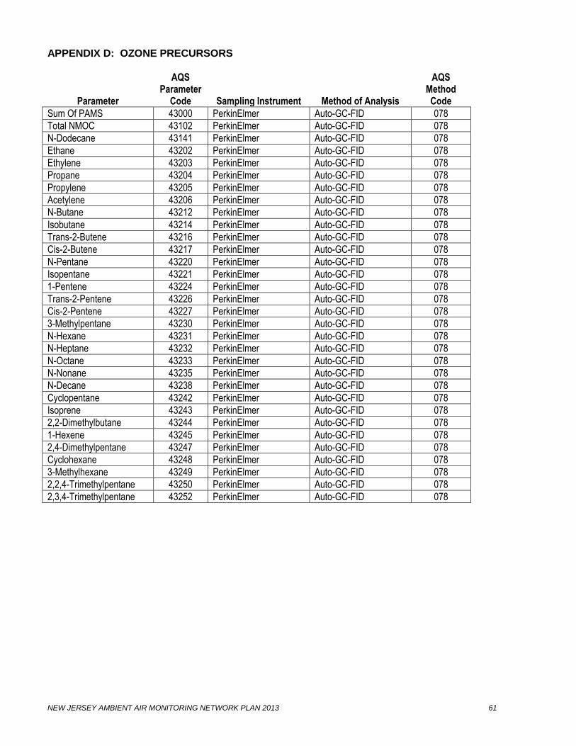
NEW JERSEY AMBIENT AIR MONITORING NETWORK PLAN 2013 61
APPENDIX D: OZONE PRECURSORS
Parameter
AQS Parameter
Code
Sampling Instrument
Method of Analysis
AQS Method Code
Sum Of PAMS 43000 PerkinElmer Auto-GC-FID 078
Total NMOC 43102 PerkinElmer Auto-GC-FID 078
N-Dodecane 43141 PerkinElmer Auto-GC-FID 078
Ethane 43202 PerkinElmer Auto-GC-FID 078
Ethylene 43203 PerkinElmer Auto-GC-FID 078
Propane 43204 PerkinElmer Auto-GC-FID 078
Propylene 43205 PerkinElmer Auto-GC-FID 078
Acetylene 43206 PerkinElmer Auto-GC-FID 078
N-Butane 43212 PerkinElmer Auto-GC-FID 078
Isobutane 43214 PerkinElmer Auto-GC-FID 078
Trans-2-Butene 43216 PerkinElmer Auto-GC-FID 078
Cis-2-Butene 43217 PerkinElmer Auto-GC-FID 078
N-Pentane 43220 PerkinElmer Auto-GC-FID 078
Isopentane 43221 PerkinElmer Auto-GC-FID 078
1-Pentene 43224 PerkinElmer Auto-GC-FID 078
Trans-2-Pentene 43226 PerkinElmer Auto-GC-FID 078
Cis-2-Pentene 43227 PerkinElmer Auto-GC-FID 078
3-Methylpentane 43230 PerkinElmer Auto-GC-FID 078
N-Hexane 43231 PerkinElmer Auto-GC-FID 078
N-Heptane 43232 PerkinElmer Auto-GC-FID 078
N-Octane 43233 PerkinElmer Auto-GC-FID 078
N-Nonane 43235 PerkinElmer Auto-GC-FID 078
N-Decane 43238 PerkinElmer Auto-GC-FID 078
Cyclopentane 43242 PerkinElmer Auto-GC-FID 078
Isoprene 43243 PerkinElmer Auto-GC-FID 078
2,2-Dimethylbutane 43244 PerkinElmer Auto-GC-FID 078
1-Hexene 43245 PerkinElmer Auto-GC-FID 078
2,4-Dimethylpentane 43247 PerkinElmer Auto-GC-FID 078
Cyclohexane 43248 PerkinElmer Auto-GC-FID 078
3-Methylhexane 43249 PerkinElmer Auto-GC-FID 078
2,2,4-Trimethylpentane 43250 PerkinElmer Auto-GC-FID 078
2,3,4-Trimethylpentane 43252 PerkinElmer Auto-GC-FID 078

NEW JERSEY AMBIENT AIR MONITORING NETWORK PLAN 2013 62
APPENDIX D: OZONE PRECURSORS (Continued)
Parameter
AQS Parameter
Code
Sampling Instrument
Method of Analysis
AQS Method Code
3-Methylheptane 43253 PerkinElmer Auto-GC-FID 078
Methylcyclohexane 43261 PerkinElmer Auto-GC-FID 078
Methylcyclopentane 43262 PerkinElmer Auto-GC-FID 078
2-Methylhexane 43263 PerkinElmer Auto-GC-FID 078
1-Butene 43280 PerkinElmer Auto-GC-FID 078
2,3-Dimethylbutane 43284 PerkinElmer Auto-GC-FID 078
2-Methylpentane 43285 PerkinElmer Auto-GC-FID 078
2,3-Dimethylpentane 43291 PerkinElmer Auto-GC-FID 078
N-Undecane 43954 PerkinElmer Auto-GC-FID 078
2-Methylheptane 43960 PerkinElmer Auto-GC-FID 078
M/P Xylene 45109 PerkinElmer Auto-GC-FID 078
Benzene 45201 PerkinElmer Auto-GC-FID 078
Toluene 45202 PerkinElmer Auto-GC-FID 078
Ethylbenzene 45203 PerkinElmer Auto-GC-FID 078
O-Xylene 45204 PerkinElmer Auto-GC-FID 078
1,3,5-Trimethylbenzene 45207 PerkinElmer Auto-GC-FID 078
1,2,4-Trimethylbenzene 45208 PerkinElmer Auto-GC-FID 078
N-Propylbenzene 45209 PerkinElmer Auto-GC-FID 078
Isopropylbenzene 45210 PerkinElmer Auto-GC-FID 078
O-Ethyltoluene 45211 PerkinElmer Auto-GC-FID 078
M-Ethyltoluene 45212 PerkinElmer Auto-GC-FID 078
P-Ethyltoluene 45213 PerkinElmer Auto-GC-FID 078
M-Diethylbenzene 45218 PerkinElmer Auto-GC-FID 078
P-Diethylbenzene 45219 PerkinElmer Auto-GC-FID 078
Styrene 45220 PerkinElmer Auto-GC-FID 078
1,2,3-Trimethylbenzene 45225 PerkinElmer Auto-GC-FID 078

NEW JERSEY AMBIENT AIR MONITORING NETWORK PLAN 2013 63
APPENDIX E: BTEX COMPOUNDS
Parameter
AQS Parameter
Code
Sampling Instrument
Method of Analysis
AQS Method Code
Benzene 45201
Syntech Spectras BTEX analyzer GC 955
Auto GC - PID 132
Toluene 45202
Syntech Spectras BTEX analyzer GC 955
Auto GC - PID 132
Ethylbenzene 45203
Syntech Spectras BTEX analyzer GC 955
Auto GC - PID 132
m,p-Xylene 45109
Syntech Spectras BTEX analyzer GC 955
Auto GC - PID 132
o-Xylene 45204
Syntech Spectras BTEX analyzer GC 955
Auto GC - PID 132
Related Documents