ALTERNATIVES TO SLASH-AND-BURN (ASB) IN PERU

Welcome message from author
This document is posted to help you gain knowledge. Please leave a comment to let me know what you think about it! Share it to your friends and learn new things together.
Transcript

ALTERNATIVES TO SLASH-AND-BURN (ASB) IN PERU


ALTERNATIVES TO SLASH-AND-BURN (ASB) IN PERU
SUMMARY REPORT AND SYNTHESIS OF PHASE II
Edited by:
Douglas White, Sandra J. Velarde, Julio Alegre, and Thomas P. Tomich
With contributions from:
Luis Miguel Aparicio, Manuel Arca, Luis Arévalo, Jhon Avilés, Dale Bandy, Arnoud Braun, Jorge Bushby, Hector Campos, Mirela Clavo, Violeta Colán, Jonathan Cornelius, German Escobar, Merle Faminow, Ymber Flores, Sam Fujisaka, Andy Gillison, Antonio Guerrero, Wagner Guzmán, Dean Holland, Federico Holmann, Glenn Hyman, Jacques Imbernon, Ricardo Labarta, Efraín Leguía, Nadine Lehrer, Tamsyn Murray, Meine van Noordwijk, Cheryl Palm, Roberto Porro, Ernesto Raéz-Luna, Keneth Reátegui, Auberto Ricse, Abby Rosenheck, Cesar Sabogal, Angel Salazar, José Sanchez, Helmut Scheuch, Joyotee Smith, Carmen Sotelo, Javier Soto, Julio Ugarte, Héctor Vidaurre, John Weber, and David Yanggen.
December 2005

White, D., S.J. Velarde, J.C. Alegre, T.P. Tomich, 2005. Alternatives to Slash-and-Burn (ASB) in Peru, Summary Report and Synthesis of Phase II. Alternatives to Slash-and-Burn Programme, Nairobi, Kenya.
For recent updates visit:
http://www.asb.cgiar.org email: [email protected]
Acknowledgements
The ASB-Peru team appreciates the financial support from the governments of Peru (Secretaria Técnica de Cooperacion-SECTI), Spain (Agencia Española de Cooperación Internacional- AECI), Canada (International Development Research Centre- IDRC), the Netherlands (DML/BD), Norway, the United States (Agency for International Development-USAID), the United Kingdom (Department for International Development- DfID) and Denmark (Danish International Development Agency- DANIDA); the European Union, the Inter-American Development Bank (IADB), and the International Tropical Timber Organization (ITTO), which enabled the research activities and construction of modern field research facilities. The USAID global bureau forestry team and ASB core funding from World Bank support to CGIAR systemwide programs funded preparation, printing and distribution of this ASB-Peru synthesis report.
The authors would also like to thank Deborah K. Kirby for copy-editing and for the layout of the report.
Cover design: Deborah K. Kirby Main cover photograph: Peruvian Amazon by T.P. Tomich
For further information contact:
ASB Programme, ICRAF P.O. Box 30677, Nairobi, Kenya Tel: +254 2 524114/524000 or + 1 650 833 6645 Fax: +254 2 524001 or +1 650 833 6646 Website: http://www.asb.cgiar.org Email: [email protected]
© 2005 Alternatives to Slash-and-Burn
ASB encourages free dissemination of its work when reproduction and use are for non-commercial purposes, provided all sources are acknowledged. ASB follows a policy of open, public access to its datasets.

CONTENTS Tables ___________________________________________________________________viii
Figures ____________________________________________________________________ ix
Acronyms and abbreviations___________________________________________________ x
Scientific and local plant names________________________________________________ xii
Resumen _______________________________________________________________________ xiii
I. Problemas de desarrollo y problemas tratados ______________________________xiii
II. Productos logrados y problemas encontrados _______________________________xiii
III. Objetivos alcanzados __________________________________________________ xiv
IV. Recomendaciones para el futuro ________________________________________ xvii
Overview and Summary of Conclusions ______________________________________________ xix
I. Development problem and immediate problems addressed ____________________ xix
II. Outputs produced and problems encountered ______________________________ xix
III. Objectives achieved ___________________________________________________ xx
IV. Recommendations for follow up ________________________________________xxiii
1. Introduction ________________________________________________________________1
1.A. The Peruvian Amazon __________________________________________________ 3 1.A.1. Amazon challenges _____________________________________________________4 1.A.2. Natural resources ______________________________________________________5 1.A.3. A brief history of deforestation and government policy _________________________7 1.A.4. Stakeholder groups ____________________________________________________10
1.B. Characterization of the benchmark sites ___________________________________ 14 1.B.1. Ucayali _____________________________________________________________14 1.B.2. Yurimaguas__________________________________________________________17 1.B.3. Analogous areas in Latin America ________________________________________17
1.C. Land use systems _____________________________________________________ 18 1.C.1. Traditional land use systems _____________________________________________21 1.C.2. Alternative land use systems_____________________________________________25
1.D. Assessing land use ____________________________________________________ 26 1.D.1. Global environmental concerns___________________________________________26 1.D.2. Agronomic sustainability _______________________________________________27 1.D.3. Smallholders’ socio-economic concerns____________________________________27 1.D.4. Institutional barriers to technology adoption ________________________________27 1.D.5. The ASB matrix ______________________________________________________28 1.D.6. Caveats regarding the ASB matrix approach ________________________________29
2. Global environmental impacts_________________________________________________31
2.A. Carbon stocks________________________________________________________ 31
2.B. Greenhouse gas emissions ______________________________________________ 32
2.C. Aboveground biodiversity ______________________________________________ 36
2.D. Belowground biodiversity ______________________________________________ 38
3. Agronomic and silvicultural sustainability _______________________________________39

3.A. Soil structure and biological activity ______________________________________ 39
3.B. Nutrient balance______________________________________________________ 42
3.C. Genetic variation in tree species: understanding geographical patterns __________ 43
4. Smallholder farmer context ___________________________________________________45
4.A. Financial profitability _________________________________________________ 45
4.B. Labor requirements and household food security____________________________ 48
4.C. Institutional issues ____________________________________________________ 49 4.C.1. Market institutions ____________________________________________________50 4.C.2. Other institutional issues________________________________________________52
5. Interventions, impacts and tradeoffs ____________________________________________57
5.A. Government policies and projects ________________________________________ 57 5.A.1. Timber______________________________________________________________57 5.A.2. Roads ______________________________________________________________60 5.A.3. Coca _______________________________________________________________60 5.A.4. Agricultural credit_____________________________________________________62
5.B. Institutional capacity building ___________________________________________ 62 5.B.1. Participatory research __________________________________________________62 5.B.2. Agro-enterprise development ____________________________________________64 5.B.3. Agroecosystems and human health________________________________________68 5.B.4. Agroforestry systems capacity building ____________________________________68
5.C. The mixed results of promoting sustainable land use intensification _____________ 70 5.C.1. Managed forest _______________________________________________________71 5.C.2. Secondary forest management ___________________________________________72 5.C.3. Cocoa ______________________________________________________________75 5.C.4. Oil palm ____________________________________________________________75 5.C.5. Improved tree germplasm _______________________________________________77 5.C.6. Agroforestry systems __________________________________________________78 5.C.7. New varieties of traditional crops _________________________________________81 5.C.8. Improved fallows _____________________________________________________88 5.C.9. Improved pastures_____________________________________________________90 5.C.10. Riverine systems ______________________________________________________91 5.C.11. Amazonian products ___________________________________________________93
5.D. Dynamics and trends of land use _________________________________________ 94 5.D.1. Spatial land use trends__________________________________________________94 5.D.2. Land use dynamics ____________________________________________________96
6. Policy and institutional options ________________________________________________99
6.A. ASB-Peru matrix _____________________________________________________ 99
6.B. Relationships amongst global benefits, sustainability, and local/national objectives 102 6.B.1. Shared objectives: Food security and agro-enterprise development ______________103 6.B.2. The NARS’ overlapping objective of regional development ___________________104 6.B.3. Farmer versus international objectives: Coca and cattle production______________105 6.B.4. Agricultural research and development and other farmer objectives _____________105 6.B.5. Are the IARCs alone in terms of environmental objectives? ___________________105
6.C. Policy initiatives _____________________________________________________ 107 6.C.1. Intensification and deforestation_________________________________________107 6.C.2. Land use policy______________________________________________________107 6.C.3. Processing __________________________________________________________107 6.C.4. Protected areas ______________________________________________________108

6.C.5. Capacity building of local organizations___________________________________108 6.C.6. Forest product development ____________________________________________108 6.C.7. Environmental service payments ________________________________________108 6.C.8. Product certification __________________________________________________110 6.C.9. Non-agricultural development __________________________________________110
7. Lessons and conclusions ____________________________________________________111
Annex ________________________________________________________________________115
Associated scientific personnel _______________________________________________ 115
References _____________________________________________________________________117

viii
Tables
Table 1. Indigenous populations of the Ucayali......................................................................................... 12 Table 2. Descriptive statistics of farms at the ASB benchmark sites ......................................................... 19
Table 3. ASB meta LUS and representative systems at the Peruvian benchmark sites............................... 21
Table 4. Aboveground carbon stocks of different land use systems .......................................................... 32
Table 5. Description of the six land management systems monitored for greenhouse gases fluxes in Yurimaguas, Peru (1997-1999).................................................................................................. 33
Table 6. Nitrous oxide fluxes of different land management treatments. .................................................. 34
Table 7. Methane fluxes of different land management treatments ........................................................... 35
Table 8. Aboveground biodiversity index measures .................................................................................. 37 Table 9. Taxonomic richness, mean abundance and biomass of macroinvertebrates in different land
use systems in Yurimaguas. ....................................................................................................... 38
Table 10. Soil physical indicators of agronomic sustainability in Yurimaguas ......................................... 39
Table 11. Soil characteristics before and after different fallow systems at Yurimaguas............................ 42
Table 12. Soil nutrients and organic carbon stored for six LUS in Yurimaguas ......................................... 43
Table 13. Profitability of land use systems matrix ..................................................................................... 48 Table 14. Labor requirements and food entitlements of land use systems matrix (Ucayali) ..................... 49
Table 15. Market institutions matrix .......................................................................................................... 52 Table 16. Social and government institutions matrix................................................................................. 56 Table 17. Recommended zones/communities for each of the identified crop options ............................... 66
Table 18. Problems and solutions for Cacao plantations in Ucayali .......................................................... 75
Table 19. Financial returns from three agroforestry systems ..................................................................... 80
Table 20. Rice varieties and yields of the 1997 – 1998 campaign ............................................................. 82
Table 21. Rice varieties and yields of the 1998 – 1999 campaign ............................................................. 83
Table 22. Preferred traits of rice varieties farmers in Ucayali benchmark site .......................................... 84 Table 23. Financial performance of different short-duration planted fallows at Yurimaguas ................... 89
Table 24. Transport costs: Ucayali River (2001) ....................................................................................... 93 Table 25. Summary matrix of land uses and analysis criteria .................................................................. 101

ix
Figures
Figure 1. Political map of Peru and location of ASB benchmark sites ........................................................ 2 Figure 2. Converted forest (1955-1995) and population (1940-1996) the in Ucayali benchmark area........ 8 Figure 3. Herd size and number of terrorist acts in the Ucayali region (1977-95)....................................... 9 Figure 4. The Ucayali benchmark site: The Aguaytía watershed............................................................... 16 Figure 5. Population growth in the cities of Pucallpa and Yurimaguas ..................................................... 17 Figure 6. Climate similarity map: regions with similar rainfall and temperature conditions to the
Ucayali benchmark site. ............................................................................................................. 18 Figure 7. Ucayali land use by agricultural system (1996).......................................................................... 19 Figure 8. The ASB meta matrix: a tool for evaluating and comparing LUS ............................................... 28 Figure 9. Soil carbon, microbial carbon and nitrogen mineralization of different land use systems in
Yurimaguas ................................................................................................................................ 40 Figure 10. Soil macrofauna of different land use systems in Yurimaguas................................................. 40 Figure 11. Returns to labor and land of Ucayali LUS................................................................................ 46 Figure 12. Market prices 1997-2000 (monthly average and standard deviation)....................................... 51 Figure 13. Coca leaf production and price in Peru..................................................................................... 61 Figure 14. Oil palm production and market value...................................................................................... 76 Figure 15. New and traditional varieties, average mean and standard deviation of yield .......................... 84 Figure 16. Research sites of rice farmers in Ucayali.................................................................................. 85 Figure 17. Average yields of traditional and new rice varieties planted in the Ucayali region.................. 86 Figure 18. Market sale and household consumption of rice by pioneer and established farmers .............. 87 Figure 19. Ucayali River monthly levels (1987-1997)............................................................................... 92 Figure 20. Four riverine farm types: Returns to labor and land ................................................................. 93 Figure 21. Map of villages with census data linked to a GIS database ...................................................... 95 Figure 22. Aguaytía watershed deforestation patterns (1955-1995) .......................................................... 96 Figure 23. Land use changes in Ucayali benchmark site (2000)................................................................ 97

x
Acronyms and abbreviations
AIDER - Asociación para la Investigación y el Desarrollo Regional AMUCAU - Asociación de Mujeres Campesinas de Ucayali APODESA - Apoyo al Desarrollo Mediante Sistemas Automatizados APROLEU - Asociación de Productores de Leche de Ucayali ASB - Alternatives to Slash-and-Burn Systemwide Programme AU - animal units B/C - benefit – cost ratio BNDES - Brazilian National Bank for Economic and Social Development c. - circa C - carbon CAF – Corporación Andina de Fomento CBD - Convention on Biological Diversity CBM - Center for Biodiversity Management CDM - Clean Development Mechanism CIAT – Centro Internacional de Agricultura Tropical CIEF - Centro de Información Estratégico Forestal CIF - Cost, Insurance and Freight. CIFOR – Center for International Forestry Research CGIAR - Consultative Group on International Agricultural Research CH4 - methane cmol – centimol cmolc – cation exchange capacity CO2 - carbon dioxide CNF - Cámara Nacional Forestal COCEPASA - Comité Central de Productores Agrarios de San Alejandro COCEPU - Comité Central de Palmicultores de Ucayali CODESU - Consorcio para el Desarrollo Sostenible de Ucayali CONAM - Consejo Nacional del Ambiente CONTRADROGAS - Comisión de lucha contra las drogas CP-CFV – Consejo Peruano de Certificación Forestal CRESE – Centro Regional de Servicios CRP - Comité de Reforestación de Pucallpa CRU - Comité de Reforestación de Ucayali CTARU - Consejo Transitorio de Administración Regional- Ucayali DEPAM - Desarrollo Participativo Amazónico DEVIDA - Comisión Nacional para el Desarrollo y Vida sin Drogas DRAU - Dirección Regional de Agricultura-Ucayali FHIA - Fundación Hondureña de Investigación Agrícola FONAM - Fondo Nacional del Ambiente FUSEVI - Asociación Fuerza por la Selva Viva ha - hectare GASEC - Asociación de Ganaderos y Agricultores Selva Central

xi
GEA - Grupo Empresarial Amazónico del Perú GHG - greenhouse gases ICRAF - World Agroforestry Centre IDRC - International Development Research Centre of Canada IIAP - Instituto de Investigaciones de la Amazonía Peruana IFPRI - International Food Policy Research Institute INADE - Instituto Nacional de Desarrollo INEI - Instituto Nacional de Estadística e Informática INIA - Instituto Nacional de Investigación y Extensión Agraria INRENA - Instituto Nacional de Recursos Naturales IPCC - International Panel on Climate Change IRR - Internal rate of return ITTO - International Tropical Timber Organization IVITA - Instituto Veterinario de Investigaciones Tropicales y de Altura K - potassium kg - kilogram L - liter LUS - land use systems m.a.s.l. - meters above sea level µg - micro grams N - nitrogen NGO - non-government organization N2O - nitrous oxide NPV - net present value P - phosphorus ppm - parts per million ProInversion - Agencia de Promoción de la Inversión Privada PPO - Participatory/Project Planning by Objectives PROMPEX - Comisión para la Promoción de Exportaciones PROSEMA - Asociación de Productores de Semilla Mejorada SF - Secondary forests SEPIA – Seminario Permanente de Investigación Agraria t - tons TSBF - Tropical Soil Biology and Fertility Institute UNALM - Universidad Nacional Agraria La Molina UNAP - Universidad Nacional de la Amazonía Peruana UNDCP - United Nations International Drug Control Programme UNODC - United Nations Office on Drugs and Crime UNODCCP - United Nations Office for Drug Control and Crime Prevention UNU - Universidad Nacional de Ucayali USAID - United States Agency for International Development WRI - World Resources Institute WWF - World Wildlife Fund

xii
Scientific and local plant names
Bactris gasipaes – Pijuayo Brachiaria decumbens – Brachiaria Calycophyllum spruceanum – Capirona Cedrela odorata – Cedro Cedrelinga catenaeformis – Tornillo Ceiba pentandra – Lupuna Centrosema macrocarpun – Centrosema Coffea arabica – Café Colubrina glandulosa – Colubrina Copaifera reticulata – Copaiba Cordia spp. – Ahallu caspi Eugenia stipitata – Arazá, Araçá-boi, Brazilian guava Guazuma crinita – Bolaina Hura crepitans – Catahua Imperata brasiliensis - Imperata Inga edulis – Inga, guaba Pueraria phaseoloides – Kudzu Rottboellia cochinchinensis - Maleza Scheelea spp. – Shapaja, Shapajilla, Yagua Schizolobium amazonicum – Pashaco Swietenia macrophylla – Caoba Tabebuia spp. – Tahuarí Vetiver zizianoides – Vetiveria
xiii
Resumen
I. Problemas de desarrollo y problemas tratados
La conversión de bosques primarios a otros usos del suelo amenaza la biodiversdad y libera
gases asociados con el calentamiento global. Así mismo, la conversión del bosque puede fomentar el
desarrollo económico de países tropicales y proporciona un sustento viable para muchos pequeños
agricultores. Las exportaciones de la madera de alto valor son una fuente importante de divisas. Pero
los caminos forestales proporcionan acceso a nuevas tierras y los colonos inicien actividades agrícolas.
Se estima que la expansión de la frontera agrícola, sobre todo por pequeños agricultores, es responsible
de por lo menos de 50 por ciento de la tala de árboles en bosques tropicales (Barraclough y Ghimire,
2000).
Existen opciones tecnológicas y políticas que pueden mejorar la productividad de los diferents
sistemas de uso del suelo y reducir la tala de árboles, pero las condiciones y las instituciones
requeridas para alcanzar estas metas no son bien comprendidas. Si los políticos desean disminuir el
índice de deforestación tropical de una manera eficaz y eficiente, es crítico que entiendan cómo las
diferentes políticas afectan a los pequeños agricultores y sus decisiones en la producción agrícola y la
inversión.
La investigación de ASB ha cuantificado las consecuencias ambientales de diversos usos del
suelo y determinado cómo estas consecuencias se pueden atenuar con cambios tecnológicos, políticos
e institucionales apropiados. El punto central de la investigación es el análisis de las ganancias y
pérdidas (tradeoffs) entre los diversos objetivos ambientales, económicos y sociales. El programa de
investigación implentado durante la fase II de ASB en Perú (1996-2003) tiene también como objetivo,
una mejor comprensión de cómo el Gobierno de Perú, las organizaciones de investigación nacionales e
internacionales y las agencias donantes pueden balancear los objetivos ambientales globales con el
desarrollo económico y la reducción de la pobreza
II. Productos logrados y problemas encontrados
Los investigadores de ASB han cuantificado las consecuencias del cambio de uso del suelo
para el medio ambiente. Ellos midieron los efectos de las diferentes prácticas agrícolas con respecto a
1) cambio climático, específicamente flujos de gases del efecto invernadero y secuestro de carbono, y
2) biodiversidad, encima y debajo del suelo. Los resultados de investigación de ASB en el Perú se
resumen debajo. Los detalles con respecto a las herramientas desarrolladas por ASB para obtener y
para analizar los datos se encuentran en otros dos documentos: Reporte de Biodiversidad encima del
Suelo (http://www.asb.cgiar.org/WG_biodiversity.shtm); Reporte final del Grupo de Trabajo en
xiv
Cambio Climático, Fase II (http://www.asb.cgiar.org/WG_climatechange.shtm); y el Reporte del
Grupo del Trabajo Socio económico (http://www.asb.cgiar.org/txt_only/WG_socioecon.shtm).
La investigación de ASB en Perú se basa en las innovaciones metodológicas y los resultados
empíricos de otros dos grupos temáticos de ASB: el primero, el grupo de sostenibilidad agronómica de
las diferentes alternativas de uso del suelo; y el segundo, el grupo que investiga los problemas
socioeconómicos y políticos que afectan la adoptción de las diferentes alternativas de uso del suelo por
pequeños agricultores. El trabajo de estos dos últimos grupos permite evaluar las diferentes opciones
de uso del suelo así como las innovaciones políticas y tecnológicas necesarias para superar
restricciones de mercado y de otro tipo.
Este documento también resume los resultados de investigación ambiental para alcanzar la
tercera meta principal de la fase II: relacionar las ventajas ambientales globales con alternativas
sostenibles a la agricultura de tumba-y-quema. Para que las alternativas de uso del suelo tengan un
impacto significativo en Perú (o en cualesquiera de los seis países que participan actualmente en
ASB), el alcance de la investigación debe ampliarse más allá de estudios de cambio climático y
biodiversidad. Esta meta implica el determinar la sostenibilidad agronómica de diferentes usos del
suelo y su adopción por pequeños agricultores. El informe presenta una evaluación comparativa de los
impactos positivos y negativos de posibles intervenciones tecnológicas y políticas. Puesto que el
cambio de uso del suelo por los pequeños agricultores puede afectar a una población mayor
(externalidades), estas evaluaciones consideran los efectos en diversas escalas geográficas, tales como
parcela, hogar, paisaje, cuenca y nacional, así como global.
III. Objetivos alcanzados
1. Cambio climático
• Los stocks de carbono fueron medidos en parcelas en los sitios de referencia de Ucayali
(provincias de Coronel Portillo y de Padre Abad, Ucayali) y de Yurimaguas (provincia de Alto
Amazonas, Loreto) para los diferentes usos del suelo, desde los bosques naturales hasta los
sistemas agroforestales, cultivos anuales y pastos. Se avanzó en mejorar las debilidades
metodológicas para estimar los stocks de carbón sobre y debajo del suelo.
• Los datos de stocks de carbón fueron utilizados para estimar 'stocks de carbono promedio en el
tiempo' para los principales usos del suelo. Así, el cambio de uso del suelo fue traducido como
liberación neta o secuestro neto de carbono.
• Las emisiones de gases del efecto invernadero (metano y óxido nitroso) fueron medidas para los
mismos usos del suelo estudiados para la medición de stocks de carbón. Se encontraron efectos
significativos debido a variación estacional de los gases del efecto invernadero. Por tanto, será

xv
necesaria investigación adicional para entender las causas de esta variación y desarrollar
estimaciones anuales de flujo más confiables.
2. Biodiversidad
• Se usó una metodología común con otros países de ASB para cuantificar sistemáticamente la
biodiversidad debajo del suelo. Un equipo de investigadores nacionales empleó estos métodos
para examinar la relación entre la macrofauna del suelo y los diferentes sistemas de uso del suelo
de los sitios de referencia en Perú.
• Dos estudios de biodiversidad encima del suelo fueron conducidos en Perú. Los métodos e
indicadores usados para la evaluación rápida de la biodiversidad vegetal encima del suelo fueron
desarrollados y validados originalmente en un estudio intensivo en la provincia de Jambi en
Sumatra central.
3. Usos sostenibles del suelo
• Se desarrollaron indicadores de sostenibilidad agronómica (estructura del suelo, balance de
nutrientes, protección de cultivos y biota del suelo) para evaluar los factores limitantes
agronómicos de largo plazo en cada uno de los usos del suelo estudiados.
• Se experimentó con germoplasma mejorado de cultivos agrícolas (e.g. forrajes, arroz y plátanos)
junto con los agricultores, para alcanzar mayor producción y en consecuencia, mejorar la
seguridad alimentaria y el bienestar económico de los pequeños agricultores.
• Semillas forestales mejorads también ayudaron a los pequeños agricultores a aumentar sus
ingresos. Esto se logró mediante la domesticación forestal participativa.
• Se evaluaron financieramente los diferentes usos del suelo. Para entender mejor la adopción de las
tecnologías de uso del suelo, se evaluaron los diferentes usos del suelo actuales y alternativos, en
términos de beneficio económico, requerimiento de mano de obra y contribución a la seguridad
alimentaria local.
• A matrix linking the environmental, agronomic, socio-economic, policy, and institutional
indicators was developed. This tool enables comparison and integrated assessment of the land use
options according to different objectives.
• Se desarrolló una matriz que relaciona indicadores ambientales, agronómicos, socioeconómicos,
políticos e institucionales. Esta herramienta permite la comparación y la evaluación integrada de
las opciones del uso del suelo según diversos objetivos.

xvi
4. Evaluación de opciones políticas y tecnológicas para superar los obstáculos al desarrollo
sostenible
• Las imágenes aéreas y los satelitales fueron examinadas para detectar tendencias de la
deforestación en el sitio de referencia de Ucayali.
• Se identificaron numerosas causas de la deforestación incluyendo las políticas del gobierno (e.g.
construcción de caminos, crédito agrícola, regulaciones de la explotación forestal) y los usos
privados del suelo (e.g. explotación forestal, agricultura, ganadería).
• Se realizó un estudio integrado de los factores clave para el desarrollo agroforestal en Ucayali.
• Se analizó la política forestal en Bolivia en la comparación con la política forestal peruana para
dar las recomendaciones a esta última.
• Se empoderó a pequeños agricultores mediante a través de entrenamiento empresarial y
organizacional.
5. Análisis de pérdidas y ganancias ambientales, agronómicas y socio-económicas
• El uso del suelo seguirá cambiando en la Amazonía peruana. En un país como el Perú, con altos
índices de desempleo, la disponibilidad de tierra y la posibilidad de ganar más que el salario
mínimo, son grandes incentivos para la migración hacia la Amazonía.
• Los sistemas forestales y agroforestales tienen normalmente mayor carbono y mayor biodiversidad
que los sistemas agrícolas. Sin embargo, no se puede generalizar. A pesar que los sistemas
agrícolas tienen menores stocks de carbono (4.8-9 t ha-1), especialmente los pastos (~5 t ha-1), los
barbechos de períodos largos pueden tener mayores stocks de carbono (hasta 24 t ha-1) que otros
sistemas agrícolas. Mientras que la biodiversidad encima del suelo tiene una tendencia decreciente
en la gradiente de bosques a otros sistemas, la biodiversidad debajo del suelo no muestra una
tendencia clara. Los sistemas producción de cacao y cítricos tienen menor macrofauna en el suelo
(peso total: ~8 g m -2) que los barbechos de períodos largos o cortos (20 y 15 g m-2
respectivamente) o que los pastos “mejorados” (38.4 g m-2).
• No se encontraron grandes diferencias en la sostenibilidad agronómica de los diferentes sistemas
analizados, a excepción de los pastos. Todos estos sistemas son sostenibles pero a diferentes
niveles de productividad. A pesar que los bosques tienen el suelo menos compactado (1.2 g cm-3
densidad), las medidas de potasio, calcio, y magnesio, no muestran grandes diferencias entre los
diferentes sistemas, a excepción de los pastos nativos, donde el potasio disponible es el menor
observado (5ppm). Los suelos de los sistemas agrícolas tienen mayor densidad (1.25-1.3 g cm-3).
Los pastos, nativos y “mejorados” son los más compactados (1.4 g cm-3 y 1.45 g cm-3).
• Los sistemas de uso del suelo analizados tienen diferentes retornos a la tierra y a la mano de obra.
Los sistemas de barbecho convencionales tienen los más altos retornos a la mano de obra

xvii
(US$4.62 día-1). Por otro lado, los pastos y los barbechos “mejorados” generaron los menores
retornos a la mano de obra (US$2.79 y US$2.34 día-1). Los sistemas perennes de cítricos y cacao
tienen los mayores retornos a la tierra (US$810 y US$644 ha-1). Sin embargo, los retornos a la
mano de obra de estos dos sistemas (~US$3.8 day-1) no son sobresalientes. Todos los sistemas de
uso del suelo generan ingresos mayores al salario mínimo de US$2.86 día de trabajo-1 a excepto
por los sistemas “mejorados” mencionados anteriormente.
• Los resultados financieros de los sistemas productivos de la llanura aluvial son muy diferentes a
los de las tierras de altura descritos en el párrafo anterior. Los retornos a la tierra y a la mano de
obra son altos para los barrizales (US$1796 ha-1 y US$6.74 día-1 respectivamente) y restingas
(US$1271 ha-1 y US$4.89 day-1 respectivamente) – casi el doble de los sistemas de tierras de
altura.
• A pesar que los sistemas de barbecho pueden mostrar pérdidas productivas, por invasión de
malezas y reducción en la fertilidad del suelo, las prácticas de manejo de los agricultores pueden
ayudar a mantener y hasta mejorar la viabilidad financiera de estos sistemas. Para las áreas más
antiguas y degradadas, los agricultores casi siempre usan leguminosas de crecimiento rápido como
el kudzu, para incrementar la fertilidad del suelo y la materia orgánica. Los agricultores también
están probando otros cultivos como algodón, frijoles y frutas tropicales.
• Es interesante saber que los pastos mostraron pobres resultados financieros, siendo sus retornos a
la tierra y a la mano de obra, los menores de los sistemas analizados. A pesar de ello, el ganado
sigue siendo teniendo una alta prioridad en las preferencias y aspiraciones de muchos agricultores.
La mayoría de agricultores en el sitio de referencia de Ucayali tiene la esperanza de incrementar o
comenzar la producción pecuaria en el futuro (Labarta, 1998). Además de aspectos culturales, las
ventajas de comercialización del ganado son claves para entender estas preferencias. El impacto
ambiental de la producción pecuaria es el más negativo de todos los sistemas analizados en
términos de stocks de carbono, biodiversidad encima del suelo y compactación del suelo.
IV. Recomendaciones para el futuro
• Integrar resultados de ASB con la agenda política en los niveles nacionales e internacionales.
Canales de comunicación adicionales pueden aumentar el impacto de ASB sobre el uso del suelo
en la Amazonía.
• Continuar la capacitación científica y de organizaciones locales de agricultores, especialmente con
respecto a la comercialización de productos.
• Aumentar las evaluaciones de sosteniblidad a nivel de parcela para incluir externalidades
ambientales en los niveles del paisaje y de cuenca.

xviii
• Se necesita estudiar en profundidad los impactos potenciales de nuevos caminos y tendencias de la
integración económica entre los países de la Amazonía. Por ejemplo, el asfaltado del camino que
conecta Puerto Maldonado con la ciudad de Río Branco, y en el futuro, el camino que conecta
Pucallpa con Cruzeiro do Sul, puede tener un gran impacto sobre el uso del suelo en la Amazonía.
• Usando criterios financieros, identificar una gama más amplia de alternativas de uso del suelo
basado en árboles como la agroforestería y sistemas silvo-pastoriles, que proporcionan ventajas
ambientales y agronómicas más altas y que los pequeños agricultores puedan adoptar.
• Continuar los esfuerzos de identificar donde y cómo la intensificación del uso del suelo reduce las
necesidades de deforestación. Puesto que la intensificación puede también conducir al uso
extensivo del suelo por in-migración, probablemente políticas asociadas (e.g. acceso a caminos y
mercados, áreas protegidas, derechos de propiedad) serán requeridas además de las nuevas
tecnologías que aumenten la productividad y la rentabilidad del suelo.
• Relacionar al gobierno con los esfuerzos de las comunidades locales para reducir incursiones en el
bosque y las áreas protegidas. A pesar que existen leyes para prevenir estas infracciones, los
recursos disponibles para su monitoreo y ejecución son escasos. Las comunidades locales podrían
ser empoderadas para asumir estos roles.
• Construir y fortalecer las relaciones con los diferentes grupos de expertos en el país y
principalmente, con los políticos, ofreciendo productos traducidos al español.
xix
OVERVIEW AND SUMMARY OF CONCLUSIONS
I. Development problem and immediate problems addressed
The conversion of primary forests to other land uses threatens biodiversity and releases gases
into the atmosphere that are associated with global warming. Meanwhile, forest conversion can foster
economic development of tropical countries and provides a viable livelihood for many smallholder
farmers. Exports of high value timber are an important source of foreign exchange. But logging roads
provide access for human settlers to claim new lands and begin agricultural activities. Agricultural
expansion, primarily by smallholders, is estimated to be the cause of at least 50 percent of the
deforestation in tropical forests (Barraclough & Ghimire, 2000).
Technology and policy options that can improve the productivity of land use systems and
reduce deforestation exist, but the conditions and institutions required to achieve these goals are not
well understood. If policy-makers wish to influence the rate of tropical deforestation in an effective
and efficient manner, it is critical that they understand how policy interventions affect smallholder
households and agricultural production and investment decisions.
ASB research has quantified the environmental consequences resulting from different land
uses and assessed how these consequences can be mitigated with appropriate technological, policy and
institutional changes. Central to the research is an analysis of tradeoffs that arise among the different
environmental, economic and social objectives. The research program implemented during ASB Phase
II in Peru (1996-2003) includes the objective of better understanding how the Government of Peru,
national and international research organizations and donor agencies can balance global environmental
objectives with economic development and poverty reduction.
II. Outputs produced and problems encountered
ASB researchers have quantified the environmental impacts from land use change. They have
measured the effects of alternative land use practices with respect to 1) climate change, specifically
greenhouse gas fluxes and carbon sequestration, and 2) biodiversity, both above- and belowground.
Research results from Peru are summarized below. Details regarding the tools developed by ASB to
obtain and analyze the data are reported in separate summary documents: Above Ground Biodiversity
Summary Report (http://www.asb.cgiar.org/WG_biodiversity.shtm); the Climate Change Working
Group Final Report, Phase II (http://www.asb.cgiar.org/WG_climatechange.shtm); and the Socio
Economic Working Group report (http://www.asb.cgiar.org/txt_only/WG_socioecon.shtm).
ASB research in Peru draws on the methodological innovations and empirical results of two
other global ASB thematic groups: one on the agronomic sustainability of land use alternatives, and
the other on the socio-economic and policy issues that affect the adoptability of land use alternatives

xx
by smallholders. The work of these two latter groups enables assessment of the land use options that
intensify land use as well as the evaluation of the policy and technology innovations necessary to
overcome market and non-market constraints that impede change.
This summary report also synthesizes environmental research results with additional
information to address the third main goal of Phase II: linking global environmental benefits with
sustainable alternatives to slash-and-burn cultivation. For land use alternatives to have a significant
impact in Peru (or in any of the six countries currently participating in ASB), the scope of the research
must expand beyond climate change and biodiversity. This ‘linking’ goal involves ascertaining the
agronomic sustainability of the alternative land uses and their adoptability by smallholder farmers. The
report presents a comparative assessment of the positive and negative impacts created by potential
technology and policy interventions. Since land use change by private smallholders can affect a larger
public (externalities), these assessments take into account the effects evaluated at different geographic
scales, such as plot, household, landscape, watershed, national, and global.
III. Objectives achieved
1. Climate change
• Carbon stocks were measured for sample plots in the benchmark sites of Ucayali (comprising the
Provinces of Coronel Portillo and Padre Abad, Ucayali region) and Yurimaguas (Province of Alto
Amazonas, Loreto region) for land uses ranging from natural forests through agroforestry to
annual cropping and pastures. Progress was made in resolving methodological weaknesses for
estimating above- and belowground carbon stocks.
• Carbon stock data were used to estimate ‘time-averaged carbon stocks’ for the major land uses.
Land use change was thus translated into a net release or net sequestration of carbon.
• Greenhouse gas emissions (methane and nitrous oxide) were measured for the same land uses as
those studied for their carbon stocks. Significant effects arising from seasonal variation were
discovered in greenhouse gas emissions. Additional measurements will therefore be necessary to
understand the causes of variation and to develop more reliable annual flux estimates.
2. Biodiversity
• A methodology to systematically quantify belowground biodiversity was coordinated with studies
of other ASB countries. A team of national researchers employed these methods to examine the
relationship between soil macrofauna and land use systems of Peru benchmark sites.
• Two aboveground biodiversity studies were conducted in Peru. Methods and indicators for rapid
assessment of aboveground plant biodiversity, originally developed and validated in an intensive

xxi
study in Jambi Province of Central Sumatra, were implemented for the different land use systems
of the Peru benchmark sites.
3. Sustainable land uses
• Indicators of agronomic sustainability (soil structure, nutrient balance, crop protection and soil
biota) were developed to assess the long-term agronomic constraints for each of the land uses
studied.
• Improved germplasm of agricultural crops (e.g., forages, rice and plantains) were tested with
farmers to achieve greater yields and in turn improve the food security and economic welfare of
smallholder farmers.
• Improved tree seeds also helped farmers to increase their income. This was achieved through
participatory tree domestication.
• Financial performance concerns of land uses were evaluated. To better understand the adoptability
of land use technologies, both current and alternative land uses were assessed according to their
profitability, labor requirements and contribution to household food security.
• A matrix linking the environmental, agronomic, socio-economic, policy, and institutional
indicators was developed. This tool enables comparison and integrated assessment of the land use
options according to different objectives.
4. Evaluating policy and technology options to overcome obstacles to sustainable development
• Aerial and satellite images were examined to detect deforestation trends in the Ucayali benchmark
site.
• Numerous drivers of deforestation were identified including government policies (e.g., road
construction, agricultural credit, and timber harvest regulations) and private land uses (e.g.,
logging, agriculture, and ranching).
• An integrated study for the key factors for the development of agroforestry in Ucayali was
undertaken.
• Forestry policy in Bolivia was analyzed in comparison to the one in Peru in order to give
recommendations for the Peruvian regulation.
• Small-scale farmers were empowered through organizational and enterpreneural capacity building.

xxii
5. Tradeoffs analysis
• Land use will continue to change in the Peruvian Amazon. In a country with high unemployment
like Peru, the availability of land, together with the possibility of earning more than the minimum
wage, creates ample incentive for citizens to migrate to the region.
• Forests and agroforestry systems typically have more carbon and above- and belowground
biodiversity than agricultural systems. Nevertheless, generalizations are not always possible.
Although agricultural systems have lower stored carbon (4.8-9 t ha-1), especially pastures (~5 t ha-
1), longer fallow systems can have more stored carbon (up to 24 t ha-1) than other agricultural
systems. While Aboveground biodiversity follows a decreasing trend, from forest to agricultural
land uses, belowground biodiversity does not demonstrate a simple trend. Tree-based systems such
as cocoa and citrus have less soil macrofauna (total weight: ~8 g m -2) than either long or short
agricultural fallow systems (20 and 15 g m-2, respectively) or improved pastures (38.4 g m-2).
• Aside from pastures, there are no big differences in agronomic sustainability among LUS. The LUS
are sustainable but at different levels of productivity. Although forested areas have lower soil
compaction (1.2 g cm-3 bulk density), the other measures of potassium, calcium and magnesium,
are not distinct from other land uses, except for native pastures, where available potassium (5ppm)
is the lowest observed. Soils of agricultural lands have higher bulk densities (1.25-1.3 g cm-3).
Pastures, both improved and native, have the highest bulk densities (1.4 g cm-3 and 1.45 g cm-3).
• The LUS have different returns to land and to labor. Conventional fallow systems demonstrate the
highest returns to labor (US$4.62 day-1). In contrast, both “improved” pastures and “improved”
fallows generated the lowest returns to labor (US$2.79 and US$2.34 day-1). The perennial systems
of citrus and cocoa have the highest returns to land (US$810 and US$644 ha-1). Of interest, the
returns to labor performance of these two systems are not outstanding because of high labor
requirements (~US$3.8 day-1). Excluding the two “improved” land systems mentioned above, all
LUS generat labor earnings greater than the minimum wage of US$2.86 workday-1.
• The financial performance of the riverine agricultural production is very different from upland
systems. Both returns to land and labor are high for mudflats (US$1796 ha-1 and US$6.74 day-1,
respectively) and floodplains (US$1271 ha-1 and US$4.89 day-1, respectively) – nearly double
those of some upland systems.
• Even though fallow-based agricultural systems can demonstrate productivity losses, from weed
invasions and soil fertility decreases, management practices of farmers can help maintain and even
enhance the financial viability of such systems. For older, degraded areas, farmers often use fast-
growing leguminous plants, such as kudzu, to increase soil fertility and organic matter. Farmers
are also experimenting with crops such as cotton, beans and tropical fruits.

xxiii
• One intriguing result of the financial analysis of the LUS is the poor performance of pasture
systems. The returns to land and labor are some of the lowest of the systems assessed. Despite
such performance, cattle remain a high priority for many farmers. The majority of farmers in the
Ucayali benchmark site hope to increase or start cattle production in the future (Labarta, 1998). In
addition to cultural aspects, marketing advantages may be key to understanding farmers’
preferences. The environmental impact of cattle production in terms of stored carbon,
aboveground biodiversity and soil compaction are the most negative of any land use.
IV. Recommendations for follow up
• Integrate ASB findings with the policy agenda at national and international levels. Additional
communication channels can increase the impact of ASB on land use in the Amazon.
• Continue human capacity building not only of scientific but also local farmer organizations,
especially with respect to marketing of products.
• Broaden assessments of sustainability at the plot level to include environmental externalities at the
landscape and watershed levels.
• Further study of the potential impacts of new transportation links and trends of economic
integration occurring amongst the countries of the Amazon. Current developments such as the
paving of the road that connects Puerto Maldonado with the city of Rio Branco, and in the future,
of the road that connects Pucallpa with Cruzeiro do Sul, might have a great impact on land use in
the Amazon.
• By using financial criteria, identify a wider range of tree-based alternatives, both agroforestry and
silvo-pastoral, that provide higher environmental and agronomic benefits and are feasible for
smallholders to adopt.
• Continue efforts to identify where and how intensification of land use reduces needs to deforest.
Since intensification may also lead to extensive land use via in-migration, associated policies (e.g.,
road and market access, protected areas, and property rights) will likely be required in addition to
new technologies that increase land productivity and profitability.
• Link government with local community effort to reduce incursions into the forest and protected
areas. While laws to prevent infractions exist, insufficient resources are available for monitoring
and enforcement. Local communities could be further empowered to take on these roles.
• Build and strenghten relationships with think-tanks in the country and, mainly with policy makers,
delivering products translated into Spanish.


1
1. INTRODUCTION This report is a comprehensive summary of the ASB consortium and CGIAR research
activities conducted with other partners in the Peruvian Amazon. The benchmark sites of Ucayali and
Yurimaguas are the focus of ASB research (Figure 1). Like the benchmark sites in Brazil, Cameroon
and Indonesia, research activities seek to understand the magnitudes and mechanics of human
activities in tropical forests. By having four benchmark sites in the Amazon, two in Peru and two in
Brazil, ASB has the ability to compare the effects of different farm management practices and
government policies upon forest cover.
Five international members are part of the ASB consortium that has conducted research in
Peru: International Centre for Research in Agroforestry (ICRAF*, now known as the World
Agroforestry Centre), Centro Internacional de Agricultura Tropical (CIAT*), Tropical Soil Biology
and Fertility Institute (TSBF*), Centre for International Forestry Research (CIFOR*) and the Center
for Biodiversity Management (CBM). The ASB consortium started work in 1994 joining on-going
ICRAF and CIAT research in two sites. In the Ucayali ASB site, CIAT has been conducting research
on the improvement of tropical grasses and legumes since the 1980s. At the Yurimaguas site, ICRAF
was continuing tropical soils and agronomy research performed by North Carolina State University
during the 1970s and 1980s.
ASB national partner institutes include Instituto Nacional de Investigación y Extensión
Agraria (INIEA, formerly INIA), Cámara Nacional Forestal (CNF), Comité de Reforestación de
Ucayali (CRU), Instituto Nacional de Recursos Naturales (INRENA), Instituto de Investigaciones de
la Amazonía Peruana (IIAP), Instituto Veterinario de Investigaciones Tropicales y de Altura (IVITA),
Dirección Regional de Agricultura-Ucayali (DRAU), Universidad Nacional Agraria La Molina
(UNALM), Universidad Nacional de la Amazonía Peruana (UNAP), Universidad Nacional de Ucayali
(UNU), Consorcio de Desarrollo Sostenible de Ucayali (CODESU), Asociación de Mujeres
Campesinas de Ucayali (AMUCAU), Productores de Semilla Mejorada (PROSEMA) and Desarrollo
Participativo Amazónico (DEPAM). Over a dozen donor institutes have provided research funds (see
Acknowledgements).
* Members of ASB Global Steering Group (GSG).

2
Benchmark site
Figure 1. Political map of Peru and location of ASB benchmark sites
Source: ASB and University of Texas Map Library (2003). Download full color image at:
http://www.asb.cgiar.org/gallery/PERU/ASB-Peru-sites.jpg

3
By conducting research in a collaborative manner, scientists of the ASB consortium share and learn new
research methods from an array of scientific disciplines. Principle research themes include agronomic
sustainability, above- and belowground biodiversity, greenhouse gas emissions, economic analysis of land
use alternatives, dynamics of land use and deforestation, tree domestication and improved germplasm of
tree crops. In addition to ASB activities, other CGIAR centers have conducted associated research in the
region. These include CIAT studies of farmer participatory research of improved rice and plantains,
marketing of Amazonian products and pasture intensification. CIFOR (Center for International Forestry
Research) research includes studies of secondary forest management and timber harvest certification.
1.A. The Peruvian Amazon
Amazon is a deceptive term. The region, spread over parts of seven nations, is far from being
uniform. Not only do plant and animal life differ within the Amazon basin, but also the amount of
human activity, thereby causing the condition of natural resources to vary across the region. While
some areas remain “pristine” forest (i.e., low productivity), others are severely degraded agricultural
lands.
The areas where ASB conducts research in Peru are ecologically important. By virtue of the
nearby Andes, the primary forests are more biodiverse than other parts of the Amazon. An exceptional
total of endemic plants (c. 20,000) makes the forests a strong candidate for conservation support
(Myers et al., 2000). Peruvian rainforests contain 23% and 44%, respectively, of known tropical plant
and bird diversity in the tropics (IUCN, 1996). The varied topography (200 to 2000 m.a.s.l.) and
associated annual rainfall, ranging from 1100 - 5000 mm, provide conditions for numerous species to
thrive.
Nearly 60% of Peru’s national territory is considered part of the Amazon. Despite the
relatively large area, the Amazon region of Peru is markedly different and isolated from the rest of the
country. To the west, the cooler sierra and drier coastal regions are stark contrasts to the hot and humid
tropical forest. For centuries, the high Andes mountains have made access to the lowland Amazon
region difficult, but new access roads and improved airports have facilitated a rapid change in the
landscape.
Currently, relatively few people live in the Peruvian Amazon: only about 2.2 million people or
9% of the country’s population. Yet, this small human population practices land-extensive economic
activities that have potentially severe consequences for biodiversity and the global environment. Slash-
and-burn agriculture, timber extraction, livestock production, and commercial fishing have had
dramatic impacts upon natural resources. The most visible impact is deforestation. By 2000, of the
68.5 million ha of forest land, approximately 7.34 million ha had been deforested (FAO and INRENA,
2005).

4
1.A.1. Amazon challenges Many settlers migrate to and within the Amazon with the hope of earning a better living
(Townsend, 1983; Aramburú, 1984, Barham and Coomes, 1995). While a few have realized large
financial gains from the wealth of timber and other natural resources, the Ucayali and other regions in
the Peruvian Amazon remain some of the country’s poorest areas (see section 1.A.2 on Natural
Resources). Over 90% of the population is considered poor as measured by earning less than US$1
day-1 (INEI, 1995a). Poverty is also reflected by other quality of life measures. For instance, chronic
malnutrition affects 47% of rural children below age five (INEI, 1997a), anemia and vitamin A
deficiencies are widespread, and the incidences of malaria, dengue fever and persistent diarrhea
continue to rise (Dirección Regional de Salud, 1997).
The productivity of Amazonian natural resources is often short lived. Both timber extraction
and agricultural activities are limited by slow regenerative capabilities. After forests are converted to
agricultural use, soil nutrient leaching, due to heavy rainfall, along with invasive weeds restrict annual
crop cultivation to a few seasons (Nye and Greenland, 1960, Ruthenberg, 1976; de Rouw 1995;
Fujisaka et al., 2000). Slash-and-burn practices (also termed shifting cultivation) are used to regenerate
land productivity and are sustainable as long as fallow periods are of sufficient duration. In many
instances, 15-30 years are required for a land parcel to adequately recuperate. But, as population
density increases and farm size decreases, smallholder farmers are compelled to shorten fallow cycles
and thereby reduce the ability of the land to recover (Boserup, 1965; Smith et al., 1999).
Research and policy efforts to improve the productivity of land face a difficult challenge
(White et al., 2005a). For farmers it is typically preferable to expand production than to invest in land
improvements or to use fertilizers. One hectare of land in the Peruvian Amazon can cost less than 50
kg of fertilizer or the equivalent value of two days’ wages. Thus, while many technologies exist that
may help minimize the negative environmental impact of agricultural practices and permit a more
intensive and sustainable land use, options need to be developed with special regard to their financial
feasibility, and to resource constraints (land, labor and capital) of farmers (White et al., 2001).
Smallholder farmers also face marketing challenges. Market prices are typically low and
variable. A rudimentary local and regional infrastructure network isolates the Amazon region from the
rest of the country and increases marketing costs. For products to reach international markets, they
need to be transported down the longest river or across some of the tallest mountains in the world.
Such conditions frustrate farmers’ attempts to be competitive in a global marketplace.
Population growth and land use change in the Peruvian Amazon often lead to social tension.
Although areas may be undeveloped, it does not imply that they are uninhabited. Timber logging and
settlements sometimes threaten the land of indigenous groups living throughout the region. As land
tenure claims fall into dispute, tensions arise. Loggers are typically the first to arrive in search of high-
value timber to extract. Sometimes formal permission is sought before resources are harvested; other

5
times force is used. Violent acts are not uncommon (Webber, 2002; Eguren, 2003). Encroachment also
occurs in protected national forests such as the von Humboldt reserve (see section 5.C.1). Efforts to
ameliorate these tensions are in process. The government of Peru and non-government organizations
(NGOs) are clarifying the legal rights of indigenous groups and providing fora to settle disputes.
The governance of natural resources in the Peruvian Amazon is not always transparent and
equitable. The remoteness of the Amazon coupled with centralized decision-making in the capital of
Lima makes the development of transparent government policies and their consistent implementation
difficult. Although Peru is currently undergoing a process of decentralizing government
responsibilities, changes are not always smooth as diverse stakeholders attempt to influence decisions.
For example, the allocation of funds is in contention amongst different government sectors such as
agriculture, forestry, education, health, and transport. How changes in government priorities will affect
long-term forest cover, the well-being of settler farmers and indigenous communities, and the overall
economic welfare of the region are not known.
1.A.2. Natural resources The Peruvian Amazon has a diversity of natural resources. Its forests and rivers support the
livelihoods of many and drive much of the economy. Forests produce a variety of products in addition
to timber. Edible and medicinal plants, bushmeat, and animal hides are a few examples. Forest
biomass also serves as a nutrient source for agricultural activities (Nye and Greenland, 1960). Rivers
provide fish for much of the population and fertile land for farming. Annual river level changes
(approximately 10 m) deposit nutrients over extensive lowland areas. Hence, both the forests and
rivers are important nutrient sources for agricultural activity.
The extraction of natural resources drives much of the economy in the Peruvian Amazon.
Timber, petroleum, natural gas and fish are some of the more important activities. Nonetheless, forests
are the most visibly affected. From 1981 to 1990, the average deforestation rate in the Peruvian
Amazon was estimated at 114,000 ha per year (FAO, 1993). Recent estimates are 149,631 ha per year
for the period 1990-2000 (Elgegren, 2005). The total deforested area in Peru is 8.2 million ha
(Ministry of Agriculture, 1995).
Timber extraction is one cause of deforestation. The Peruvian government authorizes logging
with contracts and permits. In 2000, approximately one-fourth of the 1.4 million ha approved for
logging was in Ucayali region (INRENA, 2001). The new forestry law in 2002 increased the total
concession area to 3.44 million ha, of which 59% was in Ucayali. Only large-scale logging operations
benefited from the change in government policy. Contracts and permits were provided for areas with
more than 100,000 ha (INRENA, 2003). Currently, 2.84 million ha are under concession in Ucayali
(INRENA, 2005).
In 2000, Peru produced approximately 1.3 million m3 of industrial tropical hardwood logs
(INRENA, 2001), an increase of nearly 50% from 1991. The export of such products was worth nearly

6
US$52 million (ITTO, 2000). International trade of mahogany (US$1,300 m-3) has been a driving
factor behind logging (ITTO, 2002b). Such forces to deforest are likely to worsen as prices continue to
rise. Since 1995, timber prices in the USA have increased 17% (ITTO, 2000). The United States
receives approximately 75% of Peruvian mahogany exports (Global Trade Information Service, 2003).
The World Wildlife Fund asserts that the vast majority of Peruvian mahogany exports (largely in the
form of logs and lumber) is illegally harvested – much of it harvested from protected areas and
indigenous reserves (Maravi, 2003). The Government of Peru estimates that the value of illegal
mahogany exports exceeds the trade of legal Peruvian mahogany by a factor of three (Auer et al.,
2003). In order to address these problems, the timber sector is currently undergoing change as new
legislation is being applied (see section 5.A.1).
The Ucayali region is an important source of timber for Peru. Most of Ucayali’s timber
production is consumed domestically, particularly in Lima. The region supplies almost 36% of the
sawnwood produced in Peru, 60% of the plywood, and 32% of the flooring (INRENA, 1994). The
Ucayali produced nearly 2.4 million m3 of sawnwood between 1980 and 1992 (INRENA, 1994).
Ironically, the people of Ucayali benefit relatively little from the value of its forest resources. Although
cutting, transporting and sawing activities generate jobs, much of the wealth created by sawmills does
not remain in Ucayali.
Despite the importance of timber to the regional economy, measures regarding the benefits to
tropical regions are not reliable. Since timber extraction is often a clandestine activity, accurate
estimates of its contribution to gross regional product (GRP) can be elusive and likely to be subject to
under-reporting. In 1983, the Gross Value of Production (GVP) in Ucayali’s timber activity
contributed 53% of the agricultural GVP or 20% of the region’s total GVP. In 1996, the timber activity
in Ucayali increased slightly to 22% of the regional GVP (Ara, 1997). Upon adding the contribution of
processing of wood products, the timber sector provided nearly half of the regional GVP in 1996
(INEI, 1997b).
Other resources (e.g., petroleum and natural gas), are also being prospected and extracted in
the Peruvian Amazon. Government contractual lease arrangements similar to those of Ecuador and
Bolivia permit national and multi-national firms to conduct activities. Petroleum production in the
Amazon region averaged 28 million barrels between 1995 and 2000, about three quarters of the
national production. These are important economic activities. For example, mining is the largest sector
in the Peruvian Amazon region, contributing nearly 28% of the gross regional product. Together,
agriculture and forestry supply about 20%. Nevertheless, these economic statistics are skewed by
mining activity in the Loreto region. For other regions of the Peruvian Amazon, agriculture and
forestry produces 30% to 40 % of the gross regional product (INEI, 1997b).
Fish production is also under pressure as exploitation is beginning to affect supply. Large-
scale commercial operations harvesting fish from freshwater rivers and lakes have affected the
population dynamics. The fish catch averages 8,000 t yr-1 or approximately 10 times the production of

7
beef in Ucayali. Fish is a lower-cost protein source for both urban and riverine dwellers (Saavedra,
1996). But because of increased commercial fishing pressures, many artisanal fishermen complain of
worsening difficulties in catching fish of adequate size (Murray and Packham, 2002).
1.A.3. A brief history of deforestation and government policy1 National government policies have changed the environmental landscape of the Peruvian
Amazon. Although the region has experienced a steady increase in the human population since the
1940s, settlement cannot fully explain the fluctuating rate of forest conversion. In the Ucayali region,
for example, the human population increased steadily from 1940 to 2000. Deforestation rates,
however, were more heterogeneous during the same period (Figure 2). Changes in deforestation rates
are attributable to distinct policies of government administrations that promoted resource extraction
and agricultural production. Nevertheless, decades of laissez-faire policies have likely compounded
deforestation rates. Ill-defined property rights together with unclear forest management procedures and
monitoring have created conditions for illegal logging activity (for more details on the forestry law,
see section 4.C.2.b).
During the middle 1960s, the Belaúnde government integrated the Amazon region into the
national economy with road construction and preferential agricultural development policies. During
these years, forest conversion increased at a relatively slow but constant rate similar to that of
population growth. The next administration of the Velazco military government (1968-1975) also
focused upon agriculture with a central policy of agrarian reform. Although primarily aimed at the
Peruvian coastal and highlands areas, the policy also affected the Amazon region. Farmer cooperatives
based in the highlands were deeded large areas in the Amazon to extract timber and establish cattle
ranches. The government also aggressively intervened in the economy with subsides, price controls
and tariff protection. As a result, this period marked a rapid rise in forest conversion rates.
1 Adapted from White et al. (2005a)

8
0
50
100
150
200
250
300
350
400
450
1940 1950 1960 1970 1980 1990 2000Year
Con
verte
d Fo
rest
(100
0 ha
) .Po
pula
tion
(100
0 pe
rson
s) .
Deforested Area
Population
Figure 2. Converted forest (1955-1995) and population (1940-1996) in the Ucayali benchmark area
(Data: INEI, 1994a, INEI 1994b; IIAP/CRP, 1996)
Deforestation rates increased even more during the next three administrations, far outpacing
the population growth rate. The Morales-Bermúdez government (1975-1980) maintained similar
development policies as the Velazco government, but with some subsidy reductions. Perhaps the
increased rate of deforestation is due to a lagged effect of earlier more-generous policies. The
following democratically elected Belaúnde government (1980-1985) was a contrast to previous
military governments. An economic liberalization policy partially reduced the presence of state control
in agricultural activities. Despite subsidy and tariff reductions, parastatal institutes purchased crops,
provided technical support and assisted with credit for input purchases (e.g., fertilizers). The
government continued an explicit policy of promoting Amazon development, where activities,
especially cattle ranching, received emphasis. These large ranches can still be seen bordering the
primary and secondary roads in Ucayali.
The government of García (1985-1990) continued the fast pace of forest conversion with
populist policies. The administration increased government expenditure along with agricultural price
subsidies and improved salaries of public sector employees. Such policies coupled with inadequate tax
revenues caused a severe financial imbalance that led to conditions of rampant inflation (Coomes,
1996). To ease the burden upon farmers affected by real agricultural price decreases (due to inflation),
the government subsidized credit, fertilizers and chemical inputs and established high floor prices for
many crops. In the Amazon, the government price-supported crops were mainly rice and maize. Such

9
policies created incentives for farmers to increase their cultivated areas, which is reflected in the high
deforestation rate of the period.
In the late 1980s, three forces led to a decline in deforestation rates. One, inflation and general
economic instability caused by the García government, damaged the agricultural sector. Farmers could
no longer be sure of continued price supports, and they therefore reduced production. As a result,
forest conversions slowed. Secondly, a rise in domestic terrorism disrupted economic activity
throughout Peru. In the Aguaytía watershed (Ucayali region), the Sendero Luminoso rebels attacked
cattle ranches, seizing both crops and livestock. These attacks led to a severe decline in livestock
numbers in the region (Figure 3). Agricultural investment became extremely risky and many lands
were abandoned. Almost a decade later, cattle herds had not yet reached their previous sizes (Fujisaka
and White, 1998). Third, the cost of timber increased as high-valued trees near roads and rivers
disappeared. Numerous large-scale lumber and plywood mills in Ucayali closed due to low profits
(Smith et al., 2003).
The slowing of deforestation rates continued with the Fujimori government of the 1990s.
Structural adjustment policies eliminated agricultural credit and price supports (Hopkins, 1998). As a
result, agricultural expansion and associated deforestation rates slowed (Yanggen, 1999). Currently,
only small credit programs operated by the Ministry of Agriculture provide modest loans for certified
seed, fertilizer or machinery. This Andean-Amazon context starkly differs from that of Brazil where
government support has been more generous and consistent (Hecht, 1993; Scatena et al., 1996; Vosti
and Witcover, 1996).
0
20
40
60
80
100
120
1977 1980 1983 1986 1989 1992 1995
Year
Hea
d of
Cat
tle (x
1000
) .
0
10
20
30
40
50
60A
cts
Head of cattleReported terrorist acts
Figure 3. Herd size and number of terrorist acts in the Ucayali region (1977-95)
(Data: INEI, 1995b)

10
1.A.4. Stakeholder groups A wide range of stakeholders are involved in ASB activities in Peru. To ensure that ASB
research is demand-driven, periodic consultations are made with stakeholders ranging from informal
discussions to formal workshops and interviews. For example, in 1996, ASB scientists conducted a
diagnostic and characterization study of the Ucayali land use systems. One hundred and fifty-one
farmers were interviewed about their agricultural, forest and off-farm activities along with the
challenges and opportunities they face (Fujisaka et al., 1996; Fujisaka et al., 1999).
In 1998, national and international research and development organizations in Pucallpa held a
participatory planning workshop with the objective of defining research priorities. Four themes were
prioritized for action: biodiversity, marketing of Amazonian products, professional training, and
participatory research on technologies. As a follow-up to the Participatory Project Planning by
Objectives (PPO), organizations met again to establish a structure for measuring the impact of research
and development and to improve institutional coordination (CIAT, 1999). Twenty-two institutes in the
Ucayali region participated, representing the diverse sectors of health, natural resource management,
university education and agricultural crops research and extension. The workshop identified impact
pathways linking the supply of institutional outputs and the demand for sustainable development goals.
The participants agreed that an impact assessment (IA) framework would facilitate the
transparent reporting of results within their organizations and to donors. After the meeting, working
groups were established whose tasks were to refine indicators and collect data, but the participants met
only a few times. Factors that contributed to the disintegration of these groups included the problems
of overworked contributors, difficulties in finding convenient times to meet, and different institutional
objectives. Had financial resources been specifically dedicated to this effort, the outcomes might have
been more positive. Although these discussions could have led to an agreement on the paths to
development impact and the indicators to be used, it was not possible to establish a participatory
monitoring and evaluation process (Gottret and White, 2001).
The ASB Millennium Ecosystem Assessment identified and interviewed specific stakeholder
groups. Questions of user needs were posed to identify priorities of farmers and policymakers in Peru
and at other ASB benchmark sites in Brazil, Thailand, Indonesia and Cameroon.2 Below is a non-
comprehensive list of the main stakeholders for the Ucayali benchmark site.
1.A.4.a. Smallholder farmers and organizations Farmers in the Ucayali benchmark area are mostly colonist settlers originally from elsewhere in the
Amazon lowlands and Andes highlands. Of the 151 Ucayali farmers interviewed in 1996, 78% were
originally from the Amazon region, 21% from the Andes and 1% from the Peruvian Pacific coastal
region (Fujisaka et al., 1996). The 1994 agricultural census revealed that 21,500 farming households
were in Ucayali region, of which 77% belonged to the Coronel Portillo and Padre Abad provinces

11
(INEI, 1994a). Formal and informal farmer associations include 118 producer committees in the
provinces of Padre Abad and Coronel Portillo with more than 3,800 members, 38 communal agro-
enterprises (Empresas Comunales de Servicios Agropecuarios) with more than 1,000 members, and 75
informal associations with more than 1,800 members (Valdivieso, 1999).
The main producer associations in the Ucayali benchmark area are Comité de Productores
Agrarios de Nueva Requena y Bajo Aguaytía, Comité Central de Productores Agrarios de San
Alejandro (COCEPASA), Asociación de Mujeres Campesinas de Ucayali (AMUCAU), Comité
Central de Productores de Palma de Ucayali (COCEPU), Asociación de Productores de Leche de
Ucayali (APROLEU), Centro de Promoción y Desarrollo Ganadero Forestal Ciudad Constitución, and
the Asociación de Ganaderos y Agricultores Selva Central (GASEC). The Asociación de Productores
de Semilla Mejorada (PROSEMA) is a group of 40 families that produces improved tree seed with
ICRAF.
AMUCAU is the only organized women’s group in the Ucayali. As an organization
representing approximately 600 families, it participates actively in numerous development projects and
applies to the Ministry of Agriculture annually to receive permission to use riverine areas for cropping
activities (see section 1.C.1.i). AMUCAU and PROSEMA are interested in sharing their experiences
with other organizations in Peru and abroad. Both organizations consider themselves as technicians
(developers and users of technical agricultural knowledge), but are not recognized as such by the
government and others since they do not have formal qualifications.
1.A.4.b. Indigenous populations The Shipibo-Conibo are the largest ethnic group in Ucayali and the fourth largest indigenous
group in Peru, comprising 7.6% of the total indigenous population (Table 1). For most groups,
important traditional activities include agriculture, hunting, fishing, and handicrafts. Based on
experiences in the San Francisco Shipibo-Conibo community, tourism can be a source of income but is
typically restricted by distant road and river access.
2 See ASB-MA status report v. 5.0 at www.asb.cgiar.org/ma/ASB-MA_statusreport_ver5.0.pdf

12
Table 1. Indigenous populations of the Ucayali
% of Indigenous Population Ethnic group Population
Ucayali Peru
Communities (No.)
Shipibo Conibo 18237 50.1 7.6 89 Campa Asháninka 4838 13.3 2 48 Campa Pajonalino 3823 10.5 1.6 33 Campa del Ucayali 2019 5.5 0.8 12 Piro (Yine) 1708 4.7 0.7 8 Cashibo Cacataibo 1356 3.7 0.6 6 Cocama Cocamilla 1283 3.5 0.5 2 Cashinahua 909 2.5 0.4 15 Sharanahua 438 1.2 0.2 7 Yaminahua 324 0.9 0.1 3 Culina 300 0.8 0.1 4 Amahuaca 172 0.5 0.1 5 Unspecified 1023 2.8 0.4 12 Total 36430 244
Source: Webb and Fernández Baca (2002)
1.A.4.c. Private sector organizations
Private companies include logging companies and agro industries (e.g., Amazonian fruits and
oil palm). Grupo Empresarial Amazónico del Perú (GEA), a Peruvian company with Swiss investors,
works with PROSEMA, AMUCAU and Pronaturaleza (among others) to obtain timber from fast
growing species in the region.
The local availability of rapidly-maturing, genetically improved timber species are the product
of alliances with numerous organizations. WWF (World Wildlife Fund) supports GEA in obtaining the
first Forest Stewardship Council forest certification in Peru. While ICRAF provides plantation
management services and training to the local farmers, PROSEMA and AMUCAU ensure that the
plantations are protected. For industrial technical guidance and monitoring activities, the Swiss
Engineering School provides assistance (GEA, 2004).
1.A.4.d. Government and policy makers
Local policy makers include the mayors of municipalities and regional governors. Efforts to
decentralize decision-making away from Lima and increase the management of budgetary decisions
make these local positions more important than before. Decisions regarding forest concessions are also
becoming more localized. Roundtable dialogues in the areas, San Alejandro and Ucayali, bring
together groups with often-conflicting interests in management of the area.

13
Public Agencies that conduct activities within the benchmark site include regional directorates
from the Ministries of Agriculture, Fisheries, Industry, Tourism and International Negotiations and
Labour; Programa Nacional de Apoyo Alimentario (PRONAA); Fondo Nacional de Compensación y
Desarrollo Social (FONCODES); Desarrollo de cultivos alternativos (DECA); INRENA; and
ProAmazonia, from the Ministry of Agriculture.
National policy makers include ministries (mentioned above) and commissions or task forces
from parliament members with direct influence on the Amazon such as the ‘Amazon, Indigenous and
Afro-Peruvian issues’; ‘Environment and Ecology’; and ‘Women’ and ‘Development’.
1.A.4.e. Donors and international development agencies Donors and international development agencies contribute to alternative development
programs to eradicate coca production. They include USAID, Winrock International, CARE, and the
United Nations Office on Drugs and Crime (UNODC), through specific projects implemented by
DEVIDA (formerly known as CONTRADROGAS). Proposed alternatives include cotton, peach palm,
oil palm, and dairy processing plants.
1.A.4.f. Research and development organizations The Consorcio para el Desarrollo Sostenible de Ucayali (CODESU) is an NGO founded with
IDRC (International Development Research Centre of Canada) support in the 1990s. The consortium
encourages inter-institutional collaboration, serves as a convener for discussions, and facilitates the
implementation of numerous research and development projects. CODESU has achieved a degree of
institutional sustainability by implementing the CONTRADROGAS (coca substitution) projects of the
USAID/Winrock International.
Scientists and extension workers in national and international agricultural and forestry
research systems comprise IIAP, INIA (Instituto Nacional de Investigación Agraria), IVITA,
UNALM3 Forestry, Soils and Agronomy departments, UNAP and UNU. International NGOs with
local research stations and offices working in the region are ICRAF, CIFOR and CIAT.
Other NGOs and projects include the CNF (Madebosques project), which has initiated several
secondary forest development projects with farmers along the Neshuya-Curimaná road; WWF working
with forest concession holders, Pronaturaleza, which leads a reforestation project, and Asociación para
la Investigación y el Desarrollo Regional (AIDER) that works with native communities helping them
with resource planning, especially for forests resources. One of AIDER’s projects is the conservation
of communal forests with Shipibo-Conibo communities, with the Foundation of Netherlands
Volunteers (SNV).
3 UNALM Forestry Faculty and UNAP have included agroforestry in their curricula.

14
1.B. Characterization of the benchmark sites
The physical characteristics of the Amazon region are diverse, much like its famed plants and
animals. Both topography and soils differ throughout the region, ranging from fertile riverbanks to
nutrient-deficient acidic soils that quickly erode in the Andes’ foothills. Hence, generalizations about
the Amazon region must be made with caution. In order to adequately document and understand the
bio-physical characteristics of the heterogeneous region, ASB activities take place in more than one
site. Nevertheless, limited financial resources with which to conduct research led to a tradeoff between
geographically broad efforts and those that have a more detailed focus. Hence, a balanced approach
between the extremes has been taken with two sites comprising the ASB research domain: the main
benchmark site of Ucayali (Aguaytía watershed); and a second site near Yurimaguas. For this
summary, most of the land use system and farm analysis is from the primary benchmark site of
Ucayali.
1.B.1. Ucayali The Ucayali benchmark comprises a large portion of the Aguaytía river watershed covering
approximately 1.6 million ha (Figure 4). The Aguaytía watershed lies in both the Padre Abad and
Coronel Portillo provinces in the northern part of the Ucayali region, which has a total area of 102,517
km2. Ucayali borders the state of Acre, Brazil, and its capital is Pucallpa. The benchmark region
corresponds to an area that is 80% the size of El Salvador, but only has about 5% of that country’s
population. Pucallpa is 4700 km via river from the Atlantic Ocean, but its elevation is only 150 m.a.s.l.
Ucayali is an ideal forest margins benchmark site for three reasons (White et al., 2005a). First,
the bio-physical characteristics (e.g., rainfall and soils) are similar to those of many regions in the
Amazon, including another ASB research site in Acre, Brazil (IICA, 1995). Thus, research outcomes
can be applied more widely and compared to the larger Amazon region. Second, approximately 50
years of deforestation and a steadily growing population base has led to the relatively small area (2%
of the Peruvian Amazon) containing a wide range of land uses. Third, since the Aguaytía watershed
was settled earlier than many other parts of the Amazon, the pattern of land use change can be
considered a probable path that other soon-to-be developed areas may follow. Whereas an estimated
10% of the Peruvian Amazon (80,000 km2) is deforested, 25% of the benchmark region has already
been converted to other land uses (IIAP, 1999).
Native Shipibo-Conibo communities have long inhabited the Ucayali region along the rivers,
which served as the main transportation routes. Between 1880 and 1940, Europeans exploited
Amazonian rubber tree resources that caused an economic revolution in the region, marking the first
links to international markets. Large-scale settlement of the area began in the 1940s after construction
of a road linking a major Amazon tributary, the Ucayali River, with the capital city, Lima (Figure 1).
Today, economic activity in the Ucayali region is highly dependent upon the natural forest and soil
15
resources. Agriculture, hunting and forest activities produce 31%, and other manufacturing industries
contribute 25%, of the gross regional product. Poverty is commonplace in the Ucayali region.
Human settlement patterns in the Ucayali region are heterogeneous, much like the entire
Peruvian Amazon. In many areas, road and river access can be difficult or non-existent, especially
since seasonal flooding can affect all means of transportation. Population density ranges from 0.22
persons km-2 in the more remote eastern province to 9.3 persons km-2 in the Coronel Portillo province,
which contains the city of Pucallpa. Average population density for Ucayali is 4.1 and the overall of
the Peruvian Amazon is 3 persons km-2 (INEI, 1999).
The Ucayali region follows a trend toward urbanization that is apparent in the greater
Peruvian Amazon (Aramburú, 1984). In 1996, only 35% of the Ucayali population lived in rural areas.
According to the Ucayali agricultural census (1996), 21,245 households with approximately 108,000
household members cultivated approximately 1.9 million ha.
The Ucayali River serves as an important transportation route. Although the relatively gentle
rise enables navigation by ships, cargo must be unloaded and reloaded three times onto larger vessels
in Iquitos, Manaus and Belém in order to reach the world market. Between Pucallpa-Iquitos, ships
draw 3 m with a capacity of cargo and passengers of up to 500 t. For transportation upstream from
Pucallpa (Atalaya), ships can carry 120 t with a 1 m draw. Required cargo transfers are not always
mechanized so transport is often less expensive by truck over the Andes.
Mean annual rainfall is 2300 mm, ranging from 1700 mm in Pucallpa to 3000 mm in
Aguaytía, a town in the foothills about 160 km west-southwest of Pucallpa. Rainfall follows a bimodal
pattern, with wet months from February-May and September-November, and dry months from June-
August and December-January. The mean annual temperature of Pucallpa is 25oC with a mean daily
high and low of 31oC and 20oC, respectively. Soils in the Ucayali region include those found in
alluvial, riverine systems (where pH is about 7.7 and available P is 15 ppm), and poorer upland soils
that are acidic (pH 4.4 and 2 ppm of available P) (Riesco et al., 1986; Loker, 1993a,b).

Figure 4. The Ucayali benchmark site: The Aguaytía watershed
Region limit
Main rivers Secondary rivers Main roads Secondary roads Towns
Gas-tube
Source: CTAR Ucayali, IIAP. 2002. Proyecto Zonificación Ecológica Económica de la Cuenca del Río Aguaytía.
16

17
1.B.2. Yurimaguas The second ASB site, Yurimaguas in the province of Alto Amazonas, Loreto region (see
Figure 1), adds geographic breadth and a longer-term research context to the ASB program. The
Yurimaguas site was home to the North Carolina State/TropSoils research center (of the Soil
Management Collaborative Research Support Program sponsored by USAID) where agronomic
experimental data were collected for nearly 30 years. The soil is classified as loamy, siliceous Typic
Paleudults. Average annual rainfall of the Yurimaguas area is 2,200 mm with a mean temperature of
26 oC (Alegre and Cassel, 1999).
The Yurimaguas region provides an interesting comparison to Ucayali with respect to rates of
human migration (Figure 5). In 1971, Yurimaguas had approximately 20,000 residents and a growing
population. Within 24 years the population doubled to about 55,000 people in 1995, half of them living
in rural areas. In contrast, Pucallpa grew at an even faster rate, with the population doubling in less
than 10 years.
0
50
100
150
200
1950 1960 1970 1980 1990 2000
Popu
latio
n (th
ousa
nds)
PucallpaYurimaguas
Figure 5. Population growth in the cities of Pucallpa and Yurimaguas
(Data: INEI, 1995a)
1.B.3. Analogous areas in Latin America The research advances of the ASB consortium can benefit many smallholder farmers in other
regions of South America. A climate model identifies other areas with similar growing conditions
(Figure 6). Darker regions reflect a higher probability of a climate similar to that found in Ucayali
benchmark site. Climate variables assessed are monthly rainfall patterns and totals along with high and
low daily temperatures (Jones et al., 2002). Large areas of western Brazil and northeastern Bolivia
have very similar climate conditions. Small areas in Mexico, Colombia and Venezuela are also
analogous. Other spatial models can be calibrated to estimate how soil characteristics may affect the
agronomic and silvicultural performances. These bio-physical models can be used together to more
accurately estimate potential impact research.
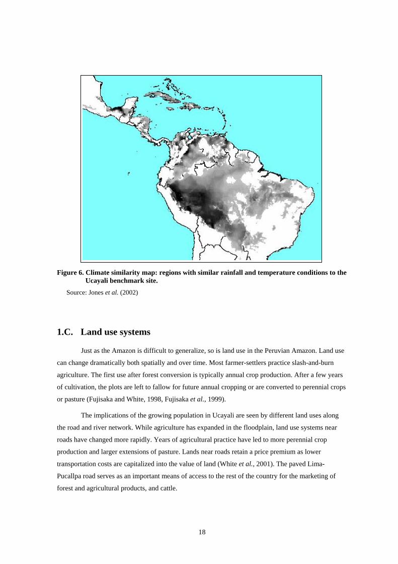
18
Figure 6. Climate similarity map: regions with similar rainfall and temperature conditions to the Ucayali benchmark site.
Source: Jones et al. (2002)
1.C. Land use systems
Just as the Amazon is difficult to generalize, so is land use in the Peruvian Amazon. Land use
can change dramatically both spatially and over time. Most farmer-settlers practice slash-and-burn
agriculture. The first use after forest conversion is typically annual crop production. After a few years
of cultivation, the plots are left to fallow for future annual cropping or are converted to perennial crops
or pasture (Fujisaka and White, 1998, Fujisaka et al., 1999).
The implications of the growing population in Ucayali are seen by different land uses along
the road and river network. While agriculture has expanded in the floodplain, land use systems near
roads have changed more rapidly. Years of agricultural practice have led to more perennial crop
production and larger extensions of pasture. Lands near roads retain a price premium as lower
transportation costs are capitalized into the value of land (White et al., 2001). The paved Lima-
Pucallpa road serves as an important means of access to the rest of the country for the marketing of
forest and agricultural products, and cattle.

19
To a lesser extent, land use change has occurred along the road that connects Yurimaguas to
the rest of the country (Rhoades and Bidegaray, 1987). Yet, despite having a greater proportion of
settlers with a longer history in the Yurimaguas region, there is markedly less pasture and perennial
production per farm (Table 2). These land uses are not as financially viable since the road to
Yurimaguas is more primitive and provides reliable access only during the dry season.
Table 2. Descriptive statistics of farms at the ASB benchmark sites
Yurimaguas Ucayali
Average farm size (ha) 23.6 28.7
Primary forest (ha) 8.5 9.5 Fallow (ha) 9.4 8.2 Annual crops (ha) 1.9 1.6 Perennials (ha) 0.8 2.3 Pasture (ha) 3.1 7.1 Average fallow period 3.6 years 3.2 years
Migrants before 1960 45% 25%
Source: Labarta (1998)
In Ucayali, the ASB site characterization survey identified four major types of land use
systems: upland slash-and-burn; riverine slash-and-burn; cattle ranching; and oil palm production
(Figure 7). Farm sizes of settlers who practice slash-and-burn and cultivate oil palms are about 30 ha.
Cattle ranches, established earlier (see section 1.A.3), are about 60 ha on average.
0
10
20
30
40
50
60
70
Upland Riverine Cattle Oil Palm
Hec
tare
s
PerennialsAnnualsFallowPastureForest
Figure 7. Ucayali land use by agricultural system (1996)
Source: Fujisaka et al. (1999)

20
The amount of remaining on-farm forest is related to farm type and decreases with the length
of settlement. In the more recently inhabited areas, 59% of the farm remained forested, whereas in
more mature settlements, forest coverage decreased to 40%. Oil palm farmers had over 50% of their
land still forested, while cattle ranches, the oldest settlements, had an average of 19% of their land
under forest. Conversely, the land area dedicated to pastures generally increased according to the age
of the settlement. Pastures covered 60% of the larger cattle ranches. For smallholders, the recent
settlers had about 10% in pasture, whereas those longer-established had 19% (Fujisaka and White,
1998). Approximately 20% of farmers who have pastures, actually own cattle (Fujisaka, 1997).
Despite the defined farm categories, farmers nevertheless have a diversified production
strategy with a variety of agricultural activities and land uses (Figure 7). On average, annual crop
production ranges from 1.3 ha for ranchers and oil palm producers to 2.6 ha for upland slash and-burn
farmers. Riverine annual crops cover about 1.5 ha. Perennial crop production is greatest with oil palm
farmers (5 ha) and least with riverine farmers and cattle ranchers (<2 ha). Fallow land on average
comprises about 25% of the landholdings for all farm types.
A variety of activities besides agricultural crops provide income. More than half of the survey
respondents reported incomes from off-farm, non-farm labor and from pensions or other off-farm cash
remittances. Nearly 20% sold cattle and 27% pigs and/or chickens to earn cash. Field observations
revealed that many Aguaytía watershed farmers far from the roads cultivated coca for the illicit drug
trade. Only 25% of the farmers (mainly those settled along the rivers) reported harvesting timber,
mainly the softwoods bolaina (Guazuma crinita) and capirona (Calycophyllum spruceanum). Upland
pioneer slash-and-burn farmers commonly produce charcoal from selected hardwood tree species such
as Shihuahuaco or Cumaru (Dipteryx odorata) and Tahuarí (Tabebuia sp.). Markets as far away as
Lima demand high-quality charcoal provided by these tropical tree species (Fujisaka and White, 1998;
Labarta, et al., 2003).
Brief descriptions of principal land uses are presented in Table 3 (as they correspond to the
ASB meta land use systems (LUS) matrix, described in section 1.D.5). These representative
agricultural, ranching and forest land use systems (LUS) form the basis of comparison throughout this
summary report. Although the actual set of the LUS studied by the other benchmark locations slightly
differ, the set is consistent with the ASB meta LUS matrix, and thereby enables cross-site analysis and
comparison.

21
Table 3. ASB meta LUS and representative systems at the Peruvian benchmark sites
ASB Meta LUS Representative LUS
1. Natural forest • Residual forest: previously logged primary forest with some extraction (e.g., nuts, animals) and selective logging 4
2. Forest extraction • Small-scale selective logging with some on-farm processing*
3. Complex, multistrata agroforestry systems
• Multistrata system*: Cedrelinga catenaeformis (tornillo), Coffea arabica (Coffee), Colubrina glandulosa (Shaina), Bactris gasipaes (Pijuayo or palm hearts), Eugenia stipitata (Araza) and Inga edulis (Guaba5)
4. Simple treecrop systems • Oil palm
• Cocoa
• Citrus
5. Crop/fallow systems
• Long fallow: high forest converted to 3 years of annual crop production (rice, maize, cassava, plantain, beans) followed by 7 to 20 years fallow
• Short fallow: secondary forest converted to 3 years of annual crop production (rice, maize, cassava, plantain, beans) followed by 2 to 6 years of fallow
• Improved fallows* 6. Continuous annual cropping systems • Riverine agriculture
7. Grasslands/pasture • Native grasses
• Brachiaria
• Brachiaria with legumes*
* These systems are research-based and not found extensively in the benchmark sites.
1.C.1. Traditional land use systems Of the 12 LUS under study at the Peruvian benchmark sites, 7 are commonly found: natural
forest, slash-and-burn agriculture, bush fallow agriculture, native pastures, oil palm, citrus and riverine
agriculture.
1.C.1.a. Natural forest
Forests in the Peruvian Amazon have experienced different levels of human intervention.
Natural forests include nearly-untouched primary forests to forests that have been selectively logged.
The typical method of timber harvesting is not clear-cut but rather a selective logging of high value
4 Few untouched forests exist at the Peruvian benchmark sites. The forests referred to here (with minimal
extraction of forest products plus selective logging) are used as the point of departure for analysis of the other LUS found at the benchmark sites. In many cases, this minimal extraction/logging is undertaken illegally.
5 Do not confuse with Psidium guajava

22
species. From 2000 to 2002, relatively few species 6 produce approximately 50% of the volume of
more than 120 species harvested. Similarly, only 20 to 25 species comprise 90% of the total volume
extracted from the forests (INRENA, 2001, 2002, 2003). Approximately 40 million hectares of Peru's
70 million hectares of humid tropical rainforest has the potential of being productive forest. Yet, only
2 million hectares of this is currently being utilized. (Prebble and Leigh, 1997). The estimated average
commercial volume of the Ucayali forests is 100 m3 ha-1 (CORDEU, 1982; Iturraran, 1988, cited in
Barrantes & Trivelli, 1996).
Timber extraction and processing is conducted by both formal and informal operations.
Formal companies tend to be larger and backed by financing from Lima or international sources. Less
formal small-scale harvesting operations are widely scattered throughout the Amazon region,
particularly along the rivers, and often in remote areas. Ill-trained, informal loggers with chainsaws
perform most extraction. Vertical integration of the industry including extraction, transformation,
transport, and commercialization is not strong. Consequently, the logging industry is very inefficient.
Furthermore in 1994, chronic overcapacity of the industry and civil unrest in the Ucayali region caused
the sawmills in Pucallpa to function at only 40% of their capacity (Barrantes and Trivelli, 1996).
1.C.1.b. Fallows and secondary forests
Farmers benefit from fallows and secondary forests. Useful species in secondary forests
include medicinal plants, edible fruits, firewood, and wood for rural construction or handcrafts. The
amount of on-farm secondary forest changes according to the age of settlement. In younger settlement
areas, many smallholders preserve tree cover on a small part of their farm in order to benefit from a
wide range of forest products. In older settlement areas, secondary forests are the only significant
forest resource available to the rural poor (Smith et al., 1999). The inverse relationship between forest
cover and settlement age in the Ucayali region is opposite to Tambopata region in the southern
Peruvian Amazon. These long-term residents maintain more forest on their farms than do recent
colonists (Alvarez and Naughton-Treves, 2003).
Most farm families in the benchmark site, however, underutilize timber trees that grow their
secondary forests. A minority of farm families actively harvests trees for cash timber sales. Most
farmers harvest trees for on-farm uses, but do not sell timber due to low on-farm prices for
unprocessed timber. In cases where farm families do exploit timber for cash sales, management
practices generate low cash returns. On-farm prices are often only one third of the net price at saw
mills in urban centers, due to the lack of bargaining power, irregular stem size, high transportation
costs. (Faminow, 2001).
6 For example, Cedrelinga catenaeformis, Virola sp., Swietenia macrophylla, Hura crepitans, Eucalyptus sp.,
Chorisia integrifolia.

23
1.C.1.c. Oil palm
In Ucayali, approximately 2000 ha are planted with oil palm. Smallholder farmers who belong
to a cooperative organization, Comité Central de Palmicultores de Ucayali (COCEPU), manage 70%
of the plantations. More than 300 families depend upon palms as a principal source of income. Actual
yields, however, are much lower than original predictions. Despite this shortcoming, the regional
government is currently in the process of establishing larger areas.
Data for the oil palm system are from a CTARU project (CTARU, 2002). Production
theoretically begins in year 5 with an annual yield of 8 t ha-1 of palm fruit that increases and stabilizes
to 18 tons in year 8. Ministry of Agriculture statistics (2000) show that for Ucayali, 1695 ha produced
10,242 tons implying an average of yield of 6 t ha-1. The price for palm fruits has been approximately
US$43 t-1; and is more consistent than world prices because of government subsidies. Nursery costs to
produce the palms are assumed by the CTARU and are not in the private farmer financial calculations.
These cost are approximately US$354 ha-1. Many oil palm farmers hire permanent workers for the
continual harvest, some owners dedicate their time to managing the farm. section 5.C.4 discusses the
financial and agronomic challenges they face.
1.C.1.d. Cocoa
The Ucayali region has approximately 1500 ha of cocoa in the western portion of the Ucayali
benchmark site - close to the Andean foothills. Yields have been low due to diseases such as witch’s
broom (Crinipellis perniciosa) and moniliasis. Recent extension efforts by CARE, Winrock
International and ICRAF have helped farmers increase yields (see section 5.C.2).
1.C.1.e. Citrus
Many established smallholder farmers also produce a variety of citrus products as part of their
diversification strategy. In the 1980s, the regional government promoted citrus production.
Approximately 9000 ha are under production of limes (44%), oranges (42%) and tangerines (14%).
Total production in the Ucayali region is 15,300 t year-1 (Ministerio de Agricultura, 2001).
1.C.1.f. Long fallow slash-and-burn agriculture
Farmers convert high forest or older fallows (secondary forests) ranging from 6 to 20 years of
age for agricultural production. The biomass enhances soil nutrients with the burning reduces pests and
weeds (Nye and Greenland, 1960, de Rouw, 1995). Traditional long crop-fallow rotations typically
start with upland rice in the first year, followed by two years of maize, plantain or cassava (Fujisaka
and White, 2001). Two representative systems are examined below: 1) agricultural production with the
first year in rice and the next two years with cassava, and 2) agriculture production with rice in the first
year then two years of plantain. In both systems, land is fallowed for eight years. Land preparation in
the first year requires 21 workdays ha-1, given that a secondary forest is assumed to be converted to
agricultural use. (High forest conversion typically requires more labor: 42 workdays ha-1.) In addition
to traditional crop production, illicit crops such as coca are also cultivated (see section 5.A.3).

24
1.C.1.g. Short fallow slash-and-burn agriculture
Shorter crop-fallow rotations are also used to cultivate traditional annual food crops, usually
grown for three years, followed by three to five years of natural bush fallow. As with longer fallow
systems, fire is typically used to prepare the land. Weed invasions and lower soil fertility can lead to
smaller harvests as compared to longer fallows (Labarta, 1998). The representative systems are the
same as the long fallow system described above but have a 4-year fallow period. In some areas farmers
use Kudzu (Pueraria phaseoloides) to fix nitrogen and shorten the fallow period, thereby intensifying
production (Yanggen and Reardon, 2001).
1.C.1.h. Native pastures
Cattle are an important livelihood option in the Peruvian Amazon. Approximately, 46% of
farmers have cattle; 95% of them have less than 100 head (INEI, 1986). Despite the importance of
cattle production, the sector has been affected by political and social instability. In the ASB farmer
survey of 1999, approximately only 23% of farmers had cattle.
Most of small ranches (92%) had mixed systems that include annual crop production. A
majority of farmers with pastures (52%) did not have cattle but almost all of them aspire to get some.
Capital constraints limits farmers’ cattle purchases. Approximately 85% of farmers with cattle
financed their initial purchases with off-farm income (Yanggen, 2003).
After growing annual crops for various rotations, farmers often leave fields fallow and, if
available, graze cattle. Native grasses quickly take over such as Paspalum conjugatum, Axonopus
compresus and Homolepsis atruensis. Native pastures, however, degrade rapidly thereby producing
less biomass per ha. At least one third of pastures in the cattle zone along the Pucallpa-Lima road are
considered to be degraded (Riesco et al., 1986). The stocking rate on such traditional pastures is only
about 0.6 animal units (AU) ha-1. Milk yield is approximately 3 liters day-1 (Holmann, 1999).
Investments required for pasture and livestock production include livestock at US$300 AU-1, pasture
establishment (US$3 ha-1), and fencing, shed and corral at approximately US$100 ha-1.
1.C.1.i. Riverine
Areas along the Ucayali and Aguaytía rivers provide a diverse range of agro-ecological
conditions in which to cultivate crops, they are classed as “Iquitos varzea” WWF ecoregion. A
significant proportion of agricultural production comes from riverine areas: 60% of plantain, over half
of rice and nearly a third of maize, cassava and bean production (Ministerio de Agricultura, 2001).
These areas are commonly divided into four types: upper and lower floodplains, beaches and mudflats.
Annual flooding provides nutrients, making the soils relatively fertile and enabling greater crop yields.
While only the upper floodplains require fallowing, to control weeds principally, the lower areas come
with a greater risk of unexpected flooding and catastrophic crop loss. Of the estimated 150,000 ha of
available riverine land, only one third is used for agricultural production, primarily because of flood
risks and expensive transportation costs (Labarta et al., 2005). Two systems presented below are the

25
mudflats, where temporary farmers produce rice, and floodplains where permanent dwellers cultivate a
variety of crops, including rice, maize, cassava, beans, soybeans and plantains (for more detail, see
section 5.C.10).
1.C.2. Alternative land use systems The following systems are possible alternatives to the prevailing traditional uses at the
Peruvian benchmark sites. These systems, some of which are still being tested in pilot projects, are:
1.C.2.a. Managed forest
The geographically diverse distribution of logging areas has made enforcement of
management controls nearly impossible. Legal mechanisms are being developed to encourage
permanent production forests and to concentrate logging activities in selected areas. The Peruvian
government is in the process of implementing the recent national forest/forestry law to encourage
forest protection and rational use, Law Nº 27308 (Congreso de la República, 2000). One goal of
sustainable timber harvesting is to sustain the forest while providing small-scale farmers with a steady
income. Low-impact timber harvesting, which creates a mosaic of clearings of different ages, is
intended to allow adequate forest regeneration and regrowth. Felling cycles are shorter and extraction
methods require smaller investments than those of larger-scale operations. This LUS may be a feasible
alternative to the current situation, in which farmers extract timber illegally and sell it at low prices.
An ITTO project in von Humboldt National Forest, described in section 5.C.1, is an example of an
attempt to make managed forest a feasible LUS (ITTO, 2002a).
1.C.2.b. Multistrata agroforestry
Agroforestry LUS systems offer possibilities for income generation that are also relatively
environmentally-friendly. Several tree species were planted with sufficient spacing to avoid
competition and obtain sustainable production. In Yurimaguas, a diversified production system started
with annual crops in the first two years and later producing timber, poles, coffee and fruit (Cedrelinga
catenaeformis, Coffea arabica, Colubrina glandulosa, Bactris gasipaes, Eugenia stipitata and Inga
edulis). Centrosema (centrosema macrocarpum) understorey formed the lower strata in the system.
The multistrata agroforestry systems in Yurimaguas were managed by ICRAF-INIA from 1985 to
1997 and then transferred to INIA for maintenance and yield evaluation until 2003. Biophysical
evaluation was terminated due to a lack of local expertise and lab facilities.
Two representative systems are examined below. The first is a bolaina, annual crop (rice,
maize, cowpea) and centrosema system, and the second contains inga, annual crops (rice, maize,
cowpea) and centrosema. Both systems were adjusted for the 20-year analysis horizon. The
experimental data were extrapolated with coppicing of bolaina resulting in planting cost savings. See
section 5.C.6 for details on the original experimental systems.

26
1.C.2.c. Improved fallows
An experiment with short-duration planted tree fallows was conducted at Yurimaguas.
Managed tree fallows of planted inga (Inga edulis) and colubrina (Colubrina glandulosa), with and
without centrosema cover were compared with the traditional bush fallow in terms of weed
suppression and crop production (Alegre et al., 2005). The centrosema cover crop trial is used in the
analysis below. See section 5.C.8 for details of the other experimental fallow systems.
1.C.2.d. Improved pastures
Brachiaria decumbens (brachiaria), a grass of African origin, was introduced in the 1970s to
improve pasture performance. Its vitality, low labor requirements and easy adaptation to the Aguaytía
watershed conditions have lead to its widespread adoption. Between 1982 and 1996, brachiaria use
rose from 17% to 40% of total pasture cover (Riesco et al., 1986; Fujisaka and White, 1998; Fujisaka
et al., 1999) and is so common that many farmers now consider it a native species. The brachiaria
option can increase the stocking rate to 1.5 head ha-1, increase beef production by 0.3 kg head-1 day-1
and increases milk production (Holmann 1999a,b). Brachiaria is burned to control weeds but receives
little or no other management. The analysis below refers to brachiaria pastures requiring higher
livestock investment costs (US$450 ha-1) and establishment costs (US$40 ha-1) than native pastures.
To improve animal carrying capacity of pastures along with milk and beef production, the
CIAT Tropileche (tropical milk) project attempted to introduce legumes Arachis pintoi and Cratylia
argentena. For details see section 5.C.9.
1.D. Assessing land use7
Most smallholder farmers at the Peruvian benchmark sites employ slash-and-burn methods to
convert forest to agricultural uses, including pasture. Since this land use dynamic is often the most
profitable and logical option for smallholder farmers, ASB assesses the agronomic and financial
performance in addition to the negative environmental consequences (carbon and other greenhouse gas
releases and the loss of biodiversity). During Phase II, ASB developed and implemented a research
framework that quantified the biophysical and socio-economic variables associated with natural forests
and other land uses. The framework provides a basis for understanding and synthesizing the research
results of Peru.8
1.D.1. Global environmental concerns Land uses implemented after forest conversion markedly differ in their capacity to replicate
the global environmental services of forests, which are unsurpassed in terms of both storing carbon
7 Adapted from Tomich et al. (1998). 8 Cross-site synthesis is an ultimate research goal. See the forthcoming Slash and Burn: The search for alternatives’ (Palm et al .(eds.), 2005), as well as ASB global reports on biodiversity (Gillison, 2000) and carbon stocks (Palm et al., 1999) and also ASB MA status report (Tomich et al., 2005).
27
and conserving biodiversity. ASB scientists quantified three indicators of the global environmental
consequences of land use change. Two of these are linked to global climate change: carbon stocks and
net flux of the greenhouse gases, specifically carbon dioxide, methane and nitrous oxide. The third
indicator is biodiversity, the conservation of which is a major international concern, especially in moist
tropical forests. Both aboveground vegetation and belowground faunal diversity are measured. The
research techniques and protocols employed are described in the global working group reports (Palm
et al., 1999; Gillison, 2000; Bignell et al., 2005).
1.D.2. Agronomic sustainability Agronomic sustainability is long-term production capacity of a land use system. Although
researcher and farmer perspectives may clash in what sustainable means, all agree that maintaining
agronomic sustainability is important for both traditional and alternative land uses. Soil scientists and
agronomists collaborating in ASB identified and developed indicators for three basic components of
agronomic sustainability—soil structure, nutrient balances and crop protection (Weise, 2001a,b).
1.D.3. Smallholders’ socio-economic concerns Similar to the diverse agronomic criteria, three sets of quantifiable socio-economic criteria
were employed by ASB scientists to assess land use alternatives from the smallholders’ perspective
(Tomich et al., 1998a; Vosti et al., 2000, 2001). They include:
• Production incentives: Is the land use system profitable for smallholders? Does it pay smallholders to invest in land improvements or in some other alternative?
• Labor constraints: Can households supply the necessary family labor for a given land use, either themselves or by hiring workers?
• Household food security: Is the option so risky, in terms of unreliable yields and variable market prices, that adoption would jeopardize food security for the household?
During ASB Phase II, methods for measuring these criteria were developed and implemented.
1.D.4. Institutional barriers to technology adoption Many factors limit the ability of smallholder farmers to adopt new technologies (Feder and
Umali, 1993; Franzel et al., 2001). In order for researchers and policymakers to better target
technologies, the objectives and limitations of smallholders along with the effect of the current policy
and institutional context must be made known. Policies that influence land use decisions of
smallholder farmers include subsidies and credit programs in addition to research and extension
priorities. Institutions that affect smallholder farmers include legal systems such as land tenure and
property rights. Imperfect markets, where prices drastically fluctuate, are also a common institutional
barrier. ASB researchers have identified and implemented a set of 12 indicators, both quantitative and
qualitative, of institutional factors as they affect land, labor, capital and commodity markets as well as
the availability of relevant technological information and materials. (Vosti et al., 2000; Diaw, personal
communication).

28
1.D.5. The ASB matrix A central task of the ASB research program is to identify the current and alternative land use
systems that have the best chance of attaining multiple objectives. These objectives form four broad
classes: environmental, agronomic, socioeconomic, and policy/institutional. ASB researchers have
developed a framework with indicators to assess the synergies and tradeoffs among these objectives
(Figure 8). Field-level measurements of the predominant land use systems (LUS) provide a starting
point to quantify the major tradeoffs and for identifying ‘best bet’ alternatives that provide an
attractive balance among competing objectives. Tomich et al. (1998a) define a best bet land use
alternative as: a way to manage tropical rainforests or a forest-derived land use that, when supported
by necessary technological and institutional innovation and policy reform, somehow takes into
consideration the local private and global public goods and services that tropical rainforests supply.
This implies that the best bet LUS make a significant contribution to each of the broad sets of
environment, agronomic sustainability, smallholder, and policymaker objectives.
Meta land use systems (LUS) Global environmental concerns
Agronomic sustainability
Smallholders’ socioeconomic concerns
Institutional issues
1. Natural forest 2. Forest extraction 3. Complex, multistrata agroforestry systems
4. Simple tree/crop systems 5. Crop/fallow systems 6. Continuous annual cropping systems
7. Grasslands/pasture
Figure 8. The ASB meta matrix: a tool for evaluating and comparing LUS
The four broad classes of criteria correspond to diverse, and sometimes conflicting, interests
of various international, national, and local groups. Differing perceptions of interest groups compound
the challenge of identifying and assessing appropriate indicators for the various criteria. As discussed
in detail below, each class or criterion comprises many other indicators that need to be taken into
account when assessing best bets. Identifying one or more best bets for a specific setting depends on
the extent of conflict or agreement across the criteria. If estimates reveal tradeoffs across objectives,
either a multidimensional decision process or a system of weighting competing objectives is required
to identify a best bet. While economic valuation provides a suitable weighting scheme for some of the
indicators, it is problematic for others (e.g., biodiversity). Thus, it is unlikely that this problem of
choice of best bet land use alternatives (and possibilities for development of suitable technological
innovations) can be captured in a single, summary measure.

29
A general matrix format was developed (Tomich et al., 1998a) as an alternative to a futile
quest for a single indicator. This matrix is a framework that organizes data to assess possible tradeoffs
and synergies across specific indicators. The general framework, the ‘ASB Meta Matrix,’ appears in
Figure 8. Columns of this matrix are the broad classes of criteria discussed above. The rows represent
the seven ‘meta’ land use systems (LUS) that were selected for global comparisons across ASB study
sites. These rows correspond to specific land uses found at the benchmark sites of Peru, which are
described in section 1.C. The ASB-Peru matrix is a summary presentation and serves as the basic tool
to assess tradeoffs of the land use systems in section 5.C.8.
Since deforestation is one of the two primary concerns of ASB research, natural forests
provide the logical reference point to compare the contribution of a given LUS to global environmental
services. Pasture is at the opposite end of the ecological continuum since, as will be shown, this LUS is
least able to provide the environmental services. Between these two extremes, a range of five generic
LUS were selected for cross-site and/or cross-regional comparisons: extraction from forest products;
agroforestry systems; simple treecrop systems (including, but not limited to, monocultures); annual
crop/fallow systems (longer fallow slash-and-burn systems and shorter rotation bush fallows); and
continuous annual systems (which may be monocrops or intercropped). This range covers the whole
spectrum of land uses, in both traditional and modernized (more intensive) forms, found both in Peru and
at the other ASB sites in Indonesia, Cameroon, Brazil and Thailand.
1.D.6. Caveats regarding the ASB matrix approach To create a summary matrix of diverse and complex information, numerous simplifying
assumptions were made. Many of the limitations regarded issues of spatial scale. Estimating regional
or global impact from benchmark site measures, such as those described here, required assumptions of
independence across space and of additivity as measures are scaled up. These assumptions are
reasonable for some measures (e.g., carbon stocks), but they are only a first order approximation for
others, including aboveground biodiversity, agronomic and socio-economic issues.
To illustrate, biodiversity measures are very sensitive to scaling assumptions. Summary
measures alone cannot fully and adequately describe how much biodiversity will be lost for each
hectare of converted forest. Principal methodological gaps of measuring biodiversity concern the
scaling out of results over space and time. As biodiversity samples are taken over larger and larger
areas of a particular ecosystem, the number of additional species observed increase, but at a decreasing
rate. Thus, while some of the species may differ amongst the plots, only a fraction will be observed for
the first time. This complementarity (or non-independence) across space implies that biodiversity
values of different plots cannot be added to produce larger geographic scale biodiversity measures.
Another issue is the minimum habitat thresholds of different species. The number of species observed
within a small study area does not reveal how much land area is required for their conservation. If a
piece of land were to be surrounded by land under different uses, the number and type of species could
30
change dramatically. Often, the long-term survival prospects of species depend on the extent of their
habitat, which is influenced by the land cover pattern of the landscape.
Spatial scale can also affect profitability estimates of land uses in two ways. First, transport
costs are often a function of distance. Farmers who are distant from markets or those who must use
low-quality roads must pay more to transport their purchased input and their harvests. Annual rains
typically make secondary roads impassable, thereby preventing farmers from selling harvests for days
or weeks. Nevertheless, simple spatial assumptions are not always appropriate. Farmers further from
markets but with better and more regular road access may actually have lower transport costs than
farmers closer to market but with a less-developed infrastructure (Nelson and Leclerc, 2003). Second,
product markets are affected by scalar assumptions. A rapid change in the extent of a particular land
use can lead to enlarged product supplies that overwhelm markets. Given that forest margins regions
often have immature markets (e.g., inelastic demand), the larger harvests can depress prices
drastically. These effects of imperfect markets and unstable prices are not directly included within the
profitability estimates. To document the market depth, price variability of different farm products is
provided as a summary measure.
The heterogeneity of field analyses is another important limitation of the LUS system
profitability analysis. In Peru, not only was research conducted in different sites (Yurimaguas and
Ucayali), but different researchers also conducted the original financial analyses. For instance, analysis
periods differ. Although efforts were made to harmonize the analyses, direct comparisons of the LUS
may not be based on ideal data.
General agronomic sustainability and global environmental measures also have limitations.
Estimates were calculated with respect to only the on-site, field-level effects. The extent and spatial
arrangement of land use alternatives produce environmental externalities (e.g., fire, runoff from
erosion, and smoke). Similarly, net greenhouse gas emissions to the atmosphere are likely to be
influenced by the spatial arrangement of sources and sinks (along with the temporal influences- see
section 2.B).
One of the key challenges of future ASB research is to develop methods and to extend
existing databases that enable assessments at higher scale levels. In summary, best bet LUS do not refer
to a single land use system or technology. The most feasible manner in which to achieve the multiple
objectives is likely to come from combinations of complementary land use practices in a given spatial
context (van Noordwijk et al., 1997). Yet given the complexity and diversity of tropical LUS along
with a rudimentary understanding of decision-making (political) processes above the farm level,
landscape-level analysis is not yet feasible. Nevertheless, the land use-specific analysis presented here
is a necessary precursor to that work. In addition, the estimates provided here were calculated in a
systematic manner that facilitates critique and comparison of land use systems from around the globe
(see Vosti et al., 2000).
31
2. GLOBAL ENVIRONMENTAL IMPACTS The foci of ASB biophysical research in Peru match those of the global consortium. Field
research examined (1) how different LUS are associated with levels of biodiversity, sequestered carbon
and greenhouse gas emissions, and (2) agronomic sustainability. In addition to studies comparable to
other ASB benchmark sites, Peru research also included studies of the geographical patterns in tree
species genetic variation. In order to capitalize on logistical efficiency of field research and link
scientific results, researchers co-located sampling sites wherever possible.
2.A. Carbon stocks
A partnership of scientists from INIA, UNU, TSBF and ICRAF evaluated the above- and
belowground carbon stocks in various LUS at the Ucayali and Yurimaguas benchmark sites. The
evaluation was accomplished using the procedural guidelines developed by TSBF and other partners
for the ASB program (Palm et al., 2000). In this section, we present aboveground carbon stocks data
that show the greater changes on net carbon stocks. Belowground carbon stock data are presented in
sections 3.A and 3.B.
When forest is converted to agricultural uses, aboveground (time-averaged) carbon stocks are
considerably reduced (less dense and lower vegetation replaces woody species). As expected, managed
forest and older natural fallows have the highest carbon contents. As fallows mature into secondary
forests, they increase their carbon content (Table 4). Among tree-based systems, the carbon content of
perennial systems is relatively high, ranging from 41 t ha-1 for oil palm plantations to 74 t ha-1 for
rubber plantations (Ucayali). Carbon of multistrata agroforestry systems (Yurimaguas) lies at 59 t ha-1.
Rubber plantations and multistrata systems have a permanent understorey of Kudzu, which increase the
carbon stocks by 2-5 t ha-1 (Alegre et al., 2000a).
Carbon stocks of annual cropping systems and other land use systems reveal stark differences.
The amount of carbon stored in annual cropping systems is very low (3-17 t ha-1). Although a system
with upland rice showed similar carbon stocks to the biennial plantain system, the rice was grown
immediately after forest clearing and thus included carbon measures of the remaining unburned logs.
Subtracting the logs (which will decompose) reduces the estimate by at least 50%. Pastures contained
the lowest quantities of carbon (2 t ha-1). Of note, carbon stocks were greater overall in land use
systems in Yurimaguas than in Ucayali. This result is probably due to the lower levels of agricultural
intensification and more evenly distributed annual rainfall in Yurimaguas (Fujisaka et al., 1998;
Alegre et al., 2000a).

32
Table 4. Aboveground carbon stocks of different land use systems in Yurimaguas and Ucayali, Peru
Yurimaguas Land Use Aboveground Carbon (t ha-1)a Ucayali Land Use Aboveground
Carbon (t ha-1)a Forest Forest Moderately logged (>40 yr ago) 294 a Primary 162 a Residual (logged) 123 a Agroforestry Perennial Crops Multistrata b 59 Rubber (30 year) w/ Kudzu 74 Oil Palm with grasses 41 Fallows Fallows 15 – year 185 15 - year 126 5 – year 44 3 - year 21 3 – year 19 Agricultural Crops Agricultural Crops Rice 17 Maize 8 Cassava 3 Plantain 16 Pasture Pasture Degraded (30yr) 2 Degraded 5 Improved (w/ brachiaria) 5
a includes standing, dead and fallen logs. b Bactris, Cedrelinga, Inga, Colubrina, coffee with cover crop of centrosema. N.B. None of the results above are time averaged. Source: Alegre et al. (2000a)
2.B. Greenhouse gas emissions
Deforestation and resulting land use change lead to a release of other greenhouse gases in
addition to carbon emissions. These gases include methane (CH4) and nitrous oxide (N2O). Globally,
tropical ecosystems are considered important sources and sinks for carbon dioxide (CO2), CH4 and
N2O. Clearing of the forest for different land use systems alters the soil-atmosphere exchanges of
gases. Some land uses result in gas fluxes that will contribute to global warming and depletion of the
stratospheric ozone layer (IPCC, 2000).
Most methane and nitrous oxide measurements in the tropics have been taken from
undisturbed forest systems or pastures (Steidler et al., 1996; Keller et al., 1997), while few studies
have been undertaken in areas converted to other land uses. A goal of ASB was to sample and compare
trace gas fluxes from the full spectrum of land uses ranging from natural forests to pastures. In the
benchmark sites, scientists employed a strategy of intensively sampling fewer, well-characterized
locations. Sites in Peru were selected for the first trials because of their well-defined land uses and on-
site laboratory capability to monitor the soil variables that affect gas fluxes. Similar land use categories
were monitored in both Ucayali and Yurimaguas, representing the entire range of sequestered carbon

33
from forest to pasture. To minimize the variability and disturbance caused by monitor placement, the
chambers were placed in the same measurement locations. Nine monitor chambers (30 cm diameter
and 10 cm high) covered an area of 0.07 m2 per land use system. In Yurimaguas, experiment data were
collected for 20 months (replicated sampling every month for three continuous days for each system).
Details of the treatments are given in Table 5.
Table 5. Description of the six land management systems monitored for greenhouse gases fluxes in Yurimaguas, Peru (1997-1999)
Land Management System System Components System Management
High input cropping Annual maize-soybean or maize-peanut rotation*
Tillage; liming to pH 5.5 or higher; NPK fertilization of maize crops (100 kg N ha-1 as urea equally split at 3 wks and 7 wks after planting); no N fertilizer on soybeans or peanut crops
Low input cropping Annual upland rice-cowpea rotation*
No tillage or liming; hand planting with planting stick; 30 kg N ha-1 as urea applied to rice 6 wks after planting
Peach palm plantation Bactris gasipaes trees with a legume cover crop: centrosema macrocarpum
First year planted with rice-cowpea rotation; trees planted Jan 1986 at 5 x 5 m spacing; legume cover crop planted as understorey second year; no tillage, liming or fertilization
Multistrata agroforestry
Overstorey trees: (Cedrelinga catenaeformis and Bactris gasipaes) Understorey trees and shrubs: (coffee, Eugenia stipitata, Inga edulis), and a cover crop: Centrosema macrocarpum
First year planted with rice-cowpea rotation; trees planted Jan 1986; legume cover crop planted third year.
13-year-old forest fallow Natural vegetation First year with annual crops then
abandoned to natural fallow regrowth 23-year-old secondary forest (control) Natural vegetation Remained undisturbed throughout
experiment
* Centrosema macrocarpum planted after two crop rotations then slashed and burned after one year.
Field evidence suggests that the holding capacity of methane by methanotrophic organisms in
well-drained upland tropical soils diminishes as the intensity of land use increases. Factors that affect
methane flux, i.e. consumption and production, include bulk density, water-filled pore space, and
nitrogen (N) fertilization of soil. Tropical soils are reputed to be a major source of nitrous oxide gases
(Keller et al., 1997). Emissions of nitrous oxide can result from the processes of nitrification and de-
nitrification (Firestone and Davidson, 1989) and are affected by N fertilization, land conversion, soil
compaction and water logging. Early analyses of tropical forest conversion to pasture indicated a large
positive flux (4.18 µg cm-2 hr-1) of N2O (Luizao et al., 1989). However, more recent studies suggest
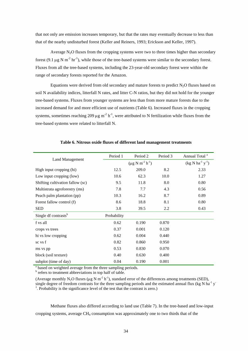
34
that not only are emission increases temporary, but that the rates may eventually decrease to less than
that of the nearby undisturbed forest (Keller and Reiners, 1993; Erickson and Keller, 1997).
Average N2O fluxes from the cropping systems were two to three times higher than secondary
forest (9.1 µg N m-2 hr-1), while those of the tree-based systems were similar to the secondary forest.
Fluxes from all the tree-based systems, including the 23-year-old secondary forest were within the
range of secondary forests reported for the Amazon.
Equations were derived from old secondary and mature forests to predict N2O fluxes based on
soil N availability indices, litterfall N rates, and litter C-N ratios, but they did not hold for the younger
tree-based systems. Fluxes from younger systems are less than from more mature forests due to the
increased demand for and more efficient use of nutrients (Table 6). Increased fluxes in the cropping
systems, sometimes reaching 209 µg m-2 h-1, were attributed to N fertilization while fluxes from the
tree-based systems were related to litterfall N.
Table 6. Nitrous oxide fluxes of different land management treatments
Period 1 Period 2 Period 3 Annual Total a Land Management
(µg N m-2 h-1) (kg N ha-1 y-1) High input cropping (hi) 12.5 209.0 8.2 2.33 Low input cropping (low) 10.6 62.3 10.0 1.27 Shifting cultivation fallow (sc) 9.5 11.8 8.0 0.80 Multistrata agroforestry (ms) 7.8 7.7 4.3 0.56 Peach palm plantation (pp) 10.3 16.2 8.7 0.89 Forest fallow control (f) 8.6 18.8 8.1 0.80 SED 3.8 39.5 2.2 0.43
Single df contrastsb Probability
f vs all 0.62 0.190 0.870 crops vs trees 0.37 0.001 0.120 hi vs low cropping 0.62 0.004 0.440 sc vs f 0.82 0.860 0.950 ms vs pp 0.53 0.830 0.070 block (soil texture) 0.40 0.630 0.400 subplot (time of day) 0.04 0.190 0.001 a based on weighted average from the three sampling periods. b refers to treatment abbreviations in top half of table. (Average monthly N2O fluxes (µg N m-2 h-1), standard error of the differences among treatments (SED), single degree of freedom contrasts for the three sampling periods and the estimated annual flux (kg N ha-1 y-
1. Probability is the significance level of the test that the contrast is zero.)
Methane fluxes also differed according to land use (Table 7). In the tree-based and low-input
cropping systems, average CH4 consumption was approximately one to two thirds that of the

35
secondary forest (–30.1 µg C m-2 h-1). The second period of the low input cropping system appears to
diverge from the other readings, which were closer to those of the secondary forest. The high-input
cropping system produced positive net CH4 fluxes.
Table 7. Methane fluxes of different land management treatments
Period 1 Period 2 Period 3 Annual Total a Land Management
(µg C m-2 h-1) (kg C ha-1 y-1) High input cropping (hi) 5.2 33.0 25.9 1.33 Low input cropping (low) -20.3 -10.2 -17.1 -1.59 Shifting cultivation fallow (sc) -27.7 -16.5 -24.5 -2.22 Multistrata agroforestry (ms) -25.5 -27.2 -21.4 -2.12 Peach palm plantation (pp) -21.0 -13.8 -12.7 -1.16 Secondary forest control (f) -30.1 -32.1 -29.0 -2.62 SED 10.8 10.7 5.6 1.12
Single df contrasts b Probability
f vs all 0.17 0.010 0.001 crops vs trees 0.07 0.002 <0.001 hi vs low cropping 0.04 0.002 <0.001 sc vs f 0.83 0.176 0.414 ms vs pp 0.69 0.240 0.156 block (soil texture) 0.66 0.790 0.200 subplot (time of day) 0.89 0.180 0.001 a based on weighted average from the three sampling periods. b refers to treatment abbreviations in top half of table.
(Average methane fluxes (µg C m-2 h-1), standard error of the differences among treatments (SED), single degree of freedom contrasts for the three sampling periods, and the estimated annual flux (kg C ha-1 y-1). Probability is the significance level of the test that the contrast is zero.)
The N2O and CH4 fluxes of land use systems tend to be related. A low-input annual cropping
system had N2O emissions one and one-half times higher than the secondary forest but half the CH4
consumption rates. On the other hand, a fertilized, high-input annual cropping system had N2O
emissions almost four times that of the secondary forest in addition to a switch from CH4 consumption
to CH4 production on these soils. These results demonstrate the increased global warming potential of
annual systems compared to the forest and tree-based systems.
These results demonstrate two important results with respect to greenhouse gas emissions and
land use change: 1) the forest and agroforestry systems are greenhouse gas sinks; and 2) as land use
intensification increases, more gases are released. Data obtained from the measurements in Peru will
be used to help create a gas flux model for the tropics. A new version of the CENTURY model is
under development by Colorado State University and is being validated to simulate trace gas
36
production and consumption. The model will be used to predict gas fluxes from a variety of
environments and land management systems that could not be accomplished via intensive field
sampling due to the financial expenses involved.
Efforts to establish tree-based systems on the large areas of degraded lands in the tropics
could also partially counteract the past effects of deforestation on increased atmospheric trace gas
concentrations. In contrast, annual cropping systems exacerbate these effects because they sequester
little C, have higher N2O emissions and substantially reduced CH4 consumption or even net CH4
emissions (Alegre and Arévalo, 2000).
2.C. Aboveground biodiversity
Both Gillison and Alegre (2000) and Fujisaka et al. (2000) examined the relationship between
different land uses and aboveground plant biodiversity. The former study employs a plant functional
attributes approach to measure the diversity of plants. The latter research uses traditional ecological
approaches combined with an ethnographic component, and focuses upon farmer understanding and
preferences for different plants, including the effect of weeds.
Slash-and-burn practices create diverse landscape mosaics that can limit large-scale vegetation
classification and the characterization of aboveground biodiversity. An alternative approach identifies
linkages between key site physical features, plant biodiversity and land use type. Twenty-one (40 x 5
m) transects were used to sample a range of land use types and successional sequences. A rapid survey
was used to record all vascular plant species, vegetation structure, functional types and a range of site
physical features, including soils. This approach uses readily-observable plant functional types
(compiled from rule-based combinations of adaptive morphological or plant functional attributes) in
combination with an overall number of plant species (Gillison, 2000).
Initial analysis of the data revealed close associations between plant-based classifications and
land use type and vegetation succession, but generally weak correlations with soil physical and
chemical variables. The most significant correlations of soil attributes were with vegetation structure,
plant functional attributes and richness ratios of plant species to functional types. The highest species
and functional type richness were recorded in a forest logged 40 years previously, 20-year abandoned
gardens and 2-year successional fallows dominated by Asteraceous ‘daisy’ fallows. Multistrata
agroforests showed moderate richness while improved pastures were least rich, with only four plant
species and functional types (Table 8). In terms of management under agroforestry systems, richness
of species imply more biomass for C sequestration and recycling of nutrients through organic matter
decomposition (Gillison and Alegre, 2000).

37
Table 8. Aboveground biodiversity index measures
Meta Land Use Site Species Richness Plant Functional Type Ratio
Uc 63 31 2.03 Natural forests (N) Iq Resting 71 39 1.82 Managed forests (M) Uc 33 years since logged 66 31 2.13
Extensive Agroforests (A) Br Reca Copoazu/ peach/palm/coffee 47 33 1.42
Yu Bactris palm 11 9 1.22 Intensive agroforests (A*) Br Coffee/rubber/no
shade 24 21 1.14
Crop/ long fallow systems (L) Yu 10-year fallow 36 26 1.38
Crop/ short fallow systems (S)
Br Newly opened/ mixed crops 26 20 1.30
Continuous annual cropping systems (C)
Br 3 year Cassava/ex Capoeira 33 29 1.14
Pasture/ Grasslands (P) Yu Grazed and burned savanna 23 18 1.31
Intensive pasture (P*) Br 20 year brachiaria 12 10 1.20 Values are average for this land use type. * von Humboldt Forest Reserve. UC – Ucayali; Iq – Iquitos; Br – Brazil; Yu – Yurimaguas
Fujisaka et al. (2000) looked at the sequence of interactions between farmers and ecosystems
in order to examine how farmers manage biodiversity. The typical land use sequence of slash-and-burn
agriculture starts with forest, followed by cropping, a fallow period, cropping after fallow and often
resulting in pasture or a fallow again. In sampling across this sequence in Ucayali, 235 plant species
were recorded in the forest, of which 143 were not found in any successive land use. Plants not
existing in the forest colonized both cropland fields and fallow. In total, 595 species were identified
across the land uses. Changes in plant communities generally reflected the replacement of shade-
tolerant plants and plants for which seed is dispersed by bats, other mammals, ants, and larger birds.
Pioneer plants, which are adapted to open conditions and produce larger numbers of small seed
dispersed by smaller birds or wind, also predominated. Each form of land use contained 7-25% of the
original forest species plus 13 to 66 new plant species adapted to that land use.
As field conditions changed over time, different sets of more competitive weeds emerged. In
response, farmers adapted agricultural crops, fallowed fields, and cleared more forest. Farmers were
most concerned about Rottboellia cochinchinensis in fields after fallow, and Imperata brasiliensis,
which serve as an indicator of land degradation. Farmers named useful species across treatments, but
counts of these species were very low, suggesting high levels of human intervention in the forest and
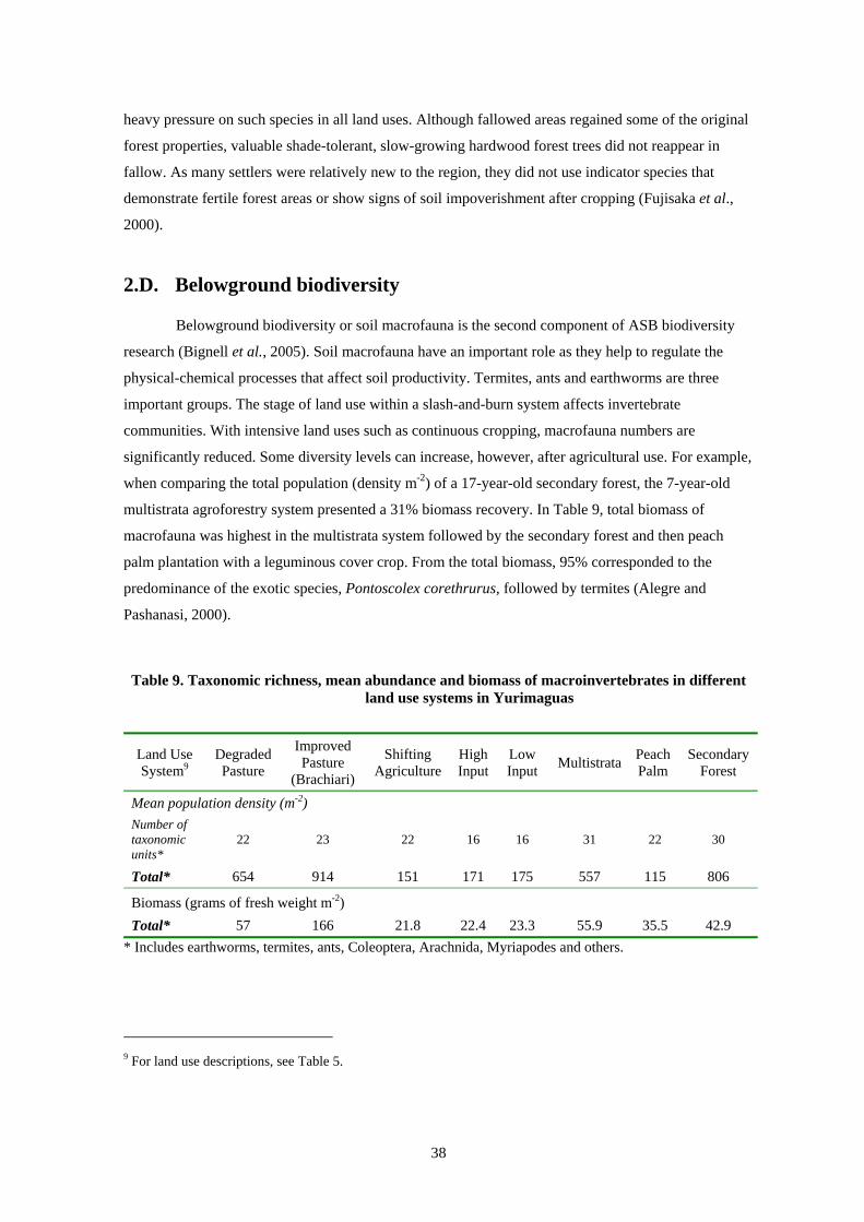
38
heavy pressure on such species in all land uses. Although fallowed areas regained some of the original
forest properties, valuable shade-tolerant, slow-growing hardwood forest trees did not reappear in
fallow. As many settlers were relatively new to the region, they did not use indicator species that
demonstrate fertile forest areas or show signs of soil impoverishment after cropping (Fujisaka et al.,
2000).
2.D. Belowground biodiversity
Belowground biodiversity or soil macrofauna is the second component of ASB biodiversity
research (Bignell et al., 2005). Soil macrofauna have an important role as they help to regulate the
physical-chemical processes that affect soil productivity. Termites, ants and earthworms are three
important groups. The stage of land use within a slash-and-burn system affects invertebrate
communities. With intensive land uses such as continuous cropping, macrofauna numbers are
significantly reduced. Some diversity levels can increase, however, after agricultural use. For example,
when comparing the total population (density m-2) of a 17-year-old secondary forest, the 7-year-old
multistrata agroforestry system presented a 31% biomass recovery. In Table 9, total biomass of
macrofauna was highest in the multistrata system followed by the secondary forest and then peach
palm plantation with a leguminous cover crop. From the total biomass, 95% corresponded to the
predominance of the exotic species, Pontoscolex corethrurus, followed by termites (Alegre and
Pashanasi, 2000).
Table 9. Taxonomic richness, mean abundance and biomass of macroinvertebrates in different land use systems in Yurimaguas
Land Use System9
Degraded Pasture
Improved Pasture
(Brachiari)
Shifting Agriculture
High Input
Low Input Multistrata Peach
Palm Secondary
Forest
Mean population density (m-2) Number of taxonomic units*
22 23 22 16 16 31 22 30
Total* 654 914 151 171 175 557 115 806
Biomass (grams of fresh weight m-2) Total* 57 166 21.8 22.4 23.3 55.9 35.5 42.9
* Includes earthworms, termites, ants, Coleoptera, Arachnida, Myriapodes and others.
9 For land use descriptions, see Table 5.

39
3. AGRONOMIC AND SILVICULTURAL SUSTAINABILITY Agronomic research in Peru was complemented by silvicultural research. The sustainable
cultivation of trees, in addition to crops, is an important economic and environmental goal. ASB
agronomic research was conducted primarily in the Yurimaguas benchmark site. Scientists used the six
land uses types as for the greenhouse gas emissions research described in section 2.B: 1) shifting
agriculture; 2) high input cropping; 3) low-input cropping; 4) multistrata agroforestry; 5) peach palm
plantation; 6) secondary forest fallow (Table 5).
3.A. Soil structure and biological activity
Soil biological, chemical, and physical properties along with nutrient balances are useful
indicators of agronomic sustainability. Soil physical properties were similar in all systems except for
high-input cropping (Table 10). Amendments of lime and fertilizers improved soil fertility in the high-
input system, but tillage worsened physical properties.
Table 10. Soil physical indicators of agronomic sustainability in Yurimaguas
Land Use Bulk
Density (gr/cm3)
Penetrometer Resistance (K Pascal)
Porosity (%)
Infiltration (cm/hr)
Water Stable Aggregates
(%)
Aggregate Mean
Diameter (mm)
Forest 1.25 10 52 45 19 0.49 Fallow 1.42 30 48 22 15 0.45 Multistrata 1.33 75 47 16 17 0.41 Plantation 1.35 65 46 15 15 0.46 Crop - low input 1.41 65 46 15 13 0.36 Crop - high input 1.51 280 39 2 5 0.15
Source: Alegre et al. (1999) and Alegre et al. (2001)
Soil biological properties in high-input cropping were lower than in all other systems as
reflected by lower soil organic matter, lower soil microbial biomass, lower mineralization (Figure 9),
and lower macrofaunal diversity (Figure 10) (Alegre et al., 1999; Alegre et al., 2001).
Nutrient balances were positive for the forest and fallow systems because there was little or no
nutrient export from crop harvest. Harvest in the other systems resulted in negative nutrient balances
but was offset to some degree by fertilization in the high-input cropping system, and nutrient pumping
and N-fixation in the agroforestry systems.

40
0
0.2
0.4
0.6
0.8
1
1.2
1.4
Fallow Multistrata Plantation Crop LI Crop HI
Frac
tion
of fo
rest
M icrobial CTotal CN mineralization
Figure 9. Soil carbon, microbial carbon and nitrogen mineralization of different land use systems in Yurimaguas
Source: Alegre et al. (1999) and Alegre et al. (2001)
30
22
31
1616
22
0
100
200
300
400
500
600
700
800
900
Forest Fallow Multistrata Plantation Crop LI Crop HI
Mac
rofa
unal
den
sity
(ind
/m2)
Mac
rofa
unal
bio
mas
s (gr
FW
*10/
m2)
. BiomassDensityTaxonomic units
Figure 10. Soil macrofauna of different land use systems in Yurimaguas
Source: Alegre et al. (1999) and Alegre et al. (2001)
Since there were no significant differences in nutrient content among fallow systems between
the sampling periods, the comparison for each nutrient was based on the mean of each nutrient of all
fallow systems before and after burning for each soil depth (Table 11). Most of the changes in soil
nutrients after the fallow phase and after burning and cropping occurred at the shallow depth at 0-5 cm

41
while at other depths no significant changes occurred. The exception was that potassium (K) levels
increased significantly after burning at 5-15 cm depth.
Organic carbon (OC) content and total N increased 24% after burning due to mineralization
accelerated by fire. Initial soil N increased from 1 to 2 mg kg-1 (100%) for all fallow systems with and
without the inclusion of legumes in the system. The differences are due to the higher amount of
biomass (fire wood and poles) removed from the systems. Consequently, a higher amount of N and
other nutrients are not being recycled into the soil.
Initial soil pH in water at 0-5 cm depth was 4.5 and there were no significant changes after
fallow or after burning for any of the fallow systems. Deeper soil pH fluctuated from 4.5 to 4.7 for all
fallow systems. No changes were detected during three years of fallow before and after burning. The
mean of the initial soil exchangeable aluminum at 0-5 cm depth for all treatments of 0.97 cmolc10 liter-1
declined by 57% (0.42 cmolc liter-1) after burning due to the ash. Additions of other exchangeable
cations included 71 kg-ha of calcium (Ca) and 20 kg-ha of magnesium (Mg). Aluminum saturation was
also reduced from 45% to 15% due to the same reasons as exchangeable acidity. Despite this, modified
Olsen phosphorus (P) was recycled in very low amounts in the ash with no more than 1 kg ha-1 of P
recycled. Tthe mean content of all treatments in the 0-5 cm depth was increased from 90 mg gr-1 to 20
mg gr-1. This was related mainly to the organic content in the soil that was released after burning and
accumulation through mychorriza during the 3-year fallow period (Ruiz, 1994).
The mean K for all fallows increased by 183% after burning at 0-5 cm depth and by 156% at
5-15 cm depth due to high amounts of K added in the ash, which was recycled from the biomass of the
burned material. Calcium content increased by 117% after burning while Mg increased by 100%.
These two cations were incorporated in the ash by a total mean for all fallows of 71 kg ha-1 of Ca and
20 kg ha-1 of Mg.
10 cmolc = cation exchange capacity.
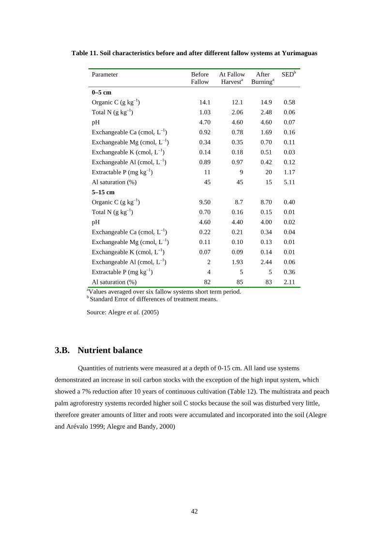
42
Table 11. Soil characteristics before and after different fallow systems at Yurimaguas
Parameter Before Fallow
At Fallow Harvesta
After Burninga
SEDb
0–5 cm Organic C (g kg–1) 14.1 12.1 14.9 0.58 Total N (g kg–1) 1.03 2.06 2.48 0.06 pH 4.70 4.60 4.60 0.07 Exchangeable Ca (cmolc L–1) 0.92 0.78 1.69 0.16 Exchangeable Mg (cmolc L–1) 0.34 0.35 0.70 0.11 Exchangeable K (cmolc L–1) 0.14 0.18 0.51 0.03 Exchangeable Al (cmolc L–1) 0.89 0.97 0.42 0.12 Extractable P (mg kg–1) 11 9 20 1.17 Al saturation (%) 45 45 15 5.11 5–15 cm Organic C (g kg–1) 9.50 8.7 8.70 0.40 Total N (g kg–1) 0.70 0.16 0.15 0.01 pH 4.60 4.40 4.00 0.02 Exchangeable Ca (cmolc L–1) 0.22 0.21 0.34 0.04 Exchangeable Mg (cmolc L–1) 0.11 0.10 0.13 0.01 Exchangeable K (cmolc L–1) 0.07 0.09 0.14 0.01 Exchangeable Al (cmolc L–1) 2 1.93 2.44 0.06 Extractable P (mg kg–1) 4 5 5 0.36 Al saturation (%) 82 85 83 2.11
aValues averaged over six fallow systems short term period. b Standard Error of differences of treatment means.
Source: Alegre et al. (2005)
3.B. Nutrient balance
Quantities of nutrients were measured at a depth of 0-15 cm. All land use systems
demonstrated an increase in soil carbon stocks with the exception of the high input system, which
showed a 7% reduction after 10 years of continuous cultivation (Table 12). The multistrata and peach
palm agroforestry systems recorded higher soil C stocks because the soil was disturbed very little,
therefore greater amounts of litter and roots were accumulated and incorporated into the soil (Alegre
and Arévalo 1999; Alegre and Bandy, 2000)
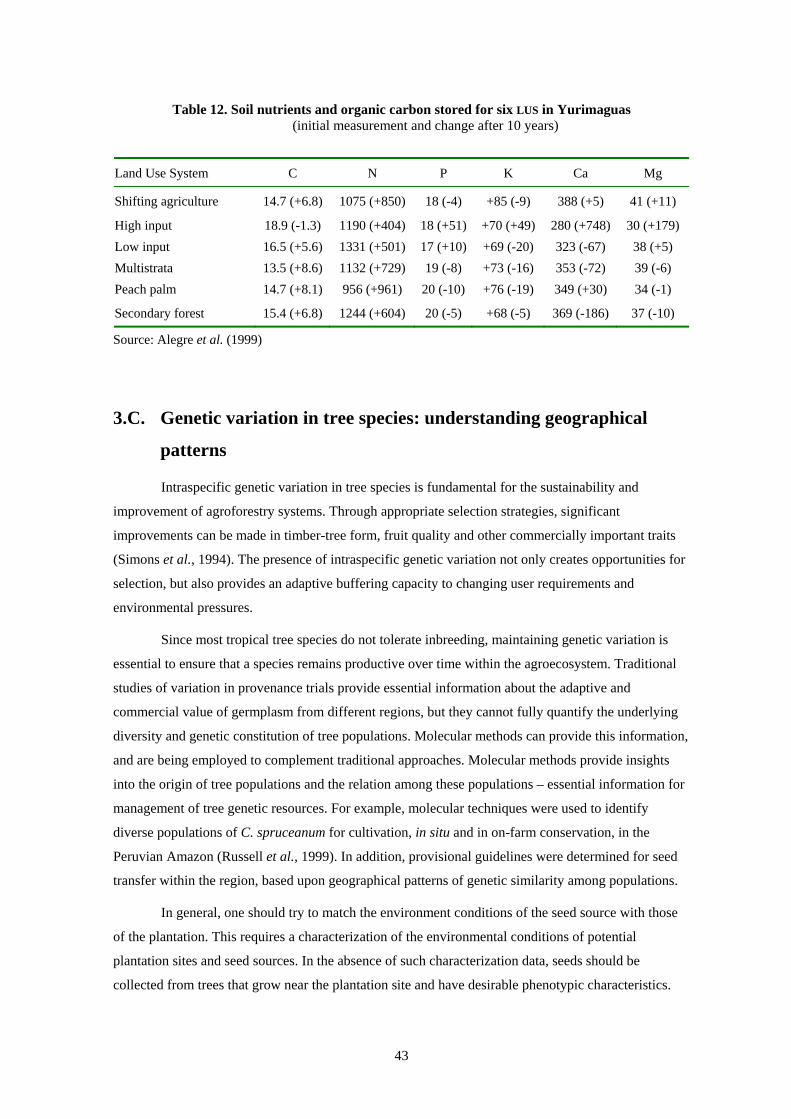
43
Table 12. Soil nutrients and organic carbon stored for six LUS in Yurimaguas (initial measurement and change after 10 years)
Land Use System C N P K Ca Mg
Shifting agriculture 14.7 (+6.8) 1075 (+850) 18 (-4) +85 (-9) 388 (+5) 41 (+11)
High input 18.9 (-1.3) 1190 (+404) 18 (+51) +70 (+49) 280 (+748) 30 (+179) Low input 16.5 (+5.6) 1331 (+501) 17 (+10) +69 (-20) 323 (-67) 38 (+5) Multistrata 13.5 (+8.6) 1132 (+729) 19 (-8) +73 (-16) 353 (-72) 39 (-6) Peach palm 14.7 (+8.1) 956 (+961) 20 (-10) +76 (-19) 349 (+30) 34 (-1)
Secondary forest 15.4 (+6.8) 1244 (+604) 20 (-5) +68 (-5) 369 (-186) 37 (-10)
Source: Alegre et al. (1999)
3.C. Genetic variation in tree species: understanding geographical
patterns
Intraspecific genetic variation in tree species is fundamental for the sustainability and
improvement of agroforestry systems. Through appropriate selection strategies, significant
improvements can be made in timber-tree form, fruit quality and other commercially important traits
(Simons et al., 1994). The presence of intraspecific genetic variation not only creates opportunities for
selection, but also provides an adaptive buffering capacity to changing user requirements and
environmental pressures.
Since most tropical tree species do not tolerate inbreeding, maintaining genetic variation is
essential to ensure that a species remains productive over time within the agroecosystem. Traditional
studies of variation in provenance trials provide essential information about the adaptive and
commercial value of germplasm from different regions, but they cannot fully quantify the underlying
diversity and genetic constitution of tree populations. Molecular methods can provide this information,
and are being employed to complement traditional approaches. Molecular methods provide insights
into the origin of tree populations and the relation among these populations – essential information for
management of tree genetic resources. For example, molecular techniques were used to identify
diverse populations of C. spruceanum for cultivation, in situ and in on-farm conservation, in the
Peruvian Amazon (Russell et al., 1999). In addition, provisional guidelines were determined for seed
transfer within the region, based upon geographical patterns of genetic similarity among populations.
In general, one should try to match the environment conditions of the seed source with those
of the plantation. This requires a characterization of the environmental conditions of potential
plantation sites and seed sources. In the absence of such characterization data, seeds should be
collected from trees that grow near the plantation site and have desirable phenotypic characteristics.
44
Using seeds from geographically distant regions should be avoided, unless there is evidence from
genetic trials that such seedlots are adapted to local environmental conditions.
The strategy for management and conservation of genetic variation within a species depends
upon its eco-geographical patterns of variation. Rather than investigate these patterns in all priority
tree species, it may be possible to deduce them from the species’ life history. Every species has a set of
life-history characteristics, such as pioneer versus late-successional habit, annual versus unpredictable
seed production, and short-distance versus long-distance seed dispersal. These characteristics partially
determine the patterns of genetic variation within and among populations of the species (Hamrick et
al., 1992). Species with similar life-history characteristics are more likely to have analogous eco-
geographical patterns of genetic variation. For example, species with short-distance seed dispersal tend
to have large genetic differences among populations, compared with species that disperse their seeds
over long distances. This is because there is little opportunity for the introduction of genes from
neighboring populations, so each population tends to evolve in relative isolation.
By understanding the variation patterns in certain “paradigm species,” we may be able to infer
the variation patterns in other species with similar life history characteristics. C. spruceanum, for
example, is a paradigm for pioneer species (with numerous, small, wind- and water-dispersed seeds) in
the floodplains of the Peruvian Amazon. Since its seeds are dispersed over long distances, there are
relatively small genetic differences among populations (Russell et al., 1999). In addition, there are
indications that genetic diversity accumulates below the confluence of large river tributaries, due to
downstream movement of seeds and the genes they contain. In this case, a few carefully-chosen
populations could be managed and conserved below the confluence of large tributaries, without a
serious loss of genetic diversity at the regional level. For species with short-distance seed dispersal,
and by inference large genetic differences among populations, a different strategy is needed. In this
case, a larger number of geographically distinct populations is needed to effectively conserve overall
diversity in the species.
Genetic management and conservation strategies can be developed for “paradigm species” in
an eco-region, and these strategies recommended as a “best bet” strategy for other species with similar
life-history characteristics. Recommendations should incorporate traditional approaches designed to
identify the most productive germplasm with the results of molecular analysis.

45
4. SMALLHOLDER FARMER CONTEXT In this section, a variety of measures are estimated that assess alternative LUS from a farmer
perspective. At issue is whether alternative LUS are financially attractive and if barriers to adoption
exist. Major economic concerns of smallholders include profitability, labor intensity, and food security
(Vosti and Witcover, 1996; Tomich et al., 1998a; Vosti et al., 2000) plus a range of other issues. For
example, institutional failures can also prevent technologies from being adopted. These contextual
factors include potential restrictions to land use change and equity biases that arise from market
failure, government policy and social customs.
Four matrices summarize factors that affect smallholder land use decisions and technology
adoption: profitability (Table 13); labor requirements, cash flow constraints and food security (Table
14); market institutions (Table 15); and non-market institutions such as social and governmental issues
(Table 16).
4.A. Financial profitability
Primary factors affecting the adoptability of a LUS include its relative profitability compared
to the current LUS and the feasibility of its adoption in terms of available farm land, labor, and capital
resources. The profitability matrix enables comparison of enterprise budgets, which contain numerous
financial measures (Monke and Pearson, 1989).11 Enterprise budgets organize information to facilitate
the calculation of financial return estimates of a LUS. Detailed information regarding both inputs and
outputs along with market prices form the basis of the enterprise budget. Since many of the LUS in
Peru are not consistent each year, a multi-year period of analysis is required. Hence, the establishment
and operation phases of perennial and pastures systems, for instance, can both be adequately
examined.
To estimate LUS profitability, the net present value (NPV) is calculated. The NPV is the
present discounted value of LUS revenues minus costs of purchased inputs (e.g., seeds, pesticides) and
labor inputs over a 20-year period.12 A 15% annual discount rate is used for the NPV calculations,
which reflects farmer preference for earlier income and is based on the opportunity cost of capital. The
multi-year analysis horizon takes account of changing input requirements and product outputs of a
LUS.
The profitability matrix also summarizes the financial returns to both land and labor for each
of the LUS. In more remote land-abundant areas, labor not land is typically the limiting input for

46
farmers (Boserup, 1965; Binswanger and McIntire, 1987; Theile, 1993). Particularly in forest margin
environments, returns to labor typically better represents the criteria that smallholder farmers use to
evaluate land use options (Collinson, 2000; White et al., 2005b). In addition to financial returns,
smallholder farmers often have concerns about the costs of establishing an alternative LUS. Large
capital investments, long delays in achieving positive cash flow, and substantial maintenance
requirements may place a system out of reach for many smallholders even if the returns are attractive.
Table 13 and Figure 11 summarize these measures for LUS found in the benchmark site.
The financial performance of Ucayali land use systems is varied both in terms of returns to
land and returns to labor. Despite the range of returns, systems typically have similar performance with
respect to both factors of land and labor. For the LUS studied, the land and labor returns are positively
correlated (0.90, R2 = 0.82), as can be seen in Figure 11. (Such results, however, are not generalizable
to all forest margins areas—see, for example, the return to labor and land for extractive activities
studied by ASB in Sumatra—(Tomich et al., 2001)).
Figure 11. Returns to labor and land of Ucayali LUS
11 The term financial refers to the private market of a profitability analysis, whereas economic analysis considers
societal issues such as externalities and welfare effects (Gittinger, 1982). While the ASB matrices of other countries use economic as well as financial prices, Peru has had few market distortions after 1990 (see section 1.A.3). Therefore the calculations presented here use only financial prices.
12 The rental prices of land are not included in the financial analysis. In land-abundant regions, land costs are typically low and difficult to determine.
$2
$3
$4
$5
$6
$7
-500 0 500 1000 1500 2000
Returns to land ($/ha)
Ret
urns
to la
bor (
$/w
orkd
ay)
Bolaina
Inga
Oil palm
Cocoa
Citrus system
Rice-yuca (long fallow)
Rice-yuca (short fallow)
Rice-plantain (long fallow)
Rice plantain (shortfallow)Improved fallows
Native pastures
Improved pasture
Riverine (floodplain)
Riverine (mudflats)
Wage rate =~US$2.86

47
Since two distinct land types are found in the Ucayali region, the analysis separates land uses
of upland and riverine areas. Agricultural production in riverine systems generates the highest returns
to land and labour: nearly double those of upland systems. Mudflats and floodplains have the highest
returns to land over the 20-year horizon (NPV US$1796 ha-1 and NPV US$1270, respectively). They
permit farmers to earn almost US$5 to US$7 workday-1, respectively.
Citrus (NPV US$810 ha-1) and cocoa systems (NPV US$643 ha-1) have the highest of returns
to land in the uplands. Returns of the citrus system come from both the sale of agricultural crops and
fruits. The short and long fallow systems and the oil palm perform similarly. Traditional and improved
pastures, as well as the multistrata Inga agroforestry system, have very low NPV returns to land (NPV
US$21 ha-1, US$-4 ha-1 and US$19 ha-1, respectively). Improved fallows has the lowest returns to land
(NPV US$-221 ha-1).
Systems at or below the average daily wage for unskilled labor, approximately US$2.86 (10
Peruvian soles), are unlikely to be attractive options for farmers. Almost all systems produce labor
returns greater than this market wage, with most in the US$3 to US$7 day-1 range.
Surprisingly, pasture systems produce some of the lowest returns to labor (and returns to
land). High investment costs, in terms of cattle13 and fencing, reduce the financial performance. Cattle
have a strong cultural significance in Peru as in many Latin American countries. The majority of
farmers in the Ucayali benchmark site hope to increase or start cattle production in the future (Labarta,
1998). Other systems that require initial investments, such as cocoa, oil palm and agroforestry systems,
generate returns to labor higher than the market wage with higher returns to land than pastures.
Nevertheless, short and long fallow slash-and-burn systems produce higher returns to labor than these
perennial systems. Citrus systems, however, demonstrate good returns to both land and labor, although
the price elasticity of demand for citrus may foreclose profitable production at a large scale unless
markets expand, either through exports (which may not be competitive internationally) or increases in
domestic demand driven by rising incomes. More research is needed to examine the viability of
expanding citrus production.
Farmers may not be able to afford the establishment costs of the perennial systems either in
terms of labor and material investments or waiting until the system produces its first year of positive
cash flow. Oil palm requires almost five years until earnings from the system are positive. Even short
and long fallow systems have negative cash flow (when imputed labour costs are included) earnings in
the first year since land preparation can be approximately US$53 ha-1.
13 A heifer, for example costs approximately US$450, and a weaned calf US$150.

48
Table 13. Profitability of land use systems matrix
Land Use System* Scale Returns to Land Returns to Labor Establishment Costs
Farm size: 30 ha LUS (ha)
NPV* private prices (US$ ha-1)
Wage to set NPV=0 Private prices
(US$ workday-1)
Labor and materials
(US$ ha-1)
Year of first positive cash
flow
Multistrata system 1 18-60 2.9 - 3.62 148-176 3 - 4
Oil palm 5-10 226 3.2 1272 4
Cocoa 1 644 3.34 4
Citrus 0.5 810 3.96 3
Long fallow 2 262 - 440 4.12 - 4.62 280-465 2
Short fallow 2 367 - 591 4.10-4.61 280-465 2
Improved fallows 1** (221) 4.5 112 3
Native pastures 1 – 60 22 3.33 2
Improved pasture 1 – 60 (4) 2.79 200 2
Riverine 1.7 - 4.5 1271 - 1796 4.89 – 6.74 53-148 1
* NPV: annual discount rate = 15%; time horizon: 20 years; **size of experimental plot. Sources: Alegre et al. (2005); Faminow (2001); Holmann (1999a,b); Labarta et al. (2005); White et al.
(2001); Yanggen (2003)
4.B. Labor requirements and household food security
Smallholder farmers cultivate a variety of crops in difficult agronomic conditions. Not only do
plant pests and diseases along with weather changes (e.g., lower rainfall during El Niño years)
potentially reduce harvests, but market price changes can also threaten the financial security of the
household. In extreme cases, the food security of smallholders can be put in jeopardy if the alternative
land uses produce insufficient earnings to purchase food. Hence smallholder farmers can be expected
to be, and prudently so, averse to the risks of adopting new technologies (Schultz 1964, Hazell and
Norton, 1986). As a result, farmers often employ a strategy of diversification with both on- and off-
farm activities to ensure food security (Ruthenberg, 1976).
Farm labor availability and household food needs also affect a farmer’s ability to adopt
alternative LUS. Table 14 summarizes these additional concerns, which include measures of total labor
requirements, the potential effects upon household access to food, along with production and/or price
risks. Farm household labor is measured in terms of workdays required for farm activities including
adjustments for the gender and age characteristics of the average farm household. For both the
establishment and production phases of multi-year LUS, the matrix includes information as to whether

49
a LUS provides the household additional food production (F), supplies additional income (US$), neither
(0) or both (B).
The labor inputs to establish perennial LUS are higher than traditional fallow systems. During
the establishment phase, annual crop production typically provides earnings that reduce establishment
costs. Operating labor requirements for oil palm are much higher than other systems. In contrast,
pasture systems are markedly lower. Pasture systems, however, do not address food security concerns
during the establishment phase. Most systems are subject to both production yield and market price
risks.
Table 14. Labor requirements and food entitlements of land use systems matrix (Ucayali)
Land Use System Labor Source of Food Security*
Scale (ha)
Establishment (days ha-1)
Operating (days ha-1
yr-1) Establishment During
operation
Risk#
Multistrata system 0.5 104-413 30-143 F B B Oil palm 5 118 684 F B B Cocoa 1 60 136 F B B Citrus system ~1 72 125 F B B Long fallow 2 21 53-67 B B B Short fallow 2 21 53-67 B B B Improved fallows 0.1 92 33-143 F B B Native pastures 50 4 8 0 $ P Improved pasture 20 18 6 0 $ P Riverine 1-5 16 74-100 B B B * additional food production (F); supplies additional income (US$); neither (0); both (B). # market price risk (M); production risk (P); or both (B). Source: Editors
4.C. Institutional issues
Institutions and infrastructure also affect the adoption potential of specific land use systems
relative to alternatives. Markets and communication infrastructure tend to be better developed in the
more densely populated portions of the benchmark site closer to the road and river network.
Agriculture is more commercially oriented in these regions. Lower transportation costs, in conjunction
with better infrastructure, result in smaller marketing margins. However, a major handicap for
producers across the benchmark site in areas of both well-developed and underdeveloped market
institutions is the near nonexistence of capital markets.

50
ASB scientists evaluated the institutional factors that inhibit change of land use systems. The
constraints were ranked on a simple scale: no constraint; possible constraint under certain conditions;
or a clear constraint. Ten market and non-market institutions were evaluated. Four of them concerned
the functioning of markets: input supply; output; labor; and capital. The remainder included
institutional issues: information requirements; regulatory issues; local environmental impacts; property
rights; equity biases; and social cooperation requirements. The LUS varied with regard to purchased
input intensity and thus adoption domains were likely to differ according to input market development
(Table 15).
4.C.1. Market institutions
4.C.1.a. Input supply markets In many traditional land use systems, chemical inputs (e.g., fertilizers, pesticides) are rarely used. At
the agricultural frontier, high transport costs increase their purchase price. Adding to the cost-
ineffectiveness is the relatively low value of production; therefore, the investment is not justified.
Similarly, input supply markets of improved genetic material often do not exist for agriculture,
agroforestry or cattle ranching activities. ICRAF research efforts have addressed this gap by improving
tree seed quality (see section 5.C.5); and CIAT research to improve pastures has resulted in mixed
success (see section 5.C.7). Farmers have demonstrated interest in CIAT research on new rice varieties
(Fujisaka et al., 1996; White et al., 2003). Farmers also identified plantains resistant to the black
sigatoka fungus as a research priority. Winrock International introduced new varieties (FHIA-21) but
taste characteristics and market prices were not deemed satisfactory by many farmers.
4.C.1.b. Output markets
Farmers typically acquire price information at markets or when products are sold to
intermediaries. Thin markets for many agricultural products often cause severe price declines during
harvest months. Market prices for many agricultural crops are low and unstable (Figure 12).
Government support for product markets ranges from no attention to minor subsidized purchases.
National and international markets increasingly dictate prices (see section 1.A.1). While most
agricultural and tree products receive no support, political pressure can cause temporary lapses in a
laissez-faire policy. For example, in 2001 the Peruvian government agreed to purchase oil palm
production above the international price to protect local producers. Similarly in 1999, the government
purchased large quantities of rice in response to a bumper harvest. This policy was in reaction to the
unforeseen effect of a previous government policy that encouraged rice production by providing
farmers financial support. How a free-trade agreement will affect Peruvian production and
competitiveness remains unknown.

51
$/kg0.00 1.00 2.00 3.00 4.00 5.00 6.00 7.00
Plantain
Cassava
Maize
Cocona
Rice
Orange
Lemon
Pijuayo
Watermelon
Pineapple
Cocoa
Pepper
Figure 12. Market prices for agricultural crops, 1997-2000 (monthly average and standard deviation)
4.C.1.c. Labor markets Unemployment is a central challenge to development at the national level in Peru. Unemployment
rates of 20% are estimated for both rural and urban sectors, and underemployment levels are much
higher. Despite this, rural labor markets do not appear to meet seasonal labor demands effectively
because of inadequate transportation and communication infrastructure. As a result, the nuclear and
extended family typically tends to farm activities. Also of interest is that although labor demands
markedly increase during certain agricultural activities (e.g., land preparation, harvest), wages do not
appear to adjust (White et al., 2005b). See section 5.D.2.
4.C.1.d. Capital markets Liquidity problems restrict farm activities and the adoption of many technologies. In the 1990s, most
public agricultural credit projects were canceled. Private bank credit is rarely available in rural areas,
and when offered, the interest rates are often very high. This lack of formal sector credit has reduced
expansion of agricultural activity (Yanggen, 2000) because many agricultural investments are
financially infeasible (see section 5). To cope with this situation, farmers often obtain credit from
informal sources (e.g., relatives, local moneylenders). In addition, some NGOs often offer funds or
financing for special projects. For example, considerable government support has been given to
smallholder production of oil palm (see section 5.C.4) and sustainable timber production (see section

52
5.C.1). Cotton has received private sector support with technical training and contract farming
arrangements that guarantee the purchase price.
Table 15. Market institutions matrix
Aggregate Assessment
Land Use System Input Supply Markets Output Markets Labor Markets Capital Markets
Residual forest ◐ ◐
Forest extraction ◐ ◐
Multistrata system ◐ ◐ ◐
Oil palm ◐ ◐
Cocoa ◐ ◐ ◐ ◐
Citrus ◐
Slash-and-burn (long fallow) ◐
Bush fallow (short fallow) ◐
Improved fallows ◐
Native pasture* ◐
Improved pasture* ◐ ◐
Riverine ◐ ◐ ◐
- no constraint, ◐ - possible constraint, - constraint
* - for meat and milk Source: Editors
4.C.2. Other institutional issues Government policies and programmes and social issues can also impede or facilitate the
adoption of alternative LUS. For instance, the regulatory environment may or may not be conducive to
production or marketing of farm outputs. Legal matters, paperwork and “red-tape” can create
formidable transactions costs that undermine incentives for production and investment. Local
environmental externalities, property rights, equity and social cooperation considerations can also be
important to smallholders and their ability to adopt new LUS. These institutional issues are summarized
in Vosti et al. (2000) (ASB Socio-economic Working Group Report).

53
4.C.2.a. Non-market information Farmers in the benchmark site obtain information from the national government (Ministry of
Agriculture, INIA) and national/international NGOs (e.g., Pronaturaleza, Winrock International,
CARE, CIAT, CODESU, IPGRI, ICRAF) and the private sector. In particular, private firms are slowly
increasing technical support, especially for cotton.
A government change in 2000 has led to the reorganization of INIEA. Salaries were increased,
thereby improving work incentives for scientific personnel. Nevertheless, farmers still have little
access to modern improved agricultural technologies. Peru faces both inadequate funding and
inadequate policies of the national government and donor agencies, much like most developing
countries (Sachs, 2001). Extension agents often have cursory training and few resources with which to
work. Sometimes extensionists are used for political purposes. During the Fujimori government, the
extension service was in effect a propaganda force.
The extension service is housed in the Ministry of Agriculture outside the National
Agricultural Research and Extension Institute, INIEA (formerly INIA). Extensionists work within the
local and regional agricultural agencies of the Ministry of Agriculture (INIA, 2003). INIEA extension
activities are done mainly through the Seed Reproduction and Plant program and a network of
Technical Assistance Providers (PATs). While INIEA and the Ministry of Agriculture do coordinate
efforts, the separation does cause difficulties. In 2003, INIA was commanded to conduct extension
activities, however, until 2004, this new function was not allocated any additional budget, and
currently it is being accomplished through the research budget.
Mirroring the political turbulence during and after the Fujimori administration, INIA suffered
substantial changes that created institutional instability. Despite considerable difficulties in carrying
out research activities during the 1990s due to lack of resources, many scientists managed to continue
with a number of experimental activities, especially in forest plantations and agroforestry systems. An
enormous amount of raw data was produced. In order to convert this information into coherent and
reliable conclusions, considerable effort and resources are required. Political instability also affects the
attitude of professionals regarding proper recognition of their work. Consequently, secretive handling
of research findings jeopardizes effective teamwork and reduces technology diffusion and the
possibility of enriching other research activities.
Knowledge gaps and diffusion have been most critical for the oil palm and cocoa systems,
as the production potential of these crops is rarely reached (for details of recent cocoa management
improvements see section 5.C.2). Besides formal government agencies, local farmer groups, farmer
federations, and grassroots NGOs throughout Peru offer an additional avenue for exchanging
knowledge generated by agricultural research and rural development. For more on local organizations
see section 1.A.3.

54
4.C.2.b. Regulatory issues The harvesting of common property resources such as timber is often restricted by
government regulation. Yet the efficacy of regulations is mixed at best. Incomplete implementation of
management controls (e.g., few checkpoints, payoffs, and corruption) facilitates illegal activity.
Commercial control rights to timber belong to the state with the exception of timber cut for the
landholder’s own use. Harvesting is permitted if authorization is obtained, otherwise the activity is
considered illegal and the timber could be seized. For more on timber industry regulation, see section
5.A.1.
4.C.2.c. Local environmental issues
The relative flatness of much of the Amazon landscape does not lead to widespread soil
erosion problems. Since chemical inputs are not extensively used for agricultural purposes,
contamination of water resources is minimal. Rudimentary sanitation in rural areas and water-borne
diseases, however, often cause diarrhea and malaria. As mentioned at the end of section 2, further
work is needed to assess how extensive LUS can affect landscape biodiversity and watershed functions.
4.C.2.d. Property rights Forest land belongs to the state. Concessions are often given to mineral and timber
companies to extract the natural resources. For smallholder farmers, in most cases, land tenure at the
forest margins is ill defined. Acquisition of land rights differs according to the location of the land and
proposed owner. While few upland and permanent riverine smallholder farmers have full formal title
to their land, certificates of possession typically provide an acceptable level of security. In contrast,
riverine mudflats and beaches for temporary production are not privately held. Rather, the Ministry of
Agriculture gives permission to farmer groups on an annual basis (Labarta et al., 2005). Indigenous
communities often receive assistance from NGOs and the government to delineate their lands and to
protect their legal rights (Webber, 2003). (See section 1.A.1 for details on indigenous versus settler
conflicts.) In high population urban areas such as Pucallpa, land disputes are increasingly common.
Squatters often claim possession of undeveloped land.
4.C.2.e. Equity biases
The Peruvian Amazon has a long history of inequitable distribution of wealth. Large-scale
harvesting of timber is one of the more visible inequities. Although some small and local producers do
cut and process timber, the majority of value-added processing is done by large operations that pay
low wages. Wealth rarely remains in the Amazon region and is typically transferred to Lima. In
addition, indigenous communities have naively sold harvesting rights at undervalued prices to
outsiders (Raez-Luna et al., 1998; Webber, 2002).
Cattle production is another case of inequitable distribution of benefits stemming from
government policy of years past (see section 1.A.1). Early ranches were the result of relatively large
distributions of land. Such land has close access to transportation links and typically belongs to

55
absentee owners. While pastures and many improved technologies are scale neutral (small and large
farmers can both adopt them), there is often a bias towards large ranches if agricultural credit projects
do not include small farmers. In contrast, a bias against small-scale production does not appear to be a
problem with most agricultural crops. Government policies and international projects have supported
the cost of establishing perennials, especially oil palm.
Despite specific policies intending to improve the situation of resource-poor smallholder
farmers, national government and international agencies have had mixed success. Evidence of farmer
dissatisfaction includes numerous public demonstrations. For nearly a week in 2001, smallholder
farmers who produce coca in the Aguaytía blocked the Pucallpa-Lima road to traffic. Farmers
demanded that the alternatives-to-coca production projects provide subsidies so that the promoted
agricultural crops become financially viable. In 2002, farmers again revolted in response to ineffective
development programs by burning the office and vehicle of an NGO.
Smallholder farmers’ concerns often are valid. Some development projects may place
economic growth objectives before poverty alleviation. For instance in 2002, USAID promoted bean
production in the riverine mudflats. Technical and marketing assistance was given to private
companies, sometimes from Lima, while local farmers were paid daily wages to perform agricultural
tasks.
4.C.2.f. Social cooperation
The adoption of many land use systems can be facilitated by social cooperation. Marketing
and producer organizations provide farmers with a forum to share experiences and access information.
Cooperation can also be less formal. For instance, many farmers involved in a CIAT participatory
research project shared improved rice seeds with neighbors (White et al., 2003). Nevertheless, a lack
of cooperation is common, and conflict and theft of harvests and cattle are not uncommon. In addition,
some land uses have negative externalities, which affect neighboring farmers. For example,
uncontrolled fires can damage infrastructure and crop investments of farmers (see section 5.A.2.).
In a DEPAM-sponsored research project (5.B.1), social cooperation was mixed. Separately,
nine villages installed trials of new varieties of a potentially sigatoka-resistant plantain variety
following their own methods of testing. One village preferred a single, large, communally-managed
trial, while the remainder chose to spread their resources across many farms, as a response to diversity
in conditions and a lack of trust in communal activities. Nevertheless, within most villages, there was
enthusiasm to share and compare results (Holland, 1999).
From the point of view of 26 families interviewed in San Alejandro y Nueva Requena, the
greatest needs are for accessible credit, secure markets and better prices for their products. The next
most important priorities include the mechanization of production systems, improved transport and
product processing. While social cooperation among farmers, government and grass-roots
organizations can improve these factors, the main barriers to cooperation are a lack of trust between

56
farmers and their organizations. Insufficient organization within the farmers’ groups is also a barrier.
Some of the root causes of these conditions are inadequate transparency and coordination between
organizations (public, research, private), a lack of information within farmers’ groups (Lehrer et al.,
2003) and a lack of tangible benefits compared to transaction costs.
Table 16. Social and government institutions matrix
Aggregate Assessment
Land Use System Non-market Information
Regulatory Issues
Local Environmental
Impact
Property Rights
Equity Biases
Social Cooperation
Residual forest ◐ ◐ ◐ ◐
Forest extraction ◐ ◐ ◐ ◐ ◐
Multistrata system ◐
Oil palm ◐
Cocoa ◐ ◐
Citrus ◐ ◐
Slash-and-burn ◐ ◐
Bush fallow ◐ ◐ ◐
Improved fallows ◐ ◐
Native pastures ◐
Improved pasture ◐ ◐ ◐ ◐
Riverine ◐ ◐ ◐ - no constraint, ◐ - possible or moderate constraint, - constraint.
Note: Since erosion is not a major problem, we assumed that the environmental impacts were moderate. Source: Editors
57
5. INTERVENTIONS, IMPACTS AND TRADEOFFS
5.A. Government policies and projects
5.A.1. Timber Forest legislation has changed often in Peru (Rios Torres, 2003). The former forestry law
(D.L. N° 21147) valid from 1975 to 2000, considered forests to be owned by the State. Harvesting
rights were provided to individuals through permits, authorizations and contracts. Private land rights
were available for agriculture and pastures, but not for the production of forest products (Smith et al.,
2001).
The two types of contracts available to harvest timber generated a confusing regulatory
structure. Small contracts referred to areas less than 1000 ha; large contracts concerned areas more
than 1000 ha. Small contracts were supposed to benefit small loggers by not requiring either a
technical or an economic feasibility study. Because of this cost-saving loophole, large commercial
operations made thousands of applications in addition to those of the intended small-scale
beneficiaries. Such contracts prevented administrative control and contributed to illegal logging. The
presence of a less-restricted method of harvesting timber created incentives for large-scale operations
to subcontract smaller activities and take advantage of their lower cost structure. Subcontracts
typically included labor opportunities or capital assistance for chainsaws and tractors (Hidalgo, 2003).
This dual structure also hampered efforts to regulate timber harvests. The required documentation of
wood products could be easily manipulated. Forest inhabitants faced other regulations. Bans and
licenses were required for the commercial hunting of game animals. Few abided by the formal rules
especially since obtaining licenses was a time-consuming process (Smith et al., 2001).
To limit the harmful effects of timber exploitation, the Peruvian government developed a
series of policies. These policies came in the form of taxes and two types of harvest controls: species-
specific and geography-specific. During the 1990s, frequent policy changes reduced incentives for
compliance. For example, a moratorium on new timber exploitation contracts was enacted in 1992. In
1995, the reforestation tax was increased on timber extractors in the formal sector. Informal or illegal
operators were therefore not affected. In 1996, while a compliance review of management plans was
conducted, the Peruvian government introduced a temporary ban on logging in various regions of the
country. Soon after, the export of rough-sawn mahogany and cedar was no longer permitted. The
transport of logs was also prohibited along three major rivers bordering Brazil, Bolivia and Colombia
(Chirinos and Ruiz, 2003). Nevertheless, many unrecorded truckloads and rafts of logs were
transported within Peru on a daily basis.
For many years, forestry investors have been disappointed with inconsistent progress on the
development of new forestry legislation. Such confusion has hampered financial investments in the
58
sector. In addition, constant changes of personnel in the government forestry organization have
weakened the functioning of the sector. After many years of discussion, the new Forestry and Wildlife
Law (N° 27308) was approved in July 2000. The Ministry of Agriculture began its implementation in
2002. The law introduces a group of basic concepts for sustainable forestry management. Concession
holders are required to concentrate activities in certain areas and to use management practices that
permit timber harvests. Concessions for up to 40 years, in the first instance, are renewable. Incentives
for sustainable forest management include a 25% reduction on tariffs on concession rights. Criteria to
qualify for these incentives include a) forest certification, and b) the implementation of integrated
projects for harvesting, processing, and manufacture of value-added products.
The new law also enables concession holders to use their holdings as collateral to obtain
credit. There are two types of concession: small, 5000 to 10,000 ha; and large, 10,000 to 40,000 ha
(Ríos Torres, 2003b). For both, application requirements include general administrative information of
the person/company and a technical and economic proposal. By May 2004, more than 7 million ha
were under concession in Ucayali, Madre de Dios, San Martin, Loreto and Huánuco. So far, in the
Ucayali region alone, 2.84 million ha of concession have been granted but none in Yurimaguas or Alto
Amazonas (INRENA, 2005).
In addition to permits for timber, the law stipulates regulations for harvesting non-timber
products on community property, forest plantations and secondary forests. Sustainable wildlife
harvesting for commercial purposes is to take place in animal breeding farms and wildlife management
areas. Several different types of hunting practice are also defined and permitted under certain
conditions (Ríos Torres, 2003b).
Within this legal framework, forest certification is a voluntary procedure that enables timber
to be sold at a premium price in international markets. In 2002, the Forest Stewardship Council
approved the standards developed by the CP-CFV (Peruvian Council of Forest Certification) for
Amazon forests (Hidalgo, 2003). The new law, however, states that starting in 2006 only products
from managed forests14 can be marketed (both internally and internationally). But, national legislation
could still change or be modified to accommodate unforeseen delays in implementation (A. Guerrero,
personal communication).
Currently, management of the forestry sector is shared among various institutes and at
different levels, including the private sector. The Ministry of Agriculture is in charge of policy and
regulative functions. INRENA has executive, technical and administrative functions, including the
granting of forest concessions. OSINFOR (Supervising Agency for Woody Forest Resources)
monitors the compliance with forest management plans. This agency was recently created and merged
with INRENA. CONAFOR (Consejo Nacional Consultivo de Política Forestal) contributes to defining
14 This was derived from “ITTO 2000 objective”: By 2000, all tropical timber entering international trade come
from sustainably managed sources. This was not achieved by any party.

59
the national forestry policy and to strengthening civil participation, together with forest management
committees. These statutory bodies, however, have yet to be created. Incomplete implementation of
the new law has led to widespread criticism in both public and private sectors (Caillaux, 2004; A.
Guerrero, personal communication).
Lack of an integrated national forestry information system contributes to a chronic under-
valuation of forestry activity within the national economy. Currently, INRENA processes some
statistical information through the CIEF project (Centro de Información Estratégico Forestal - Center
of Strategic Forestry Information) but data entry and analysis is typically two years behind schedule
(Rios, 2001).
Regional governments will be authorized to grant forest concessions when the ongoing
decentralization process is fully implemented. The extent that the decentralization of forest
management authority will affect illegal logging is unknown. Decentralization may shift rent-seeking
opportunities from the central governmental to more disparate and localized sets of actors, with
implications for regulatory, monitoring, and interdiction policies and procedures (Auer et al., 2003).
Civil society, including NGOs and the private sector, are actively participating in discussions
regarding implementation of the forestry law. Fora include forest management committees and
Forestry Dialogue Roundtables (Mesas de Concertación Forestal). Management committees may
pertain to specific regions. The San Alejandro watershed (Ucayali), for example, was formed through
the initiative of local government. ICRAF Peru, INIA and WWF have also been active members since
its formation in 2003.
The Forestry Dialogue Roundtables in the different regions have played an important role in
the implementation of the new concessions, particularly in Ucayali, Madre de Diós, San Martín and
Huánuco. Despite the negative factors mentioned above, most of the concession holders retain a
positive attitude towards the new legislation. To work in a more efficient manner, some concession
holders are forming a consortium. Others are exporting and still others are applying for new
concession areas. Organizations such as FONDEBOSQUE and NGOs such as Pronaturaleza and
WWF-Perú have given economic and technical support to small concession holders (Hidalgo, 2003).
In addition, CEDEFOR (Centro de Desarrollo Forestal), a WWF project financed by USAID, has
helped to build capacity within Peru’s forestry sector in order to ensure forest conservation and
sustainable forest management. WWF field teams provide technical support in the development of
sustainable forest management plans and building capacity in business management skills. This effort
includes the promotion of forest exploitation, industrialization and marketing of lesser known forestry
species (Anon, 2003). INIA has also assumed a more active role in forestry research in order to
support the process.
A key element for the future of the new forest concession model is the political will to
continue with its implementation. It is important that the government maintains a consistent position,

60
in order to provide confidence, security and stability to the forestry investments, which by their nature
are long term (Hidalgo, 2003). Although the new forestry law addresses many weaknesses inherent in
previous laws, the forest concession model and its implementation can nevertheless benefit from
further review and improvement.
5.A.2. Roads Road access is an underlying cause of deforestation throughout the Amazon (Pfaff, 1996;
Imbernon, 1999). Although the construction of a road connecting Pucallpa to Brazil has been
discussed for decades, authorities have recently selected other routes to connect the Atlantic and
Pacific Oceans.
Brazilian President, Luiz Inácio Lula da Silva, signed a memorandum of understanding
entitled Physical and Economic Integration of Peru and Brazil during a visit to Peru in August 2003.
The agreement has important implications for the Amazon region. Under the agreement, Peru can
present proposals to BNDES (Brazilian National Bank for Economic and Social Development) and
CAF (Andean Development Corporation) to finance the paving of two key Amazonian roads
(Tarapoto-Yurimaguas and Iñapari-Puente Inambari). The port of Yurimaguas would become of much
greater prominence. The new road would complement the recent improvements of the Tarapoto road to
the Peruvian ports of Paita and Bayovar on the Pacific. The project will create another major road link
to the heart of the Peruvian Amazon.
Improvement of the Iñapari-Puente Inambari road to the south in Madre de Dios region,
together with the Brazilian construction of a road bridge over the River Acre, would create the first
direct road link between the two countries. The road would connect the Brazilian states of Rondonia
and Acre with the Peruvian ports of Matarani and Ilo.
The completion of these projects will have important, if unpredictable, implications for the
agricultural and forest development of the western Amazon. The efforts will take place in the context
of a recently-signed free trade agreement between Peru and the MERCOSUR (Southern Common
Market) countries. Peruvian government sources highlight the possibility of increased food exports to
the Brazilian Amazon city of Manaus. In addition, since the Brazilian state of Amazonas and the entire
River Madeira watershed have acid soils, the sale of phosphates from Bayovar, Peru may increase (El
Comercio, 2003). Whether cheaper rock phosphate would lead to more or less deforestation is
unknown. Meanwhile, in the south, the new international road will affect the landscape Madre de Dios,
currently the most rural and least developed region of Peru.
5.A.3. Coca The high price of coca has changed both the political and natural landscape of Peru. A leaf
with great cultural significance, coca has been used since before Incan times. Its cultivation for illicit
production of cocaine is a recent phenomenon. Illegal production in the Amazon has undermined parts
of Peruvian society as wealth enables the influencing of government officials – local and national.

61
Many lower-level officials, numerous high-ranking national civil servants and some military personnel
have been charged with drug-related crimes. Approximately 60% of the nation’s coca-growing area is
concentrated in the Huallaga Valley of San Martín and Huánuco and in the nearby Aguaytía watershed
of Ucayali. Between 1994 and 1996, the total area under coca was greater than the total area of
plantain and banana (INEI, 1995b; USAID/US Embassy, 1997).
Coca production has encouraged deforestation. As aerial eradication efforts increased, coca
fields became smaller and in more remote areas to avoid detection. Chemical sprays used in the
eradication of coca are known to affect the productivity of agricultural crops for many years. As a
result, some farmers have been forced to migrate to new areas, again encouraging deforestation.
As recently as 1995, Peru was the world's number one coca-producing country. Cultivation in
Peru jumped from 35,000 ha in 1980 to 129,100 ha in 1992. Expansion first began to decline in 1993
when prices dropped by 50%. Starting in 1995, the cultivation trend began a 4-year decline to 38,000
ha until the end of 1999 (Figure 13). Price and production decreases were attributable to an array of
factors, including the disintegration of the Colombia drug cartels, the expansion of coca leaf
production in Colombia, and the intensive and sustained law enforcement program mounted by the
Peruvian military and police (UNODC, 2003).
Figure 13. Coca leaf production and price in Peru
The coca price and production trends changed again in 2000 when Peru changed government
administrations. National and international officials have again expressed concern that a steady price
recovery of coca leaf, from less than US$1 kg-1 in 1996 to US$2.5 kg-1 in 2002 will entice farmers
back into coca production. Police officials complain that the recent political turmoil in Lima has
interrupted the financing for their eradication and interdiction efforts (Krauss, 2001). Because of these
factors, coca production started to increase again. The resurgence of coca occurred just as the prices of
various legal crops like maize, cocoa and coffee plunged. For many smallholder farmers, coca
0
20
40
60
80
100
120
140
1980 1982 1984 1986 1988 1990 1992 1994 1996 1998 2000 2002Year
hect
ares
(x10
00) .
0
0.5
1
1.5
2
2.5
3
$/kg
dry
leaf
.
haprice

62
production is not only relatively more attractive once again but often a choice of economic survival.
Farmer frustration with ineffective alternative-to-coca development projects has led to rebellions (see
section 4.C.2.f).
Coca has led to different patterns of human migration. Jobless and landless peasants from the
highlands continue to migrate to coca-producing regions. They seek economic opportunities by
opening new areas in the forest. In the Ucayali, numerous newer settlers have left conflictive coca
production areas in search of safer areas. Ironically, government road programs have provided access,
some of which were explicitly intended to spur legal development and facilitate alternative crops to
markets (Krauss, 2001). Coca earnings have subsidized new legal agricultural activities such as
investments in extra farm labor or cattle (White et al., 2003).
5.A.4. Agricultural credit Agricultural credit can have unintended effects. The availability of money can distort markets,
the economy, and have environmental implications. For example, the provision of credit in the
Peruvian Amazon during the 1980s enabled farmers to purchase labor so that more forest could be
cleared for agricultural production (Coomes, 1996; Yanggen, 1999; Spoor, 2002). Credit was so
enticing that urban dwellers sometimes acquired land in order to be able to receive the government
benefit. In the northern regions of the Peruvian Amazon, demand for land and titles caused conflicts
between actual inhabitants of supposedly vacant land and the urban dwellers that were able persuade
government officials to provide legal documents (Coomes, 1996).
5.B. Institutional capacity building
5.B.1. Participatory research DEPAM was an entry point in a long-term strategy to facilitate the institutionalization of
collaborative and participatory research approaches among national and international centers. Nearly
50 researchers from 13 institutes have collaborated in 11 interdisciplinary and participatory research
projects, testing innovative technology options jointly with farmers. The project objective was to
create a collaborative team of researchers from national and international institutes who jointly plan
and carry out participatory agricultural research projects that are demand driven.
Priorities areas for research and a workplan were developed for the DEPAM team by the
stakeholders during a 3-day PPO workshop in 1998 (1.A.4). A Stakeholder Committee of farmers and
farmer organization representatives continued the process of priority setting to monitor research and
adoption of the outputs. An Advisory Committee, comprised of representatives of organizations that
participate in the DEPAM team, provided technical advice and also monitored the project advances.
CODESU provided administrative support, and CIAT, technical support, in the areas of agronomy and
63
participatory research training. Small research grants were used as an incentive for institutes to work
together in a farmer participatory approach. These projects were entitled:
• Botanical Origins of Honey from Secondary Forests
• Fish Culture Integrated with Agricultural Development
• Production Systems Involving Management of Secondary Forest Species
• Secondary Forest as a Component of the Economy of Small- and Medium-sized Farms
• Participatory Evaluation of Rice and Banana Varieties on Smallholder Farms
• Participatory Research in Management of Maize Variety Marginal-28
• Farm-level Economic Evaluation of Crops in Ucayali Agricultural Systems
• Participatory Evaluation of Soil Management in Smallholder Farms in Ucayali
• Soil Conservation with Agroforestry Systems in the Alexander Von Humboldt Zone
• Biocidal Plants in Ucayali Region
• Participatory Evaluation of Market Options for Amazonian Products
Research teams reported the following benefits from working in a participatory fashion in the projects:
• Better interactions between the researcher and the farmer
• Adoption of results of research is faster, unlike in traditional research
• The approach takes advantage of the knowledge of farmers about their own conditions, environment, and production technologies
• The farmers identify their problems and intervene with their own solutions
• Institutional strengths are better used
• Farmers and their families participate more actively
Nevertheless, discussions with researchers involved in DEPAM in Pucallpa found that
institutional policies, structures, and freedom often present a barrier to researchers’ abilities to respond
flexibly to the needs of farmers and of other institutes. DEPAM also sought to facilitate and
institutionalize inter-institutional collaboration amongst research and development organizations
working in the Ucayali. Such collaboration has been elusive. Although by design each project was
proposed by sets of partners, respective “lead” institutes have largely conducted the work. Long
standing inter-institutional competition and reliance upon independent log-frame planning has
hindered collaboration of both national and international organizations.
Instability of research and development institutes has caused many capacity building efforts to
be less than optimal. Researchers and administrators in Pucallpa continually rotated in and out of
positions and organizations. To illustrate, the half-life of researchers involved DEPAM was
approximately 10 months. Changing donor interests have also exacerbated institutional instability.
Participatory and multi-institutional research will likely remain a fringe activity until it is
understood and integrated as a valued approach into organizational structures and log-frames. For
example, one prominent researcher declared that participatory research was good, but should be
64
maintained as a separate institutional activity. To address these challenges, researchers developed a
working group to discuss their work, share experiences and develop projects.
5.B.2. Agro-enterprise development Despite an emerging wealth of publications about potential new market opportunities for
Amazonian fruit and forest products (Clay and Clement, 1993; Toledo, 1994), few production and
marketing efforts have been successful. For example in the mid 1990s, citrus and achiote (Bixa
orellana) turned out to be commercial export failures in Ucayali. Despite not reaching larger national
markets, farmers in the Aguaytía watershed continue to sell citrus at low prices in the city, their only
viable market.
CIAT, CODESU and the International Development Research Centre of Canada (IDRC)
formed a rural enterprise development project in 1998 as part of DEPAM. The steering committee
included another six institutes: the regional government (Consejo Transitorio de Administración de la
Región Ucayali – CTARU), the Ministry of Agriculture (Dirección Regional de Agricultura- Ucayali),
ICRAF, the local Chamber of Commerce (Cámara de Industria y Comercio de Ucayali), Asociación de
Mujeres Campesinas de Ucayali (AMUCAU), and a producer group from Campo Verde. The objective
of the project was to develop new market opportunities with the participation of farmers and local
organizations. Improvement to the post-harvest stage of Amazon products was the focus of the project
with processing, transformation and commercialization activities. For details on project activities see
section 5.C.11
The agro-enterprise project of DEPAM (section 5.B.2) was formulated in order to overcome
marketing constraints that have restricted the sale of Amazonian products. The project consisted of
three main efforts; each of them was conducted with the participation of rural producers. First, a
qualitative evaluation of producer organizations reviewed the organizational capacity to develop and
sustain projects. Second, an identification and evaluation of market opportunities focused on both new
and traditional products. The participatory evaluation of new crops included aguaje, barbasco, camu
camu, castaña, cocona, copuazú, palmito de Pijuayo, and uña de gato. Non-traditional crops included
14 products: cotton, bolaina, carambola, guanábana, pineapple, cocoa, black pepper, oil palm, beans,
Valencia oranges, plantain, peanut, lemons and cassava. Three points of view were used for the
evaluations: agronomic (climate, soil, rainfall, fertility), commercialization (market locations, prices
and price trends, quality control requirements) and economic (investments required, costs,
profitability).
To address the diversity of production systems in the Ucayali, four types of producers
reviewed the options: native and colonist riverine farmers along the Ucayali; colonist bush fallow
farmers in San Alejandro; and slash-and-burn farmers in the Campo Verde area. Product selection
generally depended upon location. Upland farmers most preferred cocona, and riverine farmers chose
camu-camu. Prioritized traditional products were pepper, cotton, cassava, bolaina, pineapple, plantain,

65
cocoa, peanut, orange, dry beans. Of the new product portfolio, no marked general preference was
evident. Rejected options included oil palm, limes, carambola and guanábana. While the first two
rejected products may be surprising since they have received much support in the Ucayali region,
farmers may be demonstrating an interest in new options. To start the process, black pepper was
chosen in consideration of organizational interest, potential profitability and market demand
(Valdivieso, 2001).
5.B.2.a. Spatial analysis
Following the identification of the promising products with market potential, a study was
undertaken to identify the optimal locations in the reference site area for each of the eight crops/plant
species15. The methodology incorporated farmer preferences for the different crops, along with
edapho-climatic (rainfall, elevation, soil quality, temperature etc) and market access variables, and
land use information, to assess the relative suitability of each crop in each part of the reference site
region. On the basis of this analysis, specific areas were identified where, according to these variables,
the proposed crops have the best possibility of being successful in contributing to sustainable
livelihoods of the local population through the rural agroenterprise initiative.
Based on biophysical conditions, land use patterns, and socio-economic dynamics, eight study
zones were identified. National census data was used to analyze communities within these zones, and
to select those where specific agroenterprise projects would be most likely to succeed. Community
representatives participated in feedback surveys on their relative preferences and abilities to cultivate
each crop. In the survey, respondents were asked to rate their liking of each crop and to indicate why
they would (or would not) be interested in cultivating that crop. These results were used to select
variables from the survey and the national census to act as indicators for comparing strengths and
weaknesses of different communities for cultivating each crop. The most important indicators
identified through this process were the following:
• Market sales: percent of farmers who grow crops based on high prices or a secure market
• Household consumption: low percentage of on-farm consumption is another indicator of market involvement
• Crop diversity index: indicator of the number of crops produced on each farm
• Household economic sufficiency: percent of farmers whose agricultural production provides enough earnings
• Technical assistance: percent of farmers who have received technical support
• Certified-improved crops: percent of farmers using certified or improved varieties on their farms
• Total: overall probability of agroenterprise projects being successful in specific communities or zones, using all of the above indicators
15 A collaborative project between Appalachian State University, USA, in collaboration with CIAT’s
Agroenterprise and Land Use Project, and CODESU.
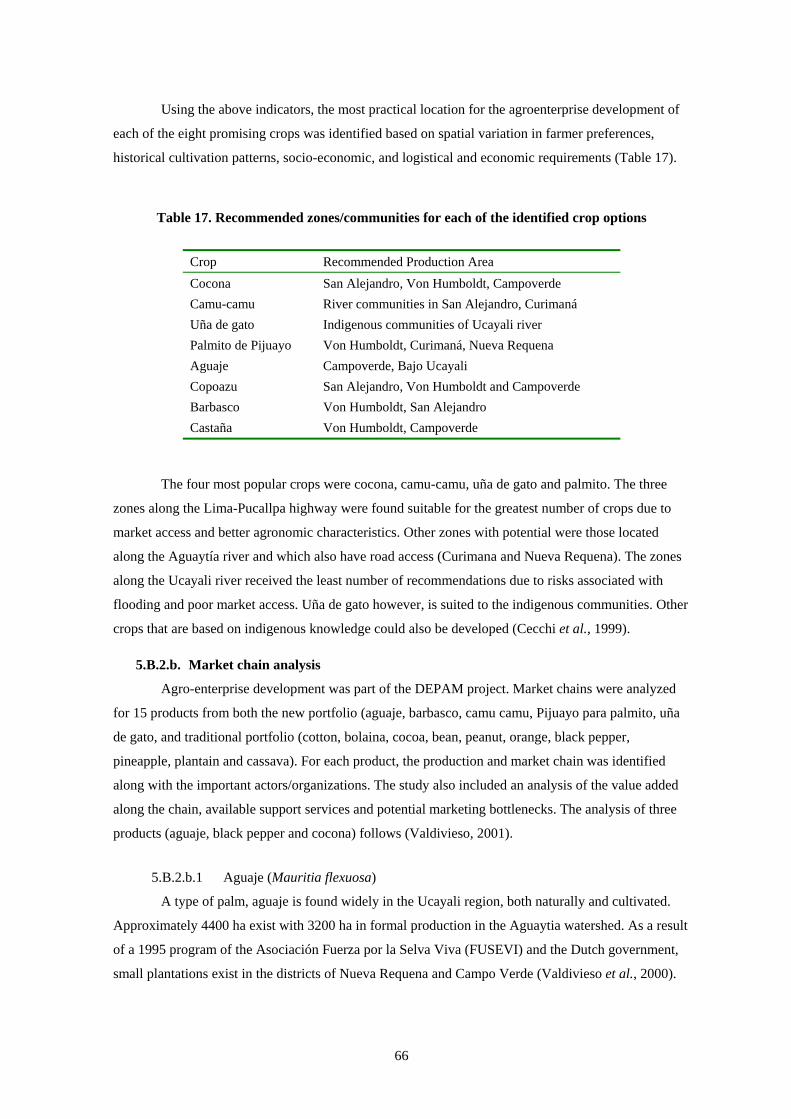
66
Using the above indicators, the most practical location for the agroenterprise development of
each of the eight promising crops was identified based on spatial variation in farmer preferences,
historical cultivation patterns, socio-economic, and logistical and economic requirements (Table 17).
Table 17. Recommended zones/communities for each of the identified crop options
Crop Recommended Production Area Cocona San Alejandro, Von Humboldt, Campoverde Camu-camu River communities in San Alejandro, Curimaná Uña de gato Indigenous communities of Ucayali river Palmito de Pijuayo Von Humboldt, Curimaná, Nueva Requena Aguaje Campoverde, Bajo Ucayali Copoazu San Alejandro, Von Humboldt and Campoverde Barbasco Von Humboldt, San Alejandro Castaña Von Humboldt, Campoverde
The four most popular crops were cocona, camu-camu, uña de gato and palmito. The three
zones along the Lima-Pucallpa highway were found suitable for the greatest number of crops due to
market access and better agronomic characteristics. Other zones with potential were those located
along the Aguaytía river and which also have road access (Curimana and Nueva Requena). The zones
along the Ucayali river received the least number of recommendations due to risks associated with
flooding and poor market access. Uña de gato however, is suited to the indigenous communities. Other
crops that are based on indigenous knowledge could also be developed (Cecchi et al., 1999).
5.B.2.b. Market chain analysis
Agro-enterprise development was part of the DEPAM project. Market chains were analyzed
for 15 products from both the new portfolio (aguaje, barbasco, camu camu, Pijuayo para palmito, uña
de gato, and traditional portfolio (cotton, bolaina, cocoa, bean, peanut, orange, black pepper,
pineapple, plantain and cassava). For each product, the production and market chain was identified
along with the important actors/organizations. The study also included an analysis of the value added
along the chain, available support services and potential marketing bottlenecks. The analysis of three
products (aguaje, black pepper and cocona) follows (Valdivieso, 2001).
5.B.2.b.1 Aguaje (Mauritia flexuosa)
A type of palm, aguaje is found widely in the Ucayali region, both naturally and cultivated.
Approximately 4400 ha exist with 3200 ha in formal production in the Aguaytia watershed. As a result
of a 1995 program of the Asociación Fuerza por la Selva Viva (FUSEVI) and the Dutch government,
small plantations exist in the districts of Nueva Requena and Campo Verde (Valdivieso et al., 2000).
67
The aguaje begins to produce fruit six years after planting. The traditional form of harvest of
the fruits is by felling of female, fruit-bearing trees (the species is dioecious). This is putting severe
pressure on populations of the species, particularly those located closest to the Amazonian cities,
where demand is highest. Even where female trees remain, distortion of the sex-ratio may lead to
genetic erosion, because unequal sex ratios result in low effective population sizes. Only some farmers
use ladders or climb the aguajes to harvest the fruit. Families typically consume about 10% of their
produce and sell the remainder in local markets with high demand (Valdivieso et al., 2000).
5.B.2.b.2 Black Pepper
Production of black pepper began in Ucayali in the 1960s with the arrival of various Japanese
families from Brazil. Within three years, these families had planted more than 50 ha and established an
effective producer cooperative to provide support and processing services. Problems arose, however,
in the 1980s in the form of increasing competition from imports and, more importantly, the arrival of
leftist guerrillas. The cooperative suffered from these two factors as planted area, yield and quality
declined simultaneously. Annual production in Pucallpa is approximately 30 t with only a small
portion of that managed by the cooperative. The income generating opportunity from black pepper
appears to be favorable. Import prices (figures in CIF16) have risen in the last five years from an
average of US$1.16 in 1993 to US$3.02 kg-1 in 2000 (Valdivieso, 2000).
The pricing structure of the black pepper marketing chain is as follows. Producers in Ucayali
benchmark receive a farm gate price of US$3.14kg-1 to US$3.70 kg-1, wholesale market prices average
US$6.00, industrial clients buy at an average of US$7.40kg-1 and the final consumer pays anywhere
from US$28 to US$55 kg-1 (Valdivieso, 2000).
The black pepper project focused on improving the income of producers through lowering
installation costs, selecting adequate soils for the crop, reducing disease and pest problems, and
improving farmer organization and marketing. Improved post-harvest management led to product
differentiation. Consequently, farmers realized a 25% price increase within local markets. In addition,
links to external markets led to sales of 1.5 t with prices 29% to 58% above local prices. The project
also facilitated the organization of producers into a private business. As part of the project
sustainability objective, farmers started to purchase business support services (see section 5.B). Less
tangible benefits consist of an improved entrepreneurial vision and capacity of farmers, which includes
adding value to the product (by milling) for local markets and investigating the possibility of
processing for larger firms and/or export for niche markets.
5.B.2.b.3 Cocona
16 CIF is the landed price of an import on the receiving country's dock including the cost of international freight
charges and insurance, before the addition of domestic tariffs or other taxes and fees.
68
Based on the implementation of the market opportunity identification and evaluation, cocona
(Solanum sessiliflorum Dunal) was identified as a product with good market potential, of interest for
smallholders. Beginning in July 2000 the project worked with local organizations with mixed results.
During 2001, support for this activity has declined due to institutional difficulties with Peruvian
governmental organizations and substantial reductions in operating budgets.
5.B.3. Agroecosystems and human health In recognition that farmers are interested in much more than agriculture, the CIAT work on
health and nutrition could provide a foundation for needed multi-sectoral research and development
approaches. For the past three years, a team of Peruvian and international researchers has been
investigating the relationship between health, biodiversity and natural resource use in the Ucayali region.
Taking an ecosystem approach this study demonstrated that the landscape level variables of flooding and
the changing ecology of the floodplain are the key forces affecting food security, nutritional status and
human health. This research showed that the annual flooding and extensive inundation of large areas of
the floodplain challenges almost every aspect of human settlement. As the rivers rise, crops are drowned,
transport is restricted to watercraft, fish disperse into the flooded forests and food procurement becomes
more difficult. The combination of factors creates problems of seasonal food insecurity, disease outbreaks
and economic hardship for many rural frontier families. Engagement in different resource-use activities,
whether they be farming, fishing, hunting or logging, is determined by the rhythm of the rivers as they
flood and later recede. Similarly, nutrient intake varies throughout the year as dietary changes reflect these
resource use patterns.
Disease transmission is affected by the 8-15 meter rise in river levels and the associated
changes in vector habitats and water quality. The movement of people across the landscape is
synchronized to the dynamics of the floodplain, as families migrate to different biotypes making use of
the diversity of ecological resources that become available with the flooding cycle. These migratory
patterns affect the spread of disease, land use strategies and anthropogenic environmental changes. In
addition, recent evidence has shown that flooding of deforested riverbanks and adjacent upland
terraces results in the methylation of naturally occurring mercury in the soil and its entry into the food
chain. A better understanding of these ecological rhythms and their impact on health allows
development interventions to take advantage of the annual floods rather than being drowned
economically by them (Murray et al., 2000a,b; 2002a,b).
In addition to these efforts, ICRAF, IVITA and INIA produced an identification and use guide
of medicinal plants used by native and mestizo women in Ucayali (Clavo et al., 2003).
5.B.4. Agroforestry systems capacity building PROSEMA and AMUCAU are two farmers’ organizations that are members of the ASB
consortia in Peru. They work in close relationship with ICRAF in the Ucayali benchmark site (see
section 1.A.4.a). Since 2002, a project funded by the TINKER foundation and the European Union,
69
and supported by ICRAF, has helped to empower PROSEMA members for decision making and to
increase their negotiation capacity (related to goods, services, agreements, contracts, etc.) through
both, technical and entrepreneurial capacity building (ICRAF, 2003). Within this framework, the
PROSEMA farmers have established a private company, Empresa Comercializadora Campesina de
Ucayali (ECOCU S.A.). Currently, ECOCU channels the production of beans, cassava, maize and
other crops from PROSEMA to the local market. In the future, ECOSU will negotiate the wood and
other forest products with GEA Forestal or the best business opportunity. Members will also provide
skilled manpower to local forest industries and produce seeds and planting stock for certified
plantations (ICRAF, 2003b).
So far, two main constraints for the development of the TINKER project have been the long
distance between the lands of each beneficiary, which makes communication very difficult, and, more
importantly, skepticism of some of the farmers about the fulfillment of the project objectives (ICRAF,
2003). Lack of trust prevails at all levels, among farmers, business and government organizations and
NGOs (Lehrer et al., 2003). To overcome the latter, a framework agreement and individual contracts
have been signed between industry (GEA17 Forestal) and farmers (PROSEMA). The agreement
establishes that PROSEMA will provide an inventory of members with legalized land rights and with
adequate biophysical conditions to plant bolaina, and guarantees that GEA18 will buy the products
produced by PROSEMA. Seedlings are produced on GEA lands financed by a project from
Pronaturaleza, the largest Peruvian NGO. ICRAF, without taking part in the framework agreement, is
mentioned as the knowledge provider on domesticated and genetically selected species, and as
capacities provider for entrepreneurial and agroforestry systems management. In the long term, this
partnership seeks to establish 1) a company for the production of value-added forest products using
native species, and 2) certified agroforestry mosaics for exports to Europe and Japan.
The specific areas for capacity building include collection, selection and storage of forest
seeds; pijuayo (harvest and post harvest); organization and entrepreneurial law, management, and
basic accounting oriented to the establishment of the new enterprise. Other activities include an
exchange of experiences between Pijuayo producers from Yurimaguas and Ucayali; management and
procedures for obtaining land title and community forestry concessions.
PROSEMA has also negotiated an agreement with INIA for the establishment of nurseries
with the technical assistance of ICRAF within INIA’s facilities. The seedlings generated in the nursery
have been sold to WWF who is developing a reforestation project in the area (so far for a value of
US$2600).
The first TINKER project activity was the diagnosis of the initial social, productive and
economical situation of PROSEMA and AMUCAU. Ninety percent of them did not have land property

70
titles, and the organizations were found to be very weak with inactive Boards of Directors and
disordered documentation. Organizations were not formally registered and therefore with little
negotiation capacity. The situation has been addressed with the support of the ICRAF team for both
organizations in improving documentation, fulfilling government obligations (payment of land,
income and assets taxes, registration as legal entities, record of patrimony), and renewing the Boards
of Directors. Now, 25 farm families have compiled the documentation necessary for land titling, as
required by the Special Project for Land Titling from the Peruvian Government (PETT – Proyecto
Especial de Titulación de Tierras). ICRAF and the TINKER project have contributed to the
establishment, strenghtening and consolidation of PROSEMA. In addition, the project has contributed
to the reactivation and strengthening of AMUCAU.
5.C. The mixed results of promoting sustainable land use
intensification
ASB partners work with farmers to improve technologies. Numerous land use alternatives
have been developed, ranging from higher-yield, pest- and disease-resistant annual crops to multistrata
agroforestry systems. For example, ICRAF, INIA and Winrock International have both on-station and
on-farm demonstration plots of improved fallows, multistrata agroforestry, soil conservation and
fertilization trials. ICRAF and INIA are also developing a seed bank for agroforestry species to be
used by the Ministry of Agriculture, INIA and reforestation programs. In addition, INIA tests and
multiplies improved rice germplasm from CIAT.
Nevertheless, research challenges remain. Despite years of agronomic research, adoption
responses have been mixed. On the positive side, improved rice varieties have demonstrated yield
gains and an ability to alleviate a critical seasonal labor bottleneck during the harvest period (see
section 5.C.7), and bolaina tree production is occurring at a large scale (1.A.4.c). For products that do
not have established markets, research organizations now place greater emphasis upon marketing
issues before embarking upon projects (Faminow and Weber, 2001; Valdivieso, 2001).
Marketing is a central challenge to the development process. In the Ucayali region, earnings
from both traditional and new products suffer from unstable markets. Prices of subsistence crops often
fluctuate seasonally according to the harvest period. Since farmers have urgent cash-flow needs and
few storage facilities, they are not able to wait for better market prices. Prices of perennial crops are
also unstable. Despite the isolation of the Amazon, oversupplies in international markets have affected
local prices. For example, coffee, palm oil, and cocoa have experienced price declines ranging from
25% to 50% (Ministry of Agriculture, 2002). The price of palm oil in 1999 (US$384 ton-1) began to
17 Grupo Empresarial Amazónico del Perú S.A. 18 GEA Forestal is a Peruvian timber company owned by a Swiss national which is reforesting degraded lands
with two fast-growing native species: bolaina and capirona (WRI, 2001).

71
decline and by 2001 the average crude palm oil price was US$183 ton-1, a 71% drop from the 1998
average prices representing a 15-year low (Asia Times, 2003).
The following sections describe the research and development activities of the ASB
consortium with respect to different land use systems.
5.C.1. Managed forest Sustainable management of forests remains a challenge in Peru. Alexander von Humboldt
National Forest is located between the regions of Ucayali and Huánuco. When demarcated in 1965 the
forest initially covered an area of 645,000 ha. Over the past 30 years, a growing proportion of the land
has been settled, reducing the area by approximately 25%. Development along the Pucallpa–Lima road
and an auxiliary road (started in the early 1980s) has improved access to the region. Road access, need
for land, and insufficient park enforcement has led to approximately 2500 people living in the forest.
The highest pressure is not from the people who live within the forest borders, but from the people
who live outside of those borders, seeking not only forest (timber and non-timber) products but also
commodities such as rice, corn or cattle products (Prebble and Leigh, 1997).
Since its establishment, the forest has been the focus of numerous management, utilization,
and research activities by a variety of international and bilateral bodies. FAO began supporting the
area in the 1960s with forestry management studies and continued with additional activities during the
1970s and 1980s. JICA (Japan International Cooperation Agency) financed a project in the 1980s. At
the end of the 1980s and beginning of the 1990s, however, political instability and terrorism drove
away most interventions in the region.
In 1990, ITTO started a forest management project led by INRENA. The project endeavored
to establish a model sustainable harvesting plan in a portion of the forest (138,000 ha). The model was
based on the timber sale concept, where private loggers were allowed to harvest the forest as part of
the management plan. The project also sought to expand the number of timber species for commercial
extraction, promote forest regeneration and raise the socio-economic level of the rural communities.
The plantations that these projects established are now cared by INIEA. Twenty years after planting,
results show that it is possible to enrich the forest with “tornillo” (Cedrelinga catenaeformis) and
manage its natural regeneration. It is also feasible to clear cut “bolaina” (Guazuma crinita), and
“marupa” (Simarouba amara).
The ITTO project was effective in planning forest management and encouraged private
enterprise to undertake sustainable harvesting operations. The management plan was based on
developing a complementary relationship between the public and the private sectors and a well-
established information base. Another example was the creation of a road network of approximately
250 km costing US$2400 km-1, using skidder trails. In addition, within the first three years of the
project, all commercial and potentially commercial species were inventoried. To ensure maximum
efficiency and minimum impact during harvesting, inventory data were combined with topography,

72
watershed and road information within a GIS database. The spatially referenced information enabled
the project to locate skid trails that the contractors were obliged to adhere to. The project offered
annual cutting parcels to private companies at a public auction. Successful contractors harvested the
stated species and volume according to the practices laid out in the management plans. Details of all
timber extracted, i.e. species type, volume, sales and destination, were recorded in the project database
(ITTO, 2002a).
Economic resources generated by the timber sales should have been sufficient to finance
project costs (i.e. silviculture, forest monitoring, and road design and construction). During the first
stage of implementation, however, contracted companies did extract the full available volume. In the
late 1980s and early 1990s, Ucayali suffered from a period of unforeseen civil strife. Operations of
many timber companies were brought to a standstill. Only in the late 1990s had confidence begun to
return and business to recover. In addition, low timber prices of 1994-95 did little to help the situation.
Many of the settlers within the von Humboldt National Forest live in extreme poverty. The
project has attempted to divert their livelihood activities away from illegal and legal agricultural
exploitation of the land (i.e. coca and subsistence farming) by providing an opportunity to become
actively involved in the forest management. Approximately 360 jobs were created by the project.
Another 120 have benefited indirectly, for example, those in transportation services. Even so, the
participation of communities and diffusion of results was limited (ITTO, 2002a).
Financially, project income was much lower than expected because only high-value species
were extracted. Moreover, large expenditures including forest inventories, topographic maps and
database management undercut returns. For example, inventory of 3500 ha required two months’ work
and 50 local staff. In addition, apart from the cost of road construction, a further US$500 km-1 was
required for annual maintenance. Paradoxically, results of these projects became the conceptual base
for the New Forest Law in Peru (see section 5.A.1).
5.C.2. Secondary forest management19 Despite the potential household benefits that come from secondary forest, little evidence
exists of improved management practices for enhanced production and even less for environmental
services (Smith et al., 2001). To improve the productivity of secondary forests, CIFOR along with
other organizations conducted numerous research projects in the Peruvian Amazon. The “secondary
forest management by farmers” project (1997-2000) led by CIFOR, CATIE and national institutes
from Peru (UNALM), Brazil and Nicaragua, characterized secondary forest use, examined dynamics
and identified management options (CIFOR, 2004a). Other topics researched in the Ucayali
benchmark site include rehabilitation methods of degraded secondary forests and abandoned pastures
by INIA and CIFOR (CIFOR, 2004b) and socio-economic evaluation for the adoption of the
rehabilitation methods. In addition, improved plantation and natural regeneration management in the

73
Ucayali region and the Puerto Inca province was led by CIFOR with INIA, IIAP, INRENA-Ucayali,
CRP, DRAU, AIDER, UNU, CNF/Proyecto Madebosques, ICRAF and UNALM (CIFOR, 2003).
Management strategies for secondary forests are more likely to be adopted if they are compatible
with agricultural practices and the soil recuperation functions. Forest products that export high levels
of biomass may, for example, jeopardize the soil recuperation function. Farmers are more likely to
prefer forest production that can be harvested during the fallow period than those that require the
maintenance of secondary forest for longer periods (Smith et al., 1999). Box 1 summarizes strategic
elements for increasing forest cover on small-scale farms whilst simultaneously increasing farmers’
welfare.
Management of secondary forests requires an integrated natural resource management
approach that analyzes secondary forest as a fundamental part of the farmers’ production systems and
improves the management of multiple resources, such as soils. These resources often have multiple
purposes with on- and off-site benefits, such as forest products and environmental services. According
to Smith et al. (2001), distinct strategies are required for different stages of the frontier development
process. At each stage, improved management needs to be complemented by policies at the national
and international level.
Although secondary forest currently makes an important contribution to agricultural
productivity and subsistence goods, its contribution to cash income is low relative to agriculture.
Analysis of multi-resource forest inventories shows, however, that many species have potential uses,
as multiple-use species or low-value timber, even in older areas where soils are degraded. Thus,
improved management for multiple use species and recuperation of agricultural productivity appear to
be an appropriate strategy for maintaining the usefulness of secondary forest in older areas. In newer
19 Adapted from Smith et al. (2001).
Box 1: Potential tradeoffs between increasing forest cover and increasing farmers’ welfare
• Efforts to maintain forest cover on small-scale farms may be more effective if they focus on reducing extensive cattle ranching, instead of reducing fallow periods.
• Mandatory maintenance of forest cover on small farms is likely to reduce farmer welfare unless innovative mechanisms, such as commercialization of the environmental services of forests, are used to achieve a ‘quantum leap’ in the benefits of forested land in comparison to other land uses, particularly pasture.
• Improved short-rotation fallows may improve soil recuperation at the expense of forest cover in areas where most forest cover consists of SF.
• Conflicts between improved soil recuperation and forest cover could be overcome by technologies that reinforce the multiple functions of SF (recuperation of site productivity and provision of forest products and environmental services). Clearly, further research is required to identify the conditions under which this is realistic. In particular, it is necessary to investigate whether alternative approaches to soil recuperation may be required in highly degraded areas.
Source: Smith et al. (1999)

74
areas, forest inventories reveal the potential for high timber productivity, or biodiversity recovery in
areas of secondary forests that farmers are willing to maintain on a permanent basis. If the conversion
of residual forest to agriculture could be slowed down at the early stages of frontier development,
management for high productivity timber may be possible. Innovative mechanisms such as trade in
forest carbon could be used to enhance the effectiveness of this strategy by inducing farmers to convert
some of their secondary forests used as agricultural fallows to permanent secondary forests.
Synergies between forest and agricultural products can enhance the adoption of improved SF
management practices. Short production cycles, capable of generating a marketable product within the
fallow period, are an obvious advantage. Guazuma crinita, for example, can be harvested during the
fallow period and thereby not compete with agricultural production. In the Ucayali benchmark site,
markets exist for such fast-growing trees. Similarly, Cordia spp. and Calycophyllum spruceanum can
produce poles within four years of establishment. Nevertheless, the value of timber is typically low
relative to the high cost of transportation from remote areas. The farmgate price of G. crinita logs, for
example, is only one-third of the price paid by sawmills in the nearest urban area.
To overcome such cost disadvantages, concerted management can increase the productivity of
trees. Although seed dispersal phenology of Guazuma crinita coincides with site preparation for
cropping in such a way as to promote natural regeneration, farmers can increase its abundance through
direct seeding during the cropping phase. Improved management also includes thinning and trimming
to remove vines and other vegetation perceived as weedy where a sufficient density of commercial
species exits.
The development of effective management strategies for SF requires an understanding of how
different SF (secondary forest fallow versus permanent secondary forest) function in the farm
production system. Naturally-regenerated timber species provide shade for coffee, such as
Schizolobium amazonicum or Hampea popayanensis. A comprehensive understanding also includes
the identification of factors that underlie farm decision-making. Inga is probably one of the best
examples of a multiple-use tree species, being used for fruit, soil fertility restoration and firewood.
Site conditions can also enhance tree productivity. The planting density of fast growing
pioneer tree species may be determined by substrate fertility, past use and seed availability. Capacity
to resprout after fire or cutting, capable of Tabebuia spp. and Callycophyllum spruceanum is a key,
though not indispensable, characteristic that can improve the productivity of trees. Compatibility with
the agricultural cycle is another advantage. Fire resistant palms, for example, provide useful products
and persist during the agricultural phase (Scheelea e.g., S. basleriana and S. tessmannii) and by G.
crinita. The optimization of growth and survival of planted trees requires the careful management of
the secondary forest fallow canopy.

75
5.C.3. Cocoa Using participatory research methods, CARE, Winrock International and ICRAF have increased the
historically low productivity of cocoa plantations. Farmers involved, who live along the Pucallpa-Lima
road (von Humboldt at km 86; Aguaytía at km 180), are part of the Association of Technical Cacao
producers from Padre Abad Province (Asociación de Cacaoteros Técnificado de Padre Abad -
ACTPA). The identified problems and responses are shown in Table 18. In 2001, yields more than
doubled as compared to those of a few years before (Ministry of Agriculture, 2001). In addition, this
research helped recuperate degraded lands. The development of productive and pest-resistant
germplasm cultivars and introducing other productive tree species renewed abandoned coca
plantations.
Table 18. Problems and solutions for Cacao plantations in Ucayali
Problems Found Management Alterations
Pests and diseases: witch's broom (escoba de brujas) and monoliasis
Pruning
No plant improvement Budding (from productive plants) Excessive shade Thinning of shade trees High density, unorganized cocoa plantations Thinning and design improvement Low productivity
Soil sampling and analysis: interpretation and recommendation for fertilization, especially with natural and organic fertilizers
Source: Arévalo, personal communication, and Paredes (2000)
5.C.4. Oil palm Since 1985, the United Nations International Drug Control Programme (UNDCP) has worked
in cooperation with Peruvian drug control efforts. UNDCP has two major alternative to coca
production programs in the Huallaga and La Convención valleys, in the central Amazon region of
Peru, with a total investment of US$48 million (UNDCP, 2003). In the Aguaytía watershed
(considered part of the Huallaga valley for administrative purposes), UNDCP strengthens grassroots
production of palm oil.
In 1991, UNDCP and the Ucayali regional government signed an agreement for the
installment of 1500 ha of palms to be used for the production of palm oil. Smallholder farmers were
grouped into an association called COCEPU, a non-profit association regulated by internal laws and
the Civil Code. COCEPU administers matters of production and sale of oil palm products. An integral
part of the assistance included the construction of a palm oil mill, which was completed in 1996. The
mill has a processing capacity of 6 t of palm racemes hour-1, with possibility of an expansion to 18 t

76
hour-1. The US$1.2 million cost of the plant was largely co-financed by UNDCP and the Peru-Canada
Counterpart Fund with lesser amounts coming from the Ucayali regional government and farmer
associations (UNODCCP, 2001; UNDCP, 2003).
In 1997, the plant processed 520 t of crude palm oil (CPO) and 35 t of kernel oil (PKO)
(palmiste) with a retail value of US$315,000. It generated another US$40,000 by processing raw
materials from third parties. According to producers, with appropriate care, 1 ha of palm generates a
net annual income of US$700. Each farmer has on average five hectares. The project has also directly
created 30 jobs, including COCEPU technical and administrative staff. In addition to creating jobs, the
plant has generated other occupations in the region such as food services, lodging and trade.
(UNODCCP, 2001; UNDCP, 2003).
0
200
400
600
800
1000
1200
1400
1600
1997 1998 1999 2000
tons
0
100
200
300
400
500
600
700
800
Val
ue (U
S$ x
100
0) .
oilpalmistevalue
Figure 14. Oil palm production and market value
(Data: COCEPU (1997-2000))
Palm oil producers have a cash crop market, albeit with unstable prices. In order to assure the
financial viability of palm oil production, the Peruvian government has agreed to purchase output at a
guaranteed price above the global price. Low production levels also threaten the long-term financial
viability of oil palm. High output systems require relatively high levels of technology adoption with
production levels dependent on fertilizer inputs and the multiplication and distribution of hybrid palm
varieties. Although the Ministry of Agriculture has provided loans for the purchase of fertilizers at
cost, sometimes farmers resell or apply them on other crops (White et al., 2005a). Production problems
also include adverse weather and a tendency on the part of some farmers to neglect plantation
maintenance. A realistic low production of 8 t ha-1 generates a NPV of -US$634 ha-1 over the 20-year
horizon and associated returns to labor of US$2.59 workday-1, which is below the minimum wage.
This all suggests that oil palm may not be an attractive alternative for farmers.
CPO
PKO

77
Despite the mixed results of palm oil investments, more programs are planned to increase
production. The UNDCP intends to build similar plants in other regions of the Peruvian Amazon
(UNODCCP, 2001) and the regional government of Ucayali continues to provide subsidies for
plantation establishment. Despite the low earnings of oil palm production, farmers are willing to
become involved in such government projects. The benefits of land title and improved road access, for
example, have the ability to overcome low earnings prospects (White et al., 2005a).
5.C.5. Improved tree germplasm Farmers in the lowland forests of the Peruvian Amazon depend upon more than 250 tree
species for construction material, fence posts, firewood, charcoal, fibers, resins, fruits, medicines and
environmental service functions such as soil conservation and shade (Sotelo and Weber, 1997). These
trees contribute significantly to the income and nutritional security of resource poor-farmers (Labarta
and Weber, 1998) and provide environmental services with local, national and global benefits.
It is widely known that deforestation and logging decreases the abundance of tree species
around many rural communities in the tropics (Pearce and Brown, 1994). As a result, these
communities have fewer natural resource options for economic development in the future. Less widely
recognized, but equally important, is the fact that genetic variation within tree species may also be
decreasing around rural communities (Ledig, 1992). If this continues unchecked, the communities will
miss opportunities for sustainable economic development in the future. Reduced variation within tree
populations is likely to decrease production stability and yield over time. It is imperative, therefore,
that domestication projects focus not only on increasing the number of valuable tree species on farm,
but also on managing the genetic resources of these species (O’Neill et al., 2001).
While many tree species contain considerable genetic variation, providing domestication
projects great opportunities for selection, this also presents a challenge. How can the most productive
germplasm for different agroforestry systems be efficiently identified? Farmers consistently cite the
lack of high-quality tree germplasm as a major constraint to diversifying and expanding their
agroforestry practices, and traditional tree improvement methods are too slow and expensive to satisfy
their demand (Simons, 1996). Non-traditional approaches, which involve farmers as main
collaborators in the research and development process, are required (Weber et al., 2001).
For example in the Aguaytía watershed, farmers want more productive germplasm of bolaina,
capirona, and other timber trees (Sotelo and Weber, 1997). In 1996, researchers and farming
communities worked together to collect seed from 11 natural populations of each species, and
established on-farm provenance trials in 1998. These were the first genetics trials of native tree species
in the Peruvian Amazon. The principal objective of the trials was to identify the most promising
regions as seed sources for reforestation in different environments in the Peruvian Amazon. The trials
were established on farms in the Aguaytía watershed, which is representative of many watersheds in

78
the western Amazon basin. Farmers participate in the evaluation of growth and other characteristics,
and provide useful information about their selection criteria for the tree germplasm.
Preliminary results of the on-farm provenance trials illustrate the potential gain in productivity
that farmers can realize from an early selection of fast-growing timber trees (Sotelo Montes et al.,
2000). In both bolaina and capirona, there was significant variation in average height among
provenances in the nursery, after 6 and 12 months in the field (P < 0.001). In the case of bolaina, after
12 months in the field the local provenance from the Aguaytía watershed (von Humboldt) was 13%
taller than the average height of the other provenances combined (P < 0.05). Capirona did not grow as
rapidly as bolaina during the first few years.
Accelerating the delivery of high-quality tree germplasm to farmers is a second principal
objective of participatory tree domestication. A traditional forestry approach involves many steps –
species selection trials, provenance trials to identify the best seed source(s) of each species, progeny
tests to identify the best mother trees within each selected site, collection of seeds or vegetative
material from the best mother trees to establish seedling or clonal seed orchards, and finally the
production of high-quality seed for dissemination. For most agroforestry tree species, this approach is
too time consuming and expensive. Furthermore, governmental and non-governmental organizations
cannot meet the growing demand for quality germplasm, particularly in light of the breakdown of
formal institutes and networks in some developing countries.
By involving farmers in germplasm selection, production and dissemination, delivery of high-
quality germplasm may be accelerated. On-farm genetics trials, like the provenance trials mentioned
above, can be transformed directly into seed orchards. Farmers with on-farm genetic trials are being
organized into networks for the production and commercialization of high-quality seed, seedlings and
timber. These seed orchards are a new form of small business enterprise in Peru and serve as ex situ
conservation sites.
5.C.6. Agroforestry systems20 Agroforestry systems seek agronomic complementarities by optimizing nutrient cycling, and water use
efficiency. Pest and disease problems can also be reduced by virtue of crop diversification. ASB
scientists hypothesize that these systems provide a higher level of global environmental benefits
compared to the agricultural alternatives. Although few agroforestry systems are currently in use, on-
farm research continues to develop, test and, if possible, support the adoption of such systems and
improves their agronomic and market performance.
ICRAF surveyed farmers to determine their preferred tree species for agroforestry, and
compiled a list of 150 species that have potential for various agroforestry systems. Many of the species
have not been scientifically identified, and are known only by their local names. As part of a project

79
funded by the UK Darwin Initiative, specimens were collected. Information on their distribution, uses
and ecology are also being compiled and placed in a database. The production of an identification
guide can serve as a valuable resource for other national partners such as INIA, IIAP and other
organizations (Pennington, 2003; Reynel et al., 2003).
Results presented below are from ICRAF field experiments, since agroforestry systems are
not common to the Ucayali region. Ex ante research suggests that typical farmers could sustainably
manage secondary forests to produce 100 stems hectare-1 of bolaina and/or capirona for markets with
an annual sustainable yield. Current prices received on farm for an unprocessed stem (10 m length, 25
cm diameter at breast height) are very low. Average prices are approximately US$0.30 for bolaina and
US$4.50 for capirona (Guevara et al., 2001).
Smallholder farmers sell low-valued cut stems and do not perform value-added processing
because they are not organized and individually have too small an annual output to allow the purchase
of necessary equipment (like chain saws). The increased cash flow from adding value to timber
products will be profitable only if processing can be performed on a cost-effective basis, which
requires sufficient scale and capacity utilization of equipment.
This could range from very basic processing, by cutting unprocessed stems into 2.5 m lengths,
through to squaring cut stems and cutting into boards for wall panels. Compared with selling
unprocessed stems, farmers could receive (a) twice as much money by simply cutting the stems into
logs (2.5 m length) using a chain saw, (b) three times as much by squaring the logs with a chain saw
attachment, and (c) and at least six to eight times as much by processing the logs into boards. For
example, current estimated revenues to farmers from selling boards (12 mm x 90 mm x 2.45 m)
processed from one stem are US$15 for bolaina and US$35 for capirona. Sustained annual cash flow
from the sale of boards processed from 100 stems could be US$1,500 for bolaina and US$3,500 for
capirona.
Annual gross revenue generated from 50 farmers processing boards would be US$75,000 for
bolaina and US$175,000 for capirona. Farmers can realize increased returns from various sources: 1)
organization to increase bargaining power; 2) improving silvicultural and genetic management for
faster tree growth; 3) increasing marketing efficiency: e.g., product sorting for uniformity, organized
transportation, etc.; and 4) performing value-added activities at farm level, e.g., primary processing of
logs.
Two other assumptions cause the estimates to be relatively conservative. The values of future
coppicing growth were not considered. In addition, expenses for “technology transfer” were included,
calculated as the average costs of providing technical assistance to participating farmers by project
20 Adapted from Faminow (2001). Data have beeen used as input for Table 25. The analyses differ in the discount
rates and time horizon.
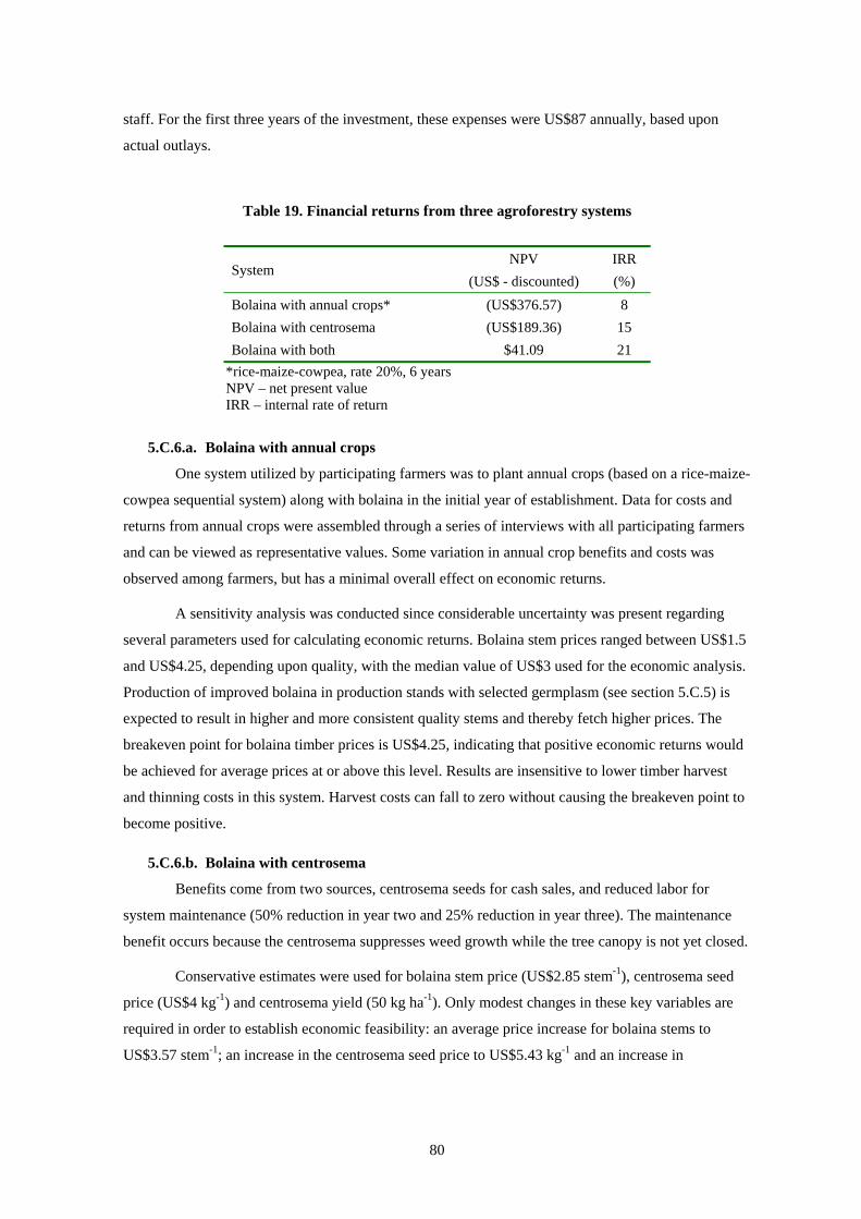
80
staff. For the first three years of the investment, these expenses were US$87 annually, based upon
actual outlays.
Table 19. Financial returns from three agroforestry systems
System NPV
(US$ - discounted) IRR (%)
Bolaina with annual crops* (US$376.57) 8 Bolaina with centrosema (US$189.36) 15 Bolaina with both $41.09 21
*rice-maize-cowpea, rate 20%, 6 years NPV – net present value IRR – internal rate of return
5.C.6.a. Bolaina with annual crops
One system utilized by participating farmers was to plant annual crops (based on a rice-maize-
cowpea sequential system) along with bolaina in the initial year of establishment. Data for costs and
returns from annual crops were assembled through a series of interviews with all participating farmers
and can be viewed as representative values. Some variation in annual crop benefits and costs was
observed among farmers, but has a minimal overall effect on economic returns.
A sensitivity analysis was conducted since considerable uncertainty was present regarding
several parameters used for calculating economic returns. Bolaina stem prices ranged between US$1.5
and US$4.25, depending upon quality, with the median value of US$3 used for the economic analysis.
Production of improved bolaina in production stands with selected germplasm (see section 5.C.5) is
expected to result in higher and more consistent quality stems and thereby fetch higher prices. The
breakeven point for bolaina timber prices is US$4.25, indicating that positive economic returns would
be achieved for average prices at or above this level. Results are insensitive to lower timber harvest
and thinning costs in this system. Harvest costs can fall to zero without causing the breakeven point to
become positive.
5.C.6.b. Bolaina with centrosema
Benefits come from two sources, centrosema seeds for cash sales, and reduced labor for
system maintenance (50% reduction in year two and 25% reduction in year three). The maintenance
benefit occurs because the centrosema suppresses weed growth while the tree canopy is not yet closed.
Conservative estimates were used for bolaina stem price (US$2.85 stem-1), centrosema seed
price (US$4 kg-1) and centrosema yield (50 kg ha-1). Only modest changes in these key variables are
required in order to establish economic feasibility: an average price increase for bolaina stems to
US$3.57 stem-1; an increase in the centrosema seed price to US$5.43 kg-1 and an increase in

81
centrosema seed yield to 63.3 kg ha-1. Harvest and thinning costs would need to fall to 45% of the
budgeted value in order to break even.
5.C.6.c. Bolaina with centrosema and annual crops
Combining the two systems above into one integrated system, with annual crops in the first
year followed by establishing centrosema for soil cover and seed production in the second year,
produces the best economic results. Net cash flow is improved by covering a portion of tree investment
costs in the first year from positive cash flow from annual crop production, balanced by cash generated
from centrosema seed production beginning in 1999. Conservative values were utilized and the likely
scenario of higher than budgeted prices for bolaina stems and centrosema seed, plus possibly higher
centrosema yields, would increase economic returns to this system.
5.C.7. New varieties of traditional crops21 The CIAT Systems for Smallholder Project initiated a participatory research project with new
rice varieties in 1998. The decision to conduct rice research was based upon a diagnosis of the Ucayali
site where farmers prioritized rice as an important crop requiring scientific inquiry (Fujisaka et al.,
1999). Throughout Peru, the importance of rice production and consumption increases yearly. Peru
produced 1.11 million tons (milled basis) in 2000. Domestic production, however, is not stable. While
the 2000 level represents a 47% increase over 1991, 70,000 fewer tons were produced in comparison
with the previous year.
The majority of Peru’s rice production is irrigated (paddy rice) in the regions of Lambayeque
and Piura in the north and Arequipa in the south. In the major production zones, rice quality and yields
vary greatly. Average yields are 6.3 t ha-1; some farmers have yields as high as 14 t ha-1 (USFAS,
2000). Smallholder farmers produce the majority of the rice supply with few inputs. The use of
chemicals is highly dependent on market prices, national economic conditions and credit policies.
Annual rice consumption is estimated at 46 kilograms per capita. Rice is sold in traditional
markets by weight from 50 kg sacks. In recent years, however, Peru has seen a rapid expansion of
supermarkets chains. As a result, consumers increasingly purchase prepackaged one-kilogram bags of
rice, which now total 13% of all rice sales. Higher quality rice, especially imported, is also marketed in
this manner (USFAS, 2000).
5.C.7.a. Rice trials
This sub-section is divided into two parts. The first describes the rice trial work and reviews
the major results. The second section presents results of a farm survey (n=60), which focused on rice
production and variety adoption, conducted in July 2003. The following sections are from Fujisaka et
al., 2000a and White et al., 2003.
21 Adapted from White et al. (2003).

82
The research objective (in work led by Fujisaka and colleagues) was to increase farmer
participation and to gradually, and in a step-wise fashion, widen their scope of such participation in the
research process. Scientists first worked with farmers interested in testing new rice varieties. Seed was
provided for small plot trials. Researchers helped farmers in the use of scientific methods such as
replications, controls, crop cut sampling, moisture correction, and yield calculations. Farmers selected
varieties and trial layouts, and managed all trial operations. During the five planting seasons of the 2-
year project, field visits and field days provided continual feedback among farmers and researchers.
Farmers tested the five introduced varieties CT-11253-6-1-M-M, Porvenir 95, INIA 14,
Ucayali 91, capirona, and Uquihua along with their traditional varieties, Carolino, Chancabanco, and
Aguja Blanca in the sowings starting in early November 1997 and continuing until early February
1998. Yields of the introduced varieties were not always superior to yields of farmers’ varieties
because the rice materials also included lowland varieties and were introduced to farmers as such. An
early project goal was to start the participatory testing, albeit with an understanding by farmers that the
multiplication of more appropriate upland rices was in process. Yields of the new varieties on farmers’
fields were satisfactory (mean 0.91 t ha-1), but were not superior to farmers’ own varieties (0.94 t ha-1)
(Table 20). Although plantings suffered heavily from El Niño related drought, farmers were not
discouraged. Some farmers adopted trial varieties for use on their farms.
Table 20. Rice varieties and yields of the 1997–1998 campaign
Variety Average Yield (t/ha)*
Standard Deviation
Number of Participating
Farmers New CT-11253-6-1-M-M 1.15 0.5 8 Porvenir-95 1.23 0.5 11 INIA-14 1.07 0.4 10 Ucayali-91 0.76 0.5 8 Capirona 0.64 0.3 18 Uquihua 0.59 0.3 11 Average of means 0.91 0.5
Traditional Carolino 1.08 0.4 5 Chancabanco** 0.90 0.8 6 Aguja Blanca 0.83 0.4 7 Average of means 0.94 0.4 * Calculated at 14% moisture of rice grain ** Early-maturing variety Source: CIAT field data (March 1998)

83
During the next planting period (September through October 1998), farmers tested the
introduced varieties CIRAD, IRAT 146, Sabana 10, Sabana 6, and Progreso. Mean yields were slightly
higher than of traditional varieties, 2.06 t ha-1 in period 4 and 1.9 t h-1, respectively (Table 21). Farmers
continued to adopt selected introduced varieties in their own fields.
Table 21. Rice varieties and yields of the 1998–1999 campaign
Variety Average yield*
(t ha-1) Standard Deviation
Number of Participating
Farmers New O. Sabana 10 2.18 0.78 29 CIRAD 409** 2.13 0.92 27 IRAT 146** 2.11 0.66 26 Progresso 1.93 0.91 26 O. Sabana 6 1.89 0.73 22 Average of means 2.06 0.80
Traditional
Carolino 2.70 0.47 4 Chancabanco** 2.40 0.66 9 Aguja Blanca 1.54 0.66 21 Others 1.85 0.49 2 Average of means 1.90 0.77 * Calculated at 14% humidity of rice grain ** Early-maturing variety Source: CIAT field data (March 1999)
A “traditional” variety produced the highest yields during the project horizon (Figure 15).
Chancabanco or “Bank Breaker” was introduced in the 1980s of CIAT parentage and has been widely
adopted. Chancabanco acquired its name from local lore. Since the agrarian bank was obligated to
purchase agricultural production during those years, an unexpectedly large harvest of Chancabanco
rice broke the bank by straining the capacity of the national government to make the payments to
farmers. Since Chancabanco has been available for many years, farmers often consider the variety as
being traditional.
While Chancabanco may have high yields, grain quality is inferior. A high percentage of
grains break during milling, thereby reducing its market value and cooking quality. Three of the “new”
introduced varieties, Sabana 10, CT and CIRAD 409, had higher yields than the other traditional
varieties. Most of the new varieties had higher grain and culinary quality.

84
0
0.5
1
1.5
2
2.5
3
3.5
Saba
na 1
0
CT
CIR
AD
409
Mar
avill
a
IRA
T 14
6
Prog
esso
Saba
na 6
Con
fianz
a
O. T
urip
ana
Can
astra
Cha
ncab
anco
Car
olin
o
Agu
ja
Oth
er
t/ha
Figure 15. New and traditional varieties, average mean and standard deviation of yield
Source: CIAT field data (1999, 2000)
Yield is not the only important criteria for rice production. Farmers are interested in many
other characteristics. During a field day consultation with farmers in 1999, the following preferences
of varieties were mentioned (Table 22).
Table 22. Preferred traits of rice varieties by farmers in Ucayali benchmark site
Variety Early
mat
urity
Pest
and
dis
ease
re
sist
ance
Larg
e Pa
nicl
e
Gra
in q
ualit
y
Mill
ing
qual
ity
Coo
king
qua
lity
No
Lodg
ing
Thre
shin
g ea
se
Not
itch
y
Hig
h Ti
llerin
g
Cirad 409 x x x x x Sabana 10 x x x Maravilla x x x x x Chancabanco x x Aguja x x x x x Carolino x x x
n = 41 4 51 4 30 30 24 5 4 6 16 7 36 3
New Traditional
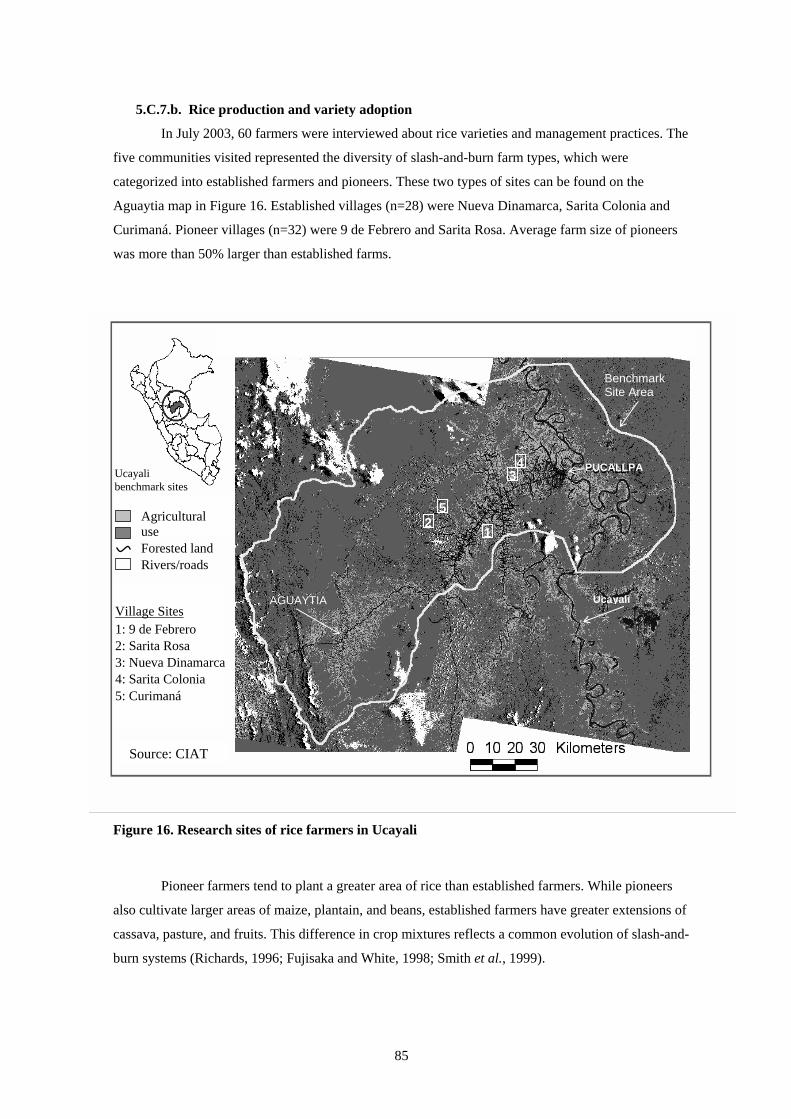
85
5.C.7.b. Rice production and variety adoption
In July 2003, 60 farmers were interviewed about rice varieties and management practices. The
five communities visited represented the diversity of slash-and-burn farm types, which were
categorized into established farmers and pioneers. These two types of sites can be found on the
Aguaytia map in Figure 16. Established villages (n=28) were Nueva Dinamarca, Sarita Colonia and
Curimaná. Pioneer villages (n=32) were 9 de Febrero and Sarita Rosa. Average farm size of pioneers
was more than 50% larger than established farms.
Figure 16. Research sites of rice farmers in Ucayali
Pioneer farmers tend to plant a greater area of rice than established farmers. While pioneers
also cultivate larger areas of maize, plantain, and beans, established farmers have greater extensions of
cassava, pasture, and fruits. This difference in crop mixtures reflects a common evolution of slash-and-
burn systems (Richards, 1996; Fujisaka and White, 1998; Smith et al., 1999).
PUCALLPA
AGUAYTIA Ucayali
Benchmark Site Area
Source: CIAT
Ucayali benchmark sites
Agricultural use Forested land Rivers/roads
Village Sites 1: 9 de Febrero 2: Sarita Rosa 3: Nueva Dinamarca 4: Sarita Colonia 5: Curimaná
3
2
4
5
1
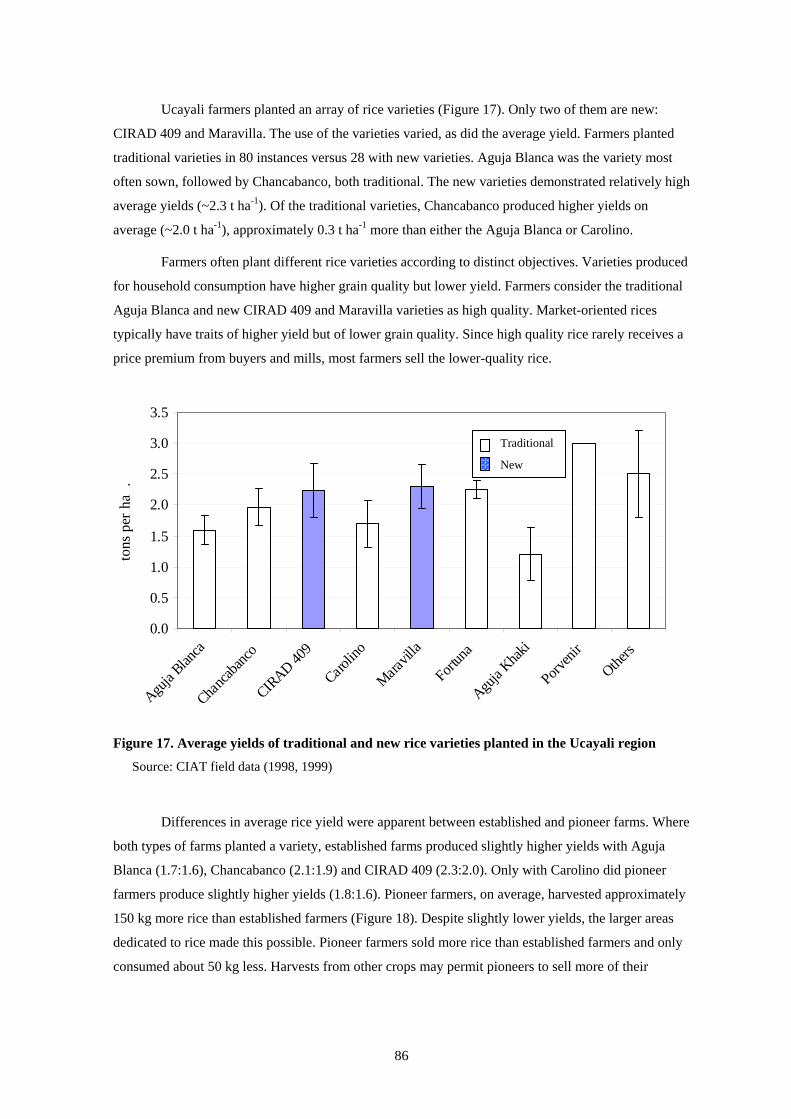
86
Ucayali farmers planted an array of rice varieties (Figure 17). Only two of them are new:
CIRAD 409 and Maravilla. The use of the varieties varied, as did the average yield. Farmers planted
traditional varieties in 80 instances versus 28 with new varieties. Aguja Blanca was the variety most
often sown, followed by Chancabanco, both traditional. The new varieties demonstrated relatively high
average yields (~2.3 t ha-1). Of the traditional varieties, Chancabanco produced higher yields on
average (~2.0 t ha-1), approximately 0.3 t ha-1 more than either the Aguja Blanca or Carolino.
Farmers often plant different rice varieties according to distinct objectives. Varieties produced
for household consumption have higher grain quality but lower yield. Farmers consider the traditional
Aguja Blanca and new CIRAD 409 and Maravilla varieties as high quality. Market-oriented rices
typically have traits of higher yield but of lower grain quality. Since high quality rice rarely receives a
price premium from buyers and mills, most farmers sell the lower-quality rice.
#
Figure 17. Average yields of traditional and new rice varieties planted in the Ucayali region
Source: CIAT field data (1998, 1999)
Differences in average rice yield were apparent between established and pioneer farms. Where
both types of farms planted a variety, established farms produced slightly higher yields with Aguja
Blanca (1.7:1.6), Chancabanco (2.1:1.9) and CIRAD 409 (2.3:2.0). Only with Carolino did pioneer
farmers produce slightly higher yields (1.8:1.6). Pioneer farmers, on average, harvested approximately
150 kg more rice than established farmers (Figure 18). Despite slightly lower yields, the larger areas
dedicated to rice made this possible. Pioneer farmers sold more rice than established farmers and only
consumed about 50 kg less. Harvests from other crops may permit pioneers to sell more of their
0.0
0.5
1.0
1.5
2.0
2.5
3.0
3.5
Aguja
Blanca
Chanca
banco
CIRAD 40
9
Carolin
o
Maravil
la
Fortun
a
Aguja
Khaki
Porveni
r
Others
tons
per
ha
.
Traditional
New
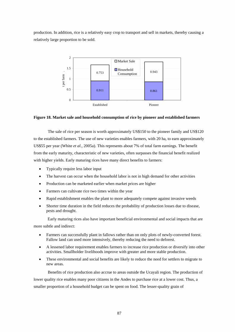
87
production. In addition, rice is a relatively easy crop to transport and sell in markets, thereby causing a
relatively large proportion to be sold.
0.911 0.861
0.753 0.943
0
0.5
1
1.5
2
Established Pioneer
t per
farm
.
Market Sale
HouseholdConsumption
Figure 18. Market sale and household consumption of rice by pioneer and established farmers
The sale of rice per season is worth approximately US$150 to the pioneer family and US$120
to the established farmers. The use of new varieties enables farmers, with 20 ha, to earn approximately
US$55 per year (White et al., 2005a). This represents about 7% of total farm earnings. The benefit
from the early maturity, characteristic of new varieties, often surpasses the financial benefit realized
with higher yields. Early maturing rices have many direct benefits to farmers:
• Typically require less labor input
• The harvest can occur when the household labor is not in high demand for other activities
• Production can be marketed earlier when market prices are higher
• Farmers can cultivate rice two times within the year
• Rapid establishment enables the plant to more adequately compete against invasive weeds
• Shorter time duration in the field reduces the probability of production losses due to disease, pests and drought.
Early maturing rices also have important beneficial environmental and social impacts that are
more subtle and indirect:
• Farmers can successfully plant in fallows rather than on only plots of newly-converted forest. Fallow land can used more intensively, thereby reducing the need to deforest.
• A lessened labor requirement enables farmers to increase rice production or diversify into other activities. Smallholder livelihoods improve with greater and more stable production.
• These environmental and social benefits are likely to reduce the need for settlers to migrate to new areas.
Benefits of rice production also accrue to areas outside the Ucayali region. The production of
lower quality rice enables many poor citizens in the Andes to purchase rice at a lower cost. Thus, a
smaller proportion of a household budget can be spent on food. The lesser-quality grain of
88
Chancabanco, for example, is transported all over Peru. The Ucayali region exports 40% of the rice
produced to other regions of the country (Ministry of Agriculture, 2003).
The field interviews conducted as a follow up to the participatory research initiated in the late
1990s by CIAT and INIA scientists revealed that farmers continue to plant two of the modern
varieties, Maravilla and CIRAD 409. Some nine upland rice varieties are planted in the region.
Average yield of traditional (i.e. older) varieties is 1.8 t ha-1 while modern varieties produced 2.2 t ha-1,
a 20% increase.
5.C.8. Improved fallows22 An experiment at Yurimaguas evaluated managed tree fallows of planted inga, and colubrina,
with and without centrosema cover. These systems were compared in terms of weed suppression, crop
production, and economic benefits with a traditional bush fallow and herbaceous centrosema cover
crop. The fallow vegetation was cleared and burnt for cropping after three years of growth. Maize,
cowpea, and rice were grown in the three subsequent seasons.
The planted trees grew faster and accumulated more biomass than those in natural fallow.
centrosema, as a pure cover crop as well as an understorey between trees, effectively suppressed
weeds. The tree fallows with and without centrosema did not increase crop yields compared with
natural fallow and gave significantly lower yields in the third season. Trees were removed from the
fallow for firewood or poles thereby reducing the recycling of nutrients. Only pure centrosema
significantly increased maize yields in the first season after its harvest compared with natural fallow.
Utilizing very conservative price and production parameters for the improved fallow systems,
the inga and inga-centrosema systems had the highest net present values (NPV) of US$509 and
US$392 ha-1, respectively (r=20%, n=6). However, the NPV for inga-centrosema systems reduces to
US$ 18.71 using 15% discount rate over a 20 year period. Sensitivity analysis of NPV and returns to
labor measures, under more optimistic conditions, revealed different results. The NPV for the two
systems with colubrina (for poles) increased to US$1421 and US$1782, respectively with higher labor
returns (Table 23).
Planted fallows with economically valuable trees such as inga and colubrina have the potential
to raise farmers’ income, reduce poverty and alleviate degradation of natural resources in the humid
tropics of Peru, but they require more extensive testing under a range of biophysical and socio-
economic conditions. Tree fallows of pure inga or associated with centrosema appear to offer the next
best option to farmers, but potential outcomes must be tempered by the market opportunities that
farmers confront. Inga is a staple fruit sold in local markets with inelastic demand that has minimal
market potential for sales outside the region. Product bulkiness, perishability and distance to markets
are other key marketing constraints. Since most rural families produce primarily for on-farm
22 Adapted from Alegre et al. (2000c) and Alegre et al. (2005).

89
consumption, wide-scale adoption of inga plantations could satiate cash markets in local urban centers,
thereby lowering prices and returns to adoption.
Not only do centrosema systems require less labor than the inga systems, but they also
produce products for markets that are likely to be more stable in the face of widespread adoption and
increased production. Demand for legume seed in the region is strong, particularly in the western
Brazilian Amazon. Mixed fallows of trees and centrosema also offer the possibility of integrating
livestock into the system and increase the scope for greater income (Arevalo et al., 1998).
Other ICRAF research examined how existing improved fallow systems affect land use on the
farm (see section 5.D.2 for details on analysis approach). Econometric analysis of farmer households
showed that use of Kudzu-improved fallows increases land productivity and counteracts or mitigates
declines in soil fertility. (Farms on alluvial soils and farms that used productivity-enhancing capital
inputs such as fertilizer, improved seed, and herbicides showed similar tendencies.) Such farm
management techniques also had environmental implications. Secondary forest clearing increased but
primary forest conversion was less. Productivity enhancements enabled farmers to reuse secondary
forest fallows.
Table 23. Financial performance of different short-duration planted fallows at Yurimaguas
Labor Used (No. of days) a
Net cash flow for ($US ha–1)
Fallow systems
Fallow
Cropping
Total fallow phaseb
cropping phasec
Total net present valued
($US ha–1)
Returns to labor
($US workday–1)
Natural fallow 0 259 259 0 771 283 1.09
Inga 145 332 477 (652) 2365 509 1.07
Inga+Centrosema 182 332 504 (296) 1736 392 0.78
Colubrina 115 256 371 (664) 883 (89) (0.24)
Colubrina+ Centrosema 154 258 412 (168) 878 206 0.50
Centrosema 125 253 376 (53) 672 123 0.33 a Period 1994-1999 b Undiscounted sum of net returns for 1994-1996 c Undiscounted sum of net returns for 1997-1999 d Discount rate of 20 % Source: Alegre et al. (2000b), Alegre et al. (2005)
Kudzu-improved fallows and brachiaria pastures have been widely adopted by farmers
because they increase returns to the scarce labor. However, because they free up scarce labor, Kudzu-
improved fallows increase secondary forest clearing and brachiaria pastures increase all types of forest

90
clearing. Although ranching is not directly correlated with primary forest clearing, econometric results
do show increased deforestation rates (Yanggen, 2000).
5.C.9. Improved pastures Tropileche is a Latin American research consortium with the goal of improving pastures for
milk and beef (dual-purpose) production systems. In Ucayali, scientists from CIAT, IIAP and IVITA
comprised the multi-disciplinary research team. To varying degrees, improved pastures and forages
increase both stocking rates and milk production. During the 1970s, technicians started promoting
brachiaria to improve pasture performance. The nutritive quality of brachiaria is approximately three
times that of native pastures. Natural pastures produce 800 kg ha-1 during the rainy period while
brachiaria produces 1340 kg ha-1 (Abanto and Vela, 1997). Moreover, farmers were attracted by the
greater vitality of brachiaria since native grasses degrade rather quickly. Between 1982 and 1996,
brachiaria use rose from 15.5% to 40% of total pasture cover (Riesco et al., 1986; Fujisaka, 1997;
Fujisaka and White, 1998).
Brachiaria is also popular with farmers because it requires relatively little labor and financial
investment. Seed is inexpensive, approximately US$24 required ha-1 and easy to apply after
preparation (Holmann, 1999). Farmers also use vegetative material from nearby pastures instead of
seed. This procedure, which typically occurs after the harvest of annual crops, requires 19 workdays
ha-1. Farmers considered the ease of transplanting brachiaria by hand as a principle advantage. In
addition, annual maintenance requirements are typically half the US$48 ha-1 of native pastures
(Yanggen, 2003).
Nevertheless, aggressive brachiaria growth can have costly disadvantages. Since cattle herd
numbers have not yet recovered from the earlier herd decline (see below), farmers rarely have enough
cattle to keep the growth in check. In some areas, the grass has become a fire hazard thereby damaging
or destroying surrounding crops and houses (Smith et al., 1999; White et al., 2001).
Improved pasture is a relative term. Other forage options, also made available to farmers, have
different performance and cost characteristics. Alternative leguminous forage options, which have the
ability to enhance soil fertility and biomass production, are more costly to establish and maintain.
Arachis pintoi and Cratylia argentena, for example, require a respective cash outlay of about US$300
ha-1 and US$400 ha-1. In addition, approximately once every four years farmers may need to reseed
their pastures in order to maintain their productivity, costing about 25% as much as the initial
establishment.
Despite pasture productivity improvements, the A. pintoi and C. argentena options were not
financially feasible. The inferior genetic quality of the cattle prevented the realization of full nutritive
benefit of the legume forages. For most farmers extensive production is more cost-effective than
intensive production. An additional hectare of a native pasture costs approximately US$150, while
establishing an improved forage alternative requires at least US$250 more. This latter alternative only
91
maintains 90% more stock and yields 56% more milk than the extensive option (Holmann, 1999a,b).
Thus, efforts to incorporate leguminous forages faced major financial challenges because of the high
costs, limited access to capital and low market prices.
Adoption of legume pastures was elusive for another contextual reason. The region had not
recovered from the herd decline of the early 1990s (see section 1.A.3). The low stocking rate led to an
over-supply of pasture biomass that exceeds cattle demand and thereby made improved pasture
production a low priority of many farmers. As a result, Tropileche has redirected its efforts where
pasture demands are greater in the Moyobamba region of Peru.
5.C.10. Riverine systems23 The richness of the alluvial soils along the rivers in the Amazon permit farmers to realize high
crop yields. These rich soils have led to a number of government proposals to increase agricultural
production in the floodplains. Nevertheless, the financial viability of riverine agriculture remains
uncertain. Distinct agronomic and market conditions affect the financial performance.
Distinct agro-ecological conditions along the rivers provide farmers with unique opportunities
to cultivate a wide range of crops. Farming activities follow rising and falling river levels. The
changing river level (~10m) produces three types of soil zones (Figure 19). First, the beaches (playas)
are the lowest areas with soils being a mix of sand and mud. The beaches are cultivable for
approximately 4 to 5 months each year. Cowpeas and peanuts are planted here due to the uncertain
level of the river and a very short growing season (~2 months). Second, the mudflats (barrizales) are
the richest soils, with mud texture sediments, and appear for 5 to 6 months. In these areas, rice
production achieves high yields. Third, the flood plains (restinga) are higher level zones with fertile
soils and with shorter flooding periods. Plantain, maize, soybeans, beans, vegetables, sugar cane and
fruits can grow for 6 to 12 months.
23 Adapted from Labarta et al. (2005).

92
Figure 19. Ucayali River monthly levels (1987-1997)
Source: Labarta et al. (2005). (Data: Dirección de Transporte Acuático)
Two farmer types are found in the floodplain region. Permanent dwellers establish their
homes and farms on higher ground (restingas) and typically use all three types of soils with a diverse
array of crops. In contrast, temporary farmers use the region for only short periods using mainly
beaches and mudflats. The land tenure situation for temporary farmers is unique. Farmers have no
legal title. Instead, the Ministry of Agriculture assigns annual land use permits.
Unexpected flooding often affects the beginning and/or end of the agricultural season. To
avoid this problem, faster maturing crops are planted in lower zones. Plantain can even tolerate
temporary flooding without yield decreases and survive 10 to 15 years without replanting.
Agricultural practices and profitabilities differ greatly between permanent and temporary
farmers (Figure 20). Temporary farms are smaller because the short cropping season causes acute
seasonal labor shortages. Mudflats are the most profitable soil zones with the highest returns to labor
~1.5 times the standard wage. Floodplains have slightly lower returns to labor (~1.3 times.) Sandy
beaches yield returns nearly equal to the agricultural wage. Permanent dwellers plant a wider variety
of crops in different locations. Many of the crops have low returns that are more oriented to household
food security. Overall returns to labor are about 1.2 times the standard wage. Plantains are the most
important crop and main contributor to earnings.
136
137
138
139
140
141
142
143
144
145
146
147
148
Janu
ary
Febr
uary
Mat
ch
Apr
il
May Jun
July
Aug
ust
Sept
embe
r
Oct
ober
Nov
embe
r
Dic
embe
r
m.a
.s.l.
AverageMaxMin
Floodplains
Mudflats
Beaches

93
Figure 20. Four riverine farm types: Returns to labor and land
Source: Labarta et al. (2005)
Good soil fertility does not guarantee the profitability of agricultural activities. Production and
profits can be attractive but are very susceptible to risks of flooding, price declines and transport costs
(Table 24). Unexpected floods can destroy entire harvests, resulting in total economic loss. The
government provides aid for losses of homes but not for crop damage.
Table 24. Transport costs: Ucayali River (2001)
Distance, in hours, from Pucallpa (US$ unit-1)
48 hours 12-24 hours Less than 12 hours
Rice and Maize (50 kg)* 1.0 0 .8 0.4 Plantains (20 kg)* 0.3 0.3 0.1
* Approximate measures
Source: Labarta et al. (2005)
A better understanding of river level variations will make possible site-specific forecasting of
the future floods. Forecasts that are more accurate will enable the creation of flood warning systems
and minimize moral hazard problems of insurance programs. But the environmental (e.g., biodiversity)
implications of agricultural production along the floodplains versus upland regions are unknown.
5.C.11. Amazonian products The promotion of processing of products has proved difficult in the Ucayali. Efforts to
facilitate the marketing of cocona, for example, were frustrated by insufficient funding and personnel
0
200
400
600
800
1000
1200
1400
Beach Mudflat Floodplain
Ret
urns
to L
and
($/h
a) .
00.511.522.533.544.55
Ret
urns
to L
abor
($/d
ay)
Returns to land
Returns to labor
Temporary farmers using only Permanent
Farmer

94
of both international and national organizations (5.B.2.b.3). As project funding for DEPAM ended at
the end of 2000, a consulting enterprise, the Regional Center for Business Services (CRESE), was
established to provide agro-enterprise support services. CRESE provided business development
services focused on improving production, post harvest and marketing systems to individuals,
businesses and development institutes within a framework of responsible and fair profit maximization.
CRESE assisted in the development of the black pepper enterprise and led its implementation,
analyzed existing support services in the Ucayali region, administered an alternative development
project funded by CARE in the region of Aguaytía and provided consulting services to the USAID-
Chemonics-CODESU Poverty Reduction and Alleviation initiative.
5.D. Dynamics and trends of land use
5.D.1. Spatial land use trends Early GIS research compared the driving forces of deforestation between ASB sites in Brazil
and Peru. With satellite images, Imbernon (1997) found that road access and frontier markets are more
developed in Brazil than in Peru. Deforestation patterns in the Ucayali region initially followed rivers
but as roads improved access to resources, faster rates of deforestation occurred along the roads. In
addition, Ucayali deforestation patterns are not the orderly herringbone pattern typical for colonization
schemes in Brazil. Roads and land grants in the Ucayali are not as organized, leading to less regular
and more dispersed deforestation patterns.
Other GIS analyses by CIAT used high-resolution images to identify the ASB Ucayali
benchmark area of the Aguaytía watershed, along with identifying and coding land uses with Landsat
and Radarsat imagery. CIAT-ICRAF-INEI developed a socio-economic database for over 400 villages
in the Ucayali from the 1993 and 1994 population and agricultural censuses (INEI, 1995b). Each
village was geo-referenced with GPS receivers (Figure 21). The entire census database of hundreds of
variables related to population, government services, farming systems and natural resources was linked
to each village. Analysis was conducted to identify variables that were most useful to understand
poverty dynamics in the benchmark site. Unmet basic needs were calculated from the population
census. The indicator comprised five standards of basic human development needs: school attendance;
dependency ratio; house materials; house plumbing; and number of persons per room. For the 40,369
rural people in the census survey, the average number of unmet needs was two but displayed a wide
variation (standard deviation 0.46).
The research, including a training workshop, was held in Lima for professional staff from the
IIAP, INEI, and Ministries of Agriculture, Education and Health. Workshop participants learned some
of the basics of the user-friendly GIS package ArcView in focusing on spatial patterns of poverty and
environment (Hyman et al., 1999).
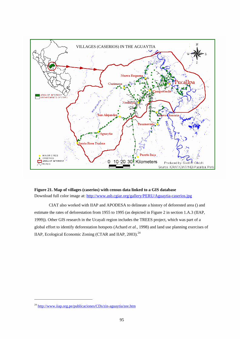
95
VILLAGES (CASERIOS) IN THE AGUAYTIA
Figure 21. Map of villages (caserios) with census data linked to a GIS database Download full color image at: http://www.asb.cgiar.org/gallery/PERU/Aguaytia-caserios.jpg
CIAT also worked with IIAP and APODESA to delineate a history of deforested area () and
estimate the rates of deforestation from 1955 to 1995 (as depicted in Figure 2 in section 1.A.3 (IIAP,
1999)). Other GIS research in the Ucayali region includes the TREES project, which was part of a
global effort to identify deforestation hotspots (Achard et al., 1998) and land use planning exercises of
IIAP, Ecological Economic Zoning (CTAR and IIAP, 2003).24
24 http://www.iiap.org.pe/publicaciones/CDs/zin-aguaytia/zee.htm
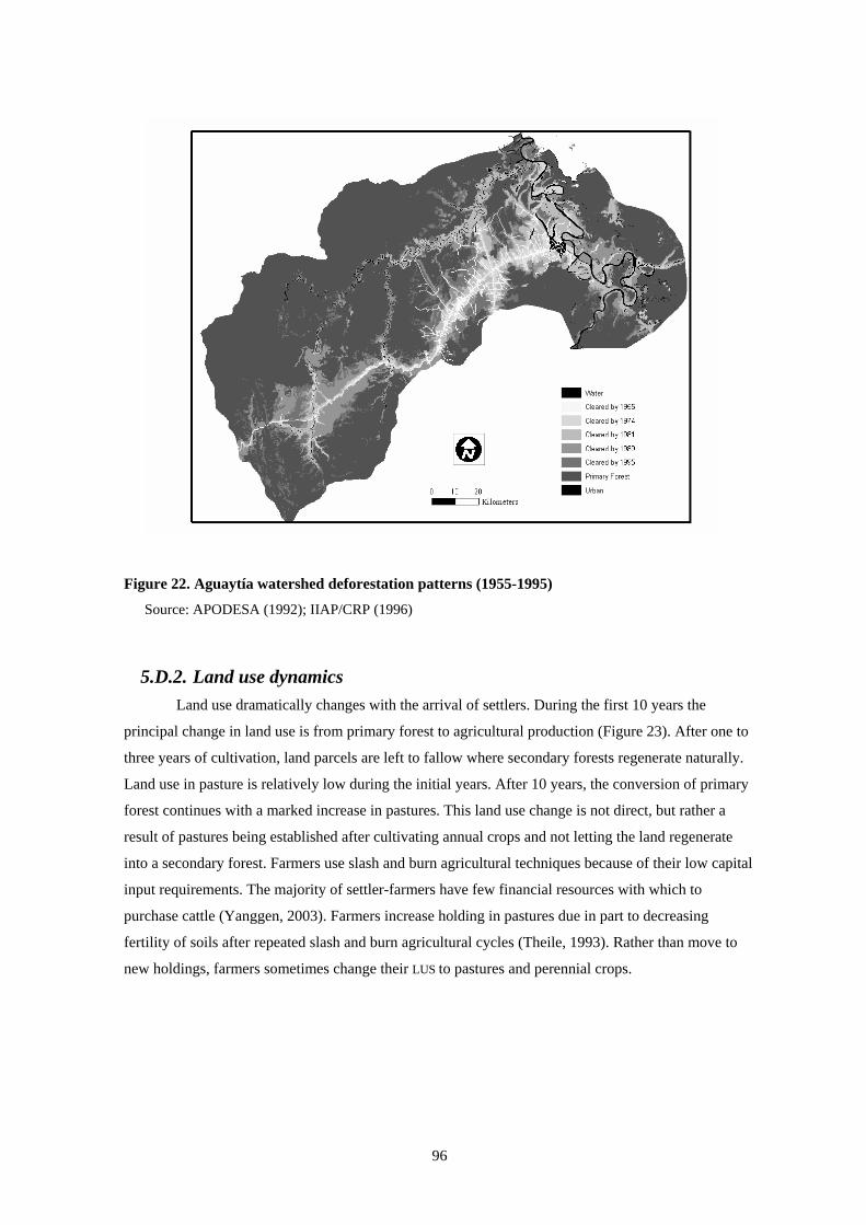
96
Figure 22. Aguaytía watershed deforestation patterns (1955-1995)
Source: APODESA (1992); IIAP/CRP (1996)
5.D.2. Land use dynamics Land use dramatically changes with the arrival of settlers. During the first 10 years the
principal change in land use is from primary forest to agricultural production (Figure 23). After one to
three years of cultivation, land parcels are left to fallow where secondary forests regenerate naturally.
Land use in pasture is relatively low during the initial years. After 10 years, the conversion of primary
forest continues with a marked increase in pastures. This land use change is not direct, but rather a
result of pastures being established after cultivating annual crops and not letting the land regenerate
into a secondary forest. Farmers use slash and burn agricultural techniques because of their low capital
input requirements. The majority of settler-farmers have few financial resources with which to
purchase cattle (Yanggen, 2003). Farmers increase holding in pastures due in part to decreasing
fertility of soils after repeated slash and burn agricultural cycles (Theile, 1993). Rather than move to
new holdings, farmers sometimes change their LUS to pastures and perennial crops.

97
Figure 23. Land use changes in Ucayali benchmark site (2000)
Source: Yanggen (2003)
ASB research also analyzed how government policy could promote sustainable production
systems that improve the well-being of farmers and reduce the impact of agriculture on deforestation
(Yanggen, 2000). A detailed farm household survey was conducted in 1998 in the Aguaytía watershed.
The effect of agriculture on deforestation was examined at three levels: 1) how production
determinants (prices, biophysical conditions, policies, etc) affect farmer decisions concerning; 2)
input/technology use and output supply decisions that in turn determine; and 3) rates of deforestation.
The research also analyzed how changes in Peruvian agricultural policies, including those of structural
adjustment in the 1990s, had affected forest cover.
Results from the econometric model show a clear evolution of land use patterns. Annual crop
production is most strongly associated with early frontier development leading to deforestation at the
forest margin. Livestock tends to come later after primary forest has been cleared and natural resource
depletion leads to clearing of less productive secondary forest fallow land. These results confirm those
of Fujisaka and White (1998) and Smith et al. (1999). Perennial production, on the other hand,
stagnates over time.
Model results also revealed that upon provision of subsidized agricultural credit and
guaranteed minimum prices in the latter half of the 1980s, almost all (94%) of farmers increased their
overall production levels (predominantly of rice and maize) and 90% hired more labor. Nevertheless,
only 11% increased purchased input use. These government policies led farmers to increase output by
hiring more labor for slash-and-burn production of annual crops. A sharp increase in forest clearing
0
10
20
30
40
50
60
0-5 5-15 15-25 >25Years at farm
Land
Use
(%)
.Primary forestSecondary forestPasturesPerennialsAnnual crops

98
can be explained, in part, by 75% of farmers reporting that they cleared larger areas of primary forest
for agricultural use. When subsidized credit and guaranteed prices were eliminated in the context of
structural adjustment, production levels rapidly declined in the Aguaytía watershed (Yanggen, 1999).
Satellite images confirm a related decrease in deforestation rates (IIAP, 1999).
The analysis also demonstrated the key role of capital availability. The use of credit was
positively correlated with those inputs requiring a financial expenditure: purchased inputs and hired
labor. Farmers could also increase agricultural production with technologies that save on labor and
capital (Kudzu-improved fallows and brachiaria-improved pastures). Adoption of these technologies
reflects attempts by farmers to overcome capital constraints. While the impacts of these particular
credit and and labor-saving technologies on deforestation are not uniform, the access or lack of access
to credit plays a key role in determining the farmer production practices that influence deforestation
patterns. A central conclusion of this research is that livestock production and the production of annual
crops using shifting slash-and-burn agriculture are key motors of deforestation in the Aguaytía
watershed. The availability of financial credit and labor increases the extensive production practices
that cause deforestation.
99
6. POLICY AND INSTITUTIONAL OPTIONS
6.A. ASB-Peru matrix
The ASB consortium has the ultimate goal of facilitating better land uses that can improve
smallholder farmer livelihoods and reduce pressures on natural forests. Nevertheless, such a goal is not
easily attained since tradeoffs often exist between economic and environmental objectives. In Peru, lus
that store more carbon and have greater levels of biodiversity also have lower financial returns to labor
and land (Table 25).
Forests and agroforestry systems typically have more carbon and above- and belowground
biodiversity than agricultural systems. Nevertheless, generalizations are not always possible. Although
agricultural systems have lower stored carbon (4.8-9 t ha-1), especially pastures (~5 t ha-1), longer
fallow systems can have more stored carbon (up to 24 t ha-1) than other agricultural systems, when the
entire cycle of cropping and secondary forest is considered. While aboveground biodiversity follows a
decreasing trend, from forest to agricultural land uses, belowground biodiversity does not demonstrate
a simple trend. Tree-based systems such as cocoa and citrus have less soil macrofauna (total weight:
~8 g m-2) than either long or short agricultural fallow systems (20 and 15 g m-2, respectively) or
improved pastures (38.4 g m-2).
Aside from pastures, there are no big differences in agronomic sustainability among LUS. The
LUS are sustainable but at different levels of productivity. Most systems do not use inorganic
treatments (e.g., fertilizers or pesticides): only with oil palm systems is chemical fertilizer typically
used. The indicators in Table 25 reflect the resulting soil quality and associated productivity of the
land uses. Although forested areas have lower soil bulk density (1.2 g cm-3), a measure of soil
compaction, the other measures of P, Ca and Mg, are not distinct from other land uses, except for
native pastures, where available P (5ppm) is the lowest observed. Soils of agricultural lands have
higher bulk densities (1.25-1.3 g cm-3). Pastures, both improved and native, have the highest bulk
densities (1.4 g cm-3 and 1.45 g cm-3).
The socio-economic aspects of LUS differ in many ways. Not only do the LUS generate
products for home consumption and for market sale, they have different returns to land and to labor.
Conventional fallow systems demonstrate the highest returns to labor (US$4.62 day-1). In contrast,
both “improved” pastures and “improved” fallows generated the lowest returns to labor (US$2.79 and
US$2.34 day-1). The perennial systems of citrus and cocoa have the highest returns to land (US$810
and US$644 ha-1). Of interest, the returns to labor performance of these two systems are not
outstanding because of high labor requirements (~US$3.8 day-1). Excluding the two “improved” land
systems mentioned above, all LUS generat labor earnings greater than the minimum wage of US$2.86
workday-1 (Figure 11).
100
The financial performance of the riverine agricultural production is very different from upland
systems. Both returns to land and labor are high for mudflats (US$1796 ha-1 and US$6.74 day-1,
respectively) and floodplains (US$1271 ha-1 and US$4.89 day-1, respectively) – nearly double those of
some upland systems. Many indigenous groups have long recognized such productivity and have
settled along the rivers. Such financial opportunities have also spurred recent efforts of development
projects (e.g., USAID and the regional government of Ucayali) in the past decade. However, the
available cropping period for riverine agricultural is very short and there is a high risk of a sudden
flooding (Kvist and Nebel, 2000).
Do the land uses systems of Ucayali have contrasting environmental, agronomic and socio-
economic attributes? Forest-based systems have higher levels of stored carbon and biodiversity.
Recent efforts by ASB partners in the Ucayali benchmark site, however, suggest that sustainable
timber production is possible. Future research will clarify the financial feasibility and attractiveness of
agroforestry systems for timber production.
For fallow-based agricultural systems, one may be tempted to state that they are neither
financially attractive nor sustainable. Results, summarized in Table 25, refute such a claim. Although
such agricultural systems can demonstrate productivity losses, from weed invasions and soil fertility
decreases, management practices of farmers can help maintain and even enhance the financial viability
of such systems. For older, degraded areas, farmers often use fast-growing leguminous plants, such as
kudzu, to increase soil fertility and organic matter. Farmers are also experimenting with crops such as
cotton, beans and tropical fruits.
One intriguing result of the financial analysis of the LUS is the poor performance of pasture
systems. The returns to land and labor are some of the lowest of the systems assessed. Despite such
performance, cattle remain a high priority for many farmers. Cattle have a strong cultural significance
in Peru as in many Latin American countries. The majority of farmers in the Ucayali benchmark site
hope to increase or start cattle production in the future (Labarta, 1998). The environmental impact of
cattle production in terms of stored carbon, aboveground biodiversity and soil compaction are the most
negative of any land use. In addition to cultural aspects, marketing advantages may be key to
understanding farmers’ preferences (as it is the case for ASB Brazil findings).
Land use will continue to change in the Peruvian Amazon. In a country with high
unemployment like Peru, the availability of land, together with the possibility of earning more than the
minimum wage, creates ample incentive for citizens to migrate to the region. Current developments
such as the paving of the road that connects Puerto Maldonado with the city of Rio Branco, and in the
future, of the road that connects Pucallpa with Cruzeiro do Sul, might also have a great impact on land
use in the Amazon. This has yet to be explored however.

Table 25. Summary matrix of land uses and analysis criteria
Global environment Agronomic sustainability Socioeconomic indicators (smallholder adoptability, national policy concerns)
Stored carbon Biodiversity Plot-level: soil structure and
nutrients Potential EmploymentFood
security Institutions and policy
Land use system (typical scale of operation) Farm size: 20-30 ha Cattle farm size: 50-60 ha.
Aboveground (t C ha-1)
Aboveground (species
richness; PFT richness; ratio)
Soil macrofauna biomass (g m-2 fresh weight)
Bulk density (g cm-3)
Avail-able P (ppm)
Ca (cmolL-1)
Mg (ppm)
Returns to Land a
(US$ ha-1)
Returns to Labor b
(US$ ha-1)
Labor requirements
(workdays ha-1 year-1)
Own production
(OP) or exchange
(E)
Market Other
Primary, untouched 250 63 31 2.03 84.9 1.20 10 <0.5 <0.25 -- -- -- -- o,k n,r,e,P,b,S
Primary, previously logged 122.8 66 31 2.13 91.1 1.20 10 <0.5 <0.25 -- -- -- -- o,k n,r,e,p,b,S
60 2.92 186 E i,o,l,K N,e Multistrata Agroforestry (0.5 ha) **
Bolaina, rice, maize, cowpea Inga, centrosema, rice, maize, cowpea 19 3.62 101 E i,o,l,K N,e Oil palm (5 ha) 41.4 18.5 1.0 0.5 226 3.34 99 E o,l,K e
Cocoa (2 ha) ~16 27 19 1.42 ~8 15-20 1.0 0.5 644 3.70 132 E i,o,l,k n,e
Citrus system (0.5-2 ha) ~16 27 19 1.42 ~8 <0.5 <0.25 810 3.96 116 E i,O,K n,e
Long fallow (2 ha) 24.0 36 26 1.38 19.7 1.25 15 <0.5 <0.25 262 440
4.12 4.62
27 32
OP i,O,L n,E,s
Short fallow (2 ha) 8.7 26 20 1.30 15.1 1.30 15 <0.5 <0.25 368 591
4.10 4.61
28 34
OP i,O,L n,e,s
Improved fallows (0.1 ha) ** (221) 2.34 75 OP/E i,O,L,K N,e,s
Native pasture (2-20 ha) 4.8 23 18 1.31 1.45 5 0.5 0.25 22 3.33 8 E i,O,K E,s
Improved pasture (2-20 ha) 5 12 10 1.20 38.4 1.40 10 0.5 0.25 (4) 2.79 7 E i,O,l,K n,e,b,s
Riverine: Mudflats (<2 ha) Floodplains (5 ha)
6
6
>15
>1
>0.5
1796 1271
6.74 4.89
74 100
OP/E i,O,l,k N,p,b,s
* Experimental systems; a NPV: 20 year horizon, 15% discount rate; b The wage rate that corresponds to NPV = 0 (20 year horizon, 15% discount rate); c Letters indicates institutional constraints to, or impacts of, adoption (upper case indicates a serious problem, lower case indicates a relatively minor problem); Market: i = input market, o = output markets, l = labour markets, k = capital markets; Non-market: n = information, r = regulatory issues, p = property rights issues, e = environmental constraint/problem, b = equity implications, s = social cooperation required for adoption; d Price base: year 2000 (1US$ = 3.5 Nuevos Soles); ** Agroforesty systems were selected on the basis of the quality of the available data and finacial performance.
101

102
6.B. Relationships amongst global benefits, sustainability, and
local/national objectives25
The tropical forest margins represent different sets of problems, opportunities, and concerns to
its farmer-settlers, national agricultural research systems (NARS), and international agricultural
research centers (IARCs). Research and development agencies have responded to the problem of
different goals by seeking the participation of “multiple-stakeholders” in setting collaborative research
and development agendas. “Project planning by objectives” or similar exercises are thought to allow
different interests to be voiced and understood, collaborative relationships to be formed, and common
work plans established. This section discusses the interests and goals of farmers, NARS, and IARCs
working in the Ucayali forest margins and asks to what degree do the different objectives limit the
effectiveness of collaborative efforts (Fujisaka, 2000).
Farmer-settlers in Ucayali are largely poor, have limited access to social services, and have
had little political voice. Although many are involved with producer groups, the sophistication of such
organizations and their ability to affect government policy is often limited. Among farmer goals are
food security, viable economic alternatives, and access to social services. As reported by many,
insufficient financial capital impedes their transition from slash-and-burn agriculture to other
livelihood strategies such as cattle ranching or non-agricultural activities. As is the case with logging,
farmers’ slash-and-burn agriculture has taken advantage of the low values assigned to tropical forest
lands and resources.
The Peruvian Amazon (compared to the coastal and Andean regions) contributes relatively
little to national economic output. Policy to develop rural areas, and specifically the Amazon, are a
strategic government initiative, which can be considered an effort to prevent a resurgence of the
Shining Path insurgency. In the Amazon region, government action contains motives of protecting
territorial sovereignty from incursions by neighboring countries. Despite not realizing substantial
agricultural advances, NARS continue to seek both farmer welfare gains and regional development.
Because of these forces, agricultural research in Ucayali has recently shifted from a focus on
traditional crops to a search for new alternatives emphasizing export oriented crops.
A pattern of resource use in the Amazon has led to a number of global concerns. Logging,
slash-and-burn agriculture, and pasture establishment have contributed to deforestation, losses of forest
biodiversity, and emissions of green house gases (GHGs) associated with global climate change.
IARCs working in the Amazon have attempted to address both these global environmental concerns
and the problems of local poverty. Reducing coca production has been a goal of international
organizations (e.g., UN) and governments of drug-consuming countries such as the United States.
25 Based upon Fujisaka (2000).
103
Although no attempt was made to review the research and development priorities of each of
the many individual agencies or of each of many different groupings of farmers, the major priorities of
each group were identified to discuss implications for partnerships among farmers and researchers,
both national and international. The analysis was based upon discussions ranging from farmer
interviews to workshops with different stakeholders. The first set of interviews in 1996 was part of
ASB characterization activities and covered, among other things, land use patterns and decisions, and
farmers’ problems and objectives. CIAT researchers carried out the second set of interviews to update
and broaden an understanding of farmer priorities in early 2000 (n=35). National and international
research and development objectives were identified via several exercises. The 1998
“Participatory/Project Planning by Objectives” (PPO) workshop developed a common and overlapping
set of research problems and priorities (see section 1.A.4). In early 1999, these “stakeholders” again
met to define research responsibilities in a 3-day workshop to select indicators and to measure impact.
The IARCs further defined their own areas of shared and overlapping concern in a review and
planning meeting held in mid 1999.
6.B.1. Shared objectives: Food security and agro-enterprise development Farmer settlers in Ucayali first seek food security through slash-and-burn annual crop
production. Farmers in upland areas away from the rivers grow mainly rice, cassava, and some maize.
Farmers along the rivers produce banana and some maize. Rice farmers face problems of weeds,
drought, insect pests, diseases, and storage pests. Banana farmers estimated consistent yield losses of
50% due to the foliar disease Sikatoka negra, as well as some theft from parcels close to the rivers.
Farmers, NARS, and IARCs share the goal of improved food production systems. The NARS
in Ucayali have long sought to improve the traditional annual crops of rice, banana, cassava, beans,
and maize. Recent research has worked to develop relatively high-input maize systems for the riverine
flood plains. Collaborative NARS and IARC efforts on traditional crops have included facilitation of
farmer participatory research on rice and banana.
Germplasm improvement of traditional crops is farmer-appropriate to the extent that materials
suited to local environments have been developed or identified. Farmers have gained from new rice,
cassava, and maize varieties. Farmers were unable to afford the fungicides recommended for the
control of Sikatoka negra in their bananas, but would rapidly adopt disease-resistant varieties when
available. Farmers have not adopted high-input mechanized maize production systems due to
perceived low benefits and high risks, and difficulties in obtaining cash needed for such systems.
Because of a perception of regional comparative disadvantage, the national government
currently does not support research on crops such as rice in the Amazon (Takahashi, Minister of
Agriculture, 2000, personal communication). International contributions to traditional crop
improvement have been based on a goal of improving food security among the rural poor, rather than
on increasing regional output.

104
After food security, farmers look for ways to build financial capital to pay for inputs, school
and health fees, and to improve eventually their livelihoods. Substantial numbers of farmers regularly
sought and tested new options including annual crops such as beans, peanut, maize, soybean,
vegetables, cotton, and sugar cane; and perennial crops such as coffee and cacao.
Farmers, NARS, and IARCs share the goal of identifying and developing viable new agro-
enterprises. Although farmers have shown clear interest in alternative crops, many lacked planting
materials and necessary start-up costs. Those successful in producing promoted crops later faced a lack
of processing facilities and markets. Market establishment has been hindered by unstable and low
supply, by the relative isolation of the region and associated high transport costs. Demand for citrus
and achiote was extremely limited. Palm heart was produced in increasing quantities in several tropical
Latin American countries; while the biggest consumer, France, has not increased demand (Winrock
International, 1999). In contrast, cotton production has increased markedly with financing and
technical support of private enterprises.
With the installation of a processing plant, oil palm farmers were able to sell their outputs; and
many reported plans to increase their palm areas. It is unlikely, however, that oil palm production in
the Amazon can compete globally with such Asian countries as Malaysia or Indonesia. Given cheap
forest land and labor, Indonesia’s large plantations are expected to account for up to 5.5 million ha of
oil palm in the next few years (Potter and Lee, 1999).
6.B.2. The NARS’ overlapping objective of regional development In the research described above, the NARS have sought both to enhance regional development
and contribute to improved farmer welfare. Many of the NARS’ activities concern traditional
agricultural crops but also include agroforestry and new products. For example, the NARS have
worked to benefit farmers in their research on perennials such as citrus, achiote, cotton, peach palm
hearts, and oil palm. Current research for the region focuses on the development and promotion of new
crop alternatives such as Amazonian fruit, softwoods, and other products with possible markets outside
of the region, e.g., uña de gato, (Uncaria tomentosa), camu-camu (Myrciaria dubia) and copoazu
(Theobroma grandiflorum). In addition, poultry has been promoted by the NARS in the area, with
many farmers willing to invest labor and local materials if start-up credit were available.
Agroforestry for timber production has been promoted by NARS along with ICRAF. For
many years, logging of tropical timber (and pro-logging policies) supported much of the early and
current development of the region. With deforestation, however, supplies of timber increasingly come
from regions that are more distant. Nevertheless, efforts to reforest and encourage local timber
production have had mixed success. The NARS invested in research on the domestication,
propagation, and management of commercially valuable hard and soft woods (e.g., Tabebuia
serratifolia, Schizolobium amazonicum, Cedrelinga catenaeformis, Terminalia oblonga, Amburana
cearencis). While farmer settlers have shown little interest in hardwoods requiring more care and time

105
to harvest, they have started to tend and locally market the softwood, bolaina, with support from
NARS, ICRAF, community groups and private entities (i.e. GEA). The domestication of trees (e.g., of
bolaina, capirona, pijuayo, and inga) commonly used by farmers has also been successful.
6.B.3. Farmer versus international objectives: Coca and cattle production Both coca and cattle production are contentious products, socially and environmentally. Many
farmers cited a goal of leaving annual cropping for cattle ranching. CIAT and the NARS shared the
goal of regional development in conducting collaborative research on improved pastures and forages.
CIAT and local agencies in Ucayali were part of a consortium (Tropileche) formed to develop
improved, more intensive dual-purpose (milk and meat) cattle systems (see section 5.C.9). An
opposing international concern is that pasture establishment after slash-and-burn agriculture in Ucayali
and elsewhere in the Amazon has contributed substantially to deforestation (White et al., 2001;
Yanggen, 2000, 2003).
Many farmers see coca as a rare opportunity to earn an ample livelihood. Coca was grown
extensively in the Aguaytía region (and other parts of Peru) until internationally-assisted government
eradication efforts reduced its cultivation. These programs represent the interests of drug consuming
countries in stemming production. The eradication programs, however, did not further international
interests in farmer welfare and environmental issues. Based on farmers’ outlining of costs and benefits
(especially in terms of building financial capital), coca leaf production was a highly successful agro-
enterprise. The crop also provided financial benefits to laborers hired for weed control and harvest. As
a result of eradication efforts, many coca growers found themselves forced to turn to the production of
cassava, plantain, and charcoal. In so doing, such farmers made a shift from being cash-paying
consumers of local agricultural produce to being competitors with other producers. Yet, the land use
change away from coca may have worse environmental consequences. To earn an adequate livelihood,
farmers need to cultivate larger fields of traditional crops, which can hasten deforestation rates.
6.B.4. Agricultural research and development and other farmer objectives Farmers identified a range of other problems related to agriculture including low prices for
outputs, high transport costs, annual flooding in the riverine areas, insecure land tenure, and poor roads
in the wet season. Other rural development challenges included a lack of schools and health posts in
some remote areas. Although government projects have included road improvement, school and health
post construction and staffing and latrine construction, not all areas had access to such services and not
all structures were adequately staffed. For instance, farmers criticized an on-going latrine project for
favoritism in beneficiary selection. Farmers also sought secure land titles (see sections 4.C.2.d and
5.C.4).
6.B.5. Are the IARCs alone in terms of environmental objectives? Donors and IARCs have supported collaborative projects such as ASB and DEPAM, which
have objectives of both farmer welfare and the environment. These projects have given substantial

106
attention to the identification or development of so-called “win-win” technological innovations that
provide both private (farmer) and public (environmental) benefits. Examples include improved
fallows, secondary forest management, and agroforestry. Nevertheless, farmers rarely adopt these
innovations. The technologies are largely “knowledge intensive,” can require long-term investments,
and do not produce adequate returns over costs, especially given the alternative of continued extensive
agriculture. Land prices as low as US$15 ha-1 encourage continued forest extraction and slash-and-
burn agriculture over practices that are more intensive.
Where primary forests are no longer available, secondary forests have been managed for
timber production. For example, most of Costa Rica’s original forest has been logged and much of the
area converted to pasture. Remaining forests are effectively protected, in part because of benefits from
eco-tourism. Government policies (including subsidies) have been successful in encouraging ranchers
and smallholders to adopt improved management and innovative use of their relatively large areas of
secondary forest (Berti, 1999). In Peru, however, as in other developing countries, farmers (and
loggers) have had few incentives to consider the more global environmental goals. Both slash-and-
burn agriculture and logging in Ucayali have taken advantage of relatively open access to forest
resources. Consequently, the NARS have largely had to seek economic development over addressing
global environmental concerns.
A thrust of the IARCs, especially of ICRAF and CIFOR, has been to identify policy
alternatives that generate more farmer and NARS interest in environmental protection. While the
secondary forest management project did not receive much acceptance by farmers (section 5.C.2), the
planting of bolaina by farmers for local processing appears to have demonstrated early success (section
1.A.4.c). Also in an attempt to achieve this goal, WWF offered a training course on timber certification
in 1999. Yet, local reticence remains because implementation costs are to be paid by loggers and the
timber industry.
In sum, the goals of farmers, NARS, and IARCs reflect both overlap and divergence. In
Ucayali, as in other tropical forest margins, local resource users strive to capture the private goods and
services of rainforest resources. Slash-and-burn agriculture, cattle ranching, and logging represent the
conversion of natural capital (forests) into subsistence goods and financial capital. NARS goals have
been economic development of the region and improved welfare of local settlers. International
concerns have been split between a desire to maintain global public goods (biodiversity and forest
carbon stocks) and improved local welfare.
Farmers, NARS, and IARCs share a goal of sustainable livelihoods of both settlers and
indigenous groups in the Amazon. Research to improve traditional crop and livestock systems will
continue to contribute to the goal of improving local welfare, although improved profitability of such
cropping could lead to further deforestation. Stakeholders also share hopes for the success of new
alternative crops (including trees) and agro-enterprises. Such crops may benefit farmers and regional
107
economic output, and may represent an improvement over slash-and-burn agriculture. A lack of
markets (in part due to the area’s isolation) remains as a substantial barrier to commercial success.
6.C. Policy initiatives26
6.C.1. Intensification and deforestation To reduce environmental impacts of land-extensive agricultural practices (i.e. slash-and-burn),
research and policy initiatives can promote cropping practices that are more sedentary. Labor-intensive
production of high-value perennial crops can accomplish this by absorbing labor into sedentary
production while still providing high returns to labor. Agroforestry techniques that incorporate trees
with high-value products into pastures and fallows also have the potential to do so.
Nevertheless, the realization of intensive production with associated financial benefits may
encourage more deforestation in two ways. First, if new practices or crops are sufficiently profitable,
farmers may invest in labor-saving capital equipment or simply hire more labor in order to expand
production into the forest margins. Second, more settlers arriving to the region in order to earn a living
from improved agricultural practices may exacerbate deforestation rates. The laissez faire migration
policy of the Peruvian government could be changed with complementary policies that restrict access
to (primary) forest lands, such as reductions in new road construction, progressive taxes according to
farm size, and regulations that limit on-farm primary forest clearing. Governments and development
agencies can use credit, tax and land reform policies as incentives to rehabilitate degraded lands for
improved pastures, agricultural use or reforestation.
6.C.2. Land use policy The clearing of extensive tracts of primary forest by settlers, especially a few large ranchers,
sacrifices large areas of rainforest while providing few economic benefits for the general population.
Efforts by policymakers could focus both on restricting the size of cattle ranches and limiting
production to older settlement areas where degraded land is less productive for annual crops but
suitable for pastures.
6.C.3. Processing The transformation of agricultural raw materials into products such as furniture, oils,
preserves, handicrafts, and flour can dramatically lower the transportation costs (Yanggen, 1999) and
enable the region to realize more gains from value-added processing. By generating more earnings
locally, it may be possible to reduce the need to expand primary-good production in order to generate
adequate household earnings. Competitiveness remains a key issue. Production efficiencies, costs of
labor, and access to markets from remote regions can limits these options.
26 Adapted from Faminow and Weber (2001), White et al. (2000), Yanggen (2000a,b).

108
6.C.4. Protected areas In principle, national parks and reserves can maintain forest cover. Yet, issues regarding
property rights, governance, and land encroachment can challenge the long-term viability of protected
areas. While military involvement may also bring potential problems of corruption and illegal land
acquisitions by leaders, such an example is illustrative of how much effort may be required to protect
areas.
6.C.5. Capacity building of local organizations Public meetings with open discussion can improve understanding of differing objectives and
potential conflict amongst diverse stakeholder groups, which often range from national and
international organizations to local associations. Yet, a balanced representation of stakeholders and
their associated viewpoints is rarely easy to attain. Even when local groups participate in negotiations,
they tend to be less influential. In contrast, more-organized stakeholder groups are able to exploit their
political and legal prestige in order to sway a policy outcome. Assistance of less-organized stakeholder
groups to become more effective during negotiations can achieve a more representative policy-making
process.
Information and organizations can foster more-equitable marketing. Farmer organizations may
enable producers to negotiate fairer prices with intermediaries and mills. Radio announcements can
provide crucial production and marketing information to reach more distant and difficult-to-access
farmers.
Several countries have experimented with giving local governments and organizations greater
rights and responsibilities related to forest management and conservation. In Bolivia, however, the
goal of improved conservation was not met because local groups remained more concerned about their
access to resources and immediate incomes (Kaimowitz et al., 1998).
6.C.6. Forest product development Extractive reserves might make land with standing forest more valuable. The promotion and
development of non-traditional forest products can provide private incentives to use forests (Kishor
and Constantino, 1994; Rice et al., 1997). A challenge is to identify production practices that both
increase returns to labor as well as decrease forest clearing. Conserving tree genetic resources and
developing sustainable economic opportunities in the Amazon is a possible way to achieve these two
goals. Training national institutes and empowering local communities to act in participatory tree
domestication, genetic resource management, and creating economic benefits from conservation
measures are essential steps in the process of institutionalising conservation measures.
6.C.7. Environmental service payments In theory, conservation payments can allow private landholders to receive monetary
compensation for the public services they provide. Payments can come in many forms such as for

109
reforestation campaigns, biodiversity preservation, and carbon sequestration. Managing these
interventions is tricky, however, and a lot of work is still needed on market mechanisms, monitoring,
and accountability (Swisher and Masters, 1992). For example, inappropriate incentive structures may
not lead to greater reforestation if the projects involved focus on the number of trees planted, rather
than the percentage that survive.
Innovative ways of increasing the value of forests relative to other land uses include
international trade in carbon sequestration services. The recovery of biodiversity and the fixation and
storage of atmospheric carbon are particularly important environmental services as markets for them
are beginning to emerge.27 Mechanisms such as these may be able to alter the economics of forested
land compared to other land uses and thus substantially enhance the effectiveness of traditional
approaches to increasing forest cover. However, to compete in carbon markets, the cost of sequestering
carbon in land-use change and forestry projects will have to be lower than the market price of carbon.
Most studies suggest that the costs of carbon mitigation options, particularly those based on forestry,
are quite modest (Cacho et al., 2003).
For the Ucayali benchmark site, Smith and Mourato (2002) estimated that a compensation of
US$8 t-1 to US$31 t-1 of C would be required to protect residual forest, maintain secondary forests or
to induce small-scale farmers to plant multistrata agroforestry systems. Global data indicate that the
transition costs of agroforestry systems and community plantations are often higher than the costs of
industrial plantations (Smith and Scherr, 2003) or large-scale forest protection schemes involved in
carbon trading. “In theory, secondary forest fallow could also qualify for carbon sequestration
payments if farmers increase fallow periods. Sequestration payments are, however, unlikely to be
sufficient to justify the transactions cost of participating in carbon markets because the scope for
increasing fallow periods is unlikely to exceed a few years” (Smith et al., 2001, p.298). These farmers
may be able to store carbon more economically than the cost of reducing carbon emissions through
many fuel-switching energy projects. Environmental markets and supporting policies, however, rarely
consider improved secondary forest management. Only one international fund includes forest-oriented
projects (the BioCarbon Fund). In addition, the Kyoto credits are restricted to afforestation,
reforestation, and agroforestry projects.
Despite these marketing challenges, Peru is becoming more involved in carbon trading efforts.
In 2004, Peru presented numerous Clean Development Mechanism (CDM) projects to the 1st World
Carbon Fair (http://www.carbonexpo.com). Of these projects, 14 pertained to the energy sector and 5
to the forestry sector. Peruvian participation in CARBONEXPO was the first concrete step to put the
country in the international CDM carbon arena. The effort also demonstratesd improved coordination
amongst organizations. PROMPEX, FONAM, CONAM, Ministry of Economy and Finance, and
ProInversion worked together (CO2mercio, 2004). Similarly, a project on participatory reforestation
110
has recently been submitted for review. This project includes parts of the Aguaytía watershed and is
led by DEVIDA and UNODC (INRENA, 2004). A joint project between PROSEMA and
ProNaturaleza is undergoing to establish plantations of bolaina and capirona with an estimated
potential of sequestring 450 t CO2 per hectare (Luis Miguel Aparicio, personal communication).
6.C.8. Product certification Milk and meat processors could require their farmers and ranchers to use practices such as
silvo-pastoral agroforestry systems or intensive pasture management. A certification process, similar to
that of timber, could provide higher market prices thereby providing an incentive to invest in
environmentally-friendly production techniques. In some cases, marketing benefits accrued from
producing a “green” product may be sufficient to cover costs, although the media and the public would
probably still need to monitor the claims made by companies.
6.C.9. Non-agricultural development Development of a non-agricultural economic sector can remove pressures upon the natural
resource base. This implies the need for a broad-based local development strategy including tourism
and other services along with industrial sectors. Economic vigor of the entire country, especially in
urban areas, can attract citizens away from the forest margins, as can migration to industrialized
countries (Aide and Grau, 2004).
27 Data on carbon fixation by type of secondary forests is available for both Yurimaguas and Ucayali benchmark
sites at http://www.asb.cgiar.org/data/Cstock.htm.

111
7. LESSONS AND CONCLUSIONS Rather than the grandiose breadbasket envisioned by government planners during past
decades, the Peruvian Amazon region continues to be more a relief valve for an expanding population.
Yet, despite the bad performance of previous organized settlement programs (Nelson, 1973), the
national government is once again poised to formally develop the Amazon territory. For example, the
Peruvian government instituted an Amazon policy that seeks to promote investment and development
in the region by instating tax-relief measures (Law 27037) for fuel purchases, agricultural and cattle
ranching activities, aquaculture, fishing, related manufacturing linked to processing, transformation
and commercialization, and tourism (Congreso de la República, 1998).
The tight financial situation of the Peruvian government will likely not change in the short- or
medium-term. Alternative and low-cost tactics to disseminate technologies and receive better market
prices are required. Improved coordination with other government institutions (e.g., health and
education) can facilitate dissemination of modern varieties to more communities in a cost-effective
manner.
Forest margin regions will continue to have agricultural activity and cattle production for the
foreseeable future. Producers need the incomes and consumers demand the products. In many frontier
regions, farmers have no viable use for their land besides cattle. This leads to situations like those
found in Ucayali where desperate farmers, with few alternative options, have established pastures
without even having cattle in the hope that they might get some in the future. Moreover, consumer
demand for animal products continues to grow rapidly. In developing countries, the livestock sector
expanded so fast between 1982 and 1993 that IFPRI/FAO/ILRI (1998) has called it ‘The Next Food
Revolution’. Annual growth rates during the period were 7.4% for poultry, 6.1% for pork, 5.3% for all
meat, and 3.1% for milk. It remains to be seen whether the necessary increases in agricultural and
animal production will come from extensive or intensive production systems (May and Segura, 1997).
Forest margins research in Peru has benefited from the ASB consortium, and vice versa. Not
only are researchers coordinating and sharing experiences within the region but also with scientists
from around the world. ASB has encouraged a new attitude towards research, by changing isolated
agricultural crop or forest research into a more interlinked and wide-ranging research program that
examines farming systems, secondary forests and the driving forces of deforestation.
The implementation of agricultural varieties and agroforestry alternatives has increased based
on interaction created by ASB activities. National research partners and universities have started to
include agroforestry within their workplans and curricula. Training in tree domestication and genetic
resource management has motivated INIA, INRENA and others to institutionalize these projects,
thereby scaling up and scaling out these activities in Peru. In addition, the government of Peru has
incorporated recommendations regarding tree genetic resource management in its new national
forestry laws.

112
“Win-win” or “best-bet” technologies that try to provide both private (income) and public
(carbon and biodiversity) gains have survived in field trials, demonstrations, and at the researchers’
desks, but not in farmers’ fields. Technologies such as improved fallows, agroforestry, multistrata
systems and secondary forest management provide lower private benefits to local users than current
land use systems.
Few real options have moved out of the textbook and desktop to survive in the real world.
Many farmers have expressed disappointment in local development agencies over perceived broken
promises. For example, the productivity and profitability of oil palm has never led to the realization of
farmers being able to own personal pickup trucks. Similarly, efforts to generate income from
secondary forest production were not viable (CNF/Madebosques). In addition, strong dissatisfaction
with alternative development projects was common in coca producing areas (see section 4.C.2.f). Ex
ante financial feasibility analyses can improve the chances of developing and disseminating viable and
attractive land use options. Many agroforestry enterprises, for example, require more study with
respect to the sensitivity of cash flow estimates’ yields, prices, and household food security.
Technology adoption of intensive systems remains a challenge. Decades of agricultural
research in the tropics have produced a myriad of agricultural management options. Yet, experiment
station research rarely simulates the conditions that smallholder farmers face (Fearnside, 1987). For
example in Africa, a review of technologies developed and made available showed that farmers had
adopted only approximately one third of them (Waterworth and Muwamba, 1989). In order for land
use alternatives to have a significant impact, they must be both agronomically sustainable and
financially rewarding from the perspective of smallholder farmers. Hence, the scope of ASB research
requires inquiry beyond biophysical measures such as climate change and biodiversity to also consider
agronomic and farmer social and economic perspectives.
The international research community cannot expect local resource users to pay the costs of
maintaining global public goods, e.g., biodiversity and carbon sequestration. Valuation of such goods
and of the losses incurred by current land use systems has been attempted, although the policy
mechanisms by which higher income countries contribute to such costs has remained highly
problematic.
Unfortunately, no “silver bullet” policies have been found. One study, in the Brazilian
Amazon, found few signs of success of several policy initiatives despite their potential. Policies
included environmental conservation (e.g., charging of fees for unsustainable forest use), payment to
land owners for better management practices, establishment of unambiguous forest resource property
rights, and changes in related policies such as those dealing with road building and agricultural credit
(Richards, 1999).
Much of the international research community has accepted the idea that the creation of social
capital will be necessary to successfully improved resource management. In Ucayali, social capital
113
gains should lead to financial capital gains. Yet, these efforts take years to develop. Micro-finance and
farmers’ research groups may be examples of promising efforts to spur the development process.
The destruction of the forest itself—as distinct from its biodiversity—also eliminates a
national renewable resource which, if conserved and managed rationally, has the potential to
contribute more than the 1-4% of GDP (gross domestic product) currently attributed to it (Brack and
Mendiola, 2000), Researchers concerned with environmental problems have had to ask, however, to
what extent do new alternatives, ostensibly beneficial to farmers and to regional development, lead to
increased deforestation (Yanggen, 2000; Angelsen and Kaimowitz, 2001; White et al., 2001).
Planned future efforts from ASB include the continued and extended conversion of scientific
research results into more farm-level impact. In order to increase the probability of change, the process
of technology development will be linked with policy decisions. Research institutes and policymakers
are working together to examine the implications of both research priorities and government policies.
Examples of more immediate policy action include the allocation of funds for agricultural research and
the prioritization of extension efforts. Other longer-term research efforts include projects to remunerate
farmers for their environmental services. These research and development endeavors will be
coordinated with other ASB countries, especially Brazil, to compare and contrast research outcomes.
Future research should also provide alternative land uses so that deforestation and extensive land use
will no longer be farmers’ most attractive option. Technical research, to increase productivity and
prevent land degradation, must go hand in hand with policy analysis and implementation to increase
incentives for forest preservation while addressing farmer livelihood objectives.


115
ANNEX
Associated scientific personnel
Scientist Discipline Institutional Affiliation
Julio Alegre Soil Scientist ICRAF Manuel Arca Soil Scientist INIA Luis Arévalo Soil Scientist ICRAF Dale Bandy Agronomist ICRAF Arnoud Braun Agronomist ICRAF Scott Cecci Geographer CIAT Mirela Clavo Botanist IVITA Violeta Colán Forester CIFOR Jonathan Cornelius Forester ICRAF German Escobar Ecologist CIAT Merle Faminow Agricultural and Natural Resource Economist ICRAF Ymber Flores Forester INIA Sam Fujisaka Agricultural Anthropologist CIAT Andy Gillison Ecologist CIFOR Wagner Guzmán Agricultural and Natural Resource Economist ICRAF Glenn Hyman Geographer CIAT Jacques Imbernon Geographer CIRAD Ricardo Labarta Agricultural and Natural Resource Economist CIAT, ICRAF Efraín Leguía Agronomist CIAT Tamsyn Murray Health and Agriculture Specialist CIAT Cheryl Palm Soil Scientist TSBF Keneth Reátegui Animal Scientist CIAT Auberto Ricse Forester INIA César Sabogal Forester CIFOR Angel Salazar Soil Scientist INIA, IIAP José Sánchez Agronomist CIAT Joyotee Smith Agricultural Economist CIFOR Carmen Sotelo Forester ICRAF Abby Rosenheck Political Scientist CIAT Julio Ugarte Forester ICRAF Eric Veneklaas Ecologist CIAT Héctor Vidaurre Forester ICRAF John C. Weber Forest geneticist ICRAF Douglas White Agricultural and Natural Resource Economist CIAT David Yanggen Agricultural and Natural Resource Economist ICRAF


117
REFERENCES Abanto, C.G. and J. Vela. 1997. Evaluación Técnica y Economía de Sistemas de Producción Ganadera en
Fundos de la Region Ucayali. Instituto Nacional de Investigación en Agricultura Pucallpa, Peru, 44 pp.
Achard, F., H. Eva, A. Glinni, P. Mayaux, T. Richards and H. Stibig (eds.). 1998. Identification of Deforestation Hot Spot Areas in the Humid Tropics. European Commission Tropical Ecosystem Environment Observations by Satellites. Series B, Research Report 4, Brussels, Belgium.
Aide, T.M. and H.R. Grau. 2004. Globalization, Migration, and Latin American Ecosystems. Science, 305 (24), 191-196.
Asia Times, 2003. The price of Malaysia's palm oil expansion. Online at: http://www.atimes.com/atimes/archive/5_3_2003.html
Alegre, J. and L. Arévalo. 2000. Greenhouse Gas Emissions from Slash-and-Burn and Alternative Land Uses in Peru. ICRAF-ASB working paper.
Alegre, J. and L. Arévalo. 1999. Manejo sostenible de suelos con sistemas agroforestales en los trópicos húmedos. Memorias del primer Congreso de la Sociedad Boliviana del Suelo, 28-31 Julio. La Paz, Bolivia.
Alegre, J. and D. Bandy. 2000. Soil Nutrient Stocks in Different Land Use Management Systems in the Humid Tropics of Peru. ICRAF, Pucallpa, Peru.
Alegre, J. and D.K. Cassel. 1999. Intensive Soil Management in the Humid Tropics. Technical Bulletin No 99-1, Soil Management Cooperative Research Support Program (CRSP), North Carolina State University, 28 pp.
Alegre, J. and B. Pashanasi. 2000. Soil Macrofauna in Different Land Use Systems in Pucallpa and Yurimaguas Peru. Working paper.
Alegre, J., M.R. Rao, L. Arévalo, W. Guzman and M.D. Faminow. 2005. Planted tree fallows for improving land productivity in the humid tropics of Peru. Agriculture, Ecosystems and Environment, 110: 104-117.
Alegre, J., B. Pashanasi, L. Arévalo and C. Palm. 2001. Efecto del manejo del suelo sobre las propiedades biológicas del suelo en los trópicos húmedos del Peru. Resúmenes XV Congreso Latinoamericano de la Ciencia del Suelo, Centro de Convenciones Plaza América, Varadero, Cuba, Boletín 4, p. 60.
Alegre, J., L. Arévalo, A. Ricse, and J. Barbarán. 2000a. Carbon Sequestration and Trace Gas Emissions in Slash-and-Burn and Alternative Land Uses in the Humid Tropics of Peru. ICRAF-ASB working paper.
Alegre, J., L. Arévalo, M.R. Rao, W. Guzmán. 2000b. Short duration planted fallows in the humid tropics of Peru. Annual Meeting of American Society of Agronomy, Crop Science Society of America, Soil Science Society of America. Minneapolis, Minnesota 5-9 November 2000. (abstract only).
Alegre, J., L. Arévalo, W. Guzmán, M.R. Rao. 2000c. Barbechos mejorados para Intensificar el uso de la tierra en los trópicos húmedos del Perú. Agroforestería en las Américas 7(27): 7-18.
Alegre, J., L. Arévalo, C. Palm, J. Smyth, and L. Szott. 1999. Agronomic Sustainability Indicators for Peru. Poster presentation at Symposium on Slash and Burn Agriculture: a Global Synthesis. Soil Science Society of America. Salt Lake City, Utah, 1-5 November 1999. (Proceedings in 2000).
Alvarez, N. L. and L. Naughton-Treves. 2003. Linking national agrarian policy to deforestation in the Peruvian Amazon: a case study of Tambopata, 1986-1997. Ambio 32 (4): 269-274.
Angelsen, A. and D. Kaimowitz (eds.). 2001. Agricultural Technologies and Tropical Deforestation. CABI, Cambridge.
Anon., 2003. CEDEFOR y los Bosques de la Amazonia. In: Bosques Amazónicos virtu@l. Año 3, No. 6. Setiembre 2003. Iquitos, Perú.
APODESA. 1992. Cobertura y uso de la tierra en el área de influencia de la carretera Federico Basadre-Río Ucayali, mediante la utilización de técnicas de percepción remota. INADE, pp. 31.

118
Ara, M. 1997. The forestry industry in Ucayali. In: T. Murray and G. Gallopín, (eds.) Proceedings of the First International Workshop on an Integrated Conceptual Framework for Tropical Agroecosystem Research based on Complex Systems Theories. CIAT Working Document 167. CIAT: Cali, Colombia. 26-28 May 1997, pp. 45-46.
Aramburú, C.E. 1984. Expansion of the Agrarian and Demographic Frontier in the Peruvian Selva. In: M.Schmink and C.Wood (eds.), Frontier Expansion in Amazonia, University of Florida Press, Gainsville, pp. 155-179.
Arevalo, L., J. Alegre, D. Bandy and L. Szott. 1998. Changes in soil properties following cattle grazing in a silvopastoral system in the Peruvian Amazon. Agroforestry Systems, 40: 109-124.
Auer, M. R., C. D. Ingram and C. Farley. 2003. Towards an improved understanding of illegal logging and associated trade. USDA Forest Service International Programs, Discussion paper, May 30.
Barham, B.L. and O.T. Coomes. 1995. Prosperity's Promise: The Amazon Rubber Boom and Distorted Economic Development. Westview Press, Boulder, USA.
Berti, C. G. 1999. Transformaciones recientes en la industria y la política forestal costarricense y sus implicaciones para el desarrollo de los bosques secundarios. Tesis Magister Scientiae, Centro Agronómico Tropical de Investigación y Enseñanza, Turrialba, Costa Rica.
Barrantes, R. and C. Trivelli. 1996. Bosques y Madera: Análisis Económico del Caso Peruano. Consorcio de Investigación Económica. Instituto de Estudios Peruanos, Lima, Peru.
Bignell, D.E., J. Tondoh, L. Dibog, S. Pin Huang, F. Moreira, D. Nwaga. B. Pashanahi. E. Guimaraes Pereira, F-X. Susilo and M.J. Swift. 2005. Belowground Biodiversity Assessment: The ASB Functional Group. In: Slash and Burn: The Search for Alternatives, C.A. Palm, S.A. Vosti, P.A. Sanchez, and P.J. Ericksen (eds.), Columbia University Press, New York, NY, USA.
Binswanger, H. and J. McIntire. 1987. Behavioral and Material Determinants of Production Relations in Land-abundant Tropical Agriculture. Economic Development and Cultural Change, 36: 73-99.
Boserup, E. 1965. The Conditions for Agricultural Growth: The Economics of Agrarian Change under Population Pressure. Aldine Publishing Co., Chicago.
Brack, A. and C. Mendiola. 2000. El Perú: un país de vocación forestal. Online at http://www.peruecologico.com.pe/lib_c19_t05.htm. In: Enciclopedia “Ecología del Perú”, Capítulo 19: Flora y vegetación como recurso natural. Lima: Bruño, PNUD.
Cacho, O.J., R.G. Marshall and M. Milne. 2003. Smallholder Agroforestry Projects: Potential For Carbon Sequestration and Poverty Alleviation. ESA Working Paper No. 03-06 June 2003. Food and Agriculture Organization of the United Nations. FAO.
Caillaux, J. 2004. Un banco de plástico. In: “Del Consultor”. El Comercio, Perú. 7 Abril 2004.
Cecchi, S., M.A. Valdivieso, J. Soto, G. Hyman, C. Ostertag, C. Wheatley and V. Gottret. 1999. Development of guidelines for the design of policy options for national support systems whose objective is the promotion of rural agroenterprises. Rural Agroenterprise Development Project, Annual Report, CIAT, Cali, Colombia.
Chirinos, C. and M. Ruiz. 2003. Case study on the development and implementation of guidelines for the control of illegal logging with a view to sustainable forest management in Peru. Peruvian Environmental Law Society (SPDA). ITTO, 34th Session, 12 - 17 May 2003, Panama City, Panama.
CIAT. 1999. Annual report: Rural Agroenterprise Project SN-1. CIAT, Cali, Colombia.
CIFOR. 2004a. Investigaciones para el manejo de bosques secundarios en la región de Ucayali: algunos resultados y lecciones aprendidas.
CIFOR. 2004b. INIA y el CIFOR desarrollan un estudio de diagnóstico sobre la adopción de prácticas de rehabilitación de tierras forestales degradadas en la Región de Ucayali.
CIFOR. 2003. Actividades del CIFOR en la Amazonía Peruana, 1998-2003.
Clavo, M., Z. Seijas and J. Alegre. 2003. Plantas Medicinales Usadas por las Mujeres Nativas y Mestizas de la Region Ucayali. Pucallpa, Peru.

119
Clay, J.W. and C.R. Clement. 1993. Selected species and strategies to enhance income generation from Amazonian forests. FAO: Misc/93/6 Working Paper: Food and Agriculture Organization of the United Nations.
Collinson, M.P. (ed.). 2000. A History of Farming Systems Research. FAO and CABI, Rome.
CO2mercio. 2004. La Cartera de Proyectos Presentado en la Feria. Boletín dedicado a informar sobre las oportunidades del mercado de carbono, Boletín No. 4, 20 Julio 2004. 4 (6).
Congreso de la República. 1998. Ley de Promoción de la Inversión en la Amazonía Peruana. Ley No. 27037, 30 Diciembre 1998, Lima, Perú.
Congreso de la República. 2000. Ley Forestal y de Fauna Silvestre. Ley No. 27.308, 15 Julio 2000, Lima, Perú.
Coomes, O.T. 1996. State credit programs and the peasantry under populist regimes: Lessons from the APRA experience in the Peruvian Amazon. World Development, 24, 1333–1346.
CORDEU (Corporación de Desarrollo de Ucayali, Dirección Departamental de Industria y Turismo). 1982. Evaluación de la Problemática de la Industria Maderera de Pucallpa. Asociación de Industriales Madereros de Ucayali, and Cámara de Industria y Comercio de Pucallpa, Pucallpa.
CTARU. 2002. Proyecto Palma Aceitera en Ucayali. Pucallpa, Peru (Raw data obtained by Guzman).
CTAR and IIAP. 2003. Zonificación Ecológica Económica de la Cuenca del Rio Aguaytía. Convenio IIAP-CTAR-Ucayali. Digital version [released July 2003, maps from 2002].
de Rouw, A. 1995. The fallow period as a weed-break in shifting cultivation (tropical wet forests). Agriculture, Ecosystems and Environment, 54: 31-43.
Dirección Regional de Salud. 1997.
Dirección de Transporte Acuático. Ministerio de Transportes y Comunicaciones (Región Ucayali).
Eguren, F. 2003. Las politicas agrarias en la última década: una evaluación. SEPIA X. Pucallpa, Peru. On line at: http://www.sepia.org.pe/tema1/fernandoeguren.pdf
Erickson, H. E. and M. Keller. 1997. Tropical land-use change and soil emissions of nitrogen oxides. Soil Use and Management, 13, 278-287.
El Comercio. 2003. Ejes de desarrollo. El Comercio, Perú. 24 Agosto 2003.
Elgegren, J.O. 2005. La deforestación en el Perú. Presentación powerpoint. Taller de Indicadores Ambientales. Análisis Ambiental de País – Perú. 20 y 21 de octubre de 2005. Reserva Nacional de Paracas, Perú.
Faminow, M. D. 2001. ICRAF Concept for Intensified Management of Secondary Forests. Draft document. February. ICRAF, Lima.
Faminow, M. D., J. C. Weber. 2001. Linking poverty and the environment: Strategic management of genetic resources for sustainable livelihood options in the Amazon. ICRAF working paper .
FAO and INRENA, 2005. Actualización de la Evaluación de los Recursos Forestales Mundiales a 2005. Perú. Informe Final. Lima. INRENA.
Feder, G. and D.L. Umali. 1993. The Adoption of Agricultural Innovations: A Review. Technological Forecasting and Social Change, 43: 215-239.
Fearnside, P. M. 1987. Rethinking Continuous Cultivation in Amazonia. BioScience, 37, 209-214.
Firestone, M. K. and E. A. Davidson. 1989. Methodological basis of NO and N20 production and consumption in soil. p. 7-21. In: M. O. Andreae and D. S. Schimel (eds.) Exchange of Trace Gases between Terrestrial Ecosystems and the Atmosphere. John Wiley, New York, USA.
Franzel, S., R. Coe, P. Cooper, F. Place and S.J. Scherr. 2001. Assessing the adoption potential of agroforestry practices in sub-Saharan Africa. Agricultural Systems, 69: 37-62.
Fujisaka, S. 1997. Metodología para caracterizar sistemas de uso de tierras: Acre, Rondônia, y Pucallpa en la Amazonía. In: Conceptos y Metodologías de Investigación en Fincas con Sistemas de

120
Producción Animal de Doble Propósito, C.E. Lascano and F. Holmann, (eds.), CIAT, Cali, pp. 174-190.
Fujisaka, S. 2000. How shared are Farmer, National and International Agendas in the Forest Margins? CIAT Report. 7 pp.
Fujisaka, S. and D. White. 1998. Pasture or permanent crops after slash-and-burn cultivation? Land use choice in three Amazon colonies. Agroforestry Systems, 42(1): 45-59.
Fujisaka, S., O. Madrid, L. Hurtado, H. Usma, A. Ricse, Y. Flores, F. Idrogo, J. Barbaran, L. Arévalo and R. Labarta. 1996. ASB Benchmark Site Diagnosis and Characterization: Pucallpa, Peru. CIAT, Cali, Colombia.
Fujisaka, S., C. Castilla, G. Escobar, V. Rodrigues, E. Veneklaas, R. J. Thomas and M. J. Fisher. 1998. The effects of forest conversion on annual crops and pastures: estimates of carbon emissions and plant species loss in a Brazilian Amazon colony. Agriculture, Ecosystems and Environment, 69: 17-26.
Fujisaka, S., O. Madrid, L. Hurtado, H. Usma, A. Ricse, Y. Flores, F. Idrogo, J. Barbaran, L. Arévalo and R. Labarta. 1999. Land use systems and dynamics in Pucallpa, Peru. In: Systems and Farmer Participatory Research: Developments in Research on Natural Resource Management, S. Fujisaka (ed.), Centro Internacional de Agricultural Tropical, Cali, Colombia, pp. 22-29.
Fujisaka, S., R. Labarta, E. Leguía and J. Avilés. 2000a. Farmer rice and banana trials in the Aguaytía watershed, Pucallpa. CIAT Annual Report, PE-5 Project.
Fujisaka, S., G. Escobar, and E. Veneklaas. 2000b. Weedy forest and fields: Interaction of colonists' land use and plant community and diversity in the Peruvian Amazon. Agriculture, Ecosystems and Environment, 78 (2), 175-186.
GEA. 2004. Grupo Forestal Amazónico, memorial. On line at: http://www.geaperu.com/memorial.php?e=1&c=9
Gillison, A. 2000. Aboveground Biodiversity Assessment Working Group Summary Report 1996-99. Impact on biodiversity of different land uses. On line at: http://www.asb.cgiar.org/txt_only/WG_biodiveristy.shtm
Gillison, A. and J. Alegre. 2000. The use of plant functional attributes in characterising plant biodiversity and land use impact in a forested land use mosaic in the Peruvian Amazon basin. CIFOR-ICRAF-ASB Working paper.
Global Trade Information Service. 2003. Global Trade Atlas. Columbia, South Carolina: GTIS, Inc.
Gottret, V. and D. White. 2001. Assessing the impact of integrated natural resource management: challenges and experiences. Conservation Ecology, 5(2): 17 [online] URL: http://www.consecol.org/vol5/iss2/art17/
Guevara, R., M. Faminow and E. Toledo. 2001. Mercado Internacional para los Productos de Bosques Secundarios: Suplemento al Informe Final sobre el Uso Económico y Productivo de los Bosques Secundarios en el Área de Influencia del Proyecto de Desarrollo Alternativo (Gobierno del Perú - USAID). Informe Elaborado a Solicitud de CARE Peru por ICRAF. Lima, 21 de Setiembre. 71 pp. On line at: http://www.care.org.pe/satelite/pda/archivo/informes/ad02-011.pdf
Guzmán, C.J.C. 2003. El Análisis de las Políticas Forestales en Bolivia, como referente al caso Peruano. Tesis para optar el grado de Magister Scientiae en Bosques y Gestión de Recursos Forestales. Universidad Nacional Agraria La Molina, Lima, Perú.
Hampton, H.D. 1971. How the United States Cavalry Saved the National Parks. Indiana University Press: Bloomington USA.
Hamrick, J.L., M.J. Godt and S.L. Sherman Broyles. 1992. Factors influencing levels of genetic diversity in woody plant species. New Forests, 6: 95-124.
Hazell, P. and R. Norton. 1986. Mathematical Programming for Economic Analysis in Agriculture. McMillan Publishing, New York.
Hecht, S.B. 1993. The logic of livestock and deforestation in Amazonia. Considering land markets, value of ancillaries, the larger macroeconomic context, and individual economic strategies. BioScience, 43: 687-695.

121
Hidalgo, J. 2003. Estado de la Situación Forestal en el Perú. Presentado a la Mesa Especial. SEPIA X, Pucallpa 19-22 Agosto 2003, Perú.
Holland, D. 1999. Farmer experimentation to adapt technologies: A Multi-Institutional, Farmer Participatory Research Team (DEPAM). CIAT working document, Cali, Colombia.
Holmann, F. 1999a. Ex Ante Analysis of New Forage Alternatives for Farms with Dual-Purpose Cattle in Peru, Costa Rica, and Nicaragua. Livestock Research for Rural Development, 11(3), On line at: http://www.cipav.org.co/lrrd/lrrd11/3/hol113.htm
Holmann, F. 1999b. Análisis ex-ante de nuevas alternativas forrajeras en fincas con ganado de doble propósito en Perú, Costa Rica y Nicaragua. Pasturas Tropicales, 21(2): 2-17.
Hopkins, R. 1998. The Impact of Structural Adjustment on Agricultural Performance. p. 88 –105. In J.Crabtree and J.Thomas, (eds.) Fujimori's Peru: The Political Economy. Institute of Latin American Studies, University of London, London.
Hyman, G., G. Lema, C. Sanchez, C. Santur, H. Savedre, S. Cecchi, C. Larrea, L. Limachi and J. Soto. 1999. Spatial analysis of socioeconomics, environment and poverty. CIAT working paper. CIAT, Cali, Colombia.
ICRAF. 2003a. Empowerment of small scale farmers in the Peruvian Amazon through organization and enterpreneurship. Narrative report for the Tinker Foundation.
ICRAF. 2003b. Farmers in the Peruvian Amazon consolidate to secure genetic resources – and their futures. Agroforestry in Action Series, available on line at: http://www.worldagroforestrycentre.org/AR2003/downloads/2pager_TM_Web002.pdf
IIAP (Instituto de Investigación de la Amazonia Peruana). 1999. Zonificación Ecológica Económica de la Cuenca del Rio Aguaytía. Convenio IIAP-CTAR-Ucayali.
IIAP/CRP (Instituto de Investigaciones de la Amazonia Peruana/Comité de Reforestación de Pucallpa). 1996. Deforestación en el Area de Influencia de la Carretera Federico Basadre – Pucallpa. IIAP, Programa de Ordenamiento Ambiental, Iquitos, Perú.
IICA (Instituto Interamericano de Cooperación para la Agricultura). 1995. Preservación del Bosque Amazónico: Una Estrategia Común en Base a la Estabilización de la Agricultura Migratoria y al Manejo Sostenible del Bosque. PROCITROPICOS (Programa Cooperativo de Investigación y Transferencia de Tecnología para los Trópicos Suramericanos), Documentos para el Segundo Seminario-Taller Regional para la Elaboración del Proyecto, Pucallpa, Peru.
Imbernon, J. 1997. A Comparison of the Driving Forces Behind Deforestation in the Peruvian and Brazilian Amazon. ASB Technical Report no. 2. ICRAF-CIRAD, Nairobi, Kenya.
Imbernon, J. 1999. A comparison of driving forces behind deforestation in the Peruvian and Brazilian Amazon. Ambio, 28(6): 509-513.
INEI. 1986. Encuesta Nacional de Hogares Rurales (ENAHR): Resultados Definitivos. Lima, Perú.
INEI. 1994a. Departamento de Ucayali: Perfil Socio-Demográfico. Lima. Libro Electrónico. On line at: http://www.inei.gob.pe/biblioineipub/bancopub/Est/Lib0182/2500.htm
INEI.1994b. Perfil Agropecuario de Ucayali. Libro Electrónico. On line at: http://www.inei.gob.pe/biblioineipub/bancopub/Est/Lib0207/n00.htm
INEI. 1995a. Dimensiones y Características de la Pobreza en el Perú: 1993. Libro electrónico. Lima.
INEI. 1995b. III Censo Agropecuario, Departamento de Ucayali. INEI, Lima, Perú, 922 pp.INEI. 1999. Conociendo Ucayali. INEI, Oficina Departamental del Ucayali: Pucallpa, 111 pp.
INEI. 1997a. Estadística del medio ambiente INEI Lima, Perú.
INEI. 1997b. III Censo Agropecuario, Departamento de Ucayali. INEI, Lima, Perú, 922 pp. On line at http://www.inei.gob.pe/biblioineipub/bancopub/Est/Lib0207/n00.htm
INIA. 2003. Estrategia Nacional de Desarrollo de la Innovación Tecnológica Agraria y Agroindustrial en el Perú (Libro Verde). On line at: http://www.inia.gob.pe/PUBLICACIONES/libroVERDE/contenido.htm

122
INRENA. 1994. Compendio Estadístico de la Actividad Forestal y de Fauna 1980-1991. Ministerio de Agricultura, Lima.
INRENA. 2001. Perú Forestal en Números 2000. INRENA, Lima, Perú.
INRENA. 2002. Perú Forestal en Números 2001. INRENA, Lima, Perú.
INRENA. 2003. Perú Forestal en Números 2002. INRENA, Lima, Perú.
INRENA. 2004a. Datos preliminares (para Perú Forestal en Números). Comunicación personal con funcionarios de INRENA.
INRENA. 2004b. Aprueban revisión a del Subproyecto “Reforestación Participativa de la Cabecera de Cuenca del Río Monzón para la recuperación del potencial productivo de suelos”. Boletín de noticias, 14 de abril 2004.
INRENA. 2005. Anexo Estadístico 2004. Lima, Perú.
IPCC (Intergovernamental Panel on Climate Change). 2000. Land Use, Land-use Change, and Forestry. Cambridge University Press, Cambridge, UK.
ITTO. 2000. Tropical Timber Market Report (January-December issues). Yokohama, ITTO.
ITTO. 2002a. Informe de Evaluación Ex-Post. Proyectos de la OIMT en el campo de la ordenación forestal sostenible ejecutados en Latinoamérica. Resumen Ejecutivo. Trigésimo período de sesiones. 13 al 18 de Mayo de 2002. Bali, Indonesia. On line at: http://www.itto.or.jp/live/Live_Server/247/S-CRF30-11.doc
ITTO. 2002b. Tropical Timber Market Report. January. Yokohama, ITTO.
IUCN. 1996. The Conservation Atlas of Tropical Forests: The Americas. C.S. Harcourt and J.A. Sayer (eds.). Simon and Schuster, New York, 354pp.
Jones, P., P. Thorton, W. Díaz and P. Wilkens. 2002. Marksim: A computer tool that generates simulated weather data for crop modeling and risk assessment. CIAT, Cali, Colombia.
Kaimowitz, D., C. Vallejos, P. Pacheco and R. López. 1998. Municipal governments and forest management in lowland Bolivia. Journal of Environment and Development, 7(1): 45-59.
Keller, M., J. Mellilo, W. A. de Mello. 1997. Trace gas emissions from ecosystems of the Amazon Basin. Ciencia e Cultura, 49: 87-97.
Keller, M. and W.A. Reiners. 1993. Soil-atmosphere exchange of nitrous oxide, nitric oxide, and methane under secondary succession of pasture to forest in the Atlantic lowlands of Costa Rica. Global Biogeochemical Cycles, 8: 399-409.
Krauss, C. 2001. Desperate Farmers Imperil Peru's Fight on Coca. New York Times. February 23.
Kvist, L.P. and G. Nebel. 2000. Bosque de la llanura aluvial del Perú: Ecosistemas, habitantes y usos de los recursos. Folia Amazónica, 10(1-2): 5-56.
Labarta, R.A. 1998. Los productores de la cuenca amazónica del Perú y la dinámica de uso de la tierra: resultados de la caracterización de Pucallpa y Yurimaguas. ICRAF Research Report, Pucallpa, Peru.
Labarta, R.A. and J.C. Weber. 1998. Valorización económica de bienes tangibles de cinco especies arbóreas agroforestales en la cuenca amazónica peruana. Revista Forestal Centroamericana 23:12-21.
Labarta, R.A. and D.S. White. 2003. Producción de carbón vegetal por pequeños productores en la Amazonia Peruana: Analizando los cambios en la expansión de frontera agrícola y la deforestación. Congreso Latinoamericano y del Caribe de Economistas Ambientales y de Recursos Naturale, Cartagena, Colombia.
Labarta, R., D. White, E. Leguía, W. Guzmán, J. Soto, H. Campos, and J. Avilés. 2005. La agricultura en la Amazonia ribereña del río Ucayali: ¿Una zona productiva pero poco rentable? Accepted by Acta Amazónica.
Ledig, F.T. 1992. Human impacts on genetic diversity in forest ecosystems. Oikos 63: 87-108.

123
Lehrer, N., L. Arévalo, and M. Luna. 2003. Limitantes para el Desarrollo Sostenible en la Amazonia Peruana Desde el Punto de Vista de Los Agricultores. ICRAF/Fulbright presentation at SEPIA X, Pucallpa, Peru.
Linares Bensimon, C. 1995. Silvicultural management proposal for Alexander von Humboldt National Forest. Unasylva – 181(46), 1995/2 On line at: http://www.fao.org/docrep/v5200e/v5200e04.htm#silvicultural%20management%20proposal%20for%20alexander%20von%20humboldt%20national%20forest
Loker, W.M. 1993a. The Human Ecology of Cattle Raising in the Peruvian Amazon: the View from the Farm. Human Organization 52(1): 14-24.
Loker, W.M. 1993b. Medio Ambiente y Agricultura en la Amazonia Peruana: Un Experimento Metodológico. p. 13 – 25. In: Desarrollo Rural en la Amazonia Peruana, W.M. Loker and S. Vosti (eds.), CIAT/IFPRI, Cali, Colombia.
Luizao, F.P., P. Matson, G. Livingston, R. Luizao, and P. Vitousek. 1989. Nitrous oxide flux following tropical land clearing. Global Biogeochemical Cycles, 3: 281-285.
Maravi, E. 2003. WWF-Peru. Presentation at WWF Headquarters, Washington, D.C. January 23.
Ministry of Agriculture. 1995. Informe del Peru Sobre Progreso Alcanzado para el Logro del Objetivo del Año. Ministerio de Agricultura. Lima, Peru.
Ministry of Agriculture. 2000. Portal Agrario. Ministerio de Agricultura, República del Perú. On line at: http://www.minag.gob.pe
Ministry of Agriculture. 2001. Portal Agrario. Ministerio de Agricultura, República del Perú. On line at: http://www.minag.gob.pe
Ministry of Agriculture. 2004. Portal Agrario. Ministerio de Agricultura, República del Perú. On line at: http://www.minag.gob.pe
Monke, E. and S.R. Pearson. 1989. The Policy Analysis Matrix for Agricultural Development, Cornell University Press, Ithaca, USA, 280 pp.
Murray, T. 2000. Investigación del Uso de Recursos Naturales, la Biodiversidad y la Salud en la Frontera del Amazonas: Un enfoque ecosistémico. IDRC: Ottawa. On line at: http://www.idrc.ca/books/reports/2000
Murray, T. and R. Packham. 2002. Rhythm of the Rivers: An Ecosystem Approach to Human Health on the Amazon River. In: Systems Theory and Practice in the Knowledge Age, G. Ragsdell, D. West, and J. Wilby, (eds.), Kluwer Academic/Plenum Publishers, New York, USA, pp. 1-8.
Murray, T., J. Kay, D. Waltner-Toews, E. Raez-Luna. 2000. Linking Human and Ecosystem Health on the Amazon Frontier. On line at: http://www.welcome.to/ciat-peru.
Murray, T., J. Kay, D. Waltner-Toews, and E. Raez-Luna. 2002. Linking human and ecosystem health on the Amazon frontier: An adaptive ecosystem approach. In: Conservation Medicine: Ecological Health in Practice, A. A. Aguirre, ,R.S. Ostfeld, C.A. House, G.M. Tabor and M.C. Pearl (eds.), Oxford University Press, Oxford, UK.
Myers, N., R.A. Mittermeier, C.G. Mittermeier, G.A.B. da Fonseca, and J. Kent. 2000. Biodiversity hotspots for conservation priorities. Nature 403: 853-858.
Nelson, M. 1973. The Development of Tropical Lands: Policy Issues in Latin America. Johns Hopkins University, Baltimore and London. 306 pp.
Nelson, A. and G. Leclerc. 2003. A Spatial Model Of Accessibility: Linking Population And Infrastructure To Land Use Patterns In The Honduran Hillsides. In: Making Development Work, C. Hall and G. Leclerc (eds.), University of New Mexico Press.
Nye P.H. and D.J. Greenland. 1960. The Soils Under Shifting Cultivation, Farnham Royal CABI, Cambridge.
O’Neill, G.A., I.K. Dawson, C. Sotelo Montes, L. Guarino, D. Current, M. Guariguata, and J.C. Weber. 2001. Strategies for genetic conservation of trees in the Peruvian Amazon basin. Biodiversity and Conservation, 10(6): 837-850.
124
Palm C.A., P.L. Woomer, J.C. Alegre, L.A. Arevalo, C. Castilla, D.G. Cordeiro, B. Feigl, K. Hairiah, J. Kotto-Same, A. Mnedes, A. Moukam, D. Murdiyarso, R. Njomgang, W.J. Parton, A. Ricse, V. Rodrigues, S.M. Sitompul, and M. van Noordwijk. 1999. Carbon sequestration and trace gas emissions in slash-and-burn and alternative land uses in the humid tropics. ASB Climate change working group. Final report phase II. ICRAF Nairobi, Kenya.
Paredes A.M. 2000. Rehabilitación - Renovación en Cacao. USAID/Contradrogas/Winrock International. 57pp.
Pearce, D. and K. Brown. 1994. Saving the world’s tropical forests. p. 2-26. In: The causes of tropical deforestation – the economic and statistical analysis of factors giving rise to the loss of the tropical forests, D. Pearce and K. Brown (eds.), University of British Columbia Press, Vancouver, British Columbia, Canada.
Pennington, T. 2003. Tree diversity and agroforestry development in the Peruvian Amazon. Royal Botanic Garden, Edinburgh, UK. On line at: http://www.rbge.org.uk/rbge/web/science/research/biodiversity/perueng.jsp
Pfaff, A. 1996. What drives deforestation in the Brazilian Amazon: Evidence from satellite and socioeconomic data. Working paper 1772. Washington: World Bank.
Potter, L. and J. Lee. 1999. Tree planting in Indonesia: trends, impacts and directions. CIFOR, Bogor, Indonesia.
Prebble, C. and J. Leigh. 1997. Putting a Model into Practice in Peru. Tropical Forest Update. 7(3), ITTO, Yokohama, Japan.
Ráez-Luna, E.F., T. Murray, D. Waltner-Toews, and G. Gallopín. 1998. A discussion of issues in the Pucallpa benchmark site, from an agroecosystem perspective, with recommendations for research and development. Working paper. CIAT. Cali, Colombia.
Reynel, C., T. Pennington, R. Pennington, C. Flores, and A. Daza. 2003. Arboles útiles de la amazonia y sus usos. Un manual con apuntes de identificación, ecología y propagación de las especies. Darwin Initiative proj. 09-017/ICRAF/UNALM. Ed. Tarea Grafica Educativa, Lima. 536 pp.
Rhoades, R. and P. Bidegaray. 1987. The Farmers of Yurimaguas: Land Use and Cropping Strategies in the Peruvian Jungle. Centro Internacional de la Papa (CIP), Peru, Lima.
Richards, M., 1996. Missing a moving target? Colonist technology development on the Amazon frontier. ODI Research Study, Overseas Development Institute, London.
Riesco, A., M. de la Torre, C. Reyes, G. Meine, H. Huaman, and M. Garcia. 1986. Análisis exploratorio de los sistemas de fundo de pequeños productores en la Amazonia, Región de Pucallpa. IVITA, Pucallpa, Perú.
Ríos Torres, M. 2001. Colección, análisis y presentación de información socioeconómica: Perú. Proyecto Información y análisis para el manejo forestal sostenible: Integrando esfuerzos nacionales e internacionales en 13 países tropicales en América Latina (GCP/RLA/133/EC) FAO, Santiago, Chile. On line at: http://www.rlc.fao.org/proyecto/rla133ec/SE-pdf/SE%20Per.PDF
Ríos Torres, M. 2003a. Out on a limb. The reality of the ongoing concession process in Peru is that much of the timber can’t be sold. In: Tropical Forests Update, 3(3): 31-32.
Ríos Torres, M. 2003b. Laying down the law in Peru. Peru holds great hope for its new forestry Act. In: Tropical Forests Update Vol 3, No 3, 10:12.
Ruiz, P.O. 1994. Effects of soil management on vesicular-arbuscular mycorrhizal fungus and on soil phosphorus fractions in Ultisols of the Peruvian Amazon. PhD Thesis, Soil Science Department. North Carolina State University. Raleigh NC. 228 pp.
Russell, J.R., J.C. Weber, A. Booth, W. Powell, C. Sotelo Montes, and I.K. Dawson. 1999. Genetic variation of Calycophyllum spruceanum in the Peruvian Amazon Basin, revealed by amplified fragment length polymorphism (AFLP) analysis. Molecular Ecology, 8: 199-204.
Ruthenberg, H., 1976. Farming Systems in the Tropics. Oxford University Press, Oxford, UK. pp. 365.
Sachs, J. 2001. New Approaches to International Donor Assistance. Presentation at International Development Research Centre (IDRC) 19 June, Ottawa, Canada.

125
Saavedra, J.C. 1996. Diagnóstico de la Actividad Pesquera en la Región Ucayali. Dirección Regional de Pesquería de Ucayali. Unpublished report.
Scatena, F.N., R.T. Walker, A.K.O. Homma, A.J. de Conto, C.A Palheta Ferreira, R. de Amorim Carvalho, A.C.P.N. da Rocha, A.I.M. dos Santos, and P.M. de Oliveira. 1996. Cropping and fallow sequences of small farms in the “terra firme” landscape of the Brazilian Amazon: a case study from Santarem, Pará. Ecol. Econ., 18: 29–40.
Schultz, T.W., 1964. Transforming Traditional Agriculture. Yale University Press, New Haven.
Simons, A.J. 1996. Delivery of improvement for agroforestry trees. In: Tree improvement for sustainable tropical forestry, M.J. Dieters, A.C. Matheson, D.G. Nikles, C.E. Harwood, and S.M. Walker (eds.). Proceedings QFRI-IUFRO Conference, Caloundra, Queensland, Australia, 27 October – 1 November, pp. 391-400. Queensland Forestry Research Institute, Gympie, Australia.
Simons, A.J., D.J. MacQueen, and J.L. Stewart. 1994. Strategic concepts in the domestication of non-industrial trees. In: Tropical trees: the potential for domestication and the rebuilding of forest resources, R.R.B. Leakey and A.C. Newton (eds.). Proceedings of a conference, 23-28 August 1992, Heriot-Watt University, Edinburgh, Scotland, p. 91-102. HMSO, London, UK.
Smith, J. and S. Mourato. 2002. Can Carbon Trading Reduce Deforestation by Slash-and-Burn Farmers? Evidence from the Peruvian Amazon. In: Valuing the Environment in Developing Countries: Case Studies, D. Pearce, C. Pearce and C. Palmer (eds.). Edward Elgar, Cheltenham, UK.
Smith J.and S. J. Scherr. 2003. Capturing the Value of Forest Carbon for Local Livelihoods. World Development, 31(12): 2143–2160.
Smith, J., K. Muongoy, R. Persson, and J. Sayer. 1999. Harnessing carbon markets for tropical forest conversion: towards a more realistic assessment. Bogor: CIFOR.
Smith, J., P. van de Kop, K. Reátegui, I. Lombardi, C. Sabogal, and A. Díaz. 1999. Dynamics of secondary forests in slash-and-burn farming: interactions among land use types in the Peruvian Amazon. Agriculture, Ecosystems and Environment, 76: 85-98.
Smith J., B. Finegan, C. Sabogal, M.S.G. Ferreira, G. Siles, P. van de Kop and A. Díaz. 2001. Management of Secondary Forests in Colonist Swidden Agriculture in Peru, Brazil and Nicaragua. In: M. Palo, J. Usivuori and G. Mery (ed.), World Forests, Markets and Policies. World Forests Volume III, Kluwer Academic Publishers, Dordrecht/London/ Boston. p. 263-278.
Smith, J., V. Colán, C. Sabogal, and O. Galván. 2003. De la extracción migratoria hacia la intensificación: Implicaciones para un mejor manejo forestal en la Amazonía peruana. Bosques Amazónicos (Perú), 33: 1-13.
Sotelo Montes, C. and J.C. Weber. 1997. Priorización de especies arbóreas para sistemas agroforestales en la selva baja del Perú. Agroforestería en las Américas, 4(14): 12-17.
Sotelo Montes, C., H. Vidaurre, J.C. Weber, A.J. Simons, and I.K. Dawson. 2000. Producción de semillas a partir de la domesticación participativa de árboles agroforestales en la amazonía peruana. In: Memorias del segundo symposio sobre avances en la producción de semillas forestales en América Latina, R. Salazar (ed.) Santo Domingo, República Dominica, 18-22 Octubre 1999, pp 65-72. Proyecto de Semillas Forestales (PROSEFOR) – Centro de Agricultura Tropical y de Enseñanza (CATIE) – International Union of Forest Research Organizations (IUFRO), Turrialba, Costa Rica.
Spoor, M. 2002. Policy regimes and performance of the agricultural sector in Latin America and the Caribbean during the last three decades. Journal of Agrarian Change, 2(3): 381-400.
Steudler, P. A., J.M. Melillo, B.J. Feigl, C. Neill, M.C. Piccolo, and C.C. Cerri. 1996 Consequences of forest-to-pasture conversion on CH4 fluxes in the Brazilian Amazon Basin. Journal of Geophysical Research, 101, D13:18, 547-554.
Swisher, J. and G. Masters. 1992. A mechanism to reconcile equity and efficiency in global climate protection: International carbon emission offsets. Ambio, 21: 154-159.
Thiele, G. 1993. The dynamics of farm development in the Amazon: the barbecho crisis model. Agricultural Systems, 42: 179-97.
Toledo, J.M. (ed.). 1994. Biodiversidad y Desarrollo Sostenible de la Amazonia Peruana Economia de Mercado. Stansa SA: Lima, Perú.

126
Tomich, T.P., M. van Noordwijk, S.A. Vosti, and J. Witcover. 1998a. Agricultural development with rainforest conservation: Methods for seeking Best Bet alternatives to slash-and-burn, with applications to Brazil and Indonesia. Agricultural Economics, 19(1-2): 159-174.
Tomich, T.P., M. van Noordwijk, S. Budidarsono, A. Gillison, T. Kusumanto, D. Murdiyarso, F. Stolle, and A.M. Fagi (eds.). 1998b. Alternatives to Slash-and-Burn in Indonesia: Summary report and synthesis of Phase II. ASB-Indonesia Report No. 8. ASB-ICRAF, Bogor, Indonesia, 139 pp.
Tomich T.P., M. van Noordwijk, S. Budidarsono, A.N. Gillison, T. Kusumanto, D. Murdiyarso, F. Stolle, and A.M. Fagi. 2001. Agricultural Intensification, Deforestation, and the Environment: Assessing Tradeoffs in Sumatra, Indonesia. In: Tradeoffs or Synergies? Agricultural Intensification, Economic Development and the Environment, D.R. Lee and C.B. Barrett (eds.). CAB International, Wallingford, UK. On line at: http://www.asb.cgiar.org/
Townsend, J. 1983. Seasonality and capitalist penetration in the Amazon Basin. In: The Dilemma of Amazon Development, E. Moran (ed.). Westview Press, Boulder, USA, pp. 140-157.
United Nations Drug Control Program (UNDCP) 2003. UNDCP Projects in Peru. On line at: http://www.undcp.org/peru/projects.html
United Nations Office on Drugs and Crime (UNODC). 2003. Peru Coca Survey for 2002. On line at: http://www.unodc.org:80/pdf/publications/peru_coca-survey_2002.pdf
United Nations Office for Drug Control and Crime Prevention (UNODCCP). 2001. Alternative Development in the Andean Area: The UNDCP Experience. Revised edition. On line at: http://www.unodc.org/pdf/publications/alt-development_andean.pdf
USAID/US Embassy in Peru. 1997. Programa Desarrollo Alternativo. October conference handouts. Lima, Peru.
United States Foreign Agricultural Service (USFAS). 2000. Peru Grain and Feed Annual Report. Global Agriculture Information Network (GAIN). Report # PE 0001. Lima, Peru.
University of Texas Map Library. 2003. Political map of Peru. On line at: http://www.lib.utexas.edu/maps/americas/peru_pol91.jpg
Valdivieso, M.A. 2001. Proyecto Desarrollo Empresarial Rural (PDER): Informe Final. CODESU-CIAT-IDRC, Lima, Peru.
Valdivieso, M.A. 1999. Inventario: Proyectos de desarrollo empresarial rural, procesos de transformación en la región, organizaciones de productores y agremiaciones. http://www.ciat.cgiar.org/agroempresas/ pdf/proyecto_palma_aceitera.pdf
Valdivieso, M.A., J. Velásquez, and E. Ramírez. 2000. Análisis de la Cadena Agroindustrial de Productos Amazónicos. El Consorcio para el Desarrollo Sostenible de Ucayali (CODESU,) y El Proyecto Desarrollo de Agroempresas Rurales del CIAT. Lima, Peru. 66 pp. On line at: http://www.ciat.cgiar.org/agroempresas/espanol/inicio.htm
van Noordwijk, M., C. Cerri, P.L. Woomer, K. Nugroho, and M. Bernoux. 1997. Soil carbon dynamics in the humid tropical forest zone. Geoderma, 79(1-4): 187-225.
Vosti, S. and J. Witcover. 1996. Slash-and-burn agriculture: Household perspectives. Agriculture, Ecosystems and Environment, 58: 23-28.
Vosti S., J. Witcover, J. Gockowski, T.P. Tomich, C.L. Carpentier, M. Faminow, S. Oliveira, and C. Diaw. 2000. Working Group on Economic and Social Indicators: Report on Methods for the ASB Best Bet Matrix. Alternatives to Slash-and-Burn. Online at: http://www.asb.cgiar.org/txt_only/WG_socioecon.shtm
Vosti, S.A., J. Witcover, C.L. Carpentier, S.J. Oliveira, and J.C. dos Santos, 2001. Intensifying Small-Scale Agriculture in the Western Brazilian Amazon: Issues, Implications and Implementation. In: Tradeoffs or Synergies? Agricultural Intensification, Economic Development and the Environment, D.R. Lee and C.B. Barrett, (eds.), CAB International, Wallingford, UK.
Waterworth J.V. and J. Muwamba, 1989. Report of a study on the use of on-farm research results by extension in Zambia and Swaziland. Mimeograph. CIMMYT, Harare, Zimbabwe.
127
Webb, R. and G. Fernández Baca. 2002. Anuario Estadístico: Perú en Números 2002. Instituto Cuánto: Lima. p 246.
Webber, J. 2002. 'Naked' Natives Block Illegal Loggers in Peru. Published Sunday, August 4, Reuters.
Weber, J.C., C. Sotelo Montes, H. Vidaurre, I.K.Dawson, and A.J. Simons. 2001. Participatory domestication of agroforestry trees: an example from the Peruvian Amazon. Development in Practice, 11(4): 425-433.
Weise, S. (Compiler), 2001a. Agronomic Sustainability:ASB Phase II Working Group Report on Methodology. ASB-SLUM Working Group Document.
Weise, S. (Compiler), 2001b. Agronomic Sustainability:ASB Phase II Working Group Report: A First Attempt at Cross-Site Comparisons. ASB-SLUM Working Group Document.
White, D.S., F. Holmann, S. Fujisaka, K. Reátegui, and C.E. Lascano. 2001. Will intensifying pasture management in tropical Latin America protect forests (or is it the other way around)? In: Agricultural Technologies and Tropical Deforestation, A. Angelsen and D. Kaimowitz (eds.). CABI, Cambridge, UK, pp. 91-111. On line at: http://www.cabi-publishing.org/bookshop/readingroom/0851994512/0851994512%20ch%206.pdf
White, D.S., E. Leguía, J. Sánchez, and S. Fujisaka. 2003. Impact of CIAT Upland Rice Varieties on Resource-Poor Farms in the Peruvian Amazon. CIAT working paper.
White, D.S., M. Arca, J. Alegre, D. Yanggen, R. Labarta, J. Weber, C. Sotelo, and H.Vidaurre. 2005. Alternatives to Slash-and-Burn (ASB) in Peru: Challenges, research, and impact. In: Slash and Burn: The Search for Alternatives, C.A. Palm, S.A. Vosti, P.A. Sanchez, P.J. Ericksen, and A.S.R. Juo. Columbia University Press, New York, USA.
White, D.S., R. Labarta, and E. Leguía. 2005a. Peak-season labor needs and end-uses: Attributes of agricultural technologies hindering a transition from subsistence to market production. CIAT working paper.
White, D.S., R. Labarta, and E. Leguía. 2005b. Technology adoption by resource-poor farmers: considering the implications of peak-season labor costs. Agricultural Systems, 85(2): 183-201. doi:10.1016/j.agsy.2004.07.018
Winrock International. 1999. Palmito–Pijuayo. Report on alternative crops.
WRI. 2001. Three innovative Latin American companies awarded for offering green returns. News Release. On line at: http://business.wri.org/newsrelease_text.cfm?NewsReleaseID=31
Yanggen, D.R. 2003. Intensificación de la producción ganadera y su impacto sobre la deforestación en la Amazonia Peruana. SEPIA X. Pucallpa 19-22 August.
Yanggen, D.R. 1999. Agriculture's Impact on Deforestation in the Peruvian Amazon: An Analysis of Policy Options to Promote Sustainable Alternatives in the Post Liberalization Era. Conference: La Economía Agraria Peruana en la Época Pos-Liberalización: Resultados de Eficiencia y Equidad en la Costa, la Sierra, y la Selva. September 10-11, 1999. GRADE. Lima, Peru.
Yanggen, D. R. 2000. Sustainable Agriculture and Deforestation in the Peruvian Amazon. Doctoral Dissertation, Michigan State University, Department of Agricultural Economics, East Lansing, Michigan, USA.
Yanggen, D.R. and T. Reardon. 2001. Kudzu-improved fallows in the Peruvian Amazon. In: Agricultural Technologies and Tropical Deforestation, A. Angelsen and D. Kaimowitz (eds.). CABI, Cambridge, UK, pp. 213-230. On line at: http://www.cabi-publishing.org/bookshop/readingroom/0851994512/0851994512%20ch%2012.pdf

© Copyright and Fair Use
ASB / ICRAF holds the copyright to its publications and web pages but encourages duplication, without alteration, of these materials for non-commercial purposes. Proper citation is required in all instances. Information owned by other providers and requiring permission is marked as such. Website links provided by the ASB site will have their own policies that must be honored. The information provided by ASB is, to the best of our knowledge, accurate although we do not warranty the information nor are we liable for any damages arising from use of the information. ASB / ICRAF maintains a database of users although this information is not distributed and is used only to measure the usefulness of our information. Without restriction, please add a link to our website, http://www.asb.cgiar.org, on your website or publication.
Related Documents