Step 1. Collect Information The team located, collected and re- viewed information from 13 entities that provided 170 datasets, two reports and one survey. Step 2 Filter and Compile Data was filtered for relevance, consis- tency and reliability. Useable data was compiled into twenty-one GIS data sets representing Physical Features and in- terpretative studies (Modifiers). Natural Physical Features such as streams and woodlands were plotted to reveal an overall pattern of remaining natural land across the county. Based on the team’s professional experience and input from the Advisory Committee, Modifiers were interpreted and catego- rized into three categories: Biodiversity, Water Resources and Management, and Landscape Character. Step 3 Analyze Physical Features were then overlaid with Modifiers to help rank or priori- tize them. Where Physical Features and Modifiers overlap represents the highly functional lands. A composite represent- ing Physical Features and Modifiers was created for each category: Biodiversity, Water Resources & Management, and Landscape Character. Step 4 Synthesize The final composite represents where all three categories overlap. These GREEN- PRINT Focus Areas are the highest and best natural systems in the county, and are of primary importance to protect because they provide the greatest pub- lic benefit for the county and region. GREENPRINT Properties are parcels within GREENPRINT Focus Areas. ALT GREENPRINT Process s 3R-2N’s data layer, “Forested Hillsides Seen from Rivers” is over- laid onto a Google Earth perspective. Sewickley Bridge bottom left. Image credit: Landbase Systems. Existing datasets located and screened for ALT GREENPRINT (May 2007): 3 Rivers - 2nd Nature (3R-2N): Watersheds Ranked for Preserva- tion and/or Restoration; Watersheds Ranked for Biotic Integrity; Watersheds Ranked for Eco-ratings; Forested Hillsides Seen from Rivers; Woodlands Contiguous to Streams 3 Rivers Wet Weather (3RWW): Watersheds; Combined Sewage Overflows; Sanitary Sewer Overflows Allegheny County: Base Layers from Comprehensive Plan; Gre- enways; Wetlands; Agriculture Reserve Parcels Report; Biologic Diverse Areas City of Pittsburgh: Physical and Ecological Investigation of Pitts- burgh’s Hillsides, 2004 (aka The Hillside Report) Federal Emergency Management Agency (FEMA): 100-, and 500- year floodplains Landbase Systems (LBS): Riparian Woodlands within 75’ of Stream; Woodlands not touching streams; Woodlands Visible from Highways Pennsylvania American Water: Drinking Water Intakes PA Department of Environmental Protection (PaDEP): Public Drinking Water Intake Points; PA Integrated Water Quality Mon- itoring and Assessment Report (Streams Attaining Some Uses, Approved TMDLs); Act 167-Stormwater Management Plan for Pine Creek Pa. Dept. of Transportation (PennDOT): Highway Traffic Counts per Day Southwest Planning Commission/Pennsylvania Environmental Council: Natural Infrastructure U.S. Geologic Survey (USGS): Pomeroy & Davies Landslides University of Pittsburgh: Public Opinion Poll on Water Treatment Facilities Western Pennsylvania Conservancy (WPC): Natural Heritage In- ventory; Aquatic Classification Project; Upper Ohio River Eco- system Information System; Conservation Blueprint & Forest Block Anal- ysis; Interior Forest Patches; Vernal Pools DISCLAIMER: The best available data were collected. ALT did not verify the accuracy of the datasets used in the ALT GREENPRINT. There are areas of the county where no data were available. the landscape that defines our region’s character A survey by ALT revealed a strong de- mand for the preservation of scenic character afforded by wooded slopes next to rivers and along highways. What is unseen are all the other things wooded hillsides do, such as stabilize steep slopes, prevent landslides, inter - cept large quantities of rainwater, and provide wildlife habitat. In defining Allegheny County’s pro- totypical scenic landscape, we open a dialog toward protecting this vital natural system—we call it the Ridge to River Continuum. Ridge to River Continuum “visual continuity of uninterrupted forests from ridgeline to riverbank” Within the views one sees from major high- ways following the rivers in Allegheny Coun- ty, are developed and natural lands, 44% and 37% respectively. This tenuous balance is vulnerable to over-development. Development of highly visible ridgelines and unstable wooded slopes permanently alters the region’s visual character, Pittsburgh’s green image, and can aggravate major land- slides. To the right, in green, is a sample of the re- maining tracts of undeveloped natural lands that are visible from the Ohio River and highways adjacent to the Ohio River. This final composite represents lands where two and three over - lapping criteria exist. This is ALT’s GREENPRINT. Biodiversity + Water Biodiversity + Landscape Character Water + Landscape Character Biodiversity + Water + Landscape (3% of county) = GREENPRINT FOCUS AREAS in Allegheny County Dead Mans Hollow is 400 acres protected by ALT that exemplifies a GREENPRINT property with all three criteria: recorded biological diver - sity, water management capacity, and its wood- ed riverfront slopes are visible from the Yough- iogheny River, Great Allegheny Passage Trail and highways. physical features with modifiers Data Layers Used: Physical Features • County Main Rivers, Streams, Wetlands • County Biolgical Diverse Areas • 3R-2N Woodlands Contiguous to Riparian Vegetation • LBS Riparian Woodlands (within 75’ of both streambanks) • LBS Non-riparian Woodlands Modifiers • 3R-2N Watersheds Ranked on Biotic Integrity • 3R-2N Watersheds Ranked on “Eco Ratings” • WPC Natural Heritage Inventory Program Data Layers Used: Physical Features • County Main Rivers, Streams, Wetlands • FEMA Floodplains • LBS Non-riparian Woodlands • WPC Calcareous Areas • WPC Stream Reach Benchmarks • WPC Vernal Pools Modifiers • 3R-2N >50% Woodlands within a Watershed • 3R-2N Watersheds Ranked on Preservation and/or Restoration Potential • FEMA Floodplains 100-, and 500-year Data Layers Used: Physical Features • County Main Rivers, Streams • County Trails • 3R-2N Woodland Visible from Rivers • PennDOT Traffic Counts per Day (>20,000/day) • LBS Woodland Visible from Major Highways This map shows wooded slopes adjacent to, and vis- ible from, major highways and river corridors. Land with the BEST capacity for BIOLOGICAL DIVERSITY in Allegheny County Land with the BEST capacity for WATER MANAGEMENT in Allegheny County + THE BEST LANDSCAPE CHARACTER in Allegheny County + Biodiversity Landscape Water

Welcome message from author
This document is posted to help you gain knowledge. Please leave a comment to let me know what you think about it! Share it to your friends and learn new things together.
Transcript
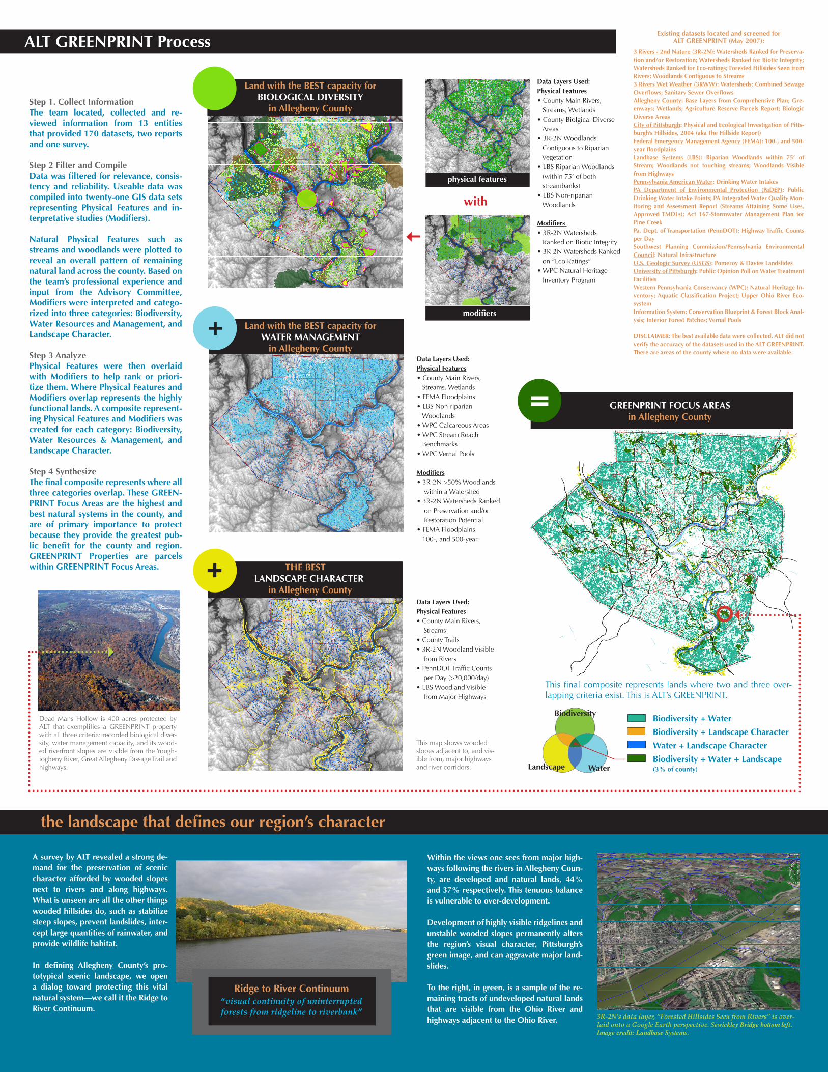
Step 1. Collect Information The team located, collected and re-viewed information from 13 entities that provided 170 datasets, two reports and one survey.
Step 2 Filter and CompileData was filtered for relevance, consis-tency and reliability. Useable data was compiled into twenty-one GIS data sets representing Physical Features and in-terpretative studies (Modifiers). Natural Physical Features such as streams and woodlands were plotted to reveal an overall pattern of remaining natural land across the county. Based on the team’s professional experience and input from the Advisory Committee, Modifiers were interpreted and catego-rized into three categories: Biodiversity, Water Resources and Management, and Landscape Character. Step 3 AnalyzePhysical Features were then overlaid with Modifiers to help rank or priori-tize them. Where Physical Features and Modifiers overlap represents the highly functional lands. A composite represent-ing Physical Features and Modifiers was created for each category: Biodiversity, Water Resources & Management, and Landscape Character. Step 4 SynthesizeThe final composite represents where all three categories overlap. These GREEN-PRINT Focus Areas are the highest and best natural systems in the county, and are of primary importance to protect because they provide the greatest pub-lic benefit for the county and region. GREENPRINT Properties are parcels within GREENPRINT Focus Areas.
ALT GREENPRINT Process
dfas
3R-2N’s data layer, “Forested Hillsides Seen from Rivers” is over-laid onto a Google Earth perspective. Sewickley Bridge bottom left. Image credit: Landbase Systems.
Existing datasets located and screened for ALT GREENPRINT (May 2007):
3 Rivers - 2nd Nature (3R-2N): Watersheds Ranked for Preserva-tion and/or Restoration; Watersheds Ranked for Biotic Integrity; Watersheds Ranked for Eco-ratings; Forested Hillsides Seen from Rivers; Woodlands Contiguous to Streams3 Rivers Wet Weather (3RWW): Watersheds; Combined Sewage Overflows; Sanitary Sewer Overflows Allegheny County: Base Layers from Comprehensive Plan; Gre-enways; Wetlands; Agriculture Reserve Parcels Report; Biologic Diverse AreasCity of Pittsburgh: Physical and Ecological Investigation of Pitts-burgh’s Hillsides, 2004 (aka The Hillside Report)Federal Emergency Management Agency (FEMA): 100-, and 500-year floodplainsLandbase Systems (LBS): Riparian Woodlands within 75’ of Stream; Woodlands not touching streams; Woodlands Visible from HighwaysPennsylvania American Water: Drinking Water Intakes PA Department of Environmental Protection (PaDEP): Public Drinking Water Intake Points; PA Integrated Water Quality Mon-itoring and Assessment Report (Streams Attaining Some Uses, Approved TMDLs); Act 167-Stormwater Management Plan for Pine CreekPa. Dept. of Transportation (PennDOT): Highway Traffic Counts per Day Southwest Planning Commission/Pennsylvania Environmental Council: Natural InfrastructureU.S. Geologic Survey (USGS): Pomeroy & Davies LandslidesUniversity of Pittsburgh: Public Opinion Poll on Water Treatment FacilitiesWestern Pennsylvania Conservancy (WPC): Natural Heritage In-ventory; Aquatic Classification Project; Upper Ohio River Eco-system Information System; Conservation Blueprint & Forest Block Anal-ysis; Interior Forest Patches; Vernal Pools
DISCLAIMER: The best available data were collected. ALT did not verify the accuracy of the datasets used in the ALT GREENPRINT. There are areas of the county where no data were available.
the landscape that defines our region’s character
A survey by ALT revealed a strong de-mand for the preservation of scenic character afforded by wooded slopes next to rivers and along highways. What is unseen are all the other things wooded hillsides do, such as stabilize steep slopes, prevent landslides, inter-cept large quantities of rainwater, and provide wildlife habitat.
In defining Allegheny County’s pro-totypical scenic landscape, we open a dialog toward protecting this vital natural system—we call it the Ridge to River Continuum.
Ridge to River Continuum“visual continuity of uninterrupted forests from ridgeline to riverbank”
Within the views one sees from major high-ways following the rivers in Allegheny Coun-ty, are developed and natural lands, 44% and 37% respectively. This tenuous balance is vulnerable to over-development.
Development of highly visible ridgelines and unstable wooded slopes permanently alters the region’s visual character, Pittsburgh’s green image, and can aggravate major land-slides.
To the right, in green, is a sample of the re-maining tracts of undeveloped natural lands that are visible from the Ohio River and highways adjacent to the Ohio River.
This final composite represents lands where two and three over-lapping criteria exist. This is ALT’s GREENPRINT.
Biodiversity + Water
Biodiversity + Landscape Character
Water + Landscape Character
Biodiversity + Water + Landscape(3% of county)
= GREENPRINT FOCUS AREASin Allegheny County
Dead Mans Hollow is 400 acres protected by ALT that exemplifies a GREENPRINT property with all three criteria: recorded biological diver-sity, water management capacity, and its wood-ed riverfront slopes are visible from the Yough-iogheny River, Great Allegheny Passage Trail and highways.
physical features
with
modifiers
Data Layers Used: Physical Features• County Main Rivers, Streams, Wetlands• County Biolgical Diverse Areas• 3R-2N Woodlands Contiguous to Riparian Vegetation• LBS Riparian Woodlands (within 75’ of both streambanks)• LBS Non-riparian Woodlands
Modifiers • 3R-2N Watersheds Ranked on Biotic Integrity • 3R-2N Watersheds Ranked on “Eco Ratings” • WPC Natural Heritage Inventory Program
Data Layers Used:Physical Features• County Main Rivers, Streams, Wetlands• FEMA Floodplains• LBS Non-riparian Woodlands• WPC Calcareous Areas• WPC Stream Reach Benchmarks• WPC Vernal Pools
Modifiers• 3R-2N >50% Woodlands within a Watershed • 3R-2N Watersheds Ranked on Preservation and/or Restoration Potential• FEMA Floodplains 100-, and 500-year
Data Layers Used:Physical Features• County Main Rivers, Streams• County Trails• 3R-2N Woodland Visible from Rivers• PennDOT Traffic Counts per Day (>20,000/day)• LBS Woodland Visible from Major Highways
This map shows wooded slopes adjacent to, and vis-ible from, major highways and river corridors.
Land with the BEST capacity for BIOLOGICAL DIVERSITY
in Allegheny County
Land with the BEST capacity for WATER MANAGEMENT
in Allegheny County
+
THE BESTLANDSCAPE CHARACTER
in Allegheny County
+
Biodiversity
Landscape Water


in response to regional threats
Allegheny Land Trust developed this Regional Conservation Agenda to identify, prioritize and conserve lands that harbor bidiversity, manage water resources, and define our region’s scenic character
EXECUTIVE SUMMARY
January 2008
Conclusions
Wooded slopes and ridgelines need greater protection from over-development, as they are the region’s most visually prominent natural features and the most vulnerable to development. Wooded slopes frame our river corridors, define our communities, and compliment the built environment. This has created a distinct and globally unique development pattern for the region. [Physical and Ecological Investigation of Pittsburgh’s Hillsides, 2004]
Watersheds with comparatively less development have correspondingly higher water quality, fewer floods, better hydrologic cycling, and potential for greater biological diversity.
For every 10% of a watershed that is left covered with trees, the cost of municipal water treatment decreases by approximately 20%. [-from The Economic Benefits of Land Conservation by the the Trust for Public Land]
In Allegheny County, large woodland masses and north-facing wooded riverfront slopes harbor many of the county’s biologically significant lands.
When woodlands are replaced by an equal amount of asphalt, the amount of runoff can be up to 50 times greater. [“Selection of Rational Coefficients per Land Use” (taken form Malcom,1997, and Lindeburg,1999]
Recommendations
Conserve large tracts of woodlands in the upper reaches of watersheds to intercept rain water before it becomes stormwater.
Conserve large tracts of woodlands on steep slopes along the rivers to maintain their ecological services and maintain county’s unique visual appeal.
Landbank developable lands in watersheds that suffer from frequent flooding and sewer over-flows until degraded infrastructure is repaired or upgraded to prevent sewage overflow prob-lems from worsening.
More public resources need to be dedicated to flood prevention.
Measure and document the economic benefits of ecological services to supplement the sci-ence behind ALT GREENPRINT. Durable economic metrics will help to enlist local government cooperation and support.
Allegheny Land Trust location: Suite 206A Sewickley Car Barn Shops 409 Broad Street Sewickley, PA 15143 contact: 412.741.2750 www.alleghenylandtrust.org
Project Overview
WOODLANDS KEEP RAINWATER FROM BECOMING STORMWATERRainfall interception of a lone oak tree can be up to 27% of total precipitation, that’s 27% of a typical rain event that does not reach the ground. It it caught and held by leaves, branches, trunk and bark, then evaporates from these surfaces.
In hardwood stands, annual rainfall interception by a forest canopy rangesfrom 6-48%.
Tree canopy, understory and ground litter, (fallen leaves and branches intercept13-76% of precipitation events.
-Journal for Surface Water Quality Professionals, vol. XX, 2006 “Not All Green Space is Created Equal”
A Case for Conservation
Land provides natural system functions, also known as ecosystem services. These services vary based on the type of land and its placement in the landscape. Eco-system services range from cleaning water and releasing oxygen to providing shelter and food for wildlife. Because of this, all lands have intrinsic value, some more than others. ALT developed the ALT GREENPRINT to identify lands with the highest capacity to perform three overlapping functions: harbor biologic diversity, manage water resources, and provide scenic character.
ALT’s GREENPRINT methodology involved collecting, compiling, and analyzing a vast set of available data and reports on the region’s land and water resources. GIS technology was applied to processing and integrating information in order to identify lands in Allegheny County with the greatest capacity to perform certain ecosystem services.
Conserving land that, 1) harbors diverse or unique plant and animal species, and 2) naturally manages rainwater before it becomes stormwater, and 3) has highly visible physical features that shape the region’s scenic character and provide the greatest public benefit. Lands that do all three are prioritized and recommended for conservation in this Regional Conservation Agenda.
ALT GREENPRINT was completed for Allegheny County but can be applied to dif-ferent spatial scales from a single watershed to a greater multi-county area.
Intent
Allegheny Land Trust intends to use GREENPRINT to promote strategic land conservation and to directly conserve highly functional landscapes that harbor biological diversity, manage water resources, and maintain the region’s scenic landscape character.
Recommendations
Q: What are Ecosystem Services? A: “...the conditions and processes through which natural ecosystems,and the species that make them up, sustain and fulfill human life.”
-from, Ecosystem Services: Benefits Supplied to Human Societies by Natural Ecosystems. Gretchen C. Daily, Editor
We Thank our Advisors for their Input, Suggestions, and Time: (alpabetically by organization) John Schombert, 3 Rivers Wet Weather Project Robert Hurley, Allegheny County Economic Development Paul King, Allegheny County Health Department Curt Meeder & Rose Reilly, Army Corps of Engineers Noor Ismail, City of Pittsburgh Planning Direc-tor Eric Carlson, EPA Region 3 Dave French, Kimball Engineers William Kirk, McCandless Municipal Water and Sewer Authority Marijke Hecht, Nine Mile Run Watershed Organization Jay Lucas, PA American Water Rick Lorson, PA Fish and Boat Commission Dennis Puko, PA Department of Community & Economic Development Steve Quick, Perkins Eastman Urban Planners Rita Coleman, PA Department of Environmental Protection Kathy Frankel, PA Department of Conservation and Natural Resources Davitt Woodwell, Pennsylvania Environmental Council Ray Reaves, Planning Consultant Art Gazdik, Ross Township Municipal Engineer Court Gould, Sustainable Pittsburgh Sue Thompson, Three Rivers Ecological Research Center Tyler Gourley, University of Pittsburgh Institute of Politics Charles Bier, Western Pennsylvania Conservancy
Ad
viso
ry
Co
mm
itte
e
Acknowledgements: Image Earth, planning, graphic production; Landbase Systems, planning, data organization and advanced spatial analysis. Roy Kraynyk, photography, unless otherwise noted. We thank the Howard Heinz Endownments for underwriting this project.
Direct conservation of land; planning assistance; site assessment; policy development and advocacy; education; research; land bank
Planning and land use managment; integrate GREENPRINT into Comprehensive Plans; adopt and enforce conservation-oriented zoning and land development codes; create Transfer Development Rights programs
Integrate GREENPRINT into Comprehensive Plan to advocate conservation of highly functional green infrastructure; create incentives for conserving GREENPRINT areas; promote awareness and share GREENPRINT mapping; funding
Restrict new sources of stormwater and sewage inputs into failing systems; regulate geologically hazardous areas; funding
Promote and fund flood prevention strategies; evaluate performance of outdated flood control facilities
MUNICIPALITIES
LAND TRUSTS
COUNTY GOVERNMENT
STATE AGENCIES
FEDERAL AGENCIES
Funding Sources
DCNRFoundationsOther private sources
County, State &Federal agencies Bonds Foundations
DCNRPennDOT via(Enhancement Funding)
Scale
Parcel
Watershed
Landscape
WATERMANAGEMENT
BIOLOGICALDIVERSITY
LANDSCAPE CHARACTER
Benefits
Protection of the region’s unique biodiversity
• Watershed Management: Stormwater & FloodControls and Water Quality Improvements • Property Value Enhancement• Managed Growth
Protection of region’s scenic character and air quality
Implementation Partners
Land trusts,DCNR,DEP
Municipalities, Municipal authorities,Watershed organizations, Land trusts, 3 Rivers Wet Weather,County, DCED*, PaDEP, ACOE*, EPA*, FEMA, Others
County,Municipalities,Land trusts
Protection Strategy
• Direct conservation of land & easements• PA Nartural Diversity Inventory
• County Comprehensive Plan • Municipal land planning, ordinances, code enforcement• Landbanking
• County Comprehensive Plan • Municipal land planning, ordinances, code enforcement
Implementation Matrix
phot
o by
imag
e ea
rth
biodiversity water landscape character
* DCED=Pa. Dept. of Community Development ACOE=U.S. Army Corps of Engineers EPA= U.S. Environmental Protection Agency
KEYROLES
phot
o by
Ace
Aer
ial P
hoto
grap
hy
phot
o by
Ace
Aer
ial P
hoto
grap
hy
Related Documents


![2012 DVGBC Greenprint [#042 Special]](https://static.cupdf.com/doc/110x72/568c4aa51a28ab491699030e/2012-dvgbc-greenprint-042-special.jpg)


