Allegheny River Headwaters Watershed Conservation Plan Acidity The capacity of water for neutralizing a basic solution. Agricultural Preservation Areas Lands enrolled in a statewide program that has been established to promote the conservation and preservation of agricultural lands and the agricultural community. Air Pollutant Any substance in the air that causes damage to life, ecosystems, or property. Airsheds Geographic areas responsible for emitting 75 percent of the air pollution reaching a body of water. All Terrain Vehicle A small, open motor vehicle having one seat and three or more wheels fitted with large tires. It is designed chiefly for recreational use over roadless, rugged terrain. Atmospheric Deposition The process of airborne pollutants falling to the ground. Basicity The extent to which a substance is a base, which is defined as having a pH over seven. Bedrock The solid rock that underlies the soil and other unconsolidated material, or that is exposed at the surface. Best Management Practices Refer to the most environmentally appropriate techniques for agriculture, forestry, mining, development, urban storm water management, and other practices that are potential threats to natural resources. Biological Diversity The number and variety of organisms found within a specific geographic region, or a particular habitat; the variability among living organisms on the earth, including the variability within and between species and within and between ecosystems. Biological Diversity Area An area of land recognized as supporting populations of state, nationally, or globally significant species or natural communities, high-quality examples of natural communities or ecosystems, or natural exceptional native diversity. Canal A man-made waterway that is usually used to connect existing bodies of water. Carbon Monoxide A colorless, odorless, poisonous gas that results from the incomplete burning of carbon fuels. APPENDIX A. GLOSSARY Appendix A. Glossary Page 1 of 6

Welcome message from author
This document is posted to help you gain knowledge. Please leave a comment to let me know what you think about it! Share it to your friends and learn new things together.
Transcript
Allegheny River Headwaters Watershed Conservation Plan
Acidity The capacity of water for neutralizing a basic solution.
Agricultural Preservation Areas
Lands enrolled in a statewide program that has been established to promote the conservation and preservation of agricultural lands and the agricultural community.
Air Pollutant Any substance in the air that causes damage to life, ecosystems, or property.
Airsheds Geographic areas responsible for emitting 75 percent of the air pollution reaching a body of water.
All Terrain Vehicle A small, open motor vehicle having one seat and three or more wheels fitted with large tires. It is designed chiefly for recreational use over roadless, rugged terrain.
Atmospheric Deposition The process of airborne pollutants falling to the ground.
Basicity The extent to which a substance is a base, which is defined as having a pH over seven.
Bedrock The solid rock that underlies the soil and other unconsolidated material, or that is exposed at the surface.
Best Management Practices
Refer to the most environmentally appropriate techniques for agriculture, forestry, mining, development, urban storm water management, and other practices that are potential threats to natural resources.
Biological Diversity The number and variety of organisms found within a specific geographic region, or a particular habitat; the variability among living organisms on the earth, including the variability within and between species and within and between ecosystems.
Biological Diversity Area An area of land recognized as supporting populations of state, nationally, or globally significant species or natural communities, high-quality examples of natural communities or ecosystems, or natural exceptional native diversity.
Canal A man-made waterway that is usually used to connect existing bodies of water.
Carbon Monoxide A colorless, odorless, poisonous gas that results from the incomplete burning of carbon fuels.
APPENDIX A. GLOSSARY
Appendix A. Glossary Page 1 of 6
Allegheny River Headwaters Watershed Conservation Plan
Comprehensive Plans A general policy guide for the physical development of a municipality, taking into account many factors including locations, character, and timing of future development.
Concentrated Animal Feeding Operation
A farm where large quantities of livestock or poultry are housed inside buildings or a confined area and all units of production, including feed, wastes and dead animals are concentrated in one area.
Conservation The maintenance of environmental quality and resources; resources include physical, biological, or cultural. Ecosystem management within given social and economic constraints; producing goods and services for humans without depleting natural ecosystem diversity, and acknowledging the natural character of biological systems
Conservation Lands Public or private lands with management plans that include the protection of natural areas as a primary objective.
Dedicated Area An area of land recognized because of an owner's specific intention to protect it, which could result in the improving to become either a biological diversity area in the future or an even better high-quality area within an already designated biological diversity area.
Degradation A degeneration to a poorer quality, condition or state.
Direct Deposition Occurs when pollutants enter a waterway by falling directly into it.
Drainage Pattern The arrangement of streams in a landscape in response to local topography and subsurface geology.
Easement A deed restriction that landowners may voluntarily place of their property to protect its future uses.
Eco-region A geographical unit based on associations of those biotic and environmental factors that directly affect or indirectly express energy, moisture, and nutrients regulating the structure and function of ecosystems.
Ecosystems An area and its living and non-living components.
Environmental Education A learning process that increases knowledge and awareness of the environment and associated challenges, develops skills and expertise to address these challenges, and fosters attitudes, motivation, and commitment to make informed decisions and take responsible actions.
Erosion The processes by which solids are displaced from the earth's surface; includes weathering, dissolution, abrasion, corrosion, and transportation.
Appendix A. Glossary Page 2 of 6
Allegheny River Headwaters Watershed Conservation Plan
Factory Farms Larger, corporate-based farms that emphasize high volume and profit.
Family Farms Smaller farms that have been in operation for several generations.
Floodplain The level land among the course of a river or stream formed by the deposition of sediment during periodic floods.
Forest Management The art and science of treating a forest to promote a desired outcome.
Frack To hydrologically—use water to—fracture the shale within the Marcellus shale formation to release the gases for collection.
Geology Geology is the science that deals with the study of the earth and its history, and is the name of the natural features of our plant.
Ground-level Ozone A harmful secondary pollutant formed in the atmosphere when nitrogen oxide (NOx) combines and reacts with volatile organic compounds in the presence of sunlight and warm temperatures.
Groundwater Water beneath the earth's surface; found in pore spaces in rock material. Supplies wells and springs as a source of drinking water for many; also
High-Grading Involves cutting of only the biggest, most profitable trees in a stand; considered a non-sustainable practice.
Hydric Soils Soils that are adequately moist in the upper section to cultivate anaerobic conditions during the growing season.
Hydrologic Unit Code A system for organizing watersheds of the United States that divides and subdivides the watershed into successively smaller hydrologic units and is then assigned an identifying number.
Hydrology The study of movement of water on the earth; includes surface water and groundwater.
Indirect Deposition Occurs when a pollutant enters a waterway by falling onto land and being washed into waterbodies as runoff.
Invasive species Environmentally noxious weeds that grow aggressively, spread easily, and displaces other plants.
Karst An area of limestone marked by irregularities such as sinkholes, fissures, caves, and underground streams, which are created by erosion.
Landscape Conservation Area
A larger area of land that contains minimal human disturbance and allows ecosystems to function on a landscape level.
Landslide Ground movements that change the stability of slope from stable to unstable are landslides
Appendix A. Glossary Page 3 of 6
Allegheny River Headwaters Watershed Conservation Plan
Lichens A symbiosis between a fungal and algal life form that usually grows on trees or rocks.
Major Employers Companies having a minimum of 200 employees.
Management Recommendations
Non-regulatory suggestions to improve the quality of life.
Methylmercury A neurotoxin formed by the transformation of mercury by certain microorganisms; it is highly toxic and easily accumulates in fish, shellfish and animals that eat fish.
Natural Heritage Inventories
A method of assessing areas of important plants, animals, and ecological communities.
Natural Resources A naturally-occurring material with economic value.
Nonpoint Source Pollutants that have no readily visible source and often require detailed analysis and research to discern the source.
Ozone A colorless, odorless, gas that forms in the atmosphere.
Ozone Layer A colorless, odorless, gas located in the upper atmospheric layer that filters the sun's harmful ultraviolet rays.
Particular Matter Tiny drops of liquid or small particles of dust, metal or other materials that float in the air.
Physiographic Provinces A region with a particular type of landscape and geology.
Point Source Pollutants that can be easily traced to their source.
Precipitation Any form of water that falls from the sky, including, rain, snow, sleet, fog, and hail.
Preservation The act or process of keeping something safe from harm or injury; the act of maintaining or reserving.
Prime Agricultural Soils Soils that are extremely well suited for agricultural uses and meet certain physical, chemical, and slope characteristics.
Red beds Stratosphere of reddish-colored sedimentary rocks, such as sandstone, siltstone, and shale.
Restoration Returning to its original state or condition.Riparian Areas Areas of protective vegetation next to a body of water that serves as a
barrier against polluted runoff and provides habitat corridors for wildlife.
Runoff Rainfall or snowmelt not absorbed by soil that flows over the surface of the ground to a receiving waterway.
Appendix A. Glossary Page 4 of 6
Allegheny River Headwaters Watershed Conservation Plan
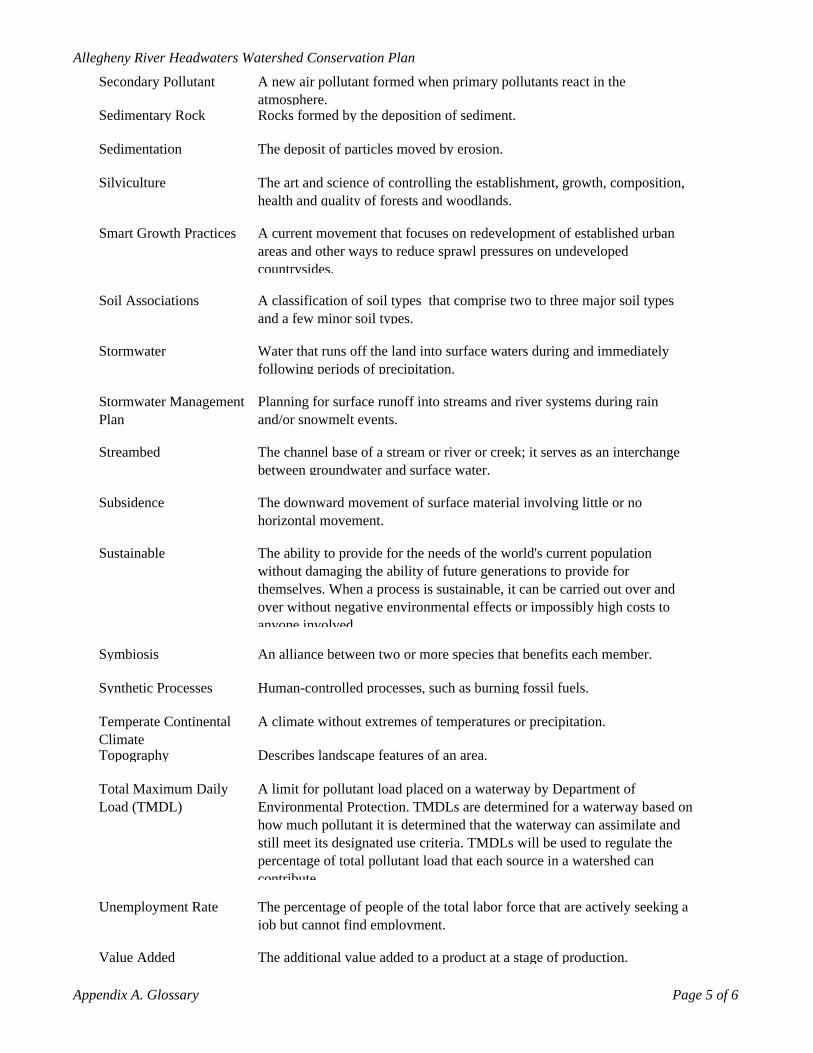
Secondary Pollutant A new air pollutant formed when primary pollutants react in the atmosphere.
Sedimentary Rock Rocks formed by the deposition of sediment.
Sedimentation The deposit of particles moved by erosion.
Silviculture The art and science of controlling the establishment, growth, composition, health and quality of forests and woodlands.
Smart Growth Practices A current movement that focuses on redevelopment of established urban areas and other ways to reduce sprawl pressures on undeveloped countrysides.
Soil Associations A classification of soil types that comprise two to three major soil types and a few minor soil types.
Stormwater Water that runs off the land into surface waters during and immediately following periods of precipitation.
Stormwater Management Plan
Planning for surface runoff into streams and river systems during rain and/or snowmelt events.
Streambed The channel base of a stream or river or creek; it serves as an interchange between groundwater and surface water.
Subsidence The downward movement of surface material involving little or no horizontal movement.
Sustainable The ability to provide for the needs of the world's current population without damaging the ability of future generations to provide for themselves. When a process is sustainable, it can be carried out over and over without negative environmental effects or impossibly high costs to anyone involved
Symbiosis An alliance between two or more species that benefits each member.
Synthetic Processes Human-controlled processes, such as burning fossil fuels.
Temperate Continental Climate
A climate without extremes of temperatures or precipitation.
Topography Describes landscape features of an area.
Total Maximum Daily Load (TMDL)
A limit for pollutant load placed on a waterway by Department of Environmental Protection. TMDLs are determined for a waterway based on how much pollutant it is determined that the waterway can assimilate and still meet its designated use criteria. TMDLs will be used to regulate the percentage of total pollutant load that each source in a watershed can contribute
Unemployment Rate The percentage of people of the total labor force that are actively seeking a job but cannot find employment.
Value Added The additional value added to a product at a stage of production.
Appendix A. Glossary Page 5 of 6
Allegheny River Headwaters Watershed Conservation Plan
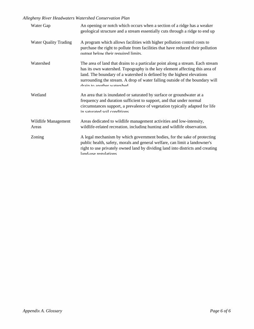
Water Gap An opening or notch which occurs when a section of a ridge has a weaker geological structure and a stream essentially cuts through a ridge to end up
Water Quality Trading A program which allows facilities with higher pollution control costs to purchase the right to pollute from facilities that have reduced their pollution output below their required limits.
Watershed The area of land that drains to a particular point along a stream. Each stream has its own watershed. Topography is the key element affecting this area of land. The boundary of a watershed is defined by the highest elevations surrounding the stream. A drop of water falling outside of the boundary will drain to another watershed
Wetland An area that is inundated or saturated by surface or groundwater at a frequency and duration sufficient to support, and that under normal circumstances support, a prevalence of vegetation typically adapted for life in saturated soil conditions.
Wildlife Management Areas
Areas dedicated to wildlife management activities and low-intensity, wildlife-related recreation, including hunting and wildlife observation.
Zoning A legal mechanism by which government bodies, for the sake of protecting public health, safety, morals and general welfare, can limit a landowner's right to use privately owned land by dividing land into districts and creating land-use regulations.
Appendix A. Glossary Page 6 of 6
Allegheny River Headwaters Watershed Conservation Plan
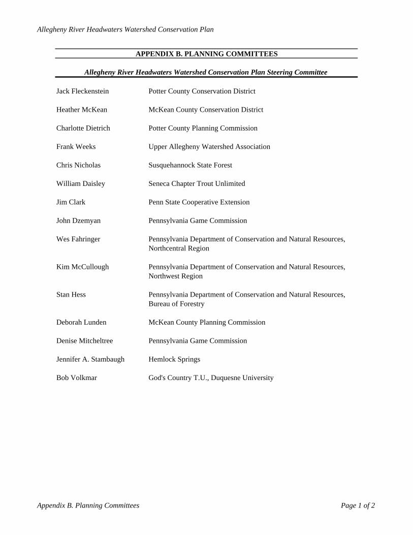
APPENDIX B. PLANNING COMMITTEES
Allegheny River Headwaters Watershed Conservation Plan Steering Committee
Jack Fleckenstein Potter County Conservation District
Heather McKean McKean County Conservation District
Charlotte Dietrich Potter County Planning Commission
Frank Weeks Upper Allegheny Watershed Association
Chris Nicholas Susquehannock State Forest
William Daisley Seneca Chapter Trout Unlimited
Jim Clark Penn State Cooperative Extension
John Dzemyan Pennsylvania Game Commission
Wes Fahringer Pennsylvania Department of Conservation and Natural Resources, Northcentral Region
Kim McCullough Pennsylvania Department of Conservation and Natural Resources, Northwest Region
Stan Hess Pennsylvania Department of Conservation and Natural Resources, Bureau of Forestry
Deborah Lunden McKean County Planning Commission
Denise Mitcheltree Pennsylvania Game Commission
Jennifer A. Stambaugh Hemlock Springs
Bob Volkmar God's Country T.U., Duquesne University
Appendix B. Planning Committees Page 1 of 2
Allegheny River Headwaters Watershed Conservation Plan
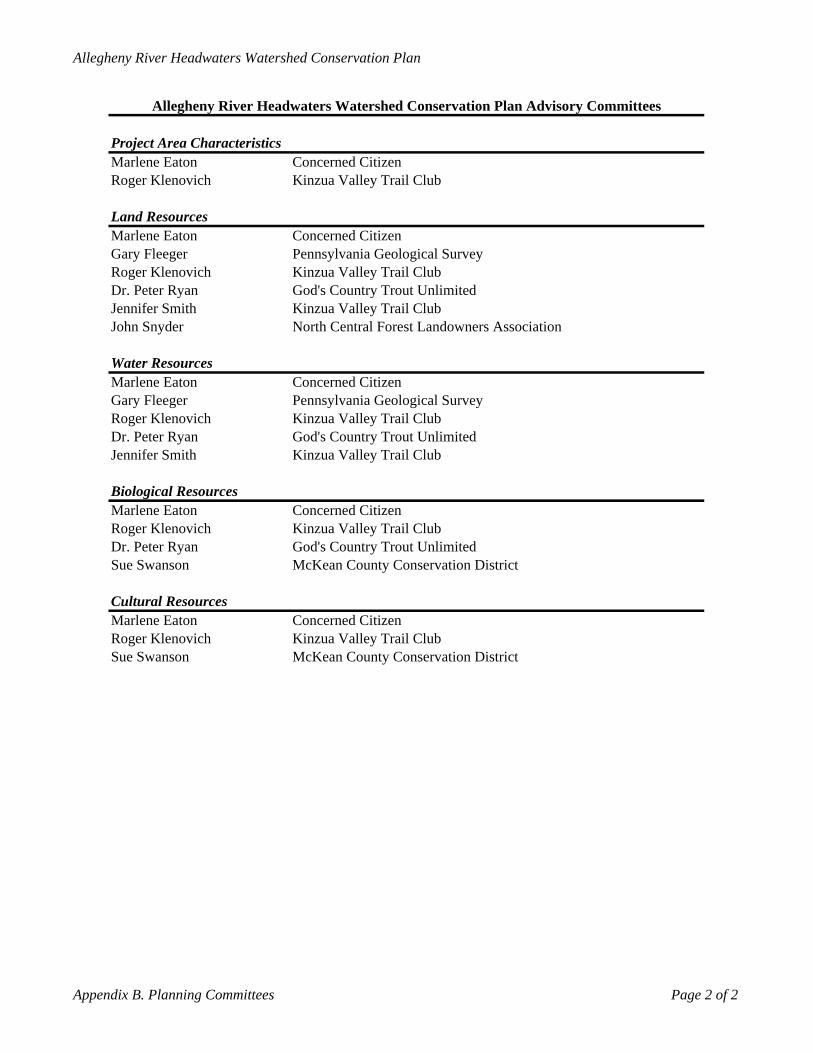
Allegheny River Headwaters Watershed Conservation Plan Advisory Committees
Project Area CharacteristicsMarlene Eaton Concerned CitizenRoger Klenovich Kinzua Valley Trail Club
Land ResourcesMarlene Eaton Concerned CitizenGary Fleeger Pennsylvania Geological SurveyRoger Klenovich Kinzua Valley Trail ClubDr. Peter Ryan God's Country Trout UnlimitedJennifer Smith Kinzua Valley Trail ClubJohn Snyder North Central Forest Landowners Association
Water ResourcesMarlene Eaton Concerned CitizenGary Fleeger Pennsylvania Geological SurveyRoger Klenovich Kinzua Valley Trail ClubDr. Peter Ryan God's Country Trout UnlimitedJennifer Smith Kinzua Valley Trail Club
Biological ResourcesMarlene Eaton Concerned CitizenRoger Klenovich Kinzua Valley Trail ClubDr. Peter Ryan God's Country Trout UnlimitedSue Swanson McKean County Conservation District
Cultural ResourcesMarlene Eaton Concerned CitizenRoger Klenovich Kinzua Valley Trail ClubSue Swanson McKean County Conservation District
Appendix B. Planning Committees Page 2 of 2
Alle
ghen
y Ri
ver H
eadw
ater
s Wat
ersh
ed C
onse
rvat
on P
lan
APP
EN
DIX
C. E
ME
RG
EN
CY
SE
RV
ICE
S
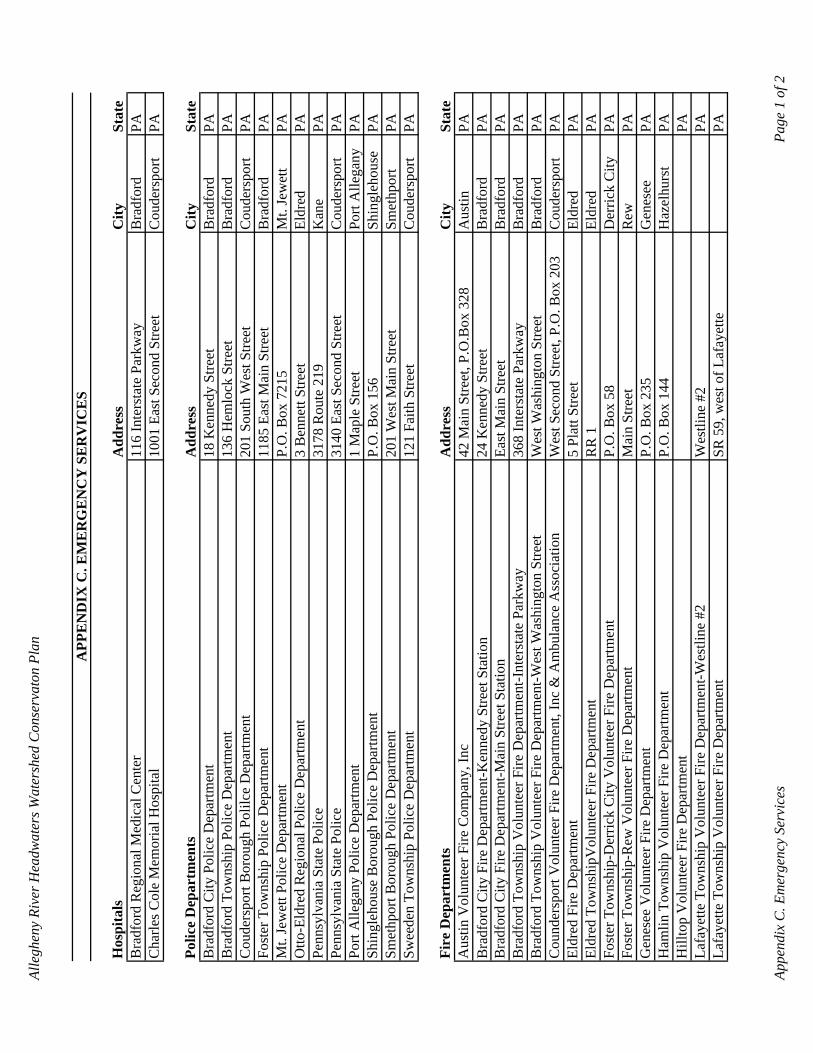
Hos
pita
lsA
ddre
ssC
itySt
ate
Bra
dfor
d R
egio
nal M
edic
al C
ente
r11
6 In
ters
tate
Par
kway
Bra
dfor
dPA
Cha
rles C
ole
Mem
oria
l Hos
pita
l10
01 E
ast S
econ
d St
reet
Cou
ders
port
PA
Polic
e D
epar
tmen
tsA
ddre
ssC
itySt
ate
Bra
dfor
d C
ity P
olic
e D
epar
tmen
t18
Ken
nedy
Stre
etB
radf
ord
PAB
radf
ord
Tow
nshi
p Po
lice
Dep
artm
ent
136
Hem
lock
Stre
etB
radf
ord
PAC
oude
rspo
rt B
orou
gh P
olilc
e D
epar
tmen
t20
1 So
uth
Wes
t Stre
etC
oude
rspo
rtPA
Fost
er T
owns
hip
Polic
e D
epar
tmen
t11
85 E
ast M
ain
Stre
etB
radf
ord
PAM
t. Je
wet
t Pol
ice
Dep
artm
ent
P.O
. Box
721
5M
t. Je
wet
tPA
Otto
-Eld
red
Reg
iona
l Pol
ice
Dep
artm
ent
3 B
enne
tt St
reet
Eldr
edPA
Penn
sylv
ania
Sta
te P
olic
e31
78 R
oute
219
Kan
ePA
Penn
sylv
ania
Sta
te P
olic
e31
40 E
ast S
econ
d St
reet
Cou
ders
port
PAPo
rt A
llega
ny P
olic
e D
epar
tmen
t1
Map
le S
treet
Port
Alle
gany
PASh
ingl
ehou
se B
orou
gh P
olic
e D
epar
tmen
tP.
O. B
ox 1
56Sh
ingl
ehou
sePA
Smet
hpor
t Bor
ough
Pol
ice
Dep
artm
ent
201
Wes
t Mai
n St
reet
Smet
hpor
tPA
Swee
den
Tow
nshi
p Po
lice
Dep
artm
ent
121
Faith
Stre
etC
oude
rspo
rtPA
Fire
Dep
artm
ents
Add
ress
City
Stat
eA
ustin
Vol
unte
er F
ire C
ompa
ny, I
nc42
Mai
n St
reet
, P.O
.Box
328
Aus
tinPA
Bra
dfor
d C
ity F
ire D
epar
tmen
t-Ken
nedy
Stre
et S
tatio
n24
Ken
nedy
Stre
etB
radf
ord
PAB
radf
ord
City
Fire
Dep
artm
ent-M
ain
Stre
et S
tatio
nEa
st M
ain
Stre
etB
radf
ord
PAB
radf
ord
Tow
nshi
p V
olun
teer
Fire
Dep
artm
ent-I
nter
stat
e Pa
rkw
ay36
8 In
ters
tate
Par
kway
Bra
dfor
dPA
Bra
dfor
d To
wns
hip
Vol
unte
er F
ire D
epar
tmen
t-Wes
t Was
hing
ton
Stre
etW
est W
ashi
ngto
n St
reet
Bra
dfor
dPA
Cou
nder
spor
t Vol
unte
er F
ire D
epar
tmen
t, In
c &
Am
bula
nce
Ass
ocia
tion
Wes
t Sec
ond
Stre
et, P
.O. B
ox 2
03C
oude
rspo
rtPA
Eldr
ed F
ire D
epar
tmen
t5
Plat
t Stre
etEl
dred
PAEl
dred
Tow
nshi
pVol
unte
er F
ire D
epar
tmen
tR
R 1
Eldr
edPA
Fost
er T
owns
hip-
Der
rick
City
Vol
unte
er F
ire D
epar
tmen
tP.
O. B
ox 5
8D
erric
k C
ityPA
Fost
er T
owns
hip-
Rew
Vol
unte
er F
ire D
epar
tmen
tM
ain
Stre
etR
ewPA
Gen
esee
Vol
unte
er F
ire D
epar
tmen
tP.
O. B
ox 2
35G
enes
eePA
Ham
lin T
owns
hip
Vol
unte
er F
ire D
epar
tmen
tP.
O. B
ox 1
44H
azel
hurs
tPA
Hill
top
Vol
unte
er F
ire D
epar
tmen
tPA
Lafa
yette
Tow
nshi
p V
olun
teer
Fire
Dep
artm
ent-W
estli
ne #
2W
estli
ne #
2PA
Lafa
yette
Tow
nshi
p V
olun
teer
Fire
Dep
artm
ent
SR 5
9, w
est o
f Laf
ayet
tePA
Appe
ndix
C. E
mer
genc
y Se
rvic
esPa
ge 1
of 2
Alle
ghen
y Ri
ver H
eadw
ater
s Wat
ersh
ed C
onse
rvat
on P
lan
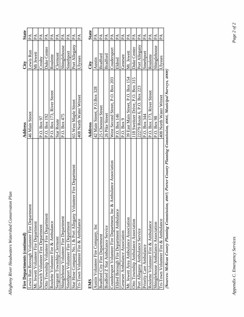
Fire
Dep
artm
ents
(con
tinue
d)A
ddre
ssC
itySt
ate
Lew
is R
un B
orou
gh V
olun
teer
Fire
Dep
artm
ent
46 M
ain
Stre
etLe
wis
Run
PAM
t. Je
wet
t Vol
unte
er F
ire D
epar
tmen
tM
t Jew
ett
PAN
orw
ich
Vol
unte
er F
ire D
epar
tmen
tP.
O. B
ox 9
7C
rosb
yPA
Otto
Tow
nshi
p V
olun
teer
Fire
Dep
artm
ent
P.O
. Box
192
Duk
e C
ente
rPA
Rou
lette
Vol
unte
er F
ire &
Am
bula
nce
P.O
. Box
173
, Riv
er S
treet
Rou
lette
PASe
rgea
nt T
owns
hip-
Cle
rmon
tSt
ar R
oute
Cle
rmon
tPA
Shin
gleh
ouse
Vol
unte
er F
ire D
epar
tmen
tP.
O. B
ox 4
75Sh
ingl
ehou
sePA
Smet
hpor
t Vol
unte
er F
ire D
epar
tmen
tSm
ethp
ort
PASt
ar H
ose
Com
pany
No.
1 &
Por
t Alle
gany
Vol
unte
er F
ire D
epar
tmen
t65
Wes
t Map
le S
treet
Port
Alle
gany
PATr
i-Tow
n V
olun
teer
Fire
& A
mbu
lanc
e40
8 N
orth
Wat
er W
treet
Uly
sses
PA
EM
SA
ddre
ssC
itySt
ate
Aus
tin V
olun
teer
Fire
Com
pany
, Inc
42 M
ain
Stre
et, P
.O.B
ox 3
28A
ustin
PAB
radf
ord
City
Fire
Dep
artm
ent
25 C
hest
nut S
treet
Bra
dfor
dPA
Bra
dfor
d Z
Stat
Am
bula
nce
Serv
ice
26 P
ike
Stre
etB
radf
ord
PAC
ound
ersp
ort V
olun
teer
Fire
Dep
artm
ent,
Inc
& A
mbu
lanc
e A
ssoc
iatio
nW
est S
econ
d St
reet
, P.O
. Box
203
Cou
ders
port
PAEl
dred
Bor
ough
Fire
Dep
artm
ent A
mbu
lanc
eP.
O. B
ox 1
46El
dred
PAG
enes
ee A
mbu
lanc
e A
ssoc
iatio
nP.
O. B
ox 9
Gen
esee
PAM
t. Je
wet
t Are
a A
mbu
lanc
e A
ssoc
iatio
n39
Eas
t Mai
n St
reet
, P.O
. Box
154
Mt.
Jew
ett
PAO
tto T
owns
hip
Am
bula
nce
Ass
ocia
tion
118
Swei
tzer
Driv
e, P
.O. B
ox 3
15D
uke
Cen
ter
PAPo
rt A
llega
ny A
mbu
lanc
e Se
rvic
e22
279
Rou
te 6
, P.O
. Box
223
Port
Alle
gany
PAPr
iorit
y C
are
Am
bula
nce
P.O
. Box
344
Smet
hpor
tPA
Rou
lette
Vol
unte
er F
ire &
Am
bula
nce
P.O
. Box
173
, Riv
er S
treet
Rou
lette
PASh
ingl
ehou
se A
mbu
lanc
e A
ssoc
iatio
nP.
O. B
ox 9
8Sh
ingl
ehou
sePA
Tri-T
own
Vol
unte
er F
ire &
Am
bula
nce
408
Nor
th W
ater
Wtre
etU
lyss
esPA
(Sou
rces
: McK
ean
Cou
nty
Pla
nnin
g C
omm
issi
on, 2
007;
Pot
ter
Cou
nty
Pla
nnin
g C
omm
issi
on, 2
005,
Mun
icip
al S
urve
ys, 2
009)
Appe
ndix
C. E
mer
genc
y Se
rvic
esPa
ge 2
of 2
Allegheny River Headwaters Watershed Conservation Plan
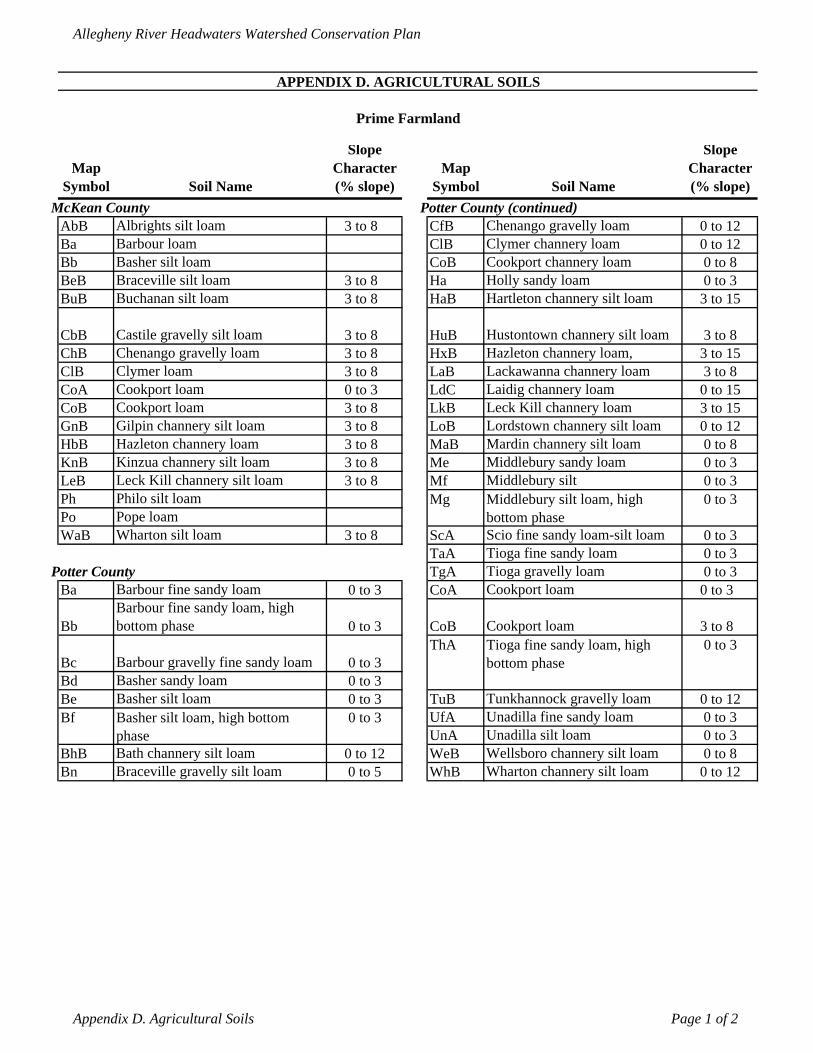
APPENDIX D. AGRICULTURAL SOILS
Prime Farmland
Map Symbol Soil Name
Slope Character (% slope)
Map Symbol Soil Name
Slope Character (% slope)
McKean County Potter County (continued)AbB Albrights silt loam 3 to 8 CfB Chenango gravelly loam 0 to 12Ba Barbour loam ClB Clymer channery loam 0 to 12Bb Basher silt loam CoB Cookport channery loam 0 to 8BeB Braceville silt loam 3 to 8 Ha Holly sandy loam 0 to 3BuB Buchanan silt loam 3 to 8 HaB Hartleton channery silt loam 3 to 15
CbB Castile gravelly silt loam 3 to 8 HuB Hustontown channery silt loam 3 to 8ChB Chenango gravelly loam 3 to 8 HxB Hazleton channery loam, 3 to 15ClB Clymer loam 3 to 8 LaB Lackawanna channery loam 3 to 8CoA Cookport loam 0 to 3 LdC Laidig channery loam 0 to 15CoB Cookport loam 3 to 8 LkB Leck Kill channery loam 3 to 15GnB Gilpin channery silt loam 3 to 8 LoB Lordstown channery silt loam 0 to 12HbB Hazleton channery loam 3 to 8 MaB Mardin channery silt loam 0 to 8KnB Kinzua channery silt loam 3 to 8 Me Middlebury sandy loam 0 to 3LeB Leck Kill channery silt loam 3 to 8 Mf Middlebury silt 0 to 3Ph Philo silt loam Mg Middlebury silt loam, high
bottom phase0 to 3
Po Pope loamWaB Wharton silt loam 3 to 8 ScA Scio fine sandy loam-silt loam 0 to 3
TaA Tioga fine sandy loam 0 to 3Potter County TgA Tioga gravelly loam 0 to 3
Ba Barbour fine sandy loam 0 to 3 CoA Cookport loam 0 to 3
BbBarbour fine sandy loam, high bottom phase 0 to 3 CoB Cookport loam 3 to 8
Bc Barbour gravelly fine sandy loam 0 to 3ThA Tioga fine sandy loam, high
bottom phase0 to 3
Bd Basher sandy loam 0 to 3Be Basher silt loam 0 to 3 TuB Tunkhannock gravelly loam 0 to 12Bf Basher silt loam, high bottom
phase0 to 3 UfA Unadilla fine sandy loam 0 to 3
UnA Unadilla silt loam 0 to 3BhB Bath channery silt loam 0 to 12 WeB Wellsboro channery silt loam 0 to 8Bn Braceville gravelly silt loam 0 to 5 WhB Wharton channery silt loam 0 to 12
Appendix D. Agricultural Soils Page 1 of 2
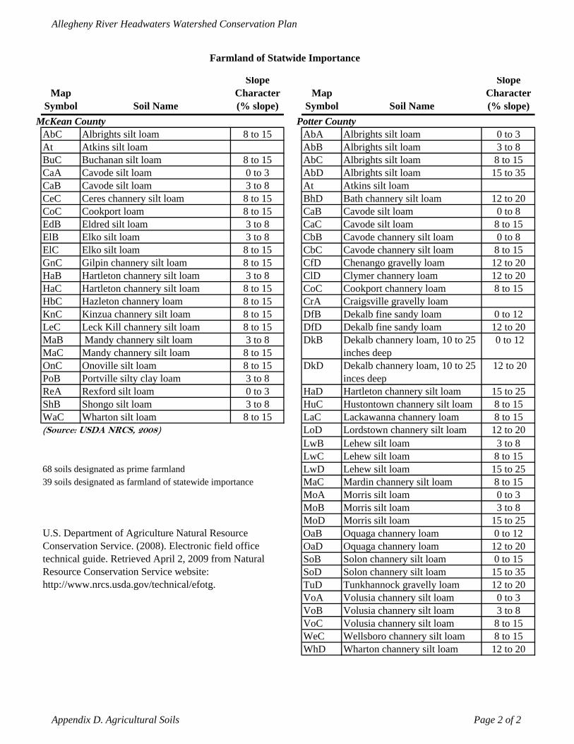
Allegheny River Headwaters Watershed Conservation Plan
Farmland of Statwide Importance
Map Symbol Soil Name
Slope Character (% slope)
Map Symbol Soil Name
Slope Character (% slope)
McKean County Potter CountyAbC Albrights silt loam 8 to 15 AbA Albrights silt loam 0 to 3 At Atkins silt loam AbB Albrights silt loam 3 to 8 BuC Buchanan silt loam 8 to 15 AbC Albrights silt loam 8 to 15 CaA Cavode silt loam 0 to 3 AbD Albrights silt loam 15 to 35 CaB Cavode silt loam 3 to 8 At Atkins silt loam CeC Ceres channery silt loam 8 to 15 BhD Bath channery silt loam 12 to 20 CoC Cookport loam 8 to 15 CaB Cavode silt loam 0 to 8 EdB Eldred silt loam 3 to 8 CaC Cavode silt loam 8 to 15 ElB Elko silt loam 3 to 8 CbB Cavode channery silt loam 0 to 8 ElC Elko silt loam 8 to 15 CbC Cavode channery silt loam 8 to 15 GnC Gilpin channery silt loam 8 to 15 CfD Chenango gravelly loam 12 to 20 HaB Hartleton channery silt loam 3 to 8 ClD Clymer channery loam 12 to 20 HaC Hartleton channery silt loam 8 to 15 CoC Cookport channery loam 8 to 15 HbC Hazleton channery loam 8 to 15 CrA Craigsville gravelly loamKnC Kinzua channery silt loam 8 to 15 DfB Dekalb fine sandy loam 0 to 12 LeC Leck Kill channery silt loam 8 to 15 DfD Dekalb fine sandy loam 12 to 20 MaB Mandy channery silt loam 3 to 8 DkB Dekalb channery loam, 10 to 25
inches deep 0 to 12
MaC Mandy channery silt loam 8 to 15 OnC Onoville silt loam 8 to 15 DkD Dekalb channery loam, 10 to 25
inces deep 12 to 20
PoB Portville silty clay loam 3 to 8 ReA Rexford silt loam 0 to 3 HaD Hartleton channery silt loam 15 to 25 ShB Shongo silt loam 3 to 8 HuC Hustontown channery silt loam 8 to 15 WaC Wharton silt loam 8 to 15 LaC Lackawanna channery loam 8 to 15 (Source: USDA NRCS, 2008) LoD Lordstown channery silt loam 12 to 20
LwB Lehew silt loam 3 to 8 LwC Lehew silt loam 8 to 15
68 soils designated as prime farmland LwD Lehew silt loam 15 to 25 39 soils designated as farmland of statewide importance MaC Mardin channery silt loam 8 to 15
MoA Morris silt loam 0 to 3 MoB Morris silt loam 3 to 8 MoD Morris silt loam 15 to 25
U.S. Department of Agriculture Natural Resource Conservation Service. (2008). Electronic field office technical guide. Retrieved April 2, 2009 from Natural Resource Conservation Service website: http://www.nrcs.usda.gov/technical/efotg.
OaB Oquaga channery loam 0 to 12 OaD Oquaga channery loam 12 to 20 SoB Solon channery silt loam 0 to 15 SoD Solon channery silt loam 15 to 35 TuD Tunkhannock gravelly loam 12 to 20 VoA Volusia channery silt loam 0 to 3 VoB Volusia channery silt loam 3 to 8 VoC Volusia channery silt loam 8 to 15 WeC Wellsboro channery silt loam 8 to 15 WhD Wharton channery silt loam 12 to 20
Appendix D. Agricultural Soils Page 2 of 2
Allegheny River Headwaters Watershed Conservation Plan
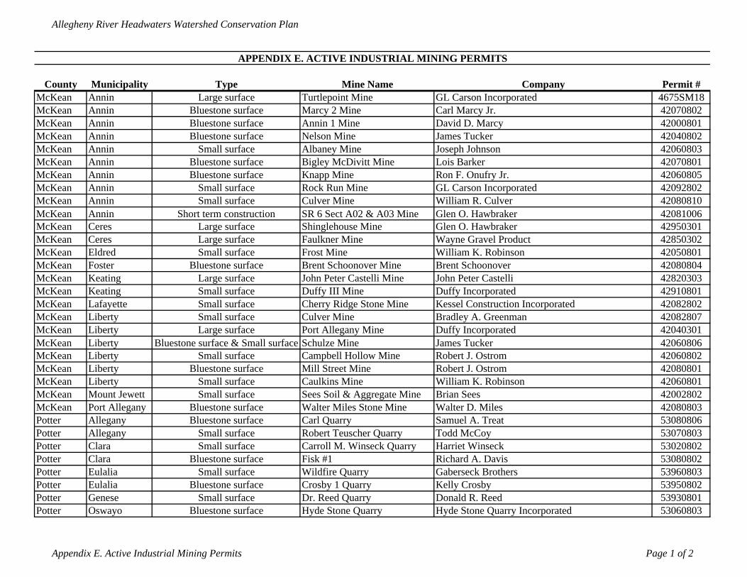
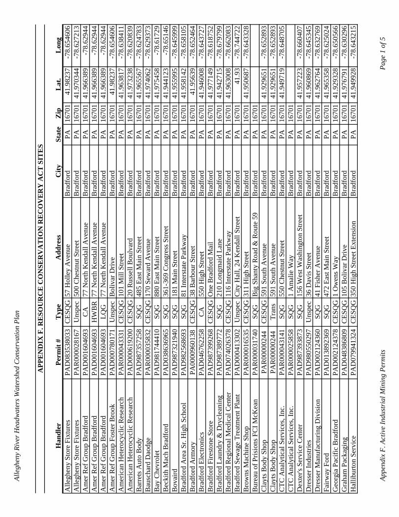
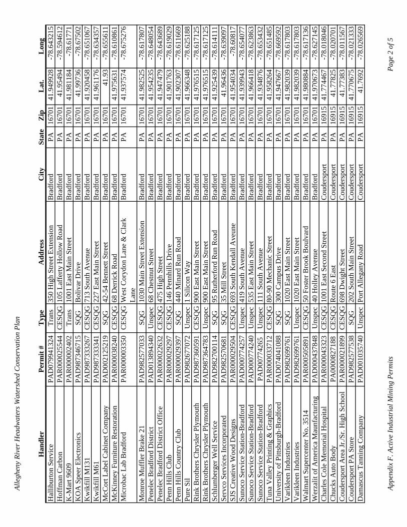
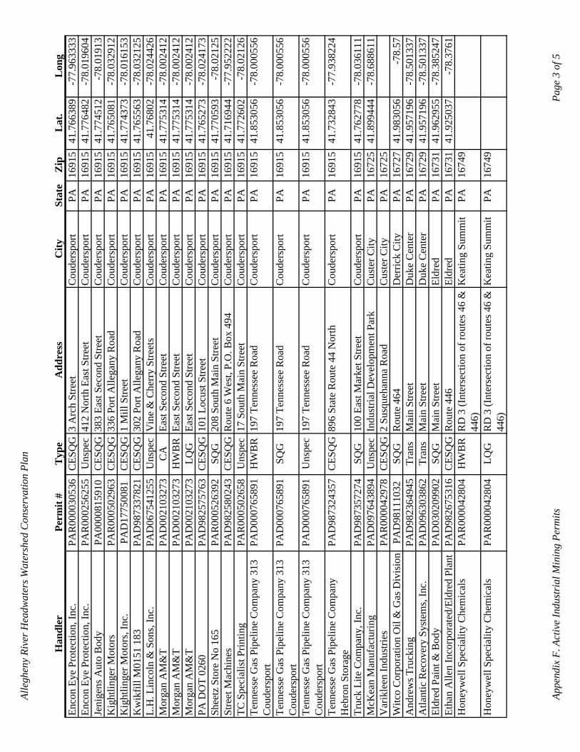
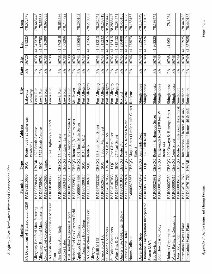
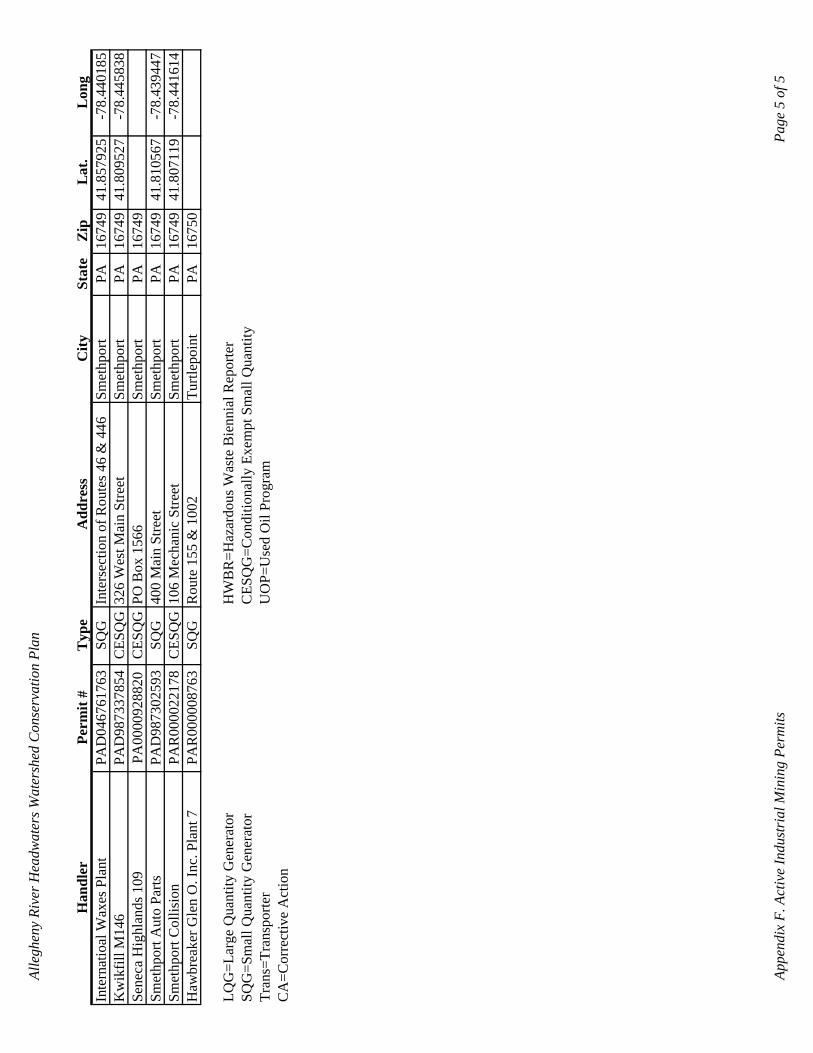
APPENDIX E. ACTIVE INDUSTRIAL MINING PERMITS
County Municipality Type Mine Name Company Permit #McKean Annin Large surface Turtlepoint Mine GL Carson Incorporated 4675SM18McKean Annin Bluestone surface Marcy 2 Mine Carl Marcy Jr. 42070802McKean Annin Bluestone surface Annin 1 Mine David D. Marcy 42000801McKean Annin Bluestone surface Nelson Mine James Tucker 42040802McKean Annin Small surface Albaney Mine Joseph Johnson 42060803McKean Annin Bluestone surface Bigley McDivitt Mine Lois Barker 42070801McKean Annin Bluestone surface Knapp Mine Ron F. Onufry Jr. 42060805McKean Annin Small surface Rock Run Mine GL Carson Incorporated 42092802McKean Annin Small surface Culver Mine William R. Culver 42080810McKean Annin Short term construction SR 6 Sect A02 & A03 Mine Glen O. Hawbraker 42081006McKean Ceres Large surface Shinglehouse Mine Glen O. Hawbraker 42950301McKean Ceres Large surface Faulkner Mine Wayne Gravel Product 42850302McKean Eldred Small surface Frost Mine William K. Robinson 42050801McKean Foster Bluestone surface Brent Schoonover Mine Brent Schoonover 42080804McKean Keating Large surface John Peter Castelli Mine John Peter Castelli 42820303McKean Keating Small surface Duffy III Mine Duffy Incorporated 42910801McKean Lafayette Small surface Cherry Ridge Stone Mine Kessel Construction Incorporated 42082802McKean Liberty Small surface Culver Mine Bradley A. Greenman 42082807McKean Liberty Large surface Port Allegany Mine Duffy Incorporated 42040301McKean Liberty Bluestone surface & Small surface Schulze Mine James Tucker 42060806McKean Liberty Small surface Campbell Hollow Mine Robert J. Ostrom 42060802McKean Liberty Bluestone surface Mill Street Mine Robert J. Ostrom 42080801McKean Liberty Small surface Caulkins Mine William K. Robinson 42060801McKean Mount Jewett Small surface Sees Soil & Aggregate Mine Brian Sees 42002802McKean Port Allegany Bluestone surface Walter Miles Stone Mine Walter D. Miles 42080803Potter Allegany Bluestone surface Carl Quarry Samuel A. Treat 53080806Potter Allegany Small surface Robert Teuscher Quarry Todd McCoy 53070803Potter Clara Small surface Carroll M. Winseck Quarry Harriet Winseck 53020802Potter Clara Bluestone surface Fisk #1 Richard A. Davis 53080802Potter Eulalia Small surface Wildfire Quarry Gaberseck Brothers 53960803Potter Eulalia Bluestone surface Crosby 1 Quarry Kelly Crosby 53950802Potter Genese Small surface Dr. Reed Quarry Donald R. Reed 53930801Potter Oswayo Bluestone surface Hyde Stone Quarry Hyde Stone Quarry Incorporated 53060803
Appendix E. Active Industrial Mining Permits Page 1 of 2
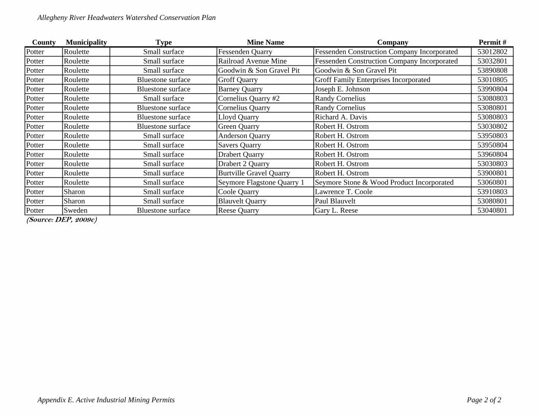
Allegheny River Headwaters Watershed Conservation Plan
County Municipality Type Mine Name Company Permit #Potter Roulette Small surface Fessenden Quarry Fessenden Construction Company Incorporated 53012802Potter Roulette Small surface Railroad Avenue Mine Fessenden Construction Company Incorporated 53032801Potter Roulette Small surface Goodwin & Son Gravel Pit Goodwin & Son Gravel Pit 53890808Potter Roulette Bluestone surface Groff Quarry Groff Family Enterprises Incorporated 53010805Potter Roulette Bluestone surface Barney Quarry Joseph E. Johnson 53990804Potter Roulette Small surface Cornelius Quarry #2 Randy Cornelius 53080803Potter Roulette Bluestone surface Cornelius Quarry Randy Cornelius 53080801Potter Roulette Bluestone surface Lloyd Quarry Richard A. Davis 53080803Potter Roulette Bluestone surface Green Quarry Robert H. Ostrom 53030802Potter Roulette Small surface Anderson Quarry Robert H. Ostrom 53950803Potter Roulette Small surface Savers Quarry Robert H. Ostrom 53950804Potter Roulette Small surface Drabert Quarry Robert H. Ostrom 53960804Potter Roulette Small surface Drabert 2 Quarry Robert H. Ostrom 53030803Potter Roulette Small surface Burtville Gravel Quarry Robert H. Ostrom 53900801Potter Roulette Small surface Seymore Flagstone Quarry 1 Seymore Stone & Wood Product Incorporated 53060801Potter Sharon Small surface Coole Quarry Lawrence T. Coole 53910803Potter Sharon Small surface Blauvelt Quarry Paul Blauvelt 53080801Potter Sweden Bluestone surface Reese Quarry Gary L. Reese 53040801(Source: DEP, 2009c)
Appendix E. Active Industrial Mining Permits Page 2 of 2
Alle
ghen
y Ri
ver H
eadw
ater
s Wat
ersh
ed C
onse
rvat
ion
Plan
APP
EN
DIX
F. R
ESO
UR
CE
CO
NSE
RV
AT
ION
RE
CO
VE
RY
AC
T S
ITE
S
Han
dler
Perm
it #
Typ
eA
ddre
ssC
itySt
ate
Zip
Lat
.L
ong
Alle
ghen
y St
ore
Fixt
ures
PAD
0835
3803
3C
ESQ
G57
Hol
ley
Ave
nue
Bra
dfor
dPA
1670
141
.982
37-7
8.65
4606
Alle
ghen
y St
ore
Fixt
ures
PAR
0000
2816
7U
nspe
c50
0 C
hest
nut S
treet
Bra
dfor
dPA
1670
141
.970
344
-78.
6272
13A
mer
Ref
Gro
up B
radf
ord
PAD
0016
0469
3C
A77
Nor
th K
enda
ll A
venu
eB
radf
ord
PA16
701
41.9
6638
9-7
8.62
944
Am
er R
ef G
roup
Bra
dfor
dPA
D00
1604
693
HW
BR
77 N
orth
Ken
dall
Ave
nue
Bra
dfor
dPA
1670
141
.966
389
-78.
6294
4A
mer
Ref
Gro
up B
radf
ord
PAD
0016
0469
3LQ
G77
Nor
th K
enda
ll A
venu
eB
radf
ord
PA16
701
41.9
6638
9-7
8.62
944
Am
er R
ef G
roup
Fos
ter B
rook
PAD
0007
8017
1U
nspe
cB
oliv
ar D
rive
Bra
dfor
dPA
1670
141
.982
37-7
8.65
4606
Am
eric
an H
eter
ocyc
lic R
esea
rch
PAR
0000
4333
1C
ESQ
G10
1 M
ill S
treet
Bra
dfor
dPA
1670
141
.963
817
-78.
6384
11A
mer
ican
Het
eroc
yclic
Res
earc
hPA
D00
0619
200
CES
QG
20 R
usse
ll B
oulv
ard
Bra
dfor
dPA
1670
141
.973
238
-78.
6208
39B
arre
ts A
uto
Bod
yPA
D98
7357
258
SQG
485
East
Mai
n St
reet
Bra
dfor
dPA
1670
141
.965
567
-78.
6247
83B
ausc
hard
Dao
dge
PAR
0000
3583
2C
ESQ
G17
0 Se
war
d A
venu
eB
radf
ord
PA16
701
41.9
7406
2-7
8.62
9373
Bay
Che
vrol
etPA
D98
1744
410
SQG
880
East
Mai
n St
reet
Bra
dfor
dPA
1670
141
.975
458
-78.
6172
9B
ecki
th M
ach
Bra
dfor
dPA
D03
8636
965
SQG
361-
369
Con
gres
s Stre
etB
radf
ord
PA16
701
41.9
4412
3-7
8.65
146
Bov
aird
PAD
9873
2194
0SQ
G18
1 M
ain
Stre
etB
radf
ord
PA16
701
41.9
5599
5-7
8.64
5999
Bra
dfor
d A
rea
Sr. H
igh
Scho
olPA
D98
2568
693
SQG
81 In
ters
tate
Par
kway
Bra
dfor
dPA
1670
141
.958
142
-78.
6581
05B
radf
ord
Arm
ory
PA00
0096
0138
CES
QG
38 B
arbo
ur S
treet
Bra
dfor
dPA
1670
141
.956
39-7
8.65
2464
Bra
dfor
d El
ectro
nics
PAD
0467
6225
8C
A55
0 H
igh
Stre
etB
radf
ord
PA16
701
41.9
4600
8-7
8.64
3727
Bra
dfor
d Fi
rest
one
Stor
ePA
D98
7399
268
CES
QG
One
Bra
dfor
d M
ail
Bra
dfor
dPA
1670
141
.977
149
-78.
6187
52B
radf
ord
Laun
dry
& D
rycl
eani
ngPA
D98
7389
772
SQG
210
Long
mai
d La
neB
radf
ord
PA16
701
41.9
4271
5-7
8.67
9799
Bra
dfor
d R
egio
nal M
edic
al C
ente
rPA
D07
4026
378
CES
QG
116
Inte
rsta
te P
arkw
ayB
radf
ord
PA16
701
41.9
6300
8-7
8.66
2083
Bra
dfor
d Se
wag
e Tr
eatm
ent P
lant
PAD
0004
1330
2U
nspe
cC
ity H
all,
24 K
enda
ll St
reet
Bra
dfor
dPA
1670
141
.93
-78.
7447
22B
row
ns M
achi
ne S
hop
PAR
0000
1653
5C
ESQ
G31
1 H
igh
Stre
etB
radf
ord
PA16
701
41.9
5068
7-7
8.64
3328
Bur
eau
of P
risio
ns F
CI M
cKea
nPA
R00
0031
740
SQG
Big
Sha
nty
Roa
d &
Rou
te 5
9B
radf
ord
PA16
701
Cla
yts B
ody
Shop
PAR
0000
0244
CES
QG
591
Sout
h A
venu
eB
radf
ord
PA16
701
41.9
2965
1-7
8.65
2893
Cla
yts B
ody
Shop
PAR
0000
0244
Tran
s59
1 So
uth
Ave
nue
Bra
dfor
dPA
1670
141
.929
651
-78.
6528
93C
TC A
naly
tical
Ser
vice
s, In
c.PA
R00
0043
141
SQG
550
Che
stnu
t Stre
etB
radf
ord
PA16
701
41.9
4971
9-7
8.64
8705
CTC
Ana
lytic
al S
ervi
ces,
Inc.
PAR
0000
2585
8SQ
G1
Am
alie
Way
Bra
dfor
dPA
1670
1D
exte
r's S
ervi
ce C
ente
rPA
D98
7393
873
SQG
156
Wes
t Was
hing
ton
Stre
etB
radf
ord
PA16
701
41.9
5722
3-7
8.66
0407
Dre
sser
Indu
strie
sPA
D98
0550
297
Uns
pec
36 D
avis
Stre
etB
radf
ord
PA16
701
41.9
6086
9-7
8.64
5345
Dre
sser
Man
ufac
turin
g D
ivis
ion
PAD
0021
2436
0SQ
G41
Fis
her A
venu
eB
radf
ord
PA16
701
41.9
6276
4-7
8.63
2769
Fairw
ay F
ord
PAD
0138
9236
9SQ
G47
2 Ea
st M
ain
Stre
etB
radf
ord
PA16
701
41.9
6535
8-7
8.62
5024
Geo
rgia
Pac
ific
Bra
dfor
dPA
D00
2124
378
CES
QG
1 O
wen
s Way
Bra
dfor
dPA
1670
141
.929
328
-78.
6505
66G
raha
m P
acka
ging
PAD
0483
8680
9C
ESQ
G10
5 B
oliv
ar D
rive
Bra
dfor
dPA
1670
141
.976
791
-78.
6302
96H
allib
urto
n Se
rvic
ePA
D07
9941
324
CES
QG
350
Hig
h St
reet
Ext
ensi
onB
radf
ord
PA16
701
41.9
4992
8-7
8.64
3215
Appe
ndix
F. A
ctiv
e In
dust
rial
Min
ing
Perm
itsPa
ge 1
of 5
Alle
ghen
y Ri
ver H
eadw
ater
s Wat
ersh
ed C
onse
rvat
ion
Plan
Han
dler
Perm
it #
Typ
eA
ddre
ssC
itySt
ate
Zip
Lat
.L
ong
Hal
libur
ton
Serv
ice
PAD
0799
4132
4Tr
ans
350
Hig
h St
reet
Ext
ensi
onB
radf
ord
PA16
701
41.9
4992
8-7
8.64
3215
Hof
fman
Car
bon
PAR
0000
2554
4C
ESQ
G10
5 La
ffer
ty H
ollo
w R
oad
Bra
dfor
dPA
1670
141
.954
94-7
8.59
4612
K-M
art 9
609
PAR
0000
0240
2Tr
ans
1001
Eas
t Mai
n St
reet
Bra
dfor
dPA
1670
141
.981
184
-78.
6177
1K
OA
Spe
er E
lect
roni
csPA
D98
7346
715
SQG
Bol
ivar
Driv
eB
radf
ord
PA16
701
41.9
9736
-78.
6750
2K
wik
fill M
131
PAD
9873
3326
7C
ESQ
G71
3 So
uth
Ave
nue
Bra
dfor
dPA
1670
141
.920
458
-78.
6510
67K
wik
fill M
61PA
D98
7333
341
CES
QG
227
East
Mai
n St
reet
Bra
dfor
dPA
1670
141
.961
176
-78.
6343
57M
cCor
t Lab
el C
abin
et C
ompa
nyPA
D00
2125
219
SQG
42-5
4 B
enne
tt St
reet
Bra
dfor
dPA
1670
141
.93
-78.
6556
11M
cKin
ney
Furn
iture
Res
tora
tion
PAR
0000
3824
0C
ESQ
G68
Der
rick
Roa
dB
radf
ord
PA16
701
41.9
7563
1-7
8.61
0861
Mic
roba
c La
b B
radf
ord
PAR
0000
0335
0C
ESQ
GW
est C
oryd
on L
ane
& C
lark
La
neB
radf
ord
PA16
701
41.9
3757
4-7
8.67
5276
Mon
roe
Muf
fler B
rake
21
PAD
9825
7703
3SQ
G10
30 M
ain
Stre
et E
xten
sion
Bra
dfor
dPA
1670
141
.982
525
-78.
6178
07Pe
nele
c B
radf
ord
Dis
trict
PA
D01
3894
340
Uns
pec
68 C
hest
nut S
treet
Bra
dfor
dPA
1670
141
.954
235
-78.
6480
54Pe
nele
c B
radf
ord
Dis
trict
Off
ice
PAR
0000
2263
2C
ESQ
G47
5 H
igh
Stre
etB
radf
ord
PA16
701
41.9
4747
9-7
8.64
3689
Penn
Hill
s Clu
bPA
R00
0029
297
CES
QG
146
Penn
hills
Driv
eB
radf
ord
PA16
701
41.9
0176
3-7
8.61
9029
Penn
Hill
s Cou
ntry
Clu
bPA
R00
0029
397
SQG
440
Min
ard
Run
Roa
dB
radf
ord
PA16
701
41.9
0230
7-7
8.61
1669
Pure
Sil
PAD
9826
7707
2U
nspe
c1
Silic
on W
ayB
radf
ord
PA16
701
41.9
6634
8-7
8.62
5188
Rin
k B
roth
ers C
hrys
ler P
lym
outh
PAD
9873
6059
1C
ESQ
G90
0 Ea
st M
ain
Stre
etB
radf
ord
PA16
701
41.9
7651
5-7
8.61
7125
Rin
k B
roth
ers C
hrys
ler P
lym
outh
PAD
9873
6478
3U
nspe
c90
0 Ea
st M
ain
Stre
etB
radf
ord
PA16
701
41.9
7651
5-7
8.61
7125
Schl
umbe
rger
Wel
l Ser
vice
PAD
9827
0011
4SQ
G95
Rut
herf
ord
Run
Roa
dB
radf
ord
PA16
701
41.9
2543
9-7
8.61
4111
Serv
co S
ervi
ces I
ncor
pora
ted
PAD
9825
7068
1SQ
G35
Mill
Stre
etB
radf
ord
PA16
701
41.9
6436
-78.
6390
97SJ
S C
reat
ive
Woo
d D
esig
nsPA
R00
0029
504
CES
QG
693
Sout
h K
enda
ll A
veun
eB
radf
ord
PA16
701
41.9
5403
4-7
8.60
817
Suno
co S
ervi
ce S
tatio
n-B
radf
ord
PAD
0007
7425
7U
nspe
c41
9 So
uth
Ave
nue
Bra
dfor
dPA
1670
141
.939
943
-78.
6540
77Su
noco
Ser
vice
Sta
tion-
Bra
dfor
dPA
D00
0774
240
Uns
pec
535
East
Mai
n St
reet
Bra
dfor
dPA
1670
141
.966
418
-78.
6238
63Su
noco
Ser
vice
Sta
tion-
Bra
dfor
dPA
D00
7742
65U
nspe
c11
1 So
uth
Ave
nue
Bra
dfor
dPA
1670
141
.934
876
-78.
6534
32Tu
na V
alle
y Pr
intin
g &
Gra
phic
sPA
R00
0033
712
CES
QG
80-9
0 M
echa
nic
Stre
etB
radf
ord
PA16
701
41.9
5826
4-7
8.65
1485
Uni
vers
ity o
f Pitt
sbur
gh-B
radf
ord
PAD
0740
4108
8SQ
G30
0 C
ampu
s Driv
eB
radf
ord
PA16
701
41.9
4766
7-7
8.66
9592
Var
ikle
en In
dust
ries
PAD
9826
9976
1SQ
G10
20 E
ast M
ain
Stre
etB
radf
ord
PA16
701
41.9
8203
9-7
8.61
7803
Var
ikle
en In
dust
ries
PAD
9826
9976
1U
nspe
c10
20 E
ast M
ain
Stre
etB
radf
ord
PA16
701
41.9
8203
9-7
8.61
7803
Wal
mar
t Sup
erce
nter
No.
351
4PA
R00
0505
891
CES
QG
50 F
oste
r Bro
ok B
oulv
ard
Bra
dfor
dPA
1670
141
.980
884
-78.
6171
36W
erza
lit o
f Am
eric
a M
aunf
actu
ring
PAD
0004
3784
8U
nspe
c40
Hol
ley
Ave
nue
Bra
dfor
dPA
1670
141
.970
673
-78.
6271
45C
harle
s Col
e M
emor
ial H
ospi
tal
PAR
0000
4332
3C
ESQ
G10
01 E
ast S
econ
d St
reet
Cou
ders
port
PA16
915
41.7
7446
7-7
8.01
8046
Chu
cks A
uto
Bod
yPA
0000
8271
88C
ESQ
GR
oute
6 E
ast
Cou
ders
port
PA16
915
41.7
7825
-78.
0207
01C
oude
rspo
rt A
rea
Jr./S
r. H
igh
Scho
olPA
R00
0021
899
CES
QG
698
Dw
ight
Stre
etC
oude
rspo
rtPA
1691
541
.773
83-7
8.01
1567
Cou
ders
port
PA S
tore
PAD
9825
7753
8SQ
G20
2 So
uth
Mai
n St
reet
Cou
ders
port
PA16
915
41.7
7067
5-7
8.02
1333
Dam
ascu
s Tan
ning
Com
pany
PAD
0010
3574
0U
nspe
cPo
rt A
llega
ny R
oad
Cou
ders
port
PA16
915
41.7
692
-78.
0265
69
Appe
ndix
F. A
ctiv
e In
dust
rial
Min
ing
Perm
itsPa
ge 2
of 5
Alle
ghen
y Ri
ver H
eadw
ater
s Wat
ersh
ed C
onse
rvat
ion
Plan
Han
dler
Perm
it #
Typ
eA
ddre
ssC
itySt
ate
Zip
Lat
.L
ong
Enco
n Ey
e Pr
otec
tion,
Inc.
PAR
0000
3053
6C
ESQ
G3
Arc
h St
reet
Cou
ders
port
PA16
915
41.7
6638
9-7
7.96
3333
Enco
n Ey
e Pr
otec
tion,
Inc.
PAR
0002
5625
5U
nspe
c41
2 N
orth
Eas
t Stre
etC
oude
rspo
rtPA
1691
541
.776
482
-78.
0196
04Je
nige
ns A
uto
Bod
yPA
0000
8159
10C
ESQ
G38
3 Ea
st S
econ
d St
reet
Cou
ders
port
PA16
915
41.7
7451
2-7
8.01
913
Kig
htlin
ger M
otor
sPA
R00
0502
963
CES
QG
336
Port
Alle
gany
Roa
dC
oude
rspo
rtPA
1691
541
.765
081
-78.
0329
12K
ight
linge
r Mot
ors,
Inc.
PAD
1775
0081
CES
QG
1 M
ill S
treet
Cou
ders
port
PA16
915
41.7
7437
3-7
8.01
6153
Kw
ikfil
l M01
51 1
83PA
D98
7337
821
CES
QG
302
Port
Alle
gany
Roa
dC
oude
rspo
rtPA
1691
541
.765
563
-78.
0321
25L.
H. L
inco
ln &
Son
s, In
c.PA
D06
7541
255
Uns
pec
Vin
e &
Che
rry
Stre
ets
Cou
ders
port
PA16
915
41.7
6802
-78.
0244
26M
orga
n A
M&
TPA
D00
2103
273
CA
East
Sec
ond
Stre
etC
oude
rspo
rtPA
1691
541
.775
314
-78.
0024
12M
orga
n A
M&
TPA
D00
2103
273
HW
BR
East
Sec
ond
Stre
etC
oude
rspo
rtPA
1691
541
.775
314
-78.
0024
12M
orga
n A
M&
TPA
D00
2103
273
LQG
East
Sec
ond
Stre
etC
oude
rspo
rtPA
1691
541
.775
314
-78.
0024
12PA
DO
T 02
60PA
D98
2575
763
CES
QG
101
Locu
st S
treet
Cou
ders
port
PA16
915
41.7
6527
3-7
8.02
4173
Shee
tz S
tore
No
165
PAR
0005
2639
2SQ
G20
8 So
uth
Mai
n St
reet
Cou
ders
port
PA16
915
41.7
7059
3-7
8.02
125
Stre
et M
achi
nes
PAD
9825
8024
3C
ESQ
GR
oute
6 W
est,
P.O
. Box
494
Cou
ders
port
PA16
915
41.7
1694
4-7
7.95
2222
TC S
peci
alis
t Prin
ting
PAR
0005
0265
8U
nspe
c17
Sou
th M
ain
Stre
etC
oude
rspo
rtPA
1691
541
.772
602
-78.
0212
6Te
nnes
se G
as P
ipel
ine
Com
pany
313
C
oude
rspo
rtPA
D00
0765
891
HW
BR
197
Tenn
esse
e R
oad
Cou
ders
port
PA16
915
41.8
5305
6-7
8.00
0556
Tenn
esse
Gas
Pip
elin
e C
ompa
ny 3
13
Cou
ders
port
PAD
0007
6589
1SQ
G19
7 Te
nnes
see
Roa
dC
oude
rspo
rtPA
1691
541
.853
056
-78.
0005
56
Tenn
esse
Gas
Pip
elin
e C
ompa
ny 3
13
Cou
ders
port
PAD
0007
6589
1U
nspe
c19
7 Te
nnes
see
Roa
dC
oude
rspo
rtPA
1691
541
.853
056
-78.
0005
56
Tenn
esse
Gas
Pip
elin
e C
ompa
ny
Heb
ron
Stor
age
PAD
9873
2435
7C
ESQ
G89
6 St
ate
Rou
te 4
4 N
orth
Cou
ders
port
PA16
915
41.7
3284
3-7
7.93
8224
Truc
k Li
te C
ompa
ny, I
nc.
PAD
9873
5727
4SQ
G10
0 Ea
st M
arke
t Stre
etC
oude
rspo
rtPA
1691
541
.762
778
-78.
0361
11M
cKea
n M
anuf
actu
ring
PAD
0976
4389
4U
nspe
cIn
dust
rial D
evel
opm
ent P
ark
Cus
ter C
ityPA
1672
541
.899
444
-78.
6886
11V
arik
leen
Indu
strie
sPA
R00
0042
978
CES
QG
2 Su
sque
hann
a R
oad
Cus
ter C
ityPA
1672
5W
itco
Cor
pora
tion
Oil
& G
as D
ivis
ion
PAD
9811
1032
SQG
Rou
te 4
64D
erric
k C
ityPA
1672
741
.983
056
-78.
57A
ndre
ws T
ruck
ing
PAD
9823
6494
5Tr
ans
Mai
n St
reet
Duk
e C
ente
rPA
1672
941
.957
196
-78.
5013
37A
tlant
ic R
ecov
ery
Syst
ems,
Inc.
PAD
0963
0386
2Tr
ans
Mai
n St
reet
Duk
e C
ente
rPA
1672
941
.957
196
-78.
5013
37El
dred
Pai
nt &
Bod
yPA
D03
0209
902
SQG
Mai
n St
reet
Eldr
edPA
1673
141
.962
955
-78.
3852
47Et
han
Alle
n In
corp
orat
ed/E
ldre
d Pl
ant
PAD
9826
7531
6C
ESQ
GR
oute
446
El
dred
PA16
731
41.9
2503
7-7
8.37
61H
oney
wel
l Spe
cial
ity C
hem
ical
sPA
R00
0042
804
HW
BR
RD
3 (I
nter
sect
ion
of ro
utes
46
&
446)
Kea
ting
Sum
mit
PA16
749
Hon
eyw
ell S
peci
ality
Che
mic
als
PAR
0000
4280
4LQ
GR
D 3
(Int
erse
ctio
n of
rout
es 4
6 &
44
6)K
eatin
g Su
mm
itPA
1674
9
Appe
ndix
F. A
ctiv
e In
dust
rial
Min
ing
Perm
itsPa
ge 3
of 5
Alle
ghen
y Ri
ver H
eadw
ater
s Wat
ersh
ed C
onse
rvat
ion
Plan
Inte
rnat
ioal
Wax
es P
lant
PAD
0467
6176
3H
WB
RIn
ters
ectio
n of
Rou
tes 4
6 &
446
Smet
hpor
tPA
1674
941
.857
925
-78.
4401
85
Han
dler
Perm
it #
Typ
eA
ddre
ssC
itySt
ate
Zip
Lat
.L
ong
PA D
epar
tmen
t of T
rans
pora
tion
0250
PAD
9825
1565
6SQ
GR
oute
400
3 (.2
5 m
iles e
ast
Bra
dfor
d)La
faye
tte
Tow
nshi
pPA
1672
641
.822
5-7
8.57
2778
Alle
ghen
y B
radf
ord
Man
ufac
turin
gPA
D98
7284
924
HW
BR
1522
Sou
th A
venu
eLe
wis
Run
PA16
738
41.9
4737
8-7
8.64
8448
Alle
ghen
y B
radf
ord
Man
ufac
turin
gPA
D98
7284
924
SQG
1522
Sou
th A
venu
eLe
wis
Run
PA16
738
41.8
6778
3-7
8.66
688
Con
trol C
hief
Cor
pora
tion
PAD
9907
5268
5U
nspe
cLe
wis
Run
PA16
738
41.8
1638
9-7
8.69
5833
IA C
onst
ruct
ion
Cor
pora
tion
McK
ean
Plan
tPA
R00
0508
069
UO
P70
24 H
ighw
ay R
oute
59
Lew
is R
unPA
1673
8
Jim
Shi
elds
Aut
o B
ody
PAR
0000
0235
2C
ESQ
G15
Irvi
ne S
treet
Lew
is R
unPA
1673
841
.876
218
-78.
6636
86M
cCor
t Lab
el
PAD
0386
3434
1C
ESQ
G20
Egb
ert L
ane
Lew
is R
unPA
1673
841
.872
266
-78.
7447
22TS
A B
radf
ord
Reg
iona
l Airp
ort
PAR
0005
1226
9C
ESQ
G21
2 A
irpor
t Driv
e Su
ite E
Lew
is R
unPA
1673
8N
atio
nal F
uel G
as C
lerm
ont F
ield
PAD
9873
2951
3C
ESQ
GR
oute
12
(8.9
mile
s eas
t)M
t. Je
wet
tPA
1674
0A
pple
bys D
ry C
lean
ers
PA00
0094
3696
CES
QG
801
Nor
th M
ain
Stre
etPo
rt A
llega
nyPA
1674
341
.823
004
-78.
2901
02Ed
Dau
gher
tys B
ody
Shop
IA C
onst
ruct
ion
Cor
pora
tion
Port
PAD
9873
9031
7PA
D00
2106
979
SQG
SQG
RD
1 B
ox 6
12R
oute
6Po
rt A
llega
nyPo
rt A
llega
nyPA PA
1674
316
743
41.8
1256
5-7
8.27
8902
Alle
gany
Kw
ikfil
l M14
5PA
D98
7333
267
CES
QG
36 S
outh
Mai
n St
reet
Port
Alle
gany
PA16
743
41.8
1331
3-7
8.28
2072
Shee
tx S
tore
166
PAR
0005
2640
0SQ
G1
Sout
h M
ain
Stre
etPo
rt A
llega
nyPA
1674
341
.815
232
-78.
2837
19St
. Bob
ain
Con
tain
ers
PAD
0451
6705
3H
WB
RO
ne G
lass
Pla
cePo
rt A
llega
nyPA
1674
341
.817
415
-78.
2888
447
St. B
obai
n C
onta
iner
sPA
D04
5167
053
LQG
One
Gla
ss P
lace
Port
Alle
gany
PA16
743
41.8
1741
5-7
8.28
8844
7W
itter
Gas
& O
ilPA
D98
7335
205
SQG
27 P
earl
Stre
etPo
rt A
llega
nyPA
1674
341
.815
132
-78.
2849
71Q
uake
r Sta
te O
il-B
urge
r Hol
low
PAD
9809
1834
6C
ESQ
GR
oute
246
Rix
ford
PA16
745
41.9
3040
8-7
8.45
5165
Fore
st H
ouse
Hot
elN
orm
s Col
lisio
nPA
D98
7392
024
PA00
0082
6867
CES
QG
CES
QG
1746
U.S
. Rou
te 6
Wes
tM
aple
Stre
et (1
mile
sout
h C
ente
r R
oule
tteR
oule
ttePA PA
1674
616
746
41.7
6211
541
.773
573
-78.
1149
68-7
8.15
5167
Stre
et)
Dav
es B
ody
Shop
Dom
inio
n Tr
asnp
orat
ion
Inco
rpor
ated
PA
D09
4174
349
PAR
0005
1331
7C
ESQ
GLQ
GSu
nnys
ide
Roa
d98
2 Pl
ank
Roa
dSh
ingl
ehou
seSh
ingl
ehou
sePA PA
1674
816
748
41.9
5294
241
.973
326
-78.
1874
49-7
8.10
9139
Shar
on M
&R
Eds S
ervi
ces
John
Hew
itt A
uto
Bod
yPA
R00
0025
981
PAR
0000
1860
6C
ESQ
GC
ESQ
GR
oute
44
& H
oneo
ye S
treet
Fairg
roun
ds R
oad
(100
feet
W
Shin
gleh
ouse
Shin
gleh
ouse
PA PA16
748
41.9
6252
5-7
8.19
8775
1674
8R
oute
44)
Uni
mar
t Cor
pora
tion
PAR
0000
2725
0C
ESQ
G10
9 O
sway
o &
Hon
eoye
Stre
etSh
ingl
ehou
sePA
1674
841
.962
1-7
8.19
84W
ayne
Pav
ing
& C
ontra
ctin
gPA
R00
0000
315
CES
QG
Cer
es S
treet
Shin
gleh
ouse
PA16
748
Don
s Bod
y Sh
opPA
R00
0036
103
CES
QG
Rou
te 6
(1 m
ile so
uth
Haz
elhu
rst)
Smet
hpor
tPA
1674
9In
tern
atio
al W
axes
Pla
ntPA
D04
6761
763
CA
Inte
rsec
tion
of R
oute
s 46
& 4
46Sm
ethp
ort
PA16
749
41.8
5792
5-7
8.44
0185
Appe
ndix
F. A
ctiv
e In
dust
rial
Min
ing
Perm
itsPa
ge 4
of 5
Alle
ghen
y Ri
ver H
eadw
ater
s Wat
ersh
ed C
onse
rvat
ion
Plan
Haw
brea
ker G
len
O. I
nc. P
lant
7PA
R00
0008
763
SQG
Rou
te 1
55 &
100
2Tu
rtlep
oint
PA16
750
CA
=Cor
rect
ive
Act
ion
Han
dler
Perm
it #
Typ
eA
ddre
ssC
itySt
ate
Zip
Lat
.L
ong
Inte
rnat
ioal
Wax
es P
lant
PAD
0467
6176
3SQ
GIn
ters
ectio
n of
Rou
tes 4
6 &
446
Smet
hpor
tPA
1674
941
.857
925
-78.
4401
85K
wik
fill M
146
PAD
9873
3785
4C
ESQ
G32
6 W
est M
ain
Stre
etSm
ethp
ort
PA16
749
41.8
0952
7-7
8.44
5838
Sene
ca H
ighl
ands
109
PA00
0092
8820
CES
QG
PO B
ox 1
566
Smet
hpor
tPA
1674
9Sm
ethp
ort A
uto
Parts
PAD
9873
0259
3SQ
G40
0 M
ain
Stre
etSm
ethp
ort
PA16
749
41.8
1056
7-7
8.43
9447
Smet
hpor
t Col
lisio
nPA
R00
0022
178
CES
QG
106
Mec
hani
c St
reet
Smet
hpor
tPA
1674
941
.807
119
-78.
4416
14
LQG
=Lar
ge Q
uant
ity G
ener
ator
HW
BR
=Haz
ardo
us W
aste
Bie
nnia
l Rep
orte
rSQ
G=S
mal
l Qua
ntity
Gen
erat
orC
ESQ
G=C
ondi
tiona
lly E
xem
pt S
mal
l Qua
ntity
Tr
ans=
Tran
spor
ter
UO
P=U
sed
Oil
Prog
ram
Appe
ndix
F. A
ctiv
e In
dust
rial
Min
ing
Perm
itsPa
ge 5
of 5
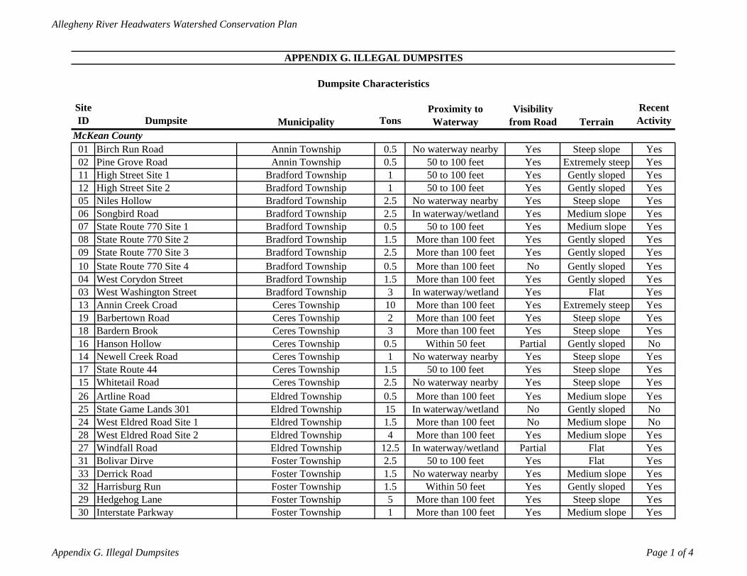
Allegheny River Headwaters Watershed Conservation Plan
Site ID Dumpsite Tons
Recent Activity
01 Birch Run Road 0.5 Yes02 Pine Grove Road 0.5 Yes11 High Street Site 1 1 Yes12 High Street Site 2 1 Yes05 Niles Hollow 2.5 Yes06 Songbird Road 2.5 Yes07 State Route 770 Site 1 0.5 Yes08 State Route 770 Site 2 1.5 Yes09 State Route 770 Site 3 2.5 Yes10 State Route 770 Site 4 0.5 Yes04 West Corydon Street 1.5 Yes03 West Washington Street 3 Yes13 Annin Creek Croad 10 Yes19 Barbertown Road 2 Yes18 Bardern Brook 3 Yes16 Hanson Hollow 0.5 No14 Newell Creek Road 1 Yes17 State Route 44 1.5 Yes15 Whitetail Road 2.5 Yes26 Artline Road 0.5 Yes25 State Game Lands 301 15 No24 West Eldred Road Site 1 1.5 No28 West Eldred Road Site 2 4 Yes27 Windfall Road 12.5 Yes31 Bolivar Dirve 2.5 Yes33 Derrick Road 1.5 Yes32 Harrisburg Run 1.5 Yes29 Hedgehog Lane 5 Yes30 Interstate Parkway 1 YesFoster Township More than 100 feet Yes Medium slope
Foster Township More than 100 feet Yes Steep slopeFoster Township Within 50 feet Yes Gently slopedFoster Township No waterway nearby Yes Medium slopeFoster Township 50 to 100 feet Yes FlatEldred Township In waterway/wetland Partial FlatEldred Township More than 100 feet Yes Medium slopeEldred Township More than 100 feet No Medium slopeEldred Township In waterway/wetland No Gently slopedEldred Township More than 100 feet Yes Medium slopeCeres Township No waterway nearby Yes Steep slopeCeres Township 50 to 100 feet Yes Steep slopeCeres Township No waterway nearby Yes Steep slopeCeres Township Within 50 feet Partial Gently slopedCeres Township More than 100 feet Yes Steep slopeCeres Township More than 100 feet Yes Steep slopeCeres Township More than 100 feet Yes Extremely steep
Bradford Township In waterway/wetland Yes FlatBradford Township More than 100 feet Yes Gently slopedBradford Township More than 100 feet No Gently slopedBradford Township More than 100 feet Yes Gently slopedBradford Township More than 100 feet Yes Gently slopedBradford Township 50 to 100 feet Yes Medium slopeBradford Township In waterway/wetland Yes Medium slope
APPENDIX G. ILLEGAL DUMPSITES
Dumpsite Characteristics
MunicipalityProximity to Waterway
Visibility from Road Terrain
McKean CountyAnnin Township No waterway nearby Yes Steep slopeAnnin Township 50 to 100 feet Yes Extremely steep
Bradford Township 50 to 100 feet Yes Gently slopedBradford Township 50 to 100 feet Yes Gently slopedBradford Township No waterway nearby Yes Steep slope
Appendix G. Illegal Dumpsites Page 1 of 4
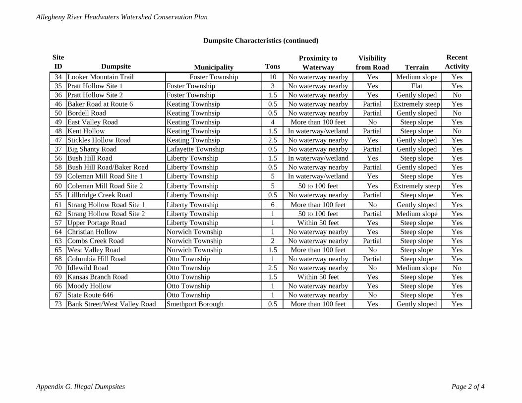
Allegheny River Headwaters Watershed Conservation Plan
Site ID Dumpsite Tons
Recent Activity
34 Looker Mountain Trail 10 Yes35 Pratt Hollow Site 1 3 Yes36 Pratt Hollow Site 2 1.5 No46 Baker Road at Route 6 0.5 Yes50 Bordell Road 0.5 No49 East Valley Road 4 Yes48 Kent Hollow 1.5 No47 Stickles Hollow Road 2.5 Yes37 Big Shanty Road 0.5 Yes56 Bush Hill Road 1.5 Yes58 Bush Hill Road/Baker Road 0.5 Yes59 Coleman Mill Road Site 1 5 Yes60 Coleman Mill Road Site 2 5 Yes55 Lillbridge Creek Road 0.5 Yes61 Strang Hollow Road Site 1 6 Yes62 Strang Hollow Road Site 2 1 Yes57 Upper Portage Road 1 Yes64 Christian Hollow 1 Yes63 Combs Creek Road 2 Yes65 West Valley Road 1.5 Yes68 Columbia Hill Road 1 Yes70 Idlewild Road 2.5 No69 Kansas Branch Road 1.5 Yes66 Moody Hollow 1 Yes67 State Route 646 1 Yes73 Bank Street/West Valley Road 0.5 YesSmethport Borough More than 100 feet Yes Gently sloped
Otto Township No waterway nearby No Steep slopeOtto Township No waterway nearby Yes Steep slopeOtto Township Within 50 feet Yes Steep slopeOtto Township No waterway nearby No Medium slopeOtto Township No waterway nearby Partial Steep slopeNorwich Township More than 100 feet No Steep slopeNorwich Township No waterway nearby Partial Steep slopeNorwich Township No waterway nearby Yes Steep slopeLiberty Township Within 50 feet Yes Steep slopeLiberty Township 50 to 100 feet Partial Medium slopeLiberty Township More than 100 feet No Gently slopedLiberty Township No waterway nearby Partial Steep slopeLiberty Township 50 to 100 feet Yes Extremely steepLiberty Township In waterway/wetland Yes Steep slopeLiberty Township No waterway nearby Partial Gently slopedLiberty Township In waterway/wetland Yes Steep slopeLafayette Township No waterway nearby Partial Gently slopedKeating Townhsip No waterway nearby Yes Gently slopedKeating Townhsip In waterway/wetland Partial Steep slopeKeating Townhsip More than 100 feet No Steep slopeKeating Townhsip No waterway nearby Partial Gently slopedKeating Townhsip No waterway nearby Partial Extremely steepFoster Township No waterway nearby Yes Gently slopedFoster Township No waterway nearby Yes Flat
Dumpsite Characteristics (continued)
MunicipalityProximity to Waterway
Visibility from Road Terrain
Foster Township No waterway nearby Yes Medium slope
Appendix G. Illegal Dumpsites Page 2 of 4
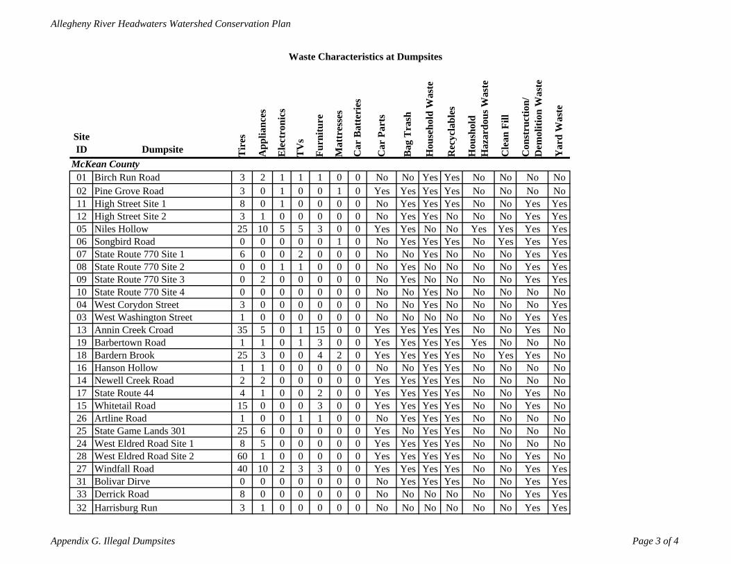
Allegheny River Headwaters Watershed Conservation Plan
Site ID Dumpsite T
ires
App
lianc
es
Ele
ctro
nics
TV
s
Furn
iture
Mat
tres
ses
Car
Bat
teri
es
Car
Par
ts
Bag
Tra
sh
Hou
seho
ld W
aste
Rec
ycla
bles
Hou
shol
d H
azar
dous
Was
te
Cle
an F
ill
Con
stru
ctio
n/
Dem
oliti
on W
aste
Yar
d W
aste
01 Birch Run Road 3 2 1 1 1 0 0 No No Yes Yes No No No No02 Pine Grove Road 3 0 1 0 0 1 0 Yes Yes Yes Yes No No No No11 High Street Site 1 8 0 1 0 0 0 0 No Yes Yes Yes No No Yes Yes12 High Street Site 2 3 1 0 0 0 0 0 No Yes Yes No No No Yes Yes05 Niles Hollow 25 10 5 5 3 0 0 Yes Yes No No Yes Yes Yes Yes06 Songbird Road 0 0 0 0 0 1 0 No Yes Yes Yes No Yes Yes Yes07 State Route 770 Site 1 6 0 0 2 0 0 0 No No Yes No No No Yes Yes08 State Route 770 Site 2 0 0 1 1 0 0 0 No Yes No No No No Yes Yes09 State Route 770 Site 3 0 2 0 0 0 0 0 No Yes No No No No Yes Yes10 State Route 770 Site 4 0 0 0 0 0 0 0 No No Yes No No No No No04 West Corydon Street 3 0 0 0 0 0 0 No No Yes No No No No Yes03 West Washington Street 1 0 0 0 0 0 0 No No No No No No Yes Yes13 Annin Creek Croad 35 5 0 1 15 0 0 Yes Yes Yes Yes No No Yes No19 Barbertown Road 1 1 0 1 3 0 0 Yes Yes Yes Yes Yes No No No18 Bardern Brook 25 3 0 0 4 2 0 Yes Yes Yes Yes No Yes Yes No16 Hanson Hollow 1 1 0 0 0 0 0 No No Yes Yes No No No No14 Newell Creek Road 2 2 0 0 0 0 0 Yes Yes Yes Yes No No No No17 State Route 44 4 1 0 0 2 0 0 Yes Yes Yes Yes No No Yes No15 Whitetail Road 15 0 0 0 3 0 0 Yes Yes Yes Yes No No Yes No26 Artline Road 1 0 0 1 1 0 0 No Yes Yes Yes No No No No25 State Game Lands 301 25 6 0 0 0 0 0 Yes No Yes Yes No No No No24 West Eldred Road Site 1 8 5 0 0 0 0 0 Yes Yes Yes Yes No No No No28 West Eldred Road Site 2 60 1 0 0 0 0 0 Yes Yes Yes Yes No No Yes No27 Windfall Road 40 10 2 3 3 0 0 Yes Yes Yes Yes No No Yes Yes31 Bolivar Dirve 0 0 0 0 0 0 0 No Yes Yes Yes No No Yes Yes33 Derrick Road 8 0 0 0 0 0 0 No No No No No No Yes Yes32 Harrisburg Run 3 1 0 0 0 0 0 No No No No No No Yes Yes
Waste Characteristics at Dumpsites
McKean County
Appendix G. Illegal Dumpsites Page 3 of 4
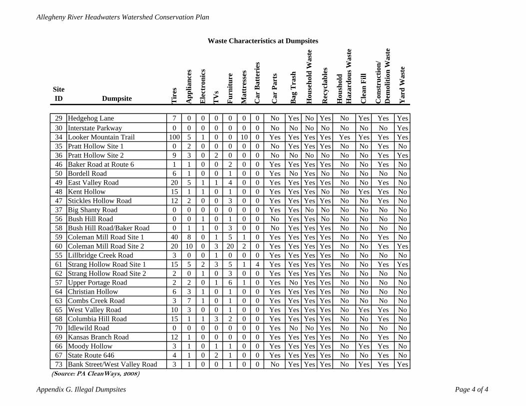
Allegheny River Headwaters Watershed Conservation Plan
Site ID Dumpsite T
ires
App
lianc
es
Ele
ctro
nics
TV
s
Furn
iture
Mat
tres
ses
Car
Bat
teri
es
Car
Par
ts
Bag
Tra
sh
Hou
seho
ld W
aste
Rec
ycla
bles
Hou
shol
d H
azar
dous
Was
te
Cle
an F
ill
Con
stru
ctio
n/
Dem
oliti
on W
aste
Yar
d W
aste
29 Hedgehog Lane 7 0 0 0 0 0 0 No Yes No Yes No Yes Yes Yes30 Interstate Parkway 0 0 0 0 0 0 0 No No No No No No No Yes34 Looker Mountain Trail 100 5 1 0 0 10 0 Yes Yes Yes Yes Yes Yes Yes Yes35 Pratt Hollow Site 1 0 2 0 0 0 0 0 No Yes Yes Yes No No Yes No36 Pratt Hollow Site 2 9 3 0 2 0 0 0 No No No No No No Yes Yes46 Baker Road at Route 6 1 1 0 0 2 0 0 Yes Yes Yes Yes No No Yes No50 Bordell Road 6 1 0 0 1 0 0 Yes No Yes No No No No No49 East Valley Road 20 5 1 1 4 0 0 Yes Yes Yes Yes No No Yes No48 Kent Hollow 15 1 1 0 1 0 0 Yes Yes Yes No No Yes Yes No47 Stickles Hollow Road 12 2 0 0 3 0 0 Yes Yes Yes Yes No No Yes No37 Big Shanty Road 0 0 0 0 0 0 0 Yes Yes No No No No No No56 Bush Hill Road 0 0 1 0 1 0 0 No Yes Yes No No No No No58 Bush Hill Road/Baker Road 0 1 1 0 3 0 0 No Yes Yes Yes No No No No59 Coleman Mill Road Site 1 40 8 0 1 5 1 0 Yes Yes Yes Yes No No Yes No60 Coleman Mill Road Site 2 20 10 0 3 20 2 0 Yes Yes Yes Yes No No Yes Yes55 Lillbridge Creek Road 3 0 0 1 0 0 0 Yes Yes Yes Yes No No No No61 Strang Hollow Road Site 1 15 5 2 3 5 1 4 Yes Yes Yes Yes No No Yes Yes62 Strang Hollow Road Site 2 2 0 1 0 3 0 0 Yes Yes Yes Yes No No No No57 Upper Portage Road 2 2 0 1 6 1 0 Yes No Yes Yes No No No No64 Christian Hollow 6 3 1 0 1 0 0 Yes Yes Yes Yes No No No No63 Combs Creek Road 3 7 1 0 1 0 0 Yes Yes Yes Yes No No No No65 West Valley Road 10 3 0 0 1 0 0 Yes Yes Yes Yes No Yes Yes No68 Columbia Hill Road 15 1 1 3 2 0 0 Yes Yes Yes Yes No No Yes No70 Idlewild Road 0 0 0 0 0 0 0 Yes No No Yes No No No No69 Kansas Branch Road 12 1 0 0 0 0 0 Yes Yes Yes Yes No No Yes No66 Moody Hollow 3 1 0 1 1 0 0 Yes Yes Yes Yes No Yes Yes No67 State Route 646 4 1 0 2 1 0 0 Yes Yes Yes Yes No No Yes No73 Bank Street/West Valley Road 3 1 0 0 1 0 0 No Yes Yes Yes No Yes Yes Yes
Waste Characteristics at Dumpsites
(Source: PA CleanWays, 2008)
Appendix G. Illegal Dumpsites Page 4 of 4
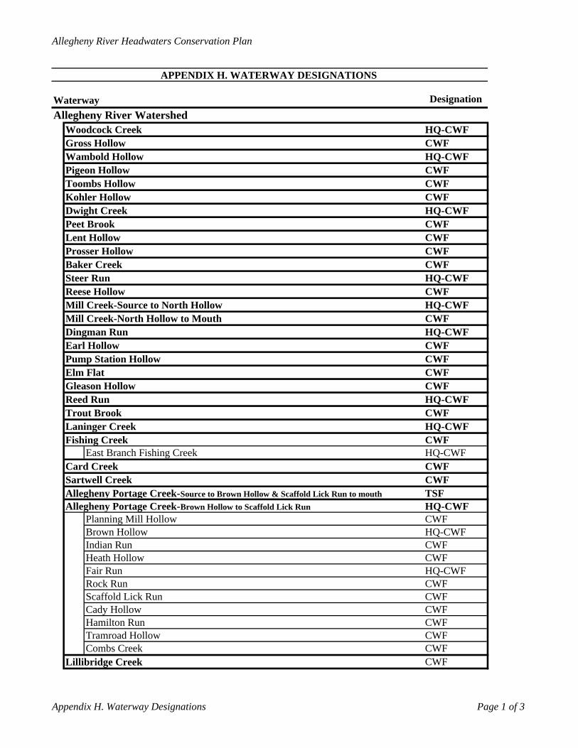
Allegheny River Headwaters Conservation Plan
APPENDIX H. WATERWAY DESIGNATIONS
Waterway DesignationAllegheny River Watershed
Woodcock Creek HQ-CWFGross Hollow CWFWambold Hollow HQ-CWFPigeon Hollow CWFToombs Hollow CWFKohler Hollow CWFDwight Creek HQ-CWFPeet Brook CWFLent Hollow CWFProsser Hollow CWFBaker Creek CWFSteer Run HQ-CWFReese Hollow CWFMill Creek-Source to North Hollow HQ-CWFMill Creek-North Hollow to Mouth CWFDingman Run HQ-CWFEarl Hollow CWFPump Station Hollow CWFElm Flat CWFGleason Hollow CWFReed Run HQ-CWFTrout Brook CWFLaninger Creek HQ-CWFFishing Creek CWF
East Branch Fishing Creek HQ-CWFCard Creek CWFSartwell Creek CWFAllegheny Portage Creek-Source to Brown Hollow & Scaffold Lick Run to mouth TSFAllegheny Portage Creek-Brown Hollow to Scaffold Lick Run HQ-CWF
Planning Mill Hollow CWFBrown Hollow HQ-CWFIndian Run CWFHeath Hollow CWFFair Run HQ-CWFRock Run CWFScaffold Lick Run CWFCady Hollow CWFHamilton Run CWFTramroad Hollow CWFCombs Creek CWF
Lillibridge Creek CWF
Appendix H. Waterway Designations Page 1 of 3
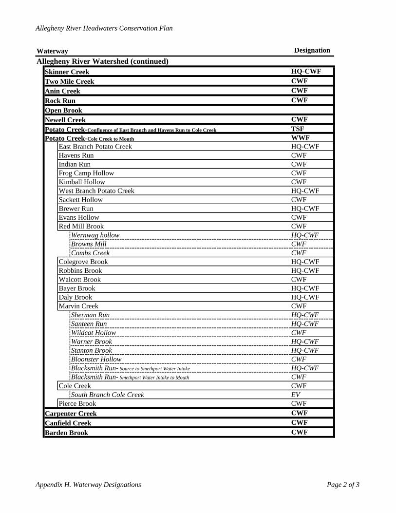
Allegheny River Headwaters Conservation Plan
Waterway DesignationAllegheny River Watershed (continued)
Skinner Creek HQ-CWFTwo Mile Creek CWFAnin Creek CWFRock Run CWFOpen BrookNewell Creek CWFPotato Creek-Confluence of East Branch and Havens Run to Cole Creek TSFPotato Creek-Cole Creek to Mouth WWF
East Branch Potato Creek HQ-CWFHavens Run CWFIndian Run CWFFrog Camp Hollow CWFKimball Hollow CWFWest Branch Potato Creek HQ-CWFSackett Hollow CWFBrewer Run HQ-CWFEvans Hollow CWFRed Mill Brook CWF
Wernwag hollow HQ-CWFBrowns Mill CWFCombs Creek CWF
Colegrove Brook HQ-CWFRobbins Brook HQ-CWFWalcott Brook CWFBayer Brook HQ-CWFDaly Brook HQ-CWFMarvin Creek CWF
Sherman Run HQ-CWFSanteen Run HQ-CWFWildcat Hollow CWFWarner Brook HQ-CWFStanton Brook HQ-CWFBloonster Hollow CWFBlacksmith Run- Source to Smethport Water Intake HQ-CWFBlacksmith Run- Smethport Water Intake to Mouth CWF
Cole Creek CWFSouth Branch Cole Creek EV
Pierce Brook CWFCarpenter Creek CWFCanfield Creek CWFBarden Brook CWF
Appendix H. Waterway Designations Page 2 of 3
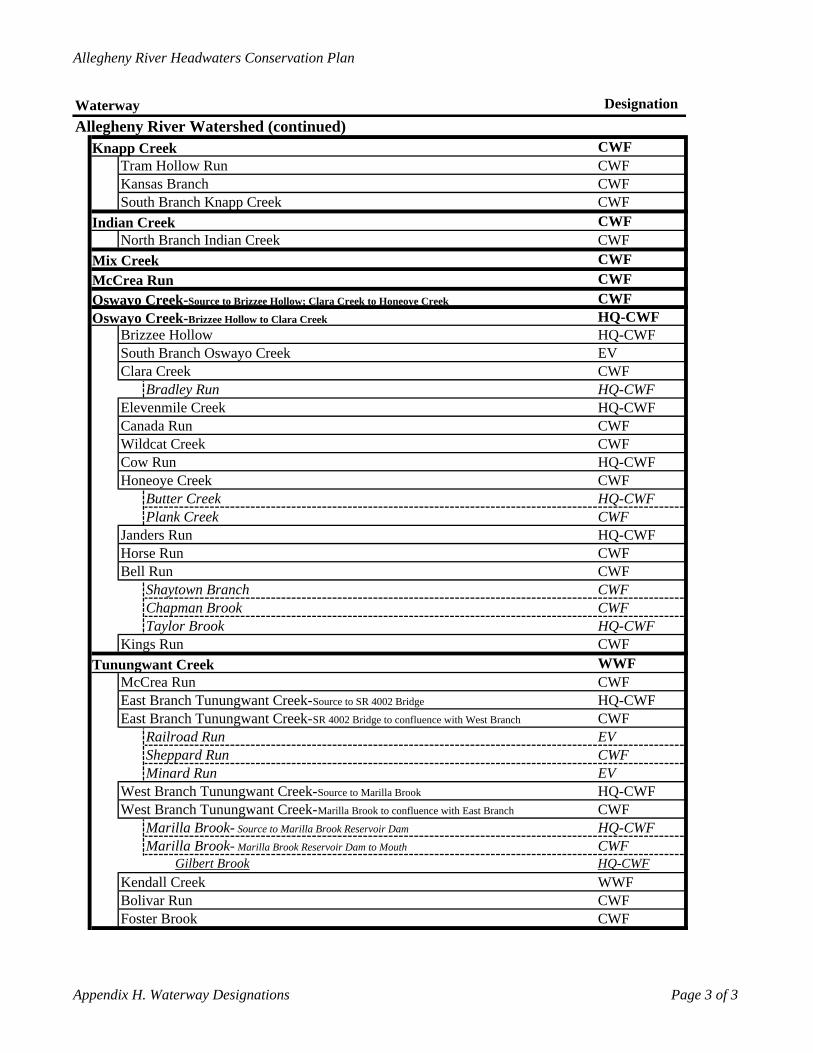
Allegheny River Headwaters Conservation Plan
Waterway DesignationAllegheny River Watershed (continued)
Knapp Creek CWFTram Hollow Run CWFKansas Branch CWFSouth Branch Knapp Creek CWF
Indian Creek CWFNorth Branch Indian Creek CWF
Mix Creek CWFMcCrea Run CWFOswayo Creek- CWFSource to Brizzee Hollow; Clara Creek to Honeoye Creek
Oswayo Creek- HQ-CWFBrizzee Hollow
Brizzee Hollow to Clara CreekHQ-CWF
South Branch Oswayo Creek EVClara Creek CWF
Bradley Run HQ-CWFElevenmile Creek HQ-CWFCanada Run CWFWildcat Creek CWFCow Run HQ-CWFHoneoye Creek CWF
Butter Creek HQ-CWFPlank Creek CWF
Janders Run HQ-CWFHorse Run CWFBell Run CWF
Shaytown Branch CWFChapman Brook CWFTaylor Brook HQ-CWF
Kings Run CWFTunungwant Creek WWF
McCrea Run CWFEast Branch Tunungwant Creek- HQ-CWFEast Branch Tunungwant Creek-
Source to SR 4002 Bridge
CWFRailroad Run
SR 4002 Bridge to confluence with West Branch
EVSheppard Run CWFMinard Run EV
West Branch Tunungwant Creek- HQ-CWFSource to Marilla Brook
West Branch Tunungwant Creek- CWFMarilla Brook to confluence with East Branch
Marilla Brook- HQ-CWFMarilla Brook-
Source to Marilla Brook Reservoir Dam
CWFGilbert Brook
Marilla Brook Reservoir Dam to MouthHQ-CWF
Kendall Creek WWFBolivar Run CWFFoster Brook CWF
Appendix H. Waterway Designations Page 3 of 3
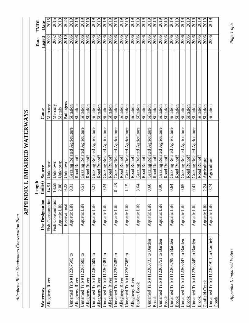
Alle
ghen
y Ri
ver H
eadw
ater
s Con
serv
atio
n Pl
an
APP
EN
DIX
I. IM
PAIR
ED
WA
TE
RW
AY
S
Wat
erw
ayU
se D
esig
natio
nL
engt
h (m
iles)
Sour
ceC
ause
Dat
e L
iste
dT
MD
L
Dat
eA
llegh
eny
Riv
er
Fish
Con
sum
ptio
n14
.91
Unk
now
nM
ercu
ry20
0220
15Fi
sh C
onsu
mpt
ion
13.5
8U
nkno
wn
Mer
cury
2002
2015
Aqu
atic
Life
2.08
Unk
now
nM
etal
s20
0620
19R
ecre
atio
nal
9.22
Unk
now
nPa
thog
ens
2010
2023
Unn
amed
Trib
#11
2367
505
to
Alle
ghen
y R
iver
Aqu
atic
Life
0.31
Gra
zing
Rel
ated
Agr
icul
ture
Silta
tion
2006
2019
Roa
d R
unof
fSi
ltatio
n20
0620
19U
nnam
ed T
rib #
1123
6760
5 to
A
llegh
eny
Riv
erA
quat
ic L
ife0.
51G
razi
ng R
elat
ed A
gric
ultu
reSi
ltatio
n20
0620
19R
oad
Run
off
Silta
tion
2006
2019
Unn
amed
Trib
#11
2367
609
to
Alle
ghen
y R
iver
Aqu
atic
Life
0.21
Gra
zing
Rel
ated
Agr
icul
ture
Silta
tion
2006
2019
Roa
d R
unof
fSi
ltatio
n20
0620
19U
nnam
ed T
rib #
1123
6738
1 to
A
llegh
eny
Riv
erA
quat
ic L
ife0.
24G
razi
ng R
elat
ed A
gric
ultu
reSi
ltatio
n20
0620
19R
oad
Run
off
Silta
tion
2006
2019
Unn
amed
Trib
#11
2367
485
to
Alle
ghen
y R
iver
Aqu
atic
Life
0..4
8G
razi
ng R
elat
ed A
gric
ultu
reSi
ltatio
n20
0620
19R
oad
Run
off
Silta
tion
2006
2019
Unn
amed
Trib
#11
2367
585
to
Alle
ghen
y R
iver
Aqu
atic
Life
1.15
Gra
zing
Rel
ated
Agr
icul
ture
Silta
tion
2006
2019
Roa
d R
unof
fSi
ltatio
n20
0620
19B
arde
n B
rook
Aqu
atic
Life
3.64
Gra
zing
Rel
ated
Agr
icul
ture
Silta
tion
2006
2019
Roa
d R
unof
fSi
ltatio
n20
0620
19U
nnam
ed T
rib #
1123
6373
3 to
Bar
den
Bro
okA
quat
ic L
ife0.
68G
razi
ng R
elat
ed A
gric
ultu
reSi
ltatio
n20
0620
19R
oad
Run
off
Silta
tion
2006
2019
Unn
amed
Trib
#11
2363
751
to B
arde
n B
rook
Aqu
atic
Life
0.96
Gra
zing
Rel
ated
Agr
icul
ture
Silta
tion
2006
2019
Roa
d R
unof
fSi
ltatio
n20
0620
19U
nnam
ed T
rib #
1123
6379
9 to
Bar
den
Bro
okA
quat
ic L
ife0.
64G
razi
ng R
elat
ed A
gric
ultu
reSi
ltatio
n20
0620
19R
oad
Run
off
Silta
tion
2006
2019
Unn
amed
Trib
#11
2363
347
to B
arde
n B
rook
Aqu
atic
Life
0.65
Gra
zing
Rel
ated
Agr
icul
ture
Silta
tion
2006
2019
Roa
d R
unof
fSi
ltatio
n20
0620
19U
nnam
ed T
rib #
1123
6334
9 to
Bar
den
Bro
okA
quat
ic L
ife0.
41G
razi
ng R
elat
ed A
gric
ultu
reSi
ltatio
n20
0620
19R
oad
Run
off
Silta
tion
2006
2019
Can
field
Cre
ekA
quat
ic L
ife2.
24A
gric
ultu
reSi
ltatio
n20
0620
19U
nnam
ed T
rib #
1123
6491
1 to
Can
field
C
reek
Aqu
atic
Life
0.74
Agr
icul
ture
Silta
tion
2006
2019
Appe
ndix
I. Im
pair
ed W
ater
sPa
ge 1
of 5
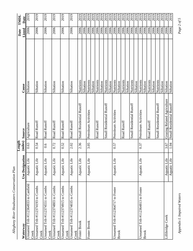
Alle
ghen
y Ri
ver H
eadw
ater
s Con
serv
atio
n Pl
an
Wat
erw
ayU
se D
esig
natio
nL
engt
h (m
iles)
Sour
ceC
ause
Dat
e L
iste
dT
MD
L
Dat
eU
nnam
ed T
rib #
1123
6493
3 to
Can
field
C
reek
Aqu
atic
Life
0.63
Agr
icul
ture
Silta
tion
2006
2019
Unn
amed
Trib
#11
2374
193
to C
ombs
C
reek
Aqu
atic
Life
0.54
Roa
d R
unof
fSi
ltatio
n20
0620
19
Unn
amed
Trib
#11
2374
551
to C
ombs
C
reek
Aqu
atic
Life
0.6
Roa
d R
unof
fSi
ltatio
n20
0620
19
Unn
amed
Trib
#11
2374
803
to C
ombs
C
reek
Aqu
atic
Life
0.72
Roa
d R
unof
fSi
ltatio
n20
0620
19
Unn
amed
Trib
#11
2374
915
to C
ombs
C
reek
Aqu
atic
Life
0.52
Roa
d R
unof
fSi
ltatio
n20
0620
19
Unn
amed
Trib
#11
2374
035
to C
ombs
C
reek
Aqu
atic
Life
2.02
Roa
d R
unof
fSi
ltatio
n20
0620
19
Fost
er B
rook
Aqu
atic
Life
2.36
Smal
l Res
iden
tial R
unof
fN
utrie
nts
2006
2019
Silta
tion
2006
2019
Fost
er B
rook
Aqu
atic
Life
3.05
Petro
leum
Act
iviti
esN
utrie
nts
2006
2019
Silta
tion
2006
2019
Roa
d R
unof
fN
utrie
nts
2006
2019
Silta
tion
2006
2019
Smal
l Res
iden
tial R
unof
fN
utrie
nts
2006
2019
Silta
tion
2006
2019
Unn
amed
Trib
#11
2364
717
to F
oste
r B
rook
Aqu
atic
Life
0.57
Petro
leum
Act
iviti
esN
utrie
nts
2006
2019
Silta
tion
2006
2019
Roa
d R
unof
fN
utrie
nts
2006
2019
Silta
tion
2006
2019
Smal
l Res
iden
tial R
unof
fN
utrie
nts
2006
2019
Silta
tion
2006
2019
Unn
amed
Trib
#11
2364
813
to F
oste
r B
rook
Aqu
atic
Life
0.37
Petro
leum
Act
iviti
esN
utrie
nts
2006
2019
Silta
tion
2006
2019
Roa
d R
unof
fN
utrie
nts
2006
2019
Silta
tion
2006
2019
Smal
l Res
iden
tial R
unof
fN
utrie
nts
2006
2019
Silta
tion
2006
2019
Lilli
brid
ge C
reek
Aqu
atic
Life
3.67
Gra
zing
Rel
ated
Agr
icul
ture
Silta
tion
2006
2019
Aqu
atic
Life
1.04
Smal
l Res
iden
tial R
unof
fSi
ltatio
n20
0620
19
Appe
ndix
I. Im
pair
ed W
ater
sPa
ge 2
of 5
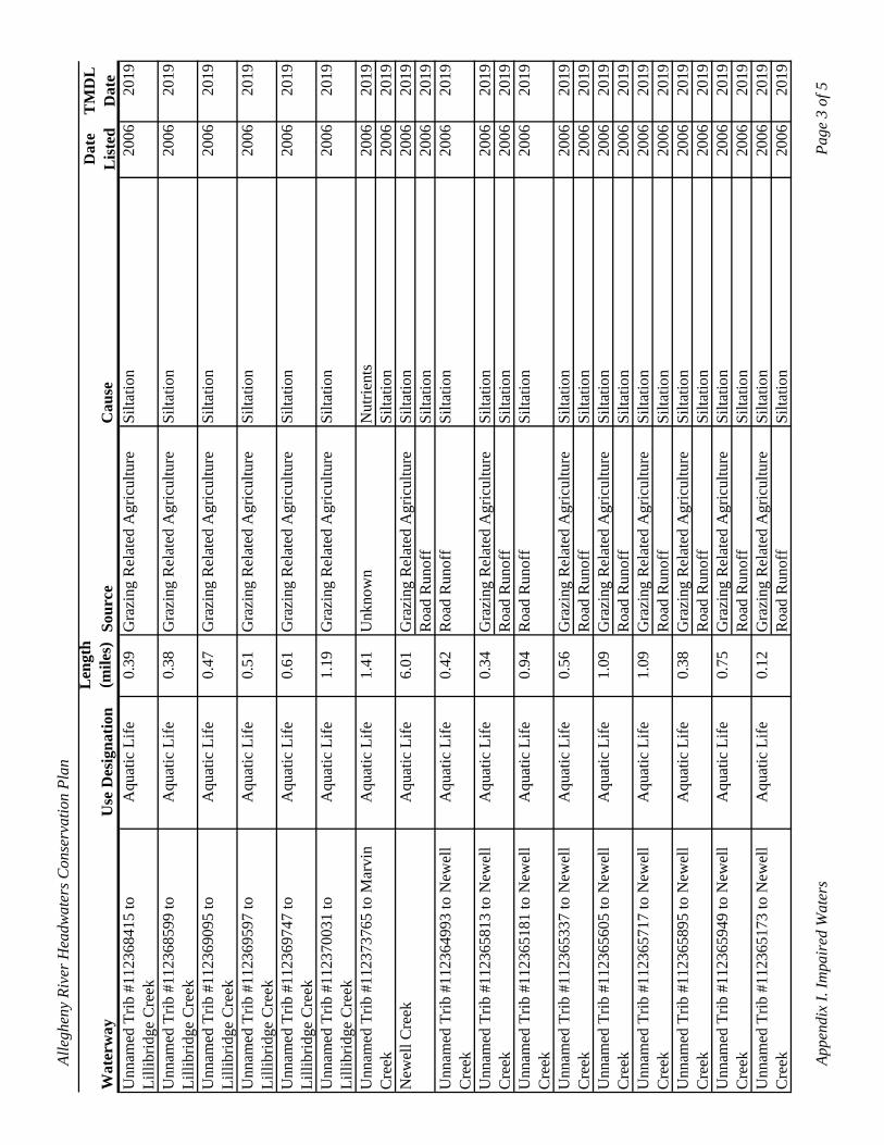
Alle
ghen
y Ri
ver H
eadw
ater
s Con
serv
atio
n Pl
an
Wat
erw
ayU
se D
esig
natio
nL
engt
h (m
iles)
Sour
ceC
ause
Dat
e L
iste
dT
MD
L
Dat
eU
nnam
ed T
rib #
1123
6841
5 to
Li
llibr
idge
Cre
ekA
quat
ic L
ife0.
39G
razi
ng R
elat
ed A
gric
ultu
reSi
ltatio
n20
0620
19
Unn
amed
Trib
#11
2368
599
to
Lilli
brid
ge C
reek
Aqu
atic
Life
0.38
Gra
zing
Rel
ated
Agr
icul
ture
Silta
tion
2006
2019
Unn
amed
Trib
#11
2369
095
to
Lilli
brid
ge C
reek
Aqu
atic
Life
0.47
Gra
zing
Rel
ated
Agr
icul
ture
Silta
tion
2006
2019
Unn
amed
Trib
#11
2369
597
to
Lilli
brid
ge C
reek
Aqu
atic
Life
0.51
Gra
zing
Rel
ated
Agr
icul
ture
Silta
tion
2006
2019
Unn
amed
Trib
#11
2369
747
to
Lilli
brid
ge C
reek
Aqu
atic
Life
0.61
Gra
zing
Rel
ated
Agr
icul
ture
Silta
tion
2006
2019
Unn
amed
Trib
#11
2370
031
to
Lilli
brid
ge C
reek
Aqu
atic
Life
1.19
Gra
zing
Rel
ated
Agr
icul
ture
Silta
tion
2006
2019
Unn
amed
Trib
#11
2373
765
to M
arvi
n C
reek
Aqu
atic
Life
1.41
Unk
now
nN
utrie
nts
2006
2019
Silta
tion
2006
2019
New
ell C
reek
Aqu
atic
Life
6.01
Gra
zing
Rel
ated
Agr
icul
ture
Silta
tion
2006
2019
Roa
d R
unof
fSi
ltatio
n20
0620
19U
nnam
ed T
rib #
1123
6499
3 to
New
ell
Cre
ekA
quat
ic L
ife0.
42R
oad
Run
off
Silta
tion
2006
2019
Unn
amed
Trib
#11
2365
813
to N
ewel
l C
reek
Aqu
atic
Life
0.34
Gra
zing
Rel
ated
Agr
icul
ture
Silta
tion
2006
2019
Roa
d R
unof
fSi
ltatio
n20
0620
19U
nnam
ed T
rib #
1123
6518
1 to
New
ell
Cre
ekA
quat
ic L
ife0.
94R
oad
Run
off
Silta
tion
2006
2019
Unn
amed
Trib
#11
2365
337
to N
ewel
l C
reek
Aqu
atic
Life
0.56
Gra
zing
Rel
ated
Agr
icul
ture
Silta
tion
2006
2019
Roa
d R
unof
fSi
ltatio
n20
0620
19U
nnam
ed T
rib #
1123
6560
5 to
New
ell
Cre
ekA
quat
ic L
ife1.
09G
razi
ng R
elat
ed A
gric
ultu
reSi
ltatio
n20
0620
19R
oad
Run
off
Silta
tion
2006
2019
Unn
amed
Trib
#11
2365
717
to N
ewel
l C
reek
Aqu
atic
Life
1.09
Gra
zing
Rel
ated
Agr
icul
ture
Silta
tion
2006
2019
Roa
d R
unof
fSi
ltatio
n20
0620
19U
nnam
ed T
rib #
1123
6589
5 to
New
ell
Cre
ekA
quat
ic L
ife0.
38G
razi
ng R
elat
ed A
gric
ultu
reSi
ltatio
n20
0620
19R
oad
Run
off
Silta
tion
2006
2019
Unn
amed
Trib
#11
2365
949
to N
ewel
l C
reek
Aqu
atic
Life
0.75
Gra
zing
Rel
ated
Agr
icul
ture
Silta
tion
2006
2019
Roa
d R
unof
fSi
ltatio
n20
0620
19U
nnam
ed T
rib #
1123
6517
3 to
New
ell
Cre
ekA
quat
ic L
ife0.
12G
razi
ng R
elat
ed A
gric
ultu
reSi
ltatio
n20
0620
19R
oad
Run
off
Silta
tion
2006
2019
Appe
ndix
I. Im
pair
ed W
ater
sPa
ge 3
of 5
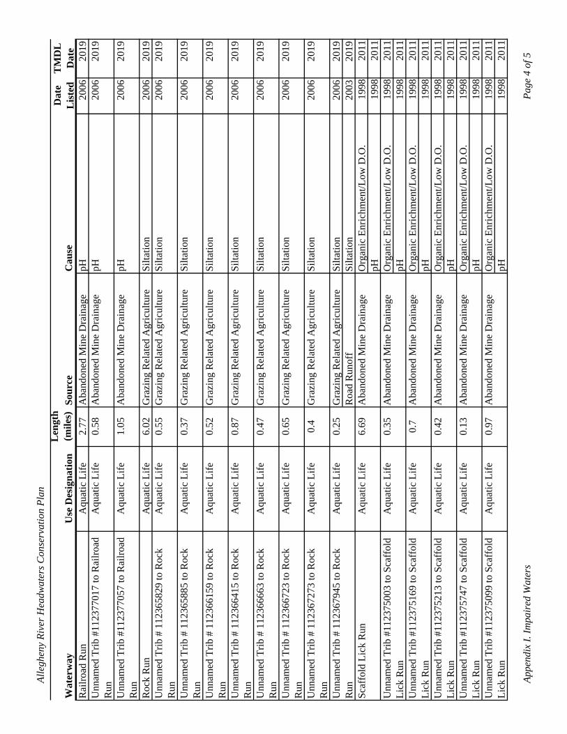
Alle
ghen
y Ri
ver H
eadw
ater
s Con
serv
atio
n Pl
an
pH19
9820
11Li
ck R
un
Wat
erw
ayU
se D
esig
natio
nL
engt
h (m
iles)
Sour
ceC
ause
Dat
e L
iste
dT
MD
L
Dat
eR
ailro
ad R
unA
quat
ic L
ife2.
77A
band
oned
Min
e D
rain
age
pH20
0620
19U
nnam
ed T
rib #
1123
7701
7 to
Rai
lroad
R
unA
quat
ic L
ife0.
58A
band
oned
Min
e D
rain
age
pH20
0620
19
Unn
amed
Trib
#11
2377
057
to R
ailro
ad
Run
Aqu
atic
Life
1.05
Aba
ndon
ed M
ine
Dra
inag
epH
2006
2019
Roc
k R
unA
quat
ic L
ife6.
02G
razi
ng R
elat
ed A
gric
ultu
reSi
ltatio
n20
0620
19U
nnam
ed T
rib #
112
3658
29 to
Roc
k R
unA
quat
ic L
ife0.
55G
razi
ng R
elat
ed A
gric
ultu
reSi
ltatio
n20
0620
19
Unn
amed
Trib
# 1
1236
5885
to R
ock
Run
Aqu
atic
Life
0.37
Gra
zing
Rel
ated
Agr
icul
ture
Silta
tion
2006
2019
Unn
amed
Trib
# 1
1236
6159
to R
ock
Aqu
atic
Life
0.52
Gra
zing
Rel
ated
Agr
icul
ture
Silta
tion
2006
2019
Run
Unn
amed
Trib
# 1
1236
6415
to R
ock
Aqu
atic
Life
0.87
Gra
zing
Rel
ated
Agr
icul
ture
Silta
tion
2006
2019
Run
Unn
amed
Trib
# 1
1236
6663
to R
ock
Aqu
atic
Life
0.47
Gra
zing
Rel
ated
Agr
icul
ture
Silta
tion
2006
2019
Run
Unn
amed
Trib
# 1
1236
6723
to R
ock
Aqu
atic
Life
0.65
Gra
zing
Rel
ated
Agr
icul
ture
Silta
tion
2006
2019
Run
Unn
amed
Trib
# 1
1236
7273
to R
ock
Aqu
atic
Life
0.4
Gra
zing
Rel
ated
Agr
icul
ture
Silta
tion
2006
2019
Run
Unn
amed
Trib
# 1
1236
7945
to R
ock
Aqu
atic
Life
0.25
Gra
zing
Rel
ated
Agr
icul
ture
Silta
tion
2006
2019
Run
Scaf
fold
Lic
k R
unA
quat
ic L
ife6.
69R
oad
Run
off
Aba
ndon
ed M
ine
Dra
inag
eSi
ltatio
n20
0320
19O
rgan
ic E
nric
hmen
t/Low
D.O
.19
9820
11
Unn
amed
Trib
#11
2375
003
to S
caff
old
Aqu
atic
Life
0.35
Aba
ndon
ed M
ine
Dra
inag
epH
1998
2011
Org
anic
Enr
ichm
ent/L
ow D
.O.
1998
2011
Unn
amed
Trib
#11
2375
169
to S
caff
old
Lick
Run
Aqu
atic
Life
0.7
Aba
ndon
ed M
ine
Dra
inag
epH
1998
2011
Org
anic
Enr
ichm
ent/L
ow D
.O.
1998
2011
Unn
amed
Trib
#11
2375
213
to S
caff
old
Lick
Run
Aqu
atic
Life
0.42
Aba
ndon
ed M
ine
Dra
inag
epH
1998
2011
Org
anic
Enr
ichm
ent/L
ow D
.O.
1998
2011
Unn
amed
Trib
#11
2375
747
to S
caff
old
Lick
Run
Aqu
atic
Life
0.13
Aba
ndon
ed M
ine
Dra
inag
epH
1998
2011
Org
anic
Enr
ichm
ent/L
ow D
.O.
1998
2011
Unn
amed
Trib
#11
2375
099
to S
caff
old
Lick
Run
Aqu
atic
Life
0.97
Aba
ndon
ed M
ine
Dra
inag
epH
1998
2011
Org
anic
Enr
ichm
ent/L
ow D
.O.
1998
2011
Appe
ndix
I. Im
pair
ed W
ater
sPa
ge 4
of 5
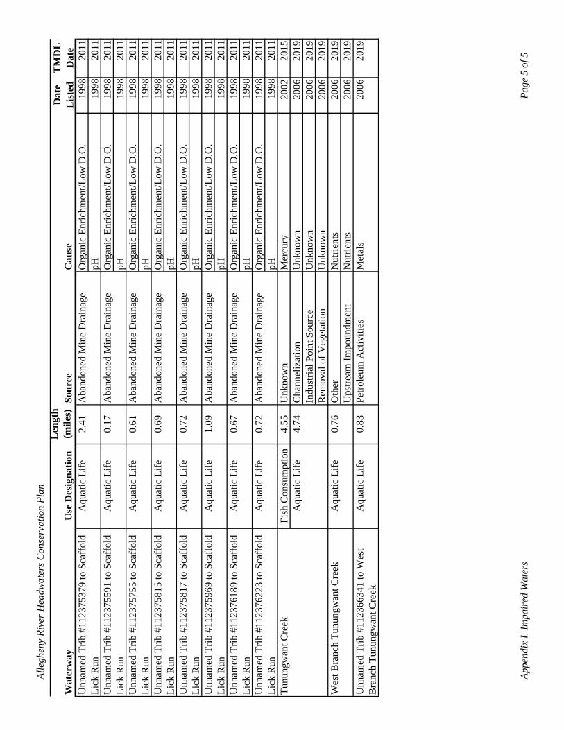
Alle
ghen
y Ri
ver H
eadw
ater
s Con
serv
atio
n Pl
an
Bra
nch
Tunu
ngw
ant C
reek
Len
gth
(mile
s)D
ate
TM
DL
W
ater
way
Unn
amed
Trib
#11
2375
379
to S
caff
old
Use
Des
igna
tion
Aqu
atic
Life
2.41
Sour
ceA
band
oned
Min
e D
rain
age
Cau
seL
iste
dD
ate
Org
anic
Enr
ichm
ent/L
ow D
.O.
1998
2011
Unn
amed
Trib
#11
2375
591
to S
caff
old
Lick
Run
Aqu
atic
Life
0.17
Aba
ndon
ed M
ine
Dra
inag
epH
1998
2011
Org
anic
Enr
ichm
ent/L
ow D
.O.
1998
2011
Unn
amed
Trib
#11
2375
755
to S
caff
old
Lick
Run
Aqu
atic
Life
0.61
Aba
ndon
ed M
ine
Dra
inag
epH
1998
2011
Org
anic
Enr
ichm
ent/L
ow D
.O.
1998
2011
Unn
amed
Trib
#11
2375
815
to S
caff
old
Lick
Run
Aqu
atic
Life
0.69
Aba
ndon
ed M
ine
Dra
inag
epH
1998
2011
Org
anic
Enr
ichm
ent/L
ow D
.O.
1998
2011
Unn
amed
Trib
#11
2375
817
to S
caff
old
Lick
Run
Aqu
atic
Life
0.72
Aba
ndon
ed M
ine
Dra
inag
epH
1998
2011
Org
anic
Enr
ichm
ent/L
ow D
.O.
1998
2011
Unn
amed
Trib
#11
2375
969
to S
caff
old
Lick
Run
Aqu
atic
Life
1.09
Aba
ndon
ed M
ine
Dra
inag
epH
1998
2011
Org
anic
Enr
ichm
ent/L
ow D
.O.
1998
2011
Unn
amed
Trib
#11
2376
189
to S
caff
old
Lick
Run
Aqu
atic
Life
0.67
Aba
ndon
ed M
ine
Dra
inag
epH
1998
2011
Org
anic
Enr
ichm
ent/L
ow D
.O.
1998
2011
Lick
Run
Unn
amed
Trib
#11
2376
223
to S
caff
old
Aqu
atic
Life
0.72
Aba
ndon
ed M
ine
Dra
inag
epH
1998
2011
Org
anic
Enr
ichm
ent/L
ow D
.O.
1998
2011
Tunu
ngw
ant C
reek
Lick
Run
pH19
9820
11Fi
sh C
onsu
mpt
ion
Aqu
atic
Life
4.55
4.74
Unk
now
nM
ercu
ry20
0220
15C
hann
eliz
atio
nU
nkno
wn
2006
2019
Indu
stria
l Poi
nt S
ourc
eU
nkno
wn
2006
2019
Wes
t Bra
nch
Tunu
ngw
ant C
reek
Aqu
atic
Life
0.76
Rem
oval
of V
eget
atio
nU
nkno
wn
2006
2019
Oth
erN
utrie
nts
2006
2019
Unn
amed
Trib
#11
2366
341
to W
est
Aqu
atic
Life
0.83
Ups
tream
Impo
undm
ent
Petro
leum
Act
iviti
esN
utrie
nts
Met
als
2006
2006
2019
2019
Appe
ndix
I. Im
pair
ed W
ater
sPa
ge 5
of 5
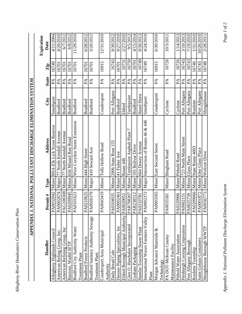
Alle
ghen
y Ri
ver H
eadw
ater
s Con
serv
atio
n Pl
an
APP
EN
DIX
J. N
AT
ION
AL
PO
LL
UT
AN
T D
ISC
HA
RG
E E
LIM
INA
TIO
N S
YST
EM
Han
dler
Perm
it #
Typ
eA
ddre
ssC
itySt
ate
Zip
Exp
irat
ion
D
ate
Alle
ghen
y H
ighl
ands
Cou
ncil
PA00
3204
2M
inor
BSA
-Elk
Lic
k Sc
out R
eser
veSm
ethp
ort
PA16
749
4/11
/200
4A
mer
ican
Ref
ing
Gro
up, I
nc.
PA00
0267
4M
ajor
77 N
orth
Ken
dall
Ave
nue
Bra
dfor
dPA
1670
14/
20/2
010
Am
eric
an R
efin
ing
Gro
up, I
ncPA
G10
8308
Min
or77
Nor
th K
enda
ll A
venu
eB
radf
ord
PA16
701
6/7/
2012
Baz
zoui
, Wad
id S
FTP
PA02
0994
5M
inor
656
Min
ard
Run
Roa
dB
radf
ord
PA16
701
6/9/
2012
Bra
dfor
d C
ity A
utho
rity
Wat
er
Trea
tmen
t Pla
ntPA
0101
621
Min
orW
est C
oryd
on S
treet
Ext
ensi
onB
radf
ord
PA16
701
11/2
9/20
10
Bra
dfor
d Fo
rest
Pro
duct
sPA
0210
625
Min
or44
4 H
igh
Stre
etB
radf
ord
PA16
701
6/28
/201
2B
radf
ord
Sani
tary
Aut
horit
y Se
wag
e Tr
eatm
ent P
lant
PA00
2637
9M
ajor
410
Sew
ard
Ave
Bra
dfor
dPA
1670
15/
20/2
012
Cou
ders
port
Are
a M
unic
ipal
A
utho
rity
PA00
4341
9M
inor
Tolls
Hol
low
Roa
dC
oude
rspo
rtPA
1691
512
/31/
2010
Dai
ly B
read
Caf
ePA
0104
035
Min
or29
06 S
tate
Rou
t 155
Port
Alle
gany
PA16
743
9/30
/201
2D
ress
er P
ipin
g Sp
ecia
litie
s, In
cPA
0002
461
Min
or41
Fis
her A
veB
radf
ord
PA16
701
9/27
/201
0El
dred
Bor
ough
Mun
icip
al A
utho
rity
PA00
2005
2M
inor
Rou
te 4
46
Eldr
edPA
1673
12/
27/2
010
Gle
n O
. Haw
bake
r Inc
orpo
rate
dPA
R70
8307
Min
orTu
rtlep
oint
Asp
halt
Plan
t 7Tu
rtlep
oint
PA
1675
09/
5/20
12G
raha
m P
acka
ging
PAR
2383
12M
inor
105
Bol
ivar
Driv
eB
radf
ord
PA16
701
4/15
/201
4H
amlin
Tow
nshi
p Se
wer
Pla
ntPA
0210
781
Min
or66
4 D
ewey
Ave
nue
Haz
el H
urst
PA16
749
9/30
/201
3In
tern
atio
nal W
axes
Far
mer
s-V
alle
y Pl
ant
PA00
0237
2M
ajor
Inte
rsec
tion
of R
oute
s 46
& 4
46Sm
ethp
ort
PA16
749
4/24
/201
0
Mor
gan
Adv
ance
Mat
eria
ls &
Te
chno
logy
PA00
0356
5M
inor
East
Sec
ond
Stre
etC
oude
rspo
rtPA
1691
56/
30/2
010
PA D
OT-
McK
ean
Cou
nty
Mai
nten
ance
Fac
ility
PA00
3558
1M
inor
Bin
gham
Roa
dC
yclo
nePA
1672
610
/3/2
011
Pith
old
Wat
er A
ssoc
iatio
nPA
0220
906
Min
orPi
thol
d R
oad
Cyc
lone
PA16
726
1/14
/201
3Pi
ttsbu
rgh
Cor
ning
Cor
pora
tion
PA00
0215
1M
inor
723
Nor
th M
ain
Stre
etPo
rt A
llega
nyPA
1674
33/
10/2
013
Port
Alle
gany
Bor
ough
PA00
2573
9M
inor
Gla
ss P
lace
Port
Alle
gany
PA16
743
7/19
/201
0R
oule
tte T
owns
hip
PA02
0906
6M
inor
Stat
e R
oute
400
3R
oule
ttePA
1674
61/
31/2
010
Sain
t Gob
ain
Con
tain
ers
PA00
0187
2M
inor
One
Gla
ss P
lace
Port
Alle
gany
PA16
743
10/2
6/20
10Sh
ingl
ehou
se B
orou
gh W
WTP
PA00
3677
3M
inor
Wol
cott
Driv
eSh
ingl
ehou
sePA
1674
82/
28/2
011
Appe
ndix
J. N
atio
nal P
ollu
tant
Dis
char
ge E
limin
atio
n Sy
stem
Page
1 o
f 2
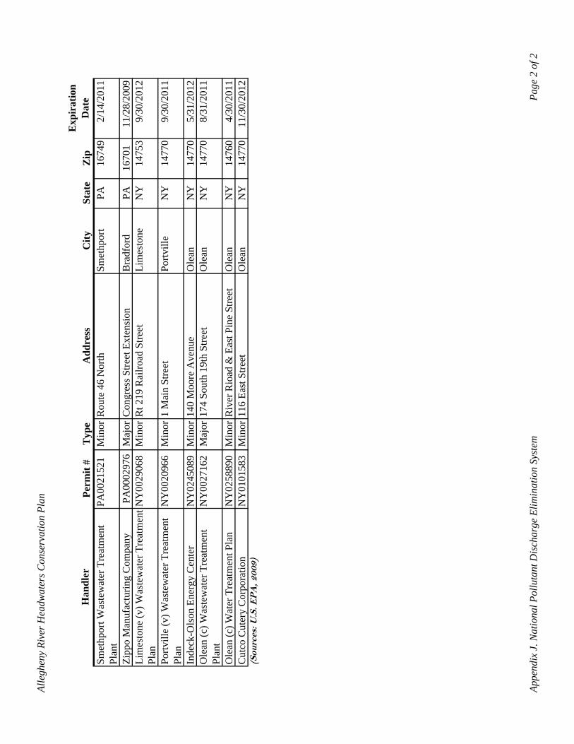
Alle
ghen
y Ri
ver H
eadw
ater
s Con
serv
atio
n Pl
an
Han
dler
Perm
it #
Typ
eA
ddre
ssC
itySt
ate
Zip
Exp
irat
ion
D
ate
Smet
hpor
t Was
tew
ater
Tre
atm
ent
Plan
tPA
0021
521
Min
orR
oute
46
Nor
thSm
ethp
ort
PA16
749
2/14
/201
1
Zipp
o M
anuf
actu
ring
Com
pany
PA00
0297
6M
ajor
Con
gres
s Stre
et E
xten
sion
Bra
dfor
dPA
1670
111
/28/
2009
Lim
esto
ne (v
) Was
tew
ater
Tre
atm
ent
Plan
NY
0029
068
Min
orR
t 219
Rai
lroad
Stre
etLi
mes
tone
NY
1475
39/
30/2
012
Portv
ille
(v) W
aste
wat
er T
reat
men
t Pl
anN
Y00
2096
6M
inor
1 M
ain
Stre
etPo
rtvill
eN
Y14
770
9/30
/201
1
Inde
ck-O
lson
Ene
rgy
Cen
ter
NY
0245
089
Min
or14
0 M
oore
Ave
nue
Ole
anN
Y14
770
5/31
/201
2O
lean
(c) W
aste
wat
er T
reat
men
t Pl
ant
NY
0027
162
Maj
or17
4 So
uth
19th
Stre
etO
lean
NY
1477
08/
31/2
011
Ole
an (c
) Wat
er T
reat
men
t Pla
nN
Y02
5889
0M
inor
Riv
er R
ioad
& E
ast P
ine
Stre
etO
lean
NY
1476
04/
30/2
011
Cut
co C
uter
y C
orpo
ratio
nN
Y01
0158
3M
inor
116
East
Stre
etO
lean
NY
1477
011
/30/
2012
(Sou
rces
: U.S
. EP
A, 2
009)
Appe
ndix
J. N
atio
nal P
ollu
tant
Dis
char
ge E
limin
atio
n Sy
stem
Page
2 o
f 2
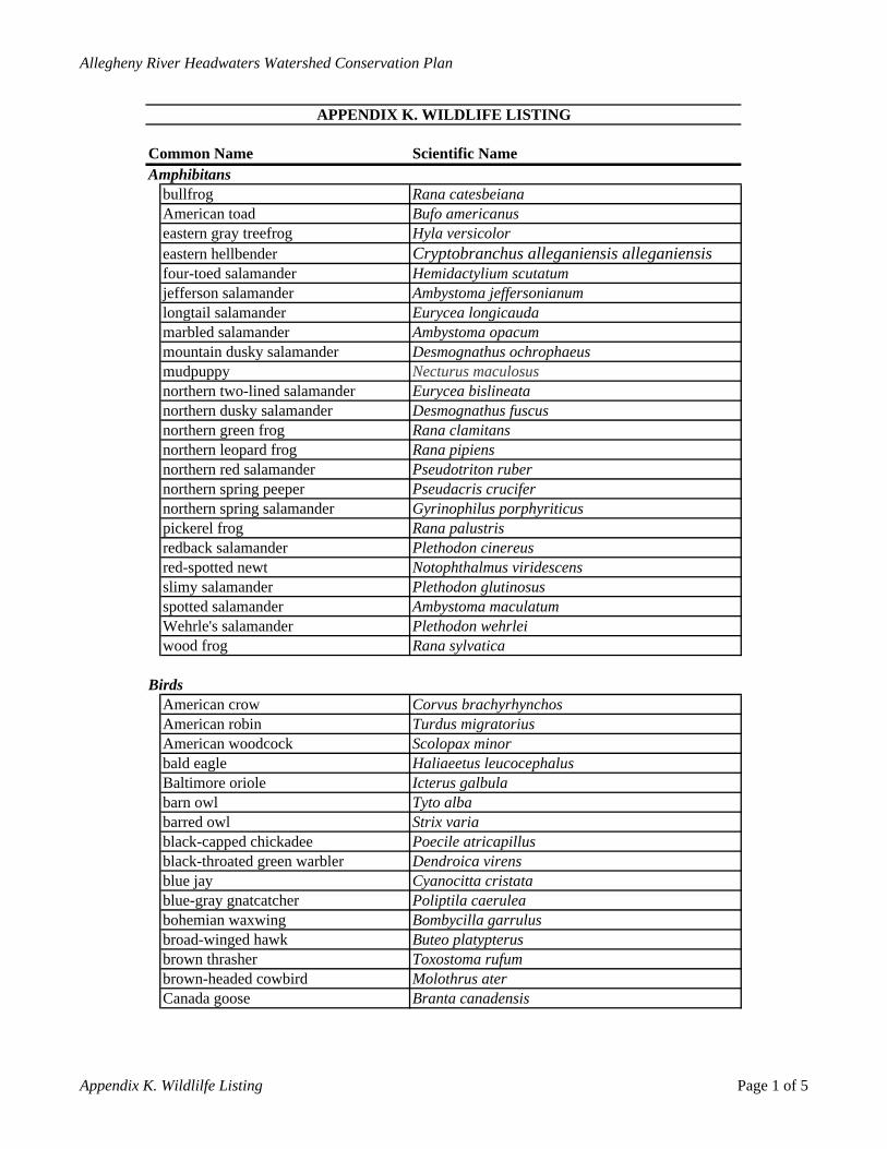
Allegheny River Headwaters Watershed Conservation Plan
APPENDIX K. WILDLIFE LISTING
Common Name Scientific NameAmphibitans
bullfrog Rana catesbeianaAmerican toad Bufo americanuseastern gray treefrog Hyla versicoloreastern hellbender Cryptobranchus alleganiensis alleganiensisfour-toed salamander Hemidactylium scutatumjefferson salamander Ambystoma jeffersonianumlongtail salamander Eurycea longicaudamarbled salamander Ambystoma opacummountain dusky salamander Desmognathus ochrophaeusmudpuppy Necturus maculosusnorthern two-lined salamander Eurycea bislineatanorthern dusky salamander Desmognathus fuscusnorthern green frog Rana clamitansnorthern leopard frog Rana pipiensnorthern red salamander Pseudotriton rubernorthern spring peeper Pseudacris crucifernorthern spring salamander Gyrinophilus porphyriticuspickerel frog Rana palustrisredback salamander Plethodon cinereusred-spotted newt Notophthalmus viridescensslimy salamander Plethodon glutinosusspotted salamander Ambystoma maculatumWehrle's salamander Plethodon wehrleiwood frog Rana sylvatica
BirdsAmerican crow Corvus brachyrhynchosAmerican robin Turdus migratoriusAmerican woodcock Scolopax minorbald eagle Haliaeetus leucocephalusBaltimore oriole Icterus galbulabarn owl Tyto albabarred owl Strix variablack-capped chickadee Poecile atricapillusblack-throated green warbler Dendroica virensblue jay Cyanocitta cristatablue-gray gnatcatcher Poliptila caeruleabohemian waxwing Bombycilla garrulusbroad-winged hawk Buteo platypterusbrown thrasher Toxostoma rufumbrown-headed cowbird Molothrus aterCanada goose Branta canadensis
Appendix K. Wildlilfe Listing Page 1 of 5
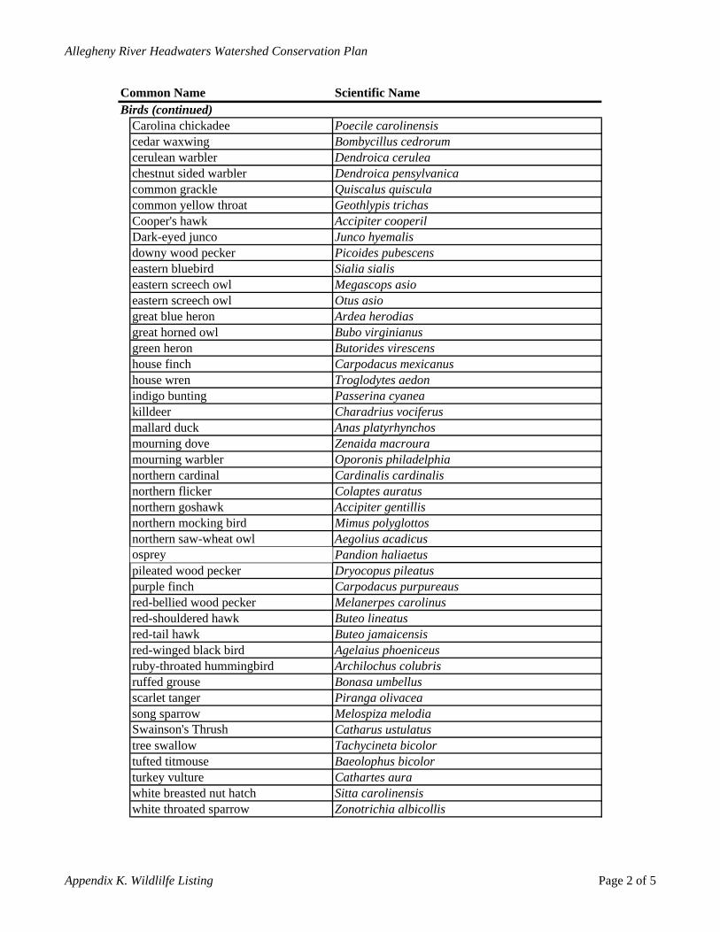
Allegheny River Headwaters Watershed Conservation Plan
Common Name Scientific NameBirds (continued)
Carolina chickadee Poecile carolinensiscedar waxwing Bombycillus cedrorumcerulean warbler Dendroica ceruleachestnut sided warbler Dendroica pensylvanicacommon grackle Quiscalus quisculacommon yellow throat Geothlypis trichasCooper's hawk Accipiter cooperilDark-eyed junco Junco hyemalisdowny wood pecker Picoides pubescenseastern bluebird Sialia sialiseastern screech owl Megascops asioeastern screech owl Otus asiogreat blue heron Ardea herodiasgreat horned owl Bubo virginianusgreen heron Butorides virescenshouse finch Carpodacus mexicanushouse wren Troglodytes aedonindigo bunting Passerina cyaneakilldeer Charadrius vociferusmallard duck Anas platyrhynchosmourning dove Zenaida macrouramourning warbler Oporonis philadelphianorthern cardinal Cardinalis cardinalisnorthern flicker Colaptes auratusnorthern goshawk Accipiter gentillisnorthern mocking bird Mimus polyglottosnorthern saw-wheat owl Aegolius acadicusosprey Pandion haliaetuspileated wood pecker Dryocopus pileatuspurple finch Carpodacus purpureausred-bellied wood pecker Melanerpes carolinusred-shouldered hawk Buteo lineatusred-tail hawk Buteo jamaicensisred-winged black bird Agelaius phoeniceusruby-throated hummingbird Archilochus colubrisruffed grouse Bonasa umbellusscarlet tanger Piranga olivaceasong sparrow Melospiza melodiaSwainson's Thrush Catharus ustulatustree swallow Tachycineta bicolortufted titmouse Baeolophus bicolorturkey vulture Cathartes aurawhite breasted nut hatch Sitta carolinensiswhite throated sparrow Zonotrichia albicollis
Appendix K. Wildlilfe Listing Page 2 of 5
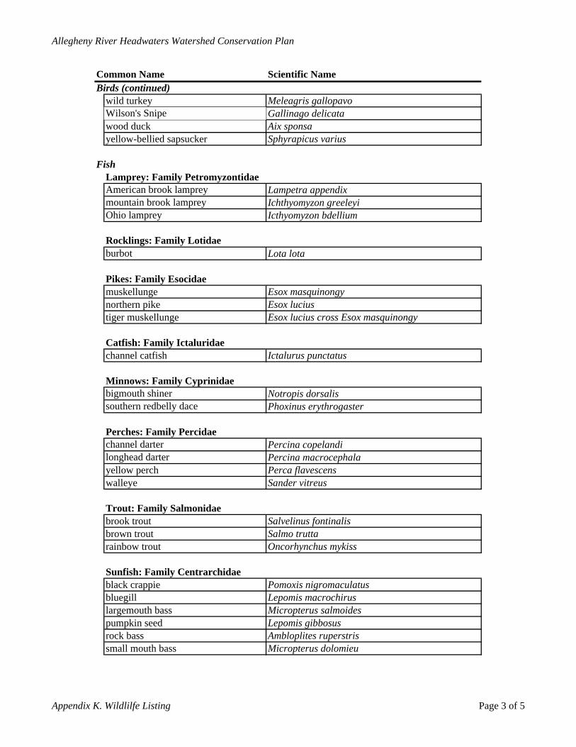
Allegheny River Headwaters Watershed Conservation Plan
Common Name Scientific NameBirds (continued)
wild turkey Meleagris gallopavoWilson's Snipe Gallinago delicatawood duck Aix sponsayellow-bellied sapsucker Sphyrapicus varius
FishLamprey: Family PetromyzontidaeAmerican brook lamprey Lampetra appendixmountain brook lamprey Ichthyomyzon greeleyiOhio lamprey Icthyomyzon bdellium
Rocklings: Family Lotidaeburbot Lota lota
Pikes: Family Esocidaemuskellunge Esox masquinongynorthern pike Esox luciustiger muskellunge Esox lucius cross Esox masquinongy
Catfish: Family Ictaluridaechannel catfish Ictalurus punctatus
Minnows: Family Cyprinidaebigmouth shiner Notropis dorsalissouthern redbelly dace Phoxinus erythrogaster
Perches: Family Percidaechannel darter Percina copelandilonghead darter Percina macrocephalayellow perch Perca flavescenswalleye Sander vitreus
Trout: Family Salmonidaebrook trout Salvelinus fontinalisbrown trout Salmo truttarainbow trout Oncorhynchus mykiss
Sunfish: Family Centrarchidaeblack crappie Pomoxis nigromaculatusbluegill Lepomis macrochiruslargemouth bass Micropterus salmoidespumpkin seed Lepomis gibbosusrock bass Ambloplites ruperstrissmall mouth bass Micropterus dolomieu
Appendix K. Wildlilfe Listing Page 3 of 5
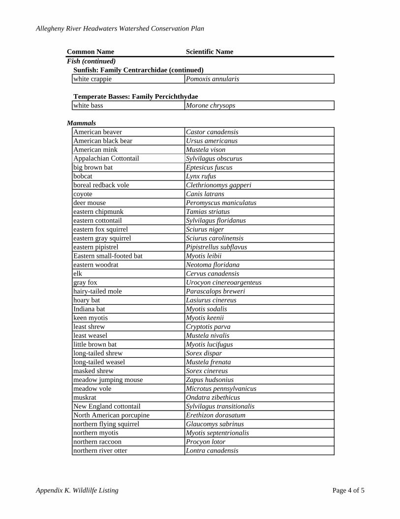
Allegheny River Headwaters Watershed Conservation Plan
northern river otter Lontra canadensis
Common Name Scientific NameFish (continued)
Sunfish: Family Centrarchidae (continued)white crappie Pomoxis annularis
Temperate Basses: Family Percichthydaewhite bass Morone chrysops
MammalsAmerican beaver Castor canadensisAmerican black bear Ursus americanusAmerican mink Mustela visonAppalachian Cottontail Sylvilagus obscurusbig brown bat Eptesicus fuscusbobcat Lynx rufusboreal redback vole Clethrionomys gappericoyote Canis latransdeer mouse Peromyscus maniculatuseastern chipmunk Tamias striatuseastern cottontail Sylvilagus floridanuseastern fox squirrel Sciurus nigereastern gray squirrel Sciurus carolinensiseastern pipistrel Pipistrellus subflavus
Myotis leibiiEastern small-footed batNeotoma floridanaeastern woodratCervus canadensiselk
gray fox Urocyon cinereoargenteushairy-tailed mole Parascalops brewerihoary bat Lasiurus cinereusIndiana bat Myotis sodaliskeen myotis Myotis keeniileast shrew Cryptotis parvaleast weasel Mustela nivalislittle brown bat Myotis lucifuguslong-tailed shrew Sorex disparlong-tailed weasel Mustela frenatamasked shrew Sorex cinereusmeadow jumping mouse Zapus hudsoniusmeadow vole Microtus pennsylvanicusmuskrat Ondatra zibethicusNew England cottontail Sylvilagus transitionalisNorth American porcupine Erethizon dorasatumnorthern flying squirrel Glaucomys sabrinusnorthern myotis Myotis septentrionalisnorthern raccoon Procyon lotor
Appendix K. Wildlilfe Listing Page 4 of 5
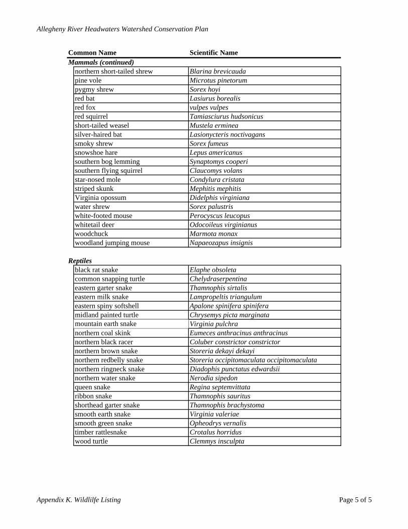
Allegheny River Headwaters Watershed Conservation Plan
Mammals (continued)
woodland jumping mouse Napaeozapus insignis
Reptiles
wood turtle Clemmys insculpta
Scientific NameCommon Name
northern short-tailed shrew Blarina brevicaudapine vole Microtus pinetorumpygmy shrew Sorex hoyired bat Lasiurus borealisred fox vulpes vulpesred squirrel Tamiasciurus hudsonicusshort-tailed weasel Mustela ermineasilver-haired bat Lasionycteris noctivaganssmoky shrew Sorex fumeussnowshoe hare Lepus americanussouthern bog lemming Synaptomys cooperisouthern flying squirrel Claucomys volansstar-nosed mole Condylura cristatastriped skunk Mephitis mephitisVirginia opossum Didelphis virginianawater shrew Sorex palustriswhite-footed mouse Perocyscus leucopuswhitetail deer Odocoileus virginianuswoodchuck Marmota monax
black rat snake Elaphe obsoletacommon snapping turtle Chelydraserpentinaeastern garter snake Thamnophis sirtalis eastern milk snake Lampropeltis triangulumeastern spiny softshell Apalone spinifera spiniferamidland painted turtle Chrysemys picta marginatamountain earth snake Virginia pulchranorthern coal skink Eumeces anthracinus anthracinusnorthern black racer Coluber constrictor constrictornorthern brown snake Storeria dekayi dekayinorthern redbelly snake Storeria occipitomaculata occipitomaculatanorthern ringneck snake Diadophis punctatus edwardsiinorthern water snake Nerodia sipedonqueen snake Regina septemvittataribbon snake Thamnophis sauritusshorthead garter snake Thamnophis brachystomasmooth earth snake Virginia valeriaesmooth green snake Opheodrys vernalistimber rattlesnake Crotalus horridus
Appendix K. Wildlilfe Listing Page 5 of 5
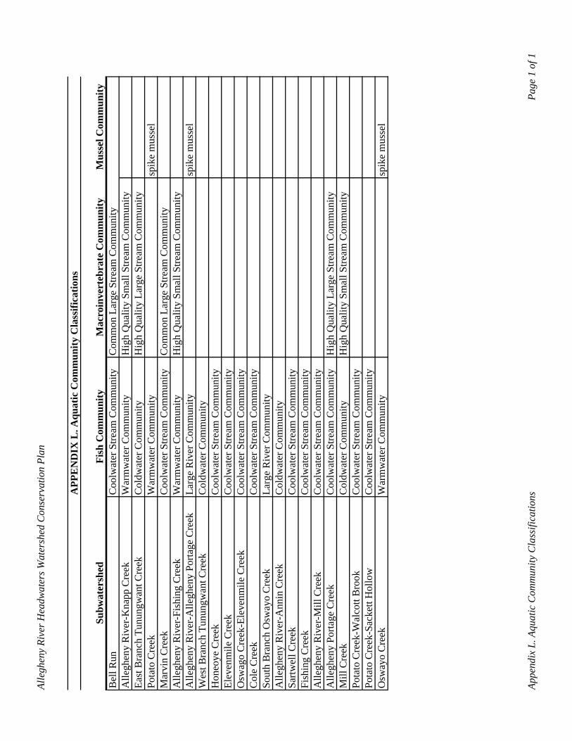
Alle
ghen
y Ri
ver H
eadw
ater
s Wat
ersh
ed C
onse
rvat
ion
Plan
APP
EN
DIX
L. A
quat
ic C
omm
unity
Cla
ssifi
catio
ns
Subw
ater
shed
Fish
Com
mun
ityM
acro
inve
rteb
rate
Com
mun
ityM
usse
l Com
mun
ityB
ell R
unC
oolw
ater
Stre
am C
omm
unity
Com
mon
Lar
ge S
tream
Com
mun
ityA
llegh
eny
Riv
er-K
napp
Cre
ekW
arm
wat
er C
omm
unity
Hig
h Q
ualit
y Sm
all S
tream
Com
mun
ityEa
st B
ranc
h Tu
nung
wan
t Cre
ekC
oldw
ater
Com
mun
ityH
igh
Qua
lity
Larg
e St
ream
Com
mun
ityPo
tato
Cre
ekW
arm
wat
er C
omm
unity
spik
e m
usse
l M
arvi
n C
reek
Coo
lwat
er S
tream
Com
mun
ityC
omm
on L
arge
Stre
am C
omm
unity
Alle
ghen
y R
iver
-Fis
hing
Cre
ekW
arm
wat
er C
omm
unity
Hig
h Q
ualit
y Sm
all S
tream
Com
mun
ityA
llegh
eny
Riv
er-A
llegh
eny
Porta
ge C
reek
Larg
e R
iver
Com
mun
itysp
ike
mus
sel
Wes
t Bra
nch
Tunu
ngw
ant C
reek
Col
dwat
er C
omm
unity
Hon
eoye
Cre
ekC
oolw
ater
Stre
am C
omm
unity
Elev
enm
ile C
reek
Coo
lwat
er S
tream
Com
mun
ityO
swag
o C
reek
-Ele
venm
ile C
reek
Coo
lwat
er S
tream
Com
mun
ityC
ole
Cre
ekC
oolw
ater
Stre
am C
omm
unity
Sout
h B
ranc
h O
sway
o C
reek
Larg
e R
iver
Com
mun
ityA
llegh
eny
Riv
er-A
nnin
Cre
ekC
oldw
ater
Com
mun
itySa
rtwel
l Cre
ekC
oolw
ater
Stre
am C
omm
unity
Fish
ing
Cre
ekC
oolw
ater
Stre
am C
omm
unity
Alle
ghen
y R
iver
-Mill
Cre
ekC
oolw
ater
Stre
am C
omm
unity
Alle
ghen
y Po
rtage
Cre
ekC
oolw
ater
Stre
am C
omm
unity
Hig
h Q
ualit
y La
rge
Stre
am C
omm
unity
Mill
Cre
ekC
oldw
ater
Com
mun
ityH
igh
Qua
lity
Smal
l Stre
am C
omm
unity
Pota
to C
reek
-Wal
cott
Bro
okC
oolw
ater
Stre
am C
omm
unity
Pota
to C
reek
-Sac
kett
Hol
low
Coo
lwat
er S
tream
Com
mun
ityO
sway
o C
reek
War
mw
ater
Com
mun
itysp
ike
mus
sel
Appe
ndix
L. A
quat
ic C
omm
unity
Cla
ssifi
catio
ns
Page
1 o
f 1
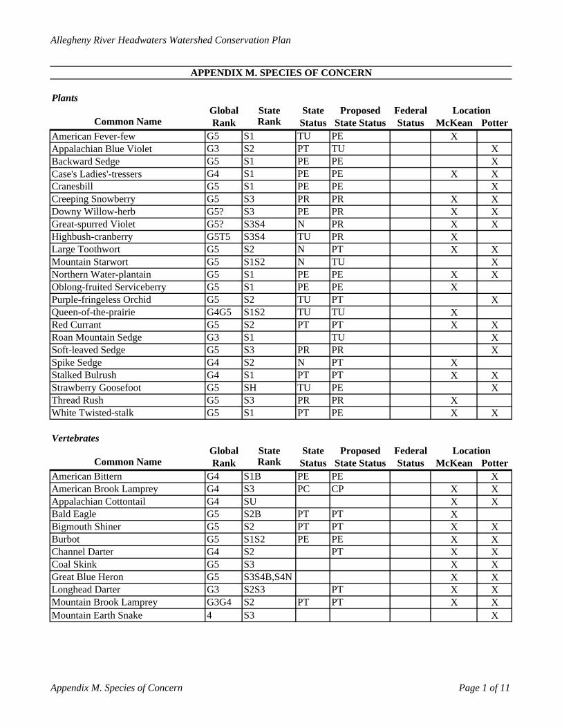
Allegheny River Headwaters Watershed Conservation Plan
PlantsGlobal State State Proposed Federal
Common Name Rank Rank Status State Status Status McKean PotterAmerican Fever-few G5 S1 TU PE XAppalachian Blue Violet G3 S2 PT TU XBackward Sedge G5 S1 PE PE XCase's Ladies'-tressers G4 S1 PE PE X XCranesbill G5 S1 PE PE XCreeping Snowberry G5 S3 PR PR X XDowny Willow-herb G5? S3 PE PR X XGreat-spurred Violet G5? S3S4 N PR X XHighbush-cranberry G5T5 S3S4 TU PR XLarge Toothwort G5 S2 N PT X XMountain Starwort G5 S1S2 N TU XNorthern Water-plantain G5 S1 PE PE X XOblong-fruited Serviceberry G5 S1 PE PE XPurple-fringeless Orchid G5 S2 TU PT XQueen-of-the-prairie G4G5 S1S2 TU TU XRed Currant G5 S2 PT PT X XRoan Mountain Sedge G3 S1 TU XSoft-leaved Sedge G5 S3 PR PR XSpike Sedge G4 S2 N PT XStalked Bulrush G4 S1 PT PT X XStrawberry Goosefoot G5 SH TU PE XThread Rush G5 S3 PR PR XWhite Twisted-stalk G5 S1 PT PE X X
VertebratesGlobal State State Proposed Federal
Common Name Rank Rank Status State Status Status McKean PotterAmerican Bittern G4 S1B PE PE XAmerican Brook Lamprey G4 S3 PC CP X XAppalachian Cottontail G4 SU X XBald Eagle G5 S2B PT PT XBigmouth Shiner G5 S2 PT PT X XBurbot G5 S1S2 PE PE X XChannel Darter G4 S2 PT X XCoal Skink G5 S3 X XGreat Blue Heron G5 S3S4B,S4N X XLonghead Darter G3 S2S3 PT X XMountain Brook Lamprey G3G4 S2 PT PT X XMountain Earth Snake 4 S3 X
APPENDIX M. SPECIES OF CONCERN
Location
Location
Appendix M. Species of Concern Page 1 of 11
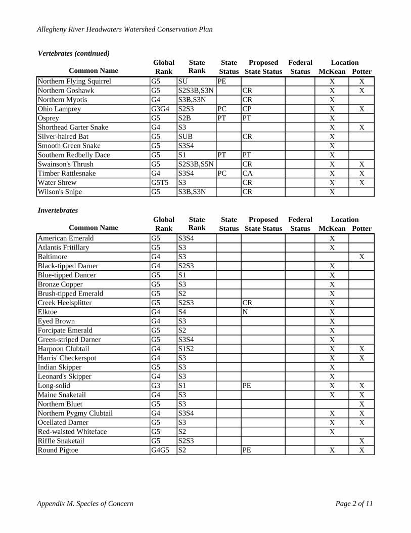
Allegheny River Headwaters Watershed Conservation Plan
Vertebrates (continued)Global State State Proposed Federal
Common Name Rank Rank Status State Status Status McKean PotterNorthern Flying Squirrel G5 SU PE X XNorthern Goshawk G5 S2S3B,S3N CR X XNorthern Myotis G4 S3B,S3N CR XOhio Lamprey G3G4 S2S3 PC CP X XOsprey G5 S2B PT PT XShorthead Garter Snake G4 S3 X XSilver-haired Bat G5 SUB CR XSmooth Green Snake G5 S3S4 XSouthern Redbelly Dace G5 S1 PT PT XSwainson's Thrush G5 S2S3B,S5N CR X XTimber Rattlesnake G4 S3S4 PC CA X XWater Shrew G5T5 S3 CR X XWilson's Snipe G5 S3B,S3N CR X
InvertebratesGlobal State State Proposed Federal
Common Name Rank Rank Status State Status Status McKean PotterAmerican Emerald G5 S3S4 XAtlantis Fritillary G5 S3 XBaltimore G4 S3 XBlack-tipped Darner G4 S2S3 XBlue-tipped Dancer G5 S1 XBronze Copper G5 S3 XBrush-tipped Emerald G5 S2 XCreek Heelsplitter G5 S2S3 CR XElktoe G4 S4 N XEyed Brown G4 S3 XForcipate Emerald G5 S2 XGreen-striped Darner G5 S3S4 XHarpoon Clubtail G4 S1S2 X XHarris' Checkerspot G4 S3 X XIndian Skipper G5 S3 XLeonard's Skipper G4 S3 XLong-solid G3 S1 PE X XMaine Snaketail G4 S3 X XNorthern Bluet G5 S3 XNorthern Pygmy Clubtail G4 S3S4 X XOcellated Darner G5 S3 X XRed-waisted Whiteface G5 S2 XRiffle Snaketail G5 S2S3 XRound Pigtoe G4G5 S2 PE X X
Location
Location
Appendix M. Species of Concern Page 2 of 11
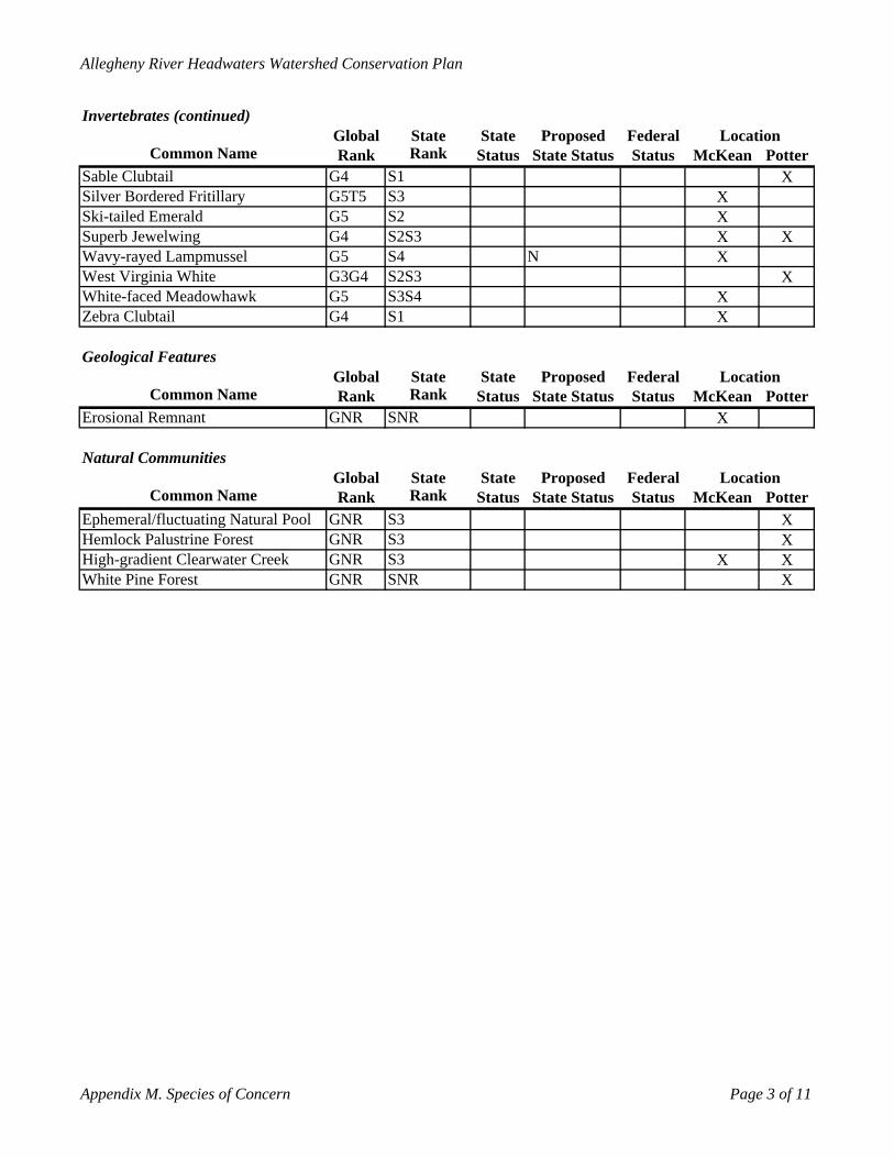
Allegheny River Headwaters Watershed Conservation Plan
Invertebrates (continued)Global State State Proposed Federal
Common Name Rank Rank Status State Status Status McKean PotterSable Clubtail G4 S1 XSilver Bordered Fritillary G5T5 S3 XSki-tailed Emerald G5 S2 XSuperb Jewelwing G4 S2S3 X XWavy-rayed Lampmussel G5 S4 N XWest Virginia White G3G4 S2S3 XWhite-faced Meadowhawk G5 S3S4 XZebra Clubtail G4 S1 X
Geological FeaturesGlobal State State Proposed Federal
Common Name Rank Rank Status State Status Status McKean PotterErosional Remnant GNR SNR X
Natural CommunitiesGlobal State State Proposed Federal
Common Name Rank Rank Status State Status Status McKean PotterEphemeral/fluctuating Natural Pool GNR S3 XHemlock Palustrine Forest GNR S3 XHigh-gradient Clearwater Creek GNR S3 X XWhite Pine Forest GNR SNR X
Location
Location
Location
Appendix M. Species of Concern Page 3 of 11
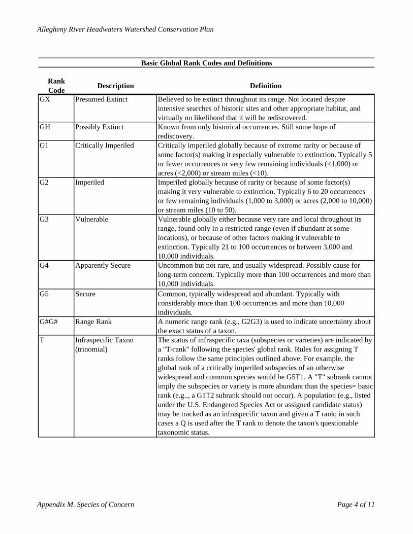
Allegheny River Headwaters Watershed Conservation Plan
Rank Code Description Definition
GX Presumed Extinct Believed to be extinct throughout its range. Not located despite intensive searches of historic sites and other appropriate habitat, and virtually no likelihood that it will be rediscovered.
GH Possibly Extinct Known from only historical occurrences. Still some hope of rediscovery.
G1 Critically Imperiled Critically imperiled globally because of extreme rarity or because of some factor(s) making it especially vulnerable to extinction. Typically 5 or fewer occurrences or very few remaining individuals (<1,000) or acres (<2,000) or stream miles (<10).
G2 Imperiled Imperiled globally because of rarity or because of some factor(s) making it very vulnerable to extinction. Typically 6 to 20 occurrences or few remaining individuals (1,000 to 3,000) or acres (2,000 to 10,000) or stream miles (10 to 50).
G3 Vulnerable Vulnerable globally either because very rare and local throughout its range, found only in a restricted range (even if abundant at some locations), or because of other factors making it vulnerable to extinction. Typically 21 to 100 occurrences or between 3,000 and 10,000 individuals.
G4 Apparently Secure Uncommon but not rare, and usually widespread. Possibly cause for long-term concern. Typically more than 100 occurrences and more than 10,000 individuals.
G5 Secure Common, typically widespread and abundant. Typically with considerably more than 100 occurrences and more than 10,000 individuals.
G#G# Range Rank A numeric range rank (e.g., G2G3) is used to indicate uncertainty about the exact status of a taxon.
T Infraspecific Taxon (trinomial)
The status of infraspecific taxa (subspecies or varieties) are indicated by a "T-rank" following the species' global rank. Rules for assigning T ranks follow the same principles outlined above. For example, the global rank of a critically imperiled subspecies of an otherwise widespread and common species would be G5T1. A "T" subrank cannot imply the subspecies or variety is more abundant than the species= basic rank (e.g.., a G1T2 subrank should not occur). A population (e.g., listed under the U.S. Endangered Species Act or assigned candidate status) may be tracked as an infraspecific taxon and given a T rank; in such cases a Q is used after the T rank to denote the taxon's questionable taxonomic status.
Basic Global Rank Codes and Definitions
Appendix M. Species of Concern Page 4 of 11
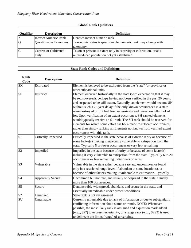
Allegheny River Headwaters Watershed Conservation Plan
Qualifier Description Definition? Inexact Numeric Rank Denotes inexact numeric rank.Q Questionable Taxonomy Taxonomic status is questionable; numeric rank may change with
taxonomy. C Captive or Cultivated
OnlyTaxon at present is extant only in captivity or cultivation, or as a reintroduced population not yet established.
Rank Code Description Definition
SX Extirpated Element is believed to be extirpated from the "state" (or province or other subnational unit).
SH Historical Element occurred historically in the state (with expectation that it may be rediscovered), perhaps having not been verified in the past 20 years, and suspected to be still extant. Naturally, an element would become SH without such a 20-year delay if the only known occurrences in a state were destroyed or if it had been extensively and unsuccessfully looked for. Upon verification of an extant occurrence, SH-ranked elements would typically receive an S1 rank. The SH rank should be reserved for elements for which some effort has been made to relocate occurrences, rather than simply ranking all Elements not known from verified extant occurrences with this rank.
S1 Critically Imperiled Critically imperiled in the state because of extreme rarity or because of some factor(s) making it especially vulnerable to extirpation from the state. Typically 5 or fewer occurrences or very few remaining
S2 Imperiled Imperiled in the state because of rarity or because of some factor(s) making it very vulnerable to extirpation from the state. Typically 6 to 20 occurrences or few remaining individuals or acres.
S3 Vulnerable Vulnerable in the state either because rare and uncommon, or found only in a restricted range (even if abundant at some locations), or because of other factors making it vulnerable to extirpation. Typically
S4 Apparently Secure Uncommon but not rare, and usually widespread in the state. Usually more than 100 occurrences.
S5 Secure Demonstrably widespread, abundant, and secure in the state, and essentially ineradicable under present conditions.
S? Unranked State rank is not yet assessed.SU Unrankable Currently unrankable due to lack of information or due to substantially
conflicting information about status or trends. NOTE: Whenever possible, the most likely rank is assigned and a question mark added (e.g.., S2?) to express uncertainty, or a range rank (e.g.., S2S3) is used to delineate the limits (range) of uncertainty.
Global Rank Qualifiers
State Rank Codes and Definitions
Appendix M. Species of Concern Page 5 of 11
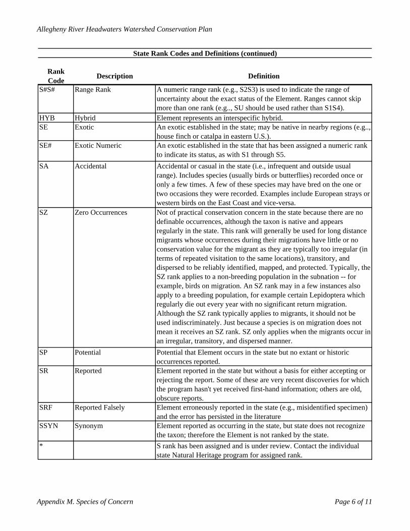
Allegheny River Headwaters Watershed Conservation Plan
Rank Code Description Definition
S#S# Range Rank A numeric range rank (e.g., S2S3) is used to indicate the range of uncertainty about the exact status of the Element. Ranges cannot skip more than one rank (e.g.., SU should be used rather than S1S4).
HYB Hybrid Element represents an interspecific hybrid.SE Exotic An exotic established in the state; may be native in nearby regions (e.g..,
house finch or catalpa in eastern U.S.).SE# Exotic Numeric An exotic established in the state that has been assigned a numeric rank
to indicate its status, as with S1 through S5.SA Accidental Accidental or casual in the state (i.e., infrequent and outside usual
range). Includes species (usually birds or butterflies) recorded once or only a few times. A few of these species may have bred on the one or two occasions they were recorded. Examples include European strays or western birds on the East Coast and vice-versa.
SZ Zero Occurrences Not of practical conservation concern in the state because there are no definable occurrences, although the taxon is native and appears regularly in the state. This rank will generally be used for long distance migrants whose occurrences during their migrations have little or no conservation value for the migrant as they are typically too irregular (in terms of repeated visitation to the same locations), transitory, and dispersed to be reliably identified, mapped, and protected. Typically, the SZ rank applies to a non-breeding population in the subnation -- for example, birds on migration. An SZ rank may in a few instances also apply to a breeding population, for example certain Lepidoptera which regularly die out every year with no significant return migration. Although the SZ rank typically applies to migrants, it should not be used indiscriminately. Just because a species is on migration does not mean it receives an SZ rank. SZ only applies when the migrants occur in an irregular, transitory, and dispersed manner.
SP Potential Potential that Element occurs in the state but no extant or historic occurrences reported.
SR Reported Element reported in the state but without a basis for either accepting or rejecting the report. Some of these are very recent discoveries for which the program hasn't yet received first-hand information; others are old, obscure reports.
SRF Reported Falsely Element erroneously reported in the state (e.g., misidentified specimen) and the error has persisted in the literature
SSYN Synonym Element reported as occurring in the state, but state does not recognize the taxon; therefore the Element is not ranked by the state.
* S rank has been assigned and is under review. Contact the individual state Natural Heritage program for assigned rank.
State Rank Codes and Definitions (continued)
Appendix M. Species of Concern Page 6 of 11
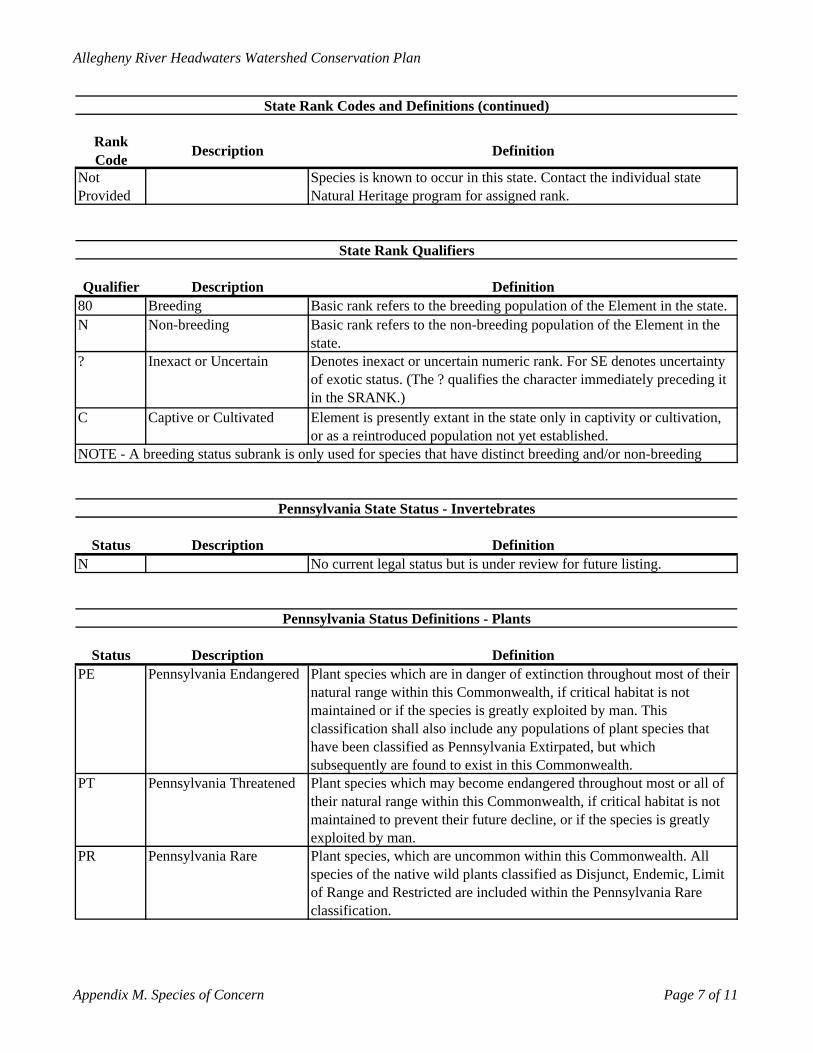
Allegheny River Headwaters Watershed Conservation Plan
Rank Code Description Definition
Not Provided
Species is known to occur in this state. Contact the individual state Natural Heritage program for assigned rank.
Qualifier Description Definition80 Breeding Basic rank refers to the breeding population of the Element in the state.N Non-breeding Basic rank refers to the non-breeding population of the Element in the
state.? Inexact or Uncertain Denotes inexact or uncertain numeric rank. For SE denotes uncertainty
of exotic status. (The ? qualifies the character immediately preceding it in the SRANK.)
C Captive or Cultivated Element is presently extant in the state only in captivity or cultivation, or as a reintroduced population not yet established.
Status Description DefinitionN No current legal status but is under review for future listing.
Status Description DefinitionPE Pennsylvania Endangered Plant species which are in danger of extinction throughout most of their
natural range within this Commonwealth, if critical habitat is not maintained or if the species is greatly exploited by man. This classification shall also include any populations of plant species that have been classified as Pennsylvania Extirpated, but which subsequently are found to exist in this Commonwealth.
PT Pennsylvania Threatened Plant species which may become endangered throughout most or all of their natural range within this Commonwealth, if critical habitat is not maintained to prevent their future decline, or if the species is greatly exploited by man.
PR Pennsylvania Rare Plant species, which are uncommon within this Commonwealth. All species of the native wild plants classified as Disjunct, Endemic, Limit of Range and Restricted are included within the Pennsylvania Rare classification.
Pennsylvania Status Definitions - Plants
State Rank Codes and Definitions (continued)
State Rank Qualifiers
NOTE - A breeding status subrank is only used for species that have distinct breeding and/or non-breeding
Pennsylvania State Status - Invertebrates
Appendix M. Species of Concern Page 7 of 11
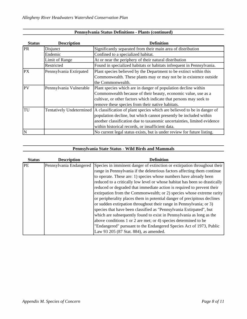
Allegheny River Headwaters Watershed Conservation Plan
Status Description DefinitionDisjunct Significantly separated from their main area of distributionEndemic Confined to a specialized habitat.Limit of Range At or near the periphery of their natural distributionRestricted Found in specialized habitats or habitats infrequent in Pennsylvania.
PX Pennsylvania Extirpated Plant species believed by the Department to be extinct within this Commonwealth. These plants may or may not be in existence outside the Commonwealth.
PV Pennsylvania Vulnerable Plant species which are in danger of population decline within Commonwealth because of their beauty, economic value, use as a cultivar, or other factors which indicate that persons may seek to remove these species from their native habitats.
TU Tentatively Undetermined A classification of plant species which are believed to be in danger of population decline, but which cannot presently be included within another classification due to taxanomic uncertainties, limited evidence within historical records, or insufficient data.
N No current legal status exists, but is under review for future listing.
Status Description DefinitionPE Pennsylvania Endangered Species in imminent danger of extinction or extirpation throughout their
range in Pennsylvania if the deleterious factors affecting them continue to operate. These are: 1) species whose numbers have already been reduced to a critically low level or whose habitat has been so drastically reduced or degraded that immediate action is required to prevent their extirpation from the Commonwealth; or 2) species whose extreme rarity or peripherality places them in potential danger of precipitous declines or sudden extirpation throughout their range in Pennsylvania; or 3) species that have been classified as "Pennsylvania Extirpated", but which are subsequently found to exist in Pennsylvania as long as the above conditions 1 or 2 are met; or 4) species determined to be "Endangered" pursuant to the Endangered Species Act of 1973, Public Law 93 205 (87 Stat. 884), as amended.
Pennsylvania Status Definitions - Plants (continued)
PR
Pennsylvania State Status - Wild Birds and Mammals
Appendix M. Species of Concern Page 8 of 11
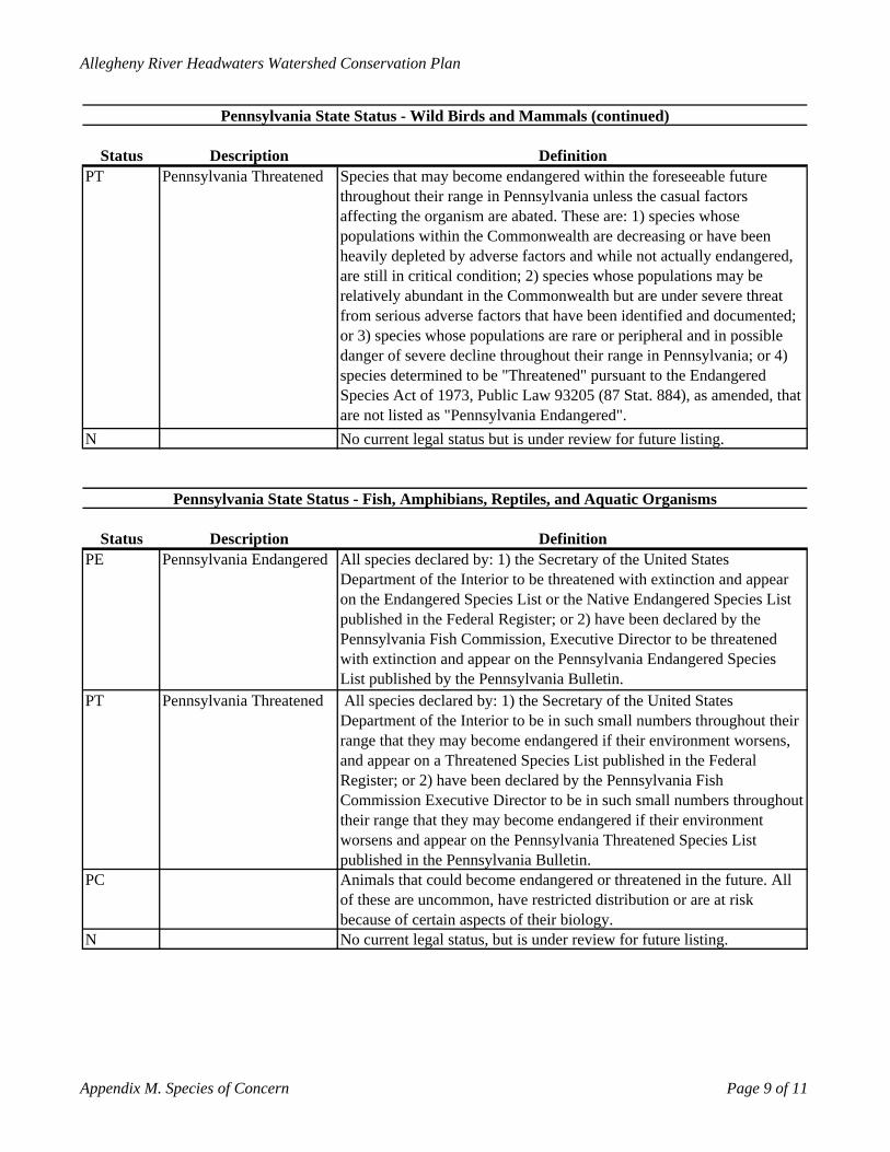
Allegheny River Headwaters Watershed Conservation Plan
Status Description DefinitionPT Pennsylvania Threatened Species that may become endangered within the foreseeable future
throughout their range in Pennsylvania unless the casual factors affecting the organism are abated. These are: 1) species whose populations within the Commonwealth are decreasing or have been heavily depleted by adverse factors and while not actually endangered, are still in critical condition; 2) species whose populations may be relatively abundant in the Commonwealth but are under severe threat from serious adverse factors that have been identified and documented; or 3) species whose populations are rare or peripheral and in possible danger of severe decline throughout their range in Pennsylvania; or 4) species determined to be "Threatened" pursuant to the Endangered Species Act of 1973, Public Law 93205 (87 Stat. 884), as amended, that are not listed as "Pennsylvania Endangered".
N No current legal status but is under review for future listing.
Status Description DefinitionPE Pennsylvania Endangered All species declared by: 1) the Secretary of the United States
Department of the Interior to be threatened with extinction and appear on the Endangered Species List or the Native Endangered Species List published in the Federal Register; or 2) have been declared by the Pennsylvania Fish Commission, Executive Director to be threatened with extinction and appear on the Pennsylvania Endangered Species List published by the Pennsylvania Bulletin.
PT Pennsylvania Threatened All species declared by: 1) the Secretary of the United States Department of the Interior to be in such small numbers throughout their range that they may become endangered if their environment worsens, and appear on a Threatened Species List published in the Federal Register; or 2) have been declared by the Pennsylvania Fish Commission Executive Director to be in such small numbers throughout their range that they may become endangered if their environment worsens and appear on the Pennsylvania Threatened Species List published in the Pennsylvania Bulletin.
PC Animals that could become endangered or threatened in the future. All of these are uncommon, have restricted distribution or are at risk because of certain aspects of their biology.
N No current legal status, but is under review for future listing.
Pennsylvania State Status - Wild Birds and Mammals (continued)
Pennsylvania State Status - Fish, Amphibians, Reptiles, and Aquatic Organisms
Appendix M. Species of Concern Page 9 of 11
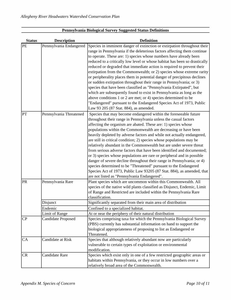
Allegheny River Headwaters Watershed Conservation Plan
Status Description DefinitionPE Pennsylvania Endangered Species in imminent danger of extinction or extirpation throughout their
range in Pennsylvania if the deleterious factors affecting them continue to operate. These are: 1) species whose numbers have already been reduced to a critically low level or whose habitat has been so drastically reduced or degraded that immediate action is required to prevent their extirpation from the Commonwealth; or 2) species whose extreme rarity or peripherality places them in potential danger of precipitous declines or sudden extirpation throughout their range in Pennsylvania; or 3) species that have been classified as "Pennsylvania Extirpated", but which are subsequently found to exist in Pennsylvania as long as the above conditions 1 or 2 are met; or 4) species determined to be "Endangered" pursuant to the Endangered Species Act of 1973, Public Law 93 205 (87 Stat. 884), as amended.
PT Pennsylvania Threatened Species that may become endangered within the foreseeable future throughout their range in Pennsylvania unless the casual factors affecting the organism are abated. These are: 1) species whose populations within the Commonwealth are decreasing or have been heavily depleted by adverse factors and while not actually endangered, are still in critical condition; 2) species whose populations may be relatively abundant in the Commonwealth but are under severe threat from serious adverse factors that have been identified and documented; or 3) species whose populations are rare or peripheral and in possible danger of severe decline throughout their range in Pennsylvania; or 4) species determined to be "Threatened" pursuant to the Endangered Species Act of 1973, Public Law 93205 (87 Stat. 884), as amended, that are not listed as "Pennsylvania Endangered".
Pennsylvania Rare Plant species which are uncommon within this Commonwealth. All species of the native wild plants classified as Disjunct, Endemic, Limit of Range and Restricted are included within the Pennsylvania Rare classification.
Disjunct Significantly separated from their main area of distributionEndemic Confined to a specialized habitat.Limit of Range At or near the periphery of their natural distribution
CP Candidate Proposed Species comprising taxa for which the Pennsylvania Biological Survey (PBS) currently has substantial information on hand to support the biological appropriateness of proposing to list as Endangered or Threatened.
CA Candidate at Risk Species that although relatively abundant now are particularly vulnerable to certain types of exploitation or environmental modification.
CR Candidate Rare Species which exist only in one of a few restricted geographic areas or habitats within Pennsylvania, or they occur in low numbers over a relatively broad area of the Commonwealth.
Pennsylvania Biological Survey Suggested Status Definitions
PR
Appendix M. Species of Concern Page 10 of 11
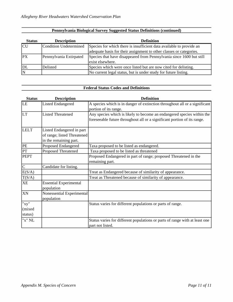
Allegheny River Headwaters Watershed Conservation Plan
Status Description DefinitionCU Condition Undetermined Species for which there is insufficient data available to provide an
adequate basis for their assignment to other classes or categories.PX Pennsylvania Extirpated Species that have disappeared from Pennsylvania since 1600 but still
exist elsewhere.DL Delisted Species which were once listed but are now cited for delisting.N No current legal status, but is under study for future listing.
Status Description DefinitionLE Listed Endangered A species which is in danger of extinction throughout all or a significant
portion of its range.LT Listed Threatened Any species which is likely to become an endangered species within the
foreseeable future throughout all or a significant portion of its range.
LELT Listed Endangered in part of range; listed Threatened in the remaining part.
PE Proposed Endangered Taxa proposed to be listed as endangered.PT Proposed Threatened Taxa proposed to be listed as threatenedPEPT Proposed Endangered in part of range; proposed Threatened in the
remaining part.C Candidate for listing.E(S/A) Treat as Endangered because of similarity of appearance.T(S/A) Treat as Threatened because of similarity of appearance.XE Essential Experimental
populationXN Nonessential Experimental
population"xy" (mixed status)
Status varies for different populations or parts of range.
"x" NL Status varies for different populations or parts of range with at least one part not listed.
Federal Status Codes and Definitions
Pennsylvania Biological Survey Suggested Status Definitions (continued)
Appendix M. Species of Concern Page 11 of 11
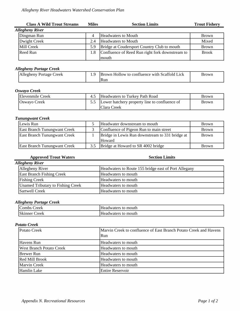
Allegheny River Headwaters Watershed Conservation Plan
Class A Wild Trout Streams Miles Section Limits Trout FisheryAllegheny River
Dingman Run 4 Headwaters to Mouth BrownDwight Creek 2.4 Headwaters to Mouth MixedMill Creek 5.9 Bridge at Coudersport Country Club to mouth BrownReed Run 1.8 Confluence of Reed Run right fork downstream to
mouthBrook
Allegheny Portage CreekAllegheny Portage Creek 1.9 Brown Hollow to confluence with Scaffold Lick
RunBrown
Oswayo CreekElevenmile Creek 4.5 Headwaters to Turkey Path Road BrownOswayo Creek 5.5 Lower hatchery property line to confluence of
Clara CreekBrown
Tunungwant CreekLewis Run 5 Headwater downstream to mouth BrownEast Branch Tunungwant Creek 3 Confluence of Pigeon Run to main street BrownEast Branch Tunungwant Creek 1 Bridge in Lewis Run downstream to 331 bridge at
Howard Brown
East Branch Tunungwant Creek 3.5 Bridge at Howard to SR 4002 bridge Brown
Approved Trout Waters Section LimitsAllegheny River
Allegheny River Headwaters to Route 155 bridge east of Port AlleganyEast Branch Fishing Creek Headwaters to mouthFishing Creek Headwaters to mouthUnamed Tributary to Fishing Creek Headwaters to mouthSartwell Creek Headwaters to mouth
Allegheny Portage CreekCombs Creek Headwaters to mouthSkinner Creek Headwaters to mouth
Potato CreekPotato Creek Marvin Creek to confluence of East Branch Potato Creek and Havens
RunHavens Run Headwaters to mouthWest Branch Potato Creek Headwaters to mouthBrewer Run Headwaters to mouthRed Mill Brook Headwaters to mouthMarvin Creek Headwaters to mouthHamlin Lake Entire Reservoir
Appendix N. Recreational Resources Page 1 of 2

Allegheny River Headwaters Watershed Conservation Plan
Approved Trout Waters Section LimitsOswayo Creek
South Branch Oswayo Creek Headwaters to mouthOswayo Creek Clara Creek to Sharon Center BridgeElevenmile Creek Turkey Path Road to mouthBell Run Headwaters to mouth
Tunungwant CreekMarilla Brook Reservoir Entire Reservoir
Appendix N. Recreational Resources Page 2 of 2
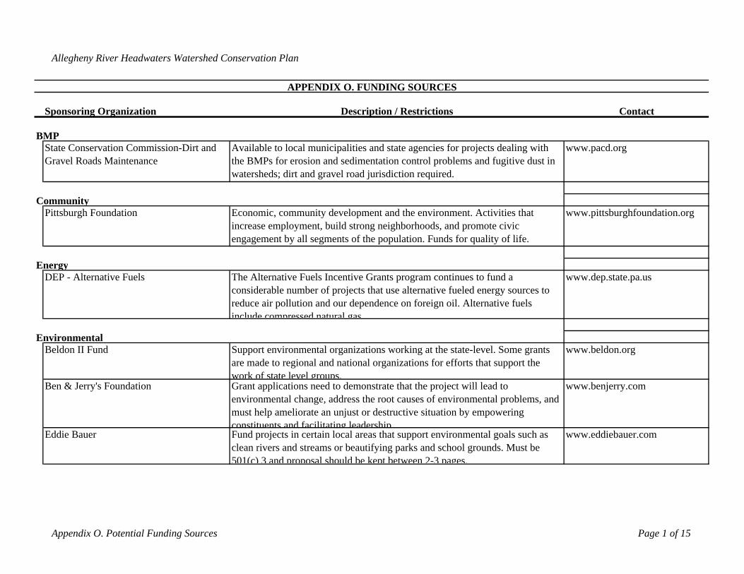
Allegheny River Headwaters Watershed Conservation Plan
Sponsoring Organization Description / Restrictions Contact
BMPState Conservation Commission-Dirt and Gravel Roads Maintenance
Available to local municipalities and state agencies for projects dealing with the BMPs for erosion and sedimentation control problems and fugitive dust in watersheds; dirt and gravel road jurisdiction required.
www.pacd.org
Pittsburgh Foundation Economic, community development and the environment. Activities that increase employment, build strong neighborhoods, and promote civic engagement by all segments of the population. Funds for quality of life.
www.pittsburghfoundation.org
DEP - Alternative Fuels The Alternative Fuels Incentive Grants program continues to fund a considerable number of projects that use alternative fueled energy sources to reduce air pollution and our dependence on foreign oil. Alternative fuels include compressed natural gas
www.dep.state.pa.us
Beldon II Fund Support environmental organizations working at the state-level. Some grants are made to regional and national organizations for efforts that support the work of state level groups.
www.beldon.org
Ben & Jerry's Foundation Grant applications need to demonstrate that the project will lead to environmental change, address the root causes of environmental problems, and must help ameliorate an unjust or destructive situation by empowering constituents and facilitating leadership
www.benjerry.com
Eddie Bauer Fund projects in certain local areas that support environmental goals such as clean rivers and streams or beautifying parks and school grounds. Must be 501(c) 3 and proposal should be kept between 2-3 pages.
www.eddiebauer.com
Community
Environmental
APPENDIX O. FUNDING SOURCES
Energy
Appendix O. Potential Funding Sources Page 1 of 15
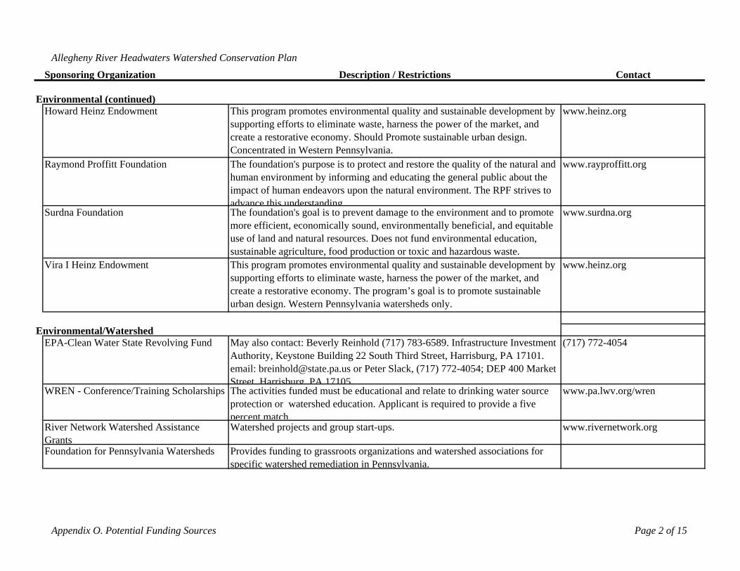
Allegheny River Headwaters Watershed Conservation Plan
Sponsoring Organization Description / Restrictions Contact
Howard Heinz Endowment This program promotes environmental quality and sustainable development by supporting efforts to eliminate waste, harness the power of the market, and create a restorative economy. Should Promote sustainable urban design. Concentrated in Western Pennsylvania.
www.heinz.org
Raymond Proffitt Foundation The foundation's purpose is to protect and restore the quality of the natural and human environment by informing and educating the general public about the impact of human endeavors upon the natural environment. The RPF strives to advance this understanding
www.rayproffitt.org
Surdna Foundation The foundation's goal is to prevent damage to the environment and to promote more efficient, economically sound, environmentally beneficial, and equitable use of land and natural resources. Does not fund environmental education, sustainable agriculture, food production or toxic and hazardous waste.
www.surdna.org
Vira I Heinz Endowment This program promotes environmental quality and sustainable development by supporting efforts to eliminate waste, harness the power of the market, and create a restorative economy. The program’s goal is to promote sustainable urban design. Western Pennsylvania watersheds only.
www.heinz.org
EPA-Clean Water State Revolving Fund May also contact: Beverly Reinhold (717) 783-6589. Infrastructure Investment Authority, Keystone Building 22 South Third Street, Harrisburg, PA 17101. email: [email protected] or Peter Slack, (717) 772-4054; DEP 400 Market Street Harrisburg PA 17105
(717) 772-4054
WREN - Conference/Training Scholarships The activities funded must be educational and relate to drinking water source protection or watershed education. Applicant is required to provide a five percent match.
www.pa.lwv.org/wren
River Network Watershed Assistance Grants
Watershed projects and group start-ups. www.rivernetwork.org
Foundation for Pennsylvania Watersheds Provides funding to grassroots organizations and watershed associations for specific watershed remediation in Pennsylvania.
Environmental (continued)
Environmental/Watershed
Appendix O. Potential Funding Sources Page 2 of 15
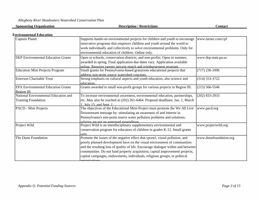
Allegheny River Headwaters Watershed Conservation Plan
Sponsoring Organization Description / Restrictions Contact
Captain Planet Supports hands-on environmental projects for children and youth to encourage innovative programs that empower children and youth around the world to work individually and collectively to solve environmental problems. Only for environmental education of children. Online only.
www.turner.com/cpf
DEP Environmental Education Grants Open to schools, conservation districts, and non-profits. Open in summer, awarded in spring. Final application due dates vary. Application available online. Requires twenty percent match and reimbursement program.
www.dep.state.pa.us
Education Mini Projects Program Small grants for Pennsylvania-based grassroots educational projects that address non-point source watershed concepts.
(717) 236-1006
Emerson Charitable Trust Strong emphasis on cultural aspects and youth education, also science and education.
(314) 553-3722
EPA Environmental Education Grants Region III
Grants awarded to small non-profit groups for various projects in Region III. (215) 566-5546
National Environmental Education and Training Foundation
To increase environmental awareness, environmental education, partnerships, etc. May also be reached at (202) 261-6464. Proposal deadlines: Jan. 1, March 1, July 15, and Sept. 1
(202) 833-2933
PACD - Mini Projects The objectives of the Educational Mini-Project must promote the We All Live Downstream message by: stimulating an awareness of and interest in Pennsylvania's non-point source water pollution problems and solutions; salaries are not an approved expenditure
www.pacd.org
Project Wild Project Wild is an interdisciplinary supplementary environmental and conservation program for educators of children in grades K-12. Small grants only.
www.projectwild.org
The Dunn Foundation Promote the issues of the negative effect that sprawl, visual pollution, and poorly planned development have on the visual environment of communities and the resulting loss of quality of life. Encourage dialogue within and between communities. Do not fund property acquisition, capital improvement projects, capital campaigns, endowments, individuals, religious groups, or political organizations
www.dunnfoundation.org
Environmental Education
Appendix O. Potential Funding Sources Page 3 of 15
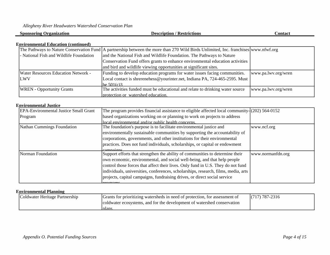
Allegheny River Headwaters Watershed Conservation Plan
Sponsoring Organization Description / Restrictions Contact
The Pathways to Nature Conservation Fund - National Fish and Wildlife Foundation
A partnership between the more than 270 Wild Birds Unlimited, Inc. franchises and the National Fish and Wildlife Foundation. The Pathways to Nature Conservation Fund offers grants to enhance environmental education activities and bird and wildlife viewing opportunities at significant sites.
www.nfwf.org
Water Resources Education Network - LWV
Funding to develop education programs for water issues facing communities. Local contact is [email protected], Indiana PA, 724-465-2595. Must be 501(c)3
www.pa.lwv.org/wren
WREN - Opportunity Grants The activities funded must be educational and relate to drinking water source protection or watershed education.
www.pa.lwv.org/wren
EPA-Environmental Justice Small Grant Program
The program provides financial assistance to eligible affected local community-based organizations working on or planning to work on projects to address local environmental and/or public health concerns.
(202) 564-0152
Nathan Cummings Foundation The foundation's purpose is to facilitate environmental justice and environmentally sustainable communities by supporting the accountability of corporations, governments, and other institutions for their environmental practices. Does not fund individuals, scholarships, or capital or endowment campaigns
www.ncf.org
Norman Foundation Support efforts that strengthen the ability of communities to determine their own economic, environmental, and social well-being, and that help people control those forces that affect their lives. Only fund in U.S. They do not fund individuals, universities, conferences, scholarships, research, films, media, arts projects, capital campaigns, fundraising drives, or direct social service programs
www.normanfdn.org
Coldwater Heritage Partnership Grants for prioritizing watersheds in need of protection, for assessment of coldwater ecosystems, and for the development of watershed conservation plans.
(717) 787-2316
Environmental Education (continued)
Environmental Planning
Environmental Justice
Appendix O. Potential Funding Sources Page 4 of 15
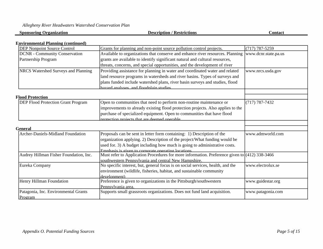
Allegheny River Headwaters Watershed Conservation Plan
Sponsoring Organization Description / Restrictions Contact
DEP Nonpoint Source Control Grants for planning and non-point source pollution control projects. (717) 787-5259DCNR - Community Conservation Partnership Program
Available to organizations that conserve and enhance river resources. Planning grants are available to identify significant natural and cultural resources, threats, concerns, and special opportunities, and the development of river
www.dcnr.state.pa.us
NRCS Watershed Surveys and Planning Providing assistance for planning in water and coordinated water and related land resource programs in watersheds and river basins. Types of surveys and plans funded include watershed plans, river basin surveys and studies, flood hazard analyses and floodplain studies
www.nrcs.usda.gov
DEP Flood Protection Grant Program Open to communities that need to perform non-routine maintenance or improvements to already existing flood protection projects. Also applies to the purchase of specialized equipment. Open to communities that have flood protection projects that are deemed operable
(717) 787-7432
Archer-Daniels-Midland Foundation Proposals can be sent in letter form containing: 1) Description of the organization applying. 2) Description of the project/What funding would be used for. 3) A budget including how much is going to administrative costs. Emphasis is given to corporate operating locations
www.admworld.com
Audrey Hillman Fisher Foundation, Inc. Must refer to Application Procedures for more information. Preference given to southwestern Pennsylvania and central New Hampshire.
(412) 338-3466
Eureka Company No specific interest, but, general focus is on social services, health, and the environment (wildlife, fisheries, habitat, and sustainable community development)
www.electrolux.se
Henry Hillman Foundation Preference is given to organizations in the Pittsburgh/southwestern Pennsylvania area.
www.guidestar.org
Patagonia, Inc. Environmental Grants Program
Supports small grassroots organizations. Does not fund land acquisition. www.patagonia.com
Flood Protection
General
Environmental Planning (continued)
Appendix O. Potential Funding Sources Page 5 of 15
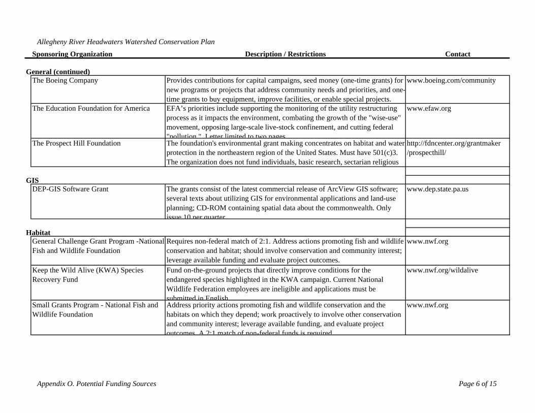
Allegheny River Headwaters Watershed Conservation Plan
Sponsoring Organization Description / Restrictions Contact
The Boeing Company Provides contributions for capital campaigns, seed money (one-time grants) for new programs or projects that address community needs and priorities, and one-time grants to buy equipment, improve facilities, or enable special projects.
www.boeing.com/community
The Education Foundation for America EFA’s priorities include supporting the monitoring of the utility restructuring process as it impacts the environment, combating the growth of the "wise-use" movement, opposing large-scale live-stock confinement, and cutting federal "pollution " Letter limited to two pages
www.efaw.org
The Prospect Hill Foundation The foundation's environmental grant making concentrates on habitat and water protection in the northeastern region of the United States. Must have 501(c)3. The organization does not fund individuals, basic research, sectarian religious
http://fdncenter.org/grantmaker /prospecthill/
DEP-GIS Software Grant The grants consist of the latest commercial release of ArcView GIS software; several texts about utilizing GIS for environmental applications and land-use planning; CD-ROM containing spatial data about the commonwealth. Only issue 10 per quarter
www.dep.state.pa.us
General Challenge Grant Program -National Fish and Wildlife Foundation
Requires non-federal match of 2:1. Address actions promoting fish and wildlife conservation and habitat; should involve conservation and community interest; leverage available funding and evaluate project outcomes.
www.nwf.org
Keep the Wild Alive (KWA) Species Recovery Fund
Fund on-the-ground projects that directly improve conditions for the endangered species highlighted in the KWA campaign. Current National Wildlife Federation employees are ineligible and applications must be submitted in English
www.nwf.org/wildalive
Small Grants Program - National Fish and Wildlife Foundation
Address priority actions promoting fish and wildlife conservation and the habitats on which they depend; work proactively to involve other conservation and community interest; leverage available funding, and evaluate project outcomes A 2:1 match of non-federal funds is required
www.nwf.org
GIS
Habitat
General (continued)
Appendix O. Potential Funding Sources Page 6 of 15
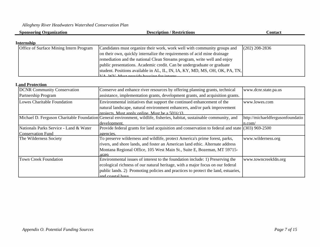
Allegheny River Headwaters Watershed Conservation Plan
Sponsoring Organization Description / Restrictions Contact
Office of Surface Mining Intern Program Candidates must organize their work, work well with community groups and on their own, quickly internalize the requirements of acid mine drainage remediation and the national Clean Streams program, write well and enjoy public presentations. Academic credit. Can be undergraduate or graduate student. Positions available in AL, IL, IN, IA, KY, MD, MS, OH, OK, PA, TN, VA WV Must provide housing for interns
(202) 208-2836
DCNR Community Conservation Partnership Program
Conserve and enhance river resources by offering planning grants, technical assistance, implementation grants, development grants, and acquisition grants.
www.dcnr.state.pa.us
Lowes Charitable Foundation Environmental initiatives that support the continued enhancement of the natural landscape, natural environment enhancers, and/or park improvement projects. Must apply online. Must be a 501(c)3.
www.lowes.com
Michael D. Ferguson Charitable Foundation General environment, wildlife, fisheries, habitat, sustainable community, and development.
http://michaeldfergusonfoundation.com/
Nationals Parks Service - Land & Water Conservation Fund
Provide federal grants for land acquisition and conservation to federal and state agencies.
(303) 969-2500
The Wilderness Society To preserve wilderness and wildlife, protect America's prime forest, parks, rivers, and shore lands, and foster an American land ethic. Alternate address Montana Regional Office, 105 West Main St., Suite E, Bozeman, MT 59715-4689
www.wilderness.org
Town Creek Foundation Environmental issues of interest to the foundation include: 1) Preserving the ecological richness of our natural heritage, with a major focus on our federal public lands. 2) Promoting policies and practices to protect the land, estuaries, and coastal bays
www.towncreekfdn.org
Internship
Land Protection
Appendix O. Potential Funding Sources Page 7 of 15
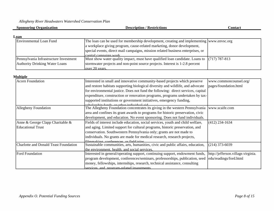
Allegheny River Headwaters Watershed Conservation Plan
Sponsoring Organization Description / Restrictions Contact
Environmental Loan Fund The loan can be used for membership development, creating and implementing a workplace giving program, cause-related marketing, donor development, special events, direct mail campaigns, mission related business enterprises, or capital campaign work
www.envsc.org
Pennsylvania Infrastructure Investment Authority Drinking Water Loans
Must show water quality impact, must have qualified loan candidate. Loans to stormwater projects and non-point source projects. Interest is 1-2.8 percent over 20 years.
(717) 787-813
Acorn Foundation Interested in small and innovative community-based projects which preserve and restore habitats supporting biological diversity and wildlife, and advocate for environmental justice. Does not fund the following: direct services, capital expenditure, construction or renovation programs, programs undertaken by tax-supported institutions or government initiatives, emergency funding, scholarship funds or other individual aid
www.commoncounsel.org/ pages/foundation.html
Allegheny Foundation The Allegheny Foundation concentrates its giving in the western Pennsylvania area and confines its grant awards to programs for historic preservation, civic development, and education. No event sponsoring. Does not fund individuals.
www.scaife.com
Anne & George Clapp Charitable & Educational Trust
Fields of interest include education, social services, youth and child welfare, and aging. Limited support for cultural programs, historic preservation, and conservation. Southwestern Pennsylvania only; grants are not made to individuals. No grants are made for medical research, research projects, filmmaking conferences or field trips
(412) 234-1634
Charlotte and Donald Teast Foundation Sustainable communities, arts, humanities, civic and public affairs, education, the environment, health, and social services.
(214) 373-6039
Ford Foundation Interested in general/operating support, continuing support, endowment funds, program development, conferences/seminars, professorships, publication, seed money, fellowships, internships, research, technical assistance, consulting services and program-related investments
http://jefferson.village.virginia. edu/readings/ford.html
Loan
Multiple
Appendix O. Potential Funding Sources Page 8 of 15
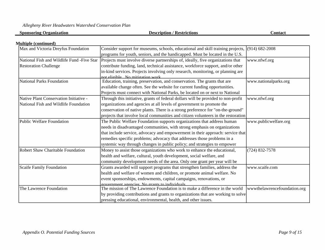
Allegheny River Headwaters Watershed Conservation Plan
Sponsoring Organization Description / Restrictions Contact
Multiple (continued)Max and Victoria Dreyfus Foundation Consider support for museums, schools, educational and skill training projects,
programs for youth, seniors, and the handicapped. Must be located in the U.S. (914) 682-2008
National Fish and Wildlife Fund -Five Star Restoration Challenge
Projects must involve diverse partnerships of, ideally, five organizations that contribute funding, land, technical assistance, workforce support, and/or other in-kind services. Projects involving only research, monitoring, or planning are not eligible No mitigation work
www.nfwf.org
National Parks Foundation Education, training, preservation, and conservation. The grants that are available change often. See the website for current funding opportunities. Projects must connect with National Parks, be located on or next to National
www.nationalparks.org
Native Plant Conservation Initiative - National Fish and Wildlife Foundation
Through this initiative, grants of federal dollars will be provided to non-profit organizations and agencies at all levels of government to promote the conservation of native plants. There is a strong preference for "on-the-ground" projects that involve local communities and citizen volunteers in the restoration
www.nfwf.org
Public Welfare Foundation The Public Welfare Foundation supports organizations that address human needs in disadvantaged communities, with strong emphasis on organizations that include service, advocacy and empowerment in their approach: service that remedies specific problems; advocacy that addresses those problems in a systemic way through changes in public policy; and strategies to empower
www.publicwelfare.org
Robert Shaw Charitable Foundation Money to assist those organizations who work to enhance the educational, health and welfare, cultural, youth development, social welfare, and community development needs of the area. Only one grant per year will be
(724) 832-7578
Scaife Family Foundation Grants awarded will support programs that strengthen families, address the health and welfare of women and children, or promote animal welfare. No event sponsorships, endowments, capital campaigns, renovations, or government agencies No grants to individuals
www.scaife.com
The Lawrence Foundation The mission of The Lawrence Foundation is to make a difference in the world by providing contributions and grants to organizations that are working to solve pressing educational, environmental, health, and other issues.
wwwthelawrencefoundation.org
Appendix O. Potential Funding Sources Page 9 of 15
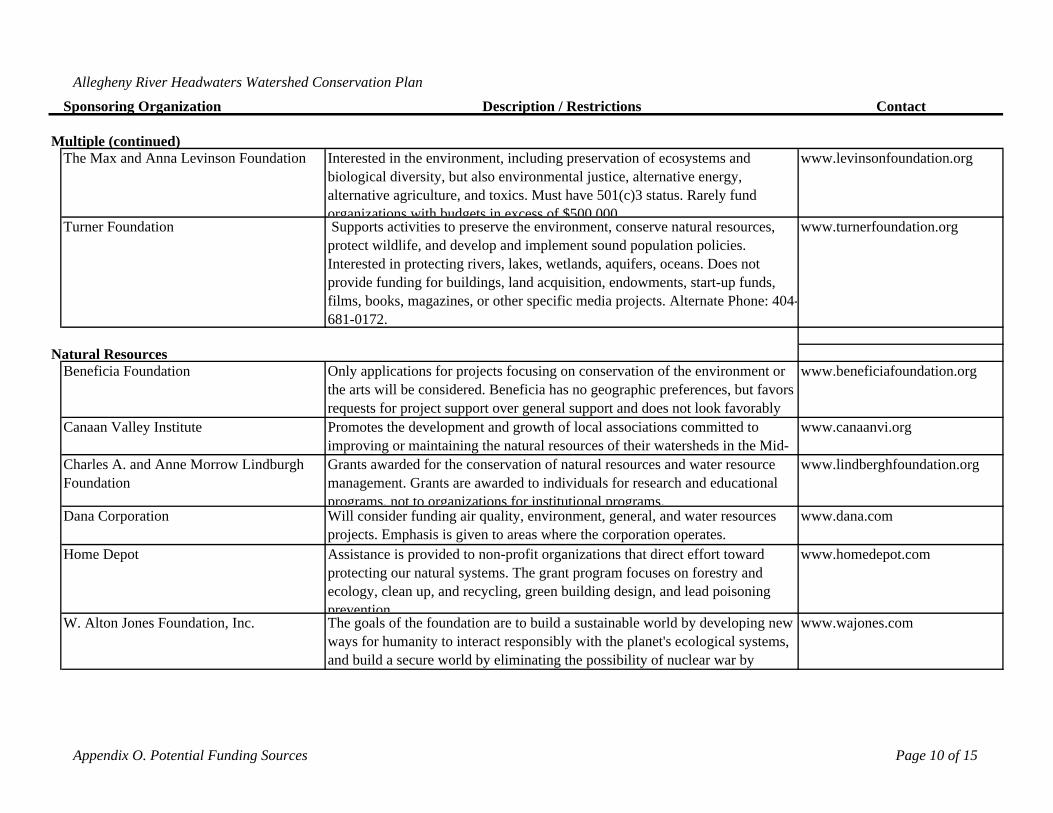
Allegheny River Headwaters Watershed Conservation Plan
Sponsoring Organization Description / Restrictions Contact
Multiple (continued)The Max and Anna Levinson Foundation Interested in the environment, including preservation of ecosystems and
biological diversity, but also environmental justice, alternative energy, alternative agriculture, and toxics. Must have 501(c)3 status. Rarely fund organizations with budgets in excess of $500 000
www.levinsonfoundation.org
Turner Foundation Supports activities to preserve the environment, conserve natural resources, protect wildlife, and develop and implement sound population policies. Interested in protecting rivers, lakes, wetlands, aquifers, oceans. Does not provide funding for buildings, land acquisition, endowments, start-up funds, films, books, magazines, or other specific media projects. Alternate Phone: 404-681-0172.
www.turnerfoundation.org
Beneficia Foundation Only applications for projects focusing on conservation of the environment or the arts will be considered. Beneficia has no geographic preferences, but favors requests for project support over general support and does not look favorably
www.beneficiafoundation.org
Canaan Valley Institute Promotes the development and growth of local associations committed to improving or maintaining the natural resources of their watersheds in the Mid-
www.canaanvi.org
Charles A. and Anne Morrow Lindburgh Foundation
Grants awarded for the conservation of natural resources and water resource management. Grants are awarded to individuals for research and educational programs, not to organizations for institutional programs.
www.lindberghfoundation.org
Dana Corporation Will consider funding air quality, environment, general, and water resources projects. Emphasis is given to areas where the corporation operates.
www.dana.com
Home Depot Assistance is provided to non-profit organizations that direct effort toward protecting our natural systems. The grant program focuses on forestry and ecology, clean up, and recycling, green building design, and lead poisoning prevention
www.homedepot.com
W. Alton Jones Foundation, Inc. The goals of the foundation are to build a sustainable world by developing new ways for humanity to interact responsibly with the planet's ecological systems, and build a secure world by eliminating the possibility of nuclear war by
www.wajones.com
Natural Resources
Appendix O. Potential Funding Sources Page 10 of 15
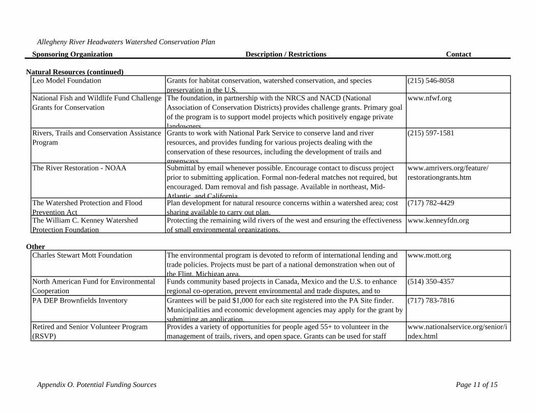
Allegheny River Headwaters Watershed Conservation Plan
Sponsoring Organization Description / Restrictions Contact
Leo Model Foundation Grants for habitat conservation, watershed conservation, and species preservation in the U.S.
(215) 546-8058
National Fish and Wildlife Fund Challenge Grants for Conservation
The foundation, in partnership with the NRCS and NACD (National Association of Conservation Districts) provides challenge grants. Primary goal of the program is to support model projects which positively engage private landowners
www.nfwf.org
Rivers, Trails and Conservation Assistance Program
Grants to work with National Park Service to conserve land and river resources, and provides funding for various projects dealing with the conservation of these resources, including the development of trails and greenways
(215) 597-1581
The River Restoration - NOAA Submittal by email whenever possible. Encourage contact to discuss project prior to submitting application. Formal non-federal matches not required, but encouraged. Dam removal and fish passage. Available in northeast, Mid-Atlantic and California
www.amrivers.org/feature/ restorationgrants.htm
The Watershed Protection and Flood Prevention Act
Plan development for natural resource concerns within a watershed area; cost sharing available to carry out plan.
(717) 782-4429
The William C. Kenney Watershed Protection Foundation
Protecting the remaining wild rivers of the west and ensuring the effectiveness of small environmental organizations.
www.kenneyfdn.org
Charles Stewart Mott Foundation The environmental program is devoted to reform of international lending and trade policies. Projects must be part of a national demonstration when out of the Flint, Michigan area.
www.mott.org
North American Fund for Environmental Cooperation
Funds community based projects in Canada, Mexico and the U.S. to enhance regional co-operation, prevent environmental and trade disputes, and to
(514) 350-4357
PA DEP Brownfields Inventory Grantees will be paid $1,000 for each site registered into the PA Site finder. Municipalities and economic development agencies may apply for the grant by submitting an application.
(717) 783-7816
Retired and Senior Volunteer Program (RSVP)
Provides a variety of opportunities for people aged 55+ to volunteer in the management of trails, rivers, and open space. Grants can be used for staff
www.nationalservice.org/senior/index.html
Natural Resources (continued)
Other
Appendix O. Potential Funding Sources Page 11 of 15
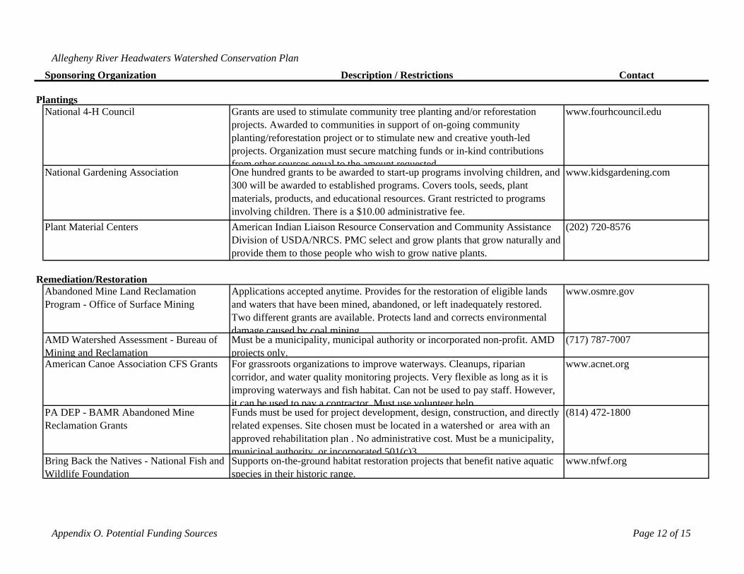
Allegheny River Headwaters Watershed Conservation Plan
Sponsoring Organization Description / Restrictions Contact
National 4-H Council Grants are used to stimulate community tree planting and/or reforestation projects. Awarded to communities in support of on-going community planting/reforestation project or to stimulate new and creative youth-led projects. Organization must secure matching funds or in-kind contributions from other sources equal to the amount requested
www.fourhcouncil.edu
National Gardening Association One hundred grants to be awarded to start-up programs involving children, and 300 will be awarded to established programs. Covers tools, seeds, plant materials, products, and educational resources. Grant restricted to programs involving children. There is a $10.00 administrative fee.
www.kidsgardening.com
Plant Material Centers American Indian Liaison Resource Conservation and Community Assistance Division of USDA/NRCS. PMC select and grow plants that grow naturally and provide them to those people who wish to grow native plants.
(202) 720-8576
Abandoned Mine Land Reclamation Program - Office of Surface Mining
Applications accepted anytime. Provides for the restoration of eligible lands and waters that have been mined, abandoned, or left inadequately restored. Two different grants are available. Protects land and corrects environmental damage caused by coal mining
www.osmre.gov
AMD Watershed Assessment - Bureau of Mining and Reclamation
Must be a municipality, municipal authority or incorporated non-profit. AMD projects only.
(717) 787-7007
American Canoe Association CFS Grants For grassroots organizations to improve waterways. Cleanups, riparian corridor, and water quality monitoring projects. Very flexible as long as it is improving waterways and fish habitat. Can not be used to pay staff. However, it can be used to pay a contractor Must use volunteer help
www.acnet.org
PA DEP - BAMR Abandoned Mine Reclamation Grants
Funds must be used for project development, design, construction, and directly related expenses. Site chosen must be located in a watershed or area with an approved rehabilitation plan . No administrative cost. Must be a municipality, municipal authority or incorporated 501(c)3
(814) 472-1800
Bring Back the Natives - National Fish and Wildlife Foundation
Supports on-the-ground habitat restoration projects that benefit native aquatic species in their historic range.
www.nfwf.org
Plantings
Remediation/Restoration
Appendix O. Potential Funding Sources Page 12 of 15
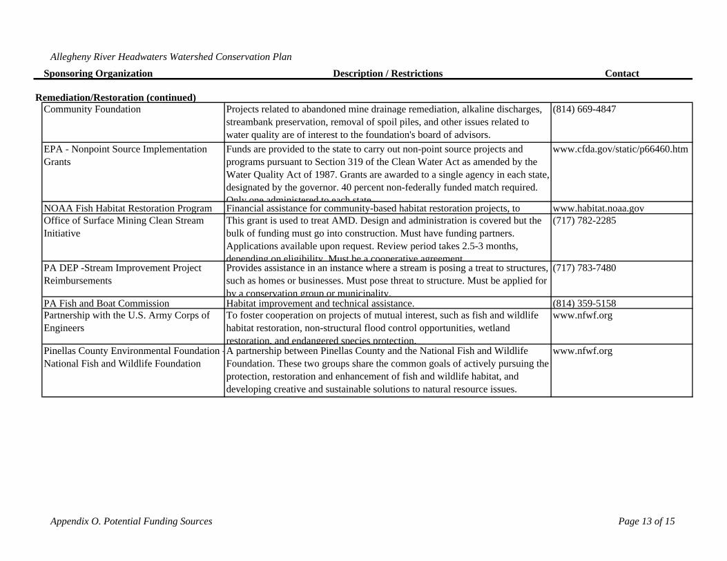
Allegheny River Headwaters Watershed Conservation Plan
Sponsoring Organization Description / Restrictions Contact
Community Foundation Projects related to abandoned mine drainage remediation, alkaline discharges, streambank preservation, removal of spoil piles, and other issues related to water quality are of interest to the foundation's board of advisors.
(814) 669-4847
EPA - Nonpoint Source Implementation Grants
Funds are provided to the state to carry out non-point source projects and programs pursuant to Section 319 of the Clean Water Act as amended by the Water Quality Act of 1987. Grants are awarded to a single agency in each state, designated by the governor. 40 percent non-federally funded match required. Only one administered to each state
www.cfda.gov/static/p66460.htm
NOAA Fish Habitat Restoration Program Financial assistance for community-based habitat restoration projects, to www.habitat.noaa.govOffice of Surface Mining Clean Stream Initiative
This grant is used to treat AMD. Design and administration is covered but the bulk of funding must go into construction. Must have funding partners. Applications available upon request. Review period takes 2.5-3 months, depending on eligibility Must be a cooperative agreement
(717) 782-2285
PA DEP -Stream Improvement Project Reimbursements
Provides assistance in an instance where a stream is posing a treat to structures, such as homes or businesses. Must pose threat to structure. Must be applied for by a conservation group or municipality.
(717) 783-7480
PA Fish and Boat Commission Habitat improvement and technical assistance. (814) 359-5158Partnership with the U.S. Army Corps of Engineers
To foster cooperation on projects of mutual interest, such as fish and wildlife habitat restoration, non-structural flood control opportunities, wetland restoration, and endangered species protection.
www.nfwf.org
Pinellas County Environmental Foundation -National Fish and Wildlife Foundation
A partnership between Pinellas County and the National Fish and Wildlife Foundation. These two groups share the common goals of actively pursuing the protection, restoration and enhancement of fish and wildlife habitat, and developing creative and sustainable solutions to natural resource issues.
www.nfwf.org
Remediation/Restoration (continued)
Appendix O. Potential Funding Sources Page 13 of 15
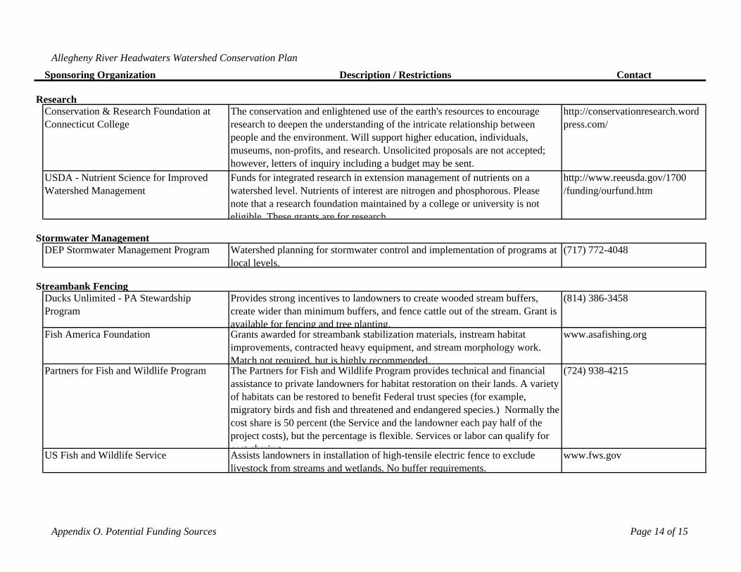
Allegheny River Headwaters Watershed Conservation Plan
Sponsoring Organization Description / Restrictions Contact
Conservation & Research Foundation at Connecticut College
The conservation and enlightened use of the earth's resources to encourage research to deepen the understanding of the intricate relationship between people and the environment. Will support higher education, individuals, museums, non-profits, and research. Unsolicited proposals are not accepted; however, letters of inquiry including a budget may be sent.
http://conservationresearch.wordpress.com/
USDA - Nutrient Science for Improved Watershed Management
Funds for integrated research in extension management of nutrients on a watershed level. Nutrients of interest are nitrogen and phosphorous. Please note that a research foundation maintained by a college or university is not eligible These grants are for research
http://www.reeusda.gov/1700 /funding/ourfund.htm
DEP Stormwater Management Program Watershed planning for stormwater control and implementation of programs at local levels.
(717) 772-4048
Ducks Unlimited - PA Stewardship Program
Provides strong incentives to landowners to create wooded stream buffers, create wider than minimum buffers, and fence cattle out of the stream. Grant is available for fencing and tree planting.
(814) 386-3458
Fish America Foundation Grants awarded for streambank stabilization materials, instream habitat improvements, contracted heavy equipment, and stream morphology work. Match not required, but is highly recommended.
www.asafishing.org
Partners for Fish and Wildlife Program The Partners for Fish and Wildlife Program provides technical and financial assistance to private landowners for habitat restoration on their lands. A variety of habitats can be restored to benefit Federal trust species (for example, migratory birds and fish and threatened and endangered species.) Normally the cost share is 50 percent (the Service and the landowner each pay half of the project costs), but the percentage is flexible. Services or labor can qualify for cost sharing
(724) 938-4215
US Fish and Wildlife Service Assists landowners in installation of high-tensile electric fence to exclude livestock from streams and wetlands. No buffer requirements.
www.fws.gov
Research
Stormwater Management
Streambank Fencing
Appendix O. Potential Funding Sources Page 14 of 15
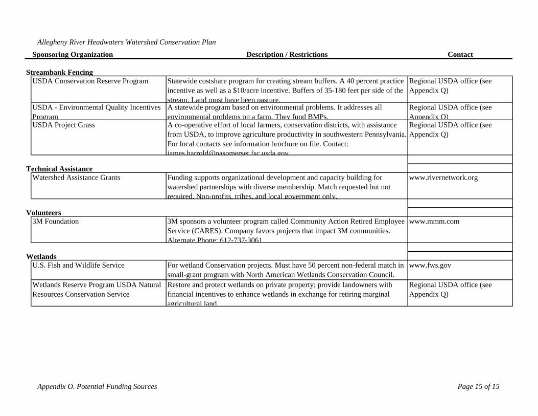
Allegheny River Headwaters Watershed Conservation Plan
Sponsoring Organization Description / Restrictions Contact
USDA Conservation Reserve Program Statewide costshare program for creating stream buffers. A 40 percent practice incentive as well as a $10/acre incentive. Buffers of 35-180 feet per side of the stream. Land must have been pasture.
Regional USDA office (see Appendix Q)
USDA - Environmental Quality Incentives Program
A statewide program based on environmental problems. It addresses all environmental problems on a farm. They fund BMPs.
Regional USDA office (see Appendix Q)
USDA Project Grass A co-operative effort of local farmers, conservation districts, with assistance from USDA, to improve agriculture productivity in southwestern Pennsylvania. For local contacts see information brochure on file. Contact: james harrold@pasomerset fsc usda gov
Regional USDA office (see Appendix Q)
Watershed Assistance Grants Funding supports organizational development and capacity building for watershed partnerships with diverse membership. Match requested but not required. Non-profits, tribes, and local government only.
www.rivernetwork.org
3M Foundation 3M sponsors a volunteer program called Community Action Retired Employee Service (CARES). Company favors projects that impact 3M communities. Alternate Phone: 612-737-3061
www.mmm.com
U.S. Fish and Wildlife Service For wetland Conservation projects. Must have 50 percent non-federal match in small-grant program with North American Wetlands Conservation Council.
www.fws.gov
Wetlands Reserve Program USDA Natural Resources Conservation Service
Restore and protect wetlands on private property; provide landowners with financial incentives to enhance wetlands in exchange for retiring marginal agricultural land.
Regional USDA office (see Appendix Q)
Volunteers
Wetlands
Technical Assistance
Streambank Fencing
Appendix O. Potential Funding Sources Page 15 of 15
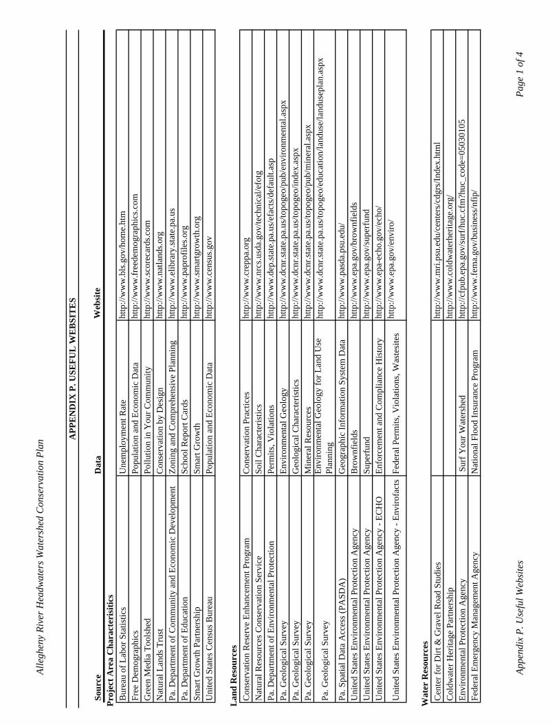
Alle
ghen
y Ri
ver H
eadw
ater
s Wat
ersh
ed C
onse
rvat
ion
Plan
APP
EN
DIX
P. U
SEFU
L W
EB
SIT
ES
Sour
ceD
ata
Web
site
Proj
ect A
rea
Cha
ract
eris
itics
Bur
eau
of L
abor
Sta
tistic
s
U
nem
ploy
men
t Rat
e ht
tp://
ww
w.b
ls.g
ov/h
ome.
htm
Free
Dem
ogra
phic
s Po
pula
tion
and
Econ
omic
Dat
a ht
tp://
ww
w.fr
eede
mog
raph
ics.c
omG
reen
Med
ia T
ools
hed
Pollu
tion
in Y
our C
omm
unity
http
://w
ww
.scor
ecar
ds.c
omN
atur
al L
ands
Tru
stC
onse
rvat
ion
by D
esig
nht
tp://
ww
w.n
atla
nds.o
rgPa
. Dep
artm
ent o
f Com
mun
ity a
nd E
cono
mic
Dev
elop
men
tZo
ning
and
Com
preh
ensi
ve P
lann
ing
http
://w
ww
.elib
rary
.stat
e.pa
.us
Pa. D
epar
tmen
t of E
duca
tion
Scho
ol R
epor
t Car
dsht
tp://
ww
w.p
apro
files
.org
Smar
t Gro
wth
Par
tner
ship
Smar
t Gro
wth
http
://w
ww
.smar
tgro
wth
.org
Uni
ted
Stat
es C
ensu
s Bur
eau
Popu
latio
n an
d Ec
onom
ic D
ata
http
://w
ww
.cen
sus.g
ov
Lan
d R
esou
rces
Con
serv
atio
n R
eser
ve E
nhan
cem
ent P
rogr
amC
onse
rvat
ion
Prac
tices
http
://w
ww
.cre
ppa.
org
Nat
ural
Res
ourc
es C
onse
rvat
ion
Serv
ice
Soil
Cha
ract
eris
tics
http
://w
ww
.nrc
s.usd
a.go
v/te
chni
cal/e
fotg
Pa. D
epar
tmen
t of E
nviro
nmen
tal P
rote
ctio
nPe
rmits
, Vio
latio
nsht
tp://
ww
w.d
ep.st
ate.
pa.u
s/ef
acts
/def
ault.
asp
Pa. G
eolo
gica
l Sur
vey
Envi
ronm
enta
l Geo
logy
http
://w
ww
.dcn
r.sta
te.p
a.us
/topo
geo/
pub/
envi
ronm
enta
l.asp
xPa
. Geo
logi
cal S
urve
yG
eolo
gica
l Cha
ract
eris
tics
http
://w
ww
.dcn
r.sta
te.p
a.us
/topo
geo/
inde
x.as
pxPa
. Geo
logi
cal S
urve
yM
iner
al R
esou
rces
http
://w
ww
.dcn
r.sta
te.p
a.us
/topo
geo/
pub/
min
eral
.asp
x
Pa. G
eolo
gica
l Sur
vey
Envi
ronm
enta
l Geo
logy
for L
and
Use
Pl
anni
nght
tp://
ww
w.d
cnr.s
tate
.pa.
us/to
poge
o/ed
ucat
ion/
land
use/
land
usep
lan.
aspx
Pa. S
patia
l Dat
a A
cces
s (PA
SDA
)G
eogr
aphi
c In
form
atio
n Sy
stem
Dat
aht
tp://
ww
w.p
asda
.psu
.edu
/U
nite
d St
ates
Env
ironm
enta
l Pro
tect
ion
Age
ncy
Bro
wnf
ield
sht
tp://
ww
w.e
pa.g
ov/b
row
nfie
lds
Uni
ted
Stat
es E
nviro
nmen
tal P
rote
ctio
n A
genc
ySu
perf
und
http
://w
ww
.epa
.gov
/sup
erfu
ndU
nite
d St
ates
Env
ironm
enta
l Pro
tect
ion
Age
ncy
- EC
HO
Enfo
rcem
ent a
nd C
ompl
ianc
e H
isto
ryht
tp://
ww
w.e
pa-e
cho.
gov/
echo
/
Uni
ted
Stat
es E
nviro
nmen
tal P
rote
ctio
n A
genc
y - E
nviro
fact
sFe
dera
l Per
mits
, Vio
latio
ns, W
aste
site
sht
tp://
ww
w.e
pa.g
ov/e
nviro
/
Wat
er R
esou
rces
Cen
ter f
or D
irt &
Gra
vel R
oad
Stud
ies
http
://w
ww
.mri.
psu.
edu/
cent
ers/
cdgr
s/In
dex.
htm
lC
oldw
ater
Her
itage
Par
tner
ship
http
://w
ww
.col
dwat
erhe
ritag
e.or
g/
Envi
ronm
enta
l Pro
tect
ion
Age
ncy
Sur
f You
r Wat
ersh
edht
tp://
cfpu
b.ep
a.go
v/su
rf/h
uc.c
fm?h
uc_c
ode=
0503
0105
Fe
dera
l Em
erge
ncy
Man
agem
ent A
genc
yN
atio
nal F
lood
Insu
ranc
e Pr
ogra
mht
tp://
ww
w.fe
ma.
gov/
busi
ness
/nfip
/
Appe
ndix
P. U
sefu
l Web
site
sPa
ge 1
of 4
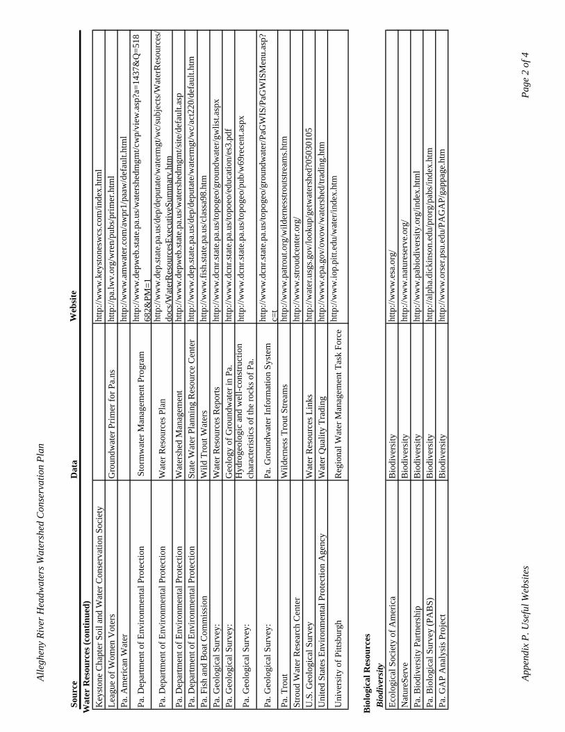
Alle
ghen
y Ri
ver H
eadw
ater
s Wat
ersh
ed C
onse
rvat
ion
Plan
Sour
ceD
ata
Web
site
Wat
er R
esou
rces
(con
tinue
d)K
eyst
one
Cha
pter
Soi
l and
Wat
er C
onse
rvat
ion
Soci
ety
http
://w
ww
.key
ston
esw
cs.c
om/in
dex.
htm
lLe
ague
of W
omen
Vot
ers
Gro
undw
ater
Prim
er fo
r Pa.
nsht
tp://
pa.lw
v.or
g/w
ren/
pubs
/prim
er.h
tml
Pa. A
mer
ican
Wat
erht
tp://
ww
w.a
mw
ater
.com
/aw
pr1/
paaw
/def
ault.
htm
l
Pa. D
epar
tmen
t of E
nviro
nmen
tal P
rote
ctio
n S
torm
wat
er M
anag
emen
t Pro
gram
http
://w
ww
.dep
web
.stat
e.pa
.us/
wat
ersh
edm
gmt/c
wp/
view
.asp
?a=1
437&
Q=5
1868
2&PM
=1Pa
. Dep
artm
ent o
f Env
ironm
enta
l Pro
tect
ion
Wat
er R
esou
rces
Pla
nht
tp://
ww
w.d
ep.st
ate.
pa.u
s/de
p/de
puta
te/w
ater
mgt
/wc/
subj
ects
/Wat
erR
esou
rces
/do
cs/W
ater
Res
ourc
esEx
ecut
iveS
umm
ary.
htm
Pa. D
epar
tmen
t of E
nviro
nmen
tal P
rote
ctio
nW
ater
shed
Man
agem
ent
http
://w
ww
.dep
web
.stat
e.pa
.us/
wat
ersh
edm
gmt/s
ite/d
efau
lt.as
pPa
. Dep
artm
ent o
f Env
ironm
enta
l Pro
tect
ion
Stat
e W
ater
Pla
nnin
g R
esou
rce
Cen
ter
http
://w
ww
.dep
.stat
e.pa
.us/
dep/
depu
tate
/wat
erm
gt/w
c/ac
t220
/def
ault.
htm
Pa. F
ish
and
Boa
t Com
mis
sion
Wild
Tro
ut W
ater
sht
tp://
ww
w.fi
sh.st
ate.
pa.u
s/cl
assa
98.h
tm
Pa. G
eolo
gica
l Sur
vey:
W
ater
Res
ourc
es R
epor
tsht
tp://
ww
w.d
cnr.s
tate
.pa.
us/to
poge
o/gr
ound
wat
er/g
wlis
t.asp
xPa
. Geo
logi
cal S
urve
y:
Geo
logy
of G
roun
dwat
er in
Pa.
http
://w
ww
.dcn
r.sta
te.p
a.us
/topo
eo/e
duca
tion/
es3.
Pa. G
eolo
gica
l Sur
vey:
H
ydro
geol
ogic
and
wel
l-con
stru
ctio
n ch
arac
teris
tics o
f the
rock
s of P
a.ht
tp://
ww
w.d
cnr.s
tate
.pa.
us/to
poge
o/pu
b/w
69re
cent
.asp
x
Pa. G
eolo
gica
l Sur
vey:
Pa
. Gro
undw
ater
Info
rmat
ion
Syst
emht
tp://
ww
w.d
cnr.s
tate
.pa.
us/to
poge
o/gr
ound
wat
er/P
aGW
IS/P
aGW
ISM
enu.
asp?
c=t
Pa. T
rout
Wild
erne
ss T
rout
Stre
ams
http
://w
ww
.pat
rout
.org
/wild
erne
sstro
utst
ream
s.htm
Stro
ud W
ater
Res
earc
h C
ente
rht
tp://
ww
w.st
roud
cent
er.o
rg/
U.S
. Geo
logi
cal S
urve
yW
ater
Res
ourc
es L
inks
ht
tp://
wat
er.u
sgs.g
ov/lo
okup
/get
wat
ersh
ed?0
5030
105
Uni
ted
Stat
es E
nviro
nmen
tal P
rote
ctio
n A
genc
yW
ater
Qua
lity
Trad
ing
http
://w
ww
.epa
.gov
/ow
ow/w
ater
shed
/trad
ing.
htm
Uni
vers
ity o
f Pitt
sbur
ghR
egio
nal W
ater
Man
agem
ent T
ask
Forc
eht
tp://
ww
w.io
p.pi
tt.ed
u/w
ater
/inde
x.ht
m
Bio
logi
cal R
esou
rces
Bio
dive
rsity
Ecol
ogic
al S
ocie
ty o
f Am
eric
aB
iodi
vers
ityht
tp://
ww
w.e
sa.o
rg/
Nat
ureS
erve
Bio
dive
rsity
http
://w
ww
.nat
ures
erve
.org
/ Pa
. Bio
dive
rsity
Par
tner
ship
Bio
dive
rsity
http
://w
ww
.pab
iodi
vers
ity.o
rg/in
dex.
htm
l Pa
. Bio
logi
cal S
urve
y (P
AB
S)B
iodi
vers
ityht
tp://
alph
a.di
ckin
son.
edu/
pror
g/pa
bs/in
dex.
htm
Pa
. GA
P A
naly
sis P
roje
ctB
iodi
vers
ityht
tp://
ww
w.o
rser
.psu
.edu
/PA
GA
P/ga
ppag
e.ht
m
Appe
ndix
P. U
sefu
l Web
site
sPa
ge 2
of 4
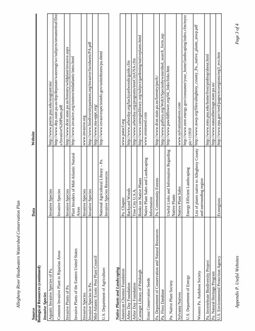
Alle
ghen
y Ri
ver H
eadw
ater
s Wat
ersh
ed C
onse
rvat
ion
Plan
Sour
ceD
ata
Web
site
Bio
logi
cal R
esou
rces
(con
tinue
d)In
vasi
ve S
peci
esA
quat
ic In
vasi
ve S
peci
es o
f Pa.
Inva
sive
Spe
cies
http
://w
ww
.pse
rie.p
su.e
du/s
eagr
ant/a
is/
Com
mon
Inva
sive
Pla
nt in
Rip
aria
n A
reas
Inva
sive
Spe
cies
http
://w
ww
.dep
.stat
e.pa
.us/
dep/
depu
tate
/wat
erm
gt/w
c/su
bjec
ts/s
tream
rele
af/D
ocs/
Inva
sive
%20
Plan
ts.p
df
Inva
sive
Pla
nts o
f Pa.
Inva
sive
Spe
cies
http
://w
ww
.dcn
r.sta
te.p
a.us
/fore
stry
/wild
plan
t/inv
asiv
e.as
px
Inva
sive
Pla
nts o
f the
Eas
tern
Uni
ted
Stat
esPl
ant I
nvad
ers o
f Mid
-Atla
ntic
Nat
ural
A
reas
http
://w
ww
.inva
sive
.org
/eas
tern
/mid
atla
ntic
/intro
.htm
l
Inva
sive
Spe
cies
Inva
sive
Spe
cies
ww
w.in
vasi
ve.o
rgIn
vasi
ve S
peci
es in
Pa.
Inva
sive
Spe
cies
http
://w
ww
.bio
dive
rsity
partn
ers.o
rg/in
vasi
ve/fa
ctsh
eets
/PA
M
id-A
tlant
ic E
xotic
Pes
t Pla
nt C
ounc
ilht
tp://
ww
w.m
a-ep
pc.o
rg/
U.S
. Dep
artm
ent o
f Agr
icul
ture
: N
atio
nal A
gric
ultu
ral L
ibra
ry –
Pa.
In
vasi
ve S
peci
es R
esou
rces
http
://w
ww
.inva
sive
spec
iesi
nfo.
gov/
unite
dsta
tes/
pa.sh
tml
Nat
ive
Plan
ts a
nd L
ands
capi
ngA
mer
ican
Che
stnu
t Fou
ndat
ion
Pa. C
hapt
erw
ww
.pat
acf.o
rg
Arb
or D
ay F
ound
atio
nB
acky
ard
Woo
dsht
tp://
ww
w.a
rbor
day.
org/
back
yard
woo
ds/g
uide
.cfm
A
rbor
Day
Fou
ndat
ion
Tree
City
U.S
.A.
http
://w
ww
.arb
orda
y.or
g/pr
ogra
ms/
treeC
ityU
SA.c
fm
Car
negi
e Li
brar
y of
Pitt
sbur
ghB
ooks
on
Nat
ive
Plan
tsht
tp://
ww
w.c
arne
giel
ibra
ry.o
rg/s
ubje
ct/g
arde
ning
/nat
ivep
lant
s.htm
l
Erns
t Con
serv
atio
n Se
eds
Nat
ive
Plan
t Sal
es a
nd L
ands
capi
ng
Info
rmat
ion
ww
w.e
rnst
seed
.com
Pa. D
epar
tmen
t of C
onse
rvat
ion
and
Nat
ural
Res
ourc
esPa
. Com
mun
ity F
ores
tsht
tp://
ww
w.d
cnr.s
tate
.pa.
us/fo
rest
ry/p
ucfc
/ Pa
. Flo
ra D
atab
ase
http
://w
ww
.paf
lora
.org
/Web
3/Sp
ecie
sbyw
ater
shed
_sea
rch_
form
.asp
Pa. N
ativ
e Pl
ant S
ocie
tyU
sefu
l Lin
ks a
nd In
form
atio
n R
egar
ding
N
ativ
e Pl
ants
http
://w
ww
.paw
ildflo
wer
.org
/04_
links
/link
s.htm
Sylv
ania
Nat
ives
N
ativ
e Pl
ant S
ales
w
ww
.sylv
ania
nativ
es.c
om
U.S
. Dep
artm
ent o
f Ene
rgy
Ener
gy E
ffic
ient
Lan
dsca
ping
http
://w
ww
.eer
e.en
ergy
.gov
/con
sum
er/y
our_
hom
e/la
ndsc
apin
g/in
dex.
cfm
/myt
opi
c=11
910
Wes
tern
Pa.
Aud
ubon
Soc
iety
List
of p
lant
s nat
ive
to A
llegh
eny
Cou
nty
and
surr
ound
ing
regi
onht
tp://
ww
w.a
swp.
org/
files
/alle
ghen
y_co
unty
_Pa.
_nat
ive_
plan
ts_a
swp.
Pa. I
nver
tebr
ate
Bio
dive
rsity
Pro
ject
ht
tp://
ww
w.e
nto.
psu.
edu/
hom
e/fr
ost/p
inbi
op/a
bout
.htm
lPa
. Nat
ural
Her
itage
Pro
gram
http
://w
ww
.nat
ural
herit
age.
stat
e.pa
.us/
U
.S. E
nviro
nmen
tal P
rote
ctio
n A
genc
y Ec
oreg
ions
http
://w
ww
.epa
.gov
/wed
/pag
es/e
core
gion
s/re
g3_e
co.h
tm
Appe
ndix
P. U
sefu
l Web
site
sPa
ge 3
of 4
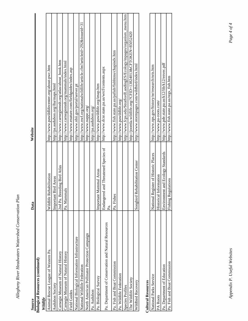
Alle
ghen
y Ri
ver H
eadw
ater
s Wat
ersh
ed C
onse
rvat
ion
Plan
Wild
bird
Rec
over
ySo
ngbi
rd R
ehab
ilita
tion
Cen
ter
http
://w
ww
.stor
mpa
ges.c
om/w
ildbi
rd/in
dex.
htm
l
Pa. F
ish
and
Boa
t Com
mis
sion
Fish
ing
Reg
ulat
ions
http
://w
ww
.fish
.stat
e.pa
.us/
regs
_fis
h.ht
m
Cul
tura
l Res
ourc
es
Sour
ceD
ata
Web
site
Bio
logi
cal R
esou
rces
(con
tinue
d)W
ildlif
eA
nim
al R
escu
e Le
ague
of W
este
rn P
a.W
ildlif
e R
ehab
ilita
tion
http
://w
ww
.paw
ildlif
ecen
ter.o
rg/a
bout
-pw
c.ht
m
Aud
ubon
Soc
iety
Impo
rtant
Bird
Are
asht
tp://
pa.a
udub
on.o
rg/ib
a/m
aps.h
tml
Car
negi
e M
useu
m o
f Nat
ural
His
tory
2nd
Pa. B
reed
ing
Bird
Atla
sht
tp://
ww
w.c
arne
giem
nh.o
rg/a
tlas/
abou
t_bo
ok.h
tm
Car
negi
e M
useu
m o
f Nat
ural
His
tory
Pa. M
amm
als
http
://w
ww
.car
negi
emnh
.org
/mam
mal
s/in
dex.
htm
l Fi
eld
Gui
des
http
://w
ww
.ena
ture
.com
/fiel
dgui
des/
inde
x.as
p N
atio
nal B
iolo
gica
l Inf
orm
atio
n In
fras
truct
ure
http
://w
ww
.nbi
i.gov
/por
tal/s
erve
r.pt
Nat
iona
l Wild
life
Fede
ratio
nht
tp://
ww
w.n
wf.o
rg/n
atio
nalw
ildlif
e/ar
ticle
.cfm
?arti
clei
d=29
2&is
suei
d=31
ht
tp://
ww
w.n
appc
.org
/ N
orth
Am
eric
an P
ollin
ator
Pro
tect
ion
Cam
paig
nht
tp://
pa.a
udub
on.o
rg/
Pa. A
udub
on
http
://w
ww
.paw
ildlif
e.or
g/im
ap.h
tm
Pa. B
iolo
gica
l Sur
vey
Pa. D
epar
tmen
t of C
onse
rvat
ion
and
Nat
ural
Res
ourc
es
Impo
rtant
Mam
mal
Are
asEn
dang
ered
and
Thr
eate
ned
Spec
ies o
f Pa
.ht
tp://
ww
w.d
cnr.s
tate
.pa.
us/w
rcf/c
onte
nts.a
spx
http
://w
ww
.fish
.stat
e.pa
.us/
pafis
h/fis
hhtm
s/ch
apin
dx.h
tm
Pa. F
ish
and
Boa
t Com
mis
sion
Pa. F
ishe
sht
tp://
ww
w.p
awild
life.
org/
Pa. W
ildlif
e Fe
dera
tion
http
://w
ww
.fcps
.edu
/Stra
tford
Land
ingE
S/Ec
olog
y/m
page
s/or
gani
sm_m
enu.
htm
Sp
ecie
s Pro
files
The
Wild
life
Soci
ety
http
://jo
omla
.wild
life.
org/
?CFI
D=1
3824
013&
CFT
OK
EN=8
5052
420
Nat
iona
l Par
ks S
ervi
ceN
atio
nal R
egis
ter o
f His
toric
Pla
ces
http
://w
ww
.nps
.gov
/his
tory
/nr/r
esea
rch/
nris
.htm
PA R
oots
His
toric
al In
form
atio
nht
tp://
ww
w.p
a-ro
ots.c
om/
Pa. D
epar
tmen
t of E
duca
tion
Envi
ronm
ent a
nd E
colo
gy S
tand
ards
http
://w
ww
.pde
.stat
e.pa
.us/
k12/
lib/k
12/e
nvec
Appe
ndix
P. U
sefu
l Web
site
sPa
ge 4
of 4
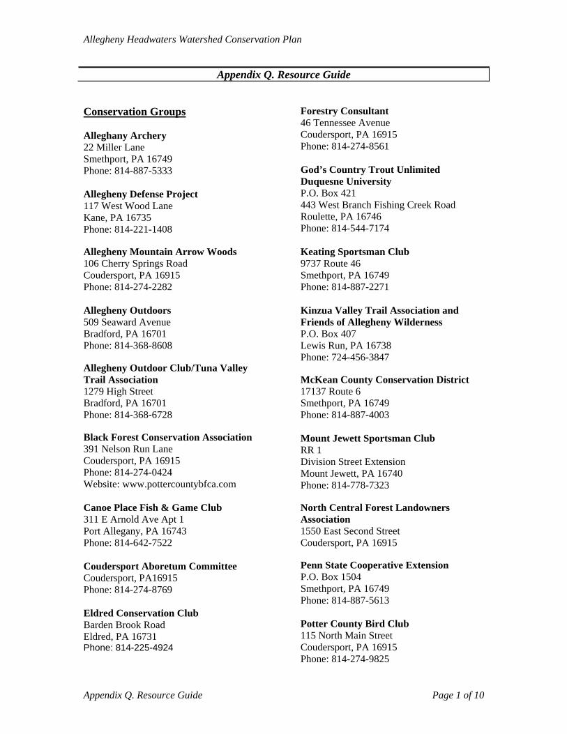
Allegheny Headwaters Watershed Conservation Plan
Appendix Q. Resource Guide Conservation Groups Alleghany Archery 22 Miller Lane Smethport, PA 16749 Phone: 814-887-5333 Allegheny Defense Project 117 West Wood Lane Kane, PA 16735 Phone: 814-221-1408 Phone: 814-544-7174 Allegheny Mountain Arrow Woods 106 Cherry Springs Road Coudersport, PA 16915 Phone: 814-274-2282 Allegheny Outdoors 509 Seaward Avenue Bradford, PA 16701 Phone: 814-368-8608 Allegheny Outdoor Club/Tuna Valley Trail Association 1279 High Street Bradford, PA 16701 Phone: 814-368-6728 Black Forest Conservation Association 391 Nelson Run Lane Coudersport, PA 16915 Phone: 814-274-0424 Website: www.pottercountybfca.com Canoe Place Fish & Game Club 311 E Arnold Ave Apt 1 Port Allegany, PA 16743 Phone: 814-642-7522 Coudersport Aboretum Committee Coudersport, PA16915 Phone: 814-274-8769 Eldred Conservation Club Barden Brook Road Eldred, PA 16731 Phone: 814-225-4924
Forestry Consultant 46 Tennessee Avenue Coudersport, PA 16915 Phone: 814-274-8561 God’s Country Trout Unlimited Duquesne University P.O. Box 421 443 West Branch Fishing Creek Road Roulette, PA 16746
Keating Sportsman Club 9737 Route 46 Smethport, PA 16749 Phone: 814-887-2271 Kinzua Valley Trail Association and Friends of Allegheny Wilderness P.O. Box 407 Lewis Run, PA 16738 Phone: 724-456-3847 McKean County Conservation District 17137 Route 6 Smethport, PA 16749 Phone: 814-887-4003 Mount Jewett Sportsman Club RR 1 Division Street Extension Mount Jewett, PA 16740 Phone: 814-778-7323 North Central Forest Landowners Association 1550 East Second Street Coudersport, PA 16915 Penn State Cooperative Extension P.O. Box 1504 Smethport, PA 16749 Phone: 814-887-5613 Potter County Bird Club 115 North Main Street Coudersport, PA 16915 Phone: 814-274-9825
Appendix Q. Resource Guide Page 1 of 10
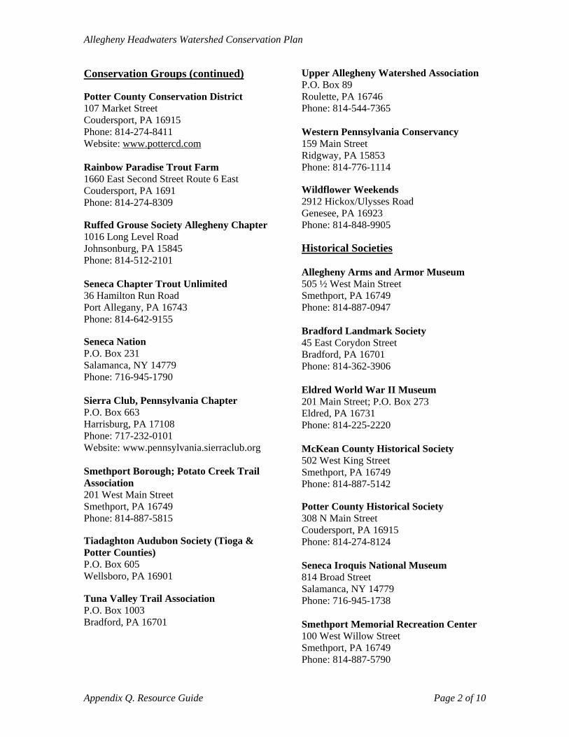
Allegheny Headwaters Watershed Conservation Plan
Conservation Groups (continued) Potter County Conservation District 107 Market Street Coudersport, PA 16915 Phone: 814-274-8411 Website: www.pottercd.com Rainbow Paradise Trout Farm 1660 East Second Street Route 6 East Coudersport, PA 1691 Phone: 814-274-8309 Ruffed Grouse Society Allegheny Chapter 1016 Long Level Road Johnsonburg, PA 15845 Phone: 814-512-2101 Seneca Chapter Trout Unlimited 36 Hamilton Run Road Port Allegany, PA 16743 Phone: 814-642-9155 Seneca Nation P.O. Box 231 Salamanca, NY 14779 Phone: 716-945-1790 Sierra Club, Pennsylvania Chapter P.O. Box 663 Harrisburg, PA 17108 Phone: 717-232-0101 Website: www.pennsylvania.sierraclub.org Smethport Borough; Potato Creek Trail Association 201 West Main Street Smethport, PA 16749 Phone: 814-887-5815 Tiadaghton Audubon Society (Tioga & Potter Counties) P.O. Box 605 Wellsboro, PA 16901 Tuna Valley Trail Association P.O. Box 1003 Bradford, PA 16701
Upper Allegheny Watershed Association P.O. Box 89 Roulette, PA 16746 Phone: 814-544-7365 Western Pennsylvania Conservancy 159 Main Street Ridgway, PA 15853 Phone: 814-776-1114 Wildflower Weekends 2912 Hickox/Ulysses Road Genesee, PA 16923 Phone: 814-848-9905 Historical Societies Allegheny Arms and Armor Museum 505 ½ West Main Street Smethport, PA 16749 Phone: 814-887-0947 Bradford Landmark Society 45 East Corydon Street Bradford, PA 16701 Phone: 814-362-3906 Eldred World War II Museum 201 Main Street; P.O. Box 273 Eldred, PA 16731 Phone: 814-225-2220 McKean County Historical Society 502 West King Street Smethport, PA 16749 Phone: 814-887-5142 Potter County Historical Society 308 N Main Street Coudersport, PA 16915 Phone: 814-274-8124 Seneca Iroquis National Museum 814 Broad Street Salamanca, NY 14779 Phone: 716-945-1738 Smethport Memorial Recreation Center 100 West Willow Street Smethport, PA 16749 Phone: 814-887-5790
Appendix Q. Resource Guide Page 2 of 10
Allegheny Headwaters Watershed Conservation Plan
Historical Societies (continued) Smethport Visitors Center 119 West Main Street Smethport, PA 16749 Zippo Case Museum 1932 Zippo Drive Bradford, PA 16701 Regional Planning Commissions Northcentral Regional Planning and Development Commission 651 Montmorenci Road Ridgway, PA 15853 Phone: 814-773-3162 http://web2.ncentral.com/ncentral/index.html State Agencies DCNR/Bureau of Forestry P.O. Box 673 3150 East Second Street (Denton Hill) Coudersport, PA 16915 Phone: 814-274-3600 DCNR – Region 4 – Northcentral – Williamsport Regional Office 330 Pine Street Suite 400 Williamsport, PA 17701 Phone: 570-326-3521 DCNR – Region 6 – Northwest – Erie Regional Office 230 Chestnut Street Meadville, PA 16335-3481 Phone: 814-332-6190 Department of Environmental Protection (DEP) Headquarters Rachel Carson State Office Building 400 Market Street Harrisburg, PA 17101 Phone: 717-783-2300 Website: www.dep.state.pa.us
PA DCNR Bureau of Forestry P.O. Box 673 Coudersport, PA 16915 Phone: 814-274-3600 Old Red Schoolhouse Wildlife and Nature Center Route 44 Shinglehouse, PA 16748 PA Department of Conservation and Natural Resources Rachel Carson State Office Building 6th Floor, P.O. Box 8475 Harrisburg, PA 17105-8475 PA Fish and Boat Commission P.O. Box 71 Smethport, PA 16749 Phone: 814-359-5250 PA Game Commission 466 Bloomster Road Smethport, PA 16749 Phone: 814-887-7739 PA Geological Survey 3240 Schoolhouse Road Middletown, PA 17057-3534 Phone: 717-702-2045 PA Senate 315 Second Avenue Suite 203 Warren, PA 16365 Phone: 814-726-7201 PA State Conservation Commission 2301 North Cameron Street Harrisburg, PA 17110 Phone: 717-787-8821 Fax: 717-705-3778 Website: www.pascc.state.pa.us
Appendix Q. Resource Guide Page 3 of 10

Allegheny Headwaters Watershed Conservation Plan
State Agencies (continued) Pennsylvania Department of Education 333 Market Street Harrisburg, PA 17126 Phone: 717-783-6788 Website: www.pde.state.pa.us/ PA Department of Emergency Management Eastern Area Office Hamburg Center Hamburg, PA 19526 Phone: 610 562-3003 Fax: 610 562-7222 Website: www.pema.state.pa.us/ PA Department of Labor and Industry Room 1700 651 Boas Street Harrisburg, PA 17121 Phone: 717-787-5279 Website: www.dli.state.pa.us/ PA Department of Community and Economic Development 400 Forum Building Room 357 Harrisburg, PA 17120 Phone: 717-783-8950 Website: http://www.dced.state.pa.us/ PA Department of Health Health & Welfare Building 7th & Forster Streets Harrisburg, PA 17120 Phone: 1-877-PA-HEALTH Website: www.portal.state.pa.us/portal/server.../department_of_health.../17457 PA Historical and Museum Commission State Museum Building 300 North Street Harrisburg, PA 17120 Phone: 717-787-3362 Fax: 717-783-9924 Website: www.phmc.state.pa.us/
PennVEST 22 S. Third Street Harrisburg, PA 17101 Phone: 717-783-6798 Website: www.portal.state.pa.us/portal/server.pt/.../pennvest/9242 Susquehannock State Forest P.O. Box 673 Coudersport, PA 16915 Phone: 814-274-3600 State Legislators (Legislators in office 2010; see General Assembly website: www.legis.state.pa.us for current information) House of Representatives - District 67 Hon. Martin T. Causer 107 South Main Street Room 1 Coudersport, PA 16915 Phone: 814-274-3631 Fax: 814-274-8159 Website: http://www.repcauser.com House of Representatives - District 65 Hon. Kathy L. Rapp 404 Market Street Warren, PA 16365 Phone: 814-723-5203 Fax: 814-728-3564 Website: http://www.reprapp.com Federal Agencies Environmental Protection Agency (EPA) EPA Region 3 Regional Office 1650 Arch Street Philadelphia, PA 19103 Phone: 1-800-438-2474 Website: www.epa.gov United States Army Corps of Engineers Baltimore District P.O. Box 1715 Baltimore, MD 21203-1715 Phone: 410-962-7608 Website http://www.nab.usace.army.mil/
Appendix Q. Resource Guide Page 4 of 10
Allegheny Headwaters Watershed Conservation Plan
Federal Agencies (continued) United States Department of Energy Pennsylvania Public Utility Commission Commonwealth Keystone Building 400 North Street P.O. Box 3265 Harrisburg, PA 17105 Website: www.puc.state.pa.us United States Department of Energy National Energy Technology Laboratory Pittsburgh Research Center 626 Cochrans Mill Road, P.O. Box 10940 Pittsburgh, PA 15236 Phone: 412-386-6569 Fax: 412-386-5917 Website: www.netl.doe.gov United States Fish and Wildlife Service Pennsylvania Field Office 315 South Allen Street, Suite 322 State College, PA 16801 Phone: 814-234-4090 Fax: 814-234-0748 Website: www.fws.gov U.S. Department of Agriculture (USDA) Animal and Plant Health Inspection Service (APHIS) – Pennsylvania Wildlife Services P.O. Box 60827 Harrisburg, PA 17106 Phone: 717-236-9451 Website: www.aphis.usda.gov/wildlife_damage USDA Farm Service Agency Potter County Farm Service Agency 105 Market Street Coudersport, PA 16915 Phone: 814-274-8522 Website: www.fsa.usda.gov USDA Farm Service Agency Pennsylvania State Farm Service Agency 1 Credit Union Place Harrisburg, PA 17110 Phone: 717-237-2117 Website: www.fsa.usda.gov
USDA Natural Resources Conservation Service (NRCS) Pennsylvania State Office One Credit Union Place, Suite 340 Harrisburg, PA 17110 Phone: 717-237-2100 Fax: 717-237-2238 Website: www.pa.nrcs.usda.gov USDA-NRCS Coudersport Field Office (Potter and McKean County) 105 Market Street Coudersport, PA 16915 Phone: 814-274-8166 USDA-NRCS Soil Survey Office 216 Spring Run Road Mill Hall, PA 17751 Phone: 570-726-3196 ext. 122 U.S. Forest Service Ranger Station 29 Forest Service Dr. Bradford, PA 16701 Phone: 814-362-4613 U.S. Forest Service-Allegheny National Forest 4 Farm Colony Drive Warren, PA 16365 Phone: 814-728-6168 McKean County Annin Township P.O. Box 143 Turtlepoint, PA 16750 Phone: 814-642-7959 Bradford City 24 Kennedy Street Bradford, PA 16701 Phone: 814-362-3884 ext:11 Bradford Township 136 Hemlock Street Bradford, PA 16701 Phone: 814-368-3564 Ceres Township 12 Barbertown Road Shinglehouse, PA 16748 Phone: 814-697-6948
Appendix Q. Resource Guide Page 5 of 10
Allegheny Headwaters Watershed Conservation Plan
McKean County (continued) Eldred Borough 3 South Bennett Street Eldred, PA 16731 Phone: 814-225-4777 Eldred Township 1834 West Eldred Road Eldred, PA 16731 Phone: 814-225-4704 Foster Township 1185 East Main Street Bradford, PA 16701 Phone: 814-362-4656 Hamlin Township 22 Park Road Kane, PA 16735 Phone: 814-778-5855 Keating Township 7160 Route 46 Ease Smethport, PA 16730 Phone: 814-887-9921 Lafayette Township 7534 Route 59 Lewis Run, PA 16738 Phone: 814-368-5030 Lewis Run Borough P.O. Box 265 Lewis Run, PA 16738 Phone: 814-368-5030 Liberty Township Portage Road Port Allegany, PA 16743 Phone: 814-642-2445 McKean County Commissioners McKean County Commissioners 500 W. Main Street Smethport, PA 16749 Phone: 814.887.3200
McKean County Conservation District 17137 Route 6 Smethport, PA 16749 Phone: 814-887-4001 McKean County Recycling Program Recycling Coordinator 17137 Route 6 Smethport, PA 16749 Phone: 814.887.4004 McKean County Planning Commission 17137 Route 6 Smethport, PA 16749 Phone: 814-887-2754 Mount Jewett Borough P.O. Box 7215 Mount Jewett, PA 16740 Phone: 814-778-5701 Norwich Township 3853 West Valley Road Smethport, PA 16749 Phone: 814-887-2732 Otto Township 695 Main Street Duke Center, PA 16729 Phone: 814-966-3553 Port Allegany Borough 45 West Maple Street Port Allegany, PA 16743 Phone: 814-642-2526 Sergeant Township 126 Circle Drive Mt. Jewell, PA 16740 Phone: 814-778-5525 Smethport Borough 201 West Main Street Smethport, PA 16749 Phone: 814-887-5815
Appendix Q. Resource Guide Page 6 of 10
Allegheny Headwaters Watershed Conservation Plan
Potter County Alleghany Township 92 Cobb Hill Road Genesee, PA 16923 Phone: 814-848-5030 Clara Township 621 Clara Road Shinglehouse, PA 16748 Phone: 814-698-2217 Coudersport Borough 201 South West Street Coudersport, PA 16915 Phone: 814-274-9776 Eulalia Township 1160 East Second Street Coudersport, PA 16915 Phone: 814-274-8102 Genesee Township 120 Hickox Road Genesee, PA 16923 Phone: 814- 228-3366 Hebron Township 786 Baker Creek Road Coudersport, PA 16915 Phone: 814-274-7306 Hebron Township Supervisor 1854 SR 44 Shinglehouse, PA 16748 Phone: 814-698-2140 Homer Township 348 Southwoods Road Coudersport, PA 16915 Phone: 814-274-7629 Keating Township P. O. Box 385 Austin, PA 16720 Phone: 814-642-2291 Oswayo Borough 115 Rumsey Street Oswayo, PA 16915 Phone: 814-698-2665
Oswayo Township Eleven Mile Road Shinglehouse, PA 16748 Phone: 814-698-2745 Pleasant Valley Township 2324 Startwell Creek Road Port Allegany, PA 16743 Phone: 814-544-8892 Potter County Conservation District 107 Market Street Coudersport, PA 16915 Phone: 814-274-8411 Website: www.pottercd.com Potter County Planning Commission 24 Maple View Lane Coudersport, PA 16915 Phone: 814-274-8254 Commissioners Office of Potter County Gunzburger Building One North Main Street Coudersport, PA 16915 Phone: 814-274-8290 Roulette Township 80 Railroad Avenue P.O. Box 253 Roulette, PA 16746 Phone: 814-544-7549 Sharon Township RD 1 Box 96 Shinglehouse, PA 16748 Phone: 814-697-7316 Shinglehouse Borough P.O. Box 156 Shinglehouse, PA 16748 Phone: 814-697-6711 Summit Township 3401 Big Moores Run Road Austin, PA 16720 Phone: 814-647-4381
Appendix Q. Resource Guide Page 7 of 10
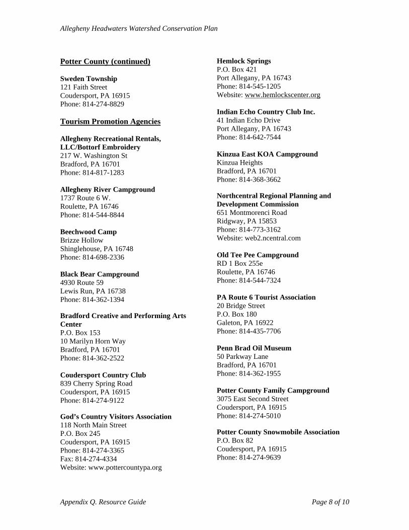
Allegheny Headwaters Watershed Conservation Plan
Potter County (continued) Sweden Township 121 Faith Street Coudersport, PA 16915 Phone: 814-274-8829 Tourism Promotion Agencies Allegheny Recreational Rentals, LLC/Bottorf Embroidery 217 W. Washington St Bradford, PA 16701 Phone: 814-817-1283 Allegheny River Campground 1737 Route 6 W. Roulette, PA 16746 Phone: 814-544-8844 Beechwood Camp Brizze Hollow Shinglehouse, PA 16748 Phone: 814-698-2336 Black Bear Campground 4930 Route 59 Lewis Run, PA 16738 Phone: 814-362-1394 Bradford Creative and Performing Arts Center P.O. Box 153 10 Marilyn Horn Way Bradford, PA 16701 Phone: 814-362-2522 Coudersport Country Club 839 Cherry Spring Road Coudersport, PA 16915 Phone: 814-274-9122 God’s Country Visitors Association 118 North Main Street P.O. Box 245 Coudersport, PA 16915 Phone: 814-274-3365 Fax: 814-274-4334 Website: www.pottercountypa.org
Hemlock Springs P.O. Box 421 Port Allegany, PA 16743 Phone: 814-545-1205 Website: www.hemlockscenter.org Indian Echo Country Club Inc. 41 Indian Echo Drive Port Allegany, PA 16743 Phone: 814-642-7544 Kinzua East KOA Campground Kinzua Heights Bradford, PA 16701 Phone: 814-368-3662 Northcentral Regional Planning and Development Commission 651 Montmorenci Road Ridgway, PA 15853 Phone: 814-773-3162 Website: web2.ncentral.com Old Tee Pee Campground RD 1 Box 255e Roulette, PA 16746 Phone: 814-544-7324 PA Route 6 Tourist Association 20 Bridge Street P.O. Box 180 Galeton, PA 16922 Phone: 814-435-7706 Penn Brad Oil Museum 50 Parkway Lane Bradford, PA 16701 Phone: 814-362-1955 Potter County Family Campground 3075 East Second Street Coudersport, PA 16915 Phone: 814-274-5010 Potter County Snowmobile Association P.O. Box 82 Coudersport, PA 16915 Phone: 814-274-9639
Appendix Q. Resource Guide Page 8 of 10
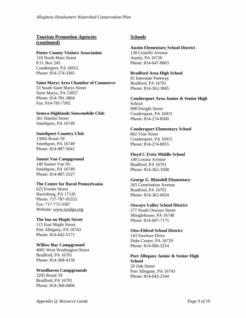
Allegheny Headwaters Watershed Conservation Plan
Tourism Promotion Agencies (continued) Potter County Visitors Association 118 North Main Street P.O. Box 245 Coudersport, PA 16915 Phone: 814-274-3365 Saint Marys Area Chamber of Commerce 53 South Saint Marys Street Saint Marys, PA 15857 Phone: 814-781-3804 Fax: 814-781-7302 Seneca Highlands Snowmobile Club 361 Hamlin Street Smethport, PA 16749 Smethport Country Club 13065 Route 59 Smethport, PA 16749 Phone: 814-887-5641 Sunset Vue Campground 140 Sunset Vue Dr. Smethport, PA 16749 Phone: 814-887-2527 The Center for Rural Pennsylvania 625 Forster Street Harrisburg, PA 17120 Phone: 717-787-95553 Fax: 717-772-3587 Website: www.ruralpa.org The Inn on Maple Street 115 East Maple Street Port Allegany, PA 16743 Phone: 814-642-5171 Willow Bay Campground 4001 West Washington Street Bradford, PA 16701 Phone: 814-368-4158 Woodhaven Campgrounds 3295 Route 59 Bradford, PA 16701 Phone: 814-368-6806
Schools Austin Elementary School District 138 Costello Avenue Austin, PA 16720 Phone: 814-647-8603 Bradford Area High School 81 Interstate Parkway Bradford, PA 16701 Phone: 814-362-3845 Coudersport Area Junior & Senior High School 698 Dwight Street Coudersport, PA 16915 Phone: 814-274-8500 Coudersport Elementary School 802 Vine Street Coudersport, PA 16915 Phone: 814-274-8055 Floyd C Fretz Middle School 140 Lorana Avenue Bradford, PA 16701 Phone: 814-362-3508 George G. Blaisdell Elementary 265 Constitution Avenue Bradford, PA 16701 Phone: 814-362-6834 Oswayo Valley School District 277 South Oswayo Street Shinglehouse, PA 16748 Phone: 814-697-7175 Otto-Eldred School District 143 Sweitzer Drive Duke Center, PA 16729 Phone: 814-966-3214 Port Allegany Junior & Senior High School 20 Oak Street Port Allegany, PA 16743 Phone: 814-642-2544
Appendix Q. Resource Guide Page 9 of 10
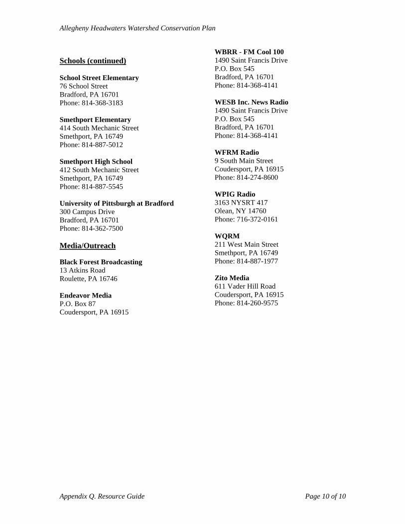
Allegheny Headwaters Watershed Conservation Plan
Appendix Q. Resource Guide Page 10 of 10
Schools (continued) School Street Elementary 76 School Street Bradford, PA 16701 Phone: 814-368-3183 Smethport Elementary 414 South Mechanic Street Smethport, PA 16749 Phone: 814-887-5012 Smethport High School 412 South Mechanic Street Smethport, PA 16749 Phone: 814-887-5545 University of Pittsburgh at Bradford 300 Campus Drive Bradford, PA 16701 Phone: 814-362-7500 Media/Outreach Black Forest Broadcasting 13 Atkins Road Roulette, PA 16746 Endeavor Media P.O. Box 87 Coudersport, PA 16915
WBRR - FM Cool 100 1490 Saint Francis Drive P.O. Box 545 Bradford, PA 16701 Phone: 814-368-4141 WESB Inc. News Radio 1490 Saint Francis Drive P.O. Box 545 Bradford, PA 16701 Phone: 814-368-4141 WFRM Radio 9 South Main Street Coudersport, PA 16915 Phone: 814-274-8600 WPIG Radio 3163 NYSRT 417 Olean, NY 14760 Phone: 716-372-0161 WQRM 211 West Main Street Smethport, PA 16749 Phone: 814-887-1977 Zito Media 611 Vader Hill Road Coudersport, PA 16915 Phone: 814-260-9575
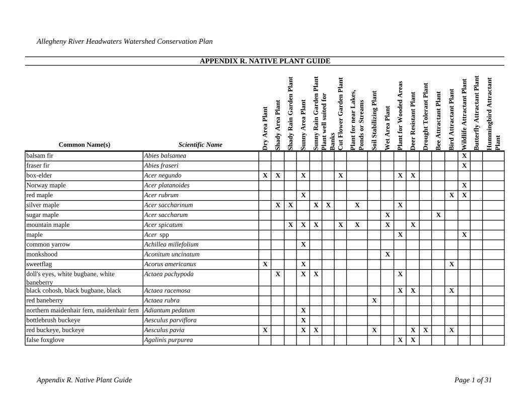
Allegheny River Headwaters Watershed Conservation Plan
APPENDIX R. NATIVE PLANT GUIDE
Common Name(s) Scientific Name Dry
Are
a Pl
ant
Shad
y A
rea
Plan
t
Shad
y R
ain
Gar
den
Plan
t
Sunn
y A
rea
Plan
t
Sunn
y R
ain
Gar
den
Plan
tPl
ant w
ell s
uite
d fo
r B
anks
Cut
Flo
wer
Gar
den
Plan
t
Plan
t for
nea
r L
akes
, Po
nds o
r St
ream
s
Soil
Stab
ilizi
ng P
lant
Wet
Are
a Pl
ant
Plan
t for
Woo
ded
Are
as
Dee
r R
esis
tant
Pla
nt
Dro
ught
Tol
eran
t Pla
nt
Bee
Att
ract
ant P
lant
Bir
d A
ttra
ctan
t Pla
nt
Wild
life
Att
ract
ant P
lant
But
terf
ly A
ttra
ctan
t Pla
nt
Hum
min
gbir
d A
ttra
ctan
t Pl
ant
balsam fir Abies balsamea Xfraser fir Abies fraseri Xbox-elder Acer negundo X X X X X XNorway maple Acer platanoides Xred maple Acer rubrum X X Xsilver maple Acer saccharinum X X X X X Xsugar maple Acer saccharum X Xmountain maple Acer spicatum X X X X X X Xmaple Acer spp X Xcommon yarrow Achillea millefolium Xmonkshood Aconitum uncinatum Xsweetflag Acorus americanus X X Xdoll's eyes, white bugbane, white baneberry
Actaea pachypoda X X X X
black cohosh, black bugbane, black Actaea racemosa X X Xred baneberry Actaea rubra Xnorthern maidenhair fern, maidenhair fern Adiantum pedatum Xbottlebrush buckeye Aesculus parviflora Xred buckeye, buckeye Aesculus pavia X X X X X X Xfalse foxglove Agalinis purpurea X X
Appendix R. Native Plant Guide Page 1 of 31
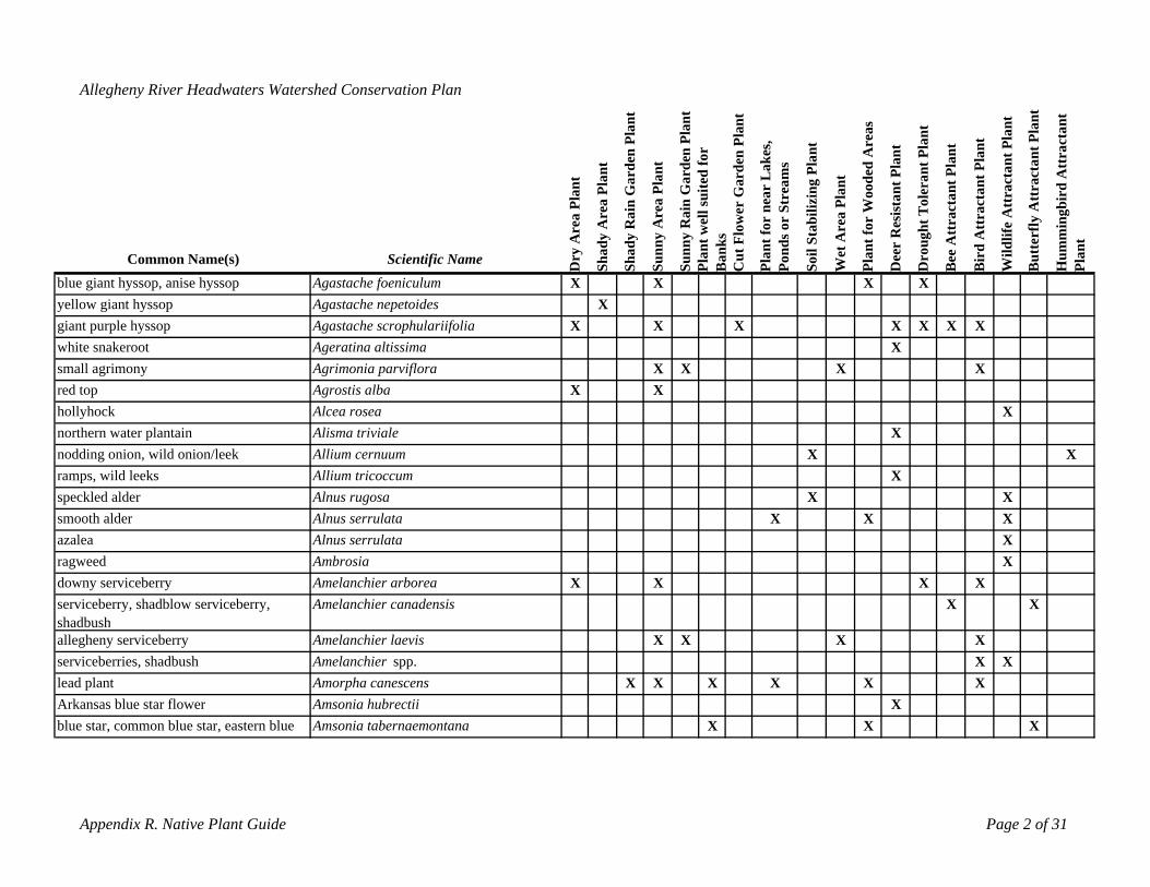
Allegheny River Headwaters Watershed Conservation Plan
Common Name(s) Scientific Name Dry
Are
a Pl
ant
Shad
y A
rea
Plan
t
Shad
y R
ain
Gar
den
Plan
t
Sunn
y A
rea
Plan
t
Sunn
y R
ain
Gar
den
Plan
tPl
ant w
ell s
uite
d fo
r B
anks
Cut
Flo
wer
Gar
den
Plan
t
Plan
t for
nea
r L
akes
, Po
nds o
r St
ream
s
Soil
Stab
ilizi
ng P
lant
Wet
Are
a Pl
ant
Plan
t for
Woo
ded
Are
as
Dee
r R
esis
tant
Pla
nt
Dro
ught
Tol
eran
t Pla
nt
Bee
Att
ract
ant P
lant
Bir
d A
ttra
ctan
t Pla
nt
Wild
life
Att
ract
ant P
lant
But
terf
ly A
ttra
ctan
t Pla
nt
Hum
min
gbir
d A
ttra
ctan
t Pl
ant
blue giant hyssop, anise hyssop Agastache foeniculum X X X Xyellow giant hyssop Agastache nepetoides Xgiant purple hyssop Agastache scrophulariifolia X X X X X X Xwhite snakeroot Ageratina altissima Xsmall agrimony Agrimonia parviflora X X X Xred top Agrostis alba X Xhollyhock Alcea rosea Xnorthern water plantain Alisma triviale Xnodding onion, wild onion/leek Allium cernuum X Xramps, wild leeks Allium tricoccum Xspeckled alder Alnus rugosa X Xsmooth alder Alnus serrulata X X Xazalea Alnus serrulata Xragweed Ambrosia Xdowny serviceberry Amelanchier arborea X X X Xserviceberry, shadblow serviceberry, shadbush
Amelanchier canadensis X X
allegheny serviceberry Amelanchier laevis X X X Xserviceberries, shadbush Amelanchier spp. X Xlead plant Amorpha canescens X X X X X XArkansas blue star flower Amsonia hubrectii Xblue star, common blue star, eastern blue Amsonia tabernaemontana X X X
Appendix R. Native Plant Guide Page 2 of 31
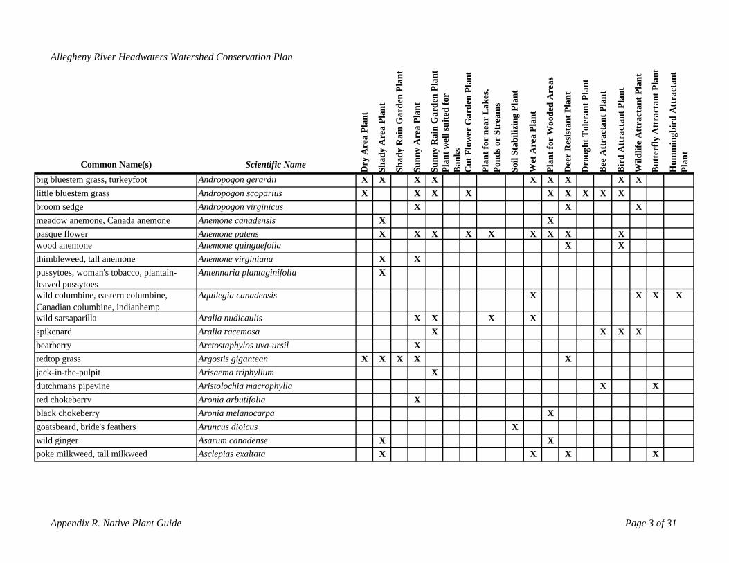
Allegheny River Headwaters Watershed Conservation Plan
Common Name(s) Scientific Name Dry
Are
a Pl
ant
Shad
y A
rea
Plan
t
Shad
y R
ain
Gar
den
Plan
t
Sunn
y A
rea
Plan
t
Sunn
y R
ain
Gar
den
Plan
tla
nt w
ell s
uite
d fo
r an
ksC
ut F
low
er G
arde
n Pl
ant
Plan
t for
nea
r L
akes
, on
ds o
r St
ream
s
Soil
Stab
ilizi
ng P
lant
Wet
Are
a Pl
ant
Plan
t for
Woo
ded
Are
as
Dee
r R
esis
tant
Pla
nt
Dro
ught
Tol
eran
t Pla
nt
ee A
ttra
ctan
t Pla
nt
ird
Att
ract
ant P
lant
Wild
life
Att
ract
ant P
lant
utte
rfly
Att
ract
ant P
lant
Hum
min
gbir
d A
ttra
ctan
t Pl
ant
big bluestem grass, turkeyfoot Andropogon gerardii X X X
P B P
X X X
B
X
B
X
B
Xlittle bluestem grass Andropogon scoparius X X X X X X X X Xbroom sedge Andropogon virginicus X X Xmeadow anemone, Canada anemone Anemone canadensis X Xpasque flower Anemone patens X X X X X X X X Xwood anemone Anemone quinguefolia X Xthimbleweed, tall anemone Anemone virginiana X Xpussytoes, woman's tobacco, plantain-leaved pussytoes
Antennaria plantaginifolia X
wild columbine, eastern columbine, Canadian columbine, indianhemp
Aquilegia canadensis X X X X
wild sarsaparilla Aralia nudicaulis X X X Xspikenard Aralia racemosa X X X Xbearberry Arctostaphylos uva-ursil Xredtop grass Argostis gigantean X X X X Xjack-in-the-pulpit Arisaema triphyllum Xdutchmans pipevine Aristolochia macrophylla X Xred chokeberry Aronia arbutifolia Xblack chokeberry Aronia melanocarpa Xgoatsbeard, bride's feathers Aruncus dioicus Xwild ginger Asarum canadense X Xpoke milkweed, tall milkweed Asclepias exaltata X X X X
Appendix R. Native Plant Guide Page 3 of 31
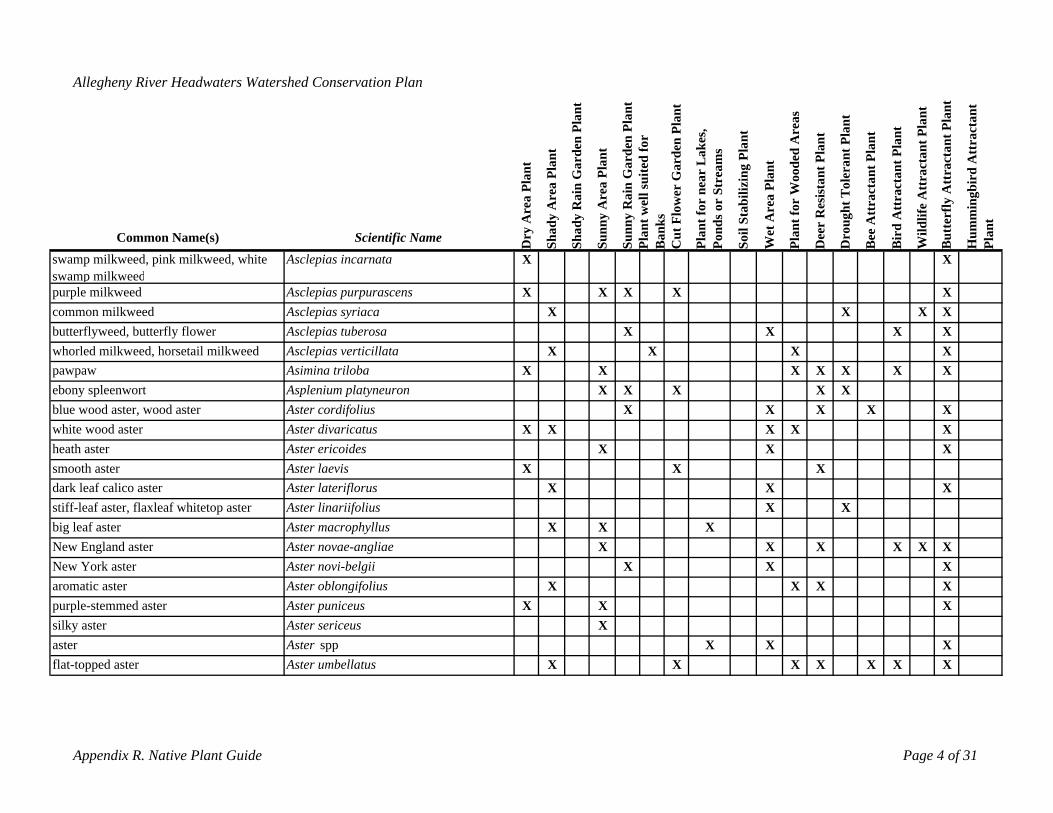
Allegheny River Headwaters Watershed Conservation Plan
Common Name(s) Scientific Name ry A
rea
Plan
t
Shad
y A
rea
Plan
t
Shad
y R
ain
Gar
den
Plan
t
Sunn
y A
rea
Plan
t
Sunn
y R
ain
Gar
den
Plan
tla
nt w
ell s
uite
d fo
r an
ksC
ut F
low
er G
arde
n Pl
ant
Plan
t for
nea
r L
akes
, on
ds o
r St
ream
s
il St
abili
zing
Pla
nt
Wet
Are
a Pl
ant
Plan
t for
Woo
ded
Are
as
Dee
r R
esis
tant
Pla
nt
roug
ht T
oler
ant P
lant
ee A
ttra
ctan
t Pla
nt
ird
Att
ract
ant P
lant
Wild
life
Att
ract
ant P
lant
utte
rfly
Att
ract
ant P
lant
umm
ingb
ird
Att
ract
ant
Plan
t
swamp milkweed, pink milkweed, white Asclepias incarnata
D P B P D B BSo B H
X Xswamp milkweedpurple milkweed Asclepias purpurascens X X X X Xcommon milkweed Asclepias syriaca X X X Xbutterflyweed, butterfly flower Asclepias tuberosa X X X Xwhorled milkweed, horsetail milkweed Asclepias verticillata X X X Xpawpaw Asimina triloba X X X X X X Xebony spleenwort Asplenium platyneuron X X X X Xblue wood aster, wood aster Aster cordifolius X X X X Xwhite wood aster Aster divaricatus X X X X Xheath aster Aster ericoides X X Xsmooth aster Aster laevis X X Xdark leaf calico aster Aster lateriflorus X X Xstiff-leaf aster, flaxleaf whitetop aster Aster linariifolius X Xbig leaf aster Aster macrophyllus X X XNew England aster Aster novae-angliae X X X X X XNew York aster Aster novi-belgii X X Xaromatic aster Aster oblongifolius X X X Xpurple-stemmed aster Aster puniceus X X Xsilky aster Aster sericeus Xaster Aster spp X X Xflat-topped aster Aster umbellatus X X X X X X X
Appendix R. Native Plant Guide Page 4 of 31
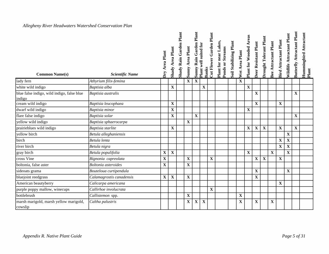
Allegheny River Headwaters Watershed Conservation Plan
cowslip
Common Name(s) Scientific Name ry A
rea
Plan
t
Shad
y A
rea
Plan
t
Shad
y R
ain
Gar
den
Plan
t
Sunn
y A
rea
Plan
t
Sunn
y R
ain
Gar
den
Plan
tnt
wel
l sui
ted
for
nks
Cut
Flo
wer
Gar
den
Plan
t
Plan
t for
nea
r L
akes
, on
ds o
r St
ream
s
il St
abili
zing
Pla
nt
Wet
Are
a Pl
ant
Plan
t for
Woo
ded
Are
as
Dee
r R
esis
tant
Pla
nt
roug
ht T
oler
ant P
lant
ee A
ttra
ctan
t Pla
nt
ird
Att
ract
ant P
lant
Wild
life
Att
ract
ant P
lant
utte
rfly
Att
ract
ant P
lant
umm
ingb
ird
Att
ract
ant
Plan
t
lady fern
D
Athyrium filix-femina X
Pla
P
X
Ba
So D B B B H
Xwhite wild indigo Baptisia alba X X Xblue false indigo, wild indigo, false blue Baptisia australis X Xindigocream wild indigo Baptisia leucophaea X X X
Baptisia minordwarf wild indigoflare false indigo Baptisia solar
X XX X X
Baptisia sphaerocarpayellow wild indigo Xprairieblues wild indigo Baptisia starlite X X X X X Xyellow birch Betula alleghaniensis Xbirch Betula lenta X Xriver birch Betula nigra X Xgray birch Betula populifolia X X X X Xcross Vine Bignonia capreolata X X X X X Xboltonia, false aster Boltonia asteroides X Xsideoats grama Bouteloua curtipendula X Xbluejoint reedgrass Calamagrostis canadensis X X X XAmerican beautyberry Calicarpa americana Xpurple poppy mallow, winecups Callirhoe involucrata Xbottlebrushmarsh marigold, marsh yellow marigold,
Callistemon spp.Caltha palustris
XX X X
XX X X
Appendix R. Native Plant Guide Page 5 of 31
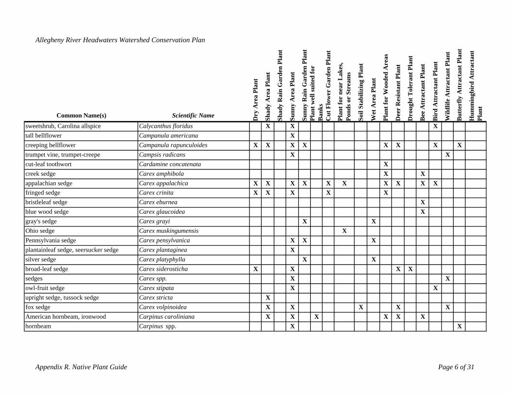
Allegheny River Headwaters Watershed Conservation Plan
hornbeam Carpinus spp. X X
Common Name(s) Scientific Name ry A
rea
Plan
t
dy A
rea
Plan
t
dy R
ain
Gar
den
Plan
t
Sunn
y A
rea
Plan
t
Sunn
y R
ain
Gar
den
Plan
tnt
wel
l sui
ted
for
nks
Cut
Flo
wer
Gar
den
Plan
t
Plan
t for
nea
r L
akes
, nd
s or
Stre
ams
il St
abili
zing
Pla
nt
Wet
Are
a Pl
ant
Plan
t for
Woo
ded
Are
as
Dee
r R
esis
tant
Pla
nt
roug
ht T
oler
ant P
lant
ee A
ttra
ctan
t Pla
nt
rd A
ttra
ctan
t Pla
nt
Wild
life
Att
ract
ant P
lant
utte
rfly
Att
ract
ant P
lant
umm
ingb
ird
Att
ract
ant
Plan
t
D Sha
Sha
Po D BPla
Ba
So Bi
B H
sweetshrub, Carolina allspice Calycanthus floridus X X Xtall bellflower Campanula americana Xcreeping bellflower Campanula rapunculoides X X X X XX X Xtrumpet vine, trumpet-creepe Campsis radicans X Xcut-leaf toothwort Cardamine concatenata Xcreek sedge Carex amphibola X Xappalachian sedge Carex appalachica X X X X X X X X X Xfringed sedge Carex crinita X X X X Xbristleleaf sedge Carex eburnea Xblue wood sedge Carex glaucoidea Xgray's sedge Carex grayi X XOhio sedge Carex muskingumensis XPennsylvania sedge Carex pensylvanica X X Xplantainleaf sedge, seersucker sedge Carex plantaginea Xsilver sedge Carex platyphylla X Xbroad-leaf sedge Carex siderosticha X X X Xsedges Carex spp. X Xowl-fruit sedge Carex stipata X Xupright sedge, tussock sedge Carex stricta Xfox sedge Carex volpinoidea X X X X XAmerican hornbeam, ironwood Carpinus caroliniana X X X X X X
Appendix R. Native Plant Guide Page 6 of 31
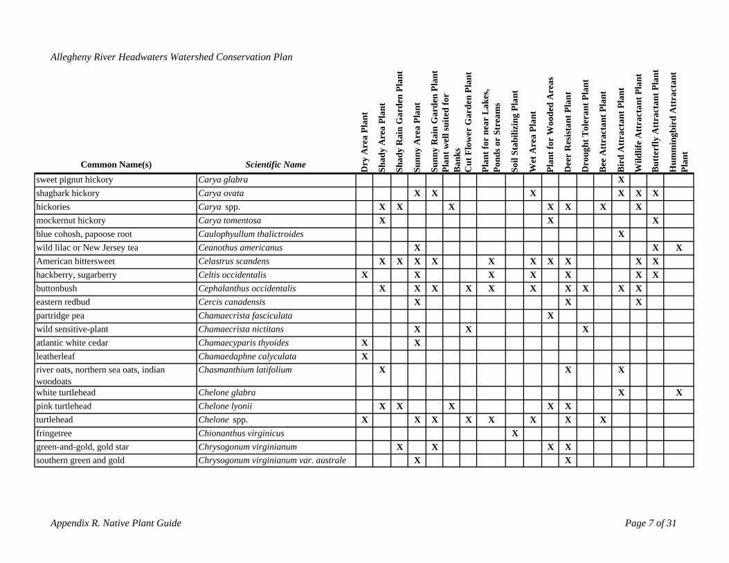
southern green and gold Chrysogonum virginianum var. australe X X
Appendix R. Native Plant Guide Page 7 of 31
Allegheny River Headwaters Watershed Conservation Plan
y A
rea
Plan
t
dy A
rea
Plan
t
dy R
ain
Gar
den
Plan
t
Sunn
y A
rea
Plan
t
Sunn
y R
ain
Gar
den
Plan
tnt
wel
l sui
ted
for
nks
Cut
Flo
wer
Gar
den
Plan
t
t for
nea
r L
akes
, nd
s or
Stre
ams
il St
abili
zing
Pla
nt
Wet
Are
a Pl
ant
t for
Woo
ded
Are
as
Dee
r R
esis
tant
Pla
nt
ough
t Tol
eran
t Pla
nt
ee A
ttra
ctan
t Pla
nt
rd A
ttra
ctan
t Pla
nt
Wild
life
Att
ract
ant P
lant
tter
fly A
ttra
ctan
t Pla
nt
mm
ingb
ird
Att
ract
ant
t
Common Name(s) Scientific Name Dr
Sha
Sha
Pla
Ba
Plan
Po So Plan
Dr
B Bi
Bu
Hu
Plan
sweet pignut hickory Carya glabra Xshagbark hickory Carya ovata X X X X X Xhickories Carya spp. X X X X X X Xmockernut hickory Carya tomentosa X X Xblue cohosh, papoose root Caulophyullum thalictroides Xwild lilac or New Jersey tea Ceanothus americanus X X XAmerican bittersweet Celastrus scandens X X X X X X X X X Xhackberry, sugarberry Celtis occidentalis X X X X X X Xbuttonbush Cephalanthus occidentalis X X X X X X X X X Xeastern redbud Cercis canadensis X X Xpartridge pea Chamaecrista fasciculata Xwild sensitive-plant Chamaecrista nictitans X X Xatlantic white cedar Chamaecyparis thyoides X Xleatherleafriver oats, northern sea oats, indian
Chamaedaphne calyculata XChasmanthium latifolium X X X
woodoatswhite turtlehead Chelone glabra X Xpink turtlehead Chelone lyonii X X X X Xturtlehead Chelone spp. X X X X X X X Xfringetree Chionanthus virginicus Xgreen-and-gold, gold star Chrysogonum virginianum X X X X
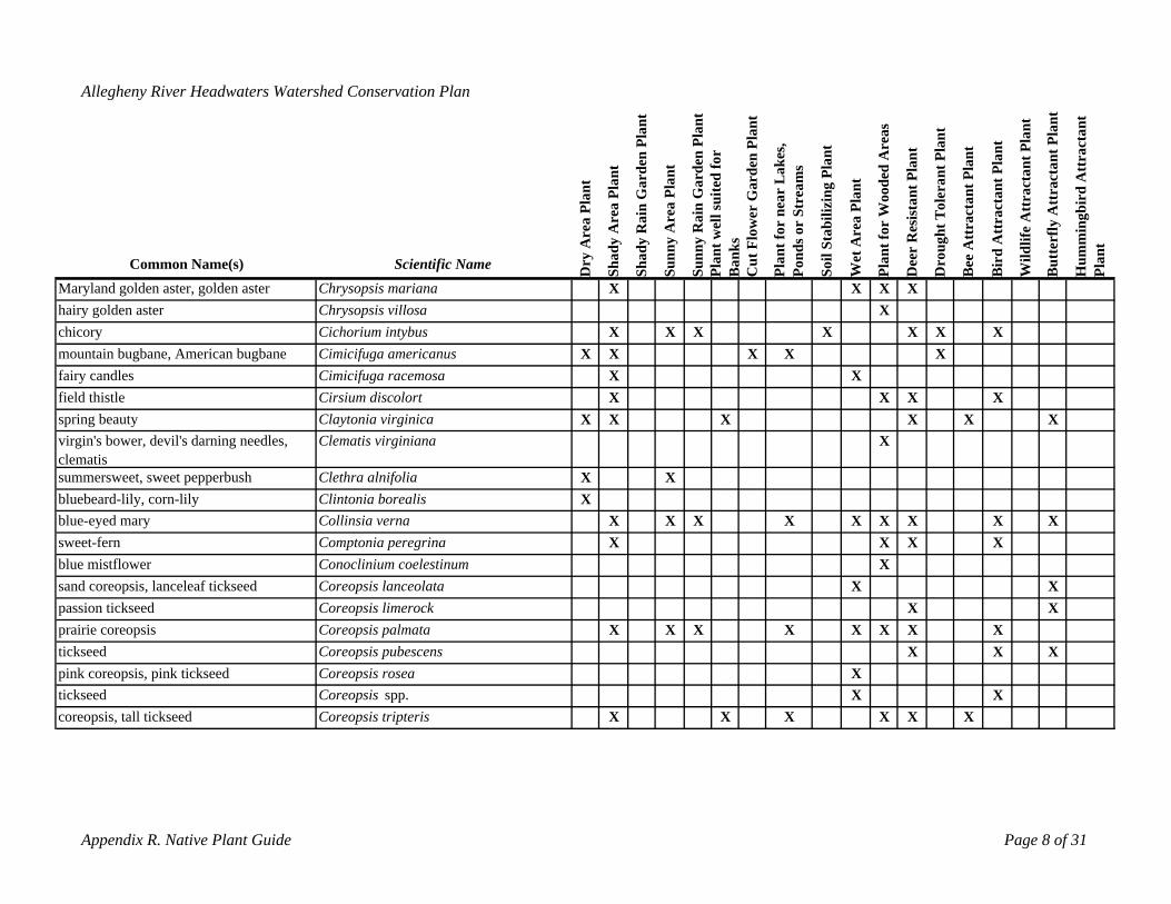
coreopsis, tall tickseed Coreopsis tripteris X X X X X X
Appendix R. Native Plant Guide Page 8 of 31
Allegheny River Headwaters Watershed Conservation Plan
y A
rea
Plan
t
dy A
rea
Plan
t
dy R
ain
Gar
den
Plan
t
Sunn
y A
rea
Plan
t
Sunn
y R
ain
Gar
den
Plan
tnt
wel
l sui
ted
for
nks
Cut
Flo
wer
Gar
den
Plan
t
t for
nea
r L
akes
, nd
s or
Stre
ams
il St
abili
zing
Pla
nt
Wet
Are
a Pl
ant
t for
Woo
ded
Are
as
Dee
r R
esis
tant
Pla
nt
ough
t Tol
eran
t Pla
nt
ee A
ttra
ctan
t Pla
nt
rd A
ttra
ctan
t Pla
nt
Wild
life
Att
ract
ant P
lant
tter
fly A
ttra
ctan
t Pla
nt
mm
ingb
ird
Att
ract
ant
t
Common Name(s) Scientific Name Dr
Sha
PoSha
Pla
Ba
Plan
So Plan
Dr
B Bi
Bu
Hu
Plan
Maryland golden aster, golden aster Chrysopsis mariana X X X Xhairy golden aster Chrysopsis villosa Xchicory Cichorium intybus X X X X X X Xmountain bugbane, American bugbane Cimicifuga americanus X X X X Xfairy candles Cimicifuga racemosa X Xfield thistle Cirsium discolort X X X Xspring beautyvirgin's bower, devil's darning needles,
Claytonia virginica X X XClematis virginiana
X X XX
clematissummersweet, sweet pepperbush Clethra alnifolia X Xbluebeard-lily, corn-lily Clintonia borealis Xblue-eyed mary Collinsia verna X X X X X X X X Xsweet-fern Comptonia peregrina X X X Xblue mistflower Conoclinium coelestinum Xsand coreopsis, lanceleaf tickseed Coreopsis lanceolata X Xpassion tickseed Coreopsis limerock X Xprairie coreopsis Coreopsis palmata X X X X X X X Xtickseed Coreopsis pubescens X X Xpink coreopsis, pink tickseed Coreopsis rosea Xtickseed Coreopsis spp. X X
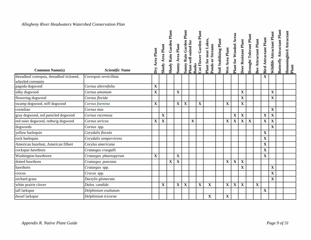
dwarf larkspur Delphinium tricorne X X
Appendix R. Native Plant Guide Page 9 of 31
Allegheny River Headwaters Watershed Conservation Plan
y A
rea
Plan
t
dy A
rea
Plan
t
dy R
ain
Gar
den
Plan
t
Are
a Pl
ant
Rai
n G
arde
n Pl
ant
nt w
ell s
uite
d fo
r ks
Cut
Flo
wer
Gar
den
Plan
t
t for
nea
r L
akes
, nd
s or
Stre
ams
il St
abili
zing
Pla
nt
Wet
Are
a Pl
ant
t for
Woo
ded
Are
as
Dee
r R
esis
tant
Pla
nt
ough
t Tol
eran
t Pla
nt
ee A
ttra
ctan
t Pla
nt
Att
ract
ant P
lant
Wild
life
Att
ract
ant P
lant
tter
fly A
ttra
ctan
t Pla
nt
mm
ingb
ird
Att
ract
ant
t
Common Name(s)threadleaf coreopsis, threadleaf tickseed,
Scientific Name Dr
Sha
Sha
Sunn
y
Sunn
yPl
aB
an
Plan
Po So Plan
Dr
B
Coreopsis verticillata
Bir
d
Bu
Hu
Plan
Xwhorled coreopsispagoda dogwood Cornus alternifolia Xsilky dogwood Cornus amomum X X X Xflowering dogwood Cornus florida X Xswamp dogwood, stiff dogwood Cornus foemina X X X X X Xcornelian Cornus mas Xgray dogwood, red panicled dogwood Cornus racemosa X X X X Xred osier dogwood, redtwig dogwood Cornus sericea X X X X X X X X Xdogwoods Cornus spp. Xyellow harlequin Corydalis flavula Xrock harlequin Corydalis sempervirens XAmerican hazelnut, American filbert Corylus americana Xcockspur hawthorn Crataegus crusgalli XWashington hawthrorn Crataegus phaenopyrum X X Xdotted hawthorn Crataegus punctata X X X X Xhawthorn Crataegus spp. X Xcrocus Crocus spp. Xorchard grass Dactylis glomerata Xwhite prairie clover Dalea candida X X X X X X X X Xtall larkspur Delphinium exaltatum X
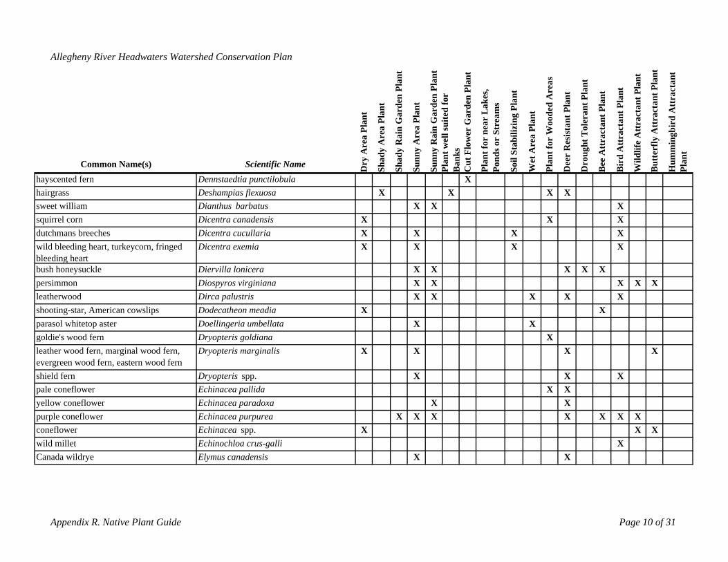
Canada wildrye Elymus canadensis X X
Appendix R. Native Plant Guide Page 10 of 31
Allegheny River Headwaters Watershed Conservation Plan
y A
rea
Plan
t
dy A
rea
Plan
t
dy R
ain
Gar
den
Plan
t
Are
a Pl
ant
Rai
n G
arde
n Pl
ant
nt w
ell s
uite
d fo
r ks
Cut
Flo
wer
Gar
den
Plan
t
t for
nea
r L
akes
, nd
s or
Stre
ams
il St
abili
zing
Pla
nt
Wet
Are
a Pl
ant
t for
Woo
ded
Are
as
Dee
r R
esis
tant
Pla
nt
ough
t Tol
eran
t Pla
nt
ee A
ttra
ctan
t Pla
nt
Att
ract
ant P
lant
Wild
life
Att
ract
ant P
lant
tter
fly A
ttra
ctan
t Pla
nt
mm
ingb
ird
Att
ract
ant
t
Common Name(s) Scientific Name Dr
Sha
Sha
Sunn
y
Sunn
yPl
aB
an
Plan
Po So Plan
Dr
B Bir
d
Bu
Hu
Plan
hayscented fern Dennstaedtia punctilobula Xhairgrass Deshampias flexuosa X X X Xsweet william Dianthus barbatus X X Xsquirrel corn Dicentra canadensis X X Xdutchmans breeches wild bleeding heart, turkeycorn, fringed
Dicentra cucullaria Dicentra exemia
X XX X
XX
XX
bleeding heart bush honeysuckle Diervilla lonicera X X XX Xpersimmon Diospyros virginiana X X X X Xleatherwood Dirca palustris X X X X Xshooting-star, American cowslips Dodecatheon meadia X Xparasol whitetop aster Doellingeria umbellata X Xgoldie's wood fernleather wood fern, marginal wood fern,
Dryopteris goldiana Dryopteris marginalis X
XX X X
evergreen wood fern, eastern wood fernshield fern Dryopteris spp. X X Xpale coneflower Echinacea pallida X Xyellow coneflower Echinacea paradoxa X Xpurple coneflower Echinacea purpurea X X X X X X Xconeflower Echinacea spp. X X Xwild millet Echinochloa crus-galli X
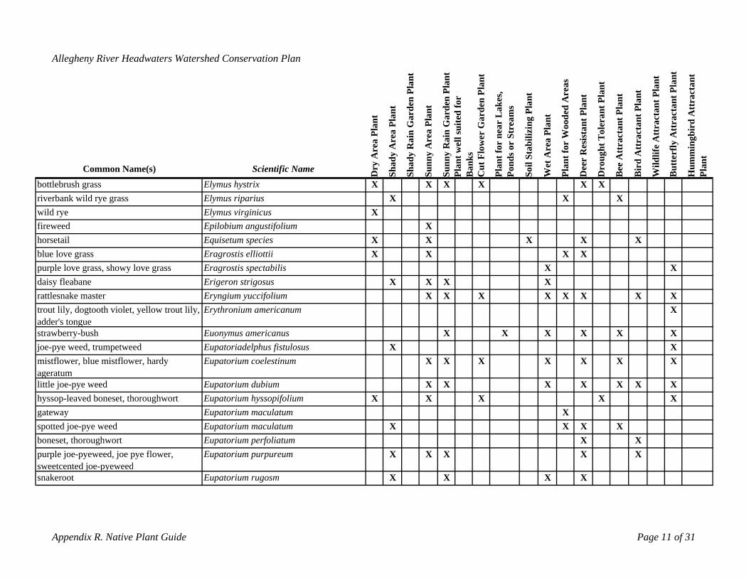
sweetcented joe-pyeweedsnakeroot Eupatorium rugosm X X X X
Appendix R. Native Plant Guide Page 11 of 31
Allegheny River Headwaters Watershed Conservation Plan
y A
rea
Plan
t
dy A
rea
Plan
t
dy R
ain
Gar
den
Plan
t
Are
a Pl
ant
Rai
n G
arde
n Pl
ant
t wel
l sui
ted
for
ksC
ut F
low
er G
arde
n Pl
ant
t for
nea
r L
akes
, nd
s or
Stre
ams
il St
abili
zing
Pla
nt
Wet
Are
a Pl
ant
t for
Woo
ded
Are
as
Dee
r R
esis
tant
Pla
nt
ght T
oler
ant P
lant
ee A
ttra
ctan
t Pla
nt
Att
ract
ant P
lant
Wild
life
Att
ract
ant P
lant
tter
fly A
ttra
ctan
t Pla
nt
mm
ingb
ird
Att
ract
ant
t
Common Name(s) Scientific Name r
Sha
Sha
Sunn
y
Sunn
yn n
Pla
Ba oPlan
So Plan ro
u
ird
u
Hu
Plan
bottlebrush grass
D
Elymus hystrix X
P
X X X
D
X X
B B B
riverbank wild rye grass Elymus riparius X X Xwild rye Elymus virginicus Xfireweed Epilobium angustifolium Xhorsetail Equisetum species X X X X Xblue love grass Eragrostis elliottii X X X Xpurple love grass, showy love grass Eragrostis spectabilis X Xdaisy fleabane Erigeron strigosus X X X Xrattlesnake master Eryngium yuccifolium X X X X X X X Xtrout lily, dogtooth violet, yellow trout lily, Erythronium americanum Xadder's tonguestrawberry-bush Euonymus americanus X X X X X Xjoe-pye weed, trumpetweed Eupatoriadelphus fistulosus X Xmistflower, blue mistflower, hardy Eupatorium coelestinum X X X X X X Xageratumlittle joe-pye weed Eupatorium dubium X X X X X X Xhyssop-leaved boneset, thoroughwort Eupatorium hyssopifolium X X X X Xgateway Eupatorium maculatum Xspotted joe-pye weed Eupatorium maculatum X X X Xboneset, thoroughwort Eupatorium perfoliatum X Xpurple joe-pyeweed, joe pye flower, Eupatorium purpureum X X X X X
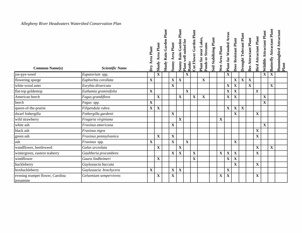
X
evening trumpet flower, Carolina jessamine
Appendix R. Native Plant Guide Page 12 of 31
Gelsemium sempervirens X X X X X
Allegheny River Headwaters Watershed Conservation Plan
rea
Plan
t
dy A
rea
Plan
t
dy R
ain
Gar
den
Plan
t
Are
a Pl
ant
Rai
n G
arde
n Pl
ant
t wel
l sui
ted
for
Cut
Flo
wer
Gar
den
Plan
t
t for
nea
r L
akes
, nd
s or
Stre
ams
il St
abili
zing
Pla
nt
Wet
Are
a Pl
ant
t for
Woo
ded
Are
as
ista
nt P
lant
ght T
oler
ant P
lant
ee A
ttra
ctan
t Pla
nt
Att
ract
ant P
lant
Wild
life
Att
ract
ant P
lant
tter
fly A
ttra
ctan
t Pla
nt
mm
ingb
ird
Att
ract
ant
t
Common Name(s) Scientific Name ry A
Sha n
Sha
Sunn
y
Sunn
yPl
a oBan
ks
Plan la
n
r i
Dee
r R
es
ou rd u uPl
an
joe-pye-weed Eupatorium spp.
D
X X
P P
X
So D B B B H
X Xflowering spurge Euphorbia corollata X X X X X X Xwhite wood aster Eurybia divaricata X X X X Xflat-top goldentop Euthamia graminifolia X X X XAmerican beech Fagus grandiflora X X X X X X Xbeech Fagus spp. X Xqueen-of-the-prairie Filipendula rubra X X X X Xdwarf fothergilla Fothergilla gardenii X X Xwild strawberry Fragaria virginiana X Xwhite ash Fraxinus americana X Xblack ash Fraxinus nigra Xgreen ash Fraxinus pennsylvanica X X Xash Fraxinus spp. X X X Xwandflower, beetleweed Galax urceolata X X X Xwintergreen, eastern teaberry Gaultheria procumbens X X X X X X Xwindflower Gaura lindheimeri X X X Xhuckleberry Gaylussacia baccata X Xboxhuckleberry Gaylussacia brachycera X X X X
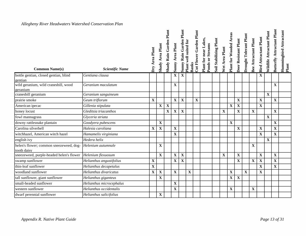
western sunflower Helianthus occidentalis X X Xdwarf perennial sunflower Helianthus salicifolius X
Appendix R. Native Plant Guide Page 13 of 31
Allegheny River Headwaters Watershed Conservation Plan
rea
Plan
t
Are
a Pl
ant
Rai
n G
arde
n Pl
ant
Are
a Pl
ant
Rai
n G
arde
n Pl
ant
wel
l sui
ted
for
Cut
Flo
wer
Gar
den
Plan
t
t for
nea
r L
akes
, nd
s or
Stre
ams
biliz
ing
Plan
t
Wet
Are
a Pl
ant
t for
Woo
ded
Are
as
ista
nt P
lant
ght T
oler
ant P
lant
ee A
ttra
ctan
t Pla
nt
Att
ract
ant P
lant
Wild
life
Att
ract
ant P
lant
tter
fly A
ttra
ctan
t Pla
nt
mm
ingb
ird
Att
ract
ant
Common Name(s) Scientific Name Dry
A
Shad
y
Shad
y
Sunn
y
Sunn
ynt
Po Dr
BPla
Ban
ks
Plan
Soil
Sta
Plan
Dee
r R
es
ou
Bir
d
Bu
Hu
Plan
t
bottle gentian, closed gentian, blind gentian
Gentiana clausa X X X
wild geranium, wild cranesbill, wood Geranium maculatum X Xgeraniumcranesbill geranium Geranium sanguineum Xprairie smoke Geum triflorum X X X X X X XAmerican ipecac Gillenia stipulata X X X X Xhoney locust Gleditsia triacanthos X X X X X X Xfowl mannagrass Glyceria striata Xdowny rattlesnake plantain Goodyera pubescens X X XCarolina silverbell Halesia caroliana X X X X X Xwitchhazel, American witch hazelenglish ivy
Hamamelis virginiana Hedera helix
X X XX
helen's flower; common sneezeweed, dog- Helenium autumnale X Xtooth daisysneezeweed, purple-headed helen's flower Helenium flexuosum X X X X X X Xswamp sunflower Helianthus angustifolius X X X X X X Xthin-leaf sunflower Helianthus decapetalus X X Xwoodland sunflower Helianthus divaricatus X X X X X X Xtall sunflower, giant sunflower Helianthus giganteus X X Xsmall-headed sunflower Helianthus microcephalus X
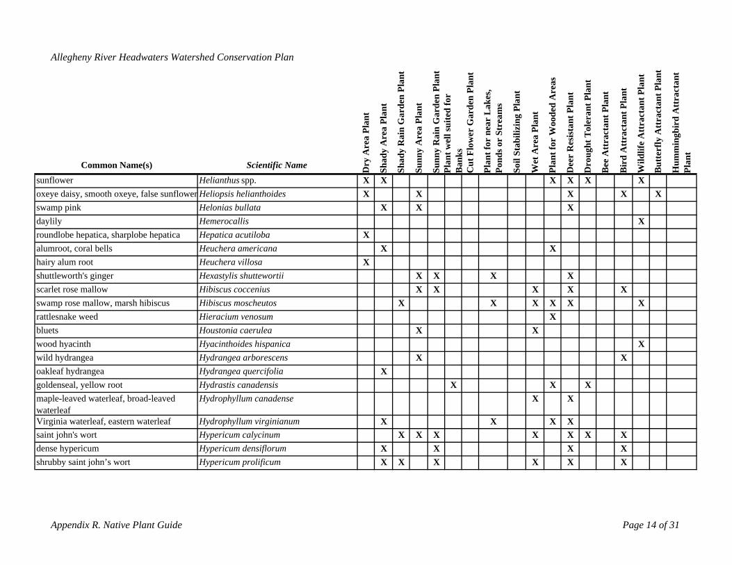
dense hypericum Hypericum densiflorum X X X Xshrubby saint john’s wort Hypericum prolificum X X X X X X
Appendix R. Native Plant Guide Page 14 of 31
Allegheny River Headwaters Watershed Conservation Plan
rea
Plan
t
Are
a Pl
ant
Rai
n G
arde
n Pl
ant
Are
a Pl
ant
Rai
n G
arde
n Pl
ant
wel
l sui
ted
for
Cut
Flo
wer
Gar
den
Plan
t
t for
nea
r L
akes
, r
Stre
ams
biliz
ing
Plan
t
Wet
Are
a Pl
ant
t for
Woo
ded
Are
as
ista
nt P
lant
ght T
oler
ant P
lant
ee A
ttra
ctan
t Pla
nt
Att
ract
ant P
lant
Wild
life
Att
ract
ant P
lant
tter
fly A
ttra
ctan
t Pla
nt
mm
ingb
ird
Att
ract
ant
ry A dy ntdy
Sunn
y
Sunn
y
nks
Plan nd
s o
il St
a
an
Dee
r R
es
rou
rd u uPl
ant
Common Name(s) Scientific Name D Sha
Sha
Po PlPla
Ba
So D B Bi
B H
sunflower Helianthus spp. X X X X X Xoxeye daisy, smooth oxeye, false sunflower Heliopsis helianthoides X X X X Xswamp pink Helonias bullata X X Xdaylily Hemerocallis Xroundlobe hepatica, sharplobe hepatica Hepatica acutiloba Xalumroot, coral bells Heuchera americana X Xhairy alum root Heuchera villosa Xshuttleworth's ginger Hexastylis shuttewortii X X X Xscarlet rose mallow Hibiscus coccenius X X X X Xswamp rose mallow, marsh hibiscus Hibiscus moscheutos X X X X X Xrattlesnake weed Hieracium venosum Xbluets Houstonia caerulea X Xwood hyacinth Hyacinthoides hispanica Xwild hydrangea Hydrangea arborescens X Xoakleaf hydrangea goldenseal, yellow root
Hydrangea quercifolia XHydrastis canadensis X X X
maple-leaved waterleaf, broad-leaved Hydrophyllum canadense X XwaterleafVirginia waterleaf, eastern waterleaf Hydrophyllum virginianum X X X Xsaint john's wort Hypericum calycinum X X X X X X X
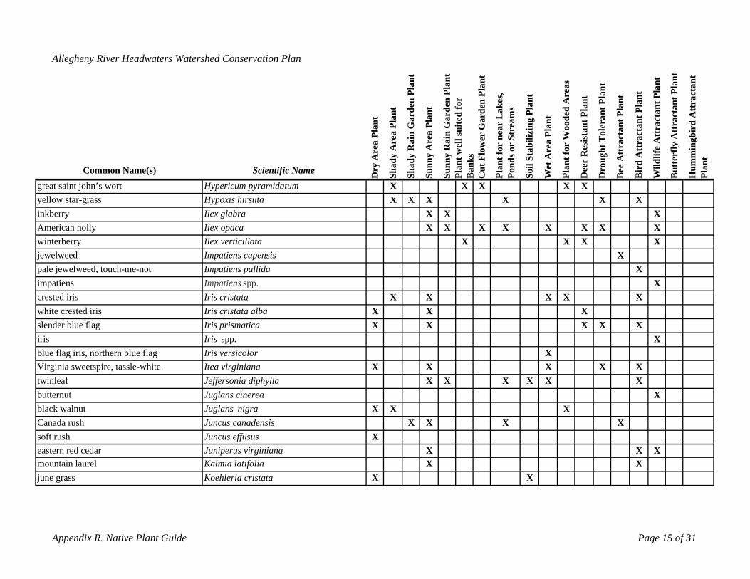
mountain laurel Kalmia latifolia X Xjune grass Koehleria cristata X X
Appendix R. Native Plant Guide Page 15 of 31
Allegheny River Headwaters Watershed Conservation Plan
rea
Plan
t
Are
a Pl
ant
Rai
n G
arde
n Pl
ant
Are
a Pl
ant
Rai
n G
arde
n Pl
ant
wel
l sui
ted
for
Cut
Flo
wer
Gar
den
Plan
t
t for
nea
r L
akes
, r
Stre
ams
biliz
ing
Plan
t
Wet
Are
a Pl
ant
t for
Woo
ded
Are
as
ista
nt P
lant
ght T
oler
ant P
lant
ee A
ttra
ctan
t Pla
nt
Att
ract
ant P
lant
Wild
life
Att
ract
ant P
lant
tter
fly A
ttra
ctan
t Pla
nt
mm
ingb
ird
Att
ract
ant
y A dy nt
dy
Sunn
y
Sunn
y
nks
n nds o
il St
a
Dee
r R
es
ou rd
t
Common Name(s) Scientific Name Dr
Sha
Sha
Pla
Ba
Pla
Po So Plan
Dr
B Bi
Bu
Hu
Plan
great saint john’s wort Hypericum pyramidatum X X X X Xyellow star-grass Hypoxis hirsuta X X X X X Xinkberry Ilex glabra X X XAmerican holly Ilex opaca X X X X X X X Xwinterberry Ilex verticillata X X X Xjewelweed Impatiens capensis Xpale jewelweed, touch-me-not Impatiens pallida Ximpatiens Impatiens spp. Xcrested iris Iris cristata X X X X Xwhite crested iris Iris cristata alba X X Xslender blue flag Iris prismatica X X X X Xiris Iris spp. Xblue flag iris, northern blue flag Iris versicolor XVirginia sweetspire, tassle-white Itea virginiana X X X X Xtwinleaf Jeffersonia diphylla X X X X X Xbutternut Juglans cinerea Xblack walnut Juglans nigra X X XCanada rush Juncus canadensis X X X Xsoft rush Juncus effusus Xeastern red cedar Juniperus virginiana X X X
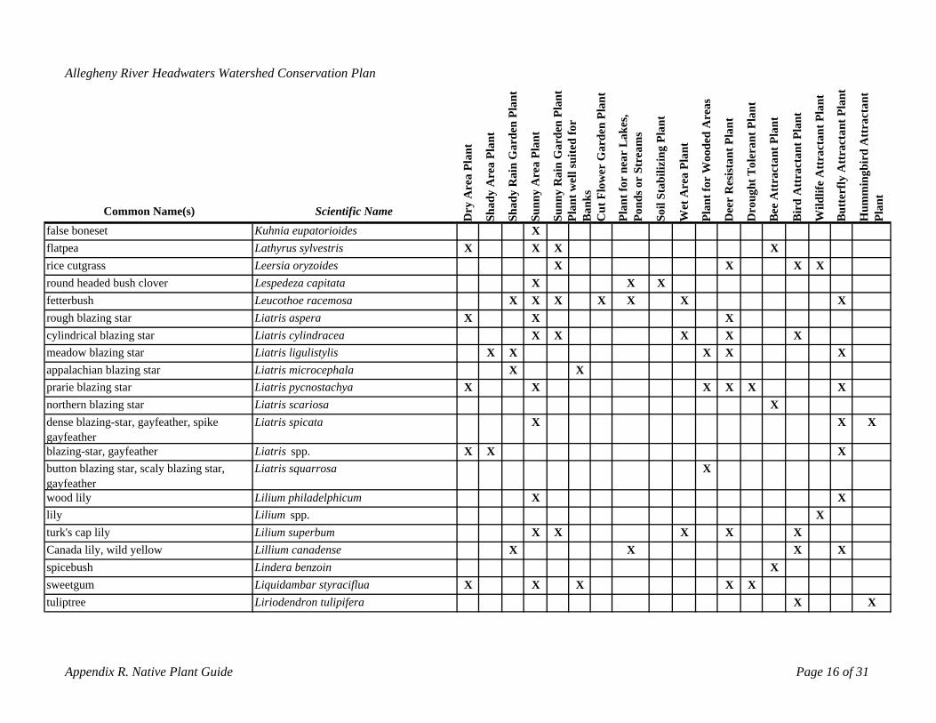
sweetgum Liquidambar styraciflua X X X X Xtuliptree Liriodendron tulipifera X X
Appendix R. Native Plant Guide Page 16 of 31
Allegheny River Headwaters Watershed Conservation Plan
rea
Plan
t
Are
a Pl
ant
Rai
n G
arde
n Pl
ant
Are
a Pl
ant
Rai
n G
arde
n Pl
ant
wel
l sui
ted
for
Cut
Flo
wer
Gar
den
Plan
t
t for
nea
r L
akes
, r
Stre
ams
biliz
ing
Plan
t
Wet
Are
a Pl
ant
t for
Woo
ded
Are
as
ista
nt P
lant
t Tol
eran
t Pla
nt
ee A
ttra
ctan
t Pla
nt
Att
ract
ant P
lant
Wild
life
Att
ract
ant P
lant
tter
fly A
ttra
ctan
t Pla
nt
mm
ingb
ird
Att
ract
ant
y A dy dy
Sunn
y
Sunn
ynt
nk
s
nds o
il St
a
Dee
r R
es
ough
rd
t
Common Name(s) Scientific Name Dr
Sha
Sha
Pla
Po Dr
Ba
Plan
So Plan
B Bi
Bu
Hu
Plan
false boneset Kuhnia eupatorioides Xflatpea Lathyrus sylvestris X X X Xrice cutgrass Leersia oryzoides X X X Xround headed bush clover Lespedeza capitata X X Xfetterbush Leucothoe racemosa X X X X X X Xrough blazing star Liatris aspera X X Xcylindrical blazing star Liatris cylindracea X X X X Xmeadow blazing star Liatris ligulistylis X X X X Xappalachian blazing star Liatris microcephala X Xprarie blazing starnorthern blazing star
Liatris pycnostachya XLiatris scariosa
X X X XX
X
dense blazing-star, gayfeather, spike Liatris spicata X X Xgayfeather blazing-star, gayfeather Liatris spp. X X Xbutton blazing star, scaly blazing star, Liatris squarrosa Xgayfeatherwood lily Lilium philadelphicum X Xlily Lilium spp. Xturk's cap lily Lilium superbum X X X X XCanada lily, wild yellow Lillium canadense X X X Xspicebush Lindera benzoin X
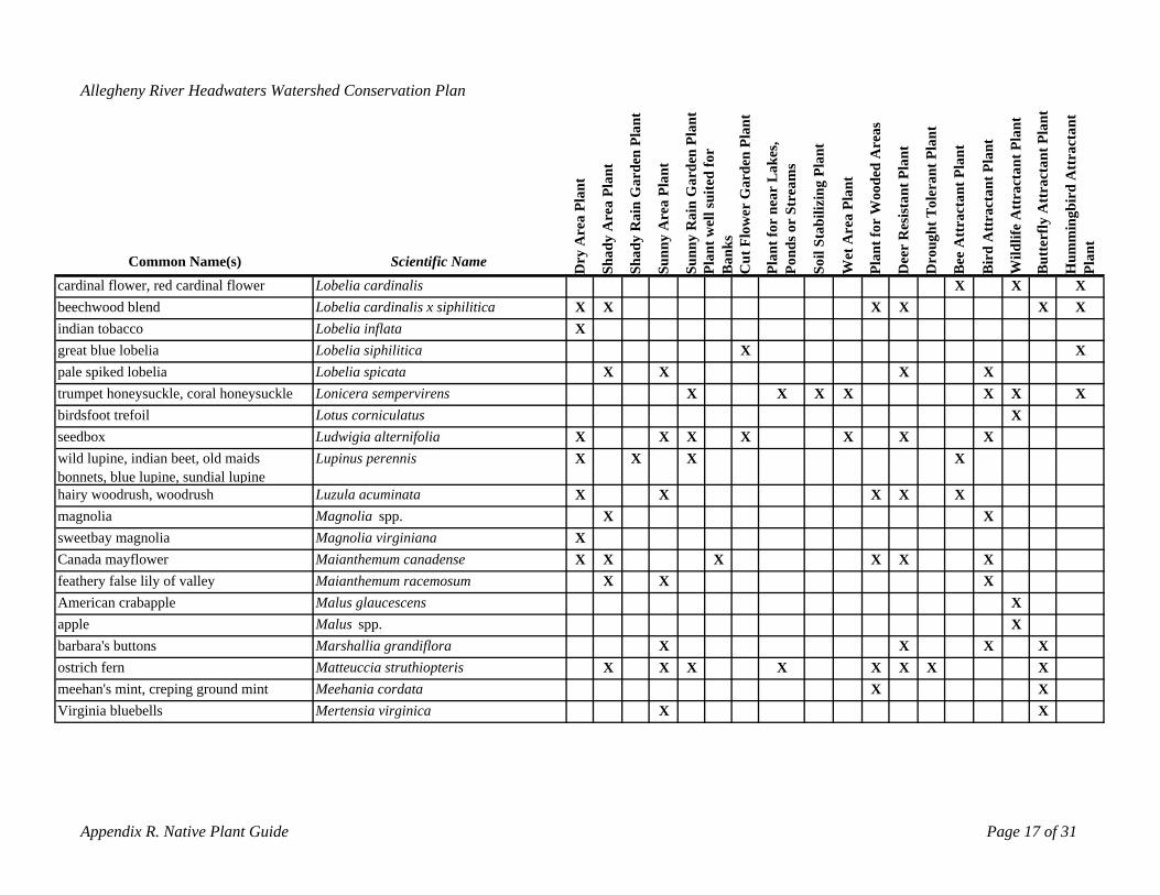
meehan's mint, creping ground mint Meehania cordata X XVirginia bluebells Mertensia virginica X X
Appendix R. Native Plant Guide Page 17 of 31
Allegheny River Headwaters Watershed Conservation Plan
rea
Plan
t
Are
a Pl
ant
Rai
n G
arde
n Pl
ant
Are
a Pl
ant
Rai
n G
arde
n Pl
ant
ell s
uite
d fo
r
Cut
Flo
wer
Gar
den
Plan
t
t for
nea
r L
akes
, r
Stre
ams
biliz
ing
Plan
t
Wet
Are
a Pl
ant
t for
Woo
ded
Are
as
ista
nt P
lant
t Tol
eran
t Pla
nt
ee A
ttra
ctan
t Pla
nt
Att
ract
ant P
lant
Wild
life
Att
ract
ant P
lant
tter
fly A
ttra
ctan
t Pla
nt
bird
Att
ract
ant
y A dy dy nt w
nks
nds o
il St
a
n
Dee
r R
es
ough
mm
ing
t
Common Name(s) Scientific Name Dr
Sha
PoSha
Sunn
y
Sunn
yPl
aB
a
Plan
So Pla
Dr
B Bir
d
Bu
Hu
Plan
cardinal flower, red cardinal flower Lobelia cardinalis X X Xbeechwood blend Lobelia cardinalis x siphilitica X X X X X Xindian tobacco Lobelia inflata Xgreat blue lobelia Lobelia siphilitica X Xpale spiked lobelia Lobelia spicata X X X Xtrumpet honeysuckle, coral honeysuckle Lonicera sempervirens X X X X X X Xbirdsfoot trefoilseedbox
Lotus corniculatus Ludwigia alternifolia X X X X X X
XX
wild lupine, indian beet, old maids Lupinus perennis X X X Xbonnets, blue lupine, sundial lupinehairy woodrush, woodrush Luzula acuminata X X X X Xmagnolia Magnolia spp. X Xsweetbay magnolia Magnolia virginiana XCanada mayflower Maianthemum canadense X X X X X Xfeathery false lily of valley Maianthemum racemosum X X XAmerican crabapple Malus glaucescens Xapple Malus spp. Xbarbara's buttons Marshallia grandiflora X X X Xostrich fern Matteuccia struthiopteris X X X X X X X X
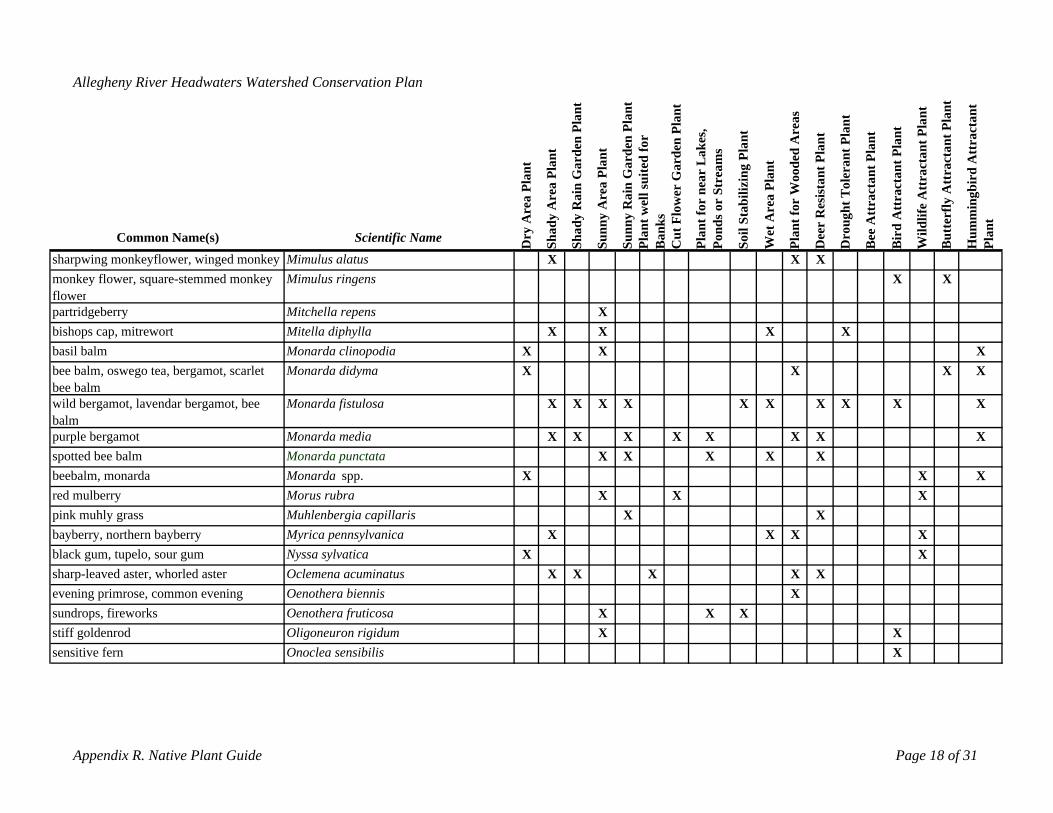
stiff goldenrod Oligoneuron rigidum X Xsensitive fern Onoclea sensibilis X
Appendix R. Native Plant Guide Page 18 of 31
Allegheny River Headwaters Watershed Conservation Plan
rea
Plan
t
Are
a Pl
ant
Rai
n G
arde
n Pl
ant
Are
a Pl
ant
Rai
n G
arde
n Pl
ant
ell s
uite
d fo
r
rden
Pla
nt
t for
nea
r L
akes
, r
Stre
ams
biliz
ing
Plan
t
Wet
Are
a Pl
ant
t for
Woo
ded
Are
as
ista
nt P
lant
t Tol
eran
t Pla
nt
ee A
ttra
ctan
t Pla
nt
Att
ract
ant P
lant
ctan
t Pla
nt
tter
fly A
ttra
ctan
t Pla
nt
bird
Att
ract
ant
y A dy t wdy nks
Cut
Flo
wer
Ga
nds o
il St
a
Dee
r R
es
gh
Wild
life
Att
ra
mm
ing
t
Common Name(s) Scientific Name Dr
Sha
Sha
Sunn
y
Sunn
yPl
anB
a
Plan
Po So Plan
Dro
u
B Bir
d
Bu
Hu
Plan
sharpwing monkeyflower, winged monkey Mimulus alatus X X Xmonkey flower, square-stemmed monkey flower
Mimulus ringens X X
partridgeberry Mitchella repens Xbishops cap, mitrewort Mitella diphylla X X X Xbasil balmbee balm, oswego tea, bergamot, scarlet
Monarda clinopodia XMonarda didyma X
XX X
XX
bee balmwild bergamot, lavendar bergamot, bee balm
Monarda fistulosa X X X X X X X X X X
purple bergamot Monarda media X X X X X X X Xspotted bee balm Monarda punctata X X X X Xbeebalm, monarda Monarda spp. X X Xred mulberry Morus rubra X X Xpink muhly grass Muhlenbergia capillaris X Xbayberry, northern bayberry Myrica pennsylvanica X X X Xblack gum, tupelo, sour gum Nyssa sylvatica X Xsharp-leaved aster, whorled aster Oclemena acuminatus X X X X Xevening primrose, common evening Oenothera biennis Xsundrops, fireworks Oenothera fruticosa X X X
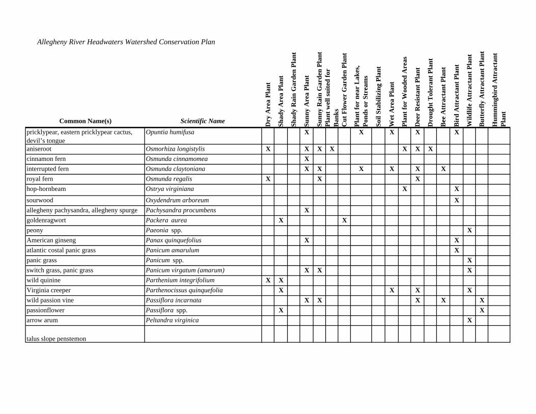
arrow arum Peltandra virginica Xbeardtongue, foxglove, white beardtongue, talus slope penstemon
Penstemon digitalis X X
Appendix R. Native Plant Guide Page 19 of 31
Allegheny River Headwaters Watershed Conservation Plan
rea
Plan
t
Are
a Pl
ant
Rai
n G
arde
n Pl
ant
Are
a Pl
ant
Rai
n G
arde
n Pl
ant
ell s
uite
d fo
r
rden
Pla
nt
ear
Lak
es,
r St
ream
s
biliz
ing
Plan
t
t for
Woo
ded
Are
as
ista
nt P
lant
t Tol
eran
t Pla
nt
t Pla
nt
Att
ract
ant P
lant
ctan
t Pla
nt
tter
fly A
ttra
ctan
t Pla
nt
bird
Att
ract
ant
Common Name(s) Scientific Name ry A dy dy
Sunn
y
ant w
Sunn
y
nks
Cut
Flo
wer
Ga
Plan
t for
nnd
s o
il St
a
Wet
Are
a Pl
ant
Plan
Dee
r R
es
roug
h
ee A
ttra
ctan
rd
Wild
life
Att
ra
u umm
ing
Plan
t
D Sha
Sha
Pl Ba
Po So D B Bi
B H
pricklypear, eastern pricklypear cactus, devil’s tongue
Opuntia humifusa X X X X X
aniseroot Osmorhiza longistylis X X X X X X Xcinnamon fern Osmunda cinnamomea Xinterrupted fern Osmunda claytoniana X X X X X Xroyal fern Osmunda regalis X X Xhop-hornbeam Ostrya virginiana X X
sourwood Oxydendrum arboreum Xallegheny pachysandra, allegheny spurge Pachysandra procumbens Xgoldenragwort Packera aurea X Xpeony Paeonia spp. XAmerican ginseng Panax quinquefolius X Xatlantic costal panic grass Panicum amarulum Xpanic grass Panicum spp. Xswitch grass, panic grass Panicum virgatum (amarum) X X Xwild quinine Parthenium integrifolium X XVirginia creeper Parthenocissus quinquefolia X X X Xwild passion vine Passiflora incarnata X X X X Xpassionflower Passiflora spp. X X
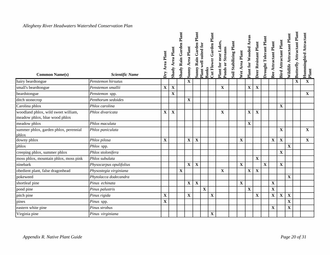
pines Pinus spp. X Xeastern white pine Pinus strobus X XVirginia pine Pinus virginiana X
Appendix R. Native Plant Guide Page 20 of 31
Allegheny River Headwaters Watershed Conservation Plan
rea
Plan
t
Are
a Pl
ant
in G
arde
n Pl
ant
Are
a Pl
ant
in G
arde
n Pl
ant
ll su
ited
for
rden
Pla
nt
ear
Lak
es,
r St
ream
s
ilizi
ng P
lant
oode
d A
reas
ista
nt P
lant
t Tol
eran
t Pla
nt
t Pla
nt
Att
ract
ant P
lant
ctan
t Pla
nt
tter
fly A
ttra
ctan
t Pla
nt
bird
Att
ract
ant
dy dy R
a
Ra
t we b
Cut
Flo
wer
Ga
t for
nnd
s o
il St
a
Wet
Are
a Pl
ant
t for
W
gh
ee A
ttra
ctan
Wild
life
Att
ra
mm
ing
t
Common Name(s) Scientific Name ry A
Sha n
Sha
Sunn
y
Sunn
yPl
a nks
lan
o Plan
Dee
r R
es
rou
ird
u uPl
an
hairy beardtongue
D
Penstemon hirsutus
Ba
P P D B B BSo H
X X Xsmall's beardtongue Penstemon smallii X X X X Xbeardstongue Penstemon spp. X Xditch stonecrop Penthorum sedoides XCarolina phlox Phlox carolina Xwoodland phlox, wild sweet william, meadow phlox, blue wood phlox
Phlox divaricata X X X X X
meadow phlox Phlox maculata Xsummer phlox, garden phlox, perennial Phlox paniculata X Xphloxdowny phlox Phlox pilosa X X X X X X Xphlox Phlox spp. Xcreeping phlox, summer phlox Phlox stolonifera X
Phlox subulatamoss phlox, mountain phlox, moss pink ninebark
XPhysocarpus opulifolius X X X X XPhysostegia virginianaobedient plant, false dragonhead X X X X
pokeweed Phytolacca dodecandra Xshortleaf pine Pinus echinata X X X Xpond pine Pinus palustris X X Xpitch pine Pinus rigida X X X X X X X
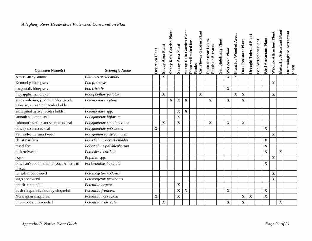
bush cinquefoil, shrubby cinquefoil Potentilla fruticosa X X X XNorwegian cinquefoil Potentilla norvegicia X X X X Xthree-toothed cinquefoil Potentilla tridentata X X X X
Appendix R. Native Plant Guide Page 21 of 31
Allegheny River Headwaters Watershed Conservation Plan
rea
Plan
t
Are
a Pl
ant
in G
arde
n Pl
ant
Are
a Pl
ant
in G
arde
n Pl
ant
ll su
ited
for
rden
Pla
nt
ear
Lak
es,
Str
eam
s
ilizi
ng P
lant
a Pl
ant
oode
d A
reas
ista
nt P
lant
t Tol
eran
t Pla
nt
t Pla
nt
Att
ract
ant P
lant
ctan
t Pla
nt
tter
fly A
ttra
ctan
t Pla
nt
bird
Att
ract
ant
Ra
we r b Ra
Cut
Flo
wer
Ga
t for
n
Are
t for
W
gh
ee A
ttra
ctan
Wild
life
Att
ra
mm
ing
Common Name(s) Scientific Name ry A dy dy
Sunn
y
Sunn
ynt nk
s
Plan on
ds o
il St
a
et
Plan
Dee
r R
es
rou
rd u uPl
ant
D Sha
Sha
Pla
Ba
P So W D B Bi
B H
American sycamore Platanus occidentalis X X XKentucky blue-grassroughstalk bluegrass
Poa pratensisPoa trivialis X
X
mayapple, mandrake Podophyllum peltatum X X X X Xgreek valerian, jacob's ladder, greek Polemonium reptans X X X X X Xvalerian, spreading jacob's laddervariegated native jacob's ladder Polemonium spp. X Xsmooth solomon seal Polygonatum biflorum Xsolomon's seal, giant solomon's seal Polygonatum canaliculatum X X X X Xdowny solomon's seal Polygonatum pubescens X XPennsylvania smartweed Polygonum pensylvanicum Xchristmas fern Polystichum acrostichoides Xtassel fernpickerelweed
Polystichum polyblepherumPontederia cordata
XX X
aspen Populus spp. Xbowman's root, indian physic, American Porteranthus trifoliata Xipecaclong-leaf pondweed Potamogeton nodosus Xsago pondweed Potamogeton pectinatus Xprairie cinquefoil Potentilla arguta X
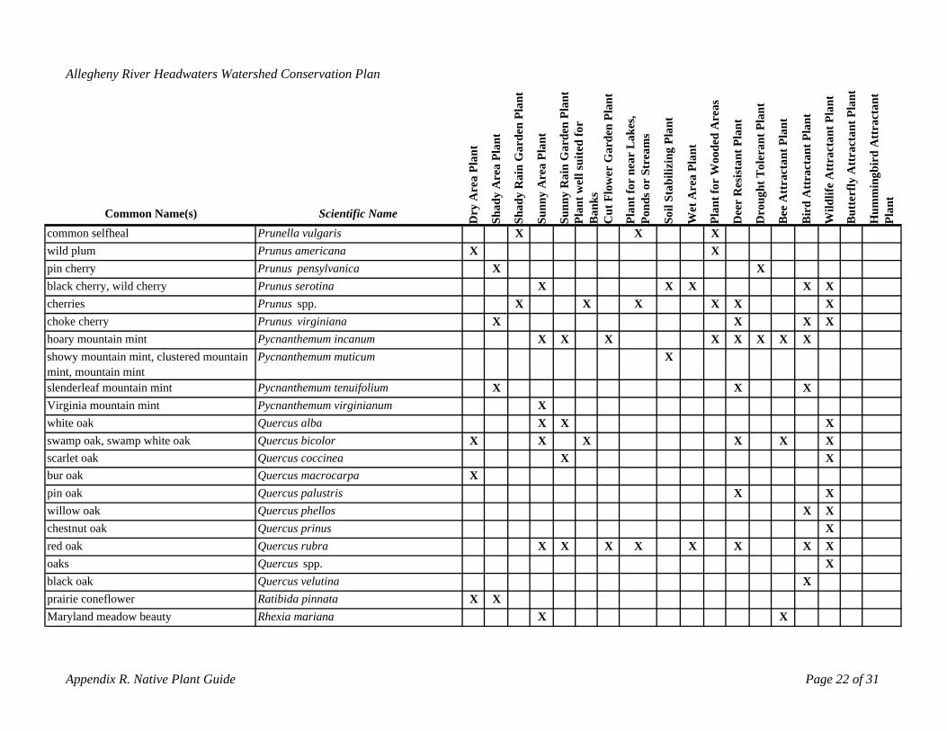
black oak Quercus velutina Xprairie coneflower Ratibida pinnata X XMaryland meadow beauty Rhexia mariana X X
Appendix R. Native Plant Guide Page 22 of 31
Allegheny River Headwaters Watershed Conservation Plan
ant
Pla
nt
in G
arde
n Pl
ant
Pla
nt
in G
arde
n Pl
ant
l sui
ted
for
rden
Pla
nt
ear
Lak
es,
Str
eam
s
ilizi
ng P
lant
oode
d A
reas
ista
nt P
lant
oler
ant P
lant
t Pla
nt
Att
ract
ant P
lant
ctan
t Pla
nt
tter
fly A
ttra
ctan
t Pla
nt
bird
Att
ract
ant
rea
Pl
Are
a
Ra
wel Are
a
Ra
Cut
Flo
wer
Ga
t for
n r b
Wet
Are
a Pl
ant
t for
W
ght T
ee A
ttra
ctan
Wild
life
Att
ra
mm
ing
y A nt
dy dy
Sunn
y
Sunn
y
nks
nds o
il St
a
Dee
r R
es
ou rd ut
Common Name(s) Scientific Name Dr
Sha
PoSha
Pla
Ba
Plan
So Plan
Dr
B Bi
Bu
H Plan
common selfheal Prunella vulgaris X X Xwild plum Prunus americana X Xpin cherry Prunus pensylvanica X Xblack cherry, wild cherry Prunus serotina X X X X Xcherries choke cherry
Prunus spp. X X XPrunus virginiana X
X X XX X X
hoary mountain mint Pycnanthemum incanum X X X X X X X Xshowy mountain mint, clustered mountain Pycnanthemum muticum Xmint, mountain mintslenderleaf mountain mint Pycnanthemum tenuifolium X X XVirginia mountain mint Pycnanthemum virginianum Xwhite oak Quercus alba X X Xswamp oak, swamp white oak Quercus bicolor X X X X X Xscarlet oak Quercus coccinea X Xbur oak Quercus macrocarpa Xpin oak Quercus palustris X Xwillow oak Quercus phellos X Xchestnut oak Quercus prinus Xred oak Quercus rubra X X X X X X X Xoaks Quercus spp. X

blackberry, raspberry Rubus spp. Xeastern coneflower, organe coneflower Rudbeckia fulgida Xblack-eyed susan Rudbeckia hirta X X X X X X X
Appendix R. Native Plant Guide Page 23 of 31
Allegheny River Headwaters Watershed Conservation Plan
ant
Pla
nt
in G
arde
n Pl
ant
Pla
nt
in G
arde
n Pl
ant
l sui
ted
for
rden
Pla
nt
ear
Lak
es,
Str
eam
s
ilizi
ng P
lant
oode
d A
reas
stan
t Pla
nt
oler
ant P
lant
t Pla
nt
Att
ract
ant P
lant
ctan
t Pla
nt
tter
fly A
ttra
ctan
t Pla
nt
bird
Att
ract
ant
rea
Pl
Are
a
Ra
Are
a
wel r b Ra
Cut
Flo
wer
Ga
t for
n
Wet
Are
a Pl
ant
t for
W i
ght T
ee A
ttra
ctan
Wild
life
Att
ra
mm
ing
y A dy dy
Sunn
y
Sunn
ynt
nk
s
nds o
il St
a
n
Dee
r R
es
ou rd
t
Common Name(s) Scientific Name Dr
Sha
PoSha
Pla
Ba
Plan
So Pla
Dr
B Bi
Bu
Hu
Plan
meadow beauty, handsome hairy Rhexia virginica X X Xsweet azalea Rhododendron arborescens X Xrosebay rhododendron Rhododendron maximum X X Xswamp azalea Rhododendron viscosum X X X X Xrhododendron Rhododendron spp. Xswamp azalea Rhododendron viscosum X X X X Xrhododendron Rhododendron spp. Xfragrant sumac Rhus aromatica Xdwarf-winged sumac Rhus copalina X X Xsmooth sumac Rhus glabra X Xsumacs Rhus spp. X X X X X Xstaghorn sumac Rhus typhina X X Xpasture rose, Carolina rose Rosa Carolina X X X X X X X Xswamp rose Rosa palustris X X X Xrose Rosa spp. XVirginia rose Rosa virginiana X X X Xcommon blackberry Rubus allegheniensis X X X Xflowering raspberry Rubus odoratus X X X X Xthimbleberry Rubus parviflorus X X X X X
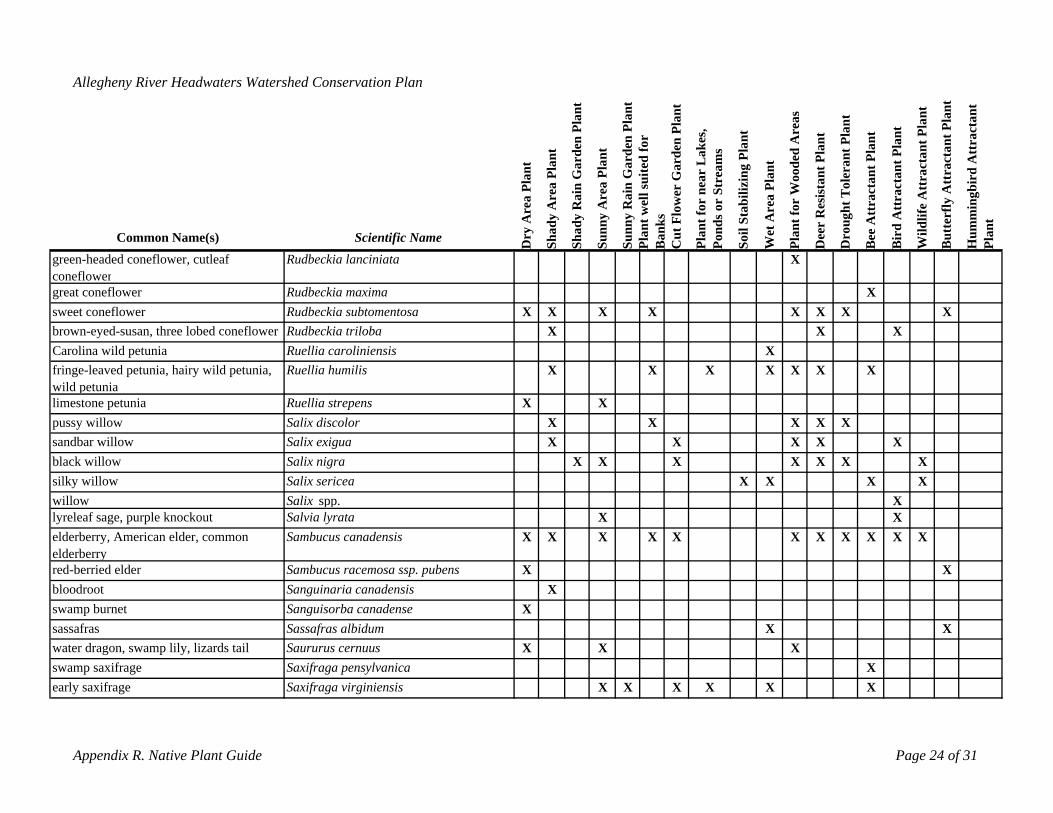
water dragon, swamp lily, lizards tail Saururus cernuus X X Xswamp saxifrage Saxifraga pensylvanica Xearly saxifrage Saxifraga virginiensis X X X X X X
Appendix R. Native Plant Guide Page 24 of 31
Allegheny River Headwaters Watershed Conservation Plan
ant
Pla
nt
in G
arde
n Pl
ant
Pla
nt
in G
arde
n Pl
ant
suite
d fo
r
rden
Pla
nt
ear
Lak
es,
Str
eam
s
ilizi
ng P
lant
oode
d A
reas
tant
Pla
nt
oler
ant P
lant
t Pla
nt
t Pla
nt
ctan
t Pla
nt
tter
fly A
ttra
ctan
t Pla
nt
bird
Att
ract
ant
y A
rea
Pl
dy A
rea
dy R
a
Are
a
Ra
t wel
lnk
sC
ut F
low
er G
a
t for
nnd
s or
il St
ab
Wet
Are
a Pl
ant
t for
W
Dee
r R
esis
ght T
ee A
ttra
ctan
Att
ract
an
Wild
life
Att
ra
mm
ing
t
Common Name(s) Scientific Name r
Sha
Sha
Sunn
y
Sunn
yPl
anB
a
Plan o So Plan ro
u
ird
u uPl
an
green-headed coneflower, cutleaf Rudbeckia lanciniata
D P
X
D B B B H
coneflowergreat coneflower Rudbeckia maxima Xsweet coneflowerbrown-eyed-susan, three lobed coneflower
Rudbeckia subtomentosa XRudbeckia triloba
X XX
X X X XX
XX
Carolina wild petunia Ruellia caroliniensis Xfringe-leaved petunia, hairy wild petunia, Ruellia humilis X X X X X X Xwild petunia limestone petunia Ruellia strepens X Xpussy willow Salix discolor X X X X Xsandbar willow Salix exigua X X X X Xblack willow Salix nigra X X X X X X Xsilky willowwillow
Salix sericeaSalix spp.
X X XX
X
lyreleaf sage, purple knockout Salvia lyrata X Xelderberry, American elder, common Sambucus canadensis X X X X X X X X X X Xelderberryred-berried elder Sambucus racemosa ssp. pubens X Xbloodroot Sanguinaria canadensis Xswamp burnet Sanguisorba canadense Xsassafras Sassafras albidum X X
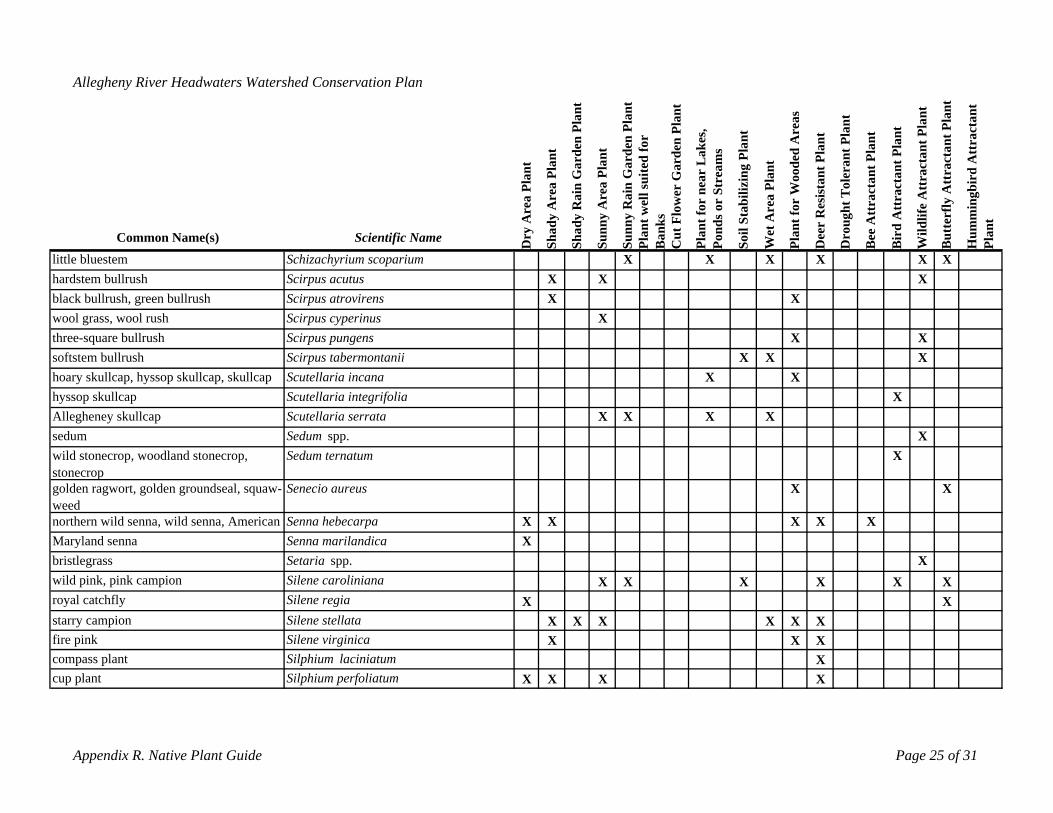
fire pink Silene virginica X X Xcompass plant Silphium laciniatum Xcup plant Silphium perfoliatum X X X X
Appendix R. Native Plant Guide Page 25 of 31
Allegheny River Headwaters Watershed Conservation Plan
ant
Pla
nt
in G
arde
n Pl
ant
Pla
nt
in G
arde
n Pl
ant
suite
d fo
r
rden
Pla
nt
ear
Lak
es,
ream
s
ilizi
ng P
lant
oode
d A
reas
tant
Pla
nt
oler
ant P
lant
t Pla
nt
t Pla
nt
ctan
t Pla
nt
tter
fly A
ttra
ctan
t Pla
nt
bird
Att
ract
ant
rea
Pl
Are
a
Ra
Are
a
Ra ell
Cut
Flo
wer
Ga
t for
n r St
b
Wet
Are
a Pl
ant
t for
W is t T
ee A
ttra
ctan
Att
ract
an
y A dy dy nt w
nks
nds o
il St
a
Dee
r R
es
ough
Wild
life
Att
ra
mm
ing
t
Common Name(s) Scientific Name Dr
Sha
PoSha
Sunn
y
Sunn
yPl
aB
a
Plan
So Plan
Dr
B Bir
d
Bu
Hu
Plan
little bluestem Schizachyrium scoparium X X X X X Xhardstem bullrush Scirpus acutus X X Xblack bullrush, green bullrush Scirpus atrovirens X Xwool grass, wool rush Scirpus cyperinus Xthree-square bullrush Scirpus pungens X Xsoftstem bullrush Scirpus tabermontanii X X Xhoary skullcap, hyssop skullcap, skullcap Scutellaria incana X Xhyssop skullcapAllegheney skullcap
Scutellaria integrifolia Scutellaria serrata X X X X
X
sedum Sedum spp. Xwild stonecrop, woodland stonecrop, Sedum ternatum Xstonecropgolden ragwort, golden groundseal, squaw- Senecio aureus X Xweednorthern wild senna, wild senna, American Senna hebecarpa X X X X XMaryland senna Senna marilandica Xbristlegrass Setaria spp. Xwild pink, pink campion Silene caroliniana X X X X X Xroyal catchfly Silene regia X Xstarry campion Silene stellata X X X X X X
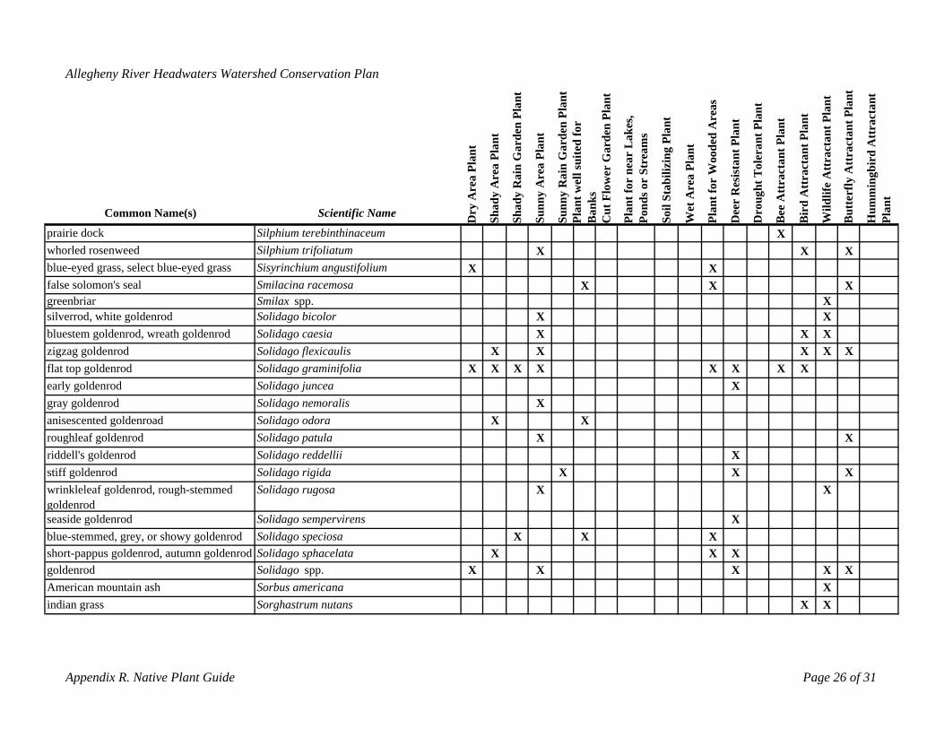
goldenrod Solidago spp. X X X X XAmerican mountain ash Sorbus americana Xindian grass Sorghastrum nutans X X
Appendix R. Native Plant Guide Page 26 of 31
Allegheny River Headwaters Watershed Conservation Plan
ant
Pla
nt
in G
arde
n Pl
ant
Pla
nt
in G
arde
n Pl
ant
uite
d fo
r
rden
Pla
nt
ear
Lak
es,
ream
s
ilizi
ng P
lant
oode
d A
reas
ant P
lant
oler
ant P
lant
t Pla
nt
t Pla
nt
ctan
t Pla
nt
tter
fly A
ttra
ctan
t Pla
nt
bird
Att
ract
ant
rea
Pl
Are
a
Ra
Are
a
Ra ell s
t for
n r St
b
Wet
Are
a Pl
ant
t for
W ist
t T
ee A
ttra
ctan
Att
ract
an
y A dy dy t w
nks
Cut
Flo
wer
Ga
nds o
il St
a
Dee
r R
es
gh
Wild
life
Att
ra
mm
ing
t
Common Name(s) Scientific Name Dr
n
oSha
Sha
Sunn
y
Sunn
yPl
aB
a
Plan
So Plan
Dro
u
ird
u
Hu
Plan
prairie dock Silphium terebinthinaceum
P B B
X
B
whorled rosenweed Silphium trifoliatum X X Xblue-eyed grass, select blue-eyed grass Sisyrinchium angustifolium X Xfalse solomon's seal Smilacina racemosa X X Xgreenbriar Smilax spp. Xsilverrod, white goldenrod Solidago bicolor X Xbluestem goldenrod, wreath goldenrod Solidago caesia X X Xzigzag goldenrod Solidago flexicaulis X X X X Xflat top goldenrod Solidago graminifolia X X X X X X X Xearly goldenrod Solidago juncea Xgray goldenrod Solidago nemoralis Xanisescented goldenroad Solidago odora X Xroughleaf goldenrod Solidago patula X Xriddell's goldenrod Solidago reddellii Xstiff goldenrod Solidago rigida X X Xwrinkleleaf goldenrod, rough-stemmed Solidago rugosa X Xgoldenrodseaside goldenrod Solidago sempervirens Xblue-stemmed, grey, or showy goldenrod Solidago speciosa X X Xshort-pappus goldenrod, autumn goldenrod Solidago sphacelata X X X
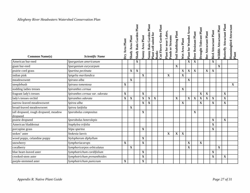
blue heart-leaved aster Symphotrichum cordifolium X Xcrooked-stem aster Symphotrichum prenanthoides X X Xpurple-stemmed aster Symphotrichum puniceum X X
Appendix R. Native Plant Guide Page 27 of 31
Allegheny River Headwaters Watershed Conservation Plan
ant
Pla
nt
in G
arde
n Pl
ant
Pla
nt
in G
arde
n Pl
ant
uite
d fo
r
rden
Pla
nt
ar L
akes
, re
ams
ilizi
ng P
lant
oode
d A
reas
ant P
lant
lera
nt P
lant
t Pla
nt
t Pla
nt
ctan
t Pla
nt
t Pla
nt
bird
Att
ract
ant
rea
Pl
Are
a
Are
a
ll s e
r b St
r W ist o
t T
Att
ract
an
tter
fly A
ttra
ctan
dy dy R
a
Ra
t we
Cut
Flo
wer
Ga
t for
nnd
s o
il St
a
t fo
Wet
Are
a Pl
ant
gh
ee A
ttra
ctan
Wild
life
Att
ra
mm
ing
t
Common Name(s) Scientific Name ry A
Sha
Sha n
oSunn
y
Sunn
yPl
aB
anks
Plan
Plan
Dee
r R
es
rou
ird
u uPl
an
American bur-reed
D
Sparganium americanum X
P So D B B B H
X X Xgiant bur-reed Sparganium eurycarpum X Xprairie cord grass Spartina pectinata X X X X XX Xindian pink Spigelia marilandica X X Xmeadowsweet Spiraea alba X Xsteeplebush Spiraea tomentosa X Xnodding ladies tresses Spiranthes cernua Xfragrant lady's tresses Spiranthes cernua var. odorata X X X X Xlady's tresses orchid Spiranthes odorata X X X X X X X X X X X Xnarrow-leaved meadowsweet Spirea alba X X X X X Xbroad-leaved meadowsweet Spirea latifolia Xtall dropseed, rough dropseed, meadow Sporobolus compositus X Xdropseedprairie dropseed Sporobolus heterolepis X XAmerican bladdernut Staphylea trifolia Xporcupine grass Stipa spartea X Xstokes’ aster Stokesia laevis X X Xwood poppy, celandine poppy Stylophorum diphyllum Xsnowberry Symphoriacarops X X X Xcoralberry Symphoricarpos orbiculatus X X X
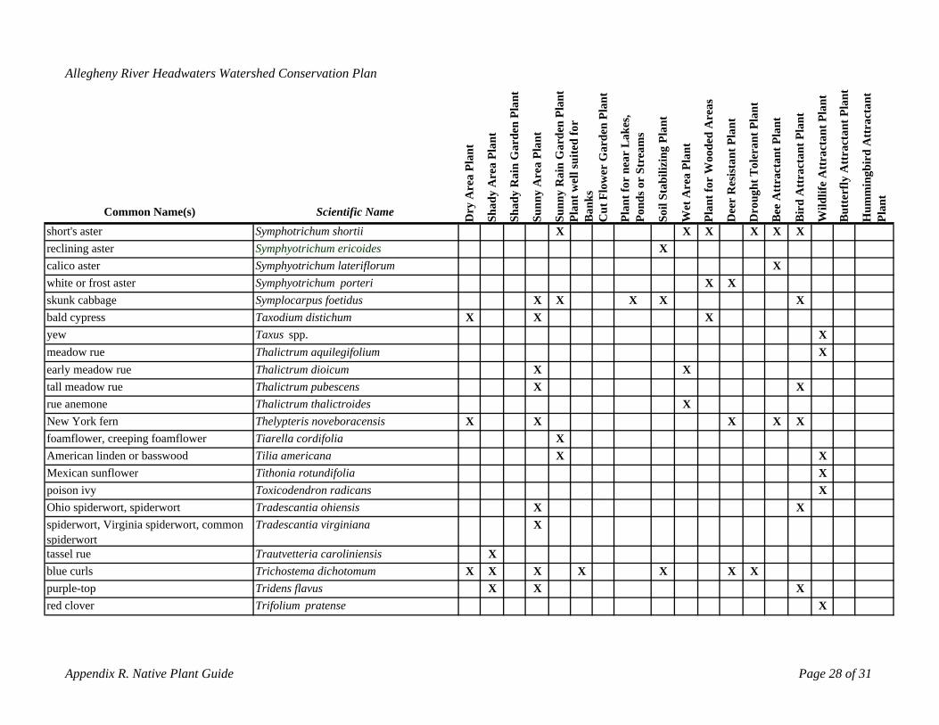
tassel rue Trautvetteria caroliniensis Xblue curls Trichostema dichotomum X X X X X X Xpurple-top Tridens flavus X X Xred clover Trifolium pratense X
Appendix R. Native Plant Guide Page 28 of 31
Allegheny River Headwaters Watershed Conservation Plan
ant
Pla
nt
arde
n Pl
ant
Pla
nt
in G
arde
n Pl
ant
r
rden
Pla
nt
ar L
akes
, re
ams
ilizi
ng P
lant
oode
d A
reas
ant P
lant
lera
nt P
lant
t Pla
nt
t Pla
nt
ctan
t Pla
nt
t Pla
nt
bird
Att
ract
ant
rea
Pl
Are
a in G
Are
a
t wel
l sui
ted
fo
e S
t
ist
t To
Att
ract
an
tter
fly A
ttra
ctan
Ra
Ra
Cut
Flo
wer
Ga
t for
nnd
s or b
Wet
Are
a Pl
ant
t for
W
gh
ee A
ttra
ctan
Wild
life
Att
ra
mm
ing
Common Name(s) Scientific Name ry A
Shad
y
Shad
y
Sunn
y
Sunn
yn nk
s
Plan o il
Sta
Plan
Dee
r R
es
rou
ird
u uPl
ant
D Pla
Ba
P So
Symphotrichum shortii
D B B B H
short's asterSymphyotrichum ericoides
X X X X X Xreclining aster
Symphyotrichum lateriflorumX
calico asterwhite or frost aster
XSymphyotrichum porteri
skunk cabbageX X
Symplocarpus foetidus bald cypress Taxodium distichum
X X X X X
yewX
Taxus spp.X X
Xmeadow rue Thalictrum aquilegifolium Xearly meadow rue Thalictrum dioicum X Xtall meadow rue Thalictrum pubescens X Xrue anemone Thalictrum thalictroides XNew York fern Thelypteris noveboracensis X X X X Xfoamflower, creeping foamflower Tiarella cordifolia XAmerican linden or basswoodMexican sunflower
Tilia americanaTithonia rotundifolia
X XX
poison ivy Toxicodendron radicans XOhio spiderwort, spiderwort Tradescantia ohiensis X Xspiderwort, Virginia spiderwort, common Tradescantia virginiana Xspiderwort
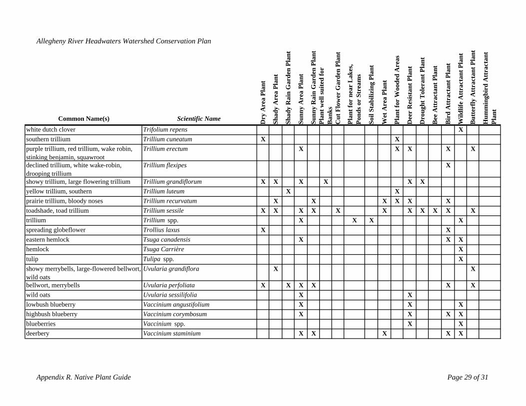
lowbush blueberry Vaccinium angustifolium X X Xhighbush blueberry Vaccinium corymbosum X X X Xblueberries Vaccinium spp. X Xdeerbery Vaccinium staminium X X X X X
Appendix R. Native Plant Guide Page 29 of 31
Allegheny River Headwaters Watershed Conservation Plan
ant
Pla
nt
arde
n Pl
ant
Pla
nt
arde
n Pl
ant
r
rden
Pla
nt
ar L
akes
, re
ams
Pla
nt
oode
d A
reas
ant P
lant
eran
t Pla
nt
t Pla
nt
t Pla
nt
ctan
t Pla
nt
t Pla
nt
bird
Att
ract
ant
rea
Pl
Are
a in G
Are
a in G
t wel
l sui
ted
fo
e S
t
ilizi
ng
ist
t Tol
Att
ract
an
tter
fly A
ttra
ctan
Ra r b Ra
Cut
Flo
wer
Ga
t for
n
Wet
Are
a Pl
ant
t for
W
gh
ee A
ttra
ctan
Wild
life
Att
ra
mm
ing
Common Name(s) Scientific Name Dry
A
Shad
y
Shad
y
Sunn
y
n
PoSunn
yPl
aB
anks
Plan nd
s o
Soil
Sta
Plan
Dee
r R
es
Dr
B
ou
Bir
d
Bu
Hu
Plan
t
white dutch cloversouthern trillium
Trifolium repensTrillium cuneatum X X
X
purple trillium, red trillium, wake robin, Trillium erectum X X X X Xstinking benjamin, squawrootdeclined trillium, white wake-robin, Trillium flexipes Xdrooping trilliumshowy trillium, large flowering trillium Trillium grandiflorum X X X X X Xyellow trillium, southern Trillium luteum X Xprairie trillium, bloody noses Trillium recurvatum X X X X X Xtoadshade, toad trillium Trillium sessile X X X X X X X X X X Xtrillium Trillium spp. X X X Xspreading globeflowereastern hemlock
Trollius laxus XTsuga canadensis
XXX X
hemlock Tsuga Carrière Xtulip Tulipa spp. Xshowy merrybells, large-flowered bellwort, Uvularia grandiflora X Xwild oatsbellwort, merrybells Uvularia perfoliata X X X X X Xwild oats Uvularia sessilifolia X X
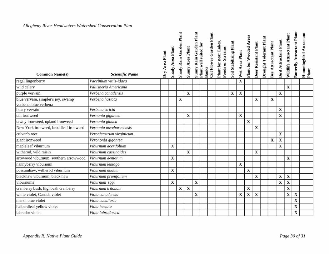
white violet, Canada violet Viola canadensis X X X X X Xmarsh blue violet Viola cucullaria Xhalberdleaf yellow violet Viola hastata Xlabrador violet Viola labradorica X
Appendix R. Native Plant Guide Page 30 of 31
Allegheny River Headwaters Watershed Conservation Plan
ant lant
arde
n Pl
ant
Pla
nt
arde
n Pl
ant
r
rden
Pla
nt
ar L
akes
, re
ams
Pla
nt
oode
d A
reas
ant P
lant
eran
t Pla
nt
t Pla
nt
t Pla
nt
ctan
t Pla
nt
t Pla
nt
bird
Att
ract
ant
P
in G
in G
t wel
l sui
ted
fo
e S
t
ilizi
ng
st ol
Att
ract
an
tter
fly A
ttra
ctan
rea
Pl
Are
a
Ra
Are
a
Ra
Cut
Flo
wer
Ga
t for
n r b
Wet
Are
a Pl
ant
t for
W i
ght T
ee A
ttra
ctan
Wild
life
Att
ra
mm
ing
y A dy dy
Sunn
y
nSu
nny
nks
nds o
il St
a
Dee
r R
es
ou rd
t
Common Name(s)regal lingonberry
Scientific Name Dr
Sha
Vaccinium vitiis-idaea
Sha
Po
X
Pla
Ba
Plan
So Plan
Dr
B Bi
Bu
Hu
Plan
wild celery Vallisneria Americana Xpurple vervain Verbena canadensis X X X Xblue vervain, simpler's joy, swamp Verbena hastata X X Xverbena, blue verbenahoary vervain Verbena stricta Xtall ironweed Vernonia gigantea X X Xtawny ironweed, upland ironweed Vernonia glauca XNew York ironweed, broadleaf ironweed Vernonia noveboracensis Xculver’s root Veronicastrum virginicum Xgiant ironweed Verononia gigantea X Xmapleleaf viburnum Viburnum acerifolium X Xwitherod, wild raisin Viburnum cassinoides X Xarrowood viburnum, southern arrowwood Viburnum dentatum X Xnannyberry viburnum Viburnum lentago Xpossumhaw, witherod viburnum Viburnum nudum X Xblackhaw viburnum, black haw Viburnum prunifolium X X Xviburnums Viburnum spp. X X X Xcranberry bush, highbush cranberry Viburnum trilobum X X X X
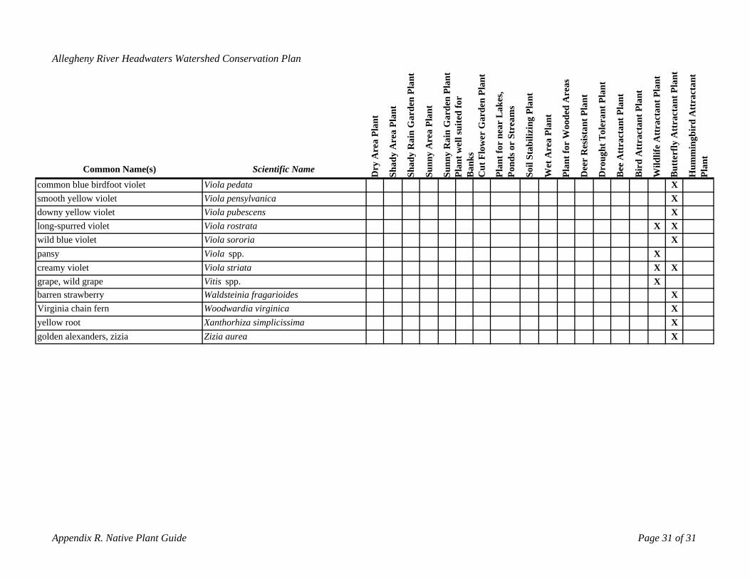
barren strawberry Waldsteinia fragarioides XVirginia chain fern Woodwardia virginica Xyellow root Xanthorhiza simplicissima Xgolden alexanders, zizia Zizia aurea X
Appendix R. Native Plant Guide Page 31 of 31
Allegheny River Headwaters Watershed Conservation Plan
ant lant
arde
n Pl
ant
lant
arde
n Pl
ant
r
rden
Pla
nt
ar L
akes
, m
s
Pla
nt
oode
d A
reas
ant P
lant
eran
t Pla
nt
t Pla
nt
t Pla
nt
ctan
t Pla
nt
t Pla
nt
bird
Att
ract
ant
P
in G P
in G
t wel
l sui
ted
fo
e S
trea
ilizi
ng
st ol
tter
fly A
ttra
ctan
rea
Pl
Are
a
Ra
Are
a
Ra
Cut
Flo
wer
Ga
t for
n r b
Wet
Are
a Pl
ant
t for
W i t T
ee A
ttra
ctan
Att
ract
an
Wild
life
Att
ra
mm
ing
y A dy dy
Sunn
y
Sunn
yn nk
s
nds o
il St
a
Dee
r R
es
ough
rd
t
Common Name(s) Scientific Name Dr
Sha
Sha
Pla
Ba
Plan
Po So Plan
Dr
B Bi
Bu
Hu
Plan
common blue birdfoot violet Viola pedata Xsmooth yellow violet Viola pensylvanica Xdowny yellow violet Viola pubescens Xlong-spurred violet Viola rostrata X Xwild blue violet Viola sororia Xpansy Viola spp. Xcreamy violet Viola striata X Xgrape, wild grape Vitis spp. X
Allegheny River Headwaters Watershed Conservation Plan
APPENDIX S: ENHANCING FISH HABITAT
Habitat is defined as the place where an organism lives or is naturally found. Enhancing habitat in an aquatic ecosystem improves the over all health and quality of a given waterway. By doing so, it in turn benefits everyone who enjoys outdoor recreation weather it be fishing, boating, or just an outdoor enthusiast.
Aquatic habitat enhancement can be constructed in both streams and lakes and is designed to
improve habitat for everything from fish to various reptiles. As well as having a wide range of organisms that habitat enhancement structures benefit there is also a diverse variety of artificial habitat purposes and designs that Pennsylvania Fish and Boat Commission (PFBC) has come up with to suit the needs of Pennsylvania’s wildlife. In order to perform a Fish Habitat improvement project the proper permits must first be required from Pennsylvania’s Department of Environmental Protection (PA DEP). Once the permits are acquired grants are applied for to provide funding.
The primary objective of artificial fish habitat is to use resources such as wood and rock rubble to
increase the abundance of submerged native habitat using designs engineered to mimic Pennsylvania’s naturally occurring resources. Artificial fish habitat also provides excellent fishing opportunities for anglers if they are aware of the locations of the structures.
PFBC offers Lake Habitat Improvement Maps for all the state and federal owned lakes where habitat
improvement projects have been completed. These maps show the general shape of the lake and indicate where all man made structures are located along with how many are present and the depth of their location. If read correctly these maps provide a very efficient way for anglers to navigate the structures and ultimately find fish (PFBC2). Habitat Enhancing Structures for Cover
Man-made aquatic habitat structures are designed to serve several different purposes for aquatic life,
each one being necessary for a successful aquatic environment. One purpose for artificial habitat is to provide smaller prey fish with cover from predators where preexisting cover is nonexistent. Most needs for this type of habitat structure is in the early man made lakes that can be found scattered across Pennsylvania. This is because in earlier years when many lakes were being formed it was thought that the lake bottom should be bare, therefore all debris was cleared from the area leaving little to no cover remaining for aquatic organisms. There are many variations for this form of habitat that use all types of materials ranging from wooden poles to large sandstone rocks. Examples of this type of habitat structure are the Porcupine Crib, Porcupine Crib Jr., Post Stump, Post Stump Plus, Post Cluster, Post Cluster Plus, Rock Star, Vertical Plank Structure, Spider Hump, Stake Tree, Felled Shoreline Tree, and Rock Rubble Humps.
Porcupine Crib and Porcupine Crib Jr. Porcupine Crib and Porcupine Crib Jr. are two habitat structures that are very alike in their design.
They are constructed using 4ft. 2×2 pieces of rough timber, 8×8×16 concrete blocks, nails, and a nylon banding strap with steel buckle. The 4 ft. pieces of wood are nailed to one another while slowly steeping inward in the shape of a pyramid with the concrete blocks placed at the bottom for weights and the nylon banding strap used for added strength. Once completed the cribs are placed at the bottom of the lake at a minimum depth of about 10 ft. and are normally placed in clusters. Once submerged the Porcupine Crib and Crib Jr. form what serves as a wooden cage like structure with openings between the boards allowing smaller bait fish to swim in and out ultimately providing them with cover. At the same time the Porcupine Crib provides places for predatory fish to hunt due to the large amounts of bait fish that are drawn to
Appendix S. Enhancing Aquatic Habitats Page 1 of 9
Allegheny River Headwaters Watershed Conservation Plan
them. Porcupine cribs serve as excellent areas for fishermen seeking various species of pan fish as well as the larger game fish species that are drawn in too feed on them (PFBC1).
Post Stump and Post Stump Plus The Post Stump and Post Stump Plus have a simple design which involves nothing more that two to
three 4ft. sections of 6 inch wide aquatic posts and are normally placed at a depth of about 4ft. of water. The Post Stump is made by pounding two sections the aquatic posts into the lake bottom until they are submerged about two feet below the surface. The two pieces of post can be placed straight up and down or at an angle depending on preference. The Post Stump Plus is constructed the same way as the plain Post Stump but involves a laterally positioned post that is bolted to the vertical posts underneath the waters surface for added cover. This Habitat structure is designed to benefit an array of aquatic organisms. The submerged posts act as artificial submerged stumps providing cover for predatory and prey fish alike. Being that this type of habitat structure is placed in shallower waters it creates fishing sites for anglers that are accessing the lakes from shore banks (PFBC1).
Post Cluster and Post Cluster Plus The Post Cluster and Post Cluster Plus are very similar in design and purpose to the Post Stump and
Post Stump Plus. This type of habitat is made with 8ft. long sections of 6 inch wide aquatic posts and normally involves the use of heavy equipment to build. The Post Cluster is placed in about 4ft. of water and is constructed by inserting the 8ft. sections of aquatic posts about two feet into the lakes bottom allowing the tops to protrude from the waters surface. The Post Cluster can include as many poles in each cluster as preferred and can be arranged in any shape that is desired. The Post Cluster Plus is constructed the same as The Post Cluster except it involves laterally positioned posts that are bolted to the vertical posts underneath the waters surface for added cover. Once completed the clusters of protruding posts replicate what acts as submerged woodland. This habitat structure is designed to benefit an array of aquatic organisms. As well as providing cover for fish of all sizes the exposed post above the surface of the water serve as excellent perch sites for fish hunting birds. Also the Post Clusters exposed portions tend to eventually attract aquatic plant growth such as lily pads which in turn attracts organisms like frogs and dragonflies that fish and other organisms can feed on. This type of habitat structure draws in all types of fish species thus providing favorable fishing for boating and shore fishermen alike. The post clusters also act as a barrier between the shore and open water by breaking up waves decreasing shore line erosion (PFBC1).
Rock Star The Rock Star is a man made habitat structure that involves the use of both rough cut timber and
sandstone rocks. To construct this type of structure you need seven tons of sand stone, seven eight ft. 2×6 sections of rough cut timber, and nails. A rock star consists of a two ton pile of sandstone encircled by five surrounding one ton piles of sandstone that is connected by five sections of 2×6 rough timber in the general shape of a star. The connecting pieces of rough cut timber should be buried in the rock piles and elevated from the lakes bottom for aquatic organisms to use for cover. After the star shaped structure is completed the last two sections of eight ft. 2×6 are nailed into the others that are already placed connecting any two of the pieces of boards for additional cover. These structures can be placed at any depth and are designed to provide cover for all types of aquatic organisms. Rock Stars can also double as spawning sites for some species of fish (PFBC1).
Vertical Plank Structure The vertical Plank Structure is a wooden box designed to provide cover for large and small fish
alike. The structure consists of 59 sections of rough cut timber that rang from 1×4×24 to 2×3×48, nine concrete blocks to allow it to sink to the bottom, and nails. Small conifer trees may also be placed in the box once built to add additional cover. This habitat structure is used much the same as the Porcupine crib.
Appendix S. Enhancing Aquatic Habitats Page 2 of 9
Allegheny River Headwaters Watershed Conservation Plan
Placement is normally at a minimum depth of 10ft. and more often then not they are placed in clusters. The main difference being the Vertical plank structure has openings that are much larger in size allowing larger fish and other aquatic organisms to enter them. If located the Vertical Plank structure is an excellent place for anglers to try their luck for not only does it provide cover for bait fish but larger sized fish as well (PFBC1).
Spider Hump and Rock Rubble Hump The Rock Rubble Hump is the simplest artificial habitat structure there is as far as its general design
is concerned. It consists of a pile of sandstone rock that stands anywhere from one to three ft. high and can be placed at any depth that is preferred. The Spider Hump is a more complex modification of the Rock Rubble Hump that is constructed using sandstone rocks, spikes, and 8ft. aquatic posts. A square is built with 8ft. posts then fastened down with spikes. Then 16 more evenly spaced posts are laid in the square and fastened down with all of the bottoms meeting in the center of the box. Once the posts are all placed three tons of rock is dumped onto the center of the structure to form a rock pile with wooden posts protruding providing excellent cover for all types of aquatic organisms. These habitat enhancement structures also provide excellent areas for fish species that prefer spawning in rocky areas (PFBC1).
Stake Tree The Stake Tree is constructed using a five gallon plastic bucket, 2×2 wooden stakes (varying in
length), and concrete. To create a Stake Tree simply arrange 6 to 8 wooden stakes in any random order in the bucket then pour in concrete to harden and hold them in place. When completed place it anywhere where it’s deep enough for it to become totally submerged and once placed it will replicate a submerged tree with branches. The Stake Tree can be placed in level or slightly steeping areas and in normally situated in groups of 10 to 30 structures or 50 to 60 per acre in a circular arrangement. These structures are excellent for attracting pan fish such as crappie and bluegill and are sure to provide fishing hot spots (PFBC1).
Felled Shoreline Tree The Felled Shoreline Tree habitat enhancement uses trees surrounding a lake or other body of water,
a chain saw, and a steel cable to create ideal aquatic habitat. A Felled Shoreline Tree is formed but cutting down a tree along the edge of a body of water and angling it so it falls into the water. Once cut down the tree is fastened to the stump that is remaining with the steel cable to keep it in place. Although this is already a naturally occurring process among aquatic ecosystems it speeds up the process and allows the person creating the habitat to place the downed trees in favorable locations. The Felled Shoreline Tree structure is to be placed where the tree will fall into water that has a steep droop off and has a minimum depth of 10ft. towards the where the top of the tree will fall. These structures provide habitat for fish of all species and sizes (PFBC1). Habitat Enhancing Structures for Spawning and Nesting
Another purpose that Habitat enhancement structures are designed to improve is spawning and
nesting sites available to aquatic organisms. There are several types of structures that are designed to provide nesting areas for specific types of fish species in Pennsylvania. These types of structures include the Black Bass Nesting Structure, Fathead Minnow Spawning Cover, and Channel Catfish Spawning Box. These three types of habitat structures all are designed to enable specific species of fish to reproduce efficiently buy building them the necessary habitat for each of their unique forms of breeding or nesting habits.
Appendix S. Enhancing Aquatic Habitats Page 3 of 9
Allegheny River Headwaters Watershed Conservation Plan
Black Bass Nesting Structure The Black Bass Nesting Structure is built from wood, nails, and concrete blocks and when completed
forms a table looking structure. It’s constructed by building a base out of 4ft. pieces of 2×2 rough cut timber to place the concrete blocks in just as you would a porcupine box. Once the Blocks are in place for weights to make the structure sink to the bottom five 8ft. pieces of 1×8 rough cut timber are laid across the top with equal lengths of over hang on each side and nailed in place. The structures are placed in depths of about 5ft. and will provide ideal nesting sites for black bass species including the much sought after large mouth bass. The overhanging edges on opposing sides of the structure are about 14 inches from the bottom allowing bass to nest and lay their eggs underneath the cover it provides (PFBC1).
Fathead Minnow Spawning Cover The Fathead Minnow Cover habitat structure is very simple to construct and consists of nothing
more then a 2ft. long 1×8 with one end being pointed and the other flat. To build Fathead Minnow Spawning Cover you use a sledge to pound the piece of 1×8 into the bank of a lake or other body of water at a depth of 1 to 2ft. The structure is to be driven into the substrate 3 to 6in. at a slight upward angle. For ideal success the recommended density of this structure is six per acre. Like most other fish species Fathead Minnows spawn seasonally occurring during the month of June therefore the structures may be removed once the spawning time period has expired (PFBC1).
Channel Catfish Spawning Box The Channel Catfish Spawning Box has one of the more complex structural designs, among the
materials need to build this structure are 8ft. 1×8 boards, 16×16 concrete blocks, nails, and lag screws with washers. Using the boards a rectangle is constructed that is 32in. long 16in. wide and 10in. high. The box has a entrance hole 6in in diameter and two ½ in. air release holes on the top of the box towards the entrance hole. Two 16×16 concrete blocks are fastened to the bottom of the structure for anchors using the lag screws. Once completed the Channel Catfish Spawning Box is placed in 3 to 5ft. of water. When placed the structure will provide the Channel Catfish with a place to spawn or simply use for cover (PFBC1).
Habitat Enhancing Structures for Basking
These types of structures are designed primarily for reptile species and are essentially small floating
dock like structures anchored down to provide organisms like turtles with an island refuge from the water. Basking structures benefit more then just the organisms that use them for retreat form the water. They also provide cover for fish just the same as a boat dock would. There is one main type of basking structure design in Pennsylvania and it’s called the Turtle Basking Platform.
Turtle Basking Platform The Turtle Basking Platform involves quite a variety of materials to construct. Materials needed to
build this structure are 2ft. and 4ft. 1×8 rough cut lumber, 4ft. 4×4 rough cut lumber, various screws and bolts, stainless steel rope wire and cable clamp, PVC pipe and caps, sealer, conduit hangers, and 8×8×16 cement blocks. A 4ft. × 4ft. dock like structure is constructed form the rough cut timber and two capped PVC pipes serving as floats. The steel cables are then attached to opposing sides of the structure and the cement blocks are attached to the steel cables acting as anchors. These structures are placed in about 5ft. of water and can be placed alone or in clusters (PFBC1).
Habitat Enhancing Structures for Erosion Control
These types of structures are designed to eliminate shoreline erosion and act as wave deflectors.
They also deplete the amount of sediment eroded into the water and create a buffer zone for nutrient
Appendix S. Enhancing Aquatic Habitats Page 4 of 9
Allegheny River Headwaters Watershed Conservation Plan
saturation. This is accomplished by laying seeded jute matting above the banks where the habitat enhancement is constructed. Jute Matting will reinforce the shoreline and add plant growth to absorb nutrients. Along with the water quality benefits this type of habitat enhancement offers it also provides more desirable cover for fish that prefer shallow waters along the shoreline. Therefore these structures benefit anglers that fish from shore as well as the aquatic organisms that live there. There are two types of erosion controlling or deflecting habitat enhancement designs in Pennsylvania, the Saw-Toothed Deflector and the Stone Framed Deflector.
Saw-Toothed Deflector and Stone Framed Deflector These two types of structures are not only very similar in design and appearance but involve the use
of all the same materials. Both are constructed using large sandstone or limestone boulders to form an outline and smaller sandstone or limestone rocks to fill in the interior of the structures. Also pre-seeded jute matting is used in the construction of these structures along the shore where rock meets dirt for accelerated plant growth and bank stability. The Saw-Toothed Deflector uses the rocks to form an irregular pattern along the shore where erosion is occurring. The Stone Framed Deflector places rocks in a triangular pattern consisting of a 30 degree angle from shore that meets a 90 degree angle coming back towards shore. The long face of the triangle should be facing the direction in which the wind and waves are coming from. Stone Framed Deflectors extend further out into the lake then Saw-Toothed Deflector thus provide more availability in the relation to fish habitat. Along with the construction of these habitat structures riparian buffers are often put in place where stone deflectors are located (PFBC1).
Habitat Enhancement Structures for Streams
All of Pennsylvania’s Rivers and streams are ever changing as the years go on. These changes
develop naturally and can occur over the course of several years or just a couple days if flooding is sever enough. Changes among rivers and streams are caused by the systems natural urge to find equilibrium or the most stable direction of flow. This natural urge can cause the river or stream to wind back and forth and ultimately ruin the systems livability for more demanding aquatic organisms like trout. This is because constant bends and breaks in a running waterway causes it to become shallow, slow moving, and can in turn limit livable space for aquatic organisms. For this reason the Pennsylvania Fish and Boat Commission along with other conservation groups have developed ways to improve the course of a moving system while respecting the desired course of the waterway at the same time. These improvements often involve the use of heavy equipment and are constructed from natural materials such as wood and rock. A common solution that man made habitat enhancement structures provide for a moving aquatic ecosystems is straightening of its natural flow. By straightening the systems flow the river or stream will eventually move faster and deepen over the span of several years in turn providing more livable space and desirable habitat. Many of the created habitat structures also serve a double purpose for aquatic organisms by offering cover for them to hide amongst (Lutz, 2007).
There are various aquatic enhancements and habitat structures that are installed in Pennsylvania’s
streams and river systems. Sometimes they just involve stream bank stabilization or placement of woody debris for fish cover, but there are several man made habitat structures that involve quite elaborate designs and a lot of work to construct. All habitat structures require proper permits to build and place just as the habitat structures constructed for lakes. The most common types of structures that are constructed within streams are deflectors and Vanes. Both are mainly constructed to divert channel flow. There are also channel blocking structures that are made to block off side channels that drain from the main flow. And lastly there structures designed to provide habitat cover for aquatic organisms. These consist of Water Jacks, Cribs, and random rock or log structures (Lutz, 2007).
Appendix S. Enhancing Aquatic Habitats Page 5 of 9
Allegheny River Headwaters Watershed Conservation Plan
Channel Deflecting Structures Deflectors are triangular structures of all different sizes that serve several purposes and can be
constructed from all sorts of materials ranging from rocks to brush and even tree roots. One thing that a deflector does for a stream is adjust the main current back to the center of the waterway. While doing so the deflector narrows the channel of flow and collects substrate and debris along the bank below the structure which also deepens the waterway. Deflectors also provide some habitat cover for aquatic species such as fish. Another type of habitat structure designed for streams are Vanes. A Vane serves the same purpose as a Deflector and is constructed from basically the same materials. Types of Vane and Deflector structures include Saw-Toothed Deflectors, Stone Deflectors, Stone Deflector with Single Log, Log framed Deflector, Overhead Deflector, Log Faced Stone Deflector, Stacked Deflector, Brush Deflector, Root Wad Deflector, Single Log Vane, Single Log Vane with Root Wad, Multi-Log Vane, Rock Vane, Rock Vane with J Hook, Log Cross Vane, Rock Cross Vane.
Saw-Toothed Deflectors, Stone Deflectors, and Stone Deflector with Single Log Saw-Toothed Deflectors are made form stone and are the simplest of the deflectors to construct. This
habitat structure is made by dumping rock in the formation of triangles along the stream bank with a 30 degree angle facing the upstream end to center the current. They are to extend 5ft. out into the stream and are placed in groups of anywhere from three to as many needed. Stone Deflectors are built the same as the Saw-Toothed but tend to be larger and are placed alone instead of in groups. The Stone Deflector with Single Log is modified slightly from the others having a log buried in the rock pile that protrudes out from the tip of the deflector angling upstream against the flow. This is just to provide additional cover for fish and other aquatic organisms (PFBC1).
Log framed Deflector, Overhead Deflector, Log Faced Stone Deflector, and Stacked
Deflector The Log Framed Deflector is designed to server the same purpose as the Stone Deflector and is
constructed the same way just with a triangular frame built from logs. The main log is placed along the face against the flow at a 30 degree angle and the brace log is put along the back side. The two logs are buried in the bank on the shore side and are pinned down at the tip with rebar. The Overhead Deflector is the same design but uses planking to fill in the deflector before the rock place as filler. As for the Log Faced Stone Deflector it’s nothing more then a Stone Deflector one or two logs placed on the 30 degree face of the structure that diverts the current. The face log or logs are fastened to sill logs that are buried under the stone inside the structure. All three of these habitat enhancement structures are designed for current diversion and can double as cover for fish and other organisms like macro invertebrates (PFBC1).
Brush Deflector and Root Wad Deflector The Brush Deflector is a type of deflector that has many benefits. It’s constructed from wooded
stakes and brushy debris. This type of deflector is built by pounding the stakes into the bottom of the stream leaving about 2×2ft. square spaces in between. The stakes should form a triangle pointing towards the middle of the stream and each stake should protrude about 6 inches from the streams surface. Once the stakes are in place the spaces between stakes are stuffed with bundles of brush until it’s built up to above normal water level. This structure will eventually develop growth over of the brush pile and become land that can be walked on forming a permanent deflector. The Root Wad Deflector is simply a root wad or lower portion of a tree that is placed with the root mass in the water and the trunk buried within the streams bank. This habitat structure acts as a deflector for current but server more as a cover provider. Aquatic Organisms use the entangled mass of roots for cover from predators (PFBC1).
Appendix S. Enhancing Aquatic Habitats Page 6 of 9
Allegheny River Headwaters Watershed Conservation Plan
Single Log Vane, Single Log Vane with Root Wad, and Multi-Log Vane The Single Log Vane and Single Log Vane with Root Wad are current deflecting structures and are
designed to center the streams flow, prevent stream bank erosion, and provide cover for aquatic organisms. These habitat structures are constructed from logs and rock. A Single Log Vane is built by burying a log in the stream bank then pouring stone over the end that is stuck in the back to hold it in place. A larger stone is also placed behind the tip of the log in the stream for added strength. The log is to be pointed upstream against the flow at a 20 to 30 degree angle. Single Log Vane with Root Wad is the same structure with a root wad deflector added on the downstream side of the structure for added cover and current deflection. The Multi-Log Vane is another similar structure that is built the same as the single log vane but as the name states multiple logs are placed in the stream bank to protrude into the stream instead of a single log. This structure may be used when there are stronger currents or larger streams for added stability (PFBC1).
Rock Vane and Rock Vane with J Hook The Rock Vane and Rock Vane with J Hook are two other vane structures that are constructed from
only rock. A Rock Vane is built by making a line of larger stone out into the stream at a 90 degree angle. Then the upstream side of the structure is filled in with smaller rock forming a triangle. The Rock Vane with J Hook is the same structure just with a hook made from stone coming off the tip of the vane that curves downstream. These structures tend to deflect the current and form deep slow pools for aquatic habitat (PFBC1).
Log Cross Vane and Rock Cross Vane The Log Cross Vane and Rock Cross Vane are designed to center flow and create a deepened pool
with a fast moving current on the down stream end of the structure. These can form damming barriers in low water conditions but when water levels are normal to high the water is carried over the structure and cuts into the bottom forming deep holes that are desirable for anglers. These structures are nothing more then two vanes built on opposing sides of a stream with their tips meeting in the middle to be fastened down. Log Cross Vane being made up of two opposing Single Log Vanes and the Rock Cross Vane being made up of two opposing Rock Vanes (PFBC1).
Channel Blocking Structures
Channel blocking structures are habitat structures that are constructed to divert the flow of a stream
back to its main channel. Over time streams can develop side channels from flooding that can deplete the amount of water as well as strength of current from the main channel. This can cause poor habitat for fish and other organisms that desire cool fast flowing waters and at the same time can impact the health of the stream. Channel blocking structures use natural materials to block these side channels off and correct the flow. There are two types of channel blocking structures these being the Stone Channel Block and The Log Frame Channel Block.
Stone Channel Block and Log Frame Channel Block The Stone Channel Blocker is simply a wall build from piling rock to block off side channels. A pile
of larger rock is dumped right where the side channel flows out then a layer of smaller rock and another layer of the larger rock. The rocks are piled slightly higher then the normal water level and should not be piled higher then the surrounding stream banks. The Log Framed Channel Blocker is built in the same way but involves log frame for added strength. The log frame consists of 2 logs placed across the side channel perpendicularly that are connecter by several brace logs that are fastened down with rebar. Once the frame is in place large rocks are poured over the edged and along the structures down stream face in the side channel. Then smaller filler rocks are dumped on to fill in the frame and other remaining space.
Appendix S. Enhancing Aquatic Habitats Page 7 of 9
Allegheny River Headwaters Watershed Conservation Plan
These structures keep the main flow of the stream going in the proper direction improving the overall quality of the stream (PFBC1).
Cover Providing Structures
There are several different variations of habitat structures that provide aquatic organisms with cover.
The simplest forms of these structures are the Random Boulder Placement and the Half Log Structure. Both are quick and easy to construct and their soul purpose is to provide cover for organisms such as fish. Another type of habitat structure that is designed to provide cover is the cribbing structure. There are several different types of these structures including Bank Cover Cribbing, Bank Cover Cribbing with Root Wad, Mud Sill Cribbing, and Modified Mud Sill Cribbing all of which including the same basic design. These structures are designed to be placed along stream banks to allow fish and other organisms to swim under them for cover while also doubling as bank stabilizers.
Random Boulder Placement and Half Log Structure Random Boulder structures are just as they sound. The Structures consist of boulders that are large
enough to withstand flooding conditions being placed in the middle third of the wetted width of a stream. The boulders should protrude from the water’s surface and should not be placed in a way that they would deflect the current of the stream towards the bank causing erosion. These habitat structures are very basic and easy to construct. The Half Log Structure consists of rebar, two 6 to 8 inch spacer logs, and a 3 to 4 foot long half log to be placed as the top. To construct this habitat structure the spacers and top are put in place and then fastened into place by pounding rebar through the top piece and spacer right into the stream bottom using preexisting drilled holes. The structure is to be placed parallel to the flow of the stream with the top slightly protruding from the water’s surface. Both of these habitat structures are excellent for providing fish cover as well as cover for other aquatic organisms (PFBC1).
Brookie Water Jack and Water Jack The Water Jack and Brookie Water Jack are similar structures that basically serve the same purpose.
Both are designed to dam up and center stream flow eventually creating a deepened pool on the down stream side of the structure for organisms to live in. The Brookie Water Jack is smaller and a little simpler to construct because it is designed to be built in small fast moving streams that inhabit brook trout thus giving it the name. These structures are built from logs, rock, and a sheet of hemlock planking. A single log is placed across the stream and buried in the ground on both sides for strength. Then the sheet of planking is placed on the upstream face of the structure forcing the water to flow up and over. A notch is also to be cut in the middle of the sheet of planking so that water is still able to flow in low water conditions and when high will center the streams flow. On each side of the log along the bank rock deflectors are placed over the log to center the flow and add strength. The Basic Water Jack is a more elaborate habitat structure designed to be placed in larger streams yet is designed to serve the same purpose. It consists of the same materials the Brookie Water Jack does but it uses more logs. At the center two logs are placed along the stream perpendicular to the flow and another is placed up stream in the same way. Then the piece of wooden planking is placed over the logs at an upward steeping angle connection the gap to force the flow of water up and over the structure. Once this part is completed wing logs are placed along the sides forming structures similar to Log Framed Deflectors that keep the flow of the stream centered and the stream banks from eroding. The water jack structures provide deep pools of cold fast moving water for all sorts of aquatic organisms to thrive in. these structures also server as bank erosion controllers and channel deflecting structures. Overall they are very beneficial to a streams habitat and are very beneficial (PFBC1).
Appendix S. Enhancing Aquatic Habitats Page 8 of 9
Allegheny River Headwaters Watershed Conservation Plan
Appendix S. Enhancing Aquatic Habitats Page 9 of 9
Bank Cover Cribbing and Bank Cover Cribbing with Root Wad Cribbing structures are made from logs rock and planking boards. A Bank Cover Crib is constructed
along the bank of the stream and is designed to act as an undercut bank for fish to hide under. This habitat structure is build by taking planking boards and driving them into the stream bank in a row to form a platform that extends out over the stream about 2 feet. With the platform in place a logs are fastened to the top and bottom of the platforms edge that hangs over the stream. The portions of the logs that extend further then the platform are buried in the ground for added support. Once there is a sturdy overhanging platform structure completed rocks are dumped over the plank platform to build it up to level with the stream bank. The Bank Cover Cribbing with Root Wad is build the same way as the Bank Cover Cribbing but has root wads protruding from under the structure for added cover. The root wads are buried in the stream bank and extend out from underneath the providing excellent habitat for aquatic organisms to hide amongst (PFBC1).
Mud Sill Cribbing and Modified Mud Sill Cribbing The Mud Sill and Modified Mud Sill Cribbing are similar I design to Bank cover Cribbing structures.
The Mud Sill Cribbing is built in 8ft. sections and is made from oak planking, logs, and rock. To construct this type of habitat structure you must first dig ditches in the stream bank for the logs to lie in. Once the logs have been laid a platform is built over the part of the structure that hangs over the stream using the oak planking. When the platform is completed rocks are dumped over the top of the structure at an angle leveling it off with the stream bank. The Modified Mud Sill Cribbing it constructed in the same fashion but instead of being designed so the current can freely flow underneath the structure the up stream and down stream ends of the structure are brought down all the way to the bottom of the stream just leaving an undercut that can be gotten under from the front. Also a log is placed protruding into the water on the downstream end of the structure to deflect the current back under the structure and create an undercut. These habitat structures are very efficient in creating cover for organisms like trout and other fish species serving as good fishing spots for anglers. The Mud Sill and Modified Mud Sill Cribbing structures also prevent stream bank erosion and provide bank stability (PFBC1). References: Lutz, K.J. (2007). Habitat improvement for trout streams. Retrieved August 24, 2010 from Pennsylvania
Fish and Boat Commission website: http://fishandboat.com/water/streams/ habitat_improve_trout.pdf.
Pennsylvania Fish and Boat Commission1. (n.d.).Habitat improvement. Retrieved August 24, 2010 from
Pennsylvania Fish and Boat Commission website: http://fishandboat.com/habitat.htm. Pennsylvania Fish and Boat Commission2. (n.d.). PFBC cooperative fish habitat management programs
for lakes. Retrieved August 24, 2010 from Pennsylvania Fish and Boat Commission website: http://fishandboat.com/water/habitat/mgmt_plans/lake/intro_lake_hab.htm.
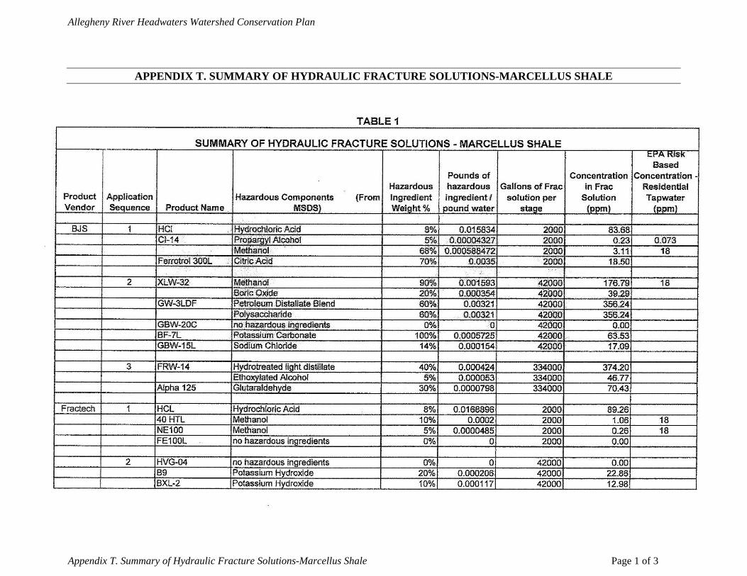
Allegheny River Headwaters Watershed Conservation Plan
APPENDIX T. SUMMARY OF HYDRAULIC FRACTURE SOLUTIONS-MARCELLUS SHALE
Appendix T. Summary of Hydraulic Fracture Solutions-Marcellus Shale Page 1 of 3
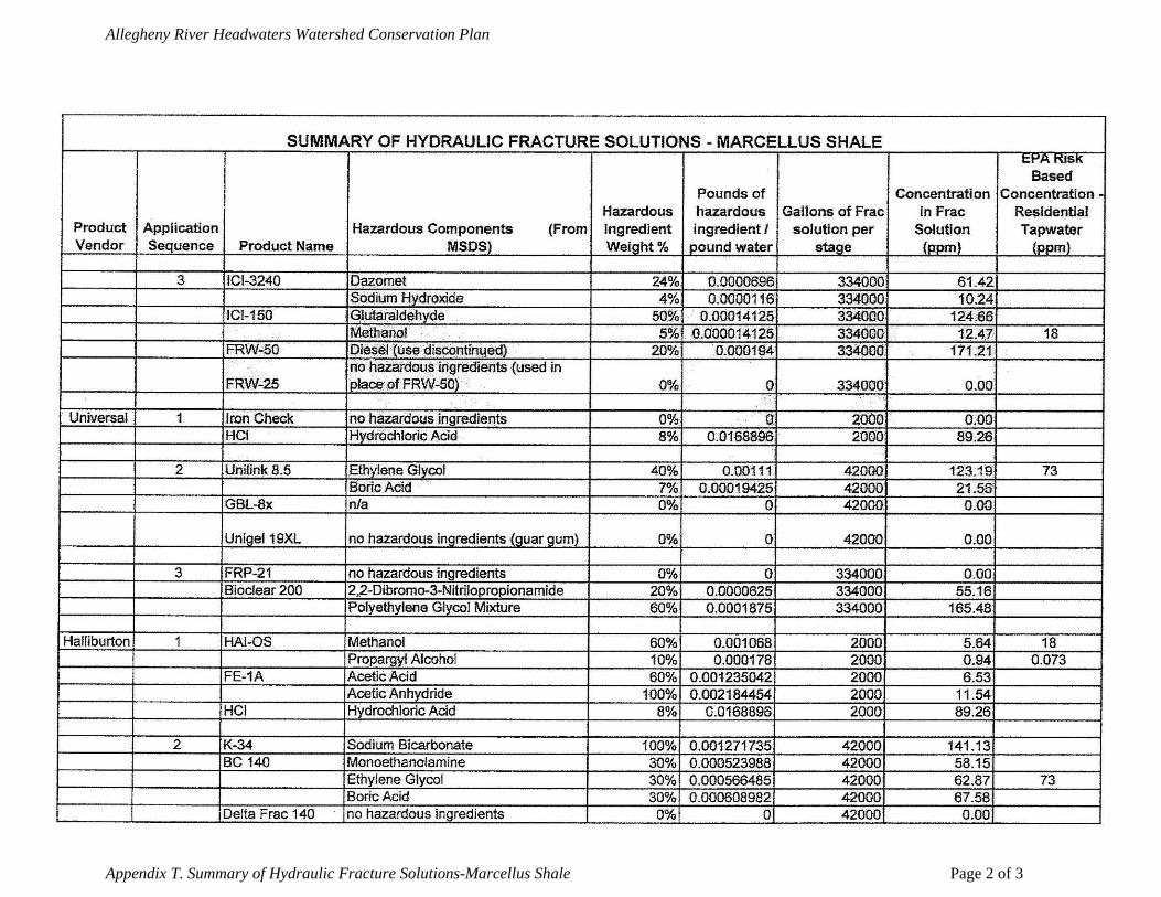
Allegheny River Headwaters Watershed Conservation Plan
Appendix T. Summary of Hydraulic Fracture Solutions-Marcellus Shale Page 2 of 3
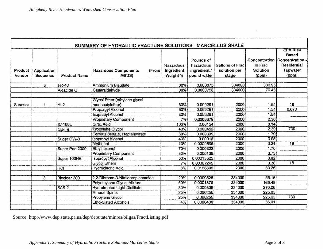
Allegheny River Headwaters Watershed Conservation Plan
Appendix T. Summary of Hydraulic Fracture Solutions-Marcellus Shale Page 3 of 3
Source: http://www.dep.state.pa.us/dep/deputate/minres/oilgas/FractListing.pdf
Allegheny River Headwaters Watershed Conservation Plan
APPENDIX U. INTERVIEW AND SURVEY QUESTIONS Interview Questions
1. How has the area changed in the past 10 years in terms of…? Were these changes good, bad, indifferent?
2. How do the following meet the needs of the community? (Are the quantities
sufficient, insufficient, or satisfactory? Are they in good condition or in need of repair/improvement?) Do you have any proposed solutions or management recommendations?
a. Transportation –area roads, public transportation, availability or ease of
using alternative transportation (biking, walking trails, etc.) to get around the area
b. Infrastructure – water and sewer lines, communications (cell phone reception, Internet service, etc.)
c. Employment opportunities d. Educational opportunities e. Land-use ordinances & zoning
3. Do the recreational opportunities currently meet the needs of the community and
visitors? (Are there too many, not enough, or a sufficient number? What condition are they in? Are they easy to access?) Do you suggest any improvements or additions to the recreational opportunities throughout the area?
a. Parks/Picnic Sites b. Hiking/Biking Trails c. Off- Road Vehicle Riding d. Scenic Vistas/Photography e. Wildlife/Bird Watching
f. Hunting/Fishing g. Boating/Swimming h. Historical Sites/Structures i. Other j. Winter Recreation
4. What are some of the positive features of the watershed/area? (Please consider both ecology and social/community features in your answer, from water quality to economics.) What is one of the strongest or most attractive features/characteristic of the watershed area?
5. What impacts (positive or negative) are currently affecting the land, water, and
biological resources? What positive/negative impacts are affecting the community character of the region? What impacts are affecting the local economy?
6. Do you have any specific projects or type of projects you would like to see identified in
the plan? (Examples: Stream access locations for fishing/paddling; Erosion control projects; Trail development or linkages; Dirt and gravel road improvements; Restoration
Appendix U. Interview and Survey Questions Page 1 of 2
Allegheny River Headwaters Watershed Conservation Plan
of a particular site or area affected by abandoned mines or mine refuse; Illegal dumpsites to be cleaned-up; Invasive plant infestations to control; Important natural areas to protect.)
7. What must the watershed conservation plan include to be successful?
8. Do you have any other concerns that we have not discussed?
9. Do you know of any other people we should ask to interview?
10. Do you have any questions or comments before we conclude this interview?
Survey Questions
Municipal Surveys 1.) Does your municipality have a comprehensive plan? YES or NO
If yes, what is the name of the plan(s) and when was it adopted? 2.) Does your municipality currently utilize zoning? YES or NO Does your municipality currently utilizing subdivision ordinances? YES or NO Does your municipality have floodplain ordinances? YES or NO 3.) Are there any municipal parks in your municipality? If yes, please list them? 4.) a. Does your municipality have any public water services in the project area? YES or NO Supplier_____________________________ b. Do you foresee the need to upgrade or establish a public water supply in your municipality in the project area within the next ten years? YES or NO 5.) a. Does your municipality have any public sewage systems in the project area? YES or NO Treatment System ___________________________ b. Do you foresee the need to upgrade or establish a public sewage system in your municipality in the project area within the next ten years? YES or NO 6.) Who provides emergency services, such as: Police ___________________________________ Fire _____________________________________ EMS ____________________________________ 7.) Is there anything unique, or well known about your municipality that you would like to have highlighted in the plan? 8.) Comments Public Surveys
Appendix U. Interview and Survey Questions Page 2 of 2
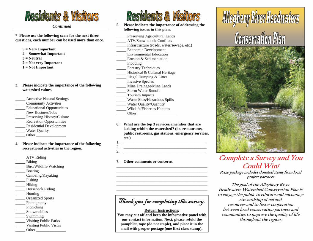
Complete a Survey and You Complete a Survey and You Complete a Survey and You Could Win!Could Win!Could Win!
Prize package includes donated items from local Prize package includes donated items from local Prize package includes donated items from local project partnersproject partnersproject partners
Continued
3. Please indicate the importance of the following watershed values.
_____ Attractive Natural Settings _____ Community Activities _____ Educational Opportunities _____ New Business/Jobs _____ Preserving History/Culture _____ Recreation Opportunities _____ Residential Development _____ Water Quality _____ Other _______________
5. Please indicate the importance of addressing the following issues in this plan.
_____ Preserving Agricultural Lands _____ ATV/Snowmobile Conflicts _____ Infrastructure (roads, water/sewage, etc.) _____ Economic Development _____ Environmental Education _____ Erosion & Sedimentation _____ Flooding _____ Forestry Techniques _____ Historical & Cultural Heritage _____ Illegal Dumping & Litter _____ Invasive Species _____ Mine Drainage/Mine Lands _____ Storm Water Runoff _____ Tourism Impacts _____ Waste Sites/Hazardous Spills _____ Water Quality/Quantity _____ Wildlife/Fisheries Habitats _____ Other ____________________
6. What are the top 3 services/amenities that are lacking within the watershed? (i.e. restaurants, public restrooms, gas stations, emergency services, etc.)
1. __________________________________________ 2. __________________________________________ 3. __________________________________________
* Please use the following scale for the next three questions, each number can be used more than once. 5 = Very Important 4 = Somewhat Important 3 = Neutral 2 = Not very Important 1 = Not Important
4. Please indicate the importance of the following recreational activities in the region.
_____ ATV Riding _____ Biking _____ Bird/Wildlife Watching _____ Boating _____ Canoeing/Kayaking _____ Fishing _____ Hiking _____ Horseback Riding _____ Hunting _____ Organized Sports _____ Photography _____ Picnicking _____ Snowmobiles _____ Swimming _____ Visiting Public Parks _____ Visiting Public Vistas _____ Other _______________
7. Other comments or concerns. ______________________________________________ ______________________________________________ ______________________________________________ ______________________________________________ ______________________________________________ ______________________________________________
Thank you for completing this survey.
Return Instructions: You may cut off and keep the informative panel with
our contact information. Next, please refold the pamphlet, tape (do not staple), and place it in the mail with proper postage (one first class stamp).
The goal of the Allegheny River Headwaters Watershed Conservation Plan is to engage the public to educate and encourage
stewardship of natural resources and to foster cooperation
between local conservation partners and communities to improve the quality of life
throughout the region.
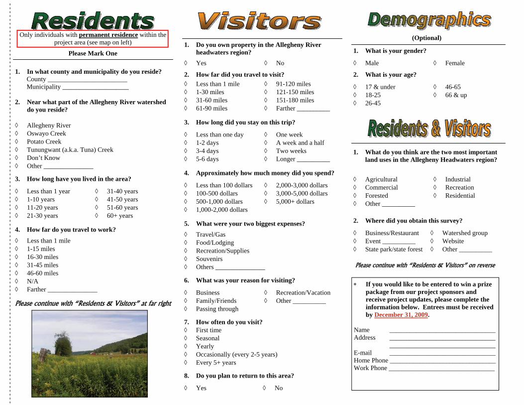
Only individuals with permanent residence within the project area (see map on left)
Please Mark One
1. In what county and municipality do you reside? County ________________________ Municipality ____________________ 2. Near what part of the Allegheny River watershed
do you reside? ◊ Allegheny River ◊ Oswayo Creek ◊ Potato Creek ◊ Tunungwant (a.k.a. Tuna) Creek ◊ Don’t Know ◊ Other _______________
(Optional)
- - -
- - -
- - -
- - -
- - -
- - -
- - -
- - -
- - -
- - -
- - -
- - -
- - -
- - -
- - -
- - -
- - -
- - -
- - -
- - -
- - -
- - -
- - -
- - -
- - -
- - -
- - -
- - -
- - -
- - -
- - -
- - -
- - -
- - -
- -
1. Do you own property in the Allegheny River headwaters region?
◊ Yes ◊ No
2. How far did you travel to visit? ◊ Less than 1 mile ◊ 1-30 miles ◊ 31-60 miles ◊ 61-90 miles
◊ 91-120 miles ◊ 121-150 miles ◊ 151-180 miles ◊ Farther __________
3. How long did you stay on this trip?
◊ Less than one day ◊ 1-2 days ◊ 3-4 days ◊ 5-6 days
◊ One week ◊ A week and a half ◊ Two weeks ◊ Longer __________
4. Approximately how much money did you spend?
◊ Less than 100 dollars ◊ 100-500 dollars ◊ 500-1,000 dollars ◊ 1,000-2,000 dollars
◊ 2,000-3,000 dollars ◊ 3,000-5,000 dollars ◊ 5,000+ dollars
6. What was your reason for visiting?
◊ Business ◊ Family/Friends ◊ Passing through
◊ Recreation/Vacation ◊ Other __________
7. How often do you visit? ◊ First time ◊ Seasonal ◊ Yearly ◊ Occasionally (every 2-5 years) ◊ Every 5+ years
1. What do you think are the two most important land uses in the Allegheny Headwaters region?
◊ Agricultural ◊ Commercial ◊ Forested ◊ Other __________
◊ Industrial ◊ Recreation ◊ Residential
2. Where did you obtain this survey?
◊ Business/Restaurant ◊ Event __________ ◊ State park/state forest
◊ Watershed group ◊ Website ◊ Other __________
Please continue with “Residents & Visitors” on reverse
3. How long have you lived in the area?
◊ Less than 1 year ◊ 1-10 years ◊ 11-20 years ◊ 21-30 years
◊ 31-40 years ◊ 41-50 years ◊ 51-60 years ◊ 60+ years
4. How far do you travel to work?
◊ Less than 1 mile ◊ 1-15 miles ◊ 16-30 miles ◊ 31-45 miles ◊ 46-60 miles ◊ N/A ◊ Farther _______________ Please continue with “Residents & Visitors” at far right
◊ 17 & under ◊ 18-25 ◊ 26-45
◊ 46-65 ◊ 66 & up
2. What is your age?
1. What is your gender?
◊ Male ◊ Female
∗ If you would like to be entered to win a prize package from our project sponsors and receive project updates, please complete the information below. Entrees must be received by December 31, 2009.
Name ________________________________ Address ________________________________ ________________________________ E-mail ________________________________ Home Phone ________________________________ Work Phone ________________________________
◊ Travel/Gas ◊ Food/Lodging ◊ Recreation/Supplies ◊ Souvenirs ◊ Others _______________
5. What were your two biggest expenses?
8. Do you plan to return to this area?
◊ Yes ◊ No
Allegheny River Headwaters Conservation Plan
APPENDIX V. PUBLIC COMMENTS
Issue, concern, or comment Action taken Public Meetings Add Sierra Club, Pennsylvania chapter to Appendix Q. Added Address radioactivity of Marcellus shale gas extraction. Marcellus shale sections in
Chapter 2 and Chapter 3 were amended
Distinguish between active, abandoned, and Marcellus shale gas wells on map 2-4.
Map revised
Address further concerns related to Marcellus shale gas exploration, including wastewater management, inter-basin transfer of water, lack of a river basin commission to regulate Ohio Basin, water quantity/availability, etc.
Marcellus shale sections in Chapter 2 and Chapter 3 were amended
Reword Management Recommendation Goal 2-7, Objective 1 from “…’redevelop’ golf course…” to “…’restore’ golf course area to a more natural open space setting.
Objective reworded
Page 5-2, Andy Pantuso Memorial Ball Field misspelled Corrected Appendix G. illegal dumpsite #29 Hedghog Lane misspelled in
two places Corrected
Appendix R. page 21 forward, table extends to next page causing formatting errors
Corrected
Page 6-15 Pantuso misspelled again Corrected Page 6-21 section header for Land-use Ordinances and Zoning
separated from body of text below. Corrected
Add “frack” to Appendix A. Glossary. Added Add gridlines to Appendix H to make it easier to read
corresponding designation. Reformatted
Amphibians is misspelled in Appendix K. Corrected Emphasize education in management recommendations Recommendations specifically
related to education and funding are included throughout chapter 7
Individual (Bill Knight)
Chapter 1 – Project Area Characteristics – Socioeconomic Profile – Transportation and Safety: please expand the Public Transportation section to detail services offered by the Area Transportation Authority of North Central Pennsylvania (ATA) http://www.rideata.net and Fullington Trailways (FT) http://www.fullingtontours.com. Currently, the ATA has limited fixed route and/or call a bus service within all counties of the Allegheny River Headwaters Conservation Plan. One daily round trip from Pittsburgh to Buffalo, via route 219 is scheduled by FT.
Section amended to include this additional information
Chapter 3 – Water Resources – Location – Tunungwant Creek: please include the warm water fishery (WWF) tributary of Kendall Creek within the Tunungwant Creek summary paragraph.
Kendall Creek was added to the summary
Appendix V. Public Comments Page 1 of 2
Allegheny River Headwaters Conservation Plan
Appendix V. Public Comments Page 2 of 2
Issue, concern, or comment Action taken Pennsylvania Department of Conservation and Natural Resources – Bureau of Recreation and Conservation
Please check the captions in the text for consistency regarding the use of periods and capitalization.
All captions reviewed and corrected
Priorities need to be listed for the goals and objectives listed in the Management Recommendations chapter.
Management recommendations were prioritized by the public during the draft review period and added to Chapter 7
Please list the contact information for all of the funding sources listed in Appendix M.
Contact information was included for all funding sources
Roulette Township Our correct address is:
Roulette Township 80 Railroad Ave. P.O. Box 253 Roulette, PA 16746
Address corrected in Appendix Q and on distribution list for final plan mailing
Conservation Guidance for Landowners on Natural Gas Development
June 2010
Natural gas exploration and extraction activity have increased significantly across western Pennsylvania in recent years. Extraction of natural gas, much like any extractive activity, can have negative effects including serious environmental impacts. Western Pennsylvania Conservancy believes that conservation of the landscape and landowner management goals should be carefully considered prior to entering into a natural resource extraction lease agreement. Conservation features on the property that may need additional protection measures include but are not limited to the following: any water features such as streams, springs, seeps, and wetlands; steep slopes (generally those having a slope of 20% or greater); intact forests; wildlife habitat; native flora and fauna; natural vegetation and floodplain areas; recreational activities and scenic vistas. It is important for the landowner to be aware of any potential negative impacts, as well as their rights as a landowner to control and guide any potential extractive use on their land. More specifically, in order to conserve the landscape, landowners should work with the land agent to carefully establish guidelines and develop an addendum to the lease agreement that permits recovery of this resource while at the same time promoting protection of ecologically-sensitive landscapes that include natural communities and species habitat. Site visit Upon request for a lease, the landowner should meet with the interested party and conduct a site visit on the property to identify potential impacts to the ecological resources on the land. This evaluation should consider:
• Conservation of natural communities, wildlife habitat, species of special concern • Impacts to recreational opportunities and scenic vistas • Degree of landscape fragmentation • Potential effects upon hydrology, water quality, air and noise pollution • Ability to significantly improve or restore degraded natural resources
The developer should use available data to locate plant and animal species of special concern (including without limitation searches or surveys the developer otherwise may be required to conduct pursuant to applicable environmental laws, or any searches or surveys conducted by a governmental entity). The site visit should occur prior to the start
of seismic work. A seismic plan should be submitted to the landowner which includes a map showing all proposed seismic lines and test hole locations, as well as conservation values and features as identified in the site visit. For Marcellus gas development, one well pad can now be used with directional drilling technology to extract natural gas from more than one square mile of shale that is located over a mile underground. Therefore, a landowner may decide to sign a lease but not allow any surface drilling or other infrastructure such as roads and pipelines on the property, but allow the gas to be extracted from another property nearby. This may result in lower payments from the developer, but it may better protect ecological resources on the property. The remainder of these conservation considerations focuses mostly on leases where drilling or other surface activities are permitted on the land owners’ property. If a significant gas source is found and a project moves forward, the developer should coordinate with the landowner as to the location of all proposed development including placement of a well or wells, access roads and pipelines and any other facility or equipment that will support the proposed operation. If the developer proceeds with extraction, the landowner should make sure the following details are addressed:
• Indicate parameters where no drilling is to occur; • Identify maximum number of wells drilled per site; • Require lease to include erosion and sediment control plan to be completed by
developer and approved by the landowner prior to any earthmoving activity including well site clearing, well pad construction, pipeline construction and access road enhancement; and
• Require submission of a restoration and re-vegetation plan to be completed by developer and approved by landowner which identifies specific steps taken to minimize site disturbance, and addresses any alterations in the land associated with the extraction or transmission activities.
Lease Agreement All new leases should obtain a comprehensive insurance provision, indemnification and hold harmless clause to protect the landowner against degradation of ecological resources. Leases with an insurance provision should be enforced by the landowner (i.e. both proof of insurance and the landowner listed on the policy as an additional insured). The landowner should also require a performance bond to ensure the developer meets the terms of the agreement. All activities and operations must be in accordance with the laws of the Commonwealth of Pennsylvania. The developer must obtain and follow the appropriate permit application process, and secure a performance bond to ensure parameters for drilling are met.
Specific recommendations for items to include in the addendum to the lease agreement: Master Site Plan – The developer should submit a master site plan to the landowner which would include the following:
(a) a map or plat indicating the location of each and every well drilled or proposed for drilling; (b) a map or plat indicating the location of each existing potable and non-potable water well; (c) a map or plat indicating the location of each potable and non-potable water well drilled or to be drilled; (d) a route map indicating the location of each pipeline laid or to be laid; (e) a map or plat indicating the location of each existing road proposed for use; (f) a map or plat indicating the location of each bridge, drain pipe or culvert pipe to be constructed; (g) a plat, diagram and/or schematics indicating the location, design, construction of each slush pit to be constructed together with a corresponding maintenance plan for each such pit; (h) a map or plat indicating the location of stream, creek, brook, or wetland together with the location of each proposed drilling site and proposed clearing site near each such stream, creek, brook, or wetland; and (i) a map or plat that contains information regarding locations of plant and animal species of special concern, as well as locations of natural communities.
Erosion and Sedimentation Control Plan – This plan should include the following: (a) existing topographic features of the site; (b) contours, ditches and other excavations; (c) water bars or diversion channels for surface runoff to prevent siltation; (d) settling basins; (e) spreading of gravel or shale on intercepting dips; (f) installation of silt fences; (g) stabilization of cut slopes; (h) stabilization of highwalls; and (i) restoration and revegetation of the property as described in a restoration and re-vegetation plan.
Wells – To reduce fragmentation and invasive plant pathways, the developer should locate wells closer to previously disturbed or developed footprint (such as landings, roads, barrow pits, pipelines and wells). Such wells should be camouflaged or screened with native plants to reduce aesthetic impacts.
Water – Water quality and quantity should be carefully considered and monitored prior to and following the extraction activity. The developer should not contaminate or pollute springs, brooks, streams, wetlands, vernal pools or other waters on the property. Any water well usage should be restricted to drilling processes only. Water well usage should not be used for frac, stimulation or completion processes. The developer or its contractors and subcontractors should not construct earthen dams across
any stream to obtain a water supply for its operations. Developer should remove all water used in drilling and fracing processes from the property including water developed from the well. In addition, the developer must supply the landowner with a plan to address water source pollution in the event of a leak.
Well Plugging – At its own expense, developer should properly and effectively plug all wells on the leased premises before abandoning, in accordance with the regulations of the Department of Environmental Protection’s Bureau of Oil and Gas Management and all applicable laws of the Commonwealth. A copy of the Certificate of Well Plugging showing the plugging procedure used and submitted to the Bureau of Oil and Gas Management should be supplied to the landowner for each well plugged and abandoned. Parameters should be established to determine acceptable production rates. If production falls below the rate and is determined to be uneconomic (i.e., not in paying quantities) to maintain and operate, then developer should (a) plug and abandon the well and (b) restore the well site and access road to the satisfaction of landowner within a specified timeframe. At the end of production, whether or not oil or gas is produced, the developer is required to cover all costs to plug the wells (according to Section 601.210 of the Oil and Gas Act) and restore all disturbed acres. All wells no longer in use should be plugged by the operator(s). Pipelines – Where possible, pipelines should be laid within the boundaries of existing roads or rights of way, such as existing pipelines and transmission lines. Developer should submit a route map for each pipeline to the landowner for review and approval as to location prior to the laying of any line. Developer should keep the pipeline and right-of-way in good repair and appearance. Drilling – It is best to limit the number of wells and number of disturbed acres. It is recommended that a buffer area (e.g. 300 feet) be included for all water sources (rivers, creeks, streams, wetlands, etc.) to prohibit drilling in certain areas. Clearing on steep slopes (those greater than 20%) should also be restricted. Pits – Developer should prevent access of wildlife to pits or excavations dug for Developer's operations by erecting and maintaining fences. Developer should have thirty (30) days from date of completion of a well to reclaim the pit. Pits must be lined with an impervious liner, not merely clay. When drilling is complete, pit liner and its contents should be properly disposed offsite. Developer should ensure that each slush pit will consist of two (2) compartments; one to contain fluids materials from the drilling operations and the second to contain surface runoff from the drilling site. Appropriate buffers should be established for pits as well.
Roads – All road locations and grades must be identified in the Master Site Plan. The landowner should limit the size of all new roads (e.g., determine an appropriate road width to be 20 feet). The location of drilling operations should be close to existing roads to prevent further fragmentation of the property. Developer should construct access roads to drilling sites along existing pipeline rights-of-way, provided that a ten percent
(10%) grade can be maintained, as described in the Erosion and Sedimentation Control Plan. Road drainage structures should conform to the Environmental Sensitive Maintenance Principles of Penn State’s Center for Dirt and Gravel Roads program.
Erosion Sedimentation and Grading – Topsoil disturbed during construction shall be stored on uphill side of disturbed area, saved and put back during reclamation. Developer should regrade and refill to contour any areas of land cleared for construction and infrastructure placement within ten (10) working days following disturbance and should reseed according to the restoration and revegetation plan. Temporary seedling should be required, in addition to permanent revegetation. Gravel or shale should be spread on intercepting dips that become subject to erosion. Further, the developer should, at its own expense, secure, plant and maintain native species (consisting of grasses and/or trees or shrub seedlings) on all well sites, retired access roads, pipeline rights-of-way and other cleared areas. Use of Department of Conservation and Natural Resources Gas Lease – The landowner may need to enter into a lease agreement that has more stringent terms than the standard lease agreement provided by the developer. WPC recommends using DCNR’s 2007 gas lease as a guiding document. Nothing in this document constitutes legal advice. Western Pennsylvania Conservancy recommends that any landowner considering entering into a natural gas lease agreement should obtain the advice of an attorney and a consultant specializing in natural gas leasing. In addition, many resources are available online that can provide basic information and education. Penn State College of Agricultural Sciences Cooperative Extension: http://extension.psu.edu/naturalgas/publications DEP, Bureau of Oil and Gas Management, Marcellus Shale http://www.dep.state.pa.us/dep/deputate/minres/oilgas/new_forms/marcellus/marcellus.htm DEP, fact sheet Landowners and Oil and Gas Leases in Pennsylvania http://www.elibrary.dep.state.pa.us/dsweb/Get/Document-44185/5500-FS-DEP2834.pdf DCNR, Marcellus Shale research in Pennsylvania http://www.dcnr.state.pa.us/topogeo/oilandgas/marcellus.aspx
Related Documents