All policy and standards in this document have been superseded by the FEMA Policy for Flood Risk Analysis and Mapping. However, the document contains useful guidance to support implementation of the new standard

Welcome message from author
This document is posted to help you gain knowledge. Please leave a comment to let me know what you think about it! Share it to your friends and learn new things together.
Transcript
All policy and standards in this document have been superseded by the FEMA Policy for Flood Risk Analysis and Mapping. However, the document contains useful guidance to support implementation of the new standard

Guidelines and Specifications for Flood Hazard Mapping Partners [April 2003]
Summary of Changes for Appendix B,
Converting to the North American Vertical Datum of 1988
The Summary of Changes below details changes to Volume 1 that were made subsequent to the initial publication of these Guidelines in February 2002. These changes represent new or updated guidance for Flood Hazard Mapping Partners.
Date Affected Section/Subsection Description of Changes
April 2003 No guidance was revised
All policy and standards in this document have been superseded by the FEMA Policy for Flood Risk Analysis and Mapping. However, the document contains useful guidance to support implementation of the new standard

Guidelines and Specifications for Flood Hazard Mapping Partners [April 2003]
Appendix B
Converting to the North American
Vertical Datum of 1988 This Appendix contains general information about the two vertical datums most commonly used in by the Federal Emergency Management Agency (FEMA) in preparing National Flood Insurance Program (NFIP) maps for the collection of vertical datum information, criteria for converting to the North American Vertical Datum of 1988 (NAVD88), guidance for the conversion of unrevised flood elevations, and guidance for converting to the National Geodetic Vertical Datum of 1929 (NGVD29).
B.1 Vertical Datums [February 2002] Every NFIP map that contains detailed flood hazard information is prepared based on hydraulic analyses that are referenced to a specific vertical datum. The two standard datums in use nationwide are NGVD29 and NAVD88. Information on these datums and on software that is available to convert to or from NAVD88 is provided in Subsections B.1.1, B.1.2, and B.1.3.
B.1.1 National Geodetic Vertical Datum of 1929 [February 2002]
Historically, the most common vertical datum used by FEMA has been NGVD29. NGVD29 assumed that 26 tide gages in the United States and Canada all represented the same zero elevation, which was mean sea level. As survey technologies became more accurate, it became increasingly apparent that NGVD29 constraints were incorrectly forcing surveys to fit different tide stations (all zero elevation or mean sea level) that actually had different elevations relative to each other. NGVD29 essentially warped the geoid, which represents an equipotential surface where gravity and elevations should be the same. Fortunately, the maximum warp anywhere in the United States, caused by forced constraints of NGVD29 at 26 tidal stations, is no more than 1.5 meters. Although there are exceptions, the warping found over smaller geographic areas, such as the area within a county, is small.
B.1.2 North American Vertical Datum of 1988 [February 2002]
During the 1970s, the National Geodetic Survey (NGS), and counterpart agencies in Mexico and Canada, decided to adopt a vertical datum based on a surface that would closely approximate the Earth’s geoid. The new adjustment, NAVD88, was completed in June 1991 and is now the only official vertical datum in the United States. NAVD88 was created by adding 625,000 kilometers of leveling, performed since NGVD29 was established, and performing a major least squares adjustment that constrained only a single tide station at zero elevation. The height of the primary tidal bench mark at Father Point/Rimouski in Quebec, Canada, was held fixed as the constraint, enabling NAVD88 and the International Great Lakes Datum of 1985 (IGLD85) to be one and the same.
Section B.1 B-1 All policy and standards in this document have been superseded by the FEMA Policy for Flood Risk Analysis and Mapping.
However, the document contains useful guidance to support implementation of the new standard
Guidelines and Specifications for Flood Hazard Mapping Partners [April 2003]
Now, other tide stations may have elevations other than zero. Subsequent to the establishment of NAVD88, new flood hazard studies are preferably referenced to that datum.
B.1.3 Conversion Software [February 2002]
The NGS and the U.S. Army Corps of Engineers (USACE) have developed software, which may be obtained free of charge, for performing conversions between NGVD29 and NAVD88. Mapping Partners may download the PC-compatible NGS VERTCON software from the NGS home page at www.ngs.noaa.gov, by selecting the NGS Geodetic Tool Kit option. Similarly, Mapping Partners may download the USACE CORPSCON software from the U.S. Army Topographic Engineering Center home page at www.tec.army.mil, by selecting What We Do; Products and Services; Software Available, and CORPSCON. Mapping Partners can use the CORPSCON software to convert horizontal datums (between the North American Datum of 1927 [NAD27] and North American Datum of 1983 [NAD 83]) as well as vertical datums (between NGVD29 and NAVD88) based on NGS NADCON and VERTCON software. Both programs compute the modeled differences in orthometric heights (elevations) between NGVD29 and NAVD88 for a given location specified by geographic coordinates (latitude and longitude). Using CORPSCON, Mapping Partners can also enter Universal Transverse Mercator or State Plane coordinates in lieu of geographic coordinates. Mapping Partners may obtain identical results using either the VERTCON or CORPSCON software.
Section B.1 B-2 All policy and standards in this document have been superseded by the FEMA Policy for Flood Risk Analysis and Mapping.
However, the document contains useful guidance to support implementation of the new standard
Guidelines and Specifications for Flood Hazard Mapping Partners [April 2003]
B.2 Data Collection [February 2002] One of the goals of the FEMA Map Modernization Program is to convert all flood maps from NGVD29 to NAVD88. The Mapping Partners that participate in Flood Map Projects or that submit map revision requests under Part 65 of the NFIP regulations shall apply proper vertical datum protocols for new and/or revised flood hazard data when preparing or revising map and report materials that have been chosen for the datum conversion. FEMA recognizes that there are, and will continue to be, limiting factors in achieving this conversion.
To evaluate the suitability of a subject jurisdiction for datum conversion, the assigned Mapping Partner shall gather the following information during the initial coordination efforts for the Flood Map Project or map revision:
• Datum used for the effective Flood Insurance Rate Map (FIRM), Flood Boundary and Floodway Map (FBFM), and Flood Insurance Study (FIS) report, if such materials exist, and the extent of changes that will occur as a result of the Flood Map Project;
• Number (percentage) of flooding sources that will be revised and the number of unrevised flooding sources that must be converted from NGVD29 to NAVD88 if the datum conversion option is chosen;
• Conversion factor from NGVD29 to NAVD88 for the subject community, whether the conversion factor for the community is constant, and maximum offset from the established conversion factor (see Section B.4.1);
• Reference datum used by FEMA for adjacent communities;
• Datum of choice for local surveyors and any known difficulties that the community would have with NAVD88; and
• Approximate level of effort (hours and costs) associated with conversion from NGVD29 to NAVD88.
Section B.2 B-3 All policy and standards in this document have been superseded by the FEMA Policy for Flood Risk Analysis and Mapping.
However, the document contains useful guidance to support implementation of the new standard

Guidelines and Specifications for Flood Hazard Mapping Partners [April 2003]
B.3 Conversion Criteria [February 2002] To eliminate possible confusion and misuse of elevation information, the flood elevations for all flooding sources studied by detailed methods within a given community must be referenced to the same datum. Therefore, if a Mapping Partner undertakes a Flood Map Project or map revision that does not include all flooding sources studied by detailed methods, the elevations for the unrevised flooding sources also must be converted to NAVD88.
Therefore, it is essential for the Project Management Team, led by the Regional Project Officer (RPO) or other FEMA Lead, to make an initial sound decision about which vertical datum can and should be used. Once the assigned Mapping Partner has gathered the information specified in Section B.2, FEMA, in consultation with all involved Mapping Partners, will make the final decision regarding the datum to which the new, revised, and unrevised flood hazard information will be referenced. The decision to use NAVD88 rather than NGVD29 will depend largely on the data gathered early in the process. Criteria that facilitate a conversion from NGVD29 to NAVD88 are as follows:
• All flooding sources in the community are being studied or restudied by detailed methods.
• Less than 50 percent and fewer than 20 miles of detailed-study streams that are not being revised will have to be converted from NGVD29 to NAVD88.
• No more than 5 percent of the total printed FIRM panels for the community have to be revised solely to convert the elevations for the unrevised flooding sources from NGVD29 to NAVD88.
• The maximum offset from an established average conversion (from NGVD29 to NAVD88) for the subject jurisdiction does not exceed 0.25 foot. Protocol for determining an average conversion factor as well as a maximum offset value is provided in Subsection B.4.1.
• The Mapping Partner performing the flood hazard analysis is able to use NAVD88.
• The community is familiar with NAVD88.
If the Flood Map Project or map revision involves a comprehensive restudy of all flooding sources studied by detailed methods, or if the Flood Map Project is resulting in a first-time FIRM, the assigned Mapping Partner shall reference all flood elevations to NAVD88 unless otherwise specified by FEMA.
The above criteria are provided for general guidance to aid Mapping Partners in making a technically sound, cost-effective, and user-friendly decision.
Section B.3 B-4 All policy and standards in this document have been superseded by the FEMA Policy for Flood Risk Analysis and Mapping.
However, the document contains useful guidance to support implementation of the new standard

Guidelines and Specifications for Flood Hazard Mapping Partners [April 2003]
B.4 Conversion of Unrevised Flood Elevations [February 2002] On rare occasions, a Mapping Partner will submit new or revised flood hazard information referenced to NAVD88 to FEMA to support preparation of a new or revised FIRM, but does not address the remainder of the unrevised flood elevations. In those circumstances, FEMA will decide whether the Mapping Partner that submitted the new or revised flood hazard information or the Mapping Partner preparing the Preliminary version of the FIRM will convert the unrevised flood hazard information to NAVD88. This decision will be made on a case-by-case cost-benefit assessment. If FEMA determines that the cost to convert the entire community is reasonable (considering the other work to be performed), the Mapping Partner that is selected to complete the conversion shall follow the procedures in Subsections B.4.1, B.4.1.1, B.4.1.2, and B.4.1.3.
B.4.1 Protocol for Determining Conversion Factor [February 2002]
The Mapping Partner responsible for conducting the new or revised flood hazard analyses shall establish single or multiple conversion factors to be applied to the unrevised 1-percent annual- chance (100-year) flood elevations presented in the FIS report and on the FIRM. To determine an average conversion factor from NGVD29 to NAVD88, the steps summarized below shall be followed.
Step 1 - Locate the Subject Jurisdiction
The Mapping Partner conducting the flood hazard analyses shall locate the subject jurisdiction on U.S. Geological Survey (USGS) 7.5-minute series topographic quadrangle maps.
Step 2 - Determe Conversion Factors for Quadrangle Corners
The Mapping Partner conducting the flood hazard analyses shall use VERTCON or CORPSCON to determine the conversion factor for each quadrangle corner that falls inside the jurisdiction boundary and each quadrangle corner that lies within 2.5 miles of the jurisdiction boundary. The Mapping Partner shall enter this information into a table that will be used in the FIS report (A sample table is provided in table B-1.) Details for the production of FIS reports are provided in Appendix J of these Guidelines.
Table B-1. Sample Conversion Table
Quad Name Corner Latitude Longitude Conversion from NGVD29 to NAVD88
Johnsonville West SE 35.375 82.125 -0.54 ft Johnsonville East SE 35.375 82.250 -0.32 ft Gilberts Corner SW 35.250 82.000 -0.54 ft
Farmville SW 35.250 82.125 -0.37 ft Taylor’s Grove SW 35.250 82.250 -0.25 ft Thompsonville SW 35.250 82.375 -0.14 ft
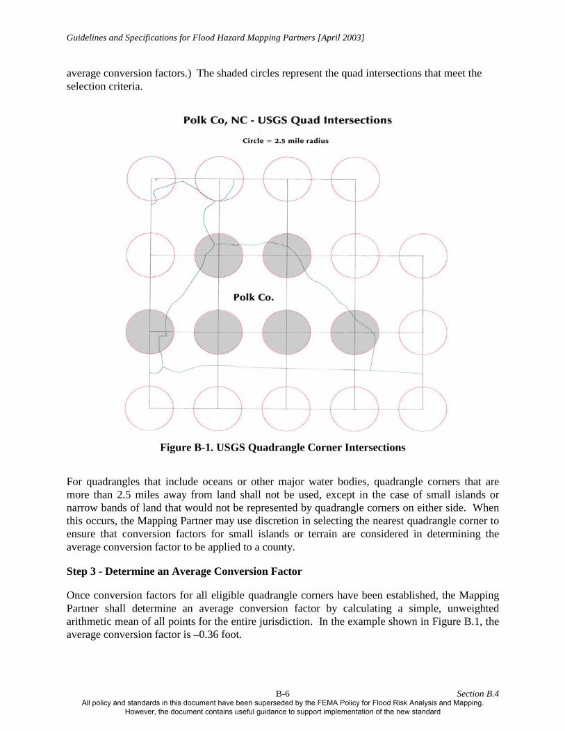
Figure B.1 shows five quadrangle corners within the county, and one outside the county that is within 2.5 miles of the county boundary. (This corner is thus to be included in the calculation of
Section B.4 B-5 All policy and standards in this document have been superseded by the FEMA Policy for Flood Risk Analysis and Mapping.
However, the document contains useful guidance to support implementation of the new standard
Guidelines and Specifications for Flood Hazard Mapping Partners [April 2003]
average conversion factors.) The shaded circles represent the quad intersections that meet the selection criteria.
Figure B-1. USGS Quadrangle Corner Intersections
For quadrangles that include oceans or other major water bodies, quadrangle corners that are more than 2.5 miles away from land shall not be used, except in the case of small islands or narrow bands of land that would not be represented by quadrangle corners on either side. When this occurs, the Mapping Partner may use discretion in selecting the nearest quadrangle corner to ensure that conversion factors for small islands or terrain are considered in determining the average conversion factor to be applied to a county.
Step 3 - Determine an Average Conversion Factor
Once conversion factors for all eligible quadrangle corners have been established, the Mapping Partner shall determine an average conversion factor by calculating a simple, unweighted arithmetic mean of all points for the entire jurisdiction. In the example shown in Figure B.1, the average conversion factor is –0.36 foot.
Section B.4 B-6 All policy and standards in this document have been superseded by the FEMA Policy for Flood Risk Analysis and Mapping.
However, the document contains useful guidance to support implementation of the new standard
Guidelines and Specifications for Flood Hazard Mapping Partners [April 2003]
Step 4 - Establish a Range of Conversion Factors
The Mapping Partner performing the flood hazard analyses shall establish a range of conversion factors from all eligible points (minimum and maximum values) for the subject jurisdiction from the values documented in Step 2. In Table B-1, the range of conversion factors is between –0.14 foot and –0.54 foot. The Mapping Partner shall use the range of conversion values, combined with the average conversion factor determined above, to determine if a conversion is needed, or if a passive-conversion approach is feasible. A passive conversion, discussed in more detail in Step 6 below, is defined as applying the average conversion factor determined above to the FIS report tables only. The FIRM and the Flood Profiles in the FIS report would not be affected by a passive conversion decision.
Step 5 - Determine the Maximum Offset
The Mapping Partner performing the flood hazard analyses shall determine the maximum offset from the average conversion factor, compared with the minimum and maximum conversion factors. In the example, the maximum offset is 0.22 foot (0.36 foot to 0.14 feet). If the Mapping Partner determines that the maximum offset exceeds 0.25 foot for any of the qualifying quadrangle corners, the Mapping Partner shall apply the multiple-conversion protocol (stream-by-stream conversion) detailed in Subsection B.4.1.2.
The exception to this requirement is situations whereby qualifying exterior quadrangle corners are the sole cause for the subject jurisdiction being ineligible for the application of a standard conversion value. To determine if this is the case, the Mapping Partner performing the flood hazard analyses shall replace anomalous conversion values that are obtained from quadrangle corners outside the subject jurisdiction with locations along the jurisdiction boundary closest to the anomalous quadrangle corner (one per quadrangle corner). Once this has been done, if the jurisdiction continues to be mathematically ineligible for conversion to NAVD88 using a standard jurisdiction-wide conversion value, the Mapping Partner shall use the stream-by-stream conversion approach detailed in Subsection B.4.1.2.
Step 6 - Establish the Conversion Factor
Using the values documented above, the Mapping Partner performing the flood hazard analyses shall establish a single average conversion factor or multiple conversion factors and apply the factor(s) to existing effective data to be converted to NAVD88. The criteria for determining whether a single conversion factor or multiple conversion factors will be used are described in Subsections B.4.1.1, B.4.1.2, and B.4.1.3. If the average conversion factor is less than 0.1 foot, Mapping Partner may apply only a passive datum conversion. As noted in Step 4, a passive conversion would affect the values shown on data tables in the FIS report, but would not affect the 1-percent-annual-chance flood elevations shown on the FIRM or on the Flood Profiles in the FIS report. The Mapping Partner shall apply the average conversion factor determined in Step 3 to all data tables in the FIS report containing flood elevations referenced to NGVD29. The use of this option is contingent on the range of conversion values determined in Step 4.
An average conversion of 0.1 foot or less could be deceiving in areas that contain conversions to NAVD88 that show plus and minus values. To illustrate this point, Table B-2 shows a
Section B.4 B-7 All policy and standards in this document have been superseded by the FEMA Policy for Flood Risk Analysis and Mapping.
However, the document contains useful guidance to support implementation of the new standard

Guidelines and Specifications for Flood Hazard Mapping Partners [April 2003]
hypothetical county where the average conversion to NAVD88 was calculated to be -0.09 foot. However, Table B-2 also shows that the county contained a large range of conversion values thereby rendering a passive-conversion decision inappropriate.
Table B-2. Conversion Values for Hypothetical County Range of conversion values - 0.38 through + 0.24 Average conversion factor - 0.09 Maximum variance from the average conversion 0.33 Maximum variance from a no-conversion value 0.38
Table B-2 demonstrates that, although a jurisdiction may have an insignificant average conversion value (0.1 foot or less), the range of conversion values indicates that quadrangle corners that are more than 0.25 foot askew of a zero conversion factor exists. The situation shown in Table B-2 indicates that a passive-conversion approach could yield up to a 0.38-foot discrepancy in this county. For this reason, a 0.25-foot tolerance was established as the maximum variance acceptable from a passive-conversion value. This hypothetical jurisdiction also would be ineligible for the application of an average conversion factor. A multiple conversion (stream-by-stream) approach, as detailed in Section B.4.1.2 would be required for this county.
B.4.1.1 Single Conversion Factor [February 2002]
The Mapping Partner performing the flood hazard analysis may apply a single conversion factor when the maximum offset from the average conversion factor does not exceed 0.25 foot. When a decision has been made during the Project Scoping phase (discussed in detail in Volume 1, Section 1.3 of these Guidelines) to apply a datum conversion and a single conversion factor is appropriate, the Mapping Partner shall apply the following procedures:
1. Determine an average conversion factor for the subject community following the procedures detailed in Subsection B.4.1 and apply the average to the dynamic flood elevations.
2. Convert static (primarily, lacustrine) flood elevations using VERTCON or CORPSCON.
3. Apply the conversion factor to the FIRM and to all components of the FIS report that display 1-percent-annual-chance flood elevations.
4. Document the datum conversion details as specified in Appendix J of these Guidelines.
5. Ensure that all unrevised hydraulic models and supporting backup information are clearly labeled in the Technical Support Data Notebook (TSDN) to indicate that the FIRM and FIS report reflect a datum conversion, and document the process used to determine the applied conversion factor. (See Appendix M of these Guidelines for more information on the TSDN requirements.)
Section B.4 B-8 All policy and standards in this document have been superseded by the FEMA Policy for Flood Risk Analysis and Mapping.
However, the document contains useful guidance to support implementation of the new standard
Guidelines and Specifications for Flood Hazard Mapping Partners [April 2003]
B.4.1.2 Multiple Conversion Factors (Stream by Stream) [February 2002]
In situations where the range of conversion factors across the subject community is prohibitively high (thereby resulting in a maximum offset from the established average conversion factor of greater than 0.25 foot), the Mapping Partner performing the flood hazard analyses shall not apply a standard conversion factor for the entire community. In the event that conversion to NAVD88 remains a desirable option, the Mapping Partner shall convert the unrevised flood elevations on a stream-by-stream basis.
Under this approach, the Mapping Partner performing the flood hazard analyses shall develop an average conversion factor for each flooding source by establishing separate conversion factors at the upstream end of the studied reach, at the downstream end, and at an intermediate point, and developing an average conversion factor from those data. If the maximum offset from the average conversion factor determined for a flooding source converted in this fashion exceeds 0.25 foot, the Mapping Partner shall follow the protocol described in Subsection B.4.1.
When multiple conversion factors are applied on a stream-by-stream basis, the Mapping Partner performing the flood hazard analyses shall present the conversion factors in a table to be placed on the FIRM and in the FIS report. An example of the table to be used in this scenario is shown as Table B-3. As noted in Subsection B.4.1.1, when a datum conversion is conducted on unrevised flood elevations, the Mapping Partner responsible for preparing the TSDN shall ensure that all unrevised hydraulic models and supporting backup information are clearly labeled to indicate that the FIRM and FIS report reflect a datum conversion. In addition, the Mapping Partner converting the elevations to the new vertical datum shall document the process used to determine the applied conversion factor.
Section B.4 B-9 All policy and standards in this document have been superseded by the FEMA Policy for Flood Risk Analysis and Mapping.
However, the document contains useful guidance to support implementation of the new standard

Guidelines and Specifications for Flood Hazard Mapping Partners [April 2003]
Table B-3. Sample Multiple Conversion Factors Table
Stream Name Minimum Conversion
Maximum Conversion
Average Conversion
Maximum Offset
Jones Branch -0.74 -0.92 -0.81 0.11
Mud River -0.59 -0.80 -0.74 0.15
B.4.1.3 Conversion of Hydrologic and Hydraulic Models [February 2002]
In situations where the range of conversion factors for a given flooding source is prohibitively high (thereby resulting in a maximum offset from the average established for the flooding source of greater than 0.25 foot), the Mapping Partner performing the flood hazard analyses shall remodel the subject stream by applying either the VERTCON or the CORPSCON program to the effective hydrologic and hydraulic models. (NOTE: To date, these details and protocols have not been finalized and FIS report paragraphs have not been formulated to address this situation. The Mapping Partner shall establish requirements for each community through coordination with the RPO or other FEMA Lead.)
Section B.4 B-10 All policy and standards in this document have been superseded by the FEMA Policy for Flood Risk Analysis and Mapping.
However, the document contains useful guidance to support implementation of the new standard

Guidelines and Specifications for Flood Hazard Mapping Partners [April 2003]
B.5 Conversion from NAVD88 to NGVD29 [February 2002] The Project Team will normally select the datum during the Project Scoping phase (Volume 1, Section 1.3 of these Guidelines) for a Flood Map Project or before a Mapping Partner submits a map revision request under Part 65 of the NFIP regulations. However, situations may be encountered when the Mapping Partner performing the flood hazard analyses provides flood hazard data referenced to NAVD88, but FEMA determines that a full conversion is not an acceptable solution because of cost constraints or other reasons.
In such cases, the Mapping Partner responsible for preparing the Preliminary copies of the FIS report and FIRM shall develop an average conversion factor and apply it to convert the flood elevations provided by the Mapping Partner performing the flood hazard analyses from NAVD88 to NGVD29. For static flood elevations, the Mapping Partner preparing the Preliminary copies of the FIS report and FIRM may apply VERTCON or CORPSCON to convert the NAVD88 elevations to NGVD29. In those situations where an average conversion factor is not practical, the Mapping Partner preparing the Preliminary copies of the FIS report and FIRM may apply the approaches outlined in Subsections B.4.1.2 and B.4.1.3 as warranted and with the approval of FEMA.
Section B.5 B-11 All policy and standards in this document have been superseded by the FEMA Policy for Flood Risk Analysis and Mapping.
However, the document contains useful guidance to support implementation of the new standard

Guidelines and Specifications for Flood Hazard Mapping Partners [April 2003]
B.6 Flood Insurance Study Report Paragraphs [February 2002] For all Flood Map Projects and map revisions, the Mapping Partner responsible for preparing the Preliminary copies of the FIS report and FIRM shall follow the guidelines provided in Appendix J of these Guidelines, which detail the appropriate paragraphs to address datums and datum conversions.
Section B.6 B-12 All policy and standards in this document have been superseded by the FEMA Policy for Flood Risk Analysis and Mapping.
However, the document contains useful guidance to support implementation of the new standard
Related Documents