ALEXANDER STREET URBAN RENEWAL AREA City of Yonkers · Yonkers City Hall 40 South Broadway, Yonkers, NY 10701 November 2008

Welcome message from author
This document is posted to help you gain knowledge. Please leave a comment to let me know what you think about it! Share it to your friends and learn new things together.
Transcript

ALEXANDER STREET URBAN RENEWAL AREA
City of Yonkers · Yonkers City Hall 40 South Broadway, Yonkers, NY 10701
November 2008
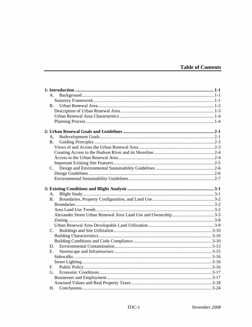
Table of Contents
1: Introduction .......................................................................................................................... 1-1 A. Background.................................................................................................................... 1-1
Statutory Framework.......................................................................................................... 1-1 B. Urban Renewal Area...................................................................................................... 1-2
Description of Urban Renewal Area .................................................................................. 1-3Urban Renewal Area Characteritics ................................................................................... 1-4 Planning Process ................................................................................................................ 1-4
2: Urban Renewal Goals and Guidelines ................................................................................ 2-1 A. Redevelopment Goals .................................................................................................... 2-1 B. Guiding Principles ......................................................................................................... 2-3
Views of and Across the Urban Renewal Area .................................................................. 2-3 Creating Access to the Hudson River and its Shoreline..................................................... 2-4 Access to the Urban Renewal Area.................................................................................... 2-4 Important Existing Site Features ........................................................................................ 2-5
C. Design and Environmental Sustainability Guidelines ................................................... 2-6 Design Guidelines .............................................................................................................. 2-6 Environmental Sustainability Guidelines........................................................................... 2-7
3: Existing Conditions and Blight Analysis ............................................................................ 3-1 A. Blight Study ................................................................................................................... 3-1 B. Boundaries, Property Configuration, and Land Use ...................................................... 3-2
Boundaries.......................................................................................................................... 3-2 Area Land Use Trends........................................................................................................ 3-2 Alexander Street Urban Renewal Area Land Use and Ownership..................................... 3-3 Zoning ................................................................................................................................ 3-8 Urban Renewal Area Developable Land Utilization.......................................................... 3-9
C. Buildings and Site Utilization...................................................................................... 3-10 Building Characteristics ................................................................................................... 3-10 Building Conditions and Code Compliance..................................................................... 3-10
D. Environmental Contamination..................................................................................... 3-13 E. Streetscape and Infrastructure...................................................................................... 3-15
Sidewalks ......................................................................................................................... 3-16 Street Lighting.................................................................................................................. 3-16
F. Public Policy ................................................................................................................ 3-16 G. Economic Conditions................................................................................................... 3-17
Businesses and Employment ............................................................................................ 3-17 Assessed Values and Real Property Taxes....................................................................... 3-18
H. Conclusions.................................................................................................................. 3-24
TOC-1 November 2008

Alexander Street Urban Renewal Plan
4: Implementation Actions .......................................................................................................4-1 A. Adoption of Alexander Street Urban Renewal Plan.......................................................4-1 B. Implementation Actions .................................................................................................4-1
City of Yonkers Actions .....................................................................................................4-1 Westchester County Actions...............................................................................................4-2 New York State Actions .....................................................................................................4-3 Federal Actions...................................................................................................................4-4
C. Environmental Review...................................................................................................4-4 D. Acquisition Policies........................................................................................................4-5 E. Relocation Plan ..............................................................................................................4-7 F. Future Amendments to the Urban Renewal Plan ...........................................................4-8
Duration of Controls ...........................................................................................................4-8 Amending the Plan .............................................................................................................4-8 Redeveloper Obligations ....................................................................................................4-8
TOC-2 November 2008

List of Tables
3-1 Existing Land Use in the Urban Renewal Area ...................................................................3-4
3-2a Land Use by Parcel, Blocks 2009 and 2010 ........................................................................3-4
3-2b Land Use by Parcel, Block 2099..........................................................................................3-5
3-2c Land Use by Parcel, Blocks 2100 ........................................................................................3-5
3-2d Land Use by Parcel, Block 2605..........................................................................................3-5
3-2e Land Use by Parcel, Block 2608..........................................................................................3-6
3-2f Land Use by Parcel, Block 2610..........................................................................................3-6
3-2g Land Use by Parcel, Block 2615..........................................................................................3-6
3-2h Land Use by Parcel, Block 2618..........................................................................................3-6
3-2i Land Use by Parcel, Block 2620..........................................................................................3-7
3-2j Land Use by Parcel, Block 2625..........................................................................................3-7
3-2k Land Use by Parcel, Block 2630..........................................................................................3-7
3-2l Land Use by Parcel, Blocks 2125, 2635, and 2640 .............................................................3-7
3-2m Land Use by Parcel, Block 7000.....................................................................................3-7
3-3 Total Land Area Per Zoning District ...................................................................................3-8
3-4 Permitted Land Use Utilization by Zoning District .............................................................3-9
3-5 Zoning of Developable Land Within the URA....................................................................3-9
3-6 Building Code Violation Records, 2001-2005...................................................................3-11
3-7 Assessed Values.................................................................................................................3-18
3-8 Assessed Values and Tax Revenues in Collins Phase I (Block 2600) ..............................3-20
3-9 Assessed Values of Privately Owned Parcels in the URA.................................................3-21
3-10 Assessed Values of Collins Phase I Development South of URA....................................3-22
3-11 Trends in Tax Revenues (1980–2006) ...............................................................................3-23
4-1 Properties Subject to Potential City of Yonkers Acquisition...............................................4-6
TOC-3 November 2008

List of Figures
1-1 Master Plan Area Boundary ........................................................................................... 1-2
2-1 View Corridors............................................................................................................... 2-2
2-2 Important Master Plan Area Features............................................................................. 2-4
3-1 Existing Land Use ......................................................................................................... 3-3
3-2 Existing Parcel Boundaries ............................................................................................ 3-4
3-3 Existing Zoning .............................................................................................................. 3-8
3-4 Existing FAR.................................................................................................................. 3-8
TOC-4 November 2008

Chapter 1: Introduction
In order to improve conditions and maximize public benefits, the Yonkers Community Development Agency (“CDA”) has prepared this Alexander Street Urban Renewal Plan (the “Urban Renewal Plan”) and an Alexander Street Master Plan (the “Master Plan”). Together, these plans present a land use strategy and “blueprint” for the redevelopment of the Alexander Street Urban Renewal Area (“URA”). The URA has the same geographic area as the Master Plan area.
By implementing the Urban Renewal Plan the CDA intends to remove blighted conditions, relocate affected businesses and households (if any), encourage private investment, redevelop cleared sites, and generally improve the economy and conditions of the City of Yonkers as a whole. Actions of this nature are controlled by New York State General Municipal Law, under Article 15, Urban Renewal, which includes requirements that the CDA must meet for the preparation of an Urban Renewal Plan. This Urban Renewal Plan will enable the CDA and the City of Yonkers to apply for funding unique to renewal actions, and so to implement the Master Plan, as described in this document.
This Urban Renewal Plan conforms to the City’s overall adopted Comprehensive Plan and intends to continue the City’s waterfront redevelopment initiatives. The Urban Renewal Plan conforms to Article 15 by containing a description of the URA, a proposed land use plan and redevelopment proposals, proposed methods of urban renewal, and an implementation program. While this document makes specific references to the Master Plan, it should be noted that the discussion in this document is only intended to provide a general overview of redevelopment goals. A more detailed discussion of goals and the overall redevelopment program can be found in the Master Plan.
For the reasons set forth in this Urban Renewal Plan, the CDA finds that the area roughly bounded by the Hudson River to the west, Wells Avenue to the south, the Metro-North Railroad right-of-way to the east, and the northern end of Trevor Park and JFK Marina Park to the north (the “Alexander Street Urban Renewal Area”) in its current condition is an area warranting redevelopment to improve the conditions of the area and the overall conditions of the City of Yonkers. A more detailed description of the URA boundary is provided below.
A. BACKGROUND
STATUTORY FRAMEWORK
New York State laws grant its municipalities the power to undertake urban renewal initiatives to redevelop areas determined to be blighted, deteriorated, or deteriorating.
Like many cities in New York, the City of Yonkers has very effectively used the urban renewal process to revitalize and redevelop areas and neighborhoods meeting these criteria in order to achieve public benefits in the form of housing, economic development, public amenities, and
1-1 November 2008

Alexander Street Urban Renewal Plan
increased fiscal and social strength and stability. To proceed with a redevelopment plan under the urban renewal process, a municipality makes a determination that a particular area—an urban renewal area—meets these criteria and, if so, prepares an urban renewal plan. The urban renewal plan sets the stage for redevelopment and embodies the City’s vision for how that urban renewal area should be in the future.
Upon adopting a plan for urban renewal, a municipality must determine that:
• The area is a substandard or insanitary area, or is in danger of becoming a substandard or insanitary area and tends to impair or arrest the sound growth and development of the municipality.
• The plan affords maximum opportunity to private enterprise, consistent with the sound needs of the municipality as a whole for the undertaking of an urban renewal program.
• The plan conforms to a comprehensive community plan for the development of the municipality as a whole.
• There is a feasible method for the relocation of families and individuals displaced from the URA into decent, safe, and sanitary dwellings, which are or will be provided in the URA or in other areas not generally less desirable in regard to public utilities and public and commercial facilities, at rents or prices within the financial means of such families or individuals, and reasonably accessible to their places of employment.
In addition, the municipality must find that the undertaking and carrying out of the urban renewal activities in stages is in the best public interest and will not cause any additional or increased hardship to the residents of such designated area.
This Urban Renewal Plan evaluates the URA and presents a redevelopment program aimed at remedying the deficiencies present in the area, and improving and enhancing the area so as to provide public benefits. Located on the City’s Hudson River waterfront, adjacent to the central business district and immediately accessible to public transit, including two Metro-North Railroad stations, the URA presents the potential to provide substantial public benefits to Yonkers as a whole.
B. URBAN RENEWAL AREA The URA, illustrated in Figure 1-1, is located along the Hudson River just north of downtown Yonkers. The area, as defined by property boundary maps on record at the City of Yonkers Tax Assessor’s Office, is generally bounded by the Hudson River to the west,1 Wells Avenue to the south, the Metro-North Railroad right-of-way to the east, and the northern end of Trevor Park and JFK Marina Park to the north. In addition, two small areas immediately east of the railroad tracks are being evaluated as part of the URA, including 23 parcels along Ashburton Avenue and seven parcels along Wells Avenue. In total, the URA comprises 85 tax parcels and approximately 153 acres. Certain parcels include land lying under the waters of the Hudson River. Therefore, there are approximately 112 acres of land and approximately 41 acres of water in the URA. The URA extends approximately 1.3 miles from north to south and land within it ranges in width from approximately one-tenth to two-tenths of a mile.
1 The western boundary of the URA is the westernmost of the City of Yonkers municipal boundary or the
western edge of individual parcels’ property lines.
1-2 November 2008

HU
DS
ON
RI V
ER
N. B
ROAD
WAY
PALI
SADE
S AV
E.
N. B
ROAD
WAY
WAR
BURT
ON
AVE.
WAR
BURT
ON
AVE.
O
LD C
ROTO
N AC
QUE
DUCT
WAR
BURT
ON
AVE.
ALEX
ANDE
R ST
.
LARKIN PLAZA
WELLS AVE.
ASHBURTON AVE.
LOCU
ST H
ILL
AVE.
WAR
BURT
ON
AVE.
ALEX
ANDE
R ST
.
LARKIN PLAZA
WELLS AVE.
ASHBURTON AVE.
GLENWOOD AVE.
GLENWOOD AVE.
GLENWOOD AVE.
GLENWOOD AVE.
HIGH STREET
HIGH STREET
BABCOCK PL.
LAMARTINE AVE.
GOLD ST.
POINT ST.
UNION PL.
BABCOCK PL.
LAMARTINE AVE.
PALI
SADE
S AV
E.
WO
ODW
ORT
H AV
E.
RAVI
NE A
VE.
WO
ODW
ORT
H AV
E.
GOLD ST.
POINT ST.
UNION PL. RA
VINE
AVE
.
LOCU
ST H
ILL
AVE.
JFK
MEMOR
IAL D
R.
HUDS
ON
TERR
.
SHO
NNAR
D TE
RR.
HUDS
ON
TERR
.
SHO
NNAR
D TE
RR.
WAR
BURT
ON
AVE.
10.3
1.07
Figure 1-1
Urban Renewal Area Boundary
SCALE
0 400 1000 FEET
YONKERS ALEXANDER STREET URBAN RENEWAL PLAN
Urban Renewal Area*
* The western Urban Renewal Area boundary is thewesternmost of either the municipal boundary of theCity of Yonkers, or the boundary of the individualparcels comprising the Urban Renewal Area.

Chapter 1: Introduction
DESCRIPTION OF URBAN RENEWAL AREA
The boundaries of this URA, located in the City of Yonkers, County of Westchester, State of New York, shown in Figure 1-1, are described based on the property boundary maps on record at the City of Yonkers Tax Assessor’s Office, and are generally as follows:
Starting at a point which is formed by the intersection of the northern and western property lines of Lot 25, Block 2640 proceed southerly along the western property line common to said Lot and Lots 19 and 1 of Block 2635 to its intersection with the southern property line of Lot 1, Block 2635; thence easterly along the southern property line common to said Lot and Lot 19, Block 2635 to the intersection of said property line with the western property line of Lot 1, Block 7000; thence following the western property line in a southerly direction to its intersection with the northern property line of Lot 44, Block 2630; thence westerly along said property line of said Lot to the intersection of said property line with the western property line of said Lot; thence southerly along the western property line common to Lots 44, 40 and 37, Block 2630 to its intersection with the northern property line of Lot 1, Block 2630; thence westerly along the northern property line of said Lot to the intersection of said property line with the western property line of said Lot; thence southerly along the western property line common to Lots 1, 2 and 3, Block 2630 and Lot 15, Block 2625 to the intersection of said property line with the southern property line of Lot 15, Block 2625; thence easterly along said property line to it’s intersection with the western property line of said Lot to its intersection with the northern property line of Lot 40, Block 2620; thence southerly along the western property line of Lot 40, Block 2620 to the point of intersection with the northern property line of Lot 1 Block 2620; thence southerly along the western property line common to Lot 1 Block 2620 and Lots 18, 23, and 1 of Block 2615, Lots 22, 18, 14, 12, 50, 53, and 57 of Block 2610, and Lots 51, 57, and 67 of Block 2605 to its intersection with the southern property line of Lot 67, Block 2605; thence easterly along said property line of said Lot to it’s intersection with the eastern right-of-way line of Alexander Street; thence easterly along a straight line across the Alexander Street right-of-way and Lot 1, Block 7000 to a point which is the intersection of the eastern property line of Lot 1, Block 7000 and the northern property line of Lot 26, Block 2010; thence southwesterly along the western property line of Lot 26, Block 2010 to its intersection with the northern right-of-way line of Wells Avenue; thence easterly along said right-of-way line to the intersection with the eastern property line of Lot 1, Block 2009; thence northerly along said property line common to Lots 1 and 30, Block 2009 to its intersection with the northern property line of Lot 30, Block 2009; thence westerly along said property line to the point of intersection with the eastern property line of Lot 1, Block 7000; thence northerly along said property line to its intersection with the southern right-of-way line of Ashburton Avenue; thence easterly along said right-of-way line to its intersection with the western right-of-way line of Warburton Avenue; thence northerly along said right-of-way line to its intersection with the center right-of-way line of Babcock Place; thence westerly along said right-of-way line to its intersection with the southern extension of the eastern property line of Lot 1, Block 7000; thence northerly along said extension and property line to its intersection with the southern property line of Lot 1, Block 2125; thence easterly along said property line of said Lot to its intersection with the eastern property line of said Lot; thence northerly along said property line to its intersection with the northern property line of said Lot; thence westerly along said property line to its intersection with the eastern property line of Lot 1, Block 7000; thence northerly along said property line to its intersection with the eastern extension of the northern property line of Lot 1, Block 2640; thence westerly along said extension (across Lot 1, Block 7000) and continuing westerly along
1-3 November 2008

Alexander Street Urban Renewal Plan
the northern property line common to Lots 1 and 25 of Block 2640 to the point or place of the beginning.
The URA boundary as described above is based on tax parcel information obtained from the City Tax Assessor’s office and is subject to change and refinement based on information obtained from property title searches or land survey information. As noted above, the western boundary is the westernmost of the municipal boundary of the City of Yonkers or the western boundary of the individual parcels comprising the URA.
URBAN RENEWAL AREA CHARACTERISTICS
The URA is generally characterized by low-rise industrial buildings, parking lots, and outdoor storage areas; larger buildings include the decommissioned Glenwood Power Station and the vacant British International Cables Corporation (BICC) building along the river’s edge. The URA is accessed by Alexander Street, Babcock Place, Ashburton Avenue, and Wells Avenue, all of which are two-lane local roadways that traverse the southern segment of the URA. Another public roadway, JFK Memorial Drive, provides access to JFK Marina Park in the northern segment of the URA.
This Urban Renewal Plan considers two City of Yonkers parks, Trevor Park and JFK Marina Park, and the County owned Habirshaw Park. These properties contain important public open spaces that have been integrated into the redevelopment plan for the URA in order to promote a continuous open space system along the waterfront. The Beczak Environmental Education Center within Habirshaw Park is also part of the URA.
PLANNING PROCESS
Part of the planning process includes the preparation of a Generic Environmental Impact Statement (GEIS) to comply with the requirements of the New York State Environmental Quality Review Act (SEQRA). Several public meetings were held to meet the requirements of SEQRA and to solicit public input about the Plan. Under SEQRA, the CDA is the lead agency for the GEIS.
The planning process for this Urban Renewal Plan and the Master Plan began with a community meeting held at the Yonkers Public Library on Thursday, June 30, 2005. The meeting was well attended by stakeholders, interested individuals, and neighborhood residents. The City presented its goals for redeveloping the URA and discussed the principles that should guide the master planning process with the attendees. The initial concepts for the Master Plan were discussed as well, and the City solicited public comments from those present.
This meeting was followed up by numerous meetings with individual property owners and other interested parties. A second openly advertised public meeting was held on October 6, 2005, at the Nepperhan Community Center on Warburton Avenue. This meeting was also well attended and involved a discussion of the City’s redevelopment concepts for the URA. The City provided community members the opportunity to comment and shape the developing plans. This meeting also served as the scoping meeting for the CDA’s GEIS. Additional public meetings were held on December 7, 2005, and June 28, 2006, providing additional opportunities for interested individuals, agencies, and affected landowners to comment and provide input on the plan. A second public scoping meeting was held on November 28, 2006, and also afforded the public an
1-4 November 2008

Chapter 1: Introduction
opportunity to comment on and provide input on the plan. The resulting scoping document adopted by the CDA on April 19, 2007, sets forth the general contents and analyses of the GEIS.
1-5 November 2008

Chapter 2: Urban Renewal Goals and Guidelines
A. REDEVELOPMENT GOALS The redevelopment of the Alexander Street Urban Renewal Area (URA) represents the City of Yonkers’ continued commitment to revitalizing its waterfront and downtown districts. This initiative is one of several redevelopment efforts underway to revitalize the City’s waterfront and its environs. The Alexander Street Master Plan is intended to present the City’s redevelopment and revitalization goals, as reflected in recent improvements to the waterfront and downtown areas.
Directly south of the URA, the City recently completed Phase I of the Collins development, where mixed uses and improved public access were first introduced to the waterfront. Phase II of the Collins development began with a groundbreaking in September 2006. To the east of the URA, the City is using the urban renewal process to plan for improvements in the Ashburton Avenue and Ravine Avenue neighborhoods. In the adjacent central business district, major streetscape improvements have enhanced the area and substantial new investments have been made. The development of i.park (the former Otis elevator plant) and the redevelopment of the Board of Education and Yonkers Public Library, as well as the restoration of the historic Metro-North Railroad station and Yonkers Recreation Pier, have contributed vitality and momentum to the reemergence of Yonkers as a thriving and vital city. Together with these other planning and redevelopment initiatives, the Alexander Street Urban Renewal Plan seeks to further strengthen Yonkers and its entire waterfront area.
In developing the Alexander Street Urban Renewal Plan, the City crafted specific goals aimed at directing and informing the planning process. The goals of the Urban Renewal Plan are consistent with the goals of the Alexander Street Master Plan, which provides more detailed discussion regarding the proposed development program in the URA. These goals stem from the City’s intent to revitalize Yonkers’ Hudson River waterfront and downtown districts, and reflect numerous public policies adopted by the City of Yonkers.
The CDA presented its draft Alexander Street redevelopment goals at its public planning workshops held on June 30, 2005, and October 6, 2005, at the Yonkers Public Library and Nepperhan Community Center, respectively. Based on the ensuing discussion with the public, the City has adopted the following goals for the Alexander Street Urban Renewal Area:
Goal 1: Create a Transit Oriented Development (TOD).
• Concentrate the highest residential density closet to the two existing Metro North train stations – Yonkers and Glenwood;
• Design with the pedestrian as the highest priority; • Design to include the easy use of bicycles, scooters, and rollerblades as daily
support transportation systems; • Provide adequate infrastructure support, including parking, and roadway
capacity; and
2-1 November 2008

Alexander Street Urban Renewal Plan
• Reduce residential parking ratio of one parking space for every one dwelling unit.
Goal 2: Create a vibrant new waterfront community, which incorporates a variety of uses
including commercial, residential, entertainment, and recreational and open spaces.
• Consider land use compatibility in locating the various uses; • Create a variety of retail and other visitor serving uses that benefit residents,
workers and visitors, including regional retail, entertainment and recreational uses;
• Where appropriate, encourage ground floor neighborhood-serving retail and personal service in locations convenient to Alexander Street residents and visitors, and/or encourage the location of other pedestrian activities along pedestrian pathways, at intersections and at transit stops;
• Where appropriate, design building forms and ground floor uses that enliven and activate streets and open space and which provide visual interaction between building occupants and pedestrians (eyes on the street) for safety and security;
• Develop a variety of housing with convenient access to goods and services, and public transit;
• Ensure a pedestrian scale and an interest in ground floor treatments of buildings through the use of treatments such as clear glass fenestration, cornice treatment and detailed façade;
• Establish direct connections between the existing train stations and new development; and
• Ensure that the new development activities strengthen Yonkers’ downtown.
Goal 3: Enhance and create new public access to the Hudson River along the entire 1.3 mile waterfront and shoreline.
• Develop an esplanade trail system; • Create interconnected public places forming a continuous public esplanade along
the Yonkers shoreline; • Promote environmentally sensitive design to minimize impervious surfaces and
improve habitat function; • Promote a pedestrian- and cyclist-friendly streetscape (i.e., combine and align
along the esplanade); • Integrate special outdoor activity areas; • Develop smooth transitions with greenway interface; • Provide a well-lit greenway system; • Ensure north- south continuity; • Provide a diversity of trail experiences; • Provide vehicle access in front of buildings and a public street along the entire
length of esplanade; • Improve linkages between the Master Plan Area and surrounding neighborhoods; • Improve vehicular access and circulation within the Master Plan area and
between it and the surrounding neighborhoods; and • Provide off-street parking for residences, employees and commercial patrons and
convenient on-street parking for visitors.
2-2 November2008

HU
DS
ON
RI V
ER
N. B
ROAD
WAY
PALI
SADE
S AV
E.
N. B
ROAD
WAY
WAR
BURT
ON
AVE.
WAR
BURT
ON
AVE.
O
LD C
ROTO
N AC
QUE
DUCT
OLD
CRO
TON
ACQ
UEDU
CT
WAR
BURT
ON
AVE.
ALEX
ANDE
R ST
.
LARKIN PLAZA
WELLS AVE.
ASHBURTON AVE.
LOCU
ST H
ILL
AVE.
WAR
BURT
ON
AVE.
ALEX
ANDE
R ST
.
LARKIN PLAZA
WELLS AVE.
ASHBURTON AVE.
GLENWOOD AVE.
GLENWOOD AVE.
GLENWOOD AVE.
GLENWOOD AVE.
HIGH STREET
HIGH STREET
BABCOCK PL.
LAMARTINE AVE.
GOLD ST.
POINT ST.
UNION PL.
BABCOCK PL.
LAMARTINE AVE.
PALI
SADE
S AV
E.
WO
ODW
ORT
H AV
E.
RAVI
NE A
VE.
WO
ODW
ORT
H AV
E.
GOLD ST.
POINT ST.
UNION PL.
RAVI
NE A
VE.
LOCU
ST H
ILL
AVE.
JFK
MEMOR
IAL D
R.
HUDS
ON
TERR
.
SHO
NNAR
D TE
RR.
HUDS
ON
TERR
.
SHO
NNAR
D TE
RR.
WAR
BURT
ON
AVE.
GLENWOODTRAIN
STATION
JFK MARINA PARK
HABIRSHAW PARK
YONKERSRIVERFRONT
LIBRARY
10.1
9.07
Figure 2-1
View Corridors
SCALE
0 400 1000 FEET
YONKERS ALEXANDER STREET URBAN RENEWAL PLAN
Urban Renewal Area Boundary
View Corridor

Chapter 2: Urban Renewal Goals and Guidelines
Goal 4: Maintain Views and Community Amenities
• Establish a residential neighborhood with connections to existing neighborhoods, the waterfront, and Yonkers’ downtown commercial district;
• Maintain visual connections from the upland community through buildings constructed on the site to the Hudson River and the Palisades;
• Maintain and improve public views of the Hudson River consistent with a level of development necessary to support infrastructure and other public amenities;
• Protect major views of the Hudson River and the Palisades using street view corridors, open spaces and the careful placement of building footprints and massing of the buildings;
• Provide high quality design solutions for buildings and landscaping; • Improve and enhance existing City parks and amenities, including Trevor Park
and JFK Marina Park; • Enhance access to JFK Marina Park and provide additional boating resources; • Consider adaptive reuse of buildings with historic significance and/or unique
features; and • Create a variety of water-dependent and water-related recreational uses.
B. GUIDING PRINCIPLES In addition to the overall goals, the City will establish a set of guiding principles intended to provide shape and form to the physical elements of the Alexander Street Urban Renewal Plan. These principles are intended to create a physical planning framework for developers to follow. In doing so, the Urban Renewal Plan will be implemented in a way that is consistent with the City’s goals. The guidelines are primarily aimed at providing access to the Hudson River and its shoreline; improving movement and circulation in to, out of, and within the Urban Renewal Area; capitalizing on important existing site features; maintaining views of and across the urban renewal area; and, to the extent practicable, enhancing and maintaining the character of the surrounding neighborhoods. These factors are more fully discussed below.
VIEWS OF AND ACROSS THE URBAN RENEWAL AREA
The City intends to maintain, to the extent possible, views of and across the Alexander Street Urban Renewal Area that are available to the general public.
Due to the elevated topography inland and to the east of the Alexander Street URA, publicly accessible view corridors into and through the area to the Hudson River and the Palisades beyond generally follow the roadways running perpendicular to the Hudson River. These view corridors include Ashburton Avenue, Babcock Place, Lamartine Avenue, Union Place, Gold Street, and Point Street (see Figure 2-1).
Publicly available views from within the area include vantages from Habirshaw Park, the Glenwood and Yonkers station railroad platforms, and JFK Marina Park. In addition, there are numerous private views across the site from many vantages scattered throughout the residential neighborhoods to the east.
In developing the Urban Renewal Plan, efforts to maintain the public’s visual access were taken into account in the layout and configuration of the plan’s physical elements. In doing so, the City fully recognizes that newly established buildings in the URA will be larger than those currently there, and as a result, views of and through the site will be changed, and in some cases reduced or partially obscured. However, the resulting Master Plan attempts to reflect this principle in several
2-3 November 2008

Alexander Street Urban Renewal Plan
important ways, maximizing the potential for public views to exist while minimizing the effects of new development.
The Urban Renewal Plan does this by including the following urban design features:
• Roadway Alignment—The roadway layout aligns new streets with the existing street grid to the east of the URA, thereby extending existing public roadway view corridors through the site and ensuring that new buildings do not block views along these corridors.
• Building Orientation—The building envelopes are oriented on an axis parallel to the direction of the view corridors, thereby minimizing the buildings’ reduction of the view corridors. Building heights are defined on the basis of minimizing the effect of the building mass and height on upland views toward the Hudson.
• Shoreline Public Access—Unimpeded public access is provided to new parklands along the shoreline of the Hudson River. By increasing the amount of public parkland, new vantage points are made available from which the public can enjoy the views of the Hudson and beyond.
CREATING ACCESS TO THE HUDSON RIVER AND ITS SHORELINE
A fundamental objective of the City in crafting this Master Plan is to enhance existing and provide new public access to the Hudson River and its shoreline. The City intends that its waterfront redevelopment efforts guarantee unencumbered and fully accessible public parkland along the entire Hudson River waterfront. Further, the City intends that the Alexander Street URA’s new shoreline open space will be contiguous with the public esplanade initiated under the developments to the immediate south of the URA. Public access is intended to provide all people with the opportunity to visit and enjoy the river’s shoreline and to provide as many places and venues as possible within the overall redevelopment plan for this access to be available.
The Master Plan clearly reflects this principle by placing new parks, public plazas, and a riverfront esplanade encompassing approximately 17.5 acres along the river’s edge. Approximately 8.4 acres of additional land belonging to the public realm (including sidewalks and streetscape elements on private property) would be incorporated into the Master Plan. Further, this design principle guided the proposed placement of the public roadway network in the URA. By positioning many public roads in a location between the parcels to be redeveloped and the public shoreline esplanade, the City intends to reinforce the public accessibility and public character of the parkland.
Improving and enhancing existing City parkland is solely intended to enhance the public’s access to the Hudson River and its shoreline. JFK Marina Park currently includes a boat launch ramp enabling recreational boaters to launch boats brought in on trailers, for which oversized parking spaces are provided. The ramp and floating docks enable the launching of smaller rooftop vessels, such as canoes and kayaks. The park also provides more passive opportunities for people to gain access to the riverside for viewing and fishing. Improving this park to increase the number and types of public recreational opportunities is an important element of the City’s intent to enhance access to the river.
ACCESS TO THE URBAN RENEWAL AREA
Another key objective of the Alexander Street Urban Renewal Plan is to increase public access by foot and by vehicle into and within the Urban Renewal Area. The City of Yonkers recognizes that existing public transportation access to the Alexander Street Urban Renewal Area is limited, and the City of Yonkers views this as a limitation on its redevelopment potential. As a result, the Master Plan attempts to enhance opportunities to enter and leave the area.
2-4 November2008

Chapter 2: Urban Renewal Goals and Guidelines
Currently, the Urban Renewal Area is accessible via four public streets: Ashburton Avenue, Babcock Place, Wells Avenue, and JFK Memorial Drive. These four roadways are limited in the degree to which they can be altered to increase or redirect traffic flows into and out of the Urban Renewal Area. Ashburton and Wells Avenues enter the area via underpasses beneath the railroad tracks, thereby presenting both vertical and horizontal alignment limitations. Babcock Place and JFK Memorial Drive enter the area by way of overpasses over the railroad. JFK Memorial Drive accesses and dead-ends in JFK Marina Park, which is not accessible from any other point of land. Several new roadways and transportation infrastructure improvements are planned for the area to increase access and improve circulation. These improvements are further discussed in the Master Plan.
The City of Yonkers also recognizes the advantages of the Urban Renewal area’s location with respect to the region’s commuter rail system. The Alexander Street Waterfront area is flanked to the north and south by Metro-North Railroad stations that provide easy access from the waterfront to New York City. A guiding principle of the Master Plan is to encourage a development pattern and circulation system that maximizes access to and use of the railroad connections to enable Yonkers residents easy access to jobs elsewhere, and to make it easy for visitors to access Yonkers’ waterfront amenities. Building higher residential density into the Urban Renewal Area ensures that people live near commuter rail stations, thereby reducing the necessity for new residents to rely on automobiles for transport to jobs, entertainment, and shopping.
Similarly, the City of Yonkers’ emphasis that the redeveloped area and its open spaces be fully accessible to Yonkers residents is reinforced by pedestrian connections with the existing residential neighborhoods to the east of the Urban Renewal Area. Roadway access where it currently exists should be enhanced, while new public pedestrian and vehicular access is to be established across the Point Street Bridge and through connections at the Glenwood railroad station, and through JFK Memorial Park. The City of Yonkers also intends to improve the pedestrian environment within the Urban Renewal area by incorporating safe sidewalks and pedestrian crossings throughout the area.
IMPORTANT EXISTING SITE FEATURES
Also fundamental to the Urban Renewal Plan is the requirement that the redevelopment consider the important site features that should remain in place and, if appropriate, be enhanced and included in the redevelopment as assets. The Hudson River’s shoreline is the most obvious of these features. The built environment of the site was carefully reviewed and inventoried to consider whether existing buildings and structures would merit conservation attention. Based on a historic resources inventory and analysis, it was determined that most of the standing buildings in the URA do not possess historical or architectural significance; however, as discussed below, several such features did warrant consideration.
The structures and built features that were identified early in the master planning process as important features are shown in Figure 2-2, and include the Yonkers City Jail building, which is eligible for listing on the National Register of Historic Places, the Beczak Environmental Education Center in Habirshaw Park, and the visually prominent and interesting brick smokestack at the North Yonkers Pump Station. In addition, the visually prominent Glenwood Power Station and the recently constructed Greyston Bakery were considered as features to be incorporated into the master planning process. The Yonkers Canoe Club, located on the shore of the North Yonkers Pump Station site, was also considered to be an important use that should be incorporated in the redevelopment plan.
2-5 November 2008

HU
DS
ON
RI V
ER
N. B
ROAD
WAY
PALI
SADE
S AV
E.
N. B
ROAD
WAY
WAR
BURT
ON
AVE.
WAR
BURT
ON
AVE.
O
LD C
ROTO
N AC
QUE
DUCT
WAR
BURT
ON
AVE.
ALEX
ANDE
R ST
.
LARKIN PLAZA
WELLS AVE.
ASHBURTON AVE.
LOCU
ST H
ILL
AVE.
WAR
BURT
ON
AVE.
ALEX
ANDE
R ST
.
LARKIN PLAZA
WELLS AVE.
ASHBURTON AVE.
GLENWOOD AVE.
GLENWOOD AVE.
GLENWOOD AVE.
GLENWOOD AVE.
HIGH STREET
HIGH STREET
BABCOCK PL.
LAMARTINE AVE.
GOLD ST.
POINT ST.
UNION PL.
BABCOCK PL.
LAMARTINE AVE.
PALI
SADE
S AV
E.
WO
ODW
ORT
H AV
E.
RAVI
NE A
VE.
WO
ODW
ORT
H AV
E.
GOLD ST.
POINT ST.
UNION PL. RA
VINE
AVE
.
LOCU
ST H
ILL
AVE.
JFK
MEMOR
IAL D
R.
HUDS
ON
TERR
.
SHO
NNAR
D TE
RR.
HUDS
ON
TERR
.
SHO
NNAR
D TE
RR.
WAR
BURT
ON
AVE.
10.1
9.07
SCALE
0 400 1000 FEET
Figure 2-2
Important Urban Renewal Area Features
JFK Marina Park
Hudson River Museum
Trevor Park
GlenwoodPower Station
GlenwoodTrain Station
GreystonBakery
YonkersCity Jail
YonkersCanoe
Club
NorthYonkers
PumpStation
YonkersTrain
Station
YonkersRiverfront
Library
BeczakEnvironmental
EducationCenter
YONKERS ALEXANDER STREET URBAN RENEWAL PLAN
Urban Renewal Area Boundary
Site Access
Train Stations
Hudson River Shoreline

Alexander Street Urban Renewal Plan
C. DESIGN AND ENVIRONMENTAL SUSTAINABILITY GUIDELINES The Alexander Street Master Plan includes general design and environmental sustainability guidelines, which are intended to provide more specific details for the design of the Master Plan and a prelude to the Design Guidelines currently being drafted. The City of Yonkers intends that all actions by individual developers who propose projects within the Master Plan Area conform to these guidelines. The City of Yonkers’ intent is to ensure that redevelopment proceeds with sensitivity to design, community, and environmental concerns.
The design guidelines describe the location and height of street walls, density, massing, parking, building use, open space, esplanade and greenway systems, street level functions, sidewalk safety, the preservation and creation of quality building stock and view corridors. The Design Guidelines will assist the City of Yonkers in creating a unique and exciting waterfront.
The environmental sustainability guidelines address site sustainability, water efficiency, materials, and energy conservation.
Development under the Master Plan will be required to conform to these standards and guidelines, as detailed below and further elaborated in the Alexander Street Design Guideline Handbook.
DESIGN GUIDELINES
• A density of up to 3,752 residential units in several multi-unit buildings; • A street and block plan composed of local streets, parks of various sizes and a continuous
waterfront esplanade; • Streets and blocks laid out to maintain scenic vistas from streets in upland neighborhoods to
the waterfront and the Palisades beyond; • Development parcels designed for residential, as well as, commercial uses. In addition,
building height zones, with a maximum height of up to 30 stories, are specified. The placement of the height zones is established to provide view corridors, concentrate bulk in key locations and establish the scale of the Master Plan Area;
• All building structures higher than seven stories would be oriented on an axis perpendicular to the Hudson River.
• The highest density of new residences should be concentrated in areas closest to public transportation (especially the two Metro-North Railroad stations) and in portions of the URA where building heights necessary to increase density will have a minimal visual impact on public view corridors.
• Street walls with windows and entrances/exits would be required on all building walls facing the esplanade and major public streets, and brick would be the preferred material for all street-facing buildings. A 25-foot base utilizing high-quality, visually appealing materials is required to provide a consistent low-scale enclosure for these areas. Articulated storefronts would be required to establish a rhythm at ground level, and buildings with frontages of over 100 feet must be divided into distinct components to minimize the appearance of a super-block.
• Corner towers for architectural emphasis and angled rooflines at corners and on streets facing the water should be used.
• Public and Private open space areas would consist of a system of diverse spaces and unifying elements. Open space areas would be required to have consistent treatment in paving, planting, lighting, and furnishings. The waterfront esplanade, which would unify and relate to
2-6 November2008

Chapter 2: Urban Renewal Goals and Guidelines
the streetscape elements in the plan, would consist of a walkway at the water’s edge set within a landscaped park-like setting, with benches and rows of large shade trees. Plantings would also be required along all major streets.
• Particular attention must be paid to the most visible areas of the buildings. Building corners and entries and roof treatments should use high-quality design and materials.
• Parking for new residential, retail, and commercial structures is to be in parking garages located within each building. Roofs of parking garages are to be landscaped plazas that provide access to residents of adjoining buildings. Parks that will include bicycle paths and walkways wide enough to accommodate scooters and rollerblades as daily support transportation systems;
• New infrastructure systems (water, sewer, storm and power) including new sidewalks, lighting and streetscapes;
• Because of the high visibility of the upper floors from the river, the downtown, and the train platform, blank walls are prohibited above the second floor.
• Commercial uses are permitted at the street level, particularly along Alexander Street and Warburton Avenue, and are to present a pedestrian-scale “Main Street” commercial district-type appearance consistent with the nearby Yonkers downtown district. Small-scale retail establishments are permitted and should primarily be of a type serving neighborhood patrons (e.g., delis, drug stores, cafes, salons, convenience stores, and similar establishments). A single grocery store of no more than 25,000 square feet would be permitted within the URA. Restaurant uses are permitted, and outside seating on sidewalks and public plaza areas would be considered to enhance vibrancy of street life; however, public plaza space is not intended for private enterprise uses except on a street vendor basis as permitted by the City of Yonkers.
• Office space would be permitted in certain buildings above the first floor. • A varied roof line is encouraged. Rooftop signage is not permitted, and rooftop mechanical
equipment should be enclosed. • Lighting and signage should reinforce the character of the new neighborhood. Signs for uses
above the first floor will not be permitted except for directories at entrances. A mix of rental and home-ownership opportunities at various price levels to accommodate diverse household income levels;
• Public on-street parking to accommodate visitors and commercial patrons; • Off-street parking for residences, employees, and commercial patrons; and • All utilities will be buried underground.
ENVIRONMENTAL SUSTAINABILITY GUIDELINES
The City intends that all project sponsors undertaking activities under this Urban Renewal Plan will incorporate sustainable development practices into the construction operation and management of any residential, retail, commercial, office, and open space elements. The City intends that all buildings be designed utilizing green building technologies in accordance with the U.S. Green Building Council (USGBC) Leadership in Energy and Environmental Design (LEED) standards for New Construction (version 2.1). The guidelines address the following areas: site sustainability, water efficiency, materials, energy conservation, and indoor air quality.
Developers undertaking projects under the Urban renewal Area will include the following in their sustainability program:
2-7 November 2008

Alexander Street Urban Renewal Plan
• Provide shade and/or light-colored and/or open grid pavement for at least 30 percent of the site’s non-roof impervious surfaces, including parking lots, walkways, plazas, etc.;
• Place residential and office parking spaces in covered parking garages within individual building masses to help mitigate the heat island effect1;
• Landscape all parking garages roofs with no parked cars permitted on parking garage roofs; • Use Energy Star® compliant and LEED Standard high emissivity roofing for a minimum of
75 percent of the roof surface to reduce the heat island effect; • Install a “green” (vegetated) roof for at least 50 percent of the roof area; • Use lighting dimmers, lighting shields, modular lighting, etc., to reduce light pollution; • Provide bicycle storage and changing rooms in commercial office buildings; and To reduce water consumption, the Master Plan will incorporate the following in its landscape program:
• Water-efficient landscaping (using high-efficiency irrigation and captured rain or recycled site water to reduce water consumption);
• Planted roofs to reduce stormwater runoff; • Use of native plant species in landscaped areas and planters to minimize irrigation; and • Porous paving to minimize impervious surfaces. The Urban Renewal Plan intends that future development projects within the Alexander Street Urban Renewal Area employ energy conservation strategies to minimize energy consumption. Areas of concentration include optimizing lighting through such features as:
• Occupancy sensors; • Fiber-optic lighting; • Internal and external shading devices; • Shading with vegetation; • High-intensity discharge lamps; • Fluorescent fixtures; • Lighting dimmers; • Light pipes; • Daylighting controls; • Indirect lighting; and • High-efficiency appliances. In addition, the Urban Renewal Plan will eliminate hydrochlorofluorocarbon (HCFC) and halon use (which are harmful to the ozone layer) by specifying only the use of heating, ventilation, air conditioning, and refrigeration (HVAC&R) systems that do not use HCFCs and halons.
The City also encourages the use of solar water heating, passive solar heating, and to the extent possible given potential water table constraints, geothermal heating systems (ground-source heat pumps) as design of HVAC and mechanical systems for individual build elements of the Master Plan are further developed.
1 “Heat islands” form as cities replace natural land cover with pavement, buildings, and other infrastructure.
Increased urban temperatures can affect public health, the environment, and the amount of energy that consumers use for summertime cooling. See: http://www.epa.gov/heatisland/
2-8 November2008

Chapter 2: Urban Renewal Goals and Guidelines
During construction, the individual building project sponsors will take the source of construction materials into consideration and use recycled and salvaged materials, as well as materials harvested from sustainable forests, to the greatest possible extent. Construction materials that can be recycled will be reused in the Urban Renewal Area or sent to a licensed recycling facility equipped to process the reusable material. Specific measures to be incorporated are:
• Providing an easily accessible recycling area that serves the entire building and is dedicated to the separation, collection, and storage of materials for recycling;
• Using salvaged, refurbished, or reused materials, products, and furnishings; • Specifying materials with recycled content; • Using locally manufactured building materials, with a goal of incorporating a minimum
of 20 percent of building materials and products that are manufactured regionally within a radius of 500 miles;
• Using rapidly renewable building materials and products (i.e., materials made from plants that are typically harvested within a 10-year cycle or shorter, such as bamboo flooring, cotton batt insulation, linoleum flooring, sunflower seed board, wheatgrass cabinetry, and wool carpet);
• Using wood certified in accordance with the Forest Stewardship Council’s Principles and Criteria for wood building components;
• Developing and following a Construction Waste Management Plan; and • Recycling all construction waste and waste generated by residential, retail and office uses
in accordance with applicable guidelines established by the City of Yonkers.
2-9 November 2008

Chapter 3: Existing Conditions and Blight Analysis
This chapter of the Urban Renewal Plan discusses and analyzes the existing conditions of the Alexander Street Urban Renewal Area (URA).
The Alexander Street URA is a key Hudson River waterfront area, easily accessible to downtown Yonkers and to two Metro-North commuter rail stations. Despite these invaluable assets, the URA in its existing state appears to be substandard from the perspective of land use, public policy, building and site utilization, streetscape infrastructure, and economic conditions.
A. BLIGHT STUDY As discussed earlier, municipalities have the authority to undertake an urban renewal initiative to redevelop areas that are determined to be blighted, deteriorated, or deteriorating. The New York State General Municipal Urban Renewal Law Article 15 Section 502.4 defines a substandard or insanitary area as:
interchangeable with a slum, blighted, or deteriorated or deteriorating area, or an area which has a blighting influence on the surrounding area, whether residential, non-residential, commercial, industrial, vacant, or land in highways, railway and subway tracks, bridge and tunnel approaches and entrances, or other similar facilities, over which air rights and easements or other rights of user necessary for the use and development of such air rights, to be developed as air rights sites for the elimination of the blighting influence, or any combination thereof and may include land, buildings or improvements, or air rights and concomitant easements or other rights of user necessary for the use and development of such air rights, not in themselves substandard or insanitary, the inclusion of which is deemed necessary for the effective undertaking of one or more urban renewal programs.1
The existence of blighted areas within a community contributes to a negative influence on adjacent properties, impairing economic soundness and stability. A substandard or insanitary area is not necessarily a slum. Moreover, an area may be substandard or insanitary so as to justify clearance and redevelopment under the law, although not every single parcel or building in the area is in such condition.
Documenting the blighting conditions that characterize the Alexander Street URA included evaluating the URA’s existing conditions and considering these conditions relative to the area’s potential. The evaluation examined conformity and consistency with existing City of Yonkers land use plans, including the extent to which the URA meets zoning district development potential; the condition and state of the URA’s infrastructure; the condition of the URA’s buildings and built environment, including building code conformity and history of code violations; environmental contamination and presence of hazardous materials; utilization and use of URA buildings and sites; conformity and consistency of the URA and its uses with public policies; and current URA economic performance, including employment and property tax generation.
1 New York State General Municipal Law, Article 15, “Urban Renewal”
3-1 November 2008

Chapter 3: Existing Conditions and Blight Analysis
As discussed below, the URA is a blighted and deteriorated area warranting redevelopment to rectify its pervasive substandard conditions.
B. BOUNDARIES, PROPERTY CONFIGURATION, AND LAND USE BOUNDARIES
The Alexander Street URA is generally bounded by the Hudson River to the west, Wells Avenue to the south, the Metro-North Railroad right-of-way to the east, and the northern end of Trevor Park and JFK Marina Park to the north. In addition, two small areas immediately east of the railroad tracks are being evaluated as part of the URA. In total, the URA comprises 85 tax parcels described in the records of the City of Yonkers’ Assessment Department. Throughout this Urban Renewal Plan, the parcels comprising the URA are referred to collectively as the URA or are identified by their tax parcel identification, i.e., by block and lot number. Further, all references to parcels, ownership, and parcel size are based on data and property boundary maps on record at the City of Yonkers Tax Assessor’s Office.
The URA comprises approximately 153 acres. Several waterfront parcels also include lands lying under the waters of the Hudson River. Within the URA there are approximately 112 acres of land and approximately 41 acres of water. The boundaries of the URA are shown in Chapter 1, Figure 1-1.
AREA LAND USE TRENDS
In Yonkers and in many communities along the Hudson River, the character of the waterfront is changing and, in many cases, deteriorating because many of the industrial facilities formerly on the river have closed or moved away, leaving vacant, underutilized, and environmentally contaminated sites. In general, waterfront land is no longer critical for modern industrial uses due to structural changes in the economy and technology, and because highway transportation has replaced traditional water-based and rail transportation.
In the Alexander Street URA, such changes are apparent. Several notable industrial facilities have been removed in past decades, including buildings associated with the Yonkers Gas Light Company and Polychrome Corporation, and large petroleum tanks once used by A. Tarricone Incorporated. The last water-dependent industrial use in the URA ceased operation with the closing of the ATI tank farm. The tanks on this site were removed in 2003. The only railroad use is the BICC facility which is currently being demolished. Although some buildings representing the area’s industrial past still remain, including the Glenwood Power Station, the uses have changed. The power station has been decommissioned and is no longer operating, and in other cases heavy industry has been replaced by “lighter” industrial activity, which is generally not water-dependent or does not benefit from riverside locations. In fact, the existing uses not only do not functionally or economically relate to the waterfront, they prevent the waterfront from becoming a public amenity.
A general trend throughout Yonkers and other communities along the Hudson River is revitalization of industrial areas and development of economically beneficial, aesthetically pleasing, and publicly accessible residential, commercial, and recreational uses. This has already occurred just south of the URA with the implementation of the Yonkers Downtown Waterfront Master Plan, and the development of Phase I of the Collins project, revitalization of the historic Yonkers Pier, and the creation of the Riverwalk esplanade. The dissolution of the industrial uses is not specific to Yonkers. Additional Hudson River waterfront redevelopment efforts are underway or planned for underutilized or former industrial areas, including Sleepy Hollow, Tarrytown, Haverstraw, Ossining, Peekskill, Beacon, and Newburgh, not to mention the
3-2 November 2008

HU
DS
ON
RI V
ER
N. B
ROAD
WAY
PALI
SADE
S AV
E.
N. B
ROAD
WAY
WAR
BURT
ON
AVE.
WAR
BURT
ON
AVE.
OLD
CRO
TON
ACQ
UEDU
CT
WAR
BURT
ON
AVE.
ALEX
ANDE
R ST
.
LARKIN PLAZA
WELLS AVE.
ASHBURTON AVE.
LOCU
ST H
ILL
AVE.
WAR
BURT
ON
AVE.
ALEX
ANDE
R ST
.
LARKIN PLAZA
WELLS AVE.
ASHBURTON AVE.
GLENWOOD AVE.
GLENWOOD AVE.
GLENWOOD AVE.
GLENWOOD AVE.
HIGH STREETHIGH STREET
BABCOCK PL.
LAMARTINE AVE.
GOLD ST.
POINT ST.
UNION PL.
BABCOCK PL.
LAMARTINE AVE.
PALI
SADE
S AV
E.
WO
ODW
ORT
H AV
E.
RAVI
NE A
VE.
WO
ODW
ORT
H AV
E.
GOLD ST.
POINT ST.
UNION PL.RA
VINE
AVE
.
LOCU
ST H
ILL
AVE.
JFK
MEMOR
IAL D
R.
HUDS
ON
TERR
.
SHO
NNAR
D TE
RR.
HUDS
ON
TERR
.
SHO
NNAR
D TE
RR.
WAR
BURT
ON
AVE.
10.3
1.07
SCALE
0 400 1000 FEET
Figure 3-1
Existing Land UseYONKERS ALEXANDER STREET URBAN RENEWAL PLAN
URA Area Boundary
Residential
Parks
Industrial/Commercial
Community Facilites/Public Service
Vacant Land/Parking
Transportation

Alexander Street Urban Renewal Plan
extensive waterfront reclamation and revitalization efforts on the Hudson in Manhattan and New Jersey, and the East River waterfront initiatives underway in Brooklyn, Queens, and Manhattan.
ALEXANDER STREET URBAN RENEWAL AREA LAND USE AND OWNERSHIP
A potential impediment to development in the URA is multiplicity of ownership and the large number of small or irregularly shaped parcels. This ownership configuration inhibits redevelopment on orderly development blocks, and thereby stymies the improvement of site and economic conditions. An analysis of ownership shows that the numerous parcels in the study area are individually owned.
Land use and site utilization was determined by reviewing City of Yonkers tax records and conducting a visual assessment that noted the usage and occupancy status of each property. The review of properties indicates a pattern of underutilization scattered throughout the study area. In addition, the presence of multiple parking lots as the primary use is an indication of underutilization. Utilization was also measured as the amount of built floor area compared to the allowable zoning floor area of each parcel.
As shown in Figure 3-1, the URA consists mostly of industrial and commercial uses and vacant land. However, the URA also contains three public parks. As shown in Table 3-1, below, a significant portion of the URA (approximately 33 acres) is occupied by these parks, which include two City of Yonkers parks (Trevor Park and JFK Marina Park) and Westchester County’s Habirshaw Park, which is the location of the nonprofit Beczak Environmental Education Center. The nonprofit Hudson River Museum is located within Trevor Park. Glenview, the mansion comprising part of the Hudson River Museum, is listed on the National Register of Historic Places.
Although these parks are included within the URA, their presence and condition are not substantively factored into the analysis discussed below. The parks are included solely to ensure that improvements to the parks and improvements to the URA are integrated, resulting in a strengthening of the open space and public access opportunities along the Hudson River waterfront. The Hudson River Museum, in actions unrelated to this Urban Renewal Plan, is undertaking several upgrades and improvements to its facilities.
Following public parkland, the next most prominent land use consists of existing roadways and the Metro-North Railroad right-of-way. These lands represent approximately 28 acres. One train station, Glenwood, is located within the URA, just south of Trevor Park, and the main Yonkers station is located immediately south of the URA in downtown Yonkers.
While open space and transportation rights-of-way make up nearly half of the URA’s land area, the remainder of the area is largely characterized by commercial and industrial uses, storage yards, and utilities.
The most prominent industrial uses within the URA—covering roughly 20 acres—include the Altman Lighting facility, Supertrans bus storage facility, Excelsior Transparent Bag Company, and a Metropolitan Transportation Authority (MTA) bus garage. The smaller industrial facilities are used primarily for light manufacturing and storage.
3-3 November 2008

Chapter 3: Existing Conditions and Blight Analysis
Table 3-1 Existing Land Use in the Urban Renewal Area
Facility/Land Use Acres Percent Parks 32.8 21.4 Vacant/vehicle storage 27.5 18.0 Transportation 26.9 17.6 Industrial/commercial 19.7 12.9 Community facility/public service 5.0 3.3 Residential 0.5 0.3 Water 40.6 26.5 Total 153.0 100 Notes: Area calculations exclude underwater lands and do not include in-water parts of parcels. Sources: GIS analysis of City of Yonkers tax parcel data and April 2004 aerial photography,
AKRF, Inc. field surveys.
Within the URA, there are also a number of institutional uses and community facilities, including the Beczak Environmental Education Center mentioned earlier, Yonkers City Jail, and Westchester County Department of Social Services (DSS) office. The recent development of the Beczak Center is an indication of changing trends along the waterfront. The Beczak Center provides a number of educational workshops that take advantage of its direct beach access on the edge of the Hudson River. The Yonkers City Jail occupies a prominent brick building along Alexander Street, and the building is eligible for listing on the National Register of Historic Places. At this time, the City of Yonkers intends to vacate the jail building and relocate its facility to another location, leaving the existing building available for potential reuse. The Westchester County DSS office is also slated for relocation to another site outside the URA, leaving the current building site unoccupied.
As shown in Figure 3-2, the URA consists of 85 parcels, which are primarily vacant or industrial parcels, including a number of parcels that include or are entirely occupied by the Hudson River. Tables 3-2a through 3-2m, below, provide descriptions of existing land uses and ownership of each parcel comprising the URA. The tables are organized by block and lot numbers. Land uses for each parcel were determined based on extensive field surveys and data provided by the City of Yonkers Tax Collector’s Office.
Table 3-2aLand Use by Parcel, Blocks 2009 and 2010
Block-Lot(s) Land Use Description Owner 2009-1
Warehouse/parking i.park/i.park parking lot Hudson View Associates
2009-20 and 30 Parking/vacant/private ROW
i.park parking lot Hudson View Associates
2010-1, 6, 9, 16, 23, and 26 Parking/vacant i.park parking
lot Hudson View Associates
3-4 November 2008

1
1
4
1
10
9
7
281.3
200
21.23
35.37
6
4
5
25
14
27
13
12
26
16
24
31
18
19
20
1
2099
2100
7000
2618
2608
BABCOCK PLACE
WA
RB
UR
TO
N A
VE
NU
E
ASHBURTON AVENUE
WO
OD
WO
RT
H A
VE
NU
E
IRVIN PLACE
WOOD PLACE
1
1
67
23
18
1
57
1
51
57
22
53
1
50
62
18
50
29
1
82
29
1435.37
4
1
12
16
44
48
1
9
10
36
35
25
30
26
2
20.23
14.18
6
23
20
30
200
35
1
70
2610
2605
2615
7000
2608
2009
2620
26182100
7000
WA
RB
UR
TO
N A
VE
NU
E
ALE
XA
ND
ER
ST
RE
ET
BABCOCK PLACE
WELLS AVENUE
WO
OD
WO
RT
H A
VE
NU
E
PO
LYC
HR
OM
E P
LAC
E
ASHBURTON AVENUE
WELLS AVENUE (PRIVATE DRIVE)
2010
2099
7000
2625
20992100
1
1
1
1
40
82
44
50
19
3
35
2
1
25
36
37
40
10
15
2620
2125
2640
2630
2605
2615
2608
2009
2618
2635
WA
RB
UR
TO
N A
VE
NU
E
RA
VIN
E A
VE
NU
E
WO
OD
WO
RT
H A
VE
NU
E
NO
RT
H B
RO
AD
WAY
GLENWOOD AVENUE
ALE
XA
ND
ER
ST
RE
ET
DOCK STREET
POINT STREET
ASHBURTON AVENUE
LOC
US
T H
ILL
AV
EN
UE
LAMARTINE AVENUE
BABCOCK PLACE
GOLD STREET
GR
OV
E S
TR
EE
T
WILLOW PLACE
CO
TTA
GE
PLA
CE
BE
LL S
TR
EE
T
PO
LYC
HR
OM
E P
LAC
E
WELLS AVENUE
26107000
HU
DS
ON
RI V
ER
10.3
1.07
Figure 3-2
Existing Parcel Boundaries
SCALE
0 400
NTS
NTS
1000 FEET
YONKERS ALEXANDER STREET URBAN RENEWAL PLAN
Urban Renewal Area Parcels
Block Boundary
Block Number
Parcel Boundary
Lot Number
Inset 1
Inset 2
35.37
2099
Inset 1
Inset 2

Alexander Street Urban Renewal Plan
Table 3-2bLand Use by Parcel, Block 2099
Block-Lot(s) Land Use Description Owner
2099-1.3 Retail Small grocery store Spears Development Corp. 2099-4 and 5 Vacant Vacant land Kingsbridge Enterprises
2099-6 Vacant Private parking 159-163 Warburton Ave. Corp.
2099-7 Vacant Private parking Douglas Ascare
2099-9 Multi-family residential Apartment building 159-163 Warburton Ave. Corp.
2099-12 Multi-family residential Multi-family home Darette Mills 2099-13 Vacant Multi-family home Greg Smith
2099-14 Vacant Multi-family home Greenwich Investors XVI LLC
2099-16 Vacant Private parking Woodworth Realty Corp. 2099-18, 19, 20, and 21.23
Warehouse/distribution Max Braun & Sons Meats Woodworth Realty Corp.
2099-24, 25, and 26
Industrial Greyston Bakery Greyston Foundation
2099-27 Industrial Scaffolding company Bruce Lord 2099-28 Industrial Scaffolding company Ecklond Development LLC 2099-31 Industrial Scaffolding company Wingnut Properties
Table 3-2c
Land Use by Parcel, Block 2100 Block-Lot(s) Land Use Description Owner
2100-1 Industrial Pollack Paint Insl-X Products Corporation
2100-4 Industrial Stevens Paint Stevens Paint Corporation
2100-10 Industrial A&D Carting Stevens Paint Corporation
Table 3-2d
Land Use by Parcel, Block 2605Block-Lot(s) Land Use Description Owner
2605-51 Parking/vacant Parking lot with small buildings Robert Altman
2605-57 and 62 Habirshaw Park/Beczak Environmental Education Center
Beczak Environmental Education Center
Westchester County
2605-67 Utility North Yonkers Pump Station Westchester County
3-5 November 2008

Chapter 3: Existing Conditions and Blight Analysis
Table 3-2eLand Use by Parcel, Block 2608
Block-Lot(s) Land Use Description Owner 2608-1 Institutional Yonkers City Jail City of Yonkers
2608-14.18 Industrial Bus dispatch office/garage Edward Muto
2608-20.23 Industrial Warehouse Yonkers Waterfront Inc. 2608-25 Industrial Glenwood Container Krasnow Trust USA
2608-29 and 35.37 Industrial Newspaper distribution Sun Chemical Corp.
2608-70 Industrial Bus dispatch office/garage Westchester County
Table 3-2fLand Use by Parcel, Block 2610
Block-Lot(s) Land Use Description Owner 2610-12, 14, 18, 22, 30, 35, and 44
Vacant Vacant, primarily industrial, Hudson River
Yonkers Alexander Street Redevelopment Inc.
2610-48 Vacant/parking Bus parking Yonkers Alexander Street Redevelopment Inc.
2610-50 and 53 Industrial Manufacturing/distribution Altman Lighting Co.
2610-51 Vacant/parking Bus/jail parking Robert Altman 2610-57 Industrial Vacant/industrial Robert Altman
Table 3-2gLand Use by Parcel, Block 2615
Block-Lot(s) Land Use Description Owner
2615-1 Vacant Underwater/Hudson River Sun Chemical Corp.
2615-18 Industrial Manufacturing, Excelsior Transparent Bag
B J 96 Corp.
2615-23 and 29 Institutional Social services, parking, underwater Sun Chemical Corp.
Table 3-2hLand Use by Parcel, Block 2618
Block-Lot(s) Land Use Description Owner
2618-1 Industrial Manufacturing, Greyston Bakery
104 Ashburton Avenue, LLC
2618-2 Vacant Bus turn-around Yonkers CDA 2618-200 Vacant Vacant New York State
3-6 November 2008

Alexander Street Urban Renewal Plan
Table 3-2iLand Use by Parcel, Block 2620
Block-Lot(s) Land Use Description Owner 2620-1 Industrial Warehouse/manufacturing, water B J 96 Corp. 2620-35 and 40 Vacant Vacant/parking/private ROW One Point Street Inc.
2620-36 Industrial Industrial 159 Babcock LLC 2620-50 Industrial MTA bus garage/parking City of New York 2620-82 Vacant/parking Former railroad ROW, bus parking New York Central Lines
Table 3-2jLand Use by Parcel, Block 2625
Block-Lot(s) Land Use Description Owner 2625-15, 17, and 21
Vacant/parking Vacant/parking/underwater One Point Street Inc.
2625-23 Vacant/parking Vacant/parking One Point Street Inc.
Table 3-2kLand Use by Parcel, Block 2630
Block-Lot(s) Land Use Description Owner 2630-1, 2, 3, and 10 Industrial Vacant/parking One Point Street Inc.
2630-37, 40, and 44 Vacant Underwater, shoreline City of Yonkers
Table 3-2lLand Use by Parcel, Blocks 2125, 2635, and 2640
Block-Lot(s) Land Use Description Owner 2125-1 Park Trevor Park/Hudson River Museum City of Yonkers 2635-1 Vacant Underwater Glenn Place Equities 2635-15 Vacant Vacant industrial building K. Capolina Design & Reno 2635-19 Vacant Vacant industrial building/underwater New York Central Railroad 2640-1 Park JFK Marina Park/underwater City of Yonkers 2640-25 Vacant Underwater City of Yonkers
Table 3-2mLand Use by Parcel, Block 7000
Block-Lot(s) Land Use Description Owner 7000-1 Railroad Metro-North Railroad MTA Metro-North
Immediately outside the boundaries of the URA there are a wide variety of uses. While the most prevalent use immediately outside the URA is residential, there are several commercial, industrial, and institutional uses. Interspersed with residential buildings along Warburton Avenue are neighborhood commercial uses, such as grocers and various other commercial uses, as well as the Nepperhan Community Center. The land use patterns generally change to the south of Ashburton Avenue, where the residential uses give way to the commercial core of downtown Yonkers.
3-7 November 2008

Chapter 3: Existing Conditions and Blight Analysis
ZONING
The City of Yonkers has established 21 zoning districts that accommodate a variety of uses, ranging from single-family homes on large lots to heavy industrial uses. Four of these zoning districts lie within the boundaries of the URA, as shown in Figure 3-3. Corresponding to the existing patterns of land use, the largest zoning district in the URA is the Industrial (I) zoning district, followed by the Medium-Density Apartment Houses (M) and the Planned Industrial (IP) districts. In addition, a small Commercial, Storage, and Light Manufacturing (CM) district is mapped along the western edge of the URA, along Ashburton and Warburton Avenues. The IP and M districts, mapped in the northern segment of the URA, include the Glenwood Power Station and the two parks. Table 3-3, below, shows the amount of total land area in the URA within each designated zoning category.
Table 3-3Total Land Area Per Zoning District
Zoning District Square Feet Acres CM 73,938 1.7
I 1,920,427 44.1 IP 388,195 8.9 M 917,469 21.1
Total 3,300,029 75.8 Notes: 1. Areas do not include public road right-of-ways, rail right-of-ways, or portions of parcels over water.
2. JFK Memorial Drive is not considered a public road right-of-way. Sources: GIS analysis of zoning district boundaries and April 2004 aerial photography.
With the exception of the M district, which is restricted to residential, community facility, and cultural uses, the zoning districts within the URA permit relatively intensive commercial and industrial land uses and prohibit residential uses, making the residential uses in the URA “non-conforming” as the only district within the URA that permits residential development (the M district) is only mapped on the parcel occupied by Trevor Park. The CM district permits such uses as industrial parks, warehousing, automotive service, and limited retail. While the IP district also permits a certain degree of retail use, its principal uses place a greater emphasis on office or light to medium industrial uses. The I district permits the most intensive uses, including such uses as concrete batch plants, light to heavy industrial facilities, automobile repair shops, truck and bus depots, freight terminals, and rock crushing operations.
The largest zoning district in the URA, the I district, also contains the largest amount of developable land in the URA. The I district is also where most of the existing buildings and businesses within the URA are located. The only developable land area in the IP district is currently occupied by the decommissioned Glenwood Power Station, which covers about 2 acres. In the CM district, there are 23 parcels occupying 2.9 developable acres. This area is currently occupied by A&D Carting, Max Braun & Sons, five residential buildings, a grocery store, and several other miscellaneous industrial uses. The M district only covers parkland within the URA and is not likely to be developed.
In evaluating the utilization of the URA and considering its potential levels of use and occupancy allowable under the existing zoning, the URA is shown to be significantly underutilized. The URA currently has approximately 877,500 square feet of built area; under existing zoning, approximately 14.8 million square feet would be allowed. Table 3-4, below, summarizes the square footage and floor area ratio (FAR) of existing development within the study area, and compares the FAR to what is currently allowed under existing zoning. The distribution of the existing FAR conditions among the parcels comprising the URA is shown in Figure 3-4.
3-8 November 2008

OL A
C
CM M
M
M
B A
IP
I
I
I
I PUR
A
BA A
MG
MG
S-50
A
BR B
M M
B
BA
M
C
HU
DS
ON
RI V
ER
N. B
ROAD
WAY
PALI
SADE
S AV
E.
N. B
ROAD
WAY
WAR
BURT
ON
AVE.
WAR
BURT
ON
AVE.
O
LD C
ROTO
N AC
QUE
DUCT
OLD
CRO
TON
ACQ
UEDU
CT
WAR
BURT
ON
AVE.
ALEX
ANDE
R ST
.
LARKIN PLAZA
WELLS AVE.
ASHBURTON AVE.
LOCU
ST H
ILL
AVE.
WAR
BURT
ON
AVE.
ALEX
ANDE
R ST
.
LARKIN PLAZA
WELLS AVE.
ASHBURTON AVE.
GLENWOOD AVE.
GLENWOOD AVE.
GLENWOOD AVE.
GLENWOOD AVE.
HIGH STREET
HIGH STREET
BABCOCK PL.
LAMARTINE AVE.
GOLD ST.
POINT ST.
UNION PL.
BABCOCK PL.
LAMARTINE AVE.
PALI
SADE
S AV
E.
WO
ODW
ORT
H AV
E.
RAVI
NE A
VE.
WO
ODW
ORT
H AV
E.
GOLD ST.
POINT ST.
UNION PL.
RAVI
NE A
VE.
LOCU
ST H
ILL
AVE.
JFK
MEMOR
IAL D
R.
HUDS
ON
TERR
.
SHO
NNAR
D TE
RR.
HUDS
ON
TERR
.
SHO
NNAR
D TE
RR.
10.3
1.07
Figure 3-3
Existing Zoning
SCALE
0 400 1000 FEET
YONKERS ALEXANDER STREET URBAN RENEWAL PLAN
Urban Renewal Area
Zoning Boundary
Detached One Family
Apartments - Low Density
Apartments - Medium Density
Elevator Apartments - High Density
Restricted Business
Neighborhood Business
General Business
Office/Laboratories
Wholesale Business
Commercial Storage/Light Manufacturing
Planned Industrial
Industrial
Planned Unit Redevelopment
S-50
MG
M
A
BR
B
BA
OL
C
CM
IP
I
PUR

I
A
C CM
B
10.3
1.07
Figure 3-4
Existing FARYONKERS ALEXANDER STREET URBAN RENEWAL PLAN
LegendUrban Renewal Boundary
Zoning District Boundaries
Existing FAR/Development Density< 0.10 - Low
0.10 - 0.30
0.30 - 0.50
0.50 - 0.75
0.75 - 1.00
1.00 - 2.00
> 2.00 - 7.5*
0 (No Buildings)
Permited Densities
CMIIP
District1.07.50.8
FAR
- Medium
- High* Maximum Allowed by Zoning
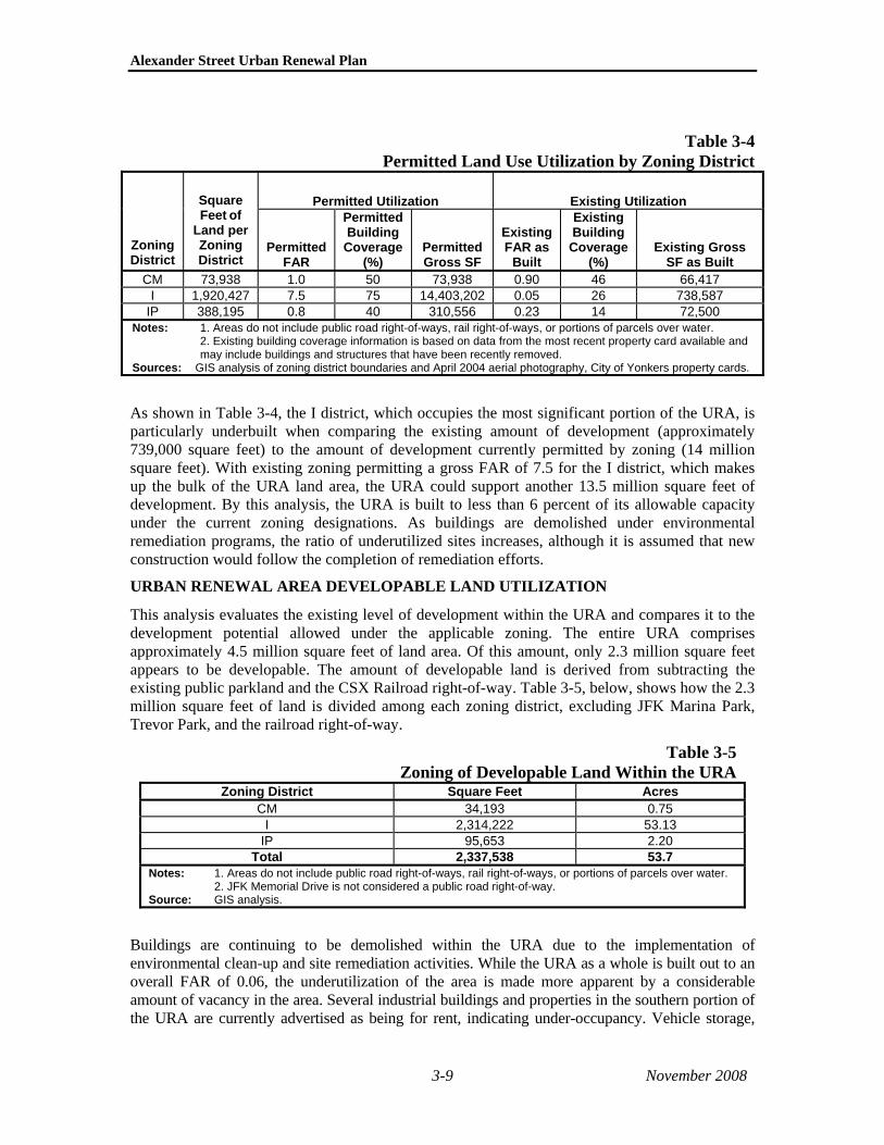
Alexander Street Urban Renewal Plan
Table 3-4Permitted Land Use Utilization by Zoning District
Permitted Utilization Existing Utilization
Zoning District
Square Feet of
Land per Zoning District
Permitted FAR
Permitted Building Coverage
(%) Permitted Gross SF
Existing FAR as
Built
Existing Building Coverage
(%) Existing Gross
SF as Built CM 73,938 1.0 50 73,938 0.90 46 66,417
I 1,920,427 7.5 75 14,403,202 0.05 26 738,587 IP 388,195 0.8 40 310,556 0.23 14 72,500
Notes: 1. Areas do not include public road right-of-ways, rail right-of-ways, or portions of parcels over water. 2. Existing building coverage information is based on data from the most recent property card available and may include buildings and structures that have been recently removed.
Sources: GIS analysis of zoning district boundaries and April 2004 aerial photography, City of Yonkers property cards.
As shown in Table 3-4, the I district, which occupies the most significant portion of the URA, is particularly underbuilt when comparing the existing amount of development (approximately 739,000 square feet) to the amount of development currently permitted by zoning (14 million square feet). With existing zoning permitting a gross FAR of 7.5 for the I district, which makes up the bulk of the URA land area, the URA could support another 13.5 million square feet of development. By this analysis, the URA is built to less than 6 percent of its allowable capacity under the current zoning designations. As buildings are demolished under environmental remediation programs, the ratio of underutilized sites increases, although it is assumed that new construction would follow the completion of remediation efforts.
URBAN RENEWAL AREA DEVELOPABLE LAND UTILIZATION
This analysis evaluates the existing level of development within the URA and compares it to the development potential allowed under the applicable zoning. The entire URA comprises approximately 4.5 million square feet of land area. Of this amount, only 2.3 million square feet appears to be developable. The amount of developable land is derived from subtracting the existing public parkland and the CSX Railroad right-of-way. Table 3-5, below, shows how the 2.3 million square feet of land is divided among each zoning district, excluding JFK Marina Park, Trevor Park, and the railroad right-of-way.
Table 3-5Zoning of Developable Land Within the URA
Zoning District Square Feet Acres CM 34,193 0.75
I 2,314,222 53.13 IP 95,653 2.20
Total 2,337,538 53.7 Notes: 1. Areas do not include public road right-of-ways, rail right-of-ways, or portions of parcels over water.
2. JFK Memorial Drive is not considered a public road right-of-way. Source: GIS analysis.
Buildings are continuing to be demolished within the URA due to the implementation of environmental clean-up and site remediation activities. While the URA as a whole is built out to an overall FAR of 0.06, the underutilization of the area is made more apparent by a considerable amount of vacancy in the area. Several industrial buildings and properties in the southern portion of the URA are currently advertised as being for rent, indicating under-occupancy. Vehicle storage,
3-9 November 2008

Chapter 3: Existing Conditions and Blight Analysis
which occupies approximately 20 percent of the URA, generally does not include substantial floor areas and represents a significant underutilization of the potentially valuable waterfront.
The underbuilt and underutilized character of the Alexander Street URA is further revealed in comparison to the Collins Phase I development at the Yonkers Pier, immediately south of the URA, which encompasses a land area of approximately 109,000 square feet, with 338,000 gross square feet of building space for an FAR of approximately 3.0. Collins Enterprises is currently constructing a second development immediately south of the URA (on parcels B and C of the Yonkers Downtown Waterfront Master Plan) (Collins Phase II) with an FAR of approximately 3.5. The level of building development in this comparable area, with FARs of approximately 3.0 and 3.5, respectively, is a stark contrast to the URA’s actual FAR of approximately 0.3. Both Collins developments incorporate residential, commercial, and retail uses consistent with recent Yonkers downtown redevelopment master planning and economic revitalization policies and efforts. Residential uses are not currently permitted by zoning in much of the URA since the I, IP, and CM zoning districts all prohibit residential uses. The M district, the only zoning district in which residential use is permitted, is occupied by Trevor Park.
C. BUILDINGS AND SITE UTILIZATION BUILDING CHARACTERISTICS
The buildings in the URA vary in purpose, appearance, and style. The buildings are generally characterized by one- or two-story brick, cinderblock, or metallic walls with large garage doors and loading areas. Windows are typically sparse on these buildings and are often covered by steel gates. Notable exceptions include the North Yonkers Pump Station and City Jail, which vary significantly from other buildings in the study area in their historic character. The Westchester County DSS office, Beczak Center, and the large glass building on the Hudson River Stage property are noticeably different from other buildings due to their more modern appearance.
Many of the vacant and occupied buildings in the study area are in a state of disrepair. While in many cases buildings may only be cosmetically damaged, other buildings in the URA do not appear to be habitable. Common cosmetic flaws found throughout the study area include chipping and peeling paint, broken windows, and cracked walls. At least two residential buildings in the URA are not habitable. These buildings along Warburton Avenue are vacant and have been boarded up. Other less obvious conditions of deterioration may also exist in other locations throughout the URA. In general, the relatively poor condition of the URA’s building stock has had a blighting effect on the area, reducing the incentives for new investment.
BUILDING CONDITIONS AND CODE COMPLIANCE
Building code violations dealing primarily with unsafe or unsound exterior and interior conditions are also indicative of blight. The City of Yonkers Department of Housing and Buildings (DHB) is responsible for ensuring the safe and lawful use of buildings and properties through enforcing the building code. The DHB regularly conducts inspections of construction work, plumbing, elevators, and electrical wiring during the building process. Inspections are also made to target unsafe buildings, illegal uses, illuminated signs, and new places of public assembly. When appropriate, DHB also performs fire safety inspections. DHB maintains an inventory of all complaints and violations filed with the DHB.
Table 3-6, below, lists the recorded building code violations for URA parcels.
Based on research, there were 40 building code violations recorded with the DHB. Of these 40 violations, three were for debris or poorly maintained properties and seven were for unsafe conditions or structural problems. The remaining violations generally referred to permitting issues or other non-threatening violations. The number of violations for structural problems or poorly
3-10 November 2008

Alexander Street Urban Renewal Plan
maintained properties is indicative of an area characterized by unsafe and uncared for conditions. In several cases, actual unsafe and threatening conditions are on record.
Table 3-6Building Code Violation Records, 2001-2005
Block-Lot Building Code Violation 2009-1 2/9/04 – (1) The fire service phase 2 system is not operating correctly (noted in past
violations reports as well); (2) The emergency phone is not operating properly; (3) Provide finished walls at new opening; (4) Remove tripping hazard by new doorsill in the hall entrance of new door buck; and (5) Install hoistway fascia.
1/28/03 – Certificate of Occupancy denied due to Fire Department approval outstanding. 11/8/02 – Certificate of Occupancy denied because of the following issues: (1) Final Building
Inspector approval required; (2) Permit for signs required; and (3) Elevator violations outstanding.
9/13/02 – Removal of a large diesel fuel above ground tank on west side of premises without having obtained a Building Permit. Creation of additional parking in area where diesel fuel tank was removed without having obtained a Building Permit.
8/12/02 – Inspector observed the installation of 8-foot-high chain link fencing running east and west to the north side of the main entrance to Kawasaki Rail Car without having obtained a Building Permit.
5/28/02 – City of Yonkers Complaint form/ticket for (1) Construction of a test track (Kawasaki) without having obtained a Building Permit; and (2) Occupying the premises (Kawasaki Test Track) without having obtained a Certificate of Occupancy.
11/30/01 – Inspector observed the installation of a “Test Track” located on premises without having obtained a Building Permit.
7/5/01 – Sign Application denied because Building Permit not yet obtained. 5/2/01 – Expired Building Permit. Corrected on 5/31/01. 4/23/01 – Expired Building Permit.
2099-1.3 7/25/03 – Property has had a change in use, now occupied by a check cashing business. No Certificate was obtained for this change of occupancy.
7/22/03 – No record of a Building Permit or Certificate of Occupancy for Spears Development Corp. Prior to processing Sign Application, must file for a Building Permit for use of business.
3/23/01 – Certificate of Occupancy denied. 3/8/01 – Expired Building Permit.
2099-13 9/12/05 – Overgrowth of bushes and weeds located in the front yard and sidewalk area. 3/31/04 – Debris in front yard of premises; front gate should be locked to prevent trespassing.
Corrected on 4/14/04. 6/5/03 – Order of Condemnation for the following “dangerous and unsafe conditions”: (1) No
electricity supplied to building; (2) Illegal use of extension cords throughout the public hallways; (3) One family occupancy being occupied by owner and four unrelated roomers in violation of existing Certificate of Occupancy; (4) Smoke detectors are not provided throughout; and, (5) Second means of egress obstructed by locks on room doors.
2099-31 4/7/03 – Expired Building Permit. 7/17/01 – Premises/structure is dangerous, unsafe, and a nuisance because Inspector
observed structural damage to the north side of the building caused by a vehicle crashing into the building. An enclosed sidewalk bridge should be installed from the corner of Babcock Place and Woodworth Avenue.
2100-1 2/8/01 – Graffiti to be removed from side of building. 2100-10 4/1/04 – A concrete block retaining wall running along Ashburton Avenue was bulging and in
danger of failing. Immediate repairs were required to remove this dangerous condition.
2605-51 5/10/04 – Inspector observed the parking of two different school bus companies on the same premises. No change of occupancy shall be made unless a certificate is issued by the Building Department. Corrected on 6/3/04.
11/20/02 – Created a parking lot for the storage of buses without obtaining a Building Permit. Installed barbed/razor wire on top of fence in the yards of the premises, which is not permitted and is in violation of Yonkers Zoning Ordinance Section 43-41D(1).
3-11 November 2008
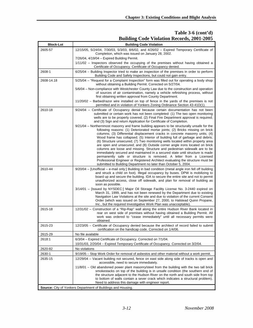
Chapter 3: Existing Conditions and Blight Analysis
Table 3-6 (cont’d)Building Code Violation Records, 2001-2005
Block-Lot Building Code Violation 2605-57 12/15/05, 5/24/04, 7/30/03, 5/3/03, 8/6/02, and 4/26/02 – Expired Temporary Certificate of
Completion, which was issued on January 28, 2002. 7/26/04, 4/19/04 – Expired Building Permit. 1/11/02 – Inspectors observed the occupying of the premises without having obtained a
Certificate of Occupancy. Certificate of Occupancy denied. 2608-1 6/25/04 – Building Inspector tried to make an inspection of the premises in order to perform
Building Code and Safety Inspections, but could not gain entry. 2608-14.18 5/25/04 – “Request for a Complaint Inspection” form was filled out for operating a body shop
without obtaining a Building Permit. Corrected on 5/27/04. 5/6/04 – Non-compliance with Westchester County Law due to the construction and operation
of sources of air contamination, namely a vehicle refinishing process, without first obtaining written approval from County Department.
11/20/02 – Barbed/razor wire installed on top of fence in the yards of the premises is not permitted and in violation of Yonkers Zoning Ordinance Section 43-41D(1).
2610-18 9/24/04 – Certificate of Occupancy denial because certain documentation has not been submitted or certain work has not been completed: (1) The two open monitoring wells are to be properly covered; (2) Final Fire Department approval is required; and (3) Sign and return Application for Certificate of Completion.
9/21/04 – Northernmost masonry and frame building appears to be structurally unsafe for the following reasons: (1) Deteriorated mortar joints; (2) Bricks missing on brick columns; (3) Differential displacement cracks in concrete masonry units; (4) Wood frame has collapsed; (5) Interior of building full of garbage and debris; (6) Structure unsecured; (7) Two monitoring wells located within property area are open and unsecured; and (8) Outside corner angle irons located on brick columns are loose and missing. Structure and pedestrian sidewalk are to be immediately secured and maintained in a secured state until structure is made permanently safe or structure is removed. A letter from a Licensed Professional Engineer or Registered Architect evaluating the structure must be submitted to Building Department no later than October 5, 2004.
2610-44 9/20/04 – [Unofficial – e-mail only:] Building in bad condition (metal angle iron fell off building and struck a child on foot). Illegal occupancy by buses. DPW is mobilizing to board up and secure the building. IDA to secure the entire site and not to permit unauthorized access, close off sidewalk, and plan for removal of building as soon as possible.
3/14/01 – [Issued by NYSDEC:] Major Oil Storage Facility License No. 3-2440 expired on March 31, 1999, and has not been renewed by the Department due to existing Navigation Law Violations at the site and due to violation of the current Consent Order (which was issued on September 27, 2000, to Halstead Quinn Propane, Inc., but the required Investigative Work Plan was unacceptable).
2615-18 12/31/02 – Construction of a “Rip-Rap” wall along the entire Hudson River Bank located in rear on west side of premises without having obtained a Building Permit. All work was ordered to “cease immediately” until all necessary permits were obtained.
2615-23 12/23/05 – Certificate of Occupancy denied because the architect of record failed to submit certification on the handicap code. Corrected on 1/4/06.
2615-29 No file available 2618:1 6/3/04 – Expired Certificate of Occupancy. Corrected on 7/1/04.
10/31/03, 2/20/04 – Expired Temporary Certificate of Occupancy. Corrected on 3/2/04. 2620-82 No violations 2630-1 9/19/05 – Stop Work Order for removal of asbestos and other material without a work permit. 2635-15 12/29/04 – Vacant building not secured, fence on east side along side of tracks is open and
accessible, need to secure immediately. 11/8/01 – Old abandoned power plant masonry/steel from the building with the two tall brick
smokestacks on top of the building is in unsafe condition (the southern end of the structure adjacent to the Hudson River on the north and south side from top to bottom of walls contain a sever crack which indicates a structural problem). Need to address this damage with engineer report.
Source: City of Yonkers Department of Buildings and Housing.
3-12 November 2008

Alexander Street Urban Renewal Plan
D. ENVIRONMENTAL CONTAMINATION The URA has historically supported industrial uses, many of which utilized materials that, if not disposed of properly, could result in environmental contamination of the site. While no comprehensive environmental site assessment or hazardous material investigation has been done on the entire URA, the URA is known to consist of a number of parcel assemblages based on historic or current uses. In addition, many sites are likely to have petroleum related contamination from above or underground storage tanks or current surface petroleum uses. Many of the sites are currently being utilized as truck, bus, and other vehicle fleet lots.
It should also be noted that lead-based paint or asbestos-containing material may be found within the buildings throughout the URA that may be demolished to allow redevelopment to occur.
The Alexander Street URA is an area of known and likely environmental contamination. The presence of contaminated sites contributes to the overall finding that the URA is blighted and in need of comprehensive redevelopment activity. The proposed Brownfield Opportunity Area plan is intended to assist in establishing priorities for addressing environmental contamination in furtherance of the redevelopment of the overall waterfront area.
Each of the summaries below identify certain assemblages with known or potential environmental contamination issues and provide an overview of potential and/or known hazardous materials conditions. While many sites within the URA may be contaminated, the discussion below describes only sites of known and likely contamination.
JFK MARINA PARK (BLOCK 2640)
The park was created in the 1960s by filling the area in the Hudson River with fill material that came primarily from ash from the City’s municipal trash incinerator.
GLENWOOD POWER STATION (BLOCK 2635)
Historically, the site was used to generate electricity for the New York Central Railroad and was later purchased by Con Edison. Mechanical equipment associated with power generation, including turbines, transformers, etc., are likely to have used petroleum products or PCBs.
BICC (BLOCK 2620, LOTS 35 AND 40; BLOCK 2625; AND BLOCK 2630, LOTS 1-3 AND 10)
There are known contamination issues on the BICC site, including petroleum, PCBs, and metal contamination. This site has an approved Remedial Investigation/Feasibility Study (RI/FS) and Proposed Remedial Action Plan (PRAR), and its remediation is underway.
NEW YORK CENTRAL LINES (CSX) AND MTA BUS YARD (LIBERTY LINES) (BLOCK 2620, LOTS 50 AND 82)
Contamination may exist on these sites due to the railroad freight operations that historically took place on the site and as well as bus maintenance operations. The bus repair operations and fuel storage tanks may have resulted in contamination. Furthermore, there may be some contamination associated with debris or railroad ties on the site, including creosote from treated lumber.
SUN CHEMICAL (WEST SITE—OCCUPIED BY WESTCHESTER COUNTY DSS, BLOCK 2615, LOTS 1, 23, AND 29; EAST SITE—VACANT AND OCCUPIED BY STAN LOU TOBACCO, BLOCK 2608, LOTS 35.37 AND 29)
Sun Chemical currently owns two properties in the URA. The “west site” is located at 137-145 Alexander Street (Block 2615, Lots 1, 23, and 29) and is formerly known as the Sun PolyChrome Administrative research and development site. This site was occupied by the Westchester County
3-13 November 2008

Chapter 3: Existing Conditions and Blight Analysis
DSS. The historic uses on the site include lumber and coal storage, boat construction, and chemical storage. PolyChrome performed research and development at the site for its manufacturing operations at the “east site” (see below), at which it coated photosensitive aluminum printing plates potentially starting as early as the 1950s to 1994. Operations involved use of hazardous substances. PolyChrome was a large-quantity generator of hazardous waste, which primarily consisted of ignitable and corrosive solvents. The site was also owned by Standard Oil for some time.
The “east site” is located at the southeast corner of the intersection of Alexander and Ashburton Avenues and was formerly known as the Sun PolyChrome Manufacturing site. PolyChrome manufactured coated photosensitive aluminum printing plates at the site from the 1960s to approximately 1994. The site included between nine underground storage tanks containing fuel oil and gasoline as well as four aboveground storage tanks containing known hazardous substances, including sulfuric acid and sodium hydroxide, with both above- and below ground piping systems.
ATI (SUPERTRRANS BUS) (BLOCK 2610, LOTS 12, 14, 18, 22, 39, 35, 44, 48)
The ATI Halstead-Quinn site is located at 78-91 Alexander Street, just to the west of the Sun east site and to the south of the Sun west site. It was formerly a 5-million-gallon tank farm and is currently used for school bus storage.
PATCLIN CHEMICAL (BLOCK 2608, LOTS 14, 20)
The Patclin Chemical site originally had three separate addresses: 60, 62, and 66 Alexander Street. However, starting in the 1990s, Supertrans NY, Inc. or Supertrans Bus Company began occupying the smaller warehouse building at 60 Alexander Street. The remainder of the site consisting of 62 and 66 Alexander site is a known contaminated site with its history as a chemical manufacturing and storage facility. The U.S. Environmental Protection Agency (EPA) completed an emergency drum removal effort at the Patclin Chemical site in 2003 and 2004.
Supertrans NY, Inc. has used a number of above- and underground storage tanks, and an open spill (New York State Department of Environmental Conservation [DEC] report No. 9511617) exists due to a 1,000-gallon underground diesel storage tank failure. According to previous reports, this portion of the site contains four 250-gallon home heating oil aboveground storage tanks, one 275-gallon waste oil tank, one 1,000-gallon tank, one 2,000-gallon underground storage tank for diesel, and numerous five- and 55-gallon drums filled with transmission fluid, brake fluid, windshield wiper fluid, antifreeze, and miscellaneous degreasers and solvents for engine repair and maintenance.
Patclin Chemical Corp. owned and occupied the larger building on the northern portion of the site with the former address 66 Alexander Street. The building at 66 Alexander Street was built in 1966 for a company called CI-TEX Corporation. A certificate of occupancy issued in 1971 lists the site’s use as a solvent mixing operation and general storage laboratory. Patclin Chemical took over the site after CI-TEX Corporation abandoned the site and began its solvent mixing operations. On March 3, 1998, there was an explosion and fire at the facility originating from hazardous materials and a leaking underground storage tank. This event prompted the EPA to conduct a facility inspection. Patclin’s former operations at the site have caused the site to be listed on the federal CERCLIS, a list of sites potentially eligible for federal Superfund listing. However, the site is not yet on the federal Superfund list and there are no current plans to list the site. Patclin mixed chemicals over floor drains that lead to the sewer system. Patclin also had a history of former air emission violations and spills. As a result of the potential danger associated with the abandoned chemicals at the facility, the EPA performed a drum removal operation in the building in approximately 2002, which cost approximately $350,000.
3-14 November 2008

Alexander Street Urban Renewal Plan
ALTMAN LIGHTING (BLOCK 2610, LOTS 50, 53, AND 57)
The Altman Lighting facility was previously and continues to be used for manufacturing operations. The manufacturing is known to have included the use of solvents.
GLENWOOD CONTAINER CORP. (BLOCK 2608, LOT 25)
The Glenwood Container Corp. parcel is located adjacent to the Patclin Chemical site. Contamination is possible at this site due to the proximity to Patclin Chemical and the storage of some hazardous materials on the site.
I.PARK (BLOCKS 2009 AND 2010)
The i.park parcel is another site with historic manufacturing uses on the site. Although the site currently lies vacant and is used for vehicle parking, much of the site has an industrial past with facilities including an oil house, tool manufacturing facility, foundry, and machine shop.
STEVENS PAINT, POLLACK PAINT, AND A&D CARTING (BLOCK 2010)
There are three existing businesses on Block 2010 where contamination may exist. Although there are a number of historic industrial uses on the site, a manufactured gas plant that occupied the entire block is of greatest concern. High levels of contamination are likely on the site.
E. STREETSCAPE AND INFRASTRUCTURE The URA is served by several roadways and by public transportation. One of the primary corridors entering the URA is Ashburton Avenue, which provides access to major highways east of the URA. Warburton Avenue serves as the nearest major north-south roadway in the area located just east of the URA. Within the URA, Alexander Street, a two-lane roadway, provides access to most parcels in the southern portion of the URA. Alexander Street is fed from south to north by Wells Avenue, Ashburton Avenue, and Babcock Place.
The northern portion of the URA is served by JFK Memorial Drive and Warburton Avenue. JFK Memorial Drive provides access to JFK Marina Park and to the City’s Museum Middle School just to the north of the URA boundary. The decommissioned Glenwood Power Station is also accessible by JFK Memorial Drive and by traveling through JFK Marina Park. There is, however, no roadway connection between the northern and southern portions of the URA. Traveling from one end of the URA to the other requires exiting the URA and crossing over the railroad tracks.
Although the roadways within the URA provide adequate automobile transportation, the steep hills, narrow right-of-ways, and sharp turns in and around the area limit truck traffic. Since trucks have replaced water-based and rail transportation as the primary method for transporting goods, the industrial development potential of the URA is increasingly limited.
Public transportation to the URA is available via the Westchester County Bee-Line Bus System. One bus route serves Alexander Street, with a stop at the Westchester County DSS office, and provides access to and from downtown Yonkers. Other bus routes serve Warburton Avenue and provide transportation between downtown Yonkers and other municipalities throughout the county. The URA itself is generally underserved by bus lines, but nearby Getty Square serves as a major hub for the Bee-Line buses.
In addition to buses, the URA is prominently served by Metro-North Railroad. With two railroad stations – the Glenwood and Yonkers stations – the URA has unparalleled access to the regional commuter rail network. The rail access enables residents to commute to jobs outside of Yonkers, and provides convenient means for people from elsewhere to commute to jobs in downtown Yonkers and to employers located in the URA. In addition, the railroad link makes the Yonkers waterfront easily accessible to visitors wishing to come for entertainment, dining, cultural events,
3-15 November 2008

Chapter 3: Existing Conditions and Blight Analysis
or shopping. The Yonkers Metro-North station is located immediately south of the URA, and a second station, Glenwood, is located in the central portion of the URA.
Further contributing to the accessibility of the waterfront is the recently inaugurated ferry service between Yonkers and Lower Manhattan. The ferries run between the Recreation Pier, immediately adjacent to the Yonkers train station in downtown Yonkers, and the Battery Park City Ferry Terminal, located just west of the World Trade Center site, as well as Pier 11 at the foot of Wall Street.
SIDEWALKS
Sidewalks flanking Alexander Street appear to be in a state of disrepair and are often blocked by parked cars or trucks. Based on recent field surveys, the sidewalks appear to be moderately used by people walking to and from the county’s DSS office. The roads that are oriented east-west through and into the URA also contain sidewalks, and they are generally in better condition.
The portion of the URA north of Babcock Place is not served by any sidewalks as it does not contain any public right-of-ways. Although limited amounts of vehicular traffic and relatively wide access roads would allow for pedestrian travel in this segment of the URA, there is generally not a significant amount of pedestrian travel in this area.
Sidewalks in the northern portion of the URA are located beside Warburton Avenue and JFK Memorial Drive. Although JFK Memorial Drive has sidewalks, they are somewhat narrow and not buffered by any on-street parking or other streetscaping. Although this creates a perceivably uncomfortable pedestrian environment, use of the sidewalks is not precluded by this condition. The primary pedestrian use in this area comes from school student use originating at the adjacent Museum Middle School.
STREET LIGHTING
Lighting exists throughout the study area but in varying and inconsistent forms. In general, public road rights-of-way are lit with cobra-head lights throughout the study area. In the central portion of the study area, the BICC private right-of-way is not lit, but light generally spills over onto the right-of-way from lighting on private property. In JFK Marina Park, several different styles of lighting fixtures are found between the parking area and bulkhead line. Trevor Park is lit only near the parking area for the Hudson River Museum and around the tennis courts.
F. PUBLIC POLICY Several public policy initiatives guide development in Yonkers at a local, citywide, countywide, and statewide level. A number of documents identify these policies and goals for the URA and the waterfront as a whole. Pertinent policies and goals are described below. Upon examination of these policies and comparing their goals and recommendations to the existing conditions of the URA, it is apparent that existing conditions do not advance public policy, and, in fact, run counter to expressed policy directives.
Among the major public policy documents are the following:
CONNECTIONS: THE YONKERS COMPREHENSIVE PLAN
The City of Yonkers adopted its most recent Comprehensive Plan on September 19, 2000. The plan recommends redevelopment of vacant land and underutilized land between Ashburton Avenue and Point Street. The plan encourages a mix of uses related to or enhanced by proximity to the water’s edge, connections to the Glenwood train station and to JFK Marina Park to increase pedestrian traffic, improved access to the marina, and providing access to the water’s edge. These recommendations are consistent with this URP, however the Comprehensive Plan also
3-16 November 2008

Alexander Street Urban Renewal Plan
recommends the preservation of industrial sites in Yonkers, which is not a goal of the Alexander Street URP.
PATTERNS FOR WESTCHESTER
“Patterns for Westchester” is Westchester County’s Comprehensive Plan, prepared in 1996. The plan provides several relevant policies, including: channel development to centers where infrastructure can support growth, where public transportation can be provided efficiently, and where redevelopment can enhance economic vitality; and encourage private development to incorporate public access and open space corridors, where appropriate, to integrate trailways and to enhance linear parks.
WESTCHESTER COUNTY OPEN SPACE POLICIES
The Westchester County Open Space policies direct the County to acquire or otherwise protect properties along the Hudson River for public access, public use, and scenic enjoyment; redevelop waterfront areas with deteriorating, substandard, or incompatible development that can be reclaimed for open space or park use; and foster local revitalization and economic development opportunities at or near the waterfront.
NEW YORK STATE COASTAL POLICIES
The New York State Waterfront Revitalization of Coastal Areas and Inland Waterways Act established policies to restore, revitalize, and redevelop deteriorated and underutilized waterfront areas for commercial, industrial, cultural, recreational, and other compatible uses; protect, maintain, and increase the level and types of access to public water-related recreation resources and facilities; and promote the creation of water-dependent and water-enhanced recreation over non-water-related uses along the coast.
THE 2006 NEW YORK STATE OPEN SPACE CONSERVATION PLAN
The DEC’s 2006 Open Space Plan identifies areas with significant environmental or other qualities worthy of conservation, and the entire Yonkers waterfront is listed as such a place. The plan recommends urban waterfront redevelopment, waterfront trail and greenway systems, public access enhancement, and parkland development projects.
GREENWAY ACT OF 1991
The Greenway Act of 1991 was created to facilitate and enhance local land use planning and create a voluntary regional planning compact for the Hudson River Valley. The act promotes natural and cultural resource protection, regional planning, economic development, public access, and heritage and environmental education. A continuous trail along the Hudson is a major priority.
G. ECONOMIC CONDITIONS BUSINESSES AND EMPLOYMENT
There are approximately 20 businesses or organizations located in the URA, ranging from wholesalers operating within small warehouses, to bus companies with large vehicle storage yards, to offices affiliated with county government. While some of these employers are well-known or easily identifiable (by signs on their premises), others are small operations occupying smaller spaces or in smaller buildings without identifying signage. Six of the known employers—including the MTA, Supertrans, Excelsior Transparent Bag, Greyston Bakery, Westchester County DSS, and Altman Lighting—were contacted to approximate the number of people employed in the URA.
3-17 November 2008

Chapter 3: Existing Conditions and Blight Analysis
Within these six businesses, there are approximately 1,025 full-time employees. The MTA employs approximately 250 full-time workers at its bus storage, dispatch, and maintenance yard. Supertrans, a school bus storage and dispatching business, employs approximately 185 workers. Excelsior Transparent Bag, which manufactures packaging materials, employs approximately 120 workers. Greyston Bakery, a wholesale bakery facility that currently operates 24 hours per day, employs approximately 60 full-time workers. The Westchester County DSS office located within the URA employs approximately 270 full-time workers throughout the year plus five part-time hourly workers during the summertime. Altman Lighting, a theatrical, architectural, and film and video lighting leasing and manufacturing business, employs approximately 125 workers in its manufacturing department and 15 employees in its leasing department.
It is important to note that only a sample of businesses was contacted as part of this study. Data for these businesses is cited because they were identifiable, were able to be contacted, and responded to contacts that were made. Also, these businesses occupy relatively large spaces and/or extensive land areas. Although there are other businesses operating within the URA, they do not appear to be major employers based on the size of their facilities. The number of employees cited above is, therefore, less than the actual number of employees within the URA; however, the actual number is not believed to be significantly larger.
Of further significance, however, is the fact the employment within the URA is decreasing. The Westchester County DSS office is expected to relocate to another site within the City of Yonkers in the near future. In addition, the Altman Lighting manufacturing facility is expected to relocate to an out-of-Yonkers site. Further, the Yonkers City Jail facility is relocating its operations outside the URA, further reducing the employment base of the URA industries. This analysis, recognizes that a number of smaller businesses did not provide employment data, nonetheless, the estimated number of employees of approximately 1,025 is conservatively high.
ASSESSED VALUES AND REAL PROPERTY TAXES
The assessed valuation of real property in the URA is relatively modest, and consequently the real property tax revenue contribution of the URA to the City is modest. As noted above in the analysis of land use, with the exception of such large facilities as the North Yonkers Pump Station and City Jail, the URA contains rather small-scale development, including many one- or two-story industrial buildings with loading docks and vehicle storage areas. The 2005 assessed valuation of all URA real estate, both land and buildings on all 85 parcels (39 parcel assemblages), was $7.26 million, while the taxes for 2005/2006 totaled $1.21 million (see Table 3-7). It should be noted that a substantial portion of the URA is located within the City of Yonkers Empire Zone, within which certified businesses are eligible to receive tax credits and other benefits, such as property tax refunds, wage-based tax credits, state sales tax exemptions, and reduced utility and telephone rates. Such incentives are provided to attract new investment, retain existing businesses, and generally improve the economic well-being of the area.
Table 3-7Assessed Values
Block-Lot(s) Land Use Assessed Value 2005 Total Taxes Collected
20064
Publicly Used Parcels
2605-571 Beczak Environmental Education Center $78,200 $1,695
2605-621 and 671 North Yonkers Pump Station $822,550 $10,804 2608-11 Yonkers City Jail $205,200 $3,188
2615-1, 23, and 29 Westchester County Dept. of Social Services $363,500 $223,818
2618-2002 Vacant $10,900 $0 2620-82 CSX $444,200 $3,258 2125-11 Trevor Park $2,293,400 $41,476
3-18 November 2008

Alexander Street Urban Renewal Plan
2640-11 JFK Marina $442,800 $11,634 2630-371, 401, and 441 Vacant $55,000 $947
Subtotal $4,715,750 $296,820 Privately Used Parcels 2009-1 and 20; 2010-1, 6, 9, 16, 23, and 26
Vacant $230,900 $137,326
2099-1.3 Small grocery store $13,700 $8,244 2099-4 and 5 Vacant land $3,800 $2,385 2099-6 Vacant/parking $1,400 $888 2099-7 House $3,500 $5,324 2099-9 Apartment building $93,000 $57,982 2099-12 House $7,200 $45,58.69 2099-13 House $7,300 $4,753 2099-14 House $8,850 $5,823 2099-16, 18, 19, and 20 Max Braun & Sons $20,000 $13,409 2099-21.23 House $13,700 $8,844 2099-24, 25, and 26 Greyston Foundation $12,000 $6,105 2099-27, 28, and 31 Scaffolding company $35,500 $22,950 2100-1 Pollack Paint $31,200 $19,597 2100-4 Stevens Paint $25,000 $15,877 2100-10 A&D Carting $8,300 $5,728
2605-51 A Plus Transportation, Inc.; Yonkers Police Department parking $44,800 $27,940
2608-14.18, 701; 2610:123, 143, 183, 22, 30, 35, 443, and 483
Supertrans Bus, Inc. $148,310 $19,144
2608-20.233 Traffic Moving Systems, Inc. $44,000 $28,691 2608-25 Glenwood Container $42,500 $26,525 2608-29 Pennysaver/vacant $52,000 $32,608 2608-35.37 Stanlou Tobacco/vacant $97,500 $60,908 2610-50 Hudson River Pilot $41,850 $26,239 2610-53 and 57 Altman Lighting $138,350 $85,898 2615-182; 2620-1 and 36 Excelsior Transparent Bag $473,300 $291,488 2618-12 and 21, 3 Greyston Bakery $91,300 $1,279 2620-35 and 40; 2625-15, 17, 21, and 23; 2630-1, 21, 31, and 10
Vacant/vehicle parking $157,300 $89,520
2620-50 MTA bus garage $95,000 $125,987 2620-821 Vacant/vehicle parking $442,200 $384,266 2635-1, 15, and 192 Glenwood Power Station $165,000 $5,720
Subtotal $2,548,760 $915,955 Total $7,264,510 $1,212,775
Notes: 1 These parcels are tax-exempt except for frontage taxes collected by the City of Yonkers and sewer taxes collected by Westchester County. Taxes collected for 2618-2 also include solid waste taxes collected by Westchester County.
2 These parcels are wholly tax-exempt. 3 2004 property taxes on these parcels are either completely or partially outstanding as of May 13, 2005. 4 The total taxes collected for each parcel include real estate, school, and frontage taxes collected by the City of
Yonkers, and county/state solid waste and sewer taxes collected by Westchester County. In addition, some parcels pay sundry interest, housing unit taxes, or ETPA fees to the City of Yonkers, and safety inspection fees to Westchester County.
Sources: City of Yonkers, Tax Collector’s Office; AKRF, Inc., 2006.
It should also be noted that publicly owned parcels account for a substantial portion (67 percent) of the URA’s value, while accounting for only 31 percent of the total tax revenues generated by the area. This is due to the fact that most of those parcels are tax-exempt, only paying frontage taxes to the City of Yonkers and sewer taxes to Westchester County.
As noted above, the URA generates relatively modest tax revenues for the City of Yonkers and Westchester County. For purposes of comparison, the value of the new mixed-use waterfront development located immediately south of the URA was examined. This relatively small seven-lot development, known as Collins Phase I, is valued at $1,762,600 as of 2005, as shown in Table 3-8. The tax revenues from Collins Phase I were artificially low, however, due to a short-term tax abatement agreement with the City. When these benefits expire, Collins Phase I will become a substantial revenue source for the City. It should be noted, however, that the Collins Phase I
3-19 November 2008

Chapter 3: Existing Conditions and Blight Analysis
project makes payments in lieu of taxes (PILOT) to the Yonkers Industrial Development Agency which is apportioned between the City of Yonkers and Westchester County. While these payments are not “taxes,” per se, the PILOT represents a substantial contribution to public finance resulting from this development. A recent PILOT was in the amount of approximately $1 million.
Table 3-8Assessed Values and Tax Revenues in Collins Phase I (Block 2600)
Lot Address Assessed Value 2005 Taxes Collected 2006 1 1 Van Der Donck Street $706,700 $15,738.46 2 96 Main Street $66,700 $1,627.10 3 65 Water Grant $24,500 $1,173.38 5 1 Pierpointe Street $744,600 $16,631.77 7 100 Main Street $74,500 $1,817.94 23 75 Water Grant $20,300 $733.51 24 71 Water Grant $125,300 $1,663.26
Total $1,762,600 $39,385.42 Sources: City of Yonkers, Tax Collector’s Office; AKRF, Inc., 2006. Tax revenues from Collins Phase I are relatively low due to a short-term tax abatement
agreement with the City of Yonkers.
A clearer picture can be drawn of the disparity between the URA and neighboring comparable blocks when looking at the assessed value per square foot of lot area. The overall assessed value per square on the URA parcels is less than half the value of the Collins Phase I development. As shown in Table 3-9, below, the overall assessed value per square foot of lot area for the privately owned parcels in the URA is approximately $1.62, with a range of $0.17 to $12.24 (based on parcel assemblages). The average lot size is 41,891 square feet, just less than 1 acre, while the average assessed value is $0.81 per square foot (based on individual parcels, not shown in the table).
While it is recognized that redevelopment of the URA would result in changes to the employment base, it is interesting to note the stark difference in assessed value between the industrial properties and the redeveloped properties. In sharp contrast to the URA, the parcels within Collins Phase I are approximately three times as valuable as those within the URA. The average value of Collins Phase I is $5.01 per square foot, with a range of $0.51 to $15.46 (see Table 3-10), as compared to $1.62 in the URA. The average lot size in Collins Phase I is similar to that of the URA (50,272 square feet), but the average assessed value per lot is nearly three times as much, at $251,800.
3-20 November 2008

Alexander Street Urban Renewal Plan
Table 3-9Assessed Values of Privately Owned Parcels in the URA
Block-Lot(s) Land Use Assessed
Value Lot Area
(S.F.)
Assessed Value Per
Sq. Ft. 2009-1 and 20; 2010-1, 6, 9, 16, 23, and 26
Vacant $230,900 1,321,126 $0.17 2099-1.3 Small grocery store $13,700 7,215 $1.90 2099-4 and 5 Vacant land $3,800 2,558 $1.49 2099-6 Vacant/parking $1,400 2,559 $0.55 2099-7 House $3,500 4,869 $0.72 2099-9 Apartment building $93,000 7,595 $12.24 2099-12 House $7,200 3,253 $2.21 2099-13 House $7,300 3,284 $2.22 2099-14 House $8,850 3,294 $2.69 2099-16, 18, 19, and 20 Max Braun & Sons $20,000 6,248 $3.20 2099-21.23 House $13,700 8,628 $1.59 2099-24, 25, and 26 Greyston Foundation $12,000 8,985 $1.34 2099-27, 28, and 31 Scaffolding company $35,500 12,962 $2.74 2100-1 Pollack Paint $31,200 15,166 $2.06 2100-4 Stevens Paint $25,000 19,234 $1.30 2100-10 A&D Carting $8,300 21,186 $0.39
2605-51 A Plus Transportation, Inc.; Yonkers Police Department parking
$44,800 82,632 $0.54
2608-14.18 and 701; 2610:123, 143, 183, 22, 30, 35, 443, and 483
Supertrans Bus, Inc. $148,310 286,535
$0.52
2608-20.233 Traffic Moving Systems, Inc. $44,000 20,760 $2.12
2608-25 Glenwood Container $42,500 17,468 $2.43 2608-29 Pennysaver/Vacant $52,000 39,673 $1.31 2608-35.37 Stanlou Tobacco/vacant $97,500 59,125 $1.65 2610-50 Hudson River Pilot $41,850 61,568 $0.68 2610-53 and 57 Altman Lighting $138,350 129,713 $1.07
2615-182; 2620-1 and 36 Excelsior Transparent Bag $473,300 384,458 $1.23
2618-12 and 21, 3 Greyston Bakery $91,300 79,714 $1.15 2620-35 and 40; 2625-15, 17, 21, and 23; 2630-1, 21, 31, and 10
Vacant/vehicle parking $157,300 923,799
$0.17 2620-50 MTA bus garage $95,000 165,090 $0.58 2620-821 Vacant/vehicle parking $442,200 241,439 $1.83 2635-1, 15, and 192 Glenwood Power Station $165,000 185,148 $0.89 Total $2,548,760 4,125,284 Average $84,958.67 137,509 $1.62 Sources: City of Yonkers, Assessor’s Office; AKRF, Inc., 2005.
3-21 November 2008

Chapter 3: Existing Conditions and Blight Analysis
The URA clearly underperforms with respect to real estate investment and tax revenue generation. Furthermore, in the URA there has been a downward trend in tax revenues between 1980 and 2006. As shown in Table 3-11, below, taxes collected from 1980 to 2000 fell, while there was a slight increase between 2000 and 2006. However, the taxes collected in 2006 were still more than $825,000 lower (or approximately 62 percent less) than those collected in 1980. This decline can be attributed to the departure of large businesses and the arrival of non-profit organizations and government entities. It is important to note that there are still private businesses operating within the Alexander Street URA (e.g., Excelsior Transparent Bag and Altman Lighting), but the area is not as productive overall as it used to be from a tax perspective.
Table 3-10Assessed Values of Collins Phase I Development South of URA
Block-Lot Business Name Lot Area (Sq. Ft.)
Assessed Value 2005
Assessed Value Per Sq. Ft.
2600-1 1 Van Der Donck Street 45,706 $706,700 $15.46 2600-2 96 Main Street 73,342 $66,700 $0.91 2600-3 65 Water Grant 47,980 $24,500 $0.51 2600-5 1 Pierpointe Street 52,376 $744,600 $14.22 2600-7 100 Main Street 81,847 $74,500 $0.91 2600-23 75 Water Grant 39,476 $20,300 $0.51 2600-24 71 Water Grant 11,175 $125,300 $11.21 Total 351,902 $1,762,600 Average 50,272 $251,800 $5.01 Sources: City of Yonkers, Tax Assessor’s Office; AKRF, Inc., 2006.
3-22 November 2008

Alexander Street Urban Renewal Plan
Table 3-11Trends in Tax Revenues (1980–2006)
Taxes Collected Block-Lot Business Name/Land Use 1980 1990 2000 2006
2009-1 and 20; 2010-1, 6, 9, 16, 23, and 26
Vacant (i.park) $382,509 $3,644 $12,347 $137,326
2099-1.3 Small grocery store X X $6,422 $8,244 2099-1 $3,003 $2,382 X X 2099-3 $4,348 $1,060 X X 2099-4 and 5 Vacant land $6,101 $121 $1,875 $2,385 2099-6 Vacant/parking $508 $583 $701 $888 2099-7 House $3,569 $4,044 $4,176 $5,324 2099-9 Apartment building $32,111 $36,456 n/a $57,982 2099-12 House $2,507 $2,853 n/a $4,559 2099-13 House $2,492 $2,883 n/a $4,753 2099-14 House $3,082 $3,506 n/a $5,823 2099-16,18, 19, and 20 Max Braun & Sons $6,923 $7,887 n/a $13,409
2099-21.23 House $4,781 $5,461 n/a $8,844 2099-24, 25, and 26 Greyston Foundation $17,513 $10,237 $6,863 $9,517 2099-27, 28, and 31 Scaffolding company $19,420 $21,910 $23,600 $22,950 2100-1 Pollack Paint $23,149 $22,512 $15,318 $19,597 2100-4 Stevens Paint $17,364 $19,814 $12,460 $15,877 2100-10 A&D Carting $13,241 $11,990 $4,612 $5,728 2125-1 Trevor Park $29,419 $36,038 $35,111 $41,476
2605-51 A Plus Transportation, Inc; Yonkers Police parking $19,465 $22,247 $35,616 $27,940
2605-57 Beczak Environmental Education Center $27,174 $31,089 $37,954 $1,695
2605-62 and 67 North Yonkers Pump Station $5,491 $9,438 $9,461 $10,804 2608-1 Yonkers City Jail $1,590 $2,766 $2,768 $3,188 2608-14 Westchester Hudson Fuel $2,970 $3,397 X X 2608-18 Westchester Hudson Fuel $9,968 $11,532 X X 2608-20.23 Traffic Moving Systems, Inc. $27,792 $31,700 $25,698 $28,691 2608-25 Glenwood Container $14,723 $16,804 $20,698 $26,525 2608-29 Pennysaver/vacant $54,426 $62,076 $25,526 $32,608 2608-35.37 Stanlou Tobacco/vacant $93,176 $62,246 $47,604 $60,908 2608-14.18 and 70; 2610-12, 14, 18, 22, 30, 35, 44, and 48
Supertrans Bus, Inc. $72,840 $154,931 $124,241 $19,144
2610-50 $27,752 $31,973 $33,330 $26,239 2610-53 and 57 Altman Lighting $83,998 $95,494 $109,166 $85,898
2615-1, 23, and 29 Westchester County Dept. of Social Services $247,373 $194,010 $174,043 $148,755
2618-1 and 2 Greyston Bakery $28,875 $1,343 $1,995 $1,279 2618-200 Vacant (NYS) X $0 $0 $0 2615-18; 2620-1 and 36 Excelsior Transparent Bag $217,873 $197,005 $248,401 $291,488
2620-50 MTA bus garage $24,142 $1,185 $22,683 $125,987 2620-82 CSX $2,979 $3,745 $3,883 $3,258 2620-35 and 40; 2625-15, 17, 21, and 23; 2630-1, 2, 3, and 10
Vacant/vehicle parking $631,683 $133,180 $63,025 $89,520
2630-37, 40, and 44 Vacant $18,878 $4,508 $5,490 $4,692 2635-1, 15, and 19 Glenwood Power Station $1,706 $662 $1,142 $5,720 2640-1 JFK Marina $7,429 $10,622 $11,021 $9,420
Total $2,194,344 $1,275,332 $1,198,761 $1,368,440 Notes: All dollar amounts have been inflated to 2006 dollars using the Bureau of Labor Statistics, CPI multipliers. X = Parcel did not exist in this year (Some parcels were combined or subdivided between 1980 and 2006). n/a = Incomplete or missing tax information. Sources: City of Yonkers, Tax Collector’s Office; AKRF, Inc., 2006.
3-23 November 2008

Chapter 3: Existing Conditions and Blight Analysis
H. CONCLUSIONS This analysis has evaluated certain relevant conditions of physical blight and other conditions that demonstrate the deteriorated conditions of the URA. One of the standard criteria for identifying blighted conditions is utilization of property. This analysis has determined that the URA contains approximately 877,500 square feet of built area, whereas approximately 14.8 million square feet are allowed under current zoning. While it is unlikely that industrial facilities would be built to an FAR of 7.5 as permitted in the City’s I district, this number still demonstrates the underutilization of the URA. Even at an FAR of 2.0, the URA would have more than 3 million square feet of unused floor area. Numerous parcels are dedicated to surface parking lots and vehicle storage, further demonstrating the current underutilization of sites within the affected area and opportunities for redevelopment with greater economic potential. In fact, the only two uses in the URA that cannot be located in less industrialized zones are the Altman Lighting facility and Excelsior Transparent Bag. In general, the URA where mapped as the I district is not occupied by the intensive industrialized uses that are intended for that area.
Further hindering redevelopment efforts are the irregular shape of parcels and ownership of underutilized sites by multiple owners. This impedes needed redevelopment and removal of blighted conditions. The URA’s pattern of ownership suggests that creating sites with areas large enough to accommodate commercial and residential development recently experienced in other parts of Yonkers could be time-consuming and more costly than typical urban redevelopment programs of this type.
Many properties in the URA are vacant or underutilized buildings, and many have missing windows, significant cracks, or graffiti. In addition, many parcels have building code violations with the DHB. Furthermore, the known and suspected contamination of sites with hazardous materials and potential asbestos conditions creates additional public safety concerns and barriers to the orderly and cost-effective reuse and redevelopment of the subject parcels. Taken together, these findings indicate generally blighted conditions within the URA.
3-24 November 2008

Chapter 4: Implementation Actions
A. ADOPTION OF ALEXANDER STREET URBAN RENEWAL PLAN Article 15 of the General Municipal Law provides that the Yonkers Community Development Agency (CDA) recommends the site designation area to the City Council, which may designate the area as an “Urban Renewal Area” (URA). The City Council designates the site designation area for the URA. Upon designation, the CDA prepares an Urban Renewal Plan—this plan—and submits the Urban Renewal Plan to the Planning Board. The Planning Board certifies the Urban Renewal Plan as meeting the requirements of Article 15 and submits its report to the City Council. The City Council then approves, modifies, or disapproves the Urban Renewal Plan.
B. IMPLEMENTATION ACTIONS The City intends and anticipates that this Urban Renewal Plan be implemented in large part through the efforts of private parties submitting redevelopment proposals for CDA and City consideration that are consistent with this URP and the Alexander Street Master Plan. It is more than likely, however, that public funds would be required to assist in the implementation of needed infrastructure improvements, including water and sewer systems, roadways, and public open space. The infrastructure investment use public funds is expected to involve state, county, federal, and City of Yonkers funds, as well as private funds used in partnership with public funds. A variety of funding mechanisms are anticipated, including revenue and potentially general obligation bonds. While the exact financing source of such funds is unknown at this time, the potential establishment of special districts for the purpose of creating revenue sources is considered a possibility. It is expected that any public funding mechanism or any action related to infrastructure investment would require actions by the City agencies, including the City Council.
It is anticipated that each proposed development submission would require one or more government actions by the City of Yonkers, Westchester County, New York State, and federal government. While it is impossible to anticipate the specific governmental actions needed, a summary listing of representative and anticipated governmental actions that may be required is provided below. This list is representative, and there may be other permits or actions needed for specific project proposals. Necessary government actions would be identified and addressed by project sponsors at the time individual development projects are proposed.
CITY OF YONKERS ACTIONS
CITY MAP CHANGES AND SUBDIVISION OF LAND
City Council and Planning Board approvals would be required for official map actions resulting from specific development actions proposed to implement this plan. These actions may include the mapping of new streets and discontinuing existing or paper streets in the Alexander Street waterfront area, as well as the designation of newly created public parks. The Planning Board would also be required to approve any land subdivisions that may be required.
4-1 November 2008
Chapter 4: Implementation Actions
ADOPTION OF HOME RULE MESSAGE
The City Council must adopt and transmit to a “Home Rule Message” to the State Legislature for any necessary discontinuance of parkland required to establish roadways or other non-parkland uses in Trevor and JFK Marina Parks. Parkland that is occupied by current and planned roadways may require de-dedication for use as a public road right-of-way.
ZONING APPROVALS
Proposed redevelopment projects under this URA would require approval by the Yonkers City Council for adoption of the land use and building controls, including those that would be applicable to the URA under the provisions of Article VII, Special Use Permits, of the City’s Zoning Ordinance.
LAND DISPOSITION AGREEMENTS
The CDA and the City Council would be required to grant approval of land disposition agree-ments (LDAs) with private developers or other entities (e.g., Westchester County) to purchase or lease any properties that are acquired and owned by the City.
REDEVELOPERS SPONSORSHIP AGREEMENTS
The CDA and the City Council would be required to approve the selection of private developers for the residential, retail, marina, and other components of proposed plans under this Urban Renewal Plan.
EXPENDITURE OF CITY FUNDS
The Mayor, CDA, and the City Council would be required to make authorizations and grant approvals for the expenditure of the City’s share of any public infrastructure improvements that are agreed upon relative to carrying out actions contemplated in the Master Plan.
OTHER ACTIONS
Other City actions potentially required to implement projects consistent with the proposed Master Plan. These actions include potential amendments to the adjacent Neighborhood Development Plan (NDP) #4 to clarify the boundary and land uses where they may overlap this URA. In addition, other actions may include Bureau of Housing and Buildings review of building plans for compliance with building code requirements; Planning Board for site plan, special use and zoning permits, and Master Plan review; Water Bureau approval of water connections; Fire Department review of building plans for compliance with fire code requirements; City Engineer approval of utility plans; and City Traffic Engineer approval of new street and traffic control systems.
It is more than likely that public funding action would be required for capital purposes, such as infrastructure improvements and potentially for land acquisitions. Such actions would require various actions on the part of City Council for the appropriation of funds, authorization of bonding, and other related actions.
WESTCHESTER COUNTY ACTIONS
WESTCHESTER COUNTY PLANNING BOARD
Section 239 of General Municipal Law and Section 277 of the County Administrative Code re-quire that certain planning and zoning actions be referred to the Westchester County Planning Board. As the Urban Renewal Plan would be considered for adoption by the Yonkers City Council, and because the plan may result in zoning changes, the Urban Renewal Plan must be referred to the Westchester County Planning Board for review.
4-2 November 2008

Alexander Street Urban Renewal Plan
DEPARTMENT OF ENVIRONMENTAL FACILITIES
Any connections to the Westchester County sewer trunk line, which is located within the Urban Renewal Area, as well as construction contiguous to or within the trunk line easement area, are subject to review and approval by the Department of Environmental Facilities.
HEALTH DEPARTMENT
Extensions of public water and sewer mains and any required realty subdivisions require approval and permits from the Westchester County Health Department. In addition, boilers and petroleum bulk storage for non-residential and commercial uses are subject to departmental review and approval, as are certain other air quality-related issues.
DEPARTMENT OF PUBLIC WORKS
Review and approval of design and construction activities for consistency with county standards is required by the Westchester County Department of Public Works for all proposed county facilities.
NEW YORK STATE ACTIONS
NEW YORK STATE DIVISION OF HOUSING AND COMMUNITY RENEWAL
The Urban Renewal Plan shall be filed with the Commissioner of the Division of Housing and Community Renewal (DHCR). Potential amendments to NDP #4 as discussed above must also be filed with the Commissioner of DHCR.
TIDAL WETLANDS PERMIT
The waters in front of the development parcels are mapped as littoral zone, which is New York State tidal wetland. All dredging, filling of areas not presently filled, and new shoreline structures related would require a permit from the New York State Department of Environmental Conserva-tion (DEC) under the Tidal Wetlands Program.
PROTECTION OF WATERS PROGRAM
Any dredging, filling, and construction in a water body with water quality classification of C(t) or better requires a Protection of Waters permit, issued by DEC. This permit is required for any project-related construction activities related to the marina or other waterfront development that would disturb the river bottom, including dredging and pile-driving. The DEC has classified the waters of the Hudson River as class SB, a higher water quality classification than C(t).
COASTAL ZONE CONSISTENCY DETERMINATION
New York State recognized that waterfront space is limited and has developed policies to protect the coastal area. This is accomplished with a set of 44 state policies that must be analyzed to determine if the Master Plan is consistent with these policies. The coastal zone consistency determination is made by the New York State Department of State. Because the City of Yonkers has not yet adopted a Local Waterfront Revitalization Program, the local policies are not in effect.
STATE POLLUTION DISCHARGE ELIMINATION SYSTEM (SPDES) PERMIT
A general SPDES permit from DEC would be required for construction if more than 5 acres are being disturbed at any one time. A Notice of Intent would have to be filed, and a spill prevention contingency plan would have to be developed for the stormwater discharge system.
4-3 November 2008

Chapter 4: Implementation Actions
OFFICE OF GENERAL SERVICES (OGS)
The Land Utilization Division of OGS would be required to approve settlement of New York State commerce grants to the City of Yonkers and the grant of rights to underwater areas required for marinas or other relevant development proposals.
OFFICE OF PARKS, RECREATION AND HISTORIC PRESERVATION (OPRHP)
Under the State Historic Preservation Act, projects requiring state approval must consult with the State Historic Preservation Officer (SHPO) concerning the project’s impact on historic and archaeological resources eligible for or listed on the State and National Registers of Historic Places. Resources eligible for the State and National Registers are located both in and adjacent to the URA.
LEGISLATIVE APPROVAL FOR THE DISCONTINUANCE OF PARKLAND
The State Legislature must provide Legislative approval for the discontinuance of parkland associated with any planned roadway improvements or other non-parkland uses at JFK Marina and Trevor Parks as discussed above.
FEDERAL ACTIONS
NATIONWIDE PERMITS
Waterfront construction would involve U.S. Army Corps of Engineers (COE) Nationwide Permit for Maintenance (No. 3) for the repair, rehabilitation, and replacement of currently functioning shoreline structures (e.g., bulkheads).
RIVERS AND HARBORS ACT OF 1899
Structures in navigable waters of the United States require a permit from COE under Section 10 of this act. This permit will be required for marina facilities.
SECTION 401 OF THE CLEAN WATER ACT OF 1973
This is a water quality certification program, and its purpose is to ensure that water quality standards would not be violated by in-the-water activities that would occur with the construction of the marina. Permitting responsibility for this federal law has been delegated to New York State, and the certification is issued by DEC.
SECTION 404 OF THE CLEAN WATER ACT OF 1973
A permit issued by the COE under this law would be required for the proposed marina. The COE coordinates the permit with the Environmental Protection Agency (EPA), National Marine Fisheries, Fish and Wildlife Service, and other resource agencies.
C. ENVIRONMENTAL REVIEW The CDA intends to prepare a Draft Generic Environmental Impact Statement (DGEIS) pursuant to SEQRA and its implementing regulations in regard to the adoption of this Urban Renewal Plan and its related actions, including the adoption of the Alexander Street Master Plan. The Yonkers CDA has been designated as lead agency for the environmental review.
The DGEIS will provide members of the Yonkers CDA, other involved agencies, the public, and interested agencies with an understanding of the range of potential environmental impacts (beneficial or adverse) associated with approval of the proposed Alexander Street Urban Renewal Plan, the Alexander Street Master Plan, and the designation of the URA as a Brownfields Opportunity Area. An important aspect of the environmental review process is that it incorporates public review and commentary into the decision-making process. Given the fact that the Urban
4-4 November 2008

Alexander Street Urban Renewal Plan
Renewal Plan and the Master Plan are broad-scale policy documents, and do not represent specific project proposals, the SEQRA process will to the extent possible identify potentially significant adverse impacts, develop practicable mitigation, and consider alternatives that avoid or reduce identified impacts, consistent with the objectives of the project sponsor.
A “Generic” Environmental Impact Statement (GEIS) is prepared when a proposed action represents a comprehensive program having wide application and defining the range of future projects in the affected area. The proposed action is based on long-range planning efforts that reflect a City-wide perspective on the most appropriate uses for the use and redevelopment of the City’s waterfront land.
The steps in preparing the GEIS include:
• Scoping—a process intended to elicit comments from interested and involved agencies and the public on the content and scope of the GEIS. A public scoping meeting was conducted on November 28, 2006, by the CDA. A scoping memo and revised scope was presented to the CDA. After due consideration, the CDA adopted the final scope on April 19, 2007, and circulated the scope to involved and interested agencies and persons.
• DGEIS—a draft document to be published by the Yonkers CDA for public and agency review and comment.
• Public review—of at least 30 days, including a public hearing at which any individual, group, or agency may comment on the DGEIS.
• Final GEIS (FGEIS)—incorporating into the GEIS relevant substantive comments made during public review of the DGEIS.
• Findings—to be made by the Yonkers CDA as the lead agency and involved agencies no sooner than 10 days after publication of the FGEIS. The findings will be its final determination with regard to the Urban Renewal Plan’s potential environmental impacts and associated mitigation measures and possible alternatives. Following adoption of a Findings Statement, the Yonkers CDA may take action concerning the proposed URP. Involved agencies may approve or disapprove elements of the action within their jurisdiction after they have subsequently made their own SEQRA findings.
D. ACQUISITION POLICIES The CDA intends and anticipates that this Urban Renewal Plan be implemented by private enterprise. As such, the acquisition and assemblage of parcels within the URA is anticipated to be accomplished in the private marketplace by private parties or redevelopers. As a consequence, this Urban Renewal Plan identifies all parcels within the URA as potential acquisition sites for redevelopment activities, but does not identify or target parcels for specific acquisition by the CDA or other City of Yonkers agencies.
All necessary acquisitions for redevelopment actions may not be possible to accomplish through negotiated transactions. Consequently, it may be necessary for the CDA or other City agencies to acquire parcels to assist in site assemblage or to gain site control. In these circumstances, any and all parcels within the URA may be subject to such acquisition. The parcels comprising the URA that not owned by the CDA, the City, or public redevelopment entities that are subject to potential City acquisition under this Urban Renewal Plan are listed below, in Table 4-1.
The Block-Lot designation of the properties listed in Table 4-1 reflects the City of Yonkers tax assessor’s office tax parcel designation of each such parcel comprising the URA. It should be noted that the land use and ownership reflect information on record in the City’s Tax Assessor’s office. The actual land use, description, and ownership may vary over time due to real property
4-5 November 2008

Chapter 4: Implementation Actions
transactions or use changes that are not yet reflected in the City’s records. These variations in no manner affect the acquisition potential of the individual properties under this Urban Renewal Plan.
Table 4-1Properties Subject to Potential City of Yonkers Acquisition
Block-Lot(s) Land Use Use Description Owner 2009-1 Warehouse/parking i.park/i.park parking lot Hudson View Associates
2009-20 and 30 Parking/vacant/private ROW i.park parking lot Hudson View Associates
2010-1, 6, 9, 16, 23, and 26 Parking/vacant i.park parking lot Hudson View Associates
2099-1.3 Retail Small grocery store Spears Development Corp. 2099-4 and 5 Vacant Vacant land Kingsbridge Enterprises
2099-6 Vacant Private parking 159-163 Warburton Ave. Corp.
2099-7 Vacant Private parking Douglas Ascare
2099-9 Multi-family residential Apartment building 159-163 Warburton Ave. Corp.
2099-12 Multi-family residential Multi-family home Darette Mills 2099-13 Vacant Multi-family home Greg Smith
2099-14 Vacant Multi-family home Greenwich Investors XVI LLC
2099-16 Vacant Private parking Woodworth Realty Corp. 2099-18, 19, 20,
and 21.23 Warehouse/distribution Max Braun & Sons Meats Woodworth Realty Corp.
2099-24, 25, and 26 Industrial Greyston Bakery Greyston Foundation
2099-27 Industrial Scaffolding company Bruce Lord 2099-28 Industrial Scaffolding company Ecklond Development LLC 2099-31 Industrial Scaffolding company Wingnut Properties 2100-1 Industrial Pollack Paint Insl-X Products Corporation 2100-4 Industrial Stevens Paint Stevens Paint Corporation 2100-10 Industrial A&D Carting Stevens Paint Corporation
2605-51 Parking/vacant Parking lot with small buildings Robert Altman
2608-14.18 Industrial Bus dispatch office/garage Edward Muto
2608-20.23 Industrial Warehouse Yonkers Waterfront Inc. 2608-25 Industrial Glenwood Container Krasnow Trust USA
2608-29 and 35.37 Industrial Newspaper distribution Sun Chemical Corp.
2608-70 Industrial Bus dispatch office/garage Westchester County
2610-50 and 53 Industrial Manufacturing/distribution Altman Lighting Co. 2610-51 Vacant/parking Bus/jail parking Robert Altman 2610-57 Industrial Vacant/industrial Robert Altman 2615-1 Vacant Underwater/Hudson River Sun Chemical Corp.
2615-18 Industrial Manufacturing, Excelsior Transparent Bag B J 96 Corp.
2615-23 and 29 Institutional Social services, parking, Sun Chemical Corp.
4-6 November 2008

Alexander Street Urban Renewal Plan
underwater
2618-1 Industrial Manufacturing, Greyston Bakery
104 Ashburton Avenue, LLC
2618-200 Vacant Vacant New York State
2620-1 Industrial Warehouse/manufacturing, water B J 96 Corp.
2620-35 and 40 Vacant Vacant/parking/private ROW One Point Street Inc.
2620-36 Industrial Industrial 159 Babcock LLC 2620-50 Industrial MTA bus garage/parking City of New York
2620-82 Vacant/parking Former railroad ROW, bus parking New York Central Lines
2625-15, 17, and 21 Vacant/parking Vacant/parking/underwat
er One Point Street Inc.
2625-23 Vacant/parking Vacant/parking One Point Street Inc. 2630-1, 2, 3,
and 10 Industrial Vacant/parking One Point Street Inc.
2635-1 Vacant Underwater Glenn Place Equities 2635-15 Vacant Vacant industrial building K. Capolina Design & Reno
2635-19 Vacant Vacant industrial building/underwater New York Central Railroad
7000-1 Railroad Metro-North Railroad MTA Metro-North Source: City of Yonkers Assessor’s Office
Upon the acquisition of any parcel within the URA by any party undertaking redevelopment under this Urban Renewal Plan, it is anticipated that any and all structures on such properties would be demolished. Certain structures, such as the City-owned City Jail, would be retained as historic buildings and adaptively reused for purposes consistent with this Urban Renewal Plan.
Should the City acquire any of the properties listed above, or any other properties necessary for the implementation of this Urban Renewal Plan, the City will make every reasonable effort to acquire real property expeditiously by negotiation, as described in Section 24.102 of the Uniform Relocation Assistance Act. As soon as feasible, property owners of properties to be acquired by the City will be notified of the agency’s interest in acquiring the property and the basic protections, including the City’s obligation to secure an appraisal. The City will establish an amount which it believes is just compensation for the real property which is not less than the approved appraisal of the fair market value of the property. The owner will be given reasonable opportunity to consider the offer and present material which the owner considers relevant to determining the value of the property and to suggest modifications to the proposed terms and conditions of the purchase. Before requiring an owner to surrender possession of the real property, the City will pay the agreed purchase price to the owner.
E. RELOCATION PLAN It is not contemplated that any direct displacements of residences or businesses will occur, nor is it the City’s intent to use eminent domain in any acquisition. However, should acquisition of real property by the City be necessary, the City will provide relocation assistance in compliance with all applicable state and federal statutory requirements. As necessary, relocation operations will be administered by the relocation staff of the City.
4-7 November 2008

Chapter 4: Implementation Actions
F. FUTURE AMENDMENTS TO THE URBAN RENEWAL PLAN Article 15 of the Urban Renewal Law requires that an urban renewal plan contain certain provisions that ensure the applicable state and local law requirements are met. Therefore, this Urban Renewal Plan states that the following may be necessary to effectuate this plan:
DURATION OF CONTROLS
Land use restrictions, controls, and standards contained within this Urban Renewal Plan, and any modification for this URA, will run with the land and will be binding on all parties and all persons claiming under them for a period of not less than 40 years from the plan’s effective date. Actions provided for in this Urban Renewal Plan will be completed within that time.
AMENDING THE PLAN
The provisions of this Urban Renewal Plan may be modified or amended or added to at any time by the City Council of the City of Yonkers, provided that the owners or lessees of land sold or leased by the City and who are directly affected by such changes, amendments, or additions concur with such changes, amendments, or additions made subsequent to the sale or lease of land in the URA by the City.
The Commissioner of Buildings of the City of Yonkers will notify the City upon receipt of any application for a permit for building construction or alteration, or for a certificate of occupancy for a structure or use within the URA boundaries. The Commissioner of Buildings will not issue a building construction or alteration permit or a certificate of occupancy for a structure or use within this URA without having first obtained the consent of the City, unless the construction, alteration, or use is necessary for the immediate protection of the public health or safety. The Director of the City will consent to the issuance of certificates and permits upon a determination that the proposed construction, alteration, or use is not inconsistent with this URP or amendments thereto.
REDEVELOPER OBLIGATIONS
The land acquired by the City will be disposed of subject to an agreement or agreements between the City and the redeveloper. The redeveloper will be required by the contractual agreements to observe the controls and development objectives as contained in the Alexander Street Master Plan and the Alexander Street Urban Renewal Plan. The redeveloper will also be required to submit a redevelopment schedule satisfactory to the City. The agreement with the redeveloper will include, but not be limited to, requirements for adherence to all applicable local, state, and federal laws. The following provisions or provisions of similar intent will be included in the agreement: (1) the purchase and/or lease of the land by the redeveloper is for the purpose of redevelopment in accordance with the Alexander Street Master Plan and the Alexander Street Urban Renewal Plan and not for speculation, and (2) the building of improvements will be commenced and completed within a reasonable time.
4-8 November 2008
Related Documents