Al Jib Village Profile Prepared by The Applied Research Institute – Jerusalem Funded by Spanish Cooperation 2012

Welcome message from author
This document is posted to help you gain knowledge. Please leave a comment to let me know what you think about it! Share it to your friends and learn new things together.
Transcript

Al Jib Village Profile
Prepared by
The Applied Research Institute – Jerusalem
Funded by
Spanish Cooperation
2012

Palestinian Localities Study Jerusalem Governorate
1
Acknowledgments ARIJ hereby expresses its deep gratitude to the Spanish agency for International Cooperation for Development (AECID) for their funding of this project. ARIJ is grateful to the Palestinian officials in the ministries, municipalities, joint services councils, village committees and councils, and the Palestinian Central Bureau of Statistics (PCBS) for their assistance and cooperation with the project team members during the data collection process. ARIJ also thanks all the staff who worked throughout the past couple of years towards the accomplishment of this work.

Palestinian Localities Study Jerusalem Governorate
2
Background This report is part of a series of booklets, which contain compiled information about each city, village, and town in the Jerusalem Governorate. These booklets came as a result of a comprehensive study of all villages in Jerusalem Governorate, which aims at depicting the overall living conditions in the governorate and presenting developmental plans to assist in developing the livelihood of the population in the area. It was accomplished through the "Village Profiles and Needs Assessment;" the project funded by the Spanish Agency for International Cooperation for Development (AECID). The "Village Profiles and Needs Assessment" was designed to study, investigate, analyze and document the socio-economic conditions and the needed programs and activities to mitigate the impact of the current unsecure political, economic and social conditions in the Jerusalem Governorate.
The project's objectives are to survey, analyze, and document the available natural, human, socioeconomic and environmental resources, and the existing limitations and needs assessment for the development of the rural and marginalized areas in the Jerusalem Governorate. In addition, the project aims at preparing strategic developmental programs and activities to mitigate the impact of the current political, social, and economic instability with the focus on the agricultural sector. All village profiles in Arabic and English are available online at http://vprofile.arij.org.

Palestinian Localities Study Jerusalem Governorate
3
Table of Content
Location and Physical Characteristics .............................................................................. 4
History ......................................................................................................................................... 5
Religious and Archaeological Sites .................................................................................... 6
Population .................................................................................................................................. 6
Education .................................................................................................................................... 7
Health Status ............................................................................................................................. 8
Economic Activities ................................................................................................................. 9
Agricultural Sector ............................................................................................................... 10
Institutions and Services .................................................................................................... 13
Infrastructure and Natural Resources ........................................................................... 14
Impact of the Israeli Occupation ...................................................................................... 17
Development Plans and Projects ..................................................................................... 22
Village Development Priorities and Needs .................................................................. 23
References ............................................................................................................................... 24

Palestinian Localities Study Jerusalem Governorate
4
Al Jib Village Profile
Location and Physical Characteristics Al Jib is a Palestinian village in Jerusalem Governorate located (horizontally) 9.5km north-west of Jerusalem City. It is bordered by Bir Nabala and Al Judeira villages to the east, Beituniya’s lands to the north, Beit Ijza village and Biddu town to the west, and An Nabi Samwil village to the south (ARIJ-GIS Unit, 2012) (See map 1).
Map 1: Al Jib location and borders
Source: ARIJ - GIS Unit, 2012
Al Jib is located at an altitude of 739m above sea level with a mean annual rainfall of 588mm. The average annual temperature is 16 oC, and the average annual humidity is approximately 60% (ARIJ-GIS Unit, 2012). Since 1995, Al Jib has been governed by a village council, which is currently administrated by 6 members appointed by the Palestinian National Authority, in addition to 6 permanent employees. The
Palestinian Localities Study Jerusalem Governorate
5
Village Council owns a permanent headquarters, a vehicle for the collection of solid waste and a pick-up that it uses to serve the community (Al Jib Village Council, 2010). It is the responsibility of the village council to provide a number of services to the residents of Al Jib, including (Al Jib Village Council, 2010):
Establishing an electricity network or providing generators. Solid waste collection, road construction, pavement and rehabilitation, street cleaning and social
development services. Implementing projects and case studies for the village. Establishing a sewage network. Protecting historical and archeological sites. Providing schools of all levels of education. Providing headquarters for governmental services (post, security, etc.).
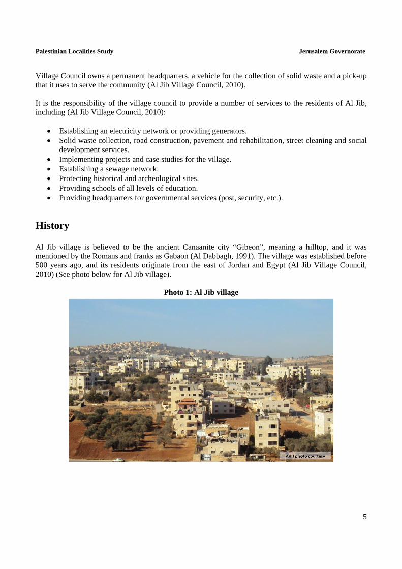
History Al Jib village is believed to be the ancient Canaanite city “Gibeon”, meaning a hilltop, and it was mentioned by the Romans and franks as Gabaon (Al Dabbagh, 1991). The village was established before 500 years ago, and its residents originate from the east of Jordan and Egypt (Al Jib Village Council, 2010) (See photo below for Al Jib village).
Photo 1: Al Jib village

Palestinian Localities Study Jerusalem Governorate
6
Religious and Archaeological Sites In terms of religious establishments, there are two mosques in the village: 'Abd Allah ben 'Abbas and Al Farooq Mosques. The village has two archaeological sites: an ancient church and an Omari mosque (Al Jib Village Council, 2010). Additionally, there is a room curved in rocks, a crusade church, tombs curved in rocks, an olive oil-press also curved in rocks, a well and a reservoir, in addition to Khirbet al 'Adas (Al Dabbagh, 1991) (See Map 2).
Map 2: Main locations in Al Jib Village
Source: ARIJ - GIS Unit, 2012.
Population According to the Palestinian Central Bureau of Statistics (PCBS), the total population of Al Jib in 2007 was 3,805; of whom 1,927 were male and 1,878 female. There were 719 households living in 1,015 housing units.

Palestinian Localities Study Jerusalem Governorate
7
Age Groups and Gender The General Census of Population and Housing carried out by PCBS in 2007 showed the distribution of age groups in Al Jib was as follows: 37.3% were less than 15 years old, 47.6% between 15 - 64, and 2.8% over the age of 65. Data additionally showed that the sex ratio of males to females in the village is 102.6:100, meaning that males and females constituted 50.6% and 49.4% of the population respectively.
Families Al Jib residents are from several families, mainly the Abu Hammood, Abu Dayyah, Ash Sha'abiya, Al Halaiqa, Tayoon, 'Ayish, 'Assaf and Khattab families (Al Jib Village Council, 2010).
Immigration According to the field survey conducted by ARIJ, approximately 300 persons have left the village since the Second Intifada in 2000 (Al Jib Village Council, 2010).
Education According to the results of the PCBS Population, Housing and Establishment Census (2007), the illiteracy rate amongst the Al Jib population was approximately 7.1%, of whom 78.7% were females. Of the literate population, 14.8% could read and write with no formal education, 30.4% had elementary education, 30% had preparatory education, 12.4% had secondary education, and 5.1% completed higher education. Table 1 shows the educational level in the village of Al Jib by sex, and educational attainment in 2007.
Table 1: Al Jib population (10 years and above) by sex and educational attainment, 2007
S E x
Illite-rate
Can read
& write
Elem-entary
Prepa-ratory
Second-ary
Associate Diploma
Bach-elor
Higher Diploma
Master PhD Un-
known Total
M 36 193 369 398 139 26 31 2 2 1 - 1,197
F 133 158 350 311 154 29 28 - 2 - 2 1,167
T 169 351 719 709 293 55 59 2 4 1 2 2,364 Source: PCBS, 2009.
There are four public schools in the village run by the Palestinian Ministry of Education and Higher Education (MoEHE), and two schools run by private bodies (Directorate of Education in Jerusalem, 2011) (see Table 2).

Palestinian Localities Study Jerusalem Governorate
8
Table 2: The Schools in Al Jib by name, stage, sex, and supervising authority (2010/2011)
School Name Supervising Authority Sex
Ibn Khaldoon Boys Elementary School Government Males Fatima az Zahra' Girls High School Government Females Al Jib Co-educated Elementary School Government Mixed Al Jib Boys High School Government Males Nuzhat al Muttaqeen School Private Mixed Al Huda Islamic School Private Mixed Source: Directorate of Education in Jerusalem, 2011
In the village there are 1,507 students, 99 teachers, and 63 classes (Directorate of Education in Jerusalem, 2011). It should be noted here that the average number of students per teacher in the school is nearly 15, whilst the average number of students per class is approximately 24 (Directorate of Education in Jerusalem, 2011). There are two local kindergartens run by a private body, attended by 123 children in 2011. Table 3 shows these kindergartens according to their names and supervising authority (Directorate of Education in Jerusalem, 2011).
Table 3: The Kindergartens in Al Jib by name and supervising authority
Kindergarten Name No. of Children Supervising Authority
Nuzhat al Muttaqeen School 72 Private Al Huda Islamic School 51 Private Source: Directorate of Education in Jerusalem, 2011
Additionally, the educational sector in Al Jib village faces some obstacles, mainly overcrowded and small classrooms in some schools (Al Jib Village Council, 2010).
Health Status There are few health centers available in Al Jib village; a health center called Az Zahra' Medical Center, two physician clinics; one governmental and one private, a private dental clinic, a private medical laboratory, a governmental motherhood and childhood care center and a private pharmacy. However, in the absence of required health services and in emergencies, patients go to Ramallah Governmental Hospital in Ramallah city, or to Al Maqasid Charitable Hospital and/or Al 'Oyoon Hospital, both located in Jerusalem around 14km from the village (Al Jib Village Council, 2010). The health sector in the village suffers many obstacles and problems, mainly (Al Jib Village Council, 2010):
The lack of an ambulance. The lack of a radiology center and governmental medical laboratories in the village.

Palestinian Localities Study Jerusalem Governorate
9
Economic Activities The economy in Al Jib is dependent on several economic sectors, mainly the agricultural sector, which absorbs 65% of the workforce (Al Jib Village Council, 2010) (See Figure 1). A field survey conducted by ARIJ in 2011 showed that the distribution of labor by economic activity in Al Jib is as follows:
Agriculture sector (65%) Israeli labor market (30%) Government or private employees sector (5%)
Figure 1: Economic activity in Al Jib village
Source: Al Jib Village Council, 2010
In terms of commercial and industrial productions in Al Jib village, there are 16 grocery stores, a bakery, one vegetable and fruit store, 8 different services stores and 18 different professional workshops (blacksmith, carpentry, etc.) (Al Jib Village Council, 2010). Moreover, the unemployment rate in Al Jib has reached around 50%. The social groups most affected in the village as a result of Israeli restrictions and procedures are (Al Jib Village Council, 2010):
1. Former workers in Israel. 2. Workers in the educational sector. 3. Workers in the agriculture sector. 4. Workers in the health sector. 5. Workers in the trade sector. 6. Workers in the services sector.

Palestinian Localities Study Jerusalem Governorate
10
Labor Force According to the PCBS Population, Housing and Establishment Census (2007), 33.2% of Al Jib’s labour force was economically active, of whom 66.6% were employed. 66.6% were not economically active, of whom 44.4% were students and 42.4% were housekeepers (See table 4).
Table 4: Al Jib population (10 years and above) by sex and employment status-2007
S E X
Economically Active Not Economically Active
Un-known
Total Emp-loyed
Currently Un-
employed
Un-employed
(Never worked)
Total Stud-ents
House- keeping
Unable to work
Not working & Not looking
for work
Other Total
M 479 76 180 735 332 3 66 37 20 458 4 1,197
F 43 - 6 49 367 665 64 19 2 1,117 1 1,167
T 522 76 186 784 699 668 130 56 22 1,575 5 2,364Source: PCBS, 2009.
Agricultural Sector Al Jib has a total area of around 8,894 dunums of which 5,090 are considered ‘arable’ land and 636 dunums are registered as ‘residential’ (See table 5 and map 3).
Table 5: Land use and land cover in Al Jib village in 2010 (area in dunum)
Total Area
Built up
Area
Agricultural area (5,090)
Inland water
Forests Open
Spaces
Area of Industrial,
Commercial & Transport Unit
Area of Settlements,
Military Bases &
Wall Zone Permanent
Crops Green-houses
Range-lands
Arable lands
8,894 636 1,327 0 605 3,158 0 23 638 30 2,477
Source: ARIJ – GIS Unit, 2012.

Palestinian Localities Study Jerusalem Governorate
11
Map 3: Land use/land cover in Al Jib village
Source: ARIJ - GIS Unit, 2012.
Table 6 shows the different types of rain-fed and irrigated open vegetables planted in the area. The most common crop cultivated within this area is snakecucumber.
Table 6: Total area of rain-fed and irrigated open cultivated vegetables in Al Jib village
Cultivated vegetables Rainfed (dunums) Irrigated (dunums) Fruity vegetables 82 5 Leafy vegetables 1 5 Green legumes 23 5 Bulbs 0 0 Other vegetables 3 5 Total Area 109 20 Source: Palestinian Ministry of Agriculture - Jerusalem, 2010
Table 7 shows the different types of fruit trees planted in the area. Al Jib is known for the cultivation of olives; in total, 770 dunums of land are planted with olive trees.

Palestinian Localities Study Jerusalem Governorate
12
Table 7: Total area of fruit and olive trees in Al Jib village (dunum)
Fruit trees Rainfed Irrigated Olives 770 0 Citrus 0 0 Stone-fruits 85 23 Pome fruits 0 0 Nuts 52 0 Other fruits 289 0 Total Area 1,196 23 Source: Palestinian Ministry of Agriculture - Jerusalem, 2010
In terms of field crops and forage in Al Jib cereals, particularly wheat and barley, are the most cultivated covering an area of about 655 dunums (See table 8).
Table 8: Total area of field crops in Al Jib village (dunum)
Fruit trees Rainfed Irrigated Cereals 655 0 Bulbs 8 0 Dry legumes 0 0 Oil crops 0 0 Forage crops 23 0 Stimulating crops 0 0 Other crops 0 0 Total Area 686 0 Source: Palestinian Ministry of Agriculture - Jerusalem, 2010
The difference between the two sets of results obtained from the Ministry of Agriculture and by ARIJ’s GIS Unit in sizes of agricultural areas is explained by the fact that the Ministry of Agriculture and the Palestinian Central Bureau of Statistics (2010) conducted a survey which used a definition of agricultural areas based on land ownership. Therefore, the areas included in the survey were those of actual holdings of agricultural areas instead of seasonal ones. The survey did not consider fragmented and small seasonal cultivated areas in residential and agricultural areas. ARIJ’s survey, however, indicated the existence of a high proportion of small and fragmented holdings (home gardens) throughout the occupied Palestinian territories, thus accounting for the larger area of agricultural holdings calculated by ARIJ. The field survey conducted by ARIJ shows that 2% of the residents in Al Jib rear and keep domestic animals such as goats, sheep, and bees (Al Jib Village Council, 2010) (See Table 9).

Palestinian Localities Study Jerusalem Governorate
13
Table 9: Livestock in Al Jib village
Cows* Sheep Goats Camels Horses Donkeys Mules Broilers Layers Bee
Hives
0 1,655 730 0 0 0 0 0 0 65 *Including cows, bull calves, heifer calves and bulls Source: Palestinian Ministry of Agriculture - Jerusalem, 2010
There are also around 4 kilometers of agricultural roads in the village (Al Jib Village Council, 2010), divided as follows:
Table 10: Agricultural roads in Al Jib village and their lengths
Suitability of Agricultural Roads Length (km)
For vehicles - For tractors and agricultural machinery only 2 For animals only 2 Unsuitable - Source: Al Jib Village Council, 2010
However, the residents face some obstacles concerning the agricultural sector, mainly:
Lack of capital. Lack of support for feed and agricultural pesticides. Lack of workers. Difficult access to agricultural lands due to the Segregation Wall. Lack of economic feasibility.
Institutions and Services Al Jib village has no governmental institutions, but does have a number of local institutions and associations that provide services to various segments of society, including children, youth, and women. These services are in the areas of culture, sports and others, including (Al Jib Village Council, 2010):
Al Jib Village Council: Founded in 1995 by the Ministry of Interior with the goal of solving issues in the village and providing various services to its population.
Women Center for Motherhood & Childhood: Founded in 2003 by the Ministry of Interior and dedicated to woman and child care.
Rural Women Development Society: Founded in 2000 by the Ministry of Interior for the development and empowerment of women in Al Jib.
Rural Local Development Center: Founded in 2000 by the Ministry of Interior, the center is concerned with village development.
Al Jib Sports Club: Founded in 1998 by the Ministry of Sports & Youth, the AJSC provides sports, social, and cultural activities to young people.

Palestinian Localities Study Jerusalem Governorate
14
Farmers Union: Founded in 2003 by the Palestinian National Authority and concerned with agricultural matters in the village.
Women's Committee/ Palestine Workers Union: Founded in 1999 by the Palestinian National Authority and provides women in the village with various services.
The Agricultural Cooperative Society: Founded in 1984 by the Palestinian National Authority and concerned with agricultural matters in the village.
The Charitable Cooperative Society: Founded in 1984 by the Union of Charitable Societies and concerned with agricultural matters in the village.
Infrastructure and Natural Resources
Electricity and Telecommunication Services Al Jib has been connected to a public electricity network since 1972. It is served by Jerusalem Electricity Company, which is the main source of electricity in the village. Approximately 100% of the housing units in the village are connected to this network. However, the village faces some problems concerning electricity, mainly thefts by village residents (Al Jib Village Council, 2010). Al Jib is connected to a telecommunication network and approximately 50% of housing units within the village boundaries are connected to phone lines (Al Jib Village Council, 2010).
Transportation Services 20 unlicensed/illegal cars and 16 cars from Ramallah form the main means of transportation in Al Jib (Al Jib Village Council, 2010). There is 1km of designated ‘main’ roads and 8km of ‘secondary’ roads (Al Jib Village Council, 2010) (See Table 11).
Table 11: Roads in Al Jib Village
Status of Internal Roads Road Length (km) Main Sub
Paved & in good condition 1 2 Paved but in poor condition - 6 Unpaved - - Source: Al Jib Village Council, 2010
Water Resources The West Bank Water Department provides Al Jib with water purchased from an Israeli company (Mekerot), supplied through the public water network established in 1980. Approximately 100% of the housing units are connected to this network (Al Jib Village Council, 2010). The quantity of water supplied to Al Jib in 2010 was approximately 240,000 cubic meters/ year; therefore, the average rate of water supply per capita in Al Jib is 160 liters per day. However, no Al Jib citizen consumes this amount

Palestinian Localities Study Jerusalem Governorate
15
of water due to water losses, which are recorded at around 60%. These losses happen at the main source, major transport lines, in the distribution network, and at the household level (Al Jib Village Council, 2010). Therefore, the actual rate of water consumption per capita in Al Jib is 62 liters per day. Water consumption by Al Jib residents is low compared with the minimum quantity of 100 liters per capita per day proposed by the World Health Organization. However, domestic harvesting cisterns form an alternative source of water for the population. Despite the existence of 50 cisterns in the locality, they do not sufficiently meet residents' water needs (Al Jib Village Council, 2010). Two springs are located in the village, Al Balad and Abu Zaher. There is also a public water reservoir with a capacity of 200 cubic meters. However, it is considered unsuitable for use and is in need of restoration (Al Jib Village Council, 2010).
Sanitation Al Jib has a public sewerage network established in 2000 (Al Jib Village Council, 2010). According to the results of a community survey conducted by the Applied Research Institute – Jerusalem (ARIJ) in 2010 as part of the project "A Proposed Environmentally Sound Wastewater Management System for the West Bank", the majority of Al Jib housing units (90%) use the sewage network as a means for wastewater disposal, while the rest of housing units (10%) use cesspits (ARIJ & CENTA, 2010). Based on the estimated daily per capita water consumption, the estimated amount of wastewater generated per day is approximately 210 cubic meters, or 76,800 cubic meters annually. At the individual level in Al Jib, it is estimated that the per capita wastewater generation is 50 liters per day, depending on the consumption rate. The wastewater collected through the sewerage network and by cesspits is discharged by wastewater tankers directly in open areas or nearby valleys with no regard for the environment. There is no wastewater treatment either at the source or at the disposal sites and this poses a serious threat to both environmental and public health (ARIJ-WERU, 2012).
Solid Waste Management Al Jib Village Council is the official body responsible for managing the collection and disposal of solid waste generated by the citizens and establishments in the village. As the process of solid waste management is costly, a monthly fee (around 20 NIS/month) is charged to the population served by domestic solid waste collection and transportation services. However, the collected fees are not considered sufficient for good management of solid waste, especially as only 10% of these fees are collected from the citizens (Al Jib Village Council, 2010). Most of the population in Al Jib benefit from solid waste services, whereby waste is collected from households, institutions, shops, and public squares in plastic bags and then transferred to 80 containers1 distributed throughout the village. Al Jib Village Council collects the solid waste on a tri-weekly basis, then transports it using a waste vehicle owned by Al Jib Village Council and Beit 'Anan Local Council to El 'Eizariya and Ramallah Municipality dumping sites. In Ramallah Municipality dumping site solid waste is buried, while in El 'Eizariya dumping site it is buried or burnt (Al Jib Village Council, 2010).
1 Each with a capacity of 1 liter

Palestinian Localities Study Jerusalem Governorate
16
The daily per capita rate of solid waste production in Al Jib is 0.7kg. Thus the estimated amount of solid waste produced per day by Al Jib residents is nearly 3 tons, or 1,078 tons per year (ARIJ-WERU, 2012).
Environmental Conditions Like other villages and camps in the Governorate, Al Jib experiences several environmental problems which must be addressed and solved. These problems can be identified as follows: Water Crisis
1. Water is cut off by the West Bank Water Department for long periods of time in several neighborhoods of the village for several reasons: Israeli domination over Palestinian water resources causes obstacles in the organization of
water pumping and distribution. The West Bank Water Department distributes water to various areas on an interval basis because the amount of water available is not sufficient to supply all citizens at the same time. Consequently, the West Bank Water Department purchases water from Israeli companies in order to supply residents' needs.
2. High rate of water losses because the water network is old and in need of rehabilitation and renovation.
Wastewater Management
The absence of a public sewage network in some neighborhoods (10%) forces residents to use unhygienic cesspits for the disposal of wastewater, and/or to discharge wastewater in the streets. This is particularly common in winter, as citizens cannot afford the high cost of sewage tankers during this period. These methods facilitate environmental damage, health problems, and the spread of epidemics and diseases in the village. This wastewater also contaminates the groundwater because most cesspits are built without lining, allowing wastewater to enter into the ground and avoiding the need to use sewage tankers. Additionally, the untreated wastewater collected from cesspits by sewage tankers is disposed of in open areas without concern for the damage it causes to the environment and to residents' health.
The untreated wastewater collected by the public sewage network is also disposed of in open areas without concern for the damage it causes to the environment and residents' health.
Solid Waste Management
The lack of a central sanitary landfill to serve Al Jib and neighboring communities in the governorate is due mainly to the obstacles created by the Israeli authorities for local and national institutions in granting licenses to establish such a landfill, because the appropriate land is within Area C and under Israeli control. Ramallah Municipality, in partnership with Al Bireh and Beituniya Municipalities, is seeking to establish a regional landfill in accordance with approved international standards. However, the project faces many obstacles (Ramallah Municipality, 2011):
1. Problems regarding purchasing and acquisition of land due to technical reasons related to its owners.

Palestinian Localities Study Jerusalem Governorate
17
2. Lack of availability of funding for the purchase of land, despite a formal commitment from the Prime Minister and the Ministry of Finance to cover the cost of lands.
3. Inability to acquire approved lands due to their location in Area C according to the Oslo Agreement.
The lack of a system in the village and the governorate to separate hazardous waste from non-hazardous waste, so hazardous and industrial solid waste are collected with non-hazardous waste and transported to Ramallah Municipality and El 'Eizariya landfills for disposal.
Impact of the Israeli Occupation
Geopolitical Status of Al Jib Village According to the Oslo II Interim Agreement signed on 28th September 1995 between the Palestinian Liberation Organization (PLO) and Israel, Al Jib village was divided into areas ‘B’ and ‘C’. Approximately 666 dunums (7.5% of the total village area) were assigned as area ‘B’, where the Palestinian National Authority (PNA) has complete control over civil matters but Israel continues to have overriding responsibility for security. Area ‘B’ constitutes most of the inhabited Palestinian areas, including municipalities, villages, and some camps. Most of the village’s population resides in area ‘B’ which constitutes a very small area in comparison to the total area of the village. Approximately 8,228 dunums (92.5% of the total village area) is classified as area ‘C’, where Israel retains full control over security and administration. In area ‘C’ Palestinian building and land management is prohibited unless through a permit given by the Israeli Civil Administration. Most of the lands lying within the area ‘C’ are agricultural lands and Israeli settlements (Table 12).
Table 12 : The geopolitical divisions of Al Jib village according to the Oslo II interim agreement, 1995
Percent of Total village area
Area in dunums Area
0 0 Area A 7.5 666 Area B
92.5 8,228 Area C 0 0 Nature Reserve
100 8,894 Total Source: ARIJ-GIS Unit, 2012
Al Jib Village and the Israeli Occupation Practices Al Jib village has had land confiscated by Israel for various Israeli purposes. These include the construction of Israeli settlements on the village territories and the Racial Segregation plan, through which Israel seeks to control the north-western region of Jerusalem Governorate. This area contains the Givat Ze'ev settlement bloc. In 2005 Israel announced a project that will bring the major settlement blocs into Israel, including Ma'ale Adummim (east of Jerusalem city) Ariel (north of Salfit city), Mod'in

Palestinian Localities Study Jerusalem Governorate
18
Illit (west of Ramallah city), Gush Etzion (southwest of Bethlehem city) and Qiryat Arba (Hebron city) through the annexation of land. Below is a breakdown of Israeli confiscations of Al Jib village lands: During the Israeli occupation of the Palestinian territory, the Israeli government has confiscated 2366 dunums of land from Al Jib village (26.6% of its total area) to establish the three Israeli settlements of Giv'at Ze'ev, Givon, and Giv'on HaHadasha. Currently, these settlements are inhabited by over 13,000 Israeli settlers. These settlements constitute a major part of the Giv'at Ze'ev settlement bloc which includes five Israeli settlements (Table 13).
Table 13: Israeli Settlements constructed over Al Jib lands
Settlement Name Year of
construction
Area confiscated from Al Jib (dunums)
Population of settlers
'Giv'at Ze'ev 1982 2246 10,779 Givon 1978 108 1,179 Giv'on HaHadasha 1980 13 1,113
Total 2366 13,071 Source: ARIJ-GIS Unit, 2012
Al Jib Village and the Israeli Segregation Wall Plan The Israeli Segregation Wall Plan has had a negative and destructive impact on Al Jib Village. According to the last amendment of the plan, published on the webpage of the Israeli Defense Ministry on 30th April 2007, the Wall extends 6km over Al Jib’s lands and isolates 4683 dunums of the village, which comprises 52.6% of the village’s total area. The isolated lands include open and agricultural areas, herbaceous and shrub areas, and Israeli settlements established on the village territory (Table 14).
Table 14: The land classification of lands to be isolated by the Segregation Wall in Al Jib Village - Jerusalem Governorate
No. Land classification Area (dunums)
1 Israeli settlements 2366 2 Agricultural areas 1363 3 Open spaces 255 4 Forests 21 5 Herbaceous & shrubs 523 6 Palestinian residential areas 84 7 Wall zone 71
Total 4683 Source: ARIJ-GIS Unit, 2012

Palestinian Localities Study Jerusalem Governorate
19
Palestinian Suffering in Al Jib Due to the Segregation Wall With the completion of the Segregation Wall, the urbanized areas of Al Jib and a number of neighboring Palestinian villages (Al Judeira, Beit Hanina al Balad and Bir Nabala) will be isolated from neighboring Palestinian communities and from Jerusalem city. Along with neighboring localities, Al Jib will be surrounded by the Wall from the four sides and will therefore be completely isolated. Al Jib and the neighboring villages will be linked to Ramallah through a tunnel passing under the Israeli bypass road 44. The Wall has also divided an entire neighborhood of the village geographically and socially, as part of the neighborhood lies inside the wall and the bulk of it outside the wall. Israeli occupation authorities constructed the Wall close to the urbanized area of the village, increasing the total area of land confiscated in the village, and minimizing the area available for future urban expansion for the people of Al Jib. Such Israeli policies and plans- in Al Jib and across the Jerusalem Governorate- have led to a high population and high urbanization density due to the lack of land for construction and expansion. Construction is permitted only in area B, which constitutes only 12% of the village territories, creating internal and vertical urban expansion. Israeli isolation policy (represented by the construction of the Wall) has created ‘Migration procedure’, from areas which have become isolated and excluded from the city of Jerusalem to areas that remain under the influence of the Israeli Jerusalem Municipality. Many Palestinian families in Al Jib village hold Jerusalem identity (the blue ID), and through staying in areas that have been isolated to the east of the Wall and their exclusion from the city center, they will be deprived of their rights to reside within the city boundaries. This type of policy clearly indicates the Israeli government’s plan to alter the demographic balance in Jerusalem city in favor of Israelis as part of the process of Judaization. Palestinian farmers in Al Jib village are denied access to their lands isolated behind the Wall by the Israel occupation authorities. They cannot access their lands without a special permit that must be issued by the Israeli Liaison Office to pass through special gates built within the Wall; access to isolated agricultural lands is limited to those farmers who can prove their land ownership to the Israeli Civil Administration. Permits2 are issued only to land-owners, usually old people, who have their names included in the property ownership instruments. In addition, the Israeli Civil Administration issues these permits seasonally, which makes it difficult for farmers to cultivate their lands themselves, particularly given that these permits do not allow the necessary labor force or equipment to pass through the Wall.
Al Khalayleh Neighborhood Locality Israeli occupation forces have separated the Al Khalayleh Palestinian neighborhood from the rest of Al Jib by building the Segregation Wall to the west of the village. Al Khalayleh’s residents are under the threat of eviction and demolition, as the neighborhood is located in the heart of Giv'at Ze'ev settlement bloc. The population of Al Khalayleh is estimated at 700 citizens, who are only allowed to enter and exit by special permits, since it is located within the area isolated by the Wall.
2 Obtaining a permit is not an easy process, and permits are usually denied for the owners of isolated lands.

Palestinian Localities Study Jerusalem Governorate
20
In April 2012, Israeli occupation forces demolished a number of houses in Al Khalayleh and displaced 67 Palestinian refugees from the neighborhood, most of whom were children. The people displaced included seven Palestinian families who had become homeless three times within six months. The occupation forces also confiscated tents given to those people by emergency relief and humanitarian agencies. The aim of these attacks is to force residents to leave their homes at the heart of Giv'at Ze'ev, as Israel considers them a threat to the surrounding settlements. The neighborhood is therefore highly vulnerable to demolitions and evictions in the near future.
Ramallah City as a Substitute for Jerusalem City Since the outbreak of the Second Intifada in 2000, Palestinians living in Al Jib and other neighboring villages have lost their connection with Jerusalem City, previously their primary source of education, employment, and health services. Instead, residents now use Ramallah City to fulfill these needs. The construction of the Segregation Wall around the city of Jerusalem has excluded many Palestinian residential localities outside the holy city’s borders in order to maintain a favorable Israeli demographic balance. The four-part community of Al Jib, Al Judeira, Beit Hanina al Balad and Bir Nabala villages are amongst the localities cut off from Jerusalem, and are now linked to Ramallah via a tunnel that passes under Israeli bypass road 443.
Tunnel to connect the northern and north-western areas of Jerusalem After the construction of the Segregation Wall around the city of Jerusalem, many of the surrounding Palestinian communities were separated from the city itself. The Wall also separated Palestinian villages north of Jerusalem from those in the north-west through the annexation of the Giv'at Ze'ev bloc. Therefore, Israeli occupation authorities established a 1.5 kilometer underground tunnel linking the areas north of Jerusalem city with those to the north-west. This tunnel connects six villages north of Jerusalem through Al Jib village with nine villages north-west of Jerusalem through Biddu town. Palestinians in Al Jib must use this tunnel daily to read the north of Jerusalem and Ramallah city.
Israeli Military Orders Issued in Al Jib Village The Israeli occupation authorities have issued a set of military orders to confiscate lands in Al Jib village for different military purposes. These include:
1. Israeli military order 13/05/T: issued on 26th January 2005 to confiscate 226 dunums of land in Al Jib for the Segregation Wall construction.
2. Israeli military order 94/04/T: issued on 31st December 2004 to confiscate 89 dunums of land in Al Jib for the Segregation Wall construction.

Map 4: Tunnel to connect the northern and north-western areas of Jerusalem
Source: ARIJ - GIS Unit, 2012.

Development Plans and Projects
Implemented Projects Al Jib Village Council has implemented several development projects in Al Jib during the past five years (See Table 15).
Table 15: Implemented development plans and projects in Al Jib during the last five years
Name of the Project Type Year Donor
Establishment of a health center Public Services 2008 USAID Establishment of a sewage network Infrastructure 2009 African Development Bank Pavement of internal roads Infrastructure 2005 European Union Pavement of internal roads Infrastructure 2009 Ministry of Finance Source: Al Jib Village Council, 2010
Proposed Projects Al Jib Village Council, in cooperation with the civil society organizations in the village and the village residents, hopes to implement several projects in the coming years. These project ideas were developed during the PRA workshop conducted by ARIJ staff in the village. The projects are as follows, in order of priority from the perspectives of the participants in the workshop:
1. Creating productive projects for the village. 2. Creating land reclamation and cultivation projects. 3. Providing periodical treatment for agricultural pests. 4. Finding a solution for wastewater. 5. Providing projects for women. 6. Providing educational courses.

Palestinian Localities Study Jerusalem Governorate
23
Village Development Priorities and Needs
Al Jib suffers from a significant shortage of infrastructure and services. Table 16 shows the development priorities and needs in the village, according to the village council’s feedback (Al Jib Village Council, 2010).
Table 16: Development priorities and needs in Al Jib
No. Sector Strongly Needed
Need-ed
Not a Priority
Notes
Infrastructural Needs 1 Opening and Pavement of Roads * 11.5km 2 Rehabilitation of Old Water Networks * 4.5km 3 Extending the Water Network to Cover New Built up
Areas *
2.5km
4 Construction of New Water Networks * 7km 5 Rehabilitation/ Construction of New Wells or Springs * 1 well & 3 springs 6 Construction of Water Reservoirs * 400 cubic meters 7 Construction of a Sewage Disposal Network * 3.5km 8 Construction of a New Electricity Network * 9 Providing Containers for Solid Waste Collection * 60 containers 10 Providing Vehicles for Collecting Solid Waste * 1 vehicle 11 Providing a Sanitary Landfill *
Health Needs 1 Building of New Clinics or Health Care Centres * emergency center 2 Rehabilitation of Old Clinics or Health Care Centres * 3 Purchasing of Medical Equipment and Tools *
Educational Needs 1 Building of New Schools * elementary level 2 Rehabilitation of Old Schools
* elementary & secondary
levels for girls 3 Purchasing of New Equipment for Schools * laboratories and gyms
Agriculture Needs 1 Rehabilitation of Agricultural Lands * 600 dunums 2 Building Rainwater Harvesting Cisterns * 50 cisterns 3 Construction of Barracks for Livestock * 5 barracks 4 Veterinary Services * 5 Seeds and Hay for Animals * 700 tons per year 6 Construction of New Greenhouses * 40 greenhouses 7 Rehabilitation of Greenhouses * 8 Field Crops Seeds * 9 Plants and Agricultural Supplies * 3km are main roads, 4km are sub roads and 4.5km are agricultural. Source: Al Jib Village Council, 2010.

Palestinian Localities Study Jerusalem Governorate
24
References Al Dabbagh, M, 1991. Our Country, Palestine; Chapter 8, Part Two. Kafr Qari' – Palestine. Dar al
Huda Press. Applied Research Institute - Jerusalem (ARIJ), 2012. Geographic Information Systems and
Remote Sensing Unit Database. Bethlehem - Palestine. Applied Research Institute - Jerusalem (ARIJ), 2012. Geographic Information Systems and Remote
Sensing Unit; Land Use Analysis (2010) – Half Meter High Accuracy. Bethlehem - Palestine. Applied Research Institute - Jerusalem (ARIJ). 2012. Water & Environment Research Unit
Database (WERU). Bethlehem - Palestine. Al Jib Village Council, 2010. Ministry of Education & Higher Education (MOHE) - Jerusalem, 2011. Directorate of Education;
A database of schools (2010/2011). Jerusalem – Palestine. Palestinian Central Bureau of Statistics. 2009. Jerusalem, Palestine: General Census of Population
and Housing Censuses, 2007. Palestinian Ministry of Agriculture (MOA), 2010. Directorate of Agriculture data (2009/2010).
Jerusalem - Palestine. Ramallah Municipality (2011). Ramallah Municipality Website; Data Retrieved on the first of
March, 2012. http://www.ramallah.ps/atemplate.aspx?id=1207. Applied Research Institute - Jerusalem (ARIJ) & Spanish Centre of New Water Technologies
(CENTA) (2010). A Proposed Environmentally Sound Wastewater Management System for the West Bank. 2010. Bethlehem - Palestine.
Related Documents