Teaching the Teaching the National Airspace System National Airspace System Soaring Safety Foundation FIRC Rich Carlson

Welcome message from author
This document is posted to help you gain knowledge. Please leave a comment to let me know what you think about it! Share it to your friends and learn new things together.
Transcript

Teaching the Teaching the National Airspace SystemNational Airspace System
Soaring Safety FoundationFIRC
Rich Carlson
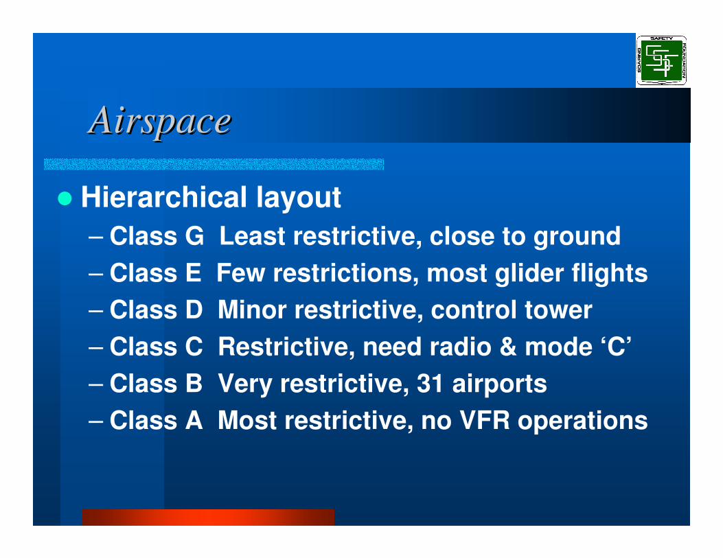
AirspaceAirspace
� Hierarchical layout– Class G Least restrictive, close to ground – Class E Few restrictions, most glider flights – Class D Minor restrictive, control tower – Class C Restrictive, need radio & mode ‘C’ – Class B Very restrictive, 31 airports – Class A Most restrictive, no VFR operations

Airspace & SafetyAirspace & Safety
� Preparation for cross country soaring flight is the essence of the Bronze Badge training program.
� Cross country soaring requires knowledge of, and participation in, the nation’s airspace system.
� Keep up-to-date on the airspace environment in which you plan to fly.

Teaching the NASTeaching the NAS
� Use simple (Class G) to complex (Class A) method– Pilot, Aircraft, Environment
� Introduce basics and then add exceptions (grammar rules)
� Use mnemonic’s to aid in learning– G for Ground, B for Busy

Class “G” AirspaceClass “G” Airspace
� Class G airspace is that portion of the airspace that has not been designated as Class A, Class B, Class C, Class D, or Class E airspace.
� No specific pilot certification is required.
� No specific equipment is required.� Transition to E is shown on Sectional.

Low Altitude Class “G” Airspace Low Altitude Class “G” Airspace VFR Weather MinimumsVFR Weather Minimums
1,200 feet or less above the surface (regardless of MSL altitude):– Minimum visibility:
• 1 statute mile
– Cloud clearance:• Clear of clouds
More than 1,200 feet above the surface but less than 10,000 feet MSL:– Minimum visibility:
• 1 statute mile
– Cloud clearance:• 500 feet below• 1,000 feet above• 2,000 feet horizontal

High Altitude Class “G” Airspace High Altitude Class “G” Airspace VFR Weather MinimumsVFR Weather Minimums
� More than 1,200 feet above the surface and at or above 10,000 feet MSL:– Minimum visibility:
• 5 statute miles
– Minimum cloud clearance:• 1,000 feet below• 1,000 feet above• One mile horizontal

Class “E” AirspaceClass “E” Airspace
� Generally, if the airspace is not Class A, Class B, Class C, or Class D, and it is above 700’/1200’ AGL, it is Class E airspace.
� No specific pilot certification is required. � No specific equipment is required.� Transition from G is shown on Sectional.

Class “E” AirspaceClass “E” AirspaceVFR Weather MinimumsVFR Weather Minimums
� Below 10,000 feet MSL:– Minimum visibility:
• 3 statute miles
– Cloud clearance:• 500 feet below• 1,000 feet above• 2,000 feet horizontal
� Above 10,000 feet MSL:– Minimum visibility:
• 5 statute miles
– Cloud clearance:• 1,000 feet below• 1,000 feet above• One mile horizontal
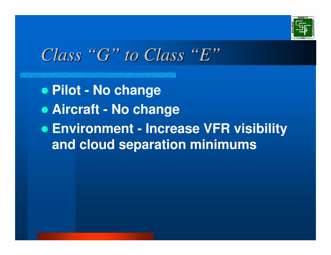
Class “G” to Class “E”Class “G” to Class “E”
� Pilot - No change� Aircraft - No change� Environment - Increase VFR visibility
and cloud separation minimums

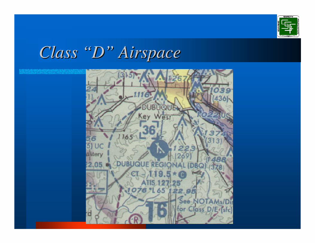
Class “D” AirspaceClass “D” Airspace
� Class D airspace is designated around airports with an operating control tower.
� Class D airspace structure resembles a simple hockey puck.

Class “D” AirspaceClass “D” AirspaceDepiction On SectionalsDepiction On Sectionals� Class D airspace is depicted on
Sectional charts by a circle, drawn with a dashed blue line.
� Ceiling of the Class D airspace is noted within the circle on the Sectional.

Class “D” AirspaceClass “D” AirspaceEntry RequirementsEntry Requirements
– Radio contact should be initiated far enough from the Class D airspace boundary to preclude entering the Class D airspace before two-way radio communications are established.
– Pilots of arriving aircraft should contact the control tower on the publicized frequency and give their position, altitude, destination, and any request(s).
Class “D” AirspaceClass “D” Airspace

Class “E” to Class “D”Class “E” to Class “D”
� Pilot - Radio procedures– Establish radio contact
� Aircraft - Increase aircraft equipment– Radio
� Environment - Increase airspace complexity– Depicted on sectional
Class “C” AirspaceClass “C” Airspace
� Class C airspace is designated around selected airports.
� Class C airspace structure resembles an upside-down two-layer cake.
Class “C” AirspaceClass “C” AirspaceDepiction On SectionalsDepiction On Sectionals� Class C airspace is depicted on
Sectional charts by concentric circles, drawn with a solid magenta line.
� Ceiling height and floor height of each Class C airspace layer is shown on the Sectional (in hundreds of feet MSL).

Class “C” AirspaceClass “C” AirspaceEntry RequirementsEntry Requirements� Class C airspace entry requires:
– Operating two-way radio, with radio contact established.
– Altitude-encoding transponder (Mode C or Mode S).

Class “C” AirspaceClass “C” Airspace
Class “D” to Class “C”Class “D” to Class “C”
� Pilot - No change� Aircraft - Increase aircraft equipment
– Transponder– Altitude Encoder
� Environment - Increase airspace complexity– Dual rings– Cut-outs, wedges, varying heights
Class “B” AirspaceClass “B” Airspace
� Class B airspace is designated around very large, busy airports.
� Class B airspace structure generally resembles an upside-down wedding cake of three layers or more.
� At this writing there are 31 Class B airspace installations in the United States.

Class “B” AirspaceClass “B” AirspaceDepiction On SectionalsDepiction On Sectionals� Class B airspace is depicted on
Sectional charts by concentric circles, drawn with a solid blue line.
� Ceiling height and floor height of each Class B airspace layer is shown on the Sectional (in hundreds of feet MSL).

Class “B” AirspaceClass “B” AirspaceEntry RequirementsEntry Requirements� Class B airspace entry requires:
– Two-way radio communication.– Permission to enter.– Altitude-encoding transponder (Mode C
or Mode S).– In some cases, Private Pilot (or higher)
pilot licensure.

Class “B” AirspaceClass “B” Airspace

Class “C” to Class “B”Class “C” to Class “B”
� Pilot - Requires– Private pilot or better in 12– Logbook endorsements in others– Permission to enter
� Aircraft - No change� Environment - Increase airspace
complexity– Multiple rings– Cut-outs, wedges, varying heights

Mode C Veil AirspaceMode C Veil Airspace
– Mode C veil airspace surrounds Class B airspace installations.
– For many aircraft, flight within Mode C veil airspace requires an altitude-encoding transponder.
– Gliders, balloons, and airplanes certified without an engine-driven electrical system are exempt from the altitude encoding transponder requirement when flying in Mode C veil airspace.
Mode C Veil Airspace DepictionMode C Veil Airspace Depiction
� Mode C veil airspace is depicted on Sectional charts by a labeled circle, drawn with a solid magenta line.
� The radius of the Mode C veil airspace is printed in magenta-colored letters on the Sectional chart.
Class “A” Airspace Class “A” Airspace
– The floor of Class A airspace is 18,000 feet MSL (Flight Level 180), and the ceiling is 60,000 feet MSL (Flight Level 600).
– Class A airspace overlies the entire United States.
– Flights in Class A airspace are conducted under Instrument Flight Rules and are under positive control from the ground.
– VFR flight is not permitted in Class A airspace.

Class “A” AirspaceClass “A” AirspaceDepiction On Sectionals Depiction On Sectionals � Class A airspace overlies the entire
United States. For this reason, Class A airspace is not depicted on sectional charts.

Class “B” to Class “A”Class “B” to Class “A”
� Pilot - Increase pilot requirements– Instrument rating– Communications with ATC
� Aircraft - Compliance with FAR’s– Pitot/Static check– IFR instruments – IFR certification certificate
� Environment– High Altitude systems (cold, O2)

US AirspaceUS Airspace
Exceptions Exceptions
� The basic NAS laid out in this talk defines the US Airspace rules. However, just as in grammar there are exceptions (e.g., I before E except after C).

Exceptions Exceptions
� Class E airspace to the ground� No transponder exception for
overflight of Class B or C airspace� Special use Airspace

Special Use AirspaceSpecial Use Airspace
� Within special use airspace, limitations may be imposed on aircraft.
� Except for controlled firing areas, special use airspace areas are depicted on aeronautical charts.

Special Use AirspaceSpecial Use Airspace
� Special use airspace types:– Temporary Flight Restrictions – Prohibited areas– Restricted areas – Warning areas– Military operations areas (MOA's)– Alert areas– Victor Airways– Military Training Routes

Temporary Flight RestrictionsTemporary Flight Restrictions
� Added to system by FDC NOTAM.� Not depicted on sectionals.� May appear with little notice!� Some common TFR’s
– Presidential visits and movement.– Major sporting events.
� Check with FSS before flight.
Prohibited AreasProhibited Areas
� Prohibited areas are established for security or other reasons associated with the national welfare.
� No flight is allowed in Prohibited areas.
� Prohibited areas are depicted on Sectional charts.

Restricted AreasRestricted Areas
� Restricted areas are established for security or military reasons. – Restricted areas denote the existence of
hazards to aircraft such as artillery firing, aerial gunnery, or guided missiles.
– Penetration of restricted areas without authorization from the using or controlling agency may be extremely hazardous.

Restricted AreasRestricted Areas
� Restricted airspace is depicted on Sectional charts.
� Before entering a Restricted area, contact the controlling authority (usually FAA Flight Service).

Warning AreasWarning Areas
� Warning areas contain activity that may be hazardous to non-participating aircraft.
� Warning areas extend from three nautical miles outward from the coast of the U.S.
� Warning areas are depicted on Sectional charts.
Military Operation Areas Military Operation Areas (MOA’s)(MOA’s)� MOA's exist to separate military flight
training activities from other traffic. – Most military flight training activities
necessitate acrobatic or abrupt flight maneuvers.
– Pilots operating under VFR should exercise extreme caution while flying within a MOA when military activity is being conducted.

Military Operation Areas Military Operation Areas (MOA’s)(MOA’s)
– The activity status (active/inactive) of MOA's may change frequently.
– Pilots should contact any FSS within 100 miles of the area to obtain the MOA hours of operation.
– Before entering an active MOA, pilots should contact the controlling agency for traffic advisories.

Alert AreasAlert Areas
� Alert areas exist to inform pilots of areas that may contain a high volume of pilot training or an unusual type of aerial activity.
� Pilots should be particularly alert for other traffic when flying in these areas.
� Alert areas are depicted on Sectional charts.

Victor AirwaysVictor Airways
� Victor Airways are aerial highways that connect electronic navigation aids.– Victor Airways carry a high volume of
VFR and IFR traffic.– Flight near Victor Airways requires extra
vigilance to see and avoid other traffic.– Victor Airways are 8 nautical miles wide
(4 n.m. either side of the centerline).
Military Training Routes Military Training Routes (MTR’s)(MTR’s)� Military Training Routes are usually
established below 10,000 feet MSL for operations at speeds in excess of 250 knots. Route segments may be defined at higher altitudes for purposes of route continuity.

Military Training Routes Military Training Routes (MTR’s)(MTR’s)
– IFR Military Training Routes - (IR) • Operations on these routes are conducted
in accordance with Instrument Flight Rules regardless of weather conditions.
– VFR Military Training Routes - (VR)• Operations on these routes are conducted
in accordance with Visual Flight Rules.
Related Documents


![Airspace Volumes & Sectorisation · aimed at including TMA, CTA, CTR, ATZ airspace classification or any other nomenclature used to describe the airspace around an airport]. [The](https://static.cupdf.com/doc/110x72/5e6c872238dc2c12146ebb3e/airspace-volumes-sectorisation-aimed-at-including-tma-cta-ctr-atz-airspace.jpg)