UGSB — BATUMI UGSB AD 2.1 Aerodrome location indicator and name UGSB — BATUMI UGSB AD 2.2 Aerodrome geographical and administrative data 413637N 0413558E on the RWY 13/31 ARP coordinates and site at AD 1 5 KM SW from Batumi Direction and distance from city 2 37 FT/28° C Elevation/Reference temperature 3 68 FT Geoid undulation at AD ELEV PSN 4 5° E (1995)/NIL MAG VAR/Annual change 5 BATUMI AIRPORT LTD Post: 220 Airport Highway 6015 BATUMI GEORGIA Tel: +995422235100, +995422235102, +995422235103 Fax: +995422235103 Email: [email protected] Email: [email protected] AFS: UGSBBFXX SITA: BATUMXH AD Administration, address, telephone, telefax, telex, AFS 6 IFR/VFR Types of traffic permitted (IFR/VFR) 7 NIL Remarks 8 UGSB AD 2.3 Operational hours H24 AD Administration 1 H24 Customs and immigration 2 Health: H24 Sanitation: H24 Health and sanitation 3 H24 AIS Briefing Office 4 H24 ATS Reporting Office (ARO) 5 H24 MET Briefing Office 6 BATUMI TWR: H24 BATUMI APP: H24 ATS 7 H24 Fuelling 8 H24 Handling 9 H24 Security 10 H24 De-icing 11 NIL Remarks 12 UGSB AD 2.4 Handling services and facilities NIL Cargo-handling facilities 1 Fuel: TS1(equivalent jet A - 1) Oil: AMG-10, MK-8P Fuel/oil types 2 © 2019 Georgian Air Navigation - Sakaeronavigatsia Ltd. AD 2.UGSB-1 01 MAR 2019 AIP Georgia

Welcome message from author
This document is posted to help you gain knowledge. Please leave a comment to let me know what you think about it! Share it to your friends and learn new things together.
Transcript
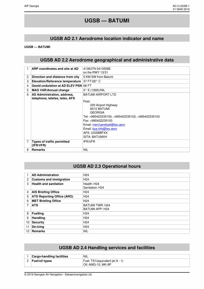
UGSB — BATUMI
UGSB AD 2.1 Aerodrome location indicator and nameUGSB — BATUMI
UGSB AD 2.2 Aerodrome geographical and administrative data
413637N 0413558Eon the RWY 13/31
ARP coordinates and site at AD1
5 KM SW from BatumiDirection and distance from city237 FT/28° CElevation/Reference temperature368 FTGeoid undulation at AD ELEV PSN45° E (1995)/NILMAG VAR/Annual change5BATUMI AIRPORT LTD
Post:220 Airport Highway6015 BATUMIGEORGIA
Tel: +995422235100, +995422235102, +995422235103Fax: +995422235103Email: [email protected]: [email protected]: UGSBBFXXSITA: BATUMXH
AD Administration, address,telephone, telefax, telex, AFS
6
IFR/VFRTypes of traffic permitted(IFR/VFR)
7
NILRemarks8
UGSB AD 2.3 Operational hours
H24AD Administration1H24Customs and immigration2Health: H24Sanitation: H24
Health and sanitation3
H24AIS Briefing Office4H24ATS Reporting Office (ARO)5H24MET Briefing Office6BATUMI TWR: H24BATUMI APP: H24
ATS7
H24Fuelling8H24Handling9H24Security10H24De-icing11NILRemarks12
UGSB AD 2.4 Handling services and facilities
NILCargo-handling facilities1Fuel: TS1(equivalent jet A - 1)Oil: AMG-10, MK-8P
Fuel/oil types2
© 2019 Georgian Air Navigation - Sakaeronavigatsia Ltd.
AD 2.UGSB-101 MAR 2019
AIP Georgia
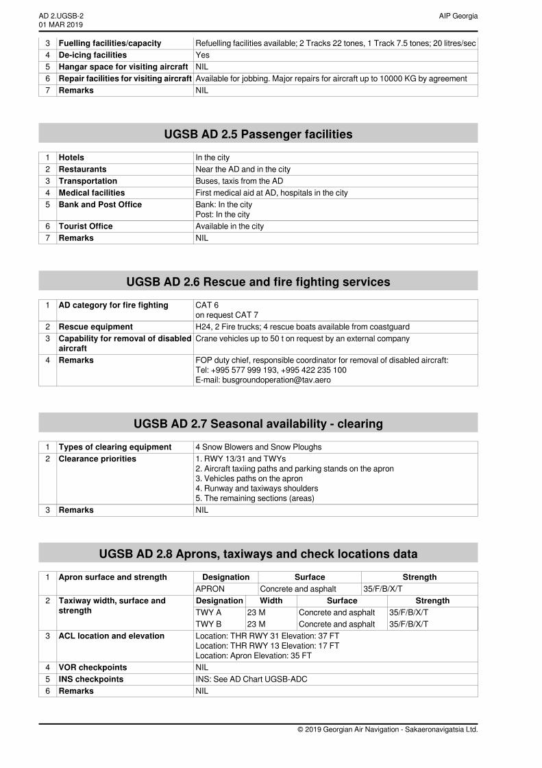
Refuelling facilities available; 2 Tracks 22 tones, 1 Track 7.5 tones; 20 litres/secFuelling facilities/capacity3YesDe-icing facilities4NILHangar space for visiting aircraft5Available for jobbing. Major repairs for aircraft up to 10000 KG by agreementRepair facilities for visiting aircraft6NILRemarks7
UGSB AD 2.5 Passenger facilities
In the cityHotels1Near the AD and in the cityRestaurants2Buses, taxis from the ADTransportation3First medical aid at AD, hospitals in the cityMedical facilities4Bank: In the cityPost: In the city
Bank and Post Office5
Available in the cityTourist Office6NILRemarks7
UGSB AD 2.6 Rescue and fire fighting services
CAT 6on request CAT 7
AD category for fire fighting1
H24, 2 Fire trucks; 4 rescue boats available from coastguardRescue equipment2Crane vehicles up to 50 t on request by an external companyCapability for removal of disabled
aircraft3
FOP duty chief, responsible coordinator for removal of disabled aircraft:Tel: +995 577 999 193, +995 422 235 100E-mail: [email protected]
Remarks4
UGSB AD 2.7 Seasonal availability - clearing
4 Snow Blowers and Snow PloughsTypes of clearing equipment11. RWY 13/31 and TWYs2. Aircraft taxiing paths and parking stands on the apron3. Vehicles paths on the apron4. Runway and taxiways shoulders5. The remaining sections (areas)
Clearance priorities2
NILRemarks3
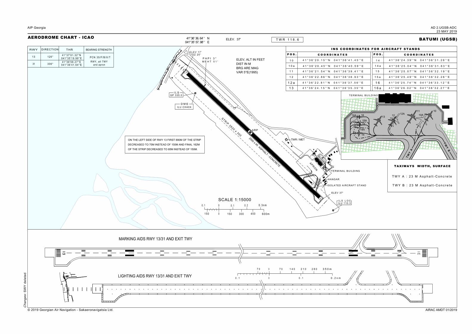
UGSB AD 2.8 Aprons, taxiways and check locations data
StrengthSurfaceDesignation35/F/B/X/TConcrete and asphaltAPRON
Apron surface and strength1
StrengthSurfaceWidthDesignation35/F/B/X/TConcrete and asphalt23 MTWY A35/F/B/X/TConcrete and asphalt23 MTWY B
Taxiway width, surface andstrength
2
Location: THR RWY 31 Elevation: 37 FTLocation: THR RWY 13 Elevation: 17 FTLocation: Apron Elevation: 35 FT
ACL location and elevation3
NILVOR checkpoints4INS: See AD Chart UGSB-ADCINS checkpoints5NILRemarks6
© 2019 Georgian Air Navigation - Sakaeronavigatsia Ltd.
AIP GeorgiaAD 2.UGSB-201 MAR 2019
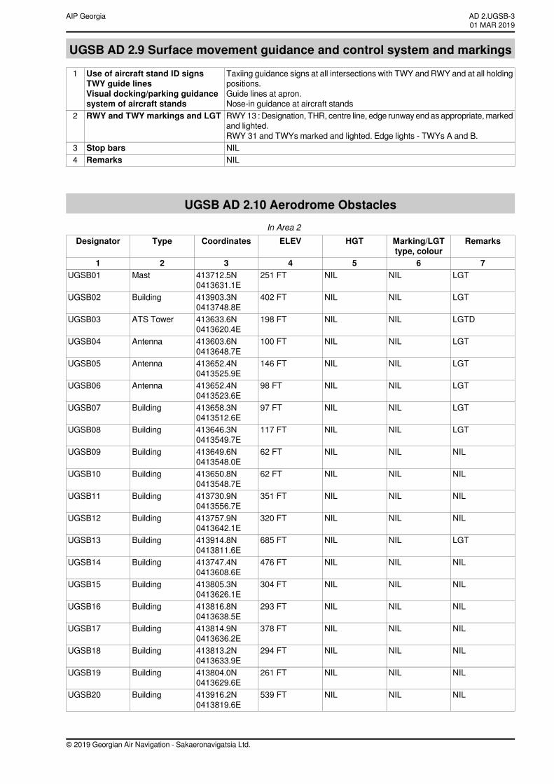
UGSB AD 2.9 Surface movement guidance and control system and markings
Taxiing guidance signs at all intersections with TWY and RWY and at all holdingpositions.Guide lines at apron.Nose-in guidance at aircraft stands
Use of aircraft stand ID signsTWY guide linesVisual docking/parking guidancesystem of aircraft stands
1
RWY13 : Designation, THR, centre line, edge runway end as appropriate, markedand lighted.RWY 31 and TWYs marked and lighted. Edge lights - TWYs A and B.
RWY and TWY markings and LGT2
NILStop bars3NILRemarks4
UGSB AD 2.10 Aerodrome ObstaclesIn Area 2
RemarksMarking/LGTtype, colour
HGTELEVCoordinatesTypeDesignator
7654321LGTNILNIL251 FT413712.5N
0413631.1EMastUGSB01
LGTNILNIL402 FT413903.3N0413748.8E
BuildingUGSB02
LGTDNILNIL198 FT413633.6N0413620.4E
ATS TowerUGSB03
LGTNILNIL100 FT413603.6N0413648.7E
AntennaUGSB04
LGTNILNIL146 FT413652.4N0413525.9E
AntennaUGSB05
LGTNILNIL98 FT413652.4N0413523.6E
AntennaUGSB06
LGTNILNIL97 FT413658.3N0413512.6E
BuildingUGSB07
LGTNILNIL117 FT413646.3N0413549.7E
BuildingUGSB08
NILNILNIL62 FT413649.6N0413548.0E
BuildingUGSB09
NILNILNIL62 FT413650.8N0413548.7E
BuildingUGSB10
NILNILNIL351 FT413730.9N0413556.7E
BuildingUGSB11
NILNILNIL320 FT413757.9N0413642.1E
BuildingUGSB12
LGTNILNIL685 FT413914.8N0413811.6E
BuildingUGSB13
NILNILNIL476 FT413747.4N0413608.6E
BuildingUGSB14
NILNILNIL304 FT413805.3N0413626.1E
BuildingUGSB15
NILNILNIL293 FT413816.8N0413638.5E
BuildingUGSB16
NILNILNIL378 FT413814.9N0413636.2E
BuildingUGSB17
NILNILNIL294 FT413813.2N0413633.9E
BuildingUGSB18
NILNILNIL261 FT413804.0N0413629.6E
BuildingUGSB19
NILNILNIL539 FT413916.2N0413819.6E
BuildingUGSB20
© 2019 Georgian Air Navigation - Sakaeronavigatsia Ltd.
AD 2.UGSB-301 MAR 2019
AIP Georgia
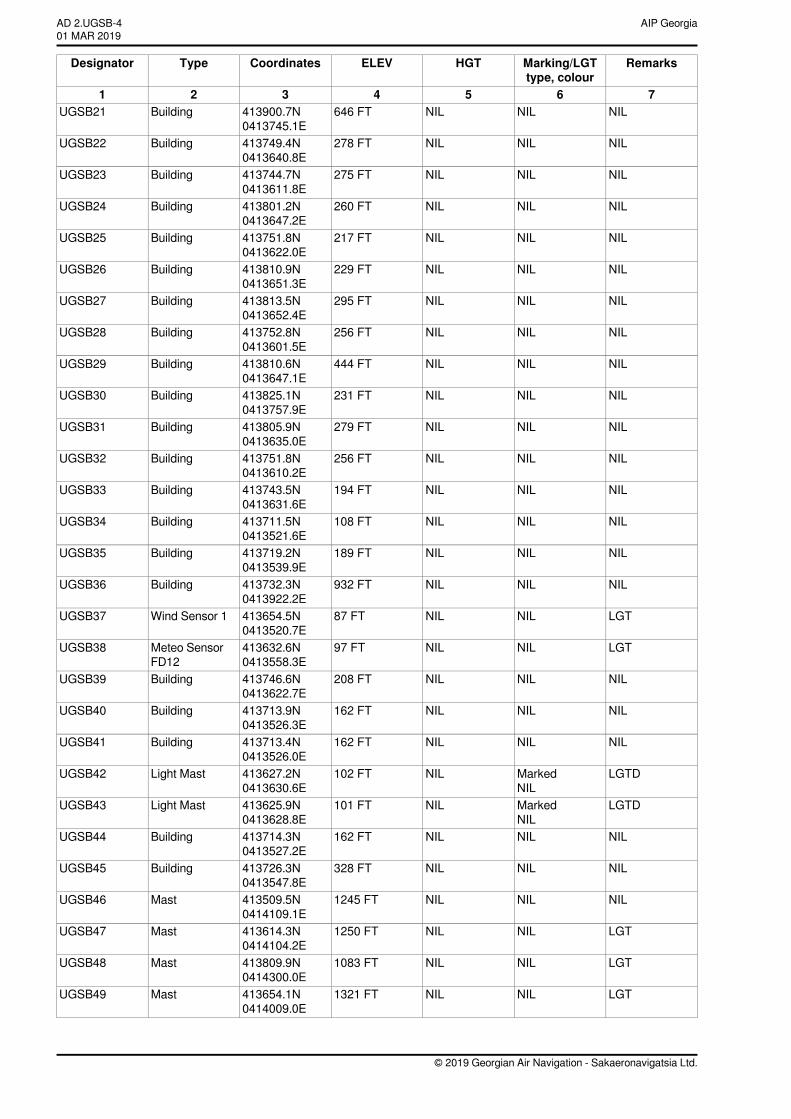
RemarksMarking/LGTtype, colour
HGTELEVCoordinatesTypeDesignator
7654321NILNILNIL646 FT413900.7N
0413745.1EBuildingUGSB21
NILNILNIL278 FT413749.4N0413640.8E
BuildingUGSB22
NILNILNIL275 FT413744.7N0413611.8E
BuildingUGSB23
NILNILNIL260 FT413801.2N0413647.2E
BuildingUGSB24
NILNILNIL217 FT413751.8N0413622.0E
BuildingUGSB25
NILNILNIL229 FT413810.9N0413651.3E
BuildingUGSB26
NILNILNIL295 FT413813.5N0413652.4E
BuildingUGSB27
NILNILNIL256 FT413752.8N0413601.5E
BuildingUGSB28
NILNILNIL444 FT413810.6N0413647.1E
BuildingUGSB29
NILNILNIL231 FT413825.1N0413757.9E
BuildingUGSB30
NILNILNIL279 FT413805.9N0413635.0E
BuildingUGSB31
NILNILNIL256 FT413751.8N0413610.2E
BuildingUGSB32
NILNILNIL194 FT413743.5N0413631.6E
BuildingUGSB33
NILNILNIL108 FT413711.5N0413521.6E
BuildingUGSB34
NILNILNIL189 FT413719.2N0413539.9E
BuildingUGSB35
NILNILNIL932 FT413732.3N0413922.2E
BuildingUGSB36
LGTNILNIL87 FT413654.5N0413520.7E
Wind Sensor 1UGSB37
LGTNILNIL97 FT413632.6N0413558.3E
Meteo SensorFD12
UGSB38
NILNILNIL208 FT413746.6N0413622.7E
BuildingUGSB39
NILNILNIL162 FT413713.9N0413526.3E
BuildingUGSB40
NILNILNIL162 FT413713.4N0413526.0E
BuildingUGSB41
LGTDMarkedNIL
NIL102 FT413627.2N0413630.6E
Light MastUGSB42
LGTDMarkedNIL
NIL101 FT413625.9N0413628.8E
Light MastUGSB43
NILNILNIL162 FT413714.3N0413527.2E
BuildingUGSB44
NILNILNIL328 FT413726.3N0413547.8E
BuildingUGSB45
NILNILNIL1245 FT413509.5N0414109.1E
MastUGSB46
LGTNILNIL1250 FT413614.3N0414104.2E
MastUGSB47
LGTNILNIL1083 FT413809.9N0414300.0E
MastUGSB48
LGTNILNIL1321 FT413654.1N0414009.0E
MastUGSB49
© 2019 Georgian Air Navigation - Sakaeronavigatsia Ltd.
AIP GeorgiaAD 2.UGSB-401 MAR 2019
RemarksMarking/LGTtype, colour
HGTELEVCoordinatesTypeDesignator
7654321NILNILNIL206 FT413856.1N
0413731.2EBuildingUGSB50
NILNILNIL374 FT413751.4N0413613.4E
BuildingUGSB51
NILNILNIL377 FT413819.5N0413704.1E
BuildingUGSB52
NILNILNIL210 FT413759.3N0413631.1E
BuildingUGSB53
NILNILNIL75 FT413648.5N0413549.6E
BuildingUGSB54
NILNILNIL56 FT413650.4N0413548.9E
BuildingUGSB55
NILNILNIL69 FT413654.9N0413544.1E
BuildingUGSB56
NILNILNIL62 FT413656.6N0413539.3E
BuildingUGSB57
NILNILNIL49 FT413647.0N0413551.5E
BuildingUGSB58
NILNILNIL59 FT413647.6N0413552.5E
BuildingUGSB59
NILNILNIL56 FT413648.0N0413551.1E
BuildingUGSB60
NILNILNIL59 FT413649.0N0413548.8E
BuildingUGSB61
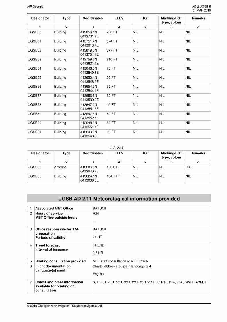
In Area 3RemarksMarking/LGT
type, colourHGTELEVCoordinatesTypeDesignator
7654321LGTNILNIL100.0 FT413606.0N
0413640.7EAntennaUGSB62
NILNILNIL134.7 FT413624.1N0413638.3E
BuildingUGSB63
UGSB AD 2.11 Meteorological information provided
BATUMIAssociated MET Office1H24
—
Hours of serviceMET Office outside hours
2
BATUMI
24 HR
Office responsible for TAFpreparationPeriods of validity
3
TREND
0.5 HR
Trend forecastInterval of issuance
4
MET staff consultation at MET OfficeBriefing/consultation provided5Charts, abbreviated plain language text
English
Flight documentationLanguage(s) used
6
S, U85, U70, U50, U30, U20, P85, P70, P50, P40, P30, P20, SWH, SWM, TCharts and other informationavailable for briefing orconsultation
7
© 2019 Georgian Air Navigation - Sakaeronavigatsia Ltd.
AD 2.UGSB-501 MAR 2019
AIP Georgia
NILSupplementary equipmentavailable for providing information
8
Batumi TWR, APP; Tbilisi ACCATS units provided withinformation
9
NILAdditional information (limitationof service etc.)
10
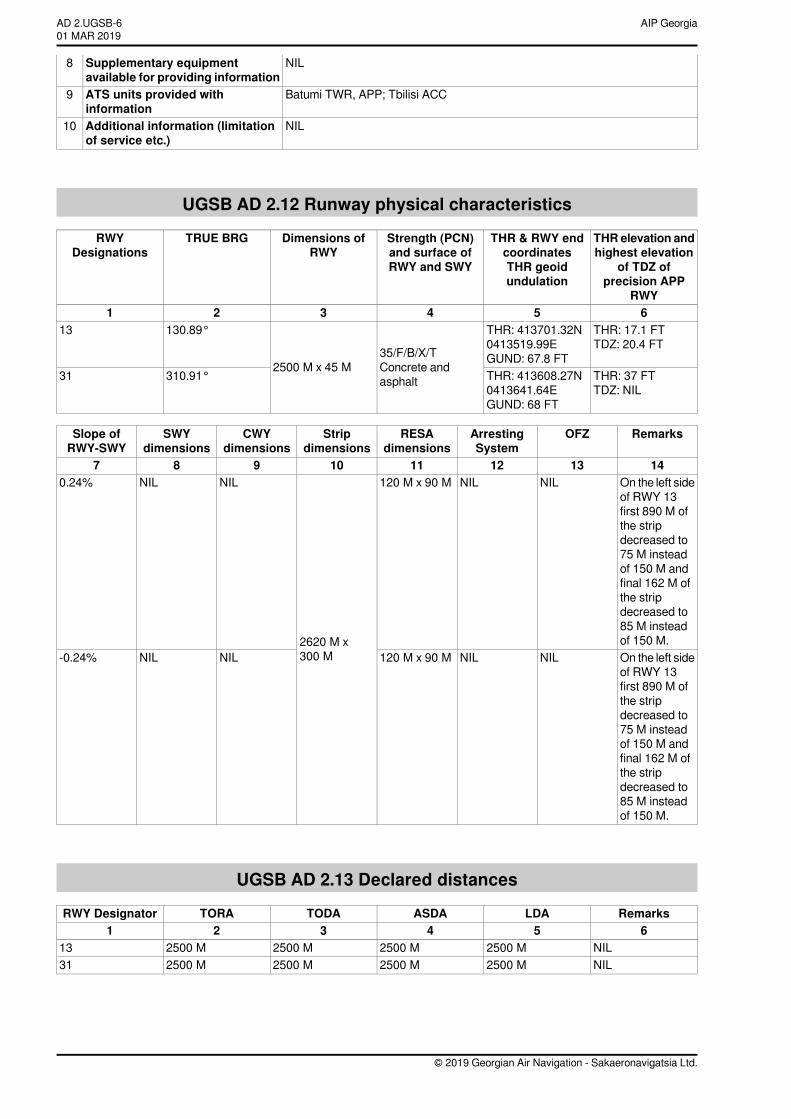
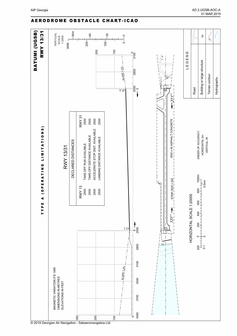
UGSB AD 2.12 Runway physical characteristics
THRelevation andhighest elevation
of TDZ ofprecision APP
RWY
THR & RWY endcoordinatesTHR geoidundulation
Strength (PCN)and surface ofRWY and SWY
Dimensions ofRWY
TRUE BRGRWYDesignations
654321THR: 17.1 FTTDZ: 20.4 FT
THR: 413701.32N0413519.99EGUND: 67.8 FT35/F/B/X/T
Concrete andasphalt
2500 M x 45 M
130.89°13
THR: 37 FTTDZ: NIL
THR: 413608.27N0413641.64EGUND: 68 FT
310.91°31
RemarksOFZArrestingSystem
RESAdimensions
Stripdimensions
CWYdimensions
SWYdimensions
Slope ofRWY-SWY
1413121110987On the left sideof RWY 13first 890 M ofthe stripdecreased to75 M insteadof 150 M andfinal 162 M ofthe stripdecreased to85 M insteadof 150 M.
NILNIL120 M x 90 M
2620 M x300 M
NILNIL0.24%
On the left sideof RWY 13first 890 M ofthe stripdecreased to75 M insteadof 150 M andfinal 162 M ofthe stripdecreased to85 M insteadof 150 M.
NILNIL120 M x 90 MNILNIL-0.24%
UGSB AD 2.13 Declared distances
RemarksLDAASDATODATORARWY Designator654321
NIL2500 M2500 M2500 M2500 M13NIL2500 M2500 M2500 M2500 M31
© 2019 Georgian Air Navigation - Sakaeronavigatsia Ltd.
AIP GeorgiaAD 2.UGSB-601 MAR 2019
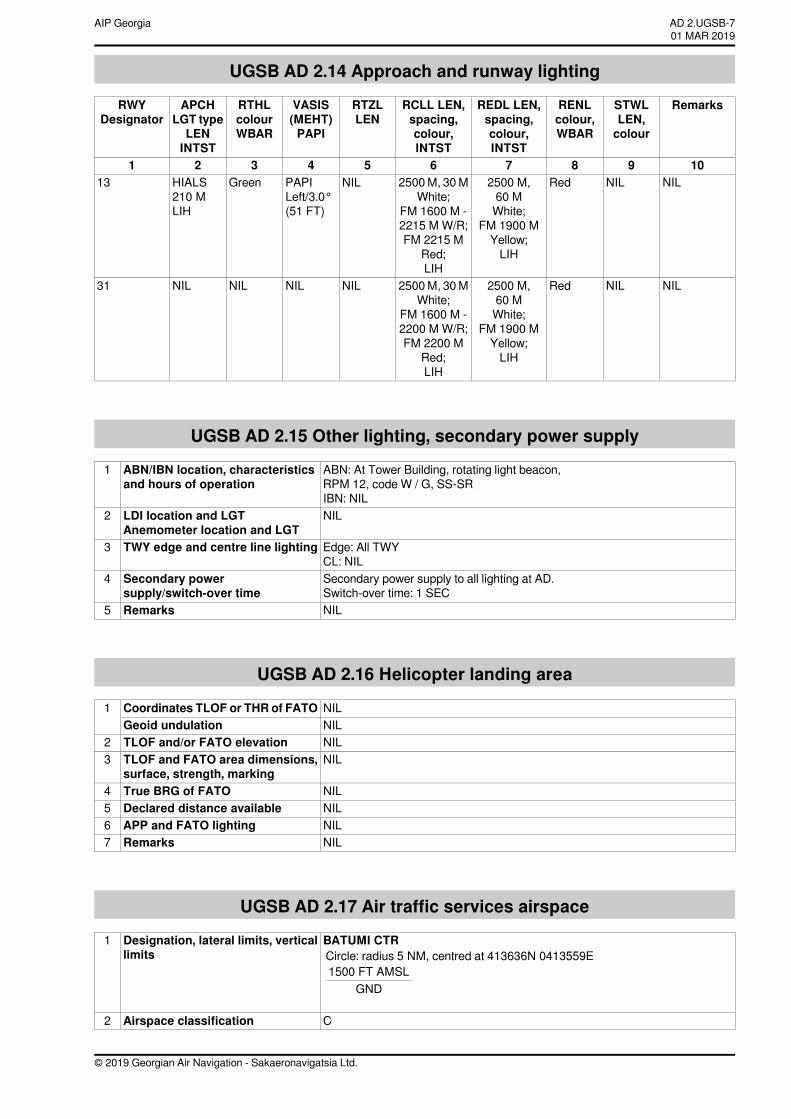
UGSB AD 2.14 Approach and runway lighting
RemarksSTWLLEN,colour
RENLcolour,WBAR
REDL LEN,spacing,colour,INTST
RCLL LEN,spacing,colour,INTST
RTZLLEN
VASIS(MEHT)PAPI
RTHLcolourWBAR
APCHLGT typeLENINTST
RWYDesignator
10987654321NILNILRed2500 M,
60 MWhite;
FM 1900 MYellow;LIH
2500M, 30MWhite;
FM 1600 M -2215 M W/R;FM 2215 M
Red;LIH
NILPAPILeft/3.0°(51 FT)
GreenHIALS210 MLIH
13
NILNILRed2500 M,60 MWhite;
FM 1900 MYellow;LIH
2500M, 30MWhite;
FM 1600 M -2200 M W/R;FM 2200 M
Red;LIH
NILNILNILNIL31
UGSB AD 2.15 Other lighting, secondary power supply
ABN: At Tower Building, rotating light beacon,RPM 12, code W / G, SS-SRIBN: NIL
ABN/IBN location, characteristicsand hours of operation
1
NILLDI location and LGTAnemometer location and LGT
2
Edge: All TWYCL: NIL
TWY edge and centre line lighting3
Secondary power supply to all lighting at AD.Switch-over time: 1 SEC
Secondary powersupply/switch-over time
4
NILRemarks5
UGSB AD 2.16 Helicopter landing area
NILCoordinates TLOF or THR of FATO1NILGeoid undulationNILTLOF and/or FATO elevation2NILTLOF and FATO area dimensions,
surface, strength, marking3
NILTrue BRG of FATO4NILDeclared distance available5NILAPP and FATO lighting6NILRemarks7
UGSB AD 2.17 Air traffic services airspace
BATUMI CTRCircle: radius 5 NM, centred at 413636N 0413559E1500 FT AMSL
GND
Designation, lateral limits, verticallimits
1
CAirspace classification2
© 2019 Georgian Air Navigation - Sakaeronavigatsia Ltd.
AD 2.UGSB-701 MAR 2019
AIP Georgia
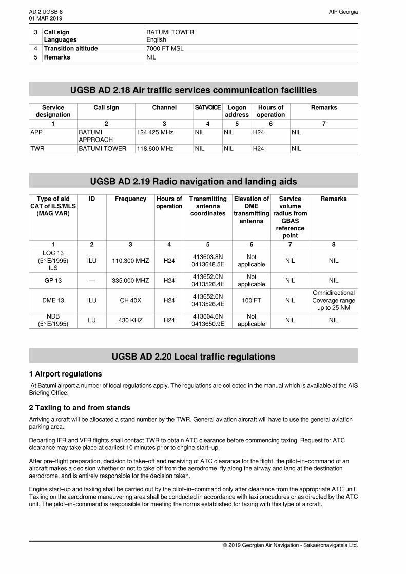
BATUMI TOWEREnglish
Call signLanguages
3
7000 FT MSLTransition altitude4NILRemarks5
UGSB AD 2.18 Air traffic services communication facilities
RemarksHours ofoperation
Logonaddress
SATVOICEChannelCall signServicedesignation
7654321NILH24NILNIL124.425 MHzBATUMI
APPROACHAPP
NILH24NILNIL118.600 MHzBATUMI TOWERTWR
UGSB AD 2.19 Radio navigation and landing aids
RemarksServicevolume
radius fromGBAS
referencepoint
Elevation ofDME
transmittingantenna
Transmittingantenna
coordinates
Hours ofoperation
FrequencyIDType of aidCAT of ILS/MLS(MAG VAR)
87654321
NILNILNotapplicable
413603.8N0413648.5EH24110.300 MHZILU
LOC 13(5°E/1995)
ILS
NILNILNotapplicable
413652.0N0413526.4EH24335.000 MHZ—GP 13
OmnidirectionalCoverage rangeup to 25 NM
NIL100 FT413652.0N0413526.4EH24CH 40XILUDME 13
NILNILNotapplicable
413604.6N0413650.9EH24430 KHZLUNDB
(5°E/1995)
UGSB AD 2.20 Local traffic regulations
1 Airport regulationsAt Batumi airport a number of local regulations apply. The regulations are collected in the manual which is available at the AISBriefing Office.
2 Taxiing to and from standsArriving aircraft will be allocated a stand number by the TWR. General aviation aircraft will have to use the general aviationparking area.
Departing IFR and VFR flights shall contact TWR to obtain ATC clearance before commencing taxing. Request for ATCclearance may take place at earliest 10 minutes prior to engine start–up.
After pre–flight preparation, decision to take–off and receiving of ATC clearance for the flight, the pilot–in–command of anaircraft makes a decision whether or not to take off from the aerodrome, fly along the airway and land at the destinationaerodrome, and is entirely responsible for the decision taken.
Engine start–up and taxiing shall be carried out by the pilot–in–command only after clearance from the appropriate ATC unit.Taxiing on the aerodrome maneuvering area shall be conducted in accordance with taxi procedures or as directed by the ATCunit. The pilot–in–command is responsible for meeting the norms established for taxing with this type of aircraft.
© 2019 Georgian Air Navigation - Sakaeronavigatsia Ltd.
AIP GeorgiaAD 2.UGSB-801 MAR 2019
Taxiing from the holding position to the line–up and take–off shall be performed only after clearance from the tower controller.The pilot-in-command shall take off within one minute after receiving the clearance from the ATC unit. If a take - off has notbeen carried out within the above mentioned time interval the pilot-in-command shall request a new clearance.
Isolated aircraft stand with the coordinates 413615.71N 0413639.05E is available on the TWY B.
3 Parking area for small aircraft (general aviation)General aviation aircraft shall be directed by marshallers to the parking area for small aircraft.
4 Taxiing for helicoptersHelicopters shall always be directed to the stand by a marshaller.
5 Apron – taxiing during winter conditionsAs a rule, apron and RWY are not snow-covered during winter.
6 Taxiing – limitationsTaxiing is carried out in accordance with general rules (see point 2). Additional information will be given to each aircraft fromthe TWR.
7 Educational and training flights. Technical test flying. Use of runwaysEducational and training flights can be made only after permission from the TWR. Permission will not be given within thefollowing periods: 18.00-08.00 LT and on Saturdays, on Sundays and official holidays. For educational and training flights andsuch technical test flights necessary for the purpose of ascertaining the airworthiness during flight, use of the RWY system isrestricted as follows: RWY 31 must be used for take-off only and RWY 13 must be used for landing only.
8 Helicopter flights – limitationIrregular helicopter flights are allowed only after prior approval from the Batumi Aerodrome Administration.
9 Removal of disabled aircraft from runwayWhen an aircraft is wrecked on a runway, it is the duty of the owner or user of such aircraft to have it removed as soon aspossible. If a wrecked aircraft is not removed from the runway as quickly as possible by the owner or user, the aircraft will beremoved by the aerodrome authority at the owner's or user's expense.
UGSB AD 2.21 Noise abatement proceduresNot applicable.
UGSB AD 2.22 Flight procedures
1 Runway useTake-off from RWY13 and landing on RWY31 is only permitted in day time exclusively in accordance with the Visual FlightRules (VFR) for aeroplanes with MTOW not exceeding 5700 kilograms and for all types of helicopters.
2 Procedures for IFR flights within Batumi TMAATS surveillance service is provided within Batumi TMA by Batumi approach (call sign “Batumi approach”) on frequency124.425 MHZ.A radar separation minimum of 5 NM is applied between all identified aircraft within Batumi TMA.
All aircraft shall follow speed limit max IAS 250 KT within Batumi TMA bellow FL110, unless a different speed is instructed byATC. If unable to comply, advice ATC immediately.
Arrival routes STARs are established for RWY 13 and departure routes SIDs for RWY 31.
Clearance for visual approach on RWY 13 will be issued only after the pilot has reported the aerodrome insight.
Visual departures are not allowed.
Surveillance radar approaches and precision radar approaches are not conducted.
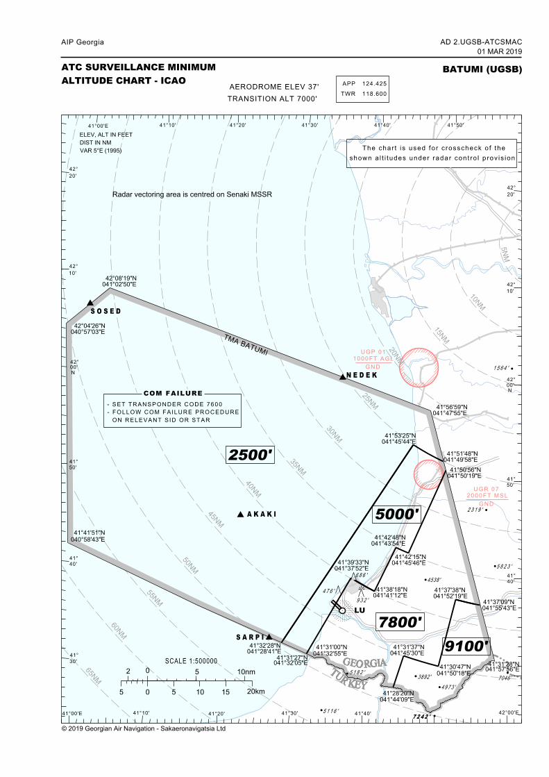
Aircraft radar vectoring is provided in accordance with the ATC Surveillance Minimum Altitude Chart AD2.UGSB-ATCSMAC.
© 2019 Georgian Air Navigation - Sakaeronavigatsia Ltd.
AD 2.UGSB-901 MAR 2019
AIP Georgia
ATIS service is not available, all pertinent information is provided by ATCO.
3 Procedures for VFR flights within Batumi TMATwo-way radio communication shall be maintained with the Batumi Approach on the FRQ 124.425 MHZ, with Batumi TWRon the FRQ 118.600 MHZ.
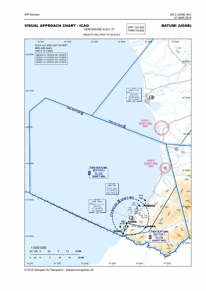
Transfer of VFR flights from/to Batumi TMA – Batumi tower is conducted when passing altitude 1500 FT, over establishedentry/exit points shown in the Visual Approach Chart AD2.UGSB-VAC unless otherwise instructed by APP or TWR unit.
4 Procedures for VFR flights within Batumi CTRVFR flights entering Batumi CTR from uncontrolled airspace shall establish communication with Batumi Tower at least 5minutes before entry to obtain clearance.VFR flights shall enter/exit Batumi Control Zone via the entry/exit points shown in the Visual Approach Chart AD2.UGSB-VACunless otherwise instructed by APP or TWR unit.
The altitude, at which the aircraft is entering Batumi CTR, shall be 1500 FT MSL or below.
If the traffic situation requires or the active runway is blocked, the aircraft conducting VFR flight may be directed to the holdingareas:
ABUKO – north-east holding area established over Makhinjauri at 1500 FT MSL or below;
GONIG – south holding area established over Gonio at 1500 FT MSL or below.
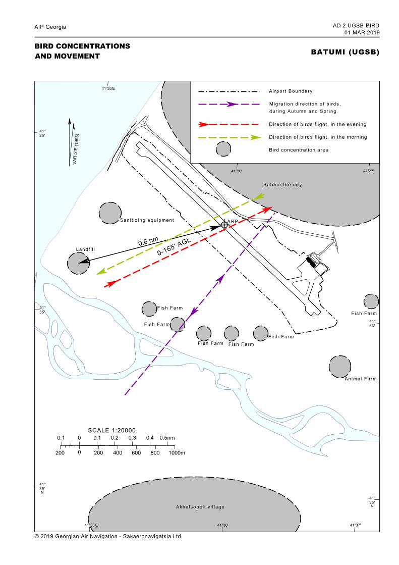
UGSB AD 2.23 Additional informationIntense activity of raven flocks takes place daily from 08:00 to 10:00 (local time) when birds fly from resting area (town) acrossthe RWY 13/31 to their feeding area, SW of the airport. Their flight height is approximately 100 FT (30 M) AGL. From 16:00to 19:00 (local time) the same activity as described above takes place in reverse when the birds return to their resting area.
Intense activity of seagulls also takes place during daytime near the airport territory over the Black Sea, as they use sea waterfor feeding and resting.
Seasonal activity of swallows and hawks takes place during autumn and spring when they fly across the RWY 13/31, theirflight height varies from 100 FT (30 M) to 165 FT (50 M) AGL.
Because of the permanent character of the bird activity in the vicinity of the airport, pilots are informed of the fact and theestimated heights (AGL), continually by air traffic controllers.
Pilots of aircraft are advised, where the design limitations of aircraft installations permit, to operate landing lights in flight, withinthe terminal area and during take-off, approach-to-land and climb and descent procedures.
Dispersal activities include occasional playing back of distressed calls from high fidelity weather-resistant speakers, highshooting sound produced of liquid gas cannons allocated near the RWY13/31. Also loud-hailers installed on aerodrome servicevehicle are continually used for distressing birds. No open waste-bins on the aerodrome.
UGSB AD 2.24 Charts related to an aerodrome
AD 2.UGSB-ADCAerodrome Chart ‒ ICAO←AD 2.UGSB-AOC-AAerodrome Obstacle Chart – ICAO Type A
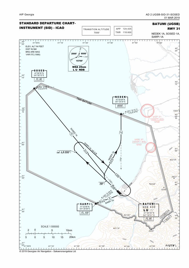
AD 2.UGSB-SID-31-SOSEDStandard Departure Chart - Instrument – ICAORWY 31(NEDEK 1A, SOSED 1A, SARPI 1A)
AD 2.UGSB-RSID-31-SOSEDStandard Departure Routes - Instrument – ICAORWY 31(NEDEK 1A, SOSED 1A, SARPI 1A)
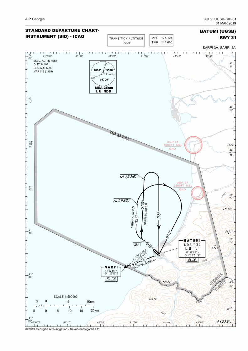
AD 2.UGSB-SID-31Standard Departure Chart - Instrument – ICAORWY 31(SARPI 3A, SARPI 4A)
AD 2.UGSB-RSID-31Standard Departure Routes - Instrument – ICAORWY 31(SARPI 3A, SARPI 4A)
AD 2.UGSB-STAR-13Standard Arrival Chart - Instrument – ICAORWY 13
© 2019 Georgian Air Navigation - Sakaeronavigatsia Ltd.AIRAC AMDT 01/2019
AIP GeorgiaAD 2.UGSB-1023 MAY 2019~~~eaip-amdt~~~ver-date-2019-04-17T11-26-21-432
AD 2.UGSB-RSTAR-13Standard Arrival Routes - Instrument – ICAORWY 13
AD 2.UGSB-ATCSMACATC Surveillance MinimumAltitude Chart – ICAO
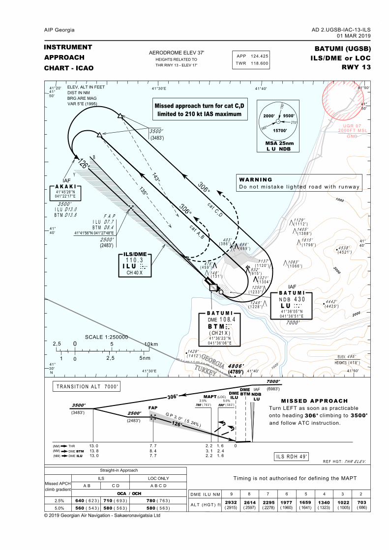
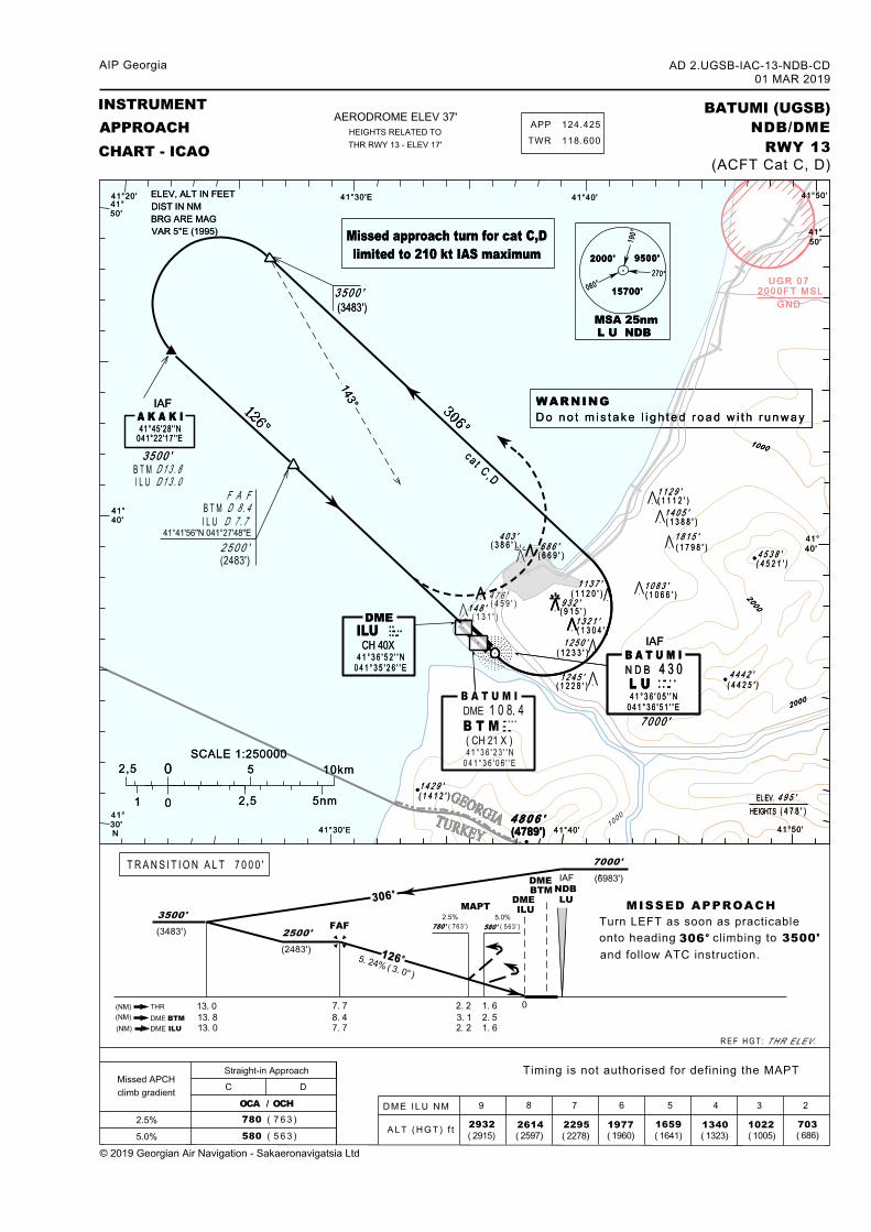
AD 2.UGSB-IAC-13-ILSInstrument Approach Chart – ICAOILS/DME or LOC RWY 13
AD 2.UGSB-IAC-13-NDB-ABInstrument Approach Chart – ICAONDB/DME RWY 13(CAT A, B)
AD 2.UGSB-IAC-13-NDB-CDInstrument Approach Chart – ICAONDB/DME RWY 13(CAT C, D)
AD 2.UGSB-VACVisual Approach Chart – ICAOAD 2.UGSB-BIRDBird Concentrations and Movement
© 2019 Georgian Air Navigation - Sakaeronavigatsia Ltd.
AD 2.UGSB-1101 MAR 2019
AIP Georgia
AIP Georgia AD 2.UGSB-RSID-31-SOSED 01 MAR 2019
© 2019 Georgian Air Navigation – Sakaeronavigatsia Ltd.
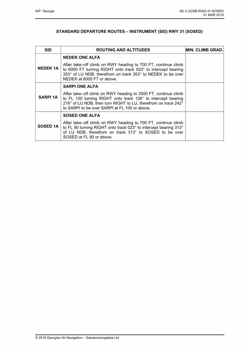
STANDARD DEPARTURE ROUTES – INSTRUMENT (SID) RWY 31 (SOSED)
SID ROUTING AND ALTITUDES MIN. CLIMB GRAD.
NEDEK 1A
NEDEK ONE ALFA
After take–off climb on RWY heading to 700 FT, continue climb to 6000 FT turning RIGHT onto track 023° to intercept bearing 353° of LU NDB, therefrom on track 353° to NEDEK to be over NEDEK at 6000 FT or above.
SARPI 1A
SARPI ONE ALFA
After take–off climb on RWY heading to 3500 FT, continue climb to FL 100 turning RIGHT onto track 126° to intercept bearing 216° of LU NDB, then turn RIGHT to LU, therefrom on track 242° to SARPI to be over SARPI at FL 100 or above.
SOSED 1A
SOSED ONE ALFA
After take–off climb on RWY heading to 700 FT, continue climb to FL 90 turning RIGHT onto track 023° to intercept bearing 313° of LU NDB, therefrom on track 313° to SOSED to be over SOSED at FL 90 or above.
AIP Georgia AD 2.UGSB-RSID-31 01 MAR 2019
© 2019 Georgian Air Navigation – Sakaeronavigatsia Ltd.
STANDARD DEPARTURE ROUTES – INSTRUMENT (SID) RWY 31
SID ROUTING AND ALTITUDES MIN. CLIMB GRAD.
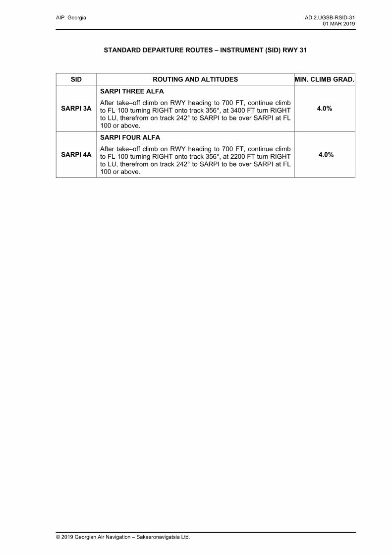
SARPI 3A
SARPI THREE ALFA
After take–off climb on RWY heading to 700 FT, continue climb to FL 100 turning RIGHT onto track 356°, at 3400 FT turn RIGHT to LU, therefrom on track 242° to SARPI to be over SARPI at FL 100 or above.
4.0%
SARPI 4A
SARPI FOUR ALFA
After take–off climb on RWY heading to 700 FT, continue climb to FL 100 turning RIGHT onto track 356°, at 2200 FT turn RIGHT to LU, therefrom on track 242° to SARPI to be over SARPI at FL 100 or above.
4.0%

AIP Georgia AD 2.UGSB-RSTAR-13 01 MAR 2019
© 2019 Georgian Air Navigation – Sakaeronavigatsia Ltd.
STANDARD ARRIVAL ROUTES – INSTRUMENT (STAR) RWY 13
STAR ROUTING AND ALTITUDES
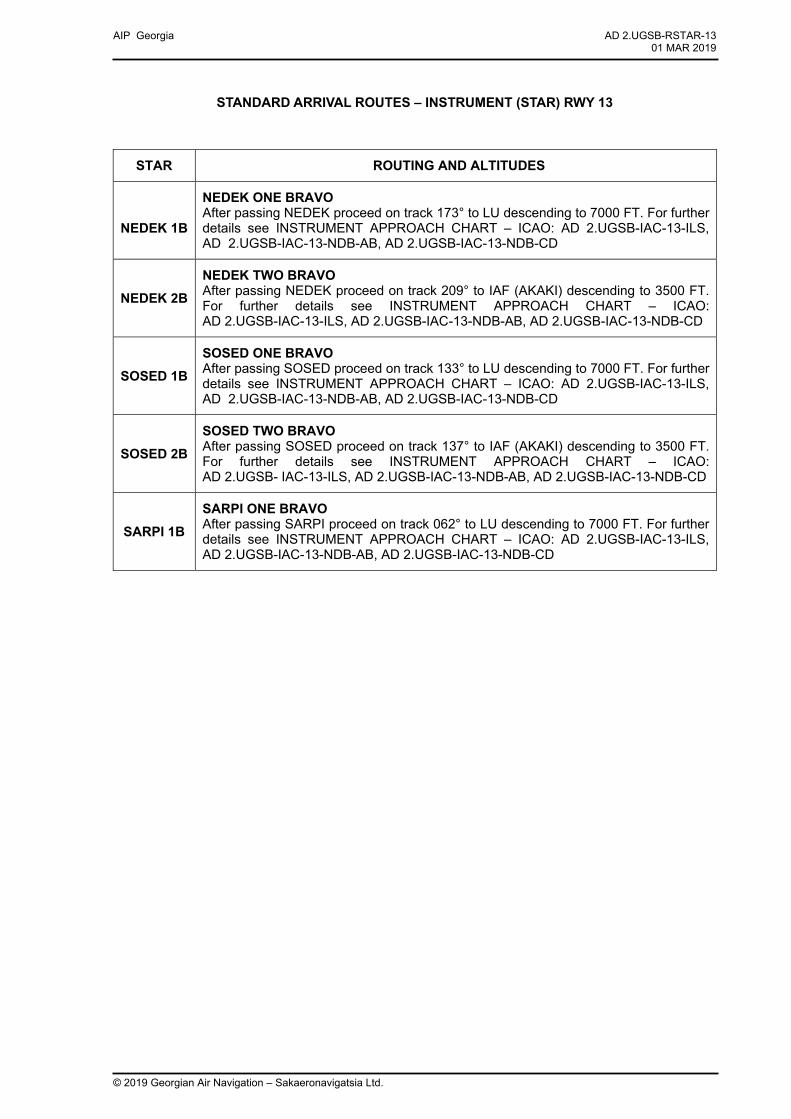
NEDEK 1B
NEDEK ONE BRAVO After passing NEDEK proceed on track 173° to LU descending to 7000 FT. For further details see INSTRUMENT APPROACH CHART – ICAO: AD 2.UGSB-IAC-13-ILS, AD 2.UGSB-IAC-13-NDB-AB, AD 2.UGSB-IAC-13-NDB-CD
NEDEK 2B NEDEK TWO BRAVO After passing NEDEK proceed on track 209° to IAF (AKAKI) descending to 3500 FT. For further details see INSTRUMENT APPROACH CHART – ICAO: AD 2.UGSB-IAC-13-ILS, AD 2.UGSB-IAC-13-NDB-AB, AD 2.UGSB-IAC-13-NDB-CD
SOSED 1B SOSED ONE BRAVO After passing SOSED proceed on track 133° to LU descending to 7000 FT. For further details see INSTRUMENT APPROACH CHART – ICAO: AD 2.UGSB-IAC-13-ILS, AD 2.UGSB-IAC-13-NDB-AB, AD 2.UGSB-IAC-13-NDB-CD
SOSED 2B SOSED TWO BRAVO After passing SOSED proceed on track 137° to IAF (AKAKI) descending to 3500 FT. For further details see INSTRUMENT APPROACH CHART – ICAO: AD 2.UGSB- IAC-13-ILS, AD 2.UGSB-IAC-13-NDB-AB, AD 2.UGSB-IAC-13-NDB-CD
SARPI 1B SARPI ONE BRAVO After passing SARPI proceed on track 062° to LU descending to 7000 FT. For further details see INSTRUMENT APPROACH CHART – ICAO: AD 2.UGSB-IAC-13-ILS, AD 2.UGSB-IAC-13-NDB-AB, AD 2.UGSB-IAC-13-NDB-CD

K
K
K
E
EE
E¼¼»¼
2000
3000
4000
5000
1000
3000
4000
2000200
0
1000
1000
2000
5000
2000
3000
1000
3000
5000
1539
5663
4285
43835085
5026
7054
4813
2428
BATUMINDB 430LULU
41°36'05"N041°36'51"E
POTI
100'
DME 111,0PTIPTI
(CH 47X)42°09'42"N041°41'50"E
BATUMI
100'
DME 108,4BTMBTM
(CH 21X)41°36'23"N041°36'06"E
TMA BATUMIC
SECTOR 1FL 115
6000FT MSL
TMA BATUMI C
SECTOR 2FL 115
1500FT MSL
TMA BATUMI CCT
RBA
TUMI C 1500FT MSL
TMA KUTAISI CUGP01
1000FT AGLGND
UGR072000FT MSL
GND
GONIG
DIDUSNINKA
ABUKO686(649)
932(895)
476(439)
1321(1284)
41°50'E
41°50'E
41°40'E
41°40'E
41°30'E
41°30'E
41°20'E
41°20'E
41°10'E
41°10'E
41°0'E
41°0'E
42°20'N
42°20'N
42°10'N
42°10'N
42°0'N
42°0'N
41°50'N
41°50'N
41°40'N
41°40'N
41°30'N
41°30'N
AD 2.UGSB-VAC01 MAR 2019
AIP Georgia
VISUAL APPROACH CHART - ICAO BATUMI (UGSB)
1:500 000
AERODROME ELEV. 37'
© 2019 Georgian Air Navigation - Sakaeronavigatsia Ltd
APP 124.425TWR118.600
MAX1500
§
§
§
§
MAX
1500
§
§MAX 1500
ABUKO 41°39'55"N 041°40'55"EDIDUS 41°31'58"N 041°33'29"EGONIG 41°34'50"N 041°34'40"ENINKA 41°33'54"N 041°41'36"E
ELEV, ALT AND HGT IN FEETBRG ARE MAGVAR 5° E (1995)
HEIGHTS RELATED TO AD ELEV
MAX1500
§
§
2,5 0 2,5 5 7,5 101,25 NM
5 0 5 10 15 202,5 KM
Related Documents


