Agroecology of pre-contact Hawaiian dryland farming: the spatial extent, yield and social impact of Hawaiian breadfruit groves in Kona, Hawai'i Noa Lincoln a, * , Thegn Ladefoged b a Interdisciplinary Program in the Environment and Resources, Stanford University, Stanford, CA 94305, USA b Department of Anthropology, University of Auckland, Auckland, New Zealand article info Article history: Received 19 February 2014 Received in revised form 4 May 2014 Accepted 8 May 2014 Available online 24 May 2014 Keywords: Agricultural development Agroecology Breadfruit Dryland agriculture Ethnoagriculture Human biocomplexity Kona Hawai'i abstract Modeling Hawaiian dryland (rainfed) agriculture has been an effective means for examining interactions between ecosystems and human behavior. Dryland agriculture in these discussions has often been treated as a homogenous farming system; however, this was in fact a dynamic system with distinct agroecological zones where specific mixes of crops were grown using different farming methods. We examine this variability by using historical depictions and ground surveys to estimate the extent of an agroecological zone represented by breadfruit plantations within Kona, Hawai'i Island. We estimate that the plantations produced 21,200e58,400 mt/yr of breadfruit on 3100e5900 ha with a likely canopy cover within the plantations of 38e73%. Our models suggest that yields per area in the plantation ranged from 1.96 to 3.61 dry mt/ha. Given the yield and labor requirements, breadfruit could have produced a caloric surplus for 15 people in contrast to 3.6 people under assumed requirements of sweet potato. This high surplus would have been vital for socio-political developments centered in the region, and highlights the importance of assessing variability of dryland field systems in discussion of their role in historical trajectories. © 2014 Elsevier Ltd. All rights reserved. 1. Introduction Dryland, or rainfed, agricultural systems, some covering scores of square kilometers, were the dominant source of food on the Is- land of Hawai'i at the time of European contact and a central part of the pre-historic economy (Ladefoged et al., 2009). The uneven distribution of climate and soil resources across the archipelago led to differential agricultural opportunities, levels of food surplus and, consequently, population densities and political trajectories (Kirch, 1990,1994, 2007, 2010; Kirch and O'Day, 2003; Kirch et al., 2012; Ladefoged et al., 2008; Ladefoged and Graves, 2008). Kirch et al. (2012), Graves et al. (2010), and others demonstrate the coupled nature of agricultural resource intensity and political hierarchical development. A reliable agricultural system capable of producing surpluses was essential for supporting the socio-political dynamics of Hawaiian polities; the feedback between ecosystems and social/ political developments creates a co-evolving ethno-landscape (Egan, 2003; Evans et al., 2001). Even though the prolific farming systems of Hawai'i were able to sustain large populations on small islands, there were still impor- tant limitations. These limitations have primarily been explored in the context of biogeochemical properties of the agricultural land- scapes. The general soil and climatic conditions that bound the intensification of dryland systems as a whole are well understood (Vitousek et al., 2004, in press) and were summarized in a predic- tive geospatial model of intensive dryland cultivation in Hawai'i by Ladefoged et al. (2009), in which they discuss the total agricultural capability of each island in terms of yield ratios to land and labor. These and other important discussions treat dryland farming in Hawai'i as homogeneous systems based on sweet potato (Ipomoea batatas) production; however these were in fact dynamic systems with distinct agroecological zones where specific mixes of crops were grown using different farming methods. How does this complexity affect what we have learned from Hawaiian dryland agriculture in relationship to the total yields, relative surplus, and coupled social evolution? The relatively low productivity and stability within dryland systems in relation to irrigated systems was probably a factor in stimulating Hawaiian planters to create and exploit new forms of cropping that allowed them to develop ways of elevating and * Corresponding author. Tel.: þ1 808 217 7710. E-mail address: [email protected] (N. Lincoln). Contents lists available at ScienceDirect Journal of Archaeological Science journal homepage: http://www.elsevier.com/locate/jas http://dx.doi.org/10.1016/j.jas.2014.05.008 0305-4403/© 2014 Elsevier Ltd. All rights reserved. Journal of Archaeological Science 49 (2014) 192e202

Welcome message from author
This document is posted to help you gain knowledge. Please leave a comment to let me know what you think about it! Share it to your friends and learn new things together.
Transcript

lable at ScienceDirect
Journal of Archaeological Science 49 (2014) 192e202
Contents lists avai
Journal of Archaeological Science
journal homepage: http: / /www.elsevier .com/locate/ jas
Agroecology of pre-contact Hawaiian dryland farming: the spatialextent, yield and social impact of Hawaiian breadfruit groves in Kona,Hawai'i
Noa Lincoln a, *, Thegn Ladefoged b
a Interdisciplinary Program in the Environment and Resources, Stanford University, Stanford, CA 94305, USAb Department of Anthropology, University of Auckland, Auckland, New Zealand
a r t i c l e i n f o
Article history:Received 19 February 2014Received in revised form4 May 2014Accepted 8 May 2014Available online 24 May 2014
Keywords:Agricultural developmentAgroecologyBreadfruitDryland agricultureEthnoagricultureHuman biocomplexityKonaHawai'i
* Corresponding author. Tel.: þ1 808 217 7710.E-mail address: [email protected] (N.
http://dx.doi.org/10.1016/j.jas.2014.05.0080305-4403/© 2014 Elsevier Ltd. All rights reserved.
a b s t r a c t
Modeling Hawaiian dryland (rainfed) agriculture has been an effective means for examining interactionsbetween ecosystems and human behavior. Dryland agriculture in these discussions has often beentreated as a homogenous farming system; however, this was in fact a dynamic system with distinctagroecological zones where specific mixes of crops were grown using different farming methods. Weexamine this variability by using historical depictions and ground surveys to estimate the extent of anagroecological zone represented by breadfruit plantations within Kona, Hawai'i Island. We estimate thatthe plantations produced 21,200e58,400 mt/yr of breadfruit on 3100e5900 ha with a likely canopy coverwithin the plantations of 38e73%. Our models suggest that yields per area in the plantation ranged from1.96 to 3.61 dry mt/ha. Given the yield and labor requirements, breadfruit could have produced a caloricsurplus for 15 people in contrast to 3.6 people under assumed requirements of sweet potato. This highsurplus would have been vital for socio-political developments centered in the region, and highlights theimportance of assessing variability of dryland field systems in discussion of their role in historicaltrajectories.
© 2014 Elsevier Ltd. All rights reserved.
1. Introduction
Dryland, or rainfed, agricultural systems, some covering scoresof square kilometers, were the dominant source of food on the Is-land of Hawai'i at the time of European contact and a central part ofthe pre-historic economy (Ladefoged et al., 2009). The unevendistribution of climate and soil resources across the archipelago ledto differential agricultural opportunities, levels of food surplus and,consequently, population densities and political trajectories (Kirch,1990, 1994, 2007, 2010; Kirch and O'Day, 2003; Kirch et al., 2012;Ladefoged et al., 2008; Ladefoged and Graves, 2008). Kirch et al.(2012), Graves et al. (2010), and others demonstrate the couplednature of agricultural resource intensity and political hierarchicaldevelopment. A reliable agricultural system capable of producingsurpluses was essential for supporting the socio-political dynamicsof Hawaiian polities; the feedback between ecosystems and social/political developments creates a co-evolving ethno-landscape(Egan, 2003; Evans et al., 2001).
Lincoln).
Even though the prolific farming systems of Hawai'i were able tosustain large populations on small islands, there were still impor-tant limitations. These limitations have primarily been explored inthe context of biogeochemical properties of the agricultural land-scapes. The general soil and climatic conditions that bound theintensification of dryland systems as a whole are well understood(Vitousek et al., 2004, in press) and were summarized in a predic-tive geospatial model of intensive dryland cultivation in Hawai'i byLadefoged et al. (2009), in which they discuss the total agriculturalcapability of each island in terms of yield ratios to land and labor.These and other important discussions treat dryland farming inHawai'i as homogeneous systems based on sweet potato (Ipomoeabatatas) production; however these were in fact dynamic systemswith distinct agroecological zones where specific mixes of cropswere grown using different farming methods. How does thiscomplexity affect what we have learned from Hawaiian drylandagriculture in relationship to the total yields, relative surplus, andcoupled social evolution?
The relatively low productivity and stability within drylandsystems in relation to irrigated systems was probably a factor instimulating Hawaiian planters to create and exploit new forms ofcropping that allowed them to develop ways of elevating and

Fig. 1. Rainfall distribution in the study area of Kona, Hawai'i.
N. Lincoln, T. Ladefoged / Journal of Archaeological Science 49 (2014) 192e202 193
diversifying the dryland system and make feasible the expansioninto increasingly marginal areas. These innovations may havemaximized the available opportunities given the underlying envi-ronmental conditions and socio-political climate; better under-standing their impact is a first step in understanding the degree towhich limitations and opportunities shaped innovation. The agro-forestry plantation based on breadfruit (Artocarpus artilis) withinthe Kona region of Hawai'i Island, herein referred to as the kaluulu,represents an example of this type of innovative practice (Kelly,1983).
Breadfruit played an important role in the agrarian culture ofpre-European Hawai'i; it was one of three staple sources of starch(Abbott, 1992) and found on all islands of the archipelago (Meilleuret al., 2004). While breadfruit was an important food source, it wasclearly a less preferred source of starch than taro and sweet po-tatoes (Abbot, 1992; Handy et al., 1972). In Hawai'i breadfruit alsoserved several additional purposes; its trunk provided wood forhouses, canoes, surfboards and drums; its bark was processed intocloth; its flowers were used in lei making and medicinal applica-tions; and its latex-laden sap was used for chewing gum, caulking,waterproofing, and glue used in cloth making and bird catching(Abbott, 1992; Handy et al., 1972; Malo, 1951).
The location of the kaluulu in the Kona region is significant asKona was often a political center of Hawai'i Island during the pre-contact era (Kamakau, 1961). Despite the uniqueness and poten-tial political importance of the kaluulu, little is known about thisagricultural regime. We utilize ground surveys, historical de-pictions, and growth observations to determine the historicalextent of the kaluulu, and the total yield and surplus generatedwithin the kaluulu. We discuss the implications of this analysis forour understanding and interpretation of human biocomplexity inHawai'i. In applying innovative and novel, multi-disciplinary ap-proaches to understanding the impact of one particular agroeco-logical zone relating to a well-published body of previous researchwe aim to highlight the importance of considering variability inlocal conditions, and how that variability may relate to adaptationsand long-term trajectories of farming systems and theirproductivity.
2. Agricultural landscape in Kona, Hawai'i
2.1. Environment and geology of Kona
Kona is situated on the leeward slopes of Mauna Loa and Hua-lalai volcanoes. The volcanoes create a localized weather systemand a wet environment in the uplands of Kona that is quite distinctfrom most other leeward areas in the archipelago. This rainfall isnot evenly distributed (Fig. 1); rainfall increases upslope from aslittle as 600 mm/yr at the coast to as much as 2000 mm/yr at~600 m elevation, declining again at higher elevation (Giambellucaet al., 2012). Mauna Loa and Hualalai volcanoes also create apatchwork of overlapping lava flows (Fig. 2) that range from lessthan 65 years old to over 10,000 years old (Trusdell et al., 2006),and are primarily Histosols and Andisols. The different flow agesand rainfall creates amatrix of soil fertility and farming opportunitywithin the Kona agricultural landscape (Lincoln et al., 2014).
2.2. Pre-European Kona agriculture
During the millennium or so of settlement before Europeancontact, Hawaiians developed and intensified virtually every arablehabitat in the archipelago (Kirch, 2010). The systematic develop-ment of dryland agriculture commenced by the 15th century andwas intensified up into the 19th century (Dye, 2011; Ladefoged andGraves, 2008; McCoy, 2005; Tomonari-Tuggle, 2006). The pre-
historic agricultural developments of Kona, herein referred to asthe “Kona field system,” were first described archaeologically byNewman (1971), who concluded that the Kona field system coveredan area of approximately 14,000 ha. Revised estimates byLadefoged et al. (2009) predicts patchy intensification of approxi-mately 15,500 ha on lava flows 4000 yr and older.
The archaeological record of the Kona field system is extensivebut ad-hoc, largely conducted by various contract archaeologists forprivate or private developments and national or state parks. Whilefew studies have specifically examined for evidence of breadfruit,there is no definitive archaeological evidence to tell us about thekaluulu. Direct examinations for the historical presence of bread-fruit within the expected elevation range of the kaluulu include anexamination of plantmicrofossils in the traditional land divisions ofKi'ilae and Kauleol�ı in south Kona that clearly indicated the lack ofpresence of breadfruit within the samples (Horrocks andRechtman, 2009), and an archeological survey in the traditionalland division of Kealakekua that produced evidence of breadfruitcharcoal but lacked breadfruit pollen in soil samples (Tomonari-
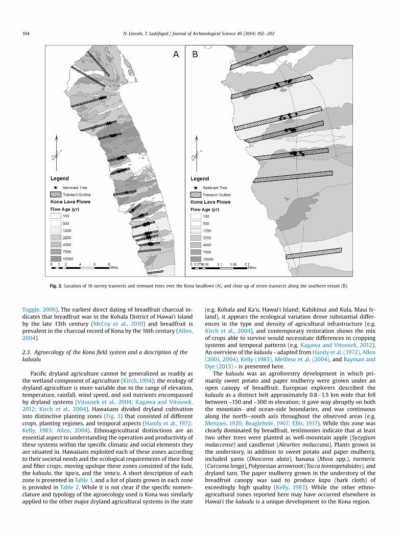
Fig. 2. Location of 16 survey transects and remnant trees over the Kona lavaflows (A), and close up of seven transects along the southern extant (B).
N. Lincoln, T. Ladefoged / Journal of Archaeological Science 49 (2014) 192e202194
Tuggle, 2006). The earliest direct dating of breadfruit charcoal in-dicates that breadfruit was in the Kohala District of Hawai'i Islandby the late 13th century (McCoy et al., 2010) and breadfruit isprevalent in the charcoal record of Kona by the 16th century (Allen,2004).
2.3. Agroecology of the Kona field system and a description of thekaluulu
Pacific dryland agriculture cannot be generalized as readily asthe wetland component of agriculture (Kirch, 1994); the ecology ofdryland agriculture is more variable due to the range of elevation,temperature, rainfall, wind speed, and soil nutrients encompassedby dryland systems (Vitousek et al., 2004; Kagawa and Vitousek,2012; Kirch et al., 2004). Hawaiians divided dryland cultivationinto distinctive planting zones (Fig. 3) that consisted of differentcrops, planting regimes, and temporal aspects (Handy et al., 1972;Kelly, 1983; Allen, 2004). Ethnoagricultural distinctions are anessential aspect to understanding the operation and productivity ofthese systems within the specific climatic and social elements theyare situated in. Hawaiians exploited each of these zones accordingto their societal needs and the ecological requirements of their foodand fiber crops; moving upslope these zones consisted of the kula,the kaluulu, the '�apa'a, and the 'ama'u. A short description of eachzone is presented in Table 1, and a list of plants grown in each zoneis provided in Table 2. While it is not clear if the specific nomen-clature and typology of the agroecology used is Kona was similarlyapplied to the other major dryland agricultural systems in the state
(e.g. Kohala and Ka'u, Hawai'i Island; Kahikinui and Kula, Maui Is-land), it appears the ecological variation drove substantial differ-ences in the type and density of agricultural infrastructure (e.g.Kirch et al., 2004), and contemporary restoration shows the mixof crops able to survive would necessitate differences in croppingsystems and temporal patterns (e.g. Kagawa and Vitousek, 2012).An overview of the kaluulu - adapted fromHandy et al. (1972), Allen(2001, 2004), Kelly (1983), Meilleur et al. (2004), and Bayman andDye (2013) - is presented here.
The kaluulu was an agroforestry development in which pri-marily sweet potato and paper mulberry were grown under anopen canopy of breadfruit. European explorers described thekaluulu as a distinct belt approximately 0.8e1.5 km wide that fellbetween ~150 and ~300 m elevation; it gave way abruptly on boththe mountain- and ocean-side boundaries, and was continuousalong the northesouth axis throughout the observed areas (e.g.Menzies, 1920; Beaglehole, 1967; Ellis, 1917). While this zone wasclearly dominated by breadfruit, testimonies indicate that at leasttwo other trees were planted as well-mountain apple (Syzygiummalaccense) and candlenut (Aleurites moluccana). Plants grown inthe understory, in addition to sweet potato and paper mulberry,included yams (Dioscorea alata), banana (Musa spp.), turmeric(Curcuma longa), Polynesian arrowroot (Tacca leontopetaloides), anddryland taro. The paper mulberry grown in the understory of thebreadfruit canopy was said to produce kapa (bark cloth) ofexceedingly high quality (Kelly, 1983). While the other ethno-agricultural zones reported here may have occurred elsewhere inHawai'i the kaluulu is a unique development to the Kona region.

Fig. 3. A modern artist's rendition of the emic agricultural zones of Kona, consisting of the dry lowland plains (kula), the breadfruit plantations (kaluulu), the intensive tuber cropgardens ('�apa'a), and the modified upland forests ('ama'u). Reproduced with permission from the Bishop Museum.
Table 2Crops grown in the climate defined ethno-agricultural zones of Kona, Hawai'i.
Crop Agricultural zone
Kula Kaluulu '�Apa'a 'Ama'u
Aleurites moluccana (Kukui) e xx x xArtocarpus artilis ('Ulu) e xxx xx e
Broussonetia papyifera (Wauke) x xxx xCalophyllum inophyllum (Kamani) x e e e
N. Lincoln, T. Ladefoged / Journal of Archaeological Science 49 (2014) 192e202 195
The breadfruit plantations were well remarked upon (Appendix1), being the first densely cultivated zone encountered by Europeanexplorers heading inland. Accounts from the early contact periodmarvel at the “perfection” and “luxuriant nature” of the plantationsthat “flourish(ed) amazingly.” The plantations are testified to havebeen “regular and very extensive,” and to have stretched along themountain as “far as we could see on both sides.” Observers reportthat the trees “were a good distance apart, so as to give room totheir boughs to spread out vigorously on all sides,” and that theywere “elegant in form, and grow to a height of twenty or thirtyfeet.” The trees were said to “thrive … well on an elevated
Table 1Brief description and location of agroecological zones found in the Kona farminglandscape based on historical descriptions.
Agroecologicalzone
Historical description
Kula Dry lowland plains extending from near coastline toapproximately 150 m. Densest concentration of houses withmany small garden developments and animal pens.
Kaluulu Agroforestry zone based on breadfruit canopy, described as 0.8e1.5 km thick belt falling between approximately 150 and300 m. Some permanent living structures.
'�Apa'a Densest agricultural zone with systematic features used forplanting consisting of long rock walls and cleared fields. Mostpreferred staples grown here. Some permanent livingstructures. Varying width described as extending toapproximately 600 m.
'Ama'u Agroforestry based on modified forest. Understory cropsplanted under native canopy. Resource plants encouraged andharvested. No permanent habitation. Unclear boundaries;described as extending to approximately 900 m.
Cocos nucifera (Niu) xxx e e e
Colocasia esculenta (Kalo) e x xxx xCordia subcordata (Kou) xx e e e
Cordyline fruticosa (K�ı) e x xxx xCurcuma longa ('�Olena) e x x e
Dioscorea alata (Uhi) e e xx xxxHeteropogon contortus (Pili) xxx e e e
Hibiscus tiliaceus (Hau) xx e e e
Ipomea batatas ('Uala) xx xxx xxx e
Lagenaria siceraria (Ipu) xx x e e
Morinda citrifolia (Noni) xxx e e e
Musa spp (Mai'a) e xxx xxx xxxPandanus tectorius (Hala) xx x e e
Piper methysticum ('Awa) e xx xx xPipturus albidus (Mamaki) e e e xxxSaccharum officinarum (K�o) e x xxx xSchizostachyum glaucifolium ('Ohe) e e xx xSyzygium mallaccense ('�Ohi'a 'ai) e xx x xTacca leontopetaloides (Pia) e xx e e
Tephrosia purpurea (Auhuhu) xx e e e
Thespesia populnea (Kou) xx e e e
Touchardia latifolia (Olon�a) e e e xxxZingiber zerumbet ('Awapuhi) e x x x
xxx ¼ prevalent, xx ¼ occasional, x ¼ probable.
N. Lincoln, T. Ladefoged / Journal of Archaeological Science 49 (2014) 192e202196
situation” and be “producing double the number to what the treesdo on the rich plains of Otaheiti (Tahiti).” The “space between thetrees did not lay idle,” and was used to cultivate the crops reportedabove.
2.4. Pre-European Hawaiian land divisions
The lands onwhich agriculture and other activities took place inpre-European Hawai'i were divided into multiple levels of politicalhierarchy (Fig. 4). On Hawai'i Island there were sixmoku (districts),controlled by ali'i (high chiefs). These districts were divided intosmaller subsections managed by subservient chiefs and furtherencompassed even smaller divisions known as ahupua'a. Eachahupua'a would have been managed by a konohiki (governor)subservient to the hierarchy of ruling chiefs above him (Hommon,2013). The high chiefs would often war with each other for controlof more or better land (Kirch et al., 2012); often one chief wouldcontrol multiple moku or even the entire island (Kamakau, 1961).Moku boundaries may have shifted, and at different times someahupua'a may have paid tribute to different moku. Within the
Fig. 4. Illustration of the six moku (districts) and sm
ahupua'a smaller divisions existed for family groups and landsspecifically associated with chiefs. In Kona land privatization(Mahele) records of 1842, approximately 60 years after Europeancontact, show that family groups would have several separatesections of land and indicates that each family had access to several,if not all, of the different agroecological zones (Kelly, 1983). A quicksearch of the Mahele database (www.waihona.com), which docu-ments land claims made in 1848 at the initiation of land privati-zation in Hawai'i, suggests that in Kona at least 72 claims weremade that include breadfruit plantations, most of which were smallclaims made by commoners.
3. Methods
3.1. Analysis of extant of breadfruit groves
We performed a series of observations that were utilized as thebasis for a GIS analysis to estimate of the potential extent and yieldof the kaluulu in pre-European Hawai'i.
aller ahupua'a of pre-European Hawai'i Island.

N. Lincoln, T. Ladefoged / Journal of Archaeological Science 49 (2014) 192e202 197
3.1.1. Ground surveys for breadfruitWhile breadfruit trees have a relatively short lifespan (approx-
imately 80 years), the existence of original kaluulu trees can bepreserved by breadfruits' propensity to throw “root runners/rootshoots” (root-based clones) that originate frommature trees even ifthe original trees are removed. Breadfruit trees transported byCaptain Bligh from Tahiti to the St. Vincent and the GrenadineBotanical Gardens survive today as clones that grew from rootrunners of the mother tree, and hence have survived at least 200years.
Sixteen transects were surveyed for potential remnant treesbetween June 2011 and August 2012 (Fig. 2). Transects were 250 mwide and extended from the shoreline to 500 m elevation; tran-sects ranged in length from 3000 to 8500 m. Transects were situ-ated throughout the pre-historic range of the Kona field system andto the north and south. Transect spacing and orientation was non-uniform in a deliberate effort to capture areas of minimal historicaldisturbance. All breadfruit trees were surveyed and evaluated; onthe basis of their locales and characteristics some trees were sub-sequently removed from the analysis as probably representinghistorical plantings. The trees included in this analysis were used toevaluate the northesouth extent of the kaluulu. Remnant trees mayhave spread out from the original extent of the plantation (due toroot running propagation) but the rate of tree creep, based oninformal observations within Kona and discussion with breadfruitexperts, is assumed to be insignificant along the roughly 30 kmnorthesouth axis.
3.1.2. Determination of yieldsOver a three-year period between January 2010 and December
2012 every mature fruit was collected and weighed on 54 estab-lished breadfruit trees on a bi-weekly schedule; trees were notpruned or fertilized over their lifetime. The trees were selected toencompass a factorial design of three levels of rainfall e
1000e1050, 1100e1050, and 1250e1300 mm/yr1 (Giambellucaet al., 2012) e and two soil age brackets e 1200e2250 and4000e7500 yr (Trusdell et al., 2006). At each combination of soiland rainfall three trees were identified by landowner testimony torepresent young (10e15 yr), moderate (20e25 yr), and old (>35 yr)ages.
3.1.3. Canopy measurementsWe measured the canopy radius of over 60 breadfruit trees to
establish our model parameters of potential planting regimesemployed within the kaluulu. Menzies (1920) provides the bestdescription of the planting densities when he writes, “we enteredthe breadfruit plantations, the trees of which were a good distanceapart, so as to give room to their boughs to spread out on all sides,”which he contrasts with the densely packed plantings of the Mar-quesas. While this and other descriptions are not quantitativelyhelpful, they provide a starting point for understanding theplanting regime, and especially for eliminating ways the trees werenot planted. We assumed that the minimum tree spacing would bethe shortest distance needed for maximum canopy diameter to bereached by a mature tree. Individual trees that were not pruned orfertilized were chosen for canopy measurement; trees were clas-sified in the same tree age, soil age, and rainfall regimes as for theyield observations. All trees were measured for trunk diameter andcanopy radius at the four cardinal directions. Only mean canopy
1 Design was based on long term averages, however the timing of the studycoincided with drought conditions. Study years ranged from 50 to 80% of the longterm normalized mean for West Hawai'i (www.usgs.gov).
radius for each treewas utilized; total canopy radius was calculatedas the sum of the trunk and canopy radii.
3.1.4. Use of historical depictionsA historical map and drawing that depict the ocean- and
mountain-side boundaries of the kaluulu were rendered into a GIS.Reg. Map 1280 held in the Hawai'i State Survey Office, made by J.S.Emerson circa 1880, depicts a “forest boundary” line that has beeninterpreted as representing the lower boundary of the kaluulu; it isherein referred to as the Emerson Map. Within the same area adrawing by Persis Goodale Thurston, a daughter of early Europeanmissionaries, depicts the agricultural landscape of the Kona regionin 1827; it is herein referred to as the Thurston Drawing. Bothartists have been praised for their accurate capture of historicalsettings (Kelly, 1983). These depictions of the kaluulu were used todetermine the historic extent within the specific region depicted.
The Emerson Map was uploaded and georeferenced in Arc-Map10 using control points such as geological and shoreline fea-tures, and ahupua'a boundaries. Due to the high spatial alignmentevidenced by the near perfect match of the depicted shoreline wefelt confident in using his linear depiction of the kaluulu. TheThurston Drawing was geographically integrated by digitallyreturning to the physical location where the artist made thedrawing based on the location of the Thurston's house site depictedin the drawing and located from historical maps depicting the exactparcel and building locations (OHA, 2012). The drawing was pro-jected on the landscape by adjusting the aspect and angle ofperspective from the assumed location of the artist until the digitalperspective best matched that of the illustration (Fig. 5), thenrendered onto the landscape. This operation was performed mul-tiple times and the mean depiction utilized to delineate the upperand lower boundaries of the kaluulu. The accuracy of the ThurstonDrawing was evidenced in the good alignment of natural features,and low variation in the rendering process (mean standard devia-tion in elevation along the upper and lower boundaries at 10equidistant points was 4.5 m and 9.7 m respectively).
3.2. Estimation of kaluulu extent and yield
The methods in this section apply to the findings from methodsin section 3.1, to integrate and extrapolate the results into broadercalculations defining the extent and yield of the breadfruit plan-tations in Kona at the time of European contact.
3.2.1. Inverse determination of environmental boundaries andextent of the kaluulu
Using raster files of rainfall (http://rainfall.geography.hawaii.edu) and elevation (http://gis.ess.washington.edu/data) the pointvalue of both parameters were determined for each pixel along theboundaries defined by the historical depictions. The pixel valueswere used to calculate the distribution statistics for potentialrainfall and elevation limitations to the kaluulu. Mean elevation(and Standard Deviation) for the lower boundary was 211.2 m(±30.3) for the Emerson Map and 224.4 m (±11.6) for the ThurstonDrawing; mean rainfall (and Standard Deviation) was 1017.7 mm(±52.9) for the Emerson Map and 1039.0 mm (±23.3) for theThurston Drawing. The upper elevation and rainfall boundariesfrom the Thurston Drawing were 444.4 m (±15.2) and 1287.7 mm(±36.4) respectively.
We used the environmental boundaries to define the west-east(coastal-inland) spatial distribution of the kaluulu (Fig. 6) withstandard deviations. Applying theories of dryland agriculturalintensification derived from investigations by the human bio-complexity project in Kohala (e.g. Kirch et al., 2012) we predictedthat the drier (coastal) extent of the kaluulu would have been

Fig. 5. The Thurston Drawing depicting the kaluulu overlaid on 3D image of the Kona landscape.
N. Lincoln, T. Ladefoged / Journal of Archaeological Science 49 (2014) 192e202198
driven by a rainfall threshold that sets the expansive limits ofbreadfruit production. Applying the concept of agricultural pref-erence presented by Allen (2004) and others, we predicted that thewetter (inland) limit would have been driven by the cultural desireto plant taro intensively in the overlap zone where both taro andbreadfruit could be grown. We represented the upper and lowerboundaries of the kaluulu using the determined rainfall parametersand applied an elevation cap to the inland boundary at a two sigmaincrease in the elevation parameter to account for patterns of lowrainfall that extend well into the saddle area between Mauna Loaand Hualalai and the decreasing evaporative potential andincreasing soil moisture with elevation. Our analysis includes a onesigma increase and decrease in the rainfall parameter to both thecoastal and inland boundaries. Using geologic substrate age(Trusdell et al., 2006) we removed lava flows 500 yr and youngerfrom the extent (the ground survey identified trees on the 1200 yrage class of flows, but not the 500 yr age class). We used the extentof breadfruit from the ground surveys to impose northesouth(cross-slope) limitation to the kaluulu extent.
3.2.2. Total yield calculations of the kaluuluUsing the potential extent and its deviations determined above,
we calculated potential breadfruit yields of the kaluulu based onour growth observations. For yield calculations lava flows weregrouped as <4000 yr or �4000 yr; rainfall was treated as threegroups each assuming the yield of the nearest rainfall categoryobserved; trees were treated as four age groups with the fraction oftrees in each age group based on an adjustable model parameter ofmaximum tree age; trees younger than 7.5 years were assumed tobe unproductive; and an adjustable parameter examining treespacing across the range identified from our canopy measurementswas included.
4. Results
4.1. Breadfruit yield and canopy
Results from the yield and canopy measurements are presentedby rainfall class, soil age, and tree age (Table 3). The average yieldacross all trees was 248 kg/yr; yields from individual trees rangedfrom 159 to 429 kg/yr. Tree age had a non-linear effect; the twooldest classes of trees did not differ significantly from each other,
but differed substantially from the youngest age. Similarly the twodrier rainfall classes did not differ significantly, but a significantyield increase occurred for the wettest class. Drier classes of rainfalland younger classes of substrate age tended to produce more,smaller fruits; this may result in understated differences in yield assmaller fruits have a higher proportion of inedible skin. Across alltreatments canopy radius ranged from 4.5 to 7.7 m, and averaged6.3 m across all treatments; no significant differences occurredwith rainfall or soil age. Canopy radius showed a strong linearcorrelation to average tree age in the three classes (p < 0.001;r2 ¼ 0.93).
4.2. Ground survey
The ground surveys yielded multiple trees in most transects. Atotal of 94 trees were considered remnant trees by our standards(Fig. 2). Four transects yielded no trees e the two northern- andsouthern-most transects. When removing these four transects themean number of trees in each transect was 7.8 with a standarddeviation of 4.4. The trees fell into a distinct belt across the land-scape. Assuming a mean width of the kaluulu to be 1 km treedensity averaged 0.31 trees per ha within the area of interest.
Our survey suggests the kaluulu extended further along thenorthesouth axis than Newman (1971) determined. The southerntermination appears to occur abruptly on the southern border ofthe Keokea ahupua'a; tree counts in the southern transectsremained high until the Keokea ahupua'a, at which point no treeswere found; no transect was conducted in the neighboring ahu-pua'a to the south, but a visual assessment using a telescope at theshoreline supported the lack of trees and our proposed cutoff. Thearea between the northern-most transect with remnant trees andthe next transect to the north (with no trees) is today heavilymodified, and therefore the specificity of the northern boundaryremains ambiguous. We considered the Kau ahupua'a, the ahupua'asouth of the first transect to have yielded no trees, the northern-most possible extent of the kaluulu.
4.3. GIS determination of kaluulu extent
Our estimated productive area for the kaluulu is 3095e5917 ha,with amean of 4657 ha (Fig. 6). A previous estimate of the extent byMeilleur et al. (2004) places the total area at 2325 ha. We compared

Fig. 6. Modeled extent of the kaluulu, and select ahupua'a demonstrating the connection between significant political divisions and the extent of the breadfruit plantations.
Table 3Breadfruit yield and canopy measurement means and Standard Deviations (SD)grouped by rainfall, soil age, and tree age.
Yield (kg/y) Canopy radius (m)
Mean SD Mean SD
Rainfall1000e1050 mm 220.1 38.6 5.9 1.11100e1150 mm 224.6 47.2 6.1 1.11250e1300 mm 301.1 90.8 6.5 1.2
Soil Age1200e4000yr 230.8 54.7 6.1 1.14000yr and above 266.4 83.0 6.3 1.2
Tree Age5e10 yr 180.8 27.7 4.5 0.415e20 yr 274.8 48.4 6.3 0.525 yr and above 290.6 73.5 7.7 0.7
All Samples 248.6 70.6 6.3 1.1
N. Lincoln, T. Ladefoged / Journal of Archaeological Science 49 (2014) 192e202 199
as
our modeled width of the kaluulu with historical descriptions(Appendix 1) to anecdotally assess the model accuracy. Testimoniesindicate that the plantation was a 0.8e1.6 km wide; our meanextent of the kaluulu varies in width between 1.0 and 1.6 km, andour minimum extent varies in width from 0.6 to 1.2 km. Based onthese historical descriptions we suggest that the true extent of thekaluulu likely fell somewhere between our mean and minimummodeled extents, and that the maximum modeled extent is highlyunlikely.
4.4. Variation in annual yield of kaluulu
Total yield estimates from our model ranged up to 105,000 mt/yr when 100% tree cover is reached in the maximum area ofcultivation. We generated informed parameters to determine apotential range of yields; estimated parameters include only min-imum and mean cultivation area, a tree life span of 50e80 years,and tree spacing of 14e18 m. Applying this suite of inputs ourmodel suggests a yield range of 21,200e58,400 mt/yr and 38e73%tree cover. Applying midpoint values for area, planting density, and

N. Lincoln, T. Ladefoged / Journal of Archaeological Science 49 (2014) 192e202200
tree age suggests 53% tree cover on 4185 ha producing 36,520mt/yrof breadfruit. Previous estimates of breadfruit yields of the kaluuluby Meilleur et al. (2004) place the total annual yield at18,000e75,000 mt/yr. Applying a conversion ratio of 0.32 (Joneset al., 2011) to our model results suggests that the dry yield perarea of breadfruit within the kaluuluwas in the range 1.96e3.61 drymt/ha, with a midpoint value of 2.70. These figures are higher thanthe value of 1.5 dry mt/ha of sweet potato applied by Ladefogedet al. (2009) but are substantially lower than the values producedfrom field experiments in the Kohala field system that ranged up to8 dry mt/ha of sweet potato (Kagawa and Vitousek, 2012).
5. Discussion
In general it can be said that the development of dryland agri-culture in Hawai'i, including Kona, began with individual gardenplots in areas close to settlements or of elevated production po-tential, followed by a relatively quick and extensive expansion,occurring between the mid- to late-15th century and the mid- tolate-17th century (Bayman and Dye, 2013; Escott and Spear, 2003;Ladefoged and Graves, 2008; Allen, 2001). However due to a lack ofgood chronology studies and the potentially patchwork nature ofthe development in Kona, care is needed when discussing thedating of the Kona fields (Tomonari-Tuggle, 2006). In general, theseinitial stages were followed by development of more marginalareas as well as further intensification of existing areas. When andwhy distinct agricultural zones within larger dryland systemsemerged is of interest because they greatly impact our interpreta-tion of yield and surpluses of the dryland systems and the corre-sponding potential for political transformations. The establishmentof the kaluulu agricultural zone in Kona can be viewed as a result ofa series of cultural decisions within environmental constraints. Onecould grow breadfruit in the '�apa'a, or conversely the kaluulu couldhave not existed in lieu of sweet potato. Kona residents were facedwith a number of tradeoffs when evaluating the relative merits ofbreadfruit and sweet potato production, such as annual yields, la-bor requirements, the seasonal nature of breadfruit production, andresilience to drought and social disturbances.
The incorporation of the kaluulu as an agro-ecological zoneincreased the total area under cultivation in Kona when comparedto the results of the Ladefoged et al. (2009) geospatial model. Thatmodel excludes all soils <4000 yr, yet our ground survey suggeststhe plantations crossed flows as young as 1200 yr and our yieldobservations indicate considerable productivity on these youngflows. Within the kaluulu substrates �1200 and <4000 yr amountsto 34e36% of the cultivated area across all scenarios and accountsfor 25e29% of the total yields. These young lava flows may havebeen inadequate to crop sweet potato or dryland taro intensively,but the establishment of the kaluulu may have increased the po-tential for low intensity plantings beneath the canopy throughnutrient uplift and soil creation (Lincoln et al., 2014). The exclusionof variation in crops and planting regimes represented by emicagricultural zones leads to a systematic underestimation of thepotential area under cultivation.
It has been suggested that the establishment of the breadfruitplantations was a means of increasing resilience in the agriculturalsystem; breadfruit would likely produce more consistently inter-annually, particularly in drought years (Allen, 2004). Our analysissuggests that yields per area of breadfruit are higher than averagefigures applied to dryland cultivation (Ladefoged et al., 2009). Weemphasize that our yield values only include breadfruit, ignoringthe additional crops known to have grown in the understory, andtherefore represent the low end of the potential total yields for thekaluulu. The increase in both cultivatable area and yields per areaincrease the assumed agricultural potential. Applying our midpoint
value of 2.7 dry mt/ha we calculate 12,570 dry mt/ha/yr within thekaluulu; over the same area applying the model and assumptions ofLadefoged et al. (2009) predicts 4540 dry mt/ha/yr. These figurescan be translated into a rough estimate of annual carrying capacity.Using caloric values from Kurashima and Kirch (2011) andassuming a 3000 kcal diet the resulting carrying capacity of thekaluulu is 16 people per ha compared to 6.5 people per ha fordryland areas in the Ladefoged et al. (2009) model.
In addition to increased production levels, the establishment ofthe kaluulu plantation was an infrastructural investment in land-scape capital e a dynamic, possibly even vulnerable, improvement,but still one that would create lasting implications for generationsof Kona inhabitants. The importance of the kaluulu as infrastructureis supported by its continuous nature across the landscape. Whileoccurring completely within the moku of Kona it crosses over 70ahupua'a and many more individual family plots. Due to theregional level authority needed to instigate landscape level infra-structure it has been suggested that the establishment of thekaluulu occurred under the reign of the powerful chief 'Umi (Allen,2004). Oral traditions suggest that 'Umi attained island wide rulesometime in the late 16th century, that he relocated the royal courtfrom the windward Waipi'o valley to Kona, and that he wasinstrumental in developing both dryland and wetland agriculturethroughout the island, implementing the moku and ahupua'a landtenure system on Hawai'i, and enhancing class distinctions andspecialist laborers.
Once established, the kaluuluwould have resulted in a high yieldto labor ratio, as the trees require minimal maintenance over timeyet produce large amounts of food. Kurashima and Kirch (2011)examine existing literature to estimate labor requirements of 2.9people/ha for dryland sweet potato cultivation and of 1 person/hafor mixed agroforestry. Combining the carrying capacity and laborrequirements suggests that the surplus of the kaluulu would be 15people/ha compared to 3.6 people/ha under sweet potatocultivation.
Although the kaluulu would have been an efficient means ofgrowing large quantities of food, breadfruit is a highly seasonal crop(Jones et al., 2011). As such, there were undoubtedly timesthroughout the year when breadfruit would have been overlyabundant and had to have been stored or used for alternative ac-tivities. The archaeological evidence for breadfruit storage inHawai'i is minimal, as opposed to theMarquesas where the practiceis well documented (e.g. Addison, 2006). During the two relativelyshort (but abundant) breadfruit seasons (Jones et al., 2011) anysurpluses could be used to feed pigs, providing a means of “storing”crops in the form of animal protein, albeit at a low conversion rate.In the stratified political economy of Hawai'i, pigs were primarilyeaten in great numbers by the elite and were used in rituals; anincreased demand for pigs brought on by increased specialists andpolitical hierarchy could justify the political motivation to haveestablished a large source of feed in the form of the breadfruitplantations.
The northern and southern extents of the kaluulu closely alignwith significant environmental and pre-contact political features(Fig. 6). The southern boundary coincides with a noticeable shift inthe landscape; within the Kona moku, south of the boundary lavaflows 1200 yr or younger make up more than 80% of the landscape,whereas to the north they make up less than 20% of the landscape(Trusdell et al., 2006). The northern-most ahupua'a to which thekaluulu may have extended coincides with our mapping of theexpansive limit of breadfruit growth as driven by low rainfall.
At the southern boundary of the kaluulu there is a complexpolitical junction that occurs in the uplands; there meets theKahuku ahupua'a of the Ka'u moku that overarches the southernahupua'a of the Kona moku, and the Keauhou ahupua'a of the Kona
N. Lincoln, T. Ladefoged / Journal of Archaeological Science 49 (2014) 192e202 201
moku that overarches the northern Kona ahupua'a (Fig. 6). Thisoverarching aspect of the Ka'u moku may indicate that Ka'ucontrolled these southern Kona ahupua'a at some point, or points,in time (Hommon, 2013). In other areas of Hawai'i it has beensuggested that “capping” of smaller ahupua'a by overarching ahu-pua'a results from a temporal aspect of political transformations(Ladefoged and Graves, 2006). At the northern boundary of thekaluulu the overarching Keauhou ahupua'a terminates, and a shift isseen from finely-divided, overarched ahupua'a to large ahupua'athat extend to the uplands. The extant of breadfruit therefore oc-curs entirely in ahupua'a that are overarched by the Keauhouahupua'a. Hommon (2013) suggests that districts were centered onareas of high resources and agricultural potential, and the distinctboundaries originated in buffer zones of poor resources. Thenorthern and southern cutoffs of the kaluulu may represent apunctuated resource buffer zone; the political center representedby Keauhou ahupua'a is centered on and overarches the extent ofthe plantations, but the moku of Kona continues further north andsouth through much more marginally productive lands.
6. Conclusion
The kaluulu was a significant agricultural development in theKona region, and the incorporation of this agroecological zone intoour understanding of the societal development of the region hasimportant implications. The interaction of preference, opportu-nities, and limitations looked to maximize the productivity withinthe socio-environmental context, and may have led to innovativeadaptations that enhanced the society. The balancing act betweenindividual preferences for foods, political desires and strategies,and the relative efficiencies and productivities of alternative cropsplayed a role in the establishment of the kaluulu and the transitionto the '�apa'a zone. Breadfruit was not a favored food, but had theadded benefit of low maintenance and greater surplus. A betterunderstanding of production potential within the '�apa'a zone maylead to further insights about the spatial transition between thesetwo agricultural zones, and the reasoning behind it. A considerationof the kaluulu and breadfruit production in the Kona dryland sys-tem substantially increases the total planting area, the yields andsurplus, and possibly the inter-annual resilience of yields. Theproduction of breadfruit may have been influenced by increasinglevels of socio-political stratification and demand for highly desir-able products such as pigs and quality bark cloth. We suggest thatboth the increased yield:labor ratio and the political demand forhigh quality goods played a role in its development. Regardless ofthe specific role that the kaluulumay have played in the agriculturaleconomy of Kona, we emphasize that it is clearly important toconsider the vastly different levels of production and social re-quirements that accompanied the emic agricultural zones in orderto account for the high variations in land, labor, and yield associatedwith Hawaiian dryland farming. This understanding illustrates thenecessity of considering the ethnoecology of planting and theintricate variations within dryland farming in the Hawaiian case,and it is likely that this importance applies to dryland systemselsewhere that encompass high ecological variation.
Acknowledgments
This work was supported by the Atherton Foundation, theSwitzer Foundation, Stanford University Emmett InterdisciplinaryProgram in the Environment and Resources, the Pacific InternshipPrograms for Exploring Science, the Stanford School of Earth Sci-ences Undergraduate Research Program, and the New ZealandRoyal Society Marsden Fund. Research was conducted in partner-ship with the Bishop Museum's Amy Greenwell Ethnobotanical
Garden and the Hawaiian Homegrown Food Network. Thanks toresearch interns Nicholas Wilhoite, Jon Nahakuelua, Jessica East-ling, Christina Feng, Javier Stell-Fresquez, Adelaide Oneal and JoseBenebase. Thanks to essential mentors Peter Vitousek and DianeRagone.
Appendix A. Supplementary data
Supplementary data related to this article can be found at http://dx.doi.org/10.1016/j.jas.2014.05.008.
References
Abbott, I.A., 1992. La'au Hawai'i: Traditional Hawaiian Uses of Plants. BishopMuseum Press, Honolulu, Hawai'i, USA.
Addison, D., 2006. Feast or Famine? Predictability, Drought, Density, and Irrigation:the Archaeology of Agriculture in Marquesas Islands valleys (Unpublished PhDdissertation). University of Hawai'i, Honolulu, Hawai'i, USA.
Allen, M.S., 2001. Gardens of Lono: Archeological Investigations at the Amy BHGreenwell Ethnobotanical Garden, Kealakekua, Hawaii. Bishop Museum Press,Honolulu, Hawai'i, USA.
Allen, M.S., 2004. Bet-hedging strategies, agricultural change, and unpredictableenvironments: historical development of dryland agriculture in Kona, Hawaii.J. Anthropol. Archaeol. 23, 196e224.
Bayman, J.M., Dye, T.S., 2013. Hawaii's past in a world of Pacific Islands. SAAArchaeol. Rec. 44.
Beaglehole, J.C., 1967. The Life of Captain James Cook. Stanford University Press, PaloAlto, California, USA.
Dye, T., 2011. The tempo of change in the leeward Kohala field system, Hawaii Is-land. Rapa Nui J. 25 (2), 21e30.
Egan, D., 2003. Defining cultural and ethnographic landscapes. Ecol. Restor. 21 (4),258e260.
Ellis, W., 1917. Journal of William Ellis: a Narrative of a Tour Through Hawaii, 1823.Hawaiian Gazette Co, Honolulu, Hawai'i, USA.
Escott, G., Spear, R.L., 2003. A Data Recovery Report for Hokulia: a Study of a 1540Acre Parcel in the Ahupuaa of Honuaino, Hokukano, Kenaueue, Halekii, Keekee,Ilikahi, Kanakau, Kalukalu, and Onouli, in the Districts of North and South KonaIsland of Hawaii, Hawaii. SCS, Kailua-Kona, Hawai'i, USA.
Evans, M.J., Roberts, A., Nelson, P., 2001. Ethnographic landscapes. Cult. Resour.Manag. 5, 53e56.
Giambelluca, T.W., Chen, Q., Frazier, A.G., Price, J.P., Chen, Y.L., Chu, P.S., Eischeid, J.K.,Delparte, D.M., 2012. Online rainfall atlas of Hawai'i. Bull. Am. Meteorol. Soc..
Graves, M.W., Cachola-Abad, C.K., Ladefoged, T.N., 2010. The evolutionary ecology ofHawaiian political complexity. In: Kirch, P.V. (Ed.), Roots of Conflict. School forAdvanced Research Press, Santa Fe, New Mexico, USA.
Handy, E.S., Handy, E.G., Pukui, M.K., 1972. Native Planters. Bishop Museum Press,Honolulu, Hawai'i, USA.
Hommon, R.J., 2013. The Ancient Hawaiian State: Origins of a Political Society.Oxford University Press, New York, New York, USA.
Horrocks, M., Rechtman, R.B., 2009. Sweet potato (Ipomoea batatas) and banana(Musa sp.) microfossils in deposits from the Kona field system, Island of Hawaii.J. Archaeol. Sci. 36 (5), 1115e1126.
Jones, A.M., Ragone, D., Tavana, N.G., Bernotas, D.W., Murch, S.J., 2011. Beyond theBounty: breadfruit (Artocarpus altilis) for food security and novel foods in the21st Century. Oceania 9, 129e149.
Kagawa, A.K., Vitousek, P.M., 2012. The ahupua'a of Puanui: a resource for under-standing hawaiian rain-fed agriculture. Pac. Sci. 66 (2), 161e172.
Kamakau, D., 1961. Ruling Chiefs of Hawaii. Bishop Museum Press, Honolulu,Hawai'i, USA.
Kelly, M., 1983. Na mala o Kona. Bishop Museum Press, Honolulu, Hawai'i, USA.Kirch, P.V., 1990. The evolution of sociopolitical complexity in prehistoric Hawaii: an
assessment of the archaeological evidence. J. World Prehist. 4 (3), 311e345.Kirch, P.V., 1994. The Wet and the Dry. University of Chicago Press, Chicago, Illinois,
USA.Kirch, P.V., 2007. Hawaii as a model system for human ecodynamics. Am. Anthropol.
109 (1), 8e26.Kirch, P.V., 2010. Roots of Conflict. School for Advanced Research Press, Santa Fe,
New Mexico, USA.Kirch, P.V., O'Day, S.J., 2003. New archaeological insights into food and status: a case
study from pre-contact Hawaii. World Archaeol. 34 (3), 484e497.Kirch, P.V., Hartshorn, A.S., Chadwick, O.A., Vitousek, P.M., Sherrod, D.R., Coil, J.,
Sharp, W.D., 2004. Environment, agriculture, and settlement patterns in amarginal Polynesian landscape. Proc. Natl. Acad. Sci. U. S. A. 101 (26),9936e9941.
Kirch, P.V., Asner, G., Chadwick, O.A., Field, J., Ladefoged, T.N., Lee, C., Vitousek, P.M.,2012. Building and testing models of long-term agricultural intensification andpopulation dynamics: a case study from the leeward Kohala field system,Hawai'i. Ecol. Model. 227, 18e28.
Kurashima, N., Kirch, P.V., 2011. Geospatial modeling of pre-contact Hawaiian pro-duction systems on Moloka'i Island, Hawaiian Islands. J. Archaeol. Sci. 38 (12),3662e3674.

N. Lincoln, T. Ladefoged / Journal of Archaeological Science 49 (2014) 192e202202
Ladefoged, T.N., Graves, M.W., 2006. The formation of Hawaiian territories. In:Lilley, I. (Ed.), Archeology of Oceania: Australia and the Pacific Islands. BlackwellPublishing Ltd., Hoboken, New Jersey, USA, pp. 259e283.
Ladefoged, T.N., Graves, M.W., 2008. Variable development of dryland agriculture inHawai'i. Curr. Anthropol. 49 (5), 771e802.
Ladefoged, T.N., Lee, C.T., Graves, M.W., 2008. Modeling life expectancy and surplusproduction of dynamic pre-contact territories in leeward Kohala, Hawai'i.J. Anthropol. Archaeol. 27 (1), 93e110.
Ladefoged, T.N., Kirch, P.V., Gon, S.M., Chadwick, O.A., Hartshorn, A.S., Vitousek, P.M.,2009. Opportunities and constraints for intensive agriculture in the Hawaiianarchipelago prior to European contact. J. Archaeol. Sci. 36 (10), 2374e2383.
Lincoln, N.K., Chadwick, O.A., Vitousek, P.M., 2014. Indicators of soil fertility andopportunities for precontact agriculture in Kona, Hawai'i. Ecosphere 5 (4), 42.
Malo, D., 1951. Hawaiian Antiquities. Bishop Museum Press, Honolulu, Territory ofHawai'i.
McCoy, M.D., 2005. The development of the Kalaupapa field system, Moloka'i Island,Hawai'i. J. Polyn. Soc. 114 (4), 339e358.
McCoy, M.D., Graves, M.W., Murakami, G., 2010. Introduction of breadfruit (Arto-carpus altilis) to the Hawaiian Islands. Econ. Bot. 64 (4), 374e381.
Meilleur, B.A., Jones, R.R., Titchnal, C.A., Huang, A.S., 2004. Hawaiian Breadfruit:Ethnobotany, Nutrition, and Human Ecology. University of Hawaii Press, Hon-olulu, Hawai'i, USA.
Menzies, A., 1920. Hawaii Nei 128 Years Ago. [s.n.], Honolulu, Territory of Hawai'i.Newman, T.S., 1971. Hawaii Island agricultural zones, circa A.D. 1823: an ethno-
historical study. Ethnohistory 18 (4), 335e351.OHA (Office of Hawaiian Affairs), 2012. Kipuka GIS Database. http://kipukadatabase.
com.Tomonari-Tuggle, M.J., 2006. Archeological Data Recovery Investigations for the
Northern Portion of Captain Cook Ranch. International Archeological ResearchInstitute Inc., Honolulu, Hawai'i, USA.
Trusdell, F.A., Wolfe, E.W., Morris, J., 2006. Digital Database of the Geologic Map ofthe Island of Hawaii [Hawaii]. In: USGS Data Series:144.
Vitousek, P.M., Ladefoged, T.N., Kirch, P.V., Hartshorn, A.S., Graves, M.W.,Hotchkiss, S.C., Chadwick, O.A., 2004. Soils, agriculture, and society in precon-tact Hawai'i. Science 304, 1665e1668.
Vitousek, P.M., Chadwick, O.A., Hotchkiss, S.C., Ladefoged, T.N., Stevenson, C., 2014.Farming the rock. J. Polyn. Archaeol. (in press).
Related Documents