DEA&DP Ref: E18/2/3/2/2-Ptn 11 Farm 59 Meerlustkloof (s 24G) Caledon REVISED FINAL ENVIRONMENTAL IMPACT REPORT APPLICATION IN TERMS OF NEMA s 24G FOR RECTIFICATION OF LISTED ACTIVITIES COMMENCED WITHOUT ENVIRONMENTAL AUTHORISATION, FARM 59/11 ‘MEERLUSTKLOOF’, CALEDON, WESTERN CAPE APRIL 2013 CHARL DE VILLIERS ENVIRONMENTAL CONSULTING 14 Bradwell Road VREDEHOEK 8001 Ph 021 461 2477 * Cell 083 785 0776 * Fax 086 553 9256 * e-mail [email protected] with

Agrisouth_s24G_FINAL_Revised_FEIR_30042013
Aug 07, 2015
Welcome message from author
This document is posted to help you gain knowledge. Please leave a comment to let me know what you think about it! Share it to your friends and learn new things together.
Transcript
DEA&DP Ref: E18/2/3/2/2-Ptn 11 Farm 59 Meerlustkloof (s 24G) Caledon
REVISED FINAL ENVIRONMENTAL IMPACT REPORT
APPLICATION IN TERMS OF NEMA s 24G FOR RECTIFICATION OF
LISTED ACTIVITIES COMMENCED WITHOUT ENVIRONMENTAL
AUTHORISATION, FARM 59/11 ‘MEERLUSTKLOOF’, CALEDON,
WESTERN CAPE
APRIL 2013
CHARL DE VILLIERS ENVIRONMENTAL CONSULTING
14 Bradwell Road
VREDEHOEK 8001
Ph 021 461 2477 * Cell 083 785 0776 * Fax 086 553 9256 * e-mail [email protected]
with

REVISED FINAL EIR FOR ‘MEERLUSTKLOOF’ 59/11, CALEDON
Page 2 of 111
Table of Contents
1. INTRODUCTION.......................................................................................................................................... 4
1.1 LAYOUT OF THE FARM IN RELATION TO THE PHYSICAL LANDSCAPE ........................................... 8
1.2 FLOOD DAMAGE: NOVEMBER 2008 ........................................................................................... 12
1.3 FLOOD DAMAGE: OCTOBER 2012 ............................................................................................... 14
1.4 GROUNDS FOR EMERGENCY MEASURES – OCTOBER 2012 ....................................................... 18
1.5 UNAUTHORISED ACTIVITIES SUBJECT TO THIS APPLICATION..................................................... 20
1.6 ADMINISTRATIVE ACTIONS RELATING TO SUBMISSION OF s 24G APPLICATION ....................... 24
1.7 SCOPE OF THE WORK TO BE UNDERTAKEN ................................................................................ 26
1.8 ASSUMPTIONS AND LIMITATIONS .............................................................................................. 27
1.9 THE NEED AND DESIRABILITY OF THE PROPOSED DEVELOPMENT............................................ 28
1.10 ALTERNATIVES ............................................................................................................................ 29
2. LEGAL AND POLICY REQUIREMENTS ........................................................................................................ 33
2.1 NATIONAL ENVIRONMENTAL MANAGEMENT ACT (NEMA) AND THE NEMA EIA
REGULATIONS ............................................................................................................................. 34
2.2 NEMA CHAPTER 1: THE NATIONAL ENVIRONMENTAL MANAGEMENT PRINCIPLES .................. 34
2.3 NEMA CHAPTER 7: THE DUTY OF CARE ...................................................................................... 35
2.4 NEMA CHAPTER 5: INTEGRATED ENVIRONMENTAL MANAGEMENT ......................................... 36
2.5 MANDATORY AND DISCRETIONARY PROCEDURES RELATING TO APPLICATIONS FOR
ENVIRONMENTAL AUTHORISATION ........................................................................................... 36
2.6 THE NEMA EIA REGULATIONS ..................................................................................................... 37
2.7 APPEALS ..................................................................................................................................... 40
2.8 NEMA CHAPTER 5: COMPLIANCE NOTICES AND RECTIFICATION PROCEDURES ........................ 40
2.9 NATIONAL ENVIRONMENTAL MANAGEMENT: BIODIVERSITY ACT ............................................ 41
2.10 NATIONAL WATER ACT ............................................................................................................... 43
2.11 NATIONAL HERITAGE RESOURCES ACT 25 OF 1999 ................................................................... 44
2.12 CONSERVATION OF AGRICULTURAL RESOURCES ACT ................................................................ 45
2.13 LAND USE PLANNING ORDINANCE ............................................................................................ 46
2.14 THE DEPARTMENT OF ENVIRONMENTAL AFFAIRS AND DEVELOPMENT PLANNING
(DEA&DP) GUIDELINES AND BIODIVERSITY SECTOR PLANS ....................................................... 47
2.15 THE DRAFT WESTERN CAPE RURAL LAND-USE PLANNING AND MANAGEMENT
GUIDELINES ................................................................................................................................. 50
2.16 CAPENATURE’S REQUIREMENT WITH RESPECT TO BIODIVERSITY IN DEVELOPMENT
APPLICATIONS ............................................................................................................................. 51
3. THE RECEIVING ENVIRONMENT ................................................................................................................... 53
3.1 LOCATION ................................................................................................................................... 53
3.2 SOCIO-ECONOMIC CONTEXT ...................................................................................................... 54
3.3 DISTINCTIVE ENVIRONMENTAL FEATURES ................................................................................. 54

REVISED FINAL EIR FOR ‘MEERLUSTKLOOF’ 59/11, CALEDON
Page 3 of 111
3.4 CONDITION OF THE RIVERS AFTER THE 2008 AND 2012 FLOODS .............................................. 59
4. ALTERNATIVES .......................................................................................................................................... 67
4.1 CHOICES W.R.T. THE CONSIDERATION OF ALTERNATIVES ......................................................... 68
4.2 SALIENT ASPECTS OF THE DEADP GUIDELINE ON ALTERNATIVES (2007) .................................. 70
4.3 RESPONSES TO FLOOD DAMAGE, NOVEMBER 2008 .................................................................. 71
4.4 RESPONSES TO FLOOD DAMAGE, OCTOBER 2012 ..................................................................... 73
4.5 NEED AND DESIRABILITY ............................................................................................................. 77
4.6 ALTERNATIVES SELECTED FOR IMPACT ASSESSMENT AND EVALUATION .................................. 78
5. IMPACTS ASSOCIATED WITH THE UNAUTHORISED ACTIVITIES ............................................................... 80
5.1 UNCERTAINTY OF PREDICTIVE METHODS AND ASSUMPTIONS ................................................. 80
5.2 IMPACTS OF THE UNAUTHORISED EMERGENCY SUMP ............................................................. 81
5.3 IMPACTS OF THE IRRIGATION PIPELINE OVER THE ELANDSKLOOF RIVER ................................. 84
5.4 IMPACTS ARISING FROM THE REBUILT CROSSING OVER THE ELANDSKLOOF RIVER
CROSSING .................................................................................................................................... 85
5.5 IMPACTS ARISING FROM THE REBUILT CROSSING OVER THE MEERLUSTKLOOF RIVER ............ 86
5.6 RECOMMENDED MONITORING FRAMEWORK ........................................................................... 87
6. IMPACT ASSESSMENT: METHOD .............................................................................................................. 88
6.1 METHOD OF IMPACT IDENTIFICATION ....................................................................................... 88
6.2 IMPACT ASSESSMENT METHODOLOGY ...................................................................................... 89
6.3 A NOTE ON ‘MITIGATION’, ‘REHABILITATION’ AND ‘RESTORATION’ ......................................... 91
7. ASSESSMENT AND EVALUATION OF IMPACTS ......................................................................................... 93
7.1 IMPACTS RESULTING FROM THE UNAUTHORISED EXCAVATION OF THE SUMP
(ELANDSKLOOF RIVER) ................................................................................................................ 93
7.2 IMPACTS RESULTING FROM UNAUTHORISED PIPE CULVERT CROSSINGS
(MEERLUSTKLOOF AND ELANDSKLOOF RIVERS) ........................................................................ 95
7.3 IMPACTS RESULTING FROM PIPELINE OVER ELANDSKLOOF RIVER ........................................... 97
7.4 SUMMARY OF IMPACT SIGNIFICANCE WITH MITIGATION, AND DISCUSSION ........................... 99
7.5 RECOMMENDATIONS WITH REGARD TO ENVIRONMENTAL AUTHORISATION ....................... 101
8.1 EFFECTS OF FLOODS AMPLIFIED BY CONDITION OF CATCHMENT AND FLOODPLAINS ........... 103
8.2 CRITICAL INFORMATION GAPS THAT COMPROMISE RESILIENCE OF AFFECTED SYSTEMS ...... 103
8.3 FRAMEWORK STRATEGIC, CATCHMENT-BASED MANAGEMENT OF THE TWO RIVERS ........... 104
9. PUBLIC PARTICIPATION PROCESS ........................................................................................................... 106
9.1 PUBLIC PARTICIPATION: DRAFT EIR AND EMP ......................................................................... 106
9.2 PUBLIC PARTICIPATION: FINAL EIR AND EMP ........................................................................... 106
9.3 DRAFTING OF REVISED FINAL EIR AND EMP FOR A SECOND ROUND OF COMMENT .............. 106
9.4 HOW TO COMMENT ON THE REVISED FINAL ENVIRONMENTAL IMPACT REPORT.................. 107
9.5 PROCESS TASKS STILL TO BE COMPLETED ................................................................................ 108
REFERENCES ................................................................................................................................................... 109

REVISED FINAL EIR FOR ‘MEERLUSTKLOOF’ 59/11, CALEDON
Page 4 of 111
TABLES:
Table 1: Assessment criteria for the evaluation of impacts
Table 2: Definition of significance ratings
Table 3: Definition of probability ratings
Table 4: Definition of confidence ratings
Table 5: Summary of impact assessment and evaluation of significance of impacts
FIGURES:
Figure 1: Approximate study area downstream of confluence of Elandskloof and Meerlustkloof
Rivers
Figure 2: Topography of farm and sites of flood damage, 2008 and 2012
Figure 3: Meerlustkloof 59/11, Caledon
Figure 4: Locality map showing the farm Meerlustkloof 59/11, Caledon. Map sourced from
Government topo-cadastral 1: 250 000 map series 3319 WORCESTER.
Figure 5: Location of unauthorised sump in context of the Elandskloof and Meerlustkloof rivers. All
rivers shown as blue lines. FEPA wetlands and rivers shown as green polygons and thick blue lines,
respectively.
APPENDICES
Appendix A (1-2): Locality Maps
Appendix B: Site Layout
Appendix C: Annotated Site Photographs
Appendix D: Critical Biodiversity Areas Map
Appendix E (1 – 11): Specialist Reports and Supplementary Information
Appendix F: Public Participation Process
Appendix G: Environmental Management Programme (EMP)

REVISED FINAL EIR FOR ‘MEERLUSTKLOOF’ 59/11, CALEDON
Page 5 of 111
ABBREVIATIONS
CARA Conservation of Agricultural Resources Act, 1983 (Act no. 43 of 1983)
CBA Critical Biodiversity Area
DEA&DP Department of Environmental Affairs and Development Planning
DWA Department of Water Affairs
EAP Environmental Assessment Practitioner
ECA Environment Conservation Act (Act no. 73 of 1989)
EIA Environmental Impact Assessment
EIR Environmental Impact Report
EMP Environmental Management Programme
GN Government Notice
I&APs Interested and Affected Parties
IEM Integrated Environmental Management
NEMA National Environmental Management Act (Act no. 107 of 1998)
NEMBA National Environmental Management: Biodiversity Act (Act no. 10 of 2004)
NFEPA National Freshwater Ecosystem Priority Area
NHRA National Heritage Resources Act (Act no. 25 of 1999)
NWA National Water Act (Act no. 36 of 1998)
SAHRA South African Heritage Resources Agency
SPC Spatial Planning Categories

REVISED FINAL EIR FOR ‘MEERLUSTKLOOF’ 59/11, CALEDON
Page 6 of 111
1. INTRODUCTION
A Final Environmental Assessment Report relating to the application for ‘retrospective’
authorisation of an emergency irrigation sump excavated at the end of 2008 was submitted to
the Department of Environmental Affairs and Development Planning in September 2012. This
report has, however, had to be revised to reflect the full ambit of unauthorised activities that
followed the flood in November 2008 and, more recently, flood damage in October 2012. This
report therefore replaces the final draft that was submitted to the Department of
Environmental Affairs and Development Planning in September 2012.
The application relates to emergency interventions initiated by Agrisouth Orchards (SA) (Pty) Ltd
in response to two highly destructive floods that occurred on its farm ‘Meerlustkloof’ in
November 2008 and October 2012.
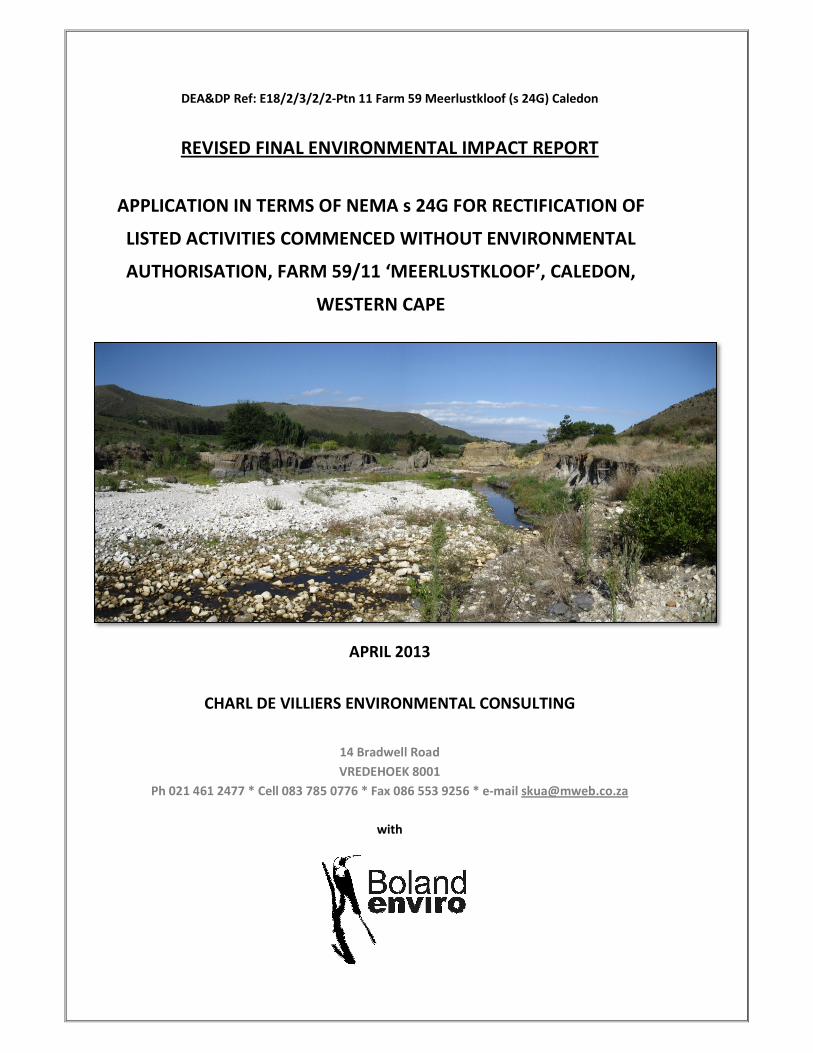
‘Meerlustkloof’ is located in the Caledon magisterial district and falls within the Theewaterskloof
Local Municipality. The nearest settlement is Genadendal, some 12.5 km to the east. The farm is
about 32 km from Caledon by road. See Figure 1.
Figure 1:

REVISED FINAL EIR FOR ‘MEERLUSTKLOOF’ 59/11, CALEDON
Page 7 of 111
The farm comprises three portions:
−−−− Elandskloof 59/9;
−−−− Elandskloof 59/11; and
−−−− Elandskloof 59/4.
This application relates to the farm portions Elandskloof 59/11 and Elandskloof 59/4.
Agrisouth Orchards (SA) (Pty) Ltd (‘Agrisouth’) purchased the ‘Meerlustkloof’ property in 1990.
‘Meerlustkloof’ is a working fruit farm which exports apples and pears. It was established as a
fruit farm in 1970. Orchards occupy about 109 ha or roughly 12% of the 929 ha farm, which spans
the Elandskloof River and a tributary, the Meerlustkloof River. The Elandskloof River joins the
Riviersonderend which also represents the southern boundary of the farm.
The terrain is hilly and rises steeply from the floodplains of the two rivers to the Riviersonderend
Mountains directly to the north. The foothills of the Riviersonderend Mountains are characterised
by deeply incised kloofs. ‘Breëkraal se Rante’ overlook the Elandskloof River from the west. See
Figure 2 for a topo-cadastral map of the property.
The ‘Introduction’ firstly describes the broad physical landscape, and how this shapes the spatial
layout of orchards and associated infrastructure, before summarising the impacts of each flood
episode and, in turn, how the Applicant responded to the ensuing disruption to farming
operations.
The ‘Introduction’ also identifies the listed activities1 for which rectification is sought, describes
the scope of work and records the assumptions and limitations that informed and defined the
environmental assessment.
1 The legal and regulatory context relating to the unauthorised activities in question is presented in detail in
Chapter 2 of this report.

REVISED FINAL EIR FOR ‘MEERLUSTKLOOF’ 59/11, CALEDON
Page 8 of 111
Figure 2: Topography of farm and sites of flood damage, 2008 and 2012
1.1 LAYOUT OF THE FARM IN RELATION TO THE PHYSICAL LANDSCAPE
Topography, the major drainage systems and distribution of arable soils dictate the location of
orchards and infrastructure on the farm. It is necessary to understand the physical opportunities
and constraints within which this farming operation functions in order to understand the
Applicant’s response to the destructive effects of floods. See Figure 2 for a schematic explanation
of the main features referred to here.
1.1.1 Overview of river and floodplain (wetland) systems
Two rivers that drain southwards from the Riviersonderend Mountains converge on the farm
‘Meerlustkloof’ – the Elandskloof River (the larger of the two watercourses) and a tributary that
joins the Elandskloof River from the east, the Meerlustkloof River. These rivers form a typically
dendritic or ‘Y’-shaped pattern, with the Elandskloof River forming the left-hand ‘arm’ and stem
of the ‘Y’. The Elandskloof River joins the eastwards-flowing Riviersonderend about 3 km below

REVISED FINAL EIR FOR ‘MEERLUSTKLOOF’ 59/11, CALEDON
Page 9 of 111
its convergence with the Meerlustkloof River. The floodplains associated with two watercourses
represent the most intensively developed parts of the farm. Chapter 3 describes the natural
environment.
1.1.2 River crossings
The local topography and two rivers effectively divide the cultivated parts of the farm into three
sections which are informally labelled A, B and C for the sake of explanation (see Figure 3). These
sections are separated as follows by the two rivers:
Section of farm Right (W) bank2 Left (E) bank
(A) North of confluence of Meerlustkloof
and Elandskloof rivers (affected reach ± 1.5
km)
Orchards, roads and
employee
accommodation
Orchards, roads
and packing sheds
2 Convention holds that the viewer is facing downstream when referring to the left or right banks of a river

REVISED FINAL EIR FOR ‘MEERLUSTKLOOF’ 59/11, CALEDON
Page 10 of 111
(B) Elandskloof River from Meerlustkloof
River to the DR1313 (± 3 km)
Orchards, roads and
employee
accommodation
Orchards, roads
and pump house
(C) Elandskloof River from the DR1313 to
the Riviersonderend River (± 0.5 km)
Orchards, two
pump houses and
roads
Orchards and roads
The main, tarred, access road to the farm from the DR1313 runs in a northerly direction to the
east of the Elandskloof River. Gravel roads connect the latter road with accommodation,
infrastructure and orchards on the western (right) banks of the two rivers by means of two
crossings (see Figures 2 and 3).
Access to Section A from the main transport axis on the farm is located next to the packing sheds,
on the left bank of the Meerlustkloof River. Before November 2008, a cement bridge spanned the
Meerlustkloof River at this point. Flood damage necessitated the replacement of the bridge with
a temporary pipe culvert, which is described below.
See Appendix C for photographs of the respective sites.
The box on the right provides the co-ordinates for the
respective sites.
Section B of the farm used to be connected to the
remainder of the property by means of a concrete drift
across the Elandskloof River, about 140 m downstream
of the confluence of the two rivers. The drift was also
replaced by a pipe culvert following its destruction by
the November 2008 flood.
Access arrangements to Section C are recorded for the sake of completeness. This part of the
farm is readily accessible from the DR1313, which was severely damaged at its crossing over the
Elandskloof River in October 2012.
Repairs in November 2012 to the damaged pipe culvert over the Elandskloof River were
undertaken by either the Overberg District Council or the Western Cape Department of Transport
and Public Works.
Bridge Meerlustkloof River
34° 2'53.03"S 19°24'56.84"E
Bridge Elandskloof River
34° 3'07.91"S 19°24'56.97"E
Drift Elandskloof River
34° 3'08.12"S 19°24'57.39"E
Sump Elandskloof River
34° 3'15.64"S 19°25'13.70"E
Pipeline Elandskloof River
34° 3'47.46"S 19°26'11.96"E
REVISED FINAL EIR FOR ‘MEERLUSTKLOOF’ 59/11, CALEDON
Page 11 of 111
1.1.3 Irrigation infrastructure
Altogether 109 ha of ‘Meerlustkloof’ are under irrigated orchard. The farm is watered from three
main sources:
− About 37 ha of orchards in the upper reaches of the farm are irrigated from an earth-
walled dam that is replenished via a pipeline from the mountains (centre point of the
dam – approx. 34°02'19.11"S 19°25'11.25"E);
− Another 31 ha of orchards in the lower-lying parts of the farm, i.e. towards the
Riviersonderend, receive water from the Zonderend Water Users Association; and
− The middle parts of the farm – constituting about 41 ha of orchards or a third of the
entire planting – are irrigated by water abstracted directly from the Elandskloof River.
The critical period for irrigation is usually between October and March, over the dry summer
months.
It has been the central portions of the farm, which are irrigated from the Elandskloof River, that
have been most adversely affected by floods episodes over the past seven years, namely in 2006,
2007, 2008 and 2012.
Until 2006, water was taken from a concrete weir about 800 m downstream of the confluence of
the Elandskloof and Meerlustkloof rivers. The pump house, which is still in use, is about 200 m
north-east of the location of the former weir. It is understood that the weir was built at the time
that ‘Meerlustkloof’ had been first developed as a fruit farm, and therefore had been in operation
for at least 20 years by the time ‘Meerlustkloof’ was bought by Agrisouth Orchards (SA) (Pty) Ltd.
The structure was apparently about 1.5 m high and 25 m wide.
The weir was ruptured in a flood in the autumn of 2006 and rendered inoperable by another
flood in November 2007. In order to ensure that irrigation was not interrupted, a pipe was
installed at a bridge upstream of the weir and connected via a gravity feed to the pump station.
This temporary system was destroyed by yet another flood, in November 2008, which swept
away about 5 ha of orchards, the drift and two bridges, and destroyed farm roads along the banks
of both rivers.
The preceding sections described the broad topography and layout of the farm, and the
infrastructural elements – river crossings and abstraction points – that have borne the brunt of
flood damage. The following section provides a more detailed account of damage that resulted
from the floods of November 2008 and October 2012 respectively. It also describes the actions

REVISED FINAL EIR FOR ‘MEERLUSTKLOOF’ 59/11, CALEDON
Page 12 of 111
taken by Agrisouth Orchards (SA) (Pty) Ltd to protect is property and secure the ‘Meerlustkloof’
farming operation against further disruption and, potentially, loss of production.
1.2 FLOOD DAMAGE: NOVEMBER 2008
Cut-off low pressure systems contributed to substantial flooding in the Cape Winelands and
Overberg districts between 11 and 13 November, 2008 (Holloway and Fortune, 2009). Although
meteorologically less significant than a similar event the previous year, the November 2008 cut-
off low contributed significant losses which totalled R943-million in the Winelands and Overberg.
At ‘Meerlustkloof’, 369 mm of rainfall were measured between 11 and 13 November 2008 (Mr
Arrie Grobler, pers comm, 24-01-2013). The swollen rivers and ensuing erosion damaged bridges,
roads, orchards and irrigation systems, and large parts of the farm were left isolated for several
days. The damage to farm infrastructure is described below.
1.2.1 Meerlustkloof River
As indicated previously, a cement bridge used to connect the two banks of the Meerlustkloof
River just upstream from the packing sheds. This bridge was, however, washed away in November
2008. It was replaced by a vented culvert comprising two segmented 1.5 m diameter concrete
pipes overlain with a one-lane deck built from wooden poles and compacted rock. This structure
remained in place until it was breached by the flood in October 2012 (Figures 5 and 6, Appendix
C).
1.2.2 Elandskloof River
The river channel downstream of the former drift over the Elandskloof River had been about 26 m
wide prior to the flood in November 2008. Lateral erosion cut massively into both banks of the
river, increasing the bank width of the channel by some 30 m to 150 m – in other words, a three
to five-fold increase in the width of the incised area. Figure 1, Appendix C, shows the extent of
erosion and deposition of coarse sediments across the width of the flood channel.
The river was ‘opened up’ relatively less at the site of the former weir (~25 m in 2004) but its
width was approximately doubled by the 2008 flood. A rock outcrop that strikes laterally into the
channel appears to have inhibited erosion at the site of the weir (see Figure 4, Appendix C, which
shows the remains of the weir in the bed of the Elandskloof River), although the remains of the
structure appeared to have deflected flow towards the left bank.

REVISED FINAL EIR FOR ‘MEERLUSTKLOOF’ 59/11, CALEDON
Page 13 of 111
The former drift spanning the Elandskloof River was irrevocably damaged in the November 2008
flood. As with the damaged crossing at the packing shed, this reach of the Elandskloof River was
also subsequently spanned by an informal pipe culvert with three segmented 1.5 diameter pipes
and a single-lane deck built from poles and compacted rock. The rebuilt structure was severely
damaged by the flood in October 2012 (Figure 7, Appendix C).
The November 2008 flood also destroyed the relocated abstraction point and, with the weir
entirely inoperable as a result of flood damage, necessitated urgent steps to reinstate a supply of
water to irrigate fruit trees. It bears noting that the 2008 flood coincided with the onset of the
hot, dry summer season, which meant that securing a reliable supply of water in order to irrigate
fruit trees was a pressing concern for the farm.
From a business perspective, the situation amounted to an emergency. If irrigation had not been
resumed timeously, up to R3.8-million’s worth of annual fruit production from the 41 ha of
orchards in question could have been lost. It takes about five years for a newly planted orchard to
start bearing fruit that can be harvested. Had it been necessary to replace water-stressed fruit
trees, the total cost to Agrisouth would have been in the order of R20-million in forfeited income
(pers comm. Mr André van Wyk, 23 April 2013).
At the time, the Western Cape Department of Agriculture was unable to provide advice
immediately on what steps should be taken to reinstate irrigation to the central portions of the
farm. An irrigation firm based in Worcester, Brandwacht Besproeiing, apparently recommended
that a sump be excavated in the reworked bed of the river, upstream of the former weir.
The excavations were undertaken as advised and the water supply to the orchards was re-
established in December 2008. The structure in question entails an excavation of some 2 900 m2
in extent which is surrounded, except at its upstream extremity, by a bulldozed berm. See Figures
1 and 3, Appendix C, for photographs of the sump. It was necessary to raise the level of water to
allow a gravitational feed to the pump station on the northern or left bank of the Elandskloof
River. The excavation was limited in its entirety to the massively scoured and widened channel
that resulted from the flood in November 2008.
The next section describes the impacts of the October 2012 flood on the farm ‘Meerlustkloof’.

REVISED FINAL EIR FOR ‘MEERLUSTKLOOF’ 59/11, CALEDON
Page 14 of 111
1.3 FLOOD DAMAGE: OCTOBER 2012
Heavy rainfall in the catchments of the Elandskloof and Meerlustkloof rivers resulted in the
destruction of two bridges and substantial erosion of roads and orchards on ‘Meerlustkloof’
between 14 and 21 October 2012. Altogether 250 mm of rain was measured in this period.
The damage that required the most urgent attention was:
− The rupturing of two pipe culvert crossings that resulted in about 20 ha of orchards on the
western banks of the Meerlustkloof and Elandskloof rivers (i.e, sections A and B of the farm)
being made inaccessible to vehicles for spraying and eventual harvesting;
− Loss of the water supply, as a result of lateral, westwards migration of the Elandskloof River,
to the emergency sump, and damage to pipes that supplied more than half of the farm’s
irrigation water; and
− Inundation of two pump houses near the Riviersonderend as a result of sediment build-up in
the latter river that has caused flow to back up above the obstruction.
The question of how to deal with sediment build-up at the confluence of the Riviersonderend and
Elandskloof River does not form part of this application. It is clearly, however, a significant
problem that holds adverse consequences for both the farm and the environment. It is also a
problem that needs to be addressed at the appropriate hydro-geomorphological and ecological
scales. This is an issue that should form part of the scope of work for the proposed strategic
management plan for the Elandskloof and Meerlustkloof Rivers (see Chapter 8).
1.3.1 Meerlustkloof River
Although the channel and banks of the highly disturbed Meerlustkloof River remained largely
unscathed as a result of the flood in October 2012, a portion of the bridge at the packing sheds
was washed away, leaving Section A entirely cut off from the rest of the farm. See Figure 6,
Appendix C.
Advice was obtained from the Western Cape Department of Agriculture and a specialist
freshwater ecologist on the best method for effecting emergency repairs to the breached
structure (see Appendices D and E for correspondence and specialist reports relating to the best
approach to implementing the emergency repairs). In summary, it was recommended that:
−−−− Additional pipes be added to the culvert to improve its capacity to accommodate
elevated base flows;

REVISED FINAL EIR FOR ‘MEERLUSTKLOOF’ 59/11, CALEDON
Page 15 of 111
−−−− A temporary berm be constructed to deflect flow into the existing pipes for the duration
of repairs;
−−−− Rehabilitation measures be implemented as a matter of urgency to stabilise the banks by
means of re-shaping and vegetation with appropriate indigenous plants; and
−−−− A long-term solution had to be sought for the crossing, which was vulnerable to damage
by floods and would, unless redesigned, contribute to ongoing degradation and
destabilisation of the river environment.
The severely damaged culvert crossing over the Meerlustkloof River was repaired in November
2012, with the addition of two more segmented, 1.5 m diameter pipes, thereby roughly doubling
the hydraulic capacity of the structure. The deck of the rebuilt log-and-stone structure is about 21
m long and 5 m wide. The spaces between pipes are grouted and protected with stone pitching.
The work has been completed, except for a protective wing wall that needs to be built into the
right-hand bank upstream of the bridge in order to prevent erosion occurring at this point. See
Figure 10, Appendix C.
The four segmented pipes are laid several centimetres above the bed of the channel, but water is
able to percolate below and past the structure through a loosely deposited substrate of cobble
and small boulders. Higher flows would pass through the pipes.
Analysis of satellite imagery indicates that the damaged bridges over the Meerlustkloof River that
were rebuilt after the floods in 2008 and 2012 were both constructed along the same alignment
as the former concrete bridge that was destroyed in 2008. The centre point of the current pipe
culvert crossing over the Meerlustkloof River is: 34o 02’ 53.0”S 19
o 24’ 56.8”E.
1.3.2 Elandskloof River
As was the case with the damaged bridge over the Meerlustkloof River, the western approaches
of the rebuilt structure over the Elandskloof River were washed away in October 2012, isolating
Section B from the rest of the farm. An informal drift was established directly downstream of the
damaged culvert structure as a temporary measure to reinstate contact with Section B. See
Figures 7 and 8, Appendix C, for photographs of the damaged river crossing over the Elandskloof
River and temporary drift respectively.
The drift was about 20 m long and 3.5 m wide. It was constructed from uncemented rocks and
cobbles that had been dislodged from the damaged bridge directly upstream. The drift was
vented by two unanchored pipes. The drift was demolished once the bridge had been repaired
early November 2012 and most vestiges of the drift had disappeared by January 2013. According

REVISED FINAL EIR FOR ‘MEERLUSTKLOOF’ 59/11, CALEDON
Page 16 of 111
to the freshwater ecological assessment (Day, 2013, p 17; Appendix E), the long-term ecological
consequences of the latter drift were “negligible”.
The Applicants, acting on the advice of the Western Cape Department of Agriculture and Dr Liz
Day, the freshwater ecologist, added three additional 1.5 m diameter pipes to the pipe culvert
structure over the Elandskloof River. The structure, which has been built in precisely the same
way as the repaired bridge over the Meerlustkloof River, is currently equipped with six culverts
instead of the previous three (see Figure 11, Appendix C).
The rebuilt bridge over the Elandskloof River appears to be identically aligned to the drift that
spanned the channel until it was destroyed in the flood of November 2008. The centre point of
the repaired bridge is at: 34o 03’ 07.9”S 19
o 24’ 57.0”E
The flood that occurred in October 2012 brought about significant changes to the alignment of
the channel of the Meerlustkloof River in the vicinity of the sump, which was effectively put of
commission owing to changed course of the river.
The channel at the irrigation sump was forced further to the south, and the left bank of the active
channel has been laterally displaced by 15 to 21 m from its previous position. The flood of
October 2012 also precipitated extensive deposits of coarse fluvial material that raised the profile
of the river bed at the intake to the sump which, with down-cutting and lateral migration of the
active channel to the south, left the sump entirely cut off from the channel and its supply of
water.
The channel migration has taken place over a distance of about 200 m. Besides literally stranding
the sump, the realigned river has started under-cutting the farm road that runs along the top of
the southern bank of the Elandskloof River. The active channel has also found its way to the right
of a large, free-standing plinth of sediment whereas it had previously passed this structure to the
left (see Figure 1, Appendix C).
The loss of the sump as an irrigation asset has been effectively off-set by the Applicant’s resort to
two submersible ‘sump pumps’ for taking water for irrigation from the Elandskloof River. These
devices, which operate at water depths of 1 m or more, are portable and each one can be
installed in half a 200 ℓ drum partly sunken into the river bed. This technology, which was not
available when the farm experienced major damage to its irrigation infrastructure in November
2008, has a negligible impact on the riparian environment and does not trigger any requirement
for environmental authorisation. Water is fed to the existing pump station by a ‘quick release’
pipe. Together, the two pumps deliver 60 000 ℓ per hour.

REVISED FINAL EIR FOR ‘MEERLUSTKLOOF’ 59/11, CALEDON
Page 17 of 111
The flood in October 2012 also washed away the irrigation pipe that crossed the Elandskloof River
at the bridge which connected the two banks in Section B as outlined above, as well as a plastic
pipe that conveys water from one of the two pump houses below the DR1313 to the central parts
of the farm. The repairs to the damaged irrigation pipeline did not trigger any activities requiring
environmental authorisation, and are therefore not subject to this section 24G application.
Owing to the vital role of irrigation at ‘Meerlustkloof’, and the challenges of securing irrigation
infrastructure that would not have an adverse environmental impact, or be vulnerable to extreme
events such as floods, the question of the best practicable option for taking water across the
Elandskloof River is simply raised to inform future planning in this regard.
The pipe over the Elandskloof River, which used to be supported on wooden posts secured in
drums dug into the river bed, was replaced provisionally with several ‘quick release ‘aluminium
sections laid across the river bed. Owing to the force of the pump, the pipes had to be reinforced
with wooden poles and steel bindings, which meant that they can no longer be dismantled at
short notice, such as prior to an anticipated flood (Figure 9, Appendix C). The pipe was also liable
to cause erosion under slightly elevated flows and would probably be washed away under flood
conditions. The structure of drums and wooden posts that previously supported the pipe has
since been reinstated (i.e. by March 2013), lifting the pipe about 1 m above the bed of the
channel.
An alternative method for conveying irrigation water across the Elandskloof River at this point has
been identified as a priority action. The freshwater ecologist has recommended two other
alternatives to the system that is currently in place, namely:
− Routing the irrigation pipe via the existing pipe culvert road crossing over the Elandskloof
River (the most ecologically-desirable option); or
− Burying the pipe to a depth of least 0.5 m along its current alignment and securing it to a
gabion mattress (which is viewed as an improvement over the suspension of the pipes as
described above).
Another alternative has since been identified by Mr Hans King of the Western Cape Department
of Agriculture, namely suspending the pipeline from cable strung between two towers.
Any decision about the long-term routing and alignment of the water pipeline will have to be held
in abeyance until after the 2013 harvest as irrigation cannot be interrupted in this crucial period.
Also, if environmental authorisation is needed for either of the additional alternatives outlined
above, this is unlikely to be achieved before the onset of the 2013 winter and ‘flood season’ when

REVISED FINAL EIR FOR ‘MEERLUSTKLOOF’ 59/11, CALEDON
Page 18 of 111
work would in any case not be able to take place in the river. It was for these reasons that the
Applicant opted to temporarily reinstate the suspended pipe alternative (i.e. the status quo
before the 2012 flood).
The following section describes the impact of the most recent damage on the functioning of the
farm and explains why the Applicant could not countenance delays that would propel the farm
towards a worsening emergency. The description is limited to flood-related damage or disruption
which, besides having to be attended to urgently owing to the impact on farming operations,
resulted in the unauthorised activities that are the subject of this application (see Section 1.5 for
a full description of the listed activities that were triggered by emergency repairs in 2008 and
2012).
1.4 GROUNDS FOR EMERGENCY MEASURES – OCTOBER 2012
As indicated previously, ‘Meerlustkloof’ is an export fruit farm that enters the height of its
operational activities with the onset of summer and the annual harvest (which, on average, starts
in the second week of January and proceeds to mid-April each year). Being able to rely on
uninterrupted irrigation in order to ensure effective ripening of high quality fruit is particularly
critical at this time of the year on the deciduous fruit calendar. These considerations applied
directly to the Applicant’s decision to excavate an emergency sump following destruction of
irrigation infrastructure by the flood in November 2008. They were as relevant in October 2012
when it was initially believed necessary, as a stop-gap emergency measure, to dig a channel so
that water could be relayed from the realigned river to the sump, which had been left stranded
by the flood.
The grounds for the Applicant’s decision to proceed with emergency interventions in November
2008 and October 2012, without following the prescribed (and, under the circumstances,
prohibitively time-consuming) procedures for obtaining environmental authorisation, were
essentially identical, namely to reinstate normal agricultural operations which were at a critical
stage in terms of the need to irrigate and spray orchards on the eve of the respective harvest
seasons (see correspondence between the attorneys Smith Ndlovu Summers and the Department
of Environmental Affairs and Development Planning, 9 November 2012; Appendix D). Failure to
act urgently would have exacerbated what, from the Applicant’s perspective, amounted to an
escalating emergency and the prospect of catastrophic crop – and financial—losses.
The dire circumstances precipitated by the two floods are explained below. The expert opinion
provided by Dr JJB Pretorius, a specialist horticulturalist, with respect to the impact of the

REVISED FINAL EIR FOR ‘MEERLUSTKLOOF’ 59/11, CALEDON
Page 19 of 111
October 2012 flood on fruit production can be applied with equal measure to the effects of the
preceding flood, in November 2008.
1.4.1 Impacts on fruit production arising from the interruption of irrigation
With respect to the destruction of irrigation infrastructure, failure to adequately water apple
trees with ripening fruit can have severe consequences for a farming operation (Dr JJB Pretorius,
deciduous fruit specialist – 31 October 2012; Appendix E), some of which are potentially
irreversible: initially trees start losing fruit and fruit that is retained on the tree shrinks in size,
which make it potentially unsuitable to be sold for fresh consumption; complete crop loss can
result.
Apple trees that are severely water-stressed lose leaves and enter a state known as
ektodormancy. If such trees are exposed to rainfall before winter, while temperatures are still
suitable for growth, the tree responds by flowering prematurely, which destroys the next year’s
crop.
Dr Pretorius warned that there was a “very real chance” of trees dying due to a lack of water. He
recommended that the water supply to the affected orchards be restored “as soon as possible”. If
not, crop loss could start to occur “within the next couple of days” – i.e. by the first week of
November 2012. It can be assumed that the urgent situation described here with respect to water
stress and potential crop losses would have been compounded by the 2008 flood, which occurred
about three weeks later into the season than the flood in 2012.
1.4.2 Impacts on production arising from damage to bridges
Besides major inconvenience to the general operation of the farm – such as staff not being able
to get to work at a critical time of the year or, in some cases, being cut off from the outside world
– the destruction of internal river crossings by floods can seriously impede the treatment of fruit
trees against fungal infection as spraying equipment cannot be deployed in the affected orchards.
As explained by Dr Pretorius, the transition from a wet winter to dry summer creates moist and
warm conditions that are highly advantageous for fungal infection of fruit trees. In terms of
integrated pest management protocols, contact fungicides need to be applied to protect crops
during the first 60 to 80 days after full bloom. Fruit not treated in this manner may not be
marketable overseas which, in the case of Agrisouth Orchards (SA) (Pty) Ltd., could be financially
ruinous. Untreated fruit could become reduced in size, making it unsuitable even for processing
which would translate into a 100% loss. It also becomes increasingly difficult to maintain disease-

REVISED FINAL EIR FOR ‘MEERLUSTKLOOF’ 59/11, CALEDON
Page 20 of 111
free crops in orchards that have not been properly treated for fungal infections. The risk of fungal
infection remains unabated throughout the ripening process and is exacerbated by warm, wet
conditions as would have prevailed in both November 2008 and October 2012.
In the case of both floods, physical access to the orchards on the western or right banks of the
Meerlustkloof and Elandskloof Rivers was entirely cut off due to the destruction of the affected
river crossings (see sections 1.1.2, 1.1 and 1.2). Access to the affected orchards was reinstated by
constructing the two pipe culvert crossings in November and December 2008 (replacing inter alia
the destroyed drift over the Elandskloof River) and, in October and November 2012, excavating a
temporary drift over the Elandskloof River and re-equipping the damaged bridges with expanded
flow capacity in the form of additional pipes and repaired decks.
The situation with respect to the farm’s treatment of trees for fungal infections was sufficiently
acute in October 2012 to compel the Applicant to employ the services of a helicopter company to
undertake aerial spraying at a daily cost of R11 000 and an additional R350 per hectare. The
temporary drift over the Elandskloof River proved, owing to its rough surface, to be unsuitable for
transporting fungicides in tanks towed by tractors. Repairing the bridges was, in the
circumstances, an unavoidable and urgently necessary option for the farm.
From the Applicant’s perspective, the flood damage had amounted to an “ongoing emergency
situation” and, in order to protect its property – in the form of the orchards and the current
harvest – Agrisouth Orchards (SA) (Pty) Ltd, had “no alternative but to undertake the flood repair
and/or restorative works as a matter of urgency and necessity...” (Smith Ndlovu Summers,
paragraph 12; Appendix D).
1.5 UNAUTHORISED ACTIVITIES SUBJECT TO THIS APPLICATION
This section highlights those aspects of the emergency repairs (i.e. prescribed ‘activities’ listed in
terms of national environmental impact assessment regulations) that were undertaken without
the requisite environmental authorisations in terms of Chapter 5 of the National Environmental
Management Act 107 of 1998 (NEMA) as amended.
Certain aspects of the actions taken in response to the flood damage in November 2008 would
have required authorisation in terms of the 2006 version of the environmental impact assessment

REVISED FINAL EIR FOR ‘MEERLUSTKLOOF’ 59/11, CALEDON
Page 21 of 111
(EIA) regulations,3 whereas the emergency repairs initiated immediately after the flood in
October 2012 were in contravention of the 2010 EIA regulations.4
The activities relating to the November 2008 flood were concluded in a matter of weeks after the
damage had been incurred.
All of the listed activities arising from the October 2012 flood emergency had commenced before
the end of the year and had, with a few exceptions, been concluded by the end of January 2013.
Incomplete work associated with the 2012 flood includes the addition of a protective wing wall to
the repaired and expanded pipe culvert crossing over the Meerlustkloof River, and finding a more
suitable and secure method for routing an irrigation pipe across the lower reaches of the
Elandskloof River (repairs to the latter pipe in late 2012 and early 2013 did not, however,
constitute listed activities and are therefore do not form part of this section 24G application).
Both of the latter activities formed part of the suite of emergency responses implemented by
Agrisouth Orchards (SA) (Pty) Ltd in the last two months of 2012.
1.5.1 Activities triggered in November 2008 by the 2006 NEMA EIA regulations
The emergency repairs in November and December 2008 entailed excavation of the sump in the
Elandskloof River, and reinstating two vehicle crossings over the Meerlustkloof and Elandskloof
rivers.
The activities that were triggered by these unauthorised operations in 2008 are activities 1(m)
and 4 of Listing Notice, 1 GN R. 386 of the 2006 NEMA EIA regulations, namely:
3 Listing Notice 1, GN R. 386 of 21 April 2006, identified in terms of sections 24 and 24D of the National
Environmental Management Act 107 of 1998. 4 Listing Notice 1, GN R. 544 of 18 June 2010 (as amended) and, potentially, Listing Notice 3, GN R. 546 of 18
June 2010, published in terms of sections 24(2) and 24D of the National Environmental Management Act 107
of 1998.

REVISED FINAL EIR FOR ‘MEERLUSTKLOOF’ 59/11, CALEDON
Page 22 of 111
1(m) The construction of facilities or infrastructure,
including associated structures or infrastructure, for...
any purpose in the one in ten year flood line of a river
or stream, or within 32 metres from the bank of a
river or stream where the flood line is un-known,
excluding purposes associated with existing
residential use... but including (iii) bridges and (iv)
dams...
Construction of two pipe culvert crossings (‘bridges’)
to replace a drift over the Elandskloof River and a
former cement bridge over the Meerlustkloof River,
both of which were destroyed in the flood. The
alignment of the repaired/replacement structures was
identical to what had been there previously.
Excavation of an emergency irrigation sump (i.e. a
‘dam’) in the reworked bed of the Elandskloof River
following destruction of an abstraction point by the
flood. See below.
4 The dredging, excavation, infilling, removal or
moving of soil, sand or rock exceeding 5 cubic metres
from a river, tidal lagoon, tidal river, lake, in-stream
dam, floodplain or wetland
The sump lies roughly along the median line of the
reworked flood channel. There is a gap of 40 to 80 m
between the northern bank of the sump and the river
bank, and a 30 m gap between the sump and the right
(southern) bank of the river. The sump is about 2 900
m2
in extent. It is a kidney-shaped structure, open at
its upstream end, with bulldozed banks increasing to
about three metres in height along its downstream
aspect. The southern bank of the sump is partly
defined by remnants of floodplain soil deposits.
Overall, the sump occupies about one fifth of the
post-2008 river reach within which it is located. Water
was drawn via a 250 mm pipe to an established
pumping station about 280 m due east of the sump.
Excess water was released into the Elandskloof River
about 275 m downstream of the sump. The sump was
in use from late 2008 to October 2012, when changes
in the position of the active channel resulted in the
sump losing its supply of water.
1.5.2 Activities triggered in October 2012 by the 2010 NEMA EIA regulations
Emergency repairs following the flood in October 2012 entailed:
− Excavating a temporary drift across the Elandskloof River; and
− Rebuilding the damaged bridges over the Meerlustkloof and Elandskloof rivers, and
equipping them with additional 1.5 m diameter pipes.
Note that the unauthorised construction (and completion) of the sump had commenced during the
validity of the 2006 NEMA EIA regulations, which means that this set of activities do not require
retrospective authorisation in terms of the 2010 NEMA EIA regulations.

REVISED FINAL EIR FOR ‘MEERLUSTKLOOF’ 59/11, CALEDON
Page 23 of 111
The interventions carried out in October 2012 and directly thereafter triggered various activities in
Listing Notice 1 and, potentially, Listing Notice 3 of the 2010 NEMA EIA regulations (GN R. 544 and
546 respectively, published 18 June 2010), namely in terms of:
− Listing Notice 1, activities 11(iii) and (xi), 18, 39(iii) and 40(iv); and
− Listing Notice 3, activity 16(iv).
These following activities were triggered in terms of Listing Notice 1:
11 The construction of (iii) bridges and (xi)
infrastructure or structures covering 50 square
metres or more where such construction occurs
within a watercourse or within 32 metres of a
watercourse...
Construction of two expanded pipe culvert crossings
to repair two bridges over the Meerlustkloof and
Elandskloof rivers respectively. The alignment of the
repaired/replacement structures was identical to
what had been there previously. The temporary drift
over the Elandskloof River was about 70 m2
in extent.
18 The infilling or depositing of any material of more
than 5 cubic metres into, or the dredging, excavation,
removal or moving of soil, sand, shells, shell grit,
pebbles or rock or more than 5 cubic metres from (i)
a watercourse... (Note that the EMP drafted for this
application is also to be submitted for approval as a
management plan for maintenance purposes as
provided for by Activity 18, LN1).
[Corrected by “Correction Notice 2” of 10 December
2010, GN No. R. 1159]
This activity applies to the construction of a
temporary drift over the Elandskloof River, pending
repairs to the damaged pipe culvert crossing. The
drift had been dismantled by late January 2013.
39 The expansion of (iii) bridges within a watercourse
or within 32 metres of a watercourse....
The hydraulic capacity of the two repaired pipe
culvert crossings was doubled (on the advice of the
Department of Agriculture and a freshwater
ecologist) with the addition of extra 1.5 m diameter
concrete pipes. In the case of the bridge over the
Meerlustkloof River, two extra pipes were added.
Three more pipes were added to the crossing over
the Elandskloof River.
40 The expansion of (iv) infrastructure by more than
50 m2
within a watercourse or within 32 m of a
watercourse....
[Corrected by “Correction Notice 2” of 10 December
2010, GN No. R. 1159]
Each pipe consists of two lengths, totalling 5 m when
laid end-on-end. The total area of expansion was
therefore 75 m2, explained as follows: Before the
repairs, the bridge over the Meerlustkloof River had
two pipes with a surface area of 15 m2 in total which
was doubled to 30 m2. The bridge over the
Elandskloof River initially had three pipes (of 22.5
m2), which were doubled in extent to 45 m
2.

REVISED FINAL EIR FOR ‘MEERLUSTKLOOF’ 59/11, CALEDON
Page 24 of 111
One activity was commenced in terms of Listing Notice 3, namely:
16 The construction of (iv) infrastructure covering 10
square metres or more where such construction
occurs within a watercourse or within 32 metres of a
watercourse (d) in the Western Cape (ii) outside
urban areas (hh) within 5 km of a statutory protected
area that is not a national park....
[Corrected by “Correction Notice 2” of 10 December
2010, GN No. R. 1159]
All the unauthorised activities in question occurred
within 2 km of the Riviersonderend Nature Reserve,
which is a proclaimed protected area in terms of the
National Forests Act 30 of 1998 and the National
Environmental Management: Protected Areas Act 57
of 2003. The reserve is managed by CapeNature
(cf.< http:bgis.sanbi.org>)
The identification of these unauthorised activities is based on communication between the
Applicant’s lawyers and the Department of Environmental Affairs and Development Planning (cf.
Appendix D), interviews with the Applicant and site visits with:
− LandCare representatives from the Western Cape Department of Agriculture on January
26 and February 16, 2012 (i.e. with respect to the activities triggered in response to the
November 2008 flood) ; and
− The Department of Environmental Affairs and Development Planning, Breede-Overberg
Catchment Management Agency, Department of Water Affairs and the Western Cape
Department of Agriculture on 29 October 2012 (following renewed flood damage in
October 2012).
1.6 ADMINISTRATIVE ACTIONS RELATING TO SUBMISSION OF s 24G APPLICATION
This section summarises actions following the issuing of a pre-compliance notice in terms of section
31L of the National Environmental Management Act (NEMA) 107 of 1998 as amended by the
Department of Environmental Affairs and Development Planning (DEADP) on 28 December 2011. It
also outlines the sequence of authority consultations that followed on the flood damage in October
2012.
Pre-compliance
notice issued by
DEADP
28-12-2011
Agrisouth Orchards SA (Pty) Ltd (‘Agrisouth’) notified that a dam
had been constructed in a watercourse without environmental
authorisation. Agrisouth instructed to cease unauthorised
activity, rehabilitate the site to its original condition, and to
rectify the effects of the unlawful activity. Agrisouth afforded
seven days in which to make representations as to why a
compliance notice should not be issued.
Response by DEADP requested to refrain from issuing a compliance notice

REVISED FINAL EIR FOR ‘MEERLUSTKLOOF’ 59/11, CALEDON
Page 25 of 111
Agrisouth’s attorneys
16 January 2012
until attorneys had an opportunity to consult with their client
and make written representations to DEADP.
DEADP to attorneys
17 January 2012
Agrisouth granted an extension until 23-01-2012 to make a
submission to DEADP.
Attorneys to DEADP
24-01-2012
Agrisouth’s attorneys set out circumstances of excavation of
sump, i.e. sump excavated as a response to an emergency
resulting from severe flooding in November 2008. Request that
DEADP refrains from issuing a compliance notice, instead
motivating inter alia that Agrisouth submit a section 24G
application with a view to investigation, among others, whether
rehabilitation of the site (and reinstatement of original
conditions) would constitute the best practicable environmental
option.
Agrisouth appoints
EAP to undertake s
2G environmental
assessment
27-01-2012
EAP undertakes site visits with representatives of Western Cape
Department of Agriculture’s sustainable resource management
programme on 26-01-2012 and 16-03-2012. EAP notifies DEADP
of appointment on 31-01-2012. Freshwater Consulting Group
appointed to undertake specialist aquatic impact assessment (23-
02-2012)
Section 24G
application form
submitted to DEADP
08-02-2012
DEADP acknowledges
receipt of application
27-02-2012
DEA&DP requests correction to activities for which authorisation
is being sought (viz. 2006, not 2010 NEMA EIA regulations).
Public participation process must be undertaken and organs of
state must be consulted. Amended application form accepted by
DEA&DP on 06-03-2012.
Section 24G process –
Submission of Final
EIR to DEA&DP, 06-
09-2012
RENEWED FLOOD
DAMAGE, OCTOBER
2012
Final EIR published by BolandEnviro cc for second, 21-day round
of comment. Comment received from CapeNature and Overberg
District Municipality (see Appendix F). Final EIR submitted to
DEA&DP on 06-09-2012; acknowledgement of receipt issued by
DEA&DP on 17-09-2012.
Agrisouth hosts
authority meeting at
‘Meerlustkloof’ to
discuss emergency
responses to flood
damage, 29-10-2012
Meeting attended by representatives of DEA&DP section 24G
Unit and IEM directorate, BOCMA, Department of Water Affairs
and the Western Cape Department of Agriculture.
− It was agreed to that no decisions on the regulatory
responsibilities of Agrisouth could be taken on site.
− Agrisouth would request EAP to compile a memorandum on

REVISED FINAL EIR FOR ‘MEERLUSTKLOOF’ 59/11, CALEDON
Page 26 of 111
the situation at the farm for consideration by the
Department of Environmental Affairs and Development
Planning and Department of Water Affairs respectively (see
Appendix D).
− It was recommended that a meeting be set up with the
respective departments to consider an authorisation strategy
once the departments had received a formal request in this
regard from Agrisouth.
Meeting between EAP
and DEA&DP on
revised s 24G process,
26-11-2012
In summary, it was agreed that:
− The Final EIR would be amended to reflect the circumstances
that were triggered by the flood in October 2012;
− The Final EIR would be resubmitted to the DEA&DP after a
single, 21-day public participation process;
− The application for rectification would be expanded to
include – in terms of the 2006 NEMA EIA regulations – the
unauthorised construction of the two bridges in response to
the 2008 flood (note that these activities had not been
included in the s 31L pre-compliance notice issued on 28-12-
2011);
− Unauthorised activities that had commenced in response to
the October 2012 flood would be dealt with in terms of the
2010 NEMA EIA regulations. These activities related to the
reconstruction (and expansion) of the two pipe culvert
crossings, and the temporary drift; and
− All reporting and the EMPR/Maintenance Management Plan
would be amended accordingly.
1.7 SCOPE OF THE WORK TO BE UNDERTAKEN
The scope of the study is determined with reference to the requirements of the relevant
legislation namely section 24G of the National Environmental Management Act (Act 107 of 1998)
(NEMA), as amended.
The main responsibilities of the Environmental Assessment Practitioner (EAP) undertaking an
environmental assessment in terms of s 24G would include but not be limited to, the following:
− Submission of the required Application Form to the relevant authority to register the
proposed project;

REVISED FINAL EIR FOR ‘MEERLUSTKLOOF’ 59/11, CALEDON
Page 27 of 111
− Consultation with the relevant authorities and stakeholders, at prescribed intervals
throughout the environmental assessment process, to ensure that relevant issues or
concerns are identified, assessed and reported;
− Ensure the assessment of and response to issues that are raised throughout the public
participation process, and which are relevant to the decision that needs to be taken;
− Compile a report containing —
(i) an assessment of the nature, extent, duration and significance of the impacts of the
activity on the environment, including the cumulative effects;
(ii) a description of mitigation measures undertaken or to be undertaken in respect of
the impacts of the activity on the environment;
(iii) a description of the public participation process followed during the course of
compiling the report, including all comments received from interested and affected
parties and an indication of how issues raised have been addressed; and
(iv) an environmental management programme.
− Provide such other information or undertake such further studies as the relevant
authority may deem necessary;
− Submission of the draft report to the public and commenting authorities for comment,
and
− Submission of the final report to the competent authority, specifically the Department of
Environmental Affairs and Development Planning (DEA&DP), for a decision.
1.8 ASSUMPTIONS AND LIMITATIONS
This environmental assessment is assailed with predictive uncertainty arising from a variety of
inter-related sources. The recommendations that are captured in Chapter 5 and Chapter 8 have
been specifically designed to contend with these uncertainties by means of an incrementally
structured planning process.
The over-riding problem is thus: Owing to extensive, flood-related erosion, destabilisation of the
Elandskloof and Meerlustkloof rivers and the generally degraded condition of the adjacent
floodplains, it will take a comprehensive planning process to identify the most appropriate
strategy for achieving long-term stability of the river in manner that it is consistent with
rehabilitation of ecological function and structure as well securing reasonable levels of
agricultural activity in adjacent areas (cf. Day (2012; 2013); Appendix E).
In this context, the problems arising from historical degradation of the affected catchment,
changing weather patterns, chronic instability of the Elandskloof and Meerlustkloof rivers and the
ensuring vulnerability of critical farming infrastructure to floods represent a sub-set of a larger
REVISED FINAL EIR FOR ‘MEERLUSTKLOOF’ 59/11, CALEDON
Page 28 of 111
management problem that needs to be addressed in a strategic, holistic manner, with the right
specialist expertise, and at a catchment scale if further degradation and instability of the system is
to be halted and rectified.
In the absence of reliable assumptions about how the unauthorised works may be impacting on
the riparian environment, and what effect future floods may have on a highly destabilised system,
a phased process of investigation and management is recommended to deal with these
uncertainties. Given these critical uncertainties, it would be rash to recommend alternative
stream crossing and rehabilitation measures without understanding the dynamics and responses
of the broader system, and what is necessary to achieve its stabilisation and long-term
rehabilitation. These questions are dealt with comprehensively in the environmental impact
report (Chapters 6 and 7).
Assumptions and limitation that apply specifically to the specialist investigations and impact
assessment are recorded in Section 5.1 (‘Uncertainty of predictive methods and assumptions’).
1.9 THE NEED AND DESIRABILITY OF THE PROPOSED DEVELOPMENT
‘Need’ is understood to mean requiring something because it is essential or very important, and
not just desirable. ‘Desirability’, in turn, refers to wanting or wishing for something owing to its
attractiveness, utility or necessity (cf. The New Oxford Dictionary of English, 1998). The DEA&DP
guideline on need and desirability (2010) suggests that ‘need’ refers to the ‘timing’ of a proposed
development, and ‘desirability’ to place. Jointly, the concepts raise critical questions about the
contextual appropriateness of development, and the “wise use of land”.
Here, the ‘need’ for a proposed development would depend on the degree of social or public
harm that would result from the development not going ahead. ‘Desirability’ can reflect both a
private desire that, if not met, will result in disappointment, as well as a more objective aspect –
namely, would a proposed development be strategically and contextually appropriate?
The preferred alternative is discussed in terms of its need and desirability in Chapter 4.

REVISED FINAL EIR FOR ‘MEERLUSTKLOOF’ 59/11, CALEDON
Page 29 of 111
1.10 ALTERNATIVES
The assessment of feasible and reasonable alternatives to development proposals forms a
cornerstone of integrated environmental management. It is also required by law.5 The rationale
underpinning the function of alternatives in project planning, impact assessment and decision
making is dealt with comprehensively in Chapter 4 below.
Alternatives are only addressed with respect to the events that followed the flood in October
2012. The reason for this are set out below.
1.10.1 Assessment of alternatives relating to the unauthorised emergency sump
Firstly, the emergency sump – which was the original trigger for this section 24G application – has
been effectively left stranded and operationally redundant as a result of sediment accumulation
and the southwards migration of the active channel during the 2012 flood (Day, 2013, p 14).
Although it was initially recognised that a long-term and more environmentally-acceptable
alternative had to be found for taking water from the middle reaches of the Elandskloof River (see
the August 2012 version of this Final EIR), changes in the river morphology and, more
importantly, procurement of new pumps by the Applicant have negated the need to investigate
other options for abstracting water for irrigation (see section 1.3.2 above for a description of this
technology, and its application). This environmental impact report confirms the earlier
recommendation that the removal of obstacles in the adjacent channel adjacent to the sump be
treated as a matter of priority. The sump, however, should be left in situ until completion of the
proposed strategic planning process for the stabilisation and rehabilitation of the Meerlustkloof
and Elandskloof rivers (see Chapter 8).
On the basis of the foregoing, alternatives to the sump will not be dealt with any further.
1.10.2 Assessment of alternatives relating to the unauthorised emergency repairs to
the bridges over the Meerlustkloof and Elandskloof rivers in 2008
Secondly, the initial application for retrospective environmental authorisation of unauthorised
activities that had been undertaken in response to flood damage in November 2008 did not
5 Cf. s 24(4)(b) of the National Environmental Management Act 107 of 1998 as amended

REVISED FINAL EIR FOR ‘MEERLUSTKLOOF’ 59/11, CALEDON
Page 30 of 111
include listed activities triggered by the repair of the flood-damaged pipe culvert crossings over
the Meerlustkloof and Elandskloof rivers.
The decision to confine the section 24G application to the unauthorised excavation of the
emergency was informed by the pre-compliance notice (issued by the DEADP on 28 December
2011) that related exclusively to the sump. It was the Applicant’s understanding that the repairs
to the two damaged bridges was confined to the replacement of damaged infrastructure and, on
the basis of the so-called ‘like-for-like’ principle, did not trigger a requirement for prior
environmental authorisation. Hearsay has it that this opinion was communicated verbally to the
Applicants at the time. Whereas this cannot be independently corroborated, it can be confirmed
that that the Department of Environmental Affairs and Development Planning did not raise this as
an issue in response to the section 24G application form that was submitted on 8 February 2012,
or during subsequent communications with the Applicants attorneys.
As a consequence, the initial environmental assessment only dealt with impacts arising from the
unauthorised excavation of the emergency sump. It was only during the site visit at
‘Meerlustkloof’, on 29 October 2012, that the legality of the emergency repairs to the two bridges
in 2008 came into question. It was subsequently agreed at a meeting between the Applicant’s
environmental assessment practitioner and representatives of the Sub-directorate: Section 24G
applications on 26 November 2012 that this Application would be amended to include the
unauthorised emergency repairs to the two bridges following the flood in November 2008, as well
as the urgent but unauthorised works that had been undertaken in the wake of the October 2012
flood.
1.10.3 The need to balance short-term mitigation with long-term rehabilitation of the
two rivers
Under the circumstances, it is not possible to provide a detailed assessment and evaluation of
impacts arising from the unauthorised repairs to the two bridges in 2008 as these did not feature
in the environmental assessment process that commenced early in 2012, and neither were they
included in the terms of reference for the aquatic ecologist, Dr Liz Day. Both bridges have been
rebuilt in the interim, following severe damage in the October 2012 flood, and both have been
equipped with extra hydraulic capacity by doubling the number of 1.5 m pipes that provide
venting through the structures (see Day, 2013, p 23; Appendix E).
The aquatic specialist did (Day 2013, Appendix E), however, note that the repairs to the two
bridges in 2008 would have had adverse environmental effects, including:

REVISED FINAL EIR FOR ‘MEERLUSTKLOOF’ 59/11, CALEDON
Page 31 of 111
− Concentration of flows and increased velocities as a result of river narrowing;
− In-filling of the floodplain and further concentration of flows by berms placed along the
top of the river bank; and
− A significant contribution to negative cumulative impacts on both rivers (such as severe
sedimentation, erosion and ongoing disturbance to downstream riparian habitats).
The latter findings with respect to the freshwater ecological impacts of the repairs to the bridges
in 2008, as well as the updated Present Ecological Status of the Meerlustkloof and Elandskloof
rivers, provides a useful baseline against which to assess the environmental effects of the
additional pipes that were added to the bridges after the flood in October 2012. The latter will be
treated as a design alternative for the purposes of impact assessment and evaluation.
The aquatic ecologist was unable to assess the impacts of the unauthorised drift as it had been
demolished by the time that she visited the farm in January 2013, and most traces of the
structure had disappeared by then. It could, however, be concluded that the drift would have had
a “negligible” long-term impact (See Day, 2013; Appendix E). The lifespan of the drift was, from
the outset, viewed as limited as it constituted a temporary measure to allow farm personnel to
ford the Elandskloof River until such time that adjacent pipe culvert crossing had been repaired.
The only alternatives to the drift would have been the ‘no go’ option, i.e. accepting the status quo
directly after the flood in October 2012 – and do nothing to reinstate contact with the western
parts of the farm – or to rebuild the pipe culvert crossing, which has happened, but with
potentially hugely damaging delays to the farming operation.
Neither of the latter options are considered to be feasible or reasonable. Their need and
desirability would also have to be questioned if considered in the light of the arguments
presented in Chapter 4, ‘Alternatives’.
1.10.4 Strategic, contextual constraints to the identification of alternatives
In general, it must be emphasised that without effective simultaneous rehabilitation of
the river from the overwhelming effects of flood damage, and deliberate steps to curb
pressures that contribute to the degradation of the farming-ecosystem interface, efforts
expended in rehabilitation of the impacts of the sump and other unauthorised
infrastructure will be of little measureable effect in terms of contributing improvements
to the overall ecological state of the affected rivers and wetlands.
Furthermore, insufficient information exists at present to provide a useful guide as to the
best approach to achieve long-term stability of the river system in a manner that is

REVISED FINAL EIR FOR ‘MEERLUSTKLOOF’ 59/11, CALEDON
Page 32 of 111
compatible both with rehabilitation of ecological function and structure, while allowing for
and securing reasonable levels of agricultural activity in adjacent areas. This issue is
particularly true in a context where extreme storms are predicted to become more
frequent with global climate change and, given the present levels of degradation and
instability of the above rivers, seemingly throughout their reaches in developed areas, their
present levels of resilience to ongoing hydrological / climatic disturbance is expected to be
particularly low.
This state of affairs can probably be extended to many other sub-catchments in this part of
the Riviersonderend system.
In light of the above, it is strongly recommended that the detailed design and actual
implementation of mitigation measures needs to be informed by additional critical
information that would only become available by means of a suitably-resourced
investigation at the appropriate hydro-geomorphological and ecological scales.
It is against this background that the identification of alternatives would, for the purposes
of this application and the decision that is sought, be premature and unjustified, and that
the question of alternatives is properly left to the conclusion of the recommended
planning process

REVISED FINAL EIR FOR ‘MEERLUSTKLOOF’ 59/11, CALEDON
Page 33 of 111
2. LEGAL AND POLICY REQUIREMENTS
This Environmental Impact Assessment (EIA) is being undertaken in terms of Section 24G of the
National Environmental Management Act (Act 107 of 1998), which relates to the rectification of
the unlawful commencement of listed activities.
Other legislation and policy may, however, also apply to this application. Other regulatory and
policy instruments may include:
− The National Environmental Management: Biodiversity Act 10 of 2004 (threatened
species);
− The National Water Act 38 of 1998 (water use licensing);
− The National Heritage Resources Act 25 of 1999;
− The Conservation of Agricultural Resources Act 43 of 1983;
− The draft Western Cape Rural Land-use Planning and Management Guidelines (2009);
− CapeNature’s requirements and recommendations with respect to applications for
environmental, mining, agriculture, water, and planning-related authorisations (2009).
Several technical and interpretive guidelines may also apply to aspects of the application. These
include:
− Brownlie S (2005) Guideline for involving biodiversity specialists in EIA processes: Edition
1. CSIR Report No ENV-S-C 2005 053 C. Republic of South Africa, Provincial Government
Western Cape, Department of Environmental Affairs and Development Planning, Cape
Town;
− Holness and Bradshaw (2010) Critical Biodiversity Areas of the Overberg District
Municipality. Park Planning and Development Unit, SANParks, Port Elizabeth; and
− DEA&DP (2010) Guideline on Need and Desirability, EIA Guideline and Information
Document Series. Western Cape Department of Environmental Affairs & Development
Planning (DEA&DP).
The implications of each of these instruments are set out below.

REVISED FINAL EIR FOR ‘MEERLUSTKLOOF’ 59/11, CALEDON
Page 34 of 111
2.1 NATIONAL ENVIRONMENTAL MANAGEMENT ACT (NEMA) AND THE
NEMA EIA REGULATIONS
The interpretation and application of environmental legislation is governed by the Constitution of
the Republic of South Africa Act 108 of 1996.
Chapter 2 of the Constitution constitutes a Bill of Rights that includes an environmental clause.6
Section 24 of the Bill of Rights states that “everyone has the right to have the environment
protected through reasonable laws or other means that prevent pollution and ecological
degradation, promote conservation and secure ecologically sustainable development and use of
natural resources while promoting justifiable economic and social development”.
Constitutional provisions relating to the promotion of administrative justice and promotion of
access to information have a direct bearing on the environmental regulatory dispensation, which
obtain statutory expression through framework legislation in the form of the National
Environmental Management Act 107 of 1998, as amended.
NEMA is enforced by the national Department of Environmental Affairs, but certain powers have
been assigned to the Western Cape Department of Environmental Affairs and Development
Planning (DEA&DP), which in this instance is the recognised competent authority.
2.2 NEMA CHAPTER 1: THE NATIONAL ENVIRONMENTAL MANAGEMENT
PRINCIPLES
Chapter 1 of NEMA (the National Environmental Management Principles) lays down principles7
that apply the actions of all organs of state that may significantly affect the environment. These
principles serve as guidelines by reference to which any organ of state must exercise any function
when taking any decision in terms of any statutory provision concerning the protection of the
environment.8
The National Environmental Management Principles place people and their needs at the forefront
of environmental management, and require that development must be socially, environmentally
6 s 24, The Constitution of RSA
7 Section 2, Act 107 of 1998 as amended
8 Section 2(1)c), Act 107 of 1998 as amended

REVISED FINAL EIR FOR ‘MEERLUSTKLOOF’ 59/11, CALEDON
Page 35 of 111
and economically sustainable.9 They also promote the right of all interested and affected parties
to participate in environmental governance.10
The principles that would have particular relevance to decisions relating to the transformation of
undisturbed habitats and ecosystems are those that require that environmental management
must (in paraphrased format):
− Avoid, minimise or remedy disturbance of ecosystems and loss of biodiversity;
− Avoid degradation of the environment;
− Avoid jeopardising ecosystem integrity;
− Pursue the best practicable environmental option by means of integrated environmental
management; and
− Pay specific attention to management and planning procedures pertaining to sensitive,
vulnerable, highly dynamic or stressed ecosystems.11
2.3 NEMA CHAPTER 7: THE DUTY OF CARE
Chapter 7 of the National Environmental Management Act 107 of 1998 prescribes a general ‘duty
of care’ and requirement to remediate environmental damage. Section 28(1) of NEMA states:
Every person who causes, has caused or may cause significant pollution or degradation of
the environment must take reasonable measures to prevent such pollution or
degradation from occurring, continuing or recurring, or, insofar as such harm to the
environment is authorised by law or cannot reasonably be avoided or stopped, to
minimise and rectify such pollution or degradation of the environment....
The Duty of Care can, inter alia, be enforced through directives issued by the competent
authority.12
9 Section 2(2), Act 107 of 1998 as amended
10 Section 2(4)(f), Act 107 of 1998 as amended
11 Cf. sub-sections 2(4)(a)(i), (ii), (vi); (b); and (r)
12 s 28(4), NEMA
REVISED FINAL EIR FOR ‘MEERLUSTKLOOF’ 59/11, CALEDON
Page 36 of 111
2.4 NEMA CHAPTER 5: INTEGRATED ENVIRONMENTAL MANAGEMENT
One of the primary objectives of integrated environmental management is to promote the
integration of the National Environmental Management Principles into all decision making that
may significantly affect the environment.13
Section 24(4)(a) of NEMA, in turn, lays down minimum, non-discretionary procedures14
that apply
to every application for an ‘environmental authorisation’, i.e. a listed or specified activity.
‘Listed activities’ refer to activities listed or specified in terms of, respectively, NEMA s 24(2)(a) or
(b) that may not be commenced without environmental authorisation issued in terms of section
24(1) of NEMA. Listed activities are defined by Listing Notices that are published with the NEMA
EIA regulations.
2.5 MANDATORY AND DISCRETIONARY PROCEDURES RELATING TO
APPLICATIONS FOR ENVIRONMENTAL AUTHORISATION
The mandatory and discretionary procedures relating to environmental assessment in support of
applications for environmental authorisation are summarised as follows:
NEMA s 24(4)(a)
Minimum, non-discretionary requirements that apply to
every application for environmental authorisation
NEMA s 24(4)(b)
Minimum, discretionary requirements that may apply with
respect to every application for environmental
authorisation
There must be co-ordination and co-operation between
organs of state where an activity may fall under the
jurisdiction of more than one organ of state.
All applications for an environmental authorisation (see
below) must include, where applicable:
−−−− Investigation of the potential consequences or impacts
of alternatives to the activity on the environment; and
−−−− Assessment of the significance of those potential
consequences or impacts, including the option of not
implementing the activity.
Any decision by an organ of state must take into account:
−−−− The findings and recommendations flowing from an
environmental assessment;
−−−− The general objectives of integrated environmental
management as provided for in Chapter 5 of NEMA
−−−− The national environmental management principles
Where applicable, measures must be investigated to
mitigate adverse consequences or impacts to the minimum.
13 s 23(2)(a), NEMA
14 As amended by the National Environmental Management Amendment Act 62 of 2008

REVISED FINAL EIR FOR ‘MEERLUSTKLOOF’ 59/11, CALEDON
Page 37 of 111
NEMA s 24(4)(a)
Minimum, non-discretionary requirements that apply to
every application for environmental authorisation
NEMA s 24(4)(b)
Minimum, discretionary requirements that may apply with
respect to every application for environmental
authorisation
(section 2, NEMA).
An application must contain a description of the
environment likely to be significantly affected by the
proposed activity.
Where applicable, potential impacts on heritage resources
(the ‘national estate’ in terms of section 3(2) of the National
Heritage Resources Act 25 of 1999) must be investigated,
assessed and evaluated.
There must be an investigation of:
−−−− The potential environmental consequences for, or
impacts on, of the activity; and
−−−− The significance of those potential consequences or
impacts.
Where applicable, gaps in knowledge, the adequacy of
predictive methods and underlying assumptions and
uncertainties arising from the compilation of information
must be reported.
The public and all organs of state with jurisdiction over any
aspect of the activity must be given a reasonable
opportunity to participate in public information and
participation procedures.
Where applicable, arrangements for monitoring and
managing environmental consequences and impacts must
be investigated and formulated, as must the effectiveness
of such arrangements.
Where applicable, applications must consider information
and maps that specify the attributes of the environment in
particular geographic areas where such information and
maps have been complied by either the national Minister of
Water and Environmental Affairs or a provincial MEC
2.6 THE NEMA EIA REGULATIONS
NEMA section 24(5) provides for regulations that lay down procedures for applications for
environmental authorisations. These, and their accompanying listing notices of activities that may
not commence without environmental authorisation in terms of NEMA s 24(1), are generally
known as the ‘EIA regulations’.
2.6.1 ‘Listed activities’ requiring environmental authorisation: the 2006 and 2010
NEMA EIA regulations
The activities subject to this application commenced in November/December 2008 and
October/November 2012 respectively, which means that two different sets of listed activities
applied to the respective flood incidents.
The unauthorised excavation of the emergency sump and repairs to the two bridges in 2008
commenced in terms of the 2006 version of the NEMA EIA regulations, whereas the unauthorised
activities that were commenced with in response to flood damage in October 2012 were in
contravention of the 2010 amendments to the NEMA EIA regulations.

REVISED FINAL EIR FOR ‘MEERLUSTKLOOF’ 59/11, CALEDON
Page 38 of 111
Whereas listing notices published with the 200615
and 201016
NEMA EIA regulations identify
activities that require environmental authorisation subject to the respective periods of validity of
the regulations, the EIA regulations17
‘proper’ constitute the substantive rules governing
applications for environmental authorisation. Both sets of regulation have undergone periodic
amendment.
The NEMA EIA regulations have, since 2006, broadly provided two types of application procedure:
− The basic assessment; and
− The more comprehensive scoping and EIA process.
Under the 2006 NEMA EIA regulations, Listing Notice 1 defined activities for which a basic
assessment had to be undertaken, and Listing Notice 2 described activities subject to mandatory
scoping and EIA. Permission could be sought for a basic assessment, for example, to be upgraded
to a full EIA. Similar provisions are currently in force with respect to the 2010 NEMA EIA
regulations, except that there are currently three and not two listing notices: Listing Notices 1
and 3 respectively define activities and geographical areas to which the basic assessment
procedure applies. Scoping and EIA must be undertaken with respect to activities on Listing
Notice 2.
Had the activities subject to this application been contemplated de novo, afresh, they would have
been subject to environmental authorisation and the prescribed basic assessment process as
defined in the 2006 and 2010 editions of the NEMA EIA regulations respectively..
2.6.2 Listed activities ‘triggered’ by emergency excavations and repairs in 2008
The following listed activities on Listing Notice 1 of GN R. 386 of 21 April 2006 were undertaken
without environmental authorisation in 2008:
1(m) The construction of facilities or infrastructure, including associated structures or
infrastructure, for... any purpose in the one in ten year flood line of a river or stream, or within
32 metres from the bank of a river or stream where the flood line is un-known, excluding
15 GN R. 386 of 21 April 2006 (Listing Notice 1)
16 GN R. 544 and 546 of 18 June 2010 (Listing Notices 1 and 3 respectively)
17 Cf. GN R. 385 for the 2006 NEMA EIA regulations, and GN R. 543 for the 2010 NEMA EIA regulations

REVISED FINAL EIR FOR ‘MEERLUSTKLOOF’ 59/11, CALEDON
Page 39 of 111
purposes associated with existing residential use... but including (iii) bridges and (iv) dams...;
and
4 The dredging, excavation, infilling, removal or moving of soil, sand or rock exceeding 5 cubic
metres from a river, tidal lagoon, tidal river, lake, in-stream dam, floodplain or wetland....
2.6.3 Listed activities ‘triggered’ by emergency excavations and repairs in 2012
The following listed activities on Listing Notice 1 (GN R. 544 of 18 June 2010) were undertaken
without environmental authorisation in 2012:
11 The construction of (iii) bridges and (xi) infrastructure or structures covering 50 square metres
or more where such construction occurs within a watercourse or within 32 metres of a
watercourse...
18 The infilling or depositing of any material of more than 5 cubic metres into, or the dredging,
excavation, removal or moving of soil, sand, shells, shell grit, pebbles or rock or more than 5
cubic metres from (i) a watercourse... (Note that the EMP drafted for this application is also
submitted for approval as a management plan for maintenance purposes as provided for
by Activity 18, LN1). [Corrected by “Correction Notice 2” of 10 December 2010, GN No. R. 1159]
39 The expansion of (iii) bridges within a watercourse or within 32 metres of a watercourse....
40 The expansion of (iv) infrastructure by more than 50 m2
within a watercourse or within 32 m
of a watercourse.... [Corrected by “Correction Notice 2” of 10 December 2010, GN No. R. 1159]
The following activity on Listing Notice 3 (GN R. 546 18 June 2010) was undertaken without
environmental authorisation in 2012:
16 The construction of (iv) infrastructure covering 10 square metres or more where such
construction occurs within a watercourse or within 32 metres of a watercourse (d) in the
Western Cape (ii) outside urban areas (hh) within 5 km of a statutory protected area that is
not a national park.... [Corrected by “Correction Notice 2” of 10 December 2010, GN No. R. 1159]
See Section 1.5 above for a full definition and description of the activities in question.
It is an offence to commence a listed activity without environmental authorisation.18
Transgressors can, on conviction, be sentenced to a fine not exceeding R5-million and/or
18 NEMA s 24F(2)

REVISED FINAL EIR FOR ‘MEERLUSTKLOOF’ 59/11, CALEDON
Page 40 of 111
imprisonment to a maximum of 10 years.19
It is a defence to a charge in terms of NEMA s 24F(2)
to show that the activity was commenced or continued in response to an emergency so as to
protect human life, property or the environment.
2.7 APPEALS
In terms of section 43(1) of NEMA, any affected person may appeal to the Minister against a
decision taken by any person acting under a power delegated by the Minister under Act of 107 of
1998.
2.8 NEMA CHAPTER 5: COMPLIANCE NOTICES AND RECTIFICATION
PROCEDURES
2.8.1 Compliance notices
Section 31L of the Act provides that an environmental management inspector may issue a
compliance notice if there are reasonable grounds to believe that a person has not complied with
a provision of the law (such as the NEMA EIA regulations) for which that inspector has been
designated. A compliance notice must inter alia set out the details of the conduct that constitutes
non-compliance and any steps that must be taken with a specified period.20
Failure to comply
with a compliance notice constitutes an offence as defined by s 24F(2) of the Act.
2.8.2 Rectification applications i.t.o. s 24G of NEMA
NEMA, through s 24G, provides a process that can lead to the rectification of unauthorised,
unlawful activities. The ‘rectification process’ entails submission of an environmental impact
assessment to the competent authority that, in turn, can have two potential outcomes:
− An instruction to cease the activity, either wholly or in part, and to rehabilitate the
environment;21
or
− Authorisation, subject to conditions, of the activity/ies that had been commenced
unlawfully (i.e. continuation).22
19 NEMA s 24F(4)
20 Cf. sub-sections 31L(1) and (2)
21 s 24G(2)(a), NEMA
22 s 24G(2(b), NEMA

REVISED FINAL EIR FOR ‘MEERLUSTKLOOF’ 59/11, CALEDON
Page 41 of 111
The prescribed NEMA s 24G process may, depending on what the competent authority requires,
entail:
− An environmental assessment;
− A description of mitigation measures;
− A description of the public participation process, the issues raised by interested and
affected parties, and how these had been addressed; and
− An environmental management programme.23
The findings of any other studies that may be been required by the relevant authorities would
also have to be recorded in the environmental impact report.24
It is understood that an
application for rectification of an unauthorised activity to allow for its legal continuation would be
subject to the NEMA section 24(4) procedures for the investigation, assessment and
communication potential environmental impacts of activities on the environment.25
2.9 NATIONAL ENVIRONMENTAL MANAGEMENT: BIODIVERSITY ACT
The National Environmental Management: Biodiversity Act, 2004 (Act 10 of 2004) (NEMBA)
among others provides for the:
− Management and conservation of South Africa’s biodiversity within the framework of the
National Environmental Management Act, 107 of 1998;
− Protection of species and ecosystems that warrant national protection;
− Sustainable use of indigenous biological resource; and
− Fair and equitable sharing of benefits arising from bio-prospecting involving indigenous
biological resources; and
− Establishment and functions of a South African National Biodiversity Institute.
The NEMBA is part of a suite of legislation falling under NEMA, which includes the Protected
Areas Act, the NEM: Air Quality Act and the NE: Coastal Zone Act.
23 s 24G(1)(a), NEMA
24 s 24G(1)(b), NEMA
25 “An application (or EIA process followed) in terms of section 24G of NEMA is also subject to the minimum requirements
of section 24(4)(a) and (b) of NEMA. As such, the requirement to investigate the impact of alternatives is applicable. The
requirement for public participation is applicable, but the extent thereof is left to the discretion of the competent
authority.” Paul Hardcastle, DEA&DP, by e-mail 01.04.2010.

REVISED FINAL EIR FOR ‘MEERLUSTKLOOF’ 59/11, CALEDON
Page 42 of 111
Chapter 3 of NEMBA provides a framework for integrated and co-ordinated biodiversity planning,
monitoring of conservation status and promote research in biodiversity.
Chapter 4 deals with threatened and protected ecosystems and species and related threatening
processes and restricted activities.
Section 73 deals with Duty of Care relating to invasive species, while Section 76(2) calls for
development of invasive species monitoring, control and eradication plans by all organs of state
in all spheres of government, as part of environmental management plans required in terms of
Section 11 of NEMA.
NEMBA is particularly relevant to the EIA regime with regard to its provision for the listing of
threatened ecosystems26
and threatening processes27
which, in turn, provide the basis for certain
listed activities. However, no threatened ecosystems had been gazetted when the unauthorised
activities in question had commenced. The ecosystem status of affected vegetation is recorded
below, and uses the recently-published ‘National list of ecosystems that are threatened and in
need of protection’ (DEA 2011) as the reference.
NEMBA would appear to apply to this application insofar as mitigation and longer-term
management of the sites and the broader catchment would be aimed at clearing and controlling
invasive alien plants. Most of the subject property would have supported Greyton Shale Fynbos
(FFh7; Mucina and Rutherford, 2006), an Endangered ecosystem gazetted in terms of the 2011 list
of threatened ecosystems (DEA 2011). The threatened status of this ecosystem is attributed to
loss of habitat measured against the biodiversity target for Greyton Shale Fynbos.
However, this vegetation type – if it had at all been present in a palmiet floodplain wetland
associated with braided foothill channels – has been extirpated from the floodplains of the
Meerlustkloof and Elandskloof river by decades of cultivation and associated agricultural
developments and appears to be limited to steeper, shale-based slopes and high-lying foothills
flanking the river.
The unauthorised activities in question were confined exclusively to the severely eroded channels
of the Meerlustkloof and Elandskloof rivers and therefore would not have entailed the
disturbance or removal of Greyton Shale Fynbos.
26 S 52
27 S 53

REVISED FINAL EIR FOR ‘MEERLUSTKLOOF’ 59/11, CALEDON
Page 43 of 111
2.10 NATIONAL WATER ACT
The National Water Act (NWA), Act 36 of 1998 has the purpose to ensure that South Africa’s
water resources are protected, used, developed, conserved, managed and controlled in ways
which inter alia:
− Promote equitable access to water;
− Redress past racial discrimination;
− Facilitate social and economic development;
− Protect aquatic and associated ecosystems and their biological diversity;
− Reduce and prevent pollution and degradation of water resources; and
− Manage floods and droughts.28
Section 4 of the NWA describes the entitlement to water use, whereby a person may continue
with an existing lawful water use and a person may use water in terms of a general authorisation
or license. Section 21 of the Act defines ‘water use’ which is subject to compulsory licensing
unless the water use is exempted from such compulsory licensing in terms of subsections 22(1)(a)
and (c). Two ‘water uses’ as defined by section 21 of the Act would appear to apply to this
application, viz:
− s 21(c) – Impeding or diverting the flow of water in a watercourse (see definitions below);
and
− s 21(i) – Altering the bed, banks, course or characteristics of a watercourse.
Definition of ‘watercourse’29
Definition of ‘wetland’30
“Watercourse” means –
(a) a river or spring;
(b) a natural channel in which water flows
regularly or intermittently;
(c) a wetland, lake or dam into which, or from
which, water flows; and
(d) any collection of water which the Minister
may, by notice in the Gazette, declare to be a
watercourse, and a reference to a water-
course includes, where relevant, its bed and
banks...
“Wetland” means –
land which is transitional between terrestrial and
aquatic systems where the water table is usually at
or near the surface, or the land is periodically
covered with shallow water, and which land in
normal circumstances supports or would support
vegetation typically adapted to life in saturated soil...
28 S 2 National Water Act 36 of 1998
29 S 1(1), NWA 36 of 1998
30 S 1(1), NWA 36 of 1998

REVISED FINAL EIR FOR ‘MEERLUSTKLOOF’ 59/11, CALEDON
Page 44 of 111
Section 39 of the Act provides for General Authorisations, in terms of which specified water uses
do not require a licence. In this instance, the General Authorisation31
that dispenses with the
need to obtain a water use licence for impeding or diverting the flow of water in a watercourse,
or altering the bed, banks, course or characteristics of a watercourse, is not applicable to the
unauthorised activities that are the subject of this application. This is because GN 1199 does not
apply to development within 500 m of a wetland.
It is recommended that the s 24G process be concluded before a final decision is taken on the
obligations of the applicant in terms of the National Water Act 36 of 1998 as water licensing
requirements in terms of the latter Act would be linked to the alternatives that are eventually
authorised retrospectively by the Department of Environmental Affairs and Development
Planning. The ecological assessment that has been undertaken to inform this application is of
direct relevance to the factors that would inform a decision on a water use licence application
(see, for example, subsections 7(1) to 7(10) of GN 1199 of impacts that must not arise from a
water use).
Section 41 of the National Water Act prescribed procedures for applications for water use
licences. Subsection 41(2)(a)(ii) states that a responsible authority may require that the effect of
the proposed licence on water quality be investigated. The responsible authority may direct that
such an impact assessment complies with the EIA regulations published in terms of the former
Environment Conservation Act 73 of 1989.32
Those aspects of the NEMA s 24G application that also may require a water use licence in terms
of Act 36 of 1998 (viz. sections 21(c) and (i)) have been subjected to a comprehensive assessment
by an aquatic specialist (see Chapters 3, 5 and 6 and Appendix E for the ecological assessment).
2.11 NATIONAL HERITAGE RESOURCES ACT 25 OF 1999
The National Heritage Resources Act (NHRA) 25 of 1999 regulates the management of heritage
resources in South Africa. It is enforced by Heritage Western Cape in the Western Cape Province.
The Act applies to propose planning and development processes in two main aspects, viz. through
regulating of activities:
31 GN 1199 of 18 December 2009 – Impeding or diverting the flow of water in a watercourse [Section 21(c)] and
Altering the bed, banks, course or characteristics of a watercourse [Section 21(i)] 32
Section 41(3), NWA

REVISED FINAL EIR FOR ‘MEERLUSTKLOOF’ 59/11, CALEDON
Page 45 of 111
− Affecting the National Estate;33
and/or
− That may exceed prescribed thresholds.34
The ‘National Estate’ is defined as:
(Those) heritage resources of South Africa which are of cultural significance or other
special value for the present community and for future generations...”35
The NHRA provides for a system of grading and recording heritage resources into resources of
national, provincial or local heritage significance. Criteria are laid down by the Act. The Act
prescribes penalties for damaging or otherwise harming heritage resources. Section 38(1) of the
NHRA identifies activities that have to be reported to the provincial heritage authorities for a
decision on whether a heritage impact report is necessary. These activities include construction of
barriers of various types exceeding 300 m in length, construction of bridges or similar structures
in excess of 50 m in length and development or other activity which will change the character of a
site exceeding 5 000 m2.
None of these circumstances apply to the unauthorised activities in question. See Section 1.2
above for a comprehensive description of the sump and its dimensions.
2.12 CONSERVATION OF AGRICULTURAL RESOURCES ACT
The Conservation of Agricultural Resources Act (CARA), Act 43 of 1983 has the objectives of
conserving the natural agricultural resources of South Africa, through the maintenance of the
production potential of the land, by combating and preventing erosion and the weakening of
water sources, the protection of vegetation and the combating of weeds and invader plants.
CARA provides for prescribed Control Measures,36
enforced through regulations37
. A directive also
may be issued in order to compel landowners to comply with a Control Measure.38
Section 6 describes how that the Minister is to achieve the objects of the Act by prescribing
control measures which may relate to (a) cultivation of virgin soil, (b) the utilisation and
33 Section 3, NHRA 25 of 1999
34 Section 38, NHRA
35 Section 3(1), NHRA
36 Section 6 of CARA.
37 Section 29 of CARA.
38 Section 7 of CARA.
REVISED FINAL EIR FOR ‘MEERLUSTKLOOF’ 59/11, CALEDON
Page 46 of 111
protection of land which is cultivated, (c) the irrigation of land, (d) the prevention or control of
water logging or salination of the land, (e) the utilisation and protection of vleis, marshes, water
sponges, water courses and water sources, (f) the regulating of the flow pattern of run-off water,
(g) the utilisation and protection of vegetation ... (l) the control of weeds and invader plants, (m)
the restoration or reclamation of eroded land or land which is otherwise disturbed or denuded, ...
(o) the construction, maintenance, alteration or removal of soil conservation works or other
structures on land.
The CARA regulations give regulatory effect to the Section 6 Control Measures. They inter alia
deal with the cultivation of virgin soil (i.e. soil that has not been mechanically disturbed for 10
years or more), cultivation of land with a slope, protection of cultivated land against erosion
through the action of water and wind, and utilisation and protection of vleis, marshes, water
sponges and water courses. Permits for the cultivation of virgin soil are issued in terms of
Regulation 2, R1048 of 25 May 1984. CARA is enforced by the Department of Agriculture, Forestry
and Fisheries (DAFF).
Comment has been elicited from the Western Cape Department of Agriculture and the national
Department of Agriculture, Forestry and Fisheries on the obligations of the Applicant in terms of
the CARA Section 6 Control Measures.
2.13 LAND USE PLANNING ORDINANCE
The Land Use Planning Ordinance 15 of 1985 (LUPO) provides a framework for strategic spatial
planning as well as land use control.
Chapter 1 of LUPO provides for structure plans that lay down guidance for the future spatial
development of an area, such as a municipality. Structure plans do not confer or take away rights
in land. However, applications for rezoning must be consistent with an applicable structure plan.
Structure plans must give regard to the preservation of the natural and developed environments.
Chapter 2 of LUPO deals with zoning schemes which form the nub of municipal land use
regulation. Zoning schemes determine land-use rights, provide for control over these rights and
the utilisation of land in the area of jurisdiction of a municipality. Scheme regulations give effect
to control over zoning, and scheme regulations may authorise the granting of departures and sub-
divisions by a municipal council.
Land use must be consistent with its zoning, and the province or a municipal council – if
authorised by the provisions of a structure plan – may grant or refuse an application for rezoning.

REVISED FINAL EIR FOR ‘MEERLUSTKLOOF’ 59/11, CALEDON
Page 47 of 111
Rezoning applications are dealt with by municipal councils and must follow prescribed
procedures. Land must first be rezoned before it can be sub-divided.
The unauthorised activities subject to this rectification application do not require a decision in
terms of LUPO.
2.14 THE DEPARTMENT OF ENVIRONMENTAL AFFAIRS AND DEVELOPMENT
PLANNING (DEA&DP) GUIDELINES AND BIODIVERSITY SECTOR PLANS
There are a number of guideline documents and conservation plans that must inform the work of
both the environmental practitioner and specialists. Of direct relevance are:
− The Department of Environmental Affairs and Development Planning Guidelines on Public
Participation (2010);
− DEA&DP guideline on involving biodiversity specialists in EIA (2005);
− The Draft Western Cape Rural Land-use Planning and Management Guidelines (2009);
and, related to this,
− Critical Biodiversity Areas of the Overberg District Municipality (Holness and Bradshaw,
2010).
Salient aspects of each of the guidelines are summarised below.
2.14.1 Public participation
The public participation guideline provides information on the DEA&DP’s interpretation of the
public participation requirements of the EIA regulations (2010). Of direct relevance here are the
guidelines relating to appropriate mechanisms for notifying interested and affected parties of
their right to comment on applications for environmental authorisation and rectification (e.g. use
of notice boards on site, or the placement of notices in local or regional newspapers). Also
applicable are the minimum periods for public comment: 40 days in the case of draft reports, and
21 days for final documents. Interested and affected parties will have 21 days in which to
comment on this Revised Final Environmental Impact Report. See Chapter 9 for full details of the
public participation process.
2.14.2 Biodiversity specialists
The DEA&DP guideline on involving biodiversity specialists in EIA processes (2005) places a very
strong emphasis on pre-empting irreversible loss of biodiversity and ecological functioning

REVISED FINAL EIR FOR ‘MEERLUSTKLOOF’ 59/11, CALEDON
Page 48 of 111
through proactive planning and impact avoidance. These considerations can no longer apply,
however, once transformation has occurred and mitigation through remediation – not avoidance
– is the only alternative strategy.
Key elements of the DEA&DP biodiversity guidelines that do apply to the application in question,
and have been implemented, are:
− Adoption of an ecosystem approach to impact assessment;
− Addressing impacts on biodiversity at the major levels of hierarchical organisation
(species, communities/habitats, and the catchment or riverscape scale); and
− Relating impact significance to ecological management objectives and the thresholds that
underpin Critical Biodiversity Areas (cf. Holness and Bradshaw, 2010) and National
Freshwater Ecosystem Priority Areas (Driver et al., 2011).
2.14.3 CBA maps and National Freshwater Ecosystem Priority Areas
The CBA Map for the Overberg District Municipality (Holness and Bradshaw, 2010) indicates
areas of land as well as aquatic features which must be safeguarded in their natural state if
biodiversity is to persist and ecosystems are to continue functioning.
Maps of ‘Critical Biodiversity Areas’ (CBA maps) are derived from systematic conservation
planning methods (Margules and Pressey, 2000; Pence, 2008) and identify the most spatially-
efficient network of sites that are required to ensure the continued persistence of:
− Biodiversity pattern (e.g. species, habitats, vegetation types and ecosystems);
− The ecological processes and disturbance regimes by which this biodiversity pattern is
maintained (e.g. seasonal migration of sunbirds or fire in fynbos); and
− The services nature provides to society, such as supplying water, pollination in support of
fruit production, and providing protection against floods
With ecological support areas and areas of other natural vegetation, CBAs form the basis for the
system of spatial planning categories that were designed to give effect to the goals and objectives
of the Western Cape Provincial Spatial Development Framework in rural areas (see below).
The desired management objectives for CBAs (manage against further degradation, restore to a
natural or near-natural condition, manage in a natural condition) provide a useful test for
determining the appropriateness of a proposed development – development that is consistent
with a site’s desired management objectives would be appropriate, whereas development that is
REVISED FINAL EIR FOR ‘MEERLUSTKLOOF’ 59/11, CALEDON
Page 49 of 111
not consistent with these objectives would probably not be appropriate, and an alternative
should be explored. Biodiversity sector plans incorporate a CBA map for each municipality, a
profile of biodiversity per municipality, and land use guidelines. CBA maps represent
CapeNature’s primary reference when commenting on development applications.
Maps produced for South Africa’s National Freshwater Ecosystem Priority Areas (NFEPA) project
depict areas that have been prioritised for conserving freshwater ecosystems and supporting
sustainable use of water resources. (Driver et al., 2011; Day, 2012).
As with CBA maps, FEPA maps promote an ecosystem perspective in environmental assessment in
that they introduce a broader scale to impact identification than is often the case with site or
property-specific impact assessment. These maps emphasise the functional attributes of
biodiversity by providing spatial or geographic surrogates for ecological processes that may
otherwise not be readily evident if an assessment were limited to a particular site or property.
FEPAs have been determined for different river and wetland types throughout South Africa.
Criteria for selection as FEPAs include ensuring that there is an adequate extent of conservation
of different river and wetland ecosystem types, that they represent adequate habitats to support
threatened fish species and their migration corridors, and ecological connectivity between
systems is maintained as far as possible. FEPAs are often tributaries or rivers that support ‘hard-
working’ rivers downstream (that is, rivers that are heavily utilised or impacted by agricultural,
industrial or other human activities). They need to stay (or get into) good condition to manage
and conserve freshwater ecosystems and to protect downstream water resources for human use.
FEPAs do not necessarily need to be protected from all human use. Rather, they should be
supported by good planning, decision-making and management to ensure that human use does
not impact on their condition or on the important resources they may protect downstream (cf.
Driver et al., 2011).
The extent of degradation of wetlands and rivers in South Africa means that even systems
considered in the best relative condition for a particular ecosystem type may be highly degraded.
Nevertheless, the recommended condition for all river and wetland FEPAs is an Ecological
Category A (natural) or B (largely natural) indicative of a system that is in an unmodified/natural
to largely natural condition respectively (Driver et al., 2011).
It is important to recognise that although CBA and NFEPA maps represent the best available
mapped information on biodiversity priority areas, they need to be ground-truthed and do not

REVISED FINAL EIR FOR ‘MEERLUSTKLOOF’ 59/11, CALEDON
Page 50 of 111
replace the need for a specialist assessment (Ralston et al., 2009). Ground-truthing is also needed
to identify potential errors in land cover mapping.
Also, impacts on CBAs and NFEPAs need to be related to the criteria that informed the selection
of a piece of land as a CBA or FEPA as these can range from irreplaceable vegetation, habitats or
species – for which no compensatory trade-offs are available – to areas selected in terms of the
‘best design’ principle which promotes ecologically functional landscapes. In the latter instance,
the goal is to secure ecological processes which, depending on circumstances, may allow more
flexibility in planning than would be the case with developments that would result in irreversible
loss of biodiversity and for which no options remain for meetings targets or thresholds.
See Chapter 3 (‘The receiving environment’) for a description of important biodiversity features
and conservation priorities in the study area.
2.15 THE DRAFT WESTERN CAPE RURAL LAND-USE PLANNING AND
MANAGEMENT GUIDELINES
The draft Western Cape Rural Land-use Planning and Management Guidelines (DEA&DP 2009a)39
translate mapped CBA categories into spatial planning policy in areas outside the urban edge in
the Western Cape. The guidelines are based on the Western Cape Provincial Spatial Development
Framework, an approved section 4(6) structure plan in terms of the Land-use Planning Ordinance
15 of 1985. They aim to:
− Promote sustainable development in appropriate rural locations throughout the
Western Cape;
− Safeguard the functionality of the province’s life-supporting ecosystem services;
− Maintain the integrity, authenticity and accessibility of the province’s significant
farming, ecological, cultural and scenic rural landscapes and natural resources;
− Assist Western Cape municipalities to plan and manage their rural areas more
effectively; and
− Provide clarity to the province’s social partners on what kind of development is
appropriate beyond the urban edge, suitable locations where it could take place, and
the desirable form and scale of such development.
39 http://www.capegateway.gov.za/other/2009/9/wcpsdf_rural_guidelines_may_09_draft_3.pdf

REVISED FINAL EIR FOR ‘MEERLUSTKLOOF’ 59/11, CALEDON
Page 51 of 111
These guidelines delineate Spatial Planning Categories (SPCs) in terms of, among others, the
biodiversity categories that are used by CapeNature’s Critical Biodiversity Area maps40
for
Western Cape municipalities (Pence, 2008; Maree and Vromans, 2010). Such SPCs indicate the
type of land use that should be accommodated in the SPC and where these land use should take
place. CBA maps, in turn, provide desired management objectives for the various mapped
biodiversity categories that underpin SPCs.
The following CBAs, biodiversity management objectives and corresponding spatial planning
categories apply to this application:
CBA category
(Spatial planning category)
Desired conservation
management objective
Appropriate activities
Critical Biodiversity Areas =
Core 1
Retain in a natural state or, if
degraded, rehabilitate to a
near-natural state and
manage accordingly
−−−− Essentially ‘no go’ areas.
−−−− Conservation management (e.g. alien clearing) to be
encouraged
Ecological Support Areas =
Core 2 Maintain ecological processes
−−−− ‘As for Core 1, but with latitude for low impact land
uses.
−−−− Development can be considered in less sensitive
areas as long as ecological processes are not
disrupted
−−−− To be informed by environmental sensitivity
mapping, transformation thresholds and cumulative
impacts −−−− Where existing agricultural activities occur in Core 2
SPCs, wetland and river bank protection must be
pursued
The CBAs and SPCs are particularly relevant to evaluating the desirability of development and
changes in land use.
2.16 CAPENATURE’S REQUIREMENT WITH RESPECT TO BIODIVERSITY IN
DEVELOPMENT APPLICATIONS
The Western Cape Nature Conservation Board Act (15 of 1998) designates CapeNature as the
statutory custodian of biodiversity in the Western Cape. The organisation requires that a
biodiversity assessment must be undertaken if a development may result in the loss of habitat or
ecological functioning in any of the following situations, or if there is any doubt about the
biodiversity value of an area (CapeNature 2008):
− Rivers, wetlands, groundwater-dependent communities and estuaries;
− Critical Biodiversity Areas and Ecological Support Areas;
40 Cf. http://bgis.sanbi.org
REVISED FINAL EIR FOR ‘MEERLUSTKLOOF’ 59/11, CALEDON
Page 52 of 111
− Viable or connected Critically Endangered and Endangered ecosystems;
− Any area identified by a systematic conservation plan as important for biodiversity
conservation;
− Any special habitat with unique signature of species;
− Any habitat with rare, threatened or range-restricted plant or animal species;
− Natural habitat in ecological corridors or along vegetation boundaries, including frontal
dune systems; or
− Mountain Catchment Areas.
CapeNature recommends that CBA maps be used as the primary biodiversity informant in the
Western Cape Province.
Dr Liz Day, a specialist freshwater ecologist, was appointed to provide comment and
recommendations with respect to the mitigation and long-term management of impact arising
from the unauthorised activities undertaken in response to flood damage in November 2008 and
October 2012, as well as to provide guidance on future management priorities with regard to
agricultural utilisation of the Elandskloof and Meerlustkloof Rivers. Hydrological expertise was
provided by Mr Hans King, an engineer with the Western Cape Department of Agriculture’s
Programme for Sustainable Resource Management.

REVISED FINAL EIR FOR ‘MEERLUSTKLOOF’ 59/11, CALEDON
Page 53 of 111
3. THE RECEIVING ENVIRONMENT
This section provides an overview of the receiving environment that is subject to this
environmental assessment. It draws heavily on the specialist ecological comment prepared by Dr
Liz Day of the Freshwater Consulting Group in April 2012 and February 2013. Dr Day was also
extensively consulted during the period of authority consultation in October and November 2012.
For a comprehensive account of the bio-physical attributes, functioning and condition of the site
and its environs, see the two reports titled Specialist comment on freshwater ecosystems (Day,
2012 and 2013) in Appendix E.
3.1 LOCATION
The unauthorised activities which are subject to this application are located on the farm
’Meerlustkloof’, in the floodplains of the Meerlustkloof and Elandskloof rivers, northerly tributaries
of the Riviersonderend about 12.5 km due west of Genadendal in the Theewaterskloof Municipality.
The farm is owned by Agrisouth Orchards (SA) (Pty) Ltd.
See the ‘Introduction’ above for a
detailed description of where the
infrastructure in question is
located in the landscape.
Figure 4. Locality map showing
the farm Meerlustkloof 59/11,
Caledon. Map sourced from
Government topo-cadastral 1:
250 000 map series 3319
WORCESTER.
REVISED FINAL EIR FOR ‘MEERLUSTKLOOF’ 59/11, CALEDON
Page 54 of 111
3.2 SOCIO-ECONOMIC CONTEXT
The unauthorised activities that are the subject of this application all take place on a working fruit
farm, ‘Meerlustkloof’, which is owned by Agrisouth Orchards (SA) (Pty) Ltd. ‘Meerlustkloof ‘was
established as a fruit farm in 1970 and purchased by the current owners in 1990. ‘Meerlustkloof’
exports annually about 6 000 tons of apples and pears. Orchards occupy about 100 ha or roughly
11% of the farm, which spans the Elandskloof Meerlustkloof rivers.
Altogether 36 ha of orchards are irrigated by water taken from the Elandskloof River. The balance
of water for irrigation is supplied from the nearby mountains via an earth storage dam and water
purchased from the Zonderend Water Users Association. The orchards watered from the
Elandskloof River – i.e. which are currently irrigated from the unauthorised sump – produce an
annual crop valued at R3.8-million.
The ‘Meerlustkloof’ farm employs about 50 full-time workers and another 120 contract
employees during the annual harvest. The annual wage bill and other spending on employees
amounts to R1.65-milliion, of which 100% accrues to historically disadvantaged persons.
‘Meerlustkloof’ undergoes an annual audit for compliance with GlobalGAP and HACCP production
and workplace safety standards respectively.
Only one other property abuts ‘Meerlustkloof’ in the catchment in question, namely ‘Elandskloof’
upstream on the Elandskloof River. The latter property is apparently no longer actively farmed
and is currently being developed as a country retreat or ‘lifestyle’ estate. It comprises farm
‘Matjieskloof’ 900/00 and portion 20 of ‘Elandskloof’ 59. The southern boundary of
‘Meerlustkloof’ is defined by the Riviersonderend.
3.3 DISTINCTIVE ENVIRONMENTAL FEATURES
The impacts of the unauthorised activities on the Meerlustkloof and Elandskloof rivers are
virtually exclusively limited to effects on heavily disturbed and destabilised aquatic ecosystems
that drain into the Riviersonderend. The description of the receiving environment is confined to
components that are relevant to an environmental assessment in such a context, viz:
− The surrounding catchment;
− The eco-regional status of the affected river;
− River and wetland types;
− The general condition of the affected wetlands and rivers; and
− The conservation context.

REVISED FINAL EIR FOR ‘MEERLUSTKLOOF’ 59/11, CALEDON
Page 55 of 111
Given that it provides the basis against which potential impacts that may have arisen as a result of
the unauthorised excavations and repairs in 2008 and 2012 are to be assessed and evaluated, the
post-November 2008 Present Ecological State (see Section 3.3.4 for an explanation of ‘PES’) of
the river is dealt with on its own (see Section 3.3.6).
As indicated below at Section 3.3.4, the PES of the Elandskloof River (for which an assessment has
been made) before the flood in November 2008 has tentatively been set at ‘C’, or moderately
modified. The PES for the Elandskloof and Meerlustkloof rivers was assessed as being Category ‘E’
or a ‘seriously modified system’ for both rivers following the 2012 flood, emergency repairs and
ensuing damage to the channels.
3.3.1 Catchment context
The farm Meerlustkloof is located in the Riviersonderend Catchment (DWA Drainage Region H6),
within the Breede River Water Management Area and the ‘WMA 18’ water management area as
mapped by the Atlas of National Freshwater Ecosystems Priority Areas in South Africa (SANBI,
2011).The Elandskloof River rises in the north of the sub-catchment. The Meerlustkloof River rises in
the north eastern part of the sub-catchment. The Elandskloof and Meerlustkloof sub-catchments
have a combined area of 39.3 km2 (King 2012a; Appendix E).
Drainage lines passing through the farm rise on the steep sandstone mountain slopes of the
Riviersonderendberge (~1 588 mamsl). These drainage lines constitute perennial and seasonally
Figure 5. Location of unauthorised
sump in context of the Elandskloof
and Meerlustkloof rivers. All rivers
shown as blue lines. FEPA wetlands
and rivers shown as green
polygons and thick blue lines,
respectively.

REVISED FINAL EIR FOR ‘MEERLUSTKLOOF’ 59/11, CALEDON
Page 56 of 111
flowing tributaries that drain via the lower reaches of the Elandskloof River and a tributary, the
Meerlustkloof River, into the Riviersonderend directly east of the ridgeline formed by Breëkraal se
Rante. The catchment is generally very steep (for example, 73% of the catchment of the
Meerlustkloof River has a slope steeper than 30%), which gives rises to disproportionately large run-
off if the area is saturated (King, 2012a; Appendix E). Higher than average run-offs can be
anticipated if fires in the mountains are followed by extreme rainfall events.
The Meerlustkloof River joins the Elandskloof River about 600 m upstream of the unauthorised sump
on the latter river (Figure 2).
A preliminary hydrological study was undertaken by Mr Hans King (Pr. Eng.) of the Western Cape
Department of Agriculture (see King, 2012a, Appendix E). The study was aimed at determining peak
storm run-off for the Elandskloof and Meerlustkloof catchments for various flood return periods.
Mean annual rainfall for the catchments is 983 mm, occurring bimodally in summer and winter.
The objective of these calculations was to inform the design of river protection works (e.g. groynes
or weirs). Run-off must be known in order to establish if the available flow channel, which has been
constricted by agricultural encroachment into the floodplain, is adequate to accommodate a
reasonable flood. Run-off data are also used for the design of erosion protection structures that
must inter alia be cognisant of upstream sources of destabilisation that may contribute abnormal
sediment supplies to the system (King, 2012b; Appendix E).
The Department of Agriculture had initiated a detailed survey of the channel and floodplains in the
vicinity of the unauthorised sump in April 2012, the result of which would, in conjunction with the
hydrological study, be used to calculate flood heights for the purposes of design soil stabilisation
works and identifying the most appropriate method for abstracting water from the Elandskloof
River. These results have not yet been released (23-03-2013).
3.3.2 Ecoregional status
An ecoregional classification produced by DWAF divided the country’s rivers into 31 distinct
ecoregions, or groups of rivers which share similar physiography, climate, geology, soils and
potential natural vegetation. The Elandskloof and Meerlustkloof Rivers lie in the Southern Coastal
Belt Ecoregion (also see River Health Programme (2011)). This ecoregion is characterised by:
− Terrain comprising low plains, closed hills with moderate relief, open hills with high
relief, and low mountains with high relief;
− Altitude that varies from 0 to 600 mamsl;

REVISED FINAL EIR FOR ‘MEERLUSTKLOOF’ 59/11, CALEDON
Page 57 of 111
− Rock types include quartzitic sandstone, shale, sand and biotite granite overlain by sand-
clay, sand-clay-loam, loam-sand, clay-loam and sand-loam soils;
− Natural terrestrial vegetation that is dominated by a variety of thicket, fynbos and
renosterveld types, with patches of forest in the Riversonderend range. In the present
study area, NFEPA vegetation data, based on the South African vegetation map (Mucina
and Rutherford, 2006) identifies natural wetland vegetation on the site as Southwest
Shale Fynbos (Mucina and Rutherford (2006);
− Moderate bimodal annual rainfall calculated at 983 mm p.a. by King (2012a); and
− Mean annual temperatures between 18 and 22 °C.
All the unauthorised activities took place in the eroded channels of the Meerlustkloof and
Elandskloof rivers which, in turn, are located within a highly transformed matrix of orchards which
have displaced virtually all vestiges of floodplain vegetation and no longer support Greyton Shale
Fynbos, had this previously occurred at any of the sites.
3.3.3 River and wetland types
In terms of the national classification of rivers by DWAF (Kleynhans et al., 2005), and the sub-
region by Brown and Fowler in 2000, the Elandskloof and Meerlustkloof Rivers are treated as
mountain streams in their upper reaches, becoming upper (cobble) foothill systems in their lower
reaches where the slopes flatten out into broad valley bottoms. Under natural conditions, the
latter river reaches probably comprised broad wetland areas, classified in terms of the South
African National Wetland Classification of SANBI (2009) as ‘valley bottom wetlands’. The
unauthorised works are located within the upper foothill river reaches of the Meerlustkloof and
Elandskloof rivers.
The Riviersonderend River itself, into which the Elandskloof River flows, is classified as a lowland
floodplain River in these reaches (Figures 3 and 4 in the aquatic ecological specialist report,
Appendix E).
3.3.4 General condition of rivers and wetlands
Present Ecological Status (PES) assessments are used to classify rivers or reaches of rivers into
broad classes, reflecting river ecological condition, when compared to the natural or ‘reference’
condition for rivers of that ecoregion and type (see Table 1, aquatic specialist report, Appendix
E). The PES for the Breede River Basin (cf. Brown and Fowler, 2000) classifies the Elandskloof and
Meerlustkloof rivers as follows:

REVISED FINAL EIR FOR ‘MEERLUSTKLOOF’ 59/11, CALEDON
Page 58 of 111
Upper or mountain stream reaches: Category A, i.e. in unmodified, natural condition; and
Lower foothill reaches: Category B, i.e. as being largely natural with few
modifications.
The more recent NFEPA assessment (2011) depicts the wetlands associated with the lower
reaches of the Elandskloof River as being ‘moderately modified’ (i.e. Category C) which, given the
history of agricultural land use in the area, is viewed as the best estimate of river and wetland
condition prior to the 2008 flood. However, as noted by Day (2012, p. 6; 2013, p. 8), this finding of
PES is “subject to substantial uncertainty” owing to the absence of a comprehensive baseline
ecological assessment of the two rivers in question.
3.3.5 Biodiversity conservation context
The Critical Biodiversity Areas Map for the Overberg District Municipality (Holness and Bradshaw,
2010) assigns the following biodiversity categories to the reaches in the direct vicinity of each of
the four sites on the Meerlustkloof and Elandskloof rivers:
Bridge: Meerlustkloof River CBA Feature important for maintaining
hydrological processes; Area with potential
occurrence of threatened species or their
habitats
ESA Important supporting area for maintaining
ecological processes
Bridge and drift: Elandskloof River CBA Habitat required for CBA network; As above.
ESA Important supporting area for maintaining
ecological processes
Sump: Elandskloof River ESA Important supporting area for maintaining
ecological processes
Water pipe: Elandskloof River ESA Important supporting area for maintaining
ecological processes
CBAs should be managed against further degradation and rehabilitated to a near-natural or
natural condition, and managed accordingly. ESAs, in turn, should be managed in support of
maintaining hydrological and ecological processes. These are elaborated in the baseline ecological
assessment (Appendix E).
Figure 5 shows the location of a single FEPA wetland on the Elandskloof River in the reaches just
downstream of the unauthorised sump. As noted above, the Riviersonderend system in the
reaches up- and downstream of the confluence of the Elandskloof River has also been mapped as
a FEPA wetland, with a PES Category of C.

REVISED FINAL EIR FOR ‘MEERLUSTKLOOF’ 59/11, CALEDON
Page 59 of 111
Neither the Elandskloof nor the Riviersonderend sub-catchments have been identified by NFEPA
as sub-catchments of concern from a fish conservation perspective, and neither is considered to
be a ‘FEPA river’. The Riviersonderend River itself is however identified as a FEPA, with a PES
Category C that is compatible with that assigned to the surrounding wetland.
3.3.6 Present ecological state of the Meerlustkloof and Elandskloof rivers
See Appendix E for a comprehensive account of the present ecological state (PES) of the two
rivers and their floodplain wetlands following visual assessments by the aquatic ecologist in
February 2012 and January 2013. PES was scored with reference the ‘Wetland Index of Habitat
Integrity’ which reflects the state of hydrology, geomorphology, water quality and vegetation
alteration of a river or wetland system.
Present ecological state
February 2012
January 2013
Elandskloof River Seriously modified (E) Seriously modified (E) although
slight improvement w.r.t.
alteration of vegetation.
Meerlustkloof River
Not assessed
At bridge Seriously modified (E)
Upper reaches Largely to seriously modified
(E/D)
3.4 CONDITION OF THE RIVERS AFTER THE 2008 AND 2012 FLOODS
The floods in November 2008 and October 2102 constituted significant disturbance events, with
both immediate and long-term ramifications for river function, stability and biodiversity at a variety
of scales.
It is important – for the purposes of impact assessment and the formulation of appropriate
management objectives – to differentiate between the implications of natural disturbance
(flooding), the effects of previous modifications to the channel and floodplains of the two rivers, and
impacts arising from the respective unauthorised emergency interventions. All these factors can be
mutually-reinforcing, as evidenced by the impacts of the floods on the farm ‘Meerlustkloof’ in
November 2008 and October 2012.

REVISED FINAL EIR FOR ‘MEERLUSTKLOOF’ 59/11, CALEDON
Page 60 of 111
This section (a) describes the condition of the two rivers before and after the floods in 2008 and
2012, and (b) explains the effects of the repaired infrastructure and its antecedents on flow and
sediment dynamics, and how this has impacted on the condition of riparian habitat and ecosystems.
It deals first with the Elandskloof River, then the Meerlustkloof River and, lastly, draws attention to
the need for a comprehensive ecosystem-based management plan that addresses cumulative
impacts, river instability and ecological degradation at the appropriate functional, spatial and
temporal scales.
The respective sites were evaluated by the aquatic ecologist, Dr Liz Day, in February 2012 and
January 2013.
In terms of the status quo (i.e. as observed in February 2012 and January 2013), the lower-lying,
developed areas surrounding the Elandskloof and Meerlustkloof Rivers on ‘Meerlustkloof’ have
been disturbed to “critical levels”, according to the specialist ecological assessment. Large-scale
erosion of river and wetland beds, banks and floodplains have inter alia resulted in:
− A physically unstable system;
− Increased vulnerability to down-cutting in places; and
− Lateral erosion of the river banks.
Whereas some of these impacts need an immediate response (such as clearing obstacles from the
relocated active channel near the sump), others are linked to instability of the rivers which,
among others, is driven by historical land use patterns on the farm, channel confinement, alien
infestation and the impacts of the river crossings on hydrological, sedimentation and ecological
processes and habitat. The latter concerns must addressed by a strategic river management plan
that is based on best available information, clear management objectives and a phased
programme of implementation.
3.4.1 Description of the Elandskloof River in the reaches of the sump prior to the flood
in October 2012
The sequence of events that led to the unauthorised excavation of the sump in the Elandskloof
River in November 2008 is summarised in the ‘Introduction’ (Chapter 1). This section records the
key findings of the aquatic ecologist following her visit to the site in February 2012. For a full
account of the ecological implications of the excavation of the sump, and its subsequent
redundancy following the flood in October 2012, see the specialist aquatic assessments by Dr Day,
Appendix E.

REVISED FINAL EIR FOR ‘MEERLUSTKLOOF’ 59/11, CALEDON
Page 61 of 111
Contribution of agricultural development to erosion and destabilisation of the Elandskloof River
At the time of the February 2012 site visit, the lower-lying agricultural areas surrounding the
Elandskloof and Meerlustkloof Rivers were disturbed to critical levels. Large-scale erosion of river
and wetland beds, banks and floodplains had resulted in a physically unstable system, vulnerable
to ongoing down-cutting in some places, as well as lateral erosion of the river banks. For example,
it is estimated on the basis of historical GoogleEarth imagery that the macro-channel widened
from some 26 m in width prior to the November 2008 floods, to a bank width in excess of 124 m
in places just upstream of the sump in the Elandskloof River.
Although down-cutting into the river bed appeared to have been stabilised in places by underlying
shales, lateral erosion was clearly ongoing. There would also potentially be erosion of the river
bank and progressive channel widening. Remnant piles of soil and rock, which previously
comprised the river bed, now lie within the main eroded river channel, resulting in places in the
deflection of flows which exacerbate scouring and bank erosion.
In February 2012, the remains of the former weir comprised a few blocks of concrete in the
middle of the significantly widened river channel. Owing to their effects of concentrating and
deflecting flows, these broken remnants of the former weir were also contributing to ongoing
erosion of the river banks.
Impacts of the sump on the riparian environment
The sump is a bermed structure which, until October 2012, diverted almost all of the summer low
flows. The river between the upstream diversion into the sump and the pump station outlet
received only a fraction of its natural summer base flows. Seepage through the walls of the sump
allowed for some establishment of wetland vegetation in wetted areas.
Although wetland vegetation (e.g. Juncus lomatophylus, Juncus kraussii and various other sedges)
had established in wetted portions of the river bed, this habitat remained for the most part highly
unstable. Loose sands, gravels and pieces of eroded consolidated substrate were all likely to shift
in even small flood events, creating a habitat that would be characteristically abrasive, unstable
and turbid during high flows. This was, in turn, would impact on the suitability of this destabilised
habitat for colonisation by all but the most hardy of wetland and riverine fauna.
The single exception to the above was in the area on the left hand side of the river channel, north
of the sump. This area, which had been eroded out of the river floodplain in an area formerly
occupied by orchards, had probably been protected from the full force of later floods by the
presence of the sump and its structures. It includes low lying depressional areas, and zones in

REVISED FINAL EIR FOR ‘MEERLUSTKLOOF’ 59/11, CALEDON
Page 62 of 111
which water backs up against collapsed earthworks and eroded banks, providing an ideal habitat
for the establishment of wetland vegetation that thrives in disturbed, permanently wet habitats.
Stands of Typha capensis reeds, as well as Bulboschoenus maritimus had established there, along
with weedy annuals, grasses and other wetland sedges, by the time of the February 2012 site
visit.
3.4.2 Description of the Elandskloof River in the reaches of the sump after the flood in
October 2012
The October 2012 floods wrought still greater damage to the Elandskloof River in the vicinity of the
sump.
Changes to the alignment of the active channel and large-scale sediment deposition
The effects of this flood included significant erosion of the river channel, deposition of sediments
across large areas of the previously eroded and disturbed channel, and migration of the active
channel even further to the south. This, in turn, has resulted in erosion to the steep right bank of the
Elandskloof River and removing large sections of the ‘mesas’ or sediment stacks left in the newly-
widened channel after the 2008 floods.
Erosion of the right hand river bank has resulted in undercutting and bank collapse, which is likely to
continue, threatening a farm road that runs parallel to the river at this point.
As previously described, the floods resulted in isolation of the unauthorised emergency sump which,
cut off from its former supply of water, is now dry.
Flood-related improvements to the riverine environment
Notwithstanding high levels of geomorphological disturbance following the October 2012 flood,
these changes have improved the condition of the riverine environment. The reasons for this are
twofold: hydrological fragmentation has been eliminated owing to the isolation of the sump from
the active channel, and riverine conditions have been re-established in the section of river that
was previously cut off from all but seepage flows.
Evidence of previous in-filling of the floodplain wetland of the Elandskloof River
The recent high levels of erosion of the river channel have exposed a layer of organic material
underlying the sediment, which is assumed to reflect past wetland conditions that are often
associated with long-standing beds of Palmiet reed (Prionium serratum). The likelihood of the
existing right hand bank having been artificially in-filled in the past has been raised during site
discussions, and it seems credible that at least some infilling has occurred since the 1970. The
proximity of the organic deposits to the sheer river bank suggests that the organic deposits preceded

REVISED FINAL EIR FOR ‘MEERLUSTKLOOF’ 59/11, CALEDON
Page 63 of 111
the encroachment of the river bank over wetland areas, and that the latter was probably an
anthropogenic effect.
3.4.3 Description of the Elandskloof River at the repaired drift, 2004 to 2012
The repairs to the road crossing over the Elandskloof River following the 2008 floods resulted in
effective narrowing of the river channel in these reaches. This crossing is about 400 m upstream of
the former sump.
Previous narrowing of the river and implications for erosion
As with the reaches upstream of the sump, the river upstream of the piped culvert over the
Elandskloof River had already been artificially confined in 2004, but still had a component of
indigenous riparian vegetation. Downstream of the structure, the river was more confined, and the
crossing itself marked the onset of significant constriction of the channel. The 2008 floods
precipitated extensive erosion of the river bed, banks and floodplain which resulted in significant
widening of the active floodplain. Berms were subsequently established top of the river banks in a
bid to control flooding and erosion which had claimed several hectares of orchards and destroyed
farm roads in November 2008. The berms further confined the already-constricted channel.
Impacts of the rebuilt pipe culvert crossing following the November 2008 flood
In addition, the culverts built under the road crossing concentrated flows into downstream areas,
which would have contributed to further erosion and mobilisation of sediment. The pipe culverts
(there were three, double-length 1.5 m diameter pipes in the crossing prior to its destruction in
October 2012) also would have exacerbated blockages of debris and sediment during floods, causing
bank and bridge overtopping, thus further contributing to channel and bank destabilisation. The
results of the channel narrowing and berming were evident after the 2012 flooding, where
significant flood damage occurred directly upstream and downstream of the damaged river crossing
and a large load of sediment was deposited across the riverbed near the sump.
Positive ecological effects of the rebuilt pipe culvert crossing (post-October 2012)
Ecologically, the Applicants’ response to the devastation of the 2012 floods was largely a positive
one in that the number of pipes in the crossing was doubled from three to six. thereby improving
hydraulic capacity and facilitating sediment transport through the structure. Although the
refurbished crossing helps to spread downstream flows, the river at this point remains effectively
channelised owing to berms against either bank that would concentrate high flows and contribute to
the river’s erosive capacity.

REVISED FINAL EIR FOR ‘MEERLUSTKLOOF’ 59/11, CALEDON
Page 64 of 111
3.4.4 Description of the Elandskloof River at the irrigation pipeline (post-October 2012)
Downstream of the DR1313, the Elandskloof River is crossed by an irrigation pipeline. Prior to the
2012 floods, the pipeline was suspended above the river. See section 1.3.2 for a detailed description
of the repairs to the damaged pipeline.
The pipeline was initially laid across the river bed following its rupturing by the flood in October
2012. The freshwater ecologist (Day 2013, Appendix E) found that the temporary structure had
already contributed to localised changes in in-stream flows by January 2013. This, in turn, had
resulted in upstream pooling, concentration of flows in places downstream, as well as infilling along
the upper river banks. These impacts were, at the time of the site visit in January 2013, of relatively
lesser consequence, but this would not be the case when water levels started rising in winter. Dr Day
found that the pipeline would facilitate accumulation of flood debris during high flows, leading to
erosion and sedimentation; in the event of a flood, the pipeline would be likely to wash away,
causing extensive cumulative damage in the downstream river reaches.
The state of affairs outlined here has, however, been terminated following the reinstatement of the
drums and wooden posts that previously supported the pipeline, prior to the flood in October 2012.
The pipeline is now (March 2013) at least one metre above the level riverbed. It has been
recommended, however, that other options be considered for routing the pipeline over the
Elandskloof River (see Chapter 4, ‘Alternatives’).
3.4.5 Description of the Meerlustkloof River in the reaches of the repaired river crossing
The Meerlustkloof River has been subjected to a similar pattern of events as that described for the
Elandskloof River above. The bridge that was damaged in the 2008 and 2012 floods is about 300 m
upstream from the confluence of the Meerlustkloof and Elandskloof Rivers. A ridge separates the
two rivers above the confluence. The river had apparently been spanned by a concrete structure at
this point, but this structure was destroyed during the flood in November 2008. It was replaced by a
pipe culvert crossing (see below).
Analysis of GoogleEarth satellite imagery shows the river existing as a narrow channel within
vegetated, steep banks in 2004. By 2008, channelisation and narrowing of the river corridor had
taken place and the road crossing itself appears to have acted as a trigger for the erosion that
occurred that year.
REVISED FINAL EIR FOR ‘MEERLUSTKLOOF’ 59/11, CALEDON
Page 65 of 111
3.4.6 Impacts of the repaired pipe culverts, November 2008 and October 2012
Erosion arising from constriction at the crossing (which was vented by two 1.5 m diameter pipes
until the flood in October 2012) resulted in extensive widening of the in-filled channel at this point.
Furthermore, erosion also led to denudation of the river bank and bed, which would have made the
channel more vulnerable to erosion from subsequent high flows, such as those experienced in 2012.
The additional pipes (there are now four pipes, doubling the hydraulic capacity of the structure)
installed in the Meerlustkloof River after the 2012 floods allow for a wider spread of flows across the
river channel than that existing at least between 2008 and 2012. During low flows, river water
trickles beneath the culverts, passing through the uncompacted, loose stone and rock debris that
today characterise the river in these reaches. During higher flows, water would pass within the
pipelines.
However, it is likely that the upstream end of the crossing will be exposed to significant scour during
large floods. In order to reduce the risk of erosion occurring at this point, it has been recommended
that a stabilising be constructed on at least the right hand river bank at the crossing. The loose
cobbles between and above the pipelines should also be grouted to make them less vulnerable to
scour.
Notwithstanding the fact that the additional culverts have widened the river channel, potentially
reducing constriction and therefore flow velocities in this section of the channel, compared to
natural conditions the channel is still highly constricted and is likely to experience high levels of
erosion in the future.
3.4.7 Addressing cumulative impacts: The need for ecosystem-based management
The reports by the aquatic ecologist (Day 2012 and 2013; Appendix E) provide more detailed
assessments of the impacts to the river and its associated wetlands that were likely to have resulted
from the respective unauthorised emergency works.
The key ‘drivers’ that contributed to the cycle of degradation and destabilisation of the Elandskloof
and Meerlustkloof rivers were, in summary, artificial constriction of the channel with berms and
other earthworks that resulted in erosion which, in turn, was exacerbated by the establishment of
alien vegetation that promoted further down-cutting and release of sediments into the system.
In this regard, the ecological assessment (Day, 2012, p 12) concludes:

REVISED FINAL EIR FOR ‘MEERLUSTKLOOF’ 59/11, CALEDON
Page 66 of 111
The large floods of 2008 (and 2012) thus appear likely to have fallen on a system
that was already in a state of flux, vulnerable to erosion and highly disturbed. Its
resilience against flood disturbance would have been very low, as evidenced by the
extent of bed and bank erosion. Recovery from such levels of disturbance is unlikely
in the short-to medium term, without significant intervention (own emphasis; C de
V), given the extent of disturbance within the river channel...
It follows that although this environmental assessment is primarily concerned with impacts arising
from flood-related unauthorised activities in 2008 and 2012, the cumulative, long-term impacts of
extensive erosion as a result of flood damage cannot be ignored. Such erosion and destabilisation of
particularly the Elandskloof River poses significant threats to both the remnant valley bottom
wetlands downstream of the sump and to the FEPA wetlands of the Riviersonderend River.
This realisation underscores the urgent necessity for adopting an integrated, ecosystem-based
approach to management that stems the “vicious cycle” of erosion and deposition (King, 2012b) that
drives river instability while, simultaneously, working towards improving the ecological state of the
Elandskloof and Meerlustkloof rivers.

REVISED FINAL EIR FOR ‘MEERLUSTKLOOF’ 59/11, CALEDON
Page 67 of 111
4. ALTERNATIVES
One of the central principles of environmental management is that it must seek the best
practicable environmental option, i.e. the option that provides the most benefit or causes the
least damage to the environment as a whole, at a cost acceptable to society, in the long term as
well as the short term.41
The primary mechanism for doing so is through the identification and
examination of alternatives that provide a basis for choice among options available to the
decision-maker (Preston et al., 1996, p 755).
Proactive identification and screening of alternatives against factors such as strategic
development objectives, and contextual desirability and feasibility is a distinguishing feature of
sound environmental assessment practice; it is, however, not compulsory under all
circumstances. Section 24(4)(b) of NEMA situates the consideration of alternatives with minimum
discretionary requirements for environmental assessment that may apply with respect to
applications for environmental authorisation (own emphasis; see section 2.5 on the mandatory
and discretionary measures pertaining to environmental assessment).
The identification and assessment of ‘feasible and reasonable’ alternatives suitably early in the
project planning process is clearly desirable; however, in the context of two devastating floods
that caused severe disruption to farm infrastructure at a critical time of the annual production
cycle, urgent operational imperatives inevitably, and unsurprisingly so, side-lined a more
considered and precautionary approach which, under the circumstances, was simply not available
to the Applicants.
There have already been several references to the need for a comprehensive, strategically-
directed planning process to address the chronic instability of the two rivers, ongoing
environmental degradation and the risks that this state of affairs holds for biodiversity and
farming activities on ‘Meerlustkloof’. Such a planning process would inter alia have to address the
most environmentally suitable ways for bridging the Meerlustkloof and Elandskloof rivers and
interrupting the vicious cycle of erosion and sedimentation which has yielded so much damage
over recent years. The identification of alternatives, informed by the principles of the ‘best
practicable environmental option’, feasibility and reasonableness falls squarely within the ambit
of such a planning process.
41 Cf. sections 1(1)(iii) and 2(4)(b) of the National Environmental Management Act 107 of 1998 as amended.

REVISED FINAL EIR FOR ‘MEERLUSTKLOOF’ 59/11, CALEDON
Page 68 of 111
4.1 CHOICES W.R.T. THE CONSIDERATION OF ALTERNATIVES
One of the roles of environmental assessment is to identify and bound the alternatives that are to
be taken forward for impact assessment and evaluation. This section summarises some of the
considerations that have influenced the selection of alternatives for impact assessment and
evaluation.
4.1.1 Confinement of impact assessment to specific unauthorised activities, 2008 and
2012
For reasons such as incomplete information, the instability and dynamism of the two rivers, and
the desirability of linking impact assessment to the formulation of relevant and achievable
objectives, only the impacts arising from the excavation of the sump in November 2008 and the
repairs to the two bridges after the flood in October 2012 will be assessed. The fact is that
nothing can be done now that would demonstrably and rapidly undo the environmental
consequences of the repairs to the two flood-damaged river crossings in late 2008.
Also, as far as assessment of the impacts arising from the unauthorised construction of the two
bridges in 2008 is concerned, the replacement structures appear to have been erected in
precisely the same place as their predecessors. However, the design of the replacement
structures – piped culverts with decks constructed from river stone, logs and gravel – was
substantially different to what had previously been in place: the Meerlustkloof River was spanned
by a concrete bridge, and the Elandskloof River by a drift. Prior to the November 2008 flood, both
rivers were confined by bulldozed berms. These conditions changed dramatically with the flood in
2008, which precipitated wide-scale bank erosion and changes to the alignment of the channel.
Whereas a detailed ecological assessment has been undertaken of the impacts of the
unauthorised emergency sump (excavated late in 2008) and repairs to flood-damaged
infrastructure in late 2012, the assessment of the impacts on the river resulting from the bridges
that were destroyed in October 2008 had not benefited from an equivalent level of specialist
evaluation and analysis.
The freshwater ecologist was unable to assess the impacts of the emergency drift that had been
laid across the Elandskloof River after damage to the adjacent pipe culvert crossing in October
2012 as the drift was demolished once the culvert had been repaired by December 2013 (see Day
2013; Appendix E).

REVISED FINAL EIR FOR ‘MEERLUSTKLOOF’ 59/11, CALEDON
Page 69 of 111
4.1.2 Assessment of cumulative impacts
There is little argument that the biophysical consequences of these unauthorised emergency
works have persisted over the past four years (chiefly by cumulatively exacerbating the overall
instability of the two rivers, and degrading in-stream and floodplain habitats), and that their
effects contributed either directly or indirectly to the damage to the riparian environment and
farm infrastructure during the flood in October 2012.
As indicated, there is considerable urgency to address these cumulative impacts and their
respective ‘drivers’, but that can only take place under the aegis of a more comprehensive
planning process. Cumulative impact assessment and, more importantly, the design of mitigatory
strategies that focus on long-term hydro-geomorphological and ecological rehabilitation at the
scale of the affected catchments is beyond the scope if this study.
4.1.3 Linking alternatives and mitigation to demonstrable environmental outcomes
This environmental assessment has to inform the competent authority about the significance of
the impacts that arose from two sets of related unauthorised activities, in November 2008 and
October 2012, and, importantly, recommending appropriate mitigatory measures to stem and,
ideally, reverse further environmental degradation. The impact assessment can pinpoint impacts
that arose from the unauthorised excavation of the sump, and the repairs that followed the 2012
floods, with relative certainty. It can therefore recommend mitigation measures that would most
be limited to the amelioration of impacts that can be directly attributed to the unauthorised
structures in question.
This, as indicated above, is no longer possible with respect to the bridges that were built in
October 2012.
4.1.4 Scope of alternatives to be assessed: Exclusion of ‘no go’ option
The ‘no development’ alternative is not considered as, from the perspective of the Applicant, it
was not a reasonable option and, practically, simply could not be countenanced. In all cases,
failure to have to acted as it did, would have seriously jeopardised production and, with time, the
long-term financial sustainability of the Applicant’s farming
operation on ‘Meerlustkloof’.
REVISED FINAL EIR FOR ‘MEERLUSTKLOOF’ 59/11, CALEDON
Page 70 of 111
4.1.5 Preliminary ecological assessment of impacts arising from construction of
bridges in 2008
Impacts arising from the unauthorised reconstruction of the flood-damaged river crossings in late
2008 contributed to changes to the channel, banks and remnant floodplain of the rivers that were
not only reshaped or entirely obliterated by the flood in October 2012, but also would have
influenced flows, erosion and sedimentation patterns arising from the sharp increase in run-off
volumes. These factors are taken into account in the freshwater ecological assessment, which
found that the repairs to the crossings over the Elandskloof and Meerlustkloof rivers in 2008 had
had a highly negative impact – directly and cumulatively – on river hydraulics, floodplain habitat
and destabilisation and degradation of downstream reaches (see Day, 2013 (Appendix E), and
sections 2.3.1 and 2.4.1).
4.2 SALIENT ASPECTS OF THE DEADP GUIDELINE ON ALTERNATIVES (2007)
In terms of the DEA&DP Guideline on Alternatives (2007), the term means “different means of
meeting the general requirements of the activity” and can include location, activity, design or
layout, technological and operational alternatives. The DEA&DP guideline emphasises that
alternatives must be ‘feasible’ and ‘reasonable’, and that such ‘feasibility’ or ‘reasonableness’
must be weighed up against:
− The general purpose, requirements and need of the activity;
− How the activity impacts on the affected environment; and
− How the activity impacts on the affected human community.
The New Oxford English Dictionary (Pearsall (ed), 1998) defines ‘feasible’ as meaning “possible to
do easily or conveniently” and ‘reasonable’ as, variously, “fair and sensible... based on good
sense.... as much as it is appropriate or fair”, etc.
In order to ensure that the question of alternatives is given appropriate attention – even if only to
demonstrate why alternatives were not practically available to the Applicant when flood damage
occurred in November 2008 and October 2012 – a number of hypothetical responses to flood
damage are presented and discussed with respect their reasonableness and feasibility.
The environmental consequences of each respective course of action are addressed in the
chapters dealing with the environmental impacts of the unauthorised activities (Chapter 5) and
the actual impact assessment (Chapter 6).

REVISED FINAL EIR FOR ‘MEERLUSTKLOOF’ 59/11, CALEDON
Page 71 of 111
4.3 RESPONSES TO FLOOD DAMAGE, NOVEMBER 2008
The Applicant responded to flood damage in the following ways in November 2008:
− Excavation of a sump in the eroded channel bed of the Elandskloof River; and
− Construction of pipe culvert crossings over the Meerlustkloof and Elandskloof rivers.
4.3.1 The emergency sump
Hypothetically, the Applicant had a number of options in November 2008 for responding to the
precipitous loss of irrigation for the central parts of the farm (representing some 40% of the total
area under orchards) at the onset of summer:
Alternative
(selected alternatives
underlined, in bold).
General purpose of
alternative
Reasonableness Feasibility
Do nothing Fundamentally
contradicts the agri-
economic objectives
of the farm as a
productive and
profitable investment.
Hardly reasonable
owing to the
potentially ruinous
economic
consequences of such
a choice.
Both easy and
possible to
implement.
Abstract water
directly from active
channel
Continue lawful taking
of water from
Elandskloof River to
meet legitimate
agricultural and
economic needs
Based on good sense
and appropriate, but
pumping technology
not available at the
time. Would
constitute the best
practicable environ-
mental option for
taking water.
Hypothetical question
as high-powered
submersion pump
technology not
available at the time.
Excavate sump (with
potential local
variation w.r.t. siting,
capacity and
abstraction volumes)
This and the next
alternative have been
selected for impact
assessment and
evaluation
As above Reasonable if
contextualised within
the real constraints
faced by the
Applicant, and the
urgency to re-
establish the severed
irrigation supply.
However, this
resulted in significant
environmental harm.
This was the most
convenient option for
reinstating irrigation
(on advice of
irrigation specialist),
but with significant
negative implications
w.r.t. modifications to
flows, erosion and
quality of in-stream
habitat.
Demolish sump and
rehabilitate residual
impacts
This option can now
being considered as
the sump is no longer
needed for irrigation.
Environmentally, it
makes ‘good sense
and be appropriate to
demolish the sump,
rehabilitate its ‘foot-
print’ and remove
obstacles in the
adjacent channel.
Demolition of the
sump is possible and
desirable. Detailed
recommendations are
made with regard to
this course of action.

REVISED FINAL EIR FOR ‘MEERLUSTKLOOF’ 59/11, CALEDON
Page 72 of 111
4.3.2 Construction of bridges over the Meerlustkloof and Elandskloof rivers
Loss of the two crossings – a former bridge over the Meerlustkloof River, and a concrete drift over
the Elandskloof River – meant that 20% of the cultivated portion of the farm could not be
accessed for spraying and other purposes.
Alternative General purpose of
alternative
Reasonableness Feasibility
Do nothing Fundamentally
contradicts the agri-
economic objectives
of the farm as a
productive and
profitable investment.
This course of action
would neither be
sensible nor
appropriate for a
working export fruit
farm on the eve of the
annual harvest..
Both easy and
possible to
implement.
Apply ‘like-for-like’
principle and rebuild
damaged structures
according to the
previous designs
Reinstate access to
20% of the productive
surface of the farm.
Neither sensible nor
appropriate given the
substantial time con-
straints on the
Applicant and the
delays that would
have resulted from an
extended planning
process.
Option possible but
not easy or
convenient, especially
in the context of
pressing operational
imperatives, potential
production losses, and
the ensuing economic
costs that long delays
would incur.
Build crossings
elsewhere
As above Maybe a sensible and
appropriate course of
action; only, however,
if informed by a
strategic, ecosystem-
based planning
process geared
towards the stabili-
sation and rehabili-
tation of the two
rivers in support of
sustainable farming.
Possible, but neither
easy nor convenient.
Construct pipe culvert
crossings.
This alternative has
been selected for
impact assessment
and evaluation to
provide an un-
mitigated baseline
against which to
assess the impacts of
the crossings that
were rebuilt in 2012.
As above In the evident
absence of other
choices, this option
made good sense to
the Applicant. It was
also appropriate to
the farm’s operational
needs. However,
implementation of
this option held
severe environmental
consequences.
Possible and, in the
circumstances, the
most convenient
method for meeting
immediate
operational demands
which, if neglected,
potentially would
have been highly
deleterious to the
Applicant’s economic
interests and the
long-term viability of
the farm.

REVISED FINAL EIR FOR ‘MEERLUSTKLOOF’ 59/11, CALEDON
Page 73 of 111
4.4 RESPONSES TO FLOOD DAMAGE, OCTOBER 2012
Alternatives relating to the sump are not discussed because this structure was rendered
redundant by the flood in October 2012 and a feasible and environmentally-acceptable
alternative – in the form of in-channel, submerged ‘sump pumps’ – could be implemented to
reinstate the irrigation supply to the central parts of the farm. The only question remaining with
respect to the sump is when and how it will be demolished and its ‘footprint’ rehabilitated. The
factors that informed the reasonableness and feasibility of rebuilding the damaged river crossings
were effectively identical to those that applied in 2008.
4.4.1 Reconstruction of bridges over the Meerlustkloof and Elandskloof rivers
Alternative General purpose of
alternative
Reasonableness Feasibility
Do nothing Fundamentally
contradicts the agri-
economic objectives
of the farm as a viable
investment.
This course of action
would neither be
sensible nor
appropriate for a
working export fruit
farm on the eve of
annual harvest.
Both easy and
possible to
implement.
Apply ‘like-for-like’
principle and rebuild
damaged structures
according to the
previous designs
This alternative has
been selected for
impact assessment
and evaluation.
Reinstate access to
20% of the productive
surface of the farm.
For the Applicant, this
option was sensible
and appropriate. The
pipe culvert crossings
installed in 2008 were
uncomplicated struc-
tures that could be
rebuilt quickly and
relatively cheaply. The
doubling in hydraulic
capacity of both pipe
culverts was a positive
impact. Overall, a
reasonable and
sensible option,
except for problem of
channel constriction.
Events since the flood
in October 2012
demonstrated the
feasibility and con-
venience of rebuilding
the two damaged
stream crossings. In
both cases, repairs
that included the
installation additional
pipes had been
concluded largely by
late December 2012.
Both bridges were
fully operational by
January 2013.
Build crossings
elsewhere
As above Potentially, a sensible
and appropriate
course of action, but
only if informed by a
strategic, ecosystem-
based planning
process aimed at
stabilising and
rehabilitating the two
rivers in support of
sustainable farming.
Possible, but neither
easy nor convenient.
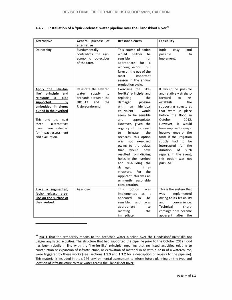
REVISED FINAL EIR FOR ‘MEERLUSTKLOOF’ 59/11, CALEDON
Page 74 of 111
4.4.2 Installation of a ‘quick-release’ water pipeline over the Elandskloof River42
Alternative General purpose of
alternative
Reasonableness Feasibility
Do nothing
Fundamentally
contradicts the agri-
economic objectives
of the farm.
This course of action
would neither be
sensible nor
appropriate for a
working export fruit
farm on the eve of the
most important
season in the annual
production cycle.
Both easy and
possible to
implement.
Apply the ‘like-for-
like’ principle and
reinstate a pipe
supported by
embedded in drums
buried in the riverbed
This and the next
three alternatives
have been selected
for impact assessment
and evaluation.
Reinstate the severed
water supply to
orchards between the
DR1313 and the
Riviersonderend.
Exercising the ‘like-
for-like’ principle and
replacing the
damaged pipeline
with an identical
equivalent would
seem to be sensible
and appropriate.
However, given the
urgency of the need
to irrigate the
orchards, this option
was not exercised
owing to the delays
that would have
resulted from digging
holes in the riverbed
and re-building the
damaged infra-
structure. For the
Applicant, this was an
eminently reasonable
consideration.
It would be possible
and relatively straight-
forward to re-
establish the
supporting structures
that were in place
before the flood in
October 2012.
However, it would
have imposed a major
inconvenience on the
farm if the irrigation
supply had to be
interrupted for the
duration of such
repairs. In the event,
this option was not
pursued.
Place a segmented,
‘quick release’ pipe-
line on the surface of
the riverbed.
As above This option was
implemented as it
appeared to be
sensible, and was
appropriate to
meeting the
immediate
This is the system that
was implemented
owing to its feasibility
and convenience.
Technical short-
comings only became
apparent after the
42 NOTE that the temporary repairs to the breached water pipeline over the Elandskloof River did not
trigger any listed activities. The structure that had supported the pipeline prior to the October 2012 flood
has been rebuilt in line with the ‘like-for-like’ principle, meaning that no listed activities relating to
construction or expansion of infrastructure, or excavation of material in or within 32 m of a watercourse,
were triggered by these works (see sections 1.1.3 and 1.3.2 for a description of repairs to the pipeline).
This material is included in the s 24G environmental assessment to inform future planning on the type and
location of infrastructure to take water across the Elandskloof River.

REVISED FINAL EIR FOR ‘MEERLUSTKLOOF’ 59/11, CALEDON
Page 75 of 111
Alternative General purpose of
alternative
Reasonableness Feasibility
operational priorities
of the farm. It was
reasoned that ‘quick
release’ pipes could
be removed prior to
impending floods, and
would have a limited
environmental
impact. Owing to
unforeseen technical
problems (pipes that
were torn apart by
the ‘head’ of water
pressure) it became
necessary to secure
the structure with
wooden poles and
steel ties. This undid
the evident benefits
of ‘quick release’
technology, and
contributed to
erosion.
option had been
implemented and set
in action. The
feasibility of this
option must therefore
be called into
question – on both
technical and environ-
mental grounds.
Bury the pipeline at a
depth and encase
with gabions at least
1 m below the
riverbed
As above This option is certainly
based on ‘good sense’
as it would secure the
irrigation supply with
a substantially re-
duced risk of
interruption owing to
flood damage, while
actively avoiding
adverse impacts on
the river environ-
ment. However, the
urgency that arose
with the destruction n
of the previous
irrigation pipeline
demanded an
immediate response,
which would not have
been possible if the
pipe were be placed
in a trench and
armoured with
gabions. This system
holds distinct
operational and
environmental ad-
vantages over the
status quo and
consideration should
be given to its
This system is feasible
in the sense that it is
‘possible’. It would,
however, be highly
inconvenient to im-
plement it during the
driest time of the year
which coincides with
the greatest need for
irrigation. It would
also probably require
environmental
authorisation which
would add to the
considerable cost
burden that the
Applicant has had to
carry as a result of
damage and
disruption arising
from devastating
floods in 2008 and
2012. In that regard,
this option is neither
easy nor convenient.
This is a question that
needs to be taken up
with the relevant
authorities for
resolution as it inter
alia touches on issues
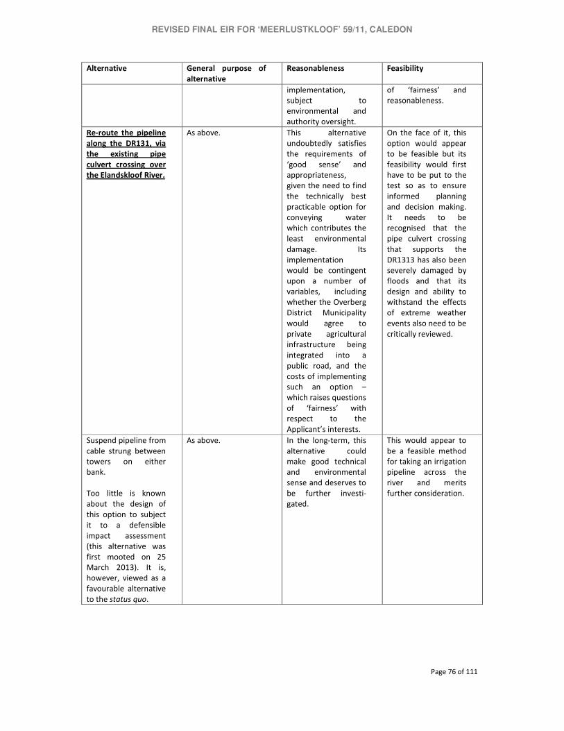
REVISED FINAL EIR FOR ‘MEERLUSTKLOOF’ 59/11, CALEDON
Page 76 of 111
Alternative General purpose of
alternative
Reasonableness Feasibility
implementation,
subject to
environmental and
authority oversight.
of ‘fairness’ and
reasonableness.
Re-route the pipeline
along the DR131, via
the existing pipe
culvert crossing over
the Elandskloof River.
As above. This alternative
undoubtedly satisfies
the requirements of
‘good sense’ and
appropriateness,
given the need to find
the technically best
practicable option for
conveying water
which contributes the
least environmental
damage. Its
implementation
would be contingent
upon a number of
variables, including
whether the Overberg
District Municipality
would agree to
private agricultural
infrastructure being
integrated into a
public road, and the
costs of implementing
such an option –
which raises questions
of ‘fairness’ with
respect to the
Applicant’s interests.
On the face of it, this
option would appear
to be feasible but its
feasibility would first
have to be put to the
test so as to ensure
informed planning
and decision making.
It needs to be
recognised that the
pipe culvert crossing
that supports the
DR1313 has also been
severely damaged by
floods and that its
design and ability to
withstand the effects
of extreme weather
events also need to be
critically reviewed.
Suspend pipeline from
cable strung between
towers on either
bank.
Too little is known
about the design of
this option to subject
it to a defensible
impact assessment
(this alternative was
first mooted on 25
March 2013). It is,
however, viewed as a
favourable alternative
to the status quo.
As above. In the long-term, this
alternative could
make good technical
and environmental
sense and deserves to
be further investi-
gated.
This would appear to
be a feasible method
for taking an irrigation
pipeline across the
river and merits
further consideration.

REVISED FINAL EIR FOR ‘MEERLUSTKLOOF’ 59/11, CALEDON
Page 77 of 111
4.5 NEED AND DESIRABILITY
The concept of ‘need and desirability’ is introduced in Section 1.9. It would seem apparent from the
preceding discussion of the reasonableness of the various alternatives, that the preferred options –
the unauthorised sum, the repaired and expanded pipe culvert crossings and, subject to review, the
irrigation pipeline across the Elandskloof River – had their background in manifest emergencies
precipitated by floods in November 2008 and October 2012.
The potentially dire consequences of the damage and resultant disruption to farming operations
demanded an immediate response from the Applicant. Failure to have timeously reinstated the
water supply and secure access to orchards with ripening fruit at the onset of summer could have
had disastrous consequences for the farm and its economic viability. For the Applicant, there was an
incontrovertible need to act swiftly; failure to have done so would, from the perspective of a
working export fruit farm, have been irrational and unthinkable. There would also have been evident
societal need or motivation for the Applicant not to have followed these respective courses of action
which, in the judgment of the Applicant, were urgent, essential and rational.
The upshot is that failure to have acted in the way that it had, meant that the Applicant could have
suffered irreparable harm to its farm. Any other alternative course of action could, in the
circumstances, therefore not be countenanced. Again, from the perspective of the Applicant, there
could be no question about the ‘desirability’ of its response to the potentially dire consequences of
the floods in November 2008 and October 2012 for the viability and wellbeing of the farm.
4.5.1 Need and desirability: The unauthorised emergency sump
The environmental assessment does shows that the unauthorised sump – with due recognition to
the circumstances under which it was excavated, and the apparent lack of choice in the matter for
the Applicant – is not desirable from an environmental perspective and that it must be demolished.
4.5.2 Need and desirability: Unauthorised emergency repairs to river crossings
The addition of extra pipes means that the impacts of the two pipe culvert crossings have been
considerably minimised with respect to erosion and sediment transport, which is viewed as being
ecologically advantageous. Management will, however, have to address other channel restrictions
and berms.

REVISED FINAL EIR FOR ‘MEERLUSTKLOOF’ 59/11, CALEDON
Page 78 of 111
4.5.3 Need and desirability: Water pipeline over the Elandskloof River
The water pipeline over the Elandskloof River is viewed as an essential temporary measure that
may, depending on the outcome of an appropriate planning process, have to be replaced with
another suitable alternative.
4.5.4 Summary: Need and desirability
All these interventions can be assessed as meeting the legitimate operational needs of the farm.
They are not, however, equally desirable from the view of maintaining a desired level of
environmental quality and ecosystem functioning. Contextual factors that would influence an
assessment of the desirability of the various alternatives include the proximity of these structures to
FEPA wetlands and potential overlaps with one or more ecological support areas. However, long-
term planning about the most suitable type and location of infrastructure must be informed by a
strategic environmental planning process as this cannot be adequately dealt with through
mechanism of activity-specific environmental assessment.
4.6 ALTERNATIVES SELECTED FOR IMPACT ASSESSMENT AND EVALUATION
The following alternatives are ‘taken forward’ for detailed impact assessment and evaluation:
Alternative 1
Existing,
unauthorised
structure
Alternative 2 Alternative 3 Alternative 4
Sump in the
Elandskloof River
Demolish sump and
rehabilitate area
Pipe culvert
crossings
(Meerlustkloof River
and Elandskloof
River)
Rebuild bridge to
original (post-
October 2008)
specifications) with
additional pipes
Former drift,
Elandskloof River Drift demolished. No alternatives available or necessary.

REVISED FINAL EIR FOR ‘MEERLUSTKLOOF’ 59/11, CALEDON
Page 79 of 111
Pipeline over the
Elandskloof River43
Support pipe from
posts embedded in
drums in the
riverbed
Bury pipeline to a
depth of at least 50
cm; stabilise with
buried gabions
Route pipeline via
pipe culvert
crossing on the
DR1313
43 NOTE The replacement of the irrigation pipe over the Elandskloof River did not trigger any requirement for
environmental authorisation. This assessment is included for the purposes of informing future planning.
REVISED FINAL EIR FOR ‘MEERLUSTKLOOF’ 59/11, CALEDON
Page 80 of 111
5. IMPACTS ASSOCIATED WITH THE UNAUTHORISED ACTIVITIES
This chapter is based on the findings of the freshwater ecological assessments by Dr Liz Day in 2012
and 2013 (Appendix E). Owing to the severely destabilised and degraded condition of the
catchments of the Elandskloof and Meerlustkloof rivers, and the structural shortcomings of activity-
specific environmental assessment, it is necessary to draw attention to some of the key limitations
that have detracted from the predictive value of this environmental assessment.
5.1 UNCERTAINTY OF PREDICTIVE METHODS AND ASSUMPTIONS
Questions of inadequate information about especially the stability and geomorphological dynamics
of the Elandskloof and Meerlustkloof catchment were introduced at Section 1.8 which discussed
assumptions and limitations that may inhibit the predictive reliability of this environmental
assessment. This uncertainty has been acknowledged as a defining feature of this study.
The specialist ecological assessments (Day 2012 and 2013) identified limitations that placed
constraints on the environmental assessment and which would have to be addressed through a
more comprehensive, catchment-wide planning process. In particular, the ecological assessment
highlighted the following factors that inhibited the predictive reliability of the environmental
assessment:
− Detailed water quality, hydraulic, hydrological, faunal or floral assessments were not
undertaken;
− Access to the catchment was limited to the Elandskloof and Meerlustkloof Rivers only within
the property boundary of Agrisouth Orchards (SA); and
− Only a visual inspection was carried out, for contextualisation of the impacts of the
unauthorised structures, on river reaches within the ‘Meerlustkloof’ property.
The ecological assessment concluded that the rivers had not been subject to the type of detailed
assessment that would normally be required for the preparation of a detailed management or
rehabilitation plan, to be implemented at the level of the river reach or sub-catchment, and the site
assessment had a relatively narrow focus on the section of the river affected by the unauthorized
sump.
This underlying uncertainty has, as emphasised, been a central contention in the design of
appropriate measures to address both the short-term issue of mitigating the impacts of the sump,

REVISED FINAL EIR FOR ‘MEERLUSTKLOOF’ 59/11, CALEDON
Page 81 of 111
pending its replacement and demolition, as well as placing the search for an alternative method of
abstraction within the broader framework of a catchment-wide management plan for the two rivers.
5.2 IMPACTS OF THE UNAUTHORISED EMERGENCY SUMP
5.2.1 Identification of impacts
It has been suggested that, prior to construction of the sump, the Elandskloof and Meerlustkloof
Rivers both on the farm ‘Meerlustkloof’ but also in all likelihood on adjacent farms, were subject to a
number of activities that triggered or contributed to the wholesale devastation of riverine and
wetland habitats apparent today. Such activities are believed to have included:
− Significant long-term encroachment of agricultural lands, access roads, pump stations and
other infrastructure into a large portion of the floodplain;
− Concentration of flows within a narrow channel, as a result of agricultural encroachment,
culverts, channelized side-drains and minor drainage lines, all resulting in significant channel
incision and bank erosion during periods of high flow;
− Exacerbation of channel and bed erosion as a result of possible invasion of the low flow
channel by alien trees.
While the magnitude of impact associated with the sump is considered far less than the cumulative
long-term impact of the above impacts, many of which are deeply embedded in standard
agricultural practice in the broader Breede River catchment, it is nevertheless likely to have
contributed substantially to the cumulative degradation of the Elandskloof River, at least within a
localised extent. The main impacts associated with the unauthorised and unmitigated construction
of the sump include:
− Abstraction of a significant volume of water from the river, resulting (at least at the time of
the site visit) in the near-complete diversion of low flows from the main river channel: This
means that for the entire river reach between the diversion point and the point at which the
excess water from the pump station re-enters the river, the river was, during the operational
phase of the sump, largely deprived of summer base flows. This resulted in limited areas of
flowing water, as well as shrinkage of even saturated to moist areas, thus inhibiting the
extent to which wetland and riverine vegetation can be sustained on the river bed. This
impact had a compounded effect, in that the slow rate of re-vegetation of the low flow
channel in these reaches meant that they remained prone to erosion, while essentially
terrestrial areas within the disturbed river bed became increasingly vulnerable to invasion by
terrestrial alien vegetation, such as Sesbania punicea. This effect was magnified by the fact

REVISED FINAL EIR FOR ‘MEERLUSTKLOOF’ 59/11, CALEDON
Page 82 of 111
that flood damage considerably widened the effective low flow channel, with the result that
drying of its margins would be more likely, even without large-scale abstraction;
− Perpetuation of a disturbed in-channel environment, through the creation of in-stream
diversion and retention berms to allow for the collection and abstraction of water: These
berms seem likely to have contributed to the substantial erosion that took place along the
right hand river bank, adjacent to the sump. It appears that the berms that comprised the
sump structure play a role in diverting flood flows past the sump, but (given the extent of
eroded debris in the channel), these flows were deflected into the eroding stream bank, as
well as into a large mound of former stream bank, which (in early 2012) comprised an
isolated in-stream hillock, that contributed to flow deflections and further erosion, and
which by 2013 was described as an isolated mesa; the sump structure is considered
instrumental in precipitating the erosion and channel deflections that occurred in 2013, the
latter were the cumulative result of channelization, agricultural and infrastructure
encroachment along the reaches of the river, leading to significant loss of channel and
floodplain capacity, and resultant erosion.
− Provision of artificial in-stream habitat in the form of standing water, lacustrine habitat,
which would not normally occur in the Elandskloof River and which could provide habitat for
ecologically undesirable species, such as alien fish, many of which thrive in such conditions:
Information regarding the fish fauna of the Elandskloof systems has not been accessed in
this report, other than in terms of the absence of this sub-catchment from any FEPA
importance rating as a result of the presence of fish of conservation status (see Section
3.3.4).
Had the above impacts been assessed as part of a planning phase Basic Assessment, prior to their
implementation, they would, in the absence of any mitigation measures, have been assessed by FCG
as of medium to high negative significance, affecting river / wetland conditions in the long-term at a
medium to high level of magnitude. The fact that the sub-catchment is connected to the
Riviersonderend system, itself a FEPA river, means that the ramifications of significant impacts to
river condition in the Elandskloof River would be assessed as of elevated significance.
At January 2013, the sump had however been rendered redundant by in-stream deflection and the
implementation of the pump abstraction scheme. Recommendations made in the following
section are based on the fact that at present the sump is defunct and the current irrigation
abstraction scheme entails utilising submersible pumps placed in drums in the riverbed.

REVISED FINAL EIR FOR ‘MEERLUSTKLOOF’ 59/11, CALEDON
Page 83 of 111
5.2.2 Recommendations for mitigation
i. The current (2013) approach to river abstraction is strongly supported – namely, the use of
submersible pumps placed in drums in the riverbed;
ii. No further in-channel impoundment works should be undertaken in the river without a full
ecological assessment, and no efforts to stabilize the river banks with gabions, groynes or
other structures should take place without specialist input into their design;
iii. The sump structure (earth walls etc) should be removed (mechanically), but only once more
clarity has been obtained on the type and siting of soil conservation works in the Elandskloof
River. The area occupied by the sump should be re-landscaped as a riverine environment
that will not result in additional erosion knick-points. Material obtained from the demolition
of the sump can be used for landscaping the intervening river banks between groynes.
Chapter 8 provides a detailed motivation for a strategic, ecosystem-based approach with
respect to the stabilisation and rehabilitation of the Meerlustkloof and Elandskloof rivers. It
is meanwhile recommended that the sump be authorised for at least two additional years so
that the planning process that will ultimately determine its fate can be satisfactorily
concluded ;
iv. The extensive berms and mounds of disturbed, partially eroded material that are associated
with the location of the now defunct sump, and which contribute to the creation of nodes of
disturbed areas, vulnerable to alien plant invasion as well as to areas that result in flow
diversion, concentration and ongoing lateral erosion should be removed from the channel,
or landscaped into more natural features compatible with achieving the re-instatement of
stable wetland vegetation on the expanded channel floor. Such in-channel manipulation
should however only be carried out with input from a geomorphological and/or hydrological
specialist, and subject to their approval. See the Final Environmental Management
Programme and Maintenance Plan (Appendix G) for detailed recommendations on how the
channel south of the sump needs to be cleared. These recommendations were finalised in
late March 2013 on the basis of discussions with Mr Hans King (Western Cape Department of
Agriculture) and Dr Liz Day.
REVISED FINAL EIR FOR ‘MEERLUSTKLOOF’ 59/11, CALEDON
Page 84 of 111
5.3 IMPACTS OF THE IRRIGATION PIPELINE OVER THE ELANDSKLOOF RIVER44
5.3.1 Identification of impacts
As outlined in Section 1.3.2, the irrigation pipeline in its present form is associated with the
following potential and actual impacts:
− Disturbance to the river bed and banks;
− Contribution to localised erosion as a result of blockages of in-channel flows;
− Likelihood of causing debris dams and other obstructions to flows during floods.
In a Basic Assessment Scenario, laying the pipeline across the riverbed would not have been
supported from an ecological perspective, and would have been assessed as of medium to high
negative significance, with impacts being long-term and taking place at a local to reach scale at a
medium magnitude. However, the pipeline has since (i.e.by March 2013) been lifted above the
riverbed and supported with the same type of structure that was in place before the river flooded in
October 2012 (see sections 1.1.3 and 1.3.2 for detailed descriptions of the repairs effected to the
pipeline).
5.3.2 Recommendations for mitigation
The current (April 2013) configuration of the pipeline is supported for the purposes of this section
24G application although it needs to be revisited to find a more acceptable alternative. The reason
for this is that the structure, although lifted at least 1 m above the riverbed, potentially would entail
hydrological disturbance as it would be prone to the creation of debris dams during floods, which
would increase erosion and contribute to degradation of in-stream habitat.
Four options have been identified for taking a water pipeline across the river. They are, in order of
preference from an ecological perspective:
i. Extending the pipeline north, so that it can be attached to the existing road bridge – this
approach would be the most benign from an ecological perspective;
ii. Suspending the pipeline from a cable strung between two towers. This system can be
designed to fail under high flows so that the pipeline splits into two halves that swing 90°,
44 NOTE that none of the activities associated with repairs to the irrigation pipeline required environmental
authorisation. Section 5.3 is retained to inform future planning regarding the selection of the best practicable
environmental option for taking irrigation water across the Elandskloof River.

REVISED FINAL EIR FOR ‘MEERLUSTKLOOF’ 59/11, CALEDON
Page 85 of 111
i.e. parallel to the direction of flow, thereby pre-empting major damage to infrastructure
and, potentially, the riparian environment; and
iii. Passing the pipeline beneath the river bed – this approach would require the pipeline to be
buried below the river bed and it is suggested that it should be embedded / stabilised in a
gabion mattress, buried at least 0.5m below the existing river bed and banks; disturbance to
the bed and banks as a result of excavation should be addressed after installation of the
pipeline, such that pre-disturbance ground levels are achieved.
Regardless of the approach selected (above), mitigation measures would need to be accompanied by
the removal of all waste and debris associated with the current structure; all fill that has been used
to embed the existing pipeline must be removed from the river bank and bed and these areas must
be re-instated to natural ground level.
5.4 IMPACTS ARISING FROM THE REBUILT CROSSING OVER THE ELANDSKLOOF
RIVER CROSSING
5.4.1 Identification of impacts: Post-2008 flood activities
Repairs to the Elandskloof River crossing in 2008 are likely to have resulted in the following impacts:
− Concentration of flows and increased velocities at the crossing, as the result of river
narrowing;
− Infilling of the floodplain and further concentration of flows as a result of the construction of
berms along the top of the river bank (see Fig. 8, Appendix C);
− Significant contribution to the cumulative impacts in the Elandskloof River, resulting in
severe sedimentation, erosion and ongoing disturbance to riverine habitats in the
downstream river reaches.
The above impacts would not have been approved in a Basic Assessment from an ecological
perspective and are considered of high negative significance, taking place on a long-term to
permanent basis, at a high magnitude.
5.4.2 Identification of impacts: Post-2012 flood activities
The approach to the bridge repairs following the 2012 floods is considered a positive impact, when
compared to the previous designs, and has resulted in localised widening of the river channel and a
decrease in velocity and scour potential in the vicinity of the bridge. Since the berms below the
crossing over the Elandskloof River remain in situ, the extent of channel widening is limited to the

REVISED FINAL EIR FOR ‘MEERLUSTKLOOF’ 59/11, CALEDON
Page 86 of 111
bridge area, and the system as a whole in these reaches remains essentially channelised and
confined.
5.4.3 Recommendations for mitigation
Maintenance of the existing road design is supported. The following additional measures should
however be implemented:
i. Attempts should be made to establish locally indigenous wetland and riverine vegetation
along the bare, exposed river bed up- and downstream of the bridge; species such as
Palmiet (Prionium serratum) would be beneficial along the lower wetted bank;
ii. The berms established along the top of the river since 2008 (see the 2013 freshwater
assessment, Appendix E, Figure 7 and Photo J) should be pulled back to the outer edge of
the floodplain abutting existing orchards, so that the river channel has an area of floodplain
into which to overtop during floods, rather than scouring out the channel and elevated river
banks. A river ecologist and the Western Cape Department of Agriculture should have input
into the actual shaping of the berms / floodplain area, which should be carried out
mechanically.
5.5 IMPACTS ARISING FROM THE REBUILT CROSSING OVER THE
MEERLUSTKLOOF RIVER
5.5.1 Identification of impacts: Post-2008 flood activities
These activities have had the same level of impact on the Meerlustkloof River as previously outlined
for the Elandskloof River crossing (Section 5.4).
5.5.2 Identification of impacts: Post-2012 flood activities
Similarly, the widening of the culverts and the planned additional bank and bridge reinforcement at
this crossing have had a slight positive impact on river conditions, albeit at a highly localised scale,
given the fact that the river remains impacted by significant channelization.
5.5.3 Recommendations for mitigation
The opportunities to remove berms and widen the riverine floodplain further are limited along these
reaches of the river by existing infrastructure. It is however recommended that attention should be
paid to improving in-stream habitat quality and reducing the vulnerability of the system to erosion,

REVISED FINAL EIR FOR ‘MEERLUSTKLOOF’ 59/11, CALEDON
Page 87 of 111
by establishing locally indigenous riverine and wetland plants along the river bank, with particular
attention being paid to stabilising the wetted bank.
5.6 RECOMMENDED MONITORING FRAMEWORK
To track the progress and efficacy of implementation of the direct mitigation measures, as well as to
allow tracking of long-term river rehabilitation success (or other), it is recommended that
consideration be given to incorporation of the following elements into a long-term monitoring
programme for the Elandskloof and Meerlustkloof Rivers:
− Regular SASS5 bio-assessment monitoring (this tool provides information regarding both
water quality and macroinvertebrate habitat quality) which should commence before the
recommended short-term mitigation measures are implemented in order to establish a
baseline for future monitoring;
− Water quality monitoring (analysis of regular samples collected from selected sites for the
assessment of major nutrient concentrations and (ideally) suspended sediments;
− Flow monitoring, if required to provide input into long-term rehabilitation design;
− Periodic audits of fish community structure in the main stem rivers; and
− Regular assessments of PES, to track long–term changes in habitat quality.
REVISED FINAL EIR FOR ‘MEERLUSTKLOOF’ 59/11, CALEDON
Page 88 of 111
6. IMPACT ASSESSMENT: METHOD
This and the following chapters explain the impact assessment methodology, define what is
understood by ‘mitigation’ and how this relates to desired management objectives, identifies
impacts on the environment that may have arisen as a result of the unauthorised activities on the
Applicant’s property, assesses the environmental implications of such impacts, and evaluates their
significance – without and with mitigation – against relevant criteria.
Impacts are related exclusively to the biophysical environment as the unauthorised activities have
not had an evident effect on socio-economic aspects such as heritage resources, human wellbeing or
safety, or developmental opportunities. In fact, the unauthorised activities were aimed at securing
and stabilising the status quo ante that immediately preceded the destruction of the weir and other
critical elements of farm infrastructure by floods in November 2008 and October 2012.
6.1 METHOD OF IMPACT IDENTIFICATION
Impacts were identified on the basis of sites visits in January and February 2012, October 2012, and
January 2013, reference to systematic biodiversity plans and the NFEPA maps, authority
consultation, and specialist assessment.
Site visits were held as follows:
26 January 2012 Applicant, EAP and the Western Cape Department of Agriculture (WCDoA)
16 February 2012 Applicant, EAP and the WCDoA
28 February 2012 Dr Liz Day
29 October 2012 Applicant, EAP, WCDoA, Department of Environmental Affairs and
Development Planning (DEADP), the Department of Water Affairs and the
Breede-Overberg Catchment Management Agency
25 January 2013 Applicant, EAP and Dr Liz Day
Consultations were held between the EAP, Dr Day and the WCDoA on 15 May 2012, the EAP and
DEADP on 26 November 2013, and the EAP and Mr Hans King of the WCDA and Dr Liz Day on 25
and 26 March 2013 respectively.
The specialist ecological assessments in 2012 and 2013 focused on:
− Changes in environmental flows resulting from the unauthorised structures;
− Erosion and sediment deposition; and

REVISED FINAL EIR FOR ‘MEERLUSTKLOOF’ 59/11, CALEDON
Page 89 of 111
− The condition of in-stream and floodplain habitats (as a coarse surrogate for biodiversity
pattern and process).
Each of the alternatives is assessed and evaluated with reference to impacts associated with
these aspects of the river and floodplain environment.
6.2 IMPACT ASSESSMENT METHODOLOGY
The impact assessment relies on the conventional methodology of deducing significance ratings
from the extent, magnitude and duration of impacts. The magnitude of impacts has been
adjusted to reflect potential loss of habitat or ecological functioning in CBAs and FEPAs as being
of ‘regional’ extent.
The SIGNIFICANCE of an impact is derived by taking into account the temporal and spatial scales
and magnitude. The means of arriving at the different significance ratings is explained in Table 2.
Table 1: Assessment criteria for the evaluation of impacts
CRITERIA CATEGORY
DESCRIPTION
Extent or
spatial
influence of
impact
Regional Riviersonderend
Local Downstream of site till confluence with Riviersonderend
Site specific Within ~100 m radius of site
Magnitude of
impact (at the
indicated
spatial scale)
High
Natural and/ or social functions and/ or processes are severely &
irreplaceably altered (including loss of habitat in CBA/FEPA selected in
support of pattern targets or thresholds, including habitat in CR or EN
ecosystems and/or CR or EN plant and animal species)
Medium
Natural and/ or social functions and/ or processes are notably altered. but
reversible (including loss of habitat in CBA/FEPA selected in support of ‘best
design’ or VU ecosystems and/or VU plant and animal species)
Low Natural and/ or social functions and/ or processes are slightly altered.
Very Low Natural and/ or social functions and/ or processes are negligibly altered.
Zero Natural and/ or social functions and/ or processes remain unaltered.
Duration of
impact
Short Term 0-1 year
Medium Term 1-5 years
Long Term More than 5 years

REVISED FINAL EIR FOR ‘MEERLUSTKLOOF’ 59/11, CALEDON
Page 90 of 111
Table 2: Definition of significance ratings
SIGNIFICANCE
RATINGS LEVEL OF CRITERIA REQUIRED
High • High magnitude with a national or regional extent and long-term duration.
• High magnitude with either a regional extent and medium term duration or a local extent and
long term duration.
• Medium magnitude with a national or regional extent and long-term duration.
Medium • High magnitude with a local extent and medium term duration.
• High magnitude with a regional extent and short term duration or a site-specific extent and
long term duration.
• High magnitude with either a local extent and short-term duration or a site-specific extent and
medium term duration.
• Medium magnitude with any combination of extent and duration except site specific and short
term or regional and long term.
• Low magnitude with a regional extent and long term duration.
• Very low magnitude with any combination of extent and duration except national/regional and
medium or long term.
Low • High magnitude with a site-specific extent and short-term duration.
• Medium magnitude with a site-specific extent and short-term duration.
• Low magnitude with any combination of extent and duration except site specific and short
term.
• Very low magnitude with a regional extent and long term duration.
Very low • Low magnitude with a site-specific extent and short-term duration.
• Very low magnitude with any combination of extent and duration except regional and long
term.
Neutral • Zero magnitude with any combination of extent and duration.
Once the significance of an impact has been determined, the PROBABILITY of this impact
occurring as well as the CONFIDENCE in the assessment of the impact, are estimated using the
rating systems outlined in Tables 3 and 4, respectively. It is important to note that the
significance of an impact should always be considered in concert with the probability of that
impact occurring.

REVISED FINAL EIR FOR ‘MEERLUSTKLOOF’ 59/11, CALEDON
Page 91 of 111
Table 3: Definition of probability ratings
PROBABILITY RATINGS CRITERIA
Definite Estimated greater than 95 % chance of the impact occurring.
Highly probable Estimated 80 to 95 % chance of the impact occurring.
Probable Estimated 20 to 80 % chance of the impact occurring.
Possible Estimated 5 to 20 % chance of the impact occurring.
Unlikely Estimated less than 5 % chance of the impact occurring.
Unknown Likelihood of impact not occurring cannot be demonstrably excluded
Table 4: Definition of confidence ratings
CONFIDENCE RATINGS CRITERIA
Certain Wealth of information on and sound understanding of the environmental
factors potentially influencing the impact.
Sure
Reasonable amount of useful information on and relatively sound
understanding of the environmental factors potentially influencing the
impact.
Unsure Limited useful information on and understanding of the environmental
factors potentially influencing this impact.
A summary of the significance of the potential impacts is presented in Table 5.
6.3 A NOTE ON ‘MITIGATION’, ‘REHABILITATION’ AND ‘RESTORATION’
Management interventions are defined and shaped by their intended objectives.
Here, ‘mitigation’ is understood to be guided by the objective of preventing further environmental
degradation and rehabilitation of some of the original, pre-disturbance condition of the affected
environment or ecosystem. This also reflects the management objectives for CBAs (cf. Holness and
Bradshaw, 2010; see also Section 2.1.6 on the Western Cape rural land-use guidelines and
management objective for Core 1 and Core 2 spatial planning categories).
Mitigation can ‘soften’ some of the negative effects of a particular set of disturbances and, to some
extent, restore an element of environmental functionality or amenity such as visual integrity or a use
value such as grazing. Mitigation may include keeping a site clear of alien vegetation. Full ecological
recovery would not, however, be the objective.
REVISED FINAL EIR FOR ‘MEERLUSTKLOOF’ 59/11, CALEDON
Page 92 of 111
‘Rehabilitation’ seeks to repair damaged ecosystem functions with the primary goal of securing
ecosystem productivity for human benefit (Aronson et al., 1993). Rehabilitation attempts to adopt
the original ecosystem’s structure and functioning that, in the long-term, can promote eventual
restoration of the full complement of biodiversity and its supporting ecological processes. Ecological
restoration is not, however, the primary objective.
‘Ecological restoration’ is defined as management to return a damaged ecosystem to its pre-
disturbance condition, functionally, structurally and in terms of species composition. It is recognised,
though, that complete restoration is unlikely (cf. Cairns, 1993, p 193) and that a reinstatement of
appropriate ecosystem functions (such as bank stabilisation or re-establishing an ecological corridor)
may be the most realistic goal (cf. Holmes et al., 2008). However, areas restored in support of
reclaiming an element of ecological functionality could, if effectively managed, contribute to
structural and compositional changes towards a desired reference condition.

REVISED FINAL EIR FOR ‘MEERLUSTKLOOF’ 59/11, CALEDON
Page 93 of 111
7. ASSESSMENT AND EVALUATION OF IMPACTS
This chapter assesses impacts relating to environmental flow requirements (chiefly with respect to
the former impact of the sump on in-stream water availability), erosion and sedimentation, and
riparian habitat. Erosion dynamics are treated as a direct driver of in-stream habitat degradation,
and have therefore been assigned identical significance ratings.
7.1 IMPACTS RESULTING FROM THE UNAUTHORISED EXCAVATION OF THE
SUMP (ELANDSKLOOF RIVER)
The previous draft of the Final Environmental Assessment Report outlined a number of alternatives
for mitigating the impacts of the sump that have been annulled by significant changes to the river
environment following the flood in October 2012 and, importantly, the successful implementation of
an abstraction method that does not rely on the sump.
7.1.1 Impacts on environmental flow requirements
These related chiefly to the significant volumes of water that were taken from the active channel
and rerouted via the sump, with adverse environmental consequences for riparian habitat in the
affected reach which received only a fraction of natural summer base flows.
Flows have subsequently been restored owing to flood-dictated changes in the channel morphology.
Alternative 1
‘Retain status quo’
Alternative 2 Demolish and rehabilitate
No mitigation
With mitigation
No mitigation
With mitigation
Extent Regional Regional Local Site-specific
Magnitude High (-) Medium (-) Low (-) Very low (-)
Duration Long-term Long-term Long-term Short-term
Significance HIGH (-) HIGH (-) LOW (-) VERY LOW (-)
Probability of impact occurring
DEFINITE POSSIBLE DEFINITE POSSIBLE
Confidence CERTAIN SURE CERTAIN CERTAIN
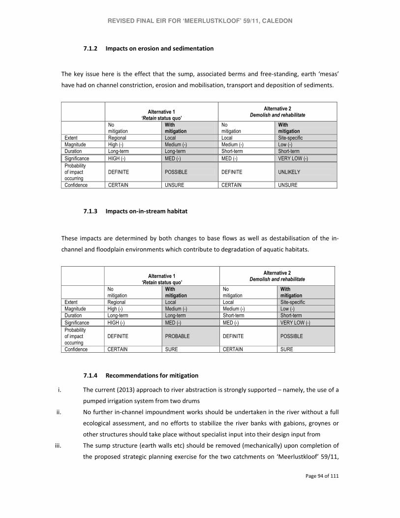
REVISED FINAL EIR FOR ‘MEERLUSTKLOOF’ 59/11, CALEDON
Page 94 of 111
7.1.2 Impacts on erosion and sedimentation
The key issue here is the effect that the sump, associated berms and free-standing, earth ‘mesas’
have had on channel constriction, erosion and mobilisation, transport and deposition of sediments.
Alternative 1
‘Retain status quo’
Alternative 2 Demolish and rehabilitate
No mitigation
With mitigation
No mitigation
With mitigation
Extent Regional Local Local Site-specific
Magnitude High (-) Medium (-) Medium (-) Low (-)
Duration Long-term Long-term Short-term Short-term
Significance HIGH (-) MED (-) MED (-) VERY LOW (-)
Probability of impact occurring
DEFINITE POSSIBLE DEFINITE UNLIKELY
Confidence CERTAIN UNSURE CERTAIN UNSURE
7.1.3 Impacts on-in-stream habitat
These impacts are determined by both changes to base flows as well as destabilisation of the in-
channel and floodplain environments which contribute to degradation of aquatic habitats.
Alternative 1
‘Retain status quo’
Alternative 2 Demolish and rehabilitate
No mitigation
With mitigation
No mitigation
With mitigation
Extent Regional Local Local Site-specific
Magnitude High (-) Medium (-) Medium (-) Low (-)
Duration Long-term Long-term Short-term Short-term
Significance HIGH (-) MED (-) MED (-) VERY LOW (-)
Probability of impact occurring
DEFINITE PROBABLE DEFINITE POSSIBLE
Confidence CERTAIN SURE CERTAIN SURE
7.1.4 Recommendations for mitigation
i. The current (2013) approach to river abstraction is strongly supported – namely, the use of a
pumped irrigation system from two drums
ii. No further in-channel impoundment works should be undertaken in the river without a full
ecological assessment, and no efforts to stabilize the river banks with gabions, groynes or
other structures should take place without specialist input into their design input from
iii. The sump structure (earth walls etc) should be removed (mechanically) upon completion of
the proposed strategic planning exercise for the two catchments on ‘Meerlustkloof’ 59/11,
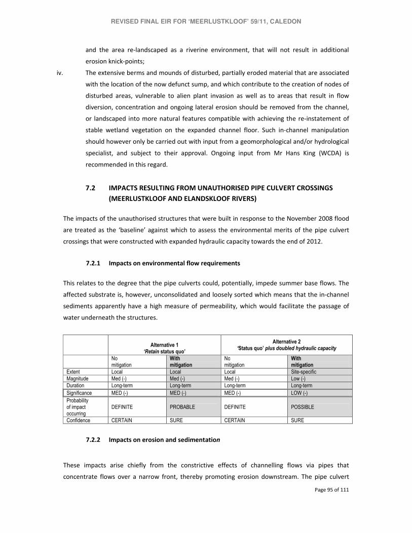
REVISED FINAL EIR FOR ‘MEERLUSTKLOOF’ 59/11, CALEDON
Page 95 of 111
and the area re-landscaped as a riverine environment, that will not result in additional
erosion knick-points;
iv. The extensive berms and mounds of disturbed, partially eroded material that are associated
with the location of the now defunct sump, and which contribute to the creation of nodes of
disturbed areas, vulnerable to alien plant invasion as well as to areas that result in flow
diversion, concentration and ongoing lateral erosion should be removed from the channel,
or landscaped into more natural features compatible with achieving the re-instatement of
stable wetland vegetation on the expanded channel floor. Such in-channel manipulation
should however only be carried out with input from a geomorphological and/or hydrological
specialist, and subject to their approval. Ongoing input from Mr Hans King (WCDA) is
recommended in this regard.
7.2 IMPACTS RESULTING FROM UNAUTHORISED PIPE CULVERT CROSSINGS
(MEERLUSTKLOOF AND ELANDSKLOOF RIVERS)
The impacts of the unauthorised structures that were built in response to the November 2008 flood
are treated as the ‘baseline’ against which to assess the environmental merits of the pipe culvert
crossings that were constructed with expanded hydraulic capacity towards the end of 2012.
7.2.1 Impacts on environmental flow requirements
This relates to the degree that the pipe culverts could, potentially, impede summer base flows. The
affected substrate is, however, unconsolidated and loosely sorted which means that the in-channel
sediments apparently have a high measure of permeability, which would facilitate the passage of
water underneath the structures.
Alternative 1
‘Retain status quo’
Alternative 2 ‘Status quo’ plus doubled hydraulic capacity
No mitigation
With mitigation
No mitigation
With mitigation
Extent Local Local Local Site-specific
Magnitude Med (-) Med (-) Med (-) Low (-)
Duration Long-term Long-term Long-term Long-term
Significance MED (-) MED (-) MED (-) LOW (-)
Probability of impact occurring
DEFINITE PROBABLE DEFINITE POSSIBLE
Confidence CERTAIN SURE CERTAIN SURE
7.2.2 Impacts on erosion and sedimentation
These impacts arise chiefly from the constrictive effects of channelling flows via pipes that
concentrate flows over a narrow front, thereby promoting erosion downstream. The pipe culvert

REVISED FINAL EIR FOR ‘MEERLUSTKLOOF’ 59/11, CALEDON
Page 96 of 111
crossings would, in their own right, constitute barriers that are perpendicular to especially high
flows, which would also exacerbate the potential for erosion.
An increase in hydraulic capacity (i.e. larger and/or more pipes), spread along the full width of the
channel, counters the adverse effects of channel constriction by assuring more evenly spread and
relatively slower flow volumes. The transport of sediment past the structures is also facilitated by
improving the capacity of venting to accommodate high flows.
Alternative 1
‘Retain status quo’
Alternative 2 ‘Status quo’ plus doubled hydraulic capacity
No mitigation
With mitigation
No mitigation
With mitigation
Extent Regional Local Local Site-specific
Magnitude High (-) Med (-) to High (-) Med (-) to High (-) Low (-) to Med (-)
Duration Long-term Long-term Long-term Long-term
Significance HIGH (-) MED (-) to HIGH (-) MED (-) to High (-) LOW (-) to MED (-)
Probability of impact occurring
DEFINITE PROBABLE DEFINITE POSSIBLE
Confidence CERTAIN SURE CERTAIN SURE
7.2.3 Impacts on habitat
As indicated previously, these impacts are determined by both changes to base flows as well as
destabilisation of the in-channel and floodplain environments which contribute to degradation of
aquatic habitats.
Alternative 1
‘Retain status quo’
Alternative 2 ‘Status quo’ plus doubled hydraulic capacity
No mitigation
With mitigation
No mitigation
With mitigation
Extent Regional Local Local Site-specific
Magnitude High (-) Med (-) to High (-) Medium (-) to High (-) Low (-) to Med (-)
Duration Long-term Long-term Long-term Long-term
Significance HIGH (-) MED (-) to HIGH (-) MED (-) to HIGH (-) LOW (-) to MED (-)
Probability of impact occurring
DEFINITE PROBABLE DEFINITE POSSIBLE
Confidence CERTAIN SURE CERTAIN SURE
7.2.4 Recommendations for mitigation
The existing road design is supported, and should be retained. The following additional measures
should however be implemented:
i. Attempts should be made to establish locally indigenous wetland and riverine vegetation
along the bare, exposed river bed up- and downstream of the bridge; species such as Palmiet
(Prionium serratum) would be beneficial along the lower wetted bank;

REVISED FINAL EIR FOR ‘MEERLUSTKLOOF’ 59/11, CALEDON
Page 97 of 111
ii. The berms established along the top of the river since 2008 (see Figure 7 and Photo J of the
2013 freshwater assessment, Appendix E) should be pulled back to the outer edge of the
floodplain abutting existing orchards, so that the river channel has an area of floodplain into
which to overtop during floods, rather than scouring out the channel and elevated river
banks. A river ecologist should have input into the actual shaping of the berms / floodplain
area, which should be carried out mechanically.
iii. `The opportunities to remove berms and widen the riverine floodplain further are limited
along these reaches of the river by existing infrastructure. It is however recommended that
attention should be paid to improving in-stream habitat quality and reducing the
vulnerability of the system to erosion, by establishing locally indigenous riverine and wetland
plants along the river bank, with particular attention being paid to stabilising the wetted
bank.
7.3 IMPACTS RESULTING FROM PIPELINE OVER ELANDSKLOOF RIVER45
In its current form and location, the pipeline that has been laid across the lower reaches of the
Elandskloof River does not constitute an activity requiring environmental authorisation.
However, the specialist freshwater ecological assessment by Dr Day (Day 2013, Appendix E)
recommended mitigation measures, and alternatives, that would have a direct bearing on the
management of the existing pipeline crossing as well as any decisions about future substitutes.
The specialist assessment relates to the position of the pipeline when it was first repaired after the
flood in October 2012, namely on the riverbed. It has since been lifted by at least 1 m from its
original, post-flood, position.
The impact assessment reported here is therefore retained to highlight considerations that would
need to inform future planning about this infrastructure and, potentially, its replacement.
7.3.1 Impacts on environmental flows
The pipeline in its current form and placement contributes to upstream pooling and flow
constriction downstream.
45 NOTE section 7.3 is included for the sake of completeness and to inform future planning regarding the
selection of the best practicable option for taking irrigation water across the Elandskloof River. This part of the
impact assessment has no bearing on the section 24G application.

REVISED FINAL EIR FOR ‘MEERLUSTKLOOF’ 59/11, CALEDON
Page 98 of 111
Alternative 1 ‘Retain status quo’
Alternative 2
Suspend pipe from posts supported by drums in
riverbed
Alternative 3 Bury pipeline and secure
with gabions
Alternative 4 Route pipeline via road
crossing
No mitigation
With mitigation
No mitigation
With mitigation
No mitigation
With mitigation
No mitigation
With mitigation
Extent Local Local Local Local Local
Site-specific
N/A N/A
Magnitude Low (-) to High (-)
Low (-) to High (-)
Low (-) to High (-)
Low (-) to High (-)
Low (-) Low (-) N/A N/A
Duration Long-term Long-term Long-term Long-term Short-term Short-term Long-term Long-ter m
Significance LOW (-) to HIGH (-)
LOW (-) to HIGH (-)
LOW (-) to HIGH (-)
LOW (-) to HIGH (-)
LOW (-) V LOW (-) High (+) High (+)
Probability of impact occurring
DEFINITE PROBABLE DEFINITE PROBABLE DEFINITE POSSIBLE DEFINITE DEFINITE
Confidence CERTAIN SURE CERTAIN SURE CERTAIN SURE CERTAIN CERTAIN
7.3.2 Impacts on erosion and sedimentation
Constrictions to flow downstream of the pipeline, and in-filling along the upper river banks are
conducive to erosion which will be exacerbated during high flows and if debris is jammed against the
structure.
Alternative 1 ‘Retain status quo’
Alternative 2
Suspend pipe from posts supported by drums in
riverbed
Alternative 3 Bury pipeline and secure
with gabions
Alternative 4 Route pipeline via road
crossing
No mitigation
With mitigation
No mitigation
With mitigation
No mitigation
With mitigation
No mitigation
With mitigation
Extent Regional Regional Regional Regional Local
Site-specific
N/A N/A
Magnitude Low (-) to High (-)
Low (-) to High (-)
Low (-) to High (-)
Low (-) to High (-)
Low (-) Low (-) N/A N/A
Duration Long-term Long-term Long-term Long-term Short-term Short-term Long-term Long-ter m
Significance MED (-) to HIGH (-)
MED (-) to HIGH (-)
MED (-) to HIGH (-)
MED (-) to HIGH (-)
LOW (-) V LOW (-) High (+) High (+)
Probability of impact occurring
DEFINITE PROBABLE DEFINITE PROBABLE DEFINITE POSSIBLE DEFINITE DEFINITE
Confidence CERTAIN SURE CERTAIN SURE CERTAIN SURE CERTAIN CERTAIN
7.3.3 Impacts on habitat
As indicated previously, these impacts are determined by both changes to base flows as well as
destabilisation of the in-channel and floodplain environments which contribute to degradation of
aquatic habitats.
Alternative 1 Alternative 3 Alternative 4

REVISED FINAL EIR FOR ‘MEERLUSTKLOOF’ 59/11, CALEDON
Page 99 of 111
‘Retain status quo’ Alternative 2 Suspend pipe from posts supported by drums in
riverbed
Bury pipeline and secure with gabions
Route pipeline via road crossing
No mitigation
With mitigation
No mitigation
With mitigation
No mitigation
With mitigation
No mitigation
With mitigation
Extent Regional Regional Regional Regional Local
Site-specific
N/A N/A
Magnitude Low (-) to High (-)
Low (-) to High (-)
Low (-) to High (-)
Low (-) to High (-)
Low (-) Low (-) N/A N/A
Duration Long-term Long-term Long-term Long-term Short-term Short-term Long-term Long-ter m
Significance MED (-) to HIGH (-)
MED (-) to HIGH (-)
MED (-) to HIGH (-)
MED (-) to HIGH (-)
LOW (-) V LOW (-) High (+) High (+)
Probability of impact occurring
DEFINITE PROBABLE DEFINITE PROBABLE DEFINITE POSSIBLE DEFINITE DEFINITE
Confidence CERTAIN SURE CERTAIN SURE CERTAIN SURE CERTAIN CERTAIN
7.3.4 Recommendations for mitigation
Three methods for crossing the river are recommended for consideration, in order of preference
from an ecological perspective:
i. Extending the pipeline north, so that it can be attached to the existing road bridge – this
approach would be the most benign from an ecological perspective;
ii. Suspending the pipeline from a cable strung between to towers either side of the river; and
iii. Passing the pipeline beneath the river bed – this approach would require the pipeline to be
buried below the river bed and it is suggested that it should be embedded / stabilised in a
gabion mattress, buried at least 0.5m below the existing river bed and banks; disturbance to
the bed and banks as a result of excavation should be addressed after installation of the
pipeline, such that pre-disturbance ground levels are achieved;
Regardless of the approach selected (above), mitigation measures would need to be accompanied by
the removal of all waste and debris associated with the current structure; all fill that has been used
to embed the existing pipeline must be removed from the river bank and bed and these areas must
be re-instated to natural ground level.
7.4 SUMMARY OF IMPACT SIGNIFICANCE WITH MITIGATION, AND DISCUSSION
The significance of impacts resulting from the respective structures, after mitigation, is summarised
below. The impacts of the temporary drift over the Elandskloof River could not be assessed owing to
the demolition of this structure prior to the site visit by the specialist freshwater ecologist in January
2013. The long-term ecological impacts of the drift were, however, considered to be “negligible”
(Day 2013, p 17; Appendix E).
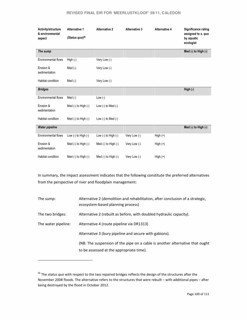
REVISED FINAL EIR FOR ‘MEERLUSTKLOOF’ 59/11, CALEDON
Page 100 of 111
Activity/structure
& environmental
aspect
Alternative 1
(Status quo)46
Alternative 2 Alternative 3 Alternative 4 Significance rating
assigned to s. quo
by aquatic
ecologist
The sump Med (-) to High (-)
Environmental flows High (-) Very Low (-)
Erosion &
sedimentation
Med (-) Very Low (-)
Habitat condition Med (-) Very Low (-)
Bridges High (-)
Environmental flows Med (-) Low (-)
Erosion &
sedimentation
Med (-) to High (-) Low (-) to Med (-)
Habitat condition Med (-) to High (-) Low (-) to Med (-)
Water pipeline Med (-) to High (-)
Environmental flows Low (-) to High (-) Low (-) to High (-) Very Low (-) High (+)
Erosion &
sedimentation
Med (-) to High (-) Med (-) to High (-) Very Low (-) High (+)
Habitat condition Med (-) to High (-) Med (-) to High (-) Very Low (-) High (+)
In summary, the impact assessment indicates that the following constitute the preferred alternatives
from the perspective of river and floodplain management:
The sump: Alternative 2 (demolition and rehabilitation, after conclusion of a strategic,
ecosystem-based planning process)
The two bridges: Alternative 2 (rebuilt as before, with doubled hydraulic capacity).
The water pipeline: Alternative 4 (route pipeline via DR1313)
Alternative 3 (bury pipeline and secure with gabions).
(NB: The suspension of the pipe on a cable is another alternative that ought
to be assessed at the appropriate time).
46 The status quo with respect to the two repaired bridges reflects the design of the structures after the
November 2008 floods. The alternative refers to the structures that were rebuilt – with additional pipes – after
being destroyed by the flood in October 2012.
REVISED FINAL EIR FOR ‘MEERLUSTKLOOF’ 59/11, CALEDON
Page 101 of 111
Mitigation measures are recommended for each of the structures.
Mitigation cannot, however, be divorced from the urgent need to address – at the appropriate
hydro-geomorphological and ecological scales – questions of systematic instability and degradation
that assail the management of the Meerlustkloof and Elandskloof rivers and their agricultural
interface.
Failure to address the latter questions at the right scale will simply perpetuate the instability that has
characterised the response of the two rivers to floods over the past decade.
With this in mind, the aquatic specialist has recommended measures to address cumulative impacts
and the longer-term stabilisation and rehabilitation of the Meerlustkloof and Elandskloof rivers (see
Chapter 8, ‘Strategic river management plan’).
Recommended mitigation and maintenance measures are also reflected in the Final Environmental
Management Programme/Maintenance Plan that has been prepared as part of the Final
Environmental Impact Assessment Report (see Appendix G).
7.5 RECOMMENDATIONS WITH REGARD TO ENVIRONMENTAL AUTHORISATION
Based on the foregoing environmental assessment process, the following alternatives are
recommended for retrospective authorisation insofar as this would be necessary in terms of the
relevant provisions of NEMA:
7.5.1 – Unauthorised excavation of the sump in terms of the 2006 NEMA EIA regulations, subject
to its demolition and rehabilitation by 31 December 2015, in terms the objectives and guidelines
contained in the draft environmental management plan/maintenance management plan that
forms part of this environmental assessment process;
7.5.2 – Unauthorised construction of the two pipe culvert crossings (bridges) over the
Meerlustkloof and Elandskloof rivers in terms of the 2006 and 2010 NEMA EIA regulations; and
7.5.3 – Unauthorised construction of a temporary drift immediately downstream of the damaged
pipe culvert crossing over the Elandskloof River.

REVISED FINAL EIR FOR ‘MEERLUSTKLOOF’ 59/11, CALEDON
Page 102 of 111
Any additional infrastructure, or expansion of existing infrastructure, that exceeds any of the
thresholds prescribed by the three listing notice in the 2010 NEMA EIA regulations will have to be
subjected de novo to the procedures that regulate applications for environmental authorisation
.
Of over-riding importance, however, is the urgent to commence drafting a strategic management
plan for the Meerlustkloof and Elandskloof rivers. See Chapter 8.

REVISED FINAL EIR FOR ‘MEERLUSTKLOOF’ 59/11, CALEDON
Page 103 of 111
8. STRATEGIC RIVER MANAGEMENT PLAN FOR ‘MEERLUSTKLOOF’ 59/11
This Chapter records the findings and recommendations of the freshwater specialist with respect to
the need for a comprehensive, ecosystem-based management plan for the Elandskloof and
Meerlustkloof rivers and their catchments (see Appendix E). The desirability of such a plan is also
supported by the Western Cape Department of Agriculture and CapeNature.
8.1 EFFECTS OF FLOODS AMPLIFIED BY CONDITION OF CATCHMENT AND
FLOODPLAINS
As noted by Dr Day, one of the problems in carrying out the ecological assessments for this section
24G environmental assessment has been the need to separate out the effects of unauthorised
activities on riverine ecosystems from the effects of climate change and natural disasters such as
large-scale flood events. While the various unauthorised activities cannot be blamed for the
extensive disturbance of the river corridor and the large-scale erosion of river bed, bank and
floodplain material that were evident during both the 2012 and 2013 site visits, they are likely to
have contributed to the decreased resilience of the systems, along with the effects of a long history
of infilling of the floodplains, channelization of the rivers and generally reduced flood capacity.
Given the scale of ecological disturbance and the trajectory of ongoing erosion evident in the
Elandskloof and Meerlustkloof Rivers at present, implementation of the mitigation measures
outlined in this report is unlikely to effect any substantial change in river condition or long-term
stability, when viewed against a backdrop of poor long-term land-use management, the effects of
which are triggered episodically by large flood events.
8.2 CRITICAL INFORMATION GAPS THAT COMPROMISE RESILIENCE OF
AFFECTED SYSTEMS
The Elandskloof River in its reaches adjacent to the sump is at present particularly prone to erosion,
threatening the stability of the adjacent bank and upper access road. However, insufficient
information exists at present to provide a useful guide as to the best approach to achieve long-
term stability of the river system in a manner that is compatible with rehabilitation of both
ecological function and structure, while allowing for and securing reasonable levels of agricultural
activity in adjacent areas. This is particularly true in a context where extreme storms are predicted
to become more frequent with global climate change and, given the present levels of degradation
and instability of the above rivers, seemingly throughout their reaches in developed areas, their

REVISED FINAL EIR FOR ‘MEERLUSTKLOOF’ 59/11, CALEDON
Page 104 of 111
present levels of resilience to ongoing hydrological / climatic disturbance is expected to be
particularly low.
8.3 FRAMEWORK STRATEGIC, CATCHMENT-BASED MANAGEMENT OF THE TWO
RIVERS
The following measures are recommended for implementation in the short- to medium term, as part
of a more holistic approach to river management and rehabilitation in the Elandskloof and
Meerlustkloof catchments, and should be seen in part as a mechanism to address the residual and
indirect impacts of both recent unauthorised activities described in this report, and the cumulative
effects of decades of inappropriate land-use, coupled with natural phenomena:
− A river management plan should be compiled for the entire Elandskloof / Meerlustkloof sub
catchments. The plan should provide practical management objectives, strategies and
targets for achieving an ecologically stable riverine system that allows for (and defines)
reasonable agricultural use of surrounding areas, while ensuring the long-term rehabilitation
of the riverine environment to a PES of at least Category C (the assumed pre-impact
condition of the system) in the reaches affected by agricultural activities.
− Adequate hydraulic and hydrological data should be collected to allow for the
development and implementation of a high-confidence rehabilitation strategy for the
Elandskloof and Meerlustkloof Rivers throughout their reaches, such that it allows for at
least the minimum objectives set out in the proposed rehabilitation plan to be practically
achievable, including the establishment of stable, vegetated river banks and corridors, with
adequate setback areas from adjacent agricultural lands to allow for mitigation against
runoff and water quality impacts associated with this kind of land-use, The development of
criteria for such habitats and areas would need to be developed as part of the river
management plan outlined above, which would need to include input from role players such
as biodiversity and conservation officials and specialists, the department of agriculture,
hydrological and geomorphological specialists and local landowners.
− Control measures should be implemented over the timing and rate of abstraction along
the river, both within the present study area and among upstream land users - uncontrolled
ad hoc abstraction by upstream land owners has however also been identified as a
significant issue affecting river management in the lower reaches of the Elandskloof River
(Mr Arrie Grobler, Agrisouth Orchards (Pty) Ltd, pers. comm. to Liz Day, FCG). An audit of
abstraction and impoundment activities in the Elandskloof and Meerlustkloof River

REVISED FINAL EIR FOR ‘MEERLUSTKLOOF’ 59/11, CALEDON
Page 105 of 111
catchments as a whole, and the development of an abstraction plan, that takes into account
both the required ecological reserve for the river systems, and the rights of individual
landowners, is strongly recommended. Such a plan would need to address issues such as the
rate and timing of abstraction throughout the year.
− Ongoing attention should be paid to the removal of weedy aliens from the channel and its
precincts, noting that the highly disturbed nature of the river beds at present mean that they
are particularly vulnerable to invasion
− Current sources of channel destabilisation should be addressed, including piled sediment /
remnants of eroded banks and berms that currently lie within the low flow channel of the
river, and which result in further deflection of flood and base flows onto the adjacent river
bank, contributing to ongoing scour and bank undercutting. Subject to approval from the
WCDA hydrological / hydraulics specialist Mr Hans King, it is recommended that key zones of
such impact should be removed from the channel, and/or reshaped into the river bed and
banks, as appropriate. Included in this activity is the recommendation for the remnant
concrete weir structures to be removed from the channel, at least in so far as they are
resulting in undesirable deflections of flow onto vulnerable river banks.
− Gabion groynes should be designed and installed as and where appropriate, along the
Elandskloof River, such that they provide protection from the ongoing erosion of the river
and the destabilisation of the left and right river banks – groynes should be as designed by
the WCDA hydrological / hydraulics specialist, and their installation should:
o not result in longitudinal lining / hard stabilisation of the river bank, other than at the
groyne structures themselves;
o be carried out in conjunction with a more holistic plan for the river, which allows for the
removal of berms along the river banks, and their replacement on the outer edge of the
river corridor / edge of existing orchards;
o be designed to improve riverine and marginal habitat.
Finally, it is noted that concerns were raised during the source of the present project regarding the
condition of the access road across the eroding Elandskloof River near the sump. Stabilisation of the
river banks in this area should not be driven by the need to maintain this crossing, but should be
driven by the need to effect urgent rehabilitation of the river and reduce erosion. Where necessary,
access to the right hand river bank is available by an existing road higher up the Elandskloof River.

REVISED FINAL EIR FOR ‘MEERLUSTKLOOF’ 59/11, CALEDON
Page 106 of 111
9. PUBLIC PARTICIPATION PROCESS
A detailed Public Participation Process (PPP) was followed for the proposed development, in
terms of the 2010 NEMA EIA Regulations. Refer to Appendix F for a detailed description.
9.1 PUBLIC PARTICIPATION: DRAFT EIR AND EMP
The Draft Environmental Impact Report (EIR) and Draft Environmental Management Programme
(EMP) were made available for public review and comment for a 40-day period from 26 June to 6
August 2012. Comments received during this period were captured and responded to in a
Comments and Response Report attached in Appendix F of this report. Persons who commented
on the report were included in the Interested and Affected Parties register.
9.2 PUBLIC PARTICIPATION: FINAL EIR AND EMP
The Final Environmental Impact Report and EMP were made available for a 21-day period
commenting period from 8 to 30 August 2012. Comments were received from CapeNature and
the Overberg District Municipality. The Final EIR and EMP were submitted to the Department of
Environmental Affairs and Development Planning on 6 September 2012
9.3 DRAFTING OF REVISED FINAL EIR AND EMP FOR A SECOND ROUND OF
COMMENT
The Final EIR was withdrawn and revised following the commencement of additional
unauthorised activities in response to the flood of October 2012.
The section 24G application was also expanded, on the basis of discussions with the Department
of Environmental Affairs and Development Planning, to cater for a wider range of unauthorised
activities that had been undertaken in the wake of flood damage in November 2008. On
November 28, 2012, the Department of Environmental Affairs and Development Planning
indicated that the Final EIR and EMP could be updated and made available as a Revised FEIR and
EMP for a 21-day commenting period.
The current round of public participation is therefore aimed at obtaining comment on the Revised
Final EIR and EMP.

REVISED FINAL EIR FOR ‘MEERLUSTKLOOF’ 59/11, CALEDON
Page 107 of 111
9.4 HOW TO COMMENT ON THE REVISED FINAL ENVIRONMENTAL IMPACT
REPORT
A. Submit all comments/suggestions relating to the Revised Final Environmental Impact
Report to BolandEnviro and the Department of Environmental Affairs and Development
Planning (DEA&DP) at:
Boland Environmental Consultants
Attention: Mr Charl de Villiers
PO Box 250
WORCESTER 6849
Tel: 023 347 0336
Fax: 023 347 5336
Cell: 083 785 0776
Email: <[email protected]>
Department of Environmental Affairs and Development Planning
Attention: Ms Kayleen Fester
Section 24G Unit
Private Bag X9086,
CAPE TOWN 8000
Tel: 021 483 2067
Fax: 021 483 4033
Email: <[email protected]>
B. Quote the reference: E18/2/3/2/2-Ptn 11 farm 59, MEERLUSTKLOOF (s 24FG), Caledon
C. The closing date for comments is 22 May 2013.
Any comments received during this round of public participation will be submitted to the DEA&DP
with the Revised Final EIR and Revised Final EMP. Registered interested and affected parties will
be notified of submission of the Final EIR and Final EMP to the DEA&DP. Electronic copies of the
final documents will be made available for I&APs.
The Applicant and I&APs have a prescribed right to appeal against the decision on the application
by the Competent Authority. All registered IA&Ps will be notified timeously of the decision in the
event that they wish to exercise their right to appeal.

REVISED FINAL EIR FOR ‘MEERLUSTKLOOF’ 59/11, CALEDON
Page 108 of 111
9.5 PROCESS TASKS STILL TO BE COMPLETED
The following tasks have either already been undertaken with respect to public participation or still
need to be concluded:
Release draft EIR & EMP for public review 26 June 2012
Comment period (40 days) on draft EIR & EMP ends 6 August 2012
Update EIR with comment and responses 6 August 2012
Release final EIR and EMP to registered I&APs 13 August 2012
Comment period (21 days) on final EIR & EMP ends 3 September 2012
Update EIR with comment and responses First week Sept 2012
Submit EIR, EMP to DEA&DP for consideration Second week Sept 2012
Final EIR, EMP withdrawn for updating. October 2012
Comment period (21 days) on Revised FEIR and EMP 30 April 2013
Submit revised final documents with I&AP comment 23 May 2013
DEA&DP Acceptance of Report and Issue of Decision Date unknown
I&APs Notification of Decision and appeal process Date unknown
Appoint Environmental Control Officer (ECO) Date unknown
Commence with restoration activities Date unknown
REVISED FINAL EIR FOR ‘MEERLUSTKLOOF’ 59/11, CALEDON
Page 109 of 111
REFERENCES
Aronson J, Floret C, LeFloc’h E, Ovalle C and Pontanier R (1993) Restoration and Rehabilitation of
Degraded Ecosystems in Arid and Semi-Arid Lands. A view from the South. Restoration
Ecology¸ March 1993: 8-17.
Brown C and Fowler J (2000) Breede River Basin Study. Preliminary Assessment of the Breede River
Basin. Southern Waters Report for MBB, Ninham Shand and Jakoet & Associates, for the
Department of Water Affairs and Forestry.
Brownlie S (2005) Guideline for involving biodiversity specialists in EIA processes: Edition 1. CSIR
Report No ENV-S-C 2005 053 C. Republic of South Africa, Provincial Government Western
Cape, Department of Environmental Affairs and Development Planning, Cape Town.
Cairns J (1993) Ecological restoration: Replenishing our national and global ecological capital. In:
Saunders, Hobbs and Ehrlich (eds.) Nature Conservation 3: Reconstruction of fragmented
ecosystems. Virginia Polytechnic Institute and State University, Blacksburg, Virginia, pp. 193-
208.
Day Liz (2012) Section 24G application for rectification of an unauthorised sump on the farm
Meerlustkloof, near Villiersdorp: Specialist comment on freshwater ecosystems. Freshwater
Consulting Group.
Day Liz (2013) Section 24G application for rectification of unauthorised activities on the farm
Meerlustkloof, near Villiersdorp: Specialist comment on freshwater ecosystems. Freshwater
Consulting Group.
De Villiers CC, Brownlie S, Clark B, Day EG, Driver A, Euston-Brown DIW, Helme NA, Holmes PM,
Job N, Rebelo AB (2005) Fynbos Forum Ecosystem Guidelines for Environmental Assessment in
the Western Cape. Fynbos Forum and Botanical Society of South Africa, Kirstenbosch.
DEA&DP (2010) Guideline on Alternatives, EIA Guideline and Information Document Series.
Western Cape Department of Environmental Affairs & Development Planning (DEA&DP).
DEA&DP (2010) Guideline on Need and Desirability, EIA Guideline and Information Document
Series. Western Cape Department of Environmental Affairs & Development Planning
(DEA&DP).
DEA&DP (2010) Guideline on Public Participation EIA Guideline and Information Document Series.
Western Cape Department of Environmental Affairs & Development Planning (DEA&DP).
Department of Environmental Affairs (DEA) (2011) National list of ecosystems that are threatened
and in need of protection. GG 34809 GN R. 1002, 9 December 2011. Government Printer,
Pretoria.

REVISED FINAL EIR FOR ‘MEERLUSTKLOOF’ 59/11, CALEDON
Page 110 of 111
Driver A, Nel JL, Snaddon K, Murray K, Roux DJ, Hill L, Swartz ER, Manuel J and Funke N (2011)
Implementation Manual for Freshwater Ecosystem Priority Areas. Water Research Commission
Report No 1801/1/11, South African National Biodiversity Institute, Pretoria.
Helme N, Holmes P and Rebelo T (2005) Midland and Mountain Fynbos Ecosystems. In: (De
Villiers et al., Fynbos Forum Ecosystem Guidelines for Environmental Assessment in the
Western Cape. Fynbos Forum and Botanical Society of South Africa, Kirstenbosch.
Holloway A and Fortune G (2009) Exposure to severe weather events: A review of recent
experience in the Western Cape. Unpubl. Presentation, Disaster Mitigation for Sustainable
Livelihoods Programme, University of Cape Town, Rondebosch.
Holmes PM, Esler KJ, Richardson DM and Witowski ETF (2008) Guidelines for improved management
of riparian zones invaded by alien plants in South Africa. South African Journal of Botany 74, pp
538-552.
Holness S and Bradshaw P (2010) Critical Biodiversity Areas of the Overberg District Municipality.
Park Planning and Development Unit, SANParks, Port Elizabeth
http://bgis.org/overberg/project.asp
Job, Nancy, Kate Snaddon, Liz Day, Jeanne Nel, Lindie Smith-Adao (2008) C.A.P.E. fine-scale
planning project: AQUATIC ECOSYSTEMS OF THE UPPER BREEDE RIVER VALLEY PLANNING
DOMAIN. Freshwater Consulting Group and Council for Scientific and Industrial Research.
King H (2012a) Hydrological Study of the Meerlustkloof and Elandskloof Rivers, Caledon. Report
prepared by the Western Cape Department of Agriculture, Elsenburg.
King H (2012b) River Maintenance Plans Enrichment Session Report prepared for the Department
of Environmental Affairs and Development Planning on behalf of the Western Cape
Department of Agriculture, Elsenburg.
Kleynhans CJ, Thirion C and Moolman J (2005). A Level I River Ecoregion classification System for
South Africa, Lesotho and Swaziland. Report No. N/0000/00/REQ0104. Resource Quality
Services, Department of Water Affairs and Forestry, Pretoria, South Africa.
Manning J (2007) Field Guide to Fynbos. Struik Publishers, Cape Town.
Maree KS and Vromans DC. (2010) The Biodiversity Sector Plan for the Witzenberg, Breede Valley
and Langeberg Municipalities: Supporting land-use planning and decision-making in Critical
Biodiversity Areas and Ecological Support Areas. Produced by CapeNature as part of the
C.A.P.E. Fine-scale Biodiversity Planning Project. Kirstenbosch.
Margules CR and RL Pressey (2000) Systematic conservation planning. Nature Vol 405: 243-253.
Mucina L, Rutherford MC and Powrie LM (eds.) (2006) The Vegetation Map of South Africa,
Lesotho and Swaziland. Strelitzia 19, South African National Biodiversity Institute, Pretoria.

REVISED FINAL EIR FOR ‘MEERLUSTKLOOF’ 59/11, CALEDON
Page 111 of 111
Nel J L, Murray K M, Maherry A M, Petersen C P, Roux D J, Driver A, Hill L,van Deventer H, Funke
N, Swartz e R, Smith-Adao L B, Mbona N, Downsborough L and & Nienaber S. 2011. Technical
Report for the National Freshwater Ecosystem Priority Areas project. WRC Report No.
1801/2/11. Water Research Commission, Pretoria.
Pence, G. Q.K. (2008) C.A.P.E. Fine-Scale Systematic Conservation Planning Assessment: Technical
Report. Produced for CapeNature as part of the GEF-funded C.A.P.E. Fine-Scale Biodiversity
Planning Project. Cape Town, South Africa.
Preston GR, Robins N and Fuggle RF (1996) Integrated Environmental Management. In Fuggle and
Rabie (eds.) Environmental Management in South Africa. Juta, Kenwyn.
Ralston S, de Villiers C, Manuel J, te Roller K and Pence G (2009) Where are we going? Fine Scale
Systematic Conservation Plans and their Contribution to Environmental Assessment. In:
IAIAsa 2009 National Conference Proceedings, 23-26 August 2009, Wilderness.
Rebelo AG, Boucher C, Helme N, Mucina L and Rutherford MC (2006) Fynbos Biome, in Mucina
and Rutherford (eds.) The Vegetation of South Africa, Lesotho and Swaziland. Strelitzia 19,
South African National Biodiversity Institute, Pretoria.
River Health Programme (2011) State of Rivers Report: Rivers of the Breede Water Management
Area. Department of Water Affairs, Western Cape, Republic of South Africa.
South African National Biodiversity Institute (2009) Further development of a proposed National
Wetland Classification System for South Africa. Primary Project Report (Final Draft). Prepared
by the Freshwater Consulting Group for the South African National Biodiversity Institute
(SANBI).
South African National Biodiversity Institute (SANBI) (2011) SANBI Biodiversity GIS Unit
<http://bgis.sanbi.org>
SRK Consulting (2011) Environmental Management Framework Cape Winelands District
Municipality Environmental Management Framework Report: 2012 to 2017. Draft. Report No.
410438/4.