United States Department of Agriculture Forest Service Northern Research Station Resource Bulletin NRS-84 Urban Trees and Forests of the Chicago Region David J. Nowak Robert E. Hoehn III Allison R. Bodine Daniel E. Crane John F. Dwyer Veta Bonnewell Gary Watson

Welcome message from author
This document is posted to help you gain knowledge. Please leave a comment to let me know what you think about it! Share it to your friends and learn new things together.
Transcript

United StatesDepartment of Agriculture
Forest Service
Northern Research Station
Resource Bulletin NRS-84
Urban Trees and Forests of the Chicago Region
David J. NowakRobert E. Hoehn IIIAllison R. BodineDaniel E. Crane
John F. DwyerVeta BonnewellGary Watson

Visit our homepage at: http://www.nrs.fs.fed.us/
Published by: For additional copies:
U.S. FOREST SERVICE U.S. Forest Service11 CAMPUS BLVD SUITE 200 Publications DistributionNEWTOWN SQUARE PA 19073 359 Main Road Delaware, OH 43015-8640 Fax: (740)368-0152August 2013 Email: [email protected]
Abstract
An analysis of trees in the Chicago region of Illinois reveals that this area has about 157,142,000 trees with tree and shrub canopy that covers 21.0 percent of the region. The most common tree species are European buckthorn, green ash, boxelder, black cherry, and American elm. Trees in the Chicago region currently store about 16.9 million tons of carbon (61.9 million tons CO2) valued at $349 million. In addition, these trees remove about 677,000 tons of carbon per year (2.5 million tons CO2/year) ($14.0 million/year) and about 18,080 tons of air pollution per year ($137 million/year). Chicago’s regional forest is estimated to reduce annual residential energy costs by $44.0 million/year. The compensatory value of the trees is estimated at $51.2 billion. Various invasive species, insects and diseases, and lack of adequate regeneration of certain species currently threaten to change the extent and composition of this forest. Information on the structure and functions of the regional forest can be used to inform forest management programs and to integrate forests into plans to improve environmental quality in the Chicago region. These findings can be used to improve and augment support for urban forest management programs and to integrate urban forests within plans to improve environmental quality in the Chicago region.
Cover Photo
Photo by Antonio Perez, Chicago Tribune, used with permission.
Manuscript received for publication 10 August 2012
Acknowledgments
Thanks go to Gerard T. Donnelly, Ph.D., President and CEO of The Morton Arboretum for commissioning and supporting this project; Beth Corrigan, Angela
Hewitt, and Edith Makra for project coordination; Al Zelaya for outstanding support of i-Tree software; Jeanette McBride for map support; Cherie LeBlanc Fisher for training and procedure consultation; Northeastern Area State and Private Forestry for substantial funding; and to our data collection team: Amy Aghababian, Sarah Akinde, Greg Deresinski, Alec Edwards, Guy Fischer, Eric Injerd, Lisa Maenpaa, Carrie
Tauscher, James Van Someren, Philip Watson, and Evelyn Wisniewski.

Urban Trees and Forests of the Chicago Region
David J. Nowak
Robert E. Hoehn III
Allison R. Bodine
Daniel E. Crane
John F. Dwyer
Veta Bonnewell
Gary Watson
The Authors
DAVID J. NOWAK is a research forester and project leader with the U.S. Forest Service’s Northern Research Station at Syracuse, New York.
ROBERT E. HOEHN III is a forester with the U.S. Forest Service’s Northern Research Station at Syracuse, New York.
ALLISON R. BODINE is a research urban forester with the Davey Institute at Syracuse, New York.
DANIEL E. CRANE is an information technology specialist with the U.S. Forest Service’s Northern Research Station at Syracuse, New York.
JOHN F. DWYER is a research associate with The Morton Arboretum in Lisle, Illinois.
VETA BONNEWELL is a data specialist with The Morton Arboretum in Lisle, Illinois.
GARY WATSON is head of research with The Morton Arboretum in Lisle, Illinois.

Morton Arboretum, used with permission.

CONTENTS
Executive Summary 1
i-Tree Eco Model and Field Measurements 2
Tree Characteristics of the Regional Forest 5
Urban Forest Cover and Leaf Area 12
Air Pollution Removal by Urban Trees 14
Carbon Storage and Sequestration 15
Trees Affect Energy Use in Buildings 18
Structural and Functional Values 19
Street Tree Populations 20
Variation in Urban Forest Structure by County 22
Changing Species Composition and Size Structure 26
Potential Insect and Disease Impacts 28
Potential Loss of Ash Species 31
European Buckthorn Prominence 32
Conclusion 36
Appendices 37
References 98

Page intentionally left blank

1
EXECUTIVE SUMMARY
Trees in the Chicago regional forest can contribute signifi cantly to human health and environmental quality. Th e urban forest resource comprises all trees, both within and outside forested stands. Th is can include boulevard trees, trees planted in parks, and trees that naturally occur in public rights-of-way, as well as trees planted on private or commercial properties. Relatively little is known about this forest resource, what it contributes to society and the economy, and the value of its contributions.
Th e trees and forests of the Chicago region in Illinois are important natural resources that contribute substantially to the environment, human health, and quality of life of the region. Th e value of these contributions are posed to increase in the future, but at the same time mounting threats from insects, disease, invasive species, climate change, development, and changing infrastructure could limit the contributions. Addressing these future challenges is complicated by the diversity of the region’s trees and forests, their dynamic character, the fragmented ownership pattern, and the lack of comprehensive information about the resources. To address these critical information needs, Th e Morton Arboretum undertook an assessment of the Chicago region’s urban forests in collaboration with the U.S. Forest Service. Th is assessment seeks to inform approaches for urban forest management that will inspire the citizens of the region to plant and protect trees and improve the vigor of the urban forest. Th e data reported illustrates important trends and strives to convey the importance of trees to constituencies that may not principally value trees but value the services they provide. Targeting information on the value of the urban forest fosters regional collaboration among the many stakeholders.
To better understand the urban forest resource and its value, the U.S. Forest Service, Northern Research Station, developed the Urban Forest Eff ects (UFORE) model, which is now known and distributed as i-Tree Eco (www.itreetools.org). Information derived from this advances the understanding of the forest resource; improves forest policies, planning and management; provides data to support the potential inclusion of trees within environmental regulations; and determines how trees aff ect the environment and consequently enhance human health and environmental quality in urban and rural areas.
Th e i-Tree Eco model quantifi es forest structure, function, and values. Forest structure is a measure of various physical attributes of the vegetation, including tree species composition, number of trees, tree density, tree health, leaf area, biomass, and species diversity. Forest functions, which are determined by forest structure, include a wide range of environmental and ecosystem services such as air pollution removal and cooler air temperatures. Forest values are an estimate of the economic worth of the various forest functions.
The trees and forests
of the Chicago region
in Illinois are important
natural resources that
contribute substantially
to the environment,
human health, and
quality of
life of the
region.
Photo by ©Mark Donnelly

2
Table 1.—Summary of urban forest features, Chicago region, 2010
Feature Measure
Number of trees 157,142,000
Tree and shrub canopy cover 21.0%
Tree cover 15.5%Most dominant species by:
Number of trees European buckthorn, green ash, boxelder, black cherry, American elm
Leaf surface area silver maple, boxelder, green ash, European buckthorn, black walnut
Trees < 6 inches diameter (%) 73.3%
Pollution removal
Trees 18,080 tons/year ($137 million/year)
Trees and shrubsa 24,170 tons/year ($183 million/year)
VOC emissions 11,976 tons/year
Carbon storage 16.9 million tons ($349 million)
Carbon sequestration 677,000 tons/year ($14.0 million/year)
Building energy reduction $44.0 million/year
Reduced carbon emissions $1.3 million/year
Compensatory value $51.2 billiona Shrub removal estimate is approximate as shrub leaf area parameters were not measured.
To determine the vegetation structure, functions, and values of trees in the Chicago region, a vegetation assessment was conducted during the summer of 2010. For this assessment, 2,076 one-tenth-acre fi eld plots were sampled and analyzed using the i-Tree Eco model. Th is report summarizes results of this assessment (see Table 1).

3
I-TREE ECO MODEL AND FIELD MEASUREMENTS
To help assess the regional forest, data from 2,076 fi eld plots located throughout the Chicago region were analyzed using the Forest Service’s i-Tree Eco (formerly UFORE) model.1 Th is region was defi ned as the city of Chicago and the seven counties surrounding it: Cook, DuPage, Kane, Kendall, Lake, McHenry, and Will (Figure 1). In the analysis, data is presented for the region as a whole as well as the city of Chicago and each of the counties. Cook County is referred to as suburban Cook because it excludes the Chicago city area to avoid redundancy.
Th ough forests have many functions and values, only a few of these attributes can be assessed due to current limited ability to quantify all of these values through standard data analyses. i-Tree Eco uses standardized fi eld data from randomly located plots and local hourly air pollution and meteorological data to quantify forest structure (e.g., species composition, tree density, tree health, leaf area, leaf and tree biomass, species diversity, etc.) and its numerous eff ects, including:
• Amount of pollution removed hourly by the forest, and its associated percent air quality improvement throughout a year. Pollution removal is calculated for ozone, sulfur dioxide, nitrogen dioxide, carbon monoxide, and particulate matter (<10 microns)
• Total carbon stored and net carbon annually sequestered by the forest• Eff ects of trees on building energy use and consequent eff ects on carbon
dioxide emissions from power sources• Compensatory value of the forest as well as the value of air pollution removal
and carbon storage and sequestration• Potential impact of infestations by insects/diseases such as Asian longhorned
beetle, gypsy moth, emerald ash borer, oak wilt, or Dutch elm diseaseFor more information go to www.itreetools.org
Figure 1.—Chicago region, 2010. The striped area is the city of Chicago.
Field Survey Data
Plot Information
• Land use
• Percent tree cover
• Percent shrub
cover
• Percent plantable
• Percent ground
cover types
• Shrub species/
dimensions
Tree parameters
• Species
• Stem diameter
• Total height
• Height to crown base
• Crown width
• Percent foliage
missing
• Percent dieback
• Crown light
exposure
• Distance and
direction to
buildings from trees

4
Since the city of Chicago was analyzed in 20072, the most recent study focused on analyzing the seven counties outside of Chicago with 0.1-acre plots established as a randomized grid within each county. Th e plots were divided among the following counties: suburban Cook (Cook County exclusive of Chicago) (203 plots, 17.9 percent of area), DuPage (192 plots, 8.2 percent of area), Kane (184 plots, 12.9 percent of area), Kendall (187 plots, 7.9 percent of area), Lake (188 plots, 11.5 percent of area), McHenry (188 plots, 15.0 percent of area), and Will (189 plots, 20.9 percent of area). Results from the 2007 Chicago city plots were added to the most recent study plots based on land use classifi cations3 for the Chicago region (city of Chicago = 745 plots, 5.7 percent of area).
All plots were distributed among the following land uses (Figure 2):• Residential (751 plots, 30.1 percent of area) includes areas with single and
multiple family dwellings.• Agriculture (450 plots, 32.9 percent) includes row crops, pasture, and nurseries.• Open space (419 plots, 23.0 percent) includes open land primarily for
conservation such as forest preserves, private hunting clubs and campgrounds, vacant forest and grassland, wetlands and open water such as lakes and rivers. Open water is 20 percent of the area of open space land use and 4.6 percent of the total area.
• Commercial/transportation/institutional (CTI) (456 plots, 14.0 percent) is a group of less prevalent land uses. Commercial land use (57 percent of the group by area) includes manufacturing, mining, and industrial parks. Transportation land use (19 percent of the group by area) includes major highways and associated facilities, aircraft transportation, communications and utility, and waste facilities. Institutional land use (24 percent of the group by area) includes medical, educational, religious, and government facilities.
Field data were collected by the Morton Arboretum personnel through a project known as the “Tree Census.” Data collection took place during the leaf-on season to properly assess tree canopies. Within each plot, data collected included ground and tree cover, shrub characteristics, and individual tree attributes of: species, stem-diameter at breast height (d.b.h.; measured at 4.5 ft.), tree height, height to base of live crown, crown width, percentage crown canopy missing and dieback, and distance and direction to
Morton Arboretum, used with permission
Photo by ©Mark Donnelly
Photo by ©Mark Donnelly
Morton Arboretum, used with permission
Figure 2.—Land use distribution, Chicago region, 2010, for inventoried plots.
Agriculture 32.9%
Residential 30.1%
Open Space 23.0%
CTI 14.0%
Morton Arboretum, used with permissionMorton Arboretum, used with permission

5
residential buildings.4 Trees were defi ned as woody plants with a diameter greater than or equal to 1 inch at breast height (d.b.h.). Some species that would commonly be considered shrubs were classifi ed as trees for this analysis if they met the 1-inch minimum diameter requirement. Measurements of crown dimensions and percentage crown canopy missing and dieback were used to assess leaf surface area of trees.
During data collection, trees sampled in the inventoried plots were identifi ed to the most specifi c taxonomic classifi cation possible. In this analysis, there are trees that have been identifi ed to the species or genus level. In the event that a tree was identifi ed to the species level (e.g., Siberian elm) and other trees of the same genus were sampled, the genera classifi cation (e.g., elm) includes all sampled trees of the genus that could not be classifi ed to a specifi c species level. Trees designated as “hardwood” or “softwood” include the sampled trees that could not be identifi ed as a more specifi c species or genera classifi cation. Since hardwood and softwood are species groups that comprise multiple species and genera, they are not included in the analysis of the most common species. In this report, tree species, genera, or species groups are hereafter referred to as tree species.
To calculate current carbon storage, biomass for each tree was estimated using forest-derived equations5 from the literature and fi eld measured tree data. Since open-grown, maintained urban trees tend to have less biomass than predicted by those forest-derived biomass equations, we adjusted for this diff erence by multiplying by 0.8.5 No adjustment was made for trees found in natural stand conditions. Tree dry-weight biomass was converted to stored carbon by multiplying by 0.5.5
To estimate the gross amount of carbon sequestered annually, average annual diameter growth from appropriate genera, diameter class, and tree condition was added to the existing tree diameter (year x) to estimate tree diameter and carbon storage in year x+1.
Air pollution removal estimates are derived from calculated hourly tree-canopy resistances for ozone, and sulfur and nitrogen dioxides based on a hybrid of big-leaf and multi-layer canopy deposition models.6, 7 As the removal of carbon monoxide and particulate matter by vegetation is not directly related to transpiration, removal rates (deposition velocities) for these pollutants were based on average measured values from the literature8, 9 that were adjusted depending on leaf phenology and leaf area. Particulate removal incorporated a 50 percent resuspension rate of particles back to the atmosphere.10
Eff ect of trees on residential building energy use was calculated based on procedures11 using distance and direction of trees from residential structures, tree height, and tree condition data.
Compensatory values were based on valuation procedures of the Council of Tree and Landscape Appraisers, which uses tree species, diameter, condition, and location information.12
To learn more about i-Tree Eco methods1,13 visit: http://nrs.fs.fed.us/tools/ufore/, or www.itreetools.org.
Morton Arboretum, used with permission

6
TREE CHARACTERISTICS OF THE REGIONAL FOREST
Th e Chicago region has an estimated 157,142,000 trees (standard error [SE] of 10,244,000). Tree and shrub cover in the Chicago region is estimated to be 21.0 percent.14 Based on the fi eld data in conjunction with photo-interpretation, tree cover in the Chicago region is estimated to be 15.5 percent.14
Th e fi ve most common species in the regional forest were European buckthorn (28.2 percent), green ash (5.5 percent), boxelder (5.5 percent), black cherry (4.9 percent), and American elm (3.4 percent) (Figure 3). Th e 10 most common species account for 59.0 percent of all trees; their relative abundance is illustrated in Figure 3. In total, 161 tree species were sampled in the Chicago region; these species and their relative abundance are presented in Appendix I. See Appendix II for more information on species distribution by land use and area.
Th e overall urban tree density in the Chicago regional forest is 60.4 trees/acre. Th e highest density of trees occurs in open space (134.2 trees/ac), followed by residential (69.3 trees/ac) and CTI land (42.5 trees/ac) (Figure 4). Land uses that contain the most trees are open space (51.1 percent of tree population), followed by residential areas (34.6 percent) (Figure 4). More information on the tree species in each land use is given in Appendix II and III.
Total leaf area is greatest in residential (46.6 percent of total tree leaf area) and open space (40.3 percent) land use (Figure 5). Leaf area is a measure of leaf surface area (one side). Leaf area index (LAI) is a measure of the total leaf surface area (one side) divided by land area. As each land use has a diff erent land area, LAI standardizes the canopy depth on an equal area basis. Higher LAIs indicate a greater leaf surface area per acre of land. Land uses that have the highest LAI are open space (1.9) and residential (1.7) (Figure 5).
Figure 3.—Urban tree species composition, Chicago region, 2010.
European buckthorn 28.2%
Green ash 5.5%
Boxelder 5.5%
Black cherry 4.9%
American elm 3.4%
Sugar maple 2.8%
White ash 2.6%
Amur honeysuckle 2.1%
Silver maple 2.0%
Northern red oak 2.0%
other species 41.0%
The five most common
species in the Chicago
regional forest were
European buckthorn,
green ash, boxelder,
black cherry, and
American elm.

7
The overall urban
tree density in the
Chicago regional
forest is 60.4 trees
per acre.
Figure 4.—Number of trees and tree density by land use, Chicago region, 2010.
0
20
40
60
80
100
120
140
0
10
20
30
40
50
60
70
80
90
Open Space Residential CTI Agriculture
Den
sity
(tre
es p
er a
cre)
Num
ber o
f Tre
es (m
illio
ns)
Land Use
Number of treesDensity
Figure 5.—Total leaf area and leaf area index by land use, Chicago region, 2010.
0
0.5
1
1.5
2
2.5
0
200
400
600
800
1,000
1,200
1,400
1,600
Residential Open Space CTI AgricultureLe
af A
rea
Inde
x (L
AI)
Leaf
Are
a (th
ousa
nd a
cres
)
Land Use
Leaf areaLeaf area index
Trees with diameters less than 6 inches account for 73.3 percent of the population (Figure 6). Trees in this diameter class also contain 21.6 percent of the total leaf area. Most of the common trees are relatively small, with the exception of silver maple and northern red oak (Figure 7). Trees that have diameters greater than 18 inches account for 4.8 percent of the tree population, but comprise 32.7 percent of the total leaf area. Th ough these large-diameter trees are a small percentage of the tree population, they are an important part of the regional forest in the Chicago region. Leaf area has a strong correlation with benefi ts that the trees produce for the ecosystem, such as pollution removal.

8
Figure 6.—Percent of total population and leaf area by diameter class, Chicago region, 2010.
0
5
10
15
20
25
30
35
40
45
50
1-3 3-6 6-9 9-12 12-15 15-18 18-21 21-24 24-27 27-30 30+
Prop
ortio
n of
Tot
al P
opul
atio
n (p
erce
nt)
Diameter Class (d.b.h. in inches)
Leaf areaAbundance
Figure 7.—Percent of species population by diameter class for 10 most common tree species, Chicago region, 2010.
urop
ean
buck
thor
nG
reen
ash
Boxe
lder
Blac
k ch
erry
Amer
ican
elm
Suga
r map
leW
hite
ash
Am
ur h
oney
suck
leSi
lver
map
leN
orth
ern
red
oak
0
10
20
30
40
50
60
70
80
1-3
3-6
6-9
9-12
12-1
5
15-1
8
18-2
1
21-2
4
24-2
7
27-3
0
30+
Species
Spec
ies
Popu
latio
n (p
erce
nt)
Diameter Class (d.b.h. in inches)
9
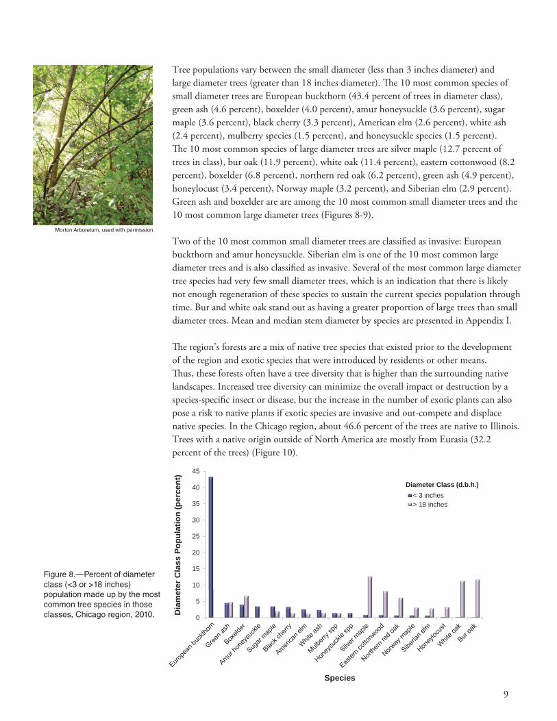
Tree populations vary between the small diameter (less than 3 inches diameter) and large diameter trees (greater than 18 inches diameter). Th e 10 most common species of small diameter trees are European buckthorn (43.4 percent of trees in diameter class), green ash (4.6 percent), boxelder (4.0 percent), amur honeysuckle (3.6 percent), sugar maple (3.6 percent), black cherry (3.3 percent), American elm (2.6 percent), white ash (2.4 percent), mulberry species (1.5 percent), and honeysuckle species (1.5 percent). Th e 10 most common species of large diameter trees are silver maple (12.7 percent of trees in class), bur oak (11.9 percent), white oak (11.4 percent), eastern cottonwood (8.2 percent), boxelder (6.8 percent), northern red oak (6.2 percent), green ash (4.9 percent), honeylocust (3.4 percent), Norway maple (3.2 percent), and Siberian elm (2.9 percent). Green ash and boxelder are are among the 10 most common small diameter trees and the 10 most common large diameter trees (Figures 8-9).
Two of the 10 most common small diameter trees are classifi ed as invasive: European buckthorn and amur honeysuckle. Siberian elm is one of the 10 most common large diameter trees and is also classifi ed as invasive. Several of the most common large diameter tree species had very few small diameter trees, which is an indication that there is likely not enough regeneration of these species to sustain the current species population through time. Bur and white oak stand out as having a greater proportion of large trees than small diameter trees. Mean and median stem diameter by species are presented in Appendix I.
Th e region’s forests are a mix of native tree species that existed prior to the development of the region and exotic species that were introduced by residents or other means. Th us, these forests often have a tree diversity that is higher than the surrounding native landscapes. Increased tree diversity can minimize the overall impact or destruction by a species-specifi c insect or disease, but the increase in the number of exotic plants can also pose a risk to native plants if exotic species are invasive and out-compete and displace native species. In the Chicago region, about 46.6 percent of the trees are native to Illinois. Trees with a native origin outside of North America are mostly from Eurasia (32.2 percent of the trees) (Figure 10).
Morton Arboretum, used with permission
Figure 8.—Percent of diameter class (<3 or >18 inches) population made up by the most common tree species in those classes, Chicago region, 2010. 0
5
10
15
20
25
30
35
40
45
Dia
met
er C
lass
Pop
ulat
ion
(per
cent
)
Species
< 3 inches> 18 inches
Diameter Class (d.b.h.)

10
Figure 9.—Number of trees in diameter class (<3 or >18 inches) made up by the most common tree species in those classes, Chicago region, 2010 0
5,000
10,000
15,000
20,000
25,000
30,000
35,000
Num
ber o
f Tre
es (t
hous
ands
)
Species
< 3 inches> 18 inches
Diameter Class (d.b.h.)
Invasive plant species are often characterized by their vigor, ability to adapt, reproductive capacity, and lack of natural enemies. Th ese factors enable them to displace native plants and threaten natural areas.15 Seventeen of the 161 tree species sampled in the Chicago region are identifi ed on the state invasive species list.16 Th ese species comprise 38.4 percent of the tree population and though considered invasive to Illinois, may cause only minimal impact (Table 2). Th e three most common of these species are European buckthorn (28.2 percent of population), amur honeysuckle (2.1 percent), and black locust (1.9 percent) (Figure 11).
Figure 10.—Percent of total tree population by area of native origin, Chicago region, 2010.
0
10
20
30
40
50
60
Illinois NorthAmerica
Eurasia NorthAmerica +*
Asia Unknown Americas+**
Europe
Tota
l Pop
ulat
ion
(per
cent
)
Area of Native Origin * native to North America and one other continent, excluding South America ** native to North America and South America, and one other continent

11
Table 2.—Inventoried species listed on the Illinois invasive species list, Chicago region, 2010
Scientific Name Common Name % of Popa % of Leaf Area
Rhamnus cathartica European buckthorn 28.2 6.55
Lonicera maackii Amur honeysuckle 2.1 0.48
Robinia pseudoacacia Black locust 1.9 1.93
Ulmus pumila Siberian elm 1.4 3.24
Acer platanoides Norway maple 1.2 3.57
Ailanthus altissima Tree-of-heaven 1.2 0.70
Morus alba White mulberry 1.0 0.84
Acer ginnala Amur maple 0.5 0.16
Frangula alnus Glossy buckthorn 0.3 0.09
Pyrus calleryana Callery pear 0.2 0.14
Populus alba White poplar 0.1 0.62
Maclura pomifera Osage orange 0.1 0.11
Elaeagnus umbellata Autumn olive 0.1 0.09
Euonymus alatus Winged burningbush 0.1 0.01
Elaeagnus angustifolia Russian olive < 0.1 0.02
Corylus avellana European filbert < 0.1 < 0.01
Ligustrum vulgare Common privet < 0.1 < 0.01a % of Pop - Percent of tree population
Figure 11.—Number of trees by species on state invasive species list, Chicago region, 2010. 0
5
10
15
20
25
30
35
40
45
50
Num
ber o
f Tre
es (m
illio
ns)
Species
European buckthorn and amur honeysuckle tend to be small (greater than 70 percent of the trees are less than 3 inches in diameter), but are relatively common. Th ese invasive plants have shifted the composition of the original regional forest from more native large tree species to more small-statured invasive tree species. Th is trend is likely to continue; continued monitoring of the regional forest is needed to track the extent to which this trend continues.

12
URBAN FOREST COVER AND LEAF AREA
Th e Chicago region has a canopy cover of 21.0 percent of which 15.5 percent was made up of tree species and 5.5 percent by shrub species. Common ground cover classes (including cover types beneath trees and shrubs) in the Chicago region include water, bare soil, herbaceous, duff /mulch cover, impervious surfaces (excluding buildings), and buildings. Th e dominant ground cover in the Chicago region include herbaceous (65.2 percent of cover), impervious surfaces excluding buildings (12.6 percent), and buildings (7.6 percent) (Figure 12). Ground covers also vary within each land use. For example, agricultural land uses have a greater percentage of herbaceous ground cover while impervious surfaces and buildings dominate CTI land uses.
Many tree benefi ts are linked to the healthy leaf area of the plant, i.e., the greater the leaf area, the greater the benefi t. In the Chicago regional forest, tree species with the greatest leaf area are silver maple, boxelder, and green ash (Figure 13).
Tree species that contribute a relatively large amount of leaf area per stem (species with percent of leaf area much greater than percent of total population) are bur oak, silver maple, and black walnut. Tree species with mostly smaller individuals are honeysuckle species and European buckthorn (species with percent of leaf area much less than percentage of total population).
Th e importance values (IVs) are calculated using a formula that takes into account the relative leaf area and relative abundance. High importance values do not mean that these trees should necessarily be encouraged in the future, rather these species currently dominate the urban forest structure. Th e species in the regional forest with the greatest IVs are European buckthorn, boxelder, and green ash (Table 3).
Table 3.—Percent of total populationand leaf area, and importance value of species
with the greatest importance values, Chicago region, 2010
Common name %Popa %LAb IVc
European buckthorn 28.2 6.5 34.7
Boxelder 5.5 7.9 13.4
Green ash 5.5 7.1 12.6
Silver maple 2.0 8.3 10.3
Black cherry 4.9 4.8 9.7
American elm 3.4 4.1 7.5
Black walnut 1.6 5.7 7.3
Sugar maple 2.8 3.3 6.1
Northern red oak 2.0 3.7 5.7
Bur oak 1.0 4.7 5.7a %Pop – percent of total tree populationb %LA – percent of total leaf areac IV = %Pop + %LA
In the Chicago regional
forest, tree species with
the greatest leaf area are
silver maple, boxelder,
and green ash.
Morton Arboretum, used with permission

13
Figure 12.—Percent of land use areas covered by ground cover classes, Chicago region, 2010.
0 20 40 60 80 100
Agriculture
CTI
Open Space
Residential
Percent of Land Use
Land
Use
water
bare soil
herbaceous
duff/mulch cover
impervious surfaces(excluding buildings)buildings
Ground Cover Classes
Figure 13.—Percent of total tree population and leaf area for 10 most common tree species, Chicago region, 2010.
0
5
10
15
20
25
30
Silver maple Boxelder Green ash Europeanbuckthorn
Blackwalnut
Black cherry Bur oak Americanelm
Easterncottonwood
Northernred oak
Prop
ortio
n of
Tot
al P
opul
atio
n (p
erce
nt)
Species
Leaf areaAbundance

14
AIR POLLUTION REMOVAL BY URBAN TREES
Poor air quality is a common problem in many urban areas and can lead to human health problems, damage to plants and ecosystem processes, and reduced visibility. Th e urban forest can help improve air quality by reducing air temperature, directly removing pollutants from the air, and reducing energy consumption in buildings, which consequently reduces air pollutant emissions from power plants. Trees also emit volatile organic compounds (VOCs) that can contribute to ozone formation. However, integrative studies have revealed that an increase in tree cover leads to reduced ozone formation.17
Pollution removal by trees in the Chicago region was estimated using the i-Tree Eco model in conjunction with fi eld data and hourly pollution and weather data for the year 2007. Pollution removal was greatest for ozone (O3), followed by particulate matter less than 10 microns (PM10), nitrogen dioxide (NO2), sulfur dioxide (SO2), and carbon monoxide (CO) (Figure 14). It is estimated that trees alone remove 18,080 tons of air pollution (CO, NO2, O3, PM10, SO2) per year with an associated value of $137 million (based on 2007 national median externality costs associated with pollutants18). Th e eff ects of shrub cover in the Chicago region remove an additional estimated 6,090 tons per year ($46 million/year). Th us, tree and shrub cover combined remove approximately 24,170 tons of pollution per year ($183 million/year).
In 2007, trees in the Chicago region emitted 11,976 tons of VOCs (5,827 tons of isoprene, 2,176 tons of monoterpenes, and 3,973 tons of other VOCs). Emissions vary among species based on species characteristics (i.e., some genera such as oaks are high isoprene emitters) and amount of leaf biomass. Forty-seven percent of the region’s
0
10
20
30
40
50
60
70
80
90
0
1
2
3
4
5
6
7
8
CO NO2 O3 PM10 SO2
Valu
e (m
illio
n do
llars
/yea
r)
Pollu
tion
Rem
oved
(tho
usan
d to
ns/y
ear)
Pollutant
Pollution removedValue
Figure 14.—Annual air pollution removal and value by urban trees, Chicago region, 2010.
It is estimated that
in the Chicago
region, trees alone
remove 18,080 tons
of air pollution
per year with an
associated value of
$137 million.
Morton Arboretum, used with permission

15
VOC emissions were from the Quercus and Acer genera (Figure 15). Th ese VOC emissions have a negative eff ect on the environment as they are a precursor chemical to ozone formation. Th us, trees have a negative dollar value associated with these emissions.19
General recommendations for improving air quality with trees are given in Appendix IV.
CARBON STORAGE AND SEQUESTRATION
Climate change is an issue of global concern to many. Th e region’s trees can help mitigate climate change by sequestering atmospheric carbon (from carbon dioxide) in tissue and by reducing energy use in buildings, thus reducing carbon dioxide emissions from fossil-fuel based power sources.20
Trees reduce the amount of carbon in the atmosphere by sequestering carbon in new tissue growth. Th e amount of carbon annually sequestered is increased with healthier and larger diameter trees. Gross sequestration by urban trees in the Chicago region is about 677,000 tons of carbon per year (2.5 million tons per year of carbon dioxide) with an associated value of $14.0 million per year. Net carbon sequestration in the Chicago region is estimated at about 476,000 tons per year (1.7 million tons per year of carbon dioxide) based on estimated carbon loss due to tree mortality and decomposition.
Carbon storage is another way trees can infl uence global climate change. As a tree grows, it stores more carbon by holding it in its accumulated tissue. As a tree dies and decays, it releases much of the stored carbon back into the atmosphere. Th us, carbon storage is an indication of the amount of carbon that can be released if trees are allowed to
0.0 0.5 1.0 1.5 2.0 2.5 3.0 3.5 4.0 4.5
Ulmus
Pinus
Fraxinus
Robinia
Rhamnus
Juglans
Picea
Populus
Acer
Quercus
VOCs Emitted (thousand tons)
Gen
era
IsopreneMonoterpeneOther VOCs
VOCs Emitted
Figure 15.—Annual volatile organic compounds (VOCs) emitted by genera with highest total emissions, Chicago region, 2010.
Morton Arboretum, used with permission

16
die and decompose. Maintaining healthy trees will keep the carbon stored in trees, but tree maintenance can contribute to carbon emissions.21 When a tree dies, using the wood in long-term wood products, to heat buildings, or to produce energy will help reduce carbon emissions from wood decomposition or from fossil-fuel or wood-based power plants. Trees in the Chicago region store an estimated 16.9 million tons of carbon (61.9 million tons of carbon dioxide) (valued at $349 million). Of all the species sampled, bur oak stores the most carbon (approximately 11.7 percent of total estimated carbon stored) and European buckthorn annually sequesters the most carbon (9.1 percent of all sequestered carbon) (Figures 16-17). Trees greater than 30 inches in diameter store the most carbon in the region (Figures 18-19).
0
200
400
600
800
1,000
1,200
1,400
0
10
20
30
40
50
60
70
Europeanbuckthorn
Boxelder Black cherry Silver maple Bur oak White oak Northern redoak
Green ash Easterncottonwood
Black walnut
Val
ue (t
hous
and
dolla
rs/y
ear)
Sequ
estr
atio
n (th
ousa
nd to
ns/y
ear)
Carbon sequestrationValue
0
5
10
15
20
25
30
35
40
45
50
0.0
0.2
0.4
0.6
0.8
1.0
1.2
1.4
1.6
1.8
2.0
Bur oak Silver maple White oak Boxelder Easterncottonwood
Northern redoak
Black cherry Green ash Siberian elm Honeylocust
Val
ue (m
illio
n do
llars
)
Stor
age
(mill
ion
tons
)
Carbon storageValue
Figure 16.—Estimated annual carbon sequestration and value for urban tree species with the greatest sequestration, Chicago region, 2010.
Figure 17.—Estimated annual carbon storage and value for urban tree species with the greatest storage, Chicago region, 2010.
Species

17
0
20
40
60
80
100
120
0.0
0.5
1.0
1.5
2.0
2.5
3.0
3.5
4.0
4.5
5.0
0-3 3-6 6-9 9-12 12-15 15-18 18-21 21-24 24-27 27-30 30+
Tota
l Seq
uest
ratio
n (th
ousa
nd to
ns/y
ear)
Tota
l Sto
rage
(mill
ion
tons
)
Carbon storageCarbon sequestration
0
20
40
60
80
100
120
0
1
2
3
4
5
6
7
0-3 3-6 6-9 9-12 12-15 15-18 18-21 21-24 24-27 27-30 30+
Aver
age
Sequ
estr
atio
n (lb
s/ye
ar)
Aver
age
Stor
age
(thou
sand
lbs)
Diameter Class (d.b.h. in inches)
Carbon storageCarbon sequestration
Figure 18.—Estimated total carbon storage and sequestration by diameter class, Chicago region, 2010.
Figure 19.—Estimated average carbon storage and sequestration by diameter class, Chicago region, 2010.
Trees in the Chicago region
store an estimated 16.9
million tons of carbon.
Morton Arboretum, used with permission

18
TREES AFFECT ENERGY USE IN BUILDINGS
Trees aff ect energy consumption by shading buildings, providing evaporative cooling, and blocking winter winds. Trees tend to reduce building energy consumption in the summer months and can either increase or decrease building energy use in the winter months, depending on the location of trees around the building. Estimates of tree eff ects on energy use are based on fi eld measurements of tree distance and direction to space-conditioned residential buildings.11
Based on average energy costs in 200922, trees in the Chicago region reduce energy costs from residential buildings by an estimated $44.0 million annually (Table 4). Trees also provide an additional $1.3 million in value per year by reducing the amount of carbon released by fossil-fuel based power sources (a reduction of 63,000 tons of carbon emissions or 232,000 tons of carbon dioxide) (Table 5).
Table 4.—Annual monetary savingsa ($) in residential energy
expenditures during heating and cooling seasons, Chicago region, 2010
Heating Cooling Total
MBTUb 20,165,000 n/a 20,165,000
MWHc 1,771,000 22,049,000 23,820,000
Carbon avoided 686,900 623,000 1,309,900a Based on 2009 statewide energy costs22
b MBTU – Million British Thermal Units (not used for cooling)c MWH – Megawatt-hour
Table 5.—Annual energy savings (MBTU, MWH, or tons) due to trees near
residential buildings, Chicago region, 2010
Heating Cooling Total
MBTUa 1,809,500 n/a 1,809,500
MWHb 15,100 187,700 202,800
Carbon avoided (t)c 33,200 30,100 63,300 a MBTU – Million British Thermal Units (not used for cooling)b MWH – Megawatt-hourc To convert carbon estimates to carbon dioxide, multiply carbon value by 3.667
Morton Arboretum, used with permission
Based on average
energy costs in 2009,
trees in the Chicago
region reduce
energy costs from
residential buildings
by an estimated
$44.0 million
annually.

19
STRUCTURAL AND FUNCTIONAL VALUES
Th e region’s forests have a structural value based on the tree itself that includes compensatory value and carbon storage value. Th e compensatory value is an estimate of the value of the forest as a structural asset (e.g., how much should one be compensated for the loss of the physical structure of the tree). Th e compensatory value12 of the trees and forests in the Chicago region is about $51.2 billion (Figure 20). For small trees, a replacement cost can be used; for larger trees, several estimation procedures are used.12 Th e structural value of the forest resource tends to increase with an increase in the number and size of healthy trees.
Forests also have functional values (either positive or negative) based on the functions the trees perform. Annual functional values also tend to increase with increased number and size of healthy trees and are usually on the order of several million dollars per year. Th ere are many other functional values of the forest, though they are not quantifi ed here (e.g., reduction in air temperatures and ultra-violet radiation, improvements in water quality, aesthetics, wildlife habitat, etc.). Th us the functional estimates provided in this report only represent a portion of the total forest functional values. Th rough proper management, urban and rural forest values can be increased. However, the values and benefi ts also can decrease as the amount of healthy tree cover declines.
Urban trees in the Chicago region have the following structural values:• Compensatory value - $51.2 billion• Carbon storage - $349 million
Urban trees in the Chicago region have the following annual functional values:• Carbon sequestration - $14.0 million• Pollution removal - $137 million • Reduced energy costs - $44.0 million
More detailed information on the trees and forests in the Chicago region can be found at http://nrs.fs.fed.us/data/urban. For information on carbon storage, carbon sequestration, and pollution removal by stem diameter class, see Appendix V.
Urban forests
have a structural
value based on
the characteristics
of the trees
themselves.
Urban forests also
have functional
values based on the
ecosystem functions
the trees perform.
Large, healthy,
long-lived trees
provide the greatest
structural and
functional values.
Figure 20.—Tree species with the greatest compensatory value, Chicago region, 2010.
0
1
2
3
4
5
6
7
Bur oak White oak Silver maple Green ash Northernred oak
Europeanbuckthorn
Black cherry Boxelder Easterncottonwood
Honeylocust
Com
pens
ator
y Va
lue
(bill
ions
of d
olla
rs)
Species

20
STREET TREE POPULATIONS
Street trees are defi ned as the trees located on the public right-of-way next to streets and roads.a Street trees are found throughout the Chicago region, with most street trees located in residential (76.0 percent) and CTI (14.5 percent) areas (Table 6). Suburban Cook County, Lake County, and the city of Chicago collectively have 83.2 percent of the street tree population (Table 7).
Th e Chicago region has an estimated 2.3 million street trees. While constituting only 1.5 percent of the region’s tree population, these street trees account for 15 percent of the trees in the city of Chicago (Table 7). Th e number of street trees by species can be found in Appendix III. Th ere is no estimate of street trees for rural Will County as there were no street trees in the inventoried fi eld plots.
a Street trees are located in public rights-of-way, most commonly between the sidewalk and the road. If there are no sidewalks, trees within 30 feet of the center of the road are included as are trees within 10 feet of the curb on boulevards or very wide streets. Note: i-Tree sampling will pick up street trees in a sample, but it is not specifi cally designed to sample street trees (i.e., it is not a sample of streets). In Lake County, two plots had trees along streets adjacent to woodlands that sampled buckthorn and other woodland trees that fell within the street tree defi nition. Th us the relatively large number of street trees in Lake County and buckthorn street trees are likely due to the low proportion of street tree sampled (small sample size) and plots sampling woodland trees along roads.
Table 6.—Street trees by land use, Chicago region, 2010
Percent of
Land Use Number of Trees
Total Population
Population of Street Trees
Population in Land Use
Residential 1,783,100 1.13 76.0 3.3
CTI 340,800 0.22 14.5 2.2
Open Space 222,300 0.14 9.5 0.3
Agriculture - 0.00 0.0 0.0
Total 2,346,200 1.49 100.0 -
Table 7.—Street trees by area, Chicago region, 2010
Street Trees in County/City as a Percent of
Area Number of Street Trees
Total Regional Tree Population
Total Street Tree Population
Total County/City Tree Population
Suburban CookCounty
801,100 0.51 34.1 1.8
Lake County 602,800 0.38 25.7 1.8
City of Chicago 549,800 0.35 23.4 15.3
DuPage County 177,400 0.11 7.6 1.0
McHenry County 104,600 0.07 4.5 0.5
Kendall County 65,700 0.04 2.8 1.3
Kane County 44,800 0.03 1.9 0.5
Will County - - - -
Total 2,346,200 1.49 100.0 -
Morton Arboretum, used with permission

21
Morton Arboretum, used with permission
Th e most common street tree species in the Chicago region are green ash (12.9 percent of street trees), European buckthorn (12.7 percent), and Norway maple (12.2 percent) (Figure 21).
Concerns for the future of Chicago’s regional forest, such as the spread of pest infestations and invasive species, will have a signifi cant impact on the structure of the street tree population. For example, ash trees comprise an estimated 18 percent of the street trees in the region, thus the character of the streets will change dramatically as a result of emerald ash borer infestations.
While street trees may be planted trees, they may also be trees in the street corridor that have established themselves. Trees that establish themselves in street corridors can be a cause for concern in the Chicago region when considering the issue of invasive species. European buckthorn and Norway maple are among the three most common street tree species. Th ey are also listed on the Illinois state invasive species list. Th e development of a strategy (or lack thereof) to control invasive species will further aff ect the character of the region’s street trees.
0
2
4
6
8
10
12
14
Green ash Europeanbuckthorn
Norwaymaple
Honeylocust Silver maple White ash Littleleaflinden
Northernhackberry
Slippery elm Red maple
Stre
et T
ree
Popu
latio
n (p
erce
nt)
Figure 21.—Percent of street tree population of the 10 most common street tree species, Chicago region, 2010.
Species
Ash trees comprise an estimated 18 percent
of the street trees in the region, thus the
character of the streets will change
dramatically as a result of emerald
ash borer infestations.

22
VARIATION IN URBAN FOREST STRUCTURE BY COUNTY
Th e Chicago region in Illinois includes 4,009 mi2 and 8.5 million residents. It has a diverse landscape that is heavily impacted by the city of Chicago with its extensive residential areas, intricate system of infrastructure, and designated open spaces. Th e county areas surrounding Chicago (Lake, DuPage, and suburban Cook) are suburban with extensive residential areas. Counties on the south and western edges (Will, Kendall, Kane, and McHenry) also have substantial agricultural land. Population density ranges from 12,482 people/mi2 in the city of Chicago to 326 people/mi2 in Kendall County, which is highly agricultural (77 percent of land use) and located on the periphery of the region (Figure 22).
Th e highest tree density occurs in the suburban counties: Lake (112 trees/ac), suburban Cook (93 trees/ac), and DuPage (81 trees/ac) (Figure 23). Counties with extensive agricultural areas as well as the city of Chicago have lower tree densities. Suburban Cook County contains the greatest percentage of the regional tree population (27.6 percent), followed by Lake (21.3 percent) and McHenry (14.2 percent) (Table 8). See Appendix III for more information on the tree species in each area.
Th e three most common trees in each county and the city of Chicago (Table 9) are among the 10 most common species of the whole Chicago region (Figure 3) with three exceptions: mulberry, willow species, and white spruce (Table 9). European buckthorn is the most common species in all areas except Kendall County and the city of Chicago. European buckthorn is most common in Lake, McHenry, suburban Cook, and DuPage Counties (greater than 25 percent of the tree population).
Th e number of trees, leaf area, and leaf area index follow a similar pattern by land use classifi cation across the seven counties (Figure 24). Th e suburban counties with a greater percentage of residential and open space land use have larger amounts and higher density of leaf area. Counties with large areas of agriculture and the city of Chicago with a large area of CTI areas have lower values.
Table 8.—Number of trees and percent of total population by area,
Chicago region, 2010
Trees
Area Number % of Popa
Suburban Cook County 43,400,000 27.6
Lake County 33,500,000 21.3
McHenry County 22,300,000 14.2
Will County 21,900,000 13.9
DuPage County 17,300,000 11.0
Kane County 9,900,000 6.3
Kendall County 5,200,000 3.3
City of Chicago 3,600,000 2.3
Chicago Region 157,100,000 100.0a % of Pop – Percent of total tree population
Morton Arboretum, used with permission
Morton Arboretum, used with permission
Morton Arboretum, used with permission

23
0 20 40 60 80 100
Chicago Region - 2,134
Kendall County - 326
McHenry County - 532
Will County - 819
Kane County - 984
Lake County - 1,590
DuPage County - 2,792
Suburban Cook County - 3,413
City of Chicago - 12,482
Percent of Area
Area
ResidentialAgricultureCTIOpen Space
Land se Category
Figure 22.—Percent of area occupied by land use categories, Chicago region, 2010. Population density (people/mi2) is given along y axis.
0
20
40
60
80
100
120
0
5
10
15
20
25
30
35
40
45
SuburbanCook
County
LakeCounty
McHenryCounty
Will County DuPageCounty
KaneCounty
KendallCounty
City ofChicago
Tree
Den
sity
(tre
es p
er a
cre)
Num
ber o
f Tre
es (m
illio
ns)
Area
Number of treesTree density
Figure 23.—Number of trees and tree density by area, Chicago region, 2010.
Tree size also varies by land use and area. Residential areas, particularly in the city of Chicago, had the greatest percent of trees greater than 18 inches diameter compared to other land uses (Appendix VII). Th e city of Chicago also had the greatest percentage of trees greater than 18 inches in open space and CTI categories compared with the counties. Th e relatively large trees in the city of Chicago may refl ect early settlement and establishment of neighborhoods, parks, forest preserves, and other areas.

24
Th e structure of forest resources varies signifi cantly across the Chicago region. Variations in tree and shrub cover within the city of Chicago and the seven counties are evident and vary among land use classifi cations (Table 10). Tree and shrub cover is greatest in residential and open space areas. Cover is less for CTI land uses and is the lowest in agricultural areas. Lake, suburban Cook, and DuPage Counties, which are predominantly residential and open space, have the greatest percentages of tree and shrub cover. Th e counties with the lowest percentage of tree and shrub cover are Will, Kane, and Kendall Counties, which are predominantly agricultural.
Ground cover in each county refl ects the diff erences in population density. Counties with greater population density have more buildings and impervious cover. Herbaceous cover is dominant in suburban Cook and the surrounding counties, but impervious cover dominates in the city of Chicago (Figure 25).
Table 9.—Percent of tree population by area and region for three most common tree
species in each area, Chicago region, 2010
% of Population
Area Common Name Areaa Regionb
City of Chicago white ash 6.2 0.1
mulberry 5.3 0.1
green ash 4.9 0.1
DuPage County European buckthorn 25.4 2.8
boxelder 6.3 0.7
black cherry 6.1 0.7
Kane County European buckthorn 15.4 1.0
boxelder 10.4 0.7
willow 7.4 0.5
Kendall County sugar maple 12.8 0.4
mulberry 7.5 0.2
American elm 6.2 0.2
Lake County European buckthorn 40.9 8.7
green ash 5.0 1.1
white spruce 4.8 1.0
McHenry County European buckthorn 35.7 5.1
boxelder 7.0 1.0
black cherry 6.0 0.9
Suburban Cook County European buckthorn 31.1 8.6
black cherry 6.0 1.6
boxelder 5.3 1.5
Will County European buckthorn 12.9 1.8
sugar maple 12.7 1.8
green ash 12.4 1.7a Percent of total population in area (e.g., 6.2 percent of trees in the city of Chicago are white ash).b Percent of regional tree population (e.g., 0.1 of the region’s trees are white ash in the city of Chicago).
The highest tree
density occurs
in the suburban
counties. Counties
with extensive
agricultural areas
as well as the city
of Chicago have
lower tree densities.

25
0
0.2
0.4
0.6
0.8
1
1.2
1.4
1.6
1.8
2
0
100
200
300
400
500
600
700
SuburbanCook County
Lake County McHenryCounty
Will County DuPageCounty
Kane County KendallCounty
City ofChicago
Leaf
Are
a In
dex
(LA
I)
Leaf
Are
a (th
ousa
nd a
cres
)
Area
Leaf areaLeaf area index
Figure 24.—Total leaf area and leaf area index by area, Chicago region, 2010.
Table 10.—Percent tree and shrub cover14 by area and land use, Chicago region, 2010
Residential Agriculture Open Space CTI TotalPopulation Density
(people/mi2)
City of Chicago 23.9 - 29.8 7.0 18.9 12,482
Suburban Cook County 30.4 6.8 49.6 9.1 29.2 3,413
DuPage County 36.7 12.0 32.5 12.6 28.6 2,792
Lake County 43.0 7.8 34.8 14.2 31.6 1,590
Kane County 36.0 1.7 25.6 10.9 13.4 984
Will County 30.1 2.7 31.4 9.2 15.4 819
McHenry County 43.1 4.1 37.3 9.3 20.4 532
Kendall County 19.2 1.9 48.5 7.7 8.7 326
Chicago Region 21.0 2,134
0 50 100
Chicago Region - 2,134
Kendall County - 326
McHenry County - 532
Will County - 819
Kane County - 984
Lake County - 1,590
DuPage County - 2,792
Suburban Cook County - 3,413
City of Chicago - 12,482
Percent of Area
Area
water
bare soil
herbaceous
duff/mulch cover
impervious surfaces(excluding buildings)
buildings
Ground Cover Classes
Figure 25.—Percent of areas covered by ground cover classes, Chicago region, 2010. Population density (people/mi2) is provided along y axis.

26
CHANGING SPECIES COMPOSITION AND SIZE STRUCTURE
Change in species composition and tree size structure of the Chicago regional forest will likely have a signifi cant infl uence on the benefi ts provided by the regional forest for the next several decades. Th ese changes are likely to require a diff erent approach in aspects of forest management strategies that aff ect species composition, including pest management, regeneration, and restoration eff orts. Recent research reveals that urban forests are declining nationally at a rate of about 4 million trees/year with tree and shrub cover in Chicago dropping about 0.5 percent between 2005 and 2009.23
While we do not have comparable forest resource inventory information for previous years to examine past trends, we can look at the size and structure of the present forest for indications of the possible future forest. In the future, replications of the i-Tree inventory and assessment will provide the basis for assessing trends in the forest resource, its management, and the benefi ts that it provides.
Th e future forest will be determined, in part, by the trees that are currently part of the forest. Younger trees will grow to larger sizes and the older trees will eventually decline and die. By comparing the species structure of smaller (young) trees with that of the larger (older) trees, we can predict the change in the species composition and size structure of the forest over time. Other factors that will infl uence future forest structure include insects, disease, land use changes, climate change, changing infrastructure, and natural resource management.
Species that make up signifi cant portions of the large tree population in the present forest, but are not as common among the younger trees, are likely to be less common in the future forest. Th ese species include silver maple, white oak, bur oak, eastern cottonwood, northern red oak, boxelder, Norway maple, honeylocust, and Siberian elm (Figures 8, 9). Given the relatively large sizes of trees of these species, and the likelihood that they will not be as abundant in the future forest, we might expect some decrease in the overall tree size and the benefi ts that the forest provides. Long-lived large trees are
Morton Arboretum, used with permission

27
essential elements in a healthy vigorous urban forest given their especially high potential to sequester carbon, remove air pollution, and moderate high temperatures through shading and evapotranspirational cooling.
Species that make up a larger proportion of the small trees than large trees include European buckthorn, amur honeysuckle, black cherry, sugar maple, American elm, ash, and mulberry. Th ese species tend to be prolifi c seeders that have become established in open areas and corridors throughout the region. We can expect these species to be more common in the future forest, but there will be exceptions. Not all of these species will become large; we can expect ash to succumb to emerald ash borer, and elm to succumb to Dutch elm disease. In addition, some of these species will not attain a large stature (e.g., buckthorn, honeysuckle). Other problems may emerge to aff ect the growth and development of other species in the future.
Trends in size by species are due, in part, to several factors. Large trees that often pre-date urbanization, such as oaks, are approaching the end of their lifespans. Native ash trees are rapidly being lost to emerald ash borer, while other large tree species are subject to emerging pests and pathogens
such as Asian longhorned beetle, thousand cankers disease, and bur oak blight. In many cases, trees planted since urbanization have not yet attained large sizes and conditions are not good for regeneration of a number of important species such as the oaks. A shift in dominance from larger tree species, such as oaks and ashes, toward small, short-lived, nonnative and opportunistic species (e.g., European buckthorn) would have important implications for the future of the forest and its management.
Species composition and size structure vary by land use classifi cation (Table 11). Among the species that comprise the large trees (greater than 18 inches in diameter), silver maple is the most common in residential areas, but northern red oak ranks fi rst in CTI areas, boxelder fi rst in agricultural areas, and bur oak fi rst in open space areas.
Within the small tree category (1 to 3 inches in diameter), European buckthorn ranks fi rst in abundance in all land uses. It is followed by green ash in residential areas, black cherry in open space areas, tree-of-heaven in CTI, and mulberry in agricultural areas.
While large tree species are common among street tree plantings, street trees comprise only about 1.5 percent of the total tree population. Th us, street tree plantings are not frequent or numerous enough to help sustain the population of trees that achieve large sizes. Although street trees are visually prominent, they are not highly signifi cant on the regional scale. Open spaces (51.5 percent of trees) and residential lots (34.6 percent of trees) are the dominate land uses that support more than 85 percent of the tree population and leaf area, and their associated benefi ts. To sustain the composition of large trees, regeneration of species that become large, either through natural regeneration or tree planting, needs to be facilitated in the Chicago region, particularly in open space and residential lands.
Morton Arboretum, used with permission

28
Insect and Disease Impacts
Insects and diseases can infest urban forests, potentially killing trees and reducing the health, value, and sustainability of the urban forest. Various pests have diff erent tree hosts, so the potential damage or risk of each pest will diff er. Twenty-nine exotic insects/diseases were considered for their potential impact using range maps of these pests in the coterminous United States (www.foresthealth.info).24 For a complete analysis of the 29 exotic insects/diseases, see Appendix VI.
Although there are numerous pests that could impact Chicago’s regional forest, Asian longhorned beetle (ALB), gypsy moth (GM), emerald ash borer (EAB), oak wilt (OW), and Dutch elm disease (DED) pose the most serious threats based on the number of trees at risk to infestation.
Th ese fi ve insects or diseases pose a threat because they currently exist or have existed (ALB has been eradicated) within the Chicago region. If ALB reinfests the Chicago region and the infestation goes unchecked, the eff ects to the forests could be devastating with a potential loss greater than 41.6 million trees (greater than one-fourth of the forest; $17.4 billion in compensatory value). Potential loss of trees from GM is 17.7 million ($18.5 billion in compensatory value), EAB is 12.7 million ($4.2 billion in compensatory value), OW is 9.0 million ($16.0 billion), and DED is 8.2 million ($1.6 billion) (Figure 26).
Table 11.—Three most common small and large tree species in each land use classification,
Chicago region, 2010
Stem Diameter 1-3 in Stem Diameter >18 in
SpeciesNumber of
Trees % of Popa SpeciesNumber of
Trees % of Popa
Agriculture 3,324,180 353,724
European buckthorn 1,484,771 45% Boxelder 148,232 42%
Mulberry spp 380,140 11% White oak 61,617 17%
Ginkgo 172,176 5% Bur oak 42,213 12% CTI 8,739,710 525,549
European buckthorn 3,639,424 42% Northern red oak 46,744 9%
Tree-of-heaven 815,705 9% White oak 44,775 9%
Sugar maple 780,027 9% Green ash 43,679 8% Open Space 40,196,575 2,625,955
European buckthorn 18,083,258 45% Bur oak 531,994 20%
Black cherry 2,061,360 5% Eastern cottonwood 470,706 18%
Amur honeysuckle 2,047,861 5% White oak 315,923 12% Residential 23,658,163 3,954,961
European buckthorn 9,725,630 41% Silver maple 705,523 18%
Green ash 1,379,618 6% White oak 427,188 11%
Boxelder 1,172,484 5% Bur oak 266,418 7%a % of Pop – percent of tree population in land use by stem diameter class
Emerald ash borer
Photo by David Cappaert
Michigan State University,
www.invasive.org

29
Table 12 shows the current status of the fi ve insects/diseases in the Chicago region.24 Th e magnitude of threat varies by county/area (Figure 27) and land use (Figure 28), with the most signifi cant risk being in suburban Cook and Will Counties and in open space areas from ALB.
Th ese fi ve insects and diseases threaten common trees such as willow, poplar, ash, birch, maple, oak, and elm (Appendix VI). Of the 10 most common tree species, the only species not threatened by these insects and diseases are European buckthorn (an invasive species that comprises 28.2 percent of the total tree population), black cherry (the fourth most common species and 4.9 percent of the population), and amur honeysuckle (the eighth most common species, 2.1 percent of the population, and another invasive species).
Figure 26.—Number of trees at risk and associated compensatory value for five most threatening insects/diseases, Chicago region, 2010. See text for explanation of acronyms.
0
2
4
6
8
10
12
14
16
18
20
0
5
10
15
20
25
30
35
40
45
ALB GM EAB OW DED
Com
pens
ator
y Va
lue
(bill
ions
of d
olla
rs)
Num
ber o
f Tre
es (m
illio
ns)
Insect/Disease
Trees at riskCompensatory value
Table 12.—Presencea of the most threatening pests, Chicago region, 2010
Area ALBb GM EAB OW DEDc
Cook Countyd
DuPage County
Kane County
Kendall County
Lake County
McHenry County
Will Countya Red indicates pest occurs within county; orange indicates pest is within 250 miles of the county edgeb See text for explanation of acronyms.c Range of Dutch elm disease is based on native range of American elmd Includes the city of Chicago
Asian longhorned
beetle
Photo by Kenneth R. Law
USDA APHIS PPQ, www.invasive.org
Ed Hedborn, Morton Arboretum, used with permission

30
Symptoms of Dutch elm disease. Joseph O'Brien, U.S. Forest Service
Figure 27.—Number of trees at risk to the five most significant insects/diseases by area, Chicago region, 2010. See text for explanation of acronyms.
Figure 28.—Number of trees at risk to the five most significant pest threats by land use, Chicago region, 2010. See text for explanation of acronyms.
0
2
4
6
8
10
12
City ofChicago
SuburbanCook
County
DuPageCounty
KaneCounty
KendallCounty
LakeCounty
McHenryCounty
Will County
Num
ber o
f Hos
t Tre
es (m
illio
ns)
Area
ALB GM EABDED OW
Insect/Disease
0
5
10
15
20
25
Agriculture CTI Open Space Residential
Num
ber o
f Hos
t Tre
es (m
illio
ns)
Land Use
ALB GM EABDED OW
Insect/Disease

31
Potential Loss of Ash Species
It is likely that the most profound change in the Chicago regional forest over the next 10 years will be the loss of nearly all of the 13 million ash trees (all ash species) to the emerald ash borer. Ash is a signifi cant tree in the Chicago region (Table 13). It is found in all land use categories and since it can attain a fairly large size, it can be a key component of the landscape. Th e contribution of ash to improving the urban environment is substantial in that it ranks fi rst in leaf area among species in the region and second only to buckthorn in number of trees and number of trees with a stem diameter between 1 and 3 inches. Ash is a prolifi c seeder and its winged seeds can scatter across signifi cant distances. Its high ranking in number of trees is most likely due to its prolifi c seeding habits.
Since ash grows well in urban areas, it is often planted along streets and in residential and CTI areas (Table 14). Among Chicago region street trees, ash (white and green) is the most common genus and makes up 18 percent of the total, second only to maple (Figure 21). Th irty-three percent of ash trees are large (greater than 18 inches diameter), a high proportion for street trees. Land use classifi cations with the highest percentage of large ash trees are CTI (7.7 percent) and residential areas (7.3 percent) across the region. Th is distribution may be due to past planting of ash trees in transportation corridors, in residential and commercial areas, and on corporate campuses, hospital grounds, and at schools. Overall, ash ranks seventh among all species in the region in terms of percent of trees with stem diameter greater than 18 inches.
Table 13.—Ash measurements, Chicago region, 2010
Parameter Units Value % of Total Region Rank
Population number 12,692,249 8.08 2
Density trees/acre 4.88 -- 2
Carbon stored tons 894,589 5.30 7
Carbon sequestered tons/year 42,824 6.32 3
Net carbon sequestered tons/year 32,433 6.81 3
Leaf area acres 271,878 9.57 1
Leaf biomass tons 76,465 8.10 2
Trees, diameter 1-3 in number 5,323,587 41.95a 2
Trees, diameter >18 in number 479,400 3.78a 7
Street trees number 422,662 18.01b 1
Street trees, diameter >18 in number 137,301 33.00c 1a Percent of all ash treesb Percent of all street treesc Percent of ash street trees
Table 14.—Ash trees by land use, Chicago region, 2010
Land Use Number of
TreesDensity
(trees/ac)% of All Trees in Land Use
% of Ash Trees in Land Use with d.b.h. > 18 in
Agricultural 74,724 0.1 1.1 0.0
CTI 724,326 2.0 4.7 7.7
Open Space 7,011,331 11.7 8.7 1.0
Residential 4,881,868 6.2 9.0 7.3
Chicago Region 12,692,249 4.8 8.08 3.8
Illinois Department of Agriculture

32
Th e expected loss of ash species to EAB will have a signifi cant impact on the forest across the entire region (Table 15). Ash is commonly found in association with other species, so the eff ect of its loss will be somewhat diff use. Th e impact may be especially great in cities where green ash has traditionally been planted due to its ability to do relatively well in harsh urban environments. In some residential areas and along transportation routes, the loss of ash will be a signifi cant loss of tree cover because large ash trees are a major portion of the landscape. Tree removal costs will be substantial for municipalities and residents. It will be important to identify other species that can fi ll the important role that ash has played in the Chicago regional forest in order to sustain the urban forest and the important benefi ts that it provides. Th is will include improving diffi cult sites so that a wider range of species can be planted and guarding against catastrophic losses of important species such as ash.
European Buckthorn Prominence
Since European buckthorn is so common in the Chicago region, it is important to understand its current distribution, its rank relative to other trees in the region, and its spread as an invasive species.
DistributionEuropean buckthorn is the most common species in the Chicago region based on the number of individual trees (28.2 percent of the total tree population). It is also the most dominant species in all land use categories in terms of number of trees. European buckthorn ranges from 24 percent of the total number of trees in residential to 34 percent in agricultural areas (Appendix II, Fig. 30). Th e variation in density of European buckthorn in diff erent land uses (Table 16) refl ects the overall diff erence in the number of trees in each land use. Despite its dominance in the region as a whole, it is not the most common tree in all parts of the region, particularly in the city of Chicago. It also comprises a lower proportion of the tree population in rural Kane, Kendall, and Will Counties.
Th e large number of European buckthorn trees could be the result of several diff erent scenarios: a few areas with an extremely high number of trees; many areas with a small number of trees; or a combination of both. European buckthorn can form very dense stands of trees. Th e highest density of European buckthorn trees in a plot recorded
Table 15.—Ash trees by county, Chicago region, 2010
County/Area Number of Trees Density (trees/ac) % Trees in Area
City of Chicago 407,380 2.8 11.3
Suburban Cook County 3,240,664 7.0 7.5
DuPage County 1,539,986 7.2 8.9
Kane County 180,746 0.5 1.8
Kendall County 221,619 1.1 4.2
Lake County 3,020,392 10.1 9.0
McHenry County 1,228,076 3.1 5.5
Will County 2,853,386 5.3 13.0
Veta Bonnewell, Morton Arboretum, used with permission

33
in this study was 920 trees per acre. Nine percent of the study plots with European buckthorn had a density of greater than 500 trees/acre, while 53 percent had a density of 10 to 100 trees/acre.
Th e highest density of European buckthorn for the entire region occurs in the open space land use (41 trees/ac). In general, the counties with the lowest human population density and with the most agriculture (Kendall and Will) have the lowest density of European buckthorn (Table 17). However, the density of European buckthorn in McHenry County (20.4 trees/ac), a rural county, is closer to the density of the suburban counties (20.6 to 45.8 trees/ac) rather than the density in other rural counties (4.2 to 15.4). Th e distribution of European buckthorn in McHenry is unusual in that the density in residential land use is the highest of any county (34 trees/ac). Th e density in McHenry is also higher in the open space land use (50 trees/ac) than in other rural counties (24 trees/acre). Th is suggests thatsome factor in addition to land use is important in European buckthorn distribution in the region.
Table 16.—Characteristics of European buckthorn by area, Chicago region, 2010
AreaDensity
(trees/acre) % of Popa % Leaf Areab
City of Chicago 1.1 4.4 0.7
Suburban Cook County 28.9 31.1 7.9
DuPage County 20.6 25.4 4.2
Kane County 4.6 15.4 1.9
Kendall County 1.1 4.2 0.6
Lake County 45.8 40.9 12.0
McHenry County 20.4 35.7 7.2
Will County 5.2 12.9 3.7
Chicago Region 17.0 28.2 6.5a % of Pop – Percent of tree population in the area. For example, European buckthorn is 4.4% of all the trees in the city of Chicagob % Leaf Area – Percent of leaf area in the area. For example, the leaf area of European buckthorn is 0.7% of the leaf area in the city of Chicago
Table 17.—Density of European buckthorn density by land use, Chicago region, 2010
Agricultural (trees/ac)
CTI (trees/ac)
Open Space (trees/ac)
Residential (trees/ac)
All Land Use (trees/ac)
Chicago Region 2.8 12.5 40.9 16.4 17.0
Counties grouped by population density
Urban (Chicago) - 0.8 5.2 0.0 1.1
Suburban (DuPage, Lake, suburban Cook) 25.7 22.1 61.0 19.0 32.3
Rural (Kane, Kendall, McHenry, Will) 1.1 0.0 24.0 16.6 8.5
Counties grouped by geographic location
North (Lake, McHenry) 7.1 45.7 64.4 23.8 31.4
Middle (Kane, DuPage, suburban Cook, Chicago) 3.5 7.7 40.1 14.4 16.8
South (Will, Kendall) 0.0 0.0 9.8 12.6 4.1

34
One such factor aff ecting the distribution of European buckthorn may be geographic location. When the counties are grouped into three clusters roughly based on their north-south geographic positions, the density of European buckthorn decreases across all land use types moving from north to south (Table 17). Th is suggests that there may have been a pattern of introduction and spread of the species from north to south.
Importance and ValueWhile European buckthorn is a common tree in the Chicago region, its importance depends on which characteristic is being evaluated. European buckthorn comprises 28 percent of stems (i.e., the most common), yet it has 2.4 percent of the total carbon stored by trees. Table 18 shows where European buckthorn ranks relative to other species in the Chicago region based on several parameters. Th e rankings refl ect how tree size is related to the measured characteristic. European buckthorn is a small tree with 95 percent of the trees having a stem diameter less than 6 inches and almost none greater than 12 inches. European buckthorn is the fourth most important species when ranked in order of the amount of leaf area (Table 3). Th e top three trees ranked by leaf area are silver maple, box elder, and green ash (Figure 13). Th ese three are common trees that can grow to a much greater size (Figure 8). Since these species have lower numbers but higher leaf surface area than European buckthorn, they have a greater average leaf area per tree. Related to the large leaf area, European buckthorn annually sequesters the most carbon (9.1 percent of the total estimated carbon sequestered). However, more carbon is stored by trees with larger trunks, so European buckthorn is not the top species for carbon storage.
Compensatory value is an estimate of the monetary value of a tree calculated from the cost of a tree of replaceable size. Using the estimate of the compensatory value, European buckthorn ranks as the sixth most valuable species. Awareness of the invasiveness of European buckthorn has increased since the data used for compensatory value calculations were published in 1994. Th us considering the invasive characteristics of this species, the compensatory value estimate is likely to be overestimated.
Other values can be calculated based on the various functions that a tree performs as discussed in the section “Structural and Functional Values.” Invasiveness is not a factor in these calculations and because the species is so common, European buckthorn ranks high among all species in many of these parameters (Table 18).
Table 18.—European buckthorn as percent of total and rank relative
to other species, Chicago region, 2010
Parameter Percent of Total Rank
Number of trees 28.2 1
Carbon Sequestered 9.1 1
Net Carbon Sequestered 12.0 1
Carbon Stored 2.4 12
Leaf Area 6.5 4
Leaf Biomass 3.9 9
Compensatory Value ($) 4.3 6

35
Invasive Species IssuesAs indicated by its common name, European buckthorn is not native to this area. It was imported to the region25 in the mid-1800s as an ornamental. Its rapid growth to produce dense thickets and tolerance of many soil and light conditions were attractive features. However, these same features combined with rapid reproduction from seed distributed by birds allowed European buckthorn to spread into natural areas. By the 1930s the nursery industry recognized the problem and stopped widespread sales of the plant.25
Since European buckthorn is not native to Illinois, its high density in open space land illustrates the invasiveness of this species through natural regeneration. In 1923 Joy Morton collected European buckthorn on the Morton Arboretum grounds in DuPage County with a note that it was “spontaneous.” Th us, the current distribution of European buckthorn in the Chicago region is the result of at least 80, and quite likely more than 100, years of natural reproduction in the region. Th e pattern of distribution in the region suggests that the initial planting and/or subsequent reproduction have been successful in the residential and open spaces in suburban areas.
After so long a time, has the European buckthorn population reached a state of equilibrium, at least in some parts of the region? Extensive tree data in Chicago, suburban Cook, and DuPage Counties were collected in 1994.26 Since then, the number of European buckthorn trees has decreased 32 percent in the city of Chicago. For both suburban Cook and DuPage Counties the number of European buckthorn trees was 2.5 times greater in 2010 than in 1994. Th is suggests that there is the potential for further increase in the numbers of European buckthorn if development occurs in more rural areas where numbers are currently lower.
European buckthorn has long been known to be invasive and its removal from some natural areas, while locally signifi cant, appears to have had little impact in distribution across the region. Th is suggests that a signifi cant coordinated eff ort would be required to reduce the overall magnitude of the species in the region. Th e counties where European buckthorn is not as prevalent may be able to institute policies and actions to limit its impact as suburbanization occurs.

36
CONCLUSION
Th e Chicago regional forest contributes signifi cantly to the environment, the economy, and residents' well-being. From the core of the city to the agricultural areas on the periphery, 157,142,000 trees, representing 161 species, provide a canopy cover of 15.5 percent across the region. Th at canopy, and particularly leaf surface area, provides a wide range of important environmental benefi ts including air pollution removal, reduced carbon emissions, carbon storage and sequestration, and reduced energy use for buildings, among many other contributions.
Th ere are a number of forces for change that are likely to have major, mostly negative, impacts on the region’s forest structure, health, and the environmental benefi ts provided to the region’s 9 million residents. Th ese forces include insects and disease infestation, invasive trees and other plants, land use change, changing infrastructure, aging and loss of larger trees, expansion of opportunistic species, and changes in the management and use of the forest. Th ese forecasted changes have prompted three Morton Arboretum researchers to characterize the Chicago region’s forest as being in a “transitional state” in a recent scientifi c paper.27 Many of the possible transition scenarios would reduce the vitality and sustainability of the forest and signifi cantly reduce the benefi ts provided.
To sustain and enhance the forest and the benefi ts it contributes amidst these major challenges, a comprehensive and integrated management strategy must be developed and implemented across the region. Th e strategy—the Regional Trees Initiative—will serve as a collaborative action roadmap to conserve, protect, enhance, and sustain the region’s forest. A coalition of organizations that can infl uence, or are infl uenced by, the regional forest and the benefi ts that it provides will be critical to the strategy. Th e coalition members will come from diverse areas of the public, private, not-for-profi t, and community sectors and will work together to better understand, communicate, and address the benefi ts and challenges of the region’s forest. Scientifi c knowledge, combined with current and future threats and forecasted forest conditions, will inform goals, opportunities, and the promise of collaborative management.
Th e primary goal of the Regional Trees Initiative is to achieve meaningful and sustained tree and forest improvements for the Chicago region resulting in substantial sustained improvements in environmental quality and human health and well-being. Th e development and implementation of the Regional Trees Initiative will inspire residents, landowners, and communities to plant and protect trees, and provide stewardship to ensure the incredible resources our trees provide. Th ese inspired stakeholders are the critical owners of our future forest and, as such, will serve as the ambassadors for this important eff ort.
Th e “Tree Census” and analysis summarized here are the platform on which to build the strategy—taking action for the benefi t of the entire Chicago region and beyond.
Morton Arboretum, used with permission

37
APPENDIX I. SPECIES SAMPLED IN THE CHICAGO REGIONAL FOREST
Table 19.—Speciesa sampled in the urban forest, Chicago Region, 2010
Genus Species Common NameNumber of
TreesPop%
Leaf Area
% IVb
Median stem d.b.h.
(in)
Avg. stem d.b.h. (in)
Basal Area(ft2)c
Structural Value
($ Millions)
Abies balsamea balsam fir 205,390 0.1 0.1 0.2 3.6 3.7 20,612 10.2
Acer ginnala amur maple 744,480 0.5 0.2 0.7 3.3 3.8 98,638 65.0
Acer negundo boxelder 8,597,890 5.5 7.9 13.4 4.4 6.7 4,049,814 1,773.5
Acer nigrum black maple 69,910 0.0 0.0 0.0 1.6 2.3 4,213 6.6
Acer palmatum Japanese maple 36,060 0.0 0.0 0.0 2.5 2.6 2,030 1.6
Acer platanoides Norway maple 1,858,800 1.2 3.6 4.8 5.7 8.6 1,319,139 1,397.9
Acer rubrum red maple 340,290 0.2 0.7 0.9 13.2 13.6 504,705 566.3
Acer saccharinum silver maple 3,209,940 2.0 8.3 10.3 10.6 13.3 5,497,028 4,330.8
Acer saccharum sugar maple 4,457,170 2.8 3.3 6.1 2.5 4.2 1,149,169 1,627.8
Acer species maple spp 1,980 0.0 0.0 0.0 19.5 19.5 4,328 4.9
Acer x freemanii Freeman maple 280,470 0.2 0.3 0.5 4.1 4.3 39,109 31.3
Aesculus glabra Ohio buckeye 64,160 0.0 0.2 0.2 8.8 17.6 179,716 149.7
Aesculus hippocastanum horsechestnut 40,250 0.0 0.0 0.0 3.5 3.2 3,293 1.6
Aesculus species buckeye spp 4,020 0.0 0.0 0.0 3.0 5.5 977 0.9
Ailanthus altissima tree-of-heaven 1,830,940 1.2 0.7 1.9 3.1 4.2 341,516 186.4
Alnus glutinosa European alder 382,610 0.2 0.2 0.4 3.0 4.1 69,725 52.4
Amelanchier arborea downy serviceberry 57,460 0.0 0.0 0.0 4.5 4.6 8,509 5.0
Amelanchier species serviceberry spp 163,110 0.1 0.0 0.1 2.3 2.4 8,003 7.6
Betula nigra river birch 552,800 0.4 0.4 0.8 3.3 5.2 146,506 168.0
Betula papyrifera paper birch 352,400 0.2 0.2 0.4 5.0 6.3 118,950 75.6
Betula populifolia gray birch 145,590 0.1 0.1 0.2 2.7 3.3 12,500 7.8
Carpinus betulus European hornbeam 99,760 0.1 0.0 0.1 3.5 3.6 10,217 4.8
Carpinus caroliniana American hornbeam 26,130 0.0 0.0 0.0 2.5 2.5 1,283 1.4
Carya alba mockernut hickory 121,430 0.1 0.0 0.1 2.7 3.3 11,596 10.3
Carya cordiformis bitternut hickory 186,540 0.1 0.1 0.2 2.8 3.6 23,163 17.7
Carya laciniosa shellbark hickory 9,750 0.0 0.0 0.0 1.5 1.5 213 0.5
Carya ovata shagbark hickory 1,711,410 1.1 0.8 1.9 3.1 4.2 316,063 319.6
Carya species hickory spp 70,090 0.0 0.0 0.0 2.5 2.8 5,374 4.5
Castanea mollissima Chinese chestnut 11,090 0.0 0.0 0.0 18.5 18.5 21,826 9.6
Catalpa species catalpa spp 7,940 0.0 0.0 0.0 18.0 19.0 17,729 14.0
Catalpa speciosa northern catalpa 59,440 0.0 0.1 0.1 3.9 14.2 124,520 102.2
Celtis occidentalis northern hackberry 1,020,060 0.6 0.9 1.5 3.3 5.7 386,617 561.3
Celtis species hackberry spp 5,950 0.0 0.0 0.0 1.3 1.3 97 0.3
Cercidiphyllum japonicum katsura tree 11,090 0.0 0.0 0.0 7.5 7.5 3,869 3.4
Cercis canadensis astern redbud 110,420 0.1 0.0 0.1 5.1 6.4 47,035 48.2
Cornus alternifolia alternateleaf dogwood 34,590 0.0 0.0 0.0 0.0 1.3 672 1.5
Cornus florida flowering dogwood 81,590 0.1 0.0 0.1 2.6 3.7 11,547 4.6
Cornus mas cornelian cherry 11,090 0.0 0.0 0.0 6.5 6.5 2,963 3.2
Cornus racemosa gray dogwood 68,010 0.0 0.0 0.0 1.5 1.5 1,484 2.7
Cornus species dogwood spp 246,200 0.2 0.0 0.2 2.1 2.4 13,165 8.3
Corylus avellana European filbert 17,440 0.0 0.0 0.0 3.5 3.5 1,522 0.6
Cotinus coggygria smoke tree 13,070 0.0 0.0 0.0 3.6 4.1 1,660 1.2
continued

38
Crataegus crus-galli cockspur hawthorn 320,200 0.2 0.1 0.3 3.1 3.8 38,567 26.3
Crataegus mollis downy hawthorn 1,203,680 0.8 0.3 1.1 3.4 4.1 190,978 132.6
Crataegus phaenopyrum Washington hawthorn 23,100 0.0 0.0 0.0 4.2 5.5 5,949 5.2
Crataegus species hawthorn spp 1,895,670 1.2 0.7 1.9 3.9 4.5 329,703 217.3
Elaeagnus angustifolia Russian olive 54,970 0.0 0.0 0.0 3.5 4.6 9,275 4.8
Elaeagnus umbellata autumn olive 228,040 0.1 0.1 0.2 3.4 3.8 28,470 22.5
Euonymus alatus winged burningbush 148,650 0.1 0.0 0.1 2.3 2.4 7,987 5.2
Euonymus atropurpurea eastern wahoo 46,320 0.0 0.0 0.0 4.9 5.1 8,501 6.7
Fagus sylvatica European beech 20,240 0.0 0.0 0.0 3.5 3.5 1,766 1.3
Forsythia species forsythia spp 104,650 0.1 0.0 0.1 1.4 1.4 1,997 4.6
Frangula alnus glossy buckthorn 500,900 0.3 0.1 0.4 2.2 2.3 24,009 16.7
Fraxinus americana white ash 4,025,410 2.6 2.5 5.1 3.4 5.0 1,172,765 1,016.8
Fraxinus nigra black ash 2,040 0.0 0.0 0.0 7.5 7.5 712 0.5
Fraxinus pennsylvanica green ash 8,657,000 5.5 7.1 12.6 3.8 5.8 3,082,162 3,180.8
Fraxinus species ash spp 9,830 0.0 0.0 0.0 1.6 2.3 561 0.3
Ginkgo biloba ginkgo 199,650 0.1 0.1 0.2 1.5 4.1 78,383 109.8
Gleditsia triacanthos honeylocust 997,510 0.6 1.3 1.9 10.9 12.2 1,274,034 1,660.9
Gymnocladus dioicus Kentucky coffeetree 33,380 0.0 0.1 0.1 23.3 17.2 74,207 83.4
Hamamelis virginiana witch hazel 206,360 0.1 0.0 0.1 2.2 2.6 14,295 7.2
Hardwood species hardwood 5,561,440 3.5 0.0 3.5 3.0 4.5 1,313,392 0.0
Hibiscus syriacus rose-of-Sharon 77,240 0.0 0.0 0.0 2.4 2.2 3,297 3.4
Juglans nigra black walnut 2,469,240 1.6 5.7 7.3 5.8 7.6 1,367,988 1,110.8
Juniperus species juniper spp 570,600 0.4 0.1 0.5 3.5 3.8 75,967 62.5
Juniperus virginiana eastern redcedar 563,500 0.4 0.2 0.6 6.1 6.6 186,138 172.3
Ligustrum species privet spp 28,830 0.0 0.0 0.0 2.2 2.1 1,134 1.3
Ligustrum vulgare common privet 7,940 0.0 0.0 0.0 2.5 2.5 411 0.4
Liquidambar styraciflua sweetgum 17,090 0.0 0.0 0.0 5.4 5.9 4,627 4.5
Liriodendron tulipifera yellow-poplar 17,440 0.0 0.1 0.1 11.5 11.5 13,698 15.3
Lonicera maackii amur honeysuckle 3,370,400 2.1 0.5 2.6 2.0 2.4 196,254 173.7
Lonicera species honeysuckle spp 1,559,430 1.0 0.2 1.2 2.1 2.6 102,200 81.3
Maclura pomifera Osage orange 80,910 0.1 0.1 0.2 11.7 14.7 123,433 139.8
Magnolia denudata Chinese magnolia 5,950 0.0 0.0 0.0 2.5 4.5 1,223 1.3
Magnolia species magnolia spp 202,990 0.1 0.1 0.2 4.1 5.4 58,234 60.2
Magnolia stellata star magnolia 69,320 0.0 0.0 0.0 3.5 3.6 6,954 4.5
Magnolia x soulangiana saucer magnolia 26,030 0.0 0.0 0.0 3.9 6.1 7,350 7.8
Malus pumila paradise apple 3,970 0.0 0.0 0.0 10.0 11.0 2,912 2.8
Malus species apple spp 1,724,980 1.1 1.4 2.5 5.8 6.8 672,523 594.1
Morus alba white mulberry 1,584,250 1.0 0.8 1.8 4.6 5.9 581,977 523.7
Morus rubra red mulberry 66,440 0.0 0.1 0.1 11.5 11.8 69,575 73.4
Morus species mulberry spp 2,653,100 1.7 1.4 3.1 3.7 5.3 843,366 704.3
Ostrya virginiana eastern hophornbeam 602,120 0.4 0.3 0.7 2.8 3.6 72,564 55.1
Other species other species 131,860 0.1 0.0 0.1 3.0 4.9 42,281 0.0
Phellodendron amurense amur corktree 66,490 0.0 0.0 0.0 3.3 5.2 15,740 16.7
continued
Appendix I.—continued
Table 19.—Speciesa sampled in the urban forest, Chicago Region, 2010
Genus Species Common NameNumber of
TreesPop%
Leaf Area
% IVb
Median stem d.b.h.
(in)
Avg. stem d.b.h. (in)
Basal Area(ft2)c
Structural Value
($ Millions)

39
Picea abies Norway spruce 377,510 0.2 0.6 0.8 9.7 10.9 333,995 347.3
Picea glauca white spruce 1,786,850 1.1 0.8 1.9 4.1 4.6 312,969 177.0
Picea omorika Serbian spruce 78,160 0.0 0.0 0.0 2.0 2.0 2,810 3.9
Picea pungens blue spruce 1,107,240 0.7 1.2 1.9 5.7 6.7 436,958 467.0
Picea species spruce spp 70,810 0.0 0.0 0.0 3.4 4.6 14,230 12.4
Pinus banksiana jack pine 25,720 0.0 0.0 0.0 10.0 10.0 15,502 9.8
Pinus densiflora Japanese red pine 11,090 0.0 0.0 0.0 6.5 6.5 2,963 2.3
Pinus nigra Austrian pine 983,160 0.6 0.8 1.4 8.3 8.0 457,247 411.3
Pinus resinosa red pine 15,010 0.0 0.0 0.0 10.3 8.8 7,754 6.5
Pinus species pine spp 67,980 0.0 0.0 0.0 5.1 5.2 12,917 1.2
Pinus strobus eastern white pine 1,525,970 1.0 1.5 2.5 9.0 9.6 1,011,104 1,157.0
Pinus sylvestris scotch pine 23,500 0.0 0.0 0.0 6.5 6.5 6,281 5.0
Platanus occidentalis American sycamore 7,970 0.0 0.1 0.1 26.0 20.9 23,415 25.5
Platanus species sycamore spp 130,350 0.1 0.2 0.3 2.6 8.1 106,429 85.8
Populus alba white poplar 95,600 0.1 0.6 0.7 25.9 28.7 498,858 268.4
Populus deltoides eastern cottonwood 2,198,060 1.4 3.7 5.1 8.8 12.4 3,551,011 1,702.6
Populus species cottonwood spp 11,870 0.0 0.0 0.0 7.0 9.5 15,519 9.9
Populus tremuloides quaking aspen 230,070 0.1 0.1 0.2 3.9 3.6 22,703 10.0
Prunus americana American plum 150,100 0.1 0.0 0.1 1.9 2.7 10,923 10.1
Prunus cerasifera cherry plum 157,440 0.1 0.1 0.2 2.8 4.1 22,444 13.5
Prunus pensylvanica pin cherry 40,550 0.0 0.0 0.0 1.9 3.2 3,929 1.8
Prunus persica peach 107,320 0.1 0.0 0.1 1.9 2.2 4,786 3.4
Prunus sargentii sargent cherry 80,070 0.1 0.0 0.1 4.0 5.1 21,415 15.7
Prunus serotina black cherry 7,737,030 4.9 4.8 9.7 4.5 5.8 2,499,170 1,860.4
Prunus serrulata kwanzan cherry 14,270 0.0 0.0 0.0 9.5 9.4 9,018 5.7
Prunus species plum spp 874,810 0.6 0.2 0.8 2.2 3.1 87,634 51.8
Prunus virginiana common chokecherry 114,910 0.1 0.0 0.1 1.5 2.0 5,190 4.0
Pseudotsuga menziesii Douglas-fir 108,410 0.1 0.1 0.2 5.5 6.4 38,838 31.4
Pyrus calleryana callery pear 257,690 0.2 0.1 0.3 5.1 5.7 64,720 57.4
Pyrus communis common pear 266,140 0.2 0.2 0.4 6.5 7.9 136,883 129.8
Pyrus species pear spp 11,960 0.0 0.0 0.0 5.5 6.5 4,053 3.8
Quercus alba white oak 1,857,380 1.2 3.5 4.7 15.1 15.2 3,604,278 4,852.2
Quercus bicolor swamp white oak 104,750 0.1 0.3 0.4 19.6 17.7 256,312 430.3
Quercus ellipsoidalis northern pin oak 20,240 0.0 0.0 0.0 9.5 9.5 11,039 9.7
Quercus imbricaria shingle oak 23,500 0.0 0.0 0.0 6.5 6.5 6,281 7.1
Quercus macrocarpa bur oak 1,603,410 1.0 4.7 5.7 20.5 19.4 4,890,638 6,481.1
Quercus muehlenbergii chinkapin oak 79,770 0.1 0.1 0.2 2.9 10.6 124,659 144.0
Quercus palustris pin oak 360,430 0.2 0.6 0.8 11.6 11.6 375,959 408.1
Quercus rubra northern red oak 3,087,850 2.0 3.7 5.7 7.3 9.8 2,957,124 3,110.2
Quercus species oak spp 109,680 0.1 0.0 0.1 3.5 4.1 14,120 0.0
Quercus velutina black oak 53,670 0.0 0.0 0.0 2.7 5.3 16,320 12.0
Quercus x macnabiana Macnab’s oak 6,010 0.0 0.0 0.0 11.5 12.8 8,962 10.3
Rhamnus cathartica European buckthorn 44,281,470 28.2 6.5 34.7 2.1 2.6 2,924,581 2,198.6
continued
Appendix I.—continued
Table 19.—Speciesa sampled in the urban forest, Chicago Region, 2010
Genus Species Common NameNumber of
TreesPop%
Leaf Area
% IVb
Median stem d.b.h.
(in)
Avg. stem d.b.h. (in)
Basal Area(ft2)c
Structural Value
($ Millions)

40
Appendix I.—continued
Rhamnus species rhamnus spp 83,300 0.1 0.0 0.1 2.8 3.4 8,993 5.1
Rhus hirta staghorn sumac 1,980 0.0 0.0 0.0 14.5 14.5 2,435 0.4
Rhus species sumac spp 390,400 0.2 0.1 0.3 2.2 2.8 29,699 28.0
Robinia pseudoacacia black locust 2,972,090 1.9 1.9 3.8 7.2 7.3 1,225,674 852.0
Salix amygdaloides peachleaf willow 77,720 0.0 0.0 0.0 7.0 8.1 40,196 19.2
Salix discolor pussy willow 55,420 0.0 0.0 0.0 4.8 7.5 27,448 20.6
Salix exigua narrowleaf willow 2,040 0.0 0.0 0.0 1.5 1.5 44 0.1
Salix nigra black willow 44,830 0.0 0.1 0.1 18.5 17.2 77,995 58.5
Salix species willow spp 1,349,650 0.9 0.9 1.8 2.9 6.3 847,465 546.8
Salixx sepulcralis simonk
weeping willow 11,090 0.0 0.0 0.0 18.5 18.5 21,826 17.9
Sambucusnigra s canadensis
common elderberry 197,340 0.1 0.0 0.1 1.8 2.0 7,350 7.9
Sassafras albidum sassafras 47,370 0.0 0.0 0.0 1.5 1.5 1,033 1.9
Softwood species softwood 59,220 0.0 0.0 0.0 2.7 5.8 19,503 0.0
Syringa reticulata Japanese tree lilac 19,020 0.0 0.0 0.0 5.1 3.9 2,371 1.5
Syringa species lilac spp 789,950 0.5 0.1 0.6 2.3 2.7 54,642 48.0
Syringa vulgaris common lilac 109,050 0.1 0.0 0.1 3.2 3.2 9,338 4.1
Taxodium distichum baldcypress 26,030 0.0 0.0 0.0 4.1 3.6 2,582 2.1
Taxus species yew spp 315,130 0.2 0.1 0.3 4.4 4.5 52,862 43.2
Thuja occidentalis northern white-cedar 2,457,220 1.6 0.7 2.3 3.5 4.5 504,051 573.6
Tilia americana American basswood 822,780 0.5 0.9 1.4 6.0 7.2 411,763 438.3
Tilia cordata littleleaf linden 243,320 0.2 0.6 0.8 8.5 10.1 181,431 219.0
Tilia species basswood spp 71,040 0.0 0.1 0.1 4.9 6.2 29,354 32.2
Tilia tomentosa silver linden 3,970 0.0 0.0 0.0 4.0 14.5 7,490 9.2
Tsuga canadensis eastern hemlock 268,660 0.2 0.2 0.4 4.7 5.0 62,441 58.7
Ulmus americana American elm 5,363,030 3.4 4.1 7.5 4.0 5.4 1,631,337 653.1
Ulmus parvifolia Chinese elm 13,900 0.0 0.0 0.0 6.5 11.4 19,022 20.6
Ulmus pumila Siberian elm 2,240,590 1.4 3.2 4.6 5.5 8.0 1,610,478 939.4
Ulmus rubra slippery elm 453,470 0.3 0.2 0.5 2.8 4.7 123,691 46.0
Ulmus species elm spp 177,320 0.1 0.0 0.1 4.2 5.7 51,676 2.5
Unknown species unknown 21,920 0.0 0.0 0.0 6.2 8.5 14,295 16.7
Viburnum lentago nannyberry 69,310 0.0 0.0 0.0 1.7 1.8 2,142 2.3
Viburnumopulus v americanum
American cranberrybush
1,980 0.0 0.0 0.0 3.5 3.5 173 0.1
Viburnum prunifolium black haw 68,650 0.0 0.0 0.0 2.2 2.3 3,338 3.4
Viburnum rhytidophyllum leather leaf viburnum 17,440 0.0 0.0 0.0 1.5 1.5 381 0.6
Viburnum species viburnum spp 363,230 0.2 0.0 0.2 2.2 2.3 16,899 15.1
Zanthoxylum americanum common prickly ash 207,940 0.1 0.0 0.1 1.4 1.4 4,159 9.2
Zelkova serrata Japanese zelkova 11,090 0.0 0.0 0.0 1.5 1.5 242 0.4a Species refers to tree species, genera, or species groups that were classified during field data collectionb IV = importance value (% population + % leaf area)c Basal area is the cross sectional area of the tree stems measured at d.b.h.
Table 19.—Speciesa sampled in the urban forest, Chicago Region, 2010
Genus Species Common NameNumber of
TreesPop%
Leaf Area
% IVb
Median stem d.b.h.
(in)
Avg. stem d.b.h. (in)
Basal Area(ft2)c
Structural Value
($ Millions)

41
APPENDIX II. TREE SPECIES DISTRIBUTION
Th is appendix illustrates various species distributions for the Chicago regional forest. During fi eld data collection, sampled trees are identifi ed to the most specifi c classifi cation possible. Some trees have been identifi ed to the species or genus level. Th e designations of “hardwood” or “softwood” include the sampled trees that could not be identifi ed as a more specifi c species or genera classifi cation.
Th e species distributions for each land use are illustrated for the 20 most common species or all species if there are less than 20 species in the land use category (Figures 30-75). More detailed information on species by land use can be found at: http://nrs.fs.fed.us/data/urban.
Tree Species Distribution in the Chicago Region
Figure 29.—The 20 most common tree species as a percent of the total urban tree population, Chicago region, 2010.
0 5 10 15 20 25 30
White oakNorway mapleHawthorn spp
Eastern cottonwoodSiberian elm
Northern white-cedarBlack walnutMulberry sppBlack locust
Northern red oakSilver maple
Amur honeysuckleWhite ash
Sugar mapleAmerican elm
HardwoodBlack cherry
BoxelderGreen ash
European buckthorn
Tree Population (percent)
Spec
ies

42
Figure 30.—The percent land use a tree population occupied for the 10 most common tree species, Chicago region, 2010. For example, European buckthorn comprises 34 percent of the Agriculture tree population.
Figure 31.—The percent county tree population occupied by the 10 most common tree species, Chicago region, 2010. For example, European buckthorn comprises 41 percent of the Lake County tree population.
0
5
10
15
20
2
0
35
Europeanbuckthorn
Green ash Boxelder Black cherry Hardwood Americanelm
Sugar maple White ash Amurhoneysuckle
Silver maple
Land
Use
Po
pula
tion
(per
cent
)
Species
Agriculture CTIOpen Space Residential
Land se
0
5
10
15
20
25
30
35
40
45
Europeanbuckthorn
Green ash Boxelder Black cherry Hardwood Americanelm
Sugar maple White ash Amurhoneysuckle
Silver maple
Area
Po
pula
tion
(per
cent
)
Species
City of Chicago Suburban Cook County
DuPage County Kane County
Kendall County Lake County
McHenry County Will County
Area

43
Figure 32.—The percent of tree species population in each land use category, Chicago region, 2010. For example, 77 percent of black cherry is found within Open Space land use.
Figure 33.—The percent of species population within each area, Chicago region, 2010. For example, 63 percent of sugar maple is found within Will County.
0
10
20
30
40
50
60
70
80
Europeanbuckthorn
Green ash Boxelder Black cherry Hardwood Americanelm
Sugar maple White ash Amurhoneysuckle
Silver maple
Spec
ies
Popu
latio
n (p
erce
nt)
Species
AgricultureCTIOpen SpaceResidential
Land se
0
10
20
30
40
50
60
70
Europeanbuckthorn
Green ash Boxelder Black cherry Hardwood Americanelm
Sugar maple White ash Amurhoneysuckle
Silver maple
Spec
ies
Popu
latio
n (p
erce
nt)
Species
City of Chicago Suburban Cook County
DuPage County Kane County
Kendall County Lake County
McHenry County Will County
Area

44
Figure 34.—Percent of trees in Residential category of land use, Chicago region, 2010.
Figure 35.—Percent of trees in Agriculture category of land use, Chicago region, 2010.
0 5 10 15 20 25
Amur honeysuckleLilac spp
White mulberrySugar mapleBlue spruce
Mulberry sppNorthern red oak
Black cherryAmerican elm
Apple sppSiberian elm
Norway mapleHardwood
White spruceWhite ash
Silver mapleNorthen white-cedar
Green ashBoxelder
European buckthorn
Percent of Trees
Spec
ies
0 5 10 15 20 25 30 35 40
White oakFlowering dogwoodAmur honeysuckle
Sycamore sppApple spp
Black walnutCherry plum
White spruceWhite mulberry
Plum sppHardwood
GinkgoBalsam fir
Black cherryShagbark hickory
Eastern white pineSiberian elm
BoxelderMulberry spp
European buckthorn
Percent of Trees
Spec
ies

45
Figure 36.—Percent of trees in Commercial/Transportation/Institution (CTI) category of land use, Chicago region, 2010.
Figure 37.—Percent of trees in Open Space category of land use, Chicago region, 2010.
0 5 10 15 20 25 30
Honeysuckle sppHoneylocust
Apple sppBlack walnut
Amur honeysuckleSlippery elm
Eastern white pineNorthen white-cedar
HardwoodMulberry spp
Juniper sppBlack cherry
Norway mapleEastern cottonwood
Green ashAmerican elm
BoxelderSugar maple
Tree-of-heavenEuropean buckthorn
Percent of Trees
Spec
ies
0 5 10 15 20 25 30 35
Honeysuckle sppDowny hawthornShagbark hickory
Bur oakWhite oak
Eastern cottonwoodSilver mapleBlack walnut
Hawthorn sppNorthern red oak
White ashSugar maple
Amur honeysuckleBlack locust
American elmHardwood
BoxelderGreen ash
Black cherryEuropean buckthorn
Percent of Trees
Spec
ies

46
Tree Species Distribution in the City of Chicago
Figure 38.—The 20 most common tree species as a percent of the total urban tree population, city of Chicago, 2010.
Figure 39.—Percent of trees in Residential category of land use, city of Chicago, 2010.
0 1 2 3 4 5 6 7
Northern red oakYew spp
Northern hackberryBasswood spp
Sugar mapleRhamnus spp
Northen white-cedarEastern cottonwood
HoneylocustHawthorn spp
BoxelderOther speciesNorway maple
European buckthornAmerican elm
Silver mapleTree-of-heaven
Green ashMulberry spp
White ash
Tree Population (percent)
Spec
ies
0 2 4 6 8 10
Sugar mapleApple spp
Eastern redcedarNorthern hackberry
Lilac sppHoneylocust
White ashPlum spp
Juniper sppBoxelder
Blue spruceSiberian elm
Yew sppGreen ash
Tree-of-heavenAmerican elm
Northern white-cedarNorway maple
Silver mapleMulberry spp
Percent of Trees
Spec
ies

47
Figure 40.—Percent of trees in Commercial/Transportation/Institution (CTI) category of land use, city of Chicago, 2010.
Figure 41.—Percent of trees in Open Space category of land use, city of Chicago, 2010.
0 2 4 6 8 10 12
Ash sppViburnum sppOther species
River birchApple spp
Hawthorn sppServiceberry spp
Black hawNorway mapleAmerican elm
Northern hackberryMulberry spp
Plum sppGreen ash
BoxelderEuropean buckthorn
White ashHoneylocust
Eastern cottonwoodTree-of-heaven
Percent of Trees
Spec
ies
0 2 4 6 8 10 12
Northern hackberryNorway maple
Mulberry sppHoneylocustSilver maple
Littleleaf lindenBlack cherry
American elmAmerican basswoodEastern cottonwood
BoxelderSugar maple
Northern red oakBasswood spp
Green ashRhamnus sppHawthorn spp
European buckthornOther species
White ash
Percent of Trees
Spec
ies

48
Tree Species Distribution in Suburban Cook County
Figure 42.—The 20 most common tree species as a percent of the total urban tree population, suburban Cook County, 2010.
Figure 43.—Percent of trees in Residential category of land use, suburban Cook County, 2010.
0 5 10 15 20 25 30 35
Hawthorn sppHoneysuckle spp
Mulberry sppNorthen white-cedar
Silver mapleAmur maple
Downy hawthornWhite oak
Amur honeysuckleEastern cottonwood
Northern red oakWhite ash
Black locustTree-of-heaven
American elmHardwoodGreen ash
BoxelderBlack cherry
European buckthorn
Tree Population (percent)
Spec
ies
0 5 10 15 20 25 30
Black walnutWhite mulberry
Plum sppHoneylocustBlack cherry
Tree-of-heavenNorway maple
Blue spruceSilver maple
Apple sppWhite ash
Siberian elmBlack locust
Mulberry sppNorthern white-cedar
HardwoodAmerican elm
BoxelderGreen ash
European buckthorn
Percent of Trees
Spec
ies

49
Figure 44.—Percent of trees in Agriculture category of land use, suburban Cook County, 2010.
Figure 45.—Percent of trees in Commercial/Transportation/Institution (CTI) category of land use, suburban Cook County, 2010.
Figure 46.—Percent of trees in Open Space category of land use, suburban Cook County, 2010.
0 20 40 60 80
Plum spp
Black walnut
Hawthorn spp
Hardwood
Silver maple
Black cherry
European buckthorn
Percent of Trees
Spec
ies
0 5 10 15 20 25 30 35 40
Sumac sppRose-of-Sharon
HoneylocustGreen ash
Sugar mapleNorway maple
Slippery elmAutumn oliveAmur maple
Willow sppAustrian pineMulberry sppMagnolia spp
Honeysuckle sppHardwood
European buckthornJuniper spp
American elmBoxelder
Tree-of-heaven
Percent of Trees
Spec
ies
0 10 20 30 40
Shagbark hickoryViburnum spp
Bur oakHoneysuckle spp
Silver mapleHawthorn sppAmerican elm
Amur mapleWhite oak
Black locustDowny hawthorn
BoxelderEastern cottonwood
White ashAmur honeysuckle
Green ashHardwood
Northern red oakBlack cherry
European buckthorn
Percent of Trees
Spec
ies

50
Tree Species Distribution in DuPage County
Figure 47.—The 20 most common tree species as a percent of the total urban tree population, DuPage County, 2010.
Figure 48.—Percent of trees in Residential category of land use, DuPage County, 2010.
Figure 49.—Percent of trees in Agriculture category of land use, DuPage County, 2010.
0 5 10 15 20 25 30
HoneylocustSumac spp
American elmLilac spp
Eastern white pineMulberry spp
European alderSilver maple
Apple sppSlippery elmSiberian elm
Northen white-cedarNorway maple
Amur honeysuckleGreen ashHardwoodWhite ash
Black cherryBoxelder
European buckthorn
Tree Population (percent)
Spec
ies
0 5 10 15 20 25 30
Willow sppCallery pearBlack cherry
American elmEuropean hornbeam
HardwoodBlue spruce
Mulberry sppWhite mulberry
HoneylocustNorthern white-cedar
Lilac sppSilver mapleSiberian elm
Apple sppBoxelder
Norway mapleGreen ashWhite ash
European buckthorn
Percent of Trees
Spec
ies
0 5 10 15 20 25 30 35 40
Boxelder
Peach
European alder
Percent of Trees
Spec
ies

51
Figure 50.—Percent of trees in Commercial/Transportation/Institution (CTI) category of land use, DuPage County, 2010.
Figure 51.—Percent of trees in Open Space category of land use, DuPage County, 2010.
0 10 20 30 40 50
Siberian elmAmerican elm
American basswoodPin oak
Common pearApple spp
Norway spruceWhite ash
HoneylocustSumac spp
Amur honeysuckleHardwood
Cockspur hawthornMulberry sppSlippery elmBlack cherry
BoxelderEastern white pine
Northern white-cedarEuropean buckthorn
Percent of Trees
Spec
ies
0 2 4 6 8 10 12 14
Mulberry sppBitternut hickory
Silver mapleBur oak
Black walnutSugar maple
American elmShagbark hickory
Paper birchSumac spp
Northern red oakGreen ash
Slippery elmEuropean alder
Amur honeysuckleWhite ashBoxelder
HardwoodBlack cherry
European buckthorn
Percent of Trees
Spec
ies

52
Figure 52.—The 20 most common tree species as a percent of the total urban tree population, Kane County, 2010.
Figure 53.—Percent of trees in Residential category of land use, Kane County, 2010.
0 2 4 6 8 10 12 14 16
Northern hackberryEastern cottonwood
Bur oakGreen ash
Silver mapleAmerican elm
Eastern redcedarDowny hawthorn
Apple sppNorthern red oak
Siberian elmMulberry sppBlack cherryBlack walnut
White mulberryAmur honeysuckle
HardwoodWillow spp
BoxelderEuropean buckthorn
Tree Population (percent)
Spec
ies
0 2 4 6 8 10
Lilac sppCommon elderberryEastern cottonwood
Blue spruceGreen ash
White mulberryBur oak
Black walnutMulberry spp
Downy hawthornSilver maple
Apple sppEastern redcedar
Black cherryAmur honeysuckle
HardwoodNorthern red oak
Siberian elmBoxelder
European buckthorn
Percent of Trees
Spec
ies
Tree Species Distribution in Kane County

53
Figure 54.—Percent of trees in Agriculture category of land use, Kane County, 2010.
Figure 55.—Percent of trees in Commercial/Transportation/Institution (CTI) category of land use, Kane County, 2010.
Figure 56.—Percent of trees in Open Space category of land use, Kane County, 2010.
0 10 20 30 40 50 60 70
Littleleaf linden
Softwood
White mulberry
Osage orange
European buckthorn
Mulberry spp
Percent of Trees
Spec
ies
0 5 10 15 20
White mulberry
Apple spp
Juniper spp
Honeylocust
Northern hackberry
Norway maple
Percent of Trees
Spec
ies
0 5 10 15 20 25
Norway spruceRed mulberry
White oakEastern cottonwood
Mulberry sppDowny hawthorn
Gray dogwoodNorthern hackberry
Apple sppCommon chokecherry
Green ashAmerican elm
Black cherryWhite mulberry
Black walnutAmur honeysuckle
HardwoodBoxelder
Willow sppEuropean buckthorn
Percent of Trees
Spec
ies

54
Tree Species Distribution in Kendall County
Figure 57.—The 20 most common tree species as a percent of the total urban tree population, Kendall County, 2010.
Figure 58.—Percent of trees in Residential category of land use, Kendall County, 2010.
0 2 4 6 8 10 12 14
Apple sppNorthern red oak
Cherry plumAmur honeysuckle
Green ashWhite ash
Downy hawthornBlack walnutBlack locust
American basswoodEastern hophornbeam
Northern hackberryEuropean buckthorn
Black cherryEastern white pine
BoxelderAmerican elm
HardwoodMulberry sppSugar maple
Tree Population (percent)
Spec
ies
0 5 10 15 20 25 30 35 40
Common pearBlue spruce
Freeman mapleBlack maple
American elmAmerican basswood
Common lilacPeach
American plumEastern white pine
Silver mapleLilac spp
Black walnutNorthern hackberry
Callery pearHardwood
Norway mapleApple sppBoxelder
Sugar maple
Percent of Trees
Spec
ies

55
Figure 59.—Percent of trees in Agriculture category of land use, Kendall County, 2010.
Figure 60.—Percent of trees in Open Space category of land use, Kendall County, 2010.
0 10 20 30 40 50
Lilac sppEastern hophornbeam
Eastern redcedarHoneylocust
Bur oakCommon pear
Black cherryWhite mulberry
Apple sppAmur honeysuckle
HardwoodWhite ash
Black walnutGreen ash
Sycamore sppCherry plum
Mulberry spp
Percent of Trees
Spec
ies
0 2 4 6 8 10
Honeysuckle sppBlack walnut
Bitternut hickoryNorthern red oak
Amur honeysuckleGreen ash
Mulberry sppWhite ash
Downy hawthornBoxelder
Black locustAmerican basswood
Eastern hophornbeamNorthern hackberry
European buckthornSugar mapleBlack cherry
Eastern white pineAmerican elm
Hardwood
Percent of Trees
Spec
ies

56
Tree Species Distribution in Lake County
Figure 61.—The 20 most common tree species as a percent of the total urban tree population, Lake County, 2010.
Figure 62.—Percent of trees in Residential category of land use, Lake County, 2010.
0 10 20 30 40 50
Plum sppSilver maple
Eastern cottonwoodApple spp
Honeysuckle sppHawthorn spp
Eastern hophornbeamNorway maple
Sugar mapleWhite oak
American elmShagbark hickoryNorthern red oak
Northen white-cedarWhite ashBoxelder
Black cherryWhite spruce
Green ashEuropean buckthorn
Tree Population (percent)
Spec
ies
0 5 10 15 20
Eastern white pineBlue spruceSilver maple
Eastern cottonwoodAustrian pine
Apple sppWitch hazel
Norway spruceShagbark hickory
Sugar mapleWhite oak
Black cherryNorway maple
BoxelderNorthern red oak
White ashGreen ash
Northern white-cedarWhite spruce
European buckthorn
Percent of Trees
Spec
ies

57
Figure 63.—Percent of trees in Agriculture category of land use, Lake County, 2010.
Figure 64.—Percent of trees in Commercial/Transportation/Institution (CTI) category of land use, Lake County, 2010.
Figure 65.—Percent of trees in Open Space category of land use, Lake County, 2010.
0 10 20 30 40 50 60 70
Black walnutTree-of-heaven
Willow sppPaper birch
Flowering dogwoodBlack cherryMulberry spp
BoxelderEuropean buckthorn
Percent of Trees
Spec
ies
0 10 20 30 40 50 60 70
White mulberryAmur honeysuckle
Bur oakHoneysuckle spp
Northern hackberryRed maple
American elmWhite oakWhite ash
Sugar mapleAustrian pine
Serviceberry sppNorthern red oak
Apple sppBoxelder
Shagbark hickoryBlack cherry
Norway mapleGreen ash
European buckthorn
Percent of Trees
Spec
ies
0 10 20 30 40 50 60
Downy hawthornCockspur hawthorn
Silver mapleBur oak
Glossy buckthornBlack locust
Quaking aspenHawthorn sppSugar maple
Eastern hophornbeamHoneysuckle spp
White oakNorthern red oakShagbark hickory
White ashAmerican elm
Green ashBoxelder
Black cherryEuropean buckthorn
Percent of Trees
Spec
ies

58
Tree Species Distribution in McHenry County
Figure 66.—The 20 most common tree species as a percent of the total urban tree population, McHenry County, 2010.
Figure 67.—Percent of trees in Residential category of land use, McHenry County, 2010.
0 10 20 30 40
Common prickly ashLilac spp
White mulberryWhite oak
Austrian pineNorthern red oak
Bur oakMulberry spp
Amur honeysuckleAmerican elm
Silver mapleShagbark hickory
Siberian elmEastern white pine
HardwoodBlack walnut
Green ashBlack cherry
BoxelderEuropean buckthorn
Tree Population (percent)
Spec
ies
0 10 20 30 40
Siberian elmMulberry spp
Eastern cottonwoodBur oak
Eastern redcedarForsythia spp
River birchWhite oak
Black walnutNorthern red oak
Eastern white pineHardwood
White mulberryAmur honeysuckle
Lilac sppSilver maple
Austrian pineBlack cherry
BoxelderEuropean buckthorn
Percent of Trees
Spec
ies
59
Figure 68.—Percent of trees in Agriculture category of land use, McHenry County, 2010.
Figure 69.—Percent of trees in Commercial/Transportation/Institution (CTI) category of land use, McHenry County, 2010.
Figure 70.—Percent of trees in Open Space category of land use, McHenry County, 2010.
0 5 10 15 20 25 30
Apple sppWhite ash
Autumn oliveBlue spruce
Norway spruceAmur honeysuckle
White oakWhite mulberry
Honeysuckle sppRiver birch
White spruceHardwood
Mulberry sppPlum sppBalsam fir
Shagbark hickoryEastern white pine
BoxelderSiberian elm
European buckthorn
Percent of Trees
Spec
ies
0 10 20 30 40 50
Mulberry sppBlack walnut
Amur honeysuckleNorway maple
Percent of Trees
Spec
ies
0 10 20 30 40
Glossy buckthornWhite oak
Amur honeysuckleHawthorn sppMulberry spp
Dogwood sppCommon prickly ash
Siberian elmNorthern red oak
Bur oakEastern white pineShagbark hickory
Silver mapleAmerican elm
HardwoodBoxelder
Black walnutBlack cherry
Green ashEuropean buckthorn
Percent of Trees
Spec
ies

60
Tree Species Distribution in Will County
Figure 71.—The 20 most common tree species as a percent of the total urban tree population, Will County, 2010.
Figure 72.—Percent of trees in Residential category of land use, Will County, 2010.
0 2 4 6 8 10 12 14
American basswoodSiberian elmBlue spruce
Bur oakHoneysuckle spp
White mulberryNorthern hackberry
Black walnutEastern cottonwood
Hawthorn sppBlack cherry
Amur honeysuckleBoxelder
Silver mapleHardwood
Black locustAmerican elm
Green ashSugar maple
European buckthorn
Tree Population (percent)
Spec
ies
0 5 10 15 20 25 30
Bur oakBlack cherry
Austrian pineAmur honeysuckle
HoneylocustNorway mapleAmerican elm
Northern white-cedarNorthern red oak
Apple sppFreeman maple
BoxelderAmerican basswood
White mulberryHardwoodWillow spp
Blue spruceGreen ash
Silver mapleEuropean buckthorn
Percent of Trees
Spec
ies

61
Figure 73.—Percent of trees in Agriculture category of land use, Will County, 2010.
Figure 74.—Percent of trees in Commercial/Transportation/Institution (CTI) category of land use, Will County, 2010.
Figure 75.—Percent of trees in Open Space category of land use, Will County, 2010.
0 10 20 30 40 50 60 70 80
Apple spp
Ohio buckeye
Ginkgo
Percent of Trees Sp
ecie
s
0 10 20 30 40
Northern white-cedarChinkapin oakAustrian pineMulberry spp
Apple sppNorthern hackberry
Red mapleOsage orange
Amur honeysuckleHardwood
White mulberryTree-of-heaven
Siberian elmAmerican elmBlack walnut
Green ashEastern cottonwood
Sugar maple
Percent of Trees
Spec
ies
0 5 10 15 20
Common elderberryWhite ash
Siberian elmEastern cottonwood
Austrian pineBlack walnut
Bur oakHoneysuckle spp
Northern hackberrySilver maple
Amur honeysuckleBlack cherry
Hawthorn sppBoxelder
HardwoodEuropean buckthorn
Black locustAmerican elmSugar maple
Green ash
Percent of Trees
Spec
ies

62
APPENDIX III. TOTAL ESTIMATE OF TREES BY LAND USE AND AREA
Common NameaNumber of
Trees
Carbon Storage (tons)
Gross Carbon Sequestration
(tons/yr)
Net Carbon Sequestration
(tons/yr)Leaf Area
(ac)
Leaf Biomass
(tons)
Compensatory Value
($1,000)
Number of Street
Trees
Agriculture
Amur honeysuckle 62,800 297 69 69 425.3 93.5 1,799 -
Apple spp 70,900 16,081 651 639 4,095.7 1,575.1 41,566 -
Autumn olive 20,500 161 23 23 150.7 50.3 377 -
Balsam fir 205,400 2,928 344 342 1,454.4 675.9 10,163 -
Black cherry 224,200 10,801 385 (559) 2,133.2 738.0 10,073 -
Black walnut 72,800 8,759 418 399 6,910.6 2,470.6 26,670 -
Blue spruce 41,100 1,172 104 103 741.8 561.4 2,763 -
Boxelder 539,100 190,034 6,268 5,589 23,768.5 9,699.7 274,731 -
Bur oak 42,200 92,824 1,805 1,691 6,817.5 3,001.3 228,129 -
Cherry plum 97,500 471 123 123 626.2 169.7 2,438 -
Common pear 21,700 4,481 198 194 353.8 118.1 11,304 -
Eastern hophornbeam 10,800 5 3 3 60.5 17.7 321 -
Eastern redcedar 10,800 375 21 20 294.0 364.4 891 -
Eastern white pine 246,500 16,419 934 920 6,501.2 1,865.0 103,347 -
European alder 36,500 1,612 77 75 511.7 166.4 1,975 -
European buckthorn 2,401,900 27,060 3,528 3,366 10,440.2 2,069.9 103,314 -
Flowering dogwood 62,200 2,338 108 94 228.8 59.3 3,663 -
Ginkgo 172,200 200 88 88 303.7 59.7 6,457 -
Green ash 32,500 76 17 17 158.9 46.2 1,219 -
Hardwood 163,500 15,907 - (870 - - - -
Hawthorn spp 19,600 98 17 17 161.6 25.9 359 -
Honeylocust 10,800 59 19 19 61.3 28.6 762 -
Honeysuckle spp 61,600 220 57 57 425.5 93.5 1,713 -
Lilac spp 10,800 25 9 8 15.3 6.6 373 -
Littleleaf linden 20,900 424 79 78 355.8 118.9 2,344 -
Mulberry spp 780,600 26,525 1,963 1,915 7,683.3 2,887.6 75,542 -
Norway spruce 41,100 8,834 317 292 545.1 405.3 25,516 -
Ohio buckeye 28,700 68,776 1,232 1,185 3,352.9 1,094.4 141,572 -
Osage orange 20,900 1,014 69 64 143.1 64.1 2,224 -
Paper birch 41,400 17,014 653 614 2,022.8 631.0 35,885 -
Peach 36,500 29 17 17 25.9 9.0 913 -
Pin oak 20,500 1,788 133 132 622.9 251.5 6,059 -
Plum spp 163,400 5,767 378 352 990.1 341.7 9,719 -
River birch 61,600 1,207 165 164 445.5 154.0 3,005 -
Shagbark hickory 225,900 23,804 1,980 1,884 5,657.8 1,848.4 103,046 -
Siberian elm 390,200 70,569 1,878 1,612 10,944.3 3,325.3 89,638 -
Silver maple 39,200 178 37 36 69.2 16.2 979 -
Softwood 20,900 40 - (11) - - - -
Sycamore spp 65,000 266 68 68 589.8 120.8 1,869 -
Tree-of-heaven 20,700 282 75 75 447.5 149.4 427 -
White ash 42,200 150 50 49 259.2 65.7 1,706 -
White mulberry 104,200 1,670 210 207 553.8 180.6 5,296 -
continued
Table 20.—Estimate of trees by land use

63
White oak 61,600 100,494 1,697 616 7,081.4 2,298.0 197,181 -
White spruce 102,700 3,748 261 258 2,861.7 2,050.7 11,479 -
Willow spp 41,400 60,727 927 650 4,076.4 1,122.5 54,279 -
Total 6,967,500 785,709 27,455 22,684 115,369 41,092 1,603,085 -
Commercial/Transportation/Institution
American basswood 31,200 4,183 222 205 1,590.8 207.2 32,662 -
American elm 574,000 26,132 1,594 1,488 14,510.9 4,707.9 74,774 3,900
American hornbeam 24,100 128 30 29 91.2 24.5 1,339 -
American sycamore 2,000 2,537 81 71 594.5 128.5 9,338 2,000
Amur corktree 24,100 2,628 168 158 389.7 130.0 14,838 -
Amur honeysuckle 232,100 1,404 261 172 538.7 118.4 9,324 -
Amur maple 72,400 1,490 183 176 504.1 126.6 6,178 -
Apple spp 210,700 21,956 1,451 1,360 5,838.2 2,245.1 111,782 5,900
Ash spp 7,900 14 5 4 25.9 10.5 249 -
Austrian pine 173,300 6,809 453 407 2,853.0 1,226.6 63,976 -
Autumn olive 72,400 1,681 173 158 82.0 27.4 9,225 -
Basswood spp 3,900 3,047 86 74 567.3 117.7 15,711 -
Black cherry 354,800 84,776 2,920 1,241 8,055.7 2,786.9 189,741 -
Black haw 13,700 172 25 24 93.4 31.2 968 -
Black walnut 218,300 37,830 1,878 1,730 25,888.4 9,255.4 152,402 -
Blue spruce 2,000 15 2 2 10.1 7.6 122 -
Boxelder 753,100 91,028 2,270 754 12,533.9 5,114.9 84,786 24,100
Bur oak 33,100 54,523 1,033 526 2,674.1 1,177.2 221,844 -
Callery pear 23,400 913 91 88 175.4 58.6 5,157 -
Chinese elm 3,900 4,238 87 49 532.5 269.9 16,341 --
Chinkapin oak 51,400 11,846 367 357 1,223.6 538.7 30,902 -
Cockspur hawthorn 97,500 3,887 489 422 709.7 238.5 17,205 -
Common pear 29,300 2,876 240 194 383.3 128.0 12,667 -
Cottonwood spp 7,900 131 19 19 47.4 14.3 927 -
Dogwood spp 9,800 244 20 20 93.4 24.3 206 -
Eastern cottonwood 494,600 85,619 2,140 1,972 14,084.9 4,533.5 187,819 -
Eastern redcedar 3,900 289 11 10 145.5 180.4 2,195 -
Eastern white pine 258,200 24,634 1,158 1,041 4,579.8 1,313.8 280,604 -
Elm spp 2,000 5 1 1 3.7 1.1 33 -
European buckthorn 4,520,800 34,062 4,432 4,122 14,738.5 2,922.1 163,046 48,300
Green ash 568,000 68,266 2,482 1,646 26,370.8 7,672.8 437,943 35,900
Hardwood 292,700 17,557 - (1,728) - - - 24,100
Hawthorn spp 11,800 702 47 35 153.4 24.6 2,981 -
Honeylocust 205,200 58,623 2,511 2,173 5,042.1 2,355.2 286,088 55,500
Honeysuckle spp 187,800 4,901 657 508 664.0 145.9 16,377 -
Japanese maple 24,100 112 39 39 139.1 34.9 1,125 -
Juniper spp 311,800 1,963 334 330 971.1 1,203.1 18,542 -
Kentucky coffeetree 3,900 22 6 6 7.4 2.5 176 3,900
Common NameaNumber of
Trees
Carbon Storage (tons)
Gross Carbon Sequestration
(tons/yr)
Net Carbon Sequestration
(tons/yr)Leaf Area
(ac)
Leaf Biomass
(tons)
Compensatory Value
($1,000)
Number of Street
Trees
Appendix III.—continued
continued
Table 20.—Estimate of trees by land use

64
Lilac spp 3,900 109 8 5 7.4 3.2 480 -
Littleleaf linden 52,200 6,572 357 332 3,672.4 1,227.1 56,470 28,100
Magnolia spp 96,600 1,279 322 316 382.5 114.0 6,134 -
Mulberry spp 293,700 15,101 877 818 3,820.4 1,435.9 46,438 -
Northern hackberry 95,000 1,786 264 250 1,086.5 252.2 13,145 3,900
Northern red oak 93,500 79,387 2,310 1,874 5,453.2 1,938.4 195,714 -
Northern white-cedar 283,600 8,118 338 306 2,049.0 1,757.7 149,398 -
Norway maple 379,900 30,381 1,611 1,502 12,922.8 3,111.4 108,737 11,800
Norway spruce 48,800 8,246 374 357 2,602.0 1,934.5 30,898 -
Osage orange 60,000 40,281 841 (838) 3,052.2 1,368.7 137,612 -
Other species 9,800 19 - (5) - - - -
Paper birch 3,900 734 44 39 165.6 51.7 2,321 -
Pin oak 40,900 11,661 427 308 2,321.3 937.2 31,523 -
Pine spp 19,500 288 - (79) - - - -
Plum spp 41,100 328 87 81 280.5 96.8 1,609 -
Quaking aspen 2,000 79 10 10 49.9 17.5 640 -
Red maple 57,300 60,452 1,557 509 6,531.8 1,962.3 155,087 25,300
Red mulberry 3,900 356 31 30 129.0 57.1 1,810 -
Red pine 3,900 67 14 14 24.0 15.7 174 3,900
Rhamnus spp 5,900 89 20 19 86.0 17.0 439 -
River birch 9,800 55 17 16 55.8 19.3 455 -
Rose-of-Sharon 48,300 219 76 74 78.1 16.8 2,143 -
Serviceberry spp 58,500 172 66 64 138.4 46.7 3,219 -
Shagbark hickory 126,600 2,469 301 298 1,060.3 346.4 8,833 -
Shellbark hickory 9,800 19 7 7 37.3 8.7 463 -
Siberian elm 155,200 12,498 874 826 5,095.2 1,548.1 44,586 5,900
Silver maple 30,000 30,472 761 642 2,353.9 552.7 100,619 3,900
Slippery elm 238,200 5,579 418 410 1,005.9 200.9 6,666 48,300
Spruce spp 2,000 9 2 2 8.4 6.4 122 -
Sugar maple 1,223,700 82,778 4,232 2,875 35,095.4 9,431.2 357,906 -
Sumac spp 138,000 2,265 251 234 414.6 148.0 15,940 -
Sycamore spp 19,500 55 17 16 67.0 13.7 999 -
Tree-of-heaven 1,418,400 20,695 2,513 2,405 8,105.4 2,706.0 72,644 -
Unknown 2,000 2,209 49 41 261.9 65.7 9,336 -
Viburnum spp 19,600 153 23 21 58.6 19.6 1,122 -
Washington hawthorn 2,000 126 15 15 30.9 10.4 439 -
White ash 148,500 20,273 782 583 1,845.3 467.7 55,150 5,900
White mulberry 127,600 12,904 504 437 1,398.1 456.3 51,319 -
White oak 44,800 99,998 2,071 755 6,146.4 1,994.5 333,112 -
Willow spp 98,600 2,165 170 155 216.0 59.5 1,801 -
Yew spp 19,500 1,058 46 42 727.5 508.3 10,420 -
Total 15,447,100 1,222,747 50,653 35,649 255,744 84,031 4,495,521 340,600 continued
Common NameaNumber of
Trees
Carbon Storage (tons)
Gross Carbon Sequestration
(tons/yr)
Net Carbon Sequestration
(tons/yr)Leaf Area
(ac)
Leaf Biomass
(tons)
Compensatory Value
($1,000)
Number of Street
Trees
Appendix III.—continued
Table 20.—Estimate of trees by land use

65
Open Space
American basswood 381,800 17,018 1,004 265 7,919.6 1,031.4 82,627 15,500
American elm 3,572,600 151,902 10,795 8,727 68,683.7 22,283.6 366,337 -
American plum 23,100 396 60 60 111.4 38.4 1,055 -
American sycamore 2,000 54 11 10 29.4 6.4 166 -
Amur corktree 42,300 253 67 66 240.9 80.5 1,879 -
Amur honeysuckle 2,397,800 13,344 2,424 2,363 9,435.8 2,073.5 115,692 -
Amur maple 627,700 8,415 1,739 1,717 2,151.0 540.1 26,522 -
Apple spp 216,900 21,810 938 785 3,578.5 1,376.1 38,689 -
Austrian pine 153,900 2,581 277 266 1,473.2 633.5 25,545 -
Autumn olive 135,100 2,379 244 238 2,189.6 731.0 12,925 -
Basswood spp 61,200 1,958 142 137 1,088.5 225.8 13,774 -
Bitternut hickory 144,100 2,440 250 182 1,290.1 361.8 9,894 -
Black ash 2,000 107 9 8 74.4 19.8 520 -
Black cherry 5,946,300 445,604 27,181 22,239 94,103.1 32,555.1 1,189,157 -
Black locust 2,406,900 237,110 12,273 10,864 42,646.2 10,241.9 659,662 -
Black maple 59,000 91 39 38 88.0 22.1 3,538 -
Black oak 53,700 6,102 264 176 1,106.8 348.9 12,008 -
Black walnut 1,575,300 162,434 9,536 8,771 63,022.1 22,531.1 456,932 26,800
Blue spruce 80,600 1,481 181 174 491.7 372.2 12,042 -
Boxelder 4,030,300 454,746 17,614 11,946 90,616.3 36,979.3 579,732 -
Buckeye spp 2,000 8 2 1 14.3 4.7 60 -
Bur oak 1,117,700 1,196,325 20,715 15,547 84,154.6 37,048.4 3,971,594 43,300
Callery pear 21,600 1,016 136 132 289.8 96.8 5,316 -
Chinese elm 2,000 89 8 8 86.2 43.7 519 -
Chinkapin oak 28,300 46,317 803 549 923.4 406.6 113,142 2,000
Cockspur hawthorn 207,700 1,295 295 262 1,109.7 372.9 6,139 -
Common chokecherry 109,000 494 60 3 194.7 67.4 3,369 -
Common elderberry 111,500 329 141 140 72.6 24.2 4,111 -
Common lilac 13,400 77 7 5 12.6 5.4 220 -
Common pear 36,500 1,926 133 129 804.3 268.5 7,274 -
Common prickly ash 207,900 172 131 129 767.7 256.3 9,227 -
Cottonwood spp 2,000 5,235 90 61 218.9 66.0 8,030 -
Dogwood spp 184,800 819 200 199 497.9 129.6 5,468 -
Downy hawthorn 1,054,200 30,807 2,285 1,944 6,545.2 2,199.3 101,823 -
Downy serviceberry 2,000 4 2 2 2.5 0.7 107 2,000
Eastern cottonwood 1,207,200 871,417 13,839 7,075 58,258.3 18,751.4 1,036,825 -
Eastern hophornbeam 462,600 5,550 762 685 4,174.5 1,215.6 33,922 -
Eastern redcedar 147,600 5,717 345 200 1,693.6 2,098.6 36,553 -
Eastern white pine 578,100 51,880 2,191 1,487 13,530.7 3,881.7 435,131 -
Elm spp 136,000 4,227 48 (586) 456.4 138.6 1,918 -
European alder 335,000 14,289 873 804 4,781.4 1,555.0 49,651 -
European buckthorn 24,505,100 235,034 31,910 29,637 99,895.1 19,805.7 1,222,475 26,800
continued
Common NameaNumber of
Trees
Carbon Storage (tons)
Gross Carbon Sequestration
(tons/yr)
Net Carbon Sequestration
(tons/yr)Leaf Area
(ac)
Leaf Biomass
(tons)
Compensatory Value
($1,000)
Number of Street
Trees
Appendix III.—continued
Table 20.—Estimate of trees by land use

66
Freeman maple 44,700 2,221 301 291 2,444.6 613.8 10,113 -
Glossy buckthorn 457,200 2,235 541 477 2,442.6 815.4 14,748 -
Gray dogwood 68,000 74 36 36 122.6 26.1 2,669 -
Green ash 4,939,300 214,234 10,224 9,038 84,785.7 24,669.1 881,832 4,100
Hardwood 3,641,600 213,916 - (33,807) - - - -
Hawthorn spp 1,597,800 48,165 3,911 3,119 16,841.3 2,702.5 157,123 -
Hickory spp 6,100 462 25 18 106.0 26.6 1,407 -
Honeylocust 179,100 78,520 1,768 1,305 5,278.3 2,465.6 271,099 4,100
Honeysuckle spp 993,900 6,721 1,319 1,258 2,503.1 550.1 50,213 -
Horsechestnut 40,300 490 103 93 275.3 85.9 1,629 40,300
Jack pine 25,700 2,936 100 69 660.0 245.3 9,846
Juniper spp 21,600 210 16 16 77.3 95.7 325 -
Kwanzan cherry 14,300 2,774 107 66 474.2 163.6 5,691 -
Littleleaf linden 34,700 4,809 192 181 3,607.4 1,205.4 31,243 -
Macnab’s oak 2,000 475 24 22 91.7 40.4 1,551 -
Mulberry spp 541,200 66,643 3,184 2,838 11,692.8 4,394.4 212,941 -
Nannyberry 69,300 135 38 37 85.7 28.6 2,297 -
Narrowleaf willow 2,000 2 1 1 5.7 1.6 51 -
Northern catalpa 31,300 390 57 56 277.5 75.3 1,041 4,100
Northern hackberry 720,200 98,479 4,043 2,548 20,405.8 4,736.1 493,728 4,100
Northern red oak 1,931,700 528,465 17,306 13,546 59,232.8 21,054.7 1,570,200 -
Northern white-cedar 190,200 7,050 278 245 3,151.8 2,703.7 82,401 -
Norway maple 170,200 34,376 1,443 1,247 12,509.4 3,011.9 156,181 10,200
Norway spruce 30,500 31,646 623 552 4,538.5 3,374.3 158,999 -
Oak spp 109,700 2,068 - (336) - - - -
Ohio buckeye 15,200 15 7 7 10.1 3.3 742 -
Other species 112,100 9,956 - (1,608) - - - -
Paper birch 141,500 2,426 631 620 792.4 247.2 5,769 -
Peachleaf willow 77,700 10,495 317 124 729.2 206.1 19,178 -
Pear spp 2,000 31 8 8 11.9 3.9 131 -
Pin cherry 23,100 88 17 17 124.0 26.7 289 -
Pin oak 223,700 51,948 2,247 1,986 7,566.4 3,054.6 170,673 -
Plum spp 285,500 3,139 532 517 1,900.4 655.9 16,413 -
Quaking aspen 228,100 2,234 305 280 1,399.1 491.5 9,375 -
Red maple 104,100 45,972 1,572 1,373 5,945.2 1,786.0 225,993 -
Red mulberry 41,600 5,563 300 276 1,395.4 618.1 20,955 -
Rhamnus spp 75,400 1,094 116 104 505.3 100.2 4,211 -
River birch 141,000 8,063 587 554 2,143.8 741.2 40,126 -
Russian olive 23,100 202 65 64 347.4 116.0 1,025 -
Sargent cherry 41,600 959 93 82 88.7 30.6 1,883 -
Sassafras 47,400 49 21 21 85.2 18.7 1,885 -
Serviceberry spp 13,400 9 5 5 16.6 5.6 595 -
Shagbark hickory 1,080,700 18,265 1,963 1,910 9,066.6 2,962.0 93,704 -
continued
Common NameaNumber of
Trees
Carbon Storage (tons)
Gross Carbon Sequestration
(tons/yr)
Net Carbon Sequestration
(tons/yr)Leaf Area
(ac)
Leaf Biomass
(tons)
Compensatory Value
($1,000)
Number of Street
Trees
Appendix III.—continued
Table 20.—Estimate of trees by land use

67
Siberian elm 436,000 28,187 1,507 1,268 9,243.3 2,808.4 76,612 28,900
Silver maple 1,280,400 473,290 12,004 9,250 63,082.2 14,810.9 1,164,069 8,200
Slippery elm 191,200 20,859 696 567 3,660.3 731.0 34,976 -
Softwood 38,300 2,203 - (358) - - - -
Spruce spp 21,600 271 37 36 68.2 51.5 1,665 -
Star magnolia 43,300 503 82 81 153.0 45.6 2,353 -
Sugar maple 2,345,000 183,335 8,730 8,000 40,247.4 10,815.7 782,534 -
Sumac spp 158,400 841 177 174 641.0 228.7 6,947 -
Swamp white oak 69,600 95,307 2,106 1,817 6,212.6 2,735.2 374,162 -
Sweetgum 2,000 189 9 9 65.5 13.4 3,175 -
Sycamore spp 22,300 22,835 573 521 3,472.7 711.6 69,597 -
Tree-of-heaven 8,200 2,377 64 58 157.6 52.6 3,898 -
Unknown 4,100 63 9 8 25.7 6.4 251 -
Viburnum spp 265,200 1,201 236 221 393.9 131.4 11,178 -
Washington hawthorn 13,200 87 21 20 136.6 46.0 631 -
White ash 2,072,000 109,324 6,084 2,929 22,995.4 5,828.5 336,028 2,000
White mulberry 484,500 19,656 1,577 1,408 6,714.0 2,190.9 68,669 -
White oak 1,177,600 649,426 16,003 11,870 43,396.7 14,082.4 2,105,344 -
White poplar 27,800 66,213 1,058 910 5,422.6 2,103.4 103,276 -
Willow spp 725,100 80,730 2,124 1,131 6,096.9 1,678.9 172,895 -
Winged burningbush 56,700 171 10 (13) 25.5 8.5 692 -
Witch hazel 2,000 2 1 1 4.4 1.2 56 -
Total 80,369,100 7,268,326 267,558 176,609 1,144,778 364,126 20,710,857 222,400
Residential
Alternateleaf dogwood 34,600 69 32 32 23.7 7.1 1,535 -
American basswood 409,700 51,444 2,470 2,258 15,107.0 1,967.5 322,975 15,100
American cranberrybush 2,000 23 6 6 4.7 1.6 74 -
American elm 1,216,400 170,439 6,462 3,069 32,205.3 10,448.6 211,944 9,900
American hornbeam 2,000 12 3 2 5.7 1.6 55 -
American plum 127,000 1,782 324 315 558.9 193.0 9,042 -
American sycamore 4,000 5,825 176 154 840.9 181.7 15,989 4,000
Amur honeysuckle 677,800 9,882 1,563 1,426 3,299.5 725.1 46,848 -
Amur maple 44,300 8,930 525 420 1,918.7 481.7 32,328 -
Apple spp 1,226,500 96,373 8,171 7,582 25,434.0 9,781.1 402,078 2,000
Ash spp 2,000 78 5 5 17.5 7.0 71 -
Austrian pine 655,900 43,285 2,911 2,715 17,317.5 7,445.5 321,756 -
Baldcypress 26,000 208 46 45 240.9 168.3 2,110 -
Basswood spp 6,000 379 34 32 332.1 68.9 2,739 6,000
Bitternut hickory 42,400 2,211 164 106 464.8 130.3 7,844 -
Black cherry 1,211,800 194,379 11,935 8,690 31,561.3 10,918.6 471,399 -
Black haw 54,900 135 57 56 98.3 32.8 2,437 -
Black locust 565,200 65,925 5,043 4,584 12,077.0 2,900.4 192,365 7,900
Black maple 11,000 880 97 93 438.4 110.0 3,062 -
continued
Common NameaNumber of
Trees
Carbon Storage (tons)
Gross Carbon Sequestration
(tons/yr)
Net Carbon Sequestration
(tons/yr)Leaf Area
(ac)
Leaf Biomass
(tons)
Compensatory Value
($1,000)
Number of Street
Trees
Appendix III.—continued
Table 20.—Estimate of trees by land use

68
Black walnut 602,800 198,032 8,235 6,951 66,557.6 23,795.0 474,807 -
Black willow 44,800 23,837 1,018 926 2,629.1 742.9 58,482 -
Blue spruce 983,600 91,203 5,551 4,826 33,493.4 25,349.0 452,033 43,700
Boxelder 3,275,300 467,243 22,270 16,205 96,919.5 39,551.6 834,293 22,200
Buckeye spp 2,000 184 19 18 160.4 52.4 857 2,000
Bur oak 410,400 630,300 16,963 13,112 40,677.4 17,908.0 2,059,529 -
Callery pear 212,600 10,898 1,239 1,191 3,440.4 1,148.5 46,910 43,800
Catalpa spp 7,900 5,869 218 180 301.7 95.4 14,020 2,000
Cherry plum 59,900 3,996 318 270 1,495.7 405.4 11,110 -
Chinese chestnut 11,100 6,412 266 241 1,259.5 393.9 9,570 -
Chinese elm 7,900 1,232 52 23 216.7 109.8 3,717 -
Chinese magnolia 6,000 238 25 24 81.3 24.2 1,263 -
Cockspur hawthorn 14,900 583 85 82 156.9 52.8 2,951 -
Common chokecherry 6,000 238 28 23 35.3 12.2 633 -
Common elderberry 85,800 199 92 91 283.4 94.7 3,807 -
Common lilac 95,600 1,149 199 157 347.2 149.5 3,880 -
Common pear 178,700 24,936 1,613 1,513 5,418.9 1,809.1 98,567 43,700
Common privet 7,900 50 15 15 16.3 6.6 365 -
Cornelian cherry 11,100 651 80 78 253.0 74.8 3,191 -
Cottonwood spp 2,000 246 22 21 63.3 19.1 931 -
Dogwood spp 51,600 623 154 147 377.8 98.3 2,612 -
Douglas-fir 108,400 4,167 179 75 3,250.1 2,270.6 31,405 -
Downy hawthorn 149,400 7,089 866 815 1,567.1 526.6 30,757 -
Downy serviceberry 55,400 1,251 246 238 515.5 140.2 4,901 -
Eastern cottonwood 496,300 217,252 7,461 5,907 33,307.4 10,720.4 477,937 -
Eastern hemlock 268,700 9,213 841 751 6,015.2 2,492.4 58,659 -
Eastern hophornbeam 128,700 4,843 686 636 3,010.9 876.8 20,883 -
Eastern redcedar 401,100 19,634 1,402 1,260 4,669.7 5,786.4 132,616 -
Eastern redbud 110,400 12,064 735 645 856.2 244.6 48,163 -
Eastern wahoo 46,300 1,408 231 225 804.3 268.5 6,716 -
Eastern white pine 443,200 44,092 2,204 1,955 17,682.5 5,072.8 337,942 2,000
Elm spp 39,400 6,948 13 (330) 55.6 16.9 563 2,000
European alder 11,100 232 51 50 102.8 33.4 771 -
European beech 20,200 451 109 107 439.1 98.0 1,294 20,200
European buckthorn 12,853,700 109,148 21,612 20,079 60,888.9 12,072.1 709,745 222,600
European filbert 17,400 136 46 44 40.0 12.4 635 -
European hornbeam 99,800 1,499 287 256 406.5 109.2 4,793 -
Flowering dogwood 19,400 55 19 19 64.0 16.6 922 -
Forsythia spp 104,600 168 92 91 367.4 122.7 4,605 -
Freeman maple 235,700 5,533 992 966 4,680.1 1,175.0 21,227 47,000
Ginkgo 27,500 24,909 829 733 2,244.4 441.4 103,361 27,500
Glossy buckthorn 43,700 311 91 89 173.7 58.0 1,981 -
Gray birch 145,600 2,224 502 493 2,029.7 537.7 7,849 -
continued
Common NameaNumber of
Trees
Carbon Storage (tons)
Gross Carbon Sequestration
(tons/yr)
Net Carbon Sequestration
(tons/yr)Leaf Area
(ac)
Leaf Biomass
(tons)
Compensatory Value
($1,000)
Number of Street
Trees
Appendix III.—continued
Table 20.—Estimate of trees by land use

69
Green ash 3,117,200 273,301 11,915 8,975 90,475.4 26,324.6 1,859,772 263,200
Hackberry spp 6,000 7 4 4 6.7 1.7 301 -
Hardwood 1,463,600 97,513 - (26,476) - - - -
Hawthorn spp 266,500 13,849 1,377 1,241 3,246.4 520.9 56,809 -
Hickory spp 64,000 341 123 121 781.3 196.1 3,098 -
Honeylocust 602,300 283,543 11,274 9,697 26,585.0 12,418.2 1,102,902 163,300
Honeysuckle spp 316,100 1,522 419 395 984.2 216.3 12,965 -
Japanese maple 11,900 141 27 20 154.7 38.9 481 -
Japanese red pine 11,100 207 26 25 50.4 21.6 2,327 -
Japanese tree lilac 19,000 383 72 70 106.7 45.9 1,477 2,000
Japanese zelkova 11,100 12 8 8 12.8 4.3 416 -
Juniper spp 237,200 6,158 644 618 2,500.9 3,099.4 43,598 -
Katsura tree 11,100 826 91 83 70.4 23.5 3,445 -
Kentucky coffeetree 29,500 27,154 859 603 3,083.3 1,029.3 83,185 6,000
Leather leaf viburnum 17,400 15 10 10 24.7 8.3 635 -
Lilac spp 775,200 6,985 1,502 1,428 2,260.7 972.8 47,107 -
Littleleaf linden 135,600 19,175 1,078 990 9,048.1 3,023.4 128,931 59,400
Macnab’s oak 4,000 3,147 103 91 136.4 60.0 8,771 -
Magnolia spp 106,400 11,111 763 719 2,242.2 668.3 54,033 -
Maple spp 2,000 1,303 47 42 168.8 42.4 4,905 2,000
Mockernut hickory 121,400 2,030 377 363 1,409.2 360.3 10,328 -
Mulberry spp 1,037,600 121,361 6,327 5,749 17,402.3 6,540.2 369,409 6,
Northern catalpa 28,200 46,853 1,426 1,229 1,733.7 470.9 101,145 4,000
Northern hackberry 204,800 11,741 1,061 1,011 3,116.4 723.3 54,380 66,700
Northern pin oak 20,200 2,611 248 222 413.9 190.4 9,651 -
Northern red oak 1,062,700 463,969 17,334 12,796 39,983.3 14,212.1 1,344,239 12,900
Northern white-cedar 1,983,500 32,483 3,293 3,090 15,529.0 13,322.0 341,822 2,000
Norway maple 1,308,700 317,697 14,130 11,671 75,921.7 18,279.8 1,133,008 263,800
Norway spruce 257,200 29,545 1,573 1,130 9,519.0 7,077.3 131,846 -
Ohio buckeye 20,200 1,769 183 165 1,114.4 363.8 7,356 -
Other species 9,900 2,448 - (673) - - - 2,000
Paper birch 165,600 12,180 1,309 1,161 4,064.1 1,267.8 31,631 -
Paradise apple 4,000 667 48 46 132.2 50.9 2,821 -
Peach 70,800 572 172 165 572.5 197.7 2,444 -
Pear spp 9,900 885 76 73 138.4 46.2 3,623 -
Pin cherry 17,400 637 117 114 175.9 37.9 1,544 -
Pin oak 75,300 71,766 2,282 1,767 6,663.5 2,690.1 199,866 2,000
Pine spp 48,500 645 20 (118) 56.6 24.3 1,182 -
Plum spp 384,900 7,445 1,079 950 3,217.7 1,110.7 24,035 25,500
Privet spp 28,800 94 35 34 47.7 19.4 1,262 -
Pussy willow 55,400 7,163 331 315 668.2 188.8 20,567 -
Red maple 178,900 68,339 2,657 1,722 8,782.4 2,638.4 185,171 24,900
Red mulberry 20,900 14,855 552 495 1,598.7 708.3 50,628 -
continued
Common NameaNumber of
Trees
Carbon Storage (tons)
Gross Carbon Sequestration
(tons/yr)
Net Carbon Sequestration
(tons/yr)Leaf Area
(ac)
Leaf Biomass
(tons)
Compensatory Value
($1,000)
Number of Street
Trees
Appendix III.—continued
Table 20.—Estimate of trees by land use

70
Red pine 11,100 1,279 98 93 220.9 144.9 6,365 -
Rhamnus spp 2,000 267 9 - 15.8 3.1 461 -
River birch 340,300 30,049 2,532 2,407 9,075.2 3,137.9 124,432 2,000
Rose-of-Sharon 28,900 95 35 35 59.8 12.9 1,291 4,000
Russian olive 31,900 1,382 107 66 204.6 68.3 3,823 -
Sargent cherry 38,400 5,317 314 263 663.2 228.9 13,838 -
Saucer magnolia 26,000 1,554 174 168 215.7 64.4 7,818 -
Scotch pine 23,500 665 69 62 321.7 138.3 5,046 -
Serbian spruce 78,200 333 96 94 183.6 154.5 3,885 -
Serviceberry spp 91,200 716 204 197 298.5 100.9 3,797 -
Shagbark hickory 278,200 32,507 2,041 1,825 6,100.4 1,993.1 114,002 -
Shingle oak 23,500 1,495 190 183 600.0 264.2 7,147 -
Siberian elm 1,259,200 336,274 11,468 9,342 66,631.0 20,244.9 728,544 4,000
Silver linden 4,000 1,682 55 49 256.2 53.2 9,235 4,000
Silver maple 1,860,300 1,098,218 28,271 21,176 169,551.4 39,808.3 3,065,150 141,900
Slippery elm 24,000 1,664 172 165 407.7 81.4 4,327 2,000
Smoke tree 13,100 240 47 46 55.1 18.4 1,199 2,000
Spruce spp 47,200 2,366 118 (63) 820.9 621.2 10,636 -
Staghorn sumac 2,000 663 5 (87) 18.5 7.8 351 2,000
Star magnolia 26,000 499 93 90 252.8 75.3 2,163 -
Sugar maple 888,500 130,542 6,403 5,851 19,342.0 5,197.8 487,406 17,900
Sumac spp 94,000 1,145 124 86 513.2 183.2 5,080 -
Swamp white oak 35,200 17,422 695 529 970.1 427.0 56,112 -
Sweetgum 15,100 183 29 28 153.7 31.5 1,281 2,000
Sycamore spp 23,500 13,922 304 294 2,672.1 547.5 13,305 -
Tree-of-heaven 383,700 55,326 3,186 2,830 11,221.6 3,746.2 109,421 2,000
Yellow-poplar 17,400 2,560 197 186 2,695.1 708.7 15,271 -
Unknown 15,900 1,899 131 117 485.3 121.9 7,104 2,000
Viburnum spp 78,400 480 143 139 149.2 49.9 2,815 -
Washington hawthorn 7,900 1,002 87 80 260.7 87.6 4,114 -
Weeping willow 11,100 7,035 217 201 1,227.8 347.0 17,897 -
White ash 1,762,700 208,620 11,248 9,176 44,868.9 11,372.6 623,901 111,500
White mulberry 867,900 119,004 6,790 5,587 15,309.3 4,995.7 398,381 -
White oak 573,300 646,222 20,272 14,171 43,831.1 14,223.4 2,216,543 33,400
White poplar 67,800 103,650 2,865 2,307 12,298.7 4,770.8 165,172 23,500
White spruce 1,684,200 50,849 3,454 3,057 20,046.7 14,365.9 165,571 -
Willow spp 484,500 151,742 5,488 4,655 15,277.9 4,207.1 317,874 -
Winged burningbush 91,900 708 191 186 259.7 86.7 4,510 -
Witch hazel 204,300 2,182 237 7 1,047.0 274.7 7,182 -
Yew spp 295,600 4,664 573 523 3,078.9 2,150.8 32,746 -
Total 54,357,300 7,593,875 331,684 241,050 1,325,164 454,911 24,346,220 1,783,500
Chicago Region 157,141,000 16,871,000 677,000 476,000 2,841,000 944,000 51,156,000 2,347,000 a Species refers to tree species, genera, or species groups that were classified during field data collection.
Common NameaNumber of
Trees
Carbon Storage (tons)
Gross Carbon Sequestration
(tons/yr)
Net Carbon Sequestration
(tons/yr)Leaf Area
(ac)
Leaf Biomass
(tons)
Compensatory Value
($1,000)
Number of Street
Trees
Appendix III.—continued
Table 20.—Estimate of trees by land use

71
Common NameaNumber of
Trees
Carbon Storage (tons)
Gross Carbon Sequestration
(tons/yr)
Net Carbon Sequestration
(tons/yr)Leaf Area
(ac)
Leaf Biomass
(tons)
Compensatory Value
($US 1,000)
Number of Street
Trees
City of Chicago
American basswood 56,800 10,785 338 300 3,297.8 429.5 61,898 6,000
American cranberrybush 2,000 23 6 6 4.7 1.6 74 -
American elm 165,800 27,261 934 602 4,405.1 1,429.1 30,836 13,800
American hornbeam 2,000 12 3 2 5.7 1.6 55 -
American sycamore 8,000 8,416 268 235 1,464.8 316.6 25,494 5,900
Apple spp 45,800 5,138 350 327 1,379.8 530.6 20,251 7,900
Ash spp 9,800 91 10 9 43.5 17.5 319 -
Basswood spp 71,000 5,384 261 243 1,987.9 412.4 32,224 6,000
Black ash 2,000 107 9 8 74.4 19.8 520 -
Black cherry 44,700 7,924 385 317 1,326.7 458.9 18,245 -
Black haw 13,700 172 25 24 93.4 31.2 968 -
Black locust 16,100 6,947 254 217 881.4 211.7 14,258 7,900
Black walnut 16,200 5,907 163 94 1,558.2 557.1 13,720 -
Blue spruce 37,700 2,925 223 211 945.7 715.7 16,429 -
Boxelder 124,100 14,107 499 120 1,415.1 577.5 19,122 2,000
Buckeye spp 4,000 192 20 19 174.7 57.1 917 2,000
Bur oak 16,000 32,504 718 616 2,018.1 888.5 116,003 -
Callery pear 5,900 81 16 15 31.6 10.6 431 -
Catalpa spp 7,900 5,869 218 180 301.7 95.4 14,020 2,000
Cherry plum 2,000 118 16 15 79.1 21.5 478 -
Chinese elm 13,900 5,559 147 79 835.4 423.5 20,578 -
Chinese magnolia 6,000 238 25 24 81.3 24.2 1,263 -
Chinkapin oak 2,000 5 2 2 4.9 2.2 145 2,000
Cockspur hawthorn 10,200 101 17 17 48.7 16.3 527 -
Common chokecherry 6,000 238 28 23 35.3 12.2 633 -
Common privet 7,900 50 15 15 16.3 6.6 365 -
Cottonwood spp 11,900 5,612 130 100 329.6 99.3 9,889 -
Dogwood spp 2,000 17 6 6 10.9 2.8 88 -
Downy serviceberry 2,000 4 2 2 2.5 0.7 107 2,000
Eastern cottonwood 111,800 40,483 1,340 1,255 6,668.5 2,146.4 82,105 -
Eastern redcedar 27,700 770 64 59 289.8 359.1 5,569 -
Eastern redbud 9,900 502 46 44 116.4 33.2 2,172 -
Eastern wahoo 2,000 6 3 2 6.2 2.1 84 -
Eastern white pine 13,900 269 25 24 155.9 44.7 2,744 2,000
Elm spp 24,000 288 36 36 174.5 53.0 1,377 2,000
European buckthorn 157,200 1,059 174 123 718.6 142.5 6,240 -
Flowering dogwood 2,000 45 10 10 21.5 5.6 148 -
Ginkgo 4,000 260 26 25 146.8 28.9 1,388 4,
Gray birch 2,000 117 16 15 46.2 12.2 511 -
Green ash 176,200 33,732 976 544 8,109.8 2,359.6 223,086 47,600
Hackberry spp 6,000 7 4 4 6.7 1.7 301 -
Hawthorn spp 117,300 9,305 470 335 1,750.2 280.9 27,418 -
Hickory spp 6,100 462 25 18 106.0 26.6 1,407 -
Appendix III.—continued
continued
Table 20.—Estimate of trees by area

72
Honeylocust 113,200 43,093 1,535 1,264 2,836.5 1,324.9 170,492 57,300
Honeysuckle spp 2,000 42 9 9 14.6 3.2 142 -
Japanese maple 11,900 141 27 20 154.7 38.9 481 -
Japanese tree lilac 7,900 12 6 6 9.1 3.9 269 2,000
Juniper spp 31,800 188 37 35 74.4 92.3 1,742 -
Kentucky coffeetree 9,900 37 12 11 15.1 5.0 449 9,900
Kwanzan cherry 14,300 2,774 107 66 474.2 163.6 5,691 -
Lilac spp 31,700 253 43 39 101.8 43.7 1,815 -
Littleleaf linden 52,500 7,316 324 291 5,217.5 1,743.4 47,029 17,800
Macnab’s oak 6,000 3,622 127 113 228.1 100.4 10,322 -
Magnolia spp 4,000 95 19 19 62.8 18.7 366 -
Maple spp 2,000 1,303 47 42 168.8 42.4 4,905 2,000
Mulberry spp 189,000 65,516 2,075 1,681 6,261.0 2,353.1 154,721 6,000
Narrowleaf willow 2,000 2 1 1 5.7 1.6 51 -
Northern catalpa 16,100 5,639 205 166 286.4 77.8 12,705 8,000
Northern hackberry 61,700 13,715 552 503 2,369.4 549.9 62,626 14,000
Northern red oak 61,100 27,156 835 648 2,704.5 961.4 80,589 2,000
Northern white-cedar 111,100 1,236 142 136 533.5 457.6 15,401 2,000
Norway maple 143,200 52,476 2,174 1,919 12,574.4 3,027.6 198,166 119,200
Norway spruce 9,900 3,026 125 108 856.4 636.8 14,657 -
Other species 131,900 12,424 - (2,286) - - - 2,000
Paper birch 3,900 734 44 39 165.6 51.7 2,321 -
Paradise apple 4,000 667 48 46 132.2 50.9 2,821 -
Peach 7,900 103 28 27 33.9 11.7 299 -
Pear spp 12,000 916 84 80 150.2 50.1 3,754 -
Pin oak 6,000 18,741 330 186 530.8 214.3 41,846 2,000
Pine spp 13,900 150 20 18 56.6 24.3 1,182 -
Plum spp 59,200 1,414 235 222 657.5 227.0 4,894 2,000
Privet spp 13,900 42 16 16 9.6 3.9 599 -
Quaking aspen 2,000 79 10 10 49.9 17.5 640 -
Red maple 23,900 4,601 258 232 1,059.3 318.2 17,087 11,900
Red mulberry 9,900 3,470 153 139 260.4 115.4 11,757 -
Red pine 3,900 67 14 14 24.0 15.7 174 3,900
Rhamnus spp 83,300 1,449 146 122 607.1 120.4 5,110 -
River birch 15,800 78 24 22 71.4 24.7 672 2,000
Rose-of-Sharon 17,900 89 30 29 48.7 10.5 799 4,000
Russian olive 2,000 321 11 (1) 74.1 24.7 531 -
Serviceberry spp 11,800 32 8 8 13.8 4.7 626 -
Shagbark hickory 2,000 9 2 2 33.6 11.0 102 -
Siberian elm 57,600 12,828 406 310 1,538.7 467.5 25,715 11,900
Silver linden 4,000 1,682 55 49 256.2 53.2 9,235 4,000
Silver maple 169,400 109,300 2,777 1,967 14,087.9 3,307.6 346,255 83,500
Slippery elm 2,000 13 4 4 3.0 0.6 30 2,000
Smoke tree 2,000 143 16 15 21.5 7.1 732 2,000
Common NameaNumber of
Trees
Carbon Storage (tons)
Gross Carbon Sequestration
(tons/yr)
Net Carbon Sequestration
(tons/yr)Leaf Area
(ac)
Leaf Biomass
(tons)
Compensatory Value
($US 1,000)
Number of Street
Trees
Appendix III.—continued
continued
Table 20.—Estimate of trees by area

73
Spruce spp 17,800 1,711 105 98 794.7 601.4 9,696 -
Staghorn sumac 2,000 663 5 (87) 18.5 7.8 351 2,000
Sugar maple 78,900 11,734 562 498 2,647.9 711.6 48,439 17,900
Sumac spp 6,000 24 5 5 18.3 6.5 228 -
Sweetgum 6,000 202 13 12 74.1 15.2 3,349 2,000
Tree-of-heaven 174,000 25,251 1,111 942 2,983.5 996.0 44,362 2,000
Unknown 21,900 4,172 188 166 772.9 194.1 16,690 2,000
Viburnum spp 32,000 502 73 69 136.4 45.5 2,167 -
Washington hawthorn 11,900 1,179 108 100 310.1 104.2 4,689 -
White ash 221,400 26,789 1,094 786 4,313.4 1,093.2 74,114 29,800
White mulberry 3,900 8,279 145 114 494.9 161.5 27,576 -
White oak 28,100 14,771 488 394 1,122.1 364.1 53,370 9,900
White poplar 6,100 3,338 69 62 56.8 22.0 6,137 -
Willow spp 2,000 385 8 (6) 3.2 0.9 602 -
Witch hazel 2,000 2 1 1 4.4 1.2 56 -
Yew spp 61,500 1,006 136 129 419.1 292.8 7,460 -
Total 3,590,500 730,094 25,535 17,952 110,177 34,265 2,333,495 550,100
Suburban Cook County
Alternateleaf dogwood 23,500 13 13 13 5.9 1.8 1,043 -
American basswood 21,600 177 29 29 39.0 5.1 1,136 -
American elm 1,625,000 124,597 6,632 5,207 30,799.8 9,992.6 241,151 -
American hornbeam 24,100 128 30 29 91.2 24.5 1,339 -
American plum 94,000 322 123 120 83.5 28.8 3,745 -
Amur corktree 24,100 2,628 168 158 389.7 130.0 14,838 -
Amur honeysuckle 957,900 3,163 850 826 2,256.3 495.8 40,576 -
Amur maple 700,100 9,905 1,922 1,894 2,655.1 666.6 32,700 -
Apple spp 396,500 18,508 2,166 1,996 4,372.2 1,681.4 77,278 -
Austrian pine 167,100 5,640 375 341 2,226.4 957.2 53,851 -
Autumn olive 137,400 3,584 334 314 1,836.4 613.1 20,134 -
Black cherry 2,586,100 161,547 10,715 8,624 24,458.0 8,461.2 451,347 -
Black locust 1,205,900 143,302 9,393 8,628 21,153.7 5,080.3 447,515 -
Black walnut 292,300 32,844 1,919 1,734 20,713.2 7,405.1 94,565 -
Blue spruce 327,200 19,432 1,209 1,034 7,007.0 5,303.3 103,269 23,500
Boxelder 2,295,500 148,958 7,591 4,834 22,019.1 8,985.8 201,729 24,100
Bur oak 304,900 303,466 5,119 3,774 16,600.2 7,308.0 1,131,049 43,300
Callery pear 21,600 1,016 136 132 289.8 96.8 5,316 -
Common chokecherry 21,600 13 9 9 46.0 15.9 666 -
Common pear 94,000 16,035 926 862 2,399.8 801.2 61,303 23,500
Downy hawthorn 735,900 23,524 1,460 1,196 3,477.4 1,168.4 79,403 -
Eastern cottonwood 966,000 452,170 9,445 6,576 40,230.6 12,948.9 717,542 -
Eastern hemlock 70,500 317 91 89 97.9 40.6 4,564 -
Eastern redcedar 23,500 1,166 90 85 646.9 801.5 7,840 -
Eastern redbud 47,000 9,271 461 425 391.9 111.9 38,070 -
Eastern white pine 90,900 4,286 297 278 2,301.0 660.1 45,690 -
Appendix III.—continued
continued
Common NameaNumber of
Trees
Carbon Storage (tons)
Gross Carbon Sequestration
(tons/yr)
Net Carbon Sequestration
(tons/yr)Leaf Area
(ac)
Leaf Biomass
(tons)
Compensatory Value
($US 1,000)
Number of Street
Trees
Table 20.—Estimate of trees by area

74
Elm spp 153,400 10,892 27 (950) 341.2 103.6 1,136 -
European alder 64,900 335 78 76 1,568.8 510.3 3,842 -
European buckthorn 13,474,500 141,689 21,736 20,760 48,422.0 9,600.4 819,115 48,300
Freeman maple 68,600 1,141 256 250 1,119.9 281.2 4,110 47,000
Ginkgo 23,500 24,648 803 708 2,097.6 412.6 101,972 23,500
Glossy buckthorn 196,700 398 54 21 490.7 163.8 4,107 -
Green ash 2,110,800 122,383 6,163 5,224 44,860.5 13,052.6 811,340 118,200
Hardwood 1,794,500 128,195 - (22,453) - - - 24,100
Hawthorn spp 546,500 15,074 1,224 824 1,880.9 301.8 56,808 -
Hickory spp 23,500 49 25 25 30.4 7.6 1,175 -
Honeylocust 368,000 174,954 5,803 4,696 13,618.9 6,361.6 684,855 94,700
Honeysuckle spp 612,400 5,635 981 805 1,483.1 325.9 34,576 -
Japanese maple 24,100 112 39 39 139.1 34.9 1,125 -
Juniper spp 381,900 4,332 533 520 1,622.0 2,009.7 35,176 -
Kentucky coffeetree 23,500 27,139 853 597 3,075.7 1,026.8 82,912 -
Lilac spp 164,500 2,210 493 482 854.7 367.8 11,945 -
Littleleaf linden 95,300 19,858 935 858 9,272.9 3,098.5 144,663 47,600
Magnolia spp 143,600 8,516 729 695 1,519.2 452.8 40,050 -
Mulberry spp 633,400 16,725 1,688 1,631 4,981.3 1,872.1 69,067 -
Northern hackberry 157,100 4,974 638 620 1,378.8 320.0 27,135 -
Northern red oak 1,040,800 166,015 7,469 6,752 27,489.6 9,771.3 616,375 -
Northern white-cedar 646,900 14,821 1,134 1,080 6,253.1 5,364.4 178,321 -
Norway maple 436,700 159,718 5,823 4,392 40,452.7 9,739.8 557,370 70,500
Oak spp 86,600 1,992 - (324) - - - -
Paper birch 47,000 3,694 453 438 605.6 188.9 13,780 -
Pin oak 88,400 38,576 1,690 1,561 4,968.7 2,005.9 136,741 -
Pine spp 23,500 196 - (54) - - - -
Plum spp 274,400 7,941 1,029 917 3,367.7 1,162.4 24,204 23,500
Red maple 157,100 80,948 2,821 2,311 10,021.4 3,010.6 319,597 -
River birch 153,400 1,293 396 388 1,061.5 367.0 8,129 -
Rose-of-Sharon 48,300 219 76 74 78.1 16.8 2,143 -
Sargent cherry 23,500 37 23 22 46.5 16.0 881 -
Sassafras 21,600 15 9 9 35.8 7.9 960 -
Scotch pine 23,500 665 69 62 321.7 138.3 5,046 -
Shagbark hickory 196,700 1,706 326 321 1,693.9 553.4 12,207 -
Shingle oak 23,500 1,495 190 183 600.0 264.2 7,147 -
Siberian elm 376,000 96,763 3,232 2,921 22,732.7 6,907.0 187,238 -
Silver maple 671,900 282,342 7,983 6,165 43,033.0 10,103.6 982,832 70,500
Slippery elm 72,400 4,829 189 185 588.6 117.5 3,283 48,300
Spruce spp 21,600 271 37 36 68.2 51.5 1,665 -
Star magnolia 43,300 503 82 81 153.0 45.6 2,353 -
Sugar maple 160,200 52,516 1,674 1,219 7,064.6 1,898.5 215,677 -
Sumac spp 48,300 1,683 154 147 76.4 27.3 11,211 -
Swamp white oak 43,300 91,464 1,914 1,644 5,228.6 2,301.9 351,334 -
Appendix III.—continued
continued
Common NameaNumber of
Trees
Carbon Storage (tons)
Gross Carbon Sequestration
(tons/yr)
Net Carbon Sequestration
(tons/yr)Leaf Area
(ac)
Leaf Biomass
(tons)
Compensatory Value
($US 1,000)
Number of Street
Trees
Table 20.—Estimate of trees by area

75
Sycamore spp 23,500 13,922 304 294 2,672.1 547.5 13,305 -
Tree-of-heaven 1,490,700 49,843 4,149 3,861 14,842.3 4,955.1 131,346 -
Viburnum spp 308,600 1,299 317 300 425.3 142.0 11,836 -
White ash 1,129,900 85,891 5,558 4,116 22,191.1 5,624.6 296,133 23,500
White mulberry 188,000 86,406 3,510 2,558 6,958.1 2,270.6 261,050 -
White oak 741,500 415,732 10,998 7,947 28,193.1 9,148.8 1,407,922 23,500
White poplar 45,100 87,310 1,792 1,421 8,557.8 3,319.7 138,320 23,500
Willow spp 237,600 35,679 2,128 1,969 5,478.0 1,508.5 96,531 -
Winged burningbush 66,800 123 25 13 26.9 9.0 1,638 -
Yew spp 94,000 1,099 191 186 392.4 274.1 7,284 -
Total 43,369,500 3,982,277 170,306 117,830 611,024 195,950 12,816,630 801,100
DuPage County
Alternateleaf dogwood 11,100 19 19 17.8 5.3 492 -
American basswood 64,300 12,901 603 554 2,718.3 354.0 88,351 11,100
American elm 259,400 32,701 1,445 1,148 13,093.8 4,248.1 57,522 -
American plum 11,100 17 11 11 24.0 8.3 416 -
Amur corktree 12,900 134 23 23 185.3 61.9 571 -
Amur honeysuckle 506,800 1,780 392 354 1,764.3 387.7 20,408 -
Amur maple 44,300 8,930 525 420 1,918.7 481.7 32,328 -
Apple spp 354,300 39,486 2,588 2,265 8,222.0 3,161.9 162,808 -
Austrian pine 57,200 4,207 279 262 1,767.8 760.1 33,622 -
Baldcypress 11,100 52 13 13 75.9 53.0 707 -
Bitternut hickory 77,200 447 97 96 576.5 161.6 4,282 -
Black cherry 1,049,600 108,322 6,041 5,118 20,850.5 7,213.3 269,438 -
Black locust 51,400 4,860 290 263 1,248.3 299.8 13,126 -
Black walnut 136,100 49,497 1,457 1,305 14,582.6 5,213.4 119,468 -
Blue spruce 133,000 30,123 1,344 1,168 10,345.8 7,830.1 150,846 -
Boxelder 1,084,500 228,088 7,828 4,359 42,302.0 17,262.9 327,060 -
Bur oak 168,100 95,187 2,352 1,887 6,197.8 2,728.5 233,193 -
Callery pear 86,000 8,151 667 634 2,224.4 742.6 36,521 -
Chinese chestnut 11,100 6,412 266 241 1,259.5 393.9 9,570 -
Chinkapin oak 22,600 46,199 782 529 867.8 382.1 112,964 -
Cockspur hawthorn 97,500 3,887 489 422 709.7 238.5 17,205 -
Common elderberry 11,100 32 14 13 21.5 7.2 492 -
Common lilac 33,300 71 24 23 30.4 13.1 954 -
Common pear 62,500 5,408 519 463 1,396.9 466.4 24,108 -
Cornelian cherry 11,100 651 80 78 253.0 74.8 3,191 -
Dogwood spp 31,900 285 41 41 163.3 42.5 1,190 -
Downy serviceberry 55,400 1,251 246 238 515.5 140.2 4,901 -
Eastern cottonwood 9,800 30,215 463 349 3,433.9 1,105.3 75,042 -
Eastern hemlock 44,300 373 73 71 564.1 233.7 3,020 -
Eastern redcedar 22,200 399 27 14 59.3 73.4 1,723 -
Eastern redbud 33,300 372 84 82 216.0 61.7 2,037 -
Eastern wahoo 44,300 1,402 229 223 798.1 266.4 6,633 -
Appendix III.—continued
continued
Common NameaNumber of
Trees
Carbon Storage (tons)
Gross Carbon Sequestration
(tons/yr)
Net Carbon Sequestration
(tons/yr)Leaf Area
(ac)
Leaf Biomass
(tons)
Compensatory Value
($US 1,000)
Number of Street
Trees
Table 20.—Estimate of trees by area

76
Eastern white pine 289,500 28,984 1,419 1,285 5,867.6 1,683.3 318,820 -
European alder 317,700 15,798 923 852 3,827.1 1,244.7 48,555 -
European buckthorn 4,395,100 41,716 5,650 5,359 14,113.9 2,798.3 209,147 -
European hornbeam 99,800 1,499 287 256 406.5 109.2 4,793 -
Gray birch 22,200 593 127 124 300.0 79.5 1,602 -
Green ash 606,100 75,908 3,248 2,574 30,823.7 8,968.4 558,648 99,800
Hardwood 906,000 88,107 - (13,289) - - - -
Hawthorn spp 23,900 723 93 85 339.5 54.5 1,830 -
Honeylocust 246,100 93,244 4,160 3,696 8,270.9 3,863.5 394,348 33,300
Honeysuckle spp 93,100 281 79 76 171.0 37.6 3,244 -
Jack pine 25,700 2,936 100 69 660.0 245.3 9,846 -
Japanese red pine 11,100 207 26 25 50.4 21.6 2,327 -
Japanese tree lilac 11,100 372 66 65 97.6 42.0 1,208 -
Japanese zelkova 11,100 12 8 8 12.8 4.3 416 -
Katsura tree 11,100 826 91 83 70.4 23.5 3,445 -
Lilac spp 266,000 626 272 267 251.5 108.2 11,309 -
Littleleaf linden 11,100 123 30 30 53.1 17.7 747 11,100
Magnolia spp 55,400 3,779 337 321 1,042.8 310.8 19,752 -
Mulberry spp 317,500 14,769 1,156 1,096 2,976.1 1,118.5 58,792 -
Northern hackberry 12,900 100 19 19 41.3 9.6 772 -
Northern red oak 176,500 117,425 2,717 2,405 8,702.4 3,093.2 327,517 -
Northern white-cedar 419,800 2,407 395 383 1,169.0 1,003.0 37,355 -
Norway maple 423,000 43,909 2,727 2,471 18,096.4 4,357.1 177,821 11,100
Norway spruce 48,800 8,246 374 357 2,602.0 1,934.5 30,898 -
Paper birch 174,700 5,499 959 935 2,409.2 751.5 13,711 -
Peach 47,600 52 30 30 91.9 31.8 1,329 -
Peachleaf willow 64,300 2,928 71 (81) 66.0 18.7 3,419 -
Pin oak 29,300 9,217 297 180 1,483.6 599.0 24,917 -
Pine spp 30,600 587 - (161) - - - -
Plum spp 25,700 101 25 25 70.4 24.3 757 -
Pussy willow 55,400 7,163 331 315 668.2 188.8 20,567 -
Red maple 22,200 1,431 175 169 773.7 232.4 6,137 -
Red pine 11,100 1,279 98 93 220.9 144.9 6,365 -
River birch 55,400 5,420 564 542 1,807.8 625.1 22,728 -
Rose-of-Sharon 11,100 6 5 5 11.1 2.4 492 -
Sassafras 25,700 35 13 12 49.4 10.8 925 -
Saucer magnolia 11,100 1,354 121 116 194.7 58.1 6,952 -
Serviceberry spp 33,300 109 46 45 65.5 22.2 1,476 -
Shagbark hickory 151,200 1,422 223 219 1,744.5 569.9 10,187 -
Shellbark hickory 9,800 19 7 7 37.3 8.7 463 -
Siberian elm 394,600 29,577 1,470 1,318 4,838.0 1,470.0 72,435 -
Silver maple 343,200 219,616 5,538 4,496 33,928.8 7,966.0 641,523 -
Slippery elm 356,900 21,551 976 871 4,375.2 873.8 38,685 -
Smoke tree 11,100 97 31 31 33.6 11.2 467 -
Appendix III.—continued
continued
Common NameaNumber of
Trees
Carbon Storage (tons)
Gross Carbon Sequestration
(tons/yr)
Net Carbon Sequestration
(tons/yr)Leaf Area
(ac)
Leaf Biomass
(tons)
Compensatory Value
($US 1,000)
Number of Street
Trees
Table 20.—Estimate of trees by area

77
Spruce spp 11,100 631 - (173) - - - -
Star magnolia 11,100 7 5 4 27.7 8.3 348 -
Sugar maple 158,300 68,484 2,368 1,847 9,660.4 2,596.0 240,858 -
Sumac spp 253,200 2,226 360 344 1,324.7 472.9 15,535 -
Swamp white oak 12,900 3,666 170 156 930.8 409.8 22,134 -
Sweetgum 11,100 170 26 25 145.0 29.7 1,107 -
Sycamore spp 19,500 55 17 16 67.0 13.7 999 -
Tree-of-heaven 55,400 2,514 361 350 1,029.2 343.5 8,838 -
Viburnum spp 22,600 32 13 13 40.0 13.3 1,112 -
Weeping willow 11,100 7,035 217 201 1,227.8 347.0 17,897 -
White ash 933,800 48,690 2,524 2,117 6,247.9 1,583.6 146,663 11,100
White mulberry 133,000 15,863 1,108 1,045 2,980.0 972.4 64,762 -
White oak 70,500 177,916 3,409 2,834 9,882.5 3,206.9 595,767 -
White poplar 44,300 79,214 2,062 1,734 9,106.6 3,532.5 123,991 -
White spruce 55,400 5,463 300 137 2,451.5 1,756.8 20,755 -
Willow spp 66,500 120 42 41 36.6 10.1 1,935 -
Winged burningbush 33,300 412 89 87 106.3 35.5 2,101 -
Witch hazel 22,200 12 11 11 75.1 19.7 984 -
Yew spp 86,000 2,121 174 164 1,021.0 713.3 20,871 -
Total 17,285,000 1,986,579 77,851 51,423 337,581 115,276 6,197,568 177,500
Kane County
American basswood 74,700 16,683 559 498 2,571.6 334.9 96,722 -
American elm 166,100 12,974 719 91 3,824.1 1,240.7 22,595 -
Amur honeysuckle 589,400 7,549 1,176 1,117 2,577.0 566.3 38,509 -
Apple spp 247,300 18,707 1,493 1,419 3,905.4 1,501.8 72,247 -
Austrian pine 14,900 337 39 37 68.2 29.4 3,986 -
Baldcypress 14,900 155 33 32 165.1 115.3 1,404 -
Bitternut hickory 14,900 2,199 151 94 451.9 126.7 6,402 -
Black cherry 422,400 31,190 2,475 2,273 4,086.3 1,413.7 84,828 -
Black locust 59,800 2,514 372 361 1,187.8 285.3 9,506 -
Black walnut 469,500 99,351 4,567 3,648 24,812.3 8,870.6 234,514 -
Black willow 44,800 23,837 1,018 926 2,629.1 742.9 58,482 -
Blue spruce 74,700 16,123 775 628 4,382.1 3,316.4 81,409 -
Boxelder 1,027,300 90,734 3,546 818 9,721.7 3,967.2 89,440 -
Bur oak 149,700 339,032 8,679 6,749 18,624.2 8,199.2 1,093,643 -
Callery pear 14,900 445 84 82 177.7 59.3 1,436 -
Cockspur hawthorn 14,900 583 85 82 156.9 52.8 2,951 -
Common chokecherry 76,100 475 47 (10) 107.5 37.2 2,284 -
Common elderberry 74,700 167 79 77 261.9 87.5 3,315 -
Downy hawthorn 195,100 7,836 942 888 1,760.8 591.7 32,320 -
Eastern cottonwood 120,400 46,094 1,867 1,600 7,979.4 2,568.2 154,203 -
Eastern hemlock 14,900 4,317 177 136 2,372.9 983.2 26,348 -
Eastern redcedar 179,300 15,001 934 848 2,444.1 3,028.6 105,909 -
Eastern white pine 29,900 4,721 249 231 1,889.1 541.9 39,051 -
Appendix III.—continued
continued
Common NameaNumber of
Trees
Carbon Storage (tons)
Gross Carbon Sequestration
(tons/yr)
Net Carbon Sequestration
(tons/yr)Leaf Area
(ac)
Leaf Biomass
(tons)
Compensatory Value
($US 1,000)
Number of Street
Trees
Table 20.—Estimate of trees by area

78
European buckthorn 1,525,100 8,093 1,585 1,509 3,336.1 661.5 68,224 -
Gray dogwood 45,700 41 22 22 67.7 14.4 1,704 -
Green ash 150,900 22,388 984 883 5,168.3 1,503.8 150,125 -
Hardwood 619,500 53,781 - (13,176) - - - -
Hawthorn spp 14,900 125 - (34) - - - -
Honeylocust 51,900 21,496 830 744 2,988.7 1,396.1 84,768 -
Juniper spp 81,800 2,420 255 245 1,217.5 1,508.6 15,202 -
Lilac spp 74,700 1,473 201 194 353.6 152.1 9,107 -
Littleleaf linden 35,800 1,349 172 166 726.0 242.6 9,525 -
Mulberry spp 404,000 33,916 2,072 2,031 5,924.2 2,226.4 104,288 -
Northern hackberry 82,600 1,409 239 232 377.1 87.5 10,008
Northern red oak 269,000 11,944 1,387 1,014 2,580.7 917.3 38,991 -
Northern white-cedar 14,900 292 36 34 117.4 100.7 2,183 -
Norway maple 66,800 24,391 983 820 4,338.1 1,044.5 87,136 29,900
Norway spruce 30,500 31,646 623 552 4,538.5 3,374.3 158,999 -
Ohio buckeye 15,200 15 7 7 10.1 3.3 742 -
Osage orange 20,900 1,014 69 64 143.1 64.1 2,224 -
Paper birch 44,800 770 180 175 471.2 147.0 1,874 -
Peach 29,900 276 86 85 255.7 88.3 1,065 -
Plum spp 45,400 101 42 40 86.5 29.9 1,602 -
Privet spp 14,900 52 19 19 38.1 15.5 663 -
Red maple 29,900 648 146 146 347.2 104.3 1,824 14,900
Red mulberry 45,400 17,269 716 647 2,687.7 1,190.7 61,141 -
River birch 14,900 9,563 420 382 1,392.9 481.6 34,330 -
Russian olive 29,900 1,061 97 67 130.5 43.5 3,293 -
Sargent cherry 45,400 5,912 345 284 698.3 241.0 14,044 -
Saucer magnolia 14,900 200 53 52 21.0 6.3 867 -
Siberian elm 343,700 17,101 1,207 569 2,806.3 852.7 39,543 -
Silver maple 164,700 126,026 3,590 2,949 14,932.7 3,506.0 381,525 -
Softwood 36,100 49 - (13) - - - -
Star magnolia 14,900 491 88 86 225.1 67.1 1,815 -
Sumac spp 14,900 15 11 10 24.2 8.6 544 -
Swamp white oak 14,900 39 18 17 29.4 12.9 897 -
White ash 29,900 2,158 208 199 1,086.0 275.3 9,711 -
White mulberry 482,200 19,414 1,804 1,605 4,485.9 1,463.8 76,873 -
White oak 75,600 124,039 3,172 2,645 7,289.5 2,365.4 395,468 -
White spruce 29,900 2,699 202 191 1,214.2 870.2 14,570 -
Willow spp 730,400 89,850 2,751 1,610 7,852.6 2,162.3 173,694 -
Winged burningbush 14,900 104 30 29 76.6 25.6 630 -
Yew spp 14,900 187 34 33 44.5 31.1 1,289 -
Total 9,877,200 1,374,841 54,750 29,759 174,240 65,947 4,221,990 44,800
Kendall County
American basswood 178,200 13,072 744 693 5,418.4 705.7 83,690 -
American elm 323,300 13,163 983 922 7,443.4 2,414.9 32,021 -
Appendix III.—continued
continued
Common NameaNumber of
Trees
Carbon Storage (tons)
Gross Carbon Sequestration
(tons/yr)
Net Carbon Sequestration
(tons/yr)Leaf Area
(ac)
Leaf Biomass
(tons)
Compensatory Value
($US 1,000)
Number of Street
Trees
Table 20.—Estimate of trees by area

79
American plum 21,900 1,443 191 184 451.5 155.9 4,880 -
Amur honeysuckle 99,800 277 71 70 358.0 78.7 3,288 -
Apple spp 87,400 7,378 578 565 2,538.2 976.1 23,931 -
Autumn olive 11,200 6 4 4 40.8 13.6 495 -
Bitternut hickory 67,000 1,993 153 86 713.6 200.1 5,612 -
Black cherry 256,100 10,897 993 961 2,598.0 898.8 38,649 -
Black locust 145,100 7,477 518 501 3,276.5 786.9 24,056 -
Black maple 11,000 880 97 93 438.4 110.0 3,062 -
Black walnut 132,300 44,658 1,492 1,340 13,741.7 4,912.8 97,099 -
Blue spruce 11,000 21 7 7 36.6 27.7 575 -
Boxelder 265,400 61,044 3,095 2,743 17,926.1 7,315.4 115,825 -
Bur oak 32,800 43,482 902 872 4,056.4 1,785.8 121,152 -
Callery pear 43,800 1,843 260 250 674.3 225.1 8,475 43,800
Cherry plum 97,500 471 123 123 626.2 169.7 2,438 -
Common chokecherry 11,200 6 4 4 41.3 14.3 419 -
Common lilac 21,900 677 124 121 213.7 92.0 2,252 -
Common pear 32,600 4,873 266 260 689.2 230.0 12,546 -
Downy hawthorn 111,600 4,693 426 399 1,919.0 644.8 13,650 -
Eastern hophornbeam 178,300 2,207 274 267 1,187.8 345.9 13,147 -
Eastern redcedar 10,800 375 21 20 294.0 364.4 891 -
Eastern white pine 256,300 18,380 1,006 962 5,801.2 1,664.2 172,995 -
European buckthorn 223,200 1,440 277 273 661.2 131.1 10,430 -
Freeman maple 11,000 57 15 13 18.8 4.7 316 -
Gray dogwood 22,300 33 14 14 54.9 11.7 966 -
Green ash 110,600 2,114 216 209 2,688.4 782.2 11,620 -
Hardwood 366,900 25,402 - (3,373) - - - -
Hawthorn spp 44,600 1,568 142 131 227.8 36.6 4,717 -
Honeylocust 10,800 59 19 19 61.3 28.6 762 -
Honeysuckle spp 55,800 548 77 75 12.1 2.6 3,249 -
Lilac spp 43,700 1,009 156 145 179.1 77.1 4,471 -
Littleleaf linden 11,000 1,299 98 93 567.1 189.5 9,681 11,000
Mulberry spp 392,700 20,506 1,381 1,357 6,945.7 2,610.4 56,330 -
Northern hackberry 200,300 3,969 495 478 2,430.2 564.1 23,945 -
Northern red oak 89,100 11,969 671 602 2,681.8 953.3 45,564 11,000
Northern white-cedar 33,500 1,646 53 33 201.9 173.1 15,794 -
Norway maple 55,000 4,060 299 282 1,123.3 270.5 17,087 -
Peach 21,900 170 45 41 217.0 74.9 665 -
Pin oak 33,300 14,668 563 501 1,500.4 605.7 48,103 -
Plum spp 22,300 976 92 89 383.5 132.4 3,847 -
Red mulberry 11,200 35 15 14 174.9 77.5 495 -
River birch 11,200 6,903 237 210 1,202.1 415.6 33,231 -
Sargent cherry 11,200 327 40 39 7.2 2.4 796 -
Shagbark hickory 11,200 92 18 18 120.1 39.3 586 -
Silver maple 33,100 13,953 466 413 2,353.1 552.5 41,852 -
Appendix III.—continued
continued
Common NameaNumber of
Trees
Carbon Storage (tons)
Gross Carbon Sequestration
(tons/yr)
Net Carbon Sequestration
(tons/yr)Leaf Area
(ac)
Leaf Biomass
(tons)
Compensatory Value
($US 1,000)
Number of Street
Trees
Table 20.—Estimate of trees by area

80
Slippery elm 22,100 1,710 118 83 107.2 21.5 3,972 -
Sugar maple 672,200 28,638 2,760 2,631 7,550.9 2,029.1 119,693 -
Sycamore spp 87,300 23,101 641 589 4,062.6 832.4 71,467 -
Washington hawthorn 11,200 36 15 15 118.1 39.7 495 -
White ash 111,000 10,324 556 456 2,528.8 641.0 31,736 -
White mulberry 77,500 1,118 221 217 1,084.3 353.8 3,718 -
White oak 11,200 63,830 892 542 2,081.6 675.5 144,815 -
Willow spp 11,200 27,477 488 384 1,435.2 395.2 69,341 -
Yew spp 11,000 25 6 6 43.5 30.3 522 -
Total 5,247,100 508,378 23,418 18,046 113,308 36,887 1,561,417 65,800
Lake County
American basswood 94,100 2,975 339 292 2,175.0 283.3 15,964 13,400
American elm 686,200 12,293 1,186 308 10,322.4 3,349.0 30,427 -
Amur honeysuckle 99,200 410 123 121 451.5 99.2 3,514 -
Apple spp 329,300 26,753 1,641 1,572 6,743.1 2,593.1 77,618
Austrian pine 228,900 9,948 804 733 4,267.9 1,834.9 81,845 -
Black cherry 1,360,800 178,753 7,734 3,906 19,097.6 6,606.8 368,215 -
Black locust 228,100 41,790 1,198 909 5,328.2 1,279.6 102,645 -
Black oak 53,700 6,102 264 176 1,106.8 348.9 12,008 -
Black walnut 188,800 51,550 2,020 1,814 20,926.4 7,481.5 128,759 26,800
Blue spruce 141,700 6,659 595 558 2,728.2 2,064.8 30,568 20,200
Boxelder 1,359,800 291,727 11,666 9,647 65,369.1 26,676.3 471,907 20,200
Bur oak 211,200 167,341 3,531 1,984 13,677.7 6,021.5 664,657 -
Callery pear 40,500 301 94 92 174.0 58.1 1,796 -
Cherry plum 40,500 2,322 129 88 471.2 127.7 4,551 -
Chinkapin oak 25,100 11,839 353 345 1,194.5 525.8 29,090 -
Cockspur hawthorn 174,400 986 213 180 868.3 291.8 4,330 -
Common lilac 53,900 478 58 18 115.6 49.7 894 -
Common pear 53,900 7,539 438 410 2,285.7 763.0 31,481 20,200
Douglas-fir 81,000 3,808 146 43 2,726.5 1,904.8 26,891 -
Downy hawthorn 161,000 1,843 323 275 955.0 320.9 7,208 -
Eastern cottonwood 321,200 132,491 3,475 610 17,892.3 5,758.9 221,181 -
Eastern hemlock 121,400 4,138 484 439 2,784.3 1,153.7 23,681 -
Eastern hophornbeam 396,400 7,343 1,025 909 5,615.6 1,635.4 38,966 -
Eastern redcedar 167,800 5,901 380 234 1,800.9 2,231.6 37,464 -
Eastern redbud 20,200 1,919 144 94 132.0 37.7 5,885 -
Eastern white pine 141,700 31,329 1,212 1,013 10,840.8 3,110.0 224,766 -
European beech 20,200 451 109 107 439.1 98.0 1,294 20,200
European buckthorn 13,708,300 132,287 17,308 15,275 67,862.6 13,454.7 592,995 249,500
Flowering dogwood 62,200 2,338 108 94 228.8 59.3 3,663 -
Freeman maple 40,500 874 190 186 1,285.7 322.8 2,546 -
Glossy buckthorn 234,900 1,773 500 468 1,507.3 503.2 9,597 -
Gray birch 121,400 1,514 360 354 1,683.5 446.0 5,737 -
Green ash 1,665,900 103,819 4,535 2,930 35,118.1 10,217.9 569,604 20,200
Appendix III.—continued
continued
Common NameaNumber of
Trees
Carbon Storage (tons)
Gross Carbon Sequestration
(tons/yr)
Net Carbon Sequestration
(tons/yr)Leaf Area
(ac)
Leaf Biomass
(tons)
Compensatory Value
($US 1,000)
Number of Street
Trees
Table 20.—Estimate of trees by area

81
Hardwood 60,500 776 - (171) - - - -
Hawthorn spp 369,600 11,565 1,042 867 3,881.0 622.8 37,030 -
Hickory spp 40,500 292 98 96 750.9 188.4 1,923 -
Honeylocust 60,700 15,357 771 647 1,719.8 803.3 62,544 20,200
Honeysuckle spp 338,800 2,703 450 427 1,945.9 427.6 19,145 -
Horsechestnut 40,300 490 103 93 275.3 85.9 1,629 40,300
Juniper spp 20,200 193 37 36 89.9 111.6 949 -
Littleleaf linden 20,200 231 56 55 245.1 81.9 1,393 -
Mockernut hickory 121,400 2,030 377 363 1,409.2 360.3 10,328 -
Mulberry spp 158,500 2,261 357 339 903.6 339.7 8,287 -
Northern catalpa 20,200 41,300 1,230 1,072 1,464.1 397.6 88,624 -
Northern hackberry 151,200 8,057 696 652 3,426.3 795.3 44,541 60,700
Northern pin oak 20,200 2,611 248 222 413.9 190.4 9,651 -
Northern red oak 941,500 634,399 19,255 12,576 48,345.1 17,184.4 1,650,768 -
Northern white-cedar 1,038,800 18,676 1,842 1,708 9,805.7 8,412.0 182,014 -
Norway maple 490,600 45,438 2,703 2,265 10,596.6 2,551.4 146,252 20,200
Norway spruce 202,400 18,515 1,045 651 4,437.2 3,299.0 77,672 -
Ohio buckeye 20,200 1,769 183 165 1,114.4 363.8 7,356 -
Paper birch 81,900 21,657 1,001 847 3,393.2 1,058.5 43,920 -
Peachleaf willow 13,400 7,567 247 204 663.2 187.4 15,760 -
Pin oak 78,800 7,688 441 410 2,217.2 895.1 24,098 -
Plum spp 247,100 1,480 321 298 617.0 212.9 8,081 -
Quaking aspen 228,100 2,234 305 280 1,399.1 491.5 9,375 -
Red maple 77,300 77,810 1,995 392 5,578.0 1,675.7 173,808 23,400
River birch 81,000 341 132 129 240.4 83.1 3,623 -
Serbian spruce 60,700 308 85 83 151.5 127.5 3,134 -
Serviceberry spp 100,600 550 164 157 342.5 115.8 4,733 -
Shagbark hickory 748,600 22,876 2,138 1,970 9,094.0 2,971.0 83,475 -
Siberian elm 107,800 107,581 3,150 2,542 19,451.0 5,909.9 237,134 26,800
Silver maple 316,100 178,069 3,974 1,765 29,498.6 6,925.9 396,243 -
Spruce spp 20,200 33 14 14 34.6 26.2 1,063 -
Sugar maple 559,700 44,156 2,249 1,328 10,460.2 2,811.0 165,342 -
Sumac spp 40,500 280 22 (7) 125.3 44.7 449 -
Swamp white oak 33,700 17,561 699 529 993.8 437.5 55,908 -
Tree-of-heaven 20,700 282 75 75 447.5 149.4 427 -
White ash 1,354,500 160,604 7,498 4,362 31,060.7 7,872.7 441,010 20,200
White mulberry 99,200 4,199 395 348 1,617.3 527.8 16,470 -
White oak 627,000 377,258 11,491 5,598 24,460.2 7,937.5 1,182,844 -
White spruce 1,598,800 42,687 2,953 2,729 16,381.0 11,738.9 130,246 -
Willow spp 54,900 61,823 987 694 4,169.3 1,148.1 57,096 -
Winged burningbush 33,700 239 57 44 75.4 25.2 833 -
Witch hazel 182,100 2,170 225 (4) 971.8 255.0 6,198 -
Yew spp 20,200 1,179 56 26 1,733.9 1,211.2 4,429 -
Total 33,536,600 3,198,889 133,852 93,060 564,176 192,765 9,247,549 602,500
Appendix III.—continued
continued
Common NameaNumber of
Trees
Carbon Storage (tons)
Gross Carbon Sequestration
(tons/yr)
Net Carbon Sequestration
(tons/yr)Leaf Area
(ac)
Leaf Biomass
(tons)
Compensatory Value
($US 1,000)
Number of Street
Trees
Table 20.—Estimate of trees by area
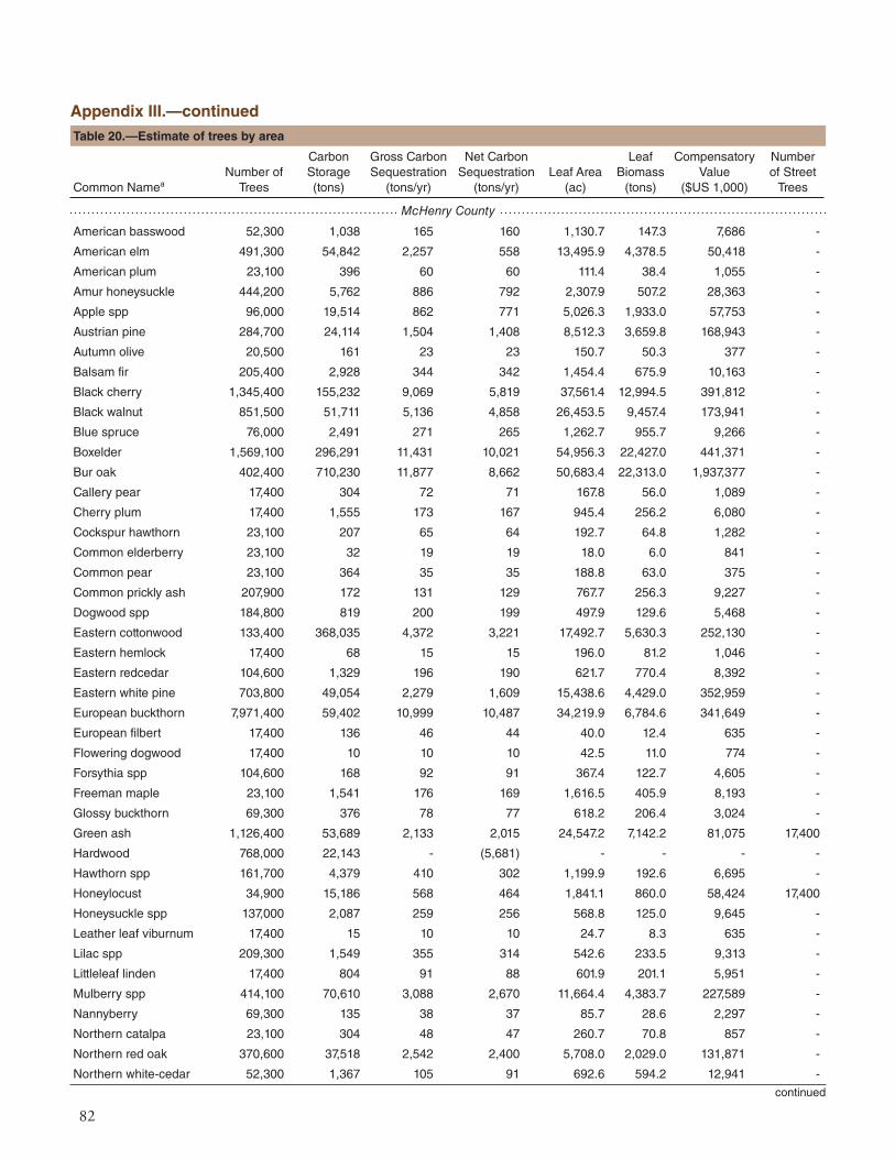
82
McHenry County
American basswood 52,300 1,038 165 160 1,130.7 147.3 7,686 -
American elm 491,300 54,842 2,257 558 13,495.9 4,378.5 50,418 -
American plum 23,100 396 60 60 111.4 38.4 1,055 -
Amur honeysuckle 444,200 5,762 886 792 2,307.9 507.2 28,363 -
Apple spp 96,000 19,514 862 771 5,026.3 1,933.0 57,753 -
Austrian pine 284,700 24,114 1,504 1,408 8,512.3 3,659.8 168,943 -
Autumn olive 20,500 161 23 23 150.7 50.3 377 -
Balsam fir 205,400 2,928 344 342 1,454.4 675.9 10,163 -
Black cherry 1,345,400 155,232 9,069 5,819 37,561.4 12,994.5 391,812 -
Black walnut 851,500 51,711 5,136 4,858 26,453.5 9,457.4 173,941 -
Blue spruce 76,000 2,491 271 265 1,262.7 955.7 9,266 -
Boxelder 1,569,100 296,291 11,431 10,021 54,956.3 22,427.0 441,371 -
Bur oak 402,400 710,230 11,877 8,662 50,683.4 22,313.0 1,937,377 -
Callery pear 17,400 304 72 71 167.8 56.0 1,089 -
Cherry plum 17,400 1,555 173 167 945.4 256.2 6,080 -
Cockspur hawthorn 23,100 207 65 64 192.7 64.8 1,282 -
Common elderberry 23,100 32 19 19 18.0 6.0 841 -
Common pear 23,100 364 35 35 188.8 63.0 375 -
Common prickly ash 207,900 172 131 129 767.7 256.3 9,227 -
Dogwood spp 184,800 819 200 199 497.9 129.6 5,468 -
Eastern cottonwood 133,400 368,035 4,372 3,221 17,492.7 5,630.3 252,130 -
Eastern hemlock 17,400 68 15 15 196.0 81.2 1,046 -
Eastern redcedar 104,600 1,329 196 190 621.7 770.4 8,392 -
Eastern white pine 703,800 49,054 2,279 1,609 15,438.6 4,429.0 352,959 -
European buckthorn 7,971,400 59,402 10,999 10,487 34,219.9 6,784.6 341,649 -
European filbert 17,400 136 46 44 40.0 12.4 635 -
Flowering dogwood 17,400 10 10 10 42.5 11.0 774 -
Forsythia spp 104,600 168 92 91 367.4 122.7 4,605 -
Freeman maple 23,100 1,541 176 169 1,616.5 405.9 8,193 -
Glossy buckthorn 69,300 376 78 77 618.2 206.4 3,024 -
Green ash 1,126,400 53,689 2,133 2,015 24,547.2 7,142.2 81,075 17,400
Hardwood 768,000 22,143 - (5,681) - - - -
Hawthorn spp 161,700 4,379 410 302 1,199.9 192.6 6,695 -
Honeylocust 34,900 15,186 568 464 1,841.1 860.0 58,424 17,400
Honeysuckle spp 137,000 2,087 259 256 568.8 125.0 9,645 -
Leather leaf viburnum 17,400 15 10 10 24.7 8.3 635 -
Lilac spp 209,300 1,549 355 314 542.6 233.5 9,313 -
Littleleaf linden 17,400 804 91 88 601.9 201.1 5,951 -
Mulberry spp 414,100 70,610 3,088 2,670 11,664.4 4,383.7 227,589 -
Nannyberry 69,300 135 38 37 85.7 28.6 2,297 -
Northern catalpa 23,100 304 48 47 260.7 70.8 857 -
Northern red oak 370,600 37,518 2,542 2,400 5,708.0 2,029.0 131,871 -
Northern white-cedar 52,300 1,367 105 91 692.6 594.2 12,941 -
Appendix III.—continued
continued
Common NameaNumber of
Trees
Carbon Storage (tons)
Gross Carbon Sequestration
(tons/yr)
Net Carbon Sequestration
(tons/yr)Leaf Area
(ac)
Leaf Biomass
(tons)
Compensatory Value
($US 1,000)
Number of Street
Trees
Table 20.—Estimate of trees by area

83
Norway maple 161,200 18,622 1,013 939 5,070.0 1,220.7 77,548 34,900
Norway spruce 58,500 9,608 395 366 1,769.2 1,315.4 27,259 -
Oak spp 23,100 75 - (12) - - - -
Pin cherry 40,500 724 133 131 300.0 64.6 1,833 -
Pin oak 124,700 48,273 1,769 1,356 6,473.5 2,613.4 132,417 -
Plum spp 143,800 4,555 271 246 977.5 337.4 6,311 -
River birch 166,300 13,067 1,140 1,090 4,675.1 1,616.4 52,851 -
Russian olive 23,100 202 65 64 347.4 116.0 1,025 -
Serbian spruce 17,400 24 11 10 32.1 27.0 751 -
Serviceberry spp 17,400 206 57 56 31.6 10.7 777 -
Shagbark hickory 601,700 50,939 3,578 3,387 9,199.0 3,005.4 213,029 -
Siberian elm 667,900 91,325 2,767 2,283 17,132.4 5,205.5 137,561 -
Silver maple 555,900 520,598 10,252 8,527 65,794.8 15,447.7 1,189,626 -
Softwood 23,100 2,193 - (356) - - - -
Sugar maple 40,500 40,250 1,252 1,098 4,524.6 1,215.9 143,964 -
Yellow-poplar 17,400 2,560 197 186 2,695.1 708.7 15,271 -
White ash 101,600 2,608 426 414 1,720.8 436.1 12,108 34,900
White mulberry 259,100 9,292 906 791 2,654.3 866.2 29,766 -
White oak 276,100 292,561 8,539 6,513 24,442.4 7,931.7 941,599
White spruce 102,700 3,748 261 258 2,861.7 2,050.7 11,479 -
Total 22,344,600 3,129,498 105,522 80,696 474,978 158,882 7,818,760 104,600
Will County
American basswood 280,600 15,015 918 202 7,266.5 946.4 82,817 -
American elm 1,646,000 70,643 4,693 4,448 32,015.5 10,387.1 188,086 -
Amur corktree 29,500 120 44 43 55.6 18.6 1,308 -
Amur honeysuckle 673,000 5,987 818 752 3,984.2 875.5 39,006 -
Apple spp 168,500 20,736 1,533 1,449 6,759.4 2,599.4 102,229 -
Austrian pine 230,300 8,428 641 606 4,801.2 2,064.2 69,031 -
Autumn olive 59,000 470 79 78 394.4 131.6 1,520 -
Bitternut hickory 27,500 12 13 12 12.8 3.6 1,442 -
Black cherry 672,000 81,695 5,009 4,594 25,874.8 8,951.4 237,835 -
Black haw 54,900 135 57 56 98.3 32.8 2,437 -
Black locust 1,265,600 96,144 5,291 4,568 21,647.2 5,198.8 240,921 -
Black maple 59,000 91 39 38 88.0 22.1 3,538 -
Black walnut 382,400 71,536 3,313 3,059 39,590.9 14,154.1 248,745 -
Blue spruce 306,100 16,096 1,413 1,234 8,029.0 6,076.6 74,598 -
Boxelder 872,300 72,103 2,767 1,951 10,128.9 4,133.5 107,088 -
Bur oak 318,200 282,731 7,338 6,332 22,465.8 9,890.4 1,184,023 -
Callery pear 27,500 685 139 136 166.1 55.4 2,318 -
Chinkapin oak 30,000 120 33 31 79.8 35.1 1,846 -
Common elderberry 88,400 297 122 122 54.6 18.2 3,270 -
Dogwood spp 27,500 565 127 121 297.0 77.3 1,540 -
Douglas-fir 27,500 360 34 32 523.6 365.8 4,514 -
Eastern cottonwood 535,500 104,799 2,478 1,343 11,953.2 3,847.4 200,378 -
Appendix III.—continued
continued
Common NameaNumber of
Trees
Carbon Storage (tons)
Gross Carbon Sequestration
(tons/yr)
Net Carbon Sequestration
(tons/yr)Leaf Area
(ac)
Leaf Biomass
(tons)
Compensatory Value
($US 1,000)
Number of Street
Trees
Table 20.—Estimate of trees by area

84
Eastern hophornbeam 27,500 847 152 148 442.6 128.9 3,013 -
Eastern redcedar 27,500 1,074 68 40 646.2 800.7 4,467 -
European buckthorn 2,826,700 19,618 3,752 3,420 16,628.6 3,296.9 150,780 -
Freeman maple 137,300 4,142 657 639 3,083.8 774.2 16,175 -
Ginkgo 172,200 200 88 88 303.7 59.7 6,457 -
Green ash 2,710,000 141,844 6,383 5,297 50,474.6 14,686.0 775,269 -
Hardwood 1,046,200 26,489 - (4,738) - - - -
Hawthorn spp 617,100 20,076 1,971 1,902 11,123.5 1,784.9 82,777 -
Honeylocust 111,900 57,356 1,886 1,665 5,629.4 2,629.6 204,658 -
Honeysuckle spp 320,200 2,068 597 570 381.3 83.8 11,268 -
Juniper spp 54,900 1,199 132 127 545.6 676.2 9,396 -
Mulberry spp 143,900 5,326 533 515 942.4 354.2 25,257 -
Northern hackberry 354,300 79,783 2,727 1,305 14,585.6 3,385.3 392,227 -
Northern red oak 139,300 65,397 2,072 1,820 6,457.2 2,295.2 218,477 -
Northern white-cedar 139,800 7,206 203 175 1,956.5 1,678.5 129,613 -
Norway maple 82,400 33,840 1,463 1,332 9,102.4 2,191.6 136,545 -
Norway spruce 27,500 7,229 325 297 3,001.3 2,231.5 37,774 -
Ohio buckeye 28,700 68,776 1,232 1,185 3,352.9 1,094.4 141,572 -
Osage orange 60,000 40,281 841 (838) 3,052.2 1,368.7 137,612 -
Plum spp 56,900 112 62 61 228.6 78.9 2,080 -
Red maple 30,000 9,323 391 355 3,479.9 1,045.4 47,797 -
River birch 54,900 2,708 389 377 1,269.1 438.8 12,454 -
Siberian elm 292,900 92,353 3,495 3,103 23,414.7 7,114.2 239,753 -
Silver maple 955,800 152,254 6,493 4,824 31,427.7 7,378.8 350,960 -
Sugar maple 2,787,200 150,876 8,500 8,105 52,776.1 14,182.6 693,874 -
Sumac spp 27,500 23 - (6) - - - -
Tree-of-heaven 90,000 791 141 141 629.6 210.2 1,417 -
White ash 143,400 1,302 301 288 820.1 207.9 5,310 -
White mulberry 341,200 8,662 992 961 3,700.3 1,207.5 43,450 -
White oak 27,500 30,033 1,054 938 2,984.2 968.4 130,394 -
Willow spp 247,100 80,030 2,306 1,900 6,692.5 1,842.9 147,649 -
Yew spp 27,500 105 22 21 152.0 106.2 1,310 -
Total 21,890,600 1,960,091 86,127 67,224 455,571 144,187 6,958,274 -
Chicago Region 157,141,100 16,870,647 677,361 475,990 2,841,056 944,000 51,155,683 2,346,400 a Species refers to tree species, genera, or species groups that were classified during field data collection
Appendix III.—continued
Common NameaNumber of
Trees
Carbon Storage (tons)
Gross Carbon Sequestration
(tons/yr)
Net Carbon Sequestration
(tons/yr)Leaf Area
(ac)
Leaf Biomass
(tons)
Compensatory Value
($US 1,000)
Number of Street
Trees
Table 20.—Estimate of trees by area

85
APPENDIX IV. GENERAL RECOMMENDATIONS FOR AIR QUALITY IMPROVEMENT
Urban vegetation can directly and indirectly aff ect local and regional air quality by altering the urban atmospheric environment. Four main ways that urban trees aff ect air quality are:
Temperature reduction and other microclimatic eff ects Removal of air pollutants Emission of volatile organic compounds (VOC) and tree maintenance emissions Energy conservation on buildings and consequent power plant emissions
Th e cumulative and interactive eff ects of trees on climate, pollution removal, and VOC and power plant emissions determine the overall impact of trees on air pollution. Cumulative studies involving urban tree impacts on ozone have revealed that increased urban canopy cover, particularly with low VOC emitting species, leads to reduced ozone concentrations in cities. Local urban forest management decisions also can help improve air quality.
Urban forest management strategies to help improve air quality include:
Strategy ReasonIncrease the number of healthy trees Increase pollution removalSustain existing tree cover Maintain pollution removal levelsMaximize use of low VOC-emitting trees Reduces ozone and carbon monoxide formationSustain large, healthy trees Large trees have greatest per-tree eff ectsUse long-lived trees Reduce long-term pollutant emissions from planting and removalUse low maintenance trees Reduce pollutants emissions from maintenance activitiesReduce fossil fuel use in maintaining vegetation Reduce pollutant emissionsPlant trees in energy conserving locations Reduce pollutant emissions from power plantsPlant trees to shade parked cars Reduce vehicular VOC emissionsSupply ample water to vegetation Enhance pollution removal and temperature reductionPlant trees in polluted or heavily populated areas Maximizes tree air quality benefi tsAvoid pollutant-sensitive species Improve tree healthUtilize evergreen trees for particulate matter Year-round removal of particles

86
APPENDIX V. RELATIVE TREE EFFECTS
Th e urban forest in the Chicago region provides benefi ts that include carbon storage and sequestration, and air pollutant removal. To estimate a relative value of these benefi ts, tree benefi ts were compared to estimates of average carbon emissions in the region,28 average passenger automobile emissions,29 and average household emissions.30
General tree information:Average tree diameter (d.b.h.) = 5.3 inMedian tree diameter (d.b.h.) = 3.1 inNumber of trees sampled = 9,731Number of species sampled = 161
Table 21.—Average tree effects by tree diameter class (d.b.h.), Chicago region, 2010
d.b.h. (inch)a
Carbon storage Carbon sequestration Pollution removal
(lbs) ($) (miles) b (lbs/yr) ($/yr) (miles) b (lbs/yr) ($/yr)
1-3 6 0.06 20 1.7 0.02 6 0.04 0.15
3-6 39 0.41 140 5.3 0.05 19 0.1 0.46
6-9 135 1.40 500 10.1 0.10 37 0.3 1.07
9-12 309 3.19 1,130 17.1 0.18 63 0.5 1.95
12-15 550 5.69 2,010 22.8 0.24 84 0.8 3.00
15-18 909 9.40 3,330 33.4 0.35 122 1.0 3.81
18-21 1,333 13.79 4,880 40.3 0.42 148 1.1 4.30
21-24 1,920 19.86 7,030 51.0 0.53 187 1.3 4.88
24-27 2,432 25.16 8,910 63.5 0.66 233 1.6 6.08
27-30 3,346 34.62 12,260 72.9 0.75 267 1.6 6.01
30+ 6,158 63.71 22,550 108.5 1.12 397 2.6 9.79a lower limit of the diameter (d.b.h.) class is greater than displayed (e.g. 3-6 is actually 3.01 to 6 inches)b miles = number of automobile miles driven that produces emissions equivalent to tree effect
Th e trees in the Chicago region provide:Carbon storage equivalent to:Amount of carbon (C) emitted in region in 120 days orAnnual carbon emissions from 10,128,000 automobiles or Annual C emissions from 5,085,400 single family houses
Carbon monoxide removal equivalent to:Annual carbon monoxide emissions from 1,110 automobiles or Annual carbon monoxide emissions from 4,600 family houses
Nitrogen dioxide removal equivalent to:Annual nitrogen dioxide emissions from 213,500 automobiles orAnnual nitrogen dioxide emissions from 142,400 single family houses
Sulfur dioxide removal equivalent to:Annual sulfur dioxide emissions from 1,406,600 automobiles orAnnual sulfur dioxide emissions from 23,600 single family houses
Particulate matter less than 10 micron (PM10) removal equivalent to:Annual PM10 emissions from 14,789,000 automobiles orAnnual PM10 emissions 1,427,700 single family houses
Annual C sequestration equivalent to:Amount of C emitted in region in 4.8 days orAnnual C emissions from 406,600 automobiles or Annual C emissions from 204,200 single family home

87
APPENDIX VI. POTENTIAL INSECT AND DISEASE IMPACTS
Th e following insects and diseases were analyzed to quantify their potential impact on the Chicago regional forest:
• Aspen leafminer - Aspen leafminer is an insect that causes damage primarily to trembling or small tooth aspen by larval feeding of leaf tissue. While outbreaks of the aspen leafminer have been recorded throughout parts of Alaska, Canada, and the western United States, the pest is relatively uncommon in eastern North America.31
• Asian longhorned beetle - Asian longhorned beetle32 is an insect that bores into and kills a wide range of hardwood species. Th is beetle was discovered in 1996 in Brooklyn, NY, and has subsequently spread to Long Island, Queens, and Manhattan. In 1998, the beetle was discovered in the suburbs of Chicago, IL, and successfully declared eradicated in 2006. Beetles have also been found in Jersey City, NY (2002), Toronto/Vaughan, Ontario (2003), and Middlesex/Union counties, NJ (2004). In 2007, the beetle was found on Staten and Prall’s Islands, NY. Most recently, beetles were detected in Worcester, MA (2008) and Bethel, OH (2011). In addition to the eradication in Chicago, successful eradication has since occurred in Hudson County, NJ (2008) and Islip, NY (2011).
• Beech bark disease - Beech bark disease is an insect-disease complex that primarily impacts American beech. It is caused by the infestation of several diff erent species. First, the insect, Cryptococcus fagisuga, feeds on the sap of the beech trees. Th ese aff ected trees can become hosts to the nectria fungi. Th e two primary species of nectria fungi in North America are N. coccinea var. faginata and N. gallifena.33
• Butternut canker - Butternut canker is caused by a fungus that infects butternut trees. Th e disease was fi rst discovered in 1967 in Wisconsin and has since caused signifi cant declines in butternut populations in the United States.34
• Chestnut blight - Th e most common hosts of the fungus that cause chestnut blight are American and European chestnut. Th is disease causes canker formation in host trees resulting in dead limbs, brown or yellowing leaves, or mortality.35
• Dogwood anthracnose - Dogwood anthracnose is a disease that aff ects dogwood species, specifi cally fl owering and Pacifi c dogwood. It is caused by a fungus that produces leaf spots and necrotic blotches and canker formation on twigs, branches, and the main stem of infected trees.36
• Dutch elm disease - American elm, one of the most important street trees in the 20th century, has been devastated by the Dutch elm disease. Since fi rst reported in the 1930s, it has killed more than 50 percent of the native elm population in the United States.37
• Douglas-fi r beetle - Th e Douglas-fi r beetle is a bark beetle that infests Douglas-fi r trees. Infestations of the Douglas-fi r beetle have been seen throughout the western United States, British Columbia, and Mexico often resulting in tree mortality.38
• Emerald ash borer - Since being discovered in Detroit in 2002, emerald ash borer39 has killed millions of ash trees in Illinois, Indiana, Kentucky, Maryland, Michigan, Minnesota, Missouri, New York, Ohio, Ontario, Pennsylvania, Quebec, Virginia, West Virginia, and Wisconsin.
• Fir engraver - One common pest of white fi r, grand fi r, and red fi r trees is the fi r engraver. Th is bark beetle is distributed primarily in the western United States.40

88
• Fusiform rust– Fusiform rust is a fungal disease that is distributed in the southern United States. It is particularly damaging to slash pine and loblolly pine because it infects the living tissue of the host’s stems and branches. Pine trees aff ected by the fungus can develop fatal galls and cankers.41
• Gypsy moth - Th e gypsy moth42 is a defoliator that feeds on many species causing widespread defoliation and tree death if outbreak conditions last several years.
• Hemlock woolly adelgid– As one of the most damaging pests to eastern hemlock and Carolina hemlock, hemlock woolly adelgid has played a large role in hemlock mortality in the United States. Since the pest was fi rst discovered in 1951, infestations have expanded to cover about half of the range of hemlock in the eastern United States.43
• Jeff rey pine beetle - Jeff rey pine beetle is native to North America and is distributed across California, Nevada, and Oregon where its only host, Jeff rey pine, also occurs. 44
• Large aspen tortrix– Quaking aspen is a principal host for the defoliator, large aspen tortrix. Th e insect has been found across much of the northeastern, north central, and western United States, as well as Alaska and Canada. Large aspen tortrix can reach outbreak levels where quaking aspen are abundant and will potentially strip hosts of all of their foliage.45
• Laurel wilt - Laurel wilt is a fungus-caused disease that is introduced to host trees by the redbay ambrosia beetle. Redbay, as well as other tree species in the Laurel family, are common hosts for laurel wilt which has been observed in North Carolina, South Carolina, Georgia, Alabama, Mississippi, and Florida.46
• Mountain pine beetle - Mountain pine beetle is a bark beetle that primarily attacks pine species in the western United States. Th e major host species of the mountain pine beetle, lodgepole pine, ponderosa pine, western white pine, sugar pine, limber pine, and whitebark pine, have a similar distribution as this pest.47
• Oak wilt - Oak wilt, which is caused by a fungus, is a prominent disease among oak trees producing leaf wilting and discoloration, heavy defoliation, or fungal mats beneath the bark. Th e disease has been found in 21 states throughout most of the midwestern United States and it is still unknown whether any species of oak are immune to it.48
• Port-Orford-cedar root disease - Port-Orford-cedar root disease is caused by a fungus. Th is fungus is most damaging to Port-Orford cedar and Pacifi c yew species.49
• Pine shoot beetle - Pine shoot beetle is a wood borer that attacks various pine species, though scotch pine is the preferred host in North America. Th e beetle has an international geographic distribution. In the United States it has been discovered in Illinois, Indiana, Maine, Maryland, Michigan, New Hampshire, New York, Ohio, Pennsylvania, Vermont, West Virginia, and Wisconsin, as well as in Ontario and Quebec in Canada.50
• Spruce beetle - All species of spruce that fall within the spruce beetle’s range are suitable hosts for attack. Th is bark beetle causes signifi cant mortality and covers large areas of Alaska, Canada, and the northern United States, as well as some patches through the Rocky Mountain range.51
• Spruce budworm - Spruce budworm is an insect that causes severe damage to balsam fi r. During the larval stage of the budworm’s life, it feeds primarily on the needles or expanding buds of its hosts. Years of heavy defoliation can ultimately lead to tree mortality. Other hosts for the spruce budworm include white, red, and black spruce.52

89
• Sudden oak death - Sudden oak death is a disease that is caused by a fungus. It is most common in British Columbia, Washington, Oregon, and California and impacts many diff erent species including, southern red oak, California black oak, northern red oak, pacifi c madrone, tanoak, and coastal live oak.53
• Southern pine beetle - Although the southern pine beetle will attack most pine species, its preferred hosts are loblolly, Virginia, pond, spruce, shortleaf, and sand pines. Th e range of this particular bark beetle covers much of the southeastern United States.54
• Sirex woodwasp - Th e sirex woodwasp is a wood borer that primarily attacks pine species. It is not native to the United States, but is known to cause high amounts of tree mortality among North American species that have been planted in countries of the southern hemisphere.55
• Th ousand cankers disease - Th ousand cankers disease is an insect-disease complex that kills several species of walnuts, including black walnut. It is known to occur primarily in the western states of Washington, Oregon, California, Idaho, Utah, Arizona, New Mexico, and Colorado. Tennessee is the fi rst state in the east where thousand cankers disease has been found. Tree mortality is the result of attacks by the walnut twig beetle and subsequent canker development caused by associated fungi.56
• Western pine beetle - Western pine beetle aggressively attacks ponderosa and Coulter pines. Th is bark beetle has caused signifi cant swaths of damage in California, Oregon, Washington, Idaho, British Columbia, Montana, Nevada, Utah, Colorado, Arizona, New Mexico, Texas, and parts of northern Mexico.57
• White pine blister rust - Since its introduction to the United States in 1900, white pine blister rust has had a detrimental eff ect on white pines, particularly in the Lake States.58
• Western spruce budworm - Western spruce budworm is an insect that causes defoliation in western conifers. It has been found in Arizona, New Mexico, Colorado, Utah, Wyoming, Montana, Idaho, Oregon, and Washington in the United States and British Columbia and Alberta in Canada. Th e western spruce budworm feeds on new foliage of its hosts. Common host species include Douglas-fi r, grand fi r, white fi r, subalpine fi r, corkbark fi r, blue spruce, Engelmann spruce, white spruce, and western larch.59

90
As each insect/disease is likely to attack diff erent host tree species, the implications for the Chicago region will vary. Th e number of trees at risk (Table 22) refl ects only the known host species that are likely to experience mortality. Th e species host lists used for these insects/diseases can be found at http://nrs.fs.fed.us/data/urban.
Table 22.—Potential risk to trees by insect or disease, Chicago region, 2010
Code Scientific Name Common NameTrees at Risk
#
Compensatory Value
($ millions)
AL Phyllocnistis populiella aspen leafminer 1,771,000 673
ALB Anoplophora glabripennis Asian longhorned beetle 41,641,000 17,431
BBD Cryptococcus fagisuga beech bark disease 20,000 1
BC Sirococcus clavigignenti-juglandacearum
butternut canker - -
CB Cryphonectria parasitica chestnut blight - -
DA Discula destructive dogwood anthracnose 441,000 20
DED Ophiostoma novo-ulmi Dutch elm disease 8,234,000 1,641
DFB Dendroctonus pseudotsugae Douglas-fir beetle 108,000 31
EAB Agrilus planipennis emerald ash borer 12,694,000 4,198
FE Scotylus ventralis fir engraver 108,000 31
FR Cronartium fusiforme fusiform rust - -
GM Lymantria dispar gypsy moth 17,690,000 18,496
HWA Adelges tsugae hemlock woolly adelgid 269,000 59
JPB Dendroctonus jeffreyi jeffrey pine beetle - -
LAT Choristoneura conflictana large aspen tortrix 3,319,000 981
LWD Raffaelea lauricola laurel wilt 47,000 2
MPB Dendroctonus ponderosae mountain pine beetle 401,000 352
OW Ceratocystis fagacearum oak wilt 9,036,000 16,062
POCRD Phytophthora lateralis Port-Orford-cedar root disease - -
PSB Tomicus piniperda pine shoot beetle 3,138,000 1,972
SB Dendroctonus rufipennis spruce beetle 3,421,000 1,008
SBW Choristoneura fumiferana spruce budworm - -
SOD Phytophthora ramorum sudden oak death 3,448,000 3,518
SPB Dendroctonus frontalis southern pine beetle 6,342,000 2,659
SW Sirex noctilio sirex woodwasp 6,387,000 2,642
TCD Pityophthorus juglandis & Geosmithia spp.
thousand canker disease 2,469,000 1,111
WPB Dendroctonus brevicomis western pine beetle - -
WPBR Cronartium ribicola white pine blister rust 1,526,000 1,157
WSB Choristoneura occidentalis western spruce budworm 3,404,000 1,028
With the exception of Dutch elm disease and chestnut blight, all of the insects and diseases that were analyzed have existing pest range maps. Th ese range maps were used to determine the proximity of the insect/disease to the counties within the Chicago region. In the case of Dutch elm disease, the disease is known to occur in the native range of elm species. For each county in the Chicago region, it was determined whether the insect/disease occurs within the county, is within 250 miles of the county edge, is between 250 and 750 miles away, is greater than 750 miles away, or if no distance could be determined (no range map exists).

91
In Figure 76, the bars representing each pest are color coded according to the region’s proximity to the pest occurrence in the United States.23 Since the Chicago region covers multiple counties, the pest was color coded according to the closest proximity determined during the analysis of each county (i.e., if a pest is known to occur in one county within the Chicago region and be within 250 miles of the other counties then it will be color coded as being within the region). For more information on these pests and to access pest range maps, please visit www.foresthealth.info.
Based on the host tree species for each pest and the current range of the pest, it is possible to determine what the risk is that each tree species sampled in the Chicago region could be attacked by an insect or disease. In Table 23, species risk is designated as one of the following:
• Red - tree species is at risk to at least one pest within county
• Orange - tree species has no risk to pests within county, but has a risk to at least one pest within 250 miles from the county
• Yellow - tree species has no risk to pests within 250 miles of county, but has a risk to at least pest that is 250 to 750 miles from the county
• Green - tree species has no risk to pests within 750 miles of county, but has a risk to at least pest that is greater than 750 miles from the county
Species that were sampled in the Chicago region, but that are not listed in this matrix, are not known to be hosts to any of the 29 exotic insects/diseases analyzed. Tree species at the greatest risk to existing pest infestations in the Chicago region are willows and poplars (Salix spp.) and Norway spruce.
Figure 76.—Number of trees at risk and associated compensatory value of insect/disease effects, Chicago region, 2010. See page 90, Table 22, for a description of acronyms.
0
2
4
6
8
10
12
14
16
18
20
0
5
10
15
20
25
30
35
40
45G
ME
AB
OW
DED S
BLA
TP
SB
WP
BR
BC
ALB A
LD
AB
BD
SB
WS
WS
PB
TCD
HW
ALW
D FRS
OD
WSB
MPB DFB FE JP
BPO
CR
DW
PB CB
Com
pens
ator
y Va
lue
(bill
ions
o fd
olla
rs)
Num
ber o
f Tre
es (m
illio
ns)
Insect/Disease Trees at riskCompensatory value
Red indicates insect/disease is within region Orange indicates insect/disease is within 250 miles of region Yellow indicates insect/disease is within 750 miles of region Green indicates insect/disease is outside of these ranges Blue indicates no data on pest range

92
Pestc
Spp
. Ris
ka
Ris
k w
eigh
tb
Common Name
GM
EA
B
OW
DE
D
SB
LAT
PS
B
WP
BR
BC
ALB
AL
DA
BB
D
SB
W
LWD
SW
SP
B
TC
D
HW
A
FR
SO
D
WS
B
MP
B
DF
B
FE
JPB
PO
CR
D
WP
B
CB
14 Willow spp 1 2 2
14 Norway spruced 3 3
14 Quaking aspen 2 2
14 Peachleaf willow 2 2
14 Pussy willow 2 2
14 Black willow 2 2
14 Weeping willow 2 2
14 Narrowleaf willow 2 2
12 Eastern white pine 3 3
11 River birch 2
11 Paper birch 2
11 Gray birch 2
10 Scotch pined 1 3 3
9 Northern red oak
9 White spruce 3 3
9 Blue spruce 3 3
9 Pin oak
9 Douglas fird 3
8 White oak
8 Apple spp
8 Bur oak
8 Austrian pine 3 3
8 Oak spp
8 Swamp white oak
8 Chinkapin oak
8 Serbian spruce 3 3
8 Spruce spp 3 3
8 Pine spp 3 3
8 Black oak
8 Jack pine 3 3
8 Shingle oak
8 Northern pin oak
8 Red pine 3 3
8 Japanese red pine 3 3
8 Macnab’s oak
8 Paradise appled
7 Green ash 2
7 American elm 2
7 Siberian elmd 2
7 Slippery elm 2
Table 23.—Potential insect and disease risk for tree species, Chicago region, 2010

93
7 Elm spp 2
7 Chinese elmd 2
4 White ash 1
4 Hawthorn spp
4 Downy hawthorn
4 American basswood
4 Eastern hophornbeam
4 European alderd
4 Cockspur hawthorn
4 Callery peard
4 Littleleaf linden
4 Witch hazel
4 Common chokecherry 1
4 White poplard
4 Basswood spp
4 Washington hawthorn
4 European filbertd
4 Sweetgum
4 Smoke tree
4 Pear spp
4 Cottonwood spp
4 Ash spp
4 Silver linden
4 Black ash
4 Staghorn sumac
3 Boxelder 2
3 Sugar maple 2
3 Silver maple 2
3 Eastern cottonwood 2
3 Norway mapled 2
3 Amur mapled 2
3 Red maple 2
3 Freeman maple 2
3 Dogwood spp 2
3 Flowering dogwood 2
3 Black maple 2
3 Gray dogwood 2
3 Ohio buckeye 2
3 Horsechestnutd 2
3 Japanese mapled 2
3 Alternateleaf dogwood 2
Table 23.—continued
Pestc
Spp
. Ris
ka
Ris
k w
eigh
tb
Common Name
GM
EA
B
OW
DE
D
SB
LAT
PS
B
WP
BR
BC
ALB
AL
DA
BB
D
SB
W
LWD
SW
SP
B
TC
D
HW
A
FR
SO
D
WS
B
MP
B
DF
B
FE
JPB
PO
CR
D
WP
B
CB

94
aSpecies RiskRed indicates that tree species is at risk to at least one pest within regionOrange indicates that tree species has no risk to pests region county, but has a risk to at least one pest within 250 miles from the regionYellow indicates that tree species has no risk to pests within 250 miles of region, but has a risk to at least pest that is 250 to 750 miles from the regionGreen indicates that tree species has no risk to pests within 750 miles of region, but has a risk to at least pest that is greater than 750 miles from the region
bRisk weightNumerical scoring system based on sum of points assigned to pest risks for species. Each pest that could attack tree species is scored as 4 points if red, 3 points if orange or blue, 2 points if yellow and 1 point if green.
cPest Color CodesRed indicates pest is within Chicago regionOrange indicates pest is within 250 miles of Chicago regionYellow indicates pest is within 750 miles of Chicago regionGreen indicates pest is outside of these rangesBlue indicates no data on pest range
dSpecies in bold text indicate that species is on the state invasive species list
3 European beech 2
3 Katsura tree 2
3 Cornelian cherry 2
3 Buckeye spp 2
3 Maple spp 2
4 Eastern hemlock 3 3
2 Black walnut 3
2 Balsam fir 3
2 Sassafras 3
Table 23.—continued
Pestc
Spp
. Ris
ka
Ris
k w
eigh
tb
Common Name
GM
EA
B
OW
DE
D
SB
LAT
PS
B
WP
BR
BC
ALB
AL
DA
BB
D
SB
W
LWD
SW
SP
B
TC
D
HW
A
FR
SO
D
WS
B
MP
B
DF
B
FE
JPB
PO
CR
D
WP
B
CB

95
APPENDIX VII. SELECTED AREA TREE DATA BY LAND USE
Table 24.—Tree population statistics by area and land use, Chicago region, 2010
Area AcresTree Density
(N/ac)Leaf Area (ft2/ ac)
Valuea ($/ac)
% Illinois species
% Trees with d.b.h.a Plantable Area %1-3 in. >18 in.
-----------------------------------------------------------Residential-------------------------------------------------------------
City of Chicago 70,800 22.8 37,800 20,300 45.6 29.9 17.9 13.5
Suburban Cook County 213,900 69.1 60,800 24,100 43.1 49.9 5.6 35.5
DuPage County 100,900 74.4 84,700 34,600 36.0 40.8 7.7 32.2
Kane County 74,700 63.8 74,100 42,800 47.3 31.0 9.4 27.2
Kendall County 24,100 46.8 51,400 16,400 72.7 32.1 5.8 37.4
Lake County 117,400 102.2 111,700 49,400 52.8 39.5 8.8 40.7
McHenry County 75,000 87.7 96,200 40,300 38.4 46.9 6.9 35.2
Will County 107,100 55.9 59,700 22,700 44.6 51.4 4.1 48.3
Total 783,900 69.3 73,600 31,100 44.9 43.5 7.3 34.9
-----------------------------------------------------------Open Space-----------------------------------------------------------
City of Chicago 21,000 63.5 68,900 27,900 58.6 43.0 7.6 33.6
Suburban Cook County 123,400 193.0 90,200 54,300 45.5 49.4 3.4 43.6
DuPage County 55,300 107.9 80,200 30,900 58.9 44.4 2.8 46.4
Kane County 57,900 80.3 33,700 17,000 39.4 58.0 3.3 67.6
Kendall County 19,000 177.7 164,900 50,800 75.2 34.1 2.6 38.1
Lake County 106,000 152.2 78,000 24,200 38.8 56.9 2.2 43.1
McHenry County 92,400 133.0 114,200 41,000 51.0 51.4 4.1 49.4
Will County 123,800 103.6 72,300 27,600 73.0 46.0 3.5 41.0
Total 598,800 134.2 83,300 34,600 51.5 50.0 3.3 45.9
-------------------------------------------Commercial/Transportation/Institution------------------------------------------
City of Chicago 55,900 11.5 12,000 5,500 55.1 44.5 6.7 9.7
Suburban Cook County 111,100 35.5 20,100 8,400 24.8 48.5 3.7 18.9
DuPage County 52,700 70.5 28,100 18,200 34.2 62.0 1.3 27.1
Kane County 30,800 4.3 1,000 800 33.3 16.7 0.0 28.9
Kendall County 4,900 - - - - - 0.0 50.0
Lake County 38,600 101.5 58,600 33,000 22.1 65.7 5.1 31.1
McHenry County 18,200 14.0 7,400 2,100 14.3 71.4 0.0 1.6
Will County 51,000 55.9 84,800 18,800 83.5 51.6 3.2 43.9
Total 363,100 42.5 30,700 12,400 38.4 56.6 3.4 23.9
------------------------------------------------------------Agricultural-------------------------------------------------------------
City of Chicago
Suburban Cook County 17,600 47.8 14,000 1,700 15.0 55.8 0.0 70.1
DuPage County 4,900 20.0 50,400 6,800 25.0 62.5 25.0 73.5
Kane County 171,300 1.9 400 100 0.0 56.3 0.0 86.7
Kendall County 158,200 4.7 3,600 1,300 22.4 65.2 4.3 90.7
Lake County 37,300 40.0 25,100 5,400 25.0 48.6 4.2 56.9
McHenry County 205,400 15.7 13,600 4,700 33.1 36.9 6.4 88.7
Will County 261,100 0.9 600 600 12.5 87.5 12.5 93.6
Total 855,800 8.1 5,900 1,900 25.7 47.7 5.1 88.3
Chicago Region 2,602,000 60.4 68,900 19,700 46.6 48.3 4.7 53.5a Value = compensatory valueb Percent of tree population of the diameter class (d.b.h. in inches)

96
APPENDIX VIII. TREE PLANTING INDEX MAP
To determine the best locations to plant trees, tree canopy and impervious cover maps from National Land Cover Data60 were used in conjunction with 2000 U.S. Census data to produce an index of priority planting areas for the Chicago region. Index values were produced for each census block group; the higher the index value, the higher the priority of the area for tree planting. Th is index is a type of “environmental equity” index with areas with higher human population density and lower tree cover tending to get the higher index value. Th e criteria used to make the index were:
• Population density: the greater the population density, the greater the priority for tree planting
• Tree stocking levels: the lower the tree stocking level (the percent of available greenspace (tree, grass, and soil cover areas) that is occupied by tree canopies), the greater the priority for tree planting
• Tree cover per capita: the lower the amount of tree canopy cover per capita (m2/capita), the greater the priority for tree planting
Each criteria was standardized61 on a scale of 0 to 1 with 1 representing the census block group with the highest value in relation to priority of tree planting (i.e., the census block group with highest population density, lowest stocking density or lowest tree cover per capita were standardized to a rating of 1). Individual scores were combined and standardized based on the following formula to produce an overall priority planting index (PPI) value between 0 and 100:
PPI = (PD * 40) + (TS * 30) + (TPC * 30)
Where PPI = index value, PD is standardized population density, TS is standardized tree stocking, and TPC is standardized tree cover per capita.
Based on “environmental equity”, the Tree Planting Index gives the highest priority to tree planting in the city of Chicago where population density tends to be highest and tree cover the lowest (Figure 77).

97
Figure 77.—Priority planting areas, Chicago region, 2010. Higher index scores indicate higher priority areas for planting.
0 6 12 18 243Miles
.
PPI0 - 10.0
10.1 - 20.0
20.1 - 30.0
30.1 - 40.0
40.1 - 50.0
50.1 - 60.0
60.1 - 70.0
70.1 - 80.0
80.1 - 90.0
90.1 - 100.0
Priority Planting Index

98
REFERENCES
1 Nowak, D.J.; Crane, D.E. 2000. Th e Urban Forest Eff ects (UFORE) Model: quantifying urban forest structure and functions. In: Hansen, M.; Burk, T., eds. Integrated tools for natural resources inventories in the 21st century. Proceedings of IUFRO conference. Gen. Tech. Rep. NC-212. St. Paul, MN: U.S. Department of Agriculture, Forest Service, North Central Research Station: 714-720.
Nowak, D.J.; Hoehn, R.E.; Crane, D.E.; Stevens, J.C.; Walton, J.T; Bond, J. 2008. A ground-based method of assessing urban forest structure and ecosystem services. Arboriculture and Urban Forestry. 34(6): 347-358.
2 Nowak, D.J.; Hoehn, R.E., III; Crane, D.E.; Stevens, J.C.; Leblanc Fisher, C. 2010. Assessing urban forest eff ects and values, Chicago’s urban forest. Resour. Bull. NRS-37. Newtown Square, PA: U.S. Department of Agriculture, Forest Service, Northern Research Station. 27 p.
3 Chicago Metropolitan Agency for Planning (CMAP). 2005. Land-use inventory. Chicago, IL: Chicago Metropolitan Agency for Planning. http://www.cmap.illinois.gov/land-use-inventory
4 i-Tree. 2009. i-Tree eco manual. Version 4.1.0. Washington, DC: U.S. Department of Agriculture, Forest Service and Kent, OH: Davey Tree Expert Co., and other cooperators. 113 p. http://www.itreetools.org/resources/manuals/i-Tree%20Eco%20Users%20Manual.pdf
5 Nowak, D.J. 1994. Atmospheric carbon dioxide reduction by Chicago’s urban forest. In: McPherson, E.G.; Nowak, D.J.; Rowntree, R.A., eds. Chicago’s urban forest ecosystem: results of the Chicago Urban Forest Climate Project. Gen. Tech. Rep. NE-186. Radnor, PA: U.S. Department of Agriculture, Forest Service, Northeastern Forest Experiment Station: 83-94.
Nowak, D.J.; Crane, D.E.; Stevens, J.C.; Ibarra, M. 2002. Brooklyn’s urban forest. Gen. Tech. Rep. NE-290. Newtown Square, PA: U.S. Department of Agriculture, Forest Service, Northeastern Research Station. 107 p.
Nowak, D.J. and D.E. Crane. 2002. Carbon storage and sequestration by urban trees in the USA. Environmental. Pollution . 116(3):381-389.
6 Baldocchi, D. 1988. A multi-layer model for estimating sulfur dioxide deposition to a deciduous oak forest canopy. Atmospheric Environment. 22: 869-884.
7 Baldocchi, D.D.; Hicks, B.B.; Camara, P. 1987. A canopy stomatal resistance model for gaseous deposition to vegetated surfaces. Atmospheric Environment. 21: 91-101.
99
8 Bidwell, R.G.S.; Fraser, D.E. 1972. Carbon monoxide uptake and metabolism by leaves. Canadian Journal of Botany. 50: 1435-1439.
9 Lovett, G.M. 1994. Atmospheric deposition of nutrients and pollutants in North America: an ecological perspective. Ecological Applications. 4:629-650.
10 Zinke, P.J. 1967. Forest interception studies in the United States. In: Sopper, W.E.; Lull, H.W., eds. Forest hydrology. Oxford, UK: Pergamon Press: 137-161.
11 McPherson, E.G.; Simpson, J.R. 1999. Carbon dioxide reduction through urban forestry: guidelines for professional and volunteer tree planters. Gen. Tech. Rep. PSW-171. Albany, CA: U.S. Department of Agriculture, Forest Service, Pacifi c Southwest Research Station. 237 p.
12 Nowak, D.J.; Crane, D.E.; Dwyer, J.F. 2002. Compensatory value of urban trees in the United States. Journal of Arboriculture. 28(4): 194-199.
13 Nowak, D.J.; Crane, D.E.; Stevens, J.C.; Ibarra, M. 2002. Brooklyn’s urban forest. Gen. Tech. Rep. NE-290. Newtown Square, PA: U.S. Department of Agriculture, Forest Service, Northeastern Research Station. 107 p.
14 Based on photo-interpretation of Google Earth™ imagery (image dates circa 2008 and 2010) of 1,000 random points in each county and the City of Chicago. Standard error of estimate is 0.4 percent for the Chicago region. Tree cover was estimated using fi eld plot estimates of tree and shrub cover, along with tree/shrub overlap. Plot cover estimates were prorated to equal photo-interpretation estimates of combined tree and shrub cover.
15 National Invasive Species Information Center. 2011. Beltsville, MD: U.S. Department of Agriculture, National Invasive Species Information Center. http://www.invasivespeciesinfo.gov/plants/main.shtml
16 Illinois state invasive species list derived from: Invasive.org: Center for Invasive Species and Ecosystem Health. Illinois Invasive Plant List. http://www.invasive.org/species/list.cfm?id=152
17 Nowak D.J.; Dwyer, J.F. 2000. Understanding the benefi ts and costs of urban forest ecosystems. In: Kuser, John E., ed. Handbook of urban and community forestry in the northeast. New York, NY: Kluwer Academics/Plenum: 11-22.
18 Murray, F.J.; Marsh L.; Bradford, P.A. 1994. New York state energy plan, vol. II: issue reports. Albany, NY: New York State Energy Offi ce. Th ese values were updated to 2007 dollars based on the producer price index from U.S. Department of Labor, Bureau of Labor Statistics. www.bls.gov/ppi

100
19 Some economic studies have estimated VOC emission costs. Th ese costs are not included here as there is a tendency for readers to add positive dollar estimates of ozone removal eff ects with negative dollar values of VOC emission eff ects to determine whether tree eff ects are positive or negative in relation to ozone. Th is combining of dollar values to determine tree eff ects should not be done, rather estimates of VOC eff ects on ozone formation (e.g., via photochemical models) should be conducted and directly contrasted with ozone removal by trees (i.e., ozone eff ects should be directly compared, not dollar estimates). In addition, air temperature reductions by trees have been shown to signifi cantly reduce ozone concentrationsa, but are not considered in this analysis. Photochemical modeling that integrates tree eff ects on air temperature, pollution removal, VOC emissions, and emissions from power plants can be used to determine the overall eff ect of trees on ozone concentrations.
aCardelino, C.A.; Chameides, W.L. 1990. Natural hydrocarbons, urbanization, and urban ozone. Journal of Geophysical Research. 95(D9): 13,971-13,979.
Nowak, D.J.; Civerolo, K.L.; Rao, S.T.; Sistla, S.; Luley, C.J.; Crane, D.E. 2000. A modeling study of the impact of urban trees on ozone. Atmospheric Environment. 34: 1601-1613.
20 Abdollahi, K.K.; Ning, Z.H.; Appeaning, A., eds. 2000. Global climate change and the urban forest. Baton Rouge, LA: GCRCC and Franklin Press. 77 p.
Carbon values are estimated at $22.8 USD per tonne based on: Fankhauser, S. 1994. Th e social costs of greenhouse gas emissions: an expected value approach. Th e Energy Journal. 15(2): 157-184.
21 Nowak, D.J.; Stevens, J.C.; Sisinni, S.M.; Luley, C.J. 2002. Eff ects of urban tree management and species selection on atmospheric carbon dioxide. Journal of Arboriculture. 28(3): 113-122.
22 Energy costs are derived from the U.S. Energy Information Administration based on 2009 state average costs for natural gas (http://tonto.eia.doe.gov/dnav/ng/ng_pri_sum_a_EPG0_PRS_DMcf_a.htm); 2010/2011 heating season fuel oil costs (http://tonto.eia.doe.gov/OOG/INFO/HOPU/hopu.asp); 2009 residential electricity costs (http://www.eia.doe.gov/cneaf/electricity/epm/table5_3.html) and 2008 costs of wood (http://www.eia.doe.gov/emeu/states/sep_sum/html/sum_pr_tot.html).
23 Nowak, D.J.; Greenfi eld,E.J.; 2012. Tree and impervious cover change in U.S. Urban Forestry and Urban Greening. 11(1): 21-30.
24 Insect/disease proximity to study area was completed using the U.S. Forest Service’s Forest Health Technology Enterprise Team (FHTET) database. Data includes distribution of pest by county FIPs code for 2004-2009. FHTET range maps are available at www.foresthealth.info for 2006-2010.

101
FHTET pest range data was supplemented by:
For ALB – Bond, S.; Antipin, J.; Smith, M.; Squibb, J. 2008. USDA and its partners declare victory over the Asian longhorned beetle. USDA News Release, April 17, 2008. 0104.08.
http://www.aphis.usda.gov/newsroom/hot_issues/alb/alb_news.shtml
For GM – Gypsy Moth Slow the Spread Foundation, Inc. http://www.gmsts.org/fdocs/Accomplishments_2011.pdf
For DED – Eastern Forest Environmental Th reat Assessment Center. Dutch Elm Disease. http://threatsummary.forestthreats.org/threats/threatSummaryViewer.cfm?threatID=43
25 Minnesota Department of Natural Resources. 2012. Invasive species of Minnesota: buckthorn. St. Paul, MN: Minnesota Department of Natural Resources. http://www.dnr.state.mn.us/invasives/terrestrialplants/woody/buckthorn/index.html
Wisconsin Department of Natural Resources. 2008. Common buckthorn (Rhamnus cathartica). Madison, WI: Wisconsin Department of Natural Resources. http://dnr.wi.gov/topic/Invasives/fact/CommonBuckthorn.html
26 McPherson, E.G.; Nowak, D.J.; Rowntree, R.A. 1994. Chicago urban forest ecosystem: Results of the Chicago urban forest climate project. Gen. Tech. Rep. NE-186. U.S. Department of Agriculture, Northeastern Forest Experiment Station. 201 p.
27 Fahey, R.T.; Bowles, M.L.; McBride, J.L. 2012. Origins of the Chicago urban forest: composition and structure in relation to pre-settlement vegetation and modern land-use. Arboriculture and Urban Forestry (in press).
Explanation of Calculations of Appendix V
28 Total carbon emissions were based on 2003 U.S. per capita carbon emissions, calculated as total U.S. carbon emissions (Energy Information Administration, 2003, Emissions of Greenhouse Gases in the United States 2003. http://www.eia.doe.gov/oiaf/1605/1605aold.html ) divided by 2003 total U.S. population (www.census.gov). Per capita emissions were multiplied by study population to estimate total city carbon emissions.
29 Average passenger automobile emissions per mile were based on dividing total 2002 pollutant emissions from light-duty gas vehicles (National Emission Trends http://www.epa.gov/ttn/chief/trends/index.html) by total miles driven in 2002 by passenger cars (National Transportation Statistics http://www.bts.gov/publications/national_transportation_statistics/2004/).

102
Average annual passenger automobile emissions per vehicle were based on dividing total 2002 pollutant emissions from light-duty gas vehicles by total number of passenger cars in 2002 (National Transportation Statistics http://www.bts.gov/publications/national_transportation_statistics/2004/).
Carbon dioxide emissions from automobiles assumed 6 pounds of carbon per gallon of gasoline with energy costs of refi nement and transportation included (Graham, R.L.; Wright, L.L.; Turhollow, A.F. 1992. Th e potential for short-rotation woody crops to reduce U.S. CO2 emissions. Climatic Change. 22: 223-238.)
30 Average household emissions based on average electricity kWh usage, natural gas Btu usage, fuel oil Btu usage, kerosene Btu usage, LPG Btu usage, and wood Btu usage per household from:
Energy Information Administration. 2004. Total energy consumption in U.S. households by type of housing unit, 2001. Washington, DC: U.S. Department of Energy, Energy Information Administration. http://www.eia.gov/emeu/recs/recs2001/ce_pdf/enduse/ce1-4c_housingunits2001.pdf
CO2, SO2, and NOx power plant emission per KWh from: U.S. Environmental Protection Agency. U.S. power plant emissions total by year
http://www.epa.gov/cleanenergy/energy-resources/egrid/index.html
CO emission per kWh assumes one-third of 1percent of C emissions is CO based on: Energy Information Administration. 1994. Energy use and carbon emissions: non-
OECD countries. OE/EIA-0579(94). Washington, DC: Department of Energy, Energy Information Administration. http://tonto.eia.doe.gov/bookshelf
PM10 emission per kWh from: Layton, M. 2004. 2005 Electricity environmental performance report: electricity
generation and air emissions. Sacramento, CA: California Energy Commission. http://www.energy.ca.gov/2005_energypolicy/documents/2004-11-15_workshop/2004-11-15_03- A_LAYTON.PDF
CO2, NOx, SO2, PM10, and CO emission per Btu for natural gas, propane and butane (average used to represent LPG), Fuel #4 and #6 (average used to represent fuel oil and kerosene) from:
Abraxas energy consulting. http://www.abraxasenergy.com/emissions/
CO2 and fi ne particle emissions per Btu of wood from: Houck, J.E.; Tiegs, P.E.; McCrillis, R.C.; Keithley, C.; Crouch, J. 1998. Air emissions
from residential heating: the wood heating option put into environmental perspective. In: Proceedings of U.S. EPA and Air and Waste Management Association conference: living in a global environment, V.1: 373-384.
103
CO, NOx and SOx emission per Btu of wood based on total emissions from wood burning (tonnes) from:
Residential Wood Burning Emissions in British Columbia. 2005. http://www.env.gov.bc.ca/air/airquality/pdfs/wood_emissions.pdf.
Emissions per dry tonne of wood converted to emissions per Btu based on average dry weight per cord of wood and average Btu per cord from:
Kuhns, M.; Schmidt, T. 1988. Heating with wood: species characteristics and volumes I. NebGuide G 88-881-A. Lincoln, NE: University of Nebraska, Institute of Agriculture and Natural Resources, Cooperative Extension.
References of Appendix VI
31 Kruse, J.; Ambourn, A.; Zogas, K. 2007. Aspen leaf miner. Forest Health Protection leafl et. R10-PR-14. Juneau, AK: U. S. Department of Agriculture, Forest Service, Alaska Region. http://www.fs.usda.gov/Internet/FSE_DOCUMENTS/fsbdev2_038064.pdf
32 Animal and Plant Health Inspection Service. 2010. Plant health – Asian longhorned beetle. Washington, DC: U.S. Department of Agriculture, Animal and Plant Health Inspection Service. http://www.aphis.usda.gov/plant_health/plant_pest_info/asian_lhb/index.shtml
Natural Resources Canada. 2011. Trees, insects, and diseases of Canada’s forests - Asian longhorned beetle. Ottawa, ON: Natural Resources Canada, Canadian Forest Service. https://tidcf.nrcan.gc.ca/insects/factsheet/1000095
33 Houston, D.R.; O’Brien, J.T. 1983. Beech bark disease. Forest Insect & Disease Leafl et 75. Washington, DC: U. S. Department of Agriculture, Forest Service. 8 p. http://www.fs.usda.gov/Internet/FSE_DOCUMENTS/fsbdev2_043310.pdf
34 Ostry, M.E.; Mielke, M.E.; Anderson, R.L. 1996. How to identify butternut canker and manage butternut trees. U.S. Department of Agriculture, Forest Service, North Central Forest Experiment Station. http://www.na.fs.fed.us/spfo/pubs/howtos/ht_but/ht_but.htm
35 Diller, J.D. 1965. Chestnut blight. Forest Pest Leafl et 94. U.S. Department of Agriculture, Forest Service. 7 p. Washington, DC: U.S. Department of Agriculture, Forest Service. http://www.fs.usda.gov/Internet/FSE_DOCUMENTS/fsbdev2_043617.pdf
36 Mielke, M.E.; Daughtrey, M.L. How to identify and control dogwood anthracnose. NA-GR-18. Broomall, PA: U.S. Department of Agriculture, Forest Service, Northeastern Area State and Private Forestry. http://na.fs.fed.us/spfo/pubs/howtos/ht_dogwd/ht_dog.htm

104
37 Th e Plant Disease Diagnostic Clinic, Cornell University. 2011. Dutch elm disease. Ithaca, NY: Cornell University. http://plantclinic.cornell.edu/factsheets/dutchelmdisease.pdf
38 Schmitz, R.F.; Gibson, K.E. 1996. Douglas-fi r beetle. Forest Insect & Disease Leafl et 5. R1-96-87. Washington, DC: U.S. Department of Agriculture, Forest Service. 8 p. http://www.fs.usda.gov/Internet/FSE_DOCUMENTS/fsbdev2_043201.pdf
39 Michigan State University. 2010. Emerald ash borer. East Lansing, MI: Michigan State University [and others]. http://www.emeraldashborer.info/
40 Ferrell, G.T. 1986. Fir engraver. Forest Insect & Disease Leafl et 13. Washington, DC: U.S. Department of Agriculture, Forest Service. 8 p. http://www.fs.usda.gov/Internet/FSE_DOCUMENTS/fsbdev2_042951.pdf
41 Phelps, W.R.; Czabator, F.L. 1978. Fusiform rust of southern pines. Forest Insect & Disease Leafl et 26. Washington, DC: U.S. Department of Agriculture, Forest Service. 7 p. http://www.fs.usda.gov/Internet/FSE_DOCUMENTS/fsbdev2_043078.pdf
42 Northeastern Area State and Private Forestry. 2005. Gypsy moth digest. Newtown Square, PA: U.S. Department of Agriculture, Forest Service, Northeastern Area State and Private Forestry. http://www.na.fs.fed.us/fhp/gm/
43 U.S. Forest Service. 2005. Hemlock woolly adelgid. Pest Alert NA-PR-09-05. Newtown Square, PA: U.S. Department of Agriculture, Forest Service, Northern Area State and Private Forestry. http://na.fs.fed.us/spfo/pubs/pest_al/hemlock/hwa05.htm
44 Smith, S.L.; Borys, R.R.; Shea, P.J. 2009. Jeff rey pine beetle. Forest Insect & Disease Leafl et 11. Washington, DC: U.S. Department of Agriculture, Forest Service. 8 p. http://www.fs.usda.gov/Internet/FSE_DOCUMENTS/fsbdev2_043542.pdf
45 Ciesla, W.M.; Kruse, J.J. 2009. Large aspen tortrix. Forest Insect & Disease Leafl et 139. Washington, DC: U.S. Department of Agriculture, Forest Service. 8 p. http://www.fs.usda.gov/Internet/FSE_DOCUMENTS/fsbdev2_042981.pdf
46 U.S. Forest Service, Forest Health Protection. 2011. Laurel wilt. Atlanta, GA: U.S. Department of Agriculture, Forest Service, Forest Health Protection, Southern Region. http://www.fs.fed.us/r8/foresthealth/laurelwilt/
47 Gibson, K.; Kegley, S.; Bentz, B. 2009. Mountain pine beetle. Forest Insect & Disease Leafl et 2. Washington, DC: U.S. Department of Agriculture, Forest Service. 12 p. http://www.fs.usda.gov/Internet/FSE_DOCUMENTS/fsbdev2_042835.pdf

105
48 Rexrode, C.O.; Brown, H.D. 1983. Oak wilt. Forest Insect & Disease Leafl et 29. Washington, DC: U.S. Department of Agriculture, Forest Service. 6 p. http://www.fs.usda.gov/Internet/FSE_DOCUMENTS/fsbdev2_043443.pdf
49 Liebhold, A. 2010 . Personal communication on the geographical distribution of forest pest species in U.S.
50 Ciesla, W.M. 2001. Tomicus piniperda. North American Forest Commission, Exotic Forest Pest Information System for North America (ExFor). http://spfnic.fs.fed.us/exfor/data/pestreports.cfm?pestidval=86&langdisplay=english
51 Holsten, E.H.; Th ier, R.W.; Munson, A.S.; Gibson, K.E. 1999. Th e spruce beetle. Forest Insect & Disease Leafl et 127. Washington, DC: U.S. Department of Agriculture, Forest Service. 12 p. http://www.fs.usda.gov/Internet/FSE_DOCUMENTS/fsbdev2_043099.pdf
52 Kucera, D.R.; Orr, P.W. 1981. Spruce budworm in the eastern United States. Forest Pest Leafl et 160. Washington, DC: U.S. Department of Agriculture, Forest Service. 8 p. http://www.fs.usda.gov/Internet/FSE_DOCUMENTS/fsbdev2_042853.pdf
53 Kliejunas, John. 2005. Phytophthora ramorum. North American Forest Commission, Exotic Forest Pest Information System for North America (ExFor). http://spfnic.fs.fed.us/exfor/data/pestreports.cfm?pestidval=62&langdisplay=english
54 Clarke, Stephen R.; Nowak, J.T. 2009. Southern pine beetle. Forest Insect & Disease Leafl et 49. Washington, DC: U.S. Department of Agriculture, Forest Service. 8 p. http://www.fs.usda.gov/Internet/FSE_DOCUMENTS/fsbdev2_042840.pdf
55 Haugen, D.A.; Hoebeke, R.E. 2005. Sirex woodwasp – Sirex noctilio F. (Hymenoptera: Siricidae). Pest Alert NA-PR-07-05. Newtown Square, PA: U.S. Department of Agriculture, Forest Service, Northern Area State and Private Forestry. http://na.fs.fed.us/spfo/pubs/pest_al/sirex_woodwasp/sirex_woodwasp.htm
56 Seybold, S.; Haugen, D.; Graves, A. 2010. Th ousand cankers disease-Pest Alert. NA-PR-02-10. Newtown Square, PA: U.S. Department of Agriculture, Forest Service, Northeastern Area State and Private Forestry. http://na.fs.fed.us/pubs/palerts/cankers_disease/thousand_cankers_disease_screen_res.pdf
Cranshaw, W.; Tisserat, N. 2009. Walnut twig beetle and the thousand cankers disease of black walnut. Pest Alert. Ft. Collins, CO: Colorado State University. http://www.ext.colostate.edu/pubs/insect/0812_alert.pdf

106
57 DeMars, C.J., Jr.; Roettgering, B.H. 1982. Western pine beetle. Forest Insect & Disease Leafl et 1. Washington, DC: U.S. Department of Agriculture, Forest Service. 8 p. http://www.fs.usda.gov/Internet/FSE_DOCUMENTS/fsbdev2_043087.pdf
58 Nicholls, T.H.; Anderson, R.L. 1977. How to identify white pine blister rust and remove cankers. St. Paul, MN: U.S. Department of Agriculture, Forest Service, Northeastern Area State and Private Forestry. http://na.fs.fed.us/spfo/pubs/howtos/ht_wpblister/toc.htm
59 Fellin, D.G.; Dewey, J.E. 1986. Western spruce budworm. Forest Insect & Disease Leafl et 53. Washington, DC: U.S. Department of Agriculture, Forest Service. 10 p. http://www.fs.usda.gov/Internet/FSE_DOCUMENTS/fsbdev2_043445.pdf
Explanation of Calculations of Appendix VIII
60 National Land Cover Data are available at: www.epa.gov/mrlc/nlcd-2001.html
61 Standardized value for population density was calculated as PD = (n – m) / r, where PD is the value (0-1), n is the value for the census block (population / km2), m is the minimum value for all census blocks, and r is the range of values among all census blocks (maximum value – minimum value). Standardized value for tree stocking was calculated as TS = [1 – (t/(t+g)], where TS is the value (0-1), t is percent tree cover, and g is percent grass cover. Standardized value for tree cover per capita was calculated as TPC = 1 – [(n – m) / r], where TPC is the value (0-1), n is the value for the census block (m2/capita), m is the minimum value for all census blocks, and r is the range of values among all census blocks (maximum value – minimum value).

Printed on Recycled Paper
Nowak, David J.; Hoehn, Robert E. III; Bodine, Allison R.; Crane, Daniel E.; Dwyer, John F.; Bonnewell, Veta; Watson, Gary. 2013. Urban trees and forests of the
Chicago region. Resour. Bull. NRS-84. Newtown Square, PA: U.S. Department of Agriculture, Forest Service, Northern Research Station. 106 p.
An analysis of trees in the Chicago region of Illinois reveals that this area has about 157,142,000 trees with tree and shrub canopy that covers 21.0 percent of the region. The most common tree species are European buckthorn, green ash, boxelder, black cherry, and American elm. Trees in the Chicago region currently store about 16.9 million tons of carbon (61.9 million tons CO2) valued at $349 million. In addition, these trees remove about 677,000 tons of carbon per year (2.5 million tons CO2/year) ($14.0 million/year) and about 18,080 tons of air pollution per year ($137 million/year). Chicago’s regional forest is estimated to reduce annual residential energy costs by $44.0 million/year. The compensatory value of the trees is estimated at $51.2 billion. Various invasive species, insects and diseases, and lack of adequate regeneration of certain species currently threaten to change the extent and composition of this forest. Information on the structure and functions of the regional forest can be used to inform forest management programs and to integrate forests into plans to improve environmental quality in the Chicago region. These findings can be used to improve and augment support for urban forest management programs and to integrate urban forests within plans to improve environmental quality in the Chicago region.
KEY WORDS: urban forestry, ecosystem services, air pollution removal, carbon sequestration, tree value
The U.S. Department of Agriculture (USDA) prohibits discrimination in all its programs and activities on the basis of race, color, national origin, age, disability, and where applicable, sex, marital status, familial status, parental status, religion, sexual orientation, genetic information, political beliefs, reprisal, or because all or part of an individual’s income is derived from any public assistance program. (Not all prohibited bases apply to all programs.) Persons with disabilities who require alternate means for communication of program information (Braille, large print, audiotape, etc.) should contact USDA’s TARGET Center at (202)720-2600 (voice and TDD). To file a complaint of discrimination, write to USDA, Director, Office of Civil Rights, 1400 Independence Avenue, S.W., Washington, DC 20250-9410, or call (800)795-3272 (voice) or (202)720-6382 (TDD). USDA is an equal opportunity provider and employer.

Northern Research Station
www.nrs.fs.fed.us
Related Documents