AGRICULTURAL IMPACT STATEMENT DATCP #3873 Cardinal-Hickory Creek 345 kV Electric Transmission Line and New Hill Valley Substation Dane, Grant, Iowa, Lafayette Counties PSC # 05-CE-146 WISCONSIN DEPARTMENT OF AGRICULTURE, TRADE AND CONSUMER PROTECTION PUBLISHED APRIL 18, 2019

Welcome message from author
This document is posted to help you gain knowledge. Please leave a comment to let me know what you think about it! Share it to your friends and learn new things together.
Transcript

AGRICULTURAL IMPACT STATEMENT
DATCP #3873
Cardinal-Hickory Creek 345 kV Electric Transmission Line and New Hill Valley Substation Dane, Grant, Iowa, Lafayette Counties
PSC # 05-CE-146
WISCONSIN DEPARTMENT OF AGRICULTURE, TRADE AND CONSUMER PROTECTION
PUBLISHED APRIL 18, 2019

AGRICULTURAL IMPACT STATEMENT
DATCP #3873
Cardinal-Hickory Creek 345 kV Electric Transmission Line and
New Hill Valley Substation
Dane, Grant, Iowa, Lafayette Counties
WISCONSIN DEPARTMENT OF AGRICULTURE,
TRADE AND CONSUMER PROTECTION
Brad Pfaff, Secretary
Sara Walling, Administ rator Division of Agricultural Resource Managem ent
Lacey Cochart , Director Bureau of Land and Water Resources
Marilyn M. Weiss, Author Alice Halpin, Author
Melissa Gilm ore, Author
Published April 18, 2019


Cardinal- Hickory Creek Elect r ic Project Agr icultura l I m pact Statem ent
TABLE OF CONTENTS
DATCP SUMMARY OF ANALYSIS AND RECOMMENDATIONS ........... .. . . . . . . . . . . . . . . . . . . .. . . . . . . . . . . . . .. . . . . . . 1
The Review Process ........ ... . . . . . . . . . . . . . . . . . . . . .. . . . . . . . . . . . . . . . . . . . . . . . . . . . . . . .. . . . . . . . . . . . . . . . . . . . . . . . . . . . . . . .. . 1
The Proj ect and Project Area ........ ... .. . . . . . . . . . . . . . . . . . . .. . . . . . . . . . . . . . . . . . . . . . . . . . . . . . . .. . . . . . . . . . . . . . . . . . . . . . 1
Proj ect Effects on Agriculture ......... .. . . . . . . . . . . . . . . . . . . . . .. . . . . . . . . . . . . . . . . . . . . . . . . . . . . . . .. . . . . . . . . . . . . .. . . . . . . 2
DATCP Recom m endat ions ......... .. .. . . . . . . . . . . . . . . . . . . .. . . . . . . . . . . . . . . . . . . . . . . . . . . . . . . .. . . . . . . . . . . . . . . . . . . . . . . . . . 3
I nt roduct ion ........ ... . . . . . . . . . . . . . . . . . . . . .. . . . . . . . . . . . . . . . . . .. . . . . . . . . . . . .. . . . . . . . . . . . . . . . . . . . . . . . . . . . . . . .. . . . . . . . . . . 10
Proj ect Descript ion ........ ... . . . . . . . . . . . . . . . . . . . . .. . . . . . . . . . . . . . . . . . .. . . . . . . . . . . . .. . . . . . . . . . . . . . . . . . . . . . . . . . . . . . . .. 11
Overview ........... . . . . . . . . . . . . . . . . . . . . .. . . . . . . . . . . . . . . . . . . . . . . . . . . . . . . .. . . . . . . . . . . . . . . . . . . . . . . . . . . . . . . .. . . . . . . . . . . . . . . 11
The Public Service Com m ission Role and Review Process ......... .. .. . . . . . . . . . . . . . . . . . . .. . . . . . . . . . . . . 12
Other Regulatory Ent it ies ......... .. . . . . . . . . . . . . . . . . . . . . .. . . . . . . . . . . . . . . . . . . . . . . . . . . . . . . .. . . . . . . . . . . . . . . . . . . . . . . . 12
The Independent Environm ental Monitor ......... .. . . . . . . . . . . . . . . . . . . . . .. . . . . . . . . . . . . . . . . . . . . . . . . . . . . . . .. . . 12
The Independent Agricultural Monitor ........ ... . . . . . . . . . . . . . . . . . . . . .. . . . . . . . . . . . . . . . . . . . . . . . . . . . . . . .. . . . . . . 13
Const ruct ion Mit igat ion Plans ......... .. .. . . . . . . . . . . . . . . . . . . .. . . . . . . . . . . . . . . . . . . . . . . . . . . . . . . .. . . . . . . . . . . . . .. . . . . 13
Potent ially Affected Count ies, Cit ies, Villages, and Towns ........ ... .. . . . . . . . . . . . . . . . . . . .. . . . . . . . . . . . 14
Proj ect Purpose and Need ......... .. .. . . . . . . . . . . . . . . . . . . .. . . . . . . . . . . . . . . . . . . . . . . . . . . . . . . .. . . . . . . . . . . . . . . . . . . . . . . . 15
Proj ect Schedule ........ ... . . . . . . . . . . . . . . . . . . . . .. . . . . . . . . . . . . . . . . . . . . . . . . . . . . . . .. . . . . . . . . . . . . . . . . . . . . . . . . . . . . . . .. . . . 15
Right -of-Way Requirem ents ........ ... . . . . . . . . . . . . . . . . . . . . .. . . . . . . . . . . . . . . . . . . . . . . . . . . . . . . .. . . . . . . . . . . . . . . . . . . . . 15
Proj ect ROWs and Exist ing Transm ission Line ROWs ........... .. . . . . . . . . . . . . . . . . . . .. . . . . . . . . . . . . . . . . . . 16
Elect r ic Transm ission St ructures ......... .. .. . . . . . . . . . . . . . . . . . . .. . . . . . . . . . . . . . . . . . . . . . . . . . . . . . . .. . . . . . . . . .. . . . . 17
Routes ........ ... . . . . . . . . . . . . . . . . . . . . .. . . . . . . . . . . . . . . . . . . . . . . . . . . . . . . .. . . . . . . . . . . . . . . . . . . . . . . . . . . . . . . .. . . . . . . . . . . .. . . . . 17
Substat ion Sites ........ ... . . . . . . . . . . . . . . . . . . . . .. . . . . . . . . . . . . . . . . . . . . . . . . . . . . . . .. . . . . . . . . . . . . . . . . . . . . . . . . . . . . . . .. . . . . 18
Laydown Yards and Other Tem porary Work Spaces........... .. . . . . . . . . . . . . . . . . . . .. . . . . . . . . . . . . . . . . . . . . 18
Off-ROW Access Roads ........ ... . . . . . . . . . . . . . . . . . . . . .. . . . . . . . . . . . . . . . . . . . . . . . . . . . . . . .. . . . . . . . . . . . . . . . . . . . . . .. . . . . 20
Agricultural Landowner Concerns ........ ... .. . . . . . . . . . . . . . . . . . . .. . . . . . . . . . . . . . . . . . . . . . . . . . . . . . . .. . . . . . . . .. . . . . 21
ROW Easem ents ........ ... . . . . . . . . . . . . . . . . . . . . .. . . . . . . . . . . . . . . . . . . . . . . . . . . . . . . .. . . . . . . . . . . . . . . . . . . . . . . . . . . . . . . .. . . . . 21
Landowner Bill of Rights ........ ... . . . . . . . . . . . . . . . . . . . . .. . . . . . . . . . . . . . . . . . . . . . . . . . . . . . . .. . . . . . . . . . . . . . . . . . . . . . . . . . 21
Com pensat ion for Yield Losses ......... .. .. . . . . . . . . . . . . . . . . . . .. . . . . . . . . . . . . . . . . . . . . . . . . . . . . . . .. . . . . . . . . . . . . . . . . 22
Transm ission St ructures and Im pacts t o Cropland ........ ... .. . . . . . . . . . . . . . . . . . . .. . . . . . . . . . . . . . . . . . . . . . 22
Appraisal Process ........ ... . . . . . . . . . . . . . . . . . . . . .. . . . . . . . . . . . . . . . . . . . . . . . . . . . . . . .. . . . . . . . . . . . . . . . . . . . . . . . . . . . . . . .. . . 24
Farm land Preservat ion ........ ... . . . . . . . . . . . . . . . . . . . . .. . . . . . . . . . . . . . . . . . . . . . . . . . . . . . . .. . . . . . . . . . . . . . . . . . . . . . . . . . . . 25
Prim e Farm land ......... .. . . . . . . . . . . . . . . . . . . . . .. . . . . . . . . . . . . . . . . . . . . . . . . . . . . . . .. . . . . . . . . . . . . . . . . . . . . . . . . . . . . . . .. . . . . . 26
Organic Farm s ........ ... . . . . . . . . . . . . . . . . . . . . .. . . . . . . . . . . . . . . . . . . . . . . . . . . . . . . .. . . . . . . . . . . . . . . . . . . . . . . . . . . . . . . .. . . . . . . 26
Lands Enrolled in I ncent ive Program s ........... .. . . . . . . . . . . . . . . . . . . .. . . . . . . . . . . . . . . . . . . . . . . . . . . . . . . .. . . . . . . . 27
Mississippi River Rout ing Area ........ ... .. . . . . . . . . . . . . . . . . . . .. . . . . . . . . . . . . . . . . . .. . . . . . . . . . . . .. . . . . . . . . . . . . . . . . . 32
Route Descript ions ........ ... . . . . . . . . . . . . . . . . . . . . .. . . . . . . . . . . . . . . . . . . . . . . . . . . . . . . .. . . . . . . . . . . . . . . . . . . . . . . . . . . . . . . .. 32
Farm land Types and Soils ......... .. . . . . . . . . . . . . . . . . . . . . .. . . . . . . . . . . . . . . . . . . . . . . . . . . . . . . .. . . . . . . . . . . . . . . . . . . . . . . . 33
Im pacts t o Agricultural Propert ies ........ ... . . . . . . . . . . . . . . . . . . . . .. . . . . . . . . . . . . . . . . . .. . . . . . . . . . . . .. . . . . . . . . . . . . 34
Sum m ary ........ ... . . . . . . . . . . . . . . . . . . . . .. . . . . . . . . . . . . . . . . . .. . . . . . . . . . . . .. . . . . . . . . . . . . . . . . . . . . . . . . . . . . . . .. . . . . . . . . . . . . . 35
Western Rout ing Area ........ ... . . . . . . . . . . . . . . . . . . . . .. . . . . . . . . . . . . . . . . . . . . . . . . . . . . . . .. . . . . . . . . . . . . . . . . . . . . . . . . . . . . 36
Western North Route ........ ... . . . . . . . . . . . . . . . . . . . . .. . . . . . . . . . . . . . . . . . . . . . . . . . . . . . . .. . . . . . . . . . . . . . . . . . . . . . . . . . . . . . 36
Western South Route ........ ... . . . . . . . . . . . . . . . . . . . . .. . . . . . . . . . . . . . . . . . . . . . . . . . . . . . . .. . . . . . . . . . . . . . . . . . . . . . . . .. . . . . 43
Com parison of the Western North and the Western South Routes ......... .. .. . . . . . . . . . . . . . . . . . . .. 58
Hill Valley Substat ion Area ........ ... .. . . . . . . . . . . . . . . . . . . .. . . . . . . . . . . . . . . . . . .. . . . . . . . . . . . .. . . . . . . . . . . . . . . . . .. . . . . 61
Potent ial Subsegm ents ........ ... . . . . . . . . . . . . . . . . . . . . .. . . . . . . . . . . . . . . . . . . . . . . . . . . . . . . .. . . . . . . . . . . . . . . . . . . . . . .. . . . . 61

Cardinal- Hickory Creek Elect r ic Project Agr icultura l I m pact Statem ent
Farm land Types and Soils ......... .. . . . . . . . . . . . . . . . . . . . . .. . . . . . . . . . . . . . . . . . . . . . . . . . . . . . . .. . . . . . . . . . . . . . . . . . . . . . . . 62
Im pacts t o Agricultural Propert ies ........ ... . . . . . . . . . . . . . . . . . . . . .. . . . . . . . . . . . . . . . . . .. . . . . . . . . . . . .. . . . . . . . . . . . . 63
Substat ion Area Com m ents ........ ... . . . . . . . . . . . . . . . . . . . . .. . . . . . . . . . . . . . . . . . . . . . . . . . . . . . . .. . . . . . . . . . . . . . . .. . . . . 64
Eastern Rout ing Area ........ ... . . . . . . . . . . . . . . . . . . . . .. . . . . . . . . . . . . . . . . . . . . . . . . . . . . . . .. . . . . . . . . . . . . . . . . . . . . . . . .. . . . . 65
Eastern North Route ......... .. . . . . . . . . . . . . . . . . . . . . .. . . . . . . . . . . . . . . . . . . . . . . . . . . . . . . .. . . . . . . . . . . . . . . . . . . . . . . . . . . . . . . 65
Eastern South Route ......... .. . . . . . . . . . . . . . . . . . . . . .. . . . . . . . . . . . . . . . . . . . . . . . . . . . . . . .. . . . . . . . . . . . . . . . . . . . . . . . . . . . . . . 74
Com parison of the Eastern North and the Eastern South Routes ........ ... .. . . . . . . . . . . . . . . . . . . .. . . 95
Dane County Rout ing Area ........ ... .. . . . . . . . . . . . . . . . . . . .. . . . . . . . . . . . . . . . . . .. . . . . . . . . . . . .. . . . . . . . . . . . . . . . . . . . . . . 98
Route Descript ions ........ ... . . . . . . . . . . . . . . . . . . . . .. . . . . . . . . . . . . . . . . . . . . . . . . . . . . . . .. . . . . . . . . . . . . . . . . . . . . . . . . . . . . . . .. 98
Farm land Types and Soils ......... .. . . . . . . . . . . . . . . . . . . . . .. . . . . . . . . . . . . . . . . . . . . . . . . . . . . . . .. . . . . . . . . . . . . . . . . . . . . . . 100
Im pacts t o Agricultural Property Owners ......... .. . . . . . . . . . . . . . . . . . . . . .. . . . . . . . . . . . . . . . . . . . . . . . . . . . . . . .. . 102
Dane County Rout ing Area Com m ents ........ ... . . . . . . . . . . . . . . . . . . . . .. . . . . . . . . . . . . . . . . . . . . . . . . . . . . . . .. .. . . . 103
Drainage Dist r ict ...... .. .. . . . . . . . . . . . . . . . . . . . . . .. . . . . . . . . . . . . . . . . . . . . . . . . . . . . . . .. . . . . . . . . . . . . . . . . . . . . . . . . . . . . . . .. . . 104
Sum m ary ........ ... . . . . . . . . . . . . . . . . . . . . .. . . . . . . . . . . . . . . . . . .. . . . . . . . . . . . .. . . . . . . . . . . . . . . . . . . . . . . . . . . . . . . .. . . . . . . . . . . . . 104
Applicants’ Preferred and Alternate Routes ........ ... . . . . . . . . . . . . . . . . . . . . .. . . . . . . . . . . . . . . . . . . . . . . . . . .. . . . 105
Route Descript ions ........ ... . . . . . . . . . . . . . . . . . . . . .. . . . . . . . . . . . . . . . . . . . . . . . . . . . . . . .. . . . . . . . . . . . . . . . . . . . . . . . . . . . . . . . 105
Farm land Types and Soils ......... .. . . . . . . . . . . . . . . . . . . . . .. . . . . . . . . . . . . . . . . . . . . . . . . . . . . . . .. . . . . . . . . . . . . . . . . . . . . . . 106
Affected Agricultural Propert ies ........ ... . . . . . . . . . . . . . . . . . . . . .. . . . . . . . . . . . . . . . . . . . . . . . . . . . . . . .. . . . . . . . . . . . . . . 107
Agricultural Set t ings ......... .. . . . . . . . . . . . . . . . . . . . . .. . . . . . . . . . . . . . . . . . . . . . . . . . . . . . . .. . . . . . . . . . . . . . . . . . . . . . . . . . . . . . 109
Agricultural Product ivit y ........ ... . . . . . . . . . . . . . . . . . . . . .. . . . . . . . . . . . . . . . . . . . . . . . . . . . . . . .. . . . . . . . . . . . . . . . . . . . . . . . . 109
Land in Agriculture ........ ... . . . . . . . . . . . . . . . . . . . . .. . . . . . . . . . . . . . . . . . . . . . . . . . . . . . . .. . . . . . . . . . . . . . . . . . . . . . . . . . . . . . . . 111
Num ber and Size of Farm s........... .. . . . . . . . . . . . . . . . . . . .. . . . . . . . . . . . . . . . . . . . . . . . . . . . . . . .. . . . . . . . . . . . . . . . . . . . . . 112
Property Taxes and Values ........ ... .. . . . . . . . . . . . . . . . . . . .. . . . . . . . . . . . . . . . . . . . . . . . . . . . . . . .. . . . . . . . . . . . . . . . . . . . . 113
Const ruct ion Process ......... .. . . . . . . . . . . . . . . . . . . . . .. . . . . . . . . . . . . . . . . . . . . . . . . . . . . . . .. . . . . . . . . . . . . . . . . . . . . . . . . . . . . . 114
Act ivit ies Prior to the Start of Const ruct ion ......... .. .. . . . . . . . . . . . . . . . . . . .. . . . . . . . . . . . . . . . . . . . . . . . . . .. . . . 114
Surveying and Marking the ROW ......... .. .. . . . . . . . . . . . . . . . . . . .. . . . . . . . . . . . . . . . . . . . . . . . . . . . . . . .. . . . . . . . . . . . . 114
Clearing the ROW ........... .. . . . . . . . . . . . . . . . . . . .. . . . . . . . . . . . . . . . . . . . . . . . . . . . . . . .. . . . . . . . . . . . . . . . . . . . . . . . . . . . . . . .. . 114
Erosion Cont rol I nstallat ions ........ ... .. . . . . . . . . . . . . . . . . . . .. . . . . . . . . . . . . . . . . . . . . . . . . . . . . . . .. . . . . . . . . . . . . . . . . . . 115
Laydown Yards ........ ... . . . . . . . . . . . . . . . . . . . . .. . . . . . . . . . . . . . . . . . . . . . . . . . . . . . . .. . . . . . . . . . . . . . . . . . . . . . . . . . . . . . . .. . . . . . 115
Const ruct ion Mat t ing ......... .. . . . . . . . . . . . . . . . . . . . . .. . . . . . . . . . . . . . . . . . . . . . . . . . . . . . . .. . . . . . . . . . . . . . . . . . . . . . . . . . . . . . 116
Off-ROW Access Roads ........ ... . . . . . . . . . . . . . . . . . . . . .. . . . . . . . . . . . . . . . . . . . . . . . . . . . . . . .. . . . . . . . . . . . . . . . . . . . . . .. . . . 116
Auguring and Blast ing ........ ... . . . . . . . . . . . . . . . . . . . . .. . . . . . . . . . . . . . . . . . . . . . . . . . . . . . . .. . . . . . . . . . . . . . . . . . . . . . . . . . . . 116
Dewatering ........ ... . . . . . . . . . . . . . . . . . . . . .. . . . . . . . . . . . . . . . . . .. . . . . . . . . . . . .. . . . . . . . . . . . . . . . . . . . . . . . . . . . . . . .. . . . . . . . . . . 117
Structure Installat ion ........ ... . . . . . . . . . . . . . . . . . . . . .. . . . . . . . . . . . . . . . . . . . . . . . . . . . . . . .. . . . . . . . . . . . . . . . . . . . . . . . .. . . . 117
Structure Set t ing ........ ... . . . . . . . . . . . . . . . . . . . . .. . . . . . . . . . . . . . . . . . . . . . . . . . . . . . . .. . . . . . . . . . . . . . . . . . . . . . . . . . . . . . . .. . . 118
Wire St r inging and Clipping ........ ... .. . . . . . . . . . . . . . . . . . . .. . . . . . . . . . . . . . . . . . . . . . . . . . . . . . . .. . . . . . . . . . . . . . . . . . . . 118
Rem oval of Exist ing Facilit ies ......... .. . . . . . . . . . . . . . . . . . . . . .. . . . . . . . . . . . . . . . . . . . . . . . . . . . . . . .. . . . . . . . . . . . . .. . . . 118
Cleanup and Restorat ion ........ ... . . . . . . . . . . . . . . . . . . . . .. . . . . . . . . . . . . . . . . . . . . . . . . . . . . . . .. . . . . . . . . . . . . . . . . . . . . . . . 118
Ongoing Vegetat ion Managem ent ........ ... . . . . . . . . . . . . . . . . . . . . .. . . . . . . . . . . . . . . . . . .. . . . . . . . . . . . .. . . . . . . . . . . . 119
Potent ial Im pacts of Transm ission Line Const ruct ion on Agriculture ........ ... . . . . . . . . . . . . . .. . . . 121
Topsoil Mixing ........ ... . . . . . . . . . . . . . . . . . . . . .. . . . . . . . . . . . . . . . . . . . . . . . . . . . . . . .. . . . . . . . . . . . . . . . . . . . . . . . . . . . . . . .. . .. . . . 121
Soil Com pact ion ........ ... . . . . . . . . . . . . . . . . . . . . .. . . . . . . . . . . . . . . . . . . . . . . . . . . . . . . .. . . . . . . . . . . . . . . . . . . . . . . . . . . . . . . .. . . . 122
Drainage ........ ... . . . . . . . . . . . . . . . . . . . . .. . . . . . . . . . . . . . . . . . . . . . . . . . . . . . . .. . . . . . . . . . . . . . . . . . . . . . . . . . . . . . . .. . . . . . . . . . . . . . 123
De-watering......... .. .. . . . . . . . . . . . . . . . . . . .. . . . . . . . . . . . . . . . . . . . . . . . . . . . . . . .. . . . . . . . . . . . . . . . . . . . . . . . . . . . . . . .. . . . . . . . . . 124
I rr igat ion ........ ... . . . . . . . . . . . . . . . . . . . . .. . . . . . . . . . . . . . . . . . . . . . . . . . . . . . . .. . . . . . . . . . . . . . . . . . . . . . . . . . . . . . . .. . . . . . . . . . . . . . 124
Erosion and Conservat ion Pract ices ........ ... .. . . . . . . . . . . . . . . . . . . .. . . . . . . . . . . . . . . . . . . . . . . . . . . . . . . .. . . . . . . . . . 125
Tem porary Access Roads ........ ... . . . . . . . . . . . . . . . . . . . . .. . . . . . . . . . . . . . . . . . . . . . . . . . . . . . . .. . . . . . . . . . . . . . . . . . . .. . . . 126

Cardinal- Hickory Creek Elect r ic Project Agr icultura l I m pact Statem ent
Trees and Other Woody Vegetat ion ........ ... .. . . . . . . . . . . . . . . . . . . .. . . . . . . . . . . . . . . . . . . . . . . . . . . . . . . .. . . . . . . . . . 127
Fencing ........ ... . . . . . . . . . . . . . . . . . . . . .. . . . . . . . . . . . . . . . . . . . . . . . . . . . . . . .. . . . . . . . . . . . . . . . . . . . . . . . . . . . . . . .. . . . . . . . . . . .. . . . 129
Weed Cont rol ...... .. .. . . . . . . . . . . . . . . . . . . . . . .. . . . . . . . . . . . . . . . . . . . . . . . . . . . . . . .. . . . . . . . . . . . . . . . . . . . . . . . . . . . . . . .. . . . . . . . 129
Const ruct ion Debris ........ ... . . . . . . . . . . . . . . . . . . . . .. . . . . . . . . . . . . . . . . . . . . . . . . . . . . . . .. . . . . . . . . . . . . . . . . . . . . . . . . . . . . . . 130
Seeding and Seedbed Preparat ion ......... .. .. . . . . . . . . . . . . . . . . . . .. . . . . . . . . . . . . . . . . . . . . . . . . . . . . . . .. . . . . . . . . . . 130
Crop Rotat ion and Dairy Operat ions ......... .. .. . . . . . . . . . . . . . . . . . . .. . . . . . . . . . . . . . . . . . . . . . . . . . . . . . . .. . . . . . . . . 131
Elect r ical I nterference with Precision Farm ing and Other Technologies ........ ... . . . . . . . . . . . . . . 132
Bio-security ......... .. . . . . . . . . . . . . . . . . . . . . .. . . . . . . . . . . . . . . . . . . . . . . . . . . . . . . .. . . . . . . . . . . . . . . . . . . . . . . . . . . . . . . .. . . . . . . . . . 132
Organic Farm s ........ ... . . . . . . . . . . . . . . . . . . . . .. . . . . . . . . . . . . . . . . . . . . . . . . . . . . . . .. . . . . . . . . . . . . . . . . . . . . . . . . . . . . . . .. . . . . . 133
Const ruct ion Noise and Dust ........ ... . . . . . . . . . . . . . . . . . . . . .. . . . . . . . . . . . . . . . . . . . . . . . . . . . . . . .. . . . . . . . . . . . . . . . . . . 134
Agricultural Safety near Operat ing Elect r ical Transm ission Lines ........ ... .. . . . . . . . . . . . . . . . . .. .. . 134
Mailing List ........ .. . . . . . . . . . . . . . . . . . . . . . .. . . . . . . . . . . . . . . . . . . . . . . . . . . . . . . .. . . . . . . . . . . . . . . . . . . . . . . . . . . . . . . .. . . . . . .. . . . 138
State Governm ent ........ ... . . . . . . . . . . . . . . . . . . . . .. . . . . . . . . . . . . . . . . . . . . . . . . . . . . . . .. . . . . . . . . . . . . . . . . . . . . . . . . . . . . . . .. 138
City, Village, and Town Clerks ........ ... . . . . . . . . . . . . . . . . . . . . .. . . . . . . . . . . . . . . . . . . . . . . . . . . . . . . .. . . . . . . . . . . . . . . . . 138
Count ies ......... .. . . . . . . . . . . . . . . . . . . . . .. . . . . . . . . . . . . . . . . . . . . . . . . . . . . . . .. . . . . . . . . . . . . . . . . . . . . . . . . . . . . . . .. . . . . . . . . . . . . . . 138
Libraries ......... .. . . . . . . . . . . . . . . . . . . . . .. . . . . . . . . . . . . . . . . . . . . . . . . . . . . . . .. . . . . . . . . . . . . . . . . . . . . . . . . . . . . . . .. . . . . . . . . . . . . . . 138
Landowners and Interested Part ies ........ ... . . . . . . . . . . . . . . . . . . . . .. . . . . . . . . . . . . . . . . . . . . . . . . . . . . . . .. . . . . . . . . . 139
Newspapers ......... .. . . . . . . . . . . . . . . . . . . . . .. . . . . . . . . . . . . . . . . . . . . . . . . . . . . . . .. . . . . . . . . . . . . . . . . . . . . . . . . . . . . . . .. . . . . . . . . . 140
APPENDIX A: Acronym s ........... . . . . . . . . . . . . . . . . . . . . .. . . . . . . . . . . . . . . . . . . . . . . . . . . . . . . .. . . . . . . . . . . . . . . . . . . . . . . . . . . . . . . .. 141
APPENDIX B: DATCP Statutes for Agricultural Im pact Statem ents ......... .. . . . . . . . . . . . . . . . . . . . . .. . .. . . . 142
APPENDIX C: Landowners’ Statuary Rights ........ ... . . . . . . . . . . . . . . . . . . . . .. . . . . . . . . . . . . . . . . . . . . . . . . . . . . . . .. . .. . . . 145
APPENDIX D: Addit ional I nform at ion Sources ........ ... .. . . . . . . . . . . . . . . . . . . .. . . . . . . . . . . . . . . . . . . . . . . . . . . . . . . .. . . . 148
APPENDIX E: General Transm ission St ructure Diagram s and ROW Dim ensions ......... .. .. . . . . .. . . . 150
APPENDIX F: Farm land Soil Definit ions ........ ... .. . . . . . . . . . . . . . . . . . . .. . . . . . . . . . . . . . . . . . . . . . . . . . . . . . . .. . . . . . . . . . . . 160
APPENDIX G: Badger Coulee Wreck-Out Procedure ......... .. .. . . . . . . . . . . . . . . . . . . .. . . . . . . . . . . . . . . . . . . . . . . . . . . . 162
APPENDIX H: DOA Publicat ion - Rights of Landowners Under Wisconsin Em inent Dom ain Law . 163
APPENDIX I : Badger Coulee Organic Procedures ......... .. .. . . . . . . . . . . . . . . . . . . .. . . . . . . . . . . . . . . . . . . . . . . . . . .. . . . 165
TABLES
Table 1: Potent ially Affected Locat ions ........ ... .. . . . . . . . . . . . . . . . . . . .. . . . . . . . . . . . . . . . . . . . . . . . . . . . . . . .. . . . . . . . . . . . . . . 14
Table 2: Proposed Laydown Yards Affected Propert ies ........ ... . . . . . . . . . . . . . . . . . . . . .. . . . . . . . . . . . . . . . . . . . . . . . . . 19
Table 3: Potent ially Affected Organic Farm s ........... .. . . . . . . . . . . . . . . . . . . .. . . . . . . . . . . . . . . . . . . . . . . . . . . . . . . .. . . . . . . . 26
Table 4: Potent ially Affected CRP Parcels ......... .. . . . . . . . . . . . . . . . . . . . . .. . . . . . . . . . . . . . . . . . . . . . . . . . . . . . . .. . . . . . .. . . . . 28
Table 5: Potent ially Affected CREP Parcels ........ ... . . . . . . . . . . . . . . . . . . . . .. . . . . . . . . . . . . . . . . . . . . . . . . . . . . . . .. . . . . . . . . . 29
Table 6: Potent ially Affected CSP Parcel ........ ... . . . . . . . . . . . . . . . . . . . . .. . . . . . . . . . . . . . . . . . . . . . . . . . . . . . . .. . . . . . . . . . . . . 29
Table 7: Potent ially Affected Agricultural Landowners with MFL-Enrolled Parcels ........ ... . . . . . . . . . . . 30
Table 8: Mississippi River Area - Acres Affected ........ ... .. . . . . . . . . . . . . . . . . . . .. . . . . . . . . . . . . . . . . . . . . . . . . . . . . . . .. . . 32
Table 9: Mississippi River Area - Off-ROW Access Roads ........ ... .. . . . . . . . . . . . . . . . . . . .. . . . . . . . . . . . . . . . . . . . . . . 33

Cardinal- Hickory Creek Elect r ic Project Agr icultura l I m pact Statem ent
Table 10: Mississippi River Area – Potent ially Affected Agricultural Landowners ......... .. . . . . . . . . . . . . 34
Table 11: Western North Route - Acres Affected ......... .. .. . . . . . . . . . . . . . . . . . . .. . . . . . . . . . . . . . . . . . . . . . . . . . . . . . . .. . 36
Table 12: Western North Route - Off-ROW Access Roads ......... .. .. . . . . . . . . . . . . . . . . . . .. . . . . . . . . . . . . . . . . . . . . . 36
Table 13: Western North Route - Agricultural Land Use ........ ... .. . . . . . . . . . . . . . . . . . . .. . . . . . . . . . . . . . . . . . . . . . . . 37
Table 14: Western North Route - Farm land Soils ........ ... . . . . . . . . . . . . . . . . . . . . .. . . . . . . . . . . . . . . . . . . . . . . . . . . . . . . .. 37
Table 15: Western North Route - Potent ially Affected Agricultural Landowners ........ ... . . . . . . . . . . . . . 38
Table 16: Western South Route Com ponents – Acres Affected ........ ... .. . . . . . . . . . . . . . . . . . . .. . . . . . . . . . . . . . 44
Table 17: Western South Route Com ponents – Off-ROW Access Roads ........ ... .. . . . . . . . . . . . . . . . .. . .. . 44
Table 18: Western South Route Parts 1 and 2 - Agricultural Land Use ........ ... .. . . . . . . . . . . . . . . . . . . .. . . . 46
Table 19: Western South Route Parts 1 and 2 - Farm land Soils ......... .. . . . . . . . . . . . . . . . . . . . . .. . . . . . . . . . . . . 47
Table 20: Western South Route, Plat teville Opt ions - Agricultural Land Use ......... .. .. . . . . . . . . . . . . . . . 47
Table 21: Western South Route, Plat teville Opt ions – Farm land Soils ......... .. . . . . . . . . . . . . . . . . . . . . .. . . . . 47
Table 22: Western South Route, Livingston Opt ions - Agricultural Land Use ......... .. .. . . . . . . . . . . . . . . . 47
Table 23: Western South Route, Livingston Opt ions – Farm land Soils ........ ... . . . . . . . . . . . . . . . . . . . . .. . . . 48
Table 24: Western South Route Part 1 – Potent ially Affected Agricultural Landowners ......... .. . . . 48
Table 25: Western South Route Part 2 – Potent ially Affected Agricultural Landowners ......... .. . . . 49
Table 26: Western South Route, Plat teville Opt ions – Potent ially Affected
Agricultural Landowners ........ ... . . . . . . . . . . . . . . . . . . . . .. . . . . . . . . . . . . . . . . . . . . . . . . . . . . . . .. . . . . . . . . . . . . . . . . . . . 50
Table 27: Western South Route, Livingston Opt ions – Potent ially Affected
Agricultural Landowners ........ ... . . . . . . . . . . . . . . . . . . . . .. . . . . . . . . . . . . . . . . . . . . . . . . . . . . . . .. . . . . . . . . . . . . . . . . . . . 50
Table 28: Western Routes - Com parison of Affected Agricultural Acres ......... .. .. . . . . . . . . . . . . . . . . . . .. . . 58
Table 29: Western Routes - Com parison of Agricultural Land Use ......... .. .. . . . . . . . . . . . . . . . . . . .. . . . . . . . . . 58
Table 30: Western Routes – Com parison of Farm land Soils for Agricultural Propert ies ......... .. . . . 59
Table 31: Substat ion Area – Acres Affected by Subsegm ent ......... .. . . . . . . . . . . . . . . . . . . . . .. . . . . . . . . . . .. . . . . 61
Table 32: Substat ion Area – Off-ROW Access Roads ........ ... .. . . . . . . . . . . . . . . . . . . .. . . . . . . . . . . . . . . . . . . . . . .. . . . . 62
Table 33: Substat ion Area – Agricultural Land Use by Subsegm ent ......... .. . . . . . . . . . . . . . . . . . . . . .. . . . . . . . 62
Table 34: Substat ion Site Area – Farm land Soils by Subsegm ent ......... .. . . . . . . . . . . . . . . . . . . . . .. . . . .. . . . . 62
Table 35: Substat ion Area – Potent ially Affected Agricultural Landowners ......... .. . . . . . . . . . . . . . . . . . . . . 63
Table 36: Eastern North Route – Acres Affected ......... .. .. . . . . . . . . . . . . . . . . . . .. . . . . . . . . . . . . . . . . . . . . . . . . . . . . . . .. . 65
Table 37: Eastern North Route – Off-ROW Access Roads ......... .. .. . . . . . . . . . . . . . . . . . . .. . . . . . . . . . . . . . . . . . . . . . 66
Table 38: Eastern North Route – Agricultural Land Use ........ ... .. . . . . . . . . . . . . . . . . . . .. . . . . . . . . . . . . . . . . . . . . . . . 66
Table 39: Eastern North Route – Farm land Soils ........ ... . . . . . . . . . . . . . . . . . . . . .. . . . . . . . . . . . . . . . . . . . . . . . . . . . . . . .. 66
Table 40: Eastern North Route – Potent ially Affected Agricultural Landowners ........ ... . . . . . . . . . . . . . 67
Table 41: Eastern South Route Part 1 and Eastern Alt South – Acres Affected ........ ... .. . . . . . . .. . . . . 76
Table 42: Eastern South Route, Highway 18 Opt ions – Acres Affected ........ ... .. . . . . . . . . . . . . . . . . . . .. . . . 76
Table 43: Eastern South Route Com ponents – Acres Affected ......... .. .. . . . . . . . . . . . . . . . . . . .. . . . . . . . . .. . . . . 77
Table 44: Eastern South Route, Barneveld Opt ions – Acres Affected ........ ... .. . . . . . . . . . . . . . . . . . . .. . . . . . 77
Table 45: Eastern South Route, Mount Horeb Opt ions – Acres Affected ........ ... .. . . . . . . . . . . . . . . . .. . .. . 78
Table 46: Eastern South Route Com ponents and Opt ions – Off-ROW Access Roads ......... .. .. . . . . 78
Cardinal- Hickory Creek Elect r ic Project Agr icultura l I m pact Statem ent
Table 47: Eastern South Rt . Pt . 1 & Eastern Alt South Rt . – Agricultural Land Use ......... .. .. . . . . . . 79
Table 48: Eastern South Rt . Pt . 1 and Eastern Alt South Rt . – Farm land Soils ........ ... . . . . . . . . .. . . . . 79
Table 49: Eastern South Rt ., Highway 18 Opt ions – Agricultural Land Use ......... .. .. . . . . . . . . . . . .. . . . . 79
Table 50: Eastern South Route, Highway 18 Opt ions – Farm land Soils ......... .. . . . . . . . . . . . . . . . . . . . . .. . . 80
Table 51: Eastern South Rt . Com ponents – Agricultural Land Use ......... .. .. . . . . . . . . . . . . . . . . . . .. . . . .. . . . . 80
Table 52: Eastern South Rt . Com ponents – Farm land Soils ........ ... . . . . . . . . . . . . . . . . . . . . .. . . . . . . . . . . . . . . . . . . 80
Table 53: Eastern South Rt ., Barneveld Opt ions – Agricultural Land Use ........ ... .. . . . . . . . . . . . . . .. . . . . 81
Table 54: Eastern South Rt ., Barneveld Opt ions – Farm land Soils ......... .. . . . . . . . . . . . . . . . . . . . . .. . . . .. . . . . 81
Table 55: Eastern South Rt ., Mount Horeb Opt ions – Agricultural Land Use ......... .. .. . . . . . . . . . .. . . . . 81
Table 56: Eastern South Rt ., Mount Horeb Opt ions – Farm land Soils ........ ... . . . . . . . . . . . . . . . . . . . . .. . . . . . 81
Table 57: Eastern South Rt . Pt . 1 and Eastern Alt South Rt . – Potent ially
Affected Agricultural Landowners ........ ... . . . . . . . . . . . . . . . . . . . . .. . . . . . . . . . . . . . . . . . . . . . . . . . . . . . . .. . .. . . . . 82
Table 58: Eastern South Rt ., Hwy 18 Opt ions – Potent ially Affected Agricultural Landowners .... 85
Table 59: Eastern South Rt . Pt . 2 - Potent ially Affected Agricultural Landowners ......... .. . . . . . . . . . . 85
Table 60: Eastern South Rt ., Barneveld Opt ions – Potent ially Affected Agricultural Landowners . 85
Table 61: Eastern South Rt . Pt . 3 – Potent ially Affected Agricultural Landowners ......... .. . . . . .. . . . . 86
Table 62: Eastern South Rt ., Mount Horeb Opt ions – Potent ially Affected
Agricultural Landowners ........ ... . . . . . . . . . . . . . . . . . . . . .. . . . . . . . . . . . . . . . . . . . . . . . . . . . . . . .. . . . . . . . . . . . . . . . . . . . 86
Table 63: Eastern South Rt . Pt . 4 – Potent ially Affected Landowners ........ ... . . . . . . . . . . . . . . . . . . . . .. . . . . . 87
Table 64: Eastern North Rt . and Avg. Eastern South Rt . - Acres Affected ......... .. .. . . . . . . . . . . . . . . . . . . 96
Table 65: Eastern North Rt . and Avg. Eastern South Rt . – Agricultural Land Use ......... .. .. . . . . . . . . 96
Table 66: Eastern North Rt . and Avg. Eastern South Rt . – Farm land Soils ......... .. . . . . . . . . . . . . . .. . . . . 97
Table 67: Stagecoach Road Opt ions – Acres Affected ......... .. .. . . . . . . . . . . . . . . . . . . .. . . . . . . . . . . . . . . . . . . . . . . . . . . 99
Table 68: Eastern End Com ponents – Acres Affected ......... .. .. . . . . . . . . . . . . . . . . . . .. . . . . . . . . . . . . . . . . . . . . . . . . . . 99
Table 69: Black Earth Creek Opt ions – Acres Affected ........ ... . . . . . . . . . . . . . . . . . . . . .. . . . . . . . . . . . . . . . . . . . . . . . . 100
Table 70: Eastern End, Stagecoach Rd. Opt ions – Agricultural Land Uses ......... .. .. . . . . . . . . . . . . . . . . . 100
Table 71: Eastern End, Stagecoach Rd. Opt ions - Farm land Soils ......... .. . . . . . . . . . . . . . . . . . . . . .. . . . .. . . . 101
Table 72: Eastern End Com ponents – Agricultural Land Uses ........ ... .. . . . . . . . . . . . . . . . . . . .. . . . . . . . . . . . . . . 101
Table 73: Eastern End Com ponents – Farm land Soils ......... .. . . . . . . . . . . . . . . . . . . . . .. . . . . . . . . . . . . . . . . . . . . . . . . . 101
Table 74: Eastern End, Black Earth Creek Opt ions – Agricultural Land Uses ......... .. .. . . . . . . . . . . . . . . 101
Table 75: Eastern End, Black Earth Creek Opt ions – Farm land Soils ........ ... . . . . . . . . . . . . . . . . . . . . .. . . . . . 102
Table 76: Stagecoach Road Opt ions – Potent ially Affected Agricultural Landowners ......... .. .. . . . 102
Table 77: Eastern End Pt . 1 & Pt . 2 Com ponents – Potent ially Affected
Agricultural Landowners ........ ... . . . . . . . . . . . . . . . . . . . . .. . . . . . . . . . . . . . . . . . . . . . . . . . . . . . . .. . . . . . . . . . . . . . . . . . . 103
Table 78: Black Earth Creek Opt ions – Potent ially Affected Agricultural Landowners ......... .. . . . . 103
Table 79: Applicants’ Preferred and Alternate Routes – Acres Affected ......... .. .. . . . . . . . . . . . . . . . . . . .. . 106
Table 80: Applicants’ Preferred and Alternate Routes – Off-ROW Access Roads ......... .. .. . . . . .. . . . 106
Table 81: Num ber of Affected Property Owners ........ ... . . . . . . . . . . . . . . . . . . . . .. . . . . . . . . . . . . . . . . . . . . . . . . . . . . . . .. . 107

Cardinal- Hickory Creek Elect r ic Project Agr icultura l I m pact Statem ent
Table 82: Landowners with Organic Farm s or with Land Enrolled in
Conservat ion or MFL Program s ........... . . . . . . . . . . . . . . . . . . . . .. . . . . . . . . . . . . . . . . . . . . . . . . . . . . . . .. . . . . . . . . . 108
Table 83: Acres of Selected Crops from 2013 to 2017 ........ ... . . . . . . . . . . . . . . . . . . . . .. . . . . . . . . . . . . . . . . . . . . . . . . 110
Table 84: Milk Product ions from 2013 through 2017 (1,000 lbs.) ......... .. . . . . . . . . . . . . . . . . . . . . .. . . . . . . . . 111
Table 85: 2018 Populat ion Density Est im ates........... .. . . . . . . . . . . . . . . . . . . .. . . . . . . . . . . . . . . . . . . . . . . . . . . . . . . .. . . . . 111
Table 86: Percent Change in Acres in Farm s, 1997 to 2017 ......... .. .. . . . . . . . . . . . . . . . . . . .. . . . . . . . . . . . . . . . . 111
Table 87: Num ber of Farm s between 1997 and 2017 ......... .. .. . . . . . . . . . . . . . . . . . . .. . . . . . . . . . . . . . . . . . . . . . . . . . 112
Table 88: Farm Size Dist r ibut ions ........ ... .. . . . . . . . . . . . . . . . . . . .. . . . . . . . . . . . . . . . . . . . . . . . . . . . . . . .. . . . . . . . . . . . . . . . . . . . . 112
Table 89: Farm land Taxes and Values ......... .. .. . . . . . . . . . . . . . . . . . . .. . . . . . . . . . . . . . . . . . . . . . . . . . . . . . . .. . . . . . . . . . . . . . . 113
FIGURES
Figure 1: Potent ial Substat ion Sites ......... .. . . . . . . . . . . . . . . . . . . . . .. . . . . . . . . . . . . . . . . . . . . . . . . . . . . . . .. . . . . . . . . . . . . .. . . . . 18
Figure 2: I n-Field Effect of Pole Locat ion ......... .. .. . . . . . . . . . . . . . . . . . . .. . . . . . . . . . . . . . . . . . . . . . . . . . . . . . . .. . . . . . . . . . . . 23
Figure 3: Field Edge Effect of Pole Locat ion ......... .. .. . . . . . . . . . . . . . . . . . . .. . . . . . . . . . . . . . . . . . . . . . . . . . . . . . . .. . . . . . . . . 23
Figure 4: Western Routes - Com parison of Agricultural Land Use ........ ... .. . . . . . . . . . . . . . . . . . . .. . . . . . . . . . . 59
Figure 5: Eastern South Rt . Pt . 1 and Eastern Alt South – Agricultural Land Use ......... .. .. . . .. . . . . 95
Figure 6: Eastern South Rt . Pt . 1 and Eastern Alt South – Farm land Soils ......... .. . . . . . . . . . . . . . . . . . . . . 96
Figure 7: Applicants’ Preferred and Alternate Routes - Agricultural Land Uses ........ ... .. . . . . . . .. . . . 106
Figure 8: Applicants’ Preferred and Alternate Routes - Farm land Soils ........ ... . . . . . . . . . . . . . . . . . . . . .. . . 107

Cardinal- Hickory Creek Elect r ic Project Agr icultura l I m pact Statem ent
Wisconsin Departm ent of Agriculture, Trade and Consum er Protect ion 1
DATCP SUMMARY OF ANALYSIS AND RECOMMENDATIONS
The Review Process
The Wisconsin Departm ent of Agriculture, Trade and Consum er Protect ion (DATCP) has prepared
an Agricultural Im pact Statem ent (AIS) for the proposed Cardinal-Hickory Creek project
(DATCP # 3873) in accordance with Wis. Stat . §32.035. This project includes m ult iple route
choices for a new 345 kilovolt ( kV) elect r ic t ransm ission line and two potent ial locat ions for a new
Hill Valley Substat ion. The Applicants are the Am erican Transm ission Com pany LLC and it s
corporate m anager, ATC Managem ent I nc. (ATC) ; I TC Midwest LLC ( ITC) ; and Dairyland Power
Cooperat ive (DPC) . I n t his docum ent the proj ect applicants are referred to collect ively as the
“Applicants.”
Proj ect applicat ion m aterials were subm it ted to DATCP and the Public Service Com m ission of
Wisconsin (PSC) in April 2018. The PSC is the authority that will approve, deny, or m ake
m odificat ions to this project . Start ing in May 2018, the PSC, DATCP, and the Wisconsin
Departm ent of Natural Resources (WDNR) m ade data requests regarding all aspects of the
project applicat ion. On October 4, 2018, the PSC found the applicat ion com plete and started it s
360-day proj ect review (180 days with a 180-day-extension granted on March 13, 2019) .
As part of it s review of t he project , DATCP part icipated in the three PSC public scoping m eet ings
held in Novem ber 2018. DATCP used the m eet ings to provide inform at ion to affected landowners
and receive com m ents. DATCP also sent a quest ionnaire to agricultural property owners who
m ay have 3 or m ore acres acquired as an easem ent or purchased for this project . DATCP sent
quest ionnaires to 377 property owners represent ing 89 percent of all potent ially affected
agricultural acres. 126 landowners responded to the quest ionnaire. The com m ents from these
agricultural landowners are sum m arized in Chapters IV – VI I I of this docum ent .
The Project and Project Area
The proposed new elect r ic line would start at the exist ing Hickory Creek Substat ion in Dubuque
County, I owa and cross the Mississippi River at one of two locat ions. I n Wisconsin, there are
m ult iple potent ial routes connect ing the new high-voltage line from Cassville in Grant County to
the Cardinal Substat ion near Madison in Dane County. A new interm ediary Hill Valley Substat ion
would also be built either in the town Eden in I owa County or in the town of Wingville in Grant
County. I n addit ion to this AIS, a Map Book has been prepared which depicts all of the proj ect
alternat ives. As part of this proj ect , the Applicants propose to const ruct :
A new Hill Valley Substat ion, south of the village of Mont fort
Approxim ately 100 m iles of new 345 kilovolt ( kV) elect r ic t ransm ission lines from the
Mississippi River through Grant County to the Cardinal Substat ion in Dane County
A new 138 kV interconnect ion between the new Hill Valley Substat ion and an exist ing
138 kV elect r ic line (X-16)

Cardinal- Hickory Creek Elect r ic Project Agr icultura l I m pact Statem ent
Wisconsin Departm ent of Agriculture, Trade and Consum er Protect ion 2
Modificat ions within the Eden, Stonem an, Nelson Dewey, Cardinal, and Wyom ing
Valley substat ions.
Of the 895 property owners that m ight be affected by this proj ect , 692 own agricultural
propert ies. Approxim ately 3,700 acres or 77 percent of all potent ially affected acres are in
agriculture.
The m ajorit y of the t ransm ission line st ructures would be self- support ing steel m onopoles, 120 to
175 feet tall with spans between st ructures that range from 750 to 1,100 feet . The typical r ight -
of-way (ROW) for m ost of the route segm ents would be 150- feet wide. Const ruct ion is
ant icipated to begin in October 2021.
The project is located in southwest Wisconsin and crosses the r iver valleys and steep r idges of
the Drift less Area. This area of the state has the highest percentage of land dedicated to farm ing
and the largest num ber of beef cat t le, swine, and dairy goats. On average, farm ers own m ore
than 75 percent of the land in the four potent ially affected count ies. Agriculture in this region
includes cropland used for corn and soybeans as well as sm all grains, pasture for dairy and beef
cat t le, t ree farm s, and farm forests. The area is also hom e to a wide range of organic farm s.
The four count ies, Dane, Grant , I owa, and Lafayet te are all top agriculture producers. A large
percentage of the land is prim e farm land and yields are typically am ong the highest in the state
and the count ry. Besides consistent ly ranking in the top 10 for acres of corn, soybeans, and
alfalfa hay harvested, t he region accounts for alm ost 12 percent of all the m ilk produced in the
state.
Project Effects on Agriculture
Most of the potent ial routes for this project are cross- count ry. They run across fields, woodlots,
and open areas, following no part icular boundaries. Const ruct ing an elect r ic line through the
m iddle of these highly product ive farm s and fields instead of along field edges or property
boundaries often increases the im pacts t o agricultural operat ions. This increased im pact is felt
during const ruct ion and long afterwards.
Cross-count ry rout ing increases the potent ial for : soil m ixing which can significant ly affect future
crop yields; dam aging agricultural erosion cont rol and/ or water m anagem ent pract ices and
facilit ies, necessary for farm ing in hilly environm ents; interference with fencing and livestock
m anagem ent ; contam inat ion of organic farm s; and m ore t ree rem oval causing increased forest
fragm entat ion, interference with forest m anagem ent plans, and a reduct ion in farm incom e from
t im ber.
The cross- count ry nature of the routes often require elect r ic poles to be located within farm
fields. After const ruct ion is com pleted, the areas around these elect r ic poles becom e islands of
non- farm able land that can interfere with exist ing cropping pat terns. Cross-count ry routes also

Cardinal- Hickory Creek Elect r ic Project Agr icultura l I m pact Statem ent
Wisconsin Departm ent of Agriculture, Trade and Consum er Protect ion 3
require the const ruct ion and use of num erous and lengthy access roads to reach st ructures not
accessible by road, causing addit ional acres of farm land im pacts. These off-ROW access roads
m ay be located in less than opt im al places for t he farm er, especially if they becom e perm anent
m aintenance roads. Perm anent off-ROW access roads are possible for any access road ident ified
in the applicat ion.
Due to the increased im pacts associated with cross-count ry routes, DATCP generally prefers
routes that follow the edges of fields or propert y boundaries.
DATCP also prefers routes that contain the least am ount of new ROW on farm land soils of highest
product ivit y. One m ethod of accom plishing this is to collocate new lines with exist ing ut ilit y
corr idors. For this project , m any of the routes do part ially overlap exist ing lower-voltage elect r ic
ROWs and as such, require fewer acres of new ROW. However because the routes are m ost ly
cross-count ry, project im pacts to farm land and farm land operat ions would st ill be significant .
I n general, the m ajor project im pacts that agricultural land owners are concerned about include:
I nterference with livestock operat ions and pasture fencing
Dam age to erosion cont rol and water m anagem ent pract ices and facilit ies including
grassed waterways, t erraces, diversions, contour cropping, drain t iles, and dam s
Disturbance to valuable topsoil through rut t ing, com pact ion, t opsoil displacem ent , and
soil m ixing
Blockage of access to farm land and buildings
Changes to land enrolled in conservat ion easem ents and tax credit program s result ing
in a loss of revenue to farm ers
Dam age to farm land forests grown for t im ber and firewood, used for recreat ion,
and/ or enrolled in the Managed Forest Law (MFL) program
Contam inat ion of organic farm s and interference with organic farm ing pract ices
Significant changes to rural view-sheds and property values
I nterference with future property uses affect ing planned im provem ents and
developm ent potent ial
I ssues associated with st ray voltage that could affect agricultural facilit ies and
livestock
DATCP Recommendations
Having reviewed all of the m aterials provided by the Applicants to DATCP and PSC, the com m ents
from agricultural property owners, and publically available data, DATCP does not recom m end a
specific route. All the routes reviewed for this project would im pact significant acres of farm land.
However, the Applicants’ Preferred Route crosses fewer acres of cropland and pasture and fewer
acres of prim e farm land than the Applicants’ Alternate Route.

Cardinal- Hickory Creek Elect r ic Project Agr icultura l I m pact Statem ent
Wisconsin Departm ent of Agriculture, Trade and Consum er Protect ion 4
Even though no specific route is recom m ended, DATCP does recom m end the following to the
PSC, the Applicants, and to agricultural propert y owners so that im pacts to farm land and farm
operat ions can be m inim ized.
Recommendations to the Public Service Commission
I f the PSC approves a route with residences or agricultural buildings within the ROW,
DATCP recom m ends that the potent ial im pacts of this proj ect t o the st ructures should
be reviewed to determ ine if a m inor route m odificat ion is warranted. No residence
should be located within the approved ROW. I f agricultural buildings or st ructures are
located within the approved ROW, the PSC should require the Applicants to work with
property owners to m inim ize im pacts to the use of the buildings/ st ructures during and
after const ruct ion and verify that the buildings/ st ructures are properly grounded.
The following landowners m ay have hom es or st ructures within or very near t o
the ROW of route segm ents.
C R Bishop and Sons (East ern Sout h Rout e, Subsegm ent Q02) : Agr icult ural
buildings m ay be in t he proposed ROW
Oakdale Farm s LTD Part nership/ Bloom field Farm s LLC ( East ern South Rout e
Par t 1, Subsegm ent Q02) : Agr icult ural st ructures are in t he ROW
Deane and Nancy Thom as ( East ern Sout h Rout e, Subsegm ent Q02) : Building
m ay be in t he proposed ROW
St ephen and Korena Esser ( East ern Alt Sout h Rout e, Subsegm ent s R03, R04) :
Agr icult ural building m ay be in t he proposed ROW.
Mark Sukowat y ( Mount Horeb West Opt ion, Subsegm ent T05) : Residence m ay
be within proposed ROW
William L. Kahl LLC ( East ern End, Subsegm ents Z01B, Y07) : Som e buildings
m ay be wit hin t he proposed ROW.
Proj ect facilit ies should not interfere with exist ing land uses including long- term
research proj ects and air st r ips. I f the Applicants’ Alternate Route is approved by the
PSC, the Applicants should be required to:
Work w it h t he UW Plat tev il le Pioneer Farm ( West ern South Rout e Part 2 ,
Subsegm ent G08) so that proj ect act iv it ies do not in t er fere w ith it s research
proj ect s. The farm is concerned that proj ect const ruct ion act iv i t ies could
affect i t s long- t erm agro- ecology research and wat er qualit y st udy.
Ver i fy t hat t he proj ect st ructures and conductors do not in t er fere w ith t he use
of t he exist ing airst r ip ( W161) owned by David Forset h ( East ern Nort h Rout e,
Subsegm ent P09) . Modif icat ions t o st ructure t ype and height s m ay be
necessary so t hat t he use of t he airst r ip rem ains safe for t ake- offs and
landings.

Cardinal- Hickory Creek Elect r ic Project Agr icultura l I m pact Statem ent
Wisconsin Departm ent of Agriculture, Trade and Consum er Protect ion 5
Minor route m odificat ions suggested by landowners to m inim ize im pacts to their
farm ing operat ions and exist ing land uses m ay be appropriate. DATCP recom m ends
that the PSC and the Applicants consider m inor route m odificat ions provided that no
new property owners would be affected, the difference in the cost would be
reasonable, and no significant new environm ental im pacts would be caused by the
m odificat ion. An exam ple of this type of m odificat ion involves the property owned by
Daniel, Elisabeth, and Ralph Springer that would be affected by Subsegm ents R07
and R08 of the Eastern Alt South Route. The Springers recom m end that the route be
m odified to cont inue east on Fesenfeld Road and then turn south on Sunny Slope
Road, avoiding the center of their cropland. This m odificat ion would decrease
agricultural im pacts, affect no other landowner, and require one less turning
st ructure.
Paul and Lorrie Adam s own agricultural property that could be affected by the
Western North Route (Subsegm ents D05, D08) . The Adam s are concerned that a
sm all uneconom ical rem nant would be created in the southwest corner of their
property and it would be inaccessible during the growing season. DATCP
recom m ends that if project const ruct ion act ivit ies during the growing season create
inaccessible cropland or cropland that is too sm all or odd-sized to be farm ed, the
Applicants should properly com pensate the property owners for the tem porary loss of
the use of the land.
I n the Dane County Rout ing Area of the project , two agricultural propert ies are
located within the Middleton Drainage Dist r ict . DATCP recom m ends that the PSC
require the Applicants to work with the Dane County Drainage Board and the
landowners within the drainage dist r ict to m inim ize im pacts to surface and subsurface
drainage, and restore the drainage pat terns to pre-const ruct ion funct ion if they are
affected by const ruct ion act ivit ies. The potent ially affected landowners are:
Jerom e Wagner ( Subsegm ent s Y05, Y06B, and Z02)
William L. Kahl LLC ( Subsegm ent s Y06B, Y07, and Z01B)
Due to the num ber and range of organic farm s potent ially affected by the project , a
writ ten list of general pract ices and procedures for working in and near organic farm s
can be an im portant proact ive tool to insure organic operat ions are protected. DATCP
recom m ends that a docum ent sim ilar to the one created by ATC (Appendix I ) on a
previous high-voltage elect r ic project (PSC Docket 5-CE-142) should be created for
this proj ect . The docum ent should be included with project environm ental
docum ents.
The organic procedure docum ent should include the protect ion of organic topsoil,
prohibited use of herbicides, protect ion from herbicide drift , cleaning of const ruct ion
Cardinal- Hickory Creek Elect r ic Project Agr icultura l I m pact Statem ent
Wisconsin Departm ent of Agriculture, Trade and Consum er Protect ion 6
vehicles used on organic farm s, the proper use and type of unt reated (no
preservat ives) wood m ats, and issues with seed applicat ion. All appropriate
personnel and cont ractors should be t rained on the im plem entat ion of t hese best
m anagem ent pract ices for const ruct ing in or near organic farm land. Furtherm ore, the
Applicants should work with the owner/ operator of each organic farm to determ ine
the appropriate farm -specific pract ices and substances that should and should not be
used on each farm .
Many of the proposed routes include double-circuit ing an exist ing lower-voltage line
onto the new poles with the new 345 kV line. This will require the rem oval or
“wrecking out ” of exist ing st ructures. During the process of rem oving exist ing poles,
top soil can be m ixed with poorer qualit y subsoils, topsoil can be lost , and com pact ion
can occur to a greater extent than during typical const ruct ion act ivit ies. DATCP
recom m ends that a docum ent sim ilar to the one created by ATC (Appendix G) on a
previous high-voltage elect r ic project (PSC Docket 5-CE-142) should be created for
this proj ect . This docum ent detailing project - specific wreck out procedures in
agricultural fields should be included with environm ental docum ent and used to t rain
const ruct ion personnel.
Many potent ially affected agricultural property owners have land enrolled in
conservat ion easem ent and tax incent ive program s (see Tables 3, 4, 5, 6, and 7 of
this docum ent ) . DATCP recom m ends that the PSC require the Applicants to work with
any part icipant in a conservat ion or tax incent ive program to avoid or m it igate
im pacts to these lands, as m uch as pract icable. The landowners should be
com pensated if, because of the project , the landowner is rem oved from the program ;
required to pay financial penalt ies; or program paym ents are reduced. The Applicants
should also pay for any repairs required by a program for any conservat ion pract ice
dam aged by project const ruct ion.
A num ber of acres of farm land in this area are operated by renters. DATCP
recom m ends that the PSC should require the Applicants to keep renters of agricultural
land, if known, as well as farm owners affected by the proposed project up- to-date
and inform ed of const ruct ion schedules and potent ial im pacts so that farm act ivit ies
can be adjusted accordingly. To the extent pract icable, the t im ing of ROW
acquisit ions and const ruct ion by the Applicants and their cont ractors should be
coordinated with farm ers to m inim ize crop dam age and disrupt ion of farm operat ions.

Cardinal- Hickory Creek Elect r ic Project Agr icultura l I m pact Statem ent
Wisconsin Departm ent of Agriculture, Trade and Consum er Protect ion 7
DATCP recom m ends that significant ruts caused by project const ruct ion act ivit ies
should be defined in environm ental and agricultural docum ents as any rut t ing that
has a depth of 6 inches or greater. The Applicants should be proact ive in prevent ing
the occurrence of significant rut t ing in agricultural soils. DATCP recom m ends that the
PSC should require that if significant ruts occur, the Applicants im plem ent m it igat ion
m easures that include either: the use of const ruct ion m ats, using approved alternate
access, changing the type of equipm ent used, and/ or tem porarily suspending work
unt il the area dries out or firm s up. All significant ruts should be restored as quickly
as pract icable.
The project area has hilly regions and m any port ions of routes would cross steep
grades. The farm s in these areas have inst ituted a wide range of erosion cont rols and
water m anagem ent pract ices and facilit ies. These facilit ies include grassed
waterways, terraces, diversions, contour cropping, drain t iles, and dam s. DATCP
recom m ends that the Applicants work with farm land owners and operators to
understand the locat ion and funct ion of these features. The Applicants should be
required to avoid these features as m uch as pract icable, and any im pacts should be
m inim ized or m it igated. Mit igat ion m ay include com pensat ion if the feature needs to
be replaced or restored by the landowner.
Where const ruct ion act ivit ies have altered the pre-const ruct ion drainage of fields,
result ing in new wet areas, the PSC should require the Applicants to work with
affected landowners to determ ine the m eans to return the agricultural land to pre-
const ruct ion funct ion. New drainage t iles, regrading, or addit ional fill m ay be required
to correct the problem s that arise after const ruct ion is com pleted.
DATCP recom m ends that the Applicants im plement t raining for all m anagers,
m onitors, and other appropriate const ruct ion personnel for all perm it condit ions,
statutory requirem ents, and PSC order condit ions related to the protect ion of
agricultural resources.
The PSC should require the Applicants to draft Const ruct ion Managem ent Plans
(CMPs) for each const ruct ion segm ent . These plans should be subm it ted for review
and approval by the PSC, WDNR, and DATCP, prior to the start of each const ruct ion
segm ent . CMPs should include a detailed m ap of the const ruct ion segm ent and best
m anagem ent pract ices for const ruct ion in and restorat ion of all environm ental
resources as well as for agricultural resources. Agricultural- related issues that should
be included in the CMP are general const ruct ion pract ices for the protect ion of topsoils
(during all const ruct ion act ivit ies including st ructure rem oval) , m anagem ent of
livestock and pasture fencing, agricultural erosion cont rol facilit ies and pract ices, and

Cardinal- Hickory Creek Elect r ic Project Agr icultura l I m pact Statem ent
Wisconsin Departm ent of Agriculture, Trade and Consum er Protect ion 8
protect ion of organic producers. Plans should include specifics for all areas that would
have const ruct ion im pacts including the ROW, off-ROW access roads, laydown yards,
and other tem porary work areas.
Due to the num ber and range of agricultural propert ies that would be affected by the
project and that const ruct ion m anagem ent would be directed by two different ut ilit ies
which m ay operate different ly, DATCP recom m ends that the PSC require the use of
I ndependent Environm ental Monitors ( I EMs) and Independent Agricultural Monitors
( IAMs) for this project . I t is reasonable to have IAMs hired to verify that const ruct ion
avoids or m inim izes im pacts to agricultural propert ies. These m onitors should be
hired with the approval of the PSC, DATCP, and WDNR and all reports generated by
these ent it ies should be shared with the PSC, DATCP, and WDNR.
Recommendations to the Applicants
The Applicants should consult with affected farm land owners to determ ine the least
dam aging locat ions for t ransm ission st ructures and off-ROW access roads.
The Applicants should consult with the appropriate county conservat ionist in the
project area to ensure that const ruct ion proceeds in a m anner that m inim izes
drainage problem s, crop dam age, soil com pact ion, and soil erosion.
The Applicants should undertake post -const ruct ion m onitoring to ensure that any
dam age to agricultural fields or operat ions from const ruct ion act ivit ies has been
repaired or m it igated. Where const ruct ion act ivit ies have caused dam age to
agricultural fields or operat ions, the Applicants should work with landowners to
address the problem s, as soon as pract icable. Problem s could involve const ruct ion
debris, erosion cont rol devices, altered or dam aged fencing, altered field drainage,
set t led areas, or newly wet areas.
Recommendations to Agricultural Property Owners
Landowners should exam ine the language of any easem ent cont ract carefully and
verify that it contains all agreed- to term s. Though landowners m ay choose to waive
any or all of the pract ices and procedures described in the Wis. Stat . §182.017
(Landowner Bill of Rights) , DATCP recom m ends to only do so with careful
considerat ion.
Landowners/ operators should keep records of the condit ion of their land within the
ROW before, during, and after const ruct ion to docum ent any im pacts or dam age that
occurs due to the proposed proj ect . Docum entat ion could include crop yield records
and photographs taken every season.

Cardinal- Hickory Creek Elect r ic Project Agr icultura l I m pact Statem ent
Wisconsin Departm ent of Agriculture, Trade and Consum er Protect ion 9
Landowners should tell the Applicants the locat ion of any drainage t iles on their
property, especially the locat ion of t iles in the vicinity of the ROW. I f drainage t iles
are dam aged by const ruct ion act ivit ies, landowners should observe and photograph
any drain t ile repairs to ensure that they are adequately repaired.
Landowners with conservat ion easem ents within the ROW should consult with the
conservat ion program provider to determ ine if any effects will occur due to the land’s
alterat ion or potent ial rem oval from the cont ract . I f the landowner is charged a fee
for rem oving or altering the land within the conservat ion easem ent , the Applicants
should com pensate the landowner for the am ount of that fee.
DATCP recom m ends that landowners with organic cert ificat ions and those working
towards organic cert ificat ion discuss the range and type of substances that are not
perm it ted on their land by their cert ifying ent it y. This list should be provided to the
Applicants and their cont ractors.
Dairy operators should contact their local elect r ic power ut ilit y to request st ray
voltage test ing of their facilit ies before proj ect const ruct ion starts. Another t est
should be conducted after the line has been energized to determ ine if the proposed
project is causing any elect r ical problem s on those farm s.
DATCP recom m ends that affected farm operat ions that have a writ ten bio-security
plan, provide this plan to the Applicants.
Elect r ic t ransm ission lines can present a num ber of safet y concerns to farm ers and
their operat ions. Safety issues can include contact with elect r ic lines, as well as
potent ial elect r ical im pacts to m etal fences, m etal buildings, grain bins, irr igat ion
system s, dairy operat ions, and buried pipelines. DATCP recom m ends that farm
operators discuss any operat ion or facilit y safet y concerns related to the const ruct ion
or operat ion of this elect r ic project with the Applicants. General inform at ion and
reference m aterial can be found in Chapter XI I of this AIS under, “Agricultural Safety
near Operat ing Elect r ical Transm ission Lines.”

Cardinal- Hickory Creek Elect r ic Project Agr icultura l I m pact Statem ent
Wisconsin Departm ent of Agriculture, Trade and Consum er Protect ion 10
INTRODUCTION
The Wisconsin Departm ent of Agriculture, Trade and Consum er Protect ion (DATCP) has prepared
this Agricultural Im pact Statem ent (AIS) in accordance with Wis. Stat . §32.035. The AIS is an
inform at ional and advisory docum ent that describes and analyzes the potent ial effects of the
project on farm operat ions and agricultural resources, but it cannot stop a proj ect . DATCP is
required to prepare an AIS when the actual or potent ial exercise of em inent dom ain powers
involves an acquisit ion of interest in m ore than 5 acres of land from any farm operat ion. The
term “ farm operat ion” includes all owned and rented parcels of land, buildings, equipm ent ,
livestock, and personnel used by an individual, partnership, or corporat ion under single
m anagem ent to produce agricultural com m odit ies.
The AIS reflects the general object ives of DATCP in it s recognit ion of the im portance of
conserving im portant agricultural resources and m aintaining a healthy rural econom y. DATCP is
not involved in determ ining whether or not em inent dom ain powers will be used or the am ount of
com pensat ion to be paid for the acquisit ion of any property.
Support ing the need to fully inform agricultural property owners of the potent ial exercise of
em inent dom ain, Wis. Stat . §32.035(4) (d) requires a wait ing period for easem ent acquisit ions, as
follows:
Wait ing period. The condem nor m ay not negot iate with an owner or m ake a jurisdict ional
offer under this subchapter unt il 30 days after t he im pact statem ent is published.
The full text of Wis. Stat . §32.035 is included in Appendix B. Addit ional references to statutes
that govern em inent dom ain and condem nat ion processes are also included in Appendix B. Wis.
Stat . §182.017 and the Landowner Bill of Rights can be found in Appendix C with other sources of
inform at ion provided in Appendix D.
The proposed Cardinal-Hickory Creek Elect r ic Project will require a Cert ificate of Public
Convenience and Necessity (CPCN) from the Public Service Com m ission of Wisconsin (PSC) . The
PSC will analyze the need for the proj ect and the potent ial environm ental and com m unity impacts
in an Environm ental Im pact Statem ent (EIS) . The PSC will receive test im ony and hold hearings
to further assess the im pacts of this proj ect . Afterwards, the PSC will approve, m odify, or deny
the Applicants’ proposed proj ect . Const ruct ion on the proj ect cannot begin before the Applicants
receive a CPCN from the PSC, as well as perm its and approvals from other federal and state
regulatory ent it ies.
Addit ional inform at ion about this project can be found on the DATCP web page:
ht tps: / / datcp.wi.gov/ Pages/ Program s_Services/ AISCardinalHickoryCrkProject .aspx.
I nform at ion about this project and the PSC review process can be found on the PSC web site
(ht tp: / / psc.wi.gov/ ) under the PSC Docket 05-CE-146.

Cardinal- Hickory Creek Elect r ic Project Agr icultura l I m pact Statem ent
Wisconsin Departm ent of Agriculture, Trade and Consum er Protect ion 11
PROJECT DESCRIPTION
Overview
The Cardinal-Hickory Creek Proj ect is a proposal for the const ruct ion of about 100-m iles of new
345 kilovolt ( kV) elect r ic t ransm ission line and, near the village of Mont fort , a new substat ion.
The new substat ion would be called the Hill Valley Substat ion. The new elect r ic lines would
connect from the Hickory Creek Substat ion in Dubuque County, I owa to the Cardinal Substat ion
in Dane County, Wisconsin.
The project applicants (Applicants) are the Am erican Transm ission Com pany LLC and it s
corporate m anager, ATC Managem ent I nc. (ATC) ; I TC Midwest LLC ( ITC) ; and Dairyland Power
Cooperat ive (DPC) . The Applicants’ proposal includes the following facilit ies in Wisconsin:
A new 345 kV/ 138 kV interm ediate substat ion to be called the Hill Valley Substat ion
and to be located south of the village of Mont for t
A new 34 to 52-m ile 345 kV t ransm ission line from a crossing of the Mississippi River
to the village/ town of Cassville and to a new Hill Valley Substat ion
A new 50 to 53-m ile 345 kV t ransm ission line from the new Hill Valley Substat ion to
the Cardinal Substat ion in the town of Middleton
A new 138 kV interconnect ion from the new Hill Valley Substat ion with an exist ing
138 kV t ransm ission line, X-16
Modificat ions within the Eden, Stonem an, Nelson Dewey, Cardinal, and the Wyom ing
Valley substat ions.
Const ruct ion m anagem ent , easem ent acquisit ion, and operat ion of the proj ect west of the
proposed Hill Valley Substat ion would be conducted by I TC. Const ruct ion m anagem ent ,
easem ent acquisit ion, and operat ion of the Hill Valley Substat ion and the port ion of the project
east of the Hill Valley Substat ion would be conducted by ATC. The two com panies and their
subcont ractors m ay const ruct and m anage the r ight -of-way (ROW) different ly, creat ing different
issues for landowners.
The Applicants have ident ified two potent ial locat ions for crossing the Mississippi River and two
m ajor routes from the Mississippi River t o the Cardinal Substat ion. The two m ajor routes
intersect at the proposed Hill Valley Substat ion. I nterspersed along these m aj or routes are
num erous alternate segm ents. While the Applicants have ident ified route opt ions as “Preferred” ,
“Alternate” , and “Other” , this AIS describes and com pares the agricultural im pacts for m ost of t he
potent ial route variat ions.
The applicat ion contains 229 m iles of potent ial routes, totaling about 4,200 acres, and involving
over 750 property owners. Access roads not along the proposed ROW, laydown yards, and

Cardinal- Hickory Creek Elect r ic Project Agr icultura l I m pact Statem ent
Wisconsin Departm ent of Agriculture, Trade and Consum er Protect ion 12
substat ion sites would affect addit ional acres. More than 75 percent of all potent ially affected
acres involve agricultural propert ies. Const ruct ion is ant icipated to begin in October 2021.
As part of it s review of t he project , DATCP sent a quest ionnaire to agricultural property owners
who m ay have 3 or m ore acres acquired as an easem ent or purchased for this project . DATCP
sent quest ionnaires to 377 propert y owners represent ing 89 percent of all potent ially affected
agricultural acres. 126 landowners responded to the quest ionnaire. The com m ents from these
agricultural landowners are sum m arized in Chapters IV – VI I I of this docum ent .
The Public Service Commission Role and Review Process
The Applicants submit ted applicat ion m aterials for this project to the PSC in April 2018. After
requests for addit ional inform at ion, the PSC deem ed the applicat ion com plete on October 4, 2018
and started it s 360-day project review (180 days with a 180 day-extension granted on March 13,
2019) . The PSC is the authority that will approve, deny, or m ake m odificat ions to this proj ect .
The PSC’s approval is not const rained by either the Applicants’ “Preferred” or “Alternate” route
designat ions, as it m ay choose from any com binat ion of route segm ents described in the
applicat ion.
Other Regulatory Entities
The Rural Ut ilit ies Service (RUS) , with the cooperat ion of the U.S. Fish and Wildlife Service
(USFWS) and the U.S. Arm y Corps of Engineers (ACOE) , is current ly conduct ing an environm ental
review of the proj ect . I t intends to publish a final EIS and Record of Decision (ROD) in the winter
of 2019/ 2020. The ROD will focus on rout ing decisions that could be affected by federal
regulat ions including the crossing of the Mississippi River, federally protected species, and
easem ents required from federally owned/ m anaged lands such as the Upper Mississippi River
Nat ional Wildlife and Fish Refuge.
The part of the proj ect t hat would be located in I owa will require approval from the Iowa Ut ilit ies
Board ( IUB) . The IUB will determ ine if the project is necessary to serve a public use, represents
a reasonable relat ionship to an overall plan of t ransm it t ing elect r icit y in the public interest , and
m eets all other legal requirem ents ( I owa Code § 478.1(5) ) .
The Independent Environmental Monitor
For many large ut ility projects, Independent Environmental Monitors ( IEMs) have become a standard
requirement by the PSC. IEMs are hired and work on behalf of the PSC as opposed to the Applicants.
Construct ion act ivit ies typically subject to monitoring and report ing by the IEM include a wide range
of environmental issues such as impacts to wetlands, waterways, protected species, archaeological
sites, state and federal propert ies, and erosion control. The IEM is responsible for report ing incidents
and stopping work when construct ion act ivit ies would violate any applicable permit , approval, order
condit ion, or agreement with regulatory agencies. The IEM reports direct ly to the PSC and consults
with the Wisconsin Department of Natural Resources (WDNR) and DATCP.

Cardinal- Hickory Creek Elect r ic Project Agr icultura l I m pact Statem ent
Wisconsin Departm ent of Agriculture, Trade and Consum er Protect ion 13
The Independent Agricultural Monitor
The I EM m ay or m ay not be knowledgeable about im pacts that are specific to farm ing and farm
operat ions. For project s that affect significant acres of agricultural land, it m ay be appropriate
for I ndependent Agricultural Monitors ( IAMs) to be retained as well. I f the use of IAMs is
required by the PSC, they should be independent from the Applicants, sim ilar to the I EMs and
report t o the PSC, DATCP, and WDNR.
Const ruct ion act ivit ies subject to review and report ing by IAMs should include act ivit ies that
m ight result in the m ixing of agricultural soils, erosion of topsoil, soil com pact ion, im pacts to
agricultural operat ions, const ruct ion in and near organic farm s, rem oval of elect r ic poles, and
issues associated with irr igat ion and drainage. I AMs should be responsible for verifying that the
Applicants com ply with any agricultural best m anagem ent pract ices and agricultural condit ions in
the PSC order and any const ruct ion environm ental docum ents approved by the PSC.
I n the past , only agricultural specialists and no IAMs have been required for large elect r ic
t ransm ission projects. The I EM has been tasked with also m onitoring agricultural issues.
Agricultural specialists, as opposed to IAMs, are ent irely chosen and funded by the Applicant with
lit t le or no input from DATCP. The Applicants have stated that agricultural specialists could be
retained for this project , if necessary, to negot iate m it igat ion m easures with agricultural
landowners.
Due to the num ber and range of affected agricultural propert ies, that the routes are prim arily
cross- count ry through agricultural fields, and that const ruct ion m anagem ent would be directed by
two different ut ilit ies which m ay operate different ly, DATCP recom m ends the use of IAMs to
m onitor agricultural im pacts on this project . The PSC should find it reasonable to hire IAMs to
verify that const ruct ion through agricultural propert ies avoids or m inim izes im pacts as m uch as
pract icable and to verify that m it igat ion or restorat ion is properly perform ed. These m onitors
should be hired with the approval of the PSC, DATCP, and WDNR and all report s generated by
IAMs should be shared with the PSC, DATCP, and WDNR.
Construction Mitigation Plans
Prior t o the start of const ruct ion for each const ruct ion segm ent , the Applicants should com plete
Const ruct ion and Mit igat ion Plans (CMPs) . The Applicants should submit draft CMPs for review
and approval by the PSC, WDNR, and DATCP, prior to the start of const ruct ion. CMPs should
include a detailed m ap of the const ruct ion segm ent and best m anagem ent pract ices for
const ruct ion in and restorat ion of all environm ental resources as well as for agricultural
resources. Agricultural- related issues that should be included in the CMP are general const ruct ion
pract ices for the protect ion of topsoils (during all const ruct ion act ivit ies including st ructure
rem oval) , m anagem ent of livestock and pasture fencing, agricultural erosion cont rol facilit ies and
pract ices, and protect ion of organic producers. Plans should include specifics for all areas that

Cardinal- Hickory Creek Elect r ic Project Agr icultura l I m pact Statem ent
Wisconsin Departm ent of Agriculture, Trade and Consum er Protect ion 14
would have const ruct ion im pacts including the ROW, off-ROW access roads, laydown yards, and
other tem porary work areas.
Potentially Affected Counties, Cities, Villages, and Towns
Depending on the route the PSC approves, the Cardinal-Hickory Creek project could im pact
landowners with propert ies in m any cit ies, villages, towns, and count ies. These locat ions are
listed below.
Table 1: Potent ially Affected Locat ions
County
City,
Village,
Town Name
Applicants’ Routes and Segments Access Roads
and Laydown
Yards Proposed Alternate Other
Dane
Town Blue Mounds X X
Town Cross Plains X X X X
Town Middleton X X X X
Town Springdale X X X
Town Vermont X X
Village Blue Mounds X X
Village Mount Horeb X X
Grant
Town Beetown X X
Town Cassville X X X X
Town Clifton X X X X
Town Ellenboro X X
Town Harrison X X
Town Liberty X X
Town Platteville X X X
Town Potosi X X
Town South Lancaster X X
Town Waterloo X X X
Town Wingville X X X X
Village Cassville X X X X
Village Livingston X
Village Montfort X X X
Iowa
City Dodgeville X X X
Town Arena X X
Town Brigham X X X
Town Dodgeville X X X X
Town Eden X X X X
Town Highland X X
Town Linden X X X
Town Mifflin X X X
Town Ridgeway X X
Town Wyoming X X
Village Barneveld X X X
Village Cobb X
Village Rewey X X
Village Ridgeway X
Lafayette Town Belmont X X
Town Elk Grove X X

Cardinal- Hickory Creek Elect r ic Project Agr icultura l I m pact Statem ent
Wisconsin Departm ent of Agriculture, Trade and Consum er Protect ion 15
Many units of governm ent have voiced their concerns about this project through resolut ions.
Som e units of governm ent , organizat ions, and private landowners have also requested full party
status to part icipate in the legal port ion of the PSC process, as well.
The Applicants will apply for perm its and authorizat ions governed by local ordinances (county,
town, village, or cit y) that relate to m at ters of public safety. Local perm it and authorizat ion
requirem ents vary but generally include road crossing perm its, road authorizat ions, and noise
abatem ent . The Applicants are not required and will not pursue local perm its or approvals
involving sit ing or land use, such as condit ional use, shoreland protect ion, floodplain, and zoning
which the Applicants feel are adequately addressed through the PSC review processes. Local
units of governm ent m ay provide their com m ents and concerns to the PSC so they m ay be
considered and addressed.
Project Purpose and Need
The DATCP AIS program is not set up to determ ine the adequacy of the need for the project or
conduct any cost -benefit analyses. The need and purpose of the Cardinal-Hickory Creek proj ect
will be fully described in the PSC EIS and analyzed within the PSC review process. I n order for
the PSC to approve this project , the PSC m ust find that the need and cost for the project are
reasonable and the proj ect m eets a range of other criteria.
I n brief, the Applicants propose that the Cardinal-Hickory Creek project would facilitate the
t ransfer of energy produced by wind facilit ies to the west of Wisconsin, reduce congest ion on the
t ransm ission system between I owa and Wisconsin, increase reliabilit y, and lower wholesale
energy costs. The est im ated cost for this proj ect is approxim ately $0.5 billion dollars.
Project Schedule
I f the proj ect is approved by the PSC, the Applicants ant icipate acquiring ROW easem ents
start ing in April 2021 with const ruct ion beginning in October 2021. Proj ect const ruct ion is
ant icipated to start on the new substat ion in October 2020 and on the t ransm ission line in
October 2021. The prelim inary in-service date for the project is Decem ber 2023.
Right-of-Way Requirements
The ROW is a st r ip of land that is acquired as an easem ent to const ruct , operate, and m aintain a
power line. The Applicants will acquire easem ents for the route(s) approved by the PSC. Most of
the routes require a 150- foot -wide ROW. Easem ents are private cont racts between the
Applicants and the landowner. New easem ents are required by Wis. Stat . §182.017(7) (a) to
include the specific locat ion of the easem ent and the type of elect r ic st ructure(s) t o be
const ructed on the property.
For this project , the Applicants intend to acquire new high-voltage easem ents for the proj ect ’s
ROW. Where the project ROW would overlap part of an exist ing elect r ic t ransm ission line

Cardinal- Hickory Creek Elect r ic Project Agr icultura l I m pact Statem ent
Wisconsin Departm ent of Agriculture, Trade and Consum er Protect ion 16
easem ent , the Applicants m ay release the unneeded exist ing ROW after all const ruct ion is
com pleted. I n m ost cases, the new easem ent will be significant ly wider than the form er lower-
voltage easem ent .
I n addit ion to exist ing elect r ic line easem ents, m any Cardinal-Hickory Creek route segm ents
part ially overlap the propert ies and easem ents used for highways, roads, natural gas lines, and
railroads.
For the route segm ents sited along highways and roads, the Applicants plan to locate st ructures a
m inimum of six feet onto private property, though topography and other obstacles m ay require
the st ructures to be located further away from the road. For routes that are located along
WisDOT highways, the Applicants have worked with WisDOT prior t o subm it t ing the applicat ion.
After a route is chosen, the Applicants will cont inue to work closely with WisDOT to determ ine the
appropriate placem ent of st ructures so that they will not interfere with exist ing highway needs
and any planned highway const ruct ion. Coordinat ion and consultat ion will also be required
between the Applicants and affected railroad and ut ilit y com panies for approval of st ructure
locat ions.
Project ROWs and Existing Transmission Line ROWs
The project is routed along several exist ing 69 kV, 138 kV, and 161 kV elect r ic t ransm ission lines.
Where the new 345 kV elect r ic line would follow an exist ing t ransm ission corridor, the lower
voltage line generally would be dism ant led and st rung on the new 345 kV elect r ic m onopoles,
creat ing a double-circuited configurat ion with at least 6 conductors on each pole.
Typically, when lines are double-circuited, the lower voltage line is taken out of service unt il it is
reconst ructed on the new poles. However, the potent ially-affected lower-voltage lines for this
project cannot be taken out of service and st ill reliably m aintain elect r ic service to the region.
The Applicants propose to first const ruct the new t ransm ission st ructures offset from the exist ing
elect r ic line alignm ents, keeping the exist ing lines in-service unt il they can be t ransferred to the
new poles. Once the new double-circuit lines are placed in service, the lower voltage st ructures
would be rem oved. This procedure would tem porarily require a m uch wider const ruct ion
easem ent than typical.
Exist ing t ransm ission st ructures that do not have foundat ions and are located in cropland are
typically cut off and the st ructures rem oved to a m inim um of four feet below grade. Any soil
rem oved in the process should be segregated, topsoil from subsoils, and the subsoils should not
be m ixed or deposited on any cropland soils. I f necessary, topsoil can be brought in so that at
the form er pole locat ion so that the layer of topsoil is sim ilar to the surrounding topsoil depth and
topography.
The Applicants m ay release exist ing lower-voltage easem ents that are no longer required, aft er
const ruct ion is com pleted.

Cardinal- Hickory Creek Elect r ic Project Agr icultura l I m pact Statem ent
Wisconsin Departm ent of Agriculture, Trade and Consum er Protect ion 17
Electric Transmission Structures
The two types of foundat ions typically used for high-voltage elect r ic projects are concrete caisson
foundat ions and direct -em bedded foundat ions. Other alternat ive foundat ions m ay be used to
m inim ize environm ental im pacts. A m ajorit y of the proposed t ransm ission line st ructures for this
project are self- support ing steel m onopoles with reinforced concrete caisson foundat ions. The
excavat ions for the st ructure foundat ions would range from 5 to 12 feet in diam eter with depths
from 20 to 60 feet . Depending on soil condit ions, foundat ions m ay be drilled deeper than 60
feet . For direct -em bedded foundat ions, excavated holes would typically range from 3 to 6 feet in
diam eter and 20 to 30 feet in depth.
The st ructures are ant icipated to range from 120 to 175 feet tall and spaced 750 to 1,200 feet
apart , depending on final engineering. Som e of the m ore typical st ructures and ROW
configurat ions that are likely to be used for this project across agricultural propert ies are
presented in Appendix E.
The life expectancy for t he proposed steel st ructures range from 60 to 80 years.
Routes
Due to the vast num ber of route/ segm ent com binat ions, this docum ent has divided the routes
into five general rout ing areas. They are the:
Mississippi River Rout ing Area with 4 route opt ions
Nelson Dewey Nor t h
Nelson Dewey South
St onem an Nor th
St onem an South
Western Rout ing Area with 2 route opt ions
West ern Nor t h
West ern South
Hill Valley Substat ion Area with 2 potent ial substat ion sites
Eastern Rout ing Area with 2 route opt ions
East ern Nor t h
East ern Sout h
Dane County Rout ing Area
Accom panying this docum ent is a Map Book which shows all potent ial route segm ents and
substat ion sites.
Chapters IV to VI I I of t his docum ent list and com pare the potent ial agricultural im pacts for all
potent ial segm ents. Chapter IX com pares the Applicants’ Preferred and Alternate routes overall.
This docum ent ident ifies the length and acres of im pacts for each rout ing opt ion, as well as the

Cardinal- Hickory Creek Elect r ic Project Agr icultura l I m pact Statem ent
Wisconsin Departm ent of Agriculture, Trade and Consum er Protect ion 18
land use and type of farm land soils. Appendix F contains descript ions and definit ions for
farm land soils and land use categories used throughout this docum ent .
Substation Sites
Figure 1: Potent ial Substat ion Sites
The Applicants ident ified two potent ial sites for the new Hill Valley Substat ion. The 80-acre South
Site is located in the town of Wingville, Grant County and is current ly owned by ATC. The
74-acre North Site is owned by Donald and Timothy Leix and located in the town of Eden, I owa
County. The substat ion, access drive, and storm water drainage facilit ies would require
approxim ately 22 acres. The ent ire substat ion would be surrounded by a security wall
approxim ately 25 feet high. Both sites are current ly used to grow corn, soybeans, and alfalfa.
The South Site was purchased by ATC in January of 2018 from a willing seller. The Applicants
learned about the owner’s interest in selling the land prior to subm it t ing the project applicat ion.
The site has the advantage of an exist ing 138 kV elect r ic line, potent ially reducing the am ount of
new ROW required for connect ions to the new substat ion.
The locat ion of the new substat ion will be determ ined by the PSC.
Laydown Yards and Other Temporary Work Spaces
Laydown yards will be required throughout the const ruct ion area for the setup of j ob t railers and
the storage and staging of const ruct ion equipm ent and m aterials. Sixteen laydown yards have
been ident ified by the Applicants. The typical laydown yard is about 10 or m ore acres with a
m inimum 30- foot -wide driveway for access.

Cardinal- Hickory Creek Elect r ic Project Agr icultura l I m pact Statem ent
Wisconsin Departm ent of Agriculture, Trade and Consum er Protect ion 19
Many laydown yards are gravel pits or areas with hard surfaces. Of the sixteen potent ial laydown
yards, the following five would affect agricultural propert ies.
Table 2: Proposed Laydown Yards Affected Propert ies
Property Owner ID Town/Village County Land Use Acres
JEWISON, JOSEPH AND REGINA LY-8 Town of Platteville Grant Other Agricultural Land 11.53
LEIX, DONALD, TIMOTHY AND CYNTHIA LY-2 Village of Montfort Grant Cropland 12.79
NEHLS, KENNETH A LY-5 Town of Waterloo Grant Pasture 17.30
SPENSLEY, DAVID AND MARJORIE LY-9 Town of Belmont Lafayette Cropland 18.86
WILLIAM L. KAHL LLC LY-17 Town of Middleton Dane Quarry and Other Agricultural Land 13.90
Three agricultural property owners who would have a laydown yard sited on their property
provided com m ents to DATCP.
Laydown yard LY-2 is owned by Donald, Tim othy, and Cynthia Leix (Leix Farm s, I nc.) .
The land affected by the proposed laydown yard is prim arily used for hay, corn, and
pasture.
Laydown yard LY-5 is owned by Kenneth Nehls. Alm ost 18 acres of his pasture would
be required for LY-5. Of his 110 acres, Mr. Nehls has enrolled 70 acres in the
Conservat ion Reserve Program (CRP) . LY-5 is part of the CRP-enrolled land.
Laydown yard LY-17 is a quarry owned by William L. Kahl
Both the owners of the Leix Farm s and William Kahl could have other parts of this project
potent ially affect ing their propert ies. Their concerns are discussed later in this docum ent .
I n addit ion to laydown yards, helicopter landing zones and pads will be required. Typical heavy-
lift helicopters require one to two acres for the helicopter t o land and take-off and to t ransport
and store tower assem blies and equipm ent . Typical light -duty helicopters require a 50- by
50- foot landing pad. No specific helicopter land zones/ pads are ident ified in the proj ect
applicat ion. The Applicants will ident ify and subm it for PSC review, all helicopter landing
zones/ pads, once a route is approved by the PSC.
Work plat form s are also som et im es needed in areas of steep topography. Const ruct ion work
plat form s would be about 30 by 30 feet .
I n a few instances wire pulling operat ions m ay require a tem porary workspace outside of the
ROW. The Applicants intend to find voluntary tem porary access from cooperat ive landowners.
After const ruct ion is com pleted, laydown yards and other tem porary works spaces will be
returned to their pre-const ruct ion condit ions. Landowners m ay request any im provem ents that
were m ade to the land be left in place.
I f different or addit ional laydown yards or t em porary workspaces are required beyond those
ident ified in the proj ect applicat ion and support ing m aterials, the Applicants will not ify the PSC of

Cardinal- Hickory Creek Elect r ic Project Agr icultura l I m pact Statem ent
Wisconsin Departm ent of Agriculture, Trade and Consum er Protect ion 20
these new locat ions and subm it the necessary inform at ion in accordance with Wis. Adm in.
Code § PSC 111.71.
Off-ROW Access Roads
For purposes of const ruct ion or m aintenance, m ost of the proposed t ransm ission st ructure
locat ions can be accessed along the ROW or direct ly from public roads that intersect the ROW.
This project will require the const ruct ion of som e t ransm ission st ructures in areas where access
along the ROW is prevented by steep slopes, extensive areas of waterways and wet lands, or
other protected resources. At these locat ions, addit ional access roads will be needed. These
off-ROW access roads would be approxim ately 30 feet wide, though difficult terrain m ay require
wider roads for const ruct ion vehicles to safely m aneuver. The off-ROW roads m ay also be less
than 30 feet wide.
The Applicants have ident ified specific locat ions and landowners who m ay be im pacted by these
off-ROW access roads. Many of the proposed off-ROW access roads m ake use of exist ing farm
lanes, driveways, or cleared forest roads or t rails. New roads and less substant ial exist ing lanes
m ay need im provem ents to allow for the safe m ovem ent of const ruct ion equipm ent .
Im provem ents m ay include vegetat ion rem oval, grading, the addit ion of gravel, erosion cont rol,
or t em porary const ruct ion m ats. Em inent dom ain m ay be used to acquire any access roads
ident ified in the proj ect applicat ion.
Som e of the off-ROW access roads ident ified in the applicat ion m ay be required for long- term
m aintenance of the new line and will not be restored to pre-const ruct ion condit ions after
const ruct ion is com pleted. These access roads will be perm anent . After const ruct ion is
com pleted, all other off-ROW access roads will be restored to pre- const ruct ion condit ions, unless
the landowners request the road and any other im provem ents be left in-place.
During the final stages of const ruct ion planning, off-ROW access roads m ay be refined. I f the
Applicants find that addit ional off-ROW access roads are needed other t han those specified in the
project applicat ion, the Applicants will not ify the PSC of these new locat ions and subm it the
necessary inform at ion in accordance with Wis. Adm in. Code § PSC 111.71.

Cardinal- Hickory Creek Elect r ic Project Agr icultura l I m pact Statem ent
Wisconsin Departm ent of Agriculture, Trade and Consum er Protect ion 21
AGRICULTURAL LANDOWNER CONCERNS
ROW Easements
Elect r ic t ransm ission lines are built on easem ents acquired from landowners. The purchase of
land is typically reserved for substat ions. Easem ents are private cont racts between the
Applicants and the landowner.
New easem ents are required by Wis. Stat . §182.017(7) (a) to include all of the following:
the length and width of the ROW
the num ber, type, and m axim um height of all st ructures to be erected on the land
the m inim um height of the t ransm ission lines above the landscape
the num ber and m axim um voltage of the lines to be const ructed and operated
The easem ent cont ract will specify rest r ict ions and rights of both the ut ilit y ’s and the landowner’s
use of the land.
Landowner Bill of Rights
The “Landowner Bill of Rights” is part of Wis. Stat . §182.017. The statute lists a wide range of
r ights and responsibilit ies connected with the const ruct ion and operat ion of t ransm ission lines for
landowners and ut ilit ies. Prim arily, the statute applies to im pacts from elect r ic lines which are or
will be 100 kV or greater and longer than one m ile. Addit ionally, the lines m ust be built after
1976. I ssues detailed in this statute include:
a list of specifics that easem ents m ust contain
j ust com pensat ion and what it m ust include
how topsoil m ust be protected
restorat ion requirem ents for t opography and waterways
const ruct ion t im ing for agricultural product ion areas
debris and stone rem oval
the repair or com pensat ion for im pacts to fences, drain t iles, and crops
elect r ic grounding for farm facilit ies
weed cont rol and the use of herbicides
ownership and harvest ing of any required t ree rem ovals
liabilit y for injuries and access to private property
interference with television and radio recept ion
Landowners m ay be asked to waive som e or all of the r ights listed in this statute. No landowner
is required to waive any of these r ights. The com plete statute is included in Appendix C.

Cardinal- Hickory Creek Elect r ic Project Agr icultura l I m pact Statem ent
Wisconsin Departm ent of Agriculture, Trade and Consum er Protect ion 22
Compensation for Yield Losses
The Applicants intend to work with landowners to pay for crop dam ages, com pact ion, and
potent ial future crop loss caused by the const ruct ion of this proj ect . Yield losses would be
ident ified and agreed to in a Dam age Report supplied by the landowner once const ruct ion has
started. Landowners/ operators should keep records of the condit ion of their land within the ROW
and any other areas of const ruct ion act ivit y before, during, and after const ruct ion to docum ent
im pacts or dam age caused by the proj ect . Docum entat ion could include crop yield records and
photographs taken every season. The US Departm ent of Agriculture (USDA) Custom Rate Guide
will be used by the Applicants as a guideline for crop dam age paym ents and yields will be based
on the report s issued by the Nat ional Agricultural Stat ist ics Service (NASS) . The NASS provides
the average yield by crop, by county. Som e NASS inform at ion is included in this report in
Chapter X, “Agricultural Set t ings” . Com pact ion claim s depend on who would repair the
com pact ion, the farm er or the const ruct ion crew.
The Applicants m ay hire an agricultural specialist to assist in determ ining appropriate m it igat ion
m ethods and costs.
Transmission Structures and Impacts to Cropland
Loss of Farmland from Transmission Structures
When elect r ic t ransm ission st ructures are located within cropland, an area larger than the
foundat ion is lost from product ion. Large farm equipm ent cannot m aneuver close to these
st ructures without r isking dam age. Therefore, a port ion of the land surrounding the pole and it s
foundat ion becom es inaccessible and unusable. The exact acres lost depends on the size of the
foundat ion, the size and m aneuverabilit y of the farm equipm ent , and exist ing cropping pat terns.
St ructures located in the m iddle of a field will affect m ore cropland than those located at the edge
of a field.
Calculating the Field Effect of Structures
The following sim plified equat ion can be used to est im ate farm land lost due to the placem ent of
t ransm ission st ructures. This is a conservat ive est im ate and actual figures m ay vary great ly.
A = 𝟐𝟐 𝟑𝟑� x [ H x ( D+ E+ E) ]
A = I naccessible area ( square feet )
H = Horizontal distance ( feet ) from the point where the agricultural equipm ent begins to turn to avoid the st ructure to the point where the m achine is back on its regular t ravel path
D = Diam eter of the pole and foundat ion ( feet )
E = Addit ional distance from the pole that equipm ent m ust t ravel to safely avoid accidents with the pole ( feet )
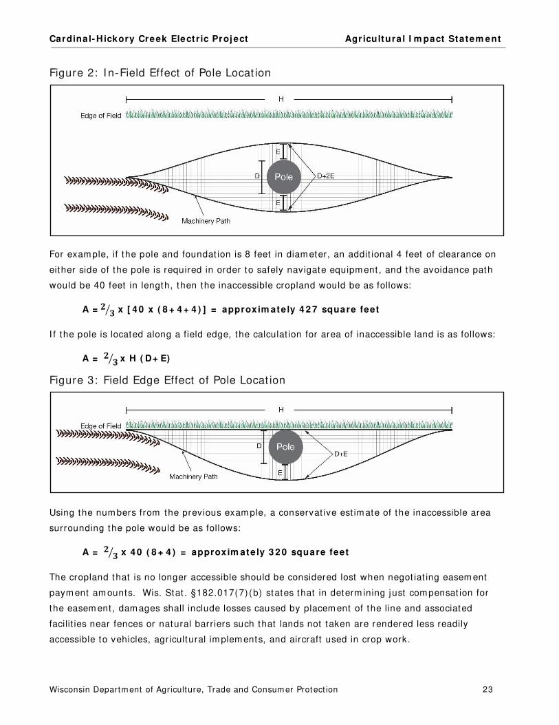
Cardinal- Hickory Creek Elect r ic Project Agr icultura l I m pact Statem ent
Wisconsin Departm ent of Agriculture, Trade and Consum er Protect ion 23
Figure 2: I n-Field Effect of Pole Locat ion
For exam ple, if the pole and foundat ion is 8 feet in diam eter, an addit ional 4 feet of clearance on
either side of the pole is required in order to safely navigate equipm ent , and the avoidance path
would be 40 feet in length, then the inaccessible cropland would be as follows:
A = 𝟐𝟐 𝟑𝟑� x [ 4 0 x ( 8 + 4 + 4 ) ] = approxim ate ly 4 2 7 square feet
I f the pole is located along a field edge, the calculat ion for area of inaccessible land is as follows:
A = 𝟐𝟐 𝟑𝟑� x H ( D+ E)
Figure 3: Field Edge Effect of Pole Locat ion
Using the num bers from the previous exam ple, a conservat ive est im ate of the inaccessible area
surrounding the pole would be as follows:
A = 𝟐𝟐 𝟑𝟑� x 4 0 ( 8 + 4 ) = approxim ate ly 3 2 0 square feet
The cropland that is no longer accessible should be considered lost when negot iat ing easem ent
paym ent am ounts. Wis. Stat . §182.017(7) (b) states that in determ ining just com pensat ion for
the easem ent , dam ages shall include losses caused by placem ent of the line and associated
facilit ies near fences or natural barriers such that lands not taken are rendered less readily
accessible to vehicles, agricultural im plem ents, and aircraft used in crop work.

Cardinal- Hickory Creek Elect r ic Project Agr icultura l I m pact Statem ent
Wisconsin Departm ent of Agriculture, Trade and Consum er Protect ion 24
Farm ing around t ransm ission poles can be difficult , part icularly when larger farm equipm ent is
used. At tem pts to reduce the area that cannot be cropped by plant ing closer to the pole than is
prudent m ay increase the likelihood that the equipm ent m akes contact with the st ructure and
becom es dam aged.
Removal of Existing Transmission Structures
Many of the proposed routes include double-circuit ing an exist ing lower-voltage line onto the new
poles with the new 345 kV line. This will require the rem oval of the exist ing pole. Poles in
cropland without foundat ions are typically cut off and the st ructures rem oved to a m inim um of
four feet below grade. During the process of rem oving these poles, t opsoil can be m ixed with
subsoils, com pacted, or lost . DATCP recom m ends that st ructure rem oval or “wrecking out ”
procedures be created and appropriate const ruct ion personnel t rained on the procedures. A well-
established procedure will serve to protect the agricultural use of the land so that the land quickly
recovers it s product ivit y. A sam ple of a wreck out procedure from a previous high-voltage
elect r ic t ransm ission project (PSC Docket 5-CE-142) is included in Appendix G.
Appraisal Process
I n Wisconsin, the acquisit ion of easem ents by ut ilit ies with em inent dom ain authority is st ipulated
under Wis. Stat . §32.06. Addit ional inform at ion about the appraisal process and landowners
r ights can be found in publicat ions from the Wisconsin Departm ent of Adm inist rat ion on it s
website (doa.wi.gov) , under the search term , “Relocat ion Assistance” . One of the publicat ions,
“The Rights of Landowners under Wisconsin Em inent Dom ain Law” is included in Appendix H of
this docum ent .
The ut ilit y m akes a financial offer to landowners using the fair m arket value of the easem ent plus
any ant icipated dam ages to the parcel or agricultural operat ions. The fair m arket value is the
price that a willing buyer would pay to a willing seller in the m arket . This is based on at least one
full narrat ive appraisal for each property the ut ilit y intends to acquire. The appraisal m ust be
presented to the landowner.
Addit ionally, landowners have the r ight to obtain their own appraisal of their property. They will
be com pensated for the cost of this appraisal by the ut ilit y if the following condit ions are m et :
The appraisal m ust be subm it ted to the ut ilit y or it s designated real estate cont ractor
within 60 days after the landowner receives the init ial ut ilit y appraisal.
The appraisal fee m ust be reasonable.
The appraisal m ust be a full, narrat ive appraisal.
The appraisal m ust be com pleted by a qualified appraiser.
Cardinal- Hickory Creek Elect r ic Project Agr icultura l I m pact Statem ent
Wisconsin Departm ent of Agriculture, Trade and Consum er Protect ion 25
The am ount of com pensat ion for the easem ent is established during the negot iat ion process
between the ut ilit y and the individual landowner. Landowners can also negot iate addit ional
st ipulat ions from the ut ilit y.
The ut ilit y is required to provide landowners with inform at ion about their r ights in this process
before negot iat ions begin. Wis. Stat . §32.035(4) (d) requires the ut ilit y to not negot iate with a
landowner or m ake a jurisdict ional offer unt il 30 days after the AIS is published. However,
elect r ic project s that require a CPCN from the PSC ( including this project ) , m ay negot iate with
landowners prior to approval from the PSC, only if the ut ilit y advises the landowner that the
ut ilit y does not have the authority to acquire the property by condem nat ion at that t im e (Wis.
Stat . §32.03(5) (c) ) . The ut ilit y has condem nat ion authority only after t he project is approved by
the PSC.
Landowners should keep in m ind that easem ents are cont racts. The signed easem ent cont ract is
binding to the landowner and any future owners of the land, unt il the cont ract is dissolved.
Though landowners can choose to waive any of their r ights, DATCP recom m ends to only do so
with careful considerat ion. When considering whether or not to sign an easem ent , landowners
should exam ine the language carefully and verify that it contains all agreed- to term s.
Landowners should be fam iliar with the Landowners’ Bill of Rights (Appendix C) so as to
determ ine if addit ional condit ions and/ or paym ents should be negot iated with the ut ilit y.
Landowners m ay want to seek legal advice if they have any quest ions about this process, and
should m ake sure that any at torney hired has expert ise and experience in em inent dom ain law
and procedures. A web link for finding an at torney is provided in Appendix D.
Farmland Preservation
Wisconsin’s Farm land Preservat ion Program (FPP) provides count ies, towns, and landowners with
tools to aid in protect ing agricultural land for cont inued agricultural use and to prom ote act ivit ies
that support the larger agricultural econom y. Through this program , count ies adopt state-
cert ified farm land preservat ion plans that m ap areas ident ified as im portant for farm land
preservat ion and agricultural developm ent based upon reasonable criteria. The plans ident ify
farm land preservat ion areas in the county and local governm ents m ay choose to adopt an
exclusive agricultural zoning ordinance to ensure that landowners covered by the ordinance are
eligible to claim farm land preservat ion tax credits. Such an ordinance m ust also be cert ified by
DATCP. DATCP cert ified the Farm land Preservat ion Plans for Grant County in 2011, I owa County
in 2017, Lafayet te County in 2017, and Dane County in 2017.
Within these farm land preservat ion areas, local governm ents and owners of farm land can pet it ion
for designat ion by the state as an Agricultural Enterprise Area (AEA) . This designat ion highlights
the im portance of the area for agriculture and further supports local farm land preservat ion and
agricultural developm ent goals. Designat ion as an AEA also enables eligible landowners to enter
into farm land preservat ion agreem ents. Through an agreem ent , a landowner agrees to

Cardinal- Hickory Creek Elect r ic Project Agr icultura l I m pact Statem ent
Wisconsin Departm ent of Agriculture, Trade and Consum er Protect ion 26
voluntarily rest r ict the use of his/ her land to agr iculture for fifteen years. No land that could be
acquired for this proj ect is part of an AEA.
Both AEAs and FPP zoning areas are required to follow the state soil and water conservat ion
standards to protect water qualit y and soil health.
Prime Farmland
Farm land soils are classified by the USDA based on their abilit y to produce crops. Protect ing
prim e farm land and prim e farm land, if drained or protected from flooding should be a priorit y for
ut ilit y const ruct ion projects. Definit ions of the types of USDA of farm land soils are listed in
Appendix F. I n this report , under each of the potent ial route and route opt ions, the acres of
im pacted farm land soils are listed. Typically, DATCP recom m ends considering routes that contain
the least am ount of new ROW on farm land soils of highest product ivit y.
Organic Farms
This project will im pact a num ber of farm s that use organic pract ices, are working towards an
organic cert ificat ion, or are cert ified organic. Care m ust be taken to protect the farm ing
operat ion and it s organic status. Organic farm ers should provide the Applicants and it s
subcont ractors with a list of the types of substances, m aterials, seeds, or pract ices that are not
perm it ted on the land by their cert ifying ent it y. Prior t o the start of const ruct ion, appropriate
const ruct ion m ethods should be agreed- to between the landowner and the Applicants. More
inform at ion about organic farm ing and potent ial im pacts from a ut ilit y project are discussed in
Chapter XI I , “Potent ial Im pacts of Transm ission Line Const ruct ion on Agriculture.”
Based on inform at ion provided in com m ents and addit ional data, the following table lists the
property owners who m ay have organic farm s affected by the project , depending on the route
approved by the PSC. There m ay be addit ional organic farm s or farm s with organic pract ices
affected by the project who did not com m ent .
Table 3: Potent ially Affected Organic Farms
Route Landowner Certifier Type Subsegments
Western
North
HELMUTH, DANIEL D JR AND IVA S (VALLEY VIEW
FARM)
Midwest Organic Services
Association Inc.
Crops D08
HERSHBERGER, HENRY AND CLARA (LONG LANE
FARM)
D08
WEPKING FARMS PARTNERSHIP (IHM ORGANIC
VIEW FARMS LLC)
Organic Tilth D04, D05
Western
South
ALLGYER, BENJAMIN AND LYDIA (BENJAMIN
ALLGYER FARM)
Midwest Organic Services
Association Inc.
Crops, Livestock H03
BEILER, ELMER AND ANNA Natures International
Certification Services
Crops, Livestock H06
ESH, STEPHEN AND DRUSILLA Midwest Organic Services
Association Inc.
Crops, Livestock H02, H03
FEHRENSEN, WOLF-GEOG (GARY WEDIG) Midwest Organic Services
Association Inc.
Crops, Livestock G08

Cardinal- Hickory Creek Elect r ic Project Agr icultura l I m pact Statem ent
Wisconsin Departm ent of Agriculture, Trade and Consum er Protect ion 27
Route Landowner Certifier Type Subsegments
Western
South
cont’d.
KINSINGER, ANDREW AND SARAH (MAPLE SHADE
FARM)
Natures International
Certification Services
Crops, Livestock H06
MARTIN, BETTIE (WILSON ORGANIC FARMS) H06
Eastern
North
DOLAN, DAVID (DOLAN FARMS) Midwest Organic Services
Association Inc.
Crops, Livestock P05, P06
EVANS, LESLIE AND LINDA P06
HOLBERG, GARY AND HEIDI P07
MEUDT, KEVIN (DOLAN FARMS) Organic bee
keepers
P07
STRONCEK, GREGORY AND LEA DOLAN-STRONCEK
(SEVEN SEEDS FARM LLC)
P07, P08
MIESS, KEVIN AND SHERRY (MIESS ORGANIC FARM
LLC)
Midwest Organic Services
Association Inc.
Crops, Livestock P03
Eastern
South
BICKFORD, PAUL (BICKFORD FARMS INC) Natures International
Certification Services
Crops S08, S09
CAYGILL, DAVID AND MICHELLE (CAYGILL FARM) Midwest Organic Services
Association Inc.
Crops, Livestock Q02
DOLAN, WILLIAM AND ROSE CENITE Midwest Organic Services
Association Inc.
Crops, Livestock S01
HANSON, KEVIN AND SHEILA (4K & S DAIRY) Q02
Eastern Alt
South
DAMMEN, LARRY AND KAY R09
Due to the num ber and range of organic operat ions that would be affected by m any of the
potent ial project routes, DATCP recom m ends that the Applicants produce a list of standard
procedures for protect ing organic soils and pract ices. Appendix I contains a sam ple of general
pract ices that were used on a previous high-voltage elect r ic t ransm ission project (PSC Docket 5-
CE-142) . While there m ay be different procedures required by different organic cert ifying ent it ies
or landowners, Appendix I appears to be an exam ple of a reasonable list of best m anagem ent
pract ices for the protect ion of m ost organic farm s. All appropriate personnel and cont ractors
should be t rained on the im plem entat ion of a project -specific best m anagem ent pract ices for
const ruct ing in or near organic farm land.
Lands Enrolled in Incentive Programs
Port ions of farm lands are often enrolled in incent ive program s that are adm inistered by federal,
state, and/ or county governm ents. These program s require proper m anagem ent of the resources
in return for financial incent ives. DATCP recom m ends the Applicants ident ify these lands, prior to
the start of const ruct ion, and work with landowners to understand the funct ion of and
m anagem ent plans used on these resources. Many propert ies are enrolled in m ore than one
program . Im pacts to the resource should be avoided or m inim ized as m uch as pract icable. Any
im pacts caused by the project should be rem ediated so that the resource can be returned to pre-
const ruct ion funct ion, if possible. I f im pacts cannot be avoided, the landowners should be
com pensated for any revenue lost from these incent ive program s, as a result of the project .

Cardinal- Hickory Creek Elect r ic Project Agr icultura l I m pact Statem ent
Wisconsin Departm ent of Agriculture, Trade and Consum er Protect ion 28
Conservation Reserve Program
The Conservat ion Reserve Program (CRP) offers farm ers financial incent ives to convert highly
erodible or environm entally sensit ive cropland to perm anent vegetat ive cover by plant ing species
that will enhance the environm ent . Land taken out of CRP is often t ransit ioned into row crop
product ion, potent ially causing an increase in soil erosion. For elect r ic projects, t ransm ission
poles should be located outside of CRP land, as m uch as pract icable.
Based on inform at ion provided in com m ents, the following table lists the project -affected
property owners who m ay have land enrolled in CRP. Actual im pacts will depend on the route
approved by the PSC. There m ay be addit ional landowners with CRP lands affected by the
project who did not com m ent .
Table 4: Potent ially Affected CRP Parcels
Route Landowner Subsegments
Western North ADRIAN, DOUGLAS AND JENNIFER D04
MOORE RESIDENCE D04
PIGEON CREEK LAND LLC D04
WEISS, GERALD (PROGRESSIVE PLUS) D04
WEPKING FARMS PARTNERSHIP (IHM ORGANIC VIEW FARMS LLC) D04, D05
Western South ABING, CARL AND ELIZABETH E06, E07
HOWE, KENNETH AND JAMIE PLOESSL-HOWE E07
RILEY, MICHAEL AND JUDITH E19
UDELHOFEN, PATRICK AND WENDY E16
Eastern North BUTTERIS, DANIEL AND JUDITH P03
D’ANGELO, BETSY P07, P08, P09
EVANS, LESLIE AND LINDA P06
FOSTER, THOMAS AND CAROL (O’CONNELL FARMS LLC) P09
KRITZ, MARY M AND DOUGLAS T GURAK P09
STANFIELD, DAVID J AND SANDIE P09
Eastern South BETTNER, ROY Q06, R13, R14, R15, S01,
S02, S03
Eastern Alt South EVELYN M MUELLER REVOCABLE TRUST R03
Mount Horeb East Option LAUFENBERG, RICHARD AND JOANN U02
Laydown Yard NEHLS, KENNETH A LY-5
Conservation Reserve Enhancement Program
The Conservat ion Reserve Enhancem ent Program (CREP) pays landowners to install conservat ion
pract ices such as filter st r ips along waterways or to return cont inually flooded fields to wet lands
while leaving the rem ainder of the adjacent land in agricultural product ion. Landowners agree to
install and m aintain the conservat ion pract ice for the durat ion of the CREP cont ract . CREP is a
joint effort between the federal, state, and county governm ents. CREP m ay perm it overhead
elect r ic lines to cross over CREP-enrolled lands, depending on the pract ice. However, if the
pract ice is a r iparian buffer, the land within the ROW m ay be taken out of the program . CREP
also lim its the building of elect r ic facilit ies within these areas. Perm anent ut ilit y access roads are
not allowed across CREP land, though tem porary roads m ay be perm it ted, provided the
conservat ion pract ice is reestablished.
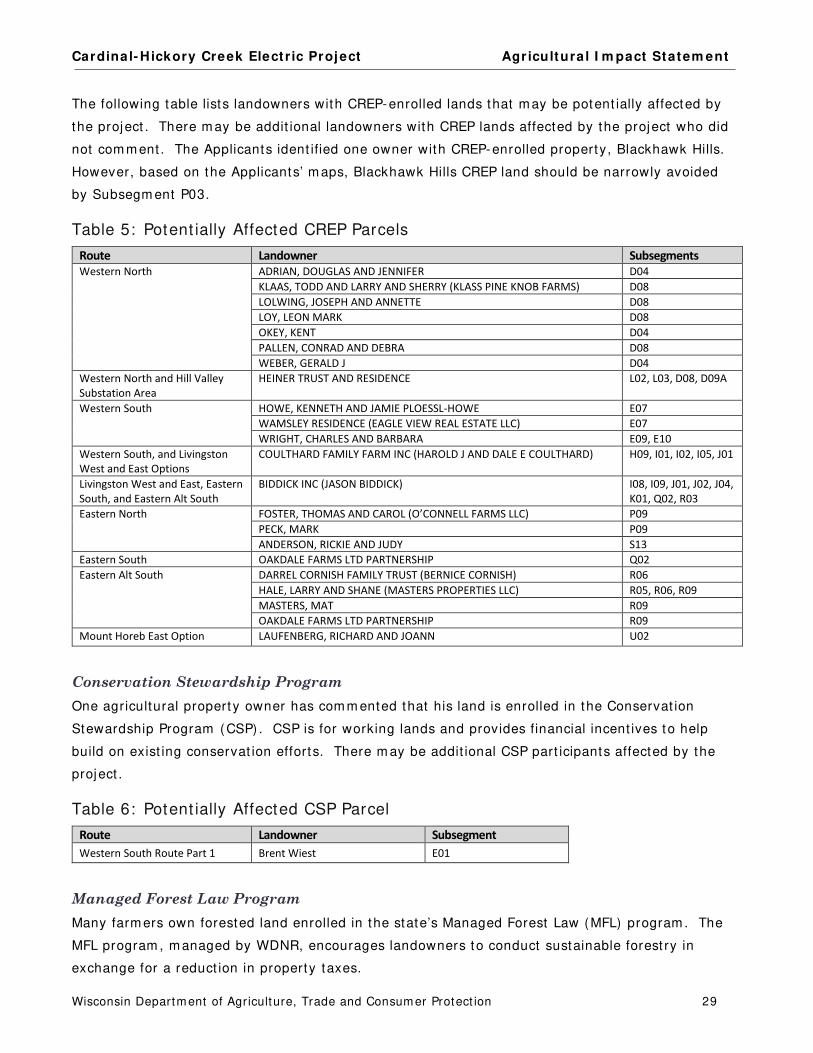
Cardinal- Hickory Creek Elect r ic Project Agr icultura l I m pact Statem ent
Wisconsin Departm ent of Agriculture, Trade and Consum er Protect ion 29
The following table lists landowners with CREP-enrolled lands that m ay be potent ially affected by
the project . There m ay be addit ional landowners with CREP lands affected by the project who did
not com m ent . The Applicants ident ified one owner with CREP-enrolled property, Blackhawk Hills.
However, based on the Applicants’ m aps, Blackhawk Hills CREP land should be narrowly avoided
by Subsegm ent P03.
Table 5: Potent ially Affected CREP Parcels
Route Landowner Subsegments
Western North ADRIAN, DOUGLAS AND JENNIFER D04
KLAAS, TODD AND LARRY AND SHERRY (KLASS PINE KNOB FARMS) D08
LOLWING, JOSEPH AND ANNETTE D08
LOY, LEON MARK D08
OKEY, KENT D04
PALLEN, CONRAD AND DEBRA D08
WEBER, GERALD J D04
Western North and Hill Valley
Substation Area
HEINER TRUST AND RESIDENCE L02, L03, D08, D09A
Western South HOWE, KENNETH AND JAMIE PLOESSL-HOWE E07
WAMSLEY RESIDENCE (EAGLE VIEW REAL ESTATE LLC) E07
WRIGHT, CHARLES AND BARBARA E09, E10
Western South, and Livingston
West and East Options
COULTHARD FAMILY FARM INC (HAROLD J AND DALE E COULTHARD) H09, I01, I02, I05, J01
Livingston West and East, Eastern
South, and Eastern Alt South
BIDDICK INC (JASON BIDDICK) I08, I09, J01, J02, J04,
K01, Q02, R03
Eastern North FOSTER, THOMAS AND CAROL (O’CONNELL FARMS LLC) P09
PECK, MARK P09
ANDERSON, RICKIE AND JUDY S13
Eastern South OAKDALE FARMS LTD PARTNERSHIP Q02
Eastern Alt South
DARREL CORNISH FAMILY TRUST (BERNICE CORNISH) R06
HALE, LARRY AND SHANE (MASTERS PROPERTIES LLC) R05, R06, R09
MASTERS, MAT R09
OAKDALE FARMS LTD PARTNERSHIP R09
Mount Horeb East Option LAUFENBERG, RICHARD AND JOANN U02
Conservation Stewardship Program
One agricultural propert y owner has com m ented that his land is enrolled in the Conservat ion
Stewardship Program (CSP) . CSP is for working lands and provides financial incent ives to help
build on exist ing conservat ion efforts. There m ay be addit ional CSP part icipants affected by the
project .
Table 6: Potent ially Affected CSP Parcel
Route Landowner Subsegment
Western South Route Part 1 Brent Wiest E01
Managed Forest Law Program
Many farm ers own forested land enrolled in the state’s Managed Forest Law (MFL) program . The
MFL program , m anaged by WDNR, encourages landowners to conduct sustainable forest ry in
exchange for a reduct ion in property taxes.
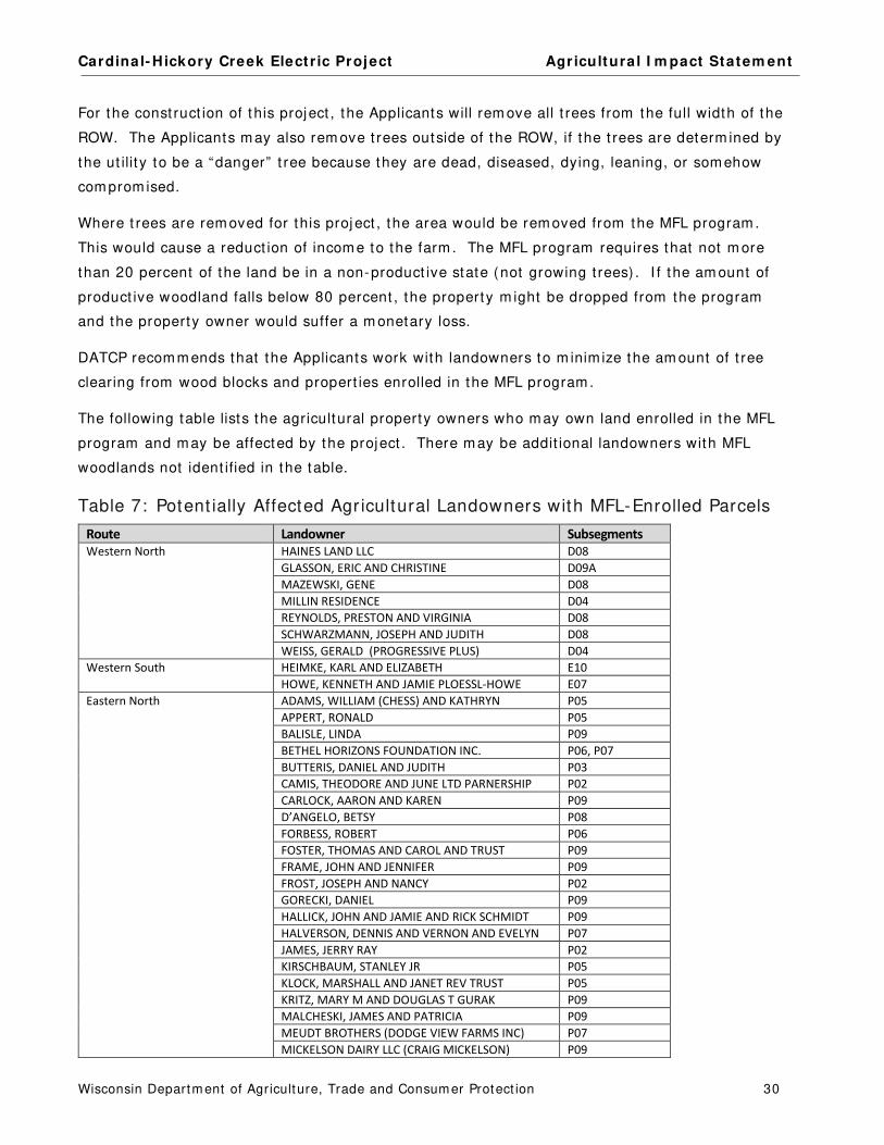
Cardinal- Hickory Creek Elect r ic Project Agr icultura l I m pact Statem ent
Wisconsin Departm ent of Agriculture, Trade and Consum er Protect ion 30
For the const ruct ion of t his project , the Applicants will rem ove all t rees from the full width of the
ROW. The Applicants m ay also rem ove t rees outside of the ROW, if the t rees are determ ined by
the ut ilit y to be a “danger” t ree because they are dead, diseased, dying, leaning, or som ehow
com prom ised.
Where t rees are rem oved for this proj ect , the area would be rem oved from the MFL program .
This would cause a reduct ion of incom e to the farm . The MFL program requires that not m ore
than 20 percent of the land be in a non-product ive state (not growing t rees) . I f the am ount of
product ive woodland falls below 80 percent , the property m ight be dropped from the program
and the property owner would suffer a m onetary loss.
DATCP recom m ends that the Applicants work with landowners to m inim ize the am ount of t ree
clearing from wood blocks and propert ies enrolled in the MFL program .
The following table lists the agricultural property owners who m ay own land enrolled in the MFL
program and m ay be affected by the project . There m ay be addit ional landowners with MFL
woodlands not ident ified in the table.
Table 7: Potent ially Affected Agr icultural Landowners with MFL-Enrolled Parcels
Route Landowner Subsegments
Western North HAINES LAND LLC D08
GLASSON, ERIC AND CHRISTINE D09A
MAZEWSKI, GENE D08
MILLIN RESIDENCE D04
REYNOLDS, PRESTON AND VIRGINIA D08
SCHWARZMANN, JOSEPH AND JUDITH D08
WEISS, GERALD (PROGRESSIVE PLUS) D04
Western South HEIMKE, KARL AND ELIZABETH E10
HOWE, KENNETH AND JAMIE PLOESSL-HOWE E07
Eastern North ADAMS, WILLIAM (CHESS) AND KATHRYN P05
APPERT, RONALD P05
BALISLE, LINDA P09
BETHEL HORIZONS FOUNDATION INC. P06, P07
BUTTERIS, DANIEL AND JUDITH P03
CAMIS, THEODORE AND JUNE LTD PARNERSHIP P02
CARLOCK, AARON AND KAREN P09
D’ANGELO, BETSY P08
FORBESS, ROBERT P06
FOSTER, THOMAS AND CAROL AND TRUST P09
FRAME, JOHN AND JENNIFER P09
FROST, JOSEPH AND NANCY P02
GORECKI, DANIEL P09
HALLICK, JOHN AND JAMIE AND RICK SCHMIDT P09
HALVERSON, DENNIS AND VERNON AND EVELYN P07
JAMES, JERRY RAY P02
KIRSCHBAUM, STANLEY JR P05
KLOCK, MARSHALL AND JANET REV TRUST P05
KRITZ, MARY M AND DOUGLAS T GURAK P09
MALCHESKI, JAMES AND PATRICIA P09
MEUDT BROTHERS (DODGE VIEW FARMS INC) P07
MICKELSON DAIRY LLC (CRAIG MICKELSON) P09

Cardinal- Hickory Creek Elect r ic Project Agr icultura l I m pact Statem ent
Wisconsin Departm ent of Agriculture, Trade and Consum er Protect ion 31
Route Landowner Subsegments
Eastern North cont’d. PEAT, MARGARET P05
SENDECKE, JAMES P02
STANFIELD, DAVID J AND SANDIE P09
SWEENEY, GERALD P09
TOWNSEND, FRED AND BARBARA BORNS P09
WELP, PAUL AND SARA P09
WISPROPMAR LLC P09
URNESS, JON AND JUDITH P09
URNESS, VIRGINIA P09
Eastern South JOHNSON, BRYAN AND BRADLEY R05

Cardinal- Hickory Creek Elect r ic Project Agr icultura l I m pact Statem ent
Wisconsin Departm ent of Agriculture, Trade and Consum er Protect ion 32
MISSISSIPPI RIVER ROUTING AREA
The potent ial routes from the crossing of the Mississippi River t o the beginning of the Western
Routes are described in this chapter. I ncluded are references to the accom panying Map Book.
Alm ost all of the potent ial route segm ents in the Mississippi River Rout ing Area would be
collocated with lower voltage elect r ic lines along exist ing ROWs.
Route Descriptions
Map Book Figure 1
Two potent ial routes cross the Mississippi River from Iowa. They cross into Wisconsin either at
the Nelson Dewey Substat ion in the town of Cassville or at the Stonem an Substat ion in the
village of Cassville. Both crossing locat ions can connect to the Western North Route or the
Western South Route. For either crossing, federal approval is required for the crossing of the
Mississippi River and for an easem ent across the Upper Mississippi River Nat ional Wildlife and Fish
Refuge.
After crossing the r iver, the Nelson Dewey North Route connects t o the Western North Route and
the Nelson Dewey South Route connects t o the Western South Route. Sim ilarly, the Stonem an
North Route connects to the Western North Route and a Stonem an South Route connects to the
Western South Route.
The Nelson Dewey North Route has the addit ional opt ion of being routed along either side of t he
Nelson Dewey Substat ion. Subsegm ent A01B is routed along the west and north boundary of t he
Nelson Dewey Substat ion (Opt ion 1) . Subsegm ents A01C and C02A are routed along the south
and east boundaries of t he Nelson Dewey Substat ion (Opt ion 2) . Neither Subsegm ent A01B or
Subsegm ents A01C and C02A cross agricultural propert ies.
The following tables describe the potent ial routes and route im pacts of t he Mississippi River Area.
Table 8: Mississippi River Area - Acres Affected
Option Subsegments
Length
(miles)
ROW
(acres)
ROW Acres
Shared (percent)
Acres in
Agriculture
Percentages
In Agriculture
Nelson Dewey North
Option 1
A01A, A01B, A02,
A03 1.5 25.1 7.1 (28%) 3.0 12%
Nelson Dewey North
Option 2
A01A, C02A, A01C,
A02, A03 1.5 24.0 6.7 (28%) 3.0 13%
Nelson Dewey South A01A, C02A, C02B,
C04 1.8 30.0 3.4 (11%) 13.3 44%
Stoneman North B01, B02, C01, C03 1.8 32.9 11.7 (36%) 21.2 64%
Stoneman South B01, B02, B03, B04 1.1 19.6 7.6 (39%) 10.4 53%
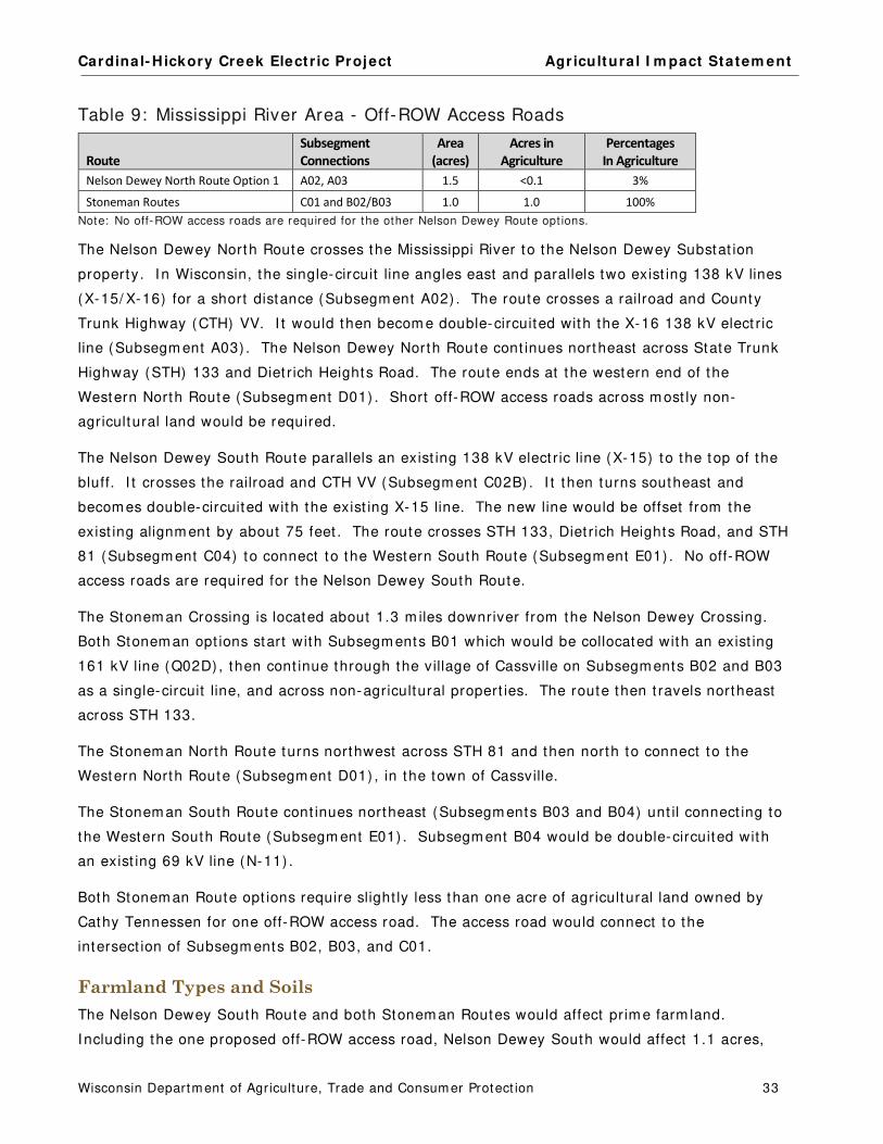
Cardinal- Hickory Creek Elect r ic Project Agr icultura l I m pact Statem ent
Wisconsin Departm ent of Agriculture, Trade and Consum er Protect ion 33
Table 9: Mississippi River Area - Off-ROW Access Roads
Route
Subsegment
Connections
Area
(acres)
Acres in
Agriculture
Percentages
In Agriculture
Nelson Dewey North Route Option 1 A02, A03 1.5 <0.1 3%
Stoneman Routes C01 and B02/B03 1.0 1.0 100%
Note: No off-ROW access roads are required for the other Nelson Dewey Route opt ions.
The Nelson Dewey North Route crosses the Mississippi River to the Nelson Dewey Substat ion
property. I n Wisconsin, the single-circuit line angles east and parallels two exist ing 138 kV lines
(X-15/ X-16) for a short distance (Subsegm ent A02) . The route crosses a railroad and County
Trunk Highway (CTH) VV. I t would then becom e double-circuited with the X-16 138 kV elect r ic
line (Subsegm ent A03) . The Nelson Dewey North Route cont inues northeast across State Trunk
Highway (STH) 133 and Diet r ich Heights Road. The route ends at the western end of the
Western North Route (Subsegm ent D01) . Short off-ROW access roads across m ost ly non-
agricultural land would be required.
The Nelson Dewey South Route parallels an exist ing 138 kV elect r ic line (X-15) to the top of the
bluff. I t crosses the railroad and CTH VV (Subsegm ent C02B) . I t then turns southeast and
becom es double-circuited with the exist ing X-15 line. The new line would be offset from the
exist ing alignm ent by about 75 feet . The route crosses STH 133, Diet r ich Heights Road, and STH
81 (Subsegm ent C04) to connect to the Western South Route (Subsegm ent E01) . No off-ROW
access roads are required for the Nelson Dewey South Route.
The Stonem an Crossing is located about 1.3 m iles downriver from the Nelson Dewey Crossing.
Both Stonem an opt ions start with Subsegm ents B01 which would be collocated with an exist ing
161 kV line (Q02D) , then cont inue through the village of Cassville on Subsegm ents B02 and B03
as a single-circuit line, and across non-agricultural propert ies. The route then t ravels northeast
across STH 133.
The Stonem an North Route turns northwest across STH 81 and then north to connect to the
Western North Route (Subsegm ent D01) , in the town of Cassville.
The Stonem an South Route cont inues northeast (Subsegm ents B03 and B04) unt il connect ing to
the Western South Route (Subsegm ent E01) . Subsegm ent B04 would be double-circuited with
an exist ing 69 kV line (N-11) .
Both Stonem an Route opt ions require slight ly less than one acre of agricultural land owned by
Cathy Tennessen for one off-ROW access road. The access road would connect to the
intersect ion of Subsegm ents B02, B03, and C01.
Farmland Types and Soils
The Nelson Dewey South Route and both Stonem an Routes would affect prim e farm land.
I ncluding the one proposed off-ROW access road, Nelson Dewey South would affect 1.1 acres,

Cardinal- Hickory Creek Elect r ic Project Agr icultura l I m pact Statem ent
Wisconsin Departm ent of Agriculture, Trade and Consum er Protect ion 34
Stonem an North would affect 1.43 acres, and Stonem an South would affect 1.0 acres of prim e
farm land. The Nelson Dewey North Route would affect the fewest agricultural acres (3.0 acres) ,
1.5 acres of pasture, and no cropland, or prim e farm land. The Stonem an North Route would
affect the m ost agricultural acres (22.1 acres) and the m ost cropland (4.8 acres) .
Impacts to Agricultural Properties
The agricultural landowners below could be affected by the Mississippi River Area routes.
Table 10: Mississippi River Area – Potent ially Affected Agricultural Landowners
Agricultural Landowners
Nelson Dewey
North
(acres)
Nelson Dewey
South
(acres)
Stoneman
North
(acres)
Stoneman
South
(acres)
BREUER, PAUL - - 5.60 0.84 - -
DEGENHARDT, ARLENE 1.98 - - - - - -
ESSER BROTHERS LTD PARTNERSHIP - - 6.43 1.12 0.10
JUNK, WAYNE AND ARLENE 0.13 - - 4.05 - -
KIRSCHBAUM, GARY AND SUZANNE - - - - 5.22 - -
TENNESSEN, CATHY - - - - 10.90 9.66
YUNK, GARY AND VICTORIA 0.89 1.25 - - - -
TOTALS 3.00 13.28 22.11 9.76 NOTE: This table includes acres affected by the ROW and off-ROW access roads.
The com m ents from two agricultural landowners that could be affected by routes in the
Mississippi River Rout ing Area are sum m arized below.
Farm Ow ner: Paul Breuer
Routes ( Subsegm ents) : 5.6 acres Nelson Dewey South (C02B) , 0.8 acres Stonem an North (C01, C03)
Paul Breuer’s cropland and woodland would be affected by the Nelson Dewey South Route and
one off-ROW access road for the Stonem an North Route. The woodland includes walnut and oak
t rees. Mr. Breuer is concerned that the project m ight affect a creek on his land.
Farm Ow ners/ Operator: Gary and Suzanne Kirschbaum / Richard Junk
Routes ( Subsegm ents) : 3.0 acres Nelson Dewey South (C02B, C04) , 6.8 acres Stonem an North (C01, C03) , 0.7 acres for an off-ROW access road
Cropland and woodland owned by the Kirschbaum s would be affected by either the Nelson Dewey
South or the Stonem an North Routes and m ay be required for one off-ROW access road to the
Western North Route. The renter grows corn, soybeans, hay, and oats in rotat ion and also uses
the pasture for 6 head of beef cat t le. The owners are concerned about im pacts to fencing on
their property. They also sell firewood from their woodlot .

Cardinal- Hickory Creek Elect r ic Project Agr icultura l I m pact Statem ent
Wisconsin Departm ent of Agriculture, Trade and Consum er Protect ion 35
Summary
The Nelson Dewey North Route would affect the fewest acres in agriculture. Much of the land
affected by the Nelson Dewey and Stonem an Routes is not in agriculture. Addit ionally, m ost of
the routes part ially over lap exist ing elect r ic line ROWs.
The affected agricultural land is heavily wooded and the routes would require t ree clearing to
expand the exist ing ROWs. Wood from these property owners is often sold for firewood or other
uses. I t is im portant that landowners are consulted about wood ownership and are appropriately
com pensated.

Cardinal- Hickory Creek Elect r ic Project Agr icultura l I m pact Statem ent
Wisconsin Departm ent of Agriculture, Trade and Consum er Protect ion 36
WESTERN ROUTING AREA
Western North Route
The Western North Route connects from either the Nelson Dewey North or the Stonem an North
routes to the Hill Valley Substat ion Site Area. The alternat ive to the Western North Route is the
Western South Route which is described in the following sect ion. The descript ions in this sect ion
include references to the accom panying Map Book.
Route Description
Map Book Figures 1 – 6
The Western North Route (Subsegm ents D01, D03, D04, D05, D08, and D09A) extends cross-
count ry across the width of Grant County. I t t ravels northeast from the town of Cassville to the
town of Wingville, ending at the Hill Valley Substat ion Area. I t crosses through the towns of
Beetown, South Lancaster, Ellenboro, Liberty, and Clifton, as well as passing just southeast of t he
city of Lancaster. Alm ost all of this route is across agricultural land.
The Western North Route would be double-circuited with an exist ing 138 kV elect r ic line (X-16)
for it s ent ire 32-m ile length. For m ost of the route, the new 345 kV line would be offset to the
north of the exist ing elect r ic line by about 75 feet . The new ROW would overlap the exist ing
ROW width between 3 and 95 feet . Between Stage Road and STH 129 and from Laplat te Road to
the new substat ion area, the new alignm ent would be located south of t he exist ing elect r ic line so
as to avoid im pacts to exist ing st ructures.
Table 11: Western North Route - Acres Affected
Route Subsegments
Length
(miles)
ROW
(acres)
ROW Acres
Shared (percent)
Acres in
Agriculture
Percentage
In Agriculture
Western North D01, D03, D04, D05, D08, D09A 32.4 587.2 204.1 (35%) 546.2 93%
Table 12: Western North Route - Off-ROW Access Roads
Route Subsegment Connections
Area
(acres)
Acres in
Agriculture
Percentage
In Agriculture
Western North All subsegments 129.0 127.1 98%
The Western North Route crosses Set t lem ent Road, Hauger Lane ( twice) , STH 81, Rat t lesnake
Road, CTH U, Black Jack Road, Grant River Road, Five Points Road, Bee Lane, CTH N, Boice Creek
Road, Old Potosi Road, Stage Road, U.S. Highway (USH) 61, STH 129, Muldoon Lane, Lincoln
Road, CTH A, Coon Hollow Road, Ridge Road, Sleepy Hollow Road ( twice) , Scenic Road, Pine
Knob Road, CTH E, Hopewell Road, Rock Church Road, La Plat te Road, Ebenezer Road, and
Stockyard Road.

Cardinal- Hickory Creek Elect r ic Project Agr icultura l I m pact Statem ent
Wisconsin Departm ent of Agriculture, Trade and Consum er Protect ion 37
Ninety-one off-ROW access roads would be required for the const ruct ion and potent ially, the
cont inued m aintenance of the new elect r ic line. About 20 percent of the agricultural land affected
by this route is for off-ROW access roads. Alm ost all agricultural landowners that would be
im pacted by the proj ect ROW would also be im pacted by off-ROW access roads.
Farmland Types and Soils
Approxim ately 64 percent of the agricultural land affected by this route and it s m any off-ROW
access roads is across cropland and pasture. Another 31 percent of the affected agricultural land
is used for resident ial areas, farm buildings, farm roads, woodlands, and wet lands. The
Applicants have ident ified the specialty farm s crossed by this route as t ree farm s.
Table 13: Western North Route - Agricultural Land Use
Agricultural Land Use
ROW
(acres)
Off-ROW
Access Roads
(acres)
Totals
(acres) Percentages
Cropland 246.12 74.31 320.43 48%
Pasture 107.60 2.81 110.41 16%
Idle or Fallow Field 31.43 0.23 31.66 5%
Specialty Farmland
(tree farms) 0.79 0.34 1.13 <1%
Other Agricultural Land 160.22 49.70 209.92 31%
Totals 546.16 127.39 673.56 100%
About 20 percent of the route is across agricultural land that is classified as prim e and prim e if
drained farm land soils. Slight ly m ore than half of the affected agricultural land (54 percent ) is
not prim e farm land.
Table 14: Western North Route - Farm land Soils
Farmland Soil Classification
ROW
(acres)
Off-ROW
Access Roads
(acres)
Totals
(acres) Percentages
Prime farmland 100.24 28.37 128.62 19%
Prime farmland if drained 1.22 0.33 1.55 <1%
Farmland of statewide importance 133.97 43.64 177.61 26%
Not prime 310.73 55.05 365.78 54%
Totals 546.16 127.39 673.56 100%
Impacts to Agricultural Properties
The Western North Route would affect 151 property owners of which 132 are agricultural
propert ies. Out of the affected 132 agricultural property owners, 109 would also have addit ional
acres required for off-ROW access roads. The table below ident ifies the agricultural property
owners affected by the Western North Route. Those with asterisks before their nam e would also
be affected by off-ROW access roads.
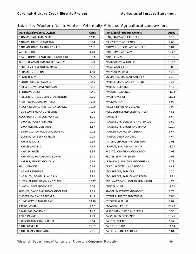
Cardinal- Hickory Creek Elect r ic Project Agr icultura l I m pact Statem ent
Wisconsin Departm ent of Agriculture, Trade and Consum er Protect ion 38
Table 15: Western North Route - Potent ially Affected Agricultural Landowners
Agricultural Property Owners Acres Agricultural Property Owners Acres
*ADAMS, PAUL AND LORRIE 12.41 LENZ, JAMES AND KATHLEEN 1.19
*ADAMS, TIMOTHY AND AMY 9.14 *LENZ, PETER AND CAROL 4.63
*ADRIAN, DOUGLAS AND JENNIFER 12.61 *LOLWING, JOSEPH AND ANNETTE 9.04
AXTELL, BART 1.20 *LOY, DAVID AND AMY 12.47
*BAHL, DONALD J AND RUTH C BAHL TRUST 9.53 *LOY, LEON M 16.86
BOLK, SUSAN AND MARGARET BAGLEY 5.08 *MAJESTIC VIEW LAND LLC 19.62
*BUTTLES, ELAM AND BARBARA 16.61 *MAZEWSKI, GENE 3.85
*CHAMBLISS, GLENN 1.18 *MCMAHON, DAVID 5.29
*CLAUER, KEVIN 12.95 MCMAHON, MARK AND ANDREA 2.36
*COON HOLLOW ROAD LLC 6.45 *MILLER, LLOYD AND KATHERINE 3.24
*DRISCOLL, WILLIAM AND JOAN 4.11 *MILLIN RESIDENCE 4.49
ERRTHUM, LARRY 3.41 *MOORE RESIDENCE 11.12
*ESSER BROTHERS LIMITED PARTNERSHIP 6.06 *MORROW, LYLE 11.03
*FEIST, GERALD AND PATRICIA 15.75 *MUMM, HEATH 5.92
*FOLEY, MICHAEL AND JOSHUA LUDWIG 11.99 *NISLEY, HENRY AND ELIZABETH 1.94
*GLASSON, ERIC AND CHRISTINE 4.76 NOEL, JOHN M AND DEBRA A TRUST 4.85
GOOD HOPE LAND COMPANY LLC 1.01 *OKEY, KENT 6.64
*GRANEY, ROGER AND JANET 9.31 *PAGENKOPF, BURDETTE AND PHYLLIS 3.69
*GRANVILLE INCOME TRUST 1.67 *PAGENKOPF, DANIEL AND NANCY 10.05
*GRISWOLD, PATRICK E. AND JANE M. 2.02 *PALLEN, CONRAD AND DEBRA 3.67
*GUDENKAUF, BERNICE TRUST 2.05 *PIGEON CREEK LAND LLC 4.64
*HAFNER, SCOTT 9.96 *PITZEN, CHARLES AND CASSINDA 2.08
*HAINES LAND LLC 7.65 *RAGATZ, BRADLEY AND MISTY 13.78
*HALE, DARLEEN 3.36 RAGATZ, JONATHON AND ALLISON 1.08
*HAMPTON, RANDALL AND RONALD 6.41 REUTER, JEFF AND ELLEN 1.65
*HARPER, STUART AND SALLY 5.64 *REYNOLDS, PRESTON AND VIRGINIA 5.71
HAUK, FRANCIS 5.65 *RIEDL, WALTER L. AND LINDA A. 6.41
*HEINER RESIDENCE 8.88 *SCHROEDER, PATRICK R. 1.20
*HELMUTH, DANIEL JR. AND IVA 8.82 *SCHROEDER, PATRICK AND KAREN 12.81
*HERSHBERGER, HENRY AND CLARA 16.97 *SCHWARZMANN, JOSEPH AND JUDITH 4.74
*HI-VIEW SHORTHORNS INC. 6.14 *SNIDER, KURT 17.52
HUGHES, DAVID AND SUSAN ANDERSON 9.63 STADER, MATTHEW AND BECKY 2.75
*JASPER, DALE AND BARBARA 2.49 *STADER, ROBERT AND TERESA 7.88
*JUNK, WAYNE AND ARLENE 13.28 *STELPFLUG TRUST 2.07
KALINS, KEVIN 4.82 *TOAD VALLEY LLC 20.49
*KATZUNG, DARREN S. 1.47 VESPERMAN, DAVID AND LINDA 1.95
KELLY, DENNIS 4.79 *WASHBURN RESIDENCE 10.45
*KIRSCHBAUM FAMILY TRUST 6.14 *WEBER, GERALD 5.37
*KITE, DAVID JR. 15.67 *WEISS, GERALD 14.64
*KITE, JAMES AND LINDA 2.81 *WHITTY, DANIEL C. TRUST 1.84
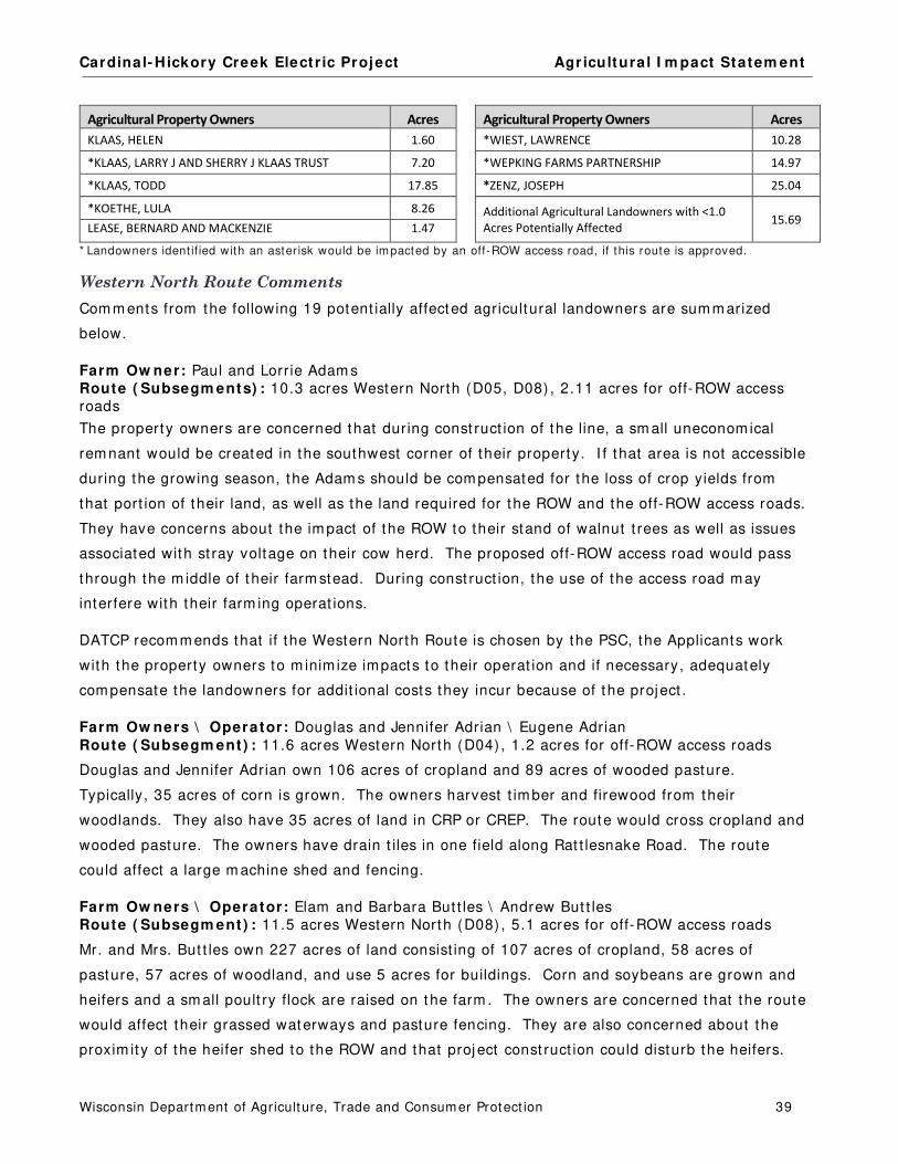
Cardinal- Hickory Creek Elect r ic Project Agr icultura l I m pact Statem ent
Wisconsin Departm ent of Agriculture, Trade and Consum er Protect ion 39
Agricultural Property Owners Acres Agricultural Property Owners Acres
KLAAS, HELEN 1.60 *WIEST, LAWRENCE 10.28
*KLAAS, LARRY J AND SHERRY J KLAAS TRUST 7.20 *WEPKING FARMS PARTNERSHIP 14.97
*KLAAS, TODD 17.85 *ZENZ, JOSEPH 25.04
*KOETHE, LULA 8.26 Additional Agricultural Landowners with <1.0
Acres Potentially Affected 15.69
LEASE, BERNARD AND MACKENZIE 1.47
* Landowners ident if ied with an aster isk would be impacted by an off-ROW access road, if this route is approved.
Western North Route Comments
Com m ents from the following 19 potent ially affected agricultural landowners are sum m arized
below.
Farm Ow ner: Paul and Lorrie Adam s
Route ( Subsegm ents) : 10.3 acres Western North (D05, D08) , 2.11 acres for off-ROW access roads
The property owners are concerned that during const ruct ion of the line, a sm all uneconom ical
rem nant would be created in the southwest corner of their property. I f that area is not accessible
during the growing season, the Adam s should be com pensated for the loss of crop yields from
that port ion of their land, as well as the land required for the ROW and the off-ROW access roads.
They have concerns about the im pact of the ROW to their stand of walnut t rees as well as issues
associated with st ray voltage on their cow herd. The proposed off-ROW access road would pass
through the m iddle of t heir farm stead. During const ruct ion, the use of the access road m ay
interfere with their farm ing operat ions.
DATCP recom m ends that if the Western North Route is chosen by the PSC, the Applicants work
with the property owners to m inim ize impacts to their operat ion and if necessary, adequately
com pensate the landowners for addit ional costs they incur because of t he project .
Farm Ow ners \ Operator: Douglas and Jennifer Adrian \ Eugene Adrian
Route ( Subsegm ent ) : 11.6 acres Western North (D04) , 1.2 acres for off-ROW access roads
Douglas and Jennifer Adrian own 106 acres of cropland and 89 acres of wooded pasture.
Typically, 35 acres of corn is grown. The owners harvest t im ber and firewood from their
woodlands. They also have 35 acres of land in CRP or CREP. The route would cross cropland and
wooded pasture. The owners have drain t iles in one field along Rat t lesnake Road. The route
could affect a large m achine shed and fencing.
Farm Ow ners \ Operator: Elam and Barbara But t les \ Andrew But t les Route ( Subsegm ent ) : 11.5 acres Western North (D08) , 5.1 acres for off-ROW access roads
Mr. and Mrs. But t les own 227 acres of land consist ing of 107 acres of cropland, 58 acres of
pasture, 57 acres of woodland, and use 5 acres for buildings. Corn and soybeans are grown and
heifers and a sm all poult ry flock are raised on the farm . The owners are concerned that the route
would affect their grassed waterways and pasture fencing. They are also concerned about the
proxim ity of the heifer shed to the ROW and that proj ect const ruct ion could disturb the heifers.

Cardinal- Hickory Creek Elect r ic Project Agr icultura l I m pact Statem ent
Wisconsin Departm ent of Agriculture, Trade and Consum er Protect ion 40
Farm Ow ner \ Operators: Kevin Clauer \ Jim Zenz and Terry St r ief Route ( Subsegm ent ) : 9.7 acres Western North (D04) , 3.2 acres for off-ROW access roads
Mr. Clauer owns 160 acres of land consist ing of 64 acres of cropland and 96 acres of pasture.
The cropland is used to grown corn and the pasture accom m odates 40 head of beef cat t le. This
farm is under the FPP. Mr. Clauer is concerned about the potent ial negat ive effect of this project
on the three dam s on his property.
Farm Ow ners \ Operator: Gerald and Pat ricia Feist \ Pat r ick Schroeder Route ( Subsegm ent ) : 14.2 acres Western North (D08) , 1.6 acres for off-ROW access roads
Mr. and Mrs. Feist own 174 acres of land which includes 68 acres of cropland, 50 acres of
pasture, 50 acres of woodland, and 5 acres for buildings. This farm is included in the FPP. Trees
are periodically harvested from the woodland. The project could affect cropland, pasture,
woodland, and two grassed waterways. The owners are concerned that the project could
perm anent ly dam age the qualit y of their soils by bringing stones up to the surface, m ixing soil
layers, and com pact ing soils. Pasture fencing m ight need to be altered during const ruct ion to
keep livestock out of the const ruct ion zone. The owners are also concerned about im pacts to
cropland and pasture that could affect their rental incom e during and after const ruct ion.
Farm Ow ners: Randall and Ronald Ham pton Route ( Subsegm ent ) : 5.4 acres Western North (D01) , 1.5 acres for an off-ROW access road
The Ham ptons own 700 acres of land and rent 52 acres of cropland from Catherine Tennessen.
The Ham ptons grow corn, soybeans, and hay, and raise 100 head of beef cat t le and 250 head of
sheep/ goats. The route could affect cropland and pasture, as well as grassed waterways and a
fence.
Farm Ow ner \ Operator: Francis Hauk \ Cam el Ridge Farm s Route ( Subsegm ent ) : 5.7 acres Western North (D03, D04)
Mr. Hauk owns 64 acres of land consist ing of 45 acres of cropland, 19 acres of woodland, and 2
acres for buildings. The renter grows corn and soybeans on the land. The route could affect his
cropland and grassed waterways.
Farm Ow ners: Daniel Jr. and I va Helm uth Route ( Subsegm ent ) : 7.5 acres Western North (D08) , 1.3 acres for off-ROW access roads
The Helm uths own 197 acres of land consist ing of 113 acres of cropland, 61 acres of pasture, 20
acres of woodland, and 3 acres for buildings. They grow corn and raise 7 head of replacem ent
dairy cat t le. This farm is cert ified for organic product ion by Midwest Organic Services
Associat ion, I nc. The owners are concerned that the project could affect their organic status and
pasture fencing.
Farm Ow ners: Larry J. and Sherry J. Klaas I r revocable Trust and Todd Klaas Operator: Todd Klaas Pine Knob Farm s
Route ( Subsegm ent ) : 17.8 acres Western North (D08) , 7.2 acres for Off-ROW access roads
Larry and Sherry Klaas (Klaas I rrevocable Trust ) own 295 acres. Their son, Todd Klaas owns 625
acres. Both propert ies are operated by Todd Klaas (Klaas Pine Knob Farm s) . Corn, soybeans,

Cardinal- Hickory Creek Elect r ic Project Agr icultura l I m pact Statem ent
Wisconsin Departm ent of Agriculture, Trade and Consum er Protect ion 41
hay, and wheat are grown on the land. They have a 225-cow dairy operat ion with 200
replacem ent dairy cat t le. Land from both owners are enrolled in CREP. Their concerns include
the potent ial negat ive im pact to the three creeks that would be crossed by the proposed off-ROW
access road, disturbance and com pact ion of product ive soils, st ray voltage, and interference with
their phone and TV recept ion from the operat ing line.
Farm Ow ners \ Renter: Millin Residence \ Gary Stelpflug Route ( Subsegm ent ) : 3.7 acres Western North (D04) , 0.8 acres for off-ROW access roads
The Millins own 69 acres of land consist ing of 64 acres of woodland and 5 acres of cropland. The
cropland is rented to Mr. Stelpflug who grows corn and soybeans in rotat ion. 60 acres of the
woodland is enrolled in the MFL program . The proposed route and access road could affect
cropland and woodland, as well as som e fencing. The property owners are concerned about the
effect the project could have on their t im ber revenue.
Farm Ow ners: Moore Residence Route ( Subsegm ent ) : 9.5 acres Western North (D04) , 1.6 acres for an off-ROW access road
This property is 160 acres which includes 15 acres of cropland, 140 acres of woodland, and 5
acres for buildings. Four acres of the cropland are in corn with the rem aining 11 acres enrolled in
CRP. The woodland includes m arketable t im ber of oak and walnut , as well as firewood. The
owners are concerned that const ruct ion of the elect r ic line will increase erosion potent ial on their
farm . The route passes close to the residence and the Moores are concerned about the new
elect r ic line causing interference with radio/ TV recept ion or causing problem s for other types of
elect ronics. The Moores would prefer the new line be const ructed on the south side of the
exist ing t ransmission line instead of the north side.
Farm Ow ner \ Operator: John M. Noel and Debra A. Noel I r revocable Trust \ Kurt Snider Route ( Subsegm ent ) : 4.8 acres Western North (D04)
The Trust owns 40 acres of land consist ing of 30 acres of woodland and 10 acres of cropland.
The route would affect cropland on this property.
Farm Ow ner: Pigeon Creek Land LLC Route ( Subsegm ent ) : 4.5 acres Western North (D04) , 0.1 acre for an off-ROW access road
This property consists of 40 acres of cropland, 50 acres of pasture, 50 acres of woodland, and 25
acres for buildings. 46 acres are enrolled in CRP. They grow corn and raise 80 head of beef
cat t le. The woodland is used for t im ber and firewood.
Farm Ow ners: Pat rick and Karen Schroeder Route ( Subsegm ent ) : 10.8 acres Western North (D08) , 2.0 acres for off-ROW access roads
The Schroeders own 700 acres of land and rent addit ional farm land from Pat Feist and Joseph
and Judith Schwarzm ann. The Schroeders t ypically grow 450 acres of corn, 220 acres of
soybeans, 360 acres of hay, and 130 acres of wheat . They also run a 400-cow dairy operat ion
with 250 replacem ent dairy cat t le. This farm is covered by the FPP. The route could affect
grassed waterways in their cropland. I n addit ion, m uch of their farm land soil is a red clay, a soil

Cardinal- Hickory Creek Elect r ic Project Agr icultura l I m pact Statem ent
Wisconsin Departm ent of Agriculture, Trade and Consum er Protect ion 42
sensit ive to com pact ion. There are shade t rees in their pastures that could be affected by the
project .
Farm Ow ners \ Operator: Joseph and Judith Schwarzm ann \ Pat r ick Schroeder Route ( Subsegm ent ) : 4.6 acres Western North (D08) , 0.1 acres for off-ROW access road
The Schwarzm anns own 166 acres of land consist ing of 60 acres of cropland, 25 acres of pasture,
66 acres of woodland, 10 acres with a pond and st ream s and 5 acres for buildings. I n an average
year the renter grows 15 acres of corn, 15 acres of soybeans, and 30 acres of hay. The
woodland is enrolled in the MFL program . The route and the off-ROW access road could
negat ively affect a grassed waterway and fencing, incom e they receive from the woodland, and
the rem oval of t rees could cause increased erosion.
Farm Ow ner: Toad Valley LLC Route ( Subsegm ent ) : 16.7 acres Western North (D04) , 3.8 acres for off-ROW access roads
Toad Valley LLC owns over 600 acres of land including 380 acres of cropland, 200 acres of
pasture, 25 acres of woodland, and 15 acres for buildings. Corn, soybeans, and hay are grown.
The farm also has 35 beef cows.
Farm Ow ner: Gerald Weiss and Progress Plus LLC Route ( Subsegm ent ) : 9.9 acres Western North (D04) , 4.7 acres for off-ROW access roads
The owners have 350 acres consist ing of 242 acres of cropland, 65 acres of pasture, 26 acres of
woodland, and 17 acres for buildings. Typically, 120 acres of corn, 45 acres of soybeans, and 75
acres of hay are grown. He also raises 110 head of beef cat t le. 202 acres of this farm are
enrolled in the CRP, 26 acres are enrolled in the MFL program , and all of the farm is covered by
the FPP. The proposed project could affect terraces, diversions, grassed waterways, and contour
cropping as well as barbed-wire fencing. Mr. Weiss is very concerned that the route crosses
through the m iddle of his MFL-enrolled land.
Farm Ow ner \ Operator: Wepking Farm s Partnership (Catherine Bayuk, General Partner) \ I hm Organic View Farm s LLC Route ( Subsegm ent ) : 13.5 acres Western North (D04, D05) , 1.5 acres for off-ROW access
roads
The Wepking Farm s partnership owns a num ber of parcels southeast of the city of Lancaster
between USH 61 and STH 129. The 210-acre property includes 95 acres of cropland, 78 acres of
pasture, 5 acres of woodland, 5 acres of idle land, 22 acre in CRP land (Monarch Habitat 15 year
agreem ent ) , and 5 acres used for buildings. I n an average year, the operator grows 40 acres of
corn, 35 acres of soybeans, and 20 acres of hay. They also raise 60 head of beef cat t le. This
farm is cert ified for organic product ion by Oregon Tilth.
The project could affect the organic cert ificat ion of this operat ion. The owners are concerned that
the proposed locat ion of the ROW, st ructures, and off-ROW access roads could cause the
dest ruct ion of conservat ion efforts that include grassed areas, contour st r ips, and dirt dam s; loss
of shade t rees used by the beef cat t le; loss of pine windbreaks m ore than 40 years old and used
Cardinal- Hickory Creek Elect r ic Project Agr icultura l I m pact Statem ent
Wisconsin Departm ent of Agriculture, Trade and Consum er Protect ion 43
to reduce soil erosion; dam age to two m anm ade water dam s in the pasture, and interference or
dam age to a 22-acre m onarch but terfly habit plot which is in it s second year of a 15-year
program . The owners also stated that the Western North Route crosses over their fencing eight
t im es which if rem oved m ight affect farm ing operat ions. The project m ight inhibit the
developm ent of an organic com post ing operat ion.
Farm Ow ner: Joseph Zenz (Zenz Farm s LLC) Route ( Subsegm ent ) : 19.9 acres Western North (D04, D08) , 5.2 acres for off-ROW access
roads
Mr. Zenz owns 500 acres of land and rents addit ional land for his farm operat ion. I n an average
year he grows 1,100 acres of corn and 1,100 acres of soybeans. He also raises 100 head of beef
cat t le. This farm is included in the FPP. He has 30 acres of t rees that he does not expect t o be
affected by the project . Mr. Zenz is concerned that the project would affect grassed waterways
on his property.
Western South Route
Map Book Figures 2 and 7 – 1 4
The Western South Route is the alternat ive to t he Western North Route described in the previous
sect ion of this docum ent . The Western South Route extends east from the town of Cassville,
passes to the south of t he city of Plat teville, turns north, passes east or west of the village of
Livingston, and ends at the Hill Valley Substat ion Area. For m uch of it s length, the new 345 kV
line would be double-circuited with exist ing elect r ic lines.
Route Descriptions
The analysis of the Western South Route is broken into 4 parts.
W estern South Route Part 1
(Subsegm ents E01, E03, E04, E06, E07, E09, E10, E12, E13, E14, E16, E18, E19,
G01 and F01)
Plat teville North (Subsegm ents F02, F03, and G06A) or Plat teville South
(Subsegm ents F04, F06, and G04)
W estern South Route Part 2
(Subsegm ents G06B, G08, G09, H01, H02, H03, H06, H07, and H09)
Livingston W est (Subsegm ents J01, J02, J03, J04, and K01) or Livingston East
(Subsegm ents I 01, I 02, I 05, I 06, I 07, I 08, I 09, and K01)
Livingston West and Livingston East include the com m on Subsegm ent , K01

Cardinal- Hickory Creek Elect r ic Project Agr icultura l I m pact Statem ent
Wisconsin Departm ent of Agriculture, Trade and Consum er Protect ion 44
Table 16: Western South Route Components – Acres Affected
Route Portion Subsegment
Length
(miles)
ROW
(acres)
ROW Acres
Shared (percent)
Acres in
Agriculture
Percentages
In Agriculture
Western South
Part 1
Segment E, Subsegment
G01 and F01 24.4 444.5 128.2 (29%) 433.8 98%
Platteville North F02, F03, G06A 1.6 28.1 - - 27.4 98%
Platteville South F04, F06, G04 1.6 29.2 5.0 (17%) 24.3 83%
Western South
Part 2
G06B, G08, G09, H01,
H02, H03, H06, H07, H09 17.9 324.9 133.8 (41%) 316.4 97%
Livingston West Segment I and K01 7.1 128.7 47.7 (37%) 127.7 99%
Livingston East Segment J and K01 5.2 93.5 48.2 (52%) 93.1 100%
Table 17: Western South Route Components – Off-ROW Access Roads
Route Portion Subsegment Connections
Area
(acres)
Acres in
Agriculture
Percentages
In Agriculture
Western South Part 1 E01, E04, E06, E07, E09, E10, E13, E14, E16, E19, G01 77.3 74.5 96%
Platteville North F03 0.8 0.7 88%
Platteville South - - - - - - - -
Western South Part 2 G06B, G08, G09, H01, H07 6.8 6.0 88%
Livingston West - - - - - - - -
Livingston East I06, IO8, IO9 0.6 0.6 100%
Map Book Figures 2 and 7 - 8
Western South Route Part 1 (Segm ent E and Subsegm ents G01 and F01) , in Grant County, starts
in the town of Cassville and passes through the towns of Waterloo, Potosi, Harrison, and
Plat teville. The proposed line would be double-circuited with X-15, an exist ing 138 kV line. Much
of the new ROW would overlap the northern port ion of the exist ing line’s ROW by about 50 feet .
The route crosses Millst ream Lane, Cadwell Road, STH 133/ Great River Road, Adrian Hollow
Road, West Haas Road, and Chaffie Hollow Road. East of the Chaffie Hollow Road, the route dips
south and the new line would cross to the south side of the exist ing t ransm ission line alignm ent .
The route then crosses E. Park Lane and CTH N. East of CTH N, the route crosses back to the
north side of the exist ing elect r ic line alignm ent and cont inues across Dugway Road, Dutch
Hollow Road, Reynolds Ridge Road, CTH U, and Old Potosi Road.
Map Book Figure 8
At Stage Road (Subsegm ent E12) , the X-15 line t ies in to the exist ing Potosi Substat ion tap
st ructure. The new and exist ing double-circuited line cont inues east . I t then turns southeast ,
briefly depart ing from the exist ing alignm ent for approxim ately 1,400 feet (Subsegm ent E14) .
The new single-circuit 345 kV line crosses Buena Vista Lane and USH 61 before again rej oining
the exist ing X-15 line alignm ent .
Map Book Figures 8 - 9
The 345 kV/ X-15 double-circuit line cont inues east along the north side of the exist ing X-15
alignm ent , crossing Rockville Road, West Road, Big Plat te Road, Bennet t Lane, Stanton Road,

Cardinal- Hickory Creek Elect r ic Project Agr icultura l I m pact Statem ent
Wisconsin Departm ent of Agriculture, Trade and Consum er Protect ion 45
Harrison Road, Morris Road, and Maple Glen Lane. West of Southwest Road, the X-15 line
cont inues east along it s current alignm ent into the Hillm an Substat ion. The new 345 kV line
becom es a single-circuit , briefly t raveling south (Subsegm ent G01) and then east (Subsegm ent
F01) cross- count ry.
Map Book Figure 1 0
The Western South Route would use either the Plat teville North (Subsegm ents F02, F03, G06A)
or the Plat teville South (Subsegm ents F04, F06) opt ion. For both opt ions, the new 345 kV line
cont inues east as a single-circuit line, cross-count ry, and along new ROW. The route opt ions
cross CTH D. Plat teville South allows for som e corridor sharing with USH 151.
Map Book Figures 1 0 - 1 3
The Western South Route Part 2, (Subsegm ent G06B) turns south and crosses USH 151. I t then
turns east along the south side of College Farm Road. The route crosses Pleasant Valley Road,
turns northeast crosses College Farm Road again and STH 80 to parallel along the east side of
USH 151. I t then turns east , crossing to the north side of the exist ing 138 kV line (X-14) . From
this point , the line would be double-circuited with the X-14 t ransm ission line. The exist ing
H- fram e st ructures of the X-14 line would be replaced with double-circuited m onopoles for
approxim ately 3.7 m iles. The double-circuited line would cross into the town of Elk Grove in
Lafayet te County.
The route briefly parallels I pswitch Road then turns north (Subsegm ent G09) and becom es a
single-circuit t ransm ission line again as it crosses into the town of Belm ont . Extending north for
approxim ately 2 m iles, t he cross-count ry route would pass over CTH XX and USH 151. From the
north side of USH 151 (Subsegm ent H01) , the route cont inues north unt il reaching Mitchell
Hollow Road. I t then would becom e double-circuited (Subsegm ent H02) with an exist ing 69 kV
line (Y-105) . The route stair-steps north and west along the exist ing line’s alignm ent , briefly
paralleling CTH B.
The route (Subsegm ents H03-H09) turns northwest and north paralleling along the east side of
Sunny Lane/ Sunnydale Road and crossing W Mound Road. I t cont inues north paralleling along
the east side of Sunnydale Road/ CTH G, 2nd St reet , CTH A, Argall Rd/ Lower Mifflin Road,
CTH E/ Rundell Road, and ending at Bollant Road. At two locat ions the alignm ent would depart
from the current Y-105 alignm ent . One is in the vicinity of Sunnydale Road up to W Mound Road.
The second locat ion is at the village of Rewey where the route departs from the exist ing line’s
alignm ent to bend around the west side of the village as a single-circuit line.
Map Book Figure 1 3
There are two route opt ions around the village of Livingston, Livingston West (Segm ent J) or
Livingston East (Segm ent I ) .

Cardinal- Hickory Creek Elect r ic Project Agr icultura l I m pact Statem ent
Wisconsin Departm ent of Agriculture, Trade and Consum er Protect ion 46
Livingston West would be a single-circuit line routed prim arily along roads. I t first t ravels west
along the north side of Bollant Road, crosses into Grant County, and t ravels along the south side
of STH 80. I t crosses STH 80. Upon reaching the intersect ion of Rock Church Road and Old 80
Road, the route turns north along the east side of Old 80 Road unt il reaching CTH E. I t crosses
CTH E and cont inues north and east cross-count ry unt il turning east along the south side of
Mart inville Road. I t would then becom e double-circuited with the exist ing Y-105 elect r ic line and
cont inue north along the exist ing elect r ic alignm ent (Subsegm ent K01) unt il reaching the
intersect ion of STH 80 and Ebenezer Road.
Livingston East would cont inue north double-circuited with the Y-105 elect r ic line along CTH E
m ost ly along the Y-105’s exist ing alignm ent . Just after Bollant Road, the route crosses to the
west side of CTH E for one span to avoid st ructures and then returns to the east side of CTH E.
At the intersect ion of CTH E/ CTH XX and Enloe Road, the route turns west along the north side of
CTH E for a short distance (Subsegm ent I 07) . The route then departs from the exist ing Y-105
alignm ent , turns north cross-count ry t o CTH X and then west along the north side of CTH X
(Subsegm ent I 08, I 09) . The exist ing Y-105 elect r ic line would be relocated from its current
locat ion along STH 80 and cont inue to be double-circuited with new 345 kV line on it s new
alignm ent . Where the route m eets STH 80, it (Subsegm ent K01) , it would cont inue north on the
exist ing Y-105 alignm ent unt il the intersect ion of STH 80 and Ebenezer Road.
Both Livingston East and West would require alm ost ent irely new ROW across agricultural lands.
The Livingston East Opt ion is shorter and would affect fewer acres of land. Addit ionally, a greater
percentage of Livingston East would overlap the exist ing ROW of lower-voltage elect r ic lines.
Farmland Types and Soils
The agricultural land affected by the Western South Route Part 1 and Part 2 is overwhelm ingly
used as cropland and pasture with m inor am ounts of idle or fallow fields and specialty farm land.
About one- third of the land is prim e farm land and prim e if drained or protected from flooding,
another third is farm land of statewide im portance, and the rem ainder is not prim e farm land.
Table 18: Western South Route Parts 1 and 2 - Agricultural Land Use
Agricultural Land Use
Western South Route Part 1
(acres)
Western South Route Part 2
(acres) Subtotals
Cropland 251.02 235.25 486.27
Pasture 56.74 21.47 78.21
Idle or Fallow Field 17.21 - - 17.21
Specialty Farmland (tree farms) 0.49 - - 0.49
Other Agricultural Land 182.83 65.95 249.78
Totals 508.29 322.68 830.97
NOTE: Acres in this table include off-ROW access roads

Cardinal- Hickory Creek Elect r ic Project Agr icultura l I m pact Statem ent
Wisconsin Departm ent of Agriculture, Trade and Consum er Protect ion 47
Table 19: Western South Route Parts 1 and 2 - Farm land Soils
Farmland Soil Classification
Western South Route
Part 1
(acres)
Western South Route
Part 2
(acres) Subtotals
Prime farmland 63.59 205.38 268.97
Prime farmland if drained 1.41 10.14 11.55
Prime farmland if protected from flooding 5.39 2.36 7.75
Farmland of statewide importance 156.93 93.99 250.92
Not prime 280.97 10.81 291.78
Totals 508.29 322.68 830.97
NOTE: Acres in this table include off-ROW access roads
Table 20: Western South Route, Plat teville Opt ions - Agricultural Land Use
Agricultural Land Use
Platteville North
(acres)
Platteville South
(acres)
Cropland 25.90 23.99
Other Agricultural Land 2.20 0.30
Totals 28.10 24.29
NOTE: Acres in this table include off-ROW access roads
Table 21: Western South Route, Plat teville Opt ions – Farm land Soils
Farmland Soil Classification Platteville North
(acres)
Platteville South
(acres)
Prime farmland 17.46 20.63
Farmland of statewide importance 10.00 3.66
Not prime 0.64 - -
Totals 28.10 24.29
NOTE: Acres in this table include off-ROW access roads
The Plat teville North Opt ion affects a few m ore acres of cropland than the Plat teville South
Opt ion. The Plat teville South Opt ion affects a few m ore acres of prim e farm land.
Table 22: Western South Route, Livingston Opt ions - Agricultural Land Use
Agricultural Land Use Livingston West
(acres)
Livingston East
(acres)
Cropland 85.73 54.34
Pasture 4.11 8.89
Other Agricultural Land 38.20 30.72
Totals 128.04 93.94 NOTE: Acres in this table include off-ROW access roads
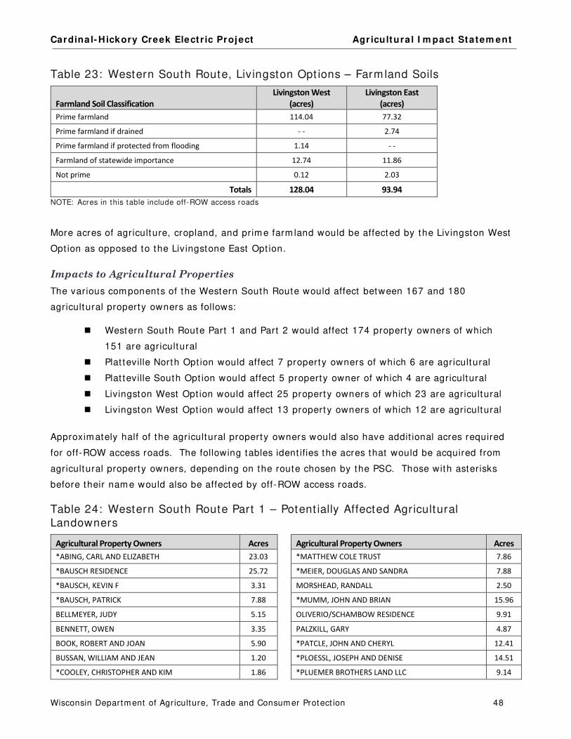
Cardinal- Hickory Creek Elect r ic Project Agr icultura l I m pact Statem ent
Wisconsin Departm ent of Agriculture, Trade and Consum er Protect ion 48
Table 23: Western South Route, Livingston Opt ions – Farm land Soils
Farmland Soil Classification Livingston West
(acres)
Livingston East
(acres)
Prime farmland 114.04 77.32
Prime farmland if drained - - 2.74
Prime farmland if protected from flooding 1.14 - -
Farmland of statewide importance 12.74 11.86
Not prime 0.12 2.03
Totals 128.04 93.94
NOTE: Acres in this table include off-ROW access roads
More acres of agriculture, cropland, and prim e farm land would be affected by the Livingston West
Opt ion as opposed to the Livingstone East Opt ion.
Impacts to Agricultural Properties
The various com ponents of the Western South Route would affect between 167 and 180
agricultural property owners as follows:
Western South Route Part 1 and Part 2 would affect 174 property owners of which
151 are agricultural
Plat teville North Opt ion would affect 7 property owners of which 6 are agricultural
Plat teville South Opt ion would affect 5 property owner of which 4 are agricultural
Livingston West Opt ion would affect 25 propert y owners of which 23 are agricultural
Livingston West Opt ion would affect 13 propert y owners of which 12 are agricultural
Approxim ately half of the agricultural property owners would also have addit ional acres required
for off-ROW access roads. The following tables ident ifies the acres that would be acquired from
agricultural property owners, depending on the route chosen by the PSC. Those with asterisks
before their nam e would also be affected by off-ROW access roads.
Table 24: Western South Route Part 1 – Potent ially Affected Agricultural Landowners
Agricultural Property Owners Acres Agricultural Property Owners Acres
*ABING, CARL AND ELIZABETH 23.03 *MATTHEW COLE TRUST 7.86
*BAUSCH RESIDENCE 25.72 *MEIER, DOUGLAS AND SANDRA 7.88
*BAUSCH, KEVIN F 3.31 MORSHEAD, RANDALL 2.50
*BAUSCH, PATRICK 7.88 *MUMM, JOHN AND BRIAN 15.96
BELLMEYER, JUDY 5.15 OLIVERIO/SCHAMBOW RESIDENCE 9.91
BENNETT, OWEN 3.35 PALZKILL, GARY 4.87
BOOK, ROBERT AND JOAN 5.90 *PATCLE, JOHN AND CHERYL 12.41
BUSSAN, WILLIAM AND JEAN 1.20 *PLOESSL, JOSEPH AND DENISE 14.51
*COOLEY, CHRISTOPHER AND KIM 1.86 *PLUEMER BROTHERS LAND LLC 9.14

Cardinal- Hickory Creek Elect r ic Project Agr icultura l I m pact Statem ent
Wisconsin Departm ent of Agriculture, Trade and Consum er Protect ion 49
Agricultural Property Owners Acres Agricultural Property Owners Acres
*CROGHAN, WILLIAM C 3.92 *POST, STEVEN AND ANN 4.77
CULLEN, SCOTT AND CHRISTIAN 1.39 REDING, JEREMY 4.52
*DEMMER, KENNETH AND JEANINE 14.31 *REYNOLDS, DANIEL AND BRENDA 18.53
DEMUTH TRUST 2.47 REYNOLDS, THOMAS AND DEBRA 1.17
DIMICK, NICHOLAS AND NATHAN 3.39 *REYNOLDS, WAYNE AND KAREN 5.36
*ESSER BROTHERS LIMITED PARTNERSHIP 5.67 REYNOLDS, WILLIAM AND MARY 4.55
*FECHT, JOHN AND CAROL FECHT 14.78 *RILEY, MICHAEL AND JUDITH 7.53
*FECHT, JOHN J 1.22 *SCHWAB, BART T 1.62
*FOLKS, GERALD 4.90 *SCOTT FARM ENTERPRISES INC 7.08
*FRITZ, MIKEL AND PAMELA 14.04 SEDBROOK, RICHARD AND NANCY 8.43
*GRINDE, H BROOKE AND JOCELYN 12.09 *SEDGWICK, ROBERT II 5.48
HAAS, ROBERT AND BRIDGET 2.26 *UDELHOFEN, JOANNE 1.54
HEIMKE, KARL AND E ELIZABETH 9.01 *UDELHOFEN, JOHN AND ANGELA 2.00
HENRY, GARY 1.74 UDELHOFEN, PATRICK AND WENDY 9.07
*HOWE , KENNETH AND JAMIE PLOESSL-HOWE 15.24 UPPENA, JEROME AND ELAINE 1.39
*HUBERT, DOUGLAS AND JILL 8.12 UPPENA, MICHAEL 3.14
*JACOB EASTLICK TRUST 2.67 *VOSBERG FRANCIS L FARMS LLC 3.98
*JANTZEN, LESTER AND DOROTHY 4.76 WAMSLEY RESIDENCE 3.74
JEIDY, DORIS 4.57 *WEBER, STEVEN AND KIMBERLY 10.31
*JENTZ, WAYNE J 6.35 *WIEST RESIDENCE 13.72
*KEY, KATHLEEN 4.78 *WIEST, BRAD A 2.28
*KINYON, CHARLES M JR AND SHERYL L 1.04 WIEST, BRENT 4.53
KRUSER, EDWARD SR AND DENNIS 9.61 *WIEST, TODD 8.48
KUSTER, BETH 1.18 *WRIGHT, CHARLES AND BARBARA 21.38
*LEIBFRIED, DANIEL AND BRADFORD 21.87 *YAGER IRREVOCABLE TRUST 7.69
*LEIBFRIED, LOUIS AND PAMELA 6.23 Additional Agricultural Landowners with <1.0 Acres
Potentially Affected 4.26
LEY, WILLIAM AND JACQUELINE 1.63
Table 25: Western South Route Part 2 – Potent ially Affected Agricultural Landowners
Agricultural Property Owners Acres Agricultural Property Owners Acres
ALLGYER, BENJAMIN AND LYDIA 1.71 LEE, WILLIAM AND DAWN 1.03
BEILER RESIDENCE 4.60 LUDLUM, DIANE 1.90
BEILER, ELMER AND ANNA 4.07 MAGBY, JOHN AND SARAH ANN 8.24
BELLMEYER, JUDY 2.28 MARTIN, BETTIE 4.12
*BOARD OF REGENTS OF STATE 1.85 MCCANN LAND LLC 1.15
*BOARD OF REGENTS OF STATE COLLEGES 7.14 MCNETT, ARTHUR 4.92
BUNKER, C ROBERT AND ELAINE 12.03 MCNETT, CRYSTAL 7.62
CHASE, ROBERT AND RITA 7.68 *NODOLF, DANIEL 13.56
CLARE, PAT - TRUSTEE 5.00 *PLATTEVILLE PROGRESSIVE PROPERTIES LLC 6.30
CLARE, PATRICK 11.70 ROBINSON, STEVE AND JOSEPH 3.94

Cardinal- Hickory Creek Elect r ic Project Agr icultura l I m pact Statem ent
Wisconsin Departm ent of Agriculture, Trade and Consum er Protect ion 50
Agricultural Property Owners Acres Agricultural Property Owners Acres
CLASEN, DONNA RAE 11.44 SANDER, KENT AND MARY ANN 1.34
EDGE, DALE AND IRENA 3.51 SCHAEFER, DAVE AND LISA AND ANTJE FEHRENSEN 15.67
ESH, STEPHEN AND DRUSILLA 9.83 SCHAMBOW, KEITH AND ROGER 9.76
FEHRENSEN, GERT TIMO 6.83 *SCHURZ, GUY L 6.22
*FEHRENSEN, WOLF-GEORG AND ANTJE AND EVA
AND GERT TIMO 23.07 SIEGERT, DONALD J - TRUSTEE 8.42
FIRST NAT'L BANK AND TRUST 25.45 STANTON, DARRIN 1.12
GRABER, WILLIAM AND JOYCE 8.29 STEINBACK, DOUGLAS JR AND JANICE 9.17
GRANT COUNTY REAL ESTATE SERVICES INC 1.84 STOLTZFOOS, ISAAC AND BARBARA 1.02
HARMS, JAMES 3.50 STOLTZFUS, ELI AND MIRIAM 10.43
*KING, MAHLON AND KATIE 4.00 VOIGTS, LARRY AND KIMBERLY 2.28
KINSINGER, ANDREW AND SARAH 3.81 WALTER/KEMINK RESIDENCE 2.98
KLEIN, LEONARD AND JUDITH 7.95 *WEIGEL, THOMAS AND KELLI 9.39
KLEIN, MICHAEL 7.95 Additional Agricultural Landowners with
<1.0 Acres Potentially Affected 7.63 KLEIN, MICHAEL AND AMY 3.92
KLINGE, DOROTHY 4.81
Table 26: Western South Route, Plat teville Opt ions – Potent ially Affected Agricultural Landowners
Agricultural Property Owners
Platteville North
(acres)
Platteville South
(acres)
BELLMEYER, JUDY 7.25 7.55
*BENNETT, OWEN 0.66 - -
HARMS-MYERS, TAMMY 1.08 2.29
IREANE LANDIS REVOCABLE TRUST 4.43 - -
*SANDER, KENT AND MARY ANN 4.69 5.03
*WHITCHER, KENNETH AND FERN 9.99 9.41
Totals 28.10 24.29
Table 27: Western South Route, Livingston Opt ions – Potent ially Affected Agricultural Landowners
Agricultural Property Owners
Livingston East
(acres)
Livingston West
(acres)
Common
Subsegment K01
(acres)
ALLEN, JEFFREY AND REBECCA 17.61 - - - -
BIDDICK INC - - 8.88 4.72
BIDDICK, JAMES AND LINDA LEE 5.76 10.23
*BIDDICK, JASON 13.14 - - 14.26
COULTHARD, HAROLD J AND DALE E 7.73 - - - -
*GENE N SMITH LIVING TRUST 10.64 - - - -
GINGERICH, JOSEPH AND VERA - - 1.46 - -
*GRUNENWALD, DIANE 3.64 - - - -

Cardinal- Hickory Creek Elect r ic Project Agr icultura l I m pact Statem ent
Wisconsin Departm ent of Agriculture, Trade and Consum er Protect ion 51
Agricultural Property Owners
Livingston East
(acres)
Livingston West
(acres)
Common
Subsegment K01
(acres)
IVERSON, RICKY AND ALISA - - 1.00 - -
IVERSON, RONALD AND JUDY - - 5.78 - -
JINKINS, CHARLES - - 5.21 - -
JINKINS, JOHN, THOMAS, AND MARK - - 11.23 - -
KIELER REVOCABLE TRUST - - 2.92 - -
KRAMER, EUGENIA - - - - 3.76
MCCARTHY/BOLLANT RESIDENCE - - 10.98 - -
PARJIM FARMLAND HOLDINGS LLC/FAMILY LUCKY 7 FARM LLC - - 10.00 - -
PROCHASKA, JEAN - - - - 3.52
RILEE B REVOCABLE TRUST - - 4.00 - -
ROWE/LOY RESIDENCE - - 1.52 - -
RUNDELL REVOCABLE TRUST - - 1.08 - -
SCHAEFER, DAVE AND LISA AND ANTJE FEHRENSEN - - 16.66 - -
TONKIN, BRUCE AND SUSAN - - - - 8.54
Additional Agricultural Landowners with <1.0 Acres
Potentially Affected 0.03 1.66 0.29
Totals 58.55 92.61 35.09
Western South Route Comments
The com m ents from the following 33 agricultural landowners that could be affected by the
Western South Route com ponents are sum m arized below.
Western South Route Part 1 Com m ents
Farm Ow ners: Carl and Elizabeth Abing Renters: David and Mike Schauff rent 133 acres / Pat and Dennis Bausch rent 100 acres
Route ( Subsegm ents) : 17.2 acres Western South Part 1 (E06, E07) , 5.8 acres for off-ROW access roads
The Abings own 480 acres of land consist ing of 250 acres of cropland, 197 acres of pasture, 80
acres of woodland, and 3 acres for buildings. Corn, soybeans, and hay are grown. They typically
raise 30 head of beef cat t le. 16.7 acres are enrolled in CRP. Their woodland is cut for firewood
and som e of the larger t rees can be cut for t im ber. The proj ect would cross cropland and pasture
on their property. All of their fields have grassed waterways and there is a dam in the pasture
that the owners want protected from const ruct ion act ivit ies. The route and the off-ROW access
roads could affect field and pasture fencing. The owners are concerned that heavy const ruct ion
equipm ent will dam age their soils and disrupt crop product ion.
Farm Ow ner: Pat rick Bausch
Route ( Subsegm ents) : 7.7 acres Western South Part 1 (E01, E03, E04) , 0.2 acres for an off-ROW access road
Mr. Bausch owns 1,100 acres of land and rents addit ional farm land. I n an average year, he
grows 600 acres of corn, 600 acres of soybeans, and 50 acres of hay. He also raises 200 head of
beef cat t le. The proposed project would cross his cropland and pasture.

Cardinal- Hickory Creek Elect r ic Project Agr icultura l I m pact Statem ent
Wisconsin Departm ent of Agriculture, Trade and Consum er Protect ion 52
Farm Ow ner \ Operators: Judy Bellm eyer \ Tim Clare and Sons (Saddle Ridge Farm ) Potent ia l I m pacts ( Subsegm ents) :
5 .2 acres West ern South Par t 1 ( G01, F01) 7 .3 acres Plat t evil le Nor t h (F02, F03, G06A) 7 .6 acres Plat t evil le South (F04) 2 .3 acres West ern South Par t 2 ( G06B)
Ms. Bellm eyer owns 896 acres of land and rents 806 acres to Mr. Clare. Im pacts to the land
owned by Ms. Bellm eyer depends on the route approved by the PSC. The cropland has grassed
waterways and buildings that could be affected by the project . The project could affect som e of
her best Tam a soils. She is concerned that the project could negat ively affect propert y values
and lim it the potent ial for developm ent of this land. She is also concerned that her renter would
no longer want t o rent t he land with a newly-const ructed t ransm ission line, negat ively affect ing
her incom e.
Farm Ow ners \ Operator: Robert and Joan Book \ Gary Stelpflug
Route ( Subsegm ents) : 5.9 acres Western South Part 1 (E12, E13)
Mr. and Mrs. Book own 450 acre of cropland which is rented to Mr. Stelpflug.
Farm Ow ner \ Operator: Gerald Folks \ Mikel Frit z
Route ( Subsegm ents) : 4.8 acres Western South Part 1 (E16) , 0.1 acres for an off-ROW access road
Mr. Folks owns 42.5 acres of land consist ing of 25 acres of cropland and 17.5 acres of woodland.
Mr. Frit z grows corn and soybeans in rotat ion. The woodland includes 10 acres of walnut t rees.
The project would affect cropland and woodland on his propert y. He is concerned that
const ruct ion personnel will not stay on the ROW.
Farm Ow ners \ Operator: Kenneth Howe and Jam ie Ploessi-Howe \ William Hauk
Route ( Subsegm ents) : 14.2 acres Western South Part 1 (E07) , 1.1 acres for off-ROW access roads
The Howes have 89 acres of cropland that Mr. Hauk grows corn and soybeans in rotat ion. They
also have 20 acres of pasture used for two horses, 136 acres of woodland, and 5 acres for
buildings. This farm includes 41.62 acres in CRP, 34.65 acres in CREP, and 200 acres in the MFL
program . The woodland provides firewood and is periodically logged. The project could affect
drainage t iling on the cropland, grassed waterways on the CREP-enrolled land, pasture, and
woodland. The buildings that could be affected include the house, barn, sheds, an outdoor wood
furnace, and a shop for repair ing equipm ent . The owners are concerned that the project will
disturb wildlife habitat on their property. They are st rongly opposed to this project , but if it is
built , they would like it to be placed further away from their hom e on the other side of the hill.
Farm Ow ners \ Operator: Douglas and Jill Hubert \ Mike Futz
Route ( Subsegm ents) : 6.8 acres Western South Part 1 (E16) , 1.3 acres for an off-ROW access road
Mr. and Mrs. Hubert own 80 acres of land consist ing of 25 acres of cropland and 55 acres of
woodland. Typically, they grow 18 acres of corn and 7 acres of soybeans. The farm is enrolled in

Cardinal- Hickory Creek Elect r ic Project Agr icultura l I m pact Statem ent
Wisconsin Departm ent of Agriculture, Trade and Consum er Protect ion 53
the FPP. The Hubert s are concerned about the project affect ing their fencing. They do not object
to the proposed proj ect as long as it follows the exist ing t ransmission line route.
Farm Ow ners: Douglas and Sandra Meier Route ( Subsegm ents) : 6.4 acres Western South Part 1 (E07, E09) , 1.5 acres for off-ROW access roads
Mr. and Mrs. Meier own 70 acres of land consist ing of 53 acres of pasture and 17 acres of
cropland. The cropland is used to grow hay and they also raise 12 head of beef cat t le. The
project could affect their pasture.
Farm Ow ner / Operator: Gary Palzkill / Joseph Majenis
Route ( Subsegm ent ) : 4.9 acres Western South Part 1 (E14)
Mr. Palzkill owns 21 acres of land consist ing of 17 acres of cropland, 2.5 acres of pasture, and 1.5
acres for buildings. All of the cropland is rented to Mr. Majenis. Mr. Majenis grows corn,
soybeans, and hay in rotat ion. Mr. Palzkill also raises 6 head of beef cat t le.
Farm Ow ners: Michael and Judith Riley
Route ( Subsegm ent ) : 5.8 acres Western South Part 1 (E19) , 1.7 acres for an off-ROW access road
The Rileys own 94 acres of land consist ing of 27 acres of cropland, 20 acres of pasture, and 47
acres of woodland. The cropland is enrolled in CRP. The route crosses cropland, pasture, and
woodland on their property. They are concerned that the project will affect their new fencing.
Farm Ow ner: Scot t Farm Enterprises, I nc. (Rocky Skem p) Route ( Subsegm ent ) : 6.3 acres Western South Part 1 (E19) , 0.8 acres for an off-ROW access road
This property is 1,030 acres and includes 550 acres of cropland, 300 acres of pasture, 278 acres
of woodland, and 2 acres for buildings. I n an average year, the owner grows 380 acres of corn
and 170 acres of soybeans. The owner already has a t ransm ission line on his property and does
not have any concerns about this proposed line.
Farm Ow ners: Pat rick and Wendy Udelhofen
Route ( Subsegm ent ) : 9.1 acres Western South Part 1 (E16)
The Udelhofens own 105 acres of land and rent addit ional land from Mat t Cole. The Udelhofens
typically grow 65 acres of corn. They also have 32 acres enrolled in CRP. The route could affect
a grassed waterway in their pasture, as well as the fencing. They are concerned that
const ruct ion could dam age their soils. The owners state that the exist ing elect r ic ROW has not
been m aintained and weeds have taken over the easem ent . They are concerned this would occur
for this project , as well.
Farm Ow ner: Robert Vosberg ( form erly owned by Vosberg Francis L Farm s LLC)
Route ( Subsegm ent ) : 4.0 acres for off ROW Roads for Western South Part 1 (E19)
Mr. Vosberg owns 780 acres of land consist ing of 520 acres of cropland, 167 acres of pasture, 90
acres of woodland, and 3 acres for buildings. I n an average year he grows 200 acres of corn,
180 acres of soybeans, 100 acres of hay, and 40 acres of oats. He also raises 100 head of beef
Cardinal- Hickory Creek Elect r ic Project Agr icultura l I m pact Statem ent
Wisconsin Departm ent of Agriculture, Trade and Consum er Protect ion 54
cat t le. Mr. Vosberg is concerned about the two lengthy access roads proposed across his
property, if the Western South Route is chosen. He is concerned that the project would affect his
barbed wire fencing. The cropland soils that would be affected by the route are high-qualit y
Fayet te soils. He is concerned that const ruct ion crews will dam age his cropland.
Farm Ow ner: Brent Wiest Route ( Subsegm ent ) : 4.5 acres Western South Part 1 (E01)
Mr. Wiest owns 120 acres of land and rents addit ional land for his operat ion. He grows corn and
soybeans on 240 acres of cropland. The route crosses cropland and potent ially, land enrolled in
the Conservat ion Stewardship Program (CSP) . Mr. Wiest has applied to part icipate in the CSP for
Monarch but terfly habitat . The route also crosses grassed waterways used for drainage and a
grass buffer used for erosion cont rol. There is also a fence line that Mr. Wiest ant icipates will
need to be rem oved for the project .
Plat teville Opt ions Com m ents
Farm Ow ner \ Operators: Judy Bellm eyer \ Tim Clare and Sons (Saddle Ridge Farm ) Potent ia l I m pacts ( Subsegm ents) :
7 .3 acres Plat t evil le Nor t h (F02, F03, G06A) 7 .6 acres Plat t evil le South (F04)
Ms. Bellm eyer has land that m ay be im pacted by both Plat teville Route opt ions, as well as the
Western South Route Part 1 and Part 2. The full text of her com m ents are included in the
Western South Route Part 1 sect ion above.
Farm Ow ners: Southwest Equest r ian Center LLC / Tam m y Harm s-Myers
Route ( Subsegm ent ) : 1.1 acres Plat teville North (F02, F03) , 2.3 acres Plat teville South (F04, F06)
The equest r ian center would be affected by both the Plat teville Route opt ions. The com pany
boards about 20 horses and Ms. Harm s-Myers is concerned about st ray voltage from the new
operat ing line. She is also concerned that the project m ay affect a new building and fencing
planned for the propert y.
Western South Route Part 2 Com m ents
Farm Ow ners: Benjam in and Lydia Allgyer
Route ( Subsegm ent ) : 1.7 acres Western South Part 2 (H03)
The 154 acres owned by the Allgyers are cert ified organic by the Midwest Organic Services
Associat ion, I nc.
Farm Ow ners: Elm er and Anna Beiler
Route ( Subsegm ent ) : 4.1 acres Western South Part 2 (H06)
Mr. and Mrs. Beiler own 95 acres of land consist ing of 55 acres of cropland, 35 acres of pasture,
and 5 acres for buildings. I n an average year, they grow 27 acres of corn, 20 acres of hay, and 8
acres of tobacco. They also have a 46-cow dairy operat ion with 14 replacem ent dairy cat t le.
This farm is cert ified by Nature’s I nternat ional Cert ificat ion Services for organic product ion. The
owners are concerned that the new line will create induced currents on their fencing which is

Cardinal- Hickory Creek Elect r ic Project Agr icultura l I m pact Statem ent
Wisconsin Departm ent of Agriculture, Trade and Consum er Protect ion 55
connected to their dairy facilit ies. There are also water lines running under the fencing that could
be affected by induced currents.
Farm Ow ner \ Operator: Judy Bellm eyer \ Tim Clare and Sons (Saddle Ridge Farm ) Potent ia l I m pacts ( Subsegm ents) : 2.3 acres Western South Part 2 (G06B)
Ms. Bellm eyer has land that m ay be im pacted by Western South Route Part 2, as well as both
Plat teville Route Opt ions and the Western South Route Part 1. The full text of her com m ents are
included in the Western South Route Part 1 sect ion above.
Farm Ow ners: Robert and Rita Chase
Route ( Subsegm ent ) : 7.7 acres Western South Part 2 (G08)
Mr. and Mrs. Chase own 346 acres of land and rent 42 addit ional acres from Kenneth Kram er. I n
an average year, they grow 160 acres of corn, 130 acres of soybeans, 50 acres of hay, and 20
acres of oats. They also raise 30 steers. The route could affect cropland with grassed waterways
and pasture fencing.
Farm Ow ner: Jam es Harm s
Route ( Subsegm ent ) : 3.5 acres Western South Part 2 (G06B)
Mr. Harm s owns 120 acres of cropland planted with seed corn and soybeans in rotat ion. He rents
all of his farm land to Schweigert Farm s. The route m ay affect grassed waterways on the
property. The landowner is concerned about a potent ial loss of rental incom e.
Farm Ow ners: Andrew and Sarah Kinsinger (Maple Shade Farm s)
Route ( Subsegm ent ) : 3.8 acres Western South Part 2 (H06)
The Kinsingers operate an organic dairy and vegetable farm cert ified by Natures Internat ional
Cert ificat ion Services.
Farm Ow ner \ Operator: Bet t ie Mart in \ Wilson Organic Farm s
Route ( Subsegm ent ) : 4.1 acres Western South Part 2 (H06)
Ms. Mart in owns 150 acres of land and rents 40 acres to Wilson Organic Farm s. This farm is
cert ified for organic crop product ion. They also raise 50 head of beef cat t le. The route could
affect new fencing along the property line. Ms. Mart in is concerned about a potent ial loss of
incom e because of the project .
Farm Ow ner: Arthur McNet t Route ( Subsegm ent ) : 4.9 acres Western South Part 2 (H07)
Mr. McNet t owns 720 acres of land, of which 710 acres is cropland and 10 acres is for buildings.
He rents addit ional cropland and typically grows 1,000 acres of corn and 500 acres of soybeans.
The proposed route would affect his cropland. He has grain facilit ies next t o an exist ing elect r ic
line. Mr. McNet t stated that ATC has been easy to work with in the past and he doesn’t have any
concerns about the proposed project .

Cardinal- Hickory Creek Elect r ic Project Agr icultura l I m pact Statem ent
Wisconsin Departm ent of Agriculture, Trade and Consum er Protect ion 56
Farm Ow ners: Keith and Roger Scham bow
Route ( Subsegm ents) : 9.8 acres Western South Part 2 (H09)
The Scham bows own 481 acres of land consist ing of 381 acres of cropland, 85 acres of pasture,
and 15 acres for buildings. I n an average year, they grow 210 acres of corn, 100 acres of
soybeans, and 70 acres of hay. They also raise 60 steers. The route could affect one grassed
waterway and fencing.
Farm Ow ner \ Operator: Guy Schurz \ Arthur McNet t Route ( Subsegm ents) : 6.2 acres Western South Part 2 (H06, H07) , 0.02 acres for an off ROW access road
Mr. Schurz owns 205 acres of land consist ing of 150 acres of cropland, 50 acres of pasture, and 5
acres for buildings. Mr. McNet t rents all of the cropland and grows corn and soybeans in rotat ion.
The route could affect cropland with drainage t iling. Mr. Schurz is very concerned about a loss in
his farm ’s property value.
Farm Ow ner: UW Board of Regents (UW Plat teville Pioneer Farm )
Route ( Subsegm ents) : 5.4 acres Western South Part 2 (G08) , 3.6 acres for off ROW access roads
This land is part of the UW Plat teville Pioneer Farm . They have stated that there is a long- term
agro-ecology research project on the propert y t hat could be im pacted by the new t ransm ission
line. The Director of the Pioneer Farm , Charles R. Steiner, stated that they have a very lim ited
land base and any land taken out of product ion would negat ively im pact their abilit y to produce
enough feed for their livestock enterprises and m eet the requirem ents of their nut r ient
m anagem ent plan. Addit ionally, for the past 15 years, they have been collect ing both surface
and groundwater data as part of water qualit y research at Pioneer Farm . They are concerned
about how the const ruct ion of this project would im pact their water m onitoring and exist ing
agricultural research project s.
Livingston Opt ions Com m ents
Farm Ow ner: Biddick, I nc. ( Jason Biddick) Potent ia l I m pacts ( Subsegm ents)
19.0 acres Both Liv ingst on Rout e Opt ions ( K01) 9 .4 acres Liv ingst on West ( J01, J02, J04) 13.0 acres Liv ingst on East ( I 08, I 09) , 0.1 acre for an off ROW access road 1 .4 acres East ern Alt Sout h ( R03) 0 .2 acres East ern South Par t 1 ( Q02)
The Biddicks own 2,900 acres and rent addit ional land including another 33 acres from Jean
Prochaska who would also be potent ially affected by the proj ect . I n total, this farm operates
6,000 acres of cropland, 800 acres of pasture, 200 acres of woodland, and has buildings on 40
acres. I n an average year they grow 1,700 acres of corn, 2,700 acres of soybeans, 200 acres of
hay, 400 acres of wheat , 500 acres of oats, and 500 acres of popcorn. They also raise 900 beef
cat t le. 60 acres of this property are enrolled in CREP. Another 560 acres of this land is included
in the FPP. The proposed proj ect could affect grassed waterways in the cropland and fencing on
the property.

Cardinal- Hickory Creek Elect r ic Project Agr icultura l I m pact Statem ent
Wisconsin Departm ent of Agriculture, Trade and Consum er Protect ion 57
Farm Ow ners: Harold J. and Dale E. Coulthard
Route ( Subsegm ent ) : 7.7 acres Livingston East ( I 01, I 02, I 05) , < 0.3 acres along Western South Part 2 and Livingston West
The Coulthards own 440 acres of land consist ing of 385 acres of cropland, 25 acres of pasture, 29
acres of woodland, and 1 acre for buildings. They grow corn and soybeans. All of the woodland
is enrolled in CREP. The owners are concerned that the project could negat ively affect drainage
on their property and that the new elect r ic line will be close to their grain bins, grain drier,
m achine shop, and storage shed.
Farm Ow ners: Ronald and Judy I verson
Route ( Subsegm ent ) : 5.8 acres Livingston West (J03, J04)
Mr. and Mrs. I verson own 700 acres of land consist ing of 540 acres of cropland, 60 acres of
pasture, 98 acres of woodland, and 2 acres for buildings. I n an average year, the I versons grow
260 acres of corn, 260 acres of soybeans, and 20 acres of hay. They also raise 18 head of beef
cat t le. The farm is covered by the FPP. The route would affect cropland on their property. The
owners are concerned about the route negat ively im pact ing the visual aesthet ics of their land.
Farm Ow ner \ Operator: Jean Prochaska \ Biddick Inc. Route ( Subsegm ents) : 3.5 acres Both Livingston East and West (K01)
Jean Prochaska owns 33 acres of cropland and uses 3 acres for buildings. The land is rented to
the Biddicks. The Prochaska propert y is enrolled in the FPP. The route could affect grassed
waterways in the cropland and fencing on the property.
Farm Ow ner \ Operator: Gene M. Sm ith Living Trust \ Double N Cat t le Co. (Michael and
Mat thew Mueller)
Route ( Subsegm ent ) : 10.2 acres Livingston East ( I 08, I 09) , 0.4 acres for an off-ROW access road
The Trust includes 243 acres with 145 acres of cropland, 89 acres of pasture, alm ost 1 acre of
idle farm land, 5 acres for buildings, and 3 acres of waterways and terraces. The renter grows
corn, soybeans, hay, and oats. They t ypically raise 8 beef cows with 8 calves on this farm . The
owner is concerned that proj ect const ruct ion could lead to soil erosion, especially where it would
cross a creek and a spring- fed st ream . The route could also affect new fencing and several t rees
that provide shade in the pasture. The owner is concerned about potent ial loss of property
values and im pacts to wildlife.
Farm Ow ners \ Operator: Bruce and Susan Tonkin \ Stuart Brokopp
Route ( Subsegm ent ) : 8.5 acres Both Livingston East and West Opt ions (K01)
Mr. and Mrs. Tonkin own 100 acres of cropland. The cropland is rented to Mr. Brokopp to grow
corn and soybeans. The Tonkins would prefer t o see the proj ect follow the Preferred Route along
exist ing roads rather than the Alternate Route that passes through fields.

Cardinal- Hickory Creek Elect r ic Project Agr icultura l I m pact Statem ent
Wisconsin Departm ent of Agriculture, Trade and Consum er Protect ion 58
Comparison of the Western North and the Western South Routes
The tables below com pare the five potent ial routes between the Mississippi River Area and the Hill
Valley Substat ion Area.
Table 28: Western Routes - Comparison of Affected Agricultural Acres
Route Options
ROW
(acres)
Percent of
ROW Shared
Off-ROW
Roads
(acres)
Total Affected
Agriculture
(acres)
Total
Percentages In
Agriculture
Western
North N/A 587.2 35% 129.5 673.2 94%
Western
South
Platteville North
Livingston East 891.0 35% 85.5 952.5 98%
Western
South
Platteville North
Livingston West 926.2 33% 84.9 986.5 98%
Western
South
Platteville South
Livingston East 892.1 35% 84.7 948.7 97%
Western
South
Platteville South
Livingston West 927.3 34% 84.1 982.7 97%
The Western North Route would affect the fewest acres overall and the fewest agricultural acres.
There is lit t le difference between the am ounts of acres affected by the various Western South
Routes. On average, the Western South Routes would im pact j ust under 1,000 acres of which
alm ost all are in agriculture as opposed to the Western North Route which would affect j ust under
675 acres. All Western Routes overlap exist ing ROWs for about one- third of the affected acres,
helping to reduce the acres of new ROW required.
Table 29: Western Routes - Comparison of Agricultural Land Use
Route Options
Cropland
(acres)
Pasture
(acres)
Idle or Fallow
Field
(acres)
Specialty
Farmland*
(acres)
Other
Agricultural Land
(acres)
Western
North N/A 320.4 110.4 31.7 1.1 209.9
Western
South
Platteville North
Livingston East 566.5 87.1 17.2 0.5 281.7
Western
South
Platteville North
Livingston West 597.9 82.3 17.2 0.5 289.2
Western
South
Platteville South
Livingston East 564.6 87.1 17.2 0.5 279.8
Western
South
Platteville South
Livingston West 596.0 82.3 17.2 0.5 287.3
NOTE: Acres in this table include off-ROW access roads * The Applicants have ident if ied the specialty farm land on these routes as t ree farms
All four of the Western South Routes Opt ions would affect m ore acres of cropland than the
Western North Route.
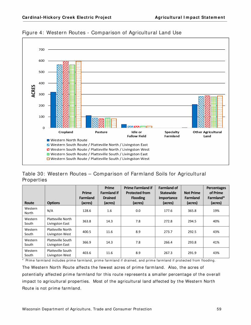
Cardinal- Hickory Creek Elect r ic Project Agr icultura l I m pact Statem ent
Wisconsin Departm ent of Agriculture, Trade and Consum er Protect ion 59
Figure 4: Western Routes - Comparison of Agricultural Land Use
Table 30: Western Routes – Comparison of Farm land Soils for Agricultural Propert ies
Route Options
Prime
Farmland
(acres)
Prime
Farmland if
Drained
(acres)
Prime Farmland if
Protected from
Flooding
(acres)
Farmland of
Statewide
Importance
(acres)
Not Prime
Farmland
(acres)
Percentages
of Prime
Farmland*
(acres)
Western
North N/A 128.6 1.6 0.0 177.6 365.8 19%
Western
South
Platteville North
Livingston East 363.8 14.3 7.8 272.8 294.5 40%
Western
South
Platteville North
Livingston West 400.5 11.6 8.9 273.7 292.5 43%
Western
South
Platteville South
Livingston East 366.9 14.3 7.8 266.4 293.8 41%
Western
South
Platteville South
Livingston West 403.6 11.6 8.9 267.3 291.9 43%
* Pr ime farm land includes pr ime farm land, pr ime farm land if drained, and pr ime farm land if protected from flooding.
The Western North Route affects the fewest acres of prim e farm land. Also, the acres of
potent ially affected prim e farm land for this route represents a sm aller percentage of the overall
im pact to agricultural propert ies. Most of the agricultural land affected by the Western North
Route is not prim e farm land.

Cardinal- Hickory Creek Elect r ic Project Agr icultura l I m pact Statem ent
Wisconsin Departm ent of Agriculture, Trade and Consum er Protect ion 60
There is lit t le difference between the percentages of farm land soils affected by any of the four
Western South Route Opt ions. Most of the land crossed by these opt ions are prim e farm land or
farm land of statewide im portance. The Western South Route Opt ions would affect between 386
and 424 acres of prim e farm land. Only about 30 percent of these longer route opt ions are
categorized as not prim e farm land.
Both the Western North Route and any of the Western South Routes have the advantage of being
routed along an exist ing elect r ic line, thereby reducing the am ount of new ROW required for the
project . However, because the exist ing elect r ic lines are cross-count ry and specifically across
fields, the im pacts would st ill be potent ially significant to agricultural operat ions and pract ices,
crop yields, and livestock m anagem ent . The cross- count ry nature of the routes coupled with the
hilly terrain of the region m akes a high num ber of lengthy off-ROW access roads necessary for
the const ruct ion of this project , regardless of the route chosen. More than a few of the proposed
access roads are m ore than 4 m iles long. Between 50 and 80 percent of the agricultural property
owners affected by one of the Western Routes would also have access roads across their land.
The off-ROW access roads for the Western North Route would im pact the m ost agricultural acres.

Cardinal- Hickory Creek Elect r ic Project Agr icultura l I m pact Statem ent
Wisconsin Departm ent of Agriculture, Trade and Consum er Protect ion 61
HILL VALLEY SUBSTATION AREA
Potential Subsegments
Map Book Figure 1 5
There are num erous route variat ions that could connect the western routes to either of the two
substat ion sites and then connect to the eastern routes. I f the South Substat ion Site were
chosen by the PSC, Subsegm ents D10A, D10B, D10C, and L05 cross land current ly owned by the
ATC. I f the PSC chose the North Substat ion Site, Subsegm ents M05 and O01 cross land that
would be purchased by the Applicants. Therefore, Subsegm ents, D10A, D10B, D10C, L05, M05,
and O01 have been excluded from the following agricultural property analyses. The rem aining 19
subsegm ents within the Substat ion Area can be used in a variety of configurat ions to connect to
one or both substat ion sites. Most of the segm ents are short and affect a sim ilar set of
landowners. For this reason, no potent ial route configurat ions are analyzed in this docum ent .
I nstead, for each subsegm ent within the Hill Valley Substat ion Area, the affected acres are listed
and the im pacts to agricultural property owners are detailed.
Table 31: Substat ion Area – Acres Affected by Subsegment
Subsegment
Length
(miles)
ROW
(acres)
Shared ROW
(acres)
Acres in
Agriculture
Percentages
In Agriculture
L01 0.2 4.35 3.04 4.11 94%
L02 0.5 8.41 0.30 8.34 99%
L03 <0.1 0.71 - - 0.71 100%
L04 0.3 5.80 - - 4.65 80%
M01 0.7 11.71 - - 11.71 100%
M02 0.3 4.95 - - 4.95 100%
M03 0.4 7.18 - - 3.59 50%
M04 0.3 5.07 - - 5.07 100%
N01 0.7 11.72 5.78 7.09 61%
N03 0.3 4.89 3.12 4.83 99%
N04 <0.1 0.29 0.15 0.16 55%
N05 0.2 4.24 1.53 2.77 65%
N06 <0.1 0.13 0.05 0.08 62%
N07 0.2 1.41 1.59 0.49 35%
O02 0.5 8.36 - - 8.36 100%
O03 0.3 4.35 - - 4.35 100%
P01 0.3 5.09 - - 4.58 90%
R01 0.3 4.68 2.35 4.07 87%
R02 0.2 3.31 2.36 3.31 100%

Cardinal- Hickory Creek Elect r ic Project Agr icultura l I m pact Statem ent
Wisconsin Departm ent of Agriculture, Trade and Consum er Protect ion 62
Table 32: Substat ion Area – Off-ROW Access Roads
Off-ROW Access
Roads
Subsegment
Connections
Area
(acres)
Acres in
Agriculture
Percentages
In Agriculture
L-OR-001 L01, L02 0.54 0.19 35%
L-OR-002 L04, R01 0.54 0.41 76%
N-OR-01 N01 1.19 1.19 100%
N-OR-02 N02 0.44 0.44 100%
Farmland Types and Soils
The next two tables detail the agricultural land use and farm land soils that would be affected by
each subsegm ent with the Substat ion Area.
Table 33: Substat ion Area – Agricultural Land Use by Subsegment
Subsegment
Cropland
(acres)
Pasture
(acres)
Other Agriculture
(acres)
Subtotal
(acres)
L01 3.15 - - 0.95 4.11
L02 4.94 3.24 0.17 8.34
L03 0.71 - - - - 0.71
L04 2.90 - - 1.76 4.65
M01 11.71 - - - - 11.71
M02 4.94 - - 0.01 4.95
M03 2.59 1.00 - - 3.59
M04 5.07 - - - - 5.07
N01 6.72 0.02 0.35 7.09
N03 4.83 - - - - 4.83
N04 0.15 - - 0.01 0.16
N05 2.71 - - 0.06 2.77
N06 0.08 - - - - 0.08
N07 0.45 - - 0.04 0.49
O02 8.36 - - - - 8.36
O03 4.35 - - - - 4.35
P01 2.81 1.85 - - 4.66
R01 2.60 - - 1.92 4.52
R02 1.94 - - 1.37 3.31
Table 34: Substat ion Site Area – Farm land Soils by Subsegment
Subsegment
Prime Farmland
(acres)
Farmland of Statewide
Importance
(acres)
Not Prime
(acres)
Subtotal
(acres)
L01 2.90 1.21 - - 4.11
L02 2.04 6.29 - - 8.34
L03 0.23 0.48 - - 0.71
L04 1.15 2.81 0.70 4.65

Cardinal- Hickory Creek Elect r ic Project Agr icultura l I m pact Statem ent
Wisconsin Departm ent of Agriculture, Trade and Consum er Protect ion 63
Subsegment
Prime Farmland
(acres)
Farmland of Statewide
Importance
(acres)
Not Prime
(acres)
Subtotal
(acres)
M01 10.07 0.79 0.85 11.71
M02 1.02 0.82 3.11 4.95
M03 0.42 2.44 0.74 3.59
M04 1.59 3.48 - - 5.07
N01 3.56 2.55 0.98 7.09
N03 3.50 1.33 - - 4.83
N04 0.11 0.05 - - 0.16
N05 0.95 1.82 - - 2.77
N06 0.08 - - - - 0.08
N07 0.20 0.29 - - 0.49
O02 7.32 - - 1.04 8.36
O03 2.84 1.51 - - 4.35
P01 2.18 0.94 1.54 4.66
R01 1.76 2.76 - - 4.52
R02 0.13 2.64 0.54 3.31
Impacts to Agricultural Properties
The following table lists the agricultural property owners potent ially affected by each of the
subsegm ents within the Substat ion Area. Landowners with an asterisk before their nam e would
also have an off-ROW access road.
Table 35: Substat ion Area – Potent ially Affected Agr icultural Landowners
Landowner Acres Affected by Subsegment
BISHOP, BRADLEY O01: <0.01a
FITZSIMMONS, DONELLE L02: 0.01a
GIROTTO, JAY AND LYNN M02: 4.95a, M03: 2.59a, M04: 3.94a, R01: 0.08a, R02: 0.71a
*GORSLINE RESIDENCE N01: 6.10a, off-ROW access road: 1.19a
*HEINER RESIDENCE L02: 6.88a, L03: 0.71a, L04: 0.10a, R01: 3.31a, off-ROW access road: 0.15a
KITE, JAMES M01: 4.16a, R01: 0.28a, R02: 2.59a
*KLAAS, HELEN L04: 4.55a, R01: 0.40a, off-ROW access road: 0.41a
KRAMER, EUGENIA L01: 3.96a, L02: 0.22a, M01: 7.55a
*KRAMER FARMS LLC L01: 0.15a, off-ROW access road: 0.04a
LEIX, DONALD AND TIMOTHY N01: 0.49a
LEIX, MARION AND MARY N07: 0.49a
*LEIX, TIMOTHY AND DONALD AND CYNTHIA M04: 1.13a, N01: 050a, N03: 2.60a, N05: 2.77a, N06: 0.08a, O02: 8.36a,
O03: 3.60a, P01: 2.79a, off-ROW access road: 0.44a
MICK, KATHY N03: 2.23a, N04: 0.16a, N05: <0.01a, O03: 0.75a
MOEN, KENNETH AND LUANNE P01: 1.79a
SHEMAK, PAUL AND LORI BUTTERIS M03: 1.00a
SIMONS, HARRY L02: 1.23a
NOTE: a= acres

Cardinal- Hickory Creek Elect r ic Project Agr icultura l I m pact Statem ent
Wisconsin Departm ent of Agriculture, Trade and Consum er Protect ion 64
Substation Area Comments
One agricultural landowner that could be affected by routes within the Substat ion Area
com m ented. The com m ent from the Leix Farm s is sum m arized below.
Farm Ow ner: Leix Farm s, I nc. ( includes land owned by Donald, Tim othy, Cindy, Marion, Mary Leix and RBN Land LLC) Potent ia l I m pacts:
74.0 acres Nor t h Substat ion Sit e for Hil l Valley Subst at ion
1 .1 acres Subsegm ent M04
1 .0 acre Subsegm ent N01
2 .6 acres Subsegm ent N03
2 .8 acres Subsegm ent N05
< 0.1 acre Subsegm ent N06
0 .5 acres Subsegm ent N07
8 .4 acres Subsegm ent O02
3 .6 acres Subsegm ent O03
2 .8 acres Subsegm ent P01
2 .7 acres East ern Nor th Rout e ( Subsegm ent P02)
6 .6 acres East ern South Par t 1 (Subsegm ent s Q01, Q02)
12.8 acres Laydown Yard LY- 02
Leix Farm s owns 1,160 acres of land consist ing of 950 acres of cropland, 90 acres of pasture, 110
acres of woodland, and 10 acres for buildings. I n an average year, they grow 550 acres of corn,
350 acres of alfalfa hay, and 50 acres of wheat . They also run a 650-cow dairy operat ion with
600 replacem ent dairy cat t le and 30 head of beef cat t le. All of their land is included in the FPP.
There is the potent ial that , whichever substat ion and routes are chosen, project facilit ies will
im pact cropland and fencing owned by Leix Farm s. The owners describe a lack of com m unicat ion
between them selves and the Applicants, especially considering the am ount of Leix Farm s’ land
potent ially required for the project .
The owners are concerned for two em ployees who occupy rental hom es on their property. One
residence is located along Subsegm ent Q02 at 682 US Hwy 18 in Mont fort . The second residence
is located at 450 US Hwy 18, near the eastern end of Subsegm ent Q01. The owners are
concerned about induced currents, noise from the line, and radio/ TV recept ion for their
em ployees and their fam ilies who could be living close to the line. The owners are concerned
that the com binat ion of this proj ect , the Badger Hollow Solar project , and the Red Barn Wind
project will have a significant negat ive im pact on the aesthet ic beauty of the Mont fort area.

Cardinal- Hickory Creek Elect r ic Project Agr icultura l I m pact Statem ent
Wisconsin Departm ent of Agriculture, Trade and Consum er Protect ion 65
EASTERN ROUTING AREA
Eastern North Route
The Eastern North Route connects from the Hill Valley Substat ion Site Area to the Stagecoach
Opt ions in the Dane County Rout ing Area. The alternat ive to the Eastern North Route is the
Eastern South Route which is described in the sect ion following the Eastern North Route. The
descript ions in this chapter include references to the accom panying Map Book.
Route Description
Map Book Figures 1 6 - 2 1
The Eastern North Route starts in I owa County, in the town of Eden and ends in the town of
Cross Plains in Dane County. The 44-m ile route includes Subsegm ents P02, P03, P04, P05, P06,
P07, P08, and P09. From the town of Eden, it crosses the towns of Highland, Dodgeville,
Wyom ing, and Arena in I owa County. And in Dane County, the route crosses the towns of
Verm ont and Cross Plains. Much of the Eastern North Route is cross- count ry and would require
alm ost all new ROW. I t overlaps exist ing ut ilit y or road ROWs for only a fract ion of it s length.
The Eastern North Route t ravels northeast for t he first 8.7 m iles double-circuited with an exist ing
138 kV elect r ic line (X-17) . The proposed new elect r ic centerline would be offset by about 40
feet to the south of the exist ing X-17 alignm ent . The new ROW would overlap the exist ing
elect r ic ROW width by about 100 feet . The route crosses the Blue River Road, Willow Spring
Road, Tower road, STH 80, CTH BH, and Sunny Ridge Road.
After crossing Sunny Ridge Road, the X-17 line cont inues northeast as a single-circuit and the
new 345 kV line turns east . For the rem aining 35 m iles of the route, t he proposed elect r ic line is
single-circuited (Subsegm ents P03–P09) . The route is alm ost ent irely cross-count ry, following no
property lines, roads, or other ut ilit y ROWs. The route crosses CTH Q, CTH I I , CTH M, Jam es
Road, STH 23, CTH ZZ, Dyreson Rd, CTH Z, Far Look Road, N Clay Hill Road, CTH T, CTH H, Blue
Ridge Road, CTH HH, Sweeney Road, CTH K, Zwet t ler Road, CTH F, Blue Mounds Trail, CTH JJ,
STH 78, Union Valley Road, and Garfoot Road. Due to the hilly topography, the Applicants have
ident ified 39 off-ROW access roads, alm ost ent irely through agricultural propert ies.
Table 36: Eastern North Route – Acres Affected
Route Subsegment
Length
(miles)
ROW
(acres)
ROW Acres
Shared (percent)
Acres in
Agriculture
Percentage
In Agriculture
Eastern North P02, P03, P04, P05, P06, P07,
P08, P09 43.9 798.60 120.5 (15%) 674.42 84%

Cardinal- Hickory Creek Elect r ic Project Agr icultura l I m pact Statem ent
Wisconsin Departm ent of Agriculture, Trade and Consum er Protect ion 66
Table 37: Eastern North Route – Off-ROW Access Roads
Route Subsegment Connections
Area
(acres)
Acres in
Agriculture
Percentage
in Agriculture
Eastern North P02, P05, P09 57.54 52.27 91%
Farmland Types and Soils
Alm ost all of the land affected by the route is in agriculture. More than 50 percent of the
agricultural land is cropland and pasture. The rest of the affected agricultural land is used for
resident ial areas, farm buildings, farm roads, woodlands, and wet lands. The Applicants have
ident ified the specialty farm s along this route as t ree farm s.
Table 38: Eastern North Route – Agricultural Land Use
Agricultural Land Use
ROW
(acres)
Off-ROW
Access Roads
(acres)
Totals
(acres) Percentages
Cropland 271.37 25.78 297.15 41%
Pasture 82.67 2.13 84.80 12%
Specialty Farmland (tree farms) 3.93 - - 3.93 <1%
Other Agricultural Land 314.57 24.34 338.91 47%
Totals 672.54 52.25 724.80
More than half of the agricultural land affected by this route is not prim e farm land. About 22
percent is prim e farm land, prim e if drained, and prim e if protected from flooding. Another 20
percent is classified as farm land of statewide importance.
Table 39: Eastern North Route – Farm land Soils
Farmland Soil Classification
ROW
(acres)
Off-ROW
Access Roads
(acres)
Totals
(acres) Percentages
Prime farmland 101.52 9.46 110.97 15%
Prime farmland if drained 6.86 0.69 7.54 1%
Prime farmland if protected from flooding 41.11 3.35 44.45 6%
Farmland of statewide importance 135.21 12.63 147.84 20%
Not prime 387.85 26.14 413.99 57%
Totals 672.54 52.25 724.80
Impacts to Agricultural Properties
The Eastern North Route would affect 186 property owners of which 134 own agricultural
propert ies. Alm ost half of the affected agricultural property owners (66 property owners) would
also be im pacted by off-ROW access roads. The following table ident ifies the acres that could be
acquired from agricultural propert y owners, depending on the route chosen by the PSC. Those
with asterisks before their nam e would also be affected by off-ROW access roads.

Cardinal- Hickory Creek Elect r ic Project Agr icultura l I m pact Statem ent
Wisconsin Departm ent of Agriculture, Trade and Consum er Protect ion 67
Table 40: Eastern North Route – Potent ially Affected Agricultural Landowners
Agricultural Property Owners Acres Agricultural Property Owners Acres
*ADAMS, WILLIAM (CHESS) AND KATHRYN 3.87 LEIX, MARION AND MARY 2.65
APPERT, RONALD 2.19 *MALCHESKI, JAMES AND PATRICIA 7.51
*BALISLE, LINDA 14.23 MAYLAND FAMILY LTD PARTNERSHIP 6.90
BARRETT, DEWEY 5.86 *MEINHOLZ, MARVIN AND NANCY 4.24
BAUM, PETER AND MARILYN 1.96 MEUDT BROTHERS 3.60
BETHEL HORIZONS FOUNDATION INC 14.47 MEUDT, KEVIN 6.59
BUTTERIS, DANIEL AND JUDITH 10.49 *MICKELSON, CRAIG 4.49
*C R BISHOP AND SONS INC/
TWIN CREEKS ENTERPRISES LLC 13.16 MIESS REV LVG TRUST, ROBERT AND BETTY 8.72
CAMIS LTD PARTNERSHIP, THEODORE AND JUNE 14.12 *MIESS, DANIEL AND LYNETTE 14.84
CARLOCK, AARON AND KAREN 4.65 MIESS, GLEN AND GERTRUDE 2.76
CARTER, DOUGLAS 3.16 MIESS, KEVIN AND SHERRY 4.58
*CLIFTON, JOSEPH M 2.64 MIESS, MITCHELL ALEXANDER AND AMY 3.92
D'ANGELO, BETSY 18.56 *MISCHO, ROBERT AND BEVERLY 1.54
DAVID DOLAN 10.71 *MOEN, KENNETH AND LUANNE 6.87
DEAL, STEVE AND JOANNE 9.11 *NIESEN, JOSHUA AND MICHELLE 5.15
DEPIRRO, DAVID 2.63 *NORSLIEN, MYRON 9.46
DOLAN, PAUL AND MARY 5.68 *NOVAK, BRUCE AND SARAH 12.77
EDGINGTON, JOHN AND ERIN 6.67 *NOVAK, BRUCE 3.82
ERDMAN WI PROPERTIES LLC 45.53 *O'CONNELL, JOSEPH AND KEITH 7.61
ESSER, THOMAS AND DIANE 5.22 O'FLAHRITY, JOHN AND JEAN 1.11
EVANS, LESLIE AND LINDA 3.06 OIMOEN REVOC TR, GREGORY J AND BARBARA J 5.30
FESSEL, JOSEF AND FRANZISKA 2.31 *PAILING FAMILY ENTERPRISES LLC 11.79
FILLBACH, PATRICIA 8.88 *PAILING, TIMOTHY 4.53
FORBESS, ROBERT 3.35 PARRELL, WAYNE AND AUDREY 6.47
FOREMAN, DANA 5.10 *PEAT, MARGARET G 2.36
FORSETH TRUST 6.14 *PECK, MARK AND MARY 19.21
FORSETH, DAVID 13.32 *PECK, MARK 1.22
*FOSTER, THOMAS AND CAROL 18.51 PLESHA, MICHAEL AND GLORIA 2.25
*FRAME, JOHN AND JENNIFER 10.37 PUSTINA, ARTHUR AND CARLA 1.83
FROST, JOSEPH AND NANCY 1.10 RAY, KEITH 4.75
*GALLAGHER, RICH AND LUANN 1.11 *RIDER, PAULA 6.54
*GINTHER JT REV TRUST, OLIVER AND JANE 10.30 *RODENSCHMIT, EDWIN AND WILLIAM 13.42
GORECKI, DANIEL 2.24 *SCHMELZER RESIDENCE 12.86
*GREENE, QUINTIN AND LORI 4.54 *SCHULTZ LIVING TR, DONALD A AND BEVERLY J 1.90
GURAK, DOUGLAS AND MARY KRITZ 10.53 *SCHUSTER, KENNETH AND ROMONA 1.00
*HAACK, GERALD AND SHIRLEY 8.20 *SENDECKE, JAMES 5.15
*HAACK, GERALD J 1.35 STANFIELD, DAVID AND SANDIE 8.51
HAHN JT REVOC TRUST, DAVID AND CAROLYN 2.73 SWEENEY, GERALD 11.93
*HALL, GREG 6.91 THOMPSON, DAVID 3.12
HALLICK, JOHN AND JAMIE, AND RICK SCHMIDT 3.95 TOWNSEND, FRED AND BARBARA BORNS 2.83

Cardinal- Hickory Creek Elect r ic Project Agr icultura l I m pact Statem ent
Wisconsin Departm ent of Agriculture, Trade and Consum er Protect ion 68
Agricultural Property Owners Acres Agricultural Property Owners Acres
*HALVERSON, DENNIS AND VERNON AND EVELYN 8.91 TREMELLING, JEANNE 8.79
*HEDRICH, PAM 7.52 TREWEEK, WILLIAM AND LINDA TRICKEL 2.34
HOLBERG, GARY AND HEIDI 1.97 *URNESS, JON AND JUDITH 8.38
*HORVATH, DAVID AND DONNA 10.53 URNESS, VIRGINIA 9.13
HOTTMANN, BARRY AND NICOLE ROCK-
GARTHWAITE 1.23 VIAL, MARY GRACE 1.15
HYATT, STEVEN AND BECKY 4.56 *WELP, PAUL AND SARA 10.97
*JAMES, JEFF AND JULIE 15.75 *WHITEHOUSE, BRIAN AND BECKIE KUTZKE-
WHITEHOUSE 2.47
*JAMES, JERRY RAY 2.64 WIENKES, PATRICK AND LORI 1.47
*KALSCHEUR ENTERPRISES LLC/
KALSCHEUR RENTALS LTD PARTNERSHIP 12.04 WISPROPMAR LLC 8.82
KIRSCHBAUM, STANLEY JR 2.36 ZEMLICKA RESIDENCE 3.65
KLOCK REV TRUST, MARSHALL AND JANET 3.08 ZIMMERMAN, CURTIS 1.28
KOWALIK FAMILY TRUST 8.13 ZIMMERMAN, GARY JR 1.32
KRITZ, MARY 2.81 Additional Agricultural Landowners with <1.0 Acres
Potentially Affected 10.84
*LEE ACRES LLC 9.56
Eastern North Route Comments
Com m ents from the following 28 agricultural landowners that could be affected by the Western
North Route are sum m arized below. Som e of t hese landowners could be affected by m ore than
one route.
Farm Ow ners: William (Chess) and Kathryn Adam s
Route ( Subsegm ent ) : 3.7 acres Eastern North (P05) , 0.2 acres for an off-ROW access road
Mr. and Mrs. Adam s own 70 acres of land including 3 acres of cropland used to grow corn, 52
acres of woodland, 3 acres of wet land, 5 acres of restored prair ie, and 2 acres for buildings. All
of the woodland is enrolled in the MFL program . The owners are concerned that the project
m ight affect their log cabin, 2-car garage, storage shed, and driveway. They are also concerned
that som e of their woodland, as well as 9-year old fruit t rees, could be affected.
Farm Ow ners: Mitchell Alexander and Am y Miess
Route ( Subsegm ent ) : 3.9 acres Eastern North (P03)
Mr. Alexander and Ms. Miess own 142 acres of land consist ing of 20 acres of cropland, 87 acres of
pasture, 20 acres of woodland, 10 acres of wet lands, and 5 acres for buildings. They grow hay
and raise 48 head of beef cat t le. The route could affect a grassed waterway and springs, fencing,
woodland, and t rees that act as a windbreak on their farm . The owners are concerned about the
loss of property values and aesthet ic values of their land. They are st rongly opposed to this
project .
Farm Ow ner \ Operator: Dewey Barret t \ Jess Schm elzer
Route ( Subsegm ent ) : 5.9 acres Eastern North (P02)
Mr. Barret t owns 49 acres of land consist ing of 10 acres of cropland, 35 acres of woodland, 2
acres of wet lands, and 2 acres for buildings. The woodland is cut for t im ber and firewood. Mr.

Cardinal- Hickory Creek Elect r ic Project Agr icultura l I m pact Statem ent
Wisconsin Departm ent of Agriculture, Trade and Consum er Protect ion 69
Barret t is concerned that the project would affect the value of his property and that the route
could negat ively affect his newly built house.
Farm Ow ner \ Operator: Bethel Horizons Foundat ion, I nc.\ Dave Price
Route ( Subsegm ent ) : 14.5 acres Eastern North (P06, P07)
The Foundat ion owns 73 acres of cropland, 245.5 acres of woodland, 127 acres of idle farm land,
and 50.5 acres of com m ercial land. They grow corn, soybeans, and hay. The farm land is
covered by the FPP. Som e of the land is enrolled in the MFL program . The Foundat ion is
concerned about the project ’s effect on the value of it s property.
Farm Ow ners: Daniel and Judith But teris
Route ( Subsegm ent ) : 10.5 acres Eastern North (P03)
Daniel and Judith But teris own 265 acres of land consist ing of 120 acres of cropland, 40 acres of
pasture, 80 acres of woodland, 10 acres of CRP land, and 15 acres for buildings. I n an average
year, they grow 40 acres of corn, 40 acres of soybeans, and 40 acres of hay. They also raise 80
head of beef cat t le. Their woodland is enrolled in the MFL program . This route passes near their
house. I t would also affect their cropland, woodland, and CRP land. The owners are concerned
that the proj ect would be const ructed across the contours of their hilly cropland and divide their
woodland. They are also concerned about a potent ial loss in property values, as the project m ay
negat ively affect the property’s aesthet ics which would m ake it difficult to sell this farm in the
future. They are st rongly opposed to this route.
Farm Ow ners \ Operator: Aaron and Karen Carlock \ Sara Am ble (Mickelson Dairy)
Route ( Subsegm ent ) : 4.7 acres Eastern North (P09)
The Carlocks own 80 acres of land and rent 11 acres to Ms. Am ble. The rented cropland is used
to grow corn and hay. Eleven acres of their land is covered by the FPP. This route crosses
cropland, woodland, and wet land on this property. They are concerned that the const ruct ion
act ivit ies could dam age a drainage ditch that parallels Union Valley Road, as well as a couple of
culverts and a st ream located in the sam e area. The owners est im ate that one acre of their
walnut and oak t rees would be clear cut for the proj ect ROW. They are also very concerned that
dam age to their wet land could lead to dam age to their adjacent cropland.
Farm Ow ner: C R Bishop and Sons, I nc. (Twin Creeks Enterprises LLC)
Potent ia l I m pacts ( Subsegm ent ) :
10.2 acres East ern Nort h ( P02) , 3.0 acres for an off-ROW access road 10.6 acres East ern Sout h Part 1 ( Q02) 1 .2 acres East ern Alt Sout h ( R03)
Several of the Western Route opt ions cross land owned by C R Bishop. Im pacts to this farm are
dependent on the route approved for this proj ect . Im pacts to this property are discussed in
detail in the Eastern South Route Part 1 sect ion.

Cardinal- Hickory Creek Elect r ic Project Agr icultura l I m pact Statem ent
Wisconsin Departm ent of Agriculture, Trade and Consum er Protect ion 70
Farm Ow ner \ Operator: Betsy D’Angelo \ Paul Welp
Route ( Subsegm ent ) : 18.6 acres Eastern North (P07, P08, P09)
Ms. D’Angelo owns 280 acres of land consist ing of 180 acres of cropland, 80 acres of woodland,
10 acres of wet land, and 10 acres for buildings. All of the cropland is rented to Mr. Welp and he
grows 60 acres of corn, 60 acres of soybeans, and 60 acres of hay. Som e of the land is enrolled
in CRP. The woodland includes windbreaks and recreat ional areas where firewood is cut . Ms.
D’Angelo is concerned that the project will affect contour st r ips on her cropland that are used to
cont rol erosion. She is also concerned that t ransm ission line const ruct ion would com pact and
m ix her cropland soils. Addit ionally, the route could affect 10 acres of pollinator habitat and
could interfere with access to som e or all of her buildings.
Farm Ow ners: Leslie and Linda Evans
Route ( Subsegm ent ) : 3.1 acres Eastern North (P06)
The Evans own 80 acres of land and grow hay, corn, and oats on their cropland. They also raise
8 head of beef cat t le and have 9 horses on their farm . 40 acres of their land are enrolled in CRP.
The owners follow organic pract ices on their farm but the property is not cert ified for organic
product ion. The owners are concerned that this proj ect could affect soil erosion, fencing, im pact
their historic hom e, as well as cause a decrease in property values. They would prefer the line
not be built on this route.
Farm Ow ner \ Operator: Robert Forbess \ Dennis Dochnahl Route ( Subsegm ent ) : 3.4 acres Eastern North (P06)
Mr. Forbess owns 79 acres of land consist ing of 40 acres of cropland, 37.5 acres of woodland,
and 1.5 acres for buildings and a driveway. Mr. Dochnahl grows corn and hay and has 30 acres
of his woodland enrolled in the MFL program . The route would affect both cropland and woodland
on this property. Mr. Forbess is concerned that a loss of cropland would cause a loss of rental
incom e. He is also concerned about the aesthet ic loss of the rural landscape.
Farm Ow ner: David Forseth
Route ( Subsegm ent ) : 17.7 acres Eastern North (P09) , 1.7 acres for an off-ROW access road
Mr. Forseth owns 272 acres of land consist ing of 100 acres of pasture, 90 acres of woodland, 80
acres of cropland, and 2 acres for buildings. I n an average year, he grows 80 acres of hay and
raises 20 head of beef cat t le. The route could im pact his cropland, woodland, pasture, and an
airst r ip on his property. This route m ight interfere with the west approach to his airst r ip (W161)
and cause difficulty with take-offs and landings. The proposed off-ROW access roads m ight also
interfere with the use of the airst r ip.
Farm Ow ners \ Operator: Thom as and Carol Foster and Trust \ O’Connell Farm s LLC
Route ( Subsegm ent ) : 17.6 acres Eastern North (P09) , 1.5 acres for an off-ROW access road
The Fosters own 485.8 acres of land which includes 204.9 acres of cropland, 40.2 acres of
pasture, 199.7 acres of woodland, 20.9 acres of wet land, and 10.4 acres for buildings. The Trust
grows corn, soybeans, hay, and wheat and typically raises 10 to 20 head of replacem ent dairy
cat t le and 10 to 20 head of beef cat t le. The owners have land enrolled in CREP and MFL
Cardinal- Hickory Creek Elect r ic Project Agr icultura l I m pact Statem ent
Wisconsin Departm ent of Agriculture, Trade and Consum er Protect ion 71
program s and the pasture is enrolled in CRP. They don’t believe that t he project would affect
their MFL lands. The ent ire farm is part of the FPP. The owners are concerned that the route
could affect their m ain grassed waterway and m ain drainage ditch, fencing, and som e m ature
t rees in their woodland. The owners have been working with Jon Callaway of ATC to find a route
on their property with the least im pacts. They are sat isfied with the route worked out with ATC.
Farm Ow ner: Gary Holberg Route ( Subsegm ent ) : 1.7 acres Eastern North (P07)
Mr. Holberg owns a 180-acre farm that is farm ed organically and where beef is raised.
Farm Ow ner: Kalscheur Enterprises LLC (Kalscheur Rentals Ltd. Partnership, Kalscheur I nvestm ents LLC)
Route ( Subsegm ent ) : 9.6 acres Eastern North (P09) ; 2.8 acres for off-ROW access road
This property is 650 acres and consists of 350 acres of cropland, 250 acres of woodland, and 50
acres of idle farm land. Corn and soybeans are grown in rotat ion. The owner is concerned that
the waterways crossed by the ROW could be im pacted, as well as his nearby hom e.
Farm Ow ners \ Operator: Mary M. Kritz and Douglas T. Gurak / John Dougherty
Route ( Subsegm ent ) : 10.5 acres Eastern North (P09)
This property includes 53 acres of pasture, 100 acres of woodland, 1 acre for buildings, and 5
acres of wet land. All of the cropland is enrolled in CRP and is hayed every 3 years. Mr.
Doughert y rents 35 acres of pasture for 25 dairy cows. This farm is covered by the FPP. The
owners have highly erodible soils on a hilly topography. They are concerned that const ruct ion
could cause considerable erosion due to the t ype of soil and the land’s topography. Also the
route would require clear cut t ing som e of their MFL-enrolled woodland and potent ially affect their
CRP land. On the northeast parcel of the owners’ land, there is a m an-m ade dam and drainage
pond. This farm has been in the owners’ fam ily for over 100 years and they have spent
significant am ounts of t im e restoring the land and the buildings.
Farm Ow ners: Daniel and Lynet te Miess
Route ( Subsegm ent ) : 14.3 acres Eastern North (P04, P05) , 1.0 acres for an off-ROW access road
Daniel and Lynet te Miess own 446 acres of land and rent land from the Robert and Bet ty Miess
Trust . Typically, this property grows 90 acres of hay, 80 acres of corn, and 30 acres of oats.
They also have a 50-cow dairy herd with 40 replacem ent dairy anim als and 60 head of beef
cat t le. This route would affect their cropland. They are concerned about the loss of crop yields
from const ruct ion act ivit ies. They are also concerned about a loss of property values.
Farm Ow ners: Kevin and Sherry Miess (Miess Organic Farm LLC)
Route ( Subsegm ent ) : 4.6 acres Eastern North (P03)
Mr. and Mrs. Miess own 350 acres of cropland, 350 acres of pasture, 50 acres of woodland, and
use 20 acres for buildings. The owners rent addit ional land from Karl and Carla Pust t ina. I n an
average year they grow 20 acres of corn, 30 acres of soybeans, and 100 acres of hay. They raise
210 head of beef cat t le. They also have a large plot for the product ion of com m ercial flowers.

Cardinal- Hickory Creek Elect r ic Project Agr icultura l I m pact Statem ent
Wisconsin Departm ent of Agriculture, Trade and Consum er Protect ion 72
This has been a cert ified organic farm for 25 years. The owners are concerned that the proj ect
could affect two springs in their field and t rees that are grown to generate incom e. They are also
concerned about a potent ial loss of property values and are st rongly opposed to the project .
Farm Ow ner \ Operator: Meudt Brothers (Dodge-View Farm s, I nc.) \ Dolan Farm s LLC
Route ( Subsegm ent ) : 3 .6 acres Eastern North (P07)
The Meudt Brothers (Dodge-View Farm s, I nc.) own 380 acres consist ing of 157 acres of cropland,
149 acres of pasture, 65 acres of woodland, and 9 acres for buildings. 10 acres are rented to
Dolan Farm s LLC. I n an average year, they grow 70 acres of corn, 75 acres of hay, and 12 acres
of wheat . They also raise 35 head of beef cat t le. The owners are concerned that const ruct ion
act ivit ies could com pact soils and the t ransm ission st ructures could disrupt the contours of their
land. They are also concerned about how the proposed facilit ies m ight interfere with their plans
to const ruct another hom e on a 10-acre parcel. Addit ionally, they are concerned about the
project affect ing their property values.
Farm Ow ner \ Operator: Kevin Meudt \ Dolan Farm s LLC
Route ( Subsegm ent ) : 6.6 acres Eastern North (P07)
Mr. Meudt owns 84 acres of land consist ing of 77 acres of cropland and 7 acres for buildings. All
of the cropland is rented to the Dolan Farm s. Mr. Meudt is an organic bee keeper. This farm is
part of the FPP. Project st ructures could affect grassed waterways and terraces on cropland. Mr.
Meudt is concerned about the proxim ity of a shed to the ROW and that the ROW would bisect his
fields. The project m ight also disrupt his honey bees, im pact property aesthet ics, and affect his
property values.
Farm Ow ner \ Operator: Pailing Family Enterprises LLC \ Robert Keen
Route ( Subsegm ent ) : 9.7 acres Eastern North (P09) , 2.1 acres for an off-ROW access road
This property consists of 100 acres of cropland, 100 acres of pasture, and 80 acres of woodland.
Mr. Keen grows corn, soybeans, and hay. This farm is covered by the FPP. The route could
affect fencing on their property. They are st rongly opposed to the proj ect .
Farm Ow ner \ Operator: Paula Rider \ Ed Bat tan (Way Acres LLC)
Route ( Subsegm ent ) : 5.7 acres Eastern North (P02) , 0.8 acres for an off-ROW access road
Ms. Rider owns 458 acres of land consist ing of 284 acres of cropland, 85 acres of pasture, 58
acres of woodland, and 30 acres for buildings. Cropland is used to grow about 100 acres of corn,
74 acres of soybeans, 60 acres of hay, and 50 acres of wheat . They also raise 45 head of beef
cat t le and 11 horses. The cropland is part of the FPP. The proj ect could affect waterways on this
cropland and pasture fencing. Ms. Rider doesn’t want to lose any m ore cropland.
Farm Ow ner: Jess Schm elzer (Schm elzer Residence)
Route ( Subsegm ent ) : 11.1 acres Eastern North (P02) , 2.1 acres for off-ROW access roads
Mr. Schm elzer owns 715 acres of land consist ing of 592 acres of cropland, 119 acres of pasture
and woodland, and 4 acres for buildings. I n an average year, he grows 260 acres of corn, 282
acres of soybeans, 40 acres of hay, and 10 acres of oats. He also raises 127 head of beef cat t le.
This farm is covered by the FPP. Mr. Schm elzer also rents cropland from Dewey Barret t .

Cardinal- Hickory Creek Elect r ic Project Agr icultura l I m pact Statem ent
Wisconsin Departm ent of Agriculture, Trade and Consum er Protect ion 73
Farm Ow ner \ Operator: Jam es Sendecke \ Ryan Poppe
Route ( Subsegm ent ) : 5.1 acres Eastern North (P02) , < 0.01 acre for an off-ROW access road
Mr. Sendecke owns 141 acres of land consist ing of 50 acres of cropland, 21 acres of pasture, 60
acres of woodland, and 10 acres for buildings. Mr. Poppe grows soybeans on the rented land. 20
acres of the woodland are enrolled in the MFL program . The route could affect cropland and
woodland on his propert y. He is concerned that this project will cause aesthet ic im pacts and a
decrease in the area’s property values, affect ing local tax revenues.
Farm Ow ners \ Operators: David and Sandie Stanfield \ Keith and Joe O’Connell Route ( Subsegm ent ) : 8.5 acres Eastern North (P09)
The Stanfields own 266.9 acres of land consist ing of 91.2 acres of cropland, 3.7 acres of pasture,
166.2 acres of woodland, and 5.8 acres for buildings. They rent 61 acres of land to the
O’Connells. They grow corn and hay and raise a 30-bird flock of poult ry. Som e of this propert y
is enrolled in CRP and all of their woodland is enrolled in the MFL program . The woodland is
m anage for oak, hickory, and walnut t rees. This route could affect their woodland and their CRP
land with an established prair ie. I t would also affect the fencing between the Stanfield and Foster
propert ies. They are concerned that clear cut t ing the woodland would disrupt their forest
m anagem ent plan. Im pacts to the woodland and the CRP-enrolled land could negat ively affect
wildlife habitat and increase the potent ial for erosion.
Farm Ow ners: Gregory St roncek and Lea Dolan-St roncek
Route ( Subsegm ent ) : 0.96 acres Eastern North (P07, P08)
Mr. St roncek states that his affected property is a seventh generat ion fam ily, organic, pasture-
based farm (Seven Seeds Farm LLC) .
Farm Ow ner \ Operator: Gerald Sweeney \ Kallen Schwartz
Route ( Subsegm ent ) : 12.1 acres Eastern North (P09)
Mr. Sweeney owns 366 acres of land consist ing of 96 acres of cropland, 194 acres of pasture, 55
acres of woodland, 19 acres of wet land, and 2 acres for buildings. Mrs. Schwartz rents all of the
cropland to grow corn. Mr. Sweeney raises 17 head of beef cat t le. All of the woodland is
enrolled in the MFL program . This farm is covered by the FPP. The route could affect cropland,
pasture, and woodland on this property.
Farm Ow ners \ Operator: Jon and Judith Urness \ Dale Tollefson
Route ( Subsegm ent ) : 8.0 acres Eastern North (P09) , 0.4 acres for an off-ROW access road
Mr. and Mrs. Urness own 121 acres of land consist ing of 36 acres of cropland, 4 acres of pasture,
78 acres of woodland, and 3 acres for buildings. Typically, the renter uses all of the cropland to
grow corn. 40 acres of the woodland is enrolled in the MFL program and the cropland is all
enrolled in the FPP. I n t he next five years, the Urnesses plan to log part of the woodland that
would be affected by this route. The owners have scheduled the installat ion of a grassed
waterway som et im e this year and the grassed waterway could be affected by the project .
Depending on the locat ion of the t ransm ission poles, a m achine shed at the south end of the
property could also be affected.

Cardinal- Hickory Creek Elect r ic Project Agr icultura l I m pact Statem ent
Wisconsin Departm ent of Agriculture, Trade and Consum er Protect ion 74
Farm Ow ner \ Operator: U.S. Bank \ Ed Bat ton
Route ( Subsegm ent ) : 7.2 acres Eastern North (P02) , 0.3 acres for an off-ROW access road
The bank owns 80 acres of land that is all pasture. The bank is concerned that the proj ect could
affect fencing on this property.
Eastern South Route
The Eastern South Route st ret ches from the Hill Valley Substat ion Area to the Dane County
Rout ing Area. The alternat ive to the Eastern South Route is the Eastern North Route. The
following analysis is broken into 7 parts for easier anslyses.
Traveling east from the Substat ion Site Area, the Eastern South Route has two alternat ives, the
Eastern South Route Part 1 and the Eastern Alt South Route. The Eastern Alt South Route has
two Dodgeville opt ions. Eastern South Route Part 1 t ravels through the northern port ion of the
city of Dodgeville whereas, the Eastern Alt South Route t ravels m ost ly south of the city of
Dodgeville and parallels USH 151.
From Subsegm ent S02, the Eastern South Route Part 1 and the Eastern Alt South Route (with
either the Dodgeville East or the Dodgeville West opt ion) can be routed along either the Highway
18 North or Highway 18 South opt ion.
Cont inuing east , the Eastern South Route has two other areas with opt ional segm ents. The first
is j ust west of the village of Barneveld and the second is northeast of the village of Mount Horeb.
I n between these opt ions, the route in this docum ent is called the Eastern South Route Part 2
and Part 3. The last st retch is the Eastern South Route Part 4 which ends south of the village of
Cross Plains in the Dane County Rout ing Area.
A list of all the Eastern South Route opt ions reviewed in this chapter are ident ified below.
East of the Substat ion Area ( 3 opt ions)
East ern Sout h Rout e Par t 1 (Subsegm ent s Q01, Q02, Q03, Q04, Q05, Q06)
East ern Alt South Route ( Subsegm ent s R03, R04, R05, R06, R07, R08, R09)
with Dodgeville West (Subsegm ent s R10, R11, R13, R14)
East ern Alt South Route ( Subsegm ent s R03, R04, R05, R06, R07, R08, R09)
with Dodgeville East ( Subsegm ent R15)
Highw ay 1 8 ( 5 opt ions)
From East ern Sout h Rout e Par t 1, Highway 18 Nor t h (Subsegm ent S01)
From East ern Sout h Rout e Par t 1, Highway 18 South (Subsegm ent s S02, S03)
From Dodgevil le West , Highway 18 Nor th (Subsegm ent S01)
From Dodgevil le West , Highway 18 Sout h ( Subsegm ent s S02, S03)
From Dodgevil le East , Highway 18 Sout h ( Subsegm ent S03)
Eastern South Route Part 2 (Subsegm ents S04, S05, S08, S09)

Cardinal- Hickory Creek Elect r ic Project Agr icultura l I m pact Statem ent
Wisconsin Departm ent of Agriculture, Trade and Consum er Protect ion 75
Barneveld ( 3 opt ions)
Barneveld Nor th (Subsegm ent s S11A, S11B, S11C, S10D)
Barneveld Nor th Ext ended ( Subsegm ent s S11A, S11B, S11D)
Barneveld South (Subsegm ent s S10A, S10B, S10C, S10D)
Eastern South Route Part 3 (Subsegm ents S12, S13)
Mount Horeb ( 2 opt ions)
Mount Horeb West ( Subsegm ent s T01, T02, T03, T04, T05)
Mount Horeb East ( Subsegm ent s U01, U02)
Eastern South Route Part 4 (Subsegm ents V01, V02, V03, V04)
Route Descriptions
From the Substat ion Site Area, there are 3 route opt ions to the east , the Eastern South Route or
the Eastern Alt South Route along the Dodgeville West or the Dodgeville East Opt ion.
Map Book Figures 1 6 and 2 2 – 2 4
The Eastern South Route Part 1 is located along USH 18 and would be double-circuited for m uch
of the route with an exist ing 69 kV line (Y-138) . The route crosses through the town of Eden,
village of Cobb, village of Edm und, town of Linden, the city of Dodgeville, and the town of
Dodgeville. I t starts along the south side of USH 18 (Subsegm ent Q01) , then crosses to the
north side of the highway at CTH XX (Subsegm ent Q02) . I t follows the Y-138 elect r ic line
alignm ent for m ost of the route segm ent . At Sinbad Road, the route crosses to the south side of
USH 18, cont inuing to parallel the highway. Subsegm ent Q03 crosses into the city of Dodgeville
(Subsegm ents Q04) . At Johns St reet , the Y-138 line departs t o the south while the new 345 kV
line cont inues east as a single-circuit (Subsegm ent Q05) . The route crosses over USH 18
(Subsegm ent Q06) and ends north of the USH 18/ USH 151 interchange. The Eastern South
Route Part 1 crosses Bridge Road, STH 80, Cave Hollow Road/ CTH J, Olson Road, Baker Road,
USH 18, Sunny Slope Road, CTH CH, CTH Q, Survey Road, Lehner Road, STH 23, Johns St reet ,
Bennet t Road, and USH 18.
Map Book Figures 1 6 and 2 2 – 2 4
The Eastern Alt South Route start ing with Subsegm ent R03, proceeds east , double-circuited with
an exist ing 69 kV line (Y-106) , m ost ly on the south side of CTH B. I t crosses CTH XX, Anderson
Lane, Drinkwater Road, Vickerm an Road, and CTH G. Just before CTH J, the Y-106 alignm ent
cont inues east and south as a single-circuit along Glaeser and Whitson roads. The new single-
circuit 345 kV line jogs south and east , cross-count ry (Subsegm ent R04 and R05) . At Whitson
road, the 345 kV line would again be double-circuited with the Y-106 line and the route proceeds
east along Whitson Road (Subsegm ent R06) . The route then crosses Buchingham Road and
STH 39 where it again becom es single-circuited (Subsegm ent R07) . Cont inuing east along
Fesenfeld Road, the route m ost ly parallels som e roads with som e cross-count ry port ions
(Subsegm ents R08, R09) . The route crosses Sunny Slope Road, Pellow Road, CTH Q, CTH B, and
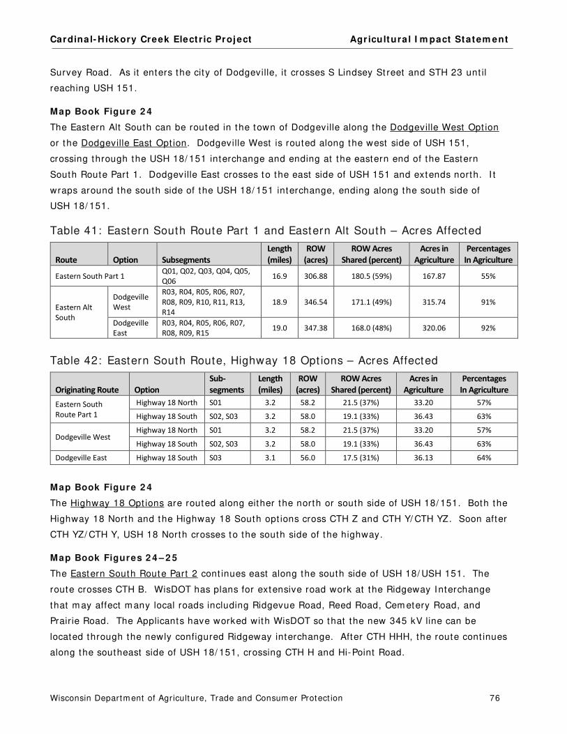
Cardinal- Hickory Creek Elect r ic Project Agr icultura l I m pact Statem ent
Wisconsin Departm ent of Agriculture, Trade and Consum er Protect ion 76
Survey Road. As it enters the city of Dodgeville, it crosses S Lindsey St reet and STH 23 unt il
reaching USH 151.
Map Book Figure 2 4
The Eastern Alt South can be routed in the town of Dodgeville along the Dodgeville West Opt ion
or the Dodgeville East Opt ion. Dodgeville West is routed along the west side of USH 151,
crossing through the USH 18/ 151 interchange and ending at the eastern end of the Eastern
South Route Part 1. Dodgeville East crosses to the east side of USH 151 and extends north. I t
wraps around the south side of the USH 18/ 151 interchange, ending along the south side of
USH 18/ 151.
Table 41: Eastern South Route Part 1 and Eastern Alt South – Acres Affected
Route Option Subsegments
Length
(miles)
ROW
(acres)
ROW Acres
Shared (percent)
Acres in
Agriculture
Percentages
In Agriculture
Eastern South Part 1 Q01, Q02, Q03, Q04, Q05,
Q06 16.9 306.88 180.5 (59%) 167.87 55%
Eastern Alt
South
Dodgeville
West
R03, R04, R05, R06, R07,
R08, R09, R10, R11, R13,
R14
18.9 346.54 171.1 (49%) 315.74 91%
Dodgeville
East
R03, R04, R05, R06, R07,
R08, R09, R15 19.0 347.38 168.0 (48%) 320.06 92%
Table 42: Eastern South Route, Highway 18 Opt ions – Acres Affected
Originating Route Option
Sub-
segments
Length
(miles)
ROW
(acres)
ROW Acres
Shared (percent)
Acres in
Agriculture
Percentages
In Agriculture
Eastern South
Route Part 1
Highway 18 North S01 3.2 58.2 21.5 (37%) 33.20 57%
Highway 18 South S02, S03 3.2 58.0 19.1 (33%) 36.43 63%
Dodgeville West Highway 18 North S01 3.2 58.2 21.5 (37%) 33.20 57%
Highway 18 South S02, S03 3.2 58.0 19.1 (33%) 36.43 63%
Dodgeville East Highway 18 South S03 3.1 56.0 17.5 (31%) 36.13 64%
Map Book Figure 2 4
The Highway 18 Opt ions are routed along either the north or south side of USH 18/ 151. Both the
Highway 18 North and the Highway 18 South opt ions cross CTH Z and CTH Y/ CTH YZ. Soon after
CTH YZ/ CTH Y, USH 18 North crosses to the south side of the highway.
Map Book Figures 2 4 – 2 5
The Eastern South Route Part 2 cont inues east along the south side of USH 18/ USH 151. The
route crosses CTH B. WisDOT has plans for extensive road work at the Ridgeway Interchange
that m ay affect m any local roads including Ridgevue Road, Reed Road, Cem etery Road, and
Prair ie Road. The Applicants have worked with WisDOT so that the new 345 kV line can be
located through the newly configured Ridgeway interchange. After CTH HHH, the route cont inues
along the southeast side of USH 18/ 151, crossing CTH H and Hi-Point Road.

Cardinal- Hickory Creek Elect r ic Project Agr icultura l I m pact Statem ent
Wisconsin Departm ent of Agriculture, Trade and Consum er Protect ion 77
Table 43: Eastern South Route Components – Acres Affected
Route Subsegments
Length
(miles)
ROW
(acres)
ROW Acres Shared
(percent)
Acres in
Agriculture
Percentages
In Agriculture
Eastern South Route
Part 2 S04, S05, S08, S09 6.2 112.2 53.0 (47%) 52.8 47%
Eastern South Route
Part 3 S12, S13 11.0 199.2 87.7 (44%) 88.4 44%
Eastern South Route
Part 4 V01, V02, V03, V04 4.3 78.0 32.4 (42%) 68.2 87%
Subtotal 21.5 389.4 173.1 (44%) 209.4 54%
Map Book Figure 2 5
The brief Barneveld Opt ions, allow the Eastern South Route to be located on either the north or
south side of USH 18/ 151. The Barneveld North Extended Opt ion stays on the north side of the
highway for an addit ional three-quarters of a m ile.
Table 44: Eastern South Route, Barneveld Opt ions – Acres Affected
Option Subsegments
Length
(miles)
ROW
(acres)
ROW Acres
Shared (percent)
Acres in
Agriculture
Percentages
In Agriculture
Barneveld North S11A, S11B, S11C, S10D 1.4 17.5 12.4 (71%) 1.0 6%
Barneveld North
Extended S11A, S11B, S11D 1.4 17.8 15.3 (86%) 1.6 9%
Barneveld South S10A, S10B, S10C, S10D 1.4 17.2 12.8 (74%) 0.4 2%
Map Book Figures 2 5 - 2 7
The Eastern South Route Part 3 cont inues m ost ly along the south side of USH 18/ 151 through the
village of Barneveld, across CTH K, Mounds View Road, E. Brigham Road, through the southern
end of the village of Blue Mounds, across CTH F, Cave of the Mounds Road, Erbe Road, CTH E,
STH 78, through the southern end of the village of Mount Horeb, across Sand Rock Road, CTH JG,
STH 92, and CTH I D.
Map Book Figure 2 7
Both the Mount Horeb East Opt ion and the Mount Horeb West Opt ion are located east of the
village of Mount Horeb. The Mount Horeb West Opt ion crosses USH 18/ 151 just east of CTH ID,
and proceeds north, cross-count ry, as a single-circuit line. Just south of CTH S and Wally Road,
the new 345 kV line would m eet up with an exist ing line 69 kV line (Y-128) . From there, the
proposed 345 kV line would be double-circuited and generally follow the exist ing Y-128 alignment
with slight variat ions around two farm s. For the last three-quarters of a m ile, the route turns
east along the north side of CTH J. Most of this opt ion is cross-count ry.
The Mount Horeb East Opt ion would be all new elect r ic ROW. The opt ion start s east along USH
18/ 151, then crosses the highway to proceed north towards the town of Cross Plains. With the
except ion of Subsegm ent U01, the route is cross-count ry.
The length and agricultural acres affected by the two Mount Horeb Opt ions are com parable.

Cardinal- Hickory Creek Elect r ic Project Agr icultura l I m pact Statem ent
Wisconsin Departm ent of Agriculture, Trade and Consum er Protect ion 78
Table 45: Eastern South Route, Mount Horeb Opt ions – Acres Affected
Option Subsegments
Length
(miles)
ROW
(acres)
ROW Acres
Shared (percent)
Acres in
Agriculture
Percentages
In Agriculture
Mount Horeb West T01, T02, T03, T04, T05 4.2 77.0 20.9 (27%) 60.2 78%
Mount Horeb East U01, U02 4.2 76.5 8.9 (12%) 64.7 85%
Map Book Figures 2 7 – 2 8
The last sect ion of the Eastern South Route is referred to as the Eastern South Route Part 4. I t
extends north to j ust south of the village of Cross Plains. The ent ire sect ion would be double-
circuited with an exist ing 69 kV line (Y-128) . The route is cross- count ry and would require the
expansion of the exist ing elect r ic ROW width an addit ional 70 to 126 feet .
Off-ROW Access Roads
Off-ROW access roads would be required for m ost of the Eastern South Route com ponents. They
are overwhelm ingly across agricultural propert ies.
Table 46: Eastern South Route Components and Opt ions – Off-ROW Access Roads
Route Option Subsegment Connections
Area
(acres)
Acres in
Agriculture
Percentages
In Agriculture
Eastern South Route Part 1 Q02, Q05 1.04 0.76 73%
Eastern Alt South Route Dodgeville West R09 0.49 0.32 65%
Dodgeville East R09, R15 1.98 1.92 97%
Eastern South Route Highway 18 North S01 0.48 0.44 92%
Eastern South Route Highway 18 South S03 1.18 1.14 97%
Eastern South Route Part 2 S08, S09 0.87 0.56 64%
Eastern South Route Barneveld North none - - - - - -
Eastern South Route Barneveld South none - - - - - -
Eastern South Route Part 3 S13 10.0 5.9 59%
Eastern South Route Mount Horeb West none - - - - - -
Eastern South Route Mount Horeb East U01, U02 1.96 1.35 69%
Eastern South Route Part 4 V03, V04 1.17 0.82 70%

Cardinal- Hickory Creek Elect r ic Project Agr icultura l I m pact Statem ent
Wisconsin Departm ent of Agriculture, Trade and Consum er Protect ion 79
Farmland Types and Soils
Most of the land that would be required for the Eastern South Route Part 1 or the Eastern Alt
South opt ions is cropland and ident ified as prim e farm land.
Table 47: Eastern South Rt . Pt . 1 & Eastern Alt South Rt . – Agricultural Land Use
Agricultural Land Use
Eastern South
Route Part 1
(acres)
Eastern Alt South Route (acres)
Dodgeville West Dodgeville East
Cropland 126.08 148.59 150.72
Pasture 8.31 26.76 27.68
Other Agricultural Land 34.00 140.71 143.58
Totals 168.39 316.06 321.98
NOTE: This table includes acres affected by the ROW and off-ROW access roads.
Table 48: Eastern South Rt . Pt . 1 and Eastern Alt South Rt . – Farm land Soils
Farmland Soil Classification
Eastern South
Route Part 1
(acres)
Eastern Alt South Route (acres)
Dodgeville West Dodgeville East
Prime farmland 121.82 213.99 215.97
Prime farmland if drained 0.50 4.13 4.13
Farmland of statewide importance 36.80 64.78 70.22
Not prime 9.27 33.17 31.65
Totals 168.39 316.06 321.98
NOTE: This table includes acres affected by the ROW and off-ROW access roads.
Fewer acres of agricultural land would be required for the Eastern South Route Part 1 as opposed
to the Eastern Alt South Route opt ions. I t also would affect fewer acres of prim e farm land.
Table 49: Eastern South Rt ., Highway 18 Opt ions – Agricultural Land Use
Agricultural Land Use
Hwy 18 North
Subsegment S01
(acres)
Hwy 18 South
From Dodgeville West
Subsegments S02, S03
(acres)
Hwy 18 South from
Dodgeville East
Subsegment S03
(acres)
Cropland 27.20 19.96 19.73
Pasture 4.53 4.15 4.06
Other Agricultural Land 2.06 13.50 13.49
Totals 33.78 37.60 37.27
NOTE: This table includes acres affected by the ROW and off-ROW access roads.

Cardinal- Hickory Creek Elect r ic Project Agr icultura l I m pact Statem ent
Wisconsin Departm ent of Agriculture, Trade and Consum er Protect ion 80
Table 50: Eastern South Route, Highway 18 Opt ions – Farm land Soils
Farmland Soil Classification
Hwy 18 North
Subsegment S01
(acres)
Hwy 18 South
Subsegments S02, S03
(acres)
Hwy 18 South from
Dodgeville East
Subsegment S03
(acres)
Prime farmland 3.28 7.42 7.09
Prime farmland if drained 0.91 0.14 0.14
Prime farmland if protected from flooding - - 0.02 0.02
Farmland of statewide importance 11.90 9.41 9.41
Not prime 17.69 20.61 20.61
Totals 33.78 37.60 37.27
NOTE: This table includes acres affected by the ROW and off-ROW access roads.
The agricultural im pacts of all three short Highway 18 opt ions are fair ly sim ilar though fewer
acres of prim e farm land would be affected by the Highway 18 North Opt ion.
The next two tables list the agricultural land use and farm land soils for t he three Eastern South
Route com ponents, Part 2, Part 3, and Part 4.
Table 51: Eastern South Rt . Components – Agricultural Land Use
Agricultural Land Use
Eastern South Route
Part 2
(acres)
Eastern South
Route Part 3
(acres)
Eastern South
Route Part 4
(acres) Subtotals
Cropland 37.72 71.28 30.88 139.88
Pasture 3.35 7.40 6.58 17.33
Other Agricultural Land 12.27 23.66 31.59 56.52
Totals 53.35 102.34 69.06 224.75
NOTE: This table includes acres affected by the ROW and off-ROW access roads.
Table 52: Eastern South Rt . Components – Farm land Soils
Farmland Soil Classification
Eastern South Route
Part 2
(acres)
Eastern South
Route Part 3
(acres)
Eastern South
Route Part 4
(acres) Subtotals
Prime farmland 20.75 31.64 12.26 64.65
Prime farmland if protected from flooding - - 0.17 - - 0.17
Farmland of statewide importance 17.56 19.22 14.82 51.60
Not prime 15.04 51.30 41.98 108.32
Totals 53.35 102.34 69.06 224.74
NOTE: This table includes acres affected by the ROW and off-ROW access roads.

Cardinal- Hickory Creek Elect r ic Project Agr icultura l I m pact Statem ent
Wisconsin Departm ent of Agriculture, Trade and Consum er Protect ion 81
Table 53: Eastern South Rt ., Barneveld Opt ions – Agricultural Land Use
Agricultural Land Use
Barneveld
North
(acres)
Barneveld North
Extended
(acres)
Barneveld
South
(acres) Cropland 0.86 1.23 0.43
Other Agricultural Land 0.12 0.36 0.02
Totals 0.98 1.59 0.45
Table 54: Eastern South Rt ., Barneveld Opt ions – Farm land Soils
Farmland Soil Classification
Barneveld
North
(acres)
Barneveld North
Extended
(acres)
Barneveld
South
(acres) Prime farmland 0.13 0.13 0.08
Farmland of statewide importance 0.51 1.10 0.37
Not prime 0.34 0.37 - -
Totals 0.98 1.59 0.45
The Barneveld opt ions are very short and would affect only a few agricultural acres. Barneveld
South affects the fewest acres of cropland and prim e farm land.
Table 55: Eastern South Rt ., Mount Horeb Opt ions – Agricultural Land Use
Agricultural Land Use Mount Horeb West
(acres) Mount Horeb East
(acres)
Cropland 36.02 35.99
Pasture 0.20 16.71
Other Agricultural Land 24.05 13.36
Totals 60.27 66.06
NOTE: This table includes acres affected by the ROW and off-ROW access roads.
Table 56: Eastern South Rt ., Mount Horeb Opt ions – Farm land Soils
Farmland Soil Classification
Mount Horeb West
(acres)
Mount Horeb East
(acres)
Prime farmland 15.71 8.64
Prime farmland if protected from flooding 2.27 0.54
Farmland of statewide importance 15.14 29.28
Not prime 27.69 27.59
Totals 60.27 66.06
NOTE: This table includes acres affected by the ROW and off-ROW access roads.
The Mount Horeb East Opt ion affects slight ly more agricultural acres than the West Opt ion.
However fewer acres of prim e farm land would be affected by the Mount Horeb East Opt ion.

Cardinal- Hickory Creek Elect r ic Project Agr icultura l I m pact Statem ent
Wisconsin Departm ent of Agriculture, Trade and Consum er Protect ion 82
Impacts to Agricultural Property Owners
The various com ponents and opt ions of the Eastern South Route could affect between 131 and
170 agricultural propert y owners, depending on the route chosen by the PSC. Num bers of
potent ially affected landowners are as follows, by route com ponent :
Eastern South Route Part 1 would affect 74 property owners of which 45 are
agricultural
Eastern Alt South Route with Dodgeville West would affect 86 property owners of
which 73 are agricultural
Eastern Alt South Route with Dodgeville East would affect 83 property owners of
which 72 are agricultural
Highway 18 Opt ions could affect up to 14 property owners of which up to 10 are
agricultural
Eastern South Route Part 2, Part 3, and Part 4 would affect 87 propert y owners of
which 62 are agricultural
Barneveld Opt ions would affect up to 7 propert y owners of which 2 are agricultural
Mount Horeb West would affect 18 property owners of which 13 are agricultural
Mount Horeb East would affect 26 property owners of which 23 are agricultural
Approxim ately three-quarters of all property owners regardless of the route opt ions chosen would
be agricultural property owners. Many would have off-ROW access roads affect ing them besides
the ROW easem ents. The Eastern South Route opt ions and com ponents would affect the
agricultural property owners listed in the following seven tables. Those with asterisks before
their nam e would also be affected by off-ROW access roads.
Table 57: Eastern South Rt . Pt . 1 and Eastern Alt South Rt . – Potent ially Affected Agricultural Landowners
Agricultural Property Owners
Eastern South
Route Part 1
(acres)
Eastern Alt South Route
with Dodgeville West
(acres)
Eastern Alt South
Route with
Dodgeville East
(acres)
ADAMS, DANIEL 7.25 7.25
ANDERSON RESIDENCE 4.70 - - - -
BEERKIRCHER, RICKY AND KERRY 2.71 - - - -
BETTNER, ROY 4.53 2.89 6.92
BIDDICK, JASON <1.0 1.36 1.36
BISHOP, BRADLEY - - 1.28 1.28
BROKISH, JOSEPH AND NANCY - - 7.57 7.57
BROKISH, MICHAEL AND SHERRY - - 8.37 8.37
BROWN, KEITH AND MARY - - 6.17 6.17
*BROWN, SEAN AND DANIELLE 2.46 - - - -
C AND NW TRANSPORTATION CO 3.35 <1.0 <1.0

Cardinal- Hickory Creek Elect r ic Project Agr icultura l I m pact Statem ent
Wisconsin Departm ent of Agriculture, Trade and Consum er Protect ion 83
Agricultural Property Owners
Eastern South
Route Part 1
(acres)
Eastern Alt South Route
with Dodgeville West
(acres)
Eastern Alt South
Route with
Dodgeville East
(acres)
C R BISHOP AND SONS INC/TWIN CREEKS ENTERPRISES LLC 10.60 1.22 1.22
CAYGILL, DAVID AND MICHELLE 1.73 - - - -
CLIFTON, JOSEPH M 8.52 - - - -
CORNISH, BERNICE - - 3.19 3.19
DAENTL, JAMES W AND PEGGY J REVOC TRUST 6.89 - - - -
DAMMEN, LARRY AND KAY - - 5.50 5.50
DAVIES, ROBERT L - - - - 3.47
*DONALDSON, ARTHUR AND SUSAN - - 16.71 15.70
DOUBLE CREEK LLC/MASTERS PROPERTIES LLC - - 1.24 1.24
DOUBLE H FARMS LLC - - 2.96 2.96
DURST, DANIEL AND DENISE 1.54 - - - -
ESSER, STEPHEN AND KORENA - - 9.52 9.52
FAULL RESIDENCE - - 18.70 18.70
FESENFELD, DONALD AND LARRY - - 4.33 4.33
FRITSCH RESIDENCE - - 6.17 6.17
FRITSCH, GERALD 8.16 - - - -
FRONTIER FS 1.15 - - - -
GARD, RODNEY AND LINDA AND CONNIE 1.62 - - - -
GIROTTO, JAY AND LYNN - - 1.01 1.01
HAAS, GERALD AND VIRGINIA - - 2.09 2.09
HALE, LARRY AND SHANE - - 4.01 4.01
HANSON, KEVIN AND SHEILA 4.54 - - - -
HANSON, WILLIAM C AND NANCY K REVOCABLE TRUST <1.0 <1.0 - -
HELLENBRAND RESIDENCE 4.02 - - - -
HENNESSEY PROPERTIES LP/
LORRAINE HENNESSEY LLC <1.0 8.45 8.45
JACOBSON FAMILY TRUST - - 1.68 1.68
JEWELL, ALAN AND MARCIA - - 11.69 11.69
JOHNSEN, LARRY AND DENISE - - 10.45 10.45
JOHNSON BLOCK AND COMPANY INC - - 7.04 7.04
JOHNSON, BRYAN AND BRADLEY - - 1.82 1.82
JORDAN, RACHEL L 6.80 - - - -
KEENA/OXNEM/WELLE RESIDENCE - - 3.97 3.97
KEENEY, WILLIAM AND CHERYL 4.34 - - - -
KITE, JAMES - - 4.96 4.96
KROLL, KEVIN 2.62 - - - -
LAUFENBERG, GEORGE M AND PATSY R REV TRUST 10.77 - - - -
LEE, JAMES H - - 7.78 7.78
LEIX, MARION AND MARY 4.34 - - - -
LEIX, TIMOTHY AND DONALD AND CYNTHIA 2.21 - - - -
LENZ RESIDENCE - - 5.11 5.11

Cardinal- Hickory Creek Elect r ic Project Agr icultura l I m pact Statem ent
Wisconsin Departm ent of Agriculture, Trade and Consum er Protect ion 84
Agricultural Property Owners
Eastern South
Route Part 1
(acres)
Eastern Alt South Route
with Dodgeville West
(acres)
Eastern Alt South
Route with
Dodgeville East
(acres)
LENZ, LEONARD - - 1.94 1.94
LEY, THOMAS 2.42 - - - -
LINDEN TOWN - - 1.13 1.13
LONGENECKER, DAVID AND LINDA - - 8.42 8.42
MASTERS, MAT - - 4.38 4.38
MUELLER, EVELYN L REV TRUST - - 5.08 5.08
MUELLER, STEVEN W <1.0 7.51 7.51
NOVAK, DANIEL AND SUSAN MURPHY - - 8.17 8.17
NOVAK, TODD AND TIMOTHY - - 1.54 1.54
OAKDALE FARMS LTD PARTNERSHIP/
BLOOMFIELD FARMS LLC 9.48 <1.0 <1.0
OXNEM, JOHN AND BONNIE - - 2.74 2.74
*OXNEM, LEE AND JOHN - - 6.34 6.34
OXNEM, LEE AND MARY LOU - - 2.10 2.10
POWELL RESIDENCE 6.08 - - - -
*REYNOLDS, JOHN AND CYNTHIA 3.64 - - - -
RILEY RESIDENCE 4.78 - - - -
RIPP, PATRICK AND ANN - - 6.96 6.96
ROCK, THOMAS AND ANN 7.15 4.14 4.14
ROCKIN M LAND COMPANY LLC 4.03 - - - -
RULE QUARRY LLC - - 2.96 2.96
RULE, CAROLE AND R NORM - TRUSTEES - - 2.41 2.41
RULE, CHARLES - - 18.08 18.08
RULE, DOUGLAS - - 3.95 3.95
RULE, FAMA - - 4.60 4.60
RULE, RANDY AND TAMMY - - 4.49 4.49
RULE, TERRILL - - 1.70 1.70
SCHWARTZ, PAUL A AND ELAINE M REVOC TRUST 4.58 - - - -
SHAULL, THOMAS AND CHARITY - - 7.07 7.07
SPRINGER, DANIEL AND ELISABETH AND RALPH - - 10.71 10.71
SURVEY ROAD INVESTMENTS LLC - - 2.12 2.12
SWIGGUM, BENJAMIN A AND ROLAND P 13.34 - - - -
THOMAS, CAROL 3.81 - - - -
THOMAS, DEANE AND NANCY 6.33 - - - -
TWO SISTERS PROPERTIES LLC - - 4.11 4.11
*UMHOEFER, RICK 3.66 - - - -
WENDHAUSEN SURVIVOR'S TRUST - - 6.00 6.00
WENDHAUSEN, RICHARD - - 5.39 5.39
Additional Agricultural Landowners with <1.0 Acres
Potentially Affected 1.72 7.55 6.98
Totals 168.63 316.06 321.98

Cardinal- Hickory Creek Elect r ic Project Agr icultura l I m pact Statem ent
Wisconsin Departm ent of Agriculture, Trade and Consum er Protect ion 85
Table 58: Eastern South Rt ., Hwy 18 Opt ions – Potent ially Affected Agr icultural Landowners
Agricultural Property Owners Hwy 18 North
(acres) Hwy 18 South
(acres)
Hwy 18 South from
Dodgeville East
(acres)
*BETTNER, ROY 6.11 6.49 6.78
BRICK-MARGELOFSKY, TROY AND SANDIE 3.23 2.68 2.68
DOLAN, WILLIAM AND ROSE CENITE 5.13 - - - -
HINRICHS, JAMES AND JOYCE - - 6.87 6.87
*HOPPENJAN, TIMMOTHY AND ANDREW SPURLEY - - 3.34 3.34
*KLOSTERMAN, LEO AND KAREN - - 2.78 2.78
KRUEGER, NICOLE 0.03 1.12 1.12
LALOR TRUST, THOMAS E AND ANNMARIE 9.18 7.21 7.21
LAZARUS , GEORGE AND MARTIA MORGAN - - 6.61 6.61
LEVETZOW, KYLE 6.44 - - - -
MARTIN, EDWARD 0.17 0.18 0.18
MURN, JAMES 2.26 - - - -
*VENDEN, CURTIS AND GLORIA 1.02 - - - -
ZIEHR, JOHN 0.09 - - - -
Totals 33.67 37.27 37.57
Table 59: Eastern South Rt . Pt . 2 - Potent ially Affected Agricultural Landowners
Agricultural Property Owners Acres Agricultural Property Owners Acres
*BICKFORD, PAUL 13.85 LATHROP REV LVG TRUST, RUTH R 4.75
*BJORGE, ROBERT AND CHRISTINE 6.19 MARTIN, EDWARD 1.35
BOLDT, MELVIN W 1.62 MCNALL, MIKE 1.52
HALVERSON, DENNIS AND VERNON AND EVELYN 0.47 PAULL REVOCABLE TRUST 2.06
HATFIELD, JAMES 0.93 STEFFAN, MARK AND CALLIE 2.28
*HODGSON, MARK AND BONNIE 6.34 STONE LODGE LLC 0.54
HY - VISTA DAIRY FARM LLC 7.12 STRAUBHAAR, JESSE 3.04
KRUEGER, NICOLE <0.01 THOMPSON, KYLE 1.30
Table 60: Eastern South Rt ., Barneveld Opt ions – Potent ially Affected Agricultural Landowners
Agricultural Property Owners Barneveld North
(acres)
Barneveld North
Extended
(acres) Barneveld South
(acres)
ARNESON, ERIC 0.98 1.59 - -
THOMPSON, KYLE - - - - 0.45
Totals 0.98 1.59 0.45

Cardinal- Hickory Creek Elect r ic Project Agr icultura l I m pact Statem ent
Wisconsin Departm ent of Agriculture, Trade and Consum er Protect ion 86
Table 61: Eastern South Rt . Pt . 3 – Potent ially Affected Agr icultural Landowners
Agricultural Property Owners Acres Agricultural Property Owners Acres
*ANDERSON, RICKIE AND JUDY 11.49 *MEYER RESIDENCE 3.33
BAKER TRUST, ELMER C AND NORMA J 2.85 *MT HOREB UNION HIGH SCHOOL DIST 4.63
*BARTH, MICHAEL 3.91 *RF FARMS LLC/BLUE SUN LLC 5.37
*BIGLER, DONNA R LIFE ESTATE 5.03 SCHLIMGEN, DENNIS AND LISA 5.27
*DOCKEN, RANDY 5.11 STEFFEN, GLENN AND KAREN 1.81
EMERALD RIDGE DEVELOPERS LLC 1.02 SUTTER LIVING TRUST 2.99
*HLS LLC 3.43 SUTTER REV TRUST 7.50
*IHM, JASON 9.01 *THOMSON, DENNIS AND JOAN SCHURCH
THOMSON 7.16
JOHNSON, KENT 3.00 *VAN CAMP, JIM 2.31
*LAZARUS, GEORGE AND MARTIA MORGAN 2.15 WINGRA REAL ESTATE LLC 2.07
*MARILU LLC 1.71 Additional Agricultural Landowners with <1.0
Acres Potentially Affected 3.13
Table 62: Eastern South Rt ., Mount Horeb Opt ions – Potent ially Affected Agricultural Landowners
Agricultural Property Owners Mount Horeb West
(acres)
Mount Horeb East
(acres)
ADLER, STEPHANIE AND PAUL GIBSON -- 1.02
ATWELL, DAVID -- 1.81
BAKER TRUST, ELMER C AND NORMA J 12.18 3.18
*BURNS RESIDENCE -- 4.64
*CANTRELL, ALLEN AND ELISABETH -- 2.44
*DEER RIDGE LLC -- 3.13
HISE, RODMAN AND JENNIFER -- 2.73
HOLLER, RICHARD AND CAROL -- 4.09
HOOPES, JANET 3.09 --
KELLESVIG, PAUL AND DAWN 5.42 --
KLEBBA, ROBERT AND DAVID WAUGH -- 9.57
LAUFENBERG RESIDENCE 1.73 --
LAUFENBERG, RICHARD AND JOANN -- 4.57
LYNCH, THOMAS AND MARIA MYER -- 2.46
MILLER, THOMAS AND JULIE 2.17 --
NICKELS, KENNETH AND PATRICIA SAUEY 2.30 --
ROBERTSON, GARY AND HSIU-LING -- 3.31
SHAMROCK FARMS -- 2.20
SOLBERG, RANDOLPH AND JOANN GUMZ -- 2.14
SUKOWATY, MARK 3.98 --
SUTTER, ALBERT -- 7.34
TOLCH LIVING TRUST 7.82 --
WEDIG, KURT AND TAMMY -- 1.71
*WINDY RIDGE FARM INC -- 3.18

Cardinal- Hickory Creek Elect r ic Project Agr icultura l I m pact Statem ent
Wisconsin Departm ent of Agriculture, Trade and Consum er Protect ion 87
Agricultural Property Owners Mount Horeb West
(acres)
Mount Horeb East
(acres)
ZANDER, AUDREY -- 4.53
ZANDER, JEROME AND LYNN 20.47 --
Additional Agricultural Landowners with <1.0 Acres Potentially
Affected 1.07 2.02
Totals 60.23 66.06
Table 63: Eastern South Rt . Pt . 4 – Potent ially Affected Landowners
Agricultural Property Owners Acres Agricultural Property Owners Acres
CORRELL LIVING TRUST - PAUL AND ANNE-MARIE 4.77 ZANDER-BURKHOLDER, MARY JANE 1.43
BRUNNER, DANIEL AND DEBRA 10.09 ZIMMERMAN, MARY AND NICOLE CORNISH 8.74
FAUST, DONALD AND JOANNE 2.29 RICHARDS LIVING TRUST 1.63
OVERLAND, HARLAN AND POLLY 2.54 *HOLLFELDER TRUST, ROBERT L AND RAYELLEN M 10.63
HUSSEY REV TRUST, JOHN AND MARLENE 3.20 *SHAMROCK FARMS 11.23
HERMAN, KRIS AND TURA PATTERSON 1.42 *KURTH, TERRY AND KATHLEEN 2.44
SUKOWATY, MARK 5.62 Additional Agricultural Landowners with <1.0 Acres
Potentially Affected 3.04
Eastern South Route Comments
Com m ents from the 34 agricultural landowners that could be affected by the Western South
Route opt ions and com ponents are sum m arized below. Som e of these landowners could be
affected by m ore than one route.
Com m ents from Agricultural Landowners Affected by Mult iple Eastern South Route Opt ions
Farm Ow ner: Roy Bet tner ( includes land form erly owned by Janelle Sim pson) Operators: Ross and Nicole Bet tner
Potent ia l I m pacts ( Subsegm ents) :
4 .5 acres East ern South Par t 1 ( Q06)
2 .9 acres Dodgevil le West ( R13, R14) from East ern Alt South
6 .9 acres Dodgevil le East ( R15) from East ern Alt Sout h
5 .8 acres Hwy 18 Nor th ( S01) , 0.4 acres for an off-ROW access road 5 .9 acres Hwy 18 South ( S03) , 0.6 acres for an off-ROW access road 0 .3 acres Hwy 18 South ( S02)
Several of the Eastern South Route opt ions, east of Dodgeville, could cross land owned by Roy
Bet tner. Im pacts to this farm is dependent on the route approved by the PSC. Mr. Bet tner owns
448 acres of land consist ing of 240 acres of cropland, 200 acres of pasture, and 8 acres for
buildings. Typically, the renters grow 55 acres of corn, 90 acres of soybeans, and 95 acres of
hay. The renters also have 240 head of sheep and goats, and bee hives are kept on the farm .
Trees from their woodland are cut regularly and this cont r ibutes to the farm ’s incom e. This farm
has been in the fam ily since the m id-1840s. Som e of his acres are enrolled in CRP and the MFL
program .
Mr. Bet tner is concerned about overall const ruct ion dam age to his erosion cont rol pract ices that
are used on this property. The proj ect could also affect a cat t le pass and culvert that conveys
Cardinal- Hickory Creek Elect r ic Project Agr icultura l I m pact Statem ent
Wisconsin Departm ent of Agriculture, Trade and Consum er Protect ion 88
water from a st ream , fencing, and a historic m ine. The owners are concerned about property
values, safety in the vicinity of the new elect r ic line, induced currents, loss of cropland and
wildlife habitat , loss of woodland, dam age to soils from const ruct ion equipm ent , and aesthet ic
im pacts.
Farm Ow ner: C R Bishop and Sons, I nc. (Twin Creeks Enterprises LLC)
Potent ia l I m pacts ( Subsegm ent ) :
10.2 acres East ern Nort h ( P02) , 3.0 acres for an off-ROW access road 10.6 acres East ern Sout h Part 1 ( Q02) 1 .2 acres East ern Alt Sout h ( R03)
Several of the Eastern Route opt ions could cross land owned by C R Bishop. I m pacts to this farm
is dependent on the route approved by the PSC. C R Bishop and Sons, I nc. owns 1,390 acres of
cropland, 279 acres of pasture, 35 acres of woodland, and 20 acres for buildings. They grow
corn, soybeans, hay, rye, and sorghum . They also raise 50 head of replacem ent dairy cat t le, 210
head of beef cat t le, and 100 pigs. This farm is covered by the FPP. The owners have three
farm steads including two houses that m ay be im pacted by the Eastern South Route (Subsegm ent
Q02) , j ust west of the v illage of Cobb. Addit ionally northwest of the intersect ion of USH 18 and
Bridge Road, they have a large establishm ent of cat t le barns, hog barns, storage sheds, grain
storage and drying facilit ies, which m ay be im pacted by the widened ROW and placem ent of
st ructures. There are also fences along all fields on the USH 18 corridor and a t iled grass
waterway.
Eastern South Route Part 1 Com m ents
Farm Ow ners \ Operators: Jim and Carol Anderson (Anderson Residence) \ Jeff and Deane Thom as
Route ( Subsegm ent ) : 4.7 acres Eastern South Part 1 (Q02)
The Andersons own 547 acres of land consist ing of 356 acres of cropland, 184 acres of pasture,
and 7 acres for buildings. They grow corn and soybeans and raise 5 pigs. This farm is covered
by the FPP. The owners are concerned that project const ruct ion will lead to increased rock
content in the topsoil, dam age to fencing, and lead to the int roduct ion or spread of weeds. The
line could also pass close to a shed used for storage and to house pigs.
Farm Ow ners \ Operator: William and Cheryl Keeney \ Brad Walters
Route ( Subsegm ent ) : 4.3 acres Eastern South Part 1 (Q02)
Mr. and Mrs. Keeney own 343 acres of land consist ing of 200 acres of cropland, 138 acres of
pasture, and 5 acres for buildings. The cropland is used to grow corn and hay, and the pasture is
used for 30 head of beef cat t le. The owners are concerned that the route const ructed across
their fields will affect their best cropland. I t could also affect grassed waterways and line fencing
on this property.

Cardinal- Hickory Creek Elect r ic Project Agr icultura l I m pact Statem ent
Wisconsin Departm ent of Agriculture, Trade and Consum er Protect ion 89
Farm Ow ner \ Operator: Jordan Tim berland Lim ited Partnership (Rachel Jordan General Partner) \ David Krom m
Route ( Subsegm ent ) : 6.8 acres Eastern South Part 1 (Q02)
This property is 386 acres and consists of 320 acres of cropland, 55 acres of woodland, 6 acres of
idle farm land, and 5 acres for the buildings. The renter grows corn and soybeans. The owner
also grows 1 acre of asparagus. The route could affect grassed waterways and som e terracing on
the property. The owner is in favor of replacing the exist ing line with a larger line that would
require fewer st ructures.
Farm Ow ner: George M. and Patsy R. Laufenberg Revocable Trust Route ( Subsegm ent ) : 10.8 acres Eastern South Part 1 (Q02)
Mr. and Mrs. Laufenberg own 276 acres of land and rent addit ional land for their operat ion. I n an
average year, they grow 220 acres of corn, 105 acres of soybeans, and 40 acres of oats. They
also raise 250 head of beef cat t le. Their farm is under the FPP. The route could affect cropland
and fencing. Mr. Laufenberg does not want to lose any farm land to the proj ect .
Farm Ow ners \ Operator: Powell Family Trust (Powell Residence, Beverly Powell-Zim m erm an, Marilyn Powell, Barbara Powell, and June Powell) \ Russell Brothers Farm s
Route ( Subsegm ent ) : 6.1 acres Eastern South Part 1 (Q02, Q03)
The Powells own 153 acres of land consist ing of 131 acres of cropland and 22 acres of woodland.
The renters grow corn, soybeans, and wheat in rotat ion. The owners are unsure if the route
could affect their grassed waterways or t iling. They are concerned about im pacts to the fencing
located along the north side of their property and that the project could lim it the developm ent
potent ial of their property.
Farm Ow ner \ Operator: Carol Thom as \ Ronald Miller
Route ( Subsegm ent ) : 3.8 acres Eastern South Part 1 (Q02)
This property is 160 acres and 120 acres are rented to Mr. Miller. The route could affect cropland
and pasture, including contour st r ips in the cropland and fencing. The owner is concerned about
the potent ial loss of incom e from rented land as well as im pacts to the aesthet ic value of the
property.
Farm Ow ners \ Operators: Deane and Nancy Thom as \ Jeff and Renee Thom as
Route ( Subsegm ent ) : 6.3 acres Eastern South Part 1 (Q02)
Deane and Nancy Thom as own 585 acres of land consist ing of 250 acres of cropland, 200 acres of
pasture, 105 acres of woodland, and 30 acres for buildings. They rent addit ional land from Jim
and Carol Anderson. They grow corn, soybeans, and hay and raise 350 head of beef cat t le and
100 pigs. The owners are concerned that proj ect const ruct ion including the rem oval of old
elect r ic poles could dam age their soils and erosion cont rol pract ices. Addit ionally, the route could
affect their fencing. Som e of their buildings could be in the ROW. They are concerned about the
proxim ity of the new line to their residence and the rem oval of landscaping t rees near two
residences.

Cardinal- Hickory Creek Elect r ic Project Agr icultura l I m pact Statem ent
Wisconsin Departm ent of Agriculture, Trade and Consum er Protect ion 90
Eastern Alt South Route Com m ents
Farm Ow ner: Daniel Adam s
Route ( Subsegm ent ) : 7.3 acres Eastern Alt South (R03)
Mr. Adam s owns 322 acres of land and rents addit ional farm land. I n an average year he grows
255 acres of corn and 165 acres of soybeans. He also raises hogs. His farm is under the FPP.
The proposed project could affect his cropland and buildings. Several of his buildings could be
located within the ROW. He is also concerned that the route could affect grassed waterways on
the northern edge of his property, fencing, and t rees that serve as a windbreak.
Farm Ow ners: Larry and Kay Dam m en
Route ( Subsegm ent ) : 5.5 acres Eastern Alt South (R09)
The Dam m ens own 304 acres of land consist ing of 250 acres of cropland and 32 acres of pasture,
and 22 acres for buildings. Corn, soybeans, wheat , and rye are grown. This farm is cert ified for
organic product ion and they require special const ruct ion m easures to m aintain their organic
cert ificat ion. This includes cleaning const ruct ion equipm ent before it enters their property,
m aintaining a 25- foot buffer around the cropland, and no pest icides or other hazardous m aterials
used during const ruct ion or afterwards. Also, t he owners are concerned that the project will
affect their grassed waterways.
Farm Ow ners: Stephen and Korena Esser
Route ( Subsegm ent ) : 9.5 acres Eastern Alt South (R03, R04, R05)
The Essers own 470 acres of land consist ing of 400 acres of cropland, 60 acres of pasture, and 10
acres for buildings. I n an average year, they grow 250 acres of corn and 150 acres of hay. They
also run a 200-cow dairy operat ion with 125 replacem ent dairy cat t le and 250 head of beef
cat t le. This farm is enrolled in the FPP. This property has a large num ber of agricultural
buildings located near the intersect ion of CTH B and CTH J. They are concerned about im pacts to
their operat ion during const ruct ion as well as the potent ial for induced currents affect ing their
dairy operat ion when the line is in service. I t is im portant to the owners that const ruct ion debr is
is properly disposed, so as not t o affect their cat t le feed. I n addit ion, the Essers are concerned
about the loss of cropland during const ruct ion and const ruct ion act ivit ies that would lower the
product ivit y of their cropland long- term . These const ruct ion act ivit ies of concern include
com pact ion of soils (especially during wet condit ions) , m ixing topsoils with poorer qualit y
subsoils, and bringing up rocks. This route could also affect grassed waterways in the cropland
and fencing.
Farm Ow ner \ Operator: Evelyn M. Mueller Revocable Trust \ Double M Cat t le Com pany LLC
Route ( Subsegm ent ) : 5.1 acres Eastern Alt South (R03)
The Trust owns 240 acres of land consist ing of 222 acres of cropland, 10 acres of pasture, 5.4
acres for buildings, and 2.6 acres in CRP. I n an average year, the renter grows 80 acres of corn
and 142 acres of hay. The renter also raises 400 head of beef cat t le on this propert y. All of t his
property is covered by the FPP. The route could affect cropland, pasture, and buildings. Along
CTH B, there are two beef barns, silos, and a house. While the route does cross to the north side

Cardinal- Hickory Creek Elect r ic Project Agr icultura l I m pact Statem ent
Wisconsin Departm ent of Agriculture, Trade and Consum er Protect ion 91
of CTH B, avoiding m any of the potent ial im pacts to these buildings, the project could interfere
with farm ing operat ions. Addit ionally the ROW could require the rem oval of pine t rees and affect
grassed waterways and fencing. The owner is concerned about the aesthet ic appearance of this
property, aft er the line is const ructed.
Farm Ow ners \ Operator: Donald and Larry Fesenfeld \ Lindchied Brothers (Arthur Lindchied)
Route ( Subsegm ent ) : 4.3 acres Eastern Alt South (R06, R07)
The Fesenfelds own 200 acres of land consist ing of 195 acres of cropland and 5 acres for
buildings. The renter grows corn and soybeans in rotat ion. The route could affect cropland and
grassed waterways on this property.
Farm Ow ner \ Operator: Hennessey Propert ies LP (Lorraine Hennessey LLC) \ Paul Yager (Pine Lawn Farm )
Route ( Subsegm ent ) : 8.45 acres Eastern Alt South (R09) , 0.3 acres Eastern South Part 1 (Q02, Q03)
The project could affect fencing and drain t iling along the road. The owner is concerned about
induced currents on the fencing and buildings.
Farm Ow ner \ Operator: Johnson Block and Com pany Inc. (Charles Mueller Trust ) \ Double M Cat t le Com pany LLC
Route ( Subsegm ent ) : 7.0 acres Eastern Alt South (R03)
Johnson Block and Com pany, I nc. owns 160 acres of land consist ing of 151 acres of cropland and
9 acres of pasture. They grow corn and hay and raise 10 head of beef cat t le, t ypically. All of this
property is covered under the FPP. The route would affect one grassed waterway and fencing
located along CTH B.
Farm Ow ners \ Operator: Lee and John Oxnem \ Brad Walter
Route ( Subsegm ent ) : 6.0 acres Eastern Alt South (R03) , 0.3 acres for an off-ROW access road
The Oxnem s own 484 acres of land consist ing of 352 acres of cropland, 86 acres of pasture, 9
acres of woodland, 12 acres of idle land, 5 acres of wet land, and 20 acres for buildings. They
grow corn, soybeans, and hay in rotat ion and have 10 horses. The owners are concerned about
the potent ial loss of incom e, lower property values, induced voltages, and a loss of aesthet ic
value.
Farm Ow ner \ Operator: Fam a Rule \ Masters Enterprises LLC
Route ( Subsegm ent ) : 4.6 acres Eastern Alt South (R06, R07)
This property consists of 147 acres of cropland, 36 acres of pasture, and 3 acres for buildings.
Corn and soybeans are grown. This property is covered by the FPP.
Farm Ow ner \ Operator: Two Sisters Propert ies LLC \ Chad Mosley
Route ( Subsegm ent ) : 4.1 acres Eastern Alt South (R09)
This property includes about 100 acres of cropland, 6 acres of idle farm land, and 5 acres for
buildings. Mr. Mosley rents all of the cropland. Typically, 45 acres of corn, 45 acres of soybeans,
and 10 acres of hay are grown. The route could affect grassed waterways on the cropland.

Cardinal- Hickory Creek Elect r ic Project Agr icultura l I m pact Statem ent
Wisconsin Departm ent of Agriculture, Trade and Consum er Protect ion 92
Farm Ow ners \ Operator: Daniel, Elisabeth, and Ralph Springer \ J & S Sunny Slope Farm s LLP
Route ( Subsegm ent ) : 10.7 acres Eastern Alt South (R07, R08)
The Springers own 718 acres of cropland, 341 acres of pasture, 21 acres for buildings, and 1.5
acres of wet lands. Corn, soybeans, hay, wheat , and oats are grown and 480 head of beef cat t le
and 40 head of sheep/ goats are raised on the property. 80 acres of this property is covered by
the FPP.
The Springers would prefer t o see the route cont inue east on Fesenfeld Road/ Jewell Road and
then turn south on Sunny Slope Road. Current ly the Eastern Alt South Route passes through the
m iddle of the Springer’s fields. This deviat ion from sharing the road ROW m ay be for the purpose
of avoiding a sm all st ructure at the intersect ion of Fesenfeld and Sunny Slope Roads. The
Springers own the old building and the surrounding property. They reported that the building is
not historical and holds no sent im ental value for them . They prefer that the route be m odified to
stay on Fesenfeld and Sunny Slope Roads and avoid their fields, even if it required the rem oval of
the building and the surrounding plants/ t rees from the northeast corner of their property.
I f Eastern Alt South Route is chosen, DATCP finds m erit in this route m odificat ion as it would
decrease agricultural impacts and require one less turning st ructure. DATCP recom m ends that
the Applicants discuss a route m odificat ion of Subsegm ents R07 and R08 with the landowners
and if appropriate, revise the route on their property to stay along road ROW.
Highway 18 Opt ions Com m ents
Farm Ow ners \ Operator: William Dolan and Rose Cenite \ Eric Russel Route ( Subsegm ent ) : 5.1 acres Highway 18 North (S01)
The property owners have 161 acres of farm land consist ing of 120 acres of cropland, 25 acres of
pasture, 10 acres of woodland, 1 acre of idle or fallow farm land, and 5 acres for buildings. The
renter grows corn, soybeans, and hay on 120 acres of land. 50 head of beef cat t le, 300 poult ry,
and alpacas are raised on the land. The farm is cert ified organic by Midwest Organic Services
Associat ion, I nc. for crops and livestock. Mr. Dolan states that the route would affect farm land
that has the greatest yields. He is also concerned about the project rem oving his windbreaks,
crossing 3 waterways and it s negat ive health effect .
Farm Ow ners \ Operator: Jam es and Joyce Hinrichs \ Ross Blotz
Route ( Subsegm ent ) : 6.9 acres Highway 18 South (S03)
Mr. and Mrs. Hinrichs own 263 acres of land consist ing of 210 acres of cropland, 50 acres of
pasture, and 3 acres for buildings. The renter grows corn and soybeans in rotat ion as well as hay
and wheat . The route could affect drain t iles, a grassed waterway, fencing, natural springs, and
a creek. I t could also affect a storage shed and a concrete silo. The Hinrichs are concerned that
the route could affect their oak t rees and reduce the incom e they receive for rent ing the land for
hunt ing.
Cardinal- Hickory Creek Elect r ic Project Agr icultura l I m pact Statem ent
Wisconsin Departm ent of Agriculture, Trade and Consum er Protect ion 93
Eastern South Route Parts 2, 3, and 4 Com m ents
Farm Ow ners \ Operator: Rickie and Judy Anderson (Trout Creek Farm s) \ Sham rock Farm s
Route ( Subsegm ent ) : 11.3 acres Eastern South Route Part 3 (S13) , 0.2 acres for off-ROW access roads
The Andersons own 420 acres of land consist ing of 270 acres of cropland, 50 acres of pasture, 80
acres of woodland, 10 acres for buildings, and 10 acres in CREP. Ten acres of the cropland is
used to grow hay and the rem aining cropland is used to grow corn and soybeans in rotat ion.
There are also 20 head of replacem ent dairy cat t le and 15 head of beef cat t le on this property.
This farm is covered by the FPP. They are concerned that the route could affect fencing along
USH 151.
Farm Ow ner \ Operator: Michael Barth (Barth ID Farm LLC, Barth JG Farm LLC) \ Dean Hufel Route ( Subsegm ent ) : 3.7 acres Eastern South Route Part 3 (S13) , 0.2 acres for an off-ROW access road
Michael Barth owns 217 acres of land consist ing of cropland, pasture, woodland, and buildings.
Mr. Barth is concerned the project will negat ively affect the value of his property and buildings.
Farm Ow ner: Correll Living Trust (Paul and Anne-Marie Correll)
Route ( Subsegm ent ) :
4 .8 acres East ern South Rout e Par t 4 ( V04)
0 .2 acres St agecoach Sout h from East ern Nor th Rout e ( X01)
2 .0 acres St agecoach Sout h from eit her rout e ( X02)
Several segm ents could affect the Trust ’s property. Mr. Correll would prefer the project be
routed along the Applicants’ Preferred Route which would include using Subsegm ents V04.
Farm Ow ner \ Operator: Randy Docken \ Jerom e Zander
Route ( Subsegm ent ) : 3.7 acres Eastern South Route Part 3 (S13) , 1.4 acres for an off-ROW access road
Mr. Docken owns 101 acres of land consist ing of 85 acres of cropland and 16 acres of woodland.
Mr. Zander grows corn and soybeans in rotat ion. The woodland provides firewood. The proposed
project would cross both the cropland and woodland on this property.
Farm Ow ner: Robert L. and Rayellen M. Hollfelder Trust Route ( Subsegm ent ) : 10.5 acres Eastern South Route Part 4 (V04) , < 0.1 acres for an off-ROW access road
The owner is concerned about affect s to the pasture fencing and woodlot . The Trust is also
concerned about the proxim ity of the m achine shed and garage to the route.
Farm Ow ner: Mount Horeb Area School Dist r ict Route ( Subsegm ent ) : 4.5 acres Eastern South Route Part 3 (S13) , 0.2 acres for an off-ROW access road
This 26-acre property is used to grow corn and soybeans in rotat ion. The school dist r ict m anages
this farm ’s highly erodible soil according to a county conservat ion plan using pract ices that
reduce the potent ial for erosion and com pact ion. The school dist rict is concerned that
t ransm ission st ructures could interfere with access to this property.

Cardinal- Hickory Creek Elect r ic Project Agr icultura l I m pact Statem ent
Wisconsin Departm ent of Agriculture, Trade and Consum er Protect ion 94
Farm Ow ner \ Operators: Sut ter Revocable Trust \ Jerom e and Lynne Zander
Route ( Subsegm ent ) : 7.5 acres Eastern South Route Part 3 (S13)
The Trust owns 33 acres of cropland. The route could affect a waterway on the east end of the
property and fencing along USH 18. The t rust is concerned that the project would interfere with
the developm ent potent ial of it s land.
Farm Ow ners \ Operators: Mary Zim m erm an and Nicole Cornish \ Dan and Michelle Esser
Route ( Subsegm ent ) : 8.7 acres Eastern South Route Part 4 (V04)
Ms. Zim m erm an and Ms. Cornish own 90 acres of land consist ing of 40 acres of cropland, 40
acres of woodland. The cropland is rented to the Essers who grow corn, soybeans, and hay in
rotat ion. The farm also raises 25 head of replacem ent dairy cat t le. The route would affect their
woodland.
Mount Horeb Opt ions Com m ents
Farm Ow ner \ Operators: Janet Hoopes \ Shawn and Mark Farrell Route ( Subsegm ent ) : 3.1 acres Mount Horeb West (T04, T05)
Ms. Hoopes owns 117 acres of land and rents 66 acres of cropland to t he Farrells, for corn. The
rem aining cropland is used to grow hay. The Hoopes land includes of 85 acres of cropland, 15
acres of pasture, 7 acres of idle land, 5 acres for buildings, and 5 acres of horse facilit ies. Ms.
Hoopes is very concerned about the health effects of the proposed line on her horses and on
people. She feels that the const ruct ion of the line would cause her t o relocate her horse
operat ion to a different part of her property.
Farm Ow ners \ Operator: Richard and Joann Laufenberg \ Steve Laufenberg
Route ( Subsegm ent ) : 4.6 acres Mount Horeb East (U02)
This property consists of 37 acres of cropland, 2 acres of wet lands, 1.5 acres of CRP land, and
1.5 acres of CREP land. The renter grows corn, soybeans, and hay. There is a 40- foot wide CRP
filter st r ip that was started in 2016 and is st ill being established that could be affected by the
route. The t ree line provides a natural windbreak and is also cut sustainably for firewood. The
owners are concerned about a reduct ion in rental incom e if the project rem oves cropland from
product ion. They are also concerned about a loss to the developm ent potent ial of this property.
Farm Ow ner: Mark Sukowaty
Route ( Subsegm ent ) : 4.0 acres Mount Horeb West (T05) , 5.6 acres Eastern South Route Part 4 (V01, V02)
Mr. Sukowaty owns 140 acres of land consist ing of 120 acres of cropland, 15 acres of woodland,
and 5 acres for buildings. He grows corn, soybeans, and hay in rotat ion. He plans to raise
replacem ent dairy cat t le in the future. Mr. Sukowaty is concerned that const ruct ion of the
project would interfere with his no- t ill pract ice of leaving crop residue on the land and disrupt his
farm operat ion. He is also concerned that the project would affect his buildings, including a barn
used as a repair shop and a house; all in good condit ion. I t appears that one of his buildings
would be located within the proposed ROW. The project would require the clearing of t rees that
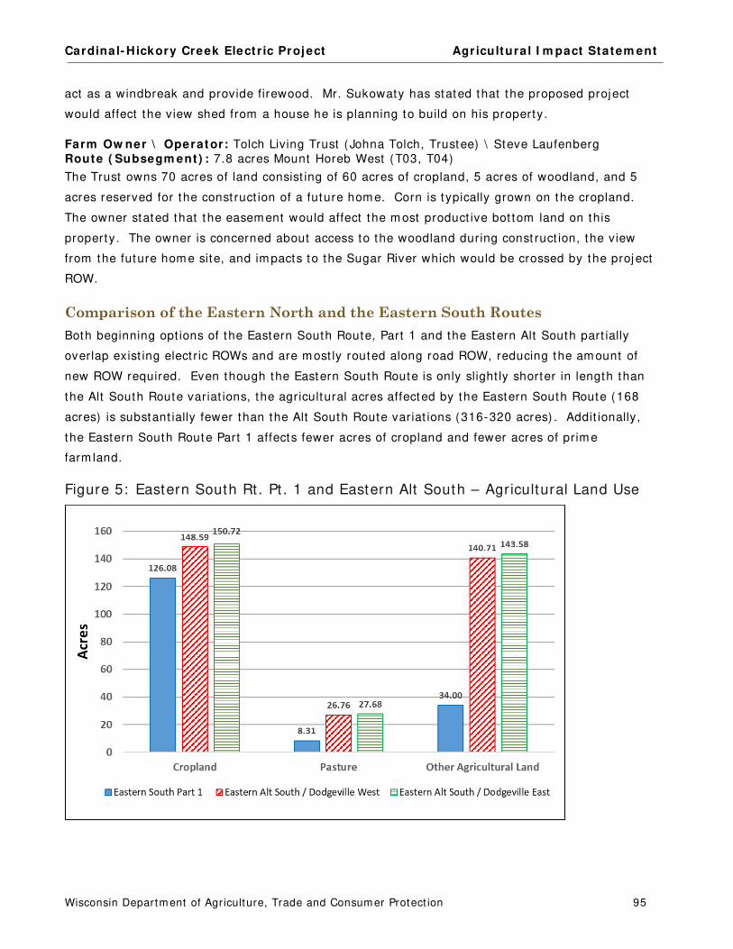
Cardinal- Hickory Creek Elect r ic Project Agr icultura l I m pact Statem ent
Wisconsin Departm ent of Agriculture, Trade and Consum er Protect ion 95
act as a windbreak and provide firewood. Mr. Sukowaty has stated that the proposed project
would affect the view shed from a house he is planning to build on his property.
Farm Ow ner \ Operator: Tolch Living Trust (Johna Tolch, Trustee) \ Steve Laufenberg
Route ( Subsegm ent ) : 7.8 acres Mount Horeb West (T03, T04)
The Trust owns 70 acres of land consist ing of 60 acres of cropland, 5 acres of woodland, and 5
acres reserved for the const ruct ion of a future hom e. Corn is typically grown on the cropland.
The owner stated that t he easem ent would affect the m ost product ive bot tom land on this
property. The owner is concerned about access to the woodland during const ruct ion, the view
from the future hom e site, and im pacts to the Sugar River which would be crossed by the proj ect
ROW.
Comparison of the Eastern North and the Eastern South Routes
Both beginning opt ions of the Eastern South Route, Part 1 and the Eastern Alt South part ially
overlap exist ing elect r ic ROWs and are m ost ly routed along road ROW, reducing the am ount of
new ROW required. Even though the Eastern South Route is only slight ly shorter in length than
the Alt South Route variat ions, the agricultural acres affected by the Eastern South Route (168
acres) is substant ially fewer than the Alt South Route variat ions (316-320 acres) . Addit ionally,
the Eastern South Route Part 1 affects fewer acres of cropland and fewer acres of prim e
farm land.
Figure 5: Eastern South Rt . Pt . 1 and Eastern Alt South – Agricultural Land Use

Cardinal- Hickory Creek Elect r ic Project Agr icultura l I m pact Statem ent
Wisconsin Departm ent of Agriculture, Trade and Consum er Protect ion 96
Figure 6: Eastern South Rt . Pt . 1 and Eastern Alt South – Farm land Soils
East of the city of Dodgeville, there is lit t le difference between the agricultural im pacts of any of
the Eastern South Route variat ions. None of the Eastern South Route variat ions affect
significant ly greater acres of ROW, agricultural propert ies, cropland, or prim e farm land.
However, there is sizeable difference between the agricultural im pacts of the Eastern South Route
and the Eastern North Route.
Table 64: Eastern North Rt . and Avg. Eastern South Rt . - Acres Affected
Route
Length
(miles)
ROW
(acres)
ROW Acres in
Agriculture
Percentage of
ROW In
Agriculture
Off-ROW
Roads
(acres)
Off-ROW Roads in
Agriculture
(acres)
Eastern North 43.9 798.6 674.4 84% 57.5 52.3
Avg. Eastern South Route 43.0 847.7 484.9 57% 14.9 9.1
Table 65: Eastern North Rt . and Avg. Eastern South Rt . – Agricultural Land Use
Route
Cropland
(acres)
Pasture
(acres)
Other
Agricultural Land
(acres)
Eastern North 297.2 84.8 338.9
Avg. Eastern South Route 326.3 38.4 128.2

Cardinal- Hickory Creek Elect r ic Project Agr icultura l I m pact Statem ent
Wisconsin Departm ent of Agriculture, Trade and Consum er Protect ion 97
Table 66: Eastern North Rt . and Avg. Eastern South Rt . – Farm land Soils
Route
Prime
Farmland
(acres)
Prime Farmland
if Drained
(acres)
Prime Farmland if
Protected From Flooding
(acres)
Farmland of
Statewide Importance
(acres)
Not Prime
(acres)
Eastern North 111.0 7.5 44.5 147.8 414.0
Avg. Eastern South Route 203.7 1.0 1.6 121.9 164.6
The Eastern North Route has fewer acres of ROW and affect s fewer acres of agricultural land,
cropland, and prim e farm land than any of the Eastern South Route variat ions. However, the
Eastern North Route would require m ore acres of off-ROW access roads through agricultural
propert ies than any of the Eastern South Route variat ions.

Cardinal- Hickory Creek Elect r ic Project Agr icultura l I m pact Statem ent
Wisconsin Departm ent of Agriculture, Trade and Consum er Protect ion 98
DANE COUNTY ROUTING AREA
Route Descriptions
Map Book Figures 2 9 – 3 0
From the Eastern North Route or the Eastern South Route, the Dane County routes extend from
the town of Cross Plains, through the Stagecoach Road Opt ions, along USH 14, through the Black
Earth Creek Opt ions, and end at the exist ing Cardinal Substat ion.
The Eastern North Route ends at the eastern end of Subsegm ent P09. The Eastern South Route
ends at the northern end of Subsegm ent V04. From each of these eastern routes, there are two
rout ing opt ions as follows:
From Eastern North Route ( 2 opt ions0
St agecoach Road Nor t h Opt ion ( Subsegm ent s W01, W02, W03, W04)
St agecoach Road South Opt ion ( Subsegm ents X01, X02)
From Eastern South Route Part 4 ( 2 opt ions)
St agecoach Road Nor t h ( V05, V06, W03, W04)
St agecoach Road South ( Subsegm ent X02)
From the Eastern North Route, the Stagecoach Road North Opt ion cont inues east along
Subsegm ent W01, as a single-circuit line. I t parallels north of Stagecoach Road unt il the
intersect ion of Celest ial Circle and Stagecoach Road where the route (Subsegm ent W02) joins
with an exist ing 69 kV line (Y-62) . The lower voltage Y-62 line would be double-circuited with
the new 345 kV line (Subsegm ent W02) unt il j ust west of CTH P and the Y-62 line term inates at
the Stagecoach Substat ion. The route cont inues along the north side of Stagecoach Road
(Subsegm ents W03 and W04) with the new 345 kV line double-circuited with another 69 kV line
(6927) unt il the route m eets up with Subsegm ent Y01A, on the south side of Stagecoach Road.
For the Stagecoach Road South Opt ion from the Eastern North Route (Segm ent X01, X02) , the
route t ravels cross-county southeast , east , and northeast to end at the start of Subsegm ent
Y01A. I t overlaps no exist ing ut ilit y ROW or road. I t does cross one road, CTH P.
The Eastern South Route can also be routed along either the Stagecoach Road North or South
opt ions. For the Stagecoach Road North Opt ion from the Eastern South Route (Subsegm ent
V05) , the route cont inues north along the east side of CTH P and would be briefly double-
circuited with a 69 kV line (Y-128) . After about 350 feet , the new 345 kV line cont inues north as
a single-circuit , crosses to the west side of CTH P, and crosses to the north side of Stagecoach
Road (Subsegm ent V06) . The route then cont inues along Subsegm ents W03 and W04, as
described above.
Cardinal- Hickory Creek Elect r ic Project Agr icultura l I m pact Statem ent
Wisconsin Departm ent of Agriculture, Trade and Consum er Protect ion 99
For the Stagecoach Road South Opt ion from the Eastern South Route, t he new line would be
routed along Subsegm ent X02, as described above.
Table 67: Stagecoach Road Opt ions – Acres Affected
Originating
Route Option Subsegments
Length
(miles)
ROW
(acres)
ROW Acres
Shared (percent)
Acres in
Agriculture
Percentages
In Agriculture
Eastern North
Stagecoach
Road North W01, W02, W03, W04 1.1 20.3 12.8 (63%) 8.7 43%
Stagecoach
Road South X01, X02 1.3 22.9 - - 22.3 97%
Eastern South
Stagecoach
Road North V05, V06, W03, W04 0.9 17.0 10.2 (60%) 9.8 58%
Stagecoach
Road South X02 0.8 14.5 - - 14.5 100%
After the Stagecoach Road Opt ions, the Eastern End Part 1 cont inues east (Subsegm ents Y01A,
Y01B, Y01C, and Y05) along the south side of Stagecoach Road, double-circuited with the
lower-voltage 6927 line. The route cont inues east , paralleling the railroad and USH 14 to the
southeast .
Table 68: Eastern End Components – Acres Affected
Route Components Subsegments
Length
(miles)
ROW
(acres)
ROW Acres
Shared (percent)
Acres in
Agriculture
Percentages
In Agriculture
Eastern End Part 1 Y01A, Y01B, Y01C, Y05 1.6 26.0 9.5 (36%) 11.1 42%
Eastern End Part 2 Y07, Y08 0.7 13.1 0.6 (5%) 0.5 4%
Subtotal 2.3 39.1 10.1 (26%) 11.6 30%
The Eastern End Route can then be routed along one of following Black Earth Creek opt ions:
Black Earth Creek North (Y06A, Y06B)
Black Earth Creek South with Highway 14 North (Y06A, Z02, Z01B)
Black Earth Creek South with Highway 14 South (Z01A, Z01B)
All of the Black Earth Creek Opt ions would be double-circuited with the exist ing 69 kV line, 6927.
The Black Earth Creek North Opt ion would cross over USH 14 (Subsegm ent Y06A) . I t would then
turn east , following the 6927 line alignm ent cross-count ry (Subsegm ent Y06B) , ending on the
south side of USH 14 (Subsegm ent Y07) .
The Black Earth Creek South with Highway 14 North Opt ion would cross to the north side of USH
14 (Subsegm ent Y06A) and proceed east following the USH 14 ROW for approxim ately 0.7 m iles
before crossing back to the south side of USH14 (Subsegm ent Z02) . The double-circuited line
would then parallel the railroad t racks on the south side of USH 14 (Subsegm ent Z01B) unt il
rejoining the exist ing alignm ent of line 6927 (Subsegm ent Y07) .

Cardinal- Hickory Creek Elect r ic Project Agr icultura l I m pact Statem ent
Wisconsin Departm ent of Agriculture, Trade and Consum er Protect ion 100
The Black Earth Creek South with Highway 14 South Opt ion would stay on the south side of USH
14 (Subsegm ent Z01A and Z01B) unt il rejoining the exist ing alignm ent of line 6927 (Subsegm ent
Y07) .
Table 69: Black Earth Creek Opt ions – Acres Affected
Route Option Subsegments
Length
(miles)
ROW
(acres)
ROW Acres
Shared (percent)
Acres in
Agriculture
Percentages
In Agriculture
Black Earth Creek North Y06A, Y06B 1.5 27.3 9.8 (36%) 15.7 58%
Black Earth
Creek South
Highway 14
North Z02, Z01B 1.6 27.7 10.5 (38%) 9.6 35%
Highway 14
South Z01A, Z01B 1.6 28.2 11.1 (39%) 1.3 5%
The last segm ent of the proj ect is the Eastern End Part 2 (Subsegm ents Y07 and Y08) which
extends east and south, ending at the Cardinal Substat ion.
Two potent ial off-ROW access roads are proposed in the Dane County Rout ing Area. One would
connect between USH 14 and Subsegm ent Y06B. I t would only be required if the Black Earth
Creek North Route Opt ion was chosen by the PSC. I t affects no agricultural propert ies. The
second off-ROW access road would connect to Subsegm ent X01. I t would only be required if the
Stagecoach Road South Opt ion was approved by the PSC. I t would require 0.89 acres of m ost ly
agricultural land.
Farmland Types and Soils
The Stagecoach Road North opt ions would affect fewer agricultural acres than the Stagecoach
Road South opt ions. Addit ionally, less cropland and prim e farm land soils would be affected by
Stagecoach Road North Opt ion.
Table 70: Eastern End, Stagecoach Rd. Opt ions – Agricultural Land Uses
Agricultural Land Use
Eastern North Route (acres) Eastern South Route (acres)
Stagecoach Road
North
Stagecoach Road
South
Stagecoach Road
North
Stagecoach Road
South
Cropland 5.92 12.79 8.34 12.45
Pasture - - 0.09 - - 0.09
Specialty Farmland (tree farms) - - 1.87 - - 1.87
Other Agricultural Land 2.83 8.34 1.49 0.13
Totals 8.74 23.08 9.84 14.54

Cardinal- Hickory Creek Elect r ic Project Agr icultura l I m pact Statem ent
Wisconsin Departm ent of Agriculture, Trade and Consum er Protect ion 101
Table 71: Eastern End, Stagecoach Rd. Opt ions - Farm land Soils
Farmland Soil Classification
Eastern North Route (acres) Eastern South Route (acres)
Stagecoach Road
North
Stagecoach
Road South
Stagecoach
Road North
Stagecoach Road
South
Prime farmland 5.65 4.27 7.01 3.81
Prime farmland if drained - - 5.36 - - 5.36
Prime farmland protected from flooding - - 5.37 - - 5.37
Farmland of statewide importance 0.27 1.46 0.25 - -
Not prime 2.82 6.61 2.57 <0.01
Totals 8.74 23.08 9.84 14.54
Eastern End Part 1 and Eastern End Part 2 are very short and would affect som e cropland that is
prim e farm land.
Table 72: Eastern End Components – Agricultural Land Uses
Agricultural Land Use Eastern End Part 1
(acres)
Eastern End Part 2
(acres)
Cropland 8.11 - -
Other Agricultural Land 3.03 0.50
Totals 11.14 0.50
Table 73: Eastern End Components – Farm land Soils
Farmland Soil Classification
Eastern End Part 1
(acres)
Eastern End Part 2
(acres)
Prime farmland 6.69 0.15
Farmland of statewide importance 3.12 0.36
Not prime 1.33 - -
Totals 11.14 0.50
The three Black Earth Creek opt ions differ great ly in agricultural im pacts. The Black Earth Creek
South with Highway 14 South would affect the fewest acres in agriculture, fewest acres of
cropland, and fewest acres of prim e farm land. Black Earth Creek North would affect the m ost
agricultural acres, cropland, and acres of prim e farm land.
Table 74: Eastern End, Black Earth Creek Opt ions – Agr icultural Land Uses
Agricultural Land Use Black Earth Creek North
(acres)
Black Earth Creek South (acres)
Hwy 14 North Option Hwy 14 South Option
Cropland 13.30 7.08 0.16
Other Agricultural Land 2.39 2.56 1.15
Totals 15.69 9.64 1.31

Cardinal- Hickory Creek Elect r ic Project Agr icultura l I m pact Statem ent
Wisconsin Departm ent of Agriculture, Trade and Consum er Protect ion 102
Table 75: Eastern End, Black Earth Creek Opt ions – Farm land Soils
Farmland Soil Classification
Black Earth Creek North
(acres)
Black Earth Creek South (acres)
Hwy 14 North Option Hwy 14 South Option
Prime farmland 5.91 1.25 0.13
Prime farmland if drained 1.88 - - - -
Prime farmland if protected from flooding 3.69 1.75 - -
Farmland of statewide importance 0.34 3.85 1.18
Not prime 3.87 2.79 - -
Totals 15.69 9.64 1.31
Impacts to Agricultural Property Owners
The various com ponents and opt ions of the Dane County Rout ing Area could affect 19 agricultural
property owners. Num bers of potent ially affected landowners are as follows:
Stagecoach Road Opt ions could affect up to 16 property owners of which 10 are
agricultural
Eastern End Route Part 1 and Part 2 would affect 11 property owners of which 7 are
agricultural
Black Earth Creek Opt ions could affect up to 14 property owners of which 2 are
agricultural
The following three tables list the agricultural property owners that would be affected by the
various com ponents of t he Dane County Rout ing Area. Those with asterisks before their nam e
would also be affected by off-ROW access roads.
Table 76: Stagecoach Road Opt ions – Potent ially Affected Agricultural Landowners
Agricultural Property Owners
From Eastern North Route (acres) From Eastern South Route (acres)
Stagecoach Rd
North
Stagecoach Rd
South
Stagecoach Rd
North
Stagecoach Rd
South AESCHBACH, JAMES AND CORINNE 0.19 - - 0.19 - -
BRUNNER, GARY AND KRISTINE 2.84 - - 2.84 - -
CORRELL LIVING TRUST - PAUL AND ANNE-MARIE - - 2.20 - - 1.98
FESTGE, FREDERICK JR 1.59 - - 1.59 - -
FRALKA, STEVEN AND JEAN <0.01 0.09 <0.01 0.09
HOLLFELDER TRUST, ROGER H AND LAURA M 0.01 7.05 3.35 6.90
KLOPP, LOUISE - - 1.63 - - - -
KRANTZ, GERARD AND ALAN 1.40 - - 1.40 - -
*MEIER, JOHN 0.25 3.03 <0.01 - -
RODENSCHMIT, EDWIN AND WILLIAM 2.00 3.50 - - - -
WINGRA REAL ESTATE LLC 0.43 5.57 0.43 5.57
ZANDER IRREV CREDIT SHELTER TRUST/ZANDER
LIVING TRUST 0.03 - - 0.03 - -
Totals 8.74 23.08 9.84 14.54
Cardinal- Hickory Creek Elect r ic Project Agr icultura l I m pact Statem ent
Wisconsin Departm ent of Agriculture, Trade and Consum er Protect ion 103
Table 77: Eastern End Pt . 1 & Pt . 2 Components – Potent ially Affected Agricultural Landowners
Agricultural Property Owners Acres Agricultural Property Owners Acres
FESTGE, FREDERICK JR <0.01 WILLIAM L KAHL LLC 0.50
RIPP, VICKI AND LA VERNE <0.01 WINGRA REAL ESTATE LLC 1.35
WAGNER, JEROME 6.58 ZANDER IRREV TRUST, LORETTA M 3.04
WAGNER, RICHARD AND LOU ANN 0.18
Subtotal 11.64
Table 78: Black Earth Creek Opt ions – Potent ially Affected Agricultural Landowners
Agricultural Property Owners
Black Earth
Creek North
(acres)
Black Earth Creek South
with Hwy 14 North
(acres)
Black Earth Creek South
with Hwy 14 South
(acres)
WAGNER, JEROME 13.31 8.51 0.18
WILLIAM L KAHL LLC 2.38 1.13 1.13
Totals 15.69 9.64 1.31
Dane County Routing Area Comments
Farm Ow ner \ Operator: William L. Kahl LLC \ Ziegleu Farm s
Potent ia l I m pacts by Route ( Subsegm ent )
2 .9 acres Black Ear th Creek Nor t h and East ern End Par t 2 ( Y06B, Y07) 1 .6 acres Black Ear th Creek Sout h and East ern End Par t 2 ( Z01B, Y07) 13.9 acres for laydown yard ( LY- 17)
Several of the Black Earth Creek opt ions would cross land owned by William Kahl LLC. Im pacts
to this farm is dependent on the route approved for the project . This 61-acre property grows
corn on 39 acres and uses 22 acres for a quarry. The owner is concerned about the proxim ity of
the routes to his house and a couple of barns. Som e of the buildings appear t o be in or very near
the ROW. The proj ect could also affect fencing on the propert y.
Farm Ow ners \ Operators: Roger H. and Laura M. Hollfelder Trust \ Robert and Rayellen Hollfelder Potent ia l I m pacts by Route ( Subsegm ent )
7 .1 acres for St agecoach Sout h from East ern Nor t h Rout e ( X01, X02) 3 .4 acres for East ern Sout h Par t 4 and St agecoach Nor t h ( V04, V05, V06, W03) 6 .9 acres for East ern Sout h Par t 4 and St agecoach Sout h ( V04, X02) < 0.1 acre for St agecoach Nor t h from East ern Nor t h Rout e ( W03)
Several of the Eastern End route com ponents would affect land owned by the Hollfelder Trust .
Im pacts t o this farm is dependent on the route approved for the project . The Trust owns 115
acres of land consist ing of cropland, pasture, woodland, wet land, and buildings. 70 acres of
cropland are rented to grow corn. This farm is covered by the FPP. The routes would cross
cropland and woodland on this property. This property is prone to flooding and 30 acres of the
farm (Subsegm ent X02) has 8- to 12- inch clay t iling. The owners are concerned that
Cardinal- Hickory Creek Elect r ic Project Agr icultura l I m pact Statem ent
Wisconsin Departm ent of Agriculture, Trade and Consum er Protect ion 104
t ransm ission line const ruct ion could worsen the problem in this part of their property.
Const ruct ion along Subsegm ents V04, V05, and V06 ( the Preferred Route) would affect their
woodland, east of CTH P. The owners would prefer the Applicants’ Preferred Route because it
follows an exist ing t ransm ission line and would have fewer new im pacts on their land.
Drainage District
Drainage dist r icts are form ed to m anage excess water from part icipat ing lands. Propert ies along
Subsegm ents Y05, Y06A, Y06B, Y07, Y08, and all of Segm ent Z crosses part s of the Middleton
Drainage Dist r ict . The dist rict is listed as act ive but with no record of recent assessm ent . The
following two agricultural landowners are part of this dist r ict :
Jerom e Wagner
Subsegm ent s Y05 ( East ern End Par t 1)
Subsegm ent Y06B ( Black Ear t h Creek Nor t h Opt ion)
Subsegm ent Z02 ( Black Ear t h Creek South, Hwy 14 Nor th Opt ion)
William L Kahl LLC
Subsegm ent s Y06B and Y07 ( Black Creek Nor t h Opt ion)
Subsegm ent Z01B ( eit her Black Ear th Creek South opt ion)
DATCP recom m ends the Applicants work with the county drainage board and the landowners
within the drainage dist r ict to m inim ize im pacts to surface and subsurface drainage. I f drainage
pat terns are affected by const ruct ion act ivit ies, the Applicants should take appropriate act ion to
restore the drainage on these fields to pre-const ruct ion funct ion.
Summary
Despite the increasing developm ent pressure from the urban centers in this rout ing area, m uch of
the land crossed by the project is in agriculture. The route using the Stagecoach North and the
Black Earth Creek South with Highway 14 South opt ions would affect the fewest agricultural
acres.
Cardinal- Hickory Creek Elect r ic Project Agr icultura l I m pact Statem ent
Wisconsin Departm ent of Agriculture, Trade and Consum er Protect ion 105
APPLICANTS’ PREFERRED AND ALTERNATE ROUTES
Route Descriptions
The Applicants have ident ified a “Preferred Route” and an “Alternate Route” .
The Applicants’ Preferred Route includes the following segm ents and subsegm ents:
Nelson Dewey Crossing
Nelson Dewey North Route Opt ion 1 (Subsegm ents A01A, A01B, A02, A03)
Western North Route (Subsegm ents D01-D08, D09A, D10A, D10B)
South Substat ion Site (Subsegm ent L05, Segm ent N)
Eastern South Route Part 1 (Segm ent Q)
Hwy 18 North (Subsegm ent S01)
Eastern South Route Part 2 (Subsegm ents S04, S05, S08, S09)
Barneveld South (Subsegm ents S10A, S10B, S10C, S10D)
Eastern South Route Part 3 (Subsegm ents S12, S13)
Mount Horeb West (Segm ent T)
Eastern South Route Part 4 (Segm ent V)
Stagecoach North (Subsegm ent W03 and W04)
Eastern End Part 1 (Subsegm ents Y01A, Y01B, Y01C, Y05, Y06A)
Black Earth Creek South – Hwy 14 North (Subsegm ents Z02, Z01B)
Eastern End Part 2 (Subsegm ents Y07 and Y08)
The Applicants’ Alternate Route includes the following segm ents and subsegm ents:
Nelson Dewey Crossing
Nelson Dewey South Route (Subsegm ents A01A, C02A, C02B, C04)
Western South Route Part 1 (Segm ent E, Subsegm ents F01 and G01)
Plat teville North (Subsegm ents F02, F03, G06A)
Western South Route Part 2 (Subsegm ents G06B, G08, G09, H01, H02, H03, H06,
H07, H09)
Livingston East (Segm ent I and Subsegm ent K01)
South Substat ion Site (Subsegm ents D10A, D10B, D10C and Segm ents L, N)
Eastern North Route (Segm ent P)
Stagecoach North (Segm ent W)
Eastern End Part 1 (Subsegm ents Y01A, Y01B, Y01C, Y05, Y06A)
Black Earth Creek North (Subsegm ent Y06B)
Eastern End Part 2 (Subsegm ents Y07 and Y08)

Cardinal- Hickory Creek Elect r ic Project Agr icultura l I m pact Statem ent
Wisconsin Departm ent of Agriculture, Trade and Consum er Protect ion 106
The tables below show that the Applicants’ Preferred Route is shorter in length, requires fewer
acres of ROW, fewer acres of agricultural propert ies, and shares m ore of it s ROW with exist ing
corridors than the Applicants’ Alternate Route.
Table 79: Applicants’ Preferred and Alternate Routes – Acres Affected
Applicants’ Route
Length
(miles)
ROW
(acres)
ROW Acres
Shared (percent)
Acres in
Agriculture
Percentages
In Agriculture
Preferred 87.4 1,576.7 662.9 (42%) 1,067.3 68 %
Alternate 102.7 1,862.0 482.4 (26%) 1,632.3 87%
Table 80: Applicants’ Preferred and Alternate Routes – Off-ROW Access Roads
Applicants’ Route
Area
(acres)
Acres in
Agriculture
Percentages
in Agriculture
Preferred 146.3 137.6 94%
Alternate 144.8 134.8 93%
Farmland Types and Soils
Figures 7 and 8 show how the two routes com pare in agricultural land uses and farm land soils.
Figure 7: Applicants’ Preferred and Alternate Routes - Agricultural Land Uses

Cardinal- Hickory Creek Elect r ic Project Agr icultura l I m pact Statem ent
Wisconsin Departm ent of Agriculture, Trade and Consum er Protect ion 107
Figure 8: Applicants’ Preferred and Alternate Routes - Farm land Soils
* I ncludes land that is either protected from flooding or not frequent ly f looded dur ing the growing season.
These figures show that the Applicants’ Preferred Route crosses fewer acres of cropland and
pasture and fewer acres of prim e farm land than the Applicants’ Alternate Route. Typically,
DATCP recom m ends considering routes that contain the least am ount of new ROW on farm land
soils of highest product ivit y. However, it is im portant to note that non-prim e soils have
agricultural product ion lim itat ions and therefore m ay be m ore suscept ible to dam age from elect r ic
line const ruct ion.
Affected Agricultural Properties
Both the Applicants’ Preferred and Alternate Routes affect a large num ber of agricultural property
owners. Between 77 and 78 percent of the affected property owners are agricultural landowners
for both routes. However, the Applicants’ Preferred Route is shorter and affects fewer
agricultural landowners.
Table 81: Number of Affected Property Owners
Applicants’ Route
Length
(miles)
Number of
Affected Property
Owners
Number of Affected
Agricultural Property Owners
Preferred 87.4 355 272
Alternate 102.7 408 319
NOTE: This table includes acres required for off-ROW access roads.
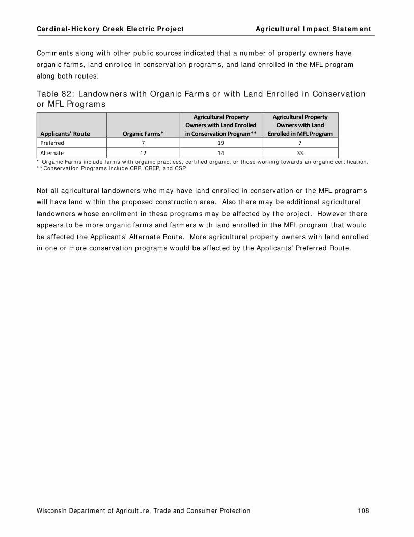
Cardinal- Hickory Creek Elect r ic Project Agr icultura l I m pact Statem ent
Wisconsin Departm ent of Agriculture, Trade and Consum er Protect ion 108
Com m ents along with other public sources indicated that a num ber of property owners have
organic farm s, land enrolled in conservat ion program s, and land enrolled in the MFL program
along both routes.
Table 82: Landowners with Organic Farms or with Land Enrolled in Conservat ion or MFL Programs
Applicants’ Route Organic Farms*
Agricultural Property
Owners with Land Enrolled
in Conservation Program**
Agricultural Property
Owners with Land
Enrolled in MFL Program
Preferred 7 19 7
Alternate 12 14 33
* Organic Farms include farms with organic pract ices, cert ified organic, or those working towards an organic cert if icat ion. * * Conservat ion Programs include CRP, CREP, and CSP
Not all agricultural landowners who m ay have land enrolled in conservat ion or the MFL program s
will have land within the proposed const ruct ion area. Also there m ay be addit ional agricultural
landowners whose enrollm ent in these program s m ay be affected by the project . However there
appears to be m ore organic farm s and farm ers with land enrolled in the MFL program that would
be affected the Applicants’ Alternate Route. More agricultural property owners with land enrolled
in one or m ore conservat ion program s would be affected by the Applicants’ Preferred Route.

Cardinal- Hickory Creek Elect r ic Project Agr icultura l I m pact Statem ent
Wisconsin Departm ent of Agriculture, Trade and Consum er Protect ion 109
AGRICULTURAL SETTINGS
The following inform at ion is intended to describe the exist ing agricultural sector for Grant ,
Lafayet te, I owa, and Dane Count ies in general term s and to aid agricultural property owners in
their easem ent negot iat ions with the Applicants. The m ajorit y of the data provided in this sect ion
was obtained from the USDA, NASS.
Agricultural Productivity
The southwest Wisconsin landscape and agriculture is diverse. The landscape ranges from river
valleys and r idges in the Drift less Area, which covers m ost of southwest Wisconsin, to the rolling
hills and broad flat areas of the glaciated area in the far eastern part of the project area. The
project area has large convent ional grain producers, as well as organic operat ions. I t also has a
range of livestock product ion.
The four potent ially affected count ies are all top agricultural producers in the state. High yields
and a large num ber of acres are planted in corn every year. For 2017, Dane, Grant , and
Lafayet te count ies were in the top 5 Wisconsin count ies for acres of harvested corn for grain.
Dane County harvested the m ost corn for grain in the state, Grant County was third, and
Lafayet te County was fourth in the state. Dane and Grant count ies had average yields of about
190 bushels of corn per acre with I owa County producing 206 bushels per acre, well in excess of
U.S. average yields. I n the sam e year, Dane and Grant count ies ranked second and sixth in the
state, respect ively, for t he num ber of acres of corn for silage harvested. Each county produced
m ore than 400 thousand tons of corn for silage.
For soybeans, Dane and I owa count ies ranked second and third, respect ively, in the num ber of
acres harvested with each county producing m ore than 4 m illion bushels of soybeans in 2017.
Addit ionally, Grant County was ranked first , I owa County fifth, and Dane County sixth in the state
for acres of alfalfa hay harvested. There was no published alfalfa hay data for Lafayet te County
in 2017, but in 2016, the county was ranked eighth in the state. All four count ies typically
produce m ore than 70 thousand tons of hay each year with Grant County producing alm ost 120
thousand tons in 2017. While southwest Wisconsin is not a large producer of winter wheat , Dane
County was ranked second in acres harvested in the state producing about 768 thousand bushels
in 2017.
Table 83 shows the acres harvested for m ajor crops in each of the four count ies, from 2013
through 2017. Over this five-year period, the num ber of acres harvested for the listed crops
fluctuate but showed no consistent t rend across the various com m odit ies. The num ber of acres
of corn for grain declined in all four count ies, though there were fluctuat ions in som e years. Over
the sam e period, corn for silage increased for Grant County and I owa County but decreased in
Dane and Lafayet te. I n all four count ies, the num ber of acres of soybeans harvested increased.
The acres of alfalfa hay dram at ically decreased in Dane, Grant , and Iowa count ies. However,

Cardinal- Hickory Creek Elect r ic Project Agr icultura l I m pact Statem ent
Wisconsin Departm ent of Agriculture, Trade and Consum er Protect ion 110
alfalfa hay increased in Lafayet te County. Acres of winter wheat also declined in all four count ies,
over the five-year period.
Table 83: Acres of Selected Crops from 2013 to 2017
County
Harvested Acres
2013 2014 2015 2016 2017
Corn for Grain
Dane County 167,900 177,700 144,500 176,500 157,300
Grant County 147,400 143,200 141,000 135,400 132,800
Iowa County 68,100 68,900 61,300 61,100 67,200
Lafayette County 131,200 129,000 112,500 123,900 124,700
Corn for Silage
Dane County NA NA 45,600 NA 33,700
Grant County 24,000 21,100 24,600 27,600 26,800
Iowa County NA 11,200 16,000 13,800 Na
Lafayette County NA 12,600 NA NA 12,100
Soybeans
Dane County 74,400 78,800 85,000 80,800 86,800
Grant County 58,700 66,200 66,000 62,500 73,400
Iowa County 32,100 38,500 40,000 41,000 49,000
Lafayette County 43,000 53,200 58,800 56,900 59,300
Alfalfa Hay
Dane County 34,600 34,900 26,600 25,200 24,300
Grant County 51,600 53,900 49,600 42,200 33,300
Iowa County 31,400 35,600 36,100 29,700 18,000
Lafayette County 23,900 29,700 36,700 26,000 NA
Winter Wheat
Dane County 16,200 14,000 14,500 13,600 9,230
Grant County 3,310 4,170 NA NA 2,000
Iowa County 3,230 4,290 4,000 2,120 1,470
Lafayette County 5,500 3,670 3,300 NA NA
* NA = data not published
Another im portant com m odity produced in this region is m ilk. I n 2017, Dane County ranked
fourth, Grant County ranked tenth, and Lafayet te County ranked fifteenth in m ilk product ion in
the state. I n 2017, all four potent ially affected count ies produced m ore than 3.5 billion pounds of
m ilk, am ount ing to m ore than 11.5 percent of all the m ilk produced in the state.
Table 84 shows the product ion of m ilk in each of the project area count ies from 2013 through
2017. Dane county saw a cont inual increase in the am ount of m ilk produced while the other
count ies saw product ion fluctuate over the sam e period but t rended upward.

Cardinal- Hickory Creek Elect r ic Project Agr icultura l I m pact Statem ent
Wisconsin Departm ent of Agriculture, Trade and Consum er Protect ion 111
Table 84: Milk Product ions from 2013 through 2017 (1,000 lbs.)
County 2013 2014 2015 2016 2017
Dane County 1,255,000 1,351,500 1,446,500 1,507,000 1,512,500
Grant County 933,800 904,500 910,800 946,000 948,300
Iowa County 409,500 407,250 416,250 441,000 445,500
Lafayette County 601,400 594,750 600,850 634,400 640,500
Land in Agriculture
Dane County is classified as an urban county, which is defined as a county having 100 or m ore
residents per square m ile. The rem aining three count ies, Grant , I owa, and Lafayet te are
classified as rural count ies having less than 100 residents per square m ile.
Table 85: 2018 Populat ion Density Est imates
County/Region Population
Area
(square miles)
Population
per Square Mile
Dane County 530,519 1,202 441
Grant County 52,615 1,148 46
Iowa County 23,867 763 31
Lafayette County 17,010 634 27
Wisconsin 5,816,231 53,952 108
According to the USDA NASS 2017 Census of Agriculture, all four count ies are over 65 percent
farm land with Grant and Lafayet te over 80 percent farm land. The project area is m ore
intensively farm ed than the state-wide average of 42 percent of land in farm s. Agricultural land
uses include woodland, wet land, and other uses not actually under cult ivat ion or used for pasture
or grazing.
Table 86: Percent Change in Acres in Farms, 1997 to 2017
Location 1997 2002 2007 2012 2017
Percent
Change
Dane County 512,971 515,475 535,756 504,420 506,688 -1.2%
Grant County 599,617 605,836 610,914 587,587 600,324 +0.1%
Iowa County 366,709 367,373 364,970 350,813 360,134 -1.8%
Lafayette County 338,376 342,800 342,617 368,501 342,518 +1.2%
Wisconsin 14,900,205 15,741,552 15,190,804 14,568,926 14,318,630 -3.9%
NOTE: 2017 USDA data is ant icipated to be available for the final AI S
The am ount of land in farm s for all four count ies Dane, Grant , I owa, and Lafayet te m odest ly
fluctuated over the 20-year period. The acres generally increased from 1997 to 2007. Then in
2012 there was a slight downturn which part ially rebounded in 2017. Only Lafayet te County
experienced an increase in 2012 before returning to 2007 levels in 2017. This is in cont rast to
the state as a whole which steadily lost land devoted to farm ing throughout the 20-year period.
Decreases in farm land is likely due to the conversion of farm land for resident ial and com m ercial

Cardinal- Hickory Creek Elect r ic Project Agr icultura l I m pact Statem ent
Wisconsin Departm ent of Agriculture, Trade and Consum er Protect ion 112
developm ent . I ncrease in land in farm s such as in Lafayet te County could be in part due to the
conversion of m arginal land into product ion.
Number and Size of Farms
Table 87: Number of Farms between 1997 and 2017
Location Farms
1997
Farms
2012
Farms
2017
Change in the
Number of Farms
Percent
Change
Dane County 2,595 2,749 2,566 -29 -1.1%
Grant County 2,238 2,436 2,482 +244 +10.9%
Iowa County 1,394 1,588 1,576 +182 +13.1%
Lafayette County 1,127 1,252 1,327 +200 +17.7%
Wisconsin 65,602 69,754 64,793 -809 -1.2%
NOTE: 2017 USDA data is ant icipated to be available for the final AI S
From 1997 to 2017, the num ber of farm s decreased by about 1 percent in the state and for Dane
County. I n each of the other three count ies, Grant , I owa, and Lafayet te, the num ber of farm s
dram at ically increased over the sam e 20-year period. These changes are also reflected in
dist ribut ion of farm size for the count ies and the state. The num ber of farm s sm aller than 50
acres significant ly increased for all four count ies and the state over the sam e period. Farm s of
this size tend to be specialty farm s that produce high-value crops and livestock. The num ber of
m id-sized farm s (between 50 and 499 acres) decreased for the ent ire region and the state.
While the num ber of farm s 500 acres or m ore increased in Dane County and the state but
t rended downward for t he other three affected count ies, Grant , I owa and Lafayet te.
Table 88: Farm Size Dist r ibut ions
Location Year
0 to 49 Acres 50 to 179 Acres 180 to 499 Acres More than 500 Acres
Number Percent Number Percent Number Percent Number Percent
Dane County
1997 782 30.1% 948 36.5% 655 25.3% 210 8.1%
2012 1,181 43.0% 875 31.8% 479 17.4% 214 7.8%
2017 1,139 44.4% 763 29.7% 438 17.1% 226 8.8%
Grant County
1997 307 13.7% 681 30.4% 982 43.9% 268 12.0%
2012 624 25.6% 836 34.3% 715 29.4% 261 10.7%
2017 626 43.8% 382 26.8% 279 19.5% 141 9.9%
Iowa County
1997 196 14.1% 468 33.6% 568 40.7% 162 11.6%
2012 409 25.8% 589 37.1% 432 27.2% 158 10.0%
2017 466 28.3% 561 35.6% 403 25.6% 106 10.5%
Lafayette County
1997 180 16.0% 314 27.8% 473 42.0% 160 14.2%
2012 362 28.9% 396 31.6% 330 26.4% 164 13.1%
2017 524 39.5% 345 26.0% 297 22.4% 161 12.1%
Wisconsin
1997 12,815 19.5% 24,546 37.4% 22,228 33.9% 6,013 9.2%
2012 22,428 32.2% 25,502 36.6% 15,688 22.5% 6,136 8.8%
2017 22,842 35.3% 21,254 32.8% 14,177 21.9% 6,520 10.1%

Cardinal- Hickory Creek Elect r ic Project Agr icultura l I m pact Statem ent
Wisconsin Departm ent of Agriculture, Trade and Consum er Protect ion 113
Property Taxes and Values
Table 89 details the 2017 average property tax, assessed value, and sale price per acre of
agricultural land in each of the four project area count ies, urban count ies, rural count ies, and all
Wisconsin count ies. The assessed values and property taxes are based on the use value of
“agricultural land” . Agricultural land is defined by statute as, “…land, exclusive of buildings and
im provem ents, and the land necessary for their locat ion and convenience, that is devoted
prim arily to agricultural use.” (Wis. Stat . §70.32(2) (c)1g) I n addit ion to being used to com pute
easem ent values; property taxes, assessed values, and land sales data provide inform at ion on
the dem and for land in the county. Land values are used as collateral for farm loans. High
values m ake farm expansions m ore expensive. Sale price data does not include farm land sold
and converted to nonfarm use nor farm land with buildings or im provem ents.
Table 89: Farm land Taxes and Values
Location
2017 Dollars per Acre of Farmland
Average Tax Assessed Value* Sale Value
Dane County $4.05 $242 $8,458
Urban Counties $3.49 $207 $7,046
Grant County $3.47 $173 $5,662
Iowa County $3.18 $158 $4,794
Lafayette County $4.50 $332 $6,614
Rural Counties $3.00 $161 $4,034
Wisconsin $3.43 $175 $4,960
Source: USDA, Nat ional Agr icultural Stat ist ic Service and Wisconsin Department of Revenue. * The assessed value is an “equalized value” calculated by DOR to correct for var iability in est imat ing the taxable value of real property across municipalit ies.
Dane County’s per-acre average tax, assessed value, and sale value of farm land were all higher
than the average urban county values and the average values for Wisconsin. Except for I owa
County’s assessed value, the average per-acre taxes, assessed values, and sale values of
farm land in the three rural count ies were higher than the averages for rural count ies.
Cardinal- Hickory Creek Elect r ic Project Agr icultura l I m pact Statem ent
Wisconsin Departm ent of Agriculture, Trade and Consum er Protect ion 114
CONSTRUCTION PROCESS
I f the proj ect is approved by the PSC, const ruct ion on the new elect r ic line will begin after the
Applicants have secured m ost necessary perm its and ROW easem ents. To ensure that the
com pany has a com plete and intact route, the Applicants will at tem pt to conclude m ost
negot iat ions with landowners prior to the start of const ruct ion.
Transm ission line const ruct ion typically requires several different act ivit ies at any given locat ion.
Const ruct ion act ivit ies include surveying and ROW m arking, erosion cont rol installat ion, clearing,
const ruct ion m at t ing, m aterial staging, st ructure installat ion, st ructure set t ing, wire st r inging and
clipping, and cleanup and restorat ion.
Activities Prior to the Start of Construction
Prior t o the start of const ruct ion, soil borings are conducted along the potent ial ROWs to
determ ine the specific soil condit ions and characterist ics. This provides sufficient inform at ion to
engineer the final design of the line. Generally, rubber- t ired or t racked drill rigs are used, and
incidental m at t ing and restorat ion m ay be needed. Also, som e state and federal perm its require
environm ental surveys to be conducted, which include wet land, species, and archeological
surveys. However, no act ivit y can be conducted on private land, prior t o the proj ect ’s approval
by the PSC without the ut ilit y first obtaining landowner perm ission in writ ing (Wis. Stat .
§182.017(7) (h) ) .
Landowners should be inform ed of the schedule of const ruct ion as early as possible, so that
farm ing operat ions are disrupted as lit t le as possible and the cost of those disrupt ions are
accounted for in the landowner and ut ilit y easem ent negot iat ions. Also, since const ruct ion while
the ground is frozen great ly reduces the r isk of soil com pact ion, Wis. Stat . §182.017(7) (c)3
requires the ut ilit y to, insofar as is pract icable and when the landowner requests, schedule any
const ruct ion across agricultural land when the ground is frozen. However, it is often not
pract icable to alter the const ruct ion schedules once established.
Surveying and Marking the ROW
The first const ruct ion step involves surveying and staking the edge of the ROW and flagging any
special land use or environm ental feature (e.g. t rails, st ream s, wet lands) . This act ivit y typically
has m inim al im pact and is com pleted by a two-person crew t raveling by foot , all- terrain vehicle
(ATV) , or pick-up t ruck. This work m ust be conducted within the PSC-approved ROW. Landowner
perm ission in writ ing is necessary to conduct any work off of the approved ROW.
Clearing the ROW
The ROW is cleared of all vegetat ion for the full width of the ROW. A m ower is used to clear
cropped fields and upland shrubby grasslands.

Cardinal- Hickory Creek Elect r ic Project Agr icultura l I m pact Statem ent
Wisconsin Departm ent of Agriculture, Trade and Consum er Protect ion 115
I n areas where the ROW crosses t rees, the landowner m ust be afforded a reasonable t im e by the
ut ilit y to harvest any t rees located within easem ent boundaries. I f the landowner fails to do so,
the landowner st ill retains t it le to all t rees cut by the ut ilit y (Wis. Stat . §182.017(7) (e) ) . Tree
rem oval can be accom plished by several types of equipm ent . Whole t ree processors capable of
cut t ing a standing t ree at it s base, rem oving all lim bs, and sawing the t ree t runk into consistent
log lengths or poles are a very efficient way to clear open m ature woodlands. I n woodlands with
a thick cover or im m ature understory t rees, hand clearing with chainsaws m ay be done, as well.
Chainsaws m ay be used to clear sm aller dim eter t rees adjacent to st ream channel. Generally
any pole t im ber or saw logs are stacked on the edge of the ROW in upland locat ions and the
sm aller diam eter lim bs and branches are chipped on the ROW. The cut logs are the property of
the landowner and wood chips m ay be spread on the ROW, piled for the landowner, or chipped
direct ly into a t ruck and hauled off the ROW.
After the clearing is com pleted, side t r im m ing the ROW occurs. Then, a final m owing of debris
and stum p cleanup is com pleted. I f the landowner gives perm ission, stum ps of tall-growing
species will be t reated with an herbicide.
Vegetat ion from som e t rees can be toxic to livestock. A m ore detailed discussion of this issue is
included in Chapter XI I of this AIS in, “Trees and Other Woody Vegetat ion.” All debris from these
t rees are to be rem oved from act ively pastured areas to prevent it s contact with livestock. This
m aterial will not be stockpiled on-site.
A fence crew operates with the clearing crew. The ut ilit y should work with landowners to ident ify
pastures that contain livestock so as not to disrupt farm ing operat ions. The ut ilit y is required to
repair to it s original condit ion any fence dam aged as a result of const ruct ion. I f fence cut t ing is
necessary, a t em porary gate will be installed, where requested by the landowner. Any such gate
will be left in place at the landowner’s request (Wis. Stat . §182.017(7) (c)5.) .
Erosion Control Installations
Erosion cont rol m ethods and m aterials vary depending on the specific const ruct ion act ivit ies and
site soil and slope condit ions at the t im e of const ruct ion. All erosion cont rol m easures needed to
m aintain stable site condit ions are installed based on locat ion-specific best m anagem ent pract ices
(BMPs) . Erosion cont rol BMPs are im plem ented prior to ant icipated ground disturbance and
im m ediately after unexpected disturbance occurs.
Laydown Yards
Act ivit ies to prepare laydown yards include installing erosion cont rol m easures, leveling uneven
surfaces, st r ipping and stockpiling topsoil if necessary, and installing gravel, t racking pads near
ent ry/ exit if needed, culvert (s) , power, and fencing. A bulldozer and dum p t rucks are generally
used. After const ruct ion is com pleted or the laydown yards are no longer needed, they m ay be
left in place or returned to prior condit ions, depending on landowner preferences. Elect r ic

Cardinal- Hickory Creek Elect r ic Project Agr icultura l I m pact Statem ent
Wisconsin Departm ent of Agriculture, Trade and Consum er Protect ion 116
t ransm ission st ructures and other const ruct ion m aterials are hauled to the laydown yards near
work areas. Trucks, loaders, and cranes are needed to deliver and unload m aterials.
Construction Matting
Const ruct ion m at t ing is effect ively used for a num ber of purposes. Mats should be used when
soils are wet to lim it com pact ion, rut t ing, and soil disturbances. Mat t ing is also used to lim it the
im pacts to wet lands. Mats can be used to protect organic farm ing pract ices and organic soils.
Som et im es a barrier of geotext ile fabric is overlain by m ats to provide an effect ive barrier
between work act ivit ies and the underlying soil and plants. However, if m ats are used in an
organic farm , the m ats should be new and not t reated with preservat ives. Lum ber t reated with
arsenic and creosote should never be used in organic farm s. I f the m ats are used, the should be
power washed prior t o use so they are clean and free of all foreign non-organic substances. Mats
are som et im es used to im pede the spread of invasive species. Const ruct ion m at t ing m ay consist
of t im ber, com posite or hybrid t im ber m ats. Trucks, forwarders, forklift s, or skid loaders are
used to install the m ats. Perm it ted tem porary clear span bridges (TCSBs) will be installed over
waterways. Mat t ing is rem oved when const ruct ion vehicle access is no longer required along the
ROW. Mat rem oval is done before restorat ion.
Off-ROW Access Roads
Access roads to the ROW are som et im es required to avoid greater im pacts. They are typically
along exist ing ROWs, including public roads and farm roads. Som e tem porary access roads will
cross agricultural fields. Tem porary access roads across private lands will be negot iated with the
affected landowner. Their const ruct ion and use should not interfere with exist ing surface
drainage pat terns. After const ruct ion is com pleted, the land m ay be restored to it s original
condit ion, or the access road m ay be left in place if required by the ut ility for m aintenance or at
the request of the landowner.
Auguring and Blasting
Auguring or excavat ion is required for all st ructures. I n m ost soils, the excavat ion for the
t ransm ission st ructure can be augured using a standard drill rig. Topsoil should be segregated
from subsoils and reserved for later use during restorat ion (Wis. Stat . §182.017(7) (c)1) . Excess
soils from excavat ions m ay be spread in upland areas or hauled to an offsite disposal locat ion,
depending on the set t ing and the property owner ’s wishes.
When bedrock is close to the surface or when subsoils consist of large boulders and large cobbles,
blast ing m ight be required to com plete the excavat ion. The Applicants have not ident ified a
procedure for blast ing but generally, explosives are placed in holes drilled into the rock and the
st ructure site is covered with blast ing m ats to keep the rock and debris loosened by the blast
from scat tering over a wide area. Following the blast , the blast ing m ats and loosened debris are

Cardinal- Hickory Creek Elect r ic Project Agr icultura l I m pact Statem ent
Wisconsin Departm ent of Agriculture, Trade and Consum er Protect ion 117
rem oved and the drilling r ig is used to auger through the broken rock unt il the appropriate depth
is reached.
Dewatering
I f water is encountered during the excavat ion process, de-watering m ay be needed. Opt ions for
dewatering include: pum ping the water from the excavat ion to a suitable upland area and
allowing it to slowly percolate into the soil, or rem oving the water from the site with a tank t ruck.
Water that is pum ped to an upland area is first pum ped into filter bags to lim it the silt that is
discharged.
Release of pum ped water in agricultural fields m ay be suitable but can have long- last ing adverse
effect s if too m uch water is allowed to flood the fields. Suitable locat ions for dewatering m ust be
carefully chosen and m onitored.
Structure Installation
Structures can be installed with a concrete foundat ion or direct ly em bedded. Based on the
st ructure locat ion within the project and the site specific soil characterist ics, the type of st ructure
installat ion will be determ ined during the final engineering process. Typical equipm ent for this
phase of const ruct ion includes dum p t rucks, drill r igs, cranes, vacuum t rucks, tanker t rucks, and
concrete t rucks.
A drill r ig is used for excavat ing the necessary hole for the st ructure. Once the base of the
st ructure is placed into the excavated hole, clean granular fill or concrete is used to backfill the
area around the pole.
For reinforced concrete foundat ions, a rebar cage and anchor bolts are placed into the
excavat ion. The excavat ion is then filled with concrete to a point where the rebar cage and
anchor bolts are covered, typically leaving one to two feet of foundat ion above the surface. The
com plete caisson is allowed to cure.
Tem porary stockpiles of excavated soils and woody debris result ing from ROW clearing and
const ruct ion will be created throughout the course of const ruct ion. Cleanup of the foundat ion site
involves the rem oval and proper disposal of the spoils. I f the st ructure is in cropland or wet land,
the spoils are m oved to an upland locat ion approved by the landowner or t rucked off the property
to an off- site disposal area such as a quarry. Excavated spoils consist of non-organic m aterial
including rocks, gravel, and sand. This m aterial should never be spread on cropland or pasture.
I n som e upland locat ions and with the landowner’s perm ission, subsoils m ay be spread across the
soil surface around the tower site and graded to ensure drainage m oves away from the tower. I n
non-agricultural upland areas, the disturbed soils are usually m ulched and/ or seeded with annual
oats or rye grass, which germ inate quickly and help to stabilize the soil surface giving nat ive
vegetat ion an opportunity for reestablishm ent .

Cardinal- Hickory Creek Elect r ic Project Agr icultura l I m pact Statem ent
Wisconsin Departm ent of Agriculture, Trade and Consum er Protect ion 118
Structure Setting
Steel t ransm ission st ructures are t ransported from the staging area to t he foundat ion locat ions in
sect ions. After the direct em bed is set or the concrete caisson is cured, the rem ainder of the
steel pole st ructure is m ounted to the base, or a direct -em bedded st ructure is set in the
excavat ion. Typical equipm ent for this phase of const ruct ion includes cranes and bucket t rucks.
I n areas, where ground-based cranes are not suitable due to soft or wet ground, steep terrain, or
environm entally protected areas, helicopters can be used to t ransport and erect the steel
st ructures. This m ay reduce the need for extensive access roads or m at t ing and the result ing
im pacts.
Wire Stringing and Clipping
After all the st ructures within a segm ent are set , the wires are pulled and clipped into place.
Large reels of rope are staged on the ROW and the individual ropes are drawn through the
pulleys from tower to tower. The wire conductor is then at tached to the ropes and pulled into
place. The pulleys are rem oved and the conductors are at tached to the insulators and properly
tensioned. This act ivit y requires access to each st ructure with a bucket t ruck, crane, or
helicopter. Wire set -up areas containing reel t railers, wire pullers, and related equipm ent are
located at each end of t he wire pull.
Removal of Existing Facilities
Where exist ing t ransm ission lines are replaced, the exist ing st ructures and wire will be rem oved.
Typical equipm ent used includes cranes, bucket t rucks, reel t railers, wirepullers, and related
st r inging equipm ent . When rem oving exist ing st ructures, it is com m on pract ice to rem ove the
st ructure to depth of at least 4 feet below grade; however, in som e cases the st ructure m ay be
cut off at grade, depending on the type of st ructure to be rem oved, land use, and const ruct ion
vehicle access const raints.
Cleanup and Restoration
Following the com plet ion of const ruct ion act ivit ies, the area is restored to preconst ruct ion
condit ions. Wis. Stat . §182.017(7) (c)4 requires that all debris be cleared and all stones and
rocks result ing from const ruct ion act ivit y be rem oved upon const ruct ion com plet ion. This
cleanup includes rem oving const ruct ion m ats or m at debris, tem porary clear span bridges, and
any other m aterial or debris from the ROW. Disturbed soils are then graded so that the
topography and slopes are returned to preconst ruct ion condit ions. All ruts and depressions are
restored. Any necessary seedbed preparat ion and seeding is perform ed along with BMPs. Typical
equipm ent used includes m at t rucks, bobcats, pick-up t rucks, and other light vehicles.
Any stockpiled topsoils and subsoils are appropriately dist r ibuted or rem oved. New topsoil is
brought in and spread on agricultural locat ions where topsoil has been lost or seriously m ixed

Cardinal- Hickory Creek Elect r ic Project Agr icultura l I m pact Statem ent
Wisconsin Departm ent of Agriculture, Trade and Consum er Protect ion 119
with subsoils. Com pacted agricultural soils are decom pacted to return the soil st ructure to it s
original condit ion.
Areas where crops are not present , such as roadsides, pastures, old fields, upland woods, and
wet lands, m ay be seeded with nat ive seed m ixes (or other appropriate seed m ixes approved by
the landowner and m ulched with cert ified weed- free m ulch. I n som e cases, where it is
reasonable to allow the natural ground cover to re-establish it self, annual grasses m ay be sown
to m inim ize the potent ial for erosion while re-establishm ent is occurring. I n wet lands, excavated
surface soils or the organic layer m ight be spread around the foundat ion enhancing the re-
establishm ent of the original wet land vegetat ion.
Any drainage t iles or other agricultural features that were dam aged by const ruct ion m ust be
repaired or replaced, or the landowner m ust be com pensated. Also, all landowner protect ions
listed in Wis. Stat . §182.017(7) (c) m ust be m et unless waived by the landowner in the easem ent
cont ract .
Negot iated easem ents m ay detail the replacem ent of landscaped vegetat ion with low-growing
plants. Any driveways, curbs, or roads dam aged need to be repaired or replaced.
Laydown yards are cleaned up and repaired. All item s such as t railers, security fencing,
dum psters, t ools, and other m aterials are rem oved. Based on landowner’s wishes, any
im provem ents m ay be left or the land m ay be graded and returned to pre-const ruct ion funct ion.
Erosion cont rol and ROW m onitoring cont inues unt il there is sufficient vegetat ive growth in the
ROW. Following com plet ion of restorat ion and re-establishm ent of vegetat ion within the ROW, all
tem porary restorat ion erosion cont rol devices not designed to be left in place are rem oved and
properly disposed. All tem porary bridges are rem oved. All rem aining const ruct ion- related
m aterials, m arkers, and debris are rem oved.
Ongoing Vegetation Management
Each t ransm ission owner has the discret ion to choose vegetat ion m anagem ent within the ROW.
The type of vegetat ion allowed to grow in the ROW and the ut ilit y ’s r ight to m anage the
vegetat ion is writ ten into the easem ent . The two owners of this project ( I TC and ATC) m ay
operate and m aintain the ROWs different ly, after const ruct ion and restorat ion are com pleted.
I n general, the goal of ROW restorat ion is to establish a sustainable ROW consist ing of com pat ible
vegetat ion. Trees along the ROW edge will need to be t r im m ed or rem oved from t im e to t im e.
The ut ilit y m ay decide to rem ove t rees outside of the easem ent area if they are tall enough to
im pact the facilit ies and are deem ed to be “danger t rees” because they are dead, dying,
diseased, leaning, or com prom ised.
Depending on site condit ions, the Applicants will m anage vegetat ion on a 3 to 5- year cycle using
cont rol m ethods including chainsaws, m owers, and other specialized vegetat ion m anagem ent

Cardinal- Hickory Creek Elect r ic Project Agr icultura l I m pact Statem ent
Wisconsin Departm ent of Agriculture, Trade and Consum er Protect ion 120
equipm ent such as aerial saws, and herbicides. Herbicide use across pasture lands and croplands
can affect grazing farm anim als. To avoid adverse im pacts, applicators should review the
herbicide label for specific inform at ion regarding grazing tolerances. Landowners with grazing
farm anim als should be clearly not ified regarding the use of the specific herbicide and any grazing
rest r ict ions. Farm s with organic pract ices within the ROW and adjacent to the ROW m ay also be
affected by herbicide drift . Herbicides can only be used on the ROW with writ ten approval from
the landowner (Wis. Stat . §182.017(7) (d) ) .

Cardinal- Hickory Creek Elect r ic Project Agr icultura l I m pact Statem ent
Wisconsin Departm ent of Agriculture, Trade and Consum er Protect ion 121
POTENTIAL IMPACTS OF TRANSMISSION LINE
CONSTRUCTION ON AGRICULTURE
Agricultural operat ions and product ivit y can be adversely affected during the const ruct ion of the
elect r ic line. These im pacts include but are not lim ited to:
I nterference with farm operat ions in the ROW and adjacent areas
I nterrupt ion of or dam age to irr igat ion system s
Alterat ion of surface and subsurface drainage system s
Im pacts t o grazing areas, row crops, and exist ing fencing
Flooding due to dewater ing act ivit ies during const ruct ion
Use of prohibited substances on farm s that are following organic pract ices
After const ruct ion is com pleted, som e im pacts m ay affect agricultural product ivit y years
afterwards, not only in the ROW but in the adjacent fields as well. These long- term potent ial
im pacts include but are not lim ited to:
Several years of yield reduct ions due to const ruct ion act ivit ies, erosion, the m ixing of
topsoil and subsoils, and/ or deep com pact ion
Ponding from altered surface and subsurface drainage profiles
I nadequate restorat ion result ing in alterat ion to the original land contours
Const ruct ion debris left in fields
ROW restorat ion that is inconsistent with landowners cropping plans
Opportunist ic weed growth
Topsoil Mixing
Potential Adverse Impact
Good agricultural topsoil is an invaluable resource that should be preserved. Mixing of topsoil
with the underlying subsoil and/ or parent m aterial will reduce t ilth, organic m at ter content and
cat ion exchange capacity, and alter soil st ructure and dist r ibut ion of part icle sizes (part icularly
water stable aggregates) . Once m ixed, full restorat ion m ay require t ransport ing new topsoil of
sim ilar qualit y from an off- site locat ion. This will add costs t o the proj ect and m ay st ill not fully
return the agricultural field to pre-const ruct ion product ivit y.
Topsoil m ixing can occur under wet or dry condit ions during the grading and re-grading of the
ROW. Significant long- term agricultural product ivit y im pacts can occur as a result of soil m ixing
if deep ruts are created during const ruct ion and the topsoil layer is shallow.
Soil m ixing is a greater danger when soils are wet . The m oisture and precipitat ion pat tern
expected during const ruct ion m ust be taken into account in planning adequate m it igat ion

Cardinal- Hickory Creek Elect r ic Project Agr icultura l I m pact Statem ent
Wisconsin Departm ent of Agriculture, Trade and Consum er Protect ion 122
m easures to protect topsoil from m ixing. I n som e soils, one inch of sum m er rainfall over five of
ten days can cause significant rut t ing with norm al const ruct ion equipm ent t raffic.
Measures to Avoid Topsoil Mixing/Inversion
To prevent the m ixing of topsoils with subsoil layers, proper m onitoring of erosion cont rol
techniques is necessary to keep topsoil within the ROW. While soil m ixing can occur during wet
or dry condit ions, soil st ructure can be m ore easily affected during wet condit ions. For that
reason, const ruct ion act ivit ies should not occur during wet condit ions, if the ROW is not m at ted.
I f topsoil is m ixed with subsoils, new topsoil should be brought in so that the negat ive effect s are
m inim ized.
Soil Compaction
Potential Adverse Impact
Equipm ent used to const ruct elect r ic t ransm ission lines has the potent ial to com pact soil and
reduce soil product ivit y on the farm land t raversed during const ruct ion. Com pact ion reduces the
uptake of water and nut r ients by crops, rest r icts root ing depth, decreases soil tem perature,
increases the proport ion of water- filled pore space at field m oisture capacity, decreases the rate
of decom posit ion of organic m at ter, decreases pore size and water infilt rat ion, and increases
surface runoff. The greater the depth at which soil com pact ion occurs, the m ore persistent it is.
Yield loss caused by soil com pact ion m ay range between 10 and 50 percent for a variety of crops
(Wolkowski, R. & Lowery, B., (2008) , Soil Com pact ion: Causes, Concerns, and Cures, University
of Wisconsin Extension, publicat ion A3367) . The m agnitude of yield loss is dependent on a
num ber of factors including, soil t ype, degree of com pact ion, and water availabilit y. Com pact ion
is m ost evident when the crop is under addit ional st ress such as during drought or excessively
wet condit ions.
The factors that influence whether a soil becom es com pacted include the weight of the
const ruct ion equipm ent t raveling, soil m oisture, and soil texture. As axle load increases, the
depth of com pact ion can increase. When t raffic loads are relat ively lightweight , less than 10 tons
per axle, the soil generally does not com pact below the 8-10 inch range. Com pact ion at this
depth norm ally can be decom pacted with typical farm t illage equipm ent . Heavier const ruct ion
equipm ent can com pact soils to a depth that cannot be rem oved by convent ional t illage. Wet
soils can also increase the r isk for com pact ion. Som et im es, the plow layer m ay appear dry, but
the subsoil m ay st ill be saturated result ing in the potent ial for significant com pact ion during
const ruct ion. Also, soil texture m ay be a good indicator of potent ially sensit ive soils. Fine soils,
such as clay or silt y clay loam s have a greater r isk of becom ing com pacted.

Cardinal- Hickory Creek Elect r ic Project Agr icultura l I m pact Statem ent
Wisconsin Departm ent of Agriculture, Trade and Consum er Protect ion 123
Soil Restoration
Elect r ic line const ruct ion can cause dam age to agricultural product ivit y from deep soil com pact ion
if proper const ruct ion m ethods are not im plem ented or proper decom pact ion is not perform ed.
However, even with the proper techniques, t im ing, and equipm ent , there are few subsoils that
cannot be adequately decom pacted.
Prevent ion of rut t ing and com pact ion is easier t han restoring the soil st ructure after it has been
dam aged. The m ost effect ive m ethod to reduce com pact ion and rut t ing in const ruct ion ROWs is
the use of const ruct ion m at t ing. To further m inim ize soil com pact ion without m ats, low- im pact
m achinery with wide t racks can be used in low- lying areas or in areas with saturated or sensit ive
soils. When soils are wet , heavy const ruct ion equipm ent m ay cause significant rut t ing and
com pact ion. Significant rut t ing is defined as rut s greater than 6 inches deep.
After const ruct ion is com pleted, the ROW will be com pacted to som e degree. Deep ripping or
deep t illing of the ROW m ay be accom plished through the use of an indust r ial V- r ipper, chisel
plow, or para plow, which will help restore the soil st ructure to pre-const ruct ion product ivit y.
Following decom pact ion, penet rom eter m easurem ents can be taken to ensure proper
decom pact ion has occurred at representat ive sites throughout the topsoil and subsoil profile.
Moisture condit ions should be com parable on and off the const ruct ion ROW and throughout the
soil horizon at the t im e of sam pling in order to get accurate readings.
Drainage
Potential Adverse Impacts
Proper field drainage is vital to a successful farm operat ion. Const ruct ion of an elect r ic
t ransm ission line can disrupt im provem ents such as drainage t iles, grassed waterways, and
drainage ditches, which regulate the flow of water on farm fields. I f drainage is im paired, water
can set t le in fields and cause substant ial dam age, such as killing crops and other vegetat ion,
concent rat ing m ineral salts, flooding farm buildings, or causing hoof rot and other diseases that
affect livestock.
Const ruct ion-caused soil com pact ion m ay cause ponded water where none existed prior t o
const ruct ion. Also, dam aged drain t iles m ay not be readily apparent aft er const ruct ion due to dry
condit ions. Therefore, it m ay take several years for drainage problem s to becom e apparent .
Mitigation Measures
DATCP recom m ends that landowners not ify the ut ilit y about the existence and locat ion of
drainage system s or planned drainage system s that could be affected. Field condit ions should be
docum ented by the landowner prior to the start of const ruct ion so it can be com pared with post -
const ruct ion condit ions.
Cardinal- Hickory Creek Elect r ic Project Agr icultura l I m pact Statem ent
Wisconsin Departm ent of Agriculture, Trade and Consum er Protect ion 124
The ut ilit y m ay use m at t ing when crossing exist ing drain t iles to evenly dist ribute the weight of
heavy equipm ent and/ or use low ground im pact const ruct ion equipm ent to prevent dam age.
However if t iles are dam aged, the ut ilit y m ust repair or replace the t ile.
Where const ruct ion act ivit ies have altered the pre-const ruct ion drainage of fields, result ing in
new wet areas, DATCP recom m ends the ut ilit y work with the landowner to determ ine the m eans
to return the agricultural land to pre-const ruct ion funct ion. New drainage t iles, regrading, or
addit ional fill m ay be required to correct the problem s that arise after const ruct ion is com pleted.
I f a landowner is planning to install drainage t ile within the next three years and drainage
locat ions have been docum ented in writ ing, these docum ents should be provided to the ut ilit y
prior to const ruct ion.
De-watering
Potential Adverse Impacts
During the auguring for the st ructure foundat ion, dewatering of the excavat ion m ay be
necessary. Im proper dewatering can result in soil erosion; sedim entat ion and deposit ion of
gravel, sand, or silt onto adjacent agricultural lands; and inundat ion of crops.
Mitigation Measures
The ut ilit y should ident ify low areas and hydric soils where excavat ion is likely to collect water as
well as upland areas suitable for the discharge of the accum ulated water. Discharge locat ions
m ust be in com pliance with current drainage laws, local ordinances, DNR perm it condit ions, and
the provisions of the Clean Water Act . Discharge locat ions m ust be well- vegetated areas that
prevent the water from returning to the ROW and prevent the deposit ion of gravel or sedim ent
onto fields, pastures, or watercourses. Water can first be pum ped through filter bags to capture
m uch of the sedim ent from the water. I f deposit ion of water onto cropland is unavoidable, crops
should not be inundated for m ore than 24 hours. Crops inundated for m ore than 24 hours m ay
incur severe dam age. The ut ilit y should com pensate the landowner for any dam age to
agricultural fields caused by de-watering act ivit ies. Discharge of water from non-organic farm s
should never be allowed to flow onto organic farm operat ions.
Irrigation
Potential Adverse Impacts
Elect r ic line const ruct ion can interfere with the operat ion of field irr igat ion system s. Many crop
fields are irr igated with center-pivot or lateral-m ove irr igat ion system s. I f irr igat ion system s are
disrupted by const ruct ion, crops outside of the proposed ROW could be negat ively affected by a
lack of water.

Cardinal- Hickory Creek Elect r ic Project Agr icultura l I m pact Statem ent
Wisconsin Departm ent of Agriculture, Trade and Consum er Protect ion 125
Mitigation Measures
The ut ilit y should discuss the locat ion of all exist ing irr igat ion system s and how const ruct ion of
the t ransm ission line m ight im pact their use. I f irr igat ion system s will be disrupted, the ut ilit y
should not ify the landowner beforehand and establish a m utually acceptable am ount of t im e that
the system will be taken out -of-service. The m axim um period of t im e that irr igat ion system s can
be taken out -of-service without reducing yields on field corn is 5 to 7 days during the period from
silking - tasseling to the finished crop. Earlier delays in m eet ing irr igat ion requirem ents m ay
result in sm aller plants, but should not reduce grain product ion significant ly. Vegetable crops will
have a shorter period between irr igat ions.
DATCP recom m ends that all irr igators along the t ransm ission ROW docum ent irr igat ion
inform at ion for their fields, including am ount and frequency of irr igat ion; and weather condit ions
such as rainfall and tem perature for the growing season prior t o the start of const ruct ion. Pre-
and post - const ruct ion records will assist the landowner in ident ifying st ressed crops caused by
the ut ilit y ’s disrupt ion of the irr igat ion system . St ressed crops could potent ially result in reduced
yields.
Any dam ages to the system (well, pum ping plant , irr igat ion system – center-pivot , t raveling large
volum e sprinkler, buried supply lines, elect r ical supply lines) caused by const ruct ion act ivit ies
should be repaired by the ut ilit y as soon as possible.
Where t ransm ission line st ructures are placed in or along irr igated fields where none existed
before, they m ay interfere with the m ovem ent of irr igat ion equipm ent . DATCP recom m ends that
the ut ilit y work with all irr igat ion operators to reconfigure the irr igat ion equipm ent where
necessary and to com pensate them for any port ion of their cropland where the irr igat ion system
can no longer reach.
Erosion and Conservation Practices
Potential Adverse Impacts
Both topsoil and subsoil along the proj ect routes are valuable resources. Const ruct ion act ivit ies
can destabilize soil horizons and cause topsoil to erode and potent ially m igrate off of the ROW.
During wet condit ions, r isks to soil from erosion are increased as exposed soils are m oved
downslope. Areas with steeper slopes can be subject to greater soil loss from erosion by water.
Silt and very fine sand, and certain clay textured soils tend to be m ore suscept ible to erosion.
Wind erosion can also be a concern in areas where windbreaks m ust be rem oved from the ROW.
Factors that affect wind erosion include degree of ped form at ion, surface roughness, wind speed,
soil m oisture, and vegetat ive cover. Sandy loam s, loam y sands, and sands are m ost suscept ible
to wind erosion. Wind erosion decreases as soil m oisture increases. Significant erosion can have
an adverse effect on long- term product ivit y of agricultural lands. Where the ROW runs up and
Cardinal- Hickory Creek Elect r ic Project Agr icultura l I m pact Statem ent
Wisconsin Departm ent of Agriculture, Trade and Consum er Protect ion 126
down gent ly sloping soils, the collect ion of surface runoff in the t racks left by const ruct ion
equipm ent can erode significant am ounts of soil in fields.
Many agricultural fields have exist ing erosion cont rol pract ices such as diversion terraces, grassed
or lined waterways, out let ditches, water and sedim ent cont rol basins, vegetated filter st r ips, etc.
These can be dam aged by const ruct ion act ivit ies.
Soil erosion can affect crop yields through the loss of natural nut r ients and applied fert ilizers.
Seeds and plants can be disturbed or com pletely rem oved from the eroded site. Organic m at ter,
m anure, and crop residue can be t ransported off the field through erosion. Pest icides can also be
carried off the site with eroded soil.
Mitigation Measures
Erosion cont rol pract ices m ust be carefully followed to m inim ize const ruct ion- related im pacts. I f
the project is approved, an Erosion Cont rol Plan will be developed to m eet the requirem ents
out lined in Wis. Adm in Code chs. NR 216 and NR 151. The plan will provide guidance on
revegetat ion and site stabilizat ion. Disturbed areas will be m onitored weekly and after rain
events as require by NR 216.
WDNR standards are described on the website:
ht tp: / / dnr.wi.gov/ topic/ storm water/ standards/ index.htm l.
Tem porary erosion cont rols m ust be properly m aintained on agricultural lands on a daily basis
throughout const ruct ion and restorat ion. Whenever necessary, they m ust be reinstalled unt il
perm anent erosion cont rols are installed or restorat ion is com pleted.
The best m ethod to cont rol erosion is the growth of a vegetat ive cover. As soon as pract icable
the land should be returned to cropland or seeded with the appropriate species m ix.
I f any exist ing erosion cont rol pract ices such as diversion terraces, grassed or lined waterways,
out let ditches, water and sedim ent cont rol basins, vegetated filter st r ips, etc. are dam aged by
const ruct ion act ivit ies, t he ut ilit y m ust restore the features to pre-const ruct ion condit ion and
funct ion.
Temporary Access Roads
Potential Adverse Impacts
Tem porary access roads m ay need to be created to allow personnel and const ruct ion equipm ent
to access the const ruct ion corridor. Where possible, exist ing public or private roads are used.
However, in som e locat ions these are not available or suitable.
Tem porary access roads m ay cross agricultural fields. The potent ial negat ive effect s of building
access roads across agricultural lands include the potent ial m ixing of topsoil with subsoil, soil
com pact ion, erosion, and interference with exist ing drainage, irr igat ion, and farm ing operat ions.

Cardinal- Hickory Creek Elect r ic Project Agr icultura l I m pact Statem ent
Wisconsin Departm ent of Agriculture, Trade and Consum er Protect ion 127
Any of these im pacts can result in the loss of agricultural product ivit y on affected soils after
const ruct ion is com pleted.
Mitigation Measures
The ut ilit y should consult with landowners before sit ing any tem porary access roads through
private property. Where new access roads are const ructed on agricultural land and the land
requires grading, the ut ilit y should st r ip and stockpile the topsoil for later reuse during
restorat ion. (Wis. Stat . §182.017(7) (c) ) . Access roads should also be designed to allow proper
drainage and m inim ize soil erosion. Geotext ile const ruct ion fabric m ay be placed below any
im ported rock used to build the road, in order t o protect the subsoil.
I f desired by the landowner, tem porary roads will be left in place after const ruct ion. I f access
roads are rem oved, Wisconsin statutes require that the land be restored to it s original condit ion
and contours (Wis. Stat . §182.017(7) (c) ) . Any disturbance to drainage t iles or drainage pat terns
should be rem ediated by the ut ilit y or it s cont ractors. I f addit ional topsoil is necessary to restore
the farm land, the new topsoil should be of sim ilar qualit y to adjacent soils.
Trees and Other Woody Vegetation
Adverse Impacts
The ut ilit y rem oves all woody vegetat ion including t rees and brush from the full width of the
ROW, prior t o the start of const ruct ion. No t rees will be perm it ted to regrow or be replanted in
the ROW after const ruct ion is com pleted.
Affected landowners m aintain ownership of any t rees that are rem oved (Wis. Stat .
§182.017(7) (e) ) . The ut ilit y is required to inform the landowner in a reasonable am ount of t im e
prior to the start of const ruct ion so that the landowner can harvest any t rees located within the
easem ent boundaries. I f the landowner fails to do so, the landowner st ill retains t it le to all t rees
cut by the ut ilit y. Typically any t im ber or saw logs are stacked on the edge of the ROW in upland
locat ions for the landowner’s disposit ion. Sm aller diam eter t rees and lim bs m ay be chipped and
either spread on the ROW or piled on the edge of the ROW for the landowner’s use, or hauling
off- site by the ut ilit y.
Agricultural property owners have t rees on their property for m any uses. They m ay have:
a woodlot for incom e, firewood, or recreat ional use
t ree crops (nurseries, orchards, Christm as t ree farm s)
a fencerow used as a windbreak to reduce erosion
t rees to shade livestock
t rees planted as a visual and/ or sound barrier from a highway or other land usage
ornam ental t rees, shade t rees, fruit t rees for personal use, or other landscaping
around the residence and out buildings for aesthet ic value

Cardinal- Hickory Creek Elect r ic Project Agr icultura l I m pact Statem ent
Wisconsin Departm ent of Agriculture, Trade and Consum er Protect ion 128
Both the existence of a woodlot or t ree crops provide financial benefit to the landowner.
Windbreaks in the form of a single row of t rees m ay protect for a distance downwind of
approxim ately 10 to 12 t im es the height of the windbreak. Therefore taller t rees in a windbreak
will protect a larger area of cropland than shorter t rees. Tree lines can serve as a herbicide
barrier between organic farm parcels and convent ional operat ions. Rem oval of this barrier m ay
allow herbicide drift to affect an organic farm operat ion. Shade t rees in pasture benefit livestock.
Heat above 75 degrees Fahrenheit can negat ively affect livestock by inhibit ing feed intake and
result in lower m ilk product ion in dairy anim als and lower weight gain in m eat anim als. Planted
t rees can have sent im ental value or add aesthet ic enjoym ent to the property. Rem oval of any
t rees from a property can decrease overall m arket value of the propert y.
Som e parts of t rees contain com pounds that are toxic if eaten by livestock. Cornell University
ident ifies these potent ial r isks to livestock
(ht tp: / / poisonousplants.ansci.cornell.edu/ php/ plants.php?act ion= display&ispecies= cat t le) :
Seeds, leaves, and bark from wild cherries, black cherry, bit ter cherry, choke cherry,
and pin cherry t rees (Prunus spp.) to all grazing anim als
Acorns and young leaves from oak t rees (Quercus spp.) for all grazing anim als
Bark, leaves, and seeds from a black locus t rees (Robinia pseudoacacia) to horses and
cat t le
Leaves, twigs, roots, unripe fruit from elderberry bushes (Sam bucus canadensis) to
cat t le and goats
Fruit from horse chestnut , buckeye t rees (Aesculus spp.) to cat t le and goats
Needles and young shoots from Ponderosa pine (Pinus ponderosa) to cat t le
Chipped wood from these t rees or other t ree parts m ay present a danger t o livestock when the
ROW is returned to pasture after const ruct ion is com pleted.
Mitigation Measures
While, landowners are com pensated for the loss of t rees that m ust be rem oved and m ay also be
com pensated for the future loss of t ree crop within the easem ent , m it igat ion can also be
addressed through the rout ing choices such as, avoiding routes that fragm ent m ajor forest blocks
and adjust ing pole placem ent to m inim ize the need for t ree rem oval.
Addit ionally, DNR guidelines should be st r ict ly adhered to for prevent ing the spread of exot ic
invasive plant species and diseases such as oak wilt and Heterobasidion root disease.
Where t rees serve an agricultural funct ion such as livestock shade or windbreaks, or if they
provide an aesthet ic value, landowners should be adequately com pensated for the full loss of t he
funct ion of the t rees. Com pensat ion should include any addit ional st ructures that would need to
be const ructed in order to serve the sam e funct ion as the form er t rees. An appraiser who has

Cardinal- Hickory Creek Elect r ic Project Agr icultura l I m pact Statem ent
Wisconsin Departm ent of Agriculture, Trade and Consum er Protect ion 129
experience and expert ise in valuing t rees should be consulted to ensure that landowners receive
fair com pensat ion that includes all of the value those t rees provide.
I f som e of the t rees m ight be considered toxic to livestock and the ROW would be returned to
pasture use, the ut ilit y should work with the landowner to ident ify potent ial r isks. I f the
landowners have specific livestock concerns, t rees such as wild cherry and black walnut m ust not
be stockpiled or disposed so that the wood or wood parts could be accessible to livestock.
Fencing
Potential Adverse Impacts
The const ruct ion process m ay necessitate sever ing fences that are located across the ROW.
Changes to exist ing fence lines can interfere with grazing act ivit ies, part icularly for rotat ional
grazing operat ions that depend on precise, scheduled grazing in part icular areas.
Mitigation Measures
I f t ransm ission line const ruct ion divides a pasture, access between the divided parcels could be
rest r icted. I f the ut ilit y needs to cut any fences during const ruct ion, the ut ilit y m ust install a
tem porary gate (Wis. Stat . §182.017 (7) (c)5.) . Severe disrupt ion of grazing operat ions should
be avoided as m uch as possible by m odifying routes or by consultat ion with the landowner
regarding t im ing of const ruct ion act ivit ies. Prior to const ruct ion, the ut ilit y should work with
landowners to ident ify grazing operat ions adjacent to the ROW. The ut ilit y should develop an
access plan for the livestock or else com pensate the farm er for the costs related to rest r ict ions on
grazing. At no t im e should livestock be allowed to wander onto the ROW.
Weed Control
Potential Adverse Impacts
Disturbance of the land by const ruct ion act ivit ies m ay allow opportunist ic weeds to take root
where none existed prior to the const ruct ion act ivit ies. Noxious weeds m ay be spread from
parcel to parcel by const ruct ion equipm ent and act ivit ies. A locat ion where weeds are likely to
take root are the newly disturbed areas surrounding the new elect r ic support st ructures.
Periodic t ransm ission ROW m aintenance act ivit ies can also cause the infestat ion of invasive
species, especially from m owing and clearing of vegetat ion.
The int roduct ion of weeds and invasive species m ay reduce crop yields as they com pete with the
crop for the sam e resources. They can interfere with harvest ing or harbor problem insects and
crop diseases. Weeds once established, tend to spread if they are not m anaged through
m echanical or chem ical act ivit ies. Weed m anagem ent can be especially t roubling for organic
farm s that have lim ited m ethods for cont rolling weeds.

Cardinal- Hickory Creek Elect r ic Project Agr icultura l I m pact Statem ent
Wisconsin Departm ent of Agriculture, Trade and Consum er Protect ion 130
Mitigation Methods
Agricultural property owners should be aware that const ruct ion act ivit ies m ay cause weed growth
where none existed prior to const ruct ion. The ut ilit y should, based on the wishes of the
landowner, re-establish vegetat ion in the ROW as soon as possible after const ruct ion is
com pleted and the m ats are rem oved. Vegetated ROWs will reduce the likelihood of weeds
establishing them selves in the newly disturbed area. Furtherm ore, the ut ilit y is responsible for
cont rolling weeds and brush around the t ransm ission line facilit ies after const ruct ion and during
the operat ion of the line. This m anagem ent m ay include the use of herbicides, but no herbicide
can be used by the ut ility or it s cont ractors for weed and brush cont rol without the writ ten
consent of the landowner (Wis. Stat . §182.017(7) (d) ) . The statute also states that if the weed
and brush cont rol is undertaken by the landowner by writ ten agreem ent , the landowner shall be
com pensated for these services.
DATCP recom m ends that the ut ilit y m ake every effort , within the scope of the landowner’s
wishes, to leave the ROW with as few im pacts from weeds, as pract icable.
Construction Debris
Potential Adverse Impacts
Often after const ruct ion is com pleted, there m ay be a significant am ount of const ruct ion debris
rem aining on the field. Prior t o reseeding the ROW, the ut ilit y will police the area and rem ove
signage, m at debris, lit ter , spoil piles, etc. I f large pieces of debris or rocks are left in the field,
agricultural m achinery m ay be dam aged when the landowner first works the land.
Mitigation Measures
The ut ilit y is required to clear all debris and rem ove all stones and rocks result ing from
const ruct ion act ivit y upon com plet ion of const ruct ion (Wis. Stat . §182.017(7) (c)4) . This is m ost
effect ively accom plished by ut ilit y personnel walking the ROW and rem oving the const ruct ion
debris and rocks prior t o laying down any seed and before releasing any cropland back to the
farm er for plant ing. Landowners should contact the ut ilit y if const ruct ion debris has not been
sat isfactorily rem oved from the ROW or if rem aining debris causes any dam age to agricultural
equipm ent .
Seeding and Seedbed Preparation
Potential Adverse Impacts
Seeding over the ROW without consult ing with the landowner m ay interfere with cropping plans
or m ay result in a cover crop that is not consistent with the landowner’s plans.

Cardinal- Hickory Creek Elect r ic Project Agr icultura l I m pact Statem ent
Wisconsin Departm ent of Agriculture, Trade and Consum er Protect ion 131
Mitigation Measures
The ut ilit y should reseed areas disturbed by const ruct ion act ivit ies following final clean-up. Seed
m ixes will be determ ined in consultat ion with the landowner, if appropriate. Any seedbed
preparat ion and seeding done by the ut ilit y m ust be done at the correct t im e and at the proper
depth to prom ote adequate seed-soil contact on cropland or pasture requiring seeding. Seeding
is to be com pleted im m ediately after seedbed preparat ion, if weather perm its. Tem porary
erosion cont rols will be used if weather does not perm it im m ediate seeding. I f seeding is done
outside of recom m ended windows, tem porary erosion cont rol m ethods such as m ulching or
tem porary cover will be used.
Crop Rotation and Dairy Operations
Potential Adverse Impacts
A com m on dairy rotat ion m ay include 2 to 3 years of field corn, followed by soybeans, and then 3
years of alfalfa. Const ruct ion act ivit ies across f ields m ay affect the yield and/ or qualit y of the
alfalfa crop that the farm ing operat ion needs to feed it s herd. I f const ruct ion act ivit ies cause a
delay in alfalfa seeding, it m ay cause a shortage of alfalfa forage or the field m ay contain an
increase percentage of grass. Som e operators m ay choose to alter their crop rotat ion schedule
and plant ext ra years of row crops to avoid the likelihood of an alfalfa crop that doesn’t m eet the
operat ion’s quant it y or qualit y forage needs. I f any of these occur, the operator will be
negat ively im pacted due to a shortage of alfalfa forage and would need to do som e or all of the
following: buy haylage or hay, obtain m ore corn silage, and/ or provide protein supplem ents such
as soybean oil m eal. All these alternat ives would increase costs to the operator.
Mitigation Measures
Dairy operators need to know the const ruct ion schedule well in advance in order t o m ake
adjustm ents to their crop rotat ion schedule. Due to the high cost of seeding alfalfa, som e
operators m ay decide to plant a row crop during the year of const ruct ion and m aybe even the
year following const ruct ion to have an addit ional opportunity for t illage to further decom pact the
soils. Other operators m ay choose to keep a field in alfalfa but m ay have decreased qualit y or
quant it y of yields due to const ruct ion im pacts. Fert ilizat ion ( top-dress) of the forage field with
potassium (K20) m ay enhance alfalfa plant density. With advanced knowledge of the
const ruct ion schedule, dairy operators can determ ine how best to provide forage for the herd and
the associated costs for these adjustm ents.
The ut ilit y should provide dairy operat ions with as m uch advance inform at ion as possible about
the const ruct ion schedule on individual propert ies and com pensate the landowner for any
increased costs associated with const ruct ion impacts to forage requirem ents.

Cardinal- Hickory Creek Elect r ic Project Agr icultura l I m pact Statem ent
Wisconsin Departm ent of Agriculture, Trade and Consum er Protect ion 132
Electrical Interference with Precision Farming and Other Technologies
Potential Adverse Concerns
Many farm ers current ly use precision agriculture, also known as satellite farm ing, or site specific
crop m anagem ent . This technology uses global posit ioning system s (GPS) and global navigat ion
satellite system (GNSS) to locate precise posit ions in a field and relate it to spat ial and tem poral
variabilit y in growth lim it ing factors. I nstead of applying a uniform rate of fert ilizers, herbicides
and pest icides, rates of applicat ion can be varied depending on m easured variables at different
locat ions. Farm ers have had concerns that close proxim ity to power lines m ay interfere with
farm equipm ent ’s abilit y to accurately receive the satellite signals needed to guide the field
posit ion of variable-applicat ion farm equipm ent .
Other concerns of elect r ical interference concern radio and television recept ion.
Mitigation Measures
Regarding precision farm ing, no interference with satellite signals is ant icipated. Ut ilit ies that
cause dam age to GPS-based or other farm equipm ent due to the operat ion of elect r ic
t ransm ission line m ust com pensate landowners for the dam age (Wis. Stat . §182.017(7) (b) ) .
Addit ionally t ransm ission lines do not usually interfere with norm al television and radio recept ion.
I n som e cases, interference is possible at a locat ion close to the ROW due to weak broadcast
signals or poor receiving equipm ent . I f interference occurs because of the t ransm ission line, the
ut ilit y is required to rem edy problem s so that recept ion is restored to it s original qualit y
(Wis. Adm in. Code § PSC 113.0707(3) ) .
Bio-security
Potential Adverse Impacts
Const ruct ion act ivit ies can spread weeds, diseases, chem icals, and genet ically-m odified
organism s (GMO’s) that can cause significant econom ic losses to farm s, and m ay have greater
negat ive im pacts on cert ified organic farm s.
Mitigation Measures
The ut ilit y should act ively work toward avoiding contact with livestock and m anure during the
const ruct ion process to reduce the r isk of biosecurity issues occurring. I f avoidance is not
possible the ut ilit y should work with the farm ers to develop protocols specific to the landowner’s
farm operat ion. I f the farm er has a biosecurity plan in-place, the ut ilit y ’s personnel and
cont ractors should follow all posted direct ives regarding bio-security on farm s.
DATCP recom m ends that any affected farm operat ion that has a writ ten bio-security plan, provide
this plan to the ut ilit y. The ut ilit y ’s em ployees and cont ractors should becom e fam iliar with these
plans and develop appropriate procedures to com ply with these plans.

Cardinal- Hickory Creek Elect r ic Project Agr icultura l I m pact Statem ent
Wisconsin Departm ent of Agriculture, Trade and Consum er Protect ion 133
Organic Farms
Potential Adverse Impacts
For cert ified organic farm s and farm s working towards cert ificat ion, contam inat ion concerns can
involve a broad range of substances. Prohibited substances m ay be spread to organic farm s
direct ly via const ruct ion m achinery or carried indirect ly by water flowing onto fields. Pest icides
can also drift onto adjacent organic farm propert ies, if wind direct ion and speed are not
appropriately m onitored. Used m ats can carry non-organic substances onto the farm and often
wood products are t reated with chem icals such as arsenic and creosote which is a contam inant
for organic farm s.
Mitigation Measures
Care m ust be taken by the ut ilit y and their cont ractors where const ruct ion crosses farm land that
is following organic pract ices. Organic topsoil is difficult to replace. Where soil on organic farm s
is excavated or bored into, the topsoil should be segregated from subsoils and set aside to be
used during restorat ion act ivit ies. No herbicide should be used on organic farm s and addit ional
precaut ions m ust be taken with herbicide use on land adjacent to organic farm s in order to
prevent herbicide drift or herbicide-dissolved water flow onto organic fields. Wis. Adm in. Code
§ ATCP 29.50(2) states that no pest icides ( includes herbicides) m ay be used in a m anner that
results in pest icide overspray or significant pest icide drift . Const ruct ion vehicles should cleaned
prior to entering organic farm parcels. No refueling or lubricat ion should be perform ed on these
farm s, even if m at t ing is used. Any oil or fuel spill on these farm s could prevent or rem ove the
cert ificat ion of the farm .
Mats used on organic farm s, should be new and if wood, unt reated with no preservat ives. Using
wood products that are t reated with chem icals such as arsenic or creosote should never be used
on an organic farm . I f used m ats are used, they should be power washed so they are clean and
free of all foreign non-organic substances.
DATCP recom m ends that landowners with organic cert ificat ions and those working towards
organic cert ificat ion discuss the range and type of substances that are not perm it ted on their land
by their cert ifying ent it y. This list should be shared with the ut ilit y and their subcont ractors. Any
substances that are not approved for use in organic product ion should not be used on these
propert ies. Addit ionally, prior t o the start of const ruct ion, appropriate m ethods should be
agreed- to between the landowner and the ut ility to avoid the potent ial for any unintent ional
contacts including herbicide applicat ions from adjacent ROW acreage to drift onto the organic
farm . Som et im es const ruct ion areas are underlain with geotext ile fabric to effect ively lim it the
potent ial for prohibited substances from contam inat ing the organic farm land. The ut ilit y should
also not apply seed to cert ified organic farm s pr ior to consultat ion with the landowner.

Cardinal- Hickory Creek Elect r ic Project Agr icultura l I m pact Statem ent
Wisconsin Departm ent of Agriculture, Trade and Consum er Protect ion 134
Construction Noise and Dust
Potential Adverse Impacts
During each phase of const ruct ion, noise and dust is generated. I n addit ion to the typical
const ruct ion techniques, blast ing m ay be necessary and helicopters m ay be used. Noise m ay
cause dairy and beef cat t le to stam pede, break through fences, and escape from the farm
property. Fur anim als and poult ry are part icularly sensit ive to noise.
Mitigation Measures
The ut ilit y should work with farm ers to determ ine potent ial sensit ive anim als and provide
appropriate advance warning of const ruct ion act ivit ies so that farm ers can take the necessary
steps to safe guard their anim als. Dust should be kept at a m inim um when pract icable.
Agricultural Safety near Operating Electrical Transmission Lines
Safety Standards
Transm ission lines m ust m eet the requirem ents of the Wisconsin State Elect r ical Code. The code
establishes design and operat ing standards and sets m inim um distances between wires, poles,
the ground and buildings. While the Wisconsin State Elect r ical Code represents the m inimum
standards for safet y, the elect r ic ut ilit y indust ry ’s const ruct ion standards are generally m ore
st r ingent than the Wisconsin State Elect r ical Code requirem ents.
There are m any safety issues that will be of concern to farm ers as it relates to equipm ent and
facilit ies near and under the elect r ic lines. Besides the following brief overview of issues, m ore
inform at ion about elect r ical safety on farm s can be found at :
Midwest Rural Energy Council: ht tp: / / m rec.org/ agricultural-wir ing-st ray-voltage/
Bonneville Power Adm inist rat ion:
ht tps: / / www.bpa.gov/ news/ pubs/ generalpublicat ions/ lusi- living-and-working-safely-
around-high-voltage-power- lines.pdf
Stray Voltage and Dairy Farms
Once a route is chosen by the PSC, and before const ruct ion begins, Neut ral- to-Earth-Voltage
(NEV) test ing is offered to all ident ified dairy farm s that are within one-half m ile of the approved
t ransm ission line and are fed by a paralleling elect r ic dist r ibut ion line. Dist r ibut ion lines are
considered parallel or collocated if the line is less than 150 feet from the proposed t ransm ission
line and parallel for m ore than 1,000 feet . This test ing will m easure the am ount of cow contact
voltage that exists on the farm before const ruct ion of the t ransm ission line. Once the project is
const ructed, the NEV test ing will be perform ed again to verify that any NEV levels present on the
farm are st ill below allowable lim its set by the PSC. Farm s with confined anim als in the project
area that were not offered test ing, can request that their facilit ies be tested.

Cardinal- Hickory Creek Elect r ic Project Agr icultura l I m pact Statem ent
Wisconsin Departm ent of Agriculture, Trade and Consum er Protect ion 135
Addit ional inform at ion and personnel to assist with st ray voltage issues can be found at :
Public Service Com m ission:
ht tps: / / psc.wi.gov/ Pages/ Program s/ St rayVoltageHom ePage.aspx
Midwest Rural Energy Council (MREC) :
ht tp: / / m rec.org/ agricultural-wir ing-st ray-voltage/ st ray-voltage
Rural Elect r ic Power Services:
ht tps: / / datcp.wi.gov/ Pages/ Growing_WI / St rayVoltage.aspx
Contact with Electrical Lines
The m ost significant r isk of injury from any elect r ic line is the danger of contact between an
object on the ground and an energized conductor. Unlike wiring in a hom e, the conductors of
overhead t ransm ission lines are not enclosed by an insulat ing m aterial. Elect r ical contact can
occur even if the two objects do not actually touch because elect r icit y can arc across an air gap.
The m ost im portant safety pract ice is to avoid placing yourself or any object t oo close to a high-
voltage overhead line. Safe distances vary with different line voltages. Addit ionally, lines sag
closer to the ground as air tem perature increases. I t ’s im portant that individuals never bring
them selves, or any object too close to an overhead elect r ic line. This includes not lift ing,
elevat ing, building or passing under an elect r ic line with any object , equipm ent , facilit y, or vehicle
that could com e close to the energized wires. As a general precaut ion, when near an elect r ic
line, never put yourself or any obj ect any higher than 14 feet above the ground.
I f tall equipm ent will be rout inely passing under or in close proxim ity to an elect r ic line, such as
bale wagons, bale elevators, grain augers, cranes, large com bines, or antennas on equipm ent ,
farm ers should always check with the ut ilit y to determ ine the safe clearance distances to specific
lines.
Farm ers working near elect r ic lines should:
Always lower portable augers or elevators to their lowest possible level (under 14
feet ) before m oving or t ransport ing and be aware of your surrounding when raising
them .
When m oving large equipm ent or high loads near an elect r ic line, always use a
spot ter, som eone to help m ake certain that contact with the elect r ic line does not
occur.
Be aware of increased height when loading and t ransport ing larger t ractors with
higher antennas.
Never at tem pt t o raise or m ove an elect r ic line to help clear a path.
Never raise ladders, poles, pipes, or rods near elect r ic lines. Nonm etallic m aterial
such as lum ber, t ree limbs, and hay can conduct elect r icit y under certain
circum stances such as if they contain m oisture and/ or are dirt - covered.

Cardinal- Hickory Creek Elect r ic Project Agr icultura l I m pact Statem ent
Wisconsin Departm ent of Agriculture, Trade and Consum er Protect ion 136
Electric Line Proximity to Fences
Barbed wire and woven wire fences insulated from ground on wood posts can assum e an induced
voltage when located near power lines. The ut ilit y is required to supply and install any necessary
grounding of fences (Wis. Stat . §182.017(7) (c)8.) .
Proper grounding of fences is recom m ended, if the fence m eets any of the following criteria:
it is located within the ROW
it parallels the elect r ic line within 125 feet of the outside conductor and is longer than
150 feet
it parallels the line 125 to 250 feet from the outside conductor and is longer than
6,000 feet .
I f it is necessary to m ove or work on fences that m eet this criteria, the fences should rem ain
solidly grounded while the work is being done.
I n situat ions where a fence cannot be grounded (elect r ic fences, for exam ple) , a filter m ay be
installed to rem ove voltages induced by the elect r ic lines. Do not use fence chargers that are not
approved by Underwriters’ Laboratories, I nc. They m ay carry voltages and currents that are
hazardous to anyone touching the fence — even if power lines are not present .
After the new line is energized and there is a shock- related problem with a fence, it should be
determ ined if the fence is properly grounded. The landowner should contact the ut ilit y to
determ ine if the elect r ic line is the cause of the problem , and if so, the ut ilit y should m ake the
appropriate fix.
For any concerns related to the elect r ic line and it s proxim ity to an exist ing or a proposed fence,
the farm er should contact the ut ilit y.
More inform at ion m ay be obtained from the Midwest Rural Energy Council:
ht tp: / / fyi.uwex.edu/ m rec/ files/ 2011/ 02/ Elect r icFencers_MREC_051.pdf
Electric Line Proximity to Grain Bins
The Nat ional Elect r ical Safety Code requires elect r ic lines to be at least 18 feet above the highest
point on any grain bin with which portable augers and other portable filing equipm ent is used.
Horizontal clearances and other setbacks for grain bins vary great ly depending on dim ensions
and elect r ic line voltages. Landowners with grain bins should work with the ut ilit y to verify new
lines have the proper setbacks.
Electric Line Proximity to Irrigation Systems
I rr igat ion system s can be operated safely under an elect r ic line. However, to avoid elect r ical
contact with power lines, two very im portant safety pract ices should be observed at all t im es:

Cardinal- Hickory Creek Elect r ic Project Agr icultura l I m pact Statem ent
Wisconsin Departm ent of Agriculture, Trade and Consum er Protect ion 137
While m oving irr igat ion pipe under or near power lines, keep the equipm ent in a
horizontal posit ion to prevent accidental contact with overhead lines.
Elect r icit y can be conducted through water, so never allow the irr igat ion system to
spray a cont inuous st ream onto an elect r ic line or a pole st ructure.
Cent ral pivot irr igat ion system s installed near or under elect r ic lines can develop hazardous shock
potent ials during operat ion and m aintenance. To elim inate these hazards:
Provide a good elect r ical ground for the pivot point .
Do not touch the sprinkler pipe or it s support ing st ructures when the system is
operat ing under or parallel to and near an elect r ic line.
Perform repairs/ m aintenance of the system with the sprinkler pipe perpendicular to
the elect r ic line.
Electric Line Proximity to Buried Pipelines
Exist ing underground pipelines that run parallel to an elect r ic line m ay corrode if the pipelines are
not properly grounded. Landowners should ident ify potent ially problem at ic pipelines to the ut ilit y
so that it can be determ ined if addit ional grounding is necessary to protect the integrit y of the
pipelines. I f new pipelines are planned, landowners should work with the ut ilit y to determ ine
appropriate locat ions in the vicinity of the elect r ic line and grounding requirem ents.
Static Discharges
Under certain condit ions, a percept ible elect rostat ic voltage can be induced on obj ects near the
elect r ic line, such as large vehicles, m achinery, or m etal buildings. This can happen when the
object is near an elect r ic line and is insulated from the ground. When a person or anim al touches
the object , a shock can be felt sim ilar to the stat ic shock received from shuffling across a carpet
and then touching a doorknob. The stat ic discharge is m om entary, but can be painful. The
m agnitude of the stat ic discharge depends on the voltage of the t ransm ission line, distance from
the conductors, size or length of the obj ect , it s orientat ion to the conductors, and the extent of
grounding of the object to the earth.
This condit ion can be corrected by effect ively grounding the object to the earth. The ut ilit y is
required to supply and install any necessary grounding of a landowner’s m achines and buildings
(Wis. Stat . §182.017(7) (c)8) . The ut ilit y should also correct any grounding problem s for
irr igat ion system s or other im provem ents to the property that are affected by the new elect r ic
line.
Refueling Near Electric Lines
Although there has been no report of an accidental ignit ion of fuel caused by spark discharges
induced from an elect r ic line field, it is recom m ended that vehicles only refuel outside of the
ROW.

Cardinal- Hickory Creek Elect r ic Project Agr icultura l I m pact Statem ent
Wisconsin Departm ent of Agriculture, Trade and Consum er Protect ion 138
MAILING LIST
State Government
NAME GOVERNMENT BRANCH
TONY EVERS STATE OF WISCONSIN GOVERNOR
REPRESENTATIVE GARY TAUCHEN COMMITTEE ON AGRICULTURE, CHAIR
SENATOR HOWARD L MARKLEIN COMMITTEE ON AGRICULTURE, REVENUE AND FINANCIAL INSTITUTIONS, CHAIR WISCONSIN DOCUMENT DEPOSITORY PROGRAM THE LIBRARY OF CONGRESS STATE DOCUMENTS SECTION
City, Village, and Town Clerks
NAME GOVERNMENT NAME GOVERNMENT
CATHY ACKER TOWN OF ARENA CLERK LAURA MAIER TOWN OF LIBERTY CLERK
MICHELLE WALKER VILLAGE OF BARNEVELD CLERK/TREAS. TAMMY RUPP TOWN OF LINDEN CLERK
SHARON BONTREGER TOWN OF BEETOWN CLERK CHRISTINA CHRISTIANSON VILLAGE OF LIVINGSTON CLERK/TREAS.
SUSAN SLOTTEN TOWN OF BELMONT CLERK HAILEY ROESSLER TOWN OF MIDDLETON CLERK
CURT WINTER TOWN OF BLUE MOUNDS DEPUTY CLERK TAMMY MCFALL TOWN OF MIFFLIN CLERK
MARY JO MICHEK VILLAGE OF BLUE MOUNDS CLERK SHELLY KAZDA VILLAGE OF MONTFORT CLERK/TREAS.
AUDREY RUE TOWN OF BRIGHAM CLERK/TREAS. ALYSSA GROSS VILLAGE OF MOUNT HOREB CLERK
ELIZABETH WIEST TOWN OF CASSVILLE CLERK CANDACE KOCH CITY OF PLATTEVILLE CLERK
JEN SCHMITZ VILLAGE OF CASSVILLE CLERK/TREAS. JAMES LORY TOWN OF PLATTEVILLE CLERK
SHELLY OSTERNDORFF TOWN OF CLIFTON CLERK TERRI LANGMEIER TOWN OF POTOSI CLERK
LORI BREIWA VILLAGE OF COBB CLERK/TREAS. DEANN SIPPOLA VILLAGE OF REWEY CLERK
NANCY MEINHOLZ TOWN OF CROSS PLAINS CLERK NANCY PARKOS TOWN OF RIDGEWAY CLERK
LISA RILEY CITY OF DODGEVILLE CLERK LORI PHELAN VILLAGE OF RIDGEWAY CLERK/TREAS.
SARA OLSON TOWN OF DODGEVILLE CLERK/TREAS. RITA ZENZ TOWN OF SOUTH LANCASTER CLERK
ANDREW BISHOP TOWN OF EDEN CLERK SUSAN SEVERSON TOWN OF SPRINGDALE CLERK
NEENA SIMMONS TOWN OF ELK GROVE CLERK CHRIS CHRISTIAN TOWN OF VERMONT CLERK
KARLA SCHWANTES TOWN OF ELLENBORO CLERK DARLENE SCHAUFF TOWN OF WATERLOO CLERK
BARB BROGLEY TOWN OF HARRISON CLERK MARLYS HELMICH TOWN OF WINGVILLE CLERK/TREAS.
LOIS NANKEE TOWN OF HIGHLAND CLERK MARY LLOYD-JONES TOWN OF WYOMING CLERK
Counties
NAME GOVERNMENT BRANCH NAME GOVERNMENT BRANCH
SCOTT MCDONELL DANE COUNTY CLERK GREG KLUSENDORF IOWA COUNTY CLERK
AMY PIAGET DANE COUNTY CONSERVATIONIST KATIE ABOTT IOWA COUNTY CONSERVATIONIST
HEIDI JOHNSON UW-EXTENSION DANE COUNTY GENE SCHRIEFER UW-EXTENSION IOWA COUNTY
SCOTT RINGLESTETTER CHAIR DANE COUNTY DRAINAGE BOARD CARLA JACOBSON LAFAYETTE COUNTY CLERK
LINDA GEBHARD GRANT COUNTY CLERK TERRY LOEFELHOLZ LAFAYETTE COUNTY CONSERVATIONIST
KEVIN LANGE GRANT COUNTY CONSERVATIONIST JOSH KAMPS UW-EXTENSION LAFAYETTE COUNTY
AMANDA CAUFFMAN UW-EXTENSION GRANT COUNTY
Libraries
NAME LIBRARY NAME LIBRARY
BETTY SCHAMBOW, DIR. ALLEN-DIETZMAN PUBLIC LIBRARY JOCELYNE SANSING DIR. MIDDLETON PUBLIC LIBRARY
ALEX LECLAIR DIR. BARNEVELD PUBLIC LIBRARY BARBARA POLIZZI DIR. MINERAL POINT PUBLIC LIBRARY
CAROLYN SHAFFER DIR. BLACK EARTH PUBLIC LIBRARY MARCIE SCHOLZE DIR. MONTFORT PUBLIC LIBRARY
KATHY ATKINS DIR. BLOOMINGTON PUBLIC LIBRARY JESSICA WILLIAMS DIR. MOUNT HOREB PUBLIC LIBRARY
LINDA GARD DIR. COBB PUBLIC LIBRARY JESSAMYN LEE-JONES DIR. PLATTEVILLE PUBLIC LIBRARY
VICTORIA STANGEL DIR. DODGEVILLE PUBLIC LIBRARY PAMELA BOSBEN DIR. ROSEMARY GARFOOT PUBLIC LIBRARY
TRUDIE FREYMILLER DIR. DWIGHT T PARKER PUBLIC LIBRARY JENNIFER BERNETZKE DIR. SCHREINER MEMORIAL LIBRARY
SUSAN UPPENA DIR. ECKSTEIN MEMORIAL LIBRARY MARC GARTLERR SOUTH CENTRAL LIB. SYS. ALICIA ASHMAN BR.
SYLVIA HENRY DIR. JOHN TURGESON PUBLIC LIBRARY JUDY SCHAEFER SOUTHWEST WIS. LIBRARY SYS. POTOSI BR.
ALYSSA TREVORROW DIR. LONE ROCK COMMUNITY LIBRARY CARRIE PORTZ DIR. SPRING GREEN COMMUNITY LIBRARY

Cardinal- Hickory Creek Elect r ic Project Agr icultura l I m pact Statem ent
Wisconsin Departm ent of Agriculture, Trade and Consum er Protect ion 139
Landowners and Interested Parties
ATTENTION NAME ATTENTION NAME
AARON AND KAREN CARLOCK KENNETH A NEHLS
ANDERSON PHARMS-
LLC/CMJA LLC
ANDERSON RESIDENCE KENNETH HOWE AND JAMIE PLOESSL-
HOWE
BARBARA POWELL MIESS ORGANIC FARM LLC KEVIN AND SHERRY MIESS
BETHEL HORIZONS FOUNDATION INC KEVIN CLAUER
BETSY D'ANGELO LARRY AND KAY DAMMEN
BETTIE MARTIN LARRY J KLAAS AND SHERRY J KLAAS
IRREVOCABLE TRUST
BEVERLY ZIMMERMAN OXNEM ACRES LLC LEE AND JOHN OXNEM
BIDDICK INC LEE OXNEM
BRENT WIEST LESLIE AND LINDA EVANS
C R BISHOP AND SONS INC TWIN CREEKS ENTERPRISES LLC MARILYN POWELL
CARL AND ELIZABETH ABING MARK SUKOWATY
CAROL THOMAS MARY ZIMMERMAN AND NICOLE CORNISH
CHARLES JINKINS MELISSA MRAVEC
DANIEL ADAMS DODGE VIEW FARMS INC MEUDT BROTHERS
DANIEL & ELISABETH AND RALPH SPRINGER MICHAEL AND JUDITH RILEY
DANIEL AND JUDITH BUTTERIS BARTH ID FARM LLC/
BARTH JG FARM LLC
MICHAEL BARTH
DANIEL AND LYNETTE MIESS MILLIN RESIDENCE
DANIEL HELMUTH JR AND IVA HELMUTH MITCHELL ALEXANDER AND AMY MIESS
STANFIELD LIVING TRUST DAVID AND SANDIE STANFIELD MOORE RESIDENCE
DALO DEVELOPERS LLC DAVID FORSETH MT HOREB UNION HIGH SCHOOL DIST
DEANE AND NANCY THOMAS PAILING FAMILY ENTERPRISES LLC
DEWEY BARRETT PAM LIEGEL
DOLAN, WILLIAM AND ROSE CENITE PATRICK AND KAREN SCHROEDER
DONALD AND LARRY FESENFELD PATRICK AND WENDY UDELHOFEN
DOUGLAS AND JENNIFER ADRIAN TO-WAY ACRES LLC PAULA RIDER
DOUGLAS GURAK AND MARY KRITZ PIGEON CREEK LAND LLC
ELAM AND BARBARA BUTTLES PRESTON AND VIRGINIA REYNOLDS
ELMER AND ANNA BEILER QUINTIN AND LORI GREENE
EVELYN L MUELLER REV TRUST JORDAN TIMBERLAND LTD PT RACHEL L JORDAN
FAMA RULE RANDALL AND RONALD HAMPTON
GARY AND SUZANNE KIRSCHBAUM RANDY DOCKEN
GENE N SMITH LIVING TRUST RICHARD AND JOANN LAUFENBERG
GEORGE M AND PATSY R LAUFENBERG REV
TRUST
TROUT CREEK FARMS LLC RICKIE AND JUDY ANDERSON
GERALD AND PATRICIA FEIST ROBERT AND JOAN BOOK
GERALD FOLKS FORBESS FAMILY TRUST ROBERT FORBESS
PROGRESS PLUS LLC GERALD WEISS ROBERT L AND RAYELLEN M HOLLFELDER
TRUST
CLARIS SCHURZ GUY L SCHURZ ROGER H AND LAURA M HOLLFELDER
TRUST
DARYL LEE
RUNDE/COULTHARD FAM
FARM INC
HAROLD J AND DALE E COULTHARD STAR OAK FARMS RONALD AND JUDY IVERSON
HENNESSEY PROPERTIES LP/LORRAINE
HENNESSEY LLC
ROY BETTNER
JAMES AND JOYCE HINRICHS SCOTT FARM ENTERPRISES INC
JAMES HARMS STEPHEN AND KORENA ESSER
JAMES SENDECKE SUTTER REV TRUST
ELIZABETH JANE BARBER
TRUST
JANET HOOPES TAMMY HARMS-MYERS SOUTHWEST EQUESTRIAN CENTER LLC
JEAN PROCHASKA LEIX FARMS INC TIMOTHY AND DONALD AND CYNTHIA LEIX
JEFF AND RENEE THOMAS TOAD VALLEY LLC
JOHN OXNEM KLAAS PINE KNOB FARMS
LIMITED PARTNERSHIP
TODD KLAAS
CHARLES MUELLER TRUST JOHNSON BLOCK AND COMPANY INC TOLCH LIVING TRUST
URNESS HOMESTEAD LLC JON AND JUDITH URNESS TWO SISTERS PROPERTIES LLC
JOSEPH AND JUDITH SCHWARZMANN VOSBERG FRANCIS L FARMS LLC
ZENZ FARMS LLC JOSEPH ZENZ WEPKING CARSON TRUST WEPKING FARMS PARTNERSHIP
BELLMEYER REVOCABLE TR. JUDY BELLMEYER WILLIAM (CHESS) AND KATHRYN ADAMS

Cardinal- Hickory Creek Elect r ic Project Agr icultura l I m pact Statem ent
Wisconsin Departm ent of Agriculture, Trade and Consum er Protect ion 140
ATTENTION NAME ATTENTION NAME
JUNE POWELL STANSMORE AND FERNE
KEENEY
WILLIAM AND CHERYL KEENEY
STEVEN J KALSCHEUR TRUST KALSCHEUR ENTERPRISES LLC/
KALSCHEUR RENTALS LTD PARTNERSHIP
WILLIAM L KAHL LLC
BELLMEYER REVOCABLE TR. JUDY BELLMEYER DIRECTOR CHARLES STEINER PIONEER FARM – UNIVERSITY OF
WISCONSIN PLATTEVILLE
LAUREL QUALY NRCS LORI HORNBECK AMERICAN TRANSMISSION COMPANY LLC
Newspapers
NEWSPAPER NEWSPAPER NEWSPAPER NEWSPAPER
WISCONSIN STATE FARMER. WISCONSIN STATE JOURNAL COUNTRY TODAY AGRI-VIEW
PLATTEVILLE JOURNAL MOUNT HOREB MAIL THE DODGEVILLE CHRONICLE

Cardinal- Hickory Creek Elect r ic Project Agr icultura l I m pact Statem ent
Wisconsin Departm ent of Agriculture, Trade and Consum er Protect ion 141
APPENDIX A: ACRONYMS
AIS Agricultural Im pact Statem ent ACOE Arm y Corps of Engineers AEA Agricultural Enterprise Area ATC Am erican Transm ission Com pany LLC BMP Best Managem ent Pract ices CMP Const ruct ion Mit igat ion Plan CPCN Cert ificate of Public Convenience and Necessity CREP Conservat ion Reserve Enhancem ent Program CRP Conservat ion Reserve Program CSP Conservat ion Stewardship Program CTH County Trunk Highway DATCP Departm ent of Agriculture, Trade, and Consum er Protect ion DPC Dairyland Power Cooperat ive EIS Environm ental Im pact Statem ent FPP Farm land Preservat ion Program IAM Independent Agricultural Monitor I EM Independent Environm ental Monitor ITC ITC Midwest LLC IUB I owa Ut ilit ies Board kV Kilovolt MFL Managed Forest Law NASS Nat ional Agricultural Stat ist ics Service NRCS Natural Resources Conservat ion Service PSC Public Service Com m ission of Wisconsin ROD Record of Decision ROW Right -of-Way RUS Rural Ut ilit ies Service STH State Trunk Highway WDNR Wisconsin Departm ent of Natural Resources Wis. Stat . Wisconsin Statute Wis. Adm in. Code Wisconsin Adm inist rat ive Code WP&L Wisconsin Power and Light USDA U.S. Departm ent of Agriculture USFWS U.S. Fish and Wildlife Service USH U.S. Highway
Cardinal- Hickory Creek Elect r ic Project Agr icultura l I m pact Statem ent
Wisconsin Departm ent of Agriculture, Trade and Consum er Protect ion 142
APPENDIX B: DATCP STATUTES FOR AGRICULTURAL IMPACT
STATEMENTS
DATCP is required to prepare an AIS whenever m ore than five acres of land from at least one
farm operat ion will be acquired for a public project if the agency/ com pany acquir ing the land has
the authority to use em inent dom ain for propert y acquisit ions. DATCP has the opt ion to prepare
an AIS for proj ects affect ing five or fewer acres from each farm if the proposed proj ect would
have significant effects on a farm operat ion. The ent it y proposing a const ruct ion project is
required to provide DATCP with the necessary details of the project so that the potent ial im pacts
and effect s of the project on farm operat ions can be analyzed. DATCP has 60 days to m ake
recom m endat ions, and publish the AIS. DATCP provides the AIS to affected farm land owners,
various state and local officials, local m edia and libraries, and any other individual or group who
requests a copy. Thirty days after the date of publicat ion, the project init iator m ay begin
negot iat ing with the landowner(s) for the property.
Wis. Stat . §32.035 is provided below and describes the Wisconsin Agricultural Im pact Statem ent
procedure and content .
( 1 ) DEFINITI ONS. In this sect ion:
(a) "Departm ent " m eans departm ent of agriculture, t rade, and consum er
protect ion.
(b) "Farm operat ion" m eans any act ivit y conducted solely or prim arily for the
product ion of one or m ore agricultural com m odit ies result ing from an
agricultural use, as defined in s. 91.01 (2) , for sale and hom e use, and
custom arily producing the com m odit ies in sufficient quant it y to be capable
of cont r ibut ing m aterially to the operator 's support .
( 2 ) EXCEPTI ON. This sect ion shall not apply if an environm ental im pact statem ent
under s. 1.11 is prepared for the proposed proj ect and if the departm ent
subm its the inform at ion required under this sect ion as part of such statem ent
or if the condem nat ion is for an easem ent for the purpose of const ruct ing or
operat ing an elect r ic t ransm ission line, except a high voltage t ransm ission line
as defined in s. 196.491(1) ( f) .
( 3 ) PROCEDURE. The condem nor shall not ify the departm ent of any project
involving the actual or potent ial exercise of the powers of em inent dom ain
affect ing a farm operat ion. I f the condem nor is the departm ent of natural
resources, the not ice required by this subsect ion shall be given at the t im e that
perm ission of the senate and assem bly com m it tees on natural resources is

Cardinal- Hickory Creek Elect r ic Project Agr icultura l I m pact Statem ent
Wisconsin Departm ent of Agriculture, Trade and Consum er Protect ion 143
sought under s. 23.09(2) (d) or 27.01(2) (a) . To prepare an agricultural im pact
statem ent under this sect ion, the departm ent m ay require the condem nor to
com pile and subm it inform at ion about an affected farm operat ion. The
departm ent shall charge the condem nor a fee approxim at ing the actual costs of
preparing the statem ent . The departm ent m ay not publish the statem ent if the
fee is not paid.
( 4 ) IMPACT STATEMENT.
(a) When an im pact statem ent is required; perm it ted. The departm ent shall
prepare an agricultural im pact statem ent for each project , except a project
under Ch. 82 or a project located ent irely within the boundaries of a city or
village, if the proj ect involves the actual or potent ial exercise of the powers
of em inent dom ain and if any interest in m ore than 5 acres from any farm
operat ion m ay be taken. The departm ent m ay prepare an agricultural
im pact statem ent on a project located ent irely within the boundaries of a
city or village or involving any interest in 5 or fewer acres of any farm
operat ion if the condem nat ion would have a significant effect on any farm
operat ion as a whole.
(b) Contents. The agricultural im pact statem ent shall include:
1. A list of the acreage and descript ion of all land lost to agricultural
product ion and all other land with reduced product ive capacity, whether
or not the land is taken.
2. The departm ent 's analyses, conclusions, and recom m endat ions
concerning the agricultural im pact of the project .
( c) Preparat ion t im e; publicat ion. The departm ent shall prepare the im pact
statem ent within 60 days of receiving the inform at ion requested from the
condem nor under sub. ( 3) . The departm ent shall publish the statem ent
upon receipt of the fee required under sub. (3) .
(d) Wait ing period. The condem nor m ay not negot iate with an owner or m ake a
jurisdict ional offer under this subchapter unt il 30 days after the im pact
statem ent is published.
( 5 ) PUBLICATION. Upon com plet ing the im pact statem ent , the departm ent shall
dist ribute the im pact statem ent t o the following:
(a) The governor's office.
(b) The senate and assem bly com m it tees on agr iculture and t ransportat ion.

Cardinal- Hickory Creek Elect r ic Project Agr icultura l I m pact Statem ent
Wisconsin Departm ent of Agriculture, Trade and Consum er Protect ion 144
(c) All local and regional units of governm ent that have jurisdict ion over the
area affected by the project . The departm ent shall request that each unit
post the statem ent at t he place norm ally used for public not ice.
(d) Local and regional news m edia in the area affected.
(e) Public libraries in the area affected.
( f) Any individual, group, club, or com m it tee that has dem onst rated an interest
and has requested receipt of such inform at ion.
(g) The condem nor.
STATUTES GOVERNI NG EMI NENT DOMAI N
The details governing em inent dom ain as it relates to ut ilit y project s are included in Wis. Stat .
ch. 32 (ht tp: / / docs.legis.wisconsin.gov/ statutes/ statutes/ 32.pdf) .
DATCP recom m ends that farm land owners concerned about em inent dom ain powers and the
acquisit ion of land should review this statute in it s ent irety. Addit ionally, landowners m ay wish to
consult with an at torney who should have expert ise in em inent dom ain proceedings. Any
Wisconsin licensed appraiser should be knowledgeable in part ial takings.

Cardinal- Hickory Creek Elect r ic Project Agr icultura l I m pact Statem ent
Wisconsin Departm ent of Agriculture, Trade and Consum er Protect ion 145
APPENDIX C: LANDOWNERS’ STATUARY RIGHTS
1 8 2 .0 1 7 Transm ission lines; privileges; dam ages.
( 1 g) DEFI NI TI ONS. I n this sect ion:
( a) “Com m ission" m eans the public service com m ission.
( b) “Com pany" m eans any of the following:
1 . A corporat ion, lim ited liabilit y com pany, partnership, or other business ent it y organized to
furnish telegraph or telecom m unicat ions service or t ransm it heat , power, or elect r ic current to
the public or for public purposes.
2 . An independent system operator, as defined in s. 196.485(1) (d) .
3 . An independent t ransm ission owner, as defined in s. 196.485(1) (d m ) .
4 . A cooperat ive associat ion organized under ch. 185 or 193 to furnish telegraph or
telecom m unicat ions service.
5 . A cooperat ive associat ion organized under ch. 185 to t ransm it heat , power, or elect r ic
current to it s m em bers.
6 . An interim cable operator, as defined in s. 66.0420 (2) (n) .
7 . A video service provider, as defined in s. 66.0420 (2) (zg) .
( bm ) “Municipal regulat ion" m eans any cont ract , ordinance, resolut ion, order, or other
regulat ion entered into, enacted, or issued by a m unicipalit y before, on, or aft er July 2, 2013.
( c) “Municipalit y" m eans a city, village, or town.
( cq) “Telecom m unicat ions service" m eans the offering for sale of the conveyance of voice,
data, or other inform at ion, including the sale of service for collect ion, storage, forwarding,
switching, and delivery incidental to such com m unicat ion regardless of t he technology or m ode
used to m ake such offer ing.
( ct ) “Urban rail t ransit system " m eans a system , either publicly or privately owned, which
provides t ransportat ion by rail in a m unicipalit y to the public on a regular and cont inuing basis
and which begins service on or aft er July 2, 2013.
( d) “Video service network" has the m eaning given in s. 66.0420 (2) (zb) .
( 1 r) RI GHT-OF-WAY FOR. Any com pany m ay, subj ect t o ss. 30.44 (3m ) , 30.45, 86.16, and
196.491 (3) (d) 3m . and to reasonable regulat ions m ade by any m unicipalit y through which it s
t ransm ission lines or system s m ay pass, const ruct and m aintain such lines or system s with all
necessary appurtenances in, across or beneath any public highway or bridge or any st ream or
body of water, or upon any lands of any owner consent ing thereto, and for such purpose m ay
acquire lands or the necessary easem ents; and m ay connect and operate it s lines or system with
other lines or system s devoted to like business, within or without this state, and charge
reasonable rates for the t ransm ission and delivery of m essages or the furnishing of heat , power,
or elect r ic light .
( 2 ) NOT TO OBSTRUCT PUBLI C USE. But no such line or system or any appurtenance thereto shall
at any t im e obst ruct or incom m ode the public use of any highway, bridge, st ream or body of
water.

Cardinal- Hickory Creek Elect r ic Project Agr icultura l I m pact Statem ent
Wisconsin Departm ent of Agriculture, Trade and Consum er Protect ion 146
( 3 ) ABANDONED LI NES REMOVED. The com m ission after a public hearing as provided in s. 196.26,
and subject to the r ight of review as provided in ch. 227, m ay declare any line to have been
abandoned or discont inued, if the facts warrant such finding. Whenever such a finding shall have
been m ade the com pany shall rem ove such line, and on failure for 3 m onths after such finding of
abandonm ent or discont inuance, any person owning land over, through or upon which such line
shall pass, m ay rem ove the sam e, or the supervisors of any town within which said lines m ay be
situated, m ay rem ove the said lines from the lim its of it s highways, and such person or
supervisors shall be ent it led to recover from the com pany owning the lines the expense for labor
involved in rem oving the property.
( 4 ) LOCATI ON OF POLES. I n case of dispute as to t he locat ion of poles, pipes or conduits, the
com m issioners appointed in condem nat ion proceedings under ch. 32 m ay determ ine the locat ion.
I n no case, except where the owner consents, shall poles be set in front of or upon any residence
property, or in front of a building occupied for business purposes, unless the com m issioners find
that the sam e is necessary and the court m ay review the finding.
( 5 ) TREE TRI MMI NG. Any com pany which shall in any m anner dest roy, t r im or injure any shade
or ornam ental t rees along any such lines or system s, or, in the course of t ree t r im ming or
rem oval, cause any dam age to buildings, fences, crops, livestock or other property, except by the
consent of the owner, or aft er the r ight so to do has been acquired, shall be liable to the person
aggrieved in 3 t im es the actual dam age sustained, besides costs.
( 6 ) MUNI CI PAL FRANCHI SE REQUI RED. No light ing or heat ing corporat ion or light ing or heat ing
cooperat ive associat ion shall have any r ight hereunder in any m unicipalit y unt il it has obtained a
franchise or writ ten consent for the erect ion or installat ion of it s lines from such m unicipalit y.
( 7 ) HI GH-VOLTAGE TRANSMI SSI ON LI NES. Any easem ent for r ights-of-way for high-voltage
t ransm ission lines as defined under s. 196.491(1) ( f) shall be subject t o all of the following
condit ions and lim itat ions:
( a) The conveyance under ch. 706 and, if applicable, the pet it ion under s. 32.06 (7) , shall
describe the interest t ransferred by specifying, in addit ion to the length and width of the r ight -of-
way, the num ber, type and m axim um height of all st ructures to be erected thereon, the m inimum
height of the t ransm ission lines above the landscape, and the num ber and m axim um voltage of
the lines to be const ructed and operated thereon.
( b) I n determ ining just com pensat ion for the interest under s. 32.09, dam ages shall include
losses caused by placem ent of the line and associated facilit ies near fences or natural barriers
such that lands not taken are rendered less readily accessible to vehicles, agricultural im plem ents
and aircraft used in crop work, as well as dam ages result ing from ozone effect s and other
physical phenom ena associated with such lines, including but not lim ited to interference with
telephone, t elevision and radio com m unicat ion.
( c) I n const ruct ing and m aintaining high-voltage t ransm ission lines on the property covered
by the easem ent the ut ilit y shall:
1 . I f excavat ion is necessary, ensure that the topsoil is st r ipped, piled and replaced upon
com plet ion of the operat ion.
2 . Restore to it s original condit ion any slope, terrace, or waterway which is disturbed by the
const ruct ion or m aintenance.

Cardinal- Hickory Creek Elect r ic Project Agr icultura l I m pact Statem ent
Wisconsin Departm ent of Agriculture, Trade and Consum er Protect ion 147
3 . I nsofar as is pract icable and when the landowner requests, schedule any const ruct ion
work in an area used for agricultural product ion at t im es when the ground is frozen in order to
prevent or reduce soil com pact ion.
4 . Clear all debris and rem ove all stones and rocks result ing from const ruct ion act ivit y upon
com plet ion of const ruct ion.
5 . Sat isfactorily repair t o it s original condit ion any fence dam aged as a result of const ruct ion
or m aintenance operat ions. I f cut t ing a fence is necessary, a t em porary gate shall be installed.
Any such gate shall be left in place at the landowner 's request .
6 . Repair any drainage t ile line within the easem ent dam aged by such const ruct ion or
m aintenance.
7 . Pay for any crop dam age caused by such const ruct ion or m aintenance.
8 . Supply and install any necessary grounding of a landowner's fences, m achinery or
buildings.
( d) The ut ilit y shall cont rol weeds and brush around the t ransm ission line facilit ies. No
herbicidal chem icals m ay be used for weed and brush cont rol without the express writ ten consent
of the landowner. I f weed and brush cont rol is undertaken by the landowner under an agreem ent
with the ut ilit y, the landowner shall receive from the ut ilit y a reasonable am ount for such
services.
( e) The landowner shall be afforded a reasonable t im e prior to com m encem ent of
const ruct ion to harvest any t rees located within the easem ent boundaries, and if the landowner
fails to do so, the landowner shall nevertheless retain t it le to all t rees cut by the ut ilit y.
( f) The landowner shall not be responsible for any injury to persons or property caused by the
design, const ruct ion or upkeep of the high-voltage t ransm ission lines or towers.
( g) The ut ilit y shall em ploy all reasonable m easures to ensure that the landowner's television
and radio recept ion is not adversely affected by the high-voltage t ransm ission lines.
( h) The ut ilit y m ay not use any lands beyond the boundaries of the easem ent for any
purpose, including ingress to and egress from the r ight -of-way, without the writ ten consent of
the landowner.
( i) The r ights conferred under pars. ( c) t o (h) m ay be specifically waived by the landowner in
an easem ent conveyance which contains such paragraphs verbat im .

Cardinal- Hickory Creek Elect r ic Project Agr icultura l I m pact Statem ent
Wisconsin Departm ent of Agriculture, Trade and Consum er Protect ion 148
APPENDIX D: ADDITIONAL INFORMATION SOURCES
DATCP ( datcp.w i.gov)
Farm land Preservat ion
Agricultural Im pact Statem ents
Wisconsin Farm Center: provides services to Wisconsin farm ers including financial
m ediat ion, st ray voltage, legal, vocat ional, and farm t ransfers
Departm ent of Adm inist rat ion ( doa.w i.gov)
Relocat ion Assistance includes several publicat ion on landowner r ights under Wisconsin em inent
dom ain law
Wisconsin Relocat ion Rights Resident ial
Wisconsin Relocat ion Rights for Businesses, Farm and Nonprofit Organizat ions
The Rights of Landowners under Wisconsin Em inent Dom ain Law, Procedures under
Wis. Stat . §32.06 (Condem nat ion procedures in m at ters other than highways, st reets,
storm & sanitary sewers, watercourses, alleys, airports and m ass t ransit facilit ies)
Public Service Com m ission of W isconsin ( psc.w i.gov)
PSC project webpage for Cardinal-Hickory Creek: 5-CE-146
PSC Publicat ions:
Elect r ic Transm ission
Elect r ic and Magnet ic Fields
Environm ent al I m pact s of Transm ission Lines
I m pact s of Subst at ions
Right - of- Ways and Easem ent s for Elect r ic Facil it y Const ruct ion in Wisconsin
Transm ission Line
Am erican Transm ission Com pany ( w w w .atcllc.com )
ATC Proj ect Website
A Guide to Agricultural Use of Am erican Transm ission Co. Rights-of-Way
ATC Real estate and r ight -of-way webpage
Departm ent of Natural Resources ( dnr.w i.gov)
Energy and ut ilit y projects
Managed Forest Law

Cardinal- Hickory Creek Elect r ic Project Agr icultura l I m pact Statem ent
Wisconsin Departm ent of Agriculture, Trade and Consum er Protect ion 149
U.S. Departm ent of Agriculture ( w w w .usda.gov)
Nat ional Agricultural Stat ist ics Service
Web Soil Survey
Soil Qualit y – Urban Technical Note No. 1, Erosion and Sedim entat ion on Const ruct ion
Sites
W isconsin Departm ent of Safety and Professional Services ( dsps.w i.gov)
Look-up for state cert ificat ion status of different types of real estate appraisers
State Bar of W isconsin ( w w w .w isbar.org)
For general legal inform at ion and assistance in finding a lawyer
Background Resources
Wolkowski, R., Soil Com pact ion: Causes, concerns and cures
University of Wisconsin-Extension, A3367, 2008.
Hughes, Jodi D., Tires, t ract ion and com pact ion, University of Minnesota Extension,
website (ht tp: / / www.extension.um n.edu/ agriculture/ t illage/ t ires- t ract ion-and-
com pact ion/ )
Cardinal- Hickory Creek Elect r ic Project Agr icultura l I m pact Statem ent
Wisconsin Departm ent of Agriculture, Trade and Consum er Protect ion 150
APPENDIX E: GENERAL TRANSMISSION STRUCTURE
DIAGRAMS AND ROW DIMENSIONS
The following figures are based on the illust rat ions subm it ted by the Applicants.
They are not to scale. The figures represent some of the ant icipated typical
range of elect r ic st ructures and ROW dimensions that may occur along the
project . After the route has been chosen, the Applicants will conduct final
engineering for the route. Final engineering may require slight ly different
st ructure dimensions and ROW configurat ions. Specific st ructure drawings
proposed for each route subsegment can be found in the project Applicat ion,
Appendix G, Exhibit 1 (PSC ERF # 353622) .

Cardinal- Hickory Creek Elect r ic Project Agr icultura l I m pact Statem ent
Wisconsin Departm ent of Agriculture, Trade and Consum er Protect ion 151
Figure E1: A Typical 345kV/ 138kV Double-Circuit Transm ission St ructure

Cardinal- Hickory Creek Elect r ic Project Agr icultura l I m pact Statem ent
Wisconsin Departm ent of Agriculture, Trade and Consum er Protect ion 152
Figure E2: A Typical 345kV Single-Circuit Transm ission St ructure

Cardinal- Hickory Creek Elect r ic Project Agr icultura l I m pact Statem ent
Wisconsin Departm ent of Agriculture, Trade and Consum er Protect ion 153
Figure E3: A Typical 345kV/ 69kV Double-Circuit Transm ission St ructure

Cardinal- Hickory Creek Elect r ic Project Agr icultura l I m pact Statem ent
Wisconsin Departm ent of Agriculture, Trade and Consum er Protect ion 154
Figure E4: A Typical 345kV/ 138kV Double-Circuit Transm ission St ructure
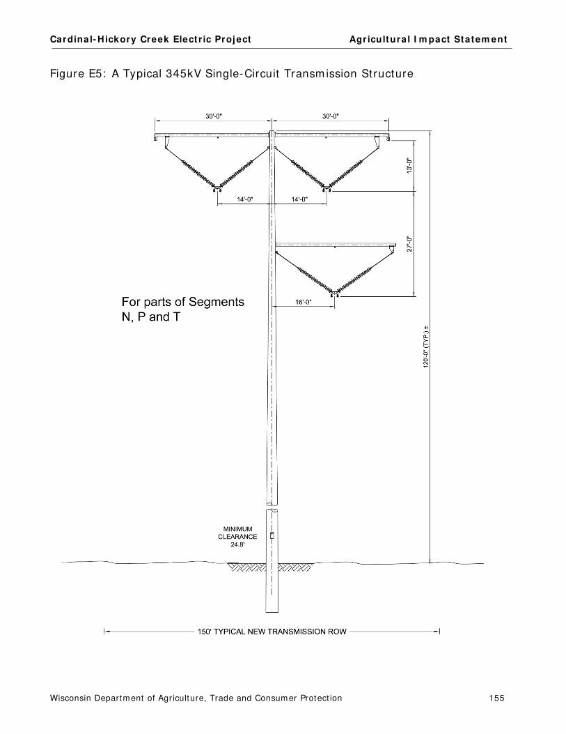
Cardinal- Hickory Creek Elect r ic Project Agr icultura l I m pact Statem ent
Wisconsin Departm ent of Agriculture, Trade and Consum er Protect ion 155
Figure E5: A Typical 345kV Single-Circuit Transm ission St ructure

Cardinal- Hickory Creek Elect r ic Project Agr icultura l I m pact Statem ent
Wisconsin Departm ent of Agriculture, Trade and Consum er Protect ion 156
Figure E6: A Typical 345kV Single-Circuit Transm ission St ructure

Cardinal- Hickory Creek Elect r ic Project Agr icultura l I m pact Statem ent
Wisconsin Departm ent of Agriculture, Trade and Consum er Protect ion 157
Figure E7: A Typical 345kV/ 138kV Double-Circuit Transm ission St ructure

Cardinal- Hickory Creek Elect r ic Project Agr icultura l I m pact Statem ent
Wisconsin Departm ent of Agriculture, Trade and Consum er Protect ion 158
Figure E8: A Typical 345kV/ 69kV Double-Circuit Transm ission St ructure

Cardinal- Hickory Creek Elect r ic Project Agr icultura l I m pact Statem ent
Wisconsin Departm ent of Agriculture, Trade and Consum er Protect ion 159
Figure E9: A 345kV/ 69kV Double-Circuit Transm ission St ructure

Cardinal- Hickory Creek Elect r ic Project Agr icultura l I m pact Statem ent
Wisconsin Departm ent of Agriculture, Trade and Consum er Protect ion 160
APPENDIX F: FARMLAND SOIL DEFINITIONS
Agricultura l Propert ies
Agricultural propert ies include any of the following act ivit ies conducted for the purpose of
producing an incom e or livelihood:
Crop or forage product ion.
Keeping livestock.
Beekeeping.
Nursery, sod, or Christm as t ree product ion.
Floriculture.
Aquaculture.
Fur farm ing.
Forest m anagem ent .
Enrolling land in a federal agricultural com m odity paym ent program or a federal or
state agricultural land conservat ion paym ent program .
Farm is defined as all land under com m on ownership that is prim arily devoted to agricultural
land use
Agricultura l Land Use Categories
Cropland – Land that is planted in row crops, sm all grains, or hay.
Pasture – Land that supports grass or other vegetat ion for dom est ic grazing anim als.
Idle or Fallow Fields – Land that is cleared and m aintained as agricultural fields but is not
current ly planted/ cult ivated.
Specialty Farmland – Unique cropland that does not fit into the categories above. Exam ples
include cropland used to grow vegetables, Christm as t ree farm s, orchards, nurseries, and
hort icultural land (such as cranberries, ginseng, fruit farm s, hops, and v ineyards) .
Other Agricultural Land – Land use or st ructures that do not fit into the above categories. I t
m ay include wooded areas, wet lands, farm residences, farm buildings, ponds, and private farm
roads.

Cardinal- Hickory Creek Elect r ic Project Agr icultura l I m pact Statem ent
Wisconsin Departm ent of Agriculture, Trade and Consum er Protect ion 161
Farm land Soil Definit ions
Farm land soil is classified by the USDA based on it s abilit y to produce crops. Protect ing prim e
farm land, prim e farm land if drained, and farm land of statewide im portance should be a priorit y
for const ruct ion projects.
Prime Farmland
Land that has the best com binat ion of physical and chem ical characterist ics for producing food,
feed, forage, fiber, and oilseed crops and is also available for these uses. I t has the soil qualit y,
growing season, and m oisture supply needed to produce econom ically sustained high yields of
crops when t reated and m anaged according to acceptable farm ing m ethods, including water
m anagem ent . I n general, prim e farm lands have an adequate and dependable water supply from
precipitat ion or irr igat ion, a favorable tem perature and growing season, acceptable acidity or
alkalinity, acceptable salt and sodium content , and few or no rocks. They are perm eable to water
and air. Prim e farm lands are not excessively erodible or saturated with water for a long period of
t im e, and they either do not flood frequent ly or are protected from flooding.
Prime Farmland if Drained
This farm land is prim e farm land but requires draining in order to have the best com binat ion of
physical and chem ical characterist ic for producing food, feed, forage, fiber, and oilseed crops.
Farmland of Statewide Importance
The criteria for defining and delineat ing this soil are to be determ ined by the appropriate state
agency or agencies. Generally, addit ional farm lands of statewide im portance include those that
are nearly prim e farm land and that econom ically produce high yields of crops when t reated and
m anaged according to acceptable farm ing m ethods. Som e m ay produce as high a yield as prim e
farm lands if condit ions are favorable. I n som e states, addit ional farm lands of statewide
im portance m ay include t racts of land that have been designated for agriculture by state law.
Non-prime soils
Non-prim e soils have lim itat ions in term s of agricultural product ion and m ay be m ore suscept ible
to dam age from elect r ic line const ruct ion.

Cardinal- Hickory Creek Elect r ic Project Agr icultura l I m pact Statem ent
Wisconsin Departm ent of Agriculture, Trade and Consum er Protect ion 162
APPENDIX G: BADGER COULEE WRECK-OUT PROCEDURE
Badger Coulee: W reck- out Procedure
Upland (non-agricultural areas) • Old poles can be cut off at or im m ediately below ground level • I f com pletely rem oved: dig out footers, back- fill old hole with gravel, and cover with
original soil Wet lands
• Old poles can be cut off at ground level • I f poles m ust be com pletely rem oved:
o Segregate topsoil as best as possible and set on a barrier (m ats or tarp/ fabric) o Dig out the sub-soil around the footers and place on a barrier (m ats or tarp/ fabric) o Rem ove the old st ructure and footers o Back- fill the old holes with gravel. Fill gravel to approxim ately 1’ below ground
level. o Back- fill sub-soil over gravel o Cover with saved topsoil
Agricultural Areas (non-organic) - Poles m ust be rem oved to avoid contact with plows
• Segregate topsoil as best as possible and set aside next to the poles ( t opsoil placed on topsoil)
• Dig out the sub-soil around the footers and place on a barrier (m ats or tarp/ fabric) • Rem ove the old st ructure and footers • Back- fill the old holes with gravel. Do not fill gravel above plow layer (~ 24 inches) . • Back- fill sub-soil over gravel • Cover with saved topsoil • I f topsoil was not able to be saved ( i.e. frozen condit ions or lack of original topsoil) , bring
in addit ional topsoil so that depth of t opsoil in im pact area m atches surrounding condit ions Agricultural Areas (Organic)
• Follow sam e procedure for convent ional agricultural fields with the following except ions: o Gravel is inert and allowed to be hauled into organic farm s but it is recom m ended
to have quarry note on scale t ickets that the gravel is suitable for organic propert ies
o Topsoil im ported m ust be from a cert ified organic locat ion Farm ed Wet lands
• Follow sam e procedure for convent ional agricultural fields with the following except ions: o All stockpiled soil should be placed on a barrier since farm ed wet lands are
jurisdict ional wet lands. o Topsoil should not be im ported without approval from the environm ental m onitor
as im ported topsoil can be considered wet land fill.

Cardinal- Hickory Creek Elect r ic Project Agr icultura l I m pact Statem ent
Wisconsin Departm ent of Agriculture, Trade and Consum er Protect ion 163
APPENDIX H: DOA PUBLICATION - RIGHTS OF LANDOWNERS
UNDER WISCONSIN EMINENT DOMAIN LAW

Cardinal- Hickory Creek Elect r ic Project Agr icultura l I m pact Statem ent
Wisconsin Departm ent of Agriculture, Trade and Consum er Protect ion 164

Cardinal- Hickory Creek Elect r ic Project Agr icultura l I m pact Statem ent
Wisconsin Departm ent of Agriculture, Trade and Consum er Protect ion 165
APPENDIX I: BADGER COULEE ORGANIC PROCEDURES
Badger Coulee Organic Procedures
1 Segregate and save the topsoil's for backfilling around foundations and for restoration on the
organic tract. This topsoil shall be used exclusively for the purposes of restoration on the organic
property. Any material (gravel, soil fill) brought in needs written approval from the organic farm
operator.
2 Prior to entry, Clean off and wash-down all machines and equipment before they enter the area.
Do this by scraping and blowing off with compressed air and /or power washing. Wash-down
should be sufficient to remove petroleum residue, vegetation, weed seeds, dirt, and other debris.
Care must be taken not to re contaminate equipment while working on Organic lands. This
includes mud and debris on pickup trucks as well.
3 Do not drag any plant debris or soils into area. Inspect undercarriage. Always clean and inspect
prior to reentry of organic farms.
4 Use only certified organic seeds for restoration. Provide a label and receive written permission from
the farmer to use of certified organic seeds. Seeds shall not be treated with any chemicals. Never
bring in conventional seeds for any reason. Do not even have conventional seeds on your vehicle.
5 Prohibit the application of prohibited substances of any kind onto organic certified lands. This
would include but not limited to, fertilizers, herbicides, insecticides (including personal bug
repellents), and other pesticides. Weed and Pest control shall be maintained using only organic
farm specific approved substances that have been also approved in writing by the farmer. Fertilizer
used shall be certified organic fertilizer, approved by the organic farmer.
6 Keep a file of invoices and labels or tags of any seeds, fertilizer, or anything else used on organic
farms.
7 No refueling or lubrication of any kind on this tract. Aerosol cans prohibited as well.
8 Inspect all vehicles prior to entry for hose, tank, and other component leaks. Also check for potential
for spills. Eliminate all of these risks of leaks and spills.
9 Do not use the organic farm for storage of non-organic soils or materials of any kind.
10 Extra care shall be used to avoid any erosion or movement of soils from non-organic lands onto
the organic lands. All erosion control devices shall be of organic character. This includes straw
waddles, bales of straw, and mulch.
11 Whenever possible, use new mats in organic areas and be sure they are untreated wood with no
preservatives If the mats or wood products are used be sure to power wash those used mats/ wood
products so they are clean and free of all foreign non organic substances.
12 Use no treated lumber of any kind on organic farms for matting, blocking or setting structure
components on, or for any other reason. Arsenic and creosote are strictly prohibited.
13 Extra care shall be used in the application of chemicals and seeds on neighboring farms. Care
shall be exercised to avoid translocation of chemicals through roots as well as drift through the air.
The same care shall be used to much sure cross pollination cannot occur with seeds/plants.


WISCONSIN DEPARTMENT OF AGRICULTURE, TRADE AND CONSUMER PROTECTION
DIVISION OF
AGRICULTURAL RESOURCE MANAGEMENT
Agricultural Impact Program
P.O. Box 8911
Madison, WI 53708-8911
608-224-4650
ht tps: / / datcp.wi.gov/ Pages/ Program s_Services/ AgriculturalIm pactStatem ents.aspx
Related Documents