AGRICULTURAL ASSESSMENT: PECAN ORCHARD FEASIBILITY STUDY Prepared by BRAD HENLEY For DR. I-KUAI HUNG, PH.D., ASSOCIATE PROFESSOR OF GIS Course GIS 390 GEOGRAPHIC INFORMATION SYSTEMS IN NATURAL RESOURCES Fall 2014 Originally presented: December 1, 2014

Welcome message from author
This document is posted to help you gain knowledge. Please leave a comment to let me know what you think about it! Share it to your friends and learn new things together.
Transcript
AGRICULTURAL ASSESSMENT: PECAN ORCHARD
FEASIBILITY STUDY
Prepared by BRAD HENLEY
For DR. I-KUAI HUNG, PH.D., ASSOCIATE PROFESSOR OF GIS
Course GIS 390 GEOGRAPHIC INFORMATION SYSTEMS IN
NATURAL RESOURCES
Fall 2014
Originally presented: December 1, 2014
TABLE OF CONTENTS
COVER ..................................................................................................................................................................... TABLE OF CONTENTS ........................................................................................................................................... SECTION 1. REPORT .......................................................................................................................................... 1
1.1 INTRODUCTION ............................................................................................................................................. 1 1.2 SCOPE .......................................................................................................................................................... 1 1.3 BACKGROUND THEORY ............................................................................................................................... 1
STUDY AREA MAP SUMMARIES ................................................................................................................. 2 MAP 1. PROXIMITY OF FEASIBILITY STUDY .............................................................................................. 3 MAP 2. HICKORY CREEK (AOI) DIGITAL ORTHRO-QUARTER QUADRANGLE (DOQQ) .................................. 4 MAP 3. HICKORY CREEK DIGITAL RASTER GRAPHICS (DRG) .................................................................... 5
SECTION 2. ANALYSIS ...................................................................................................................................... 6 2.1 PHASE I. INCORPORATING SOIL TYPE DATA ................................................................................................. 6
PHASE I MAP SUMMARIES ......................................................................................................................... 7 MAP 4. HICKORY CREEK SOIL SURVEY .................................................................................................... 8 MAP 5. EXISTING PECAN ORCHARD SOIL SURVEY ..................................................................................... 9
2.2 PHASE II. EVALUATING COMMON SOILS AND NON-FORESTED AREAS ........................................................ 10 PHASE II MAP SUMMARIES ...................................................................................................................... 11 MAP 6. HICKORY CREEK SOILS IN COMMON WITH EXISTING PECAN ORCHARD ...................................... 12 MAP 7. EXISTING PECAN ORCHARD SOILS IN COMMON WITH HICKORY CREEK ...................................... 13 MAP 8. HICKORY CREEK NON-FORESTED AREAS OVERLAYING DOQQ ..................................................... 14 MAP 9. HICKORY CREEK NON-FORESTED AREAS OVERLAYING DRG ....................................................... 15 MAP 10. HICKORY CREEK NON-FORESTED AREAS OVERLAYING SOIL SURVEY ...................................... 16 MAP 11. HICKORY CREEK NON-FORESTED AREAS AND EXISTING ORCHARD COMMON SOIL TYPES ......... 17 MAP 12. HICKORY CREEK INTERSECT OF NON-FORESTED AREAS AND EXISTING ORCHARD SOIL TYPES . 18
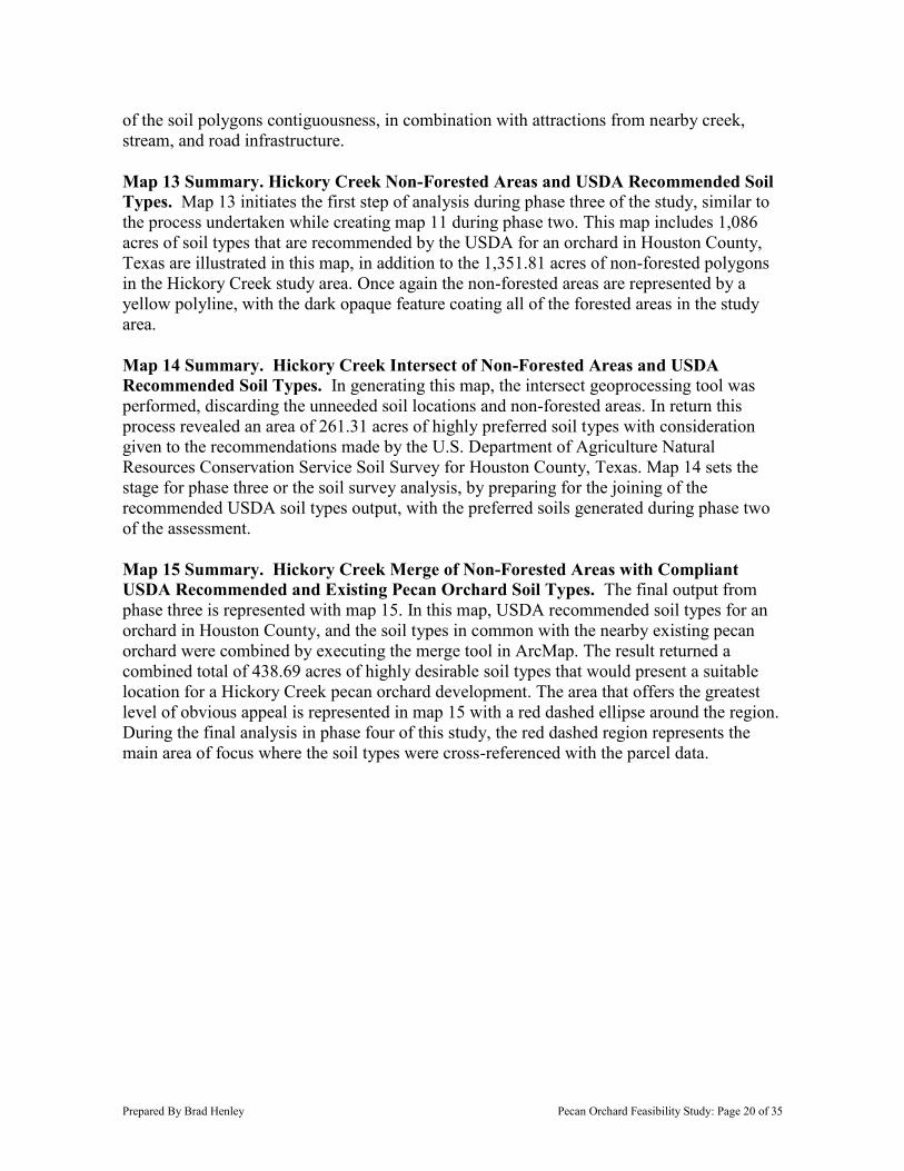
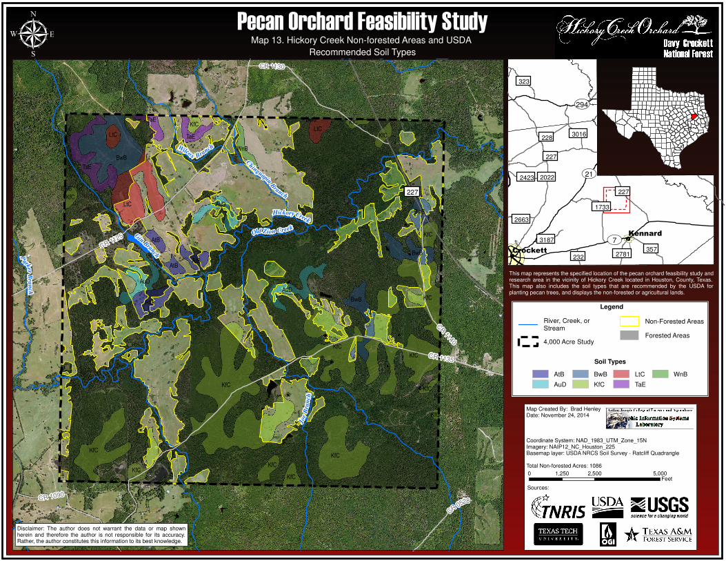
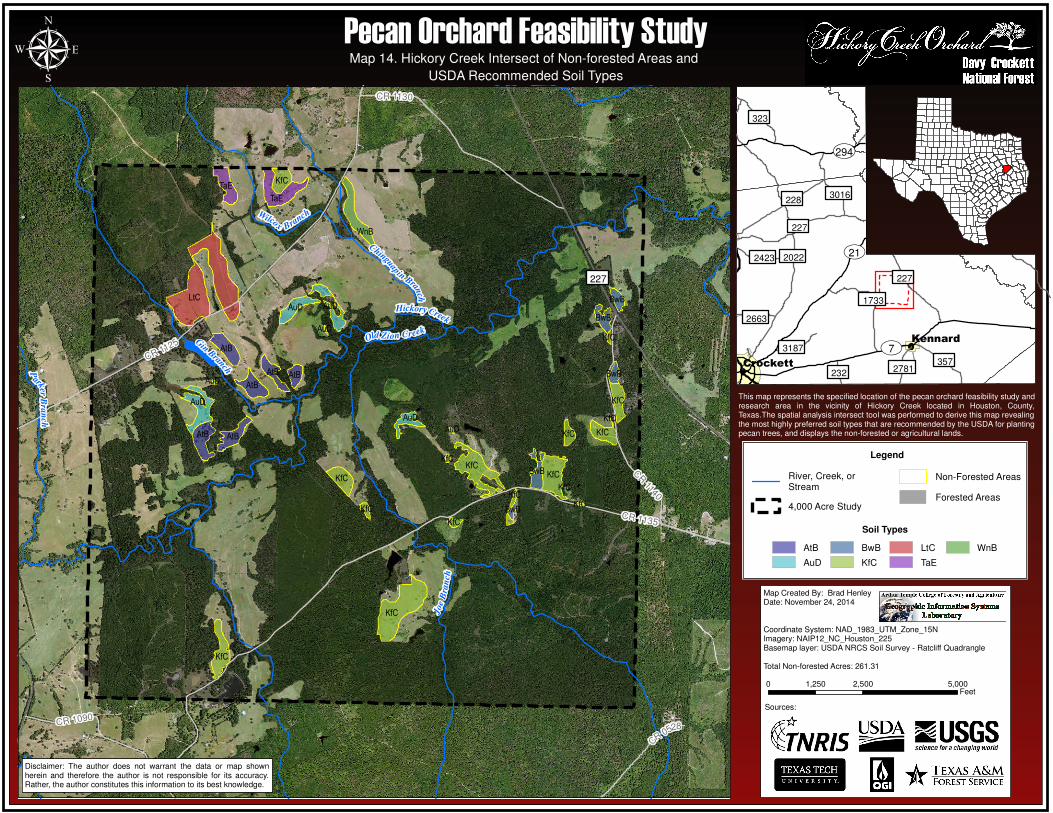
2.3 PHASE III. IDENTIFYING USDA RECOMMENDATIONS .................................................................................. 19 PHASE III MAP SUMMARIES ..................................................................................................................... 20 MAP 13. HICKORY CREEK NON-FORESTED AND USDA RECOMMENDED SOIL TYPES ............................... 21 MAP 14. HICKORY CREEK INTERSECT OF NON-FORESTED AND USDA RECOMMENDED SOIL TYPES ......... 22 MAP 15. HICKORY CREEK MERGE OF NON-FORESTED, USDA AND EXISTING PECAN ORCHARD SOILS ...... 23
2.4 PHASE IV. LAND PARCEL ANALYSIS ......................................................................................................... 24 PHASE IV MAP SUMMARIES .................................................................................................................... 24 MAP 16. HICKORY CREEK COMPLIANT SOIL TYPES AND LAND PARCEL ANALYSIS ................................. 25
2.5 ADDITIONAL MAPS ..................................................................................................................................... 26 SUMMARIES OF ADDITIONAL MAPS .......................................................................................................... 26 MAP 17. HICKORY CREEK ASPECT ......................................................................................................... 27 MAP 18. HICKORY CREEK SLOPE ........................................................................................................... 28 MAP 19. HICKORY CREEK DIGITAL ELEVATION MODEL (DEM) ............................................................... 29 MAP 20. HICKORY CREEK INTERPOLATION ANALYSIS (IDW) .................................................................. 30 MAP 21. HICKORY CREEK TRIANGULATED IRREGULAR NETWORK (TIN) WITH EDGES ............................ 31 MAP 22. HICKORY CREEK TRIANGULATED IRREGULAR NETWORK (TIN) WITH CONTOURS ...................... 32
2.6 MAPPING SETTINGS .................................................................................................................................... 33 SECTION 3. RESULTS ...................................................................................................................................... 34
3.1 CONCERNS ................................................................................................................................................. 34 3.2 CONCLUSION .............................................................................................................................................. 34
REFERENCES ..................................................................................................................................................... 35
Prepared By Brad Henley Pecan Orchard Feasibility Study: Page 1 of 35
SECTION 1. REPORT
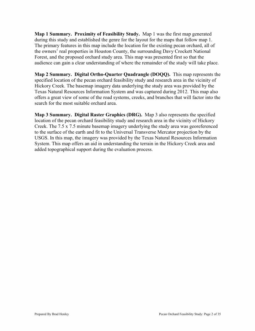
1.1 Introduction. East Texas has predominantly been categorized historically as a forestry and timber management region. The nearest region to expectedly encounter viewing a large number of properties containing the growth of nut-bearing tree plantations, better known as orchards, is the Hill Country or South Texas Regions. During 2012, I witnessed a rural real estate transaction between an East Texas timber landowner and successful almond orchard farmer. The almond farmer had no previous experience with the practice and management of Texas loblolly pine plantations; however, he had interest in diversifying his real estate investment portfolio to include a pine plantation offering a different soil type than he was used to cultivating for his almond farms. The more than two-thousand acre Neches River property of his choice, was in fact a practical timberland investment, with a desirable projected return-on-investment. As a result, the almond farmer can now learn the principles associated with growing, managing, and harvesting pine timber in East Texas, in addition to examining the new soil type and preparing it for his experimental East Texas almond orchard farm. Due to the almond farmers unorthodox endeavor, the experience enlightened me and generated the basis of the following study; does the East Texas region host lands that are practical, or even potentially possible, to develop large acreage into nut-bearing orchards. 1.2 Scope. This feasibility study was conceived outside the range of numerous suggested geographical information systems natural resources management plans and assessments. The parameters for this study required specifying an Area-of-Interest (AOI) no less than 4,000 acres from within a much larger 40,700 acre designated area of the Davy Crockett National Forest, in Houston County, Texas. The requirements additionally declare that I must generate, at minimum, eight maps derived by utilizing the GIS tools and procedures learned during the GIS 390 course. These procedures and maps are expected to accompany the report and validate the methods executed during the research. 1.3 Background Theory. This study was conducted with the expectation that the criteria selection of the subject, workflow, and GIS analysis, can, and will undoubtedly offer a reliable form of land-use determination techniques during future accounts of due-diligence. In this particular study I arranged for the investigation to include the likelihood of a pecan orchard, as opposed to the previously mentioned topic of almond orchards, primarily because of an already existing pecan orchard within the vicinity of the study area. Coincidently, the two-thousand acre Neches River property purchased by the almond farmer, just happens to be minutes away from the study area. In coordination with the nearby existing pecan orchard, the 4,000 acre AOI was established upon analyzing the area for the most attractive creeks, streams, and road system infrastructure available, to initially support the reality of a potential pecan orchard. In this study, the AOI is referred to as the Hickory Creek area due to the predominant and geographically balanced water features in the study area. The objective for this study is to use available data, scientific facts, and the most foundational principles of geospatial analysis in natural resources, to determine if a pecan orchard is suitable for the selected study area based on soil type. Additionally, the end goal is reduce the AOI down to a focused area, as small as 10%, in order to precisely identify the most desirable tracts of land in the study area, with consideration given to existing county tax parcel ownership data.
Prepared By Brad Henley Pecan Orchard Feasibility Study: Page 2 of 35
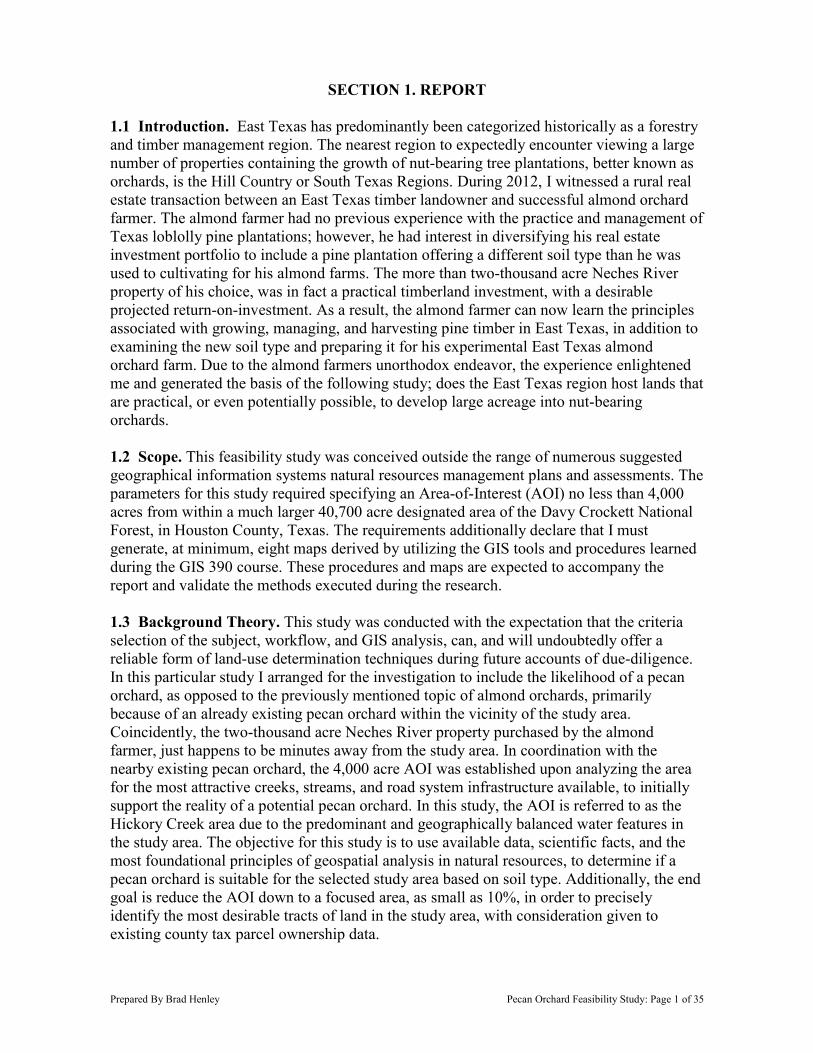
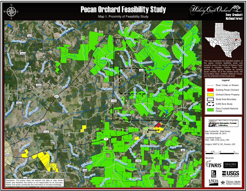
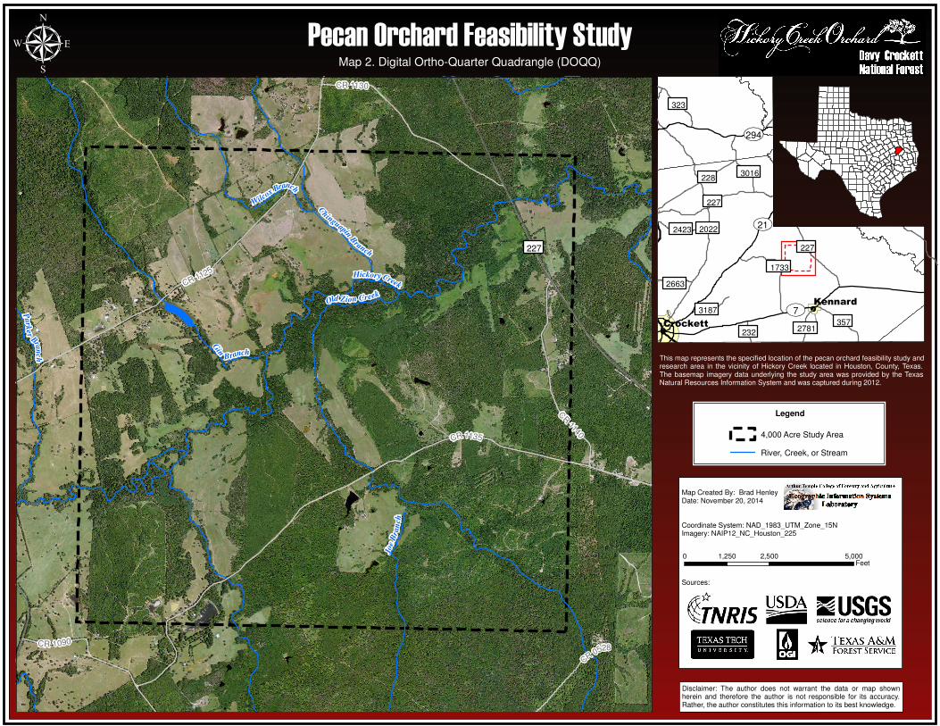
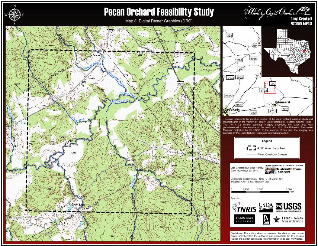
Map 1 Summary. Proximity of Feasibility Study. Map 1 was the first map generated during this study and established the genre for the layout for the maps that follow map 1. The primary features in this map include the location for the existing pecan orchard, all of the owners’ real properties in Houston County, the surrounding Davy Crockett National Forest, and the proposed orchard study area. This map was presented first so that the audience can gain a clear understanding of where the remainder of the study will take place. Map 2 Summary. Digital Ortho-Quarter Quadrangle (DOQQ). This map represents the specified location of the pecan orchard feasibility study and research area in the vicinity of Hickory Creek. The basemap imagery data underlying the study area was provided by the Texas Natural Resources Information System and was captured during 2012. This map also offers a great view of some of the road systems, creeks, and branches that will factor into the search for the most suitable orchard area. Map 3 Summary. Digital Raster Graphics (DRG). Map 3 also represents the specified location of the pecan orchard feasibility study and research area in the vicinity of Hickory Creek. The 7.5 x 7.5 minute basemap imagery underlying the study area was georeferenced to the surface of the earth and fit to the Universal Transverse Mercator projection by the USGS. In this map, the imagery was provided by the Texas Natural Resources Information System. This map offers an aid in understanding the terrain in the Hickory Creek area and added topographical support during the evaluation process.
2663
2423
3187
232
227
2781
357
1733
227
2022
��304
��21
��7
£¤287
Kennard
H ickory Cre
ek
White
Roc
k
Creek
Gail Creek
Gin
Branch
Sikes Creek
Hager
Cre
ek
Cochi no Bayou
BeaverCreek
San
Pedro Creek
Nec
hes
Riv
er
Stow
eC
reek
Aust
inB
ran
ch
Gum Creek
Rosy Bayou
C
hingu
apinB
ran
ch
Fla
t Branch
G
arris
onCre
ek
Ham
m
ond
Cre
ekD
utc
h
Smith Cre
ek
Tan
ya
rd Branch
BlackB
r
anch
C
ook
Bra
nch
Piney
Creek
Windbush
B
ranch
Wa lla
ceC
reek
Johnson Creek
Wh ite l
eyC
reek
Pigeon Roost Branch
Dickey Cree k
Pole B
ran
ch
Ly nc h Creek
Sandy Creek
Ben nett Creek
Smith Branch
Kilgore Branch
O ldZion Creek
Joe
Bra
nch
Hurrica ne Bayou
Bla
ckL
ick
Bra
nch R
yeSpring
Branch
Tanya
rd
Creek
Brice
Sprin
gBra
nch
Parker Branch
Arm
s tro
ngCreek
Butler
Bra
nch
Smitherman Branch
Merkel C reek
Bog
gy
Glade Branch
Hick
Bran ch
Lynch Creek
Camp Creek
Hag
erCreek
Pe ter Branch
Boatw
right
Creek
D
ickeyC
reek
Stro
ud
Bra
nch
Wilco
xB
ran
ch
Walnut Creek
A
rn
old
Creek
Beaver C reek
Helton
C reek
µ
This map represents the specified location ofthe pecan orchard feasibility study andresearch area in the vicinity of Hickory Creeklocated in Houston, County, Texas. Theprimary map features include an existingpecan orchard, all of the owners land's, thesurrounding Davy Crockett National Forest,and the proposed orchard study area.
Map Created By: Brad HenleyDate: November 24, 2014
Coordinate System:NAD_1983_UTM_Zone_15N
Imagery: NAIP12_NC_Houston_225
0 1.5 30.75Miles
Map 1. Proximity of Feasibility Study
Disclaimer: The author does not warrant the data or map shownherein and therefore the author is not responsible for its accuracy.Rather, the author constitutes this information to its best knowledge.
Legend
River, Creek, or Stream
Existing Pecan Orchard
Orchard Owner Property
Study Area Boundary
4,000 Acre Study
Davy Crockett NationalForest
Sources:
Pecan Orchard Feasibility Study
CR0528
CR 1090
CR 1140
CR 1130
CR 1125
CR 1135
227
Gin
Branch
Hickory Creek
Old Zion Creek
C
hinguapinB
ranch
Park
er
Bran
ch
Joe
Bra
nch
Wilcox Branch
232
2663
2781
3187
3016
2423
323
357
1733
227
228
227
2022
��294
��7
��21
Kennard
Crockett
µ
Disclaimer: The author does not warrant the data or map shownherein and therefore the author is not responsible for its accuracy.Rather, the author constitutes this information to its best knowledge.
Map Created By: Brad HenleyDate: November 20, 2014
Coordinate System: NAD_1983_UTM_Zone_15NImagery: NAIP12_NC_Houston_225
Sources:
0 2,500 5,0001,250Feet
Legend
4,000 Acre Study Area
River, Creek, or Stream
Pecan Orchard Feasibility StudyMap 2. Digital Ortho-Quarter Quadrangle (DOQQ)
This map represents the specified location of the pecan orchard feasibility study andresearch area in the vicinity of Hickory Creek located in Houston, County, Texas.The basemap imagery data underlying the study area was provided by the TexasNatural Resources Information System and was captured during 2012.
CR0528
CR 1090
CR 1140
CR 1130
CR 1125
CR 1135
227
Gin
Branch
Hickory Creek
Old Zion Creek
C
hinguapinB
ranch
Park
er
Bran
ch
Joe
Bra
nch
Wilcox Branch
232
2663
2781
3187
3016
2423
323
357
1733
227
228
227
2022
��294
��7
��21
Kennard
Crockett
µ
Disclaimer: The author does not warrant the data or map shownherein and therefore the author is not responsible for its accuracy.Rather, the author constitutes this information to its best knowledge.
Map Created By: Brad HenleyDate: November 20, 2014
Coordinate System: NAD_1983_UTM_Zone_15NImagery: NAIP12_NC_Houston_225
Sources:
0 2,500 5,0001,250Feet
Legend
4,000 Acre Study Area
River, Creek, or Stream
Pecan Orchard Feasibility StudyMap 3. Digital Raster Graphics (DRG)
This map represents the specified location of the pecan orchard feasibility study andresearch area in the vicinity of Hickory Creek located in Houston, County, Texas.The 7.5 x 7.5 minute basemap imagery underlying the study area wasgeoreferenced to the surface of the earth and fit to the Universal TransverseMercator projection by the USGS. In the instance of this map, the imagery wasprovided by the Texas Natural Resources Information System.
Prepared By Brad Henley Pecan Orchard Feasibility Study: Page 6 of 35
SECTION 2. ANALYSIS
2.1 Phase I. Incorporating Soil Type Data. Choosing the location for a new pecan orchard should be a thorough process, because it can become very costly to a pecan farmer or investor if the orchard is developed within the wrong climate, soils, water resources, and numerous other factors. The first question composed during this study was, should additional pecan orchards be established in the Hickory Creek area of the Davy Crockett National Forest? In order to validate the question, it was first necessary to identify the most common factor resulting in mortality among pecan tree orchards, in general. Evidence from research of failed pecan orchards reveals that the largest contributing factor to pecan orchard mortality is poor soil. Therefore, this phase of research was designed to use ArcMap to import existing soil data shapefiles into the AOI, as well as the existing pecan orchard. The nearby existing pecan orchard age is unknown, but believed to be less than ten years old. The orchard contains 106 acres of planted trees that lays 3.4 miles to the southeast of the Hickory Creek study area, on U.S. Highway 7, adjoining the city limits of Kennard, Texas. By examining the soil types of the existing pecan orchard, this offered an easy comparison of soil in the area which has proven to offer a dependable growing environment for pecan trees. The soil type data for this study was provided by the [1] U.S. Department of Agriculture Natural Resources Conservation Service Soil Survey for Houston County, Texas. Listed below are the soil types that remain in the two emphasized areas of the investigation, after the analysis had been conducted during this phase. Hickory Creek Study Area Soil Types: AaB - Alazan very fine sandy loam LaE - LaCerda clay loam AtB - Attoyac fine sandy loam Lc - Laneville loam AuD - Austonio fine sandy loam LtC - Lilbert loamy fine sand BaB - Bernaldo fine sandy loam MoA - Mollville loam BeA - Besner fine sandy loam MpA - Mollville-Besner complex BwB - Bowie fine sandy loam Oz - Ozias-Pophers complex CtE - Cuthbert fine sandy loam SwA - Sawlit-Latex complex HaA - Hainesville fine sand TaE - Tenaha loamy fine sand Iu - Iulus fine sandy loam WnB - Woden fine sandy loam KfC - Kirvin fine sandy loam WoB - Woodtell very fine sandy loam KhC - KhC—Kirvin soils WoE - Woodtell very fine sandy loam KuB - Kurth fine sandy loam
Existing Pecan Orchard Soil Types: BaB - Bernaldo fine sandy loam KuD - Kurth fine sandy loam HaA - Hainesville fine sand MxA – Moten-Multey complex KuB - Kurth fine sandy loam Po – Pophers silt loam Kp – Koury silt loam
Prepared By Brad Henley Pecan Orchard Feasibility Study: Page 7 of 35
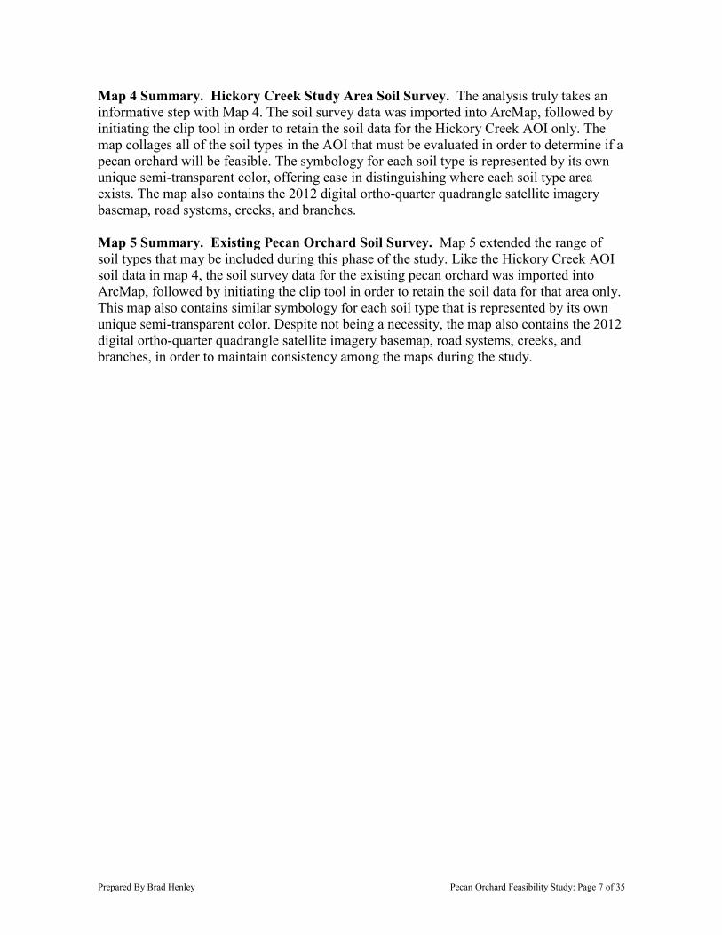
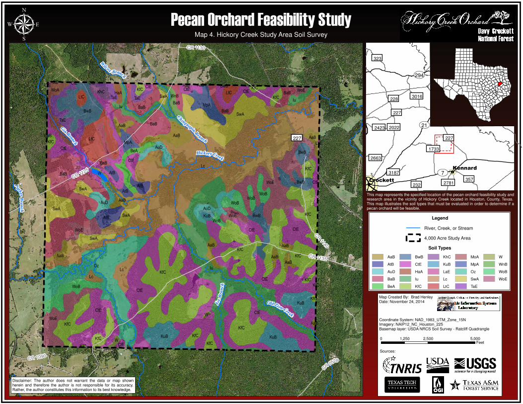
Map 4 Summary. Hickory Creek Study Area Soil Survey. The analysis truly takes an informative step with Map 4. The soil survey data was imported into ArcMap, followed by initiating the clip tool in order to retain the soil data for the Hickory Creek AOI only. The map collages all of the soil types in the AOI that must be evaluated in order to determine if a pecan orchard will be feasible. The symbology for each soil type is represented by its own unique semi-transparent color, offering ease in distinguishing where each soil type area exists. The map also contains the 2012 digital ortho-quarter quadrangle satellite imagery basemap, road systems, creeks, and branches. Map 5 Summary. Existing Pecan Orchard Soil Survey. Map 5 extended the range of soil types that may be included during this phase of the study. Like the Hickory Creek AOI soil data in map 4, the soil survey data for the existing pecan orchard was imported into ArcMap, followed by initiating the clip tool in order to retain the soil data for that area only. This map also contains similar symbology for each soil type that is represented by its own unique semi-transparent color. Despite not being a necessity, the map also contains the 2012 digital ortho-quarter quadrangle satellite imagery basemap, road systems, creeks, and branches, in order to maintain consistency among the maps during the study.
C
R0528CR 1090
CR 1140
CR 1130
CR 1125
CR 1135
227
G
inBran
ch
Hickory Creek
Old Zion Creek
C
hinguapinB
ranch
P
arkerB
ran
ch
Joe
Bra
nch
W
ilcoxBranch
KfC
WoE
SwA
WoB
Lc
CtE
W
WnB
WoB
BaB
AuD
AtB
AuD
KuB
AaB
KfC
AtB
Iu
MpA
BeA
AtB
KfCKfC
KfC
KfC
CtEWoE
AaBLtC
BaB
CtE
CtECtE
CtE
CtE
KfC
Oz
AaB
AuD
WoE
W
AtB
KuB
W
KuB
AaB
KfC
KfC
KfC
BaB
WoE
BwB
WoB
KfC
SwA
KuB
KfC
BwB
AaB
Iu
AaB
KfC
MpA
SwA
Iu
SwA
WoB
AaB
BwB
AaB
AaB
BwB
KfC
LaE
Iu
CtE
KfC
KfC
SwA
TaE
TaE
TaEHaA
WoEKhC
AaB
CtE
CtECtECtE
LtC
AaB
WoB
BwBAaB
BaB
MoA
BwB
CtECtE
CtE
CtE
Lc
BaB
SwA
LtC KfC
BaBBaB
KfCCtE
Lc
232
2663
2781
3187
3016
2423
323
357
1733
227
228
227
2022
��294
��7
��21
Kennard
Crockett
µ
Disclaimer: The author does not warrant the data or map shownherein and therefore the author is not responsible for its accuracy.Rather, the author constitutes this information to its best knowledge.
Map 4. Hickory Creek Study Area Soil Survey
Pecan Orchard Feasibility Study
This map represents the specified location of the pecan orchard feasibility study andresearch area in the vicinity of Hickory Creek located in Houston, County, Texas.This map illustrates the soil types that must be evaluated in order to determine if apecan orchard will be feasible.
Legend
River, Creek, or Stream
4,000 Acre Study Area
Map Created By: Brad HenleyDate: November 24, 2014
Coordinate System: NAD_1983_UTM_Zone_15NImagery: NAIP12_NC_Houston_225Basemap layer: USDA NRCS Soil Survey - Ratcliff Quadrangle
Soil Types
AaB
AtB
AuD
BaB
BeA
BwB
CtE
HaA
Iu
KfC
KhC
KuB
LaE
Lc
LtC
MoA
MpA
Oz
SwA
TaE
W
WnB
WoB
WoE
Sources:
0 2,500 5,0001,250Feet
CR4700
��7
Cochino Bayou
North Fork Cochino Bayou
Po
BaB
BaB
KuD
Po
HaA
HaA
MxA
KuD
KuD
Po
KuB
Kp
Kp
232
2663
2781
3187
3016
2423
323
357
1733
227
228
227
2022
��294
��7
��21
Kennard
Crockett
µ
Disclaimer: The author does not warrant the data or map shownherein and therefore the author is not responsible for its accuracy.Rather, the author constitutes this information to its best knowledge.
Map Created By: Brad HenleyDate: November 24, 2014
Coordinate System: NAD_1983_UTM_Zone_15NImagery: NAIP12_NC_Houston_225Basemap layer: USDA NRCS Soil Survey - Ratcliff Quadrangle
Existing Pecan Orchard Acreage: 106 Acres
0 500 1,000250Feet
This map represents the specified location of the pecan orchard feasibility study andresearch area in the vicinity of Hickory Creek located in Houston, County, Texas.This map illustrates the underlying soil types of a nearby existing pecan orchard.
Legend
River, Creek, or Stream
City Limits Boundary
4,000 Acre Study Area
Existing Pecan Orchard
Soil Types
BaB
HaA
Kp
KuB
KuD
MxA
Po
Pecan Orchard Feasibility StudyMap 5. Existing Pecan Orchard Soil Survey
Sources:
Prepared By Brad Henley Pecan Orchard Feasibility Study: Page 10 of 35
2.2 Phase II. Evaluating Common Soils. The next phase involved analyzing which soil types that the Hickory Creek study area, and the existing pecan orchard have in common. As mentioned during phase one, by identifying the soil types of the existing pecan orchard, the study can establish a basis for comparison between the Hickory Creek AOI and an area in which the soils have proven to effectively grow pecan trees. Using ArcMap, tabular analysis confirmed that the existing pecan orchard has a total of nine acres in common with 480 acres of the Hickory Creek study area soil types. This reveals a ratio of 1:53, or it can be better illustrated by stating that there are approximately fifty-three acres compatible with the existing orchard soil type, for every nine acres in the Hickory Creek study area. Performing the analysis deduced that the following soil types were determined to share commonality between the Hickory Creek study area and the existing pecan orchard: BaB - Bernaldo fine sandy loam KuB - Kurth fine sandy loam HaA - Hainesville fine sand
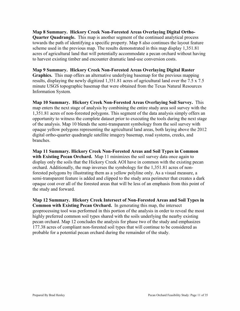
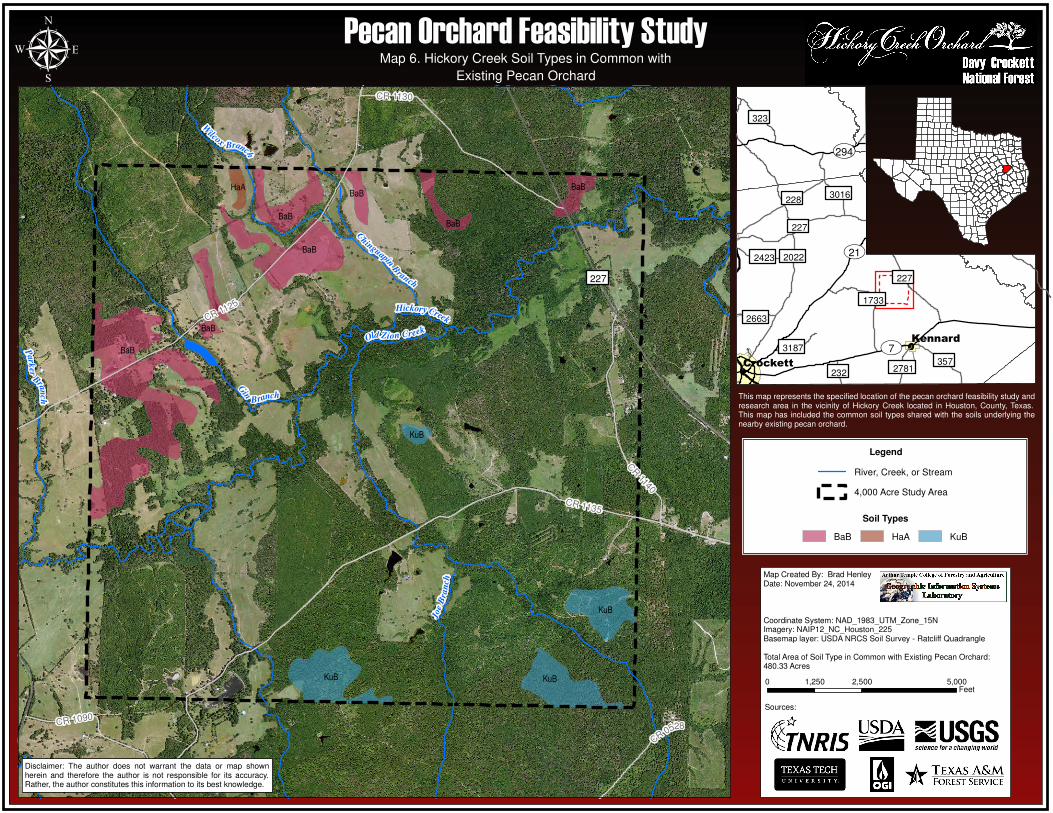
Non-Forested Areas. After identifying the common soil types between the two areas, the 2012 digital ortho-quarter quadrangle satellite imagery was then used to construct new polygon shapefiles of the non-forested areas in the Hickory Creek area. The purpose of identifying these regions was to designate which properties contain vacant agricultural land that may currently embrace an orchard site, without having to suffer the loss of existing timber and land-use conversion costs. The non-forested land polygons were then overlayed with the soil types derived during the first stage of phase two, in order to taper further into strategically selecting prime locations for the potential orchard. The last step of this phase was to execute the intersect tool leaving only the Hickory Creek AOI with non-forested properties that are compatible with the soil types of the existing pecan orchard. Map 6 Summary. Map 6 illustrates the soil types in the Hickory Creek study area that coincide with the existing pecan orchard. Tabular analysis was used in ArcMap to generate the selection, followed by exporting the selection to a new data shapefile. The analysis revealed that there are 480.33 acres of common soil types shared with the soils underlying the nearby existing pecan orchard. Once again, this map carries the layout trend with the unique semi-transparent soil type symbology, 2012 digital ortho-quarter quadrangle satellite imagery basemap, road systems, creeks, and branches. Map 7 Summary. This map continues the layout feature scheme used in the previous map. Map 7, however, reveals the soil types of the nearby existing pecan orchard that were derived during the first stage of the phase two analysis, showing only those types which are in common with the Hickory Creek study area soils. The map illustrates that 9.08 acres of soil types were derived from the analysis that correlate with soils from the Hickory Creek area.
Prepared By Brad Henley Pecan Orchard Feasibility Study: Page 11 of 35
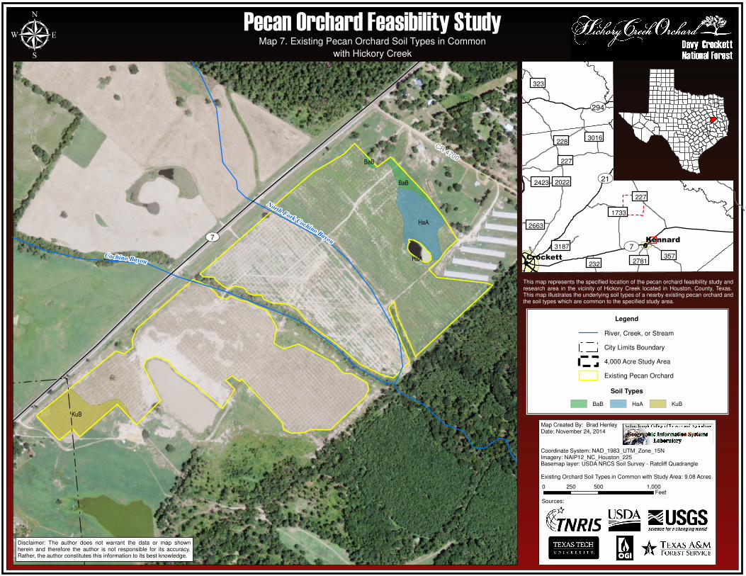
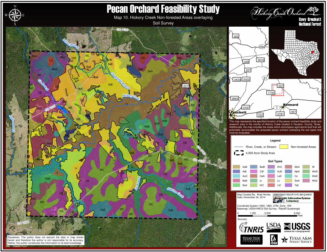
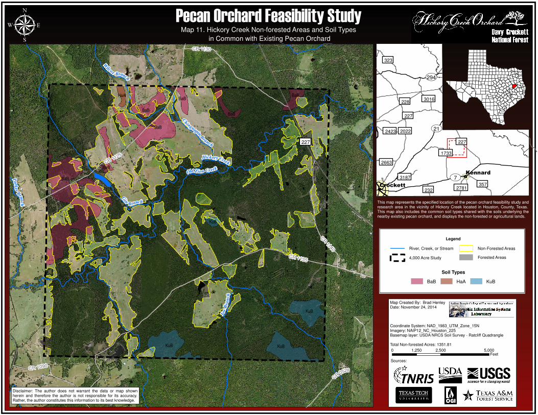
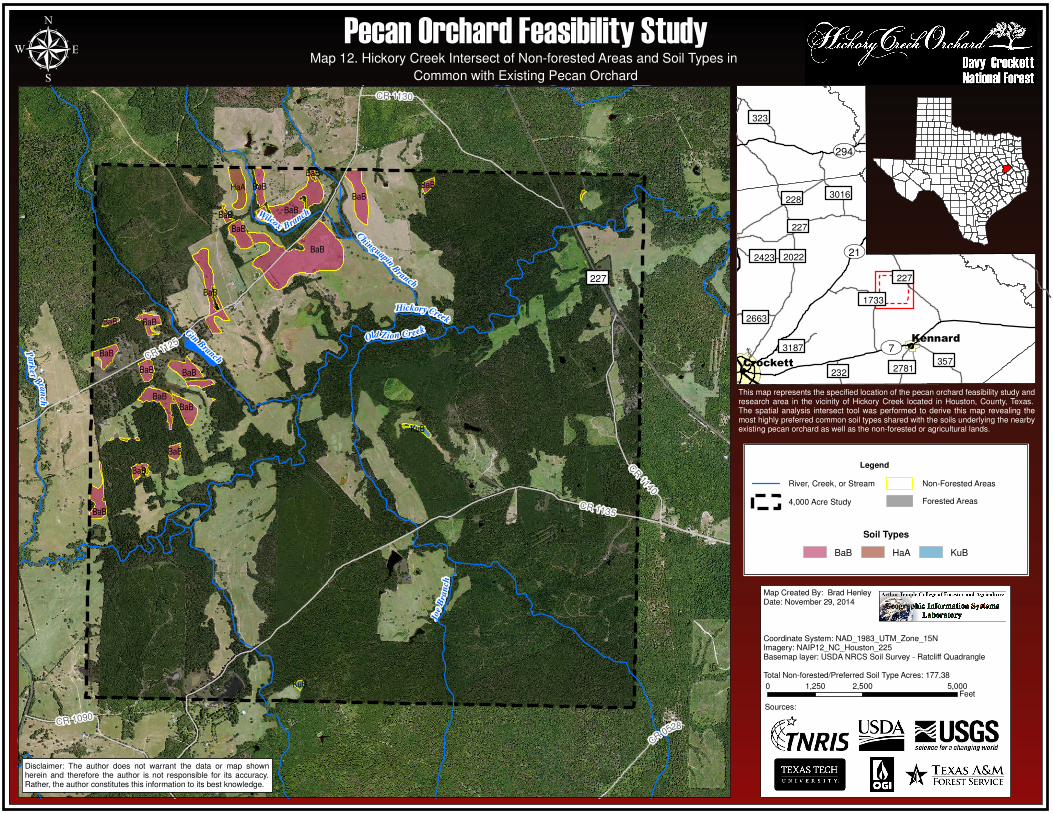
Map 8 Summary. Hickory Creek Non-Forested Areas Overlaying Digital Ortho-Quarter Quadrangle. This map is another segment of the continued analytical process towards the path of identifying a specific property. Map 8 also continues the layout feature scheme used in the previous map. The results demonstrated in this map display 1,351.81 acres of agricultural land that will potentially accommodate a pecan orchard without having to harvest existing timber and encounter dramatic land-use conversion costs. Map 9 Summary. Hickory Creek Non-Forested Areas Overlaying Digital Raster Graphics. This map offers an alternative underlying basemap for the previous mapping results, displaying the newly digitized 1,351.81 acres of agricultural land over the 7.5 x 7.5 minute USGS topographic basemap that were obtained from the Texas Natural Resources Information System. Map 10 Summary. Hickory Creek Non-Forested Areas Overlaying Soil Survey. This map enters the next stage of analysis by combining the entire study area soil survey with the 1,351.81 acres of non-forested polygons. This segment of the data analysis simply offers an opportunity to witness the complete dataset prior to executing the tools during the next stage of the analysis. Map 10 blends the semi-transparent symbology from the soil survey with opaque yellow polygons representing the agricultural land areas, both laying above the 2012 digital ortho-quarter quadrangle satellite imagery basemap, road systems, creeks, and branches. Map 11 Summary. Hickory Creek Non-Forested Areas and Soil Types in Common with Existing Pecan Orchard. Map 11 minimizes the soil survey data once again to display only the soils that the Hickory Creek AOI have in common with the existing pecan orchard. Additionally, the map inverses the symbology for the 1,351.81 acres of non-forested polygons by illustrating them as a yellow polyline only. As a visual measure, a semi-transparent feature is added and clipped to the study area perimeter that creates a dark opaque coat over all of the forested areas that will be less of an emphasis from this point of the study and forward. Map 12 Summary. Hickory Creek Intersect of Non-Forested Areas and Soil Types in Common with Existing Pecan Orchard. In generating this map, the intersect geoprocessing tool was performed in this portion of the analysis in order to reveal the most highly preferred common soil types shared with the soils underlying the nearby existing pecan orchard. Map 12 concludes the analysis for phase two of the study and emphasizes 177.38 acres of compliant non-forested soil types that will continue to be considered as probable for a potential pecan orchard during the remainder of the study.
CR0528CR 1090
CR 1140
CR 1130
CR 1125
CR 1135
227
Gin
Branch
Hickory Creek
Old Zion Creek
C
hinguapinB
ranch
Park
er
Branch
Joe
Bra
nch
W
ilcoxBranch
BaB
KuB
BaB
KuB
KuB
BaB
KuB
HaA
BaB
BaBBaB
BaB
232
2663
2781
3187
3016
2423
323
357
1733
227
228
227
2022
��294
��7
��21
Kennard
Crockett
µ
Disclaimer: The author does not warrant the data or map shownherein and therefore the author is not responsible for its accuracy.Rather, the author constitutes this information to its best knowledge.
This map represents the specified location of the pecan orchard feasibility study andresearch area in the vicinity of Hickory Creek located in Houston, County, Texas.This map has included the common soil types shared with the soils underlying thenearby existing pecan orchard.
Legend
River, Creek, or Stream
4,000 Acre Study Area
Map Created By: Brad HenleyDate: November 24, 2014
Coordinate System: NAD_1983_UTM_Zone_15NImagery: NAIP12_NC_Houston_225Basemap layer: USDA NRCS Soil Survey - Ratcliff Quadrangle
Total Area of Soil Type in Common with Existing Pecan Orchard:480.33 Acres
Sources:
0 2,500 5,0001,250Feet
Pecan Orchard Feasibility StudyMap 6. Hickory Creek Soil Types in Common with
Existing Pecan Orchard
Soil Types
BaB HaA KuB
CR4700
��7
Cochino Bayou
North Fork Cochino Bayou
BaB
BaB
HaA
HaA
KuB
232
2663
2781
3187
3016
2423
323
357
1733
227
228
227
2022
��294
��7
��21
Kennard
Crockett
µ
Disclaimer: The author does not warrant the data or map shownherein and therefore the author is not responsible for its accuracy.Rather, the author constitutes this information to its best knowledge.
Map Created By: Brad HenleyDate: November 24, 2014
Coordinate System: NAD_1983_UTM_Zone_15NImagery: NAIP12_NC_Houston_225Basemap layer: USDA NRCS Soil Survey - Ratcliff Quadrangle
Existing Orchard Soil Types in Common with Study Area: 9.08 Acres
0 500 1,000250Feet
Legend
River, Creek, or Stream
City Limits Boundary
4,000 Acre Study Area
Existing Pecan Orchard
Sources:
This map represents the specified location of the pecan orchard feasibility study andresearch area in the vicinity of Hickory Creek located in Houston, County, Texas.This map illustrates the underlying soil types of a nearby existing pecan orchard andthe soil types which are common to the specified study area.
Pecan Orchard Feasibility StudyMap 7. Existing Pecan Orchard Soil Types in Common
with Hickory Creek
Soil Types
BaB HaA KuB
Map Created By: Brad HenleyDate: November 20, 2014
Coordinate System: NAD_1983_UTM_Zone_15NImagery: NAIP12_NC_Houston_225
Total Non-forested Acres: 1351.81
Sources:
CR0528
CR 1090
CR 1140
CR 1130
CR 1125
CR 1135
227
Gin
Branch
Hickory Creek
Old Zion Creek
C
hinguapinB
ranch
Park
er
Bran
ch
Joe
Bra
nch
Wilcox Branch
232
2663
2781
3187
3016
2423
323
357
1733
227
228
227
2022
��294
��7
��21
Kennard
Crockett
µ
Disclaimer: The author does not warrant the data or map shownherein and therefore the author is not responsible for its accuracy.Rather, the author constitutes this information to its best knowledge.
Map Created By: Brad HenleyDate: November 20, 2014
Coordinate System: NAD_1983_UTM_Zone_15NImagery: NAIP12_NC_Houston_225
Total Non-forested Acres: 1351.81
Sources:
0 2,500 5,0001,250Feet
This map represents the specified location of the pecan orchard feasibility study andresearch area in the vicinity of Hickory Creek located in Houston, County, Texas.The basemap imagery data underlying the study area was provided by the TexasNatural Resources Information System and was captured during 2012. Additionally,the map includes the areas which encompass agricultural land that will potentiallyaccomodate the proposed pecan orchard.
Legend
River, Creek, or Stream
4,000 Acre Study Area
Non-forested Areas
Pecan Orchard Feasibility StudyMap 8. Hickory Creek Non-forested Areas overlaying
Digital Ortho-Quarter Quadrangle (DOQQ)

Map Created By: Brad HenleyDate: November 20, 2014
Coordinate System: NAD_1983_UTM_Zone_15NImagery: NAIP12_NC_Houston_225
Total Non-forested Acres: 1351.81
Sources:
CR0528
CR 1090
CR 1140
CR 1130
CR 1125
CR 1135
227
Gin
Branch
Hickory Creek
Old Zion Creek
C
hinguapinB
ranch
Park
er
Bran
ch
Joe
Bra
nch
Wilcox Branch
232
2663
2781
3187
3016
2423
323
357
1733
227
228
227
2022
��294
��7
��21
Kennard
Crockett
µ
Disclaimer: The author does not warrant the data or map shownherein and therefore the author is not responsible for its accuracy.Rather, the author constitutes this information to its best knowledge.
Map Created By: Brad HenleyDate: November 20, 2014
Coordinate System: NAD_1983_UTM_Zone_15NBasemap: drg_024k_31095d2
Total Non-forested Acres: 1351.81
Sources:
0 2,500 5,0001,250Feet
Pecan Orchard Feasibility StudyMap 9. Hickory Creek Non-forested Areas overlaying
This map represents the specified location of the pecan orchard feasibility study andresearch area in the vicinity of Hickory Creek located in Houston, County, Texas.The 7.5 x 7.5 minute basemap imagery underlying the study area wasgeoreferenced to the surface of the earth and fit to the Universal TransverseMercator projection by the USGS. In the instance of this map, the imagery wasprovided by the Texas Natural Resources Information System. Additionally, the mapincludes the areas which encompass agricultural land that will potentiallyaccomodate the proposed pecan orchard.
Legend
River, Creek, or Stream
4,000 Acre Study Area
Non-forested Areas
Digital Raster Graphics (DRG)
C
R0528CR 1090
CR 1140
CR 1130
CR 1125
CR 1135
227
G
inBran
ch
Hickory Creek
Old Zion Creek
C
hinguapinB
ranch
P
arkerB
ran
ch
Joe
Bra
nch
W
ilcoxBranch
KfC
WoE
SwA
WoB
Lc
CtE
W
WnB
WoB
BaB
AuD
AtB
AuD
KuB
AaB
KfC
AtB
Iu
MpA
BeA
AtB
KfCKfC
KfC
KfC
CtEWoE
AaBLtC
BaB
CtE
CtECtE
CtE
CtE
KfC
Oz
AaB
AuD
WoE
W
AtB
KuB
W
KuB
AaB
KfC
KfC
KfC
BaB
WoE
BwB
WoB
KfC
SwA
KuB
KfC
BwB
AaB
Iu
AaB
KfC
MpA
SwA
Iu
SwA
WoB
AaB
BwB
AaB
AaB
BwB
KfC
LaE
Iu
CtE
KfC
KfC
SwA
TaE
TaE
TaEHaA
WoEKhC
AaB
CtE
CtECtECtE
LtC
AaB
WoB
BwBAaB
BaB
MoA
BwB
CtECtE
CtE
CtE
Lc
BaB
SwA
LtC KfC
BaBBaB
KfCCtE
Lc
232
2663
2781
3187
3016
2423
323
357
1733
227
228
227
2022
��294
��7
��21
Kennard
Crockett
µ
Disclaimer: The author does not warrant the data or map shownherein and therefore the author is not responsible for its accuracy.Rather, the author constitutes this information to its best knowledge.
Map Created By: Brad HenleyDate: November 24, 2014
Coordinate System: NAD_1983_UTM_Zone_15NBasemap: USDA NRCS Soil Survey - Ratcliff Quadrangle
0 2,500 5,0001,250Feet
This map represents the specified location of the pecan orchard feasibility study andresearch area in the vicinity of Hickory Creek located in Houston, County, Texas.Additionally, the map includes the areas which encompass agricultural land that willpotentially accomodate the proposed pecan orchard overlaying the soil types thatmust be evaluated.
Legend
River, Creek, or Stream
4,000 Acre Study Area
Non-forested Areas
Soil Types
AaB
AtB
AuD
BaB
BeA
BwB
CtE
HaA
Iu
KfC
KhC
KuB
LaE
Lc
LtC
MoA
MpA
Oz
SwA
TaE
W
WnB
WoB
WoE
Pecan Orchard Feasibility StudyMap 10. Hickory Creek Non-forested Areas overlaying
Soil Survey
Sources:
CR0528CR 1090
CR 1140
CR 1130
CR 1125
CR 1135
227
Gin
Branch
Hickory Creek
Old Zion Creek
C
hinguapinB
ranch
Park
er
Branch
Joe
Bra
nch
W
ilcoxBranch
BaB
KuB
BaB
KuB
KuB
BaB
KuB
HaA
BaB
BaBBaB
BaB
232
2663
2781
3187
3016
2423
323
357
1733
227
228
227
2022
��294
��7
��21
Kennard
Crockett
µ
Disclaimer: The author does not warrant the data or map shownherein and therefore the author is not responsible for its accuracy.Rather, the author constitutes this information to its best knowledge.
This map represents the specified location of the pecan orchard feasibility study andresearch area in the vicinity of Hickory Creek located in Houston, County, Texas.This map also includes the common soil types shared with the soils underlying thenearby existing pecan orchard, and displays the non-forested or agricultural lands.
Legend
River, Creek, or Stream
4,000 Acre Study
Non-Forested Areas
Forested Areas
Map Created By: Brad HenleyDate: November 24, 2014
Coordinate System: NAD_1983_UTM_Zone_15NImagery: NAIP12_NC_Houston_225Basemap layer: USDA NRCS Soil Survey - Ratcliff Quadrangle
Total Non-forested Acres: 1351.81
Sources:
0 2,500 5,0001,250Feet
Pecan Orchard Feasibility StudyMap 11. Hickory Creek Non-forested Areas and Soil Types
in Common with Existing Pecan Orchard
Soil Types
BaB HaA KuB
C
R0528CR 1090
CR 1140
CR 1130
CR 1125
CR 1135
227
Gin B
ranch
Hickory Creek
Old Zion Creek
C
hinguapinB
ranch
Park
er
Bran
ch
Joe
Bra
nch
Wilcox Bra
nch
BaB
BaB
BaB
BaB
BaB
BaB
BaB
BaB
BaB
BaB
KuB
BaB
BaB
BaB
BaB
KuB
HaA BaB
BaB
BaB
BaB
BaB
232
2663
2781
3187
3016
2423
323
357
1733
227
228
227
2022
��294
��7
��21
Kennard
Crockett
µ
Disclaimer: The author does not warrant the data or map shownherein and therefore the author is not responsible for its accuracy.Rather, the author constitutes this information to its best knowledge.
This map represents the specified location of the pecan orchard feasibility study andresearch area in the vicinity of Hickory Creek located in Houston, County, Texas.The spatial analysis intersect tool was performed to derive this map revealing themost highly preferred common soil types shared with the soils underlying the nearbyexisting pecan orchard as well as the non-forested or agricultural lands.
Legend
River, Creek, or Stream
4,000 Acre Study
Non-Forested Areas
Forested Areas
Map Created By: Brad HenleyDate: November 29, 2014
Coordinate System: NAD_1983_UTM_Zone_15NImagery: NAIP12_NC_Houston_225Basemap layer: USDA NRCS Soil Survey - Ratcliff Quadrangle
Total Non-forested/Preferred Soil Type Acres: 177.38
Sources:
0 2,500 5,0001,250Feet
Pecan Orchard Feasibility StudyMap 12. Hickory Creek Intersect of Non-forested Areas and Soil Types in
Common with Existing Pecan Orchard
Soil Types
BaB HaA KuB
Prepared By Brad Henley Pecan Orchard Feasibility Study: Page 19 of 35
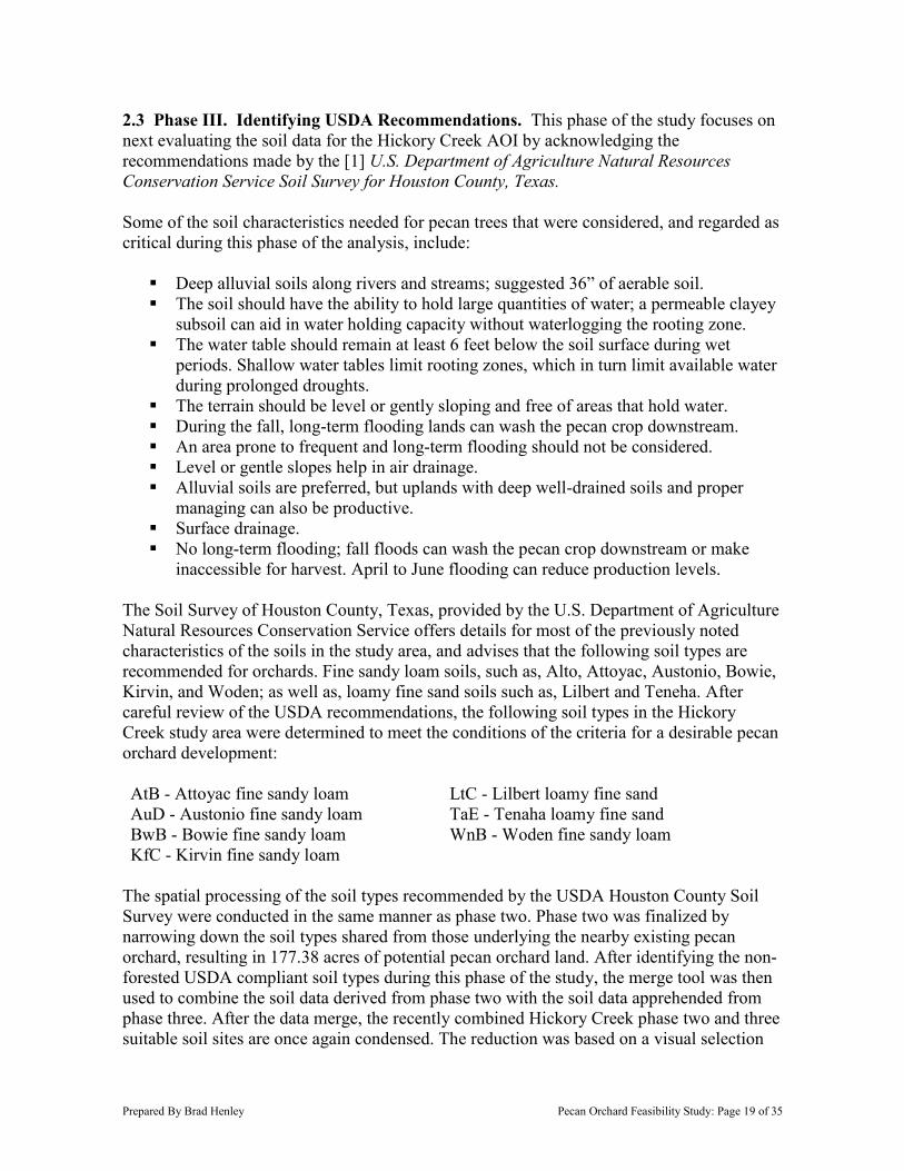
2.3 Phase III. Identifying USDA Recommendations. This phase of the study focuses on next evaluating the soil data for the Hickory Creek AOI by acknowledging the recommendations made by the [1] U.S. Department of Agriculture Natural Resources Conservation Service Soil Survey for Houston County, Texas. Some of the soil characteristics needed for pecan trees that were considered, and regarded as critical during this phase of the analysis, include:
Deep alluvial soils along rivers and streams; suggested 36” of aerable soil. The soil should have the ability to hold large quantities of water; a permeable clayey
subsoil can aid in water holding capacity without waterlogging the rooting zone. The water table should remain at least 6 feet below the soil surface during wet
periods. Shallow water tables limit rooting zones, which in turn limit available water during prolonged droughts.
The terrain should be level or gently sloping and free of areas that hold water. During the fall, long-term flooding lands can wash the pecan crop downstream. An area prone to frequent and long-term flooding should not be considered. Level or gentle slopes help in air drainage. Alluvial soils are preferred, but uplands with deep well-drained soils and proper
managing can also be productive. Surface drainage. No long-term flooding; fall floods can wash the pecan crop downstream or make
inaccessible for harvest. April to June flooding can reduce production levels. The Soil Survey of Houston County, Texas, provided by the U.S. Department of Agriculture Natural Resources Conservation Service offers details for most of the previously noted characteristics of the soils in the study area, and advises that the following soil types are recommended for orchards. Fine sandy loam soils, such as, Alto, Attoyac, Austonio, Bowie, Kirvin, and Woden; as well as, loamy fine sand soils such as, Lilbert and Teneha. After careful review of the USDA recommendations, the following soil types in the Hickory Creek study area were determined to meet the conditions of the criteria for a desirable pecan orchard development: AtB - Attoyac fine sandy loam LtC - Lilbert loamy fine sand AuD - Austonio fine sandy loam TaE - Tenaha loamy fine sand BwB - Bowie fine sandy loam WnB - Woden fine sandy loam KfC - Kirvin fine sandy loam
The spatial processing of the soil types recommended by the USDA Houston County Soil Survey were conducted in the same manner as phase two. Phase two was finalized by narrowing down the soil types shared from those underlying the nearby existing pecan orchard, resulting in 177.38 acres of potential pecan orchard land. After identifying the non-forested USDA compliant soil types during this phase of the study, the merge tool was then used to combine the soil data derived from phase two with the soil data apprehended from phase three. After the data merge, the recently combined Hickory Creek phase two and three suitable soil sites are once again condensed. The reduction was based on a visual selection
Prepared By Brad Henley Pecan Orchard Feasibility Study: Page 20 of 35
of the soil polygons contiguousness, in combination with attractions from nearby creek, stream, and road infrastructure. Map 13 Summary. Hickory Creek Non-Forested Areas and USDA Recommended Soil Types. Map 13 initiates the first step of analysis during phase three of the study, similar to the process undertaken while creating map 11 during phase two. This map includes 1,086 acres of soil types that are recommended by the USDA for an orchard in Houston County, Texas are illustrated in this map, in addition to the 1,351.81 acres of non-forested polygons in the Hickory Creek study area. Once again the non-forested areas are represented by a yellow polyline, with the dark opaque feature coating all of the forested areas in the study area. Map 14 Summary. Hickory Creek Intersect of Non-Forested Areas and USDA Recommended Soil Types. In generating this map, the intersect geoprocessing tool was performed, discarding the unneeded soil locations and non-forested areas. In return this process revealed an area of 261.31 acres of highly preferred soil types with consideration given to the recommendations made by the U.S. Department of Agriculture Natural Resources Conservation Service Soil Survey for Houston County, Texas. Map 14 sets the stage for phase three or the soil survey analysis, by preparing for the joining of the recommended USDA soil types output, with the preferred soils generated during phase two of the assessment. Map 15 Summary. Hickory Creek Merge of Non-Forested Areas with Compliant USDA Recommended and Existing Pecan Orchard Soil Types. The final output from phase three is represented with map 15. In this map, USDA recommended soil types for an orchard in Houston County, and the soil types in common with the nearby existing pecan orchard were combined by executing the merge tool in ArcMap. The result returned a combined total of 438.69 acres of highly desirable soil types that would present a suitable location for a Hickory Creek pecan orchard development. The area that offers the greatest level of obvious appeal is represented in map 15 with a red dashed ellipse around the region. During the final analysis in phase four of this study, the red dashed region represents the main area of focus where the soil types were cross-referenced with the parcel data.
C
R0528CR 1090
CR 1140
CR 1130
CR 1125
CR 1135
227
Gin
Branch
Hickory Creek
Old Zion Creek
C
hinguapinB
ranch
P
arkerB
ran
ch
Joe
Bra
nch
Wilcox Bra
nch
KfC
WnB
AuD
AtB
AuD
KfC
AtB
AtB
KfC
KfCKfC
KfC
KfC
LtC
KfC
AuD
AtB
KfC
KfC
KfC
BwB
KfC
KfC
BwB
KfC
BwB
BwB
KfC
KfC
KfC
TaE
TaE
TaE
LtC
BwB
BwB
LtC KfC
KfC
232
2663
2781
3187
3016
2423
323
357
1733
227
228
227
2022
��294
��7
��21
Kennard
Crockett
µ
Disclaimer: The author does not warrant the data or map shownherein and therefore the author is not responsible for its accuracy.Rather, the author constitutes this information to its best knowledge.
This map represents the specified location of the pecan orchard feasibility study andresearch area in the vicinity of Hickory Creek located in Houston, County, Texas.This map also includes the soil types that are recommended by the USDA forplanting pecan trees, and displays the non-forested or agricultural lands.
Legend
River, Creek, orStream
4,000 Acre Study
Non-Forested Areas
Forested Areas
Map Created By: Brad HenleyDate: November 24, 2014
Coordinate System: NAD_1983_UTM_Zone_15NImagery: NAIP12_NC_Houston_225Basemap layer: USDA NRCS Soil Survey - Ratcliff Quadrangle
Total Non-forested Acres: 1086
Sources:
0 2,500 5,0001,250Feet
Pecan Orchard Feasibility StudyMap 13. Hickory Creek Non-forested Areas and USDA
Recommended Soil Types
Soil Types
AtB
AuD
BwB
KfC
LtC
TaE
WnB
C
R0528CR 1090
CR 1140
CR 1130
CR 1125
CR 1135
227
Gin
Branch
Hickory Creek
Old Zion Creek
ChinguapinBran
ch
P
arkerB
ran
ch
Joe
Bra
nch
Wilcox Bra
nch
WnB
AuD
AuD
AtB
AuD
AuD AuD
AtBAtB
AtB
KfC
KfC
LtC
KfC
KfC
KfC
AuD
AuD
AtBAtB
KfC
KfC
KfC
KfC
KfC
KfC
KfC
BwB
BwB
BwB
KfC
BwB
BwB
KfC
KfC
KfC
KfC
KfC
TaE
TaE
232
2663
2781
3187
3016
2423
323
357
1733
227
228
227
2022
��294
��7
��21
Kennard
Crockett
µ
Disclaimer: The author does not warrant the data or map shownherein and therefore the author is not responsible for its accuracy.Rather, the author constitutes this information to its best knowledge.
This map represents the specified location of the pecan orchard feasibility study andresearch area in the vicinity of Hickory Creek located in Houston, County,Texas.The spatial analysis intersect tool was performed to derive this map revealingthe most highly preferred soil types that are recommended by the USDA for plantingpecan trees, and displays the non-forested or agricultural lands.
Legend
River, Creek, orStream
4,000 Acre Study
Non-Forested Areas
Forested Areas
Map Created By: Brad HenleyDate: November 24, 2014
Coordinate System: NAD_1983_UTM_Zone_15NImagery: NAIP12_NC_Houston_225Basemap layer: USDA NRCS Soil Survey - Ratcliff Quadrangle
Total Non-forested Acres: 261.31
Sources:
0 2,500 5,0001,250Feet
Pecan Orchard Feasibility StudyMap 14. Hickory Creek Intersect of Non-forested Areas and
USDA Recommended Soil Types
Soil Types
AtB
AuD
BwB
KfC
LtC
TaE
WnB
C
R0528CR 1090
CR 1140
CR 1130
CR 1125
CR 1135
227
Gin
Branch
Hickory Creek
Old Zion Creek
ChinguapinBran
ch
P
arkerB
ran
ch
Joe
Bra
nch
W
ilcoxBranch
WnB
AuD
AuD
AtB
AuD
AuD AuD
AtBAtB
AtB
KfC
KfC
LtC
KfC
KfC
KfC
AuD
AuD
AtBAtB
KfC
KfC
KfC
KfC
KfC
KfC
KfC
BwB
BwB
BwB
KfC
BwB
BwB
KfC
KfC
KfC
KfC
KfC
TaE
TaE
BaB
BaBBaB
BaBBaB
BaB
BaB
BaB
BaB
BaB
BaB
BaB
BaB
BaB
BaB
KuB
BaB
BaBBaB
BaB
BaB
KuB
HaA
BaB
BaB
BaB
BaB
BaB
BaB
232
2663
2781
3187
3016
2423
323
357
1733
227
228
227
2022
��294
��7
��21
Kennard
Crockett
µ
Disclaimer: The author does not warrant the data or map shownherein and therefore the author is not responsible for its accuracy.Rather, the author constitutes this information to its best knowledge.
This map represents the specified location of the pecan orchard feasibility study andresearch area in the vicinity of Hickory Creek located in Houston, County,Texas.The spatial analysis merge tool was performed to derive this map revealingthe most highly preferred soil types that are recommended by USDA for plantingpecan trees, along with soil types that are in common with the existing pecanorchard.
Legend
River, Creek, or Stream
4,000 Acre Study
Non-Forested Areas
Forested Areas
Map Created By: Brad HenleyDate: November 24, 2014
Coordinate System: NAD_1983_UTM_Zone_15NImagery: NAIP12_NC_Houston_225Basemap layer: USDA NRCS Soil Survey - Ratcliff Quadrangle
Total Non-forested Acres: 438.69
Sources:
0 2,500 5,0001,250Feet
Pecan Orchard Feasibility StudyMap 15. Hickory Creek Merge of Non-forested Areas with Compliant USDA
Recommended and Existing Pecan Orchard Soil Types
Soil Types
AtB
AuD
BaB
BwB
HaA
KfC
KuB
LtC
TaE
WnB
Prepared By Brad Henley Pecan Orchard Feasibility Study: Page 24 of 35
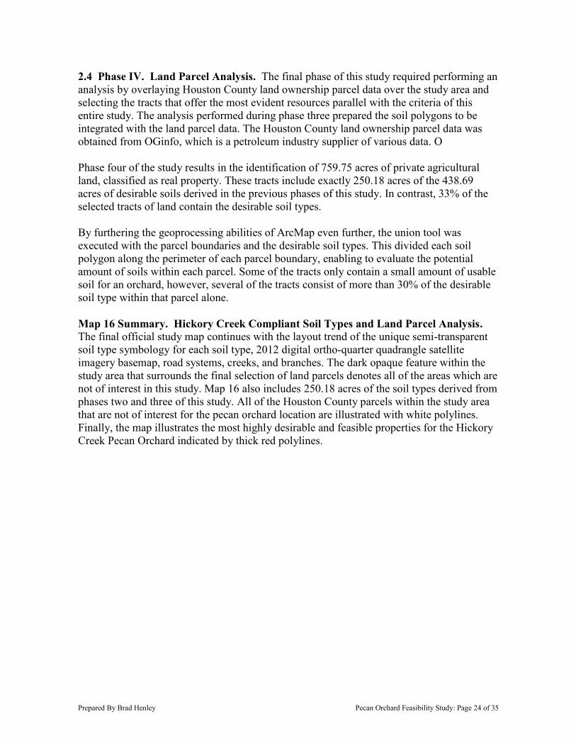
2.4 Phase IV. Land Parcel Analysis. The final phase of this study required performing an analysis by overlaying Houston County land ownership parcel data over the study area and selecting the tracts that offer the most evident resources parallel with the criteria of this entire study. The analysis performed during phase three prepared the soil polygons to be integrated with the land parcel data. The Houston County land ownership parcel data was obtained from OGinfo, which is a petroleum industry supplier of various data. O Phase four of the study results in the identification of 759.75 acres of private agricultural land, classified as real property. These tracts include exactly 250.18 acres of the 438.69 acres of desirable soils derived in the previous phases of this study. In contrast, 33% of the selected tracts of land contain the desirable soil types. By furthering the geoprocessing abilities of ArcMap even further, the union tool was executed with the parcel boundaries and the desirable soil types. This divided each soil polygon along the perimeter of each parcel boundary, enabling to evaluate the potential amount of soils within each parcel. Some of the tracts only contain a small amount of usable soil for an orchard, however, several of the tracts consist of more than 30% of the desirable soil type within that parcel alone. Map 16 Summary. Hickory Creek Compliant Soil Types and Land Parcel Analysis. The final official study map continues with the layout trend of the unique semi-transparent soil type symbology for each soil type, 2012 digital ortho-quarter quadrangle satellite imagery basemap, road systems, creeks, and branches. The dark opaque feature within the study area that surrounds the final selection of land parcels denotes all of the areas which are not of interest in this study. Map 16 also includes 250.18 acres of the soil types derived from phases two and three of this study. All of the Houston County parcels within the study area that are not of interest for the pecan orchard location are illustrated with white polylines. Finally, the map illustrates the most highly desirable and feasible properties for the Hickory Creek Pecan Orchard indicated by thick red polylines.
CR0528CR 1090
CR 1140
CR 1130
CR1125
CR 1135
227
Gin
B
ranch
Hic
kory
Cree k
Old Zion Creek
Chin
guapin
B
ranch
Park
er
Branch
Joe
Bra
nch
W
ilcoxBranch
SQUIERSQUIER
BRIANBRIAN
DAVID ETALDAVID ETAL
SQUIERSQUIER
BRIANBRIAN
DAVID ETALDAVID ETAL
CROCKETTCROCKETT
FAYE E &FAYE E &
MARK WEVERMARK WEVER
TAYLORTAYLOR
JOHNNIE CJOHNNIE C
REV TRUSTREV TRUST
TAYLORTAYLOR
JOHNNIE CJOHNNIE C
REV TRUSTREV TRUST
TAYLORTAYLOR
JOHNNIE CJOHNNIE C
REV TRUSTREV TRUST
CROCKETTCROCKETT
FAYE E &FAYE E &
MARK WEVERMARK WEVER
TAYLORTAYLOR
RODNEYRODNEY
DEANDEAN
FARLEYFARLEY
DOUGLASDOUGLAS
& VIRGINIA& VIRGINIA
TAYLORTAYLOR
JOHNNIE CJOHNNIE C
REV TRUSTREV TRUST
TAYLORTAYLOR
THOMASTHOMAS
CLAUDCLAUD
TAYLORTAYLOR
THOMASTHOMAS
CLAUDCLAUD
TAYLORTAYLOR
THOMASTHOMAS
CLAUDCLAUD
EASTONEASTON
RONRON
TAYLORTAYLOR
THOMASTHOMAS
CLAUDCLAUD
DANIELSDANIELS
DELBERTDELBERT
DANIELDANIEL
CALVIN ESTCALVIN EST
232
2663
2781
3187
3016
2423
323
357
1733
227
228
227
2022
��294
��7
��21
Kennard
Crockett
µ
Disclaimer: The author does not warrant the data or map shownherein and therefore the author is not responsible for its accuracy.Rather, the author constitutes this information to its best knowledge.
This map represents the specified location of the pecan orchard feasibility study andresearch area in the vicinity of Hickory Creek located in Houston, County, Texas.This map shows the soil types that are recommended by the USDA for plantingpecan trees along with soil types that are in common with the existing pecanorchard. The map is overlayed with parcel data, of which the most appropriate tractshave been selected for the proposed Hickory Creek Pecan Orchard.
Legend
River, Creek, or Stream
4,000 Acre Study
Parcels of Interest
(White Line) Parcel LineBoundary
Map Created By: Brad HenleyDate: November 24, 2014
Coordinate System: NAD_1983_UTM_Zone_15NImagery: NAIP12_NC_Houston_225Basemap layer: USDA NRCS Soil Survey - Ratcliff Quadrangle
Total Selected Parcels: 759.75 AcresTotal Desirable Soils: 250.18 Acres
Sources:
0 2,500 5,0001,250Feet
Pecan Orchard Feasibility StudyMap 16. Hickory Creek Compliant Soil Types and
Land Parcel Analysis
Soil Types
AtB
AuD
BaB
HaA
KfC
LtC
TaE
WnB
Prepared By Brad Henley Pecan Orchard Feasibility Study: Page 26 of 35
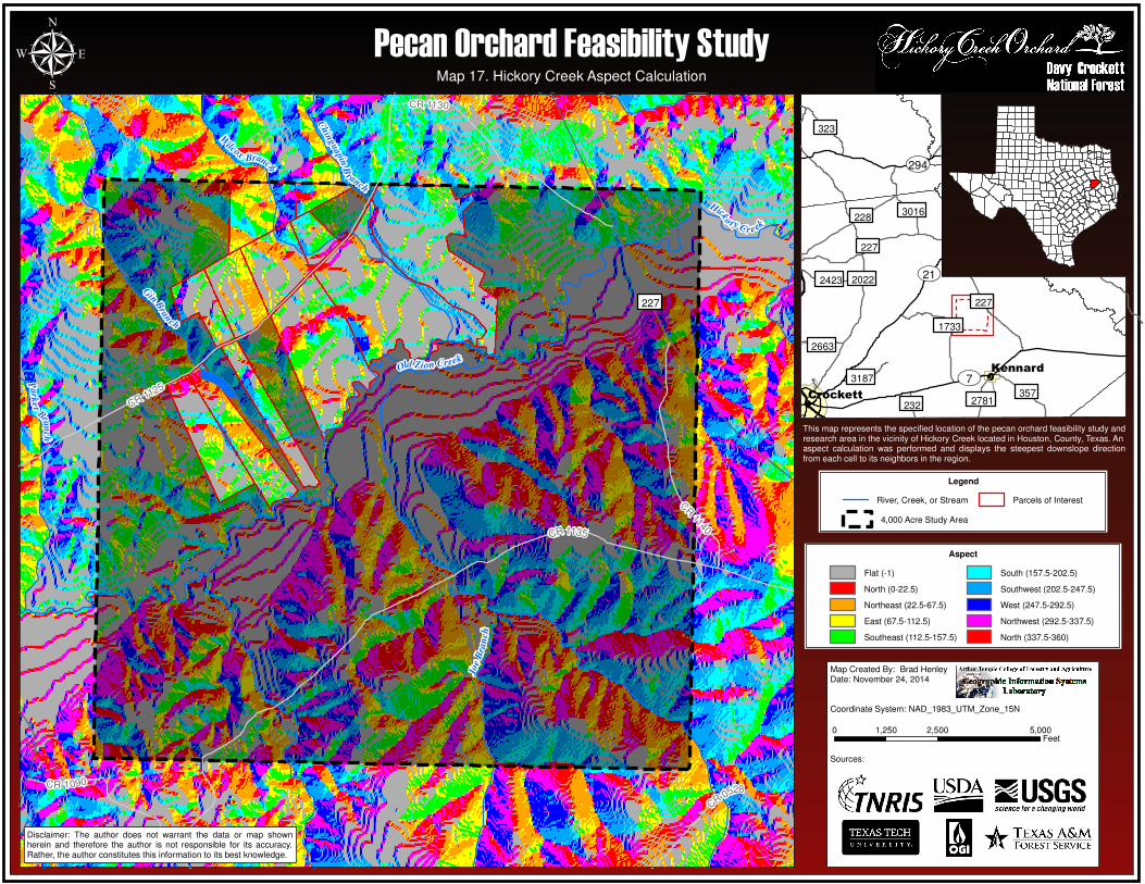
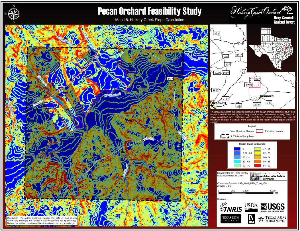
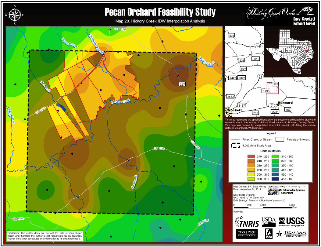
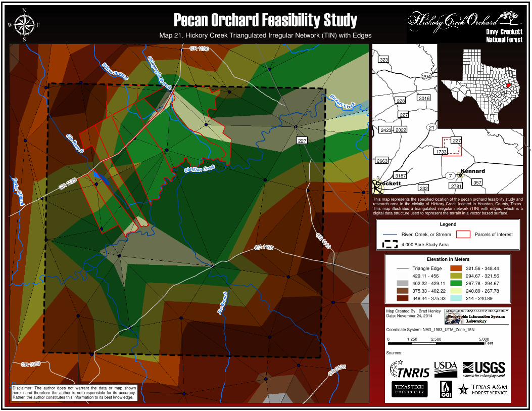
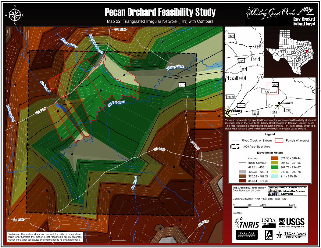
2.5 Additional Maps. Map 17 Summary. Hickory Creek Aspect Calculation. An aspect calculation was performed for the Hickory Creek study area. The aspect tool calculates the direction in which the plane fitted to the slope faces for each cell to its neighbors in the region. Map 18 Summary. Hickory Creek Slope Calculation. A slope calculation was performed and identifies the slope (gradient, or rate of maximum change in z-value) from each cell of the raster surface digital elevation model. Map 19 Summary. Hickory Creek Digital Elevation Model (DEM). Map 19 was generated from data provided by the Texas Natural Resources Information System. The map illustrates the terrain as a continuous surface raster image in the form of a digital elevation model (DEM). Map 20 Summary. Hickory Creek IDW Interpolation Analysis. This map was derived by interpolation of an elevation point dataset provided by the Texas Natural Resources Information System, calculating the inverse distance weighted (IDW) technique. Map 21 Summary. Hickory Creek Triangulated Irregular Network with Edges. This map illustrates a triangulated irregular network (TIN) with edges, which is a digital data structure used to represent the terrain in a vector based surface. Map 22 Summary. Hickory Creek Triangulated Irregular Network with Contours. Map 22 illustrates an alternative version of a triangulated irregular network by displaying the vector based surface in addition to contour lines.
CR0528
CR 1090
CR 1140
CR 1130
CR1125
CR 1135
227
Gin
Bran
ch
Hick
o ry C r eek
Old Zion Creek
Chin
guapin
B
ranch
Park
er
Bran
ch
Joe
Bra
nch
W
ilcoxBranch
232
2663
2781
3187
3016
2423
323
357
1733
227
228
227
2022
��294
��7
��21
Kennard
Crockett
µ Pecan Orchard Feasibility Study
Disclaimer: The author does not warrant the data or map shownherein and therefore the author is not responsible for its accuracy.Rather, the author constitutes this information to its best knowledge.
This map represents the specified location of the pecan orchard feasibility study andresearch area in the vicinity of Hickory Creek located in Houston, County, Texas. Anaspect calculation was performed and displays the steepest downslope directionfrom each cell to its neighbors in the region.
Map Created By: Brad HenleyDate: November 24, 2014
Coordinate System: NAD_1983_UTM_Zone_15N
Sources:
0 2,500 5,0001,250Feet
Legend
River, Creek, or Stream
4,000 Acre Study Area
Parcels of Interest
Aspect
Flat (-1)
North (0-22.5)
Northeast (22.5-67.5)
East (67.5-112.5)
Southeast (112.5-157.5)
South (157.5-202.5)
Southwest (202.5-247.5)
West (247.5-292.5)
Northwest (292.5-337.5)
North (337.5-360)
Map 17. Hickory Creek Aspect Calculation
CR0528
CR 1090
CR 1140
CR 1130
CR1125
CR 1135
227
Gin
Bran
ch
Hick
o ry C r eek
Old Zion Creek
Chin
guapin
B
ranch
Park
er
Bran
ch
Joe
Bra
nch
W
ilcoxBranch
232
2663
2781
3187
3016
2423
323
357
1733
227
228
227
2022
��294
��7
��21
Kennard
Crockett
µ
Disclaimer: The author does not warrant the data or map shownherein and therefore the author is not responsible for its accuracy.Rather, the author constitutes this information to its best knowledge.
This map represents the specified location of the pecan orchard feasibility study andresearch area in the vicinity of Hickory Creek located in Houston, County, Texas. Aslope calculation was performed and identifies the slope (gradient, or rate ofmaximum change in z-value) from each cell of the raster surface digital elevationmodel.
Map Created By: Brad HenleyDate: November 24, 2014
Coordinate System: NAD_1983_UTM_Zone_15NZ-factor = 3.5
Sources:
0 2,500 5,0001,250Feet
Legend
River, Creek, or Stream
4,000 Acre Study Area
Parcels of Interest
Terrain Slope in Degrees
0
0.01 - 24
25 - 31
32 - 62
63 - 76
77 - 81
82 - 83
84 - 84
85 - 86
87 - 89
Map 18. Hickory Creek Slope Calculation
Pecan Orchard Feasibility Study

CR0528
CR 1090
CR 1140
CR 1130
CR1125
CR 1135
227
Gin
Bran
ch
Hick
o ry C r eek
Old Zion Creek
Chin
guapin
B
ranch
Park
er
Bran
ch
Joe
Bra
nch
W
ilcoxBranch
232
2663
2781
3187
3016
2423
323
357
1733
227
228
227
2022
��294
��7
��21
Kennard
Crockett
µ
Map Created By: Brad HenleyDate: November 24, 2014
Coordinate System: NAD_1983_UTM_Zone_15N
Sources:
0 2,500 5,0001,250Feet
Legend
River, Creek, or Stream
4,000 Acre Study Area
Parcels of Interest
DEM in MetersHigh : 141
Low : 61
Pecan Orchard Feasibility StudyMap 19. Hickory Creek Digital Elevation Model (DEM)
Disclaimer: The author does not warrant the data or map shownherein and therefore the author is not responsible for its accuracy.Rather, the author constitutes this information to its best knowledge.
This map represents the specified location of the pecan orchard feasibility study andresearch area in the vicinity of Hickory Creek located in Houston, County, Texas.The map herein was generated from data provided by the Texas Natural ResourcesInformation System, and illustrates the terrain in the form of a digital elevationmodel.
CR0528
CR 1090
CR 1140
CR 1130
CR1125
CR 1135
227
Gin
Bran
ch
Hick
o ry C r eek
Old Zion Creek
Chin
guapin
B
ranch
Park
er
Bran
ch
Joe
Bra
nch
W
ilcoxBranch
232
2663
2781
3187
3016
2423
323
357
1733
227
228
227
2022
��294
��7
��21
Kennard
Crockett
µ
This map represents the specified location of the pecan orchard feasibility study andresearch area in the vicinity of Hickory Creek located in Houston, County, Texas.This map was derived by interpolation of a point dataset, calculating the inversedistance weighted (IDW) technique.
Map Created By: Brad HenleyDate: November 24, 2014
Coordinate System:NAD_1983_UTM_Zone_15NIDW Settings: Power = 3, Number of points = 20
Sources:
0 2,500 5,0001,250Feet
Map 20. Hickory Creek IDW Interpolation Analysis
Disclaimer: The author does not warrant the data or map shownherein and therefore the author is not responsible for its accuracy.Rather, the author constitutes this information to its best knowledge.
Legend
River, Creek, or Stream
4,000 Acre Study Area
Parcels of Interest
Units in Meters
210 - 230
240 - 250
260 - 270
280 - 290
300 - 310
320 - 330
340 - 360
370 - 380
390 - 400
410 - 420
430 - 440
450 - 460
Pecan Orchard Feasibility Study
CR0528
CR 1090
CR 1140
CR 1130
CR1125
CR 1135
227
Gin
Bran
ch
Hick
o ry C r eek
Old Zion Creek
Chin
guapin
B
ranch
Park
er
Bran
ch
Joe
Bra
nch
W
ilcoxBranch
232
2663
2781
3187
3016
2423
323
357
1733
227
228
227
2022
��294
��7
��21
Kennard
Crockett
µ
This map represents the specified location of the pecan orchard feasibility study andresearch area in the vicinity of Hickory Creek located in Houston, County, Texas.This map illustrates a triangulated irregular network (TIN) with edges, which is adigital data structure used to represent the terrain in a vector based surface.
Map Created By: Brad HenleyDate: November 24, 2014
Coordinate System: NAD_1983_UTM_Zone_15N
Sources:
0 2,500 5,0001,250Feet
Legend
River, Creek, or Stream
4,000 Acre Study Area
Parcels of Interest
Map 21. Hickory Creek Triangulated Irregular Network (TIN) with Edges
Elevation in Meters
Triangle Edge
429.11 - 456
402.22 - 429.11
375.33 - 402.22
348.44 - 375.33
321.56 - 348.44
294.67 - 321.56
267.78 - 294.67
240.89 - 267.78
214 - 240.89
Disclaimer: The author does not warrant the data or map shownherein and therefore the author is not responsible for its accuracy.Rather, the author constitutes this information to its best knowledge.
Pecan Orchard Feasibility Study
CR0528
CR 1090
CR 1140
CR 1130
CR1125
CR 1135
227
Gin
Bra
n
ch
H
ickory Creek
Old
Zion Creek
Chin
guapin
B
ranch
Park
erB
ranc h
Joe
Bra
nch
W
ilcoxBranch
232
2663
2781
3187
3016
2423
323
357
1733
227
228
227
2022
��294
��7
��21
Kennard
Crockett
µ
This map represents the specified location of the pecan orchard feasibility study andresearch area in the vicinity of Hickory Creek located in Houston, County, Texas.This map illustrates a triangulated irregular network (TIN) with edges, which is adigital data structure used to represent the terrain in a vector based surface.
Map Created By: Brad HenleyDate: November 24, 2014
Coordinate System: NAD_1983_UTM_Zone_15N
Sources:
0 2,500 5,0001,250Feet
Map 22. Triangulated Irregular Network (TIN) with Contours
Disclaimer: The author does not warrant the data or map shownherein and therefore the author is not responsible for its accuracy.Rather, the author constitutes this information to its best knowledge.
Legend
River, Creek, or Stream
4,000 Acre Study Area
Parcels of Interest
Elevation in Meters
Contour
Index Contour
429.11 - 456
402.22 - 429.11
375.33 - 402.22
348.44 - 375.33
321.56 - 348.44
294.67 - 321.56
267.78 - 294.67
240.89 - 267.78
214 - 240.89
Pecan Orchard Feasibility Study
Prepared By Brad Henley Pecan Orchard Feasibility Study: Page 33 of 35
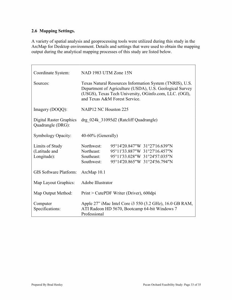
2.6 Mapping Settings. A variety of spatial analysis and geoprocessing tools were utilized during this study in the ArcMap for Desktop environment. Details and settings that were used to obtain the mapping output during the analytical mapping processes of this study are listed below. Coordinate System:
NAD 1983 UTM Zone 15N
Sources: Texas Natural Resources Information System (TNRIS), U.S. Department of Agriculture (USDA), U.S. Geological Survey (USGS), Texas Tech University, OGinfo.com, LLC. (OGI), and Texas A&M Forest Service.
Imagery (DOQQ): NAIP12 NC Houston 225
Digital Raster Graphics Quadrangle (DRG):
drg_024k_31095d2 (Ratcliff Quadrangle)
Symbology Opacity: 40-60% (Generally)
Limits of Study (Latitude and Longitude):
Northwest: 95°14'20.847"W 31°27'16.639"N Northeast: 95°11'33.887"W 31°27'16.457"N Southeast: 95°11'33.028"W 31°24'57.035"N Southwest: 95°14'20.865"W 31°24'56.794"N
GIS Software Platform: ArcMap 10.1
Map Layout Graphics: Adobe Illustrator
Map Output Method: Print > CutePDF Writer (Driver), 600dpi
Computer Specifications:
Apple 27” iMac Intel Core i3 550 (3.2 GHz), 16.0 GB RAM, ATI Radeon HD 5670, Bootcamp 64-bit Windows 7 Professional
Prepared By Brad Henley Pecan Orchard Feasibility Study: Page 34 of 35
SECTION 3. RESULTS
3.1 Concerns. Some of the issues that were experienced during the project, include:
There was limitation in generating a consistent symbology for the soil types throughout the study. The reason appeared to be related to an issue between files containing non-congruent table data having the capability of utilizing the same symbology. Upon importing the layer file that had been generated after setting up the soils symbology, the symbology import in the layer settings window would eliminate some of the tabular data after applying the actions.
The soil type’s legend mysteriously erased several times when trying to finalize map layouts, specifically when moving and resizing using the align-center function for the two legends.
Some of the geoprocessing tools would not function on the first request, such as clip or intersect, but saving the file and restarting it on each of the encounters allowed them to run effectively on the next startup.
Creating a custom shapefile locator map to clip to in the map layout has limitations. The standard data frame allows the user to pan or zoom in the data frame window, in order to adjust the data view area in the selected frame, while still in layout view. Unfortunately, the data frame will not update appropriately and will display a new unwanted shape from the data view pan and the user must undo the changes.
3.2 Conclusion. The Hickory Creek pecan orchard feasibility study did effectively meet the overall objective for the assessment. The characteristics used to initially qualify the AOI were appropriate and appear to have contributed to the success of the investigation. In addition to the selected natural resource features and road systems, having the nearby existing pecan orchard in Kennard provided a great opportunity for selecting and comparing soil types. By merging the USDA NRCS Soil Survey of Houston County recommended soil types with the soils in common with the nearby orchard, it conveyed an excellent concentration for the parcel selection needed in order to determine where to purchase property. Based on the results from this study, with an emphasis on soil types, there is an evident opportunity for the parcels validated in Map 16 to offer a favorable site for the development of a pecan orchard in the Hickory Creek area. The results from this study have validated that implementing the appropriate workflow strategies during GIS analysis can tremendously benefit the due-diligence process while examining land-use in regard to natural resources. The almond farmer described during the introduction that purchased the two-thousand acre Neches River timber land property, can currently manage his pine plantations and eventually convert the land into an orchard. However, despite East Texas consisting largely of yellow pine timber, land owners in the East Texas Region can currently develop pecan orchards on their agricultural or non-forested land, by examining their property with the analysis methods that performed during this study.

References
[1] Soil Survey of Houston County, Texas. (1903, January 1). Retrieved November 1, 2014, from http://www.nrcs.usda.gov/Internet/FSE_MANUSCRIPTS/texas/TX225/0/Houston.pdf
Related Documents