Iron Bear Island Shagawa Seven Beaver Lake Farm Lake Colby Lake One Pine Lake Sabin Lake Wynne Muckwa Lake Heikkilla Lake Lobo Lake Sand Lake Isaac Lake Argo Lake Joseph Lake Whisper Lake Crocket Lake Mud Lake Kaunonen Lake Jackpot Lake Lake White Little Lake Lake Bonga Lake Swamp Lake Big Lake Iron Lake Birch North Bay Perch Lake Kangas Lake Blueberry Lake Johnson Lake Mitchell Lake Lake Longstroff Bay Lake Cranberry Lake Sock Lake Spruce Lake Blueberry Lake Lake Whitewater Lake Cedar Lake South Kawhishiwi River Bob Bay Harris Lake Keeley Creek Denley Nira Creek Beaver Hut Lake Sue Lake Denley Lake Stony River Lake Culkin Continental Lake Fools Lake Cougar Lake Dunka River Bear Island R. Mud Lake Johnson Creek Arthur Lake Birch River Hay Lake Mud Lake Longnose Creek Wetlegs Creek Partridge River Colvin Cr. Laird Creek St. Louis River Hush Lake St. Louis River Wyman Creek Spring Mine Lake Embarrass River Camp Eight Cr. Ridge Creek Embarrass River Hay Lake Partridge River Neff Lake Colvin Cr. Cranberry Creek Partridge River Spring Mine Cr. Embarrass River Ely Municipal Airport Small Gravel Pit Medium Gravel Pit Medium Gravel Pit Small Gravel Pit Small Gravel Pit Small Gravel Pits Small Gravel Pit Medium Gravel Pit Small Gravel Pit Medium Gravel Pit Medium Gravel Pit Small Gravel Pit Small Gravel Pits Medium Gravel Pit Medium Gravel Pit Small Gravel Pit Small Gravel Pit Medium Gravel Pit Large Gravel Pit Small Gravel Pit Small Gravel Pit Large Sand Pit Small Gravel Pit Medium Gravel Pit Large Gravel Pit Large Gravel Pit Small Gravel Pit Small Gravel Pit Small Sand Pit Small Gravel Pits Small Gravel Pit Small Gravel Pit Small Gravel Pit Small Gravel Pit Medium Gravel Pit Small Gravel Pits Small Gravel Pits Medium Gravel Pit Small Gravel Pit Medium Gravel Pit Large Gravel Pit Small Gravel Pits Medium Gravel Pit Medium Gravel Pit Large Gravel Pits Small Gravel Pit Large Gravel Pit Small Gravel Pit Large Gravel Pit Small Gravel Pit Small Gravel Pit Small Gravel Pits Medium Gravel Pits Small Gravel Pit Medium Gravel Pit Medium Gravel Pits Small Gravel Pit Medium Gravel Pit Small Gravel Pit Small Gravel Pit Medium Gravel Pit Medium Gravel Pit Small Gravel Pit Small Gravel Pit Medium Gravel Pit Small Gravel Pits Small Gravel Pit Medium Gravel Pits Large Gravel Pit Small Gravel Pits Large Gravel Pit Small Gravel Pit Small Gravel Pits Small Gravel Pit Medium Gravel Pit Small Gravel Pits Medium Gravel Pit Small Quarries Small Sand Pit Small Gravel Pits Medium Gravel Pits Medium Gravel Pit Medium Gravel Pit Small Gravel Pit Small Gravel Pit Small Gravel Pit Medium Gravel Pit Small Sand Pit Medium Gravel Pit Medium Gravel Pit Small Sand Pit Small Sand Pit Small Gravel Pit Small Gravel Pits Small Gravel Pit Small Gravel Pits Large Gravel Pit Small Gravel Pit Small Gravel Pit Small Gravel Pit Small Gravel Pit Small Borrow Pit Small Gravel Pit Small Gravel Pit Small Gravel Pit Small Gravel Pit Small Gravel Pit Small Gravel Pit Small Borrow Pit Small Gravel Pits Medium Gravel Pit Small Gravel Pit Small Gravel Pit Small Borrow Pit Small Gravel Pits Small Gravel Pits Small Gravel Pit Small Quarry Small Gravel Pit Small Gravel Pit Small Gravel Pit Small Gravel Pit Medium Quarry Small Gravel Pit Small Gravel Pit Small Gravel Pits Small Gravel Pit Small Gravel Pits Small Gravel Pit Small Gravel Pit Small Gravel Pit Small Gravel Pit Small Sand Pit Small Gravel Pit Small Borrow Pit Small Gravel Pits Small Sand Pits Small Gravel Pit Small Gravel Pit Small Gravel Pit Small Gravel Pit Medium Gravel Pit Small Borrow Pit Small Borrow Pit Small Gravel Pits Small Gravel Pit Small Gravel Pit Small Gravel Pit Small Gravel Pit Small Gravel PIts Small Gravel Pit Small Gravel Pit Small Gravel Pits Small Gravel Pit Small Gravel Pit Small Gravel Pit Small Gravel Pits Small Gravel Pit Small Gravel Pits Small Gravel Pit Small Gravel Pit Small Gravel Pit Small Gravel Pit Medium Gravel Pit Small Gravel Pit Small Gravel Pit Small Gravel Pits Skibo Allen Wyman Colby Mesaba Old Mesaba Hinsdale Ridge Happy Wanderer Hoyt Lakes Aurora Babbitt Ely Pineville 6 31 31 6 6 31 6 31 6 31 36 6 31 36 31 1 6 1 6 1 6 1 1 6 31 36 1 6 31 36 1 6 31 36 1 6 31 36 1 6 31 36 1 6 31 36 31 36 1 6 1 6 31 36 1 6 31 36 1 36 31 36 31 36 31 36 36 1 36 1 36 F A L L L A K E S T O N Y R I V E R B A S S E T T M O R S E W A A S A W H I T E R.12W. R.11W. T.63N. T.62N. T.61N. T.60N. T.59N. R.11W. T.58N. R.12W. T.58N. R.13W. R.14W. R.15W. T.58N. T.59N. R.15W. T.60N. R.14W. T.61N. R.13W. T.62N. T.63N. Sand Sand Sand Sand Sand Sand Sand Sand Sand Sand and Gravel Sand and Gravel Sand and Gravel Sand and Gravel Sand and Gravel Sand and Gravel Sand and Gravel Sand and Gravel Sand and Gravel Sand and Gravel Sand with Gravel Till Till Till Till Till Till Till Till Till Till Till Till Till Till Clay Clay 1 1 1 169 1 135 135 135 16 110 70 21 21 130 138 110 120 138 100 110 21 21 21 112 100 110 21 88 21 110 21 16 120 16 904 360 341 615 358 380 593 346 593 318 620 666 666 655 795 716 585 655 360 569 360 360 680 680 407 904 341 774 903 490 796 684 583 623 797 493 2104 528 2044 273 2041 5041 244 2000 2184 226 258 3000 114 259 3037 232 239 2001 272 235 246 243 258 241 242 2126 3341 2039 Quality Tested Quality Tested Quality Tested Quality Tested Quality Tested Quality Tested Quality Tested Quality Tested Quality Tested Plate A - MN DNR Report 380 Aggregate Resource Potential in Parts of Northern St. Louis and Lake Counties, MN Sand and Gravel Potential and Silt and Clay Potential Minnesota Department of Natural Resources Division of Lands and Minerals - Director Marty Vadis © 2011, State of Minnesota, Department of Natural Resources Products of this project include a CD/ROM with the final report, map, GIS data, and metadata. AGGREGATE RESOURCE POTENTIAL IN PARTS OF NORTHERN ST. LOUIS AND LAKE COUNTIES, MN Sand and Gravel Potential and Silt and Clay Potential Resources Produced by the Aggregate Resource Mapping Program Division of Lands and Minerals Minnesota Department of Natural Resources Project Funded by the Minerals Coordinating Committee (MCC) Mapped by Hannah G. Friedrich St. Paul, Minnesota - January 2011 Classifying Sand and Gravel Potential: Sand and gravel resources were divided into four categories based on the type of geologic feature, probability (certainty), sand and gravel thickness, overburden thickness, deposit size (areal extent), textural characteristics (grain size distribution), quality (soundness and durability), and the sediment description as observed in the field (Table 1; see definitions of terms in Footnotes below Table 1). For example, a classified landform, such as an ice contact feature, typically contains sand and gravel. The resource has a high probability of containing aggregate when the landform has gravel pits located within its boundaries, sand and gravel is observed at or near the surface, and sand and gravel is encountered in surrounding water wells. Historical laboratory test results of aggregate quality are compiled, interpreted, and extrapolated from Mn/DOT pit sheets. In addition to Mn/DOT quality data, observations of quality characteristics can be assessed during field work. Thickness of overburden and sand and gravel were determined from observations and water well information. For example, if a deposit has areal extent greater than 15 acres, has thickness greater than 10 feet, has overburden thickness of 5 feet or less, has high quality, good texture, and an existing gravel pit, then the resource is classified as having high potential (Table 1). The areas classified as nonsignificant sand and gravel resource potential (low and limited potential) meet the criteria listed in Table 1. Deposits that are too small in areal extent; are too thin; have too thick of overburden; contain significantly more sand than gravel; lack identified resources; or do not meet quality specifications are in these categories. 0-5 0-15 0-40+ 0-15+ 0-45+ 0-35+ 0-45+ 10-50+ Probability 3 Sand and gravel Characteristics Very low to low Till, silt, sand, bedrock Surficial Geology Features Moderate to high Moderate to high Moderate to good Good to very good Till, sand and gravel Till, sand, sand with gravel Sand and Gravel Quality 7 Overburden Thickness (in feet) Very small to small (<1-5+ acres) Predominant Sediment Description Low Potential Very low to moderately low Low to moderately low Moderately low to low High Potential Moderately high to very high Moderately high to very high Poor to moderately poor Very poor to moderately poor Moderately large to very large (10-30+ acres) SIGNIFICANT RESOURCES Moderately small to small (3-10+ acres) Sand and Gravel Deposit Size (areal extext 5 ) Sand and Gravel Textural Characteristics 6 Sand and Gravel Thickness 4 (in feet) Limited Potential Moderate to moderately large (5-15+ acres) Glaciofluvial feature; outwash channel; outwash feature; ice contact feature NONSIGNIFICANT RESOURCES Moderate Potential Ice contact feature; linear ridge; recessional/ ground moraine; outwash terrace, channel, feature Outwash features; alluvial valley; lake plain; recess- ional/ground moraine; ice contact; linear ridge; beaches Alluvial valley; bedrock; lake plain; outwash channel feature; recessional/ground moraine; glaciofluvial feature Table 1: Classification Matrix of Sand and Gravel Potential 1 1 Table excludes classification of silt and clay potential. 2 Nonsignificant: Term representing aggregate resources that do not meet the criteria for high or moderate aggregate potential according to the characteristics listed in Table 1. This is a relative classification that changes from one mapping region to another. 3 Probability: The degree of certainty that aggregate exists within a mapping unit largely defined by the amount of available information. 4 Thickness Variability: The thickness of a deposit may range from 0 to stated value due to the presence of bedrock outcrops or lateral discontinuation of the deposit. 5 Areal Extent: The size, horizontal extent, or distribution of a unit (e.g., area in acres). This attribute does not necessarily reflect the size of an individual polygon but the size of a deposit found within that polygon. 6 Textural Characteristics: Particle size distribution, defined as the percentage of gravel or sand vs. silt or clay (e.g., sieve analysis). 7 Quality: The physical characteristics of the material, such as soundness (e.g., magnesium sulfate test), durability (Los Angeles Rattler test), and percent of deleterious rock types such as iron oxide, disintegrating rock, or unsound chert. Field observations supplement historic data. Footnotes Associated with Potential Sand and Gravel Resources Seen on Table 1 Figure 1: Conceptual Cross-Section Displaying Sand and Gravel Potential And Relative Bedrock Influence Distance (miles) Elevation (feet) - 6x Vertical Exaggeration Sandy Till Sand Sand Organics Organics Till Till Sand and Gravel Sand and Gravel S a nd a nd Gr a vel Till Mesoproterozoic Bedrock: Gabbro Archean Bedrock: Granite Bedrock: Granite Sand and Gravel Bedrock: Gabbro Dominant Sediment or Bedrock Sand Sandy Till Organics Sand and Gravel Resource Potential Limited Sand and Gravel Potential Low Sand and Gravel Potential Moderate Sand and Gravel Potential High Sand and Gravel Potential Hp Mp Lp Ltd Ltd Ltd Lp Lp Ltd Ltd Mp Mp Hp Hp Bedrock Surface and Contact Bedrock Surface Bedrock Contact Cross-Section Legend 1580 1570 1560 1550 1540 1530 1520 0.0 0.5 1.0 1.5 2.0 Bedrock Outcrop Outwash Channel Ice Contact Outwash Feature Setting 1 Setting 2 Setting 3 1580 1570 1560 1550 1540 1530 1520 Till Recessional Moraine Conceptual Cross-Section: The cross-section above conceptually illustrates three geologic settings observed within the project area. The purpose of the cross-section is to demonstrate how bedrock affects sand and gravel potential. Local bedrock may influence the sand and gravel deposit in two ways: 1) local bedrock topography may have directed the meltwater flow and the sand and gravel deposition and 2) local bedrock may also be the predominate rock type within the gravel clasts, and influence gravel quality. Setting 1 shows a steep hill of sand and gravel deposited by meltwater that flowed through or on glacial ice. The resulting landform is called an ice-contact feature. In this setting, the sand and gravel overlies granitic bedrock, a high-quality source of aggregate. A deposit with high quality gravel lithology combined with other factors like a thickness greater than 10 feet with little to no overburden, results in a classification of high potential for sand and gravel. Setting 2 shows a sand and gravel deposit over gabbroic bedrock which produces less desirable aggregate. Therefore, the deposit reflects the lower quality and is classified as moderate potential for sand and gravel. The bedrock topography is highly variable in Setting 3 and controls how sand and gravel is distributed. Where bedrock is exposed at the surface, sand and gravel thickness may range between 0 to 20+ feet thick within a single mapping unit. All but high potential classifications have possible bedrock outcrops. Printed Map Scale 1 : 63,360 0 1 2 3 4 Miles 0 1 2 3 4 5 6 Kilometers Based on a 1:50,000 scale MN DNR resource assessment Cartographic Base Map Data Sources: Lakes, rivers, streams, and drainage ditches from NWI (National Wetland Inventory), Mn/DOT (Minnesota Department of Transportation) Base map, MN DNR 24K Streams, compiled at 1:24,000 from aerial photography (1979-1988) and USGS quadrangle maps (1980-1990); PLS (Public Land Survey) townships and sections layers extracted from PLS Project, 2001, MN DNR, Division of Lands and Minerals; Populated places were derived from the GNIS (Geographic Name Information System) by pulling out the features that were coded as populated places. A selected subset of these was used for this map, 2003; County boundaries from MN DNR, derived from combination of 1:24,000 scale PLS lines, 1:100,000 scale TIGER, 1:100,000 scale DLG, and 1:24,000 hydrography lines, 1993; Hydrography labels derived from selected Mn/DOT County Highway Maps water feature annotations, 2002; Roads from Mn/DOT Base map, fall of 2006. This layer was modified slightly for this map in order to connect two road lines together where split; Railroad Tracks from Mn/DOT Base map, 2001; Topographic relief or hillshade created from a combination of 30-meter and 10-meter digital elevation models (DEM) from the USGS National Elevation Dataset, 2007 and 5-meter DEM of the Mesabi Iron Range obtained from the MN DNR; Taconite Mine Lands or active, inactive, and disturbed taconite mining areas within the Mesabi Iron Range from MN DNR, Division of Lands and Minerals (2009); Copper + Nickel + PGE and TiO2 mineral deposits footprints from MN DNR, Division of Lands and Minerals current as of January 2011. This dataset should be used as a point of reference only due to being unverified and generalized from a variety of sources. GIS Support and Cartography by Kevin J. Hanson, MN DNR, Division of Lands and Minerals. Aggregate Mapping Sources: Aerial photograph interpretation, fieldwork, pit and quarry inventory, and delineation of mapping units by Hannah G. Friedrich, 2010, Aggregate Resource Mapping Program, Division of Lands and Minerals, MN DNR (Minnesota Department of Natural Resources). Source information included aerial photographs from NAPP (National Aerial Photography Program), 1991-1992, 9" x 9" color infrared photos at 1:40,000; 1991 DOQs (Digital Orthophoto Quadrangles) at 1:12,000 from USGS (United States Geological Survey); FSA (Farm Services Administration) Color Orthophotos collected from the following years; 2003-04, 2005, 2006, 2008, 2009; FSA CIR (Color Infrared) Imagery collected in 2008 and 2009; DRGs (Digital Raster Graphics) at 1:24,000 from USGS; 7.5-minute USGS topographic quadrangles at 1:24,000 (dating from 1964-1992); the Soil Survey Geographic Database for St. Louis County, Minnesota, published September 3rd, 2009, from the USDA- NRCS (United States Department of Agriculture-Natural Resource Conservation Service); a combination of 30- meter and 10-meter DEMs (Digital Elevation Models) from the USGS National Elevation Dataset and a 5-meter DEM covering the Mesabi Iron Range from the MN DNR; and CWI (County Well Index) database of located and unlocated wells from the Minnesota Department of Health and MGS (Minnesota Geological Survey), downloaded in June 2009. Related geological maps were referenced including: Pleistocene Geology of the Embarrass Area, St. Louis County, MN by J. Lehr, 1991; USGS Bulletin 1331-C: Surficial Geology, Mesabi Vermilion Iron Range, Northeastern Minnesota, by T. Winter, R. Cotter, and H. Young, 1973; Glacial Geomorphology for the Laurentian Divide area, St. Louis and Lake Counties, Minnesota by J. Lehr and H. Hobbs, 1992 in MGS Guidebook 18; Distribution of Surficial Materials in the Copper-Nickel Region, Northeastern Minnesota by P. Olcott, 1976, modified from Prettyman, Eng, Winter and others 1973; DNR Report 262, Plate 3 Glacial Geology Map: Glacial Drift Geochemistry for Strategic Minerals, Duluth Complex, Lake County, Minnesota, 1989; DNR Report 246, Plate 1 Map of Esker Deposits and Sites Sampled in Northeastern Minnesota by M. Eng 1986; DNR Report 358, Inventory of Publicly Owned Stockpiles and Natural Aggregate Resources at the Former LTV Mine and Vicinity by G. Melchert, 2003; DNR Report 289, Dimension Stone Inventory of Northern Minnesota by M. Oberhelman 1991; MGS Miscellaneous Map M-164, Mesabi Iron Range Surficial Geology, by C. Jennings and W. Reynolds, 2005; MGS Miscellaneous Map M- 163, Bedrock Geology of the Mesabi Iron Range, by M. Jirsa, V. Chandler, and R. Lively, 2005 and MGS State Map Series S21: Preliminary Bedrock Outcrop Map, 2010. Gravel pits and quarries were extracted from the several sources (See Pits and Quarries GIS Data Sources) and reviewed in the field or on air photos. Depth to Bedrock model developed by Kevin Hanson and interpreted by Hannah Friedrich. Model created from the following sources: 30-meter USGS DEM; MGS CWI (06/2009); MGS bedrock outcrops (04/2010), MPES 380 field observed outcrops (06/2010); NRCS soil survey outcrops (01/2009); and MN DNR exploratory drill hole database (04/2010). Pits and Quarries GIS Data Sources: Pits and quarries were extracted from several external sources and then reviewed in the field and in the office by MN DNR’s Hannah G. Friedrich. Sources used to inventory the pits and quarries in the study area: Mn/DOT (Minnesota Department of Transportation) ASIS (Aggregate Source Information System) database downloaded in December of 2008; SSURGO spot feature points of gravel pits and quarries downloaded in December of 2008; St. Louis County Land Department database of pits and quarries obtained from St. Louis County in July of 2010; some pits and quarries were digitized from the USGS 1:24,000 digital topographic quadrangle maps done by the MN DNR Division of Lands and Minerals in 2003. Other pits and quarries were digitized onscreen in ArcGIS 9.3.1 by MN DNR’s Hannah G. Friedrich while in the field between fall of 2009 and summer of 2010 using aerial photography as a base. Map Disclaimer: This map was prepared from publicly available information, field data, and geologic interpretations. Every reasonable effort has been made to ensure the accuracy of the factual data on which this map interpretation is based. However, the Department of Natural Resources does not warrant the accuracy, completeness, or any implied uses of these data. Users may wish to verify critical information; sources include both the references here and information on file in the offices of the Minnesota Department of Natural Resources and the Minnesota Geological Survey. Every effort has been made to ensure the interpretations conform to sound geologic and cartographic principles. This map should not be used to establish legal title, boundaries, or locations of improvements. Project Location Map Duluth Minneapolis St. Paul St. Louis Co. Lake Co. 2 The project boundary was developed to evaluate and map sand and gravel potential and silt and clay potential around known copper + nickel + platinum group element deposits in northern St. Louis County and Lake County, Minnesota. Saint Louis County Lake County Saint Louis County Lake County Saint Louis County Lake County Taconite Mine Lands and Copper + Nickel + PGE Deposit Footprints Mine lands: Excluded from aggregate assessment. Includes all iron mining features: mines, stockpiles, tailings basins, haul roads, etc., where access is controlled. Copper + Nickel + Platinum Group Elements Deposit Footprints: These are unverified, generalized footprints based on a variety of sources and are provided here only for point of reference. Sand and Gravel Potential and Silt and Clay Potential Potential is defined as an assessment of the relative probability that a deposit exists within a given mapping unit. Evaluation of specific deposits was not done in this reconnaissance-level study. Significant Sand and Gravel Resource Potential High Potential: Units inferred to contain highest sand and gravel resource potential. Moderate Potential: Units inferred to contain moderate sand and gravel resource potential. Nonsignificant Sand and Gravel Resource Potential Low Potential: Units inferred to contain low sand and gravel resource potential. Limited Potential: Units inferred to contain limited sand and gravel resource potential or units with insufficient data to indicate the existence of sand and gravel. Silt and Clay Resource Potential Silt and Clay Potential: Units inferred to contain silt and clay resource potential. Identified Resources: Gravel Pits, Sand Pits, Borrow Pits, and Quarries Excluding Taconite Mine Lands Gravel Pits: Sites that have been or are currently being mined in deposits of sand and gravel. Gravel Pits – Mn/DOT ASIS: Sites were identified by Mn/DOT as part of the Aggregate Source Information System (ASIS). Sand Pits: Sites that have been or are currently being mined in deposits of sand with little or no gravel. Sand Pits – Mn/DOT ASIS: Sites were identified by Mn/DOT as part of ASIS. Borrow Pits: Sites comprising very small excavations or sites in nongranular deposits. Quarry: Sites include one medium active dimension stone quarry and three small inactive quarries referenced from topographic maps. Small Medium Large <5 Acres 5-15 Acres >15 Acres None None None None None None 129 31 10 24 10 3 8 1 1 6 3 1 Field Observations, Test Holes, and Quality Testing Field Observations: A total of 805 field observations were logged during the fall of 2009 and spring of 2010. The map displays field observations by their primary material symbol. Test Holes: A total of 36 test holes were completed during the spring of 2010. The map labels identify each test hole by primary material type (e.g., sand, sand and gravel, till). Sand and Gravel Sand Clay/Silt Till/Boulders Bedrock Outcrop Test hole location with an example label of primary material type e.g., Sand Number of sites in project area, e.g., 10 large gravel pits Bounding Features County Boundaries PLS Township Boundaries Section Boundaries *Transportation Features MN Highway 1 County Highways and Roads 100 Municipal Roads Railroad Tracks Township and Other Roads Cities and Populated Places Sections 1,6,31, & 36 labeled Skibo Ely (Size of font type indicates relative populations) Rivers & Streams Physical Features Water Features (Lakes, rivers, tailings basins) Shaded Topographic Relief (Azimuth = 315, Altitude = 45) Forest Roads 1532 Airport Runway Project Boundary *Transportation Features are from Mn/DOT and were current at the time of field work. Other GIS road layers were used for field work that were not mapped by Mn/DOT. These sources are unpublished and were not used for this map. Mn/DOT Tested Quality Samples: 12 samples taken from field observations and test holes were tested for quality by Mn/DOT. The quality tested samples are labeled on the map like this: Quality Tested Quality Tested Quality Tested Quality Tested Quality Tested

Welcome message from author
This document is posted to help you gain knowledge. Please leave a comment to let me know what you think about it! Share it to your friends and learn new things together.
Transcript
Iron
Bear Island
Shagawa
Seven Beaver Lake
Farm Lake
Colby
Lake
One Pine
Lake
Sa
bin
La
ke
Wyn
ne
Muckwa Lake
Heikkilla Lake
LoboLake
Sand Lake
IsaacLake
ArgoLake
Joseph Lake
Whisper Lake
Crocket Lake
MudLake
KaunonenLake Jackpot
Lake
Lake
Wh
ite
Little Lake
Lake
BongaLake
Swamp Lake
Big L
ake
IronLake
Birch
No
rth B
ay
Perch Lake
Kangas Lake
Blueberry Lake
Johnson
Lake
Mitchell Lake
Lake
Longst
roff
Bay
Lake
Cranberry Lake
Sock Lake
Spruce Lake
Blueberry Lake
Lake
Whitewater Lake
Cedar Lake
South
Kawhis
hiwi
River
BobBay
HarrisLake
Keeley Creek
Denley
Nira
Creek
BeaverHut Lake
SueLake
Denley Lake
Ston
y Riv
er
LakeCulkin
Continental Lake
FoolsLake
CougarLake
Du
nka
Riv
er
Bear
Island R.
MudLake
Joh
nso
n C
reek
ArthurLake
Birch
Riv
er
Hay Lake
MudLake
Lon
gn
ose
Cre
ek
Wetle
gs C
reek
Part
ridge
Riv
er
Colvin
Cr.
Lair
d C
reek
St. Louis River
HushLake
St. L
ouis Riv
er
Wyman
Creek
Spring Mine Lake
Embarrass River
Ca
mp
Eig
ht C
r.
Ridge
Cre
ek
Embarrass
River
HayLake
Part
ridge
Riv
er
Neff Lake
Colvin Cr.
Cranber
ry
Creek
Partridge
Riv
er
Spri
ng M
ine
Cr.
Embarrass River
Ely Municipal
Airport
Small GravelPit
Medium Gravel Pit
Medium Gravel Pit
SmallGravelPit
Small Gravel Pit
SmallGravel Pits
SmallGravel Pit
MediumGravelPit
Small Gravel Pit
MediumGravel
Pit
Medium Gravel Pit
Small GravelPit
Small Gravel Pits
MediumGravel Pit
MediumGravel
Pit
SmallGravel
Pit
Small Gravel Pit
Medium Gravel Pit
Large Gravel Pit
Small Gravel PitSmallGravel
Pit
LargeSand Pit
Small Gravel PitMediumGravel
Pit
LargeGravel
Pit
Large Gravel
Pit
Small Gravel Pit
Small Gravel Pit
Small Sand Pit
SmallGravelPits
Small GravelPit
SmallGravel
Pit
Small Gravel PitSmall Gravel
Pit
Medium GravelPit
Small Gravel Pits
Small Gravel Pits
MediumGravel
Pit
SmallGravel
Pit
MediumGravelPit
LargeGravel Pit
SmallGravel Pits
MediumGravel
Pit
MediumGravel Pit
Large Gravel
Pits
SmallGravel
Pit
Large Gravel
Pit
SmallGravel
PitLargeGravelPit
Small Gravel Pit
SmallGravelPit
SmallGravel
Pits
MediumGravel Pits
SmallGravel Pit
MediumGravel Pit
MediumGravel
Pits
SmallGravelPit
MediumGravel
Pit
SmallGravel
Pit
Small Gravel
PitMediumGravel Pit
MediumGravelPit
Small GravelPit Small
Gravel Pit
MediumGravelPit
SmallGravelPits
SmallGravel
Pit
MediumGravelPits
Large Gravel Pit
SmallGravel
Pits
Large GravelPit
SmallGravel
Pit
SmallGravel
Pits
Small Gravel Pit
Medium Gravel Pit SmallGravelPits
Medium GravelPit
SmallQuarries
SmallSand Pit
SmallGravel
Pits MediumGravel
Pits
MediumGravelPit
MediumGravelPit
Small Gravel Pit
SmallGravel Pit
SmallGravelPit
Medium Gravel Pit
Small Sand Pit
Medium Gravel Pit
Medium Gravel Pit
SmallSand Pit
Small SandPit
Small Gravel Pit
SmallGravel Pits
Small Gravel Pit
SmallGravel
Pits
Large Gravel Pit
SmallGravel Pit
Small GravelPit
Small Gravel
Pit
Small Gravel Pit
SmallBorrow
Pit
Small GravelPit
Small GravelPit
SmallGravel Pit
SmallGravel
Pit
SmallGravel
Pit
SmallGravel
Pit
SmallBorrowPit
Small Gravel Pits
Medium Gravel Pit
Small Gravel PitSmallGravelPit
Small BorrowPit
Small Gravel Pits
SmallGravel
Pits
SmallGravel Pit
SmallQuarry
Small GravelPit
Small Gravel
Pit
Small Gravel Pit
Small Gravel Pit
MediumQuarry
SmallGravelPit
Small GravelPit
Small GravelPits
SmallGravel Pit
SmallGravel Pits
SmallGravel
Pit
Small Gravel Pit
Small GravelPit
Small Gravel Pit
SmallSand Pit
Small Gravel Pit
SmallBorrow Pit
SmallGravel Pits
SmallSand Pits
SmallGravelPit
SmallGravel Pit
SmallGravelPit
SmallGravel
Pit
Medium GravelPit
SmallBorrow
Pit
SmallBorrow
Pit
SmallGravel
Pits
Small GravelPit
Small Gravel Pit
SmallGravelPit
SmallGravelPit
SmallGravel
PIts
SmallGravel
Pit
Small GravelPit
Small Gravel
Pits
Small Gravel Pit
SmallGravel Pit
Small Gravel Pit
SmallGravel
Pits
Small GravelPit
SmallGravel Pits
Small Gravel Pit
Small Gravel Pit
SmallGravel
Pit
SmallGravelPit
MediumGravel
Pit
Small GravelPit
SmallGravelPit
SmallGravel Pits
Skibo
Allen
Wyman
Colby
Mesaba
Old
Mesaba
Hinsdale
Ridge
Happy
Wanderer
Hoyt
Lakes
Aurora
Babbitt
Ely
Pineville
6
31
31
66
31
6
31
6
3136
6
31 36
31
1
616161
16
31 36
16
31 36
16
3136
16
3136
16
31 36
16
31 36
31
36
16
16
31 36
16
3136
1
36
31 363136
31 3636
1
36
1
36
F A L L L A K E
S T O N Y R I V E R
B A S S E T T
M O R S E
W A A S A
W H I T E
R.12W. R.11W.
T.6
3N
.
T.6
2N
.
T.6
1N
.
T.6
0N
.T.
59
N.
R.11W.
T.5
8N
.
R.12W.
T.5
8N
.
R.13W.R.14W.R.15W.
T.5
8N
.T.
59
N.
R.15W.
T.6
0N
.
R.14W.
T.6
1N
.
R.13W.
T.6
2N
.T.
63
N.
Sand
Sand
Sand
Sand
Sand
Sand
Sand
Sand
Sand
Sand andGravel
Sand andGravel
Sandand
Gravel
Sandand
Gravel
Sand and Gravel
Sandand
Gravel
Sand andGravel
Sandand
Gravel
Sand andGravel
Sand andGravel
Sand with Gravel
Till
Till
Till
Till
Till
Till
Till
Till
Till
Till
Till
TillTill
Till
Clay
Clay
1
1
1
169
1
135
135
135
16
110
70
21
21
130
138
110
120
138
100
110
21
21 21
112
100
110
21
88
21
110
21
16
120
16
904
360
341
615
358
380
593
346
593
318
620
666
666
655
795
716
585
655
360
569
360
360
680
680
407
904
341
774
903490
796
684
583
623797
493
2104
528
2044
273
2041
5041
244
2000
2184
226
258
3000
114
259
3037
232
239
2001
272
235
246
243
258
241
242
2126
3341
2039
Quality
Tested
Quality
Tested
Quality
Tested
Quality
Tested
Quality
Tested
Quality
Tested
Quality Tested
Quality
Tested
Quality
Tested
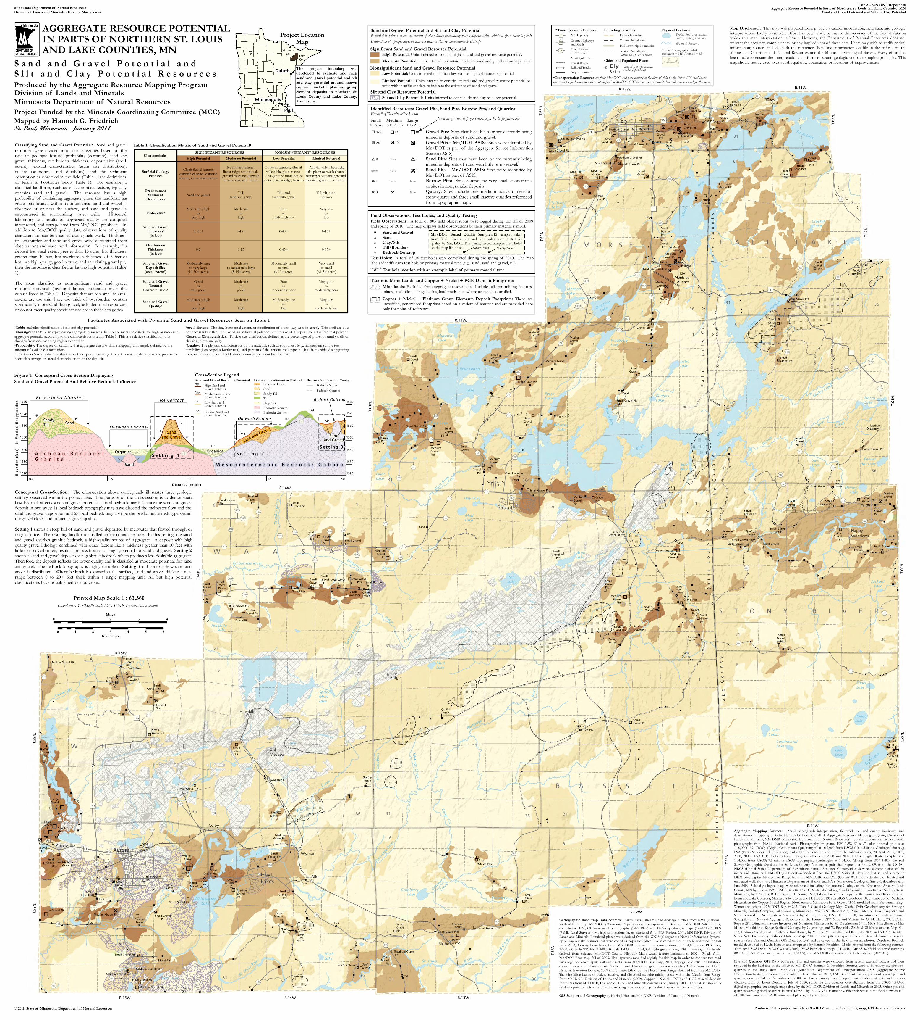
Plate A - MN DNR Report 380Aggregate Resource Potential in Parts of Northern St. Louis and Lake Counties, MN
Sand and Gravel Potential and Silt and Clay PotentialMinnesota Department of Natural ResourcesDivision of Lands and Minerals - Director Marty Vadis
© 2011, State of Minnesota, Department of Natural Resources Products of this project include a CD/ROM with the final report, map, GIS data, and metadata.
AGGREGATE RESOURCE POTENTIAL IN PARTS OF NORTHERN ST. LOUIS AND LAKE COUNTIES, MN
S a n d a n d G r a v e l P o t e n t i a l a n d S i l t a n d C l a y P o t e n t i a l R e s o u r c e sProduced by the Aggregate Resource Mapping ProgramDivision of Lands and MineralsMinnesota Department of Natural ResourcesProject Funded by the Minerals Coordinating Committee (MCC)Mapped by Hannah G. FriedrichSt. Paul, Minnesota - January 2011
Classifying Sand and Gravel Potential: Sand and gravelresources were divided into four categories based on thetype of geologic feature, probability (certainty), sand andgravel thickness, overburden thickness, deposit size (arealextent), textural characteristics (grain size distribution),quality (soundness and durability), and the sedimentdescription as observed in the field (Table 1; see definitionsof terms in Footnotes below Table 1). For example, aclassified landform, such as an ice contact feature, typicallycontains sand and gravel. The resource has a highprobability of containing aggregate when the landform hasgravel pits located within its boundaries, sand and gravel isobserved at or near the surface, and sand and gravel isencountered in surrounding water wells. Historicallaboratory test results of aggregate quality are compiled,interpreted, and extrapolated from Mn/DOT pit sheets. Inaddition to Mn/DOT quality data, observations of qualitycharacteristics can be assessed during field work. Thicknessof overburden and sand and gravel were determined fromobservations and water well information. For example, if adeposit has areal extent greater than 15 acres, has thicknessgreater than 10 feet, has overburden thickness of 5 feet orless, has high quality, good texture, and an existing gravel pit,then the resource is classified as having high potential (Table1).The areas classified as nonsignificant sand and gravelresource potential (low and limited potential) meet thecriteria listed in Table 1. Deposits that are too small in arealextent; are too thin; have too thick of overburden; containsignificantly more sand than gravel; lack identified resources;or do not meet quality specifications are in these categories.
0-5 0-15
0-40+ 0-15+0-45+
0-35+0-45+
10-50+
Probability3
Sand and gravel
Characteristics
Very lowto
low
Till, silt, sand,bedrock
Surficial GeologyFeatures
Moderateto
high
Moderateto
high
Moderateto
goodGood
tovery good
Till,sand and gravel
Till, sand,sand with gravel
Sand and GravelQuality7
OverburdenThickness
(in feet)
Very smallto small
(<1-5+ acres)
PredominantSediment
Description
Low Potential
Very lowto
moderately low
Lowto
moderately low
Moderately lowto
low
High Potential
Moderately highto
very high
Moderately highto
very high
Poorto
moderately poorVery poor
tomoderately poor
Moderately largeto very large
(10-30+ acres)
SIGNIFICANT RESOURCES
Moderately smallto small
(3-10+ acres)Sand and Gravel
Deposit Size(areal extext5)
Sand and GravelTextural
Characteristics6
Sand and GravelThickness4
(in feet)
Limited Potential
Moderateto moderately large
(5-15+ acres)
Glaciofluvial feature;outwash channel; outwashfeature; ice contact feature
NONSIGNIFICANT RESOURCESModerate Potential
Ice contact feature; linear ridge; recessional/ground moraine; outwashterrace, channel, feature
Outwash features; alluvial valley; lake plain; recess-
ional/ground moraine; icecontact; linear ridge; beaches
Alluvial valley; bedrock;lake plain; outwash channelfeature; recessional/ground moraine; glaciofluvial feature
Table 1: Classification Matrix of Sand and Gravel Potential1
1Table excludes classification of silt and clay potential.2Nonsignificant: Term representing aggregate resources that do not meet the criteria for high or moderateaggregate potential according to the characteristics listed in Table 1. This is a relative classification thatchanges from one mapping region to another.3Probability: The degree of certainty that aggregate exists within a mapping unit largely defined by theamount of available information.4Thickness Variability: The thickness of a deposit may range from 0 to stated value due to the presence ofbedrock outcrops or lateral discontinuation of the deposit.
5Areal Extent: The size, horizontal extent, or distribution of a unit (e.g., area in acres). This attribute doesnot necessarily reflect the size of an individual polygon but the size of a deposit found within that polygon.6Textural Characteristics: Particle size distribution, defined as the percentage of gravel or sand vs. silt orclay (e.g., sieve analysis).7Quality: The physical characteristics of the material, such as soundness (e.g., magnesium sulfate test),durability (Los Angeles Rattler test), and percent of deleterious rock types such as iron oxide, disintegratingrock, or unsound chert. Field observations supplement historic data.
Footnotes Associated with Potential Sand and Gravel Resources Seen on Table 1
Figure 1: Conceptual Cross-Section Displaying Sand and Gravel Potential And Relative Bedrock Influence
Distance (miles)
Elev
atio
n (fe
et) -
6x V
ertic
al Ex
agge
ratio
n
Sandy
Till Sand
Sand
Organics OrganicsTill
Till
Sand
and Gravel Sandand GravelSand and Gravel
Till
M e s o p r o t e r o z o i c B e d r o c k : G a b b r o
A r c h e a n B e d r o c k : G r a n i t e
Bedrock: Granite
Sand and Gravel
Bedrock: Gabbro
Dominant Sediment or Bedrock
SandSandy Till
Organics
Sand and Gravel Resource Potential
Limited Sand and Gravel Potential
Low Sand and Gravel Potential
Moderate Sand and Gravel Potential
High Sand and Gravel PotentialHp
Mp
Lp
Ltd
LtdLtd
LpLp Ltd
Ltd
Mp
Mp
Hp
Hp
Bedrock Surface and ContactBedrock SurfaceBedrock Contact
Cross-Section Legend
1580
1570
1560
1550
1540
1530
1520
0.0 0.5 1.0 1.5 2.0
Bedrock Outcrop
Outwash Channel
Ice Contact
Outwash Feature
S e t t i n g 1 S e t t i n g 2
Sett ing 3
1580
1570
1560
1550
1540
1530
1520
TillRece ss iona l Mo ra in e
Conceptual Cross-Section: The cross-section above conceptually illustrates three geologicsettings observed within the project area. The purpose of the cross-section is to demonstratehow bedrock affects sand and gravel potential. Local bedrock may influence the sand and graveldeposit in two ways: 1) local bedrock topography may have directed the meltwater flow and thesand and gravel deposition and 2) local bedrock may also be the predominate rock type withinthe gravel clasts, and influence gravel quality.Setting 1 shows a steep hill of sand and gravel deposited by meltwater that flowed through oron glacial ice. The resulting landform is called an ice-contact feature. In this setting, the sandand gravel overlies granitic bedrock, a high-quality source of aggregate. A deposit with highquality gravel lithology combined with other factors like a thickness greater than 10 feet withlittle to no overburden, results in a classification of high potential for sand and gravel. Setting 2shows a sand and gravel deposit over gabbroic bedrock which produces less desirable aggregate.Therefore, the deposit reflects the lower quality and is classified as moderate potential for sandand gravel. The bedrock topography is highly variable in Setting 3 and controls how sand andgravel is distributed. Where bedrock is exposed at the surface, sand and gravel thickness mayrange between 0 to 20+ feet thick within a single mapping unit. All but high potentialclassifications have possible bedrock outcrops.
Printed Map Scale 1 : 63,360
0 1 2 3 4Miles
0 1 2 3 4 5 6Kilometers
Based on a 1:50,000 scale MN DNR resource assessment
Cartographic Base Map Data Sources: Lakes, rivers, streams, and drainage ditches from NWI (NationalWetland Inventory), Mn/DOT (Minnesota Department of Transportation) Base map, MN DNR 24K Streams,compiled at 1:24,000 from aerial photography (1979-1988) and USGS quadrangle maps (1980-1990); PLS(Public Land Survey) townships and sections layers extracted from PLS Project, 2001, MN DNR, Division ofLands and Minerals; Populated places were derived from the GNIS (Geographic Name Information System)by pulling out the features that were coded as populated places. A selected subset of these was used for thismap, 2003; County boundaries from MN DNR, derived from combination of 1:24,000 scale PLS lines,1:100,000 scale TIGER, 1:100,000 scale DLG, and 1:24,000 hydrography lines, 1993; Hydrography labelsderived from selected Mn/DOT County Highway Maps water feature annotations, 2002; Roads fromMn/DOT Base map, fall of 2006. This layer was modified slightly for this map in order to connect two roadlines together where split; Railroad Tracks from Mn/DOT Base map, 2001; Topographic relief or hillshadecreated from a combination of 30-meter and 10-meter digital elevation models (DEM) from the USGSNational Elevation Dataset, 2007 and 5-meter DEM of the Mesabi Iron Range obtained from the MN DNR;Taconite Mine Lands or active, inactive, and disturbed taconite mining areas within the Mesabi Iron Rangefrom MN DNR, Division of Lands and Minerals (2009); Copper + Nickel + PGE and TiO2 mineral depositsfootprints from MN DNR, Division of Lands and Minerals current as of January 2011. This dataset should beused as a point of reference only due to being unverified and generalized from a variety of sources.GIS Support and Cartography by Kevin J. Hanson, MN DNR, Division of Lands and Minerals.
Aggregate Mapping Sources: Aerial photograph interpretation, fieldwork, pit and quarry inventory, anddelineation of mapping units by Hannah G. Friedrich, 2010, Aggregate Resource Mapping Program, Division ofLands and Minerals, MN DNR (Minnesota Department of Natural Resources). Source information included aerialphotographs from NAPP (National Aerial Photography Program), 1991-1992, 9" x 9" color infrared photos at1:40,000; 1991 DOQs (Digital Orthophoto Quadrangles) at 1:12,000 from USGS (United States Geological Survey);FSA (Farm Services Administration) Color Orthophotos collected from the following years; 2003-04, 2005, 2006,2008, 2009; FSA CIR (Color Infrared) Imagery collected in 2008 and 2009; DRGs (Digital Raster Graphics) at1:24,000 from USGS; 7.5-minute USGS topographic quadrangles at 1:24,000 (dating from 1964-1992); the SoilSurvey Geographic Database for St. Louis County, Minnesota, published September 3rd, 2009, from the USDA-NRCS (United States Department of Agriculture-Natural Resource Conservation Service); a combination of 30-meter and 10-meter DEMs (Digital Elevation Models) from the USGS National Elevation Dataset and a 5-meterDEM covering the Mesabi Iron Range from the MN DNR; and CWI (County Well Index) database of located andunlocated wells from the Minnesota Department of Health and MGS (Minnesota Geological Survey), downloaded inJune 2009. Related geological maps were referenced including: Pleistocene Geology of the Embarrass Area, St. LouisCounty, MN by J. Lehr, 1991; USGS Bulletin 1331-C: Surficial Geology, Mesabi Vermilion Iron Range, NortheasternMinnesota, by T. Winter, R. Cotter, and H. Young, 1973; Glacial Geomorphology for the Laurentian Divide area, St.Louis and Lake Counties, Minnesota by J. Lehr and H. Hobbs, 1992 in MGS Guidebook 18; Distribution of SurficialMaterials in the Copper-Nickel Region, Northeastern Minnesota by P. Olcott, 1976, modified from Prettyman, Eng,Winter and others 1973; DNR Report 262, Plate 3 Glacial Geology Map: Glacial Drift Geochemistry for StrategicMinerals, Duluth Complex, Lake County, Minnesota, 1989; DNR Report 246, Plate 1 Map of Esker Deposits andSites Sampled in Northeastern Minnesota by M. Eng 1986; DNR Report 358, Inventory of Publicly OwnedStockpiles and Natural Aggregate Resources at the Former LTV Mine and Vicinity by G. Melchert, 2003; DNRReport 289, Dimension Stone Inventory of Northern Minnesota by M. Oberhelman 1991; MGS Miscellaneous MapM-164, Mesabi Iron Range Surficial Geology, by C. Jennings and W. Reynolds, 2005; MGS Miscellaneous Map M-163, Bedrock Geology of the Mesabi Iron Range, by M. Jirsa, V. Chandler, and R. Lively, 2005 and MGS State MapSeries S21: Preliminary Bedrock Outcrop Map, 2010. Gravel pits and quarries were extracted from the severalsources (See Pits and Quarries GIS Data Sources) and reviewed in the field or on air photos. Depth to Bedrockmodel developed by Kevin Hanson and interpreted by Hannah Friedrich. Model created from the following sources:30-meter USGS DEM; MGS CWI (06/2009); MGS bedrock outcrops (04/2010), MPES 380 field observed outcrops(06/2010); NRCS soil survey outcrops (01/2009); and MN DNR exploratory drill hole database (04/2010).Pits and Quarries GIS Data Sources: Pits and quarries were extracted from several external sources and thenreviewed in the field and in the office by MN DNR’s Hannah G. Friedrich. Sources used to inventory the pits andquarries in the study area: Mn/DOT (Minnesota Department of Transportation) ASIS (Aggregate SourceInformation System) database downloaded in December of 2008; SSURGO spot feature points of gravel pits andquarries downloaded in December of 2008; St. Louis County Land Department database of pits and quarriesobtained from St. Louis County in July of 2010; some pits and quarries were digitized from the USGS 1:24,000digital topographic quadrangle maps done by the MN DNR Division of Lands and Minerals in 2003. Other pits andquarries were digitized onscreen in ArcGIS 9.3.1 by MN DNR’s Hannah G. Friedrich while in the field between fallof 2009 and summer of 2010 using aerial photography as a base.
Map Disclaimer: This map was prepared from publicly available information, field data, and geologicinterpretations. Every reasonable effort has been made to ensure the accuracy of the factual data onwhich this map interpretation is based. However, the Department of Natural Resources does notwarrant the accuracy, completeness, or any implied uses of these data. Users may wish to verify criticalinformation; sources include both the references here and information on file in the offices of theMinnesota Department of Natural Resources and the Minnesota Geological Survey. Every effort hasbeen made to ensure the interpretations conform to sound geologic and cartographic principles. Thismap should not be used to establish legal title, boundaries, or locations of improvements.
Project LocationMap
Duluth
Minneapolis
St.Paul
St. Louis
Co.Lake
Co.
2
The project boundary wasdeveloped to evaluate and mapsand and gravel potential and siltand clay potential around knowncopper + nickel + platinum groupelement deposits in northern St.Louis County and Lake County,Minnesota.
Sa
in
t
Lo
ui
s
Co
un
ty
La
ke
C
ou
nt
yS
ai
nt
L
ou
is
C
ou
nt
y
La
ke
C
ou
nt
yS
ai
nt
L
ou
is
C
ou
nt
y
La
ke
C
ou
nt
y
Taconite Mine Lands and Copper + Nickel + PGE Deposit FootprintsMine lands: Excluded from aggregate assessment. Includes all iron mining features:mines, stockpiles, tailings basins, haul roads, etc., where access is controlled.Copper + Nickel + Platinum Group Elements Deposit Footprints: These areunverified, generalized footprints based on a variety of sources and are provided hereonly for point of reference.
Sand and Gravel Potential and Silt and Clay PotentialPotential is defined as an assessment of the relative probability that a deposit exists within a given mapping unit.Evaluation of specific deposits was not done in this reconnaissance-level study.Significant Sand and Gravel Resource Potential
High Potential: Units inferred to contain highest sand and gravel resource potential. Moderate Potential: Units inferred to contain moderate sand and gravel resource potential.
Nonsignificant Sand and Gravel Resource PotentialLow Potential: Units inferred to contain low sand and gravel resource potential.Limited Potential: Units inferred to contain limited sand and gravel resource potential or units with insufficient data to indicate the existence of sand and gravel.
Silt and Clay Resource PotentialSilt and Clay Potential: Units inferred to contain silt and clay resource potential.
Identified Resources: Gravel Pits, Sand Pits, Borrow Pits, and QuarriesExcluding Taconite Mine Lands
Gravel Pits: Sites that have been or are currently beingmined in deposits of sand and gravel.Gravel Pits – Mn/DOT ASIS: Sites were identified byMn/DOT as part of the Aggregate Source InformationSystem (ASIS).Sand Pits: Sites that have been or are currently beingmined in deposits of sand with little or no gravel.Sand Pits – Mn/DOT ASIS: Sites were identified byMn/DOT as part of ASIS.Borrow Pits: Sites comprising very small excavationsor sites in nongranular deposits.Quarry: Sites include one medium active dimensionstone quarry and three small inactive quarries referencedfrom topographic maps.
Small Medium Large<5 Acres 5-15 Acres >15 Acres
None
NoneNone
None None
None
129 31 10
24 10 3
8 1
1
6
3 1
Field Observations, Test Holes, and Quality TestingField Observations: A total of 805 field observations were logged during the fall of 2009and spring of 2010. The map displays field observations by their primary material symbol.
Test Holes: A total of 36 test holes were completed during the spring of 2010. The maplabels identify each test hole by primary material type (e.g., sand, sand and gravel, till).
Sand and Gravel Sand Clay/Silt Till/Boulders Bedrock Outcrop
Test hole location with an example label of primary material typee.g., Sand
Number of sites in project area, e.g., 10 large gravel pits
Bounding Features
County BoundariesPLS Township BoundariesSection Boundaries
*Transportation FeaturesMN Highway1
County Highwaysand Roads100
Municipal Roads
Railroad Tracks
Township and Other Roads
Cities and Populated PlacesSections 1,6,31, & 36 labeled
Skibo
Ely (Size of font type indicates relative populations)
Rivers & Streams
Physical FeaturesWater Features (Lakes,
rivers, tailings basins)
Shaded Topographic Relief(Azimuth = 315, Altitude = 45)
Forest Roads
1532
Airport Runway
Project Boundary
*Transportation Features are from Mn/DOT and were current at the time of field work. Other GIS road layers were used for field work that were not mapped by Mn/DOT. These sources are unpublished and were not used for this map.
Mn/DOT Tested Quality Samples:12 samples takenfrom field observations and test holes were tested forquality by Mn/DOT. The quality tested samples are labeledon the map like this: Quality TestedQuality Tested
Quality Tested
Quality Tested
Quality Tested
Related Documents