Board Meeting| 27 June 2016 Agenda item no. 11.6 Closed Session CONFIDENTIAL SMART - way forward Recommendations That the Board resolves the following: i. That Management discount heavy rail to the airport from any further option development due to its poor value for money proposition; ii. Instructs Management to: a) Develop a bus based high capacity mode to the same level of detail as the LRT option to allow a value for money comparison with the LRT option and submit this to ATAP for consideration; b) Refine the LRT option further to address the high risk issues as articulated in this paper; c) Report back to the Board on the findings of the bus based high capacity mode and LRT comparison. d) Progress with route protection for bus / light rail, not heavy rail; e) Align the SMART and CAP business cases to enable the consideration of an integrated public transport system between the city centre and the airport f) Progress the business case development of the RTN route between Botany, Manukau and the airport and align this with NZTA’s business case development for SH20B. Executive summary The Sub-Regional Strategy that arose from the South Western Airport Multi Modal Corridor Project (SWAMMCP) prepared in 2011 concluded that investment in high capacity public transport services will be needed as part of an investment strategy in combination with state highway and local transport improvements. For the public transport component, the strategy looked at LRT, BRT and heavy rail. It ruled out LRT and BRT and concluded that the Rail Loop package would provide the best network resilience and highest benefits. It therefore recommended the development of a public transport

Welcome message from author
This document is posted to help you gain knowledge. Please leave a comment to let me know what you think about it! Share it to your friends and learn new things together.
Transcript

Board Meeting| 27 June 2016 Agenda item no. 11.6
Closed Session CONFIDENTIAL
SMART - way forward Recommendations That the Board resolves the following:
i. That Management discount heavy rail to the airport from any further option development due to its poor value for money proposition;
ii. Instructs Management to: a) Develop a bus based high capacity mode to the same level of detail as the LRT option to allow a value for money
comparison with the LRT option and submit this to ATAP for consideration; b) Refine the LRT option further to address the high risk issues as articulated in this paper; c) Report back to the Board on the findings of the bus based high capacity mode and LRT comparison. d) Progress with route protection for bus / light rail, not heavy rail; e) Align the SMART and CAP business cases to enable the consideration of an integrated public transport system between
the city centre and the airport f) Progress the business case development of the RTN route between Botany, Manukau and the airport and align this with
NZTA’s business case development for SH20B.
Executive summary The Sub-Regional Strategy that arose from the South Western Airport Multi Modal Corridor Project (SWAMMCP) prepared in 2011 concluded that investment in high capacity public transport services will be needed as part of an investment strategy in combination with state highway and local transport improvements. For the public transport component, the strategy looked at LRT, BRT and heavy rail. It ruled out LRT and BRT and concluded that the Rail Loop package would provide the best network resilience and highest benefits. It therefore recommended the development of a public transport

Board Meeting| 27 June 2016 Agenda item no. 11.6
Closed Session CONFIDENTIAL corridor that has the flexibility to accommodate the progressive development of attractive, high capacity public transport services up to and including the provision of a rail loop. Phase 1 has been completed and the Board approved commencement of Phase 2 to identify the alignment of the rail rapid transit network (RTN) and station locations. Light rail was ruled out during Phase 1 on the rationale that a light rail line between Onehunga and the airport would not provide a “single seat” connection between the city centre and the airport. It did however caveat this by stating that LRT “could be reconsidered if other corridors are developed as light rail ...” Phase 2 has progressed to a point where AT identified a ‘preferred alignment’ for a heavy rail corridor. The potential introduction of a light rail network on the isthmus has changed the strategic transport environment and the project team (at the direction of the Board) has considered the impact this may have prior to recommending a final outcome of Phase 2. The project team has therefore commissioned work to compare a possible extension of a light rail line from the isthmus to the Airport with a commuter rail option. The heavy rail alignment is also significantly different within the airport precinct when compared to other rapid transit options. It requires tunnelling and an underground station to serve the Airport terminal. The different alignments have made the intent of the sub-regional strategy (to progressively develop up to heavy rail) problematic for Auckland International Airport Limited (AIAL) as they now have to hold two different routes over their land holding (one for light rail and one for heavy rail). This has prompted the AIAL to request clarity on the corridor as it impacts their development plans. Subsequent work has not been able to demonstrate value for money by investing in a heavy rail option by 2046. The latest advice from an interim business case comparing various RTN modes signals a heavy rail line along SH20A could cost between $2.6 billion and $3.0 billion with a benefit cost ratio in the range of 0.37 - 0.64. The interim business case has identified Light Rapid Transit (LRT) to offer similar transport benefits within the 30 year planning horizon to the benefits of heavy rail but at a significantly lower level of investment ($1.2 billion - $1.3 billion). The LRT option achieved a benefit cost ratio in the range of 1.11 to 1.72. ATAP and the NZTA Board have acknowledged the low value for money offered by the heavy rail option and ruled it out from further consideration. It has however requested further analysis to re-assess a bus based high capacity mode taking into account future technologies for both the Airport and isthmus LRT proposals. The difference between a bus based system and LRT will not impact the immediate development issues faced by AIAL. Based on the evidence to date that a heavy rail option to the airport would present low value for money and that better value for money options (LRT or bus based mass transit) are still available; it is recommended that heavy rail is to be removed from further option development for improving public transport provisions to the airport.

Board Meeting| 27 June 2016 Agenda item no. 11.6
Closed Session CONFIDENTIAL
Strategic context Employment at airport and surrounding area The Airport and the surrounding business environment currently provide employment opportunities to approximately 20,000 people through 900 businesses. Over half of these employment opportunities are within the Airport’s land holding (12,000 jobs1). Only one public transport route currently serves this employment node - the Airporter. The service carries approximately 880 people per day and runs every 30 minutes at peak times and hourly in off-peak periods. It connects Manukau City Centre, the Airport, surrounding businesses and the Onehunga train station. Origin/destination patterns to the airport and environs The airport and environs have become a regional employment hub attracting employees from the entire Auckland region. The lack of a well-connected RTN network is currently prohibiting an acceptable2 level of public transport accessibility from the wider region to job opportunities within the airport business district (refer to Attachment 1 for a map illustrating existing accessibility by public transport to the airport business district). The poor level of public transport accessibility is contributing to the low public transport mode share and high single occupancy vehicle demand for employment to the Airport. The misalignment of public transport operational times with shift work hours further limits the attractiveness of public transport as a mode of choice. The RTN network (illustrated in Attachment 2) is designed to increase accessibility to key employment areas within the region and will benefit the airport business district through the provision of RTN lines from both the north as well the south-east. The appropriate mode for each RTN line is still under investigation. Airport passengers The Airport currently serves 120+ international and 300+ domestic flights every day, totalling 16.6 million passengers per annum. Airport passengers are currently serviced by a mixture of vehicle based options (taxis, rentals, shuttles, etc.), as well as a public transport offering that includes tour coaches and the SkyBus bus service. The SkyBus runs at a 10 minute frequency and
1 AIAL masterplan document – Airport of the Future, Our Vision for the next 30 years 2 Defined as a 45 minute travel time as agreed to by ATAP
Board Meeting| 27 June 2016 Agenda item no. 11.6
Closed Session CONFIDENTIAL carries approximately 1,6003 people per day. Data collected in 2012 for Auckland Transport as part of this project’s first phase showed that for the international terminal:
• Approximately 6% of travellers arrive at the international terminal via public transport (see chart below); • Over a third of visitors were dropped off with a further one in ten being driven by a fellow traveller meaning just under half used a private
vehicle to get to the terminal; and • While one in five visitors came from outside of Auckland prior to coming to the terminal, over half came from surrounding suburbs or
Auckland City (including the CBD).
3 Data retrieved from AirBus Express patronage in 2014
Board Meeting| 27 June 2016 Agenda item no. 11.6
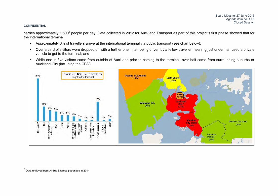
Closed Session CONFIDENTIAL Road network to the airport SH20A and SH20B connect the airport with the rest of strategic network. Sixty two thousand five hundred (62,5004) vehicles enter/exit the airport district each day through these two corridors. This volume is predicted to increase to 157,940 vpd5 by 2041. The airport company anticipates substantial investment in their internal road network to accommodate these increases (refer to attachment 5 for the anticipated roading upgrades). The first phase of access improvements to the Airport and the surrounding business district has commenced with upgrading the Kirkbride intersection to a full interchange. This together with the Waterview Connection will provide a continuous motorway link between the Airport and the city centre improving travel time and reliability over the short to medium term. The Kirkbride trench will be constructed wide enough to accommodate an RTN in the future as illustrated in Attachment 3. The NZ Transport Agency has also commenced a strategic case to investigate further road capacity improvements to the SH20B corridor. However, strategic modelling undertaken as part of ATAP indicates that these road capacity improvements on their own will not be sufficient to provide adequate capacity to the Airport by 2046 (for both the AM and inter-peak periods). Demand on the northern approach (SH20A), is still expected to exceed available capacity. Attachment 4 illustrates analysis from the ATAP foundation report that shows that volumes on these roads would still outstrip the available capacity (after upgrades) by 2046 for both peak and inter peak conditions. The increase in demand for travel to the airport is driven by:
• More businesses in the Mangere/airport area. There are more than 400 hectares of land currently available in this area for further industrial / commercial development. Auckland Airport’s 30-year vision forecasts that more than 90,000 people could work in this area by 2044.
• More houses (additional 2,300) in the area. Two special housing accord areas have already been approved in this area, these being: 1,600 new homes along Walmsley Road, Favona and 350-480 new homes at Oruarangi Road, Mangere. A further 1,192 households are forecasted in the general Mangere Bridge, Favona and Mangere area as a result of ongoing intensification.
• Doubling of passengers flying in and out of Auckland Airport over the next ten years and ultimately a tripling of passenger numbers over three decades with AIAL predicting that passenger numbers will reach 40 million per annum by 2044. Increasing passenger numbers will be accommodated by larger aircrafts arriving more frequently. Larger numbers of passengers arriving simultaneously are likely to cause subsequent peaks in demand along SH20B as passengers arrive and leave the Airport. Providing reliable travel times to and from the Airport to accommodate these peaks will deliver benefits for the tourist economy.
4 NZTA website data for 2009-2013 AADT 5 Flow
Board Meeting| 27 June 2016 Agenda item no. 11.6
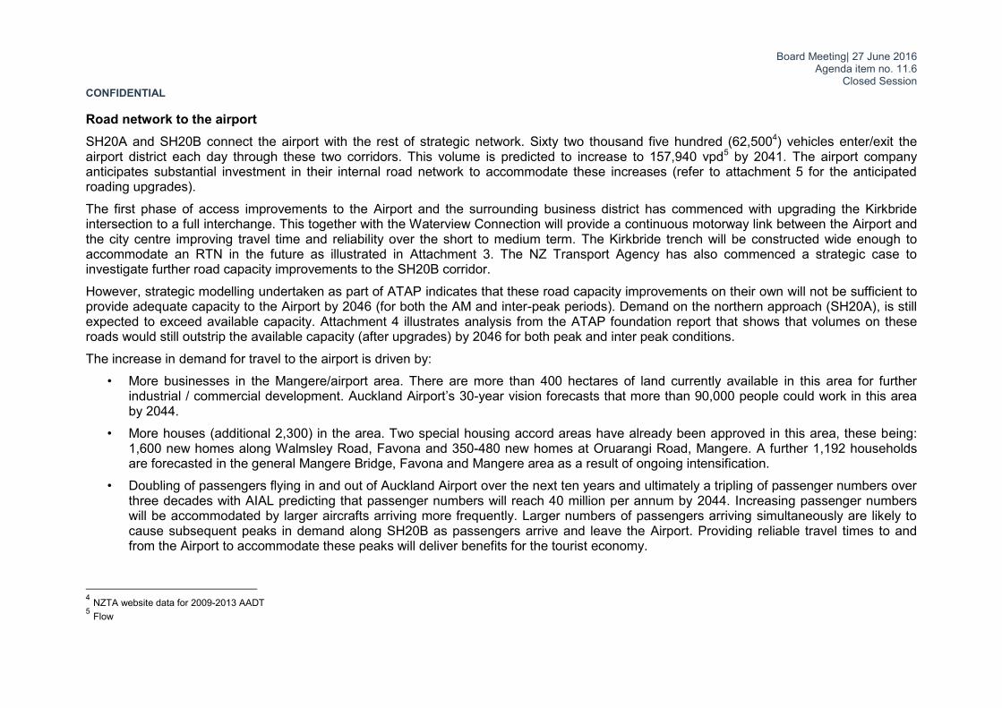
Closed Session CONFIDENTIAL Trip reliability Existing conditions on the road network make it difficult to predict the journey time to the Airport. A recent survey of end-to-end journey times between the Aotea Centre and the domestic terminal at the Airport provides the following observations for the morning peak:
• Making the journey with a private car had journey times that vary between 41min and 65min. This included time needed to park the vehicle as well.
• Taxis had a faster journey time (as passengers did not need to find parking). Journey times did however vary even greater than those for private cars (between 32min and 64min).
• Journey times on the Airport Express were less varied at between 48 min and 53 minutes. Note that the Airport Express service has been replaced by the SkyBus service after the survey was done.

Board Meeting| 27 June 2016 Agenda item no. 11.6
Closed Session CONFIDENTIAL Mangere-Otahuhu residents – where do they work? There is also a lack of connectivity between local communities, labour markets and land uses. In particular, the public transport and active mode options for people living in Mangere Bridge, Favona and Mangere are limited for commuters needing to access the Airport and surrounding industrial areas. These transport constraints are evident in the latest census data that shows the Mangere Otahuhu Local Board area as having more reliance on car-based travel to work when compared to the region (90% for the local board area vs 82% for the region). If not addressed, this will contribute to growing congestion problems that are likely to progressively affect the road network in this area over the next 30 years. More granular Statistics NZ data illustrates the strong relationship of the neighbouring residential areas with employment at the Airport while also reinforcing the regional importance of the airport employment hub (see extracts from Stats NZ website in figure below).
Board Meeting| 27 June 2016 Agenda item no. 11.6
Closed Session CONFIDENTIAL
Background on project development to date The Project was commissioned to identify the appropriate multi-modal transport connections to and from the airport and has three phases: • Phase 1: Option identification; identification of preferred corridor option; preliminary business case and assessment of alternatives • Phase 2: Scheme Assessment; updated preliminary business case • Phase 3: Preparation of the Notice of Requirement, Easement Documentation and Implementation Plan The Sub-Regional Strategy that arose from the South Western Airport Multi Modal Corridor Project (SWAMMCP) prepared in 2011 concluded that investment in high capacity public transport services will be needed as part of an investment strategy in combination with state highway and local transport improvements. For the public transport component, the 2011 strategy concluded that heavy rail options would be expensive compared to a package incorporating bus services operating mainly on the existing state highway network however the latter option is likely to be less effective in the long run. It therefore recommended the development of a public transport corridor that has the flexibility to accommodate the progressive development of attractive high capacity public transport services. Phase 1 has been completed and the Board approved commencement of Phase 2 to identify the alignment of the rail rapid transit network (RTN) and station locations. Light rail was ruled out during Phase 1 on the rationale that a light rail line between Onehunga and the airport would not provide a “single seat” connection between the city centre and the airport. It did however caveat this by stating that it “could be reconsidered if other corridors are developed as light rail ...” Phase 2 has progressed to a point where AT identified a ‘preferred alignment’ for a heavy rail corridor. The potential introduction of a light rail network on the isthmus has changed the strategic transport environment and the project team has considered the impact this may have prior to recommending a final outcome of Phase 2. The project team has therefore commissioned work to compare a possible extension of a light rail line from the isthmus to the Airport with a commuter rail option. The Board has resolved at its meeting held on 28 April 2015 that it “approves the reconsideration of Light Rail as an option to service the airport and requests Management to protect the route with urgency”.

Board Meeting| 27 June 2016 Agenda item no. 11.6
Closed Session CONFIDENTIAL
Option Discussion This section presents the analysis comparing a heavy rail and light rail option to the Airport. The two route alignments are illustrated below and then described in the following sections.
Key stats for each option:
Heavy rail route – city centre to airport: 34,313 people living within 800m catchment of
a station. This is expected to grow to 62,747 people by 2046.
72,941 jobs within 800m of a station. This is expected to grow to 108,934 jobs by 2046.
Travel time between 39 to 42 mins Total track distance between Britomart and
airport = 22.5 km Total track distance for the upgrade south of
Penrose = 12.9 km Total number of new stations = 4 Light rail route – city centre to airport: 60,240 people living within 800m catchment of
a station. This is expected to grow to 96,471 people by 2046.
83,197 jobs within 800m of a station. This is expected to grow to 146,609 jobs by 2046.
Travel time between 38-44 minutes Total track distance between Britomart and
airport = 23.0 km Total track distance for the upgrade south of
Dominion Rd = 15.1 km Total number of new stations = 7

Board Meeting| 27 June 2016 Agenda item no. 11.6
Closed Session CONFIDENTIAL
The heavy rail option:
The option proposes the extension of the Onehunga Branch Line by 10.5km along SH20/20A towards the airport with new stations at Mangere Bridge, Mangere Town Centre, the Airport Business District and a combined international/domestic airport terminal station.
The option enables a single seat journey from the city centre to the Airport. A frequency of 10 minutes is envisaged to fit in with the train schedule over the wider network. This frequency requires a double track railway and the heavy rail option therefore includes the upgrade of the existing single track Onehunga Branch Line to a double track route. It also requires consideration be given to the closure or grade separation of the eight level crossing along the Onehunga Branch Line. The Onehunga Station will be relocated eastwards (away from the curve), and the double track rail line will follow the existing rail designation up to the Manukau Harbour from where it will cross the harbour on a new bridge that is separate to the motorway bridge.
South of the harbour it is located along the western side of the motorway. The alignment is proposed to be elevated on a viaduct along SH20A, to reduce property impact along this narrow section of the motorway network. The motorway grades through the Kirkbride trench is too steep (4.6%) to accommodate a heavy rail alignment. An artist impression of this alignment as it passes over the new Kirkbride Interchange is illustrated in the image to the right.
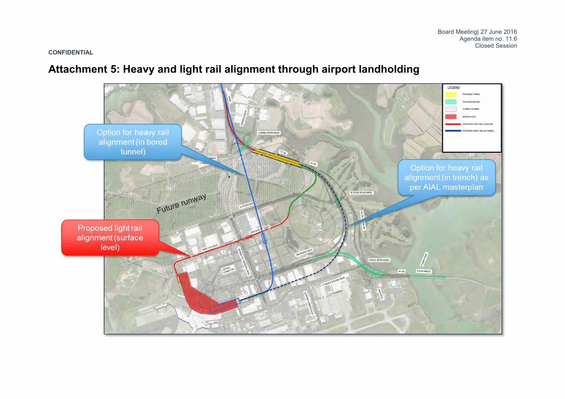
Through the airport landholding the alignment passes underneath the future extension of the proposed northern runway and approaches the terminal through a bored tunnel. The possible route through the airport land is illustrated in Attachment 5.
Based on 2013 census data, 34,313 people are living within 800m catchment of a station along the route between Aotea Station and the airport. This is expected to grow to 62,747 people by 2046. GIS analysis of the proposed unitary plan indicates approximately 94 hectare of terrace housing and apartment buildings zoned within the catchment zone. The strategic transport model estimates a peak period (7am to 9am) patronage of approximately 3,200 - 6,800 people by 2046 to cross the harbour south of Onehunga (refer to attachment 9) with the
Board Meeting| 27 June 2016 Agenda item no. 11.6
Closed Session CONFIDENTIAL Onehunga Branch Line carrying 5,300 - 8,100 people over the same period.
The travel time between the Airport and Britomart is expected to be in the 39-42 minute range. The frequent bus network will also be altered to integrate with the proposed station locations along the route to offer a comprehensive public transport network to the airport. This will increase public transport accessibility (45 minute catchment) as illustrated in Attachment 6.
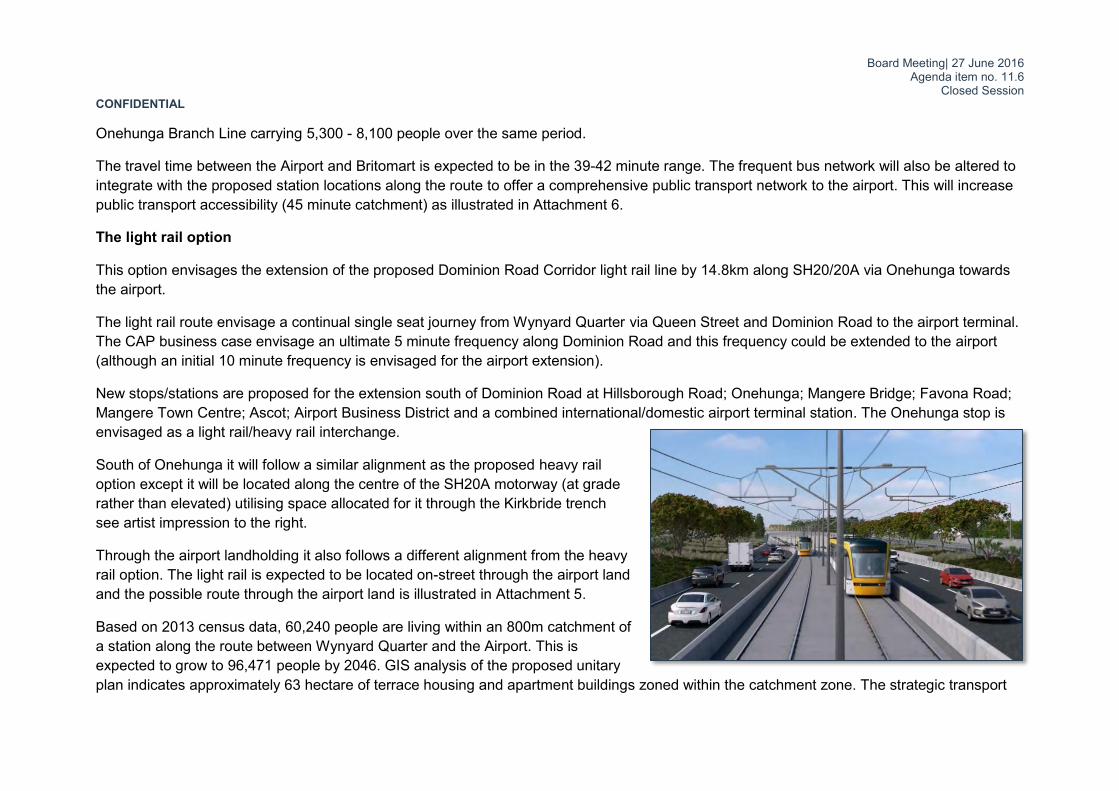
The light rail option
This option envisages the extension of the proposed Dominion Road Corridor light rail line by 14.8km along SH20/20A via Onehunga towards the airport.
The light rail route envisage a continual single seat journey from Wynyard Quarter via Queen Street and Dominion Road to the airport terminal. The CAP business case envisage an ultimate 5 minute frequency along Dominion Road and this frequency could be extended to the airport (although an initial 10 minute frequency is envisaged for the airport extension).
New stops/stations are proposed for the extension south of Dominion Road at Hillsborough Road; Onehunga; Mangere Bridge; Favona Road; Mangere Town Centre; Ascot; Airport Business District and a combined international/domestic airport terminal station. The Onehunga stop is envisaged as a light rail/heavy rail interchange.
South of Onehunga it will follow a similar alignment as the proposed heavy rail option except it will be located along the centre of the SH20A motorway (at grade rather than elevated) utilising space allocated for it through the Kirkbride trench see artist impression to the right.
Through the airport landholding it also follows a different alignment from the heavy rail option. The light rail is expected to be located on-street through the airport land and the possible route through the airport land is illustrated in Attachment 5.
Based on 2013 census data, 60,240 people are living within an 800m catchment of a station along the route between Wynyard Quarter and the Airport. This is expected to grow to 96,471 people by 2046. GIS analysis of the proposed unitary plan indicates approximately 63 hectare of terrace housing and apartment buildings zoned within the catchment zone. The strategic transport

Board Meeting| 27 June 2016 Agenda item no. 11.6
Closed Session CONFIDENTIAL model estimates a peak period (7am to 9am) patronage of approximately 3,500 - 7,500 people by 2046 to cross the harbour south of Onehunga with 5,300 - 6,900 people on the section between Onehunga and Dominion Road. Onehunga Branch Line will also carry 2,600 - 2,800 people over the peak period.
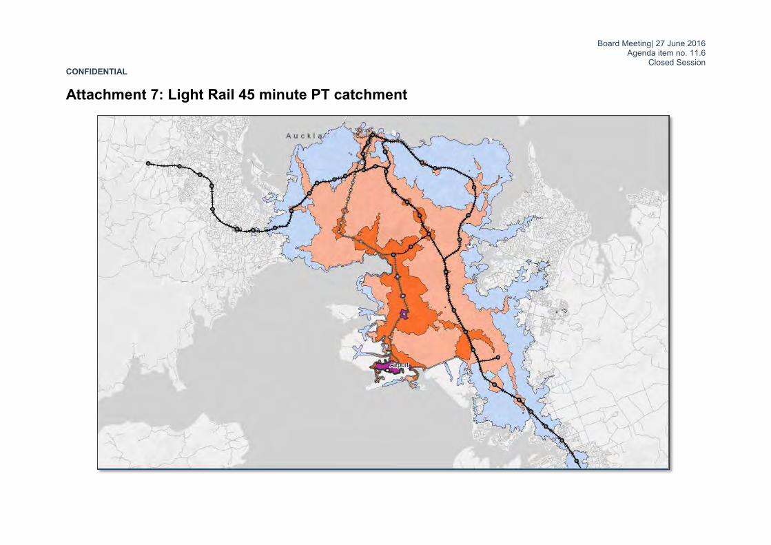
The travel time between the Airport and the Aotea stop is expected to be in the 38-41 minute range. The frequent bus network will also be altered to integrate with the proposed station locations along the route to offer a comprehensive public transport network to the airport. This will increase public transport accessibility (45 minute catchment) as illustrated in Attachment 7.
Heavy rail and light rail alignment variations through the airport land holding
The heavy rail alignment is significantly different within the airport precinct when compared to other rapid transit options. It requires tunnelling and an underground station to serve the airport terminal. The different alignments have made the intent of the sub regional strategy (to progressively develop up to heavy rail) problematic for the airport company as they now have to hold two different routes over their land holding (one for light rail and one for heavy rail). This has prompted the airport company to request clarity on the corridor as it impacts their development plans.
The heavy rail alignment approaches the airport on an elevated structure along the centre of SH20A, and passes above the Kirkbride Road interchange. The alignment then grades down to enable the heavy rail to pass beneath the future second runway extension proposed by the Airport. To achieve this SH20A requires separation of the northbound and southbound carriageways in the vicinity of Montgomerie Road to enable the heavy rail to transition from being on structure to below ground. The widening of SH20A will require purchase of adjacent commercial / industrial property. The heavy rail alignment then proceeds southward in twin bored tunnels (inbound and outbound), approximately 20 to 25m below ground level to a proposed station in the vicinity of John Goulter Drive, then heads westwards to connect to the future airport terminal. The station at the airport terminal will need to be approximately 300m long by 50m wide to enable sufficient space for platforms and turn outs.
The light rail alignment approaches the airport in the centre of SH20A at the same grade as the motorway lanes and passes beneath Kirkbride Road in the motorway trench. The alignment remains within the centre of SH20A as it passes through the proposed Landing interchange and beneath the north east corner of the future second runway extension. The light rail alignment then passes above the future airport road network on structure and then runs along the north side of John Goulter Drive at grade before connecting to the new airport terminal. Stations are provided in the vicinity of John Goulter Drive (at grade) and at the airport terminal (elevated).
Board Meeting| 27 June 2016 Agenda item no. 11.6
Closed Session CONFIDENTIAL Both heavy rail and light rail alignments are shown in Attachment 5.
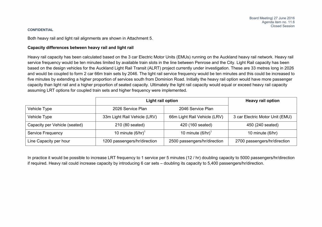
Capacity differences between heavy rail and light rail
Heavy rail capacity has been calculated based on the 3 car Electric Motor Units (EMUs) running on the Auckland heavy rail network. Heavy rail service frequency would be ten minutes limited by available train slots in the line between Penrose and the City. Light Rail capacity has been based on the design vehicles for the Auckland Light Rail Transit (ALRT) project currently under investigation. These are 33 metres long in 2026 and would be coupled to form 2 car 66m train sets by 2046. The light rail service frequency would be ten minutes and this could be increased to five minutes by extending a higher proportion of services south from Dominion Road. Initially the heavy rail option would have more passenger capacity than light rail and a higher proportion of seated capacity. Ultimately the light rail capacity would equal or exceed heavy rail capacity assuming LRT options for coupled train sets and higher frequency were implemented.
Light rail option Heavy rail option
Vehicle Type 2026 Service Plan 2046 Service Plan
Vehicle Type 33m Light Rail Vehicle (LRV) 66m Light Rail Vehicle (LRV) 3 car Electric Motor Unit (EMU)
Capacity per Vehicle (seated) 210 (80 seated) 420 (160 seated) 450 (240 seated)
Service Frequency 10 minute (6/hr)1 10 minute (6/hr)1 10 minute (6/hr)
Line Capacity per hour 1200 passengers/hr/direction 2500 passengers/hr/direction 2700 passengers/hr/direction
In practice it would be possible to increase LRT frequency to 1 service per 5 minutes (12 / hr) doubling capacity to 5000 passengers/hr/direction if required. Heavy rail could increase capacity by introducing 6 car sets – doubling its capacity to 5,400 passengers/hr/direction.

Board Meeting| 27 June 2016 Agenda item no. 11.6
Closed Session CONFIDENTIAL
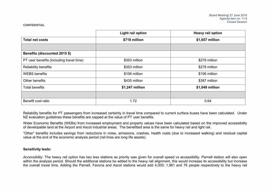
Economic Case Economic benefits based on the EEM have been calculated for each option. Both options assume the same underlying land use scenario (Scenario I9) and public transport patronage was modelled for both options through Auckland’s regional Public Transport Model (APT). A key assumption for the LRT option was that Dominion Road would be in place – i.e. the cost for the Dominion Road line was excluded for this analysis as it evaluated the extension only. The analysis did however include benefits from the additional patronage on the Dominion Road line as a result of the airport extension. Overall the LRT extension generates higher PT User benefits than the Dominion Road line without the extension due to the extended system catering better for local travel demands in the Onehunga to Mangere corridor. It also results in additional heavy rail trips through the heavy rail/light rail interchange at Onehunga. The PT user benefits for the light rail option amounts to $1,563 million and the heavy rail $1,444 million. This excludes any wider economic benefits. The total estimated capital cost for the light rail option amounts to $1,115 million and the heavy rail is estimated as $2,365 million. Costs for heavy rail and light rail options include allowance for depot and end of line stabling facilities, cut and cover tunnels where necessary across the airport land, property impacts and stations based on current planning. Note that rail station costs vary significantly for at-grade ($20 million), elevated (up to $50 million) and underground ($100+ million) concepts. Light rail costs include use of ballasted track where possible. This may be reduced (and cost increased) if access to the KiwiRail corridor adjacent to SH20 is limited. Operations and maintenance (O+M) costs for light and heavy rail represent a saving compared with high frequency bus alternatives. O+M costs are likely to rise with airport tunnel access requirements. The costs and benefits calculated for the options have been discounted assuming discount rates of 4%, 6% and 8% per annum. The discounted costs, benefits, benefit cost ratio (BCR) and net present value (NPV) for assessed options are shown in the table below for the mid-point discount rate of 6% per annum as per EEM Guidelines.
Light rail option Heavy rail option
Costs (discounted 2015 $)6
Capital costs (including fleet) $796 million $1,690 million
O+M costs -$78 million -$43 million
6 SMART Interim Business Case (December 2015)
Board Meeting| 27 June 2016 Agenda item no. 11.6
Closed Session CONFIDENTIAL Light rail option Heavy rail option
Total net costs $718 million $1,657 million
Benefits (discounted 2015 $)
PT user benefits (including travel time) $353 million $278 million
Reliability benefits $353 million $278 million
WEBS benefits $106 million $106 million
Other benefits $435 million $387 million
Total benefits $1,247 million $1,049 million
Benefit cost ratio 1.72 0.64
Reliability benefits for PT passengers from increased certainty in travel time compared to current surface buses have been calculated. Under NZ evaluation guidelines these benefits are capped at the value of PT user benefits. Wider Economic Benefits (WEBs) from increased employment and property values have been calculated based on the improved accessibility of developable land at the Airport and Ascot industrial areas. The benefitted area is the same for heavy rail and light rail. “Other” benefits includes savings from reductions in noise, emissions, crashes, health costs (due to increased walking) and residual capital value at the end of the economic analysis period (rail lines are long life assets). Sensitivity tests:
Accessibility: The heavy rail option has two less stations as priority was given for overall speed vs accessibility. Parnell station will also open within the analysis period. Should the additional stations be added to the heavy rail alignment, this would increase its accessibility but increase the overall travel time. Adding the Parnell, Favona and Ascot stations would add 4,000; 1,961 and 76 people respectively to the heavy rail

Board Meeting| 27 June 2016 Agenda item no. 11.6
Closed Session CONFIDENTIAL people catchment (2013 census). This would increase its catchment to an overall of 40,350 people which is still significantly lower than the 60,240 people in the LRT catchment. Due to the nature of the heavy rail alignment descending at a grade of 3% to pass beneath the second runway extension from being elevated above Kirkbride Road a station located at Ascot is unlikely to be achievable. The employment numbers in the catchment area also remain below that for light rail with the additional stations adding 9,381 jobs to the heavy rail catchment. This brings the total number of jobs within an 800m catchment of the heavy rail line to 82,322 compared to 83,197 jobs within the light rail catchment. Travel time for each route and mode: The methodology for calculating travel time over the LRT route involved using a simulation model for the Dominion Road and Queen Street sections and a spreadsheet based model for the SMART sections. The LRV alignment was separated into sections of constant track geometry for curve radii and gradient. Each section was analysed in order to calculate a maximum possible speed that the LRV could travel based on LRV traction power, friction from the curve radii and gradients and speed on the preceding and proceeding track segments. Testing has also been carried out to assess the impact of station locations on travel times. Station dwell times assumed were 30 seconds for LRV and 40 seconds for heavy rail based on industry averages for LRV and Auckland field data for heavy rail. The dwell time, deceleration and acceleration required at each station means that a reduction in stations can have a significant positive impact on travel time. For the Onehunga to airport section both the light and heavy rail options were tested using the minimum of 4 stations (Onehunga; Mangere Bridge; Mangere; and airport) or a maximum of 7 stations (adding Favona; Ascot; and a second station within the airport) . Results are shown in the figure below.
The travel time estimates suggest heavy rail would be the fastest mode between the airport and Britomart (with travel times varying between 39 and 42 minutes) whilst LRT would be the fastest to Aotea (travel times vary between 37 and 41 minutes). Note that normally heavy rail would be expected to be faster than light rail. For the SMART alignment this is not the case. Historically no corridor was preserved to the airport suiting heavy rail geometry. Width and curve radii constraints in the corridor prevent the heavy rail option reaching top speed other than in a

Board Meeting| 27 June 2016 Agenda item no. 11.6
Closed Session CONFIDENTIAL few isolated track segments. In the sections of tight track geometry near Onehunga the smaller light rail vehicles are able to travel faster than heavy rail. Economic benefits: The BCR for the light rail option is much higher than the BCR for the heavy rail option. This is because light rail generate slightly higher benefits but the heavy rail option costs significantly more. It is worth noting that even in a hypothetical case where heavy rail were to generate exactly the same travel time benefits as light rail the benefits would still not outweigh its costs and it would achieve a BCR of 0.75.
Patronage levels have been forecasted using strategic models and cost estimates have been based on concept design only. The BCR for each option has therefore been tested on a lower patronage uptake and a higher cost. The BCR for heavy rail drop to 0.37 and the light rail option to 1.11.
Heavy rail cost variations:
The OBL is currently a single track line extending 3.5km from Penrose Station to Onehunga Station and has 8 level crossings along the line. A key assumption of work to date is that these level crossings will all have to be grade separated and or closed – given the increased safety risk through more train services and double tracking. Costs were estimated for double-tracking based on three possible scenarios: lowered rail; realignment via Mt Smart; and elevated rail. The cost estimates varied from $458 million to $578 million.
A low cost option for double tracking the OBL (including realigning the existing line to the new formation) was subsequently developed following concerns regarding the high cost of this section of track upgrade. The option anticipates the closure of two level crossings with the remainder receiving full barrier, CCTV and pedestrian gates.
The low cost option ($155 million) has been considered in the indicative business case to provide a cost range for the heavy rail investment requirements.
This approach will however increase delays to traffic caused by level crossing barriers which will become more significant as the train frequency increases. The current frequency along the OBL is 2 trains/hour but will increase to 6 trains/hour (per direction) with the implementation of the CRL and the proposed double tracking. At this frequency and using the existing assumptions the barrier downtime will be approximately 18 minutes/hour. The benefit stream will have to be tempered with this dis-benefit to the local road network and the BCR is therefore likely to be lower under this scenario.

Board Meeting| 27 June 2016 Agenda item no. 11.6
Closed Session CONFIDENTIAL Further work was also focussed within the airport land with a revised, more direct heavy rail alignment discussed with AIAL. This alignment however introduces twin bored tunnels for the heavy rail with two underground stations approximately 20 – 25m deep. It is estimated that this will increase the costs compared to the 2015 assessment which assumed a cut and cover construction and only one station at the airport terminal. An additional station was considered near John Goulter Drive (consistent with a station provided at this location for the light rail option) which was not included within the initial $2,365M cost estimate. Bored tunnels were the preferred construction method within the Airport environment to remove the significant surface impacts to development associated with cut and cover construction. Station depths required by the tunnel boring method have additional cost implications. Overall, including the savings associated with the OBL, the additional cost of construction within the Airport is likely to increase the overall cost for heavy rail to approximately $3.0 billion. Key risks for each option:
Heavy rail option:
It should be noted that there is a significant risk that the ‘low cost Onehunga Branch Line option’ may not be acceptable to the regulator or safety case holders. A risk assessment will need to be undertaken for the level crossings should this option proceed to route protection. The Australian Level Crossing Assessment Model (ALCAM) is a risk assessment tool that can be used to identify site-specific issues and inform the prioritisation of level crossing improvements.
Ground conditions at the airport are a significant cost risk for tunnelling. The required tunnel depth will be below the water table and soil types mean that continuous shoring or tunnel lining is likely to be required. Flooding during construction would be a major hazard and cost risk given the very low site, typically 6 to 8m above sea level, and poor drainage. Cut and cover tunnel construction was not considered appropriate given the significant surface effects this approach would have on the developed airport land.
The 300m by 50m station required beneath the new airport terminal needs constructed at the same time as the terminal itself. This structure will not be able to be built once the new terminal and surrounding infrastructure has been established. This will require Auckland Transport to commit in the order of $100M to construct the underground station to coincide with the design and construction of the airport terminal, due to commence after 2021.
Light rail option:
Dominion Road option proposes some shared running through village centres. This may introduce travel time reliability risk for the overall journey between airport and city centre.
A large part of the alignment falls within the KiwiRail designation for Avondale to Southdown. The ability to accommodate a single track for heavy rail in this section may limit space for light rail and potentially increase earthworks and structure costs in steep sections.
Board Meeting| 27 June 2016 Agenda item no. 11.6
Closed Session CONFIDENTIAL Opportunity costs:
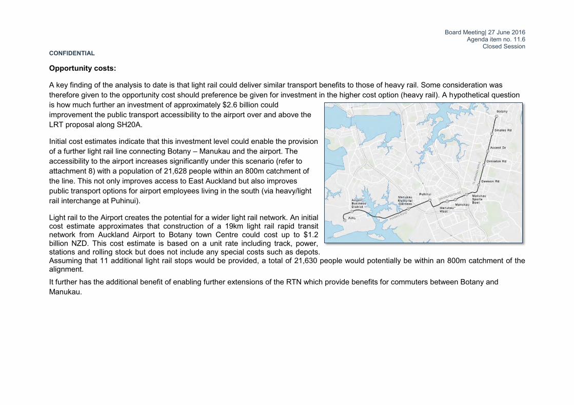
A key finding of the analysis to date is that light rail could deliver similar transport benefits to those of heavy rail. Some consideration was therefore given to the opportunity cost should preference be given for investment in the higher cost option (heavy rail). A hypothetical question is how much further an investment of approximately $2.6 billion could improvement the public transport accessibility to the airport over and above the LRT proposal along SH20A.
Initial cost estimates indicate that this investment level could enable the provision of a further light rail line connecting Botany – Manukau and the airport. The accessibility to the airport increases significantly under this scenario (refer to attachment 8) with a population of 21,628 people within an 800m catchment of the line. This not only improves access to East Auckland but also improves public transport options for airport employees living in the south (via heavy/light rail interchange at Puhinui).
Light rail to the Airport creates the potential for a wider light rail network. An initial cost estimate approximates that construction of a 19km light rail rapid transit network from Auckland Airport to Botany town Centre could cost up to $1.2 billion NZD. This cost estimate is based on a unit rate including track, power, stations and rolling stock but does not include any special costs such as depots. Assuming that 11 additional light rail stops would be provided, a total of 21,630 people would potentially be within an 800m catchment of the alignment. It further has the additional benefit of enabling further extensions of the RTN which provide benefits for commuters between Botany and Manukau.

Board Meeting| 27 June 2016 Agenda item no. 11.6
Closed Session CONFIDENTIAL
Financial Allocation The business case development will be absorbed within existing operational budgets. Capital expenditure budget has also been allocated on the existing long term plan as per the tale below. 2015/16 2016/17 2017/18 2018/19 2019/20 2020/21 2021/22 2022/23 2023/24 2024/25
SMART 2,052,000 6,322,212 12,998,468 2,367,294 2,443,047 2,526,111 2,611,999 2,700,807
This allocation is for AT contribution to the Kirkbride Trench ($21,372,680)
This allocation is for route protection of the preferred route ($ 12,649,258)
Recommended way forward The following progression pathway is recommended for the project based on analysis to date:
i. Discount heavy rail from any further option development due to its poor value for money proposition;
ii. Refine to the LRT option further address the high risk issues as articulated in this paper;
iii. Develop a bus based high capacity mode to the same level of detail as the LRT option to allow a value for money comparison with the LRT option;
iv. Report back to the Board on the findings of the bus based high capacity mode and LRT comparison. Progress with route protection once preferred mode between these two options are confirmed;
v. Align the SMART and CAP business cases to enable the consideration of an integrated public transport system between the city centre and the airport
vi. Progress the business case development of the RTN route between Botany, Manukau and the airport and align this with NZTA’s business case development for SH20B.

Board Meeting| 27 June 2016 Agenda item no. 11.6
Closed Session CONFIDENTIAL
Stakeholder Engagement and Communication The following stakeholder engagement activities are envisioned:
Formally write to the airport company to advise them that heavy rail has been excluded from future consideration and that option development would progress based on the mutually agreed light rail route. Also advise them that AT and NZTA would give further consideration of a bus based mass transit system to service the airport.
Present this report and its findings to the project Stakeholder Steering Group. Membership of this group includes representation from the Airport Company; KiwiRail; NZTA; Council; Mangere-Otahuhu Local Board and the Maungakiekie-Tamaki Local Board.
No specific public consultation is envisage at this stage but it is recommended that this report be made available on the AT website.
Attachments Attachment Number Description
1 Existing PT accessibility to the airport business district 2 Proposed RTN network 3 RTN options through Kirkbride trench 4 v/c ratios from ATAP 5 Heavy and light rail alignment through airport landholding 6 Heavy Rail 45 minute PT catchment 7 Light Rail 45 minute PT catchment 8 Possible extension of LRT route to Botany?
Board Meeting| 27 June 2016 Agenda item no. 11.6
Closed Session CONFIDENTIAL
Document ownership Submitted by Theunis van Schalkwyk
Project Director, Key Strategic Initiatives
Recommended by Peter Clark
Chief Strategy Officer
Recommended by David Warburton Chief Executive
Approved for submission

Board Meeting| 27 June 2016 Agenda item no. 11.6
Closed Session CONFIDENTIAL
Attachment 1: Existing PT accessibility to the airport business district

Board Meeting| 27 June 2016 Agenda item no. 11.6
Closed Session CONFIDENTIAL
Attachment 2: Proposed RTN network

Board Meeting| 27 June 2016 Agenda item no. 11.6
Closed Session CONFIDENTIAL
Attachment 3: RTN options through Kirkbride trench

Board Meeting| 27 June 2016 Agenda item no. 11.6
Closed Session CONFIDENTIAL
Attachment 4: Volume/capacity ratios from ATAP

Board Meeting| 27 June 2016 Agenda item no. 11.6
Closed Session CONFIDENTIAL
Board Meeting| 27 June 2016 Agenda item no. 11.6
Closed Session CONFIDENTIAL
Attachment 5: Heavy and light rail alignment through airport landholding

Board Meeting| 27 June 2016 Agenda item no. 11.6
Closed Session CONFIDENTIAL
Attachment 6: Heavy Rail 45 minute PT catchment
Board Meeting| 27 June 2016 Agenda item no. 11.6
Closed Session CONFIDENTIAL
Attachment 7: Light Rail 45 minute PT catchment

Board Meeting| 27 June 2016 Agenda item no. 11.6
Closed Session CONFIDENTIAL
Attachment 8: Possible extension of LRT route to Botany?
Related Documents