Co Planning & Community Dev. 117 N Molalla Avenue PO Box 248 Molalla, Oregon 97038 Phone: (503) 759-0219 [email protected] AGENDA Molalla Planning Commission 6:30 PM, December 4, 2019 Meeting Location: Molalla Adult Center 315 Kennel Avenue. Molalla, OR 97038 The Planning Commission Meeting will begin at 6:30pm. The Planning Commission has adopted Public Participation Rules. Copies of these rules and public comment cards are available at the entry desk. Public comment cards must be turned in prior to the start of the Commission meeting. The City will endeavor to provide a qualified bilingual interpreter, at no cost, if requested at least 48 hours prior to the meeting. To obtain services call the City Recorder at (503) 829-6855. I. CALL TO ORDER II. FLAG SALUTE AND ROLL CALL III. PUBLIC COMMENT – Limited to 3 minutes per person IV. MINUTES: • Minutes from the October 2, 2019 meeting • Minutes from the June 5, 2019 meeting V. PUBLIC HEARINGS: • Consider a request to annex a 15.5-acre parcel at the southwest corner of OR-211/OR-213. If annexed the property would be zoned General Commercial (C-2), consistent with the Molalla Comprehensive Plan (AN01- 2019). VI. DISCUSSION ITEM: • Project Updates VII. REPORTS AND ANNOUNCEMENTS VIII. ADJOURNMENT City of Molalla ◼ Community Planning & Development ◼ 117 N. Molalla Avenue, Molalla, OR 97038 ◼ (503) 759-0219 Chairman Rae Lynn Botsford | Commissioner Debbie Lumb | Commissioner Jennifer Satter Commissioner Doug Eaglebear | Commissioner Steve Deller | Commissioner Jacob Giberson | Commissioner Connie Ferrens 1

Welcome message from author
This document is posted to help you gain knowledge. Please leave a comment to let me know what you think about it! Share it to your friends and learn new things together.
Transcript
Co
Planning & Community Dev. 117 N Molalla Avenue PO Box 248 Molalla, Oregon 97038 Phone: (503) 759-0219 [email protected]
AGENDA Molalla Planning Commission
6:30 PM, December 4, 2019
Meeting Location: Molalla Adult Center 315 Kennel Avenue. Molalla, OR 97038
The Planning Commission Meeting will begin at 6:30pm. The Planning Commission has adopted Public Participation Rules. Copies of these rules and public comment cards are available at the entry desk. Public comment cards must be turned in prior to the start of the Commission meeting. The City will endeavor to provide a qualified bilingual interpreter, at no cost, if requested at least 48 hours prior to the meeting. To obtain services call the City Recorder at (503) 829-6855.
I. CALL TO ORDER
II. FLAG SALUTE AND ROLL CALL
III. PUBLIC COMMENT – Limited to 3 minutes per person
IV. MINUTES:
• Minutes from the October 2, 2019 meeting
• Minutes from the June 5, 2019 meeting
V. PUBLIC HEARINGS:
• Consider a request to annex a 15.5-acre parcel at the southwest corner of OR-211/OR-213. If annexed the property would be zoned General Commercial (C-2), consistent with the Molalla Comprehensive Plan (AN01- 2019).
VI. DISCUSSION ITEM:
• Project Updates
VII. REPORTS AND ANNOUNCEMENTS
VIII. ADJOURNMENT
City of Molalla ◼ Community Planning & Development ◼ 117 N. Molalla Avenue, Molalla, OR 97038 ◼ (503) 759-0219
Chairman Rae Lynn Botsford | Commissioner Debbie Lumb | Commissioner Jennifer Satter
Commissioner Doug Eaglebear | Commissioner Steve Deller | Commissioner Jacob Giberson | Commissioner Connie Ferrens
1
Page 1 – October 2, 2019 Planning Commission Minutes
Molalla Planning Commission
MINUTES Molalla Adult Center
315 Kennel Ave., Molalla, OR 97038
October 2, 2019
The October 2, 2019 meeting of the Molalla Planning Commission was called to order by Chair Rae
Lynn Botsford at 6:32pm. This was followed by the flag salute and roll call.
COMMISSIONER ATTENDANCE: STAFF IN ATTENDANCE:
Chair Rae Lynn Botsford – Present Alice Cannon, Planning Director - Present
Commissioner Steve Deller – Present Dan Zinder, Associate Planner – Present
Commissioner Doug Eaglebear – Present Julie Larson, Planning Assistant – Present
Commissioner Debbie Lumb – Present
Commissioner Jennifer Satter – Absent
Commissioner Jacob Giberson – Present
Commissioner Connie Farrens - Absent
PUBLIC COMMENT ON MATTERS NOT ON THE MEETING AGENDA:
No one offered public comment.
MINUTES:
Chair Botsford confirmed with PC that they have received and reviewed the minutes for August 7, 2018. Chair Botsford calls for a motion to approve the minutes. A motion to approve the minutes was made by Commissioner Eaglebear, a second was received by Commissioner Giberson. Motion passes 5-0.
PUBLIC HEARING:
• Consideration of an amendment to Molalla Municipal Development Code Section 17-4.3.030.A (File No. DCA01-2019) – A change to the procedure for processing partition applications from a Type III Public Hearing procedure to a Type II Administrative Decision Procedure, appealable to Planning Commission.
Chair Botsford called the public hearing to order and read the hearing script into the record.
2
Page 2 – October 2, 2019 Planning Commission Minutes
CITY STAFF REPORT:
Planning Director Cannon gave the staff report which can be found in the meeting packet. The staff report includes the summary of proposed changes, rationale for proposed changes, criteria for review, and staff analysis. City Staff recommends that partition applications be processed at the staff level, except in situations where a staff decision is appealed during the public notice process. Processing partition applications at the staff level would allow for an expedited process, making partition applications on smaller land divisions of three or less lots more efficient and easier. Development from these partitions would still be required to adhere to the same development standards as larger subdivisions. Staff has found that most neighboring cities and Clackamas County review partitions through a Type II procedure.
Planning Director Cannon stated the City is encouraging the PC to approve the amendment.
PUBLIC COMMENT:
No public comment received.
QUESTIONS FROM PLANNING COMMISSION:
Commissioner Deller asked about public involvement and if there was a lot of public interest in a partition, would it be escalated to a Type III?
Planning Director Cannon stated that if a staff decision is appealed during the public notice process, yes, the partition application would be escalated to a Type III and brought forth to the Planning Commission.
Commissioner Giberson asked who can appeal and land use decision
Planning Director Cannon answered that the applicant and landowner have appeal rights.
Commissioner Giberson asked if there is a cost difference between a Type II and Type III application?
Planning Director Cannon said that there is. A Type II is approximately $1,000.00, while a Type III can cost upwards of $1,700.00.
Chair Botsford inquired about the language on page 8 of the staff report. Asked if this change is consistent with the Statewide Planning Goals and relevant Oregon Administrative Rules.
Planning Director Cannon stated that the process would be consistent with the State goals, as well as the City of Molalla’s Comprehensive Plan. Director Cannon also noted that many neighboring cities and Clackamas County process partition applications as a Type III. She went on to present that Canby was one of the only cities she could find in her research that still processes partitions as a Type III.
Commissioner Giberson asked why Canby still process this way?
3
Page 3 – October 2, 2019 Planning Commission Minutes
Planning Director Cannon answered that she wasn’t sure and is assuming that Canby is processing partition applications with the Planning Commission the way Molalla has done for years. It could be a unique situation to Canby or a hold-over from a time when Planning Commissions made more routine decisions.
PUBLIC COMMENT:
No one offered public comment.
Motion was made by Commissioner Giberson to approve the consideration of an amendment to Molalla Municipal Development Code Section 17-4.3.030.A (File No. DCA-2019) – A change to the procedure for processing partition applications from a Type III Public Hearing procedure to a Type II Administrative Decision Procedure, appealable to Planning Commission. Second by commissioner Lumb. Motion passes 5-0.
DISCUSSION ITEMS:
Annexation:
Planning Director Cannon stated that the first public hearing for the annexation application at HWY 211
& HWY 213 is scheduled to take place November 6, 2019, at the next Planning Commission Meeting.
(Note: That hearing has since been postponed to December 4, 2019).
Code Amendments:
Planning Director Cannon advised the Planning Commission that she is currently looking at cleaning up
some typos found in the recently adopted development code.
Food Cart Ordinance:
Planning Director Cannon shared a PowerPoint presentation with the Planning Commission that highlighted the results of the recent community outreach survey staff conducted. The survey concluded that of the 238 citizens that participated, 97.46% supported food carts within the city. It also concluded that while most citizens support food carts in a pod style, most want to ensure that the brick and mortar restaurants within the city are still supported. Furthermore, citizens (through survey responses) have said that they want food trucks/carts to have similar code and health requirements. Director Cannon concluded with informing the Planning Commission she would be sharing the presentation with Molalla City Council in late October.
Hemp:
Planning Director Cannon brought to the Planning Commission’s attention several recent resident complaints regarding odor and noise from CHTC Inc. which operates on Industrial Way in Molalla’s industrial zone. Director Cannon told the Planning Commission that the City has met with the owner and operator of CHTC Inc. and together are working to resolve the matter.
4
Page 4 – October 2, 2019 Planning Commission Minutes
REPORTS AND ANNOUNCEMENTS:
There were no report or announcements.
ADJOURNMENT: Motion was made by Chair Botsford to adjourn the meeting, 2nd received from Commissioner Eaglebear. Meeting was adjourned at 7:25pm.
Chair, Rae Lynn Botsford Date
ATTEST: Alice Cannon, Planning Director
5
Minutes of the Molalla Planning Commission Molalla Adult Center
315 Kennel Ave., Molalla, OR 97038 June 5, 2019
The June 5, 2019 meeting of the Molalla Planning Commission was called to order by Chair Rae Lynn
Botsford at 6:32pm. This was followed by the flag salute and roll call.
COMMISSIONER ATTENDANCE: STAFF IN ATTENDANCE:
Chair Rae Lynn Botsford – Present Alice Cannon, Senior Planner – Present
Commissioner Steve Deller – Present Christie DeSantis, Exec. Admin. Asst. - Present
Commissioner Jacob Giberson -- Present Dan Zinder, GIS Specialist – Present
Commissioner Connie Farrens -- Present Gerald Fisher, Public Works Director - Present
Commissioner Doug Eaglebear – Present
Commissioner Debbie Lumb – Present
Commissioner Jennifer Satter -- Absent
PUBLIC COMMENT ON MATTERS NOT ON THE MEETING AGENDA: No one offered public comment.
MINUTES: Chair Botsford confirmed with PC that they have received and reviewed the minutes. Chair Botsford calls for a motion to approve the minutes. PC Farrens motions to approve the minutes, PC Deller seconds. Motion passes 6-0.
PUBLIC HEARING:
• Cascade Center (File No. DRW-01-2019) – Site Design Review and Subdivision (continuation) (Note: Staff Report and Materials for the May 15, 2019 public hearing served as the staff report for this meeting.)
CITY STAFF REPORT: PLANNING: Senior Planner Cannon referred to Exhibits I and J for PC to review. Applicable site design review and subdivision were discussed. Location is off Main Street, near Leroy Ave and OR 211. Proposal is to extend Leroy Avenue, which will extend from Lowe Road. Property to north is Main Street. Discussion of access points took place at the last meeting.
Senior Planner Cannon stated the City is encouraging the PC to approve the application based on findings, with conditions outlined in the staff report.
At a previous meeting, PC directed Staff to have a discussion with ODOT regarding this project. A meeting with ODOT took place on May 28, 2019. PW Director Fisher reports that ODOT wanted a Traffic Consultant to provide more data. The consultant had a report that came back within a day. ODOT completed its review of the consultant’s data within one week.
6
The intersection in question has been designated as part of the Safe Routes to School program, in addition to being on three routes for South Clackamas Transit District. It is 0.10 miles from the Molalla Middle School, and 0.50 from the Molalla Elementary School.
ODOT did not find that a signal is warranted at that intersection at this time. ODOT has to makes its decisions based on statewide rules and often does not offer any flexibility. This roadway area is in their jurisdiction. ODOT has indicated their decision on whether a traffic signal is warranted at the OR- 211/Leroy intersection is final.
The PC discussed options for ensuring traffic safety even if a full traffic signal will not be installed. Staff expressed that ODOT staff is willing to review new consultant data and consider enhanced pedestrian safety improvements at the intersection. In response, SP Cannon has recommended adding a new condition to the list of conditions presented in the May 15 staff report on page 39. The new condition condition language is proposed to be placed in Section A. Conditions Requiring Resolution before submitting Final Subdivision Plat. (see attached)
SP Cannon had a conversation with the applicant earlier in the day and they are willing to comply with this proposed condition language.
PUBLIC WORKS: Fisher shared that the Wastewater Master Plan was completed.
In conformance with the Transportation System Plan, the City has nearly completed a Safe Routes to Schools project at the intersection of Shirley/Cole, adjacent to Clark Park.
CP Farrens stated that it was difficult to make a turn at this intersection. PW Director Fisher explained that the stop signs will be moved to their permanent location soon, which will allow for easier turning. The Buckeroo Rodeo Association has been notified of this project to direct horse trailer traffic away from the intersection.
QUESTIONS FROM PLANNING COMMISSION: PC Giberson asked about adding some of the signal equipment at the new Cascade Center Development, in anticipation of the need for a future signal at this location . PW Director Fisher said ODOT is open to installing conduit crossing but not open to installation ofsignal bases. The City is trying to avoid tearing up south side of the street in the future.
PC Deller asked PW Director Fisher if ODOT was open to reserving required right-of-way. The answer is yes, with necessary right of way, but not with installing the signal base before it is warranted.
PW Director Fisher is looking for proper right of way and the Public Utility Easement at this time so that so that signal work can be completed at a later time without effecting the property owner.
APPLICANT’S PRESENTATION: Mark Grenz, from Multi/Tech Engineering at 1155 13th Street SE, Salem, OR 97302, spoke at length regarding pedestrian safety
Chris Brehmer, the applicant’s traffic consultant from Kittelson Associates, made a response to ODOT. He respects the ODOT’s decision, but hopes they will reconsider and allow the installation of pedestrian safety information after receiving new information from Kittelson.
PUBLIC COMMENT TESTIMONY:
Cora Bennett, 118 Lola Street, Molalla, OR 97038. Mrs. Bennett is legally blind and would like ODOT to
consider a traffic signal in the new Cascade Center for pedestrian safety.
7
Chair Botsford asked for rebuttal, there was none. She closed public testimony portion of the meeting at
7:08pm.
Chair Botsford thanked the City Staff, consultant, and ODOT team for looking at the traffic signal. She
shared her frustrations with ODOT, as they claim that it is ‘their highway’. She feels that as Molalla
taxpayers, it is our highway.
Motion was made by PC Giberson to approve Site Design for Cascade Center (File No. DRW-01-2019)
with conditions. Second by PC Farrens. Motion passes 6-0.
DISCUSSION ITEMS: Food Cart Ordinance: SP Cannon would like to visit with City Council first about proposed food cart regulations , in order to get an idea of the parameters they are considering with such regulations for Molalla. Cannon will bring information for PC consideration as early as August 7, 2019. If the community decides food cart regulations are appropriate for Molallla, Cannon’s goal is to keep the process for applying simple.
PC Deller was in favor of keeping the food cart concept simple.
PC Eaglebear agreed. He also feels that food cart courts provide a social gathering place.
PC Giberson shared his concern that the requirements for food carts should not be so simple that they create an unfair advantage at the expense of brick and mortar restaurants. He is concerned that food carts could take away from established restaurants in Molalla.
Urban reserves for Molalla: A private property owner is working with a consulting team to look at options for expanding urban growth boundary. When the project becomes ripe at some point in the future, PC will be actively involved in this discussion.
Chair Botsford felt it would be beneficial for a representative from the consulting team to come and talk to Planning Commission, as she felt the last presentation was very informative. SP Cannon said she would consider scheduling this at a future date, not yet determined.
PC Deller volunteered to sit on the PAC Committee of the Water Treatment Plant. GF noted this request.
The next PC meeting will be held on August 7, 2019.
ADJOURNMENT: Commissioner Giberson moved for adjournment; Commissioner Lumb seconded. Meeting adjourned at 7:36 p.m.
Chair, Rae Lynn Botsford Date
ATTEST:
Alice Cannon, Senior Planner
8

9
Planning & Community Dev. 117 N Molalla Avenue PO Box 248 Molalla, Oregon 97038 Phone: (503) 759-0219 [email protected]
CITY OF MOLALLA STAFF REPORT
ANNEXATION REQUEST – AN01-2019
Date: November 26, 2019 for the December 4, 2019 hearing
Request:
Annex a 15.52-acre property contiguous property into the City of Molalla. Consistent with the Molalla Comprehensive Plan, the property is proposing that the property be zoned General Commercial (C-2). No new development is proposed at this time.
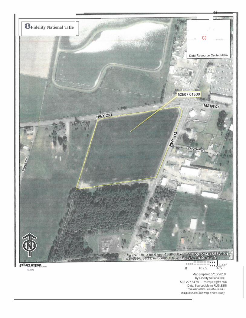
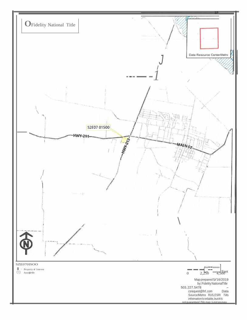
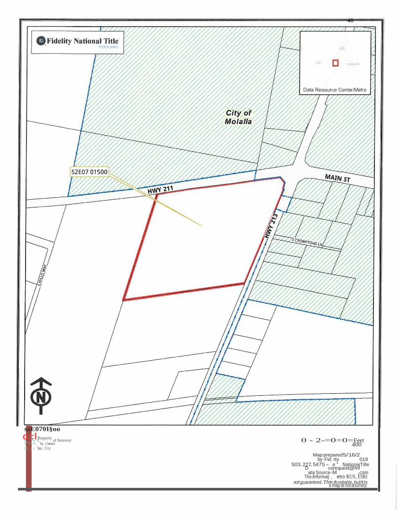
Address: SW Corner of OR-211 & OR-213
Tax Lot(s): 52E0701500
Applicant: Lyle Stratton of Stratton Innovations, LLC
Property Owners: Mike Graves of Crossroads Properties, LLC
I. APPLICABLE STANDARDS AND CRITERIA
Oregon Revised Statute 222.127 1. This section applies to a city whose laws require a petition proposing annexation of
territory to be submitted to the electors of the city.
2. Notwithstanding a contrary provision of the city charter or a city ordinance, upon
receipt of a petition proposing annexation of territory submitted by all owners of land in the territory, the legislative body of the city shall annex the territory without submitting the proposal to the electors of the city if:
City of Molalla ◼ Planning Department ◼ 117 N. Molalla Avenue, Molalla, OR 97038 ◼ (503) 759-0205
10
Page 10 of 4
a. The territory is included within an urban growth boundary adopted by the city or Metro, as defined in ORS 197.015;
b. The territory is, or upon annexation of the territory into the city will be, subject
to the acknowledged comprehensive plan of the city;
c. At least one lot or parcel within the territory is contiguous to the city limits or is
separated from the city limits only by a public right of way or a body of water; and d. The proposal conforms to all other requirements of the city’s ordinances.
3. The territory to be annexed under this section includes any additional territory
described in ORS 222.111 (1) that must be annexed in order to locate infrastructure and right of way access for services necessary for development of the territory described in subsection (2) of this section at a density equal to the average residential density within the annexing city.
4. When the legislative body of the city determines that the criteria described in
subsection (2) of this section apply to territory proposed for annexation, the legislative body may declare that the territory described in subsections (2) and (3) of this section is annexed to the city by an ordinance that contains a description of the territory annexed. [2016 c.51 §2]
17-4.3.070 Zone Change Criteria
Planning Commission review and recommendation, and City Council approval, of an ordinance amending the Zoning Map, Development Code, or Comprehensive Plan shall be based on all of the following criteria:
A. If the proposal involves an amendment to the Comprehensive Plan, the amendment must
be consistent with the Statewide Planning Goals and relevant Oregon Administrative Rules;
B. The proposal must be consistent with the Comprehensive Plan (the Comprehensive Plan
may be amended concurrently with proposed changes in zoning);
C. The City Council must find the proposal to be in the public interest with regard to community conditions; the proposal either responds to changes in the community, or it corrects a mistake or inconsistency in the subject plan or code; and
D. The amendment must conform to Section 17-4.6.050 Transportation Planning Rule Compliance
11
Page 11 of 4
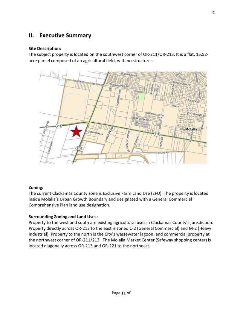
II. Executive Summary
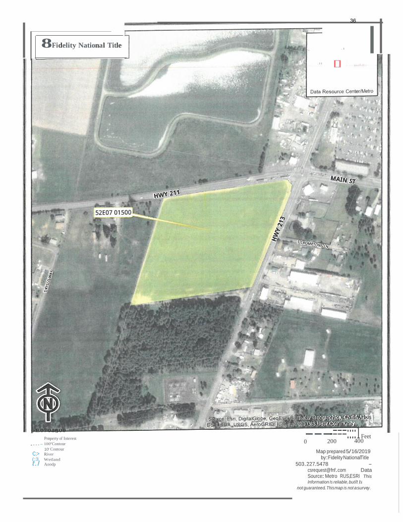
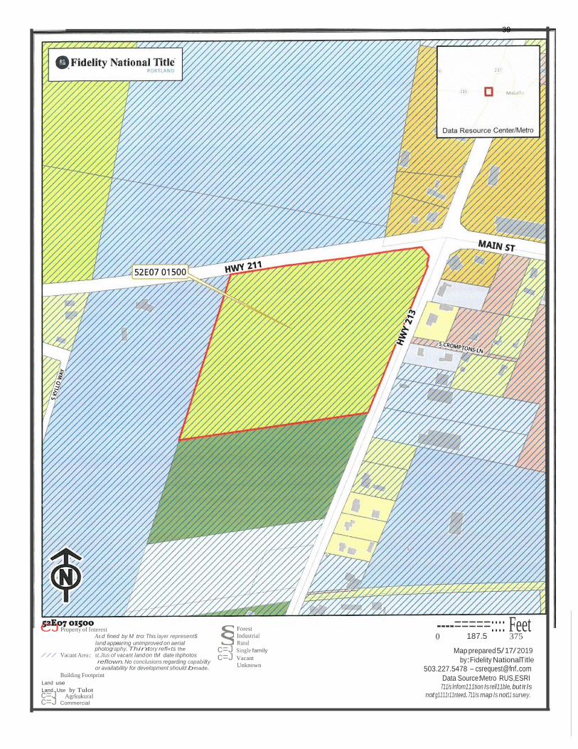
Site Description: The subject property is located on the southwest corner of OR-211/OR-213. It is a flat, 15.52-
acre parcel composed of an agricultural field, with no structures.
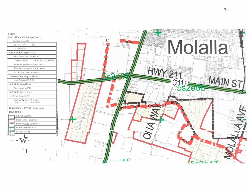
Zoning: The current Clackamas County zone is Exclusive Farm Land Use (EFU). The property is located inside Molalla’s Urban Growth Boundary and designated with a General Commercial Comprehensive Plan land use designation.
Surrounding Zoning and Land Uses: Property to the west and south are existing agricultural uses in Clackamas County’s jurisdiction. Property directly across OR-213 to the east is zoned C-2 (General Commercial) and M-2 (Heavy Industrial). Property to the north is the City’s wastewater lagoon, and commercial property at the northwest corner of OR-211/213. The Molalla Market Center (Safeway shopping center) is located diagonally across OR-213 and OR-221 to the northeast.
12
Page 12 of 4
Proposal: The applicant is proposing to annex a 15.52-acre property contiguous property into the City of Molalla. Consistent with the Molalla Comprehensive Plan, the property is proposing that the property be zoned General Commercial (C-2). No new development is proposed at this time.
Public Agency Responses: Staff sent notice of the project to the City’s Public Works Director, Fire Marshal, the Oregon Department of Transportation, and Clackamas County. All agencies had no comments. This is primarily because the annexation does not include new development and the proposed zoning designation complies with the City’s adopted Comprehensive Plan.
Public Notice and Comments: Notice of the public hearing was sent to all property owners within 300 feet of the subject properties and to a group of interested parties on October 16, 2019. The notice was posted on the City’s website on November 13 and published in the Molalla Pioneer on November 20, 2019. Signage containing public notice information was posted on the property on November 20, 2019. As of noon, on November 27, staff had received no public comments for this application.
III. Recommendation
Based on the application materials and findings demonstrating compliance with the applicable criteria, staff recommends that the Planning Commission approve an ordinance annexing the 15.52-acre subject property at the southwest corner of OR-211/OR-213, as described in application materials for AN01-2019 dated August 20, 2019.
Exhibits:
Exhibit A: AN01-2019 Application Package (including application, narrative, and legal description
Exhibit B: Findings of Fact
13
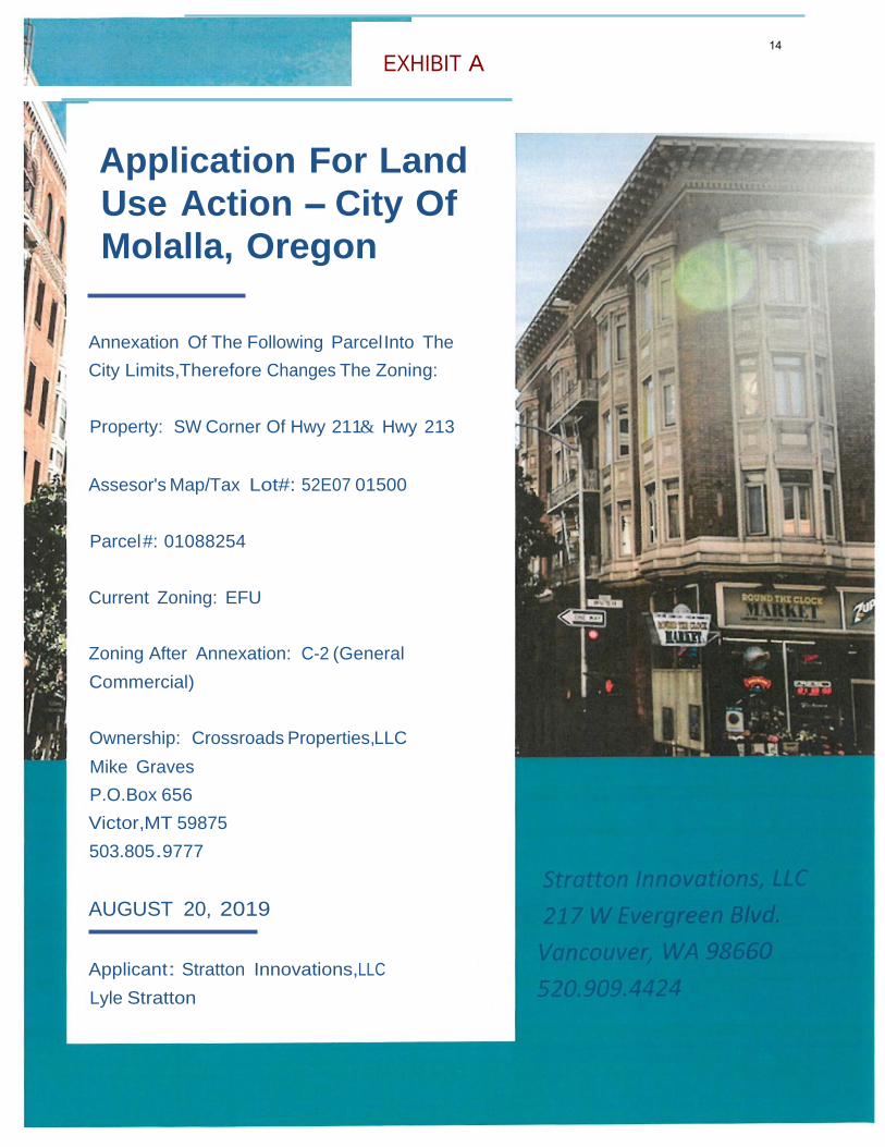
EXHIBIT A
Application For Land
Use Action - City Of
Molalla, Oregon
Annexation Of The Following Parcel Into The
City Limits,Therefore Changes The Zoning:
Property: SW Corner Of Hwy 211& Hwy 213
Assesor's Map/Tax Lot#: 52E07 01500
Parcel #: 01088254
Current Zoning: EFU
Zoning After Annexation: C-2 (General
Commercial)
Ownership: Crossroads Properties,LLC
Mike Graves
P.O.Box 656
Victor,MT 59875
503.805.9777
AUGUST 20, 2019
Applicant: Stratton Innovations,LLC
Lyle Stratton
14
2
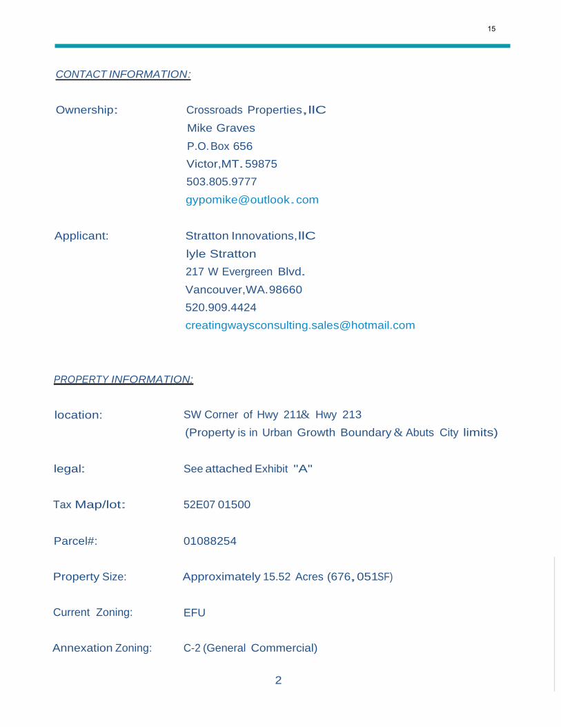
CONTACT INFORMATION:
Ownership: Crossroads Properties,llC
Mike Graves
P.O. Box 656
Victor,MT. 59875
503.805.9777
Applicant: Stratton Innovations,llC
lyle Stratton
217 W Evergreen Blvd.
Vancouver,WA.98660
520.909.4424
PROPERTY INFORMATION:
location: SW Corner of Hwy 211& Hwy 213
(Property is in Urban Growth Boundary & Abuts City limits)
legal: See attached Exhibit "A"
Tax Map/lot: 52E07 01500
Parcel#: 01088254
Property Size: Approximately 15.52 Acres (676,051SF)
Current Zoning: EFU
Annexation Zoning: C-2 (General Commercial)
15
3
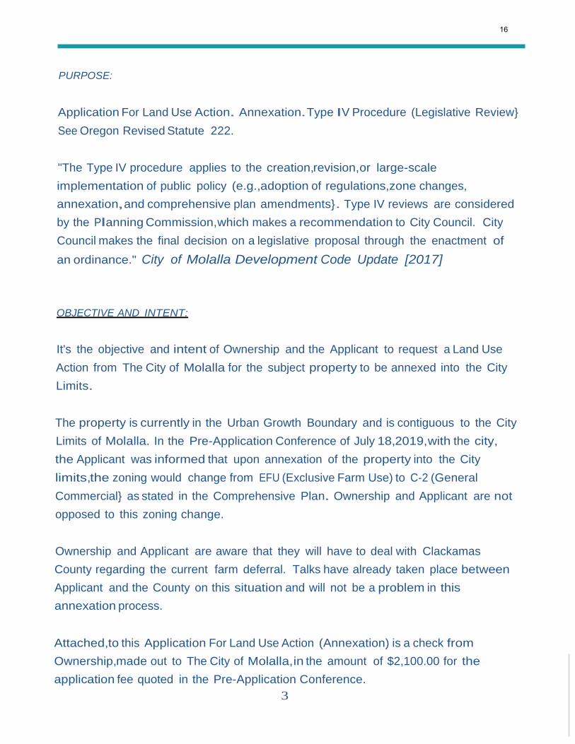
PURPOSE:
Application For Land Use Action. Annexation.Type IV Procedure (Legislative Review}
See Oregon Revised Statute 222.
"The Type IV procedure applies to the creation,revision,or large-scale
implementation of public policy (e.g.,adoption of regulations,zone changes,
annexation,and comprehensive plan amendments}. Type IV reviews are considered
by the Planning Commission,which makes a recommendation to City Council. City
Council makes the final decision on a legislative proposal through the enactment of
an ordinance." City of Molalla Development Code Update [2017]
OBJECTIVE AND INTENT:
It's the objective and intent of Ownership and the Applicant to request a Land Use
Action from The City of Molalla for the subject property to be annexed into the City
Limits.
The property is currently in the Urban Growth Boundary and is contiguous to the City
Limits of Molalla. In the Pre-Application Conference of July 18,2019,with the city,
the Applicant was informed that upon annexation of the property into the City
limits,the zoning would change from EFU (Exclusive Farm Use) to C-2 (General
Commercial} as stated in the Comprehensive Plan. Ownership and Applicant are not
opposed to this zoning change.
Ownership and Applicant are aware that they will have to deal with Clackamas
County regarding the current farm deferral. Talks have already taken place between
Applicant and the County on this situation and will not be a problem in this
annexation process.
Attached,to this Application For Land Use Action (Annexation) is a check from
Ownership,made out to The City of Molalla,in the amount of $2,100.00 for the
application fee quoted in the Pre-Application Conference.
16
4
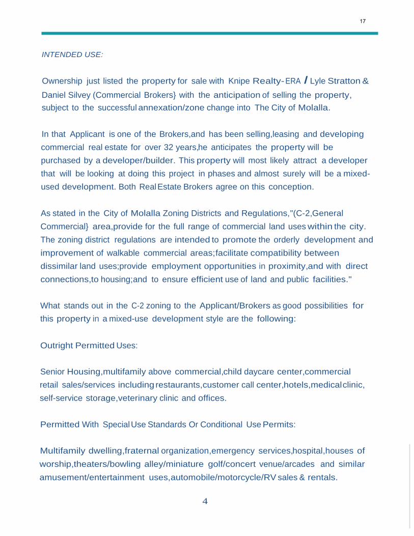
INTENDED USE:
Ownership just listed the property for sale with Knipe Realty- ERA I Lyle Stratton &
Daniel Silvey (Commercial Brokers} with the anticipation of selling the property,
subject to the successful annexation/zone change into The City of Molalla.
In that Applicant is one of the Brokers,and has been selling,leasing and developing
commercial real estate for over 32 years,he anticipates the property will be
purchased by a developer/builder. This property will most likely attract a developer
that will be looking at doing this project in phases and almost surely will be a mixed
used development. Both Real Estate Brokers agree on this conception.
As stated in the City of Molalla Zoning Districts and Regulations,"(C-2,General
Commercial} area,provide for the full range of commercial land uses within the city.
The zoning district regulations are intended to promote the orderly development and
improvement of walkable commercial areas;facilitate compatibility between
dissimilar land uses;provide employment opportunities in proximity,and with direct
connections,to housing;and to ensure efficient use of land and public facilities."
What stands out in the C-2 zoning to the Applicant/Brokers as good possibilities for
this property in a mixed-use development style are the following:
Outright Permitted Uses:
Senior Housing,multifamily above commercial,child daycare center,commercial
retail sales/services including restaurants,customer call center,hotels,medical clinic,
self-service storage,veterinary clinic and offices.
Permitted With Special Use Standards Or Conditional Use Permits:
Multifamily dwelling,fraternal organization,emergency services,hospital,houses of
worship,theaters/bowling alley/miniature golf/concert venue/arcades and similar
amusement/entertainment uses,automobile/motorcycle/RV sales & rentals.
17

5
CITY SERVICES:
In the Pre-Application Conference with The City of Molalla,city services were
discussed extensively. Applicant and Ownership both understand that until a
proposed development has been brought to the city's Public Works Department with
water,sewer and stormwater capacity needs,there is no way to determine if the
current facilities will accommodate the desired design,phases and the total
development as envisioned. Applicant was impressed with what the City of Molalla's
Public Works Department has done in recent years to minimize the strain on their
city services,especially on the north side of town.
ADDITIONAL ITEMS:
Ownership and Applicant both understand that with annexation/zone change will
require that all development will need to be built to The City Of Molalla's building
codes and infrastructure standards.
It's also recognized that any development will be required to submit all site plans,
building plans,traffic study and ingress/egress plans to Oregon Department of
Transportation (ODOT),for approval.
It's also recognized that the City of Molalla could require a wetland determination if
they find it necessary,before site plan can be approved.In Applicants research,he
found no part of the property was affected by wetlands.
18
6
FINANCIAL IMPACT ON THE CITY OF MOLALLA:
We can all agree that commercial land development is essential for a community's
success. While development can change the face of the landscape,it is imperative
for the prosperity of your town. It will generate more jobs,bring desired curb
appeal,unite community members,and maintain or increase home values.
Commercial development brings economic stability with more than new jobs,it
brings increased tax rolls to the city and brings dollars into your community from
people outside your area. It also stimulates growth in retail,real estate,equipment,
manufacturing,schools,and tourism,to name a few.
CONCLUSION:
Ownership of this property is known as Crossroads Properties,LLC. It's family owned
by several members of your city/county. Their family has been in this area for
several generations and only want the best for The City of Molalla.
It was a very tough decision for them to decide to sell this property that was owned
by their parents.
They feel that this property is one of the last parcels with excellent potential to
develop commercially within The Urban Growth Boundary. It will bring jobs,
opportunities,growth and money to the community they so intently care about.
Allowing this annexation is what's best for The City of Molalla and surrounding areas.
We are all excited what this annexation can do for this great area of Oregon.
Thank you for your consideration.
Respectfully,
Lyle Stratton- Stratton Innovations,LLC & Graves Family- Crossroads Properties,LLC
19
7
OREGON'S TRANSPORTATION PLANNING RULE: (addition to application)
The Applicant,The City of Molalla's Planning Director,The City of Molalla's City
Attorney and ODOT Region 1Staff are all in agreement that this annexation/zone
change request complies with the Oregon's Transportation Planning Rule OAR 660-
012-0060 {9) criteria is met. Kittleson and Associates (traffic engineers) who
prepared the City of Molalla's recently adopted TSP confirmed that the
comprehensive plan designation was assumed for the subject property. Therefore,
the Application does meet said criteria.
Applicable Section of OAR 6660-012-0600 {9):
{1) If an amendment to a functional plan,an acknowledged comprehensive plan,
or a land use regulation (including a zoning map) would significantly affect an
existing or planned transportation facility,then the local government must put
in place measures as provided is section (2) of this rule,unless the amendment
is allowed under section {3),{21or {10) of this rule.
9) Notwithstanding section (1) of this rule,a local government may find that an
amendment to a zoning map does not significantly affect an existing or planned
transportation facility if all of the following requirements are met.
(a) The proposed zoning is consistent with the existing comprehensive plan map
designation and the amendment does not change the comprehensive plan
map:
(b) The local government has an acknowledged TSP and the proposed zoning is
consistent with the TSP;and
(c) The area subject to the zoning map amendment was not exempted from this
rule at the time or an urban growth boundary amendment as permitted in OAR
660-024-0020 (1)(d),or the area was exempted from this rule but the local
government has a subsequently TSP amendment that accounted for
urbanization of the area.
20
8
ZONE CHANGE CRITERIA: (addition to application)
17-4.6.030 Criteria
Planning Commission review and recommendation,and City Council approval,of an
ordinance amending the Zoning Map.Development Code,or Comprehensive plan
shall be based on all of the following criteria:
A. If the proposal involves an amendment to the Comprehensive Plan,the
amendment must be consistent with the Statewide Planning Goals and
relevant Oregon Administrative Rules:
This application does not involve an amendment to the Comprehensive Plan.
The zone change reguested is what the Comprehensive Plan states.
B. The proposal must be consistent with the Comprehensive Plan (the
Comprehensive Plan may be amended concurrently with proposed changes in
zoning)
Again, this proposal is consistent with the Comprehensive Plan.
C. The City Council must find the proposal to be in the public interest with regard
to community conditions; the proposal either responds to changes in the
community,or it corrects a mistake or inconsistency in the subject plan or
code;and...
The City Council will find it's in the public's interest with regard to community
conditions in a public hearing.
D. The amendment must conform to Section 17-4.6.050 Transportation Planning
Rule Compliance (Ord.2017.081)
See page 7 of this application. Said annexation/zone change does conform to
17-4.6.050 Transportation Planning Rule and meets the criteria of said rule.
21
8Fidelity National Title·
·'
.II CJ
Property of Interest ----=====:::J Feet
Taxlots 0 187.5 375
Map prepared 5/16/2019
by:Fidelity NationalTitle
503.227.5478 - [email protected] Data Source:Metro RUS,ESRI This /nfonnatlonIs reliable,but It Is
not guaranteed.111/s map Is nota survey.
22
..
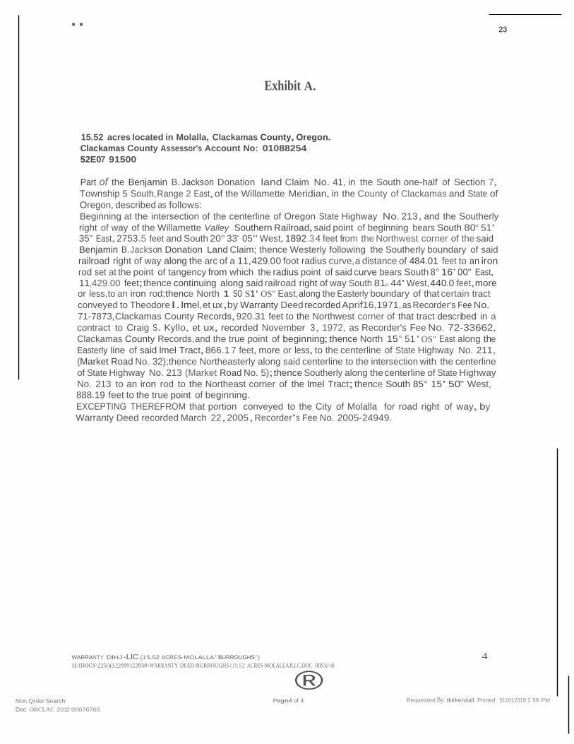
Exhibit A.
15.52 acres located in Molalla, Clackamas County, Oregon.
Clackamas County Assessor's Account No: 01088254
52E07 91500
Part of the Benjamin B. Jackson Donation land Claim No. 41, in the South one-half of Section 7,
Township 5 South,Range 2 East,of the Willamette Meridian, in the County of Clackamas and State of
Oregon, described as follows:
Beginning at the intersection of the centerline of Oregon State Highway No. 213, and the Southerly
right of way of the Willamette Valley Southern Railroad,said point of beginning bears South 80° 51' 35" East,2753.5 feet and South 20° 33' 05" West, 1892 .3 4 feet from the Northwest corner of the said
Benjamin B.Jackson Donation Land Claim; thence Westerly following the Southerly boundary of said
railroad right of way along the arc of a 11,429.00 foot radius curve,a distance of 484.01 feet to an iron
rod set at the point of tangency from which the radius point of said curve bears South 8° 16' 00" East,
11,429.00 feet;thence continuing along said railroad right of way South 81o 44' West,440.0 feet,more or less,to an iron rod;thence North 1 so S1 ' OS" East,along the Easterly boundary of that certain tract
conveyed to Theodore l.lmel, et ux,by Warranty Deed recorded Aprif16,1971, as Recorder's Fee No.
71-7873,Clackamas County Records,920.31 feet to the Northwest corner of that tract described in a
contract to Craig S. Kyllo, et ux, recorded November 3, 1972, as Recorder's Fee No. 72-33662,
Clackamas County Records,and the true point of beginning; thence North 15° 51 ' OS" East along the
Easterly line of said lmel Tract,866.1 7 feet, more or less, to the centerline of State Highway No. 211,
(Market Road No. 32);thence Northeasterly along said centerline to the intersection with the centerline
of State Highway No. 213 (Market Road No. 5);thence Southerly along the centerline of State Highway
No. 213 to an iron rod to the Northeast corner of the lmel Tract;thence South 85° 15' 50" West, 888.19 feet to the true point of beginning.
EXCEPTING THEREFROM that portion conveyed to the City of Molalla for road right of way, by
Warranty Deed recorded March 22,2005, Recorder's Fee No. 2005-24949.
WARRANTY DlHJ -LlC (15.52 ACRES-MOLALLA·"BURROUGHS") 4 H:IDOCS\225()().22999122830 \WARRANTY DEED·BURROUGHS (1S.S2 ACRES-MOLALLAJLLC.DOC IRIS:kl<dl
® Non.Qrder Search
Doc ORCLAC 2012 00076765
Page4 of 4 Requested By: tklrkendall, Pnnted 511612019 2 58 PM
23
900 SW 5th Ave,Mezzanine LevelPortland, Oregon 97204
1 Phone:(503) 227-LIST (5478) E-mail: [email protected]
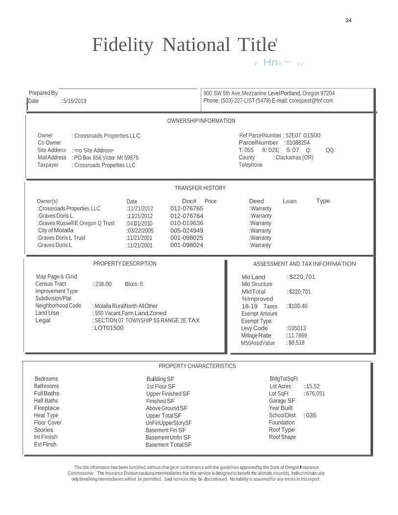
OWNERSHIP INFORMATION
Owner : Crossroads Properties LLC Ref ParcelNumber : 52E07 01500 Co Owner ParcelNumber :01088254
Site Address :•no Site Address• T: 05S R: 02E S: 07 Q: QQ:
MailAddress :PO Box 656 Victor Mt 59875 County : Clackamas (OR)
Taxpayer : Crossroads Properties LLC Telephone
TRANSFER HISTORY
Owner(s) Date Doc# Price Deed Loan Type :Crossroads Properties LLC :11/21/2012 012-076765 :Warranty
:Graves Doris L :11/21/2012 012-076764 :Warranty :Graves Russell E Oregon Q Trust :04101/2010 010-019636 :Warranty :City of Molalla :03/22/2005 005-024949 :Warranty :Graves Doris L Trust :11/21/2001 001-098025 :Warranty
:Graves Doris L :11/21/2001 001-098024 :Warranty
ASSESSMENT AND TAX INFORMATION
Mkt Land : $220,701 Mkt Structure
MktTotal :$220,701 %Improved
18-19 Taxes :$100.40
Exempt Amount
Exempt Type Levy Code :035013
Millage Rate :11.7869
M50AssdValue :$8,518
Fidelity National Title' r Hn1 '"'' LJ
Prepared By
I_ Date :5/16/2019
PROPERTY DESCRIPTION
Map Page & Grid
Census Tract
Improvement Type
Subdivision/Plat
Neighborhood Code
Land Use
Legal
:238.00 Block: 5 :Molalla RuralNorth AllOther : 550 Vacant,Farm Land,Zoned
:SECTION 07 TOWNSHIP 5S RANGE 2E TAX
: LOT01500
PROPERTY CHARACTERISTICS
Bedrooms
Bathrooms
Full Baths
Half Baths
Fireplace
Heat Type
Floor Cover
Stories lnt Finish
Ext Finsh
Building SF
1st Floor SF
Upper Finished SF
Finished SF Above Ground SF
Upper Total SF
UnFinUpperStorySF
Basement Fin SF
Basement Unfin SF
Basement TotalSF
BldgTotSqFt
Lot Acres
Lot SqFt
Garage SF
Year Built
School Dist Foundation
Roof Type
Roof Shape
:15.52
:676,051 : 035
This title information has been furnished, without charge,in conformance with the guidelines approved by the State of OregonInsurance
Commissioner. The Insurance Division cautions intermediaries that this service is designed to benefit the ultimate insureds. Indiscriminate use
only benefiting intermediaries willnot be permitted. Said services may be discontinued. No liability is assumed for any errors in this report.
24
·
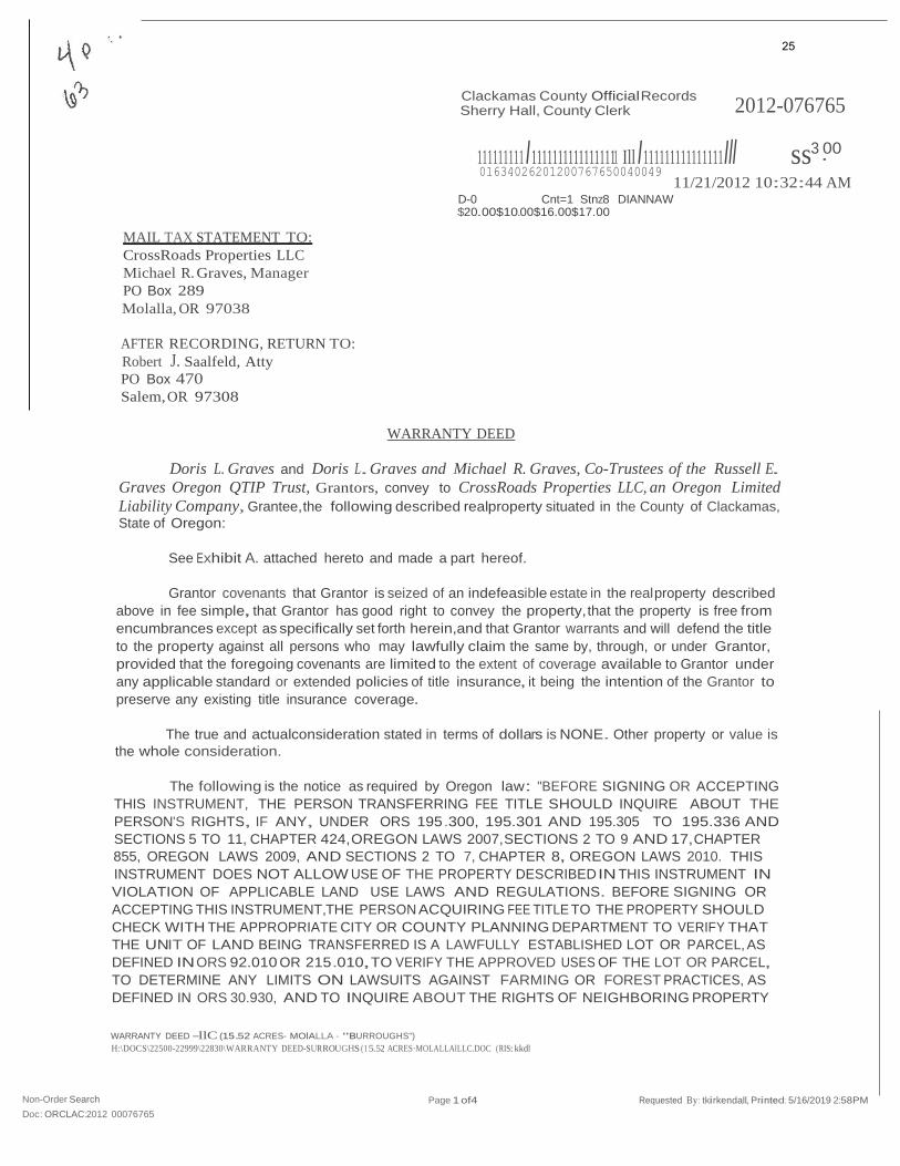
2012-076765
Clackamas County Official Records Sherry Hall, County Clerk
111111111 I11111111111111111 Ill I111111111111111Ill ss3 00 01634026201200767650040049
11/21/2012 10:32:44 AM
MAIL TAX STATEMENT TO:
CrossRoads Properties LLC
Michael R. Graves, Manager
PO Box 289
Molalla, OR 97038
AFTER RECORDING, RETURN TO:
Robert J. Saalfeld, Atty
PO Box 470
Salem, OR 97308
D-0 Cnt=1 Stnz8 DIANNAW $20.00$10.00$16.00$17.00
WARRANTY DEED
Doris L. Graves and Doris L.Graves and Michael R. Graves, Co-Trustees of the Russell E.
Graves Oregon QTIP Trust, Grantors, convey to CrossRoads Properties LLC, an Oregon Limited
Liability Company, Grantee,the following described realproperty situated in the County of Clackamas,
State of Oregon:
See Exhibit A. attached hereto and made a part hereof.
Grantor covenants that Grantor is seized of an indefeasible estate in the real property described
above in fee simple, that Grantor has good right to convey the property, that the property is free from
encumbrances except as specifically set forth herein,and that Grantor warrants and will defend the title
to the property against all persons who may lawfully claim the same by, through, or under Grantor,
provided that the foregoing covenants are limited to the extent of coverage available to Grantor under
any applicable standard or extended policies of title insurance, it being the intention of the Grantor to
preserve any existing title insurance coverage.
The true and actualconsideration stated in terms of dollars is NONE. Other property or value is
the whole consideration.
The following is the notice as required by Oregon law: "BEFORE SIGNING OR ACCEPTING
THIS INSTRUMENT, THE PERSON TRANSFERRING FEE TITLE SHOULD INQUIRE ABOUT THE
PERSON'S RIGHTS, IF ANY, UNDER ORS 195.300, 195.301 AND 195.305 TO 195.336 AND
SECTIONS 5 TO 11, CHAPTER 424,OREGON LAWS 2007,SECTIONS 2 TO 9 AND 17,CHAPTER
855, OREGON LAWS 2009, AND SECTIONS 2 TO 7, CHAPTER 8, OREGON LAWS 2010. THIS
INSTRUMENT DOES NOT ALLOW USE OF THE PROPERTY DESCRIBED IN THIS INSTRUMENT IN
VIOLATION OF APPLICABLE LAND USE LAWS AND REGULATIONS. BEFORE SIGNING OR
ACCEPTING THIS INSTRUMENT,THE PERSON ACQUIRING FEE TITLE TO THE PROPERTY SHOULD
CHECK WITH THE APPROPRIATE CITY OR COUNTY PLANNING DEPARTMENT TO VERIFY THAT
THE UNIT OF LAND BEING TRANSFERRED IS A LAWFULLY ESTABLISHED LOT OR PARCEL, AS
DEFINED IN ORS 92.010 OR 215.010,TO VERIFY THE APPROVED USES OF THE LOT OR PARCEL,
TO DETERMINE ANY LIMITS ON LAWSUITS AGAINST FARMING OR FOREST PRACTICES, AS
DEFINED IN ORS 30.930, AND TO INQUIRE ABOUT THE RIGHTS OF NEIGHBORING PROPERTY
WARRANTY DEED -llC (15.52 ACRES- MOlALLA - "BURROUGHS")
H:\DOCS\22500-22999\22830\WARRANTY DEED-SURROUGHS (1 5.52 ACRES·MOLALLAlLLC.DOC (RIS:kkdl
Non-Order Search
Doc: ORCLAC:2012 00076765
Page 1 of4 Requested By: tkirkendall,Printed: 5/16/2019 2:58PM
25
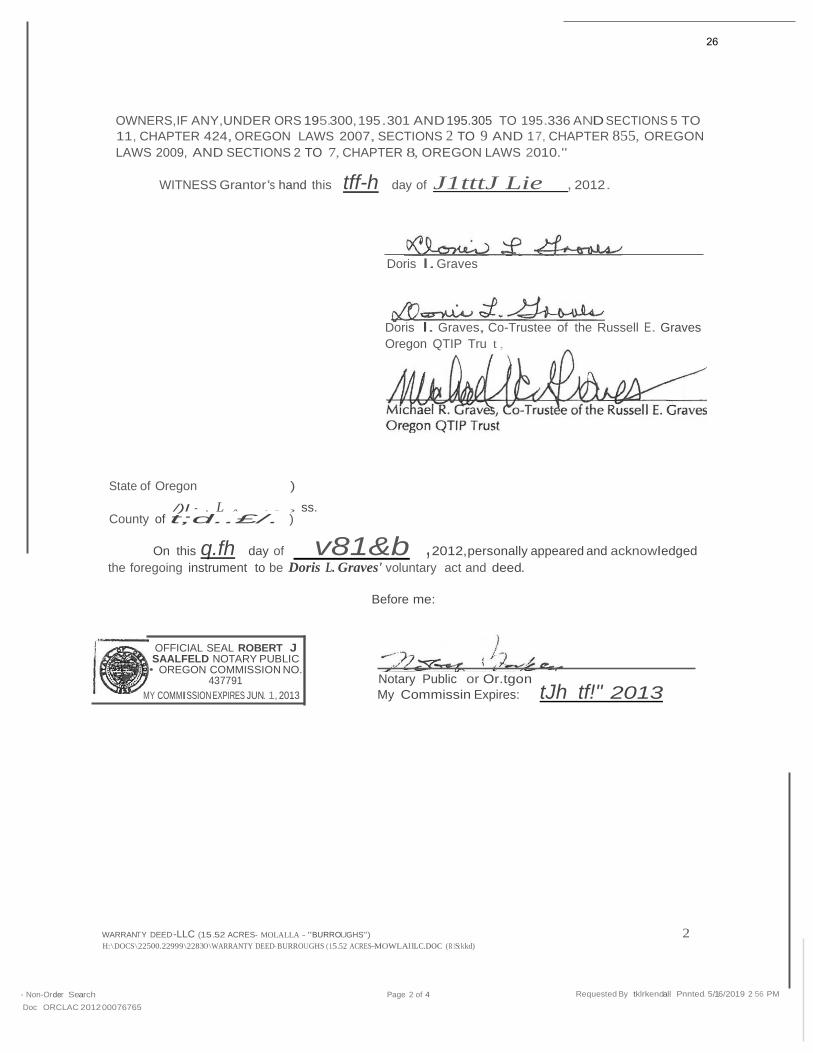
OWNERS,IF ANY,UNDER ORS 195.300, 195.301 AND 195.305 TO 195.336 AND SECTIONS 5 TO
11, CHAPTER 424, OREGON LAWS 2007, SECTIONS 2 TO 9 AND 1 7, CHAPTER 855, OREGON
LAWS 2009, AND SECTIONS 2 TO 7, CHAPTER 8, OREGON LAWS 2010."
WITNESS Grantor's hand this tff-h day of J1tttJ Lie , 2012.
Doris l. Graves
Doris l. Graves, Co-Trustee of the Russell E. Graves
Oregon QTIP Tru t ,
State of Oregon )
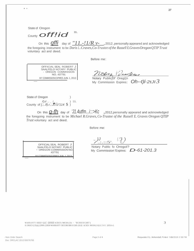
/)I - . L A - - ) ss. County of t;d..£/. )
On this q.fh day of · v81&b ,2012,personally appeared and acknowledged
the foregoing instrument to be Doris L. Graves' voluntary act and deed.
Before me:
OFFICIAL SEAL ROBERT J SAALFELD NOTARY PUBLIC • OREGON COMMISSION NO.
437791
MY COMMISSION EXPIRES JUN. 1, 2013
Notary Public or Or.tgon
My Commissin Expires: tJh tf!" 2013
WARRANTY DEED -LLC (15.52 ACRES- MOLALLA - "BURROUGHS") 2 H:\DOCS\22500.22999\22830\WARRANTY DEED- BURROUGHS (15.52 ACRES-MOWLAllLC.DOC (R IS:kkd)
· Non-Order Search
Doc ORCLAC 2012 00076765
Page 2 of 4 Requested By tklrkendall Pnnted. 5/16/2019 2 56 PM
26
. .
State of Oregon
County off!id ss.
On this qffi day of "11.-!1/R v- , 2012,personally appeared and acknowledged
the foregoing instrument to be Doris L.Craves,Co-Trustee of the Russell E.Graves Oregon QTIP Trust voluntary act and deed.
Before me:
OFFICIAL SEAL ROBERT J SAALFELO NOTARY PUBLIC
- OREGON COMMISSION NO. 437791
MY COMMISSION EXPIRES JUN.1, 2013
-
Notary Publicfor Oreg((n
My Commission Expires: Oh--t)l--2tJI 3
State of Oregon )
/} I ..... _ /_ _ ) 55.
County of [.;..lf).r.;.Jt:/1/'114 $ )
On this q-fh day of 'J1.4utfm...i:::>Kc ,2012,personally appeared and acknowledged
the foregoing instrument to be Michael R.Graves, Co-Trustee of the Russell E. Graves Oregon QTIP Trust voluntary act and deed.
Before me:
OFFICIAL SEAL ROBERT J SAALFELO NOTARY PUBLIC • OREGON COMMISSION NO.
437791
MY COMMISSION EXPIRES JUN. 1, 2013 -
..,. }J (.:'} ) / ...:.::5'. c../
Notary Public fo Oregol?
My Commission 'Expires: D-61-201.3
WARRANTY OEED -LLC (15.52 ACRES-MOlALlA · "BU RROUGHS") 3 H:\DOCS \225()().22999\22830\WARRANTY DEED·BURROUGHS (1S.S2 ACRES·MOlALlA)LLC.DOC (RJS:Idcd)
·Non·Order Search
Doc ORCLAC:2012 00076765
Page 3 of 4 Requested By. tkirkendall, Printed 5/16/2019 2:58 PM
27
S Crompto
·,(_; ..
•l·'tl
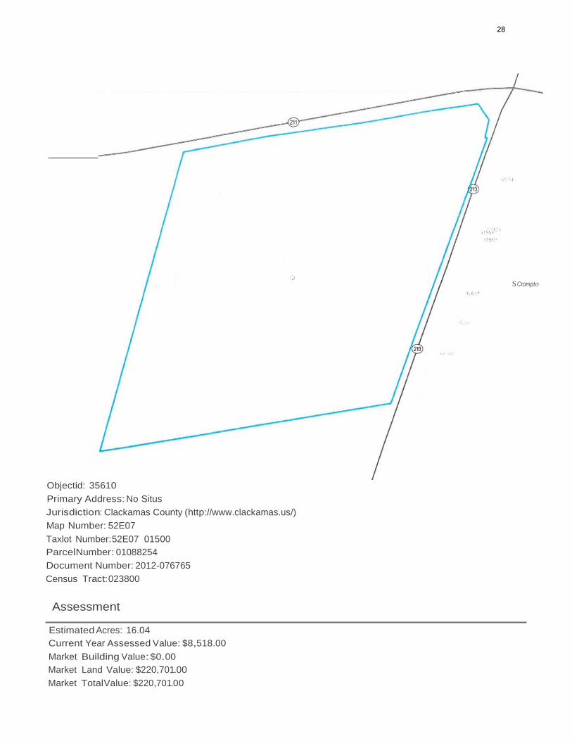
Objectid: 35610
Primary Address: No Situs
Jurisdiction: Clackamas County (http://www.clackamas.us/)
Map Number: 52E07
Taxlot Number:52E07 01500
ParcelNumber: 01088254
Document Number: 2012-076765
Census Tract:023800
Assessment
Estimated Acres: 16.04
Current Year Assessed Value: $8,518.00
Market Building Value:$0.00
Market Land Value: $220,701.00
Market TotalValue: $220,701.00
28
Sale Price: $0.00
Doc Date:11/09/2012
Doc Type: S
Taxcode: 035013
Schools
Elementary School
Rural Dell Elementary (http://ruraldell.molallariv.k12.or.us/)
Molalla River
10500 S Hwy 211, Molalla, 97038
503-651-2128
Middle School
Molalla River Middle (http://mrms.molallariv.k12.or.us)
Molalla River
318 Leroy Ave, Molalla, 97038
503-829-6133
High School
Molalla High (http://mhs.molallariv.k12.or.us}
Molalla
357 Frances St. Molalla, 97038
503-829-6382
Public Safety
Nearest Fire Station
Molalla Station #82
320 N Molalla Ave, Molalla 97038
Molalla RFPD #73
Nearest Police Station
Clackamas County Sheriff
Zoning & Development
Designation: EFU
Urban Growth Boundary: MOLALLA UGB
Voting Voting Precinct: 351
29
State House District: 18
State Senate District: 9
Congressional District: 5
Utilities & Districts
Cable Provider
Wave Broadband (Molalla}
Community Planning Organization
Molalla
Sanitary Hauler
Molalla Sanitary (https://clackamas.us/recycling/garbage/company.html)
Distant Rural Fee Zone
School District
Molalla River (http://www.molallariv.k12.or.us)
Environmental& Hazards
Flood
Likely not in a flood zone.
Wildfire
You may be at low to moderate risk.
Earthquake Hazard
You may be at a lower risk.
Soils
1A- Aloha Silt Loam, 0 To 3 Percent Slopes
3 - Amity Silt Loam
1A- Aloha Silt Loam, 0 To 3 Percent Slopes
29 - Dayton Silt Loam
Approximate Elevation
336.00 ft
North Folk Dam Failure
30
accuracy of the maps and associated data from several sources. Clackamas County makes no warranty,
Most likely not at risk of flooding due to dam failure
River Mill Dam Failure
Most likely not at risk of flooding due to dam failure
Timothy Dam Failure
Most likely not at risk of flooding due to dam failure
Parks
Nearby
Billy Sheets Field and BMX Track (http://www.cityofmolalla.com/parksrec/page/billy-sheets-field-bmx-track)
920 Toliver Rd. Molalla
0.69 miles
Molalla Skate Park (http://www.cityofmolalla.com/parksrec/page/molalla-skate-park)
215 Kennel Ave, Molalla
1.48 miles
Odd Fellows Park (http://www.cityofmolalla.com/parksrec/page/odd-fellows-park)
106 S Molalla Ave, Molalla
1.53 miles
Rotary Park
510 W Main St. Molalla
1.27 miles
Sally Fox MemorialPark (http://www.cityofmolalla.com/parksrec/page/sally-fox-park)
425 S Molalla Ave. Molalla
1.54 miles
Documents
Assessor Documents
Taxmap - 5S2E07 (http://cmap.clackamas.us/taxmap/03_5s2e07.pdf)
District Maps
Voting Precinct (https://dochub.clackamas.us/documents/drupal/c3421f6f-0684-4abf-91e4-28e19cc4ecc8)
State House District (https://dochub.clackamas.us/documents/drupal/c73f1Of1-225a-4856-b5d4-
d6347e0d41cc)
Disclaimer & Liability
The information and maps accessed through this web site provide a visual display for your convenience using data
from Clackamas County's Geographic Information System. Every reasonable effort has been made to assure the
31

representation or guarantee as to the content, sequence, accuracy, timeliness or completeness of any of the data
provided herein. Clackamas County explicitly disclaims any representations and warranties, including, without
limitation, the implied warranties of merchantability and fitness for a particular purpose. Clackamas County shall
assume no liability for any errors, omissions, or inaccuracies in the information provided regardless of how caused.
Clackamas County assumes no liability for any decisions made or actions taken or not taken by the user of this
information or data furnished hereunder. Users are strongly advised to verify from authoritative sources any
information displayed in this application before making decisions.
Liability Statement (http://www.clackamas.us/liability.html)
32
N
0
Fidelity National Title' 900 SW 5th Ave., Mezzanine Level Portland, Oregon 97204l Tl
Phone:(503) 227-LIST (5478) E-mail: [email protected]
Parcel#: 01088254 Ref Parcel Number : 52E07 01500
,55 .- •.
e:3Pf\:t· 3\llt .
.......
This map/plat is being furnished as an aid in locating the herein described Land in relation to adjoining streets, natural boundaries and other land, and is
not a survey of the land depicted. Except to the extent a policy of title insurance is expressly modified by endorsement, if any, the Company does not insure dimensions, distances, location of easements, acreage or other matters shown thereon.
33
I
,
l
:
:
\ '
8.Fidelity National Title·
I r
I I -
I I
·" 0 I
j
I I
L - , !(- ,:
I ! I
:i .
I
:::...·-- t I I
0 ! 0 ; :::E Q:
I
SZE070ISOO
c:::J Pro rty of Interest
---c::==::= Feet
Inc City 0 500 1,000
Molalla
-••• Cily limits
Par1<s and/or NaturalAreas
Home Owners Association
'-= Airport
Map prepared 5/16/2019
by:Fidelity NationalTrtle
503.227.5478 - [email protected] Data Source:Metro RUS,ESRI This information Is reliable,but It Is
not guaranteed.T1ris map Is not a survey.
34
f
8.Fidelity National Title I
tr I/
I'
/,I
t f
f I
/
52E07 01500
J 0
f "'
SZE070ISOO ----=====:: Feet c::::::J Prope<ty of Interest
-(1- Bike Route 0 500 1,000
c::::::J Airport Map prepared 5/16/2019
by:Fidelity NationalTrtle
503.227.5478 - csrequest@fnf com Data Source:Metro RUS,ESRI Tlris InformationIs reliable,butItIs
not guaranteed.Tills map Is not a survey.
35
400
8Fidelity National Title· .I
.II []
pE0701§00
Property of Interest
,...- 100'Contour
10' Contour
C;> River
(;3 Wetland
t.l Aoodp
----===::::1Feet 0 200
Map prepared 5/16/2019 by:Fidelity NationalTitle
503.227.5478 - [email protected] Data Source:Metro RUS,ESRI This
Information Is reliable, butIt Is
not guaranteed.Thismap is not a survey.
36
/
I
l
\
\
---c::==::::::J
0Fidelity National Title
'·,
J I
-----1 \ /
\ \
·,,,
·,
'·.
I /
I /
-·- .. - j- /
/
I
i I I
\
·- -- . - J: '. 'J•,
l
.... , \ \ SZE070ISOO
I- Property of Interest
03 Aoodpl<lin Feet 0 2,250 4,500
Map prepared 5/16/2019
by:Fidelity NationalTitle 503.227.5478 -
[email protected] Data Source:Metro RUS,ESRI Tills
infotmationIsreliable,butit Is not guaranteed.7hls map Is not asurvey.
37
---J
I· ·• ---.. ·:----'i
·,,,
-- --_- .,._·-- ---
Legend
. ·' ; l '
1
r--------·- Natur alRno<JrC@ Zon•no Districts • ; _r---.L- r 'l... - . _ _ . 11 -j
P.g l ore-51IAGO'I f ' : Jf- &Gl'wve Fa"" • E;;u:
1t"'l)9f (lSCf)
1 ResidentialZoning D<slrl s
Farm Fo<e>l 10-e (FF-10)
HuralRe<>'De!lliBIh"" FCft 5-Al:re (f(Rff -SI , _,
RuralArea Resldenual2-Aete I RA - 2)
R'J<ai Are.a qrs<denllat I·Acre (RA-11
Fu!Vre U<ban 10-A.cre CFV- 10)
eICommo!!ret!llZontng Dtstrlet$
H!JralComme<c!i!l cRC1
lndtntral llontng Oi&trlets
RuralIMU!tnal(RH
Sp!X;IalZo!llng Olstmls
L1n-r.11d Vie Zone {lUZ)
Hts1one O•; tntl CHOl Overlay
H>slooc Landmal'\ I HL l Ove<lay
II!BMonera1ai'!!AW< rf.e r la y MAOJ
Boundanea
Cla-,<.an-aC; ounty
lJrt)an Grool'!ll 8oundary
Un•nrorwa:ed Cornm<J <:y
M' Hood Natonel Fcres1
City B!>ur>Oilf 4l
·'"-- -' w
L-
-=::::=:'"T·-- ---
II
..
J-:
_ij .
I'
• I I l
l I r--J.1_,:_..
......._ (·
f:'
r---.....- --
....
·.)
·- •- I
' ' .....
<.....;
....
..I
II ::-,.,._....,;---4{_ 0
38
§
CJ Property of I nterest
Forest ----=====:::: Feet
As d fined by M tro: This layer represent$
land appearing unimproved on aerial Industrial
Rural 0 187.5 375
photography.Thintory refl«ts the c=J Single family Map prepared 5/ 17/2019 /// Vacant Area: st.Jtus of vacant land on tM date thphotos
reflown. No conclusions regarding capability or availability for development should bmade.
Building Footprint
Land use
Land Use by Tulot c=J Agrkukural c=J Commercial
c=J Vacant
Unknown by:Fidelity NationalTitle
503.227.5478 - [email protected] Data Source:Metro RUS,ESRI
711/s lnfom111tion Isrell11ble,but It Is notg1111r11nteed.711/s map Is not11 survey.
39
c::l Property
szE070I§oo
-··- C . of Interest V7A lty L1mits
LL..LJ Inc. City
0 - 2-=0=0=Feet 400
Map prepared5/16/2
by·Fid rty 019 503.227.547S - e ' NationaiTitle
D csrequest@fnf ata Source·M .com
This lnformatj . etro RUS, ESRI not guaranteed.ThtnIsreliable,butIt Is
s map Is not asurvey.
40
May 17, 2019
s oR·
esrr•
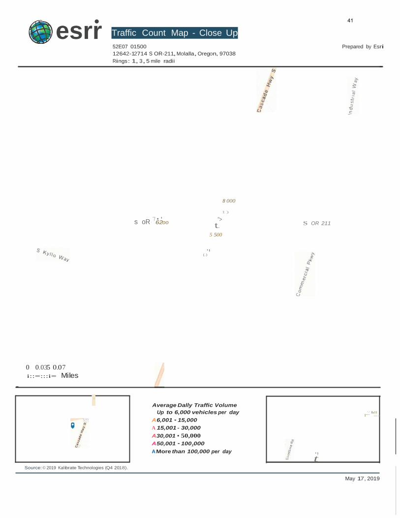
Traffic Count Map - Close Up 52E07 01500
12642-12714 S OR-211,Molalla, Oregon, 97038
Rings: 1, 3,5 mile radii
Prepared by Esri
8 000
0 0.035 0.07
i::=:::i= Miles
7•' 62oo
1)
">
t.....
5 500
., (.)
S OR 211
'
Source: © 2019 Kalibrate Technologies (Q4 2018).
Average Dally Traffic Volume
Up to 6,000 vehicles per day
A6,001 ·15,000
A 15,001 - 30,000
A30,001 • 50,000
A50,001 ·1001000
A More than 100,000 per day ., t
'·' h ll
l'"'" 111.11
41
Source:Esri
May 17, 2019
- I
esrr•
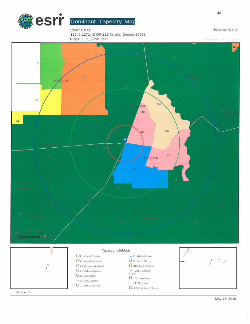
Dominant Tapestry Map 52E07 01500
12642-12714 S OR-211, Molalla, Oregon, 97038
Rings: 1, 3,5 mile radii
Prepared by Esri
28
SA
I Tapestry LifeMode
LJ Ll : Afnuenl Estates •l8: Middle Ground
,.,•.. /
.·,' t
0 L2: Upsule Avenues
0 L3: U!llown lndovlduals
0 L: Fam•ly lAndscapes
0 LS: Genxurban
•L6:COzy Country
0 L7:Eth111c Encl•ves
LJ L9: SeNor Sty ..
n LID: R ustle Out posts
• Lll : Midtown
S.09les
0 Ll2: ometown
Ll3: Ne>t wave
0Ll: SCholarS and Poltrlots
i ·' ..·.,..·
42
Source:Esri
May 17, 2019
Oesri· Dominant Tapestry Map
52E07 01500
12642-12714 S OR-211, Molalla,Oregon,97038
Rings: 1, 3, 5 mile radii
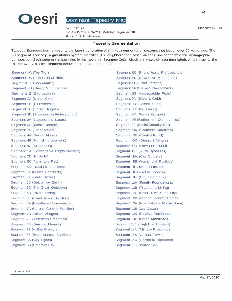
Tapestry Segmentation
Prepared by Esri
Tapestry Segmentation represents the latest generation of market segmentation systems that began over 30 years ago. The
68-segment Tapestry Segmentation system classifies U.S. neighborhoods based on their socioeconomic and demographic
composition. Each segment is identified by its two-digit Segment Code. Match the two-digit segment labels on the map to the
list below. Click each segment below for a detailed description.
Segment lA (Top Tier)
Segment lB (Professional Pride)
Segment lC (Boomburbs)
Segment lD (Savvy Suburbanites)
Segment lE (Exurbanites)
Segment 2A (Urban Chic)
Segment 2B (Pleasantville)
Segment 2C (Pacific Heights)
Segment 2D (Enterprising Professionals)
Segment 3A (Laptops and Lattes)
Segment 3B (Metro Renters)
Segment 3C (Trendsetters)
Segment 4A (Soccer Moms)
Segment 4B (HomeImprovement)
Segment 4C (Middleburg)
Segment SA (Comfortable Empty Nesters)
Segment SB (In Style)
Segment SC (Parks and Rec)
Segment SD (Rustbelt Traditions)
Segment SE (Midlife Constants)
Segment 6A (Green Acres)
Segment 6B (Salt of the Earth)
Segment 6C (The Great Outdoors)
Segment 6D (Prairie Living)
Segment 6E (Rural Resort Dwellers)
Segment 6F (Heartland Communities)
Segment 7A (Up and Coming Families)
Segment 7B (Urban Villages)
Segment 7C (American Dreamers)
Segment 7D (Barrios Urbanos)
Segment 7E (Valley Growers)
Segment 7F (Southwestern Families)
Segment SA (City Lights)
Segment SB (Emerald City)
Segment SC (Bright Young Professionals)
Segment SD (Downtown Melting Pot)
Segment SE (Front Porches)
Segment SF (Old and Newcomers)
Segment SG (Hardscrabble Road)
Segment 9A (Silver & Gold)
Segment 9B (Golden Years)
Segment 9C (The Elders)
Segment 9D (Senior Escapes)
Segment 9E (Retirement Communities)
Segment 9F (Social Security Set)
Segment lOA (Southern Satellites)
Segment lOB (Rooted Rural)
Segment lOC (Diners & Miners)
Segment lOD (Down the Road)
Segment lOE (Rural Bypasses)
Segment llA (City Strivers)
Segment llB (Young and Restless)
Segment llC (Metro Fusion)
Segment llD (Set to Impress)
Segment llE (City Commons)
Segment 12A (Family Foundations)
Segment 12B (Traditional Living)
Segment 12C (Small Town Simplicity)
Segment 12D (Modest Income Homes)
Segment 13A (International Marketplace)
Segment 13B (Las Casas)
Segment 13C (NeWest Residents)
Segment 13D (Fresh Ambitions)
Segment 13E (High Rise Renters)
Segment 14A (Military Proximity)
Segment 14B (College Towns)
Segment 14C (Dorms to Diplomas)
Segment 15 (Unclassified)
43
Source:U.S. Census Bureau,Census 2010 Summary File 1. Esri forecasts for 2018 and 2023 Esri converted Census 2000 data into 2010 geography.
May 17, 2019
esrr•
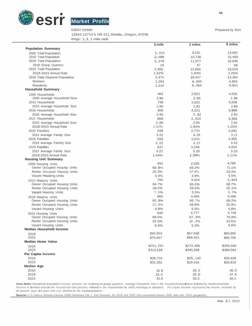
Population Summary
Market Profile 52E07 01500
12642-12714 S OR-211, Molalla, Oregon,97038
Rings: 1,3, 5 mile radii
1 mile
Prepared by Esri
3 miles 5 miles
2000 Total Population 1,315
2010 Total Population 2, 088
2018 Total Population 2, 278
2018 Group Quarters 19
2023 Total Population 2,456
8,152 13,092
10,730 15,456
11,977 16,935
57 59
12,856 18,016
2018-2023 Annual Rate 1.52% 1.43% 1.25%
2018 Total Daytime Population 2,471 10,407 13,464
Workers 1,261 4,043 4,663
Residents 1,210 6,364 8,801
Household Summary 2000 Households 462 2,821 4,535
2000 Average Household Size 2.80 2.85 2.86
2010 Households 738 3,803 5,508
2010 Average Household Size 2.80 2.81 2.80
2018 Households 806 4,221 5,999
2018 Average Household Size 2.80 2. 82 2.81
2023 Households 869 4,524 6,368
2023 Average Household Size 2.80 2.83 2.82
2018-2023 Annual Rate 1.52% 1.40% 1.20%
2010 Families 548 2,772 4,091
2010 Average Family Size 3.22 3.25 3.21
2018 Families 593 3,043 4,405
2018 Average Family Size 3.22 3.27 3.23
2023 Families 637 3,246 4,654
2023 Average Family Size 3.22 3.28 3.23
2018-2023 Annual Rate 1.44% 1.30% 1.11%
Housing Unit Summary 2000 Housing Units 491 2,935 4,796
Owner Occupied Housing Units 68.8% 69.2% 71.1%
Renter Occupied Housing Units 25.3% 27.0% 23.4%
Vacant Housing Units 5.9% 3.9% 5.5%
2010 Housing Units 794 4,024 5,843
Owner Occupied Housing Units 64.7% 65.0% 68.7%
Renter Occupied Housing Units 28.2% 29.5% 25.5%
Vacant Housing Units 7.1% 5.5% 5.7%
2018 Housing Units 865 4,466 6,366
Owner Occupied Housing Units 65.9% 65.7% 69.2%
Renter Occupied Housing Units 27.2% 28.8% 25.0%
Vacant Housing Units 6.8% 5.5% 5.8%
2023 Housing Units 930 4,777 6,748
Owner Occupied Housing Units 68.0% 67. 8% 70.9%
Renter Occupied Housing Units 25.5% 26 . 9% 23.5%
Vacant Housing Units 6.6% 5.3% 5.6%
Median Household Income 2018 $60,903 $57,638 $60,895
2023 $70,057 $66,421 $69,705
Median Home Value
2018 $251, 293 $272,496 $305,506
2023 $324,118 $345,598 $384,564
Per Capita Income
2018 $26,718 $25, 142 $26,628
2023 $31,262 $29,416 $30,810
Median Age
2010 31.8 33.2 36.0
2018 33.5 35.0 37.6
2023 33.6 35.4 38.4
Data Note: Household population includes persons not residing in group quarters. Average Household Size is the household population divided by totalhouseholds.
Persons in families include the householder and persons related to the householder by birth, marriage,or adoption. Per Capita Income represents the income received by
all persons aged 15 years and over divided by the total population.
44
Source:U.S. Census Bureau,Census 2010 Summary File 1. Esri forecasts for 2018 and 2023 Esri converted Census 2000 data into 2010 geography.
May 17, 2019
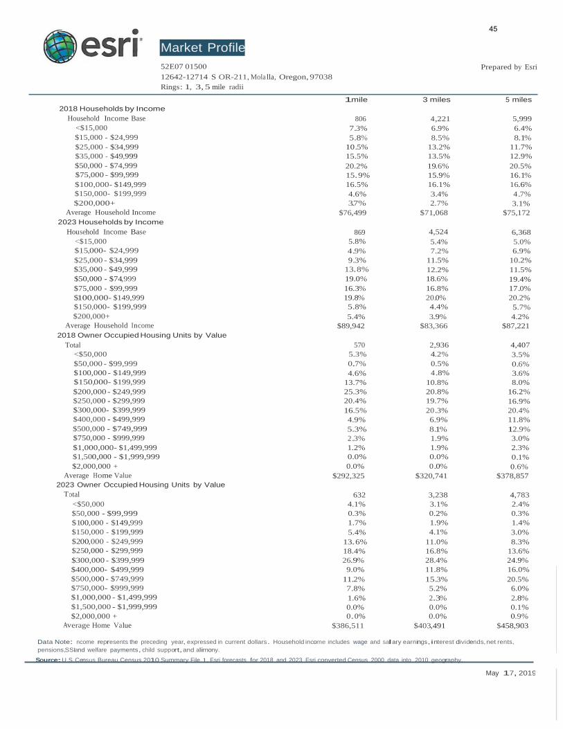
otal 632 3,238 4,783
<$50,000 4.1% 3.1% 2.4%
$50,000 - $99,999 0.3% 0.2% 0.3%
$100,000 - $149,999 1.7% 1.9% 1.4%
$150,000 - $199,999 5.4% 4.1% 3.0%
$200,000 - $249,999 13.6% 11.0% 8.3%
$250,000 - $299,999 18.4% 16.8% 13.6%
$300,000 - $399,999 26.9% 28.4% 24.9%
$400,000- $499,999 9.0% 11.8% 16.0%
$500,000 - $749,999 11.2% 15.3% 20.5%
$750,000- $999,999 7.8% 5.2% 6.0%
$1,000,000 - $1,499,999 1.6% 2.3% 2.8%
$1,500,000 - $1,999,999 0.0% 0.0% 0.1%
$2,000,000 + 0.0% 0.0% 0.9%
erage Home Value $386,511 $403,491 $458,903
Market Profile
52E07 01500 Prepared by Esri
12642-12714 S OR-211, Mola lla, Oregon, 97038
Rings: 1, 3, 5 mile radii
2018 Households by Income
1mile 3 miles 5 miles
Household Income Base 806 4,221 5,999
<$15,000 7.3% 6.9% 6.4%
$15,000 - $24,999 5.8% 8.5% 8.1%
$25,000 - $34,999 10.5% 13.2% 11.7%
$35,000 - $49,999 15.5% 13.5% 12.9%
$50,000 - $74,999 20.2% 19.6% 20.5%
$75,000 - $99,999 15.9% 15.9% 16.1%
$100,000- $149,999 16.5% 16.1% 16.6%
$150,000- $199,999 4.6% 3.4% 4.7%
$200,000+ 3.7% 2.7% 3.1%
Average Household Income $76,499 $71,068 $75,172
2023 Households by Income
Household Income Base 869 4,524 6,368
<$15,000 5.8% 5.4% 5.0%
$15,000- $24,999 4.9% 7.2% 6.9%
$25,000 - $34,999 9.3% 11.5% 10.2%
$35,000 - $49,999 13.8% 12.2% 11.5%
$50,000 - $74,999 19.0% 18.6% 19.4%
$75,000 - $99,999 16.3% 16.8% 17.0%
$100,000- $149,999 19.8% 20.0% 20.2%
$150,000- $199,999 5.8% 4.4% 5.7%
$200,000+ 5.4% 3.9% 4.2%
Average Household I ncome $89,942 $83,366 $87,221
2018 Owner Occupied Housing Units by Value
Total 570 2,936 4,407
<$50,000 5.3% 4.2% 3.5%
$50,000 - $99,999 0.7% 0.5% 0.6%
$100,000 - $149,999 4.6% 4.8% 3.6%
$150,000- $199,999 13.7% 10.8% 8.0%
$200,000 - $249,999 25.3% 20.8% 16.2%
$250,000 - $299,999 20.4% 19.7% 16.9%
$300,000- $399,999 16.5% 20.3% 20.4%
$400,000 - $499,999 4.9% 6.9% 11.8%
$500,000 - $749,999 5.3% 8.1% 12.9%
$750,000 - $999,999 2.3% 1.9% 3.0%
$1,000,000- $1,499,999 1.2% 1.9% 2.3%
$1,500,000 - $1,999,999 0.0% 0.0% 0.1%
$2,000,000 + 0.0% 0.0% 0.6%
Average Home Value $292,325 $320,741 $378,857
2023 Owner Occupied Housing Units by Value
T
Av
Data Note: ncome represents the preceding year, expressed in current dollars. Household income includes wage and salary earnings,interest dividends, net rents,
pensions,SSIand welfare payments, child support,and alimony.
45
Source:U.S. Census Bureau,Census 2010 Summary File 1. Esri forecasts for 2018 and 2023 Esri converted Census 2000 data into 2010 geography.
May 17, 2019
esr1•
Market Profile
52E07 01500
Prepared by Esri
3 miles 5 miles
12642-12714 S OR-211, Molalla, Oregon , 97038 Rings: 1, 3, 5 mile radii
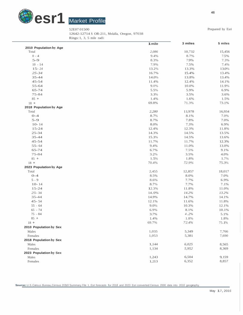
2010 Population by Age 1 mile
Total 2,086 10,732 15,456
0 - 4 9.4% 8.7% 7.5%
5-9 8.3% 7.9% 7.3%
10 - 14 7.9% 7.5% 7.4%
15- 24 13.2% 13.3% 13.0%
25-34 16.7% 15.4% 13.4%
35-44 14.0% 13.8% 13.4%
45-54 11.4% 12.4% 14.1%
55-64 9.0% 10.0% 11.9%
65-74 5.5% 5.9% 6.9%
75-84 3.3% 3.5% 3.6%
85 + 1.4% 1.6% 1.5%
18 + 69.8% 71.3% 73.1%
2018 Population by Age Total 2,280 11,978 16,934
0-4 8.7% 8.1% 7.0%
5-9 8.7% 7.8% 7.0%
10- 14 8.0% 7.3% 6.9%
15-24 12.4% 12.3% 11.8%
25-34 14.3% 14.5% 13.5%
35-44 15.3% 14.5% 13.6%
45-54 11.7% 11.7% 12.3%
55- 64 9.4% 11.0% 13.0%
65-74 6.7% 7.5% 9.1%
75-84 3.2% 3.5% 4.0%
85 + 1.5% 1.8% 1.7%
18 + 70.4% 72.9% 75.3%
2023 Population by Age
Total 2,455 12,857 18,017
0-4 8.5% 8.0% 7.0%
5 - 9 8.6% 7.7% 6.9%
10- 14 8.7% 7.7% 7.1%
15-24 12.3% 11.8% 11.0%
25- 34 14.0% 14.2% 13.2%
35-44 14.9% 14.7% 14.1%
45- 54 12.1% 11.6% 11.8%
55 - 64 9.0% 10.3% 12.1%
65 - 74 6.9% 8.1% 10.1%
75 - 84 3.7% 4 .2% 5.1%
85 + 1.4% 1.8% 1.8%
18 + 69.7% 7 2.4% 75.1%
2010 Population by Sex
Males 1,035 5,349 7,766
Females 1,053 5,381 7,690
2018 Population by Sex
Males 1,144 6,025 8,565
Females 1,134 5,952 8,369
2023 Population by Sex
Males 1,243 6,504 9,159
Females 1,213 6,352 8,857
46
Data Note:Persons of Hispanic Origin may be of any race. The DiversityIndex measures the probability that two people from the same area will be from different race/
ethnic groups.
Source: U.S.Census Bureau, Census 2010 Summary File 1. Esri forecasts tor 2018 and 2023 Esri converted Census 2000 data into 2010 geography.
May 17, 2019
esrr•
Market Profile 52E07 01500
12642-12714 S OR-211, Molalla, Oregon, 97038
Rings: 1, 3, 5 mile radii
1mile
Prepared by Esri
3 miles 5 miles
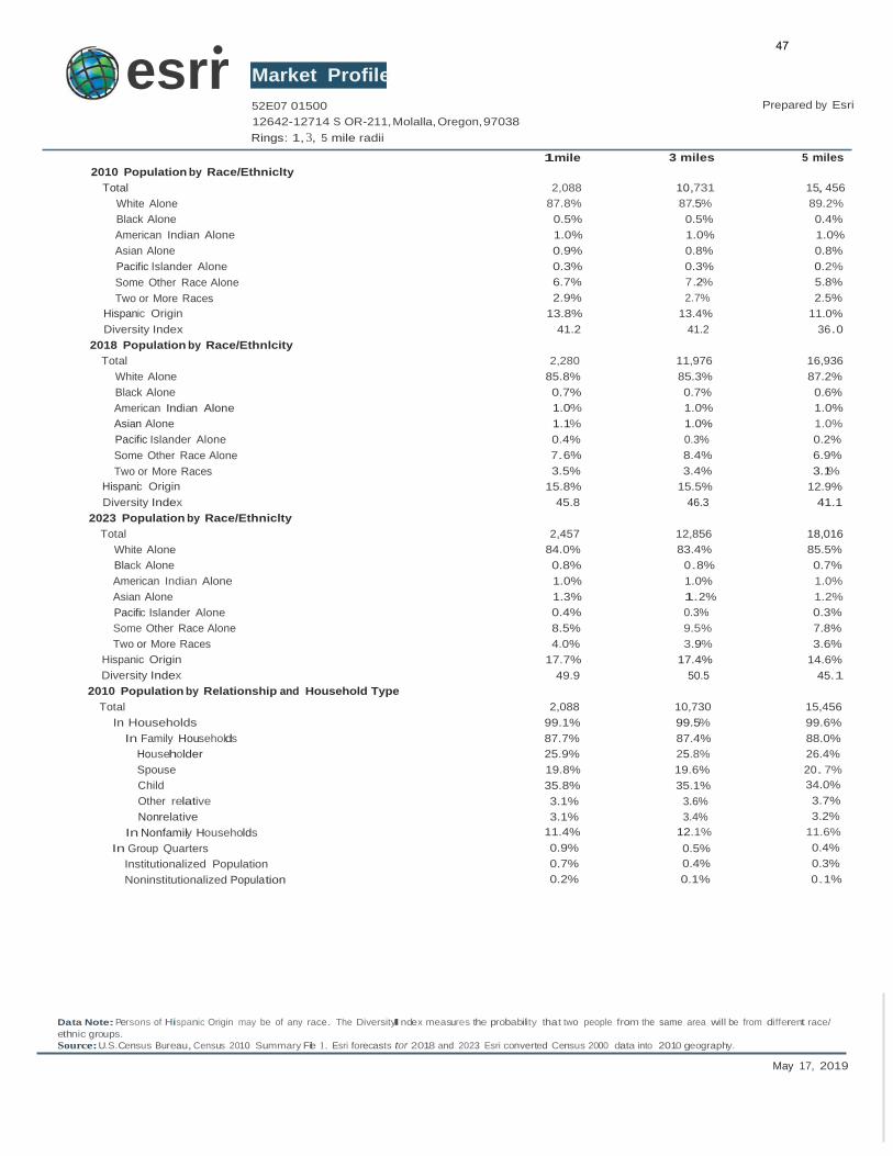
2010 Population by Race/Ethniclty
Total
White Alone
Black Alone
American Indian Alone
Asian Alone
Pacific Islander Alone
Some Other Race Alone
Two or More Races
Hispanic Origin
Diversity Index
2018 Population by Race/Ethnlcity
Total
White Alone
Black Alone
American Indian Alone
Asian Alone
Pacific Islander Alone
Some Other Race Alone
Two or More Races
Hispanic Origin
Diversity Index
2023 Population by Race/Ethniclty
Total
White Alone
Black Alone
American Indian Alone
Asian Alone
Pacific Islander Alone
Some Other Race Alone
Two or More Races
Hispanic Origin
Diversity Index
2010 Population by Relationship and Household Type
Total
In Households
In Family Households
Householder
Spouse
Child
Other relative
Nonrelative
In Nonfamily Households
In Group Quarters
Institutionalized Population
Noninstitutionalized Population
2,088
87.8%
0.5%
1.0%
0.9%
0.3%
6.7%
2.9%
13.8%
41.2
2,280
85.8%
0.7%
1.0%
1.1%
0.4%
7.6%
3.5%
15.8%
45.8
2,457
84.0%
0.8%
1.0%
1.3%
0.4%
8.5%
4.0%
17.7%
49.9
2,088
99.1%
87.7%
25.9%
19.8%
35.8%
3.1%
3.1%
11.4%
0.9%
0.7%
0.2%
10,731 15,456
87.5% 89.2%
0.5% 0.4%
1.0% 1.0%
0.8% 0.8%
0.3% 0.2%
7.2% 5.8%
2.7% 2.5%
13.4% 11.0%
41.2 36.0
11,976 16,936
85.3% 87.2%
0.7% 0.6%
1.0% 1.0%
1.0% 1.0%
0.3% 0.2%
8.4% 6.9%
3.4% 3.1%
15.5% 12.9%
46.3 41.1
12,856 18,016
83.4% 85.5%
0.8% 0.7%
1.0% 1.0%
1.2% 1.2%
0.3% 0.3%
9.5% 7.8%
3.9% 3.6%
17.4% 14.6%
50.5 45.1
10,730 15,456
99.5% 99.6%
87.4% 88.0%
25.8% 26.4%
19.6% 20. 7%
35.1% 34.0%
3.6% 3.7%
3.4% 3.2%
12.1% 11.6%
0.5% 0.4%
0.4% 0.3%
0.1% 0.1%
47
Source:U.S.Census Bureau, Census 2010 Summary File 1. Esri forecasts for 2018 and 2023 Esri converted Census 2000 data into 2010 geography.
May 17, 2019
esrr•
Market Profile 52E07 01500 Prepared by Esri
12642-12714 S OR-211,Molalla, Oregon,97038
Rings: 1, 3, 5 mile radii
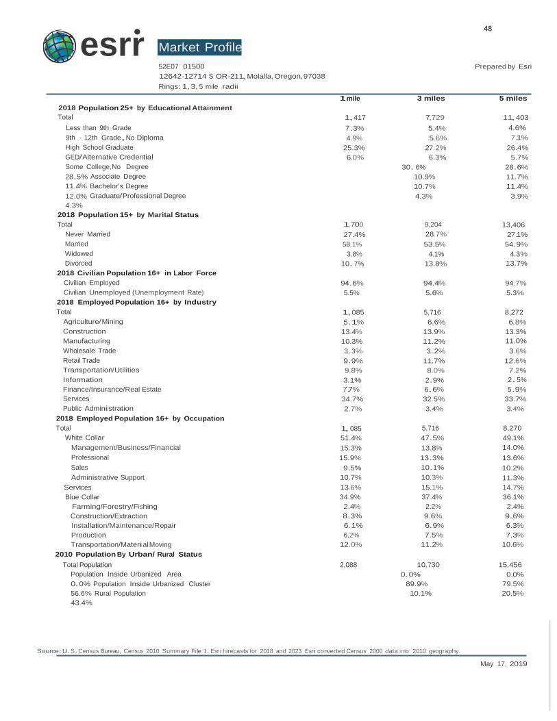
2018 Population 25+ by Educational Attainment
1 mile 3 miles 5 miles
Total 1,417 7,729 11,403
Less than 9th Grade 7.3% 5.4% 4.6%
9th - 12th Grade,No Diploma 4.9% 5.6% 7.1%
High School Graduate 25.3% 27.2% 26.4%
GED/Alternative Credential 6.0% 6.3% 5.7%
Some College,No Degree 30. 6% 28.6%
28.5% Associate Degree 10.9% 11.7%
11.4% Bachelor's Degree 10.7% 11.4%
12.0% Graduate/Professional Degree 4.3% 3.9%
4.3%
2018 Population 15+ by Marital Status
Total 1,700 9,204 13,406
Never Married 27.4% 28.7% 27.1%
Married 58.1% 53.5% 54.9%
Widowed 3.8% 4.1% 4.3%
Divorced 10. 7% 13.8% 13.7%
2018 Civilian Population 16+ in Labor Force
Civilian Employed 94.6% 94.4% 94.7%
Civilian Unemployed (Unemployment Rate) 5.5% 5.6% 5.3%
2018 Employed Population 16+ by Industry
Total 1,085 5,716 8,272
Agriculture/Mining 5.1% 6.6% 6.8%
Construction 13.4% 13.9% 13.3%
Manufacturing 10.3% 11.2% 11.0%
Wholesale Trade 3.3% 3.2% 3.6%
Retail Trade 9.9% 11.7% 12.6%
Transportation/Utilities 9.8% 8.0% 7.2%
Information 3.1% 2.9% 2. 5%
Finance/Insurance/Real Estate 7.7% 6.6% 5.9%
Services 34.7% 32.5% 33.7%
Public Administration 2.7% 3.4% 3.4%
2018 Employed Population 16+ by Occupation
Total 1, 085 5,716 8,270
White Collar 51.4% 47.5% 49.1%
Management/Business/Financial 15.3% 13.8% 14.0%
Professional 15.9% 13.3% 13.6%
Sales 9.5% 10.1% 10.2%
Administrative Support 10.7% 10.3% 11.3%
Services 13.6% 15.1% 14.7%
Blue Collar 34.9% 37.4% 36.1%
Farming/Forestry/Fishing 2.4% 2.2% 2.4%
Construction/Extraction 8.3% 9.6% 9.6%
Installation/Maintenance/Repair 6.1% 6.9% 6.3%
Production 6.2% 7.5% 7.3%
Transportation/Material Moving 12.0% 11.2% 10.6%
2010 Population By Urban/ Rural Status
Total Population 2,088 10,730 15,456
Population Inside Urbanized Area 0.0% 0.0%
0.0% Population Inside Urbanized Cluster 89.9% 79.5%
56.6% Rural Population 10.1% 20.5%
43.4%
48
householder. Multigeneratlonal and unmarried partner households are reported only to the tract level. Esriestimated block group data, which is used to estimate
polygons or non-standard geography.
Source: U.S.Census 8ureau,Census 2010 Summary File 1. Esriforecasts for 2018 and 2023 Esri converted Census 2000 data into 2010 geography.
May 17, 2019
esrr•
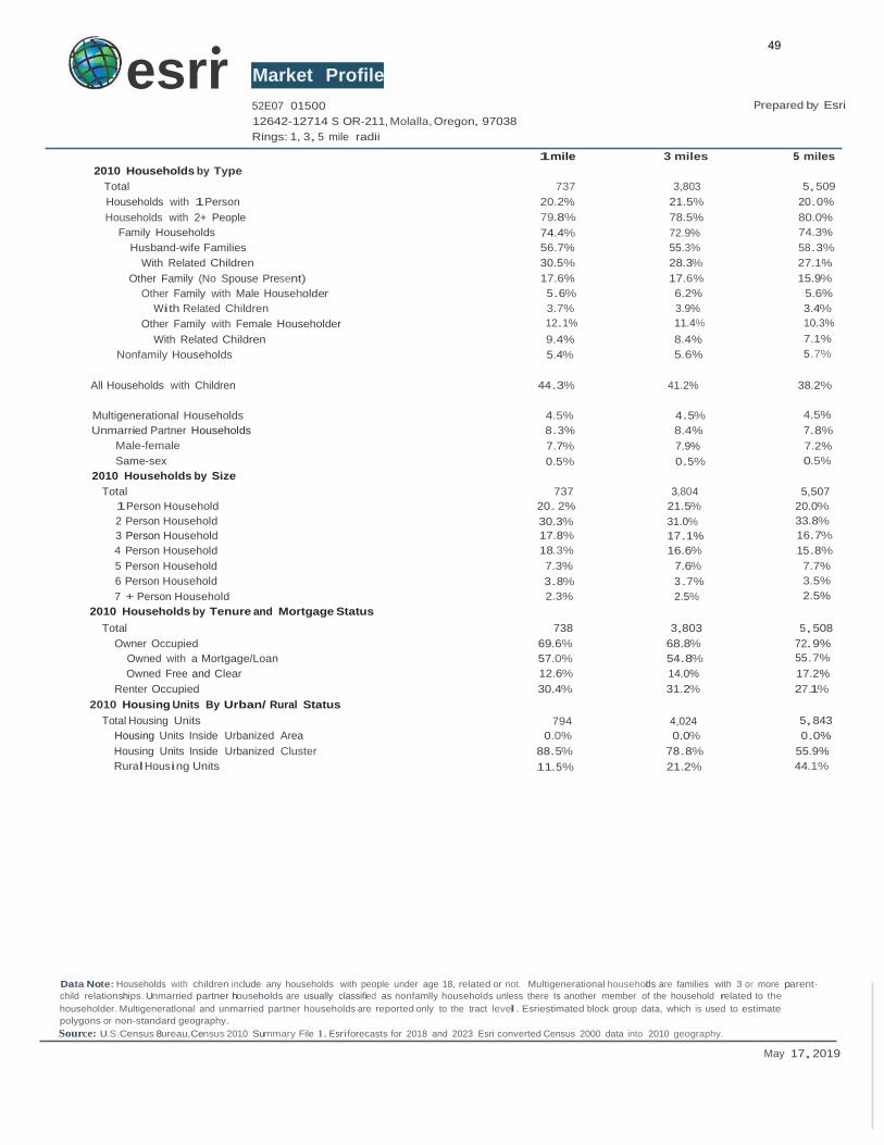
2010 Households by Type
Total
Households with 1Person
Households with 2+ People
Family Households
Husband-wife Families
Market Profile 52E07 01500
12642-12714 S OR-211, Molalla, Oregon, 97038
Rings: 1, 3, 5 mile radii
1mile
737
20.2%
79.8%
74.4%
56.7%
Prepared by Esri
3 miles 5 miles
3,803 5,509
21.5% 20.0%
78.5% 80.0%
72.9% 74.3%
55.3% 58.3%
With Related Children
Other Family (No Spouse Present)
Other Family with Male Householder
With Related Children
Other Family with Female Householder
With Related Children
Nonfamily Households
30.5%
17.6%
5.6%
3.7%
12.1%
9.4%
5.4%
28.3% 27.1%
17.6% 15.9%
6.2% 5.6%
3.9% 3.4%
11.4% 10.3%
8.4% 7.1%
5.6% 5.7%
All Households with Children 44.3% 41.2% 38.2%
Multigenerational Households
Unmarried Partner Households
Male-female
Same-sex
2010 Households by Size
Total
1Person Household
2 Person Household
3 Person Household
4 Person Household
5 Person Household
6 Person Household
7 + Person Household
2010 Households by Tenure and Mortgage Status
Total
Owner Occupied
Owned with a Mortgage/Loan
Owned Free and Clear
Renter Occupied
2010 Housing Units By Urban/ Rural Status
Total Housing Units
Housing Units Inside Urbanized Area
Housing Units Inside Urbanized Cluster
Rural Housing Units
4.5%
8.3%
7.7%
0.5%
737
20. 2%
30.3%
17.8%
18.3%
7.3%
3.8%
2.3%
738
69.6%
57.0%
12.6%
30.4%
794
0.0%
88.5%
11.5%
4.5% 4.5%
8.4% 7.8%
7.9% 7.2%
0.5% 0.5%
3,804 5,507
21.5% 20.0%
31.0% 33.8%
17.1% 16.7%
16.6% 15.8%
7.6% 7.7%
3.7% 3.5%
2.5% 2.5%
3,803 5,508
68.8% 72.9%
54.8% 55.7%
14.0% 17.2%
31.2% 27.1%
4,024 5,843
0.0% 0.0%
78.8% 55.9%
21.2% 44.1%
Data Note: Households with children include any households with people under age 18, related or not. Multigenerational househodl s are families with 3 or more parent·
child relationships. Unmarried partner households are usually classified as nonfamlly households unless there Is another member of the household related to the
49
Source: Consumer Spending data are derived from the 2015 and 2016 Consumer Expenditure Surveys, Bureau of Labor Statistics.Esrl.
Source:U.S.Census Bureau,Census 2010 Summary File 1. Esri forecasts for 2018 and 2023 Esri converted Census 2000 data Into 2010 geography.
May 17, 2019
esrr•
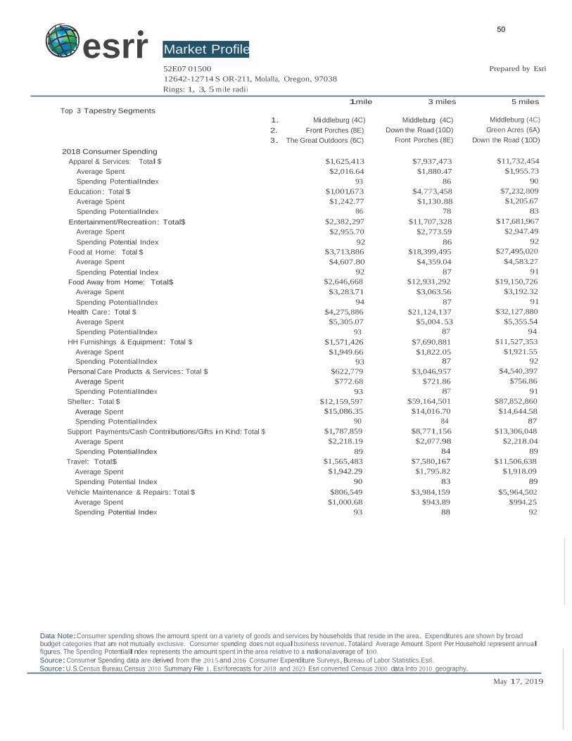
Top 3 Tapestry Segments
Market Profile 52E07 01500
12642-12714 S OR-211, Molalla, Oregon, 97038
Rings: 1, 3, 5 m ile radii
Prepared by Esri
1mile 3 miles 5 miles
2018 Consumer Spending
1. Middleburg (4C)
2. Front Porches (8E)
3. The Great Outdoors (6C)
Middleburg (4C)
Down the Road (10D)
Front Porches (8E)
Middleburg (4C)
Green Acres (6A)
Down the Road (10D)
Apparel & Services: Total $
Average Spent
Spending PotentialIndex
Education: Total $
Average Spent
Spending PotentialIndex
$1,625,413 $7,937,473
$2,016.64 $1,880.47
93 86
$1,001,673 $4,773,458
$1,242.77 $1,130.88
86 78
$11,732,454
$1,955.73
90
$7,232,809
$1,205.67
83
Entertainment/Recreation: Total$ $2,382,297 $11,707,328 $17,681,967
Average Spent $2,955.70 $2,773.59 $2,947.49
Spending Potential Index 92 86 92
Food at Home: Total $ $3,713,886 $18,399,495 $27,495,020
Average Spent $4,607.80 $4,359.04 $4,583.27
Spending Potential Index 92 87 91
Food Away from Home: Total$ $2,646,668 $12,931,292 $19,150,726
Average Spent $3,283.71 $3,063.56 $3,192.32
Spending PotentialIndex 94 87 91
Health Care: Total $ $4,275,886 $21,124,137 $32,127,880
Average Spent $5,305.07 $5,004.53 $5,355.54
Spending PotentialIndex 93 87 94
HH Furnishings & Equipment: Total $ $1,571,426 $7,690,881 $11,527,353
Average Spent $1,949.66 $1,822.05 $1,921.55
Spending PotentialIndex 93 87 92
Personal Care Products & Services: Total $ $622,779 $3,046,957 $4,540,397
Average Spent $772.68 $721.86 $756.86
Spending PotentialIndex 93 87 91
Shelter: Total $ $12,159,597 $59,164,501 $87,852,860
Average Spent $15,086.35 $14,016.70 $14,644.58
Spending PotentialIndex 90 84 87
Support Payments/Cash Contributions/Gifts in Kind: Total $ $1,787,859 $8,771,156 $13,306,048
Average Spent $2,218.19 $2,077.98 $2,218.04
Spending PotentialIndex 89 84 89
Travel: Total$ $1,565,483 $7,580,167 $11,506,638
Average Spent $1,942.29 $1,795.82 $1,918.09
Spending Potential Index 90 83 89
Vehicle Maintenance & Repairs: Total $ $806,549 $3,984,159 $5,964,502
Average Spent $1,000.68 $943.89 $994.25
Spending Potential Index 93 88 92
Data Note:Consumer spending shows the amount spent on a variety of goods and services by households that reside in the area. Expenditures are shown by broad budget categories that are not mutually exclusive. Consumer spending does not equal business revenue. Totaland Average Amount Spent Per Household represent annual figures. The Spending PotentialIndex represents the amount spent in the area relative to a national average of 100.
50
o
DDD
Planning &
Community
FOR OFFICE USE ONLY:
Planning File No.:
City Approval: _
Development
117 N. Molalla Avenue
Molalla,OR. 97038
(503) 759-0219
Fax: (503) 829-3676
Date Received: Title. _
Fee: _
land Use Type: II Date.. _------
Received by:
Fee Paid: _
APPLICATION FOR LAND USE ACTION
Type of land Use Action Requested: (check all that apply)
Annexation
Plan Amendment (Proposed Zone _
Planned Unit Development
Site Design Review
0 Variance (list standards to be varied in description
0 Conditional Use
0 Partition (# of lots _
0 Subdivision (#of lots _ _ _
0 Other: _
Contact for
additional info:
Proposed No. of Phases (one each year): _ ....,N'-+.I...A.....-. _ I
51
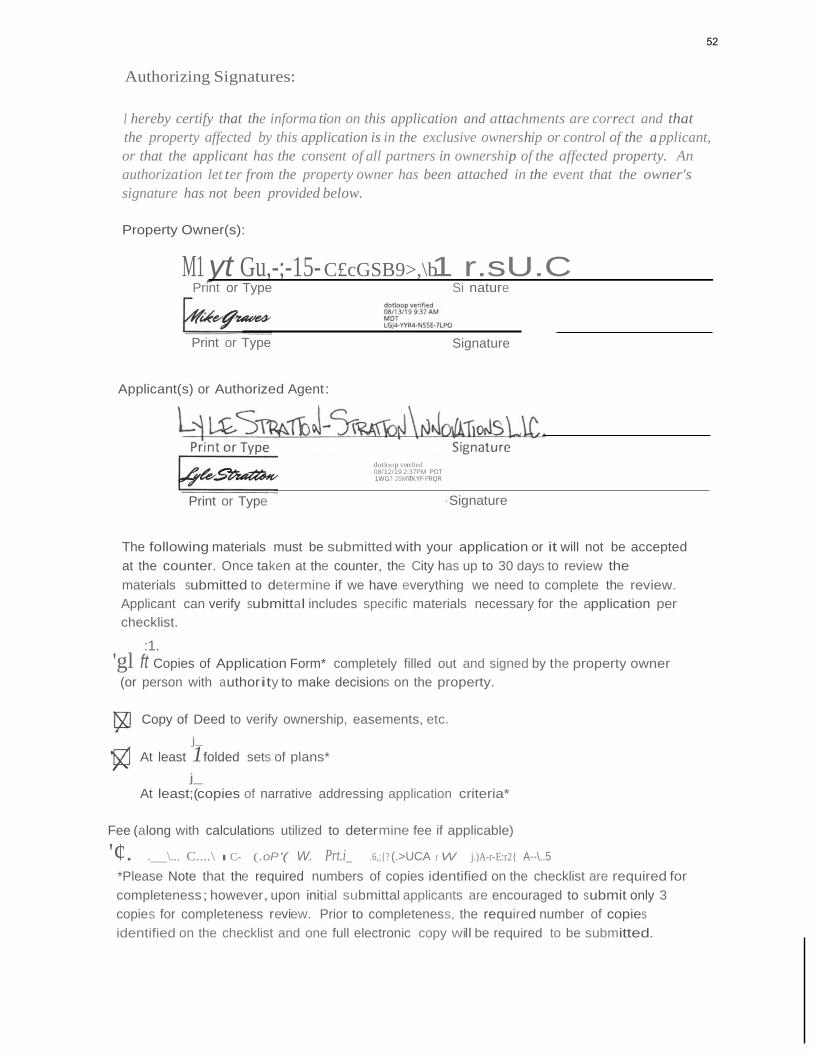
Authorizing Signatures:
I hereby certify that the informa tion on this application and attachments are correct and that
the property affected by this application is in the exclusive ownership or control of the a pplicant,
or that the applicant has the consent of all partners in ownership of the affected property. An
authorization let ter from the property owner has been attached in the event that the owner's
signature has not been provided below.
Property Owner(s):
M1 yt Gu,-;-15- C£cGSB9>,\b1 r.sU.C Print or Type Si nature
Print or Type Signature
Applicant(s) or Authorized Agent:
dotloop venfied 08/12/19 2:37PM PDT 1WG7·JSMVT·KYF·FRQR
Print or Type ·Signature
The following materials must be submitted with your application or it will not be accepted
at the counter. Once taken at the counter, the City has up to 30 days to review the
materials submitted to determine if we have everything we need to complete the review.
Applicant can verify submittal includes specific materials necessary for the application per
checklist.
:1.
'gl ft Copies of Application Form* completely filled out and signed by the property owner
(or person with authority to make decisions on the property.
Copy of Deed to verify ownership, easements, etc.
j_
At least 1folded sets of plans*
j_
At least;(copies of narrative addressing application criteria*
Fee (along with calculations utilized to determine fee if applicable)
'¢. . \... C....\ I C- (.oP '( W. Prt.i_ .6,;{? (.>UCA r W j.)A-r-E:r2{ A--\..5
*Please Note that the required numbers of copies identified on the checklist are required for
completeness; however, upon initial submittal applicants are encouraged to submit only 3
copies for completeness review. Prior to completeness, the required number of copies
identified on the checklist and one full electronic copy will be required to be submitted.
52
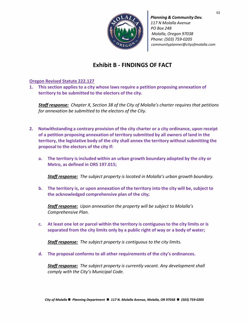
Planning & Community Dev. 117 N Molalla Avenue PO Box 248 Molalla, Oregon 97038 Phone: (503) 759-0205 [email protected]
Exhibit B - FINDINGS OF FACT Oregon Revised Statute 222.127 1. This section applies to a city whose laws require a petition proposing annexation of
territory to be submitted to the electors of the city.
Staff response: Chapter X, Section 38 of the City of Molalla’s charter requires that petitions for annexation be submitted to the electors of the City.
2. Notwithstanding a contrary provision of the city charter or a city ordinance, upon receipt of a petition proposing annexation of territory submitted by all owners of land in the territory, the legislative body of the city shall annex the territory without submitting the proposal to the electors of the city if:
a. The territory is included within an urban growth boundary adopted by the city or
Metro, as defined in ORS 197.015;
Staff response: The subject property is located in Molalla’s urban growth boundary.
b. The territory is, or upon annexation of the territory into the city will be, subject to
the acknowledged comprehensive plan of the city;
Staff response: Upon annexation the property will be subject to Molalla’s Comprehensive Plan.
c. At least one lot or parcel within the territory is contiguous to the city limits or is
separated from the city limits only by a public right of way or a body of water;
Staff response: The subject property is contiguous to the city limits.
d. The proposal conforms to all other requirements of the city’s ordinances.
Staff response: The subject property is currently vacant. Any development shall comply with the City’s Municipal Code.
City of Molalla ◼ Planning Department ◼ 117 N. Molalla Avenue, Molalla, OR 97038 ◼ (503) 759-0205
53
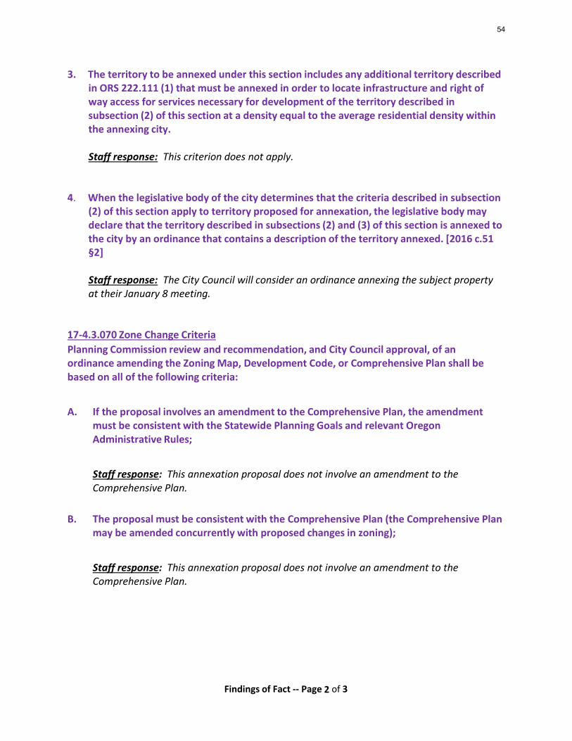
Findings of Fact -- Page 2 of 3
3. The territory to be annexed under this section includes any additional territory described in ORS 222.111 (1) that must be annexed in order to locate infrastructure and right of way access for services necessary for development of the territory described in subsection (2) of this section at a density equal to the average residential density within the annexing city.
Staff response: This criterion does not apply.
4. When the legislative body of the city determines that the criteria described in subsection (2) of this section apply to territory proposed for annexation, the legislative body may declare that the territory described in subsections (2) and (3) of this section is annexed to the city by an ordinance that contains a description of the territory annexed. [2016 c.51 §2]
Staff response: The City Council will consider an ordinance annexing the subject property at their January 8 meeting.
17-4.3.070 Zone Change Criteria
Planning Commission review and recommendation, and City Council approval, of an ordinance amending the Zoning Map, Development Code, or Comprehensive Plan shall be based on all of the following criteria:
A. If the proposal involves an amendment to the Comprehensive Plan, the amendment
must be consistent with the Statewide Planning Goals and relevant Oregon Administrative Rules;
Staff response: This annexation proposal does not involve an amendment to the Comprehensive Plan.
B. The proposal must be consistent with the Comprehensive Plan (the Comprehensive Plan may be amended concurrently with proposed changes in zoning);
Staff response: This annexation proposal does not involve an amendment to the Comprehensive Plan.
54
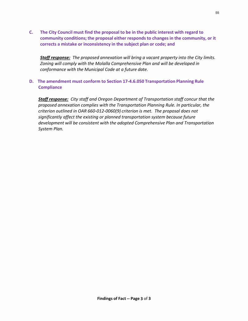
Findings of Fact -- Page 3 of 3
C. The City Council must find the proposal to be in the public interest with regard to community conditions; the proposal either responds to changes in the community, or it corrects a mistake or inconsistency in the subject plan or code; and
Staff response: The proposed annexation will bring a vacant property into the City limits. Zoning will comply with the Molalla Comprehensive Plan and will be developed in conformance with the Municipal Code at a future date.
D. The amendment must conform to Section 17-4.6.050 Transportation Planning Rule
Compliance
Staff response: City staff and Oregon Department of Transportation staff concur that the proposed annexation complies with the Transportation Planning Rule. In particular, the criterion outlined in OAR 660-012-0060(9) criterion is met. The proposal does not significantly affect the existing or planned transportation system because future development will be consistent with the adopted Comprehensive Plan and Transportation System Plan.
55
Related Documents