HELEVA LANDFILL NATIONAL PRIORITIES LIST (NPL) SITE NORTH WHITEHALL TOWNSHIP, LEHIGH COUNTY, PENNSYLVANIA CERCLIS No. PAD980537716 Agency for Toxic Substances and Disease Registry U.S. Public Health Service AR30!9tf3

Welcome message from author
This document is posted to help you gain knowledge. Please leave a comment to let me know what you think about it! Share it to your friends and learn new things together.
Transcript

HELEVA LANDFILL NATIONAL PRIORITIES LIST (NPL) SITE
NORTH WHITEHALL TOWNSHIP, LEHIGH COUNTY, PENNSYLVANIA
CERCLIS No. PAD980537716
Agency for Toxic Substances and Disease RegistryU.S. Public Health Service
AR30!9tf3

SUMMARY
The Heleva Landfill NPL (National Priorities List) site is approximately 5miles north of Allentown, in North Whitehall Township, lehigh County,Pennsylvania. The site has operated as a sanitary landfill and acceptedundetermined types and amounts of industrial wastes including solvents.Wastes were deposited in and around two abandoned mining pits. The siteis in a generally rural area, although there are small communities within1/4 mile and a number of residences within a few hundred feet.
This site is of public health concern because of the risk to human healthresulting from probable exposure to hazardous substances at concentrationsthat may result in adverse human health effects through ingestion,inhalation, or dermal contact. Contaminants, principally volatile organiccompounds (VOC's), have been detected at levels of potential concern ingroundwater off-site, in some water supply wells, in air, and in surfacewater. Groundwater is the principal contaminated medium of concern.Human exposure to VOC's and lead is currently occurring via groundwater atsome of the area residential groundwater supply wells through ingestion,inhalation, and dermal contact. The public water system is being extendedto these residents and other potentially affected groundwater users.
BACKGROUND
A. SITE DESCRIPTION
The Heleva landfill NPL site is approximately 5 miles north of Allentownin North Whitehall Township, Lehigh County, Pennsylvania. A Record ofDecision (FDD) was prepared by the U. S. Environmental Protection Agency(EPA) in March 1985, and the Pennsylvania Department of EnvironmentalResources (PADER) concurred with the approved remedy.
The site consists of a 20-acre landfill located on a 93-acre tract ofland. In the late 1800's, the site area was a large open-pit iron oremining operation. The mining operations left four open, water-filled pitslying in a generally east-west line. Two of these pits are on-site: onewas covered over by the landfilling operation, and the other was used as arunoff collection pond. The site began operations as a sanitary landfillin 1967 and accepted general mixed refuse, including paper, wood, andorchard wastes. Undetermined types and amounts of industrial wastes,including solvents, were reported to have been sent to the site beginningin that same year. Detection of contamination in the West Ormrod WaterAssociation well (1/4 mile southeast of the site) led to its closing, toconstruction of a water main from the Northhampton Water Company, and toconnection with this main by the 35 homes previously served by the well.The site was closed in 1981, and the owner covered the waste area with two
Page 1

feet of clayey soil obtained from elsewhere on the property. Because oflow fertility, this soil does not support adequate vegetation. At onetime, erosion of the cap exposed parts of the landfill and allowedprecipitation to percolate directly into the landfill.
The BOD describes the following elements of the remedy:
* Install a soil cap without a membrane on the 20-acre site that meetsrequirements of the Resource Conservation and Recovery Act (RCRA), andconstruct a surface water diversion system.
* Provide a gas venting system, provide for monitoring of off-gasses atvents and at the landfill boundary, and provide gas treatment ifnecessary. Reference documents do not describe the criteria that willbe used to determine whether vent releases need treatment.
* Conduct additional investigations to more fully delineate the locationand magnitude of the principal zone of contaminated groundwater withinthe landfill and confirm that collection of this zone will beeffective in reducing contamination beyond the landfill. Also,evaluate the existence and magnitude of sinWiole activity in thearea. Based on the findings, a source reduction program that involvespumping and treating highly contaminated groundwater from the landfillwill be implemented. Pumping at the landfill is planned to continueuntil target concentrations for indicator contaminants (vinyl chlorideand trichloroethene) are met. If contaminant target levels are notreached after two years of pumping and treating, EPA will reevaluatethe feasibility of reaching these targets.
* A treatment facility will be constructed on the property and willtreat the contaminated groundwater that is withdrawn to approvedconcentration levels before discharge into Coplay Creek. Referencedocuments do not specify the intended discharge concentration limits.
* Extend the public water supply provided by the Northampton WaterAuthority to the remaining parties whose groundwater supply wells havebeen or potentially could be contaminated by site releases. Toaccomplish this, existing water mains would be extended along Hillstreet and portions of Main Street and connected to 15 homes. Atemporary institutional restriction on well drilling for potable waterpurposes will be requested of the local government until sourcereduction successfully remediates groundwater quality.
* Implement a monitoring program during and after completion of theremedial activities to evaluate the quality of water in existingmonitoring wells and potentially affected surface water bodies in thearea. Monitoring of residential wells will be continued until thewater main extension is operational and the remaining residents in thevicinity are connected to it.
Page 2

For purposes of this Health Assessment, the Agency for Toxic Substancesand Disease Registry (ATSDR) has considered the landfill to be the site(i.e., on-site) and and areas beyond the landfill limits to be off-site.
B. SITE VISIT
ATSCR has not conducted a site visit to date.
ENVIRONMENTAL CONTAMINATION AND PHYSICAL HAZARDS
A. ON-SITE CONTAMINATION
Monitoring data provided in the reference documents for the on-site runoffcollection pond, leachate discharges, and ambient air are summarized onTable 1, in Appendices. Only a few volatile organic compounds (VOC's)were reported to be detected through this monitoring. However, as notedin the Table, some of the water quality analyses results had a an elevateddetection limit of 1,000 ppb (parts per billion). Therefore, these datamay not fully describe water quality for health-related purposes.Monitoring data are unavailable for the wastes disposed in the landfilland for on-site soils.
B. OFF-SITE CONTAMINATION
Table 2, in the Appendices, summarizes monitoring data for thecontaminants of greatest potential concern detected in off-sitegroundwater, residential water supply wells, leachate, surface water,sediment, and ambient air. Leachate and ambient air were the only mediathat were monitored both on-site and off-site. A comparison of theleachate data indicates that, generally, the same contaminants weredetected on-site and off-site, and at similar concentrations. Ambient airmonitoring also detected similar contaminants on-site and off-site, withcontaminant concentrations being somewhat less off-site.
C. PHYSICAL HAZARDS
This landfill poses a potential physical hazard because wastes withorganic content may generate methane which has the potential to e>qplode ifit accumulates in an enclosure, such as beneath a landfill cap or inbuildings. However, there are no methane monitoring data with which tofully evaluate this concern.
Page 3
DEMOGRAPHICS
The area within a three-mile radius of the landfill is primarily ruralwith the greatest portion being farm and pasture land. Some of the landadjacent to the landfill is used for craps. Although agriculturalactivities are important, much of the employment for area residents is inindustry or mining. A large percentage of the population around the sitelive in small residential communities that pocket the area. Ormrod, avillage of approximately 35 families, is located about 1/4 mile southeastof the site. Irontown, with a population of about 150 residents, is 1/4mile to the west. The Ironton Elementary School is located about 1,500feet south of the site. Ihe nearest residences are a few hundred feet tothe west, north, and east of the site.
Iron ore mining, once a major activity, is no longer pursued. Limestonequarrying for cement and aggregate is an active industry. One recentlyabandoned quarry (Whitehall Quarry) is located about 1/2 mile south of thelandfill, and two active quarries are several hundred feet farther to thesoutheast.
EVAIUATION
A. SITE CHARAGEEKEZATiaM (DATA NEEDS AND EVALUATION)
1. Environmental Media
Monitoring data (meeting EPA's Contract Laboratory Program detectionlimits) are needed for wastes and on-site soils and for fish tissue.
2. Demographics and Land Use
Information available in reference materials about demographics and landuse is satisfactory for this Health Assessment.
3. Quality Assurance and Quality Control
ATSDR presumes that site investigation protocols and analytical data havebeen reviewed by EPA and have met their acceptability criteria. Thevalidity of the conclusions drawn in this health assessment is dependenton the availability and reliability of the reference information.
B. ENVIRONMENTAL PATHWAYS
VOC's associated with the wastes that have been disposed at the site havebeen shown by monitoring to have migrated into the air, to thegroundwater, to residential water supply wells, and to nearby surfacewater and sediment. Lead also has been detected in groundwater,residential water supply wells, and other media. Non-volatile organiccompounds and inorganic compounds, other than lead, are not in evidence atlevels of concern in any of the media.
Page 4

While the landfill was operational, wind currents are likely to havetransported volatile compounds and particulates to off-site areas.Currently, wind crossing the landfill cap may periodically transportvolatile ccropounds elsewhere on-site and off-site. Ambient air monitoringfor hydrocarbons conducted off-site at the edge of the landfill have shownthat airborne contaminants migrate that far; it is therefore likely theyhave been transported to nearby areas. Monitoring has not been performedon landfill wastes to characterize the actual types of contaminants thatmight be subject to migration. Analyses for other media suggest thatthere may not be substantive contaminants that tend to sorb toparticulates. If this is so, airborne migration of VOC's might be theprincipal concern rather than contaminated particulates. The proposedlandfill cap should minimize volatilization and prevent particulateentrainment from the landfill surface, provided the confining clay layeris not breached by excessive differential settlement that might be inducedby naturally occurring waste consolidation or by the groundwater sourceremoval. The cap venting system will release gaseous contaminants andprobably methane to the air. A monitoring program for vented gasses willbe conducted to determine if treatment is needed. An air stripper, ifused to treat groundwater, would release airborne contaminants. Thecxoitaminant concentrations that might be released from landfill vents orfrom a gas or groundwater treatment system are not fully known at thistime and would depend on the types and concentrations of gas andgroundwater contaminants and the efficiencies of the treatment systems.Lateral movement of gases, including methane, may currently be occurringbeneath the partially capped landfill, especially through the fracturedrock system. Placing a vent system in the proposed RCRA cap is intendedto prevent lateral migration of gasses from the landfill. However, forthis site, this system might not reduce or eliminate lateral gas migrationunless the vents extend below the existing cap material and the combinedcaps, vents, and treatment system (if any) effectively allow gasses toescape upward through the wastes.
Monitoring results reported for two off-site soil samples did not revealmeasurable contamination. However, two samples may not be representativeof soils over the entire area beyond the landfill. Also, it is uncertainwhether the two analyses adequately describe the range and character ofsoil contamination because waste monitoring data, which would identify thetypes of contaminants that could migrate, have not been available. Theremight not be substantive contaminants of a type that sorb to soil.However, if contamination does exist in any surface soils beyond thelandfill perimeter, some migration by air, or by infiltrating rainfall,may also originate from these areas.
Landfill wastes have released contaminants that have migrated into thewater-table aquifer. Evaluations indicate the hydrcgeologic features ofprincipal importance to groundwater and contaminant movement in thevicinity of the site include:
Page 5
Afi30!9ifS

* Overburden materials around the landfill limits include mine spoilconsisting principally of clays and silts with rock fragments. Someglacial tills are also present. Permeabilities of these materials arerelatively low and in a range normally associated with silty, clayeysoils.
* Bedrock was encountered at depths of 15 to 50 feet below groundsurface and consists of shales, limestones, and dolomites.Groundwater occurring in the rock moves along joint sets, faults,bedding planes, solution channels, and cleavage planes, which may notalways be parallel to the overall groundwater flow direction.
* Data from shallow and deep monitoring wells do not indicate evidenceof a confined aquifer. Thus, the groundwater of interest flows underwater-table conditions.
* Monitoring data indicate that the general direction of groundwaterflow is toward the east and southeast.
* Iron mining operations resulted in on-site pits that have beenreported to be 30 to 60 feet deep. Their actual depths areuncertain. A geologic cross-section in the reference documentsindicates that wastes are estimated to be 30 to 50 feet deep andextend below the water table. Reports of three underground miningshafts extending southeast from the landfill toward the Town of Ormrodcould not be confirmed by the site evaluations.
Rainwater initiates contaminant migration to groundwater as it seepsthrough contaminated wastes and soils, and liquid wastes may migratedirectly to the groundwater. Where the wastes extend below the watertable, groundwater also may induce contaminant migration directly as itflows through the submerged materials. Also, contaminants in surfacewater contained in the on-site runoff pond and in two nearby off-siteponds located next to the runoff pond and near the trailer court canmigrate with the contained surface water to groundwater. The pathways forcontaminant migration off-site by groundwater are through systems of poresin the soils and openings in the underlying bedrock. Volatile organiccompounds that enter these materials probably move with little attenuationor sorbtion of contaminants. Contaminant migration in the rock could bemuch more rapid than in the soil wherever the system of rock openings iswell connected. The complexity of the fracture system precludes accurateprediction of the specific flow path, flow rate, and extent of thecontaminant plume. The Qrmrod community well, which is likely to bescreened in the bedrock, is reported to have become contaminated withinthree years after the landfill began to receive wastes. In general, itappears that groundwater and its entrained contaminants migrate to theeast and southeast and discharge into the Coplay Creek, Whitehall Quarryand a number of lakes. However, contaminants have also been found in
Page 6
91*9

three residential water supply wells located to the north and northeastalong Hill Street, in what is considered to be the upgradient direction.Reference documents do not confirm a specific cause for thiscontamination, but suggest that it may have resulted from a temporaryshift in groundwater flow direction or from airborne cxjntantinant migrationand subsequent infiltration to the groundwater at these locations. Hielatter mechanism is not likely to have been a dominant factor.
Over time, the proposed cap and treatment of contaminated groundwater atthe source should result in improved groundwater quality off-site. Thecap plays a major role in that it should substantially reduce the amountof rainwater that could enter and generate leachate within the landfillmaterials. However, there are a number of factors that have somepotential for limiting the extent of groundwater remediation. Capsettlement might reduce its effectiveness either through ponding of wateror because cracks may develop within the clay zone. Also, after thesource groundwater removal is completed, the water table will again riseand inundate waste materials from which leachate is likely to be entrainedby groundwater movement and subsequently transported off-site. Inaddition, if contaminants occur at substantial concentrations in soilsbeyond the landfill, these contaminants could continue to migrate withinfiltrating rainwater to the groundwater. The ultimate extent to whichcap settlement, waste inundation, and possible off-site soil contaminationmay occur or subsequently affect groundwater remediation cannot bepredicted.
Rainfall runoff currently transports surficial landfill contaminantsoverland to off -site areas, and some leachate derived from infiltratinggroundwater discharges at the landfill surface and flows off -site. ~Topographic data indicate that much of the landfill surface is shaped todrain surface water and entrained contaminants to a runoff collection pondon the east edge of the site. An adjacent pond, located off-siteimmediately to the east, is separated from the runoff pond by a dike-likesoil barrier. When runoff accumulates and raises the water level in therunoff pond; a hydraulic gradient is created across the dike, and water(and entrained contaminants) tends to migrate to the easterly pond. Onthe north, west, and south perimeter of the landfill, the mound slopesdownward and allows runoff (including leachate) to discharge in thesedirections. A portion of these discharges are observed to flow to Toddlake to the northwest and to a catchment pond by the trailer court. Theremainder flows toward Coplay Creek, Whitehall Quarry, and the lakes tothe east and southeast. As stated previously, contaminated groundwaterfrom the site also discharges into the creek, quarry, and easterly lakes.VOC's released to surface waters are likely to volatilize with time ratherthan sorb to suspended particles and sediments. Coplay Creek is atributary of the Lehigh River; the two join approximately 2.5 milessoutheast of the site. Ihe Lehigh River then joins the Delaware Rivernear Easton, Pennsylvania, approximately 20 miles from the site.
Page 7
AR30I95Q

The proposed cap should substantially reduce the amount of contaminationtransported by runoff from the site to the receiving surface waters.There may not be substantive contamination of the surface soils beyond thelandfill. However, if contaminants are present, these could be acx>ntinuing source of contaminated runoff to downgradient areas.
Reference documents indicate that the area waters are "used for fishing;therefore, because of contaminants in surface waters, fish are a potentialenvironmental (i.e., food chain) pathway for contaminants. Crops raisedon agricultural land adjacent to the site, and nearby, also may becontaminated if they are irrigated with groundwater or surface water.Garden produce might be a contaminant pathway if they are irrigated withcontaminated groundwater; however, there is no information to indicatewhether nearby residents raise consumable plants.
C. HUMAN EXPOSURE PATHWAYS
The most important potential human exposure pathway is through groundwaterwhich has become contaminated by site releases. The ccmnunity watersupply well that served Ormrod residents and the school has been replacedby water supplied via a pipeline. However, a few residents currently areusing contaminated groundwater for potable purposes, and a number of otherwater supply wells potentially could become contaminated with furthercontaminant migration. Certain surface waters also provide a potentialfor human exposure to contaminants. Likewise, surface water may also be apotential exposure pathway at locations where contaminants were notdetected but the detection limit for some compounds was 1,000 ppb.Sampling and analyses of two off-site soil samples did not detectccaitaminants at levels of concern, but two samples may not fullycharacterize soil quality everywhere beyond the landfill. Althoughevidence from other monitoring suggests that substantive contaminants maynot be sorted to soil, soil is considered to be a potential pathwaythrough which human exposure might take place. A summary of humanexposure pathways is provided in Table 3, in the Appendices.
PUBLIC HEALTH IMPUTATIONS
Monitoring data indicate that waste operations have released a number ofVOC's to environmental media through which there is a potential forexposure at concentrations that may pose a threat to human health. Basedon information in reference documents, it is reasonable to conclude thatthe organic compounds detected through off-site monitoring migrated fromthe landfill to the sampling locations. Lead also was detected on-siteand off-site at levels of potential health concern.
Page 8
AR30I95J

Contaminants have been detected in groundwater off-site at levels ofpotential health concern for exposure through ingestion, inhalation, anddirect contact. The groundwater monitoring well data indicate thepresence of numerous organic compounds and some metals that arepotentially a health concern if they were to migrate to active watersupply wells at the maximum detected levels. These includebenzene (10 ppb), 1,1,1-trichloroethane (1,100 ppb), lead (67 ppb)1,2-dichloroethane (44 ppb), tetrachloroethene (25 ppb),trichloroethene (15,000 ppb), l,2-|<Jichloroethene (7,000 ppb),1,1-dichloroethene (6,600 ppb), vinyl chloride (5,700 ppb)/ andchloroform (910 ppb). These concentrations exceed one or more of EPA'sMaximum Contaminant Levels (MCL's), Maximum Contaminant Level Goals(MCDS's), Proposed Maximum Contaminant level Goals (PMCIG's) or ProposedMaximum (Contaminant Levels (PMCL's) for drinking water. The concentrationof 1,2-dichloroethene exceeds EPA's 10-day Health Advisory values fordrinking water, while 1,1-dichloroethene and vinyl chloride exceed EPA's1-day advisory. These contaminants can be absorbed orally. Benzene alsowill readily volatilize fron aqueous media and is well absorbed by theinhalation route. Benzene is a known human carcinogen by the inhalationexposure route, and is considered to be carcinogenic by all routes ofexposure. Benzene also induces a variety of noncarcinogenic, hematologictoxicities following low-level, chronic exposure. Exposure to1,1,1-trichloroethane may depress the central nervous system and adverselyaffect a number of body organs. 1,2-Dichloroethane has been noted tocause liver and kidney damage and has been classified by the EPA as aprobable human carcinogen. Tetrachloroethene also is a probable humancarcinogen (EPA classification), and it may cause central nervous systemdepression and hepatic injury. Trichloroethene is readily volatilized, iswell absorbed by all exposure routes, and is a probable carcinogen (EPAclassification) and hepatic toxicant following long-term oral orinhalation exposure. 1,1-Dichloroethene is a possible human carcinogen(EPA classification), based on limited animal data and the absence ofhuman data. Human exposure to vinyl chloride occurs primarily throughinhalation. Vinyl chloride is regarded as a human carcinogen and maycause nervous system depression and hepatic damage. Chloroform also is asuspected carcinogen and can affect liver and kidneys. Qironic oral leadexposure induces neurological, hematological, and renal toxicities, withthe neonate and young being particularly sensitive to the neurologicaleffects of chronic exposure.
Monitoring of domestic water supplies has shown that groundwater at threeof the currently active residential wells have lead and VDC contaminantsat levels of health concern. Trichloroethene has been detected to a levelof 200 ppb, and 1,2-dichloroethene has been found at a concentration of31 ppb. Tetrachloroethene also has been detected up to 12 ppb.Concentrations of lead have ranged to 56 ppb. The concentrations of thesecompounds, except 1,2-dichloroethene, exceed one or more of EPA's MCL's,PMCL's, MdG's, or PMCDS's. However, EPA's 1-day and 10-day HealthAdvisory values for tetrachloroethene and 1,2-dichloroethene are muchgreater than the levels that were detected for these two contaminants.
Page 9
AR30I952

Concerns for human exposure to contaminants in groundwater willsubstantially after the public water system has been extended to theremaining groundwater users whose water supply wells are or may be (in thefuture) affected by groundwater contamination. A proposed temporarymoratorium on installation of new groundwater supply wells in the sitevicinity until (or unless) groundwater contamination has been adequatelyremediated is a further positive step toward reducing "exposure and relatedhealth concerns.
Site intruders or remedial workers, if unprotected, may be exposed toon-site wastes, <xntaminated soils, or leachate through ingestion, dermalcontact, and inhalation. Contaminant monitoring data for these materialsare somewhat incomplete. Soils and waste characterization data are notprovided in reference documents. Monitoring data available for leachateindicate trichloroethene occurs at concentrations up to 1,700 ppb andvinyl chloride to 9.6 ppb. A number of other potential leachatecontaminants were not definitively described by the data because thedetection limit was 1,000 ppb. However, the leachate data, including theuncertain levels that might be as much as 1,000 ppb, are not likely topose a health concern for short-term exposure by intruders and remedialworkers. The data do suggest, however, that there may be contaminantswithin soils and wastes (the leachate source) at higher concentrations forwhich exposure might be of concern. Therefore, a specific conclusioncannot be developed regarding health concerns that might be associatedwith exposure to on-site wastes and contaminated soils.
The proposed cap construction should prevent intruder exposure to landfillwastes or any on-site contaminated soils. Data from two off-site soilsamples do not indicate there are any contaminants at levels of concern.However, two samples might not fully represent soils in the entire areasurrounding the site. Information for other media suggests there may notbe substantive contamination of soils on cropland or residentialproperties. However, a firm conclusion regarding health implicationscannot be developed for exposure through soil ingestion, or consumption ofcrops (or garden produce) grown in these soils, on the basis of theavailable data. Likewise, information does not indicate whether croplandis irrigated with surface water or with groundwater which has substantialTOG contamination. Thus, the potential for crop uptake of contaminantsfrom irrigation water and potential public health concerns related to cropconsumption cannot be evaluated. It is also not known whether residentsraise consumable produce or whether such produce has bioaccumulatedcxsitaminants at levels for which ingestion poses a potential human healthconcern.
Monitoring performed for off-site leachate and at the catchment by thetrailer court and the pond next to the on-site runoff pond did not detectcontaminants at levels of concern for short-term exposure. However, theresults for leachate did disclose the presence of trichloroethene
Page 10
AR30I953

(1,700 ppb) • Also, surface water was not monitored at the catchmentlocation, and data for surface water at the other pond had a detectionlimit of 1,000 ppb for some constituents. The landfill cap shouldeliminate leachate discharge at the surface, but the catchment and pondapparently will remain and be a potential source of long-term exposure.Therefore, more definitive information regarding water quality at theselocations would be needed to develop a conclusion regarding healthimplications.
Chloroform, trichloroethene, and lead were detected in the lakes and creekwater at concentrations as high as 6,000, 41, and 6.5 ppb, respectively.Chloroform and trichloroethene are absorbed by all exposure routes (oral,inhalation, dermal), and lead is well absorbed orally. Therefore,frequent or prolonged exposure to contaminated surface waters duringrecreational activities such a swimming, wading, or fishing would increasethe risk of adverse health effects from exposure to these contaminants.Moreover, the analytical detection limits for other site-relatedcontaminants such as benzene and 1,2-dichloroethane was 1,000 ppb.Adverse health effects can occur following short-term oral exposures tobenzene and 1,2-dichloroethane concentrations much lower than 1,000 ppb.However, since the actual concentrations of these contaminants in surfacewater is unknown, the potential for adverse health effects as a result ofexposures to these contaminants during recreational activities cannot beassessed.
Cap construction and source groundwater remediation should reduce thefuture potential for site-related contaminants to be released from thesite and enter the creek, lakes, and other bodies of water near the site.However, discharge of treated groundwater to the creek may result inrelease of some residual contaminants. The likely concentrations of thecontaminants in treated groundwater have not been identified at this time;hence, their influence on health concerns cannot be determined. Also, ifcontaminants are present on the ground surface at the site periphery,these could continue to be transported by runoff to surface waters wherethey might contribute to contamination that may result in human healthconcerns.
Intruders, nearby residents, and unprotected remedial workers may inhaleand ingest airborne contaminants originating from the disposed wastes andcontaminated soils, further air-related exposure to organic compoundscould occur, after remediation begins, from vented off-gases or if airstripping is used to treat groundwater. Ambient air monitoring conductedon-site detected a number of contaminants at levels of potential concernto health. These include tetrachloroethene (0.8 ppb), benzene (0.4 ppb),trichioroethene (99 ppb), and chloroform (0.3 ppb). Off-site, at thelandfill boundary, levels of potential concern to human health weredetected for benzene (0.4 ppb) and tetrachloroethene (0.4 ppb). Lifetimeexposure to these concentrations in air may increase the potential forcarcinogenicity in exposed populations. The maximum levels detected for
Page 11

tetradiloroethene, triciiloroethene, and chloroform exceed typical valuesfor a rural setting.
Methane, a roixxxTteminant, poses a potential threat of physical injurybecause it can be explosive if it accumulates at critical cxsncentrations.The landfill cap and vent system is intended to lessen the potential forlateral migration of methane and contaminant gasses to" nearby residences.However, the cap system (including venting and possible gas treatment)conceivably could increase the potential for migration if the system insome way further restricts the extent to which, gases escape upward to theground surface. Data that identifies potential methane and other gasconcentrations that may accumulate in residences are not described in thereference documents; hence, conclusions regarding explosion danger orhealth concerns cannot be developed.
The contaminant levels detected in surface water indicate that consumptionof fish from the lakes and creek may provide a potential pathway forcontaminants released from the site. However there is no information toindicate whether there are specific contaminants in fish at levels thatpose a potential concern to human health.
CONCLUSIONS AND REJCCMMENDATICNS
A. CONCLUSIONS
This site is of public health concern because of the risk to human healthresulting from probable exposure to hazardous substances at concentrationsthat may result in adverse human health effects. As noted in the HumanExposure Pathways Section, human exposure to VOC's and lead is currentlyoccurring via groundwater at some of the area groundwater supply wellsthrough ingestion, inhalation, and dermal contact. These exposures shouldbe eliminated when these parties, and other remaining potentially affectedusers, are connected to the public water supply system that will beextended to their residences.
Intruders and future remedial workers (if not adequately protected) may beexposed to contaminants in on-site soil and waste through ingestion,dermal contact, and inhalation. Monitoring data for these on-sitematerials are not available; hence, potential health concerns cannot beevaluated.
Soil monitoring information appears to be too limited to determine whetherthere is a public health concern related to exposure to surface soilsbeyond the site at nearby residences (including garden areas) andcropland. Other monitoring data suggest there might not be substantiveconcentrations of contaminants that would sorb to the off-site soils.However, specific conclusions about exposures through ingestion, dermal
Page 12
AR30I955

contact, or inhalation and any related health concerns (if any) wouldrequire specific monitoring data obtained at these locations. Likewise,there is no information that indicates whether crops or garden produce areirrigated with contaminated groundwater (or surface water). Hencepotential health concerns related to consumption of garden produce, crops,or animals that consume the crops, cannot be evaluated.
Intruders, unprotected remedial workers, and nearby residents also mightbe exposed to airborne contaminants which monitoring data indicate occuron-site and on the site perimeter at levels of concern to health. Thespecific concentrations will depend on the contaminant concentrationsreleased from land fill vents, or from gas treatment equipment, and fromequipment treating groundwater. Once the landfill cap is in place, thereis some possibility that the potential for methane and other gases tomigrate laterally through subsurface formations and collect in residencescould increase. If this occurs, there would be an increased concern forexplosion and for inhalation exposure to other gases.
Intruders and unprotected remedial workers possibly are exposed tocontaminants in surface water in the runoff pond and leachate dischargeson-site. People may also be exposed off-site to contaminants in leachateand surface water at the nearby pond and catchment. Incomplete datapreclude making specific conclusions regarding health concerns at theselocations.
Persons using Todd lake, Coplay Creek, Whitehall Quarry, and the lakes tothe east and southeast for recreation possibly are exposed to contaminantsin surface water and fish tissue through ingestion, dermal contact, orinhalation. Monitoring data for evaluating health concerns related tothese exposures are incomplete.
The proposed remediation plays a major role in protecting and minimizingthe risk to human health. Important elements include extending the publicwater system to residents whose groundwater supplies are affected orpotentially affected by contaminants. A temporary moratorium oninstallation of new water supply wells also is beneficial. The proposedland fill cap and removal and treatment of source groundwater shouldreduce, but not eliminate, contaminant concentrations in groundwateroff-site after remediation is completed. The potential for cracks to formin the soil cap, for groundwater saturation of wastes, and for soilcontamination off-site might adversely affect groundwater quality in thefuture. The remediation activities may result in migration of airborneparticulate and volatile contaminants to adjacent residences, includingreleases to the air from cap vents, or from gas treatment equipment, orfrom groundwater treatment processes. The landfill cap and groundwatertreatment should have a beneficial effect on the quality of surface waterrunoff and groundwater discharge to area ponds, Whitehall Quarry, andCoplay Creek. However, the treated groundwater to be released to thecreek will contain residual contaminants. Criteria for deciding
Page 13
AR30I956

whether to treat vent gasses and criteria for treatment of groundwaterbefore its release to Coplay Creek are not provided in the KQD; therefore,health concerns that might be related to these releases cannot beevaluated.
B. KEOCMffiNDftTIONS
1. In accordance with CERCXA as amended, the Heleva Landfill NPL Site,North Whitehall Township, Lehigh County, PA has been evaluated forappropriate follow-up with respect to health effects studies. Sincehuman exposure to site contaminants may have occurred in the past andmay still be occurring, this site is being considered for follcw-uphealth studies. After consultation with regional EPA staff and Stateand local health and environmental officials, the Epidemiology andMedicine Branch, Office of Health Assessment, ATSQR, will determine iffollcw-up public health actions or studies are appropriate for *t»«site.
2. ATSQR concurs with the proposal to provide an alternate water supplyto parties around the the site whose groundwater supply wells havebeen, or potentially could be, impacted by contaminated groundwater.Near-term resampling of these wells is recommended to define currentwater quality and to determine whether a temporary alternate watersupply is needed before the proposed water line and connections arecompleted.
3. Monitoring data should be developed for on-site wastes and soils andfor fish tissue to characterize their potential cxaTtaminant pathwaysand health concerns.
4. Specific health conclusions regarding exposures through soils innearby cropland and residential areas or through crop or gardenproduce consumption would require vegetation monitoring data andadditional soil data.
5. Adequate monitoring, conservative transport models (if used), andhuman health considerations should be used for developing decisionsregarding acceptable levels of contaminants in vent gas, gastreatment, and wastewater releases.
6. Provide a means to prevent unauthorized entry onto the landfill areauntil, or unless, remsdia . measures have eliminated pathways throughwhich intruders might be exposed to contaminant levels of healthconcern.
7. Vent system design, construction, and operation need to be conductedin a manner which minimizes the potential for lateral migration ofgasses. After the cap is in place, monitoring should be conducted inadjacent residences to determine whether methane or other gases are
Page 14
AR301357

migrating and accumulating there at levels that pose health orphysical injury concerns.
8. Conduct real-time ambient air monitoring during construction todetermine whether remedial workers and nearby residents are beingexposed to contaminants at levels that pose a health concern.
9. Require remedial workers to adhere to applicable regulations andrecommendations outlined by the Occupational Safety and HealthAdministration and National Institute for Occupational Safety andHealth to ensure that these workers are not exposed to unacceptablelevels of site contaminants.
PREPARERS OF REPORT
Environmental Reviewer: Don GibeautEnvironmental Health EngineerEnvironmental Engineering Branch
Typist: Charlotta V. GavinClerk TypistEnvironmental Engineering Branch
REGIONAL REPRESENTATIVE
Regional Representative: Nick DinardoPublic Health AdvisorField Operations BranchRegion III
1. NOS Corporation, 1985, Remedial Investigation Report and FeasibilityStudy of Alternatives, Heleva landfill Site
2. USEPA, 1985, Record of Decision, Remedial Alternative Selection,Heleva landfill Site
APPENDICES
Table 1 On-site Contaminants of Potential Concern
Table 2 Off-site Contaminants of Potential Concern
Table 3 Human Exposure Pathways
Page 15
AR30I958

TABLE 1
CN-SCTE OOWIAMINANTS OF POTENTIAL CONCERN * (ppb)
RUNOFF POND _____OONIAMINANr_______ WATER SEDIMENT WATER1,2-Dichloroethane BDL a BDL BDL a BDL1,2-Dichloroethene BDL a BDL BDL a BDLTetxachloroethene BDL BDL BDL BDLTrichloroethene BDL a BDL BDL - 1,700 • BDLVinyl Chloride BDL a BDL 8.6 - 9.6 BDL1,1-Dichloroethene BDL BDL BDL BDL1,1,1-Trichloroethane BDL a BDL BDL a BDLChloroform BDL a BDL BDL a BDLBenzene BDL a BDL BDL a BDLLead BDL 4,600 21 - 70 7,900 - 9,500
OONIftMINANT______ AIR1,2-Dichloroethane BDL1,2-Dichloroethene BDL - 2.0Tetrachloroethene 0.3 - 0.8TricJiloroethene BDL - 99Vinyl Chloride BDL1,1-Dichloroethene BDL1,1,1-Trichloroethane BDLChloroform BDL - 0.3Benzene 0.2 - 0.4Lead NA
Sanpling conducted 1984500 - 4,000 identifies range of values2,700 identifies a maximum value* - Data taken from Remedial Investigation (RI) and Feasibility
Study of Alternatives, Appendix D, unless otherwiseindicated.
a - Identifies water quality analyses results that havean elevated detection limit of 1,000 ppb
b - Data from RI, Table 5-26ppb - Parts per billionNA - No analysesBDL - Below detection limit
AR3QI959

TABLE 2
OFF-SITE OaflAMINANTS OF POTENTIAL CONCERN '* (ppb)
RESIDENTIAL MDNTTORINGCONTAMINANT WPTTfi1,2-Dichloroethane BDL BDL - 44 BDL1,2-Dichloroethfine BDL - 31 b BDL - 7,000 BDLTetrachloroethene BDL - 12 b BDL - 25 j BDLTrichloroethene BDL - 200 b BDL - 15,000 j ' BDLVinyl Chloride BDL BDL - 5,700 BDL1,1-Diciiloroethfine BDL BDL - 6,600 BDL1,1,1-Trichloroethane BDL BDL - 1,100 BDLChloroform BDL BDL - 910 BDLBenzene BDL BDL - 10 d BDLLead <5 - 56 BDL - 67 8,800 - 16,500
TWO NEARBY PONDS—PONDBY CN-SITE RUNOFF POND ANDCATCHMENT BY TRA3JKR COURT _____TFACHATE_____
OONTAMTNflNT_______ WZVl'KR gRDIMFM'P___ WATER SEDIMENT1,2-Diciiloroethane BDL BDL BDL a BDL1,2-Dichloroethene BDL a BDL BDL a BDLTetxachloroethene BDL BDL BDL BDLTrichloroethene BDL a BDL BDL - 1,700 BDLVinyl Chloride BDL BDL BDL BDL1,1-Dichloroethene BDL BDL BDL BDL1,1,1-Trichloroethane BDL a <5,000 - 10,000 BDL a BDLChloroform BDL a BDL BDL a BDLBenzene BDL BDL BDL a BDLLead <5 - 6.5 <2,500 - 23,900 <5 - 38 8,600 - 26,200
Table Continued —
AR30I960

TABLE 2(Continued)
COPLAY CREEK,LAKES. QUARRY_____
CONTAMINANT_______ WATER SEDIMENT jVTR1,2-Dichloroethane BDL a BDL BDL1,2-Dichloroethene BDL - 40.8 BDL - 3,800 BDLTetrachloroethene BDL BDL 0.2 - 0.4Trichloroethene BDL - 41 BDL - 2.6 -BDL - 0.1Vinyl Chloride BDL BDL BDL1,1-Dicftloroethene BDL BDL BDL1,1,1-Tridiloroethane BDL a BDL BDLChloroform BDL - 6,000 j BDL BDLBenzene BDL a BDL 0.2 - 0.4Lead <5 - 6.5 250 - 19,500 NA
Sampling conducted 1984500 - 4,000 identifies range of values2,700 identifies a maximum value* - Data taken from Remedial Investigation (RI) and Feasibility
Study of Alternatives, Appendix D, unless otherwise indicated.a - Identifies water quality analyses results that have an
elevated detection limit of 1,000 ppbb - Data from RI, Tables 5-10 and 6-1j — Estimated value
ppb - Parts per billionNA - No analysesBDL - Below detection limit
HR38I9&I
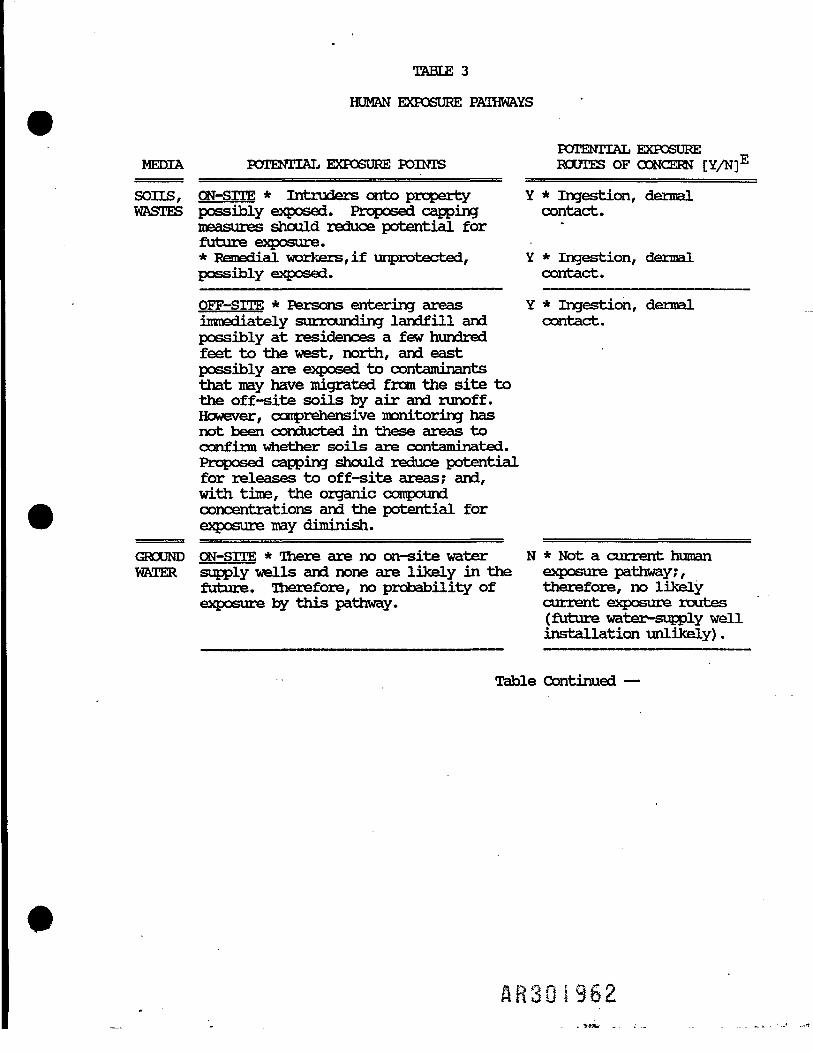
TABLE 3
HUMAN EXPOSURE PATHWAYS
POTENTIAL EXPOSUREMEDIA POTENTIAL EXPOSURE POINTS ROUTES OF CONCERN [Y/N]E
SOILS, CN-srrE * Intruders onto property Y * Ingestion, dermalWASTES possibly exposed. Proposed capping contact.
measures should reduce potential forfuture exposure.* Remedial workers,if unprotected, Y * Ingestion, dermalpossibly exposed. contact.
OFF-SITE * Persons entering areas Y * Ingestion, dermalimmediately surrounding landfill and contact.possibly at residences a few hundredfeet to the west, north, and eastpossibly are exposed to contaminantsthat may have migrated from the site tothe off-site soils by air and runoff.However, comprehensive monitoring hasnot been conducted in these areas toconfirm whether soils are contaminated.Proposed capping should reduce potential,for releases to off -site areas; and,with time, the organic compoundconcentrations and the potential forexposure may diminish.
GROUND ON-SITE * There are no on-site water N * Not a current humanWATER supply wells and none are likely in the exposure pathway;,
future. Therefore, no probability of therefore, no likelyexposure by this pathway. current exposure routes
(future water-supply wellinstallation unlikely).
Table Continued —
301962

TABLE 3(Continued)
POTENTIAL EXPOSUREMEDIA POTENTIAL EXPOSURE POINTS ROUTES OF CONCERN [Y/N]E
OFF-SITE * Most of the parties in the Y * Ingestion, dermalsite vicinity have been connected to a contact, inhalationpublic water supply system. However, a (current exposure routes;number of residences (15) along Hill after connection to publicStreet do not yet have the public supply water system, and asystem available and continue to use moratorium on new welltheir groundwater supply wells. installation,there shouldMonitoring data have indicated that some be no likely humanof these residents are exposed to exposure pathway and nocxxitaroinants of concern in three water likely exposure routes).supply wells that appear to be locatedin a current upgradient direction fromthe site.With time, the on-site remediationshould improve groundwater quality atthese locations and in downgradientareas. However, the extent ofimprovement could be diminished bysurface water infiltration atsettlement-induced depressions on thecap, and by infiltration throughsettlement-induced cracks in the cap.Quality so may be affected by releasesfrom submerged wastes or fromcontaminants that may reside beyond thelandfill in surface soils or ponds,until, or unless, their remediation isinitiated.However, the current concern forexisting groundwater users will be fullymitigated by extending the water mainand connecting all these residents tothe public supply system, providing theresidents do not continue to use thegroundwater supply in ways that resultin exposure. In addition, EPA intendsto request local authorities to impose atemporary moratorium on installation ofnew water supply wells in the area ofconcern.
SURFACE ON-SrTE * Intruders and unprotected Y * Ingestion, dermalWATER, remedial workers possible exposed to contact, inhalation.SEDI- contaminants in surface water in theMENT runoff pond and leachate discharges.
Monitoring data indicate sedimentsassociated with these waters do notcontain contaminants at levels ofconcern. Construction of a cap shouldminimize subsequent exposure potential.
Table
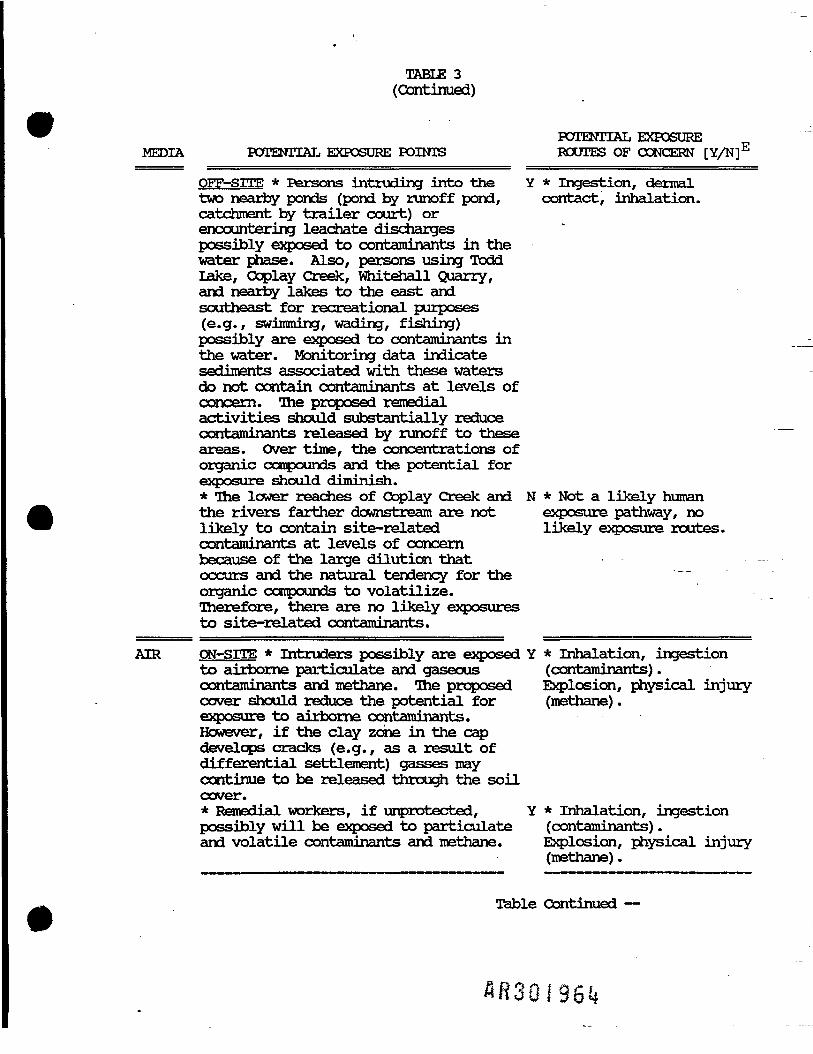
TABLE 3(Continued)
POTENTIAL EXPOSUREMEDIA POTENTIAL EXPOSURE POINTS ROUTES OF CONCERN [Y/N]E
OFF-SITE * Persons intruding into the Y * Ingestion, dermaltwo nearby ponds (pond by runoff pond, contact, inhalation.catchroent by trailer court) orencountering leachate dischargespossibly exposed to contaminants in thewater phase. Also, persons using ToddLake, Ooplay Creek, Whitehall Quarry,and nearby lakes to the east andsoutheast for recreational purposes(e.g., swimming, wading, fishing)possibly are exposed to contaminants inthe water. Manitoring data indicatesediments associated with these watersdo not contain contaminants at levels ofconcern. The proposed remedialactivities should substantially reducecontaminants released by runoff to theseareas. Over time, the concentrations oforganic compounds and the potential forexposure should diminish.* The lower reaches of Coplay Creek and N * Not a likely humanthe rivers farther downstream are not exposure pathway, nolikely to contain site-related likely exposure routes.contaminants at levels of concernbecause of the large dilution thatoccurs and the natural tendency for theorganic compounds to volatilize.Therefore, there are no likely exposuresto site-related contaminants.
AIR ON-SITE * Intruders possibly are exposed Y * Inhalation, ingestionto airborne particulate and gaseous (contaminants).contaminants and methane. The proposed Explosion, physical injurycover should reduce the potential for (methane).exposure to airborne contaminants.However, if the clay zone in the capdevelops cracks (e.g., as a result ofdifferential settlement) gasses maycontinue to be released through the soilcover.* Remedial workers, if unprotected, Y * Inhalation, ingestionpossibly will be exposed to particulate (contaminants).and volatile contaminants and methane. Explosion, physical injury
(methane).
Table Continued —
A-R30l96«i

TABLE 3(Continued)
POTENTIAL EXPOSUREMEDIA POTENTIAL EXPOSURE POINTS ROUTES OF CONCERN [Y/N]E
OFF-SITE * Persons at the nearest Y * Inhalation, ingestionresidences and persons entering areasadjacent to the site possibly areexposed to airborne particulate andgaseous contaminants and methane.Exposure possibly may occur duringremediation construction activities.Over time, emissions and exposureconcerns should diminish. However,there may be long-term emissions fromvents, from gas treatment, fromgroundwater treatment (if a strippersystem is used), and through the soilcap (e.g., cracks). Exposure also maycontinue to occur from areas adjacent tothe site, if substantial contaminantsreside there.* Nearby residents possibly may be Y * Inhalation (contaminantexposed to methane, an noncontaminant, gasses), physical injuryand contaminant gasses transported (methane).through the subsurface into their homes.The proposed cap and vent system mightsubstantially diminish the potential forexposure.
FOOD ON-SITE * Not an environmental pathway, N * Not a currentCHAIN no likely exposures. environmental pathway, no
exposure routes.
OFF-SITE *Persons consuming fish taken Y * Ingestion.from Coplay Creek, Whitehall Quarry, orlakes possibly might be exposed.However, there are no data to confirmwhether fish tissues are contaminated.There is a potential for exposure toresidents who raise consumable plants.However, there is no informationcxxTcerning consumption, or if plants areccritaminated. There also is a potentialfor exposure to persons that may consumecrops raised on the adjacent land, orthrough consumption of farm animals whouse the crop for food. However, thereis no information to indicate whetherthe crops are contaminated, or whetherconsumable farm animals consume them andare themselves contaminated. Over time,proposed site remediation should reducethe potential for exposure.
NoteE: Y =* Route(s) potentially a concernN = Route(s) not of concern A B 3 0 I 9 6 5 I
I
Related Documents