AfricaGIS 2013 - GSDI 14 - Global Geospatial Conference 2013 Addis Ababa, Ethiopia, November 4-8, 2013 By Antoine DENIS – PhD student - University of Liège - Belgium Can satellites help organic cotton certification ? Remote sensing and GIS techniques for supporting organic cotton certification process in West Africa

AfricaGIS 2013 - GSDI 14 - Global Geospatial Conference 2013 Addis Ababa, Ethiopia, November 4-8, 2013 By Antoine DENIS – PhD student - University of Liège.
Apr 01, 2015
Welcome message from author
This document is posted to help you gain knowledge. Please leave a comment to let me know what you think about it! Share it to your friends and learn new things together.
Transcript
AfricaGIS 2013 - GSDI 14 - Global Geospatial Conference 2013Addis Ababa, Ethiopia, November 4-8, 2013
By Antoine DENIS – PhD student - University of Liège - Belgium
Can satellites help organic cotton certification ?
Remote sensing and GIS techniques for supporting organic cotton certification process in West Africa
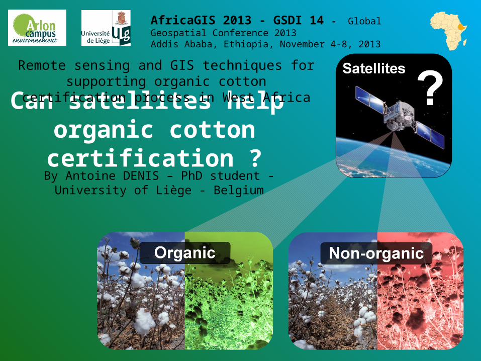
1. Context & Justification2. Objectives3. The IDEA4. Hypothesis
5. Method6. Results
7. Discussion and conclusion
Can satellites help organic cotton certification ?
1. Context & Justification
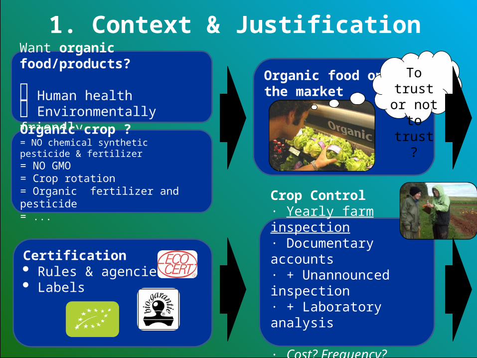
Want organic food/products?
Human health Environmentally friendly
1. Context & Justification
Organic crop ? = NO chemical synthetic pesticide & fertilizer= NO GMO= Crop rotation= Organic fertilizer and pesticide= ...
Crop Control· Yearly farm inspection· Documentary accounts· + Unannounced inspection· + Laboratory analysis · Cost? Frequency? Remote areas?
Certification Rules & agencies Labels
Organic food onthe market
To trust or not to trust ?
1. Context & Justification
1. Context & Justification
Why the Burkina Faso ?
Interest from organic certification bodies for developing countries:• Huge amount of organic products ($)
• Remote areas and certification control more difficult
Why the cotton?• Need a crop certified as organic
• That can be studied by RS
• Field big enough
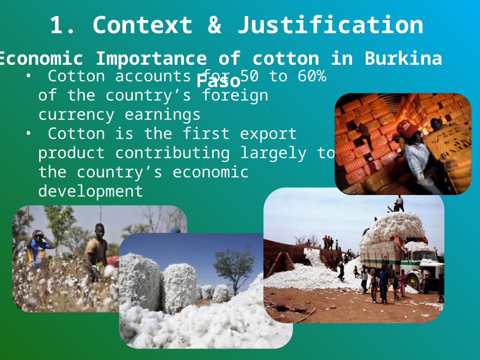
Economic Importance of cotton in Burkina Faso• Cotton accounts for 50 to 60% of the
country’s foreign currency earnings • Cotton is the first export product
contributing largely to the country’s economic development
1. Context & Justification
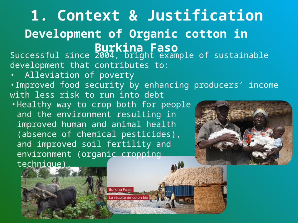
Development of Organic cotton in Burkina FasoSuccessful since 2004, bright example of sustainable development that contributes to:• Alleviation of poverty•Improved food security by enhancing producers’ income with less risk to run into debt
1. Context & Justification
• Healthy way to crop both for people and the environment resulting in improved human and animal health (absence of chemical pesticides), and improved soil fertility and environment (organic cropping technique).

2. Objectives
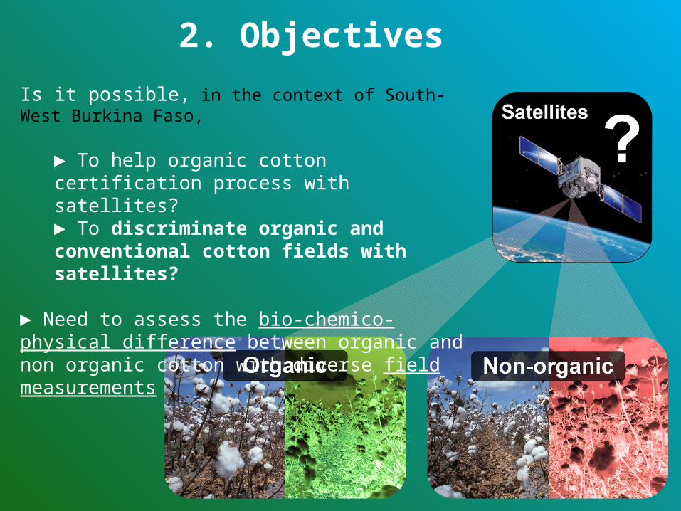
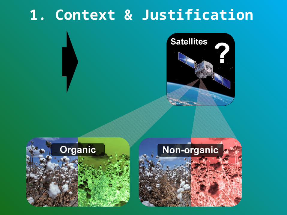
Is it possible, in the context of South-West Burkina Faso,
► To help organic cotton certification process with satellites?► To discriminate organic and conventional cotton fields with satellites?
► Need to assess the bio-chemico-physical difference between organic and non organic cotton with diverse field measurements
2. Objectives

3. The IDEA
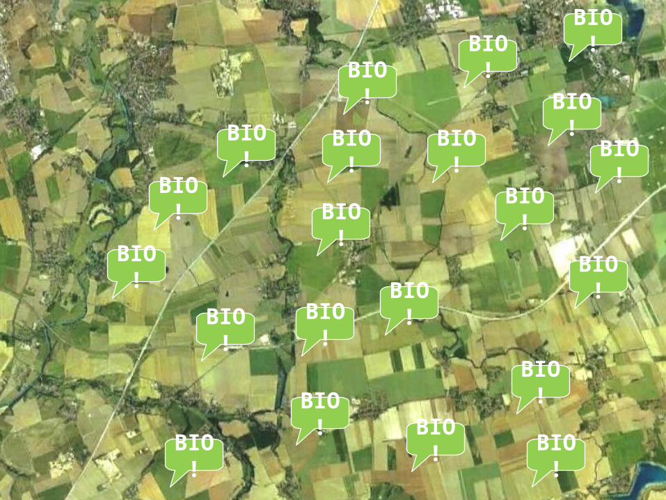
BIO!
BIO!
BIO!BIO
!BIO
!
BIO!
BIO! BIO
!
BIO!
BIO!
BIO!
BIO!
BIO!
BIO!BIO
!BIO!
BIO!
BIO!
BIO!
BIO!
BIO!
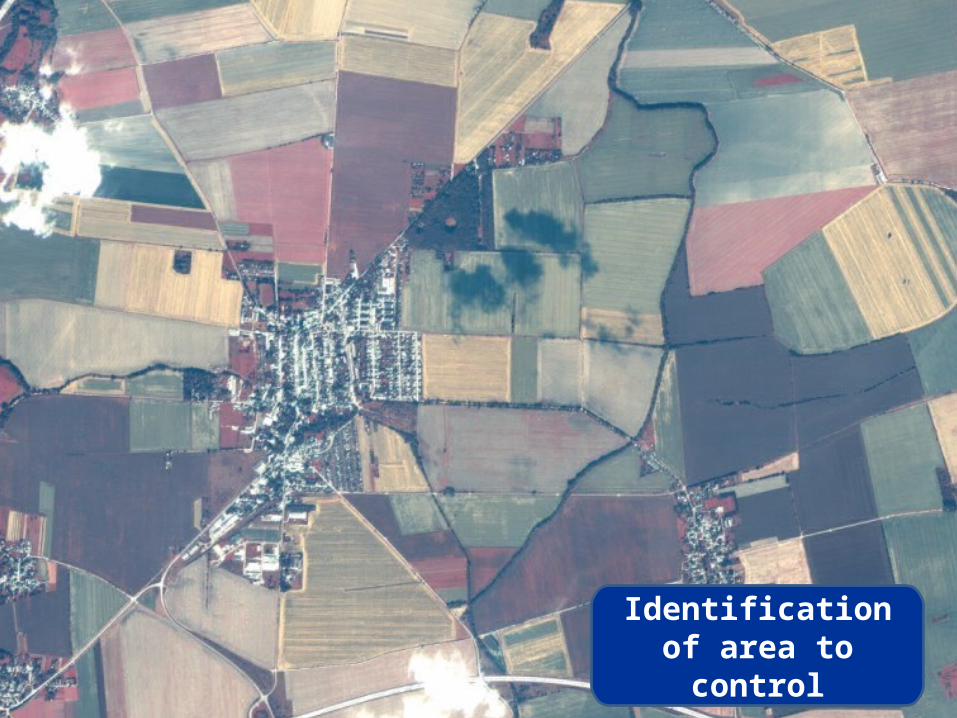
Identification of area to control
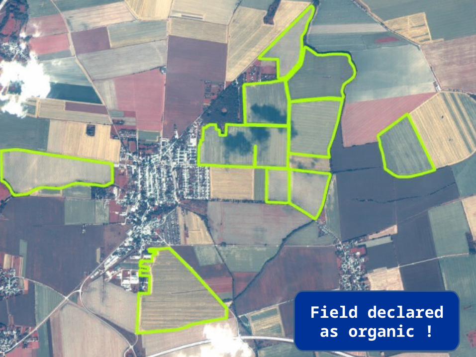
Field declared as organic !
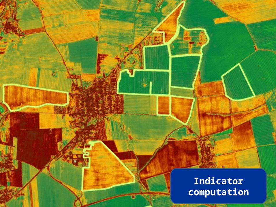
Indicator computation
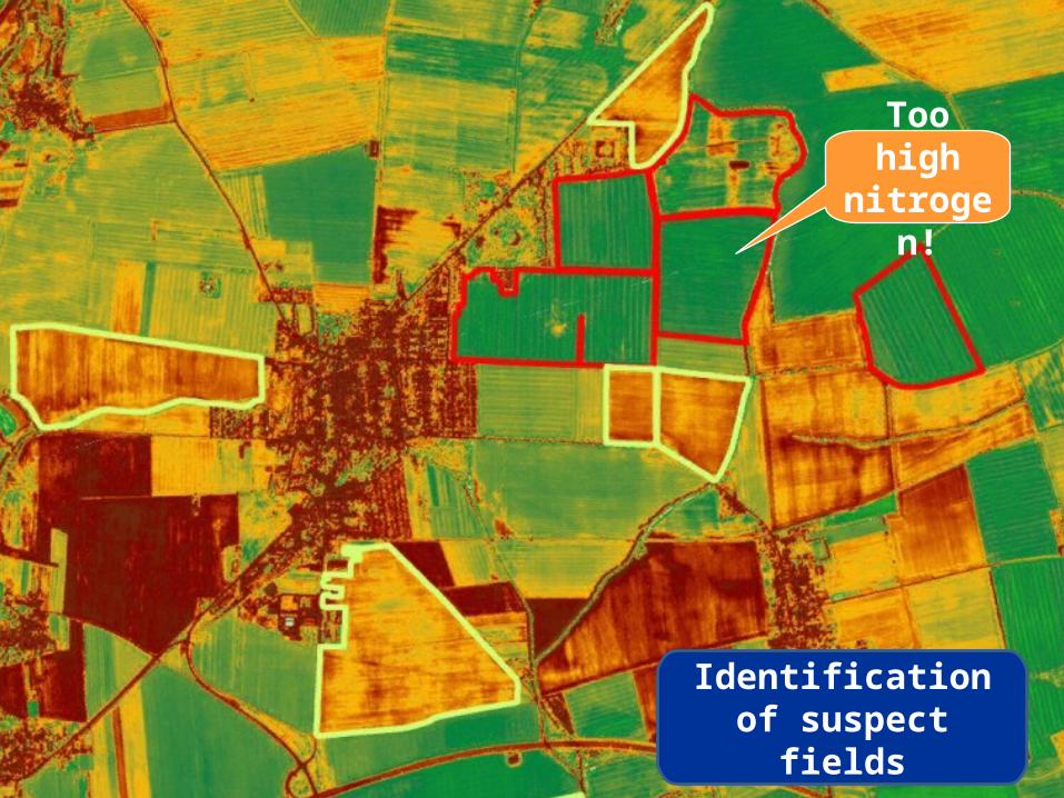
Identification of suspect fields
Too high nitrogen!
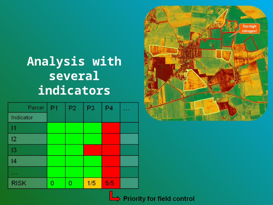
Analysis with several indicators
4. Hypothesis
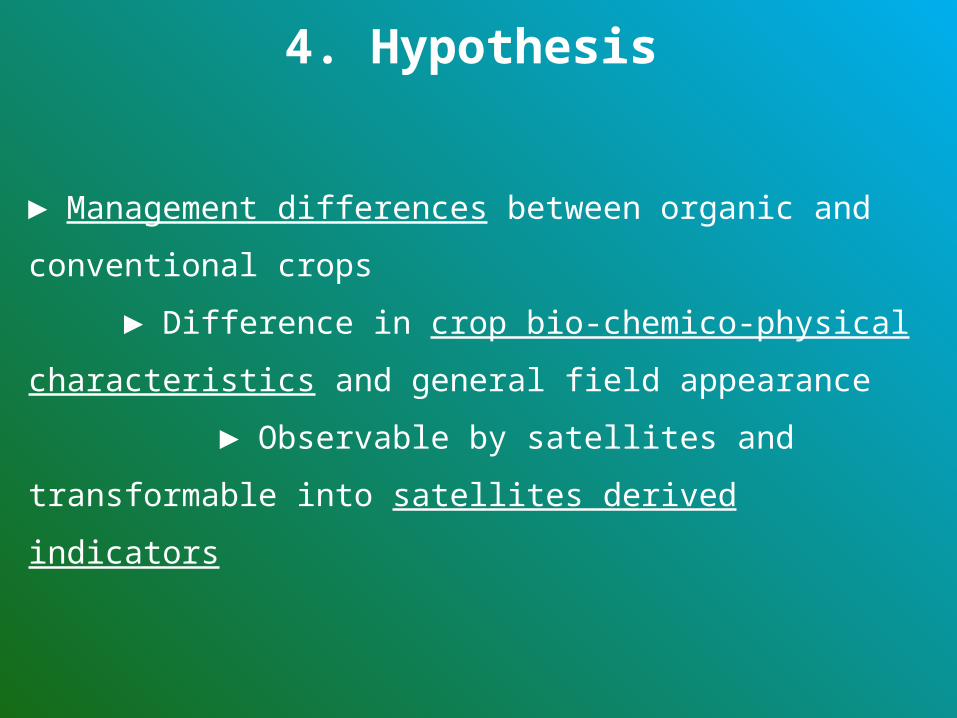
4. Hypothesis
► Management differences between organic and conventional
crops
► Difference in crop bio-chemico-physical
characteristics and general field appearance
► Observable by satellites and transformable into
satellites derived indicators
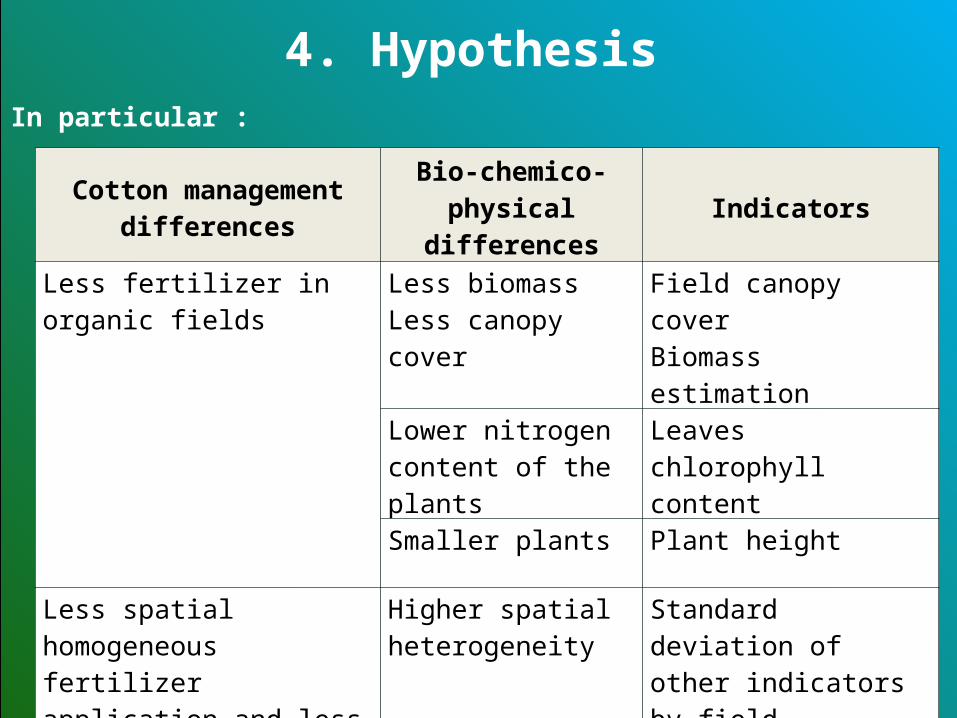
Cotton management differences
Bio-chemico-physical differences
Indicators
Less fertilizer in organic fields Less biomassLess canopy cover
Field canopy cover Biomass estimation
Lower nitrogen content of the plants
Leaves chlorophyll content
Smaller plants Plant height
Less spatial homogeneous fertilizer application and less efficient pesticide in organic fields
Higher spatial heterogeneity
Standard deviation of other indicators by field
4. HypothesisIn particular :
4. Hypothesis
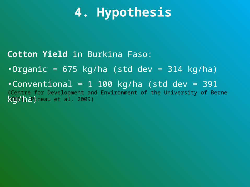
Cotton Yield in Burkina Faso:
•Organic = 675 kg/ha (std dev = 314 kg/ha)
•Conventional = 1 100 kg/ha (std dev = 391 kg/ha)(Centre for Development and Environment of the University of Berne (CDE), Pineau et al. 2009)

5. Method
5.Method
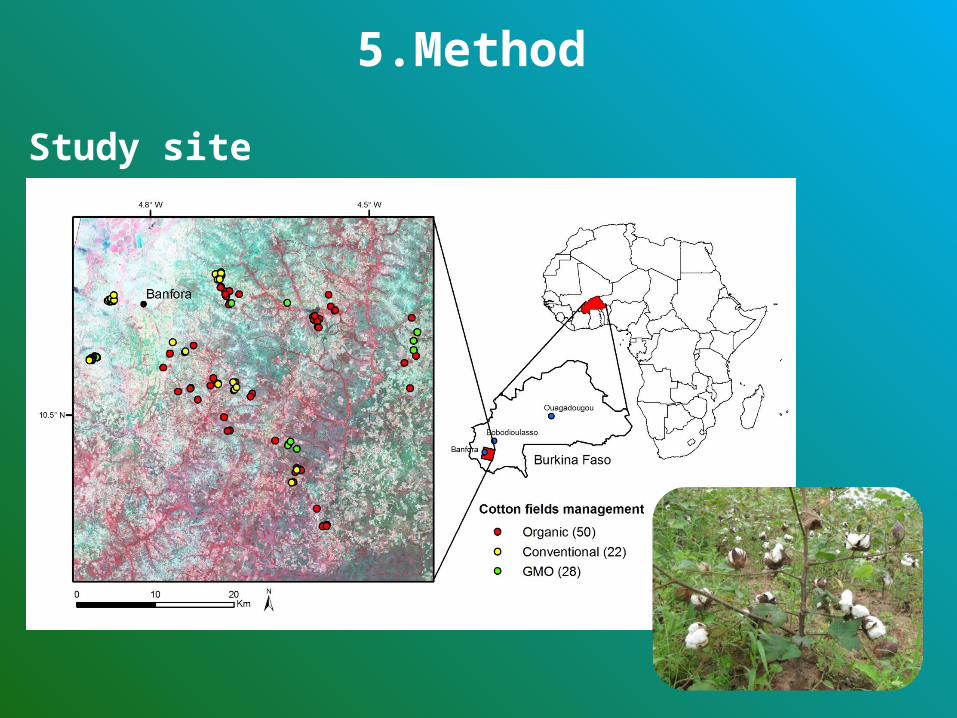
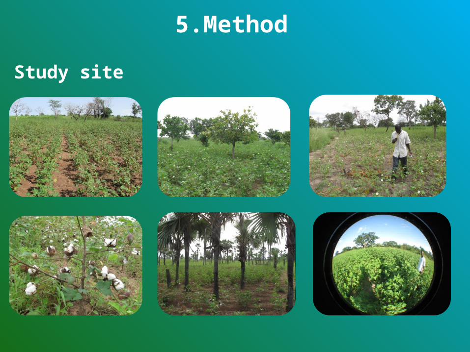
Study site
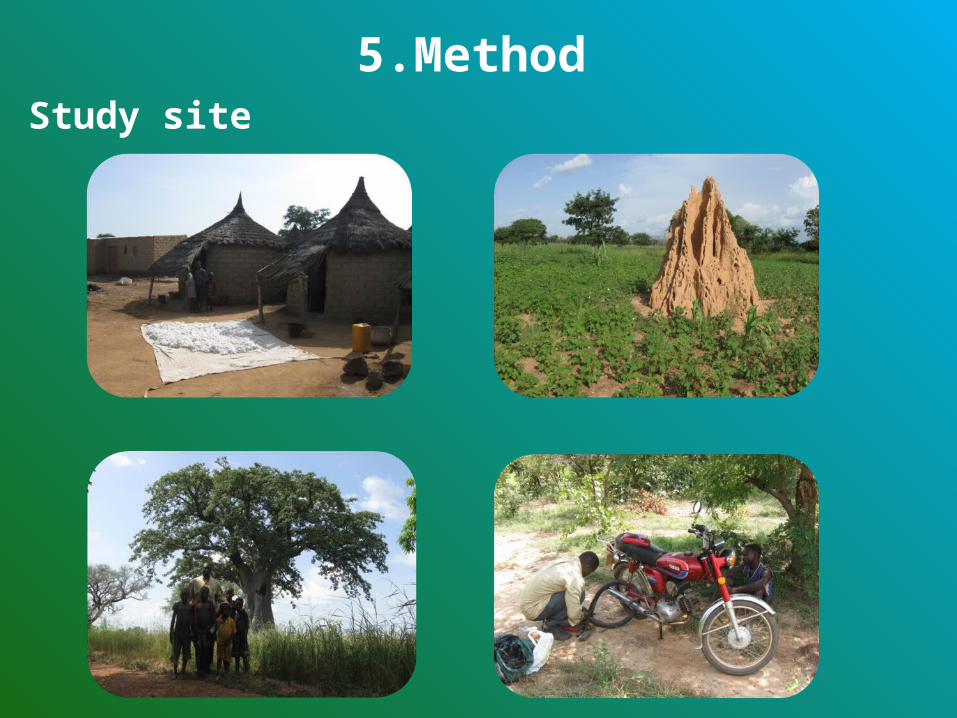
5.MethodStudy site
5.Method
Study site
• Several local varieties for organic and conventional
• Several varieties Bt GMO • Low intensive cultivation • Farming operations: manually or workanimals• Rainfed
5.Method
Cotton cropping method in Burkina Faso
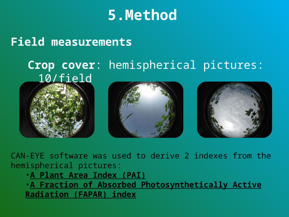
Crop cover: hemispherical pictures: 10/field
CAN-EYE software was used to derive 2 indexes from the hemispherical pictures:•A Plant Area Index (PAI)•A Fraction of Absorbed Photosynthetically Active Radiation (FAPAR) index
5.Method
Field measurements
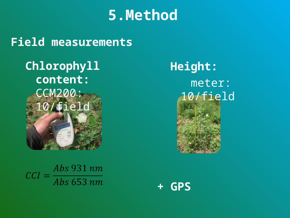
+ GPS
Chlorophyll content: CCM200: 10/field
Height:
meter: 10/field
5.Method
Field measurements
Field spatial heterogeneity = standard deviation of parameters by field
5.Method
Field measurements
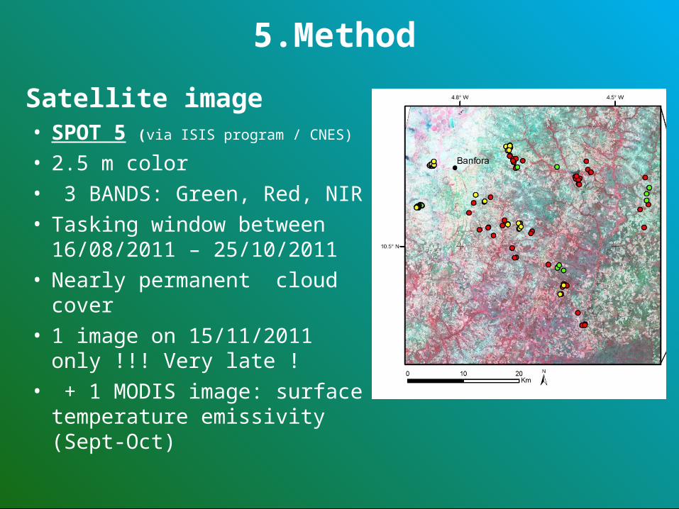
• SPOT 5 (via ISIS program / CNES)
• 2.5 m color• 3 BANDS: Green, Red, NIR• Tasking window between
16/08/2011 – 25/10/2011• Nearly permanent cloud cover• 1 image on 15/11/2011
only !!! Very late !• + 1 MODIS image: surface
temperature emissivity (Sept-Oct)
5.Method
Satellite image
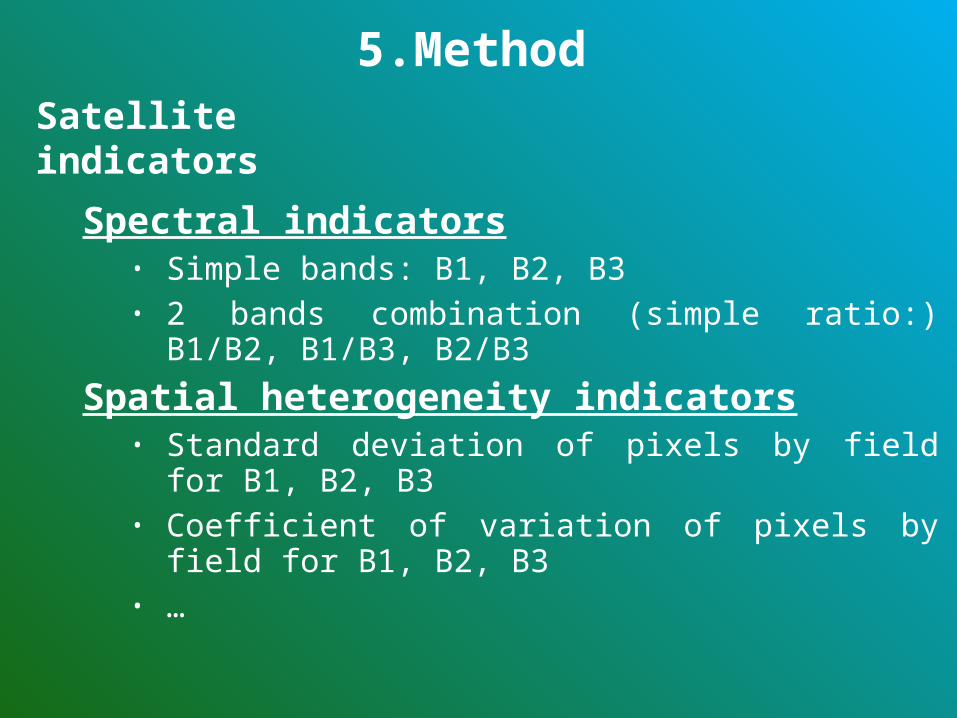
Spectral indicators• Simple bands: B1, B2, B3• 2 bands combination (simple ratio:) B1/B2, B1/B3, B2/B3
Spatial heterogeneity indicators• Standard deviation of pixels by field for B1, B2, B3• Coefficient of variation of pixels by field for B1, B2, B3• …
5.Method
Satellite indicators
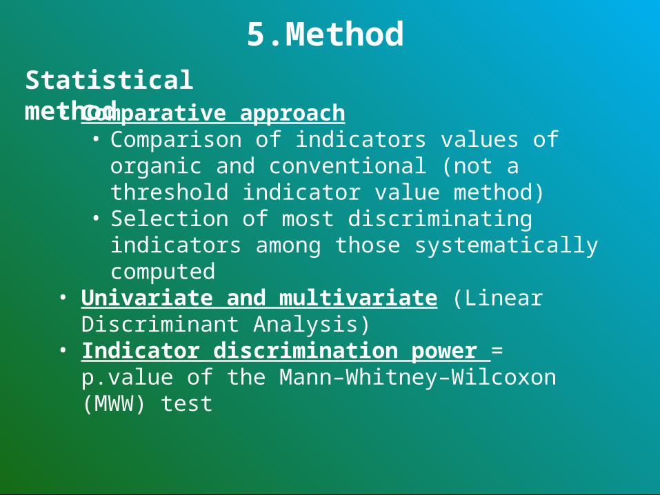
• Comparative approach• Comparison of indicators values of organic and
conventional (not a threshold indicator value method)
• Selection of most discriminating indicators among those systematically computed
• Univariate and multivariate (Linear Discriminant Analysis)
• Indicator discrimination power = p.value of the Mann–Whitney–Wilcoxon (MWW) test
5.Method
Statistical method

6. Results
6. Results
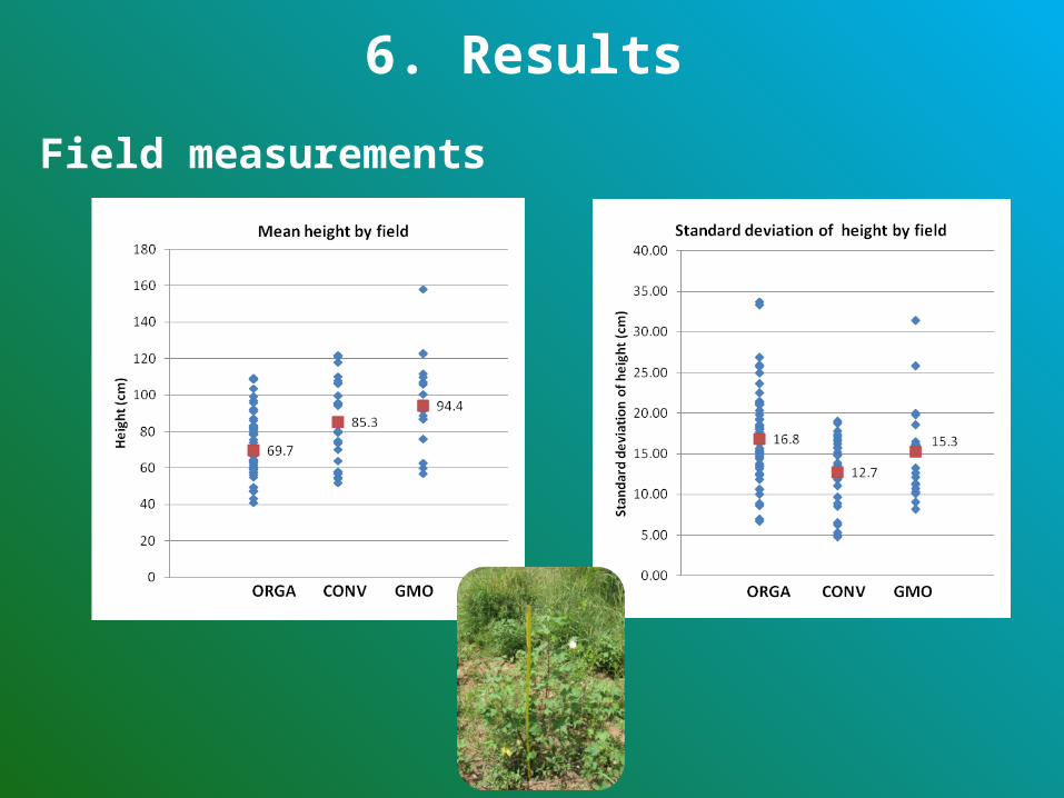
Field measurements
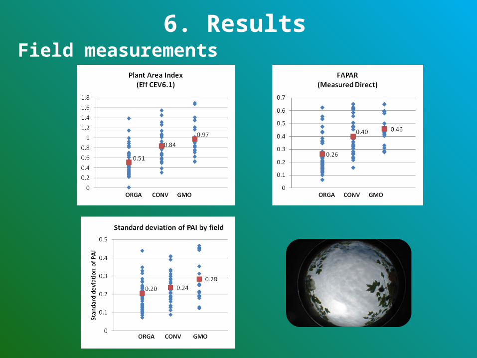
6. ResultsField measurements
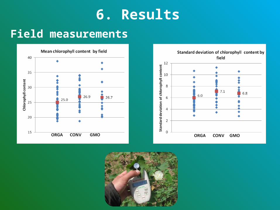
6. ResultsField measurements
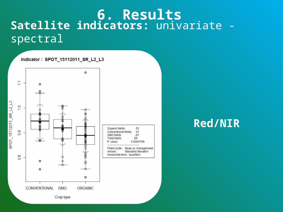
Red/NIR
6. ResultsSatellite indicators: univariate - spectral
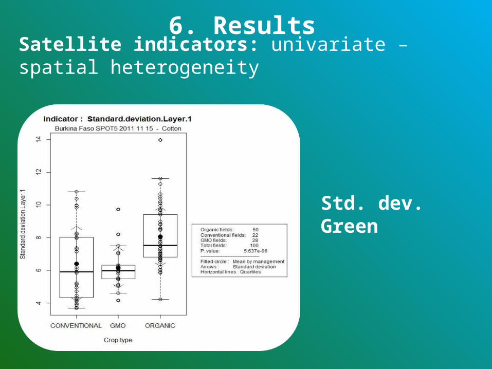
6. ResultsSatellite indicators: univariate – spatial heterogeneity
Std. dev. Green
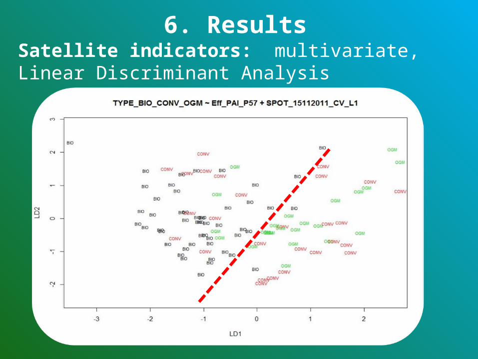
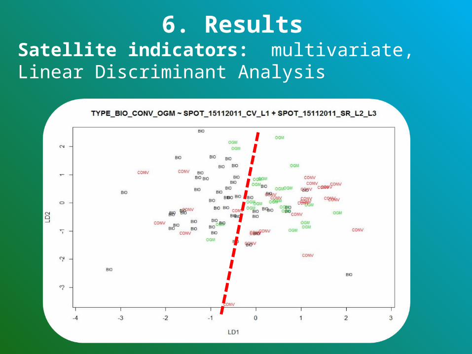
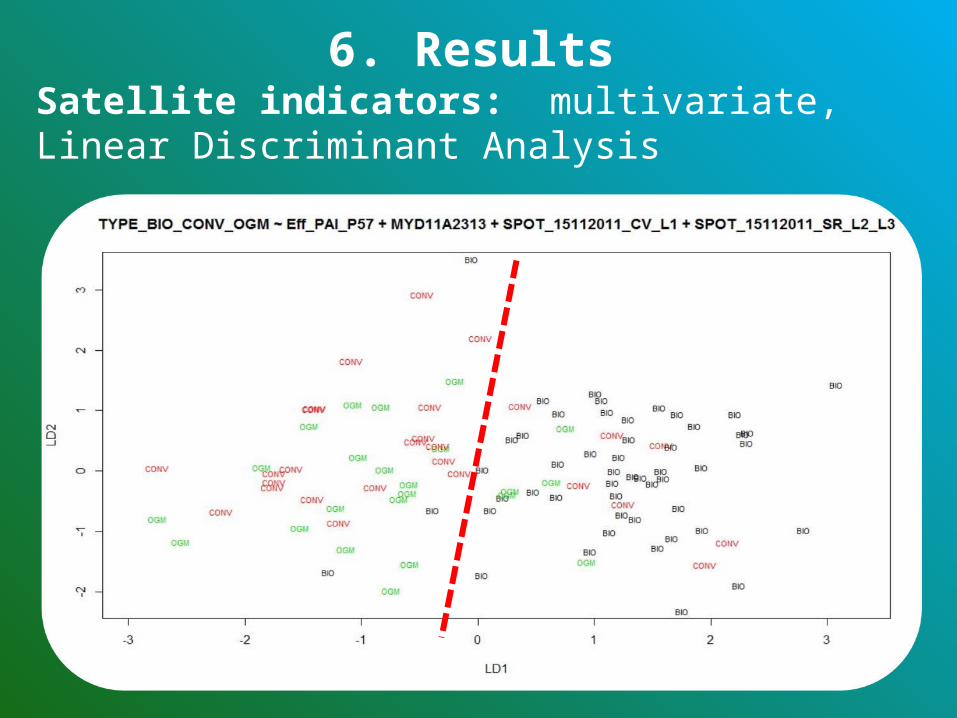
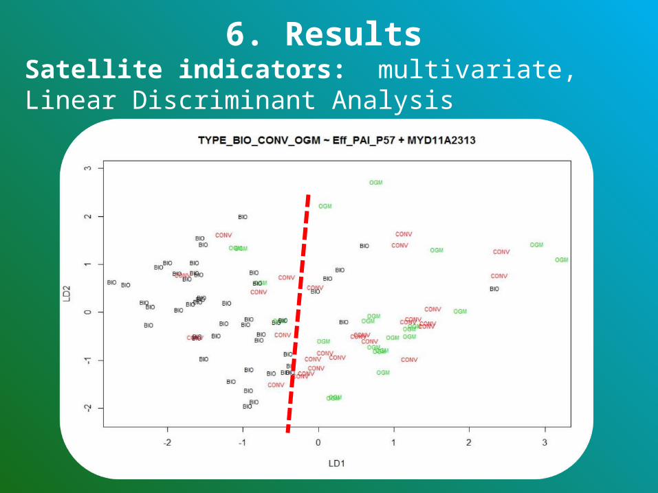
6. ResultsSatellite indicators: multivariate, Linear Discriminant Analysis
6. ResultsSatellite indicators: multivariate, Linear Discriminant Analysis
6. ResultsSatellite indicators: multivariate, Linear Discriminant Analysis
6. ResultsSatellite indicators: multivariate, Linear Discriminant Analysis

7. Discussion and conclusion
Differences are observed between cotton types•For both field and satellite indicators•Statistically significant•Not enough pronounced with values ranges that largely overlapThis prevents the use of these indicators alone to be the base of a robust discrimination
But the method enables to target for priority field control, organic fields who present indicator values getting closer to the one of conventional or GM cotton fields
Further research:•Timely satellite acquisition!•Identification of the ideal phenological stage for cotton monitoring
7. Discussion and conclusionGeneral conclusion
Regarding the initial hypothesis
Mixed results regarding the initial hypothesis:
•Most of the indicators: organic fields present significant lower general field development and higher spatial heterogeneity
•CCI indicators don’t show any significant difference between management types and the standard deviation of the canopy cover show a slightly lower spatial heterogeneity for organic fields
7. Discussion and conclusion
Satellite Indicators are questionable:•A single image was acquired very late in the crop cycle •No straight conclusion regarding the general relevance of the use of RS techniques in the study context
Use of satellite images seems to be quite compromised given the unfavourable atmospheric conditions which are most of the time cloudy. Need for daily image acquisition for cloud free image?
Trees in cotton fields can strongly influence the reflectance and the spatial heterogeneity (from no tree to a complete agroforestry system)
7. Discussion and conclusion
Relevance of the use of satellite images in this context
Difference between cotton parcel is also due to other factors, difficult to take into account:•The phenology stages that can strongly vary from one parcel, farmer or region to another due to varying seeding date, itself depending among other on the local climatic condition, with very localized rainfalls. •Varying soil natural fertility•Varying level of development of the farmers (fertilizer availability)
7. Discussion and conclusion
Remaining obstacles

• Given• Lack of experience of organic cotton farmers • Yields already achieved by the organic farmers
“elite” which are close to the conventional ones• If organic farming techniques are encouraged and
tuned (increase of quantity of available organic fertilizers) , the current gap between organic and non organic cotton yields would be considerably reduced
7. Discussion and conclusion
Skills of organic farmers
Thank You !
Université de Liège - Belgique
Acknowledgement
The French “Centre National d’Etudes Spatiales” (CNES) through its « ISIS » program (« Incitation à l'utilisation Scientifique des Images SPOT ») that enabled to acquire a SPOT 5 image at low cost for this study. SPOT "© CNES (2012), distribution Spot Image S.A.", Http://www.isis-cnes.fr/IntroPage.do
The “SOciété Burkinabé des FIbres TEXtiles” (SOFITEX) that allowed the field survey in conventional and GMO cotton fields.
The National Union of Cotton Producers of Burkina Faso (UNPCB – Union Nationale des Producteurs de Coton du Burkina Faso) that enabled the field survey in organic cotton fields and accompanied the entire field survey.
Helvetas Swiss Intercooperation Burkina Faso, for their important documentation on organic cotton production in Burkina Faso and their advices for the field survey preparation.
Contact information
Arlon Campus Environnement (ACE)University of Liège (ULg)185, Avenue de Longwy,6700 ArlonBelgium
Antoine DENIS Bernard TYCHON
TEL 0032 63 230 997 0032 63 230 829
Email [email protected] [email protected]
Website http://www.campusarlon.ulg.ac.be/
Related Documents