Disclaimers: The designations employed and the presentation of material on this map do not imply the expression of any opinion whatsoever on the part of the Secretariat of the United Nations concerning the legal status of any country, territory, city or area or of its authorities, or concerning the delimitation of its frontiers or boundaries. http://afg.humanitarianresponse.info [email protected] AFGHANISTAN Balkh Province District Atlas April 2014

Welcome message from author
This document is posted to help you gain knowledge. Please leave a comment to let me know what you think about it! Share it to your friends and learn new things together.
Transcript

Disclaimers: The designations employed and the presentation of material on this map do not imply the expression of any opinion whatsoever on the part of the Secretariat of the United Nations concerning the legal status of any country, territory, city or area or of its authorities, or concerning the delimitation of its frontiers or boundaries. http://afg.humanitarianresponse.info [email protected]
AFGHANISTAN
Balkh Province District Atlas April 2014

o
p
!!
!!
!!
!!
!!!!
!!
!!
!!
!!!!
!!
!!
!!
!!
!!
!!
!!
!!
!!!!
!!
!!!!
!!
!!!!
FayzabadDistrict
MardyanDistrict
QarqinDistrict
ShortepaDistrict
KaldarDistrict
DawlatabadDistrict
KhulmDistrict
MarmulDistrict
CharkentDistrict
DehdadiDistrict
BalkhDistrict
CharbulakDistrict
ChemtalDistrict
SholgarehDistrict
KeshendehDistrict
ZariDistrict
FeroznakhchirDistrict
Dara-eSuf-e-Bala
DistrictRuy-e-Duab
District
KhuramWa Sarbagh
District
Sar-e-PulDistrict
SozmaqalaDistrict
GosfandiDistrict
SancharakDistrict
BalkhabDistrict
KohestanatDistrict
Qala-e-ZalDistrict
Hazrat-e-SultanDistrict
Dara-e-Suf-e-PayinDistrict
AybakDistrict
Nahr-e-ShahiDistrict
B a l k hP r o v i n c e
J a w z j a nP r o v i n c e
S a m a n g a nP r o v i n c e
S a r - e - P u lP r o v i n c e
Termez
Dzharkugan
Aiwanj
Charbulak
Mardyan
Fayzabad
Sholgareh
Chemtal Dehdadi
Balkh
Dawlatabad
Shortepa
Sangcharak Gosfandi
Zari
Keshendeh
Balkhab
Ruy-e-Duab
Dara-e-Suf-e-Payin
Charkent
Marmul
Hazrat-e-Sultan
KhulmNahr-e-Shahi
Kaldar
Aybak
Sharak-e-Hayratan
Khuram WaSarbagh
Mazar-e-Sharif
TAJIKISTAN
TURKMENISTAN
UZBEKISTAN
68°0'0"E
68°0'0"E
67°30'0"E
67°30'0"E
67°0'0"E
67°0'0"E
66°30'0"E
66°30'0"E
37°3
0'0"
N
37°3
0'0"
N
37°0
'0"N
37°0
'0"N
36°3
0'0"
N
36°3
0'0"
N
36°0
'0"N
36°0
'0"N
35°3
0'0"
N
35°3
0'0"
N
Disclaimers:The designations employed and the presentation of material on this mapdo not imply the expression of any opinion whatsoever on the part of theSecretariat of the United Nations concerning the legal status of anycountry, territory, city or area or of its authorities, or concerning thedelimitation of its frontiers or boundaries.
Date Printed: 27 March 2014 01:33 PM
Data Source(s): AGCHO, CSO, AIMS, MISTISchools - Ministry of EducationHealth Facilities - Ministry of Health
Projection/Datum: Geographic/WGS-84
Doc Name:Balkh_Province_reference_map_dd_20140327_A3
Feedback: [email protected]
!̂
Kabul
INDIA
PAKISTAN
TAJIKISTAN
TURKMENISTAN
UZBEKISTAN CHINA
JAMMU ANDKASHMIR
AFGHANISTAN: Balkh Province Reference Map
0 20 40 60 Kms
°
200 km
Legend
!̂ Capital
!!!! Provincial Center
!! District Center
Administrative Boundaries
International
Province
Distirict
Transportation
Primary Road
Secondary Road
o Airport
p Airfield
River/Stream
River/Lake

p
!
!
!
!
!
!
!
!
!
!
!
!
!
!
!
!
!
!
!
!
!
!
!!
!
!
!
!
!
!
!
!
!
!
!
!
!
!
!
!
!
!
!
!
!
!
!
!
!
!
!
!
!
!
!
!
!
!
!
!!
!
!
!
!
!
!
!
!
!
!
!
!
!
!
!
!
!
!
!
!
!
!
!
!
!
!
!
!
!
!
!
!
!
!
!
!
!
!
! !
!
!
!
!
!
!
!
!
!
!
!
!
!
!
!
!
!
!
!
!
!
!
!
!
!
!
!
!
!
!
!
!
!
!
!
!
!
!
!
!
!
!
!
!
!
!
!
!
!
!
!
!
!
!
!
!
!
!
!!
!
!
!
!
!
!
!
!
!
!
!
!!
!
!
!
!
!
!
!
!
!
!
!!
!
!
!
!
!
!
!
!
!
!
!
!
!
!
!
!
!
!
!
!
!
!
!
!
!
!
!
!
!
!
!
!
!
!
!
!
!
!
!
!
!
!
!
!
!
!
!
!
!
!
!
!
!
!
!
!
!
!
!
!
!!
!
!
!
!
!
!
!
!
!
!
!
!
!
!
Â2
Â2
Â2
Â2
Â2
Â2
Â2Â2 Â2
Â2
Â2
Â2
Â2
Â2Â2
Â2
Â2
Â2
Â2
Â2
Â2
Â2
Â2
Â2
Â2
Â2
Â2
Â2
Â2
Â2
Â2
Â2
Â2
Â2
Â2
Â2 Â2
Â2
Â2
Â2
Â2
Â2
Â2
Â2Â2
Â2
Â2
Â2
Â2
Â2
Â2Â2
Â2
Â2
Â2
Æ5
"6Æ5Æ5
"6
"6
Æ5
Æ5
Æ5
Æ5
Æ5
Æ5
Æ5
Æ5
Æ5
"6
Æ5
Æ5
Æ5
Æ5
Æ5
Æ5
!!
!!
!!
Dandowkai
WalakaiNur Mahmad
NowardKhasbak
Dandoki
DewalgiHussainKhail
KhasbakWatani
NowaridDandogiBala
NowaridDandokai
NowaridEalqche
BahlolKhailZhangori
GalaJowi
Khana Abad Zhangori
Now AwardWacha Wana
Khan Wali
Nowarid BahramKhail
NowaridOmar Khail
NowaridTabaKhasbak
Nowarid WachaWana Kandahari
ShaikhTash Taimoriyan Payan
Shaikh TashTaimoryan
SikandarKhailZhangori
TourtegaWa MoshKhorya
Asfhan
KatoriSufla
TakaTurkmanAsfehanWarta
Shakh
Darabad
KatoriNowarid
Maidan
NowaridDewali
Dar AbadUzbekya
Dar AbadWatani
Dashtan
KolPanjab Naqelin
Nowarid
SarAsiyab
ShakhMughulan
ShengilRabadWatani
SorkhGonbad
Diwalqai(adramzai)
Dowagi
GhundiArab Ha
MargenTapa
NowaridKatki
Romki
AyelAbad
KakrakZhangori
Kotagi
NowaridWachaWana
Sapan
ShorabaPashtoniya
Wacha WanaAyleman
Shorabi
Dudul-i-momandi
IshpolaMaidan
Kol-i-ambo(dago)
Tozhna-i-nasiri
KatoriNeyazi
NowaridDewalyMandozai Nowarid
MiranPenjaJereb
AkhondZada
AmerKhail
Baba Qoo
BabaYusuf
Bahuddin
Banda
BartaridBar Bala
Boka
BoryaBaf
Chaqwsh
CharGonbaz
CharbaghGulshan
NowaridGhondan
NowaridKhowjaGholak
NowaridMashak
Peyaz Kar
QaisarKhail
Qalacha
Qarlaq
SalarZare
SarNahr Abdullah
Saray
SayidAbad
Talaow
Tarwa Ke
TaznaNassiri
Walge
Warsho
Warsho Dahi Bebe
Zargaran
NauwaridMaidan
Shah Ab
EalqachePayen
SultanHaji Wali(nauwarid)
Baghsor
BaghtorMohmand
Dewaly
EalqacheBala
NagharaQoul
NowaridKabuli Ha
QoulShahab
SahabTurkman Ha
AlangAfghaniya
AlangHazara
Bagh ShorWatani
Baidow
Dorman
Hashim AbadSaltaq HajiYaqoub
Hashim AbadSaltaq
Rahmat Pahl
KhalaBachgan
Dakar
DenarKhail
GhondaSufla
GhulamJan
Gor Tepa
HalimKhail
HassanAbad
HussainKhail
JowiShairan
KataKhail
KatoriDowlatZai
Khan Aqa
KhowjaGholak
Larghon
MahajerinChaqash
MandaNoor
Mashak
MashakBabaCharkhi
Mohmandan
Now AbadArab Ha
Now Abad Jowi Shairan
Now Abad Kotagi
NowAbad
Qalacha
Now AbadZozan
NowaridBoka
NowaridChamanBoka
NowaridChaqash
NowaridData Khail
KhoshallAbad
MataniDoman
Matani SonChi Khoja
Pai ShahidAfghaniya
Qala MirHaidar
QandahriHaye BaghShor
Sardar WaPai ShahidHazaraSonchi
Khoja
TurkmanHayeBaghshor
WaliAbad
Yakhdan
YakhdanAfghaniya
ShahabUzbak Ha
SultanKhoja WaliNaqelin Haza
SultanKhowja Wali
EalqacheNowaridNassiri
Bangala
CharSang
SamarQandeyan
Asiyab Sharaf
BandEashan
Now AbadShor Abi
NowaridBai Taimor
NowaridFolada
Palo
Qeshlaq GulM.chamatal
SarAsiyab
YangiQala
Zoly
Joy Shor
Kakawt(nigari)
Khasapaz
Pusht-i-bagh
Sar-i-asyab
Jar-i-Khowni
AbasKhan
AboulBai
Amirankot
BabaKohna
BabaQashqar
Char DangTokhta
Char SarakTokhta
ChealGazi
Cheal GaziPaghmanin
DahiAbdullah
DahiSawar
Family HaiyeRahayeshi Kod Bar
ChamtalChatralyan
FoladaKhalche
JangalChamtal
MarkazWolluswalyBai Taimor
FamilyHayeFerqa
FazelAbad
Gozar Arab HaMarkaz
Wolluswal
GozarArab Ha
Shair Abad Hulya
Gozar AyoubShairMast
GozarCharTaqi
Gozar Raigestan
Gul Abad
GuzzrEashan
Hazar Jereb
HussainKhail
JowiShahr
KarMalik
Khanqa Kalan
KhanqaKhord
Khasa Paz
Mashi
NahmatBai
Now Abad
NowAbad
Hazar Jereb
NowAbad Khasa Paz
Now Abad Tokhta
Park HaiyeKod Barq
Pul Babo
PulNanwaye
PulShafa Khana
PushtBagh
QalaHabasKhan
QouTaimor
ShaikhAbad
Tagari
TokhtaBala
Tokhta Payen
YakaToot
ZamboGan
MirQasim
Mandowzai
Qurghan
Arab Ha
Dahi Qazi
Dahi QaziHazara Ha
PalasPush
Rabat
RaoufMalik
SeyaQandouq
Shaige
TemorSaray
ZolgaiMahndan
DahiRaze
DirageGhondanHulya
Haji Kot
Hesarak
Kashkak
MoyeMubarak
Wata Qul
Kamperak
ChehlDukhtaranHulya
ChehlDukhtaran
Sufla
LangarKhanaKalan
Langar KhanaPayen Khord
ShairAbadSufla
Takht Pul
ShairAbadHulya
B a l k hP r o v i n c e
DawlatabadDistrict
DehdadiDistrict
BalkhDistrict
CharbulakDistrict
ChemtalDistrict
Nahr-e-ShahiDistrict
Chemtal
Dehdadi
Balkh
67°0'0"E
67°0'0"E
66°50'0"E
66°50'0"E
36°5
0'0"
N
36°5
0'0"
N
36°4
0'0"
N
36°4
0'0"
N
Disclaimers:The designations employed and the presentation of material on this mapdo not imply the expression of any opinion whatsoever on the part of theSecretariat of the United Nations concerning the legal status of anycountry, territory, city or area or of its authorities, or concerning thedelimitation of its frontiers or boundaries.
Date Printed: 01 April 2014 11:00 AM
Data Source(s): AGCHO, CSO, AIMS, MISTISchools - Ministry of EducationHealth Facilities - Ministry of Health
Projection/Datum: Geographic/WGS-84
Doc Name:Balkh_District_reference_map_dd_20140401_A3
Feedback: [email protected]: http://afg.humanitarianresponse.info/
!̂
Kabul
INDIA
PAKISTAN
TAJIKISTAN
TURKMENISTAN
UZBEKISTAN CHINA
JAMMU ANDKASHMIR
Balkh Province: Balkh District Reference Map
0 5 10 km
°
200 km
Legend
!̂ Capital
!!!! Provincial Center
!! District Center
! Village
Administrative Boundaries
International
Province
Distirict
Transportation
Primary Road
Secondary Road
Other Road
o Airport
p Airfield
River/Stream
River/Lake
"6 Hospital
Æ5 Other health facilities
Â2 Schools
!
!
!
!
!
!
!
!
!
!
!
!
!
!
!
!
!
!
!
!
!
!
!
!
!
!
!
!
!
!
!
!
!
!
!
!!
!
!
!
!
!
!
!
!
!
!
!
!
!
!
!
!
!
!
!
!
!
!
!
!
!
!
!
!
!
!
!
!
!
!
!
!
!
!
!
!
!
!
!
!
!
!
!
!
!
!
!
!
!
!
!
!
!
!
!
!
!
!
!
!
!
!
!
!
!
!
!
!
!
!
!
!
!
!
!
!
!
!
!
!
!
!
!
!
! !
!
!
!
!
!
!
!
!
!
!
!
!
!
!
!
!
!
!
!
!
!
!
!
!
!
!
!
!
!
!
!
!
!
!
!
!
!
!
!
!
!
!
!
!
!!
!
!
!
!
!
!
!
!
!
!
!
!
!
!
!
!
!
!
!
!
!
!
!
!
!
!
!
! !
!
!
!
!
!
!
!
!
!
!
!
!
!
!
!
!
!
!
!
!
!
!
!
!
!
!
!
!
!
!
!
!
!
Â2
Â2
Â2
Â2
Â2
Â2
Â2
Â2
Â2
Â2
Â2
Â2
Â2
Â2
Â2
Â2
Â2
Â2
Â2
Â2
Â2
Â2
Â2
Â2
Â2
Â2
Â2Â2
Â2
Â2
Â2
Â2
Â2
Â2
Â2
Â2
Â2
Â2
Â2
Â2
Â2
Â2
Â2
Â2
Â2
Â2
Â2
Â2
Â2
Â2
Â2
Â2
Â2
Â2
Â2Â2
Â2
Â2
Â2
Â2
Â2
Â2
Â2Â2
Â2
Â2
Â2
Â2
Æ5
Æ5
Æ5 Æ5
Æ5
Æ5
"6
Æ5
Æ5
Æ5
!!
!!
!!
FayzabadDistrict
MardyanDistrict
DawlatabadDistrict
BalkhDistrict
CharbulakDistrict
ChemtalDistrict
B a l k hP r o v i n c e
J a w z j a nP r o v i n c e
BezgakQaraboyniLabDar
SeeshaKhana-i-turkmaniya
Malik SayidHalam Kalay
Char BaghYandark
Garjag
HaidarAbad
HaidarAbadBeazgag
HaidarAbadWatani
BaitPaikal
ShashPaikal
MarkazWollusWaly
Nowa QoulHaidar Abad
Nowa QoulQanchaq
QamchaqAfghaniya
Sanis
SeaDarakhtShesha
KhanaArabya
SheshaKhanaTurkmani
FayzAbad
Dandowkai
WalakaiNur Mahmad
NowardKhasbak
Aq Tepa(2)
Dilas
Nauwarid(1)
Nauwarid(2)
Nauwarid(3)
Zigzig
DahiDaraz
Elewari
ElewariNow Arid
Hasheqan
NowaridAdinaMasjed
NowaridAhmadAbad
AdenaMasjedAham
Abad
Chochak
KhojaRoshnaye
NowaridChochak
NowaridKhowjaRoshanaye
NowaridKohnaWarnagha
Dandoki
DewalgiHussainKhail
KhasbakWatani
NowaridDandogiBala
NowaridDandokai
NowaridEalqche
Ab FroshArab Ha
Aq Tepa(1)
ArabArzankar
BahlolKhail
ZhangoriBar GorTapa
Dahi YaasMahjeren
DailbajenBala Shakhi
DailbajenPayenShaly
Darghan
DarghanSulaimanKhail
GalaJowi
Gul AghaZhangori
HazarChakush
Jargi WataniRahmat Abad
Khana AbadZhangori
Khoja GulBaradar
KohnaCharbolak
KohnaWarnagha
Koz GorTapa
Labak
Mala
MarkazWolluswali
MisgarZhangori
NaqelinArzankar Nawarid
Tegi
Now AbadTaimorakHulya
Now AwardWacha WanaKhan Wali
Now AwridArtepa
NowaridAdenaMasjed
NowaridAfghaniya
Shalkhi
NowaridBahram
Khail
NowaridDarghan
NowaridDeyayas
NowaridDowran
NowaridGor Tapa
NowaridJargi
NowaridKohna CharBolak
Nowarid Omar Khail
NowaridQa TepaAfghaniya
NowaridQandariAq Tapa
NowaridQazelQala
NowaridQorcheAkakhail
NowaridQouche
NowaridQoura CheSuliman Khail
NowaridShalkhi
Hulya
NowaridSpen Kai
NowaridTabaKhasbak
NowaridWacha WanaKandahari
NowaridWachaZadran
NowaridZakzag
NowaridZakzag
Qandahari
NowaridahiQorche
Per Wa KalayZhangori
QazelQala
QeshlaqSakhi Dad
QeshlaqWakilFakhiruddin
Qourache
QuraishTapaMangoly
Sabzi KarNowarid
Sabzikar
Shaikh TashTaimoriyan
Afghani
ShaikhTash Taimoriyan Payan
Shaikh TashTaimoryan
SikandarKhailZhangori
Spen Kai
SulimanKhail
TaimaniArzankar
TaimorakHulya
TaimorakSufla
Tegi
Tourtega WaMosh Khorya
WardakArzankar
WarnaghaNow
YouzTepa
Zakzag
Ali ZaiNow Shar
Balkhar Zai
Ali ZaiNow SharBaloch Bala
AsiyabFerqa
BalakBai
BalochJowi Shor
Boboly
HotakiNow Shar
Jar QalaNow Shar
KararanNow Shar
MomenaNow Shahr
MughulanNow Shahr
Muqori HayeArab Mazari
NaqelinQala Razaq
Now ShahrLale Zai
Tapa TamrasArab Mazari
Taraki HayeNow Shar
NowaridAfghaniya(2)
TemorakNauwarid
Choba KarnailKhail Taimorak
NowaridAfghaniya(1)
Barlawak
Dahi Now
Kok Abad
LochakAraq
Salbaron
ShalAraq
MardeyanWataniPayen
MardeyanBala
SarAsiyab
CharBagh
Choba MajarKhailTaimorak
Sabo SakhurTaimorak
BalochNow Shar
Jowi ShorWatani
NaqelinNow Shar
NowaridTarakiImam Sahib
Qeshlaq MullaKhudai Rahim
ShashPaikalTaimorak
TawakalBai
Koshkak
KoshkakPayenDahi
Mamlak
Qab ChaqWatani
ShahSalim
KhadadKhail
DailbarJean
Quraish Islam
Sadar AbadBala
SadarAbad
Payen
Diwalqai(adramzai)
Dowagi
GhundiArab Ha
MargenTapa
NowaridKatki
Romki
AyelAbad
KakrakZhangori
KotagiNawi Kot
NowaridWacha Wana
Sapan
ShorabaPashtoniya
Wacha WanaAyleman
MussaKhanQala
Razaq
Sar JarJar Qala
Shorabi
Jar Qala
Boka
SalarZare
Walge
EalqachePayen
SultanHaji Wali(nauwarid)
EalqacheBala
NagharaQoul
NowaridKabuli Ha
AlangAfghaniya
AlangHazara
Baidow
Char BaghSayedan
Dorman
Hayatan
KhalaBachgan
DenarKhail
HalimKhail
NowAbad
Kotagi
NowaridBoka
NowaridChaman
Boka
KhoshallAbad
MataniDoman
Matani SonChi Khoja
Naqelin CharBaghSayedan
PaiwandQeshlaqNaqelin
Qala MirHaidar
QandahriHaye
Bagh Shor
SonchiKhoja
Turkman HayeShar BaghSayedan
WaliAbad
Yakhdan
YakhdanAfghaniya
SultanKhoja Wali
Naqelin Haza
SultanKhowja Wali
EalqacheNowaridNassiri
BangalaMullahSenjed
Now AbadShor Abi
JangalChamtal
Charbulak
Fayzabad
Dawlatabad
66°40'0"E
66°40'0"E
66°30'0"E
66°30'0"E
36°5
0'0"
N
36°5
0'0"
N
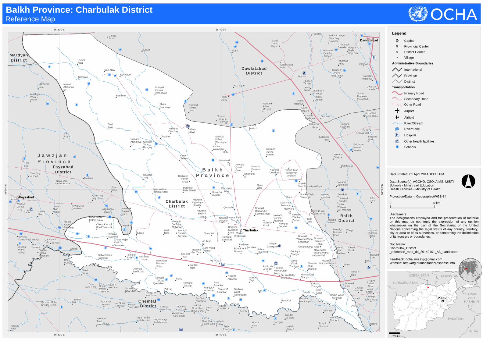
Disclaimers:The designations employed and the presentation of materialon this map do not imply the expression of any opinionwhatsoever on the part of the Secretariat of the UnitedNations concerning the legal status of any country, territory,city or area or of its authorities, or concerning the delimitationof its frontiers or boundaries.
Date Printed: 01 April 2014 03:46 PM
Data Source(s): AGCHO, CSO, AIMS, MISTISchools - Ministry of EducationHealth Facilities - Ministry of Health
Projection/Datum: Geographic/WGS-84
Doc Name:Charbulak_District_reference_map_dd_20140401_A3_Landscape
Feedback: [email protected]: http://afg.humanitarianresponse.info
!̂
Kabul
INDIA
PAKISTAN
TAJIKISTAN
TURKMENISTAN
UZBEKISTAN CHINA
JAMMUAND
KASHMIR
Balkh Province: Charbulak District Reference Map
0 5 km
°
200 km
Legend
!̂ Capital
!!!! Provincial Center
!! District Center
! Village
Administrative Boundaries
International
Province
Distirict
Transportation
Primary Road
Secondary Road
Other Road
o Airport
p Airfield
River/Stream
River/Lake
"6 Hospital
Æ5 Other health facilities
Â2 Schools

!
!
!
!
!
!
!
!
!
!!
!
!
!
! !
!
!
!
!
!
!
!
!
!
!
!
!
!
!
!
!
!
!
!
!
!
!
!
!
!
!
!
!
!
!
!
!
!
!
!
!
!
!
!
!
!
!
!
!
!
!
!
!
!
!
!
!
!
!
!
!
!
!
!
!
!
!
!
!
!
!
!
!
!
!
!
!
!
!
!
!
!
!
!
!
!
!
!
!
!
!
!
!
!
!
!
!
!
!
!
!
!
!
!
!
!
!
!
!
!
!
!
!
!
!
!
!
!
!
!
!
!
!
Â2
Â2
Â2
Â2
Â2
Â2
Â2
Â2
Â2
Â2
Â2
Â2
Â2
Â2
Â2
Â2
Â2
Â2
Â2
Â2
Â2
Â2
Â2
Â2
Â2
Â2
Æ5
Æ5
Æ5
Æ5
Æ5
!!
!!
QeshlaqSaye
Shor BalaqArllat
KhushTut
Qad-i-kamar
Arlat QadKamar
Qomishi
GoraiNazar
GuzarKhwaja
Boland (3)
Miranji
Hazari
MullahNazar Bai
PaiwandDad Sorkh
Kocha
ChopanWaldi
Kata Qaq
KhowjaBoland
KhowjaMoquri
QazalMasjed
KamarakAkhcha (baba
Khan Jan)
Aqcha
BaranGor
JarghaAqcha
KabuliQeshlaq
KamarakAqcha
Shorcha
SharimPayen
QalinQaq
KochaAregh(1)
Ali Qaq
KhowjaBurhan
KhowjaBurhan QalaHaji Sharif
KoonaJar
Qarasman
DuazdahImam
Kawsh
MirginChina
Naw Abad(1)
Sar Asya
ShahAnjir (1)Shah
Anjir(2)
Ghach Mir Haji
Now Abad(2)
QeshlaqHaji Hassa
QeshlaqKhan Mohammad
QeshlaqM.karim
Qurban Bai
Shah Anjer Sufla
Shoraba KaGordara
Basi Sar Band Dallan
Daimark
DaiyaDallan
HajiKalanDalan
Haji KhordDallan
KataQanosh
Uzbekya Dallan
Ab Dal
Ab Dara
Ab Khana
Ab Tal
AwzanCha
Ay Balaq
BabaQawanche
Bori Baf
CharKala
FatemaChashma
GeroHulya
GeroSufla
Gora Ga
Gurg Ab
Haji Barat
Hawely
HussainBai
IslamAbad
Jan BalaqBala
Jan BalaqPayen
JarShaikhak
Kabuli Ha
KaramAli
Khanqa
KhowjaBandi
KhowjaQabtal
Kohna Qeshlaq
Korcha
KoshaniBaiza
LashkarQaq
Nanwaye
NowAbadQari Ghach
Now AbadShor Balaq
Now AbadTandorak
Pak Bar
PasQadouq
Bala
PasQadouq Payen
Qabergha
Qala NayebSallar
Qalin QaqHulya
Qalin Qaq Sufla
QaraChaqal
QeshlaqQoul
QeshlaqZargar Ha
QurbanQadouq
Ramiza
SafidChashma
SarAsiyab
ShahAnjerHulya
Shar SharHulya
SharShar Sufla
Markaz Wolluswaly
ShashKhana
ShorBalaq
Tandorak
WaleMohot
Warz Ali
Yaka Tal
Shadeyan
Zaijan
BachaMurda
CharKent (2)
Nur BaiAka
Qourugh
KhwajaChinar
MullaBaba
MeyanaPushta
PariPato
Bagh Qotegak
GhaniAbad
MarkazWolluswalyMarmal
Parwaz
Tarale
KaraizKhord
B a l k hP r o v i n c e
S a m a n g a nP r o v i n c e
MarmulDistrict
CharkentDistrict
DehdadiDistrict
SholgarehDistrict
KeshendehDistrict
FeroznakhchirDistrict
Hazrat-e-SultanDistrict
Dara-e-Suf-e-PayinDistrict
Nahr-e-ShahiDistrict
Charkent
Marmul
67°20'0"E
67°20'0"E
67°10'0"E
67°10'0"E
36°3
0'0"
N
36°3
0'0"
N
36°2
0'0"
N
36°2
0'0"
N
36°1
0'0"
N
36°1
0'0"
N
Disclaimers:The designations employed and the presentation of material on this mapdo not imply the expression of any opinion whatsoever on the part of theSecretariat of the United Nations concerning the legal status of anycountry, territory, city or area or of its authorities, or concerning thedelimitation of its frontiers or boundaries.
Date Printed: 01 April 2014 11:00 AM
Data Source(s): AGCHO, CSO, AIMS, MISTISchools - Ministry of EducationHealth Facilities - Ministry of Health
Projection/Datum: Geographic/WGS-84
Doc Name:Charkent_District_reference_map_dd_20140401_A3
Feedback: [email protected]: http://afg.humanitarianresponse.info/
!̂
Kabul
INDIA
PAKISTAN
TAJIKISTAN
TURKMENISTAN
UZBEKISTAN CHINA
JAMMU ANDKASHMIR
Balkh Province: Charkent District Reference Map
0 5 10 km
°
200 km
Legend
!̂ Capital
!!!! Provincial Center
!! District Center
! Village
Administrative Boundaries
International
Province
Distirict
Transportation
Primary Road
Secondary Road
Other Road
o Airport
p Airfield
River/Stream
River/Lake
"6 Hospital
Æ5 Other health facilities
Â2 Schools

!!
!
!
!
!
!
!
!
!
!
!
!
!
!
!
!
!
!
!
!
!
!
!
!
!
!
!
!
!
!
!
!
!
!
!
!
!
!
!
!
!
!
!
!
!
!
!
!
!
!
!
!
!
!
!
!
!!
!!
!
!
!
!
!
!
!
!
! !
!
!
!
!
!
!
!
!
!
!!
!
!
!
!
!
!
!
!
!!
!
!
!
!
!
!
!
!
!
!
!
!
!
!
!
!
!
!
!
!
!
!
!
!
!
!
!
!
!
!
!
!
!
!!
!
!
!
!
!
!
!
!
!
!
!
!
!
!
!
!
!
!
!
!
!
!
!
!
!
!
!
!
!
!
!
!
!
!
!
!
!!
!
!
!
!
!
!!
!
!
!
!
!
!
!
!!
!
!
!
!!
!
!
!
!
!
!
!
!
!
!
!
!
!
!
!
!
!
!
!
!
!
!
!
!
!
!
!
!
!
!
!
!
!
!
!
!
!
!
!
!
!
!
!
!
!
!
!
!
!
!
!
!
!
!
!
!
!
!
!
!
!
!
!
!
!
!
!
!
!
!
!
!
!
! !
!
! !
!
!
!
!
!
!
!
!
!
!!
!
!
!
!
!
!
!!
!
!
!
!
!!
!
!
!
!
!
!
!
!
!
!
!
!!
!
!
!
!!
!
!
!
!
!
!
!
!
!
!
!
!
!
!
!
!
!
!
!
!
!
!
!
!
!
!
!
!
!
!!
!
!
!
!
!
!
!!
!
!
!
!
!
!
!
!
!
!
!
!
!
!
!
!
!
!
!
!!
!
!
!
!
!
!
!
!
!
!
!
!
!
!
!
!
!
!
!
!
!
!
!
!
!
!
!!
!
!
!
! !
!
!
!
!!
!
!
!
!
!
!
!
!
!
!
!
!
!
!
!
!
!
!
!
!
!
!
!
!
!
!
!
!
!
!
!
!!
!
!
!
!
Â2
Â2Â2
Â2Â2
Â2
Â2
Â2
Â2
Â2
Â2
Â2
Â2
Â2
Â2
Â2
Â2
Â2
Â2
Â2
Â2
Â2
Â2
Â2
Â2
Â2Â2
Â2
Â2Â2
Â2
Â2
Â2
Â2
Â2
Â2 Â2
Â2
Â2
Â2
Â2
Â2
Â2
Â2
Â2
Â2
Â2
Â2
Â2
Â2
Â2
Â2
Â2
Â2
Â2
Â2
Â2Â2
Â2
Â2
Â2
Â2
Â2
Â2
Â2
Â2
Â2
Â2
Â2
Â2
Â2
Â2
Â2
Â2Â2
Â2
Â2Â2
Â2
Â2
Â2
Â2Â2Â2
Â2
Â2
Â2
Â2Â2
Â2
Â2
Â2
Æ5
"6Æ5Æ5"6Æ5
Æ5
Æ5 Æ5
Æ5Æ5
Æ5
Æ5
Æ5
Æ5
Æ5
Æ5
"6
Æ5
Æ5
Æ5
Æ5
Æ5
Æ5
!!
!!
!!
!!
FayzabadDistrict
DehdadiDistrict
BalkhDistrict
CharbulakDistrict
ChemtalDistrict
SholgarehDistrict
Sar-e-PulDistrict
GosfandiDistrict
B a l k hP r o v i n c e
J a w z j a nP r o v i n c e
S a r - e - P u lP r o v i n c e
Arab QeshlaqSalar Tepa
Garjag
HaidarAbad
Beazgag
KhairAbad Bait
PaikalShashPaikal
NowaridSallar Tepa
SalarTepa
SeaDarakht
Shesha Khana Afghaniya
SheshaKhanaArabya
SheshaKhana
Turkmani
Shesha Khana Uzbeki
Zigzig
DewalgiHussain Khail
Ab FroshArab Ha
Aq Tepa (1)Bar GorTapa
Darghan
Darghan SulaimanKhail
Gul AghaZhangori
Khana Abad Zhangori
KozGorTapa
Labak MarkazWolluswali
MisgarZhangori
NawaridTegi
Now AbadTaimorak
Hulya
Now Award WachaWanaKhan Wali
Now Awrid Artepa
Nowarid Gor Tapa
NowaridOmar Khail
Nowarid Qandari Aq Tapa NowaridQouche
Nowarid SpenKai
Nowarid Taba Khasbak
Nowarid Wacha WanaKandahari
NowaridZakzag
PerWa KalayZhangori
QeshlaqSakhi Dad
Sabzi KarNowarid
Sabzikar
Sikandar Khail Zhangori
Spen Kai
TaimaniArzankar
TaimorakHulya
TaimorakSufla
TegiWardak
Arzankar
YouzTepa
Zakzag
Arab MazarNazarM.bai
Arab MazariBalaArab
MazariIran
ArabMazariPayen
ArabMazari
Sayid Gul Bai
AsiyabFerqa
BalakBai
BalochJowi Shor
Boboly
HotakiNow Shar
KararanNow Shar
MomenaNow Shahr
MughulanNow
ShahrMuqoriHaye Arab
Mazari
Naqelin QalaRazaq
Now ShahrLale Zai
PashmiQala
Tapa TamrasArab Mazari
TarakiHaye NowShar
Choba KarnailKhailTaimorak
Kokal Dash
ChobaMajar KhailTaimorak
SaboSakhur
Taimorak
BalochNow Shar
Jowi ShorWatani
NaqelinNowShar
NowaridTaraki
Imam Sahib
QeshlaqMulla Khudai
Rahim
ShashPaikalTaimorak
TawakalBai
NasiriNow AbadJowi WazirLab Barya
QaraBoyen
Chakab(1)
Chakab
Chapdera
Chighzar
ChilKapa
HaftMazar
Jari Say
Khuknul
Malik Said Alam(chonba-i-taimorak)
Qarawul(2)
Qarawul(1)
QizilKotal
Shahid
Khulmi(2)
Sardara-i-inzigul
Temuri Ha
Teraghle
Haq DadGaza Sufla
TemoriyaShakar Qoul
Amir BaiGaza Sufla
Chak BashiGazaSufla
ChashmaGozara
Chely SangAb GazaSufla
Dara Gok SeyaShakar Qoul
Aq Chashma
ArabSeya KhanaImam Sahib
Baba YakhshQoul GazaSufla
BargaAfghaniya
BargaTurkmaniya
FatemaKhail Imam
Sahib
Kaltaz
KamsaniImam Sahib
KhadadKhail
SangiWa Rahim Bai
Shair AliGaza Sufla
TakabiImamSahib
TarakiImamSahib
MullahJalat Gaza
Sufla
QarawolShakarQoul
Qezel HalqaShakar Qoul
Qezel KotalShakar Qoul
Shah WaliShakar Qoul
TaraghlyShakarQoul
HajiJan MirSadmaish
Shah GulSadmaish
Bala Koh
MasjedSukhta GulGul Bai
Diwalqai(adramzai)Dowagi
GhundiArab Ha
MargenTapa
NowaridKatki
Romki
AyelAbad
KakrakZhangori
KotagiNawi Kot Sapan
ShorabaPashtoniya
WachaWana
Ayleman
QalaAllahNoor
QalaRazaq
Sar JarJar Qala
Shorabi
Jar Qala
AmerKhail
BokaCharbagh
Gulshan
NowaridGhondan
PeyazKar
Qalacha
Sar Nahr Abdullah
Saray
Tarwa Ke
Walge
WarshoWarsho Dahi Bebe
Zargaran
DenarKhail
GhondaSuflaHalim
KhailJowi Shairan
KataKhail
Khan AqaKhowjaGholak
MandaNoor
Now AbadKotagi
Now AbadQalacha
Now AbadZozan
NowaridBoka
NowaridChamanBoka
Now Wali
Qashqotan
YakaSang
Yourte ZamanYar Taka
Tokh Dana
Chapchal
Kowrachi
Kurdgai
Qowland
TashKanda
Torpaghly
Zeir-i-kamar
AllaTaba
Arab Ha
Arab HayeZear Taba Aseman
Kotal
Awgulan
BabaHawaz
BadHamal
BaghPahlawan
Baloch Ha
Boragi
BoryaBaf
Eala Tan
Gadge
Ghoriche
HahoDara
HalqaJar
Jangly
Khulmi(1)
Taka Bai
Cheaghke
GulKhairi
AfghanChar Sai
AzonQadouq
Baloch
Borma
Chehl TanArab HaChehl Tan
Taimoriyha
GulBalaq
Jar Mir
Mughlan
QadouqDowlat
QazelSai Sar Dara
Semsai
ToghdanAli
Jar Haji Nazar BaigJar
Sayyed Ha
Kabuli
Kangori
KhairAbad
Khowja Askandar Tajek
KhowjaSekandarAli Khan
KhowjaSekandarHazara
KhowjaSekandar
Mullah HassanKhowjaSekandarZawar Ha
KhudaiRahman
Khan
KorSang Ab
MullahSahib
PushtBagh
QalaSafi Ha
QalandHulya
QalandSufla
Qoureqa Khana Hulya
QouziKhowal
RahmanKhail
SabzPoshan Sang
SurakhSar Chashma Arab Ha
Sar Sang
Seya Ab
ShahGadai
TabayqKangori
TashGulde
Tourghanchi
WahdatAbad
Aq Shahid
BawarChe
ChashmaJar Chandi
MachalDahi
QadouqBail
QazelQadouq
ShahrNow Shor Cha
Takhata Bala
PayindaMohd
Bangala
CharSang
Samar Qandeyan
AbforoshiGaza Sufla
AnjaleGazaSufla
Aq KamarChaqnaq
AsiyabGorg
AsiyabSharaf
Bai Khan
BandEashan
MazarQoul
MullahAbdulmanan
MullahAhmad Ali
MullahSenjed
Muqem BaiKaza Hulya
NowAbad
Asiyab Gorg
Now AbadShor Abi
NowaridBai Taimor
NowaridUrozgani
Omer QoulBai PeashDara
OsmanBai
Palo
Peer NazarBai BeashDara
Qabergha
QamshalyHazat Bai
QamshelyQamshelyHalam Bai
Qeshlaq Gul M.chamatal
Qoul KhailGaza Hulya
Qurban MuradBai Peash Dara
SarAsiyab
Sar AsiyabIbrahim Khan
SaryakroyaHaji Safar
Shah NazarPeash Dara
ShamsudinHulya
TakhtaPayen
Urozgani
Yak Roya
YangiQala
Zoly
Kakawt(nigari)
Jar-i-Khowni
RabatPayen
BodanaQala Doum
Chashma Shafa
Now AbadPaikanDara
QouflanDara
BabaKohna
ChealGazi
Paghmanin
Bolak KalaGaza Hulya
Chaly KhailGaza Sufla
Chamtal
Chaqnaq
Chaqnaq HajiHabibullahChaqnaq Haji
Khowja Nazar
ChashmaGaza Sufla
Chatralyan
ChepQalandari
BaiChepQarawel
Easa KhanPeash Dara
Ghar MahlyAdam Sang
Ghar MalyZear Chadar
Gor Bai
Haid AliYakroya
Haji Baba Murad
Haji BarfiYakroya
Haji Juma BaiGaza Sufla
Haji MohammadGul Yakroya
Haji MullahJuma GaraHulya
Haji NabiYak Roya
HajiQayumBai
Haji RustamChaqnaq
HajiSayidMurad
ImamQoul Bai
JangalChamtal
Kanja BaiPeash Dara
KharbozaKhori Gaza
Sufla
KorchaBala Korcha Payen
Loghman
MarkazWolluswalyBai Taimor
Gul Abad
HazarJereb
Hussain Khail
NowAbad
Hazar Jereb
NowAbad Khasa Paz
NowAbad
Tokhta
ParkHaiye
Kod Barq
PushtBagh
Tagari
Tokhta Payen
ZamboGan
MirQasim
RabatBala
Mandowzai
Qurghan
Arab Ha
Dahi Qazi
DahiQazi
Hazara Ha
Rabat
RaoufMalik
SeyaQandouq
Shaige
TemorSaray
Zolgai Mahndan
DahiRaze
DirageGhondan Hulya
Haji Kot
HesarakKashkak
MoyeMubarak
Charbulak
Sholgareh
Chemtal
Balkh
66°50'0"E
66°50'0"E
66°40'0"E
66°40'0"E
66°30'0"E
66°30'0"E
66°20'0"E
66°20'0"E
36°4
0'0"
N
36°4
0'0"
N
36°3
0'0"
N
36°3
0'0"
N
36°2
0'0"
N
36°2
0'0"
N
Disclaimers:The designations employed and the presentation of materialon this map do not imply the expression of any opinionwhatsoever on the part of the Secretariat of the UnitedNations concerning the legal status of any country, territory,city or area or of its authorities, or concerning the delimitationof its frontiers or boundaries.
Date Printed: 01 April 2014 03:47 PM
Data Source(s): AGCHO, CSO, AIMS, MISTISchools - Ministry of EducationHealth Facilities - Ministry of Health
Projection/Datum: Geographic/WGS-84
Doc Name:Chemtal_District_reference_map_dd_20140401_A3_Landscape
Feedback: [email protected]: http://afg.humanitarianresponse.info
!̂
Kabul
INDIA
PAKISTAN
TAJIKISTAN
TURKMENISTAN
UZBEKISTAN CHINA
JAMMUAND
KASHMIR
Balkh Province: Chemtal District Reference Map
0 5 10 15 km
°
200 km
Legend
!̂ Capital
!!!! Provincial Center
!! District Center
! Village
Administrative Boundaries
International
Province
Distirict
Transportation
Primary Road
Secondary Road
Other Road
o Airport
p Airfield
River/Stream
River/Lake
"6 Hospital
Æ5 Other health facilities
Â2 Schools

!!
!
!
!
!
!
!
!
!
!
!
!
!
!
!
!
!
!
!
!
!
!
!
!
!
!
!
!
!
!
!
!
!
!!
!!
!
!
!
!
!
!
!
!
!
!
!
!
!
!
!
!
!
!
!
! !
!
!
!
!
!
!
!
!
!
!
!
!
!
!
!
!
!
!
!
!
!
!
!
!
!
!
!
!
!!
!
!
!
!
!
!
!
!
!
!
!
!!
!
!
!
!
!
!
!
!
!
!
!
!
!
!
!
!
!
!
!
!
!
!
!
!
!
!
!
!
!
!
!!
!
!
!
!
!!
!
!
!!
!
!
!
!
!
!
!
! !
!
!
!
!
!
!
!
!
!
!
!
!
!
!!
!
!!
!
!
!
!
!
!
!
!
!!
! !
!
!
!
!
!
!
!
!
!
!
!
!
!
!
!
!
!
!
!
!
!
!
!
!
!
!
!
!
!
!
!
!
! !
!
!
!
!
!
!
!
!
!
!
!!
!
!
!
!
!
!
!
!
!
!
!
!
!
!
!
!
!
!
!
!
!
!
!
!
!
!
!
!
!
!
!
!
!
!!
!
!
!
!
!
!
!
!
!
!
!
!
!
!!
!
!
!
!
!
!
!
!
!
!!
!
!
!
!
!
!
!
!
!!
!
!
!
!
!
!
!
!
!
Â2
Â2
Â2
Â2 Â2
Â2
Â2
Â2
Â2
Â2
Â2
Â2
Â2
Â2
Â2
Â2
Â2
Â2
Â2
Â2
Â2
2
Â2
Â2
Â2Â2
Â2
Â2
Â2
Â2
Â2
Â2
Â2
Â2
Â2
Â2
Â2
Â2
Â2
Â2
Â2
Â2
Â2
Â2
Â2
Â2
Â2
Â2
Â2
Â2
Â2
Â2
Â2
Â2
Â2
Â2
Â2
Â2
Â2
Â2
Â2
Â2Â2
Â2
Â2
Â2
Â2
Â2
Â2
Â2
Â2
Â2
Â2 Â2
Â2
Â2
Â2
Â2
Â2
Â2
Â2
Â2
Â2
Â2
Â2
Â2
Â2Â2
Â2
Â2
2
Â2
Â2
Â2
Â2
Â2
Â2
Â2
Â2
Â2Â2Â2
Â2
Â2Â2
Â2
Â2
Â2
Â2 Â2
Â2
Â2
Â2
Â2
Â2
Â2
Â2
"6Æ5Æ5
"6
"6
Æ5
Æ5
Æ5
Æ5
Æ5
Æ5
Æ5 Æ5
Æ5
"6
Æ5
Æ5
Æ5
Æ5
Æ5
Æ5Æ5
Æ5
Æ5 Æ5
Æ5
!!
!!
!!
!!
!!
FayzabadDistrict
MardyanDistrict
QarqinDistrict
ShortepaDistrict
DawlatabadDistrict
Dehdadi District
BalkhDistrictCharbulak
District
Chemtal District
Nahr-e-ShahiDistrict
B a l k hP r o v i n c e
J a w z j a nP r o v i n c e
MalikSayid Halam
Kalay
Char BaghYandark
FazelAbad
Watani
Garjag
HaidarAbad
HaidarAbad Beazgag
Haidar AbadWatani
KhairAbad
Nowa QoulHaidar Abad
NowaQoul Qanchaq
Qamchaq Afghaniya
Sanis
Sea Darakht
SheshaKhana
Afghaniya
Shesha KhanaArabya Shesha Khana
Turkmani
Dandowkai
WalakaiNur Mahmad
Noward Khasbak
Aq Tepa(2)
Dilas
Nauwarid (2) Nauwarid(3)
DahiDaraz
Elewari
ElewariNow Arid
Hasheqan
NowaridAdinaMasjed
NowaridAhmadAbad
AdenaMasjed
Aham AbadChochak
KhojaRoshnaye
Nowarid Chochak
NowaridKhowjaRoshanaye
Nowarid KohnaWarnagha
Dandoki
KhasbakWatani
Nowarid Dandogi Bala
NowaridDandokai
NowaridEalqche
DailbajenBala Shakhi
DailbajenPayen Shaly
Darghan
Darghan Sulaiman Khail
GalaJowi
Gul Agha Zhangori
HazarChakush
Jargi Watani RahmatAbad
Khoja GulBaradar
Kohna Warnagha
Koz Gor Tapa
Labak
Mala
MarkazWolluswali Now Award
Wacha WanaKhan Wali
NowAwridArtepa
NowaridAdenaMasjed
NowaridAfghaniya
Shalkhi
Nowarid Bahram Khail
NowaridDeyayas
NowaridDowran
Nowarid GorTapa
NowaridJargi
Nowarid Omar Khail
NowaridQa Tepa
Afghaniya
NowaridQandariAq Tapa
Nowarid Qazel Qala
NowaridQoura CheSuliman KhailNowarid Shalkhi
Hulya
NowaridSpen Kai Nowarid
Taba Khasbak
Nowarid WachaZadran
NowaridahiQorche
QazelQala
Aranje
Qourache
QuraishTapa
Mangoly
Sabzikar
ShaikhTash TaimoriyanAfghani
Shaikh Tash TaimoriyanPayan
Shaikh Tash Taimoryan
SpenKai
SulimanKhail
TaimorakHulya
TaimorakSufla
TourtegaWa MoshKhorya
WarnaghaNow
YouzTepa
NowaridAfghaniya
(2)
NowaridAfghaniya
(1)
Barlawak
Dahi NowKok Abad
LochakAraq
Salbaron
ShalAraq
MardeyanWataniPayen
MardeyanBala
SarAsiyab
Char Bagh
SaboSakhur
Taimorak
Koshkak
KoshkakPayen Dahi
Mamlak
NaqelinChar Bagh
Qab ChaqWatani
ShahSalim
IslamChongar
DailbarJean
Dali CharBolak
Quraish
NagharaKhana
QarshiGak
DashtanAfghaniya
Qara GhajlaNaqelin
Shengil AbadAfghaniya
Sorkh GonbadAfghaniya
Sorkh Gonbad Uzbekya KhairAbad
Mahjer
KhairAbadWatani
Qara GhajlaKharoti
QaraGhajlaMahjer
Qara GhajlaMahjer Now Abad
Qara GhajlaOrya Khail
Qara Ghajla Watani
Dahi Now
IslamSadar Abad Bala
SadarAbad
Payen
Asfhan
KatoriSufla
TakaTurkmanAsfehan
WartaShakh
Darabad
KatoriNowarid
Maidan
NowaridDewali
AsiaAbad
Dar AbadUzbekya
DarAbad Watani
Dashtan
DashtanChar Gonbad
Qata SeaHashimAbadWatani
KolPanjab
NakhchirAbad
NaqelinNowarid
SarAsiyab
ShakhMughulan
Shengil RabadWatani
Sorkh Gonbad
TurkmaniHaye
Hashim Abad
UzbekQeshlaq
ZadyanWatani
Dudul-i-momandi
IshpolaMaidan
Kol-i-ambo(dago)
Tozhna-i-nasiri
KatoriNeyazi
NowaridDewalyMandozai
NowaridMiran
PenjaJereb
AkhondZada
Amer Khail
Bahuddin
BoryaBaf
Chaqwsh
NowaridGhondan
NowaridKhowjaGholak
NowaridMashak
QaisarKhail
Qalacha
Qarlaq
SalarZare
Saray
SayidAbad
Talaow
Tarwa Ke
Walge
WarshoWarsho Dahi Bebe
NauwaridMaidan
Shah Ab
SultanHaji Wali
(nauwarid)
Baghsor
BaghtorMohmand
Dewaly
EalqacheBala
NagharaQoul
NowaridKabuli Ha
QoulShahab
SahabTurkman Ha
AlangAfghaniya
Bagh ShorWatani
CharBaghSayedan
Dorman
Hashim AbadSaltaq HajiYaqoub
Hayatan
JowiArab
KhalaBachgan
Dakar
DenarKhail
GhulamJan
Gor Tepa
HussainKhail
KataKhail
KatoriDowlatZai
Khan AqaKhowjaGholak
Larghon
MahajerinChaqash
MandaNoor
MashakMashak Baba
Charkhi
Mohmandan
Now AbadArab Ha Now
Abad Qalacha
NowAbad Zozan
NowaridBoka
NowaridChaman
Boka
NowaridChaqash
NowaridData Khail
KhoshallAbad
Kotarma
MataniDoman
Matani Son Chi Khoja
Naqelin CharBagh Sayedan
Paiwand QeshlaqNaqelin
Qala MirHaidar
QandahriHaye Bagh
Shor
Sonchi Khoja
TalyGak
Turkman HayeShar
Bagh Sayedan
Turkman HayetelyGak
WaliAbad
Yakhdan
YakhdanAfghaniya
ShahabUzbak Ha
SultanKhoja Wali
Naqelin Haza
Sultan KhowjaWali
Ealqache NowaridNassiri
ChahiDalyHsharak
FarukhAbad
JangalSaddiq
NaqelinQal Taq
Neachka
Qafan
Qaltaq
TaghanAraq
ZardyanMahjer
Dali (1)
Dali (2)Pas
Aregh
AraghBator
ArangeBozer
Chor Aragh
DaliKohna
Dali Now
PeashArugh
Sar TepaYuoz Arigh
Nawabad
Wata Qul
GulAfghani
Kamperak
NaqelinShairak
SeyaGerd
ShahrakWatani
LangarKhanaKalan
Charbulak
Fayzabad
Dawlatabad
Shortepa
67°0'0"E
67°0'0"E
66°50'0"E
66°50'0"E
66°40'0"E
66°40'0"E
66°30'0"E
66°30'0"E
37°2
0'0"
N
37°2
0'0"
N
37°1
0'0"
N
37°1
0'0"
N
37°0
'0"N
37°0
'0"N
36°5
0'0"
N
36°5
0'0"
N
Disclaimers:The designations employed and the presentation of materialon this map do not imply the expression of any opinionwhatsoever on the part of the Secretariat of the UnitedNations concerning the legal status of any country, territory,city or area or of its authorities, or concerning the delimitationof its frontiers or boundaries.
Date Printed: 01 April 2014 03:47 PM
Data Source(s): AGCHO, CSO, AIMS, MISTISchools - Ministry of EducationHealth Facilities - Ministry of Health
Projection/Datum: Geographic/WGS-84
Doc Name:Dawlatabad_District_reference_map_dd_20140401_A3_Landscape
Feedback: [email protected]: http://afg.humanitarianresponse.info
!̂
Kabul
INDIA
PAKISTAN
TAJIKISTAN
TURKMENISTAN
UZBEKISTAN CHINA
JAMMUAND
KASHMIR
Balkh Province: Dawlatabad District Reference Map
0 5 10 15 km
°
200 km
Legend
!̂ Capital
!!!! Provincial Center
!! District Center
! Village
Administrative Boundaries
International
Province
Distirict
Transportation
Primary Road
Secondary Road
Other Road
o Airport
p Airfield
River/Stream
River/Lake
"6 Hospital
Æ5 Other health facilities
Â2 Schools

p
!
!
!!
!
!
!
!
!
!
!
!
!
!
!
!
!
!
!
!
!
!!
!
!
!
!
!
!
!
!
!
!
!
!
!
!
!
!
!
!
!
!
!
!
!
!
!
!
!
!
!
!
!
!
!
!
!
!
!
!
!
!
!
!
!
!
!
!
!!
!
!
!
!
!
!
!
!
!
!
!
!
!
!
!
!
!
!
!
!
Â2
Â2
Â2
Â2
Â2
Â2
Â2
Â2
Â2Â2
Â2
Â2
Â2
Â2
Â2
Â2
Â2
Â2
Â2
Â2
Â2
Â2
Â2
Â2
Â2
Â2
Â2
Â2
Â2
Â2
Â2
Â2Â2
Â2
Â2
Â2
Â2Â2
Â2Â2
Â2
Â2
Â2
Â2
Â2
Â2
Â2
Â2
Â2
Â2
Â2
Â2
Â2
Â2
Â2
Â2
Â2
Â2
Â2
Â2
Â2
Â2
Â2
Â2
Â2
Â2
Â2
Â2
Â2
Â2
Â2
Â2
Â2
Â2
Â2
Â2
Â2Â2
Â2
Â2
Â2
Æ5
Æ5
"6
Æ5
Æ5
Æ5
Æ5
Æ5Æ5Æ5"6"6Æ5Æ5Æ5Æ5"6
Æ5
Æ5Æ5Æ5Æ5Æ5Æ5Æ5
Æ5Æ5Æ5
Æ5
Æ5
Æ5
Æ5
!!
!!
!!!!
NowaridGhondan
GhondaSufla
KhowjaGholak
Now AbadZozan
Joy Shor
Kakawt(nigari)
Khasapaz
KhushTut
Pusht-i-bagh
Sar-i-asyab
RabatPayen
ChashmaShafa
AbasKhan
AboulBai
Amirankot
BabaKohna
BabaQashqar
Char DangTokhta
Char SarakTokhta
ChealGazi
Cheal GaziPaghmanin
DahiAbdullah
DahiSawar
Family HaiyeRahayeshiKod Bar
FamilyHaye
Ferqa
FazelAbad
Gozar ArabHa MarkazWolluswal
Gozar ArabHa Shair
Abad Hulya
Gozar AyoubShairMast
GozarCharTaqiGozar
Raigestan
Gul Abad
GuzzrEashan
HazarJereb
Hussain Khail
JowiShahr
KarMalik
KhanqaKalan
KhanqaKhord
KhasaPaz
Mashi
NahmatBai
Now Abad
Now AbadHazarJereb
Now AbadKhasa Paz
Now AbadTokhta
Park HaiyeKod Barq
Pul Babo
PulNanwaye
Pul ShafaKhana
PushtBagh
QalaHabasKhan
QouTaimor
ShaikhAbad
Tagari
TokhtaBalaTokhtaPayen
YakaToot
ZamboGan
DehDadi
RabatBala
Arab Ha
Dahi QaziHazara Ha
Palas Push
SeyaQandouq
DirageGhondanHulya
BabaYadgar
ChehlDukhtaranHulya
ChehlDukhtaranSufla
Gala Go
KhojaAmir Jan
LangarKhanaKalan
Langar KhanaPayen Khord
QalaHajer
Qala Mir
ShairAbadSufla
TakhtPul
TurkmaniyaShair AbadYaka Bagh
Shair Abad
YakaToot
Paghmani Ha
ShairAbadHulya
Sultan BabaAli Shair
KaraizKhord
B a l k hP r o v i n c e
CharkentDistrict
DehdadiDistrict
BalkhDistrict
ChemtalDistrict
SholgarehDistrict
Mazar-e-SharifDistrict
Nahr-e-ShahiDistrict
Dehdadi
Nahr-e-Shahi
Mazar-e-Sharif
67°0'0"E
67°0'0"E
36°4
0'0"
N
36°4
0'0"
N
Disclaimers:The designations employed and the presentation of material on this mapdo not imply the expression of any opinion whatsoever on the part of theSecretariat of the United Nations concerning the legal status of anycountry, territory, city or area or of its authorities, or concerning thedelimitation of its frontiers or boundaries.
Date Printed: 01 April 2014 11:00 AM
Data Source(s): AGCHO, CSO, AIMS, MISTISchools - Ministry of EducationHealth Facilities - Ministry of Health
Projection/Datum: Geographic/WGS-84
Doc Name:Dehdadi_District_reference_map_dd_20140401_A3
Feedback: [email protected]: http://afg.humanitarianresponse.info/
!̂
Kabul
INDIA
PAKISTAN
TAJIKISTAN
TURKMENISTAN
UZBEKISTAN CHINA
JAMMU ANDKASHMIR
Balkh Province: Dehdadi District Reference Map
0 5 km
°
200 km
Legend
!̂ Capital
!!!! Provincial Center
!! District Center
! Village
Administrative Boundaries
International
Province
Distirict
Transportation
Primary Road
Secondary Road
Other Road
o Airport
p Airfield
River/Stream
River/Lake
"6 Hospital
Æ5 Other health facilities
Â2 Schools

!
!
!
!
!
!
!
!
!
!
!
!
!
!
!
!
!
Â2
Â2
Â2
Â2
Â2
Â2
Â2
Â2
Â2
Â2
Â2
Â2
Â2
Â2
Â2
Â2
Â2
Â2
Â2
Æ5
Æ5Æ5
Æ5
!!
ShortepaDistrict
Sharak-e-HayratanDistrict
KaldarDistrict
KhulmDistrict
Nahr-e-ShahiDistrict B a l k h
P r o v i n c e
TazahAregh
BuzaraqJowi Jadid
KhojaGulsawar
KochaAqam
Kohna Kaldar
MarkazWolluswaly
Qara Ja
Qarantoghy
Qounily
Raig
Tazaraq
Jeyretan
Tazlaq
Kaldar
Sharak-e-Hayratan
UZBEKISTAN
67°40'0"E
67°40'0"E
67°30'0"E
67°30'0"E
67°20'0"E
67°20'0"E
37°2
0'0"
N
37°2
0'0"
N
37°1
0'0"
N
37°1
0'0"
N
37°0
'0"N
37°0
'0"N
Disclaimers:The designations employed and the presentation of materialon this map do not imply the expression of any opinionwhatsoever on the part of the Secretariat of the UnitedNations concerning the legal status of any country, territory,city or area or of its authorities, or concerning the delimitationof its frontiers or boundaries.
Date Printed: 01 April 2014 03:47 PM
Data Source(s): AGCHO, CSO, AIMS, MISTISchools - Ministry of EducationHealth Facilities - Ministry of Health
Projection/Datum: Geographic/WGS-84
Doc Name:Kaldar_District_reference_map_dd_20140401_A3_Landscape
Feedback: [email protected]: http://afg.humanitarianresponse.info
!̂
Kabul
INDIA
PAKISTAN
TAJIKISTAN
TURKMENISTAN
UZBEKISTAN CHINA
JAMMUAND
KASHMIR
Balkh Province: Kaldar District Reference Map
0 5 10 km
°
200 km
Legend
!̂ Capital
!!!! Provincial Center
!! District Center
! Village
Administrative Boundaries
International
Province
Distirict
Transportation
Primary Road
Secondary Road
Other Road
o Airport
p Airfield
River/Stream
River/Lake
"6 Hospital
Æ5 Other health facilities
Â2 Schools

!
!
!
!
!
!
!
!
!
!
!
!
!
!!
!
!
!
!
!
!
!
!
!
!
!
!
!
!
!
!
!
!
!
!
!
!
!
!
!
!
!
!
!
!
!
! !
!
!
!
!
!
!
!
!
!
!
!
!
!
!
!
!
!
!
!
!
!
!
!
!
!
!
!
!
!
!
!
!
!
!
!
!
!
!
!
!
!
!!
!
!
! !
!
!
!
!
!
!
!
!
!
!
!
!
!
!
!
!
!
!
!
!
!
!
!
!
!
!
!
!
!
!
!
!
!
!
!
!
!
!
!
!
!
!
!
!
!
!
!
!
!
!
!
!
!
!
!
!
!
!
!
!
!
!
!
!
!
!
!
!
!
!
!
!
!
!
!
!
!
!
!
!
!
!
!
!
!
!
!
!
!
!
!
!
!
!
!
!
!
!
!
!
!
!
!
!
!
!
!
!
!
!
!
!
!
!
!
!
!
!
!
!
!
!
!
!
!
!
!
!
!
!
!
!
!
!
!
!
!
!
!
!
!
!
!
!!
!
!
!!
!
!
!
!
!
!
!
!
!
!
!
!
!
!
!
!
!
!
!!
!
!
!
!
!
!
!
!
!
!
!
!
!
!
!
!
!
!
!
!
!
!
!
!
!
!
!
!
!
!
!
!
!
!
!
!!
!
!
!
!
!
!
!
!
!
!
!
!
!
!
!
!
!
!
!
!
!
!
!
!!
!
!
!
!
!
!
!
!
!
!
!
!
!
!
!
!
!
!
!
!
!
!
!
!
!
!
!
!
!
!
!
!
!
!
!
!
!
!
!
!
!
!
!
!
!
!
!
!
!!
!
!
!
!
!
!
!
!
!
!
!
!
!
!
!
!
!
!
!
!
!
!
!
!
!
!
!
!
!
!
!!
!
!
!
!
!
!
!
!
!
!
! !
!
!
!
!
!
!
!
!
!
!
!
!
!
!
!
!
!
!
!
!
!
!
!
!
!
!
!
!
!
!
!
!!
!
!
!
!
!!
!
!
!
!
!
!
!
!
!
!
!
!
!
!
!
!
!
!
!!
!
!
!
!
!
!
!
!
!
!
!
!
!
!
!
!
!
!
!
!
!
!
!
!
!
!
!
!
!
!
!
!
!
!
!
!
!
!
!!
!
!
!
!
!
!
!
!
!
!
!
!
!
!
Â2
Â2Â2
Â2
Â2
Â2
Â2
Â2
Â2
Â2
Â2
Â2
Â2
Â2Â2
Â2
Â2
Â2
Â2
Â2
Â2
Â2
Â2
Â2
Â2
Â2
Â2
Â2
Â2
Â2
Â2
Â2
Â2
Â2
Â2
Â2
Â2
Â2
Â2
Â2
Â2
Â2
Â2
Â2
Â2
Â2
Â2
Â2
Â2Â2
Â2
Â2
Â2
2
Â2
Â2
Â2
Â2Â2
Â2
Â2
Æ5
Æ5
Æ5
Æ5
Æ5
Æ5
Æ5
Æ5
!!
!!
QaicehaQazel HajiAslam
QaichaQazel
QeshlaqPahen
SharafBai
Kandali
Almoghowl
Choghdan(2)
KondelTepa
KuchiJonaito
Kundaly
QazelMohammadIsmail
AllaTaba
Arab HayeZear Taba Aseman
Kotal KhairAbad
SarAsiyab Haji Mullah
Bai
QeshlaqeSaydali
Tasheldara
Ab Partab
BakhtganBala
BakhtganPayen
Faizan
JowiKhushk
JowiTaimor
Khazan
Kheyabak
KhowjaBaida
KhowjaRoshnaye
Mullayan
Qala Noorak
SangJalab
Ashkan
HajiSarwar
Mahang Sai
Qeshlaq MirzaBai
Abdulgan
BandeChap
Chehelgazai
DehSayed
DomeBandak
GholyakHajiChaharyar
HiliKalan
Kochereg Kolinawa
NahiSyahgak
Qalacha
Rahraw
Sarchashma
SareWozan
Zo Payin
Chak Ab
Now Abad(1)
Shamshersang
Zeri Koh
Katadasht
QashlaghakBaybul
Boogosht
Hilimahmud
Sardara
Gardeash
Khonje
NaiKalan(1)
QaraBai (2)
AllaTaimor
Ambort
ArchJaffar
ArchaKhaki
BabaMulki
Badouq
Bal Sang
Baloch
BalochPesta
BandChap
BandarAli
Banosh
BarafAbak
Be BeMaryam
Chaghdan Bala
ChaghdanPayen
Qara Sum
Awmaki
ShanGharq
TaiDaqat
Anjortoo
Dewan
KohnaQeshlaq
Now AbadDewan
NowQeshlaq
Qaghalsai
QajiJal Tor
QashimSai
Sar Qash
Shamalak
TagabTakht (2)
Geech
Malkhan
SewakBala
BaghKhushk Zera Koh
Beni Gaw
Boland Haraq
BolaniPayen
ChahkSufla
CharKhok
Charkh Ab
ChashmaRaq
ChashmaSawal
Choqurak
DahanDara
DailMaraqBala
DailMaraqPayen
DamBandak
Dam Go
Dapsan
Dara
DaraKalima
DaraMaghzar
DashtQadough
DashtRaq
DokanKhana
FeelBand
GardanaQala
GardanaZowak
Gharichak
Ghola
Gulabi
Hail Bakhte
HajiMahmod
HajiTalab
Ham Bar
HaraqSurkh
Hatefi
HazarPaimana
Jaghlar
Jow KharDahiJow Paya
KailkMurda
KalaKhan
Kalag
Kalan
KamalBast
KataDasht
Khak Batak
KhanakDahqan
KhoonAba
Kocha Aghz
KohKalan
KohTakak
KolBurda
Lagham
Lar Bandak
Maghzar(1)
Maghzar(2)
Mazar
Mir Bok
MirzaKamar
Mirzaye
Mukhtar
NadQaiche
NaiRajab
Nar Now
Nawak
NaySiyagag
Now AbadCharkhab
Palize
PassPatawa
Qafzar
Qala Cha
QalaIran
Qala Murad
QaraKhowal
Qeshlaq ArabMarkaz Wolluswaly
QeshlaqKalan
QeshlaqRazeq
Qeshlaqak
Quraish
Rama Rah
Ranraiz
Sakfalar
Sakin Tapa
SangShanda
SarAwazan
SarChashma
Sar Kotal BabaMushkail
SarPeyada
SarWazan
SarabiBala
SarabiPayen
Sayad
Sayestan
Senjetak
Sey Maha
Seya JowBazar
Seya Tal
Seya To
SeyaToot
Shaikh Ab
ShakarDara
Sheena
BarikTough
Char Taq
ChochoLar
Dahak
DomBarikak
DomQambar
Hail Ab
HailZearak
Howz
JumaKhani
KaramShahi
Karan
Khakraiz
Khalifa
Khar ParidaPesta Mazar
LarKoch Ko
LarSurukh
LarkLor Band
MeyanDahi Mirzaye
MullahAymaq
NaiKamal
NaiMirak
Nawa Yalang
PaiMazar
QaberGah
QeshalqDoum Pusht
Qeshlaq AwalBam Pusht
SapandZarak
Sar Chashma
Shoran BalaShoran Payen
Sollan
Somak Ha
Surkha
TaghaMurad
Taigag
Tajek Ha
Taq Zard
TeghaNarim
Turk
Za Ghonda
Zard Allo
ZardBadam
Zo Ha
Shaige
Abro
Andarab
SafidKhak
WakhshakAb Ahmad
AbdoQoul
Airak
Airghani
Ash Dada
Sar Dara
SarDarakht
SarKotal
SukhtaHulya
Tagab PerNazar
Takhki
Tanorak
Tonje Ha
TortiKosa
Toulaki
ZardKamar
KamarakAkhcha (baba
Khan Jan)
AchaMily
Baba EwazKushinda
Bala
Bikhak
Chalcha
Kelwan
KhameZagh
Negal(1)
Negal(2)
Nighak(1)Nighak
(2)
Petaw
Sarab(1) Sarab
(2)
Sarab(3)
Sarab(4)
Tora Gai
ZereShaqil
Halak
NaiKalan
(2)
Paitow(2)
QaraBai (1)
AqchaBairaKhalily
BaranGor
Charkh Ab
JarghaAqcha
KabuliQeshlaq
KamarakAqcha
Pul Barq
PulBarqSufla
Qalqan
Qazel Kend Sar Band HajiTallab Bai
Shorcha
AchaMaily
AchaMaily
AirghaniBala
AirghaniPayen
Ali Baig
Almartak
Amllan ChakanaPayen
AmrotakiJangalakChakana
Aq KaprakArab Ga
Asp Rah
Asqahq
Attaullah
BadamakChakana
Bai BoghaHulya
Bai BoghaKohna
BaiGhazi
BaigMohammad
Bariki
BazarJai
BeariChakana
Chaghzar Chakana
Chak Ab
Chashma
Chelito
Chokhi
DahanDara
DandanShakan
DewanMadrasa
DewanTangi
Dogh Ab
DomBandi
GardanaBai Ghazi
Golar
HailZard
HalkaChakana
Jadok
Jeagdahi To
KataBadam
KataGardan
KhairAbad
Khataye
Khowalak
KhudayarChakana
KohnaQeshlaq
LarBashi
Lar Qara
Larshepoul
LayceChakana
Markaz Wahid Adari
NaiDaraz
NaiSai
NajarBaig
No Tose
Now AbadNow AbadKata Gardan
Now Seli
Own Bai
Pusht Sarak
QalamShaikh
Qara Kamar
QaraTeari
QatarNow
QeshlaqJoura Bai
QeshlaqKalan Lalmi
QeshlaqQoulChakana
Saidi
Sar Ab
Sar Jar
Sar KotalQayamat
SarSurkhi
Sarzod
SeaDarah
Shamalak
SharimBala
SharimPayen
Targhi
TeaghaChalpa
TeaghaMeyana
Tour Ghayor
YakaKhak Chakana
Yaka WalangNasurrullah
ZahirChakana
ZaitorChakana
Payen
Zangal
ZegolagZemdad
Nawabad
NowAbad (3)
Nayak
Shaykhsang
Wuyto
QaraJangan
HazaraMurda
Qourugh Habas
Qourugh Sultan
Na Yag
Seya Tal
Alka
Gord
SareBand
Shamallak
Wokar
WuljaqoduqBala
Alghan
Alghan
AlghanPahnaZardan
Ghashu
Khwajabedak
Shawo
Surkhlech
Zardtala
BaiBecha(2)
MalikShahidGuda
Nauma
Oimatan(2)
OkareBala
Jora
Molagholam
Qal'a-i-wakil
Paitow(1)
Alqajahr
Baloch
Band TajakYa BandTalkhak
BandZagh
BeyananBoblai
GoliChoqorak
Baloch
WayBalaq
Dowgana
GolaHessar
Gola LalMalik
Gola LalMalik Masjid
Qeyamudi
Gola SafidKhak LalMalik
Guldara
Jamshad
KataSang
KhamQadouqMirka
Now AbadKhair Abad
Ab Larkhak
AliMiran
Arghawak
AshlazBala
AsiyaAbad
Bazarak
Bossi
ButaBala
ChaharMaghzak
Chakana BalaHafizullah
Char Noorak
ChashmaDarazMirka
Room
SarChapal
SarSewak
SarShowlan
ShahJahan
Shahan
Sowdagaran
TahiChapal Mirak
DomToghan
GuliDarah
Hokar
KhaniBaig
MalikShahidKadah
NaiZaheni
Now AmadBala
NowaiZagh
NowraGaow
Mourda
OljaQadaq
QarahBalaq
QarahJangal
QeshlaqHaji
Nahim
QeshlaqKhaliqBahi
Sajawak
SarKhalar
SurkhAbak
TamorDastazDarah
Temor-i-poushband
WaymatanJaar
WaymatanTakna
Wetman
WotahZagh
Yateemak
Yousufi
BotaPayen
HajiNazamuldin
Haklak YaKham Zagh
Jowdarstan
KhalMirza
Kham Cha YaKham Aid
QawaiMosht
QeshlaqDowlatMohammad
Shaltaq
TagabSabzak
Omar Baig
Tapai YakRowya
Zair KotalSayid
Ahmad
Zear KotalMullahChari
Basi Sar Band Dallan
Daimark
DaiyaDallan
Haji Khord Dallan
KataQanosh
Uzbekya Dallan
B a l k hP r o v i n c e
S a m a n g a nP r o v i n c e
S a r - e - P u lP r o v i n c e
CharkentDistrict
SholgarehDistrict
KeshendehDistrict
ZariDistrict Dara-e
Suf-e-BalaDistrict
GosfandiDistrict
BalkhabDistrict
Dara-e-Suf-e-PayinDistrict
Zari
Keshendeh
67°10'0"E
67°10'0"E
67°0'0"E
67°0'0"E
66°50'0"E
66°50'0"E
66°40'0"E
66°40'0"E
36°1
0'0"
N
36°1
0'0"
N
36°0
'0"N
36°0
'0"N
35°5
0'0"
N
35°5
0'0"
N
35°4
0'0"
N
35°4
0'0"
N
Disclaimers:The designations employed and the presentation of material on this mapdo not imply the expression of any opinion whatsoever on the part of theSecretariat of the United Nations concerning the legal status of anycountry, territory, city or area or of its authorities, or concerning thedelimitation of its frontiers or boundaries.
Date Printed: 01 April 2014 11:00 AM
Data Source(s): AGCHO, CSO, AIMS, MISTISchools - Ministry of EducationHealth Facilities - Ministry of Health
Projection/Datum: Geographic/WGS-84
Doc Name:Keshendeh_District_reference_map_dd_20140401_A3
Feedback: [email protected]: http://afg.humanitarianresponse.info/
!̂
Kabul
INDIA
PAKISTAN
TAJIKISTAN
TURKMENISTAN
UZBEKISTAN CHINA
JAMMU ANDKASHMIR
Balkh Province: Keshendeh District Reference Map
0 5 10 15 20 km
°
200 km
Legend
!̂ Capital
!!!! Provincial Center
!! District Center
! Village
Administrative Boundaries
International
Province
Distirict
Transportation
Primary Road
Secondary Road
Other Road
o Airport
p Airfield
River/Stream
River/Lake
"6 Hospital
Æ5 Other health facilities
Â2 Schools

!
!
!
!
!
!
!
!
!
!
!
!!
!
!
!
!
!
!
!
!
!
!
!
!
!
!
!
!
!!
!
!
!
!
!
!
!
!
!
!
!
!
!
!
!
!
!!!
!
!
!
!
!
!!
!
!
!
!
!
!
!
!
!
!
!
!!
!
!
!
!
!
!
!
!
!
! !
!
!
!
!
!
!
!
!
!
!
!
!
!
!
!
!
!
!
!
!
!
!
!
!
!
!
!
!
!
!
!
!
Â2
Â2
Â2
Â2
Â2
Â2
Â2
Â2
Â2
Â2
Â2
Â2
Â2
Â2
Â2
Â2
Â2
Â2
Â2
Â2
Â2
Â2
Â2
Â2
Â2
Â2
Â2
Â2
Â2
Â2
Â2
Â2
Â2
Â2
Â2
Â2
Â2
Â2
Â2
Â2
Â2
Â2
Â2
Â2Â2
Â2
Â2
Â2
Â2Â2
Â2
"6
Æ5
Æ5Æ5
Æ5
Æ5
Æ5
Æ5
Æ5
!!
!!
ShortepaDistrict
Sharak-e-HayratanDistrict
KaldarDistrict
KhulmDistrict
MarmulDistrict
CharkentDistrict
FeroznakhchirDistrict
Qala-e-ZalDistrict
ChardarahDistrict
Baghlan-e-JadidDistrictHazrat-e-Sultan
District
Nahr-e-ShahiDistrict
B a l k hP r o v i n c e
K u n d u zP r o v i n c e
S a m a n g a nP r o v i n c e
Aiwanj
Now Abad GagraHassan Khail
CherKhar
KohnaQosh Rabat
Maidan
Dahi Now
JowiQajar
Wal Jato
KokaBalagh
KokaBalaghBala
Kulcha
Now AbadGurgeenNow
Abad Qarcha Balagh
Qazhayaghli
Khosh Toot
KhaliqBay
NawabadiQarachaBolaq
Qorog
Arjamaq
BachaMurda
CharKent (2)
Chaqmaqli
DowlatAbad
Gagra
GhazniGak
KhowjaPuraishan
Larkhabi
Markaz Wolluswali HazratSultan
Momen AbadQoush ParaNaw
Abad Gadi
Now Abad QorughKabuli
Bala
Qorugh Kabuli Payen
QoushPara
Shaglatoo
ShoudQoul
RahmatAbad
SayyedAbad
ZelzelaAbad
Daulat-iKoh (1)
Daulat-iKoh (2)
Daulat-iKoh (3)
ChelAiwan
Chetgari
DaulatZai
BoodmaChar Souq
Darah Afghania
GonboutanIslamAbad
IsmailKhail
LabAbiBala
Lab AbiPayen
Sufa
Toulga Chai
Saighanche
KhojaAlghar
Bagh Qotegak
GhaniAbad
Ghundak
Markaz Wolluswaly Marmal
Parwaz
ArabiKabuli Bala
NawabadiChaqmaqli
NawabadiGhaznigak
NawabadiTolagachi
Darah
AyengiRaikh
Bab Siddiq
Baghat IsmailBaig
ChehlDuzd
Dahi War Dahi
DawlatZai
Ghazi Abad Bala
GhaziAbad Payen
Gozar Haji Karim
GuzarBala
Guzar MullahSultan
GuzarSahdi
HajiAli
IsmailKhail
KohnaKhulum
Logari HaNow Abad Naqeln
Padshah Mardan
QacharAb Razaq
Sar Jan Kamas
Sayyad
Shahi Khail
Shahi KhailMarbot Jowi Qachar
Shahidan
Turkman Ha
NahibAbad
TaghanGozar
KhishtTepa
Aq Gonbaz
KochaAqam
Kohna Kaldar
Raig
Baghecha
Baghraikol
Jeyretan
Marmul
Khulm
TAJIKISTAN
68°10'0"E
68°10'0"E
68°0'0"E
68°0'0"E
67°50'0"E
67°50'0"E
67°40'0"E
67°40'0"E
67°30'0"E
67°30'0"E
67°20'0"E
67°20'0"E
37°1
0'0"
N
37°1
0'0"
N
37°0
'0"N
37°0
'0"N
36°5
0'0"
N
36°5
0'0"
N
36°4
0'0"
N
36°4
0'0"
N
36°3
0'0"
N
36°3
0'0"
N
Disclaimers:The designations employed and the presentation of materialon this map do not imply the expression of any opinionwhatsoever on the part of the Secretariat of the UnitedNations concerning the legal status of any country, territory,city or area or of its authorities, or concerning the delimitationof its frontiers or boundaries.
Date Printed: 01 April 2014 03:47 PM
Data Source(s): AGCHO, CSO, AIMS, MISTISchools - Ministry of EducationHealth Facilities - Ministry of Health
Projection/Datum: Geographic/WGS-84
Doc Name:Khulm_District_reference_map_dd_20140401_A3_Landscape
Feedback: [email protected]: http://afg.humanitarianresponse.info
!̂
Kabul
INDIA
PAKISTAN
TAJIKISTAN
TURKMENISTAN
UZBEKISTAN CHINA
JAMMUAND
KASHMIR
Balkh Province: Khulm District Reference Map
0 5 10 15 20 km
°
200 km
Legend
!̂ Capital
!!!! Provincial Center
!! District Center
! Village
Administrative Boundaries
International
Province
Distirict
Transportation
Primary Road
Secondary Road
Other Road
o Airport
p Airfield
River/Stream
River/Lake
"6 Hospital
Æ5 Other health facilities
Â2 Schools

o
!
!
!
!
!
!
!
!
!
!
!
!
!
!
!
!
!
!
Â2
Â2
Â2
Â2
Æ5
Æ5 !!
KhulmDistrict
MarmulDistrict
CharkentDistrict
FeroznakhchirDistrict
Nahr-e-ShahiDistrict
B a l k hP r o v i n c e
S a m a n g a nP r o v i n c e
CharKala
Shadeyan
Zaijan
BachaMurda
Qourugh
KhwajaChinar
MullaBaba
KhojaAlghar
BaghQotegak
GhaniAbad
Ghundak
MarkazWolluswalyMarmal
Parwaz
NahibAbad
Gori Mar
QazelAbad
QoulMohammad
Marmul
67°30'0"E
67°30'0"E
67°20'0"E
67°20'0"E
36°4
0'0"
N
36°4
0'0"
N
36°3
0'0"
N
36°3
0'0"
N
Disclaimers:The designations employed and the presentation of materialon this map do not imply the expression of any opinionwhatsoever on the part of the Secretariat of the UnitedNations concerning the legal status of any country, territory,city or area or of its authorities, or concerning the delimitationof its frontiers or boundaries.
Date Printed: 01 April 2014 03:47 PM
Data Source(s): AGCHO, CSO, AIMS, MISTISchools - Ministry of EducationHealth Facilities - Ministry of Health
Projection/Datum: Geographic/WGS-84
Doc Name:Marmul_District_reference_map_dd_20140401_A3_Landscape
Feedback: [email protected]: http://afg.humanitarianresponse.info
!̂
Kabul
INDIA
PAKISTAN
TAJIKISTAN
TURKMENISTAN
UZBEKISTAN CHINA
JAMMUAND
KASHMIR
Balkh Province: Marmul District Reference Map
0 5 km
°
200 km
Legend
!̂ Capital
!!!! Provincial Center
!! District Center
! Village
Administrative Boundaries
International
Province
Distirict
Transportation
Primary Road
Secondary Road
Other Road
o Airport
p Airfield
River/Stream
River/Lake
"6 Hospital
Æ5 Other health facilities
Â2 Schools

!
!
Â2
Â2
Â2
Â2
Â2
Â2
Â2
Â2
Â2
Â2
Â2
Â2
Â2
Â2
Â2
Â2
Â2
Â2
Â2
Â2
Â2
Â2
Â2
Â2
Â2
Â2
Â2
Â2
Â2
Â2
Â2
Â2
Â2
Â2
Â2
Â2
Â2
Â2
Â2
Â2
Â2
Â2
Â2
Â2
Â2
Â2
Â2
Â2
Â2
Â2
Â2
Æ5Æ5Æ5"6"6Æ5Æ5Æ5Æ5"6Æ5Æ5Æ5Æ5Æ5Æ5Æ5Æ5Æ5
Æ5
Æ5
Æ5
!!
!!!!
Mazar-e-SharifDistrict
Nahr-e-ShahiDistrict
B a l k hP r o v i n c e
Nahr-e-Shahi
Mazar-e-Sharif
67°8'0"E
67°8'0"E
67°6'0"E
67°6'0"E
36°4
4'0"
N
36°4
4'0"
N
36°4
2'0"
N
36°4
2'0"
N
Disclaimers:The designations employed and the presentation of materialon this map do not imply the expression of any opinionwhatsoever on the part of the Secretariat of the UnitedNations concerning the legal status of any country, territory,city or area or of its authorities, or concerning the delimitationof its frontiers or boundaries.
Date Printed: 02 April 2014 02:36 PM
Data Source(s): AGCHO, CSO, AIMS, MISTISchools - Ministry of EducationHealth Facilities - Ministry of Health
Projection/Datum: Geographic/WGS-84
Doc Name:Mazar-e-Sharif_District_reference_map_dd_20140402_A3_Landscape
Feedback: [email protected]: http://afg.humanitarianresponse.info
!̂
Kabul
INDIA
PAKISTAN
TAJIKISTAN
TURKMENISTAN
UZBEKISTAN CHINA
JAMMUAND
KASHMIR
Balkh Province: Mazar-e-Sharif District Reference Map
0 1 km
°
200 km
Legend
!̂ Capital
!!!! Provincial Center
!! District Center
! Village
Administrative Boundaries
International
Province
Distirict
Transportation
Primary Road
Secondary Road
Other Road
o Airport
p Airfield
River/Stream
River/Lake
"6 Hospital
Æ5 Other health facilities
Â2 Schools

o
p
!
!
!
!
!
!
!
!
!
!
! !
!
!
!!
!
!
!
!
!
!
!
!
!
!
!!
!
!
!
!
!
!
!
!
!
!
!!
!
!
!
!
!
!
!
!
!!
!
!
!
!
!
!
!
!
!
!
!
!
!
!
!
!
!
!
!
!
!
!
!
! !
!
!
!
!
!
!
!
!
!
!
!
!
!
!
!
!
!
!
!!
!
!
!
!
!
!
!
!
!
!
!
!
!
!
!
!
!
!
!
!
!
!
Â2
Â2 Â2
Â2
Â2
Â2
Â2Â2
Â2Â2
Â2
Â2
Â2
Â2
Â2
Â2
Â2
Â2Â2
Â2
Â2
Â2
Â2
Â2
Â2
Â2
Â2Â2
Â2Â2
Â2
Â2
Â2
Â2Â2
Â2
Â2
Â2Â2
Â2Â2
Â2
Â2
Â2
Â2
Â2
Â2
Â2
Â2
Â2
Â2
Â2Â2
Â2
Â2
Â2
Â2
Â2
Â2
Â2
Â2
Â2
Â2
Â2
Â2
Â2
Â2
Â2
Â2
Â2
Â2
Â2
Â2
Â2
Â2
Â2
Â2
Â2
Â2Â2
Â2
Â2
Â2
Â2
Â2
Â2
Â2
Â2
Â2
Â2
Â2
Â2
Â2
Â2
Â2
Â2
Â2
Â2
Â2
Â2
Â2
Â2
Â2
Â2
Â2
Â2
Â2
Â2
Â2
Â2
Â2
Â2 Â2
Â2
Â2
Â2
Â2
Â2
Â2
Â2
Â2
Â2
Â2
Â2
Â2
Â2Â2
Â2
Â2
Æ5
Æ5
"6Æ5
Æ5
Æ5Æ5Æ5Æ5"6"6Æ5Æ5Æ5Æ5"6
Æ5
Æ5Æ5Æ5Æ5Æ5Æ5Æ5
Æ5Æ5Æ5
Æ5
Æ5
Æ5
Æ5
Æ5
Æ5
Æ5
!!
!!
!!!!
Qara GhajlaNaqelin
ShengilAbadAfghaniya
KhairAbad
Mahjer
KhairAbadWatani
Qara GhajlaKharoti Qara Ghajla
MahjerQara GhajlaMahjer Now Abad
Qara GhajlaOrya Khail
Qara GhajlaWatani
Asfhan
KatoriSufla
TakaTurkmanAsfehan
WartaShakh
KatoriNowarid
NaqelinNowarid
SarAsiyab
ShakhMughulan
ShengilRabadWatani
KatoriNeyazi
PenjaJereb
AkhondZada
KatoriDowlatZai
Larghon
MandaNoor
Now Abad Zozan
Joy Shor
Kakawt (nigari)
KhushTut
Sar-i-asyab
AbasKhan
Aboul Bai
BabaKohna
BabaQashqar
ChealGazi
ChealGazi
Paghmanin
DahiAbdullah
DahiSawar
GozarArab HaShair Abad Hulya
GozarRaigestan
Gul Abad
JowiShahr
KarMalik
KhanqaKhord
Mashi
NahmatBai
Now Abad
NowAbad
Hazar Jereb
PulBabo
Pul NanwayePulShafa Khana
PushtBagh
QalaHabasKhan
QouTaimor
ShaikhAbad
Tagari
YakaToot
RabatBala
Dirage
JangalSaddiq
ZardyanMahjer
Nawabad
MullaBaba Bagh
Qotegak
GhaniAbad
Ghundak
Wata Qul
GulAfghani
ShahrakKohna
SherMohd.
Zawadin
Kamperak
NaqelinShairak
SeyaGerd
ShahrakWatani
BabaYadgar
Gala Go
KhojaAmir Jan
LangarKhanaKalan
Langar Khana Payen Khord
QalaHajer
Qala Mir
ShairAbad Sufla
Takht Pul
TurkmaniyaShair Abad
Yaka Bagh Shair Abad
Paghmani Ha
Shair AbadHulya
Shakhor
Ali Chopan
Gori MarQazel Abad
Qoul Mohammad
Sultan BabaAli Shair
Tarale
KaraizKhord
B a l k hP r o v i n c e
ShortepaDistrict
KaldarDistrict
DawlatabadDistrict
KhulmDistrict
MarmulDistrict
CharkentDistrict
DehdadiDistrict
BalkhDistrict
ChemtalDistrict
SholgarehDistrict
FeroznakhchirDistrict
Mazar-e-SharifDistrict
Nahr-e-ShahiDistrict
Dehdadi
Nahr-e-Shahi
Mazar-e-Sharif
67°20'0"E
67°20'0"E
67°10'0"E
67°10'0"E
67°0'0"E
67°0'0"E
37°0
'0"N
37°0
'0"N
36°5
0'0"
N
36°5
0'0"
N
36°4
0'0"
N
36°4
0'0"
N
Disclaimers:The designations employed and the presentation of material on this mapdo not imply the expression of any opinion whatsoever on the part of theSecretariat of the United Nations concerning the legal status of anycountry, territory, city or area or of its authorities, or concerning thedelimitation of its frontiers or boundaries.
Date Printed: 01 April 2014 11:00 AM
Data Source(s): AGCHO, CSO, AIMS, MISTISchools - Ministry of EducationHealth Facilities - Ministry of Health
Projection/Datum: Geographic/WGS-84
Doc Name:Nahr-e-Shahi_District_reference_map_dd_20140401_A3
Feedback: [email protected]: http://afg.humanitarianresponse.info/
!̂
Kabul
INDIA
PAKISTAN
TAJIKISTAN
TURKMENISTAN
UZBEKISTAN CHINA
JAMMU ANDKASHMIR
Balkh Province: Nahr-e-Shahi District Reference Map
0 5 10 15 km
°
200 km
Legend
!̂ Capital
!!!! Provincial Center
!! District Center
! Village
Administrative Boundaries
International
Province
Distirict
Transportation
Primary Road
Secondary Road
Other Road
o Airport
p Airfield
River/Stream
River/Lake
"6 Hospital
Æ5 Other health facilities
Â2 Schools

!
!
!
Â2
Â2
Â2
Æ5Æ5
ShortepaDistrict
Sharak-e-HayratanDistrict
KaldarDistrict
B a l k hP r o v i n c e
Termez
Jeyretan
TaghirPata
Sharak-e-Hayratan
UZBEKISTAN
67°26'0"E
67°26'0"E
67°24'0"E
67°24'0"E
67°22'0"E
67°22'0"E
67°20'0"E
67°20'0"E
67°18'0"E
67°18'0"E
67°16'0"E
67°16'0"E
37°1
4'0"
N
37°1
4'0"
N
37°1
2'0"
N
37°1
2'0"
N
37°1
0'0"
N
37°1
0'0"
N
37°8
'0"N
37°8
'0"N
Disclaimers:The designations employed and the presentation of materialon this map do not imply the expression of any opinionwhatsoever on the part of the Secretariat of the UnitedNations concerning the legal status of any country, territory,city or area or of its authorities, or concerning the delimitationof its frontiers or boundaries.
Date Printed: 02 April 2014 02:37 PM
Data Source(s): AGCHO, CSO, AIMS, MISTISchools - Ministry of EducationHealth Facilities - Ministry of Health
Projection/Datum: Geographic/WGS-84
Doc Name:Sharak-e-Hayratan_District_reference_map_dd_20140402_A3_Landscape
Feedback: [email protected]: http://afg.humanitarianresponse.info
!̂
Kabul
INDIA
PAKISTAN
TAJIKISTAN
TURKMENISTAN
UZBEKISTAN CHINA
JAMMUAND
KASHMIR
Balkh Province: Sharak-e-Hayratan District Reference Map
0 1 2 3 4 km
°
200 km
Legend
!̂ Capital
!!!! Provincial Center
!! District Center
! Village
Administrative Boundaries
International
Province
Distirict
Transportation
Primary Road
Secondary Road
Other Road
o Airport
p Airfield
River/Stream
River/Lake
"6 Hospital
Æ5 Other health facilities
Â2 Schools

p
!
!
!
!
!
!
!
!
!
!
!
!
!
!
!
!
!
!
!
!
!
!
!
!
!
!
!
!
!
!
!
!
!
!
!
!
!
!
!
!
!
!
!
!
!
!
!
!
!
!
!
!
!
!
!
!
!
!
!
!
!
!
!
!
!
!
!!
!
!
!
!
!
!
!!
!
!
!
!
!
!!
!
!
!
!
!
!
!
!
!
!!
!
!!
!
!
!
!!
!
!
!
!
!
!
!
!
!
!
!
!
!!
!
!
!
!!
!
!
!
!
!
!
!
!
!
!
!
!
!
!
!
!
!
!
!
!
!
!
!
!
!
!
!
!
!
!
!
!
!!
!
!
! !
!
! !
!
!
!
!
!
!
!
!
!
!
!
!
!
!
!!
!
!
! !
!
!
!
!
!
!!
!
!!
!
!
!
!
!
!
!
!
!
!
!
!
!
!
!
!
!
!
!
!
!
!
!
!
!
!
!
!
!
!
!
!
!!
!
!
!
!
!
!
!
!
!
!
!
!
!
!
!
!
!
!
!
!
!
!
!
!
!
!
!
!
!
!!
!
!
!
!
!
!
!
!
!
!
!
!
!
!
!
!
!!
!
!
!
!
!
!
!
!
!
!
!
!
!
!
!
!
!
!
!
!
!
!
!
!
!
!
!
!
!
!
!
!
!
!
!
!
!!
!
!
!
!
!
!
!
!
!
!
!
!!
!
!
!
!
!
!
!
!
!
!
!
!
!
!
!
!
!
!
!
!
!
!
Â2
Â2 Â2Â2
Â2
Â2
Â2
Â2
Â2
Â2 Â2
Â2Â2
Â2Â2
Â2
Â2
Â2
Â2
Â2
Â2
Â2Â2
Â2
Â2
Â2Â2
Â2
Â2
Â2
Â2
Â2
Â2
Â2
Â2
Â2
Â2Â2
Â2
Â2
Â2
Â2
Â2
Â2
Â2
Â2
Â2
Â2
Â2
Â2
Â2
Â2
Â2
Â2Â2
Â2
Â2
Â2
Â2
Â2Â2
Â2
Â2
Â2
Â2
Â2
Â2
Â2
Â2
Â2
Â2
Â2
Â2
Â2
Â2 Â2
Â2
Â2
Â2
Â2
Â2
2
Â2
Â2
Â2
Â2
Â2
Â2
 Â2
Â2
Æ5Æ5
Æ5
Æ5
Æ5
Æ5
Æ5
"6
Æ5
Æ5
Æ5
Æ5
Æ5
Æ5
!!
!!
!!
FayzabadDistrict Marmul
District
CharkentDistrict
DehdadiDistrict
ChemtalDistrict
SholgarehDistrict
KeshendehDistrict
ZariDistrict
GosfandiDistrict
SancharakDistrict
Dara-e-Suf-e-PayinDistrict
Nahr-e-ShahiDistrict
B a l k hP r o v i n c e
S a m a n g a nP r o v i n c e
S a r - e - P u lP r o v i n c e
Chely SangAb Gaza
Sufla
Baba YakhshQoul Gaza Sufla
Kaltaz
SangiWa Rahim
BaiShair AliGaza Sufla
HajiJan MirSadmaish
Shah GulSadmaish
Bala Koh
MasjedSukhta GulGul Bai
AgharSaye
Alika
DahanChak Ab
HajiKhail
QeshlaqSaye
Saighan
Shor BalaqArllat
QaicehaQazel HajiAslam
QaichaQazel
QeshlaqPahen
SharafBai
Kandali
Almoghowl
Choghdan(2)
KondelTepa
KuchiJonaito
Kundaly
QazelMohammadIsmail
Chapchal
Kowrachi
Kurdgai
Qowland
TashKanda
Torpaghly
Zeir-i-kamar
AllaTaba
Arab Ha
Arab HayeZear Taba Aseman
Kotal
Awgulan
BadHamal
BaghPahlawan
Baloch Ha
Boragi
BoryaBaf
Eala Tan
Gadge
Ghoriche
HahoDara
HalqaJar
Jangly
Chehl TanArab Ha
Jar HajiNazar Baig Jar
Sayyed Ha
Kabuli
Kangori
Karaiz
KhairAbad
Khowja Askandar TajekKhowja Sekandar Ali Khan
Khowja Sekandar Karimi
KhowjaSekandarZawar Ha
KhudaiRahman
Khan
KorSang Ab
MullahSahib
PushtBagh
QalaSafi Ha
QalandHulya
QalandSufla
Qourbaqa KhanaMarboma
Qoureqa Khana Hulya
QouziKhowal
RahmanKhail
RahmatAbad
SabzPoshan Sang
Surakh
Sar Asiyab HajiMullah Bai
Sar Chashma Arab Ha
Sar Sang
Seya Ab
ShahGadai
TabayqKangori
TashGulde
Tourghanchi
WahdatAbad
Aq Shahid
BawarChe
ChashmaJar Chandi
MachalDahi
QadouqBail
QazelQadouq
ShahrNow Shor Cha
TakhataBala
AbforoshiGaza Sufla
AnjaleGazaSufla
Aq KamarChaqnaq
Bai Khan
Muqem BaiKaza Hulya
Omer Qoul BaiPeash Dara
OsmanBai
Peer NazarBai Beash
Dara
Qabergha
QamshalyHazat Bai
QamshelyQamshelyHalam Bai
Qoul KhailGaza Hulya
QurbanMurad BaiPeash Dara
SaryakroyaHaji Safar
Shah NazarPeash Dara
ShamsudinHulya
TakhtaPayen
Yak Roya
Khush Tut
RabatPayen
BodanaQala Doum
ChashmaShafa
Now Abad
PaikanDara
QouflanDara
Bolak KalaGaza Hulya
Chaly KhailGaza Sufla
Chaqnaq
Chaqnaq HajiHabibullahChaqnaq Haji
Khowja Nazar
ChashmaGaza Sufla
ChepQalandari Bai
ChepQarawel
Easa KhanPeash Dara
Ghar MahlyAdam Sang
Ghar MalyZear Chadar
Gor Bai
Haid AliYakroya
Haji Baba Murad
HajiBarfi
Yakroya
Haji Juma BaiGazaSufla
HajiMohammadGul Yakroya
Haji MullahJuma Gara
Hulya
Haji NabiYak Roya
HajiQayumBai
Haji RustamChaqnaq
HajiSayidMurad
ImamQoul Bai
Kanja Bai PeashDara
Kharboza Khori GazaSufla
KorchaBala
KorchaPayen
Park HaiyeKod Barq
PushtBagh
RabatBala
Aq GeerAfghaniya
ShakyarKalan
SheekyarPayen
QaraBai (2)
Baloch
BalochPesta
Qad-i-kamar
Arlat QadKamar
Chaghdan Bala
ChaghdanPayen
Qara Sum
Awmaki
ShanGharq
TaiDaqat
Anjortoo
Dewan
KohnaQeshlaq
Now AbadDewan
NowQeshlaq
Qaghalsai
QajiJal Tor
QashimSai
Sar Qash
LarSurukh
TortiKosa
KamarakAkhcha (baba
Khan Jan)
AchaMily
Baba Ewaz KushindaBala
Keshendeh-yaBala
Negal(1)
Negal(2)
Nighak(1)Nighak
(2)
Petaw
Sarab(1) Sarab
(2)
Tora Gai
Paitow(2)
QaraBai (1)
AqchaBairaKhalily
BaranGor
Charkh Ab
JarghaAqcha
KabuliQeshlaq
KamarakAqcha
Pul Barq
Pul BarqSufla
Qalqan
Qazel Kend Sar Band HajiTallab Bai
Shorcha
AchaMaily
AchaMaily
AirghaniBala
AirghaniPayen
Almartak
Aq Kaprak
Arab Ga
Asqahq
Bai BoghaHulya
Bai BoghaKohna
BazarJai
Chak Ab
Chashma
Chelito
DahanDara
DandanShakan
DewanMadrasa Dewan
Tangi
Dogh AbDom
BandiGardanaBai Ghazi
Jadok
Jeagdahi To
KataGardan
KhairAbad
Khataye
KohnaQeshlaq
Larshepoul
Markaz Wahid Adari
NaiDaraz
Now Abad
Now AbadKata Gardan
Now Seli
Own Bai
Pusht Sarak
QalamShaikh
Qara Kamar
QaraTeari
QeshlaqJoura Bai Qeshlaq
Kalan Lalmi
Sar Jar
Sar KotalQayamatSar
Surkhi
Shamalak
SharimBala
SharimPayen
Tour Ghayor
ZemdadShamallak
Alghan
BaiBecha
(2)
Char Su
KochaAregh(1)
KochaAregh(2)
Oimatan(2)
ChakabQarah Shi
DomToghan
Kohchareq
Qarah Jangal
WaymatanJaar
WaymatanTakna
Wetman
MirginChina
Sar Asya
Now Abad(2)
Basi SarBand Dallan
Daimark
DaiyaDallan
HajiKalanDalan
HajiKhordDallan
KataQanosh
Uzbekya Dallan
Ab Khana
Ab Tal
AwzanCha
Ay Balaq
Bori Baf
CharKala
GeroHulya
GeroSufla
Gurg Ab
HajiBarat
Hawely
HussainBai
IslamAbad
Kabuli Ha
KaramAli
Khanqa
KhowjaQabtal
KoshaniBaiza
LashkarQaq
NanwayeNow Abad
Shor Balaq
Now AbadTandorak
Pak Bar
Qabergha
QeshlaqQoul
Qeshlaq Zargar Ha
Ramiza
SafidChashma
SarAsiyab
Shar SharHulya
ShashKhana
ShorBalaq
Tandorak
WaleMohot
YakaTal
Shadeyan
Zaijan
KhwajaChinar
Sultan BabaAli Shair
Tarale
KaraizKhord
Sholgareh
Keshendeh
Charkent
67°10'0"E
67°10'0"E
67°0'0"E
67°0'0"E
66°50'0"E
66°50'0"E
66°40'0"E
66°40'0"E
66°30'0"E
66°30'0"E
36°3
0'0"
N
36°3
0'0"
N
36°2
0'0"
N
36°2
0'0"
N
36°1
0'0"
N
36°1
0'0"
N
Disclaimers:The designations employed and the presentation of materialon this map do not imply the expression of any opinionwhatsoever on the part of the Secretariat of the UnitedNations concerning the legal status of any country, territory,city or area or of its authorities, or concerning the delimitationof its frontiers or boundaries.
Date Printed: 01 April 2014 03:47 PM
Data Source(s): AGCHO, CSO, AIMS, MISTISchools - Ministry of EducationHealth Facilities - Ministry of Health
Projection/Datum: Geographic/WGS-84
Doc Name:Sholgareh_District_reference_map_dd_20140401_A3_Landscape
Feedback: [email protected]: http://afg.humanitarianresponse.info
!̂
Kabul
INDIA
PAKISTAN
TAJIKISTAN
TURKMENISTAN
UZBEKISTAN CHINA
JAMMUAND
KASHMIR
Balkh Province: Sholgareh District Reference Map
0 5 10 15 km
°
200 km
Legend
!̂ Capital
!!!! Provincial Center
!! District Center
! Village
Administrative Boundaries
International
Province
Distirict
Transportation
Primary Road
Secondary Road
Other Road
o Airport
p Airfield
River/Stream
River/Lake
"6 Hospital
Æ5 Other health facilities
Â2 Schools

!
!!
!
!!
!
!
! !
!
!
!
!
!
!
!
!
!!
!
!
!
!
!
!
!
!
!
!
!
!
!
!
!
!!
!
!!
!
!
!
!!
!
!
!
!! !
!
!!
!
!
!
!
!
!
!
!
!
!
!
!
!
!
!
!
!
!
! !
!
!
!
!
!
!
!
!
!
!!
!
!
!
!
!
!
!
!!
!
!
!
!!
!
!
!
!
!
!
!
!
!
!
!
!
!
!
!!
!
!
!
!
!
!
!
!
!
!
!
!
!
!
!
!
!
!
!
!
!
!
!
!
!
!
!
!
!
!
!
!
!
!
!
!
!!
!
!
!
!
!
!
!
!
!
!
!
!
!
!
!
!
!
!
!
!
!
!
!
!
!!
!
!
!!
!!
!
!
!!
!
!
!
!
!
!
!
! !!
!
!
!
!
!
!
!
!
!
!
!
!
!!
!
!!
!
!
!
!
!
!
!
!
!!
! !
!
!
!
!
!
!
!
!
!
!
!
!
!
!
!
!
!
!
!
!
!
!
!
!
!
! !
!
!
!
!!
!
!
!
!
!
!!
!
!
!
!
!
!
!
!
!
!
!
!
!
!
!
!
!
!
!
!
!
!
!
!
!
!
!
!
!
!!
!
!
!
!
!
!
!
!
!
!
!
!
!
!!
!
!
!
!
!
!
!
!
!
!!
!
!
!
!
!
!
!
!
!
!!
! !
!
!
!
!
!!
!
!
!
!
!
!
!
!
!
!
Â2
Â2
Â2
Â2 Â2
Â2
Â2
Â2Â2
Â2
Â2
Â2
Â2
Â2
Â2
Â2
Â2
Â2
Â2
Â2
Â2
Â2
Â2
Â2Â2
Â2
Â2
Â2
Â2
Â2
Â2Â2
Â2
Â2
Â2
Â2
Â2
Â2
Â2
Â2
Â2
Â2
Â2
Â2
Â2
Â2
Â2
Â2
Â2
Â2
Â2
Â2
Â2
Â2
Â2
Â2
Â2
Â2
Â2
Â2
Â2
Â2
Â2
Â2
Â2
Â2
Â2
Â2
Â2Â2
Â2
Â2
Â2Â2
Â2
Â2
Â2
Â2
Â2
Â2 Â2
Â2
Â2
Â2
Â2
Â2
Â2
Â2
Â2
Â2
Â2
Â2
Â2
Â2
Â2
Â2
Â2
Â2
Â2
Â2
Â2
Â2
Â2
Â2
Â2
Â2 Â2
Â2
Â2
Â2
Â2Â2
Â2Â2Â2
Â2Â2
Â2Â2
Â2
Â2
Â2
Â2Â2
Â2
Â2
Â2
Â2
Â2
Â2
Â2
Â2Â2
Â2
Â2
Â2
Â2
Â2Â2
Â2
Â2
Â2"6Æ5
Æ5
Æ5
Æ5
Æ5
Æ5
Æ5
"6
Æ5
Æ5
Æ5
Æ5
Æ5
Æ5Æ5
Æ5
Æ5
Æ5
Æ5
Æ5Æ5
Æ5
Æ5
!!
!!
!!
!!
!!
KhanaqaDistrict
FayzabadDistrict
MardyanDistrict
AqchaDistrict
MingajikDistrict
QarqinDistrict
ShortepaDistrict
Sharak-e-HayratanDistrict
KaldarDistrict
DawlatabadDistrict
KhulmDistrict
BalkhDistrict
CharbulakDistrict
Chemtal District
Nahr-e-ShahiDistrict
B a l k hP r o v i n c e
J a w z j a nP r o v i n c e
Termez
Farooq QalaTurknaniya
AliAbad
Balochan
FazelAbad
Now WaridHaidarAbad
Watani
Jowi Wazir
Khair Abad
QamchaqAfghaniya
SeaDarakht
Dilas
DahiDaraz
Elewari
ElewariNow Arid
Hasheqan
FatahAbad
Afghaniya
FatahAbadWatani
QoureqaTurkmanyaBajgir
Chakush-i-korKorak (2)
Kalya Shakh
YandaghAriq (2)
AdenaMasjed
Chochak
NowaridKhowjaRoshanaye
Dandoki
Gala Jowi
Jargi WataniRahmatAbad
Khoja Gul Baradar
KohnaWarnagha
Mala
NowaridDowranNowarid
JargiQazelQala
Hundo Kush Afghaniya
Andari
HindukushiTurkmaniya
Mardyani Afghaniya
Saltuq
Chakush
Aranje
AranjeGhasha
Chakush
Saltaq Turkmanaya
Qourache
Sabzikar
Shaikh TashTaimoriyan
Afghani
Spen Kai
SulimanKhail
YouzTepa
Nowarid Afghaniya(2)
KuhnaQishlaqiKokal Dash
Temorak Nauwarid
NowaridAfghaniya (1)
Barlawak
Kok Abad
LochakAraq
Salbaron
ShalAraq
MardeyanWataniPayen
MardeyanBala
SarAsiyab
Char Bagh
Khanumi
KokalDash
Watani
Koshkak Payen Dahi
Mamlak
NaqelinChar Bagh
NasratAbad
Now Abad
Now DaradNasratAbad
QabChaq Watani
QaraBoyen
ShahSalim
ShaikhAbad
Keleft
KhanAraq
KhanShorQala
ChalikYoldash
ChilikiYaldash
IslamChongarIslam
Panja
ChapakAranjeWatani
Dailbar JeanDali Char
BolakQuraish
NagharaKhana
Qarshi Gak
KhairAbad
Mahjer
KhairAbad
Watani
Qara GhajlaKharoti Qara Ghajla
Mahjer
QaraGhajla
Mahjer Now Abad
Dahi Now
Islam
SadarAbad Bala
Sadar AbadPayen
Asfhan
KatoriSufla
Taka Turkman AsfehanWartaShakh
Darabad
KatoriNowarid
Maidan
DarAbad Uzbekya
Dashtan
KolPanjab
NakhchirAbad
NaqelinNowarid
ShakhMughulan
Shengil RabadWatani
Turkmani HayeHashim Abad
UzbekQeshlaq
ZadyanWatani
KatoriNeyazi
Nowarid Miran
AkhondZada
Bahuddin
ChaqwshSalar Zare
Walge
NauwaridMaidan
Shah Ab
Dewaly
EalqacheBala
QoulShahabAlang
Hazara Dorman
Hayatan
JowiArab
Dakar
GhulamJan
Gor Tepa
KataKhail
MandaNoor
Mohmandan
Nowarid Chaqash
Nowarid DataKhail
Kotarma
PaiShahidAfghaniyaQala
MirHaidar
Sonchi Khoja
Taly Gak
TurkmanHaye Shar
Bagh Sayedan
Turkman Hayetely Gak
WaliAbad
Yakhdan
SultanKhowjaWali
EalqacheNowaridNassiri
ChahiDaly Hsharak
FarukhAbad
JangalSaddiq
NaqelinQal Taq
Neachka
Qafan
Qaltaq
Taghan Araq
ZardyanMahjer
Dali (1)
Dali(2)
PasAregh
AraghBator
ArangeBozer
ChoopBash
ChorAragh
DaliKohna
Dali Now
JowiWakil
PeashArugh Sar Tepa
YuozArigh
NawabadWataQul
GulAfghani
ShahrakKohna
SherMohd.
Zawadin
Kamperak
Naqelin Shairak
SeyaGerd
ShahrakWatani
Shakhor
Jeyretan
TaghirPata
BoryaBaf
Hazara Toghi
Tash Gozar
Charbulak
Mardyan
Fayzabad
Dawlatabad
Shortepa
TURKMENISTANUZBEKISTAN
67°20'0"E
67°20'0"E
67°10'0"E
67°10'0"E
67°0'0"E
67°0'0"E
66°50'0"E
66°50'0"E
66°40'0"E
66°40'0"E
66°30'0"E
66°30'0"E
66°20'0"E
66°20'0"E
37°4
0'0"
N
37°4
0'0"
N
37°3
0'0"
N
37°3
0'0"
N
37°2
0'0"
N
37°2
0'0"
N
37°1
0'0"
N
37°1
0'0"
N
37°0
'0"N
37°0
'0"N
36°5
0'0"
N
36°5
0'0"
N
Disclaimers:The designations employed and the presentation of materialon this map do not imply the expression of any opinionwhatsoever on the part of the Secretariat of the UnitedNations concerning the legal status of any country, territory,city or area or of its authorities, or concerning the delimitationof its frontiers or boundaries.
Date Printed: 01 April 2014 03:47 PM
Data Source(s): AGCHO, CSO, AIMS, MISTISchools - Ministry of EducationHealth Facilities - Ministry of Health
Projection/Datum: Geographic/WGS-84
Doc Name:Shortepa_District_reference_map_dd_20140401_A3_Landscape
Feedback: [email protected]: http://afg.humanitarianresponse.info
!̂
Kabul
INDIA
PAKISTAN
TAJIKISTAN
TURKMENISTAN
UZBEKISTAN CHINA
JAMMUAND
KASHMIR
Balkh Province: Shortepa District Reference Map
0 5 10 15 20 25 km
°
200 km
Legend
!̂ Capital
!!!! Provincial Center
!! District Center
! Village
Administrative Boundaries
International
Province
Distirict
Transportation
Primary Road
Secondary Road
Other Road
o Airport
p Airfield
River/Stream
River/Lake
"6 Hospital
Æ5 Other health facilities
Â2 Schools

!
!
!
!
!
!
!
!
!
!
!
!
!
!
!
!
!
!
!
!
!
!
!
!
!
!
!
!
!
!
!
!
!
!
!
!
!
!
!
!
!
!
!
!
!
!
!
!
!
!
!
!
!
!
!
!
!
!
!
!
!
!
!
!
!
!
!
!
!
! !
!
!
!
!
!
!
!
!
!
!
!
!
!
!
!
!
!
!
!
!
!
!
!
!
!
!
!
!
!
!
!
!
!
!
!
!
!
!
!
!
!
!
!
!
!
!
!
!
!
!
!
!
!
!
!
!
!
!
!
!
!
!
!
!
!
!
!
!
!
!
!
!
!
!
!
!
!
!
!
!
!
!
!
!
!
!
!
!
!
!
!
!
!
!
!
!
!
!
!
!
!
!
!
!
!
!
!
!
!
!
!
!
!
!
!
!
!
!
!
!
!
!
!
!
!
!
!
!
!
!
!
!
!
!
!
!
!
!
!
!
!
!
!
!
!
!
!
!
!
!
!
!
!
!
!
!
!
!
!
!
!
!
!
!
!
!
!
!
!
!
!
!
!
!
!
!
!
!
!
!
!
!
!
!
!
!
!
!
!
!
!
!
!
!
!
!
!
!
!
!
!
!
!
!
!
!
!
!
!
!
!
!
!
!
!
!
!
!
!
!
!
!
!
!
!
!
!
!
!
!
!
!
!!
! !
!!
!
!
!
Â2
Â2
Â2
Â2
Â2
Â2
Â2
Â2
Â2
Â2
Â2
Â2
Â2
Â2
Â2
Â2
Â2
Â2
Â2
Â2
Â2
Â2
Â2
Â2
Â2
Â2
Â2
Â2
Â2
Â2
Â2
Â2Â2
Â2
Â2
Â2
Â2
Â2
Â2
Â2
Â2
Â2
Â2
Â2
Â2
Â2
Â2
Â2
Â2
Æ5
Æ5
Æ5
Æ5
Æ5
Æ5
!!
!!
SharafBai
Almoghowl
Choghdan(2)
KondelTepa
BelandWozan
Abdara
QeshlaqeSaydali
Tasheldara
JowiPayen(2)
Ab Dara
Ab Partab
BakhtganBala
BakhtganPayen
Faizan
JowiKhushk
JowiTaimor
Khazan
Kheyabak
KhowjaBaida
KhowjaRoshnaye
Mullayan
QalaNoorak
Sang Jalab
Abkhor
AfghaniyaAlghan
AkbarAbad
Alghan
Ashkan
AteBai
Chagha Te
GhorChe
HajiSarwar
Karan
Khowja Nihan
Khurasan
Ko Ran
MagjerenAfghaniya
MahangSai
MasjedSafidBala
Now AbadKaran
Qalacha
QeshlaqKalan
QeshlaqMirza Bai
Qeshlaq Pusta
Qoutan Mast
SarChashma
SayadHul Ya
SayadMeyana
SayadToye
ShakyarKalan
SheekyarPayen
Tatar
Tazeyan
Toghi
WortaBuz
Yol Turab
Abdulgan
BandeChap
Chehelgazai
DehSayed
DomeBandak
Gholyak
HajiChaharyar
HiliKalan
Kochereg Kolinawa
NahiSyahgak
Qalacha
Rahraw
Sarchashma
SareWozan
Syahnaw
Zo Payin
Chak Ab
Now Abad(1)
Now Abad (2)
Shamshersang
Zeri Koh
Baybul
Boogosht
Hilimahmud
Sardara
Gardeash
Khonje
NaiKalan
(1)
QaraBai (2)
AllaTaimor
Ambort
ArchJaffar
ArchaKhaki
BabaMulki
Badouq
Bal Sang
Baloch
BalochPesta
BandChap
BandarAli
Banosh
BarafAbak
Be BeMaryam
ChaghdanPayen
Awmaki
Geech
BaghKhushk Zera Koh
Beni Gaw
BolandHaraq
Bolani Bala
BolaniPayen
Bori
ChahkSufla
CharKhok
Charkh Ab
ChashmaRaq
ChashmaSawal
Choqurak
DahanDara
DailMaraq
BalaDailMaraqPayen
DamBandak
Dam Go
Dapsan
Dara
DaraKalima
DaraMaghzar
DashtQadough
DashtRaq
DokanKhana
FeelBand
GardanaQala
GardanaZowak
Gharichak
Ghola
Gulabi
Hail Bakhte
HajiMahmod
HajiTalab
Ham Bar
HaraqSurkh Hatefi
HazarPaimana
Hotaki
Jaghlar
Jow KharDahi
Jow Paya
KailkMurda
KalaKhan
Kalag
Kalan
KamalBast
KataDasht
KhakBatak
KhanakDahqan
KhoonAba
KochaAghz
KohKalan
KohTakak
KolBurda
Lagham
LarBandak
Maghzar(1)
Maghzar(2)
Mazar
Mir Bok
MirzaKamar
Mirzaye
Mukhtar
Nad Qaiche
NaiRajab
Nar Now
Nawak
NaySiyagag
Now AbadCharkhab
Palize
PassPatawa
Qafzar
Qala Cha
QalaIran
Qala Murad
QaraKhowal
Qazaq
QeshlaqArab Markaz
Wolluswaly
QeshlaqKalan
Qeshlaq Razeq
Qeshlaqak
Quraish
Rama Rah
Ranraiz
Sakfalar
Sakin Tapa
SangShanda
SarAwazan
SarChashma
Sar KotalBaba
Mushkail
SarPeyada
SarWazan
SarabiBala
SarabiPayen
Sayad
Sayestan
Senjetak
Sey Maha
Seya JowBazar
Seya Tal
Seya To
SeyaToot
Shaikh Ab
ShakarDara
Sheena
BarikTough
Char Taq
ChochoLar
Dahak
DomBarikak
DomQambar
Hail Ab
HailZearak
Howz
JumaKhani
Karan
Khakraiz
Khalifa
LarSurukh
Lark
MeyanDahi Mirzaye
NaiKamal
NaiMirak
NawaYalang
PaiMazar
QaberGah
QeshalqDoum Pusht
QeshlaqAwal BamPusht
Sar Chashma
ShoranBala
Shoran Payen
Sollan
Somak Ha
Surkha
TaghaMurad
Taigag
Tajek Ha
Taq Zard
TeghaNarim
Turk
Za Ghonda
ZardAllo
ZardBadam
Zo Ha
Abro
Ab Ahmad
AbdoQoul
Airak
Airghani
Ash Dada
Sar Dara
SarDarakht
SarKotal
Sukhta Hulya
SukhtaSufla
Tagab PerNazar
Tanorak
Tonje Ha
TortiKosa
Toulaki
ZardKamar
Sarab(1)
NaiKalan
(2)
Aq KamarAq Kaprak
BaigMohammad
Bariki
DahanDara
HailZard
Hazhda Sharik
KhairAbad
Lar Qara
Larshepoul
Markaz Wahid Adari
Nai Baig
NaiDaraz
No Tose
Now Seli
QalamShaikh
QeshlaqJoura Bai
QeshlaqKalanLalmi
SarSurkhi Teagha
Chalpa
TeaghaMeyanaPayen
Nawabad
Now Abad(3)
Nayak
Shaykhsang
Wuyto
HazaraMurda
KapaQourugh Qourugh
Habas
QourughSharif
QourughSultan
Na YagPaitow
Seya Tal
Barenj AbChoqurakYa Jaga
B a l k hP r o v i n c e
S a r - e - P u lP r o v i n c e
KeshendehDistrict
ZariDistrict
Dara-eSuf-e-Bala
District
GosfandiDistrict
SancharakDistrict
BalkhabDistrict
Gosfandi
Zari
66°50'0"E
66°50'0"E
66°40'0"E
66°40'0"E
36°0
'0"N
36°0
'0"N
35°5
0'0"
N
35°5
0'0"
N
35°4
0'0"
N
35°4
0'0"
N
Disclaimers:The designations employed and the presentation of material on this mapdo not imply the expression of any opinion whatsoever on the part of theSecretariat of the United Nations concerning the legal status of anycountry, territory, city or area or of its authorities, or concerning thedelimitation of its frontiers or boundaries.
Date Printed: 01 April 2014 11:01 AM
Data Source(s): AGCHO, CSO, AIMS, MISTISchools - Ministry of EducationHealth Facilities - Ministry of Health
Projection/Datum: Geographic/WGS-84
Doc Name:Zari_District_reference_map_dd_20140401_A3
Feedback: [email protected]: http://afg.humanitarianresponse.info/
!̂
Kabul
INDIA
PAKISTAN
TAJIKISTAN
TURKMENISTAN
UZBEKISTAN CHINA
JAMMU ANDKASHMIR
Balkh Province: Zari District Reference Map
0 5 10 km
°
200 km
Legend
!̂ Capital
!!!! Provincial Center
!! District Center
! Village
Administrative Boundaries
International
Province
Distirict
Transportation
Primary Road
Secondary Road
Other Road
o Airport
p Airfield
River/Stream
River/Lake
"6 Hospital
Æ5 Other health facilities
Â2 Schools
Related Documents