17 1. Introduction The starting point for this contribution is that an aerial perspective should play an important role in landscape archaeology, the significance of that role depending on context and the questions being asked. This is not to adopt a competitive position where different perspectives and sources of in- formation and understanding are “better” or “worse”, because that would be to miss the point about the inherently holistic philosophy of landscape ar- chaeology, but rather to ask what are the uses of aerial photographs and remote sensed data in a problem-orientated approach to landscape. Cen- tral to the successful use of any source of information is the clear definition of objectives (research design) and an explicit understanding of how differ- ent sources may contribute to understanding the history (or histories) of the landscape (for example). This chapter aims to provide the reader with a commentary on aerial photographs and aerial reconnaissance for land- scape studies, not as a prescriptive technical “manual” but to encourage the application of this perspective and sources in ways that are appropriate to context. Projects that “do aerial photos” because they think they should, rather than because they have an understanding of why an aerial perspec- tive will be useful, often fail to get best value from the material. Equally, op- positions that have been promoted between experiential (or phenomenolog- ical) approaches to landscapes and the “remote” aerial perspective (i.e. Thomas 2008), seem unhelpful and divisive, failing to recognise the benefits of holistic approaches (see Millican 2012 for a discussion of this issue), nor the developments in artificial reality that are creating a middle ground be- tween the embodied and the remote (Challis, Kincey 2013; Eve 2014). Aerial photographs and aerial reconnaissance for landscape studies DAVID C. COWLEY CHAPTER | 3

Welcome message from author
This document is posted to help you gain knowledge. Please leave a comment to let me know what you think about it! Share it to your friends and learn new things together.
Transcript
17
1. Introduction
The starting point for this contribution is that an aerial perspectiveshould play an important role in landscape archaeology, the significance ofthat role depending on context and the questions being asked. This is not toadopt a competitive position where different perspectives and sources of in-formation and understanding are “better” or “worse”, because that wouldbe to miss the point about the inherently holistic philosophy of landscape ar-chaeology, but rather to ask what are the uses of aerial photographs andremote sensed data in a problem-orientated approach to landscape. Cen-tral to the successful use of any source of information is the clear definitionof objectives (research design) and an explicit understanding of how differ-ent sources may contribute to understanding the history (or histories) ofthe landscape (for example). This chapter aims to provide the reader witha commentary on aerial photographs and aerial reconnaissance for land-scape studies, not as a prescriptive technical “manual” but to encouragethe application of this perspective and sources in ways that are appropriateto context. Projects that “do aerial photos” because they think they should,rather than because they have an understanding of why an aerial perspec-tive will be useful, often fail to get best value from the material. Equally, op-positions that have been promoted between experiential (or phenomenolog-ical) approaches to landscapes and the “remote” aerial perspective (i.e.Thomas 2008), seem unhelpful and divisive, failing to recognise the benefitsof holistic approaches (see Millican 2012 for a discussion of this issue), northe developments in artificial reality that are creating a middle ground be-tween the embodied and the remote (Challis, Kincey 2013; Eve 2014).
Aerial photographs andaerial reconnaissancefor landscape studies
DAVID C. COWLEY
CHAPTER | 3
DaveC
Cross-Out
DaveC
Sticky Note
delete comma
The terms of reference for this chapter encompass both aerial imagery,whether traditional aerial photographs or satellite images, and active aerialreconnaissance under the umbrella of an “aerial perspective”. Thus it aimsto cover different types of aerial imagery, site specific recording to large-area coverage, and the processes of extracting information and under-standing, as well as the active process of reconnaissance.
2. Why an aerial perspective?
The recognition of the value of an aerial perspective in providing anoverview of landscapes and ancient monuments is not new (Piggott 1989)as can be seen from the popularity of the elevated perspective view (i.e. see
David C. Cowley
18
Fig. 1. This oblique aerial view of Kilbraur, Sutherland, northern Scotland, records a landsca-pe shaped over many thousands of years by ancient geological processes, past human set-tlement and farming, and contemporary land use patterns. Such palimpsests are a richsource of archaeological narratives, which benefit from an understanding of both past andpresent activities and from detailed interpretation of aerial imagery (DP080230 ©RCAHMS. Licensor www.rcahms.gov.uk).
Cosgrove 2008). However, the development of aerial photographs as ameans of recording landscape is largely due to the recognition of their valuein military intelligence during World War I (Barber 2011; Stichelbaut, Chie-lens 2014). And it is this elevated view that was so important for military in-telligence during World War I, whether gained from aerial photographs orexperienced by an airborne observer, which is a crucial first principle forwhy the aerial perspective is so important for landscape studies. Beyondthe overview of large areas, in appropriate contexts aerial reconnaissanceand photographs can play a major role in site discovery, documentation, in-terpretation and mapping, in complementing other data sources (e.g. soilmapping, Airborne Laser Scanning) often providing unique information, inexamining how sites relate to one another in a wider context, and in explain-ing and illustrating (fig. 1). Aerial imagery can be a primary source of topo-graphic data (i.e. digital surface models) that are central to landscape re-constructions and site surveys, at multiple scales from the landscapeoverview to the site specific.
2.1. Landscape overview
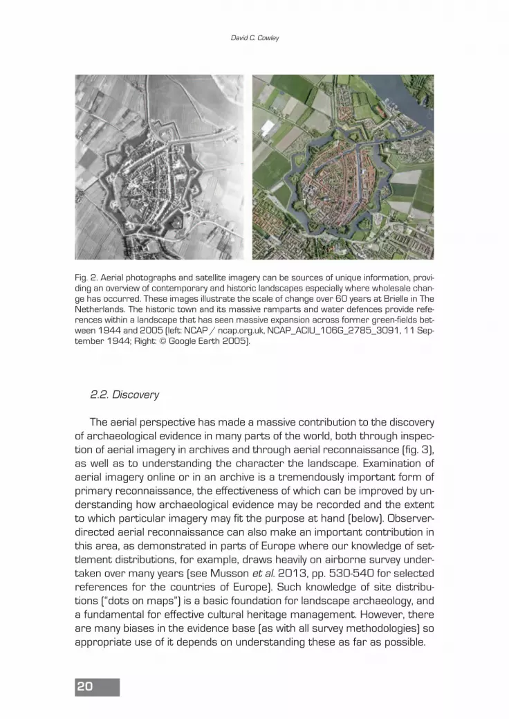
The aerial perspective, universally available from a desktop usingGoogle Earth™, provides a multi-scaled overview of the landscape – itsgeneral morphology, the textures of vegetation and the patterning of an-thropogenic and geological features. Where this perspective is availableover multiple seasons or for an extended time period of years or decades,it provides a viewpoint on landscape dynamics, including factors such aschanging land use, anthropogenic impact, and the potential utility of differ-ing methods of archaeological prospection. Such information on land-scape dynamics and changing historic land use underpins broad-brushcharacterisation, such as Historic Landscape Characterisation (Clark etal. 2004; Fairclough, Macinnes 2003), which are key tools for understand-ing historical landscape processes and management responses, for exam-ple in the implementation of the European Landscape Convention (ELC –Council of Europe 2000). In many parts of the world, where the last cen-tury has seen dramatic and accelerating urban development since the1940s, mechanisation of agriculture and extensive infrastructure proj-ects, older or “historic” aerial photographs are unique sources of informa-tion for landscapes that have been heavily altered, and on the changingcondition of archaeological features (fig. 2). Such an overview of the con-temporary and historic landscape may have a significant impact on manyaspects of landscape investigation from project design to data collectionstrategies, and on management.
Aerial photographs and aerial reconnaissance for landscape studies
19
DaveC
Sticky Note
is the 'TM' necessary?
DaveC
Sticky Note
?insert (ALS)
2.2. Discovery
The aerial perspective has made a massive contribution to the discoveryof archaeological evidence in many parts of the world, both through inspec-tion of aerial imagery in archives and through aerial reconnaissance (fig. 3),as well as to understanding the character the landscape. Examination ofaerial imagery online or in an archive is a tremendously important form ofprimary reconnaissance, the effectiveness of which can be improved by un-derstanding how archaeological evidence may be recorded and the extentto which particular imagery may fit the purpose at hand (below). Observer-directed aerial reconnaissance can also make an important contribution inthis area, as demonstrated in parts of Europe where our knowledge of set-tlement distributions, for example, draws heavily on airborne survey under-taken over many years (see Musson et al. 2013, pp. 530-540 for selectedreferences for the countries of Europe). Such knowledge of site distribu-tions (“dots on maps”) is a basic foundation for landscape archaeology, anda fundamental for effective cultural heritage management. However, thereare many biases in the evidence base (as with all survey methodologies) soappropriate use of it depends on understanding these as far as possible.
David C. Cowley
20
Fig. 2. Aerial photographs and satellite imagery can be sources of unique information, provi-ding an overview of contemporary and historic landscapes especially where wholesale chan-ge has occurred. These images illustrate the scale of change over 60 years at Brielle in TheNetherlands. The historic town and its massive ramparts and water defences provide refe-rences within a landscape that has seen massive expansion across former green-fields bet-ween 1944 and 2005 (left: NCAP / ncap.org.uk, NCAP_ACIU_106G_2785_3091, 11 Sep-tember 1944; Right: © Google Earth 2005).

2.3. Mapping
Depending on the scale of analysis it is usually a requirement to movefrom “dots on maps” to detailed interpretation and mapping. Here it isworth thinking explicitly about scale, in the sense of traditional map scalessuch as 1:100,000, 1:10,000 and 1:2,500, and the implications for thelevel of detail that is depicted. This is a discipline that is easy to ignore whenworking in GIS, as scale changes with the roll of the mouse wheel, but it isconceptually important. At 1:100,000 a site or feature will be symbolised(“dot on map”), and while at 1:10,000 it may be possible, for example, to de-pict in a generalised way an enclosure some 50 m across, depicting inter-nal features will generally be more appropriate at 1:2,500. While there isoften a temptation to “map everything – because it might be useful” (whichmay be true), scale of mapping has a direct impact on the time needed tomap, so is an important early stage of thinking, perhaps in defining multiplescales of analysis and considering what is the most appropriate mappingmethodology to support the research question.
Aerial photographs and aerial reconnaissance for landscape studies
21
Fig. 3. A previously unknown Neolithic cursus monument revealed by cropmarking and disco-vered during routine aerial reconnaissance in southeast Scotland on 8 July 2013. This is asignificant addition to the corpus of these monuments, and such discoveries continue to bemade despite over 50 years of ongoing aerial survey in this region (DP163799 © RCAHMS.Licensor www.rcahms.gov.uk).
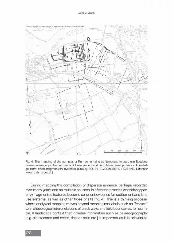
During mapping the compilation of disparate evidence, perhaps recordedover many years and on multiple sources, is often the process whereby appar-ently fragmented features become coherent evidence for settlement and landuse systems, as well as other types of site (fig. 4). This is a thinking process,where analytical mapping moves beyond meaningless labels such as “feature”to archaeological interpretations of track ways and field boundaries, for exam-ple. A landscape context that includes information such as palaeo-geography(e.g. old streams and rivers, deeper soils etc.) is important as it is relevant to
David C. Cowley
22
Fig. 4. The mapping of the complex of Roman remains at Newstead in southern Scotlanddraws on imagery collected over a 60 year period, and cumulative developments in knowled-ge from often fragmentary evidence (Cowley 2012). (GV005080 © RCAHMS. Licensorwww.rcahms.gov.uk).
the interpretation of the remains in the past, and also illustrates how they maybe impacted by factors such as contemporary or historic land use. There is abalance to be struck here, however, depending on the purpose of the mapping(e.g. Palmer 2011). Thus, mapping to inform investigation of a site that is tobe developed might include considerably more detail than mapping that seeksto establish broad-brush settlement patterns across a large area. Underlyingthis point is that mapping is best done for a purpose, and that research ques-tion will condition the type of work done, including the detail of depiction andthe extent to which non-archaeological information is included.
2.4. Site and landscape documentation
The role of aerial imagery in providing an overview of landscapes hasbeen discussed above, and the same is true of discrete foci of activity (tra-ditional archaeological “sites”). Here, when available in different seasons oryears, aerial imagery may be valuable in documenting changing materialcondition and providing differing archaeological information. As well as pro-viding information for interpretation, aerial documentation may inform man-agement issues that depend on an understanding of potential preservationand stability of archaeological remains.
2.5. 3D data
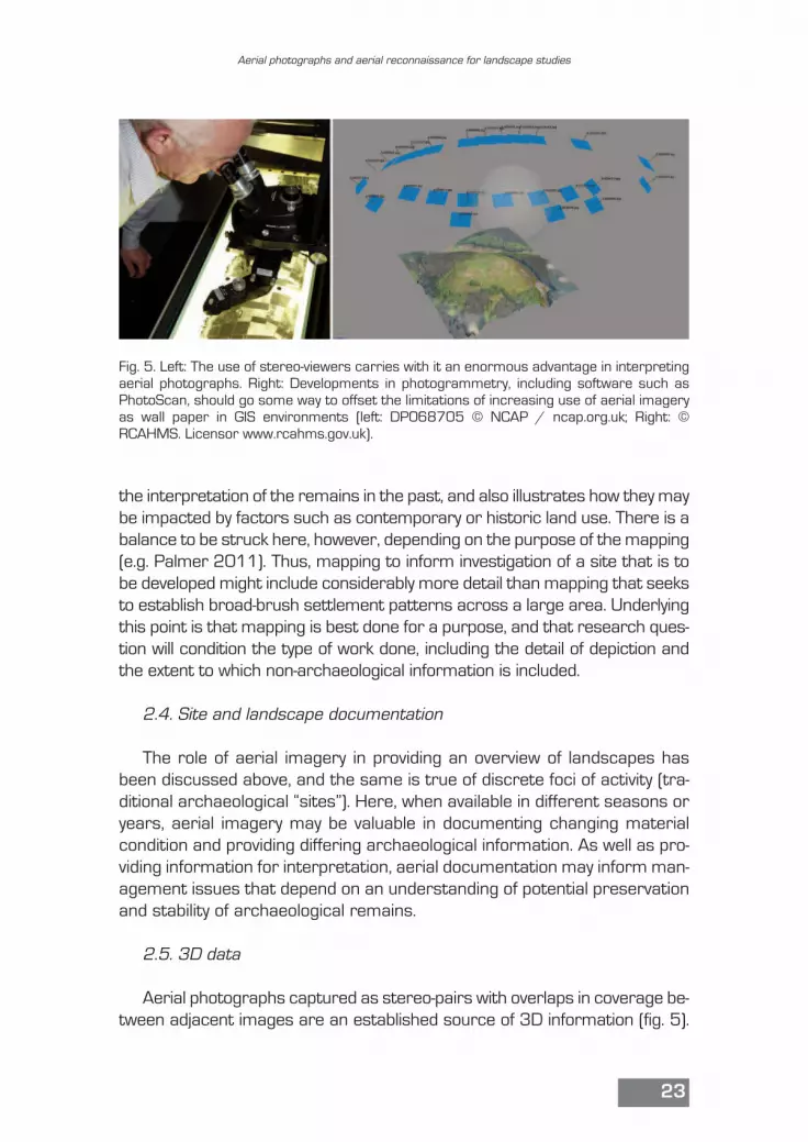
Aerial photographs captured as stereo-pairs with overlaps in coverage be-tween adjacent images are an established source of 3D information (fig. 5).
Aerial photographs and aerial reconnaissance for landscape studies
23
Fig. 5. Left: The use of stereo-viewers carries with it an enormous advantage in interpretingaerial photographs. Right: Developments in photogrammetry, including software such asPhotoScan, should go some way to offset the limitations of increasing use of aerial imageryas wall paper in GIS environments (left: DP068705 © NCAP / ncap.org.uk; Right: ©RCAHMS. Licensor www.rcahms.gov.uk).
Examination of aerial photographs in stereo adds significant information andshould be routine practice where the appropriate imagery is available, as itoffsets “flattening” of topography and allows the observer to better differenti-ate features that are otherwise viewed on a plane. However, the routine useof GIS and digital data often means that aerial images are viewed as “wallpa-per” in a GIS, and this significantly reduces the information potential of the im-agery. To a degree this trend is being compensated for by the increasinglyroutine use of soft-bench photogrammetry or Structure-from-Motion (SfM) tocreate 3D models, point clouds and visualisations (Verhoeven 2011; Verho-even et al. 2012), and software that provides proxies for stereoscopic view-ing. These provide a bridge between the disembodied “remote” and “flat” aer-ial perspective as experienced through a traditional GIS, and an engagementwith the form of the site or landscape in 3D, increasingly through simple out-puts like 3D models or in virtual reality environments.
2.6. Explaining and illustrating
It is facile to say that a picture is worth a 1000 words, but that does notmake it any less true. Conveying complex landforms and inter-relationshipsin graphic form can be difficult, while a well-chosen image may well encap-sulate multiple messages. However, it is common for aerial images to beused for impact alone, where the information they may contain is assumedto be self-evident, and is not explained. Such a “pretty picture” approach hasits place, and in the context of a landscape approach the mediation, or ex-planation, of imagery is an important mechanism that should not be missedto help the viewer engage with the subject, the archaeological informationand the contemporary landscape. This potential is developing rapidly withthe straightforward facility to output products such as 3D PDFs (above).
2.7. Complimenting other sources
The undesirability of competition between different specialists promot-ing the importance of their own area of expertise has been mentionedabove, and this is relevant in the degree to which aerial imagery is used ina complementary or supporting way to other datasets. Aerial photographsare routinely captured at the same time as ALS (see Crutchley this volume)because the “visual” information is important complementary informationfor interpretation – telling the difference between sheep and rocks scat-tered across a field, for example. The same is true of soil mapping, whichmay be at a generalised scale, but where the aerial photo evidence for vary-ing soil depth and texture may add important detail. The important point
David C. Cowley
24
here is that best practice should be to look for synergies between datasetsand sources of evidence, and critically evaluating them, rather than puttingthem in competition (better or worse).
The potential roles that an aerial perspective may play in landscape ar-chaeology have been outlined above in a discussion that has largely ignoredthe central issue of interpretation. That is, how do we look at imagery andgenerate archaeological understanding?
3. Interpretation
The interpretation of aerial imagery is an area of archaeological practicethat benefits from specialist knowledge and (should) improve with experi-ence and practice. Like all fields of archaeological practice it is a mistake toassume that extracting information from aerial imagery is simple and self-evident. Rather, it requires an understanding of both how “things” are reg-istered on aerial imagery, the nature of ground conditions and how sitesand landscape look on the ground. Thus, aerial photo interpreters who havelittle field experience may make simple errors of interpretation becausethey do not know the terrain, while a lack of understanding about how fea-tures may be recorded on aerial imagery will produce misinterpretation ofevidence. This section aims to present an approach to interpretation basedon some general principles, developed in an iterative framework where thepractice and processes in any application need repeated critical review.This will be followed by brief discussions of particular characteristics of veg-etation and light that provide archaeological information.
3.1. Some general principles for aerial photo interpretation
In the author’s experience much interpretation of aerial imagery is doneinstinctively. While much of the time this produces a result that is consid-ered adequate by others (i.e. it is “correct”), often the interpreter has limit-ed understanding of how the markings that they have observed on the pho-tographs and interpreted have been formed. This can be illustrated by aphotograph that the author uses in teaching (fig. 6). The image was takenon 4 August 2003 during routine aerial survey by RCAHMS in the middlereaches of the River Clyde in southern Scotland, and identified as “?fort”,meaning that it was regarded as possibly a multi-vallate, probably defensive,enclosure, possibly of Iron Age date. In the teaching exercise, students areasked what they think the photograph is, and almost without exception they
Aerial photographs and aerial reconnaissance for landscape studies
25

see the multiple lines of the “ditches” and fairly quickly interpret the mark-ings as a fort. In doing this they generally show little concern with the “non-archaeological” information on the photograph (cows, land use, field bound-aries), and rely heavily on shape to arrive at their interpretation. So, what isthe problem? If it looks like a fort then surely it is a fort? In fact, it is not afort, for reasons that will be explained below, but the basic problem with theinterpretative process that produced the “fort” classification is not that is itright/wrong, but that it betrays poor practice. This poor practice is basedon a simple and heavy reliance on seeing shapes, without understandinghow they have been formed, and little knowledge of farming practice andwider context.
An approach that provides more accountable and reliable interpreta-tions is one that takes account of as much of the information on the photo-graph as possible, and to consider these before making a simplistic associ-ation between a basic morphology and an archaeological interpretation. Inthis example, which is in black and white, the land cover may not be simpleto interpret, but the surface texture suggests that it may be grass and thegrazing cows confirm that this is the case. Taking into account that grassis very resistant to stress and consequent variation in colour, a little knowl-edge of the weather conditions in Scotland might make the observer suspi-cious that the markings indicate plough-levelled ditches, and they could askwhether the year 2003 had an especially dry summer (it did not). Lookingin detail at the concentric bands of marks they might observe that it is un-usual for a “fort” to have so many ditches and almost no interior space.There is also a suggestion that the lines of the “ditches” form a spiral ratherthan different circuits, which would also be suspicious. Looking in detail they
David C. Cowley
26
Fig. 6. What is it? A “fort” re-corded during routine aerialreconnaissance in 2003(E43260 © RCAHMS. Licen-sor www.rcahms.gov.uk).
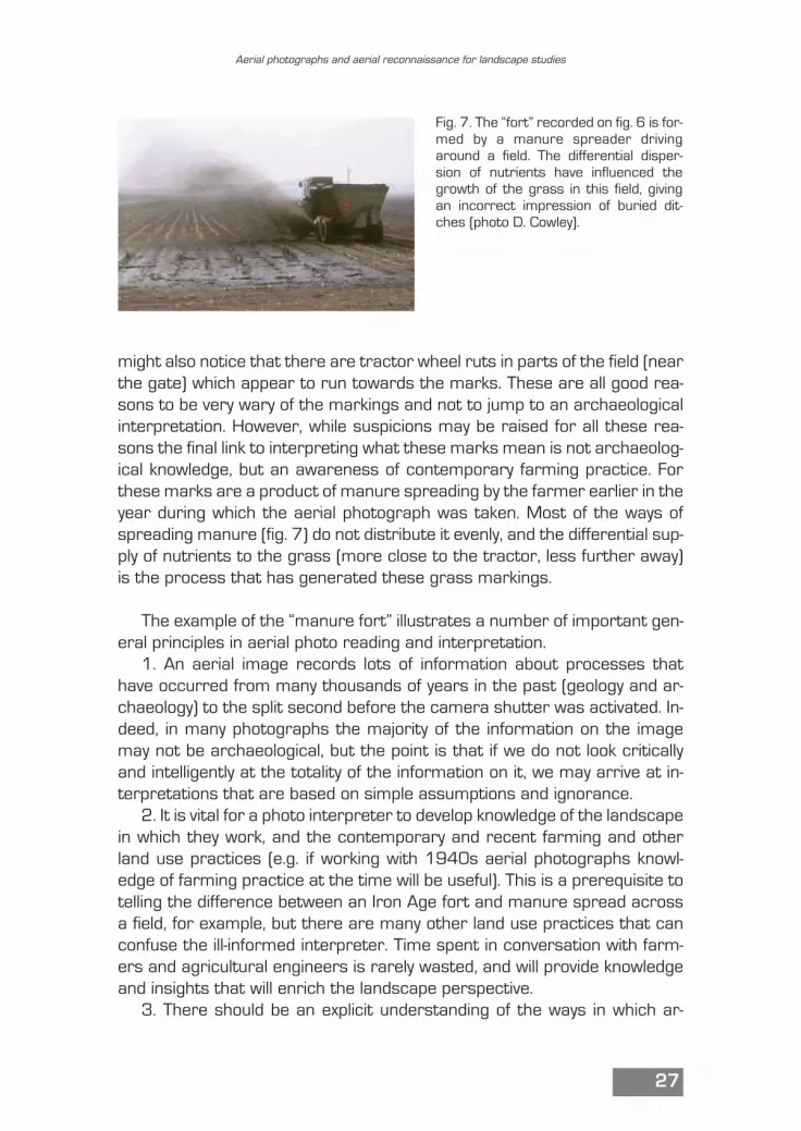
might also notice that there are tractor wheel ruts in parts of the field (nearthe gate) which appear to run towards the marks. These are all good rea-sons to be very wary of the markings and not to jump to an archaeologicalinterpretation. However, while suspicions may be raised for all these rea-sons the final link to interpreting what these marks mean is not archaeolog-ical knowledge, but an awareness of contemporary farming practice. Forthese marks are a product of manure spreading by the farmer earlier in theyear during which the aerial photograph was taken. Most of the ways ofspreading manure (fig. 7) do not distribute it evenly, and the differential sup-ply of nutrients to the grass (more close to the tractor, less further away)is the process that has generated these grass markings.
The example of the “manure fort” illustrates a number of important gen-eral principles in aerial photo reading and interpretation.
1. An aerial image records lots of information about processes thathave occurred from many thousands of years in the past (geology and ar-chaeology) to the split second before the camera shutter was activated. In-deed, in many photographs the majority of the information on the imagemay not be archaeological, but the point is that if we do not look criticallyand intelligently at the totality of the information on it, we may arrive at in-terpretations that are based on simple assumptions and ignorance.
2. It is vital for a photo interpreter to develop knowledge of the landscapein which they work, and the contemporary and recent farming and otherland use practices (e.g. if working with 1940s aerial photographs knowl-edge of farming practice at the time will be useful). This is a prerequisite totelling the difference between an Iron Age fort and manure spread acrossa field, for example, but there are many other land use practices that canconfuse the ill-informed interpreter. Time spent in conversation with farm-ers and agricultural engineers is rarely wasted, and will provide knowledgeand insights that will enrich the landscape perspective.
3. There should be an explicit understanding of the ways in which ar-
Aerial photographs and aerial reconnaissance for landscape studies
27
Fig. 7. The “fort” recorded on fig. 6 is for-med by a manure spreader drivingaround a field. The differential disper-sion of nutrients have influenced thegrowth of the grass in this field, givingan incorrect impression of buried dit-ches (photo D. Cowley).
chaeological sites may be evident as vegetation marks, shadows and soilmarks, and how our observation of them can vary.
4. Interpretation based simply on identifying shapes (round, square, lin-ear) without understanding how they were formed is an inherently weak ap-proach that is prone to error.
5. Knowledge of the landscape should extend to the range of archaeo-logical remains that may be expected, drawing on existing knowledge and,if available, evidence from excavated sites, as well as survey. More difficultis maintaining an open mind that might help in recognising features that donot fit the “known” or expectations (i.e. confirmation bias – we see what weexpect). Inevitably, there is a balance to be maintained between not assum-ing everything fits into familiar categories and not always looking for alter-native interpretations.
6. An appreciation of how changing or variable weather conditions, cropgrowth and cultivation practices may influence visibility of features can beuseful, and can be built up from examination of multi-temporal imagery.
The central important point here is that wide knowledge about the manynon-archaeological processes that occur in the landscape is a vital founda-tion to coherent and reliable photo-interpretation (fig. 8). To this can beadded understanding of how archaeological features of potential interestform, a summary of which follows. But there is also an important elementof explicit processes, accountability and self awareness that lies at theheart of this approach. Group interpretation of images can be valuable asit brings in different perspectives and can highlight interpretations that arenot underpinned by explicit knowledge. Moreover, it can also help individualinterpreters build an awareness of how their eye/brain cognitive systemworks: do you see lines better, or pits? – do you see squares more easilythan circles? A basic awareness of how human cognition and visual percep-tion works is a good foundation for image interpretation (e.g Gibson 1986,Cosgrove 2008 and references listed under Suggested Reading below).Eye-tracking experiments (e.g. Michalik 2014) demonstrate the importanceof this awareness to feature identification from imagery, and show how per-ception is a heavily contingent function. This is why dialogue and groupphoto-reading can be so valuable in developing perception and interpreta-tion – there is nothing like trying to explain or justify an interpretation to crit-ical colleagues to make you aware of its weaknesses, and how differentlyothers may see the same image. And this is an important part of a struc-tured approach to interpretation because the author’s experience sug-gests that once an interpretation has been arrived at, it is very difficult torevise it, especially without external input. These factors are at the heart ofa reflexive approach to aerial photo interpretation that avoids many of the
David C. Cowley
28
DaveC
Sticky Note
The suggested reading for this has not been included, so perhaps remove the marked text?
DaveC
Cross-Out

pitfalls of poor practice, and draw on discussions of reflexive excavationmethods (Hodder 1997; Farid 2015).
The outline of these general principles is drawn from the author’s expe-rience in Scotland and from teaching and observation of landscapes else-where, and it is presented to encourage photo interpretation to proceed ina considered way, rather than jumping in without reflection. And this is aprinciple that is worth maintaining even as experience grows, as poor inter-pretations by the author are invariably because he took the short cut frombasic morphology to description and interpretation without reflection.Moreover the general approach advocated equips the photo-interpreterwith knowledge and a broad methodology that is transferrable to otherareas. In addition, a reflexive method, perhaps learned in one area, is a goodfoundation for working anywhere, although local knowledge will need to ac-cumulate to make more accurate interpretations. Central to much of this
Aerial photographs and aerial reconnaissance for landscape studies
29
Fig. 8. Differential health of the grass in this field reveals a range of subsurface features thatinclude Iron Age settlement remains (e.g. “A”) and an in-filled old water course (“B”). The darkmarks with a light halo are produced by a stock feeder being moved around the field (e.g.“C”), with other marks left by farm vehicles (e.g. “D”). Knowledge of ancient landscape forma-tion processes and contemporary farming practice are vital to reliable aerial photographicinterpretation (B22950 © RCAHMS. Licensor www.rcahms.gov.uk).

is a requirement to be explicit about what an interpreter sees. How do youunderstand the formation of the observed feature and how do you relatethis to archaeological interpretation? Beyond making interpretation moreexplicit and accountable this clarity is valuable in developing applications ofcomputer vision in analysis. The more that processes of archaeological de-scription and interpretation are explicit the easier it may be to design algo-rithms that complement and challenge an otherwise exclusively human ap-proach to interpretation of airborne data (see Bennett et al. 2014 and Cas-sana 2014 for a discussion of these issues). For landscape archaeology,and especially primary prospection across large areas which may be cov-ered by massive aerial datasets, this is a crucial development if featureidentification from archaeological data is to move beyond the constraints ofhuman resourcing and cognition. The challenge lies in integrating “featureextraction” and the consistency of computer vision with the experience andknowledge of the human observer, recognising the limitations and fallibilityof both (Cowley 2013).
4. How we see things on aerial photographs
There are various ways in which archaeological features are visible in thelandscape and how these may be recorded on photographs. Some of this vis-ibility relates to how features constructed in the past have decayed and beenaltered by processes over centuries or millennia (i.e. agricultural regimesand specifically ploughing), and how they are represented and recorded onimagery (i.e. through the proxy of vegetation, soils or shadows). Understand-ing of these processes (box 3.1) is informed by knowledge of land use histo-ries, evidence from archaeological research such as excavations and sur-veys, anthropological/ethnographic analogy and experimental reconstruc-tions. Other factors relate to properties of photographs, including date, timeand scale, aspects of which are discussed below to inform the routine con-sideration of how well suited particular photographs are to specific purpos-es. Thus, the ways in which we see things on aerial imagery is a combinationof landscape processes and the characteristics of photographs.
To start, it is worth making a basic distinction between features thatsurvive as surface remains and have a direct expression in surface topog-raphy and/or soil texture, and those that are expressed through the proxyof vegetation and soil, which are mostly levelled by the plough. Light (shad-ows) and vegetation can be important in both of these basic distinctions,but in broad terms highlights and shadows are most important in revealingrelief features (“earthworks”) and vegetation to features that areburied/levelled.
David C. Cowley
30
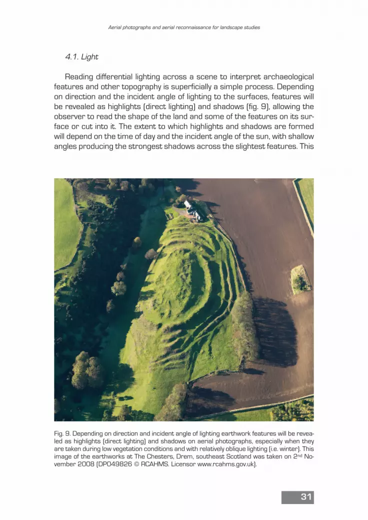
4.1. Light
Reading differential lighting across a scene to interpret archaeologicalfeatures and other topography is superficially a simple process. Dependingon direction and the incident angle of lighting to the surfaces, features willbe revealed as highlights (direct lighting) and shadows (fig. 9), allowing theobserver to read the shape of the land and some of the features on its sur-face or cut into it. The extent to which highlights and shadows are formedwill depend on the time of day and the incident angle of the sun, with shallowangles producing the strongest shadows across the slightest features. This
Aerial photographs and aerial reconnaissance for landscape studies
31
Fig. 9. Depending on direction and incident angle of lighting earthwork features will be revea-led as highlights (direct lighting) and shadows on aerial photographs, especially when theyare taken during low vegetation conditions and with relatively oblique lighting (i.e. winter). Thisimage of the earthworks at The Chesters, Drem, southeast Scotland was taken on 2nd No-vember 2008 (DP049826 © RCAHMS. Licensor www.rcahms.gov.uk).

is a simple statement, but it is made here because the direction of lighting,and specifically the direction in which shadows fall, especially on verticalphotographs, influences the observer’s ability to read topography. Thus,where there are strong shadows that fall away from the observer (i.e. in thenorthern hemisphere with images orientated with north to top in a GIS), re-versal of topography can be experienced. Often knowledge of what topogra-phy should do overrides this optical illusion, but it does highlight the need towork through carefully what lighting across a photograph is telling us.
4.2. Vegetation marks
The basic principles of variation in surface vegetation revealing buriedor slight features are straightforward. Differing depths of topsoil anddrainage properties will influence the vegetation in different ways through
David C. Cowley
32
Fig. 10. Arable crops such as barley and wheat can reveal buried features and varying soildepth through variable development and ripening. The greens and yellows (or dark and lightin black and white photographs) on this photograph taken on 24th July 2006 of the Romanfort at Newstead in southern Scotland reveal the layout of the site as the crop started toripen. The plants growing over the shallower soils and hard features, such as metalledroads and the wall (e.g. “A”) have been relatively stressed and as a result have ripenedmore quickly that other areas, but consequently have less biomass. In contrast the cropsgrowing over deeper soils, including the Roman ditches (e.g. “B”) are less stressed and areripening more gradually, all the while increasing biomass (DP011649 © RCAHMS. Licen-sor www.rcahms.gov.uk).
DaveC
Cross-Out
DaveC
Replacement Text
than
DaveC
Sticky Note
(fig. 12 below)

the growing season. Generally speaking, vegetation with a good depth oftopsoil and with a good supply of water and nutrients will grow larger, withgreater leaf area and crop yield, and take a longer period to fully ripenthan one growing over thin soils with poor water and nutrient supply. Thelatter crop is stressed and this will be reflected in stunted growth and anaccelerated progress towards being fully ripe. In arable crops such asbarley and wheat, these processes generate varying greens and yellows(or dark and light in black and white photographs) across the crop accord-ing to the depth of soil (fig. 10) in a form that changes as the crop devel-ops (fig. 11). These can reflect the presence of ditches and pits (less
Aerial photographs and aerial reconnaissance for landscape studies
33
Fig. 11. This image from Veszkény in northwest Hungary shows how the gross variability ofsoil depth across the picture has influenced crop ripening, while the shadows thrown by thevariable crop heights show how ditches and pits have created locally advantageous condi-tions that encourage plants to grow taller (© Zoltán Czajlik, reproduced by kind permission).
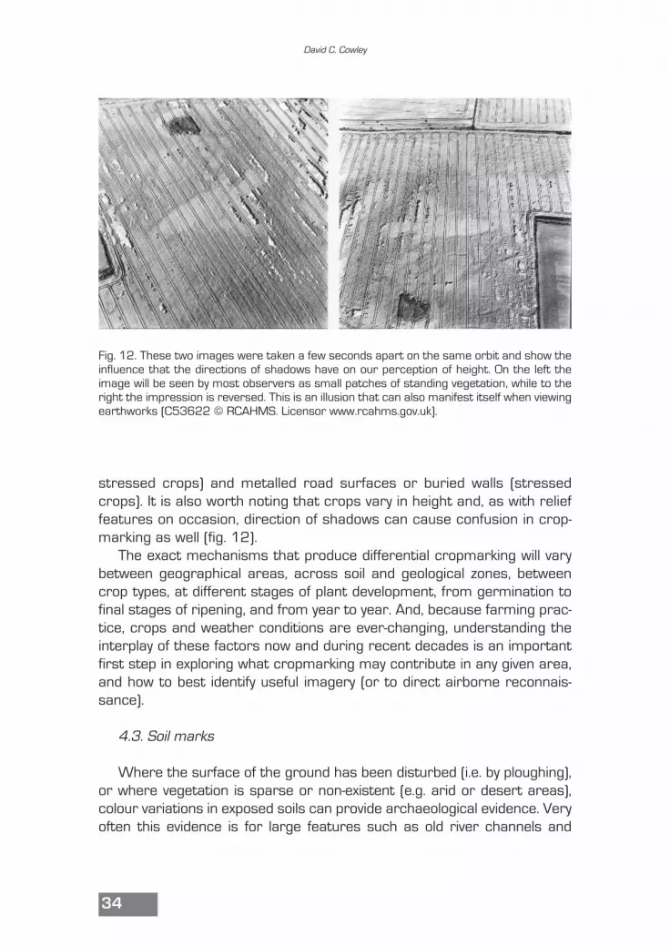
stressed crops) and metalled road surfaces or buried walls (stressedcrops). It is also worth noting that crops vary in height and, as with relieffeatures on occasion, direction of shadows can cause confusion in crop-marking as well (fig. 12).
The exact mechanisms that produce differential cropmarking will varybetween geographical areas, across soil and geological zones, betweencrop types, at different stages of plant development, from germination tofinal stages of ripening, and from year to year. And, because farming prac-tice, crops and weather conditions are ever-changing, understanding theinterplay of these factors now and during recent decades is an importantfirst step in exploring what cropmarking may contribute in any given area,and how to best identify useful imagery (or to direct airborne reconnais-sance).
4.3. Soil marks
Where the surface of the ground has been disturbed (i.e. by ploughing),or where vegetation is sparse or non-existent (e.g. arid or desert areas),colour variations in exposed soils can provide archaeological evidence. Veryoften this evidence is for large features such as old river channels and
David C. Cowley
34
Fig. 12. These two images were taken a few seconds apart on the same orbit and show theinfluence that the directions of shadows have on our perception of height. On the left theimage will be seen by most observers as small patches of standing vegetation, while to theright the impression is reversed. This is an illusion that can also manifest itself when viewingearthworks (C53622 © RCAHMS. Licensor www.rcahms.gov.uk).
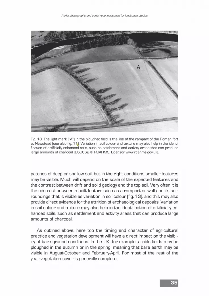
patches of deep or shallow soil, but in the right conditions smaller featuresmay be visible. Much will depend on the scale of the expected features andthe contrast between drift and solid geology and the top soil. Very often it isthe contrast between a built feature such as a rampart or wall and its sur-roundings that is visible as variation in soil colour (fig. 13), and this may alsoprovide direct evidence for the attrition of archaeological deposits. Variationin soil colour and texture may also help in the identification of artificially en-hanced soils, such as settlement and activity areas that can produce largeamounts of charcoal.
As outlined above, here too the timing and character of agriculturalpractice and vegetation development will have a direct impact on the visibil-ity of bare ground conditions. In the UK, for example, arable fields may beploughed in the autumn or in the spring, meaning that bare earth may bevisible in August-October and February-April. For most of the rest of theyear vegetation cover is generally complete.
Aerial photographs and aerial reconnaissance for landscape studies
35
Fig. 13. The light mark (“A”) in the ploughed field is the line of the rampart of the Roman fortat Newstead (see also fig. 11). Variation in soil colour and texture may also help in the identi-fication of artificially enhanced soils, such as settlement and activity areas that can producelarge amounts of charcoal (D60662 © RCAHMS. Licensor www.rcahms.gov.uk).
DaveC
Cross-Out
DaveC
Replacement Text
0
5. Characteristics of photographs
From the discussion above of the potential for aerial photographs torecord different types of archaeological features it will be clear that imagesfrom different times of the year, and differing stages of the agriculturalcycle, will provide different information. This is one aspect of the character-istics of imagery that needs to be understood to make intelligent and costeffective use of images. Thus, understanding the implications in specificcontexts of the time of year of photography, for example, should informwhat imagery is examined and to what purpose.
5.1. Scale
The other significant characteristic of photographs that should always bekept in mind is the scale at which the imagery was captured, as this will havea direct impact on the types of features that may be visible. In the author’sexperience a lack of awareness of the scale of the photographs being exam-ined is a major source of misidentification of features. Routinely users of aer-ial photographs may use contact prints at scales varying from 1:5,000 to1:24,000 and smaller. At 1:5,000, a feature 5 m across will measure 1 mm,or about the size of a mark made with a blunt pencil point. At 1:10,000, thesame feature will measure 0.5 mm across, and at smaller scales (e.g.1:25,000, 1:100,000), the feature will be too small to see (box 3.2). This isa statement of what should be obvious, but it is included here because “sites”are regularly “identified” by professional archaeologists from aerial photo-graphs where interpretation takes no account of scale. For example, in east-ern Scotland a desk-based assessment by an archaeological contractor iden-tified a cemetery of potentially mid-1st millennium AD date from aerial photo-graphs. Such cemeteries are sometimes known as clusters of “maggot-shaped” cropmarks measuring some 2 m by 1 m marking the positions of ex-tended inhumation graves (e.g. Cowley 2009). However, in this case the iden-tification was made from 1:24,000 scale contact prints, and the potentialgrave pits, when scaled correctly, were about 20 m across, and thus, what-ever else they might be, they were clearly not the remains of a cemetery.
A related issue is that, while use of magnification is routine, the use ofstereoscopic-viewers is probably less common, despite the fact that signifi-cantly more information can be captured in this way. Stereo-viewing not onlyprovides magnification and three dimensionality, but also ensures the inter-preter views more than one image where artefacts such as printing flawscan be dismissed because they occur on only one picture. Like everythingelse, stereo perception will increase with practice.
David C. Cowley
36
DaveC
Sticky Note
should this be in red? reference to box 3.1 is in black text
5.2. Types of imagery
Much can be made of differences between types of aerial photographs,most evident in the expansion in the availability and use of satellite imagery.However, more important than the platform (satellite, manned aircraft, re-motely controlled aircraft, kites, balloon etc.) that has been used to captureimagery is an understanding of its characteristics, aspects of which havebeen discussed above. Most important of these are scale (i.e. what is theground resolution of imagery) and the lighting and vegetation conditions atthe time of capture. Beyond these basics, different types of imagery may re-quire different treatment, and so these are summarised here.
The largest numbers of available aerial photographs are images taken asblock-coverage of areas for purposes such as military intelligence and map-ping (fig. 14). These are usually referred to as “verticals” although, as takenthey only provide vertical views of the surface at the centre of the image, withincreasing obliquity towards the edges of the image, and suffer from distor-tion due to varying ground relief. The important points about these images isthat they provide continuous coverage and are almost always are taken withoverlap between adjacent images to allow stereo-viewing. Imagery can be
Aerial photographs and aerial reconnaissance for landscape studies
37
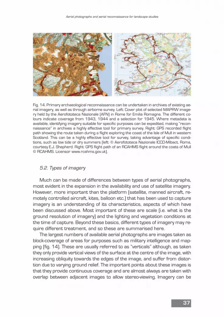
Fig. 14. Primary archaeological reconnaissance can be undertaken in archives of existing ae-rial imagery, as well as through airborne survey. Left: Cover plot of selected MAPRW image-ry held by the Aerofototeca Nazionale (AFN) in Rome for Emilia Romagna. The different co-lours indicate coverage from 1943, 1944 and a selection for 1945. Where metadata isavailable, identifying imagery suitable for specific purposes can be expedited, making “recon-naissance” in archives a highly effective tool for primary survey. Right: GPS recorded flightpath showing the route taken during a flight exploring the coast of the Isle of Mull in westernScotland. This can be a highly effective tool for survey, taking advantage of specific condi-tions, such as low tide or dry summers (left: © Aerofototeca Nazionale ICCD-Mibact, Roma,courtesy E.J. Shepherd. Right: GPS flight path of an RCAHMS flight around the coats of Mull© RCAHMS. Licensor www.rcahms.gov.uk).
DaveC
Cross-Out
geometrically corrected to remove distortions in scale, producing orthopho-tographs that are spatially accurate. Older images (e.g. 1940s) generallylack camera calibration data that limits their utility for photogrammetry, al-though developments in software should compensate for this (e.g. Structure-from-Motion). Such imagery may be available from national archives, thoughin many countries the military may limit access, from commercial surveycompanies, and from so-called global collections (Cowley, Stichelbaut 2012).The expense of accessing images varies greatly, and so too does the limita-tions on re-use, and some far-sighted countries allow free access to block-coverage photographs through geo-portals. Google Earth™ is readily acces-sible, and often has multi-temporal imagery, and should be a routine firstpoint of reference for any aerial photographic study.
In some areas with long traditions of aerial reconnaissance many of thephotographs used for archaeological purposes may be “obliques”, which isa shorthand to mean that they have usually been taken during observer-di-rected aerial reconnaissance, generally of specific targets. In practice near-verticals can be produced, and with suitable imagery the developments insoft-bench photogrammetry (i.e. Structure-from-Motion) allow simple pro-duction of 3D products from “obliques”, including point clouds and or-thophotographs. Such imagery is often held in the archives of national ar-chaeological survey bodies/heritage agencies, in Universities, and in pri-vate hands, and accessibility will vary accordingly.
There are differences too between types of digital and traditional analogueimagery. If nothing else traditional negatives or prints will require scanning ifthey are to be geo-referenced in a GIS, and this introduces additional parts ofa workflow, and potential additional factors to consider, such as distortions inold prints, and differences in scanning methods which can have a significantimpact on the end product (e.g. is a photogrammetric scanner used?). Theexpense of 3D screens or printing digital images to view them in a traditionalstereo-viewer is almost certainly a factor in the limited use of stereo-viewingin some contexts, although the rapid developments in generating 3D prod-ucts from aerial imagery may begin to compensate for this. This is an evolvingworld, and the main point to take from these differences in types of imageryis to understand them, and so ensure they are used appropriately.
Users of aerial photographs should also consider the need for enhance-ment and processing of imagery, at a minimum, for example, to improvecontrast. This is a necessary part of working with satellite imagery (Lasapo-nara, Masini 2012), and with any imagery can improve the readability of in-formation. However, there is a need to understand the processing param-eters and what is being done to the image, so that false artefacts are notintroduced.
David C. Cowley
38
DaveC
Sticky Note
remove TM?
5.3. Defining fitness for purpose
The principle of looking at all available photographs for a study area is agood place to start. It is certainly to be recommended when beginning towork in an unfamiliar area, and is advisable to anyone relatively inexperi-enced in image examination. Looking at all accessible images should pro-vide insights into changing vegetation and surface conditions, on land usepractice, on the varying visibility of archaeological and other information,and so on. But doing this as a mindless routine is probably not efficient useof time, while a solid understanding of the types of imagery (i.e. scale, timeof year) that may be most productive should allow more targeted use basedon an assessment of potential strengths and weakness and the cost/ben-efits of time spent examining imagery (Winton, Horne 2011). Where meta-data, including scale and date of photography, is available the targeting ofimagery that may be best suited to the specific purpose at hand can be arapid process. Where this is undertaken in combination with external datasources, such as historic patterns of dry or wet summers, the time spentin examining imagery can be made ever more targeted. However, at theheart of this process are the clear definition of purpose, and an awarenessof the dangers that only targeting specific imagery will introduce confirma-tion bias. Here, the relationship between a desire to document broad-brushpatterns and extracting maximum detail is central. The author’s predispo-sition is towards broad brush patterns, and in his experience a combinationof occasionally looking at all imagery, routine use of knowledge to targetspecific “high potential information” imagery and occasional “looking outsidethe box” serves well to maintain a balance between reaffirming expecta-tions and allowing surprises generated by a different way of looking. In othercases, a question of detail may require close examination of all images.
It should be best practice to record the aerial imagery that is used, to-gether with comments on why they were used, and their value to the ques-tions at hand. This not only provides useful information to users of the prod-ucts, but can also help to identify when future revision may be advisable, forexample, when different photographs become available.
6. Aerial reconnaissance
Much of the discussion above has dealt with the processes of readingand interpreting aerial imagery, while this section attempts to look at someaspects of the “aerial perspective” in reconnaissance. This is often equatedwith flying in light aircraft, but the author’s definition also extends to the
Aerial photographs and aerial reconnaissance for landscape studies
39

processes of looking in archives (fig. 14). Airborne prospection is well estab-lished in certain parts of Europe, principally the UK, but also France, andmore recently most European countries (see Musson et al. 2013, pp. 530-540 for selected references for the countries of Europe). In many areas theresults of this work have been truly revolutionary, extending monument dis-tributions and providing unique insights into landscape history. The successstories have sometimes prompted a view that flying is necessary, to thedetriment of working with existing archival sources. This is raised not tocast airborne reconnaissance in simple “good” or “bad” terms, but to high-light that any landscape prospection technique needs to be well under-stood, and articulated in an explicit survey design. This may be as simple asidentifying that in areas with extensive archival imagery the role of airbornereconnaissance may play a secondary, and perhaps minimal, role com-pared to exploring the information on existing aerial photographs (fig. 15).
Focusing now on aerial reconnaissance it is worth stressing the impor-tance of landscape knowledge in directing (relatively) expensive time in theair to best effect. This is to restate many of the points discussed above: whatis the character of the archaeological remains expected?; what are the pat-terns of crops?; what impact do weather conditions have?; and so on. Allthese will condition when to fly and how often. This is important because air-borne reconnaissance is a process of active engagement with a landscapeand any attempt to conduct “one-off” survey will almost certainly end is dis-appointment. The pattern of ripening crops across a valley, for example, willmean that the timing of the best conditions for recording will vary as muchas did the timing of crops being planted, further complicated by variations inrainfall and farming practice. The survey process will benefit from an ac-countable, reflexive approach where the ongoing returns from reconnais-sance are analysed for bias (Cowley 2002; papers in Brophy, Cowley 2005).Beyond that the process should be legal, which will vary from country tocountry, and safe, with sensible operating procedures in place, including dutyhours for pilots, fuel minima, good understanding of meteorological condi-tions, and pilots who know local conditions (e.g. flying in mountains).
Practical arrangements should ensure that photographs can be located– easy with GPS units tethered to the camera – and that imagery is collect-ed with appropriate information to allow geo-referencing and mapping if ap-propriate. How to ensure adequate map control for mapping will vary fromarea to area, but if imagery is to be used for more than pretty pictures en-suring they can be used for mapping is vital. Structure-from-motion soft-ware has helped in this respect, but there remains an imperative for theaerial photographer to have an understanding of what an interpreter under-taking mapping needs (Palmer 2005). Cameras have developed greatly,
David C. Cowley
40
DaveC
Cross-Out
DaveC
Replacement Text
M

and a good quality digital SLR will provide images that are more than fit formost purposes. Familiarity with equipment is necessary, because it will bechallenged when working in the air, where turbulence, noise and tirednesswill all compromise the ability to operate effectively.
7. Thinking about bias
All forms of archaeological prospection suffer from bias, but this is nota problem if it is recognised, and steps taken to analyse and address it. Cri-tique of survey practice is often complicated if the critique is directed at anindividual, and this is compounded if a competitive position between differ-ent techniques is an issue. However, it is author’s belief that all surveyorsshould be open to robust and systematic critique of their methodology. It isnot enough to do some flying and expect others to be grateful, without un-derstanding what you have done and why. This is a central element of re-flexive and accountable practice. For aerial reconnaissance, practitionersshould document their practice and be ready to justify it, and this requires
Aerial photographs and aerial reconnaissance for landscape studies
41
Fig. 15. Primary survey or reconnaissance is one of the main sources of information aboutsite distributions in many landscape – and this can take place in archives of existing photo-graphs or “actively” in the air. Left: sites recorded by chance on a photograph taken for map-ping purposes. The majority of such archival images have never been examined for their ar-chaeological potential. Right: the inter-tidal fish trap in Loch Shieldaig, northwest Scotland,was discovered during aerial reconnaissance in 2011. Such features, comprising a band ofstones drawn across an inlet, are difficult to see from ground-level, while airborne reconnais-sance along the coast has resulted in in many new discoveries that inform our understan-ding of these landscapes (left: OS 77 081, © Crown copyright Ordnance Survey. All rightsreserved. Right: DP156378 © Crown copyright: RCAHMS. Licensor www.rcahms.gov.uk).
DaveC
Cross-Out
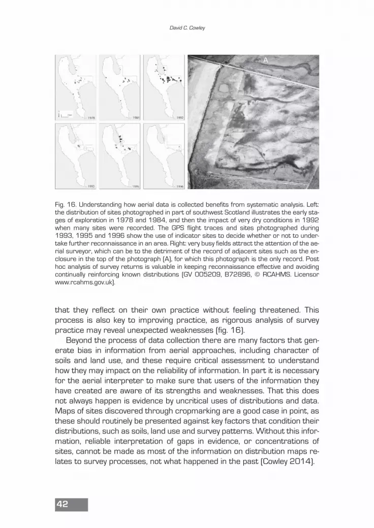
that they reflect on their own practice without feeling threatened. Thisprocess is also key to improving practice, as rigorous analysis of surveypractice may reveal unexpected weaknesses (fig. 16).
Beyond the process of data collection there are many factors that gen-erate bias in information from aerial approaches, including character ofsoils and land use, and these require critical assessment to understandhow they may impact on the reliability of information. In part it is necessaryfor the aerial interpreter to make sure that users of the information theyhave created are aware of its strengths and weaknesses. That this doesnot always happen is evidence by uncritical uses of distributions and data.Maps of sites discovered through cropmarking are a good case in point, asthese should routinely be presented against key factors that condition theirdistributions, such as soils, land use and survey patterns. Without this infor-mation, reliable interpretation of gaps in evidence, or concentrations ofsites, cannot be made as most of the information on distribution maps re-lates to survey processes, not what happened in the past (Cowley 2014).
David C. Cowley
42
Fig. 16. Understanding how aerial data is collected benefits from systematic analysis. Left:the distribution of sites photographed in part of southwest Scotland illustrates the early sta-ges of exploration in 1978 and 1984, and then the impact of very dry conditions in 1992when many sites were recorded. The GPS flight traces and sites photographed during1993, 1995 and 1996 show the use of indicator sites to decide whether or not to under-take further reconnaissance in an area. Right: very busy fields attract the attention of the ae-rial surveyor, which can be to the detriment of the record of adjacent sites such as the en-closure in the top of the photograph (A), for which this photograph is the only record. Posthoc analysis of survey returns is valuable in keeping reconnaissance effective and avoidingcontinually reinforcing known distributions (GV 005209, B72896, © RCAHMS. Licensorwww.rcahms.gov.uk).
8. Conclusions
Depending on context, an aerial perspective can be a significant part ofany landscape project, but specific applications need to be fit for purpose,problem orientated and well understood for the contribution to be effective.Aerial imagery may provide unique information that cannot be collected anyother way, for example in piecing together large areas of plough-levelled re-mains revealed as cropmarking, or where older photographs record land-scapes that have been altered or destroyed. Aerial images are especiallypowerful in providing insights to the general patterns and processes of re-cent and contemporary land use, which can have important impacts on allforms of archaeological prospection data. These are all factors that arespecific to context and, like the interpretive process that is so central to theuse of aerial imagery, effective engagement is an iterative process. Aerialimagery is a rich source of information, but one in which the indicators ofpast activity we seek are entangled objects embedded in a landscape con-text. This is why knowledge about landscape processes is so important, andthat is something best gained through combined aerial and ground per-spectives.
Acknowledgements
My thanks to Oscar Aldred, Rachel Opitz, Rog Palmer, Piers Dixon andApostolos Sarris for comments on the text – any errors are my own.
Aerial photographs and aerial reconnaissance for landscape studies
43

44
There are various ways in which archaeolo-gical features are visible in the landscapeand how these may be recorded on photo-graphs. Some of this visibility relates to howfeatures constructed in the past have deca-yed and been altered by processes overcenturies or millennia (i.e. agricultural regi-mes and specifically ploughing), and howthey are represented and recorded on ima-gery (i.e. through the proxy of vegetation,soils or shadows). A sequence of three dra-wings on the left shows a simplified processof site formation. The upper shows whatmay be visible today in a field that has beenlevelled by cultivation, with cereal crops re-sponding over different depths of soil to pro-duce cropmarking. At an earlier date or inan unploughed landscape (centre), themajor elements of the site survived in relief,but are always vulnerable to destruction.
The lower image is a speculative recon-struction of the types of structures that pro-duced the features represented by thecrops or slight relief. The original site (bot-tom) comprised a bank and ditch surroun-ding a round house with its associated do-mestic stock pen and other fenced areas.On the right: the differential survival of theearthworks at Habchester in southern Sco-tland is a product of land use regimes, inthis case with distinct histories to eitherside of the boundary that bisects the site.
Fig. 17. Left: a simplified process of site formation.Right: site of Habchester (Scotland). (Left: © Crown co-pyright: Royal Commission on the Ancient and Histori-cal Monuments of Wales © Hawlfraint y Goron: Comi-siwn Brenhinol Henebion Cymru; Right: SC993205 ©RCAHMS. Licensor www.rcahms. gov.uk).
3.1 Visibility of archaeologicalfeatures
Aerial photographs and aerial reconnaissance for landscape studies
45
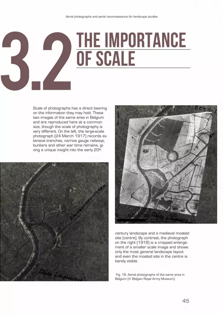
Scale of photographs has a direct bearingon the information they may hold. Thesetwo images of the same area in Belgiumand are reproduced here at a commonsize, though the scale of photography isvery different. On the left, the large-scalephotograph (24 March 1917) records ex-tensive trenches, narrow gauge railways,bunkers and other war time remains, gi-ving a unique insight into the early 20th
century landscape and a medieval moatedsite (centre). By contrast, the photographon the right (1918) is a cropped enlarge-ment of a smaller scale image and showsonly the most general landscape layoutand even the moated site in the centre isbarely visible.
3.2The importanceof scale
Fig. 18. Aerial photographs of the same area inBelgium (© Belgian Royal Army Museum).
DaveC
Cross-Out
SuggestedreadingSuggestedreading
Aerial reconnaissance and survey results
D. COWLEY 2002, A case study in the analy-sis of patterns of aerial reconnaissance in alowland area of southwest Scotland, “Ar-chaeological Prospection”, 9(4), pp. 255-65.
K. BROPHY, D. COWLEY (eds) 2005, From theAir – Understanding Aerial Archaeology,Stroud.
J. MILLS, R. PALMER (eds) 2007, PopulatingClay Landscapes, Stroud.
Archival and historic aerial imagery
D. COWLEY, B. STICHELBAUT 2012, HistoricAerial Photographic Archives for EuropeanArchaeology, “European Journal of Archae-ology”, 15(2), pp. 217-236.
D. COWLEY, R. STANDRING, M. ABICHT (eds)2010, Landscapes through the Lens –Aerial Photographs and the Historic Envi-ronment, Oxford.W. HANSON, O. OLTEAN (eds) 2013, Archae-ology from Historical Aerial and SatelliteArchives, Springer.
46
General aerial archaeology and aerial photographic interpretation
For a first overview of aerial photography,photo interpretation and mapping for ar-chaeology: C. MUSSON, R. PALMER, S. CAM-PANA 2013, Flights into the past, [1st ed.Firenze 2005, in Italian], available online at:http://www.univie.ac.at/aarg/php/cms/Occasional-Publications/
D. WILSON 2000, Air Photo Interpretationfor Archaeologists, Stroud.R. PALMER 2013, Reading aerial images, inR. OPITZ, D. COWLEY, Interpreting Archaeo-logical Topography: 3D Data, Visualisationand Observation, Oxford, pp. 76-87. P. HORNE 2009, A Strategy for the NationalMapping Programme, English Heritage.
Remote sensing
For the wider context of airborne remotesensing:T. LILLESAND, R. KIEFER 2000, Remote sens-ing and image interpretation (4th ed.), NewYork.
Related Documents