Geographical Urban Planning Research, Vol. 2, No. 3, Autumn 2014 1 Mojtaba Rafiyan 1 , Shiva Momtaz 2 , Mahdi Shiripour 3 1. Prof. of Urban Planning, Dep. of Urban planning, Tarbiat Modares University, Tehran, Iran 2. Ph.D. Candidate in Geography and Urban Planning, Institute for Humanities and Social Studies, Iran 3. Ph.D. Candidate in Geography and Urban Planning, Institute for Humanities and Social Studies, Iran Received: 04-6-2014 Accepted: 07-12-2014 Extended abstract Introduction Today urban performance not only depends on the presence of physical capital, but also increasingly depends on human and social capitals. Cities are beyond the appearance. Social and cultural aspects of each city are regarded as latent aspects in urban planning, which have received less attention from theoretical and practical fields due to their non-physical nature and the difficulty to understand. Referring to the evolution of urban planning theories, this reseach attempts to study Paul Davidoff’s advocacy planning approach as one of the first intellectual principles in social, cultural and urban planning. The theoretical framework of this research can be selected with regard to a number of indices and in the light of theoretical principles of urban planning, planning design and research experiences worldwide, especially in Iran. Citizen participation in urban planning requires pattern designing.The plans and decisions are already designed and made in technical-centered pattern. Exchanging ideas with people and collecting public ideas and information can be done as the main part of the plan is performed. Therefore, public comments are not the reference for decision making. In this pattern, real participation of people and their active presence in the program is not possible because of the focus on the functional tasks and the importance of experts’ ideas. In step by step pattern, powerful companies and individuals increasingly gain more profit in preparation and implementation of designs and have more influence on decision makings through resource allocation and planning systems. In supportive planning pattern, urban planners should defend people’s rights as their advocates against powerful beneficiary individuals. In sex-centered planning, the focus is on the necessity of coordination with people, acceptance of controlling groups and classes, as well as paying attention to values, human culture and cultural diversity in programs. Therefore, by studying the advocacy planning examples, their pros and cons and the threats before them, this Corresponding Author: [email protected] Advocacy Approach in Urban Planning (Case Study: Golestan Neighborhood of Sabzevar City)

Welcome message from author
This document is posted to help you gain knowledge. Please leave a comment to let me know what you think about it! Share it to your friends and learn new things together.
Transcript
Geographical Urban Planning Research, Vol. 2, No. 3, Autumn 2014 1
Mojtaba Rafiyan1
, Shiva Momtaz2, Mahdi Shiripour
3
1. Prof. of Urban Planning, Dep. of Urban planning, Tarbiat Modares University, Tehran, Iran
2. Ph.D. Candidate in Geography and Urban Planning, Institute for Humanities and Social Studies,
Iran
3. Ph.D. Candidate in Geography and Urban Planning, Institute for Humanities and Social Studies,
Iran
Received: 04-6-2014 Accepted: 07-12-2014
Extended abstract
Introduction
Today urban performance not only depends on the presence of physical capital, but also
increasingly depends on human and social capitals. Cities are beyond the appearance. Social and
cultural aspects of each city are regarded as latent aspects in urban planning, which have
received less attention from theoretical and practical fields due to their non-physical nature and
the difficulty to understand. Referring to the evolution of urban planning theories, this reseach
attempts to study Paul Davidoff’s advocacy planning approach as one of the first intellectual
principles in social, cultural and urban planning. The theoretical framework of this research can
be selected with regard to a number of indices and in the light of theoretical principles of urban
planning, planning design and research experiences worldwide, especially in Iran. Citizen
participation in urban planning requires pattern designing.The plans and decisions are already
designed and made in technical-centered pattern. Exchanging ideas with people and collecting
public ideas and information can be done as the main part of the plan is performed. Therefore,
public comments are not the reference for decision making. In this pattern, real participation of
people and their active presence in the program is not possible because of the focus on the
functional tasks and the importance of experts’ ideas. In step by step pattern, powerful
companies and individuals increasingly gain more profit in preparation and implementation of
designs and have more influence on decision makings through resource allocation and planning
systems. In supportive planning pattern, urban planners should defend people’s rights as their
advocates against powerful beneficiary individuals. In sex-centered planning, the focus is on the
necessity of coordination with people, acceptance of controlling groups and classes, as well as
paying attention to values, human culture and cultural diversity in programs. Therefore, by
studying the advocacy planning examples, their pros and cons and the threats before them, this
Corresponding Author: [email protected]
Advocacy Approach in Urban Planning (Case Study: Golestan
Neighborhood of Sabzevar City)

Geographical Urban Planning Research, Vol. 2, No. 3, Autumn 2014 2
research has attempted to determine the advantages and disadvantages of this approach in
Golestan district in Sabzevar.
Materials and methods
This study is based on document reviews (reports, books and scientific and valid internet
resources) and field studies (questionnaires, observations, interviews). Qualitative method and
SWOT technique are used to study intellectual and behavioral aspects of participation. The
texture of Golestan District is examined by SWOT technique through the participation status in
urban management planning in order to identify pros and cons, opportunities and threats to
maximize pros and opportunities and minimize cons and threats in citizen participation. The
sample includes 81 heads of household in the district who volunteered to take part in the
research. The data were collected from interviews performed by experienced researchers.
Results and discussion
Golestan district with a population of about 765 people is located in Sabzevar. The district with
the size of 6.7 hectare is considered as one of the areas which require renovation and
improvement in the detailed urban plan. Investigation of the current situation indicates that this
district is always faced with many urban problems. This fact has made the district known as one
of the undesirable districts in the city. In the research area under the study of urban planners,
some measurements have been taken in line with advocacy planning purposes in order to defend
the residents’ rights. Then, by holding seminars with residents and completing 81 questionnaires
by heads of the households in the research area, it can be inferred from the results that high
social capital is potentially available for the residents of the district. The pros and cons,
opportunities and threats were also collected and the following strategies were proposed
according to them (pros and cons, opportunities and threats):
Aggressive strategies (maximum-maximum)
Attracting residents’ cooperation and institutionalization in interventions of texture
reconstruction by the use of traditional and religious social capitals among people
Training and improving the elders’ skills and stating their requests and local problems
Approach change of municipality from a mere service institution to a social- cultural
one
Preparations for structural and functional expansion of nongovernmental organizations
(NGOs)
Defensive strategies (maximum- minimum)
Strengthening social solidarity in districts and promoting the urbanization culture
Holding meeting with participants and promoting the sense of social responsibility and
collective consciousness
Presence of planners as guides beside the heads of households in the meeting held in
mosques for better planning
Management stability in plans and urban managers’ look from bottom to people
Competitive strategies (minimum- maximum)
Using young and motivated human forces for participation in plan development
Developing legal mechanisms to guide citizen demands for urban planning
Considering the local development-centered approach in urban management planning
Developing legal mechanisms to guide citizen demands of urban management
Conservative strategies (minimum- maximum)
Preventing cross-sectional, emotional, non-scientific and non-specialized decision
makings
Decreasing cultural, ethnic and local conflicts
Improving and training skills of the youth and preventing conflicts among them
Geographical Urban Planning Research, Vol. 2, No. 3, Autumn 2014 3
Holding meetings for urban managers of the district and justifying them for cooperative
planning
According to SWOT analysis, it can be argued that the district requires a plan in which people
are the centre of attention. Therefore, a people-centered planning based on people cooperation
can be an appropriate strategy for management.
Conclusion
According to the results, it can be concluded that Golestan district can reach permanent
development if in the first place the residents are guided towards cooperative works, in
economic, social, cultural or physical and environmental issues. Secondly, the current urban
management should leave its former views and take steps toward an integrated management and
assignment of authorities to local managements with a systematic view. According to the
results, it can be concluded that the district requires a plan in which people are center of
attention. Therefore, a people-centered planning based on people’s cooperation can be an
appropriate strategy for planning. Hence, it can aslo be concluded that advocacy planning with
great attention to people’s cooperation can be an effective approach for improving the local
situation in Golestan. Finally, the results claim that Davidoff’s advocacy concept is the only
compromising way between proficiency (specialty) and political responsibility. This viewpoint
is one of the most important ideas in participation and social issues.
However, the following suggestions are offered about the application of local advocacy
planning theory:
Planners as people’s advocates should attempt to be representative of the residents so
that people’s participation will not be merely a demonstrative one.
Specialists should check, adjust or reject demands based on professional (scientific and
empirical) standards. It is completely possible that a planer changes people’s demands
to logical and legitimate technical plans. However, the problem arises when the local
community asks its advocate something against his professional standards. In this case,
the advocate is confused by his advocacy and technical judgments. Thus, he should act
as a facilitator to prioritize benefits of people in everything else.
Advocacy planners should support poor communities for rehabilitation. They should
guide them towards more essential social changes.
Urban management supports the plan in every aspect by providing the costs of
advocacy planners and plan implementation.
In order to achieve a better judgment and choose final options, the planners should pay more
attention to participatory indices.
Keywords: advocate, advocacy planning, Golestan Neighborhood, Partnership, social issues.
References 1. Assadi, I.; Saeednya, A.; Shaper of both their theories and planning areas: Since the early twentieth
century until the mid-1970s. Architecture and Urbanism, Journal of Art University, Number Four,
Spring and summer of 2010.
2. Allmendinger, P.; (2002). Towards a Post positivist Typology of Planning Theory, Planning Theory
3. Birkland, jenis; (1992). Community Participation in urban Project Assessment an Ecofeminist
Analysis, University Of Wollongony.
4. Ejlali, P.; Rafiean, m.; Askari, A.; (2012). Planning theory: traditional and new perspectives, Agah
Publication, Tehran.
5. Campbell, S.; Fainstein, S.; (1996). Reading in Planning Theory, Oxford, Blackwell.
Geographical Urban Planning Research, Vol. 2, No. 3, Autumn 2014 4
6. Campbell, S.; (1997). Reading in Planning Theory, Oxford.
7. Davidoff, P.; (1965). Advocacy and Pluralism in Planning, In Campbell, S and Fainstein, S (1996)
(eds), Readings in Planning Theory, Cambridge, M A: Blackwell.
8. Davidoff, P.; (1996). Introducing Urban Design, Interventions and Responses, NewYork.
9. Department of Roads and Urban Khorasan, Comprehensive plan Sabzevar, 1391.
10. Faludi, A.; (1973). A Reader in Planning Theory, Oxford: Pergamon.
11. Faludi, A.; (1982). Three Paradigms of Planning Theory, in Healey et al (eds), Planning Theory,
Oxford: Pergamon.
12. Gulling Worth, J. B.; (1997). Planning in USA. London: Routledge.
13. Healey, P.; McDougall, G.; Thomas, M. J.; (1982). Theoretical Debates in Planning: towards a
14. Coherent Dialogue, in Healey et al. (eds) Planning Theory, Oxford: Pergamon.
15. Hall, P.; (1989). Urban and Regional Planning, 2nd ed., Unwinhyman, London.
16. Hall, P.; (1996). The City of Theory, In Richard, T.LeGates and Fredric. S, (eds), The City Reader,
Routledge.
17. Neuman, M.; (1998). Does Planning Need the Plan, Journal of the American planning Association,
Vol. 64, No. 2.
18. Popper, K.; (1369). The Open Society and Its Enemies, translated by ali asgare mohajeri, Publishing
Company, Tehran.
19. Piran, P.; (1374). A comprehensive program of public notification: citizen, Office of Cultural
Studies, Tehran.
20. Shakoy, H.; (1377). Political Philosophy, Geography and Planning, Geography of Iran, Tehran.
1. Taylor, N.; (1999). Town Planning Social not Just Physical Planning.

Geographical Urban Planning Research, Vol. 2, No. 3, Autumn 2014 5
Ahmad Pourahmad1
, Hossein Hatami Nejad2, Mohammad Ahmadi
3
1. Prof. of Urban Planning, Geography Faculty, University of Tehran, Iran.
2. Assistance Prof. of Urban Planning, Geography Faculty, University of Tehran, Iran.
3. MA Student in Geography and Urban Planning, University of Tehran, Iran.
Received: 2-05-2014 Accepted: 13-07-2014
Extended Abstract
Introduction
The need for beauty is one of the long neglected requirements in urban studies. Human beings
essentially love beauty. In this regard, urban plans are required to promulgate the love of beauty
and nature besides the functional dimension in order to satisfy citizens. Urban aestheticization is
always examined both in functional and visual terms. The functional dimension is related to the
human body and the visual one to the human spirit. Therefore, urban landscape can satisfy
citizens by ensuring their health of body and soul. The important point in aestheticizing the
environment is that the totality of qualitative factors in the emergence of urban spaces causes
formation of a sense of belonging to and affection for the residential environment. This is
followed by a sense of responsibility and compassion to that place. This, in turn, provides the
ground for citizen participation in urban aestheticization affairs. Consequently, a constant
process of environmental quality improvement is achieved which ultimately leads to citizens’
satisfaction. Regarding the importance of urban aestheticization, the question is: What can be
the solution to urban landscape problems? In the recent decades, citizen participation in
municipal affairs has become a focus of attention as a key factor in urban development studies.
Urban managers should consider the demands and needs of people in planning and
implementation. In other words, municipal programs and projects should be an index of a city as
desired by citizens. As a building engineer considers the tastes and desires of the owner of the
building, urban managers and planners should draw a map of the city based on the demands of
all citizens. Citizen participation is one of the basic parameters in modern cities and
metropolises and is regarded as a means of achieving human development and an independent
value in the development of urban communities. It would successfully achieved as the people
actively participate in the process of implementing projects. This is why public participation is
considered as one of the most important factors in the success of projects. The 6th district, as the
heart of Tehran, is one of the densest areas in daytime and also faced with many urban
landscape problems (environmental advertising, informal employment, fabric burnout, and etc.)
due to its high accessibility. Now that we are faced with a lot of problems in the 6th district of
Tehran especially in terms of urban landscape and beauty, the question is whether participatory
planning might be the right solution? What factors increase or decrease the impact of citizen
Corresponding Author: [email protected]
Analysis on Measurment of Citizen Participation in Urban
Aestheticization (Case Study: Region 6 of Tehran)
Geographical Urban Planning Research, Vol. 2, No. 3, Autumn 2014 6
participation? In order to answer these questions, the present study has analyzed the status of
citizen participation in urban aestheticization and important factors that affect participation so as
to recognize the challenges and opportunities and offer strategies for improving citizen
participation. Most of the studies conducted in the recent years on participation were concerned
with the general set of Urban Administration and the Municipality, whereas the Municipality
has different organizations each with separate duties requiring separate studies. Due to
disregarding urban aestheticization and its importance, this study chose the Aestheticization
Organization as its subject of study. Besides determining the degree of citizenship
participation,citizenship awareness and the aestheticization organization’s accountability, the
present study has investigated the relationship between these factors. Using the results obtained
from this study, the experts of this organization can identify relevant pathologies, challenges,
opportunities and capacities and adopt appropriate strategies and policies to improve the current
situation.
Materials and methods
The method used in this article is descriptive – analytical and the information is collected by
using questionnaire. The samples of this study have been selected from the residents of Tehran
6th region. The sampling of research was done in simple random approach and sample size was
estimated by using Cochran model and collection data were analyzed in SPSS application by t-
test, crosstabs, chi square and Spearman tests. To evaluate the status of variables, a t-test was
used. In this study, we had both nominal and ordinal variables. To examine the relationship
between ordinal variables, the Spearman's test was used and to examine the relationship
between nominal and ordinal variables, the Crosstabs and Chi-Square tests were used. The
correspondence tables were laid out and the data, after being recoded, were analyzed by the
Crosstabs and Chi-Square tests.
Results and discussion
Based on the investigations about this district, analysis of the results showed that citizen
participation in aestheticization is low in the 6th district of Tehran in different fields and
concerning different people. The greatest weakness of citizen participation in aestheticization is
related to the low level of awareness and the unsatisfactory performance of the Aestheticization
Organization in providing cultural grounds. If the organization covers these weaknesses using
appropriate policies, it can to great extent increase participation. To understand the reasons of
low participation in the 6th district of Tehran, we conducted an interview with Mr. Mohammad
Toluee (Director of public participation in the Aestheticization Organization). Mr. Toluee
mentioned poor citizenship awareness as the main cause of low public participation in
aestheticization programs. He stated “Many projects have been done concerning the
participation of citizens but, due to low awareness and poor education of citizens, they were not
embraced by the people.” According to the results, there is a significant relationship between
education, gender, employment, marital status, awareness and duty accomplishment on the one
hand and participation on the other. However, there is no significant relationship between age
and participation. The participation rate increases with an increase in the level of education and
citizenship awareness. With an increase in the participation rate, citizens are more interested in
doing their duties. The results also show that women, as compared to men, and married
individuals, as compared to single individuals, have lower participation rates. Regarding the
employment variable, the lowest level of participation belongs to housewives and unemployed
individuals whereas the highest rate of participation belongs to employed individuals and
students.
Conclusions
One of the primary goals of each project in today’s world is to increase citizenship participation
as one of the most important factors in the success of urban planning. In practice, however,

Geographical Urban Planning Research, Vol. 2, No. 3, Autumn 2014 7
participation does not take place in urban planning in Iran because of poor attention to
infrastructure and ineffective participation. As a result, despite their huge costs, urban planning
projects do not achieve much success in Iran. into do successful projects, we need to raise
participation rates. To this end, we should also pay more attention to issues such as educational
status, age, gender, citizenship awareness, and location. Taking the importance of urban
aestheticization into account, especially in Tehran Metropolis, this study focuses on the 6th
district of Tehran and analyzes the factors that increase or decrease participation. It was found
that with the improvement and expansion of small and infrastructural issues such as awareness
and education, participation rates are also increased. Therefore, we can conclude that effective
factors in and requirements of participation should also be considered in projects besides
participation itself.
Keywords: Aestheticization Organization, citizenship awareness, duties of citizenship,
participation of citizenship, urban landscape.
References
1. Alshooky, Seyed Yahya; (2004). Factors affecting social participation: citizenship participation in
governance, (A case study: District 6 of Tehran municipality) Master’s Thesis, Social Science,
University of Tehran.
2. Anne. N. et al; (2013). Public participation in environmental impact assessment: why, who and how,
Environmental impact assessment, Review 43, pp. 104- 111.
3. Baghestani Barzaki, Hoorieh; (2008). The impact of citizen awareness of civil rights on the
development of active citizenship and accountability and transparency of Tehran Municipality,
Master’s thesis, Urban Affairs Management, University of Tehran.
4. Bayazdi, et al; (2009). Questionnaire data analysis using the SPSS software (PASW) 18, Abed
publications, Tehran.
5. Bell, Simon; (2003). Landscape: pattern, perception and process, Translator: Aminzadeh, Behnaz.
First Printing, Tehran University Press, Tehran.
6. Danesh, Jaber; (2013). Urban sestheticization, the need to develop a homogeneous city. Retrieved
form: http://www.memarnet.com/node/409.
7. Delavar, Ali; (2003). Theoretical and scientific principles of research in the humanities and social
sciences, Second edition, Roshd Publications, Tehran.
8. Delavar, Ali; (2013). Research Methods in Psychology and Education, Thirty-ninth printing, Fourth
Edition, Virayesh Publications, Tehran.
9. Denhardt. J. et al; (2009). Barriers to citizen participation in developing countries, International
journal of public administration. Vol. 32. No. 14. pp. 1268-1288.
10. Ghaffari, Gholamreza; Jmshidzadh, Ebrahim; (2011). Community participation and civic affairs,
Society and Culture Publications, First Printing, Tehran.
11. Hekmatnia, Hassan; Mousavi, Mirnajaf; (2008). Historical analysis of citizenship participation in
municipal affairs of Iran. Geographical Research Quarterly, Issue 8, pp. 121-136.
12. Hiraskar, J. K.; (2007). An Introduction to the Principles of Urban Planning, Translators: Soleimani,
Mohammad and Yekanifard, Ahmadreza, First Printing, Tarbiat Moallem University, Tehran.
13. Jahanshahi, Mohammad; (2011). Urban Aestheticization and Creativity, Retrieved form:
http://articlepersian.persianblog.ir/post/84.
Geographical Urban Planning Research, Vol. 2, No. 3, Autumn 2014 8
14. Janoski. T (1998). Citizenship and civil society, Cambridge University press. Cambridge.
15. Kamyar, Gholamreza; (2010). Municipal and Planning Law, Fourth edition, Majd publications,
Tehran.
16. Ksalayy, Afshin; (1379). The position and role of participatory management in the management
new cities (A case Study: the new city of Pardis) Master’s Thesis, Sociology, University of Shiraz.
17. Mahdavinejad. M.; Aminib. M.; (2011). Public participation for sustainable urban planning In Case
of Iran. Procedia Engineering 21, 405 – 413.
18. Malekian, Ehsan; (2010). The relationship between the features of citizens and their participation in
the 137 system, District 22nd of Tehran Municipality, Master’s Thesis, Executive Management,
Tehran University.
19. Malkin, Katie; (1998). Civil society and development geography, translator: Marjan Badiee,
Azandahi. Modarres, Journal, Tarbiat Modarres University, Issue 8, Tehran.
20. Matlak, John. L.; (2000). Introduction to Landscape Design and Environment, Translator: Vice
Chancellor for Research and Training Department of Tehran’s Parks and Green Spaces
Organization, Volume II, Publisher: Tehran’s Parks and Green Spaces Organization, Tehran.
21. Mirshekar, Ali; (2010). Identification of effective factors in promoting citizenship participation in
protecting the urban environment of Tehran (A Case Study: District 21 of Tehran Municipality),
Master’s Thesis, Executive Management, Tehran University.
22. Motazedi, Eghbal; (2012). The position of aesthetics in urban design. Shahrnegar, Issue 40, pp. 8-10.
23. Motevalli, Massood; (2010). Reviewing and assessing the aesthetic quality of urban landscape
based on the concept of sequential scenery, (A Case Study: Tehran’s Darabad tourism route),
Armanshahr, Issue 5, pp. 123-139.
24. Mousanejad, Mohammad Javad; (2008). Survey of Public Participation in the Management of
Tehran metropolis based on the model of Good Urban Governance (A Case Study: District 6 of
Tehran Municipality), Master’s Thesis, Tehran University.
25. Mousavi, Mirzaher; (2012). Introduction to social participation, Jame’ehshenasan Publications, First
Printing, Tehran.
26. Niroomand, Leyla; Vahedtavan, Aref; (2010). Media and new methods of citizenship participation,
Media Studies, Issue 12, pp. 219-236.
27. Petts. G.; (2003). Environmental impact assessment, Editor, Handbook of Environmental impact
assessment, Blackwell science 2003, vol. 1, London.
28. Pourezzat, Ali Asghar et al; (2009). The relationship between citizen awareness of civil rights and
organizational accountability and transparency, Journal of Social Welfare, Year I, Issue 38.
29. Rabbani, R.asool et al; (2008). The relationship between material and immaterial dimensions of
social welfare and citizenship participation in municipal affairs. Social Welfare Quarterly, Year IX,
Issue 32. pp. 91-105.
30. Rajabi, Azita; (2011). Practices of citizenship participation in urban development processes, Journal
of Environmental and Spatial Planning, Issue 18, pp. 101-116.
31. Ranhaar, H. A. C. (2009). Putting SEA in context: a discourse perspective on how SEA contributes
to decision-making, Environ impact assess, Rev 29, pp. 200-209.
32. Razavi al-Hashem, Behzad; Mousaee, Meysam; (2009). Analyzing (swot) patterns of citizen
participation in urban management planning (A case study: Tehran). Journal of Social Science,
Issue 47, pp. 195-161.
33. Rezaei, Abdolali; (1996). Social participation: the goal or mans of development, Journal of
economic and political information, Issue 109-110, USIA, Tehran.

Geographical Urban Planning Research, Vol. 2, No. 3, Autumn 2014 9
34. Rostami, Kazem; (2003). The role of community participation in rural development with an
emphasis on traditional and new partnerships (A case study: Falard region, Lordegan city), Master’s
Thesis, Geography and Urban Planning, Tarbiat Modarres University, Tehran.
35. Salehifard, Mohammad; Alizadeh, Seyed Dana; (2010). Effects of improving citizenship
participation on municipal services with an emphasis on day markets (A case Study: Mashhad,
Iran), Master’s Thesis, Tehran University.
36. Sharifian Sani, Maryam; (2001). Citizen participation in urban governance and urban management,
Journal of Urban Management, Issue 8, pp. 55-42.
37. Taj, Seyyed Hossein; (2010). Effective factors in citizenship participation, Master’s Thesis, Urban
Affairs, Tehran University.
38. Ziyari, Keramatollah; (2012). Graduate Classroom Booklet on Urban and Regional Planning
Techniques, Urban Planning, Tehran University.
39. Ziyari, Keramatollah et al; (2009). Citizen participation and its role in urban management of small
towns (A case study: the cities of Galehdar, Varzaneh and Hidaj), Journal of Geography and
Regional Development, Issue 13, pp. 211-233.

Geographical Urban Planning Research, Vol. 2, No. 3, Autumn 2014 10
Urban Growth Modeling of Maraghe City Using Logistic Regression
Mir Najaf Mousavi
1, Rasoul Yazdani Chaharborj
2
1. Assistant Prof. of Urban Planing, Dep. of Geography and Urban Planning, University of
Orumieh, Iran
2. PhD Candidate in Urban Planing, Dep. of Geography and Urban Planning, University of
Tabriz, Iran
Received: 16-08-2014 Accepted: 06-12-2014
Extended Abstract
Introduction
In developing countries, cities are dealing with uncontrolled growth that was beyond their
capacity and infrastructures for keeping the population. Urban sprawl and population growth
lead to unstable changes in land use/ land cover in urban and agricultural areas. In Iran, after the
prevalence of master plans in 1960s, the urban growth was relied on automobile-based pattern
and segregation of residential areas from administrative, industrial, commercial and recreational
land-uses. This leads to urban horizontal development in the cities. Urban horizontal
development gained much importance as it was understood that many of Iranian cities are
located in next to rivers and the surrounded by prolific agricultural lands. Therefore, with the
rapid urban growth in the recent decades many of these lands would be changed into other land
uses.
Maraghe City is also one of the medium-size cities in East Azerbaijan province. It is surrounded
by dense garden lands and, in the recent decades, many of these gardens were destructed
because of urban growth.
One of the effective devices the planners can use in land uses change monitoring is stastical and
spatial models. Logistic Regression is an information-based model that can explores the rates of
driving-forces in the urban growth. This article explores the driving factors influencing urban
growth and simulates them on the future growthes in Maraghe city using logistic regression
model in IDRISI application.
Materials and methods
This article investigated the modeling process for simulating the spatial dynamics of Maraghe
city with logistic regression. This model is a common method for empirically modeling and
analysis of land-use changes. At first, using Landsat imagery from time-series of 1989-2011, we
detected the land-use changes in 22 years period. The data used in this research were (a) land
use/land cover created by Landsat imageries (b) DEM map (c) urban land-use map and (d)
urban road maps. Dependent variable is the areas that had urban uses in 2011 and had not had
those uses in 1989. Independent variables are eleven factors including elevation, slope, aspect,
industry distance, agricultural distance, barren land distance, water surface distance, urban land
distance, road distance, barren land Boolean and agricultural land Boolean. The independent
Corresponding Author: [email protected]

Geographical Urban Planning Research, Vol. 2, No. 3, Autumn 2014 11
maps were reclassified by FUZZY methods in IDRISI TAIGA and then both dependent and
independent variables were entered as inputs to logistic regression model in IDRISI. The results
of modeling appear in the form of probability maps of future city and table statistics. For the
calibration of modeling we have used of ROC (relative operating characteristic) method.
Results and discussion
The survey of land-use changes in past 22 years indicated that the urban areas increased from
350 hectares in 1972 to 600, 624, 1049 and 1799 hectares in 1985, 1989, 2000 and 2011,
respectively. Over the 22 years, about 371 hectares of the surrounding agricultural lands were
changed into urban areas. Dependent variables in this studyis the areas covered by urban growth
in the recent 22 years and was a Boolean map that the areas with 1 value is urbanized regions
and those with zero value non-urbanized. Independent variables are driving forces affected
urban growth as a dependent variable. In this research, the eleven factors recognized as
independent variables were inputed into the model in GIS applicaiton after initial
standardization. The result of modeling was in the form of probability map and statistical table.
Urban growth modeling was carried out for two years of 2011 and 2033. The first was obtained
by the data of 1989, the probability map of 2011 was created and compared with actual map of
2011. The results indicate a high corresponding between these two maps. Thenthe modeling was
carried out to predict the future 22 years. In probability map, the cells are ranged from 0 to 1
values and aslo the cells close to 1 value were suitable areas for urban growth. On the contrary,
the cells close to 0 value were the unsuitable for urban growth. Subsequently, the areas more
capable for urban growth were extracted in a Boolean map in which the value 1 is the most
capable for urban growth.
ROC method has been used for calibration of the modeling. Namely, to the number of
independent variable, the modeling was performed without a variable in every stage and the
ROC rates were exploited. The results indicate that variable of distance from urban lands has the
most influence on urban growth and subsequent variables are the elevation, distance from
industrial land-uses, distance from agricultural lands and distance from roads, in order.
Therefore, the suitable areas for future urban growth were the lands located on northwest
Valieasr town and subsequently non-urbanized areas were the adjacent areas of the city.
Conclusion
Logistic regression modeling was used to improve social, economic and biophysical
understanding. It affected the urban growth and finding of suitable areas for Maraghe. Maraghe
city experienced great development by the recent decades, as in the past 37 years the urban
growth was more than 501 percent. However, the amount direct changes of agricultural lands
into urban and industrial land uses were very negligible. But the agricultural lands were first
changed into barren land areas and then into urban and industrial land uses.
The urban land use change in developing countries is more than the developed countries.
Therefore, the understanding of causes and driving forces of urban growth and modeling of the
impacts on urban growth is necessary for controlling of the growth.
Keywords: driving forces, logistic regression model, Maraghe City, urban growth.
References
1. Bhatta, B; (2010). Analysis of urban growth and sprawl from remote sensing data, springer, Berlin
Heidelberg.
Geographical Urban Planning Research, Vol. 2, No. 3, Autumn 2014 12
2. Boneffous, E; (1996). Reconcilation of human and environment, Translated by: Mahallati, S, Iran
university press, Tehran (in Persian).
3. Burchell, W. R., Downs; A., McCann; B., Mukherji, S.; (2005). Sprawl costs: economic impacts of
unchecked development, Island press
4. Cannavo, F. P.; (2007). The working landscape; founding, preservation, and the politics of place,
the MIT press.
5. Dewan, M. A.; Yamaguchi, Y.; (2009). Land use and land cover change in Greater Dhaka,
Bangladesh: using remote sensing to promote sustainable urbanization, Journal of applied
geography, NO 29.
6. James, A.; Lagro, J. R.; (2008). Site analysis a contextual approach to sustainable land planning and
site design, John Willey & Sons Press, New jersey.
7. Kamyab, H. R.; Salman Mahini, A.; Hoseini, S. M.; Gholamali fard, M.; (2010). Applying of
information-based approache by using of logistic regression method for urban growth modeling of
Gorgan city, Journal of environment sience, NO 54 (in persian).
8. Katty, W.; Berton, E.; Mike, J.; (2004). Access to sustainable urban form: Sustainability form and
transportation, Translated by: Moradi Masihi, V. Process and urban planning press (Tehran
municipality), Tehran, (in persian).
9. Khakpour, B.; Velayati, S.; Kianejad, S. G.; (2007). Urban land use change pattern in Babul city by
period of 1982-1999, Journal of geography and regional development, NO 9 (in persian).
10. Khoshgoftar, M. M.; Taleei, M.; (2010). Simulation of urban growth in Tehran city by CA/Markov
modeling, Journal of Iran RS and GIS, NO 2 (in persian).
11. Linch, K.; (2007). Urban and rural relationship in developing countries, Translated by: Rezvani, M.
R. Sheikhi, D., Payam press, Tehran (in persian).
12. MacArthur, D. I.; (2002). Local Environmental Health Planning; Guidance for Local and National
Authorities, WHO Regional Publications, European Series, NO 95.
13. Naghsh-e- mohit consultant engineers, (2006). Master plan of Maraghe city, Vol 1&2 (in persian).
14. Nazarian, A.; (2000). Iran urban geography, Payam noor university press, Tehran (in persian).
15. Pitzl, R. G.; (2004). Encyclopedia of human geography, Greenwood publishing, London.
16. Pourmohammadi, M. R.; (2007). Urban land use planning, SAMT publication, Tehran (in Persian).
17. Rahnama, M. R.; Abbaszade, G.; (2008). Foundations and models of urban form measuring, JDM
Press, Mashad (in persian).
18. Rahnamaei, M. T.; Pourahmad, A.; Ashrafi, Y.; (2011). Evaluation of urban growth capabilities by
using of SWOT-ANP model, Journal of geography and development, NO 24 (in persian).
19. Sadrmousavi, M. S.; Ghorbani, R.; (2006). Environmental effects of settlements expansions; Case
study: Oskochai valley, Journal of geography and regional development, NO 8 (in persian).
20. Saidi, A.; (2008). Encyclopedia of urban and rural management, Iran municipalities and rural
management organization, Tehran (in persian).
21. Samadi, A.; (2013). Spatial equilibrium and regional public services distributions by emphasis of
accessibility indicator; Case study: Maraghe city, MCh thesis, Tabriz university (in persian).
22. Shakoei, H.; (2006). New perspectives in urban geography, SAMT publication, Tehran (in persian).
23. Shie, E.; (2007). introduction to urban planning, Iran science and technology university press,
Tehran (in persian).

Geographical Urban Planning Research, Vol. 2, No. 3, Autumn 2014 13
24. Thapa, B. R.; Murayama, Y.; (2010). Drivers of urban growth in the Kathmandu valley, Nepal:
Examining the efficacy of the analytic hierarchy process, Journal of applied geography, NO 30.
25. Ziaa' Tavana, M. H.; Ghadermazi, H.; (2009). Land use changes of rural in urban fringe regions
through of urban expansion; Case study: Naisar and Hasan abad villages of Sanandaj city, Journal
of human geographic researches, NO 68 (in persian).
Geographical Urban Planning Research, Vol. 2, No. 3, Autumn 2014 14
Modernity and its impact on women identifying in urban public spaces
(Case Study: El Goli Park (Tabriz))
Tala Rashidi 1
, Abbas Malekhoseini 2
1. MA in Urban Planning, Islamic Azad University, Arak Branch, Department of Urban
Planning, Arak, Iran
2. Associate Professor, Assistant Professor of Urban Planning, Department of Urban
Planning, Islamic Azad University, Malayer Branch, Iran
Received: 10-06-2014 Accepted: 14-10-2014
Expanded Abstract
Introduction
Women in traditional Iranian society were living in “Andaroni” most of the time, i.e. living
inside home; life outside home and neighborhood was considered “Birooni” life and was
unauthorized for women. Travel in different parts of city was permitted only with a male family
member, or whenever there was an important reason for that. Women’s entertainments were
limited to attending religious ceremonies, spending time at home with neighborhoods, friends
and family at home, or some outdoor entertainments with family members such as going to
garden. Thus, in the traditional urban planning ideas, the women were belonging to private
spheres and men were belonging to public spheres.
If we define modernity as the lifestyle of today's new and modern society, as a substitute for old
life style and against it, it will be faced with reshaping of cities and urbanization and the
emergence of new social institutions, attendance of people in different areas and the formation
of legal system. Modernity has changed all aspects of life in the world, especially in Third
World countries such as Iran. Presence of women in urban public places is one of the main
deformations in Iranian cities. The purpose of this research is to investigate the formed changes
in order to accept woman in municipal public areas which are realm of modernity. Urban parks
as one of the most prominent manifestations of modern urban spaces and the results of
modernity are selected for this research. In this study, it is emphasized on civil and structural
changes in the society and also on the choice of being in the public areas. In other words, by
emergence of modern institutions such as universities and educational institutes, and enterance
of women into the labor market, their presence in the public areas is largely inevitable. These
are not the only causes for the widespread presence of women in the urban public spaces; a
change in customs, interests, behavior and lifestyle has also a huge impact on the change.
Materials and methods
In this research, an objective based research methodology is applied, and the nature of the
research is descriptive-analytic. The study was conducted in Tabriz El Goli Park. The sample
included 196 female residents of the city of Tabriz. They wereselected and studied by random
Corresponding Author:

Geographical Urban Planning Research, Vol. 2, No. 3, Autumn 2014 15
sampling. In addition to the questionnaire data collection, interviews, observation and life
experience have also been employed.
El Goli (Shah Goli) is one of the most important public parks in Tabriz. It is located in 7
kilometers far from the city center. El Goli Park with an area of about 160000 square meters is
located in the District 2 of Tabriz Municipality. This place has been created at the age of the Ağ
Qoyunlu and has been expanded at the age of Safavids.
Results and discussion
Results of this study indicate that the main problems for the presence of women in public spaces
are fear of persecution, harassment, annoying look at them and staring by others, rather than
family prevention, customary issues, and lack of facilities. Therefore, even though many of the
taboos of women presence in public spaces such as parks are broken, but there are still many
negative mentalities towards this presence. In other words, it is true that the men and women of
today Iranian society live in modern place and time but they are still far from modern mental
visions. People of all ages go to the park with a variety of purposes. Users of the park do not go to the
park for just resting and relaxation. The women more than 50 or 60 years may go to the park
with purpose of rest and relaxation, but young people are seeking other purposes. They might go
to the park for dating, social relationships, show off, satisfying the requirements of freedom,
independence and identity, and in general, to see other people and be seen by the other. Nowadays, regarding the presence of women in public spaces, certain changes have taken place
as compared with the traditional women. Women have moved out of the limited space of house
and inner space; facilities such as radio, TV, Internet, and satellite have provided new forms of
relations and great opportunities for links with outside the house for women. Nevertheless, most
of the women who are using the parks are going to the park with their families (about 50 percent
of them). However, 10 percent of women have stated that they were alone in the park, which
represents the hidden effects of modernity in breaking many mental idols and traditional values,
at least in the small part of the community.
With all of these interpretations, the results indicate that individualism as an evidence of
modernity is not yet formed in many women and men. The formation of the individualism for
men and women are different. For men individualism does not change their sexual roles, but for
a woman, it needs her to be economically independent and self-conscious, and the society
should stop considering her only as a mother, a wife or generally as the second sex.
Conclusion
It should be noted that this study was conducted in one historic Metropolis (Tabriz), which is
the gateway to modernity in Iran. However, as one travels from the metropolitan cities toward
small towns and villages she/he will be faced with more traditional cultures. The extensive
diversity in large cities is based on “being anonymous” and this puts people together as they are
pursuing a different patterns of life. This, in turn, makes the place attractive. Thus, the intensity
of many behaviors, actions, attitudes, and even new types of coatings are results of ”audacity
and modernity”. It can largely be seen in major cities and reduced in the small cities, towns and
villages. Therefore, the modernity has caused many dynamics in cities of Iran (especially big
cities). As a result of the dynamics and evolution, "All the fixed and frozen relations, with the
old and venerable prejudices and opinions and their affiliates," as Marx said, are being
marginalized or being driven. Although the solid and firm opinions are disappearing, but there
is still a long way for women to live in a society in which they can feel comfortable and secure.
Keywords: modernity, parks, public sphere, Tabriz, urban public space, , women.
Geographical Urban Planning Research, Vol. 2, No. 3, Autumn 2014 16
References
1. Abazari, Yousef; Sadeghi fasayi, Soheila; Hamidi, Nafise; (2008). A sense of insecurity in the
everyday life experience of women, Women's Studies, Volume 6, Number 1.
2. Ahmadi, Babak; (1998). The mystery of Modernity, Nashr-e Markaz Publications, Tehran, First
Edition.
3. Alizadeh, Hoshmand; (2007). Changes conceptions of women’s public space in the Kurdish city,
Cities, Vol. 24, No. 6.
4. AzimiArani, Hossein; (2004). Today’s Iran in the Mirror of Development Topics (What should be
done to solve the economic short term and long term crises?), Publications of Office for the
Development of Islamic Culture, Tehran, Third Edition, First Edition in 1999.
5. Behnam, Jamashid; (2007). Iranians and the Idea of Modernism, Farzanrooz Publications and
Researches, Tehran, Third Edition, First Edition in 1996.
6. Behnam, Jamshid; Jahanbeglou, Ramin; (2003). Civilization and Modernization (interview),
published by Center Publications, Tehran, first edition.
7. Ganji, Akbar; (1996), Tradition, Modernity, Post-Modernism, An Interview between Akbar Ganji
and Dariush Ashoori, Hasan Boshrooyeh, Reza Davari, Moosa Qaninejad, First Book, Serat
Cultural Institute Publications, Tehran, First Edition.
8. Habibi, Mohsen; (1994). the echo of modernity in Iran, Goftogu Magazine, Issue 3.
9. Hassan Beigi, M.; (1987). old Tehran, Tehran, Qoqnoos Publication.
10. Henaff, Marcel; Strong Tracy, B.; (2001). Public Space and Democracy, University of Minnesota
Press, Minneapolis, London.
11. Jaberi moghadam, Mortezahadi; (2007). City and modernity, the Ministry of Culture and Islamic
Guidance, second edition, Tehran, 343 p.
12. Jahanbeglou, Raminm (1997). Modernists, Nashr-e Markaz Publications, Tehran, First Edition.
13. Jahanbeglou, Ramin; (2002). a policy of modernization and political modernization, the journal
reflects the thoughts, Issue 29.
14. Jarvandi, Reza; Forghani, Nazfar; (2008). compares the travel motives among youth and adult, Case
Study passengers in Shiraz, research of Youth, Culture and Society, second edition.
15. Kazemi, Abbas; Abazari, Yousef; (2004). daily life and shopping centers in Tehran, a Journal of
Anthropology, Vol 3, No. 6.
16. Kazemi, Mehravesh; (2005). analytical approach to issues of gender and its impact on space quality
(case study Tabriz Fajr Park), the Journal of city Identity, Third Year, No. 4, Spring-Summer 2009.
17. Mohamadpour, Ahmad; Bahmani, Maryam; (2011). Women Passage and use indication, Womens
Strategic Studies, Vol 12, No. 47.
18. Panu, Lehtovuori; (2005). EXPERIENCE AND CONFLICT: The dialectics of the production of
public urban space in the light of new event venues in Helsinki 1993–2003, Helsinki University of
Technology: Centre for Urban and Regional Studies Publications, Espoo, Finland.
19. Piran, Parviz; (2005). The Theory of City in Iran (Lecture), Urbanism Queries Journal, No. 12, pp
118-121.
20. Pourahmad, Ahmad; Ashrafi, Yousef; Rashidi, Tala; (2014). Transformations of women
participation in urban public space; Case Study: El-Goli and Khaghani parks in Tabriz, Women in
Development & Politics, Tehran University, Volume 11, Number 3, Pages 351-376.

Geographical Urban Planning Research, Vol. 2, No. 3, Autumn 2014 17
21. Rahmatabadi, Elham; (2008). From Inner Space to Public sphere, Urbanism Queries Journal, No.
25-24.
22. Rahnamaee, Mohammad Taghi; Ashrafi, Yousef; (2007). the public spaces of the city and its role in
the formation of civil society from the perspective of urban planning, Geographical Society's
Journal, V. 5, No. 15 and 14.
23. Shahri, Jafar; (1988). Social History of Tehran in the 13th Century, Life and Business, Volume 1,
Esmailiyan Publications, Tehran, First Edition.
24. Worpole, Ken; Greenhalgh, Liz; (1996). The Freedom of the City, Demos, London.
Geographical Urban Planning Research, Vol. 2, No. 3, Autumn 2014 18
Qadir Siami 1
, Seyed Moein Mousavi Nodoushan 2
1. Faculty member of the International University of Imam Reza (AS), Iran
2. Lecturer of Technical and Vocational Faculty, Shahid Chamran University, Kerman, Iran
Received: 03-03-2014 Accepted: 26-10-2014
Extended Abstract
Introduction
Following widespread use of automobiles and rapidly increasing use of motor vehicles, the
bicycle gradually lost its importance as a vehicle in many cities. The bicycles are used just for
recreation aspect at a low level. However, the bicycles are still used as a vehicle in cities like
Isfahan, Kashan and Yazd. The city of Kerman is a major, densely populated and historic city in
central and south-east Iran. It has high potential for design, development of biking trails based
on the criteria such as the age structure of the population (80 percent of the population is in the
age ranged from 10 to 50 years), numerous historic and tourism sites across the city, academies
(4 public universities, 7 non-profit universities, 2 Azad universities, 12 applied-science
universities and 4 engineering and professional universities) and a large number of students.
Hence, based on the field survey on the path networks and reviewing them by the international
location index, the optimal routes for bicycle traffic in the city was proposed and evaluated in
this study.
Materials and methods
The study has an applied-developmental research method, and survey in terms of the research
framework. It was performed in Kerman. First, Iranian approved regulations and reputable
international regulations such as AASHTO and local regulations and standards like "Chicago
Cycling Union" and "Illinois Department of Transportation" were studied for gaining required
standards. Accordingly, criteria for an optimal bicycling route were extracted. Then, after the
completion of theoretical and methodological data including geometric, physical and transport
information on the study area in Kerman, information layers were produced in the form of a
flowchart and table. Then, the numerical value of each index was calculated. The scores of these
indices were rated based on the Delphi model (based on expert opinion). The reverse ranks of
layers were considered as the weight of that index in the IHWP model. In the Delphi model, the
four international indices (BCI, BLOS, IDOT, and CBF) were rated based on their importance
according to expert opinions in this field. The paths were valued and prioritized based on these
indices, the proposed quality standard, and the conditions of paths according to the studied
conditions and overlaping of the obtained layers.
Corresponding Author: [email protected]
Allocation of Optimum Paths for Bicycle Traffic Based on Local and
International Standards Using AHP (Case Study: Kerman City)
Geographical Urban Planning Research, Vol. 2, No. 3, Autumn 2014 19
Results and discussion
Study of the sections in terms of the Bicycle Compatibility Index (BCI) shows that the
sidewalks of Jomhoori Eslami St. and Shahab St. received the highest scores. These paths have
a higher degree of quality and desirability because of low volume of truck passing, proper width
of sideline, low traffic and proper parking spaces, among others. Study of the sections in terms
of Bicycle Level of Service (BLOS) index suggests that the pathways of Jomhoori Eslami Blvd,
Shahid Sadooghi Blvd and Shahab St. received also the highest level of service. A reason why
Shahid Sadooghi Blvd has a better desirability based on this index is that the BLOS index is
more dependent on pavement conditions and path width compared to the BCI index. Study of
the sections in terms of the bike map index of "the Illinois Department of Transportation"
(IDOT) shows that Jomhoori Blvd, Shahid Blvd Sadooghi, Shahb St., and Resalat St. received
the highest level of service based on this index. Due to the extreme sensitivity of this index to
the number of crossing trucks, Daneshgah Blvd with a high truck passing condition is ranked as
the last. Review of the sections in terms of the bike map index of "Chicago Bicycling
Federation" (CBF) indicates that Jomhoori Eslami Blvd and Shahid Sadooghi St., which
achieved better results in the previous methods and indices, gained fewer scores in this method
due to the high speed required by this plan. Instead, Khaju St. and Zarisef St. obtained better
scores than previous methods because of lower speed of cars.
Conclusion
In this research, the Bicycle Compatibility Index (BCI), Bicycle Level of Service (BLOS), Bike
Map Index of "Illinois Department of Transportation" (IDOT) and Bike Map Index of "Chicago
Bicycling Federation" (CBF) were calculated for paths of the bicycle networks. Then, the results
obtained from each index were presented with overlaps to be employed in decision-making
process. In each of these indices, more emphasis was on special cases which led to different
results in certain paths. To measure the impact of various factors on the path desirability, all
indices must be viewed together to obtain reliable results. As mentioned before, the main
emphasis of these indices was on the path width, speed limit, traffic volume passing, and in
some parameters on the pavement quality and truck passing. However, factors such as
conditions of crossroads along the path and local features such as the application of path, and
the use of source and destination can affect the path desirability. None of the proposed indices
had applied these conditions. It is suggested to use the IEI (Interswction Evaluation Index) path
section index and the RSI (Road SafetyIndex ) crossroad evaluation index. They also apply the
desired factors in more comprehensive studies by AASHTO, in 2006. The total value of the
scores for each pathwas obtained according to the total score of the Delphi model and
eventually reversed hierarchical analysis. The final score of each path in terms of desirability
and suitability can easily be calculated. At this point, using the weight of each index from the
Delphi model, the ratio of the overall impact score to the end result can be obtained. According
to final results, Sahab St. and Jomhoori Eslami Blvd received the highest scores with the highest
quality and desirability as well as the Daneshgah Blvd had the lowest quality and desirability for
the purpose.
Keywords: bicycles transportation network, biking feasibility study indices, Inversion
Hierarchical Weight Process, navigating template.

Geographical Urban Planning Research, Vol. 2, No. 3, Autumn 2014 20
References
1. Aal Ebrahim, P.; (2002). Bicycling Development in Cities with a View to Physical Planning. M. S.
Thesis, Science and Technology University, Architecture and Urban Development Faculty, p. 11.
2. AASHTO, (2010). Guide for the development of bicycle facilities. American association of
highway and transportation officials
3. Asadollahi, R.; Saffarzadeh, M.; Mamdohi, A.; (2011). A Pattern for Bicycling Networks.
Transportation Journal, 2, 101-114.
4. Asadollahi, R.; Saffarzadeh, M.; Mamdohi, A.; (2010). A Comparative Study of Road Measurement
Indexes for Bicycling Possibilities, Traffic Engineering Journal, 45, 5-12.
5. Baltes, M.; (1997). Factors Influencing Nondiscretionary Work Trips by Bicycle Determined from
1990 US Census Metropolitan Area Statistical Area Data, Transportation Research Record 1538,
96-101.
6. Chicagoland Bicycle Federation memo by Randy Neufeld and Ed Barsotti; (2000). August.
7. Barostti, Ed; Kilgore, Gin; (2001). The Road Network is the Bicycle Network, Bicycle Suitability
Measures for Roadways and Sidepaths.
8. Federal Highway Administration University Course on Bicycle and Pedestrian ransportation, Final
Report; (2006). July, Publication No. FHWA-HRT-05-133.
9. Gozarrah Consulting Engineers; (2005). Bicycling Facilities, Shiveh Publications, Tehran Traffic
Organization, 49.
10. Hataminezhad, H.; Ashrafi Y.; (2009). The Bicycle and its Role in Urban Transport, Anthropology-
Geography Journal, 70, 46.
11. Honarvar, A.; Sharifian E.; Farzan F.; (2006). Views on Development of Clean Transport Systems
focused on Bicycling: Factors, Obstacles, Solutions, 2nd Conference on Air Pollution and its Health
Effects, Tehran.
12. Illinois Department of Transportation memo by Craig Williams; (1994). September 5.
13. Jahanshahloo, L.; Amini, E.; (2006). Urban Planning and its Role in Sustainable Urban
Transportation, 7th Conference on Transportation and Traffic Engineering, Tehran, p. 1.
14. Kenfolakhar, H.; (2002). Planning Principles for Designing Pedestrian and Bicycle Traffic,
Translated by F. Gharib, Tehran University Publications.
15. Ludwig, L.; Starr, S.; (2005). Library as place: results of a delphi study, Journal of the Medical
Library Association, 93 (3), 315-327.
16. MCC Lintock, Hugh.; (1992). bicycle and city traffic in London, Belhaven Press, London, Hlasted
Press, John Wiley and sons, New York.
17. Ministry of Housing and Urban Development; (1996). Urban Road Design Code, Section 11, Urban
Development Research Center, p. 3.
18. Shahabian, P.; (2006). Vehicle Risk at Bicycle Intersections, Municipality Journal, Year 5, 58, 21.
19. Sheikholeslami, A.; (1995). Studies to Develp Bicycling Network as an Urban Transport Means, M.
S. Thesis in Transportation Eng, Science and Technologu University.
20. Taghvai, M.; Fathi, E.; (2011). Location and Design Criteria for Bicycling Paths, Applied Sociology
Journal 43, 135-152.

Geographical Urban Planning Research, Vol. 2, No. 3, Autumn 2014 21
Mahmood Zoghi
1, Amir Safaee
2, Bahram Malekmohammadi
3
1. MA student in Environmental Planning and Management, Faculty of Environment,
University of Tehran, Tehran, Iran
2. PhD Candidate in Environmental Planning, Faculty of Environment, University of
Tehran, Tehran, Iran
3. Assistant Professor of Environmental Planning, Department of Environmental
Planning and Management, Faculty of Environment, University of Tehran, Tehran,
Iran
Received: 16-11-2014 Accepted: 05-01-2015
Extended Abstract
Introduction:
Economy affects everything in current utilitarianism school. Land owners are usually going to
change the uses of their landds and use it in other land uses with strong economic purposes.
Green lands are considered by investigators to build villa and residential complexes for some
reasons including high environmental quality and having suitable climatic conditions.
Today, with population growth and land limitations, the request for transformation and changes
ofthese land use types has been increased and finally the beneficiaries and influential
individuals are looking for maximum benefits. In this condition, the stakeholders are looking for
more benefit and some organizations and statesmen are going to make sustainability in the area.
Thus, the conflict between the interest groups appears and causes sometimes competition or
contention for personal benefits. Environmental issues such as water contention, contamination,
and land use change have multi-objective nature. They have many decision makers. Games
theory can be considered as one of the suitable approaches, despite its lower application ratio to
MCDM in environmental contention. Land use change crisis in Iran can be considered as an
example of strategic game, because different decision makers and beneficiaries play a role in
land use change. The beneficieriese look for their own benefits and purposes.They are ready to
break many of impediments and break the law.
Material and methods
Game is defined as the reactions in which there is dependency and mutual connection between
two or more sides and decision of each decision maker affects other decision maker’s benefits
and also influenced by their decisions. A game or contention model is prediction of the most
important aspects of a contention and should be simplified to be understood easier.
In this research, a review was made of the literature of land use change, particularly garden and
agriculture land uses of Darabad region of Tehran and available legislated laws. The land use
Corresponding Author: [email protected]
Insights about Game Theory in Conflict Analysis of Land Use
Change (Case Study: Tehran Dar Abad)
Geographical Urban Planning Research, Vol. 2, No. 3, Autumn 2014 22
change condition in Iran and its process were recognized to determine decision makers’
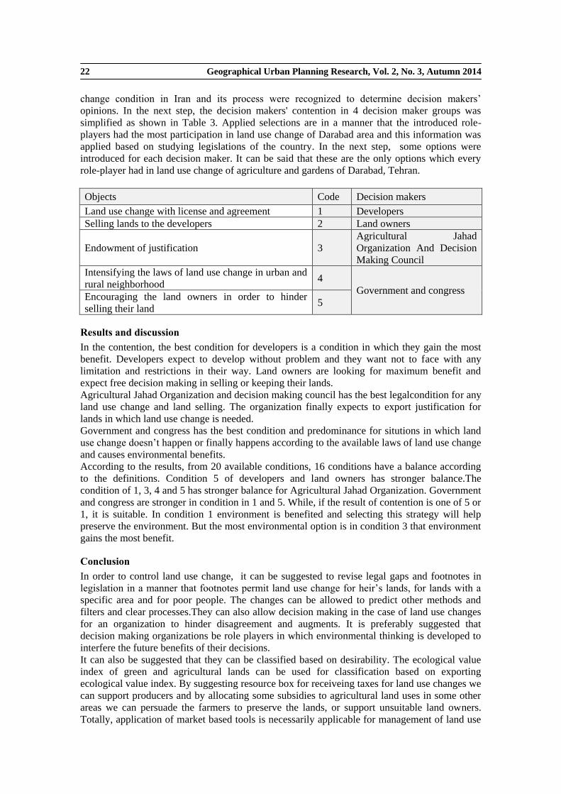
opinions. In the next step, the decision makers' contention in 4 decision maker groups was
simplified as shown in Table 3. Applied selections are in a manner that the introduced role-
players had the most participation in land use change of Darabad area and this information was
applied based on studying legislations of the country. In the next step, some options were
introduced for each decision maker. It can be said that these are the only options which every
role-player had in land use change of agriculture and gardens of Darabad, Tehran.
Decision makers Code Objects
Developers 1 Land use change with license and agreement
Land owners 2 Selling lands to the developers
Agricultural Jahad
Organization And Decision
Making Council 3 Endowment of justification
Government and congress 4
Intensifying the laws of land use change in urban and
rural neighborhood
5 Encouraging the land owners in order to hinder
selling their land
Results and discussion
In the contention, the best condition for developers is a condition in which they gain the most
benefit. Developers expect to develop without problem and they want not to face with any
limitation and restrictions in their way. Land owners are looking for maximum benefit and
expect free decision making in selling or keeping their lands.
Agricultural Jahad Organization and decision making council has the best legalcondition for any
land use change and land selling. The organization finally expects to export justification for
lands in which land use change is needed.
Government and congress has the best condition and predominance for situtions in which land
use change doesn’t happen or finally happens according to the available laws of land use change
and causes environmental benefits.
According to the results, from 20 available conditions, 16 conditions have a balance according
to the definitions. Condition 5 of developers and land owners has stronger balance.The
condition of 1, 3, 4 and 5 has stronger balance for Agricultural Jahad Organization. Government
and congress are stronger in condition in 1 and 5. While, if the result of contention is one of 5 or
1, it is suitable. In condition 1 environment is benefited and selecting this strategy will help
preserve the environment. But the most environmental option is in condition 3 that environment
gains the most benefit.
Conclusion
In order to control land use change, it can be suggested to revise legal gaps and footnotes in
legislation in a manner that footnotes permit land use change for heir’s lands, for lands with a
specific area and for poor people. The changes can be allowed to predict other methods and
filters and clear processes.They can also allow decision making in the case of land use changes
for an organization to hinder disagreement and augments. It is preferably suggested that
decision making organizations be role players in which environmental thinking is developed to
interfere the future benefits of their decisions.
It can also be suggested that they can be classified based on desirability. The ecological value
index of green and agricultural lands can be used for classification based on exporting
ecological value index. By suggesting resource box for receiveing taxes for land use changes we
can support producers and by allocating some subsidies to agricultural land uses in some other
areas we can persuade the farmers to preserve the lands, or support unsuitable land owners.
Totally, application of market based tools is necessarily applicable for management of land use
Geographical Urban Planning Research, Vol. 2, No. 3, Autumn 2014 23
change. By this strategythe land use change can be controlled according to the sustainability and
suitability conditions.
Keywords: Darabad, economy, game theory, land owners, land use change.
References
1. Abrishamchi, A.; Danesh-Yazdi, M.; Tajrishi, M.; (2011). Conflict resolution of water resources
allocation using game theoretic approach: the case of orumieh river basin in Iran. AWRA summer
specialty Conference, June 27 – 29.
2. Abdoli, GH; (2007). Game Theory and its Applications (static and dynamic games with perfect
information), SID Tehran University Press, Tehran.
3. Akbari, M.; (2010). described the neighborhood Dara bad region. Social deputy mayor of Tehran,
Institute of Literary Thought, Tehran.
4. Bahrain, H.; (1989). Tehran city and how it should be. Ecology 15, Ss83-97.
5. Bator, F. M.; (1958). the anatomy of market failure, Quarterly Journal of Economics 72(3): 351–
379.
6. Christopher, S.; Miller, Roberta Balastad; (1999). Monitoring the Urban Environment from Space,
Lamont Doherty Earth Observatory, Columbia University, Palisades, NY, USA.
7. Fang, L.; Hipel, K.; Kilgour, M.; (1993). Interactive Decision Making: The Graph Model for
Conflict Resolution, Wiley, New York.
8. Ganji, khalili; Davar, Mohammad Karamuz; (2007). Development of stochastic dynamic Nash
game model for reservoir operation. I. the symmetric stochastic model with perfect information.
Advances in water Resources 30 528-542.
9. Hipel, K.; Fang, L.; (2005). Multiple participant decision making in societal and technological
systems, In: Arai T, Yamamoto S, Makino K (Eds) Systems and human science-for safety, security,
and dependability: selected papers of the 1st international symposium. SSR2003. Osaka. Japan.
Elsevier, Amsterdam, the Netherlands. Chapter 1, PP: 3–31.
10. Inohara, Takehiro; Keith, w hipel; (2008). Coalition analysis in the graph model for conflict
resolution, systems engineering, 11 343-359.
11. Iran Newspaper, (2013). the land was developed, (Friendly city), No. 5382, pp. 17.
12. Kilgour d. m.; k. w. hipel; (2005). The graph model for conflict resolution: past, present, and future,
Group decision and negotiation, number 14 441-460.
13. Kilgur, DM.; KW. Hipel; (2005). the graph model for conflict resolution: past, present, and future,
group decision and negotiation, 441-460. 441-460.
14. Khatibi, N.; (2005). accelerated degradation of catchments in Tehran (Damavand area focusing on
Masha), Earth Watch Institute, http://www.earthwatchers.org/takhrib-3.html.
15. Madani, K.; Hipel, K.W.; (2011). Non-cooperative stability definitions for strategic analysis of
generic water resources conflicts, Water Resource Manage, 25: 1949–1977.
16. Madani, K.; (2010). Game theory and water resources, Journal of Hydrology, Vol. 381, No. 3-4, PP:
225-238.
17. Medema, S. G.; (2007). The Hesitant Hand: Mill, Sidgwick, and the evolution of the theory of
market Failure, History of Political Economy 39(3): 331-358.

Geographical Urban Planning Research, Vol. 2, No. 3, Autumn 2014 24
18. Malek Mohammadi, B.; Safaei, A.; (2012). Lake conflict analysis using game theory, Master's
thesis, Faculty of Environment, Tehran University.
19. Muhammad, A.; Rabiee, HR.; Ziaeian, P.; (2005). and land cover change detection and recovery of
the aid in remote sensing and GIS. Madras Journal of Science, No. 4, pp. 41-54.
20. Makhdoom, M.; (1991). assessment ecological potential area for urban development, rural
industrialization and tourism In Guilan and Mazandaran, ecology magazine, Issue 16, pp. 81-100.
21. Mashhadi, A.; (2008). Crime and gardens and agricultural land conversion policy instruments
criminal negligence involved. Persian date Azar 23. http://www.vekalat.org.
22. News ASR IRA, (2012). ceding Park Pardisan Rs 6,500 yards, 19 September,
http://aftabnews.ir/fa/news/170694.
23. Nazarian, A.; (1991). expand the Tehran city and the emergence of satellite towns, Geographical
Research Quarterly, No. 20, pp. 97-139.
24. Sotoudeh, M.; (1992). Historical Geography Shemiran, printing, Institute for Cultural Studies,
Tehran.
25. Sharieh, J. Bernard; (1994). the towns and villages, Cyrus Trjmh¬Y Inc., publishing and Nika,
Mashhad.
26. Shie, I.; (1998). Introduction to the Principles of Urban Planning, University of Science and
Technology, Tehran.
27. Malek Mohammadi, B.; Safaei, A.; (2014). game theory and guidelines for sustainable governance
of shared water resources (Case Conflict Blue Lake), Journal of Ecology, No. 1, pp: 121-138.
28. Vahedian, Bickei; L., Pour Ahmad; A., Seifuddini, F.; (1390). Effects of physical development on
the land area of Tehran 5, New approaches in human geography Journal, Vol. 4, No. 1, pp. 29-46.
29. Yousefi, S.; Hipel, K. W.; m. tarek hegazy; (2010). Considering attitudes in strategic negotiation
over brownfield disputes, journal of legal affairs and dispute resolution in engineering and
construction 240-247.
Geographical Urban Planning Research, Vol. 2, No. 3, Autumn 2014 25
Changes of Urban Hierarchical System in Lorestan Province from
1976 to 2012
Edris Babakhanzadeh1
, Eghbal Pahkideh2, Mohammad Raoof Heidari Far
3, Shoorsh Ahangari
4
1. MA Student in Geography and Urban Planning, University of Isfahan, Iran
2. Lecturer in Geography, University of Payame Noor, Iran
3. Assistant Prof. of Political Geography, Payame Noor University, Iran
4. PhD Candidate in Geography and Urban Planning, University of Kharazmi, Iran
Received: 06-02-2014 Accepted:19-11-2014
Expanded Abstract
Introduction
Urbanization expansion, population explosion and population movement have changed very
much the urban systems and urban patterns of Iran. Cities as major players of geographical
regions should maintain and accept substantial role in terms of establishment of regional
equilibrium and balance, because according to their size and functions they affect spatial and
regional balance. In the last 50 years, cities because of economic evolutions and political
interventions have been expanded more rapidly. It has been a reason that some big industrial
poles, networks of Colossal cities and megalopolises with particular spatial order in the national
and regional scales have been emerged into each otehr. One of the original characters of
urbanization in developing countries including Iran is inappropriate spatial distribution of cities
in the realm of these countries. In the countries, there is a metropolitan with several million
people as a chief that has developed more highly and develop its political, administrative and
socioeconomic influences throughout the country. Consequently, problems and issues will be
penetrated into an urban network system.
Methods
The methodology of this research is descriptive – analytic and data are gathered based on the
statistics obtained from five periods of census. The statistic population of the research is the
urban points of Lorestan Province and the used models are Rank – Sized model, Anthropic
Coefficient, Class Difference Limit, and City Primacy Indices. At the end, the suggestions
suitable for urban system of lorestan province are presented.
Results and discussion
The aim of this research is to investigate the urban system of Lorestan Province from 1976 to
2012. The research findings indicate that based on the Rank- Size model there has been balance
in the urban hierarchical system of the Province from 1986 to 1996, but in 2006 this balance has
been a bit disordered. The numbers obtained from Anthropic Coefficient also shows that the
urban centralization of the Province has been decreased during this period. The City Primacy
Index used in this research, on the other hand, shows that there exists no City Primacy in the
Corresponding Author: [email protected]
Geographical Urban Planning Research, Vol. 2, No. 3, Autumn 2014 26
Province; instead, the mediated cities are in great importance in this relevance. An increase in
the numbers of cities in the province might have undermined the spatial balance so that it is the
most important reason for the converting of big villages into city in Iran for this period. Most of
cities which add to the urban system of the province in the periods have populations less than 5
thousand people.
Conclusion
The numbers and data found from the indicators used in City Primacy Index in the province
articulate that there is no more evidence from the Index in the province or the prediction ability
is very weak. However, lokking at the statistics and numbers of tables and figures, the inevitable
and definite role of mediated cities of the Lorstan Province can better be comprehended in
distribution of population and facilities throughout the country. Data and information obtained
from the research obtained from various indicators and indices represent that urban hierarchy
between the years 1986-1996 in this county in contrast with other regions has been more
systematically located while in most of the other provinces such as Tehran, Mashhad, Tabriz,
Kermanshah and etc. In the mentioned provinces there are great distances between City Primacy
Index and second city. With the distance between the primary capital city and the subordinate
cities are too high and this cause the emergence and exist of City Primacy Index in these
provinces in all times. The expansion in the numbers of cities in Lorstan province is growing the
increasing distance and distribution of urban population. Thus, Lorestan like other provinces is
going towards City Primacy Index. Nevertheless, the situation of the province in opposite to
other provinces of Iran show that the distribution of population become more equal and
balanced while City Primacy Index has been one of the clear features.
Keywords: Anthropic Coefficient, City Primacy Index, Lorestan Province, urban hierarchical
system, urban network.
References
1. Amanpour, S.; Naghdi Pourbirgani, M.; B. Habibian; (2011). The Study of The Position Masjed
Soliman City in Urban Hierarchical Systems of Khuzestan Province, The Journal of Regional
Planning, year 1, No. 4, pp 81-92.
2. Amar, T.; (2007). Population and Urbanization in Gillan Province: A Geographic Study, The
Journal of Geographic Landscape, year 2, No 5, pp 5-22.
3. Banifatimah, H.; (2002). Adapting Case Study in Urbanization for North and South of Iran, The
Journal of Human and Literature Faculty (Tabriz University), No. 45, pp1-27.
4. Ebrahimzadeh, E.; Negahban Marvei, M.; (2012). An Analyze for Urbanization and New Cities
Situation in Iran, The Journal of Geographic Research, No. 75, pp 152-172.
5. Farhoodi, R. A.; Zangenei Shahraki, S.; Mocheshi, R. Saed; (2009). The Study of Spatial
Distribution of Population in Iranian Urban System between 1956 to 2006, Human Geography
Research, No. 68, pp 55-68.
6. Garakhloo, M.; Omranzadeh, B.; Saraskanrood, M. A.; (2008). Territorial Mangement and Urban
Network Anlyze in the Ardebil Province from 1966 to 2006, The Journal of Applied Geographical
Research Sciences, 8Periods, No. 11, pp 73-97.
7. Hekmatnia, H.; Mosavi, M .N.; (2006). Applying of Model in Geography with emphasis on
Regional and Urban Planning, New Science(Elme Novin) Press, First Edition, Yazd.
Geographical Urban Planning Research, Vol. 2, No. 3, Autumn 2014 27
8. Lotfi, S.; Babakhanzadeh, E.; (2012). The Study of Urban Hierarchy and City Primacy Index in
Kermanshah Province from 1956 to 2006, The Journal of Spatial Planning, year 2, No. 3, pp 51-74.
9. Lotfi, S.; Irandost, K.; Babakhanzadeh, E.; (20130). The Study of City Primacy Index and Urban
System Evolution in Zagros Region (1956-2006), Geographical Planning of Space Quarterly
Journal, year 3, No. 8, pp 23-45.
10. Nastarn, M.; Abolhasani, F.; Eizadi, M.; (2010). The Analyze of Urban Hierarchy among Cities
with more than hundred Thousand People of Iran, Quarterly Geographical Journal of Environmental
Based Territorial planning, No. 11, pp 157-174.
11. Public Census of People and Households, 1956, 1966, 1976, 1986, 1996, 2006.
12. Potter, Robert B.; Dr Sally, Lloyd-Evans; (1998). The city in the Developing World, Routledge,
Translated to Persian by Irandost, K and Others, (2005). The Publications of Iranian Organization of
Municipalities and Village managing.
13. Rahnamaee, M. T.; Farhoodi, R.A.; Ziae Tavana, M. H.; Khamr, G. A.; (2011). The Analyzing of
City Primacy Index in The regional (Zabol) and Province (Sistan and Baluchistan) level, The
Journal Of Geography (Iranian Geographic Association), No. 28, pp 11-81.
14. Rezaee, M.; Taghvaei, M.; (2010). A Geographical Study on the Urban Network of Ilam Province
with Emphasis on the Small Town Role, The Journal of Geography and Planning (Tabriz
University), year 15, No. 32, pp 65-93.
15. Saraghi, E.; Abolfathi, D.; Maleki, H.; (2009). Globalization and its Affect on Urbanization among
Cities of Developing Countries (Case Study: Tehran Metropolitan), The Journal of Applied
Research of Geographical Sciences, Period 10, No. 13, pp 139-172.
16. Shahterian, M.; Ashnoee, A.; Zaree Farshad, H.; (2011). The Analyze and Comparing about the
Destitutions of Cities Measurement in Iranian Urban System and Neighboring Countries, Human
Geography Research, No. 87, pp 85-99.
17. Tagvaei, M.; Saberi, H.; (2010). The Study of Iranian Urban Systems between 1956-2006, the
Journal of regional and Urban research, year 2, No. 5, pp. 55-76.
18. Tagvaei, M.; Mosavi, M. N.; (2011). A Critical Study of Indicators for Defining of City Primacy
Index and New Indicators Invention, The Journal of Geography and Environmental Study, First
Period, No. 1, pp 25-34.
19. Talishi, M.; Aliakbari, E.; Panahi Jolodarlo, G.; (2012). The Changes in Urban Hierarchical
Systems of Ardebil Province in the Periods between 1986-2006, The Journal Of Geography (Iranian
Geographic Association), New Era, year 10, No. 32, pp 75-100.
20. Tavakolinia, J.; Shali, M.; (2011). Urban Systems of East Azerbaijan Province, The Journal Of
Geography (Iranian Geographic Association), New Era, year 9, No. 29, pp 129-147.
21. The Web Site of Statistical Center of Iran: www.sci.org.ir.
22. Ziaree, K. A.; Mosavi, M. N.; (2005). The Study of Urban Hierarchical System in West Azerbaijan,
The Journal of Humanity (Isfahan University), 18 Periods, No. 1, pp 163-173.
Related Documents


