Adjusting to Floods on the Brahmaputra Plains, Assam, India

Welcome message from author
This document is posted to help you gain knowledge. Please leave a comment to let me know what you think about it! Share it to your friends and learn new things together.
Transcript

Adjusting to Floods on the Brahmaputra Plains, Assam, India

Executive summary
The central objective of the research project ‘Documenting and Assessing Adaptation Strategies to Too Much, Too Little Water’ is to document adaptation strategies at local or community level to constraints and hazards related to water and induced by climate change in the Himalayan region, including how people are affected by water stress and hazards, their local short and long-term responses, and the extent to which these strategies reduce vulnerability to water stress and hazards. Five case studies were carried out in four countries. The results of each have been summarised in separate documents on a CD-ROM to accompany a single synthesis document.
The Assam case study presented here documents and assesses the local and /or traditional practices of communities which have evolved from their culture, customs, beliefs, indigenous knowledge systems (IKS) and skills that have enabled them to survive water stresses and cope with hazards and disasters over the long term in the fl ood plains of the Brahmaputra basin of eastern Assam, India. The research was carried out at two sites: viz, the areas of Majgaon (one village: Majgaon) and Matmora (four villages: Tinigharia, Khamon Birina, Opar Khamon, Bahpora No.1) through participatory action research (PRA) complemented by secondary data in some cases. The fi ve villages are in the Dhemaji and Lakhimpur districts of Assam, respectively. The study sites were selected on the basis of their long history of water-induced stresses and the vulnerability and adaptability of the communities to water-induced hazards such as fl oods, fl ash fl oods, river bank erosion, and land degradation caused by sand deposition.
The study sites are inhabited by three prominent indigenous communities – the ‘Mishing’ (Matmora area), the ‘Ahom’, and the ‘Chutiya’ (Majgaon) – and several Assamese caste groups such as Brahmins, ‘Koibartta’ (Matmora area), and a Bihari community (Majgaon). Floods, fl ash fl oods, and sand casting are the most serious water-induced stresses in the eastern Brahmaputra basin in Assam where the study sites are located. The study villages have many things in common in terms of the nature of water-induced problems, a fl ood history tracing back to the 1950 earthquake, impacts of fl oods, community adaptations, and ways of living and coping with stress. There are also signifi cant differences in degrees and types of vulnerabilities as well as in coping and adaptation strategies, depending on the culture, traditions, indigenous knowledge systems, physical location, intensity of fl ooding, and extent of outside intervention.
The Mishing community builds thatched, stilt houses and granaries on stilts, while others build houses with high plinths but build granaries on stilts. People store food and save money for bad times and try to keep themselves informed about fl ood situations and warnings as preparatory measures, sometimes using their folk beliefs and observational experiences. They take shelter on high platforms close by or on the road or on embankments with their cattle if they are in danger of being displaced and have to move houses or villages. Transportation during fl oods is usually on rafts made from the wood of the banana tree and they help each other in rescue and evacuation operations. Most of the villagers are skilled swimmers and know how to use boats and rafts. They try various methods of cultivating paddy of different varieties whenever there is a slight respite from fl oods. Some of them have grown alternative crops and vegetables with consistent efforts but on a subsistence scale. Other villagers have engaged in alternative livelihoods, such as daily-wage labour, fi shing, selling dry fi sh and country liquor (sometimes against cultural taboos), and providing menial labour for government projects, whereas others have migrated to get work. Their adaptive capacities need to be augmented by well-designed interventions aimed at making people more proactive and communities self sustained so that they are ready to face future hazards.

Adjusting to Floods on the Brahmaputra Plains, Assam, India
1
Contents
Introduction 1
Research approach and methods 2
Impacts of water stress and hazards on livelihoods 9
Responses to water stress and hazards 24
Enabling and constraining factors 39
Conclusions and way forward 44
Bibliography 48
Acronyms and abbreviations 50
Local terms 51
Annex 53
Introduction
Floods, fl ash fl oods, river-bank erosion, and sand casting (deposition of large amounts of sand by fl ood water) are the most frequent water- induced hazards in the eastern Brahmaputra basin in Assam. Located in the north-eastern region of India in the eastern Himalayas (Das 2009), fl oods affect this part of Assam every year; fl ash fl oods are also a normal component of the fl ood regime. Sand casting, although not a new phenomenon, has become increasingly devastating since the mid 1990s, especially on the northern banks of the eastern Brahmaputra valley. All of these hazards affect all aspects of the land, lives, and livelihoods of communities living in the region to a signifi cant degree. Both fl oods and fl ash fl oods leave people homeless and displaced, destroy crops, damage public property, and damage development infrastructure. Victims who become destitute suffer from trauma and shock. Moreover, annual cycles of hazards cripple people’s resilience and intensify the poverty spiral. Thousands of hectares of fertile land in hundreds of villages with crops, settlements, and infrastructure have been lost to the river due to frequent shifting in the river course and erosion of river banks. Sand casting has proved to be one of the worst hazards because it results in degradation of thousands of acres of farm land and wetlands due to deposition of debris, mainly coarse sand particles, by fl ood waters. The indigenous communities living in these areas have developed mechanisms over time that have become ingrained in their lifestyles and traditions – for example, housing, agriculture, livestock rearing, food storage, and weather and fl ood predictions – and these help them to cope with and adapt to the immediate and long-term impacts of such hazards.
Climate change is considered a major driving force, triggering alterations in the regional and local weather and climate systems all over the globe. These changes have, in turn, affected the socioeconomic, cultural, and political spheres of human societies (IPCC 2007). The impacts of climate change on the Himalayan region are rising temperatures, recession of glaciers, extreme rain events, increased incidences of landslides and cloudbursts, and fl ash fl oods triggered by landslides which affect the hydrological regimes of large rivers like the Brahmaputra that sustain millions of people, scores of ethnic cultures, and diverse ecosystems in the eastern Himalayan region (Singh and Bengtsson 2005; Bajracharya et al. 2007).
Adjusting to Floods on the Brahmaputra Plains, Assam, IndiaPartha Das, Dadul Chutiya, and Nirupam Hazarika, Aaranyak, Guwahati, Assam

Adjusting to Floods on the Brahmaputra Plains, Assam, India
2
So far as climate change in northeast India is concerned, climate scientists have observed rising temperatures in the region as a whole and decreasing rainfall in the eastern and southern areas (Das 2004, Mirza et al.1998). They also refer to recent drought-like situations in the years 2001, 2005, 2006, 2008, and 2009 as indicators of climate change in the region (IPCC 2007). Anecdotal references and grey literature recount other symptoms, such as increasing spells of intense rainfall in the pre-monsoon and monsoon seasons in some places, as well as lack of rainfall in post-monsoon and winter seasons in others, both affecting agriculture adversely (ICIMOD 2008). Both extreme rainfall episodes and rates of soil erosion are believed to have increased in upstream areas (Tibet in China and Arunachal Pradesh in India) of the Brahmaputra basin. There are increasing reports of fl oods caused by damming of landslides in the foothills of the Arunachal Himalayas. As a result fl ash fl oods have increased in the hills affecting vast areas of the fl ood plains. The intensity, frequency, and duration of riverine fl oods have also changed. Sediment load in the rivers has increased due to denudation by intense rainfall of fragile and tectonically dynamic hill slopes, scaling up the affects of sand casting.
The result of all this is that traditional coping and adaptation practices of riparian communities living in these areas, practices that had developed in response to normal climatic variations so far, have been rendered less effective against the increasing scale and intensity of the changing hazards. Consequently, communities are experiencing a phase of transition in their traditional coping strategies, adaptation, knowledge, and practices. Moreover, rapid changes occurring in traditional societies in the last two decades, especially in the economy, livelihoods, culture, and education, accruing from state-driven development programmes (or lack of the same) and forces of globalisation, have also played an important role in determining how people are now responding to water-induced stresses in contrast to responses in the past.
In terms of socioeconomics, these fl ood-prone areas of Lakhimpur and Dhemaji are remote and underdeveloped. Traditional coping and adaptation mechanisms against natural disasters are crucial for the survival and development of marginalised communities, especially when existing disaster management and development programmes fail to protect them against recurring fl oods and increasing poverty. Collapse of the indigenous adaptation practices or changes therein need to be taken seriously by researchers and planners. It is important to study how people have been living with fl oods in such fl ood-prone areas and document their specifi c coping and adaptation strategies, both traditional and contemporary, in the light of the history of the land and the community as well as in the context of the prevailing sociopolitical scenario. It is also pertinent to examine whether the traditional coping capacities and adaptation strategies are still useful in dealing with the changing nature of the multiple water-induced disasters as well as the social, economic, cultural, and political changes affecting the society as a whole.
The current study, carried out in fi ve villages in two districts of eastern Assam – viz, Lakhimpur and Dhemaji – is an attempt to understand how ethnic communities in remote and isolated pockets prone to high fl ood risks have lived with and adapted to fl oods and associated water-induced hazards; whether they will be able to cope with the same disasters in future; and what can be done to strengthen their relevant coping strategies and adaptation capacities for the present and the future. Thematically, the subject of this study is similar to other case studies carried out in other countries for communities living in similar conditions; e.g., in the char lands of Bangladesh (Haque 1988; Zaman 1989,1991, 1993; Chowdhury 2001). This study was carried out by Aaranyak, an environmental research organisation in north-east India based in Guwahati, Assam, for the International Centre for Integrated Mountain Development (ICIMOD), as part of a regional project on ‘Assessing Local Adaptation Strategies to Too Much, Too Little Water’.
Research approach and methods
Profi le of the fi eld team
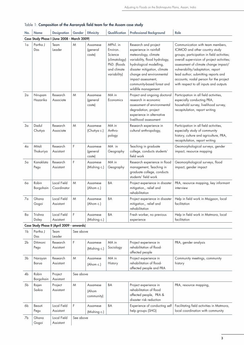
The fi eld team in the fi rst phase (June 2008-March 2009) consisted of eight core members – the team leader, two research associates, two research assistants, one local fi eld coordinator, and two local fi eld assistants. In the second phase of the project (April-September, 2009) the team was reconstituted with two research assistants, two project assistants, and two fi eld assistants (Table 1).
Concepts and assumptions
The fi eld team tried to arrive at an understanding of the basic underlying concepts of vulnerability, risk, and adaptation in an empirical sense in terms of real-life experience and usage of these terms by a villager without following the formal textual defi nitions of the same.
Adjusting to Floods on the Brahmaputra Plains, Assam, India
3
Table 1: Composition of the Aaranyak fi eld team for the Assam case study
No. Name Designation Gender Ethnicity Qualifi cation Professional Background Role
Case Study Phase I (June 2008 - March 2009)
1a Partha J Das
Team Leader
M Assamese (general caste)
MPhil. in Environ.Science (climatology) PhD. (fl oods and climate variability)
Research and project experience in rainfall meteorology, climate variability, fl ood hydrology, hydrological modelling, disaster mitigation, climate change and environmental impact assessment, community-based forest and wildlife management
Communication with team members, ICIMOD and other country study groups; participation in fi eld activities; overall supervision of project activities; assessment of climate change impact/ vulnerability/adaptation; report lead author; submitting reports and accounts; nodal person for the project with respect to all inputs and outputs
2a Nirupam Hazarika
Research Associate
M Assamese(general caste)
MA in Economics
Project and ongoing doctoral research in economic assessment of environmental degradation, project experience in alternative livelihood assessment
Participation in all fi eld activities, especially conducting PRA, household survey, livelihood survey, recapitulation, report writing
3a Dadul Chutiya
Research Associate
M Assamese(Chutiya c.)
MA in Anthro-pology
Research experience in cultural anthropology,
Participation in all fi eld activities, especially study of community history, culture and agriculture, PRA, recapitulation, report writing
4a Mitali Thakuriya
Research Assistant
F Assamese(general caste)
MA in Geography
Teaching in graduate college, conducts students’ fi eld work
Geomorphological surveys, gender impact, resource mapping
5a Kanaklata Pegu
Research Assistant
F Assamese (Mishing c.)
MA in Geography
Research experience in fl ood management, Teaching in graduate college, conducts students’ fi eld work
Geomorphological surveys, fl ood impact, gender impact
6a Robin Borgohain
Local Field Coordinator
M Assamese (Ahom c.)
BA Project experience in disaster mitigation,, relief and rehabilitation
PRA, resource mapping, key informant interview
7a Ghana Gogoi
Local Field Assistant
M Assamese(Ahom c.)
BA Project experience in disaster mitigation,, relief and rehabilitation
Help in fi eld work in Majgaon, local facilitation
8a Trishna Doley
Local Field Assistant
F Assamese (Mishing c.)
BA Fresh worker, no previous experience
Help in fi eld work in Matmora, local facilitation
Case Study Phase II (April 2009 - onwards)
1b Partha J Das
Team Leader
See above
2b Ditimoni Pegu
Research Assistant
F Assamese
(Mishing c.)
MA in Sociology
Project experience in rehabilitation of fl ood- affected people
PRA, gender analysis
3b Narayan Barua
Research Assistant
M Assamese
(Ahom c.)
MA in History
Project experience in rehabilitation of fl ood- affected people and PRA
Community meetings, community history
4b Robin Borgohain
Project Assistant
See above
5b Rajen Saikia
Project Assistant
M Assamese
(Ahom community)
BA Project experience in rehabilitation of fl ood affected people, PRA & disaster risk reduction
PRA, resource mapping,
6b Beauti Pegu
Local Field Assistant
F Assamese
(Mishing c.)
BA Experience of conducting self help groups (SHG)
Facilitating fi eld activities in Matmora, local coordination with community
7b Ghana Gogoi
Local Field Assistant
See above
Adjusting to Floods on the Brahmaputra Plains, Assam, India
4
Vulnerability is the quality or situation of a community making it likely to be affected by a hazard. The vulnerability of a community to water-induced hazards, such as fl oods, is determined by a range of factors such as location (living on fl ood plains, proximity to rivers, or proximity to development and welfare infrastructure); physiography and hydrogeomorphology (altitude, slope, proximity to hills or foothills, state of rivers, and water and sediment yield); structural interventions (embankments, spurs, or dams); climate variability (rainfall extremes); fl ood management practices (fl ood forecasting, early warning, and state of the watershed ); economic conditions of exposed communities (purchasing capacity, savings, local infl ation, and supply chain of essential commodities); social conditions (literacy, social security, and ethnic diversity); traditional knowledge (medicine and healing practices, housing types, food storage, and agricultural practices); general awareness about problems and solutions (contemporary fl ood management practices elsewhere); and other survival skills (managing a boat or being able to swim).
Risk means the chance of being affected by a natural hazard when a villager, a rural household, or the village as a whole are vulnerable and cannot offset the likely impact with their own capacity and resources.
Adaptation is a set of actions resorted to over the long term to reduce the adverse impacts of fl oods on people’s lives. Some of these practices have become part of the lifestyle or culture when the benefi ts accrued have become time-tested. Adaptation practices evolve or are acquired over a long time span and these are effective as short-term and long-term measures of response to impacts of fl oods.
Coping is a way of responding immediately to a hazard in order to reduce the intensity of its impact on a short time scale. Coping can mean the adoption of ad hoc and short-term measures by villagers to save their lives or property instantaneously when they are hit by the fi rst wave of fl ooding. Coping also includes intermittent measures that are not regularly or uniformly practised but which are effective in reducing vulnerability or enhancing resilience to various degrees.
The study commenced with several hypothesises which were based on a general conceptual understanding of the theoretical foundation and the objectives of the project. This understanding was aided by the familiarity of the project team with the project sites, their communities, and their water-related issues. These assumptions are that:
i. climate change is accentuating fl oods and other water-induced hazards in the Brahmaputra Basin located in the Himalayas;
ii. people have been responding effectively to impacts of fl oods in many different ways, knowingly or unknowingly and in a planned or unplanned manner, by using traditional knowledge, practices, and skills;
iii. it is possible to have a good understanding of impacts of hazards and coping and adaptation of communities by observing the nuances of their individual, family, and community lives and by interacting with them continuously in a designed and organised manner;
iv. people adapt differently to the impacts of different water-induced hazards in different situations depending on their location, environment (topography, ecosystems, or climate), economy, culture, religion, age, gender, status of development, governance (or lack of it), education, and political awareness;
v. the poor are more vulnerable to water-induced stresses than the rich; and
vii. traditional coping and adaptation are losing their effectiveness against the changing nature of hazards and the fl uid social dynamics of indigenous societies.
General step-by-step approach
The activities starting with the orientation workshop to the formulation of the fi nal report are presented in chronological order in the Annex (Table A1)
Study site selection
It was the opinion of the project team that a suitable site for this project was ideally one with a long history of fl oods and associated hazards going back at least thirty years and inhabited preferably by one or more indigenous communities or a mixture of different communities which have learned to live with fl oods over a long period of time. It was also thought preferable that populations should not have been too exposed to research and intervention so that the communities concerned had not developed research fatigue and would be friendly and cooperative.

Adjusting to Floods on the Brahmaputra Plains, Assam, India
5
Eight different sites were considered from the districts of Lakhimpur, Dhemaji and Jorhat (mainly on the Majuli river island in Jorhat) according to the criteria of suitability. Considerations were based on the team’s prior familiarity and knowledge of these sites. Rapid rural appraisals (RRA) were carried out with the cooperation of the communities during brief two-day visits. Finally two sites were selected for the study: Majgaon village in the Bordoloni Development Block of Dhemaji District and the other was a cluster of four villages in the Matmora area in the Dhokuakhona Sub-Division of Lakhimpur District. Majgaon was selected because it represents an area chronically affected by fl oods where people have struggled to live with fl oods for more than fi fty years against all odds. The village is located between two rivers – the Na-Nadi and the Jiyadhal (also known as the Kumatiya) – both being fl ashy rivers with a long history of fl ooding and consequent devastation (Hazarika 2003).
Flooding is usually caused by heavy rain in the hills upstream from Arunachal Pradesh in the north and is often intensifi ed by breaching of embankments along these rivers. Because of this direct causal relationship between rainfall and fl oods, any change in the rainfall regime as a result of climate variability is refl ected in the fl ood patterns. This provides researchers with an opportunity to study water hazards caused by climate change. The embankment on the River Jiyadhal has protected people from fl oods for more than thirty years, but breaching of the embankment has caused devastating fl oods from time to time. The other river, i.e., the Na-Nadi is an unmanaged river and has no embankment near the study site: thus Majgaon presented us with an opportunity to study how people deal with situations arising out of having or not having an embankment.
The Matmora area is located on the bank of the Brahmaputra River in the eastern part of Dhokuakhona Development Block. The area has a long history of multiple, water-induced hazards, mainly fl oods, fl ash fl oods, bank erosion, and breaching of the embankment; and the consequent impacts have increased in the last decade to a great extent. Most of the fertile farm lands have become unfi t for agriculture because of successive fl oods in 2007 and 2008 and the depositions of sand carried from the river by the fl ood waters. The fl oods of 2007 and 2008 caused the collapse of the Sissi-Tekeliphuta embankment (also known as the Matmora embankment); and affl icted unprecedented damage on the land, houses, economy, livelihoods, and the social fabric of more than 25 villages in the area. The River Brahmaputra is of glacial origin and there is a signifi cant input of snowmelt to its runoff, therefore the Brahmaputra basin is highly prone to climate change impacts (ICIMOD 2008).
Matmora represented a case of people who have suffered from and survived water-induced hazards over long periods; and for whom the impacts have increased in the last two decades. Moreover, villages with tribal (Mishing) communities and non-tribal (general caste groups) people are contiguous in Matmora, providing the team with an opportunity to compare different aspects of vulnerability, risk, and adaptation between the Mishing community (known as the best-adapted community in fl ood-prone areas of Assam) and non-Mishing communities. It also gave us an opportunity to study the extent to which cultural norms and traditions make people vulnerable or resilient. Therefore, a cluster of four villages, all located adjacent to each other, were selected in Matmora. The selected villages are: Bahpora No 1 (referred to as Bahpora in this report), Opar Khamon, Khamon Birina, and Tinigharia (a village spread on and around the embankment). The embankment plays an important role in both controlling and causing fl oods and infl uences people’s decisions about where to settle with respect to the embankment. Therefore, Matmora also provided an opportunity to study how people’s vulnerability and adaptation are infl uenced by development infrastructure like the embankment.
The people of Matmora have been trying to cope with the affects of sand casting since 2007 because this is the fi rst time they have faced this problem on such a scale. Effective adaptation practices are yet to be developed at the community level with respect to sand casting. Catastrophic fl oods have occurred, such as those in 1998 and 2007, in Majgaon and the fl oods in 1998 and 2008 in Matmora. Usually the traditional coping and adaptation strategies are not enough to deal with these big fl oods.
Field work and data collection
The fi eld work began in August 2008 and the month of August was spent looking for suitable project sites and carrying out RRA. Actual fi eld research in the two project sites took place between September 2008 and February 2009 over a six-month period for approximately 80 days in the fi rst phase. In the second phase, fi eld work was carried out between April and June 2009 for about 40 days before submitting the second draft report. An additional 10 days was spent in the fi eld in the month of July to improve the quality of the report. A fi nal round of fi eld work took place during August and September 2009 for about 10 days. The fi eld work was carried out, but not without challenges and constraints. One constraint was the arrangement of lodging for women researchers in and around the fi eld sites. In Majgaon, where no

arrangements could be made, women researchers were lodged in Bahaktika a neighbouring village: in Matmora: one female researcher stayed with her relatives near Dhokuakhona, the nearest township.
Both primary and secondary data were collected during the study. Secondary data collected at the village and block level concerned the physiographical, environmental, socioeconomic, and vulnerability profi les of the sites and surrounding areas. A large amount of secondary information and data was collated through review and analysis of the available literature. The literature review looked at two specifi c considerations: the geographical area of interest and the theme of the study. Information on the project areas was related
mainly to the weather and climate regime, fl ood history, community history, disaster management, economic and human development, and society and culture. Information on specifi c themes was collected from all relevant sources and cases without being geographically confi ned to the project areas; and these cover aspects such as vulnerability to fl oods, adaptation practices of indigenous people living in similar riparian situations, and the infl uence of culture on vulnerability and adaptation. Grey literature, such as newspaper reports and articles, articles published in local magazines, and souvenir publications written in local languages, was an important source of information. Newspaper reports from local correspondents captured the local issues very well, whereas articles in local magazines provided a good overview of the history, geography, and ethnic culture of the project areas. Grey literature is usually not considered to provide authentic reference sources in scientifi c research, and doubtful information needs to be validated with standard sources if available.
Primary data were collected at community, focused group, household, and, sometimes, at individual level. Different methods and tools of participatory rural appraisal (PRA) were used to collect the primary data such as stakeholder analysis, focus group discussions, resource mapping, transect walks, key informant interviews (open ended), semi-structured interviews (household survey with a semi-structured questionnaire), Venn diagrams, historical time lines, trend analyses, crop calendars, and informal chats (Figures 1, 2, and 3). The type of information collected through PRA includes history of the settlements and water-induced disasters, general geography and environment, changes in landscape over time, livelihood (occupational) patterns, gender vulnerability, and coping and adaptation practices. Table 2 shows the details of the types of information collected using different methodologies. The details of the PRA exercises in terms of the people involved in the study disaggregated into community and gender representation, and the monthly time table are provided in the Annex (Tables A2, A3).
PRA methodology is an effective way of collecting information at group level and facilitates direct and intimate interactions between the researcher(s) and the subject(s) in rural areas; and hence it was used as the principal method of investigation (Negi 2001). Household surveys were carried out in 50 households in both project sites using semi-structured questionnaires.
Figure 1: Transect walk in Majgaon and Dhemaji in the direction of the Na-Nadi accompanied by a group of youths from the village
Figure 2: Focus group discussion with women in Majgaon
Figure 3: Walk and focus group in Matmora, August 2008: the fi eld team takes stock of the fl ood situation and its impact on the people of Matmora during the fl oods of 2008
6

Adjusting to Floods on the Brahmaputra Plains, Assam, India
7
Table 2: Details of data collection
General context or approach used for data collection
Data and info collected (qualitative & quantitative)
Level of data collection (e.g., household, community, district, etc.)
Methods used for data collection (e.g., transect walk, semi-structured interviews with …, visual records, etc.)
Environmental context Land use or land cover (LU/LC) change, biodiversity, natural resources , degradation of land, land restoration, creation and aggradation of wetland, soil productivity
Household and community level
Semi-structured interviews with elders, resource mapping, transect walk, focus group, historical timeline, trend analysis, geospatial analysis (remote sensing)
Climate and hazard context
Trends in rainfall, temperature, fl ood history, fl ooding characteristics, fl ash fl ood, sand casting, fl ood damage, droughts
Gauging station, river basin, village, north-east India
Analysis of secondary data, information from literature, key informant interview, focus group, historical timeline, trend analysis
Economic context Household income, poverty indicators, BPL families, price fl uctuation, SHG, micro-fi nance, access to credit
Individual, household, community, SHG
Key information interview (Panchayat members) semi structured questionnaire, community meetings, focus group of SHG
Political context PRI, opinion on governance, support for political parties, benefi t to supporters, voting in election, articulation of grievances or demands, protest campaign or movement
Individual, household and community
Semi structured questionnaire, community meetings, focus group, informal discussion or chat
Sociocultural context Indigenous knowledge systems (IKS), cultural traits (customs, beliefs, norms), religion (sect, animism), housing type, survival skills, water and land related confl icts, power relationship, food and seed storage
Household and community level
Semi structured interview,
focus group, community meetings
Demographic context Population, density, sex ratio, literacy, migration (in and out), rehabilitation, village area
Village, panchayat, block, district
Analysis of secondary data, household survey, community meetings, focus group
Livelihood context Existing livelihood types, preferred livelihoods, diversifi cation of livelihoods , economic and cultural constraints, impact on natural resources, food security
Individual, household, community
Semi structured interview, focus group
Health and nutrition context
Water borne diseases, drinking water source and quality, sanitation, traditional healing system, access to health care
Household and community level
Semi-structured questionnaire, focus group
Gender context Relative role of women and men in normal and fl ood time in farming, family maintenance, income generation, water management; sanitation and pregnancy during fl oods
Household and community
Semi structured interview, focus group
Agricultural context Crop variety, cropping method, crop calendar, winter crops, innovative cropping practices, water harvesting or irrigation, crop marketing
Household and community
Semi structured interview, focus group
External intervention context
Agencies (GO/NGO), benefi ts, effi cacy, dependence, attitude,
Individual and community, external agency
Key informant interviews, community meetings
Note: PRI: panchayati raj institution; GO: government organisation; NGO: non-government organisation; GIS: geographical information system; GPS: global positioning system techniques; IKS: indigenous knowledge system; LU/LC: land use/land cover; SHG: self help group

Adjusting to Floods on the Brahmaputra Plains, Assam, India
8
The head of the family and the women were interviewed following a set of lead questions. Questions were aimed at validating existing information or getting more detailed information on particular issues, e.g., gender impact and role, family economy and assets, and religious affi liation. Although rapid rural appraisal (RRA) was useful for identifying and carrying out a quick reconnaissance of different sites in the fi rst stage, PRA techniques were useful for delving into specifi cs of different aspects of community life, and this method secured fi rst-hand information about sources of vulnerability and examples of coping and adaptation in the community. The important PRA exercises and proceedings were recorded on audio and video, besides making fi eld notes. Recapitulation of the audio-visual recordings and the fi eld notes was useful for drafting minutes, analysing the data, and preparing daily and weekly fi eld reports organised into thematic sections.
Data verifi cation and analysis
Secondary data collected from research reports, theses, research papers, government reports, and other documents were analysed, interpreted, and, in some instances, cross-checked with expert opinion and also with the communities at large. For example, secondary data on rainfall trends, river fl ood levels and fl ood fl ows (discharge), and fl ood damage (to households, cattle, and crops) were verifi ed with expert and community opinions. On the other hand primary information collected directly from the community on anomalies of weather and climate, fl ood history, fl ood damage, fl ood relief and rehabilitation, embankments, and development infrastructure were compared with information from secondary sources and inputs from government offi cials. Similarly, to resolve issues arising from confl icting information within the community, opinions of relevant experts and offi cials were sought. For example, information from the community about the embankment on the Brahmaputra River at Matmora obtained through focus group discussion and social mapping was confl icting and confusing. The Department of Water Resources was approached for validation and correction. Information about cultural features of the Mishing community was cross-validated and corrected with the help of a folklore expert, anthropologists, and scholars from the Mishing community because the team believed that the opinions of external experts were more in tune with the overall situation of the Mishing society and also explained other information coming from the same community. In both cases some of the information and data were vindicated whereas some remained unverifi ed. The unverifi ed information obtained from meetings and discussions was later checked during the household surveys using semi-structured questionnaires. To identify unconfi rmed and dubious information and observations, the team mainly re-applied PRA tools with different groups and individuals and sometimes with mixed focus groups. For example, information on relative gender roles in agriculture and household responsibilities in fl ood and non-fl ood periods was derived originally from focus groups of men and women separately. Confl icting opinions coming out of this process were later validated by interacting with a mixed focus group of men and women during which exaggerations from both groups were neutralised by counter points of view. Information still found to be doubtful and unverifi ed was not included in the report. Some of the dubious information that came from particular individuals or focus groups was cross-validated with other individuals and focus groups from the same village at a later date. Sometimes the same individuals and focus groups were approached with the same questions to affi rm their earlier opinions. On occasions they would negate information that they had given earlier and would come to a unanimous opinion about confl icting information. Moreover, the team members also used to brainstorm amongst themselves about the moot information and tried to settle matters using their own judgement. Often it would require going back to the village to get reassurance about information before making a fi nal decision.
Challenges and shortcomings
The four main challenges encountered during fi eld work were: (i) limitations of PRA techniques in general; (iii) community expectations of benefi ts out of participation in the PRA; (iii) exaggeration of problems by the community; and (iv) inadequacy and unreliability of secondary data and literature. PRA techniques have their own advantages because information comes directly from the community to the researcher. Nevertheless, the information derived from PRA, especially when it seems doubtful and confl icting, needs to be carefully validated within and outside the community. Often women would not respond frankly to male surveyors, especially when gender-sensitive questions were asked. Moreover, there was
a general reluctance of some women to speak freely while in groups. The female researchers in the team would then deal with women separately in focus groups or individually during visits to houses while interacting with them in a more homely atmosphere. In such cases the women’s views were recorded through semi-structured interviews or informal chats.
The main approach used for this study was participatory research in which PRA techniques were the principal methods and tools of investigation. Use of structured questionnaires is not considered preferable in this approach. In this case, however,

Adjusting to Floods on the Brahmaputra Plains, Assam, India
9
detailed and quantitative information was necessary in order to understand the prevailing socioeconomic conditions of the target populations in relation to, for example, family income, relative differential benefi ts from different livelihoods, and extent of educational qualifi cations because these are meaningful parameters for assessing vulnerability at family level. Such information is best derived through sample household surveys with structured questionnaires and, hence, the team carried out household surveys in the fi rst phase of the work to seek specifi c information through semi-structured interviews with open-ended and semi-structured questions. These household surveys served several purposes. They were useful in generating detailed information at family level. People liked to divulge information about sensitive issues (e.g., women’s health problems and sanitation during fl oods) during these personal sessions. People, especially women who remain silent in group discussions, open up during household interviews. In the second phase household surveys were not included because the information required had been collected during the fi rst phase and, in the second phase, fi eld surveys focused on exploring adaptation practices, and for these household surveys were not necessary.
The second challenge was the expectation of the community that material or fi nancial benefi ts would be forthcoming in return for their participation and cooperation in the PRA. In the initial stage the team was frequently asked what the people would gain by cooperating with the researchers. In response, the team made it clear that the investigation was purely for research and that there was no plan to provide tangible benefi ts to the community. They did state, however, that indirect benefi ts might accrue from the work since the results of the survey would go to policy makers with specifi c recommendations for reducing vulnerability and strengthening adaptation skills in the community. Government assistance would then include the right kind of disaster mitigation and development intervention plans. (The attitude of the communities was not surprising because they are facing a great deal of hardship in their struggle for survival and existing government programmes have never provided them with enough protection against fl oods nor given them suffi cient support to recover from fl ood impacts. It should be stated also, however, that although conventional relief and rehabilitation programmes are not adequate and effective enough, they have made some people dependent on external aid.) Once the purpose of the study was explained, people cooperated wholeheartedly with the team and requested us to pressurise the government to solve their problems (e.g., by repairing or constructing the embankment, by providing them with work or job opportunities, and so on). In some cases people assumed that such studies occur to identify benefi ciaries for relief and rehabilitation (R&R) and they grossly overstated their losses, damage, and problems. Such overestimates were not diffi cult to detect due to the familiarity of the team with the ground realities. Cross verifi cation was carried out with the help of other individuals and groups in the same village to ascertain the real fi gures.
Building up a rapport with the community in such poverty stricken and marginalised locations is always a challenge. It was not diffi cult for the project team to win the trust and confi dence of the communities because the team was always sincere, honest, and transparent with the community in its approach. Moreover, the team had several members who belonged to the ethnic groups form the project sites who were instrumental in breaking the ice and building trust. It should be mentioned that having local individuals in a study team is useful, but, at the same time, it can also happen that some respondents will not talk freely in the presence of surveyors who are from their own areas. They are more comfortable with outsiders. This happened during discussions on local politics and political affi liations. Similarly, being familiar with the sites and the issues is advantageous, but it might give rise to a sense of over confi dence in one’s own judgment and opinions. Such situations, however, occurred only in the beginning and, as the team and the communities became more and more familiar with each other with increasing mutual rapport and trust, such problems became insignifi cant.
Collecting data from secondary sources, especially those from ill-maintained government sources can be unreliable at times, and it may not be possible to verify everything against any other existing data, PRA results, or external expert opinions. Absence of essential secondary data and information, lack of relevant government reports, or insuffi ciency of scientifi c and grey literature sometimes constrains the scope of studies like this one.
Impacts of water stress and hazards on livelihoods
General characteristics of the study sites
Of the two study sites selected for this work, one is Majgaon, situated in the southern part of the Bordoloni Development Block of Dhemaji District about 2.5 km away from Bordoloni Chariali (an assamese word meaning a junction of four roads heading in different directions) on National Highway 52. It is situated between two rivers, the river Na-Nadi on the west-ern border of the village and the river Jiyadhal that fl ows through the eastern fl ank of the village about two km away from it
Adjusting to Floods on the Brahmaputra Plains, Assam, India
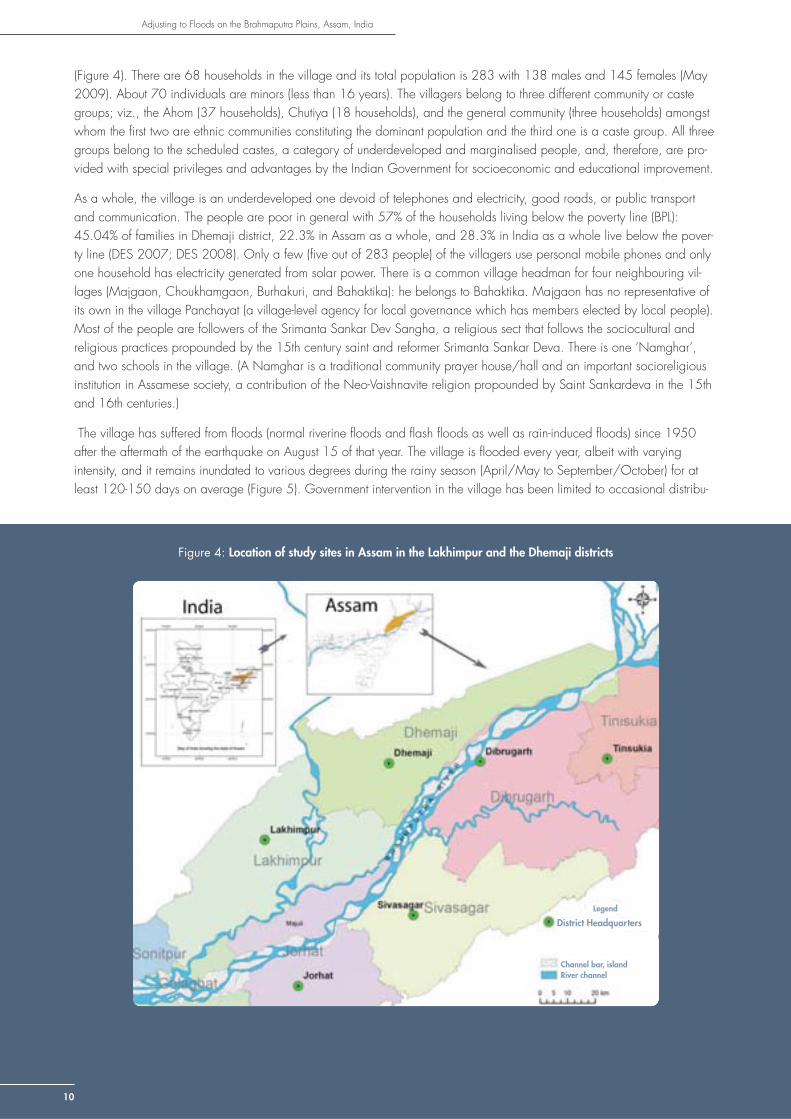
(Figure 4). There are 68 households in the village and its total population is 283 with 138 males and 145 females (May 2009). About 70 individuals are minors (less than 16 years). The villagers belong to three different community or caste groups; viz., the Ahom (37 households), Chutiya (18 households), and the general community (three households) amongst whom the fi rst two are ethnic communities constituting the dominant population and the third one is a caste group. All three groups belong to the scheduled castes, a category of underdeveloped and marginalised people, and, therefore, are pro-vided with special privileges and advantages by the Indian Government for socioeconomic and educational improvement.
As a whole, the village is an underdeveloped one devoid of telephones and electricity, good roads, or public transport and communication. The people are poor in general with 57% of the households living below the poverty line (BPL): 45.04% of families in Dhemaji district, 22.3% in Assam as a whole, and 28.3% in India as a whole live below the pover-ty line (DES 2007; DES 2008). Only a few (fi ve out of 283 people) of the villagers use personal mobile phones and only one household has electricity generated from solar power. There is a common village headman for four neighbouring vil-lages (Majgaon, Choukhamgaon, Burhakuri, and Bahaktika): he belongs to Bahaktika. Majgaon has no representative of its own in the village Panchayat (a village-level agency for local governance which has members elected by local people). Most of the people are followers of the Srimanta Sankar Dev Sangha, a religious sect that follows the sociocultural and religious practices propounded by the 15th century saint and reformer Srimanta Sankar Deva. There is one ‘Namghar’, and two schools in the village. (A Namghar is a traditional community prayer house/hall and an important socioreligious institution in Assamese society, a contribution of the Neo-Vaishnavite religion propounded by Saint Sankardeva in the 15th and 16th centuries.)
The village has suffered from fl oods (normal riverine fl oods and fl ash fl oods as well as rain-induced fl oods) since 1950 after the aftermath of the earthquake on August 15 of that year. The village is fl ooded every year, albeit with varying intensity, and it remains inundated to various degrees during the rainy season (April/May to September/October) for at least 120-150 days on average (Figure 5). Government intervention in the village has been limited to occasional distribu-
Figure 4: Location of study sites in Assam in the Lakhimpur and the Dhemaji districts
District Headquarters
Legend
10
Channel bar, islandRiver channel

tion of relief and rehabilitation materials, compensation for fl ood damage, and construction of an earthen road and culvert. The Indo Global Social Service Society (IGSSS), an international development agency, has provided the village with tube wells, ring wells, high-rise platforms, high-rise seed banks, medical treatment, and community boats through a rehabilitation pro-gramme it carried out in the village during 2007 and 2008 through a local non-government organisation (NGO) called Amateur.
The villages in Matmora are located about fi ve km from the town of Dhokuakhona on the west (Figure 6). In May 2009 the team counted 128 households in Bahpora village, 33 households in Opar Khamon, 70 households in the Khamon Birina, and 22 households in Tinigharia. The villages of Opar Khamon, Khamon Birina, and Tinigharia are entirely populated by the Mishing community, a major ethnic tribe of Assam. Bahpora village is a non-tribal village with a mixed population of Koibartta (a traditional fi sh trading community with scheduled case status), Brahmins (an upper caste group), and the Bihari (a migrant population from Uttar Pradesh, a north Indian state) who came to the village about four decades ago. Tinigharia has people who were displaced from neighbouring villages (Matmora, Janji, Bali, Arkep, and Modarguri) that were fully or partly eroded away by the Brahmaputra at different times since the 1960s.
Human pressure has worn away the embankment and made it weak in many places. The existing embankment was built in 1962 and, at that time, passed through several villages like Tinigharia and Matmora. Almost the entire landmass of Matmora
Figure 5: Life in too much water, a scene from Majgaon in the rainy season: villagers live in and around water six months a year
Figure 6: Location of Majgaon between Na-Nadi and Kumatiya (Jiyadhal) rivers
11

Adjusting to Floods on the Brahmaputra Plains, Assam, India
12
village has been engulfed by the Brahmaputra over the years (Figure 7) leaving only fi ve households in the south- western corner of the village. In Tinigharia, half of the village on the country side of the embankment survived and people settled down by just clinging to the embankment and its sides (Figure 8). All of these villages are poor and underdeveloped with a high percentage of BPL families; viz., 100% in Tinigharia, 85% in Khamon Birina, 75% in Opar Khamon, and 87% in Bahpora compared with 35.59% of rural BPL families
Figure 7: River bank erosion in Matmora, June 2008
Figure 8: Vulnerable shelter – settlement of Tinigharia village on the old embankment of Matmora
in the Lakhimpur district as a whole. Having seen their present conditions, it is hard to believe that many of these families were self-reliant farmers until the late 1990s. While the Mishing people observe both Hinduism as well as their traditional religious practices, the other caste groups in Bahpora village are Hindus only. The Koibartta community in Bahpora belongs to the Mayamoria Vaishnavite sect, a branch of the Neo-Vaishnavite religion propounded by Aniruddha Dev, an eighteenth century religious reformer. As with Majgaon, Matmora has a history of fl oods occurring over the last 58 years in the aftermath of the 1950 earthquake, with major fl oods occurring twice or thrice a decade. The general profi les of the fi ve villages in the two study sites are presented in Table 3.
Table 3: General profi le of the villages in the two study sites (static picture as of today)
Village H/H Community/Caste Group
Population Site Location(Lat)
Location(Long)
Altitude(masl)
Block/District
Majgaon 68 3 (Ahom, Chutiya, Baishya)
283 Site 1-Majgaon
N 27°23.714´
E 94°24.301´
60 Bordoloni
(Dhemaji)
Bahpora no 128 3 (Koibartta, Brahmin, Bihari)
557 Site 2-Matmora
N 27°12.272´
E 94°29.202´
64 Dhokuakhona
(Lakhimpur)
Opar Khamon
33 1 (Mishing) 147 Site 2-Matmora
N 27°33.784´
E 94°39.646´
70 Dhokuakhona
(Lakhimpur)
Khamon Birina
70 1 (Mishing) 336 Site 2-Matmora
N 27°12.183´
E 94°31.286´
73 Dhokuakhona
(Lakhimpur)
Tinigharia 22 1 (Mishing) 150 Site 2-Matmora
N 27°12.320´
94°31.517´ 75 Dhokuakhona
(Lakhimpur)
The history of fl oods for the villagers is also the history of the rise and fall of the embankment entwined with progressive shifting of old villages and migration of the inhabitants to new locations. Villages like Matmora, Janji, Bali, Arkep, and Modarguri were originally (in the 1950s) located on the bank of the River Brahmaputra, about 10 kilometres to the east of the present study site. With the construction of the fi rst embankment on the Brahmaputra in that area in 1952, the westward movement of the river began to break through the confi nement imposed by the embankment. The embankment

Adjusting to Floods on the Brahmaputra Plains, Assam, India
13
has been reconstructed at four different stretches in the area to date to keep pace with the movement of the river. Consequently, the original locations of these villages were engulfed by the river and the people from the villages shifted to new places, always on the river bank, moving back westwards with the river. The river has advanced towards Dhokuakhona town by 10 kilometres at least in the last 5 years; the embankment was reconstructed four times; and the villages were dislocated six to eight times. Floods became more acute and frequent (three to fi ve deluges a year) after the catastrophic fl oods of 1998 when a stretch of the embankment, about two and half kilometres’ long, was washed away rendering the whole embankment in that area weak. Since 1998, Matmora has experienced fl oods annually with the average period of inundation each year being more than 50 days.
People were much better off even fi ve years ago, but they are poverty stricken now and marginalised because during the fl ood in 2007 a complete breakdown in the agricultural system occurred when a large area of agricultural land was affected by sand deposits for the fi rst time. No government intervention worth its name has taken place in the area, apart from occasional repairs to the embankment on the River Brahmaputra, and those too have been carried out in a piecemeal manner, leading to frequent breaches; and these breaches in turn caused devastating fl oods in 2007 and 2008 (Figure 9). Routine relief and rehabilitation facilities provided to the villagers affected are far too inadequate given the scale of damage and destruction. Non-government organisations (NGOs) like the Red Cross Society, Rural Volunteer Centre, and the ‘Takam Mishing Porin Kebang’ (TMPK), a union of students from the Mishing community, helped the victims with rescue and relief resources in 2007 and 2008.
The two sites are similar in the types of water-related hazards they experience and in other geo-environmental features. But they are also markedly different in certain demographic and sociocultural features. Both sites are subjected to regular episodes of fl oods and fl ash fl oods. Whereas in Majgaon chronic fl ooding occurred almost every year since 1950, however, Matmora was affected only during major fl oods between 1950 and 1998. The earthquake in 1950 had a direct impact on the Majgaon area. A big fl ood on the River Subansiri caused by a landslide dam outburst fl ood (LDOF) immediately after the earthquake brought many changes to the landscape and environment of Majgaon where marshy lands and wetlands were fi lled with silt and debris in some places and depressed areas were created in others. The Matmora area was not directly affected by the 1950 fl oods as such. Both areas have borne the impacts of debris and silt washed in by fl oods. In Majgaon, however, there were less silt deposits than in Matmora in terms of intensity and scale because of the presence of rivers that are much smaller than the Brahmaputra. Therefore, the problem of land degradation is more serious in Matmora than in Majgaon. Whereas in Majgaon many of the silt-affected areas have become cultivable and others are recuperating fast, the sand-laden areas in Matmora will take a very long time to improve – more than 10 years according to locals–and recover naturally; and that too provided there is no more sand deposition. If more sand casting occurs, the time taken for reclamation will be longer than ten years. Import of silt and debris has had a positive impact in the Majgaon area because waterlogged areas and marshes have risen because of silt deposits and become cultivable over the years. In Matmora, however, sand casting is a curse. Apart from the colossal blow to agriculture because of the degradation of fertile lands, many inland fi sheries and wetlands fi lled up, affecting fi sh production and fi shing as a livelihood.
Current livelihood system in 2009 and existing vulnerabilities
The prevailing livelihood scenario is similar in both study sites, except in the case of agriculture. In Majgaon agriculture is still the primary means of sustenance and paddy is the staple crop. Although they do not grow seasonal rice varieties like ‘sali’ (summer) paddy because of damage by fl ood waters, they manage to grow ‘bao’ (deep water paddy) in normal fl ood years. ‘Bao’ is a local variety adapted to a watery environment, and it is not easily affected by fl oods.
In Matmora agriculture is no longer the main occupation. The area was one of the major rice producing belts of Lakhimpur district until 1998. Agriculture, mainly cultivation of paddy, has been affected by increasing fl oods since 1998. Finally, the
Figure 9: The Matmora deluge in 2008

consecutive fl oods of 2007 and 2008 left almost the entire area of agricultural land in Matmora irreparably damaged. Sand deposits covered the entire landmass up to an average height of four to six feet (Figure 10). The once fertile paddy fi elds are now totally unfi t for any type of conventional agriculture. For the Mishing community living in the three villages of Tinigharia, Khamon Birina, and Opar Khamon agriculture is no longer possible. In Bahpora (a village of non-Mishing communities) village there are still some patches of land that are not too degraded and people manage to grow rice and vegetables, although in much smaller quantities than before. In the absence of agriculture, people have resorted to other work, virtually anything they can fi nd to
earn enough to survive. People engage in daily wage labour, fi shing and sale of dried fi sh; carpentry; sale of driftwood, country liquor (Figure 11), and milk; and migrating to other places for menial labour such as pulling rickshaws and hand carts and working in factories.
In Majgaon about 51% of the population, both men and women, earn daily wages outside the village. At least 23% of the households have taken up fi shing and about 14% make liquor. All three communities are involved in these activities. Three households sell milk which they buy from Majgaon and two neighbouring villages and sell to hotels in nearby towns (Gogamukh, Dhemaji) for a profi t. There are at least fi ve other households where members trade in rice as middle men: they buy rice from Majgaon and nearby villages and sell it in Bordoloni. Rearing livestock, especially ducks and pigs, is a useful source of non-farm income. Rearing chickens used to be common but it became unfeasible when chickens succumbed to the fl ooded environment: disease killed off the poultry population. Fish become abundant in fl oods waters and fi shing is an important seasonal occupation in Majgaon; but until the 1980s fi shing was mainly for domestic consumption, now it is a profi table occupation which includes the sale of dried fi sh. About 12 households in the villages belonging to the Ahom and Chutiya communities are in the dried fi sh business. The total turnover in 2008 in the village was about Rs1,50,000 ($US3,125) according to participants at a focus group discussion who are involved in the trade. A number of young men and women have migrated to other parts of Assam and even to other states in India such as Nagaland (east of Assam, a hill state in northeast India) and Kerala (in the southern part of India) in search of greener pastures.
In Matmora large numbers of people are engaged in daily and weekly wage labour in menial occupations (e.g., earth-works, construction of roads, building houses, agricultural labour, and building bamboo fences) in nearby villages and urban areas like Dhokuakhona town. People from 90% of the Mishing households in Opar Khamon, Khamon Birina, and Tinigharia are involved in such work. Currently, construction of a new embankment and related infrastructure by the state Government of Assam through a Malaysian company has become a source of employment for many workers from the three Mishing villages. Some are fi nding employment in another state government project which is installing reinforced concrete (RCC) porcupines in the river near the breached embankment close to Tinigharia. (A porcupine is a mesh of poles
made of bamboo or concrete erected in the river near the banks to divert the current away from the bank and thus arrest erosion.) Women work as labourers also in road and embankment construction. Weaving is an important income-generating activity for women. Gar-ments using traditional Mishing motifs are in demand in many parts of the state. The lack of initiative in creating good marketing channels, however, means that their products are sold to middlemen who visit households and buy the products: thus the women are deprived of a good deal of profi t. Earlier, Mishing women’s weaving activities were limited to fulfi lling domestic needs but, in a fragile livelihood scenario, selling hand-woven clothes becomes an important source of income. Some people
Figure 10: Sandscapes in Matmora after the 2008 fl oods
Figure 11: A liquor corner selling ‘apong’ or traditional rice beer in Tinigharia village: selling of liquor is a thriving source of income in Matmora
14

Adjusting to Floods on the Brahmaputra Plains, Assam, India
15
collect driftwood from the bed of the Brahmaputra River, even risking their lives at times, and sell the timber. Others make wooden furniture from driftwood and trees in and around the village and sell it. A few of are skilled boat makers and they are always in demand in the area. There are villagers who are cutting down the remaining trees in the villages and selling them outside as fuelwood. Wage-earning opportunities are limited in comparison to the large population of those seeking work and it is becoming impossible for some even to have two meals day; and this makes them feel helpless and more vulnerable to stress.
Bahpora is relatively less affected and the people are better educated and better off than those in the Mishing villages. About 10% of the villagers have regular jobs (government, semi-government, and private). About 40% of the families are engaged in horticulture (e.g., growing pumpkins, water gourds, radishes, and green chillies) on a small scale, mostly in home gardens and on other small plots of land. One group of farmers from eight households grew ‘boro’ paddy as a cooperative. The paddy was grown on a waterlogged plot of land using water pumps for groundwater irrigation. Some youths (15%) belonging to all three communities, but mostly from the Mishing community, have migrated to the upper Assam districts of Tinsukia, Dibrugarh, and Sibsagar to work as rickshaw pullers, cart pullers, and menial labourers. Ten young men from the village are working in other states such as Nagaland and Kerala. Although the traditional livelihood of the Koibartta community is fi shing, many families from the community in Bahpora, particularly those who are fairly well educated and better off economically, do not fi sh. This seems to be a result of caste consciousness and an attempt to get rid of the stigma of belonging to a caste ranked low in the social hierarchy of Assamese society. There are others from even poorer sections who are involved in fi shing. Rearing chickens and making or selling liquor is strictly prohibited in Bahpora village among the Koibartta community. This is because of a diktat of the Mayamoria cult that they follow and these two practices have not developed into alternative livelihoods in this community. This seems to have infl uenced the other two communities in the village also because they too abstain from selling liquor.
Patterns of change
There is no written history of the study sites. The past of the village was reconstructed back to 1950 based on anecdotal evidence and oral history only. In the case of Majgaon, the village was inhabited well before the commencement of British rule. Even during the rule of the Ahom kings the village was in existence, but not exactly in the same location as today. The ancestors of the family of the Tamulis, the most well-to-do household in the village, are said to have occupied superior positions in the British administration. A canon (‘bortop’ in Assamese) that is more than 300 years old and which the family has had for at least six generations records the age of the village. The Assamese word ‘maj’ means centre and ‘gaon’ means village. The village is called Majgaon because it is located in between the villages of Choukhamgaon and Burhakuri.
Nineteen-fi fty was a crucial year for the study sites in particular and for the whole of eastern Assam in general because of the Great Assam Earthquake (8.6 on the Richter scale) that took place on the 15th August. This earthquake is remembered by elderly villagers as an epoch-making event in their lifetime. Majgaon was rich in agricultural and natural resources before 1950 and the farmers enjoyed good harvests of various crops, paddy being the main one. According to the elders there were 35 households in the village at that time. The earthquake and the consequent fl oods in the Subansiri (fl owing at that time about 10 km away to the west) and other rivers in the area changed the landscape and the lives of the people for ever. Rivers changed their courses and new channels were formed. Depressions and low-lying areas were created that later became wetlands and marshes. Existing marshes and peatlands were turned into plains when they were fi lled with riverine silt and debris. The beds of the Brahmaputra River and its tributaries like the Jiyadhal progressively rose as a result of increasing sand deposits on the river bed originating from accelerated soil erosion upstream in the hills and increased sediment loads in the river in the aftermath of the earthquake. Consequently, rivers became unstable and fl ashier; began to cause more frequent and bigger fl oods; and carried more silt and debris, thus making fl oods a permanent annual feature of these areas (Goswami and Das 2002).
In the case of Majgaon, the cycle of changes in topography and degradation of fertile land due to deposition and natural reclamation has continued for the last fi fty years. As of now, large areas of paddy fi elds have become uncultivable (wasteland or fallow) or less productive due to silt deposited (up to four feet on average) (Barua et al. 2003) when the village was hit by catastrophic fl oods from the Jiyadhal River in 2007. The wetlands and marshes (‘beel’ in Assamese) in the southern corner of the village fi lled in over the years and have now become a plain fi eld fi t for cultivation, something

Adjusting to Floods on the Brahmaputra Plains, Assam, India
16
Table 4: Historical timeline of study site I, Majgaon (conducted on June 4, 2009)
Changes Events 1950-1962 1963-1998 1999-2009 (May)
Environment and LU/LC
Major fl oods 1950, 1952, 1958, 1962
1972, 1978, 1988, 1996, 1998,
1998,2000, 2004, 2007
Degradation of water bodies (rivers, wetlands, fi sheries)
Siltation and fi lling up of wetlands (marshes, swamps)
Siltation and fi lling up of wetlands
Destruction of natural fi sheries near the village
New land occupation Newly formed plains near Na-Nadi were occupied for farming
Some families settling on the occupied lands
LU/LC change and land degradation
Silt casting on a minor scale Siltation after 2007 fl oods made a large area of marshy land cultivable
Change in resource use, management, availability, state of the resource
Wetlands were buried by siltation,
New land available for use, Farming on river levee, Kukurmari reserve forest completely denuded, general decline of vegetation and home gardens
Farming on river levee, disappearance of wetlands because of siltation, creation of new land for agriculture
Sociopolitical events
Language movement Assam agitation (1979-1984), insurgency
Insurgency, general deterioration of law and order situation in the state
Major development (Infrastructure)
Construction of embankments
Embankment on river Jiadhal in 1964
Breaches of embankments
1986, 1988, 1998 2004, 2007
Roads Old road through the village in 1965
Present road connecting the village to the Bordoloni marketplace and Burhakuri in 1990
School The lower primary school founded in 1955
The middle English school was set up in 1999, it has been defunct since 2007
Public water pumps (tube and ring wells)
Eight during 1988-1998, became defunct
Twelve during 2004-2007 by a non-government organisation (NGO)
NGO interventions (relief and rehabilitation)
2007 -2008 by IGSSS and Armature, a local NGO
Local institutions Fish cooperative Operated fi rst in 1965
Women’s self help group
Six surviving, established between 2001-20008
Disaster management committee
After 2007 fl oods
Youth group Youth Club formed in 1999
‘Gram sabha’/village assembly
Started in 1973(approx)
Village defence committee (VDC)
2001 onwards
‘Nam Ghar’/Vaishnaviti religious institution
Established 1955
Major economic events/change
The National Rural Employment Guarantee Act (NREGA) came in 2008-09

Adjusting to Floods on the Brahmaputra Plains, Assam, India
17
the villagers welcome as a positive impact. Table 4 shows the results of a historical timeline analysis carried out for Majgaon in June last. The analysis showed distinct trends in some phenomena related to various changes (Table 5).
The history of the Matmora area in the last 55 years is a history of continuous alterations in geography by the Brahmaputra River, rewriting the fate of the people as it redefi ned the morphology of the area. It is also the history of a people’s struggle to survive and sustain themselves on the banks of the river through adaptation. It is also a story of how the embankment has intruded into their villages again and again as attempts were made to contain the fl ood water and the movement of the river. The river could not be contained by the earthen embankments and burst out of confi nement in many places. In an active fl ood plain, the morphology of which is determined and changed frequently by the water in the river, settlements and locations are only temporary identities in space.
People had to shift their villages periodically, depending on the movement of the river and its branches (braiding channels and distributaries) and consequent cycle of erosion and deposition. The present location of the Matmora village is its fi fth transit location in the last 50 years. About half a century ago, the original Matmora village was situated far to the east about eight kilometres from its present location on the bank. It was there that an embankment now known as the Sisi-Tekeliphuta dyke (Matmora embankment) was constructed for the fi rst time in 1954 to contain the river’s movement and stop fl ooding along its bank. Figure 12 a, b, products of the community mapping exercise of the people of Tinigharia and Matmora, are sketch diagrams of the westward movement of the river showing the shifting locations of the embankment and Matmora and other neighbouring villages from 1954 to 2008. Shifting of the river course has led to reconstruction of the embankment in other locations four times to date (1958, 1964, 2007, and 2009). During the same period people from the original Matmora village moved six times (1954, 1957, 1961, 1963, 1966, and 1968) to different locations. It should be
Table 5: Trend analysis of study site I, Majgaon (conducted on June 4, 2009)
Changes in Entity/Parameter 1950-1962 1963-1998 1999-2009(May)
Environment ‘Forest’ cover (trend) - --- -
Floods (frequency) + ++ +++
Floods (intensity) ++ +++ +++
Land Fragmentation + ++ ++
Agrobiodiversity - - --
Land use Conversion of forest into settlement and/or farmland + +++ ++
Socio-economic Population (trend) + ++ ++
Subreligious groupism (new sect or cult) NT + +
Livelihood changes Subsistence agriculture - - --
Livestock rearing - -- ---
Non timber forest product - -- ---
Livestock sale NT ++ ++
Subsistence fi shing + + +
Trade in fi sh NT ++ +++
Alcohol sale NT + ++
Weaving for own use + ++ +
Sale of weaving products + ++ ++
Milk sale NT + ++
Labour work (road, embankment, and agriculture) + ++ +++
Conversion of settlement/agri into forest land + +
Migration (permanent/seasonal) Not observed
+ Not observed
Development infrastructure + + +
Remittances
Participation in politics NT NT +
Community initiatives + NT NT
Political consciousness + + ++
- decreased a little; -- decreased much; ---decreased a lot; + increased a little; ++ increased much; +++increased a lot; NT = no trend

Adjusting to Floods on the Brahmaputra Plains, Assam, India
Figure 12: Shifting of the Matmora village during due to erosion of river bank, embankments and shifting of the course of the Brahmaputra River. Map prepared during a PRA session by the community of Tinigharia village, Matmora
a) 1954-1998
b) 1998-2009
18

Adjusting to Floods on the Brahmaputra Plains, Assam, India
noted that, as the river was moving westwards crashing and fracturing the old embankment, the embankment also kept shifting in the same direction and had to be reconstructed in a new location each time the river shifted. In the process the river consumed the land on its northern bank in villages like Matmora. As a result the villagers kept moving backwards (westwards along the line of advancement of the river) and resettled on the river bank, retaining the name of the village each time. Each time the people of Matmora had settled in a new location, the embankment would be built nearby on the river side. To protect themselves they would shift the villages to the country side of the embankment. This process has been going on for more than fi ve decades: during this time the river has advanced more than 10 kilometres, the embankment has been rebuilt four times in new locations, and the Matmora villages (along with neighbouring villages like Janji, Arkep, and Modarguri.) self-initiated their own resettlement and rehabilitation, and these features have become an integral part of their lives and an important adaptation mechanism with respect to the behaviour of the river.
Part of the embankment was breached and washed away by the river in 1998 and the river devoured almost the whole of Matmora, except for fi ve households in the south- westernmost corner of the village who are still living there, whereas others left over the last 10 years to places both near and far. Some people resettled by themselves in nearby villages and on the embankment, while others left for other areas, although no-one knows where. A wider portion of the same stretch was swept away by the river again in 2007 and 2008 leaving the people open to the river. To close the breach, the state government began to construct a new embankment using geo-fabric tubes in May 2009. It will join the old embankment (constructed in 1964 in that position) at Baghchuk and Baligaon respectively in a semi-circular route. Khamon Birina, Tinigharia, and other settlements along the old embankment have been situated on the riverside. The All Assam Miri High School, which is more than a century old has moved nine times: it came to its present location in Khamon Birina after the 1998 fl oods. This school was completely buried under sand in the 2008 fl oods (Figure 13) and is now running from a temporary shelter. Being left outside the new embankment it will move again in the near future for the 10th time. More than 200 households and about a 1,000 people have been left outside the protection of the new embankment. There is no option for these people, especially those from Khamon Birina, to move to another place. If they join the settlement on the old embankment it will result in further deterioration of the embankment from human pressure.
It is relevant in this context of a dynamic riverine environment to raise the question of land rights and land access with respect to the continuous loss and gain of land and people’s need to occupy new land for settlement and agriculture.Whereas many Mishing villages are constantly losing land and being compelled to shift to other locations, some stray populations have occupied newly-created sand bars (river islands) in the river. It is considered a traditional right for the Mishing community to occupy unused riparian land to establish new settlements or for agriculture. They have been doing so for many years. There is no strict rule or law regarding land rights over mid-river islands which are temporary entities. Moreover in the past there was no population pressure or not much competition from other communities over land on river banks. Moreover, the Mishing community has a strong sense of kinship, cooperation, and support for their fellow community members. Therefore, it was never a big problem for the people rendered landless and homeless by the rivers to settle down in another area. All these factors have helped them to adapt to the impacts of fl oods and erosion in the past. In the changed situation, however, land has become scarce and the population has increased, hence there is not enough land in the area where people can establish new villages. That is why in the nineties people began migrating in small numbers to different places.
About 150 families lived in Matmora village in 1998 when the river fl ooded the whole village. Only fi ve families managed to stay back in the remnants of the village at that time; and the rest migrated to various places: about 30 families shifted to the embankment and nearby villages. Since the river is proceeding towards Dhokuakhona town, it will not be possible to resettle people affected by fl oods and erosion on a large scale in future. Thus shifting villages as the river changes course is not a viable adaptation strategy now.
The embankment constructed in 1964 in the present location provided protection to the villages for 34 years before succumbing to the river in 1998. It was a period
Figure 13: A school buried under sand: the All Assam Miri Higher Secondary School at Khamon Birina village, Matmora
19

Adjusting to Floods on the Brahmaputra Plains, Assam, India
20
of relative stability and prosperity for Matmora. Although fl oods kept on occurring, this area was not seriously affected. Rather moderate intrusions of fl ood water helped to nourish the soil with natural nutrients. It was a time when Matmora fl ourished as an educationally advanced and agriculturally rich area.
The landscape of Matmora started to change signifi cantly from the fl ood of 1998 onwards. The land immediately facing the river became sandy and the river advanced towards the villages, eroding the embankment. Sand casting became a serious menace after the 2007 fl oods: it was all pervasive after the 2008 fl oods. Sand casting is not an entirely new phenomenon since it has been happening on river banks and in neighbouring villages (Janji, Bali, and Arkep) from 1998 onwards. Nevertheless the scale and intensity of sand deposition in Matmora was unexpected. Living on sand is an experience that is quite different from living on fertile green fl oodplains and the villagers found it hard to cope with sand casting since their existing coping and adaptation strategies were not enough to deal with this new experience. It came as a shock rather than as a slow creeping change (e.g., fl ooding, erosion, loss of land, and need to shift) without giving people much time to get ready to respond.
After the two successive fl oods in 2007 and 2008, the landscape changed completely into a desert of sand all around. Transport is only available in privately-owned vehicles (mainly motor bikes) and public transport (four wheelers) from the town to the river port. Horse- drawn carts have replaced the traditional bullock cards because horses walk better and faster on sand than bullocks.
In terms of other changes, Majgaon was rich in natural resources; viz., forest cover, vegetation, and home orchards, until the 1970s. It has now become barren, devoid even of common trees, vegetation, and biodiversity due to changes in the micro-climate and gradual loss of soil productivity. The fl ourishing home orchards and home gardens in the front and backyards of each household exist only in the memory of elderly people. The Kukurmari reserve forests, on the western bank of the river Na-Nadi about three kilometres from the village, used to meet the needs of a number of villages in the area for fuelwood, fodder, cane for commercial use, bamboo and other forest products. With increasing impacts from fl oods and consequent impoverishment, the forest was overexploited and completely denuded by the late 1990s. Common trees, such as papaya, areca nut, banana, and coconut, which are an integral part of any village environment in Assam are absent or rarely seen in this village. The old trees died after being submerged under water for months together year after year and fresh saplings get little opportunity to survive.
Coming to the case of Matmora, this area had a small population and was thickly forested when the fi rst embankment was built in 1954. At that time there were approximately 20 to 22 domestic elephants in the area which were used for felling trees and carrying logs for house construction. About 25 families lived there then. With increasing population and periodic shifting of the village, people disintegrated into many units, forming several new villages.
People from both the sites indicated that there are changes in the local climate. In Majgaon the local climate has become warmer in summer and summers have become longer. Intensity of rainfall has increased and so have fl ash fl oods which are becoming stronger with rivers now carrying more sediment than ever. In Matmora, the climate, according to the locals, has become hotter and sultrier, whereas monsoon rains are now irregular and unpredictable with storms and heavy rains occurring more frequently. The micro-climate has assumed the properties of arid and deserted areas with groundwater sinking further below the surface and soil layers underneath losing moisture.
The overall impact of fl oods on the landscape, lives, and livelihoods has also brought about signifi cant changes to the socioeconomic conditions and cultural milieu of the villages in both the study sites. From a state of self sustenance the people have been reduced to penury. Social norms have been broken by the compulsion to adopt new ways of making a living. Traditionally, the Ahom or the Chutiya community fi sh or make wine for their own use, not for sale. Similarly, the women usually do not work in menial occupations. The same holds for the Mishing community in Matmora also. They have overcome social norms and mores to cope with deteriorating economic conditions. Being specifi c to Matmora, once famous for its agricultural prosperity, the area has changed into a scatter plot of impoverished, helpless households. The same farmers, who proudly claimed that they didn’t need to buy anything except kerosene and salt, now have to buy everything for their survival and they cannot afford to do so. They are no longer celebrating customary festivities like the ‘Dabaru Puja’ and the ‘Uram’ Festival just because they cannot buy the commodities needed for the celebrations. ‘Donyi-Polo’ (the sun and the moon god) festival and the celebration of the ‘Ali Ai Ligang’, their main cultural festival, is now-a-days marred without the usual fanfare.

Adjusting to Floods on the Brahmaputra Plains, Assam, India
21
Impacts on livelihoods
The impact of water stresses and hazards on all aspects of people’s lives and livelihoods is remarkable and profound at individual, family, and community levels (Barua et al.2003; Barthakur 2000). It is, in general, true that villagers have become poor, marginalised, and more vulnerable to environmental as well as socioeconomic changes because of the impacts of fl oods and associated hazards over the years. Each year, fl oods leave them more susceptible to the next year’s fl ood, creating a vicious cycle of impacts and vulnerability. Within a community or a site, however, communities or families are impacted in different ways depending on the environmental, socioeconomic, and cultural characteristics of the groups or families. There are a few households and individuals at both sites who are doing better than others in spite of the fact that they share the same experiences of water stress and hazards. For example, in Majgaon, two families who have workers employed by the government, the family owning a tractor, two families with a grocery shop, three families involved in the fi sh trade, and one family selling milk are the ones doing well in comparison to others because they have a regular source of income. Similarly, in Matmora, those Mishing families which have people with jobs or businessmen are doing better than others. Within Matmora, the Bahpora village is less affected than the other three villages because Bahpora is the furthest away from the river in terms of physical proximity and therefore has suffered less from inundation and sand casting, making agriculture and horticulture possible for some villagers, although in a very limited way. Moreover, the general economic conditions (in terms of monthly or annual income, conditions of houses, and so on) of the people are better than in the other three villages. There are more people with higher education, jobs, and businesses in this village than in the others. Within Bahpora, the Koibartta and the Brahmin community are in a better state than the Bihari community because the Bihari community has less land, less educated people, has no job holders, and its social security network is not as strong as those of the other two communities. Some families in Matmora villages purchased land plots in safer areas in their better days, and they have proved useful now for building alternative homes; and, thus, some people are migrating temporarily or permanently. Those families that have people in government or private jobs are doing quite well and those who have adjusted to other livelihoods, such as carpentry or weaving, are also benefi tting from these enterprises.
Overcoming cultural barriers to cope with fl oods through adopting new livelihoods and other unorganised activities has affected the social fabric and caused social instability. For example, trading in fi sh and country liquor is considered socially unacceptable among all the communities in Majgaon as well as among the Mishing community of Matmora. People in the past used to fi sh in the rivers and in the small water bodies, such as marshes, wetlands, ponds, and water-logged paddy fi elds, for their own consumption only. It was back in the late 1980s that trading in raw and dry fi sh started in both sites on the initiative of individual entrepreneurs. In Majgaon, fi ve young men fi rst started trading in raw fi sh and preparing dried fi sh in 1986 in an attempt to earn money by adopting a trade for which there is a conducive environment and which needs little investment. It not only turned out to be profi table for them, but it encouraged others to engage in this occupation also. Society at large, however, the elders in particular, didn’t approve of this activity and the young men were instructed to do penance in the ‘Namghar’. The young men accepted the punishment, did the penance, but soon resumed fi shing because they could see no other viable alternative. They were scolded and punished again. This cycle of action and reaction went on for some time. Meanwhile more people took to fi shing and to trading in dried fi sh. It was found to be a good income- generating option. Slowly the sanctions and opposition became weak because society could not provide any feasible alternative; neither could it ignore the money that was coming to the families. There are now more than 15 households engaged in the fi sh trade and more people are becoming attracted to it.
The fi sh trade is governed by a cooperative society called Kumotiya Fishery Cooperative. The cooperative takes potential fi sh-bearing areas (e.g., a particular stretch of the Na-Nadi, small rivulets like Singijaan and Gogajaan that are tributaries to the Na-Nadi, and nearby wetlands) on lease from the government and sublets the same to the local ‘mahaldar’ (contractor). Earlier the villagers of Majgaon used to work only as fi shermen or ‘Jaluwoi’ (a person skilled in using the fi shing net), Later on some of them, the more experienced and seasoned ones, became contractors with small holdings.
The fi sh trade is a seasonal activity that lasts from June to October. It depends on the availability of fi sh and the seasonal surge of fi sh in the water bodies which, in turn, depends on the occurrence of timely rainfall and the water levels in the rivers and water bodies. Normal fl ood conditions are conducive to a good catch, but large fl oods are harmful because the fi sh stock is washed out of the water bodies during a strong fl ood wave. Fishing continues for days and weeks during which the villagers camp near the water bodies. They sell the raw fi sh to the traders who visit the fi shing site. These local traders are actually middle men who resell the fi sh at higher prices in nearby towns. They belong to the Koibartta community from nearby villages. They dry the smaller fi sh on bamboo platforms for a few days and sell the dried fi sh either

Adjusting to Floods on the Brahmaputra Plains, Assam, India
22
to the trader or take bagfuls of dried fi sh to Jagiroad (in Morigaon District), which is the location of the biggest dried-fi sh market in Assam. Selling fi sh in Jagiroad is more profi table than selling to middlemen near the village. Notwithstanding all the progress, even now there are some people, albeit few in number, who look down upon fi shing. Such attitudes come from the comparatively better off people who have other sources of income. The villagers are yet to overcome biases against the fi sh trade. For example, there are people who sell rice in the market but won’t sell fi sh although, back in the village, they engage in the fi sh trade. It is mainly men who engage in large-scale fi shing business. The women fi sh in smaller groups, and mainly for their own domestic use. They also sell fi sh to middlemen if they have a surplus.
The situation in Matmora is similar, but the fi shing is carried out mainly in the Brahmaputra River and it is a round the year occupation, unlike in Majgaon where it is restricted to the rainy season. The fi sh trade is carried out through a cooperative made up of people from several neighbouring villages, mainly in the Bandena area about fi ve kilometres from Matmora. But commercial fi shing on the Brahmaputra is not possible for everybody because boats are essential for this.
Making traditional wine for household use is a traditional practice for the Ahom and Chutiya communities in Majgaon and the Mishing community of Matmora. In course of time selling country liquor (of inferior quality to the traditional wine) has become a thriving business in these villages, a business which has also broken the barriers of social norms. In Majgaon about 10 households are involved in making liquor and selling it from their own houses. In Matmora they sell it from their houses as well as from shops openly. These are considered illegal activities by the Excise Department which raided the shops and houses and confi scated the equipment in Majgaon. In Matmora no such action was taken. According to the people of Matmora the offi cials are sympathetic to them and realise that they should not be deprived of this vital source of income. In both places it is the women who prepare and sell the liquor, whereas the customers are men.
A sociological impact having wider ramifi cations for the state as a whole is the growing frustration and unrest in the youth from fl ood-affected families. There are instances of unemployment, impoverishment, and grievances against bad governance leading some youths to join insurgent groups: such groups try to recruit young men and women from poor families, alluring them with money and guns.
Floods have existed in Majgaon for more than fi fty years, but the impact on livelihoods was moderate until the 1970s because fl oods used to be less damaging and less frequent at that time, the population was smaller, and life was simpler and less expensive since development ideas were not there to raise aspirations. The social security network was stronger also, and the support base of natural resources, both within and outside the village, was still there to see people through if crops failed. With the changing hydrological regime of the rivers (probably partly attributable to degeneration of watershed health and partly to climate change), fl oods have become more destructive, more frequent, and silt deposits have become the new menace with fl ash fl oods increasing due to frequent cloudbursts and breaching of embankments.
Both women and men are affected in different ways and to different extents in activities related to family responsibilities and livelihoods. Women are severely affected both during and after fl oods because of the physical and mental hardships they face in looking after the family kitchen and the children. Usually it is the women who arrange for or collect water for drinking and other domestic purposes during fl oods. In Majgaon women go out in search of tube wells, and ring wells that are placed higher up from the fl oodline and hence are not submerged under water: sometimes these wells are located kilometres away from the village. They use rafts made of banana tree stumps (called ‘bhur’ in Assamese) or country boats, often operating the raft or the boat themselves. In a typical marooned situation which continues for several days to several weeks they can experience a lot of diffi culty in cooking, attending to children, and taking care of livestock and poultry. Hardships increase all the more when they are taking shelter on raised bamboo platforms inside the house as this is often a makeshift arrangement within a narrow space. Maintaining health and sanitation is the greatest challenge for women during fl oods. They have to sail to isolated places or to places covered by trees to bathe or to respond to nature’s call. Life becomes very diffi cult for pregnant women especially in fl ood times. Cases of child birth occurring in boats or in shelter camps or in confi ned conditions at home are common.
The Mishing women of Matmora are less impacted than the non-Mishing women. The Mishing women are more comfortable in the water, they can swim, can manage boats and rafts, and they live in houses on stilts that are more convenient than the temporary raised platforms of non-Mishing households. In Bahpora only a few women know how to swim or how to manage boats. In Majgaon harvesting of paddy is carried out by women. By the time the paddy is cropped the fi elds are submerged in water and in the case of early fl oods, the water level is quite high in the fi elds. Women usually wade through water and stay immersed in water for long hours during crop harvesting. In both the non-

Adjusting to Floods on the Brahmaputra Plains, Assam, India
23
Mishing villages (Majgaon and Bahpora), there are several women who have been married into the villages from areas that are not fl ood affected or not as acutely fl ood affected as their in-laws’ village, and they are not equipped to cope in highly fl ood-prone areas. It is diffi cult for them to manage in a situation and against the impacts which are new for them and, hence, they fi nd themselves more vulnerable than others. Other problems of non-Mishing women are similar to those faced by women in Majgaon.
In Matmora the embankment was effective in protecting the villages from high fl oods until 1998. It was easier for people to recover and recuperate from the impacts because the river was about three kilometres away from their villages. The communities rather benefi tted from fl oods when the soil received nutrients from the silt brought ashore with the fl ood waters. Floods became increasingly damaging after the fi rst big collapse of the embankment during the 1998 fl oods. The embankment was not repaired nor rebuilt properly for a decade. The 2008 fl oods left at least 500 families homeless and converted the villages to deserts.
The poor are more vulnerable to the direct and indirect impacts of fl oods in both areas. The families below the poverty line cannot afford to own boats and therefore are dependent on the help and cooperation of others who have boats. In times of urgent evacuation or medical emergencies, they are more prone to be affected adversely. Temporary rises in the prices of essential commodities during and after fl oods also limit their capacity to sustain themselves during trying times. Table 6 shows the average fl uctuations in prices in normal times and during fl oods in the study sites.
Table 6: Average fl uctuations of price in normal and fl ood times in the study sites (Source: Project survey)
Commodities Majgaon Matmora
Normal period (in Rs.) During fl ood (in Rs.) Normal period (in Rs.) During fl ood (in Rs.)
Rice 15 18 14 18
Kerosene 12 22 14 16
Potato 10 15 7 12
Lentil 70 75 60 70
Mustard Oil 80 85 80 100
Onion 24 26 24 35
Turmeric 5 30 5 30
Salt 5 7 5 7
Sugar 22 24
The broader context
Both the study sites are prototypes of many other areas in Lakhimpur and Dhemaji districts which face similar problems of fl ood, erosion and sand casting to different degrees. They are like a hundred other places in Assam which are affected annually by fl oods. The Brahmaputra valley, which makes up more than 75% of Assam’s geographical area, has the most fertile land in the fl ood plains, and it is very densely populated. While ethnic tribes and communities have traditionally occupied the river banks, the migrant populations from Bangladesh and other parts of Assam have peopled the river islands that are essentially sand bars called ‘char’ and ‘chapori’. Some indigenous communities, like the Mishings, also live on such sand bars. The geomorphological composition of the river banks and the islands being similar, the Brahmaputra and its tributaries affect the entire valley almost to a similar degree in terms of fl oods and erosion. The only difference lies in the fact that the north bank tributaries are fl ashier and more silt laden than the south bank tributaries and that, as of now, the problem of sand casting is more acute on the north bank than on the south bank. Therefore, the problems and concerns regarding the nature of fl oods, their impacts, and, to some extent, community coping and adaptation patterns seen in the study sites are not very different from those seen in other fl ood-prone areas of Assam. The adaptation mechanisms are different, however, depending upon the physiography of the locations and the cultural traditions of the communities concerned. The vulnerability and adaptation scenario in these study sites also has a lot in common with ‘chars’ and other riparian areas of Bangladesh as well as some areas in the Terai region in Nepal, as found during the literature review carried out for this work. Similarities can be found too with many other riparian areas in India (West Bengal and Orissa) and other countries in South Asia (Myanmar, China, and Bhutan).

Adjusting to Floods on the Brahmaputra Plains, Assam, India
24
Responses to water stress and hazards
Experiences of past water stresses and hazards
Individual and community memory of past events
In both the project areas, elderly people, mostly men and a very few women, vividly remember the years when they experienced big fl ood events, especially those that occurred after 1950, the year of the great earthquake. The younger generation remembers only a few fl oods, mainly those that have occurred since the 1990s. Immediately after the 1950 earthquake, the River Subansiri was blocked on the hills of Arunachal Pradesh (formerly the North East Frontier Agency, NEFA). Water levels and fl ows decreased so drastically in the Subansiri River near Gogamukh (in the immediate downstream area below the foothills) that one could cross the river in peak monsoon season even without getting one’s ‘tioni’ (a loincloth that covers one up to the knees, used in villages while bathing in the river or in the open) drenched. After four days the blocked water burst out and cascaded downstream on August 19 causing one of the most devastating fl oods in public memory. This was four days after the earthquake. Such fl oods are called ‘Pahar Bhanga Pani’ (water that breaks the hills) or ‘Bolia Pani’ (wild water). What is actually meant is a fl ash fl ood originating from a Landslide Dam Outburst Flood (LDOF) in the Arunachal hills (Goswami and Das 2002). Although the people of Majgaon were severely affected by this fl ood, its impact on Matmora was not serious although the level of the Brahmaputra was high during that time.
People from both sites are of the opinion that fl oods became regular and devastating in eastern Assam after the earthquake in 1950 because the Brahmaputra and its tributaries became shallow with beds rising due to carriage and deposition of excessive sediment in the rivers. Silt was deposited up to six or seven feet high in many places in the Subansiri valley. Majgaon suffered from heavy fl oods in 1962, 1968, 1988, 1992, 1996, 1998, 2000, 2002, 2004, 2007, and 2009; and the major fl ood years for Matmora were 1962, 1968, 1984, 1988, 1998, 2004, 2007, 2008, and 2009. The years 1962, 1988, 1998, 2007, and 2009 were common years for major fl oods for both the sites and for the entire Brahmaputra valley. In recent major events fl oods have become more devastating, mainly because of breaches in and erosion of the embankments.
People have to move to safe places during major fl oods. The people from Majgaon took shelter in Bordoloni Higher Secondary School (four kilometres away in the east of the village) in 1988; in Gogamukh Higher Secondary School in 1992, and on the high-rise platform in the village in 2007 and 2009. For the Matmora people the only safe refuge during fl oods is the embankment. The community memory of the people of Matmora is of the river changing course, the Brahmaputra moving westwards, relocation of the embankment, and shifting of the villages to match the movement of the river as described earlier.
The community has learned its lesson from the experience of these fl oods. In the fi rst place they have understood the nature of fl ash fl oods and how fl ash fl oods are unleashed suddenly due to excessive rainfall on the hills, bursting of natural dams caused by landslides in the hills, and breaching of embankments. They have learned to correlate heavy rainfall in the hills upstream from the rivers to probable fl oods in their areas after some time. They have learned to anticipate fl ash fl oods based on observation of heavy rains, information about LDOF, or by monitoring the conditions of the embankments. Even rumours or hearsay common during fl oods alert them. They are also aware of the fact that they might face similar situations again in the event of another incident of cloudbursts or embankment failure in the future. Now they know that continuous rainfall for three to four hours in the hills to the north can cause fl ooding in Majgaon from the Na-Nadi (which has no embankment near the village) after six hours. Similarly, people in Matmora expect fl ooding after a time lag of 10-12 hours after the Arunachal hills receive heavy rainfall. People have also learned to monitor and identify weak and vulnerable portions of the embankment that may cause breaches in or collapse of the embankment leading to fl oods. This clarity in linking heavy rainfall to fl oods is an important factor for them and helps prepare them to face the resulting situation.
Three villages; viz., Janji, Arkep and Bali in the Matmora area came to be heavily eroded and silted during the 1998 fl oods, and, even after 10 years, the soil in the remaining parts of the three villages is not fi t for cultivation. Learning from this example, the people of Matmora are mentally prepared for hard days ahead when they may have to survive without agriculture for another decade. They have also heard about similar phenomena in areas of Dhemaji district where soils have long remained uncultivable. This has, in one way, made them pessimistic about the future and, on the other hand, has made some of them desperate enough to try locally-developed techniques for growing vegetables in home gardens. As a result, many villagers have started growing vegetables like pumpkins, gourds, green chillies, and lemons using pit culture. It was found during focus group discussions with different communities that their memories and recent experiences refer

Adjusting to Floods on the Brahmaputra Plains, Assam, India
25
to almost the same events of hazards and stress. Women, however, consider drinking water as a stress if not a hazard during both fl oods and lean seasons. The drinking water sources are not adequate in the villages and water for domestic consumption is not easily available during and immediately after fl oods. The fact that it is the women who traditionally collect and manage water for the family means they consider water scarcity to be one of the priority issues.
Historical perceptions of vulnerability and risks at local level
Community perceptions are the results of memory, experience, and learning from past events of fl oods and associated hazards. They have both commonalities and differences from one site to another and from one community to another. In general, people have come to realise that normal fl oods have occurred and will continue to occur regularly, but catastrophic events happen periodically (e.g., at an interval of three to four years). Flash fl oods occur suddenly without giving much time to monitor the situations and prepare for them. Embankments are both a symbol of safety and a source of sorrow. Embankments have protected people physically from fl oods and provided safe shelter for them during fl oods. Yet it is because of the failure of the same embankments that fl oods have become destructive. Floods and fl ash fl oods are a direct result of heavy rainfall upstream in the hills. Observation and knowledge of rain in the hills is an indication of probable fl oods in the next 12-24 hours. Although there is no periodic pattern in the major fl ood cycles, more recently the frequency of heavy rain has suggested an increase in the length and intensity of the rainy season and also the number of deluges and major fl oods for which the poor health of the embankments act as an accentuating factor.
In Majgaon fl ooding from the river Jiyadhal when the embankment is breached has always brought heavy loads of debris and silt. In Matmora the amount of coarse sand particles in the Brahmaputra fl ood waters increased causing widespread sand casting. Additionally, because of the embankment the fl ood waters cannot recede quickly from the villages and, as a result, the villages remain inundated for a long time (a week to more than a month). Longer periods of inundation mean increased deposits of silt and sand augmenting the scale and intensity of sand casting. Thus it can be seen that, in coming years, fl oods might become even more devastating. Such perceptions help villagers’ preparedness.
Floods in these areas cannot always be assessed in a strictly hydrological sense, i.e., in terms of fl uctuations of water level (gauge readings), because they are caused not only by overtopping from the rivers, but also arise because of drainage congestion impeding the recession of river-borne fl ood waters towards the river (true for both sites) as well as localised rain-induced water logging in a low-lying topography, as seen in Majgaon. Such circumstances are not refl ected in local hydrological records. This is an example of how embankments sometimes increase fl ood hazards. It also shows why people consider rain and embankments as very crucial factors infl uencing their vulnerability and risks.
Collapse of the Matmora embankment in 2008 left the villages open to the river and they knew they would face high fl oods the coming summer unless the embankment was repaired immediately. Since many households were badly damaged in 2008 and the villagers could not afford to repair or rebuild their houses, they were already preparing to move to the embankment when they encountered the fi rst wave of fl oods this year (2009). Staying on the embankment is a common practice for the villagers here during fl oods since it is the nearest high and safe place. The entire Matmora area was fl ooded again in July of 2009 since repairs to the breached portion of the embankment could not be completed, vindicating the villagers’ fears. People rushed to the old embankment, as usual, for shelter.
In Matmora people received protection from the embankment prior to 1998 and the villages fl ourished in agriculture and education which made them self-reliant communities. Their farming, settlement, and other livelihood pursuits, however, were infl uenced consciously or unconsciously by a sense of safety and security provided by the embankment, which they took for granted. In other words their ways of living in a fl ood-prone area would have been different had the embankment not been there. People have been so dependent on the embankments that they think having an embankment on the river will solve all their fl ood problems. That is why in Majgaon they want an embankment on the Na-Nadi which is still an unmanaged river, and why they would like to have the existing embankment on the Jiyadhal repaired and strengthened. Similarly, in Matmora, in spite of repeated failures of the embankment in different stretches since 1998, communities still favour proper repairing and reconstruction of the breached section of the embankment as the fi rst precondition for fl ood management. Although villagers consider embankments a panacea for their fl ood woes, there are other opinions that see embankments only as ad hoc short-term measures of fl ood mitigation that may not be effi cient, suffi cient, or desirable as a long-term measure for fl ood management. Experience from elsewhere in India (the Kosi River deluge of 2008 in Bihar, for example) also shows that, in some cases, embankments have actually exacerbated the impacts of fl oods rather than mitigating them.

Adjusting to Floods on the Brahmaputra Plains, Assam, India
26
Another perception prevailing amongst the villagers in both study areas is that agriculture is and will remain totally impossible on swampy or sandy soils; and this is based on their observations from other places that have experienced similar problems and have not yet recovered. Therefore there has been no serious attempt to grow alternative crops on degraded lands or to grow staple crops using changed techniques. Agricultural experts think that it is possible to grow some types of crops in swampy (‘boro’ paddy) or moderately silted land (winter vegetables) in Majgaon and even in the virtual desert-like conditions of Matmora. They point to the inhabitants of ‘char’ (sand bars or islands in the Brahmaputra River) lands in western Assam and their agricultural techniques. Some of these ‘char’, inhabited mainly by immigrant Muslim people, are seasonally under water every year and the people have devised successful methods of agricultural production, especially for vegetables, on sandy soils. Proper exposure of the farmers of Matmora to the ‘char’-land communities will motivate them to learn from their agricultural model and enrich it by their own indigenous innovations. Communities now look for guidance, training, and intervention from government or non-government agencies to help them farm and increase productivity. On occasions such attitudes become a mental constraint that limits people’s adaptation to their environmental conditions. It prevents them from using their indigenous agricultural knowledge to experiment with different options for agriculture and horticulture. It has limited their opportunities for growing more crops for subsistence. This is a more valid criticism for Majgaon where the situation is not entirely hopeless, but yet villagers have not done their best to experiment with best practices.
One dominant perception of the administration and policy makers is that the Mishing community is deeply rooted in a riparian environment and therefore it will not move to areas with different environments away from the rivers. The results of this research show that this perception used to hold good in the past, but it is a myth in the present context. Hundreds of people have shown themselves to be in favour of leaving their present villages where they see a bleak future ahead, and they are ready to go and settle in any place where there is enough land for settlement and agriculture. Many of them would not like to live near a river again and would prefer to live in a forest or near the foothills. This is a signifi cant diversion from the popular perception about the locational preferences of the Mishing community. There are a few people, nevertheless, in particular elderly villagers, who would still be reluctant to move to a non-riverine environment.
Because of this wrong perception, planners and administrators could not read the change in attitude that is taking place under dire circumstances. Therefore, they have always underplayed the need for rehabilitation of fl ood-affected people who have become homeless or landless and who see no hope of a secured future free from vulnerability and risk in the areas in which they are living now. Policy makers are also completely oblivious of the fact that periodic migration on a local scale triggered by the shifting courses of rivers and construction or breaching of embankments has been the very essence of the struggle for survival for the Mishing population in Matmora. They have always resettled themselves in new places after their old villages have been washed away or devastated by the river. Migration is not new to them.
People are unanimous in the opinion that fl oods were more benefi cial in the past and are more destructive now. This indicates the changing nature of fl ooding. It may mean that fl oods have become more intense (discharge, fl ood level, area of inundation, and increased period of inundation), more frequent (more fl ood waves in a season), and more damaging (more adverse impacts on crops, land, houses, livestock, human life, and the environment). It also means that sediment and silt are increasing with large and coarse sand particles being deposited rather than fi ne silt particles carrying nutrients.
Community initiatives
Three different attempts have been made by the communities to solve their own problems in relation to fl oods. The fi rst example is from Majgaon where the community made several attempts to push the river Na-Nadi away from the village in a bid to get rid of the fl oods. In 1982 people from three villages in the area (Majgaon, Burhakuri, and Chowkhamgaon), all suffering from the fl ooding of the Na-Nadi, met and decided to place locally-built spurs on the Na-Nadi to divert it further west from the fi elds. The initiative failed to take off. Then the villagers demanded that the government solve the problem and submitted a memorandum to the Deputy Commissioner of Lakhimpur district asking for spurs and embankments on the Na-Nadi. When they received no response, in 1985 they requested the Deputy Commissioner to provide a sluice gate to drain out the water (that collects from the rivers or the rain) from the village to the Na-Nadi River. The authorities turned a deaf year to this request also, so they blocked the river at Lakhipathar in 1986 by building a checkdam in an attempt to divert its course. The very next year, the structure was washed away by the fi rst wave of fl oods and the river returned to its original course.

Adjusting to Floods on the Brahmaputra Plains, Assam, India
The second example is from Matmora. People from fi ve villages in Matmora; viz., Opar Khamon, Khamon Birina, Janji, Arkep, and Bali, where the impacts of fl ooding and erosion have been greatest over the last decade, made an attempt to clear a nearby reserve forest in Lakhimpur for resettlement. The propriety of such an action is questionable, because it is illegal to cut forests and convert forests to settlements without proper permission. The reserve forest in question should have been de-reserved fi rst for such a purpose, and this involves a long offi cial procedure. Their actions were, nevertheless, unoffi cially endorsed by local political forces. Later on, however, when the spade work was done by the community, the land was taken over by the same political forces to set up tea gardens and the people were not allowed to use the land. Although it was a misadventure on the part of the community, it shows how motivated they are to solve their own problems.
The third example, also from Matmora, is a very recent one. The Government of Assam began repairs on a breached portion of the Matmora embankment from the month of May 2009 with fi nancial assistance from the central Government. For the fi rst time in India, a new technology, the geotextile fabric technology, was used (Figure 14). The alignment of the new embankment, however, was done in such a way that the entire village of Khamon Birina was left on the side of the river, leaving the people of the village out in the open facing the river. The villagers, with support from neighbouring villages, demanded the realignment of the embankment and inclusion of Khamon Birina on the country side so that they also would be protected by the new embankment. Their demand is being denied by the department of the state government (Department of Embankment and Drainage, E&D in short), and they resorted to protesting against this injustice and tried to stop the construction work. The offi cials used police force and resumed the work. Considering that it was one of the villages worst affected by the previous year’s fl ood, people demanded resettlement elsewhere and were prepared to move to the old embankment anticipating fl oods again in the summer of 2009. When the fl oods came in July 2009, all the villagers moved to the old embankment.
Individual and community attitudes towards external help in relation to natural hazards
It is the primary responsibility of a government to provide relief materials (such as food, clothes, plastic sheets, and medicines) during fl oods and aid for rehabilitation (such as housing materials, tube wells, and cash) in the post-fl ood period to help communities survive the fl oods and return to normal life as soon as possible. Relief and rehabilitation work in Assam is looked after by the district administration with support from the Department of Revenue and Disaster Management. It is a common practice for non-government organisations and development agencies to help the district administration and the people by providing relief and rehabilitation materials. Communities suffering from fl oods for a long time and getting relief and rehabilitation support are sometimes seen to have become too dependent on external help. Such an attitude hampers individual or collective initiatives to cope with stresses using their own resources. This so called ‘aid dependency syndrome’ has crippled the capability of many communities to adapt. The communities from the present study sites are no exception. They would often complain about not receiving adequate relief and rehabilitation assistance from the Government or about disparity in distribution of relief materials. Their dependency on the Government is rather limited, nevertheless, given the fact that there has never been adequate support from the Government in the past. At the same time they would also look to non-government sources because of the benefi ts they had obtained from NGOs in the past. External aid is most needed during fl oods, especially when people are marooned because, in such times, their very survival is at stake. Within the community, the levels of expectation and dependence vary depending on the extent of damage suffered in previous fl oods and the economic condition of the individual or the family.
In principle everybody would welcome external help and would like to get as much as possible; but life does not stop even if outside help is not adequate. The fact that they have survived fl oods for so long shows their resilience in a way. In both Majgaon and Matmora, even in the absence of suffi cient external support, people have managed to sustain themselves by diversifying their livelihoods and changing their agricultural practices to a certain extent, so far even overcoming the barriers of cultural norms. There is not much difference in dependency patterns between the
Figure 14: The last hope: ongoing construction of the new embankment in Matmora where geo-tube technology is being used for the fi rst time in India.
27

Adjusting to Floods on the Brahmaputra Plains, Assam, India
Box 1: Traditional and folk beliefs about the occurrence of rainfall
and fl oods
1. Flowering in the mango tree indicates fl oods are coming.
2. Flowering of jack fruit implies good productivity of paddy and
soil.
3. Rainfall on ‘maghi astami’ (the eighth day of the month
of Magha coinciding with 21/22 January in the English
calendar) in a particular year augurs fl oods in that year.
4. Cows behave erratically just before a fl ood.
5. If cows are found to be standing in the cowshed in the
morning of the day of ‘Garu Bihu’ (usually the fi rst day of the
‘Bohag’ month coinciding with April 13/14) the next season
will have fl oods. Floods will be more severe than usual if the
colour of the cows found standing is blackish. If the cows are
found sleeping or lying down on the ground, it signifi es a
fl oodless year ahead.
6. Frog calls are indications of rains ahead; uninterrupted frog
calls imply heavy showers and probable fl ooding.
7. It rains when there is thunder(roaring of clouds or thunderclap)
in the northern sky in the rainy season.
8. If there are no fi sh or few fi sh in the early rainy season, there
will be fl oods
communities. Although Bahpora village is less affected than other villages in Matmora and people here are better off than others, the level of expectation of external help is the same. Moreover, dependence on external help is not limited to material benefi ts. They also expect outsiders (including the project team) to infl uence and convince the Government to meet their requirements and ensure that they get their due. In Matmora they often requested non-state visitors (such as journalists and researchers) to ensure that the embankment is repaired and built properly. They will do their best to sustain themselves through their own efforts without external help, even in the current degraded and deserted conditions, once they have a good embankment in place to protect them from the twin disasters of fl ood and erosion.
Monitoring change
Traditional and /or local early warning systems and signals
There are no effective arrangements on the part of the Government for dissemination of forecasts and warnings about rain and fl oods to the people of remote areas like the study sites. People are rarely aware about the routine weather and fl ood forecasts of government agencies like the Indian Meteorological Department (IMD) and the Central Water Commission (CWC). The few who do know about such information and get it from news- papers or television have little faith in it. Therefore people generally depend on their own observations of the weather and environment, intelligence, and traditional knowledge, and, to some extent, on folk beliefs to predict rainfall and fl oods. Long experience of living in fl ood-prone areas has equipped villagers with the knowledge and intelligence to read the nature of weather and the rivers and anticipate rain and fl oods by observing natural phenomena.
Seeing grey and black clouds in the sky means rain in the next couple of hours, dark clouds on the horizon and lack of visibility of the distant hills warn them about the possibility of rain in the hills and consequent fl oods in a matter of three to four hours in Majgaon and six to twelve hours along the Brahmaputra in the Matmora area. Villagers have an idea of how soon a fl ood wave will come and how severe it can become by observing the aspect of the rising waters and the current in the fl ow and, accordingly, they prepare to endure the fl oods from their houses or to leave their residence for safer places if required. Apart from observational skills, folk beliefs also contribute to the repertoire of predictive knowledge about fl oods. Some of these beliefs are listed in Box 1. Faith in such beliefs is weakening now, especially among the younger generation who know
less about these folk beliefs and folklore and do not take them seriously. The elderly people are of the opinion that some of these folk beliefs are no longer effective since the nature of the weather, rainfall, and fl oods is changing. There is a general agreement that, today, the indicators mentioned in folk beliefs, especially those dealing with animal behaviour or changes in the environment are not reliable, whereas they were found to be useful by people in the past. Other traditional indicators, especially those based on observations of the weather, as mentioned above, are still thought to be valid. One new practice is to assess the probability of embankment-induced fl oods by monitoring the weak and erosion-prone parts of the embankment. For this they identify points where there is undercutting of the embankment by water and observing penetration of water into the soil and bubbling in the water. Occasional news from the media about release of water from the natural landslide-induced dams in the hills also gives an indication of upcoming fl ash fl oods.
People back in 1950 could anticipate fl oods in the Subansiri River by observing a sudden fall in the water level of the river right after the earthquake. Proving them right, the entire area was infl icted by a catastrophic fl ood within a week. The temporary reduction of fl ow and water level in the river was a result of the water in

Adjusting to Floods on the Brahmaputra Plains, Assam, India
the river being blocked by a landslide-induced dam in the hills of Arunachal Pradesh. Villagers heard about the blocked water from rumours and hearsay. After 58 years, the media played a role in informing people in the months of May 2009 that a landslide dam had formed on the Brahmaputra in Tibet, and that it might burst at any time posing threats of fl ash fl oods in downstream areas of Assam. There was also an offi cial warning by the district administrations of Lakhimpur and Dhemaji through the public address system, and in the newspapers on May 29, 2009, about this possibility. It was widely reported in the local and national newspapers that Matmora received moderate fl oods on the morning of May 30; but the people had time to prepare for the fl oods and did not suffer much except for damage to standing crops (‘ahu’ and ‘boro’ paddy).
There is no organised or institutional local early warning system in place in Majgaon and nearby areas. Usually people who observe increasing levels and fl ows of water in the Na-Nadi or Jiyadhal rivers pass the message on to others in their village or in nearby villages verbally and the message is spread quickly throughout the whole area. In urgent cases, when the embankment is about to breach or has just breached, people warn others by whistling, shouting, and making noises. In the old days people used to pass the message of advancing water on to nearby villages by beating drums and cymbals in the ‘Namghar’. These practices are no longer in vogue because all of these places used by the community in the villages adjacent to the Jiyadhal embankment were heavily damaged by fl oods. There are no drums left in working condition and the villagers do not have the means to repair the ‘Namghar’ or the drums. In Majgaon people have, in the last two years, used a microphone donated by the Indo Global Social service Society (IGSSS) to inform people about weather and fl ood conditions based on news aired by the local radio and television channels.
In Matmora, river watching is a favourite pastime during the rainy season. People often gather on the river bank and monitor the fl ow and level of water in the river and discuss the possibility of fl oods. This way they can form a fairly good idea of whether fl ood waters will enter the village. Information about the state of the river becomes known to everybody through verbal communication. Long back the Mishing community used two traditional instruments, the ‘Le-long’ and ‘Mabong’, which have sounds like cymbals, to warn people within a distance of three to four kilometres about advancing and rising waters. The practice has disappeared with time, so have the instruments.
Villagers from about 10 different villages in the Matmora area have organised the monitoring of the embankment in every fl ood season since 1998 when breaches in the embankment became a regular event. Representatives from every village gather on and near the embankment in the evening and they monitor the embankment for the whole night. With rising water and fl ow momentum, the incursion of water into the soil and breaches of the embankment increase in a typical fl ood situation causing masses of soil to slump into the water. In such a situation new holes and breaches develop in the weak portions of the embankment. The villagers use bamboo or wooden pole fl ares and torches to fi nd all these places, after which the cavities are plugged with bags or sacks of sand. This needs to be done continuously throughout day and night. When the E and D Department takes such measures to save the embankments or dykes the villagers help them wholeheartedly to protect themselves from probable danger. In both areas people now use mobile phones to disseminate fl ood warnings sourced from offi cial forecasts or community observations. Usually these are individual initiatives rather than collective efforts.
Time thresholds and emergency measures – For the community it is always a crucial decision to decide to leave their houses and go to safer places because of the considerable effort and hardship involved. Hence many villagers try to endure the fl oods as long as possible. They move to other places only when it is no longer possible to stay in their own homes. People do not leave their homes in normal fl oods since they can survive in stilt houses (Mishing community) or on in-house raised platforms (Figure 15) or granaries on stilts (non-Mishing communities) inside the house and can travel for essentials on boats or rafts. It is only in major fl oods when the fl oors of the stilt houses or raised platforms are submerged or the house itself is seriously damaged that they leave for the nearest safe shelter. For example, people in Majgaon have endured most of the annual fl oods in the village itself. It was only in 1988, 1998, and, recently, in 2007 that they had to move to shelter
Figure 15: A raised platform inside a house gives shelter during fl oods: adaptation practice of non-Mishing communities in Majgaon
29

Adjusting to Floods on the Brahmaputra Plains, Assam, India
30
camps because those were very large fl oods. While this is the usual practice, the time threshold for making decisions or moving is different for different families.
People who are poor do not have boats or strongly built houses and leave early for safe places. For example, in Matmora many families in Opar Khamon didn’t move in the 2008 fl oods because they had houses in good enough condition to survive the fl oods. But most of the villagers in Khamon Birina, where houses were in poor condition, took shelter on the embankment. Some of the families from the scheduled caste (SC population) in Bahpora village come out to the road for shelter immediately after the fl oors of their houses were submerged. The reason why this happened is because they were living in normal Assamese houses or mud houses (thatched roofs, walls of bamboo with mud plaster, and earthen fl oors) with the foundation raised two to three feet. Such houses are the fi rst to be submerged by the fl oods. Once under water, they quickly become unhygienic and smell. Some people prefer to stay on raised platforms (made of bamboo) outside the house. Those who cannot make raised platforms, or do not like to stay on them, come out to the road and stay in makeshift houses.
Usually people have to leave their homes when the fl ood is caused by embankment failure or when there is a fl ash fl ood originating from an extraordinary cloudburst or landslide dam outburst fl ood (LDOF). Embankment failures are largely anticipated because they happen over a few days and people are informed through the local network, as mentioned earlier. Hence people get time to plan their evacuation. There may be a few families that fail to move or act promptly because of lack of awareness or manpower, and these families suffer more than others. In the case of a sudden surge of water from upstream (e.g., caused by cloud burst or LDOF) that could not be predicted or monitored, local evacuation is disorganised resulting in chaos and there is damage to personal property and lives.
What people take with them when they go to safe places depends on whether the evacuation is planned or sudden. Normally they carry rice, ‘apong’, vegetables, valuables (jewellery, cash, land documents, educational certifi cates, and books), dry food items that they have stored for an emergency, minimal amounts of clothes, and livestock. When people know when and how to leave they can choose the items carefully but, when the wave is sudden, usually they carry the bare minimum they can gather at that moment. Usually people know where they have to go, because normally they have pre-identifi ed shelters such as the nearest high and dry ground, the road, the embankment, the high-rise platform, or the school building. In the case of catastrophic events, however, people have no idea where to go because the strong currents in fl ood waters prevent them from proceeding in a particular direction or the nearest safe place may be overcrowded.
In general it is the women of the family who store the food and keep essentials ready for possible moves. Men repair or manage the boats, and prepare the fi shing gear. If there is enough time the women also take the weaving equipment with them. Activities related to preparations for emergency exit or evacuations are slightly different throughout the communities in Matmora depending on the proximity to sources of hazard and the distance to the chosen safe place. These activities also depend on the economic conditions of a family. The Mishing families have almost round-the-clock preparedness with material to be shifted kept separately. Their villages are the fi rst ones to be affected by fl oods and the embankment is not very close. In Bahpora, which is about two kilometres away from the river, preparations are made usually when an alarming increase in the river-water level and fl ow in the mainstream of the Brahmaputra or its small inlet channels is observed. Most of them run out to the road for shelter. Some families who have tall granaries cum emergency shelters keep things ready in the granary in advance. This is also the case with the Bihari community.
Safe places – In general people do not have any diffi culty in identifying or fi nding places where they can take refuge before, during, and after fl oods. For example, in Majgaon there are zones of higher grounds within the village of Majgaon where people can initially take shelter. Ideally the road that goes through the village and the high-rise platform constructed by IGSSS in the village are the other two safe places that people used in 2007, 2008, and 2009 for both people and livestock. In a catastrophic fl ood, people go to National Highway-52 at Bordoloni ‘chariali’ (square). In Matmora, the people of Bahpora usually come out to the road (connecting Dhokuakhona and Matmora) whereas the people from Khamon Birina go to the embankment which is the nearest high ground for them. The Opar Khamon people generally like to stay in their own houses as long as possible and, if needed, they come to the road. There is another high-rise platform in Baghchuk village, about three kilometres from Opar Khamon and Khamon Birina, where some people go if they don’t get protection in other places. A few families from Opar Khamon and Khamon Birina even reserve a space in advance on the embankment so that they can stay there whenever needed. This is not a normal trend because people are accommodative and help each other in a kindred spirit at any point in time. During and after the 2008 fl oods people took refuge on the road and on the embankment. There is no question of moving for the people of Tinigharia village since they are already located on the embankment.

Adjusting to Floods on the Brahmaputra Plains, Assam, India
Some families in Khamon Birina whose houses were badly destroyed in 2008 didn’t see any use in investing money in rebuilding house since the village was already placed outside the new embankment. Being open to the river and deprived of protection the village was bound to be fl ooded in 2009. Some families had no resources to rebuild houses. In many cases the height of the original stilt houses (more than fi ve to six feet) was reduced by the sand deposited to only one to three feet. It would have been prohibitively expensive for most of the villagers to elevate their houses to the original height. What is more they knew they could not survive the fl oods by staying in houses that were already damaged badly and becoming almost grounded. The villagers were already planning to leave for the embankment in the fi rst week of June 2009 before the next wave of fl oods came. A few households had already shifted to the embankment at the beginning of the rainy season in May 2009. When the fl oods came in July 2009, people moved to the embankment as planned because they had no other option.
It is interesting to note the preferences of different communities and families in Bahpora for different safe places The SC community readily come to the road because their grounded Assamese type, mud and thatched houses become unhygienic when the house is submerged in water and also because too much movement to and from the house causes physical damage to a house under water. The Brahmin community like to stay inside their houses on raised platforms or in stilted granaries with space to accommodate the entire family during fl oods. They do not like to come out to stay on the roads with other people because they think cleanliness, health, and sanitation are at stake when they live on open roads. The Bihari community also prefer to stay in their own neighbourhood as far as possible rather than come out to the road because the road is at a distance from their colony. We see the possibility of other factors infl uencing their preferences for not using the road as a shelter also. For example, caste considerations could be another reason why the Brahmin families are reluctant to live openly with other communities in the same place. Similarly the Bihari community, especially the women, may not feel comfortable about sharing living spaces with people from another community. But these are preferences only and they agree that, in the worst conditions, all such biases and considerations will vanish and they will not mind going anywhere for survival and subsistence during disasters.
Some families from Opar Khamon and Khamon Birina, who can afford it, have taken rented houses in Dhokuakhona, Gogamukh Lakhimpur, Jonai, or Dhemaji for family members who have jobs there and students. Some family members shift temporarily to these houses so that their jobs and studies remain uninterrupted, while others stay back.
Physical and structural adaptation strategies
When water-induced hazards like fl oods occur, the primary objective of adaptation for any community in any place is to ensure physical protection from the fl ood waters so that life goes on even when one is surrounded by water. Indigenously developed and locally- managed structural techniques are an important component of adaptation to fl oods. Communities living in our study areas have developed their own ways of adapting physically to fl oods that have withstood the test of time by evolving in response to changing environmental and social conditions.
Houses – Housing plays a major role in protecting communities from fl oods in the study sites. The Mishing community in Assam dwell on the fl ood plains, and they live in traditional stilt houses called ‘chang ghar’ (Figure 16), a type of house ideally suited to adapt to fl ood waters. A ‘chang ghar’ is usually a thatched house built on stilts made of wood and bamboo. The average height of the plinth is from six to eight feet above the ground, the height in general conforming to the highest fl ood level of the area adjudged from long-term observation, and experience of past fl oods. The base of the house (fl oor) made of bamboo and wood is adjustable and can be raised to cope with rising fl ood waters. The ‘chang ghar’ is an ingeniously designed, multipurpose house that makes it possible for the inmates to stay protected amidst fl ood waters and which allows enough light and air into the house. It has provisions for a kitchen, living room, and food store and also supports livestock (mainly pig) rearing and storage of essential household goods in the basement. The kitchen is located in the middle of the living room, making the living space comfortably warm
Figure 16: A ‘chang ghar’ (stilt house) of the Mishing community in Matmora – a classic example of adaptation to fl oods
31

Adjusting to Floods on the Brahmaputra Plains, Assam, India
32
against the general cold ambience of riverine areas especially in the night. This house is a classic example of physical adaptation that has evolved through the experience of a riparian community. Under the infl uence of modern housing styles, the traditional ‘chang ghar’ has undergone changes in terms of building materials and style. Those who can afford to have used concrete pillars in place of bamboo or wooden stilts and corrugated iron sheets as roofi ng material in place of thatch to enhance durability and concrete staircases have also been added to the fl oor.
The non-Mishing communities in our project areas do not live in stilt houses. While most of the people live in ‘kuccha’ or mud houses, some live in traditional Assamese houses. Other houses have mixed structural
elements and designs demonstrating the economic status of the family or its concern for safety from fl ood waters. For example, some houses recently built have an earthen foundation walled with brick. In some mud houses the earthen foundation is strengthened with bamboo posts as a measure against soil erosion. To provide the much-needed elevation for protection from water, the foundations of the houses are raised three or four feet above the ground in general so that water does not enter the house in normal fl ooding conditions (Figure 17). The height of the plinth in different houses depends on the economic status of the family as well as the willingness of the household to invest in raising the plinth. Raising a homestead to match the rising river bed and fl ood level is a common way of coping with fl oods. Those who can meet the expense do so after every big fl ood. These houses are usually made with locally-available materials such as bamboo, cane, reed, wood, and thatch: the exceptions are bricks and concrete.
It is interesting to examine how cultural norms and traditions determine the way people build their houses and infl uence their physical adaptation to fl oods. The Mishing communities in Matmora live in their ‘chang ghar’ following their ancient tradition. The non-tribal people in Majgaon and in Matmora do not live or do not like to live in a ‘chang ghar’ because they think it is not their culture nor their habit to live in stilt houses. A ground-based mud house is the real Assamese traditional house. People do acknowledge the utility of living in a stilt house in a fl ood-prone area, however. For some people in Majgaon and Bahpora, both non-Mishing villages, it is also a matter of comfort and convenience besides culture. They do not like to live in stilt houses like the Mishing do, because they think it will not be comfortable and convenient. According to them cleanliness, hygiene, and good sanitation practices cannot be ensured in this style of living. Yet in the mindset of others, especially elderly people who are more conservative, the tribal-non tribal divide is strong and they consider it a social norm not to stay in a ‘chang ghar’. For them it is virtually taboo to follow the Mishing way of living. It is seen as beneath their status to follow a tribal tradition. Although these are minority views, coming from the elders of the family, they do infl uence adaptive decision making in a family or community.
Some of the young people in Bahpora admit that if the situation becomes worse, there will come a time when they will be compelled to live in stilt houses permanently like the Mishing community does. Nevertheless, they will not like break the norms of their society and culture until it becomes absolutely necessary. One young couple in Bahpora expressed the hope that the new embankment under construction in Matmora will reduce the fury of fl oods in coming years so that it will not be necessary for them to think about living in stilt houses at all. Other households, who have no qualms about living in stilt houses, cannot do so because of the cost involved in making one. With raw materials, such as bamboo and timber, becoming scarce and with the community forests long gone, it will not be affordable for them to build one. They would rather invest money in raising the earthen or concrete foundations of their existing houses.
Interestingly, although these communities do not live in stilt houses, they are the same communities who build their granaries on stilts and to them social norms or other considerations that inhibit them from living in stilt houses do not come in the way of safeguarding the crops and seeds that are too valuable to be kept in normal houses. The granaries on stilts in Bahpora are bigger and better than those in Majgaon because of the comparatively better economic conditions of the Bahpora people. In Bahpora some people (both Brahmins and the Scheduled Castes) make the granaries large enough so that they can take shelter there during high fl oods (Figure 17). In Majgaon people raise the platforms three or four feet above the fl oor of the
Figure 17: A traditional Assamese house built on an elevated platform (left); the separate granary built on stilts (right) has provision for a living space during fl oods.

Adjusting to Floods on the Brahmaputra Plains, Assam, India
33
house with adjustable heights. They use these to keep their valuables and essential commodities safe when fl ood waters submerge the fl oor of the house. People stay on these inner platforms or stilted granaries with their families and valuables and manage to cook there for weeks and months together during fl oods. People endure a lot of hardship also when they are confi ned to their stilted granaries or in-house raised platforms for a long time during fl oods. It seems living on in-house platforms is more inconvenient than the other alternatives. Small inner platforms which are more inconvenient are the only option for the majority of people (e.g., in Majgaon) because the more convenient large stilted granaries are expensive to construct. Another interesting practice seen in Matmora is that many people dismantle their houses on the eve of a major fl ood or when the house is certain to be washed away by the river. They take away all the important components of the house like roofi ng materials; wooden poles, pillars and trusses; and split bamboo mats from fl oors of the ‘chang ghar’ and keep those materials in safe places so that they can re-use them to construct another house in a new location.
Water-harvesting strategies and local irrigation – Since these areas in both the study sites are perennially rainfed areas and usually have problems of excess water, traditional water harvesting or irrigation systems are not seen. Agriculture has depended mainly on the rains and the water retained on low-lying land after the fl ood waters recede, e.g., for ‘bao’ and ‘boro’ paddy. Natural water bodies created and enriched by the fl oods also served as temporary sources of localised irrigation. Since every household does not have a water source, collecting water for domestic purposes from other households is always a matter of effort, especially for the women. Some women walk for at least two kilometres to the Na-Nadi to wash clothes two to three times a week. Therefore, it is often seen that small water bodies retaining water from the last rainy season are used by people living nearby to wash clothes, bathe, and feed the cattle.
In Majgaon soil was dug out of the fi elds to construct a road through the village last year and the small holes left fi lled with water. People started using these water sources for all immediate needs, apart from drinking. In Matmora people dig out sand in some places to reach the original layer of moist soil so that they can grow gourds, pumpkins, and chillies. In Bahpora, people who are better off hire water pumps to irrigate small patches of land for ‘boro’ paddy. In Majgaon there were three cases of individuals using pot irrigation (using containers of tin) to grow vegetables in home gardens. In the changing situation the absence of an irrigation facility for winter crops has been a constraint. In Chowkhamgaon, to the east of Majgaon, a group of farmers are growing ‘boro’ paddy successfully by diverting part of the fl ow in the Singijaan, a small rivulet fl owing to the Na-Nadi (Figure 18). This exemplary innovation has been supported by the agricultural offi cials of Dhemaji district. Some young villagers in Majgaon are planning to experiment with a similar idea in their village.
Food storage systems – The Mishing community has a well-defi ned traditional practice of storing food and seeds on a three-tiered bamboo platform with the shelves placed at various heights over the oven in the kitchen of the ‘chang ghar’ (Figure 19). The lowest shelf placed directly over the oven at a height of about four feet is called a ‘parab’. Raw fi sh is dried as well as paddy in rainy season as objects on this shelf get direct heat from the oven. Utensils are also kept there. The shelf directly above is called the ‘rabbang’ and pitchers fi lled with ‘apong’ (the traditional wine of the Mishing) are kept here in winter to keep the wine warm and prevent it from becoming sour. In summer, however, the pitchers of ‘apong’ are placed on the fl oor of the ‘chang ghar’ to keep it cool. The uppermost shelf is called the ‘kumbang’ and this is where vegetables are kept. There is another storage place called a ‘sansali’ and this is a bamboo mat placed in the living room under the ceiling. People keep bags of rice on it so that the rice is not damaged by fl oods. Occasionally seeds of vegetables are kept there also. Food storage systems of the Mishing have changed with changing circumstances: for instance in some areas the ‘sansali’ is no longer used because no rice is grown.
Food is stored in case of emergencies and in the event of having to move to another location. Other communities have similar storage arrangements, but usually they use only one bamboo shelf. People in Majgaon store their crops (mainly paddy) and seeds in granaries placed on stilts and items like rice, salt, and potatoes on raised platforms inside the house for immediate use. IGSSS has built a storehouse on stilts to preserve seeds, but this has not been used properly because traditional methods
Figure 18: Innovative local irrigation for ‘boro’ paddy by diversion of the fl ow in Chowkhamgaon: a model for the farmers of Majgaon

Adjusting to Floods on the Brahmaputra Plains, Assam, India
34
of storage are still preferred. In Bahpora some people still use the ‘tom’ (a conical container made of bamboo), an old device for storing paddy seeds. Jute sacks and polythene bags are also used. Containers made of tin are used to store rice and vegetables are kept in baskets made of bamboo. Dry foods are kept in cloth bags. The Bihari community store fl our and ground maize (‘chattu’) which is a major source of nutrition for them. Storing food is always the responsibility of the women.
Local fl ood control and/or erosion protection systems – The examples given of community initiatives are actually examples of local efforts to control fl oods and erosion. In the case of small-scale erosion and breaches the community tries to control erosion by erecting branches of trees and triangular structures made of bamboo, bamboo screen, and sand bags on their own. These techniques are effective in arresting breaches on roads caused by the small inlet channels of the Brahmaputra (in Matmora) and on the embankment of Jiyadhal (Majgaon).
Agricultural adaptation
‘Boro’ paddy cultivation in Bahpora village – After devastation of the crops and crop land by the 2008 fl oods, a group of eight households in Bahpora formed an informal farmers’ cooperative society to cultivate ‘boro’ paddy for the fi rst time. ‘Boro’ is a winter paddy sown usually in December and harvested (up to three times) by May. It is a viable alternative paddy for perennially fl ood-affected areas like Bahpora where mainstream
paddy like ‘ahu’ and ‘sali’ are diffi cult to grow because of the fl oods. The cooperative selected a plot of land covering seven bighas (approximately one hectare) with minimum sand deposits and water logged to the right level. The land belonged to fi ve families who were members of the society. The group had eight core members, the members being the heads of their respective families, and about 60 general members out of which more than 20 were women. Three other members who had no share in the land helped to organise the members and manage the society. The paddy was sown in the third week of December 2008 and a water pump was hired from Dhokuakhona at the rate of Rs 800(ca $US 17) per month for two months to irrigate the fi eld when it became dry from January to April because of the lack of rainfall in the pre-monsoon and winter seasons in the area.
The group had learned about ‘boro’ paddy and its cultivation from agricultural offi cers in Dhokuakhona as well as from farmers in the nearby village of Bahpora No 2 who had already grown it. The group had no written rules, and its members contributed different amounts according to their capacities: they were to receive proportionate shares of the profi t. They spent about Rs 22,000(ca $US458 )mainly to rent a water pump and buy chemical manure, pesticide, pipe for supplying water to the fi eld, diesel and Mobil oil for the pump, and bamboo fencing. They did the entire farming themselves and men and women participated equally in the venture, although the women did the harvesting. The crop was harvested in the last week of April. Unfortunately, just before the fi rst harvest, the crop was damaged by an early fl ood of moderate intensity (inundation being not more than a metre high) in the area in the last week of April 2009. As a result production was not up to expectations, incurring a loss of Rs 12,000($US250). They produced one quintal whereas had there not been a fl ood it would have been about three quintals. Nevertheless it was an important initiative in a situation in which agriculture has become almost impossible.
The group has about 10 women members who participate in all farming activities. Instead of becoming disheartened; the farmers have decided rather to carry on not only with ‘boro’ paddy but also with winter crops this year with the same
Figure 19: The three-tier food storage system in the ‘chang ghar’ of the Mishing community

Adjusting to Floods on the Brahmaputra Plains, Assam, India
35
group. They think if the new embankment works well they will do well in their endeavours. Even if fl oods continue, they will try early varieties of ‘boro’ paddy so that they can harvest the crop well before the fl ood season. This is the second attempt at cooperative farming in their village 10 years after they had tried to grow mustard in a similar way. More families are joining this group and they expect to grow stronger this year. The group plans to register the society because this will make it eligible for government support.
Mixed paddy cultivation in Majgaon – Since ‘sali’ paddy invariably fails every year in Majgaon, people have begun mixed cultivation of the ‘ahu’ and ‘bao’ varieties of rice. Seeds of both ‘ahu’ and ‘bao’ are sown at the end of February. ‘Ahu’ can be harvested by the end of May and June, whereas ‘bao’ ripens in November and December. The logic behind mixed cultivation is that, even if the ‘ahu’ paddy is damaged by early fl oods, farmers will still be able harvest the ‘bao’ rice unless there is a catastrophic fl ood like that of 2007 when the ‘bao’ also failed. In a normal fl ood year, both varieties can be harvested. It is a useful method for smallholders because two varieties can be planted in one plot with almost the same amount of labour and investment required for one. More crops can be obtained from a single plot of land. If there is an early fl ood, say in April or May, the ‘ahu’ is damaged partially or fully depending on the nature of the fl ood. ‘Bao’ paddy has the property of thriving in water- logged conditions; in fact, it grows taller when submerged and it can resist currents. Majgaon farmers usually grow indigenous paddy varieties and they don’t use chemical manure. Mixed paddy cultivation can be considered a novel practice that has been useful for the last 20 years in meeting at least a part of their food requirements.
Settlement and agriculture on a river levee in Majgaon – This is an example of pro-active coping by a few courageous families in Majgaon. Seven families from Majgaon have shifted from the main villages and settled down in a place called Lakhipathar on the opposite bank of the river Na-Nadi. Although detached from the main village of Majgaon, Lakhipathar is considered to be a part of it. It is located on higher ground than the rest of the village on the right bank of the river and so farming and other land-based activities are relatively less affected by fl oods than in Majgaon proper. The elders say that this area was deep marshland fi lled with thick grassy forests and wildlife before 1950. As a result of the earthquake and fl oods in 1950, these low-lying marshes rose up and fi lled up in the following years. The River Na-Nadi was further away by about one kilometre to the west. Fluvial action helped the area to evolve into a fl at plain made of river-borne sediment and fertile soil. In the 1960s and 70s it was an isolated area where few people ventured. Apart from herdsmen who were the fi rst to notice the gradual conversion of the pits and marches into fl at land. Some of them had the foresight to realise that these lands in future could become good farm land with the added advantage that the right bank of the river was at a higher elevation from the rest of the area.
They started to clear the thick grassy forests and occupied the land in the middle of the 1970s. Others in Majgaon and its neighbouring villages followed them and, in the course of a decade, the entire area was taken over by four villages (Majgaon, Chowkhamgaon, Burhakuri, and Bahaktika). About 60% of the families in Majgaon now have land on both banks of the river. The topography of the area is such that the immediate banks of the river on the levee are higher than the level of the main village, including the vast areas of the present agricultural fi elds. Majgaon itself is mainly in a low-lying area like a bowl where the rain water from all sides collects and remains stagnant. Although the Majgaon people started farming there at the beginning of the 1980s, they did not live in the newly-occupied area permanently. They stayed there temporarily while clearing the area or planting or harvesting crops.
At present they can even grow ‘sali’ paddy (wet season paddy) here in normal fl ood years since the water level remains low except in very high fl oods. They also grow winter crops and vegetables such as mustard, lentils, cabbage, black gram, and cereals. The amount of land occupied by the villagers depended on the area they could clear. Thus those families who had more manpower could clear and occupy more land. There are a few households who have no land on the levee because they didn’t have manpower at that time. There are others who compensated for the lack of manpower by engaging paid workers. In 1984 one individual decided to shift permanently to the river bank and live there to escape the regular fl ooding in the main village and also to take care of the crops. Others followed him. They named their new settlement Lakhipathar. This is an example of how communities try to cope with fl oods by migrating (on a very local scale) to a river levee and farming higher ground on river banks.
Non-structural strategies
Natural resources and natural resource management – In the past both sites had good forests, orchards, and home gardens on private as well as community or government land. Later on, to cope with decreasing agricultural productivity they exploited the forests for fuelwood and sold forest produce commercially (e.g., bamboo, cane, and timber). This is how

Figure 20: Entombed water: people digging out tube wells buried under layers of sand and reusing the same as seen in Opar Khamon village, Matmora
Adjusting to Floods on the Brahmaputra Plains, Assam, India
36
the nearby Kukurmari forest near Majgaon was denuded of its resources by the late 1990s. Prolonged inundation of the village made home gardening and rearing of utility trees unviable in Majgaon. The Matmora villages, except for Bahpora, were denuded of vegetation when the few trees that existed dried or died There is no irrigation and drinking water management is inequitable with the rich owning the sources (like tube wells and ring wells), and the sources provided by external agencies are inadequate.
For the poor, access to drinking water depends, to some extent, on the mercy of the source owners and good social relations among the villagers. The nearest public well, for some, is quite far from their house. Failing which, in rare cases, they collect water from a water body and render it potable by fi ltering (almost every household has a home-made fi lter equipped with sand and charcoal) and boiling it. In Matmora many of the tube wells were buried under deposits of sand during the 2007 and 2008 fl oods, rendering them unusable. Some people dug out the tube wells from six to eight feet down, repaired them, and now use them for water (Figure 20). In Matmora denudation of the forest and vegetation cover has exacerbated the problem of river bank erosion, creating a vicious cycle of forest degradation, collapse of ecosystem services and goods, and geomorphic hazards. People got drinking water from bore or ring wells and tube wells in the past. Cutting down of the remaining trees still takes place because of the desperation of some of the poorest families.
Micro fi nance arrangements – Villagers from the study sites are very familiar with micro credit and micro fi nance as they are core activities of self help groups (SHG), but this practice is confi ned to the women as all the SHGs are formed by women. It was after 2001 only that the concept of SHGs became known and popular among the villagers through government and NGO programmes. Women took the initiative of forming SHGs mainly because they were motivated by success stories from other places and buoyed by the will to improve the economic conditions of their families and the villagers in general. In Majgaon four groups are now functioning; and in Matmora there are eight SHGs in Bahpora village and three in Opar Khamon. There are none in Khamon Birina and Tinigharia. The SHGs in Bahpora have a common history of formation and present status. Most of these SHGs were introduced between 2001 and 2004 and they were started with a bank loan of Rs 10,000 ($US 208) from local banks like the Subansiri Rural Bank or from grants provided by the District Rural Development Agency (DRDA), a government agency for rural development. To begin with activities included rearing livestock (e.g. goats and ducks), or cooperative farming on leased land (‘sali’ or ‘bao’ paddy) or rearing of muga silk trees (Persea bombycina). All these activities were highly vulnerable to fl oods, however, and came to a stop after the 2007 fl oods. The goats became sick from the submerged vegetation they consumed; did not respond to veterinary treatment; and died. The ducks met the same fate. Farming was jeopardised by inundation and sand casting. The muga silk tree (called ‘som’ in Assamese, scientifi c name Persea bombycina) died because of long exposure to water-logged conditions. There are no income-generating activities at present.
Most of the women are now not in a position to pay the membership fee after the devastating fl oods of 2007 and 2008. They cannot afford to have even the basic necessities of life. Not all of them are defunct, however. One group is still carrying out micro-fi nance operations and depositing membership contributions in the bank, whereas another one does have irregular transactions with the bank. The former consists of women from families who have permanent sources of income (jobs or business) although they are not involved in any of these activities. Thus the family economy is sustaining this SHG. For micro-credit, they take fi ve per cent interest from members and 10% from outsiders who must be from the village.
The other groups have not been able to make bank deposits for the last two years.
Surprisingly, weaving, which is not directly affected by fl oods, does not feature in the activity profi le of any of the SHGs in Bahpora. Weaving is a common skill among the village women and they produce much of their own clothing on hand-driven looms. The reason why they are reluctant to weave in SHGs is the lack of marketing skills. Learning from their own experience of what works and what does not in a fl ood-prone area and inspired by the good work of the weavers in the neighbouring Mishing community, they are now interested in taking up weaving activities once the SHGs are reactivated.

Adjusting to Floods on the Brahmaputra Plains, Assam, India
37
Three SHGs were established in Opar Khamon from 2003-2008. Two of them were registered with the state government and started rearing livestock (goats, pigs, and poultry) and making of apong, the traditional Mishing wine. As in Bahpora, here also all activities came to a stop after the 2007 fl oods. There was scarcity of fodder and the goats became diseased. Although pigs are an integral part of every Mishing household, rearing pigs commercially on a large scale became diffi cult because of scarcity of rice husk, the main fodder for pigs. The same was the case with poultry also. Making ‘apong’ has continued at household level for the family and for sale; but as an SHG activity it could not be sustained on a large scale because of the collapse of rice cultivation, the consequent increased price of rice, and paucity of hay, all of which are required for making ‘apong’.
The third and most recent SHG was supported by a Member of Parliament from the Lakhimpur constituency who was recently re-elected from the ruling party in the last general elections in May 2009. This SHG has been provided with sewing machines, yarn, and hand looms for weaving. The leader of this group is an active political worker for the ruling party in Assam, and she was the president of the local panchayat from 2002-2007. She took an active role in sensitising the villagers, especially the women, about the the importance of SHGs and she helped in their formation. The former two groups have become irregular in depositing their premiums in the bank. Their members are now working as labourers in road and embankment construction and the money earned is deposited. All the three groups are continuing with micro-credit at an interest rate of 10% for group members and 15 % for outsiders. Unlike the Bahpora groups, they have not taken loans from the bank. All three groups have helped needy people in the village by lending money for medical treatment, admission of students, and so forth.
Confl ict management arrangements – The study villages do not have major confl icts. Minor issues related to land or distribution of relief materials sometimes arise but these are not signifi cant. In general, the ‘Namghar’ for the general caste groups and the ‘Morang Ghar’ and the Kebang for the Mishing are the local institutions for settling confl icts amongst villagers. As seen now, these institutions are still prevalent but are less active than before. The ‘Namghar’ is still a dominant social institution in Majgaon and Bahpora. In Matmora, among the Mishing community, the infl uence of the ‘Kebang’ or the ‘Morang Ghar’ has rapidly declined. It appears that the drastic impact of the fl oods has meant that people are too occupied with the problems of survival to worry about social concerns. Moreover, the general norms imposed by these institutions have lost their relevance in the dire straits in which the community fi nds itself.
Social networks (family, neighbours, and clans) – In both areas the social network is strong and social relations are good. People help each other in times of need. This is particularly true of the Mishing community in Matmora. Those having boats have an advantage in these areas, but only 55% have boats in Majgaon, 23% in Bahpora, and 44% in the three Mishing villages. People are liberal about sharing their boats with poor families and those having boats help others selfl essly while rescuing and evacuating people. In both places the rich-poor divide is not sharp and those who are comparatively well off help others with food, money, and in many other ways.
It is interesting to see how people perceive being poor or rich in these areas. The offi cial defi nition of below poverty line (BPL) families is often referred to as the basis by both offi cials and villagers for relief and rehabilitation. According to the Planning Commission of India, a household is said to be living below poverty line if the household’s minimum income (expenditure) cannot satisfy the minimum consumption of food and /or energy equivalent of 2,400 kcal for a rural area (ASRB 2005). In reality, even among the BPL families, there are wide variations in respect to capacity and vulnerability. Most of the people in the Mishing community would like to call themselves poor because they have lost regular sources of income from agriculture or livestock rearing. It appears that for most of them, in all the communities and sites, being poor means not having a regular income. In simple words the poor families do not earn anything if they do not fi nd work.
It was realised during focus group discussions with BPL families that being poor, to many of them, actually means not being able to afford two square meals a day or to manage to make or buy ‘apong’, which is a daily habit in the community. The general indicators of poverty are: lack of two square meals, inability to send children to school, not being able to rebuild or repair the house, not owning a boat, and not being able to celebrate the cultural or religious festivals. There is a general agreement that families who have members with jobs or in business with regular incomes are not poor; i.e., they are rich in the local context and, hence, people who are doing relatively well.
In Majgaon some women from poor families fi nd domestic work in other families but they are never treated as maid servants, but like fellow villagers. The Mishing community in Matmora has strong clan affi liations. Those families having well-built stilt houses give shelter and food to a number of other families, which are either homeless or have dilapidated houses that cannot withstand the current and fl ood waters. They get credit from each other at no or nominal interest in times

Adjusting to Floods on the Brahmaputra Plains, Assam, India
38
of need. In Opar Khamon, four families from nearby Janji and Madarguri, who have lost their land to the river, are being looked after by the villagers. On the embankment those settled permanently do not hesitate to share space amicably with others who shift to the embankment during fl oods. Many of the distressed families in Matmora fi nd shelter and support from their relatives in other places. In the opinion of the people cohesive social relationships have remained more or less intact and this can be seen when disasters strike.
Migration and remittances – One signifi cant development in the fl ood-affected areas has been the migration of youth to different parts of Assam and to India in search of jobs to support themselves and their families who are impoverished due to the impacts of fl ood, erosion, and land degradation. Because of poverty and unemployment at least eight young men from Majgaon aged from 20 to 30, out of about 33 in this age group, all male and unmarried, have migrated to Kerala and found employment in plywood and rubber factories there. The fi rst young man migrated to Kerala in the year 2000 and then the others followed with help and support from him. They earn a modest income (Rs 5,000–Rs 8,000 per month- ca $US104 to $US166) and send back part of it to their families. Two girls, also unmarried, are working as trained weavers in Sualkuchi, the famous centre for traditional Assamese weaving in Kamrup (rural) District in western Assam and supporting their families back in the village. Migration for employment is usually temporary with the individuals spending some time in the village before returning to seasonal jobs. Table 7 gives an idea of how much the youths in Kerala send to their respective families. The same thing has happened in Matmora area with young men venturing out to other districts of Assam to work mainly as rickshaw and hand-cart pullers. A few of them have gone to Nagaland and Kerala. There is no news about others belonging to families who have left the villages over the years. Although the remittances have helped families to cope better with fl ood impacts, the migration of young people has also created a defi cit of manpower for agricultural work. This has increased the workload on parents. The remittances are used mainly to repair houses, maintain livestock, and buy foodstuff.
Table 7: Remittances to families in Majgaon from family members working in Kerala (Source: Project survey)
Migrant person Average monthly income of the h/h without remittance (Rs.) Average monthly remittance (Rs.)
A 1500 1500-2000
B 1800 700-800
C 2000 700-800
D 1000 1000-1500
E 1500 2500-3000
F 2500 500-700
G 700 1000-1500
H 1500 600-700
Diversifi cation to low vulnerability livelihoods – Since agriculture is the most damaged sector (and especially in the case of paddy, the main crop), the villagers, in an instinctive response to cope with the changed situation, have diversifi ed into new income-earning opportunities through a varied range of endeavours that are less vulnerable, although some of these occupations would not have been taken up in earlier days. The main livelihoods in the past were limited to agriculture, livestock rearing (pigs, goats, and poultry), regular jobs (government and private), small businesses (grocery shops, milk sales, and handicrafts), rearing and selling ‘muga’ silk, and menial labour. New occupations include trading in fi sh (selling raw and dried fi sh), selling country liquor and traditional wine, daily wage labour (in construction, agriculture, and pulling rickshaws and handcarts), earning commission as middlemen (reselling rice and milk), weaving, carpentry, and handicrafts.
Although new livelihoods provide for alternative sources of income, all of them do not necessarily trade off the risk effectively. In fact some of these have vulnerabilities of different kinds. Finding employment by migrating to other places, trading in fi sh, weaving, and handicrafts can be considered as livelihoods with low vulnerability. Fishing activities fl ourish in fl oods both in the Brahmaputra River, inland fi sheries, wetlands, and waterlogged areas. During high fl oods, the fl ood waters make it very diffi cult for fi shermen to navigate the river. Sometimes the fi sh stock in the inland fi sheries and wetlands are fl ushed out by large fl ood waves. Migration for jobs means adapting to a new environment and culture as well as hard work. It also creates shortage of manpower in the family. Making liquor is looked down upon in society (Majgaon) and the family (mainly women) has to live with a sense of guilt. Abundance of country liquor is also partly responsible for social degeneration and domestic violence. Traditional wine (‘apong’) is made with rice and other raw materials (Matmora) that are vulnerable to price fl uctuations. Catching driftwood is fraught with danger. Weaving, carpentry, and handicrafts are more immune to fl ood impacts. Menial labour in local areas is uncertain as there are more workers than opportunities.

Adjusting to Floods on the Brahmaputra Plains, Assam, India
Other local institutional arrangements – In Majgaon and Bahpora the ‘Namghar’ is a strong local institution that fulfi ls people’s religious and spiritual needs and governs behavioural standards. It helps in confl ict resolution and provides a platform for discussion and decision making on community issues. On some occasions, villagers in Majgaon have taken collective decisions regarding proper distribution of relief materials and location of facilities like ring wells, tube wells, and seed banks donated by government and non-government agencies. The ‘Namghar’ is a popular place where people spend time, exchange information, and learn about new ideas related to what others are doing and what they should do to improve the condition of their families and the village. The Mishing have a very defi nite structure and affi nity focused on the clan. Apart from the ‘Kebang’ (Union of villagers) the ‘Morang Ghar’ (community hall) is a place where community problems are discussed and decisions are taken. In Matmora these institutions used to be good platforms for social networking, but when the society suffered all-pervading uncertainties, regular sessions ceased. The various ‘Morang Ghar’ have been destroyed by fl oods.
Communication strategies – Folk beliefs and proverbs about weather, rainfall, water, and fl oods have been transferred from one generation to the next through oral communication. Methods of communicating information and warning signals about fl oods have already been discussed.
Enabling and constraining factors
Enabling factors
There are several factors that have helped people to cope and adapt to the impacts of water stress and hazards or which have enhanced people’s capacity to practice and perpetuate traditional adaptation strategies with refi nement in the changing circumstances both in the past and the present. There are also factors that have hindered people’s capacities and efforts to cope. The same factors can both enable and hinder coping mechanisms.
Physical and mental attributes – Physical and mental qualities play an important role in coping with any crisis situation. The communities living in the study sites have shown remarkable spirit and resilience to have survived in these diffi cult places for so long. Skills in swimming and managing boats and making and handling rafts are common skills (Figure 21). All people are not equally skilled, however. As a community the Mishing are more skilful than others in these attributes: men, women, and children are good swimmers and sailors. They are also skilful at traditional swimming styles that help them spend a long time under water or to rescue a person who is drowning. Similarly the majority of people in Majgaon, both men and women, have these skills. In Bahpora, a sizeable section of the community has no such skills. Women who have been married into the village from fl ood-free areas survive the fl oods by staying confi ned to their houses, sometimes standing on the raised platforms for weeks, and starting from the beginning again after the fl oods recede: this is a testimony to their mental toughness and agility. The more adventurous and desperate people in the Mishing community collect driftwood from the river bed using their unbelievable swimming skills. Women demonstrate more stamina and staunchness by enduring the physical discomfort and managing the family responsibilities during periods of confi nement. Mental resoluteness and an immense capacity for endurance make it possible for them to build up their lives again from the ruins after each fl ood episode.
Structural intervention – Construction of embankments, spurs, and dykes and the use of concrete porcupines (Figure 22) are among the protective measures used against fl oods and erosion in these areas for many years. The presence of such structures, especially embankments, assures people of safety and encourages them to plan adaptive activities based on the protection ensured by these measures. Embankments have had a considerable infl uence on adaptive decision making in both the past and present. For example, after the small fi sheries in Bahpora were destroyed by fl oods in 2007 and 2008, the people did not restore the water bodies, fearing fl oods would occur in future. They will be restored only if the new embankment which is under construction contains the fl oods. Similarly, the cooperative farmers
Figure 21: Engendered skills – young Mishing women transporting, navigating, and rescuing marooned people in Matmora during the 2008 fl oods
39
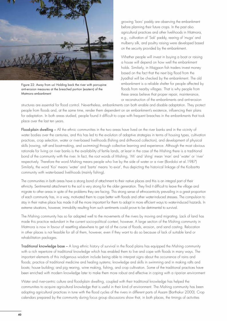
Adjusting to Floods on the Brahmaputra Plains, Assam, India
40
growing ‘boro’ paddy are observing the embankment before planning their future crops. In the past also agricultural practices and other livelihoods in Matmora, e.g., cultivation of ‘Sali’ paddy, rearing of ‘muga’ and mulberry silk, and poultry raising were developed based on the security provided by the embankment.
Whether people will invest in buying a boat or raising a house will depend on how well the embankment holds. Similarly, in Majgaon fi sh traders invest money based on the fact that the next big fl ood from the Jiyadhal will be checked by the embankment. The old embankment is a reliable shelter for people affected by fl oods from nearby villages. That is why people from these areas believe that proper repair, maintenance, or reconstruction of the embankments and anti-erosion
structures are essential for fl ood control. Nevertheless, embankments can both enable and disable adaptation. They protect people from fl oods and, at the same time, render them dependent on an embankment’s existence, infl uencing their plans for adaptation. In both areas studied, people found it diffi cult to cope with frequent breaches in the embankments that took place over the last ten years.
Flood-plain dwelling – All the ethnic communities in the two areas have lived on the river banks and in the vicinity of water bodies over the centuries, and this has led to the evolution of adaptive strategies in terms of housing types, cultivation practices, crop selection, water or river-based livelihoods (fi shing and driftwood collection), and development of physical skills (rowing, raft and boat-making, and swimming) through collective learning and experience. Although the most obvious rationale for living on river banks is the availability of fertile lands, at least in the case of the Mishing there is a traditional bond of the community with the river. In fact, the root words of Mishing, ‘Mi’ and ‘shing’ mean ‘man’ and ‘water’ or ‘river’ respectively. Therefore the word Mishing means people who live by the side of water or a river (Bordoloi et al.1987) Similarly, the word ‘Koi’ means ‘water’ and ‘barta’ means ‘to exist’, thus depicting the historical linkage of the Koibartta community with water-based livelihoods (mainly fi shing).
The communities in both areas have a strong bond of attachment to their native places and this is an integral part of their ethnicity. Sentimental attachment to the soil is very strong for the older generation. They fi nd it diffi cult to leave the village and migrate to other areas in spite of the problems they are facing. This strong sense of ethnocentricity prevailing in a great proportion of each community has, in a way, motivated them to cope better with fl oods and other water-induced stresses. The compulsion to stay in their native place has made it all the more important for them to adapt in more effi cient ways to water-induced hazards. In extreme situations, however, immobility resulting from such sentiments could prove to be detrimental to survival.
The Mishing community has so far adapted well to the movements of the rivers by moving and migrating. Lack of land has made this practice redundant in the current socio-political context, however. A large section of the Mishing community in Matmora is now in favour of resettling elsewhere to get rid of the curse of fl oods, erosion, and sand casting. Relocation in other places is not feasible for all of them, however, even if they want to do so because of lack of suitable land or rehabilitation packages.
Traditional knowledge base – A long ethnic history of survival in the fl ood plains has equipped the Mishing community with a rich repertoire of traditional knowledge which has enabled them to live and cope with fl oods in many ways. The important elements of this indigenous wisdom include being able to interpret signs about the occurrence of rains and fl oods; practice of traditional medicine and healing systems; knowledge and skills in swimming and in making rafts and boats; house building; and pig rearing, wine making, fi shing, and crop cultivation. Some of the traditional practices have been enriched with modern knowledge later to make them more robust and effective in coping with a riparian environment
Water and river-centric culture and fl ood-plain dwelling, coupled with their traditional knowledge has helped the communities to acquire agricultural knowledge that is useful in their kind of environment. The Mishing community has been adopting agricultural practices in tune with the fl ood cycles of the rivers in different parts of Assam (Barthakur 2000). Crop calendars prepared by the community during focus group discussions show that, in both places, the timings of activities
Figure 22: Away from us! Holding back the river with porcupine anti-erosion measures at the breached portion (eastern) of the Matmora embankment

Adjusting to Floods on the Brahmaputra Plains, Assam, India
41
related to cultivation have undergone gradual changes over the last decade in response to the impacts of fl oods. This is more evident in Majgaon than in Matmora, because there is hardly any agriculture in Matmora now, except in Bahpora. It is also a fact that their traditional agricultural knowledge needs to be strengthened by inputs from modern agricultural science and technology to enable them to cope with the changing impacts of fl oods.
Intervention of NGOs – Relief and rehabilitation programmes carried out by NGOs have helped people cope better both during and after fl oods in both study sites. IGSSS provided several facilities to the people of Majgaon such as tube wells, ring wells, seeds, high-rise seed banks, high-rise platform boats, and public address systems for fl ood warnings. Villagers now fi nd it easier to take refuge in high-rise platforms with their livestock, use the community boats for rescue, moving location, shopping for essentials, and fetching drinking water during fl oods. They can now save the seeds outside their house, especially in high fl oods when granaries are at risk. Getting drinking water, especially in the dry season, has become easier because of the tube wells. Food items, plastic roofi ng materials, and medicines were also provided by the NGO during the fl oods in 2007 and 2008. Other welfare organisations also distribute food items, clothes, and medicine to fl ood victims. In Matmora, the Rural Volunteer Centre, the Red Cross Society, and the ‘Takam Mishing Porin Kebang ‘(TMPK) provide relief materials such as plastic sheets for tents, hygiene kits (buckets, mugs, and water-purifying aids), and tube wells. In May 2009, the Peoples Action for Development (PAD), a voluntary organisation from Gogamukh, distributed boats in Bahpora and Khamon Birina, and these were used in the fl oods in June 2009 for rescue operations. Dependence on external aid, however, even if it is to a limited extent only, also limits innovative thinking about new ways of adapting and coping with fl oods. In both areas the study team tried to sensitise the people about reducing their reliance on external interventions and increasing their resilience by innovation, enterprise, and collective action.
Government policy and programmes – Under routine government disaster-relief operations, relief materials (mainly food) are distributed to those who are marooned by the fl oods: sometimes housing materials, such as corrugated sheets for roofi ng and cash, are also provided. Selected households in both study sites have received government help in recent years, but it was inadequate because of insuffi ciency of resources and lack of a proper and equitable distribution system. The communities complain that the list of BPL families usually targeted by government programmes does not include the growing number of poor families. Work on construction and repair of a road by the National Rural Employment Guarantee Act (NREGA) assisted the people in Majgaon with much-needed cash income in 2008. Villagers were provided with job cards and given an opportunity to work as labourers on the road. This road has facilitated communication between Majgaon and neighbouring villages, such Burhakuri, and the Bordoloni market. It also serves as an area of high ground for shelter during fl oods. Most of the women in the village were involved in this project, and the amount they received, though nominal and irregular, helped them to survive, at least temporarily. The ongoing construction of the new embankment in Matmora is expected to provide much- needed respite from annual fl oods in coming years.
Lack of proper policies in relevant sectors is a major hindrance to reducing people’s vulnerability enhancing their adaptation capacities. For example, the state is yet to put a water policy in place and the draft water policy does not address the impacts of climate change at all, nor does it address concerns for reducing vulnerability adequately. Critics say the policy once implemented may lead to increased vulnerability for rural people because it promotes water privatisation and natural water may also have a price tag in future. Government performance has been dismal in terms of providing proper rehabilitation and resettlement arrangements, and this makes people reluctant to shift to safer places because they have no confi dence in government promises. Often rehabilitation measures are not sensitive to the culture or the environment, resulting in allocation of land in places that are not acceptable for displaced people because they would fi nd it very diffi cult to adapt culturally or environmentally in those areas. Reluctance to leave temporary shelter on embankments or roads and having no alternative places to settle make the population even more vulnerable to the following year’s fl oods, as seen in Matmora. Moreover, permanent settlements on the embankment have damaged its structure, making it more prone to the onslaught of erosion in future. There is no clear policy on construction and maintenance of embankments. There are no policies or suitable programmes either for health hazards, fl ood insurance or fl ood-plain zoning, restoration of degraded lands, innovative agriculture on degraded land, and alternative livelihoods for fl ood-affected people. What is surprising is that even after the destruction of thousands of hectares of fertile agricultural land over the last decade in Dhemaji and Lakhimpur districts, no effective programme has been introduced by the agricultural departments in these areas to train people in soil restoration and alternative agro-practices suitable for sandy lands.
Changing nature of weather, climate, and fl oods – Although the communities have lived and coped with fl oods for years using their traditional knowledge and skills, their coping practices are no longer as effective as before because of the highly
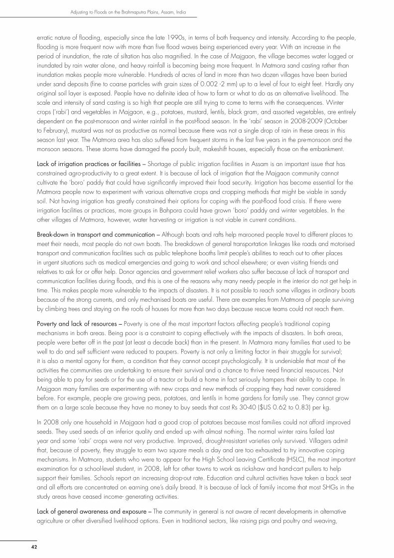
Adjusting to Floods on the Brahmaputra Plains, Assam, India
42
erratic nature of fl ooding, especially since the late 1990s, in terms of both frequency and intensity. According to the people, fl ooding is more frequent now with more than fi ve fl ood waves being experienced every year. With an increase in the period of inundation, the rate of siltation has also magnifi ed. In the case of Majgaon, the village becomes water logged or inundated by rain water alone, and heavy rainfall is becoming being more frequent. In Matmora sand casting rather than inundation makes people more vulnerable. Hundreds of acres of land in more than two dozen villages have been buried under sand deposits (fi ne to coarse particles with grain sizes of 0.002 -2 mm) up to a level of four to eight feet. Hardly any original soil layer is exposed. People have no defi nite idea of how to farm or what to do as an alternative livelihood. The scale and intensity of sand casting is so high that people are still trying to come to terms with the consequences. Winter crops (’rabi’) and vegetables in Majgaon, e.g., potatoes, mustard, lentils, black gram, and assorted vegetables, are entirely dependent on the post-monsoon and winter rainfall in the post-fl ood season. In the ‘rabi’ season in 2008-2009 (October to February), mustard was not as productive as normal because there was not a single drop of rain in these areas in this season last year. The Matmora area has also suffered from frequent storms in the last fi ve years in the pre-monsoon and the monsoon seasons. These storms have damaged the poorly built, makeshift houses, especially those on the embankment.
Lack of irrigation practices or facilities – Shortage of public irrigation facilities in Assam is an important issue that has constrained agro-productivity to a great extent. It is because of lack of irrigation that the Majgaon community cannot cultivate the ‘boro’ paddy that could have signifi cantly improved their food security. Irrigation has become essential for the Matmora people now to experiment with various alternative crops and cropping methods that might be viable in sandy soil. Not having irrigation has greatly constrained their options for coping with the post-fl ood food crisis. If there were irrigation facilities or practices, more groups in Bahpora could have grown ‘boro’ paddy and winter vegetables. In the other villages of Matmora, however, water harvesting or irrigation is not viable in current conditions.
Break-down in transport and communication – Although boats and rafts help marooned people travel to different places to meet their needs, most people do not own boats. The breakdown of general transportation linkages like roads and motorised transport and communication facilities such as public telephone booths limit people’s abilities to reach out to other places in urgent situations such as medical emergencies and going to work and school elsewhere; or even visiting friends and relatives to ask for or offer help. Donor agencies and government relief workers also suffer because of lack of transport and communication facilities during fl oods, and this is one of the reasons why many needy people in the interior do not get help in time. This makes people more vulnerable to the impacts of disasters. It is not possible to reach some villages in ordinary boats because of the strong currents, and only mechanised boats are useful. There are examples from Matmora of people surviving by climbing trees and staying on the roofs of houses for more than two days because rescue teams could not reach them.
Poverty and lack of resources – Poverty is one of the most important factors affecting people’s traditional coping mechanisms in both areas. Being poor is a constraint to coping effectively with the impacts of disasters. In both areas, people were better off in the past (at least a decade back) than in the present. In Matmora many families that used to be well to do and self suffi cient were reduced to paupers. Poverty is not only a limiting factor in their struggle for survival; it is also a mental agony for them, a condition that they cannot accept psychologically. It is undeniable that most of the activities the communities are undertaking to ensure their survival and a chance to thrive need fi nancial resources. Not being able to pay for seeds or for the use of a tractor or build a home in fact seriously hampers their ability to cope. In Majgaon many families are experimenting with new crops and new methods of cropping they had never considered before. For example, people are growing peas, potatoes, and lentils in home gardens for family use. They cannot grow them on a large scale because they have no money to buy seeds that cost Rs 30-40 ($US 0.62 to 0.83) per kg.
In 2008 only one household in Majgaon had a good crop of potatoes because most families could not afford improved seeds. They used seeds of an inferior quality and ended up with almost nothing. The normal winter rains failed last year and some ‘rabi’ crops were not very productive. Improved, drought-resistant varieties only survived. Villagers admit that, because of poverty, they struggle to earn two square meals a day and are too exhausted to try innovative coping mechanisms. In Matmora, students who were to appear for the High School Leaving Certifi cate (HSLC), the most important examination for a school-level student, in 2008, left for other towns to work as rickshaw and hand-cart pullers to help support their families. Schools report an increasing drop-out rate. Education and cultural activities have taken a back seat and all efforts are concentrated on earning one’s daily bread. It is because of lack of family income that most SHGs in the study areas have ceased income- generating activities.
Lack of general awareness and exposure – The community in general is not aware of recent developments in alternative agriculture or other diversifi ed livelihood options. Even in traditional sectors, like raising pigs and poultry and weaving,

Adjusting to Floods on the Brahmaputra Plains, Assam, India
43
their knowledge about improved practices and marketing channels is limited. In a situation in which the increasing impact of fl oods and the menace of sand casting have made agriculture less productive in Majgaon and almost non-existent in Matmora, specialised knowledge about and training on how to grow crops and vegetables in sandy and water-logged soils are become important elements in adaptation mechanisms. Innovations in agriculture, poultry, fi shing, or weaving need to be internalised to improve traditional coping practices that have become inadequate. Lack of exposure about how other communities in the state and nation are faring in similar situations also limits the capacity to adapt to a changed situation.
People in general understand that fl oods can be prevented and erosion arrested by proper structural measures because they have witnessed the same in their areas. Nevertheless, many people are not clear about the physical, geological, climatic, and anthropogenic factors causing and/or exacerbating fl ood hazards. That is precisely why it took time for people in Matmora to appreciate the fact that denudation of the forest was partly responsible for erosion.
Cultural mores and taboos – Vulnerability and adaptation are mainly determined by cultural mores, taboos, and superstitions of indigenous communities. Culture too can play a positive and a limiting role in coping and adaptation in traditional societies. Important examples from our study sites are the perceptions and taboos pertaining to living in stilt houses (of non-Mishing communities), selling fi sh, or making and selling liquor for a living. These aspects have been described already in this report.
Even when it is acknowledged that cultural perceptions are sensitive issues, it can be safely concluded that people’s resistance to living in stilt houses has made the non-Mishing community more vulnerable in the physical sense at least. Similarly taboos related to fi shing have hindered their adaptation for a long time. Notwithstanding, the interdiction related to selling country liquor in public has developed in the greater interest of the community, keeping in mind the affect on health and the social degeneration that it could lead to in a traditional society. Such norms are deep rooted but not rigid. In fact changing situations have paved the way for gradual changes in people’s mindsets regarding these proscriptions. In Majgaon such changes started to take place at the beginning of the eighties, whereas in Matmora things changed rapidly after 1998
Risk trade-off – A careful look at how communities have tried to adapt to the varied impacts of water hazards reveals that, in many cases, these are actually attempts to choose between two or more options with different degrees of vulnerability. This results sometimes in choosing a more vulnerable option. For example, the migrant youth of Majgaon are contributing to improvement of the household economy. At the same time, some of them are being called back by their parents because there is insuffi cient manpower for farming, and the latter is a greater need than jobs and remittances. At the government level, construction of embankments is an example of risk trade-off. It protects the population for some time but causes water logging on the country side and, when it fails, fl ash fl oods assume devastating proportions. Settlements on the embankment protect the people as long as the embankment lasts; but embankments wear out with settlement activities. In Majgaon eight families have shifted to the high banks of the River Na-Nadi because it is better for agriculture; but, in the process, they are slowly losing the social safety net of the parent village and the school in Majgaon is too far for the children, especially in rainy season when the farmlands on the way to school contain water up to four feet deep. They are now planning to send the mothers and children back to the village, so that the children can continue their education.
Local governance and politics – Breaching of embankments, events now taken for granted every rainy season, have become a symbol of bad governance, corruption, and the unholy nexus between the contractor, politicians, and government departments. People of Matmora allege that there is gross negligence on the part of the Water Resources’ Department of Assam in terms of repairing the embankment in a technically sound manner earlier and reconstructing the eroded and breached portion of the embankment after 2007. After the 2007 fl oods the embankment was built from soil and sand only and, too, only a fraction of it was completed before the fl oods of 2008 brought it down again. The new embankment being built with geo-tube technology could not be completed before the fl ood season in 2009. As a result the incomplete piles of tubes were washed away by the fl oods in the fourth week of June, causing yet another major fl ood in Matmora. People and newspaper reports blame the connivance between local offi cials of the Water Resources’ Department, politically powerful people, and contractors for the Matmora debacle over the last three years. Petty political interests and the lack of strong, organised protests from the communities are mainly responsible for the stark underdevelopment and improper implementation of development programmes in Matmora area. Lack of opportunities for local organisations and institutions to participate in the decision-making process and governance of embankments is an issue of concern.

Adjusting to Floods on the Brahmaputra Plains, Assam, India
44
Conclusions and way forward
Analysis of different adaptations (or maladaptations)
Analysis of major coping and adaptation strategies–Stilt houses (‘chang ghar’) of the Mishing community (a) protect the household from fl ood waters, and the multipurpose use of the house allows for rearing pigs and normal cooking and sanitation practices during fl oods; (b) the old style houses on bamboo and wooden pillars have adjustable fl oors to match the rising water level: in Matmora it will be costly to raise the height of the plinth and fl oor of those houses dwarfed by four to six feet of sand; (c) modifi cations by using concrete make the posts and pillars (usually the part of the house most exposed to water) more durable and resistant to fl ood currents, however, houses modifi ed with concrete pillars and staircases have lost the fl exibility to adjust to water levels; and (d) although the stilt houses have endured for centuries, in places like Matmora their effi cacy has decreased because of sand casting which deprives the house of some of the height over ground level. Living in stilt houses as an adaptation strategy will remain sustainable if the problems of sand casting are managed successfully or if the elevation of the house is raised proportionately. In the context of future climate change impacts and a worsening fl ood scenario, it will be diffi cult for very poor families to maintain stilt houses.
Houses with raised foundations (non-Mishing community)
(a) This house type protects people in normal fl oods, but is far less effective than the stilt houses in dealing with severe fl oods. The in-house raised platforms on which the family stays when the house is submerged are inconvenient and uncomfortable, especially for women.
(b) The height of the foundation can be raised periodically with earth fi lling or by using brick and concrete, which is too costly for poor families; however the in-house platforms can be raised as required.
(c) The provision for an in-house raised platform is culturally acceptable whereas the stilt houses are not, which makes it a feasible option.
(d) It is sustainable in the sense that villagers have lived in these raised homesteads for many years. With more frequent fl ooding, changes in the village morphology, and chances of higher fl ood levels, however, the foundation might need to be raised periodically also. Hence these houses may remain effective in future only for those who can invest in repairing and elevating them.
Alternative livelihoods
These include selling fi sh including dried fi sh, selling liquor, carpentry, daily wage labour, and labour migration.
(a) These alternative options helped people to tide over and meet their immediate needs for cash and food after mainstream agriculture failed in consecutive years, and people became homeless and temporarily displaced.
(b) All the options are fl exible, people can change the way they are doing things now if needed in future or adopt other occupations. People have already shown a great deal of resilience in choosing and adapting to new livelihoods.
(c) People have resorted to these activities out of compulsion and in the absence of other options: not much creativity but rather desperation is the reason for breaking social norms. (d). All other options will remain sustainable except that of daily wage labour which is uncertain because it depends on suitable opportunities being available locally.
Food storage
(a) The food storage methods used currently by all the communities (described earlier) ensure that essential food items are not damaged by fl ood water.
(b) With increasing inundation periods more food needs to be stored, and the community cannot afford to do this.
(c) Food-storage techniques are both innovative and creative because they are tuned to the local micro environment and fl ood levels. People know what will last long and what will not, they know how to survive and maintain nutrition with minimum amounts of food. The selection of food for storing and carrying away in case they need to move includes rice, ‘apong’, dried fi sh, and vegetables in that order of importance.
d) The traditional food-storage techniques of the Mishing will work as long as the stilt houses are effective. There is not enough opportunity to maintain these practices when people are in temporary settlements like those on the embankments.

Adjusting to Floods on the Brahmaputra Plains, Assam, India
Agriculture
(a) The ‘bao’ paddy that is grown most successfully is water resistant and grows in water-logged and marshy areas; and some varieties can withstand strong currents. The practice of mixing ‘bao’ and ‘ahu’ cultivation ensures that at least one crop survives in the case of early or high fl oods. Cultivation of ‘boro’ paddy is a suitable alternative for these areas and more people are expected to plant it to ensure food security in Bahpora.
(b) The winter (‘rabi’) crops or autumn rice follow a modifi ed cropping calendar to escape from the main fl ood waves. The changed crop calendars are well adjusted to the current, normal fl ood cycle and provide an element of fl exibility to the practices.
(c) Mixed paddy, a new crop calendar, ‘boro’ paddy in naturally water-logged areas, and the most recent pit culture in the sandy soil of Matmora (Figure 23) are examples of innovation and novelty.
(d) All these agricultural practices are suitable and viable in these areas. The water requirements for ‘boro’ paddy can be met either by using water bodies in the locality or by using water pumps through SHG or cooperative famer groups. Provision of irrigation facilities by the Government would be very useful.
Shelter and settlement on embankments (maladaptation)
(a) Embankments are preferred for immediate shelter during fl oods and some people who have lost their homes stay back for a long time, and even permanently, on the embankment. Being much higher than the fl ood plains, people on the embankment are protected physically, but the possibility of erosion and breaches make them vulnerable also. If the embankment breaches in the midst of a fl ood, the people on it become isolated and damage and loss of life can be greater than if they had taken shelter in other places.
(b) This option is fl exible in Matmora to date because people like to accommodate each other even if the embankment is overcrowded. The situation may change in future with increasing damage to the embankment due to human pressure. The changing nature of fl oods and erosion may cause the embankment to breach more frequently, rendering it an unsafe option.
(c) No creativity or innovation is associated with this option; it is rather a compulsion when no other high ground is available nearby.
(d) The sustainability of this strategy depends on the physical state of the embankment. As soon as the condition of the embankment deteriorates it will no longer be a suitable safe place.
Shifting of the village to safer places (for the Matmora area)
(a) It used to be a common practice for the Mishing people of Matmora to leave their old homes and settle in new areas when their old villages were engulfed by the river or became too vulnerable to erosion. Moving the whole village or a certain number of families to safer paces worked well as an adaptation strategy in the past because there was no dearth of land where new villages and colonies could be established. But the respite achieved by shifting was only temporary, because the advancing river would very soon consume the new localities and they would shift to yet another place as happened in Matmora, Janji, Arkep, and Bali. At present there is not enough vacant land in which large numbers of people can settle. So, as a strategy, it has become less viable.
(b) This option is losing the fl exibility it used to have in the past in the sense that it is not easy for people to choose a place and go and settle there because of paucity of fertile land by the river.
(c) It developed as an adaptation mechanism as a natural recourse to the need to meet the changes in a dynamic riverine environment. It had no element of innovation or creativity.
(d) In the present circumstances it will not remain a sustainable activity for long unless suitable places are provided by the Government for rehabilitation and resettlement.
Figure 23: Learning to live with sand – vegetables like pumpkins and gourds are grown by planting the seeds in deep pits in Opar Khamon, Matmora
45

Adjusting to Floods on the Brahmaputra Plains, Assam, India
46
Possible adaptation options
Possible options for adaptation are summarised in Table 8.
Table 8: Assessing adaptation options in the context of climate variability and change
Possible Local Adaptation Options
Who benefi ts from this option?
What kind of activities are necessary?
How much investment required?
Potential adverse consequences?
Etc.
Facilitate strengthening of houses on stilts for the Mishing community
Entire Mishing community including those residing on the embankment
Provide easy housing loans for constructing, repairing and raising of stilt houses
US$ 150,000 Unwillingness to repay loans on the part of the community
Promote safe housing for non-Mishing communities
Entire non-Mishing community
Promote housing awareness, facilitate repairing and raising of homesteads with easy subsidised fi nancing/loans for non-Mishing communities in Majgaon and Bahpora
US$ 200,000 Unwillingness to repay loans on the part of the community
Small-scale water harvesting
Small holder farmers for agricultural use, general households for domestic purposes and for livestock
Using already existing natural depressions in both sites including abandoned channels of rivers, small pond like structures created by earth cutting for the road in Majgaon , digging out new ponds in at both sites
US$ 20,000 Creation of water logged area, germination of mosquitoes, downstream users?
Training and education on innovative agriculture suited for fl ood and sand- affected areas.
Whole community especially farmers
General awareness and hands on agricultural training by agricultural experts, researchers, entrepreneurs, successful farmers from other places, training on new farming techniques on degraded land, water-resistant varieties of paddy and other crops and marketing strategies
US$ 30,000 Lack of support for seeds, irrigation, and crop insurance
Provide seeds Make quality seeds of various crops and vegetables available to the farmers free of cost at least for fi ve consecutive years
US$ 60,000 Indigenous varieties may lose preference to high-yielding varieties
Education on alternative diversifi ed livelihood options
Youth, women, other interested individuals
Awareness on other options not known to the community that could be feasible in their environment and conditions also about how to optimise gains from the existing options
US$ 25,000 Expectation will be created in the community about further fi nancial support for adopting the same
Promote fi shing as a livelihood
Families involved in fi shing in both sites
Provide fi nancial incentives for buying boats and fi shing gear to families, form community cooperatives, and facilitate easy lease of fi sh bearing areas, create small fi sheries
US$ 120,000 May not be welcomed by some in the community initially, but persistence will pay

Adjusting to Floods on the Brahmaputra Plains, Assam, India
47
Training skill enhancement in weaving and marketing woven products
Women mainly, also young entrepreneurs, traders, merchants
Hands on training by experts on how to do it more effi ciently on larger commercial scale, new design; promotion of traditional tribal textiles of the Mishing community, other common weaving products by other groups; creating network of producers, marketers, and sellers
US$ 25,000 The Mishing traditional weaving is gorgeous, colourful, and attractive and other groups may feel less benefi tted
Creating a network of volunteers for dissemination of early warning and local specifi c forecast products
All communities of target villages and nearby areas
Educating volunteers equipped with mobile phones about information gathering about fl ood forecasting and early warning, incorporate individuals from upstream foothills to the target villages along the river stretch, include government personnel into the network, producing forecast statements in local languages incorporating inputs from national and international meteorological agencies
US$ 40,000 Fear of rumour mongering or false information being propagated and panic in the community
Introduce mobile (on wheels) as well as fl oating (on boat) dispensary with doctors and nurses, basic medicines and treatment for water borne diseases and child birth
Community as a whole especially women and children
Visit villages every day during and after fl oods and on urgent calls, refer more serious cases for advanced treatment
US$ 50,000 Unnecessary or unsolicited urgent calls, community ignoring traditional medicine for urgent application
Introduce fl eet of large and small boats for rescue and communication under community ownership at least two small and two large boats per village
Community as a whole, especially old people, children and women
Make boats, set up institutional arrangement for community ownership and use, ensure access by the poor and needy
US$ 20,000 Over dependence on community boats to communicate and commute, less emphasis on their own efforts
Construct separate high rise platforms in Matmora villages (at least two) for humans and cattle and one platform for humans in Majgaon
Whole community, livestock
Get structures constructed using paid community labour, set up norms for use
US$ 20,000 People may like to over use or use for a long time even after the situation becomes normal, injuring infrastructure
Initiate and strengthen structural measures
Whole community Repair the embankments on the Brahmaputra properly (Matmora) and Jiadhal (near Majgaon); build an embankment on the River Na-Nadi near Majgaon; Construct a sluice gate near Majgaon to fl ush out additional water-logging in low lying areas
No idea about how to estimate such costs, it is primarily the responsibility of the state government
Over dependence on structures may stunt growth of adaptation and coping mechanism

Adjusting to Floods on the Brahmaputra Plains, Assam, India
48
Existing gaps and further knowledge needs
(i) At present, knowledge about future climate change in the Brahmaputra basin and consequent impacts on the Brahmaputra fl ood plains is limited. Proper research should be carried out as a priority by ICIMOD in order to establish a knowledge base derived from General Circulation Models (GCM) and regional models as well as empirical research and statistical analysis. Detailed study and documentation need to be taken up in order to map the impacts of climate change and climate variability(both observed and expected) on the spatial scales of the whole Brahmaputra basin, the eastern Himalayan region, Northeast Indian region, the Brahmaputra valley, and Assam—downscaling to the district levels of Dhemaji and Lakhimpur.
(ii) There is no comprehensive socioeconomic and cultural database specifi c to these villages. Reliable data should be generated for the districts, development blocks, panchayats, and the villages. Some data and information have been collected during the literature review for this study, but this needs to be augmented, organised, and updated.
(iii) Little policy research is carried out in the disaster risk reduction (DRR) sector in Assam. As a result no information has been available about different policies or programmes relevant to DRR and climate change at district level in these areas or for the target villages. An attempt has been made by ICIMOD in this study to gather information about various government policies and programmes as well as those of development agencies and local NGOs related to DRR and adaptation strategies in collaboration with the National Institute of Disaster Management (NIDM), New Delhi. Related issues such as impacts (both positive and negative) of policies and lack of policies and programmes are being studied with respect to the target villages. When the results of this policy analysis study are completed they are expected to refl ect the ground realities of the districts as a whole.
BibliographyAhmed, S; Mustafa, D (2007) Understanding vulnerability, building capacity: Concept, approaches and insights. In Moench, M; Dixit, A (eds) Working with the winds of change: Towards strategies for responding to the risks associated with climate change and other hazards. Kathmandu: Institute for Social and Environmental Transition, and Boulder: ProVention
AKRSP (2007) Formalisation of local support organisations: A study in the institutional development in Chitral. Chitral: AKRSP
Alam, M; Nishat, A; Siddiqui, SM (1998) ‘Water resources vulnerability to climate change with special reference to inundation’. In Vulnerability and adaptation to climate change for Bangladesh. Dordrecht: Kluwer Academic Publishers
Bajracharya, SR; Mool, PK; Shrestha, BR (2007) Impact of climate change on Himalayan glaciers and glacial lakes, case studies on GLOF and associated hazards in Nepal and Bhutan. Kathmandu: ICIMOD and UNEP
Census of India (2001) Report of census of India-2001, Series 1, Paper 1 of 2001, Provisional Population Totals. New Delhi: Directorate of Census of India, Government of India
CBS (2003) National sample census of agriculture Nepal, 2001/02, highlights. Kathmandu: HMG National Planning and Commission Secretariat, Central Bureau of Statistics
Chen, ZY (2001) Yunnan climate [M] pp 162-166. Beijing: Meteorological Press
Cheng, JG; Xie MG (2008) ‘The analysis of regional climate change features over Yunnan in recent 50 years.’ Progress in Geography, 27(5):19-26 (in Chinese)
Chew, L; Ramdas, K (2005) Caught in the storm: The impact of natural disasters on women. San Francisco: The Global Fund for Women
Das, PJ (2004) Rainfall regime of northeast India: A hydrometeorological study with special emphasis on the Brahmaputra basin. Unpublished PhD thesis, Gauhati University, Gauhati, India
Datta Ray, B; Deb, BJ (eds) (2006) Changing agricultural scenario in north-east India. New Delhi: Concept Publishing Company
Dekens, J (2008) ‘Local knowledge on fl ood preparedness: Examples from Nepal and Pakistan’. In Indigenous knowledge for disaster risk reduction: Good practices and lessons learned from experiences in the Asia-pacifi c region. Bangkok: ISDR
Deshingkar, P; Kumar, S; Chobey, HK; Kumar, D (2006) The role of migration and remittances in promoting livelihoods in Bihar. London: Overseas Development Institute
Dixit, A (2009) ‘Kosi embankment breach in Nepal: Need for a paradigm shift in responding to fl oods’. Economic and Political Weekly, Mumbai
Dixit, A; Pokhrel, A; Moench, M (2008) ‘Costs and benefi ts of fl ood mitigation in the lower Bagmati basin: Case of Nepal Terai and north Bihar, India’. From Risk to Resilience Working Paper No. 689 Kathmandu: ISET, ISET-Nepal & Provention
Duan, K; Yao, T (2004) ‘Low-frequency of southern Asian monsoon variability using a 295-year record from the Dasuopu ice core in the central Himalayas’. Geophysical Research Letters 31
Enarson, E (2001 Gender equality, environmental management and natural disaster mitigation. Bangkok: ISDR

Adjusting to Floods on the Brahmaputra Plains, Assam, India
49
Eriksson, M; Xu, J; Shrestha ,AB; Vaidya, RA; Nepal, S; Sandström, K (2009) The changing Himalayas – Impact of climate change on water resources and livelihoods in the greater Himalayas. Kathmandu: ICIMOD
GEAG (2007) Adaptive capacities of communities to cope with fl ood situation: A documentation of community based agricultural and non-agricultural practices. Gorakhpur: Gorakhpur Environmental Action Group
Goswami, DC; Das, PJ (2003) ‘The Brahmaputra River, India: The eco-hydrological context of water use in one of world’s most unique river systems.’ Ecologist Asia 11 (1): 9-11
GOB (2009) Economic Survey. 2008-09. Patna: Government of Bihar
GOB (1994) Report of the Second Irrigation Commission of Bihar. Patna: Government of Bihar
Haserodt, C (1996) ‘The geographical features and problems of Chitral: A short introduction’. In Israr-ud-Din, Bashir E (eds) Proceedings of the Second Hindu-Kush Cultural Conference, pp. 3-18. Karachi: Oxford University Press
He, YL; Zhang, YP; (2005) ‘Climate change from 1960 to 2000 in the Lancang river valley, China’. Mountain Research and Development 25(4):341-348
Herbers, H (2008) ‘The changing position of women in northern Pakistan: From agriculture producers to off farm employees’. In Israr-ud-Din (ed) Proceedings of the Third Hindu-Kush Cultural Conference, pp. 211-220. Karachi: Oxford University Press
HMG (1991) Climatic records of Nepal of the year 1988, 1989 and 1990. Kathmandu: Department of Hydrology & Meteorology
HMG (2005): Statistical information on Nepalese agriculture, time series information. Kathmandu: Agri-Business Promotion and Statistics Division, Ministry of Agriculture and Co-operatives
ICIMOD (1996) Climatic and hydrological atlas of Nepal. Kathmandu: ICIMOD
IPCC (2007b) ‘Climate change 2007: Impacts, adaptation and vulnerability’. In Parry, ML; Canziani, OF; Palutikof, JP; van der Linden, PJ; Hanson, CE (eds) Contribution of working Group II to the Fourth Assessment Report of the Intergovernmental Panel on Climate Change, Cambridge (UK): Cambridge University Press
ISET (2008) From research to capacity, policy and action, enabling adaptation to climate change for poor population in Asia through research, capacity building and innovation, A report from the adaptation team to IDRC coordinated by ISET. Kathmandu: ISET-Nepal
Israr-ud-Din (2008) ‘Chitral district: A Brief survey of resources, problems, constraints and future development’. In Israr-ud-Din (ed) Proceedings of the Third Hindu-Kush Cultural Conference, pp. 175-186. Karachi: Oxford University Press
IUCN (2004) Chitral: A study in statecraft (1320-1969). Karachi: IUCN Pakistan
IUCN (2005) Socio-economic survey of selected villages in Shishikoh valley with special focus on chalghoza pine and its contribution to livelihoods. Chitral: IUCN Chitral Publications
IUCN (2005) Socio-economic condition and mechanism for water distribution in Kirmatabad, Mukhow. Chitral: IUCN Chitral Publications
IWMI (2004) Drought mitigation in Pakistan: Current status and options for future strategies, Drought series Paper 3, Working Paper 85. Battaramulla, (Sri Lanka): International Water Management Institute. http://www.iwmi.cgiar.org/droughtassessment/fi les/pdf/WP%2085.pdf
Jianchu, X; Shrestha, A; Vaidya, R; Eriksson, M; Hewitt, K (2007) The melting Himalayas: Regional challenges and local impacts of climate change on mountain ecosystems and livelihoods. Kathmandu: ICIMOD
Komino, T (2008) Indigenous coping mechanisms for disaster management in Mansehra and Battagram districts, North West Frontier Province (NWFP), Pakistan. In Indigenous knowledge for disaster risk reduction: Good practices and lessons learned from experiences in the Asia-Pacific region. Bangkok: ISDR http://www.unisdr.org/eng/about_isdr/isdr-publications/19-Indigenous_Knowledge-DRR/Indigenous_Knowledge-DRR.pdf
Kull, D; Singh, P; Chopde, S; Wajih, S (2008) Evaluation cost and benefi ts of fl ood reduction under changing climatic conditions: The case of Rohini river basin, India, Working Paper No. 4. Kathmandu: ISET, ISET-Nepal & Provention
Li, ZQ; Han, TD; Jing, ZF; Yang, HA; Jio, KQ (2003) ‘A summary of 40-year observed variation facts of climate and glacier No.1 at headwater of Urumqi River, Tianshan, China’. Journal of Glaciology and Geocryology 2:117-123
Liu, JG; Li, SX; Ouyang, ZY; Tarn, C; Chen, XD (2008) Ecological and socioeconomic effects of China’s policies for ecosystem services. PNAS 105(28):9477-9482
Ma, X; Xu, JC; Luo, Y; Aggarwal, SP; Li, JT (2009) ‘Response of hydrological processes to land cover and climate change in Kejie watershed, Southwest China’. Hydrological Process 23:1179-1191
Ma, X; Xu, JC; Qian, J (2008) ‘Water resource management in a middle mountain watershed: A case study in Xizhuang, Yunnan, China’. Mountain Research and Development 28(3/4):286-291
Moench, M (2006) ‘Water, climatic variability and livelihood resilience: Concepts, fi eld insights and policy implications’. In Adaptation to climate variability and change: Review of policies and programmes of government of India. New Delhi: Winrock International India.
NRSA (1995) India: Report on area statistics of landuse/landcover generated using remote sensing techniques, 1995. Hyderabad: National Remote Sensing Agency
Peng, S (2004) Rice yields decline with higher night temperature from global warming. Manila: International Rice Research Institute.
Registrar General of India (2001) Census of India. New Delhi: Government of India

Adjusting to Floods on the Brahmaputra Plains, Assam, India
50
Sarma, JN (2005) ‘Fluvial process and morphology of the Brahmaputra river in Assam, India.’ Geomorphology 70:226-256
Schipper, ELF; Burton, I (2009) ‘Understanding adaptation: Origins, concepts, practice and policy’. In Schipper, ELS; Burton, I (eds) The Earthscan reader on adaptation to climate change. London: Earthscan Publications Ltd.
Shimpei, A (2007) ‘Agricultural technologies of terraced rice cultivation in the Ailao Mountains, Yunnan, China’. Asian and African Area Studies 6(2):173-196
Shrestha, AB; Wake, CP; Mayewski, PA; Dibb, JE (1999) ‘Maximum temperature trends in the Himalaya and its vicinity: An analysis based on temperature records from Nepal for the period 1971–94’. Journal of Climate 12:2775-2786
Singh, P; Bengtsson, L (2005) ‘Impact of warmer climate on melt and evaporation for the rainfed, snow fed and glacier fed basins in the Himalayan region’. Journal of Hydrology 300:140-151
Singh, P (2003) Colonising the rivers: Colonial technology, irrigation and fl ood control in north Bihar, 1850-1950. PhD Thesis, Jawaharlal Nehru University, New Delhi, India
Sinha, CP (2008) ‘Management of fl oods in Bihar’, Economic and Political Weekly, September 6, 2008
Sinha, R (2008) ‘Kosi: Rising waters, dynamic channels and human disasters’. Economic and Political Weekly, September 6, 2008
Song et al., (n.d.) Rangeland resources and livelihoods in the Dimaluo Valley, Gongshan County, Yunnan, China. Kunming (China): Center of Biodiversity and Traditional Knowledge (CBIK)
UNDP (2007) Human development report: Fighting climate change, human solidarity in a divided world. New York: United Nations Development Programme
Wood G; Shakil, S (2003) Collective action: From outside to inside, Proceedings of AKRSP Lessons Learned Exercise. Islamabad: AKRSP
WorldBank (2005) Pakistan country water resources assistance strategy water economy: Running dry Report No.34081-PK. Islamabad: World Bank, South Asia Region Agriculture and Rural Development. Unit http://siteresources.worldbank.org/PAKISTANEXTN/Resources/PWCAS-Full.pdf
Xie, ME; Cheng, JG (2004) ‘Characteristics and formation mechanism of weather disasters in Yunnan province’. Scientia Geographica Sinica 24 (6): 721-725
Xue, H (2005) Assessing the role of risk in agro-pastoral livelihoods in Shangrila County, Northwest Yunnan Province. Kunming (China) : Centre for Biodiversity and Indigenous Knowledge (CBIK).
Zhang, PZ; et al. (2008) ‘A test of climate, sun, and culture relationships from an 1810-year Chinese cave record’. Science 322(5903):940-942
Acronyms and abbreviations
ASRB Assam State Road Board
BPL below the poverty line
CWC Central Water Commission
DES Department of Economics and Statistics
DRDA District Rural Development Agency
DRR disaster risk reduction
GCM General Circulation Model
GLOF glacial lake outburst fl ood
ICIMOD International Centre for Integrated Mountain Development
IGSSS Indo Global Social Service Society
IMD India Meteorological Department
IPCC Inter-Governmental Panel for Climate Change
LDOF landslide dam outburst fl ood
NEFA North East Frontier Agency
NGO non-government organisation
NIDM National Institute of Disaster Management
NREGA National Rural Employment Guarantee Act
PAD People’s Action for Development
PRA participatory rural appraisal
RCC reinforced concrete

Adjusting to Floods on the Brahmaputra Plains, Assam, India
51
R&R relief and rehabilitation
RRA rapid rural appraisal
SC scheduled caste
SHG self help group
TMPK Takam Mishing Porin Kebang
Local terms
Ali Ai Ligang: The most important colourful Spring Festival of the Mishing community which is held every year on the fi rst Wednesday of the month of ‘Ginmur Polo’, i.e.,the Assamese month of Fagun (approximately from mid February to mid March in the English calendar). The community observes this festival to appease mother earth and their forefathers and mark the sowing of the new seeds. ‘Ali’ means root or seed; ‘Ai’ or ‘yai’ means fruit, and ‘Ligang’ means sowing. Thus Ali-Ai-Ligang refers to the ceremonial sowing of paddy which starts on a Wednesday
Aniruddha Deva: Aniruddha Deva was the spiritual leader of the Mayamaria community or the Mattaks who propounded another school of the Vaishnavite religion after Srimanta Sankardeva.
Apong is traditional rice beer, a delicacy for the Mishing community.
Bhur refers to a rectangular raft made of banana tree stumps which is ubiquitous in all fl ood prone areas in Assam. It provides an immediate means of transport on water during fl oods.
Bolia Pani: ‘Bolia’ means mad and ‘pani’ means water: Bolia pani is also used to indicate a situation when rivers carry a heavy discharge of water and fl ood the banks suddenly as if the river has become mad.
Bortop: A Bortop is a cannon which was used in the latter part of Ahom rule.
Chang Ghar: Chang means a platform and ghar mean a house. A chang ghar is a typical Mishing dwelling built on stilts of bamboo or wood (now-a-days with RCC pillars)
Chapori: Another name in Assamese for the char.
Char: Char refers to mid-river islands that are usually of temporary or seasonal nature in existence, e.g., those in the river Brahmaputra in Assam and Bangladesh.
Chariali: An Assamese word meaning a junction of four roads heading in different directions or a crossing of four roads from different directions.
Dabaru Puja: A religious ritual of the Mishing community
Donyi-Polo: The Mishing consider themselves to be descendants of the sun and the moon gods. They regard Polo (moon) as their father while Donyi (sun) is their mother. They are always worshipped at any ceremony, before business, or in necessity or need.
Jaluwoi refers to a person skilled in catching fi sh by using a net.
Mahaldar: (Usually a lease owner or a contractor in the context of fi shing) A person who hires a fi shery, or a water body or a river, on lease from the state or district authorities and in return enjoys the right to fi sh and sell the catch for. He can sublease part of the fi shery to other contractors.
Mayamoria: A small community of people also known as the Mattaks confi ned mainly to eastern Assam. They organised a rebellion during the Ahom rule protesting against the religious hegemony of the Ahom kings.
Namghar: The Namghar is a traditional community prayer house or hall and an important socioreligious institution of Assamese society: a contribution of the Neo-Vaishnavite religion propounded by Saint Sankardeva in the 15th and 16th century.

Adjusting to Floods on the Brahmaputra Plains, Assam, India
52
Pahar Bhanga Pani: Pahar means hills, bhanga means to break, and pani means water. It means water that gushes out of the hills as if breaking the hills apart, often referring to the deluge of a fl ash fl ood caused by cloudbursts or heavy rains or landslide dam outburst fl oods in the hills of Arunachal Pradesh (Himalayas)
Panchayat: The Panchayat is the village-level constitutional agency in India for local governance and its members are elected by the people of rural areas.
Srimanta Sankar Deva (1449-1568): A great saint-scholar, playwright, socioreligious reformer, Srimanta Sankar Deva is a colossal fi gure in the cultural and religious history of Assam. He provided a thread of unity to Assam straddling two major kingdoms (Ahom and Koch kingdoms). He is the person who founded the bedrock of Assamese culture and literature building on past literary activities. His biggest contribution was the new religion he had propounded that gave shape to a set of new values and social synthesis. The religion he preached called ‘Mahapuruxiya Dharma’ was part of the Bhakti movement then fl ourishing in India. It is practised by a large population, and Sattras (monasteries) that he and his followers established continue to fl ourish and sustain his legacy of the Neo-Vaiśnavite Movement. His literary and artistic contributions are living traditions in Assam today.
Srimanta Sankar Dev Sangha: Srimanta Sankardev Sangha, the largest sociocultural and religious organisation in the North-east was set up in Nagaon district of Assam in 1930 with the aim to perpetuate the ‘Ek Saran Nam Dharma’, the egalitarian spirit of the new Vaishanvite religion propounded by Srimanta Sankardeva. It runs schools promoting spiritual education, dance forms, music, and literature created by Sankaradeva.
Uram Festival: A religious festival of the Mishing community
Other local terms and local seed varieties are explained in the text.

Adjusting to Floods on the Brahmaputra Plains, Assam, India
53
Annex

Adjusting to Floods on the Brahmaputra Plains, Assam, India
54
Table A1: Step by step and chronological approach to the research
Month Week Activity
June Week 1 First communication regarding the project from ICIMOD
June Week 2 Participation in the inception workshop at ICIMOD and conceptualisation of the fi eld campaign
June Week 3 Reporting to the project implementing agency (Aaranyak) by team leader about organisation of the project and the ToR
July Week 1-2 Formation of fi eld team with Team leader, one RA and two Project Assistants, visit of team leader to some probable fi eld sites and interaction with probable local partners
July Week 3-4 Orientation of fi eld team
July Week 4 Offi cial endorsement of the Letter of Agreement (LoA) and ToR by ICIMOD and Aaranyak
August Week 1-4 Visit to different probable project sites with research associates; RRA, site identifi cation
August-September Whole two months
Stock taking of literature
August Week 1-4 Building local network of partner organisations and facilitators
September-February All weeks Actual fi eld work in two sites; viz., participatory research- phase-I
January Week 4 Presentation of preliminary results by team leader at the National Institute of Disaster Management (NIDM), New Delhi
February Week 1 Presentation of project results in the Delhi Sustainable Development Summit (DSDS)-2009
February Week 2 Interaction of fi eld team with visiting experts from ICIMOD; joint fi eld work
February Week 3-4 Analysis of fi eld data and writing of fi rst draft report, submission of report to ICIMOD
March Week 1-2 Participation in report back workshop at Dhulikhel
March Week 3-4 Further literature review
April-June All weeks Field work - Phase-II
April Week 4 Tour of fi eld sites with policy expert consultant and NIDM policy team
June Week 1-2 Field work with participation of ICIMOD expert and fi lm team
June Week 4 Survey of fl ood situation by local fi eld team
June- July June week 4 to July week 2
Writing the second draft of the report
July Week 4 Presentation of progress and summary of results in Aaranyak research seminar
Number of fi eld visits: 10 times (for 2 sites) in the two phases; Field days: At least 100 days for both sites covered by different fi eld team members
Annex: Details of research methods

Adjusting to Floods on the Brahmaputra Plains, Assam, India
55
Table A2: Details of PRA exercises
PRA method Number of events Number of participants
Ethnic representation
Gender representation
Majgaon Matmora Total Majgaon Matmora Total Majgaon Matmora
Transect walk 7 12 19 36 62 98 Ahom-23 Chutiya-13
Mishing-32; SC-20;Brahmin-4;Bihari-6
Women(33), Men(65)
Focus group 16 22 38 132 156 288 Ahom-78, Chutiya-54
Mishing-74; SC-56; Brahmin-12; Bihari-14
Women(92), Men(64)
Community meeting
4 4 8 97 128 225 Ahom-55 Chutiya-42
Mishing-67; SC-47; Brahmin-6; Bihari-8
Women(130), Man(95)
Key informant interview
8 12 20 8 12 20 Ahom-5
Chutiya-3
Mishing-6; SC-4; Brahmin-1; Bihari-1
Women(8), Men(12)
Semi- structured interview (household survey with semi-structured questionnaire) in phase-I
17* 37* 54* 17** 37** 46** Ahom-11
Chutiya-6
Mishing-20; SC-13; Brahmin-2; Bihari-2
Woman(17), Men(30)
Resource mapping 16 27 43 86 140 226 Ahom-27
Chutiya-16
Mishing-33; SC-36; Brahmin-6; Bihari-11
Women(32), Men(24)
Historical timeline & trend analysis
1 1 2 25 15 37 Ahom-13
Chutiya-12
Mishing 15 Women(16), Men(21)
Informal discussion/chat
15 20 35 Not recorded
NR NR NR NR NR
*Number of households visited; **Number of respondents on behalf of the households

Adjusting to Floods on the Brahmaputra Plains, Assam, India
56
Table A3: Monthly distribution of different types of PRA exercises conducted during the study period
Year 2008 2008 2008 2008 2009 2009 2009 2009 2009 2009 Total
Month September October November December January February March April May June
PRA type
Transect Walk MMM
TT
M
TT
M
T
M
T TT TTT
M
T
7M
12T
Focused Group MM
TT
MM
TTT
M
TT
M
T
MM
TTT
MM
TT
MM
TT
MM
TTT
MM
TTTT
16M
22T
Community Meeting
M
T
M
T
M
T
M
T
4M
4T
Key Informant Interview
MM
TTT
M
T
M
T T
M
TTT
M
T
M
T
M
T
8M
12T
Semi- structured Interview
(Household survey with
semi-structured questionnaire)
MMMM
TTTTTTTT
MMMMM
TTTTTTTT
MMMMM
TTTTTTTTT
MMM
TTTTTTT TTTTT
17M
37T
Resource mapping
MM
TT
MM
TTT
M
TT TT
MM
TTT
MM
TTTT
MM
TTT
MMM
TTTTT
MM
TTT
16M
27T
Historical Timeline & Trend Analysis
M
T
1M
1T
Informal Discussion/Chat
MMMM
TTTT
MM
TTT
MM
TT
M
TT
MM
TTTT
MM
TTT
M
T
M
T
15M
20T
Total no of exercises in a month
Majgaon 14 13 11 7 11 8 7 7 6 84
Matmora 14 21 16 15 21 16 10 13 9 135
Total 28 34 27 22 32 24 17 20 15 221
‘M’ refers to an exercise carried out in Majgaon while ‘T’ refers to one in Matmora

Adjusting to Floods on the Brahmaputra Plains, Assam, India
57

Adjusting to Floods on the Brahmaputra Plains, Assam, India
58
Publication details
Published by International Centre for Integrated Mountain DevelopmentGPO Box 3226, Kathmandu, NepalCopyright © 2009 ICIMOD All rights reserved
Copyright © 2009 ICIMOD
All rights reserved, published 2009
This publication may be reproduced in whole or in part and in any form for educational or non-profi t purposes without special permission from the copyright holder, provided acknowledgement of the source is made. ICIMOD would appreciate receiving a copy of any publication that uses this publication as a source. No use of this publication may be made for resale or for any other commercial purpose whatsoever without prior permission in writing from ICIMOD.
The views and interpretations in this publication are those of the author(s). They are not attributable to ICIMOD and do not imply the expression of any opinion concerning the legal status of any country, territory, city or area of its authorities, or concerning the delimitation of its frontiers or boundaries, or the endorsement of any product.
This publication is available in electronic form at www.books.icimod.org.
Citation: Das, P; Chutiya, D; Hazarika, N (2009) Adjusting to fl oods on the Brahmaputra plains, Assam, India. Kathmandu: ICIMOD
Acknowledgements
This report is one case study out of fi ve studies of local responses to climate related water stress and fl oods. The case studies were carried out between June 2008 and September 2009 as part of the two projects ‘Too much water, too little water – adaptation strategies to climate-induced water stress and hazards in the greater Himalayan region’, funded by the Swedish International Development Cooperation Agency (Sida), and ‘Himalayan climate change impact and adaptation assessment’ (HICIA), funded by the Norwegian Ministry of Foreign Affairs. This fi nancial support from Sweden and Norway, which enabled important fi eld work leading to fi ndings on climate change and adaptation based on evidence, is gratefully acknowledged.
Production team
Mats Eriksson (Team leader)Julie Dekens (Project coordinator)Vijay Khadgi (Project assistant)Greta Pennington Rana (Consultant editor)A Beatrice Murray (Senior editor)Punam Pradhan (Layout and design)Asha Kaji Thaku (Editorial assistance)
Photos: Keshaba Krishna Chatradhara (Bhai), Partha J Das, Dinesh Deokota, Nirupam Hazarika
Figures 4 and 6: Maps prepared by Sarat Phukan

Adjusting to Floods on the Brahmaputra Plains, Assam, India
59
Adjusting to Floods on the Brahmaputra Plains, Assam, India
59
About ICIMOD
The International Centre for Integrated Mountain Development, ICIMOD, is a regional knowledge development and learning centre serving the eight regional member countries of the Hindu Kush-Himalayas – Afghanistan, Bangladesh, Bhutan, China, India, Myanmar, Nepal, and Pakistan – and based in Kathmandu, Nepal. Globalisa-tion and climate change have an increasing infl uence on the stability of fragile mountain ecosystems and the liveli-hoods of mountain people. ICIMOD aims to assist mountain people to understand these changes, adapt to them, and make the most of new opportunities, while addressing upstream-downstream issues. We support regional transboundary programmes through partnership with regional partner institutions, facilitate the exchange of expe-rience, and serve as a regional knowledge hub. We strengthen networking among regional and global centres of excellence. Overall, we are working to develop an economically and environmentally sound mountain ecosystem to improve the living standards of mountain populations and to sustain vital ecosystem services for the billions of people living downstream – now, and for the future.

Adjusting to Floods on the Brahmaputra Plains, Assam, India
60
© ICIMOD 2009 International Centre for Integrated Mountain Development GPO Box 3226, Kathmandu, Khumaltar, Lalitpur, Nepal Tel +977-1-5003222 email [email protected] www.icimod.org
Related Documents


