Name Distric t Height Details Kailasakona Falls Chittoo r This perennial waterfall located in the Nagari valley near Tirupati in Chittoor district originates from a fracture in a sheet rock. [1] Kuntala Falls Adilaba d 10 meters Identified as second highest waterfall of the state [2] Pochera Falls Adilaba d 20 meters Situated 35 km (approx.) from Nirmal, on National Highway no.7, and is on the way to Adilabad. [3] Rampachodavaram Ethipothala Falls Guntur 22 meters About 11 km from Nagarjunasagar Dam, situated on Chandravanka river, a tributary of river Krishna [4] Kapila Theertham Talakona Chittoo r 82 meters Potentially the highest waterfall in Andhra Pradesh State Ubbalamdugu Falls Chittoo r Also called Tada Falls or Kambakam Falls Mallela Theertham Falls It is located around 58 KM from Srisailam and 185 KM from Hyderabad . Thatiguda Falls The Kakolat waterfall has great historical and mythological significance. The waterfall is located near Govindpur police station, about 33 km away from Nawada , on Kakolat Hill. Below the falls there is a deep natural reservoir. [1] The fall is approximately 160 feet (49 m) in height. The scene is panoramic due to all-round green forest area. [2] Kakolat Fall is a popular tourist spot in Bihar . During the summer, people from all over India come to the falls for picnics. The Chitrakoot Falls (alternative spelling Chitrakut) (Hindi : चचचचचचचच चचचचचचचच) is a waterfall located near Jagdalpur , in Bastar district in the Indian state of Chhattisgarh on the Indravati River . The height of the falls is about 29 metres (95 ft). [1] [2] The breadth of the waterfall varies, as the water level in the river goes down drastically during summer. However during a monsoon the river touches both the banks and is filled with silt. In contrast, during summer the water carries no silt and looks different. This is a contrast to Jog falls which has water that looks white even during monsoon. The Teerathgarh Falls is a waterfall at Kanger Ghati in Bastar district in the Indian state of Chhattisgarh . It is the 41st highest waterfall in India . [1] The Teerathgarh Falls is a block type waterfall on the Kanger River. .The water plunges 91 metres (299 ft) in a single drop The falls lie high up in the Mandovi River 's watershed and so are not particularly spectacular during the dry season. During the monsoon season however, the falls are transformed into one of the most powerful falls in India. Dudhsagar Falls is listed as India's 5th tallest waterfall,and is 227th in the world at 310 m. [1] The 60 metres (200 ft) falls on the Sankh River is a scarp falls. It is referred to as a snake type falls and is a popular picnic spot.[3] [4] Its surroundings are spectacular with hillocks, forests and streams.[5] 1 Kunchikal Falls 455 metres (1,493 ft) [1] Shimoga district , Karnataka tiered waterfalls 2 Barehipani Falls 399 metres (1,309 ft) [1] Mayurbhanj district , Orissa 2 tiered waterfalls 3 Langshiang Falls 337 metres (1,106 ft) [1] West Khasi Hills district , Meghalaya 4 Nohkalikai Falls 335 metres (1,099 ft) [1] East Khasi Hills district , Meghalaya plunge type waterfalls, single drop 5 Nohsngithiang Falls 315 metres (1,033 ft) [1] East Khasi Hills district , Meghalaya segmented type waterfalls, single drop 6 Dudhsagar Falls 310 metres (1,020 ft) [1] Goa 4 tiered waterfalls 7 Kynrem Falls 305 metres (1,001 ft) [1] East Khasi Hills district , Meghalaya 3 tiered waterfalls

Welcome message from author
This document is posted to help you gain knowledge. Please leave a comment to let me know what you think about it! Share it to your friends and learn new things together.
Transcript
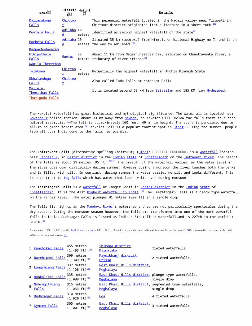
Name District Height Details
Kailasakona Falls ChittoorThis perennial waterfall located in the Nagari valley near Tirupati in Chittoor district originates from a fracture in a sheet rock.[1]
Kuntala Falls Adilabad 10 meters Identified as second highest waterfall of the state[2]
Pochera Falls Adilabad 20 meters Situated 35 km (approx.) from Nirmal, on National Highway no.7, and is on the way to Adilabad.[3]
RampachodavaramEthipothala Falls Guntur 22 meters About 11 km from Nagarjunasagar Dam, situated on Chandravanka river, a tributary of river Krishna[4]
Kapila TheerthamTalakona Chittoor 82 meters Potentially the highest waterfall in Andhra Pradesh StateUbbalamdugu Falls Chittoor Also called Tada Falls or Kambakam FallsMallela Theertham Falls
It is located around 58 KM from Srisailam and 185 KM from Hyderabad.
Thatiguda Falls
The Kakolat waterfall has great historical and mythological significance. The waterfall is located near Govindpur police station, about 33 km away from Nawada, on Kakolat Hill. Below the falls there is a deep natural reservoir. [1]The fall is approximately 160 feet (49 m) in height. The scene is panoramic due to all-round green forest area.[2] Kakolat Fall is a popular tourist spot in Bihar. During the summer, people from all over India come to the falls for picnics.
The Chitrakoot Falls (alternative spelling Chitrakut) (Hindi: चि�त्रको�ट जलप्रपा�त) is a waterfall located near Jagdalpur, in Bastar district in the Indian state of
Chhattisgarh on the Indravati River. The height of the falls is about 29 metres (95 ft).[1][2] The breadth of the waterfall varies, as the water level in the river goes down drastically during summer. However during a monsoon the river touches both the banks and is filled with silt. In contrast, during summer the water carries no silt and looks different. This is a contrast to Jog falls which has water that looks white even during monsoon.
The Teerathgarh Falls is a waterfall at Kanger Ghati in Bastar district in the Indian state of Chhattisgarh. It is the 41st highest waterfall in India.[1] The Teerathgarh Falls is a block type waterfall on the Kanger River. .The water plunges 91 metres (299 ft) in a single drop
The falls lie high up in the Mandovi River's watershed and so are not particularly spectacular during the dry season. During the monsoon season however, the falls are transformed into one of the most powerful falls in India. Dudhsagar Falls is listed as India's 5th tallest waterfall,and is 227th in the world at 310 m.[1]
The 60 metres (200 ft) falls on the Sankh River is a scarp falls. It is referred to as a snake type falls and is a popular picnic spot.[3][4]Its surroundings are spectacular with hillocks, forests and streams.[5]
1 Kunchikal Falls 455 metres (1,493 ft) [1] Shimoga district, Karnataka tiered waterfalls2 Barehipani Falls 399 metres (1,309 ft)[1] Mayurbhanj district, Orissa 2 tiered waterfalls3 Langshiang Falls 337 metres (1,106 ft)[1] West Khasi Hills district, Meghalaya4 Nohkalikai Falls 335 metres (1,099 ft)[1] East Khasi Hills district, Meghalaya plunge type waterfalls, single drop5 Nohsngithiang Falls 315 metres (1,033 ft)[1] East Khasi Hills district, Meghalaya segmented type waterfalls, single drop6 Dudhsagar Falls 310 metres (1,020 ft)[1] Goa 4 tiered waterfalls7 Kynrem Falls 305 metres (1,001 ft)[1] East Khasi Hills district, Meghalaya 3 tiered waterfalls8 Meenmutty Falls 300 metres (980 ft)[1] Wayanad district, Kerala 3 tiered waterfalls9 Thalaiyar Falls 297 metres (974 ft)[1] Dindigul district, Tamilnadu horsetail type waterfalls, single drop10 Barkana Falls 259 metres (850 ft)[1] Shimoga district, Karnataka tiered waterfalls11 Jog Falls 253 metres (830 ft)[1] Shimoga district, Karnataka segmented waterfalls with single drop12 Khandadhar Falls 244 metres (801 ft)[1] Sundargarh district, Orissa Horse tail type falls with single drop13 Vantawng Falls 229 metres (751 ft)[1] Serchhip district, Mizoram 2 tiered waterfalls14 Kune Falls 200 metres (660 ft)[1] Lonavla, Maharashtra 3 tiered waterfalls15 Soochipara Falls 200 metres (660 ft)[1] Wayanad district, Kerala 3 tiered waterfalls16 Magod Falls 198 metres (650 ft)[1] Uttara Kannada district, Karnataka 2 tiered waterfalls17 Hebbe Falls 168 metres (551 ft)[1] Chikkamagaluru district, Karnataka 2 tiered waterfalls18 Duduma Falls 157 metres (515 ft)[1] Koraput district, Orissa horsetail type waterfalls with single drop19 Joranda Falls 157 metres (515 ft)[1] Mayurbhanj district, Orissa plunge type waterfalls with single drop20 Palani Falls 150 metres (490 ft)[1] Kullu district, Himachal Pradesh21 Lodh Falls 143 metres (469 ft)[1] Latehar district, Jharkhand 2 tiered waterfalls22 Bishop Falls 135 metres (443 ft)[1] Shillong, Meghalaya 3 tiered waterfalls23 Chachai Falls 130 metres (430 ft)[1] Rewa district, Madhya Pradesh24 Keoti Falls 130 metres (430 ft)[1] Rewa district, Madhya Pradesh segmented type waterfall with single drop25 Kalhati Falls 122 metres (400 ft)[1] Chikkamagaluru district, Karnataka26 Beadon Falls 120 metres (390 ft)[1] Shillong, Meghalaya27 Keppa Falls 116 metres (381 ft)[1] Uttara Kannada district, Karnataka fan type waterfall with single drop28 Koosalli Falls 116 metres (381 ft)[1] Udupi, Karnataka 6 tiered waterfall29 Pandavgad Falls 107 metres (351 ft)[1] Thane, Maharashtra30 Rajat Prapat 107 metres (351 ft)[1] Hoshangabad district, Madhya Pradesh horsetail type waterfall with single drop31 Bundla Falls 100 metres (330 ft)[1] Kangra district, Himachal Pradesh32 Cauvery Falls 98 metres (322 ft)[1] Mysore, Karnataka segmented type with single drop33 Lower Ghaghri Falls 98 metres (322 ft)[1] Latehar district, Jharkhand

34 Hundru Falls 98 metres (322 ft)[1] Ranchi district, Jharkhand segmented type with single drop35 Sweet Falls 98 metres (322 ft)[1] Shillong, Meghalaya horsetail type with single drop36 Gatha Falls 91 metres (299 ft)[1] Panna district, Madhya Pradesh37 Kiliyur Falls 91 metres (299 ft)[1] Yercaud, Tamilnadu fan type waterfall with single drop38 Kedumari Falls 91 metres (299 ft)[1] Udupi district, Karnataka horsetail type waterfall with single drop39 Muthyala Maduvu Falls 91 metres (299 ft)[1] Bangalore, Karnataka40 Palaruvi Falls 91 metres (299 ft)[1] Kollam district, Kerala horsetail type waterfall with single drop41 Teerathgarh Falls 91 metres (299 ft)[1] Bastar district, Chhattishgarh Block type with single drop
Lalguli Falls Uttara Kannada 250 ft River Kali, 13 km from YellapurNisargadhama Falls Madikeri River Cauvery, 2 km from KushalnagarBurude Falls or Dodmane Falls Uttara Kannada 20+ km from Siddapura and 55+ km from Sirsi on Siddapur-Kumta roadShivagange Falls Uttara Kannada 243 ft River Sonda, 45 km from SirsiDabbe Falls Shimoga near Hosagadde, 20 km from KargalWaate haLLa Falls Uttara Kannada 100+ ft 30 km from SirsiVibhooti Falls Uttara Kannada 50 km from [[Sirsi] On Yana-Ankola Road]
Alekan FallsDakshina Kannada
18 km from Charmadi
Dondole FallsDakshina Kannada
50+ ft 23 km from Charmadi
Shanti Falls Chikmagalur near KemmanagundiAbbey Falls Kodagu 10 km from MadikeriArisina Gundi Falls Udupi near KollurBarkana Falls Shimoga 850 feet River Sita, near AgumbeBennehole Falls Uttara Kannada 230 ft On the way to Kumta from SirsiChunchanakatte Falls Mysore 66 ft 15 km from KrishnarajanagaraGodchinamalaki Falls Belgaum 141 ft River Markandeya, 16 km from GokakGokak Falls Belgaum 170 ft River Ghataprabha, 6 km from GokakHebbe Falls Chikmagalur 551 ft 10 km from KemmanagundiIrupu Falls Kodagu 170 ft River Lakshmana Tirtha 48 km from VirajpetChelavara Falls Kodagu 10 km from Palace EstateMallali Falls Kodagu River Kumaradhara, 25 km from SomwarpetJog Falls or Gersoppa Falls Shimoga 829 ft River Sharavathi, 30 km from SagaraKalhatti Falls Chikmagalur 403 ft near KemmanagundiKeppa Falls or Unchalli Falls or Lushington Falls
Uttara Kannada 380 ft 35 km from Siddapura
Koosalli Falls Udupi 380 ft 70 km from UdupiKudumari Falls or Belligundi Falls Udupi 300 ftKunchikal Falls Shimoga 1493 ft River Varahi, near AgumbeMagod Falls Uttara Kannada 650 ft River Bedti, 17 km from YellapurManikyadhara Falls Chikmagalur 1 km from Baba BudangiriMuthyala Maduvu Waterfall Bangalore 40 km from Bangalore, very small waterfallShivanasamudra Falls Mandya 320 ft River Cauvery, 139 km from BangaloreSathodi Falls Uttara Kannada 49 ft River Kali, 32 km from YellapurVarapoha Falls Belgaum 197 ft River Mandovi, 60 km from BelgaumSirimane Falls Chikmagalur 22km from SringeriSogal Falls Belgaum near BailhongalChunchi Falls Bangalore River Arkavathi, 90 km from BangaloreSuthanabbe Falls or Hanumanagundi Falls
Chikmagalur 100+ ft near Kudremukh
Kunchikal Falls Shimoga1493 feet ft (455 meters)
River Varahi, near Agumbe in Shimoga district. This is the highest tiered waterfalls in India and second highest in Asia. [5][6]
Kune Falls Pune 659 ft 10 km from old Mumbai-Pune expresway in lonvala- khandala vallyPandavgat WaterFalls Thane 350 ft Situated in the hills near the Khargar,Navi Mumbai on the Pune-Mumbai highwayMarleshwar WaterFalls Ratnagiri 5 km from Devrukh , formed on the banks of bav riverPeb WaterFalls Thane 10 km from Neral railway station, on the way to MatheranGarambi WaterFalls Raigad 100 ft Located near Murud, 5km from janjiraKandhar WaterFalls Sangli 25 km from Peth Naka on NH4, 65km from Sangli, 70 km from Miraj railway junctionLingamala WaterFalls Satara 620 ft Located 6 km away from the famous hill station Mahabaleshwar and at top of the Venna Valley
Thoseghar WaterFalls Satara 1150 ft36km from Satara, A full frontal view of the falls can be obtained by going to Chalkewadi and then walking down the road for 5 km
Rjmachi WaterFalls Pune 5 km from Khandala , can be seen from Mumbai - Pune expresswayGavlideo Hill Falls Thane 5 km from Thane,located near Thane - Belapur roadNivali Falls Ratnagiri 50 km from Sangameshwar,located on ratnagiri- ganpatipule ruteUsarvardhane Waterfalls Thane 300 ft Near the kansai village, 5 km by vehicle and a 45 mins trek thereafter.Ozarde WaterFalls Kolhapur 10 km from KoynaBhivpuri WaterFalls Thane 8 km from Bhivpuri railway station, or 20 km from karjat railway station

Napne Falls Sindhudurg 250 ft 15 km from VaibhavwadiDabhosa WaterFalls Thane 300 ft 5 km from JavharTiger Falls] Pune near Lonavala in khandala ghat, 80km from Mumbai, or 70 km from puneTigher WaterFalls Thane 300 ft 10 km from Karjat railway stationSahastrakunda WaterFalls
Nanded situated on painganga river at sahastrakund
Bhildari valley Waterfalls
Aurangabad Near 3km from Kannad or 12 km from Chalisgaon
Tapalwadi Falls Thane 350 ft 3 km from Neral railway station on the route to matheran hill station
Bhilar waterfalls SataraSeen on the mahabaleshwar panchgani road is one of the beautiful falls on the kudali river arisisng from the bhilar village
Amboli Ghat Falls Sindhudurg 400 ft 1s km from Amboli,The falls is well known for its fresh and pleasing environs.Chirkehind WaterFalls Satara In the lower portion of the ambenali ghat about 6-7 km after the diversion to ragtagVyaghreshwar waterfall Sindhudurg 300 ft near Mnche, 30 km from Tarale(which is on Mumbai-Goa highway)Barki Waterfalls Kolhapur 65 km from KolhapurMandakini Waterfalls Satara 25 km from MahableshwarSavDav WaterFalls Sindhudurg 10 km from Kankavli townRandha Falls Ahamednagar 350 ft 50 km from Nashik, or 45 km fromkasara railway stationNeedle Point Waterfalls Satara 20 km from Panchgani , close to mahabaleshwar panchgani routePalsambe Waterfalls Kolhapur 45 km from Kolhapur,on the way to gaganbawada at palsambaAle's waterfall Satara on the tapola road near zolchikhind is near about 8 to 9 kilometers from MahabaleshwarDhobi Falls Satara 450ft 3 km from Mahableshwar town, formed on the banks of koyna riverUmbrella Falls Ahamednagar 50 km from Nashik, or 45 km fromkasara railway station
Chinchoti WATERFalls Thane100 ft high & 20 ft broad
5 km from Mumbai-Palghar highway near vasai
Zenith WaterFalls Thane 450 ft 10 km from Khopoli railway station, 20 km from Karjat railway stationRamatirth Waterfall] Kolhapur On the banks of Hiranyakeshi river nearly 10km from Ajara
Kelghar water falls Sataraon the Mahabaleshwar medha satara road almost 14 to 15 kilometers away from the main market place
Dudhsagar WaterFalls Nashik 100 ft Located around 8 km to the west of Nasik near Someshwar TempleRamdharneshwar Waterfalls
Raigad 20 km from Alibaug ,near khim village
Chinmans waterFalls Satara It is 2.5 km away from Mahabaleshwar, towards the south into the Koyana ValleySawatkada WaterFalls Raigad On way to Garambi, we pass through village Shighre, near AlibaugDodhvne Tivre Falls Ratnagiri 200 ft 10 km from SangameshwarChinchghar Falls Sindhudurg 10 km from kudal townTamhini WaterFalls Pune In the Tamihini ghats, near PuneBerki WaterFalls Kolhapur 4 km from gaganbawada or 75 km from Kolhapur, in amboli ghatsNagartas Falls Sindhudurg 320ft 50 km from Kankavli town, in the Amboli ghat or 100km from kolhapur
Name District Height Details
Beadon Falls Shillong 394 ftBishop Falls (India) Shillong 443 ftKynrem Falls Cherrapunjee 1,000 ftLangshiang Falls Shillong 1,107 ftNohkalikai Falls Cherrapunjee 1,100 ftNohsngithiang Falls Cherrapunjee 1,035 ftSweet Falls Shillong 315 ftElephant Falls Shillong Three Steps WaterfallsCrinoline Falls ShillongMargaret Falls Shillong 315 ftSpread Eagle Falls Shillong 315 ft
Name District Height Details
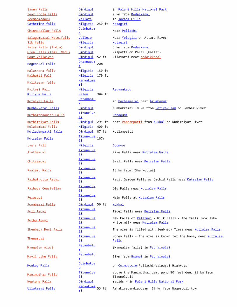
Agaya Gangai Namakkal Puliancholai in Kolli HillsAgasthiar Falls Tirunelveli VickramasingapuramAmirthi falls Vellore 25 km south of in Javadu HillsAnju Veedu Dindigul 27 km from Kodaikanal in the Villpatti RangeAyyanar Falls Virudhunagar 10KM south of RajapalayamShenbagathoppu Falls Virudhunagar 10KM south of SrivilliputturBamen Falls Dindigul in Palani Hills National ParkBear Shola Falls Dindigul 2 km from KodaikanalBeemanmadavu Vellore In Javadi HillsCatherine falls Nilgiris 250 ft KotagiriChinnakallar Falls Coimbatore Near Pollachi

Jalagamparai Waterfalls Vellore Near Yelagiri on Attaru RiverElk falls Nilgiris KotagiriFairy Falls (India) Dindigul 5 km from KodaikanalGlen Falls (Tamil Nadu) Dindigul Vilpatti on Palar (Kallar)Gaur Vellaiyan Dindigul 52 ft kilavarai near KodaikkanalHogenakal Falls Dharmapuri 20mHalashana falls Nilgiris 150 ftKalhutti Fall Nilgiris 170 ftKalikesam falls KanyakumariKarteri Fall Nilgiris AruvankaduKiliyur Falls Salem 300 ftKoraiyar Falls Perambalur in Pachaimalai near ArumbavurKumbakkarai Falls Dindigul Kumbakkarai, 8 km from Periyakulam on Pambar RiverKutharapaanjan Falls Tirunelveli PanagudiKuthiraiyar Falls Dindigul 295 ft near Pappampatti from Kukkal on Kudiraiyar RiverKolakambai Falls Nilgiris 400 ftKutladampatti falls Dindigul 87 ft KutlampattiKutralam Falls Tirunelveli 167mLaw's Fall Nilgiris CoonoorAintharuvi Tirunelveli Five Falls near Kutralam FallsChitraruvi Tirunelveli Small Falls near Kutralam FallsPaalaru Falls Tirunelveli 15 km from [Shenkottai]Pazhathotta Aruvi Tirunelveli Fruit Garden Falls or Orchid Falls near Kutralam FallsPazhaya Courtallam Tirunelveli Old Falls near Kutralam FallsPeraruvi Tirunelveli Main Falls at Kutralam FallsPoombarai Falls Dindigul 50 ft KukkalPuli Aruvi Tirunelveli Tiger Falls near Kutralam FallsPuthu Aruvi Tirunelveli New Falls or Palaruvi - Milk Falls - The falls look like white milk near Kutralam FallsShenbaga Devi Falls Tirunelveli The area is filled with Senbhaga Trees near Kutralam FallsThenaruvi Tirunelveli Honey Falls - The area is known for the honey near Kutralam FallsMangalam Aruvi Perambalur (Mangalam falls) in PachaimalaiMayil Uthu Falls Perambalur 18km from Esanai in PachaimalaiMonkey Falls Coimbatore on Coimbatore-Pollachi-Valparai HighwaysManimuthar Falls Tirunelveli above the Manimuthar dam, pond 90 feet dee, 35 km from TirunelveliNeptune Falls Dindigul rapids - in Palani Hills National ParkUllakarvi Falls Kanyakumari 55 ft Azhakiyapandiapuram, 17 km from Nagercoil townPambar Falls Dindigul 4 km from Kodaikanal also known as Liril FallsPapanasam Falls Tirunelveli near VickramasingapuramPeriyar Falls Viluppuram Kalrayan HillsPudur Megan Falls Viluppuram Kalrayan HillsPykara lower falls Nilgiris 180 ft NelgirisPykara upper falls Nilgiris 200 ft NelgirisSengupathi Falls Coimbatore Coimbatore - Siruvani main Road.Shenbaga Thoppu Meenvetti Parai Falls Virudhunagar This forest cum water falls located in the western ghats. Around 6km from Srivilliputtur.Silver Cascade Dindigul 180 ft 8 km from KodaikanalSiruvani Waterfalls Coimbatore also known as Kovai Kutralam, at Siruvani, about 40 km from CoimbatoreSkamba Falls Dindigul 8 km from KodaikanalSnake Falls (Tamil Nadu) Dindigul in Palani Hills National ParkSuruli Falls Theni 123-km from MaduraiThakkam thootam falls Dindigul near PalaniThalaiyar Falls (Rat tail) Dindigul 975ft/297m width 13 m Near Manjalaru 8 6km from devadanapattiThiruparappu Falls Kanyakumari 50 ft Thiruparappu on Kodayar RiverThirumoorthy Falls Coimbatore about 20 km from UdumalpetThoovanam falls Dindigul or Dhuvanam falls near AmaravathinagarVaideki Falls Coimbatore 30-km from Coimbatore near NarasipuramVaana Theertham Falls Tirunelveli VickramasingapuramVattaparai Falls Kanyakumari Near Bhoothapandi, 13 km of Nagercoil on Pazhayar RiverKempty Fall 40 feet Mussoorrie
This is a list of rivers in India. Rivers that flow into the sea are sorted geographically..., along the coast starting from the Bay of Bengal in the east, moving along the Indian coast southward till Kanyakumari, and moving northward along the Arabian Sea. Rivers that flow into other rivers are sorted by the proximity of their points of union to the sea: the lower in the list, the more upstream.
The biggest major rivers of India are:
flowing into the Bay of Bengal: Brahmaputra, Ganges (with its tributaries Yamuna, Kameika, Gomti, Chambal), Mahanadi, Godavari, Krishna, Kaveri (and their main tributaries)
flowing into the Arabian Sea: Indus, Narmada, Tapti (and their main tributaries)

The remaining rivers are:
flowing into the inner part of India.
coastal rivers.
Contents
[hide]
1 Rivers flowing into Bay of Bengal o 1.1 Brahmaputra River Basin
o 1.2 Ganga River Basin
o 1.3 West Bengal Coastal Rivers
o 1.4 Mahanadi River Basin
o 1.5 Godavari River Basin
o 1.6 Krishna River Basin
o 1.7 Andhra Pradesh Coastal Rivers
o 1.8 Penner River Basin
o 1.9 Kaveri River Basin
o 1.10 Tamil Nadu Coastal Rivers
2 Rivers flowing into Arabian Sea
o 2.1 Karnataka Coastal Rivers
o 2.2 Kerala Coastal Rivers
o 2.3 Coastal rivers of Goa
o 2.4 Maharashtra Coastal Rivers
o 2.5 Tapti River Basin
o 2.6 Narmada River Basin
o 2.7 Mahi River Basin
o 2.8 Sabarmati River Basin
o 2.9 Indus River Basin
3 Rivers flowing into inner part of India
4 Alphabetical list
o 4.1 A-B-C-D
o 4.2 E-F-G-H
o 4.3 I-J-K-L
o 4.4 M-N-O-P
o 4.5 Q-R-S-T
o 4.6 U-V-W
o 4.7 X-Y-Z
5 Unsorted list by Tributary
6 References
7 See also
[edit] Rivers flowing into Bay of Bengal
Subarnarekha o Kharkai
Damodar
Karnaphuli River from Mizoram and Bangladesh
Meghna River from India and Bangladesh
o Titas River in Tripura
Haora River in Agartala
[edit] Brahmaputra River Basin
Brahmaputra River o Lohit River
o Burhidihing River , also called Noa Dihing in its earlier course through Namdapha National Park
o Kameng River
o Disang
o Dikhou
o Bhogdoi
o Kakodonga
o Dhansiri River
o Subanshiri
o Kapili
o Pagladiya
o Manas River
o Sankosh
o Yamuna
o Teesta River
Rangeet River
Lachen River
Lachung River
o Dharla River in Bangladesh
Jaldhaka in Sikkim and West Bengal
[edit] Ganga River Basin
Ganges River o Hooghly River (distributary)

Jalangi River
River Churni
Ichamati River
Damodar River
Barakar River
Rupnarayan River
Ajay River
siang
tirap
Mayurakshi River
Dwarakeswar River
Mundeswari River
o Meghna River (distributary)
o Padma River (distributary)
o Budhi Gandak
o Kosi River
o Falgu River
o Gandak at Patna
o Son River
Koel River
Rihand River
Gopad River
Goini River
Neur River
Banas River
o Ghaghara River (Gogra) or Karnali River in Nepal
o Yamuna River
Ban Ganga River
Betwa River
Dhasan River
Halali River
Kaliasote River
Sindh River
Kwari River
Pahuj River in Bhind District Madhya Pradesh
Chambal River
Banas River
Berach River
Ahar River
Kali Sindh River
Parbati River (Madhya Pradesh)
Shipra River in Ujjain
Gambhir River
Parbati River (Rajasthan)
o Gomti River
o Ramganga River
Kho River
Malini River
Surkho River
o Mahananda River
o Mahakali River
o Bhagirathi River
o Alaknanda River
o Gangi River
o Beson River
o Mangai River
o Bhainsai River
o Tamsa River
o Karmanasha
[edit] West Bengal Coastal Rivers
Subarnarekha River o Kharkai River
Kangsabati River
o Bhagirathi
o Hughli
[edit] Mahanadi River Basin
Mahanadi River Brahmani River
South Koel River near Rourkela
Sankh River
Devi River
Kusabhadra River
Daya River

Bhargavi River
Kadua River
[edit] Godavari River Basin
Godavari River in Andhra Pradesh, Maharashtra states o Kolab River in Orissa State
o Indravati River in Gadchiroli district of Maharashtra State and also in Chhattisgarh state [1]
Bandiya River in Gadchiroli
[edit] Krishna River Basin
Krishna River in Andhra Pradesh, Karnataka, Maharashtra states o Munneru River in Andhra Pradesh
Akeru River in Andhra Pradesh
o Paleru River in Andhra Pradesh
o Musi River in Andhra Pradesh
o Tungabhadra River
Vedavathi River
Suvarnamukhi River
Veda River
Avathi River
Varada River
Tunga River
Bhadra River
o Bhima River in Karnataka and Maharashtra
Sina River
Nira River
Mula-Mutha River
Mula River
Mutha River
Chandani River
Kamini River
Moshi Riverf 65r
Ambi River
Bori River
Man River
Bhogwati River
Indrayani River
Kundali River
Kumandala River
Ghod River
Bhama River
Pavna River
o Malaprabha River
o Ghataprabha River
o Varma River
o Koyna River in Satara district of Maharashtra state
[edit] Andhra Pradesh Coastal Rivers
Rivers like vamsadhara and nagavalli are the two coastal rivers in srikakulam district of Andhra Pradesh
Sharada river starts at Devarapally in visakhapatnam district and drains in to the Bay of Bengal
[edit] Penner River Basin
Penner River
[edit] Kaveri River Basin
Kaveri River (Kaveri) o Kollidam (distributary)
o Amaravati River
o Arkavathy River
o Mettur Dam
o Bhavani River
o Hemavati River
o Kabini River
[edit] Tamil Nadu Coastal Rivers
Thamirabarani River Palar River
Vaigai River
Vellar
o Vasishta Nadi
o Sweta Nadi
Cooum River
Adyar River
[edit] Rivers flowing into Arabian Sea
[edit] Karnataka Coastal Rivers
The rivers flowing through three coastal districts of Karnataka join Arabian sea.
Kali River Netravati River
Sharavathi River

Aghanashini River
List of rivers of Dakshina Kannada and Udupi districts
[edit] Kerala Coastal Rivers
The rivers flowing through three coastal districts of Kerala to join Arabian sea.
Periyar River Bharathapuzha River
Pamba River
List of rivers of Kerala
[edit] Coastal rivers of Goa
Tiracol Chapora
Baga
Mandovi River
Mandovi River,known as Mhadai in Western Ghats of Goa and Karnataka, has three sources viz., the Degao, the Nanevadichi Nhõi ((nhõi means river in Konkani) and Gavali the last two sources go dry in summer season. The main origin of the river, in the form of a spring, even during Summer season, is at Bavtyacho Dongor hills near Degao village in Khanapur Taluka of Belgaum Dist in Karnataka State. The three streams confluence at the Kabnali village whereafter it is known as Mhadai, which has an easterly flow initially, then flows north and finally turns to the west on entering Goa. Mhadai River enters Goa between Krisnapur (Karnataka) and Kadval (Goa) villages. The tributaries of the Mhadai are the Nersa Nala, the Chapoli and Kapoli nala, the Bail Nala, the Volo Panshiro ( Karnataka), the Suko Panshiro, the Harparo, the Nanodyachi Nhõi, the Vellsachi Nhõi, the Valpoichi Nhõi, the Ghadghadyachi Nhõi, the Valvanti/ Volvot, the Divcholchi Nhõi, the Asnoddchi Nhõi, the Khandeaparchi Nhõi, the Mhapxechi Nhõi, Xinkerchi Nhõi etc. It is the longest River of Goa with a reported length of 105 km.
Zuari River Sal
Talpona
Galgibag
[edit] Maharashtra Coastal Rivers
Shastri River Gad River
Vashishti River
Savitri River
Patalganga River
Ulhas River
o Thane Creek (distributary)
o Vasai Creek (distributary)
Mithi River or Mahim River
Oshiwara River
Dahisar River
Tansa River in Thane
Vaitarna River
Surya River
[edit] Tapti River Basin
Tapti River and its tributaries
Tapti River in Gujarat, Maharashtra and Madhya Pradesh o Gomai River in Nandurbar district of Maharashtra
o Arunavati River in Dhule district of Maharashtra
o Panzara River in Jalgaon, Dhule districts of Maharashtra
Kaan River in Dhule district
o Aner River in Jalgaon, Dhule districts
o Girna River in Nashik, Malegaon, Jalgaon districts
Titur River in Jalgaon district
o Waghur River in Jalgaon, Aurangabad districts
o Purna River in Amravati, Akola, Buldhana, Jalgaon, Navsari districts of Gujarat, Maharashtra Madhya Pradesh
Nalganga River in Buldhana district
Vaan River in Buldhana, Akola, Amravati districts of Maharashtra
Morna River in Akola, Washim districts
Katepurna River in Akola, Washim districts
Umaa River in Akola, Washim districts
o Sangiya River in Amravati district of Maharashtra
[edit] Narmada River Basin
Narmada River o Kolar River in Sehore
o Barna River in Raisen
o Hiren River
o Tawa River
o Burhner River
[edit] Mahi River Basin
Mahi River o Som River
Gomati River
[edit] Sabarmati River Basin
Sabarmati River o Wakal River
o Sei River
[edit] Indus River Basin
Indus River (largely in Pakistan) o Panjnad River (Pakistan)
Sutlej River (Northern India and Pakistan)
Beas River
Parbati River (Himachal Pradesh)
Chenab River (largely in Pakistan)
Ravi River (largely in Pakistan)
Jhelum River (in Pakistan and Indian Kashmir)
Neelum River or Kishanganga
Tawi River
o Shyok River
Nubra River , rising from the meltwater of the Siachen Glacier
Chang Chenmo River
Galwan River
o Suru River
Dras River
Shingo River
o Yapola River
o Zanskar River
Markha River
Khurna River
Tsarap River
Doda River
o Hanley River
[edit] Rivers flowing into inner part of India
Ghaggar River in Haryana, Rajasthan Musi River at Hyderabad, India
Samir River, India/ Gujarat
[edit] Alphabetical list
This list is incomplete; you can help by expanding it.
[edit] A-B-C-D
Bharathapuzha(Kerala), brahmaputra river, beas
[edit] E-F-G-H
Falgu River
Gadhi River, Ganges River, Gambhir River, Gandak, Gayathripuzha, Ghaggar River, Ghaghara River, Ghataprabha, Girija River, Girna River, Godavari River, Gomti River, Gunjavni River
Halali River, Hoogli River
[edit] I-J-K-L
Indus River, Indravati River,
Jaldhaka, Jhelum River, Jayamangali River at tumkur district, River Jambhira
Kabini River, Kadalundi River, Kaagini River, Kali River- Karnataka, Kali River- Uttarakhand, Kali Sindh River, Kaliasote River, Karmanasha, Kallayi River Kalpathipuzha, Kameng River, Kanhan River, Kamla Balan bihar, Kannadipuzha, Karnaphuli River, Kaveri River, Kelna River, Kelo River Khadakpurna River, Kodoor River, Koel River, Kolab River, Kollidam River, Kosi River, Koyna River, Krishna River, Kundali River, kaushiga River, Kuwanav River, Ken River
Lachen River, Lachung River, Lakshmana Tirtha River, Luni River,
[edit] M-N-O-P
Mahanadi River, Mahananda River, Mahakali River, Mahi River, Mandovi River, Meenachil River, Meghna River, Mithi River, Mula River, Musi River, Mutha River, Malaprabha, Manorama River,
Narmada River, Nethravathi River, Nag River (Maharashtra)
Palar River, Pamba River, Pahuj River, Pamba(Kerala), Panjnad River, Panzara River, Parambikulam River, Parbati River (Himachal Pradesh), Parbati River (Madhya Pradesh), Parbati River (Rajasthan), Payaswini, Pench River, Penganga River, Penner River, Periyar River, Ponnaiyar River, Pranhita River, Purna River,Pluest river [Poonch J&K], Panchaganga River
[edit] Q-R-S-T
Ramganga , Rangeet River, Ravi River, Rihand River, Rukmavati River, Rupnarayan River, Rapti River, Ram Rekha River,
Saryu River, Sarswati River, Sabarmati River, Sankh River, Shalmala River, Sharavathi River, Shimsha River, Shipra River, Sindh River, Sita River, Son River, Souparnika River, South Koel River, Subarnarekha River, Sutlej River, Surya River, Swarna River,
Tansa River, Tapti River, Tawa River, Teesta River, Thuthapuzha, Tons River Tunga River, Tungabhadra River, Thamirabarani River Tedi River,
[edit] U-V-W
Vaan River, Vaigai River, Varuna Vashishti River, Vedavathi River,Vrishabhavathi,Vishwamitri River
Ulhas River, ((ural river))
Wainganga River, Wagh River, Wardha River, wehashli river
[edit] X-Y-Z
Yamuna River,
Zuari River,
Willingdon Island is the home of the modern port that serves Kochi in Kerala, India. It is an artificial island created from the materials dredged while deepening Kochi Port, it's in Ernakulam district of Kerala in south India. It's named after Lord Willingdon, the erstwhile governor of Madras who had a hand in the project. Robert Bristow, the chief protagonist and engineer for the project owned the first building on the island.
Kavvayi is a small island, near Payyannur in the Kannur district of Kerala state in India. The island is connected to Payyannur by a small bridge on the Kavvayi Pozha (River of Kavvayi).
this island is specially famous for its traditionally high families and family system. until the late 1940s the island was mainly under the rule of the Thayyil family which was under the remarkable leadership Kunhahammed Haji- a renowned zamindar of the time.
New Moore or Purbasha (as it was known in India) or South Talpatti (as it was known in Bangladesh) was a small uninhabited offshore sandbar landform in the Bay of Bengal, off the coast of the Ganges-Brahmaputra Delta region.[1] It emerged in the Bay of Bengal in the aftermath of the Bhola cyclone in 1970, and disappeared at some later point.[2]
Quibble Island a island in the City of Chennai bordered west by Buckingham Canal, South by River Adayar, North by River Coovam and to the east by Bay of Bengal. The island starts from University of Madras and ends in Estuary of Adayar. A entirely man made island. Vypin, also spelled Vypeen (Malayalam: വൈ�പ്പി�ന്� ) is one of the islands that make up the urban agglomeration of Kochi city , Kerala, India. The island which is about 27 km long was formed in the
year 1341 after a heavy flood. It is known to be the island having highest density of population in the world. It is connected to Kochi city by a bridge from Kalamuku. There are regular boat services from Fort Kochi to Vypin Island.
Salsette Island (Marathi: सा�ष्टी�, Sashti ?) is an island in Maharashtra state on India's west coast. The metropolis of Mumbai (formerly Bombay) and the city
of Thane lie on this island, making it the 14th most populous island and the fourth most densely populated island in the world, after Migingo Island in Kenya, Ap Lei Chau in Hong Kong, China and Malé Island in Maldives.
Butcher Island (Jawahar Dweep) is an island off the coast of Mumbai, India. It has an oil terminal used by the port authorities to offload it from oil tankers. The crude oil is stored in oil containers on the island. From there they are piped to Wadala, in Mumbai where they are refined. This keeps the city relatively safe from a mishap.
Cross Island is an uninhabited island located in Mumbai harbour, India, between the coast at Dockyard Road, and Elephanta Island. The island is host to an oil refinery and several large gas holders.
Elephanta Island (also called Gharapuri Island or place of caves) is one of a number of islands in Mumbai Harbour, east of Mumbai, India. This island is a popular tourist destination for a day trip because of the island's cave temples, the Elephanta Caves, that have been carved out of rock.
Oyster Rock is an island in the Mumbai harbour, Mumbai, India. It is fortified, and owned by the Indian Navy. For a short while, the islet was used as a naval museum. The Maharashtra government had thought of anchoring the decommissioned INS Vikrant (now a naval museum) on this island.
The Middle Ground Coastal Battery is an islet off the coast of Mumbai (Bombay), India. The isle, situated a few hundred metres away from the Gateway of India, lies in the Thane Creek. The islet is actually a piece of hard basalt rock, emerging from the creek bed, having an area of a few hundred square metres.
The island of Divar It is located approximately upriver 10 km from Panaji (Panjim). The Island is connected to Old Goa on the south-east side, Ribandar, on the south-west side and Narve on the north side, all by ferry. A launch also connects Divar to the city of Panaji from further north-west, in the village of Vanxim. The Konkan Railway passes through the village and the nearest stop to the village is the train station at Karmali.
Chorao (Konkani: ��डणें� Choddnnem, pronounced [c ɔ ː ɽɳɛ ː] ̃ ) is an island along the river Mandovi near Panaji, Goa, India. The island was called chudamani, meaning stunning precious stone in Sanskrit. Local legends tell of the islands emerging from the diamonds that were thrown away by Yashoda the mother of Lord Krishna. The Islanders call it chodan or chodna. It was the Portuguese who called it chorao. The Portuguese noblemen found the island a pleasurable place to live and hence the name Ilha dos fidalgos(Island of noblemen).
Srirangam (Tamil: ஸ்ரீரங்கம்), actual Tamil name is Thiruvarangam (Tamil: தி�ருவரங்கம்), is an island and a zone in the city of Tiruchirapalli (also known as Trichy or Tiruchi), in South India.
Anjuna BeachAnjuna is a beach that is around 8 kms. west of Mapusa, North Goa. The most basic attraction is Anjuna beach Flea Market, Chapora Fort. The
best time to visit this....More about Anjuna Beach....
Baga BeachHowever, Calangute is not everyones favorite. Most tourists would prefer the last segment on this stretch Baga. You d like it even though it is a
fishing beach and fairly ....More about Baga Beach....
Bagmola BeachThe last southern beach before you get to Panaji is the first southern beach to be discovered by visitors: Bogmolo. ....More about Bogmalo
Beach....
Calangute BeachCalangute is a beach that is around 16 kms from Panjim, North Goa. The most basic attraction is Baga Beach. The best time to visit this place
is from December....More about Calangute Beach....
Candolim BeachCandolim is a beach that is very much in North Goa. The most basic attraction is Aguda Fort & Calangute Beach. The best time to visit
this ....More about Candolim Beach....
Colva BeachLocated just about 6 kms from Margao city is the charming Colva Beach lazily swaying its palm trees and glittering its silvery white sand. Here,
sand, sea ....More about Colva Beach....

Majorda BeachMajorda beach is a small beach that stretches about 5 Kms north of Colva Beach along the coastline. There are many hotels over here. .... More
about Majorda Beach....
Miramar BeachMiramar Beach is 3 kms from Panaji. A lovely golden beach of soft sand girdled with palm trees facing the blue Arabian Sea, ....More about
Miramar Beach....
Palolem BeachSituated just about 2-km West Of Chaudi, Canacona District, South Goa is the Palolem Beach. The major attractions nearby this beach are
Agonda ....More about Palolem Beach....
Vagator BeachAcross the river, a fair distance away, is a headland that separates the two parts of the most photographed beach in Goa: .... More about
Vagator Beach....
Varca BeachThough Mabor, Cavelossim, and the next three beaches are really a single strand, they are treated as separate beaches because of the
villages they were once assoc....More about Varca Beach....
Alappuzha Beach Alappuzha beach also known as Alleppey beach is one of the most popular spots in the district of Alappuzha. The pier, which extends into the
sea here, is around 140 years old.More about Alappuzha Beach ....
Beypore Beach Located at the mouth of the Chaliyar River in Kozhikode district, Beypore, one of the prominent ports and fishing harbours of ancient Kerala
was an important trade and maritime centre.More about Beypore Beach ....
Ezhimala Beach Ezhimala Beach is poised to occupy a significant niche on the naval history of India when one of the largest naval academies is commissioned
here. A naval academy is being developed here in Ezhimala.More about Ezhimala Beach
Fort Kochi Beach A leisurely walk through the lanes of the city is the best way to discover historic Fort Kochi Beach.A favourite haunt of Kochiites, the beach at
Fort Kochi is a tranquil experience at any time of the day. More about Fort Kochi Beach ....
Kappad Beach Kappad beach, 16 km from Kozhikode, stranded on the shore of history with the landing of Vasco Da Gama on 27th of May, 1498. Even after
500 years of the epoch-making mooring of the maverick navigator. More about Kappad Beach ....
Kovalam Beach Kovalam is an internationally renowned beach of Kerela, with three adjacent crescent beaches. Kovalam has been a favorite haunt of tourists,
especially Europeans, since. More about Kovalam Beach ....
Moppila Bay This is a natural fishing harbour situated near St.. Angelo's Fort. A sea wall extending to a huge height, projecting from the fort separates the
rough sea and inland water. Mechanised and country crafts can and. More about Moppila Bay ....
Thirumullavaram Beach Thirumullavaram Beach is roughly 6km north of Kollam, Thirumullavaram is a beautiful beach that's well linked by road and with good facilities.
This beautiful beach filled with coconut palms is ideal for . More about Thirumullavaram Beach
Varkala Beach
The sight of the sun melting into the sea would blossom your poetic sense.The mineral water gushing from the hill is believed to have medicinal
properties. The Varkala sands has become an ideal . More about Varkala Beach ....
Mypad Beach is located at 25 km.away from Nellore, this is a fine sandy beach. A determined sea lover will find the entire coastline of Andhra Pradesh stunningly appealing with azure sea waters gently washing the sun kissed sands and lush green vegetation providing an enchanting back drop.
Decade ago the luxury hotels fronting this long stretch of sandy beach were as glamorous as it got among Mumbai's filmi crowd. Stories of wild pool parties at at the Holiday Inn and illicit tete-a-tetes at the Sun 'n' Sand Hotel were an essential ingredient of every film magazine's gossip columns. Juhu's allure is a little jaded these days, but its reputation is still strong enough to make it a must-do for every Indian tourist visiting Mumbai.
popular tourist attraction with its scenicbeaches and lush greenery. Flanked by stretches of scenery, Ganapatipule is the seaside resort of today-especially , for families. Some interesting day-trips are the Jaigad beach and the fort, the Velneshwar beach temple and Pawas, where Swami Swarupanand's Ashram is located. The added attraction is a 400 year old Swamyambhoo Ganpati Temple where thousands of devotees visit regularly. Nearby is Malgund, the birth place of Keshavsoot, the known Marathi poet.
Close by the sea, with an option to entertainment, lies one of the finest beaches in Gujrat which is the Ahmedpur-Mandvi Beach. One can have the access to water sports at this beautiful beach. It is situated at a distance of 298 kms away from Ahmedabad. The seawater over here is clear and is the perfect place for swimming.
Jammu and Kashmir
Siachen Glacier is the second longest glacier outside of the polar regions and largest in the Himalayas-Karakoram region. Nubra Glacier
Chong Kumdan Glacier
Drang Drung Glacier
Rimo Glacier
[edit] Himachal Pradesh
Bara Shigri Chandra Glacier
Chandra Nahan Glacier
Bhadal Glacier
Bhaga Glacier
The Lady of Keylong
Mukkila Glacier
Sonapani
Gora Glacier
Perad Glacier
Parbati and Dudhon
Beas Kund
Miyar Glacier
[edit] Sikkim
The Zemu Glacier
Zemu Glacier Rathong Glacier
Lonak Glacier

[edit] Uttarakhand
Goumukh, terminus of the Gangotri glacier (lower right in image, behind prayer flag). The Bhagirathi peaks rise in the background.
Gangotri Glacier Kalabaland Glacier
Meola Glacier
Milam Glacier
Namik Glacier
Panchchuli Glacier
Pindari Glacier
Ralam Glacier
Sona Glacier
Kafni Glacier
Sunderdhunga
India
Name State Height (ft)
Asirgarh Madhya Pradesh
Banihal Pass Jammu and Kashmir 9,291
Bara-lacha-la Jammu and Kashmir 16,400
Changla Pass Jammu and Kashmir 17,800
Debsa Pass Himachal Pradesh 17,520
Dongkhala Sikkim 12,000
Dhumdhar Kandi Pass
Fotu La Jammu and Kashmir 13,451
Goecha La Sikkim 16,207
Haldighati Rajasthan
Indrahar Pass Himachal Pradesh 14,473
Jelep La Sikkim 14,300
Khardung La Jammu and Kashmir 18,380
Kunjum Pass Himachal Pradesh 14,931
Lungalacha La Jammu and Kashmir 16,600
Lamkhaga Pass Himachal Pradesh 17,336
Marsimik La 18,314

Mayali Pass
Nama Pass Uttarakhand 18,045
Namika La Jammu and Kashmir 12,139
Nathu La Sikkim 14,140
Palakkad Gap Kerala 1,000
Rohtang Pass Himachal Pradesh 13,051
Sasser Pass Jammu and Kashmir 17,753
Sela Pass Arunachal Pradesh 14,000
Sin La Uttarakhand 18,028
Tanglang La Jammu and Kashmir 17,583
Traill's Pass Uttarakhand 17,100
Zojila Pass Jammu and Kashmir 12,400
Asirgarh Qila (Hindi: असा�रगढ़ क़ि�ल� ;; گڑھ آسیر ) is an Indian fortress (qila) situated in the Satpura Range, about 20 km north of the town of Burhanpur, in
Burhanpur District of Madhya Pradesh state. The fortress commands a pass through the Satpuras connecting the valleys of the Narmada and Tapti rivers, one of the most important routes from northern India to the Deccan in the southwest. It is known as the "key to the Deccan".This fort was built by Asa Ahir][1], its original name being Asa Ahir Garh. By subsequent usage three middle letters were dropped.
Related Documents