Cayuga Administration Office, 45 Munsee Street North, P.O. Box 400, Cayuga, Ontario N0A 1E0 Phone: (905) 318-5932 · Fax: (905) 772-3542 www.haldimandcounty.on.ca January 24, 2018 Addendum 1 Tender PW-ES 18-051: Empire Road Culvert Replacement The following is provided to bidders as additional information and/or clarification and/or in response to questions: 1: Appendix C – Species Mitigation Requirements The ‘Appendix C – Species Mitigation Requirements’ for this contract is attached with this addendum. 2: Construction Schedule Bidders are advised that the construction schedule for this project shall adhere to the timing windows detailed in Appendix C – Species Mitigation Requirements. 3. Tender Drawings Bidders are advised that the tender drawing package is available with the contract documents as a separate attachment on the Haldimand County website (www.haldimandcounty.on.ca). 4. Select Subgrade Material Select subgrade material shall be either: - Existing site excavated material suitable for backfill approved by the geotechnical tester as per OPSS.MUNI 1010, or; - Imported select subgrade material suitable for backfill approved by the geotechnical tester as per OPSS.MUNI 1010. See item 5 of this addendum for further clarification regarding unit pricing for this work.

Welcome message from author
This document is posted to help you gain knowledge. Please leave a comment to let me know what you think about it! Share it to your friends and learn new things together.
Transcript

Cayuga Administration Office, 45 Munsee Street North, P.O. Box 400, Cayuga, Ontario N0A 1E0
Phone: (905) 318-5932 · Fax: (905) 772-3542 www.haldimandcounty.on.ca
January 24, 2018
Addendum 1 Tender PW-ES 18-051: Empire Road Culvert Replacement
The following is provided to bidders as additional information and/or clarification and/or in
response to questions:
1: Appendix C – Species Mitigation Requirements
The ‘Appendix C – Species Mitigation Requirements’ for this contract is attached with this
addendum.
2: Construction Schedule
Bidders are advised that the construction schedule for this project shall adhere to the timing
windows detailed in Appendix C – Species Mitigation Requirements.
3. Tender Drawings
Bidders are advised that the tender drawing package is available with the contract documents
as a separate attachment on the Haldimand County website (www.haldimandcounty.on.ca).
4. Select Subgrade Material
Select subgrade material shall be either:
- Existing site excavated material suitable for backfill approved by the geotechnical
tester as per OPSS.MUNI 1010, or;
- Imported select subgrade material suitable for backfill approved by the geotechnical
tester as per OPSS.MUNI 1010.
See item 5 of this addendum for further clarification regarding unit pricing for this work.
Cayuga Administration Office, 45 Munsee Street North, P.O. Box 400, Cayuga, Ontario N0A 1E0
Phone: (905) 318-5932 · Fax: (905) 772-3542 www.haldimandcounty.on.ca
5. Section “B” – Form of Tender, Page 7
Bidders shall remove and replace Page 7 of Section “B” – Form of Tender with the attached
revised page, identified as ‘Page 7 – Revised’ in Section “B” – Form of Tender.
Attachments:
- Appendix C Species Mitigation Requirements
- Section “B” – Form of Tender Page 7 - Revised
Declaration: Bidders must acknowledge receipt of Addendum 1: Empire Road Culvert
Replacement by signing the addendum and including with your submission.
Signature of Bidder Representative Date
-
Empire Road Culvert Replacement Species at Risk Mitigation Plan
FOR: G.D. VALLEE LTD.
SUBMITTED BY:
JANUARY 2018 Project: P2017-290
Empire Road Culvert Replacement Species at Risk Mitigation Plan
Prepared by:
Ian Roul, M.Sc. Jenn Reader Senior Ecologist Ecologist
GeoProcess Research Associates Inc.
133 King Street West PO Box 65506 DUNDAS Dundas, ON L9H 6Y6
January 2018
Project No. P2017‐290
Empire Road Culvert Replacement January 2018 Species at Risk Mitigation Plan
Page | 1
CONTENTS
1 Introduction .......................................................................................................................................... 3
2 Study Area ............................................................................................................................................. 3
3 Project Policy ......................................................................................................................................... 3
4 Project Description................................................................................................................................ 5
5 Potential Species at RIsk ....................................................................................................................... 6
5.1 Study Methodology ....................................................................................................................... 6
5.2 Screening Findings ........................................................................................................................ 6
6 Screening Results and Impact Assessment ......................................................................................... 15
7 Mitigation Measures ........................................................................................................................... 16
7.1 Limits of Construction ................................................................................................................. 16
7.2 Timing of Activites ....................................................................................................................... 17
7.3 Worker Awareness ...................................................................................................................... 17
7.4 Habitat Restoration ..................................................................................................................... 17
8 Fisheries And Oceans Self Assessment ............................................................................................... 17
9 References .......................................................................................................................................... 19
Empire Road Culvert Replacement January 2018 Species at Risk Mitigation Plan
Page | 2
FIGURES
Figure 1 Study Area ..................................................................................................................................... 20
LIST OF APPENDICES
Appendix A ‐ Photo plate
Appendix B ‐ SAR Observation Report Sheet
Appendix C – DFO Self Assessment

Empire Road Culvert Replacement January 2018 Species at Risk Mitigation Plan
Page | 3
1 INTRODUCTION
GeoProcess Research Associates Inc. [GRA] was retained by G.D. Vallee Ltd. to conduct a Species at Risk
[SAR] evaluation and provide a mitigation plan with respect to the culvert replacement and waterway
realignment at Structure 980909 on York Road/Haldimand Road 9, 300m east of Empire Corners,
Haldimand County. The culvert is approximately 7 m x 7 m constructed of a concrete box without
railings. The structure spans a tributary of Elsie Creek, which in turn is a tributary of the Upper Welland
River. Both east and west walls of the culvert are in‐stream. The watercourse is under the jurisdiction of
the Niagara Peninsula Conservation Authority and lies approximately 700m upstream of a Provincially
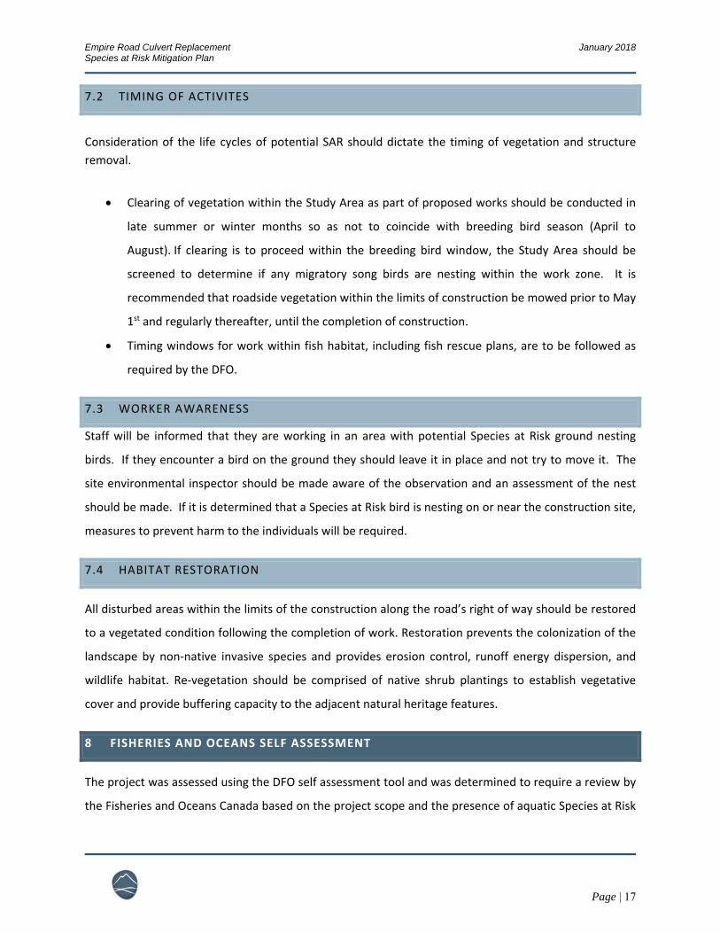
Significant Wetland. A 50m radius from the center of the bridge was evaluated for SAR presence. Refer
to Figure 1 Study Area.
The plan will demonstrate how any negative environmental effects on SAR will be mitigated, and sets
out a program for monitoring the effectiveness of the mitigation measures as it pertains to the
requirement for a mitigation plan per O. Reg. 242/08.
2 STUDY AREA
The structure is located within a rural residential area surrounded by agriculture, a golf course to the
south and a lumberyard to the northwest at the nearby intersection. The watercourse traverses the
Study Area from the northwest in a straightened fashion, with a Cattail (Typhus sp.) shallow marsh
occupying the length of the immediate upstream reach. Downstream of the culvert, vegetation includes
a complex open meadow marsh intermixed with small thickets of Grey Dogwood (Cornus racemosa) and
clusters of Hawthorn (Cratageaus sp.). The open meadow floodplain corridor is flanked by mowed
residential lawn to the west and the golf course with three large ponds to the south. From the structure
the watercourse flows directly east, joining a tributary from the golf course and continuing with natural
meander into reaches with wider riparian corridors designated Provincially Significant Wetlands
downstream.
3 PROJECT POLICY
The Endangered Species Act, 2007, S.O. 2007, Chapter 6, protects the biodiversity of Ontario by using
the best available scientific, community and aboriginal traditional knowledge and the precautionary

Empire Road Culvert Replacement January 2018 Species at Risk Mitigation Plan
Page | 4
principle as its doctrine. The purpose of the Act is to identify species at risk, protect species at risk and
their habitats, and to promote the recovery of species at risk and stewardship activities which assist in
these goals.
The following mitigation plan was prepared based on the requirements of O. Reg. 242/08, s. 23.18 and
its last amendment O. Reg. 176/13, s. 14. The section “Threats to health and safety, non‐imminent”
allows for an exemption of subsection (8), clauses 9 (1) (a) and subsection 10 (1) of the Endangered
Species Act, 2007 [ESA] regarding qualified work if conditions described in subsection (5) are met and
the mitigation plan as required by subsection (6) and (7) is completed.
To qualify for the exemption under Section 23.18 the following conditions must be met:
Work to maintain, repair, remove or replace an existing structure or any infrastructure described in subsection (2), including the decommissioning of a mine, or to upgrade an existing structure or any infrastructure described in subsection (2) to meet a safety standard, if,
i. the maintenance, repair, removal, replacement, decommissioning or upgrade does not require,
A. a temporary or permanent change to the location of the structure or infrastructure, or B. a temporary or permanent extension of the area the structure or infrastructure occupies, except in the case of the replacement of an existing culvert with a new culvert that is larger than the one it replaces, or
ii. in the case of work to maintain, repair, replace or upgrade a structure or infrastructure, the work does not alter the way in which the structure or infrastructure is used or operated.
Please note that Section 23 exemptions require a Notice of Activity before the work activity commences.
Empire Road Culvert Replacement January 2018 Species at Risk Mitigation Plan
Page | 5
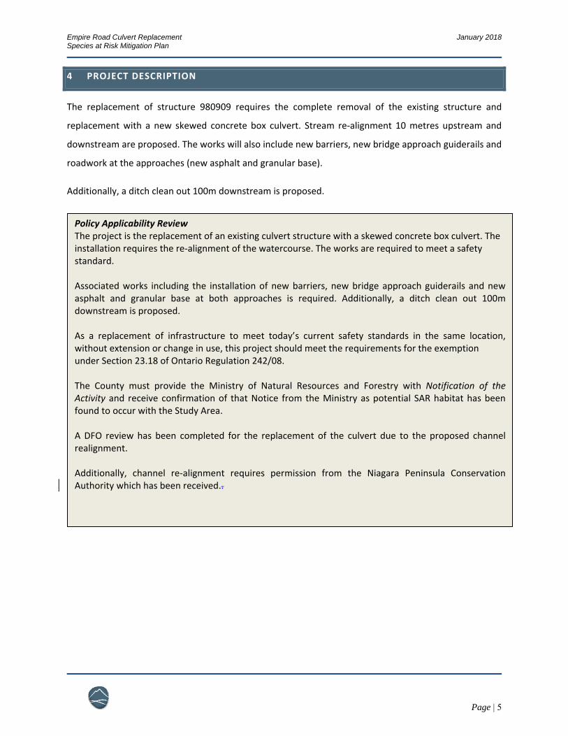
4 PROJECT DESCRIPTION
The replacement of structure 980909 requires the complete removal of the existing structure and
replacement with a new skewed concrete box culvert. Stream re‐alignment 10 metres upstream and
downstream are proposed. The works will also include new barriers, new bridge approach guiderails and
roadwork at the approaches (new asphalt and granular base).
Additionally, a ditch clean out 100m downstream is proposed.
Policy Applicability Review The project is the replacement of an existing culvert structure with a skewed concrete box culvert. The installation requires the re‐alignment of the watercourse. The works are required to meet a safety standard. Associated works including the installation of new barriers, new bridge approach guiderails and new asphalt and granular base at both approaches is required. Additionally, a ditch clean out 100m downstream is proposed. As a replacement of infrastructure to meet today’s current safety standards in the same location, without extension or change in use, this project should meet the requirements for the exemption under Section 23.18 of Ontario Regulation 242/08. The County must provide the Ministry of Natural Resources and Forestry with Notification of the Activity and receive confirmation of that Notice from the Ministry as potential SAR habitat has been found to occur with the Study Area. A DFO review has been completed for the replacement of the culvert due to the proposed channel realignment. Additionally, channel re‐alignment requires permission from the Niagara Peninsula Conservation Authority which has been received..
Empire Road Culvert Replacement January 2018 Species at Risk Mitigation Plan
Page | 6
5 POTENTIAL SPECIES AT RISK
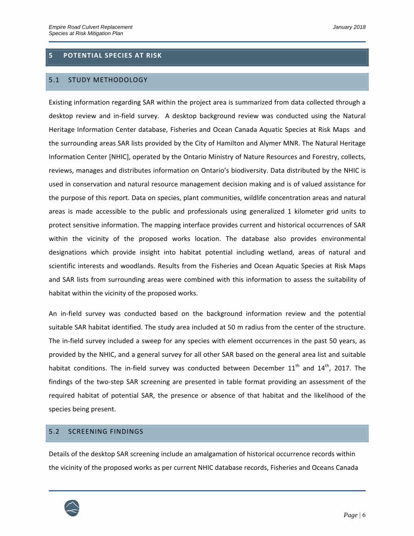
5.1 STUDY METHODOLOGY
Existing information regarding SAR within the project area is summarized from data collected through a
desktop review and in‐field survey. A desktop background review was conducted using the Natural
Heritage Information Center database, Fisheries and Ocean Canada Aquatic Species at Risk Maps and
the surrounding areas SAR lists provided by the City of Hamilton and Alymer MNR. The Natural Heritage
Information Center [NHIC], operated by the Ontario Ministry of Nature Resources and Forestry, collects,
reviews, manages and distributes information on Ontario’s biodiversity. Data distributed by the NHIC is
used in conservation and natural resource management decision making and is of valued assistance for
the purpose of this report. Data on species, plant communities, wildlife concentration areas and natural
areas is made accessible to the public and professionals using generalized 1 kilometer grid units to
protect sensitive information. The mapping interface provides current and historical occurrences of SAR
within the vicinity of the proposed works location. The database also provides environmental
designations which provide insight into habitat potential including wetland, areas of natural and
scientific interests and woodlands. Results from the Fisheries and Ocean Aquatic Species at Risk Maps
and SAR lists from surrounding areas were combined with this information to assess the suitability of
habitat within the vicinity of the proposed works.
An in‐field survey was conducted based on the background information review and the potential
suitable SAR habitat identified. The study area included at 50 m radius from the center of the structure.
The in‐field survey included a sweep for any species with element occurrences in the past 50 years, as
provided by the NHIC, and a general survey for all other SAR based on the general area list and suitable
habitat conditions. The in‐field survey was conducted between December 11th and 14th, 2017. The
findings of the two‐step SAR screening are presented in table format providing an assessment of the
required habitat of potential SAR, the presence or absence of that habitat and the likelihood of the
species being present.
5.2 SCREENING FINDINGS
Details of the desktop SAR screening include an amalgamation of historical occurrence records within
the vicinity of the proposed works as per current NHIC database records, Fisheries and Oceans Canada
Empire Road Culvert Replacement January 2018 Species at Risk Mitigation Plan
Page | 7
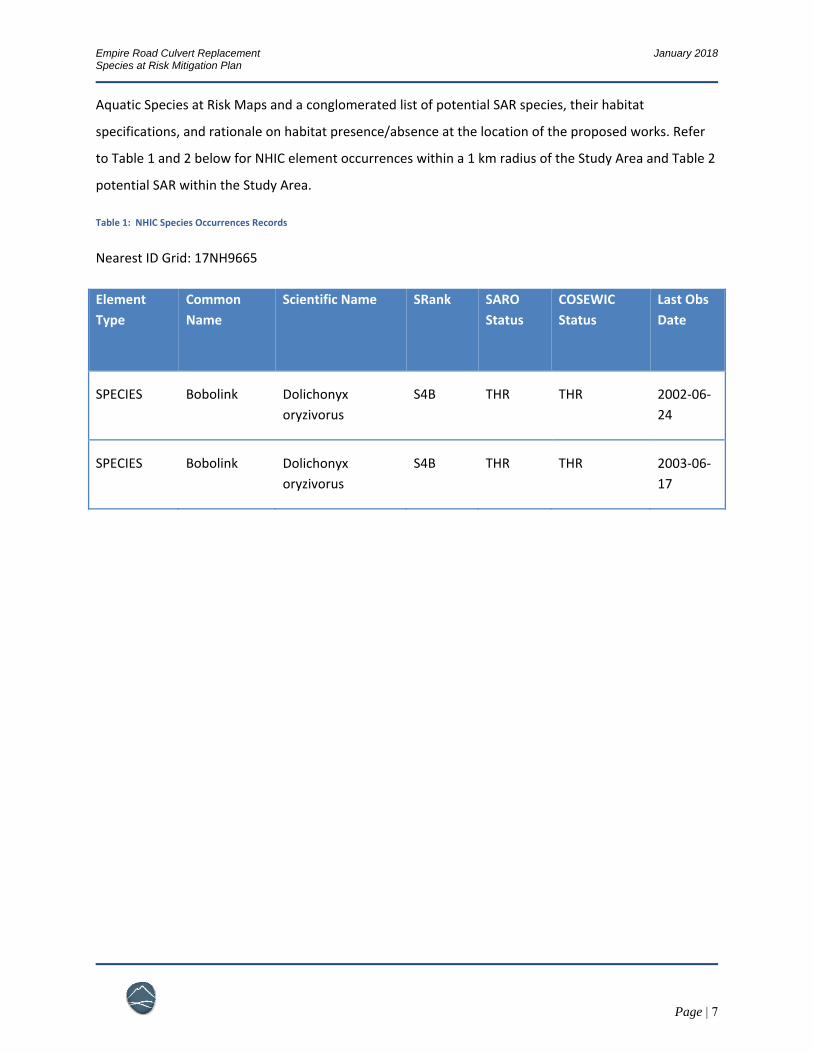
Aquatic Species at Risk Maps and a conglomerated list of potential SAR species, their habitat
specifications, and rationale on habitat presence/absence at the location of the proposed works. Refer
to Table 1 and 2 below for NHIC element occurrences within a 1 km radius of the Study Area and Table 2
potential SAR within the Study Area.
Table 1: NHIC Species Occurrences Records
Nearest ID Grid: 17NH9665
Element
Type
Common
Name
Scientific Name SRank SARO
Status
COSEWIC
Status
Last Obs
Date
SPECIES Bobolink Dolichonyx
oryzivorus
S4B THR THR 2002‐06‐
24
SPECIES Bobolink Dolichonyx
oryzivorus
S4B THR THR 2003‐06‐
17
Empire Road Culvert Replacement January 2018 Species at Risk Mitigation Plan
Page | 8
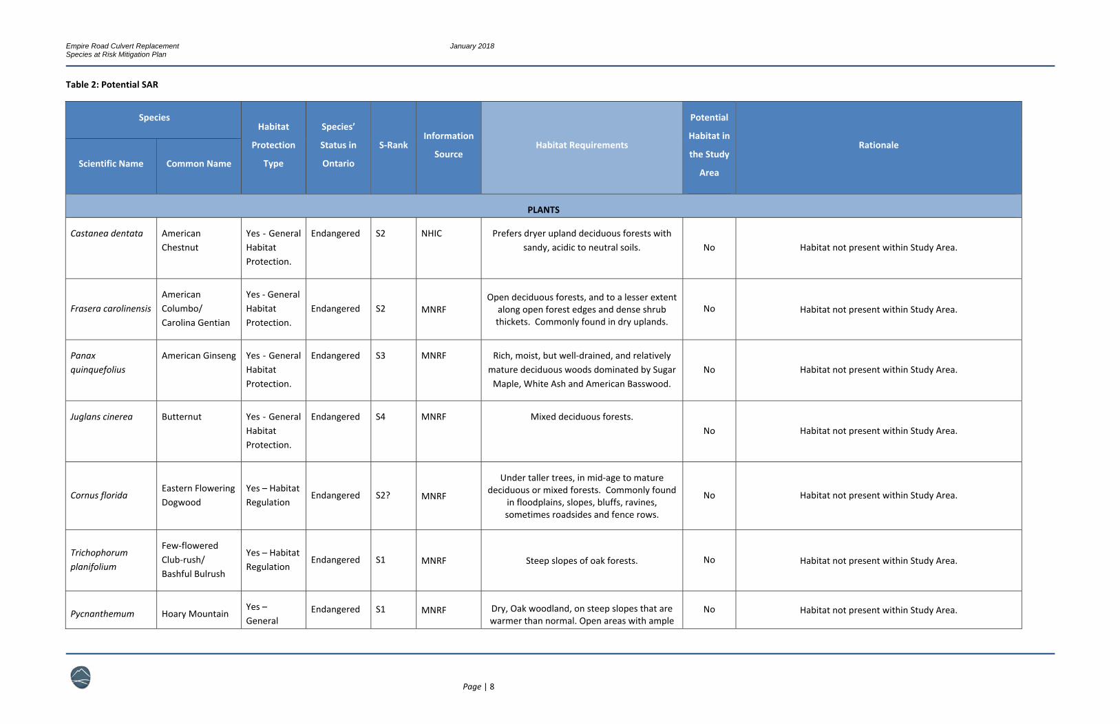
Table 2: Potential SAR
Species Habitat
Protection
Type
Species’
Status in
Ontario
S‐Rank Information
Source Habitat Requirements
Potential
Habitat in
the Study
Area
Rationale
Scientific Name Common Name
PLANTS
Castanea dentata American Chestnut
Yes ‐ General Habitat Protection.
Endangered S2 NHIC Prefers dryer upland deciduous forests with sandy, acidic to neutral soils. No Habitat not present within Study Area.
Frasera carolinensis American Columbo/ Carolina Gentian
Yes ‐ General Habitat Protection.
Endangered S2 MNRF Open deciduous forests, and to a lesser extent
along open forest edges and dense shrub thickets. Commonly found in dry uplands.
No Habitat not present within Study Area.
Panax quinquefolius
American Ginseng Yes ‐ General Habitat Protection.
Endangered S3 MNRF Rich, moist, but well‐drained, and relatively mature deciduous woods dominated by Sugar Maple, White Ash and American Basswood.
No Habitat not present within Study Area.
Juglans cinerea Butternut Yes ‐ General Habitat Protection.
Endangered S4 MNRF Mixed deciduous forests. No Habitat not present within Study Area.
Cornus florida Eastern Flowering Dogwood
Yes – Habitat Regulation
Endangered S2? MNRF
Under taller trees, in mid‐age to mature deciduous or mixed forests. Commonly found
in floodplains, slopes, bluffs, ravines, sometimes roadsides and fence rows.
No Habitat not present within Study Area.
Trichophorum planifolium
Few‐flowered Club‐rush/ Bashful Bulrush
Yes – Habitat Regulation
Endangered S1 MNRF Steep slopes of oak forests. No Habitat not present within Study Area.
Pycnanthemum Hoary Mountain Yes – General
Endangered S1 MNRF Dry, Oak woodland, on steep slopes that are warmer than normal. Open areas with ample
No Habitat not present within Study Area.

Empire Road Culvert Replacement January 2018 Species at Risk Mitigation Plan
Page | 9
Species Habitat
Protection
Type
Species’
Status in
Ontario
S‐Rank Information
Source Habitat Requirements
Potential
Habitat in
the Study
Area
Rationale
Scientific Name Common Name
incanum Mint Habitat Protection
sunlight, in habitats with depend on fire for maintenance.
Morus rubra Red Mulberry
Yes – General Habitat Protection
Endangered S2 MNRF Moist, Forested valleys and floodplains. Sandy and limestone‐based loamy soils. Prefers sun
from breaks in canopy. No Habitat not present within Study Area.
Chimaphila maculata
Spotted Wintergreen
Yes‐ General Habitat Protection
Endangered S2 MNRF Dry, oak‐pine woodlands with sandy soils. No Habitat not present within Study Area.
Eurybia divaricata White Wood Aster
Yes – General Habitat Protection
Threatened S2S3 MNRF Open, dry deciduous forests dominated by
Sugar Maple and Beech. Found mixed in with other asters.
No Habitat not present within Study Area.
BIRDS
Colinus virginianus Northern Bobwhite
Yes, General Habitat Protection
Endangered S1 NHIC Grassland, prairie or hay fields with woody cover in form of thickets, tangles of vines, shrubs; fence rows or woodland edges;
abandoned farm fields; well‐drained sandy or loamy soil; pond edges Yes
Clearing of vegetation within the Study Area as part of proposed works should be conducted in late summer or winter months so as
not to coincide with breeding bird season (April to August). If clearing is to proceed within the breeding bird window, the Study Area should be screened to determine if any migratory song birds
are nesting within the work zone.
Empidonax virescens
Acadian Flycatcher
Yes ‐ General Habitat Protection.
Endangered S2B, S3B MNRF Mature, shady forests with ravines, or in forested swamps with lots of maple and beech
trees. No Habitat not present within Study Area.
Empire Road Culvert Replacement January 2018 Species at Risk Mitigation Plan
Page | 10
Species Habitat
Protection
Type
Species’
Status in
Ontario
S‐Rank Information
Source Habitat Requirements
Potential
Habitat in
the Study
Area
Rationale
Scientific Name Common Name
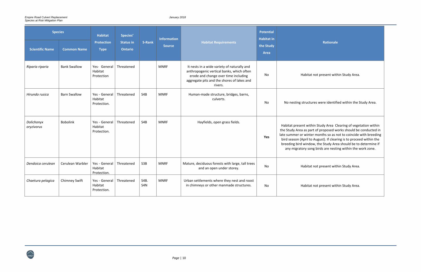
Riparia riparia Bank Swallow Yes‐ General Habitat Protection
Threatened MNRF It nests in a wide variety of naturally and anthropogenic vertical banks, which often erode and change over time including
aggregate pits and the shores of lakes and rivers.
No Habitat not present within Study Area.
Hirundo rusica Barn Swallow Yes ‐ General Habitat Protection.
Threatened S4B MNRF Human‐made structure, bridges, barns, culverts.
No No nesting structures were identified within the Study Area.
Dolichonyx oryzivorus
Bobolink Yes ‐ General Habitat Protection.
Threatened S4B MNRF Hayfields, open grass fields.
Yes
Habitat present within Study Area Clearing of vegetation within the Study Area as part of proposed works should be conducted in late summer or winter months so as not to coincide with breeding bird season (April to August). If clearing is to proceed within the breeding bird window, the Study Area should be to determine if
any migratory song birds are nesting within the work zone.
Dendoica cerulean Cerulean Warbler Yes ‐ General Habitat Protection.
Threatened S3B MNRF Mature, deciduous forests with large, tall trees and an open under storey. No Habitat not present within Study Area.
Chaetura pelagica Chimney Swift Yes ‐ General Habitat Protection.
Threatened S4B. S4N
MNRF Urban settlements where they nest and roost in chimneys or other manmade structures. No Habitat not present within Study Area.
Empire Road Culvert Replacement January 2018 Species at Risk Mitigation Plan
Page | 11
Species Habitat
Protection
Type
Species’
Status in
Ontario
S‐Rank Information
Source Habitat Requirements
Potential
Habitat in
the Study
Area
Rationale
Scientific Name Common Name
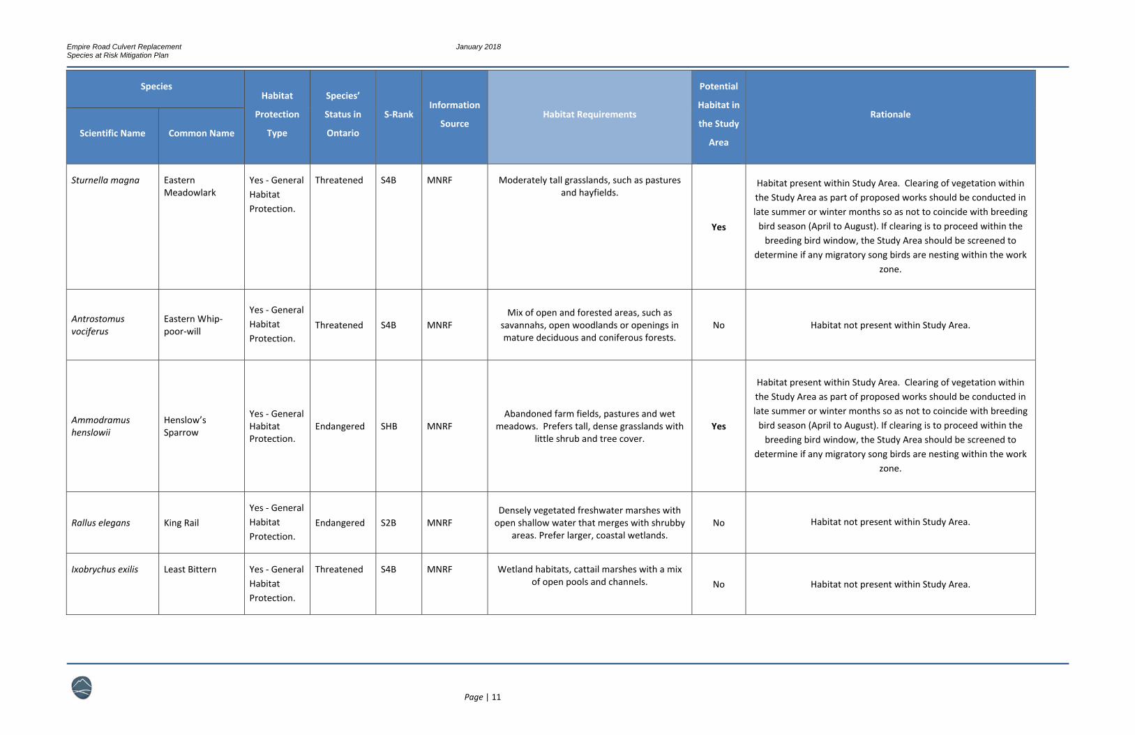
Sturnella magna Eastern Meadowlark
Yes ‐ General Habitat Protection.
Threatened S4B MNRF Moderately tall grasslands, such as pastures and hayfields.
Yes
Habitat present within Study Area. Clearing of vegetation within the Study Area as part of proposed works should be conducted in late summer or winter months so as not to coincide with breeding bird season (April to August). If clearing is to proceed within the breeding bird window, the Study Area should be screened to
determine if any migratory song birds are nesting within the work zone.
Antrostomus vociferus
Eastern Whip‐poor‐will
Yes ‐ General Habitat Protection.
Threatened S4B MNRF Mix of open and forested areas, such as
savannahs, open woodlands or openings in mature deciduous and coniferous forests.
No Habitat not present within Study Area.
Ammodramus henslowii
Henslow’s Sparrow
Yes ‐ General Habitat Protection.
Endangered SHB MNRF Abandoned farm fields, pastures and wet
meadows. Prefers tall, dense grasslands with little shrub and tree cover.
Yes
Habitat present within Study Area. Clearing of vegetation within the Study Area as part of proposed works should be conducted in late summer or winter months so as not to coincide with breeding bird season (April to August). If clearing is to proceed within the breeding bird window, the Study Area should be screened to
determine if any migratory song birds are nesting within the work zone.
Rallus elegans King Rail Yes ‐ General Habitat Protection.
Endangered S2B MNRF Densely vegetated freshwater marshes with open shallow water that merges with shrubby
areas. Prefer larger, coastal wetlands. No Habitat not present within Study Area.
Ixobrychus exilis Least Bittern Yes ‐ General Habitat Protection.
Threatened S4B MNRF Wetland habitats, cattail marshes with a mix of open pools and channels. No Habitat not present within Study Area.
Empire Road Culvert Replacement January 2018 Species at Risk Mitigation Plan
Page | 12
Species Habitat
Protection
Type
Species’
Status in
Ontario
S‐Rank Information
Source Habitat Requirements
Potential
Habitat in
the Study
Area
Rationale
Scientific Name Common Name
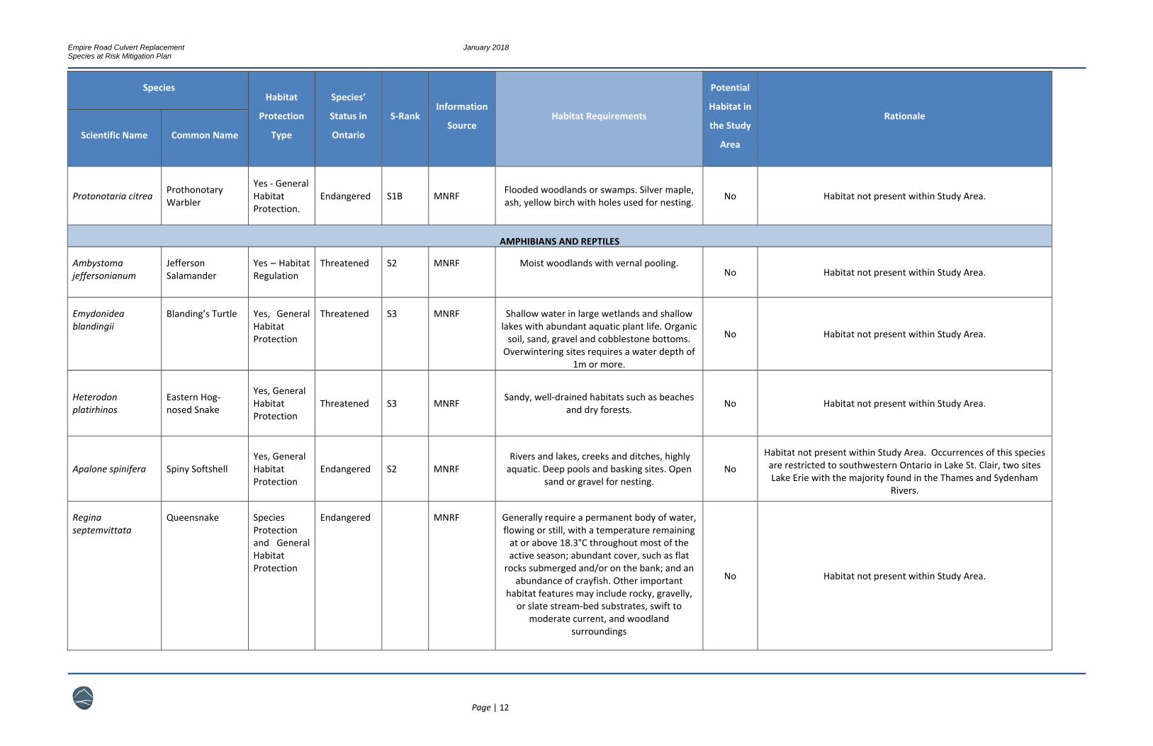
Protonotaria citrea Prothonotary Warbler
Yes ‐ General Habitat Protection.
Endangered S1B MNRF Flooded woodlands or swamps. Silver maple, ash, yellow birch with holes used for nesting. No Habitat not present within Study Area.
AMPHIBIANS AND REPTILES
Ambystoma jeffersonianum
Jefferson Salamander
Yes – Habitat Regulation
Threatened S2 MNRF Moist woodlands with vernal pooling. No Habitat not present within Study Area.
Emydonidea blandingii
Blanding’s Turtle
Yes, General Habitat Protection
Threatened S3 MNRF Shallow water in large wetlands and shallow lakes with abundant aquatic plant life. Organic soil, sand, gravel and cobblestone bottoms. Overwintering sites requires a water depth of
1m or more.
No Habitat not present within Study Area.
Heterodon platirhinos
Eastern Hog‐nosed Snake
Yes, General Habitat Protection
Threatened S3 MNRF Sandy, well‐drained habitats such as beaches and dry forests. No Habitat not present within Study Area.
Apalone spinifera Spiny Softshell Yes, General Habitat Protection
Endangered S2 MNRF Rivers and lakes, creeks and ditches, highly aquatic. Deep pools and basking sites. Open
sand or gravel for nesting. No
Habitat not present within Study Area. Occurrences of this species are restricted to southwestern Ontario in Lake St. Clair, two sites Lake Erie with the majority found in the Thames and Sydenham
Rivers.
Regina septemvittata
Queensnake Species Protection and General Habitat Protection
Endangered MNRF Generally require a permanent body of water, flowing or still, with a temperature remaining at or above 18.3°C throughout most of the active season; abundant cover, such as flat rocks submerged and/or on the bank; and an
abundance of crayfish. Other important habitat features may include rocky, gravelly,
or slate stream‐bed substrates, swift to moderate current, and woodland
surroundings
No Habitat not present within Study Area.
Empire Road Culvert Replacement January 2018 Species at Risk Mitigation Plan
Page | 13
Species Habitat
Protection
Type
Species’
Status in
Ontario
S‐Rank Information
Source Habitat Requirements
Potential
Habitat in
the Study
Area
Rationale
Scientific Name Common Name
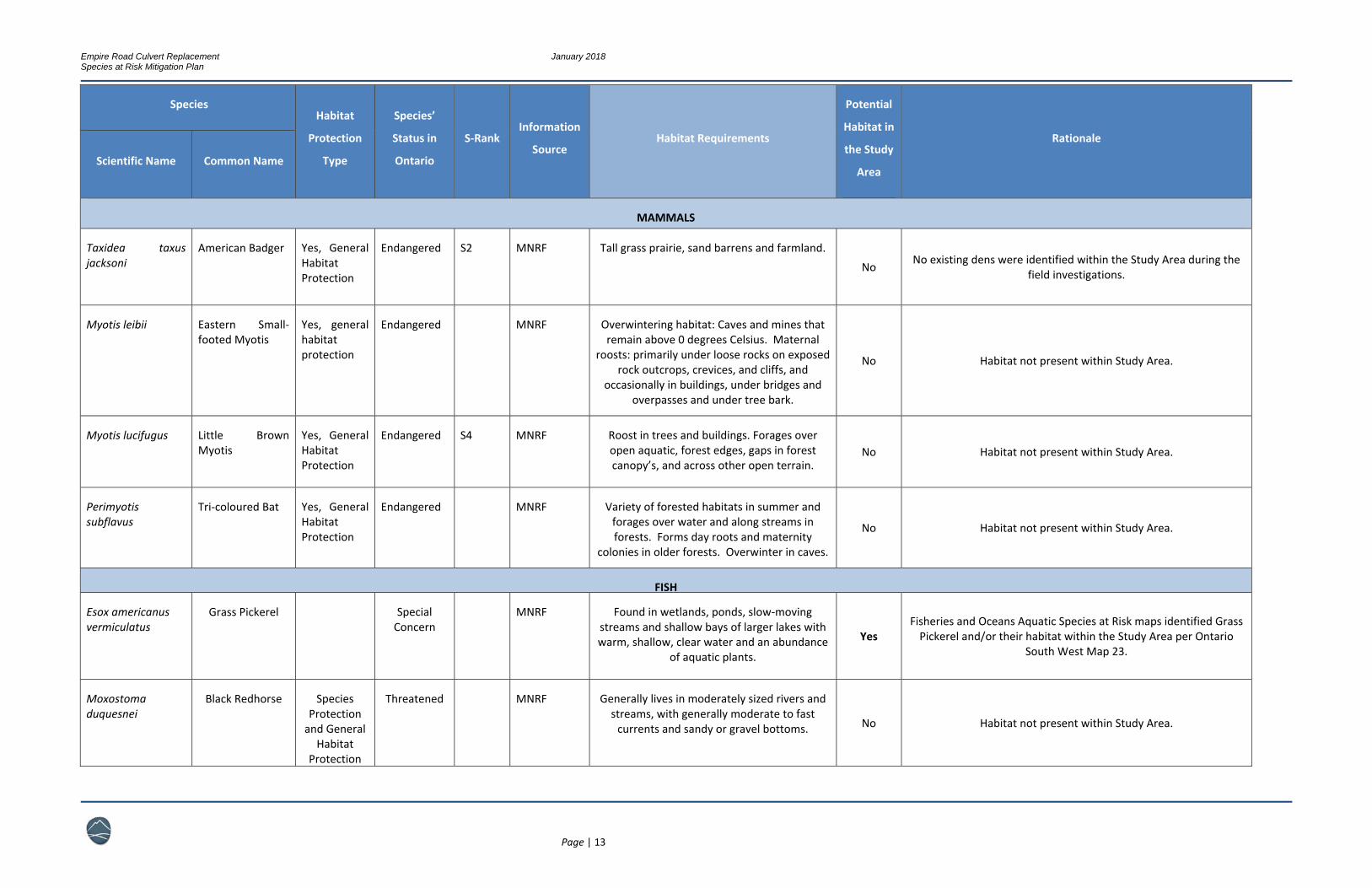
MAMMALS
Taxidea taxus jacksoni
American Badger Yes, General Habitat Protection
Endangered S2 MNRF Tall grass prairie, sand barrens and farmland.
No No existing dens were identified within the Study Area during the field investigations.
Myotis leibii Eastern Small‐footed Myotis
Yes, general habitat protection
Endangered MNRF Overwintering habitat: Caves and mines that remain above 0 degrees Celsius. Maternal
roosts: primarily under loose rocks on exposed rock outcrops, crevices, and cliffs, and
occasionally in buildings, under bridges and overpasses and under tree bark.
No Habitat not present within Study Area.
Myotis lucifugus Little Brown Myotis
Yes, General Habitat Protection
Endangered S4 MNRF Roost in trees and buildings. Forages over open aquatic, forest edges, gaps in forest canopy’s, and across other open terrain.
No Habitat not present within Study Area.
Perimyotis subflavus
Tri‐coloured Bat Yes, General Habitat Protection
Endangered MNRF Variety of forested habitats in summer and forages over water and along streams in forests. Forms day roots and maternity
colonies in older forests. Overwinter in caves.
No Habitat not present within Study Area.
FISH
Esox americanus vermiculatus
Grass Pickerel Special Concern
MNRF Found in wetlands, ponds, slow‐moving streams and shallow bays of larger lakes with warm, shallow, clear water and an abundance
of aquatic plants.
Yes Fisheries and Oceans Aquatic Species at Risk maps identified Grass Pickerel and/or their habitat within the Study Area per Ontario
South West Map 23.
Moxostoma duquesnei
Black Redhorse Species Protection and General
Habitat Protection
Threatened MNRF Generally lives in moderately sized rivers and streams, with generally moderate to fast currents and sandy or gravel bottoms. No Habitat not present within Study Area.

Empire Road Culvert Replacement January 2018 Species at Risk Mitigation Plan
Page | 14
Species Habitat
Protection
Type
Species’
Status in
Ontario
S‐Rank Information
Source Habitat Requirements
Potential
Habitat in
the Study
Area
Rationale
Scientific Name Common Name
Notropis photogenis
Silver Shiner Yes, General Habitat
Threatened MNRF Moderate to large size streams with swift currents and gravel or boulder bottoms.
No Habitat not present within Study Area.
INSECTS
Bombus offinis Rusty‐patched Bumble Bee
Species Protection and General Habitat Protection
Endangered MNRF Generally inhabits a range of diverse habitats including mixed farmland, sand dunes,
marshes, urban and wooded areas. It usually nests underground in abandoned rodent
burrows.
No Species of this species has only occurred within the Pinery
Provincial Park on Lake Huron.
INVERTEBRATES
Ligumia nasuta Eastern Pondmussel
Yes, General Habitat Protection
Endangered S1 MNRF Sheltered areas of lakes, slow moving rivers and canals, sand or mud bottoms. No
Fisheries and Oceans Canada Aquatic SAR maps (Ontario South West Map 23), does not identify this species or its critical habitat
for this area.
Villosa iris Rainbow Mussel Yes, General Habitat Protection
Threatened Medium sized rivers with a moderate to strong current. No Habitat not present within Study Area.
Lampsilis fasciola Wavy‐rayed Lampmussel
Species Protection and General Habitat Protection
Threatened Generally inhabit clear rivers and streams of a variety of sizes, where the water flow is moderate, strong and steady and the
substrate is stable. No Habitat not present within Study Area. Not within known range.
Empire Road Culvert Replacement January 2018 Species at Risk Mitigation Plan
Page | 15
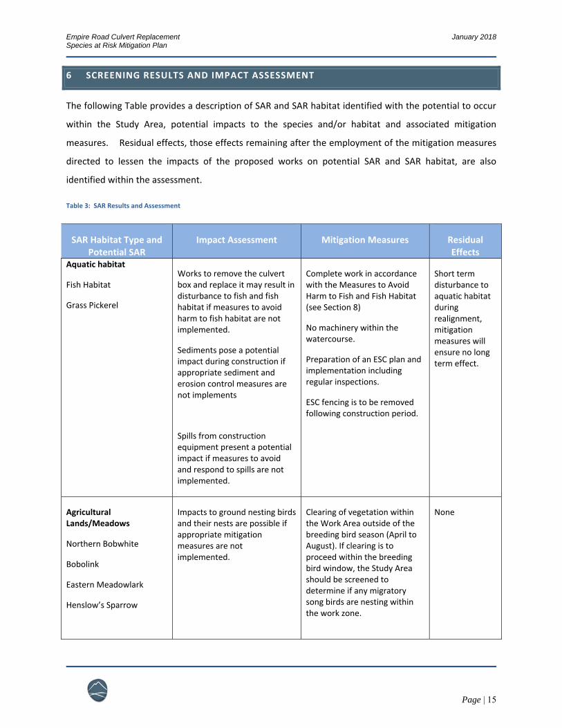
6 SCREENING RESULTS AND IMPACT ASSESSMENT
The following Table provides a description of SAR and SAR habitat identified with the potential to occur
within the Study Area, potential impacts to the species and/or habitat and associated mitigation
measures. Residual effects, those effects remaining after the employment of the mitigation measures
directed to lessen the impacts of the proposed works on potential SAR and SAR habitat, are also
identified within the assessment.
Table 3: SAR Results and Assessment
SAR Habitat Type and Potential SAR
Impact Assessment Mitigation Measures Residual Effects
Aquatic habitat
Fish Habitat
Grass Pickerel
Works to remove the culvert box and replace it may result in disturbance to fish and fish habitat if measures to avoid harm to fish habitat are not implemented.
Sediments pose a potential impact during construction if appropriate sediment and erosion control measures are not implements
Spills from construction equipment present a potential impact if measures to avoid and respond to spills are not implemented.
Complete work in accordance with the Measures to Avoid Harm to Fish and Fish Habitat (see Section 8)
No machinery within the watercourse.
Preparation of an ESC plan and implementation including regular inspections.
ESC fencing is to be removed following construction period.
Short term disturbance to aquatic habitat during realignment, mitigation measures will ensure no long term effect.
Agricultural Lands/Meadows
Northern Bobwhite
Bobolink
Eastern Meadowlark
Henslow’s Sparrow
Impacts to ground nesting birds and their nests are possible if appropriate mitigation measures are not implemented.
Clearing of vegetation within the Work Area outside of the breeding bird season (April to August). If clearing is to proceed within the breeding bird window, the Study Area should be screened to determine if any migratory song birds are nesting within the work zone.
None
Empire Road Culvert Replacement January 2018 Species at Risk Mitigation Plan
Page | 16
7 MITIGATION MEASURES
The structure replacement requires measures to mitigate harm to potential SAR, including Grass
Pickerel, Northern Bobwhite, Bobolink, Eastern Meadowlark and Henslow’s Sparrow. With the
submission of a Notice of Activity and the implementation of the following mitigation plan, the proposed
works should qualify for exemption under Section 23.18 of O. Reg. 242/08.
Based on the assessment of habitat and the likelihood of encounters on the site, the following
mitigation measures are required to meet the requirements of Paragraph 5 of Section 23.18 (O.Reg
242/08).
1. Limits of Construction;
2. Timing of activities;
3. Worker awareness; and,
4. Habitat restoration.
7.1 LIMITS OF CONSTRUCTION
Most potential impacts to SAR and SAR habitat can be avoided with the installation of reasonable limits
of construction. By keeping all works within the footprint of the existing roadway, no long term residual
effects to species habitat within the surrounding vegetation communities and watercourse will occur.
Limits of construction are to be clearly defined on all print site plans and are to be installed in
field with the use of stakes, flagging, erosion and sediment control fencing and/or exclusion
fencing.
Limits of construction are to be established prior to the arrival of any heavy machinery or any
clearing or earth works.
Limits are to be set in accordance to those advised by the DFO following project review.
All work is to be contained within the limits of construction, including machinery staging and the
storing of materials.
Empire Road Culvert Replacement January 2018 Species at Risk Mitigation Plan
Page | 17
7.2 TIMING OF ACTIVITES
Consideration of the life cycles of potential SAR should dictate the timing of vegetation and structure removal.
Clearing of vegetation within the Study Area as part of proposed works should be conducted in
late summer or winter months so as not to coincide with breeding bird season (April to
August). If clearing is to proceed within the breeding bird window, the Study Area should be
screened to determine if any migratory song birds are nesting within the work zone. It is
recommended that roadside vegetation within the limits of construction be mowed prior to May
1st and regularly thereafter, until the completion of construction.
Timing windows for work within fish habitat, including fish rescue plans, are to be followed as
required by the DFO.
7.3 WORKER AWARENESS
Staff will be informed that they are working in an area with potential Species at Risk ground nesting
birds. If they encounter a bird on the ground they should leave it in place and not try to move it. The
site environmental inspector should be made aware of the observation and an assessment of the nest
should be made. If it is determined that a Species at Risk bird is nesting on or near the construction site,
measures to prevent harm to the individuals will be required.
7.4 HABITAT RESTORATION
All disturbed areas within the limits of the construction along the road’s right of way should be restored
to a vegetated condition following the completion of work. Restoration prevents the colonization of the
landscape by non‐native invasive species and provides erosion control, runoff energy dispersion, and
wildlife habitat. Re‐vegetation should be comprised of native shrub plantings to establish vegetative
cover and provide buffering capacity to the adjacent natural heritage features.
8 FISHERIES AND OCEANS SELF ASSESSMENT
The project was assessed using the DFO self assessment tool and was determined to require a review by
the Fisheries and Oceans Canada based on the project scope and the presence of aquatic Species at Risk

Empire Road Culvert Replacement January 2018 Species at Risk Mitigation Plan
Page | 18
(see Appendix C). The project has been reviewed by the DFO and it was determined that it could
proceed with without causing serious harm to fish or fisheries using standard measures. The project is
required to be undertaken in a manner that protects fish and fish habitat, and should implement the
measures outlined in the ‘Measures to avoid causing harm to fish and fish habitat’. Refer to
http://www.dfo‐mpo.gc.ca/pnw‐ppe/measures‐mesures/measures‐mesures‐eng.html) for details.

Empire Road Culvert Replacement January 2018 Species at Risk Mitigation Plan
Page | 19
9 REFERENCES
Ontario. Ministry of Natural Resources and Forestry. N.d. Various species information pages. Retrieved
from https://www.ontario.ca/page/species‐risk.
Ontario Nature. N.d. Ontario Retile and Amphibian Atlas. Retrieved from
https://www.ontarionature.org/protect/species/herpetofaunal_atlas.php.
York Road
Scale:
Date Issued:
Drawn By:
Checked By:
Figure No.
Haldimand Empire RoadStudy Area
1:500
Dec. 2017
JJ
JR
LEGEND
1
Study Area (50 m Setback)
0 5 10 15 202.5Meters
±

Empire Road Culvert Replacement January 2018 Species at Risk Mitigation Plan
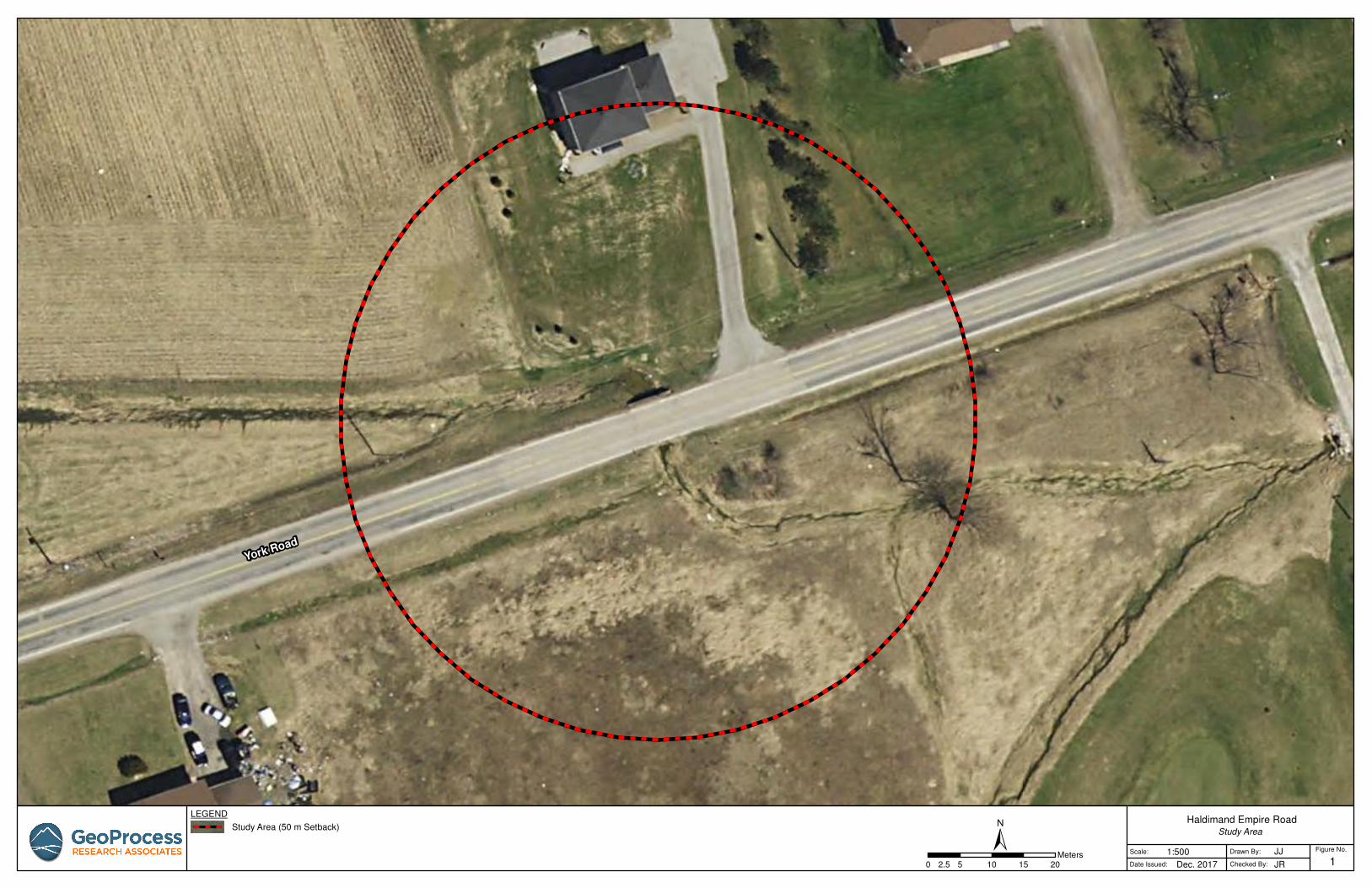
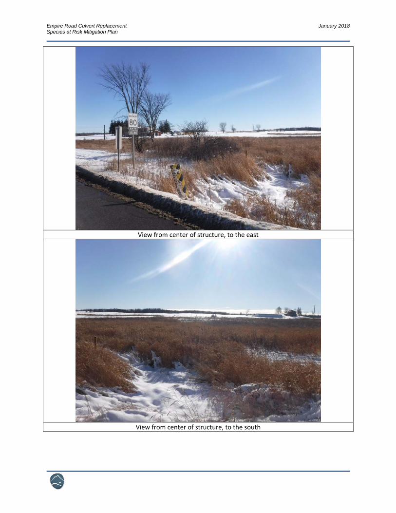
Appendix A ‐ Photoplate

Empire Road Culvert Replacement January 2018 Species at Risk Mitigation Plan
Structure, view to the northeast
View from center of structure, to the west
Empire Road Culvert Replacement January 2018 Species at Risk Mitigation Plan
View from center of structure, to the east
View from center of structure, to the south
Empire Road Culvert Replacement January 2018 Species at Risk Mitigation Plan
North side of structure, view to west
100m downstream structure, standing snag and private driveway culvert
Empire Road Culvert Replacement January 2018 Species at Risk Mitigation Plan
Appendix B – SAR Observation Sheet

Empire Road Culvert Replacement January 2018 Species at Risk Mitigation Plan
SAR Observation Records of Occurrence
Date
Location
Time
Notice of Activity
Number
Notes on Occurrence:
Species, activity, timeline, actions, due diligence, next steps, contact information, pictures provided, etc.
Signed:
Environmental Officer
at Site
General Foreman at
Site
To be submitted to the NPCA and the local OMNRF office.

Empire Road Culvert Replacement January 2018 Species at Risk Mitigation Plan
Appendix C – DFO Self Assessment
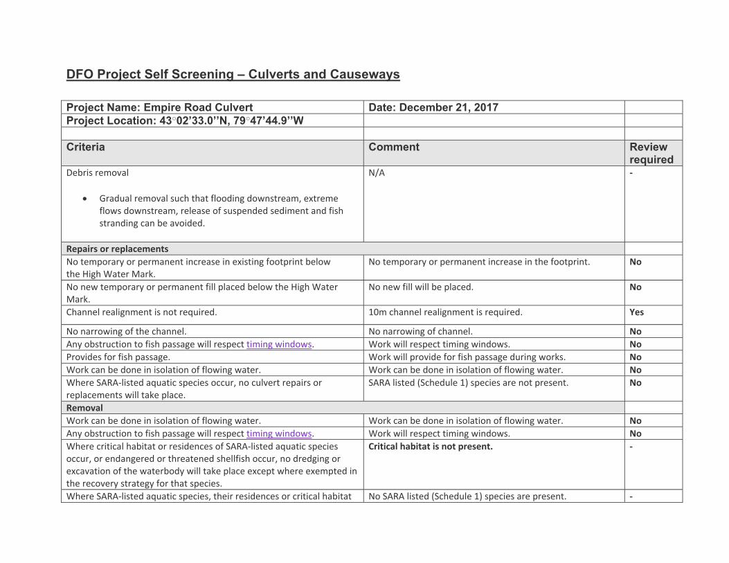
DFO Project Self Screening – Culverts and Causeways
Project Name: Empire Road Culvert Date: December 21, 2017Project Location: 43○02’33.0’’N, 79○47’44.9’’W Criteria Comment Review
requiredDebris removal
Gradual removal such that flooding downstream, extreme flows downstream, release of suspended sediment and fish stranding can be avoided.
N/A ‐
Repairs or replacements No temporary or permanent increase in existing footprint below the High Water Mark.
No temporary or permanent increase in the footprint. No
No new temporary or permanent fill placed below the High Water Mark.
No new fill will be placed. No
Channel realignment is not required. 10m channel realignment is required. Yes
No narrowing of the channel. No narrowing of channel. No Any obstruction to fish passage will respect timing windows. Work will respect timing windows. No Provides for fish passage. Work will provide for fish passage during works. No Work can be done in isolation of flowing water. Work can be done in isolation of flowing water. No Where SARA‐listed aquatic species occur, no culvert repairs or replacements will take place.
SARA listed (Schedule 1) species are not present. No
Removal Work can be done in isolation of flowing water. Work can be done in isolation of flowing water. No Any obstruction to fish passage will respect timing windows. Work will respect timing windows. No Where critical habitat or residences of SARA‐listed aquatic species occur, or endangered or threatened shellfish occur, no dredging or excavation of the waterbody will take place except where exempted in the recovery strategy for that species.
Critical habitat is not present. ‐
Where SARA‐listed aquatic species, their residences or critical habitat No SARA listed (Schedule 1) species are present. ‐

occur:
No permanent increase in existing footprint above the high water mark if the riparian area is identified as part of the critical habitat of an aquatic listed species at risk.
No removal of riparian vegetation if the riparian area is identified as part of the critical habitat of an aquatic listed species at risk.
Where SARA‐listed shellfish occur:
No scaffolding or support structures will be placed directly on the bed of the watercourse.
No dredging or excavation of the waterbody will take place.
N/A ‐
Causeways Repairs
No temporary or permanent increase in existing footprint below the High Water Mark.
No new temporary or permanent fill placed below the High Water Mark.
N/A ‐
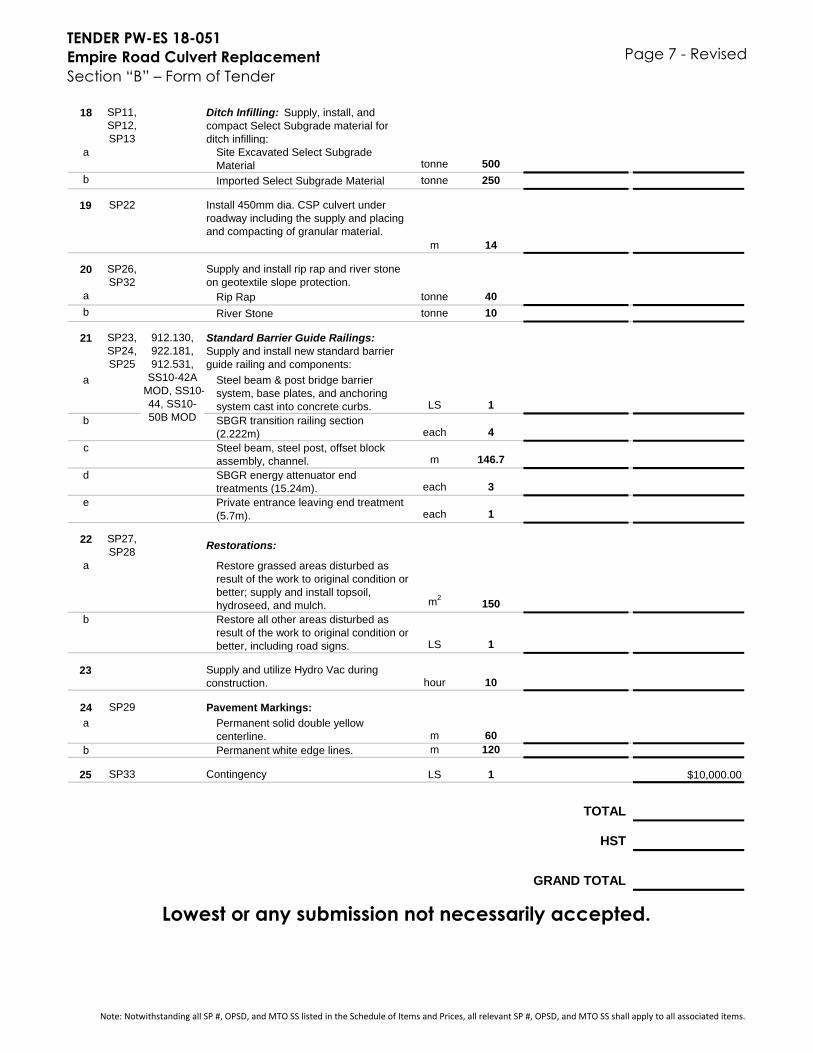
TENDER PW-ES 18-051
Empire Road Culvert Replacement
Section “B” – Form of Tender
Page 7 - Revised
18 SP11,
SP12,
SP13
Ditch Infilling: Supply, install, and
compact Select Subgrade material for
ditch infilling:
a Site Excavated Select Subgrade
Material tonne 500
b Imported Select Subgrade Material tonne 250
19 SP22 Install 450mm dia. CSP culvert under
roadway including the supply and placing
and compacting of granular material.
m 14
20 SP26,
SP32
Supply and install rip rap and river stone
on geotextile slope protection.
a Rip Rap tonne 40
b River Stone tonne 10
21 SP23,
SP24,
SP25
Standard Barrier Guide Railings:
Supply and install new standard barrier
guide railing and components:
a Steel beam & post bridge barrier
system, base plates, and anchoring
system cast into concrete curbs. LS 1
b SBGR transition railing section
(2.222m) each 4
c Steel beam, steel post, offset block
assembly, channel. m 146.7
d SBGR energy attenuator end
treatments (15.24m). each 3
e Private entrance leaving end treatment
(5.7m). each 1
22 SP27,
SP28Restorations:
a Restore grassed areas disturbed as
result of the work to original condition or
better; supply and install topsoil,
hydroseed, and mulch. m2
150
b Restore all other areas disturbed as
result of the work to original condition or
better, including road signs. LS 1
23 Supply and utilize Hydro Vac during
construction. hour 10
24 SP29 Pavement Markings:
a Permanent solid double yellow
centerline. m 60
b Permanent white edge lines. m 120
25 SP33 Contingency LS 1 $10,000.00
TOTAL
HST
GRAND TOTAL
Lowest or any submission not necessarily accepted.
912.130,
922.181,
912.531,
SS10-42A
MOD, SS10-
44, SS10-
50B MOD
Note: Notwithstanding all SP #, OPSD, and MTO SS listed in the Schedule of Items and Prices, all relevant SP #, OPSD, and MTO SS shall apply to all associated items.
Related Documents


