1 Progress & Use of GIS Progress & Use of GIS … … Agricultural Commissioner / Director of Agricultural Commissioner / Director of Weights & Measures Weights & Measures … … Mediterranean Fruit Fly ACWM ACWM Mediterranean Fruit Fly Red Imported Fire Ant ACWM ACWM Weed Abatement Weed Abatement

Welcome message from author
This document is posted to help you gain knowledge. Please leave a comment to let me know what you think about it! Share it to your friends and learn new things together.
Transcript

1
Progress & Use of GISProgress & Use of GIS……
Agricultural Commissioner / Director of Agricultural Commissioner / Director of Weights & MeasuresWeights & Measures……
Mediterranean Fruit Fly
ACWMACWM
Mediterranean Fruit Fly
Red Imported
Fire Ant
ACWMACWMWeed AbatementWeed Abatement

2
Weed AbatementWeed Abatement Weed AbatementWeed Abatement
Benefits of changeBenefits of change……
A look at how using GIS A look at how using GIS improves accuracy, efficiency improves accuracy, efficiency and documentationand documentation
Older Methods & Older Methods & EquipmentEquipmentAssessorAssessor’’s s printed printed mapbookmapbookpages, pages, bound in bound in field field folders.folders.

3
AssessorAssessor’’s s MapbookMapbook with with inspection report forminspection report form
The data for The data for each job & each job & inspection is inspection is recorded on recorded on adjacent adjacent pages.pages.
ArcPadArcPad
Compaq Compaq IpaqIpaq with with ArcPadArcPadAssessorAssessor’’s Data in s Data in ShapefileShapefile format.format.
ArcPadArcPad –– more datamore dataStreet and City Street and City ShapefilesShapefiles..
ArcPadArcPad Ortho ImagesOrtho ImagesAerial PhotosAerial Photos
Microsoft TerraServer Low Res.Microsoft TerraServer Low Res.Currently Currently ……LARIACLARIAC

4
Printed MapsPrinted Maps
Aerial photos with parcels lines were being Aerial photos with parcels lines were being printed in the office and added to the printed in the office and added to the existing existing mapbookmapbook pages.pages.
Past method of finding Past method of finding Property LinesProperty Lines
200 foot tape measure200 foot tape measure
Rarely used equipmentRarely used equipment
Measuring wheelMeasuring wheel
Range FinderRange Finder
Very UsefulVery UsefulEach tool has use in Each tool has use in different circumstances.different circumstances.
5
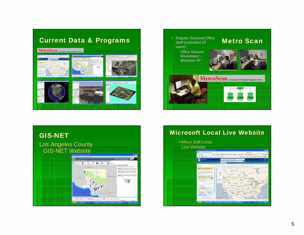
Current Data & ProgramsCurrent Data & Programs Metro ScanMetro ScanRegular Divisional Office Regular Divisional Office Staff (estimated 20 Staff (estimated 20 users)users)
Office Network Office Network Workstation Workstation --Windows XPWindows XP
GISGIS--NETNETLos Angeles County Los Angeles County
GISGIS--NET WebsiteNET Website
Microsoft Local Live WebsiteMicrosoft Local Live WebsiteMicro Soft Local Micro Soft Local Live WebsiteLive Website

6
Google EarthGoogle EarthGoogle EarthGoogle Earth, , Google SketchGoogle Sketch--upup
ESRI ESRI ArcGISArcGIS, 3, 3--D AnalystD AnalystPrinted maps, Mobile Support, Printed maps, Mobile Support, PresentationsPresentations
Mobile DevicesMobile DevicesESRI ESRI –– ArcPadArcPad 77Dell Dell AximAxim X50v X50v 77--Inspectors & Inspectors & ForemenForemen
GPS ReceiversGPS ReceiversTeletype 2851Teletype 2851Bluetooth Bluetooth WAAS Enabled WAAS Enabled Various older GPS Various older GPS models.models.

7
Innovative Use of Oblique Innovative Use of Oblique Angle ImageAngle Image
Projection of Oblique Projection of Oblique Angle ImageAngle Image
Pico Rivera WarehousePico Rivera Warehouse
Property Contamination CleanProperty Contamination Clean--up Closingup ClosingCommunity Views Project DetailCommunity Views Project Detail
Main Steps of Image RotationMain Steps of Image Rotationto match existing artist renderingto match existing artist rendering
2. Geo-referenceAerial Image
3. Set Scene
Properties
1. ClipTerrainData
1.
2. 3.
Limit Angle of changeLimit Angle of changeOvoid unrealistic viewsOvoid unrealistic views
Unrealistic Direction Unrealistic Vertical Angle of View

8
Warehouse 3Warehouse 3--D Fly ByeD Fly Bye Weed & Brush Clearance Weed & Brush Clearance ProjectProject
Illustrate a Proposed Brush Clearance AreaIllustrate a Proposed Brush Clearance AreaDiscussion of clearance issues with a 3Discussion of clearance issues with a 3--D visual aideD visual aide
Clearance Project 3Clearance Project 3--D FlyD Fly--byebye Los Angeles County Habitat Los Angeles County Habitat of Redof Red--Leg FrogLeg Frog

9
InspectorInspector’’s Weed s Weed Abatement ZonesAbatement Zones
Catalina Parcel SurveyCatalina Parcel SurveyIdentify vacant parcels next to structuresIdentify vacant parcels next to structures
Selecting Catalina Parcels Selecting Catalina Parcels THE ENDTHE END
Best of luck to all of Best of luck to all of you in your GIS you in your GIS endeavorsendeavorsI look forward to I look forward to hearing about your hearing about your projectsprojects
Related Documents


