Accuracy assessment of the MODIS 16-day albedo product for snow: comparisons with Greenland in situ measurements Julienne Stroeve * , Jason E. Box, Feng Gao, Shunlin Liang, Anne Nolin, Crystal Schaaf National Snow and Ice Data Center (NSIDC), University of Colorado, Campus Box 449, Boulder, CO 80309-0449, United States Received 18 May 2004; received in revised form 2 September 2004; accepted 6 September 2004 Abstract The accuracy of the Moderate Resolution Imaging Spectroradiometer (MODIS) 16-day albedo product (MOD43) is assessed using ground-based albedo observations from automatic weather stations (AWS) over spatially homogeneous snow and semihomogeneous ice- covered surfaces on the Greenland ice sheet. Data from 16 AWS locations, spanning the years 2000–2003, were used for this assessment. In situ reflected shortwave data were corrected for a systematic positive spectral sensitivity bias of between 0.01 and 0.09 on a site-by-site basis using precise optical black radiometer data. Results indicate that the MOD43 albedo product retrieves snow albedo with an average root mean square error (RMSE) of F0.07 as compared to the station measurements, which have F0.035 RMSE uncertainty. If we eliminate all satellite retrievals that rely on the backup algorithm and consider only the highest quality results from the primary bidirectional reflectance distribution function (BRDF) algorithm, the MODIS albedo RMSE is F0.04, slightly larger than the in situ measurement uncertainty. There is general agreement between MODIS and in situ observations for albedo b0.7, while near the upper limit, a 0.05 MODIS albedo bias is evident from the scatter of the 16-site composite. D 2004 Elsevier Inc. All rights reserved. Keywords: MODIS; Snow; Greenland 1. Introduction Surface albedo is the ratio of upwelling radiant energy relative to the downwelling irradiance incident upon a surface. Snow and ice cover, with its high albedo, is a critical component of the global energy budget, as snow reflects the majority of incident solar radiation back to space. New snow reflects more than 80% of the incident radiation, thereby allowing very little solar energy to be absorbed. However, as snow ages and/or begins to melt, developing into firn or exposing bare ice, its albedo is greatly reduced, leading to enhanced solar radiation absorption, further reducing the albedo through amplified melting in a positive feedback loop. For instance, coarse- grained (e.g., old and/or wet) snow typically has an albedo on the order of 0.5, so absorption of shortwave radiation is a factor of 3 greater than that of fine-grained fresh snow, with an albedo of about 0.85. Since vast expanses of the Earth’s polar regions are permanently covered by snow and ice (e.g., the Greenland and Antarctic ice sheets), satellite remote sensing offers the only practical means to monitor changes in snow albedo at high spatial and temporal resolutions. Surface albedo of the polar regions has been monitored using a number of space- borne sensors. The longest and most consistent set of observations of large-scale surface albedo variations over the polar regions is available from the Advanced Very High Resolution Radiometer (AVHRR) Polar Pathfinder (APP) data set (e.g., Maslanik et al., 1998). However, AVHRR has only two narrow spectral bands in the visible/near-infrared (NIR) portion of the spectrum, limiting its accuracy and sensitivity to changes in broadband albedo. The Moderate Resolution Imaging Spectroradiometer (MODIS) is a key instrument aboard both the NASA’s Terra and Aqua 0034-4257/$ - see front matter D 2004 Elsevier Inc. All rights reserved. doi:10.1016/j.rse.2004.09.001 * Corresponding author. Tel.: +1 303 492 3584; fax: +1 303 492 2468. E-mail address: [email protected] (J. Stroeve). Remote Sensing of Environment 94 (2005) 46 – 60 www.elsevier.com/locate/rse

Welcome message from author
This document is posted to help you gain knowledge. Please leave a comment to let me know what you think about it! Share it to your friends and learn new things together.
Transcript
www.elsevier.com/locate/rse
Remote Sensing of Environm
Accuracy assessment of the MODIS 16-day albedo product for snow:
comparisons with Greenland in situ measurements
Julienne Stroeve*, Jason E. Box, Feng Gao, Shunlin Liang, Anne Nolin, Crystal Schaaf
National Snow and Ice Data Center (NSIDC), University of Colorado, Campus Box 449, Boulder, CO 80309-0449, United States
Received 18 May 2004; received in revised form 2 September 2004; accepted 6 September 2004
Abstract
The accuracy of the Moderate Resolution Imaging Spectroradiometer (MODIS) 16-day albedo product (MOD43) is assessed using
ground-based albedo observations from automatic weather stations (AWS) over spatially homogeneous snow and semihomogeneous ice-
covered surfaces on the Greenland ice sheet. Data from 16 AWS locations, spanning the years 2000–2003, were used for this assessment. In
situ reflected shortwave data were corrected for a systematic positive spectral sensitivity bias of between 0.01 and 0.09 on a site-by-site basis
using precise optical black radiometer data. Results indicate that the MOD43 albedo product retrieves snow albedo with an average root mean
square error (RMSE) of F0.07 as compared to the station measurements, which have F0.035 RMSE uncertainty. If we eliminate all satellite
retrievals that rely on the backup algorithm and consider only the highest quality results from the primary bidirectional reflectance
distribution function (BRDF) algorithm, the MODIS albedo RMSE is F0.04, slightly larger than the in situ measurement uncertainty. There
is general agreement between MODIS and in situ observations for albedo b0.7, while near the upper limit, a �0.05 MODIS albedo bias is
evident from the scatter of the 16-site composite.
D 2004 Elsevier Inc. All rights reserved.
Keywords: MODIS; Snow; Greenland
1. Introduction
Surface albedo is the ratio of upwelling radiant energy
relative to the downwelling irradiance incident upon a
surface. Snow and ice cover, with its high albedo, is a
critical component of the global energy budget, as snow
reflects the majority of incident solar radiation back to
space. New snow reflects more than 80% of the incident
radiation, thereby allowing very little solar energy to be
absorbed. However, as snow ages and/or begins to melt,
developing into firn or exposing bare ice, its albedo is
greatly reduced, leading to enhanced solar radiation
absorption, further reducing the albedo through amplified
melting in a positive feedback loop. For instance, coarse-
grained (e.g., old and/or wet) snow typically has an albedo
0034-4257/$ - see front matter D 2004 Elsevier Inc. All rights reserved.
doi:10.1016/j.rse.2004.09.001
* Corresponding author. Tel.: +1 303 492 3584; fax: +1 303 492 2468.
E-mail address: [email protected] (J. Stroeve).
on the order of 0.5, so absorption of shortwave radiation is a
factor of 3 greater than that of fine-grained fresh snow, with
an albedo of about 0.85.
Since vast expanses of the Earth’s polar regions are
permanently covered by snow and ice (e.g., the Greenland
and Antarctic ice sheets), satellite remote sensing offers the
only practical means to monitor changes in snow albedo at
high spatial and temporal resolutions. Surface albedo of the
polar regions has been monitored using a number of space-
borne sensors. The longest and most consistent set of
observations of large-scale surface albedo variations over
the polar regions is available from the Advanced Very High
Resolution Radiometer (AVHRR) Polar Pathfinder (APP)
data set (e.g., Maslanik et al., 1998). However, AVHRR has
only two narrow spectral bands in the visible/near-infrared
(NIR) portion of the spectrum, limiting its accuracy and
sensitivity to changes in broadband albedo. The Moderate
Resolution Imaging Spectroradiometer (MODIS) is a key
instrument aboard both the NASA’s Terra and Aqua
ent 94 (2005) 46–60
J. Stroeve et al. / Remote Sensing of Environment 94 (2005) 46–60 47
satellites, viewing the regions poleward of 608 as many as
10–14 times a day and acquiring data in 36 spectral channels
in the visible, near infrared (NIR), and thermal infrared. In
comparison to the AVHRR instrument, MODIS has 19
spectral channels that span the visible and NIR spectrum.
Because of the higher spectral and spatial resolution of the
MODIS instrument, MODIS promises to improve our ability
to more precisely monitor changes in snow albedo and to
enable a better understanding of the feedback mechanisms
that may amplify or dampen climate variability in the polar
regions. However, MODIS albedo data require further
comparison with observations to assess their true accuracy.
One of the standard MODIS products is a set of land
surface albedo products (known as MOD43). This study is
motivated by the need to assess MOD43 albedo accuracies
over spatially homogeneous snow/ice-covered surfaces. We
incorporate the newly reprocessed version 4 MOD43
products, which include revised shortwave and NIR
narrow-to-broadband (NTB) conversion factors for spatially
homogeneous snow pixels. To assess the revised product,
we compare MOD43 surface albedo values with in situ
albedo measurements from 16 automatic weather stations
(AWS) located at diverse locations on the Greenland ice
sheet representing the ddry snowT and perennially melting
zones (Steffen & Box, 2001). Section 2 provides a summary
of the MOD43 products, and Section 3 discusses in situ
measurements. In Section 4, we show the comparisons
between the ground-based and satellite-based estimates of
the surface albedo, and a discussion of the accuracy of the
MOD43 products is summarized in Section 5.
2. MODIS albedo product
2.1. Product description
The operationally archived MODIS albedo products
(MOD43B3) (Schaaf et al., 2002) include the dbest-fitTbidirectional reflectance distribution function (BRDF)
model parameters associated with the first seven spectral
bands of MODIS (see Table 1) and three additional
broadbands (0.3–0.7, 0.7–5.0, and 0.3–5.0 Am). The BRDF
specifies the angular distribution of surface scattering as
functions of illumination and viewing geometries at a
particular wavelength. The downwelling radiative flux at
Table 1
MODIS channels used in this study
Channel Spectral interval (nm)
1 620–670
2 841–876
3 459–479
4 545–565
5 1230–1250
6 1628–1652
7 2105–2155
the surface may be written as the sum of a direct component
and a diffuse component. The directional hemispherical
reflectance (bblack-sky albedoQ) is defined as albedo in the
absence of a diffuse component and is a function of solar
zenith angle. The bihemispherical reflectance (bwhite-skyalbedoQ) is defined as albedo in the absence of a direct
component when the diffuse component is isotropic. The
completely diffuse bihemispherical albedo for isotropic
illumination can be derived through integration of the
BRDF for the entire solar and viewing hemisphere, while
the direct beam directional hemispherical albedo can be
calculated through integration of the BRDF for particular
illumination geometry (Martonchik et al., 2001). Actual
albedo under given atmospheric and illumination conditions
can be estimated as a combination of black-sky and white-
sky albedos, based on the relative proportions of beam and
diffuse illumination. In this paper, we use the terms WSA
(white-sky albedo) and BSA (black-sky albedo) in order to
maintain consistency with the terms used by the MODIS
team members.
In addition to the BRDF model measures, white-sky and
black-sky albedos are computed for local solar noon and
provided as a standard product for the same seven MODIS
channel spectral bands and the three broadband regions. A
third standard product, the nadir BRDF-adjusted reflectance
(NBAR), for the seven spectral bands at the solar zenith
angle of the mean overpass time (MOD43B4) is also
archived every 16 days. These NBAR products are used as
the primary input for the MODIS Land Cover and Land
Cover Dynamics Products due to their stability and temporal
consistency (Friedl et al., 2002). As well as the standard 1-
km tiled products, these same BRDF, albedo, and NBAR
data sets are also routinely produced at a 0.058 spatial
resolution in a global geographic (latitude/longitude) pro-
jection specifically for use by global and regional modelers.
Globally, there are 460 tiles and each tile has fixed Earth
locations covering an area of approximately 1200�1200 km
(108�108 at the equator). The Collection 3 MODIS Land
tile products are defined in the equal area Integerized
Sinusoidal projection (Rossow & Garder, 1984), whereas
the Collection 4+ MODIS Land tile products are defined in
the equal area Sinusoidal projection (Snyder, 1987).
2.2. BRDF derivation
The operational MODIS BRDF/albedo algorithm makes
use of a dkernel-drivenT linear BRDF model, which relies on
the weighted sum of an isotropic parameter and two
functions (or kernels) of viewing and illumination geometry
(Roujean et al., 1992). One kernel is derived from radiative
transfer models after Ross (1981), and the other is based on
surface scattering and geometric shadow casting theory (Li
& Strahler, 1992). All cloud-cleared, atmospherically
corrected surface reflectances over a 16-day period are
considered. The data are binned separately as snow-free or
snow-covered. After determining whether the majority of
J. Stroeve et al. / Remote Sensing of Environment 94 (2005) 46–6048
the clear observations available represents a snow-covered or
snow-free situation, the kernel weights that best fit the
majority situation are selected (Lucht et al., 2000; Schaaf et
al., 2002). The Ross (thick) and Li (sparse) model
combination is well suited for describing surface anisotropy
of global land covers (Privette et al., 1997; Lucht et al., 2000)
and is similar to schemes used to obtain BRDF and albedo
information by the Polarization and Directionality of Earth
Reflectance (POLDER) (Bicheron & Leroy, 2000; Leroy &
Hautecoeur, 1999) and Meteosat Second Generation (MSG)
(Van Leeuwen & Roujean, 2002) satellite sensors.
Both the root mean square error (RMSE) of the model fit
and the weights of determination (Lucht & Lewis, 2000) are
assessed to determine whether these full inversions are of
sufficient quality to retain and be flagged as high-quality
results. Only model fits with RMSEb0.1 and weights of
determination b2.5 are considered for retention as full
inversions. For those locations where a full BRDF model
cannot be confidently retrieved, a dbackupT algorithm is
employed. This method (Strugnell & Lucht, 2001) relies on
a global database of archetypal BRDF models and uses a
land cover classification and a database of high-quality
MODIS full inversion BRDF retrievals from a previous
year. This a priori database is then used as an initial estimate
of the surface BRDF and all available cloud-free observa-
tions are used to constrain the model. While, at present, as
little as a single observation can be used, retrievals based on
less than three observations are flagged as the absolutely
lowest quality product and any retrievals using the backup
algorithm are flagged as dlow-qualityT results, compared to
full inversion retrievals. However, it is noteworthy that
while retrievals that use the backup algorithm are flagged as
a lower-quality results, Jin et al. (2003a,b) have found the
backup algorithm to be robust and perform quite well under
most situations.
2.3. Derivation of white-sky and black-sky albedo
Once an appropriate BRDF model has been retrieved,
integration over all view angles results in a directional–
hemispherical black-sky albedo at any desired solar angle,
and a further integration over all illumination angles results
in a bihemispherical white-sky albedo. These albedo
quantities are intrinsic to a specific location, are governed
by the character and structure of its land cover, and can be
combined with appropriate atmospheric optical depth
information to produce the actual albedo for an illumina-
tion-specific geometry. The retrieved BRDF models can
also be used to compute directional surface reflectances at
any viewing geometry (e.g., nadir view).
Furthermore, MODIS spectral information can be incor-
porated via NTB conversion coefficients (Liang et al., 1999)
to provide broadband BRDF models. While generalized
conversion coefficients were found to work well for most
land cover types, a specialized set of NTB coefficients was
implemented for high albedo snow. The following NTB
formula is used for derivation of the shortwave broadband
albedo (ashort):
ashort ¼ � 0:0093þ 0:1574q1 þ 0:2789q2
þ 0:3829q3 þ 0:1131q5 þ 0:0694q7 ð1Þ
where q is the MODIS narrowband albedo for the specified
MODIS spectral channel (e.g., 1, 2, 3, 5, and 7).
A pixel is considered bpure snowQ when the normalized
difference vegetation index (NDVI) is less than 0.0 and the
normalized difference snow index (NDSI) is larger than 0.7
(Klein & Stroeve, 2002). The NDSI is similar to the NDVI
but uses the MODIS bands 4 (green spectral band) and 6
(infrared spectral band), and has high values for pixels
entirely covered by snow. Therefore, together with the
NDVI, it gives a conservative criterion for pure snow and
application of the specialized NTB coefficients. A strict
criterion for pure snow is acceptable since recent validation
results show that the generalized MODIS BRDF/albedo
coefficients yield accurate results for snow-covered forest
regions (Jin et al., 2003b). The resulting broadband short-
wave values are utilized for this study.
2.4. Other processing steps
For each ground station location discussed in Section 3, a
3�3 pixel area was extracted from the 1-km resolution
MODIS Greenland tiles. However, in the Results section,
we only use the center pixel to compare with the ground-
based measurements. All albedo values came from
dcollection 4 processingT of the MOD43B3 product and
therefore utilize the most recent snow NTB coefficients
given in Eq. (1). As mentioned earlier, the BRDF retrieval
qualities of the primary MODIS BRDF/albedo algorithm are
determined by considering the RMSE (which describes the
fit of the BRDF model to the satellite measurements) and
the weights of determination for both the albedo and the
nadir reflectance, which shows how the angular samples are
distributed in the hemisphere. If any of these retrieval
quality factors are too low, the backup algorithm is used
instead and the correspondingly low-quality flag then
merely indicates the overall number of observations that
were used with the backup algorithm. These quality flags
are stored in the standard MODIS BRDF/albedo products in
a separate layer. All albedo retrieval quality flags associated
with the data have been extracted for the further data
analysis in this study.
3. In situ snow albedo observational data
3.1. Greenland AWS
Downward and upward broadband shortwave radiation
fluxes are measured at Greenland Climate Network (GC-
Net) AWS distributed widely in latitude and elevation across
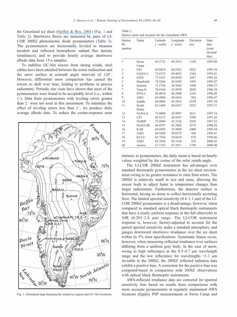
Table 2
Station name and location for the Greenland AWS
Station
ID
number
Name Latitude
(8 north)Longitude
(8 west)Elevation
(m)
Start
date
(year/
decimal
day)
1 Swiss
Camp
69.5732 49.2952 1149 1995.00
2 CP1 69.8819 46.9763 2022 1995.39
3 NASA-U 73.8333 49.4953 2368 1995.41
4 GITS 77.1433 69.0950 1887 1995.43
5 Humboldt 78.5266 56.8305 1995 1995.47
6 Summit 72.5794 38.5042 3208 1996.37
7 Tunu-N 78.0168 33.9939 2020 1996.38
8 DYE-2 66.4810 46.2800 2165 1996.40
9 JAR1 69.4984 49.6816 962 1996.47
10 Saddle 66.0006 44.5014 2559 1997.30
11 South
Dome
63.1489 44.8167 2922 1997.31
12 NASA-E 75.0000 29.9997 2631 1997.34
J. Stroeve et al. / Remote Sensing of Environment 94 (2005) 46–60 49
the Greenland ice sheet (Steffen & Box, 2001) (Fig. 1 and
Table 2). Shortwave fluxes are measured by pairs of LI-
COR 200SZ photoelectric diode pyranometers (Table 3).
The pyranometers are horizontally leveled to measure
incident and reflected hemispheric radiant flux density
(irradiance), and to provide hourly average shortwave
albedo data from 15-s samples.
To stabilize GC-Net towers from strong winds, steel
cables have been attached between the tower midsection and
the snow surface at azimuth angle intervals of 1208.However, differential snow compaction has caused the
towers to shift over time, leading to problems in precise
radiometry. Periodic site visits have shown that most of the
pyranometers were found to be acceptably level (i.e., within
18). Data from pyranometers with leveling errors greater
than 28 were not used in this assessment. To minimize the
effect of leveling errors less than 18, we produce daily
average albedo data. To reduce the cosine-response error
Fig. 1. Greenland map featuring the inland ice region and GC-Net locations.
13 CP2 69.9133 46.8547 1990 1997.36
14 NGRIP 75.0998 42.3326 2950 1997.52
15 NASA-SE 66.4797 42.5002 2579 1998.30
16 KAR 69.6995 32.9998 2400 1999.38
17 JAR2 69.4200 50.0575 568 1999.41
18 KULU 65.7584 39.6018 878 1999.46
19 JAR3 69.3954 50.3104 323 2000.41
20 Aurora 67.1352 47.2911 1798 2000.48
intrinsic to pyranometers, the daily mean is based on hourly
values weighted by the cosine of the solar zenith angle.
The LI-COR 200SZ instrument has advantages over
standard thermopile pyranometers in the ice sheet environ-
ment owing to its greater resistance to rime frost errors. The
200SZ is relatively small in size and mass, allowing the
sensor body to adjust faster to temperature changes than
larger radiometers. Furthermore, the detector surface is
horizontal, having no dome to collect horizontally accreting
frost. The limited spectral sensitivity (0.4–1.1 Am) of the LI-
COR 200SZ pyranometer is a disadvantage, however, when
compared to standard optical black thermopile instruments
that have a nearly uniform response in the full ultraviolet to
NIR (0.285–2.8 Am) range. The LI-COR instrument
response is, however, factory-adjusted to account for the
partial spectral sensitivity under a standard atmosphere, and
gauges downward shortwave irradiance over the ice sheet
within its 5% error specifications. Systematic biases occur,
however, when measuring reflected irradiance over surfaces
differing from a uniform gray body. In the case of snow,
owing to high reflectance in the 0.3–0.7 Am wavelength
range and the low reflectance for wavelengths N1.1 Aminvisible to the 200SZ, the 200SZ reflected radiation data
exhibit a positive bias. A correction for the positive bias was
computed-based in comparison with 200SZ observations
with optical black thermopile instruments.
AWS-reflected irradiance data are corrected for spectral
sensitivity bias based on results from comparisons with
more accurate pyranometers at regularly maintained AWS
locations (Eppley PSP measurements at Swiss Camp and
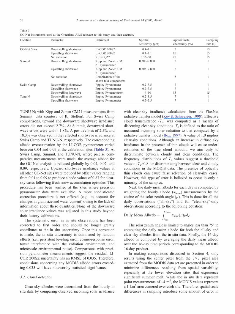
Table 3
GC-Net instruments used at the Greenland AWS relevant to this study and their accuracy
Location Parameter Instrument Spectral
sensitivity (Am)
Approximate
uncertainty (%)
Sampling
rate (s)
GC-Net Sites Downwelling shortwave LI-COR 200SZ 0.4–1.1 5 15
Upwelling shortwave LI-COR 200SZ 0.4–1.1 10 15
Net radiation REBS Q*7 0.35–30 20 15
Summit Downwelling shortwave Kipp and Zonen CM
21 Pyranometer
0.305–2.800 2 1
Upwelling shortwave Kipp and Zonen CM
21 Pyranometer
0.305–2.800 2 1
Net radiation Combination of the
above four components
5 1
Swiss Camp Downwelling shortwave Eppley Pyranometer 0.2–3.5 7 1
Upwelling shortwave Eppley Pyranometer 0.2–3.5 7 1
Downwelling longwave Eppley Pyrageometer 4–50 15 15
Tunu-N Downwelling shortwave Eppley Pyranometer 0.2–3.5 7 1
Upwelling shortwave Eppley Pyranometer 0.2–3.5 7 1
J. Stroeve et al. / Remote Sensing of Environment 94 (2005) 46–6050
TUNU-N; with Kipp and Zonen CM21 measurements from
Summit; data courtesy of K. Steffen). For Swiss Camp
comparisons, upward and downward shortwave irradiance
errors did not exceed 2.7%. At Summit, downward short-
wave errors were within 1.8%. A positive bias of 2.5% and
18.3% was observed in the reflected shortwave irradiance at
Swiss Camp and TUNU-N, respectively. The corresponding
albedo overestimation by the LI-COR pyranometer varied
between 0.04 and 0.09 at the calibration sites (Table 3). At
Swiss Camp, Summit, and TUNU-N, where precise com-
parative measurements were made, the average albedo for
the GC-Net analysis is reduced globally by 0.04, 0.07, and
0.09, respectively. Upward shortwave irradiance values at
all other GC-Net sites were reduced by offset values ranging
from 0.01 to 0.09 to produce albedo values of 0.87 for clear-
sky cases following fresh snow accumulation episodes. This
procedure has been verified at the sites where precision
pyranometer data were available. A more sophisticated
correction procedure is not offered (e.g., to account for
changes in grain size and water content) owing to the lack of
information about these quantities. None of the downward
solar irradiance values was adjusted in this study beyond
their factory calibrations.
The systematic error in in situ observations has been
corrected to first order and should no longer greatly
contributes to the in situ uncertainty. Once this correction
is made, the in situ uncertainty is dominated by random
effects (i.e., persistent leveling error, cosine-response error,
tower interference with the radiation environment, and
microscale environmental noise). Comparisons with preci-
sion pyranometer measurements suggest the residual LI-
COR 200SZ uncertainty has an RMSE of 0.035. Therefore,
conclusions concerning any MODIS albedo errors exceed-
ing 0.035 will have noteworthy statistical significance.
3.2. Cloud detection
Clear-sky albedos were determined from the hourly in
situ data by comparing observed incoming solar irradiance
with clear-sky irradiance calculations from the FluxNet
radiative transfer model (Key & Schweiger, 1998). Effective
cloud transmittance (Te) was computed as a means of
discerning clear-sky conditions. Te is defined as the ratio of
measured incoming solar radiation to that computed by a
radiative transfer model (Box, 1997). A value of 1.0 implies
clear-sky conditions. Although an increase in diffuse sky
irradiance in the presence of thin clouds will cause under-
estimates of the true cloud amount, we aim only to
discriminate between cloudy and clear conditions. The
frequency distributions of Te values suggest a threshold
value of TeN0.8 for discriminating between clear and cloudy
conditions in the MODIS data. The presence of optically
thin clouds can cause false selection of clear-sky cases.
However, this type of error is believed to occur in only a
minority of the samples.
Next, the daily mean albedo for each day is computed by
weighting the hourly albedo (ahour) measurements by the
cosine of the solar zenith angle (l). This is done for all the
daily observations (ball-skyQ) and for bclear-skyQ-onlyobservations according to the following equation:
Daily Mean Albedo ¼Z lmax
lmin
ahour lð Þldl
The solar zenith angle is limited to angles less than 758 incomputing the daily mean albedo for both the all-sky and
clear-sky albedos from the in situ data. Finally, the 16-day
albedo is computed by averaging the daily mean albedo
over the 16-day time periods corresponding to the MODIS
16-day product.
In making comparisons discussed in Section 4, only
results using the center pixel from the 3�3 pixel area
extracted from the MODIS data set are presented in order to
minimize differences resulting from spatial variability,
especially at the lower elevation sites that experience
significant summer melt. While the in situ data represent
point measurements of ~4 m2, the MODIS values represent
a 1-km2 area centered over each site. Therefore, spatial scale
differences in sampling introduce some amount of error in
J. Stroeve et al. / Remote Sensing of Environment 94 (2005) 46–60 51
our comparison that cannot be attributed to either in situ or
MODIS data. Without in situ albedo sampling at varying
scales within the MODIS footprint (pixel), we cannot
eliminate this source of error. While we acknowledge that,
at certain locations, there could be intrinsic heterogeneity
due to melt, wind structures, water pooling, dust concen-
trations, etc., we did not make an attempt to compensate for
these factors in this initial validation of the MODIS 16-day
albedo product. However, in most cases, this scale gap error
is a second-order effect that we neglect in the present work,
but would propose as part of future field work. Currently,
the MODIS geolocation accuracy is better than 150 m at the
99% confidence interval (Wolfe et al., 2002).
4. Results
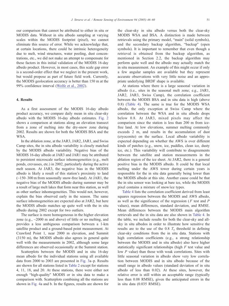
As a first assessment of the MODIS 16-day albedo
product accuracy, we compare daily mean in situ clear-sky
albedo with the MODIS 16-day albedo estimates. Fig. 2
shows a comparison at stations along an elevation transect
from a zone of melting into the dry-snow zone during
2002. Results are shown for both the MODIS BSA and the
WSA.
In the ablation zone, at the JAR3, JAR2, JAR1, and Swiss
Camp sites, the in situ albedo variability is closely matched
by the MODIS albedo variability. Negative bias of the
MODIS 16-day albedo at JAR3 and JAR1 may be attributed
to persistent microscale surface inhomogeneities (e.g., melt
ponds, crevasses, etc.) in 2002, particularly during the active
melt season. At JAR3, the negative bias in the MODIS
albedo is likely a result of this station’s proximity to land
(~150–300m from seasonally snow-free land). At JAR1, the
negative bias of the MODIS albedo during summer may be
a result of large melt lakes that form near this station, as well
as other surface inhomogeneities. This would not, however,
explain the bias observed early in the season. The same
surface inhomogeneities are expected also at JAR2, but here
the MODIS albedo matches up quite well with the in situ
albedo during 2002 except for two outliers.
The surface is more homogeneous in the higher elevation
zone (e.g., ~2000 m and above) of little or no melting, and
provides a less ambiguous comparison between a 1-km
satellite product and a ground-based point measurement. At
Crawford Point 1, near 2000 m elevation, and Summit
(3150 m), the MODIS albedo also agrees in general quite
well with the measurements in 2002, although some large
differences are observed occasionally at the Summit station.
Scatterplots between the MODIS and in situ 16-day
mean albedo for the individual stations using all available
data from 2000 to 2003 are presented in Fig. 3a–p. Results
are shown for all stations listed in Table 2 except for stations
4, 11, 18, and 20. At these stations, there were either not
enough bhigh-qualityQ MODIS or in situ data to make a
comparison with. Scatterplots combining all the stations are
shown in Fig. 4a and b. In the figures, results are shown for
the clear-sky in situ albedo versus both the clear-sky
MODIS WSA and BSA. A distinction is made between
retrievals using the primary model, bmainQ (solid symbols),
and the secondary backup algorithm, bbackupQ (open
symbols). It is important to remember that even though a
retrieval is obtained from the backup algorithm, as
mentioned in Section 2.2, the backup algorithm may
perform quite well and the albedo may actually match the
in situ measurement. An example of this might occur if only
a few angular samples are available but they represent
accurate observations with very little noise and an appro-
priate underlying BRDF shape is available.
At stations where there is a large seasonal variation in
albedo (i.e., sites in the seasonal melt zone; e.g., JAR1,
JAR2, JAR3, Swiss Camp), the correlation coefficient
between the MODIS BSA and in situ data is high (above
0.8) (Table 4). The same is true for the MODIS WSA
albedo, the only exception at Swiss Camp where the
correlation between the WSA and in situ albedo drops
below 0.8. At JAR3, mixed pixels may affect the
comparison since the station is less than 200 m from ice-
free land. At low elevations, summer melting commonly
exceeds 2 m, and results in the accumulation of dust
(cryoconite) on the surface. Local albedo variability is
expected depending on whether the AWS is over different
kinds of patches (e.g., snow, ice, puddles, clean ice, dusty
ice, etc.). This variability will contribute to disagreements
between the satellite and station measurements in the
ablation region of the ice sheet. At JAR2, there is a general
positive bias in the MODIS albedo. It could be that local
melting under the AWS tower during certain years is
responsible for the in situ data generally being lower than
the MODIS albedo at this site. Another cause could be that
the in situ sensor was looking at bare ice, while the MODIS
pixel contains a mixture of snow/ice types.
Table 4 lists the correlation coefficient derived from least
squares regression between the MODIS and AWS albedo,
as well as the significance of the regression (F test and P
values), mean differences, standard deviation, and RMSE.
Mean differences between the MODIS main algorithm
retrievals and the in situ data are also shown in Table 4. In
the table, we include results for both the clear-sky and all-
sky in situ albedos in order to illustrate how sensitive the
results are to the use of the 0.8 Te threshold in defining
clear-sky conditions from the in situ data. Stations with
high correlation coefficients (e.g., a strong relationship
between the MODIS and in situ albedo) also have higher
statistically significant relationships (high F test value and
low P value) than those with weak correlations. Sites with
little seasonal variation in albedo show very low correla-
tion between MODIS and in situ albedo because of the
small range in albedo values (standard deviation of in situ
albedo of less than 0.02). At these sites, however, the
relative error is still within an acceptable range (typically
less than 0.08 RMSE), given the anticipated errors in the
in situ data (0.035 RMSE).
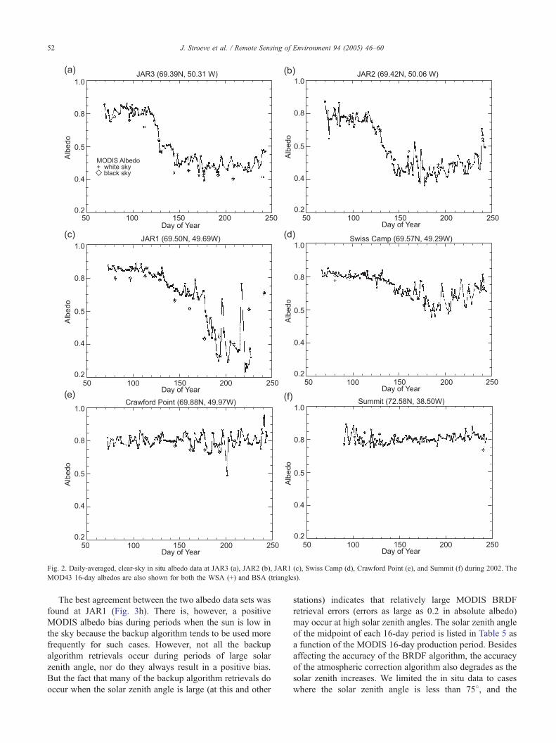
Fig. 2. Daily-averaged, clear-sky in situ albedo data at JAR3 (a), JAR2 (b), JAR1 (c), Swiss Camp (d), Crawford Point (e), and Summit (f) during 2002. The
MOD43 16-day albedos are also shown for both the WSA (+) and BSA (triangles).
J. Stroeve et al. / Remote Sensing of Environment 94 (2005) 46–6052
The best agreement between the two albedo data sets was
found at JAR1 (Fig. 3h). There is, however, a positive
MODIS albedo bias during periods when the sun is low in
the sky because the backup algorithm tends to be used more
frequently for such cases. However, not all the backup
algorithm retrievals occur during periods of large solar
zenith angle, nor do they always result in a positive bias.
But the fact that many of the backup algorithm retrievals do
occur when the solar zenith angle is large (at this and other
stations) indicates that relatively large MODIS BRDF
retrieval errors (errors as large as 0.2 in absolute albedo)
may occur at high solar zenith angles. The solar zenith angle
of the midpoint of each 16-day period is listed in Table 5 as
a function of the MODIS 16-day production period. Besides
affecting the accuracy of the BRDF algorithm, the accuracy
of the atmospheric correction algorithm also degrades as the
solar zenith increases. We limited the in situ data to cases
where the solar zenith angle is less than 758, and the
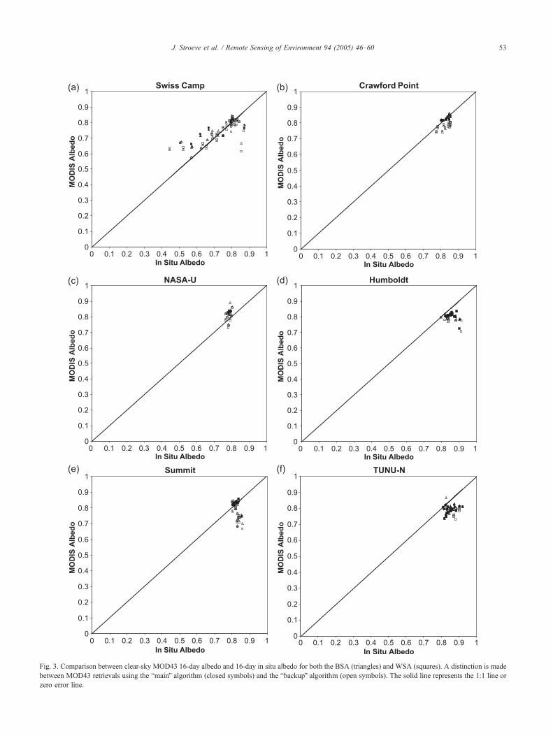
Fig. 3. Comparison between clear-sky MOD43 16-day albedo and 16-day in situ albedo for both the BSA (triangles) and WSA (squares). A distinction is made
between MOD43 retrievals using the bmainQ algorithm (closed symbols) and the bbackupQ algorithm (open symbols). The solid line represents the 1:1 line or
zero error line.
J. Stroeve et al. / Remote Sensing of Environment 94 (2005) 46–60 53
Fig. 3 (continued).
J. Stroeve et al. / Remote Sensing of Environment 94 (2005) 46–6054
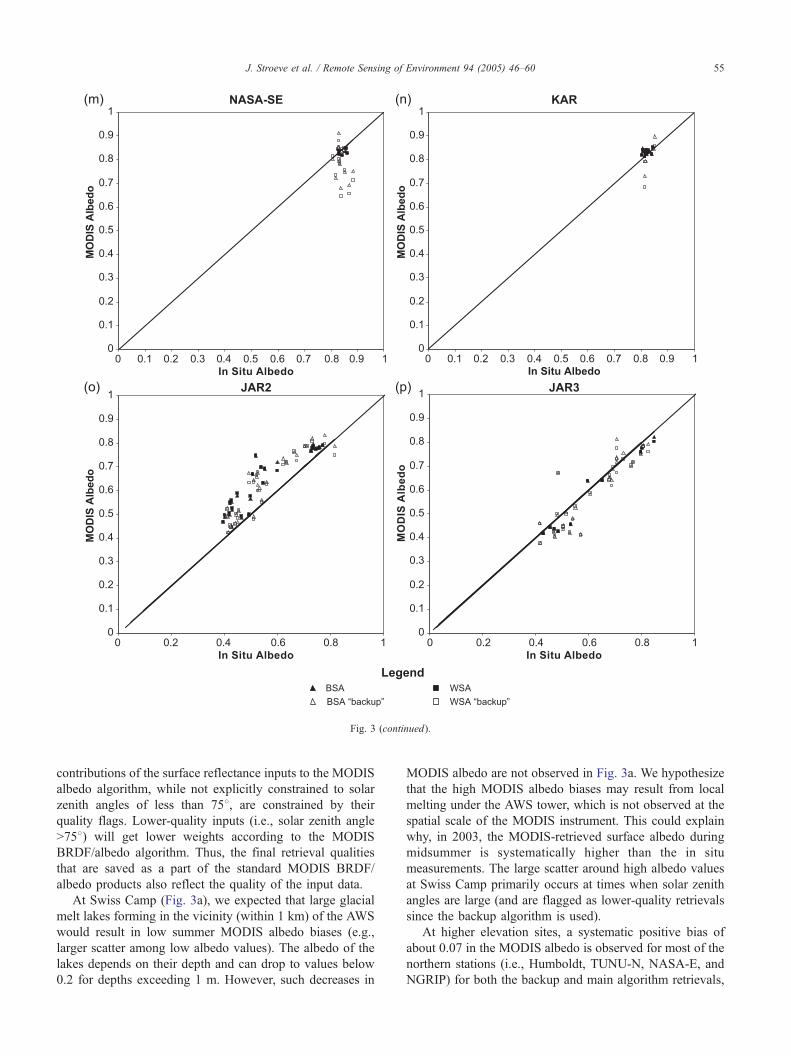
Fig. 3 (continued).
J. Stroeve et al. / Remote Sensing of Environment 94 (2005) 46–60 55
contributions of the surface reflectance inputs to the MODIS
albedo algorithm, while not explicitly constrained to solar
zenith angles of less than 758, are constrained by their
quality flags. Lower-quality inputs (i.e., solar zenith angle
N758) will get lower weights according to the MODIS
BRDF/albedo algorithm. Thus, the final retrieval qualities
that are saved as a part of the standard MODIS BRDF/
albedo products also reflect the quality of the input data.
At Swiss Camp (Fig. 3a), we expected that large glacial
melt lakes forming in the vicinity (within 1 km) of the AWS
would result in low summer MODIS albedo biases (e.g.,
larger scatter among low albedo values). The albedo of the
lakes depends on their depth and can drop to values below
0.2 for depths exceeding 1 m. However, such decreases in
MODIS albedo are not observed in Fig. 3a. We hypothesize
that the high MODIS albedo biases may result from local
melting under the AWS tower, which is not observed at the
spatial scale of the MODIS instrument. This could explain
why, in 2003, the MODIS-retrieved surface albedo during
midsummer is systematically higher than the in situ
measurements. The large scatter around high albedo values
at Swiss Camp primarily occurs at times when solar zenith
angles are large (and are flagged as lower-quality retrievals
since the backup algorithm is used).
At higher elevation sites, a systematic positive bias of
about 0.07 in the MODIS albedo is observed for most of the
northern stations (i.e., Humboldt, TUNU-N, NASA-E, and
NGRIP) for both the backup and main algorithm retrievals,
Fig. 4. (a) Comparison between clear-sky MOD43 16-day albedo and 16-
day in situ albedo for both the BSA and WSA combined for all the stations
examined in Fig. 3a–o. The solid line represents the 1:1 line or zero error
line. MODIS albedos from both the bmainQ and bbackupQ algorithm results
are shown. (b) Comparison between clear-sky MOD43 16-day albedo and
16-day in situ albedo for both the BSA and WSA combined for all the
stations examined in Fig. 3a–p. The solid line represents the 1:1 line or zero
error line. MODIS albedos from only the bmainQ algorithm results are
shown.
J. Stroeve et al. / Remote Sensing of Environment 94 (2005) 46–6056
although this bias decreases substantially at some of these
sites if we only consider the main retrievals (Table 4). At
TUNU-N, we believe part of the bias is a result of errors in
the in situ data since the albedo is observed to drift to values
greater than 0.9. The mean MODIS BSA albedo (combined
backup and main algorithm retrievals) for TUNU-N is 0.79
versus 0.86 for the in situ data. Likewise at NGRIP, the
mean in situ albedo is 0.88 versus 0.79 for the MODIS BSA
albedo. However, the mean value for main retrievals is 0.82
while that for the backup algorithm retrievals is 0.77. In
general, the broadband albedo value of fresh dry snow is
known to be about 0.84 (Konzelman & Ohmura, 1995). In
summer months, we would expect this value to drop
slightly, so it appears that there may still be a slight positive
bias in the GC-Net albedo at these sites. Another important
factor to consider is that the GC-Net albedo values increase
with increasing solar zenith angle. This alone implies that
higher mean albedo values are to be expected for the
northern stations, despite the dry-snow conditions.
At Humboldt (Fig. 3d), the mean difference between the
albedo reported in Table 4 is dominated by discrepancies
observed in 2000 and 2003 when the sun was low in the sky
(e.g., during spring in 2000 and during autumn in 2003).
There appears to be a drift in the in situ albedo during these
two time periods, which causes the in situ albedo to exceed
0.9 and must be an observational data error, likely a result of
leveling errors. Otherwise, the mean difference in the albedo
would be more on the order of 0.04.
At NASA-E (Fig. 3j), the in situ albedo is relatively
constant, whereas the MODIS albedo shows large oscil-
lations (albedo varies from 0.7 to 0.9). This appears to be
caused primarily by the backup algorithm retrievals. The
standard deviation for backup algorithm retrievals is 0.044,
which is twice as large for main algorithm retrievals (0.022).
Saddle (Fig. 3i) and NASA-SE (Fig. 3l) are located
within 104 km of each other and show similar results. At
Saddle, the MODIS and in situ albedo are within 0.03 of
each other, on average. If the five data points that are
labeled as bbackupQ are removed, the mean albedo differ-
ence is essentially 0. The same is true for NASA-SE after
removing the identical five data points in the analysis,
although at this station the agreement between the MODIS
and in situ albedo is not as strong or as significant as it is
at Saddle. Therefore, one may conclude that for the cases
examined here, the backup algorithm is not as robust as
the main one.
Although both Crawford Points 1 and 2 (stations 2 and
13, respectively) are located in the accumulation region of
the ice sheet, melt has been observed in recent years at these
stations, especially in 2002 and 2003. The MODIS albedo
product captures this larger seasonal variability, and this
larger albedo variability is also reflected in the higher
correlation coefficients for these sites.
In general, the MODIS albedo data at the Summit station
(Fig. 3e) match the in situ albedos quite well (mean
differences for main algorithm all less than or equal to
0.012) if we consider only the main algorithm retrievals.
Most of the backup algorithm retrievals significantly
underestimate the measured albedo, and these mostly occur
under conditions of high solar zenith angle. However,
during the year 2000, from day 177 onwards, all the MODIS
albedos are labeled as bbackup,Q emphasizing again that it is
not possible to say that all the backup algorithm retrievals
occur under conditions of high solar zenith angles. Other
factors contribute to the poor-quality flags during the latter
half of 2000, such as an insufficient number of angular
samples of the available surface reflectance.
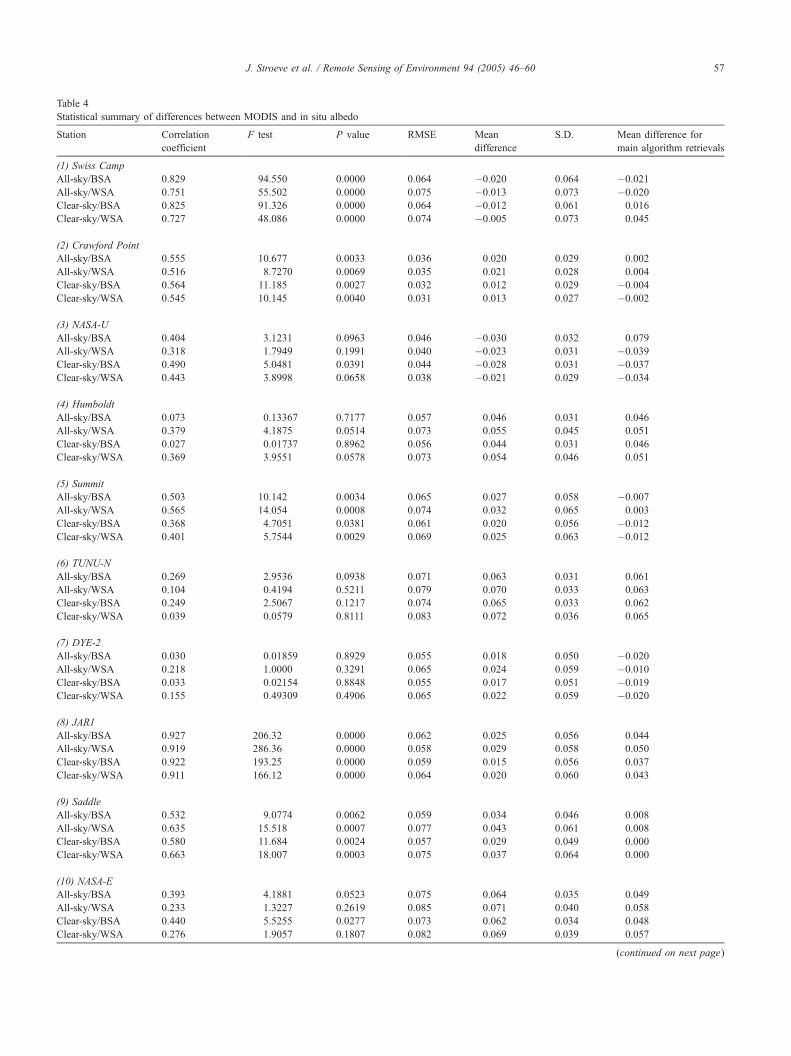
Table 4
Statistical summary of differences between MODIS and in situ albedo
Station Correlation
coefficient
F test P value RMSE Mean
difference
S.D. Mean difference for
main algorithm retrievals
(1) Swiss Camp
All-sky/BSA 0.829 94.550 0.0000 0.064 �0.020 0.064 �0.021
All-sky/WSA 0.751 55.502 0.0000 0.075 �0.013 0.073 �0.020
Clear-sky/BSA 0.825 91.326 0.0000 0.064 �0.012 0.061 0.016
Clear-sky/WSA 0.727 48.086 0.0000 0.074 �0.005 0.073 0.045
(2) Crawford Point
All-sky/BSA 0.555 10.677 0.0033 0.036 0.020 0.029 0.002
All-sky/WSA 0.516 8.7270 0.0069 0.035 0.021 0.028 0.004
Clear-sky/BSA 0.564 11.185 0.0027 0.032 0.012 0.029 �0.004
Clear-sky/WSA 0.545 10.145 0.0040 0.031 0.013 0.027 �0.002
(3) NASA-U
All-sky/BSA 0.404 3.1231 0.0963 0.046 �0.030 0.032 0.079
All-sky/WSA 0.318 1.7949 0.1991 0.040 �0.023 0.031 �0.039
Clear-sky/BSA 0.490 5.0481 0.0391 0.044 �0.028 0.031 �0.037
Clear-sky/WSA 0.443 3.8998 0.0658 0.038 �0.021 0.029 �0.034
(4) Humboldt
All-sky/BSA 0.073 0.13367 0.7177 0.057 0.046 0.031 0.046
All-sky/WSA 0.379 4.1875 0.0514 0.073 0.055 0.045 0.051
Clear-sky/BSA 0.027 0.01737 0.8962 0.056 0.044 0.031 0.046
Clear-sky/WSA 0.369 3.9551 0.0578 0.073 0.054 0.046 0.051
(5) Summit
All-sky/BSA 0.503 10.142 0.0034 0.065 0.027 0.058 �0.007
All-sky/WSA 0.565 14.054 0.0008 0.074 0.032 0.065 0.003
Clear-sky/BSA 0.368 4.7051 0.0381 0.061 0.020 0.056 �0.012
Clear-sky/WSA 0.401 5.7544 0.0029 0.069 0.025 0.063 �0.012
(6) TUNU-N
All-sky/BSA 0.269 2.9536 0.0938 0.071 0.063 0.031 0.061
All-sky/WSA 0.104 0.4194 0.5211 0.079 0.070 0.033 0.063
Clear-sky/BSA 0.249 2.5067 0.1217 0.074 0.065 0.033 0.062
Clear-sky/WSA 0.039 0.0579 0.8111 0.083 0.072 0.036 0.065
(7) DYE-2
All-sky/BSA 0.030 0.01859 0.8929 0.055 0.018 0.050 �0.020
All-sky/WSA 0.218 1.0000 0.3291 0.065 0.024 0.059 �0.010
Clear-sky/BSA 0.033 0.02154 0.8848 0.055 0.017 0.051 �0.019
Clear-sky/WSA 0.155 0.49309 0.4906 0.065 0.022 0.059 �0.020
(8) JAR1
All-sky/BSA 0.927 206.32 0.0000 0.062 0.025 0.056 0.044
All-sky/WSA 0.919 286.36 0.0000 0.058 0.029 0.058 0.050
Clear-sky/BSA 0.922 193.25 0.0000 0.059 0.015 0.056 0.037
Clear-sky/WSA 0.911 166.12 0.0000 0.064 0.020 0.060 0.043
(9) Saddle
All-sky/BSA 0.532 9.0774 0.0062 0.059 0.034 0.046 0.008
All-sky/WSA 0.635 15.518 0.0007 0.077 0.043 0.061 0.008
Clear-sky/BSA 0.580 11.684 0.0024 0.057 0.029 0.049 0.000
Clear-sky/WSA 0.663 18.007 0.0003 0.075 0.037 0.064 0.000
(10) NASA-E
All-sky/BSA 0.393 4.1881 0.0523 0.075 0.064 0.035 0.049
All-sky/WSA 0.233 1.3227 0.2619 0.085 0.071 0.040 0.058
Clear-sky/BSA 0.440 5.5255 0.0277 0.073 0.062 0.034 0.048
Clear-sky/WSA 0.276 1.9057 0.1807 0.082 0.069 0.039 0.057
(continued on next page)
J. Stroeve et al. / Remote Sensing of Environment 94 (2005) 46–60 57
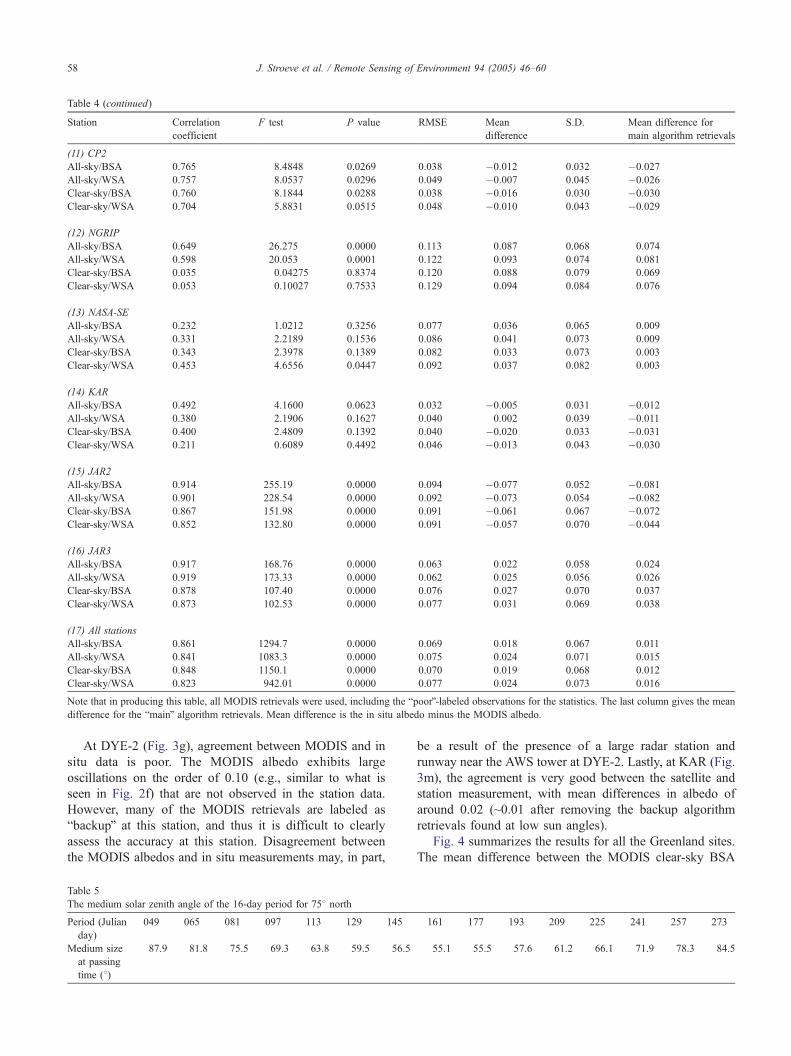
Station Correlation
coefficient
F test P value RMSE Mean
difference
S.D. Mean difference for
main algorithm retrievals
(11) CP2
All-sky/BSA 0.765 8.4848 0.0269 0.038 �0.012 0.032 �0.027
All-sky/WSA 0.757 8.0537 0.0296 0.049 �0.007 0.045 �0.026
Clear-sky/BSA 0.760 8.1844 0.0288 0.038 �0.016 0.030 �0.030
Clear-sky/WSA 0.704 5.8831 0.0515 0.048 �0.010 0.043 �0.029
(12) NGRIP
All-sky/BSA 0.649 26.275 0.0000 0.113 0.087 0.068 0.074
All-sky/WSA 0.598 20.053 0.0001 0.122 0.093 0.074 0.081
Clear-sky/BSA 0.035 0.04275 0.8374 0.120 0.088 0.079 0.069
Clear-sky/WSA 0.053 0.10027 0.7533 0.129 0.094 0.084 0.076
(13) NASA-SE
All-sky/BSA 0.232 1.0212 0.3256 0.077 0.036 0.065 0.009
All-sky/WSA 0.331 2.2189 0.1536 0.086 0.041 0.073 0.009
Clear-sky/BSA 0.343 2.3978 0.1389 0.082 0.033 0.073 0.003
Clear-sky/WSA 0.453 4.6556 0.0447 0.092 0.037 0.082 0.003
(14) KAR
All-sky/BSA 0.492 4.1600 0.0623 0.032 �0.005 0.031 �0.012
All-sky/WSA 0.380 2.1906 0.1627 0.040 0.002 0.039 �0.011
Clear-sky/BSA 0.400 2.4809 0.1392 0.040 �0.020 0.033 �0.031
Clear-sky/WSA 0.211 0.6089 0.4492 0.046 �0.013 0.043 �0.030
(15) JAR2
All-sky/BSA 0.914 255.19 0.0000 0.094 �0.077 0.052 �0.081
All-sky/WSA 0.901 228.54 0.0000 0.092 �0.073 0.054 �0.082
Clear-sky/BSA 0.867 151.98 0.0000 0.091 �0.061 0.067 �0.072
Clear-sky/WSA 0.852 132.80 0.0000 0.091 �0.057 0.070 �0.044
(16) JAR3
All-sky/BSA 0.917 168.76 0.0000 0.063 0.022 0.058 0.024
All-sky/WSA 0.919 173.33 0.0000 0.062 0.025 0.056 0.026
Clear-sky/BSA 0.878 107.40 0.0000 0.076 0.027 0.070 0.037
Clear-sky/WSA 0.873 102.53 0.0000 0.077 0.031 0.069 0.038
(17) All stations
All-sky/BSA 0.861 1294.7 0.0000 0.069 0.018 0.067 0.011
All-sky/WSA 0.841 1083.3 0.0000 0.075 0.024 0.071 0.015
Clear-sky/BSA 0.848 1150.1 0.0000 0.070 0.019 0.068 0.012
Clear-sky/WSA 0.823 942.01 0.0000 0.077 0.024 0.073 0.016
Note that in producing this table, all MODIS retrievals were used, including the bpoorQ-labeled observations for the statistics. The last column gives the mean
difference for the bmainQ algorithm retrievals. Mean difference is the in situ albedo minus the MODIS albedo.
Table 4 (continued)
J. Stroeve et al. / Remote Sensing of Environment 94 (2005) 46–6058
At DYE-2 (Fig. 3g), agreement between MODIS and in
situ data is poor. The MODIS albedo exhibits large
oscillations on the order of 0.10 (e.g., similar to what is
seen in Fig. 2f) that are not observed in the station data.
However, many of the MODIS retrievals are labeled as
bbackupQ at this station, and thus it is difficult to clearly
assess the accuracy at this station. Disagreement between
the MODIS albedos and in situ measurements may, in part,
Table 5
The medium solar zenith angle of the 16-day period for 758 north
Period (Julian
day)
049 065 081 097 113 129 145
Medium size
at passing
time (8)
87.9 81.8 75.5 69.3 63.8 59.5 56.5
be a result of the presence of a large radar station and
runway near the AWS tower at DYE-2. Lastly, at KAR (Fig.
3m), the agreement is very good between the satellite and
station measurement, with mean differences in albedo of
around 0.02 (~0.01 after removing the backup algorithm
retrievals found at low sun angles).
Fig. 4 summarizes the results for all the Greenland sites.
The mean difference between the MODIS clear-sky BSA
161 177 193 209 225 241 257 273
55.1 55.5 57.6 61.2 66.1 71.9 78.3 84.5
J. Stroeve et al. / Remote Sensing of Environment 94 (2005) 46–60 59
and in situ albedo is 0.02, and the RMSE is 0.07. If we
consider only the main algorithm retrievals, then the RMSE
drops to 0.04 and the mean differences are all less than 0.02.
The above results focused on comparing both the
MODIS black-sky and white-sky albedo to ground-based
snow albedo measurements. However, the actual albedo is a
combination of the BSA and WSA albedo, and will depend
on the particular atmospheric conditions under which the
observation was made. At most solar zenith angles, the BSA
and WSA bracket the actual albedo. Since in situ measure-
ments of atmospheric optical depth were not available, we
did not compute the actual albedo from the MODIS data.
Note, however, that, in general, the BSA and WSA at these
local solar noon zenith angles are nearly identical (they are
identical at approximately 508) and therefore close to the
actual albedo, as would be measured at the surface. Thus,
the statistical results shown in Table 4 are often similar for
the BSA and WSA retrievals. Exceptions occur primarily
during spring and autumn when the solar zenith angle often
exceeds 508, but at those times, the quality of the MODIS
albedos is often flagged as poor (e.g., the backup algorithm
is used). Therefore, the statistical differences between the
BSA and WSA have more to do with backup versus main
algorithm retrievals than with BSA versus WSA.
5. Conclusions
This study has shown that high-quality MODIS albedo
retrievals, albeit limited in extent, can be obtained over
homogeneous snow surfaces. The mean difference between
the MODIS algorithm retrievals and the in situ data is less
than 0.02 for all the stations combined (RMSE=0.07). This
result is based on all the MODIS albedo retrievals that
include use of both the main and backup algorithms. Using
only the main algorithm retrievals, the RMSE drops to 0.04
and the mean differences in albedo are less than 0.02 at all
sites. While the magnitude of individual in situ albedo
uncertainties is nearly that of the result for individual
MODIS 16-day product results, uncertainties concerning
MODIS albedo variability across the entire range of
observations (i.e., 0.39–0.88) are well within the trends
observed in the ground data. Moreover, we can conclude
that the MODIS albedo product is reliable in observing
variability below albedo values of 0.07, which are of
primary importance to ice sheet mass balance studies.
The quality of the MODIS albedo product will continue to
improve with continued improvements in atmospheric
correction and cloud detection in the MODIS processing
stream. We are not aware of any publications on the
improvements in accuracies between V003 and V004
MOD43 albedo products, although accuracies are stated on
the MODIS Land Team (MODLAND) validation web site
(http://landval.gsfc.nasa.gov/MODIS/index.php). However,
since the MODIS results presented here agree, in general,
with the observations (within F0.07), it is likely that the
MODIS albedo algorithm is reliable in selecting only the
clear-sky observations. Furthermore, even though the
MODIS atmospheric correction over Greenland does not
presently include the influence of aerosols, the conservative
nature of the MODIS albedo algorithm in accepting only
high-quality inputs, coupled with the small amount of
aerosols typically found over Greenland on cloud-free days
and the relative impact of residual aerosols on the surface
reflectance of such a bright surface, indicates that aerosol
contamination only minimally impacts the multiday retrieval.
Obviously, more frequent retrievals would better capture
changes in snow conditions (i.e., melt variability). The 16-
day time step of the MODIS algorithm is somewhat
problematic for snow surfaces, which can change rapidly
due to melting, rain-on-snow, wind sculpting of the surface,
and development of surface hoar frost. A possible alter-
native approach that would capture shorter-term albedo
variations is a daily BRDF retrieval algorithm that uses a
16-day sliding window and a weighting scheme to
emphasize the most recent observations.
The quality flags describe the quality of input samples in
terms of atmospheric correction, number of observations,
and angular distribution of samples, and indicate whether the
main or backup algorithms were used in the retrieval.
Although our validation results show that the inversions
from the backup algorithm can produce reliable data in some
cases, they confirm that, in general, the backup algorithm
albedo retrievals with low-quality flags have lower accu-
racies than albedos from full inversions (bgood qualityQ).Based on the limited number of validation sites studied thus
far (Jin et al., 2003a,b; Liang et al., 2002; Wang et al., 2004),
the MODIS BRDF/albedo product has been assigned a
Validated Stage 1 accuracy with full inversions falling within
5%, with the majority of the backup magnitude inversions
falling within 8–11%. The results of this study over spatially
homogeneous snow concur with this accuracy.
Finally, accurately measuring albedo at high latitudes is
challenging, not only for ground measurements, but also
from satellite. Reflectance measurements made at high solar
zenith angles pose difficulties in calibration and atmospheric
correction. As shown in Table 5, about half of available
satellite observations during the sunlit season are obtained
under conditions where the solar zenith angle exceeds 708.While more studies need to be conducted on how these high
solar zenith angle observations affect the BRDF retrievals,
at present, these lower-quality results (that occur because of
high solar zenith angles) should be avoided.
References
Bicheron, P., & Leroy, M. (2000). Bidirectional reflectance distribution
function signatures of major biomes observed from space. Journal of
Geophysical Research, 105, 26,669–26,681.
Box, J. (1997). Polar day effective cloud opacity in the Arctic from
measured and modeled solar radiation fluxes, MAThesis, University of
Colorado, Boulder, CO.
J. Stroeve et al. / Remote Sensing of Environment 94 (2005) 46–6060
Friedl, M. A., McIver, D. K., Hodges, J. C. F., Zhang, X. Y., Muchoney,
D., Strahler, A. H., et al. (2002). Global land cover mapping from
MODIS: Algorithms and early results. Remote Sensing of Environ-
ment, 83, 287–302.
Jin, Y., Schaaf, C. B., Gao, F., Li, X., Strahler, A. H., Lucht, W., et al.
(2003a). Consistency of MODIS surface bidirectional reflectance
distribution function and albedo retrievals: 1. Algorithm performance.
Journal of Geophysical Research, 108(D5).
Jin, Y., Schaaf, C. B., Woodcock, C. E., Gao, F., Li, X., Strahler, A. H.,
et al. (2003b). Consistency of MODIS surface bidirectional reflec-
tance distribution function and albedo retrievals: 2. Validation.
Journal of Geophysical Research, 108(D5).
Key, J., & Schweiger, A. J. (1998). Tools for atmospheric radiative transfer:
Streamer and FluxNet. Computers and Geosciences, 24(5), 443–451.
Klein, A. G., & Stroeve, J. (2002). Development and validation of a snow
albedo algorithm for the MODIS instrument. Annals of Glaciology, 34,
45–52.
Konzelmann, T., & Ohmura, A. (1995). Radiative fluxes and their impact
on the energy balance of the Greenland ice sheet. Journal of Glaciology,
41(139), 490–502.
Leroy, M., & Hautecoeur, O. (1999). Anisotropy-corrected vegetation
indexes derived from POLDER/ADEOS. IEEE Transactions on Geo-
science and Remote Sensing, 37, 1698–1708.
Li, X., & Strahler, A. H. (1992). Geometric–optical bidirectional reflectance
modeling of the discrete crown vegetation canopy: Effect of crown
shape and mutual shadowing. IEEE Transactions on Geoscience and
Remote Sensing, 30, 276–292.
Liang, S., Fang, H., Chen, M., Shuey, C. J., Walthall, C., Daughtry, C., et al.
(2002). Validating MODIS land surface reflectance and albedo
products: Methods and preliminary results. Remote Sensing of Environ-
ment, 83, 149–162.
Liang, S., Strahler, A. H., & Walthall, C. W. (1999). Retrieval of land
surface albedo from satellite observations: A simulation study. Journal
of Applied Meteorology, 38, 712–725.
Lucht, W., & Lewis, P. (2000). Theoretical noise sensitivity of BRDF and
albedo retrieval from the EOS-MODIS and MISR sensors with respect
to angular sampling. International Journal of Remote Sensing, 21,
81–98.
Lucht, W., Schaaf, C. B., & Strahler, A. H. (2000). An algorithm for the
retrieval of albedo from space using semiempirical BRDF models. IEEE
Transactions on Geoscience and Remote Sensing, 38,977–38,998.
Martonchik, J. V., Bruegge, C. J., & Strahler, A. H. (2001). A review of
reflectance nomenclature used in Remote Sensing. Remote Sensing
Reviews, 19, 9–20.
Maslanik, J., Fowler, C., Key, J., Scambos, T., Hutchinson, T., & Emery, W.
(1998). AVHRR-based Polar Pathfinder products for modeling appli-
cations. Annals of Glaciology, 25, 388–392.
Privette, J. L., Eck, T. F., & Deering, D. W. (1997). Estimating spectral
albedo and nadir reflectance through inversion of simple BRDF models
with AVHRR/MODIS-like data. Journal of Geophysical Research, 102,
29,529–29,542.
Ross, J. K. (1981). The radiation regime and architecture of plant stands.
Norwell, MA7 Dr. W. Junk, 392 pp.
Rossow, W. B., & Garder, L. (1984). Selection of a map grid for data-
analysis and archival. Journal of Climate and Applied Meteorology,
23(8), 1253–1257.
Roujean, J. L., Leroy, M., & Deschamps, P. Y. (1992). A bidirectional
reflectance model of the Earth’s surface for the correction of remote
sensing data. Journal of Geophysical Research, 97, 20,450–20,468.
Schaaf, C. B., Gao, F., Strahler, A. H., Lucht, W., Li, X., Tsang, T., et al.
(2002). First operational BRDF, albedo and nadir reflectance products
from MODIS. Remote Sensing of Environment, 83, 135–148.
Snyder, J. P. (1987). Map projections—a working manual. U.S. Geological
Survey Professional Paper 1395, Washington, DC, United States
Government Printing Office.
Steffen, K., & Box, J. E. (2001). Surface climatology of the Greenland ice
sheet: Greenland Climate Network 1995–1999. Journal of Geophysical
Research, 106(D24), 33951–33964.
Strugnell, N. C., & Lucht, W. (2001). An algorithm to infer continental-
scale albedo from AVHRR data, land cover class, and field observations
of typical BRDFs. Journal of Climate, 14, 1360–1376.
Van Leeuwen, W., & Roujean, J. -L. (2002). Land surface albedo from the
synergistic use of polar (EPS) and geo-stationary (MSG) observing
systems: An assessment of physical uncertainties. Remote Sensing of
Environment, 81, 1–17.
Wang, K., Liu, J., Zhou, X., Sparrow, M., Ma, M., Sun, Z., et al. (2004).
Validation of the MODIS global land surface product using ground
measurements in a semi desert region on the Tibetan Plateau. Journal of
Geophysical Research, 109.
Wolfe, R., Nishihama, M., Fleig, A. J., Kuyper, J. A., Roy, D. P., Storey, J. C.,
& Patt, F. S. (2002). Achieving sub-pixel geolocation accuracy in support
of MODIS land science. Remote Sensing Environment, 83, 31–49.
Related Documents