About BLAST, VORF, MSS and LAT. Dr Ole B. Andersen, DTU Space, Copenhagen, Denmark,

Welcome message from author
This document is posted to help you gain knowledge. Please leave a comment to let me know what you think about it! Share it to your friends and learn new things together.
Transcript

About BLAST, VORF, MSS and LAT.
Dr Ole B. Andersen,
DTU Space,
Copenhagen, Denmark,

2 DTU Space, Technical University of Denmark
VORF and BLAST
•VORF = Vertical Offshore Reference Frame
•A set of mathematical models of the major surfaces used in the current and “future charting”
•A suite of software utilities allowing the transformation of mapping and positioning data between the VORF surfaces
•UKHO established first demonstrator UK-VORF for Britain in 2007
•UK-HO is currently extending VORF ???
•BLAST established North Sea VORF in 2011

3 DTU Space, Technical University of Denmark
BLAST (EU 7th Interreg FW project)
"Bringing Land and Sea Together“ (BLAST),
–by harmonizing and
integrating on+offshore
data.
Creating a VORF
With matematical
Transformations.

4 DTU Space, Technical University of Denmark
Blast/VORF computation method
5 DTU Space, Technical University of Denmark
Blast/VORF computation method
Tide gauge

6 DTU Space, Technical University of Denmark
Blast/VORF computation method
Tide gauge
MSS

7 DTU Space, Technical University of Denmark
Blast/VORF computation method
Tide gauge
MSS MSS (altimetry)

8 DTU Space, Technical University of Denmark
Blast/VORF computation method
Tide gauge
geoid
MSS MSS (altimetry)
9 DTU Space, Technical University of Denmark
Blast/VORF computation method
Tide gauge
geoid
MSS MSS (altimetry)5km interpolate

10 DTU Space, Technical University of Denmark
Blast/VORF computation method
Tide gauge
Altimetric LAT= VORF
11 DTU Space, Technical University of Denmark
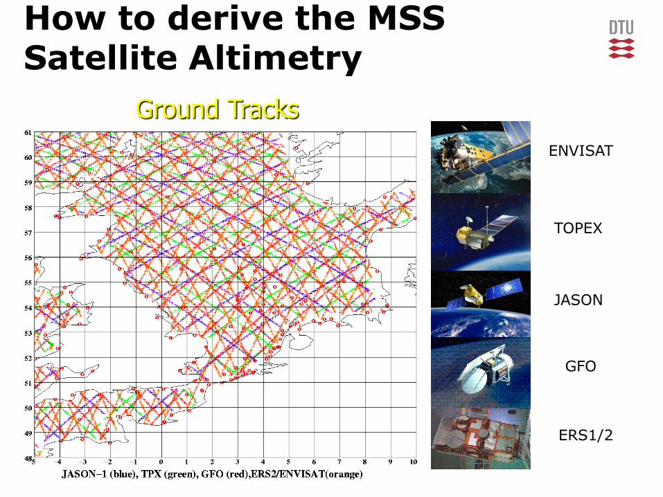
How to derive the MSS Satellite Altimetry
Ground Tracks
ENVISAT
TOPEX
JASON
GFO
ERS1/2

12 DTU Space, Technical University of Denmark
GPS vs MSS
DTU10MSS-Special NoIB version
Derived.
320 GPS measured Tide Gauges
Around Britain.
TG – MSS (extrapolated)
Mean = 1.24 cm (DNSC08)
Std = 6.8 cm
Upgrading MSS to DTU10
Comparison curtesy by
Marek Ziebart, UCL London,

13 DTU Space, Technical University of Denmark
GPS vs MSS
DTU10MSS-Special NoIB version
Derived.
320 GPS measured Tide Gauges
Around Britain.
TG – MSS (extrapolated)
Mean = 1.24 cm (DNSC08)
Std = 6.8 cm
Upgrading MSS to DTU10
Mean = 0.11 cm (DTU10)
Comparison curtesy by
Marek Ziebart, UCL London,

14 DTU Space, Technical University of Denmark
Run the tide model for 19 years to find minimum

15 DTU Space, Technical University of Denmark
Run the tide model for 19 years to find minimum

16 DTU Space, Technical University of Denmark
country LAT CD
B Grid No
D Grid (part of NS territorial
region)
No
F Available but Outside Available
but outside
DK Defined by 8 points
Recommend GOT4.7 LAT
No
N Defined by 3 points
Uses GOT4.7 LAT
No
NL Grid No
UK Grid Grid
MARINE:
VRF program includes the following
National LAT / CD datums
All implemented on to common highresBLAST grid
Associated coverage file associated with each grid
Informs on ”reliable coverage”

17 DTU Space, Technical University of Denmark
country LAT CD
B Grid No
D Grid (part of NS territorial
region)
No
F Available but Outside Available
but outside
DK Defined by 8 points
Recommend GOT4.7 LAT
No
N Defined by 3 points
Uses GOT4.7 LAT
No
NL Grid No
UK Grid Grid
MARINE:
VRF program includes the following
National LAT / CD datums
All implemented on to common highresBLAST grid
Associated coverage file associated with each grid
Informs on ”reliable coverage”

18 DTU Space, Technical University of Denmark
Backup slides -

19 DTU Space, Technical University of Denmark
Blast transformation program
Created a ”command line”
Interface program.
Development of User
interface baced
On response from users

20 DTU Space, Technical University of Denmark
Outlook
Satellite derived MSS and Ocean Tide LAT applicable.
Could be established and quality controlled for the Arctic.
UKHO – UK Navy currently extending VORF with global DTU10MSS
UK VORF + BLAST paved the road
Must be integrated with local data to enhance local modelleing.
Implementing ”error handling”

21 DTU Space, Technical University of Denmark
Arctic Ocean TPX 7.2 vs GOT 4.7 DTU10 vs GOT 4.7

22 DTU Space, Technical University of Denmark
BLAST Reference
surface
EGG02008 Geoid (N)
Numbers are
GPS levelling height
Hellip-Hlevel-N
Clear tilt in the UK
Levelling data.
23 DTU Space, Technical University of Denmark
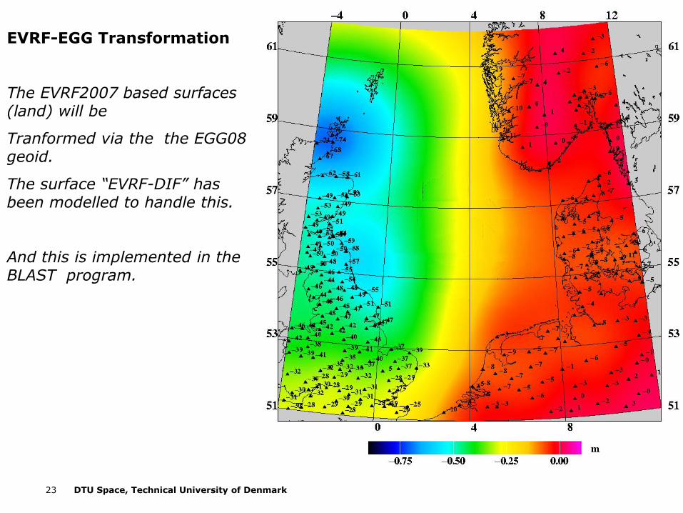
EVRF-EGG Transformation
The EVRF2007 based surfaces (land) will be
Tranformed via the the EGG08 geoid.
The surface “EVRF-DIF” has been modelled to handle this.
And this is implemented in the BLAST program.

24 DTU Space, Technical University of Denmark
BLAST LAT surface
Based on DTU10
Ocean tide model
Identical to within 5 cm of
GOT4.7 ocean tide model

25 DTU Space, Technical University of Denmark
Blast transformation programInput / Output
• Input specify which country and ”system” you are in
#The data is as follows:
#ID lat lon h country system
pt1 55.1 8.4 2 1 1
2 56.3 9.8 3.7 2 1
33 57.8 10.34 4 2 1
hgt 57.8 10.321 43.5 8 5

26 DTU Space, Technical University of Denmark
MSS from Satellite Altimetry

27 DTU Space, Technical University of Denmark
The DNSC08 Mean Sea Surface
– First purely Geometrical MSS – Mean 1993-2004 period
– Derived from T/P, T/P TDM, ERS1 ERM+GM, ERS2 ERM, ENVISAT, Geosat GM, GFO
– Total 12 years of data using T/P + Jason-1 as reference
– The MSS has been derived in the Mean Tide System
– NEW!!!! DTU10 Available – Mean 1993-2009
– Vertical Accuracy 4-6 cm deep ocean best - less accurate close to coast
Want complete coverage in space and time”
”Get the best out of ERM (Variability averaged out) and GM (high spatial resolution)”
MSS = MDT + Geoid
Model(Name)
T/P data
Years
Res
KMS04
CLS01
GSFC00/00.1.
KMS01
NCU01
GSFC98
CLS-SHOM 98,
KMS98
CSR95
OSU95
9 (93-01)
7 (93-99
7 (93-99)
7 (93-00)
6 (93-98)
3 (93-95)
3 (93-95)
3 (93-95)
2 (93-94)
1 (93-93)
2
2
2
2
2
2
2
3.75
3.75
5

28 DTU Space, Technical University of Denmark
MDT (DNSC08MSS-EGM2008 = DNSC08MDT)
29 DTU Space, Technical University of Denmark
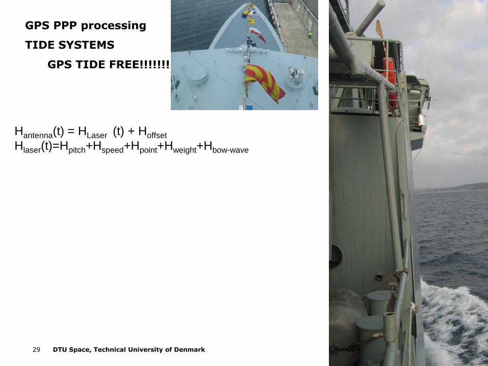
Hantenna(t) = HLaser (t) + Hoffset
Hlaser(t)=Hpitch+Hspeed+Hpoint+Hweight+Hbow-wave
GPS PPP processing
TIDE SYSTEMS
GPS TIDE FREE!!!!!!!

30 DTU Space, Technical University of Denmark
Latitude (degrees)
Sea S
urf
ace H
eig
ht
(mete
rs)
28,5 30 31,5 33 34,5 36 37,5 39 40,5 42-1,2
-0,8
-0,4
0
0,4
0,8
1,2
1,6
2SSH - Tides not removedSSH - Tides RemovedDNSC08 MDT - no IB
Hantenna(t) = HLaser (t) + Hoffset
Hlaser(t)=Hpitch+Hspeed+Hpoint+Hweight+Hbow-wave
GPS PPP processing
TIDE SYSTEMS
GPS TIDE FREE!!!!!!!
31 DTU Space, Technical University of Denmark
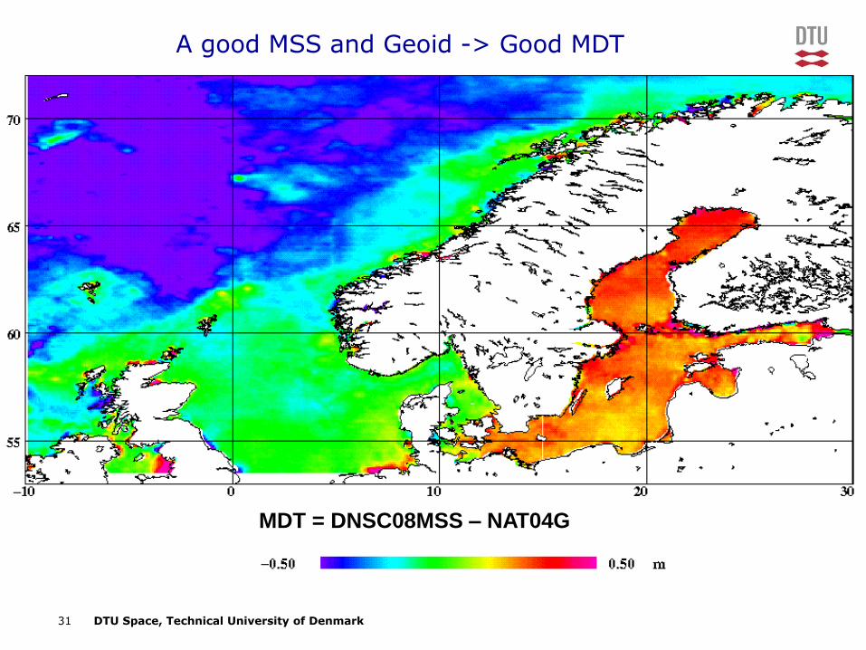
A good MSS and Geoid -> Good MDT
MDT = DNSC08MSS – NAT04G

32 DTU Space, Technical University of Denmark
DNSC08MSS-LAT47 (Ref to GRS80)
Related Documents


![i cro eparate Screen Y 100 Y) 30 O. 1kWi cro eparate Screen Y 100 Y) 30 O. 1kW 3ØX200VXO.1 kW MSS- 300 MSS- 600 MSS- 900 MSS -1200 MSS- 1500 MSS- 1800 [kg] 200 260 325 455 520 585](https://static.cupdf.com/doc/110x72/608f28a1057c035c36673166/i-cro-eparate-screen-y-100-y-30-o-1kw-i-cro-eparate-screen-y-100-y-30-o-1kw.jpg)